Appendix 1 cover - ci.azusa.ca.us
31
Appendix 13 Visual Impact Assessment
Transcript of Appendix 1 cover - ci.azusa.ca.us

Appendix 13 Visual Impact Assessment
Visual Impact Assessment For Azusa Rock Quarry
City of Azusa, California
Prepared For: Vulcan Materials Company, Western Division
3200 San Fernando Road Los Angeles, California 90065
Prepared By: RGP Planning & Development Services
8921 Research Drive Irvine, California 92618
September 4, 2008

Executive Summary: The following visual impact assessment has been prepared to identify any potential long-
term adverse visual impacts that might result from Vulcan Materials Company – Western Division’s (VMC) proposed amendment to the Azusa Rock Quarry surface mining and reclamation operation in Azusa, California. This assessment analyzes the net difference of impacts between the existing, approved Azusa Rock operation and the proposed, amended operation.
Seven categories of potentially sensitive viewpoints have been identified and assessed.
Views of the site under both approved and proposed project conditions have been simulated for each category, and a numerical ranking has been applied for each. In six of the seven categories of sensitive viewpoints, the visual conditions for the site are shown to be improved as a result of the project.
In one category of potentially sensitive viewpoints – which includes certain residences in
Duarte – a potential visual impact would result from the project’s proposed western shift of operations. However, this visual impact is offset by an increase in the visual quality of adjacent scenery that results from the project’s improvements to other areas of the project site that are outside of this single view, but nonetheless influence the rating of local scenery. Therefore, the total numerical ranking for both the existing and proposed projects remain identical in this view category.
No significant visual impacts have been identified by this assessment.
1
1. Introduction: The following visual impact assessment has been prepared pursuant to the California
Environmental Quality Act (CEQA). The purpose of this assessment is to identify any potential long-term adverse visual impacts that might result from Vulcan Materials Company – Western Division’s (VMC) proposed amendment to their surface mining and reclamation operation at the Azusa Rock Quarry in Azusa, California.
This assessment is based on the approved visual assessment practices employed by the Federal Highway Administration, the Bureau of Land Management, the United States Forest Service, and other regulatory agencies.1 This method includes:
Defining the project and its visual setting; Identifying sensitive viewpoints for assessment; Analyzing the baseline visual quality and character of the identified views; Depicting the visual appearance of the project from identified views; Assessing the project’s impacts to those views in comparison to their baseline
visual quality and character, and; Proposing methods to mitigate any potentially significant visual impacts
identified.
2. Proposed Project & Visual Setting:
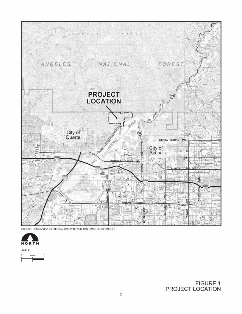
VMC proposes revisions to the currently approved Azusa Rock conditional use permit and reclamation plan for its 270-acre property in the City of Azusa. Figure 1 illustrates the location of the site. The property, situated at the northerly terminus of Fish Canyon Road, was granted rights to mine in the past for operations encompassing 190 acres within the total 270 acres of ownership. The historic footprint of actual site disturbance, however, is much less than the 190 acres. The objectives of the revised conditional use permit and revised reclamation plan would be to allow VMC to:
Modify its operations to focus mineral resource extractions along the less-visible westerly portions of the 270-acre property, and preclude further mining on the easterly areas of the 270-acre property,
Initiate immediate reclamation of the existing east side operations, and; Alter the reclamation and revegetation approach by initiating an aesthetically and
environmentally superior design across the entire property.
1 The Bureau of Land Management (Contrast Rating System), Soil Conservation Service (Visual Absorption Capability), and Federal Highway Administration (Visual Absorption Capacity) all use established quantitative and qualitative methods to measure potential visual impacts. The methodology used in this document is based on these industry standards.
��������������� ������� ����������� ������������������
������������������
��� ������������
�����������������
��
�
����
���
��
��
�
������
������
�
�
���
��
���
������
����
�
��
���
���
���
���
���
��������������������
��
��
��
��
������
���
�
��
��
����
������
�
���
���
��
����
������
������
�
�
� � � � � � � � � � � � � � � � � � � � � � � � � � � � � � � � � � � � � � �
����������� ���� �����
�����
� �����
��
��
��
����
����
��
���� !�"#$�%
���� !�&"'#��
���(�
���)* +��,��
�)�
�
��
���
���
���
���)��
��
�

3
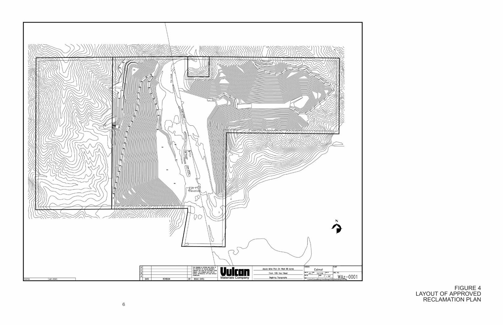
The currently applicable Azusa Rock Quarry Reclamation Plan approved in 1988 requires the operator to mine and reclaim exactly as has been done thus far using the traditional “step benching methods.” The end result of this previously approved “step benching” method is a slope face that does not resemble the original pre-mining contours, that contains continuous benches approximately 40 feet in height, and stands in stark contrast to the surrounding unmined slopes – resulting in an artificial appearance. Figure 2 provides a simulated cross-section of the step benching method. However, VMC has developed a proposed alternative reclamation approach that will result in a more naturalized visual appearance upon completion of the process. The proposed plan would include state-of-the-art micro-benching techniques that, when completed, would result in reclaimed slopes with drainage contours similar in appearance to the original slope and vegetation that obscures the contouring necessary for slope stability. The micro-benching technique would create landforms that do not contrast as sharply with surrounding, unmined slopes as the step benching technique. Figure 3, provides a simulated cross-section of the micro-benching method. For comparison, Figure 4 illustrates the layout of the currently permitted reclamation plan, and Figure 5 illustrates the layout of the proposed amendment to the reclamation plan.
Existing Visual Setting: The project site is located on the westerly edge of the San Gabriel Mountains. The surrounding communities of Azusa, Duarte, and Irwindale are all located in the San Gabriel Valley below the mountains, and the mountains provide a visual backdrop to views within these communities. Aggregate mining and related processing activities have occurred at the project site since the 1920’s. Evidence of surface mining is readily apparent at the site since the formerly excavated slopes are nearly void of vegetation. They are also much lighter in color than the undisturbed areas surrounding the site, and contain rows of unnatural-looking step benches. The site currently contains two office trailers, basic sorting and screening equipment, and various machinery that is used to convey sorted raw materials to VMC’s nearby “Reliance” Plant. The existing visual character of the project region is dominated by the presence of the San Gabriel Mountains, which form the northerly edge of the San Gabriel Valley. The form and line of the visual character results from the size and shape of the various natural mountain peaks, ridges and canyons associated with the mountain backdrop. The color and texture of the existing visual character is primarily created by the natural mixed-chaparral vegetation that covers these landforms.

�������� ������� �������
������� ������������

�������� ������� �������
�� ������ ������������
��������� ��� ������ ���
�������� ������

���������� ��� ���� � ���
�������� ������
8
3. Standards for Determining Visual Impact Significance: Appendix G of the California Environmental Quality Act (CEQA) Guidelines contains a brief checklist of environmental effects that may be considered significant. Under the category of “Aesthetics,” a project is considered to have a significant visual impact on the environment if it will:
A. Have a substantial adverse effect on a scenic vista; B. Substantially damage scenic resources, including but not limited to, trees, rock
outcroppings, and historic buildings within a state scenic highway;
C. Substantially degrade the existing visual character or quality of the site and its surroundings;
D. Create a new source of substantial light or glare, which would adversely affect
day or nighttime views in the area.
The above CEQA checklist questions have been used, herein, as guidelines for assessing the potential significance of the proposed project’s visual impacts. However, it is important to note that since the Azusa Rock Quarry is an existing, permitted operation, impacts analyzed in this report are focused on the net visual difference between the existing (permitted) condition and the proposed (amended) condition. Rating Visual Quality: “Visual quality” is a measure of a landscape or view’s visual appeal. While there are a number of standardized methods for rating visual quality, the “Scenic Quality Rating Criteria” method utilized by the BLM is believed to be superior because it allows the various landscape elements that comprise visual quality to be easily quantified and rated, with a minimum of ambiguity or subjectivity. 2 According to this method, visual quality is rated according to the presence and characteristics of seven key components of the landscape. These components include landform, vegetation, water, color, adjacent scenery, scarcity and cultural modifications. 1. The “landform” component of the visual quality rating criteria takes into account the fact that topography becomes more interesting visually as it gets steeper or more massive, or more severely or universally sculptured. Outstanding landforms may be monumental, (as found in Yosemite Valley), or they may be exceedingly artistic and subtle (such as certain badlands, pinnacles, arches, and other extraordinary formations).
2 This quantitative scale is based on the Bureau of Land Management’s (BLM) “Scenic Quality Rating Criteria” scale, as described in the BLM Visual Resource Management manual.

9
2. The “vegetation” component of the rating criteria gives primary consideration to the variety of patterns, forms, and textures created by plant life. Short-lived displays are given consideration when they are known to be recurring or spectacular. Consideration is also given to smaller scale vegetational features that add striking and intriguing detail elements to the landscape (e.g., gnarled or windbeaten trees, Joshua trees, etc.). 3. The “water” component of the rating criteria recognizes that visual quality is largely tied to the presence of water in scenery, as it is that ingredient which adds movement or serenity to a scene. The degree to which water dominates the scene is the primary consideration in selecting the rating score for the water component. 4. The “color” component of the visual quality rating criteria considers the overall color(s) of the basic components of the landscape (e.g., soil, rock, vegetation, etc.). Key factors that are used when rating the color of scenery are variety, contrast, and harmony. 5. The “adjacent scenery” component of the rating criteria takes into account the degree to which scenery outside the view being rated enhances the overall impression of the scenery under evaluation evaluated. The distance of influence for adjacent scenery normally ranges from 0-5 miles, depending upon the characteristics of the topography, the vegetation cover, and other such factors. This factor is generally applied to views that would normally rate very low in score, but the influence of the adjacent high visual quality would enhance the visual quality and raise the score. 6. The “scarcity” component of the visual quality rating criteria provides an opportunity to give added importance to one or all of the scenic features that appear to be relatively unique or rare within a region. There may also be cases where a separate evaluation of each of the key factors does not give a true picture of the overall scenic quality of an area. Often, it is a number of not so spectacular elements in the proper combination that produces the most pleasing and memorable scenery – the scarcity factor can be used to recognize this type of area and give it the added emphasis it should have. 7. The “cultural modifications” component of the visual quality rating criteria takes into account any man-made modifications to the landform, water, vegetation, and/or the addition of man-made structures. Depending on their character, these cultural modifications may detract from the scenery in the form of a negative intrusion or they may complement and improve the scenic quality of a view. Based on the above criteria, views are rated numerically and a total score of visual quality can be tabulated. Based on the BLM’s rating system, there are a total of 32 points possible. Views that score a total of 19 points or more are typically considered very high in visual quality. Views that score a total of 15 to 19 points are typically considered to have a high level of visual quality. Views that score a total of 12 to 15 points are typically considered to have an above average level of visual quality. And views that score a total

10
Key Factors Rating Criteria and Score
LANDFORM
High vertical relief as expressed in prominent cliffs, spires, or massive rock outcrops, or severe surface variation or highly eroded formations including major badlands or dune systems; or detail features dominant and exceptionally striking and intriguing such as glaciers. Score = 5
Steep canyons, mesas, buttes, cinder cones, and drumlins; or interesting erosional patterns or variety in size and shape of landforms; or detail features which are interesting though not dominant or exceptional. Score = 3
Low rolling hills, foothills, or flat valley bottoms; or few or no interesting landscape features. Score = 1
VEGETATION
A variety of vegetative types as expressed in interesting forms, textures, and patterns. Score = 5
Some variety of vegetation, but only one or two major types. Score = 3
Little or no variety or contrast in vegetation. Score = 1
WATER
Clear and clean appearing, still, or cascading white water, any of which are a dominant factor in the landscape. Score = 5
Flowing, or still, but not dominant in the landscape. Score = 3
Absent, or present but not noticeable. Score = 1
COLOR
Rich color combinations, variety or vivid color; or pleasing contrasts in the soil, rock, vegetation, water or snow fields. Score = 5
Some intensity or variety in colors and contrast of the soil, rock, and vegetation, but not a dominant scenic element. Score = 3
Subtle color variations, contrast, or interest; generally mute tones. Score = 1
INFLUENCE OF ADJACENT SCENERY
Adjacent scenery greatly enhances visual quality. Score = 5
Adjacent scenery moderately enhances overall visual quality. Score = 3
Adjacent scenery has little or no influence on overall visual quality. Score = 1
SCARCITY
One of a kind; or unusually memorable, or very rare within region. Consistent chance for exceptional wildlife or wildflower viewing, etc. Score = 5
Distinctive, though somewhat similar to others within the region. Score = 3
Interesting within its setting but fairly common within the region. Score = 1
CULTURAL MODIFICATIONS
Modifications add favorably to visual variety while promoting visual harmony. Score = 2
Modifications add little or no visual variety to the area, and introducing no discordant elements. Score = 0
Modifications add variety but are very discordant and promote strong disharmony. Score = -4
Total Score: _____________
Examples of Various Visual Quality Ratings:
Average (<11pts.) Above Average (12-15pts.) High (15-19pts.) Very High (>19pts.)
Figure 6:
Visual Quality Rating Criteria
11
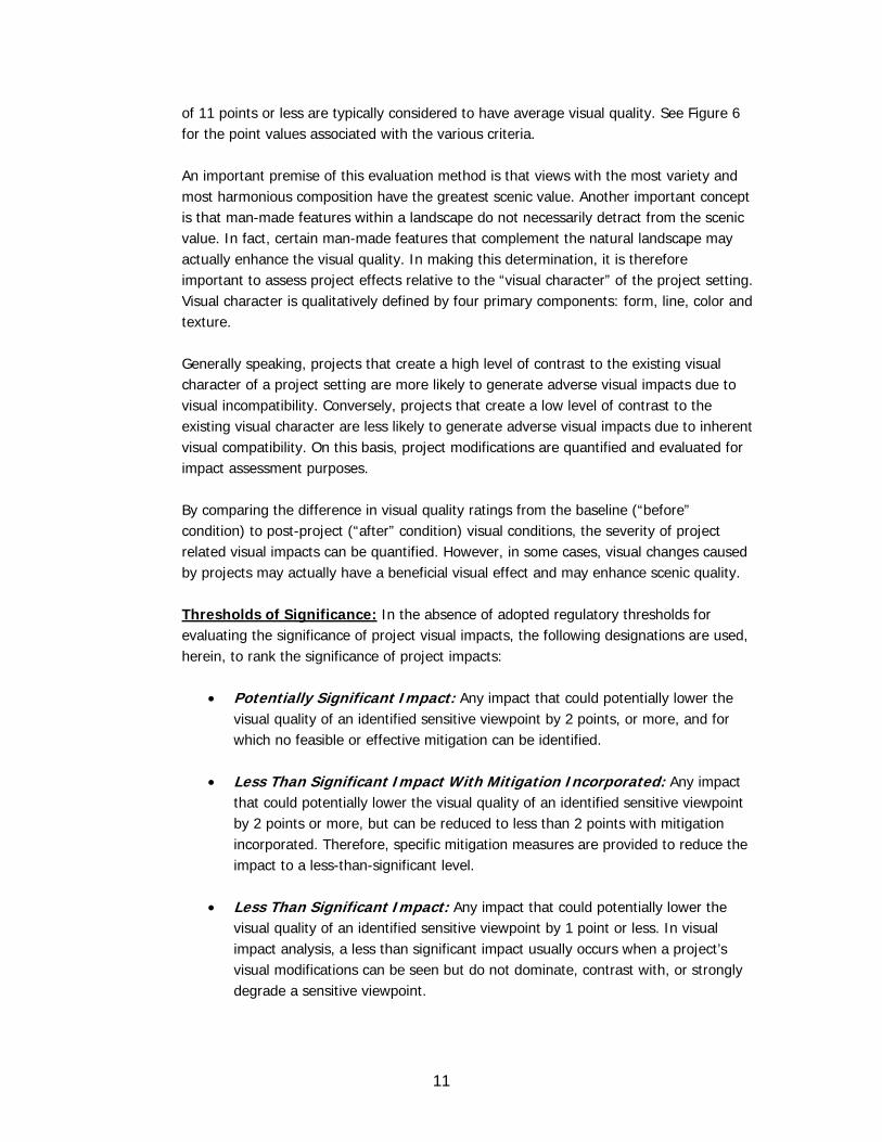
of 11 points or less are typically considered to have average visual quality. See Figure 6 for the point values associated with the various criteria. An important premise of this evaluation method is that views with the most variety and most harmonious composition have the greatest scenic value. Another important concept is that man-made features within a landscape do not necessarily detract from the scenic value. In fact, certain man-made features that complement the natural landscape may actually enhance the visual quality. In making this determination, it is therefore important to assess project effects relative to the “visual character” of the project setting. Visual character is qualitatively defined by four primary components: form, line, color and texture. Generally speaking, projects that create a high level of contrast to the existing visual character of a project setting are more likely to generate adverse visual impacts due to visual incompatibility. Conversely, projects that create a low level of contrast to the existing visual character are less likely to generate adverse visual impacts due to inherent visual compatibility. On this basis, project modifications are quantified and evaluated for impact assessment purposes. By comparing the difference in visual quality ratings from the baseline (“before” condition) to post-project (“after” condition) visual conditions, the severity of project related visual impacts can be quantified. However, in some cases, visual changes caused by projects may actually have a beneficial visual effect and may enhance scenic quality. Thresholds of Significance: In the absence of adopted regulatory thresholds for evaluating the significance of project visual impacts, the following designations are used, herein, to rank the significance of project impacts:
Potentially Significant Impact: Any impact that could potentially lower the visual quality of an identified sensitive viewpoint by 2 points, or more, and for which no feasible or effective mitigation can be identified.
Less Than Significant Impact With Mitigation Incorporated: Any impact
that could potentially lower the visual quality of an identified sensitive viewpoint by 2 points or more, but can be reduced to less than 2 points with mitigation incorporated. Therefore, specific mitigation measures are provided to reduce the impact to a less-than-significant level.
Less Than Significant Impact: Any impact that could potentially lower the
visual quality of an identified sensitive viewpoint by 1 point or less. In visual impact analysis, a less than significant impact usually occurs when a project’s visual modifications can be seen but do not dominate, contrast with, or strongly degrade a sensitive viewpoint.

12
No Impact: The project would not have an impact from an identified sensitive
viewpoint. In visual impact analysis, there is no impact if the project’s potential visual modifications cannot be seen from an identified sensitive viewpoint.
Potentially Sensitive Viewpoints: Potentially sensitive viewpoints (those viewpoints from which project impacts are assessed) typically include any scenic vistas, scenic highways, residential views, public parks, recreational areas, and/or culturally important locations from which the project could potentially be visible. A “scenic vista” is defined as an area that is designated, signed, and accessible to the public for the express purposes of viewing and sightseeing. This includes any such areas designated by a Federal, State, or local agency. A “scenic highway” is defined as any stretch of public roadway that is designated as a scenic corridor by a Federal, State, or local agency. Residential viewers typically have extended viewing periods and are generally considered to have high visual sensitivity. For this reason, residential views are typically considered sensitive. Views from public parks, recreational trails, and/or culturally important sites also have high visual sensitivities and are therefore considered as sensitive viewpoints. In order to locate sensitive viewpoints from where the project activities could potentially be seen, the project viewshed was studied in the field by RGP staff. Weather conditions were clear and sunny with 10 to 15 miles of visibility, representing the conditions under which the highest level of project visibility would occur. The analysis of viewpoints was limited to a 3 mile radius of the site. The identified potentially sensitive viewpoints include the following:
A. Highway 39 Scenic Roadway: The State of California officially designates state scenic highways through the “California Scenic Highway Program,” which is managed by Caltrans. The Caltrans Scenic Highway Coordinators maintain a list of highways that are either eligible for designation as scenic highways or have already been officially designated. This list is available on the California Scenic Highway Program web site.
According to the list which was accessed on July 22, 2008, the stretch of Highway 39 between the 210 Freeway and SR 2 is listed as “eligible” for the State Scenic Highway system. The project site will be visible from portions of Highway 39 (North Azusa Avenue and San Gabriel Canyon Road).

13
B. Foothill Boulevard/Alosta Avenue Historic Route 66 Corridor: Although they are not designated as scenic highways, the project may also be visible from portions of Foothill Boulevard and Alosta Avenue. Since these roadways are part of the historic Route 66 roadway, they are considered a locally-sensitive roadway in this analysis. The project site will be visible from portions of these roadways, especially from portions of the west-bound lanes of Alosta Avenue.
C. San Gabriel River Recreational Trail: The project site will be visible from
portions of the recreational trail that parallels the San Gabriel River. This trail is popular with local runners, walkers, and bicyclists.
D. Various City of Azusa Public Parks: Portions of the project site may be visible
from various public parks in Azusa, including Pioneer Public Park, Azusa City Park, Memorial Park, and Northside Public Park.
E. City of Duarte’s Encanto Park: Portions of the project site may be visible
from Encanto Park, located within the City of Azusa.
F. Various Azusa Residences: Portions of the project site will be visible from various residential neighborhoods located in the City of Azusa. Views from these neighborhoods vary slightly based on location and elevation, but they all share a views of the project site from all of these neighborhoods are from the southeast. The only exception is the community of Mountain Cove, located along San Gabriel Canyon Road. Views from this neighborhood are from the east-northeast.
G. Various Duarte Residences: Portions of the project site will be visible from
various residential neighborhoods located in the City of Duarte. Views of the project site from Duarte all share a general northeast view direction.
The locations of these potentially sensitive viewpoints, from which the project site may potentially be seen, are shown in Figure 7.
4. Potential Project Impacts:
Viewpoint A Impacts - Highway 39 Scenic Roadway: Figure 8 includes computer simulated views of the baseline (existing plan) and project (proposed plan) conditions of the site, as seen from Highway 39, at the time of reclamation. The visual quality for each of these conditions is also rated in a table alongside the views. As shown in Figure 8, foreground views include houses and tall trees along San Gabriel Canyon Road. Background views include the foothills of the San Gabriel Mountains. The only visual difference between the existing future and proposed future conditions is the portion of the project site shown in the center of the photos.

�-#.%.�$%#/� �%0��#12�%3'-%. !�&"'#� 45�"#$$�
��������������� ������� ����������� ������������������
���������������
������������������
�����������������
�������������������
��
�
������
�
��
�
����
������
����
�
���
��
���
������
����
�
��
���
���
���
���
���
��������������������
��
��
��
��
������
���
�
��
��
����
������
�
���
���
��
����
���
�
��
��� ������������
��������������������������
���������
/�1�6�71%��#�%�4%0�4,�6-3#�/�%4$%#�� 0#1($#�1
������
�����
� �����
� � � � � � � � � � � � � � � � � � � � � � � � � � � � � � � � � � � � � � �
�
�
/� �%0��#1�%0'���8%�%4%9� $
�
�
�
�
�
�
�
� �
�
�
�
�
�� ��
����
��
��
��
��
����
�(
����)
+�
�,��
�)��
��
�
��
�
�

�������������� �����������
����������� ��������������������
��
��������������������������������������
���������
�������
��� � ���
�� ��
�����
������������������ �������
������ �
��� ������������ ����
�������
�� ������� ���������
������������ ����� ��������
���� ����������� ��������
���������
�������
��� � ���
�� ��
�����
������������������ �������
������ �
��� ������������ ����
�������
�� ������� ���������
������������ ����� ��������
���������������� ��������
�
�
�
�
�
�
��
��
�
�
�
�
�
�
��
��
16
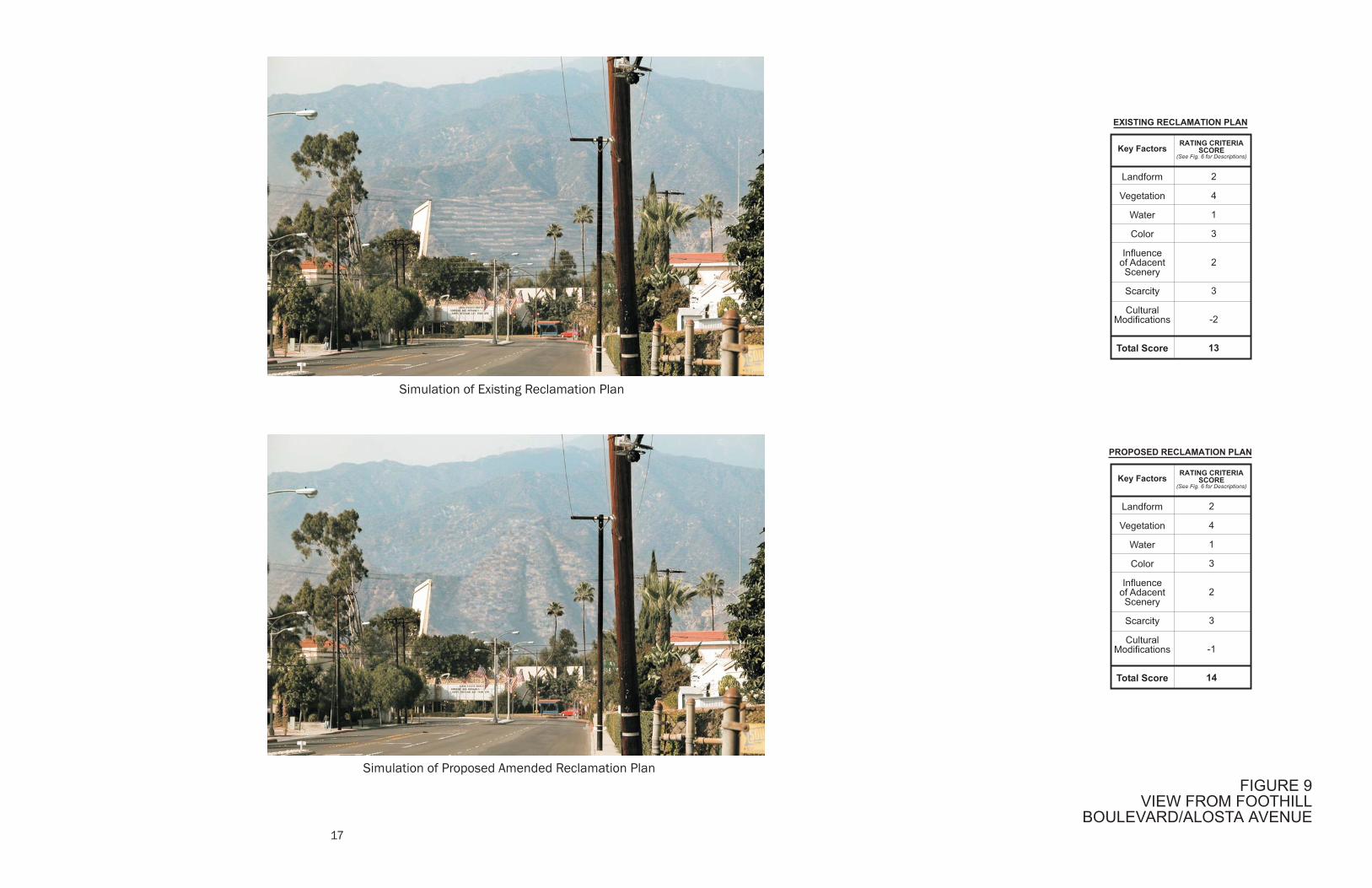
The view in the existing condition simulation has been rated at 12 points. It shows the stark, linear benches that are presently permitted for the site. Two points have been deducted under the “cultural modification” score to account for the visual interruption caused by the benches. The view shown in the proposed condition simulation has been rated at 13 points. It shows the more naturalized slopes and drainage paths typical of the micro-benching technique, and the increased vegetation that will occur under this condition. The form, line, color, and texture of the slopes are much more natural in this condition. However, one point has been deducted under the cultural modification score to account for potential viewer sensitivity to the micro-bench appearance. Nonetheless, potential views of the site from Highway 39 will be improved by 1 point as a result of the proposed project amendment. This impact is therefore considered less than significant. Viewpoint B Impacts – Foothill Boulevard/Alosta Avenue: Figure 9 includes computer simulated views of the baseline (existing plan) and project (proposed plan) conditions of the site, as seen from Alosta Avenue, at the time of reclamation. The visual quality for each of these conditions is also rated in a table alongside the views. As shown in Figure 9, foreground views include the commercial buildings and various tall trees along Alosta Avenue. Background views include the foothills of the San Gabriel Mountains. The only visual difference between the existing future and proposed future conditions is the portion of the project site shown in the center of the photos. The view in the existing condition simulation has been rated at 13 points. It shows the stark, linear benches that are presently permitted for the site. Two points have been deducted under the “cultural modification” score to account for the visual interruption caused by the benches. The view shown in the proposed condition simulation has been rated at 14 points. It shows the more naturalized slopes and drainage paths typical of the micro-benching technique, and the increased vegetation that will occur under this condition. Again, the form, line, color and texture of the slopes are much more natural in this condition. However, one point has been deducted under the cultural modification score to account for potential viewer sensitivity to the micro-bench appearance. Nonetheless, potential views of the site from Foothill Boulevard/Alosta Avenue will be improved by 1 point as a result of the proposed project amendment. This impact is therefore considered less than significant.
��������������� ���������
���������������������
����������� ��������������������
��
��������������������������������������
���������
�������
��� � ���
�� ��
�����
������������������ �������
������ �
��� ������������ ����
�������
�� ������� ���������
������������ ����� ��������
���� ����������� ��������
���������
�������
��� � ���
�� ��
�����
������������������ �������
������ �
��� ������������ ����
�������
�� ������� ���������
������������ ����� ��������
���������������� ��������
�
�
�
�
�
�
��
��
�
�
�
�
�
�
��
�
18
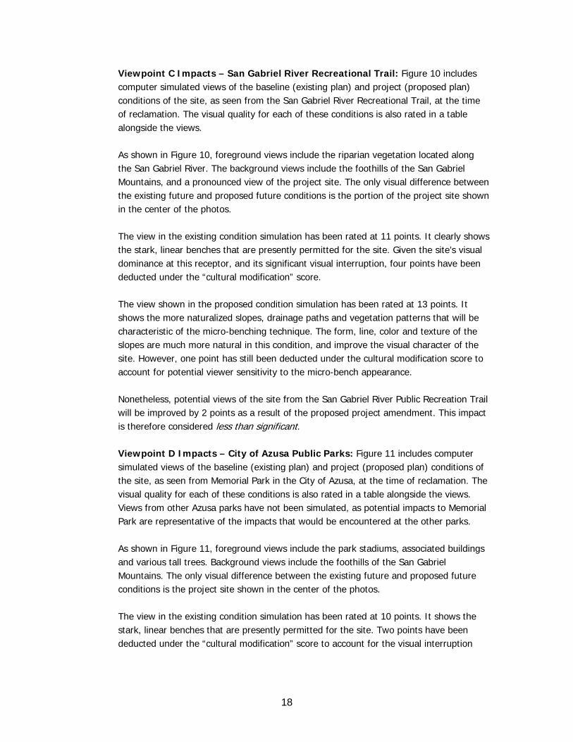
Viewpoint C Impacts – San Gabriel River Recreational Trail: Figure 10 includes computer simulated views of the baseline (existing plan) and project (proposed plan) conditions of the site, as seen from the San Gabriel River Recreational Trail, at the time of reclamation. The visual quality for each of these conditions is also rated in a table alongside the views. As shown in Figure 10, foreground views include the riparian vegetation located along the San Gabriel River. The background views include the foothills of the San Gabriel Mountains, and a pronounced view of the project site. The only visual difference between the existing future and proposed future conditions is the portion of the project site shown in the center of the photos. The view in the existing condition simulation has been rated at 11 points. It clearly shows the stark, linear benches that are presently permitted for the site. Given the site’s visual dominance at this receptor, and its significant visual interruption, four points have been deducted under the “cultural modification” score. The view shown in the proposed condition simulation has been rated at 13 points. It shows the more naturalized slopes, drainage paths and vegetation patterns that will be characteristic of the micro-benching technique. The form, line, color and texture of the slopes are much more natural in this condition, and improve the visual character of the site. However, one point has still been deducted under the cultural modification score to account for potential viewer sensitivity to the micro-bench appearance. Nonetheless, potential views of the site from the San Gabriel River Public Recreation Trail will be improved by 2 points as a result of the proposed project amendment. This impact is therefore considered less than significant. Viewpoint D Impacts – City of Azusa Public Parks: Figure 11 includes computer simulated views of the baseline (existing plan) and project (proposed plan) conditions of the site, as seen from Memorial Park in the City of Azusa, at the time of reclamation. The visual quality for each of these conditions is also rated in a table alongside the views. Views from other Azusa parks have not been simulated, as potential impacts to Memorial Park are representative of the impacts that would be encountered at the other parks. As shown in Figure 11, foreground views include the park stadiums, associated buildings and various tall trees. Background views include the foothills of the San Gabriel Mountains. The only visual difference between the existing future and proposed future conditions is the project site shown in the center of the photos. The view in the existing condition simulation has been rated at 10 points. It shows the stark, linear benches that are presently permitted for the site. Two points have been deducted under the “cultural modification” score to account for the visual interruption
����������������
���������������������������������������
��
����������� ��������������������
��������������������������������������
���������
�������
��� � ���
�� ��
�����
������������������ �������
������ �
��� ������������ ����
�������
�� ������� ���������
������������ ����� ��������
���� ����������� ��������
���������
�������
��� � ���
�� ��
�����
������������������ �������
������ �
��� ������������ ����
�������
�� ������� ���������
������������ ����� ��������
���������������� ��������
�
�
�
�
�
�
��
��
�
�
�
�
�
�
��
��

���������������� � � �����
�����������
����������� ��������������������
��������������������������������������
��
���������
�������
��� � ���
�� ��
�����
������������������ �������
������ �
��� ������������ ����
�������
�� ������� ���������
������������ ����� ��������
���� ����������� ��������
���������
�������
��� � ���
�� ��
�����
������������������ �������
������ �
��� ������������ ����
�������
�� ������� ���������
������������ ����� ��������
���������������� ��������
�
�
�
�
�
�
��
�!
�
�
�
�
�
�
��
��

21
caused by the benches and the noticeable changes they cause in the slope’s visual form, line, color and texture. The view shown in the proposed condition simulation has been rated at 11 points. It shows the more naturalized slopes and drainage paths typical of the micro-benching technique, and the increased vegetation that will occur under this condition. The form, line, color and texture of the slopes are much more natural in this condition. However, one point has still been deducted under the cultural modification score to account for potential viewer sensitivity to the micro-bench appearance. Nonetheless, potential views of the site from Memorial Park will be improved by 1 point through the proposed project amendment. This impact is therefore considered less than significant. Viewpoint E Impacts – City of Duarte’s Encanto Park: Figure 12 includes computer simulated views of the baseline (existing plan) and project (proposed plan) conditions of the site, as seen from Encanto Park in the City of Duarte, at the time of reclamation. The visual quality for each of these conditions is also rated in a table alongside the views. As shown in Figure 12, foreground views include the grassy fields and tall trees surrounding the park. The background views include the foothills of the San Gabriel Mountains, and a clear view of the project site’s eastern slope face. The only visual difference between the existing future and proposed future conditions is the portion of the project site shown in the center of the photos. The view in the existing condition simulation has been rated at 11 points. It shows the stark, linear benches that are presently permitted for the site. Two points have been deducted under the “cultural modification” score to account for the visibility of the benched slopes. The view shown in the proposed condition simulation has been rated at 12 points. It shows the more naturalized slopes, drainage paths and vegetation patterns that will be characteristic of the micro-benching technique. The visual character of the slopes are much more natural in this condition, and improve the appearance of the site. However, one point has still been deducted under the cultural modification score to account for potential viewer sensitivity to the micro-bench appearance. Consequently, potential views of the site from Encanto Park will be improved by 2 points as a result of the proposed project amendment. This impact is therefore considered less than significant.

���������������� ��������
�����������
����������� ��������������������
��������������������������������������
��
���������
�������
��� � ���
�� ��
�����
������������������ �������
������ �
��� ������������ ����
�������
�� ������� ���������
������������ ����� ��������
���� ����������� ��������
���������
�������
��� � ���
�� ��
�����
������������������ �������
������ �
��� ������������ ����
�������
�� ������� ���������
������������ ����� ��������
���������������� ��������
�
�
�
�
�
�
��
��
�
�
�
�
�
�
��
��
23
Viewpoint E Impacts – Azusa Residences: Figures 13 and 14 includes computer simulated views of the baseline (existing plan) and project (proposed plan) conditions of the site, as seen from various Azusa residences, at the time of reclamation. Figure 13 is representative of views from homes located to the south-southeast of the site, and Figure 14 is representative of views of the site specifically from the Mountain Cove community. The visual quality for each of these conditions is also rated in a table alongside the views. As shown in Figure 13, foreground views include homes and various tall trees. The background views include the foothills of the San Gabriel Mountains, and views of the project site’s western slope face. The only visual difference between the existing future and proposed future conditions is the portion of the project site shown in the center of the photos. The view in the existing condition simulation has been rated at 11 points. It shows the stark, linear benches that are presently permitted for the site. Two points have been deducted under the “cultural modification” score to account for the visibility of the benched slopes. The view shown in the proposed condition simulation has been rated at 12 points. It shows the more naturalized slopes, drainage paths and vegetation patterns that will be characteristic of the micro-benching technique. The visual character of the slopes are much more natural in this condition, and improve the appearance of the site. However, one point has still been deducted under the cultural modification score to account for potential viewer sensitivity to the micro-bench appearance. As shown in Figure 14, Mountain Cove foreground views include homes and native/ornamental vegetation. However, the background views include the steep slopes of the canyon, as well as the foothills of the San Gabriel Mountains. The western project slopes are visible. The only visual difference between the existing future and proposed future conditions is the portion of the project site shown in the left one-third portion of the photos. The view in the existing condition simulation has been rated at 13 points. It shows the stark, linear benches that are presently permitted for the site. Given the significant contrast of the slopes in this view, three points have been deducted under the “cultural modification” score. The view shown in the proposed condition simulation has been rated at 15 points. It shows improvements in the naturalization of slopes, drainage paths and vegetation patterns resulting from the micro-benching technique. However, one point has still been deducted under the cultural modification score to account for potential viewer sensitivity to the micro-bench appearance.

���������������� �� ���
����������
����������� ��������������������
��������������������������������������
��
���������
�������
��� � ���
�� ��
�����
������������������ �������
������ �
��� ������������ ����
�������
�� ������� ���������
������������ ����� ��������
���� ����������� ��������
���������
�������
��� � ���
�� ��
�����
������������������ �������
������ �
��� ������������ ����
�������
�� ������� ���������
������������ ����� ��������
���������������� ��������
�
�
�
�
�
�
��
��
�
�
�
�
�
�
��
��

��������!������� � �����������
����������
����������� ��������������������
��
��������������������������������������
���������
�������
��� � ���
�� ��
�����
������������������ �������
������ �
��� ������������ ����
�������
�� ������� ���������
������������ ����� ��������
���� ����������� ��������
���������
�������
��� � ���
�� ��
�����
������������������ �������
������ �
��� ������������ ����
�������
�� ������� ���������
������������ ����� ��������
���������������� ��������
�
�
�
�
�
�
��
��
�
�
�
�
�
�
��
�"

26
Consequently, potential views of the site from Azusa residences will be improved by 1 to 2 points as a result of the proposed project amendment. This impact is therefore considered less than significant. Viewpoint G Impacts – Duarte Residences: Figure 15 includes computer simulated views of the baseline (existing plan) and project (proposed plan) conditions of the site, as seem from residences located in the City of Duarte at the time of reclamation. The visual quality for each of these conditions is also rated in a table alongside the views. As shown in Figure 15, foreground views include homes and various residential landscaping. The background views include the foothills of the San Gabriel Mountains, and a view of the project site’s western 80 acres (the intervening ridgelines preclude views of the rest of the site). The only visual difference between the existing future and proposed future conditions is the portion of the project site shown in the center of the photos. The view in the existing condition simulation has been rated at 15 points. There are no views of the existing project. Therefore, no points have been deducted under the “cultural modification” score to account for the visibility of the benched slopes. The view shown in the proposed condition simulation has also been rated at 15 points. It shows that a portion of the proposed westerly slopes would be visible and the contour of the ridgeline would be altered. Overall, the visual character of the micro-benching mimics the natural form, line, color and texture of the surrounding native terrain, but one point has been deducted from the cultural modification score to account for potential viewer sensitivities to the appearance of the micro-benches. However, this decrease in scenic quality rating is offset by a one point increase in the “influence of adjacent scenery” score that results from the project’s improvements to other areas of the project site that are outside of this single view, but nonetheless influence the rating of local scenery. Therefore, the total score for both the existing and proposed plans remain identical. Consequently, project impacts to potential views of the site from Duarte residences are considered less than significant. Potential Impacts from Light & Glare: The issue of light and glare is typically associated with excessively bright nighttime lighting that crosses over property lines and illuminates off-site yards or bedroom windows. It is also associated with the condition that occurs when excessive nighttime lighting creates a “skyglow” effect. Specifications of any nighttime lighting have not been provided in the plan. Therefore, in the event that nighttime lighting could potentially create an issue with light and/or glare, a mitigation measure has been included to ensure that any potential for significant

��������"������� �������
����������
����������� ��������������������
��
��������������������������������������
���������
�������
��� � ���
�� ��
�����
������������������ �������
������ �
��� ������������ ����
�������
�� ������� ���������
������������ ����� ��������
���� ����������� ��������
���������
�������
��� � ���
�� ��
�����
������������������ �������
������ �
��� ������������ ����
�������
�� ������� ���������
������������ ����� ��������
���������������� ��������
�
�
�
�
�
�
�"
�
�
�
�
�
�
��
�"

28
impacts is avoided. This potential impact is therefore considered less than significant with mitigation incorporated.
5. Mitigation Measures:
The operator shall use high-pressure sodium and/or cut-off fixtures instead of mercury-vapor fixtures for any required nighttime lighting of the operations. The lighting shall also be designed to confine illumination to the project site, and/or to areas that do not include light-sensitive uses.
6. Conclusion:
Potential long-term visual impacts of the existing (permitted) and proposed (amended) conditions of the Azusa Rock Quarry have been compared and analyzed. Seven different categories of potentially sensitive visual receptors have been identified. The project has been found to increase visual rating scores for all receptors, except for Duarte residential views where a small decrease in visual score for the localized view is offset by an increase in the regional visual score. Therefore, no significant visual impacts will result from the proposed project. Given a lack of specificity in the proposed project’s nighttime lighting specifications, it could not be determined if the project could potentially contribute nighttime light and/or glare impacts. Therefore, mitigation has been included in this report that reduces this potential impact to less than significant levels.
7. References:
Caltrans California Scenic Highway Program Website City of Azusa General Plan, April 2004 United States Department of Transportation, Federal Highway Administration,
Office of Environmental Policy, “Visual Impact Assessment for Highway Projects,” Publication No. FHWA-HI-88-054 (1983)
United States Department of the Interior, Bureau of Land Management, “Visual Resource Management Manual,” Section 8400 (1980)
Vulcan Materials Company, “Azusa Rock, Inc. Revised Conditional Use Permit & Reclamation Plan Project Description,” July 2008