Appendices - sk.birdatlas.ca · Appendices Partner Organizations Atlas Sponsors Saskatchewan...
25
Appendices Partner Organizations Atlas Sponsors Saskatchewan Breeding Bird Atlas 115 Perimeter Road Saskatoon, Saskatchewan S7N 0X4 Tel: 306-249-2894 or 1-844-369-2894 [email protected] sk.birdatlas.ca October 2017
Transcript of Appendices - sk.birdatlas.ca · Appendices Partner Organizations Atlas Sponsors Saskatchewan...
Appendices
Partner Organizations
Atlas Sponsors
Saskatchewan Breeding Bird Atlas
115 Perimeter Road
Saskatoon, Saskatchewan S7N 0X4
Tel: 306-249-2894 or 1-844-369-2894
sk.birdatlas.ca
October 2017
Contents
Appendix A: Safety and Injury Liability .......................................................................................................... 3
Safety ......................................................................................................................................................... 3
Injury and Other Liability ............................................................................................................................ 3
Appendix B: Surveying Private Property and Public Areas .......................................................................... 4
Appendix C: Regional Information and Priority Squares .............................................................................. 5
Appendix D: Breeding Evidence Codes ........................................................................................................ 8
Cautions ................................................................................................................................................. 8
Questionable Codes .............................................................................................................................. 9
Strengthening the Evidence for Breeding .............................................................................................. 9
Appendix E: Data Forms and Online Data Submission .............................................................................. 11
Atlas Checklists ....................................................................................................................................... 11
Filling out the form ............................................................................................................................... 12
Rare/Colonial Species Form.................................................................................................................... 12
Filling out the form ............................................................................................................................... 13
Point Count Form .................................................................................................................................... 13
Filling out the form ............................................................................................................................... 13
Online Data Entry .................................................................................................................................... 18
Atlas Checklist data ............................................................................................................................. 18
Rare / colonial species data ................................................................................................................. 18
Point count data ................................................................................................................................... 18
Appendix F: Sensitive Species, Birding Code of Ethics .............................................................................. 19
American Birding Association Code of Birding Ethics ............................................................................. 21
Appendix G: Location .................................................................................................................................. 22
Reporting location for an atlassing session ............................................................................................. 22
Reporting location for the Rare-Colonial Species Form .......................................................................... 22
Recording UTM coordinates .................................................................................................................... 22
Using a Square Map to determine UTM coordinates .......................................................................... 22
Using a GPS to determine UTM .......................................................................................................... 24
Using a GPS to determine what square you are in ............................................................................. 24
Atlassing at the edge of a square ........................................................................................................ 24
Appendix H: Data Permissions and Privacy Policy ..................................................................................... 25
Data permissions ..................................................................................................................................... 25
Privacy policy ........................................................................................................................................... 25

3
Appendix A: Safety and Injury Liability
Safety
It is important that atlassing be enjoyable, but safety comes first. Be sure to inform people of where you
will be atlassing each day. If you plan to be away from the roadside, inform a friend or family member of
the area you plan to work in, the time you expect to return, and how to contact you (a cell phone is a good
idea in serviced areas).
Don’t go alone if you will be working in remote areas, or expect to be off-road for much of the time.
Taking along a less experienced birder can be a valuable learning experience for them and a safety
precaution for both.
It is important to know how to navigate with your map and compass (and GPS if you have one) prior to
going off-road. Courses are available on orienteering and wilderness safety - check your local community
college or outdoor clubs.
Black bears can be encountered in many places, for tips on bear safety please consult the Bear Fact
Sheet from the Government of Saskatchewan website before you go in the field
(http://publications.gov.sk.ca/documents/66/89520-English.pdf).
Always carry a small safety kit in your backpack, with items such as:
• compass and topographic map of your square
• first aid kit
• bear spray
• waterproof lighter or waterproof matches
• pocket knife
• small flashlight with batteries
• pencil and paper
• signaling device (whistle or mirror)
• extra high energy snacks (e.g. granola bars,
dried fruit, or chocolate)
• extra fresh water
• emergency “space blanket”
• mosquito repellent or head net
• sun protection (sunscreen, sunglasses, hat)
• GPS unit and cell phone, if you have them
• spare batteries for electronic devices
Injury and Other Liability
As a volunteer participant in the Saskatchewan Breeding Bird Atlas you are fully responsible for your own
safety, and for your own personal insurance in case of injury. You are not considered an employee of the
Saskatchewan Breeding Bird Atlas, Bird Studies Canada, Environment and Climate Change Canada,
Saskatchewan Ministry of Environment or any of Atlas partners or sponsors. Please exercise great
caution and care in the field when collecting data. We are not responsible for damage incurred to vehicles
while atlassing. Atlassers may be responsible for damage to landowners' property, so please always ask
permission, be respectful, and exercise caution when treading on private land. Be friendly and polite with
landowners and remember that their permission is voluntary and that they are helping the Atlas team to
achieve our coverage goals.

4
Appendix B: Surveying Private Property and Public Areas
Always get permission from the landowner to enter private property. Some of the best times to survey
for birds occur during the first couple of hours of daylight, so access should be arranged before the
day(s) you visit. Take the time to explain what the project is about, what you plan to do, and when you
plan to do it. In most cases, permission to enter onto the property will be granted. Encourage landowners
to call the Regional Coordinator or the Atlas Office if they would like further information. Landownership
information can be obtained by reviewing Rural Municipality maps, available at local Rural Municipality
offices for a small fee or in some cases on their websites.
Your Atlasser Kit contains a sign to put on the dash of your car. It states that you are collecting data for
the Atlas and gives contact information for the Atlas Office, in case people have further questions. Please
remember to use the dashboard sign; some rural roads are typically only used by locals and unfamiliar
vehicles can rouse suspicion.
Some good information about obtaining permission to access Federal and Provincial Community
Pastures, Provincial Crown Land, First Nations Land, active oil/gas fields, Cultural Heritage Sites, and
private land can be found in the “South of the Divide: Access Authorization and Field Work Protocols” on
pages 6-7 (http://www.pcap-sk.org/rsu_docs/documents/South-of-the-Divide-Researcher-
Protocol_FINAL_2014May8.pdf).
Some key points to remember:
Always get permission to access private property
Arrange access ahead of time
Be courteous in your interactions
Follow all instructions
Offer to share your findings
Only park and pull over at safe locations
Never block access to roads, trails, pastures, fields, equipment, etc.
Use the dashboard sign available on the website
Respect crops and livestock
Leave all gates as found
Leave no trace and pick up trash
5
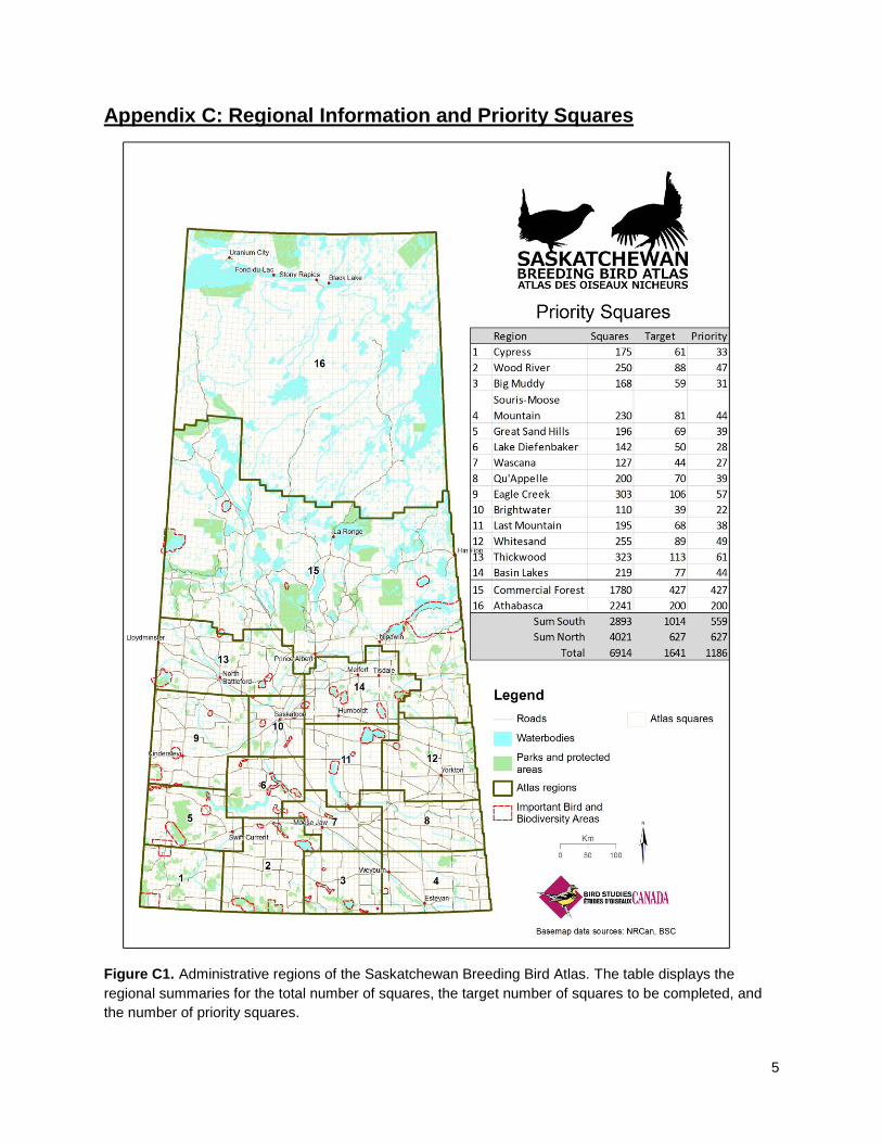
Appendix C: Regional Information and Priority Squares
Figure C1. Administrative regions of the Saskatchewan Breeding Bird Atlas. The table displays the
regional summaries for the total number of squares, the target number of squares to be completed, and
the number of priority squares.

6
Table C1. Contact information for Regional Coordinators. This list may change over the course of the
Atlas, please check the website or contact the Atlas Office for updates. * Texting preferred.
Region Name Email Regional Coordinator Telephone number
1. Cypress [email protected] Barry Robinson 780-217-7650 2. Wood River [email protected] Ryan Dudragne 306-520-4824 3. Big Muddy [email protected] Alan Smith 306-230-3335
4. Souris-Moose Mountain [email protected] Brett Quiring 306-551-8729 5. Great Sand Hills [email protected] Rob Wapple 306-227-7924 6. Lake Diefenbaker [email protected] Krista Ellingson 306-378-7153 7. Wascana [email protected] Chris Harris 306-569-5300 8. Qu'Appelle [email protected] Jared Clarke
Kristen Martin 306-581-6819 9. Eagle Creek [email protected] Guy Wapple 306-249-3280 306-227-9548
10. Brightwater [email protected] John Patterson 306-249-0468 Stan Shadick 306-652-5975 Nick Saunders 306-291-5402
11. Last Mountain [email protected] Dan Sawatzky 306-586-1738 12. Whitesand [email protected] Allison Henderson 306-786-1425 Sarah Ludlow 306-347-0447 ext. 231
13. Thickwood [email protected] Kyron Giroux 306-281-6996*
14. Basin Lakes [email protected] Bert Dalziel 306-276-2594 Harold Fisher 306-922-1363 306-960-5927
Shelly Fisher 306-716-8007
15. Commercial Forest [email protected] Atlas Office 306-249-2894
LeeAnn Latremouille 306-880-9027
Kiel Drake 306-380-9057
16. Athabasca [email protected] Atlas Office 306-249-2894
LeeAnn Latremouille 306-880-9027
Kiel Drake 306-380-9057
7
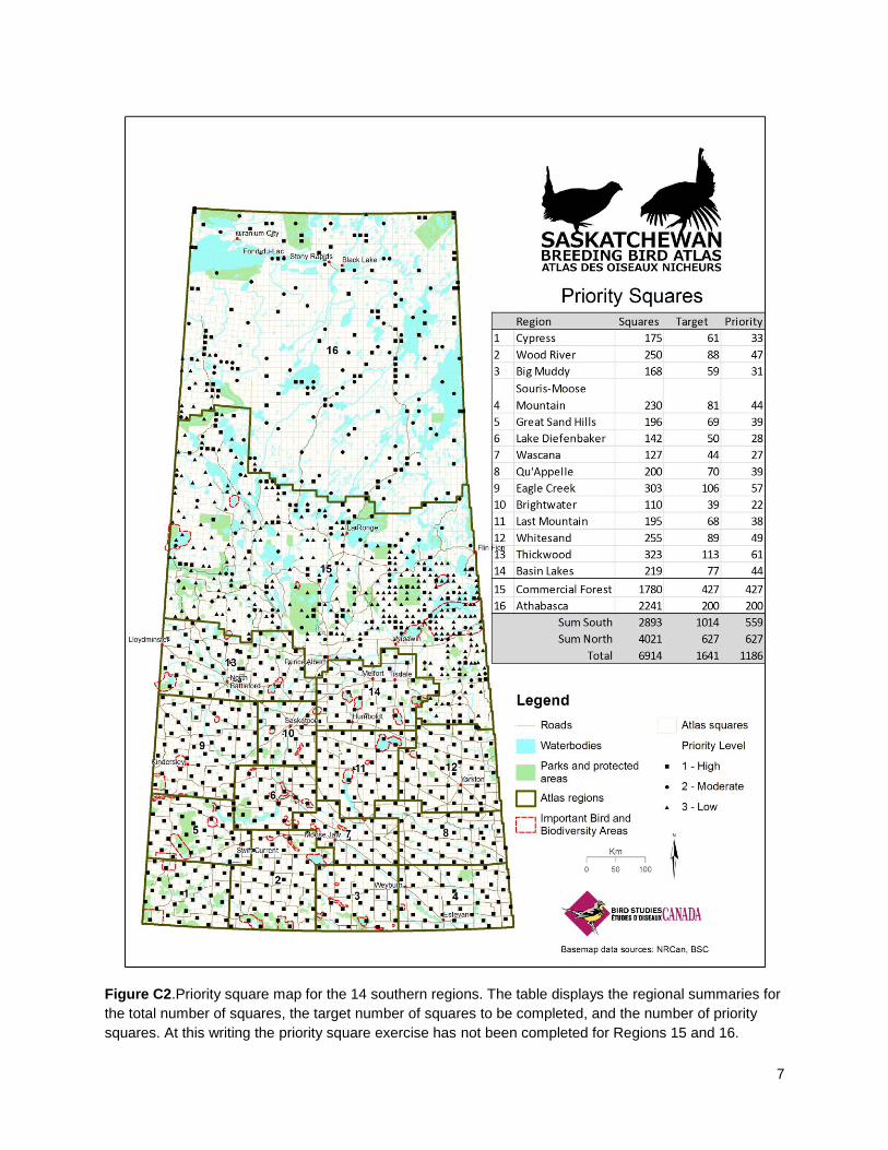
Figure C2.Priority square map for the 14 southern regions. The table displays the regional summaries for
the total number of squares, the target number of squares to be completed, and the number of priority
squares. At this writing the priority square exercise has not been completed for Regions 15 and 16.
8
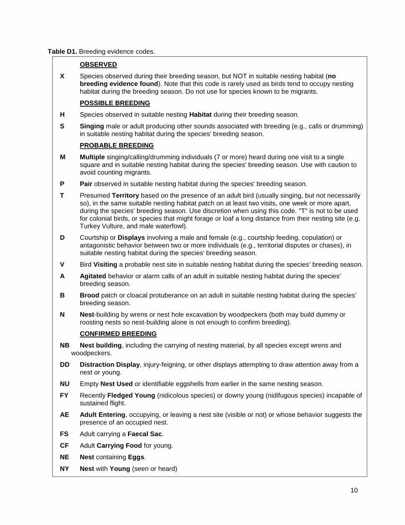
Appendix D: Breeding Evidence Codes
There are several categories of breeding evidence within each breeding level (Table 1). Familiarize
yourself with the codes and categories because they will be regularly used in the field; most atlassers find
it handy to have a copy of the codes with them for reference and even experienced atlassers do so. The
codes and categories are listed in order of breeding evidence, from lowest to highest.
When recording breeding evidence codes on the Atlas Checklist, record the highest level observed for
that time period. For example, if you hear the song of an Eastern Kingbird, then later during your walk
witness one carrying food, change the earlier recorded “S” to “CF” in the breeding evidence column and
add the individual(s) to the count column.
Be sure to only record breeding evidence codes for breeding birds; do not use X for migrants. For
species that are clearly migrants, leave the breeding evidence code blank! If you are unsure as to
whether a bird is a migrant, please refer to the Breeding Dates available on the atlas website. You may
use the X code for a bird that could be a migrant or a local breeder, i.e. in the shoulder season between
early breeding and last migration. If you have doubts about the appropriate category for a particular
observation, ask your RC or contact the Atlas Office.
Below are some examples to serve as guidelines for using breeding evidence codes.
1. Common Loon in basic (winter/subadult) plumage spending the whole summer on a lake:
Observed-X.
2. Common Loon or ducks in alternate (breeding/adult) plumage spending the whole summer on a
lake or other waters, but no song, display or broods: Possible-H.
3. Grouse heard drumming: Possible-S. (Probable-T if heard on more than one date in the same
place. Probable-D only if actual courtship and display are seen).
4. Rails heard in a marsh on a visit in early breeding season, but not on subsequent visits: Possible-S.
5. Wilson’s Snipe “winnowing” flights, for three weeks, but then no further signs: Probable-T.
(Possible-S if seen or heard only once; Probable-D if actual courtship and display to females seen).
6. Gulls frequenting dumps, ploughed fields, drive-ins, park lakes etc. throughout summer in
unsuitable breeding habitat: Observed-X.
7. Woodpeckers drumming: Possible-S if heard in breeding season; Probable-T if heard a week or
more apart in same place.
8. White-throated Sparrow building a nest: Confirmed-NB.
Cautions
Breeding evidence for some groups may be complicated by certain behaviors. Examples where caution
is required include waterfowl undergoing molt migration in the summer; some shorebirds, gulls, and
eagles “over-summering” without breeding; birds singing at stop-over sites on migration (warblers
and sparrows); and courtship behavior during migration (gulls and waterfowl). Consult the “breeding
dates” table on the web site to learn about the usual periods of migration and breeding in Saskatchewan.
9
Questionable Codes
Some species-code combinations will not be accepted by the computer system. Such combinations are
largely common sense such as: NB (nest building) for a species that does not build a nest; CF (carrying
food for young) for most precocial species; using N (Nest-building by wrens or nest hole excavation by
woodpeckers) for anything other than wrens or woodpeckers; and FS (adult carrying a faecal sac) for
non-passerines.
Other species-code combinations require caution and may be flagged by the computer system. For
example: NU (nest used) – most nests and eggshells are not unique or unmistakable; CF (adult carrying
Food for young) for species that either carry food for themselves (raptors and corvids), typically
regurgitate food (Northern Flickers), or perform courtship feeding rituals (terns); and P (pair observed in
suitable nesting habitat during the species' breeding season) for species where males and females look
alike.
Strengthening the Evidence for Breeding
During the course of the 5-year survey, while looking for previously unrecorded species, you should also
look for stronger evidence of breeding for previously recorded species. Information about the highest
breeding evidence codes obtained for each species in a square can be found on the Square Summary
sheets on the website; however data does not appear on these forms instantaneously (and only do if data
is submitted regularly) so it’s a good idea to maintain a master copy for yourself using an Atlas Checklist.
For example, on your first visit to a square, you may observe a singing Song Sparrow in suitable habitat,
which you record as “S”. If you observe this bird singing in the same location on subsequent occasions
during the breeding season at least a week apart, you would now be able to update this to “presumed
territory” and you could enter “T”. If later you were to find a Song Sparrow nest with eggs in it, you would
fill in “NE”. You would then have upgraded the Song Sparrow from "Possible" to “Probable” to the
“Confirmed” level of breeding evidence.
You should attempt to obtain probable or confirmed breeding evidence for as many species as possible,
especially those that are unusual in your region. A species needs to be confirmed as breeding only once
in the five years of the Atlas for any 10-km square.
Many observers from other atlases found that it was easier to obtain confirmed breeding records later in
the season by observing adults carrying food or seeing fledged young. However, it is still important to do
most atlassing early in the season, especially in June, because many more species are singing and
easier to find at that time. Remember that some groups are best surveyed earlier or later in the year, for
example owls and grouse are most easily detected from mid-March through April. American Goldfinch
and Cedar Waxwing are examples of species whose nesting may peak in July and continue into August
and even beyond.
10
Table D1. Breeding evidence codes.
OBSERVED
X Species observed during their breeding season, but NOT in suitable nesting habitat (no breeding evidence found). Note that this code is rarely used as birds tend to occupy nesting habitat during the breeding season. Do not use for species known to be migrants.
POSSIBLE BREEDING
H Species observed in suitable nesting Habitat during their breeding season.
S Singing male or adult producing other sounds associated with breeding (e.g., calls or drumming) in suitable nesting habitat during the species' breeding season.
PROBABLE BREEDING
M Multiple singing/calling/drumming individuals (7 or more) heard during one visit to a single square and in suitable nesting habitat during the species' breeding season. Use with caution to avoid counting migrants.
P Pair observed in suitable nesting habitat during the species' breeding season.
T Presumed Territory based on the presence of an adult bird (usually singing, but not necessarily so), in the same suitable nesting habitat patch on at least two visits, one week or more apart, during the species' breeding season. Use discretion when using this code. "T" is not to be used for colonial birds, or species that might forage or loaf a long distance from their nesting site (e.g. Turkey Vulture, and male waterfowl).
D Courtship or Displays involving a male and female (e.g., courtship feeding, copulation) or antagonistic behavior between two or more individuals (e.g., territorial disputes or chases), in suitable nesting habitat during the species' breeding season.
V Bird Visiting a probable nest site in suitable nesting habitat during the species' breeding season.
A Agitated behavior or alarm calls of an adult in suitable nesting habitat during the species' breeding season.
B Brood patch or cloacal protuberance on an adult in suitable nesting habitat during the species' breeding season.
N Nest-building by wrens or nest hole excavation by woodpeckers (both may build dummy or roosting nests so nest-building alone is not enough to confirm breeding).
CONFIRMED BREEDING
NB Nest building, including the carrying of nesting material, by all species except wrens and woodpeckers.
DD Distraction Display, injury-feigning, or other displays attempting to draw attention away from a nest or young.
NU Empty Nest Used or identifiable eggshells from earlier in the same nesting season.
FY Recently Fledged Young (nidicolous species) or downy young (nidifugous species) incapable of sustained flight.
AE Adult Entering, occupying, or leaving a nest site (visible or not) or whose behavior suggests the presence of an occupied nest.
FS Adult carrying a Faecal Sac.
CF Adult Carrying Food for young.
NE Nest containing Eggs.
NY Nest with Young (seen or heard)
11
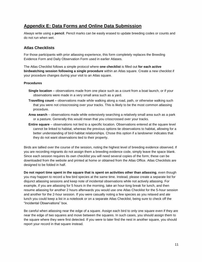
Appendix E: Data Forms and Online Data Submission
Always write using a pencil. Pencil marks can be easily erased to update breeding codes or counts and
do not run when wet.
Atlas Checklists
For those participants with prior atlassing experience, this form completely replaces the Breeding
Evidence Form and Daily Observation Form used in earlier Atlases.
The Atlas Checklist follows a simple protocol where one checklist is filled out for each active
birdwatching session following a single procedure within an Atlas square. Create a new checklist if
your procedure changes during your visit to an Atlas square.
Procedures
Single location – observations made from one place such as a count from a boat launch, or if your
observations were made in a very small area such as a yard.
Travelling count – observations made while walking along a road, path, or otherwise walking such
that you were not crisscrossing over your tracks. This is likely to be the most common atlassing
procedure.
Area search – observations made while extensively searching a relatively small area such as a park
or a pasture. Generally this would mean that you crisscrossed over your tracks.
Entire square – observations not tied to a specific location. Observations entered at the square level
cannot be linked to habitat, whereas the previous options tie observations to habitat, allowing for a
better understanding of bird-habitat relationships. Chose this option if a landowner indicates that
they do not want observations tied to their property.
Birds are tallied over the course of the session, noting the highest level of breeding evidence observed. If
you are recording migrants do not assign them a breeding evidence code, simply leave the space blank.
Since each session requires its own checklist you will need several copies of the form; these can be
downloaded from the website and printed at home or obtained from the Atlas Office. Atlas Checklists are
designed to be folded in half.
Do not report time spent in the square that is spent on activities other than atlassing, even though
you may happen to record a few bird species at the same time. Instead, please create a separate list for
disjunct atlassing sessions and keep note of incidental observations while not actively atlassing. For
example, if you are atlassing for 5 hours in the morning, take an hour-long break for lunch, and then
resume atlassing for another 2 hours afterwards you would use one Atlas Checklist for the 5-hour session
and another for the 2-hour session. If you were casually noting a few species as you relaxed and ate
lunch you could keep a list in a notebook or on a separate Atlas Checklist, being sure to check off the
“Incidental Observations” box.
Be careful when atlassing near the edge of a square. Assign each bird to only one square even if they are
near the edge of two squares and move between the squares. In such cases, you should assign them to
the square where they were first detected. If you were to later find the nest in another square, you should
report your record in that square instead.

12
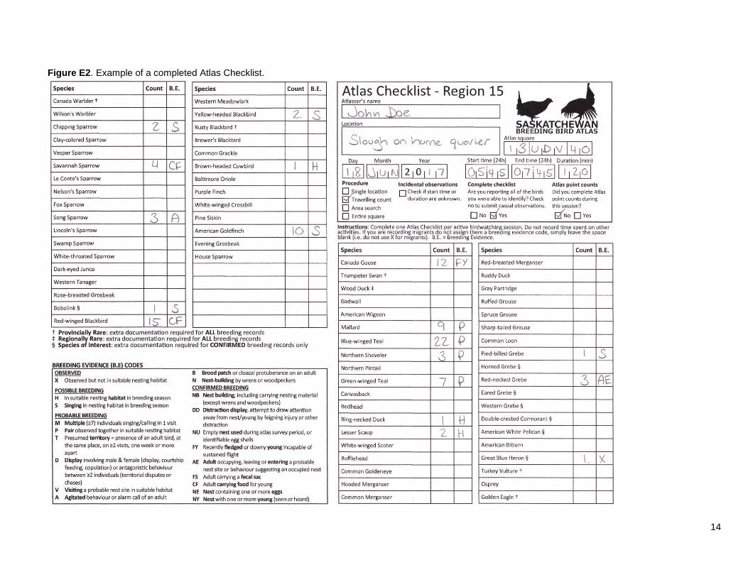
Filling out the form
At the top of each Atlas Checklist, fill out the following fields: atlasser’s name, the location where the
checklist took place (to aid in data entry), Atlas square number (found on the square map), the date
(day, month, and year), the start and end time (24h), and the duration of the session (in minutes).
Indicate which atlassing procedure was used by checking off the appropriate box (single location,
travelling count, area search, or entire square). If by chance the start time or duration is unknown check
off the box for incidental observations. Indicate if you are submitting a complete checklist (i.e. if you
are reporting all the birds you were able to identify); check no to submit casual observations. Indicate if
you completed any Atlas point counts during the session.
In the species tables use the count column to keep track of the number of individuals of all species that
you identify within the square. You may use the blank space in the species column to keep a running
tally; the dot-dash method is particularly useful for keeping track of counting in small spaces (Figure E1).
Use the breeding evidence (B.E.) column to record the highest breeding evidence code observed for
each species during the session.
Figure E1. Illustration of the dot-dash counting method.
If you find any species not listed on the Breeding Evidence form, add them in to the blank spaces in the
species columns. Complete a Rare/Colonial Species Form for each of species which you write in.
See Figure E2 for an example of a completed Atlas Checklist.
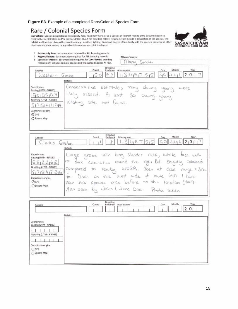
Rare/Colonial Species Form
Species designated as Provincially Rare, Regionally Rare, or as Species of Interest require additional
documentation to confirm the identification and/or provide details about the breeding colony. Such
species are designated by the symbols listed below. In addition, species not included on Regional lists
(Atlas Checklist and Square Summary sheets) require extra documentation if observed. Extra
documentation refers to a written description but can include photos or sound recordings which can be
uploaded through the data entry portal.
† Provincially Rare: documentation required for ALL breeding records.
‡ Regionally Rare: documentation required for ALL breeding records.
§ Species of Interest: documentation required for CONFIRMED breeding
records only, includes colonial species and widespread Species At Risk.
13
Filling out the form
At the top of the form fill out the atlasser’s name. For each rare species or breeding colony you
encounter complete one section on the form. Within each section, record the species name, the number
of individuals encountered (count), the level of breeding evidence, the Atlas square number, the date
(day, month, and year), the coordinates of the observation and their origin, and the details relating to
the observation.
When completing the details portion, include information that will aid the reviewer in confirming the
record or provide details about the breeding colony. Helpful details may include:
a description of the bird seen;
a description of the habitat;
the location of the species/colony;
the observation conditions (e.g. weather, lighting, duration);
your degree of familiarity with the species;
the presence of other observers and their names;
a note of photos or sound recordings taken; and
any other information you think is relevant.
See Figure E3 for an example of a completed Rare/Colonial Species Form.
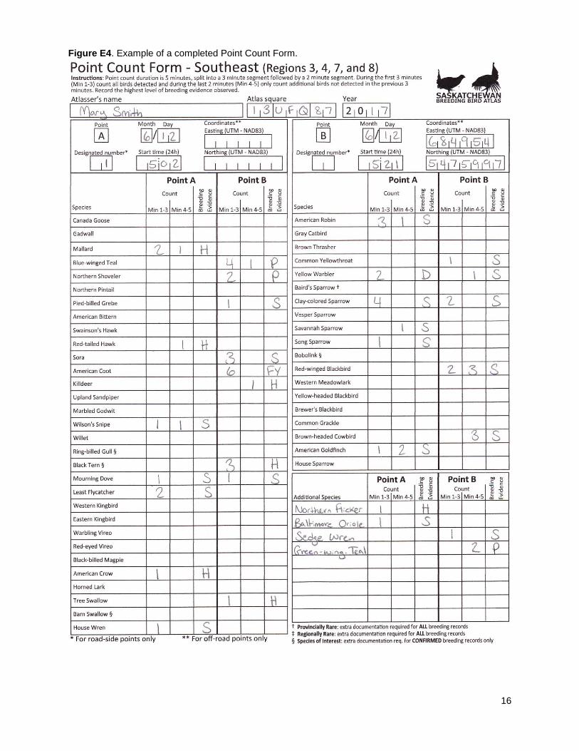
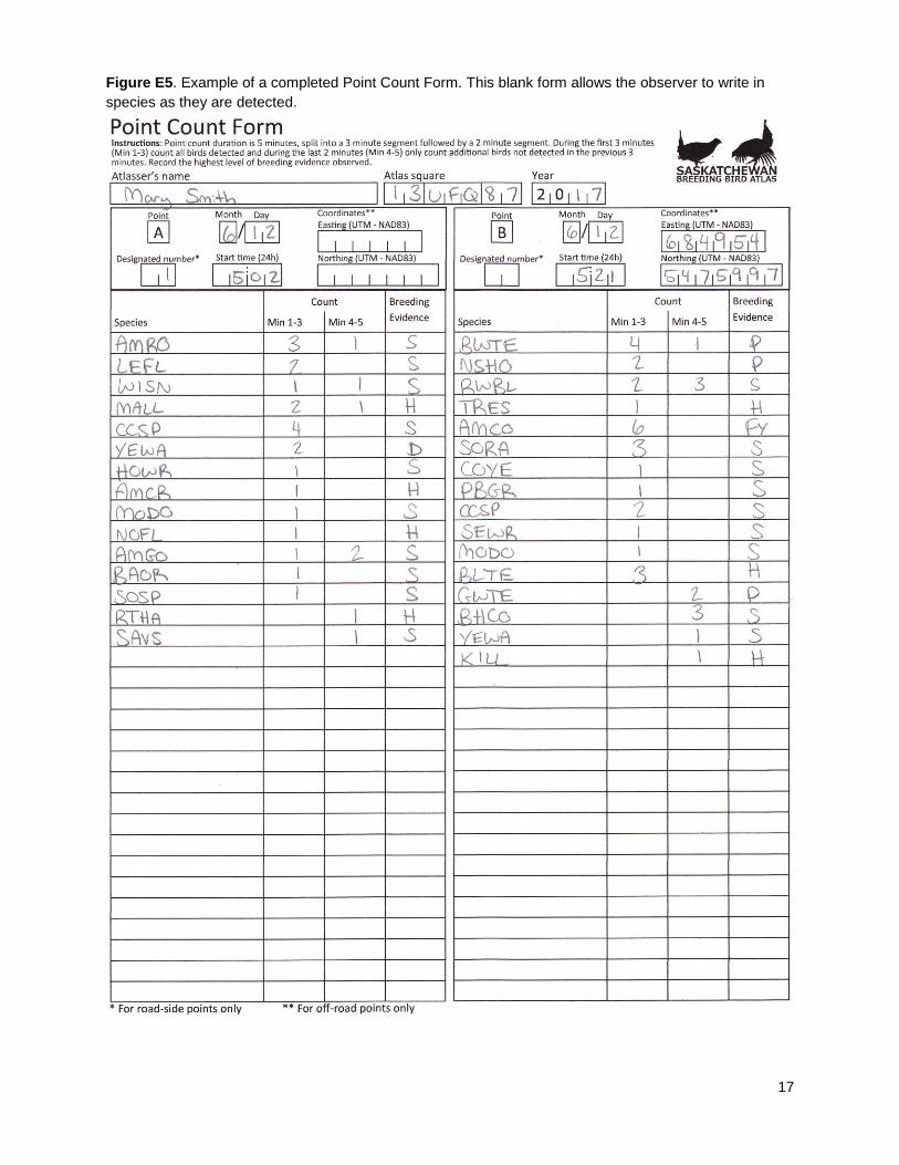
Point Count Form
Please see the document entitled “Instructions for Point Counts” for detailed information about how to
conduct point count surveys.
Filling out the form
At the top of each Point Count Form, fill out the following fields: atlasser’s name, the Atlas square
number (found on the square map), and the year. Each side of the form has space to record two point
counts. Fill out the month, day, and start time (24h) for each point count. If the point count is a
designated road-side point count (i.e. marked on your square map), enter its designated number. If the
point count is an off-road point count enter the UTM coordinates for that location.
Under the corresponding columns (e.g. Point A) record the count and breeding code information for each
species during the point count. During the first 3 minutes of the point count (column Min 1-3) count all
birds seen or heard. During the last 2 minutes of the point count (column Min 4-5) count any new birds
not detected during the previous 3 minutes. Record the highest level of breeding evidence observed.
Familiarize yourself with the species list ahead of time as it contains the 50 most common species
encountered on Breeding Bird Survey routes in the region. Space is provided to record any species not
present on this list and unlike the Atlas Checklist these additional species do not automatically require the
completion of a Rare/Colonial form unless they are not found on the Atlas Checklist or Square Summary
Sheet. A blank form is also available for those who wish to write in their own species lists.
See Figures E4 and E5 for examples of completed Point Count Forms.
14
Figure E2. Example of a completed Atlas Checklist.
15
Figure E3. Example of a completed Rare/Colonial Species Form.
16
Figure E4. Example of a completed Point Count Form.
17
Figure E5. Example of a completed Point Count Form. This blank form allows the observer to write in
species as they are detected.
18
Online Data Entry
The online data entry portal can be accessed via the website through the “Data Entry” tab on the main
page of the Atlas website.
Atlas Checklist data
To submit an Atlas Checklist, first locate the Atlas square in which the observations were made. This can
be accomplished by zooming-in on the map; by clicking “Find square” and entering the square number or
the geographic coordinates of an observation; or by selecting a saved square from your personal list.
Once you have located the square, indicate on the map where you atlassed by selecting one of the
Procedures (distance and area are calculated automatically). Fill in the remaining fields and check the
appropriate boxes. Select “continue” to proceed to the next page. If you selected yes for “Did you
complete atlas point counts during this survey” you will have the ability to indicate where those point
counts were conducted, either by selecting predefined road-side point counts or creating new off-road
point count locations by clicking on the map or entering the UTM coordinates.
The species page shows a species list where you can enter count and breeding evidence information (for
both Atlas Checklists and Point Count Forms). It also displays an automatic total of the counts (Atlas
Checklist + Point Count Form) and the highest breeding evidence to date for that square. Warnings are
displayed for species-breeding code combinations that are not accepted or require some caution. The
species list can be sorted in a variety of ways, and a custom list can be created by first clicking “Only
show species with data” and then selecting “add species”. Select “Submit” to review and submit the data.
Rare / colonial species data
Extra documentation is submitted using the “Add details” button associated with each species. From
here you can enter a written description, enter specific coordinates, and upload media files (maximum
upload size is 10mb per photo and 20mb per recording).
Point count data
All data submissions are linked to an Atlas Checklist. If you are submitting point count data only, create a
travelling count corresponding to the route you took, noting the start time and duration of the entire
session, regardless of whether or not you made observations between point count locations. If no
observations were made between point counts, check off “no" under complete checklist.
19
Appendix F: Sensitive Species, Birding Code of Ethics
Be careful when atlassing! Treat all birds and their habitat with respect and caution. Stay alert to avoid
trampling nests and be very careful in delicate habitats like sand dunes. Remember that this project is
about gathering data to help bird conservation and we should all act accordingly when surveying.
Excessive disturbance may cause the adults to abandon the nest, especially during incubation. Lingering
around a nest too long or disturbing the area around it may betray it to predators. Playing recordings of
certain species can elicit responses and generate critical information quickly, but use the recordings
judiciously, switching it off as soon as a response gives you the data you need. For further guidance, the
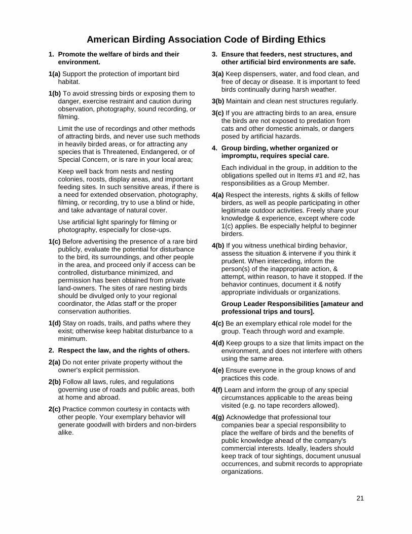
American Birding Association Code of Birding Ethics is provided at the end of this section.
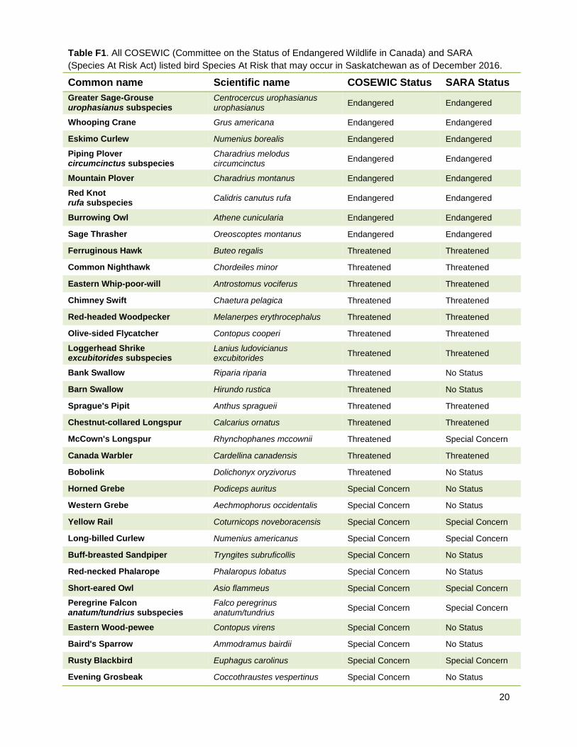
Exercise caution when near Species At Risk. In order to protect Species At Risk (Table F1), any sensitive
information, such as the precise locations of Species At Risk, should be kept strictly confidential by the
atlasser and their RC. Be extremely cautious not to disturb Species At Risk in any way. If the Atlas is to
reach its full potential as a conservation tool, it is extremely important that you report all occurrences of
rare species. If you are particularly concerned about protecting information for a rare or colonial species
you have found, contact the Atlas Coordinator at the Atlas Office, to discuss the situation and determine
how to proceed.
Be especially cautious when near nesting areas for most colonial species as they are very sensitive to
disturbance at the colony. For this reason, it is recommended that you estimate the number of nests and
site details from a distance without getting too close to the colony.
20
Table F1. All COSEWIC (Committee on the Status of Endangered Wildlife in Canada) and SARA
(Species At Risk Act) listed bird Species At Risk that may occur in Saskatchewan as of December 2016.
Common name Scientific name COSEWIC Status SARA Status
Greater Sage-Grouse urophasianus subspecies
Centrocercus urophasianus urophasianus
Endangered Endangered
Whooping Crane Grus americana Endangered Endangered
Eskimo Curlew Numenius borealis Endangered Endangered
Piping Plover circumcinctus subspecies
Charadrius melodus circumcinctus
Endangered Endangered
Mountain Plover Charadrius montanus Endangered Endangered
Red Knot rufa subspecies
Calidris canutus rufa Endangered Endangered
Burrowing Owl Athene cunicularia Endangered Endangered
Sage Thrasher Oreoscoptes montanus Endangered Endangered
Ferruginous Hawk Buteo regalis Threatened Threatened
Common Nighthawk Chordeiles minor Threatened Threatened
Eastern Whip-poor-will Antrostomus vociferus Threatened Threatened
Chimney Swift Chaetura pelagica Threatened Threatened
Red-headed Woodpecker Melanerpes erythrocephalus Threatened Threatened
Olive-sided Flycatcher Contopus cooperi Threatened Threatened
Loggerhead Shrike excubitorides subspecies
Lanius ludovicianus excubitorides
Threatened Threatened
Bank Swallow Riparia riparia Threatened No Status
Barn Swallow Hirundo rustica Threatened No Status
Sprague's Pipit Anthus spragueii Threatened Threatened
Chestnut-collared Longspur Calcarius ornatus Threatened Threatened
McCown's Longspur Rhynchophanes mccownii Threatened Special Concern
Canada Warbler Cardellina canadensis Threatened Threatened
Bobolink Dolichonyx oryzivorus Threatened No Status
Horned Grebe Podiceps auritus Special Concern No Status
Western Grebe Aechmophorus occidentalis Special Concern No Status
Yellow Rail Coturnicops noveboracensis Special Concern Special Concern
Long-billed Curlew Numenius americanus Special Concern Special Concern
Buff-breasted Sandpiper Tryngites subruficollis Special Concern No Status
Red-necked Phalarope Phalaropus lobatus Special Concern No Status
Short-eared Owl Asio flammeus Special Concern Special Concern
Peregrine Falcon anatum/tundrius subspecies
Falco peregrinus anatum/tundrius
Special Concern Special Concern
Eastern Wood-pewee Contopus virens Special Concern No Status
Baird's Sparrow Ammodramus bairdii Special Concern No Status
Rusty Blackbird Euphagus carolinus Special Concern Special Concern
Evening Grosbeak Coccothraustes vespertinus Special Concern No Status
21
American Birding Association Code of Birding Ethics
1. Promote the welfare of birds and their environment.
1(a) Support the protection of important bird habitat.
1(b) To avoid stressing birds or exposing them to danger, exercise restraint and caution during observation, photography, sound recording, or filming.
Limit the use of recordings and other methods of attracting birds, and never use such methods in heavily birded areas, or for attracting any species that is Threatened, Endangered, or of Special Concern, or is rare in your local area;
Keep well back from nests and nesting colonies, roosts, display areas, and important feeding sites. In such sensitive areas, if there is a need for extended observation, photography, filming, or recording, try to use a blind or hide, and take advantage of natural cover.
Use artificial light sparingly for filming or photography, especially for close-ups.
1(c) Before advertising the presence of a rare bird publicly, evaluate the potential for disturbance to the bird, its surroundings, and other people in the area, and proceed only if access can be controlled, disturbance minimized, and permission has been obtained from private land-owners. The sites of rare nesting birds should be divulged only to your regional coordinator, the Atlas staff or the proper conservation authorities.
1(d) Stay on roads, trails, and paths where they exist; otherwise keep habitat disturbance to a minimum.
2. Respect the law, and the rights of others.
2(a) Do not enter private property without the owner's explicit permission.
2(b) Follow all laws, rules, and regulations governing use of roads and public areas, both at home and abroad.
2(c) Practice common courtesy in contacts with other people. Your exemplary behavior will generate goodwill with birders and non-birders alike.
3. Ensure that feeders, nest structures, and other artificial bird environments are safe.
3(a) Keep dispensers, water, and food clean, and free of decay or disease. It is important to feed birds continually during harsh weather.
3(b) Maintain and clean nest structures regularly.
3(c) If you are attracting birds to an area, ensure the birds are not exposed to predation from cats and other domestic animals, or dangers posed by artificial hazards.
4. Group birding, whether organized or impromptu, requires special care.
Each individual in the group, in addition to the obligations spelled out in Items #1 and #2, has responsibilities as a Group Member.
4(a) Respect the interests, rights & skills of fellow birders, as well as people participating in other legitimate outdoor activities. Freely share your knowledge & experience, except where code 1(c) applies. Be especially helpful to beginner birders.
4(b) If you witness unethical birding behavior, assess the situation & intervene if you think it prudent. When interceding, inform the person(s) of the inappropriate action, & attempt, within reason, to have it stopped. If the behavior continues, document it & notify appropriate individuals or organizations.
Group Leader Responsibilities [amateur and professional trips and tours].
4(c) Be an exemplary ethical role model for the group. Teach through word and example.
4(d) Keep groups to a size that limits impact on the environment, and does not interfere with others using the same area.
4(e) Ensure everyone in the group knows of and practices this code.
4(f) Learn and inform the group of any special circumstances applicable to the areas being visited (e.g. no tape recorders allowed).
4(g) Acknowledge that professional tour companies bear a special responsibility to place the welfare of birds and the benefits of public knowledge ahead of the company's commercial interests. Ideally, leaders should keep track of tour sightings, document unusual occurrences, and submit records to appropriate organizations.
22
Appendix G: Location
There are two types of location reporting for the Atlas. The first is reporting the location of your atlassing
session, while the second involves reporting the precise location of rare species and breeding colonies of
colonial species.
Reporting location for an atlassing session
If you are entering your data online (highly encouraged) you will have the ability to indicate where you
atlassed through a Google Maps interface. The interface will allow you to zoom in to an Atlas square and
chose one of four “observation types”: single location, travelling count, area search, or entire square. This
process can be simplified by keeping track of atlassing locations on your square map for later data entry.
Single location: Indicate a single location on the map where the observations were made. Chose this
option if you made a stationary count (such as a 10 minute count of birds from a boat launch), or if your
observations were made in a small area (such as your yard).
Travelling count: Draw lines to indicate the path you took during your atlassing session – distance is
automatically calculated. This is a good option if you made observations while walking along a road or a
path.
Area search: Draw a closed polygon around the area you searched during your atlassing session – area
is automatically calculated. Chose this option if you searched within an area such as a park or a pasture.
Entire square: Select the entire square (not recommended). Observations entered at the square level
cannot be linked to habitat, whereas the previous options tie observations to habitat, allowing for a better
understanding of bird-habitat relationships. Chose this option if a landowner indicates that they do not
want observations tied to their property.
Reporting location for the Rare-Colonial Species Form
Please record the UTM coordinates of rare species or breeding colony locations as precisely as possible
while at the site. While there is an opportunity to mark the location of such species on a Google Map
when entering data online, noting the location at the site will ensure you do not accidentally select the
wrong location should there be a delay between the sighting and data entry.
Recording UTM coordinates
The Atlas sampling framework is based on the Universal Transverse Mercator grid and all spatial
locations are recorded in that coordinate system. UTM coordinates are composed of a zone designation
and two numbers recorded in meters, first is an ‘Easting’ and the second is a ‘Nothing’. An Easting is
always reported before a Northing.
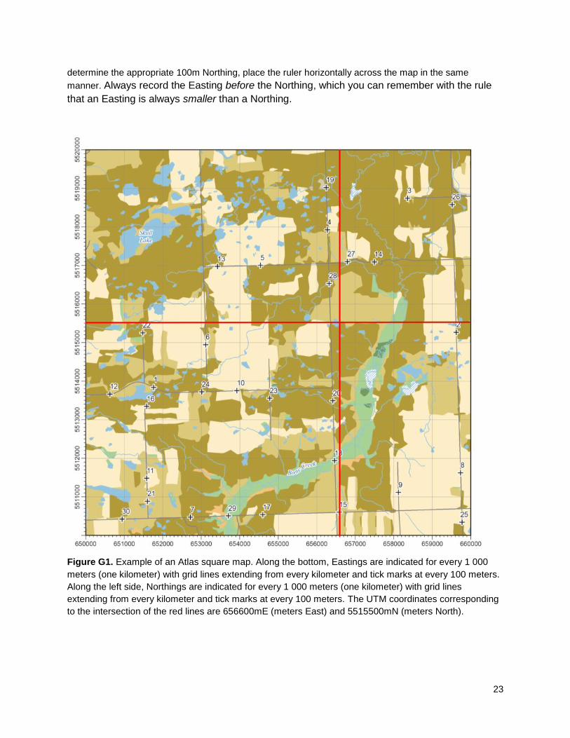
Using a Square Map to determine UTM coordinates
It is possible to determine the UTM coordinates of a location by using Atlas Square Maps as shown in
Figure H1. The Eastings are shown along the bottom of the map and increase from left to right. The 1-km
Northings are shown along the left border of the map and increase towards the top of the map. Since
UTMs are recorded in meters the 1-km designations always end in “000”. These maps also have 100m
“tick” marks between the 1-km grid lines. To determine the appropriate Easting for a location, place a ruler
vertically across the map to determine which mark on the bottom of the map is closest to the location. To
23
determine the appropriate 100m Northing, place the ruler horizontally across the map in the same
manner. Always record the Easting before the Northing, which you can remember with the rule
that an Easting is always smaller than a Northing.
Figure G1. Example of an Atlas square map. Along the bottom, Eastings are indicated for every 1 000
meters (one kilometer) with grid lines extending from every kilometer and tick marks at every 100 meters.
Along the left side, Northings are indicated for every 1 000 meters (one kilometer) with grid lines
extending from every kilometer and tick marks at every 100 meters. The UTM coordinates corresponding
to the intersection of the red lines are 656600mE (meters East) and 5515500mN (meters North).
24
Using a GPS to determine UTM
If you have a GPS unit, record the location while you are on site. Make sure you set the device to the
NAD83 datum (usually under navigation setup or something similar). If the wrong datum is used, the
locations of nests, colonies or point counts can be off by as much as 200 meters! Using any other datum
will most likely provide incorrect (and therefore unusable) coordinates, and this makes future analyses of
bird-habitat relationships very difficult. Please read your GPS owner’s manual for more instruction on how
to set the datum.
When you take a GPS reading, please record the Zone designation (a value between 12 and 14 and U or
V in Saskatchewan), as well as all 6 digits of the Easting and all 7 digits of the Northing. (If your GPS unit
gives you 7 digits for the Easting, do not record the initial “0”.) If you do not have a GPS unit, use your
square map to determine the coordinates of your location as precisely as possible.
Using a GPS to determine what square you are in
If you have a GPS unit, set it to display coordinates in UTM format (NAD83). If you know which 100 km
block (Figure 1, page 6) you are in, you can determine the other digits of the square number by reading
the zone and the 5th
number from the right of the easting and northing. Make sure you read the
Easting before the Northing, which you can remember with the rule that an Easting is always smaller than
a Northing.
Example: You are in Prince Albert National Park, which you know is in block DV, and your GPS reads:
You immediately know you are in square 13UDV24.
Atlassing at the edge of a square
Atlassing very close to the boundary of a square may be challenging. You may find it difficult to know
exactly which square you are in at times. It is worth making note of landmarks that help determine which
square you are in ahead of time, or use your GPS as indicated in the box under “Using a GPS to
determine what square you are in". Using a square map for reference, you can ensure that you are within
the square boundaries by keeping your UTM coordinates within the ranges shown on the map. For the
map shown in Figure G1 this would correspond to Eastings between 650000-660000mE and Northings
between 5510000-5520000mN.
(Zone) (Easting, meters East) 13U 429519 mE 5944078 mN
(Northing, meters North)

25
Appendix H: Data Permissions and Privacy Policy
Data permissions
The Atlas participant hereby grants Bird Studies Canada (hereafter BSC) a royalty-free, perpetual, irrevocable, non-exclusive, transferable, worldwide license to use, reproduce, modify, adapt, publish, translate, create derivative works from, distribute, perform, and display any information provided during the course of their atlas activities and/or to incorporate it in other works in any form, media, software or technology now known or later developed. The Atlas participant shall not be restricted in their ability to use the data they collect as they see fit, for any other purpose. Data submitted to the Saskatchewan Breeding Bird Atlas will be peer-reviewed by ornithological experts. The Saskatchewan Breeding Bird Atlas reserves the right to include or exclude data submitted to the project.
Bird Studies Canada and the atlas partners strongly encourage use of data by third-parties, in particular for research, education and conservation purposes. Access to raw data from NatureCounts is subject to approval by Bird Studies Canada on behalf of its partners. BSC will endeavor to provide access to data at no cost, but may at its discretion request a fee to cover data extraction time for more complex requests. Maps and other results published as part of the Saskatchewan Breeding Bird Atlas are the property of the Saskatchewan Breeding Bird Atlas (and Atlas partners) and may not be reproduced for publication without the consent of the Saskatchewan Breeding Bird Atlas. Participants are however authorized to reproduce them for the purpose of conducting their usual atlas activities. Topographic maps provided for the purpose of collecting Atlas data may not be used for any other purposes or for gathering information on private lands aside from Saskatchewan Breeding Bird Atlas data.
Privacy policy
Personal information of participants (including address, email and phone number) will not be shared with third parties, and will only be available to the atlas partner institutions and their staff, the Atlas Committee members, the Atlas Regional Coordinators (in regions for which you have provided data, or indicated an interest in participating) or other people designated by the Saskatchewan Breeding Bird Atlas for atlas-related communications.
Unless you indicate otherwise to us in writing or through your online profile, you accept that your name may be included in data summaries, reports or any data product derived from the atlas database where appropriate.
Veuillez contacter le Bureau de l'Atlas si vous souhaitez recevoir ce document en français.