Appendices Appendix E Archaeological and Paleontological ...
52
Appendices Spring Trails Draft EIR City of San Bernardino Appendix E Archaeological and Paleontological Resources Assessment
Transcript of Appendices Appendix E Archaeological and Paleontological ...

Appendices
Spring Trails Draft EIR City of San Bernardino
Appendix E Archaeological and Paleontological Resources Assessment

Appendices
The Planning Center July 2011
This page intentionally left blank.

Cogstone Resource Management Inc. Paleontology • Archaeology • History
1801 Parkcourt Pl., B102, Santa Ana, CA 92701 [email protected] www.cogstone.com ph 714-245-0264 fx 714-245-0054 toll free 888-497-0700
ARCHAEOLOGICAL AND PALEONTOLOGICAL
RESOURCES ASSESSMENT REPORT WITH
MITIGATION PLAN FOR THE
SPRING TRAILS PROJECT,
CITY OF SAN BERNARDINO, CALIFORNIA
Prepared for: The Planning Center
1580 Metro Drive Costa Mesa, CA 92626
Authors: Veronica Harper, Sherri Gust and Kim Scott
Principal Investigator: Sherri Gust
Registered Professional Archaeologist and Qualified Principal Paleontologist
March 2009
Project Number: 1708 Type of Study: Archaeological and Paleontological Assessment Sites: P-36-007030, P-36-014462, P-36-014965, P-36-014965, P-36-014966, P-36-014967, P-36-014968 USGS Quadrangle: Devore and San Bernardino North 7.5’ Area: 353 acres Key Words: Alluvial Fans, Devil Canyon Gneiss, Muscupiabe Rancho, Cable Canyon, historic ranching

Spring Trails Cultural
Cogstone
i
TABLE OF CONTENTS EXECUTIVE SUMMARY ...................................................................................................................................... III INTRODUCTION .......................................................................................................................................................1
PURPOSE OF STUDY.....................................................................................................................................................1 PROJECT DESCRIPTION ................................................................................................................................................2 PROJECT PERSONNEL ..................................................................................................................................................4
REGULATORY ENVIRONMENT...........................................................................................................................5 STATE LAWS AND REGULATIONS ...............................................................................................................................5
California Environmental Quality Act of 1970......................................................................................................5 California Register of Historical Resources..........................................................................................................5
PALEONTOLOGICAL SIGNIFICANCE CRITERIA...........................................................................................7 BACKGROUND..........................................................................................................................................................8
REGIONAL SETTING....................................................................................................................................................8 GEOLOGICAL SETTING ...............................................................................................................................................8
Devil Canyon Gneiss (MzPd) ................................................................................................................................8 Alluvial Fans..........................................................................................................................................................8 Very young landslide (Qls) ..................................................................................................................................11 Very young wash deposit (Qw2, Qw1) ..................................................................................................................11
PROJECT AREA HISTORY ..........................................................................................................................................12 PREVIOUS PROJECT RESEARCH......................................................................................................................17
1990 Study ...........................................................................................................................................................19 1998 Study ...........................................................................................................................................................19 2004 Study ...........................................................................................................................................................20 2008 Study ...........................................................................................................................................................20 2009 Study ...........................................................................................................................................................20
SITE INVENTORY AND STATUS.........................................................................................................................21 Site P1: Large Reservoir .....................................................................................................................................24 Site P2: Small Reservoir......................................................................................................................................24 Site P3: Spring.....................................................................................................................................................24 Site P4: Cable Canyon Ranch House Complex ...................................................................................................25 Site P5: Muscupiabe Reservoir............................................................................................................................26 Site P6: Metal pipes.............................................................................................................................................27 Site P7: World War II Target Range ...................................................................................................................27 Site P8: Concrete Water Reservoir and Metal Water Tanks ...............................................................................28 Resource O1 – Possible Milling Slick..................................................................................................................28 Resource O2 - Old Lady Meyers House ..............................................................................................................28 Resource O3 - Rectangular Rock Alignment .......................................................................................................29 Resource O4 – L-shaped Stone Alignment...........................................................................................................29 Resource O5 - Meyer Residence..........................................................................................................................29
NATIVE AMERICAN CONSULTATION .............................................................................................................31 PALEONTOLOGICAL RECONNAISSANCE......................................................................................................31 PREVIOUS RECOMMENDATIONS.....................................................................................................................32 POTENTIAL RESOURCES ....................................................................................................................................36
PALEONTOLOGICAL RESOURCES ...............................................................................................................................36 ARCHAEOLOGICAL RESOURCES.................................................................................................................................36 HISTORICAL RESOURCES ...........................................................................................................................................36

Spring Trails Cultural
Cogstone
ii
IMPACT ANALYSIS AND MITIGATION MEASURES.....................................................................................37 REFERENCES CITED.............................................................................................................................................40 APPENDIX A: QUALIFICATIONS ......................................................................................................................42 APPENDIX B: NATIVE AMERICAN HERITAGE COMMISSION.................................................................48 APPENDIX C: DPR 523 SITE FORMS.................................................................................................................51 APPENDIX D: RESEARCH QUESTIONS ...........................................................................................................94
LIST OF FIGURES FIGURE 1. PROJECT VICINITY .........................................................................................................................................1 FIGURE 2. PROJECT AREA ..............................................................................................................................................3 FIGURE 3. PROJECT GEOLOGY .......................................................................................................................................9 FIGURE 4. MUSCUPIABE RANCHO AS SURVEYED BY HENRY HANCOCK.......................................................................14 FIGURE 5. 1901 TOPOGRAPHIC MAP..............................................................................................................................15 FIGURE 6. PROJECT SURVEYS.......................................................................................................................................18 FIGURE 7. RECORDED SITE LOCATIONS.........................................................................................................................23 FIGURE 8. PROBABLE LOCATIONS OF CULTURAL RESOURCES LOCATED WITHIN SITE P-36-007030 .............................38
LIST OF TABLES TABLE 1. SUMMARY OF CEQA TASKS COMPLETED......................................................................................................17 TABLE 2. SITE INVENTORY ..........................................................................................................................................21 TABLE 3. PREVIOUS STUDY RECOMMENDATIONS ........................................................................................................33

Spring Trails Cultural
Cogstone
iii
EXECUTIVE SUMMARY The purpose of this study was to determine the potential effects on archaeological and paleontological resources for proposed construction related to the Master Planned Development of 347 lots, including 329 single-family residential lots as well as mini-parks, water reservoir sites, internal private roads, and open space. In addition to determining the cultural sensitivity of the project area, this project also served to synthesize previous research conducted within the project boundaries. The project is located in the City of San Bernardino approximately 1.5 miles due east of the unincorporated community of Devore, CA at the junction of the I-215 and 1-15 freeways. This study was requested by the project proponent to meet CEQA standards. The archaeological survey verified the exact location of each previously mentioned or recorded cultural resource. The condition or integrity of the resource was recorded or updated, and the proximity of the resource to areas of project impact was also noted. In total, 5 new site records were filed and 5 site records were updated. Cogstone also conducted a new survey of an area previously excluded from the project area that is now identified as a proposed road alignment. This new survey was negative for cultural resources. One resource located within the project boundaries is considered significant (as defined by CEQA) and therefore requires further mitigation. Proposed new grading for construction in the northern portion of the project area will destroy the remnant structures and subsurface historical archaeological features associated with P-36-007030, the late-19th century Cable Canyon Ranch complex. Household refuse and privies are mostly subsurface historical archaeological features that would provide new historical information. Mitigation measures must include preconstruction testing and data recovery (including a formal treatment plan) of site P-36-007030, as well as monitoring of all grubbing and de-vegetation in the site vicinity. Geologically, the project is mapped at the southern edge of the Transverse Range Province as early Pleistocene to Holocene alluvial fans and Paleozoic to Mesozoic Devil Canyon Gneiss. Although there are several sedimentary formations that are old enough to contain the remains of extinct Pleistocene animals (older alluvial fans and young alluvial fans), these sediments within the project boundaries were extremely coarse and are unlikely to have been deposited in a manner conducive to the preservation of significant fossil resources. The Native American Heritage Commission indicated that there are no known sacred lands within the immediate project area and recommended that seven tribes or individuals be contacted for further information. All were contacted by email or letter. No responses were received. Seven historic archaeological resources have been adequately mitigated by documentation. Project construction would however, destroy the Cable Canyon Ranch complex. The historic remnants of a stone house and fence of Cable Canyon Ranch do not, in themselves, meet significance criteria under CEQA and they have also been documented. However, household refuse and privies are historical archaeological features that would provide new information and thereby meet criterion D. Suggested research questions are provided. No paleontological or prehistoric archaeological resources are known within the project area. A small private cemetery was reported by locals but not located.

Spring Trails Cultural
Cogstone
iv
Impact Cult-1 Proposed new grading for construction in the northern portion of the project area will destroy the remnant structures and subsurface historical archaeological features associated with P-36-007030, the late-19th century Cable Canyon Ranch complex. Household refuse and privies are mostly subsurface historical archaeological features that would provide new historical information. Mitigation Measure Cult-1 Preconstruction archaeological testing and data recovery by a qualified archaeologist is required to mitigate the adverse impacts of construction on historic Cable Canyon Ranch. A qualified archaeologist must be present for grubbing, de-vegetation and demolition of the remnant stone structure and fence to protect resources that may be revealed by these activities. Subsequent to vegetation removal but before construction, the archaeologist will perform controlled mechanical excavation inside and outside the house area to locate features present below the ground surface. Once located, the archaeologist should develop a formal treatment plan (plan of work including research questions to be answered and contain an agreement with an accredited repository). Excavation of subsurface features can include additional mechanical excavation or hand excavation as warranted by the features. Discovery of features and recovery of archaeological materials will require extensive sampling, documentation, laboratory work, identification, analysis and interpretation. The final report should include formal evaluation and significance assessment of each feature and the project catalog and be filed with the City, the San Bernardino Archaeological Information Center and the repository (San Bernardino County Museum recommended). The City should be refused a final occupancy permit until all mitigation is demonstrated to have been performed, including curation of the project documents and artifacts. Impact Cult-2 Proposed new grading for construction might encounter unanticipated human remains, archaeological materials or fossils. Mitigation Measure Cult-2 Cultural resources sensitivity training is required for all earthmoving personnel. This training will review the types of archaeological and paleontological resources that might be found along with laws for the protection of resources. In the event of an unanticipated discovery, all work must halt within a 30 radius of the find. Work may not continue until the find has been evaluated by a qualified archaeologist or paleontologist, dependent on the nature of the discovery. If an unexpected discovery of human remains is identified at any time the applicant shall follow guidelines addressed in California Health and Safety Code Section 7050.5. This requires that work in the vicinity must halt and the County Coroner must be notified immediately. If the remains are determined to be Native American, the coroner will contact the Native American Heritage Commission. All discoveries require scientific samples and documentation including a final report.

Spring Trails Cultural
Cogstone
1
INTRODUCTION PURPOSE OF STUDY Cogstone Resource Management Inc. was retained to update previous cultural resources studies
for the proposed Spring Trails project in the community of Verdemont, City of San Bernardino,
California (Figure 1). This work was requested by the project proponent to meet CEQA
requirements.
Figure 1. Project vicinity

Spring Trails Cultural
Cogstone
2
PROJECT DESCRIPTION Montecito Equities, Ltd. has proposed a Master Planned Development for the Martin
Ranch site, an approximately 353-acre site located in an unincorporated area in the
County of San Bernardino, adjacent to the northwestern boundary of the City of San
Bernardino and within the City of San Bernardino Sphere of Influence. An application
has been filed for the following entitlements: (1) a General Plan Amendment to prezone
the project site and adjacent County area as Residential Low and Residential Estate and
to establish a Hillside Management Overlay District, (2) a Conditional Use Permit
required for residential subdivisions and to develop a helipad for fire emergencies, and
(3) a Tentative Tract Map to subdivide the project site into approximately 347 lots,
including 329 single-family residential lots, as well as mini-parks, water reservoir sites,
internal private roads, and open space. The proposed project also includes a
Development Agreement that would control development of the project site. Finally,
there is a request for annexation into the City of San Bernardino for the project site and
an adjacent 26.4 acres.
The project site is located in the community of Verdemont in the foothills of the San
Bernardino Mountains on the northeast side of Meyers Road, approximately 1/3 mile
northwesterly of its intersection with Little League Drive (Figure 2). The project site is
approximately 1.5 miles due east of the unincorporated community of Devore and the
junction of the I-215 and 1-15 freeways. Regional access to the project site is via the I-
215 Freeway exiting at the Palm Avenue interchange. Local access is currently provided
by Little League Drive, north to Meyers Road, which is taken west to Martin Ranch Road
then northerly into the project site.
In addition to the Martin Ranch project site, an adjacent 26.4-acre area is included in the
proposed annexation to prevent the area from becoming a County island. This area
consists of six rural residential parcels, four of which are occupied with residences and
related structures. Access to four of the parcels is from Meyers Road with the remaining
two obtaining access from Martin Ranch Road prior to entering the project site.

Spring Trails Cultural
Cogstone
3
Figure 2. Project area
Project Roads

Spring Trails Cultural
Cogstone
4
PROJECT PERSONNEL Cogstone Resource Management conducted the cultural resource studies. Sherri Gust
served as the Principal Investigator for the project, supervised all work, wrote segments
of the report and edited this report. Gust is a Registered Professional Archaeologist and
Qualified Principal Paleontologist. She has an M.S. in Anatomy (Evolutionary
Morphology) from the University of Southern California, a B.S. in Anthropology from
the University of California at Davis and over twenty-five years of experience in
California.
Jeff Vadala, Veronica Harper and Amy Glover performed the field survey. Kim Scott
performed field assessment of the project geology. Harper and Scott prepared portions of
the report.
Vadala and Glover have B.A. degrees in anthropology from the University of California
at Riverside. Harper has a M.A. in Anthropology from California State University at
Long Beach. Scott has a B.S. in Geology with an emphasis in Paleontology from the
University of California, Los Angeles. Further qualifications of Cogstone senior staff are
provided (Appendix A).

Spring Trails Cultural
Cogstone
5
REGULATORY ENVIRONMENT STATE LAWS AND REGULATIONS California Environmental Quality Act of 1970 CEQA declares that it is state policy to "take all action necessary to provide the people of this
state with...historic environmental qualities." It further states that public or private projects
financed or approved by the state are subject to environmental review by the state. All such
projects, unless entitled to an exemption, may proceed only after this requirement has been
satisfied. CEQA requires detailed studies that analyze the environmental effects of a proposed
project. In the event that a project is determined to have a potential significant environmental
effect, the act requires that alternative plans and mitigation measures be considered.
CEQA includes historic and archaeological resources as integral features of the environment. If
paleontological resources are identified as being within the proposed project area, the sponsoring
agency must take those resources into consideration when evaluating project effects. The level of
consideration may vary with the importance of the resource.
California Register of Historical Resources Public Resources Code § 5024.1 establishes the California Register of Historical Resources. The
register is listing of all properties considered to be significant historical resources in the state.
The California Register includes all properties listed or determined eligible for listing on the
National Register, including properties evaluated under Section 106, and State Historical
Landmarks from No. 770 on. The criteria for listing are the same as those of the National
Register. The California Register statute specifically provides that historical resources listed,
determined eligible for listing on the California Register by the State Historical Resources
Commission, or resources that meet the California Register criteria are resources which must be
given consideration under CEQA (see above). Other resources, such as resources listed on local
registers of historic registers or in local surveys, may be listed if they are determined by the State
Historic Resources Commission to be significant in accordance with criteria and procedures to

Spring Trails Cultural
Cogstone
6
be adopted by the Commission and are nominated; their listing in the California Register, is not
automatic.
Resources eligible for listing include buildings, sites, structures, objects, or historic districts that
retain historic integrity and are historically significant at the local, state or national level under
one or more of the following four criteria:
A) It is associated with events that have made a significant contribution to the broad patterns of local or regional history, or the cultural heritage of California or the United States;
B) It is associated with the lives of persons important to local, California, or national history; C) It embodies the distinctive characteristics of a type, period, region, or method of
construction, or represents the work of a master or possesses high artistic values; or D) It has yielded, or has the potential to yield, information important to the prehistory or
history of the local area, California, or the nation.
In addition to having significance, resources must have integrity for the period of significance.
The period of significance is the date or span of time within which significant events transpired,
or significant individuals made their important contributions. Integrity is the authenticity of a
historical resource’s physical identity as evidenced by the survival of characteristics or historic
fabric that existed during the resource’s period of significance. Alterations to a resource or
changes in its use over time may have historical, cultural, or architectural significance. Simply,
resources must retain enough of their historic character or appearance to be recognizable as
historical resources and to convey the reasons for their significance. A resource that has lost its
historic character or appearance may still have sufficient integrity for the California Register, if,
under Criterion D, it maintains the potential to yield significant scientific or historical
information or specific data.

Spring Trails Cultural
Cogstone
7
PALEONTOLOGICAL SIGNIFICANCE CRITERIA Only qualified, trained paleontologists with specific expertise in the type of fossils being
evaluated can determine the scientific significance of paleontological resources. Fossils are
considered to be significant if one or more of the following criteria apply:
1. The fossils provide information on the evolutionary relationships and developmental trends among organisms, living or extinct;
2. The fossils provide data useful in determining the age(s) of the rock unit or sedimentary stratum, including data important in determining the depositional history of the region and the timing of geologic events therein;
3. The fossils provide data regarding the development of biological communities or interaction between paleobotanical and paleozoological biotas;
4. The fossils demonstrate unusual or spectacular circumstances in the history of life;
5. The fossils are in short supply and/or in danger of being depleted or destroyed by the elements, vandalism, or commercial exploitation, and are not found in other geographic locations.
As so defined, significant paleontological resources are determined to be fossils or assemblages
of fossils that are unique, unusual, rare, uncommon, or diagnostically important. Significant
fossils can include remains of large to very small aquatic and terrestrial vertebrates or remains of
plants and animals previously not represented in certain portions of the stratigraphy.
Assemblages of fossils that might aid stratigraphic correlation, particularly those offering data
for the interpretation of tectonic events, geomorphologic evolution, and paleoclimatology are
also critically important. Paleontological remains are recognized as nonrenewable resources
significant to the history of life (Scott and Springer 2003).

Spring Trails Cultural
Cogstone
8
BACKGROUND REGIONAL SETTING The project is mapped at the southern edge of the Transverse Range Province. These ranges are
so named because the mountains and their subparallel valleys are nearly perpendicular to the rest
of the mountain ranges in California. Resulting from a bend in the San Andreas Fault Zone, the
mountains of the Transverse Range Province are some of the fastest growing in the world. This
province includes the Little San Bernardino Mountains at the east, traces westward through the
San Bernardino, San Gabriel, and Santa Monica Mountains and continues west through Ventura
and southern Santa Barbara County. The Los Angeles Basin and the Santa Catalina, Santa
Barbara, San Clemente, and San Nicholas Islands together with the surrounding continental shelf
(cut by deep submarine fault troughs) are included in this province (Wagner 2002).
GEOLOGICAL SETTING The project is mapped as early Pleistocene to Holocene alluvial fans and Paleozoic to Mesozoic
Devil Canyon Gneiss (Morton and Miller 2003; Figure 3). Older fan sections and the gneiss are
interrupted by branches of the San Andreas Fault Zone (Figure 3).
Devil Canyon Gneiss (MzPd) Consisting of gneiss, schist, migmite, granitics and small marble inclusions, this Proterozoic to
Mesozoic (between 2.5 billion and 65 million years old) metamorphic body is the base of the
stratigraphic sequence in the Devil Canyon area. These highly metamorphosed units are not
fossiliferous (Morton and Miller 2006).
Alluvial Fans Alluvial fans are the result of materials sloughing off the local hillsides. Sediments concentrate
in the mouths of canyons and wash into the valleys during storms. Successive storms result in
gradually accumulating fans that are a reddish-brown tint from oxidation. Within the project
area close to the hillsides, these sediments are very coarse and consist of sand, pebble, cobble,
and boulder conglomerates.

Spring Trails Cultural
Cogstone
9
Figure 3. Project Geology
KEY: Qw2, Qw1 – very young wash deposit Qls – very young landslide Qf – very young alluvial fan Qyf ; Qyf3; Qyf1 – young alluvial fan Qvof ; Qvof2 - older alluvial fan MzPd – Devil Canyon gneiss *Dense black lines are faults. *Modified from Morton and Miller 2006

Spring Trails Cultural
Cogstone
10
Older alluvial fan (Qvof and Qvof2) Quaternary Very Old Fan deposits are more than 780,000 years old. Qvof deposits are early to
middle Pleistocene in age (1.8 million to 120,000 years old) while Qvof2 deposits are early
Pleistocene in age (1.8 million to 780,000 years old). Sediments are medium to dark reddish
brown, and consolidated enough to form vertical faces as much as 30 feet (10 meters) thick.
Overall thickness can be as much as 100 feet (30 meters) thick and some fan surfaces in the
project area are cut by the Andreas Fault Zone (Morton and Miller 2006). While these
formations have been known to contain the remains of extinct Pleistocene animals, “the older
Pleistocene alluvial fans present within the project boundaries are derived from the San
Bernardino Mountains and are unlikely to have been deposited in a manner conducive to the
preservation of significant fossil resources” (Scott 2000).
Young alluvial fan (Qyf; Qyf3; Qyf1) Quaternary Younger Fan deposits are more recent in age. Qyf deposits are late Pleistocene to
Holocene in age (120,000 years old to recent), while Qyf1 deposits are late Pleistocene to early
Holocene in age (120,000 to 7,000 years old), and Qyf3 deposits are middle Holocene in age
(5,000 years old). Sediments are medium brown and contain a high proportion of cobbles.
Overall thickness can be as much as 12 feet (4 meters) thick and some fan surfaces in the project
area are cut by the Andreas Fault Zone (Morton and Miller 2006). While these formations have
been known to contain the remains of extinct Pleistocene animals, these sediments within the
project boundaries were extremely coarse and are unlikely to have been deposited in a manner
conducive to the preservation of significant fossil resources.
Very young alluvial fan (Qf) Similar to Quaternary young alluvial fan deposit unsectioned, unit 1 and unit 3 (Qyf1, Qyf3)
above, these late Holocene (less than 2,500 years old) sediments are the unconsolidated, active
portions of modern alluvial fans. These deposits are late Holocene in age (less than 5,000 years
old). Sediments are brownish and are poorly to not consolidated. Most areas lack soil
development at the surface but can be capped by weak soils south of the San Bernardino

Spring Trails Cultural
Cogstone
11
Mountains. Surfaces can be cut by recent streams (Morton and Miller 2006). Due to the age of
this deposit it is unlikely to contain fossil resources.
Very young landslide (Qls) A single landslide barely contacts the northern-most edge of the property. These deposits are
late Holocene in age (less than 5,000 years old) and may or may-not be currently active (Morton
and Miller 2006).
Very young wash deposit (Qw2, Qw1) These late Holocene (less than 2,500 years old) sediments are the unconsolidated, active portions
of modern rivers and consist of sand to boulder clasts. In the project area, Qw sediments are
mapped near Highway 215 (Morton and Miller 2006). Due to the age of this deposit it is
unlikely to contain fossil resources.

Spring Trails Cultural
Cogstone
12
PROJECT AREA HISTORY
The history of the Spring Trails project area dates back to the Mission period. The project is
located on the east side of the Cajon Pass, an access point from the Mojave Desert to the interior
Southern California valleys. The Cajon Canyon was used prehistorically by the occupants of
southern California to travel between the two locations and in 1776, Mojave Indian guides led
the Spanish priest-explorer Padre Francisco Garces along the trail and into San Bernardino. This
passage became known as the Mojave Indian Trail, and follows the Mojave River up to its
headwaters in the San Bernardino Mountains where it leads due south through Sawpit and Cable
Canyons. The Mojave Trail would later be traveled by Jeremiah Smith in 1826 and 1827 as he
led an expedition that would “open the first of the great transcontinental routes to California”
(Hoover, Rensch and Rensch 1966:317). Pioneers like Smith opened the door for American
settlers who began caravanning across the western United States to settle in Southern California
via the Mojave Trail in the 1830s and 1840s.
In 1822, as the Mission period came to an end and California became a Mexican territory,
attitudes toward land ownership changed dramatically. With the transition of political control
from Spanish to Mexican officials, the Mexican government pushed for the secularization of the
Missions in order to gain access to the large tracts of land owned by the church. By 1830, the
Mexican government redistributed Mission lands in the form of private land grants. In 1843 a
tract of land including the project area was granted to an English sailor named Michael White.
This piece of land, named the Muscupiabe Rancho, was the last Mexican Land Grant issued in
San Bernardino County. Its purpose was to establish a buffer zone at the mouth of the Cajon
Pass as a defense against raiding Indians. Michael White, a naturalized Mexican citizen (also
referred to as Miguel Blanco) received the political support of the surrounding rancheros, as well
as livestock and provisions for his help in defending the San Bernardino Valley (Van Horn et al.
2004).
White built corrals and a house of earth and logs on the north side of the mouth of Cable Canyon
in order to observe both the Cajon Canyon and the Mojave Indian Trail. Due to continued Indian
raids, White and his family occupied the house only 6 weeks before his family moved away, and

Spring Trails Cultural
Cogstone
13
White himself lasted only 9 months more until he abandoned the rancho and moved to Los
Angeles. “The silent and crafty Indians had spirited away in the night every head of stock
Michael White had” (LaFuze 1971: 17). Although Michael White no longer occupied the
rancho, he retained ownership of it when America annexed California in 1847. With the help of
a Los Angeles attorney, White was successful in retaining an American-recognized title to the
Muscupiabe rancho. For his successful petition, White’s lawyer received half of the Muscupiabe
land grant in 1853. By 1859, White had sold his remaining property to Henry Hancock. Less
than 10 years later, Hancock acquired the second half of the land from White’s lawyer. In 1867,
Hancock surveyed and mapped the entire rancho and the Federal courts upheld his ownership
(Figure 4). While Michael White, followed by Henry Hancock owned the Muscupiabe land, other families
lived and worked on portions of the property. In 1853, George Martin settled with his family on
a piece of the land grant currently known as “Glen Helen” near Devore. Martin established a
prosperous ranch which served as a way-station for all traffic moving through the Cajon Canyon.
When George Martin died in 1874, his son Archibald took over the family ranch. Archibald
Martin and Henry Hancock formed a 2 year agreement in which Archibald leased the ranch land
from Hancock for $300 a year. This contract was renewed until 1880 when Archibald
abandoned the way-station. A second Martin son, Samuel, moved away from the family ranch in
1873 and established a homestead just outside of the Muscupiabe property boundaries. Samuel
chose a location in upper Cable Canyon that included the headwaters of Cable Creek and the area
became known as the “Cable Canyon Ranch” (Van Horn et al. 2004) (Figure 5). The Samuel
Martin family operated the ranch through the 19th century and constructed a stone ranch house
and a barn in addition to several outbuildings and probably some water distribution-related
structures.

Spring Trails Cultural
Cogstone
14
Figure 4. Muscupiabe Rancho as surveyed by Henry Hancock

Spring Trails Cultural
Cogstone
15
Figure 5. 1901 topographic map
Cable Canyon Ranch

Spring Trails Cultural
Cogstone
16
In 1882, Henry Hancock sold 2,450 acres of land including the entire Cable Canyon watershed
below the Martin’s ranch to Julius Meyer and F.H. Barclay. Meyer and Barclay subdivided the
land into 19 lots with Meyer receiving 12 of the 19 lots and Barclay receiving the remainder. All
water rights accompanied the titles and in 1883, “a pipeline diversion that headed near the mouth
of Cable Canyon was built to convey Cable Creek water to the service area” (Scott 1977: 123).
By the turn of the century, the Cable Canyon Ranch had become a key location in the acquisition
and distribution of water rights as it encompassed the headwaters of Cable and Stump Canyons.
In 1906, Samuel Martin and Julius Meyer fought in court over the water rights of Cable Canyon,
Martin arguing that because the water emanated from his property he was entitled to it while
Meyer argued he purchased a right to ½ of the water when he bought the property from Hancock.
The court ruled in Meyer’s favor. In 1914, Martin filed another complaint in court over the
water rights and the case remained in litigation for five years. Before the court could reach a
decision, Martin sold his property.
Water from the ranch continued to be used, however the property was never again occupied.
Portions of the Muscupiabe property owned by the Meyers were cultivated for grapes and the
Meyer family built and maintained a small vineyard which operated until the late 1950s.

Spring Trails Cultural
Cogstone
17
PREVIOUS PROJECT RESEARCH
The Spring Trails project area has been studied and surveyed in five previous reports (Table 1;
Figure 6). The first study consisted of a record search and field survey for the project area (Ritz
and Wade 1990). The second study included intensive background research (local interviews
and a more in-depth literature search) for the project area with a minor field survey for a
potential road alignment (Schmidt 1998). The third study was a review of paleontological
records and project geology (Scott 2000). The fourth study attempted to locate potential
resources remembered by local residents and relocate previously identified resources in the
project area (Van Horn et al. 2004). The fifth study provided an assessment of road construction
alternatives (Dice 2008). This study relocated cultural resources, surveyed project additions,
summarized all work and provided a mitigation plan (Harper et al. 2009).
Table 1. Summary of CEQA tasks completed SOURCE
TASK Ritz and Wade 1990
Schmidt 1998 Scott 2000
Van Horn et al. 2004
Dice 2008 Harper et al. 2009
Paleontology Record Search
Project area, 2000.
Archaeological/ Historical Record
Search
Project area A, June 28, 1990.
1 mile radius of project area A, plus roads B, July 21 &
21, 1998.
Project area A, plus roads C,
2004.
Road
alternatives D, 2008.
spot-check
project areas A-E, review of previous
studies, 2009.
Native American Consultation
Road alternatives, Oct 1, 2008
Project area, Jan 21, 2009
Archival Research Feldham Library, local
interviews
Multiple sources, local interviews
Site Records
P36-007030, P36-007031
P36-014461, P36-014462, P36-014463, P36-014464
Updates: P36-007030, P36-007031, P36-014462, P36-014463, Plus 5 new sites P-36-
014965 through P-36-014968
Survey Area A A,B A, C D A, E Impact Analysis Yes
Recommendations Yes Yes Yes Yes Yes Yes

Spring Trails Cultural
Cogstone
18
Figure 6. Project surveys
A
C
D
CE
B
D

Spring Trails Cultural
Cogstone
19
1990 Study
This study consisted of a records search and field survey of the entire project area (Ritz and
Wade 1990). The literature review did not reveal any previously-known cultural resources
within the project boundaries and only fragmented information on the historic Muscupiabe
Rancho (includes Spring Trails) was located.
The field survey identified only two historic structures and no other resources of any kind.
Descriptions and sketch maps of the Cable Canyon Ranch house (Figure 7: P4) and the Meyer
Residence (Figure 7: O4) were included. Both of these historic structures were recorded and
submitted to the San Bernardino County Archaeological Information Center where they were
assigned Primary Numbers P-36-007030 and P-36-007031, respectively. However the physical
location of the Meyers Residence was not correctly mapped and it is actually outside of the
project boundaries.
1998 Study
This study was a supplemental cultural resources investigation to update the prior study and
survey a proposed alternate access road (Schmidt 1998). Archival research was performed at the
San Bernardino County Archaeological Information Center, as well as the California Room of
the Feldhym Library, San Bernardino, California. The research provided information on at least
three additional historic resources.
In addition, the research provided family names of local residents. Through personal
communication with these individuals, additional resources within the project boundaries
became known including a WWII small arms target range, a 19th century cabin, a small family
cemetery, a late 19th and early 20th century water supply system, and a Survey Boulder.
Additional descriptive information about the previously recorded structures (Cable Canyon
Ranch and Meyer Residence) was also provided by the informants. Survey of the alternate road
alignment (see Figure 6) did not reveal any resources but heavy vegetation made visibility poor.
No site records were filed or updated.

Spring Trails Cultural
Cogstone
20
2004 Study
This study attempted to synthesize all of the previously generated data regarding project area
cultural resources. This supplemental study intended to resurvey the project area with the
specific goal of locating the resources described by informants in the 1998 study and to survey
two new proposed road alignments for the project. Reconnaissance in the 2004 study was
greatly aided by the 2003 brush fire which had previously impeded visibility. Also as a result of
the fires, survey was possible in previously inaccessible portions of the project area.
Cable Canyon Ranch House was relocated and they noted an associated spring, two reservoirs, a
boundary wall and possible footings for a stable or outbuilding. The Meyer Residence was also
successfully relocated. Resources stated by informants to be present including the WWII
shooting range, the Hancock Survey Boulder, pieces of a water supply system, and a small
portion of the Mojave Indian trail were located and described. Resources stated by informants to
be present which could not be located included a small private cemetery and the remains of a 19th
century cabin. No site records were filed or updated.
2008 Study
This study consisted of a records searches and survey of 287 acres south of the project area for
potential road alternatives. Archival research included intensive analysis of a 1959 aerial
photograph of the project area including discussion of several of the historic structures. The
survey located four unrecorded historic resources. One is within the current project boundaries
(Figure 7: P8) and the remainder are outside of the current project boundaries (Figure 7: O1, O2,
O3). Site records were filed.
2009 Study
The goal of this study was to verify the exact location of each cultural resource, the condition or
integrity of the resource, and the proximity of the resource to areas of project impact. On
January 22, 23, 29 and February 11 of 2009, Cogstone conducted focused field survey to relocate
previously recorded or noted resources. Site records were filed and updated. Cogstone also
conducted a new survey of an area previously excluded from the project area that is now
identified as a proposed road alignment. This new survey was negative for cultural resources.
Spring Trails Cultural
Cogstone
21
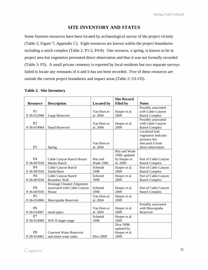
SITE INVENTORY AND STATUS Some fourteen resources have been located by archaeological survey of the project vicinity
(Table 2; Figure 7; Appendix C). Eight resources are known within the project boundaries
including a ranch complex (Table 2: P1-2, P4-8). One resource, a spring, is known to be in
project area but vegetation prevented direct observation and thus it was not formally recorded
(Table 3: P3). A small private cemetery is reported by local residents but two separate surveys
failed to locate any remnants of it and it has not been recorded. Five of these resources are
outside the current project boundaries and impact areas (Table 2: O1-O5).
Table 2. Site Inventory
Resource Description Located by Site Record Filed by Notes
P1 P-36-012968 Large Reservoir
Van Horn et al. 2004
Harper et al. 2009
Possibly associated with Cable Canyon Ranch Complex
P2 P-36-014964 Small Reservoir
Van Horn et al. 2004
Harper et al. 2009
Possibly associated with Cable Canyon Ranch Complex
P3 Spring Van Horn et al. 2004
Localized lush vegetation indicates presence but obscured it from direct observation
P4 P-36-007030
Cable Canyon Ranch House/ Martin Ranch
Ritz and Wade 1990
Ritz and Wade 1990; updated by Harper et al. 2009
Part of Cable Canyon Ranch Complex
P4 P-36-007030
Cable Canyon Ranch Stable/Barn
Schmidt 1998
Harper et al. 2009
Part of Cable Canyon Ranch Complex
P4 P-36-007030
Cable Canyon Ranch Boundary Wall
Schmidt 1998
Harper et al. 2009
Part of Cable Canyon Ranch Complex
P4 P-36-007030
Drainage Channel Alignment associated with Cable Canyon House
Schmidt 1998
Harper et al. 2009
Part of Cable Canyon Ranch Complex
P5 P-36-014966 Muscupiabe Reservoir
Van Horn et al. 2004
Harper et al. 2009
P6 P-36-014967 metal pipes
Van Horn et al. 2004
Harper et al. 2009
Possibly associated with Muscupiabe Reservoir
P7 P-36-014968 WW II target range
Schmidt 1998
Harper et al. 2009
P8 P-36-014462
Concrete Water Reservoir and metal water tanks Dice 2008
Dice 2008; updated by Harper et al. 2009

Spring Trails Cultural
Cogstone
22
Resource Description Located by Site Record Filed by Notes
O1 P-36-014460 possible milling slick Dice 2008
Dice 2008; updated by Harper et al. 2009
Not in current project boundaries. Determined to be natural.
O2 P-36-014461 Old Lady Meyers House Dice 2008 Dice 2008
Not in current project boundaries.
O3 P-36-014463 Rectangular rock alignment Dice 2008
Dice 2008; updated by Harper et al. 2009
Not in current project boundaries.
O4 P-36-014464 L-shaped stone alignment Dice 2008
Dice 2008; updated by Harper et al. 2009
Not in current project boundaries.
O5 P-36-007031
Meyer (Otto and Vera) Residence
Ritz and Wade 1990
Ritz and Wade 1990; updated by Harper et al. 2009
Not in current project boundaries.

23
Figure 7. Recorded site locations This figure provides site specific cultural resource information that is not available to the general public and is exempt from disclosure under the California Public Records Act (California Government Code Section 6254.10)"

Spring Trails Cultural
Cogstone
24
Site P1: Large Reservoir
This site was first noted by Van Horn et al. (2004) as a reservoir potentially associated with the
Cable Canyon Ranch House. The site is described as “a U-shaped structure measuring 22.6 ft.
on a side and 33 ft. in length. The walls are built of rock and concrete; the concrete-lined interior
sloping inward toward the bottom. A rubble buttress wall may be seen on the exterior of the
west side” (Van Horn et al. 2004). Van Horn et al. (2004) suggest this may have been the
reservoir involved in the Martin-Meyer water dispute. Survey by Harper et al. (2009) recorded
the site as P-36-014965 (Appendix C) and described it as a U-shaped 35 ft x 33.5 ft rectangular
stone laid rock alignment running NE to SW. The shape and positioning of the structure follows
the natural contour of the hillside. Cement lining can still be seen on a portion of the interior (W
corner of alignment) of the structure and a buttress is present around the SW base. The walls run
roughly 32-55 inches in height. This may be a reservoir or water management feature, though its
location northeast of the Ranch House does not necessarily mean it was the point of contention
between the Martin and Meyers families.
Site P2: Small Reservoir
The small reservoir was also noted by Van Horn et al. (2004). They described the site as “a
small field stone reservoir located adjacent to a shallow arroyo about 500 ft. north of the ranch
house. Built of dry laid rocks, the structure measures l0 ft. (NW-SE) by 8 ft. (NE-SW) on the
interior. Traces of a concrete lining may be seen on the interior. A portion of the northerly wall
has collapsed.” They also note that the reservoir was probably built by Samuel Martin. The
Harper et al. (2009) survey recorded the site as P-36-014964 (Appendix C) and it is in similar
condition to when it was described by Van Horn et al. (2004), with the exception that both the
northwest and southwest walls are now collapsed. Given the proximity to the Cable Canyon
Ranch House ruins, it seems likely that the two sites are associated.
Site P3: Spring
Van Horn et al. (2004) observed a spring located approximately 625 ft. northeast of the Cable
Canyon Ranch House and suggest it may have been the ranch's primary domestic water source
(Van Horn 2004). Van Horn et al. (2004) notes that “the spring was flowing at the time of the
survey, and consisted of a small brick and mortar collection box resting adjacent to the area

Spring Trails Cultural
Cogstone
25
where the water emerges. The box measures 34" (N-S) by 45" (E-W) and is 17" high. Remains
of a wood cover may still be seen on top of the box. Three pipes extend from the box southward”
(Van Horn et al. 2004). The 2009 Cogstone survey attempted to relocate the spring; however the
area immediately surrounding its location was covered by extremely dense brush, making access
to and visibility of the spring impossible. The abundance of vegetation in the area suggests that
the spring is still active, though the state of the collection box remains unknown.
Site P4: Cable Canyon Ranch House Complex
First recorded by Ritz and Wade (1990) as P-36-007030, the site was initially described as a
single-structure foundation with associated trash scatter, but has since been expanded to include
other structures surrounding the Ranch house. Van Horn et al. (2004) accurately describe the
ranch house site:
The exterior walls of the house appear to have been built largely or entirely of rock and concrete reinforced with horizontal steel strapping. The plan of the walls is nearly square in configuration, forming a single room oriented roughly to the cardinal points (partition walls may have existed within the room). The eastern wall comprises a segment of a long terrace retaining wall which separates the house from the higher terrace to the east. The exterior walls average about 12" in thickness and were veneered with concrete on both the interior and the exterior. The interior had an additional finishing coat of plaster. A prominent feature is an attractive rock and concrete fireplace which forms the northeast corner of the room. The fireplace has a rectangular opening surmounted by a concrete mantle. A stove pipe was used to form the flu. Entry was by way of doorways in the southern and northern walls. The entry on the north may have been the main entry. This wall contains a second doorway leading into a small annex. The annex consists of an ell-shaped room enclosing a small square room attached to the exterior of the north wall of the house. A concrete window sill may be seen between the main entry and the entry to the annex. A 1" iron pipe extends from the terrace retaining wall into the ell and may represent a water conduit.
Van Horn et al. (2004) go on to state that the trash scatter noted in 1990 could not be relocated,
possibly due to dense vegetation. The 2009 Cogstone survey could not relocate the trash scatter
either, though sparse pieces of aqua and amber glass were noted in the vicinity of where the
scatter was recorded. Based on recommendations from Schmidt (1998), Van Horn et al. (2004)
goes on to suggest that other features in the vicinity of the house were also probably associated
with the site. These features were located and recorded during the 2009 Cogstone survey and the

Spring Trails Cultural
Cogstone
26
site record was updated to reflect the Ranch house complex, and not just the house itself
(Appendix C). Newly added to the site record is a second and third rock wall located on the west
side of the dirt road northwest of the structure that measures 40 ft by 10 ft. One of these features
may be associated with the barn Schmidt (1998) suggests should be present in the area. A series
of Eucalyptus windbreaks were also recorded, as they are non-native and parallel the rock walls
surrounding the complex on the east, west and north sides. Directly to the south of the house in
the drainage channel is a stone alignment that was possibly used to channel the wash, and is
presumed to be associated with the ranch house complex. Finally, a scatter of bricks located east
of the house complex and at the edge of the wash was also recorded.
Other features connected to the ranch house complex should be present but their locations remain
unknown. Certainly there was at least one privy and additional trash disposal areas are possible.
Deposits such as these are of particular importance because they typically yield period artifacts.
The probability of such features being present seems high because the grounds around the house
have not been subject to significant disturbance. Given the layout of the house and the time
period, the privy may be located at least 20 ft from the house within the walled enclosure.
Site P5: Muscupiabe Reservoir
First noted by Van Horn et al. (2004), the Muscupiabe Reservoir is described as “a moderate-size
field stone and concrete reservoir (13 ft. N-S x 11.2 ft. E-W) located just below the grant line in
the northwestern portion of the study area. The reservoir is currently 4-5 feet deep, the bottom
being covered with silt…Several large sheet metal pipes (both riveted and welded types) visible
on the surface north of the reservoir indicate that it was filled by water originating north of the
site and, therefore, north of the Muscupiabe boundary. Thus, the ‘Muscupiabe Reservoir’ was
probably built by Julius Meyer not long after he purchased the rancho in 1882” (Van Horn et al.
2004). In 2009, Cogstone surveyors relocated and recorded the site as P-36-014966 (Appendix
C). All of the features of the reservoir remain the same as in 2004, with the exception that no
metal pipes were observed north of the reservoir. Instead, several pipe pieces were observed and
recorded south of the reservoir. Approximately 500 ft. to the south, another series of metal pipes
were observed (see below), and it is possible that these pipes all connected to the Muscupiabe
reservoir.

Spring Trails Cultural
Cogstone
27
Site P6: Metal pipes
First noted and recorded by Cogstone in 2009 as P-36-014967 (Appendix C), this feature is most
likely associated with the Muscupiabe reservoir, and transported water south to the Meyer
parcels. Schmidt (1998) suggested that a series of water pipes “in varying sizes, lengths, and
methods of manufacture, extended southward from the general [Cable Canyon Ranch House]
area”, and so it is possible that these pipes correspond to the Cable Canyon complex. However,
given their proximity to the Muscupiabe reservoir, it seems more likely they were associated
with the reservoir and therefore used by the Meyer family. The Metal piping runs 21.5 feet in a
north to south direction, and approximately 7 feet of the pipe is unexposed (lies under a dirt
road). The piping may continue south, as it appears to run back under the ground.
Site P7: World War II Target Range
Originally mentioned by Schmidt (1998), the site is described as a small arms range associated
with nearby Camp Ono in use during WWII. Further research by Van Horn et al. (2004)
revealed that the lease agreement, identified as No. 3260 PH- Declaration of Taking, was drawn
up between Henry L Stimson, Secretary of War of the United States, and Robert B. Myer, et al.
for 45 acres of land. Originally, the property was acquired for the term beginning April 10, 1943
and ending June 30, 1944. The estimated compensation for this period was $122.46. However, a
Supplemental Declaration of Taking was filed to extend the term for one additional year
commencing July 1, 1944 and ending June30, 1945 for $100.
The Van Horn et al. (2004) survey noted four parallel berms and adjacent trenches covering an
area of approximately 45 acres oriented northeast-southwest. Approximately 70 T-shaped
concrete target pedestals of two sizes (tall and short) were found along the northern berm, the
bulk concentrated at the eastern end. They also described two conductor field telephone lines
running the distance between the east ends of the northern and southern berms as well as a
number of spent cartridges believed to have been fired by military arms. They included (5) .30
MI Carbine cartridges (headstamped 1942 and 1943) which were used in the MI and M2 Carbine
(light rifle), and (5) .30-'06 Springfield cartridges (headstamped 1942) used in the M1 Garand,
1903 Springfield and variants, Browning Automatic Rifle (BAR), and Browning .30 caliber
machine gun (Van Horn et al. 2004). In 2009 Cogstone resurveyed and recorded the site as P-

Spring Trails Cultural
Cogstone
28
36-014968 (Appendix C), and noted that each parallel trench and berm is still present, as well as
the concrete t-shaped targets. However, neither the telephone lines nor any spent cartridges were
observed.
Site P8: Concrete Water Reservoir and Metal Water Tanks
First recorded by Dice (2008) as P-36-014462, the site consists of a concrete water reservoir and
metal water tank. Dice (2008) recorded the site as measuring roughly 70 feet long (SE-NW) by
42 feet wide (SW-NE) by about 5 feet deep. The feature was constructed by excavating out a
small amount of soil, putting down a concrete floor and walls with an interior slope, topping the
walls with cemented decorative stones, and then piling dirt back on the finished sides to form a
support slope. The site also exhibits a metal water tank about 6 feet across and 4 feet tall: this is
located 75 meters to the northwest. Rusted metal pipes run down slope from the reservoir and
water tank and likely onto former grape fields. The combination of concrete open-air reservoir
and tank is common in the Inland Empire and represents attempts by locals and/or the California
Conservation Corps (CCC) to capture seep and spring water for local use. The reservoir was
probably gravity fed from an upstream source. No date was observed on either feature. The site
was relocated and the record updated by in 2009 by Cogstone (Appendix C). The condition of
the site is the same as when it was recorded in 2008, with the exception of an additional metal
tank. This second 9 foot by 3 foot 3 inch tank is located next to the 6 foot x 4 foot tank and is on
its side laying north to south. This feature was added to the site record.
Resource O1 – Possible Milling Slick
This depression on a small boulder was recorded as a possible milling slick by Dice (2008) as P-
36-012968. However reevaluation by Cogstone determined this to be natural, not cultural
(Appendix C). The surface is rough and pitted, not smooth and slick. This resource is outside
the current project boundaries.
Resource O2 - Old Lady Meyers House
“Old Lady Meyers House” was first recorded by Dice (2008) as P-36-014461. The site consists
of a small house about 890 square feet in size, with 2 bedrooms and one bath. The house is
described as non-descript and plain, with an asphalt shingle roof and minor exterior features.

Spring Trails Cultural
Cogstone
29
Landscaping is typical of rural properties and includes peppertrees, pines and eucalyptus. County
Assessor records indicate construction was completed in 1958.
The owner of the property, Mabel Meyer, is a descendent of Julius Meyer, who bought the
property along with several other parcels in 1883. Most of the Meyers family in the Verdemont
area farmed (Dice 2008). By 1973 most of the other Meyer parcels had been sold, and “Old
Lady Meyers House” was the last remaining Meyer parcel. This resource is outside the current
project boundaries.
Resource O3 - Rectangular Rock Alignment
This site was first recorded by Dice (2008) as P-36-014463. It consists of a rectangular-shaped
multi-coursed foundation comprised of large stones located within a very shallow drainage.
Cogstone determined that the west wall measures 30 feet long, the north wall measures 33 feet,
and the east wall measures 23 feet long. While no southern wall appears visible, a plan view
map demonstrates that a south wall most likely existed at one point, as there is a fairly linear
alignment of rocks completing the rectangular shape (Appendix C).
Resource O4 – L-shaped Stone Alignment
This site was first recorded by Dice (2008) as P-36-014464. It consists of a five feet long
alignment of stone perpendicular to an 18 feet long stone alignment. The single course of stones
are angular and only partially imbedded in the soil. Dice (2008) states that the function of the
object and its age are unknown. Resurvey for the resource by Cogstone (2009) did not reveal the
structure in full. A small alignment of stone was identified in the vicinity of the site location
recorded by Dice (2008), however only an “L-shaped” distribution of stones were observed and
they appeared to be natural in alignment and not embedded into the ground as suggested by Dice
(2008).
Resource O5 - Meyer Residence
The Meyer House was first recorded by Ritz and Wade (1990) as P-36-007031. The initial
recording only describes the site as a rock and mortar foundation with a cellar and trash scatter
(Ritz 1990). Later research (Schmidt 1998) suggests the house was owned by Otto and Vera

Spring Trails Cultural
Cogstone
30
Meyer, but no further information about the site in terms of local history is noted except that the
home was destroyed by a fire in the late 1960s. The 2004 Archaeological Associates study
suggests that the house was probably built in 1917 (Van Horn et al. 2004). The majority of the
features of the site have remained the same since the initial survey in 1990.
The site is enclosed by lines of eucalyptus trees on the north and west. All that remains of the
residence today is a low stone and concrete footing which is rectangular in plan and encloses a
cellar in the northwest quarter. A full-length elevated concrete porch spans the southern footing.
The full cellar (7 ft. deep) was contains an exterior entry at the northwest corner of the house and
steps are still visible leading downward. The bathroom was located at the northeast corner of the
house to judge by soil and lavatory drain pipes still present in this area. This observation is also
supported by several heavy porcelain fragments observed around the pipes. The 2004 study
suggests that from the elevation of the footings and a vent opening in the eastern footing that the
house had an elevated wooden floor and the elevation matched that of the porch deck. However,
no evidence of the floor's supporting piers was observed. The porch itself bears four rectilinear
concrete piers with square, undecorated concrete caps.
The RECON surveyors reported a low (1 ft.) rock wall east of the house (Ritz and Wade 1990)
and Schmidt (1998) reported abandoned car parts in the area. Neither the Van Horn et al. (2004)
survey nor the Harper et al. (2009) survey found evidence of these features. The 2009 survey did
reveal another rock wall running east to west just south of the front porch, parallel to the street.
In addition the Harper et al. (2009) survey determined that the location of the site as originally
mapped was incorrect (see Appendix C). The site is located on the east side of a dirt road and
not the west as originally indicated.

Spring Trails Cultural
Cogstone
31
NATIVE AMERICAN CONSULTATION The Native American Heritage Commission indicated that there are no known sacred lands
within the immediate project area and recommended that seven tribes or individuals be contacted
for further information (Appendix B). All were contacted by email or letter. No responses were
received. The access roads area was the subject of a previous Native American consultation by
Dice (2008), also with negative results.
PALEONTOLOGICAL RECONNAISSANCE
Paleontology and sediment field assessment was performed by Kim Scott of Cogstone on
January 23, 2009 for the original areas mapped, and on February 19, 2009 for the expanded road
areas. Although there are several sedimentary formations that are old enough to contain the
remains of extinct Pleistocene animals (older alluvial fans {Qvof, Qvof2} and young alluvial fans
{Qyf, Qyf3, Qyf1}), all sediments observed onsite were extremely coarse. Materials were
primarily sands and gravels up to large cobbles (12.8 cm - 25.6 cm) and even boulders (> 25.6
cm). Sediment oxidation in these older deposits ranged from light brown to medium red.
Typically in deposits of this type, the fossils deposited are either crushed by the cobbles in the
stream channels or are weathered to nothing on the surfaces of the alluvial fans without being
buried.

Spring Trails Cultural
Cogstone
32
PREVIOUS RECOMMENDATIONS Several of the previous studies provided recommendations regarding the cultural resources
present within the Martin Ranch project boundaries. Each report’s recommendations vary
depending on the resources encountered in each study, and through time some of the reports
incorporate suggestions put forth in the previous studies (table 3). For example, Ritz and Wade
(1990) recommend conducting phase I research for historical context including archival studies
at the San Bernardino City Library and Historical Society and interviews with persons
knowledgeable about the history of the area. The next published report submitted by Schmidt
(1998) includes background research at the San Bernardino Library as well as personal
interviews. This information was then incorporated into proceeding reports as background
information (Van Horn et al. 2004, Harper et al. 2009).
The majority of the recommendations put forth in the previous studies revolve around further
background research (Ritz and Wade 1990, Schmidt 1998, Van Horn et al. 2004) in an effort to
understand the history of the project area, and each previous report recommends some form of
phase II testing. The nature of the data testing varies with each report, as each study revealed
different cultural components of the project area. Some of the reports (Schmidt 1998, Van Horn
et al. 2004) recommend testing of specific areas of sites while others (Dice 2008) only suggest
broad phase II data testing (table 3). In addition, none of the previous studies provide a specific
impact analysis component to their reports, nor do they provide specific mitigation measures
(with the exception of Scott 2000).

Spring Trails Cultural
Cogstone
33
Table 3. Previous Study Recommendations Resource Ritz and Wade 1990 Schmidt 1998 Scott 2000 Van Horn et al. 2004 Dice 2008 Harper et al. 2009
P1 P-36-014965
Large Reservoir
Suggest recordation on DPR 523 forms. Recommend that sections of reservoir be cleared using mechanical means to permit recording the construction and configuration of the sides and bottoms of the feature. Also suggest test excavations to better understand the method of construction.
Recorded onto DPR 523 forms. Not significant by CEQA standards.
P2 P-36-014964
Small Reservoir
Suggest recordation on DPR 523 forms. Recommend that sections of reservoir be cleared using mechanical means to permit recording the construction and configuration of the sides and bottoms of the feature. Also suggest test excavations to better understand the method of construction.
Recorded onto DPR 523 forms. Not significant by CEQA standards.
P3 Spring
Believe the spring to be related to the Cable Canyon Ranch House Complex and as such, suggest research for legal documents relating to the water distribution and Martin/Meyer water disputes in addition to excavation.
Unable to relocate due to dense vegetation. Most likely related to P-36-007030, so monitoring of area during devegetation recommended.
P4 P-36-007030 Cable
Canyon Ranch House Complex
Suggest Phase I research to determine the historic context of the sites including archival studies at the San Bernardino City Library and Historical Society, interviews with persons knowledgeable about the history of the area, and chain of title searches. Also recommend Phase II testing to define the significance of the material remains and the site boundaries by clearing vegetation, probing to locate subsurface deposits, collecting and mapping artifacts, test excavation, and analysis of collected artifacts. If sites are determined significant, Ritz and Wade recommend preservation in open space easements and if this is not possible they request additional data recovery.
Suggest Historical research in published and unpublished sources, as well as intensive examination of the landform in the vicinity of the sites. Schmidt recommends the removal of vegetation to facilitate complete examination of the site elements. These efforts may need to be followed by excavation of test units. Schmidt also recommends that all brush removal activities prior to grading be conducted in the presence of an archaeological monitor.
Suggest research for maps and documents relating to Samuel Martin’s original title to the Cable Canyon Ranch and legal documents relating to the water distribution and Martin/Meyer water disputes. Suggest that historic deposits should be sought using mechanical means such as backhoe trenching. Once one or more deposits have been located, they should be sampled using traditional methods of hand excavation.
Site is potentially significant by CEQA standards. Phase II testing required in conjunction with grubbing. If resources are discovered that meet CEQA significance, further data recovery is required. In addition, all devegetation within site and area surrounding P-36-007030 must be monitored.
P5 P-36-014966 Muscupiabe Reservoir
Suggest recordation on DPR 523 forms.
Recorded on DPR 523 forms. Not significant by CEQA standards.
P7 P-36-014968
WW II target range
Suggest Historical research in published and unpublished sources, as well as intensive examination of the landform in the vicinity of the sites. Schmidt recommends the removal of vegetation to facilitate complete examination of
Suggest recordation n on DPR 523 forms.
Recorded on DPR 523 forms. Not significant by CEQA standards.

Spring Trails Cultural
Cogstone
34
Resource Ritz and Wade 1990 Schmidt 1998 Scott 2000 Van Horn et al. 2004 Dice 2008 Harper et al. 2009 the site elements. These efforts may need to be followed by excavation of test units. Schmidt also recommends that all brush removal activities prior to grading be conducted in the presence of an archaeological monitor.
P8 P-36-014462
Concrete Water Reservoir and
metal water tanks
Evaluate for significance (test units) if planning evidence suggests the site will be demolished during road construction. Also suggest the resource be avoided during all project-related earthmoving. If the resource cannot be avoided, it must undergo Phase II data testing before project-related earthmoving can begin.
DPR 523 forms updated. Not significant by CEQA standards.
Areas of the project Site that have not
undergone plowing associated with
agricultural development
No specific areas within the project boundaries are mentioned, but Dice 2008 recommends any land that has not been previously plowed receive full-time monitoring. They go on to state that in areas where plowing has occurred for grape growing, limited monitoring should occur. They define limited monitoring as “once the Project Archaeologist determines that 50% of a specific project area in the Moderate zone has been graded, the Project Archaeologist may decide to terminate monitoring in a specific area if and only if the archaeological monitor detects no prehistoric cultural resources, If any buried prehistoric cultural resources are detected during grading in the Moderate zone, full time monitoring must continue in that section of the Project Site.
No further mitigation necessary
Quaternary Older Alluvium
No program to mitigate impacts to fossil resources is recommended at this time.
Mitigation is to include paleontological monitoring of those areas of Road Alternative 1 and the project site where potentially finer alluvial fan sediments may be encountered.
O1 P-36-012968
possible milling slick
State that the supposed resource is most likely natural, but still recommend that it be avoided during all project-related earthmoving and if not it should undergo Phase II data testing.
Determined to be natural. Located outside of current project boundaries. No further mitigation necessary.
O2 P-36-014461
Old Lady Meyers House
Evaluate for significance (test units) if planning evidence suggests the site will be demolished during road construction. Also suggest the resource be avoided during all project-related earthmoving. If the resource cannot be avoided, it must undergo Phase II data testing before project-related earthmoving can begin.
Located outside of current project boundaries. No further mitigation necessary.
O3 P-36-014463
Rectangular rock
Evaluate for significance (test units) if planning evidence suggests the site will be demolished during road construction. Also
Located outside of current project boundaries. No further mitigation necessary.

Spring Trails Cultural
Cogstone
35
Resource Ritz and Wade 1990 Schmidt 1998 Scott 2000 Van Horn et al. 2004 Dice 2008 Harper et al. 2009 alignment suggest the resource be avoided during all
project-related earthmoving. If the resource cannot be avoided, it must undergo Phase II data testing before project-related earthmoving can begin.
O4 P-36-014464
L-shaped stone alignment
Evaluate for significance (test units) if planning evidence suggests the site will be demolished during road construction. Also suggest the resource be avoided during all project-related earthmoving. If the resource cannot be avoided, it must undergo Phase II data testing before project-related earthmoving can begin.
Located outside of current project boundaries. No further mitigation necessary.
O5 P-36-007031 Otto and Vera Meyer
House
Suggest Phase I research to determine the historic context of the sites including archival studies at the San Bernardino City Library and Historical Society, interviews with persons knowledgeable about the history of the area, and chain of title searches. Also recommend Phase II testing to define the significance of the material remains and the site boundaries by clearing vegetation, probing to locate subsurface deposits, collecting and mapping artifacts, test excavation, and analysis of collected artifacts. If sites are determined significant, Ritz and Wade recommend preservation in open space easements and if this is not possible they request additional data recovery.
Suggest Historical research in published and unpublished sources, as well as intensive examination of the landform in the vicinity of the sites. Schmidt recommends the removal of vegetation to facilitate complete examination of the site elements. These efforts may need to be followed by excavation of test units. Schmidt also recommends that all brush removal activities prior to grading be conducted in the presence of an archaeological monitor.
Historic research for legal documents relating to the water distribution and Martin/Meyer water disputes, research focusing on Otto and Vera Meyer and their relation to Julius Meyer as well as finding a photo showing the appearance of the superstructure of the house. Recommend that the interior of the foundations of the Meyer residence be tested for an archaeological deposit using conventional hand excavation methods.
Located outside of current project boundaries. No further mitigation necessary.
Parcels APN 034811140 and APN 034811141
Though it lies outside the project area, suggest survey by a qualified archaeologist and any structures aged 45 years old or more must be avoided or Phase II evaluated for significance.
Located outside of current project boundaries. No further mitigation necessary.

Spring Trails Cultural
Cogstone
36
POTENTIAL RESOURCES
Paleontological, archaeological and historical resources are considered to be significant if they
possess integrity and may contribute information important in prehistory or history. Based on
the prior research and survey results, the potential to impact resources is discussed below.
PALEONTOLOGICAL RESOURCES The project is located at the southern edge of the Transverse Range Province. Sediments of the
project area consist of Pleistocene to Holocene alluvial fans and the Paleozoic to Mesozoic Devil
Canyon Gneiss. Older fan sections and the gneiss are interrupted by branches of the San
Andreas Fault Zone. Although there are several sedimentary formations that are old enough to
contain the remains of extinct Pleistocene animals, these sediments are so coarse that they are not
conducive to the preservation of significant fossil resources.
ARCHAEOLOGICAL RESOURCES Eight historic archaeological resources are known within the project boundaries but only site P-
36-007030, a historic ranch complex, meets CEQA significance criteria. In addition, two other
resources have been noted in previous reports but have not been recorded. One site, a spring, is
known to be in the project area but vegetation prevented direct observation. A small private
cemetery has also been reported by local residents, but two separate surveys failed to locate any
remnants of it.
HISTORICAL RESOURCES There are no historic standing structures or other built environment resources within the project
area.

Spring Trails Cultural
Cogstone
37
IMPACT ANALYSIS AND MITIGATION MEASURES Seven historic archaeological resources have been adequately mitigated by documentation.
Project construction would however, destroy the Cable Canyon Ranch complex. The historic
remnants of a stone house and fence of Cable Canyon Ranch do not, in themselves, meet
significance criteria under CEQA and they have also been documented. However, household
refuse and privies are historical archaeological features that would provide new information and
thereby meet criterion D. Suggested research questions are provided (Appendix D).
No paleontological or prehistoric archaeological resources are known within the project area. A
small private cemetery was reported by locals but not located.
Impact Cult-1 Proposed new grading for construction in the northern portion of the project area will destroy the remnant structures and subsurface historical archaeological features associated with P-36-007030, the late-19th century Cable Canyon Ranch complex. Household refuse and privies are mostly subsurface historical archaeological features that would provide new historical information. Mitigation Measure Cult-1 Preconstruction archaeological testing and data recovery by a qualified archaeologist is required to mitigate the adverse impacts of construction on historic Cable Canyon Ranch. A qualified archaeologist must be present for grubbing, de-vegetation and demolition of the remnant stone structure and fence to protect resources that may be revealed by these activities. Subsequent to vegetation removal but before construction, the archaeologist will perform controlled mechanical excavation inside and outside the house area to locate features present below the ground surface (Figure 8). Once located, the archaeologist should develop a formal treatment plan (plan of work including research questions to be answered and contain an agreement with an accredited repository). Excavation of subsurface features can include additional mechanical excavation or hand excavation as warranted by the features. Discovery of features and recovery of archaeological materials will require extensive sampling, documentation, laboratory work, identification, analysis and interpretation. The final report should include formal evaluation and significance assessment of each feature and the project catalog and be filed with the City, the San Bernardino Archaeological Information Center and the repository (San Bernardino County Museum recommended). The City should be refused a final occupancy permit until all mitigation is demonstrated to have been performed, including curation of the project documents and artifacts.

38
Figure 8. Probable locations of cultural resources located within site P-36-007030 This figure provides site specific cultural resource information that is not available to the general public and is exempt from disclosure under the California Public Records Act (California Government Code Section 6254.10)"
Spring Trails Cultural
Cogstone
39
Impact Cult-2 Proposed new grading for construction might encounter unanticipated human remains, archaeological materials or fossils. Mitigation Measure Cult-2 Cultural resources sensitivity training is required for all earthmoving personnel. This training will review the types of archaeological and paleontological resources that might be found along with laws for the protection of resources. In the event of an unanticipated discovery, all work must halt within a 30 radius of the find. Work may not continue until the find has been evaluated by a qualified archaeologist or paleontologist, dependent on the nature of the discovery. If an unexpected discovery of human remains is identified at any time the applicant shall follow guidelines addressed in California Health and Safety Code Section 7050.5. This requires that work in the vicinity must halt and the County Coroner must be notified immediately. If the remains are determined to be Native American, the coroner will contact the Native American Heritage Commission. All discoveries require scientific samples and documentation including a final report.

Spring Trails Cultural
Cogstone
40
REFERENCES CITED
California Department of Transportation (Caltrans) 2001 Cultural Resources, Online Environmental Handbook, Vol. 2.
http://www.dot.ca.gov/ser/vol2/vol2.htm 2003 Paleontology, Online Environmental Handbook, Vol. 1, Chapter 8.
http://www.dot.ca.gov/ser/vol1/sec3/physical/Ch08Paleo/chap08paleo.htm Dice, M. 2008 Phase I Cultural Resources Assessment of the Spring Trails Project Road Alternatives,
City of San Bernardino, California. On file at San Bernardino Archaeological Information Center.
Hoover, M.B., H.E. Rensch and E.G. Rensch 1966 Historic Spots in California. 3'd edition revised by William N. Abeloe. Stanford University Press. Stanford. LaFuze, P.B. 1971 Saga of the San Bernardinos. Hogar Publishing Co. Colton. Morton, D.M., and F.K.Miller 2006 Preliminary digital geologic map of the San Bernardino and Santa Ana 30' x 60'
quadrangles, Southern California, version 1.0: U.S. Geological Survey Open-File Report 06-1217; scale 1:100,000.
Ritz, F. and S. Wade 1990 Cultural Resources Survey of Martin Ranch, San Bernardino County. On file at San
Bernardino Archaeological Information Center. Schmidt, J. 1998 Supplemental Cultural Resources Investigation: The Martin Ranch (TT 15576). On file
at San Bernardino Archaeological Information Center. Scott, M.B. 1977 Development of Water Facilities in the Santa Ana River Basin California, 18101968. United States Department of the Interior, Geological Survey. Menlo Park. Scott, E. 2000 Paleontology Literature and Records Review, Martin Ranch Residential Development, Tentative Tract Map #15576, San Bernardino, County, California. On-file, San Bernardino County Museum.

Spring Trails Cultural
Cogstone
41
Van Horn, D., L. White and R. White 2004 A Supplemental Cultural Resources Study of the 353-acre Martin Ranch Project
(Tentative Tract 15576), City of San Bernardino and Unincorporated San Bernardino County. On file at San Bernardino Archaeological Information Center.
Wagner, D.L. 2002 California Geomorphic Provinces. California Geologic Survey Note 36. Website:
http://www.consrv.ca.gov/cgs/information/publications/cgs_notes/note_36/note_36.pdf

Spring Trails Cultural
Cogstone
42
APPENDIX A: QUALIFICATIONS
lmunoz
Text Box
This appendix provides site specific cultural resource information that is not available to the general public and is exempt from disclosure under the California Public Records Act (California Government Code Section 6254.10)"

Spring Trails Cultural
Cogstone
48
APPENDIX B: NATIVE AMERICAN HERITAGE COMMISSION
lmunoz
Text Box
This appendix provides site specific cultural resource information that is not available to the general public and is exempt from disclosure under the California Public Records Act (California Government Code Section 6254.10)"

Spring Trails Cultural
Cogstone
51
APPENDIX C: DPR 523 SITE FORMS
lmunoz
Text Box
This appendix provides site specific cultural resource information that is not available to the general public and is exempt from disclosure under the California Public Records Act (California Government Code Section 6254.10)"

Spring Trails Cultural
Cogstone
94
APPENDIX D: RESEARCH QUESTIONS
lmunoz
Text Box
This appendix provides site specific cultural resource information that is not available to the general public and is exempt from disclosure under the California Public Records Act (California Government Code Section 6254.10)"