Appendices 5-10-09 Final
24
______________________________________________________________________ Appendices City of Tucson and Pima County Stormwater Harvesting Technical Paper for The Water and Wastewater Infrastructure, Supply and Planning Study Phase II 1 Appendix A Pima County and City of Tucson Stormwater Regulations Floodplain and Stormwater Management Pima County Regional Flood Control District Over the past thirty years, flood control engineers have come to recognize that structural measures used to remedy flooding and erosion may create other problems by increasing flooding and erosion in downstream areas. A more holistic approach to watershed and floodplain management that includes nonstructural methods as well as structural measures where necessary is now the preferred approach to flood control. More recently communities are beginning to understand that stormwater is a resource. Since the mid-1980 the Pima County Regional Flood Control District has taken a watershed approach to flood control and floodplain management. Preservation of natural riverine systems, especially in the upper watershed areas, is critical to managing flood peaks as well as providing natural recharge. Since 1984 the County has acquired over 14,000 acres of floodprone lands including Cienega Creek, Santa Cruz River at Canoa Ranch and the Upper Canada del Oro Wash. Harvesting and re-use of stormwater has also been included in such projects as the Kino Environmental Restoration Project. The Arizona Revised Statutes provides authority to flood control districts to enact and enforce floodplain regulations. The adoption and enforcement of these regulations is mandatory for communities wishing to participate in the National Flood Insurance Program (NFIP). Residents and property owners may obtain flood insurance only if the community implements a responsible floodplain management program. Pursuant to this authority, the Pima County Regional Flood Control District (District) currently enforces the Floodplain and Erosion Hazard Management Ordinance No. 2005-FC2 (Ordinance). The purpose of this Ordinance is to promote public safety and minimize the potential for flood and erosion damage for developments that are impacted by the 100-year or base flood. Floodplain management and flood control improvements increase public safety, reduce flood and erosion hazards, and protect public and private property. Pima County’s Ordinance provides regulations for single lot and development standards for the following areas: • Floodplain management and permits • Erosion hazard and setback • Riparian habitat protection • Sediment control • Stormwater detention/retention City of Tucson
Transcript of Appendices 5-10-09 Final

______________________________________________________________________ Appendices
City of Tucson and Pima County Stormwater Harvesting Technical Paper for The Water and Wastewater Infrastructure, Supply and Planning Study Phase II
1
Appendix A Pima County and City of Tucson Stormwater Regulations Floodplain and Stormwater Management
Pima County Regional Flood Control District Over the past thirty years, flood control engineers have come to recognize that structural measures used to remedy flooding and erosion may create other problems by increasing flooding and erosion in downstream areas. A more holistic approach to watershed and floodplain management that includes nonstructural methods as well as structural measures where necessary is now the preferred approach to flood control. More recently communities are beginning to understand that stormwater is a resource. Since the mid-1980 the Pima County Regional Flood Control District has taken a watershed approach to flood control and floodplain management. Preservation of natural riverine systems, especially in the upper watershed areas, is critical to managing flood peaks as well as providing natural recharge. Since 1984 the County has acquired over 14,000 acres of floodprone lands including Cienega Creek, Santa Cruz River at Canoa Ranch and the Upper Canada del Oro Wash. Harvesting and re-use of stormwater has also been included in such projects as the Kino Environmental Restoration Project. The Arizona Revised Statutes provides authority to flood control districts to enact and enforce floodplain regulations. The adoption and enforcement of these regulations is mandatory for communities wishing to participate in the National Flood Insurance Program (NFIP). Residents and property owners may obtain flood insurance only if the community implements a responsible floodplain management program. Pursuant to this authority, the Pima County Regional Flood Control District (District) currently enforces the Floodplain and Erosion Hazard Management Ordinance No. 2005-FC2 (Ordinance). The purpose of this Ordinance is to promote public safety and minimize the potential for flood and erosion damage for developments that are impacted by the 100-year or base flood. Floodplain management and flood control improvements increase public safety, reduce flood and erosion hazards, and protect public and private property. Pima County’s Ordinance provides regulations for single lot and development standards for the following areas:
• Floodplain management and permits • Erosion hazard and setback • Riparian habitat protection • Sediment control • Stormwater detention/retention
City of Tucson

______________________________________________________________________ Appendices
City of Tucson and Pima County Stormwater Harvesting Technical Paper for The Water and Wastewater Infrastructure, Supply and Planning Study Phase II
2
The regulation of development along watercourse is based upon the delegation of regulatory authority from the State to the City for the purpose of managing flooding and floodplain areas under A.R.S. Section 48-3609 and 48-3610. This statutory authority focuses on the hydrological and public safety aspects of floodplain management. State authority is separately delegated to the City under A.R.S. Section 9-462, which authorizes the regulation of land uses and structures under the City's zoning codes. This statutory authority provides for broader regulation of floodplain areas to achieve community aesthetic, cultural and resource preservation goals. The initial City direction for regulation of watercourses was the adoption of the Interim Watercourse Improvement Policy (IWIP) by the Mayor and Council on June 27, 1988. The IWIP contains specific policies that encourage the preservation of natural watercourses and the design of landscaped, natural-appearing channels. The IWIP also contains policies restricting the use of concrete for bank protection and channelization. The IWIP continues to apply to watercourses that are not otherwise subject to WASH or ERZ regulations. The fundamental policy direction of the City was restated in Resolution 15269, adopted on April 2, 1990:
"The Mayor and Council find that protection and preservation of natural drainage systems should be the primary emphasis of City stormwater management efforts. Nonstructural solutions to flooding hazards shall be the preferred strategy over structural solutions."
The implementation of this fundamental policy direction in the management of watercourses and floodplains has been established by ordinances, resolutions, administrative interpretations, and development standards including: Chapter 26 of the Tucson Code, the Floodplain and Erosion Hazard Management regulations; the adoption of the Environmental Resource Zone (ERZ) by Ordinance 7450 on July 3, 1990 as an overlay zone, LUC § 2.8.6; adoption of the Watercourse Amenities, Safety and Habitat (WASH) regulations by Ordinance 7579 on March 25, 1991, Tucson Code, Chapter 29, Article VIII, approval of further phases of the Tucson Stormwater Management Study (TSMS) and by adoption of the Floodplain, WASH, and environmental Resource Zone (ERZ) Standard (Development Standard 9-06) by Resolution 20505 on November 6, 2006. Stormwater Quality The Federal Clean Water Act requires that municipalities above a threshold population, implement programs to prevent stormwater pollution and improve stormwater quality. Both Pima County and the City of Tucson have municipal stormwater quality permit that were issued by the EPA. City of Tucson The City of Tucson has a municipal stormwater quality permit issued by EPA, which sets program requirements and establishes penalties for noncompliance. One of the requirements is to enact a stormwater quality ordinance, which allows the City to prohibit

______________________________________________________________________ Appendices
City of Tucson and Pima County Stormwater Harvesting Technical Paper for The Water and Wastewater Infrastructure, Supply and Planning Study Phase II
3
activities that can negatively impact stormwater quality. The City enacted the Stormwater Quality Ordinance in October 2005. The Stormwater Management Section of the Department of Transportation is responsible for administration of the City's municipal stormwater permit and either provides guidance to or implements the following mandated stormwater quality programs:
• An Industrial Facilities Inspection and Enforcement program - Under this program, the City inspects certain industrial facilities also targeted under the Clean Water Act to ensure that these facilities have effective stormwater pollution prevention programs in place.
• A Construction Site Inspection and Enforcement Program - This program requires inspection of all construction sites where 1 or more acres of land is disturbed to ensure that these construction sites are operating under effective stormwater pollution prevention plans. (Again these sites are also regulated under the Clean Water Act).
• A Post Construction Pollution Control Program - This program ensures that development incorporates measures to reduce pollution and preserve environmentally sensitive areas, open space, and vegetated areas. Also included under this program are native plant protection, the City's WASH and ERZ ordinances, water harvesting requirements, maintenance of retention/detention basins, maintenance of the City's stormwater drainage system, and street sweeping.
• An Illicit Discharge Detection and Elimination Program - Under this program, the City inspects the stormwater drainage system for illegal dumping or nonstormwater connections, and ensures that any spills reaching the stormdrain system are properly cleaned up. The City can utilize the stormwater quality ordinance to require responsible parties to clean up and/or elimination of pollutant sources. Also under this program, the City operates 5 stormwater sampling stations and is required to collect and analyze samples from a minimum of 10 storm events annually.
• A municipal facilities program - This program ensures that City run facilities employ stormwater pollution prevention practices.
• Public Outreach Program- The goal of this program is to educate the community on measures they can employ to reduce or eliminate stormwater pollution (ie fix leaking vehicles, properly disposing of Household Hazardous Waste, picking up animal wastes, properly applying fertilizers, pesticides and herbicides, etc)
• A Public Participation Program - The Stormwater Management Section sponsors the Stormwater Advisory Committee where community members can participate in development of stormwater quality programs.
Pima County Pima County has a municipal stormwater quality permit issued by EPA, which sets program requirements and establishes penalties for noncompliance. One of the requirements is to enact regulations, which allows the County to prohibit activities that can negatively impact stormwater quality. The County regulates activities that would

______________________________________________________________________ Appendices
City of Tucson and Pima County Stormwater Harvesting Technical Paper for The Water and Wastewater Infrastructure, Supply and Planning Study Phase II
4
impact stormwater quality under Title 7 Environmental Quality, which is enforced by the Pima County Department of Environmental Quality; the Industrial Wastewater Ordinance (13.36), which is enforced by the Regional Wastewater Reclamation Department; and Title 16, the “Floodplain Management Ordinance. The Pima County Department of Environmental Quality is the primary department responsible for administration of the County’s municipal stormwater permit and either provides guidance to or implements the following mandated stormwater quality programs:
• An Industrial Facilities Inspection and Enforcement program - Under this program, the County inspects certain industrial facilities also targeted under the Clean Water Act to ensure that these facilities have effective stormwater pollution prevention programs in place.
• A Construction Site Inspection and Enforcement Program - This program requires inspection of all construction sites where 1 or more acres of land is disturbed to ensure that these construction sites are operating under effective stormwater pollution prevention plans.
• A Post Construction Pollution Control Program - This program ensures that development incorporates measures to reduce pollution and preserve environmentally sensitive areas, open space, and vegetated areas. Also included under this program are native plant protection, riparian habitat protection, retention/detention basins, and maintenance of the County's stormwater drainage system, and street sweeping.
• An Illicit Discharge Detection and Elimination Program - Under this program, the County inspects the stormwater drainage system for illegal dumping or nonstormwater connections, and ensures that any spills reaching the stormdrain system are properly cleaned up.
• A municipal facilities program - This program ensures that County run facilities employ stormwater pollution prevention practices.
• Public Outreach Program- The goal of this program is to educate the community on measures they can employ to reduce or eliminate stormwater pollution (ie fix leaking vehicles, properly disposing of Household Hazardous Waste, picking up animal wastes, properly applying fertilizers, pesticides and herbicides, etc.

______________________________________________________________________ Appendices
City of Tucson and Pima County Stormwater Harvesting Technical Paper for The Water and Wastewater Infrastructure, Supply and Planning Study Phase II
5
Appendix B Data Used To Show Percent Harvestable Water at Different Scales Regression Data for the Developed Condition
Name Area (mi2) Source Record (yrs) Mean AnnualRainfall (in) (in) (ac-ft)
Rooftop 0.00005 RFCD Lot Model 105 11.20 9.29 0.03 82.90%1/5 -ac Lot 0.00031 RFCD Lot Model 105 11.20 5.74 0.10 51.20%1-ac Lot 0.00156 RFCD Lot Model 105 11.20 3.60 0.30 32.10%High School Wash 1.0 Data used to Design KERP (Tetra-Tech, 2001) 11 12.00 1.54 77.78 12.79%Railroad Wash 2.3 Data used to Design KERP (Tetra-Tech, 2001) 9 12.00 1.25 153.5 10.43%Atterbury Wash 5.0 Data used to Design KERP (Tetra-Tech, 2001) 9 12.00 0.62 165.3 5.20%Tucson Arroyo 8.2 Data used to Design KERP (Tetra-Tech, 2001) 37 12.00 1.46 638.2 12.16%KERP 13.7 Empirical Equation (Tetra-Tech, 2001) 4.22%Airport Wash 23.0 Data used to Design KERP (Tetra-Tech, 2001) 17 12.00 0.25 308.7 2.10%Arivaca Creek 56.8 USGS Gage Data 9486580, Rainfall assumed 12 in 6.0 12.00 0.21 621.6 1.71%Canada Del Oro Wash 250.0 USGS Gage Data 9486350, Rainfall assumed 12 in 26 12.00 0.10 1391.1 0.87%Pantano at Vail 457.0 USGS Gage Data 09484600, Rainfall assumed 12 in 30 12.00 0.18 4349.1 1.49%Altar Valley at Three Points 463.0 USGS Gage Data 09486800, Rainfall assumed 12 in 23 12.00 0.15 3788.9 1.28%Santa Cruz at Tucson 2222.0 USGS Gage Data 09482500, Rainfall assumed 12 in 77 12.00 0.14 16300.0 1.15%Regression Equation: y = 0.0748e-0.5992log(A) R2 = 0.9075
Mean Annual Runoff % Harvestable Stormwater

______________________________________________________________________ Appendices
City of Tucson and Pima County Stormwater Harvesting Technical Paper for The Water and Wastewater Infrastructure, Supply and Planning Study Phase II
6
Regression Data for the Undeveloped ConditionName Area (mi2) Source Record (yrs) Mean Annual
Rainfall (in) (in) (ac-ft)LH 6' x 12' plot 0.00000258 Data from the Agricultural Research Service 2 11.65 2.60 0.00 22.33%Santa Rita 1 0.0063 Data from the Agricultural Research Service 28 13.70 0.59 0.20 4.28%Santa Rita 2 0.0068 Data from the Agricultural Research Service 28 14.40 0.44 0.16 3.08%Santa Rita 3 0.0106 Data from the Agricultural Research Service 28 14.13 1.05 0.60 7.46%Santa Rita 4 0.0076 Data from the Agricultural Research Service 28 13.72 1.19 0.48 8.67%Flume 105 0.0007 Data from the Agricultural Research Service 10 10.80 1.20 0.04 11.09%Flume 106 0.0013 Data from the Agricultural Research Service 10 10.65 1.23 0.09 11.50%Flume 112 0.0072 Data from the Agricultural Research Service 10 11.33 0.45 0.17 3.95%Flume 102 0.0056 Data from the Agricultural Research Service 10 10.53 0.85 0.25 8.04%Flume 103 0.0142 Data from the Agricultural Research Service 10 10.69 0.97 0.73 9.05%Flume 104 0.0175 Data from the Agricultural Research Service 10 10.53 0.61 0.57 5.82%Flume 4 0.8750 Data from the Agricultural Research Service 10 11.32 0.47 22.0 4.16%Atterbury Wash 4.97 Data used to Design KERP (Tetra-Tech, 2001) 9 12.00 0.62 165.3 5.20%Arivaca Creek 56.80 USGS Gage Data 9486580, Rainfall assumed 12 in 6.0 12.00 0.21 621.6 1.71%CDO 250.0 USGS Gage Data 9486350, Rainfall assumed 12 in 26 12.00 0.10 1,391.1 0.87%Pantano at Vail 457.0 USGS Gage Data 09484600, Rainfall assumed 12 in 30 12.00 0.18 4,349.1 1.49%Altar Valley at Three Points 463.0 USGS Gage Data 09486800, Rainfall assumed 12 in 23 12.00 0.15 3,788.9 1.28%Santa Cruz at Tucson 2222.0 USGS Gage Data 09482500, Rainfall assumed 12 in 12.00 0.14 16,300.0 1.15%Regression Equation: y = 0.033e-0.3357log(A) R2 = 0.8368
Mean Annual Runoff % Harvestable Stormwater

______________________________________________________________________ Appendices
City of Tucson and Pima County Stormwater Harvesting Technical Paper for The Water and Wastewater Infrastructure, Supply and Planning Study Phase II
7
Appendix C Description of the Mass Balance Model To: Evan Canfield From: Dave Stewart Subject: Modeling Runoff Reduction from On-site Storage Design at the Lot Scale Date: 5/4/2009 Abstract: On-site storage of stormwater in water harvesting basins or similar features is often credited as providing a reduction in runoff volume leaving a site. A model was developed to quantify the reduction in stormwater volume for a given water harvesting basin design at the lot scale. The model is based on conservation of mass, uses 105 years of historical rainfall data to simulate runoff, and uses soil moisture accounting to adjust soil storage for infiltration and evapotranspiration for the duration of the period of record. Simulated runoff volume varies by lot characteristics and basin design. Simulated runoff from lots with water harvesting basin can approach predeveloped conditions for small rainfall events, but often approaches post-developed conditions for large events or successive days of rain depending on the design. The model estimates the harvestable stormwater for the pre-developed and post-developed conditions as a percent of rainfall depth, and calculates the reduction in harvestable stormwater from the user-specified water harvesting basin design. Introduction On-site storage is often considered to have an effect on the runoff volume produced at the lot scale. A model was developed based on conservation of mass to evaluate the effect of water harvesting basin design on runoff volume for a given lot. The model is applicable to the design of water harvesting basins located either on-site, or in an adjacent right-of-way or public space; however the model is not intended for use with areas larger than the lot scale (approximately 1 acre) where transmission losses and routing are expected to be a significant factor. The model uses a mass balance approach with 105 years of rainfall data and the Soil Conservation Service (SCS) Curve Number (CN) method to simulate soil storage and runoff volume leaving the site on a daily time step. The model estimates the event runoff volume for the lot, the reduction in runoff volume from the water harvesting basin design, the monthly average soil moisture of the water harvesting basin, and the amount of stormwater that is available for harvesting at the lot scale for a given site. The on-site storage for this study is assumed to be a water harvesting basin. Objectives
• Evaluate the effects of water harvesting basin design on runoff volume at the lot scale
• Evaluate the amount of harvestable stormwater for the pre-developed and post-developed conditions at several scales

______________________________________________________________________ Appendices
City of Tucson and Pima County Stormwater Harvesting Technical Paper for The Water and Wastewater Infrastructure, Supply and Planning Study Phase II
8
Methods Rainfall Data: The 105 years of daily rainfall data used in the model were collected at the University of Arizona from 1895 to 2000 and obtained from the National Climatic Data Center (NCDC) (http://www.ncdc.noaa.gov/oa/ncdc.html). Input Parameters Lot Dimensions and Characteristics The required model inputs for the lot are the:
• Total area of the lot including the water harvesting basin, • Percent of directly connected impervious and unconnected impervious area, • Percent of the pervious and impervious area diverted to the water harvesting • CN values for the lot’s pervious, impervious, and water harvesting basin areas
“Connected impervious area” is considered in the model as an area that produces runoff that does not flow over any pervious areas while leaving the site. A schematic of how the model may be applied to the lot scale is shown in Figure 1. The percent of pervious, connected and unconnected impervious areas are specified by the user. The interface for the model was created in Microsoft Excel and is shown in Figure 2. An evaporation coefficient must be specified to represent losses in soil moisture at a daily time step relative to the average reference evapotranspiration (ET), which was obtained from the Arizona Meteorological Network (AZMET). Water Harvesting Basin dimensions The required water harvesting basin design variables are the basin length, width, depth, side slopes, porosity (if filled), and a crop coefficient to account for ET losses from vegetation. An optional minimum allowable soil moisture depth may be entered in inches based on the vegetation for the model to calculate the average number of days for each month simulated below the threshold value using the current design. Assumptions
• The lot scale is small enough that losses from overland flow of runoff to leave the site are negligible
• Infiltration and evapotranspiration occurs on a daily time step • The soil moisture reaches saturated hydraulic conductivity at AMC III • Any additional assumptions made in the input parameters (the simulation can
only be as accurate as the input parameters)

______________________________________________________________________ Appendices
City of Tucson and Pima County Stormwater Harvesting Technical Paper for The Water and Wastewater Infrastructure, Supply and Planning Study Phase II
9
Directly Connected Impervious
Unconnected Impervious Area
Pervious Area
Right of Way
Length
Lot W
idth
Roa
dway
Directly Connected Impervious AreaW
ater
Har
vest
ing
Bas
in
Figure 1. Schematic of the model applied to an example lot with pervious, directly connected impervious, and unconnected impervious areas.
______________________________________________________________________ Appendices
City of Tucson and Pima County Stormwater Harvesting Technical Paper for The Water and Wastewater Infrastructure, Supply and Planning Study Phase II
10
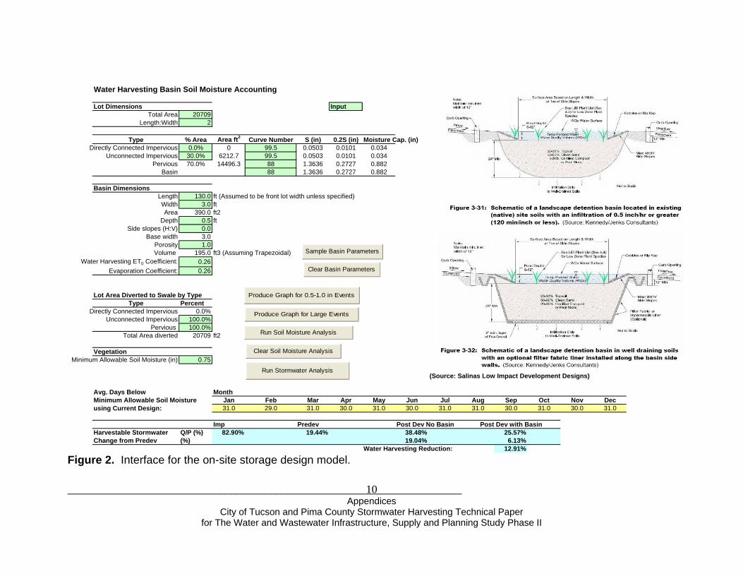
Water Harvesting Basin Soil Moisture Accounting
Lot Dimensions Input Total Area 20709
Length:Width 2
Type % Area Area ft2 Curve Number S (in) 0.2S (in) Moisture Cap. (in)Directly Connected Impervious 0.0% 0 99.5 0.0503 0.0101 0.034
Unconnected Impervious 30.0% 6212.7 99.5 0.0503 0.0101 0.034Pervious 70.0% 14496.3 88 1.3636 0.2727 0.882
Basin 88 1.3636 0.2727 0.882
Basin DimensionsLength 130.0 ft (Assumed to be front lot width unless specified)Width 3.0 ftArea 390.0 ft2
Depth 0.5 ft Side slopes (H:V) 0.0
Base width 3.0Porosity 1.0Volume 195.0 ft3 (Assuming Trapezoidal)
Water Harvesting ET0 Coefficient: 0.26Evaporation Coefficient: 0.26
Lot Area Diverted to Swale by TypeType Percent
Directly Connected Impervious 0.0%Unconnected Impervious 100.0%
Pervious 100.0%Total Area diverted 20709 ft2
VegetationMinimum Allowable Soil Moisture (in) 0.75
(Source: Salinas Low Impact Development Designs)
Avg. Days Below MonthMinimum Allowable Soil Moisture Jan Feb Mar Apr May Jun Jul Aug Sep Oct Nov Decusing Current Design: 31.0 29.0 31.0 30.0 31.0 30.0 31.0 31.0 30.0 31.0 30.0 31.0
Imp Predev Post Dev No Basin Post Dev with BasinHarvestable Stormwater Q/P (%) 82.90% 19.44% 38.48% 25.57%Change from Predev (%) 19.04% 6.13%
Water Harvesting Reduction: 12.91%
Produce Graph for Large Events
Produce Graph for 0.5-1.0 in Events
Run Soil Moisture Analysis
Clear Basin Parameters
Sample Basin Parameters
Clear Soil Moisture Analysis
Run Stormwater Analysis
Figure 2. Interface for the on-site storage design model.

______________________________________________________________________ Appendices
City of Tucson and Pima County Stormwater Harvesting Technical Paper for The Water and Wastewater Infrastructure, Supply and Planning Study Phase II
11
Estimation of Runoff Volume The SCS Curve Number (CN) method is used to estimate runoff volume by calculating soil storage, S, in inches from the CN value as:
101000−=
CNS
(1) The runoff depth, Q, in inches is estimated for each area based on daily rainfall depth, P, in inches and soil storage:
)8.0()2.0( 2
SPSPQ
+−
= (2)
Where 0.2S is considered to be the initial abstraction, and runoff depth is zero for rainfall depths less than 0.2S. Soil moisture accounting is performed in the model by updating soil storage on a daily time step as a simple mass balance. The soil storage decreases by the depth of infiltration which is found as the difference between rainfall and runoff depth. The soil storage increases each day with evapotranspiration. The change in storage each day can be summarized as:
)( QPETS −−=Δ (3) The soil storage is assumed to have a minimum value at saturated conditions equal to the SCS CN Antecedent Moisture Condition III (AMC III). Therefore, infiltration will continue to occur under saturated conditions. Impervious surfaces are often assumed to have a CN of approximately 99, with some storage to account for shallow depressions that are filled under saturated conditions. Due to soil moisture accounting, the model will simulate higher volumes of runoff for successive days of rainfall in the period of record due to saturated conditions. The water harvesting basin storage is calculated using the same method, with storage increasing from ET and storage decreasing with runoff volume diverted to the basin. The percent of the lot diverted to the water harvesting basin must be specified in the model input parameters. When the basin storage is at capacity, the additional volume runoff overflows and is assumed to leave the site. The total volume of runoff leaving the site each day is calculated as the sum of the runoff produced by all areas not diverted to the water harvesting basin, and any overflow from the basin. Model Output The output from the model includes:
• A stormwater analysis that calculates the percent of simulated total runoff depth relative to total rainfall depth for the impervious area, the pre-developed

______________________________________________________________________ Appendices
City of Tucson and Pima County Stormwater Harvesting Technical Paper for The Water and Wastewater Infrastructure, Supply and Planning Study Phase II
12
condition, and the post-developed condition with and without the basin design. In addition, the reduction in runoff from the water harvesting basin design relative to post developed conditions is calculated.
• Graphs of simulated runoff event volume for the pre-developed condition, the post-developed condition, and the post-developed condition with the water harvesting basin design for the rainfall period of record
• A soil moisture analysis that produces the monthly average number of days that the water harvesting basin soil moisture is below the specified minimum allowable soil moisture.
Results and Discussion The efficiency of the water harvesting basin design in capturing stormwater and reducing runoff volume depends on several factors including the volume of the basin, the total area diverted to the basin, as well as the overall CN and impervious area of the site that determines the “harvestable stormwater” or runoff coefficient. Simulated Runoff Volume Depending on water harvesting basin design, graphs of event runoff volume indicate that runoff volume can be decreased close to pre-developed levels for smaller rainfall events (Figure 3). However, for large rainfall events or successive days of rainfall, the runoff volume from sites with the water harvesting basin design approach the post-developed runoff volume due to reduced storage capacity. The pre-developed condition runoff volume also approaches post-developed runoff condition after several days of rainfall due to saturated soil conditions but does not reach the post-developed runoff volume due to the higher saturated hydraulic conductivity simulated from the pre-developed condition. Harvestable Stormwater The “harvestable stormwater” or long-term runoff coefficient is estimated for each condition as a ratio of the total simulated event runoff depth to total rainfall depth for the period of record. A determining factor in the amount of harvestable stormwater is the impervious area and overall CN. At a small scale, the simulated harvestable stormwater for an almost completely impervious area such as a rooftop is in the range of 70-90% of the annual rainfall depth depending on assumptions in losses in shallow depressions and the material of the roof (Table 1). For larger areas such as a 1/5 acre lot, there is an increase in pervious area and a decrease in impervious area. Assuming 50% impervious area with a CN of 99.5, and pervious area with a CN of 88 (PC-Hydro, Arroyo Engineering 2007), the harvestable stormwater is simulated as 51.2% of the annual rainfall depth. For ½ acre and 1 acre lots with assumed impervious areas of 30% and

______________________________________________________________________ Appendices
City of Tucson and Pima County Stormwater Harvesting Technical Paper for The Water and Wastewater Infrastructure, Supply and Planning Study Phase II
13
0
1000
2000
3000
4000
5000
6000
7000
0.0 0.5 1.0 1.5 2.0 2.5 3.0 3.5 4.0 4.5
Rainfall (in)
Run
off V
olum
e, Q
(ft3 )
Postdeveloped with BasinPredevelopedPostdeveloped No Basin
Figure 3. Simulated runoff volumes for the post-developed, post-developed with an example water harvesting basin

______________________________________________________________________ Appendices
City of Tucson and Pima County Stormwater Harvesting Technical Paper for The Water and Wastewater Infrastructure, Supply and Planning Study Phase II
14
design, and pre-developed conditions for the rainfall period of record.

______________________________________________________________________ Appendices
City of Tucson and Pima County Stormwater Harvesting Technical Paper for The Water and Wastewater Infrastructure, Supply and Planning Study Phase II
15
20% respectively (Arroyo Engineering 2007) and the aforementioned CN values, the simulated harvestable stormwater for the annual rainfall depth is 38.5% for ½ acre lot and 32.1% for a 1 acre lot. The simulated harvestable stormwater for the pre-developed condition with a CN of 88 and 0% impervious area is 19.4% at all scales. Table 1. Simulated harvestable stormwater as a percent of annual rainfall depth with increasing scale and decreasing impervious percent.
Scale A (ac) Imp % Pervious Impervious Predeveloped Post DevelopedRooftop 0.03 100 88 99.5 19.4% 82.9%1/5 ac lot 0.20 50 88 99.5 19.4% 51.2%1/2 ac lot 0.50 30 88 99.5 19.4% 38.5%1 ac lot 1.00 20 88 99.5 19.4% 32.1%
Harvestable StormwaterCN
Rooftops or Other Completely Impervious Areas For a single large rainfall event, rooftops may have a runoff coefficient of close to 0.99. However, if a CN of 99.5 is assumed for a rooftop, the initial abstraction or initial losses due to shallow depressions is calculated as 0.01 inches. For every rainfall event in the simulation, the initial loss of 0.01 inches must be satisfied before runoff is produced. The average number of rainfall events per year for the 105 years of U of A data is 42 events. In addition, the assumed CN of 99.5 has a storage component of 0.05 inches that decreases with rainfall to a minimum storage of 0.0165, and is restored through evaporation in the simulation. The initial losses of the rooftop are small for a large rainfall events but become significant for the smaller rainfall depths that contribute to the annual rainfall depth. The harvestable stormwater for a rooftop with a CN of 99.5 is simulated as 82.9% of the annual rainfall depth. The losses from the annual rainfall depth on the rooftop may be attributed to repeated storage in shallow depressions and saturation of the roof surface before runoff is produced. Water Harvesting Basin Efficiency The reduction of the “harvestable stormwater” or long-term runoff coefficient from the addition of the water harvesting basin to the post-developed condition provides a measure of the efficiency of the water harvesting basin design. Factors affecting the ratio of total runoff depth simulated from total rainfall depth include the impervious percent of the lot, CN values, water harvesting basin volume, the percent of the lot area diverted to the basin or the “catchment ratio”, and the ET coefficients chosen for the model. Conclusions The lot scale water harvesting basin model was created to evaluate the design of water harvesting basin design on runoff volume. The reduction of runoff volume simulated by the model varies depending on lot characteristics and the specific water harvesting basin design. The findings from the model include:

______________________________________________________________________ Appendices
City of Tucson and Pima County Stormwater Harvesting Technical Paper for The Water and Wastewater Infrastructure, Supply and Planning Study Phase II
16
• Runoff volume varies by lot characteristics and water harvesting basin design. For small rainfall events, runoff volume from the water harvesting basin can approach predeveloped conditions. For large rainfall events or successive days of rainfall, the runoff volume from the water harvesting basin approaches post-developed conditions due to reduced basin and soil storage.
• The simulated harvestable stormwater from rooftops or other completely impervious areas was from approximately 70-90% of the annual rainfall depth depending on assumptions in shallow depression storage and roof material.
• The simulated harvestable stormwater decreases with increasing area and decreasing percent of impervious area.
• The efficiency of the water harvesting basin design can be measured as the reduction in the harvestable stormwater from the post-developed condition

______________________________________________________________________ Appendices
City of Tucson and Pima County Stormwater Harvesting Technical Paper for The Water and Wastewater Infrastructure, Supply and Planning Study Phase II
17
Appendix D Legal Issues and Permit Requirements Water Rights The State of Arizona uses a bifurcated system for allocating water rights, differentiating groundwater from surface water. The State’s regulations regarding surface waters rights and the use of water resources are contained in Title 45 of the Arizona Revised Statutes. Title 45 defines surface water as:
"… the waters of all sources, flowing in streams, canyons, ravines or other natural channels, or in definite underground channels, whether perennial or intermittent, floodwater, wastewater or surplus water, and of lakes, ponds and springs on the surface. For the purposes of administering this title, surface water is deemed to include central Arizona project water.” (ARS § 45-101(9)).
Arizona governs the use of surface water in accordance with the prior appropriation doctrine, which dictates that surface water rights be allocated using a first in time, first in right methodology. This means that a water user who can apply “x” amount of surface water to a beneficial use has priority to that amount of surface water over any later user. This prioritization of use is critical during periods of drought or when a particular surface water source is over-allocated. The State of Arizona is currently adjudicating all surface water rights issued or claimed within the State, by watershed, to determine the validity and relative priority of each right. Included in the Statewide adjudication will be all surface water rights related to the Santa Cruz River. Since the Santa Cruz River is a tributary to the Gila River, all surface water right claims to the Santa Cruz River and its tributaries will be adjudicated with the Gila River Watershed Adjudication. And although, for all practical purposes, all of the surface water in the Santa Cruz Watershed has been appropriated by existing claims, it is still possible to file an application to appropriate surface water from the Santa Cruz River if a user can show a diversion and beneficial use. In some situations, a surface water right may be claimed for the containment and use of stormwater. Stormwater typically begins in the form of overland flow or sheet flow, but will gradually flow into streambeds, ravines, canyons and other natural channels. Under the Doctrine of Prior Appropriation, stormwater is not subject to appropriation until it is contained within one of these natural channels. Once collected or contained, Stormwater may be applied to a beneficial use. Stormwater harvesting has, therefore, the potential to provide an additional water source for recharge, irrigation, riparian and wildlife preservation and recreational purposes. Keep in mind that the construction and use of a stormwater detention basin does not, in and of itself, require a surface water right. Rather, it’s the act of putting the contained stormwater to beneficial use that triggers the need for a surface water right. A.R.S. § 45-151(A) defines beneficial uses as: domestic (which includes the watering of gardens and lawns not exceeding one-half acre), municipal, irrigation, stockwatering, water power, recreation, wildlife including fish, nonrecoverable water storage, and mining uses.

______________________________________________________________________ Appendices
City of Tucson and Pima County Stormwater Harvesting Technical Paper for The Water and Wastewater Infrastructure, Supply and Planning Study Phase II
18
A good example of a flood control project in Pima County that utilizes stormwater is the Kino Environmental Restoration Project (KERP). The KERP was developed from an existing flood control structure that was expanded into a multi-purpose facility. The new multi-purpose facility was designed to collect and distribute surface and reclaimed water for the purpose of irrigating public ball fields and park areas containing wildlife and riparian habitat. The surface water used at KERP is stormwater that is trapped during normal rainfall events and then redistributed throughout the KERP facility. Since the stormwater collected at KERP is appropriable surface water according to the Prior Appropriation Doctrine, the Pima County Flood Control District filed for a surface water right for the stormwater it collects and uses at the KERP facility. The KERP project demonstrated that the current Federal and State regulatory systems that regulate some aspect of local water use are not set up to deal with multiple use facilities. Surface water rights, riparian protection laws, and water quality regulations fit under separate regulatory frameworks that are not designed to operate in unison when faced with a multi-purpose facility like KERP. If the future includes more multi-purpose facilities as is anticipated, it will be necessary for the various federal, state and local agencies that regulate water uses to develop inter-modal programs to address these hybrid water use facilities. Furthermore, such changes will most likely need to be driven by the local jurisdictions that will be forced to make these new, innovative hybrid facilities fit within the State and Federal programs that regulate them. Water Quality Water quality regulations that may apply to a stormwater harvesting endeavor will depend on the project’s location, scale, and whether or not the stormwater is supplemented with reclaimed water. Arizona’s regulations administered by the Arizona Department of Environmental Quality (ADEQ) protect groundwater quality with Aquifer Protection Permits (APP), protect surface water quality with Arizona Discharge Elimination System (AZPDES) permits, and protect the public from exposure to pathogens with Reuse permits for reclaimed water. The following discussion presents the way in which state water quality regulations may apply to a range of stormwater harvesting projects with the following categories in mind:
• residential or commercial, lot-scale rainwater harvesting; • neighborhood-scale stormwater retention/detention including a stormwater
harvesting component; • Tributary Watercourse scale retention/detention incorporating passive
stormwater harvesting components; • capture of stormwater for direct use including irrigating landscape, turf, or
riparian vegetation or creating recreational lakes (beneficial uses), and; • groundwater recharge using collected stormwater from Regional Watercourses.
Aquifer Protection Permits (APP) Stormwater Exemptions: Many aspects of stormwater discharge are exempted from APP regulations in A.R.S. §49-250, including the following activities:

______________________________________________________________________ Appendices
City of Tucson and Pima County Stormwater Harvesting Technical Paper for The Water and Wastewater Infrastructure, Supply and Planning Study Phase II
19
1. Household and domestic activities. 2. Household gardening, lawn watering, lawn care, landscape maintenance and
related activities. 3. Ponds used for watering livestock and wildlife. 4. Facilities used solely for surface transportation or storage of groundwater,
surface water for beneficial use or reclaimed water that is regulated pursuant to Reuse Permit regulations.
5. Surface impoundments used solely to contain storm runoff, except for surface impoundments regulated by the federal clean water act.
6. Application of water from any source, including groundwater, surface water or wastewater, to grow agricultural crops or for landscaping purposes.
7. Surface impoundments and dry wells that are used to contain storm water in combination with discharges from one or more of the following activities or sources: fire fighting system testing and maintenance; potable water sources, including waterline flushings; irrigation drainage and lawn watering; routine external building wash down without detergents; pavement wash water where no detergents have been used; air conditioning, compressor and steam equipment condensate; foundation or footing drains; OSHA or MSHA safety equipment.
Because drywells represent a special type of injection well that receives stormwater only, and because there is a separate provision for drywell registration and rules in Title 49, Chapter 2, Article 8, drywells are excluded from APP requirements according to A.A.C. R18-9-102.1. ADEQ has not yet developed rules for stormwater drywells, except for an APP general permit to address drywells located in areas where hazardous materials are stored and one for drywells at gas stations. Item #7 in the list of exemptions above describes the only sources of non-stormwater that can be combined with it and still maintain the exemption. Whenever reclaimed water is combined with stormwater, exemptions from APP no longer apply. Stormwater General Permits Item #5 in the list of exemptions above contains an exception for stormwater impoundments that might be required to have an AZPDES permit. This type of facility is covered by a simple APP general permit provided in A.R.S. §49-245.01. There are two other stormwater general permits listed in the APP statutory provisions. A.R.S. §49-245.02.A.1. allows disposal in vadose zone injection wells of stormwater mixed with reclaimed water or groundwater, or both, from man-made bodies of water associated with golf courses, parks and residential common areas. A companion provision in A.R.S. §49-245.02.A.3. allows point source discharges to Waters of the U.S. from man-made bodies of water associated with golf courses, parks and residential common areas that contain only groundwater, stormwater or reclaimed water, or a combination thereof. Both of these latter general permits require that the water meet Aquifer Water Quality Standards, except for the standard for microbiological contaminants. Individual APP Required for Stormwater Only when Mixed with Non-stormwater In general, stormwater discharge to groundwater does not require APP coverage. However, if it is mixed with reclaimed water, the discharge remains exempted from APP

______________________________________________________________________ Appendices
City of Tucson and Pima County Stormwater Harvesting Technical Paper for The Water and Wastewater Infrastructure, Supply and Planning Study Phase II
20
only if it can be covered by a reuse permit. Reuse permit provisions for A, B, and C class reclaimed water prescribe lining requirements for impoundments and irrigation rates that prevent exceeding the demand of the vegetation type at the site. For A+ and B+ reclaimed water, these discharge provisions are waived. When stormwater and reclaimed water are combined in a project and circumstances are such that the project cannot comply with reuse permit provisions, an individual APP would be necessary. Mixing of stormwater runoff with water that has contacted industrial or mining wastes or with other non-stormwater sources precludes its eligibility for APP exemption or general permit coverage. Also, an individual APP may be required by ADEQ in instances where activities covered by general permits still result in an exceedance of Aquifer Water Quality Standards. Summary Generally, lot-scale stormwater harvesting is exempted from APP regulation. In specific instances, commercial lots using drywells require general permit coverage if the business stores hazardous materials or serves petroleum products. It is difficult to imagine a scenario that would draw neighborhood-scale stormwater harvesting projects into APP permitting. The only possible exception is for a neighborhood lake that incorporates reclaimed water as a source.

______________________________________________________________________ Appendices
City of Tucson and Pima County Stormwater Harvesting Technical Paper for The Water and Wastewater Infrastructure, Supply and Planning Study Phase II
21
Appendix E Review of Cost Effectiveness of Water Harvesting The cost effectiveness of water harvesting should be considered in the context of both water supply and stormwater benefits. Traditionally, stormwater has been treated as a waste-product that is shunted from the urban environment as quickly as possible in expensive storm drains and other infrastructure. The large volumes of stormwater running off the broad impervious surfaces typical of the urban environment increase flood peaks and nuisance flows, yet at the same time create opportunities. Harvesting stormwater runoff and using it to support landscaping can offset demand for potable water. One strategy to harvest and infiltrate water close to the point of generation has been termed Low Impact Development (San Diego County, 2007). Studies of the cost-effectiveness of this strategy have shown that harvesting stormwater is cost-effective simply as a means to reduce the cost of building downstream drainage infrastructure (EconNorthwest, 2007). The primary cost for water harvesting is capturing and storing the water. The least expensive way to harvest stormwater is by capturing and infiltrating it into depressions in the soil. Harvested stormwater can fully support the growth of many native plant species once they are established in urban landscapes, and can augment irrigation water for nonnative landscape plants. Landscapes of native trees and shrubs improve urban aesthetics, provide recreational locations, mitigate the urban heat island effect, and provide urban wildlife habitat. Studies at the University of Arizona show that people are willing to pay more for housing near riparian areas (Bark-Hodgins & Colby, 2007), so fostering the development of native riparian vegetation using stormwater harvesting may increase property values. Actively harvesting water in cisterns is more costly than passively storing water in soil. The cost of cistern storage ranges from around $1 to $3.50 per gallon depending on the type of cistern used (plastic, metal culvert, etc) and whether it is self-installed or professionally installed (Technicians for Sustainability, 2009). Cistern storage costing $1 per gallon is approximately equivalent to the cost of 500 gallons of potable water at Tucson Water’s average residential rate. In essence, the cistern must be filled to the top 500 times with rainwater before the cost saving for potable water offsets the purchase price of cistern storage. However, a study of cistern cost-effectiveness in Las Vegas concluded that they are cost-effective when both stormwater and water supply benefits are considered (French, 1988). In urban areas, where space is at a premium, water harvesting strategies may increase the developable area of sites. For commercial sites and subdivisions, the amount of land area required to temporarily retain site stormwater runoff can be reduced by designing passive water harvesting areas that double as landscape borders and stormwater retention areas, and/or by retaining stormwater temporarily in cisterns. Increasing a site’s developable space could have substantial financial benefits to offset the cost of active and passive water harvesting.

______________________________________________________________________ Appendices
City of Tucson and Pima County Stormwater Harvesting Technical Paper for The Water and Wastewater Infrastructure, Supply and Planning Study Phase II
22
In rural areas, where infrastructure is lacking, the cost of active water harvesting may be less than the cost of conventional water supply infrastructure. The cost of harvesting water that is delivered “free” from the sky and collected in a tank at the location where it will be used, could be considerably less than digging wells, extending water lines to remote areas or trucking water long distances. In areas that have historically had abundant surface water, there are likely to be existing surface water appropriations that claim flow in streams. Rainwater is the source of much of what becomes flowing surface water. Therefore, the question of when surface water emerges in the hydrologic cycle in such areas may arise. The requirement to retain stormwater—often in large stormwater detention or retention basins—is well established in Pima County and the jurisdictions within it based on the public safety-based need to manage stormwater and control flooding. Harvesting water before it would otherwise be detained or retained at a site in a large stormwater retention basin, and putting the harvested water to beneficial use has the additional benefit of offsetting potable water use that would otherwise be needed to water landscape or meet other water needs. References Bark-Hodgins, R and Colby, B. 2007. An economic assessment of the Sonoran Desert Conservation Plan. Natural Resources Journal, Vol. 46 p. 709-725 Econ-Northwest. 2007. The Economics of Low-Impact Development: A Literature Review 40pp http://www.econw.com/reports/ECONorthwest_Low-Impact-Development-Economics-Literature-Review.pdf French, R.H. 1988. Cisterns for water wonservation and flood Control. Journal of Water Resources Planning and Management, Vol.114, No. 5, 565-577 San Diego County. 2007. Low Impact Development Handbook Stormwater Management Strategies. http://www.co.san-diego.ca.us/dplu/docs/LID-Handbook.pdf Technicians for Sustainability, 2009. Personal communication with Leona Davis, TFS, February 5, 2009.

______________________________________________________________________ Appendices
City of Tucson and Pima County Stormwater Harvesting Technical Paper for The Water and Wastewater Infrastructure, Supply and Planning Study Phase II
23
Appendix F Regulations Protecting Riparian Habitat City of Tucson The City’s Office of Conservation and Sustainable Development (OCSD) staff members work with Development Services Department staff to negotiate with applicants to reduce encroachment into protected riparian habitat. This habitat is regulated pursuant to the City’s Floodplain Ordinance, WASH Ordinance and ERZ Overlay Zone. OCSD is currently facilitating the Resource Planning Advisory Committee, a Mayor and Council-appointed citizen’s committee, to revise the City’s watercourse protection regulations. WASH and other watercourse protection ordinances including recharge element - The regulation of development along watercourses is based upon the delegation of regulatory authority from the State to the City for the purpose of managing flooding and floodplain area. This statutory authority focuses on the hydrological and public safety aspects of floodplain management. State authority is separately delegated to the City authorizing the regulation of land uses and structures under the City's zoning codes. This provides for broader regulation of floodplain areas to achieve community aesthetic, cultural and resource preservation goals. The fundamental policy direction of the City was stated in a resolution in 1990:"The Mayor and Council find that protection and preservation of natural drainage systems should be the primary emphasis of City stormwater management efforts. Nonstructural solutions to flooding hazards shall be the preferred strategy over structural solutions." The implementation of this fundamental policy direction in the management of watercourses and floodplains has been established by ordinances, resolutions, administrative interpretations, and development standards including: Chapter 26 of the Tucson Code, the Floodplain and Erosion Hazard Management regulations; the adoption of the Environmental Resource Zone (ERZ) by Ordinance 7450 on July 3, 1990 as an overlay zone, LUC § 2.8.6; adoption of the Watercourse Amenities, Safety and Habitat (WASH) regulations by Ordinance 7579 on March 25, 1991, Tucson Code, Chapter 29, Article VIII, approval of further phases of the Tucson Stormwater Management Study (TSMS) and by adoption of the Floodplain, WASH, and Environmental Resource Zone (ERZ) Standard (Development Standard 9-06) by Resolution 20505 on November 6, 2006. Combined, these ordinance and standards delineate how riparian habitat is determined, what impacts are allowed, and what mechanisms are required to address mitigation for habitat loss. By their nature, riparian areas require periodic stormwater flows to survive and thrive. Urban development, which results in increased urban runoff, has mixed impacts on riparian areas. These impacts range from the benefits of somewhat longer stormwater flows due to the slow release of water from detention areas, to the negative effects of erosion caused by clean water scour. Water conservation efforts can be designed to benefit riparian areas in several ways. Site water harvesting can reduce erosive flows to the wash while at the same time, if water harvesting areas that are planted with native riparian species are located near washes, they can augment the volume of riparian habitat at a site. Water saved through conservation earmarked to benefit riparian areas

______________________________________________________________________ Appendices
City of Tucson and Pima County Stormwater Harvesting Technical Paper for The Water and Wastewater Infrastructure, Supply and Planning Study Phase II
24
could be used in several ways: by the slow release of piped water to these areas or by decreased pumpage in areas of shallow ground-water dependent riparian habitat. Pima County Pima County Floodplain and Erosion Hazard Management Ordinance (Floodplain Ordinance) - Pima County’s Floodplain Ordinance is based on the necessary and desirable goal of maintaining a balanced and cooperative relationship between human development and the land and resources that maintain them. The intent of the Floodplain Ordinance is to preserve natural floodplains and riparian habitat wherever possible. The highest and best use of regulatory floodplains is for the maintenance of the natural hydrologic and hydraulic stream flow processes with consideration for groundwater recharge, natural open space and riparian and wildlife resources. Pima County first began regulating riparian habitat in 1994 to preserve and protect these ecosystems, preserve natural washes systems and reduce erosion hazards. In 2005, the County adopted additional regulations and detailed riparian habitat maps developed with the Sonoran Desert Conservation Plan (SDCP) was initiated in 1998 to update the County Comprehensive Land Use Plan. The SDCP provided a science based resource and conservation plan and the Comprehensive Plan directs growth to areas with the least natural, historic and cultural resource values. The Conservation Lands System (CLS) was adopted in 2002 as part of the Comprehensive Plan update and includes protection of Important Riparian Areas. With regard to riparian habitat protection, the 2005 amendment to Title 16, adopted the Important Riparian Areas as well as other riparian areas, increasing the acreage of regulated riparian areas from 26,252 acres (1994) to 87,273 acres (2005). The County’s Comprehensive Plan Water was amended by the Board of Supervisors in December, 2007 to include the Resources Element, which requires comprehensive plan amendments and rezonings to include a robust examination of the available water service and renewable water supply options for the sites in question. The intent of the policy is to inform the land use decision makers of the currently available surface water, groundwater, and effluent supplies to provide pertinent information about the impacts of a proposed new development on water resources. For comprehensive plan amendments, staff conducts a water resource impact review to identify pertinent rezoning policies that should apply at later stages of land development. These include policies to minimize the adverse impacts of water supply development upon groundwater-dependent ecosystems of Pima County, including springs, perennial and intermittent streams, and shallow groundwater areas.