APN-061 Rev K · TerraStar-L is a real-time correction service that includes GPS and GLONASS...
28
Page | 1 March 5, 2019 APN-061 Rev K APN-061: NovAtel CORRECT™ with PPP using TerraStar Corrections
Transcript of APN-061 Rev K · TerraStar-L is a real-time correction service that includes GPS and GLONASS...

Page | 1 March 5, 2019
APN-061 Rev K
APN-061: NovAtel CORRECT™ with PPP using
TerraStar Corrections

Page | 2 March 5, 2019
NovAtel CORRECT™ with PPP using TerraStar Corrections
Contents What is NovAtel CORRECT™? ........................................................................................................................ 4
What is PPP? ................................................................................................................................................. 5
What is TerraStar? ........................................................................................................................................ 7
TerraStar-L ................................................................................................................................................ 7
TerraStar-C ................................................................................................................................................ 7
TerraStar-C PRO ........................................................................................................................................ 7
Coverage ................................................................................................................................................... 8
Using TerraStar ........................................................................................................................................... 10
Hardware Requirements ......................................................................................................................... 10
Firmware Requirements ......................................................................................................................... 11
OEM7 Model Requirements ............................................................................................................... 11
OEM6 Requirements ........................................................................................................................... 12
Subscriptions ........................................................................................................................................... 13
Configuring a Receiver ............................................................................................................................ 14
Enable L-Band Tracking ....................................................................................................................... 14
Verify L-Band Tracking ........................................................................................................................ 15
Obtaining a PPP Position Solution ...................................................................................................... 15
Commands .............................................................................................................................................. 18
ASSIGNLBANDBEAM (Configure L-Band Tracking) .............................................................................. 18
PPPBASICCONVERGEDCRITERIA (Configure the Decision for TerraStar-L PPP Convergence) ............ 18
PPPCONVERGEDCRITERIA (Configure the Decision for TerraStar-C PPP Convergence) ..................... 19
PPPDYNAMICS (Set the PPP Dynamics Mode) .................................................................................... 19
PPPRESET (Reset the PPP Filter) ......................................................................................................... 20
PPPSEED (Control Seeding of the PPP Filter) ...................................................................................... 20
PPPSOURCE (Specify the PPP Correction Source) ............................................................................... 21
PPPTIMEOUT (Set the Maximum Age of the PPP Corrections) .......................................................... 21

Page | 3 March 5, 2019
Logs ......................................................................................................................................................... 22
LBANDBEAMTABLE (List of L-Band Beams) ......................................................................................... 22
LBANDTRACKSTAT (Report the L-Band Tracking and Viterbi Decoding Status) .................................. 22
PPPPOS (PPP Filter Position) ............................................................................................................... 23
PPPSATS (Satellites Used in the PPPPOS Solution) ............................................................................. 24
TERRASTARINFO (TerraStar Subscription Information) ...................................................................... 24
TERRASTARSTATUS (TerraStar Decoder and Subscription Status) ..................................................... 25
Convergence Recommendations ................................................................................................................ 26
Where to go for Support ............................................................................................................................. 27

Page | 4 March 5, 2019
What is NovAtel CORRECT™? All applications have requirements and technical challenges that will drive your decisions about what
GNSS products you need. What level of solution accuracy do you want? What are your operating
constraints? Is your system connected to the internet or is it more isolated? Is the accuracy or solution
availability more important to you?
NovAtel CORRECT offers a variety of options to ensure your GNSS receiver will meet your every need.
Whether it’s an RTK solution, for highest accuracy and availability, a PPP solution, for when you need to
meet high accuracy requirements without all the extra setup, or a simple lower accuracy, lower cost
solution, NovAtel CORRECT offers it all.
Providing a single source of GNSS hardware, correction services and support, NovAtel CORRECT
simplifies the process of acquiring the best possible position. NovAtel CORRECT RTK and PPP solutions
are designed to work optimally together to deliver decimetre or better positioning. Most importantly,
NovAtel CORRECT exemplifies NovAtel’s OEM partnership model by offering system integrators and
dealers flexible, scalable and competitive positioning technology with great opportunity for future
innovation.
For more details on NovAtel CORRECT, visit our website:
www.novatel.com/products/novatel-correct-ppp
Figure 1: NovAtel CORRECT

Page | 5 March 5, 2019
What is PPP? Precise Point Positioning (PPP) is a positioning method that uses precise, globally-applicable GNSS
corrections to obtain a solution with centimetre-level accuracy. NovAtel CORRECT offers an innovative,
real-time PPP solution designed for NovAtel® OEM6® and OEM7 receivers with no additional base
station infrastructure required.
Acquiring a real-time centimetre-level PPP solution depends on the reception of GNSS satellite clock,
orbit and signal-bias corrections that are generated from a network of global reference stations. Once
the corrections are calculated, they are delivered to the end user via satellite or over the Internet.
These corrections are used by NovAtel CORRECT, on a dual-frequency OEM6 or OEM7 receiver, resulting
in centimetre-level positioning with no user supplied or local base station required.
A typical PPP solution requires a period of time to resolve any local biases and converge to centimetre
accuracy. The actual accuracy achieved, and the convergence time required is dependent on the quality
of the corrections and how they are applied in the receiver, as well as the local observing conditions.
Since PPP solutions are not dependent on a local reference receiver or network, users can achieve
centimetre-level positioning in areas where it is not practical to use traditional RTK techniques. Delivery
of the correction data over L-Band satellite means any user who can see the satellite has access to
corrections, making PPP an ideal solution for precision applications in areas where communications
infrastructure is either unreliable or not available.
If the PPP corrections and receiver algorithms are sufficiently advanced, then PPP ambiguity resolution is
possible. Ambiguity resolution refers to the determination of the integer number of cycles in the
ambiguous carrier-phase measurements. With the ambiguities resolved, the full accuracy of the carrier-
phase measurement is unlocked. This, in turn, yields a corresponding improvement in solution accuracy.
With a high-quality correction feed, even RTK-level accuracies are possible. PPP ambiguity resolution
also improves the ability of a PPP solution to recover following signal interruptions: without ambiguity
resolution, there can be discontinuities and re-convergence periods in solutions following signal
interruptions; with ambiguity resolution, solutions can instantly recover to full accuracy.
PPP ambiguity resolution is possible on OEM6 receivers with a TerraStar-C subscription and OEM7
receivers with a TerraStar-C PRO subscription.
NovAtel CORRECT with PPP combines NovAtel’s state-of-the-art receiver error models and positioning
algorithms with TerraStar satellite (L-Band) delivered corrections, providing up to 2.5 cm of horizontal
accuracy (RMS)1 and instant re-convergence. NovAtel offers two TerraStar service levels with accuracies
ranging from 2.5 cm to 40 cm for land, airborne and near-shore applications. For more details, visit the
NovAtel CORRECT with PPP webpage: https://www.novatel.com/products/terrastar-gnss-corrections
1 Calculated from 7 day static data collected in Calgary using GPS, GLONASS, GALILEO & BeiDou. Accuracy will vary with observing conditions.

Page | 6 March 5, 2019
Figure 2: Typical PPP Infrastructure (L-Band & Internet Delivery)

Page | 7 March 5, 2019
What is TerraStar? TerraStar is a global provider of precise satellite positioning services for land and near-shore
applications. TerraStar owns, operates, maintains and controls its global network of over 100 GNSS
reference stations and the associated infrastructure to ensure maximum operational reliability of its
augmentation services for land precise positioning2. Corrections provided by the network are broadcast
via seven geostationary satellites or “beams”. For more information about TerraStar, visit
www.terrastar.net.
TerraStar-L TerraStar-L is a real-time correction service that includes GPS and GLONASS satellite clock and orbit
corrections derived from the TerraStar network of reference stations that can be used in applications
requiring decimetre-level to sub-meter accuracy.
In order to use the TerraStar-L service, a subscription must be purchased for each receiver. To purchase
a TerraStar-L subscription, contact your NovAtel dealer or sales office3.
TerraStar-C TerraStar-C is an advanced GNSS correction service that provides additional information, including
higher rate clock and orbit corrections, and makes PPP ambiguity resolution possible. The benefits of
using TerraStar-C corrections include sub-decimetre accuracy and rapid re-convergence after GNSS
outages.
In order to use the TerraStar-C service, a subscription must be purchased for each receiver. Depending
on the specific needs of the application and end user, different types of subscriptions can be purchased
with flexibility in length and region. To purchase a TerraStar-C subscription, contact your NovAtel dealer
or sales office3.
TerraStar-C PRO TerraStar-C PRO powered by multi-constellation/frequency cuts the initial-convergence by nearly 60%,
while improving the horizontal accuracy by 40% compared to TerraStar-C.
In order to use the TerraStar-C Pro service, a subscription must be purchased for each receiver.
Depending on the specific needs of the application and end user, different types of subscriptions can be
purchased with flexibility in length and region. To purchase a TerraStar-C PRO subscription, contact your
NovAtel dealer or sales office.
2 www.terrastar.net 3 www.novatel.com/where-to-buy/sales-offices/

Page | 8 March 5, 2019
Coverage There are six different L-Band satellites that broadcast TerraStar corrections for specific regions and the
distribution of the L-Band satellites allows for dual coverage in virtually any location. To provide
additional coverage and redundancy, especially in large regions or countries, information for regional
subscriptions is broadcast on the three beams best suited for that region.
Figure 3: Global TerraStar Coverage
Coverage areas for specific beams can be viewed on NovAtel’s website:
www.novatel.com/products/terrastar-gnss-corrections/terrastar-coverage-map/
For example, Figure 4 shows the region covered by the primary beam, “98W”, for one specific location
selected on the map. The secondary and tertiary beams are also identified in the table and can be
shown on the map by selecting the boxes under “Show and Hide Beams”.

Page | 9 March 5, 2019
Figure 4: Example Coverage by Primary Geo Satellite / TerraStar Beam for a Specific Location4
Note that some subscription types are considered global and are broadcast on all 6 beams.
4 www.novatel.com/products/terrastar-gnss-corrections/terrastar-coverage-map/

Page | 10 March 5, 2019
Using TerraStar In addition to a TerraStar subscription (see Subscriptions, page 13), there are specific hardware and
software requirements that must be met in order to use TerraStar corrections and obtain a PPP solution.
Hardware Requirements To use TerraStar corrections and obtain the best performance, the following hardware is required:
1. NovAtel OEM6 or OEM7 receiver capable of L-Band tracking, as well as dual-frequency GPS and
GLONASS, including:
• Receiver cards: OEM628™, OEM638™, any OEM7 card
• Enclosures: FlexPak6™, ProPak6™, SMART6-L™, PwrPak7™
• SPAN® on OEM6 (OEM628, OEM638, FlexPak6 and ProPak6)
• SPAN on OEM7
2. Dual-frequency antenna compatible with GPS, GLONASS and L-Band signals. Examples include:
• GPS-702-GGL
• GNSS-802L
• GNSS-502
Note that the OEM615™, OEM617™ and OEM617D™ hardware does not support L-Band tracking and
therefore does not support TerraStar over L-Band. This is also true for the SMART6™ and FlexPak6D™

Page | 11 March 5, 2019
Firmware Requirements NovAtel CORRECT with PPP on OEM6 requires firmware version 6.710 (OEM060710RN0000) or later5.
All OEM7 firmware versions support TerraStar-L, TerraStar-C PRO requires firmware version 7.05
(OM7MR0500RN0000) or later. Specific model options are also required to track and use the TerraStar
service.
OEM7600 will support TerraStar-C PRO in future release.
OEM7 Model Requirements
The OEM7 model structure is outlined in Figure 5 below. The options in the Positioning section of the
model will determine which TerraStar services are supported. In addition to the model requirements, a
valid subscription for the desired TerraStar service is required and the user must configure the receiver
to track the TerraStar L-Band signal (see Enable L-Band Tracking) before the receiver will start using the
corrections and providing a PPP solution.
Figure 5: OEM7 Model Structure
The “L” option for CORRECT Positioning (firmware option bit 4) is the minimum requirement for using
TerraStar-L corrections.
The “P” option for CORRECT Positioning is the minimum requirement for using TerraStar-C and
TerraStar-C PRO corrections. TerraStar-L is also supported with “P”.
The “R” (RTK) option will allow the use of TerraStar-L, TerraStar-C, and TerraStar-C PRO corrections with
a valid subscription.
5 www.novatel.com/support/firmware-downloads

Page | 12 March 5, 2019
OEM6 Requirements
TerraStar-L
For TerraStar-L, firmware version 6.700 or later is required and the receiver model must include the
options for dual frequency GPS and GLONASS tracking. Also, “Positioning” option 6, as shown in Figure
6 below, must be “G” or “R” to use TerraStar-L corrections. For example, SM6L-D2L-00G-0T0.
Figure 6: OEM6 Firmware Model Options Required for TerraStar-L
**With “S” in option 3, the default channel configuration does not allow L-Band tracking. See Enable L-
Band Tracking on page 14 for details about the additional steps required to change the channel
configuration and enable L-Band tracking with an “S” model.
TerraStar-C
To track and use TerraStar-C, the PPP option must be enabled. Based on the OEM6 model structure,
option 5 must be “P” and firmware option 3 should be “L” or “J”. For example:
• OEM638-D2J-RPR-TTN
• SM6L-D2L-0PG-0T0
Figure 7: OEM6 Model Structure & Firmware Model Options Required for TerraStar-C
The “L” or “J” option enables L-Band tracking, and the “P” option allows the receiver to use TerraStar-C
PPP corrections. However, the user must configure the receiver to track the TerraStar L-Band signal (see

Page | 13 March 5, 2019
Enable L-Band Tracking) and a TerraStar subscription must be purchased and activated before the
receiver will start using the corrections and providing a PPP solution.
Subscriptions To purchase a TerraStar subscription, contact your NovAtel dealer or sales office6. NovAtel Customer
Support can provide free 5-day trial TerraStar subscriptions for test and demonstration purposes7.
The receiver’s NovAtel Product Serial Number (PSN) or TerraStar Product Activation Code (PAC) is
needed to obtain a subscription. Before contacting your NovAtel sales office, obtain the PSN and/or PAC
for the receiver you wish to activate using the commands “LOG VERSION” or “LOG TERRASTARINFO”
respectively. In the example VERSION log on the previous page, the PSN is “BFN11210275”. An example
PAC is highlighted in the TERRASTARINFO log below.
<TERRASTARINFO COM1 0 72.5 FINESTEERING 1835 138108.148 00000020 e776 13306 < "QR244:2228:3410" TERM 00000301 0 0 0 GEOGATED 0.00000 0.00000 0
Once a subscription is purchased, TerraStar begins broadcasting the subscription activation details at the
specified start date and time. In order for the receiver to download the subscription information, the
receiver must be configured to track the TerraStar L-Band signal shortly before the activation time. Note
that the subscription information will be rebroadcast periodically for the following 30 days. Thus, the
receiver can still receive the subscription activation from one of those broadcasts, if configured to track
the L-Band signal during the initial 30 days.
Alternatively, customers can contact NovAtel Customer Support to “resend” the subscription activation
in cases where the initial activation was missed within the 30 day period or for troubleshooting
purposes. Requesting a resend will again broadcast the activation for the subsequent 30 days.
When an active subscription is renewed, the updated subscription information will be broadcast during
the last seven days of the active subscription. As long as the receiver tracks the TerraStar signal during
that time, there will be no disruption in service when the new subscription (renewal) begins. The
activation information for the renewal will continue to be broadcast for the subsequent 30 days.
The steps required to configure the receiver to track and use TerraStar are described in the next
sections.
To verify the TerraStar subscription and status, use the command “LOG TERRASTARSTATUS” to output
the TERRASTARSTATUS log. For example:
<TERRASTARSTATUS COM1 0 72.5 FINESTEERING 1835 140874.036 00000020 fdc1 13306 < ENABLE LOCKED 0 DISABLED ONSHORE
6 www.novatel.com/where-to-buy/sales-offices/ 7 Contact [email protected] for more details. Maximum of 3 test subscriptions will be provided per receiver.

Page | 14 March 5, 2019
In this typical example for a term subscription, the access status is “ENABLE” indicating the subscription
is valid, the TerraStar decoder is “LOCKED” onto the data stream and the geogating status is showing
that the receiver is “ONSHORE”.
Configuring a Receiver
Enable L-Band Tracking
Before a receiver can download the required subscription information and start using TerraStar
corrections, it first must be configured to track the L-Band signal from a TerraStar geostationary satellite.
To enable L-Band tracking, the “ASSIGNLBANDBEAM” command is used. The factory default setting for
“ASSIGNLBANDBEAM” is “IDLE”, which means that the receiver will not track an L-Band signal unless
configured to do so.
To enable L-Band tracking, the “AUTO” setting is recommended in most cases. Specifically:
ASSIGNLBANDBEAM AUTO
The auto setting allows the GNSS receiver to automatically track the signal from the highest elevation
TerraStar satellite for the best performance. The receiver firmware includes a default list of TerraStar
satellites (see LBANDBEAMTABLE on page 22) and the receiver will search through the list as part of
signal acquisition and tracking. To determine which TerraStar signal is the best to use in a particular
location, the receiver must have a position solution available.
A manual setting is also available with the “ASSIGNLBANDBEAM” command, which allows a user to
specify a specific TerraStar satellite to track. For example:
ASSIGNLBANDBEAM MANUAL 98W
In the case where the receiver model includes an “S” instead of an L or J (see page 12), for example
D2S-00G-0T0, the channel configuration must be changed to allow L-Band tracking. Specifically, the
“SELECTCHANCONFIG” command must be used to select a new configuration. For example:
SELECTCHANCONFIG 3
Issuing the “SELECTCHANCONFIG” command will initiate an immediate reset of the receiver. Any
settings previously entered and not saved with a “SAVECONFIG” command will be erased when the
receiver reboots. Once the channel configuration has been set the new configuration will always be
used unless a factory reset is performed (“FRESET”). A “SAVECONFIG” command is not required to save
the channel configuration. The “CHANCONFIGLIST” log can be used to verify the configuration in use
and to see a list of available configurations.

Page | 15 March 5, 2019
Verify L-Band Tracking
To verify the L-Band tracking status, the “LBANDTRACKSTAT” log can be used. For example:
<LBANDTRACKSTAT COM1 0 80.5 FINESTEERING 1835 140789.000 00000020 29fd 13306
< 1
< "98W" 1539902500 1200 974c 00c2 0 345.395 42.398 3.5073 71580.844 1363392 1168
1085 173150784 136010 0.0038
This log reports the L-Band tracking status of the TerraStar signal. Some helpful fields are highlighted
above and described below:
• 98W: This is the name of the TerraStar beam or transmitting satellite being tracked. Additional
details for the tracked beam can be output and viewed with the LBANDBEAMTABLE log (page
22).
• 00c2: This is the “Tracking Status Word”. A tracking status of “00c2” indicates that the receiver
is tracking and locked onto the TerraStar signal.
• 42.398: This is the C/No or “Carrier to Noise Density Ratio” (in dB-Hz). The C/No is typically
about 40-45 dB-Hz in ideal conditions. A low C/No can result in missed corrections and
correspondingly degraded performance.
• 71580.44: This is the “Lock Time” (in seconds). This field can be monitored to ensure that the
L-Band signal is being tracked continuously without any loss of lock.
While the TerraStar signal can be tracked even without a subscription, the receiver will not decode and
use the TerraStar service data until a valid subscription has been activated. For more reference, see
Subscriptions (page 13).
Obtaining a PPP Position Solution
When the receiver is configured to track the TerraStar signal and has downloaded a valid subscription, it
will then begin decoding the correction data coming from the TerraStar service. Shortly after the
receiver begins decoding the corrections it will automatically start using the corrections to compute a
PPP position solution. To verify the availability of a PPP position solution, the following position logs can
be output using the “LOG” command:
• PPPPOS
• BESTPOS
• GPGGA
Here is an example command that will request the PPPPOS log in binary format on the Com1 port with a
rate of 2 Hz:
LOG COM1 PPPPOSB ONTIME 0.5
The PPPPOS log will always output the PPP solution when available, whereas the BESTPOS and GPGGA
logs will output the “best available” solution. When using BESTPOS or GPGGA logs, another solution can

Page | 16 March 5, 2019
be output in some cases, typically an autonomous or SBAS (“SINGLE” or “WAAS”) position type, until
the accuracy of the PPP solution becomes the best available. The receiver uses the estimated standard
deviations, based on the “SETBESTPOSCRITERIA” command setting8, to determine the “best” solution
available. By default, the receiver will use the three dimensional standard deviation.
At first, the PPP solution will be flagged as “converging” in the position logs. After the convergence
period, the position type will change to indicate a converged solution with the following position types:
Table 1: Position Types by Log
PPP Solution Status BESTPOS/PPPPOS GPGGA (Quality Indicator)
TerraStar-L Converging PPP_BASIC_CONVERGING 1
TerraStar-L Converged PPP_BASIC 2
TerraStar-C / TerraStar-C PRO Converging
PPP_CONVERGING 2
TerraStar-C / TerraStar-C PRO Converged
PPP 5
For TerraStar-C, the PPP solution will transition from “PPP_CONVERGING” to “PPP” based on the
“PPPCONVERGEDCRITERIA” command setting (see page 19). By default, the solution will be flagged as
converged when the estimated horizontal (2D) standard deviation of the solution is 0.32 meters.
For example, when the TerraStar-C solution is converging and is the best available:
<PPPPOS COM1 0 67.0 FINESTEERING 1835 138450.000 00000020 ec34 13306 < SOL_COMPUTED PPP_CONVERGING 51.11679113545 -114.03886168434 1064.7791 -16.9000 WGS84 0.4998 0.4735 0.8064 "TSTR" 30.000 0.000 16 16 16 16 00 00 00 33
<BESTPOS COM1 0 67.0 FINESTEERING 1835 138450.000 00000020 b1f6 13306
< SOL_COMPUTED PPP_CONVERGING 51.11679113545 -114.03886168434 1064.7791 -
16.9000 WGS84 0.4998 0.4735 0.8064 "TSTR" 30.000 0.000 16 16 16 16 00 00 00 33
$GPGGA,142714.00,5107.0075,N,11402.3317,W,2,16,0.7,1064.78,M,-16.90,M,30,TSTR*64
And when the TerraStar-C solution has converged:
<PPPPOS COM1 0 56.5 FINESTEERING 1835 140380.000 00000020 ec34 13306 < SOL_COMPUTED PPP 51.11679212035 -114.03886789158 1064.4984 -16.9000 WGS84 0.0542 0.0412 0.0994 "TSTR" 30.000 0.000 19 19 19 19 00 01 00 33 <BESTPOS COM1 0 56.5 FINESTEERING 1835 140380.000 00000020 b1f6 13306
8 See www.novatel.com/assets/Documents/Manuals/om-20000129.pdf or http://docs.novatel.com/OEM7/Content/Home.htm for the SETBESTPOSCRITERIA definition.
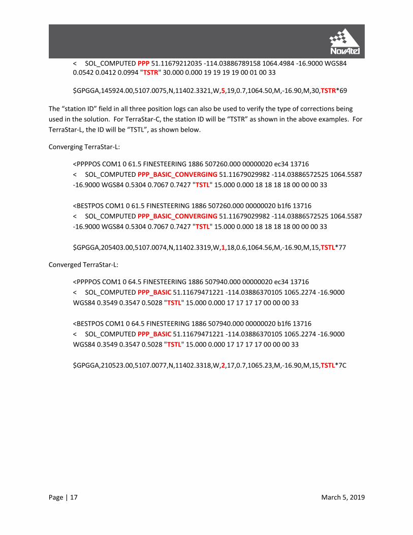
Page | 17 March 5, 2019
< SOL_COMPUTED PPP 51.11679212035 -114.03886789158 1064.4984 -16.9000 WGS84 0.0542 0.0412 0.0994 "TSTR" 30.000 0.000 19 19 19 19 00 01 00 33 $GPGGA,145924.00,5107.0075,N,11402.3321,W,5,19,0.7,1064.50,M,-16.90,M,30,TSTR*69
The “station ID” field in all three position logs can also be used to verify the type of corrections being
used in the solution. For TerraStar-C, the station ID will be “TSTR” as shown in the above examples. For
TerraStar-L, the ID will be “TSTL”, as shown below.
Converging TerraStar-L:
<PPPPOS COM1 0 61.5 FINESTEERING 1886 507260.000 00000020 ec34 13716
< SOL_COMPUTED PPP_BASIC_CONVERGING 51.11679029982 -114.03886572525 1064.5587
-16.9000 WGS84 0.5304 0.7067 0.7427 "TSTL" 15.000 0.000 18 18 18 18 00 00 00 33
<BESTPOS COM1 0 61.5 FINESTEERING 1886 507260.000 00000020 b1f6 13716
< SOL_COMPUTED PPP_BASIC_CONVERGING 51.11679029982 -114.03886572525 1064.5587
-16.9000 WGS84 0.5304 0.7067 0.7427 "TSTL" 15.000 0.000 18 18 18 18 00 00 00 33
$GPGGA,205403.00,5107.0074,N,11402.3319,W,1,18,0.6,1064.56,M,-16.90,M,15,TSTL*77
Converged TerraStar-L:
<PPPPOS COM1 0 64.5 FINESTEERING 1886 507940.000 00000020 ec34 13716
< SOL_COMPUTED PPP_BASIC 51.11679471221 -114.03886370105 1065.2274 -16.9000
WGS84 0.3549 0.3547 0.5028 "TSTL" 15.000 0.000 17 17 17 17 00 00 00 33
<BESTPOS COM1 0 64.5 FINESTEERING 1886 507940.000 00000020 b1f6 13716
< SOL_COMPUTED PPP_BASIC 51.11679471221 -114.03886370105 1065.2274 -16.9000
WGS84 0.3549 0.3547 0.5028 "TSTL" 15.000 0.000 17 17 17 17 00 00 00 33
$GPGGA,210523.00,5107.0077,N,11402.3318,W,2,17,0.7,1065.23,M,-16.90,M,15,TSTL*7C

Page | 18 March 5, 2019
Commands All of the commands and logs mentioned in this document are described in full detail in the OEM7
documentation (http://docs.novatel.com/OEM7/Content/Home.htm) or in the OEM6 Firmware
Reference Manual (www.novatel.com/assets/Documents/Manuals/om-20000129.pdf).
ASSIGNLBANDBEAM (Configure L-Band Tracking)
The “ASSIGNLBANDBEAM” command is used to configure L-Band tracking, which is disabled by default.
In most cases, the “AUTO” setting can be used to enable tracking of TerraStar and to download
subscription information as necessary (see Enable L-Band Tracking, page 14). In some cases it can be
desirable to use a specific beam in which cases the “MANUAL” setting can be used. The
LBANDBEAMTABLE log (page 22) contains a list of TerraStar beams known to the receiver and can be
helpful when using the manual option.
Examples:
ASSIGNLBANDBEAM AUTO
ASSIGNLBANDBEAM MANUAL AORW
The default setting for ASSIGNLBANDBEAM is:
ASSIGNLBANDBEAM IDLE
PPPBASICCONVERGEDCRITERIA (Configure the Decision for TerraStar-L PPP Convergence)
The receiver uses the standard deviation of the solution to determine when the PPP position has
converged. The “PPPBASICCONVERGEDCRITERIA” command allows the user to control this decision
when using TerraStar-L. The default setting for this command is:
PPPBASICCONVERGEDCRITERIA HORIZONTAL_STDDEV 0.60
Under this default setting, which is ideal and recommended for most applications, the receiver will label
the TerraStar-L PPP solution as “converged” when the horizontal standard deviation (2D) is 0.60 m or
less.
Another example is as follows:
PPPBASICCONVERGEDCRITERIA TOTAL_STDDEV 0.80
The second example will use the total position standard deviation (3D) to determine when the solution
has converged.

Page | 19 March 5, 2019
PPPCONVERGEDCRITERIA (Configure the Decision for TerraStar-C PPP Convergence)
The receiver uses the standard deviation of the solution to determine when the PPP position has
converged. The “PPPCONVERGEDCRITERIA” command allows the user to control this decision when
using TerraStar-C. The default setting for this command is:
PPPCONVERGEDCRITERIA HORIZONTAL_STDDEV 0.32
Under this default setting, the receiver will label the TerraStar-C PPP solution as “converged” when the
horizontal standard deviation (2D) is 0.32 m or less.
Another example is as follows:
PPPCONVERGEDCRITERIA TOTAL_STDDEV 0.25
The second example will use the total position standard deviation (3D) to determine when the solution
has converged.
Relaxing the convergence threshold shortens the time before a PPP solution is reported as converged.
However, it does not alter the absolute behavior of the solution. During the initial PPP solution period,
the positions can have decimetre error variation. It is recommended to only relax the convergence
threshold if the application can tolerate higher solution variability.
PPPDYNAMICS (Set the PPP Dynamics Mode)
This command configures the dynamics assumed by the PPP filter. The default setting is “DYNAMIC”:
PPPDYNAMICS DYNAMIC
To take advantage of automatic detection of antenna dynamics, specify the “AUTO” setting:
PPPDYNAMICS AUTO
“AUTO” will allow the receiver to detect the antenna dynamics and adapt filter operation accordingly.
This can be especially beneficial during convergence if the antenna will remain stationary during that
time. However, very slow “creeping” motion, where the antenna consistently moves 2 cm/s or less, can
be interpreted by the receiver as stationary. In such cases, the mode should remain as the default or
explicitly be set to DYNAMIC.

Page | 20 March 5, 2019
PPPRESET (Reset the PPP Filter)
The “PPPRESET” command is available on OEM7 receivers and can be used to reset the PPP filter. After
issuing the command, the PPP filter is restored to its initial state and PPP convergence will start over.
If deletion of the NVM-saved PPP seed information is also required, the “PPPSEED CLEAR” command
must be applied before “PPPRESET” is used. See PPPSEED, page 20, for more details.
There is an “option” field that can be used with the PPPRESET command, but it is not required and the
default is “FILTER” when not specified. For example, these commands are equivalent:
PPPRESET
PPPRESET FILTER
PPPSEED (Control Seeding of the PPP Filter)
The PPPSEED command controls the seeding of the PPP filter. Accurate position seeding can accelerate
PPP convergence. The command “PPPSEED SET” is used to explicitly specify a seed position. The seed
position must be in a datum consistent with the PPP corrections that will be used. For NovAtel CORRECT
with PPP, this is ITRF2008.
Caution must be exercised when using “PPPSEED SET”. While a “good” or accurate seed position can
accelerate convergence, a “bad” or inaccurate seed hurts performance. In some cases, a bad seed can
prevent a solution from ever converging to a correct position. In other cases, a bad seed might be
rejected immediately or the filter might operate with it for a period of time only to reject it later. In the
last case, the filter position is partially reset with a corresponding discontinuity in the PPP position.
The available options with the PPPSEED command are as follows:
• CLEAR – resets the stored seed, and prevents any auto seeding from occurring
• SET – immediately apply the specified coordinates as a seed position
• STORE – store the current PPP position in NVM for use as a future seed
• RESTORE – retrieve and apply a seed that was saved in NVM via the STORE or AUTO options
• AUTO – automatically store and restore PPP seed positions
The “STORE” and “RESTORE” options are intended to simplify seeding in operations where the antenna
does not move between power-down and power-up. For example, in agricultural operations a tractor
might be stopped in a field at the end of a day and then re-started the next day in the same position.
Before the receiver is powered-down, the current PPP position can be saved to NVM using the
command “PPPSEED STORE”, and then that position applied as a seed after power-up using “PPPSEED
RESTORE”.
The “AUTO” option automates the “STORE” and “RESTORE” process. When this option is used, the PPP
filter automatically starts using the stopping position of the previous day. The PPPDYNAMICS command
(page 19) must be set to “AUTO” when using PPPSEED so that the receiver can determine when it is

Page | 21 March 5, 2019
static, or the filter must explicitly be told it is static using “PPPDYNAMICS STATIC”. Additionally, in order
for the receiver to recall the saved seed, the “SAVECONFIG” command must be used after “PPPSEED
AUTO” to save the setting to NVM.
PPPSEED command uses this format:
PPPSEED option [latitude] [longitude] [height] [northing_std_dev] [easting_std_dev]
[height_std_dev]
Examples:
PPPSEED SET 51.11635322441 -114.03819311672 1064.5458 0.05 0.05 0.05
PPPSEED STORE
PPPSEED AUTO
PPPSOURCE (Specify the PPP Correction Source)
The PPPSOURCE command allows the user to specify the type or source of corrections the PPP filter will
use. It can also be used to disable the PPP filter. The default setting is “AUTO”, which allows the
receiver to automatically select and use the best corrections.
Examples:
PPPSOURCE NONE
PPPSOURCE TERRASTAR_L
If desired, for testing purposes, a receiver with a TerraStar-C subscription can be configured to only
accept TerraStar-L corrections using the “TERRASTAR_L” option.
PPPTIMEOUT (Set the Maximum Age of the PPP Corrections)
The maximum age of corrections that will be used by the PPP filter is determined by the PPPTIMEOUT
command. If the correction stream is interrupted, the receiver will continue using the last received
corrections but the age of those corrections will begin to grow. If the corrections become older than the
specified PPPTIMEOUT duration, the receiver will no longer use those corrections. The default setting is
360 seconds (6 minutes), the minimum is 5 seconds and the maximum duration is 900 seconds. For
example:
PPPTIMEOUT 360
PPPTIMEOUT 900
PPPTIMEOUT 200

Page | 22 March 5, 2019
Logs Any of the logs described below can be output using the LOG command. Appending an “A” or a “B” to
the log name when sending the LOG command will output the message in full ASCII (examples below are
‘abbreviated’ ASCII) or binary respectively. For example, the command “LOG PPPPOSB” will log the
PPPPOS log in binary format.
For complete details about the LOG command, including how to specify the data rate/interval and
trigger, see the LOG command definition in the OEM6 Firmware Reference Manual
(www.novatel.com/assets/Documents/Manuals/om-20000129.pdf) or OEM7 documentation
(http://docs.novatel.com/OEM7/Content/Home.htm).
LBANDBEAMTABLE (List of L-Band Beams)
This log provides a list of TerraStar L-Band beams known to the receiver. The receiver firmware contains
a default list that will be output until the receiver downloads new beam information from TerraStar.
Using the command “LOG LBANDBEAMTABLE”, this is an example output:
<LBANDBEAMTABLE COM1 0 74.5 UNKNOWN 0 0.151 02440000 f3b2 45228 < 7 < "AORE" "A" 1545855000 1200 -15.50 1 < "AORW" "B" 1545845000 1200 -54.00 1 < "IOR" "C" 1545865000 1200 64.50 1 < "POR" "D" 1545905000 1200 178.00 1 < "25E" "E" 1545825000 1200 25.00 1 < "143.5E" "F" 1545835000 1200 143.50 1 < "98W" "G" 1545865000 1200 -98.00 1
The first two fields in each entry, for example ““POR” “D””, correspond to the beam/transmitting
satellite name and the region ID. The next three fields correspond to the broadcasting frequency (Hz),
the baud rate and the longitude (degrees) of the L-Band satellite. The last field is the beam access,
where “1” indicates that access has been granted by the subscription for that particular beam. A
receiver without a subscription will have access to all beams to permit the download of a subscription.
It should be noted that AORE has been decommissioned by Inmarsat and is currently unavailable. A
replacement is expected to be available in 2020.
LBANDTRACKSTAT (Report the L-Band Tracking and Viterbi Decoding Status)
The LBANDTRACKSTAT log provides information that can be used to verify L-Band tracking. Specifically,
the name of the L-Band satellite or beam and its frequency, baud rate and service ID are included in this
log. Also, the carrier to noise density ratio or “C/No” (in dB-Hz) and lock time (in seconds) are indicators
of tracking performance.
For example:
<LBANDTRACKSTAT COM1 0 78.0 FINESTEERING 1835 138913.000 00000020 29fd 13306

Page | 23 March 5, 2019
< 1 < "98W" 1545865000 1200 974c 00c2 0 -271.092 44.380 4.8400 10121.678 192704 91 91 24473408 11363 0.0002
In this example, the receiver is tracking the “98W” beam with a frequency of 1545865000 Hz and a baud
rate of 1200. Also, the C/No is 44.380 dB-Hz and the continuous lock time is 192704 seconds, indicating
solid tracking performance. The C/No is typically about 40-45 dB-Hz in ideal conditions.
PPPPOS (PPP Filter Position)
The PPPPOS log contains the position solution computed specifically by the PPP filter. The possible
position types in this log are as follows:
Table 2: PPPPOS Position Types
Position Type Binary Value Description
NONE 0 No solution
PPP_BASIC_CONVERGING 77 Converging TerraStar-L Solution
PPP_BASIC 78 Converged TerraStar-L Solution
PPP_CONVERGING 68 Converging PPP Solution
PPP 69 Converged PPP Solution
TerraStar-C examples:
<PPPPOS COM2 0 67.0 FINESTEERING 1835 138450.000 00000020 ec34 13306 < SOL_COMPUTED PPP_CONVERGING 51.11679113545 -114.03886168434 1064.7791 -16.9000 WGS84 0.4998 0.4735 0.8064 "TSTR" 30.000 0.000 16 16 16 16 00 00 00 33 <PPPPOS COM2 0 56.5 FINESTEERING 1835 140380.000 00000020 ec34 13306 < SOL_COMPUTED PPP 51.11679212035 -114.03886789158 1064.4984 -16.9000 WGS84 0.0542 0.0412 0.0994 "TSTR" 30.000 0.000 19 19 19 19 00 01 00 33
TerraStar-L examples: <PPPPOS COM1 0 61.5 FINESTEERING 1886 507260.000 00000020 ec34 13716
< SOL_COMPUTED PPP_BASIC_CONVERGING 51.11679029982 -114.03886572525 1064.5587 -
16.9000 WGS84 0.5304 0.7067 0.7427 "TSTL" 15.000 0.000 18 18 18 18 00 00 00 33
<PPPPOS COM1 0 64.5 FINESTEERING 1886 507940.000 00000020 ec34 13716
< SOL_COMPUTED PPP_BASIC 51.11679471221 -114.03886370105 1065.2274 -16.9000
WGS84 0.3549 0.3547 0.5028 "TSTL" 15.000 0.000 17 17 17 17 00 00 00 33
See also Obtaining a PPP Position Solution.

Page | 24 March 5, 2019
PPPSATS (Satellites Used in the PPPPOS Solution)
This log provides a list of the used and unused satellites for the corresponding PPPPOS solution. The
signals of the used satellites are also described, along with the reasons for exclusions.
For example:
<PPPSATS COM2 0 47.0 FINESTEERING 1835 140613.000 00000020 ce3f 13306 < 23 < GPS 29 GOOD 00000003 < GPS 13 GOOD 00000003 < GPS 32 GOOD 00000003 < GPS 4 GOOD 00000003 < GPS 16 GOOD 00000003 < GPS 23 GOOD 00000003 < GPS 10 GOOD 00000003 < GPS 31 GOOD 00000003 < GPS 7 GOOD 00000003 < GPS 2 GOOD 00000003 < GPS 20 GOOD 00000003 < SBAS 138 NOTUSED 00000000 < SBAS 133 NOTUSED 00000000 < SBAS 135 NOTUSED 00000000 < GLONASS 14-7 GOOD 00000003 < GLONASS 23+3 GOOD 00000003 < GLONASS 5+1 GOOD 00000003 < GLONASS 15 GOOD 00000003 < GLONASS 22-3 GOOD 00000003 < GLONASS 13-2 GOOD 00000003 < GLONASS 6-4 GOOD 00000003 < GLONASS 3+5 GOOD 00000003 < GLONASS 4+6 GOOD 00000003
TERRASTARINFO (TerraStar Subscription Information)
Details about the current TerraStar subscription are contained in the “TERRASTARINFO” log. Also, the
receiver-specific Product Activation Code (PAC) is available from this log.
For “Term” subscriptions, the expiry or contract end date is indicated by a year and day of year (DOY).
See below for an example.
Example:
<TERRASTARINFO COM2 0 72.5 FINESTEERING 1835 138108.148 00000020 e776 13306 < "QR244:2228:3410" TERM 00000301 355 2015 0 GEOGATED 0.00000 0.00000 0
In this example the PAC is “QR244:2228:3414” and it has a term subscription. After the header, the fifth
and sixth fields can be used to determine the expiry date for the subscription. Those fields specifically
represent the “Service End Day of Year” (DOY) and the “Service End Year” respectively.

Page | 25 March 5, 2019
With firmware version 6.700 (OEM060700RN0000) or later, and all OEM7 firmware, the Service End DOY
matches the end date, in UTC time, indicated when the subscription was purchased. In the example
below the Service End is day 79 of 2016, which means the subscription will expire on March 19th, 2016.
<TERRASTARINFO COM1 0 71.5 FINESTEERING 1888 162835.801 00000020 a7ce 13716
< "QT365:5653:9885" TERM 00000700 79 2016 0 GEOGATED 0.00000 0.00000 0
With OEM6 firmware versions older than 6.700, for example 6.620, the Service End DOY is the day
following the TerraStar contract end DOY. Assuming older firmware, in the example above the Service
End is reported as day 79 of 2016, correlating to March 19th, which means that the subscription will
expire on March 18th, 2016.
The third field (after the header) in the TERRASTARINFO log provides subscription details and the bits
can be decoded to determine which services are enabled by the subscription. Table 3 below outlines
the bits used for TerraStar-C and TerraStar-L.
Table 3: TERRASTARINFO Subscription Details Mask
Bits Mask Description
0-8 0x000001FF Reserved
9 0x00000200 TerraStar-C
10 0x00000400 TerraStar-L
11 0x00000800 RTK ASSIST
12 0x00001000 RTK ASSIST PRO
13 0x00002000 TerraStar-C PRO
12-31 0xFFFFF000 Reserved
A receiver can have only one active subscription at a time but a subscription can enable multiple
services or bits. In the example above, “00000700” indicates the receiver has a TerraStar-C subscription
though TerraStar-L is also allowed. Other bits in the subscriptions details field may be populated but
they are currently reserved.
TERRASTARSTATUS (TerraStar Decoder and Subscription Status)
Additional TerraStar decoder and subscription status information is provided in the TERRASTARSTATUS
log. This log can be used to verify that the receiver is locked onto the TerraStar signal and is decoding
data.
For example:
<TERRASTARSTATUS COM2 0 72.5 FINESTEERING 1835 140874.036 00000020 fdc1 13306 < ENABLE LOCKED 0 DISABLED ONSHORE
If the receiver currently has a valid subscription, the first field will be “ENABLE” and in most cases the
last field or “geogating status” will be “ONSHORE”.

Page | 26 March 5, 2019
Convergence Recommendations The TerraStar solution will have an associated convergence time during which the accuracy will stabilize
and converge towards the quoted accuracy for NovAtel CORRECT with PPP9.
Although it is not currently possible to completely remove the convergence period of the PPP solution,
there are techniques to help improve or shorten the time required to reach the specified accuracy.
Some of these include:
• Ensure the antenna is located in an area that has a clear view of the sky with no obstructions,
especially during initial startup and convergence.
• If the vehicle and antenna can and will be stationary during convergence, use the “AUTO”
setting for PPPDYNAMICS (page 19) to take advantage of automatic dynamics detection and
filtering.
• Use the PPPSEED command (page 20) to specify the location of the antenna if it is located in a
known position, but at the same time avoid using a “bad” seed if the accuracy of the known
location is poor as this can increase the convergence time.
For most applications it is best to allow the PPP solution to be flagged as “converged” before proceeding
with operation. This is due to the variation that can be present in the solution as it converges. Waiting
for a converged position status will help ensure the solution has stabilized and is operating within the
expected accuracy. With TerraStar-C, if the application can tolerate higher solution variability the
PPPCONVERGEDCRITERIA command (page 19) can potentially be used to relax the convergence
tolerance or threshold.
9 www.novatel.com/products/novatel-correct/novatel-correct-ppp/

Page | 27 March 5, 2019
Where to go for Support To help answer questions and/or diagnose any technical issues that may occur, the NovAtel Support
website is a first resource: www.novatel.com/support/
Remaining questions or issues, including requests for test subscriptions or activation resends, can be
directed to NovAtel Support by visiting www.novatel.com/support/contact/. To enable the online form
and submit a ticket, first select a "Product Line" and then an associated "Product" from the list.
However, before contacting Support, it is helpful to collect data from the receiver to help investigate
and diagnose any performance-related issues. In those cases, if possible, collect the following list of logs
(the LOG command with the recommended trigger and data rate is included):
LOG VERSIONA ONCE LOG RXSTATUSA ONCHANGED LOG RAWEPHEMB ONCHANGED LOG ALMANACB ONCHANGED LOG IONUTCB ONCHANGED LOG GLORAWEPHEMB ONCHANGED LOG GLORAWALMB ONCHANGED LOG GLOCLOCKB ONCHANGED LOG RANGEB ONTIME 1 LOG BESTPOSB ONTIME 1 LOG PPPPOSB ONTIME 1 LOG PPPSATSB ONTIME 1 LOG LBANDTRACKSTATB ONTIME 1 LOG TERRASTARINFOA ONCHANGED LOG TERRASTARSTATUSA ONCHANGED LOG LBANDBEAMTABLEA ONCHANGED LOG RXCONFIGA ONCE
The data described above can be collected using a terminal program that supports binary data logging,
or NovAtel’s CONNECT utility can be downloaded and installed from the NovAtel website:
www.novatel.com/support/info/documents/809

Page | 28 March 5, 2019