APA 2021 - npd.no
14
Guidelines for production licence applications APA 2021 Awards in predefined areas
Transcript of APA 2021 - npd.no

Guidelines for production licence applications
APA 2021Awards in predefined areas

Content General application information ............................................................................................................. 2
Submission of application ................................................................................................................... 2
Overview of submissions to the MPE and the NPD............................................................................. 3
Forms ................................................................................................................................................... 3
Shape files ........................................................................................................................................... 4
Overview and naming of the content in each application ...................................................................... 4
Application for additional acreage .......................................................................................................... 5
Application for stratigraphic area ........................................................................................................... 5
Application for areas containing discoveries/shut-down fields .............................................................. 5
Geographic layout of the area ................................................................................................................. 5
Application content ................................................................................................................................. 6
1. Application summary ............................................................................................................... 6
A. Overview .................................................................................................................. 6
B. Resource potential .................................................................................................. 6
C. Map .......................................................................................................................... 7
D. Work programme and duration .............................................................................. 7
2. Geological and technological assessment ............................................................................... 9
2.1 Database and data utilisation .................................................................................. 9
2.2 Petroleum geological overview ............................................................................... 9
2.3 Resource evaluation .............................................................................................. 10
2.4 Technological assumptions and development plan .............................................. 12
3. Work programme ................................................................................................................... 12
4. Environmental conditions ...................................................................................................... 13
5. References ............................................................................................................................. 13

APA 2021 GUIDE TO APPLICATION FOR PRODUCTION LICENCE
2
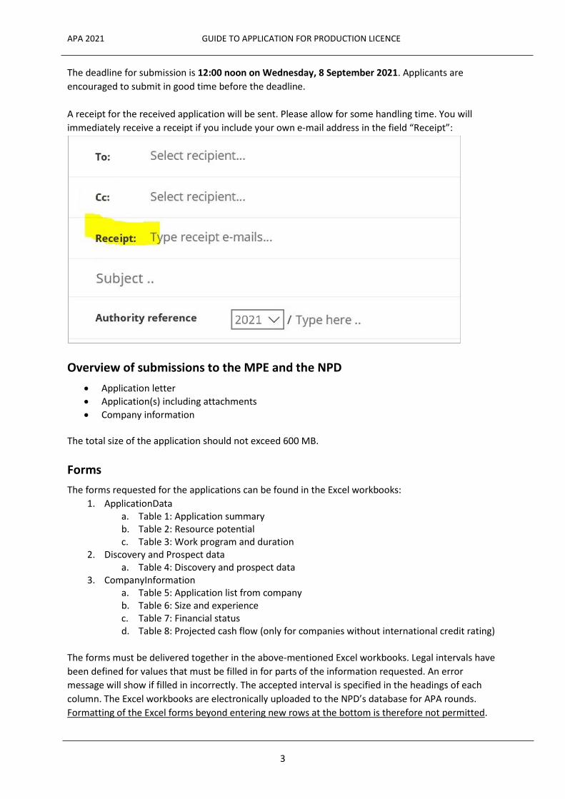
General application information Submission of application Each application must be submitted to both the Ministry of Petroleum and Energy and the Norwegian Petroleum Directorate. Upon sending via L2S Authority Communication, both the Ministry of Petroleum and Energy and the Norwegian Petroleum Directorate can be added as recipients in the same submission. The Norwegian Petroleum Directorate The application(s) including attachments must be saved in one folder named TFO2021-"companyname"-"applicationnumber"of"totalnumber" and the folder must subsequently be compressed ("zipped"). "Total number" represents the number of applications your company actually submits via L2S. The folder must not contain subfolders and the file must not be protected by password. Example for company "Energy AS" submitting one application: TFO2021-EnergyAS-1of1.zip The submission must be named TFO2021-"companyname"-"applicationnumber"of"totalnumber" and submitted via L2S Authority Communication to the Norwegian Petroleum Directorate. The inbox in L2S Authority Communication looks like this:
The Ministry of Petroleum and Energy One copy of the application shall be sent to the Ministry of Petroleum and Energy (MPE) in any electronic format. L2S Authority Communication is one possible solution to submit applications this year.
APA 2021 GUIDE TO APPLICATION FOR PRODUCTION LICENCE
3
The deadline for submission is 12:00 noon on Wednesday, 8 September 2021. Applicants are encouraged to submit in good time before the deadline. A receipt for the received application will be sent. Please allow for some handling time. You will immediately receive a receipt if you include your own e-mail address in the field “Receipt”:
Overview of submissions to the MPE and the NPD
• Application letter • Application(s) including attachments • Company information
The total size of the application should not exceed 600 MB.
Forms The forms requested for the applications can be found in the Excel workbooks:
1. ApplicationData a. Table 1: Application summary b. Table 2: Resource potential c. Table 3: Work program and duration
2. Discovery and Prospect data a. Table 4: Discovery and prospect data
3. CompanyInformation a. Table 5: Application list from company b. Table 6: Size and experience c. Table 7: Financial status d. Table 8: Projected cash flow (only for companies without international credit rating)
The forms must be delivered together in the above-mentioned Excel workbooks. Legal intervals have been defined for values that must be filled in for parts of the information requested. An error message will show if filled in incorrectly. The accepted interval is specified in the headings of each column. The Excel workbooks are electronically uploaded to the NPD’s database for APA rounds. Formatting of the Excel forms beyond entering new rows at the bottom is therefore not permitted.
APA 2021 GUIDE TO APPLICATION FOR PRODUCTION LICENCE
4
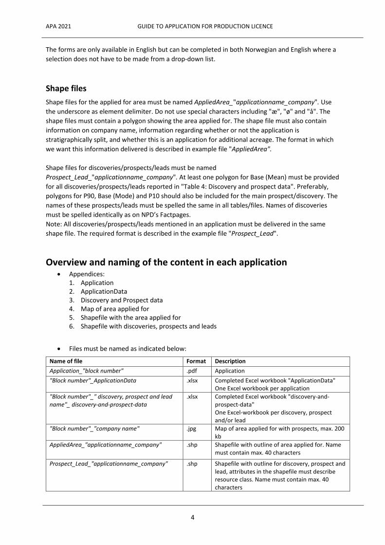
The forms are only available in English but can be completed in both Norwegian and English where a selection does not have to be made from a drop-down list. Shape files Shape files for the applied for area must be named AppliedArea_"applicationname_company". Use the underscore as element delimiter. Do not use special characters including "æ", "ø" and "å". The shape files must contain a polygon showing the area applied for. The shape file must also contain information on company name, information regarding whether or not the application is stratigraphically split, and whether this is an application for additional acreage. The format in which we want this information delivered is described in example file "AppliedArea". Shape files for discoveries/prospects/leads must be named Prospect_Lead_"applicationname_company". At least one polygon for Base (Mean) must be provided for all discoveries/prospects/leads reported in "Table 4: Discovery and prospect data". Preferably, polygons for P90, Base (Mode) and P10 should also be included for the main prospect/discovery. The names of these prospects/leads must be spelled the same in all tables/files. Names of discoveries must be spelled identically as on NPD’s Factpages. Note: All discoveries/prospects/leads mentioned in an application must be delivered in the same shape file. The required format is described in the example file "Prospect_Lead".
Overview and naming of the content in each application • Appendices:
1. Application 2. ApplicationData 3. Discovery and Prospect data 4. Map of area applied for 5. Shapefile with the area applied for 6. Shapefile with discoveries, prospects and leads
• Files must be named as indicated below:
Name of file Format Description Application_"block number" .pdf Application "Block number"_ApplicationData .xlsx Completed Excel workbook "ApplicationData"
One Excel workbook per application "Block number"_" discovery, prospect and lead name"_ discovery-and-prospect-data
.xlsx Completed Excel workbook "discovery-and-prospect-data" One Excel-workbook per discovery, prospect and/or lead
"Block number"_"company name" .jpg Map of area applied for with prospects, max. 200 kb
AppliedArea_"applicationname_company" .shp Shapefile with outline of area applied for. Name must contain max. 40 characters
Prospect_Lead_"applicationname_company" .shp Shapefile with outline for discovery, prospect and lead, attributes in the shapefile must describe resource class. Name must contain max. 40 characters

APA 2021 GUIDE TO APPLICATION FOR PRODUCTION LICENCE
5
For the various parts of the application, a guiding maximum side and figure/table numbers are indicated. If the total numbers of pages, figures and tables are exceeded, a clear reasoning must be given. Use a font size corresponding to Times New Roman 12 and single/standard spacing. Maps and illustrations should not be larger than A4. All information in figures and maps must be legible. All maps must contain coordinates, as well as a scale. The Excel-workbooks to be used in the applications can be found on the NPD’s website together with these guidelines at: www.npd.no/en/apa2021. The Excel form formats must not be changed. Exceptions are adding new rows in Tables 1, 2, 3 and 4. All units (depth, area, volume, etc.) must be provided in metric units.
Application for additional acreage Companies can apply for additional acreage where discoveries or mapped prospects extend continuously from the applicant's production licence into the area announced in APA 2021. The following criteria must be fulfilled in order to be awarded additional acreage:
1. All licensees in the existing production licence/unit are applicants. 2. The distribution of ownership interests will be identical to the existing production licence.
If the application for additional acreage aims at a new prospect mapped in an existing licence, a work programme must be proposed for the additional acreage which comprises exploration/drilling.
Application for stratigraphic area In a stratigraphic application, the interval applied for must be indicated in Chapter 1 (Application summary).
Application for areas containing discoveries/shut-down fields If the area applied for contains discoveries and/or shut-down fields, information about plans for further exploration/maturation must be provided. If there are no current plans, please give an explanation why this is not relevant.
Geographic layout of the area • Acreage without plan for development is not normally awarded • Leads without plan for maturation are not normally awarded

APA 2021 GUIDE TO APPLICATION FOR PRODUCTION LICENCE
6
Application content 1. Application summary The application summary must be included as the first part of the application. The application summary should be approximately three pages and must contain:
A. Overview of applicants and the area applied for, indicating the block number in completed form "Table 1: Application summary" (Table 1 must also be in the Excel workbook "ApplicationData")
B. Area description with completed form "Table 2: Resource potential" (Table 2 must also be in the Excel workbook "ApplicationData")
C. Map with geographical coordinates, block number and scale which shows the applied for area with an outline of the discoveries, prospects and leads that are specified in the form "Table 2: Resource potential", and presented in the application. (The map must also be included as a separate .jpg file and the area outline as a .shp file)
D. Completed form "Table 3: Work programme and duration" (Table 3 must also be in the Excel workbook "ApplicationData")
A. Overview
Provide a brief description of applicants and applied for area. For applications for additional acreage, provide a brief description for why the application is relevant for the production licence. For applications for stratigraphic area, the interval must be indicated. The form "Table 1: Application summary" is to be completed with the necessary data. An example of a filled in form is shown below. Table 1: Application summary
1 Additional acreage: where discoveries or mapped prospects extend into announced acreage from an existing
production licence with the same licensee(s) and ownership interests, indicate licence number/unit 2 O= operator, P= partner, O/P= no particular preference regarding operator or partner status 3 The size of the ownership interests primarily preferred, as well as an upper and lower limit which the applicant
can accept, in an interval between 0,000001 and 100 %. The ownership interests must be in accordance with the interests listed in the application letter from each company. An upper and lower limit are not indicated for additional acreage
4 Place an X by the company actually submitting the application, individually or on behalf of the group. Place an X by the company that paid the application fee, individually or on the behalf of the group
B. Resource potential
A brief summary of the resource potential in the applied for area must be given and outlined on a map showing the discoveries, prospects and leads described in the application, and that are listed on the form "Table 2: Resource Potential". Use different colours to show different stratigraphic levels. Key data for the discoveries, prospects and leads described in the application must be listed on the form "Table 2: Resource Potential". An example is shown below:

APA 2021 GUIDE TO APPLICATION FOR PRODUCTION LICENCE
7
Table 2: Resource potential
1 The name of the prospect or lead is informal and can be chosen freely. Ensure the name is used consistently
throughout the application documentation. For discoveries, the correct name should be collected from the NPD FactPages
2 D =discovery, P =prospect, L = lead 3,4 For different alternatives for the same prospect (case), the prospect must be listed with the associated
discovery probability for each phase. The calculation method is explained in section 2.3 of the application. The low and high values are P90 and P10, respectively. Any deviations from this must be clarified
5 The discovery probability must be stated between 0,00-1,00. Calculation of discovery probability is explained in section 2.3 of the application
6 Percentage of the prospect’s/discovery’s recoverable resources (mean) located in area applied for 7 Nomenclature approved by the Norwegian Stratigraphic Committee should be used where available, see
https://www.npd.no/en/facts/geology/lithostratigraphy/ 8 The nearest relevant facility with petroleum processing plants
C. Map
The applied for area and outline of the discoveries, prospects and leads mapped are shown in a map containing geographic coordinates, block number and scale. The prospect outline must be given as Base (Mean) in the application summary. For application for stratigraphic production licence, please fill the area with simple hatch.
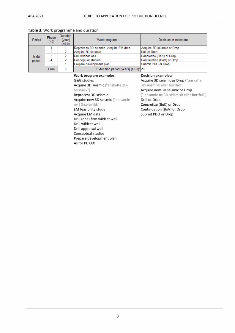
D. Work programme and duration
The applicant’s proposed work programme and duration of the production must be listed in the form "Table 3: Work programme and duration", shown below. Examples of/suggested work programmes, and decisions that will be used, are provided below the form. Other activities can also be entered. A more detailed description of the work programme should be provided in Chapter 3 of the application. An example of a completed form is shown below:
APA 2021 GUIDE TO APPLICATION FOR PRODUCTION LICENCE
8
Table 3: Work programme and duration
Work program examples:
G&G studies Acquire 3D seismic ("anskaffe 3D-seismikk") Reprocess 3D seismic Acquire new 3D seismic ("innsamle ny 3D-seismikk") EM feasibility study Acquire EM data Drill (one) firm wildcat well Drill wildcat well Drill appraisal well Conceptual studies Prepare development plan As for PL XXX
Decision examples: Acquire 3D seismic or Drop ("anskaffe 3D-seismikk eller bortfall") Acquire new 3D seismic or Drop ("innsamle ny 3D-seismikk eller bortfall") Drill or Drop Concretize (BoK) or Drop Continuation (BoV) or Drop Submit PDO or Drop
APA 2021 GUIDE TO APPLICATION FOR PRODUCTION LICENCE
9
2. Geological and technological assessment
2.1 Database and data utilisation
Seismic, wells and other data types such as EM data, used in the evaluation of the area/resource potential. How data has been utilised will be emphasised, as well as to what extent new and own interpretations and analyses were performed by the applicant. Information must be provided on consultant reports, purchased studies and other information that is not publicly available that has been used in the application. Section 2.1 should not exceed 5 pages including maps and tables. Seismic database Seismic used in the evaluation is listed with the survey name and type of
seismic, and is shown clearly in a database map of the applied for area. Data quality and measures to improve data can also be mentioned here.
Well database Well data that has been used in the evaluation is listed by name and shown
clearly in a database map of the applied for area. Key wells are marked and commented/discussed.
Studies Provide information on internal or purchased relevant technical studies with
clear references, e.g. reprocessing/geophysical special studies, geochemistry studies, basin modelling, etc.
2.2 Petroleum geological overview
The documentation in this section can be kept to a minimum for applications in mature areas/areas near existing fields or for mature/well-established exploration concepts. In these cases, it is sufficient to describe seismic mapping and plays, in addition to factors that are considered critical for the evaluation of the mapped prospectivity. Any possibility for high pressure and/or high temperature (HPHT) in the area applied for, regardless of depth and mapped prospectivity, must be addressed. The documentation for these applications should under Section 2.2 not exceed 2 pages of text in addition to a maximum of 10 figures. Applications in underexplored areas/new exploration concepts should focus on one concept with associated prospect(s)/lead(s) that are given primary focus in the descriptions, while alternative exploration concepts are described more generally. The analysis should focus on the factors that are considered critical for mapped prospectivity in the area and for evaluation of those. If previously documented studies have been used in the assessment, these must be referenced along with a short summary. The documentation under Section 2.2 for underexplored areas/new exploration concepts should not exceed 5 pages of text in addition to a maximum of 20 figures. Seismic mapping Describe which horizons are interpreted, "well tie" and the depth conversion
method. The following figures must be included as a minimum: Synthetic seismogram which documents "well tie" Seismic line which shows calibration of seismic interpretation vis-à-vis
well(s)
APA 2021 GUIDE TO APPLICATION FOR PRODUCTION LICENCE
10
Regional geology Briefly describe the primary stratigraphic, sedimentological and structural characteristics of the area. The following figures must be included as a minimum: Chronographic and lithostratigraphic column showing levels for identified
prospectivity Palaeogeographic map which illustrates the extent of the main reservoir
for mapped prospectivity Map showing structural framework in the area
Basin development Describe source rocks, maturity and migration of hydrocarbons. The
following figures must be included as a minimum: Basin map showing migration routes towards evaluated prospectivity
Plays Describe the play that represents the application’s primary prospectivity.
Briefly present other relevant plays in the applied for area, if applicable. The following figures must be included as a minimum: Map showing the distribution of the primary play in the area
2.3 Resource evaluation
Mapping and evaluation of discoveries, prospects and leads in the area applied for. Discoveries also include shut-down fields. The main prospect and/or discovery is described in detail, while secondary prospectivity/leads are described in less detail. The main prospect in the application is defined as the prospect with the greatest risk-weighted resource potential. In areas where several prospects/leads are mapped within the same play/exploration concept and area, an overall description of mapping, resource calculation and uncertainty analysis is provided. If the primary focus in the application is an existing discovery, the content of the evaluation must be adjusted, with greater emphasis on production properties and development plans and less emphasis on topics related to undiscovered resources. The documentation under Section 2.3 should not exceed 10 pages of text, in addition to about 10 figures, including:
• a maximum of 5 pages for the defined discovery/primary prospect/group of prospects, in addition to relevant figures/maps, and:
• maximum one page of text in addition to figures for each prospect in potential secondary exploration concepts.
• if required, the documentation may exceed the maximum number of pages and figures in cases where both discoveries/fields and prospects are discussed.
The form "Table 4: Discovery and Prospect data" must be filled in with data/parameters used in the evaluation of the mapped discovery/primary prospect/group of prospects. For leads, the table is filled in with as much data as possible.

APA 2021 GUIDE TO APPLICATION FOR PRODUCTION LICENCE
11
Mapping For the discovery, primary prospect or group of prospects within the primary exploration concept, provide a description of how the discovery/prospect/prospects are mapped, the type of trap and seal, expected reservoir properties, expected hydrocarbon type and fill percentage.
The evaluation must in particular explain factors considered critical to the prospect or critical for recovery from the discovery.
The following documentation must be included for the discovery/primary prospect/group of prospects: One overview map with coordinates and outline of the
discovery/prospect, as well as position of seismic lines and geological profiles
Two seismic and geological profiles in intersecting directions Time map and depth map in equal scale for reservoir horizon(s)
o A time map is not necessary if the mapping is based on depth converted seismic
Seismic attribute map/time slices, if applicable
Other figures can be included to the extent they are relevant for the description of discoveries, prospects and leads. For discoveries/shutdown fields, we expect well correlations and interpreted well logs, reservoir zonation as well as illustrations from static reservoir models.
A shorter description is provided for mapped prospects/leads within potential secondary exploration concepts.
Resource calculation For discoveries, mapped prospects and potential leads, describe the method
for calculating the following: rock volume with uncertainty range resources in place with uncertainty range recoverable resources with uncertainty range
The description shall include the method for uncertainty calculation, and explanation for the chosen reservoir and fluid parameters, as well as recovery rate.
A resource estimate with spread must be listed in the form "Table 4: Discovery and Prospect data" for all discoveries, prospects and leads. For leads, Table 4 must be completed with as many details as possible. For discoveries/shutdown fields, the calculation of recoverable resources should cover multiple development concepts and recovery methods, and should be illustrated with tornado diagrams for uncertainty range. Upsides and downsides should be described.

APA 2021 GUIDE TO APPLICATION FOR PRODUCTION LICENCE
12
If only parts of the mapped discovery, prospect or lead are located in the applied for area, the form "Table 2: Resource Potential" must clearly indicate the percentage this constitutes, as well as the total resource estimate.
Discovery probability Discovery probabilities and associated sub-probabilities listed for prospects in
the form "Table 4: Discovery and Prospect data" are addressed and explained with regard to the critical factors for the prospect. See also definitions enclosed with the form "Table 4: Discovery and Prospect data".
Technical reservoir For prospects, there must be a brief description of the expected production conditions schedule with the planned production strategy, and the most important
reservoir uncertainties and challenges that can be expected. Indicate which IOR measures could be relevant in the short and long term. A simple production profile is included.
A more detailed description, including a production profile, must be provided if an existing discovery/shutdown field is the primary focus in the application. Reservoir data (SCAL, PVT etc.) that is of significance for selecting the recovery method must be presented. Explain how uncertainties such as reservoir communication, aquifer support and pressure development can affect the production profile and how the challenges can be managed.
2.4 Technological assumptions and development plan
For the mapped discovery/primary prospect or group of prospects, there must be a description of what is assumed to provide the most optimal and feasible development solution for the area. Relevant alternative solutions can also be discussed. The description must comply with the IOR measures discussed in Section 2.3, and should be limited to about three pages including illustrations for prospects. The gas solution should be discussed, and future processing/transport capacity with possible connection to existing infrastructure is discussed if the applicant has access to such information. A more detailed description must be provided for discoveries/shut down fields: Relevant development alternatives must be presented and compared. Drainage strategies, wells, facilities, tie-in, power and transport solutions should be included in the description. Profitability calculations with assumptions should be presented for the various concepts. Brief discussions should be provided for challenges/risks and plans for potential commercial negotiations. Particular attention should be devoted to new solutions/new technology. 3. Work programme Information about the work programme for the applied for area, provided in the form "Table 3: Work programme and duration" in the application summary, must be discussed and explained. The entire work programme for the initial period must be described, with primary emphasis on the initial phase. Reference is made to examples and formulations in the form "Table 3: Work programme and duration".
APA 2021 GUIDE TO APPLICATION FOR PRODUCTION LICENCE
13
Comment briefly: • relevant seismic surveys considered/intended to be used • the time frame for the various phases of exploration and/or development plans for a
discovery • estimated time frame for tie-in to existing infrastructure • possible need for clarification/coordination in relation to adjacent production licences • proposed duration of the production licence (extension period)
The initial phase can be no longer than 10 years. The duration of the extension period is set at the expected production length, maximum is generally 30 years. If the application includes leads, describe how they will be matured into drillable prospects. The possibility of cooperating with other production licences in the area on joint geophysical acquisition should be discussed. If significant parts of a mapped discovery, prospect or lead in the applied for area extend into an already existing production licence, the impact this will have for the plans must be discussed. The description should be limited to about two pages of text. If the focus in the application is development of an existing discovery/shutdown field, a detailed schedule is expected for studies, decisions and area clarifications leading up to a PDO. Additional acreage With an application for additional acreage, include a brief description of performed, ongoing and planned work in the existing production licence, and how the additional acreage will be included in the work ahead. If the work programme for the additional acreage is intended to be as for the work programme in the existing production licence, please use "As for PL XXX" in "Table 3: Work program and duration". Do not list the remaining work program for the existing production licence. If the application for additional acreage aims at a new prospect mapped in an existing licence, a work programme must be proposed for the additional acreage which comprises exploration/drilling. 4. Environmental conditions Comment on any special environmental provisions associated with the applied for area, and how these will be safeguarded during the exploration phase and during development and production. 5. References References to reports, studies, publications used in the evaluation work