AONB - Cotswolds Area of Outstanding Natural
45
The Geological & Geomorphological Importance of the Cotswolds Area of Outstanding Natural Beauty
Transcript of AONB - Cotswolds Area of Outstanding Natural

The Geological&
GeomorphologicalImportance
of the
CotswoldsArea of
OutstandingNatural Beauty

This report was prepared on behalf of the Cotswolds AONB Conservation Board by
Gloucestershire Geology Trust (2005)
With the co-operation and assistance of
Oxfordshire Geology TrustWiltshire Geology GroupHerefordshire & Worcestershire Earth Heritage TrustWarwickshire Geological Conservation Group

CONTENTS
SectionPage No.
Overview 41 Introduction 52 Cotswolds Geology 7
2.1 Stratigraphy 72.2 Structure 92.3 Palaeontology 9
3 Cotswolds Geomorphology 104 Types of Geodiversity Sites 115 Historical Significance 13
5.1Cotteswold Naturalists Field Club
14
5.2 Museum Collections 146 Economic Resources 157 Cotswold Specialities 16
7.1 Rocks 167.2 Landscape 207.3 Fossils 24
8 Landmark Discoveries 259 Geoconservation Priorities 26
9.1 Sites 269.2 Features 289.3 Generic 28
10 Recommended Sites 29
Appendix 1 Cotswold Stratigraphy 31Appendix 2 GCR/SSSI Sites Table 34Appendix 3 GCR/SSSI Sites Map 35Appendix 4 RIGS Sites Table 36Appendix 5 RIGS Sites Map 39Appendix 6 Notable Historic Workers 40Appendix 7 Societies and Groups 44
References & Further Reading
45
List of FiguresPage Page
Fig. 1 Area Map 5 Fig. 13 Eyford Hill Pits 19
Fig. 2Landscape Character & Geological Maps
6 Fig. 14 Churchdown Hill 20
Fig. 3 Crickley Hill Cliffs 7 Fig. 15 Postlip Warren 21Fig. 4 Stratigraphic Table 8 Fig. 16 Crickley Hill Gull 22Fig. 5 Fossil Sites Table 9 Fig. 17 Lopha marshi 24Fig. 6 Topography 10 Fig. 18 Trigonia costata 24Fig. 7 Historical Figures 13 Fig. 19 Clypeus ploti 24
Fig. 8Leckhampton Limekilns
15 Fig. 20 Gryphaea bilobata 24
Fig. 9Marlstone Landscape
16 Fig. 21 Plectothyris fimbria 25
Fig. 10 Pea Grit 17 Fig. 22 CNFC Logo 25
Fig. 11Cross-bedded Oolite
17 Fig. 23 Priority Sites Table 26
Fig. 12Rolling Bank Quarry
18 Fig. 24Priority Features Table
28

The Geological and Geomorphological Importance of the Cotswolds AONB
GEOLOGY• Thickest sections of Middle Jurassic Inferior Oolite rocks in the UK.• Classic area of Jurassic stratigraphy.• The ONLY area where units such as the Pea Grit, Gryphite Grit and Rolling Bank Member can
be seen.• Long history of research.• Provides the resources for the characteristic Cotswold building, roofing
and walling stone.• Provides aquifers for local water supply.• Part of a structural feature extending from Somerset to Yorkshire.• Numerous high quality exposures.
PALAEONTOLOGY• Great variety and abundance of fossils.• First ever dinosaur described was from the Cotswolds.• Oldest confirmed Stegosaur in the world.• Early finds of carnivorous insects.• Numerous discoveries of other dinosaurs, pterosaurs and large reptiles.• First area where fossils were used as relative dating tools.• Many locations where fossils can be collected.
GEOMORPHOLOGY / LANDSCAPE• Classic example of ‘scarp and dip’ landscape.• Probably the most intense accumulation of landslips in inland Britain.• Dry valleys, windgaps, incised meanders and misfit streams.• Extensive cambering on the scarp and valley sides.• Evidence of southern most extent of recent glaciations.
HISTORICAL SIGNIFICANCE• Studies date back to early 1800’s and William Smith – “The Father of English Geology”.• Over 200 years of geological research and study since then.• Significant collections of rocks and fossils housed in local museums.• Large collection of papers and studies from the Cotteswold Naturalists Field Club.
ECONOMIC RESOURCES• Building, roofing and walling stone.• Fullers Earth.• Water.• Aggregate.• Lime.• Brick clay.• Iron.
o 36 GCR (Geological Conservation Review) / Geological SSSI (Site of Special Scientific Interest) in the AONBo 84 Regionally Important Geological Sites (RIGS) in the AONB

1. Introduction
The Cotswold Hills stretch for nearly 60 miles, forming part of an outcrop of Jurassic rocks that runs NE from the Dorset coast to the North Sea off Yorkshire. The escarpment can be identified from the area around Bath, right up to near Market Weighton in Yorkshire and is the largest continuous landform feature in lowland England. It is a classic example of a scarp and dip landscape. The steep western scarp of the Cotswolds exposes sections through Lower and Middle Jurassic rocks that dip gently eastwards towards Oxford and London. At Leckhampton Hill and Cleeve Common the thickest sections of Jurassic rocks anywhere in the country are exposed, a feature recognised by their designation as Sites of Special Scientific Interest. Towards the south-east the rocks get gradually younger and their different lithologies and erosional histories produce different types of features in the landscape. The relationships between geology and landscape can clearly be seen by comparing the similarities between a geological map of the area and the Landscape Character Assessment carried out by the AONB in 2004 (Fig. 2).
Fig.1 - The area of the Cotswolds Area of Outstanding Natural Beauty.(from Cotswolds AONB Landscape Character Assessment, 2004)
“The Cotswolds constitute a classic area of Jurassic stratigraphy. The Middle Jurassic Limestones, with their abundant and attractive fossils, have been studied by geologists since the early nineteenth century. The charm of the area is directly related to the underlying geology, not only through the influence it has on the natural landscape, but also because towns and villages throughout the district derive much of their character from the use of local limestone for building and roofing. In addition, local stone is used to construct the dry-stone wall field boundaries, which are such a distinctive feature of the Cotswold countryside. Knowledge of the geology thus helps the visitor and resident to appreciate the development of the landscape of the area, and helps the conservationist to preserve its beauty. More than this, however, an understanding of the geology is essential for the proper management of natural resources and the avoidance of ground hazards, so that geology has a fundamental contribution to make to the decision making process in matters of land use planning. Aspects of geology relating to ground conditions and the management of water resources are particularly important. The fact that the relatively hard limestones overlie comparatively soft, plastic mudstones can create problems of slope instability and can affect foundation conditions, so that civil engineering works depend on a proper understanding of the local geology. As regards water resources, Jurassic limestones are an important source of groundwater supplies for much of the United Kingdom. A detailed knowledge of their distribution, at surface outcrops and where buried beneath overlying beds, is necessary for the proper management of groundwater resources, for their protection, for water extraction and for the development of storage facilities. Limestone is still quarried at numerous sites and sand and gravel deposits have also been widely exploited.”
David A. Falvey, Director of the British Geological Survey, (2000).

The rocks that form the Cotswold Hills are made up of three different stages of the Jurassic period and date from between 210-140 million years ago. The Lower Jurassic is made up of the Lias Group, the Middle Jurassic Rocks are divided into the Inferior Oolite Group, and the Great Oolite Group and the Upper Jurassic is represented by the Ancholme Group. Each Group is subdivided into Formations and Members distinguished from each other according to differences in the constituent parts of the rock, the types of fossils found in the rocks and by erosional surfaces that mark breaks in deposition of the sediments.
Fig.2 - Simplified map of Cotswold Landscape Characters, based on Cotswolds AONB Landscape Character Assessment (2004)
The geology of the Cotswolds as everywhere has a very strong influence on the landscape, vegetation and wildlife, as well as on the industry and heritage of the people living in the area. The soils and vegetation noticeably change as the underlying geology changes from one type of rock to another, influencing growth of different species of plants and trees, which in turn provide habitats for a variety of different animal and bird species. The similarities between the distribution of Landscape Character types and underlying geology can clearly be seen on the above maps.
The landscape of the escarpment is relatively young, as the wearing back of the escarpment has taken place over the last 1.6 million years during the Quaternary period. Evidence of periglacial activity comes from gravel fans at the edge of the scarp and some areas continue to show active geomorphological processes. The Cotswolds escarpment probably has one of the highest inland concentrations of landslips in the country. The gentle undulations of the Cotswold landscape were formed by numerous streams cutting down through the rocks. Some of these streams still flow but many were the result of melting snow and ice and higher levels of precipitation following the Ice Ages that have left dry valleys behind them.
The present landscape was set by the Enclosure Acts from 1700 to 1840 when at least 120,000 acres of open land were enclosed by act of parliament, with the familiar dry-stone walls dividing off newly enclosed land for sheep. Enclosure caused two major changes to the area: firstly, the landscape looked entirely different as there were no longer large open spaces; secondly, intensive farming required fewer labourers, so villages tended to depopulate as farm workers went off to the towns to seek work. Since then the landscape has remained much the same until today.

2. COTSWOLDS GEOLOGY
2.1 StratigraphyGiven below are the major geological groups represented in the Cotswolds. Appendix 1 subdivides these groups into Formations and Members and gives more detailed information on lithology and the uses of various different rock types. Fig.4 provides a simplified stratigraphic table for the AONB.
LIAS GROUP (200-175 Ma)The name Lias comes from 18th century quarry workers, was adopted by William Smith and is still used today as the Lias Group. The Lias underlies the entire region and contributes greatly to considerable heights of parts of the escarpment and is a major influence in the number and severity of landslips along the escarpment and in valleys of the Cotswolds. The group is around 300m thick near Cheltenham but thins to less than 100m around Bristol. Sandier sediments predominate towards the south and limestone bands become more numerous. Where streams flow over the harder limestones, rapids formed by the break of slope led to the development of mills during the Middle Ages. The clays, muds and silts were laid down in a deep ocean that occasionally shallowed to allow formation of the limestones.
INFERIOR OOLITE GROUP (175-168 Ma)The Inferior Oolite is what is most commonly recognised as being ‘typical’ Cotswold limestones. It has produced building stone, walling stone, lime and aggregate and is where many of the Cotswold speciality fossils and rock types are to be found. The group is thickest in the north of the region and caps the highest point of the Cotswolds at Cleeve Common; towards the south the group thins considerably and the scarp capping is replaced by the Great Oolite Group.The base of the Inferior Oolite Group marks the onset of a long period of warm shallow tropical seas in which the typical Cotswold Limestones were deposited. There is a great variety of different rock types within it indicating that the exact nature of the environment in which they were deposited changed repeatedly, from current influenced shoals of oolite to lagoons and protected reefs.
Fig.3 - The classic exposure of the Pea Grit (Crickley Member) below the hill fort at Crickley Hill.
GREAT OOLITE GROUP (168-165 Ma)Pioneering work on this formation was carried out by William Smith in the late 1700’s and names used at this time such as Fullers Earth and Great Oolite are still in use today. The Great Oolite Group rocks form the scarp and uplands of the southern Cotswolds and much of the dip-slope in the central and northern Cotswolds. It is an extremely varied group of rocks with lithologies and faunas changing laterally as well as vertically throughout the sequence. Only the Forest Marble and Cornbrash extend across the entire district without substantial changes (Green, 1992). Many important rock types, including the famous Stonesfield Slates (Taynton Limestone Formation) roofing stones and Dagham Stone are derived from the Great Oolite. The detailed stratigraphy of the Great Oolite is too complicated for inclusion in this document so descriptions in Appendix 1 are confined to formation level.
ANCHOLME GROUP (165-161 Ma)This group outcrops only in small isolated patches in the south-east of the region and represents the youngest Jurassic strata in the area, the Kellaways and Oxford Clay Formations.

QUATERNARY DEPOSITS (1.8 Ma – Present)Quaternary deposits comprise varied, unconsolidated beds known as ‘drift’. These include glacial, periglacial and fluvial deposits as well as fan gravels and landslips and range from coarse gravels to mud and clay (Goudie & Parker, 1996). The Quaternary sediments of the Cotswolds offer perhaps, the longest terrestrial sequence in Britain (Bridgland, 1994: Parker, 1995)
Chronostratigraphy LithostratigraphySystem Series Stage Group Formation Member
Qu
ater
nar
y Holocene Made
Ground Landslip
Pleistocene
DevensianCheltenham Sand & Gravel
Head
River Terrace Deposits
Cromerian Northern Drift
Jura
ssic
Middle Jurassic
Callovian
Oxford Clay
Kellaways
Kellaways Sand Kellaways Clay
Great Oolite
Cornbrash
Bathonian
Forest Marble
White LimestoneSignet Shipton & Ardley
Hampen Taynton Limestone
Fullers Earth Eyeford Fuller’s Earth Undif.
Chipping Norton Limestone
Bajocian
Inferior Oolite
Salperton Limestone
Clypeus Grit Upper Trigonia Grit
Aston Limestone
Rolling Bank Notgrove FreestoneGryphite Lower Trigonia
Aalenian Birdlip Limestone
HarfordScottsquarCleeve CloudCrickley Leckhampton
Lower Jurassic
Toarcian
Lias
Bridport Sand
Whitby Mudstone U.
PliensbachianMarlstone Rock Dyrham
L. Pliensbachian
Charmouth Mudstone Sinemurian
Hettangian Blue Lias Fig.4 - Cotswolds stratigraphic table. © GGT

2.2 Structure
Palaeozoic rocks from the Precambrian to Carboniferous periods underlie the Cotswolds and structures produced in these rocks before the deposition of the Mesozoic cover influenced sedimentation patterns during the Permian, Triassic and Jurassic periods. The line of the Malvern Hills and its related faulting is one of the fundamental elements in the structure of the region and the East Malvern Boundary Fault forms the western boundary of the Mesozoic strata in the area. The main structural elements are parts of much larger structural features that extend well outside of the Cotswolds area.Deposition of the Mesozoic sediments was in an intermittently subsiding basin caused by extension of the earths crust due to plate tectonics. This extension was achieved mainly by reactivation of older weaknesses in the basement rocks and occurred as the Atlantic Ocean started to form and America started to pull away from Europe. These major faults were accompanied by smaller scale faulting happening at the same time as deposition was occurring. Major episodes of faulting occurred in the early Triassic, early Jurassic and late Jurassic-Cretaceous times (Green 1992).
2.3 Palaeontology
The Cotswolds are famous for the variety and abundance of fossils that can be found. The types of fossils and the ways in which they are preserved can tell us a great deal about the environments in which they lived and died. The fossil content of the rocks is a useful tool in establishing relative ages of the strata, separated into different ‘zones’ by the particular species of ammonites or brachiopods. Ages of different rocks can therefore be correlated
over very great distances. The variety is so great in the Cotswolds that it is impossible to describe all of them is this document but the assemblages include brachiopods, bivalves, ammonites, belemnites, echinoids, crinoids, fish, reptiles and mammals. Some of the most typical and characteristic Cotswold fossils are described in the “Cotswolds Specialities” section.A selection of important palaeontological sites in the Cotswolds and examples of fossils that have been found at each is given in Fig.5.
Fig.5 – Important palaeontological sites and their fossils.
Vertebrate Fossils
MINCHINHAMPTON COMMON Unique dinosaur find of Protoceratosaurus bradleyi
ALDERTON HILL, DUMBLETON HILL AND STANLEY HILL
Early Jurassic fish bed
DAGLINGWORTH QUARRY AND LONGBOROUGH QUARRY
Dinosaur remains
HUNTSMANS QUARRY, BROCKHILL AND HORNSLEASOW
Dinosaur and crocodile remains
SYREFORD QUARRY AND KINETON Pterosaur remains
EYFORD HILL Pterosaurs and other reptiles
BLOCKLEY BRICKWORKS Plesiosaurs and Ichthyosaurs
FAIRFORD AND LECHLADE GRAVEL WORKINGS, STROUD, LATTON AND CLEVELAND FARM QUARRY
Pleistocene mammals (Mammoth, Reindeer, Orox, Lemming etc)
Invertebrate Fossils
ALDERTON HILL, DUMBLETON HILL AND STANLEY HILL
Early Jurassic insects
HAPPYLANDS QUARRY AND CRICKLEY HILL Echinoderms (sea urchins)
CHEDWORTH CUTTING, GILBERTS GRAVE CUTTING AND COTSWOLD HILL QUARRY
Clypeus ploti (Chedworth Buns / Poundstones) (sea ur-chins)
EYFORD HILL Jurassic starfish
BLOCKLEY BRICKWORKS Ammonites, bivalves, crustaceans, bivalves etc
FOSSE CROSS QUARRY “Beetroot Stone” – red fossil algae

3. Cotswolds Geomorphology
Awareness and understanding of the sedimentary deposits and landforms developed during the climatically ‘restless’ Quaternary Period (1.64 Ma – present), with its glacial and interglacial episodes, is highly significant to the geoscientist working in Great Britain. Because of prolonged episodes of weathering and erosion during this time, deposits formed only in the last 500,000 years or so are the most widespread in the Cotswolds. Remnants of some older, early Pleistocene river terrace deposits, known as ‘Northern Drift’ occur in places, believed to be evidence of a proto-Evenlode/Thames river system that drained much of the Midlands and possibly parts of central and north Wales. The most extensive younger deposits include the river terrace complexes of the Severn, Upper Thames and the Warwickshire and Wiltshire Avons. Most of these were laid down during glacial Stages, with some during interglacials. Till and associated glacio-fluvial and meltwater lake deposits from the Anglian Glaciation (480,000 – 430,000 years Before Present) are present in the Vale of Moreton.Sediments laid down during the latest glaciation, the Devensian (75,000 – 10,000 years BP), and the following temperate climatic stage, the Flandrian (10,000 years – present), occupy the largest areas. Major Devensian deposits include terraces along the main river systems, fan deposits in the Severn Vale, and head in the dip slope valleys of the Cotswold escarpment. The post glacial sediments include river alluvium, very widespread and spectacular landslip along the Cotswold Scarp (possibly the largest in Britain), and local occurrences of tufa and peat. Although the essential character of the modern topography is thought to have developed during the preceding Tertiary Period, major modifications occurred during the Quaternary. The terrace deposits record episodes of shallow but progressive river incision and planation; meltwaters and post-glacial precipitation have carved valleys on the Cotswolds which are now dry or occupied by smaller misfit streams. The landslipped areas on the Cotswold Scarp have a characteristic set of topographic features and are highly responsive to environmental change in and on them, such as caused by increased rainfall or ground engineering projects. (Chidlaw, 2001)
Fig.6 - The topography of the Cotswolds clearly showing the scarp and dip landscape and whereerosion of the escarpment is most advanced in the north and south of the area. (From: Watts et al 2005)

4. Types of Geodiversity SitesThere are a number of different designations and levels of status for important geological sites covering sites that are important on international, national, regional and local scales. The majority of all sites are the result of human quarrying activities, be they ancient or modern. Most of these sites are no longer worked and provide an excellent opportunity to see what the Cotswolds are made of, quite literally. Working quarries are also a valuable asset to understanding the geology of the Cotswolds as they are continually exposing new rock that may still hold a few surprises for the geologist. A brief review of some of the designations used for geological and geomorphological sites is given below.
a. The Geological Conservation Review (GCR)A major initiative to identify and describe the most important geological sites in Britain began in 1977, with the launching of the Geological Conservation Review (GCR). The GCR was designed to identify those sites of national and international importance needed to show all the key scientific elements of the Earth heritage of Britain. These sites display sediments, rocks, fossils, and features of the landscape that make a special contribution to our understanding and appreciation of Earth science and the geological history of Britain. There is now an inventory of over 3000 GCR sites, selected for around 100 categories (the GCR ‘Blocks’) encompassing the range of geological and geomorphological features of Britain. The GCR sites form the basis of statutory geological and geomorphological site conservation in Britain.
GCR Sites in the Cotswolds AONBIn total there are 36 GCR sites within the AONB area displaying a wide range of features in eleven of the GCR Blocks. The majority of these sites represent British Jurassic stratigraphy from the Toarcian to the Bathonian stages of the Early and Middle Jurassic but also included are Jurassic-Cretaceous Reptillia, Mesozoic Palaeobotany, Palaeoentemology, Mesozoic-Tertiary Fish/Amphibia, the Quaternary of Midlands-Avon, Mass Movement and Fluvial Geomorphology of England.
b. Sites of Special Scientific Interest (SSSI)There are over 4,000 Sites of Special Scientific Interest (SSSIs) in England, covering around 7% of the country’s land area. SSSIs are the country’s very best wildlife and geological sites. They include some of our most spectacular and beautiful habitats; wildlife sites include large wetlands teeming with waders and waterfowl, winding chalk rivers, gorse and heather-clad heathlands, flower-rich meadows, windswept shingle beaches and remote uplands moorland and peat bog. Geological sites include active and disused quarries, river and coastal exposures, cuttings and various different landforms of exceptional national importance.Naturally occurring changes can have negative impacts on geological conservation unless sites are positively managed for the geological interest. Natural changes which can affect the value of the geological interest include:
• vegetation obscuring geological features;• degradation and slumping of geological faces obscuring the geological features;• flooding of quarries once they become disused;• flooding and collapse of disused mines.
Man-made impact on sites comes from activities such as:• landfill and fly tipping• inconsiderate development• neglect
Uncontrolled vegetation is a significant threat to the scientific interest at many sites, particularly inland where erosion rates are low. Disused quarries are often prone to rapid re-vegetation and generally need positive management for vegetation if faces are to be kept clear. Natural degradation of faces can also conceal exposures. (http://www.english-nature.org.uk/special/geological/protect2b2.htm)The Earth Science Conservation Classification (ESCC) has been used since 1990 by English Nature and the other organisations to classify geological sites. The ESCC has sixteen site types organised into three major categories: exposure, finite and integrity. Exposure sites include active and disused quarries, pits and cuttings, coastal and river cliffs and foreshore, river and stream sections and mines and tunnels.Finite sites contain geological features that are limited in extent so that removal of material may cause depletion of the resource. The features are often irreplaceable if destroyed. Site types include many mineral and some fossil deposits, mine dumps, finite underground mines and finite buried interest sites.Integrity sites are geomorphological and are characterised by the need for holistic management. Site types include active and static geomorphological sites, caves and karst.

The importance of distinguishing between these three groups is that their successful management usually requires a quite different approach. As a rule, exposure sites are more robust than integrity or finite sites and can often tolerate the effects of human activities to a greater degree.The site categories are not mutually exclusive and there are numerous examples where part of a site is classified as exposure and another part is classified as finite or integrity. For example, a stratigraphic sequence in a cliff or quarry would have an exposure classification, as removal of rock would generally produce further exposure of the same material. However, mineral veins within the same sequence would often have a finite classification, as removal of vein material would not produce fresh exposure, but would result in loss of the interest. (www.english-nature.org.uk/special/geological/protect2a.htm)
Geological SSSI’s in the Cotswolds AONBThe designation of geological SSSI’s in the AONB coincides with those sites recognised in the Geological Conservation Review (GCR). Features recognised and protected at these sites include stratigraphical sections and unconformities within them, important palaeontological sites, unique formations and structural features, active and fossil geomorphological sites and features that provide evidence of past environments and processes. Together they construct a picture of changing environments from around 200 million years ago to the present day and include events such as episodes of faulting and glaciation that have shaped the landscape as we see it today. [A full list of the GCR/SSSI sites in the AONB is given in Appendix 2 and a map of their distribution in Appendix 3.]
c. Regionally Important Geological / Geomorphological Sites (RIGS)The statutory protection afforded to SSSI’s protects sites of the utmost importance but many other sites that are important to local and regional geology and geomorphology are excluded. The Joint Nature Conservation Committee (JNCC) and English Nature (EN) have had the SSSI system for nationally important sites for many years and the need for a lower tier was realised in 1990 resulting in the effective formation of the “RIGS system” for local sites. The Malvern International Geoconservation Conference in 1993 stated the following reasons for site conservation:
• To preserve sites for the benefit of future generations• To allow research for the advancement of science• To train Earth scientists• To provide an essential teaching facility for schools• As a focus for recreational and leisure activities • For the aesthetic, cultural, amenity, historical and wildlife value of the sites
These criteria, when put into a local context, provided the means to decide how and where to notify sites that will achieve these goals. Sites are generally known as "RIGS" although a variety of other local terms do apply across the country. The sites have limited status in statute law but are widely used by local authorities in their planning decisions as a guide to land development and there is a general "presumption against development" in much the same way as "Key Wildlife Sites". Cooperation with landowners greatly aids this process. The whole process is managed by "RIGS groups" or their equivalent “Geology Trusts” or geoconservation organisations across the country, which are largely composed of experienced professional Earth scientists acting in a voluntary capacity. However an increasing number of groups are now employing staff and building independent financial structures. RIGS in the Cotswolds AONBThere are currently nearly 100 RIGS identified, surveyed and recorded throughout the AONB area representing all aspects of geology and landscape in the area. The RIGS recording organisations working within the AONB are county based organisations, most of which are members of The Geology Trusts, a regional association of geoconservation groups. Geology Trusts members are: Gloucestershire Geoconservation Trust, Oxfordshire Geology Trust, Wiltshire Geology Group, Herefordshire & Worcestershire Earth Heritage Trust and Warwickshire Geological Conservation Group. In Avon the RIGS recording is carried out by Avon RIGS Group.
[A list of RIGS within the AONB is given in Appendix 4 and a map of their distribution in Appendix 5.]
d. Local SitesIn addition to those sites which have qualified as GCR, SSSI or RIGS, there are many other sites which still hold great interest in the study of the geology and landscape of the AONB. These are termed ‘local sites’ and recorded in exactly the same way as RIGS but the data is not passed to the planning authorities, but kept in the database of the various Geological Records Centres of the recording groups. It may be that these sites develop extra importance subsequently as part of guided trails and walks where they combine with other sites to become more than the sum of their parts.

5. Historical SignificanceThe significance of the Cotswolds area to geology as a science and to our understanding of the Earth’s changing environments, both historically and in the modern world, cannot be emphasised too strongly. Studies date back to the earliest days of English geology when William Smith worked out an order of strata from their characteristic fossils in the area around Bath. His “Table of the Order of Strata and their Embedded Remains” and associated map was published in 1818 and formed the basis for all subsequent research. In 1834 Sir Roderick Murchison published his “Outline of the Geology of the Neighbourhood of Cheltenham” which included sections on the stratigraphy, geological structure and water supply in the area. The variety, fossil content and ease of access to geology in the Cotswolds has attracted many scholars and studies of the area were boosted by the formation of the Cotteswold Naturalists Field Club in 1846 (see below). Maps and memoirs of the Cotswolds, produced by the Geological Survey, first appeared during the 1850’s and the opening of new railway lines provided new cuttings and exposures that attracted even more geologists. The railway cuttings on the Cirencester – Andoversford - Bourton-on-the-Water line were of particular note and have since been recognised as Sites of Special Scientific Interest (SSSI). Around the turn of the century S.S. Buckman produced a series of seminal papers recognising the significance of ammonites, supplemented by brachiopods in the Cotswolds, to understanding the complexity of the Jurassic stratigraphy.In the early 20th century W.J. Arkell produced an overview of British Jurassic stratigraphy that was largely based on the Cotswolds area and detailed mapping of the geology was greatly helped by the sinking of two boreholes by the Geological Survey in the 1950’ and 1960’s. An overview of the activities of some of the most influential workers in unravelling Cotswolds geology and landscape is given in Fig.7. Further details on each named person is given in Appendix 6.
Name Influential WorkWilliam Smith • First to realise the lateral extent of rock strata.
• First to relate fossils to relative ages.• Drew the first ever geological maps.• Named numerous groups and formations.
Prof. James Buckman • Founder of Cirencester Museum.• Published “Geology of the Neighbourhood of Cheltenham”.• Published a geological chart to the strata of the Cotswold Hills.• Collected many important specimens.
Dr. John Lycett • Produced monographs on molluscs from the Great Oolite.• First to systematically examine molluscs of the British Jurassic.• Produced a handbook to the Cotswold Hills.
Rev. Peter Bellinger Brodie
• Collector and author regarding fossils of the Lias Group.• Described the first fossilised dragonfly, found in the Cotswolds.• Named various species of fossils.
Hugh Edwin Strickland • Produced “laws” of zoological and geological nomenclature.• Co-author of “The Geology of Cheltenham”.• Named various species of fossils.
Edwin Witchell • Founder member of the “Stroud Natural History and philosophical Society”.
• Had fossils named after him.• Wrote “The Geology of Stroud and the Area Drained by the
Frome”.• Vice-President of the Cotteswold Naturalists Field Club, 1887.
William Charles Lucy • President of the Cotteswold naturalists Field Club, 1887-1892.• Curator of the Gloucester literary and Scientific Association.• Founded Gloucester museum and Schools of Science and Art.• Early research into the Ice Ages in the Cotswolds.
Sydney Savory Buckman • Author of numerous species of ammonite.• Described ‘type’ ammonites from the Lias Group.• Developed the “hemerae” dating system for rocks using
ammonites.Lindsall Richardson • Correlated the Late Triassic-Early Jurassic rocks across Britain.
• Correlated the oolitic rocks across England.• Published “The Geology of Cheltenham” in 1904.• Researched water supply and alluvial deposits.• Wrote Geological Survey Memoirs for Moreton-in-Marsh,
Cirencester and Whitney.• Studied fossil sea urchins and sponges.• President of the Cotteswold Naturalists Field Club, 1932-1934.
William Buckland • The first description of a fossilised dinosaur in the world.• First description of mammals from the Mesozoic.• Pioneered the field of coprology.
Fig.7 – Influential Workers in Cotswolds Geology
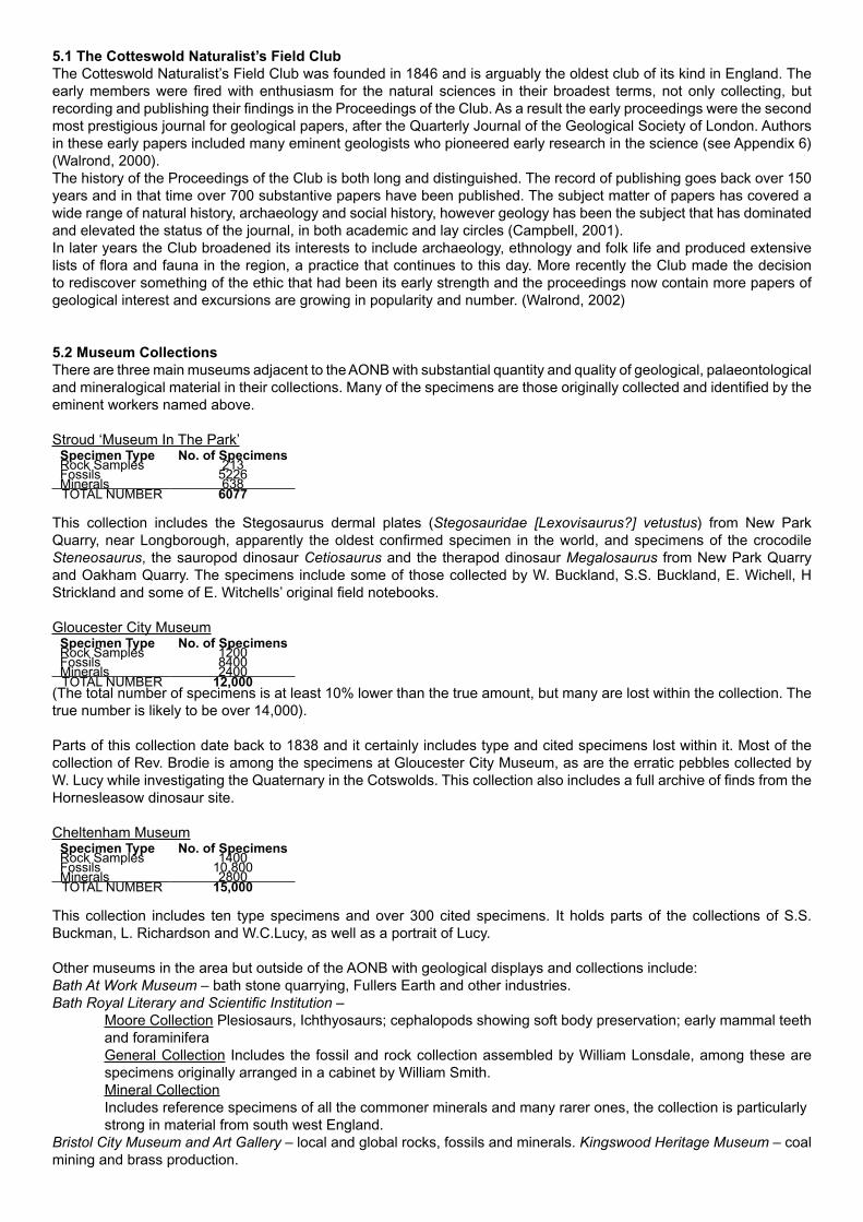
5.1 The Cotteswold Naturalist’s Field ClubThe Cotteswold Naturalist’s Field Club was founded in 1846 and is arguably the oldest club of its kind in England. The early members were fired with enthusiasm for the natural sciences in their broadest terms, not only collecting, but recording and publishing their findings in the Proceedings of the Club. As a result the early proceedings were the second most prestigious journal for geological papers, after the Quarterly Journal of the Geological Society of London. Authors in these early papers included many eminent geologists who pioneered early research in the science (see Appendix 6) (Walrond, 2000).The history of the Proceedings of the Club is both long and distinguished. The record of publishing goes back over 150 years and in that time over 700 substantive papers have been published. The subject matter of papers has covered a wide range of natural history, archaeology and social history, however geology has been the subject that has dominated and elevated the status of the journal, in both academic and lay circles (Campbell, 2001).In later years the Club broadened its interests to include archaeology, ethnology and folk life and produced extensive lists of flora and fauna in the region, a practice that continues to this day. More recently the Club made the decision to rediscover something of the ethic that had been its early strength and the proceedings now contain more papers of geological interest and excursions are growing in popularity and number. (Walrond, 2002)
5.2 Museum CollectionsThere are three main museums adjacent to the AONB with substantial quantity and quality of geological, palaeontological and mineralogical material in their collections. Many of the specimens are those originally collected and identified by the eminent workers named above.
Stroud ‘Museum In The Park’Specimen Type No. of SpecimensRock Samples 213Fossils 5226Minerals 638TOTAL NUMBER 6077
This collection includes the Stegosaurus dermal plates (Stegosauridae [Lexovisaurus?] vetustus) from New Park Quarry, near Longborough, apparently the oldest confirmed specimen in the world, and specimens of the crocodile Steneosaurus, the sauropod dinosaur Cetiosaurus and the therapod dinosaur Megalosaurus from New Park Quarry and Oakham Quarry. The specimens include some of those collected by W. Buckland, S.S. Buckland, E. Wichell, H Strickland and some of E. Witchells’ original field notebooks.
Gloucester City MuseumSpecimen Type No. of SpecimensRock Samples 1200Fossils 8400Minerals 2400TOTAL NUMBER 12,000
(The total number of specimens is at least 10% lower than the true amount, but many are lost within the collection. The true number is likely to be over 14,000).
Parts of this collection date back to 1838 and it certainly includes type and cited specimens lost within it. Most of the collection of Rev. Brodie is among the specimens at Gloucester City Museum, as are the erratic pebbles collected by W. Lucy while investigating the Quaternary in the Cotswolds. This collection also includes a full archive of finds from the Hornesleasow dinosaur site.
Cheltenham MuseumSpecimen Type No. of SpecimensRock Samples 1400Fossils 10,800Minerals 2800TOTAL NUMBER 15,000
This collection includes ten type specimens and over 300 cited specimens. It holds parts of the collections of S.S. Buckman, L. Richardson and W.C.Lucy, as well as a portrait of Lucy.
Other museums in the area but outside of the AONB with geological displays and collections include:Bath At Work Museum – bath stone quarrying, Fullers Earth and other industries. Bath Royal Literary and Scientific Institution –
Moore Collection Plesiosaurs, Ichthyosaurs; cephalopods showing soft body preservation; early mammal teeth and foraminiferaGeneral Collection Includes the fossil and rock collection assembled by William Lonsdale, among these are specimens originally arranged in a cabinet by William Smith. Mineral CollectionIncludes reference specimens of all the commoner minerals and many rarer ones, the collection is particularly strong in material from south west England.
Bristol City Museum and Art Gallery – local and global rocks, fossils and minerals. Kingswood Heritage Museum – coal mining and brass production.
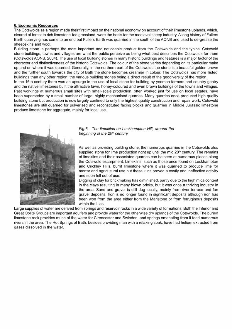
6. Economic ResourcesThe Cotswolds as a region made their first impact on the national economy on account of their limestone uplands, which, cleared of forest to rich limestone-fed grassland, were the basis for the medieval sheep industry. A long history of Fullers Earth quarrying has come to an end but Fullers Earth was quarried in the south of the AONB and used to de-grease the sheepskins and wool. Building stone is perhaps the most important and noticeable product from the Cotswolds and the typical Cotswold stone buildings, towns and villages are what the public perceive as being what best describes the Cotswolds for them (Cotswolds AONB, 2004). The use of local building stones in many historic buildings and features is a major factor of the character and distinctiveness of the historic Cotswolds. The colour of the stone varies depending on its particular make up and on where it was quarried. Generally, in the northern part of the Cotswolds the stone is a beautiful golden brown and the further south towards the city of Bath the stone becomes creamier in colour. The Cotswolds has more ‘listed’ buildings than any other region; the various building stones being a direct result of the geodiversity of the region. In the 16th century there was an upsurge in the use of local stone for building by yeoman farmers and country gentry and the native limestones built the attractive fawn, honey-coloured and even brown buildings of the towns and villages. Past workings at numerous small sites with small-scale production, often worked just for use on local estates, have been superseded by a small number of large, highly mechanised quarries. Many quarries once produced high quality building stone but production is now largely confined to only the highest quality construction and repair work. Cotswold limestones are still quarried for pulverised and reconstituted facing blocks and quarries in Middle Jurassic limestone produce limestone for aggregate, mainly for local use.
Fig.8 - The limekilns on Leckhampton Hill, around the beginning of the 20th century.
As well as providing building stone, the numerous quarries in the Cotswolds also supplied stone for lime production right up until the mid 20th century. The remains of limekilns and their associated quarries can be seen at numerous places along the Cotswold escarpment. Limekilns, such as those once found on Leckhampton and Crickley Hills, burnt limestone where it was quarried to produce lime for mortar and agricultural use but these kilns proved a costly and ineffective activity and soon fell out of use.Digging of clay for brickmaking has diminished, partly due to the high mica content in the clays resulting in many blown bricks, but it was once a thriving industry in the area. Sand and gravel is still dug locally, mainly from river terrace and fan gravel deposits. Iron is no longer found in significant deposits although iron has been won from the area either from the Marlstone or from ferruginous deposits within the Lias.
Large supplies of water are derived from springs and reservoir rocks in a wide variety of formations. Both the Inferior and Great Oolite Groups are important aquifers and provide water for the otherwise dry uplands of the Cotswolds. The buried limestone rock provides much of the water for Cirencester and Swindon, and springs emanating from it feed numerous rivers in the area. The Hot Springs of Bath, besides providing man with a relaxing soak, have had helium extracted from gases dissolved in the water.

7. Cotswold SpecialitiesThe Earth heritage importance of the Cotswolds is exemplified in a number of different rocks, fossils and features that can be classed as Cotswold specialities, either for their rarity, their abundance or their sheer quality. A brief outline of these features is given below and examples of locations where these ‘specialities’ can be seen. Many of these sites are on privately owned land and the inclusion of these sites in this document by no means infers any right of access without prior permission of the landowner.
7.1 ROCKSLias Group
Cephalopod Bed (Bridport Sand Formation)This unit is so named due to the relative abundance of Cephalopod fossils such as ammonites and belemnites in it. It is at its thickest around Dursley where it consists of ferruginous, oolitic limestones and marls (Green, 1992). The Cephalopod Bed is described as a ‘condensed sequence’ because even though it is relatively thin, it covers a wide time-span, including two ammonite zones of the late Toarcian. In the south of the AONB area around Bath it becomes sandier and the sandy facies here is thought to be younger than its stratigraphic equivalent to the north. North of Stroud the Cephalopod Bed dies away or passes laterally into clay.[Example Locations: Wotton Hill; Container Quarry, Woodchester Park]
Marlstone Rock FormationThe Marlstone is the most distinctive bed of limestone in the Liassic (Lower Jurassic) rocks in the Cotswolds. It is extensively found at the same level across the country but its lithology varies considerably from a shelly oolitic limestone to an iron rich sandstone and almost pure iron-oolite. The Marlstone in and around the Cotswolds is generally too thin and its iron content too low for use an iron ore but in other parts of the country, including north Oxfordshire, it has been a valuable source of iron. However, the pleasant rusty brown colour of Cotswold Marlstone makes it a most attractive building stone.
Fig.9 - The Marlstone Rock Formation producing flat-topped hills and a ledge in the escarpment in the south west of the AONB.
The relative hardness of the marlstone compared to its confining mudstones and siltstones leads to the formation of a conspicuous ledge around the Cotswold Escarpment, a feature best exhibited in the SW around Wotton-under-Edge and Stinchcombe. It also gives rise to the flat-topped hills of Dumbleton and Churchdown, and to the ledges on Oxenton, Alderton and Bredon Hills (Green, 1992).[Example Locations: Robinswood Hill; Churchdown Hill; Bredon Hill]
Inferior Oolite GroupPea Grit (Birdlip Limestone Formation)
This very distinctive rock, unique to the Cotswolds, consists of flattened, disc shaped grains of algal limestone which have accumulated around a nucleus, such as a shell fragment or sand grain. The grains have often been encrusted by small marine worms (annelids) and minute marine animals such as bryozoa and foraminifera (Toland 2002). The Pea Grit is up to eleven metres thick around Crickley Hill and contains abundant fossils including, echinoids, brachiopods, gastropods and corals. A particularly rich coral bed appears near the top of the Pea Grit around Crickley Hill (Crickley Coral Bed). It outcrops along the escarpment from Cleeve Hill to Stroud but continues south-east from here under the cover of younger rocks. In the east of the Cotswolds the Pea Grit changes laterally to a freestone known as Yellow Guiting Stone (Green, 1992).[Example Locations: Crickley Hill; Leckhampton Hill]

Fig.10.Left: Pea Grit exposed in the escarpment at Crickley Hill.Above: A specimen of Pea Grit showing the ‘oncoids’ that resemble peas, giving the rock its name.
Lower Freestone (Birdlip Limestone Formation)The Lower Freestone is the thickest member of the Inferior Oolite sequence and has provided a source of building stone for centuries. It was extensively quarried on Leckhampton and Cleeve Hills where its thickness and an uniform oolitic
nature and relative lack of fossils made it ideal for dimension stone and carving. Examples of its use as a decorative stone can be seen in many distinguished buildings including Gloucester and Worcester Cathedrals and much of Regency Cheltenham. Its use was not confined to high profile buildings however, and many Cotswold villages are substantially built from Freestones. The beds are strongly cross-bedded and the fronts of these large sub-marine dunes can clearly be seen in the Lower Freestone exposures at Cleeve Cloud. The Lower Freestone has also been worked from the area around Chipping Campden where it has been known as Campden Stone. The upper surface of the Lower Freestone where it comes into contact with the Oolite Marl, is an oyster encrusted hardground that has been planed down by erosion and bored into by marine organisms.
[Example Locations: Cleeve Cloud; Leckhampton Hill]
Fig.11 - Cross-bedded oolitic limestone of the Lower Freestone in the cliffs of Cleeve Cloud.
Oolite Marl (Birdlip Limestone Formation)The classic facies of Oolite Marl in the Cotswolds is a fine grained lime-mudstone which can clearly be seen in Deadmans Quarry on Leckhampton Hill overlying the hardground at the top of the Lower Freestone. Recent studies have shown that the Oolite Marl and the Upper Freestone above are actually a single sedimentary unit with ‘fingers’ of marl, interdigitating throughout the Upper Freestone. The finer grained beds are often highly fossiliferous and brachiopods are particularly common, including the characteristic fossil of the Oolite Marl, Plectothyris fimbria. (Green, 1992)[Example Locations: Hardstone Quarry, Cleeve Hill; Deadmans Quarry, Leckhampton Hill]
Harford Member (Birdlip Limestone Formation)The Harford Member occupies a restricted area in the north Cotswolds and can currently best be seen in a number of exposures on Cleeve Common. The Harford Sands are often soft, fine, unconsolidated sands but in places the sand has hardened into ‘doggers’; rounded masses of cemented sand usually near the top of the unit. The sands are so fine and pure that they were worked on Cleeve and transported to Staffordshire for use in making glaze in the potteries.Overlying the sands is a grey-brown soft clay which can be less than a metre thick but does reach up to five metres in thickness around Blockley. Recent micropalaeontological work has found that this clay contains freshwater fossils, suggesting that it was deposited in a lagoon, cut off from the open sea.[Example Locations: Sandmine Quarry, Cleeve Hill; Harford Railway Cutting; Broadway Quarry]

Rolling Bank Member (Aston limestone Formation)Rolling Bank Quarry on Cleeve Common is a Geological SSSI and a GCR site exposing the faulted contact defining the northern side of the small Rolling Bank Graben. The southern fault is in fact a 10 m plus zone of crushed rock and debris and could not be kept open due to safety issues. Preserved in Rolling Bank Quarry and the adjacent Pot Quarry are the Phillipsiana and Bourguetia Beds and Witchellia Grit of the Rolling Bank Member. These rocks cannot be seen anywhere else in the country and have only been preserved here due to more resistant rocks either side of the graben protecting them.[Example Location: Rolling Bank Quarry, Cleeve Hill]
Fig.12 - Rolling Bank Quarry on Cleeve Common.A unique exposure of the Bourguetia and Phillipsiana Beds. The northern bounding fault of
the Rolling Bank Graben is on the left of the picture.
Trigonia Grits (Aston & Salperton Limestone Formations)The Trigonia Grit appears in two horizons below and above the Rolling Bank Member. The Lower Trigonia Grit consists of rubbly limestone crowded with fossils, particularly bivalves such as Trigonia, from where its name derives, and a coral bed occurs near its base.The Upper Trigonia Grit is a splintery, shelly limestone, it is very fossiliferous and Trigonia is again one of the most notable, though often only preserved as casts. In the north-east of the Cotswolds this unit thins considerably from a maximum of 2.5m to being absent at the Vale of Moreton Axis.[Example Locations: Brownstone Quarry, Leckhampton Hill; Whiteway Cutting, Cleeve Hill]
Gryphite Grit Member (Aston limestone Formation)The Gryphite Grit is named after the common occurrence of the bivalve Gryphaea, commonly known as ‘Devil’s Toenail’s’. It is a hard, rubbly limestone containing fragmented shells, some thin mudstones as well as the complete remains of Gryphaea. The abundance of fossils in this member indicates a stable, shallow-water environment in which the organisms could thrive. The ‘Grits’ have commonly been used as walling stone or aggregate on local farms and estates.[Example Locations: Brownstone Quarry, Leckhampton Hill; Roadstone Quarry, Cleeve Hill]

Great Oolite Group
Taynton Limestone FormationIn the Taynton-Burford area, this formation was much worked for freestone and widely used for buildings in Oxford from the Middle Ages onwards.
Fullers Earth FormationThe Fullers Earth consists of mudstones with a few thin limestones directly overlying the Inferior Oolite and contains a distinctive marker bed known as the Acuminata Bed which can be recognised from south of the Mendips to around Cirencester. [Example Location: Hampen Railway Cutting]
Eyford MemberThis member is the source of many of the limestone slates that form the roofs of cottages in so many Cotswold villages. The stone was often mined more than it was quarried and extracted blocks were left in the fields over the winter to allow frost action to do its work. Water worked its way into the fine laminations in the stone and when it froze, forced the rock apart into thin sheets, perfect for roofing material. [Example Locations: Huntsmans Quarry, Naunton; Eyford Hill Pits, Naunton; Hampen Railway Cutting]
Fig.13.
Left: Eyford Hill Pits; one of the original Cotswold Slate workings that is also the type section for
the starfish Pentasteria (Archastropecten) cotteswoldiae that is the CNFC logo.Right: Close up of how the rock splits into slates naturally along its laminations.
Dagham Stone (White Limestone Formation)Within the White Limestone Formation there are a number of hard calcite-mudstone beds known as ‘Dagham Stone’. Characteristic features of these are branching voids within the rock resulting from solution of branching corals and/or burrow systems and the occurrence of these beds immediately above fossilised erosion surfaces known as hardgrounds. [Example Location: Ardley Railway Cutting]
Forest Marble FormationThe “Forest Marble” at the top of the Great Oolite succession is an enigma in itself: go to Shorncote Quarry and a dark, soft clay is pointed out to the viewer, below the Lower Cornbrash, as the Forest Marble. In Watermoor Church in Cirencester the first record of the stone that we came across referred to it as “tufa”, which it is not; Pevsner (“Buildings of England”) refers to it as Forest Marble, it is not marble. The rougher masonry is of a dark, not very coarse textured, brownish sandstone, containing sparse claystone wisps, and leavened here and there by blocks of oolite. It is clear that the Forest Marble may appear in many guises.[Example Locations: Giddeahall (A420) Road Cutting]
CornbrashThe term Cornbrash originated in Wiltshire where it was used to describe stoney soils that are well suited to growing cereals and was first used geologically by William Smith. This fossiliferous, water bearing limestone is yet another horizon of Cotswolds geology that produces springs and its outcrop is marked by a string of villages following the spring line (Green, 1992). Smith identified upper and lower distinctions in the fossil content of the Cornbrash which led to his ground breaking principle of the “orderly superposition of strata” (Green, 1992).[The outcrop of the Cornbrash in the AONB is limited to the area just west of Malmesbury and no significant exposures are currently recorded]

7.2 LANDSCAPE
OutliersNumerous outliers including Bredon Hill, Churchdown Hill and Robinswood Hill fringe the escarpment and the AONB. These outliers are remnants of previous positions of the escarpment left behind as erosion caused the scarp to retreat. Most of the outliers have survived due to presence of the harder Marlstone Rock Formation which has resisted erosion more than the surrounding clays and silts of the Lower Jurassic strata.
Fig.14 - A view of the outlier of Churchdown (Chosen) Hill from the escarpment. The church on top of the hill is built on the Marlstone Rock Formation.
[Example Locations: Robinswood Hill, Bredon Hill, Churchdown Hill, Dumbleton Hill]
Valley SystemsNumerous rivers and streams, the patterns of which are very closely linked to the underlying geology, drain the Cotswolds. Most of the rivers and streams flow towards the southeast, influenced by the regional dip of the strata and many form tributaries of the Thames. Major exceptions to this include the Rivers Chelt, Frome and Cam which flow northwest to the River Severn and the River Isbourne which flows due north through the Winchcombe embayment. The watercourses tend to run through deeply incised, steep sided valleys in their upper reaches but their profiles gradually get shallower as altitude decreases and the substrate over which they flow changes from limestone to clay and silt.Most of the valley networks in the area are probably the result of drainage patterns established during the late Pleistocene and early Holocene when the ground was frozen and discharge was much greater. This has resulted in a number of different features, described below.
Dry Valleys and Misfit StreamsThe reduction in discharge and increased porosity of the ground since the end of the Pleistocene has led to some valleys becoming dry, only occasionally reactivating with surface flow at times of particularly high rainfall. Many of these valleys once formed tributaries to what are now misfit streams. Misfit streams follow the courses of earlier, more vigorous streams in valleys that are much too big to have been created by the capacity and flow rate of the current watercourses.[Example Locations: Windrush Valley; Evenlode Valley; Postlip, Cleeve Hill]

Fig.15 - Steep sided valleys at Postlip on Cleeve Common.The valleys formed during glacial periods when thawing of seasonal snowcaps produced
much greater run-off of water.
Valley Meanders and Abandoned MeandersThe size and wavelength of valley meanders is often much greater than those of the current stream which may flow over considerable volumes of alluvium on the valley floor. The meanders developed originally by water flowing over softer substrate or frozen ground before cutting down into the harder rock below. The streams were then trapped within these valleys and the lower flow rates have led to a shorter wavelength but higher frequencies of meanders in the present day streams. Some streams have cut through the necks of valley meanders that have become clogged with sediment, leaving behind abandoned valley meanders as sections of dry valley.[Example Locations: Evenlode Valley; Windrush Valley; River Coln]
Wind GapsWind gaps are the remains of streams that once ran straight down the dip slope but have had the input from their catchment area re-routed by the later development of another stream running along the dip slope. Below the point of capture by the second stream the flow in the initial stream is reduced or even ceases, resulting in a section of dry valley being left behind just below the capture point. This type of dry valley is known as a wind gap. Below the wind gap the initial stream may dry out completely or may become a misfit stream due to its decreased catchment area.[Example Locations: Oat Hill; Stumps Cross; Andoversford; Sapperton]
Mass Movement and Superficial StructuresVarious forms of gravity induced slope movements have disrupted the strata and produced a range of superficial features and structures all over the Cotswolds. Landlslips, cambering, gulls, valley bulges and solifluction spreads are commonly found on the steep slopes of the escarpment and upland valleys. The majority of these slope movements probably occurred during the Pleistocene, resulting from freeze-thaw action on frozen ground. More recent episodes of landsliding have been identified however, with lobes of slipped material covering medieval ridge and furrow field systems and 19th century enclosures.
LandslipsThe Cotswolds is one of the main areas of landsliding in England and Wales, with a major concentration of landslips occurring along the escarpment. Causes of these landslips include erosion of the clays and silts in the Severn Vale, leading to steepening of the slopes; the gentle dip of the strata, leading to a profusion of springs emanating from the escarpment; and the nature of the underlying geology itself, with coherent limestone overlying plastic clays and silts. The most common form of landslips to be found are multiple rotational forms, which are often of considerable size. On the lower slopes below large-scale rotational failures of the strata, successive rotational slides are characteristic of shallow failures in the weathered surface material. Two main geological horizons are responsible for the majority of the landsliding. In the south of the region the Fullers Earth Formation, overlain by the Great Oolite Group, exerts a major influence, while in the north the Lias Group is overlain by the Inferior Oolite Group and is the main source of slope instability. Other, less abundant landslips have been reported from the Forest Marble. The density of landslips in the south of the region is lower than that in the north as the Fullers Earth Formation is overlain by a thick sequence of coherent rocks and is relatively thin in comparison to the great thickness of Lias that can form up to two-thirds of the height of the escarpment around Cleeve Hill. [Example Locations: Bredon Hill; Cleeve Hill; Beacon Hill]

CamberingCambering occurs in a rigid cap rock, such as the Inferior and Great Oolite Limestones, where there has been subsidence in less coherent, plastic rocks beneath, such as the Lias and Fullers Earth. This leads to a downslope bending and tilting of the strata. It commonly occurs on the flanks of valleys or the crest of the escarpment and is perhaps the most significant superficial structure in the Cotswolds. Cambering is best developed where there is a second rigid layer within the plastic rocks, the upper surface of which, acts as a decollement. In the Cotswolds area, this is provided by the presence of the Marlstone Rock Bed.Cambering influences the shape of the land by producing ridges with small plateau areas behind and by rounding off the crests of hills. In common with the occurrence of landslips, cambering is most apparent in the northern part of the Cotswolds where the Marlstone Rock Bed occurs within the Lias Group.[Example Locations: Bredon Hill; Ebrington Hill; Swainswick Valley, Windrush Valley]
GullsCambering invariably widens joints in the rigid cap rock due to extension of the strata during cambering. Gulls, a colloquial name for ‘gulleys’ or chasms, are the result of widening of these joints and are a common feature in the Cotswolds, particularly along the escarpment. The gulls may be large open cracks but are often infilled with superficial deposits that have collapsed into the voids, or are plugged with travertine that has precipitated out of water passing through the rocks.[Example Locations: Crickley Hill, Cleeve Hill; Bredon Hill]
Fig.16 - A large ‘gull’ in the Inferior Oolite at Crickley Hill Country Park, caused by cambering on the edge
of the escarpment.
Valley BulgesThe many deeply incised valleys of the Cotswolds often have broad, anticlinal deformations in the lower slopes of the valley sides where fine-grained sediments, such as the Liassic clays and silts, have bulged out. They are very well developed in the Cotswolds where limestones rest on top of these soft clays and silts. The erosion of the valleys by the streams and rivers has removed a great deal of material and released pressure in the rocks on the valley sides allowing them to bulge outwards. The formation of these Valley Bulges is thought to have occurred following thawing of permafrost when previously frozen clays became plastic and were mobilised by the weight of the overlying strata.[Example Locations: River Frome; Chipping Norton]
Slip-Troughs and Ridge and Trough TopographySlip troughs can appear similar to dry valleys but differ in that they are structurally controlled features resulting from cambering. They have an asymmetrical profile with a shallow slope facing the plateau and a steeper slope facing the vale and run parallel to the Escarpment and its major embayments, cutting across the normal valley systems. In the Cotswolds, ridge and trough topography is most evident in the north of the area, especially around the valley of the River Windrush.[Example Locations: Postlip Warren, Cleeve Hill; Windrush Valley; Swiss Cottage]

Solifluction SpreadsSolifluction is the process of generally slow moving downslope movement of poorly sorted material. The process was most active under periglacial conditions during the Pleistocene and resulted in a range of deposits such as ‘head’ and ‘fan gravels’. ‘Head’ consists of locally derived, poorly sorted masses of rubble, sand and clay, mobilised by excess pore water and accumulated by slumping of the material downslope. The largest deposits of head material derived from the Cotswolds are mainly found below the escarpment in the Severn Vale but scattered deposits occur in the Vale of Moreton, the Vale of Bourton and on the gentler slopes of many of the valleys in the area.‘Fan gravels’ contain material derived from high ground that has been transported by flowing water and deposited as fan shaped spreads on lower slopes. The best examples of fan gravels in the Cotswolds come from the Cheltenham Sands which are mainly found at the foot of the escarpment, probably resulting from seasonal run-off from the escarpment as winter snow and ice melted. Fossils from the Cheltenham Sands have included the remains of mammoth, woolly rhino’, musk-ox, reindeer and lemming.[Example Locations: All along the foot of the escarpment; Wingmoor Farm]

7.3 FOSSILSFig.17 - Lopha marshi (Ostrea marshii) (Bivalve)This bivalve is a type of oyster that lived cemented to the sea floor in shallow water and so is often found on the surfaces of hardgrounds. The thick and irregular shaped shells and their efficient feeding system allowed them to adapt to life in both turbulent and calm water on sandy, rocky and even muddy substrates.[Example Locations: Crickley Hill; Cleeve Hill]
Fig.18 - Trigonia costata (Bivalve)This large and generally triangular shaped fossil is particularly common in two members near the top of the Inferior Oolite Group in the Cotswolds to which it lends its name, the Lower and Upper Trigonia Grits. Generally all that remains of the fossil are casts left in the surrounding rock. This species is indicative of a coastline environment where they burrowed into the coarse, shifting sands (Clarkson, 1986), the strong ribbing and ornamentation on the shell giving them purchase on the sediments.[Example Locations: Brownstone Quarry, Leckhampton Hill; Cleeve Hill]
Melanioptyxis altararis [Nerinea voltzii]: Purpuroidea morrisiae [P. moreausia] (Gastropods)Following the great extinction event at the end of the Permian, gastropods such as M. altararis evolved and became important species throughout the Mesozoic era. These two gastropods clearly demonstrate the diversity of species, M.altararis being tall and thin with a smooth shell and P. morrisiae being as wide as it is tall with projecting ornamentation on the shell.[Example Locations: Minchinhampton]
Bourguetia (Gastropod)This gastropod is found in rocks of Middle to Upper Jurassic age but is commonly found in the Bourguetia Beds of the Rolling Bank Member where it is the type specimen for this unit.[Example Location: Rolling Bank Quarry, Cleeve Hill]
Fig.19 - Clypeus ploti (Echinoid)This particular species of echinoid lends its name to the uppermost beds of the Inferior Oolite Group (the Clypeus Grit) and has been known locally by various names such as “Chedworth Buns”, “Poundstones” or “Fairy Loaves”. Superstition said that keeping one in your house meant that you would never run out of bread and were protected from witchcraft. They were described by Sir Thomas Plot in the 17th century and in reality are fossilised sea-urchins from the Middle Jurassic and would have lived in the warm, shallow tropical seas at that time. [Example Locations: Crickley Hill; Hornsleasow Quarry]
Plesiechinus ornatus (Echinoid)This species of irregular echinoid can be found within the Pea Grit and in life would have been covered with spines. Echinoids are characteristic of shallow water environments and greatly aid interpretation of the sediments in which they are found.[Example Location: Crickley Hill]
Fig.20 - Gryphaea arcuata; Gryphaea bilobata (pictured) (Bivalves)These are a very common genus of fossil in the Severn Vale and Cotswolds being found in both the Liassic and Inferior Oolite rocks. G. bilobata even has a rock unit near the top of the Middle Jurassic named after it, the Gryphite Grit. Their common name of “Devil’s Toenails” accurately describes the shape and appearance of these oyster-like creatures with their thick curved shells.[Example Locations: Cleeve ill; Leckhampton Hill]
Liparoceras cheltiense (Ammonite)Originally found at Battledown, Cheltenham, this ammonite is highly characteristic of the Ibex Zone of the Charmouth Mudstone Formation in the Vale of Moreton.[Example Locations: Vale of Moreton; Battledown]

Fig.21 - Plectothyris [Terebratula] fimbria (pictured): Stiphrothyris [Terebratula] tumida: Stroudithyris sp.: Epithyris oxonica (Brachiopods)Brachiopods are commonly known as ‘lamp-shells’ due to their resemblance to ancient oil lamps and these species show the similarity very clearly. They have a distinctive ‘pie-crust’ edge and are one of the most common types of fossil found throughout the Cotswolds. Where ammonites are scarce,
brachiopods have been used to aid in relative dating of rocks due to their wide variation within a short time span. P. fimbria is the characteristic diagnostic fossil of the Oolite Marl and Stroudithyris sp. Is named after Stroud, where it was first collected and identified.[Example Locations: Deadmans Quarry Leckhampton Hill; Hardstone Quarry; Cleeve Hill]
Fig.22 - Pentasteria (Archastropecten) cotteswoldiae (Echinoid: [Starfish])This starfish is unique to the north Cotswolds and was given its species name, cotteswoldiae, accordingly. It is found in the Eyford Member, or Stonesfield Slates, that were widely used for roofing slates in Cotswold buildings and was adopted by the Cotteswold Naturalists Field Club as their emblem.[Example Location: Eyford Hill Pits]
MammothBones and tusks of Mammoths have been found at Stroud, Latton, Clevedon Farm Quarry and various other places in and around the Cotswolds from the Quaternary sands and gravels overlying the Mesozoic rocks. Associated with the Mammoth remains have been other species such as orox, beaver and lemming characteristic of the tundra environment that existed in the Cotswolds between glaciations in the Ice Ages.[Example Location: Various Quaternary head deposits]
8. Landmark DiscoveriesMegalosaurus bradleyi
Megalosaurus was the first dinosaur to be scientifically described and the specimens for this description were found in the Cotswold village of Stonesfield. The first Jurassic mammal remains also came from around Stonesfield.
PterosaursThese flying reptiles are known in Gloucestershire from both the Triassic and Jurassic periods. In the Cotswolds the Eyford Member of the Great Oolite has yielded Pterosaur remains (Rhamphocephalus bucklandi) that were first described in 1832. In the mid 1990’s a large collection of bones from a single skeleton were found near Andoversford and proved to be the most complete known specimen. (Lawrance, 2001).
CetiosaurusThe first bones of Cetiosaurus (meaning ‘whale-reptile’) were found in Oxfordshire in the early 1800’s and a complete skeleton from which the creature was first accurately described in 1869. More recently a partial skeleton has been recovered from a Cotswolds quarry and Gloucester Museum have the remains of a Cetiousaur in their collection.
Proceratosaurus bucklandiA the beginning of the 20th century the skull of a dinosaur was found during excavations for a reservoir on Minchinhampton Common, near Stroud. It was originally identified as a Megalosaurus but later reclassified as a Ceratosaur (meaning “horned-reptile).
MeteoriteThe Cotswolds was also the site of one of the earliest recorded meteorite falls in England in August 1835. The meteorite was seen passing over Cirencester, leaving a shower of small pieces in its wake, and finally came to ground in an oat field near the village of Aldsworth. (McCall, 1999)

9. Geoconservation PrioritiesSitesThe sites named below have been chosen for their value to maintaining and improving geodiversity across the Cotswolds AONB. Sites have been named for their importance to demonstrating the stratigraphic succession, palaeontology, palaeoenvironments and structure (those sites which show boundaries between different stratigraphical units above and below will be the most valuable); and for their importance to both static and active geomorphological processes. Some sites are currently in a good condition and geoconservation required at these will be ongoing management and retention of currently visible features of interest. Other sites are in worse condition and will require more extensive geoconservation work in order to re-expose the features of interest and to improve safety, access and interpretation.
Fig. 23 – Priority geoconservation sites
Site Name Grid Ref. Features of Interest G e o c o n s e r v a t i o n Reccommendations
Value
Shorncote Quarry SU 028968 First (Northmoor) Terrace of River Thames and tributaries. Cornbrash, Kellaways Clay and Forest Marble.
Avoid landfill and flooding. Maintain existing exposures.
Periglacial sedimentology; stratigraphy; palaeontology.
Veizey’s Quarry ST 881944 Athelstan Oolite & Forest Marble (Dagham Stone)
Maintain exposure free of vegetation. Improve access to the site.
Stratigraphy; palaeo-environments.
Stoney Furlong Cutting
SP 063106 White Limestone (Shipton Member)
Maintain exposure free of vegetation.
Stratigraphy; palaeontology.
Minchinhampton Common Quarries
SO 855010 Fullers Earth-Great OoliteAmmonite type-specimens Tulites subcontractus & Morrisiceras morrisi; gastropods incl. Purpuroidea.
Sites are badly overgrown and, in some cases infilled. Re-exposure is needed in order for there to be any real value in the site.
Stratigraphy; palaeontology.
Hampen Cutting SP 062205 Fullers Earth; Hampen Marly Formation; White Limestone
Maintain exposure free of vegetation and talus.
Stratigraphy; palaeo-environments.
Hornsleasow Quarry
SP 131322 Vertebrate palaeontology in palaeokarst clay bed within Chipping Norton Limestone. Sharpshill Formation, Taynton Limestone.
Maintain exposure free of vegetation.A little excavation would espose the contact with the underlying Inferior Oolite Group (Salperton Lst Fmn)
Stratigraphy; palaeontology; palaeo-environments.
Cleeve Common SO 987266 Inferior Oolite Group; full stratigraphic sequence including a unique exposure of the Rolling Bank Member
Maintain exposures free of vegetation and talus.
Stratigraphy; palaeo-environments.
Leckhampton Hill SO 946185 Inferior Oolite Group: thickest inland sequence including important unconformities/attenuations of strata.
Maintain exposures free of vegetation and talus.
Stratigraphy; palaeo-environments.
Wotton Hill ST 753,942 Bridport Sand Formation incl. Cephalopod Bed.
The site is very overgrown and obscured by talus and is in need of extensive geoconservation work.
Palaeontology; palaeo-environments.
The King & Queen Stones
SO 946386 Limestone breccia cemented by calcareous tufa.
Controlled access and regular site management required.
Quaternary geomorphology;Post-glacial structures.
The Camber Slope
SO 966403 Cambered strata of the Inferior Oolite (Birdlip Limestone Formation).Mass movement phenomena.
Maintain access and continued monitoring of active processes.
Active process geomorphology
Broadway Quarry SP 117368 Major fault system cutting the site separates exposures of Birdlip Limestone Formation from Salperton and Aston Limestone Formations (Inferior Oolite Group)
An active quarry that should retain key exposures when working ceases.
Stratigraphy;Structure.

Beckford Gravel Pit
SO 977362 Late Devensian (Cheltenham Sands) slope and floodplain deposits
Attempts should be made to maintain exposures free of vegetation and talus.
Palaeo-environments;Quaternary geology;
Haresfield Beacon
SO 819088 Base of Birdlip Limestone Formation. Excellent landscape views.
Maintain and enhance views of landscape. Improve exposure and maintain free of vegetation and talus. Improved access to exposure.
Landscape; Stratigraphy.
Wellacre Quarry / Blockley Brickpit
SP 180370 A rare Dyrham Formation (Middle Lias) Luridum subzone exposure containing an important suite of ammonite fauna.
Prevent ‘over-restoration’ of worked out areas. Maintain exposures after working is finished.
Stratigraphy; palaeontology.
Postlip Warren SO 996266 The best example of ‘ridge and trough’ features in Britain (EN SSSI notification, 1987).
Interpretation of features, maintain existing landuse to ensure features remain visible.
Q u a t e r n a r y geomorphology.
Asthall Meander SP285112 Abandoned meander core of the River Windrush.
Interpretation of features, maintain existing landuse to ensure features remain visible.
F l u v i a l geomorphology.
Ditchley Quarry SP 369202 Disused quarry with an excellent vertical sequence through the Great Oolite.
Provide and maintain exposures and access once working has ceased.
Stratigraphy.
Edge Hill Quarry SP 372468 Dyrham Formation & Marlstone Rock Bed and the ‘Belemnite Battlefield’.
Provide and maintain exposures and access once working has ceased.
Startigraphy,Palaeo-environments,Palaeontology.

9.2 FeaturesIn addition there are certain features/formations that are not currently or poorly exposed that are needed to complete a full account of the geodiversity of the Cotswolds AONB. References to potential sites come from field work and past literature therefore those from the literature may have ceased to exist since the reference was written.
Fig. 24 - Key FeaturesFeature / Unit Potential Site (s) CommentLower Fuller’s Earth Clay & Acuminata Beds
An old, overgrown quarry beside the B4066 Stroud-Uley Road at SO 823022
Due to the soft nature of the clays, exposures in the Fullers Earth are difficult to maintain. However it is an important unit both geologically and historically and efforts should be made to create a sustainable exposure.
Cephalopod Bed Cud Hill Quarry, Upton St. Leonards.
The Cephalopod Bed is exposed in the south of the area around Stroud and, in its condensed form, in the north at Cleeve and Leckhampton Hills but correlation in the mid-Cotswolds is missing.
Epithyris Bed(White Limestone)
Sherbourne-Burford Area; old quarries at SP 135119 & SP 169131.
A localised occurrence of the brachiopod Epithyris accompanied by corals contained within marl overlying the hardground of the Ardley Member. Equates to the Ornithella Beds of Richardson (1911).
Marlstone Rock Bed Cotswold Escarpment; Vale of Moreton; Vale of Bourton
The MRB is an important landscape forming bed but is infrequently exposed although the flat ledge it forms easily distinguishes its location.
Harford Member The Holt Quarry, Nr. Bourton-on-the-Hill SP 148353: Buckholt Wood, Nr. Cranham SO 894131
The Harford Member is cut out by unconformities in some parts of the area and a number of sites in this member would aid interpretation of past environments.
Rolling Bank Member Pegglesworth area, SW of Cheltenham SO 990180
The Rolling Bank Member is currently only exposed in Rolling Bank Quarry on Cleeve Hill. Another exposure in this member would greatly aid interpretation of this member in the area.
9.3 GenericMore identification, recording and monitoring is needed for all of the following features / processes.Active geomorphological processes (e.g. landslips, solifluction, fluvial processes and deposits)Dry Valleys/Wind Gaps (noted as being characteristic of the Cotswolds)Misfit StreamsOxbows/TerracesKarstic features/processesSpringsStone mines:
Improved access is needed to the Andoversford-Bourton railway line where many important historical and scientific sites are located. Disused railway lines provide safe and easy access to exposures, perfect for education and interpretation.More research in NE of AONB: There is a need for information on publicly accessible sites in the NE of the region where little interpretation is currently available.Future Opportunities: New Road cuttings, canal restoration work, discouraging ‘over restoration’ of quarries when working is finished, locating temporary exposures (building sites, roadworks, drainage ditches etc) and identifying their value, Promoting the value of geodiversity to landowners: This is a point that will be addressed through the Local Geodiversity Action Plans (LGAPs) currently being produced in the area.

10. Recommended Sites
Cleeve Common (Gloucestershire)Cleeve Common has SSSI status afforded to its outstanding geological and geomorphological interest as well as the limestone grassland value of the Common. It also contains many other sites of great importance to the geology of Gloucestershire.The principal geological potential on Cleeve Common lies in the sections that were exposed in the many small pits and quarries that lie all over and around the common. Cleeve Common lies in the axis of the thickest sequence of Lower and Middle Inferior Oolite sediments in the Cotswolds. Furthermore, it is only at Cleeve Common that the full sequence of these sediments has been preserved. It is not only unique in exposing potential outcrops of strata that are found nowhere else in the Cotswolds but also in being the only area in the Cotswolds where the full sequence of Inferior Oolite rocks can be seen. Important structures in the sequence include excellent exposures of downlap and giant forests at the base of the Lower Freestone and probable large scale channelling at the top. (Toland, 2002) It cannot be emphasised enough that Cleeve Common has a very special and unique geological potential that was almost totally hidden due to the neglect of the last 90 or so years.
Leckhampton Hill (Gloucestershire)The disused quarries on Leckhampton Hill and Charlton Kings Common expose an almost complete sequence of the Cotswold Middle Jurassic, Inferior Oolite rocks plus the uppermost part of the underlying Early Jurassic Lias Group. All aspects of the geology can be seen easily and safely seen in numerous disused quarries that are all part of the SSSI.The principal interest on Leckhampton Hill is the relative thickness of the strata and completeness of the lower part of the sequence from the Whitby Mudstone Formation of the Lias Group to the Lower Trigonia Grit towards the top of the Inferior Oolite Group. The Cotswold Sands (Bridport Sand) facies is largely absent and the Upper Lias Cephalopod Bed and the Inferior Oolite Lower Limestone is highly attenuated. The Scissum Beds (Leckhampton Member) are thicker here than in the southern Cotswolds and include a basal argillaceous member but the Pea Grit (Crickley Member) is thinner than at nearby Crickley Hill (Toland, 2002).The succession includes such features as large-scale sub-marine cross-bedding, channelling in the Upper Freestone (Scottsquar Member) (Toland, 2002) and hardgrounds with bored and encrusted surfaces and post-depositional structures including faults and cambering. One of the most recognisable features of the Cotswold Escarpment is the Devil’s Chimney, a folly left behind by quarrymen, which can be seen near to Deadmans Quarry. The remains of early 20th century limekilns can be seen as well as remnants of tramways and roads that were used to transport quarried material away from the site.
Crickley Hill (Gloucestershire)Crickley Hill is an important area for geological, archaeological and biological features of interest. The cliffs of Crickley Hill provide the finest and thickest exposure of Pea Grit in the region and the hill fort offers splendid views across the Severn Vale. The Pea Grit (Crickley Member) contains an important exposure of the Crickley Coral Bed and a unique occurrence of soft calcitic ooids can be found in the Lower Limestone (Cleeve Cloud Member). Crickley Hill has one of the best documented micropalaeontological profiles in the area (Toland, 2002) due to the long history of geological study here.Much of the area is a SSSI or Scheduled Ancient monument (SAM) for its biological and archaeological interest as well as the geology. Numerous springs emerge from the hillside where the permeable Inferior Oolite rocks meet the underlying impermeable Lias Group.
Vale of Moreton (Gloucestershire)Superficial deposits dating from the Quaternary and Recent are extensively distributed over the lower lying areas of the Cotswolds and in the valleys that cut into the hills. Ice from early glaciations entered the Vale of Moreton (Goudie & Parker, 1996) but evidence of a direct impact of glaciation elsewhere in the Cotswolds is very limited. Deposits include fluvial and glacio-fluvial sands and gravels from which numerous vertebrate remains have been recovered; gravels derived from local Jurassic limestone; boulder clay (Moreton Drift) left behind by a retreating glacier and more recent alluvial deposits. A thin layer of red clay between the Paxford Gravels and the overlying Moreton Drift has been interpreted as a remnant deposit of glacial Lake Harrison which covered the area to the north-east. Several cols in the escarpment have been interpreted as outflow channels from this lake (Goudie & Parker, 1996).
Stroud, Minchinhampton & Rodborough Commons. (Gloucestershire)The steep sided valleys and elevated commons around Stroud provide an excellent opportunity to study the geology and to collect specimens from the highly fossiliferous layers in this area. Even as early as 1882, Witchell, says that “The principal rock sections have long attracted the attention of the most eminent geologists and have become typical of the strata they represent”, and that is still true today. Some of the most remarkable finds in Cotswold, and international, palaeontology have come from the are including the Megalosaurus skull/jaw from Minchinhampton that is now in the British Museum (Natural History).The valleys and the occurrence of Fullers Earth capped by Great Oolite limestones along the valley sides has led to an extensive system of landslips, valley bulging and cambering that may be the highest concentration of mass movement processes in England.

Wotton Hill (Gloucestershire)Wotton Hill is also a SSSI and represents a relatively inshore setting during the time of deposition of the sediments and the Birdlip Limestone Formation (Lower Inferior Oolite) is less than half the thickness here than it is further north in the Cotswolds The top of the Lower Jurassic is represented by oolitic ironstones with reworked sediments and fossils capping the formation. The Scottsquar Member of the Birdlip Limestone Formation and the whole of the Aston Limestone Formation are absent through erosion or non-deposition meaning that the Lower Freestone (Cleeve Cloud Member) is directly overlain by Upper Trigonia Grit (Clypeus Grit Member (Toland, 2002).
Bredon Hill (Worcestershire)The landscape of Bredon Hill has been shaped by a variety of mass movement processes, ranging from large rotational landslips to debris slides and mudflows. Much of the hill is now apparently stable and it has been suggested that the major active phase occurred in the immediate post-glacial period. This is an assumption that is open to question and several phases of instability are more likely. The only presently active site is at Woolashill, on the north-west side of the hill. Here, a panel of mass movement debris extends from the top of the scarp, through a series of landslips and mudflows or mudslides, to the lower slopes. This site is being monitored continuously for both small and large scale movements. Early results demonstrate the complexity of processes and although there is some relationship between rates of movement and rainfall amounts, much is still to be learnt concerning the workings of the various mass movement systems.
Murhill, Winsley (Wiltshire)About one-third of this classic locality is already designated as a SSSI in order to protect bat colonies in the old mine workings. The full thickness of the Great Oolite can be seen in over 30m of old quarry faces in the woods, with two important freestone (Bath Stone) and its junction with the underlying Fuller’s Earth Clays and muddy limestones. Access is good.
Avoncliff (Wiltshire)Old quarries in the woods provide a magnificent section (c.60m) in the lowest freestone section (known to geologists as the Coombe Down Oolite) but here also including the overlying fossiliferous Twinhoe Beds with a basal erosion surface and unusual rock types. Access is easy.
Giddeahall Road Cutting (A420) and Quarry, near Ford (Wiltshire)A recent road section and old quarry exposing the top of the Great Oolite and the overlying Forest Marble, with detrital, oolitic and coral limestones, some highly fossiliferous. Patch reef and surrounding environments are represented in discontinuous sections over c. 300m. The section also shows excellent sedimentary structures and is readily accessible.
Old Quarries, SSE of Luckington (Wiltshire)Very good exposures with good sedimentary features in fossiliferous, shell detrital Forest Marble limestones overlying the Great Oolite freestone (Bath Stone). The latter was mined here and the mine entrances remain. The faces total c.200m in length with a height of up to 9.5m and demonstrate the lateral variation of the strata. General access is good and road frontage at one part gives the chance for disabled access.
Stokeford Weir (Wiltshire)This important outcrop shows mudstones and sandy iron-rich limestones with frequent ammonites and other fossils of the Middle and Upper Lias (Dyrham and Whitby Mudstone Formations) overlain by the Midford Sands (Bridport Sand Formation) which can be seen further along the river bank. The Lias rocks are the oldest outcrops in Wiltshire and are only exposed in the deepest valleys SE of Bath. Access is down steep banks of the River Avon.

Appendix 1.
Cotswold Stratigraphy
LIAS GROUP (205-180Ma)
The name Lias comes from 18th century quarry workers, was adopted by William Smith and is still used today as the Lias Group. The Lias underlies the entire region and contributes greatly to considerable heights of parts of the escarpment and is a major influence in the number and severity of landslips along the escarpment and in valleys of the Cotswolds. The group is around 300m thick near Cheltenham but thins to less than 100m around Bristol. Sandier sediments predominate towards the south and limestone bands become more numerous. Where streams flow over the harder limestones, rapids formed by the break of slope led to the development of mills during the Middle Ages.
The Charmouth Mudstone Formation consists of clay and silt deposited in a deep ocean in a subsiding basin. The clays of the Charmouth Mudstone Formation have, in the past, been used to make bricks and to waterproof mill pools in the clothing districts. Analysis of Roman pottery has also shown that these clays have been used in industry for thousands of years.The Dyrham Formation is sandier than the Charmouth Mudstone Formation below it, indicating a general shallowing of the ocean at the time of deposition.The Marlstone Rock Formation is an iron rich sandy and oolitic rock layer that forms prominent benches on the escarpment and valley sides and forms the capping rock of outliers such as Bredon Hill and Chosen Hill. This horizon shows a prolonged shallowing of the sea during the early Jurassic. The Marlstone has been used as a building stone locally and is a minor aquifer, producing a series of springs emanating from its basal contact with the Dyrham Formation clays.The Whitby Mudstone Formation shows a return to deep ocean sedimentation and consists of silty clays in the north of the AONB with a sandier facies towards the south. The increased sand content to the south is indicative of the direction of the nearest land mass where these sediments were derived.The Bridport Sand Formation, formerly known as the Cotswold Sands, complete the sequence of the early Jurassic Lias Group and indicate deposition in a much shallower sea adjacent to an eroding land mass.
INFERIOR OOLITE GROUP (180-169Ma)
The Inferior Oolite is what is most commonly recognised as being ‘typical’ Cotswold limestones. It has produced building stone, walling stone, lime and aggregate and is where many of the Cotswold speciality fossils and rock types are to be found. The group is thickest in the north of the region and caps the highest point of the Cotswolds at Cleeve Common; towards the south the group thins considerably and the scarp capping is replaced by the Great Oolite Group.The base of the Inferior Oolite Group marks the onset of a long period of warm shallow tropical seas in which the typical Cotswold Limestones were deposited. There is a great variety of different rock types within it indicating that the exact nature of the environment in which they were deposited changed repeatedly, from current influenced shoals of oolite to lagoons and protected reefs.The Birdlip Limestone Formation (Lower Inferior Oolite) is named after the area around Birdlip where there is the most significant development of this formation. It includes a number of different members:
Leckhampton Limestone Member (Scissum Beds) is a rubbly, sandy limestone containing many fragmented shells indicating that deposition was above wave base in a nearshore environment.Crickley Member (Lower Limestone & Pea Grit) is a coarse-grained oolitic limestone with fragmented shells at its base (Lower Limestone), which passes upwards into rubbly pisoidal and fossiliferous limestone (Pea Grit).Cleeve Cloud Member (Lower Freestone) is a cross-bedded oolitic limestone and has been the source of much high quality building stone. The cross-bedding indicates a shallow water, current influenced environment and the direction of foresets in the cross bedding can be used to determine the dominant current direction at the time of deposition.Scottsquar Member (Oolite Marl & Upper Freestone) is similar to the Cleeve Cloud Member but contains beds of finer grained carbonate mudstone (marl) especially near its base, but also throughout the member. The alternations between marl and oolite indicate alternations between current influenced and quiet water environments.Harford Member (Harford Sands & Snowshill Clay) consists of fine, soft sand cemented in parts into ‘doggers’, with sandy oolitic limestone horizons and capped by a bed of grey/brown clay. The sands are remnants of a Jurassic beach, occasionally covered by the sea to produce the limestones. Analysis of microfossils in the clay has shown that it was deposited in a freshwater lagoon, sheltered from the sea.
The Aston Limestone Formation (Middle Inferior Oolite) is named after the village of Cold Aston where the type section of this formation is located. The members making up the formation are:
Lower Trigonia Grit Member is named after a fossil bivalve (Trigonia) commonly found in it. It is a very shelly, sandy limestone containing thin beds of marl and sand. In the north of the Cotswolds it is rich in iron and conglomeritic with pebbles in the conglomerate derived from erosion of the underlying Harford Member.

Gryphite Grit Member (Buckmani Grit & Gryphite Grit) is named after one of the most commonly found fossils in and around the Cotswolds, a bivalve called Gryphaea (Devils Toenail). It is a very coarse limestone with interbedded horizons of mudstone, marl and sand.Notgrove Member (Notgrove Freestone) gets its name from a section exposed near Notgrove station. It has obvious bored and encrusted erosion surfaces at its base and top and can vary considerably in thickness throughout the Cotswolds. It is much finer grained and more homogeneous that the members above and below it indicating alternation of depositional environments and the erosion surfaces mark periods of missing time in the geological record.Rolling Bank Member (Witchellia Grit, Bourguetia Beds & Phillipsiana Beds) can only bee seen today on Cleeve Common where it is exposed in the SSSI of Rolling Bank Quarry and adjacent Pot Quarry. In some areas of the Cotswolds this member is completely absent which provides evidence of the palaeogeography during the Jurassic.
Salperton Limestone Formation (Upper Inferior Oolite) is named after the village of Salperton, close to its type section in Notgrove Railway Cutting. The members are:
Upper Trigonia Grit Member shows a return to similar conditions to those in which the Lower Trigonia Grit was deposited and in which Trigonia sp. flourished.Clypeus Grit Member is named after the common occurrence of the echinoid Clypeus ploti (commonly known as poundstones or Chedworth buns). In the south of the area it contains a coral rich limestone known as the Upper Coral Bed at its base. This lateral variation provides valuable evidence for Jurassic palaeogeography.
GREAT OOLITE GROUP (169-164 Ma)
Pioneering work on this formation was carried out by William Smith in the late 1700’s and names used at this time such as Fullers Earth and Great Oolite are still in use today. The Great Oolite Group rocks form the scarp and uplands of the southern Cotswolds and much of the dip-slope in the central and northern Cotswolds. It is an extremely varied group of rocks with lithologies and faunas changing laterally as well as vertically throughout the sequence. Only the Forest Marble and Cornbrash extend across the entire district without substantial changes (Green, 1992). Many important rock types, including the famous Stonesfield Slates (Eyford Member) roofing stones and Dagham Stone are derived from the Great Oolite. The detailed stratigraphy of the Great Oolite is too complicated for inclusion in this document so descriptions below are confined to formation level.
Chipping Norton Limestone Formation is a pale coloured oolitic and peloidal limestone occurring only in northern parts of Gloucestershire and Oxfordshire. It has a very variable lithology but is typically a hard, sandy oolite but in places some beds are flaggy and have been used for flagstones.
Fullers Earth Formation is a calcareous, silty mudstone with some thin limestone bands and is named after the occurrence near Bath of a montmorillonite clay which was used to extract grease from wool, a process known as ‘fulling’. In the main mass of the Cotswolds the Fullers Earth Formation forms an impervious band beneath the Great Oolite Limestones from where springs emanate. The Fullers Earth Formation is also is also the cause of many landslides around Stroud and the south of the region. The Eyford Member or Stonesfield Slates occur within the Fullers Earth Formation and consist of interbedded fine oolite and fissile calcareous sandstone. This Member was exploited for production of roofing tiles, the famous Cotswold Slates, by excavating large blocks of stone and leaving them exposed to frost action that split the rock along its natural laminations. Fossils found from this member include pterodactyl, crocodile, dinosaur and primitive mammals (Green, 1992).
Taynton Limestone Formation (Taynton Stone) occurs in the north Cotswolds and consists of a shell detrital, oolitic limestone. It has been worked for building stone and widely used in Oxford since the Middle Ages.
Hampen Formation in the north-east of the region consists primarily of shelly clays and marls with interbedded sandy limestones but towards Cirencester marly limestones become dominant.
White Limestone Formation ranges in lithology from oolitic limestone to calcareous mudstone/ siltstone with clay and marl layers towards the base. Most distinctive are the ‘Dagham Stone’ hardground horizons marking periods of erosion and/or non-deposition and containing voids thought represent solution of either branching corals or burrow systems.
Forest Marble Formation north of Bath is a hard sandy and shell fragmental limestone, replaced to the south by a dominantly clayey rock with impersistant interbedded sandy and calcareous lenticular lenses with significant variation in thickness ranging from millimetres up to around 10m.
Cornbrash Formation is a marly shelly limestone with notably different fossils found in its top part in comparison to its lower part, a fact which led William Smith to his groundbreaking discoveries on the superposition of strata.

ANCHOLME GROUP (164-146 Ma)
This group outcrops only in small isolated patches in the south-east of the region and represents the youngest Jurassic strata in the area.
Kellaways Formation spans various time zones in different parts of the area, its lower boundary being a gradual transition from the underlying limestones of the Cornbrash into more sandy/silty deposits, and its upper boundary a transition to the overlying clays and mudstones of the Oxford Clay.
Oxford Clay Formation is the youngest of the Mesozoic strata represented in the Cotswolds but is currently poorly exposed. It produces a heavy clay soil and a gently rolling landscape channelled by small streams.

Appendix 2.
GCR/SSSI Sites in the Cotswolds AONB
Site Number
Site NameGrid Reference
GCR Block
Gloucestershire
1 Campden Tunnel Pit SP 161408 Quaternary of Midlands - Avon
2 Blockley Quarry SP 181370 Mesozoic - Tertiary Fish/Amphibia
3 Snowshill SP 131322 Bathonian
4 Jackdaw Quarry SP 077309 Aalenian - Bajocian
5 New Park SP 175282 Jurassic - Cretaceous Reptillia
6 Huntsmans Quarry SP 125259Bathonian; Mesozoic Palaeobotany; Jurassic - Cretaceous Reptillia
7 Dumbleton SP 006345 Palaeoentemology
8 Rolling Bank Quarry SO 987115 Aalenian - Bajocian
9 Postlip Warren SO 995265 Mass Movement
10 Hampen Cutting SP 062205 Bathonian
11 Notgrove Cutting SP 084209 Aalenian - Bajocian
12 Harford Cutting SP 135218 Aalenian - Bajocian
13 Leckhampton Hill SO 946183 Aalenian - Bajocian
14 Crickley Hill SO 924161 Aalenian - Bajocian
15 Knap House Quarry SO 925147 Aalenian - Bajocian
16 Stoney Furlong SP 063106 Bathonian
17 Fosse Cross SP 056093 Bathonian
18 Haresfield Hill SO 819088 Aalenian - Bajocian
19 Frith Quarry SO 867082 Aalenian - Bajocian
20 Swifts Hill SO 877067 Aalenian - Bajocian
21 Fort Quarry SO 850040 Aalenian - Bajocian
22 Leigh’s Quarry SO 862026 Aalenian - Bajocian
23 Woodchester Farm Park SO 810009 Bathonian
24 Minchinhampton Common SO 856017 Bathonian
25 Coaley Wood ST 786996 Toarcian
26 Kemble Cuttings ST 975976 Bathonian
27 Nibley Knoll ST 744956 Toarcian; Aalenian - Bajocian
28 Wotton Hill ST 754940 Toarcian
29 Veizey’s Quarry ST 881944 Bathonian
Worcestershire
30 Beckford SO 978361 Fluvial Geomorphology of England
Warwickshire
31 Cross Hands Quarry SP 269290 Aalenian - Bajocian
Oxfordshire
32 Ditchley Road Quarry SP 368198 Bathonian
33 Stonesfield SP 392172Jurassic - Cretaceous Reptillia; Mesozoic Mammalia
Avon
34 Hawkesbury Quarry ST 771873 Aalenian - Bajocian
35 Browns Folley ST 794661 Bathonian
36 Wellow ST 740591 Bathonian

Appendix 3.
GCR/SSSI Site Location Map
© Crown copyright 1994.All rights reserved.Licence number WL7733.

Appendix 4.
RIGS Sites in the Cotswolds AONB
Site Number
Site Name Grid Reference
Gloucestershire1 Aston Magna Quarry SP 1983562 Stanley’s Quarry SP 1513633 Bourton-on-the-Hill Quarry SP 1693274 Guiting Quarry SO 0783025 Cutsdean Quarry SP 1053146 Luckley Farm Quarry SP 1612877 Cotswolds Hills Quarry SP 0812928 Oathill Quarry SP 1102889 Old Quarries, Gretton SP 012295
10 Cleeve Hill:a Hardstone Quarry; SO 989269b Sandmine Quarry; SO 988254c Pot Quarry; SO 987266d Cleeve Cloud; SO 985255e Rolling Bank Quarry; SO 987115f Postlip Quarries SO 995265
11 Grange Hill Quarry SP 11424412 Eyford Hill Pits SP 13825513 Bowmans Hay Cutting SP 14021714 Aston Farm Cutting SP 14621315 Daylesford Quarry SP 25427116 Soundborough Quarry SP 05221517 Syreford Quarry SP 02520518 Kilkenny Quarry SO 00518519 Little Herberts Cutting SO 96519620 Leckhampton Hill:
a Brownstone Quarry SO 951182b Incline Quarry SO 950187c Limekilns Quarries SO 948185d Charleton Kings Quarry SO 955186e Deadmans Quarry SO 947184
21 Wagon Quarry SO 94617722 Tuffleys Quarry SO 93015523 Fiddlers Elbow SO 88614324 New Farm Sinkhole SO 97616825 Chedworth
a Railway Cutting SP 053136b South Villa Cutting SP 052133c Tunnel, South SP 054129
26 Farmington Quarry SP 13016827 Leach Bridge Cutting SP 14408928 Wiggold Cutting SP 04405129 Daglingworth Quarry SP 00106130 Fourmile Lodge Quarry SO 96002131 Hailey Farm Cutting SO 95001732 Jarvis Quarry SO 99599833 Far End Cutting SO 89610634 Catbrain Quarry SO 86811735 Scottsquar Hill Quarry SO 84509236 Standish Quarry SO 82307537 Conygre Quarry SO 86704738 Doverow Hill SO 81505439 Stonehouse Brickpits SO 810054
40 Little London SO 847036
41 Selsley Quarry SO 825024
42 Marmontsflat Quarry SO 803015
43 Pen Wood Quarry SO 823023
44 Montserrat Quarry SO 855033
45 Frocester Long Barrow SO 795016
46 Coaley Peak SO 794008
47 Woodchester Park Tufa Stream SO 826006
48 North Woodchester Cutting SO 841030
49 Scar Hill Quarry ST 857996
50 Balls Green Quarry ST 865995
51 Shakespear Quarry ST 813913
52 Hillside Wood Quarry ST 742988
53 Broadway Quarry ST 749979
54 Breakheart Hill Quarry ST 755968
55 North Nibley Quarry ST 736956
56 The Quarry, Dursley ST 735994
57 Waterworks Quarry ST 767943
58 Lower Lodge Wood ST 781921
59 Hams Gulley Brook SO 756903
60 Coppice Limestone Type Section ST 808906
61 Downskilling Quarry ST 851897
62 Tetbury Goods Yard ST 893932
Oxfordshire
63 Rollright Flick Quarry / Burford Quarry SP 282307
64 William Smith Memorial SP 283243
65 Halt Farm Cutting SP 318202
66 Ascott-under-Wychwood Cutting SP 308192
67 Watermans Lodge SP 325183
68 Tangley Crossroads Quarry SP 240172
69 Dean Bottom SP 257142
70 Worsham Quarry SP 298102
71 Asthall Meander SP 285112
Wiltshire
72 Sherston Quarry ST 849856
73 Ivy Leaze Quarry ST 828857
74 Luckington Old Quarries ST 834832
75 Giddeanhall Quarry ST 854747
76 Tynings Quarry ST 836693
77 Box Hill Mines ST 833688
78 Bridge Street Quarry ST 827607
79 Stokeford Weir ST 783610
80 Murhill ST 795607
81 Avoncliff Aqueduct ST 804601
82 Avoncliff ST 807599
83 Staples Hill ST 792595
Worcestershire
84 Bredon Hill
a Woolashill SO 944399
b The Banbury Stone SO 958402
c The King and Queen Stones SO 946386
d The Camber Slope SO 966403
85 Broadway Quarry SP 117367
86 Beckford Gravel Pit SO 977362
Avon
87 Bathampton Wood ST 778650
88 Cotswold ScarpST 7582-ST 7688
89 Cross Hands ST 763811
90 Kelston Park Quarry ST 697667
91 Midford Old Station ST 760608
92 Midford Railway Cutting ST 761602
93 Midford Wellow Road Cutting ST 761603
94 Pipely BottomST 6969 –ST 7169

95 St. Catherines Brook Dip Slope ValleyST 7471 –ST 7773
96 Sodbury Tunnel East End ST 792812
97 Somerset Coal Canal (part)ST 657576 –ST 783625

Appendix 5.
RIGS Site Location Map.
© Crown copyright 1994.All rights reserved.Licence number WL7733.

Appendix 6
Historic Significance: Notable Workers
William Smith William Smith was born in the Oxfordshire village of Churchill and was the first man to realise that rock strata extended right across the country. He found that strata could be identified wherever you are from the fossils contained within it and that rocks containing the same assemblage fossils were of the same age. In 1797, he drew up a list of twenty-eight rock strata beneath the town of Bath and in 1801 he drew the first geological map of any country; fourteen years later he published a detailed map of the rock structures from the Scottish border to the English Channel. His observations and deductions, many of which would have been made in the Cotswolds, contributed greatly to the development of geology as a science, and in particularly stratigraphy, and to our understanding of the Earth’s long history. Smith was the first to use names such as Lias, Forest Marble and Cornbrash, names still in use to this day. Only towards the end of his life was his genius fully recognised, when he was given Fellowship of the Geological Society of London and later dubbed ‘The Father of English Geology’.
(Information relating to eminent geologists of the Cotteswold Naturalists Field Club below is from work done by Roger F. Vaughn B.A., B.Sc. and more information can be found on http://www.rogerco.demon.co.uk/cotts.htm)
Professor James Buckman FLS, FGS. (1818-1884). Buckman was a pharmaceutical chemist, college professor, museum curator, botanist, geologist, archaeologist, author, and farmer. Together with his son S.S.Buckman (see below) they made a team that contributed to geology in the Cotswold area over a time span of nearly 100 years. In 1848 he moved to Cirencester to take up the position of Professor of Geology and Botany at the Royal Agricultural College, and he founded and became Curator of the Cirencester Museum. In 1865, in partnership with Hugh Strickland, he published a much enlarged and improved edition of Murchison’s “Geology of the Neighbourhood of Cheltenham”. This was the first work to seriously attempt to explain the geology of the Cotswolds and Severn Valley. He published a “Geological Chart to the Oolitic Strata of the Cotswold Hills” and a Botanical Guide to the area and amassed a large collection of Great Oolite fossils from Gloucestershire. His remaining collections are in the Natural History Museum, London; B.G.S. Keyworth; Manchester Museum; and the Castle Museum, Nottingham.
Dr. John Lycett (1804-1882) In 1857 Lycett published a small handbook on the “Cotteswold Hills” and did useful work on the fossils of the Inferior Oolite in the area around Stroud. He did a vast amount of detailed work, including monographs on the “Mollusca from the Great Oolite” and the “Supplementary Monograph on the Mollusca from the Stonesfield Slate, Great Oolite, Forest Marble and Cornbrash”. In that paper he was the first to set down systematically the molluscs of the British Jurassic. His paper on “Fossil Conchology,” had the honour of being the second paper published by the Cotteswold Naturalists Field Club and in the same volume are his papers on the bivalves, Gryphaea, Tancredia, and Trigonia. His Handbook “The Cotteswold Hills” published in 1857 was described by Edwin Witchell in 1882 as “a work which has since served as a valuable guide to the study of the rocks of the lower Oolites” and who’s own book “The Geology of Stroud” somewhat replaced. Lycett kept his own geological collection at his home at Minchinhampton. His collection is now thought to be mostly divided between the Geological Survey and the Sedgwick Cambridge though some is with the B.G.S Keyworth, the Natural History Museum and some of the molluscs figured in his Great Oolite Monograph are in the National Museum of Victoria,Melbourne, Australia.
Rev. Peter Bellinger Brodie FGS. (1815-1897) Rev. Brodie was a collector and author of articles on fossil insects from the Upper Lias, Lower Lias and Rhaetic. Some of his fossil collection went to Gloucester City Museum, where it still forms part of the geology research collections. Most of it found its way through a sale in 1895 to the Natural History Museum. In 1848 he described a new species of dragonfly found in the Upper Lias at Dumbleton Hill near Cheltenham. It was the first nearly perfect carnivorous insect ever found in this country, and surprisingly it had a wingspan of around fourteen inches! By 1865, he had become such an expert on fossil insects that he was able to publish a small book entitled “A History of the Fossil Insects in the Secondary Rocks of England”. Brodie named various new species of fossils including the little ostracod Cypris liassica from the Lower Lias (Charmouth Mudstone Formation). His insect collections are mostly in the Natural History Museum, London, others are in the collections of the B.G.S. Keyworth; Warwick County Museum ; Dorset County Museum ; Bath Royal Literary and Scientific Institution ; Gloucester City Museum; and possibly (purchased by) University of Vienna.
Hugh Edwin Strickland (1811-1853) Hugh Strickland was the grandson of Edmund Cartwright, the inventor of the powerloom. At Oxford University he attended the geology lectures given by William Buckland and after leaving Oxford he went to stay at Apperley near Tewkesbury and became familiar with the geology of the area, gaining the ability to understand the geology of any district he was to visit. This so impressed Sir Roderick Murchison that he asked Strickland to sort out the boundary between the Lias and the New Red Sandstone on the Ordnance map that was being prepared. Strickland’s “Laws” were quoted for many years after his death. These “Laws” were an attempt to avoid synonyms and false names in zoological and geological nomenclature. Given the confusion of scientific names current at that time and the dubious practices of some who would put in unjustified claims when naming specimens, some “Laws” were desperately needed. In 1845 Strickland and James Buckman published a “new edition, augmented and revised” of Murchison’s 1834 “Geology of Cheltenham”. This was one of the first books on local geology, a pattern that was later followed by John Lycett in “The Cotteswold Hills” (1857) and by Edwin Witchell in the “Geology of Stroud”, (1882). Strickland named several fossils including the oyster Ostrea liassica, characteristic of the Planorbis Zone of the Lower Lias Clay in Gloucestershire; also the bivalve Pullastra arenicola from the Avicula contorta zone. The brachiopod genus Stricklandinia was named after him as well as a new species of ammonite from Crowcombe near Evesham, called Schlotheimia stricklandi by Buckman. Most of Strickland’s fossil collection are in the Sedgwick Museum, Cambridge.
Edwin Witchell FGS, (24th June 1823-20th August 1887)Witchell was on the founding Committee of the Stroud Natural History and PhilosophicalSociety whose members supported the need for a local museum. At their first meeting at Stroud Subscription Rooms it was said that “geological museums all over the world were rich with specimens from this neighbourhood, and yet, except in private collections there was no local museum of the specimens of the neighbourhood”. In 1886 in a paper in the “Proceedings” of the Club, the geologist S.S.Buckman named a brachiopod, Waldheimia (Zeilleria) witchelli, occurring in the Oolite Marl at Notgrove Station, and is at present very rare. In an issue published in March 1887, S.S. Buckman named an ammonite “Witchellia” in the volume “A Monograph of the Inferior Oolite Series”, in which he used a number of Witchell’s observations. It is from this that the “Witchellia Grit” of the Lower Bajocian found in the Cotswolds, derives its name, the zone ammonite is Witchellia laevisuscula. Witchell had a good collection of fossils, many of which he made drawings of, for his publications, one of his notebooks with line drawings of fossils, (55 pages plus an index) is stored at Stroud (Cowle) Museum. He presented some Jurassic bivalvia, echinodermata and ammonoidea to the British Museum (Natural History) between 1863 and 1886, including some specimens figured by John Lycett. These were mainly fossils from the Fuller’s Earth and the Great Oolite from the Stroud district. Some of his fossil Mammalia, from the Gannicox pit are in Stroud Museum. Witchell wanted to see a local museum formed in Stroud, and his own large, and considered, complete, collection of local fossils was a great attraction to all geologists visiting the district. The fate of some of these fossils is as yet unclear, but there is a small chance that some may be as yet unidentified at Stroud Museum. He wrote an excellent book on “The Geology of Stroud and the Area Drained by the Frome” in 1882, published in Stroud following in the handbook tradition of Murchison and Lycett. The book was the result of twenty-five years of study and included “lists of the more common fossils of each zone or division of the strata” as well a good step by step guide to the local strata and representative sections.He was elected a Fellow of the Geological Society in 1861 and contributed papers to its Quarterly Journal. The last of these, on “The Basement Beds of the Inferior Oolite of Gloucestershire,” was read for him on the 24th February 1886. He was elected a Vice-President of the Cotteswold Naturalists Field Club during the last year of his life and died on a geological excursion at Swift’s Hill on 20th August 1887, aged 64. He had left home in the afternoon to look at the quarry in the Slad valley, and after having been there sometime, as the driver of his carriage was handing to him his fossil bag, he exclaimed, “Oh dear!” and fell to the ground, and the only words he uttered afterwards were, “Don’t leave me for a minute,” and so passed away, in scientific harness, hammer in hand, one of the most active members of the Cotteswold Club. William Charles Lucy FGS, (20th May 1822-11th May 1898)Lucy took up geology as a relaxation from his business life and joined the Cotteswold Naturalists Field Club in 1859. He held the post of President of the Club from 1887 to 1892 and often entertained the Club generously when the field meetings were near his home. He was appointed Hon. Curator of the Gloucester Literary and Scientific Association Museum and was the President of the Gloucester Science and Arts Society, which founded the Gloucester Museum and Schools of Science and Art in its first building of 1873.One of his geological interests was tracing evidence of the Ice Age, especially finds of high level erratic pebbles, which he interpreted as evidence of previous ice advances during the Ice Ages, His pebble collection is still in Gloucester City Museum. Between 1860 and 1887 he published twelve papers in the “Proceedings” of the Club on such subjects as “The Gravels of the Severn and Avon”; “The Extension of the Northern Drift and Boulder Clay over the Cotswold Range”; “The Minerals of Gloucestershire”; “Boring for Water at Birdlip”; and the “Sinking of a Well in the Lower Lias at Gloucester”. In 1887 he produced a small but very useful book outlining the history of the Cotteswold Club from its formation in 1846, a synthesis of the information contained in the Clubs Minute Books. There is an unpublished portrait in oils, of William Lucy, in the collections of Gloucester City Museum along with some of his fossils. The rest of his collection is in the Natural History Museum. The ammonite genus Lucya, erected by S.S. Buckman, is named in honour of William Lucy.

Sydney Savory Buckman FGS, (3rd April 1860-24th February 1929), The name Buckman appears as the author on so many species of ammonites, but few know about his career. He published his first geological paper at the age of eighteen and gave up farming in 1886 when he moved to Stonehouse, making geology his full-time profession. In 1898 he was living at Charlton Kings, Cheltenham, where he temporarily worked on the geological collections of Cheltenham College Museum. His work in the area included a comprehensive study of the fauna of the Cornbrash, the same formation that had inspired the work of William Smith. Later he moved away from the county to live at Thame where he did some work for museums including Oxford.His early work on fossil bivalve molluscs was followed by work on another monumental monograph describing the type ammonites from the Lias Clay based on those at Whitby Museum. The monographs became his life’s work, in fact he died before they were completed. Buckman was obviously fascinated by ammonites, publishing dozens of papers on them, named hundreds of them, and invented a new way of dating rocks by time zones called “hemerae”, each with their characteristic ammonites. His hemeral scheme for the Jurassic Period contained 370 hemerae and 47 ages. It seems a pity that only one fossil species has been named after Buckman and that of Buckmania is a gastropod, and not an ammonite!
William Joscelyn Arkell, (1904-1958)“Arkell was born on 9 June 1904, in Wiltshire, took First Class Honours in geology in 1925 and was awarded the Burdett-Coutts Scholarship for work on the Corallian beds for which he was awarded his D.Phil. in 1927. Arkell devoted the majority his research to the Jurassic, achieving important synoptic works which consolidated his international reputation, and also shorter papers on English stratigraphy and local history, notably of the Cotswolds, Dorset and Oxford areas.In 1947, he accepted a Senior Research Fellowship at Trinity College Cambridge, with a study made available for him at the Sedgwick Museum. The same year saw his election to the Fellowship of the Royal Society and the publication of The Geology of Oxford and Oxford Stone, which attracted wide and lasting interest. In Cambridge Arkell resumed work, with major monographs on the Jurassic published or undertaken, papers on local geology and place-names, many submissions on nomenclature, and several collaborative papers based on specimens sent to him by colleagues in academic or mining expeditions overseas. In 1956 he suffered a severe stroke which required extended hospitalisation and left his left hand and side permanently paralysed. Although during the course of 1957 he was able to resume work to some extent in these difficult conditions, his efforts were cut short in 1958 by a second stroke from which he never regained consciousness. He was 53.In addition to his election to the Royal Society he received many awards in recognition of his achievements including the Mary Clark Thompson Gold Medal of the National Academy of Sciences of America (1944), the Lyell Medal of the Geological Society of London (1949) and the von Buch Medal of the German Geological Society (1953).”(National Cataloguing Unit for the Archives of Contemporary Scientists, 2004)
Linsdall Richardson (24th December 1881 - 1st January 1967) Richardson is a real link between the 19th and 20th Century for his active career as a geologist lasted about seventy years. He suffered from poor health and was advised by his doctor to spend more time in the open air, and so he pursued his interest in geology. He soon established a name for himself by studying and correlating the Rhaetic rocks, walking across England from the south coast to the east coast, recording sections wherever he found them. He published his results in the Quarterly Journal of the Geological Society and the Proceedings of the Cotteswold Naturalists Field Club. Having finished that task, he continued his work with a similar study of the oolitic rocks across England. In 1904 he published “The Geology of Cheltenham”, a book that is still essential reading for anyone interested in the geology of the Cotswolds. He became interested in the geology of water supply and in the alluvial deposits of the River Severn and published articles on both these subjects. For the Geological Survey, he wrote the memoir describing the “Country around Moreton-in-Marsh” in 1929, “The Country around Cirencester” in 1933 and the “Geology of the Country around Whitney” in 1946. Richardson also studied the fossil sea urchins and sponges of the oolites of the West of England, and published a joint paper in 1920, in the Proceedings of the Geologist’s Association. He assembled an educationally instructive fossil collection, stored at Cheltenham Museum, including more than two thousand five hundred brachiopods and it is clear that he collected a range, to show the variation of species, and the variation within the species at different locations. A collection of his published papers is stored with the fossils. Richardson was a member of the Cotteswold Naturalists’ Field Club from the age of nineteen and contributed his first scientific paper in 1901. He continued an almost continuous stream of papers until 1967, producing more papers for the “Proceedings” than any other geologist. He was the President of the Cotteswold Club from 1932 to 1934 and Honorary
Secretary from 1904 to 1916.

William BucklandWilliam Buckland may not be a household name, but to dinosaur lovers the world over, he should be. Professor of Geology at Oxford, Buckland is responsible for the world’s first description of a recognised dinosaur fossil, although the term “dinosaur” didn’t exist at the time. In 1824, Buckland published notice on the Megalosaurus or Great Fossil Lizard of Stonesfield. In the same science meeting where he described Megalosaurus, Buckland also announced the first fossil mammal from the Age of Reptiles. In its own way, this tiny mammal fossil was as surprising as the giant reptile he had just named. Conventional wisdom of the time said mammals came only after the great reptiles. Buckland’s discoveries in palaeontology were as varied as they were distinguished. In 1822, in An Assemblage of Fossil Teeth and Bones, he described a feeding frenzy of ancient hyenas based on fossil remains. Unlike the scriptural geologists of his day, Buckland did not hold to a literal interpretation of Genesis, especially in terms of geologic time. Though he rejected evolution, he acknowledged that the earth supported life long before the existence of humans. He was a deeply religious man who devoted much of his life to reconciling scripture and geology. One example of that effort was his two-volume work, Geology and Mineralogy, part of The Bridgewater Treatises on the Power, Wisdom and Goodness of God as Manifested in Creation. Published in 1836,Buckland’s work examined everything from mineral deposits to fossil plants in an effort to find evidence of an intelligent creator. Though it was hardly rigorous science by today’s standards, Buckland made an admirable effort to make the findings of geology palatable to the faithful. And though he wrote much about the benefits of creation to mankind, Buckland didn’t assume the universe existed just for us. Throughout his life, Buckland kept an open mind; persuaded by Louis Agassiz and his own observations, he eventually traded his belief in the diluvial theory for support of the Ice Age theory. Buckland also enthusiastically pioneered the field of coprology (the study of fossil poo).[From: http://www.strangescience.net/buckland.htm]

Appendix 7.
Societies and GroupsNumerous geology and landscape orientated groups operate within the AONB to record, conserve and protect the geological and Earth heritage of the area. The leading groups and their activities are outlined briefly below.
Gloucestershire Geoconservation Trust – geological and Earth heritage conservation, interpretation and promotion. Holders of the Gloucestershire Geological Records Centre.Oxfordshire Geology Trust - geological and Earth heritage conservation, interpretation and promotion. Holders of the Oxfordshire Geological Records Centre.Wiltshire Geology Group - geological and Earth heritage conservation, interpretation and promotion. Holders of the Wiltshire Geological Records Centre.Herefordshire & Worcestershire Earth Heritage Trust - geological and Earth heritage conservation, interpretation and promotion. Holders of the Herefordshire & Worcestershire Geological Records Centre.Warwickshire Geological Conservation Group - geological and Earth heritage conservation, interpretation and promotion.Avon RIGS Group – RIGS recording and conservation.BRERC– Bristol Region Environmental Records Centre, holders of Avon geological records.Cotteswold Naturalists Field Club – natural sciences research, study and recreation. Publishers of The Proceedings of the Cotteswold Naturalist’s Field Club.Bath Geological Society – long established and well respected local geological society.Cheltenham Mineral and Geological Society – fossil and mineral collecting group.

References and Further Reading
Arduini, P. & Teruzzi, G. (1986) The Macdonald Encyclopedia of Fossils, Macdonald & Co: London
Barron, A.J.M., Sumbler, M.G. & Morigi, A.N. 1997 A revised Lithostratigraphy for the Inferior Oolite Group (Middle Jurassic) of the Cotswolds, England, Proceedings of the Geologists Association 108, 269-285
Bath University (2004) National Cataloguing Unit for the Archives of Contemporary Scientists Guide to the manuscript papers of British scientists: http://www.bath.ac.uk/ncuacs/guidea.htm#Arkell
Bridgland, D.R. (1994) Quaternary of the Thames, Geological Conservation Review Series No.7, Chapman & Hall; London, pp. 441
Campbell, M. (2001) The publication record of the “Proceedings of the Cotteswold Naturalist’s Field Club” 1845-200 and its Earth science content, Proc. Cotteswold Naturalists Field Club, XLII(I), p.21
Chidlaw, N. (2001) An overview of the Quaternary record in the Severn Vale and Cotswolds: deposits and landforms, Proc. Cotteswold Naturalists Field Club, XLII(I), p.41
Clarkson, E.N.K. (1986) Invertebrate palaeontology and evolution – 2nd Ed., Allen & Unwin; London
Dreghorn, W. (1973) Geology Explained in the Severn Vale and Cotswolds, David & Charles, Newton Abbot
Falvey, D.A. (2000) Preface to Geology of the Cirencester District, In: Sumbler, M.G., Barron, A.J.M. & Morigi, A.N. (2000) Geology of the Cirencester District, Memoir of the British Geological Survey, Sheet 235 (England and Wales)
Goudie, A.S. & Parker, A.G. (1996) The Geomorphology of the Cotswolds, The Cotteswolds Naturalists Field Club, Oxford
Green, G.W. (1992) British Regional Geology: Bristol and Gloucestershire Region, HMSO; London
Lawrance, P. 2002 Pterosaurs of Gloucestershire, Bedrock (GGT Newsletter) Issue 11.
McCall, J. (1999) Cotswold Meteorite: The Aldsworth Fall of 1835, Bedrock (GGT Newsletter), Issue 5
O’Connor, H. (2004) Is Geology Facing Extinction as a Museological Subject? Unpublished MSc thesis.
Owen, D., Price, W, & Reid, C.R. (2005) Gloucestershire Cotswolds Geodiversity Audit & Local Geodiversity Action Plan, Gloucester: Gloucestershire Geoconservation Trust
Parker, A.G. (1995) Late Quaternary Environmental Change in the Upper Thames Basin, Central-Southern England, In: Goudie, A.S. & Parker, A.G. (1996) The Geomorphology of the Cotswolds, The Cotteswolds Naturalists Field Club, Oxford
Sumbler, M.G., Barron, A.J.M. & Morigi, A.N. (2000) Geology of the Cirencester District, Memoir of the British Geological Survey, Sheet 235 (England and Wales)
Toland, C. (2002) The Lower Inferior Oolite (Aalenian) of the Cotswolds: towards a sequence stratigraphic framework, Field Seminar for the Petroleum Exploration Society of Great Britain.
Walrond, L.J. (2000) The Cotteswold Naturalist’s Field Club, Bedrock (GGT Newsletter) Issue 7
Watts, A.B., McKerrow, W.S. & Richards, K. (2005) Localised Quaternary Uplift of south-central England, Journal of the Geological Society, Vol. 162, pp.13-24
Witchell, E. (1882) The Geology of Stroud: and the area drained by the Frome, James; Stroud