“Visualizing the Geography of Diseases in China, 1870s-1920s The … · 2017-12-23 ·...
19
“Visualizing the Geography of Diseases in China, 1870s-1920s” The Ohio State University Center for Historical Research Program for 2011-2012 Health, Disease, and Environment in World History 20 April 2012 Marta Hanson, Johns Hopkins University Department of the History of Medicine [email protected] Currently Visiting Fellow, 1 Oct 2011-31 July 2012 International Consortium for Research in the Humanities “Fate, Freedom and Prognostication: Strategies for Coping with the Future in East Asia and Europe” University of Erlangen-Nürnberg, Germany Prologue Why write about maps of disease? The history of map making and cartography are of general interest; certainly, there are plenty of books on the subject for maps of the world and within China, but medical maps? They are most interesting when read as ways of thinking through problems. From the beginning, medical mapping was not just a way of thinking but also a way to visualize current conceptions of knowledge. Their authors may use them as statements in an argument or as evidence furthering a specific hypothesis. In these cases, they function to visualize a possible causal relationship. On the one hand, disease incidence, and on the other, causes—the climate or weather, water and air quality, geological features such as elevation, waterways and mountains, or something else, such as an unknown poison or contaminant in the environment. Researchers often use them to think through the relationship between the nature of any given disease and the specific environment that produced it. 1 Medical maps may also perform a different type of rhetorical work, however, when people marshal them to legitimate colonial technologies of power, quarantine measures, and other forms of social control over populations. Mapping epidemics in these cases offered a means for other ends. They legitimated new medical and public health practices. They also left traces of both the extent, and limits, of power of public health authorities over local populations. 2 Over 50 maps of diseases in China were published from the 1870s to the 1920s. These disease maps reveal a visual history of the major transformations in modern medicine from the mid-nineteenth- * I thank my colleagues and their students at the University of Toronto, Yale University, University of Nevada Reno, the Modern China seminar at Columbia University, Johns Hopkins History seminar, Oxford and Cambridge University, and Heidelberg University for opportunities to discuss earlier versions of this research. Special thanks are due to Bill Summers, Mary Bazelton, and Richard Sosa (Yale), Meaghan Marion (Toronto), Graham Mooney (Hopkins), Angela Leung (Hong Kong University), and Daniel Han (Oxford) for generously sharing with me the medical maps of China they had come across in their own research. I dedicate this research to my late colleague Harry Marks with whom I had my first and formative conversations on the history of medical maps. 1 For a full discussion of these arguments on medical maps as ways of thinking about disease causation, see Thomas Koch, Cartographies of Disease: Maps, Mapping, and Medicine (Medlands, CA: ESRI Press, 2005). An updated version of this book has been recently published as Disease Maps: Epidemics on the Ground (University of Chicago 2010). 2 In both versions of Koch’s books on diseasea maps he discussed mainly disease maps in Anglo -American medical history and did not expand upon other functions of disease maps in colonial contexts, such as I am arguing here, as a means to legitimate power relations instead of reveal causal ones.
Transcript of “Visualizing the Geography of Diseases in China, 1870s-1920s The … · 2017-12-23 ·...

“Visualizing the Geography of Diseases in China, 1870s-1920s”
The Ohio State University Center for Historical Research Program for 2011-2012
Health, Disease, and Environment in World History
20 April 2012
Marta Hanson, Johns Hopkins University
Department of the History of Medicine
Currently Visiting Fellow, 1 Oct 2011-31 July 2012
International Consortium for Research in the Humanities
“Fate, Freedom and Prognostication: Strategies for Coping with the Future in East Asia and Europe”
University of Erlangen-Nürnberg, Germany
Prologue
Why write about maps of disease? The history of map making and cartography are of general
interest; certainly, there are plenty of books on the subject for maps of the world and within China, but
medical maps? They are most interesting when read as ways of thinking through problems. From the
beginning, medical mapping was not just a way of thinking but also a way to visualize current
conceptions of knowledge. Their authors may use them as statements in an argument or as evidence
furthering a specific hypothesis. In these cases, they function to visualize a possible causal relationship.
On the one hand, disease incidence, and on the other, causes—the climate or weather, water and air
quality, geological features such as elevation, waterways and mountains, or something else, such as an
unknown poison or contaminant in the environment. Researchers often use them to think through the
relationship between the nature of any given disease and the specific environment that produced it.1
Medical maps may also perform a different type of rhetorical work, however, when people
marshal them to legitimate colonial technologies of power, quarantine measures, and other forms of
social control over populations. Mapping epidemics in these cases offered a means for other ends. They
legitimated new medical and public health practices. They also left traces of both the extent, and limits,
of power of public health authorities over local populations.2
Over 50 maps of diseases in China were published from the 1870s to the 1920s. These disease
maps reveal a visual history of the major transformations in modern medicine from the mid-nineteenth-
* I thank my colleagues and their students at the University of Toronto, Yale University, University of Nevada Reno, the
Modern China seminar at Columbia University, Johns Hopkins History seminar, Oxford and Cambridge University, and
Heidelberg University for opportunities to discuss earlier versions of this research. Special thanks are due to Bill Summers,
Mary Bazelton, and Richard Sosa (Yale), Meaghan Marion (Toronto), Graham Mooney (Hopkins), Angela Leung (Hong
Kong University), and Daniel Han (Oxford) for generously sharing with me the medical maps of China they had come across
in their own research. I dedicate this research to my late colleague Harry Marks with whom I had my first and formative
conversations on the history of medical maps. 1 For a full discussion of these arguments on medical maps as ways of thinking about disease causation, see Thomas Koch,
Cartographies of Disease: Maps, Mapping, and Medicine (Medlands, CA: ESRI Press, 2005). An updated version of this
book has been recently published as Disease Maps: Epidemics on the Ground (University of Chicago 2010).
2 In both versions of Koch’s books on diseasea maps he discussed mainly disease maps in Anglo-American medical history
and did not expand upon other functions of disease maps in colonial contexts, such as I am arguing here, as a means to
legitimate power relations instead of reveal causal ones.

2
century peak of medical geography through the early-twentieth-century ascent of bacteriology, virology,
and laboratory medicine. They went hand in hand with the new medical statistics of the nineteenth
century; both medical maps and numbers made visible causal relations never seen before in large human
populations. Medical maps were comparable to the petri dishes of the same and following century. They
too were a state-of-the-art scientific technique for isolating the underlying causes of disease and
legitimating tool for extending state power over diseased populations. These Chinese medical maps not
only trace a transition in visualizing the geography of disease in China, but also graphically illustrate the
major transformations of modern biomedicine from the 1870s to the 1920s wrought on East Asian soil.
Over the first 50 years of their use, they transitioned from being analytical tools intended to
visualize the relationship between space and disease to technologies of power that legitimated colonial
control (Russian in Harbin, English in Hong Kong). Later, they provided evidence of Chinese state
power over its population and reinforced its sovereignty. The earliest Chinese disease maps, like
nineteenth-century vital statistics and laboratory medicine’s petri dishes, attempted to make causal
relations newly visible. During the plague epidemics of first 1894 in Hong Kong and in 1910 and again
1921 in China, however, new kinds of disease maps functioned more to legitimate colonial and later
Chinese state-populace relationships than to elucidate causal disease-agent connections. Finally, the first
disease maps in vernacular Chinese compared the distribution of bubonic plague, pneumonic plague,
cholera, and apoplexy in China with that of the world. Published on public-health posters in 1921
(bubonic and pneumonic plague) and 1928 (cholera, apoplexy), they attempted to convince a wary
public of a novel way of seeing epidemic disease, themselves, and their place in a newly globalizing
world.
Over the course of half a century, these Chinese disease maps thus did complex work ranging
from analytical tools to clarify yet unknown causal relationships to post-facto legitimating devices for
expanding colonial and state control over populations. Their practical dimension as ways of sorting out
what was happening on the ground and guiding medical and public health responses must also be
considered. The following paper should be read as a first attempt to interpret what they were intended to
analyze, what understanding of the relationship between space and disease did they visualize, what
medical practices and public health responses did they legitimate, and when did they demonstrate power
relations rather than causal ones.
The following essay is preliminary. Consider it a first analytic stab at an unexpectedly rich
treasure-trove. Initially buried in some footnotes to the concluding chapter of my book,3 these disease
maps contained so many examples with such complex histories that, even though only one made it into
Speaking of Epidemics (slide 21), I thought they deserved further reflection. I have included 22 of over
50 disease maps from 1878-1928 in the power point that accompanies this paper. This is a selection that
is still too much to cover adequately in 30+ pages. The status of my research on this subject is therefore
admittedly more data rich than analytically developed. Nonetheless, this is as good a time as any for
sustained intervention.
Although no Chinese drew a map of diseases in China using Chinese, or any other language for
that matter, before the early twentieth century (and I am certain of this), there were illustrations of what I
call the “meta-geography of China.” The first section (slides 3-10) thus introduces maps dating from the
mid-14th to the late-17th century of China’s meta-geography. Ignored in both the history of Chinese
geography and cartography, these maps transformed from being “meta-geographic maps” of a
northwest-southeast yin-yang asymmetry toward a more recognizable “geographic map” of Ming
3 Hanson, Speaking of Epidemics in Chinese Medicine: Disease and the Geographic Imagination in Late Imperial China
(Routledge 2011), pp. 135 map 7.1, 152, 207 fns 6-12.

3
China’s contours. Nonetheless they remained a hybrid map retaining symbolic elements representing
both a geographic and celestial imagination. Not formally “disease maps,” these illustrations nonetheless
represented a broad concept of northwest-southeast difference that influenced medical perspectives on
how climate and geography related to disease. Turning to a completely different approach to visualizing
the geography of disease, the second section (slides 12-17) analyzes the important examples of medical
maps from the European tradition in which they first developed as evidence in arguments about disease
causation. Some of the maps include China but peripherally, not yet as an epicenter of disease or as a
focus of epidemiological attention.
The third section (slides 18-25) covers the first medical maps of diseases in China. These maps
first appeared in the Medical Reports of the British Imperial Maritime Customs Office (IMC)
established in Shanghai. Medical officers spread across China and Japan, dealing with a range of
diseases, published them as part of regular reports to the IMC. The second set of maps (slides 26-30)
also relates to British imperialist expansion but in a location where they had successfully established a
colony in Hong Kong. Unlike in Shanghai, where they resided in a foreign concession of the city still
officially run by the Chinese government, in Hong Kong they had enough control to monitor house by
house. This is the most striking feature of the four maps of Hong Kong streets during the plague
epidemic in 1894, the same year when, in the same location, the Swiss-French physician, Alexandre
Yersin, isolated the bacterial cause of plague—the Yersinia pestis—once named after him.
In 1910, two physicians published an unprecedented synthesis titled The Diseases of China,
including Formosa and Korea. This text contained nine aerial views of China and the distribution of
eight major diseases, of which three are included here (slides 34-38). This watershed publication
illustrates the successes and limitations of laboratory medicine’s bacteriology in Chinese territory. The
maps in section five (slides 40-44) also came out of events during the same year in 1910 when a deadly
plague epidemic occurred in Manchuria, threatening to spread beyond China’s borders into a global
pandemic, thus challenging the Qing government’s sovereignty in the region. Harbin, a Russian
colonized city, was at the epicenter of the epidemic. It was situated at the crossroads connecting the
Eastern with the Southern lines of the Manchurian railway system that facilitated its spread. Whereas the
first three maps (slides 42-44) indicate only the spread of the epidemic along the railway routes (and
related failure to control it), the Harbin map (slide 40) illustrates the house-to-house extent of Russian
control over the population (and thus success in monitoring it).
Following the experience with the Manchurian plague epidemic, the Chinese government
established the Manchurian Plague Prevention Bureau, the first Chinese state-sponsored public health
institution of the modern era. The first maps in the final section VI (slides 46-59) appeared in the reports
from 1918 to 1928 of the Manchurian Plague Prevention Bureau. The survey maps of plague in
Manchuria (slides 47, 49-50) and the global distribution map of plague reservoirs (slide 50) significantly
situate plague within regional rodent and not human populations. Finally, a 1936 Plague Manual
included in its appendices photographs of the earliest 1921 anti-plague public health posters in Chinese
for a non-scientific audience (slides 52-57). These “propaganda posters” also mapped plague nationally
and globally, but as a response to resistance of the population to quarantine and other public health
measures rather than as evidence in a causal argument. The function of medical maps had transformed
by this time from an analytic tool for isolating underlying causes and a legitimating device for colonial
control of a population (Hong Kong 1894, Harbin 1910-11) to a method for convincing a wary public to
follow the new public health directives.
By the 1928 edition of The Diseases of China, including Korea and Formosa, however, not one
single map of the original nine from 1910 made it into the second edition. Although in the same year a
“propaganda poster” for cholera similar to the 1921 Chinese posters of the same form for bubonic and
4
pneumonic plague were printed for a lay Chinese audience (slides 58-59), medical maps intended for
other scientists and physicians had become obsolete (slides 60-62). The author considered geography no
longer a central determinant of disease; microorganisms, bacteria, parasitic worms, and other parasites
now ruled the day. The medical maps of diseases in China from the 1870s to the 1920s reveal a major
transformation from their use as a research method to isolate the primary cause of an epidemic, to their
final obsolescence as research tool. They continued to contain rhetorical force, but for different purposes.
The following essay analyses this transformation and examines as well the different forms medical maps
took as means for new ends.
I The Chinese Geographic Imagination
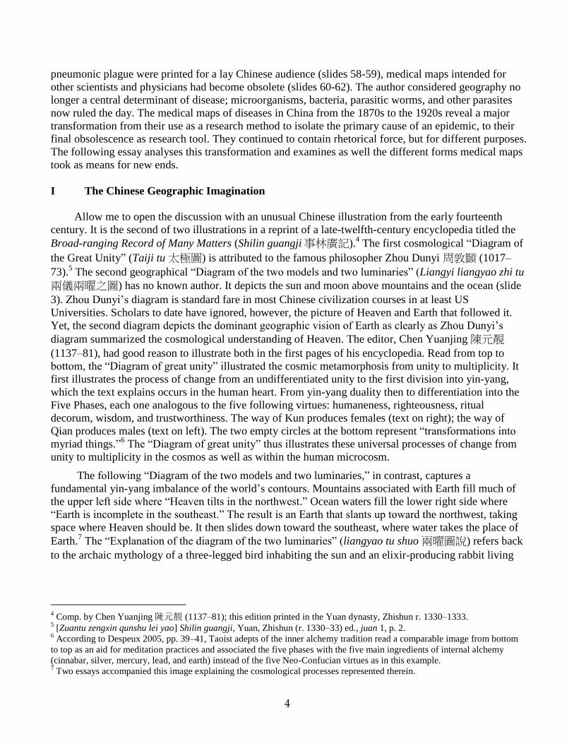
Allow me to open the discussion with an unusual Chinese illustration from the early fourteenth
century. It is the second of two illustrations in a reprint of a late-twelfth-century encyclopedia titled the
Broad-ranging Record of Many Matters (Shilin guangji事林廣記).4 The first cosmological “Diagram of
the Great Unity” (Taiji tu 太極圖) is attributed to the famous philosopher Zhou Dunyi 周敦頥 (1017–
73).5 The second geographical “Diagram of the two models and two luminaries” (Liangyi liangyao zhi tu
兩儀兩曜之圖) has no known author. It depicts the sun and moon above mountains and the ocean (slide
3). Zhou Dunyi’s diagram is standard fare in most Chinese civilization courses in at least US
Universities. Scholars to date have ignored, however, the picture of Heaven and Earth that followed it.
Yet, the second diagram depicts the dominant geographic vision of Earth as clearly as Zhou Dunyi’s
diagram summarized the cosmological understanding of Heaven. The editor, Chen Yuanjing 陳元靚
(1137–81), had good reason to illustrate both in the first pages of his encyclopedia. Read from top to
bottom, the “Diagram of great unity” illustrated the cosmic metamorphosis from unity to multiplicity. It
first illustrates the process of change from an undifferentiated unity to the first division into yin-yang,
which the text explains occurs in the human heart. From yin-yang duality then to differentiation into the
Five Phases, each one analogous to the five following virtues: humaneness, righteousness, ritual
decorum, wisdom, and trustworthiness. The way of Kun produces females (text on right); the way of
Qian produces males (text on left). The two empty circles at the bottom represent “transformations into
myriad things.”6 The “Diagram of great unity” thus illustrates these universal processes of change from
unity to multiplicity in the cosmos as well as within the human microcosm.
The following “Diagram of the two models and two luminaries,” in contrast, captures a
fundamental yin-yang imbalance of the world’s contours. Mountains associated with Earth fill much of
the upper left side where “Heaven tilts in the northwest.” Ocean waters fill the lower right side where
“Earth is incomplete in the southeast.” The result is an Earth that slants up toward the northwest, taking
space where Heaven should be. It then slides down toward the southeast, where water takes the place of
Earth.7 The “Explanation of the diagram of the two luminaries” (liangyao tu shuo 兩曜圖說) refers back
to the archaic mythology of a three-legged bird inhabiting the sun and an elixir-producing rabbit living
4 Comp. by Chen Yuanjing陳元靚 (1137–81); this edition printed in the Yuan dynasty, Zhishun r. 1330–1333.
5 [Zuantu zengxin qunshu lei yao] Shilin guangji, Yuan, Zhishun (r. 1330–33) ed., juan 1, p. 2.
6 According to Despeux 2005, pp. 39–41, Taoist adepts of the inner alchemy tradition read a comparable image from bottom
to top as an aid for meditation practices and associated the five phases with the five main ingredients of internal alchemy
(cinnabar, silver, mercury, lead, and earth) instead of the five Neo-Confucian virtues as in this example. 7 Two essays accompanied this image explaining the cosmological processes represented therein.

5
on the moon.8 The placement of this image directly after Zhou Dunyi’s “Diagram of Great Unity” gave
it comparable status as a representation of yin-yang forces in the world. The juxtaposition of these two
images—the first illustrating how original cosmic unity transforms into worldly multiplicity and the
second visualizing geographical asymmetry—portrays a core tension between universal processes and
regional variation.9
Geographic asymmetries
The two Ming editions of the Broad-ranging Record on Many Matters of the Hongzhi reign (r.
1488–1505) contain even larger versions of the same image. Instead of half a page, the first fills one
folio (slide 4); the later version spreads across two complete folios (slide 5). This expansion of size
suggests not only a nicer edition of the encyclopedia but also that this image continued to be
foundational.10
The two-folio visualization of Heaven and Earth (slide 5) has seal-like circles that
indicate the cardinal directions around a circular depiction of Heaven and Earth. Four decorative clouds
float around circle indicating the flow of qi through the cosmos. The phrases “Heaven tilts in the
northwest” and “Earth is incomplete in the southeast’’ flank the circle as would a pair of couplets on two
sides of a moon gate for the Chinese New Year.
This northwest-southeast polarity originates in a story about the titan Gong Gong recorded in the
section on “Heavenly Questions” (Tian wen 天文) in the Songs of the South (Chu ci 楚辭, 4th-3rd cent.
BCE).11
The passage reads: “[When] Kang Hui [i.e., Gong Gong] was enraged, why did the land lean
southeast?”12
The Book of Master Lie (Liezi列子, c. 300 CE) preserves the earliest response to this
question.13
It attributes the imbalance of yin-yang in the world to a fight between Gong Gong and a ruler,
Zhuan Xu.14
It follows that heaven and earth are,
“things [themselves], and like the things [of heaven and earth], things have imperfections. That is
why in ancient times Nuwa melted stones of all the five colors to patch up the flaws, and cut off the
feet of the turtle to support the four corners. Afterwards, when Gong Gong was fighting Zhuan Xu
for the empire, he knocked against Mount Buzhou in his rage, breaking [i.e., causing it to tilt] one of
the eight pillars of heaven, snapping one of the threads that support the earth. For this reason heaven
leans northwest; and the sun, moon, and stars move in that direction; the earth does not fill the
southeast, so the rivers and the rain floods find their home there.”15
8 According to the myth, the rabbit was formerly the goddess Chang E who stole the elixir of immortality from Archer Yi and
escaped to the moon. In other accounts, a toad resides on the moon, though there appears to be no connection to the rabbit or
the immortal goddess Chang E. Allan 1991, pp. 27–36. 9 For the classical textual roots of this universal-regional tension, see the introduction to The Construction of Space in Early
China, Lewis 2006. 10
[Zuantu zengxin leiju] Shilin guangji, Ming, Hongzhi reign edition, juan 1, pp. 2b-3a. Taipei facsimile. 11
I follow the argument in Allan 1991, p. 68. About half of the poetical works in this collection, including this one, are
attributed to the noble Qu Yuan屈原 (c. 343–c. 277). See Hawkes, in Loewe, ed. 1993, pp. 48–55. 12
See translations by Hawkes 1985, p. 128, lines 33–35; Field 1986, #35; and Major 1993, p. 64. 13
Although the Liezi is attributed to an early Taoist Lie Yukou (c. 400 BCE), it was not written down until around 300 CE,
probably by one anonymous author. See Graham 1990, p. 12; and Barrett 1993, pp. 298–308. 14
Although the Book of Master Guan (Guanzi 管子, 5th–1st cent. BCE), compiled c. 26 BCE by Liu Xiang 劉向 (c. 77–c. 6
BCE) and Discourses of the States (Guoyu 國語, contents date from 431–314 BCE) contained other stories about Gong Gong,
only the Liezi and the Huainanzi recounted his destruction of Mount Buzhou and the consequent toppling of one of the eight
earthly pillars that held up the canopy of the sky. See Birrell 1993, pp. 97–98. 15
Gujin lü li kao古今律歷考(Studies of Astronomical Systems Past and Present), juan 9, by Zhang Yining. This source of
1607 provides evidence that the myth of a skewed earth was still in circulation then. Translation from Graham 1990, p. 96,
Romanization altered to pinyin. Table 2.1 follows the convention in early Chinese maps to place south at top.

6
One scholar succinctly explained this story in cosmological terms as a myth to account for the fact that
the ecliptic (the path of the sun and, approximately, the moon and planets, around the earth) does not
coincide with the celestial equator (the earth’s equator defined by the rotation of the fixed stars).16
The
eight pillars in this myth not only explained why the cosmos was askew, but also why the celestial pole
of the sky’s rotation was not directly overhead, and why the major rivers of China flowed eastward.17
In discussions about geographical dualities, scholars gave one pole higher value than the other
one. The yin-yang dichotomy related to the geographic imagination in Chinese medicine, for instance,
respected north over south, admired strong over weak, and favored frugality over indulgence. Similar
reasoning valued northwest over southeast. The northwest-southeast opposition in Chinese medicine by
the early sixteenth century looked like this: northwest-north-dry-cold-highlands-frugality-robust bodies
and southeast-south-damp-hot-lowlands-indulgence-weak bodies.18
By 1500, the canonical northwest-southeast axis and the more contemporary north-south
distinction became the most important regional divisions physicians discussed. Debates on regional
variation established a range of issues, concepts, and practices that physicians from the mid-seventeenth
century drew upon for their own purposes. Ming encyclopedias and calendars frequently quoted and
illustrated the maxim from the Huainanzi, “Heaven tilts in the northwest”19
and “Earth is incomplete in
the southeast.” In the fourteenth to sixteenth centuries, three types of visual images of this geographic
concept circulated: geographic—relating to the imagined form of heaven and earth (slides 3-5),
numerological—relating to the hexagrams of the Book of Changes (not shown here),20
and medical—
relating to the macrocosm-microcosm model.21
China in the Palm of Your Hand
Published in a 1624 medical text, the third type of image of the northwest-southeast concept
exists in the palm of your hand (slide 6). The explanation of this illustration is succinct: “The high back
and the low front of the palm is an image of the mountainous northwest and the aquatic southeast.
Together forming streams and marshes, the lines within the palm are like images of the rivers.”22
What,
however, did physician Zhang Jiebin 張介賓 (1563–1640) mean by this odd geographical description of
the palm?
Take a minute now to examine the palm of your own left hand opened as if about to catch a ball.
Consider your hand is a compass, the tip of your middle finger equivalent to the South, your wrist to the
North, the right side of your palm to the West, and the left side to the East. Imagine that the fatty cheek
16
Major 1993, p. 26. 17
See summary of this argument and chart in Hawkes 1985, pp. 135–36. 18
The emergence of the “Warming and restorative current of learning” (wenbu xuepai 溫補學派) that became associated
with the southern physician Xue Ji (1487-1559) was aligned with the southeast side of this dichotomy. 19
Although the Inner Canon examples discussed in chapter two used “Heaven is insufficient in the northwest” (Tian buzu
xibei 天不足西北) instead of the phrasing “Heaven tilts in the northwest” (Tian qing xibei 天傾西北) used here, the meaning
is the same. 20
The second image is of the 64 hexagrams of the Book of Changes (Yijing 已經) arranged according to the four cardinal
directions. See The Imperial Longevity Permanent Calendar (Sheng shou wannian li 聖壽晚年歷, 1595) published by prince
Zhu Zaiyu朱載堉 (1536–1611) . 21
The third image is of the palm-side of the left hand, published in the Illustrated Commentary of the Classified Canon (Lei
jing tu yi 類經圖翼, 1624) by Zhang Jiebin 張介賓 (1563–1640). All these images are discussed in Hanson 2008b, the
longer Chinese version of Hanson 2006. 22
Zhang Jiebin, “Zhizhang jie” 指掌解 in Leijing tu yi 類經圖翼 (pr. 1624), repub. in Zhong Jingyue yixue quanshu
(Beijing: Zhongguo zhongyiyao chubanshe, 1999), j. 2, p. 646.

7
in the lower right side is northwest or “high back,” as in the quotation above, and diagonally across to
the thinner base of your index finger is southeast or “low front.”
The geographic dichotomy of a mountainous northwestern region and a low-lying watery
southeastern landscape now imprinted into your left palm has textual origins in the classical literature of
Chinese antiquity before the Common Era.23
Here an early seventeenth-century physician projected the
dichotomy onto the palm as if it represented a simple map of China proper. What a Western palm reader
would interpret as your life, career, and love lines, Zhang saw instead three rivers of China, possibly
even the Yellow, Huai, and Yangzi Rivers that go from northwest to central southeast China as if on
parallel tracks. These “river lines” flow from the mountainous northwestern frontiers (the “lower west”
side), to the aquatic southeastern coast of the “upper east” side of the palm.
The palm China map of physician Zhang depicts the same understanding of the world as the
Heaven-Earth map of the Southern Song encyclopedia. Both were world maps in that they visualized
basic assumptions about cosmic processes. In the first world map, the sun and moon, three-legged crow
and elixir-making rabbit, mountains and ocean symbolized yin-yang dynamism. The palm map assumes
the same yin-yang dyad manifested physically in the fleshy “northwest” quadrant where yin’s Earth
reigns and the lower thinner “southeast” quadrant where yang’s Heaven dominates. Both types of
maps—the symbolic one of the waves of the southeast crashing up against the mountains of the
northwest and the corporeal one within the left palm—transformed the actual geographic complexity
and variation of a vast China into a simple yin-yang duality of geographic difference.
By the mid sixteenth century, the first symbolic map originally from the early fourteenth-century
edition of the Broad-ranging Record on Many Matters began to take on other cosmologically significant
elements. Permutations of it printed in the daily-use encyclopedia titled the Complete Book of 10,000
Things (Wanbao quanshu 萬寶全書, 1641 ed.) reveal significant changes. Mountains still dominate the
“northwest” and ocean waves still fill the “southwest” but in the place of the mythological sun-raven to
the right and the moon-rabbit to the left one finds instead the 28 lunar lodges or constellations of the
“Round Heaven” (tian yuan 天圓) above encircling the “square Earth” (di fang 地方) below (slide 7). A
later 1662 edition more roughly depicts the mountains and oceans but keeps the constellations, sun, and
moon. It adds phrases indicating astronomically relevant coordinates, such as the north pole and south
pole important for determining the winter and summer solstices (slide 8). Nearly a century later in a
1749 edition of this daily-use encyclopedia, the mountains and ocean waves have become even more
abstract while the constellations and astronomical coordinates emerge even more clearly indicating their
significance (slide 9). But in a different daily-use encyclopedia from 60 years early called the Collected
Books of Chen Zixing (Chen Zixing cangshu, 1684), the symbolic map of the “northwest mountains and
southeast oceans” has transformed into a clearly recognizable map of China. In fact, a caption placed in
the ocean states that this depicts the “Ming dynasty” (qi Ming chao jian 啟明朝見). Despite this visual
move to a more cartographically legible map of China, yet another symbolic level of cosmographic
elements has been added. In addition to the constellations and the astronomical coordinates, the eight
trigrams from the Book of Changes now circle “the globe” and the phrases that “Heaven is round like a
tilting lid” and “Earth is square like a chess board” succinctly describe the maps dominant structure of a
square-Earth within a round-Heaven. With this unusual map we see simultaneously a layering on of
additional symbolic elements related to traditional meta-geography (Earth) and cosmography (Heaven)
and a move toward the modern cartography of China. These unsual maps have been completely ignored
so far in Chinese scholarship. Yet they are important not only because they visually represent the
23
For the earliest references to and illustrations of the northwest-southeast binary in Chinese history, see Marta Hanson,
“Northern Purgatives, Southern Restoratives: Ming Medical Regionalism,” Asian Medicine 2.2 (2006): 119–26.

8
Chinese geographic imagination, they also integrate the celestial imagination that was its heavenly
correlate.24
Obviously, these eight examples of meta-geographic maps from the late fourteenth to the mid
eighteenth centuries are not medical maps. They did not rely on observations, vital statistics, the
chronology of an epidemic, or any sort of quantitative mortality and morbidity data. Rather they
visualized geographic and astronomical meta-concepts symbolically to make sense of major geographic
differences and celestial phenomena. In this way, however, they were also ways of thinking through and
visually representing observations of natural processes.25
They thus visualized the geographic
imagination that informed how Chinese physicians understood the relationships between environmental
factors and disease occurrence before western medicine and European medical maps had any influence
in China.26
II European Mapping Precedents, 1792-1875
Before the nineteenth century, in fact, not one inhabitant of China suffered from plague, cholera,
typhoid fever, tuberculosis, or malaria. Millions died, however, from yin deficiency (yinxu 陰虛), foot qi
(jiaoqi 腳氣), Cold Damage (shanghan傷寒), and Warm diseases. Before late-nineteenth-century
laboratory medicine transformed the conceptualization of most infectious diseases, physicians neither in
China nor in Europe thought in terms of malaria’s Plasmodium protozoa, the tuberculosis bacilli, the
comma bacillus of cholera, or plague’s pasteurella pestis. Modern biomedical categories of disease
based on laboratory evidence of parasites, bacteria, and viruses do not apply to the pre-modern Chinese
experience with illness, disease, and epidemics. Passage through the petri dishes of the modern
laboratory fundamentally changed the definition of all disease concepts later shown to involve
microorganisms.27
However, in order to map diseases across cultures and across time people have to agree on a
common nosology or classification of diseases. They also must have the ability to gather information in
one center from a vast network of people spread geographically across the globe. After over two
centuries of global exploration and imperial expansion, this occurred in European history at the end of
the eighteenth century. At this time, geographic determinants of health and disease were the rule of the
day and a new field began to develop called medical geography.
Leonhard Ludwig Finke was the first to develop the idea of mapping diseases at a global scale in
his 1792 Notes on General Practical Medical Geography (slide 12).28
As one of the first syntheses on
medical geography in Europe, this book represents the consensus among his European peers on two
things: disease definitions and the importance of data collection on disease occurrence. The early
gathering of medical and vital statistics thus went hand in hand with the concept, if not actual example,
of medical mapping. For economic reasons, his “Nosological Map of the World” was never published in
24 I am referring to the later versions found in the editions of daily-use encyclopedias, 10,000 Things (1641, 1662,
1749) and the Collected Books of Chen Zixing (1684), depicted in slides 6-9. 25
I thank Dagmar Schäfer for this insight. 26
See Hanson, “Northern Purgatives, Southern Restoratives: Ming Medical Regionalism.” Asian Medicine 2.2 (2006): 115-
170. 27
See Cunningham (1992) on the problems of equating old European disease concepts with new identities of disease
dependent on new laboratory technologies. 28
German title is Versuch einer allgemeinen medicinisch-praktischen Geographie. See Figure 2.5 and introduction to Finke’s
book and lost map in Koch 2005, 24-26.

9
the original 3-volume work or later editions. Still both mapping and vital statistics were state-of-the-art
analytic tools to examine the complex relation between geography and disease.
The frontispiece of Finke’s Practical Medical Geography illustrates this relation. The physician
holds the rod of Asclepius—the Greek god of medicine and healing—around which a snake winds up,
symbolizing the power to heal but also to do harm. The Greek word pharmakon also has this double-
entendre meaning both drug or medicine and poison. Another snake, however, encircles the globe as if
bringing disease upon it. This illustration’s underlying argument, and that of the entire book, was that
geography determined health and disease. It was the role of the physician with his companion owl
(wisdom and knowledge) to work out the connections.
Shortly after Finke’s treatise, medical mapping developed as attempts to understand the diffusion
specifically of Yellow Fever in New York City in 1798 and then again in 1819.29
When cholera reached
Europe from India in 1832, causing havoc wherever it struck, even more physicians used medical
mapping as an analytical tool to work out what caused it and how it traveled. The first inclusion of
China was in fact in the first attempt to map the global circulation of cholera in 1832 (slide 13).30
Whereas the previous Yellow Fever maps depicted specific docks and neighborhoods in New York City
where cases occurred, this map showed the progression of cholera from city to city and nation to nation
across the globe. The function of these two types of localist and global maps also differed.
The local Yellow Fever maps sought evidence for a specific cause in a specific locale, sometimes
arguing the contagionist side, other times the anti-contagionist side, in the reigning debate on the causes
of epidemics. The global map in A. Brigham’s A Treatise on Epidemic Cholera (1832), by contrast,
shifted the focus to the geographic origin and diffusion of the cholera epidemic. Historically, his map
shows the significance of cholera in the early 1830s and the fear it instilled among Europeans first
encountering it. Analytically, the map argues that cholera began in India, diffused along both sea and
land trade routes, and had a clear temporal progress. The indication the year of cholera outbreaks in
specific cities—Moscow 1830, St Petersburg 1831, Riga 1831, then Hamburg 1832—illustrates its
yearly march toward England where it arrived (slide 14). Both the link of the first cholera pandemic to
British colonial expansion in India and the role of the Empire’s commercial routes in spreading it were
implicit in this visualization of the first cholera pandemic.
For the next three decades, one sees the increasing use of medical maps in European publications
on a wide range of diseases, but cholera remains the epidemic of greatest concern. The most famous
example of the more than 30 cholera maps of this period is Dr. John Snow’s 1854 Map of the Broad
Street outbreak of cholera in London (slide 15).31
This map is the clearest example of medical mapping
as way of thinking through a problem. In this case, Snow attempted to show a general pattern by
isolating through his map the individual incidences of cholera in one neighborhood of London in 1854.
His map and accompanying detailed evidence on each patient located the epidemic’s epicenter at the
Broad Street pump. He traced every case to the drinking water from that pump. His map visually
supported his argument that a contaminant in the water caused cholera. He still could not isolate what in
the water was the cause; that problem would not be resolved until 1883 when the German bacteriologist
Robert Koch isolated the cholera bacillus in a petri dish in his laboratory. Back in 1854, Snow’s map did
not convince all of his contemporaries in his anti-contagionist argument that something they could not
see in the drinking water caused cholera. Still, he persuaded most that medical mapping was the right
tool for supporting his hypothesis. The single year and local scale of his map, even at the level of house-
29
Koch 2005, 26-38. 30
See Figure 3.10a in Koch 2005, 66. 31
See Figure 4.12a and 4.12b in Koch 2005, 96-97.

10
to-house occurrences in one neighborhood, functioned to support his argument of a local specific cause,
even if there was resistance to it being in the Broad Street pump’s water.
Just two years later in 1856, A. K. Johnston published a map on a global scale of not just cholera’s
diffusion and span over time but the geographic distribution of the major diseases of the day. More
complex than any medical map to date, the Johnston map includes isotherms, tables of altitude, and
indices of the value of life. He combined the latest cartographic and statistical techniques to make
visible the essentially configurationist argument that diseases had local environmental causes. He placed,
for example, smallpox in all of the northern most regions of North America, goiter and catarrh in the
next band across Manitoba and Ontario, leprosy in Greenland, and yellow fever and dysentery across the
Eastern and Southern US and the West Indies (slide 16).32
The two rectangular boxes in the left corner
of his map focused on two diseases: Consumption (Tuberculosis) by population in Asia, Europe, and
America (where it was the worst) and Rheumatism among troops in Europe, Asia (where it was the
worst), Africa, and America.
Johnston’s map also showed the relative mortality of troops stationed around the globe. The
connection between the European military expansion around the globe supporting the major colonial
powers and the collection of data on disease is explicit. Similar to the 1832 Brigham map of the
diffusion of cholera, Johnston used comparable lines across the oceans and lands that followed trade
routes. On the far right, the map has Value of Life Indices by country and by cities and towns. These
early national mortality statistics were dependent on the imperial commercial and military institutions
where mostly government functionaries collected such data. This map also makes visible the
configurationist argument of disease causation related to geographical differences. Concurrently, it
depicts the imperialist and commercial expansion of British, French, German, Spanish, U.S., and
Russian states. This global medical map manifests both the distillation of new data made possible by the
extension of imperialist powers and the new methods of vital statistics gathering they brought with them
to their colonies.
In the 1850s, however, not all medical geographers believed they had sufficient data to make
medical maps. German scholar August Hirsch wrote the single most important synthesis of medical
geography of the time. Published from 1859-1864, his 2-volume magnum opus the Handbuch der
historische-geographische Pathologie was the first attempt to describe the global distribution of disease
and was the only reliable account of disease worldwide. He dedicated his book significantly to the
London Epidemiological Society, the then epicenter of vital statistic gathering not just for England but
also throughout the British Empire. Being a cautious scholar, he refused to include maps, stating to do so
was far too premature, and even refused to allow the 1873 English translation to include them.
Although by the early 1870s Snow still had not convinced all of his colleagues in his anti-
contagionist, contaminated water theory of the cause of cholera, still they had nearly all embraced his
mapping methodology. When the second pandemic of cholera reached New Orleans on February 8 of
1873, for example, mapping was one of the most important methods taken to understand it. In 1874, the
US Congress asked the Secretary of War to assign a medical officer to report on the past year’s cholera
epidemic in the US. The final US congressional report on the cholera epidemic of 1873 in the United
States had many maps dispersed across its 1,061 pages. The one featured here indicates the tracks of the
ships that brought the disease from Europe to the East Coast and down to the Caribbean (slide 17).
Although the report granted U.S. Surgeon General, Dr. John M. Woodworth, authorship, the army
physician Eli McClellan (whose name was attached to most of the report’s maps) and his colleague Dr.
John C Peters did all of the research. These maps expressed a new international consensus on the cause
and character of cholera since the Vienna Conference the year before in 1874. First, its origin was India.
32
Figure 3.11a and 3.11b in Koch 2005, p. 68-70.

11
Second, it did not develop spontaneously outside of India. Third, cholera was a portable disease, and
related to this, it always followed the arrival of a ship with infected people. Fifth, personal effects could
transmit it across long distances. Finally, the rails and steamboats were the two main vectors in the US.
They concluded that the difference in the US experience with cholera between the 1830s and 1860s was
that both rails and steamboat transport systems had improved. Still not convinced by Snow’s
contaminated water hypothesis, however, McClellan argued that it was the putrid air and foul
environment of the extremely cramped and unhygienic conditions of the traveling poor in ships, rails,
and steamboats that contributed to outbreaks of cholera.33
This more complex transportation
infrastructure with nonetheless below par quarters for the impoverished (where they thought cholera-
producing filth and infused air thrived) allowed the disease to travel further and more virulently,
sustaining their wide diffusion across the world.
Although the cholera pandemic had by then reached China, this was insignificant in McClellan’s
1874 report to the US Congress. He was primarily concerned with the transmission of cholera from
India via Europe and along trans-Atlantic shipping routes to the US. In the early 1870s, medical reports
from China were just beginning to be published through a centralized institution. But these reports were
done only in an ad hoc way and were dependent on where medical officers were stationed. Still, only
five years later in 1879, the first aerial medical map of China depicts cholera’s passage through East
Asia (slide 21). It is to the source of this map we now turn.
III Initial Mapping of the Diseases of China, 1877-1903
Western publications first began to include reports on medical work and health conditions in
China after the First Opium War (1839–42), also called the first Anglo-Chinese War, that granted
indemnity to Britain, opened up five treaty ports (Shanghai, Canton, Ningbo, Fuzhou, Amoy), and ceded
Hong Kong Island to the British.34
An important change in documentation on epidemics followed the
even more humiliating Second Opium War (1856-1860), also known as the second Anglo-Chinese War,
Arrow War (after the English boat that started it), and with French cooperation, the Anglo-French China
Expedition). One of the many consequences of Chinese defeat was that ten more treaty ports were
forced open and through them foreign powers gained more access into China’s interior. Physicians
settled in China closely behind the French, British, Russian, and U.S. military and diplomatic corps.
A decade later in 1871, the Inspector General of the Chinese Imperial Maritime Customs
Service,35
British official Robert Hart (1835–1911), decided to take advantage of the newly expanded
infrastructure of the Customs Service as a clearinghouse “to procure information with regard to disease
amongst foreigners and natives in China.” He assigned Dr. Robert Alexander Jamieson of Shanghai to
be in charge of readying the reports for publication.36
For the next forty years, the Inspector General
published in the Customs Gazette semi-annual Medical Reports from European surgeons stationed in
treaty ports.37
These substantial reports reinforced European standards for the geographic distribution of
33
For McClellan’s report, figure 7.1, see Koch 2005, 159-62 34
The most important publications were the North-China Herald, Chinese and Japanese Repository, Chinese Repository,
Chinese Recorder, British and Foreign Medico-Chirurgical Review, Medical Times Gazette, Revue medicale,
pharmaceutique et hippiatrique, Bulletin of the Royal Asiatic Society, and The Lancet. 35
For a history of the Chinese Maritime Customs, summary of Roger Hart’s life and role as Inspector General, and edited
collection of his letters as “I.G. of Peking” (1968–1907), see Fairbank, et al., eds., 1975. 36
For the full text of the “Inspector General’s Circular No. 19 of 1870,” see Wong and Wu 1936, pp. 397–98. Dr. Jamieson
was editor of these reports for the next forty years from the first issue in August 1871 to the final issues published in 1911. 37
The authors of the first History of Chinese Medicine in English remarked that “The importance of the early volumes of the
Customs Medical Reports can hardly be exaggerated.” This was the first time a publication regularly published reports
12
disease in China. Through the editorship of Jamieson and these medical reports, Western disease
concepts based on the nosology of English physician and statistician William Farr (1807–83) became
standard for studying China’s medical geography and epidemics.38
This was the decision of Jamieson,
who had little patience with Chinese concepts of disease. Twice, in his Reports of 1872, he juxtaposed
mortality tables based on Chinese and on western nosology in order to denigrate the former on the
ground that “that the ignorance of Chinese practitioners is only equaled by their conceit and that their
nosology is only slightly more absurd than their therapeutics.”39
The Medical Reports of the Imperial Maritime Customs published six medical maps from 1871
to 1898 (slides 20-25). They fall into two types with corresponding differences in function. The model
of the dissemination of an epidemic (plague in Yunnan and in Manchuria, cholera in East Asia)
emphasized that some kind of contagion or contaminant, yet unknown, spread along commercial routes.
The distribution of a disease (beriberi) approach, on the other hand, suggested a local origin in the soil or
climate where it appeared. Each map was evidence then for the corresponding hypothesis.
The first published a map, in 1878, was of the routes of plague in Yunnan province from 1871 to
1873 (slide 20).40
The possible spread to the new British colony in Hong Kong made this early 1870s
Yunnan plague a potentially international problem. The presence of a British physician, Dr. Manson,
who was stationed in the new treaty-port Amoy (modern-day Xiamen) and collected the data on the
Yunnan plague epidemic a few years earlier made the map possible. Yet what is most interesting about
this map is that it just depicts the path of the epidemic from town to town along trade routes. There is no
sense of Yunnan as a province or of its place within the larger region. We see here just lines connecting
dots suggesting Manson pooled together reports to map the broader diffusion of this specific plague
epidemic within the region.
It was instead the cholera pandemics of the 1830s and 1860s, and specifically of 1873 in the U.S.
(the same year as plague in Yunnan) that inspired the first global mapping of disease.41
The third cholera
pandemic hit many of the new treaty ports along China’s coastline making it an international problem
threatening imperialist intentions in Chinese markets. In 1879, the Medical Reports published their first
map with a broad aerial view of East Asia: it predictably depicted the routes of cholera since 1820 from
India, Indonesia, and Thailand to the Philippines, Japan, Russia, and China (slide 21).42
Although Manson’s Yunnan plague map was smaller in scale than Simmon’s East Asian cholera
map, both doctors focused on the direction of the spread of the epidemics, trying to isolate their
underlying causes via directionality and temporality. In the 1870s, no consensus in the scientific
intended for physicians without the limitations on space inevitable in medical journals. They provided nosological and
historical information from missionary hospitals. See Wong and Wu 1936, v. 1, pp. 398–99. 38
Although in the early nineteenth century the classification of disease by William Cullen (1710-1790) was still widely
standard, William Farr started revising Cullen’s and other’s nosologies in 1839 and published his influential article on
“Statistical Nosology” in 1842. By 1860, the General Record Office adopted his third nosology as their standard for vital
statistics. See Eyler 1979, pp. 53–60. Also on Farr’s nosology, see Pelling 1978, pp. 91–102. 39
See MacPherson [1987] 2002, p. 62. Jamieson 1872a, no. 3, p. 82 for quotation and first table using Chinese disease
categories; 1872b, no. 4, p. 101 for second table using Chinese disease categories. In 1872, there was little to choose (aside
from safe minor surgery) between the therapies of Chinese and European physicians in Shanghai. 40
Manson, “Notes on the Plague in Yunnan,” “Dr. Manson’s Report on the Health of Amoy for the Half-year ended 31st
March 1878,” pp. 25–27. 41
These maps appeared in the 1875 U.S. Congressional Report, The Cholera Epidemic of 1873 in the United States. See
Koch 2005, pp. 159–61. The first edition of August of Hirsch’s famous A Handbook of Geographical and Historical
Pathology, which included the first global maps of diseases, was published in several volumes from 1860 to 1864. The first
English translation in 1886 was of the second German edition. 42
Duane B. Simmons, “Cholera epidemics in Japan,” China Imperial Maritime Customs, II.- Special Series: No. 2. Medical
Reports for the Half-Year ended 30th September 1879, 18th Issue, pp. 9-30. Map on unnumbered page preceding p. 1.
13
community had yet formed on the cause of either plague or cholera. Yet the emphasis on time and space
in both medical maps reinforce their authors’ assumptions that some contaminated substance or foul air
spread along commercial routes. The 1880 distribution maps of beriberi in the world and in Japan,
however, represent the opposite conception, namely that its range varied according to geographic
location.43
The author of the beriberi distribution maps, Dr. Duane Simmons, also produced the earlier
1879 map of cholera’s spread in East Asia, showing that the two conceptions of cause—local
environmental factors versus portable contagion—varied depending on the perceived character of the
mapped disease and not necessarily the theoretical biases of the physician.
When an epidemic of bubonic plague hit the far northeast in Manchuria in 1897, the French
physician J. J. Mantignon submitted two maps with his 1898 report on it (slides 24-25).44
Mantignon’s
maps also emphasized directionality and temporality, this time connecting the plague epidemic clearly to
the new Russian extension of the Trans-Siberian railway. Following China’s construction concession to
Russia in 1896, worked started on the line in July 1897. Russia intended to link the Siberian city Chita
through Harbin to the Russian port Vladivostock on the Sea of Japan. Russian workers for the Chinese
Eastern Railway (later known as the Southern Manchurian Railway) ended up settling in, and building
up Harbin, the town halfway between Chita to the northwest and Vladivostock to the southeast. A
plague outbreak in the area thus threatened Russian imperial intentions over the region and, in fact, did
in 1910–11 during the more famous pneumonic plague epidemic in Manchuria.
Before this occurred in the Far North, however, the earlier plague epidemics of 1871-3 in
Yunnan proved to be a warning of worse to come in the Far South. Just a few years earlier than the 1897
Manchurian plague epidemic, plague reached the British colony Hong Kong in 1894. This resulted in
the first quarantines imposed on the Chinese population, draconian public health measures to dispose of
infected bodies, and the first incidence of organized Chinese protest to western medical interventions.45
The coordinated British response to the epidemic in “Victoria Hong Kong” also produced four detailed
maps. These maps depicted not just house-to-house but also week-by-week occurrence of both human
and rat plague in the colony (slides 27-30).46
The dotted houses indicating occurrence on these maps of
plague in 1894 Hong Kong recall John Snow’s Broad Street Pump map 30 years previously of cholera in
1854 London. Yet there are significant differences. Besides much more territory covered and weekly
temporal demarcation, the most remarkable variation is the absence of an epicenter. Hong Kong had no
comparable Broad Street (or rather Queen’s Road). By the time Simpson published these maps in 1903,
already 9 years had passed since Alexandre Yersin had isolated the pasteurella pestis during the same
Hong Kong epidemic of 1894 where he conducted his now famous experiments. Robert Koch had
isolated the cholera bacillus just over a decade before that in 1883. Instead, what the maps make newly
visible is the extent of the plague epidemic in Hong Kong and the ability of British authorities to track
and control it. Yet, the simultaneous tracking of rat as well as human cases signifies that these maps still
retained their older function as analytical tool. The verdict was still out on how plague spread from rats
to humans, via their feces, fleas, or something else?
43
Duane B. Simmons, “Beriberi, or the Kakke of Japan,” China Imperial Maritime Customs, II.- Special Series: No. 2.
Medical Reports for the Half-Year ended 31st March 1880, 19th Issue, pp. 9-30. Maps between 8 and 9. (chk) 44
J.-J. Matignon, “La Peste Bubonique en Mongolie,” China Imperial Maritime Customs, II.- Special Series: No. 2. Medical
Reports for the Half-Year ended 30th September 1898, 58th Issue, pp. 1-19. Maps are on unnumbered page before 1, and
between 8 and 9. 45
See Carol Benedict, Bubonic Plague in Nineteenth-Century China, for the best description of the Hong Kong context. 46
W.J. Simpson, Report on the Causes and Continuance of Plague in Hong Kong and Suggestions as to Remedial
Measures (London: Waterlow and Sons, 1903). I thank Richard Sosa, PhD Candidate, Yale University for referring me to
this source and Meaghan Marion, PhD Candidate, University of Toronto, for providing me with scans of the maps at just the
right time.
14
IV The Diseases of China, Including Formosa and Korea, 1910
Other changes were also occurring. By the first decade of the twentieth century in the 1910
edition of The Diseases of China, not one inhabitant of China, Taiwan, or Korea suffered from yin
deficiency, foot qi, Cold Damage, or Warm diseases. Millions were dying instead from plague, typhoid
fever, cholera, tuberculosis, and malaria, as The Diseases of China, including Formosa and Korea
declared they had long done. After the 1880s transformations in bacteriology and the subsequent rise of
laboratory medicine, physicians trained in Western medicine all over the world—a small but influential
portion of them now outside Europe and America—thought in terms of malaria’s plasmodium protozoa,
the tuberculosis bacilli, the comma bacillus of cholera, and plague’s pasteurella (now Yersinia) pestis.47
Modern biomedical categories of causative microorganisms based on the new laboratory evidence
of causative agents—namely bacteria, protozoan organisms, and metazoan parasites (worms or
helminthes)—now explained much of the contemporary Chinese experience with disease and
epidemics.48
Although physicians still rarely discussed viruses,49
and had not yet identified the causative
agents for such well-known diseases as leprosy, beriberi, dengue, and typhus, by 1910, researchers
agreed on how to use the microscope to confirm diagnoses for most of the known infectious and
contagious diseases. Missionary organizations were setting up simple modern laboratories in missionary
hospitals across China, with Jefferys and Maxwell’s Diseases of China encouraging this movement.50
The outcome eventually changed the understanding of pre-modern Chinese diseases, as scientists related
them to specific microorganisms and redefined them to improve the fit.51
The concepts of deviant qi,
pathogenic heat, wind-intrusion, gu poisoning, and miasmas, for people trained in modern science, were
signs of an inability to cope with the modern world. Jefferys and Maxwell’s Diseases of China
decisively extended the laboratory-based model of germ theory, bacteriology, and parasitology spatially
across China52
and temporally into her pre-laboratory past.53
They jettisoned their predecessor John
Dudgeon’s 1877 book of the same title Diseases of China, of which they asserted that “the present value
is nil.” They wrote instead about the geographic distribution of diseases in China based on rudimentary
vital statistics, new experimental evidence, and nearly 50 years of Medical Reports from the Imperial
Maritime Customs.54
47
The causative agents for these four diseases were named in the early 1880s: malaria (Laveran 1880), tuberculosis (Koch
1882), cholera (Koch 1883), plague (Yersin, Kitasato, 1894). For a more complete list, see Ackerknecht 1982, p. 180. 48
These categories came from the table of contents in Jefferys and Maxwell 1910, pp. ix–xvi. They also covered, of course,
diseases caused by other factors such as diet, alcohol and opium consumption, nervous system dysfunction, children’s
diseases, physical abnormalities, and even insanity. 49
Research on diseases of tobacco plants in the 1890s showed that they were caused by an agent that could pass through
filters that stopped the smallest known bacteria, but they did not yet call these agents a virus. The word was first used in this
technical sense in 1900. See OED, sense 2b. 50
Noting the scanty and uneven distribution of medical laboratories across China, Jeffreys and Maxwell summarized
knowledge based on laboratory medicine as a means to spread its methods further. On laboratory methods, see pp. 699–707. 51
For this process related to the redefinition of “plague” in European medical history, see Cunningham 1992. 52
For an example of the former move, see especially their overview “Map 1 Noso-Geographical Divisions of China,” in
Jefferys and Maxwell 1910, p. 31. 53
For example, they equated beri-beri with “malarial leg” (their translation of jiaoqi) and wrote that it “has been described in
a medical treatise attributed to Hwang-ti, B.C. 2697 (?).” See p. 105. 54
They acknowledged that Dudgeon’s work was the first nosological study of China on record, but dismissed it as no more
than a study of hygienic conditions, out of date, and worth reading only for its historic interest. Although their own work
would eventually become outmoded, which they admittedly foresaw (see p. 25), still Maxwell published a second edition in
1929 and advised Sutherland Gear’s “The First General Epidemiological and Morbidity Survey of China” for the years 1933–
34, as Chairman of the Research Council of the China Medical Association.

15
They also created eight unprecedented maps of the geographic distribution of plague, cholera,
leprosy, beri-beri, malaria, elephantiasis and filariasis, schistosomum Japonicum, and two types of
intestinal worms (ankylostomum duodenal and necator americanus).55
Although the statistics on which
they based these maps may well have been too dependent on guesswork to be reliable, the maps they
generated nonetheless created for the first time a visual survey of what they and their colleagues
considered the major diseases of China. The first map of the noso-geographical divisions of China,
separated out the first 6 regions—North, Central, South, Northwest, Central-west, and Southwest—
from region 7 the “Area of prolonged foreign contact” along the coastline from the Far South to
Manchuria and Korea in the north and inland along the Yangzi River (slide 35). The authors explicitly
stated their mapping logic:
It may be taken as a starting-point that, as in our past experience in other land, the distribution
of disease in China will be largely governed by climatic conditions [bold lettering is original];
and if we add to this factor that of the influence of lines of travel, and especially of foreign
contact with the formerly for centuries undisturbed China, we have named the two points which
will have the most influence on any diagrammatic representation of the subject that we may
attempt.56
They argued that food and behavior also played parts but that these were factors relevant to nosology not
nosogeography, their primary concern in the medical maps. From their perspective, these maps had three
key functions: to impart local information, contribute to future findings, and suggest “limited and
tentative generalizations.” The key point I want to make here is that, in contrast to the 1894 plague maps
of Hong Kong published in 1903 just discussed, these later 1910 maps still primarily functioned as
thinking tools for working out the relationship between environment and disease occurrence. The second
map of plague, for example, differentiated where the disease was endemic or epidemic or both (slide 37).
Although the map clearly marks in red the regions 6 and 3 as the primary loci of plague, one single red
cross in Manchuria at Niu Chuang in the northwest reminds the observer of the plague epidemic that
broke out there in 1897. Still working out the relationship between rat and human populations, the map
also designates rat plagues suggesting how important China was as a field site for international
knowledge on sylvatic plague. In the same year that Jeffreys and Maxwell published Diseases of China,
the specter of plague did indeed return to Manchuria with vengeance. This time it not only dramatically
revealed Russia’s and Japan’s imperialist ambitions through their control of the Eastern (Russian) and
South (Japanese) Manchurian Railway Lines but also, more importantly, challenged China’s sovereignty
there. In 1904, a Japanese student borrowed the British satirical use of a many tentacled power hungry
Octopus to portray Russian imperialism throughout the continent (slide 32). One tentacle, in fact,
stretches down across Manchuria representing the railway and extension of power there that would be so
important in the 1910 Manchurian pneumonic plague epidemic.
V Maps of the Manchurian Plague epidemic, 1910-11
It all came down to European fur markets; the region’s ample supply of rodents—Tarbagan
marmots—made decent imitation marten and sable. However, the inexperienced boom-time Chinese
trappers did not know enough to leave behind the plague-infested coats of sick animals. The trappers
also slept in makeshift shelters with coolie laborers along the railway towns. When the first infected
55
See Jefferys and Maxwell 1910, pp. 69, 87, 93, 107, 115, 141, 157, 174.
56 Jefferys and Maxwell 1910, quotation from p. 30, map on p. 31.

16
migrant trapper entered Manchouli (northwest of Harbin) on Oct 13, 1910 and died three days later, the
Yersinia pestis in its most contagious form as pneumonic plague had vulnerable hosts and ideal transport
along the railway lines to spread. By March the next year, the most virulent epidemic of pneumonic
plague in recorded history had claimed over 60,000 lives.57
Despite the high mortality, it could have been much worse epidemiologically if the Chinese state
had not stepped in with personnel, resources, and the first state medicine based on the modern science of
the day. Its reason for intervening, however, were largely political for the Japanese and Russians had
plans to use their alleged superior ability to control the epidemic as a pretext to justify claiming more
Siberian territory and thus provide a shield for the international community against a potential pandemic.
A watershed moment in the history of public health in China, many scholars have already written on the
range of significance of this Manchurian epidemic. It marked many firsts: public health as a national
Chinese responsibility, state acceptance of the superiority of modern medicine, the state’s recognition of
the ability to control epidemics as a gauge of international credibility, and public health interventions as
a site of imperialist rivalry.58
The final point leads to a comparison of the earliest maps of pneumonic plague. The first map
was in Russian, depicted just the city Harbin, and was intended only for a Russian audience (Slide 40).59
The other three maps were in English, portrayed the spread of plague throughout the region, and were
published for an international audience. The first came out in the Proceedings of the Royal Society of
Medicine in Britain (slide 42). The other two were published in the first "Report of the International
Plague Conference Held at Mukden, April 1911" (slides 43–44). The first and second examples are
virtually identical except that the first (slide 42) looks like the original hand-drawn version of what
became a printed copy in the Mukden report (slide 43).60
The most striking difference between these two types of maps of the 1910–11 Manchurian
plague epidemic is their scale. In the Russian plague map, the red and black dots indicate respectively
plague occurrence and deaths at the level of households. Other lines clearly delineate the “Boundary of
the Chinese Eastern Railway exclusion zone,” the “Boundaries of medical precincts,” the “Cordon line,”
and the track of the railway itself. Other symbols represent the presence of the “Moscow plague
administration” such as flying and decontamination brigades, night and outpatient clinics, hospitals,
heated-freight-car shelters, and even the ovens for incinerating corpses. The Russian Harbin map of
pneumonic plague is even more detailed than the comparable British 1894 map of bubonic plague in
Hong Kong revealing even greater control over their colony than Britain.61
The three English-language maps of plague in Manchuria, by contrast, indicate only the
directionality and extent of its spread throughout the region. Harbin is clearly the epicenter, but what the
maps make visible are the Eastern and Southern Manchurian railway lines, and the side roads taken
when, in January 2011, passengers denied tickets took plague along with them as they walked on foot
along the roads into the countryside. Whereas the former manifested Russian surveillance ability and
57
See Carl F. Nathan, Plague Prevention and Politics in Manchuria 1910–1931 (Cambridge, Mass.: East Asian Research
Center Harvard University, 1967), pp. 1-3. 58
On plague and the origins of Chinese state medicine, see Nathan 1967, pp. 6, 38-45; Ralph Croizier, Traditional Medicine
in Modern China: Science, Nationalism, and the Tensions of Cultural Change (Harvard 1968), pp. 45–6; and Benedict 1996,
pp. 150–64. 59
I thank my colleague at Hopkins, Graham Mooney, for pointing out this map to me. It is printed in X. 60
I thank Bill Summers, Yale University, for sending me copies of these maps from his own material on the Manchurian
plague epidemic. 61
In fact, Russians were the first to diagnosis it and respond to it, sending a scientific delegation already by January 2011.
See Carsten Flohr, “The Plague Fighter: Wu Lien-the and the Beginning of the Chinese Public Health System,” Annals of
Science 53(1996), pp. 369–70.

17
thus legitimated their control of Harbin, the latter presented the extent of the epidemic but, most
importantly, well within China’s borders. It certainly spread widely but it is also notable that no lines go
beyond Chinese port cities. The underlying message in both types of maps is the necessity and ability of
state power. The maps of the International Plague Conference Held at Mukden in April 1911, the first of
its kind for the Chinese government to sponsor, also states clearly to the international community for
whom they were intended that China can manage its own affairs.
VI The North Manchurian Plague Prevention Service Reports, 1918-1928
Contemporaries and later scholars largely credit one man with this outcome. Ethnically Chinese
but Malaysian born and British educated, Wu Lien-teh was the first Chinese trained in medicine at
Cambridge University where he was a student of Emmanuel College (Slide 45). The Minister of Health,
who knew Wu through overseas Chinese networks, asked if he would accept a position as head of the
state’s efforts to control the epidemic. Seeing it as an opportunity to conduct autopsies, carry out
laboratory research (and perhaps bring him fame as discoverer of a new bacterial agent), and bring the
latest medical knowledge to China, Wu accepted. As reward for his success and acknowledgement of
leadership at the International Plague Conference in Shenyang (3-28 April 1911), the government
appointed him director of the new North Manchurian Plague Prevention Service (NMPPS). Officials
also understood well after coming through the chaos of the plague epidemic that to have a voice in the
League of Nations and the International Red Cross they needed to commit to western-style medicine and
establish a national public health institution.62
Wu Lien-teh was the obvious choice. As director of the
NMPPS, he made the institution the central clearinghouse for all information on plague in China.
Through it he integrated China’s periphery into multiple centers of calculation gathering vital statistics
and epidemiological data throughout the world in London, Paris, Berlin, Moscow, and Washington
D.C.63
The new NMPPS Reports he edited thus became a vehicle to communicate China’s control
efforts to the world.
The Reports covering the decade from 1918 to 1928 published four maps. The first large folded
map depicts where plague occurred in 1920, again clarifying its spread, but for the first time Chinese is
used for most of the place names (slide 47). The same map can be seen in a 1921 photo of Wu Lien-teh
in his Harbin office directly behind his left shoulder (Slide 48). Similar to the English-language maps of
pneumonic plague in 1910–11, the epidemic followed the railway lines and ended at their termini. The
inclusion of Chinese characters was obviously not necessary for the largely cosmopolitan and
multilingual audience of these reports. Rather their presence reinforced China’s sovereignty over the
region at a time of great anxiety following Japan’s victory in the Russo-Japanese War (1904–5), which
resulted in the Japanese effectively taking control from the Russians of the South Manchuria Railway
zone. But the presence of this map in Wu Lien-teh's office also shows its practical use, comparable to a
military map, for organizing public health campaigns to control the epidemic. In other words, it was not
merely produced for the publication but likely used strategically to guide actions.
The second foldout, the “Map of North Eastern Asia showing important Plague Centres,” shifts
the focus from the dissemination of a specific epidemic in time to the locations where plague reservoirs
are endemic in northwestern China (Slide 49). The third “Map to illustrate endemic plague areas”
complements the second by placing China’s plague reservoirs (6–10a) in a global context (slide 50).
These two maps of plague centers within China and in the world no longer function analytically to
narrow the range of potential causative factors. Rather they work rhetorically to convey the national and
62
For more on this point, see Flohr, pp. 371-2. 63
More on arguments in Bruno Latour, “Centres of Calculation.”

18
international knowledge the Chinese NMPPS has of plague reservoirs and thus legitimate its role as the
central institution with the power to manage them. In fact, an epidemic of pneumonic plague did not
occur again until 1921 so the primary functions of the NMPPS in the decade following its establishment
was largely to establish plague hospitals, do research, and educate on hygiene and sanitation.64
In fact, as Susan Jones has pointed out recently in her work on the Manchurian plague, Wu’s
fieldwork on plague reservoirs in Manchuria significantly influenced a new research direction on
sylvatic plague. First the directionality of the epidemic from inland out along the railroads suggested
endemicity of plague among the rodents themselves. All of Wu’s interviews with his patients before
they died also signaled to him the significance of human contact with the tarbagan. What is not in
English but clear in Chinese is that this is a global distribution map of endemic rat plague, possibly the
first of its kind.65
Yet as the 1921 posters for the bubonic plague (slides 52–54) and for the pneumonic plague
(slides 55–57) illustrate, the most difficult factor to control was not the bacilli, fleas, or marmots, but the
people. Printed in response to the recurrence of the pneumonic plague in Manchuria, Wu Lien-teh
supposedly designed them himself. They are the first examples of maps in Chinese for ordinary Chinese.
He wrote that he had them made in response to resistance to his quarantine measures, and especially the
practice of taking the sick to hospitals against their will, quarantining households with cases of plague,
and burying the died in mass graves. From top to bottom, each one of the six levels explains one aspect
of plague he thought the populace needed to understand. He sought, in short, through better
comprehension to ensure their cooperation.
Maps had pride of place at the top of both posters and expressed that China’s national problem
was global in scope. Then the posters switch to the petri-dish scale of the epidemic and explain in
vernacular Chinese that an invisible microbe or bacillus is the cause. The illustrations on the third level
show how the bacillus travels through the fleas on rats and other rodents. Next, for bubonic plague the
photographs of buboes depict the major clinical signs and, just below, more photographs show
preventive measures. The pneumonic plague poster, by contrast, illustrates its transmission via the
Tarbagan marmot and then between humans via coughing and through the air, making it more
contagious than the bubonic variety. It also emphasizes the need for cotton masks as well as glass
partitions in a model plague ward to prevent transmission from patient to attendant. Although each
poster pulls out distinctive aspects of pneumonic and bubonic plague, the visual narrative of both
concludes that those who suspect plague infection should seek treatment from the same hospitals, clinics,
and physicians they have distrusted, avoided, and even resisted.
Conclusion The Diseases of China, including Formosa and Korea, second edition 1928
In 1928, Wu Lien-teh published a similar poster for cholera (slides 58–59). It followed the same
pattern as the bubonic and pneumonic plague posters from top to bottom showing 1) national and global
distribution, 2) cause, 3) mode of dissemination, 4) major symptoms, 5) prevention methods, and 6)
treatment. Again, a short paragraph on the right explains in simple Chinese the main points of the
illustrations to the left. The first sentence explaining the maps clarifies that cholera, or “sudden turmoil”
(huoluan 霍亂), originally came from India. It entered China from the southern and central provinces
and then from Shanghai traveled on boats throughout the eastern provinces. The petri dish appears again
64
Flohr, p 373. 65
I have based this summary of Susan Jones’s work on a paper she gave “Hunting the Hant’a: implications of sylvatic plague
for public health,” 26 September 2011, at the workshop in Oxford University on “Re-Thinking the History of Health, Disease,
and Medicine in Global Perspective.”
19
as means for isolating the cholera bacillus as the necessary cause of the disease. As in the early 1920
plague posters, the petri dish has trumped the disease maps as a scientific technique for isolating the
relationship between disease occurrence and specific agent. The global and national maps of cholera (as
with pneumonic and bubonic plague earlier) function now as visual narratives of the disease’s trajectory
through the world and recent arrival in China. Rather than being a tool for thinking through
epidemiological problems, they have become an integral aspect of a public health campaign to counter
popular resistance. The maps of bubonic plague, pneumonic plague, and cholera on these “propaganda
posters” (Wu Lien-teh’s usage) from the 1920s were the first such maps in Chinese for a popular
audience. The posters themselves were also the earliest examples in China of state-sponsored public
health propaganda.
The change in function of these medical maps also represents the much broader transformation
from medical geography to laboratory medicine. The former emphasis on the geography of disease gave
way to the latter’s new model of microorganisms. The second edition of The Diseases of China,
published in the same year as Wu Lien-teh's 1928 cholera poster, illustrates this final dénouement:
“With the exception of the attempt made in the first edition of this work, we are unaware of any
systematic study of the geographic distribution of disease in China.”66
Furthermore, the author argues
that the former noso-geographical map that established the overview of the entire contents of the 1910
edition is now outdated:
In the earlier edition, an attempt was made to divide China into different areas corresponding to
climatic conditions, regions of foreign contact and parts of the country about which our medical
knowledge was more or less strictly limited. In the light of our knowledge at the time such
attempted divisions were amply justified but we doubt whether they are now of any great value
and we propose to omit them entirely. In the past quarter of a century, there have been
considerable additions to our information, and reasons for the distribution of disease, which
were formerly regarded as geographical can now be explained in other ways.67
Finally, the author recognized that the wars fought in China since the fall of the Qing
government in 1911 had integrated its nosological profile: “Further, the last few years have seen the
country swept from end to end by huge armies, --northerners have invaded the south and southerners
have penetrated to the north, and in each case diseases have been carried by the troops in a way that
tends to a more equalised (sic) distribution of all general infective conditions.”68
Visualizing the
geography of disease, so central in the nine maps of the 1910 edition, by 1928 had become useless in
light of the new China and for scientific medicine; perhaps they were still necessary for the education of
the masses, but now they no longer held sway among educated physicians.
The medical maps of diseases in China from the 1870s to the 1920s thus reveal a major
transformation from their use as a research method to isolate the primary cause of an epidemic to their
final obsolescence as research tool. They continued to contain rhetorical force, but for different purposes.
The following essay analyzed these transformations, emphasizing the role of the western medical
experience of plague in China for the eventual scientific consensus on plague etiology. I also examined
the different forms medical maps took as means for new ends once their function as analytic tools
changed to examples of new technologies of power.
66
Jefferys, 1928, p. 15. Jefferys’s co-author for the 1910 edition, James Maxwell, did not participate in the second edition. 67
Ibid., p. 17. 68
Ibid., p. 17.