Anticipating Transit
56
1 ANTICIPATING TRANSIT
-
Upload
nashville-civic-design-center -
Category
Documents
-
view
234 -
download
5
description
A concept closely tied to the ideas of new urbanism is that developments should be designed to support transit through considerations such as density, mix of uses, walkability, and location in relation to transit services. This being said, one can come before the transit infrastructure is in place, transit ready development (TRD), and one can come after, transit oriented development (TOD). Projects from the UTCAD and Vanderbilt University Owen School of management are showcased as design recommendations for the site along Charlotte Ave and the new 28th Ave connector bridge. Following the student work, professional projects in development are featured, as they also focus on TRD principles.
Transcript of Anticipating Transit
1
ANTICIPATINGTRANSIT
NASHVILLE CIVIC DESIGN CENTER
The mission of the Nashville Civic Design Center is to elevate the quality of Nashville’s built environment and to promote public participation in the creation of a more beautiful and functional city for all.
www.civicdesigncenter.org
Anticipating Transit: A Manual for Transit-Ready Development is a project of the Nashville Civic Design Center, in partnership with the Nashville Area Metropolitan Planning Organization (MPO). This study was made possible by a grant from the MPO.
A PUBLIC–PRIVATE PARTNERSHIP
NASHVILLE AREA METROPOLITAN PLANNING ORGANIZATION
The Nashville Area MPO is the lead regional transportation planning agency for Davidson, Rutherford, Sumner, Williamson, Wilson and parts of Maury and Robertson counties. The MPO is committed to providing leadership in the planning, funding, and development of a regional multi-modal transportation system.
www.nashvillempo.org

3
ANTICIPATING TRANSITA MANUAL FOR TRANSIT-READY DEVELOPMENT

CONTENTS
55
Foreword
Introduction
2035 Transit Vision
Precedents
Case Studies
Academic Explorations
Real–world Visions
Toolbox
4
6
10
14
22
24
42
50
FOREWORD
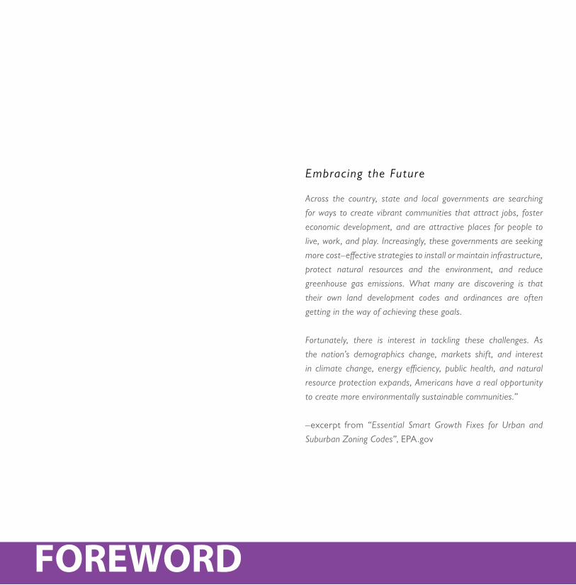
Across the country, state and local governments are searching
for ways to create vibrant communities that attract jobs, foster
economic development, and are attractive places for people to
live, work, and play. Increasingly, these governments are seeking
more cost–effective strategies to install or maintain infrastructure,
protect natural resources and the environment, and reduce
greenhouse gas emissions. What many are discovering is that
their own land development codes and ordinances are often
getting in the way of achieving these goals.
Fortunately, there is interest in tackling these challenges. As
the nation’s demographics change, markets shift, and interest
in climate change, energy efficiency, public health, and natural
resource protection expands, Americans have a real opportunity
to create more environmentally sustainable communities.”
–excerpt from “Essential Smart Growth Fixes for Urban and
Suburban Zoning Codes”, EPA.gov
Embracing the Future
77
from the suburbs is becoming increasingly expensive, with regard to transportation costs, negative environmental impacts and time lost sitting in traffic. It is not always more affordable to live outside the city and commute into the city for work. Affordability is most closely measured by the combined cost of housing and transportation (auto ownership, insurance, parking, repairs, maintenance, fuel costs, etc.). These standard practices and resulting oversights are hampering the creation of healthy, vibrant, pedestrian–oriented communities.
Our developmental practices need to be radically altered to ensure a sustainable future–socially, economically and environmentally. Municipalities must transition from a reactive, short-sighted approach to growth to a proactive one. Planning for jobs, housing, education, transportation, health and leisure should work in concert to shape cities that are able to respond to 21st century population demands and simultaneously afford a high quality of life. They must in order to compete with those that do.
Negative consequences can occur from employing conventional zoning practices used by many communities. The physical separation of land uses has made our development patterns inefficient, forcing residents to drive longer distances to get to their jobs, schools, shops, and services, all of which increase traffic congestion, air pollution, and greenhouse gas emissions. Such separation can frustrate efforts to promote alternative modes of transportation and create lively, urban places. Current zoning codes, and their minimum lot sizes and widths, low floor area ratios, large setbacks, excessive off-street parking requirements, and constricting building heights, have stifled more compact development in many cities and towns. These policies impede the development of attractive, lively, and cost-efficient places.
Much of America’s modern day built environments have been designed around the internal combustion engine–automobiles. This practice has come with a wealth of consequences. The size and design of streets has been largely based on traffic capacity consideration, overlooking the integral role they play as the primary public spaces shaping neighborhoods and communities. Many communities are struggling to balance water quality protection while accommodating new growth and development. Our current, sprawling development patterns are costly and do not create sustainable economies. Commuting into cities
INTRODUCTION
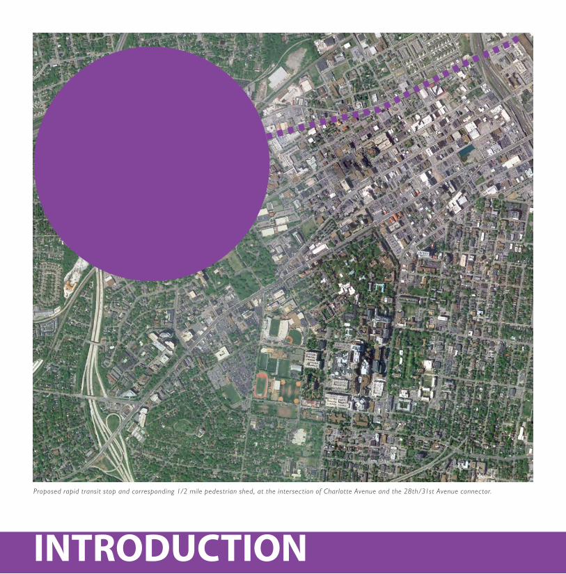
Proposed rapid transit stop and corresponding 1/2 mile pedestrian shed, at the intersection of Charlotte Avenue and the 28th/31st Avenue connector.
99
Transit-ready development (TRD) is transit-oriented devel-opment (TOD) without the transit infrastructure in place at the time of construction. Both TODs and TRDs are con-ceived as “transit villages”–developments designed around a ten minute walk, or half-mile walk, from a transit stop. Fol-lowing Smart Growth guidelines, transit villages adopt, as a premise, high densities, mixed-uses (such as housing, jobs, shops, restaurants and entertainment), mixed types and pric-es of housing and reduced parking requirements.
Vertical mixing of uses is necessary to create a vibrant, pe-destrian-oriented character. Densities are highest near tran-sit stops and begin to decrease intensity and transition to the surrounding existing uses. Adjacent, existing neighborhoods should be protected and strengthened. The intent is to pro-duce a walkable, pedestrian-friendly environment where the design of high quality public space is prioritized. The design intent of transit villages, both TODs and TRDs, is the same. It is their relationship with transit infrastructure that distin-guishes them: TRD is proactive, anticipating future transit, while TOD is reactive, responding to existing transit.
Transit villages benefit residents, transit agencies, local gov-ernments, local merchants, developers, investors, property owners, and those looking for other housing and transit op-tions. The long-term benefits contribute to creating environ-mentally, socially and economically sustainable communities.
The benefits of transit villages include:
• Contribute to community character through the de sign of public space• Promote healthy lifestyles–encouraging walking and biking rather than driving• Lead to economic development through increased foot traffic for local businesses and increase municipalities’ tax base• Foster environmentally sustainable cities: a more efficient use of land, energy and resources, helping preserve open space and leveraging expensive investments into infrastructure more effectively• Increase transit ridership minimizing the impacts of traffic, resulting in cleaner air and less dependence on oil• Respond to changing demographics by giving Ameri -cans more housing options• Offer more transportation choices: people can walk, bike and take transit if they choose
A Proact ive Approach to Smar t Growth
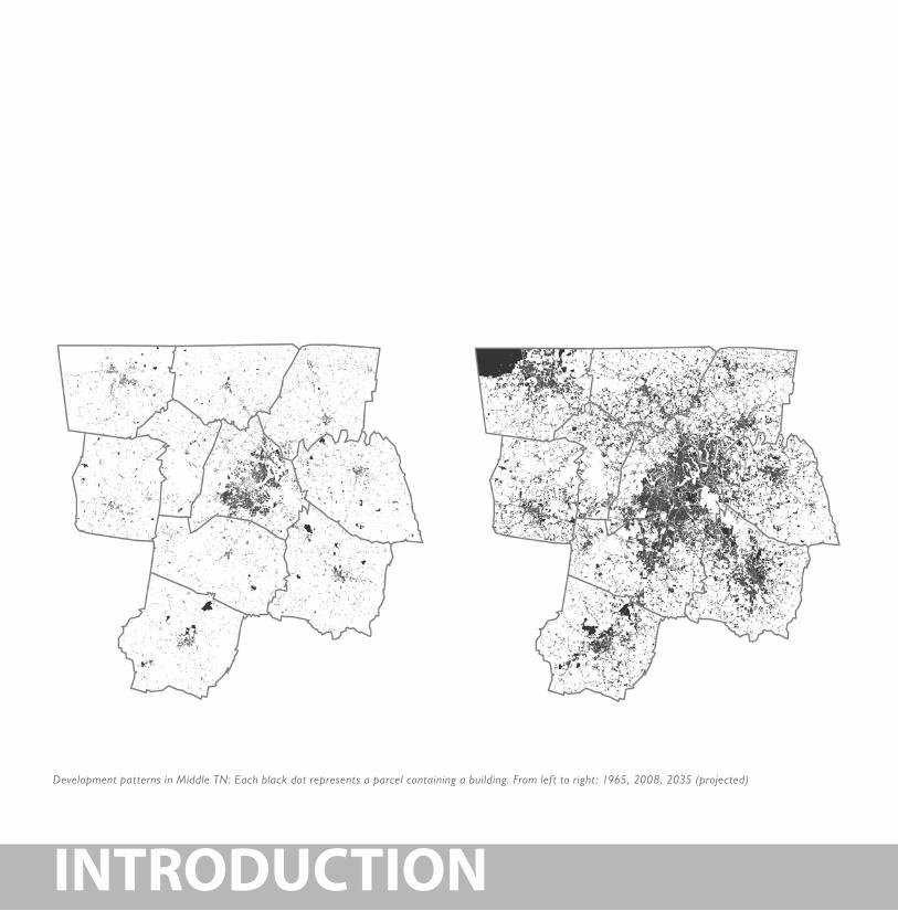
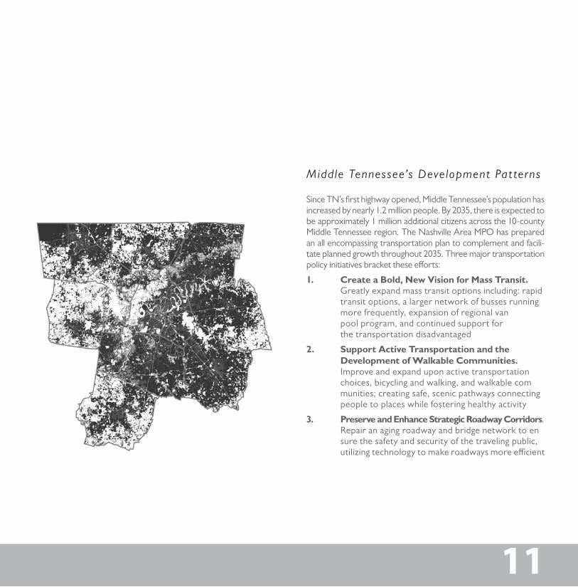
Development patterns in Middle TN: Each black dot represents a parcel containing a building. From left to right: 1965, 2008, 2035 (projected)
INTRODUCTION
11
Since TN’s first highway opened, Middle Tennessee’s population has increased by nearly 1.2 million people. By 2035, there is expected to be approximately 1 million additional citizens across the 10-county Middle Tennessee region. The Nashville Area MPO has prepared an all encompassing transportation plan to complement and facili-tate planned growth throughout 2035. Three major transportation policy initiatives bracket these efforts:
1. Create a Bold, New Vision for Mass Transit. Greatly expand mass transit options including: rapid transit options, a larger network of busses running more frequently, expansion of regional van pool program, and continued support for the transportation disadvantaged
2. Support Active Transportation and the Development of Walkable Communities. Improve and expand upon active transportation choices, bicycling and walking, and walkable com munities; creating safe, scenic pathways connecting people to places while fostering healthy activity
3. Preserve and Enhance Strategic Roadway Corridors. Repair an aging roadway and bridge network to en sure the safety and security of the traveling public, utilizing technology to make roadways more efficient
Middle Tennessee’s Development Pat terns
11
2035 VISION
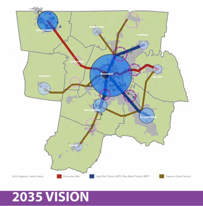
2035 Regional Transit Vision: Commuter Rail Light Rail Transit (LRT)/ Bus Rapid Transit (BRT) Express Coach Service
1313
To accommodate the current and future citizens of Middle TN, a strategic mix of transit options are proposed:
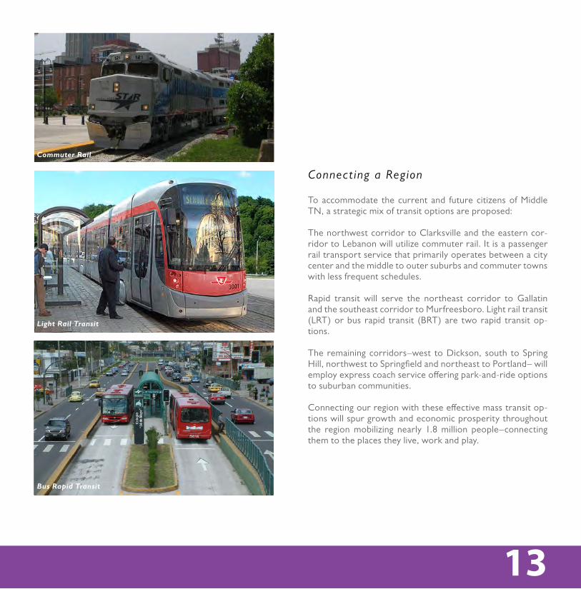
The northwest corridor to Clarksville and the eastern cor-ridor to Lebanon will utilize commuter rail. It is a passenger rail transport service that primarily operates between a city center and the middle to outer suburbs and commuter towns with less frequent schedules.
Rapid transit will serve the northeast corridor to Gallatin and the southeast corridor to Murfreesboro. Light rail transit (LRT) or bus rapid transit (BRT) are two rapid transit op-tions.
The remaining corridors–west to Dickson, south to Spring Hill, northwest to Springfield and northeast to Portland– will employ express coach service offering park-and-ride options to suburban communities.
Connecting our region with these effective mass transit op-tions will spur growth and economic prosperity throughout the region mobilizing nearly 1.8 million people–connecting them to the places they live, work and play.
Connect ing a Region
Express Coach Service
Commuter Rail
Light Rail Transit
Bus Rapid Transit
2035 VISION
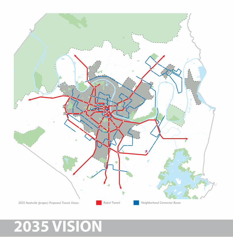
2035 Nashville (proper) Proposed Transit Vision: Rapid Transit Neighborhood Connector Buses
1515
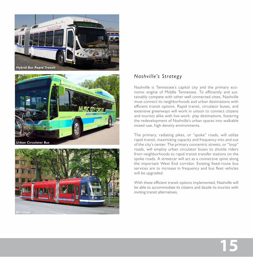
Nashville is Tennessee’s capitol city and the primary eco-nomic engine of Middle Tennessee. To efficiently and sus-tainably compete with other well connected cities, Nashville must connect its neighborhoods and urban destinations with efficient transit options. Rapid transit, circulator buses, and extensive greenways will work in unison to connect citizens and tourists alike with live-work- play destinations, fostering the redevelopment of Nashville’s urban spaces into walkable mixed-use, high density environments.
The primary, radiating pikes, or “spoke” roads, will utilize rapid transit, maximizing capacity and frequency into and out of the city’s center. The primary concentric streets, or “loop” roads, will employ urban circulator buses to shuttle riders from neighborhoods to rapid transit transfer stations on the spoke roads. A streetcar will act as a connective spine along the important West End corridor. Existing fixed-route bus services are to increase in frequency and bus fleet vehicles will be upgraded.
With these efficient transit options implemented, Nashville will be able to accommodate its citizens and dazzle its tourists with inviting transit alternatives.
Nashv i l le’s St rategy
Hybrid Bus Rapid Transit
Urban Circulator Bus
Streetcar
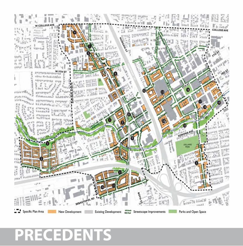
PRECEDENTS
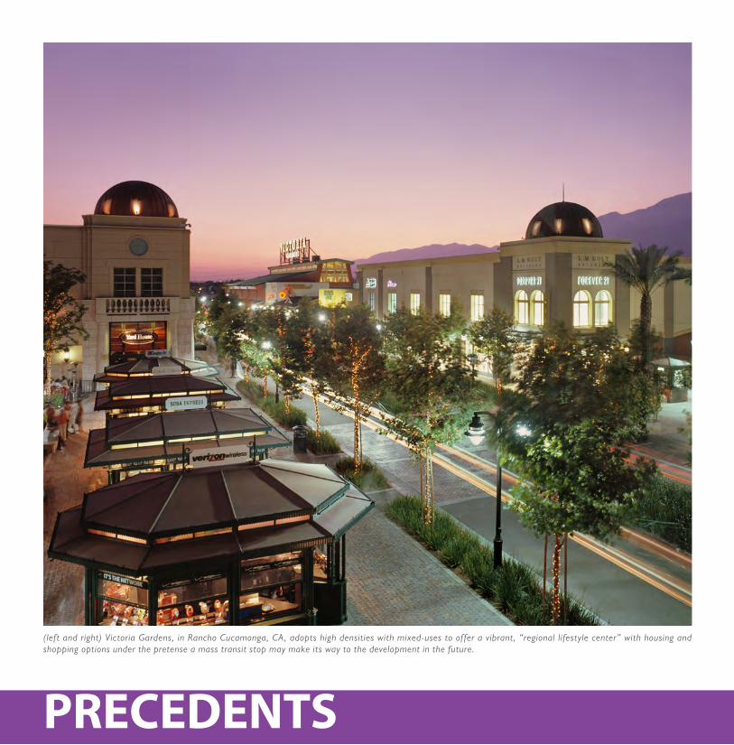
(left and right) Victoria Gardens, in Rancho Cucamonga, CA, adopts high densities with mixed-uses to offer a vibrant, “regional lifestyle center” with housing and shopping options under the pretense a mass transit stop may make its way to the development in the future.
1717
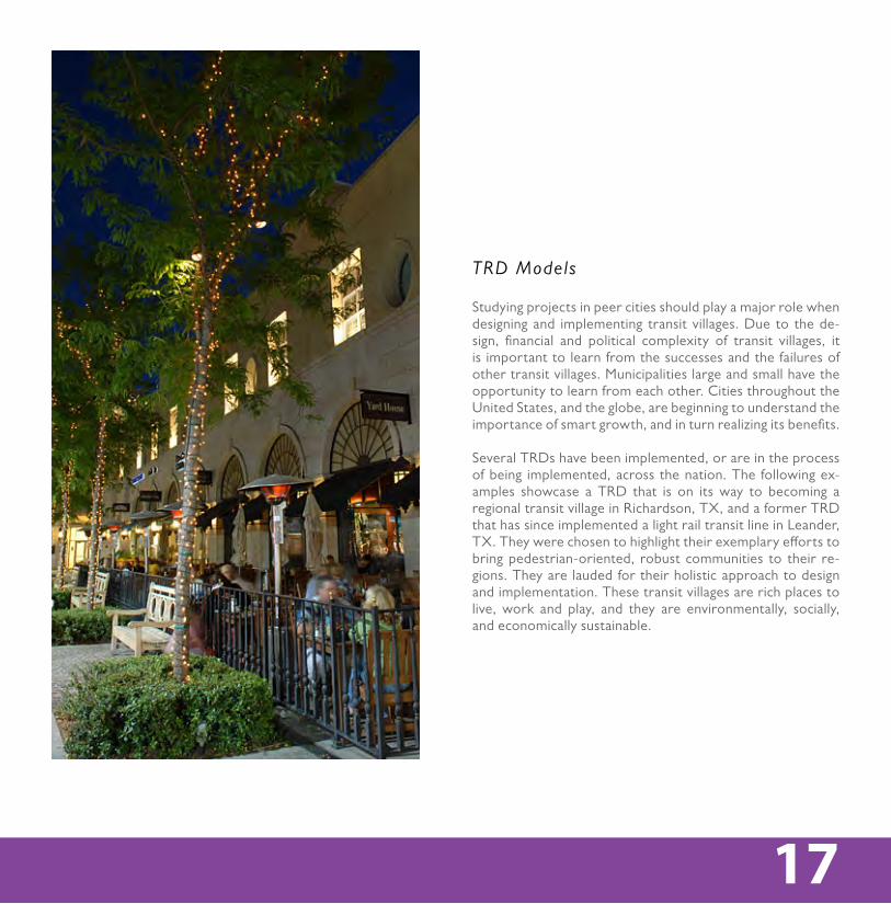
Studying projects in peer cities should play a major role when designing and implementing transit villages. Due to the de-sign, financial and political complexity of transit villages, it is important to learn from the successes and the failures of other transit villages. Municipalities large and small have the opportunity to learn from each other. Cities throughout the United States, and the globe, are beginning to understand the importance of smart growth, and in turn realizing its benefits.
Several TRDs have been implemented, or are in the process of being implemented, across the nation. The following ex-amples showcase a TRD that is on its way to becoming a regional transit village in Richardson, TX, and a former TRD that has since implemented a light rail transit line in Leander, TX. They were chosen to highlight their exemplary efforts to bring pedestrian-oriented, robust communities to their re-gions. They are lauded for their holistic approach to design and implementation. These transit villages are rich places to live, work and play, and they are environmentally, socially, and economically sustainable.
TRD Models
PRECEDENTS
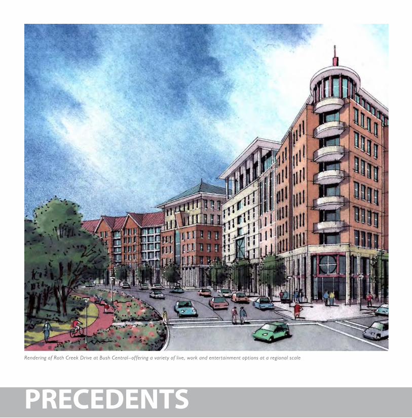
Rendering of Roth Creek Drive at Bush Central–offering a variety of live, work and entertainment options at a regional scale
1919
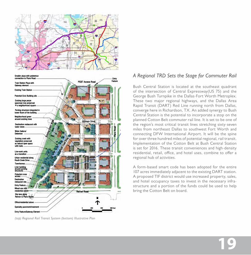
(top) Regional Rail Transit System (bottom) Illustrative Plan
Bush Central Station is located at the southeast quadrant of the intersection of Central Expressway(US 75) and the George Bush Turnpike in the Dallas-Fort Worth Metroplex. These two major regional highways, and the Dallas Area Rapid Transit (DART) Red Line running north from Dallas, converge here in Richardson, TX. An added synergy to Bush Central Station is the potential to incorporate a stop on the planned Cotton Belt commuter rail line. It is set to be one of the region’s most critical transit lines stretching sixty-seven miles from northeast Dallas to southwest Fort Worth and connecting DFW International Airport. It will be the spine for over three hundred miles of potential regional, rail transit. Implementation of the Cotton Belt at Bush Central Station is set for 2016. These transit conveniences and high-density residential, retail, office, and hotel uses, combine to offer a regional hub of activities.
A form-based smart code has been adopted for the entire 107 acres immediately adjacent to the existing DART station. A proposed TIF district would use increased property, sales, and hotel occupancy taxes to invest in the necessary infra-structure and a portion of the funds could be used to help bring the Cotton Belt on board.
A Regional TRD Sets the Stage for Commuter Rail
PRECEDENTS
2121
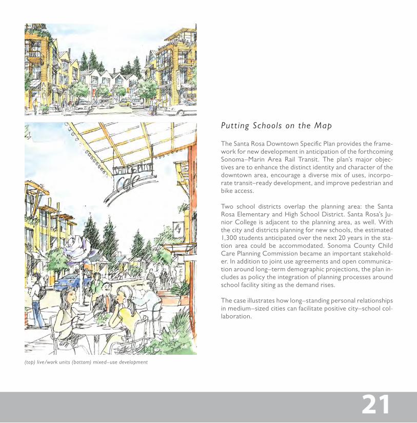
(top) live/work units (bottom) mixed–use development
The Santa Rosa Downtown Specific Plan provides the frame-work for new development in anticipation of the forthcoming Sonoma–Marin Area Rail Transit. The plan’s major objec-tives are to enhance the distinct identity and character of the downtown area, encourage a diverse mix of uses, incorpo-rate transit–ready development, and improve pedestrian and bike access.
Two school districts overlap the planning area: the Santa Rosa Elementary and High School District. Santa Rosa’s Ju-nior College is adjacent to the planning area, as well. With the city and districts planning for new schools, the estimated 1,300 students anticipated over the next 20 years in the sta-tion area could be accommodated. Sonoma County Child Care Planning Commission became an important stakehold-er. In addition to joint use agreements and open communica-tion around long–term demographic projections, the plan in-cludes as policy the integration of planning processes around school facility siting as the demand rises.
The case illustrates how long–standing personal relationships in medium–sized cities can facilitate positive city–school col-laboration.
Put t ing Schools on the Map
PRECEDENTS
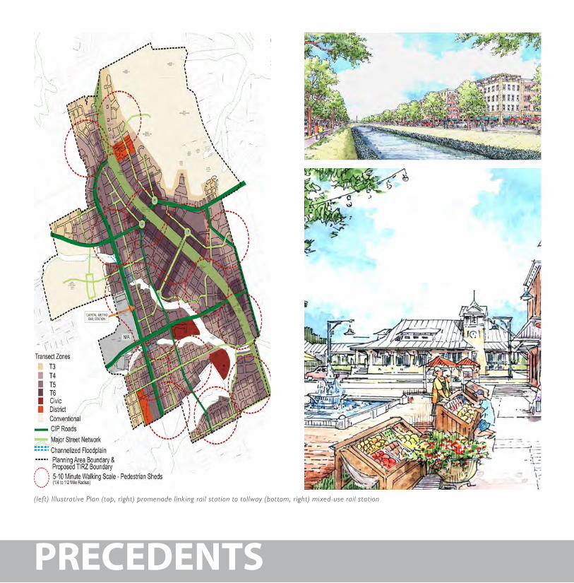
(left) Illustrative Plan (top, right) promenade linking rail station to tollway (bottom, right) mixed-use rail station
2323
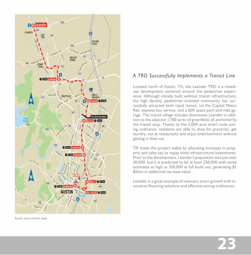
Austin area transit map
Located north of Austin, TX, the Leander TRD is a mixed-use development centered around the pedestrian experi-ence. Although initially built without transit infrastructure, the high density, pedestrian-oriented community has suc-cessfully attracted both rapid transit, via the Capital Metro Rail, express bus service, and a 600 space park-and-ride ga-rage. The transit village includes downtown Leander in addi-tion to the adjacent 1,700 acres of greenfield, all anchored by the transit stop. Thanks to the 2,000 acre smart code zon-ing ordinance, residents are able to shop for groceries, get laundry, eat at restaurants and enjoy entertainment without getting in their car.
TIF made this project viable by allocating increases in prop-erty and sales tax to repay initial infrastructure investments. Prior to the development, Leander’s population was just over 30,000, but it is predicted to be at least 250,000 with some estimates as high as 350,000 at full build out, generating $1 Billion in additional tax base value.
Leander is a great example of visionary smart growth with in-novative financing solutions and effective zoning ordinances.
A TRD Successfully Implements a Transit Line
CASE STUDIES
Diagram of proposed thoroughfare throughout the city, connecting some of the city’s key places where people learn, live, work and play.
MetrocenterWatkins School of Art
Tennessee State University
Downtown
Centennial Park
Vanderbilt University
Trevecca Nazarene University
Fannie Mae Dees ParkBelmont University
Fairgrounds
Fisk University/Meharry Medical College
I-40
I-24
I-65
I-440I-440
I-24
I-65
I-40
25
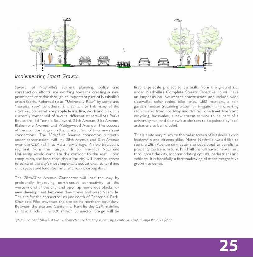
first large-scale project to be built, from the ground up, under Nashville’s Complete Streets Directive. It will have an emphasis on low-impact construction and include wide sidewalks, color-coded bike lanes, LED markers, a rain garden median (retaining water for irrigation and diverting stormwater from roadway and drains), on-street trash and recycling, bioswales, a new transit service to be part of a university run, and six new bus shelters to be painted by local artists are to be included.
This is a site very much on the radar screen of Nashville’s civic leadership and citizens alike. Metro Nashville would like to see the 28th Avenue connector site developed to benefit its property tax base. In turn, Nashvillians will have a new artery throughout the city, accommodating cyclists, pedestrians and vehicles. It is hopefully a foreshadowing of more progressive growth to come.
25
Typical section of 28th/31st Avenue Connector, the f irst step in creating a continuous loop through the city’s fabric.
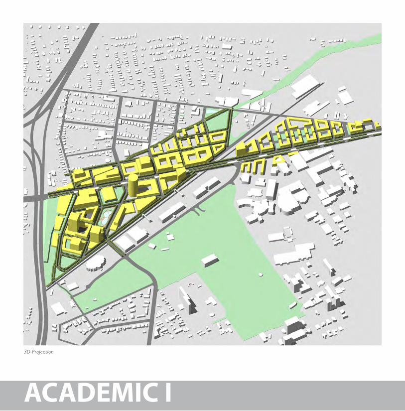
Several of Nashville’s current planning, policy and construction efforts are working towards creating a new prominent corridor through an important part of Nashville’s urban fabric. Referred to as “University Row” by some and “hospital row” by others, it is certain to link many of the city’s key places where people learn, live, work and play. It is currently comprised of several different streets–Rosa Parks Boulevard, Ed Temple Boulevard, 28th Avenue, 31st Avenue, Blakemore Avenue, and Wedgewood Avenue. The success of the corridor hinges on the construction of two new street connections. The 28th/31st Avenue connector, currently under construction, will link 28th Avenue and 31st Avenue over the CSX rail lines via a new bridge. A new boulevard segment from the Fairgrounds to Trevecca Nazarene University would complete the corridor to the east. Upon completion, the loop throughout the city will increase access to some of the city’s most important educational, cultural and civic spaces and lend itself as a landmark thoroughfare.
The 28th/31st Avenue Connector will lead the way by profoundly improving north-south connectivity at the western end of the city, and open up numerous blocks for new development between downtown and west Nashville. The site for the connector lies just north of Centennial Park. Charlotte Pike traverses the site on its northern boundary. Between the site and Centennial Park lie the CSX mainline railroad tracks. The $20 million connector bridge will be
Implementing Smart Growth
ACADEMIC
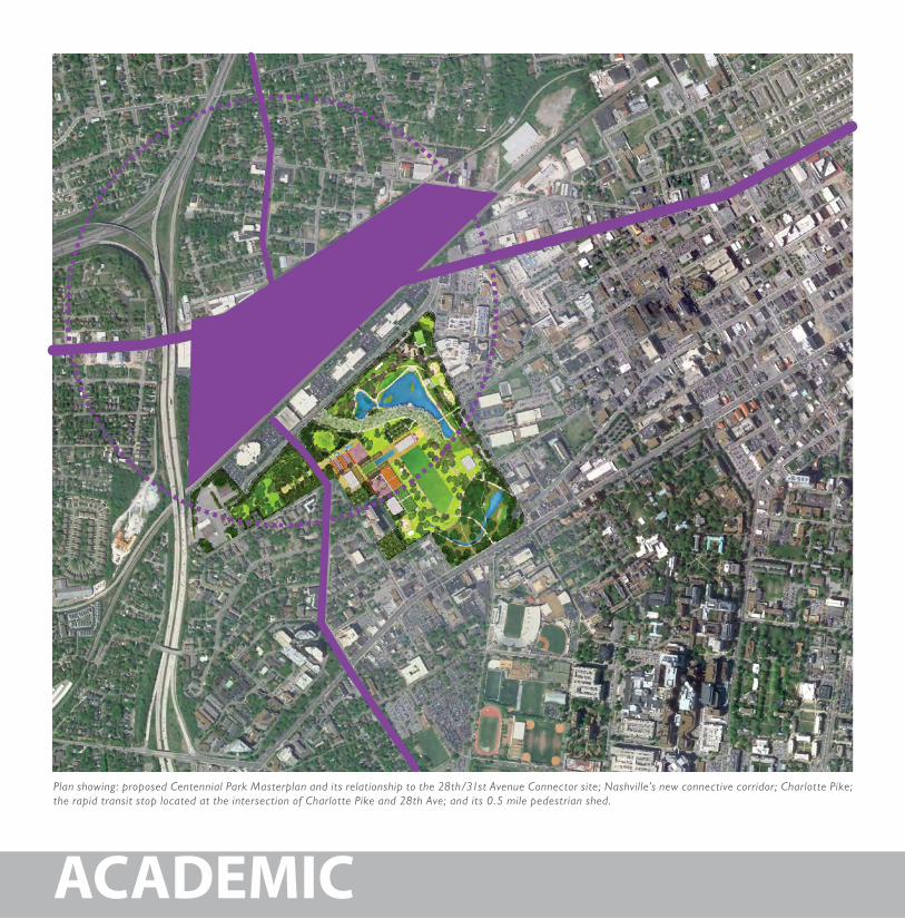
Plan showing: proposed Centennial Park Masterplan and its relationship to the 28th/31st Avenue Connector site; Nashville’s new connective corridor; Charlotte Pike; the rapid transit stop located at the intersection of Charlotte Pike and 28th Ave; and its 0.5 mile pedestrian shed.
27
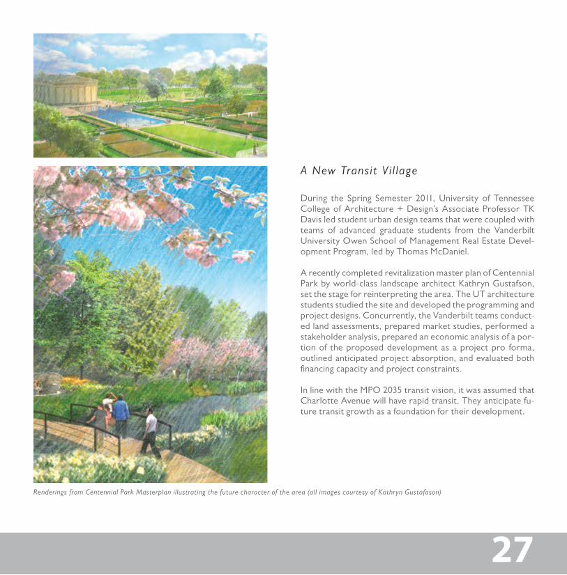
During the Spring Semester 2011, University of Tennessee College of Architecture + Design’s Associate Professor TK Davis led student urban design teams that were coupled with teams of advanced graduate students from the Vanderbilt University Owen School of Management Real Estate Devel-opment Program, led by Thomas McDaniel.
A recently completed revitalization master plan of Centennial Park by world-class landscape architect Kathryn Gustafson, set the stage for reinterpreting the area. The UT architecture students studied the site and developed the programming and project designs. Concurrently, the Vanderbilt teams conduct-ed land assessments, prepared market studies, performed a stakeholder analysis, prepared an economic analysis of a por-tion of the proposed development as a project pro forma, outlined anticipated project absorption, and evaluated both financing capacity and project constraints.
In line with the MPO 2035 transit vision, it was assumed that Charlotte Avenue will have rapid transit. They anticipate fu-ture transit growth as a foundation for their development.
27
Renderings from Centennial Park Masterplan illustrating the future character of the area (all images courtesy of Kathryn Gustafason)
A New Transit V i l lage
ACADEMIC I
3D Projection
29
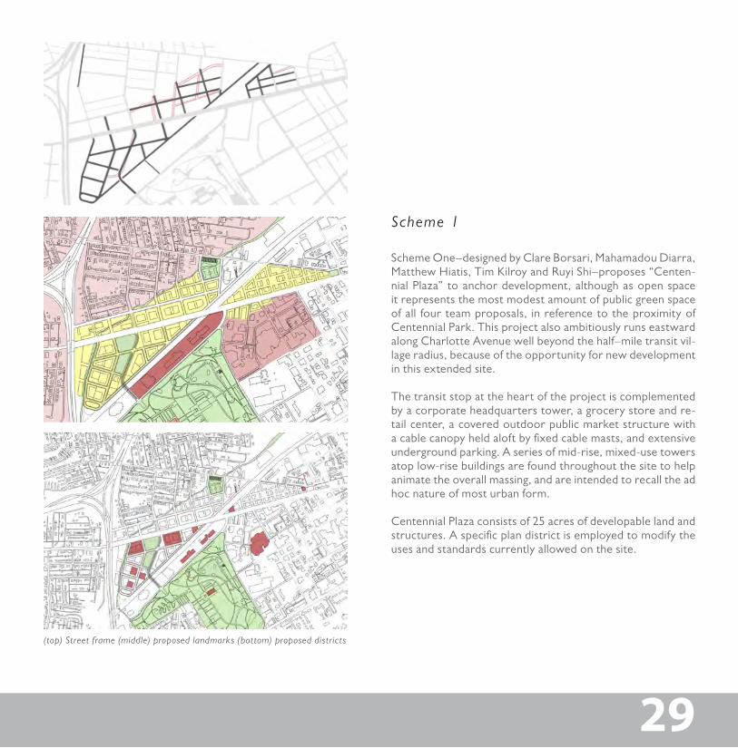
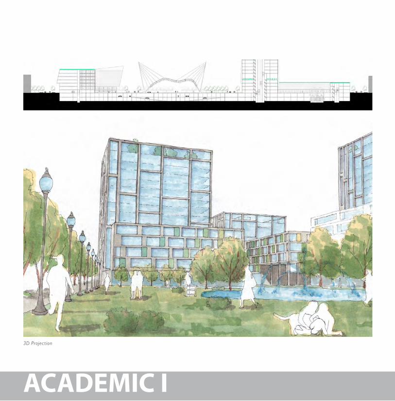
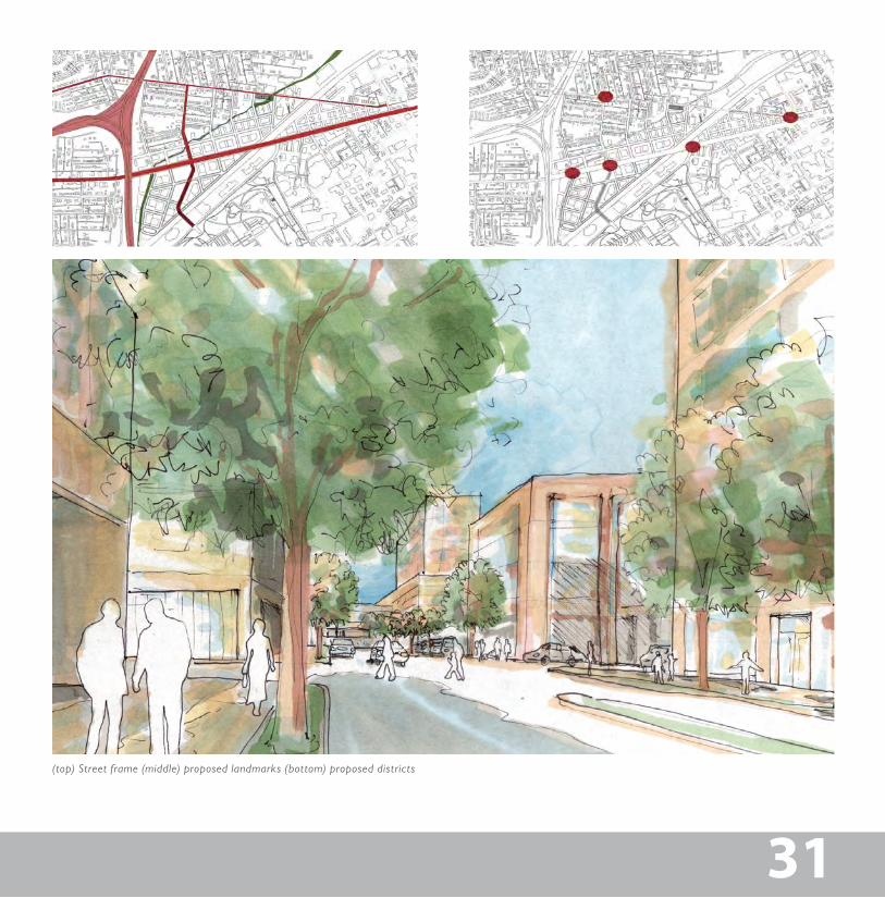
Scheme One–designed by Clare Borsari, Mahamadou Diarra, Matthew Hiatis, Tim Kilroy and Ruyi Shi–proposes “Centen-nial Plaza” to anchor development, although as open space it represents the most modest amount of public green space of all four team proposals, in reference to the proximity of Centennial Park. This project also ambitiously runs eastward along Charlotte Avenue well beyond the half–mile transit vil-lage radius, because of the opportunity for new development in this extended site.
The transit stop at the heart of the project is complemented by a corporate headquarters tower, a grocery store and re-tail center, a covered outdoor public market structure with a cable canopy held aloft by fixed cable masts, and extensive underground parking. A series of mid-rise, mixed-use towers atop low-rise buildings are found throughout the site to help animate the overall massing, and are intended to recall the ad hoc nature of most urban form.
Centennial Plaza consists of 25 acres of developable land and structures. A specific plan district is employed to modify the uses and standards currently allowed on the site.
29
(top) Street frame (middle) proposed landmarks (bottom) proposed districts
Scheme 1
ACADEMIC I
3D Projection
3131
(top) Street frame (middle) proposed landmarks (bottom) proposed districts
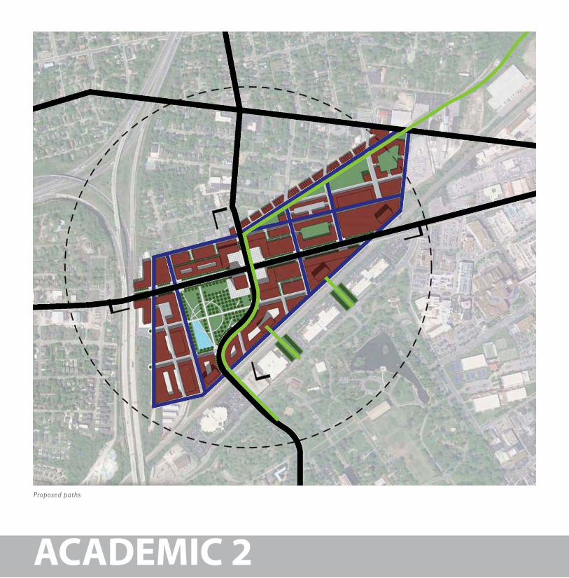
Proposed paths
ACADEMIC 2
33
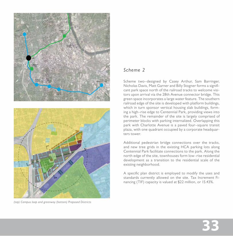
(top) Campus loop and greenway (bottom) Proposed Districts
33
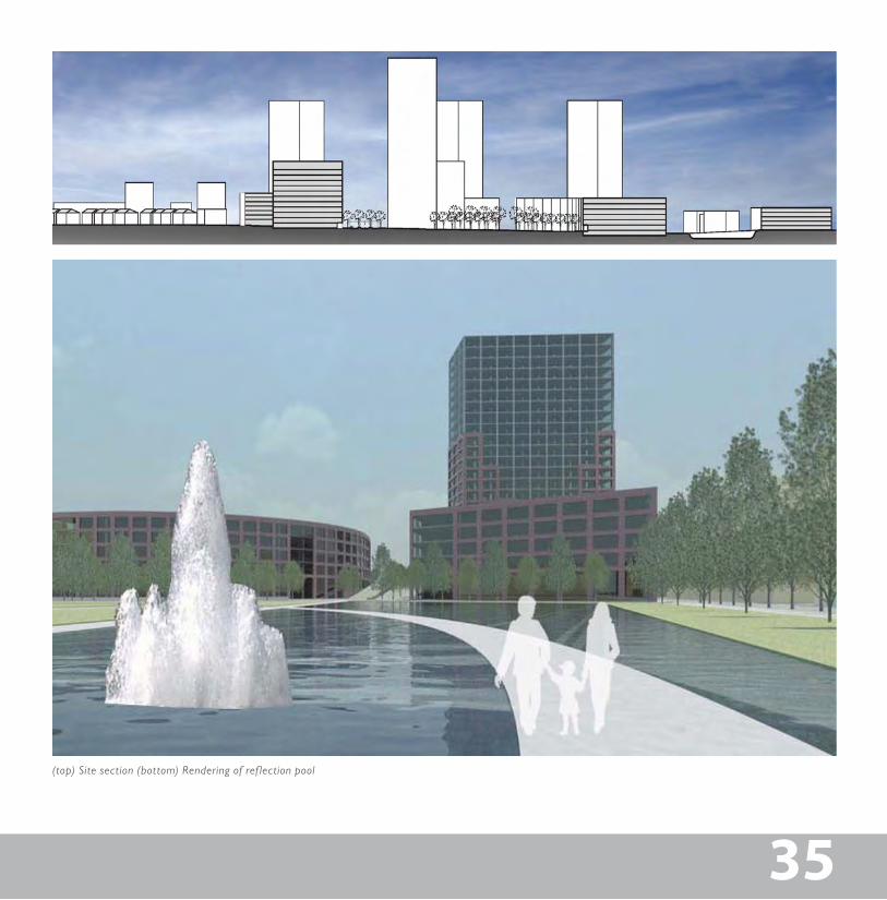
Scheme two–designed by Casey Arthur, Sam Barringer, Nicholas Davis, Matt Garner and Billy Stogner forms a signifi-cant park space north of the railroad tracks to welcome visi-tors upon arrival via the 28th Avenue connector bridge. This green space incorporates a large water feature. The southern railroad edge of the site is developed with platform buildings, which in turn sponsor vertical housing slab buildings, form-ing a high–rise edge to Centennial Park, providing views into the park. The remainder of the site is largely comprised of perimeter blocks with parking internalized. Overlapping this park with Charlotte Avenue is a paved four–square transit plaza, with one quadrant occupied by a corporate headquar-ters tower.
Additional pedestrian bridge connections over the tracks, and new tree grids in the existing HCA parking lots along Centennial Park facilitate connections to the park. Along the north edge of the site, townhouses form low–rise residential development as a transition to the residential scale of the existing neighborhood.
A specific plan district is employed to modify the uses and standards currently allowed on the site. Tax Increment Fi-nancing (TIF) capacity is valued at $22 million, or 15.43%.
Scheme 2
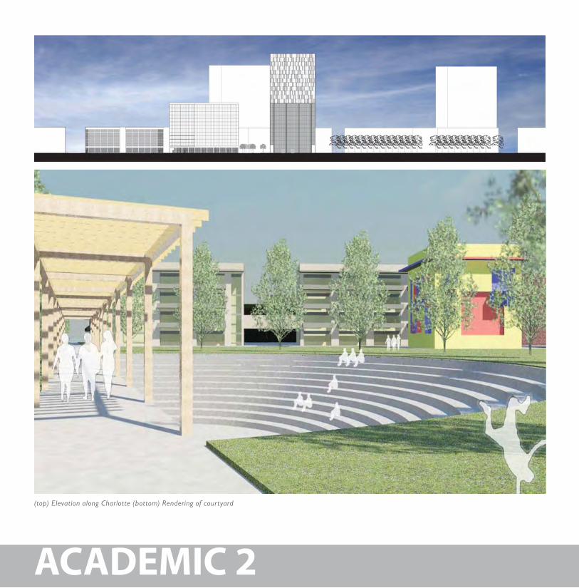
(top) Elevation along Charlotte (bottom) Rendering of courtyard
ACADEMIC 2
35
(top) Site section (bottom) Rendering of ref lection pool
35
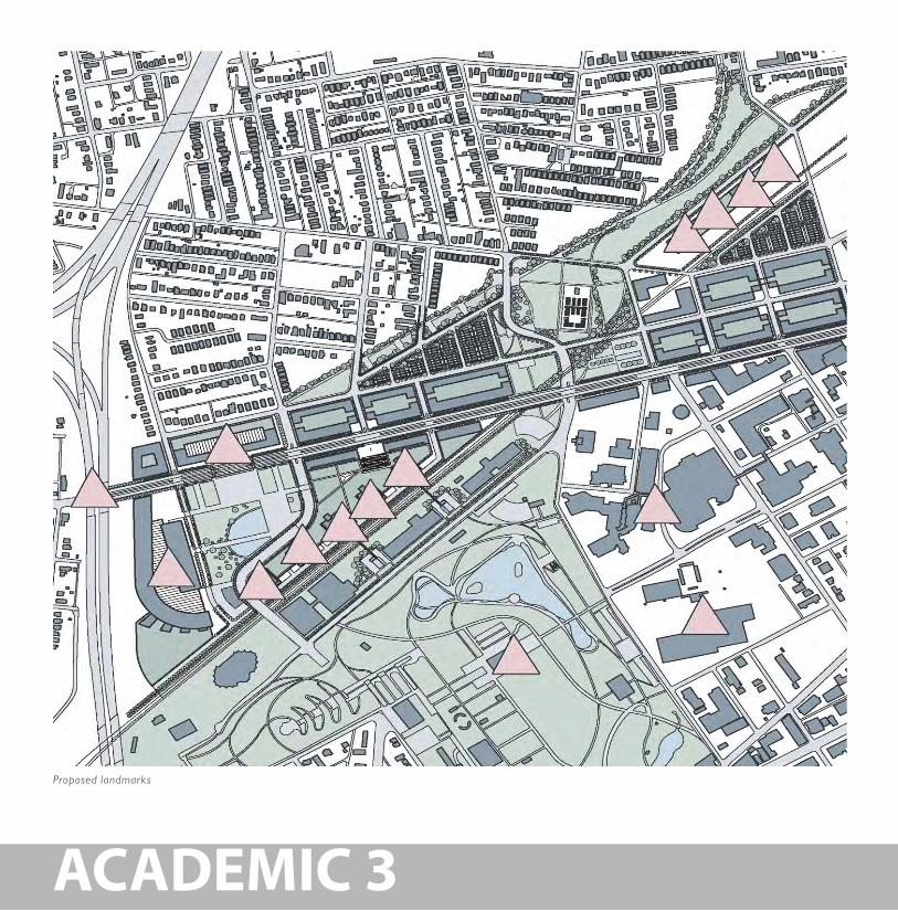
Proposed landmarks
ACADEMIC 3
37
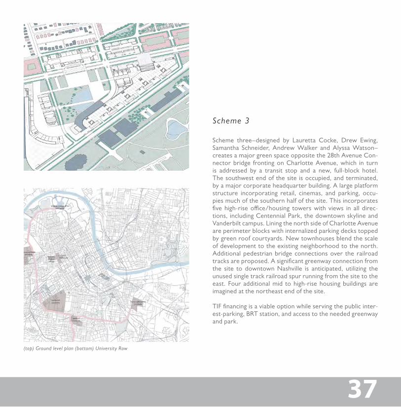
(top) Ground level plan (bottom) University Row
37
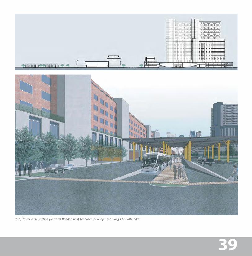
Scheme three–designed by Lauretta Cocke, Drew Ewing, Samantha Schneider, Andrew Walker and Alyssa Watson–creates a major green space opposite the 28th Avenue Con-nector bridge fronting on Charlotte Avenue, which in turn is addressed by a transit stop and a new, full-block hotel. The southwest end of the site is occupied, and terminated, by a major corporate headquarter building. A large platform structure incorporating retail, cinemas, and parking, occu-pies much of the southern half of the site. This incorporates five high-rise office/housing towers with views in all direc-tions, including Centennial Park, the downtown skyline and Vanderbilt campus. Lining the north side of Charlotte Avenue are perimeter blocks with internalized parking decks topped by green roof courtyards. New townhouses blend the scale of development to the existing neighborhood to the north. Additional pedestrian bridge connections over the railroad tracks are proposed. A significant greenway connection from the site to downtown Nashville is anticipated, utilizing the unused single track railroad spur running from the site to the east. Four additional mid to high-rise housing buildings are imagined at the northeast end of the site.
TIF financing is a viable option while serving the public inter-est-parking, BRT station, and access to the needed greenway and park.
Scheme 3
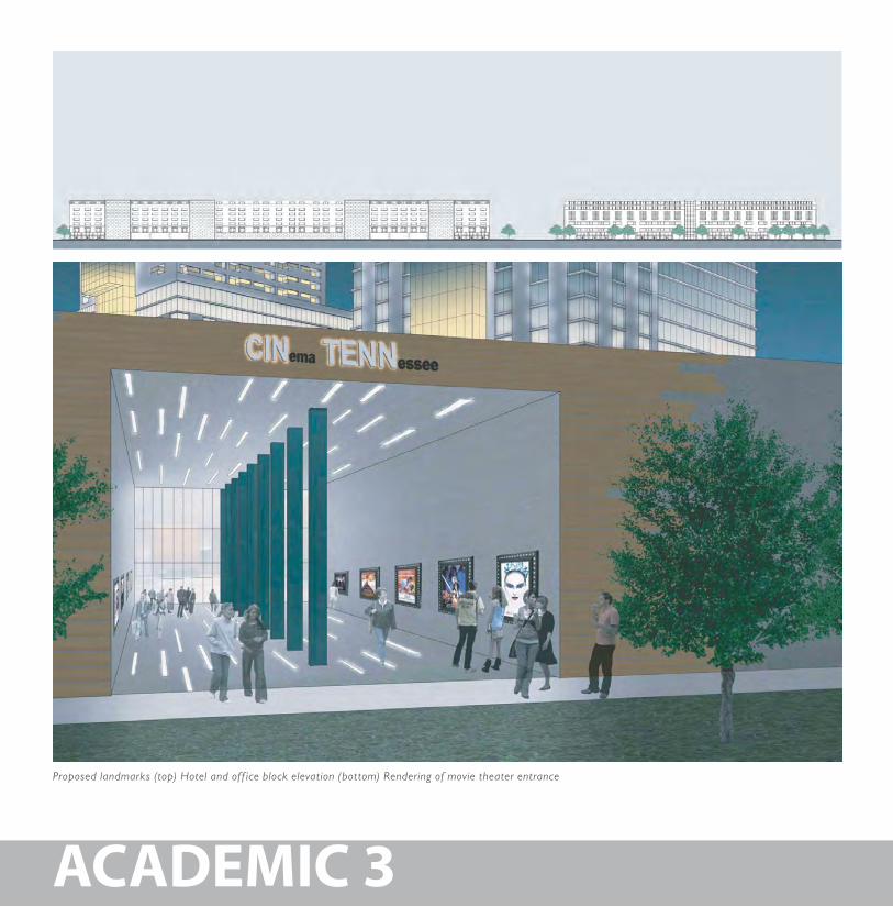
Proposed landmarks (top) Hotel and off ice block elevation (bottom) Rendering of movie theater entrance
ACADEMIC 3
39
(top) Tower base section (bottom) Rendering of proposed development along Charlotte Pike
39
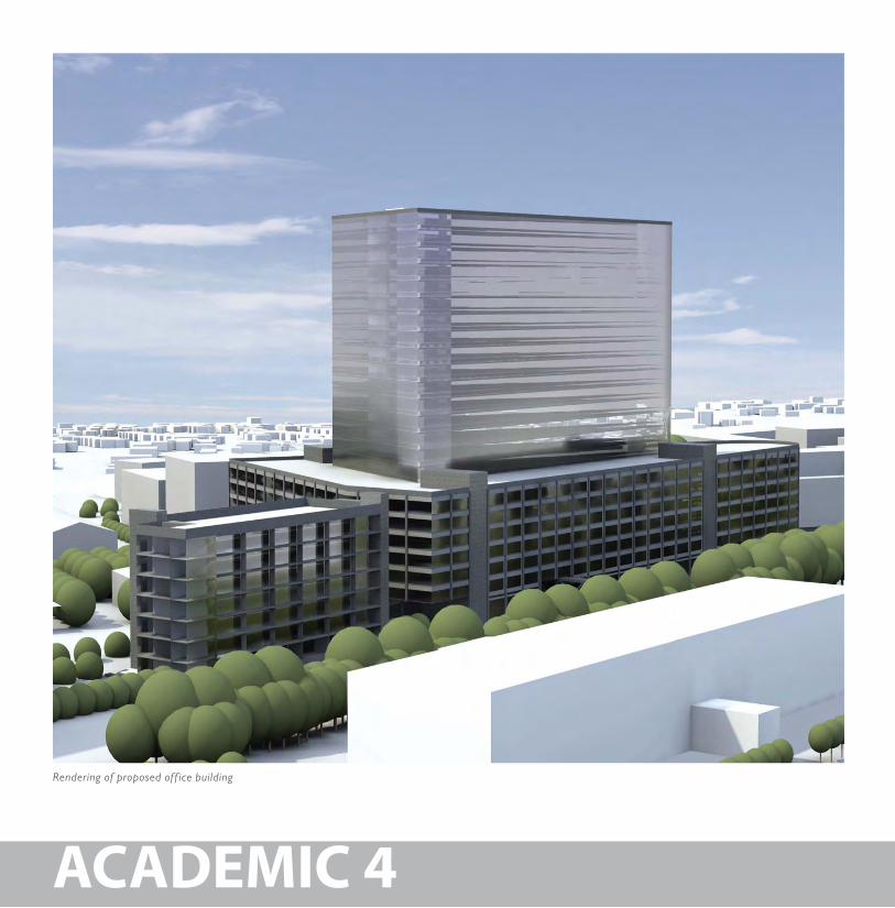
Rendering of proposed off ice building
ACADEMIC 4
41
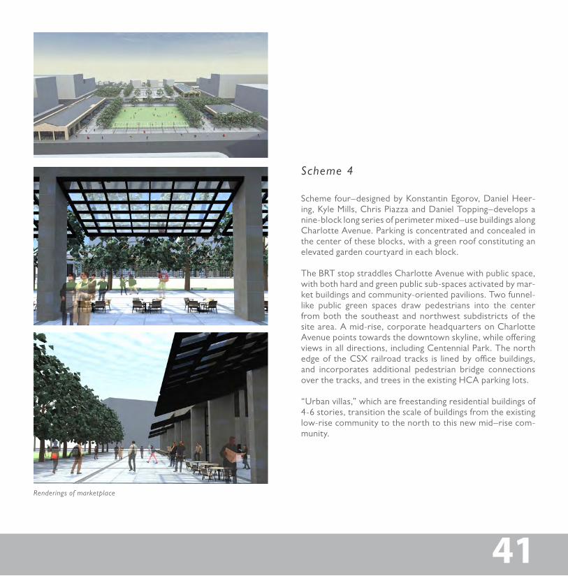
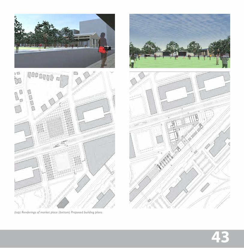
Renderings of marketplace
41
Scheme four–designed by Konstantin Egorov, Daniel Heer-ing, Kyle Mills, Chris Piazza and Daniel Topping–develops a nine-block long series of perimeter mixed–use buildings along Charlotte Avenue. Parking is concentrated and concealed in the center of these blocks, with a green roof constituting an elevated garden courtyard in each block.
The BRT stop straddles Charlotte Avenue with public space, with both hard and green public sub-spaces activated by mar-ket buildings and community-oriented pavilions. Two funnel-like public green spaces draw pedestrians into the center from both the southeast and northwest subdistricts of the site area. A mid-rise, corporate headquarters on Charlotte Avenue points towards the downtown skyline, while offering views in all directions, including Centennial Park. The north edge of the CSX railroad tracks is lined by office buildings, and incorporates additional pedestrian bridge connections over the tracks, and trees in the existing HCA parking lots.
“Urban villas,” which are freestanding residential buildings of 4-6 stories, transition the scale of buildings from the existing low-rise community to the north to this new mid–rise com-munity.
Scheme 4
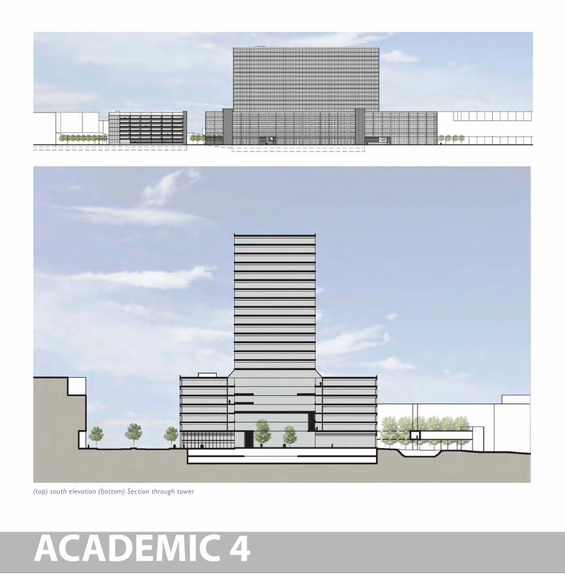
(top) south elevation (bottom) Section through tower
ACADEMIC 4
43
(top) Renderings of market place (bottom) Proposed building plans
43
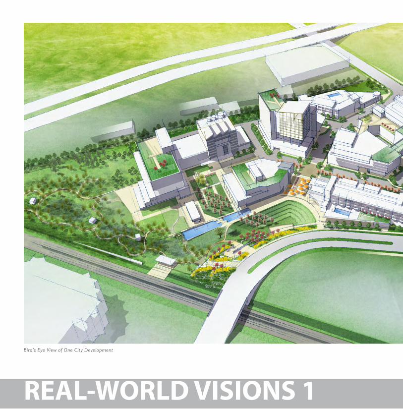
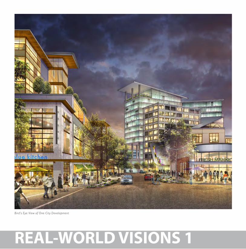
Bird’s Eye View of One City Development
REAL-WORLD VISIONS 1
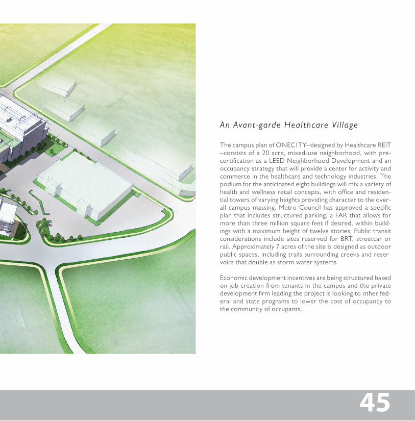
5.2 Rea l Wor ld V is ions : ONE C1T YHealthcare REIT: An Avant–garde Healthcare Vil lage for Nashvil le
4545
Rea l Wor ld V is ions : ONE C1T YHealthcare REIT: An Avant–garde Healthcare Vil lage for Nashvil le
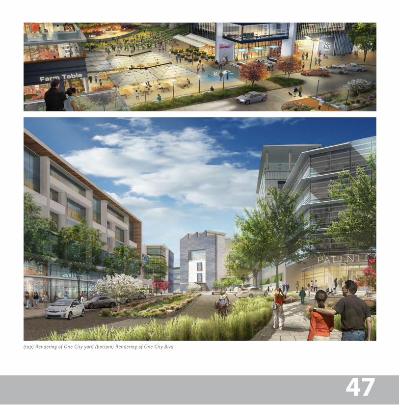
The campus plan of ONEC1TY–designed by Healthcare REIT –consists of a 20 acre, mixed-use neighborhood, with pre-certification as a LEED Neighborhood Development and an occupancy strategy that will provide a center for activity and commerce in the healthcare and technology industries. The podium for the anticipated eight buildings will mix a variety of health and wellness retail concepts, with office and residen-tial towers of varying heights providing character to the over-all campus massing. Metro Council has approved a specific plan that includes structured parking, a FAR that allows for more than three million square feet if desired, within build-ings with a maximum height of twelve stories. Public transit considerations include sites reserved for BRT, streetcar or rail. Approximately 7 acres of the site is designed as outdoor public spaces, including trails surrounding creeks and reser-voirs that double as storm water systems.
Economic development incentives are being structured based on job creation from tenants in the campus and the private development firm leading the project is looking to other fed-eral and state programs to lower the cost of occupancy to the community of occupants.
An Avant-garde Healthcare V i l lage
Bird’s Eye View of One City Development
REAL-WORLD VISIONS 1
47
(top) Rendering of One City yard (bottom) Rendering of One City Blvd
47
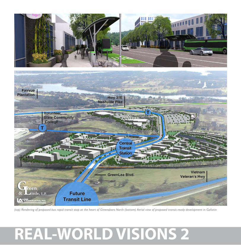
(top) Rendering of proposed bus rapid transit stop at the heart of Greensboro North (bottom) Aerial view of proposed transit-ready development in Gallatin
REAL-WORLD VISIONS 2
49
Diagram of Greensboro North
49
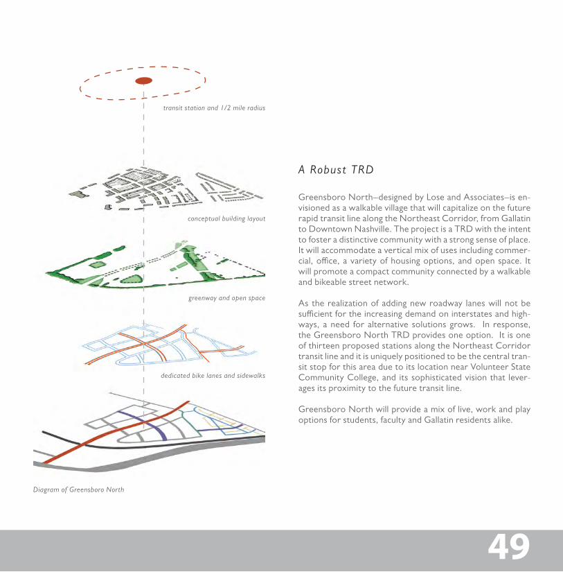
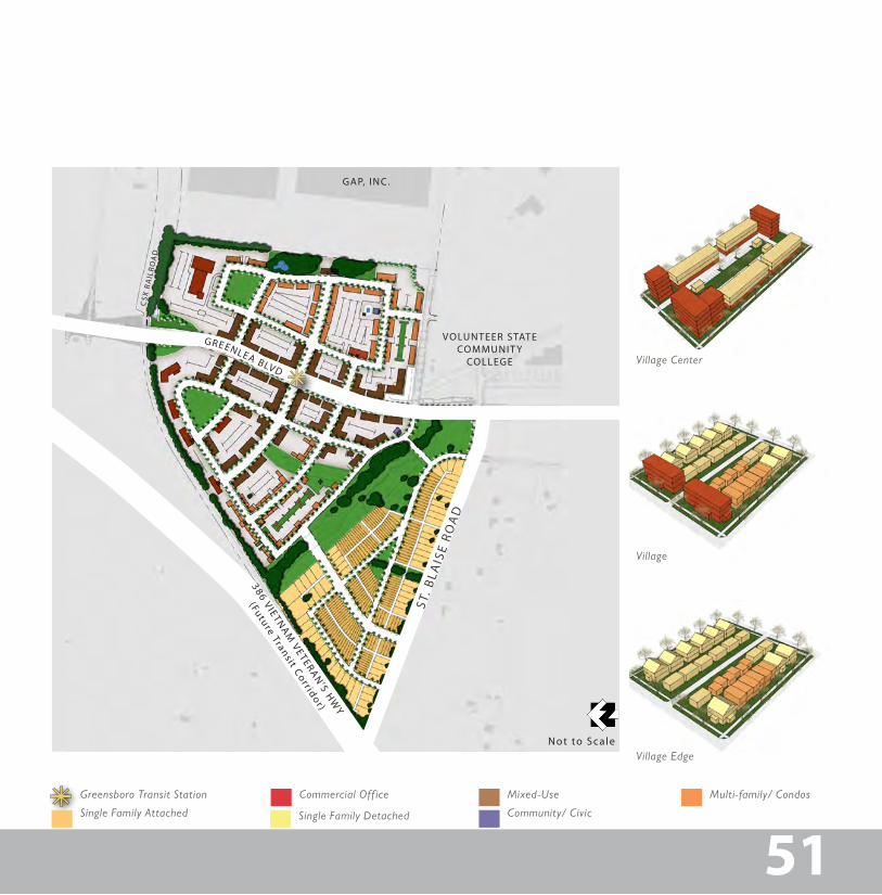
Greensboro North–designed by Lose and Associates–is en-visioned as a walkable village that will capitalize on the future rapid transit line along the Northeast Corridor, from Gallatin to Downtown Nashville. The project is a TRD with the intent to foster a distinctive community with a strong sense of place. It will accommodate a vertical mix of uses including commer-cial, office, a variety of housing options, and open space. It will promote a compact community connected by a walkable and bikeable street network.
As the realization of adding new roadway lanes will not be sufficient for the increasing demand on interstates and high-ways, a need for alternative solutions grows. In response, the Greensboro North TRD provides one option. It is one of thirteen proposed stations along the Northeast Corridor transit line and it is uniquely positioned to be the central tran-sit stop for this area due to its location near Volunteer State Community College, and its sophisticated vision that lever-ages its proximity to the future transit line.
Greensboro North will provide a mix of live, work and play options for students, faculty and Gallatin residents alike.
dedicated bike lanes and sidewalks
greenway and open space
conceptual building layout
transit station and 1/2 mile radius
A Robust TRD
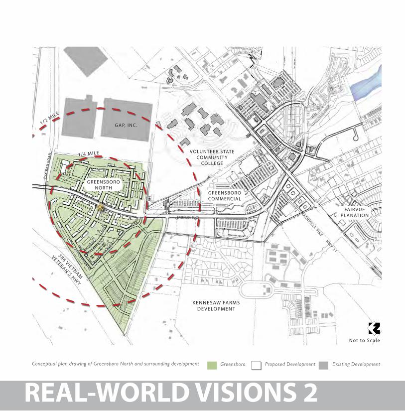
Conceptual plan drawing of Greensboro North and surrounding development
GREENLEA BLVD
NASHVILLE PIKE HWY 31
KENNESAW FARMSDE VELOPMENT
386 VIETNAM
VETERAN’S HWY
VOLUNTEER STATE COMMUNIT Y
COLLEGE
GAP, INC.
CSX
RA
ILR
OA
D
FAIR VUE PLANATION
GREENSBORO NOR TH
GREENSBORO COMMERCIAL
1/2 MILE
1/4 MILE
Not to Scale
Greensboro Proposed Development Existing Development
REAL-WORLD VISIONS 2
51
Not to Scale
386 VIETNAM
VETERAN’S H
WY
(Future Transit Corr idor)
ST. B
LAIS
E RO
AD
GREENLEA BLVD
VOLUNTEER STATE COMMUNIT Y
COLLEGE
CSX
RA
ILR
OA
D
GAP, INC.
Greensboro Transit Station Commercial Off ice
Single Family Attached
Mixed-Use
Single Family Detached
Multi-family/ Condos
Village Edge
Village
Village Center
Community/ Civic
51
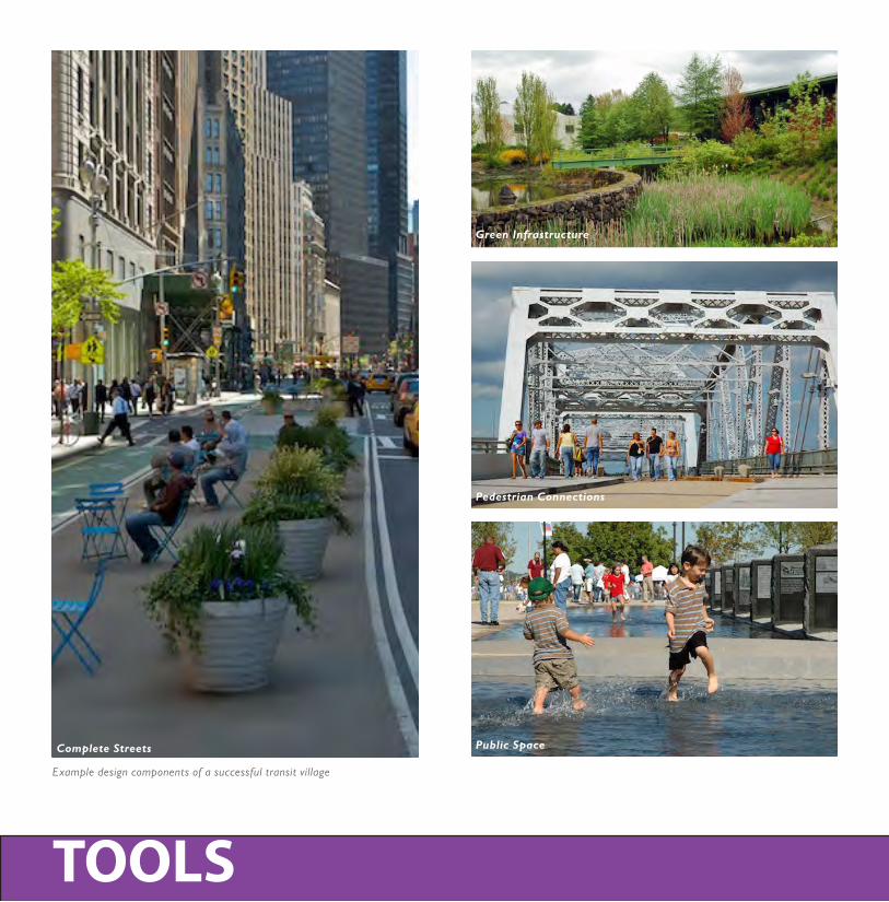
Example design components of a successful transit village
TOOLS
Green Infrastructure
Complete Streets
Pedestrian Connections
Public Space
5353
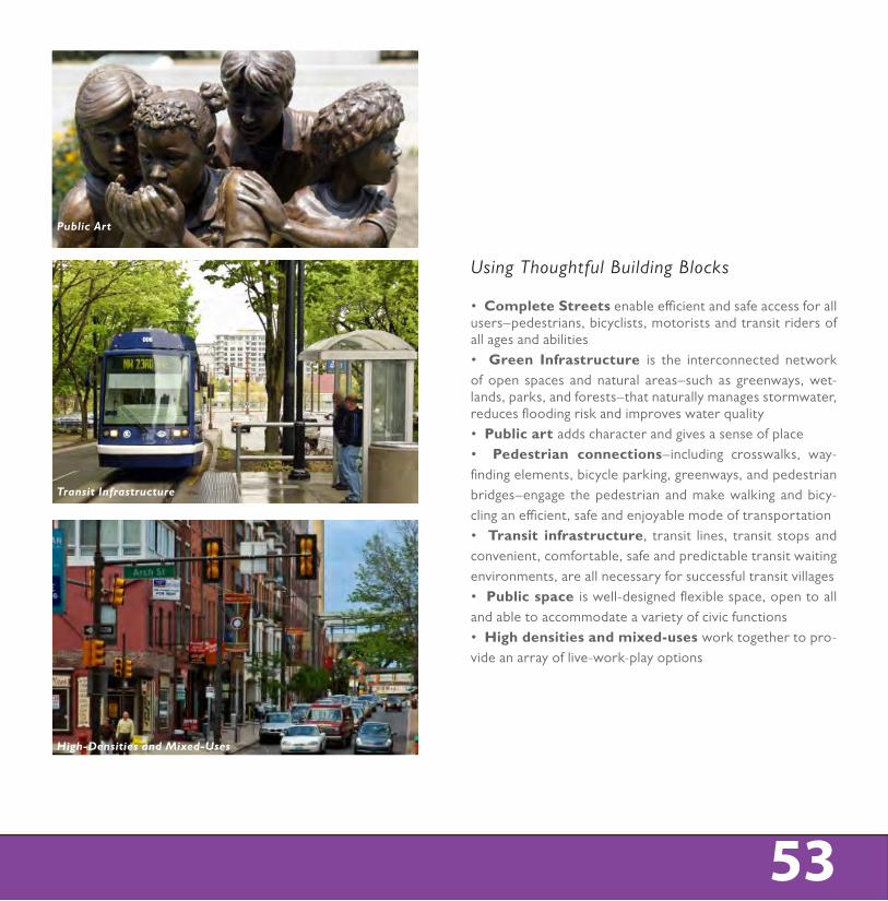
• Complete Streets enable efficient and safe access for all users–pedestrians, bicyclists, motorists and transit riders of all ages and abilities• Green Infrastructure is the interconnected network of open spaces and natural areas–such as greenways, wet-lands, parks, and forests–that naturally manages stormwater, reduces flooding risk and improves water quality• Public art adds character and gives a sense of place• Pedestrian connections–including crosswalks, way-finding elements, bicycle parking, greenways, and pedestrian bridges–engage the pedestrian and make walking and bicy-cling an efficient, safe and enjoyable mode of transportation• Transit infrastructure, transit lines, transit stops and convenient, comfortable, safe and predictable transit waiting environments, are all necessary for successful transit villages• Public space is well-designed flexible space, open to all and able to accommodate a variety of civic functions• High densities and mixed-uses work together to pro-vide an array of live-work-play options
Using Thoughtful Building Blocks
Public Art
Transit Infrastructure
High-Densities and Mixed-Uses
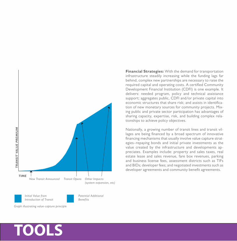
Graph illustrating value-capture principle
TOOLS
Financial Strategies: With the demand for transportation infrastructure steadily increasing while the funding lags far behind, complex new partnerships are necessary to raise the required capital and operating costs. A certified Community Development Financial Institution (CDFI) is one example. It delivers: needed program, policy and technical assistance support; aggregates public, CDFI and/or private capital into economic structures that share risk; and assists in identifica-tion of new monetary sources for community projects. Mix-ing public and private sector participation has advantages of sharing capacity, expertise, risk, and building complex rela-tionships to achieve policy objectives.
Nationally, a growing number of transit lines and transit vil-lages are being financed by a broad spectrum of innovative financing mechanisms that usually involve value capture strat-egies–repaying bonds and initial private investments as the value created by the infrastructure and developments ap-preciates. Examples include: property and sales taxes, real estate lease and sales revenue, fare box revenues, parking and business license fees, assessment districts such as TIFs and BIDs; developer fees; and negotiated investments such as developer agreements and community benefit agreements.
TIME
TR
AN
SIT
VA
LUE
PR
EM
IUM
New Transit Announced
Initial Value from Introduction of Transit
Potential Additional Benef its
Transit Opens Other Impacts (system expansion, etc)
55
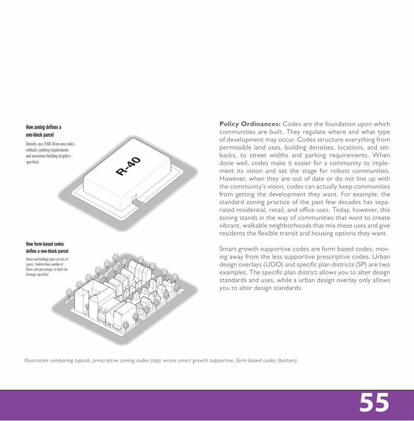
Illustration comparing typical, prescriptive zoning codes (top) versus smart growth supportive, form-based codes (bottom).
55
Policy Ordinances: Codes are the foundation upon which communities are built. They regulate where and what type of development may occur. Codes structure everything from permissible land uses, building densities, locations, and set-backs, to street widths and parking requirements. When done well, codes make it easier for a community to imple-ment its vision and set the stage for robust communities. However, when they are out of date or do not line up with the community’s vision, codes can actually keep communities from getting the development they want. For example: the standard zoning practice of the past few decades has sepa-rated residential, retail, and office uses. Today, however, this zoning stands in the way of communities that want to create vibrant, walkable neighborhoods that mix these uses and give residents the flexible transit and housing options they want.
Smart growth supportive codes are form based codes, mov-ing away from the less supportive prescriptive codes. Urban design overlays (UDO) and specific plan districts (SP) are two examples. The specific plan district allows you to alter design standards and uses, while a urban design overlay only allows you to alter design standards.R-40
R-40
How form-based codesdefine a one-block parcel
How zoning defines a one-block parcelDensity, use, FAR (floor-area ratio), setbacks, parking requirements, and maximum building height(s) specified.
Density, use, FAR (floor-area ratio), setbacks, parking requirements, maximum building height(s), frequency of openings, and surface articulation specified.
Street and building types (or mix of types), build-to lines, number of floors, and percentage of built site frontage specified.
How design guidelines define a one-block parcel
©2006 Peter Katz and Steve Price—Urban Advantage
R-40
R-40
How form-based codesdefine a one-block parcel
How zoning defines a one-block parcelDensity, use, FAR (floor-area ratio), setbacks, parking requirements, and maximum building height(s) specified.
Density, use, FAR (floor-area ratio), setbacks, parking requirements, maximum building height(s), frequency of openings, and surface articulation specified.
Street and building types (or mix of types), build-to lines, number of floors, and percentage of built site frontage specified.
How design guidelines define a one-block parcel
©2006 Peter Katz and Steve Price—Urban Advantage
LIVABILITY • PROSPERITY • SUSTAINABILITY • DIVERSITY