Annual Report AY2013 Geospatial Information …€¦ · or demonstrate any competency). Annual...
23
Unit level report 2013 Department: Geospatial Information Technology Center Unit Missions GISC_Mission Mission statement The Center for Interdisciplinary Geospatial Information Technologies is an independent unit of the College of Arts and Sciences. The mission of the Center is to provide geospatial services, accessible education and training, and institutional knowledge for geospatial information technologies to the widest possible audience, and particularly, the mid-Delta region. Inherent in this mission is its performance in such a way that our program demonstrates global leadership for geospatial information technologies organized around three core areas: Education and Training, Business and Community Development, and Institutional Knowledge. Related Items There are no related items. Annual Report_AY2013_Geospatial Information Technology Center 1 of 23
Transcript of Annual Report AY2013 Geospatial Information …€¦ · or demonstrate any competency). Annual...

Unit level report 2013Department: Geospatial Information Technology Center
Unit Missions
GISC_Mission
Mission statementThe Center for Interdisciplinary Geospatial Information Technologies is an independent unit of the College of Arts and Sciences.The mission of the Center is to provide geospatial services, accessible education and training, and institutional knowledge forgeospatial information technologies to the widest possible audience, and particularly, the mid-Delta region. Inherent in thismission is its performance in such a way that our program demonstrates global leadership for geospatial information technologiesorganized around three core areas: Education and Training, Business and Community Development, and Institutional Knowledge.
Related ItemsThere are no related items.
Annual Report_AY2013_Geospatial Information Technology Center 1 of 23
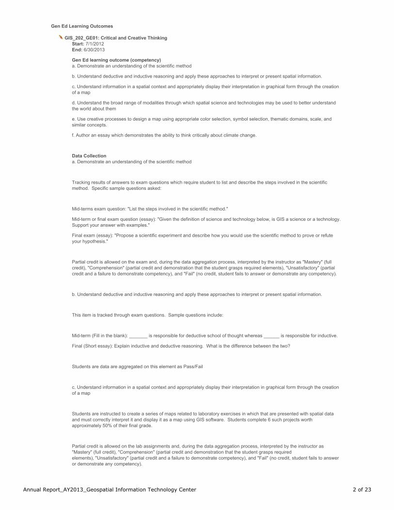
Gen Ed Learning Outcomes
GIS_202_GE01: Critical and Creative Thinking Start: 7/1/2012
End: 6/30/2013
Gen Ed learning outcome (competency)a. Demonstrate an understanding of the scientific method
b. Understand deductive and inductive reasoning and apply these approaches to interpret or present spatial information.
c. Understand information in a spatial context and appropriately display their interpretation in graphical form through the creationof a map
d. Understand the broad range of modalities through which spatial science and technologies may be used to better understandthe world about them
e. Use creative processes to design a map using appropriate color selection, symbol selection, thematic domains, scale, andsimilar concepts.
f. Author an essay which demonstrates the ability to think critically about climate change.
Data Collectiona. Demonstrate an understanding of the scientific method
Tracking results of answers to exam questions which require student to list and describe the steps involved in the scientificmethod. Specific sample questions asked:
Mid-terms exam question: "List the steps involved in the scientific method."
Mid-term or final exam question (essay): "Given the definition of science and technology below, is GIS a science or a technology. Support your answer with examples."
Final exam (essay): "Propose a scientific experiment and describe how you would use the scientific method to prove or refuteyour hypothesis."
Partial credit is allowed on the exam and, during the data aggregation process, interpreted by the instructor as "Mastery" (fullcredit), "Comprehension" (partial credit and demonstration that the student grasps required elements), "Unsatisfactory" (partialcredit and a failure to demonstrate competency), and "Fail" (no credit, student fails to answer or demonstrate any competency).
b. Understand deductive and inductive reasoning and apply these approaches to interpret or present spatial information.
This item is tracked through exam questions. Sample questions include:
Mid-term (Fill in the blank): _______ is responsible for deductive school of thought whereas ______ is responsible for inductive.
Final (Short essay): Explain inductive and deductive reasoning. What is the difference between the two?
Students are data are aggregated on this element as Pass/Fail
c. Understand information in a spatial context and appropriately display their interpretation in graphical form through the creationof a map
Students are instructed to create a series of maps related to laboratory exercises in which that are presented with spatial dataand must correctly interpret it and display it as a map using GIS software. Students complete 6 such projects worthapproximately 50% of their final grade.
Partial credit is allowed on the lab assignments and, during the data aggregation process, interpreted by the instructor as"Mastery" (full credit), "Comprehension" (partial credit and demonstration that the student grasps requiredelements), "Unsatisfactory" (partial credit and a failure to demonstrate competency), and "Fail" (no credit, student fails to answeror demonstrate any competency).
Annual Report_AY2013_Geospatial Information Technology Center 2 of 23
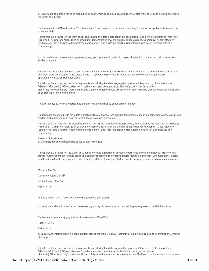
d. Understand the broad range of modalities through which spatial science and technologies may be used to better understandthe world about them
Students must read "Maphead" or "The Mapmakers" and author a term paper describing the impact of spatial technologies ontoday's society.
Partial credit is allowed on the term paper and, during the data aggregation process, interpreted by the instructor as "Mastery"(full credit), "Comprehension" (partial credit and demonstration that the student grasps required elements), "Unsatisfactory"(partial credit and a failure to demonstrate competency), and "Fail" (no credit, student fails to answer or demonstrate anycompetency).
e. Use creative processes to design a map using appropriate color selection, symbol selection, thematic domains, scale, andsimilar concepts.
Students are instructed to create a series of maps related to laboratory exercises in which that are presented with spatial dataand must correctly interpret it and display it as a map using GIS software. Students complete 6 such projects worthapproximately 50% of their final grade.
Partial credit is allowed on the lab assignments and, during the data aggregation process, interpreted by the instructor as"Mastery" (full credit), "Comprehension" (partial credit and demonstration that the student grasps requiredelements), "Unsatisfactory" (partial credit and a failure to demonstrate competency), and "Fail" (no credit, student fails to answeror demonstrate any competency).
f. Author an essay which demonstrates the ability to think critically about climate change.
Students are presented with map data depicting climate change (sea surface temperature, mean global temperature, rainfall, andsimilar) and must author an essay in which these data are interpreted.
Partial credit is allowed on this assignments and, during the data aggregation process, interpreted by the instructor as "Mastery"(full credit), "Comprehension" (partial credit and demonstration that the student grasps required elements), "Unsatisfactory"(partial credit and a failure to demonstrate competency), and "Fail" (no credit, student fails to answer or demonstrate anycompetency).
Results of Evaluationa. Demonstrate an understanding of the scientific method
Partial credit is allowed on the exam and, during the data aggregation process, interpreted by the instructor as "Mastery" (fullcredit), "Comprehension" (partial credit and demonstration that the student grasps required elements), "Unsatisfactory" (partialcredit and a failure to demonstrate competency), and "Fail" (no credit, student fails to answer or demonstrate any competency).
Mastery: 9 of 15
Comprehension: 2 of 15
Unsatisfactory: 0 of 15
Fail: 4 of 18
Of those failing, 3 of 4 failed to answer the questions (left blank).
b. Understand deductive and inductive reasoning and apply these approaches to interpret or present spatial information.
Students are data are aggregated on this element as Pass/Fail
Pass: 11 of 15
Fail: 4 of 15
c. Understand information in a spatial context and appropriately display their interpretation in graphical form through the creationof a map
Partial credit is allowed on the lab assignments and, during the data aggregation process, interpreted by the instructor as"Mastery" (full credit), "Comprehension" (partial credit and demonstration that the student grasps requiredelements), "Unsatisfactory" (partial credit and a failure to demonstrate competency), and "Fail" (no credit, student fails to answer
Annual Report_AY2013_Geospatial Information Technology Center 3 of 23
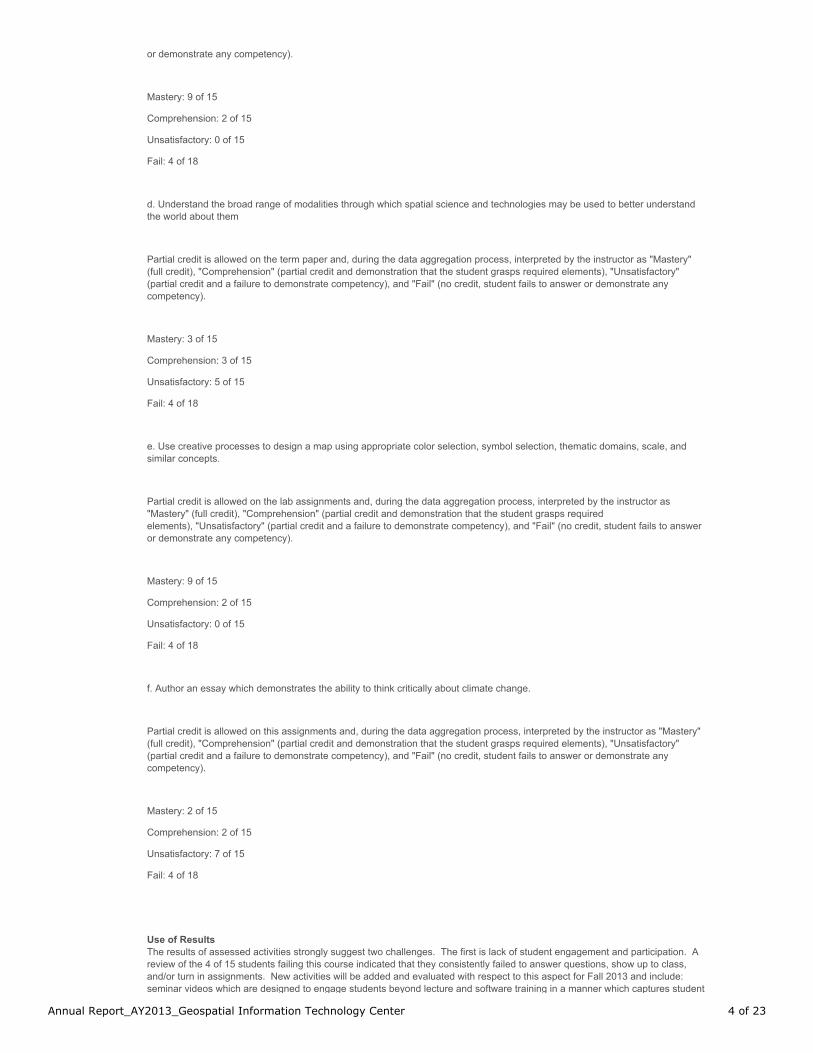
or demonstrate any competency).
Mastery: 9 of 15
Comprehension: 2 of 15
Unsatisfactory: 0 of 15
Fail: 4 of 18
d. Understand the broad range of modalities through which spatial science and technologies may be used to better understandthe world about them
Partial credit is allowed on the term paper and, during the data aggregation process, interpreted by the instructor as "Mastery"(full credit), "Comprehension" (partial credit and demonstration that the student grasps required elements), "Unsatisfactory"(partial credit and a failure to demonstrate competency), and "Fail" (no credit, student fails to answer or demonstrate anycompetency).
Mastery: 3 of 15
Comprehension: 3 of 15
Unsatisfactory: 5 of 15
Fail: 4 of 18
e. Use creative processes to design a map using appropriate color selection, symbol selection, thematic domains, scale, andsimilar concepts.
Partial credit is allowed on the lab assignments and, during the data aggregation process, interpreted by the instructor as"Mastery" (full credit), "Comprehension" (partial credit and demonstration that the student grasps requiredelements), "Unsatisfactory" (partial credit and a failure to demonstrate competency), and "Fail" (no credit, student fails to answeror demonstrate any competency).
Mastery: 9 of 15
Comprehension: 2 of 15
Unsatisfactory: 0 of 15
Fail: 4 of 18
f. Author an essay which demonstrates the ability to think critically about climate change.
Partial credit is allowed on this assignments and, during the data aggregation process, interpreted by the instructor as "Mastery"(full credit), "Comprehension" (partial credit and demonstration that the student grasps required elements), "Unsatisfactory"(partial credit and a failure to demonstrate competency), and "Fail" (no credit, student fails to answer or demonstrate anycompetency).
Mastery: 2 of 15
Comprehension: 2 of 15
Unsatisfactory: 7 of 15
Fail: 4 of 18
Use of ResultsThe results of assessed activities strongly suggest two challenges. The first is lack of student engagement and participation. Areview of the 4 of 15 students failing this course indicated that they consistently failed to answer questions, show up to class,and/or turn in assignments. New activities will be added and evaluated with respect to this aspect for Fall 2013 and include:seminar videos which are designed to engage students beyond lecture and software training in a manner which captures student
Annual Report_AY2013_Geospatial Information Technology Center 4 of 23
interest, a Facebook page, and the use of the online content management system's discussion function which will allow for moreregular communication with students.
The other issue raised is that students regularly struggle to write clearly and coherently. The Center shall work to devise amethod of identifying and working with students requiring remedial assistance with writing skills. However, one student was foundto be illiterate and referred to the Success Center, Writing Center, and other appropriate resources.
Related Items GE 01: Critical and Creative Thinking
GIS_202_GE03: Quantitative Skills Start: 7/1/2012
End: 6/30/2013
Gen Ed learning outcome (competency)a. Understand and explain basic spatial statistic methods such as spatial auto-correlation, Geary’s C, and Moran’s I.
b. Be able to differentiate between discrete and continuous data types
c. Understand the process of overlay analysis through the manipulation of raster data types, distance calculations, and the basicanalysis (break points, number of classes, mean, median, sum, standard deviation) for the attributes of spatial objects
d. Demonstrate a basic understanding of triangulation and the Pythagorean Theorem to calculate position
e. Understand the theoretical numeric construct of the relationship between map projections and coordinate systems
Data Collectiona. Understand and explain basic spatial statistic methods such as spatial auto-correlation, Geary’s C, and Moran’s I.
Students are asked to complete an essay demonstrating their understanding of Tobler's First Law of Geography
Partial credit is allowed on the exam and, during the data aggregation process, interpreted by the instructor as "Mastery" (fullcredit), "Comprehension" (partial credit and demonstration that the student grasps required elements), "Unsatisfactory" (partialcredit and a failure to demonstrate competency), and "Fail" (no credit, student fails to answer or demonstrate any competency).
Exam questions related to the interpretation of Moran's I and Geary's C statistics are asked on the mid- and final-exams.
Results are evaluated on a pass/fail basis
b. Be able to differentiate between discrete and continuous data types
Students must differentiate between discrete and continuous data types in at least 2 exam questions.
Questions related to this objective are graded on a pass/fail basis.
c. Understand the process of overlay analysis through the manipulation of raster data types, distance calculations, and the basicanalysis (break points, number of classes, mean, median, sum, standard deviation) for the attributes of spatial objects
Students are required to complete a lab practicum whereby they must add multiple data layers to a map and compute basicstatistics using the data provided. The results must be displayed in a map.
Partial credit is allowed on the exam and, during the data aggregation process, interpreted by the instructor as "Mastery" (fullcredit), "Comprehension" (partial credit and demonstration that the student grasps required elements), "Unsatisfactory" (partialcredit and a failure to demonstrate competency), and "Fail" (no credit, student fails to answer or demonstrate any competency).
d. Demonstrate a basic understanding of triangulation and the Pythagorean Theorem to calculate position
Annual Report_AY2013_Geospatial Information Technology Center 5 of 23

Students are provided instruction in the US National Grid Coordinate System and then tasked with completing a land navigationcourse which required them to apply the Pythagorean Theorem to locate their position and/or the position of a known object.
This training evolution is graded as Mastery (5 of 5 points located), Comprehension (3-4 points located), Unsatisfactory (1-2points located), and Fail (no points located, the student gave up and wandered off the course to enjoy an adult beverage). Ifsomebody actually reads the latter, I'll change the sentence and give them a quick course in USNG...
e. Understand the theoretical numeric construct of the relationship between map projections and coordinate systems
Students must differentiate between cylindrical, conic, and azimuthal map projects and explain their relationship to the use ofplanar or spherical coordinates by answering appropriate exam questions. Example questions include, but are not limited to:
"List 3 types of conical map projections."
"The Mercator Projection is an examply of a ______ map projection."
Students are evaluated on a pass/fail basis.
Results of Evaluationa. Understand and explain basic spatial statistic methods such as spatial auto-correlation, Geary’s C, and Moran’s I.
Partial credit is allowed on the exam and, during the data aggregation process, interpreted by the instructor as "Mastery" (fullcredit), "Comprehension" (partial credit and demonstration that the student grasps required elements), "Unsatisfactory" (partialcredit and a failure to demonstrate competency), and "Fail" (no credit, student fails to answer or demonstrate any competency).
Mastery: 14 of 15
Comprehension: 1 of 15
Unsatisfactory: 0 of 15
Fail: 0 of 15
Results are evaluated on a pass/fail basis for Moran's I and Geary's C
Pass: 11 of 15
Fail: 4 of 15
b. Be able to differentiate between discrete and continuous data types
Pass: 11 of 15
Fail: 4 of 15
c. Understand the process of overlay analysis through the manipulation of raster data types, distance calculations, and the basicanalysis (break points, number of classes, mean, median, sum, standard deviation) for the attributes of spatial objects
Partial credit is allowed on the exam and, during the data aggregation process, interpreted by the instructor as "Mastery" (fullcredit), "Comprehension" (partial credit and demonstration that the student grasps required elements), "Unsatisfactory" (partialcredit and a failure to demonstrate competency), and "Fail" (no credit, student fails to answer or demonstrate any competency).
Mastery: 2 of 15
Comprehension: 7 of 15
Unsatisfactory: 4 of 15
Annual Report_AY2013_Geospatial Information Technology Center 6 of 23
Fail: 2 of 15
d. Demonstrate a basic understanding of triangulation and the Pythagorean Theorem to calculate position
This training evolution is graded as Mastery (5 of 5 points located), Comprehension (3-4 points located), Unsatisfactory (1-2points located), and Fail (no points located, the student gave up and wandered off the course to enjoy an adult beverage). Ifsomebody actually reads the latter, I'll change the sentence and give them a quick course in USNG...
Master: 6 of 15
Comprehension: 5 of 15
Unsatisfactory: 0 of 15
Fail: 4 of 15
e. Understand the theoretical numeric construct of the relationship between map projections and coordinate systems
Students are evaluated on a pass/fail basis.
Pass: 9 of 15
Fail: 6 of 15
Use of ResultsAs with other general education requirements associated with this course, students struggle to demonstrate mastery becausethey struggle with written communication and/or fail to attend class. Again, attempts to increase student engagement andimprove communication will be undertaken in the Fall 2013 semester.
Additional challenges identified are a difficulty in performing analytic procedures with multiple steps and a lack of basic mapskills. Additional time for remediation will be provided in future offerings of this course.
Related Items GE 03: Quantitative Skills
GIS_202_GE04: Inquiry and Technology Start: 7/1/2012
End: 6/30/2013
Gen Ed learning outcome (competency)a. Successfully complete a minimum of 12 computer-based laboratory exercises using geographic information science andtechnologies
b. Use the Internet to find and assess the quality of spatial information
c. Use word processing and spreadsheet applications to complete assignments
Data Collectiona. Successfully complete a minimum of 12 computer-based laboratory exercises using geographic information science andtechnologies
Students are graded on this portion of the lab exercises as pass or fail (were they completed and turned in or not).
b. Use the Internet to find and assess the quality of spatial information
Students are tasked with constructing a map during a practicum whereby procedures are provided, but the students mustdiscover and correctly use geospatial data discovered using the Internet.
This assignment is graded based on Mastery (students find and apply appropriate data), Comprehension (student find but do notcorrectly apply appropriate data), Unsatisfactory (neither find or apply), and Fail (do not attempt).
c. Use word processing and spreadsheet applications to complete assignments
Annual Report_AY2013_Geospatial Information Technology Center 7 of 23
Students must learn and use appropriate technology to compile data and author essays. Further, students must learn and useGIS software to complete assignments.
This portion of their assessment is graded as Mastery (students demonstrate the ability to use all software functions for whichinstruction is provided), Comprehension (students successfully demonstrate the ability to use at least 70% of the softwarefunctions for which instruction is provided), Unsatisfactory (students cannot successfully demonstrate the ability to use at least70% of the software functions for which instruction is provided), and Fail (failure to attempt).
Results of Evaluationa. Successfully complete a minimum of 12 computer-based laboratory exercises using geographic information science andtechnologies
Pass: 11 of 15
Fail: 4 of 15 (did not attempt)
b. Use the Internet to find and assess the quality of spatial information
This assignment is graded based on Mastery (students find and apply appropriate data), Comprehension (student find but do notcorrectly apply appropriate data), Unsatisfactory (neither find or apply), and Fail (do not attempt).
Mastery: 8
Comprehension: 3
Unsatisfactory: 1
Fail: 3
c. Use word processing and spreadsheet applications to complete assignments
This portion of their assessment is graded as Mastery (students demonstrate the ability to use all software functions for whichinstruction is provided), Comprehension (students successfully demonstrate the ability to use at least 70% of the softwarefunctions for which instruction is provided), Unsatisfactory (students cannot successfully demonstrate the ability to use at least70% of the software functions for which instruction is provided), and Fail (failure to attempt).
Mastery: 2
Comprehension: 9
Unsatisfactory: 0
Fail: 4
Use of ResultsThe largest challenge with this aspect of the course is again student engagement. Secondary challenges include "getting lost inthe software" whereby students are unable to complete complex (more than 5) sequential steps using software. Anecdotalevidence suggests that this is because students are attempting to memorize steps to completing tasks rather than reasoningthrough the required steps. For example, students challenged by mastery are those who attempt to memorize "Properties | Edit |Font | Change to Bold | Apply Changes" as a series of steps as opposed to those reason that a certain property (bold face fontselection) is associated/belongs to a category of settings. Additional data will be collected in Fall 2013 in an attempt to validatethis presumption.
Related Items GE 04: Inquiry and Technology
Annual Report_AY2013_Geospatial Information Technology Center 8 of 23

Section IV.a
Brief Description The Center for Interdisciplinary Geospatial Information Technologies IGIT) is an independent unit of the College of Arts and Sciences. The mission of the Center is to provide geospatial services, accessible education and training, and institutional knowledge for geospatial information technologies to the widest possible audience, and particularly, the mid-Delta region. It is our goal to become a self-supporting unit of the University while maintaining cost-effective services for our constituents. The Center is organized around three core areas: education and training, business and community development, and institutional knowledge-and we encourage the participation of all members of the University community, novices and experts alike. The GIT Center offers both 18- and 27-hour concentrations in Geospatial Technologies in coordination with the university's Bachelor of Science in Interdisciplinary Studies Program and also a concentration in Geospatial Technologies within the Bachelor of Science in Environmental Science Program. An academic Minor and a course of study leading to a Certificate in Geospatial Information Technologies are also offered by the Center. The Certificate in GIT program is a 2-year, 18-credit-hour program of study that meets the requirements for a formal minor area of study in spatial technologies. Matriculated students willearn both the certificate and minor whereas non-matriculated students may earn only the certificate. Students are provided with basic and then advanced skills in remote sensing, GIS, and GPS using cutting edge technologies in our state-of-the-art teaching laboratory.
Judgment
Meets Standards Does Not Meet Standards Not Applicable
Narrative
Section IV.b
Comparative data
Enrollment, CHP, majors, graduation rates, expenditures, trends, etc.
Judgment
Meets Standards Does Not Meet Standards Not Applicable
Narrative
Trend data for GIT for 2009-2013
Sources
Section IV.c
Diversity Compliance Initiatives and Progress
Judgment
Meets Standards Does Not Meet Standards Not Applicable
Narrative
Section IV.d
Economic Development Initiatives and Progress
Judgment
Meets Standards Does Not Meet Standards Not Applicable
Narrative
Section IV.e
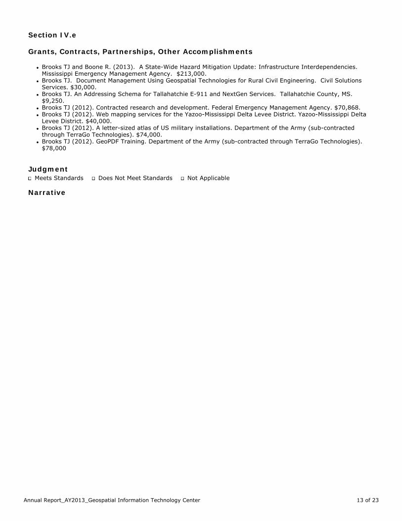
Grants, Contracts, Partnerships, Other Accomplishments
l Brooks TJ and Boone R. (2013). A State-Wide Hazard Mitigation Update: Infrastructure Interdependencies. Mississippi Emergency Management Agency. $213,000.
l Brooks TJ. Document Management Using Geospatial Technologies for Rural Civil Engineering. Civil Solutions Services. $30,000.
l Brooks TJ. An Addressing Schema for Tallahatchie E-911 and NextGen Services. Tallahatchie County, MS. $9,250.
l Brooks TJ (2012). Contracted research and development. Federal Emergency Management Agency. $70,868. l Brooks TJ (2012). Web mapping services for the Yazoo-Mississippi Delta Levee District. Yazoo-Mississippi Delta
Levee District. $40,000. l Brooks TJ (2012). A letter-sized atlas of US military installations. Department of the Army (sub-contracted
through TerraGo Technologies). $74,000. l Brooks TJ (2012). GeoPDF Training. Department of the Army (sub-contracted through TerraGo Technologies).
$78,000
Judgment
Meets Standards Does Not Meet Standards Not Applicable
Narrative
Section IV.f
Service Learning Data List of projects, number of students involved, total service learning hours, number of classes, faculty involved, accomplishments.
Judgment
Meets Standards Does Not Meet Standards Not Applicable
Narrative
Section IV.g
Strategic Plan Data Only use this section if you have strategic plan info to report that is not covered in other areas of your report
Judgment
Meets Standards Does Not Meet Standards Not Applicable
Narrative
Section IV.h
Committees Reporting To Unit Each unit includes in the annual plan and report a list of the committees whose work impacts that unit or any other aspect of the university; along with the list will be a notation documenting the repository location of the committee files and records. Committee actions affecting the unit’s goals may be noted in other applicable sections of the annual reports. Not required to be included in the unit’s annual plan and report, but required to be maintained in the repository location, will be a committee file that includes, for each committee: Mission and by-laws, Membership, Process, Minutes.
Judgment
Meets Standards Does Not Meet Standards Not Applicable
Narrative
Section V.a
Faculty (Accomplishments)
Noteworthy activities and accomplishments
l National Fire Protection Association Technical Committee for Data Exchange for the Fire Service (2010-Present). This committee is charged with developing a plan to assist fire departments with implementing technology and the authoring of a standard which enables seamless data transfer, including geospatial components, among all operational and analytic elements of the fire service.
l Member, National Association for Search and Rescue (2005-Present). Assisted with alpha course development for fundamentals of land search and rescue management (with Dr. Donald Cooper). Provide basic land navigation and map reading exercises for various emergency response organizations on a volunteer basis.
l Mississippi Emergency Management Agency (volunteer). Act as one of the operations group directors for scalableimplementation of geospatial services during a time of crisis.
l Chief Engineer, Bolivar County Volunteer Fire Department, MS (2010-Present). l National Geospatial Advisory Committee (2013-2016). Appointed by Secretary of Interior Salazar. l President, Geospatial Information and Technology Association (2013). President-Elect (2012),
Judgment
Meets Standards Does Not Meet Standards Not Applicable
Narrative
Section V.b
Staff (Accomplishments)
Judgment
Meets Standards Does Not Meet Standards Not Applicable
Narrative
Section V.c
Administrators (accomplishments)
Judgment
Meets Standards Does Not Meet Standards Not Applicable
Narrative
Section V.d
Position(s) requested/replaced with justification
Judgment
Meets Standards Does Not Meet Standards Not Applicable
Narrative
Section V.e
Recommended Change(s) of Status
Resignations-Subramanian Swaminathan
Judgment
Meets Standards Does Not Meet Standards Not Applicable
Narrative
Section VI.a
Changes Made in the Past Year
Judgment
Meets Standards Does Not Meet Standards Not Applicable
Narrative
Changes made in the past year: Recommended changes for the coming year(s):
Section VI.b
Recommended Changes for the Coming Year
Judgment
Meets Standards Does Not Meet Standards Not Applicable
Narrative
GIT Trend Data 2009-2013
Annual Report_AY2013_Geospatial Information Technology Center 9 of 23

Section IV.a
Brief Description The Center for Interdisciplinary Geospatial Information Technologies IGIT) is an independent unit of the College of Arts and Sciences. The mission of the Center is to provide geospatial services, accessible education and training, and institutional knowledge for geospatial information technologies to the widest possible audience, and particularly, the mid-Delta region. It is our goal to become a self-supporting unit of the University while maintaining cost-effective services for our constituents. The Center is organized around three core areas: education and training, business and community development, and institutional knowledge-and we encourage the participation of all members of the University community, novices and experts alike. The GIT Center offers both 18- and 27-hour concentrations in Geospatial Technologies in coordination with the university's Bachelor of Science in Interdisciplinary Studies Program and also a concentration in Geospatial Technologies within the Bachelor of Science in Environmental Science Program. An academic Minor and a course of study leading to a Certificate in Geospatial Information Technologies are also offered by the Center. The Certificate in GIT program is a 2-year, 18-credit-hour program of study that meets the requirements for a formal minor area of study in spatial technologies. Matriculated students willearn both the certificate and minor whereas non-matriculated students may earn only the certificate. Students are provided with basic and then advanced skills in remote sensing, GIS, and GPS using cutting edge technologies in our state-of-the-art teaching laboratory.
Judgment
Meets Standards Does Not Meet Standards Not Applicable
Narrative
Section IV.b
Comparative data
Enrollment, CHP, majors, graduation rates, expenditures, trends, etc.
Judgment
Meets Standards Does Not Meet Standards Not Applicable
Narrative
Trend data for GIT for 2009-2013
Sources
Section IV.c
Diversity Compliance Initiatives and Progress
Judgment
Meets Standards Does Not Meet Standards Not Applicable
Narrative
Section IV.d
Economic Development Initiatives and Progress
Judgment
Meets Standards Does Not Meet Standards Not Applicable
Narrative
Section IV.e
Grants, Contracts, Partnerships, Other Accomplishments
l Brooks TJ and Boone R. (2013). A State-Wide Hazard Mitigation Update: Infrastructure Interdependencies. Mississippi Emergency Management Agency. $213,000.
l Brooks TJ. Document Management Using Geospatial Technologies for Rural Civil Engineering. Civil Solutions Services. $30,000.
l Brooks TJ. An Addressing Schema for Tallahatchie E-911 and NextGen Services. Tallahatchie County, MS. $9,250.
l Brooks TJ (2012). Contracted research and development. Federal Emergency Management Agency. $70,868. l Brooks TJ (2012). Web mapping services for the Yazoo-Mississippi Delta Levee District. Yazoo-Mississippi Delta
Levee District. $40,000. l Brooks TJ (2012). A letter-sized atlas of US military installations. Department of the Army (sub-contracted
through TerraGo Technologies). $74,000. l Brooks TJ (2012). GeoPDF Training. Department of the Army (sub-contracted through TerraGo Technologies).
$78,000
Judgment
Meets Standards Does Not Meet Standards Not Applicable
Narrative
Section IV.f
Service Learning Data List of projects, number of students involved, total service learning hours, number of classes, faculty involved, accomplishments.
Judgment
Meets Standards Does Not Meet Standards Not Applicable
Narrative
Section IV.g
Strategic Plan Data Only use this section if you have strategic plan info to report that is not covered in other areas of your report
Judgment
Meets Standards Does Not Meet Standards Not Applicable
Narrative
Section IV.h
Committees Reporting To Unit Each unit includes in the annual plan and report a list of the committees whose work impacts that unit or any other aspect of the university; along with the list will be a notation documenting the repository location of the committee files and records. Committee actions affecting the unit’s goals may be noted in other applicable sections of the annual reports. Not required to be included in the unit’s annual plan and report, but required to be maintained in the repository location, will be a committee file that includes, for each committee: Mission and by-laws, Membership, Process, Minutes.
Judgment
Meets Standards Does Not Meet Standards Not Applicable
Narrative
Section V.a
Faculty (Accomplishments)
Noteworthy activities and accomplishments
l National Fire Protection Association Technical Committee for Data Exchange for the Fire Service (2010-Present). This committee is charged with developing a plan to assist fire departments with implementing technology and the authoring of a standard which enables seamless data transfer, including geospatial components, among all operational and analytic elements of the fire service.
l Member, National Association for Search and Rescue (2005-Present). Assisted with alpha course development for fundamentals of land search and rescue management (with Dr. Donald Cooper). Provide basic land navigation and map reading exercises for various emergency response organizations on a volunteer basis.
l Mississippi Emergency Management Agency (volunteer). Act as one of the operations group directors for scalableimplementation of geospatial services during a time of crisis.
l Chief Engineer, Bolivar County Volunteer Fire Department, MS (2010-Present). l National Geospatial Advisory Committee (2013-2016). Appointed by Secretary of Interior Salazar. l President, Geospatial Information and Technology Association (2013). President-Elect (2012),
Judgment
Meets Standards Does Not Meet Standards Not Applicable
Narrative
Section V.b
Staff (Accomplishments)
Judgment
Meets Standards Does Not Meet Standards Not Applicable
Narrative
Section V.c
Administrators (accomplishments)
Judgment
Meets Standards Does Not Meet Standards Not Applicable
Narrative
Section V.d
Position(s) requested/replaced with justification
Judgment
Meets Standards Does Not Meet Standards Not Applicable
Narrative
Section V.e
Recommended Change(s) of Status
Resignations-Subramanian Swaminathan
Judgment
Meets Standards Does Not Meet Standards Not Applicable
Narrative
Section VI.a
Changes Made in the Past Year
Judgment
Meets Standards Does Not Meet Standards Not Applicable
Narrative
Changes made in the past year: Recommended changes for the coming year(s):
Section VI.b
Recommended Changes for the Coming Year
Judgment
Meets Standards Does Not Meet Standards Not Applicable
Narrative
GIT Trend Data 2009-2013
Annual Report_AY2013_Geospatial Information Technology Center 10 of 23
Section IV.a
Brief Description The Center for Interdisciplinary Geospatial Information Technologies IGIT) is an independent unit of the College of Arts and Sciences. The mission of the Center is to provide geospatial services, accessible education and training, and institutional knowledge for geospatial information technologies to the widest possible audience, and particularly, the mid-Delta region. It is our goal to become a self-supporting unit of the University while maintaining cost-effective services for our constituents. The Center is organized around three core areas: education and training, business and community development, and institutional knowledge-and we encourage the participation of all members of the University community, novices and experts alike. The GIT Center offers both 18- and 27-hour concentrations in Geospatial Technologies in coordination with the university's Bachelor of Science in Interdisciplinary Studies Program and also a concentration in Geospatial Technologies within the Bachelor of Science in Environmental Science Program. An academic Minor and a course of study leading to a Certificate in Geospatial Information Technologies are also offered by the Center. The Certificate in GIT program is a 2-year, 18-credit-hour program of study that meets the requirements for a formal minor area of study in spatial technologies. Matriculated students willearn both the certificate and minor whereas non-matriculated students may earn only the certificate. Students are provided with basic and then advanced skills in remote sensing, GIS, and GPS using cutting edge technologies in our state-of-the-art teaching laboratory.
Judgment
Meets Standards Does Not Meet Standards Not Applicable
Narrative
Section IV.b
Comparative data
Enrollment, CHP, majors, graduation rates, expenditures, trends, etc.
Judgment
Meets Standards Does Not Meet Standards Not Applicable
Narrative
Trend data for GIT for 2009-2013
Sources
Section IV.c
Diversity Compliance Initiatives and Progress
Judgment
Meets Standards Does Not Meet Standards Not Applicable
Narrative
Section IV.d
Economic Development Initiatives and Progress
Judgment
Meets Standards Does Not Meet Standards Not Applicable
Narrative
Section IV.e
Grants, Contracts, Partnerships, Other Accomplishments
l Brooks TJ and Boone R. (2013). A State-Wide Hazard Mitigation Update: Infrastructure Interdependencies. Mississippi Emergency Management Agency. $213,000.
l Brooks TJ. Document Management Using Geospatial Technologies for Rural Civil Engineering. Civil Solutions Services. $30,000.
l Brooks TJ. An Addressing Schema for Tallahatchie E-911 and NextGen Services. Tallahatchie County, MS. $9,250.
l Brooks TJ (2012). Contracted research and development. Federal Emergency Management Agency. $70,868. l Brooks TJ (2012). Web mapping services for the Yazoo-Mississippi Delta Levee District. Yazoo-Mississippi Delta
Levee District. $40,000. l Brooks TJ (2012). A letter-sized atlas of US military installations. Department of the Army (sub-contracted
through TerraGo Technologies). $74,000. l Brooks TJ (2012). GeoPDF Training. Department of the Army (sub-contracted through TerraGo Technologies).
$78,000
Judgment
Meets Standards Does Not Meet Standards Not Applicable
Narrative
Section IV.f
Service Learning Data List of projects, number of students involved, total service learning hours, number of classes, faculty involved, accomplishments.
Judgment
Meets Standards Does Not Meet Standards Not Applicable
Narrative
Section IV.g
Strategic Plan Data Only use this section if you have strategic plan info to report that is not covered in other areas of your report
Judgment
Meets Standards Does Not Meet Standards Not Applicable
Narrative
Section IV.h
Committees Reporting To Unit Each unit includes in the annual plan and report a list of the committees whose work impacts that unit or any other aspect of the university; along with the list will be a notation documenting the repository location of the committee files and records. Committee actions affecting the unit’s goals may be noted in other applicable sections of the annual reports. Not required to be included in the unit’s annual plan and report, but required to be maintained in the repository location, will be a committee file that includes, for each committee: Mission and by-laws, Membership, Process, Minutes.
Judgment
Meets Standards Does Not Meet Standards Not Applicable
Narrative
Section V.a
Faculty (Accomplishments)
Noteworthy activities and accomplishments
l National Fire Protection Association Technical Committee for Data Exchange for the Fire Service (2010-Present). This committee is charged with developing a plan to assist fire departments with implementing technology and the authoring of a standard which enables seamless data transfer, including geospatial components, among all operational and analytic elements of the fire service.
l Member, National Association for Search and Rescue (2005-Present). Assisted with alpha course development for fundamentals of land search and rescue management (with Dr. Donald Cooper). Provide basic land navigation and map reading exercises for various emergency response organizations on a volunteer basis.
l Mississippi Emergency Management Agency (volunteer). Act as one of the operations group directors for scalableimplementation of geospatial services during a time of crisis.
l Chief Engineer, Bolivar County Volunteer Fire Department, MS (2010-Present). l National Geospatial Advisory Committee (2013-2016). Appointed by Secretary of Interior Salazar. l President, Geospatial Information and Technology Association (2013). President-Elect (2012),
Judgment
Meets Standards Does Not Meet Standards Not Applicable
Narrative
Section V.b
Staff (Accomplishments)
Judgment
Meets Standards Does Not Meet Standards Not Applicable
Narrative
Section V.c
Administrators (accomplishments)
Judgment
Meets Standards Does Not Meet Standards Not Applicable
Narrative
Section V.d
Position(s) requested/replaced with justification
Judgment
Meets Standards Does Not Meet Standards Not Applicable
Narrative
Section V.e
Recommended Change(s) of Status
Resignations-Subramanian Swaminathan
Judgment
Meets Standards Does Not Meet Standards Not Applicable
Narrative
Section VI.a
Changes Made in the Past Year
Judgment
Meets Standards Does Not Meet Standards Not Applicable
Narrative
Changes made in the past year: Recommended changes for the coming year(s):
Section VI.b
Recommended Changes for the Coming Year
Judgment
Meets Standards Does Not Meet Standards Not Applicable
Narrative
GIT Trend Data 2009-2013
Annual Report_AY2013_Geospatial Information Technology Center 11 of 23
Section IV.a
Brief Description The Center for Interdisciplinary Geospatial Information Technologies IGIT) is an independent unit of the College of Arts and Sciences. The mission of the Center is to provide geospatial services, accessible education and training, and institutional knowledge for geospatial information technologies to the widest possible audience, and particularly, the mid-Delta region. It is our goal to become a self-supporting unit of the University while maintaining cost-effective services for our constituents. The Center is organized around three core areas: education and training, business and community development, and institutional knowledge-and we encourage the participation of all members of the University community, novices and experts alike. The GIT Center offers both 18- and 27-hour concentrations in Geospatial Technologies in coordination with the university's Bachelor of Science in Interdisciplinary Studies Program and also a concentration in Geospatial Technologies within the Bachelor of Science in Environmental Science Program. An academic Minor and a course of study leading to a Certificate in Geospatial Information Technologies are also offered by the Center. The Certificate in GIT program is a 2-year, 18-credit-hour program of study that meets the requirements for a formal minor area of study in spatial technologies. Matriculated students willearn both the certificate and minor whereas non-matriculated students may earn only the certificate. Students are provided with basic and then advanced skills in remote sensing, GIS, and GPS using cutting edge technologies in our state-of-the-art teaching laboratory.
Judgment
Meets Standards Does Not Meet Standards Not Applicable
Narrative
Section IV.b
Comparative data
Enrollment, CHP, majors, graduation rates, expenditures, trends, etc.
Judgment
Meets Standards Does Not Meet Standards Not Applicable
Narrative
Trend data for GIT for 2009-2013
Sources
Section IV.c
Diversity Compliance Initiatives and Progress
Judgment
Meets Standards Does Not Meet Standards Not Applicable
Narrative
Section IV.d
Economic Development Initiatives and Progress
Judgment
Meets Standards Does Not Meet Standards Not Applicable
Narrative
Section IV.e
Grants, Contracts, Partnerships, Other Accomplishments
l Brooks TJ and Boone R. (2013). A State-Wide Hazard Mitigation Update: Infrastructure Interdependencies. Mississippi Emergency Management Agency. $213,000.
l Brooks TJ. Document Management Using Geospatial Technologies for Rural Civil Engineering. Civil Solutions Services. $30,000.
l Brooks TJ. An Addressing Schema for Tallahatchie E-911 and NextGen Services. Tallahatchie County, MS. $9,250.
l Brooks TJ (2012). Contracted research and development. Federal Emergency Management Agency. $70,868. l Brooks TJ (2012). Web mapping services for the Yazoo-Mississippi Delta Levee District. Yazoo-Mississippi Delta
Levee District. $40,000. l Brooks TJ (2012). A letter-sized atlas of US military installations. Department of the Army (sub-contracted
through TerraGo Technologies). $74,000. l Brooks TJ (2012). GeoPDF Training. Department of the Army (sub-contracted through TerraGo Technologies).
$78,000
Judgment
Meets Standards Does Not Meet Standards Not Applicable
Narrative
Section IV.f
Service Learning Data List of projects, number of students involved, total service learning hours, number of classes, faculty involved, accomplishments.
Judgment
Meets Standards Does Not Meet Standards Not Applicable
Narrative
Section IV.g
Strategic Plan Data Only use this section if you have strategic plan info to report that is not covered in other areas of your report
Judgment
Meets Standards Does Not Meet Standards Not Applicable
Narrative
Section IV.h
Committees Reporting To Unit Each unit includes in the annual plan and report a list of the committees whose work impacts that unit or any other aspect of the university; along with the list will be a notation documenting the repository location of the committee files and records. Committee actions affecting the unit’s goals may be noted in other applicable sections of the annual reports. Not required to be included in the unit’s annual plan and report, but required to be maintained in the repository location, will be a committee file that includes, for each committee: Mission and by-laws, Membership, Process, Minutes.
Judgment
Meets Standards Does Not Meet Standards Not Applicable
Narrative
Section V.a
Faculty (Accomplishments)
Noteworthy activities and accomplishments
l National Fire Protection Association Technical Committee for Data Exchange for the Fire Service (2010-Present). This committee is charged with developing a plan to assist fire departments with implementing technology and the authoring of a standard which enables seamless data transfer, including geospatial components, among all operational and analytic elements of the fire service.
l Member, National Association for Search and Rescue (2005-Present). Assisted with alpha course development for fundamentals of land search and rescue management (with Dr. Donald Cooper). Provide basic land navigation and map reading exercises for various emergency response organizations on a volunteer basis.
l Mississippi Emergency Management Agency (volunteer). Act as one of the operations group directors for scalableimplementation of geospatial services during a time of crisis.
l Chief Engineer, Bolivar County Volunteer Fire Department, MS (2010-Present). l National Geospatial Advisory Committee (2013-2016). Appointed by Secretary of Interior Salazar. l President, Geospatial Information and Technology Association (2013). President-Elect (2012),
Judgment
Meets Standards Does Not Meet Standards Not Applicable
Narrative
Section V.b
Staff (Accomplishments)
Judgment
Meets Standards Does Not Meet Standards Not Applicable
Narrative
Section V.c
Administrators (accomplishments)
Judgment
Meets Standards Does Not Meet Standards Not Applicable
Narrative
Section V.d
Position(s) requested/replaced with justification
Judgment
Meets Standards Does Not Meet Standards Not Applicable
Narrative
Section V.e
Recommended Change(s) of Status
Resignations-Subramanian Swaminathan
Judgment
Meets Standards Does Not Meet Standards Not Applicable
Narrative
Section VI.a
Changes Made in the Past Year
Judgment
Meets Standards Does Not Meet Standards Not Applicable
Narrative
Changes made in the past year: Recommended changes for the coming year(s):
Section VI.b
Recommended Changes for the Coming Year
Judgment
Meets Standards Does Not Meet Standards Not Applicable
Narrative
GIT Trend Data 2009-2013
Annual Report_AY2013_Geospatial Information Technology Center 12 of 23
Section IV.a
Brief Description The Center for Interdisciplinary Geospatial Information Technologies IGIT) is an independent unit of the College of Arts and Sciences. The mission of the Center is to provide geospatial services, accessible education and training, and institutional knowledge for geospatial information technologies to the widest possible audience, and particularly, the mid-Delta region. It is our goal to become a self-supporting unit of the University while maintaining cost-effective services for our constituents. The Center is organized around three core areas: education and training, business and community development, and institutional knowledge-and we encourage the participation of all members of the University community, novices and experts alike. The GIT Center offers both 18- and 27-hour concentrations in Geospatial Technologies in coordination with the university's Bachelor of Science in Interdisciplinary Studies Program and also a concentration in Geospatial Technologies within the Bachelor of Science in Environmental Science Program. An academic Minor and a course of study leading to a Certificate in Geospatial Information Technologies are also offered by the Center. The Certificate in GIT program is a 2-year, 18-credit-hour program of study that meets the requirements for a formal minor area of study in spatial technologies. Matriculated students willearn both the certificate and minor whereas non-matriculated students may earn only the certificate. Students are provided with basic and then advanced skills in remote sensing, GIS, and GPS using cutting edge technologies in our state-of-the-art teaching laboratory.
Judgment
Meets Standards Does Not Meet Standards Not Applicable
Narrative
Section IV.b
Comparative data
Enrollment, CHP, majors, graduation rates, expenditures, trends, etc.
Judgment
Meets Standards Does Not Meet Standards Not Applicable
Narrative
Trend data for GIT for 2009-2013
Sources
Section IV.c
Diversity Compliance Initiatives and Progress
Judgment
Meets Standards Does Not Meet Standards Not Applicable
Narrative
Section IV.d
Economic Development Initiatives and Progress
Judgment
Meets Standards Does Not Meet Standards Not Applicable
Narrative
Section IV.e
Grants, Contracts, Partnerships, Other Accomplishments
l Brooks TJ and Boone R. (2013). A State-Wide Hazard Mitigation Update: Infrastructure Interdependencies. Mississippi Emergency Management Agency. $213,000.
l Brooks TJ. Document Management Using Geospatial Technologies for Rural Civil Engineering. Civil Solutions Services. $30,000.
l Brooks TJ. An Addressing Schema for Tallahatchie E-911 and NextGen Services. Tallahatchie County, MS. $9,250.
l Brooks TJ (2012). Contracted research and development. Federal Emergency Management Agency. $70,868. l Brooks TJ (2012). Web mapping services for the Yazoo-Mississippi Delta Levee District. Yazoo-Mississippi Delta
Levee District. $40,000. l Brooks TJ (2012). A letter-sized atlas of US military installations. Department of the Army (sub-contracted
through TerraGo Technologies). $74,000. l Brooks TJ (2012). GeoPDF Training. Department of the Army (sub-contracted through TerraGo Technologies).
$78,000
Judgment
Meets Standards Does Not Meet Standards Not Applicable
Narrative
Section IV.f
Service Learning Data List of projects, number of students involved, total service learning hours, number of classes, faculty involved, accomplishments.
Judgment
Meets Standards Does Not Meet Standards Not Applicable
Narrative
Section IV.g
Strategic Plan Data Only use this section if you have strategic plan info to report that is not covered in other areas of your report
Judgment
Meets Standards Does Not Meet Standards Not Applicable
Narrative
Section IV.h
Committees Reporting To Unit Each unit includes in the annual plan and report a list of the committees whose work impacts that unit or any other aspect of the university; along with the list will be a notation documenting the repository location of the committee files and records. Committee actions affecting the unit’s goals may be noted in other applicable sections of the annual reports. Not required to be included in the unit’s annual plan and report, but required to be maintained in the repository location, will be a committee file that includes, for each committee: Mission and by-laws, Membership, Process, Minutes.
Judgment
Meets Standards Does Not Meet Standards Not Applicable
Narrative
Section V.a
Faculty (Accomplishments)
Noteworthy activities and accomplishments
l National Fire Protection Association Technical Committee for Data Exchange for the Fire Service (2010-Present). This committee is charged with developing a plan to assist fire departments with implementing technology and the authoring of a standard which enables seamless data transfer, including geospatial components, among all operational and analytic elements of the fire service.
l Member, National Association for Search and Rescue (2005-Present). Assisted with alpha course development for fundamentals of land search and rescue management (with Dr. Donald Cooper). Provide basic land navigation and map reading exercises for various emergency response organizations on a volunteer basis.
l Mississippi Emergency Management Agency (volunteer). Act as one of the operations group directors for scalableimplementation of geospatial services during a time of crisis.
l Chief Engineer, Bolivar County Volunteer Fire Department, MS (2010-Present). l National Geospatial Advisory Committee (2013-2016). Appointed by Secretary of Interior Salazar. l President, Geospatial Information and Technology Association (2013). President-Elect (2012),
Judgment
Meets Standards Does Not Meet Standards Not Applicable
Narrative
Section V.b
Staff (Accomplishments)
Judgment
Meets Standards Does Not Meet Standards Not Applicable
Narrative
Section V.c
Administrators (accomplishments)
Judgment
Meets Standards Does Not Meet Standards Not Applicable
Narrative
Section V.d
Position(s) requested/replaced with justification
Judgment
Meets Standards Does Not Meet Standards Not Applicable
Narrative
Section V.e
Recommended Change(s) of Status
Resignations-Subramanian Swaminathan
Judgment
Meets Standards Does Not Meet Standards Not Applicable
Narrative
Section VI.a
Changes Made in the Past Year
Judgment
Meets Standards Does Not Meet Standards Not Applicable
Narrative
Changes made in the past year: Recommended changes for the coming year(s):
Section VI.b
Recommended Changes for the Coming Year
Judgment
Meets Standards Does Not Meet Standards Not Applicable
Narrative
GIT Trend Data 2009-2013
Annual Report_AY2013_Geospatial Information Technology Center 13 of 23
Section IV.a
Brief Description The Center for Interdisciplinary Geospatial Information Technologies IGIT) is an independent unit of the College of Arts and Sciences. The mission of the Center is to provide geospatial services, accessible education and training, and institutional knowledge for geospatial information technologies to the widest possible audience, and particularly, the mid-Delta region. It is our goal to become a self-supporting unit of the University while maintaining cost-effective services for our constituents. The Center is organized around three core areas: education and training, business and community development, and institutional knowledge-and we encourage the participation of all members of the University community, novices and experts alike. The GIT Center offers both 18- and 27-hour concentrations in Geospatial Technologies in coordination with the university's Bachelor of Science in Interdisciplinary Studies Program and also a concentration in Geospatial Technologies within the Bachelor of Science in Environmental Science Program. An academic Minor and a course of study leading to a Certificate in Geospatial Information Technologies are also offered by the Center. The Certificate in GIT program is a 2-year, 18-credit-hour program of study that meets the requirements for a formal minor area of study in spatial technologies. Matriculated students willearn both the certificate and minor whereas non-matriculated students may earn only the certificate. Students are provided with basic and then advanced skills in remote sensing, GIS, and GPS using cutting edge technologies in our state-of-the-art teaching laboratory.
Judgment
Meets Standards Does Not Meet Standards Not Applicable
Narrative
Section IV.b
Comparative data
Enrollment, CHP, majors, graduation rates, expenditures, trends, etc.
Judgment
Meets Standards Does Not Meet Standards Not Applicable
Narrative
Trend data for GIT for 2009-2013
Sources
Section IV.c
Diversity Compliance Initiatives and Progress
Judgment
Meets Standards Does Not Meet Standards Not Applicable
Narrative
Section IV.d
Economic Development Initiatives and Progress
Judgment
Meets Standards Does Not Meet Standards Not Applicable
Narrative
Section IV.e
Grants, Contracts, Partnerships, Other Accomplishments
l Brooks TJ and Boone R. (2013). A State-Wide Hazard Mitigation Update: Infrastructure Interdependencies. Mississippi Emergency Management Agency. $213,000.
l Brooks TJ. Document Management Using Geospatial Technologies for Rural Civil Engineering. Civil Solutions Services. $30,000.
l Brooks TJ. An Addressing Schema for Tallahatchie E-911 and NextGen Services. Tallahatchie County, MS. $9,250.
l Brooks TJ (2012). Contracted research and development. Federal Emergency Management Agency. $70,868. l Brooks TJ (2012). Web mapping services for the Yazoo-Mississippi Delta Levee District. Yazoo-Mississippi Delta
Levee District. $40,000. l Brooks TJ (2012). A letter-sized atlas of US military installations. Department of the Army (sub-contracted
through TerraGo Technologies). $74,000. l Brooks TJ (2012). GeoPDF Training. Department of the Army (sub-contracted through TerraGo Technologies).
$78,000
Judgment
Meets Standards Does Not Meet Standards Not Applicable
Narrative
Section IV.f
Service Learning Data List of projects, number of students involved, total service learning hours, number of classes, faculty involved, accomplishments.
Judgment
Meets Standards Does Not Meet Standards Not Applicable
Narrative
Section IV.g
Strategic Plan Data Only use this section if you have strategic plan info to report that is not covered in other areas of your report
Judgment
Meets Standards Does Not Meet Standards Not Applicable
Narrative
Section IV.h
Committees Reporting To Unit Each unit includes in the annual plan and report a list of the committees whose work impacts that unit or any other aspect of the university; along with the list will be a notation documenting the repository location of the committee files and records. Committee actions affecting the unit’s goals may be noted in other applicable sections of the annual reports. Not required to be included in the unit’s annual plan and report, but required to be maintained in the repository location, will be a committee file that includes, for each committee: Mission and by-laws, Membership, Process, Minutes.
Judgment
Meets Standards Does Not Meet Standards Not Applicable
Narrative
Section V.a
Faculty (Accomplishments)
Noteworthy activities and accomplishments
l National Fire Protection Association Technical Committee for Data Exchange for the Fire Service (2010-Present). This committee is charged with developing a plan to assist fire departments with implementing technology and the authoring of a standard which enables seamless data transfer, including geospatial components, among all operational and analytic elements of the fire service.
l Member, National Association for Search and Rescue (2005-Present). Assisted with alpha course development for fundamentals of land search and rescue management (with Dr. Donald Cooper). Provide basic land navigation and map reading exercises for various emergency response organizations on a volunteer basis.
l Mississippi Emergency Management Agency (volunteer). Act as one of the operations group directors for scalableimplementation of geospatial services during a time of crisis.
l Chief Engineer, Bolivar County Volunteer Fire Department, MS (2010-Present). l National Geospatial Advisory Committee (2013-2016). Appointed by Secretary of Interior Salazar. l President, Geospatial Information and Technology Association (2013). President-Elect (2012),
Judgment
Meets Standards Does Not Meet Standards Not Applicable
Narrative
Section V.b
Staff (Accomplishments)
Judgment
Meets Standards Does Not Meet Standards Not Applicable
Narrative
Section V.c
Administrators (accomplishments)
Judgment
Meets Standards Does Not Meet Standards Not Applicable
Narrative
Section V.d
Position(s) requested/replaced with justification
Judgment
Meets Standards Does Not Meet Standards Not Applicable
Narrative
Section V.e
Recommended Change(s) of Status
Resignations-Subramanian Swaminathan
Judgment
Meets Standards Does Not Meet Standards Not Applicable
Narrative
Section VI.a
Changes Made in the Past Year
Judgment
Meets Standards Does Not Meet Standards Not Applicable
Narrative
Changes made in the past year: Recommended changes for the coming year(s):
Section VI.b
Recommended Changes for the Coming Year
Judgment
Meets Standards Does Not Meet Standards Not Applicable
Narrative
GIT Trend Data 2009-2013
Annual Report_AY2013_Geospatial Information Technology Center 14 of 23
Section IV.a
Brief Description The Center for Interdisciplinary Geospatial Information Technologies IGIT) is an independent unit of the College of Arts and Sciences. The mission of the Center is to provide geospatial services, accessible education and training, and institutional knowledge for geospatial information technologies to the widest possible audience, and particularly, the mid-Delta region. It is our goal to become a self-supporting unit of the University while maintaining cost-effective services for our constituents. The Center is organized around three core areas: education and training, business and community development, and institutional knowledge-and we encourage the participation of all members of the University community, novices and experts alike. The GIT Center offers both 18- and 27-hour concentrations in Geospatial Technologies in coordination with the university's Bachelor of Science in Interdisciplinary Studies Program and also a concentration in Geospatial Technologies within the Bachelor of Science in Environmental Science Program. An academic Minor and a course of study leading to a Certificate in Geospatial Information Technologies are also offered by the Center. The Certificate in GIT program is a 2-year, 18-credit-hour program of study that meets the requirements for a formal minor area of study in spatial technologies. Matriculated students willearn both the certificate and minor whereas non-matriculated students may earn only the certificate. Students are provided with basic and then advanced skills in remote sensing, GIS, and GPS using cutting edge technologies in our state-of-the-art teaching laboratory.
Judgment
Meets Standards Does Not Meet Standards Not Applicable
Narrative
Section IV.b
Comparative data
Enrollment, CHP, majors, graduation rates, expenditures, trends, etc.
Judgment
Meets Standards Does Not Meet Standards Not Applicable
Narrative
Trend data for GIT for 2009-2013
Sources
Section IV.c
Diversity Compliance Initiatives and Progress
Judgment
Meets Standards Does Not Meet Standards Not Applicable
Narrative
Section IV.d
Economic Development Initiatives and Progress
Judgment
Meets Standards Does Not Meet Standards Not Applicable
Narrative
Section IV.e
Grants, Contracts, Partnerships, Other Accomplishments
l Brooks TJ and Boone R. (2013). A State-Wide Hazard Mitigation Update: Infrastructure Interdependencies. Mississippi Emergency Management Agency. $213,000.
l Brooks TJ. Document Management Using Geospatial Technologies for Rural Civil Engineering. Civil Solutions Services. $30,000.
l Brooks TJ. An Addressing Schema for Tallahatchie E-911 and NextGen Services. Tallahatchie County, MS. $9,250.
l Brooks TJ (2012). Contracted research and development. Federal Emergency Management Agency. $70,868. l Brooks TJ (2012). Web mapping services for the Yazoo-Mississippi Delta Levee District. Yazoo-Mississippi Delta
Levee District. $40,000. l Brooks TJ (2012). A letter-sized atlas of US military installations. Department of the Army (sub-contracted
through TerraGo Technologies). $74,000. l Brooks TJ (2012). GeoPDF Training. Department of the Army (sub-contracted through TerraGo Technologies).
$78,000
Judgment
Meets Standards Does Not Meet Standards Not Applicable
Narrative
Section IV.f
Service Learning Data List of projects, number of students involved, total service learning hours, number of classes, faculty involved, accomplishments.
Judgment
Meets Standards Does Not Meet Standards Not Applicable
Narrative
Section IV.g
Strategic Plan Data Only use this section if you have strategic plan info to report that is not covered in other areas of your report
Judgment
Meets Standards Does Not Meet Standards Not Applicable
Narrative
Section IV.h
Committees Reporting To Unit Each unit includes in the annual plan and report a list of the committees whose work impacts that unit or any other aspect of the university; along with the list will be a notation documenting the repository location of the committee files and records. Committee actions affecting the unit’s goals may be noted in other applicable sections of the annual reports. Not required to be included in the unit’s annual plan and report, but required to be maintained in the repository location, will be a committee file that includes, for each committee: Mission and by-laws, Membership, Process, Minutes.
Judgment
Meets Standards Does Not Meet Standards Not Applicable
Narrative
Section V.a
Faculty (Accomplishments)
Noteworthy activities and accomplishments
l National Fire Protection Association Technical Committee for Data Exchange for the Fire Service (2010-Present). This committee is charged with developing a plan to assist fire departments with implementing technology and the authoring of a standard which enables seamless data transfer, including geospatial components, among all operational and analytic elements of the fire service.
l Member, National Association for Search and Rescue (2005-Present). Assisted with alpha course development for fundamentals of land search and rescue management (with Dr. Donald Cooper). Provide basic land navigation and map reading exercises for various emergency response organizations on a volunteer basis.
l Mississippi Emergency Management Agency (volunteer). Act as one of the operations group directors for scalableimplementation of geospatial services during a time of crisis.
l Chief Engineer, Bolivar County Volunteer Fire Department, MS (2010-Present). l National Geospatial Advisory Committee (2013-2016). Appointed by Secretary of Interior Salazar. l President, Geospatial Information and Technology Association (2013). President-Elect (2012),
Judgment
Meets Standards Does Not Meet Standards Not Applicable
Narrative
Section V.b
Staff (Accomplishments)
Judgment
Meets Standards Does Not Meet Standards Not Applicable
Narrative
Section V.c
Administrators (accomplishments)
Judgment
Meets Standards Does Not Meet Standards Not Applicable
Narrative
Section V.d
Position(s) requested/replaced with justification
Judgment
Meets Standards Does Not Meet Standards Not Applicable
Narrative
Section V.e
Recommended Change(s) of Status
Resignations-Subramanian Swaminathan
Judgment
Meets Standards Does Not Meet Standards Not Applicable
Narrative
Section VI.a
Changes Made in the Past Year
Judgment
Meets Standards Does Not Meet Standards Not Applicable
Narrative
Changes made in the past year: Recommended changes for the coming year(s):
Section VI.b
Recommended Changes for the Coming Year
Judgment
Meets Standards Does Not Meet Standards Not Applicable
Narrative
GIT Trend Data 2009-2013
Annual Report_AY2013_Geospatial Information Technology Center 15 of 23

Section IV.a
Brief Description The Center for Interdisciplinary Geospatial Information Technologies IGIT) is an independent unit of the College of Arts and Sciences. The mission of the Center is to provide geospatial services, accessible education and training, and institutional knowledge for geospatial information technologies to the widest possible audience, and particularly, the mid-Delta region. It is our goal to become a self-supporting unit of the University while maintaining cost-effective services for our constituents. The Center is organized around three core areas: education and training, business and community development, and institutional knowledge-and we encourage the participation of all members of the University community, novices and experts alike. The GIT Center offers both 18- and 27-hour concentrations in Geospatial Technologies in coordination with the university's Bachelor of Science in Interdisciplinary Studies Program and also a concentration in Geospatial Technologies within the Bachelor of Science in Environmental Science Program. An academic Minor and a course of study leading to a Certificate in Geospatial Information Technologies are also offered by the Center. The Certificate in GIT program is a 2-year, 18-credit-hour program of study that meets the requirements for a formal minor area of study in spatial technologies. Matriculated students willearn both the certificate and minor whereas non-matriculated students may earn only the certificate. Students are provided with basic and then advanced skills in remote sensing, GIS, and GPS using cutting edge technologies in our state-of-the-art teaching laboratory.
Judgment
Meets Standards Does Not Meet Standards Not Applicable
Narrative
Section IV.b
Comparative data
Enrollment, CHP, majors, graduation rates, expenditures, trends, etc.
Judgment
Meets Standards Does Not Meet Standards Not Applicable
Narrative
Trend data for GIT for 2009-2013
Sources
Section IV.c
Diversity Compliance Initiatives and Progress
Judgment
Meets Standards Does Not Meet Standards Not Applicable
Narrative
Section IV.d
Economic Development Initiatives and Progress
Judgment
Meets Standards Does Not Meet Standards Not Applicable
Narrative
Section IV.e
Grants, Contracts, Partnerships, Other Accomplishments
l Brooks TJ and Boone R. (2013). A State-Wide Hazard Mitigation Update: Infrastructure Interdependencies. Mississippi Emergency Management Agency. $213,000.
l Brooks TJ. Document Management Using Geospatial Technologies for Rural Civil Engineering. Civil Solutions Services. $30,000.
l Brooks TJ. An Addressing Schema for Tallahatchie E-911 and NextGen Services. Tallahatchie County, MS. $9,250.
l Brooks TJ (2012). Contracted research and development. Federal Emergency Management Agency. $70,868. l Brooks TJ (2012). Web mapping services for the Yazoo-Mississippi Delta Levee District. Yazoo-Mississippi Delta
Levee District. $40,000. l Brooks TJ (2012). A letter-sized atlas of US military installations. Department of the Army (sub-contracted
through TerraGo Technologies). $74,000. l Brooks TJ (2012). GeoPDF Training. Department of the Army (sub-contracted through TerraGo Technologies).
$78,000
Judgment
Meets Standards Does Not Meet Standards Not Applicable
Narrative
Section IV.f
Service Learning Data List of projects, number of students involved, total service learning hours, number of classes, faculty involved, accomplishments.
Judgment
Meets Standards Does Not Meet Standards Not Applicable
Narrative
Section IV.g
Strategic Plan Data Only use this section if you have strategic plan info to report that is not covered in other areas of your report
Judgment
Meets Standards Does Not Meet Standards Not Applicable
Narrative
Section IV.h
Committees Reporting To Unit Each unit includes in the annual plan and report a list of the committees whose work impacts that unit or any other aspect of the university; along with the list will be a notation documenting the repository location of the committee files and records. Committee actions affecting the unit’s goals may be noted in other applicable sections of the annual reports. Not required to be included in the unit’s annual plan and report, but required to be maintained in the repository location, will be a committee file that includes, for each committee: Mission and by-laws, Membership, Process, Minutes.
Judgment
Meets Standards Does Not Meet Standards Not Applicable
Narrative
Section V.a
Faculty (Accomplishments)
Noteworthy activities and accomplishments
l National Fire Protection Association Technical Committee for Data Exchange for the Fire Service (2010-Present). This committee is charged with developing a plan to assist fire departments with implementing technology and the authoring of a standard which enables seamless data transfer, including geospatial components, among all operational and analytic elements of the fire service.
l Member, National Association for Search and Rescue (2005-Present). Assisted with alpha course development for fundamentals of land search and rescue management (with Dr. Donald Cooper). Provide basic land navigation and map reading exercises for various emergency response organizations on a volunteer basis.
l Mississippi Emergency Management Agency (volunteer). Act as one of the operations group directors for scalableimplementation of geospatial services during a time of crisis.
l Chief Engineer, Bolivar County Volunteer Fire Department, MS (2010-Present). l National Geospatial Advisory Committee (2013-2016). Appointed by Secretary of Interior Salazar. l President, Geospatial Information and Technology Association (2013). President-Elect (2012),
Judgment
Meets Standards Does Not Meet Standards Not Applicable
Narrative
Section V.b
Staff (Accomplishments)
Judgment
Meets Standards Does Not Meet Standards Not Applicable
Narrative
Section V.c
Administrators (accomplishments)
Judgment
Meets Standards Does Not Meet Standards Not Applicable
Narrative
Section V.d
Position(s) requested/replaced with justification
Judgment
Meets Standards Does Not Meet Standards Not Applicable
Narrative
Section V.e
Recommended Change(s) of Status
Resignations-Subramanian Swaminathan
Judgment
Meets Standards Does Not Meet Standards Not Applicable
Narrative
Section VI.a
Changes Made in the Past Year
Judgment
Meets Standards Does Not Meet Standards Not Applicable
Narrative
Changes made in the past year: Recommended changes for the coming year(s):
Section VI.b
Recommended Changes for the Coming Year
Judgment
Meets Standards Does Not Meet Standards Not Applicable
Narrative
GIT Trend Data 2009-2013
Annual Report_AY2013_Geospatial Information Technology Center 16 of 23
Section IV.a
Brief Description The Center for Interdisciplinary Geospatial Information Technologies IGIT) is an independent unit of the College of Arts and Sciences. The mission of the Center is to provide geospatial services, accessible education and training, and institutional knowledge for geospatial information technologies to the widest possible audience, and particularly, the mid-Delta region. It is our goal to become a self-supporting unit of the University while maintaining cost-effective services for our constituents. The Center is organized around three core areas: education and training, business and community development, and institutional knowledge-and we encourage the participation of all members of the University community, novices and experts alike. The GIT Center offers both 18- and 27-hour concentrations in Geospatial Technologies in coordination with the university's Bachelor of Science in Interdisciplinary Studies Program and also a concentration in Geospatial Technologies within the Bachelor of Science in Environmental Science Program. An academic Minor and a course of study leading to a Certificate in Geospatial Information Technologies are also offered by the Center. The Certificate in GIT program is a 2-year, 18-credit-hour program of study that meets the requirements for a formal minor area of study in spatial technologies. Matriculated students willearn both the certificate and minor whereas non-matriculated students may earn only the certificate. Students are provided with basic and then advanced skills in remote sensing, GIS, and GPS using cutting edge technologies in our state-of-the-art teaching laboratory.
Judgment
Meets Standards Does Not Meet Standards Not Applicable
Narrative
Section IV.b
Comparative data
Enrollment, CHP, majors, graduation rates, expenditures, trends, etc.
Judgment
Meets Standards Does Not Meet Standards Not Applicable
Narrative
Trend data for GIT for 2009-2013
Sources
Section IV.c
Diversity Compliance Initiatives and Progress
Judgment
Meets Standards Does Not Meet Standards Not Applicable
Narrative
Section IV.d
Economic Development Initiatives and Progress
Judgment
Meets Standards Does Not Meet Standards Not Applicable
Narrative
Section IV.e
Grants, Contracts, Partnerships, Other Accomplishments
l Brooks TJ and Boone R. (2013). A State-Wide Hazard Mitigation Update: Infrastructure Interdependencies. Mississippi Emergency Management Agency. $213,000.
l Brooks TJ. Document Management Using Geospatial Technologies for Rural Civil Engineering. Civil Solutions Services. $30,000.
l Brooks TJ. An Addressing Schema for Tallahatchie E-911 and NextGen Services. Tallahatchie County, MS. $9,250.
l Brooks TJ (2012). Contracted research and development. Federal Emergency Management Agency. $70,868. l Brooks TJ (2012). Web mapping services for the Yazoo-Mississippi Delta Levee District. Yazoo-Mississippi Delta
Levee District. $40,000. l Brooks TJ (2012). A letter-sized atlas of US military installations. Department of the Army (sub-contracted
through TerraGo Technologies). $74,000. l Brooks TJ (2012). GeoPDF Training. Department of the Army (sub-contracted through TerraGo Technologies).
$78,000
Judgment
Meets Standards Does Not Meet Standards Not Applicable
Narrative
Section IV.f
Service Learning Data List of projects, number of students involved, total service learning hours, number of classes, faculty involved, accomplishments.
Judgment
Meets Standards Does Not Meet Standards Not Applicable
Narrative
Section IV.g
Strategic Plan Data Only use this section if you have strategic plan info to report that is not covered in other areas of your report
Judgment
Meets Standards Does Not Meet Standards Not Applicable
Narrative
Section IV.h
Committees Reporting To Unit Each unit includes in the annual plan and report a list of the committees whose work impacts that unit or any other aspect of the university; along with the list will be a notation documenting the repository location of the committee files and records. Committee actions affecting the unit’s goals may be noted in other applicable sections of the annual reports. Not required to be included in the unit’s annual plan and report, but required to be maintained in the repository location, will be a committee file that includes, for each committee: Mission and by-laws, Membership, Process, Minutes.
Judgment
Meets Standards Does Not Meet Standards Not Applicable
Narrative
Section V.a
Faculty (Accomplishments)
Noteworthy activities and accomplishments
l National Fire Protection Association Technical Committee for Data Exchange for the Fire Service (2010-Present). This committee is charged with developing a plan to assist fire departments with implementing technology and the authoring of a standard which enables seamless data transfer, including geospatial components, among all operational and analytic elements of the fire service.
l Member, National Association for Search and Rescue (2005-Present). Assisted with alpha course development for fundamentals of land search and rescue management (with Dr. Donald Cooper). Provide basic land navigation and map reading exercises for various emergency response organizations on a volunteer basis.
l Mississippi Emergency Management Agency (volunteer). Act as one of the operations group directors for scalableimplementation of geospatial services during a time of crisis.
l Chief Engineer, Bolivar County Volunteer Fire Department, MS (2010-Present). l National Geospatial Advisory Committee (2013-2016). Appointed by Secretary of Interior Salazar. l President, Geospatial Information and Technology Association (2013). President-Elect (2012),
Judgment
Meets Standards Does Not Meet Standards Not Applicable
Narrative
Section V.b
Staff (Accomplishments)
Judgment
Meets Standards Does Not Meet Standards Not Applicable
Narrative
Section V.c
Administrators (accomplishments)
Judgment
Meets Standards Does Not Meet Standards Not Applicable
Narrative
Section V.d
Position(s) requested/replaced with justification
Judgment
Meets Standards Does Not Meet Standards Not Applicable
Narrative
Section V.e
Recommended Change(s) of Status
Resignations-Subramanian Swaminathan
Judgment
Meets Standards Does Not Meet Standards Not Applicable
Narrative
Section VI.a
Changes Made in the Past Year
Judgment
Meets Standards Does Not Meet Standards Not Applicable
Narrative
Changes made in the past year: Recommended changes for the coming year(s):
Section VI.b
Recommended Changes for the Coming Year
Judgment
Meets Standards Does Not Meet Standards Not Applicable
Narrative
GIT Trend Data 2009-2013
Annual Report_AY2013_Geospatial Information Technology Center 17 of 23

Section IV.a
Brief Description The Center for Interdisciplinary Geospatial Information Technologies IGIT) is an independent unit of the College of Arts and Sciences. The mission of the Center is to provide geospatial services, accessible education and training, and institutional knowledge for geospatial information technologies to the widest possible audience, and particularly, the mid-Delta region. It is our goal to become a self-supporting unit of the University while maintaining cost-effective services for our constituents. The Center is organized around three core areas: education and training, business and community development, and institutional knowledge-and we encourage the participation of all members of the University community, novices and experts alike. The GIT Center offers both 18- and 27-hour concentrations in Geospatial Technologies in coordination with the university's Bachelor of Science in Interdisciplinary Studies Program and also a concentration in Geospatial Technologies within the Bachelor of Science in Environmental Science Program. An academic Minor and a course of study leading to a Certificate in Geospatial Information Technologies are also offered by the Center. The Certificate in GIT program is a 2-year, 18-credit-hour program of study that meets the requirements for a formal minor area of study in spatial technologies. Matriculated students willearn both the certificate and minor whereas non-matriculated students may earn only the certificate. Students are provided with basic and then advanced skills in remote sensing, GIS, and GPS using cutting edge technologies in our state-of-the-art teaching laboratory.
Judgment
Meets Standards Does Not Meet Standards Not Applicable
Narrative
Section IV.b
Comparative data
Enrollment, CHP, majors, graduation rates, expenditures, trends, etc.
Judgment
Meets Standards Does Not Meet Standards Not Applicable
Narrative
Trend data for GIT for 2009-2013
Sources
Section IV.c
Diversity Compliance Initiatives and Progress
Judgment
Meets Standards Does Not Meet Standards Not Applicable
Narrative
Section IV.d
Economic Development Initiatives and Progress
Judgment
Meets Standards Does Not Meet Standards Not Applicable
Narrative
Section IV.e
Grants, Contracts, Partnerships, Other Accomplishments
l Brooks TJ and Boone R. (2013). A State-Wide Hazard Mitigation Update: Infrastructure Interdependencies. Mississippi Emergency Management Agency. $213,000.
l Brooks TJ. Document Management Using Geospatial Technologies for Rural Civil Engineering. Civil Solutions Services. $30,000.
l Brooks TJ. An Addressing Schema for Tallahatchie E-911 and NextGen Services. Tallahatchie County, MS. $9,250.
l Brooks TJ (2012). Contracted research and development. Federal Emergency Management Agency. $70,868. l Brooks TJ (2012). Web mapping services for the Yazoo-Mississippi Delta Levee District. Yazoo-Mississippi Delta
Levee District. $40,000. l Brooks TJ (2012). A letter-sized atlas of US military installations. Department of the Army (sub-contracted
through TerraGo Technologies). $74,000. l Brooks TJ (2012). GeoPDF Training. Department of the Army (sub-contracted through TerraGo Technologies).
$78,000
Judgment
Meets Standards Does Not Meet Standards Not Applicable
Narrative
Section IV.f
Service Learning Data List of projects, number of students involved, total service learning hours, number of classes, faculty involved, accomplishments.
Judgment
Meets Standards Does Not Meet Standards Not Applicable
Narrative
Section IV.g
Strategic Plan Data Only use this section if you have strategic plan info to report that is not covered in other areas of your report
Judgment
Meets Standards Does Not Meet Standards Not Applicable
Narrative
Section IV.h
Committees Reporting To Unit Each unit includes in the annual plan and report a list of the committees whose work impacts that unit or any other aspect of the university; along with the list will be a notation documenting the repository location of the committee files and records. Committee actions affecting the unit’s goals may be noted in other applicable sections of the annual reports. Not required to be included in the unit’s annual plan and report, but required to be maintained in the repository location, will be a committee file that includes, for each committee: Mission and by-laws, Membership, Process, Minutes.
Judgment
Meets Standards Does Not Meet Standards Not Applicable
Narrative
Section V.a
Faculty (Accomplishments)
Noteworthy activities and accomplishments
l National Fire Protection Association Technical Committee for Data Exchange for the Fire Service (2010-Present). This committee is charged with developing a plan to assist fire departments with implementing technology and the authoring of a standard which enables seamless data transfer, including geospatial components, among all operational and analytic elements of the fire service.
l Member, National Association for Search and Rescue (2005-Present). Assisted with alpha course development for fundamentals of land search and rescue management (with Dr. Donald Cooper). Provide basic land navigation and map reading exercises for various emergency response organizations on a volunteer basis.
l Mississippi Emergency Management Agency (volunteer). Act as one of the operations group directors for scalableimplementation of geospatial services during a time of crisis.
l Chief Engineer, Bolivar County Volunteer Fire Department, MS (2010-Present). l National Geospatial Advisory Committee (2013-2016). Appointed by Secretary of Interior Salazar. l President, Geospatial Information and Technology Association (2013). President-Elect (2012),
Judgment
Meets Standards Does Not Meet Standards Not Applicable
Narrative
Section V.b
Staff (Accomplishments)
Judgment
Meets Standards Does Not Meet Standards Not Applicable
Narrative
Section V.c
Administrators (accomplishments)
Judgment
Meets Standards Does Not Meet Standards Not Applicable
Narrative
Section V.d
Position(s) requested/replaced with justification
Judgment
Meets Standards Does Not Meet Standards Not Applicable
Narrative
Section V.e
Recommended Change(s) of Status
Resignations-Subramanian Swaminathan
Judgment
Meets Standards Does Not Meet Standards Not Applicable
Narrative
Section VI.a
Changes Made in the Past Year
Judgment
Meets Standards Does Not Meet Standards Not Applicable
Narrative
Changes made in the past year: Recommended changes for the coming year(s):
Section VI.b
Recommended Changes for the Coming Year
Judgment
Meets Standards Does Not Meet Standards Not Applicable
Narrative
GIT Trend Data 2009-2013
Annual Report_AY2013_Geospatial Information Technology Center 18 of 23

Section IV.a
Brief Description The Center for Interdisciplinary Geospatial Information Technologies IGIT) is an independent unit of the College of Arts and Sciences. The mission of the Center is to provide geospatial services, accessible education and training, and institutional knowledge for geospatial information technologies to the widest possible audience, and particularly, the mid-Delta region. It is our goal to become a self-supporting unit of the University while maintaining cost-effective services for our constituents. The Center is organized around three core areas: education and training, business and community development, and institutional knowledge-and we encourage the participation of all members of the University community, novices and experts alike. The GIT Center offers both 18- and 27-hour concentrations in Geospatial Technologies in coordination with the university's Bachelor of Science in Interdisciplinary Studies Program and also a concentration in Geospatial Technologies within the Bachelor of Science in Environmental Science Program. An academic Minor and a course of study leading to a Certificate in Geospatial Information Technologies are also offered by the Center. The Certificate in GIT program is a 2-year, 18-credit-hour program of study that meets the requirements for a formal minor area of study in spatial technologies. Matriculated students willearn both the certificate and minor whereas non-matriculated students may earn only the certificate. Students are provided with basic and then advanced skills in remote sensing, GIS, and GPS using cutting edge technologies in our state-of-the-art teaching laboratory.
Judgment
Meets Standards Does Not Meet Standards Not Applicable
Narrative
Section IV.b
Comparative data
Enrollment, CHP, majors, graduation rates, expenditures, trends, etc.
Judgment
Meets Standards Does Not Meet Standards Not Applicable
Narrative
Trend data for GIT for 2009-2013
Sources
Section IV.c
Diversity Compliance Initiatives and Progress
Judgment
Meets Standards Does Not Meet Standards Not Applicable
Narrative
Section IV.d
Economic Development Initiatives and Progress
Judgment
Meets Standards Does Not Meet Standards Not Applicable
Narrative
Section IV.e
Grants, Contracts, Partnerships, Other Accomplishments
l Brooks TJ and Boone R. (2013). A State-Wide Hazard Mitigation Update: Infrastructure Interdependencies. Mississippi Emergency Management Agency. $213,000.
l Brooks TJ. Document Management Using Geospatial Technologies for Rural Civil Engineering. Civil Solutions Services. $30,000.
l Brooks TJ. An Addressing Schema for Tallahatchie E-911 and NextGen Services. Tallahatchie County, MS. $9,250.
l Brooks TJ (2012). Contracted research and development. Federal Emergency Management Agency. $70,868. l Brooks TJ (2012). Web mapping services for the Yazoo-Mississippi Delta Levee District. Yazoo-Mississippi Delta
Levee District. $40,000. l Brooks TJ (2012). A letter-sized atlas of US military installations. Department of the Army (sub-contracted
through TerraGo Technologies). $74,000. l Brooks TJ (2012). GeoPDF Training. Department of the Army (sub-contracted through TerraGo Technologies).
$78,000
Judgment
Meets Standards Does Not Meet Standards Not Applicable
Narrative
Section IV.f
Service Learning Data List of projects, number of students involved, total service learning hours, number of classes, faculty involved, accomplishments.
Judgment
Meets Standards Does Not Meet Standards Not Applicable
Narrative
Section IV.g
Strategic Plan Data Only use this section if you have strategic plan info to report that is not covered in other areas of your report
Judgment
Meets Standards Does Not Meet Standards Not Applicable
Narrative
Section IV.h
Committees Reporting To Unit Each unit includes in the annual plan and report a list of the committees whose work impacts that unit or any other aspect of the university; along with the list will be a notation documenting the repository location of the committee files and records. Committee actions affecting the unit’s goals may be noted in other applicable sections of the annual reports. Not required to be included in the unit’s annual plan and report, but required to be maintained in the repository location, will be a committee file that includes, for each committee: Mission and by-laws, Membership, Process, Minutes.
Judgment
Meets Standards Does Not Meet Standards Not Applicable
Narrative
Section V.a
Faculty (Accomplishments)
Noteworthy activities and accomplishments
l National Fire Protection Association Technical Committee for Data Exchange for the Fire Service (2010-Present). This committee is charged with developing a plan to assist fire departments with implementing technology and the authoring of a standard which enables seamless data transfer, including geospatial components, among all operational and analytic elements of the fire service.
l Member, National Association for Search and Rescue (2005-Present). Assisted with alpha course development for fundamentals of land search and rescue management (with Dr. Donald Cooper). Provide basic land navigation and map reading exercises for various emergency response organizations on a volunteer basis.
l Mississippi Emergency Management Agency (volunteer). Act as one of the operations group directors for scalableimplementation of geospatial services during a time of crisis.
l Chief Engineer, Bolivar County Volunteer Fire Department, MS (2010-Present). l National Geospatial Advisory Committee (2013-2016). Appointed by Secretary of Interior Salazar. l President, Geospatial Information and Technology Association (2013). President-Elect (2012),
Judgment
Meets Standards Does Not Meet Standards Not Applicable
Narrative
Section V.b
Staff (Accomplishments)
Judgment
Meets Standards Does Not Meet Standards Not Applicable
Narrative
Section V.c
Administrators (accomplishments)
Judgment
Meets Standards Does Not Meet Standards Not Applicable
Narrative
Section V.d
Position(s) requested/replaced with justification
Judgment
Meets Standards Does Not Meet Standards Not Applicable
Narrative
Section V.e
Recommended Change(s) of Status
Resignations-Subramanian Swaminathan
Judgment
Meets Standards Does Not Meet Standards Not Applicable
Narrative
Section VI.a
Changes Made in the Past Year
Judgment
Meets Standards Does Not Meet Standards Not Applicable
Narrative
Changes made in the past year: Recommended changes for the coming year(s):
Section VI.b
Recommended Changes for the Coming Year
Judgment
Meets Standards Does Not Meet Standards Not Applicable
Narrative
GIT Trend Data 2009-2013
Annual Report_AY2013_Geospatial Information Technology Center 19 of 23

Section IV.a
Brief Description The Center for Interdisciplinary Geospatial Information Technologies IGIT) is an independent unit of the College of Arts and Sciences. The mission of the Center is to provide geospatial services, accessible education and training, and institutional knowledge for geospatial information technologies to the widest possible audience, and particularly, the mid-Delta region. It is our goal to become a self-supporting unit of the University while maintaining cost-effective services for our constituents. The Center is organized around three core areas: education and training, business and community development, and institutional knowledge-and we encourage the participation of all members of the University community, novices and experts alike. The GIT Center offers both 18- and 27-hour concentrations in Geospatial Technologies in coordination with the university's Bachelor of Science in Interdisciplinary Studies Program and also a concentration in Geospatial Technologies within the Bachelor of Science in Environmental Science Program. An academic Minor and a course of study leading to a Certificate in Geospatial Information Technologies are also offered by the Center. The Certificate in GIT program is a 2-year, 18-credit-hour program of study that meets the requirements for a formal minor area of study in spatial technologies. Matriculated students willearn both the certificate and minor whereas non-matriculated students may earn only the certificate. Students are provided with basic and then advanced skills in remote sensing, GIS, and GPS using cutting edge technologies in our state-of-the-art teaching laboratory.
Judgment
Meets Standards Does Not Meet Standards Not Applicable
Narrative
Section IV.b
Comparative data
Enrollment, CHP, majors, graduation rates, expenditures, trends, etc.
Judgment
Meets Standards Does Not Meet Standards Not Applicable
Narrative
Trend data for GIT for 2009-2013
Sources
Section IV.c
Diversity Compliance Initiatives and Progress
Judgment
Meets Standards Does Not Meet Standards Not Applicable
Narrative
Section IV.d
Economic Development Initiatives and Progress
Judgment
Meets Standards Does Not Meet Standards Not Applicable
Narrative
Section IV.e
Grants, Contracts, Partnerships, Other Accomplishments
l Brooks TJ and Boone R. (2013). A State-Wide Hazard Mitigation Update: Infrastructure Interdependencies. Mississippi Emergency Management Agency. $213,000.
l Brooks TJ. Document Management Using Geospatial Technologies for Rural Civil Engineering. Civil Solutions Services. $30,000.
l Brooks TJ. An Addressing Schema for Tallahatchie E-911 and NextGen Services. Tallahatchie County, MS. $9,250.
l Brooks TJ (2012). Contracted research and development. Federal Emergency Management Agency. $70,868. l Brooks TJ (2012). Web mapping services for the Yazoo-Mississippi Delta Levee District. Yazoo-Mississippi Delta
Levee District. $40,000. l Brooks TJ (2012). A letter-sized atlas of US military installations. Department of the Army (sub-contracted
through TerraGo Technologies). $74,000. l Brooks TJ (2012). GeoPDF Training. Department of the Army (sub-contracted through TerraGo Technologies).
$78,000
Judgment
Meets Standards Does Not Meet Standards Not Applicable
Narrative
Section IV.f
Service Learning Data List of projects, number of students involved, total service learning hours, number of classes, faculty involved, accomplishments.
Judgment
Meets Standards Does Not Meet Standards Not Applicable
Narrative
Section IV.g
Strategic Plan Data Only use this section if you have strategic plan info to report that is not covered in other areas of your report
Judgment
Meets Standards Does Not Meet Standards Not Applicable
Narrative
Section IV.h
Committees Reporting To Unit Each unit includes in the annual plan and report a list of the committees whose work impacts that unit or any other aspect of the university; along with the list will be a notation documenting the repository location of the committee files and records. Committee actions affecting the unit’s goals may be noted in other applicable sections of the annual reports. Not required to be included in the unit’s annual plan and report, but required to be maintained in the repository location, will be a committee file that includes, for each committee: Mission and by-laws, Membership, Process, Minutes.
Judgment
Meets Standards Does Not Meet Standards Not Applicable
Narrative
Section V.a
Faculty (Accomplishments)
Noteworthy activities and accomplishments
l National Fire Protection Association Technical Committee for Data Exchange for the Fire Service (2010-Present). This committee is charged with developing a plan to assist fire departments with implementing technology and the authoring of a standard which enables seamless data transfer, including geospatial components, among all operational and analytic elements of the fire service.
l Member, National Association for Search and Rescue (2005-Present). Assisted with alpha course development for fundamentals of land search and rescue management (with Dr. Donald Cooper). Provide basic land navigation and map reading exercises for various emergency response organizations on a volunteer basis.
l Mississippi Emergency Management Agency (volunteer). Act as one of the operations group directors for scalableimplementation of geospatial services during a time of crisis.
l Chief Engineer, Bolivar County Volunteer Fire Department, MS (2010-Present). l National Geospatial Advisory Committee (2013-2016). Appointed by Secretary of Interior Salazar. l President, Geospatial Information and Technology Association (2013). President-Elect (2012),
Judgment
Meets Standards Does Not Meet Standards Not Applicable
Narrative
Section V.b
Staff (Accomplishments)
Judgment
Meets Standards Does Not Meet Standards Not Applicable
Narrative
Section V.c
Administrators (accomplishments)
Judgment
Meets Standards Does Not Meet Standards Not Applicable
Narrative
Section V.d
Position(s) requested/replaced with justification
Judgment
Meets Standards Does Not Meet Standards Not Applicable
Narrative
Section V.e
Recommended Change(s) of Status
Resignations-Subramanian Swaminathan
Judgment
Meets Standards Does Not Meet Standards Not Applicable
Narrative
Section VI.a
Changes Made in the Past Year
Judgment
Meets Standards Does Not Meet Standards Not Applicable
Narrative
Changes made in the past year: Recommended changes for the coming year(s):
Section VI.b
Recommended Changes for the Coming Year
Judgment
Meets Standards Does Not Meet Standards Not Applicable
Narrative
GIT Trend Data 2009-2013
Annual Report_AY2013_Geospatial Information Technology Center 20 of 23
Section IV.a
Brief Description The Center for Interdisciplinary Geospatial Information Technologies IGIT) is an independent unit of the College of Arts and Sciences. The mission of the Center is to provide geospatial services, accessible education and training, and institutional knowledge for geospatial information technologies to the widest possible audience, and particularly, the mid-Delta region. It is our goal to become a self-supporting unit of the University while maintaining cost-effective services for our constituents. The Center is organized around three core areas: education and training, business and community development, and institutional knowledge-and we encourage the participation of all members of the University community, novices and experts alike. The GIT Center offers both 18- and 27-hour concentrations in Geospatial Technologies in coordination with the university's Bachelor of Science in Interdisciplinary Studies Program and also a concentration in Geospatial Technologies within the Bachelor of Science in Environmental Science Program. An academic Minor and a course of study leading to a Certificate in Geospatial Information Technologies are also offered by the Center. The Certificate in GIT program is a 2-year, 18-credit-hour program of study that meets the requirements for a formal minor area of study in spatial technologies. Matriculated students willearn both the certificate and minor whereas non-matriculated students may earn only the certificate. Students are provided with basic and then advanced skills in remote sensing, GIS, and GPS using cutting edge technologies in our state-of-the-art teaching laboratory.
Judgment
Meets Standards Does Not Meet Standards Not Applicable
Narrative
Section IV.b
Comparative data
Enrollment, CHP, majors, graduation rates, expenditures, trends, etc.
Judgment
Meets Standards Does Not Meet Standards Not Applicable
Narrative
Trend data for GIT for 2009-2013
Sources
Section IV.c
Diversity Compliance Initiatives and Progress
Judgment
Meets Standards Does Not Meet Standards Not Applicable
Narrative
Section IV.d
Economic Development Initiatives and Progress
Judgment
Meets Standards Does Not Meet Standards Not Applicable
Narrative
Section IV.e
Grants, Contracts, Partnerships, Other Accomplishments
l Brooks TJ and Boone R. (2013). A State-Wide Hazard Mitigation Update: Infrastructure Interdependencies. Mississippi Emergency Management Agency. $213,000.
l Brooks TJ. Document Management Using Geospatial Technologies for Rural Civil Engineering. Civil Solutions Services. $30,000.
l Brooks TJ. An Addressing Schema for Tallahatchie E-911 and NextGen Services. Tallahatchie County, MS. $9,250.
l Brooks TJ (2012). Contracted research and development. Federal Emergency Management Agency. $70,868. l Brooks TJ (2012). Web mapping services for the Yazoo-Mississippi Delta Levee District. Yazoo-Mississippi Delta
Levee District. $40,000. l Brooks TJ (2012). A letter-sized atlas of US military installations. Department of the Army (sub-contracted
through TerraGo Technologies). $74,000. l Brooks TJ (2012). GeoPDF Training. Department of the Army (sub-contracted through TerraGo Technologies).
$78,000
Judgment
Meets Standards Does Not Meet Standards Not Applicable
Narrative
Section IV.f
Service Learning Data List of projects, number of students involved, total service learning hours, number of classes, faculty involved, accomplishments.
Judgment
Meets Standards Does Not Meet Standards Not Applicable
Narrative
Section IV.g
Strategic Plan Data Only use this section if you have strategic plan info to report that is not covered in other areas of your report
Judgment
Meets Standards Does Not Meet Standards Not Applicable
Narrative
Section IV.h
Committees Reporting To Unit Each unit includes in the annual plan and report a list of the committees whose work impacts that unit or any other aspect of the university; along with the list will be a notation documenting the repository location of the committee files and records. Committee actions affecting the unit’s goals may be noted in other applicable sections of the annual reports. Not required to be included in the unit’s annual plan and report, but required to be maintained in the repository location, will be a committee file that includes, for each committee: Mission and by-laws, Membership, Process, Minutes.
Judgment
Meets Standards Does Not Meet Standards Not Applicable
Narrative
Section V.a
Faculty (Accomplishments)
Noteworthy activities and accomplishments
l National Fire Protection Association Technical Committee for Data Exchange for the Fire Service (2010-Present). This committee is charged with developing a plan to assist fire departments with implementing technology and the authoring of a standard which enables seamless data transfer, including geospatial components, among all operational and analytic elements of the fire service.
l Member, National Association for Search and Rescue (2005-Present). Assisted with alpha course development for fundamentals of land search and rescue management (with Dr. Donald Cooper). Provide basic land navigation and map reading exercises for various emergency response organizations on a volunteer basis.
l Mississippi Emergency Management Agency (volunteer). Act as one of the operations group directors for scalableimplementation of geospatial services during a time of crisis.
l Chief Engineer, Bolivar County Volunteer Fire Department, MS (2010-Present). l National Geospatial Advisory Committee (2013-2016). Appointed by Secretary of Interior Salazar. l President, Geospatial Information and Technology Association (2013). President-Elect (2012),
Judgment
Meets Standards Does Not Meet Standards Not Applicable
Narrative
Section V.b
Staff (Accomplishments)
Judgment
Meets Standards Does Not Meet Standards Not Applicable
Narrative
Section V.c
Administrators (accomplishments)
Judgment
Meets Standards Does Not Meet Standards Not Applicable
Narrative
Section V.d
Position(s) requested/replaced with justification
Judgment
Meets Standards Does Not Meet Standards Not Applicable
Narrative
Section V.e
Recommended Change(s) of Status
Resignations-Subramanian Swaminathan
Judgment
Meets Standards Does Not Meet Standards Not Applicable
Narrative
Section VI.a
Changes Made in the Past Year
Judgment
Meets Standards Does Not Meet Standards Not Applicable
Narrative
Changes made in the past year: Recommended changes for the coming year(s):
Section VI.b
Recommended Changes for the Coming Year
Judgment
Meets Standards Does Not Meet Standards Not Applicable
Narrative
GIT Trend Data 2009-2013
Annual Report_AY2013_Geospatial Information Technology Center 21 of 23

Section IV.a
Brief Description The Center for Interdisciplinary Geospatial Information Technologies IGIT) is an independent unit of the College of Arts and Sciences. The mission of the Center is to provide geospatial services, accessible education and training, and institutional knowledge for geospatial information technologies to the widest possible audience, and particularly, the mid-Delta region. It is our goal to become a self-supporting unit of the University while maintaining cost-effective services for our constituents. The Center is organized around three core areas: education and training, business and community development, and institutional knowledge-and we encourage the participation of all members of the University community, novices and experts alike. The GIT Center offers both 18- and 27-hour concentrations in Geospatial Technologies in coordination with the university's Bachelor of Science in Interdisciplinary Studies Program and also a concentration in Geospatial Technologies within the Bachelor of Science in Environmental Science Program. An academic Minor and a course of study leading to a Certificate in Geospatial Information Technologies are also offered by the Center. The Certificate in GIT program is a 2-year, 18-credit-hour program of study that meets the requirements for a formal minor area of study in spatial technologies. Matriculated students willearn both the certificate and minor whereas non-matriculated students may earn only the certificate. Students are provided with basic and then advanced skills in remote sensing, GIS, and GPS using cutting edge technologies in our state-of-the-art teaching laboratory.
Judgment
Meets Standards Does Not Meet Standards Not Applicable
Narrative
Section IV.b
Comparative data
Enrollment, CHP, majors, graduation rates, expenditures, trends, etc.
Judgment
Meets Standards Does Not Meet Standards Not Applicable
Narrative
Trend data for GIT for 2009-2013
Sources
Section IV.c
Diversity Compliance Initiatives and Progress
Judgment
Meets Standards Does Not Meet Standards Not Applicable
Narrative
Section IV.d
Economic Development Initiatives and Progress
Judgment
Meets Standards Does Not Meet Standards Not Applicable
Narrative
Section IV.e
Grants, Contracts, Partnerships, Other Accomplishments
l Brooks TJ and Boone R. (2013). A State-Wide Hazard Mitigation Update: Infrastructure Interdependencies. Mississippi Emergency Management Agency. $213,000.
l Brooks TJ. Document Management Using Geospatial Technologies for Rural Civil Engineering. Civil Solutions Services. $30,000.
l Brooks TJ. An Addressing Schema for Tallahatchie E-911 and NextGen Services. Tallahatchie County, MS. $9,250.
l Brooks TJ (2012). Contracted research and development. Federal Emergency Management Agency. $70,868. l Brooks TJ (2012). Web mapping services for the Yazoo-Mississippi Delta Levee District. Yazoo-Mississippi Delta
Levee District. $40,000. l Brooks TJ (2012). A letter-sized atlas of US military installations. Department of the Army (sub-contracted
through TerraGo Technologies). $74,000. l Brooks TJ (2012). GeoPDF Training. Department of the Army (sub-contracted through TerraGo Technologies).
$78,000
Judgment
Meets Standards Does Not Meet Standards Not Applicable
Narrative
Section IV.f
Service Learning Data List of projects, number of students involved, total service learning hours, number of classes, faculty involved, accomplishments.
Judgment
Meets Standards Does Not Meet Standards Not Applicable
Narrative
Section IV.g
Strategic Plan Data Only use this section if you have strategic plan info to report that is not covered in other areas of your report
Judgment
Meets Standards Does Not Meet Standards Not Applicable
Narrative
Section IV.h
Committees Reporting To Unit Each unit includes in the annual plan and report a list of the committees whose work impacts that unit or any other aspect of the university; along with the list will be a notation documenting the repository location of the committee files and records. Committee actions affecting the unit’s goals may be noted in other applicable sections of the annual reports. Not required to be included in the unit’s annual plan and report, but required to be maintained in the repository location, will be a committee file that includes, for each committee: Mission and by-laws, Membership, Process, Minutes.
Judgment
Meets Standards Does Not Meet Standards Not Applicable
Narrative
Section V.a
Faculty (Accomplishments)
Noteworthy activities and accomplishments
l National Fire Protection Association Technical Committee for Data Exchange for the Fire Service (2010-Present). This committee is charged with developing a plan to assist fire departments with implementing technology and the authoring of a standard which enables seamless data transfer, including geospatial components, among all operational and analytic elements of the fire service.
l Member, National Association for Search and Rescue (2005-Present). Assisted with alpha course development for fundamentals of land search and rescue management (with Dr. Donald Cooper). Provide basic land navigation and map reading exercises for various emergency response organizations on a volunteer basis.
l Mississippi Emergency Management Agency (volunteer). Act as one of the operations group directors for scalableimplementation of geospatial services during a time of crisis.
l Chief Engineer, Bolivar County Volunteer Fire Department, MS (2010-Present). l National Geospatial Advisory Committee (2013-2016). Appointed by Secretary of Interior Salazar. l President, Geospatial Information and Technology Association (2013). President-Elect (2012),
Judgment
Meets Standards Does Not Meet Standards Not Applicable
Narrative
Section V.b
Staff (Accomplishments)
Judgment
Meets Standards Does Not Meet Standards Not Applicable
Narrative
Section V.c
Administrators (accomplishments)
Judgment
Meets Standards Does Not Meet Standards Not Applicable
Narrative
Section V.d
Position(s) requested/replaced with justification
Judgment
Meets Standards Does Not Meet Standards Not Applicable
Narrative
Section V.e
Recommended Change(s) of Status
Resignations-Subramanian Swaminathan
Judgment
Meets Standards Does Not Meet Standards Not Applicable
Narrative
Section VI.a
Changes Made in the Past Year
Judgment
Meets Standards Does Not Meet Standards Not Applicable
Narrative
Changes made in the past year: Recommended changes for the coming year(s):
Section VI.b
Recommended Changes for the Coming Year
Judgment
Meets Standards Does Not Meet Standards Not Applicable
Narrative
GIT Trend Data 2009-2013
Annual Report_AY2013_Geospatial Information Technology Center 22 of 23
Section IV.a
Brief Description The Center for Interdisciplinary Geospatial Information Technologies IGIT) is an independent unit of the College of Arts and Sciences. The mission of the Center is to provide geospatial services, accessible education and training, and institutional knowledge for geospatial information technologies to the widest possible audience, and particularly, the mid-Delta region. It is our goal to become a self-supporting unit of the University while maintaining cost-effective services for our constituents. The Center is organized around three core areas: education and training, business and community development, and institutional knowledge-and we encourage the participation of all members of the University community, novices and experts alike. The GIT Center offers both 18- and 27-hour concentrations in Geospatial Technologies in coordination with the university's Bachelor of Science in Interdisciplinary Studies Program and also a concentration in Geospatial Technologies within the Bachelor of Science in Environmental Science Program. An academic Minor and a course of study leading to a Certificate in Geospatial Information Technologies are also offered by the Center. The Certificate in GIT program is a 2-year, 18-credit-hour program of study that meets the requirements for a formal minor area of study in spatial technologies. Matriculated students willearn both the certificate and minor whereas non-matriculated students may earn only the certificate. Students are provided with basic and then advanced skills in remote sensing, GIS, and GPS using cutting edge technologies in our state-of-the-art teaching laboratory.
Judgment
Meets Standards Does Not Meet Standards Not Applicable
Narrative
Section IV.b
Comparative data
Enrollment, CHP, majors, graduation rates, expenditures, trends, etc.
Judgment
Meets Standards Does Not Meet Standards Not Applicable
Narrative
Trend data for GIT for 2009-2013
Sources
Section IV.c
Diversity Compliance Initiatives and Progress
Judgment
Meets Standards Does Not Meet Standards Not Applicable
Narrative
Section IV.d
Economic Development Initiatives and Progress
Judgment
Meets Standards Does Not Meet Standards Not Applicable
Narrative
Section IV.e
Grants, Contracts, Partnerships, Other Accomplishments
l Brooks TJ and Boone R. (2013). A State-Wide Hazard Mitigation Update: Infrastructure Interdependencies. Mississippi Emergency Management Agency. $213,000.
l Brooks TJ. Document Management Using Geospatial Technologies for Rural Civil Engineering. Civil Solutions Services. $30,000.
l Brooks TJ. An Addressing Schema for Tallahatchie E-911 and NextGen Services. Tallahatchie County, MS. $9,250.
l Brooks TJ (2012). Contracted research and development. Federal Emergency Management Agency. $70,868. l Brooks TJ (2012). Web mapping services for the Yazoo-Mississippi Delta Levee District. Yazoo-Mississippi Delta
Levee District. $40,000. l Brooks TJ (2012). A letter-sized atlas of US military installations. Department of the Army (sub-contracted
through TerraGo Technologies). $74,000. l Brooks TJ (2012). GeoPDF Training. Department of the Army (sub-contracted through TerraGo Technologies).
$78,000
Judgment
Meets Standards Does Not Meet Standards Not Applicable
Narrative
Section IV.f
Service Learning Data List of projects, number of students involved, total service learning hours, number of classes, faculty involved, accomplishments.
Judgment
Meets Standards Does Not Meet Standards Not Applicable
Narrative
Section IV.g
Strategic Plan Data Only use this section if you have strategic plan info to report that is not covered in other areas of your report
Judgment
Meets Standards Does Not Meet Standards Not Applicable
Narrative
Section IV.h
Committees Reporting To Unit Each unit includes in the annual plan and report a list of the committees whose work impacts that unit or any other aspect of the university; along with the list will be a notation documenting the repository location of the committee files and records. Committee actions affecting the unit’s goals may be noted in other applicable sections of the annual reports. Not required to be included in the unit’s annual plan and report, but required to be maintained in the repository location, will be a committee file that includes, for each committee: Mission and by-laws, Membership, Process, Minutes.
Judgment
Meets Standards Does Not Meet Standards Not Applicable
Narrative
Section V.a
Faculty (Accomplishments)
Noteworthy activities and accomplishments
l National Fire Protection Association Technical Committee for Data Exchange for the Fire Service (2010-Present). This committee is charged with developing a plan to assist fire departments with implementing technology and the authoring of a standard which enables seamless data transfer, including geospatial components, among all operational and analytic elements of the fire service.
l Member, National Association for Search and Rescue (2005-Present). Assisted with alpha course development for fundamentals of land search and rescue management (with Dr. Donald Cooper). Provide basic land navigation and map reading exercises for various emergency response organizations on a volunteer basis.
l Mississippi Emergency Management Agency (volunteer). Act as one of the operations group directors for scalableimplementation of geospatial services during a time of crisis.
l Chief Engineer, Bolivar County Volunteer Fire Department, MS (2010-Present). l National Geospatial Advisory Committee (2013-2016). Appointed by Secretary of Interior Salazar. l President, Geospatial Information and Technology Association (2013). President-Elect (2012),
Judgment
Meets Standards Does Not Meet Standards Not Applicable
Narrative
Section V.b
Staff (Accomplishments)
Judgment
Meets Standards Does Not Meet Standards Not Applicable
Narrative
Section V.c
Administrators (accomplishments)
Judgment
Meets Standards Does Not Meet Standards Not Applicable
Narrative
Section V.d
Position(s) requested/replaced with justification
Judgment
Meets Standards Does Not Meet Standards Not Applicable
Narrative
Section V.e
Recommended Change(s) of Status
Resignations-Subramanian Swaminathan
Judgment
Meets Standards Does Not Meet Standards Not Applicable
Narrative
Section VI.a
Changes Made in the Past Year
Judgment
Meets Standards Does Not Meet Standards Not Applicable
Narrative
Changes made in the past year: Recommended changes for the coming year(s):
Section VI.b
Recommended Changes for the Coming Year
Judgment
Meets Standards Does Not Meet Standards Not Applicable
Narrative
GIT Trend Data 2009-2013
Annual Report_AY2013_Geospatial Information Technology Center 23 of 23


![IS3102 Final Presentation [AY2013/2014 Sem 1]](https://static.fdocuments.in/doc/165x107/5563b300d8b42ad83c8b4794/is3102-final-presentation-ay20132014-sem-1.jpg)


