Annual Operations Plan (document) Template - oregon.gov · Oregon Department of Forestry ......
52
ASTORIA DISTRICT 2019 ANNUAL OPERATIONS PLAN 1 DRAFT ASTORIA DISTRICT 2019 ANNUAL OPERATIONS PLAN
Transcript of Annual Operations Plan (document) Template - oregon.gov · Oregon Department of Forestry ......

ASTORIA DISTRICT 2019 ANNUAL OPERATIONS PLAN 1 DRAFT
ASTORIA DISTRICT 2019 ANNUAL
OPERATIONS PLAN

ASTORIA DISTRICT 2019 ANNUAL OPERATIONS PLAN 2 DRAFT
ASTORIA DISTRICT
2019 ANNUAL OPERATIONS PLAN
OVERVIEW This plan describes the activities and outcomes that Oregonians can expect to see on the Clatsop State Forest in 2019.
The Clatsop State Forest is an actively managed forest, valued by many Oregonians for its mixture of environmental, economic, and social benefits. This plan supports this mixture and provides a balance of these benefits as required by Oregon Administrative Rule (OAR 629-035-0020). We strive to manage the forest sustainably, so that the benefits from the forest can be delivered into perpetuity. The forest harvesting is planned at a sustainable level; a level that our computer models suggest can be harvested year after year without reduction.
The forest has a mixture of habitat types for all of Oregon’s native wildlife. Recreational opportunities are diverse and high quality, allowing for off-highway vehicles, bicycling, hiking, hunting, fishing, horseback riding, and more, striving to minimize user and environmental conflicts in the context of a working forest.
Managing a large public forest has its challenges. In addition to the challenges of providing the opportunities described above, the forest is expected to be financially self-supporting. About two - thirds of the revenues from state forest timber sales go to local counties and other taxing districts, including schools. Oregon Department of Forestry (ODF) uses the remaining third of the revenue to manage the forests and keep them healthy, through activities including fire protection, tree planting, thinning, research and monitoring, recreation services, road maintenance and stream improvement.
Every year in the Clatsop State Forest, we learn new things and find new challenges and opportunities. In preparing this plan, we have consulted with geotechnical specialists, wildlife biologists, fish biologists, aquatic specialists, engineers, adjacent landowners, and a variety of interest groups.
This Draft AOP is now undergoing a 45 day public comment period. During this time, ODF is requesting review and comments on our plan from others, including the Forest Trust Land Advisory Committee (representing the counties that deeded land to ODF), the State Forests Advisory Committee (SFAC - composed of Oregonians representing many interests), Astoria District Recreation Advisory Committee, Oregon Department of Fish and Wildlife, the US Fish and Wildlife Service, motorized and non-motorized recreation users, hunters, fishermen, and wildlife advocates, as well as Oregonians in general. Comments received and our responses to those comments can be found in Appendix D when the final AOP is approved.
It is through this collaborative approach that we can finalize this AOP as one we are confident will meet the ODF goals; achieving the greatest permanent value for the citizens of Oregon.

ASTORIA DISTRICT 2019 ANNUAL OPERATIONS PLAN 3 DRAFT
A short summary of activities planned for the coming year:
• Prepare timber sales to harvest approximately 73 million board feet of timber volume, through modified clearcut and partial cut harvest, generating revenue of $30.4 million. This harvest level is in alignment with longer term plans and modeling to ensure it is sustainable and promotes the development of a mixture of habitat types across the landscape.
• Continue to operate at a decreased service level meeting the FY19 Budget Instructions. • Of the $30.4 million in revenue, Clatsop County will receive approximately two-thirds or
$20.3 million to distribute to various taxing districts within the County. The Department of Forestry will receive the remaining one-third or $10.1 million.
• Planting approximately 745,000 trees on 2,000 acres within the Clatsop State Forest.
• Protecting streams and water resources through a series of buffers and seasonal restrictions.
• Habitat development projects such as, retaining green trees in clearcut areas, and leaving
down wood and snags, all for wildlife benefits in harvest areas and future forests. • Maintain approximately 950 mile road network that provides access for timber harvest,
various recreational opportunities and fire suppression.
• Conduct density surveys for northern spotted owls.
• Conduct approximately 350 individual surveys (final survey numbers not yet decided) for the marbled murrelet.
• Conduct stream improvement projects near several planned harvest units that could benefit
from large wood additions to the stream system.
• Vacate or block approximately 2.1 miles of existing road to enhance watershed health.
• Operate and maintain the following developed facilities in a safe, clean, and responsible manner:
• Five campgrounds • One day use recreation area • Six designated camp sites
• Four dispersed camp sites • Two interpretive sites • Eight trailhead facilities
• Begin a two-year pilot project instituting a reservation system at Northrup Creek Horse
Camp.
• Provide a safe and clean environment for the variety of dispersed activities that occur across the forest – hunting, camping, angling, sight-seeing, target shooting, swimming, mushroom picking, etc.
• Maintaining and patrolling the recreation trail networks, striving to protect trail investments, provide for safety, address trail issues, and protecting water quality.
• Continue to provide public firewood cutting and special forest products (salal, mushrooms,
etc.) permits.

ASTORIA DISTRICT 2019 ANNUAL OPERATIONS PLAN 4 DRAFT
Table of Contents
OVERVIEW....................................................................................................................................................... 2
INTRODUCTION ........................................................................................................................................... 6
INTEGRATED FOREST MANAGEMENT.......................................................................................... 7
Timber Harvest Operations ......................................................................................................... 7
Overview of Timber Harvest Operations ............................................................................. 7
Structural Habitat Components ................................................................................................. 8
Harvest Operations within Terrestrial Anchor Sites and Aquatic Anchors .. 10
Summary of Timber Harvest Operations by Basin...................................................... 11
Forest Roads Management ........................................................................................................ 18
Overview .............................................................................................................................................. 18
Road Construction .......................................................................................................................... 19
Road Improvement ........................................................................................................................ 19
Road Access Management ......................................................................................................... 19
Road Maintenance .......................................................................................................................... 20
Management of Rock Source/Supply .................................................................................. 20
Land Surveying................................................................................................................................. 20
Young Stand Management ......................................................................................................... 21
Site Preparation ............................................................................................................................... 22
Seedlings / Nurseries.................................................................................................................... 22
Planting ................................................................................................................................................. 23
Vegetation Management ............................................................................................................. 23
Tree Protection ................................................................................................................................ 23
Pre-commercial Thinning .......................................................................................................... 23
Pruning ................................................................................................................................................. 24
Invasive Species ............................................................................................................................... 24
Stocking Surveys ............................................................................................................................. 24
Recreation Management ............................................................................................................. 24

ASTORIA DISTRICT 2019 ANNUAL OPERATIONS PLAN 5 DRAFT
Overview of Recreation Management ................................................................................ 24
Facilities (Campgrounds, View Points, Trail Heads, etc.) ......................................... 26
Trails ....................................................................................................................................................... 26
Volunteer Program ........................................................................................................................ 27
Grants ..................................................................................................................................................... 27
Other Integrated Forest Management Projects ............................................................. 24
Aquatic Habitat Improvement................................................................................................. 28
Land Exchange .................................................................................................................................. 29
Law Enforcement and Public Safety ............................................................ 29
Firewood Cutting Program .......................................................................... 30
Non-Timber Forest Products ....................................................................... 30
Planning ..................................................................................................................................... 30
Stand Level Inventory and Other Vegetation Inventories ........................... 30
Fish and Wildlife Surveys ............................................................................ 31
Public Information and Education ................................................................................ 33
Administration ........................................................................................................................ 33
District Organization ............................................................................... 34
APPENDIXES ............................................................................................................................. 35

ASTORIA DISTRICT 2019 ANNUAL OPERATIONS PLAN 6 DRAFT
ASTORIA DISTRICT
2019 ANNUAL OPERATIONS PLAN INTRODUCTION
This annual operations plan (AOP) outlines activities planned on state-owned forestland managed by the Astoria District for Fiscal Year 2019 (FY19), which begins July 1, 2018 and ends June 30, 2019.
The activities in this AOP maintain our current service level. All districts will be working collectively to hold steady a State Forests budget with increases only to match inflation. The hiring freeze across all state forest programs on the district is still being implemented while a blueprint for a future workforce is being finalized. Other areas where the district will seek savings are: continuing to reduce reforestation activities by minimizing the planting of species that require expensive tubing protection and maintenance and limiting pre-commercial thinning; maintaining a shorter camping season at Viewpoint Campground and Beaver Eddy Campground; reducing land surveying when feasible; and using larger rock gradations on forest roads that are less expensive to manufacture.
The district is still trying to grow volunteer programs that can help maintain some services that may be reduced during this AOP. Additional details planned at this time can be found in the Forest Roads Unit, Young Stand Management, and Recreation sections of this document.
This document describes how the activities and projects undertaken by the district will achieve the goals, strategies, and objectives of the NW Oregon Forest Management Plan (FMP), and the Astoria District Implementation Plan (IP), while implementing this budget direction.
The AOP document is divided into five major categories: Integrated Forest Management; Planning; Public Information and Education; Administration and Appendices.
The proposed operations and activities are planned to be designed, engineered, and submitted for processing during the FY19 time period. Actual on-the-ground operations will likely not occur during FY19 due to the time-lag associated with contract duration, which could be one to three years after auction. In contrast, reforestation, young stand management, recreation management, work-order-contracts for some project work associated with primary and alternate timber sales, and planning activities will be carried out during FY2019. This AOP will undergo a 45-day public comment period, occurring March 19, 2018 through May 4, 2018. Appendix D, will outline the changes made after the public comment period.
Accomplishments of forest management activities that occurred under previous AOPs can be found in several reports, including the State Forester’s Annual Report for the Association of Oregon Counties, the Common School Forest Lands Annual Report, and individual district annual reports (these reports also cover the accomplishments of the Fire Protection and Private Forests Programs). These reports are available through the local district office or online at: http://www.oregon.gov/ODF/Pages/Reports.aspx

ASTORIA DISTRICT 2019 ANNUAL OPERATIONS PLAN 7 DRAFT
INTEGRATED FOREST MANAGEMENT Timber Harvest Operations
Overview of Timber Harvest Operations
This AOP contains 13 primary operations comprised of 434 acres of partial cut harvests and 1,873 acres of regeneration harvest. The operations range in timber volume from 1.3 to 9.9 million board feet (MMBF) and have an estimated gross revenue of approximately $32.5 million. Net revenues are estimated to be $30.4 million. A detailed financial summary is included in Appendix B.
FY 2019 AOP guidance directs the Astoria District to achieve 73 MMBF. At this time, primary operations planned will achieve 73.7 MMBF. Even though this planned volume is higher than the goal of 73 MMBF, the District will ensure that as the AOP year progresses, planned versus sold volume is tracked in order to make sure the volume and financial targets are met. Planned volumes for each operation can be seen in Appendix A.
As planned, these operations are estimated to primarily contain conifer species. Hardwoods are anticipated to make up 14% of the total volume. Operations will be conducted on approximately 1.7% of the district’s total acres. Partial cuts account for 19% percent of the harvest while modified clearcuts equate to 81%. Table 1. Annual Operations Plan objectives compared to Annual Harvest Objectives (AHO) identified in the Astoria District Implementation Plan. All values are acres, except for Volume.
Annual Harvest Objectives IP Annual Objective 2019 AOP Low High
Volume (MMBF) 73.7 Partial Cut Harvest 100 2,800 434 Regeneration Harvest 285 2,200 1,873
The objective is to achieve the average of the Annual Harvest Objective (AHO) over the expected duration for the IP. Under normal circumstances, the volume proposed in an AOP will be near the AHO target; however, some events may result in an AOP volume that is farther from the AHO target. These events may consist of, but are not limited to, storm damage, insect and/or disease outbreaks, timber market conditions or other significant events. Alternate timber sales included in this AOP may be sold as primary operations in repose to any of these circumstances.
Table 2 illustrates the planned versus sold volume history over the life of the current Astoria District Implementation Plan (2011). The IP is a ten year plan intended to guide the District through 2021. The volume objective may fluctuate from year to year as long as the average over the ten years is 73 MMBF.

ASTORIA DISTRICT 2019 ANNUAL OPERATIONS PLAN 8 DRAFT
Table 2. Accomplishment of AOP Harvest Volume Compared to IP Annual Objective (MMBF)
Fiscal Year IP Annual Objective
AOP Planned Volume
AOP Sold Volume
Cumulative Difference from
Objective1
2012 69.7 69.4 67.7 -2.0
2013 69.7 70.0 73.8 4.1
2014 74.4 74.2 75.0 0.6
2015 74.3 73.5 71.4 -2.9
2016 73 73.5 76.8 3.8
2017 73 73.4 73.0 0.0
2018 (Current AOP) 73 74.1 -- --
2019 (Draft/ Approved AOP)
73 73.7
1. IP Harvest Objective versus Sold Volume
Structural Habitat Components
Stands designated for regeneration harvest in this operations plan fit into one or more of the following situations: highly marketable stands, over-stocked and dense stands, under-stocked stands, diseased stands, stands that are surplus to the complex structure targets in the desired future condition landscape design, and stands in areas that would provide an opening in the landscape to temporarily serve as big game foraging habitat and increase landscape diversity. Structural habitat components such as snags and down wood are considered for all harvest prescriptions. In the case of regeneration harvests, it is essential to incorporate structural habitat components into the management prescription to ensure they are retained. Since the Forest Management Plan strategies provide standards for these components, they are not directly addressed in this AOP. Structural components may be retained at higher levels in some units and at lower levels in other units. The intent is to achieve the targets outlined in the Forest Management Plan strategies in a given annual operations plan. The estimates used in the pre-operation reports for existing snags and down wood are generally based on SLI data for the sale areas. The estimates of the post-harvest expectations are based on ocular estimates, past contracts, monitoring results, or SLI data for that basin. During sale layout, cruise data gives a more recent account of the number of existing snags per acre. It is from the current cruise information that the remaining number of snags needed is tallied. If needed, additional green trees will be marked as wildlife trees for future snag recruitment or trees may be topped or girdled. It is rare that the conifer downwood requirements of 600-900 cubic feet per acre cannot be met, however, this type of situation would be where a higher amount of downwood would be left on another unit in the basin making up for the lower levels in the hardwood stand.

ASTORIA DISTRICT 2019 ANNUAL OPERATIONS PLAN 9 DRAFT
The process of producing an array of forest stand structures across the landscape is a gradual one. A variety of silvicultural practices will be used to actively move the forest towards the desired range of stand structures outlined in the IP (see Table 12 in the IP, page 73). Stand structures consist of Regeneration (REG), Closed Single Canopy (CSC), Understory (UDS), Layered (LYR), and Older Forest Structure (OFS). Non forested parts of the forest are labeled (NON or NF). Structure definitions can be found in the Northwest Oregon State Forests Management Plan beginning on page 4-13. All of the Primary and Alternate harvest operations and many of the other forest management activities have been reviewed by ODF’s wildlife biologists, aquatic specialist, geotechnical specialist, road engineer, operations coordinator, and fish and wildlife biologists from the Oregon Department of Fish and Wildlife. Information on operations that occur within the provincial circle of a northern spotted owl has been provided to the US Fish and Wildlife Service. Occasionally, operations may contain a resource or activity that needs to be reviewed by another state agency, such as the Department of Agriculture or the Department of State Lands. Written comments from the external resource specialists can be found in Appendix C. Oregon Department of Transportation’s (ODOT) State Archaeologist conducted a cultural resource review of all the operations planned in this AOP. A screen was done to determine if: any of the operational areas had been previously surveyed for archaeological resources utilizing the State Historic Preservation Office database; an archaeological resource was within the operational area and/or within a quarter mile from the operational area; or the General Land Office (GLO) maps from the 1850’s – 1900’s contained any insight into historic sites that existed back in those years. For this AOP, the Archaeological review revealed no resource sites within any of the planned operations or within a quarter mile of any of the planned operations. There was, however, one operation where remnants of a trail and/or structure remains may exist. The locations of these are not exactly known or mapped. Our foresters will continue to look out for artifacts during sale layout. Some smaller scale operations targeting infrastructure maintenance may also produce timber volume during the 2019 fiscal year. These small operations are not included as part of the AOP because they affect a very small area, produce little volume or revenue, and do not require significant effort to develop and execute. For example, a sale may be set up to thin the trees in an ODF Campground to remove unsuitable trees, improve safety and improve growing conditions for the remaining trees. Several other sales may remove trees adjacent to main haul roads to allow roads to dry and improve drainage. These sales will be less than $100,000 in value and comply with all policies, rules, and plans. Minor Landscape Design Modifications
The landscape design is a long term vision of the Desired Future Condition (DFC) for an array of stand structures across the district which will be achieved through a variety of silvicultural prescriptions across diverse stand types. The District’s vision for future development of complex and general stands on the landscape is described and mapped in the Astoria District Implementation Plan. The Landscape Design is composed of stands occupying 30 percent of the district that is to be managed for DFC – Complex structure, either Layered (LYR) or Older Forest Structure (OFS). Management of DFC – Complex

ASTORIA DISTRICT 2019 ANNUAL OPERATIONS PLAN 10 DRAFT
structure usually consists of partial cuts only. The DFC of the remaining 70 percent of the district is called General. A DFC of General allows for a variety of management options including both partial cuts and modified clearcuts. The development of the landscape design during implementation planning is generally conducted at the stand level, or higher, using the best available information at the time. Recognizing that some minor changes will be necessary during operational planning. Minor changes to a landscape design will not exceed 240 acres in an AOP. Modifications will be described annually in the AOP and documented in Appendix F. For this AOP, the Astoria District is proposing a major modification to the landscape design. See Appendix F for details.
Harvest Operations within Terrestrial Anchor Sites and Aquatic Anchors
The State Forests’ Species of Concern Strategies specifically identifies fish and wildlife species of concern on the Clatsop State Forest. Two of these strategies are incorporating Terrestrial Anchor Sites (TAS) and Aquatic Anchor (AA) sites into the forest.
• Terrestrial Anchor Sites (TAS): are areas intended to benefit terrestrial wildlife species of concern; especially those associated with older forest or interior habitat conditions, sensitive to forest fragmentation, or do not readily disperse across younger forest conditions. Management within TAs is intended to develop larger patches of mature forest conditions, to emulate natural small-scale disturbance patterns, and to minimize short-term negative impacts to habitat. Harvest will mostly consist of thinning’s but small regeneration harvest areas and/or retention cuts will be used at times to emulate natural small-scale disturbances. ODF biologists will be consulted when patch cuts and/or retention cuts will be used within TA’s.
• Aquatic Anchor (AA): sites are watersheds where salmon and aquatic amphibian
conservation is of concern. Riparian management strategies beyond those described in the FMP will be applied within AAs. In addition, areas designated for the development of complex structure in the Landscape Design are clustered around streams important to fish in the AA.
The Species of Concern Strategies provide long term goals for TAS and AA. Any management activities within those areas are designed to achieve those goals. These strategies have not identified specific limits to the total area that can be harvested within these areas; however, the district and resource specialist will be tracking the harvest trends within these areas. The TAS comprise approximately 8% of the Astoria District. It’s important in selecting stands for harvest and developing prescriptions in these areas to ensure these harvest activities achieve the goals of the TAS. Table 3 summarizes harvest operations within the TAS since the strategy was adopted (AOPs 2012 through 2019). In this AOP, there will be part of one harvest operation that will occur within a TAS on the Astoria District.

ASTORIA DISTRICT 2019 ANNUAL OPERATIONS PLAN 11 DRAFT
Table 3. Summary of Harvest Operations within TAS (Acres and Percent)
Terrestrial Anchor Site (TAS)
Current AOP (FY 2019) Planned Harvest
Cumulative Harvest (FY 2012 AOP to Present)
Clearcut Partial Cut Clearcut Partial Cut Buster - -
% of Acres - - Plympton - - 70
% of Acres - - 1.7% Sweethome - 239 10 360
% of Acres - 10.4 0.4% 15.7% All TAS - - 10 430
% of Acres - - 0.09% 3.9% Entire District - -
% of Acres - -
The AAs comprise approximately 23% of the Astoria district. The AA strategies focus on protection of riparian areas within the AA watersheds. Harvest in these basins require additional stream buffers contributing towards longer term riparian protection. Since the boundaries of these anchors are watersheds, these anchor basins cross lands not managed by ODF. Of the five anchor basins in the Astoria District, two are almost completely on District ownership and three have acreage on other ownerships. In this AOP, 0.56% (179 acres) of all AAs on the Astoria district will be modified clearcut and 0.6% (197 acres) will be partial cut. Table 4. Summary of Harvest Operations within AA (acres and percent)
Aquatic Anchors (AA)
Current AOP (FY 2019) Planned Harvest
Cumulative Harvest (FY 2014 AOP to Present)
Clearcut Partial Cut Clearcut Partial Cut Northrup Creek (7,207 Ac.) 169 - 663 -
% of Acres 2.3% - 9.2% - Buster Creek (10,874 Ac.) 4 - 757 440
% of Acres .036% - 7.0% 4.0% Upper Rock Creek (3,498 Ac.) - - 271 -
% of Acres - - 7.7% - Upper North Fork Nehalem (9,908 Ac.)
6 197 660 657
% of Acres .06% 2.0% 6.7% 6.6% Coal Creek (183 Ac.) - - - -
% of Acres - - - -
Summary of Timber Harvest Operations by Basin
In the following section, the commercial forest management operations planned for FY 2019 will be summarized in the context of the 17 management basins on the Astoria District. ODF and ODFW resource specialists reviewed the FY 2019 operations plan and provided input. Since the

ASTORIA DISTRICT 2019 ANNUAL OPERATIONS PLAN 12 DRAFT
Forest Management Plan strategies provide standards for these components, they are not directly addressed in this AOP. Road concerns and standards are discussed in the Transportation Planning and Harvesting section. Table 5. Summary of Timber Harvest Operations in each Management Basin. All values are in net acres.
Management Basin Partial Cut Clearcut Astoria 0 0 Beneke 0 328 Buster 0 0 Crawford 0 0 Davis 0 0 Fishhawk 0 245 Gnat 0 0 Hamilton 0 162 Klaskanine 145 215 Lousignot 0 156 N. Fork Nehalem 0 0 Northrup 0 199 Plympton 0 0 Quartz 0 200 Sager 0 109 Scattered 0 0 Sweethome 289 259 Total 434 1,873
Descriptions of operations occurring in each basin can be found below. In each basin where harvest will be occurring, the expected change in the current condition is noted. ASTORIA BASIN There are no harvest operations planned in this basin for FY 2019. BENEKE BASIN Trails End – This operation consists of two modified clearcuts totaling 134 acres. The stands are currently in the UDS condition with the age range of 72-82 years. After harvest this unit will be replanted with a mixture of conifer species, allowing for a variety of future management options. The DFC for all stands is General. All or portions of the project work for this sale may be completed through a work order contract. Wild Bill – This operation consists of three modified clearcuts totaling 194 acres. The stands are currently in a UDS and/or LYR condition with an age range of 67-77 years. After harvest this unit will be replanted with a mixture of conifer species, allowing for a variety of future management options. The DFC for all stands is General. BUSTER BASIN

ASTORIA DISTRICT 2019 ANNUAL OPERATIONS PLAN 13 DRAFT
There are no harvest operations planned in this basin for FY 2019. CRAWFORD BASIN There are no primary harvest operations planned in this basin for FY 2019. Popeye (Alternate Operation) – This operation consists of one modified clearcut unit totaling 20 acres, two partial cut units totaling 325 acres, and new construction right-of-way totaling five acres. The modified clearcut unit is currently in the UDS condition and is approximately 82 years old. After harvest this unit will be replanted with a mixture of conifer species, allowing for a variety of future management options. The partial cut units are currently in the CSC condition and range between 30-44 years old. These units are planned to have a first entry thinning in order to promote growth and to recover volume loss due to mortality. All stands have a DFC of General. DAVIS BASIN There are no harvest operations planned in this basin for FY 2019. FISHHAWK BASIN Upper Horsehawk – This operation consists of four modified clearcut units totaling 243 acres and new construction right-of-way totaling two acres. The stands are currently a mixed UDS and LYR condition. Stand ages range from 77 – 82 years. After harvest this unit will be replanted with a mixture of conifer species, allowing for a variety of future management options. The DFC for all stands is General. All or portions of the project work for this sale may be completed through a work order contract. Clean Slate (Alternate Operation) – This operation consists of four modified clearcut units totaling 257 acres. Areas 1-3 are primarily in the UDS condition and Area 4 is currently in the LYR condition. The stands range from 75 – 87 years. After harvest, these units will be replanted with a mixture of conifer species, allowing for a variety of future management options. The DFC for all stands is General. This operation is within the Northrup Creek Aquatic Anchor (AA). As a result, all Type F, and large and medium Type N streams within the AA will have a 100 foot no-harvest buffer and all small, perennial, debris flow-prone, and high-energy Type N streams within the AA will have a 50 foot no-harvest buffer. Plympton East Area 3 (Alternate Operation) – This operation consists of one modified clearcut totaling 44 acres, one partial cut totaling 39 acres and new construction right-of-way totaling one acre. The modified clearcut unit is showing as LYR in the inventory, although past blow down has altered the stand significantly. The age for this stand is approximately 77 years. This harvest will be done in order to re-establish the stand and to release the vigorously growing hemlock understory. The DFC for this stand is General. The partial cut unit is also currently in the LYR condition and is approximately 77 years old. This stand will be thinned to continue promote the DFC of LYR. (Area 2 of this operation is within the Plympton Basin)
ASTORIA DISTRICT 2019 ANNUAL OPERATIONS PLAN 14 DRAFT
The partial cut unit overlaps the edge of the Plympton NSO Circle. The thinning will be done in order to continue to promote NSO habitat. Per policy, a Biological Assessment will be done by the NWOA Biologist as part of the planning process in order to assess risk to the site. GNAT BASIN There are no primary operations planned in this basin for FY 2019. The Big Noisy (Alternate Operation) – This operation consists of three modified clearcuts totaling 105 acres, two partial cut units totaling 79 acres and new construction right-of-way totaling one acre. The modified clearcut units are primarily LYR with some CSC occurring in Area 3. The stands range from 54-81 years old. After harvest these units will be replanted with a mixture of conifer species, allowing for a variety of future management options. The partial cut units are primarily in the UDS condition with four acres of LYR occurring in Area 4. The ages range from 39-62 years. The DFC for all of these areas is General. HAMILTON BASIN El Nino– This operation consists of two modified clearcut units totaling 157acres and new construction right-of-way totaling five acres. Area 1 is a mixture of UDS and LYR and is between 72-82 years old. Area 2 is primarily UDS with a small patch of LYR. The age for Area 2 is approximately 73 years. After harvest these units will be replanted with a mixture of conifer species, allowing for a variety of future management options. The DFC for all stands is General. KLASKANINE BASIN Cal Barr - This operation consists of five modified clearcut units totaling 210 acres, three partial cuts, totaling 145 acres and new construction right-of-way totaling five acres. Areas 1 and 3 were significantly damaged during a windstorm in 2008. Inventory lists these stands as 79-81 years old and in the UDS and CSC condition. However, they are poorly stocked and have been previously salvaged. What remains of the stands will be harvested and replanted to re-establish a fully stocked, vigorously growing conifer stand. The DFC for these sale areas is General. Area 4 is a partial cut that is a mixture of UDS and CSC. The goal of the operation is to harvest the trees that would die out due to competition for growing space with the rest of the stand. The age range is 30-45 years. The DFC for this sale area is General. Area 5 is a modified clearcut currently in the UDS condition with an age of approximately 62 years. This stand will be harvested and replanted to re-establish a fully stocked, vigorously growing conifer stand. The DFC for this sale area is General. Area 6 is a partial cut that is currently in the UDS condition and is approximately 62 years old. This six acres will be thinned to promote rapid growth on the residual conifer and hardwood stand and to promote the stand towards the pathway to its DFC of LYR. In addition, Area 6 occurs within a portion of the buffer of the Leonard Road MMMA. A preliminary Biological Assessment has been done by the NWOA Biologist as part of the planning process in order to assess risk to the site.

ASTORIA DISTRICT 2019 ANNUAL OPERATIONS PLAN 15 DRAFT
Area 7 is a partial cut that is currently in the UDS and LYR condition with an age of approximately 34-41 years. The goal of the operation is to harvest the trees that would die out due to competition for growing space with the rest of the stand. The DFC for this sale area is General. Areas 8 & 9 are modified clearcuts currently in the CSC and LYR condition. The age of these areas is approximately 85 years old. These stands will be harvested and replanted to re-establish a fully stocked, vigorously growing conifer stand. The DFC for these sale areas is General. LOUSIGNOT BASIN Vesper Bell – This operation consists of three modified clearcut units totaling 156 acres. Areas 1 and 3 are currently in the UDS condition and range from 74-77 years in age. Area 2 is currently in the LYR condition and is approximately 69 years old. After harvest this unit will be replanted with a mixture of conifer species, allowing for a variety of future management options. The DFC for all the stands is General. NORTH FORK NEHALEM BASIN There are no primary harvest operations planned in this basin for FY 2019. East Summit Combination (Alternate Operation) – This operation consists of two modified clearcut units totaling 52 acres, two partial cut units totaling 146 acres and new construction right-of-way totaling five acres. The modified clearcut units, Areas 1 & 4, have a current condition of UDS and CSC and are between 37 and 52 years old. After harvest these units will be replanted with a mixture of conifer species, allowing for a variety of future management options. The DFC for all the stands is General. The partial cut units, Areas 2 & 3, are CSC with a portion of LYR within Area 2. These sale areas are approximately 37 years old. They will be thinned from below to maintain stand health and to increase the growth rates within the stand. The DFC for these stands is General. This operation is partially within the North Fork Nehalem Aquatic Anchor (AA). As a result, all Type F, and large and medium Type N streams within the AA will have a 100 foot no-harvest buffer and all small, perennial, debris flow-prone, and high-energy Type N streams within the AA will have a 50 foot no-harvest buffer. Seuss Split (Alternate Operation) – This operation consists of one modified clearcut unit totaling eight acres and one partial cut unit totaling 21 acres. The clearcut unit is currently in the UDS condition and is approximately 57 years old. The DFC for this unit is General. The partial cut unit is currently in the UDS condition and is approximately 57 years old. This stand will be moderately thinned in order to promote layering and to move the stands towards its DFC of OFS. NORTHRUP BASIN Flintstone– This operation consists of two modified clearcut units totaling 164 acres. The stands are currently in the UDS condition and are 67–80 years old. After harvest these units will be replanted with a mixture of conifer species, allowing for a variety of future management options. The DFC for all the stands is General.

ASTORIA DISTRICT 2019 ANNUAL OPERATIONS PLAN 16 DRAFT
All or portions of the project work for this sale may be completed through a work order contract. This operation is within the Northrup Creek Aquatic Anchor (AA). As a result, all Type F, and large and medium Type N streams within the AA will have a 100 foot no-harvest buffer and all small, perennial, debris flow-prone, and high-energy Type N streams within the AA will have a 50 foot no-harvest buffer. Foster Sort– This operation consists of one modified clearcut unit totaling 35 acres. The stands are currently in the UDS condition and are approximately 72 years old. After harvest these units will be replanted with a mixture of conifer species, allowing for a variety of future management options. The DFC for all the stands is General. This sale is planned to be marketed as a sort sale in an effort to achieve a higher value for the sale. This operation is within the Northrup Creek Aquatic Anchor (AA). As a result, all Type F, and large and medium Type N streams within the AA will have a 100 foot no-harvest buffer and all small, perennial, debris flow-prone, and high-energy Type N streams within the AA will have a 50 foot no-harvest buffer. PLYMPTON BASIN There are no primary harvest operations planned in this basin for FY 2019. Plympton East Area 2 (Alternate Operation) – This operation consists of one modified clearcut totaling 44 acres, one partial cut totaling 39 acres and new construction right-of-way totaling one acre. The modified clearcut unit is showing as LYR in the inventory, although past blow down has altered the stand significantly. The age for this stand is approximately 77 years. This harvest will be done in order to re-establish the stand and to release the vigorously growing hemlock understory. The DFC for this stand is General. The partial cut unit is also currently in the LYR condition and is approximately 77 years old. This stand will be thinned to continue promote the DFC of LYR. (Area 3 of this operation is within the Fishhawk Basin) The partial cut unit (Area 2) planned for this operation overlaps the edge of the Plympton NSO Circle as well as the Plympton TAS. The thinning will be done in order to continue to promote NSO habitat. A preliminary Biological Assessment has been done by the NWOA Biologist as part of the planning process in order to assess risk to the site. QUARTZ BASIN Quartz Run – This operation consists of three modified clearcut units totaling 200 acres. The stands are primarily in the LYR condition and are approximately 72 years old. After harvest, all sale areas will be replanted with a mixture of conifer species, allowing for a variety of future management options. The DFC of all the sale areas is General. SAGER BASIN West Sager – This operation consists of three modified clearcut units totaling 108 acres and new construction right-of-way totaling one acre. The clearcut units are currently in the UDS condition and range from 52-81 years in age. After harvest, all sale areas will be replanted with a mixture of conifer species, allowing for a variety of future management options. The DFC of all the sale areas is General.
ASTORIA DISTRICT 2019 ANNUAL OPERATIONS PLAN 17 DRAFT
This operation is partially within (four acres of Area 2) the Buster Creek Aquatic Anchor (AA). As a result, all Type F, and large and medium Type N streams within the AA will have a 100 foot no-harvest buffer and all small, perennial, debris flow-prone, and high-energy Type N streams within the AA will have a 50 foot no-harvest buffer. SCATTERED BASIN There are no harvest operations planned in this basin for FY 2019. SWEETHOME BASIN Huffed and Puffed – This operation consists of one modified clearcut totaling 76 acres. The stand is primarily in the UDS condition with a small portion of LYR. The age of the stand is approximately 72 years. After harvest, all sale areas will be replanted with a mixture of conifer species, allowing for a variety of future management options. The DFC of all the sale areas is General. All or portions of the project work for this sale may be completed through a work order contract. Lost Overlook - This operation consists of one modified clearcut totaling 76 acres and new construction right-of-way totaling one acre. The stands are currently in the UDS condition, with a small amount of LYR and CSC. Inventory shows the stands ranging in age from 31-97 years with the average age in the mid 60’s. After harvest, all sale areas will be replanted with a mixture of conifer species, allowing for a variety of future management options. The DFC of all the sale areas is General. Woody Woodpecker – This operation consists of two modified clearcut units totaling 100 acres, two partial cut units totaling 289 acres, and new construction right-of-way totaling six acres. The partial cut units are currently in the UDS, LYR, & OFS condition and will be thinned to promote the DFC of LYR and OFS. The stand ages range from 65-92 years. Additionally these units are within the Sweethome TAS, thus the prescriptions will be developed in consultation with the NWOA Biologist. The modified clearcut units are also in the UDS and LYR condition, however, these units have a DFC of General and are not within the TAS. The ages for the modified clearcuts range from 70-92 years old. After harvest, these sale areas will be replanted with a mixture of conifer species, allowing for a variety of future management options. A portion of Area 2 overlaps the buffer of the Boulder Candyflower MMMA. A preliminary Biological Assessment has been done by the NWOA Biologist as part of the planning process in order to assess risk to the site. This operation is partially within the North Fork Nehalem Aquatic Anchor (AA). As a result, all Type F, and large and medium Type N streams within the AA will have a 100 foot no-harvest buffer and all small, perennial, debris flow-prone, and high-energy Type N streams within the AA will have a 50 foot no-harvest buffer.

ASTORIA DISTRICT 2019 ANNUAL OPERATIONS PLAN 18 DRAFT
Forest Roads Management
Overview
A variety of forest road and transportation system management and land surveying activities are planned for this AOP. Primary objectives include providing forest access and meeting the goals, objectives and standards contained in the Forest Roads Manual. As site specific information is gained during the preparation of planned management activities, emphasis will be given to refinement of Level III Transportation Plans in conformance with:
• The 12 Guiding Principles for Road Management
• Oregon Department of Forestry Road Standards
Additionally, Board of Forestry Performance Measures, adopted in 2008 set targets for the State Forests Division to achieve. Performance Measure 5 was specific to road management and is described as follows:
The Board of Forestry Performance Measure #5 directs that the Clatsop State Forest will: Reduce the miles of hydrologically connected roads to less than 15 percent of the road network within the next ten years, and maintain or improve that level of reduction for the following ten years. Reduce the number of road crossings that are barriers to fish passage to less than two percent within the next ten years, and maintain or improve that level of reduction for the subsequent ten years. Based on current budget direction, district staff has been analyzing all costs involved in all areas of the Forest Roads Unit and are proposing to reduce project costs by, using a larger gradation of rock on forest roads which costs less to manufacture, reducing land surveying when possible, and searching out grant partnership opportunities for stream crossing improvements for fish passage. Project work will focus on work that supports current and planned timber sales, meets FPA water quality standards, protects existing infrastructure, and safety. Project work associated with these sales is anticipated to further the intent of Performance Measure 5:
Exact details of each project, such as cross drain locations, are not known at this time and will be further refined upon sale and project field layout. A summary of estimated values for planned timber operation road and project work activities is shown in the Forest Roads Summary Table, in Appendix B. Some of this project work will be accomplished with Work Order Contracts. At this time we have identified all or portions of project work on these sales that will likely be completed via these
• Cal Barr • West Sager • El Nino • Trails End • Flintstone • Upper Horsehawk • Foster Sort • Vesper Bell • Huffed and Puffed • Wild Bill • Lost Overlook • Woody Woodpecker • Quartz Run

ASTORIA DISTRICT 2019 ANNUAL OPERATIONS PLAN 19 DRAFT
contracts: Flintstone, Huffed and Puffed, Trails End, Upper Horsehawk, and miscellaneous roadside vegetation management. Road Construction
The planned harvest operations in this AOP anticipate the construction of 6.6 miles of Spur roads. Approximately 0.3 mile is planned to be native earth (dirt) roads. All dirt spurs and 0.1mile of reopened dirt spur will be blocked or vacated upon completion of road use. In addition to the blocked dirt spurs, there will be 1.7 miles of spurs vacated.
Therefore, this Operations Plan will increase the amount of active roads by an estimated 4.5 net miles. Road Improvement
Road improvement projects will use ODF road inventory protocols to assess existing road drainage, stability, surfacing and vegetation conditions, and to aid in the development of transportation system improvement plans.
• Approximately 2.3 miles of Mainline, 28.4 miles of Collector, and 18.9 miles of Spur roads are identified for improvement with planned operations.
Fish Passage
Fish passage improvements will be addressed with the Cal Barr operation with the possible replacement and upgrade of an existing culvert on a Type F stream.
Road Access Management
Approximately 2.1 miles of road are identified for closure and/or permanent vacating with these operations, as follows:
• Cal Barr: Road closure includes approximately 0.1 mile of dirt spur road and 1.2 miles of rocked spur road.
• West Sager: Road closure includes approximately 0.2 mile of dirt spur road.
• Wild Bill: Road closure includes approximately 0.1 mile of dirt spur road.
• Woody Woodpecker: Road closure includes approximately 0.5 mile of rocked spur road.
Old abandoned or legacy type roads found during sale layout will be evaluated for vacating.

ASTORIA DISTRICT 2019 ANNUAL OPERATIONS PLAN 20 DRAFT
Road Maintenance
Planned road maintenance activities will be accomplished by timber sale contracts and by the district road crew. A breakdown of planned road maintenance activities follows:
• Timber Sale Contracts: Approximately 107 miles of active road maintenance (associated with FY 2018 hauling operations and road use) is planned within timber sale contracts.
• Approximately 150 miles of mechanical road brushing and 400 miles of spraying is planned for State Forest roads in this operations plan.
District Road Crew: The District road crew will perform routine road maintenance activities on approximately 50 miles of inactive and active forest roads located throughout the District.
Specific Forest Road Costs associated with each timber sale can be found in Appendix A: Forest Roads Summary Management of Rock Source/Supply
Rock quarry development and/or rock crushing is necessary to provide sufficient quantities of road rock for planned road construction, road improvement, and road maintenance activities. Quarry developments are planned for the following operations: • El Nino • Wild Bill • Woody Woodpecker
Land Surveying
Every year surveying needs are analyzed and planned to be kept at a minimum level while ensuring property lines and corners are clearly marked. Land surveying may be necessary for the following timber sales:
• Cal Barr • Huffed and Puffed
• Trails End
• Quartz Run
Approximately 1.5 miles of ownership boundary are planned to be surveyed and 10 property corners are planned to be re-witnessed at an estimated cost of $25,000.

ASTORIA DISTRICT 2019 ANNUAL OPERATIONS PLAN 21 DRAFT
Young Stand Management
The young stand management program applies various silvicultural treatments to create diverse management options for forest development and growth.
These applications include site preparation, planting, interplanting, rehabilitation, vegetation management, slash abatement, invasive species control, tree protection, pre-commercial thinning, and pruning. To meet the objectives of the Northwest Oregon Forest Management Plan, specific prescriptions of the above applications must be developed for each set of forest and environmental conditions.
Based on current budget direction, district staff has been analyzing all costs involved in all areas of the Young Stand Management program and are proposing to: reduce the use of western redcedar and other species that requires expensive tubing and/or pruning; minimize the costs associated between planting and free-to-grow while ensuring the goal of fully stocked stands; performing release treatments only when stands are in danger of losing growth while keeping the goal of fully stocked stands and protect and maintaining existing stands from animal damage through the use of trapping and exclusion barriers (bud caps and vexar tubing).
Forest health strategies within this program focus on a diverse composition of tree species to provide stability and resiliency to the forest and emulates a natural species mix for the region. Implementation of a diversity of tree species at the time of reforestation can minimize the levels and severity of pest outbreaks, while diversifying the forest both structurally and compositionally. Enhancing the diversity of native species contributes to habitats and conditions suitable for many natural dynamics that keep pest populations and damage within acceptable levels. The program incorporates improved and locally collected seed, with a greater resistance to native and non-native pests. This integrated process reduces the susceptibility to the forest health issues of Northwest Oregon such as Swiss Needle Cast.
The use of South Fork crews has been an important component to the success of young stand management activities on the Clatsop State Forest. The recent review of the cost –benefit analysis of South Fork will shift which activities are best performed by South Fork. Some of those activities commonly used by South Fork are tree protection (trapping, bud capping and tubing), noxious weed control, mechanical hand release, and seed collection will mainly be accomplished by South Fork inmate crews.
See the Reforestation and Young Stand Management Summary in the Appendix A-4 for an itemized list of what is planned in FY2019.

ASTORIA DISTRICT 2019 ANNUAL OPERATIONS PLAN 22 DRAFT
The following specific activities will be conducted throughout the fiscal year: Site Preparation
These activities prepare the planting sites to enable new conifer stands to meet stocking guidelines and become free to grow. The site preparation activities consist of primarily three site specific prescriptions:
(1) Herbicides applied by helicopter, or by ground methods, target site specific vegetation species that will aggressively compete with the newly planted trees. In FY 2019, there are 2,000 acres proposed for site preparation through a combination of aerial and hand applications using contractors and South Fork crews.
(2) Dense slash concentrations created during timber harvest will be mechanically piled concurrently with harvest operations during the summer and fall seasons to improve and open planting areas.
(3) Slash accumulations from harvest activities (landings and processor piles) and any mechanically piled slash concentrations are burned by State Forest staff during the late fall and winter after sufficient rains have reduced the risk of an escaped broadcast burn. Seedlings / Nurseries
A wide variety of seedlings are grown at forest nurseries throughout the Pacific Northwest to meet the reforestation needs. Seedlings are grown in three different stock types, 1) plug seedlings or one year old container grown seedlings, 2) plug ones which are grown one year in a container followed by a second year in a bare root bed, and 3) straight bare root seedlings grown from seed in a bare root bed and then transplanted to a lower stocking bare root bed. The budget accounts for a string of growing costs over several years rather than just those costs of the trees being grown and planted in the winter of 2019. The budget for seedlings includes portions of the costs for growing seedlings for the planting years of 2019, 2020, and 2021. Additionally there are costs associated with the seed that is used for growing the seedlings, estimated transportation costs and various costs associated with packaging and freezer and/or cooler storage. The individual species mixture and stock type used for a particular reforestation unit is determined after the final inventory from the forest nursery. For Astoria 270,000 or 36% of the seedlings for 2019 are bare root grown Douglas-fir and western hemlock. The remaining 475,000 or 64% of the 2019 seedlings are grown in one year containers to give more flexibility to the planting season. The container seedling species include Douglas-fir and western hemlock again, along with minor amounts of grand fir, noble fir and Sitka spruce. The seedlings are grown in nurseries in Oregon and Washington to avoid a catastrophic loss at any one nursery along with a concern towards keeping transportation costs as low as possible.

ASTORIA DISTRICT 2019 ANNUAL OPERATIONS PLAN 23 DRAFT
Planting
Planting is comprised of matching the appropriate species and stock type to the planting site. Forest health strategies are addressed on a site specific basis when the planting plan is developed. Site specific prescriptions consider target species, Swiss Needle Cast risk, Phellinus weirii (laminated root rot) presence, required stocking guidelines, natural advanced regeneration, and the desired future condition of the stand. To accomplish this, a mixture of species are planted to provide for a healthy, productive, and sustainable forest ecosystem over time. This strategy provides for diverse habitats for wildlife and biodiversity while offering a full range of social, economic, and environmental benefits for future generations.
The planting plan anticipates 2,000 acres of initial planting and 200 acres of interplanting in regeneration harvest units to be planted by contractor crews. A mixture of the following species will be planted based upon the site characteristics: Douglas-fir, western hemlock, grand fir, noble fir and Sitka spruce. Stocking densities are site specific and natural regeneration is considered when establishing a new stand. Vegetation Management
Vegetation management activities focus on releasing existing conifer or hardwood stands, which have been overtopped by competing vegetation, or controlling roadside brush encroachment. Various prescriptions focus on ensuring that newly established stands are kept in a healthy condition, so the forest stand will continue to grow to its biological and economical potential. In young stand management, the plan includes 450 acres of chemical release through aerial and hand chemical application using contractor and South Fork crews, and 400 acres of mechanical hand release using contractor and South Fork crews.
Tree Protection
This activity is designed to protect young stands from being foraged by elk and deer, or damaged by clipping or girdling by mountain beaver, voles, rabbits, mice and other rodents. Site specific prescriptions are utilized to protect trees from damage, so the forest stands can develop into their desired future condition. Integrated Pest Management systems will be used in unusual situations that require more significant control methods along with associated monitoring that occurs during stocking surveys. The District plans to trap mountain beavers on 2,000 acres or nearly every planting unit using a combination of South Fork crews and contractors. Bud capping will be performed by South Fork crews and/or contractors immediately following planting of Douglas-fir in susceptible areas of big game damage. The ODFW will continue the controlled hunts for elk on State Lands in Clatsop County north of Highway 202. This hunt area leaves a large exclusion protecting the Jewell Wildlife Refuge. These controlled hunts focus hunting in areas that have been heavily impacted by big game damage with annual adjustments to tag numbers based on results. Pre-commercial Thinning
During this AOP, 600 acres of stands may be scheduled for Precommercial thinning based on funding availability. Budgets are currently being prepared but it will not be known if funding is available until later in the spring.
Precommercial thinning (PCT) is a silvicultural technique that provides growing space by removing less vigorous trees from the stand during this stage of competition. These thinnings

ASTORIA DISTRICT 2019 ANNUAL OPERATIONS PLAN 24 DRAFT
are made as an investment for the future growth and development of the stand. PCT is conducted in stands when high stand densities first develop, generally from 7 to 18 years of age. This practice accelerates the development of both conifer and hardwood stands towards the selected silvicultural pathway. Generally, all minor species, such as western redcedar and true firs, are retained. The practice of precommercial thinning allows for increased individual tree growth until significant competition between trees develops again, 10 to 15 years later. At this point, other management prescriptions can be evaluated. Red alder, western hemlock and Sitka spruce stands provide unique challenges for density management, as these specie generates a prolific amount of seed that will germinate in the understory of existing stands. Pre-commercial thinning of red alder stands regenerated from natural seeding, advanced regeneration or plantations is required at a relatively early age (7 to 8 years). Pre-commercial thinning of all of these extremely dense young stands provides flexibility in future density management activities. Pruning
There are currently no areas planned or identified for pruning for FY2019. Invasive Species
Approximately 50 acres of invasive/noxious weed treatment is expected to be accomplished by District staff and/or South Fork Crews. Planned invasive weed treatment will focus on continuing work in the Astoria Basin and addressing small populations of Scotch Broom identified along roadside ditches, landings, and in units, as resources allow. The noxious weed treatments are highly variable in nature and 50 acres is a gross estimate whereas most of the treatments are spot spraying of individual weeds and small patches of dense weeds.
Additionally, equipment on timber sale operations that leave surfaced roads are required to be washed prior to entering the forest.
Stocking Surveys
Stocking surveys will be conducted on young conifer stands to determine stocking levels in the two year old and four year old stands. Approximately 2,440 acres of stocking surveys will be conducted by district staff in FY2019. Recreation Management
Overview of Recreation Management
Recreation activities are diverse on the Clatsop State Forest, with dispersed use throughout the forest. Activities include family camping, group camping, hunting, target shooting, fishing, hiking, all-terrain vehicle (ATV) riding, horseback riding, mountain biking, nature study, and sightseeing. Due to agency budget constraints, the primary focus of the District Recreation Program will be directed at base level maintenance of existing infrastructure and trails. Budget direction in FY19 is anticipated to be similar to last year, with holding the line and trying to maintain costs. Again this will be accomplished with reducing camping days at most of our campgrounds and relying more on user groups for assistance in management of our recreation sites.

ASTORIA DISTRICT 2019 ANNUAL OPERATIONS PLAN 25 DRAFT
Additionally we will be entering into a two-year pilot project that will implement a reservation system at Northrup Creek Horse Camp. This plan will shift all campsites at this location to reservation only; no drop-in or first-come, first-served camping will be allowed. Some of the benefits of these proposal are: • The reservation system will provide horse campers certainty that they have a reserved
campsite before trailering their horse to the campground. • Reservations will be made through the same online system used by Oregon State Parks and
Recreation: Reserve America. This is a popular reservation system that will be familiar to many campers, and should be a good fit for this campground.
• Camping season at Northrup Creek will remain the same, beginning one weekend before Memorial Day and continuing through November.
• This plan will allow ODF to focus time at Northrup Creek Horse Camp when we know it is being used and free up time to work at our higher-use facilities.
Details of the proposal are: • Department of Forestry and Oregon State Parks and Recreation will continually work
together during this two-year pilot project to refine details of implementing the reservation system.
• Through Reserve America, reservations can be made up to nine months prior to the arrival date.
• There will be a small transaction fee (currently anticipated to be $8) for each reservation in addition to our standard camping fee.
• Reservations can be made with a valid credit or debit card with the VISA or MasterCard logo. • All campsites at Northrup Creek Horse Camp will be reservation only; on-site registration at
the campground will no longer be offered. • Five corral sites will be designated for horse campers only, with three of the corral sites
available to be reserved by anyone, as well as the three non-corral campsites. • Details are still being worked out on when the campground reservation system will go online
but a target date is tentatively set for May 1. • After two years the department will analyze this pilot project based on public input, user
feedback, and internal business findings to determine if this system will be ended, continued on a permanent basis, or possibly expanded to other campgrounds.
Utilizing the South Fork Inmate Camp for maintenance and repairs of recreation facilities is a critical component of achieving the FY2019 objectives of the District recreation program. It is anticipated that during FY2019 use of South Fork Crews at the Nicolai Mountain OHV Area will be limited due to higher demand in areas where travel time is more efficient for them. This factor continues to make it critical for the district to grow our volunteer program to assist in maintenance of many of our trail systems.

ASTORIA DISTRICT 2019 ANNUAL OPERATIONS PLAN 26 DRAFT
Facilities (Campgrounds, View Points, Trail Heads, etc.)
The Astoria District is responsible for operation and maintenance of five fee campgrounds, one dispersed recreation area, and eight designated sites, two interpretive sites, and seven designated trailheads.
• Gnat Creek Campground • Henry Rierson Spruce Run Campground • Beaver Eddy Campground • Northrup Creek Horse Camp • Viewpoint Campground • Lost Lake Recreation Area (Day Use Area) • Lower Nehalem designated sites (two) • North Fork Nehalem dispersed sites (two) • Kerry Road designated sites (two) • Plympton Ridge designated sites (two) • Shingle Mill OHV Staging Area and Trailhead • Hunt Creek OHV Trailhead • Astoria District Demonstration Forest • Chet Reed Arboretum • Gnat Creek Trailhead • Bloom Lake Trailhead • Soapstone Lake Trailhead • Diane Berry Equestrian Trailhead • Spruce Run Creek Trailhead • Demonstration Forest Trailhead
Activities associated with facility operation and maintenance includes:
• Campground host recruitment and supervision • Coordination of daily maintenance activity by South Fork Inmate Camp • Scheduling of garbage and recycling services, vault toilet pumping, well maintenance • Well water testing • Sign and information board management • Fee collection • Public contacts/use management • Public Use monitoring • Assessment and coordination of facility repairs • Firewood sales • Lost and Found program
During this AOP work will continue on the repair and retrofitting of our campground kiosk structures to repair rot issues.
Trails Motorized (OHV) Trails
Within the Nicolai Mountain Off-Highway Riding Area there are approximately 30 miles of Off-Highway Vehicle (OHV) trails, with an 820 foot learner’s loop at the Shingle Mill Staging Area.

ASTORIA DISTRICT 2019 ANNUAL OPERATIONS PLAN 27 DRAFT
ODF continues to receive funding from Oregon Parks and Recreation Department (OPRD) for funding District OHV positions and facility operation and maintenance costs. ODF continues to work collaboratively with the District Recreation Advisory Committee and local ATV users to develop the Nicolai Mountain OHV Riding Area.
Table 6. Motorized Trail Projects Project Type Project Name Work Resources Project Description Trail Maintenance
Nicolai OHV Trail Maintenance
South Fork/ODF/Volunteers
Maintain trails within the Nicolai Mtn. OHV Area
Non-Motorized Trails
Minor trail re-routes and associated maintenance occur as needed across the District. There are no planned re-routes of non-motorized trails during this AOP. Currently, there are approximately 20 miles of designated non-motorized trails on the District.
Table 7. Non-Motorized Trail Projects
Project Type Project Name Work Resources Project Description Trail Maintenance
Trail Maintenance South Fork/ODF/Volunteers
Maintain trails
Trail Maintenance (Motorized and Non-Motorized)
Trail maintenance (non-motorized): • Gnat Creek Trail – Four miles • Bloom Lake Trail – Two miles • Soapstone Lake Trail – Two miles • Demonstration Forest Trail – One mile • Northrup Equestrian Trails – Nine miles • Spruce Run Creek – Three miles
Volunteer Program
In 2017, the Clatsop State Forest had over 1,236 hours of volunteer work consisting of trail volunteers (North Coast Trail Alliance, Pacific Trail Riders, Sons of Beaches, and Oregon Equestrian Trails), camp-host programs, and various recreational committee member participants. The District Recreation Staff plan to continue more time in FY2019 to further develop a working relationship with local clubs and organizations, and increase volunteerism on the forest.
Grants
ODF is currently looking at the potential to grow Public/Private partnerships. If potential opportunities present themselves they will be evaluated on a case by case basis. There is also discussion and consideration of partnering with the Clatsop-Tillamook Chapter of the Society of American Foresters and the Clatsop Forest Economic Development Committee (CFEDC) to construct an outdoor classroom within the district Demonstration Forest that could be used by local schools to educate local youth on forest stewardship. This structure would also allow for a dry refuge through inclimate weather periods during the annual 6th Grade Forestry Field Day.

ASTORIA DISTRICT 2019 ANNUAL OPERATIONS PLAN 28 DRAFT
Other Integrated Forest Management Projects
Aquatic Habitat Improvement
Restoration Goals and Identification Process: The overarching principles for fish habitat restoration are described in the Forest Management Plan. Landscape and site-specific strategies will improve levels of aquatic function in the short term to meet the immediate habitat needs of depressed species and place aquatic habitats on a trajectory toward desired conditions. At the same time actions are carried out to restore the ecological processes and functions that create and maintain self-sustaining habitats over the long term. Restoration strategies include: completing assessments to identify limiting factors and identify, design, and implement projects to remedy identified problems. Projects should mimic natural process, use multidisciplinary approach, and consider site-specific as well as watershed scale processes and disturbance regimes. Projects will be designed to re-establish natural physical and biological processes. The district’s approach to restoration planning is further refined in the Implementation Plan. The types of projects in order of priority are: (1) Fish Passage, (2) Road Decommission or Hydrologic Disconnection, (3) Instream Habitat Projects, and (4) Alternative Plans to Manage Riparian Areas. More information on these project types and rationale for priorities is provided in the district IP.
Projects can be implemented opportunistically (when operating near streams that would benefit from restoration efforts) or with a more complex and typically larger scale approach both of which will be evaluated for ecological benefits. For the Astoria District the goals are to:
• Implement 2-5 larger scale projects over a 10-year period if resources and partners are available.
• Implement 2-3 opportunistic projects per year if resources and partners are available.
• Contribute to fish passage improvement and hydrologic disconnection. • There are stream enhancement opportunities identified in association with sales in
this sale plan. The potential for log placement exists for these operations: El Nino, Flintstone, Foster Sort, Vesper Bell, Wild Bill, Woody Woodpecker, Upper Horsehawk and Trails End.
Before determining if these potential projects will go into a full planning process, more field review is needed. For stream restoration the ODF Aquatic and Riparian Specialist and the ODFW District Fish Biologist will perform a field evaluation to make sure that the stream will benefit from the proposed project and meets screening criteria (see below). This evaluation will also include reviewing findings, recommendations, modeled conditions, and fish species distribution from available sources such as watershed analyses, ODFW aquatic inventories and fish distribution data, intrinsic potential models, and federal/state recovery and restoration implementation plans where available.
Some screening criteria used to help determine if a potential stream wood placement project should be further considered include:
• Good access to stream (e.g. either cable over stream or road/tractor ground near stream).
• Trees of sufficient size (meet ODFW diameter and length criteria) or with root wad attached are available in the harvest area.
• Operation is adjacent to a salmon or steelhead stream.

ASTORIA DISTRICT 2019 ANNUAL OPERATIONS PLAN 29 DRAFT
• Operation is adjacent to stream with an active channel width between 10 and 20 feet.
• Wider channels may work, but are more challenging because of the length of wood required (two times channel width). Projects in narrower channels can work as well, but are considered a lower priority-especially if the stream is steep and only contains cutthroat trout.
• Personnel are available to administer implementation of the project. • Address one or more of the habitat restoration priorities.
Restoration accomplishments are reported to OWEB using the OWRI electronic filing process and reported by ODF annually in our report to the counties, Board of Forestry, and DSL.
Aquatic and Riparian Conditions: Watershed assessments have been completed on 11 basins on this district. In addition the Oregon Department of Fish and Wildlife completed Fish Habitat Assessments and summarized the findings by district (ODFW 2005-2006). Limiting factors have largely been identified in the ODFW conservation strategy, the 2005 State of Oregon Coastal Coho Assessment (OCCA) (State of Oregon 2005), and ODF watershed analyses. Common limiting factors include: a lack of large wood in streams, increased fine sediment in riffles, a lack of complex pool habitat, and a need for more off-channel habitat.
Several strategies, described in the Forest Management Plan dictate protection measures designed to protect, maintain, and restore aquatic and riparian functions. These strategies are employed during harvest activities and include but are not limited to, leaving trees adjacent to streams to protect stream temperature, provide nutrients, protect stream banks, and eventually provide wood to improve fish habitat. Best management practices for road construction, reconstruction, and maintenance minimize impacts to water quality. Aquatic Anchors have been established on five watersheds where additional aquatic conservation measures are applied. The Aquatic Anchors include: Buster Creek, Upper North Fork Nehalem River, Upper Rock Creek, Coal Creek, and Northrup Creek. Land Exchange
The District does not anticipate commencing any land exchanges in FY19 due to budget and staffing limitations. Although we have no deliberate plans to begin any land exchanges in FY19, if high priority land exchange opportunities presents themselves, they will be evaluated on a case by case basis. Law Enforcement and Public Safety
Law enforcement for the District ATV program is provided by the Clatsop County Sheriff’s Office which has one officer dedicated approximately half time to ATV enforcement. Law enforcement for other district general recreation will be provided by a seasonal law enforcement officer during the heavy recreation use season.

ASTORIA DISTRICT 2019 ANNUAL OPERATIONS PLAN 30 DRAFT
Firewood Cutting Program
The primary objective of the District Firewood Cutting Program is to provide a source of firewood from State Forests to the public for personal use and secondarily to reduce fuel hazards, improve visibility along roads, and provide a recreational opportunity. The District’s Firewood Cutting Program is primarily tied to the completion of timber sales. Timber sale contracts require any non-merchantable wood or cull material that has been yarded to the landing and is suitable for firewood to be placed in a pile.
The District typically sells 700-1,000 woodcutting permits each year. Non-Timber Forest Products
The Astoria District currently administers a Special Forest Products program which consists of issuing Commercial Use Permits to individuals who wish to collect larger quantities of various forest products with the intent for the products to be re-sold. There is a fee charged to individuals for a Commercial Use Permit, which is based on the type of forest product and quantity. Special Forest Products include: mushrooms, salal, moss, and ferns. Additionally, the public has the ability to gather smaller quantities of these forest products, free of charge, for personal use.
The District typically sells 150-200 special forest products permits each year.
Planning Stand Level Inventory and Other Vegetation Inventories
The District, through a Salem inventory contract, is anticipating to have 50 stands inventoried in an effort to make progress in updating our inventory with current information. Many of the stands inventoried in the early 2000’s have been operated in and need to be re-inventoried to obtain post-harvest condition. It is likely that district staff will also be conducting inventory as the need arises.

ASTORIA DISTRICT 2019 ANNUAL OPERATIONS PLAN 31 DRAFT
Fish and Wildlife Surveys
All of the proposed sales in this AOP have been reviewed by ODF and ODFW biologists. Survey requirements are based on current policy, protocol, and biologist recommendations.
Fish Distribution Surveys: Streams are classified in part as supporting fish (Type F) or not supporting fish (Type N). Riparian protection measures depend in part on the presence of fish. Fish distribution information varies across the district. Many streams have been surveyed with electro fishing techniques that established the upper extent of fish use. However many very small streams have not yet been surveyed for fish presence. These streams will be evaluated with either an electro-fishing method (through contractual arrangements with private consultants or support from ODFW) or with a Physical Habitat Survey. The physical methodology was developed in conjunction with Oregon Department of Fish and Wildlife.
The Astoria District will continue its northern spotted owl (NSO) survey program, in order to effectively comply with federal and state Endangered Species Acts and to contribute to the Forest Management Plan (FMP) goals. Survey requirements for each sale are determined in accordance with the State Forest Division Northern Spotted Owl Policy, Procedures, and Guidance (January 2012).
A private contractor will continue the annual surveying for northern spotted owls on the district. However, this year the district will be transitioning from conducting operational surveys to conducting density surveys. Density surveys are designed to inform demography for the NSO population and the study area covers all suitable habitat in the study area which are called compartments. Density surveys will be conducted on all the Astoria District ownership with the exception of several smaller parcels that are considered too small to be part of the study area.
In FY2019, the district will continue its marbled murrelet survey program in order to comply with federal and state Endangered Species Acts and to contribute to Forest Management Plan goals. Survey requirements are determined in accordance with ODF Policy and Guidance. Operations fall into either the Operational Survey Zone or the Systematic Survey Zone. The Operational Survey Zone is closest to the coast where all known occupied sites are located. East of the Operational Survey Zone is the Systematic Survey Zone, where potential murrelet habitat is being surveyed systematically and operational surveys are not being conducted.

ASTORIA DISTRICT 2019 ANNUAL OPERATIONS PLAN 32 DRAFT
Table 8. Summary of Surveys for Northern Spotted Owls
Operation* Survey Years1
BA2 Required Special Considerations
Cal Barr 2016-2017 Included in the Density Survey Area
El Nino 2016-2017 Included in the Density Survey Area Flintstone 2016-2017 Included in the Density Survey Area Foster Sort 2016-2017 Included in the Density Survey Area Huffed and Puffed 2017-2018 Included in the Density Survey Area Lost Overlook 2016-2017 Included in the Density Survey Area Quartz Run 2016-2017 Included in the Density Survey Area West Sager 2017-2018 Included in the Density Survey Area Trails End 2017-2018 Included in the Density Survey Area Upper Horsehawk 2017-2018 Included in the Density Survey Area Vesper Bell 2016-2017 Included in the Density Survey Area Wild Bill 2017-2018 Included in the Density Survey Area Woody Woodpecker 2016-2017 Included in the Density Survey Area
* Indicates operations surveyed using the Density Survey Protocols 1Years that surveys have been completed or are planned. 2A Biologic Assessment is required for this operation due to the presence of NSO in the vicinity of the operation. Table 9. Summary of Surveys for Marbled Murrelets
Operation Survey Years1
BA2 Required Special Considerations
Cal Barr 2016-2018 Yes El Nino 2016-2017 Flintstone -- Systematic Survey Zone Foster Sort -- Systematic Survey Zone Huffed and Puffed 2017-2018 Lost Overlook 2013-2018 Quartz Run -- Systematic Survey Zone West Sager -- Systematic Survey Zone Trails End -- Systematic Survey Zone Upper Horsehawk -- Systematic Survey Zone Vesper Bell -- Systematic Survey Zone Wild Bill 2017-2018 Woody Woodpecker 2016-2017 Yes
1 Years that surveys have been completed or are planned. 2 A Biologic Assessment is required for this operation due to the presence of MM in the vicinity of the operation

ASTORIA DISTRICT 2019 ANNUAL OPERATIONS PLAN 33 DRAFT
Public Information and Education A number of district employees annually participate in the local school Career Day, Clatsop County Job & Career Fair, Sixth Grade Forestry Tour and Field Day, demonstration forest tours, Clatsop County Fair booth, State Fair booth, Society of American Forestry meetings and tours, and many public school presentations. The district has representatives who attend local watershed council meetings, including the Upper Nehalem Watershed, and the Nicolai-Wickiup Watershed. The Assistant District Forester is on the Board of Directors of the North Coast Watershed Association and the District Forester is an elected officer on the Clatsop Forest Economic Development Committee (CFEDC).
Administration The State Forest Program in the Astoria District is organized into four separate functional work units. They are managed by a Unit Forester or Unit Supervisor/Manager, and directly supervised by the Assistant District Forester (Operations Manager). The four work units include:
Administration includes the District Forester, Assistant District Forester, Office Manager and clerical staff. The administrative function provides policy and planning direction, budgeting, coordination between units and programs, oversight to the field units, public contact and clerical support. The office manager and clerical staff are split funded from all programs they are involved in.
The Forest Roads Unit is responsible for the road and project support, establishment and maintenance of property line surveys, and supervision of the district road maintenance crew.
The Forest Management Units, include the Jewell Unit (central Clatsop County) and the Sunset Unit (remaining state forest lands along the western and northern portions of Clatsop County). They are responsible for the planning, preparation and administration of all State Forest timber sales.
The Reforestation Unit is responsible for young stand management for the entire district. The Reforestation Unit Forester is also responsible for the management of the District’s recreation facilities and trails.
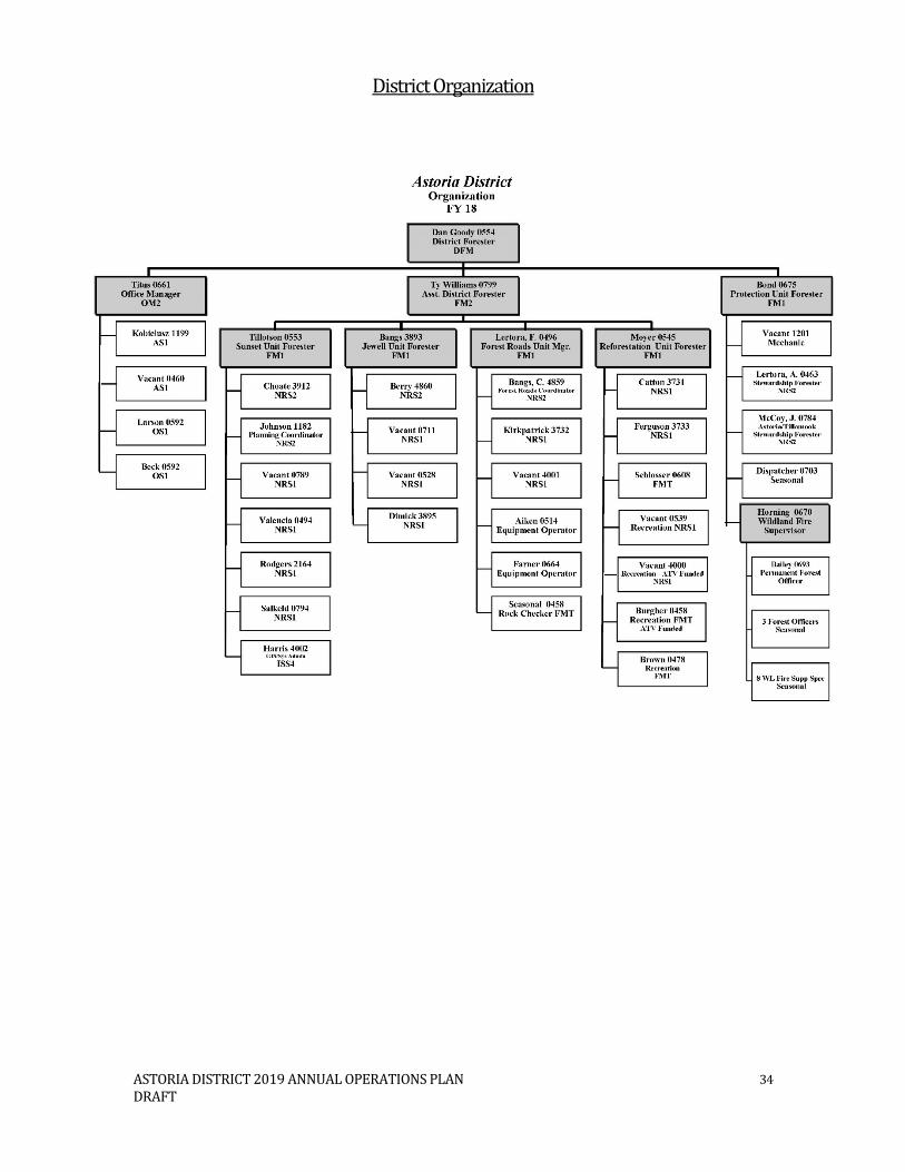
ASTORIA DISTRICT 2019 ANNUAL OPERATIONS PLAN 34 DRAFT
District Organization

ASTORIA DISTRICT 2019 ANNUAL OPERATIONS PLAN 35 DRAFT
APPENDIXES A. Summary Tables
A-1 Harvest Operations – Financial Summary A-2 Harvest Operations – Forest Resource Summary A-3 Forest Road Management Summary A-4 Reforestation and Young Stand Management Summary A-5 Recreation Management Summary
B. Vicinity Map of Harvest Operations C. Consultations with Other State Agencies
This appendix summarizes the results of consultations with the Oregon Department of Fish and Wildlife and other agencies, as appropriate. This appendix contains any written comments that we received from state agencies.
D. Public Involvement
This appendix describes the results of the public involvement process of this AOP and will be added prior to its approval.
E. Pre-Operations Reports
Pre-Operations Reports are available from the district upon request. F. Modification to the Astoria District Implementation Plan
This appendix describes the major modification to the district landscape design.

District: Fiscal Year: 2019 Date: 01/17/2018
BOF CSL Partial Cut
Clear-cut
Con-ifer
Hard-woods Total Gross Projects Net
Cal Barr 100% Clatsop (100.0%) 3 145 215 8.9 0.5 9.4 $3,952,775 $376,840 $3,575,935El Nino 100% Clatsop (100.0%) 4 0 162 4.6 1.0 5.6 $2,117,740 $230,200 $1,887,540Flintstone* 100% Clatsop (100.0%) 3 0 165 4.0 1.2 5.2 $2,277,300 $52,430 $2,199,200Foster Sort 100% Clatsop (100.0%) 4 0 35 0.8 0.5 1.3 $549,080 $0 $549,080Huffed and Puffed * 100% Clatsop (100.0%) 2 0 76 1.8 0.9 2.7 $1,231,200 $46,801 $1,184,399Lost Overlook 100% Clatsop (100.0%) 1 0 77 1.7 0.7 2.3 $924,325 $22,400 $837,925Quartz Run 100% Clatsop (100.0%) 1 0 200 5.9 0.2 6.0 $2,539,760 $141,600 $2,398,160West Sager 100% Clatsop (100.0%) 1 0 108 4.8 0.3 5.1 $2,414,160 $49,680 $2,364,480Trails End* 100% Clatsop (100.0%) 3 0 134 6.5 0.3 6.8 $3,016,640 $21,400 $2,995,240Upper Horsehawk * 100% Clatsop (100.0%) 4 0 244 9.1 0.8 9.9 $4,887,625 $32,600 $4,855,025Vesper Bell 100% Clatsop (100.0%) 2 0 156 5.0 0.6 5.7 $1,977,500 $139,000 $1,838,500Wild Bill 100% Clatsop (100.0%) 2 0 195 5.7 0.7 6.4 $3,914,196 $194,840 $3,719,356Woody Woodpecker 100% Clatsop (100.0%) 2 289 106 4.7 2.6 7.3 $2,736,500 $767,500 $1,969,000Roadside Veg. Mgt. & Rd. Projects $230,000* WOC for Projects Total: 434 1,873 63.5 10.3 73.7 $32,538,801 $2,305,291 $30,373,840Harvest Objectives and Targets 73.0 $28,032,000
Alternate OperationsClean Slate 100% Clatsop (100.0%) 0 256 7.4 1.0 8.5 $3,858,855 $365,800 $3,493,055East Summit Combination 100% Clatsop (100.0%) 146 56 2.3 0.2 2.5 $927,165 $308,900 $618,265Plympton East 100% Clatsop (100.0%) 39 45 1.2 0 1.2 $480,075 $141,900 $338,175Popeye 100% Clatsop (100.0%) 325 24 2 0.3 2.3 $873,680 $134,400 $739,280Seuss Split 100% Clatsop (100.0%) 21 8 0.5 0.1 0.6 $254,700 $10,700 $244,000The Big Noisy 100% Clatsop (100.0%) 79 105 3.4 0.3 3.8 $1,504,760 $425,700 $1,079,060
Total: 610 494 16.8 1.9 18.9 $7,899,235 $1,387,400 $6,511,835
Net Acres Volume (MMBF) Value
TIMBER HARVEST OPERATIONS - FINANCIAL SUMMARY
County Sale QuarterPrimary Operation
Fund %Astoria
Appendix A - Summary Tables
A-1

District: Date:This table lists Forest Resources and other issues addressed within Pre-Operations Report due to their presence within or near harvest operations
Primary Harvest Operations
Un
it (
Op
tio
nal
)
Fore
st H
ealt
h Is
sues
1
Inva
sive
Sp
ecie
s
LYR
/OFS
Str
uct
ure
s 2
Lan
dca
pe
Des
ign
LYR
/OFS
3
Inst
all/
Rep
lace
Cu
lver
ts o
n
Fish
Bea
rin
g /
Per
enn
ial
Stre
ams
Har
vest
ing
wit
hin
10
0' o
f
Fish
Bea
rin
g St
ream
Do
mes
tic
Wat
er S
ou
rce
Po
ten
tial
Str
eam
Hab
itat
Imp
rove
men
t 4
Wit
hin
Aq
uat
ic A
nch
or
Wit
hin
Ter
rest
rial
An
cho
r
Op
erat
ing
wit
hin
a N
SO
Pro
vin
cial
Cir
cle
(BA
Req
uir
ed)
Op
erat
ing
wit
hin
a M
MM
A
(BA
Req
uir
ed)
Mu
rrel
et T
imb
er S
ale
Scre
enin
g P
roce
ss R
equ
ired
(MM
Po
licy
2.2
7)
T&E
Fish
Ad
jace
nt
to H
arve
st
Un
it /
Hau
l Ro
ute
5
T&E
Pla
nts
Geo
tech
nic
al Is
sues
Nee
din
g
Fiel
d R
evie
w
Rec
reat
ion
Sit
es
Cu
ltu
ral R
eso
urc
es
Scen
ic R
eso
urc
es
Other Resources or Issues
Cal Barr x x x x x x xEl Nino x x x x xFlintstone x x x xFoster Sort x x x x x xHuffed and Puffed x x x xLost Overlook x x x X x xQuartz Run x x x x x xWest Sager x x x xTrails End x x xUpper Horsehawk x x x x xVesper Bell x x x x xWild Bill x x x xWoody Woodpecker x x x x x x x x x x x x1 A 'x' (in any column) indicates yes the resource or other issue occurs within or near the harvest operation and is addressed by the Pre-Operations Report
PRIMARY HARVEST OPERATIONS - FOREST RESOURCE SUMMARYAstoria Fiscal Year 2019 02/01/2018
2 A 'x' indicates the harvest operation contains stands that are currently in a Layered or Older Forest Stand Structure3 A 'x' indicate that the operation contains areas that have been designated for the development of complex forest stands (LYR/OFS)4 The final decision on these projects will occur during sale preparation and inconsultation with ODFW.5 This table lists harvest operations (units or log haul routes) that are adjacent to streams that are known to contain T&E fish. The Pre-Operation Report identifies whether T&E fish are present in the basin.
Appendix A - Summary Tables
A-2

This table lists Forest Resources and other issues addressed within Pre-Operations Report due to their presence within or near harvest operations
Alternate Harvest Operations
Un
it (
Op
tio
nal
)
Fore
st H
ealt
h Is
sues
1
Inva
sive
Sp
ecie
s
LYR
/OFS
Str
uct
ure
s 2
Lan
dca
pe
Des
ign
LYR
/OFS
3
Inst
all/
Rep
lace
Cu
lver
ts o
n
Fish
Bea
rin
g /
Per
enn
ial
Stre
ams
Har
vest
ing
wit
hin
10
0' o
f Fi
sh
Bea
rin
g St
ream
Do
mes
tic
Wat
er S
ou
rce
Po
ten
tial
Str
eam
Hab
itat
Imp
rove
men
t 4
Wit
hin
Aq
uat
ic A
nch
or
Wit
hin
Ter
rest
rial
An
cho
r
Op
erat
ing
wit
hin
a N
SO
Pro
vin
cial
Cir
cle
Op
erat
ing
wit
hin
a M
MM
A
(BA
Req
uir
ed)
Mu
rrel
et T
imb
er S
ale
Scre
enin
g P
roce
ss R
equ
ired
(MM
Po
licy
2.2
7)
T&E
Fish
Ad
jace
nt
to H
arve
st
Un
it /
Hau
l Ro
ute
5
T&E
Pla
nts
Geo
tech
nic
al Is
sues
Nee
din
g
Fiel
d R
evie
w
Rec
reat
ion
Sit
es
Cu
ltu
ral R
eso
urc
es
Scen
ic R
eso
urc
es
Other Resources or Issues
Clean Slate x x x xEast Summit Combination x x X x x x x x xPlympton East x x x x x x x xPopeye x x xSeuss Split x x x x xThe Big Noisy x x
2 A 'x' indicates the harvest operation contains stands that are currently in a Layered or Older Forest Stand Structure3 A 'x' indicate that the operation contains areas that have been designated for the development of complex forest stands (LYR/OFS)4 The final decision on these projects will occur during sale preparation and inconsultation with ODFW.5 This table lists harvest operations (units or log haul routes) that are adjacent to streams that are known to contain T&E fish. The Pre-Operation Report identifies whether T&E fish are present in the basin.
ALTERNATE HARVEST OPERATIONS - FOREST RESOURCE SUMMARY
1 A 'x' (in any column) indicates yes the resource or other issue occurs within or near the harvest operation and is addressed by the Pre-Operations Report
Appendix A - Summary Tables
A-2

District: Fiscal Year: 2019 Date: 12/20/2017
Miles Cost Miles CostCal Barr 1.6 $86,600 10.2 $186,400 $103,840 $376,840 $3,952,775 10%El Nino 1.2 $67,200 2.3 $43,000 $120,000 $230,200 $2,117,740 11%Flintstone 0.0 $0 3.6 $78,100 $0 $78,100 $2,277,300 3%Foster Sort 0.0 $0 0.0 $0 $0 $0 $549,080 0%Huffed and Puffed 0.2 $14,800 1.3 $17,001 $15,000 $46,801 $1,231,200 4%Lost Overlook 0.4 $22,400 0.0 $64,000 $0 $86,400 $924,325 9%Quartz Run 0.1 $5,600 8.0 $136,000 $0 $141,600 $2,539,760 6%West Sager 0.2 $5,200 1.9 $44,000 $480 $49,680 $2,414,160 2%Trails End 0.2 $11,200 0.6 $10,200 $0 $21,400 $3,016,640 1%Upper Horsehawk 0.4 $22,400 0.6 $10,200 $0 $32,600 $4,887,625 1%Vesper Bell 0.6 $33,600 6.2 $105,400 $0 $139,000 $1,977,500 7%Wild Bill 0.3 $16,800 3.5 $57,800 $120,240 $194,840 $3,914,196 5%Woody Woodpecker 1.2 $67,200 11.4 $193,800 $506,500 $767,500 $2,736,500 28%Roadside Veg. Mgt. & Rd.Maint. $230,000 $230,000Total 6.4 $353,000 49.6 $945,901 $1,096,060 $2,394,961 $32,538,801 7.4%
Alternate OperationsClean Slate 0 $0 7.4 $125,800 $240,000 $365,800 $3,858,855 9.0%East Summit Combination 0.7 $39,200 7.1 $120,700 $149,000 $308,900 $927,165 33.0%Plympton East 0.2 $11,200 7 $130,700 $0 $141,900 $480,075 30.0%Popeye 0.9 $50,400 4.1 $84,000 $0 $134,400 $873,680 15.0%Seuss Split 0.1 $5,600 0.3 $5,100 $0 $10,700 $254,700 4.0%The Big Noisy 0.2 $11,200 10.2 $234,500 $180,000 $425,700 $1,504,760 28.0%Total 2.1 $117,600 36.1 $700,800 $569,000 $1,387,400 $7,899,235 17.6%
Road Projects Not Associated with Harvest Operations in this AOP: None
Road Projects Planned to be Completed as a Work Order Contract
Construction Improvement Other Projects
Miles Cost Miles CostFlintstone 0.0 $0 3.6 $78,100 $78,100Huffed and Puffed 0.2 $14,800 1.3 $17,001 $15,000 $46,801Trails End 0.2 $11,200 0.6 $10,200 $21,400Upper Horsehawk 0.4 $22,400 0.6 $10,200 $32,600Roadside Veg. Mgt. & Rd.Maint. 0.0 $0 0 $0 $230,000 $230,000Total 0.8 $48,400 6.1 $115,501 $245,000 $408,901
Total Project Costs Funding Source CommentsOperation
FOREST ROADS SUMMARY
Construction Improvement Other Projects Total Project CostsPrimary Operations CommentsGross Value of Operation
Total Cost as a percent of
Gross Value
Astoria
Appendix A - Summary Tables
A-3

District: Fiscal Year: 2019 Date: 12/05/2017
Acres Planned
Average Cost*/Acre BOF Cost
Acres Planned
Average Cost*/Acre CSL Cost Total Acres Total Cost
Seedling / Nursery Costs 2,000 $181.50 $363,000.00 $0.00 2,000 $363,000.00Initial Planting 2,000 $141.00 $282,000.00 $0.00 2,000 $282,000.00Interplanting 200 $105.00 $21,000.00 $0.00 200 $21,000.00Underplanting 0 $0.00 $0.00 0 $0.00Tree Protection - Barriers 50 $116.00 $5,800.00 $0.00 50 $5,800.00Tree Protection - Direct Control 1,000 $75.00 $75,000.00 $0.00 1,000 $75,000.00Site Prep - Chemical - Aerial 1,900 $67.00 $127,300.00 $0.00 1,900 $127,300.00Site Prep - Chemical - Hand 100 $85.00 $8,500.00 $0.00 100 $8,500.00Site Prep - Broadcast Burning 0 $0.00 $0.00 $0.00 0 $0.00Site Prep - Piling Burning 1,800 $10.00 $18,000.00 $0.00 1,800 $18,000.00Site Prep - Mechanical 0 $0.00 $0.00 0 $0.00Release - Chemical - Aerial 450 $65.00 $29,250.00 $0.00 450 $29,250.00Release - Chemical - Hand 0 $0.00 $0.00 0 $0.00Release - Mechanical - Hand 0 $0.00 $0.00 0 $0.00Precommercial Thinning 600 $95.00 $57,000.00 $0.00 600 $57,000.00Pruning 0 $0.00 $0.00 0 $0.00Invasive Species 49 $150.00 $7,350.00 1 $150.00 $150.00 50 $7,500.00Road Side Spraying 294 $154.00 $45,276.00 6 $154.00 $924.00 300 $46,200.00Stocking Surveys 2,440 $1.00 $2,440.00 $0.00 2,440 $2,440.00Other $0.00 $0.00 0 $0.00
Totals 12,883 -- $1,041,916.00 7 -- $1,074.00 12,890 $1,042,990.00* Work to be completed by ODF staff; cost are for materials only
Board of Forestry Common School Forest LandsAstoriaREFORESTATION AND YOUNG STAND MANAGEMENT SUMMARY
DistrictProjects Conducted by ODF Staff or Contractors
Appendix A - Summary Tables
A-4

Acres Planned
Average Cost*/Acre BOF Cost
Acres Planned
Average Cost*/Acre CSL Cost Total Acres Total Cost
Initial Planting 0 $0.00 $0.00 0 $0.00Interplanting 0 $0.00 $0.00 0 $0.00Underplanting 0 $0.00 $0.00 0 $0.00Tree Protection - Barriers 2,000 $30.00 $60,000.00 $0.00 2,000 $60,000.00Tree Protection - Direct Control 1,000 $75.00 $75,000.00 $0.00 1,000 $75,000.00Site Prep. - Chemical Aerial 0 $0.00 $0.00 0 $0.00Site Prep - Chemical - Hand 100 $85.00 $8,500.00 $0.00 100 $8,500.00Site Prep - Broadcast Burning 0 $0.00 $0.00 0 $0.00Site Prep - Piling Burning 0 $0.00 $0.00 0 $0.00Site Prep - Mechanical 0 $0.00 $0.00 0 $0.00Release - Chemical - Hand 100 $85.00 $8,500.00 $0.00 100 $8,500.00Release - Mechanical - Hand 400 $75.00 $30,000.00 $0.00 400 $30,000.00Precommercial Thinning 0 $0.00 $0.00 0 $0.00Pruning 0 $0.00 $0.00 0 $0.00Invasive Species 200 $85.00 $17,000.00 $0.00 200 $17,000.00Other $0.00 $0.00 0 $0.00
Totals 3,800 -- $199,000.00 0 -- $0.00 3,800 $199,000.00
Grant Funded Activities
ProjectAcres
PlannedAverage
Cost*/Acre CostAcres
PlannedAverage
Cost*/Acre Cost Total Acres Total Cost$0.00 $0.00 0 $0.00$0.00 $0.00 0 $0.00$0.00 $0.00 0 $0.00$0.00 $0.00 0 $0.00
Projects Conducted by Inmates
Board of Forestry Common School Forest Lands District
FundingBoard of Forestry Common School Forest Lands District
Appendix A - Summary Tables
A-4

District: Fiscal Year: 2019 Date : 12/01/2017
ODF ($) Other ($) ODF ($) Other ($) ODF ($) Other ($)
Henry Reierson Spruce Run $14,000 $14,000 Sewer & Sanitary Service/Maintenance**Northrup Creek Horse Camp $5,000 $5,000 Sewer & Sanitary Service/Maintenance**Gnat Creek Campground $3,000 $3,000 Sewer & Sanitary Service/Maintenance**Beaver Eddy $2,000 $2,000 Sewer & Sanitary Service/Maintenance**
Misc. Improvements $2,000 $2,000*Viewpoint Quarry $500 $500 Sewer & Sanitary Service/Maintenance***Kerry Road $600 $600 Sewer & Sanitary Service/Maintenance***Plympton Ridge Road $600 $600 Sewer & Sanitary Service/Maintenance**
Lost Lake $1,500 $1,500 Sewer & Sanitary Service/Maintenance***Shingle Mill OHV Staging Area $2,000 $2,000 Sewer & Sanitary Service/Maintenance**
Bloom Lake $1,000 $1,000 Maintenance**Soapstone $1,000 $1,000 Maintenance**
Demonstration Forest $3,000 $3,000 Interpretive Signs**
Law Enforcement $30,000 $30,000 Clatsop County Sheriff's ContractClatsop Recreation Brochures $3,000 $3,000 Update/Printing of CSF Rec. BrochuresDumpsites Cleanup $2,000 $2,000 Annual & Misc. Forest Cleanup**Special Projects $5,000 $5,000 Kiosk Repairs & Maintenance**Misc. Maintenance Supplies & Repairs $3,000 $3,000 Misc. Supplies/CG Envelopes/Etc.
$75,500$3,700
TOTAL $79,200*A portion of the motorized recreation costs are funded through OPRD transfer funds.** All Maintenance Work to be performed by South Fork and ODF Staff
Other Total
RECREATION SITE MANAGEMENT SUMMARY
Operations/Maint. (Funding) Total
Costs Comments
District Total
Astoria
Project
Construction Cost (Funding)
Improvement Cost (Funding)
Campgrounds
Designated Dispersed Campsites
Day Use Areas
Trailheads
Interpretive Sites
Other Operations
Appendix A - Summary Tables
A-5

District: Fiscal Year: Date : 12/01/2017
Miles ODF ($) Other ($) Miles ODF ($) Other ($) Miles ODF ($) Other ($)
Gnat Creek Trail 4.0 $0 Maint. to be conducted by South ForkBloom Lake Trail 2.0 $0 Maint. to be conducted by South ForkSoapstone Trail 2.0 $0 Maint. to be conducted by South ForkDemonstration Forest Trail 1.0 $0 Maint. to be conducted by South ForkSpruce Run Creek Trail 3.0 $0 Maint. to be conducted by South ForkNorthrup Equestrial Trails 8.0 $0 Maint. to be conducted by South Fork
$0
Replacement parts $1,000 $1,000 ATV and side by side parts and tiresNicolai Mtn. OHV Area* 30.0 $7,200 $7,200 Equip. rental and other S/S.
Maint. to be conducted by South Fork$0 and volunteers.$0$0$0$0$0$0$0
*A portion of the motorized recreation costs are funded through OPRD transfer funds. $8,200TOTAL $8,200
Operations & Maintenance Projects
District TotalOther Total
RECREATION TRAIL MANAGEMENT SUMMARYAstoria 2019
Project Total Costs Comments
Non-Motorized
Motorized
Construction Projects Improvement Projects
Appendix A - Summary Tables
A-5

District: Fiscal Year: 2019 Date : 12/01/2017
Comments
Grant ($) Match ($)
None$0$0$0$0$0$0$0$0$0$0$0$0$0$0$0
** In-kind work to be performed by South Fork and ODF Staff $0$0
TOTAL $0
Grants TotalMatch Total
Funding Project Total
Award Date (actual or
anticipated)
RECREATION GRANT MANAGEMENT SUMMARYAstoria
Grant StatusRecreation Leadership Approval
Goals/Purpose
Appendix A - Summary Tables
A-5

Foster Sort
Popeye
Clean Slate
The Big Noisy
Seuss Split
East Summit Combination
Plymtpon East
El Nino
Cal Barr
Trails EndWild Bill
Flinstone
Lost Overlook
Upper Horsehawk
Woody Woodpecker
Huffed and Puffed
Sager Bomb
Vesper Bell
Quartz Run
Content may not reflect National Geographic's current map policy. Sources:National Geographic, Esri, DeLorme, HERE, UNEP-WCMC, USGS, NASA,ESA, METI, NRCAN, GEBCO, NOAA, increment P Corp.
®
0 3.5 7 10.51.75Miles
A s t o r i a D i s t r i c t - 2019 AOPA s t o r i a D i s t r i c t - 2019 AOPA p p e n d ix B A p p e n d ix B V i c i n i ty MapV i c i n i ty Map
LegendFY19 - Alternate Operations
FY19 - Primary OperationsModified ClearcutPartial CutOwnership Line

Appendix C – Consultations with Other State Agencies
Page 1 of 1
The Annual Operations Plan is prepared in a preliminary form by District Staff two years in advance of it becoming finalized. During this time the District reviews the plan with Department Staff Specialists as well as Staff from The Oregon Department of Fish and Wildlife (ODFW) and the Oregon Department of Transportation (ODOT). This Appendix summarizes results of consultations with the ODFW, and ODOT. Oregon Department of Fish and Wildlife – Assistant District Wildlife Biologist Review – Paul Atwood: General comments that relate to most sales Green Trees It was helpful to see the green tree retention monitoring data from past sales, thank you. Optimal green tree (GT) placement for wildlife habitat is scattered or clumped distribution in the upland portions of the harvest units; this is especially true for GTs left in lieu of created down wood or snags. Some of the pre-op reports specify that GTs are to be left in or adjacent to RMAs and/or within GTAs. RMA prescriptions for GTs should stand alone in their adequacy, and not need additional GTs for augmentation. Green trees in GTAs offer minimal value to wildlife unless protecting sensitive wildlife sites (e.g. nests) from wind-throw or edge effects. Snags Strategies for addressing snag standards were generally described, but it wasn’t clear when snags would be manually created or extra green trees would be left. It would be helpful for reviewers if these strategies were included in the supplied pre-operations reports. If larger diameter (e.g. > 20” dbh) trees are in the stand that is deficient in hard snags, ODFW recommends creating snags (topping is best method) rather than leaving extra GTs. If GTs are left in lieu of snag creation, they should be scattered or clumped in the harvest unit. Down Wood Strategies for meeting down wood standards in the FMP are well described in this AOP. It would be helpful for reviewers if these strategies were included in the supplied pre-operations reports. It is good to see that down wood targets on sales will meet or exceed the minimum standard in the FMP. If GTs are left in lieu of down wood creation, they should be scattered or clumped in the harvest unit. Roads ODFW recommends physical closure for rocked or dirt spurs, especially if they have no immediate need in further management and/or maintenance (e.g. culverts). If new spur roads have immediate further needs, consider closing them physically in later AOPs to keep open road densities down. Oregon Department of Transportation - Archeological Review:
Archaeologists from the Oregon Department of Transportation (ODOT) have reviewed the proposed timber harvests, road construction and recreation projects to review potential impacts to cultural resources. No known historical or archaeological sites were found during this review. However, ODOT’s review of historic maps and other information indicates a historically used trail may exist near the vicinity of one of the planned operations that could have led to the presence of cultural artifacts today.
It has been recommended that the following operation should be further reviewed on the ground during field reconnaissance to determine if any trail and/or cabin remains still exist: Clean Slate.

Appendix D – Public Involvement This appendix describes the results of the public involvement process of this AOP and will be published in the final version of the AOP after all the public comments have been received.

Appendix E – Pre-Operations Reports
Individual pre-operations reports for this AOP are available from the district upon request.

The updated Landscape Design for the Astoria District consists of 30 percent of the land base which is designated to achieve a Desired Future Condition (DFC) of either Layered (LYR) or Older Forest Structure (OFS). The initial landscape design was adopted in July of 2011 as part of the Astoria District Implementation Plan (IP). The IP describes the purpose of the landscape design is to achieve landscape objectives set forth in the Northwest Forest Management Plan (FMP).
In order to adapt to new information such as: updated forest inventory, new threatened and endangered species sites, forest land management classification updates, landscape changes due to storm damage, insect and/or disease or other significant events; the landscape design was anticipated to change over time. Changes of up to 240 acres annually are considered minor changes and can be approved by the District Forester concurrent with the Annual Operation Planning (AOP) process. Changes that are greater than 240 acres are considered major and require a public comment period and are approved by the State Forester.
This proposal consists of adding 3,537 acres and removing 2,582 acres. The resulting total district acreage within the mapped DFC landscape design is 42,069 acres (30.74%). A summary of the current forest condition of the proposed changes is shown in Figure 1 including a comparison of proposed changes to current landscape design levels shown in Figure 2. A summary of the current stand age of the proposed changes is shown in Figure 3 including a comparison of proposed changes to current landscape design levels shown in Figure 4. The spatial location of the changes is shown in Figure 5.
Summary of the basis for stands added to the mapped DFC landscape design:
Slivers and gaps within High Value Conservation Areas (HVCA) located in riparian areas adjacentto streams that connect to existing complex stands
Stands that increase connectivity to existing complex stands and areas where harvestprescriptions have been implemented to benefit threatened and endangered species
High Landslide Hazard Locations (HLHL)
Recently revised Marbled Murrelet Management Area (MMMA) boundary
Operational boundary revision (mid slope boundaries brought to a road or ridge top)
Stands having unique qualities such as rare plants or stands that have been previously thinned toattain a complex condition
Summary of the basis for stands removed from the mapped DFC landscape design:
Stands that are not currently designated as OFS
Stands that are outside of the Terrestrial Anchor Site boundaries
Stands on the outside edge of the current landscape design – thus maintaining the interiorstands in an effort to minimize fragmentation
Stands meeting the criteria above that also have high revenue generating potential
GIS housekeeping – snapping boundaries to ownership, removing overlaps, etc.
This proposed major modifications to the IP requires a 30 day public comment period which will be held in conjunction with the Districts 2019 AOP public comment period. At the close of the public comment period, the Department will consider the public comments and make final decisions on the proposed changes.
Appendix F - Changes to Landscape Design - Major Modification to the Astoria District Implementation Plan

Page 2 | 4
Figure 1.
Figure 2.
Appendix F - Changes to Landscape Design - Major Modification to the Astoria District Implementation Plan

Page 3 | 4
Figure 3.
Figure 4.
Appendix F - Changes to Landscape Design - Major Modification to the Astoria District Implementation Plan

Page 4 | 4
Figure 5.
Appendix F - Changes to Landscape Design - Major Modification to the Astoria District Implementation Plan