
Quality and San Juan College Dr. Carol Spencer. About San Juan College.

Placer County San Juan Water District Annex T-1 Local Hazard Mitigation Plan Update June 2021
Annex T San Juan Water District
T.1 Introduction
This Annex details the hazard mitigation planning elements specific to the San Juan Water District (SJWD
or District), a new participating jurisdiction to the 2021 Placer County Local Hazard Mitigation Plan
(LHMP) Update. This Annex is not intended to be a standalone document, but appends to and supplements
the information contained in the Base Plan document. As such, all sections of the Base Plan, including the
planning process and other procedural requirements apply to and were met by the District. This Annex
provides additional information specific to SJWD, with a focus on providing additional details on the risk
assessment and mitigation strategy for this District.
Note: SJWD participated in the original 2005 Placer County LHMP. A copy of that document could not
be located by SJWD, Placer County, or Cal OES. Additionally, staff turnover in the past 16 years has
reduced institutional memory of that 2005 Plan. It can be assumed that none of SJWD’s proposed
mitigation actions were completed, SJWD’s mitigation priorities at that time are unknown, and that the
2005 Plan was not incorporated into any SJWD planning mechanisms. Development in the District since
2005 was described by SJWD as minimal, and a general description of more recent development in the
District is included in Section T.5.2 of this Annex.
T.2 Planning Process
As described above, the District followed the planning process detailed in Chapter 3 of the Base Plan. In
addition to providing representation on the Placer County Hazard Mitigation Planning Committee (HMPC),
the District formulated their own internal planning team to support the broader planning process
requirements. Internal planning participants, their positions, and how they participated in the planning
process are shown in Table T-1. Additional details on plan participation and District representatives are
included in Appendix A.
Table T-1 SJWD – Planning Team
Name Position/Title How Participated
Scott Alcantara Safety Regulatory Compliance Coordinator
Attended Meetings, coordinated participation, gathered information, edited and reviewed response
Tony Barela Operations Manager Research and review
Lisa Brown Customer Service Manager
Research and review
Andrew Pierson Engineering Manager
Research and review
Adam Larsen Field Services Manager
Research and review

Placer County San Juan Water District Annex T-2 Local Hazard Mitigation Plan Update June 2021
Name Position/Title How Participated
Greg Turner Water Treatment Plant Superintendent
Research and review
T.3 District Profile
The District profile for the SJWD is detailed in the following sections. Figure T-1 displays a map and the
location of the District within Placer County.

Placer County San Juan Water District Annex T-3 Local Hazard Mitigation Plan Update June 2021
Figure T-1 SJWD
Placer County San Juan Water District Annex T-4 Local Hazard Mitigation Plan Update June 2021
T.3.1. Overview and Background
San Juan Water District is a community services district established by a vote of the citizens in 1954, formed
under Section 61000 et seq., Title 6, Division 3 of the California Government Code Water Code, Section
3000. We provide reliable, high-quality water service to both retail and wholesale customers in eastern
Sacramento and southern Placer counties. San Juan’s roots date back to the Gold Rush era with the
formation in 1854 of the original entity, North Fork American River and Mining Company, later known as
the North Fork Ditch Company.
SJWD provides drinking water supplies to approximately 160,000 residents in our retail and wholesale
areas. The District provides treatment and delivery of more than 65,000 acre-feet of water per year through
approximately 218 miles of pipeline to wholesale and retail customers. The retail division serves the
northeast portion of Sacramento County, east Roseville and Granite Bay.
Wholesale customers include San Juan Water District, Citrus Heights Water District, Fair Oaks Water
District, Orange Vale Water Company, a portion of the City of Folsom (north of the American River) and
periodically to another 171,000 customers in Sacramento Suburban Water District.
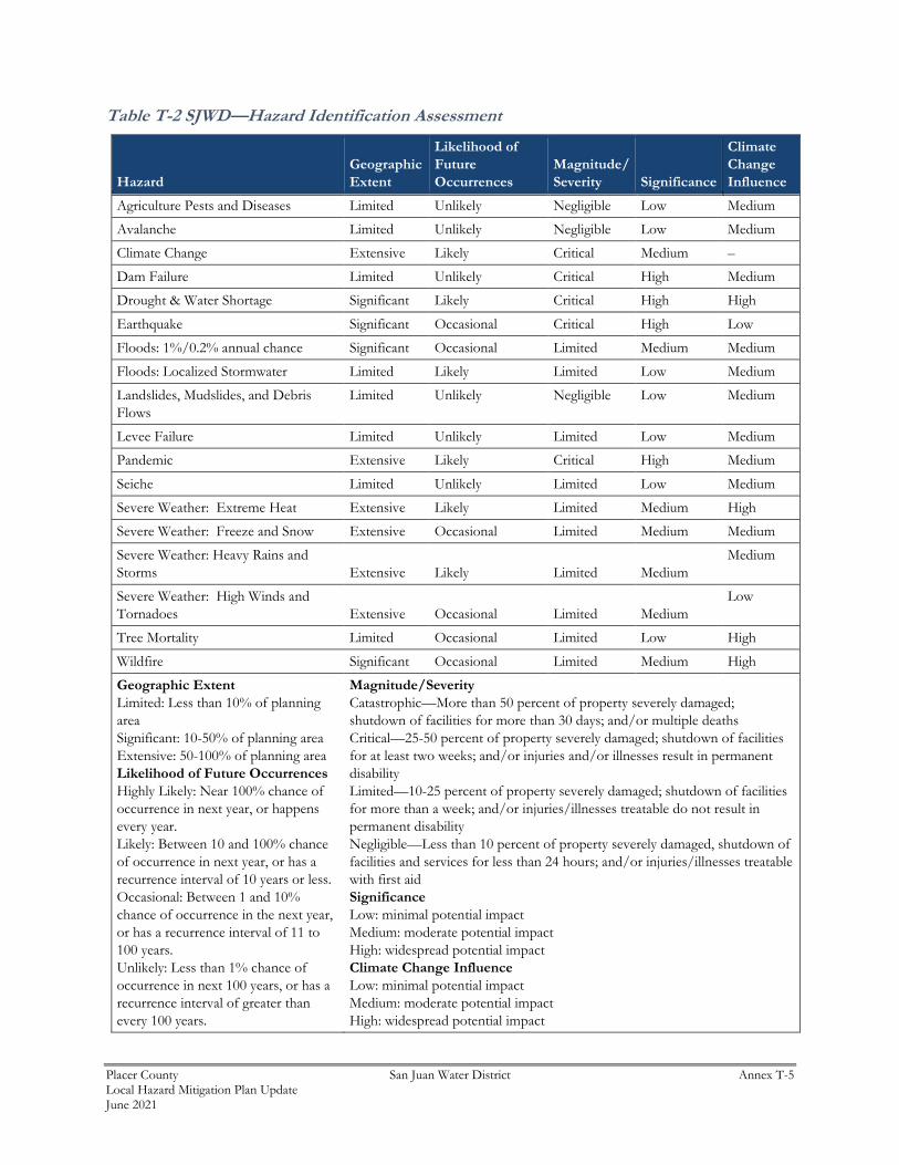
T.4 Hazard Identification
SJWD identified the hazards that affect the District and summarized their location, extent, frequency of
occurrence, potential magnitude, and significance specific to District (see Table T-2).
Placer County San Juan Water District Annex T-5 Local Hazard Mitigation Plan Update June 2021
Table T-2 SJWD—Hazard Identification Assessment
Hazard
Geographic
Extent
Likelihood of
Future
Occurrences
Magnitude/
Severity Significance
Climate
Change
Influence
Agriculture Pests and Diseases Limited Unlikely Negligible Low Medium
Avalanche Limited Unlikely Negligible Low Medium
Climate Change Extensive Likely Critical Medium –
Dam Failure Limited Unlikely Critical High Medium
Drought & Water Shortage Significant Likely Critical High High
Earthquake Significant Occasional Critical High Low
Floods: 1%/0.2% annual chance Significant Occasional Limited Medium Medium
Floods: Localized Stormwater Limited Likely Limited Low Medium
Landslides, Mudslides, and Debris
Flows
Limited Unlikely Negligible Low Medium
Levee Failure Limited Unlikely Limited Low Medium
Pandemic Extensive Likely Critical High Medium
Seiche Limited Unlikely Limited Low Medium
Severe Weather: Extreme Heat Extensive Likely Limited Medium High
Severe Weather: Freeze and Snow Extensive Occasional Limited Medium Medium
Severe Weather: Heavy Rains and
Storms Extensive Likely Limited Medium
Medium
Severe Weather: High Winds and
Tornadoes Extensive Occasional Limited Medium
Low
Tree Mortality Limited Occasional Limited Low High
Wildfire Significant Occasional Limited Medium High
Geographic Extent
Limited: Less than 10% of planning
area
Significant: 10-50% of planning area
Extensive: 50-100% of planning area
Likelihood of Future Occurrences
Highly Likely: Near 100% chance of
occurrence in next year, or happens
every year.
Likely: Between 10 and 100% chance
of occurrence in next year, or has a
recurrence interval of 10 years or less.
Occasional: Between 1 and 10%
chance of occurrence in the next year,
or has a recurrence interval of 11 to
100 years.
Unlikely: Less than 1% chance of
occurrence in next 100 years, or has a
recurrence interval of greater than
every 100 years.
Magnitude/Severity
Catastrophic—More than 50 percent of property severely damaged;
shutdown of facilities for more than 30 days; and/or multiple deaths
Critical—25-50 percent of property severely damaged; shutdown of facilities
for at least two weeks; and/or injuries and/or illnesses result in permanent
disability
Limited—10-25 percent of property severely damaged; shutdown of facilities
for more than a week; and/or injuries/illnesses treatable do not result in
permanent disability
Negligible—Less than 10 percent of property severely damaged, shutdown of
facilities and services for less than 24 hours; and/or injuries/illnesses treatable
with first aid
Significance
Low: minimal potential impact
Medium: moderate potential impact
High: widespread potential impact
Climate Change Influence
Low: minimal potential impact
Medium: moderate potential impact
High: widespread potential impact
Placer County San Juan Water District Annex T-6 Local Hazard Mitigation Plan Update June 2021
T.5 Hazard Profile and Vulnerability Assessment
The intent of this section is to profile the District’s hazards and assess the District’s vulnerability separate
from that of the Placer County Planning Area as a whole, which has already been assessed in Section 4.3
Hazard Profiles and Vulnerability Assessment in the Base Plan. The hazard profiles in the Base Plan discuss
overall impacts to the Placer County Planning Area and describes the hazard problem description, hazard
location and extent, magnitude/severity, previous occurrences of hazard events and the likelihood of future
occurrences. Hazard profile information specific to the District is included in this Annex. This vulnerability
assessment analyzes the property and other assets at risk to hazards ranked of medium or high significance
specific to the District. For more information about how hazards affect the County as a whole, see Chapter
4 Risk Assessment in the Base Plan.
T.5.1. Hazard Profiles
Each hazard vulnerability assessment in Section T.5.3, includes a hazard profile/problem description as to
how each medium or high significant hazard (as shown in Table T-2) affects the District and includes
information on past hazard occurrences and the likelihood of future hazard occurrence. The intent of this
section is to provide jurisdictional specific information on hazards and further describes how the hazards
and risks differ across the Placer County Planning Area.
T.5.2. Vulnerability Assessment and Assets at Risk
This section identifies the District’s total assets at risk, including values at risk, populations at risk, critical
facilities and infrastructure, natural resources, and historic and cultural resources. Growth and development
trends are also presented for the District. This data is not hazard specific, but is representative of total assets
at risk within the District.
Assets at Risk and Critical Facilities
This section considers the SJWD’s assets at risk, with a focus on key District assets such as critical facilities,
infrastructure, and other District assets and their values. With respect to District assets, the majority of
these assets are considered critical facilities as defined for this Plan. Critical facilities are defined for this
Plan as:
Any facility, including without limitation, a structure, infrastructure, property,
equipment or service, that if adversely affected during a hazard event may result in
severe consequences to public health and safety or interrupt essential services and
operations for the community at any time before, during and after the hazard event.
This definition is further refined by separating out three classes of critical facilities:
Class 1 facilities include those facilities that contribute to command, control,
communications and computer capabilities associated with managing an incident
from initial response through recovery.

Placer County San Juan Water District Annex T-7 Local Hazard Mitigation Plan Update June 2021
Class 2 facilities include those facilities that house Emergency Services capabilities.
Class 3 facilities are those facilities that enable key utilities and can be used as
evacuation centers/shelters/mass prophylaxis sites, etc.
Additional information on the three classes of critical facilities is described further in Section 4.3.1 of the
Base Plan.
Table T-3 lists critical facilities and other District assets identified by the District Planning Team as
important to protect in the event of a disaster. SJWD’s physical assets, valued at over $130 million, consist
of the buildings and infrastructure to support the District’s operations.
Table T-3 SJWD Critical Facilities, Infrastructure, and Other District Assets
Name of Asset Facility Type Replacement Value Which Hazards Pose Risk
Main Campus/Yard $10 Million Earthquake/Flood
Water treatment plant $50 Million Earthquake/Flood/Hazmat
Pumping stations $10 Million Earthquake/Flood
Water distribution $50 Million Earthquake/Subsidence
Water storage facilities $10 Million Earthquake/Subsidence
Total $130 million
Source: SJWD
Natural Resources
SJWD has a variety of natural resources of value to the District. These natural resources parallel that of
Placer County as a whole. Information can be found in Section 4.3.1 of the Base Plan
Historic and Cultural Resources
SJWD has a variety of historic and cultural resources of value to the District. These historic and cultural
resources parallel that of Placer County as a whole. Information can be found in Section 4.3.1 of the Base
Plan.
Populations Served
Also potentially at risk should the District be affected by natural hazard events are the populations served
by the District. SJWD provides drinking water supplies to approximately 160,000 residents in our retail
and wholesale areas. The District provides treatment and delivery of more than 65,000 acre-feet of water
per year through approximately 222 miles of pipeline to wholesale and retail customers. The retail division
serves the northeast portion of Sacramento County, east Roseville and Granite Bay.
Wholesale customers include San Juan Water District, Citrus Heights Water District, Fair Oaks Water
District, Orange Vale Water Company, a portion of the City of Folsom (north of the American River) and
periodically to another 171,000 customers in Sacramento Suburban Water District.
Placer County San Juan Water District Annex T-8 Local Hazard Mitigation Plan Update June 2021
Growth and Development Trends
General growth in the District parallels that of the Placer County Planning Area as a whole. Information
can be found in Section 4.3.1 of the Base Plan.
Future Development
The District has no control over future development in areas the District services. Future development in
these areas parallels that of the Placer County Planning Area. More general information on growth and
development in Placer County as a whole can be found in “Growth and Development Trends” in Section
4.3.1 Placer County Vulnerability and Assets at Risk of the Base Plan.
T.5.3. Vulnerability to Specific Hazards
This section provides the vulnerability assessment, including any quantifiable loss estimates, for those
hazards identified above in Table T-2 as high or medium significance hazards. Impacts of past events and
vulnerability of the District to specific hazards are further discussed below (see Section 4.1 Hazard
Identification in the Base Plan for more detailed information about these hazards and their impacts on the
Placer County Planning Area). Methodologies for evaluating vulnerabilities and calculating loss estimates
are the same as those described in Section 4.3 of the Base Plan.
An estimate of the vulnerability of the District to each identified priority hazard, in addition to the estimate
of likelihood of future occurrence, is provided in each of the hazard-specific sections that follow.
Vulnerability is measured in general, qualitative terms and is a summary of the potential impact based on
past occurrences, spatial extent, and damage and casualty potential. It is categorized into the following
classifications:
➢ Extremely Low—The occurrence and potential cost of damage to life and property is very minimal to
nonexistent.
➢ Low—Minimal potential impact. The occurrence and potential cost of damage to life and property is
minimal.
➢ Medium—Moderate potential impact. This ranking carries a moderate threat level to the general
population and/or built environment. Here the potential damage is more isolated and less costly than a
more widespread disaster.
➢ High—Widespread potential impact. This ranking carries a high threat to the general population and/or
built environment. The potential for damage is widespread. Hazards in this category may have
occurred in the past.
➢ Extremely High—Very widespread with catastrophic impact.
Depending on the hazard and availability of data for analysis, this hazard specific vulnerability assessment
also includes information on values at risk, critical facilities and infrastructure, populations at risk, and
future development.
Climate Change
Likelihood of Future Occurrence–Likely
Vulnerability–High

Placer County San Juan Water District Annex T-9 Local Hazard Mitigation Plan Update June 2021
Hazard Profile and Problem Description
Climate change adaptation is a key priority of the State of California. The 2018 State of California Multi-
Hazard Mitigation Plan stated that climate change is already affecting California. Sea levels have risen by
as much as seven inches along the California coast over the last century, increasing erosion and pressure
on the state’s infrastructure, water supplies, and natural resources. The State has also seen increased
average temperatures, more extreme hot days, fewer cold nights, a lengthening of the growing season, shifts
in the water cycle with less winter precipitation falling as snow, and earlier runoff of both snowmelt and
rainwater in the year. In addition to changes in average temperatures, sea level, and precipitation patterns,
the intensity of extreme weather events is also changing. The District is concerned that climate change can
cause possible Harmful Algal Bloom (HAB) in its source water (Folsom Lake).
Location and Extent
Climate change is a global phenomenon. It is expected to affect the whole of the District, Placer County,
and State of California. There is no scale to measure the extent of climate change. Climate change
exacerbates other hazards, such as drought, extreme heat, flooding, wildfire, and others. The speed of onset
of climate change is very slow. The duration of climate change is not yet known, but is feared to be tens to
hundreds of years.
Past Occurrences
Climate change has never been directly linked to any declared disasters. While the District noted that
climate change is of concern, no specific impacts of climate change could be recalled. The District and
HMPC members did, however, note that in Placer County, the strength of storms does seem to be increasing
and the temperatures seem to be getting hotter. Hotter temperatures, combined with recent drought
conditions, exacerbates the potential for damaging wildfires.
Vulnerability to and Impacts from Climate Change
The California Adaptation Planning Guide (APG) prepared by California OES and CNRA was developed
to provide guidance and support for local governments and regional collaboratives to address the
unavoidable consequences of climate change. California’s APG: Understanding Regional Characteristics
has divided California into 11 different regions based on political boundaries, projected climate impacts,
existing environmental setting, socioeconomic factors and regional designations. Placer County falls within
the North Sierra Region characterized as a sparsely settled mountainous region where the region’s economy
is primarily tourism-based. The region is rich in natural resources, biodiversity, and is the source for the
majority of water used by the state. This information can be used to guide climate adaptation planning in
the District and Placer County Planning Area.
The California APG: Understanding Regional Characteristics identified the following impacts specific to
the North Sierra region in which the Placer County Planning Area is part of:
➢ Temperature increases
➢ Decreased precipitation
➢ Reduced snowpack

Placer County San Juan Water District Annex T-10 Local Hazard Mitigation Plan Update June 2021
➢ Reduced tourism
➢ Ecosystem change
➢ Sensitive species stress
➢ Increased wildfire
Assets at Risk
The District noted that its facilities will most likely not be at risk from climate change.
Dam Failure
Likelihood of Future Occurrence–Unlikely
Vulnerability–High
Hazard Profile and Problem Description
Dams are manmade structures built for a variety of uses including flood protection, power generation,
agriculture, water supply, and recreation. When dams are constructed for flood protection, they are usually
engineered to withstand a flood with a computed risk of occurrence. For example, a dam may be designed
to contain a flood at a location on a stream that has a certain probability of occurring in any one year. If
prolonged periods of rainfall and flooding occur that exceed the design requirements, that structure may be
overtopped or fail. Overtopping is the primary cause of earthen dam failure in the United States.
Location and Extent
Dam failure is a natural disaster from two perspectives. First, the inundation from released waters resulting
from dam failure is related to naturally occurring floodwaters. Second, a total dam failure would most
probably happen as a consequence of the natural disaster triggering the event, such as an earthquake. There
is no scale with which to measure dam failure. However, Cal DWR Division of Safety of Dams (DOSD)
assigns hazard ratings to dams within the State that provides information on the potential impact should a
dam fail. The following two factors are considered when assigning hazard ratings: existing land use and
land use controls (zoning) downstream of the dam. Dams are classified in four categories that identify the
potential hazard to life and property: Low, Significant, High, and Extremely High. These were discussed
in more detail in Section 4.3.9 of the Base Plan.
While a dam may fill slowly with runoff from winter storms, a dam break has a very quick speed of onset.
The duration of dam failure is generally not long – only as long as it takes to empty the reservoir of water
the dam held back. The District would be affected for as long as the flood waters from the dam failure took
to drain downstream.
Dams inside the County that can affect the District can be seen on Figure T-2. No dams outside the County
affect the District.
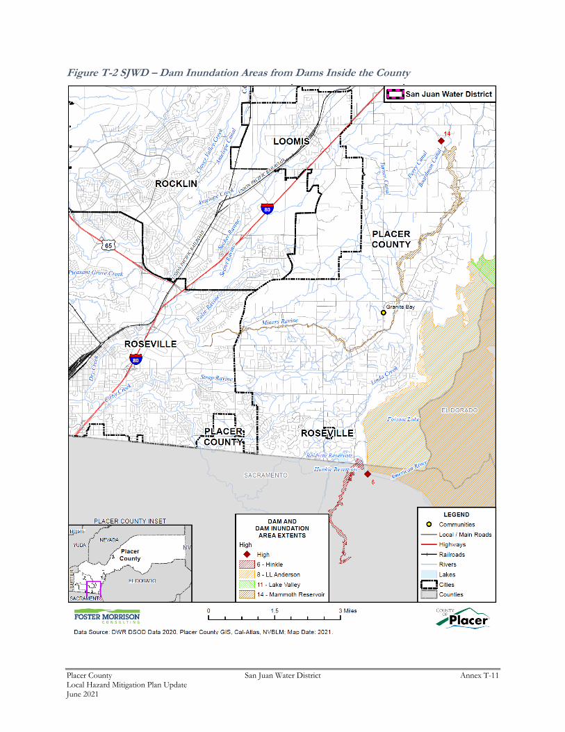
Placer County San Juan Water District Annex T-11 Local Hazard Mitigation Plan Update June 2021
Figure T-2 SJWD – Dam Inundation Areas from Dams Inside the County

Placer County San Juan Water District Annex T-12 Local Hazard Mitigation Plan Update June 2021
Past Occurrences
There has been no federal or state disaster declarations for dam failure in the County. The District noted
no other dam failure occurrences that have affected the District.
Vulnerability to and Impacts from Dam Failure
Dam failure flooding would vary by community depending on which dam fails and the nature and extent
of the dam failure and associated flooding. Impacts to the District from a dam failure flood could include
loss of life and injury, flooding and damage to property and structures, damage to critical facilities and
infrastructure, loss of natural resources, and all other flood related impacts. Additionally, mass evacuations
and associated economic losses can also be significant.
The District is concerned with flooding and disruption of utility power impacts from a dam failure event.
Assets at Risk
The District noted the following facilities at risk:
➢ Main campus/Yard
➢ Water Treatment Plant
➢ 4 District pumping stations
Drought & Water Shortage
Likelihood of Future Occurrence–Likely
Vulnerability–High
Hazard Profile and Problem Description
Drought is a complex issue involving many factors—it occurs when a normal amount of precipitation and
snow is not available to satisfy an area’s usual water-consuming activities. Drought can often be defined
regionally based on its effects. Drought is different than many of the other natural hazards in that it is not
a distinct event and usually has a slow onset. Drought can severely impact a region both physically and
economically. Drought affects different sectors in different ways and with varying intensities. Adequate
water is the most critical issue and is critical for agriculture, manufacturing, tourism, recreation, and
commercial and domestic use. As the population in the area continues to grow, so will the demand for
water.
Location and Extent
Drought and water shortage are regional phenomenon. The whole of the County, as well as the whole of
the District, is at risk. The US Drought Monitor categorizes drought conditions with the following scale:
➢ None
➢ D0 – Abnormally dry
➢ D1 – Moderate Drought

Placer County San Juan Water District Annex T-13 Local Hazard Mitigation Plan Update June 2021
➢ D2 – Severe Drought
➢ D3 – Extreme drought
➢ D4 – Exceptional drought
Drought has a slow speed of onset and a variable duration. Drought can last for a short period of time,
which does not usually affect water shortages and for longer periods. Should a drought last for a long
period of time, water shortage becomes a larger issue. Current drought conditions in the District and the
County are shown in Section 4.3.10 of the Base Plan.
Past Occurrences
There has been one state and one federal disaster declaration due to drought since 1950. This can be seen
in Table T-4.
Table T-4 Placer County – State and Federal Disaster Declarations Summary 1950-2020
Disaster Type State Declarations Federal Declarations
Count Years Count Years
Drought 1 2014 1 1977
Source: Cal OES, FEMA
Since drought is a regional phenomenon, past occurrences of drought for the District are the same as those
for the County and includes 5 multi-year droughts over an 85-year period. Details on past drought
occurrences can be found in Section 4.3.10 of the Base Plan.
Vulnerability to and Impacts from Drought and Water Shortage
Based on historical information, the occurrence of drought in California, including the District, is cyclical,
driven by weather patterns. Drought has occurred in the past and will occur in the future. Periods of actual
drought with adverse impacts can vary in duration, and the period between droughts can be extended.
Although an area may be under an extended dry period, determining when it becomes a drought is based
on impacts to individual water users. Drought impacts are wide-reaching and may be economic,
environmental, and/or societal. Tracking drought impacts can be difficult.
The most significant qualitative impacts associated with drought in the Placer County Planning Area are
those related to water intensive activities such as agriculture, wildfire protection, municipal usage,
commerce, tourism, recreation, and wildlife preservation. Mandatory conservation measures are typically
implemented during extended droughts. Drought conditions can also cause soil to compact and not absorb
water well, potentially making an area more susceptible to flooding. With a reduction in water, water
supply issues based on water rights becomes more evident. Climate change may create additional impacts
to drought and water shortage in the County and the District.
During periods of drought, vegetation can dry out which increases fire risk. Drought that occurs during
periods of extreme heat and high winds can cause Public Safety Power Shutoff (PSPS) events to be declared
in the County. More information on power shortage and failure can be found in the Severe Weather:
Extreme Heat Section below, as well as in Section 4.3.2 of the Base Plan.

Placer County San Juan Water District Annex T-14 Local Hazard Mitigation Plan Update June 2021
San Juan Water District is fortunate to have plentiful water storage under normal circumstances. The
historic drought between 2012 and 2015 resulted in minor reduction in supplies; however, the drought
resulted in more significant demand reductions forced by regulatory mandates. In general, summer 2015
water use has been cut by over 30% relative to 2013 levels. Economically the drought has impacted water
sales reducing revenues for the District. Prolonged drought can affect capital improvement plans and
operations over time.
Assets at Risk
No District assets from Table T-3 are directly at risk from this hazard.
Earthquake
Likelihood of Future Occurrence–Occasional
Vulnerability–High
Hazard Profile and Problem Description
An earthquake is caused by a sudden slip on a fault. Stresses in the earth’s outer layer push the sides of the
fault together. Stress builds up, and the rocks slip suddenly, releasing energy in waves that travel through
the earth’s crust and cause the shaking that is felt during an earthquake. Earthquakes can cause structural
damage, injury, and loss of life, as well as damage to infrastructure networks, such as water, power, gas,
communication, and transportation. Earthquakes may also cause collateral emergencies including dam and
levee failures, seiches, hazmat incidents, fires, avalanches, and landslides. The degree of damage depends
on many interrelated factors. Among these are: the magnitude, focal depth, distance from the causative
fault, source mechanism, duration of shaking, high rock accelerations, type of surface deposits or bedrock,
degree of consolidation of surface deposits, presence of high groundwater, topography, and the design,
type, and quality of building construction.
Location and Extent
The amount of energy released during an earthquake is usually expressed as a magnitude and is measured
directly from the earthquake as recorded on seismographs. An earthquake’s magnitude is expressed in
whole numbers and decimals (e.g., 6.8). Seismologists have developed several magnitude scales, as
discussed in Section 4.3.11 of the Base Plan. Placer County itself is traversed by a series of northwest-
trending faults, called the Foothill Fault Zone, that are related to the Sierra Nevada uplift. This was the
source of Oroville’s 1975 earthquake (and an earlier event in the 1940s). Subsequent research of these
events led to the identification and naming of the zone and questions about the siting and design of the
proposed Auburn Dam. Earthquakes on nearby fault segments in the zone could be the source of ground
shaking in the Placer County Planning Area.
Although portions of western and eastern Placer County are located in a seismically active region, no known
faults actually go through any of the cities or towns. However, the Bear Mountain and the Melones faults
are situated approximately three to four miles west and east of the City of Auburn respectively. Earthquakes
on these two faults would have the greatest potential for damaging buildings in Auburn, especially the
unreinforced masonry structures in the older part of the city and homes built before 1960 without adequate

Placer County San Juan Water District Annex T-15 Local Hazard Mitigation Plan Update June 2021
anchorage of framing and foundations. Similar lower magnitude but nearby earthquakes are capable of
producing comparable damages in other Placer County communities.
Another measure of earthquake severity is intensity. Intensity is an expression of the amount of shaking at
any given location on the ground surface. Seismic shaking is typically the greatest cause of losses to
structures during earthquakes. Seismic shaking maps for the area show Placer County and the District fall
within a low to moderate shake risk.
Past Occurrences
There have be no past federal or state disaster declarations from this hazard. The District noted no past
occurrences of earthquakes or that affected the District in any meaningful way.
Vulnerability to and Impacts from Earthquake
The combination of plate tectonics and associated California coastal mountain range building geology
generates earthquake as a result of the periodic release of tectonic stresses. Placer County lies in the center
of the North American and Pacific tectonic plate activity. There have been earthquakes as a result of this
activity in the historic past, and there will continue to be earthquakes in the future of the California north
coastal mountain region.
Fault ruptures itself contributes very little to damage unless the structure or system element crosses the
active fault; however, liquefaction can occur further from the source of the earthquake. In general, newer
construction is more earthquake resistant than older construction due to enforcement of improved building
codes. Manufactured buildings can be very susceptible to damage because their foundation systems are
rarely braced for earthquake motions. Locally generated earthquake motions and associated liquefaction,
even from very moderate events, tend to be more damaging to smaller buildings, especially those
constructed of unreinforced masonry (URM) and soft story buildings. None of these types of buildings are
owned by the District.
The Uniform Building Code (UBC) identifies four seismic zones in the United States. The zones are
numbered one through four, with Zone 4 representing the highest level of seismic hazard. The UBC
establishes more stringent construction standards for areas within Zones 3 and 4. All of California lies
within either Zone 3 or Zone 4. The SJWD is within the less hazardous Zone 3.
Impacts from earthquake in the District will vary depending on the fault that the earthquake occurs on, the
depth of the earthquake strike, and the intensity of shaking. Large events could cause damages to
infrastructure, critical facilities, residential and commercial properties, and possible injuries or loss of life.
Earthquake could have a significate impact on underground drinking water and the fire hydrant supply lines.
Additionally, the District has some bridge crossings that supply water throughout the system. These could
be disturbed by earth movement. While there is significant diversification and redundancy within the system
there is the possibility of some service disruption resulting from a severe earthquake in the area.

Placer County San Juan Water District Annex T-16 Local Hazard Mitigation Plan Update June 2021
Assets at Risk
The District noted the following facilities at risk:
➢ Main Water Treatment Plant
➢ Pumping stations
➢ Water Distribution system
➢ Water Storage facilities
Flood: 1%/0.2% Annual Chance
Likelihood of Future Occurrence–Occasional/Unlikely
Vulnerability–Medium
Hazard Profile and Problem Description
This hazard analyzes the FEMA DFIRM 1% and 0.2% annual chance floods. These tend to be the larger
floods that can occur in the County or in the District, and have caused damages in the past. Flooding is a
significant problem in Placer County and the District. Historically, the District has been at risk to flooding
primarily during the winter and spring months when river systems in the County swell with heavy rainfall
and snowmelt runoff. Normally, storm floodwaters are kept within defined limits by a variety of storm
drainage and flood control measures. Occasionally, extended heavy rains result in floodwaters that exceed
normal high-water boundaries and cause damage.
As previously described in Section 4.3.12 of the Base Plan, the Placer County Planning Area and the SJWD
have been subject to historical flooding.
Location and Extent
The SJWD has areas located in the 1% and 0.2% annual chance floodplain. This is seen in Figure T-3.
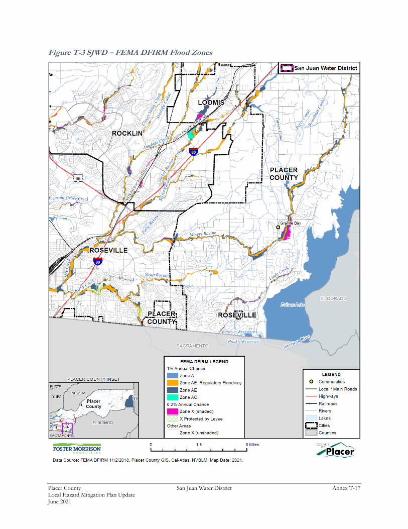
Placer County San Juan Water District Annex T-17 Local Hazard Mitigation Plan Update June 2021
Figure T-3 SJWD – FEMA DFIRM Flood Zones

Placer County San Juan Water District Annex T-18 Local Hazard Mitigation Plan Update June 2021
Table T-5 details the DFIRM mapped flood zones within the 1% annual chance flood zone as well as other
flood zones located within the District.
Table T-5 SJWD– DFIRM Flood Hazard Zones
Flood Zone Description Flood Zone Present in the District
A
Areas subject to inundation by the 1% annual-chance flood event generally determined using approximate methodologies. Because detailed hydraulic analyses have not been performed, no Base Flood Elevations (BFEs) or flood depths are shown. Mandatory flood insurance purchase requirements and floodplain management standards apply.
X
AE
Areas subject to inundation by the 1% annual-chance flood event determined by detailed methods. Base Flood Elevations (BFEs) are shown. Mandatory flood insurance purchase requirements and floodplain management standards apply.
X
AE – Regulatory Floodway
Areas subject to inundation by the 1% annual-chance flood event determined by detailed methods. Base Flood Elevations (BFEs) are shown. Mandatory flood insurance purchase requirements and floodplain management standards apply. Different from AE in that it adds the water course and adjacent lands that must be reserved in order to discharge the base flood without increasing the water surface elevation by more than one foot.
X
AH An area inundated by 1% annual chance flooding (usually an area of ponding), for which BFEs have been determined; flood depths range from 1 to 3 feet
AO Areas subject to inundation by 100-year shallow flooding (usually sheet flow on sloping terrain) where average depths are between one and three feet
Shaded X 500-year flood the areas between the limits of the 1% annual chance flood and the 0.2-percent-annual-chance (or 500-year) flood
X
X Protected by Levee
An area determined to be outside the 500‐year flood and protected by levee
from 100‐year flood
X Areas outside of known floodplains. X
Source: FEMA
Additionally, flood extents can generally be measured in volume, velocity, and depths of flooding.
Expected flood depths in the District vary, depending on the nature and extent of a flood event; specific
depths are unknown. Flood durations in the District tend to be short to medium term, or until either the
storm drainage system can catch up or flood waters move downstream. Flooding in the District tends to
have a shorter speed of onset, due to the amount of water that flows through the District.
Past Occurrences
A list of state and federal disaster declarations for Placer County from flooding is shown on Table T-6.
These events also likely affected the District to some degree.

Placer County San Juan Water District Annex T-19 Local Hazard Mitigation Plan Update June 2021
Table T-6 Placer County – State and Federal Disaster Declarations from Flood 1950-2020
Disaster Type Federal Declarations State Declarations
Count Years Count Years
Flood (including heavy rains and storms)
16 1950, 1955, 1958 (twice), 1962, 1963, 1969, 1973, 1980, 1983, 1986, 1995 (twice), 1997, 2008, 2017
13 1955, 1958, 1962, 1964, 1969, 1983, 1986, 1995 (twice), 1997, 2006 (twice), 2017
Source: Cal OES, FEMA
Vulnerability to and Impacts from Flood
Floods have been a part of the District’s historical past and will continue to be so in the future. During
winter months, long periods of precipitation and the timing of that precipitation are critical in determining
the threat of flood, and these characteristics further dictate the potential for widespread structural and
property damages. Predominantly, the effects of flooding are generally confined to areas near the
waterways of the County. As waterways grow in size from local drainages, so grows the threat of flood
and dimensions of the threat. This threatens structures in the floodplain. Structures can also be damaged
from trees falling as a result of water-saturated soils. Electrical power outages happen, and the interruption
of power causes major problems. Loss of power is usually a precursor to closure of governmental offices
and community businesses. Roads can be damaged and closed, causing safety and evacuation issues.
People may be swept away in floodwaters, causing injuries or deaths.
Floods are among the costliest natural disasters in terms of human hardship and economic loss nationwide.
Floods can cause substantial damage to structures, landscapes, and utilities as well as life safety issues.
Floods can be extremely dangerous, and even six inches of moving water can knock over a person given a
strong current. During a flood, people can also suffer heart attacks or electrocution due to electrical
equipment short outs. Floodwaters can transport large objects downstream which can damage or remove
stationary structures. Ground saturation can result in instability, collapse, or other damage. Objects can
also be buried or destroyed through sediment deposition. Floodwaters can also break utility lines and
interrupt services. Standing water can cause damage to crops, roads, foundations, and electrical circuits.
Direct impacts, such as drowning, can be limited with adequate warning and public education about what
to do during floods. Other problems connected with flooding and stormwater runoff include erosion,
sedimentation, degradation of water quality, loss of environmental resources, and economic impacts.
Assets at Risk
The District noted the following facilities at risk:
➢ Water pumping stations
➢ Water Distribution system

Placer County San Juan Water District Annex T-20 Local Hazard Mitigation Plan Update June 2021
Pandemic
Likelihood of Future Occurrence–Likely
Vulnerability–High
Hazard Profile and Problem Description
According to the World Health Organization (WHO), a disease epidemic occurs when there are more cases
of that disease than normal. A pandemic is a worldwide epidemic of a disease. A pandemic may occur
when a new virus appears against which the human population has no immunity.
A pandemic occurs when a new virus emerges for which people have little or no immunity, and for which
there is no vaccine. This disease spreads easily person-to-person, causes serious illness, and can sweep
across the country and around the world in a very short time. The U.S. Centers for Disease Control (CDC)
and Prevention has been working closely with other countries and the WHO to strengthen systems to detect
outbreaks of that might cause a pandemic and to assist with pandemic planning and preparation. An
especially severe pandemic could lead to high levels of illness, death, social disruption, and economic loss.
Location and Extent
During a pandemic, the whole of the District, County, and surrounding region is at risk, as pandemic is a
regional, national, and international event. The speed of onset of pandemic is usually short, while the
duration is variable, but can last for more than a year as shown in the 1918/1919 Spanish Flu. There is no
scientific scale to measure the magnitude of pandemic. Pandemics are usually measured in numbers affected
by the pandemic, and by number who die from complications from the pandemic.
Past Occurrences
There has been one state and federal disaster declaration due to pandemic, as shown in Table T-7.
Table T-7 Placer County – State and Federal Pandemic Disaster Declarations 1950-2020
Disaster Type Federal Declarations State Declarations
Count Years Count Years
Pandemic 1 2020 1 2020
Source: Cal OES, FEMA
The 20th century saw three outbreaks of pandemic.
➢ The 1918-1919 Influenza Pandemic (H1N1)
➢ The February 1957-1958 Influenza Pandemic (H2N2)
➢ The 1968 Influenza Pandemic (H3N2)
To date, the 21st century has seen two acknowledged pandemics.
➢ 2009 Swine Flu (H1N1)
➢ 2019/2020 COVID 19
Placer County San Juan Water District Annex T-21 Local Hazard Mitigation Plan Update June 2021
The San Juan Water District like other organizations was affected by the 2019/2020 Covid-19 pandemic in
many ways. District personnel had to modify operations to protect employees and customers from possible
exposure. These changes affected how maintenance and construction projects proceeded under the
Governor’s various executive orders.
Vulnerability to and Impacts from Pandemic
Pandemics have and will continue to have impacts on human health in the region. A pandemic occurs when
a new virus emerges for which there is little or no immunity in the human population; the virus causes
serious illness and spreads easily from person-to-person worldwide. There are several strategies that public
health officials can use to combat a pandemic. Constant surveillance regarding the current pandemic, use
of infection control techniques, and administration of vaccines once they become available. Citizens can
help prevent the spread of a pandemic by staying home, or “self-quarantining,” if they suspect they are
infected. Pandemic does not affect the buildings, critical facilities, and infrastructure in the District.
Pandemic can have varying levels of impact to the citizens of the District and greater County, depending
on the nature of the pandemic.
Impacts could range from school and business closings to the interruption of basic services such as public
transportation, health care, and the delivery of food and essential medicines. Hospitalizations and deaths
can occur, especially to the elderly or those with pre-existing underlying conditions. As seen with Covid-
19, multiple businesses were forced to close temporarily (some permanently), and unemployment rose
significantly. Supply chains for food and essentials can be interrupted.
Assets at Risk
Pandemics do not affect District facilities, but can affect District personnel who operate District facilities.
Future Development
Future development is not expected to be significantly impacted by this hazard, though population growth
in the District could increase exposure to pandemic, and increase the ability of each disease to be transmitted
among the population of the District.
Severe Weather: Extreme Heat
Likelihood of Future Occurrence–Likely
Vulnerability–Medium
Hazard Profile and Problem Description
According to FEMA, extreme heat is defined as temperatures that hover 10 degrees or more above the
average high temperature for the region and last for several weeks. Heat kills by taxing the human body
beyond its abilities. In extreme heat and high humidity, evaporation is slowed, and the body must work
extra hard to maintain a normal temperature.” Most heat disorders occur because the victim has been
overexposed to heat or has over-exercised for his or her age and physical condition. Older adults, young
children, and those who are sick or overweight are more likely to succumb to extreme heat.
Placer County San Juan Water District Annex T-22 Local Hazard Mitigation Plan Update June 2021
In addition to the risks faced by citizens of the District, there are risk to the built environment from extreme
heat. While extreme heat on its own does not usually affect structure, extreme heat during times of drought
can cause wildfire risk to heighten. Extreme heat and high winds can cause power outages and PSPS events,
causing issues to buildings in the District.
Extreme Heat and Power Shortage/Power Failure
The US power grid crisscrosses the country, bringing electricity to homes, offices, factories, warehouses,
farms, traffic lights and even campgrounds. According to statistics gathered by the Department of Energy,
major blackouts are on the upswing. Incredibly, over the past two decades, blackouts impacting at least
50,000 customers have increased 124 percent. The electric power industry does not have a universal
agreement for classifying disruptions. Nevertheless, it is important to recognize that different types of
outages are possible so that plans may be made to handle them effectively. In addition to blackouts,
brownouts can occur. A brownout is an intentional or unintentional drop in voltage in an electrical power
supply system. Intentional brownouts are used for load reduction in an emergency. Electric power
disruptions can be generally grouped into two categories: intentional and unintentional. More information
on types of power disruptions can be found in Section 4.3.2 of the Base Plan.
Public Safety Power Shutoff (PSPS)
A new intentional disruption type of power shortage/failure event has recently occurred in California. In
recent years, several wildfires have started as a result of downed power lines or electrical equipment. This
was the case for the Camp Fire in 2018. As a result, California’s three largest energy companies (including
PG&E), at the direction of the California Public Utilities Commission (CPUC), are coordinating to prepare
all Californians for the threat of wildfires and power outages during times of extreme weather. To help
protect customers and communities during extreme weather events, electric power may be shut off for
public safety in an effort to prevent a wildfire. This is called a PSPS. More information on PSPS criteria
can be found in Section 4.3.2 of the Base Plan.
Location and Extent
Heat is a regional phenomenon and affects the whole of the District. Heat emergencies are often slower to
develop, taking several days of continuous, oppressive heat before a significant or quantifiable impact is
seen. Heat waves do not strike victims immediately, but rather their cumulative effects slowly affect
vulnerable populations and communities. Heat waves do not generally cause damage or elicit the
immediate response of floods, fires, earthquakes, or other more “typical” disaster scenarios.
The NWS has in place a system to initiate alert procedures (advisories or warnings) when extreme heat is
expected to have a significant impact on public safety. The expected severity of the heat determines whether
advisories or warnings are issued. The NWS HeatRisk forecast provides a quick view of heat risk potential
over the upcoming seven days. The heat risk is portrayed in a numeric (0-4) and color
(green/yellow/orange/red/magenta) scale which is similar in approach to the Air Quality Index (AQI) or the
UV Index. This can be seen in Section 4.3.2 of the Base Plan.

Placer County San Juan Water District Annex T-23 Local Hazard Mitigation Plan Update June 2021
Past Occurrences
There has been no federal or state disaster declarations in the County for heat. The District Planning Team
noted that since extreme heat is a regional phenomenon, events that affected the County also affected the
District. Those past occurrences were shown in the Base Plan in Section 4.3.2.
The District has not been affected by the PG&E PSPS events. To date SMUD has not implemented any
PSPS events on their distribution system.
Vulnerability to and Impacts from Extreme Heat
The District experiences temperatures in excess of 100°F during the summer and fall months. The
temperature moves to 105-110°F in rather extreme situations. During these times, drought conditions may
worsen. Also, power outages and PSPS events may occur during these times as well. Health impacts,
including loss of life, are the primary concern with this hazard, though economic impacts are also an issue.
Days of extreme heat have been known to result in medical emergencies, and unpredictable human
behavior. Periods of extended heat and dryness (droughts) can have major economic, agricultural, and
water resources impacts. Extreme heat can also dry out vegetations, making it more vulnerable to wildfire
ignitions.
Assets at Risk
No District assets (from Table T-3) are at risk from this hazard. District personnel who work outdoors can
be affected.
Severe Weather: Freeze and Snow
Likelihood of Future Occurrence–Occasional
Vulnerability–Medium
Hazard Profile and Problem Description
According to the NWS and the WRCC, winter snowstorms can include heavy snow, ice, and blizzard
conditions. Heavy snow can immobilize a region, stranding commuters, stopping the flow of supplies, and
disrupting emergency and medical services. Accumulations of snow can collapse roofs and knock down
trees and power lines. In rural areas, homes and farms may be isolated for days, and unprotected livestock
may be lost. The cost of snow removal, damage repair, and business losses can have a tremendous impact
on cities and towns.
Heavy accumulations of ice can bring down trees, electrical wires, telephone poles and lines, and
communication towers. Communications and power can be disrupted for days until the damage can be
repaired. Power outages can have a significant impact on communities, especially critical facilities such as
public utilities. Even small accumulations of ice may cause extreme hazards to motorists and pedestrians.
Placer County San Juan Water District Annex T-24 Local Hazard Mitigation Plan Update June 2021
Some winter storms are accompanied by strong winds, creating blizzard conditions with blinding wind-
driven snow, severe drifting, and dangerous wind chills. Strong winds accompanying these intense storms
and cold fronts can knock down trees, utility poles, and power lines. Blowing snow can reduce visibility
to only a few feet in areas where there are no trees or buildings. Serious vehicle accidents with injuries and
deaths can result. Freezing temperatures can cause significant damage to the agricultural industry.
Location and Extent
Freeze and snow are regional issues, meaning the entire District is at risk to cold weather and freeze events.
While there is no scale (i.e. Richter, Enhanced Fujita) to measure the effects of freeze, the WRCC reports
that in a typical year, minimum temperatures fall below 32°F on 22.6 days with 0 days falling below 0°F
in western Placer County. Snowfall is measured in depths, and the WRCC reports that average snowfall
on the western side of the County is 1.4 inches. Freeze and snow has a slow onset and can generally be
predicted in advance for the County. Freeze events can last for hours (in a cold overnight), or for days to
weeks at a time. Snow event can last for hours or days, but is more unlikely in the western portion of the
County. When it does snow, the snow often melts relatively quickly.
Past Occurrences
There has been no federal and one state disaster declarations in the County for freeze and snow, as shown
on Table T-8.
Table T-8 Placer County – State and Federal Disaster Declarations from Freeze and Snow 1950-2020
Disaster Type State Declarations Federal Declarations
Count Years Count Years
Freeze 1 1972 0 –
Source: Cal OES, FEMA
The District noted that cold and freeze is a regional phenomenon; events that affected the County also
affected the District. Those past occurrences were shown in the Base Plan in Section 4.3.3.
Vulnerability to and Impacts from Severe Weather: Freeze and Snow
The District experiences temperatures below 32 degrees during the winter months. Freeze can cause injury
or loss of life to residents of the District. While it is rare for buildings to be affected directly by freeze,
damages to pipes that feed building can be damaged during periods of extreme cold. Freeze and snow can
occasionally be accompanied by high winds, which can cause downed trees and power lines, power outages,
accidents, and road closures. Transportation networks, communications, and utilities infrastructure are the
most vulnerable physical assets to impacts of severe winter weather in the County.
Assets at Risk
The District noted the following facilities at risk:
➢ Water Treatment Plant

Placer County San Juan Water District Annex T-25 Local Hazard Mitigation Plan Update June 2021
Severe Weather: Heavy Rains and Storms (Hail, Lightning)
Likelihood of Future Occurrence–Highly Likely
Vulnerability–Medium
Hazard Profile and Problem Description
Storms in the District occur annually and are generally characterized by heavy rain often accompanied by
strong winds and sometimes lightning and hail. Approximately 10 percent of the thunderstorms that occur
each year in the United States are classified as severe. A thunderstorm is classified as severe when it
contains one or more of the following phenomena: hail that is three-quarters of an inch or greater, winds in
excess of 50 knots (57.5 mph), or a tornado. Heavy precipitation in the District falls mainly in the fall,
winter, and spring months in the western side of the County and primarily in the fall and spring in the
eastern side of the County.
Location and Extent
Heavy rain events occur on a regional basis. Rains and storms can occur in any location of the District.
All portions of the District are at risk to heavy rains. Most of the severe rains occur during the fall, winter,
and spring months. There is no scale by which heavy rains and severe storms are measured. Magnitude of
storms is measured often in rainfall and damages. The speed of onset of heavy rains can be short, but
accurate weather prediction mechanisms often let the public know of upcoming events. Duration of severe
storms in California, Placer County, and the District can range from minutes to hours to days. Information
on precipitation extremes can be found in Section 4.3.4 of the Base Plan.
Past Occurrences
There have been past disaster declarations from heavy rains and storms, which were discussed in Past
Occurrences of the flood section above. According to historical hazard data, severe weather, including
heavy rains and storms, is an annual occurrence in the District. This is the cause of many of the federal
disaster declarations related to flooding.
The District noted an event that occurred on May 14, 2015. The District’s water treatment plant at 9935
Auburn-Folsom Road was hit by lightning. Damages to various electrical systems for the pumps and other
electric motors the District uses were reported. Fortunately, only minor impacts occurred, mostly due to
available redundant systems the District maintains. $4,700 in damages were reported.
Vulnerability to and Impacts from Heavy Rain and Storms
Heavy rain and severe storms are the most frequent type of severe weather occurrences in the District.
These events can cause localized flooding. Elongated events, or events that occur during times where the
ground is already saturated can cause 1% and 0.2% annual chance flooding. Wind often accompanies these
storms and has caused damage in the past. Hail and lightning are rare in the District.
Actual damage associated with the effects of severe weather include impacts to property, critical facilities
(such as utilities), and life safety. Heavy rains and storms often result in localized flooding creating

Placer County San Juan Water District Annex T-26 Local Hazard Mitigation Plan Update June 2021
significant issues. Roads can become impassable and ground saturation can result in instability, collapse,
or other damage to trees, structures, roadways and other critical infrastructure. Floodwaters and downed
trees can break utilities and interrupt services.
During periods of heavy rains and storms, power outages can occur. These power outages can affect
pumping stations and lift stations that help alleviate flooding. More information on power shortage and
failure can be found in the Severe Weather: Extreme Heat Section above, as well as in Section 4.3.2 of the
Base Plan.
Assets at Risk
The District noted the following facilities at risk:
➢ Water Treatment Plant
➢ Pumping stations
➢ Water Distribution system
➢ Water Storage facilities
Severe Weather: High Winds and Tornadoes
Likelihood of Future Occurrence–Occasional
Vulnerability–Medium
Hazard Profile and Problem Description
High winds, as defined by the NWS glossary, are sustained wind speeds of 40 mph or greater lasting for 1
hour or longer, or winds of 58 mph or greater for any duration. High winds can cause significant property
and crop damage, threaten public safety, and have adverse economic impacts from business closures and
power loss. High winds can also cause PSPS events.
Tornadoes are rotating columns of air marked by a funnel-shaped downward extension of a cumulonimbus
cloud whirling at destructive speeds of up to 300 mph, usually accompanying a thunderstorm. Tornadoes
form when cool, dry air sits on top of warm, moist air. Tornadoes are the most powerful storms that exist.
Tornadoes, though rare, are another severe weather hazard that can affect areas of the Placer County
Planning Area, primarily during the rainy season in the late fall, winter, and early spring, primarily in the
western part of the County.
Location and Extent
The entire District is subject to significant, non-tornadic (straight-line), winds. Each area of the County is
at risk to high winds. Magnitude of winds is measured often in speed and damages. These events are often
part of a heavy rain and storm event, but can occur outside of storms. The speed of onset of winds can be
short, but accurate weather prediction mechanisms often let the public know of upcoming events. Duration
of winds in California is often short, ranging from minutes to hours. The Beaufort scale is an empirical 12
category scale that relates wind speed to observed conditions at sea or on land. Its full name is the Beaufort
Wind Force Scale. The Beaufort Scale was shown in Section 4.3.5 of the Base Plan.

Placer County San Juan Water District Annex T-27 Local Hazard Mitigation Plan Update June 2021
Portions of the County are also located in a special wind hazard region, which is a result of foehn winds.
A foehn wind is a type of dry down-slope wind that occurs in the lee (downwind side) of a mountain range.
Winds of this type are called "snow-eaters" for their ability to make snow melt or sublimate rapidly. This
snow-removing ability is caused not only by warmer temperatures, but also the low relative humidity of the
air mass coming over the mountain(s). They are also associated with the rapid spread of wildfires, making
some regions which experience these winds particularly fire prone.
Tornadoes, while rare, can occur at any location in the County and District, but would more likely occur in
Western Placer. Prior to February 1, 2007, tornado intensity was measured by the Fujita (F) scale. This
scale was revised and is now the Enhanced Fujita scale. Both scales are sets of wind estimates (not
measurements) based on damage. The new scale (EF) provides more damage indicators (28) and associated
degrees of damage, allowing for more detailed analysis and better correlation between damage and wind
speed. It is also more precise because it considers the materials affected and the construction of structures
damaged by a tornado. The F Scale and EF Scale are shown in Section 4.3.5 of the Base Plan.
Past Occurrences
There has been no federal or state disaster declarations in the County for winds and tornadoes. The District
noted that since high winds is a regional phenomenon, events that affected the lower elevations of the
County also affected the District. Those past occurrences were shown in the Base Plan in Section 4.3.5.
Vulnerability to and Impacts from Severe Weather: Wind and Tornado
High winds are common occurrences in the District throughout the entire year. Straight line winds are
primarily a public safety and economic concern. Windstorm can cause damage to structures and power
lines which in turn can create hazardous conditions for people. Debris flying from high wind events can
shatter windows in structures and vehicles and can harm people that are not adequately sheltered. High
winds can impact critical facilities and infrastructure and can lead to power outages. Wind can also drive
wildfire flames, spreading wildfires quickly During periods of high winds and dry vegetation, wildfire risk
increases. High winds that occur during periods of extreme heat can cause PSPS events to be declared in
the County. More information on power shortage and failure can be found in the Severe Weather: Extreme
Heat Section above, as well as in Section 4.3.2 of the Base Plan.
Impacts from high winds in the District will vary. Future losses from straight line winds include:
➢ Downed trees
➢ Power line impacts and economic losses from power outages
➢ Increased PSPS events
➢ Occasional building damage, primarily to roofs
Assets at Risk
The District noted the following facilities at risk:
➢ Water Treatment Plant
➢ Pumping stations

Placer County San Juan Water District Annex T-28 Local Hazard Mitigation Plan Update June 2021
Wildfire
Likelihood of Future Occurrence–Occasional
Vulnerability–Medium
Hazard Profile and Problem Description
Wildland fire and the risk of a conflagration is an ongoing concern for the SJWD. Throughout California,
communities are increasingly concerned about wildfire safety as increased development in the foothills and
mountain areas and subsequent fire control practices have affected the natural cycle of the ecosystem.
Wildland fires affect grass, forest, and brushlands, as well as any structures located within them. Where
there is human access to wildland areas the risk of fire increases due to a greater chance for human
carelessness and historical fire management practices. Historically, the fire season extends from early
spring through late fall of each year during the hotter, dryer months; however, in recent years, the risk of
wildfire has become a year around concern. Fire conditions arise from a combination of high temperatures,
low moisture content in the air and fuel, accumulation of vegetation, and high winds. While wildfire risk
has predominantly been associated with more remote forested areas and wildland urban interface (WUI)
areas, significant wildfires can also occur in more populated, urban areas.
Location and Extent
Wildfire can affect all areas of the District. CAL FIRE has estimated that the risk varies across the District
and has created maps showing risk variance. Following the methodology described in Section 4.3.19 of
the Base Plan, wildfire maps for the SJWD were created. Figure T-4 shows the CAL FIRE FHSZ in the
District. As shown on the maps, FHSZs within the District range from Urban Unzoned to Moderate.

Placer County San Juan Water District Annex T-29 Local Hazard Mitigation Plan Update June 2021
Figure T-4 SJWD – Fire Hazard Severity Zones

Placer County San Juan Water District Annex T-30 Local Hazard Mitigation Plan Update June 2021
Wildfires tend to be measured in structure damages, injuries, and loss of life as well as on acres burned.
Fires can have a quick speed of onset, especially during periods of drought or during hot dry summer
months. Fires can burn for a short period of time, or may have durations lasting for a week or more.
Past Occurrences
There has been five state and six federal disaster declarations for Placer County from fire. These can be
seen in Table T-9.
Table T-9 Placer County – State and Federal Disaster Declarations Summary 1950-2020
Disaster Type State Declarations Federal Declarations
Count Years Count Years
Fire 5 1961, 1965, 1973, 1987, 2010 6 2002, 2004, 2008, 2009, 2014 (twice)
Source: Cal OES, FEMA
Vulnerability to and Impacts from Wildfire
Risk and vulnerability to the Placer County Planning Area and the District from wildfire is of significant
concern, with some areas of the Planning Area being at greater risk than others as described further in this
section. High fuel loads in the Planning Area, combined with a large built environment and population,
create the potential for both natural and human-caused fires that can result in loss of life and property.
These factors, combined with natural weather conditions common to the area, including periods of drought,
high temperatures, low relative humidity, and periodic winds, can result in frequent and potentially
catastrophic fires. During the nearly year around fire season, the dry vegetation and hot and sometimes
windy weather results in an increase in the number of ignitions. Any fire, once ignited, has the potential to
quickly become a large, out-of-control fire. As development continues throughout the County and the
District, especially in these interface areas, the risk and vulnerability to wildfires will likely increase.
Potential impacts from wildfire include loss of life and injuries; damage to structures and other
improvements, natural and cultural resources, croplands, and loss of recreational opportunities. Wildfires
can cause short-term and long-term disruption to the District. Fires can have devastating effects on
watersheds through loss of vegetation and soil erosion, which may impact the District by changing runoff
patterns, increasing sedimentation, reducing natural and reservoir water storage capacity, and degrading
water quality. Fires can also affect air quality in the District; smoke and air pollution from wildfires can be
a severe health hazard.
Although the physical damages and casualties arising from large fires may be severe, it is important to
recognize that they also cause significant economic impacts by resulting in a loss of function of buildings
and infrastructure. Economic impacts of loss of transportation and utility services may include traffic
delays/detours from road and bridge closures and loss of electric power, potable water, and wastewater
services. Schools and businesses can be forced to close for extended periods of time. Recently, the threat
of wildfire, combined with the potential for high winds, heat, and low humidity, has caused PG&E to initiate
PSPSs which can also significantly impact a community through loss of services, business closures, and
other impacts associated with loss of power for an extended period. More information on power shortage
Placer County San Juan Water District Annex T-31 Local Hazard Mitigation Plan Update June 2021
and failure can be found in the Severe Weather: Extreme Heat Section above, as well as in Section 4.3.2
of the Base Plan. In addition, catastrophic wildfire can create favorable conditions for other hazards such
as flooding, landslides, and erosion during the rainy season.
Assets at Risk
The District noted the following facilities at risk:
➢ Main Campus/Yard
T.6 Capability Assessment
Capabilities are the programs and policies currently in use to reduce hazard impacts or that could be used
to implement hazard mitigation activities. This capabilities assessment is divided into five sections:
regulatory mitigation capabilities, administrative and technical mitigation capabilities, fiscal mitigation
capabilities, mitigation education, outreach, and partnerships, and other mitigation efforts.
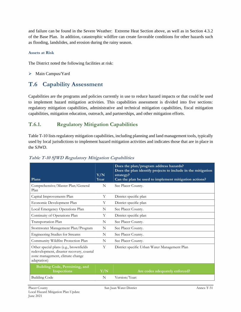
T.6.1. Regulatory Mitigation Capabilities
Table T-10 lists regulatory mitigation capabilities, including planning and land management tools, typically
used by local jurisdictions to implement hazard mitigation activities and indicates those that are in place in
the SJWD.
Table T-10 SJWD Regulatory Mitigation Capabilities
Plans Y/N Year
Does the plan/program address hazards? Does the plan identify projects to include in the mitigation strategy? Can the plan be used to implement mitigation actions?
Comprehensive/Master Plan/General Plan
N See Placer County.
Capital Improvements Plan Y District specific plan
Economic Development Plan Y District specific plan
Local Emergency Operations Plan N See Placer County.
Continuity of Operations Plan Y District specific plan
Transportation Plan N See Placer County.
Stormwater Management Plan/Program N See Placer County.
Engineering Studies for Streams N See Placer County.
Community Wildfire Protection Plan N See Placer County.
Other special plans (e.g., brownfields redevelopment, disaster recovery, coastal zone management, climate change adaptation)
Y District specific Urban Water Management Plan
Building Code, Permitting, and Inspections Y/N Are codes adequately enforced?
Building Code N Version/Year:

Placer County San Juan Water District Annex T-32 Local Hazard Mitigation Plan Update June 2021
Building Code Effectiveness Grading Schedule (BCEGS) Score
N Score:
Fire department ISO rating: N Rating:
Site plan review requirements N
Land Use Planning and Ordinances Y/N
Is the ordinance an effective measure for reducing hazard impacts?
Is the ordinance adequately administered and enforced?
Zoning ordinance N See Placer County
Subdivision ordinance N See Placer County
Floodplain ordinance N See Placer County
Natural hazard specific ordinance (stormwater, steep slope, wildfire)
N See Placer County
Flood insurance rate maps N See Placer County
Elevation Certificates N See Placer County
Acquisition of land for open space and public recreation uses
N See Placer County
Erosion or sediment control program N See Placer County
Other N See Placer County
How can these capabilities be expanded and improved to reduce risk?
Regular planning and implementation of risk reduction measures are included into most if not all operations. The Agency has multiple cooperative partnerships that help enhance these capabilities. Additional grant funding could increase risk reduction, but limited staff hinders the Districts grant writing capabilities.
Source: SJWD
T.6.2. Administrative/Technical Mitigation Capabilities
Table T-11 identifies the District department(s) responsible for activities related to mitigation and loss
prevention in SJWD.
Table T-11 SJWD’s Administrative and Technical Mitigation Capabilities
Administration Y/N Describe capability Is coordination effective?
Planning Commission N See Placer County
Mitigation Planning Committee N See Placer County
Maintenance programs to reduce risk (e.g., tree trimming, clearing drainage systems)
Y See Placer County
Mutual aid agreements Y SJWD has mutual aid agreements with other agencies
Other
Staff Y/N
FT/PT
Is staffing adequate to enforce regulations? Is staff trained on hazards and mitigation?
Is coordination between agencies and staff effective?
Chief Building Official N See Placer County
Floodplain Administrator N See Placer County
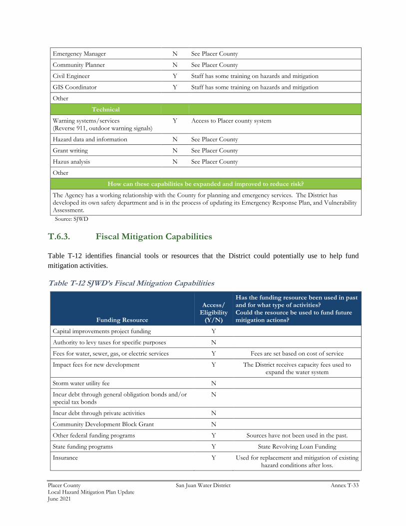
Placer County San Juan Water District Annex T-33 Local Hazard Mitigation Plan Update June 2021
Emergency Manager N See Placer County
Community Planner N See Placer County
Civil Engineer Y Staff has some training on hazards and mitigation
GIS Coordinator Y Staff has some training on hazards and mitigation
Other
Technical
Warning systems/services (Reverse 911, outdoor warning signals)
Y Access to Placer county system
Hazard data and information N See Placer County
Grant writing N See Placer County
Hazus analysis N See Placer County
Other
How can these capabilities be expanded and improved to reduce risk?
The Agency has a working relationship with the County for planning and emergency services. The District has developed its own safety department and is in the process of updating its Emergency Response Plan, and Vulnerability Assessment.
Source: SJWD
T.6.3. Fiscal Mitigation Capabilities
Table T-12 identifies financial tools or resources that the District could potentially use to help fund
mitigation activities.
Table T-12 SJWD’s Fiscal Mitigation Capabilities
Funding Resource
Access/ Eligibility
(Y/N)
Has the funding resource been used in past and for what type of activities? Could the resource be used to fund future mitigation actions?
Capital improvements project funding Y
Authority to levy taxes for specific purposes N
Fees for water, sewer, gas, or electric services Y Fees are set based on cost of service
Impact fees for new development Y The District receives capacity fees used to expand the water system
Storm water utility fee N
Incur debt through general obligation bonds and/or special tax bonds
N
Incur debt through private activities N
Community Development Block Grant N
Other federal funding programs Y Sources have not been used in the past.
State funding programs Y State Revolving Loan Funding
Insurance Y Used for replacement and mitigation of existing hazard conditions after loss.

Placer County San Juan Water District Annex T-34 Local Hazard Mitigation Plan Update June 2021
Funding Resource
Access/ Eligibility
(Y/N)
Has the funding resource been used in past and for what type of activities? Could the resource be used to fund future mitigation actions?
How can these capabilities be expanded and improved to reduce risk?
If funding were available, additional planning division staffing would greatly improve SJWD’s ability to increase vulnerability awareness and help plan for future mitigation programs. The District will seek FEMA, DWR, Cal OES, and other funding sources to increase mitigation capabilities.
Source: SJWD
T.6.4. Mitigation Education, Outreach, and Partnerships
Table T-13 identifies education and outreach programs and methods already in place that could be/or are
used to implement mitigation activities and communicate hazard-related information.
Table T-13 SJWD’s Mitigation Education, Outreach, and Partnerships
Program/Organization Yes/No
Describe program/organization and how relates to disaster resilience and mitigation.
Could the program/organization help implement future mitigation activities?
Local citizen groups or non-profit organizations focused on environmental protection, emergency preparedness, access and functional needs populations, etc.
Y
Ongoing public education or information program (e.g., responsible water use, fire safety, household preparedness, environmental education)
Y SJWD water conservation programs.
Natural disaster or safety related school programs N
StormReady certification N
Firewise Communities certification N
Public-private partnership initiatives addressing disaster-related issues
N
Other
How can these capabilities be expanded and improved to reduce risk?
Ongoing communication and coordination throughout traditional and social media platforms. THE SJWD conservation program will be expanded if additional revenue becomes available.
Source: SJWD
T.6.5. Other Mitigation Efforts
The District is involved in a variety of mitigation activities including public outreach and project activities.
These mitigation activities include:
➢ Public Service Advertisements
➢ Water Conservation (public outreach) program
➢ Website Newsletters to the general public

Placer County San Juan Water District Annex T-35 Local Hazard Mitigation Plan Update June 2021
➢ The District’s Water Conservation program includes residential programs and rebates for: high
efficiency clothes washing machines, point of use hot water heater, weather based irrigation controllers,
free mulch distribution, and water wise house calls.
T.7 Mitigation Strategy
T.7.1. Mitigation Goals and Objectives
The SJWD adopts the hazard mitigation goals and objectives developed by the HMPC and described in
Chapter 5 Mitigation Strategy.
T.7.2. Mitigation Actions
The planning team for the SJWD identified and prioritized the following mitigation actions based on the
risk assessment. Background information and information on how each action will be implemented and
administered, such as ideas for implementation, responsible office, potential funding, estimated cost, and
timeline are also included. The following hazards were considered a priority for purposes of mitigation
action planning:
➢ Climate Change
➢ Dam Failure
➢ Drought & Water Shortage
➢ Earthquake
➢ Floods: 1%/0.2% annual chance
➢ Pandemic
➢ Severe Weather: Extreme Heat
➢ Severe Weather: Freeze and Snow
➢ Severe Weather: Heavy Rains and Storms
➢ Severe Weather: High Winds and Tornadoes
➢ Wildfire
It should be noted that many of the projects submitted by each jurisdiction in Table 5-4 in the Base Plan
benefit all jurisdictions whether or not they are the lead agency. Further, many of these mitigation efforts
are collaborative efforts among multiple local, state, and federal agencies. In addition, the countywide
public outreach action, as well as many of the emergency services actions, apply to all hazards regardless
of hazard priority. Collectively, this multi-jurisdictional mitigation strategy includes only those actions and
projects which reflect the actual priorities and capacity of each jurisdiction to implement over the next 5-
years covered by this plan. It should further be noted, that although a jurisdiction may not have specific
projects identified for each priority hazard for the five year coverage of this planning process, each
jurisdiction has focused on identifying those projects which are realistic and reasonable for them to
implement and would like to preserve their hazard priorities should future projects be identified where the
implementing jurisdiction has the future capacity to implement.

Placer County San Juan Water District Annex T-36 Local Hazard Mitigation Plan Update June 2021
Multi-Hazard Actions
Action 1. Updating the 2015 Urban Water Management Plan
Hazards Addressed: Climate Change, Drought and Water Storage Hazards, Wildfire
Goals Addressed: 1, 2, 3, 4, 5, 6, 7
Issue/Background: Urban water suppliers having more than 3,000 service connections or supplying more
than 3,000 acre-feet per year (AFY) for retail or wholesale uses are required to submit an UWMP every
five years to the California Department of Water Resources (DWR). The Urban Water Management
Planning Act (Act) requires urban water suppliers to describe and evaluate sources of water supply, efficient
uses of water, demand management measures (DMMs), implementation strategy and schedule, and other
relevant information and programs. An UWMP is required in order for a water supplier to be eligible for
DWR administered state grants and loans and for drought assistance.
Project Description: The Act requires reporting agencies to describe its water supply reliability under
single dry-year, multiple dry-year, and average year conditions, with projected information in five-year
increments for a minimum of 20 years. One of the purposes of this UWMP is to ensure the efficient use of
available water supplies, as required by the Act. The Act states that urban water suppliers should make
every effort to assure the appropriate level of reliability in its water service sufficient to meet the needs of
its various categories of customers during normal, dry, and multiple dry years. The UWMP describes the
availability of water and discusses water use, reclamation, and water conservation activities. This UWMP
concludes that the water supplies available to the District’s retail and wholesale customer agencies are
adequate over the next 25- year planning period
Other Alternatives:
Existing Planning Mechanism(s) through which Action Will Be Implemented: Complete update of
Urban Water Master Plan
Responsible Agency/ Department/Partners: SJWD
Cost Estimate: Various
Benefits (Losses Avoided): Reduced risk to drought and water shortage due to climate change.
Potential Funding: SJWD – DWR Grants
Timeline: Within 2021
Project Priority (H, M, L): Medium
Action 2. Dam Failure Mitigation
Hazards Addressed: Dam Failure – Hinkle Reservoir, Flood, Heavy Rains and Storms

Placer County San Juan Water District Annex T-37 Local Hazard Mitigation Plan Update June 2021
Goals Addressed: 1, 2, 3, 4, 5, 6, 7
Issue/Background: A dam failure can range from a small uncontrolled release to a catastrophic failure,
caused by prolonged failure of the containment levee. The primary danger associated with dam failure is
the flooding of those properties located within the inundation zone of the dam. Dam failure flooding varies
by area depending on which dam fails and the nature and extent of the dam failure and associated flooding.
The dam was built in 1980 and is the rock fill-earth core dam with 1300 ft. crest length.
Project Description: Replacement of reservoir hypalon liner and inspection and modifications to outlet
structures
Other Alternatives: No action
Existing Planning Mechanisms through which Action will be Implemented: Dam Failure EAP
Responsible Office: San Juan Water District and California Department of Water Resources Division of
Safety of Dams
Priority (H, M, L): M
Cost Estimate: 18,425,000
Potential Funding: Various sources
Benefits (avoided Losses): Reduces risk of facility failure
Schedule: Complete by 2022
Action 3. Earthquake Mitigation
Hazards Addressed: Earthquake
Goals Addressed: 1, 2, 3, 4, 5, 6, 7
Project Description: Earthquake damage to water treatment plant, distribution pump station both above
and below ground water distribution mains.
Issue/Background: Various facilities have the potential to be damaged in an earthquake
Other Alternatives: No action
Existing Planning Mechanisms through which Action will be Implemented: Strengthening of facilities
when replacing or upgrading facilities when upgrades to existing facilities occurs.
Responsible Office: SJWD
Priority (H, M, L): L

Placer County San Juan Water District Annex T-38 Local Hazard Mitigation Plan Update June 2021
Cost Estimate: Project dependent
Potential Funding: Capitol project funding and grants if available
Benefits (avoided Losses): More resilient facilities
Schedule: On-going
Action 4. Redundant/Backup Power System
Hazards Addressed: Climate Change, Extreme heat, freeze and winds
Goals Addressed: 1, 2, 3, 4, 5, 6, 7
Issue/Background: The San Juan Water District administration building currently has no back up power
source.
This recently became an issue due to the initiation of the Public Safety Power Shutoff (PSPS) events that
have affected our area. Since the PSPS event can last a number of days they can disrupt the administration
of our district. The increased likelihood of power outages caused by more frequent severe weather is also a
factor that the District needs to consider
Project Description: This project would be to install a backup power source for the District’s
administration building. Two options would be explored, the first would be a solar array with battery storage
or a diesel/natural gas emergency generator.
Other Alternatives: None
Existing Planning Mechanism(s) through which Action Will Be Implemented: San Juan Water District
Engineering Department
Responsible Agency/ Department/Partners: San Juan Water District, Operation Department
Cost Estimate: $750,000
Benefits (Losses Avoided): Increase administrative capabilities during PSPS events or other serve weather
caused power outages
Potential Funding: FEMA grant Funding
Timeline: 24 months
Project Priority (H, M, L): High
Action 5. Water Main Bridge Crossing Replacement/Strengthening
Hazards Addressed: Wildfire, Climate Change
Placer County San Juan Water District Annex T-39 Local Hazard Mitigation Plan Update June 2021
Goals Addressed: 1, 2, 3, 4, 5, 6, 7
Issue/Background: The San Juan Water District has a number of water distribution mains that are attached
to over crossings and bridges in our service area. Many of these mains are decades old and are undersized
for the growth that has taken place since they were originally installed.
Project Description: This project would be to either strengthen the existing water main crossing or when
possible, replace the existing main with a larger capacity line to increase water availability for increase fire
hydrant flows and increase capacity for existing interties with other agencies.
Other Alternatives: None
Existing Planning Mechanism(s) through which Action Will Be Implemented: San Juan Water District
Engineering Department
Responsible Agency/ Department/Partners: San Juan Water District, Water Distribution Department
Cost Estimate: $500,000
Benefits (Losses Avoided): Increased water capacities and more resilient system
Potential Funding: FEMA grant Funding
Timeline: 48 months
Project Priority (H, M, L): High