Angel Island State Park - HostCentricangelisland.hostcentric.com/FINAL - AISP IMP 10.1.12.pdf ·...
191
INTERPRETATION MASTER PLAN Angel Island State Park September 2012
Transcript of Angel Island State Park - HostCentricangelisland.hostcentric.com/FINAL - AISP IMP 10.1.12.pdf ·...

INTERPRETATION MASTER PLAN
Angel Island State Park
September 2012

ii
Cover illustration by Timothy Wells.

iii
Angel Island State Park
INTERPRETATION MASTER PLAN
California State Parks
Katie Metraux
Leslie Hartzell
Amy Brees
Casey Dexter-Lee
Ben Fenkell
The Sibbett Group
Brianna Cutts
Donald Sibbett
Angel Island Conservancy
Gail Dolton
Linda Moore
September 2012
Approved By:
Danita Rodriguez, Marin District Superintendent
Amy Brees, Angel Island Sector Superintendent
Gail Dolton,Board President, Angel Island Conservancy
Donna PozziChief, Interpretation & Education Division
Kathy Amann, Assistant Deputy Director, Acquisition & Development

iv
v
EXECUTIVE SUMMARY
AgencyState of California, Department of Parks and Recreation, Marin District, Angel Island Sector, Angel Island State Park
Project TitleAngel Island State Park Interpretation Master Plan
Project DescriptionThe Interpretation Master Plan makes prioritized recommendations for interpretive services over the next 20 years. The plan builds on guidelines from the General Plan (1979) and provides a uniform interpretive vision for the park. It sets the direction for improving the visitor experience through development of interpretive facilities, exhibits, educational and multimedia programs, interpretive signage, and enhanced recreational opportunities. The Recommendations and Interpretation Action Plan (IAP) sections should be reviewed and updated every five years.
Planning ProcessDuring the two-year planning process, which began in July 2010, the team analyzed current visitor use, identified gaps in interpretive services, and surveyed visitor needs and expectations. Analysis of these data formed the basis of the Recommendations and the IAP sections.
Project FindingsThe Recommendations section presents the park’s interpretive goals and objectives, along with the strategies and project tasks to meet these goals. Interpretive planners, park administrators, and partners should use this as a tool when developing project priorities, especially for the park’s Annual Interpretation Implementation Plan.
The interpretive planning team identified four broad goals:
Goal 1: Orient - Interpretation will orient visitors to and encourage exploration of Angel Island State Park
Goal 2: Connect - Interpretation will inspire visitors to make connections to Angel Island State Park
Goal 3: Diversify - Interpretation will be accessible to a diversity of visitors
Goal 4: Promote - Interpretation will promote and increase interest in Angel Island State Park
Orientation to the park and its interpretive services was the most essential visitor need, and included strengthening partnerships and improving public outreach. As most visitors come to AISP to recreate, another priority was to connect the island’s stories to visitors through recreation. Outdated infrastructure and the poor condition of many historic buildings limit their safe use for interpretation and by visitors. A number of the projects identify historic areas that require additional work to improve site conditions before the park can implement interpretive projects and programs.
The IAP groups tasks into ten proposals. Each proposal is a stand-alone project, which can be funded in its entirety or in phases, depending on available staff and funding. Half of the proposals fall into the first priority. These can be accomplished within the next decade and relate to visitor orientation, increasing visitor outreach, and marketing interpretive services. Proposals in the second priority will be accomplished within 5-10 years. These proposals enhance learning through recreation and strengthening community partnerships through interpretive services. Third priority proposals include multidisciplinary teams and conducting advance research before interpretive facilities can be improved. These will be accomplished in 10-20 years.

vi
vii
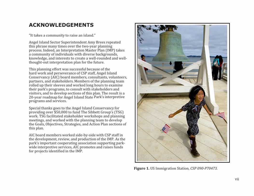
ACKNOWLEDGEMENTS
“It takes a community to raise an island.”
Angel Island Sector Superintendent Amy Brees repeated this phrase many times over the two-year planning process. Indeed, an Interpretation Master Plan (IMP) takes a community of individuals with diverse backgrounds, knowledge, and interests to create a well-rounded and well-thought-out interpretation plan for the future.
This planning effort was successful because of the hard work and perseverance of CSP staff, Angel Island Conservancy (AIC) board members, consultants, volunteers, partners, and stakeholders. Members of the planning team rolled up their sleeves and worked long hours to examine their park’s programs, to consult with stakeholders and visitors, and to develop sections of this plan. The result is a 20-year roadmap for Angel Island State Park’s interpretive programs and services.
Special thanks goes to the Angel Island Conservancy for providing over $50,000 to fund The Sibbett Group’s (TSG) work. TSG facilitated stakeholder workshops and planning meetings, and worked with the planning team to develop the Goals, Objectives, Strategies, and Action Plan sections of this plan.
AIC board members worked side-by-side with CSP staff in the development, review, and production of the IMP. As the park’s important cooperating association supporting park-wide interpretive services, AIC promotes and raises funds for projects identified in the IMP.
Figure 1. US Immigration Station, CSP 090-P70473.

viii

ix
CONTENTS
EXECUTIVE SUMMARY v
ACKNOWLEDGEMENTS vii
CONTENTS ix
FIGURES xiii
TABLES xvi
INTRODUCTION 1
Park Overview 1
Plan Purpose 1
Planning Process 1
Planning Team 2
Planning Documents 3
PARK RESOURCES 5
Natural Resources 5
Geology 5
Climate 6
Hydrology 6
Biology 6
Cultural Resources 8
Coast Miwok 8
Spanish and Mexican 9
US Military (Pre-WWI) 9
Endicott Batteries 9
Quarantine Station 10
US Immigration Station 10
US Military (WWI-WWII) 11
Cold War 12
Angel Island State Park 13
Recreational Resources 15
Educational Services 17
Interpretive Readiness 18
Museum Collections 18
Research Resources 19
VISITATION AND VISITOR USE 21
Regional Visitation Data 21
Visitor Profile 21
Visitor Survey 21
Access, Orientation, and Circulation 22
Getting to the Park 22
Park Entrance 23
Transportation within the Park 23
Circulation Routes 23
Key Destinations 26

x
Ayala Cove 26
West Garrison 28
The Batteries 30
Nike Missile Site 30
East Garrison 32
US Immigration Station 34
Backcountry 36
EXISTING INTERPRETIVE SERVICES 37
Park-wide Interpretation 37
Key Destinations 38
Ayala Cove 38
West Garrison 38
The Batteries 39
Nike Missile Site 39
East Garrison 39
US Immigration Station 40
Backcountry 41
PARTNERSHIPS AND SUPPORT 43
Cooperating Associations 43
Other Partners 45
INTERPRETATION FRAMEWORK 47
CSP Interpretive Framework 47
Statewide Programs and Campaigns 50
AISP Interpretive Framework 51
Interpretive Significance 52
Interpretive Periods 52
Interpretive Topics and Themes 53
Park-wide Themes 54
Key Destination Themes 55
Ayala Cove 55
West Garrison 56
The Batteries 57
Nike Missile Site 58
East Garrison 58
US Immigration Station 59
Backcountry 60
Curriculum Standards 61
ANALYSIS 63
Park-wide Interpretation 63
Interpretive Considerations 67
Key Destination Interpretation 68
Ayala Cove 68
West Garrison 69

xi
The Batteries 70
Nike Missile Site 70
East Garrison 71
US Immigration Station 72
Backcountry 72
Park Operations and Infrastructure 73
RECOMMENDATIONS 77
Goal 1: ORIENT 78
Goal 2: CONNECT 81
Goal 3: DIVERSIFY 88
Goal 4: PROMOTE 90
INTERPRETATION ACTION PLAN 93
Introduction 93
Proposal Overview 95
Proposal 1: WHAT’S THE SCOOP? 96
Proposal 2: NOW WHAT? 98
Proposal 3: WALK WHICH WAY? 100
Proposal 4: PEOPLE, PLACES, & PROPOSALS 102
Proposal 5: STORIES, SIGHTS, AND SCENES 106
Proposal 6: BEASTS, BEACHES, & BACKCOUNTRY 110
Proposal 7: PADDLE, PEDAL, AND PLAY! 113
Proposal 8: COME ONE, COME ALL 115
Proposal 9: IT TAKES A COMMUNITY TO RAISE
AN ISLAND 117
Proposal 10: AN ISLAND ADVENTURE AWAITS 120
REFERENCES 123
GLOSSARY 125
APPENDICES 135
Appendix A: Stakeholder Workshops 135
Appendix B: Curriculum Standards 141
Appendix C: Visitor Survey 147
Appendix D: Strategic Initiatives 163
Appendix E: Interpretive Providers 167

xii
xiii
FIGURES
Figure 1. US Immigration Station, CSP 090-P70473. viFigure 2. Map of Angel Island. xviFigure 3. Introduced Mule deer. 7Figure 4. Native Douglas iris. 8Figure 5: Park map showing picnic areas, campgrounds and trails, CSP. 14Figure 6. Picnic area at Ayala Cove. 16Figure 7. Community Service Camp, AIC. 16Figure 8. School program, CSP 090-69517. 17Figure 9. Missile consoles from the Nike Missile Site. 19Figure 10. AISP’s Key Destinations 25Figure 11. Ayala Cove visitor center and picnic areas. 27Figure 12. View of Camp Reynolds, AIC. 29Figure 13. Battery Ledyard interpretive panel. 31Figure 14. Hospital building, East Garrison. 33Figure 15. US Immigration Station. 35Figure 16. View from AISP, CSP 090-S21092. 36Figure 17. ELP at Camp Reynolds. 37Figure 18. Segway tours of the island. 41Figure 19. Interpretive program announcement. 49Figure 20. Officers’ Row., Camp Reynolds. 69Figure 21. Nike Missile Site. 70Figure 22. The baseball diamond is an historic recreation area. 71Figure 23. Panels, brochures and online applications will provide visitors with consistent information about Angel Island’s interpretive services. 96
Figure 24. Improvements to the visitors’ arrival experience at Ayala Cove will welcome and help inform visitors about Angel Island’s interpretive service and recreational opportunities. 98Figure 25. Interpretive exhibit features, park staff and volunteers, and online applications will inform and orient visitors about interpretive services and recreational opportunities at key destinations. 100Figure 26. The US Immigration Station is a model for interpretive services planning which began in 2000. Historic landscapes and facilities were identified for use in interpretive programs. 102Figure 27. Develop and expand interpretive services, exhibits and programs to better connect visitors to the park’s human stories. 106Figure 28. Connect visitors to the park’s natural resources by broadening Angel Island’s interpretation of the environment. 110Figure 29. Broaden the park’s recreational oppor- tunities using interpretation. 113Figure 30. Increase interpretive opportunities by improving outreach to schools and the community. 115Figure 31. Use interpretation to increase stewardship and community ties to the park through service programs and outreach. 117Figure 32. Increase visitation and interest in the park’s interpretive services and recreational opportunities through coordinating marketing efforts 120

xiv
xv
TABLES
Table 1. Other AISP Interpretive Service Partners 45Table 2. Estimated funding range for each Task represented by the number of dollar signs. 94Table 3. Stakeholder Workshop #1 Participants 135Table 4. Stakeholder Workshop #2 Participants 138Table 5. State Curriculum Standards 141Table 6. Planning Resources 149Table 7.Planning Information 150Table 8. Primary Activity 151Table 9. What Visitors Did or Planned to Do 152Table 10. Recognition of Island Landmarks 153Table 11. Site Visits 154

xvi
Figure 2. Map of Angel Island.

1
INTR
OD
UCTI
ONINTRODUCTION
Park OverviewAngel Island State Park (AISP) is the largest island in San Francisco Bay, consisting of 740 acres with six miles of shoreline. It is approximately one mile from Tiburon, two miles from Sausalito and Alcatraz Island, and three miles from San Francisco. It is only accessible by commercial ferries, private watercraft, or the State Park’s landing craft.
The only developed public access to the island is at Ayala Cove. Though much of the park consists of steep terrain, forest-covered slopes, and rugged coastline, there is a wealth of recreational and educational opportunities for visitors to explore, picnic areas and beaches to enjoy, and historic sites to discover. AISP has miles of hiking and bicycle trails, and sweeping views of San Francisco Bay, including five bridges and well-known landmarks.
AISP is known worldwide for its historical importance; however, it was initially created as a recreational park. In the 1950s, the public recognized the need for more green space in the crowded San Francisco Bay Area, and concerned citizens fought hard to save the island from commercial development and to create a state park. Ayala Cove was the first parcel to be designated state park land and was used for boating, picnics, and outdoor activities. Campgrounds, hiking trails, visitor centers, and other infrastructure have been added since the 1960s, after the entire island became a state park.
Park-offered interpretive programs include the Environmental Living Program (ELP) at West Garrison’s Camp Reynolds, guided tours of the US Immigration Station, and several special events at historic sites. A park concession offers guided Segway and tram tours
of the island. There are visitor centers (containing park information and exhibits) at Ayala Cove and East Garrison, and museum exhibits at the US Immigration Station Detention Barracks and Quarters 10 at Camp Reynolds. Self-guided historic tours are available at the US Immigration Station, East Garrison, and Camp Reynolds.
Plan PurposeThe California State Parks (CSP) Interpretation Master Plan (IMP) is a long-range interpretive plan that builds on the general plan and provides a unified interpretive vision for the park. It is intended to guide the development and delivery of the interpretive services at AISP. The IMP guides the park’s Annual Implementation Plan and development of interpretive facilities, exhibits, signage, educational programs, and recreational opportunities at the park. This document is intended to be viable for up to 20 years and should be reviewed and updated as necessary every five years.
Planning ProcessThe IMP process began in July 2010 and was completed in September 2012. After forming an interpretive planning team, the first few months were devoted to researching and analyzing the park’s existing interpretive conditions and determining visitor use. This included researching AISP’s planning documents and site conditions, collecting data during site visits, and conducting an informal visitor intercept survey to get an idea of how visitors use the park.
Over the course of the planning process, the team worked together through regular conference calls and workshops. The group worked on interpretive theme development, analysis of existing interpretive conditions, current and

2
projected visitor needs at the park, interpretation goals and objectives, and finally, an Interpretation Action Plan that detailed how the park will meet these goals.
In addition, two stakeholder workshops were held at the beginning and the middle of the planning process. At the first workshop, the team presented preliminary goals for interpretation to a selected group of stakeholders who represented diverse user groups and constituents. The stakeholders were invited to attend a second meeting where the team presented the revised goals and interpretive direction of the plan. The stakeholders provided valuable feedback for the planning team, much of which was incorporated into the plan. See Appendix A for more information regarding the workshops.
Planning TeamThe IMP planning team included representatives from the Northern Service Center, Marin District, the Angel Island Conservancy (AIC), and The Sibbett Group. The team consisted of core team members and an extended group of park staff, volunteers, partners, and cooperating association board members. The core team met regularly to develop content while the wider team attended stakeholder meetings and provided review comments.
Northern Service CenterLeslie Hartzell, Senior Park and Recreation Specialist
Katie Metraux, Regional Interpretive Specialist
Kathy Schulz, Regional Interpretive Specialist
Marin DistrictDanita Rodriguez, District Superintendent
Amy Brees, Sector Superintendent
Sam Toffoli, Regional Interpretive Specialist
Casey Dexter-Lee, State Park Interpreter I
Teri Pope, State Park Interpreter I
Benjamin Fenkell, State Park Interpreter I
Gerald O’Reilly, Sector Maintenance Chief
John Duggan, State Park Ranger
Interpretation & Education DivisionDonna Pozzi, Chief
Carolyn Schimandle, State Park Interpreter III
Angel Island ConservancyGail Dolton, Board President
Jacquie Klose, Operations Manager
Suzanne Badenhoop, Board Member
Linda Moore, Board Member
Jon d’Alessio, Board Member
The Sibbett Group (Consultant)Donald Sibbett
Brianna Cutts
Natasha Fraley
Chika Kurotaki
Timothy Wells

3
INTR
OD
UCTI
ONMajor Constituent Groups
Angel Island Conservancy
Angel Island Immigration Station Foundation
Angel Island-Tiburon Ferry
Blue and Gold Fleet
Angel Island Volunteers
California Institute of Biodiversity
California State Parks Foundation
Belvedere City Manager
East Bay Regional Parks
Equity Community Builders
Federated Indians of the Graton Rancheria
Golden Gate National Parks Conservancy
Golden Gate National Recreation Area, NPS
Heyday Books
Marin Community Foundation
Marin Conservation League
Save the Bay
SFPD Wilderness Youth Program
The California Parks Companies
Tiburon Town Manager
Planning DocumentsThe IMP builds on the following CSP planning documents (see References for a complete list of sources used in preparing this plan):
Interpretive Prospectus- Angel Island State Park,1977
Angel Island State Park Resource Management Plan, General Development Plan, and Environmental Impact Report, 1979
East Garrison Visitor Center Interpretive Plan,1988
Angel Island Oral History Project, 1990
Cultural Landscape Report, Part One: Site History, 2001
Angel Island Immigration Station Master Plan, 2003
All Visitors Welcome: Accessibility in State Park Interpretive Programs and Facilities, 1994.
Aiming for Excellence, 2000.
Basic Interpretation Learning System, 2004
Department Operations Manual, Interpretation and Education (DOM 0900) and the Museum Collections Management (DOM 2000)
Several reports were created during the IMP process are not included in this plan. These include the Scope of Museum Collections Statement, a sign survey, and a detailed documents survey, all of which are located on CSP’s Digital Documents Catalog.

5
PARK R
ESO
URCESPARK RESOURCES
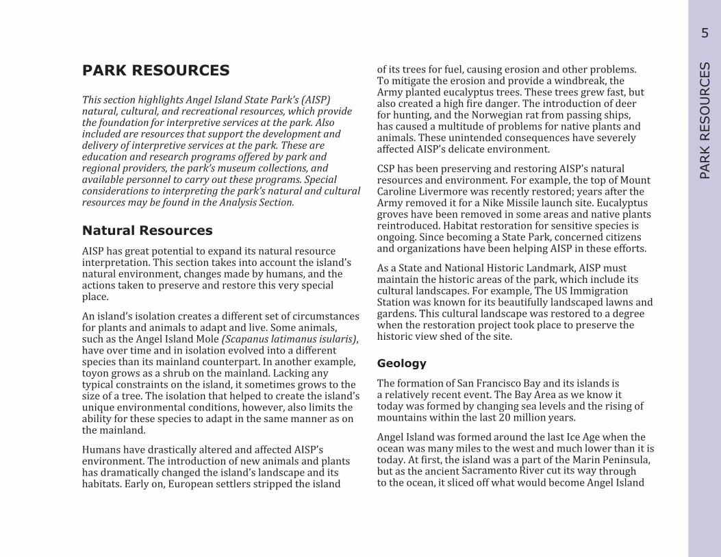
This section highlights Angel Island State Park’s (AISP) natural, cultural, and recreational resources, which provide the foundation for interpretive services at the park. Also included are resources that support the development and delivery of interpretive services at the park. These are education and research programs offered by park and regional providers, the park’s museum collections, and available personnel to carry out these programs. Special considerations to interpreting the park’s natural and cultural resources may be found in the Analysis Section.
Natural ResourcesAISP has great potential to expand its natural resource interpretation. This section takes into account the island’s natural environment, changes made by humans, and the actions taken to preserve and restore this very special place.
An island’s isolation creates a different set of circumstances for plants and animals to adapt and live. Some animals, such as the Angel Island Mole (Scapanus latimanus isularis), have over time and in isolation evolved into a different species than its mainland counterpart. In another example, toyon grows as a shrub on the mainland. Lacking any typical constraints on the island, it sometimes grows to the size of a tree. The isolation that helped to create the island’s unique environmental conditions, however, also limits the ability for these species to adapt in the same manner as on the mainland.
Humans have drastically altered and affected AISP’s environment. The introduction of new animals and plants has dramatically changed the island’s landscape and its habitats. Early on, European settlers stripped the island
of its trees for fuel, causing erosion and other problems. To mitigate the erosion and provide a windbreak, the Army planted eucalyptus trees. These trees grew fast, but also created a high fire danger. The introduction of deer for hunting, and the Norwegian rat from passing ships, has caused a multitude of problems for native plants and animals. These unintended consequences have severely affected AISP’s delicate environment.
CSP has been preserving and restoring AISP’s natural resources and environment. For example, the top of Mount Caroline Livermore was recently restored; years after the Army removed it for a Nike Missile launch site. Eucalyptus groves have been removed in some areas and native plants reintroduced. Habitat restoration for sensitive species is ongoing. Since becoming a State Park, concerned citizens and organizations have been helping AISP in these efforts.
As a State and National Historic Landmark, AISP must maintain the historic areas of the park, which include its cultural landscapes. For example, The US Immigration Station was known for its beautifully landscaped lawns and gardens. This cultural landscape was restored to a degree when the restoration project took place to preserve the historic view shed of the site.
Geology
The formation of San Francisco Bay and its islands is a relatively recent event. The Bay Area as we know it today was formed by changing sea levels and the rising of mountains within the last 20 million years.
Angel Island was formed around the last Ice Age when the ocean was many miles to the west and much lower than it is today. At first, the island was a part of the Marin Peninsula, but as the ancient Sacramento River cut its way through to the ocean, it sliced off what would become Angel Island

6
from the rest of the hills of Marin. When the ocean level rose after the Ice Age, seawater filled the valley we now call the San Francisco Bay and Angel Island was created. The riverbed exists today as the deep channel that runs through Racoon Strait (about 200 ft. deep) to the Golden Gate (about 300 ft. deep) and the Pacific Ocean.
The shape of the island is roughly pyramidal, with steep ridges extending downward from central Mount Caroline Livermore. Between the ridges are canyons, which fan out into coves at the water’s edge. The peak is about 788 feet above sea level.
Climate
The island’s climate is characterized by moderate yearly temperatures, due to the marine influence. It has dry summers with morning fog, and wet winters with an average rainfall of 25-30 inches. A prevailing westerly wind blows through the Golden Gate and across the island.
Hydrology
The waters of San Francisco Bay surround Angel Island. Fresh water flowing through the Bay comes from a drainage area of about 63,000 square miles, or about forty percent of the surface area of the state. Daily tidal changes amount to five or six feet. Fresh water on the island is available from natural springs and modern wells. During the Spanish and Mexican periods, these springs were a main attraction to passing ships in need of fresh water. Later, the US military drilled wells and brought fresh water to the island via ship.
Biology
The park has a diversity of flora and fauna living in different ecological zones. Several distinct native plant communities have evolved on the island. Such factors as water (fog, rain, springs, and ocean), solar exposure, temperature, and soil conditions have favored growth of typical California coastal communities: grassland, scrub, mixed evergreen forest, chaparral, coastal strand, and riparian.
Native trees such as coast live oak, madrone, and California bay and native shrubs occur frequently on the island. Poison oak, manzanita, chamise, gooseberry, and currant are also common. Wildflowers, many of which are native, bloom extensively in the spring. Some of the more common ones are soap plant, milk-maid, monkey flower, California poppy, lupine, shooting star, and Fremont star lily.
Several native grasses inhabit the island slopes, including purple needlegrass, pine bluegrass, meadow barley, California fescue, California brome, creeping wild rye, and Torrey melic. Some native species have recovered to various degrees since the 1960s. However, two introduced species, eucalyptus and broom, pose a real threat to other vegetation, because of their ability to grow and spread rapidly; acacia may also pose this threat.
The island is home to a diverse community of marine and terrestrial animal species. Robins, scrub jays, hawks, grebes, cormorants, and pelicans are common birds. Sea lions can be found on rocks off Point Blunt and harbor seals can be seen on the rocky shores near Point Ione. Visitors often encounter raccoons among the trees and hollows.
The island contains one truly endemic animal--the Angel Island Mole (Scapanus latimanus insularis). It is a species of special concern and is on the Department of Fish and Game’s watch list. A government report in 1935 and 1936 noted Angel Island supported a large population of moles.

7
PARK R
ESO
URCESMole mounds and surface ridges were common across the
island, particularly on the north side of the island in moist soil under chaparral (Palmer 1937). There is little recent information regarding the present distribution or status of Angel Island moles. Apparently, there has been no further work on this subspecies since it was described in 1937.
The island has a large mule deer (Odocoileus hemionus) population that descend from those the US Army introduced in 1915 for hunting purposes. In the absence of predators, the mule deer population expanded beyond the island’s carrying capacity.
California State Parks, in conjunction with the Department of Fish and Game, has since developed a management plan for the deer. The population size is monitored annually to ensure that the deer population does not expand beyond what the island’s vegetation can support.
There is also large non-native rodent population, which populated the island from ships. The rodents cause damage to the natural and cultural resources. The park has an integrated pest management program for facilities on the island.
Native plant communities on the island, along with their associated fauna, have been seriously impacted by past human activities, intensive overgrazing by the introduced deer herd, and by the introduction and expansion of non-native trees and shrubs. Introduced conifers and eucalyptus cover more than 100 acres of the island. Mesic woodland habitats on Angel Island, (e.g., mixed evergreen forest, northern coastal scrub, and chaparral) which provide potentially suitable habitat for moles, have been, and continue to be seriously degraded by these factors (Bolster, 1998). Many other introduced plants have also become well adapted; these include ice plant, century plant, pride of madeira, Monterey pine, and Monterey cypress. There is no Douglas fir on the island, the native forest having been replaced primarily by introduced eucalyptus and Monterey pines.
The Spanish, Mexican, and US military use of Angel Island caused significant changes to the landscape. In the early 19th-century passing ships denuded the native woodland for firewood, ship repairs, and building materials. After the arrival of the Spanish, European annual grasses supplanted the native grasses on the island. Remnants of native oak woodland remained in areas with difficult access, such as steep slopes, cliffs, and north-facing hillsides.
Later, military personnel and civilian workers planted gardens for food; eucalyptus trees for windbreaks and erosion control; and decorative landscaping in residential areas and at the US Immigration Station. Since becoming a State Park in the 1950s, park staff have conducted native plant restoration projects. In 1991 and 1996 a total of 80 Figure 3. Introduced Mule deer.
8
acres of eucalyptus were removed from wild land areas of the park; these sites have been largely replaced with coastal scrub habitat, with some invasion by non-native Italian thistle. Cultural landscapes have also been maintained where appropriate.
In October 2008, the Angel Fire burned approximately 303 acres (around forty percent) of wild land in the park. Several existing stands of Monterey pine burned in the fire. These sites will undergo oak restoration. None of the park’s eucalyptus stands burned in the 2008 fire; only scattered small eucalyptus that came up after the eucalyptus logging in 1991 and 1996 burned. The native habitats that burned in the Angel Fire have recovered quickly. The fire burned mostly accumulated fuels and understory plants, and provided an opportunity for native plants to regenerate and replenish the native seed bank.
Cultural Resources
Coast Miwok
The Hookooeko Tribe of the Coast Miwok group has inhabited portions of what is today Marin County since around 4000 BC. They settled in Marin County and Angel Island around 1000 AD, migrating between settlements on the mainland and the island depending on seasonally available resources.
Archaeological evidence indicates temporary summer hunting villages were at Ayala Cove, Point Stuart, Quarry Beach, and the US Immigration Station. A Hookooeko settlement also existed near China Cove on the northeast corner of Angel Island from 1000 AD until the late 1700s. During this time, the California Indian population used the land as temporary camps. China Cove afforded one of the best habitation areas on the island because of its sheltered location, the abundance of food resources, its proximity to both fresh and salt water, and the natural landing area set between the east and west slopes.
A 1905 government survey report describing sources of fresh water provided evidence of the settlement:
“...Immigrant Cove is evidently the site of an old Indian settlement, as evidenced by Kitchen Midden, which occupies the land bordering the waterfront of the Cove. These middens are in evidence at many points along the shores of San Francisco Bay, and wherever they exist, fresh water is not far away.
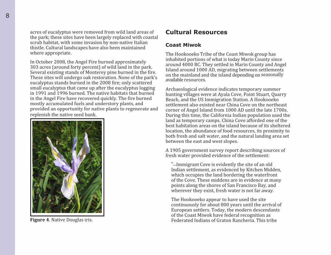
The Hookooeko appear to have used the site continuously for about 800 years until the arrival of European settlers. Today, the modern descendants of the Coast Miwok have federal recognition as Federated Indians of Graton Rancheria. This tribe Figure 4. Native Douglas iris.
9
PARK R
ESO
URCESincludes descendants of indigenous people living in
Marin and Sonoma counties during the eighteenth to twentieth centuries”(Davison & Meier, 2002 13-18).
Spanish and Mexican
Gaspar de Portolá’s expedition entered what is now San Francisco Bay in November 1769. By 1775, the Spanish had established five missions in Alta California, and the Spanish Viceroy of Mexico sent Lt. Don Juan de Ayala to chart San Francisco Bay and to bring supplies to Monterey. Ayala anchored the San Carlos on the island on August 13, 1775, and named it Isla de Los Angeles. Father Vicente from Ayala’s crew visited several Indian villages on the mainland and reported good relations with the tribes. At the time, he only found evidence of hunting villages while surveying the island.
During this period, Ayala Cove became a stop for passing ships to gather wood and replenish water supplies. In 1839, Antonio Osio received Angel Island as a land grant from the Mexican government and operated a cattle ranch there. He constructed several permanent structures, including two dams, farmhouses, a herder’s house, and a sandstone quarry. Osio imported domestic cattle and horses, and established part of a rancho that dominated island activities for twenty years.
US Military (Pre-WWI)
When Mexico ceded California to the United States (US) in 1848, the settlements on Angel Island included Osio’s cattle ranch, farms, and a quarry. In 1850, the federal government designated Angel Island a military base and evicted Osio. He placed caretakers on the island and continued to fight his claim in the courts. Despite winning his case in 1856, the
federal government appealed to the Supreme Court, who ruled in the government’s favor and granted ownership of the land to the US in March 1860.
The beginning of the Civil War in 1861 gave a new urgency to the defense of San Francisco Bay. Army engineers began mapping the Bay Area in detail. In 1863, H.W. Halleck, the General-in-Chief of the Army, issued an order to install ten to twenty guns at Points Stuart, Knox, and Blunt. By September 12, Company B of the Third Artillery, consisting of fifty men and one officer, landed on Angel Island. The new Army post, an artillery garrison, was christened Camp Reynolds (West Garrison). Dwellings and structures owned by civilians, such as a sandstone quarry on the east side of the island, were seized in 1867 for use in construction projects.
During the 1860s, the Army continued to develop Camp Reynolds, including its hospital. Over the next forty years, the Army’s construction program centered on artillery batteries, and discharge and detention camps, as well as on the enlargement of the post. In the 1870s, an extensive initiative on the part of the US Army included construction of the new-style batteries and large-caliber mortars that formed Angel Island’s defenses.
During times of increased troop movement, the Army enlarged or constructed temporary camps, which consisted of double stacked tents to house the troops, makeshift barracks for the officers, and other wood framed buildings.
Endicott Batteries
In 1885, US President Grover Cleveland appointed a joint Army, Navy and civilian board (the Board of Fortifications), to be headed by Secretary of War William C. Endicott. The findings of the board illustrated a grim picture of existing defenses in its 1886 report and recommended a massive

10
$127 million construction program of breech-loading cannons, mortars, floating batteries, and submarine mines for some 29 locations on the US coastline, including San Francisco Bay and Angel Island.
The Endicott Board’s recommendations would lead to a large-scale modernization program of harbor and coastal defenses in the US, specifically, the construction of modern, reinforced concrete fortifications, and the installation of large-caliber breech-loading artillery and mortar batteries. In April of 1898, work began on Angel Island’s first permanent Endicott Battery— Battery Drew—located just south of Camp Reynolds. The second new battery was Battery Ledyard, which was erected on the site of the old Point Knox Civil War battery, and armed with two five-inch rapid-fire guns. The third, and last, battery in the series was Battery Wallace, built above and behind Ledyard, and armed with a single eight-inch rifle on a disappearing carriage.
Angel Island’s three Endicott Batteries had been disarmed in 1909, but were not fully deactivated until 1915. In World War II, Batteries Wallace, Ledyard, and Drew were used for storage of military supplies (Hussey 1949).
Quarantine Station
Since the 17th century, governments have quarantined foreign ships for periods to prevent the spread of disease. Quarantine regulation continued to be the responsibility of state governments locally until the close of the 19th century. The National Quarantine Act of 1878 transformed the Marine Hospital Service from a series of locally controlled hospitals for seamen to one national service under the direction of the Surgeon General of the US. In 1880, the City of San Francisco asked the War Department to set aside a site for the location of a Quarantine Station on one of the islands in the bay. This was in response to
reports of smallpox epidemics in Hong Kong. In 1887, the Surgeon General of the Marine Hospital Service strongly recommended the establishment of a quarantine station for the harbor, the largest port on the west coast. Ships arriving with cases of contagious disease aboard had no isolated place for detention and there was a risk of infecting San Francisco’s general population.
In 1889, the War Department transferred land at Ayala Cove to the Treasury Department so that the Quarantine Station could be established. The first passengers from the steamship China were placed in quarantine at Ayala Cove in 1891. The station had a fumigation ship, the Omaha, the following year.
From 1892 to 1925, over 45 buildings were erected that included a two-story bathhouse, a hospital, a laboratory, barracks and a laundry, a segregated dining area for Asian detainees, a disinfecting shed, and a crematory. Medical staff treated victims of smallpox, bubonic plague, and other contagious diseases. The last detainees were treated in 1935; however, during World War I and World War II, the Quarantine Station housed prisoners of war. The station stayed in operation until 1946.
US Immigration Station
The US Immigration Station on Angel Island was the principal West Coast port of entry for immigrants to the US between 1910 and 1940, and was nicknamed “the Guardian of the Western Gate.” Hundreds of thousands of immigrants from more than 80 countries were processed at the station during the 30-year period. These included Chinese, Japanese, Koreans, Filipinos, South Asians, Mexicans, Africans, Spanish, Portuguese, Russians, and South and Central Americans. Chinese immigrants were specifically excluded from immigrating to the U. S. by the Chinese Exclusion Act of 1882. Most of the 175,000 Chinese arriving

11
PARK R
ESO
URCESat Angel Island were detained for three to ninety days while
their applications were given extra scrutiny.
While the predominant immigrant groups of detainees were Asian, many Europeans were quarantined on Angel Island for health reasons or detained if their immigration status was uncertain. The Asian and European immigrants were housed and treated separately, and their experiences varied widely.
To express their feelings some of the detainees, especially the Chinese, found a release by carving and writing on the walls of the Detention Barracks and the Hospital. They created images, left messages or wrote poems. The poems have become the predominant piece of the site’s cultural history.
On August 12, 1940, the Administration Building on Angel Island caught fire. With the facility disabled by the loss of its main building, most of the remaining detainees were moved to various locations on the mainland, including the county jail. On November 5, 1940, the bureau finally abandoned the location. The Angel Island property was ultimately declared surplus to the needs of the Department of Justice on December 9, 1940 (Davison and Meier, 89-93).
It was turned over to the Army in 1940. The Army renamed the station “North Garrison” and the Army used it as a detention facility for Prisoners of War during WWII. The first prisoners held at North Garrison were Japanese; Germans and Italians were held temporarily until they could be transported to inland camps. Later, the prisoners were Japanese, Koreans, and Okinawans. At the end of the war, North Garrison held 277 Prisoners of War.
US Military (WWI-WWII)
In 1899, American soldiers were returning from the Spanish-American War in the Philippines. Some of these men had contracted contagious diseases during their tours of duty, and needed to be separated from the general population. Accordingly, a Detention Camp was established on Angel Island at Quarry Point. Soldiers were held there until the incubation period for suspected diseases had passed.
The Detention Camp was active until 1901, when it was reconstructed for use as a Discharge Camp. At the Discharge Camp, the men were processed for separation, received their final pay and allowances, and were mustered out of service. During the first six months of 1902, 10,741 soldiers passed through the facility.
America entered World War I in 1918. Under ordinary circumstances, the basic training of new recruits took four months. However, because of the urgent need for fresh troops in Europe to combat the German forces, this period had to be shortened dramatically.
The Recruit Depot at Fort McDowell became a busy place. Both West Garrison and East Garrisons (Fort McDowell) were used during World War I. Fort McDowell was known as the “Overseas Discharge and Replacement Depot” between World War I and World War II. An average of 30,000 men each year passed through the island to be trained to serve overseas, or processed for discharge when they returned. “For Several years around 1926, Fort McDowell processed as many as 40,000 men annually; more than any other US post (Claus, 1982 54).
Recreation was part of Fort McDowell’s program of activities for the soldiers. In 1925, Colonel Gatley, Fort commander, wrote, “It is believed that recreation in the Army should be so conducted that every available soldier

12
will be required to participate in some form of athletics” (Van Sicklen Collection). Accordingly, the troops were offered pool, baseball, and basketball. More passive forms of relaxation included a library, concerts, movies, a Sunday school, church services, and Officers’ and Non-commissioned Officers’ Clubs.
World War II brought another surge in activity at Fort McDowell, which was used primarily to handle overseas replacements or to rotate troops returning from overseas duty. In this capacity, the island saw 69,756 troops and casualties in 1942 (McDonald, 1966: 126). Among the men processed were many on special assignments, such as military FBI, Intelligence officers, and Australian and New Zealand fliers (Van Sicklen Collection).
In addition to the recreation facilities available after World War I, the following were added during World War II for the use of the troops: East Garrison Recreation Hall, North Garrison Recreation Hall, a bowling alley, a baseball field with hardball and softball diamonds, tennis courts, an outdoor basketball court, and horseshoe pits (Van Sicklen Collection).
By 1946, the work of processing returning troops and prisoners of war to their respective homes was completed. Fort McDowell was no longer needed. The garrison of troops of the Transportation Corps was transferred to Camp Stoneman near Pittsburg, and Fort McDowell was turned over to the US District Engineer. On September 20, 1946, the War Department officially declared the island surplus.
Cold War
In 1954, the Army decided to return to Angel Island to construct and operate a Nike missile battery. The Nike missiles were designed to intercept high-flying strategic bombers. Construction began on the Nike battery in about 1957. The battery included: ▪ the launch area, where the missiles were
stored in underground rooms, brought up on elevators, and launched;
▪ the control area, usually at a high elevation and with its radar, had to have an unobstructed view of the launch area;
▪ and the cantonment area, including quarters, mess hall, and recreation rooms (Thompson, 1979a: 411).
The Nike site at Angel Island was the largest of the four constructed in the Bay Area. It had no fewer than three underground storage rooms and twelve launchers. The site was south of East Garrison and inland on Point Blunt. The hospital building at East Garrison was remodeled to contain the base headquarters and the approximately 100 men and officers stationed there. Within five years, the Nike system had become obsolete. The Army decommissioned the base in 1962 and left the island for the last time, ending 99 years of occupation.

13
PARK R
ESO
URCESAngel Island State Park
After the Army declared the property surplus in 1946, there was intense interest from the local community in the fate of the island. Two nonprofit groups, the Angel Island Foundation (today’s Angel Island Conservancy), and the Marin Conservation League, campaigned for the establishment of the island as a state park. The National Park Service published a historical survey of Fort McDowell, which recommended turning the surplus property into a historical monument. Over the next few years, these groups were successful in educating the public about the island’s history and potential recreational uses, and pressured local government agencies to push the state to acquire the island (Davison and Meier, 2002 131).
In 1954, the 37 acres making up the former Hospital Cove (Ayala Cove), was the first parcel of land deeded over to the State Park System, and was opened to the public. In the meantime, the US Army had selected the island as a site for a Nike missile launching facility and radar control station. Despite this partial reoccupation of the island by the Army, the State Park System acquired additional acreage above the cove in 1958. The mountaintop itself was renamed Mount Caroline Livermore, in honor of the dedicated Marin County conservationist who led the campaign to create Angel Island State Park (AISP). The remainder of the island was given over to the State in 1963, after the US Army decommissioned the Nike Missile base.
California State Parks (CSP) completed the AISP General Plan in 1979, which is the resource management plan for the park. This document directs the recreation, interpretation, cultural and natural preservation programs, and facility development at the park. Since the plan was adopted, the park has installed visitor centers at Ayala Cove and East Garrison and house museum exhibits at the Detention Barracks of the US Immigration Station.
Buildings at West Garrison’s Camp Reynolds are now used for overnight educational programs for school children. Since 2004, the US Immigration Station at AISP has undergone a large-scale stabilization of existing structures and interpretation of the site using federal and state funds, grants, and private donations. By 2011, the US Immigration Station mule barn, detention barracks, and hospital have been stabilized; there are house-museum exhibits in the detention barracks; interpretive panels and exhibit features have been installed throughout the complex; and the site’s hospital is undergoing planning for future use. This Interpretation Master Plan will help guide the development of future exhibits and interpretive programs at the park.

14
Figure 5: Park map showing picnic areas, campgrounds and trails, CSP.

15
PARK R
ESO
URCESRecreational Resources
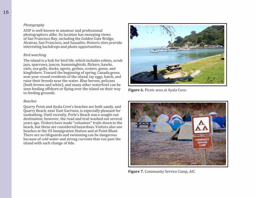
AISP has long been a respite for the densely populated San Francisco Bay communities, and the need for outdoor recreation was one of the driving forces that led to its designation as a state park in 1954. There are sandy beaches and grassy picnic areas to relax and play in, campsites, miles of paved roads and trails, sweeping views of the Bay Area, and historic areas to explore. Kayaking, boating, bicycling, and hiking are popular sports. In the spring, docents lead wildflower hikes and the park offers natural history programs to students during the school year. Fishing, birding, and photography are other enjoyable activities. This section describes the park’s recreational resources, which can be utilized and expanded upon when planning new interpretive services.
Picnic AreasThere are four group picnic areas at Ayala Cove, and one at East Garrison. All have barbeque pits and running water, and are close to restrooms. The group picnic areas can be reserved by phone or online. These areas can hold between 35 and 200 people, the largest at East Garrison. There are also single picnic tables located throughout the park that offer visitors outstanding views and quiet surroundings.
CampingAISP boasts eleven campsites around the island; many have spectacular views of the San Francisco Bay. The campsites have a remote, yet serene feel despite being in the midst of a large urban center. All camp spots have water and pit toilets, tables, food-lockers, and a barbecue. Single, group, accessible and kayak campsites are available.
BoatingAyala Cove has the largest public docks and moorings on the Bay, and is among the most protected inlets on the island. Boat slips and overnight moorings are available first-come, first-served from 8 a.m. until sunset and are open year-round. The 19 boat slips, and the 27 mooring buoys may be used by private boats. Dinghies can be taken to the dock from the moorings to gain access to the island. Mooring buoys may be used overnight; boaters can access the island with a dinghy until 10 p.m.
Kayaking is a popular sport around the island and the only way to access some of the more isolated shorelines. Kayaks can be brought over by personal craft or must be launched from the mainland. Several private companies offer kayak tours and rentals. The park has one kayak-accessible campsite that can hold up to 20 people.
HikingHikers have access to 13 miles of trails and roadways. The perimeter road, foot trails, and fire roads circle the entire island and provide access to the 788-foot summit of Mount Caroline Livermore. Both bicycles and pedestrians use the surfaced 5-mile perimeter road. Rated as moderate, the hike to the top of Mount Caroline Livermore provides a breathtaking, 360-degree panoramic view of the Bay Area. During the spring, wildflower growth is varied and abundant.
Visitors can bring their bicycles on the ferry or rent one from the concessionaire at Ayala Cove. The perimeter and fire roads are available to bikers. Foot trails and the trail to Mount Caroline Livermore are closed to cyclists. Guided Segway tours are available seasonally through the concessionaire. This is the first such tour to operate in a CSP. At this time, no personal Segways are allowed on AISP beyond those used for accessibility.
16
PhotographyAISP is well known to amateur and professional photographers alike. Its location has sweeping views of San Francisco Bay, including the Golden Gate Bridge, Alcatraz, San Francisco, and Sausalito. Historic sites provide interesting backdrops and photo opportunities.
Bird watchingThe island is a hub for bird life, which includes robins, scrub jays, sparrows, juncos, hummingbirds, flickers, hawks, owls, sea gulls, ducks, egrets, grebes, scoters, geese, and kingfishers. Toward the beginning of spring, Canada geese, now year-round residents of the island, lay eggs, hatch, and raise their broods near the water. Blue herons, pelicans (both brown and white), and many other waterfowl can be seen feeding offshore or flying over the island on their way to feeding grounds.
BeachesQuarry Point and Ayala Cove’s beaches are both sandy, and Quarry Beach, near East Garrison, is especially pleasant for sunbathing. Until recently, Perle’s Beach was a sought-out destination; however, the road and trail washed out several years ago. Visitors have made “volunteer” trails down to the beach, but these are considered hazardous. Visitors also use beaches at the US Immigration Station and at Point Blunt. There are no lifeguards and swimming can be dangerous because of cold water and strong currents that run past the island with each change of tide.
Figure 7. Community Service Camp, AIC.
Figure 6. Picnic area at Ayala Cove.
17
PARK R
ESO
URCESEducational Services
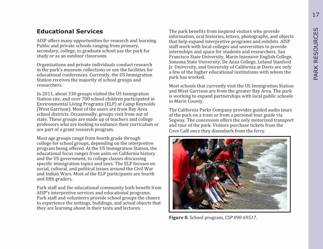
AISP offers many opportunities for research and learning. Public and private schools ranging from primary, secondary, college, to graduate school use the park for study or as an outdoor classroom.
Organizations and private individuals conduct research in the park’s museum collections or use the facilities for educational conferences. Currently, the US Immigration Station receives the majority of school groups and researchers.
In 2011, about 330 groups visited the US Immigration Station site, and over 700 school children participated in Environmental Living Programs (ELP) at Camp Reynolds (West Garrison). Most of the users are from Bay Area school districts. Occasionally, groups visit from out of state. These groups are made up of teachers and college professors who are looking to enhance their curriculum or are part of a grant research program.
Most age groups range from fourth grade through college for school groups, depending on the interpretive program being offered. At the US Immigration Station, the educational focus ranges from units on California history and the US government, to college classes discussing specific immigration topics and laws. The ELP focuses on social, cultural, and political issues around the Civil War and Indian Wars. Most of the ELP participants are fourth and fifth graders.
Park staff and the educational community both benefit from AISP’s interpretive services and educational programs. Park staff and volunteers provide school groups the chance to experience the settings, buildings, and actual objects that they are learning about in their texts and lectures.
The park benefits from inspired visitors who provide information, oral histories, letters, photographs, and objects that help expand interpretive programs and exhibits. AISP staff work with local colleges and universities to provide internships and space for students and researchers. San Francisco State University, Marin Intensive English College, Sonoma State University, De Anza College, Leland Stanford Jr. University, and University of California at Davis are only a few of the higher educational institutions with whom the park has worked.
Most schools that currently visit the US Immigration Station and West Garrison are from the greater Bay Area. The park is working to expand partnerships with local public schools in Marin County.
The California Parks Company provides guided audio tours of the park on a tram or from a personal tour guide via Segway. The concession offers the only motorized transport and tour of the park. Visitors purchase tickets from the Cove Café once they disembark from the ferry.
Figure 8. School program, CSP 090-69517.

18
Interpretive ReadinessInterpretive readiness refers to the ability of AISP to present interpretive programs and services based on current staffing levels, volunteers, and funding sources.
Interpretive programs and services are provided by paid state park staff and by volunteers. Training is done on-site through a process of mentorship, shadowing trained interpreters, and through additional source materials. Evaluations are done through the RAPPORT process. Active volunteers at the US Immigration Station, Ayala Cove, and Camp Reynolds (West Garrison) provide roving interpretation, formal tours, and staffing for special events. An Interpreter I manages volunteers for each site. The support for interpretation at the US Immigration Station is at the forefront of operations. Interpretive programs and activities are strongly encouraged and supported by all levels of staffing and management.
Current interpretive staffing levels include: ▪ 2 State Park Interpreter I’s (Full time) ▪ 1 State Park Interpreter I’s (Part-Time) ▪ 1 Park Interpretive Specialist (Seasonal) ▪ Up to 3 Park Aides (Seasonal)
Museum CollectionsA Scope of Collections Statement is a comprehensive museum collection management plan that defines the types of objects a park unit collects and why it does so. It describes the museum collection and associated interpretive themes, sets policies, and gives general direction for collecting museum objects at the park.
The museum collections support the interpretive programs of the park. For example, the majority of the museum collections at AISP relate directly to the US government’s use of the island. Many of the exhibits and programs focus on the military and immigration programs and include everything from artillery and equipment to letters and photographs of military personnel and detainees.
In some cases, the museum collection defines an interpretive project. For example, exhibits in the Detention Barracks center around the poems carved on the walls by immigrants; the park’s archival documents also describe the immigrants’ experiences there.
The park has approximately 4300 object records catalogued in the CSP museum database, “The Museum System.” Museum collections on the island are either in exhibits or in storage facilities. Another 2100 objects, mostly photographs and documentary items, relate to AISP. These are stored at other locations, such as the CSP Photographic Archives, in Sacramento, CA.
AISP’s museum collections span all major collections categories: natural history specimens, prehistoric and historic archaeological objects, large document and photographic collections, house museum furnishings, and historic fabric salvaged from buildings. A large portion of the catalogued museum objects are incidental finds turned in by visitors or staff, and archaeological collections. These consist of architectural features from buildings being stabilized, munitions, and objects relating to the US Military presence and the US Immigration Station, and objects from Native American village sites on the island. The salvaged architectural features have been especially important for historians researching the buildings for stabilization and reconstruction projects.
19
PARK R
ESO
URCESThe archival collection primarily relates to the military’s
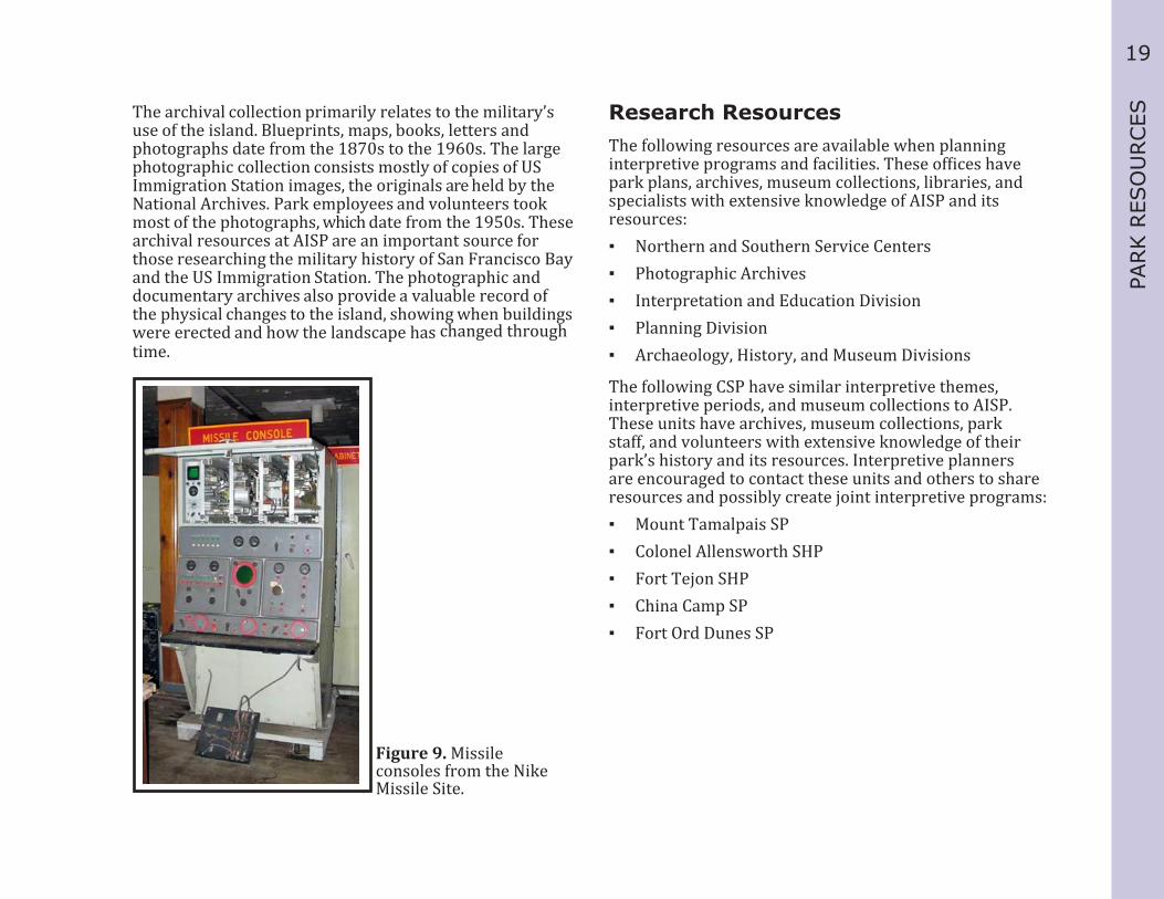
use of the island. Blueprints, maps, books, letters and photographs date from the 1870s to the 1960s. The large photographic collection consists mostly of copies of US Immigration Station images, the originals are held by the National Archives. Park employees and volunteers took most of the photographs, which date from the 1950s. These archival resources at AISP are an important source for those researching the military history of San Francisco Bay and the US Immigration Station. The photographic and documentary archives also provide a valuable record of the physical changes to the island, showing when buildings were erected and how the landscape has changed through time.
Research ResourcesThe following resources are available when planning interpretive programs and facilities. These offices have park plans, archives, museum collections, libraries, and specialists with extensive knowledge of AISP and its resources: ▪ Northern and Southern Service Centers ▪ Photographic Archives ▪ Interpretation and Education Division ▪ Planning Division ▪ Archaeology, History, and Museum Divisions
The following CSP have similar interpretive themes, interpretive periods, and museum collections to AISP. These units have archives, museum collections, park staff, and volunteers with extensive knowledge of their park’s history and its resources. Interpretive planners are encouraged to contact these units and others to share resources and possibly create joint interpretive programs: ▪ Mount Tamalpais SP ▪ Colonel Allensworth SHP ▪ Fort Tejon SHP ▪ China Camp SP ▪ Fort Ord Dunes SP
Figure 9. Missile consoles from the Nike Missile Site.
20
The following organizations have extensive libraries and online resources and at their facilities for program development. These organizations may have images available for use in publications, programs, panels, and exhibits. They also have subject matter experts that can assist in research:
State: ▪ California State Library ▪ Huntington Library ▪ Bancroft Library, UC Berkeley ▪ California Archives ▪ California Museum, Sacramento ▪ Online Archives of California
Federal: ▪ The National Archives at San Bruno
and Washington, D.C. ▪ The Library of Congress ▪ National Park Service-
₋ The Golden Gate National Recreation Area ₋ Point Reyes National Seashore
▪ Ellis Island National Monument
The following private and non-profit organizations have subject matter experts and research resources that may be helpful when developing interpretive programs and exhibits: ▪ Angel Island Conservancy ▪ Angel Island Immigration Station Foundation ▪ California Society of Pioneers ▪ California State Historical Society ▪ The Chinese Historical Society of America ▪ California Military Museum ▪ Marin Conservation League ▪ Bay Area Discovery Museum ▪ Angel Island-Tiburon Ferry

21
VIS
ITAT
ION
AN
D V
ISIT
OR U
SEVISITATION AND VISITOR USE
Several key factors are considered before undertaking major interpretive projects. This section provides data on the visitor experience at the park, demographics, and their needs and expectations. It also provides the information for analyzing the existing visitor experience and recommendations for improving it.
Regional Visitation DataAngel Island State Park (AISP) is located in Marin County and is surrounded by the greater San Francisco Bay Area. The Bay Area is comprised of nine counties: Alameda, Contra Costa, Marin, Napa, San Francisco, San Mateo, Santa Clara, Solano and Sonoma counties. The five most populous cities in these counties in 2000 were San Jose, San Francisco, Oakland, Fremont, and Hayward in this order. According to the 2009 census estimates, 19.25% of California’s population (7,116,110 people) lives in these counties.
The 2009 census estimates yielded some interesting demographic information about the Bay Area. On average, there are more people under 18 than there are over 65. The Bay Area also had smaller percentages of people living below the poverty line than California and the nation as a whole.
Visitor ProfileAISP has been open to the public since 1954, and receives thousands of visitors annually. While the park has gathered anecdotal information about visitors and the visitor experience, more data is needed to construct a comprehensive visitor profile.
Visitor SurveyThe Angel Island Conservancy conducted a visitor survey from September through October 2010; 160 visitors participated in the survey. Volunteers surveyed visitors on ferries going to and from the island, at ferry waiting areas, and at the café deck. The results represent weekend, weekday, and holiday visitor experiences. Individuals, groups, campers, and boaters were included. The small survey sample size was conducted outside the busy summer season. The survey results are a good starting point and provide the park with a glimpse of park visitors, their needs, and expectations.
Survey Synopsis
Visitor Profile ▪ On average, the majority of visitors were from the
Bay Area, with 73% local and 27% from out of town. ▪ On weekends, a slightly larger percentage
(36%) of visitors came from out of town. ▪ On the holiday (Labor Day), 83% of visitors were local. ▪ Most groups had at least one group member who
had visited AISP before—68% of groups had a return visitor, and 32% of groups were all new to the island.
Visitor Groups ▪ The majority (96%) was travelling with, or
meeting a group, 4% were traveling alone. ▪ The largest groups appear to have been
on weekdays, when school groups and other planned tours are common.

22
Primary Visitor ActivityThe overwhelming majority selected recreation as their primary interest in visiting AISP. Recreation included hiking, picnicking, exploring, or staying in Ayala cove.
Weekday travelers were less likely to indicate recreation (63%) as their primary purpose, while holiday travelers were more likely (83%) to report recreation as their primary visitation activity.
What Visitors Plan to DoMany visitors had more than one response. The most common combination of responses was hiking and picnicking, and hiking and historical sightseeing. School programs are more common on weekdays, as expected, representing 8% of those surveyed.
Interpretive OpportunitiesVisitors were asked about what locations they wanted to learn more about. More people wanted to learn about the US Immigration Station, followed by Native American history, East Garrison, Camp Reynolds (West Garrison), the center of the island, and “all of it.” There were no responses in this sample related to natural history of the island.
Access, Orientation, and CirculationPark infrastructure conditions, orientation to park resources and opportunities, and ease of access to interpretive services and to recreation impact the quality of the visitor experience. This section describes how visitors access the park and their overall experience at the park. It includes existing transportation, orientation, interpretive facilities, and amenities by key destination, and related park infrastructure conditions. Analysis of these conditions and recommendations to improve them are in the related chapters.
Getting to the Park
Ferry service is available from San Francisco, Tiburon and (seasonally) from Oakland and Alameda. There is limited weekday ferry service to AISP during the fall, winter, and early spring seasons. During peak visitation months, from April to September, the ferries run hourly from 10a.m. to 3p.m. In the fall and winter months, ferries restrict their schedules even further. The limited access to and from the park, along with the narrow window of time allotted on the island, greatly limits the day-use visitor’s access to the park.
Tiburon Ferry—Visitors board the private ferry at the dock in Tiburon for a 10-minute cruise to AISP, disembarking at Ayala Cove. A State Park interpretive exhibit shelter at the Tiburon dock displays a hiking and a biking trail map, schedules, and an introduction to the park.
San Francisco Ferry—The Blue and Gold Fleet Ferry offers year-round service to the island. Services are reduced during the off-season. Visitors board the private ferry from Pier 41 in San Francisco for a 20-minute cruise to AISP, disembarking at Ayala Cove. An interpretive exhibit shelter on the dock displays a hiking and biking trail map, schedules, and an introduction to the park.

23
VIS
ITAT
ION
AN
D V
ISIT
OR U
SEAlameda/Oakland Ferry—operates weekends/holidays
only from late May through October. Visitors board the private ferry at Jack London Square in Oakland for a 15-minute cruise to San Francisco, transferring to the AISP ferry at Pier 41, and disembarking at Ayala Cove. An interpretive exhibit shelter at the dock displays a hiking and biking trail map, schedules, and an introduction to the park.
USS Potomac-offers special cruises to AISP from Jack London Square, once per month from May to November.
Alcatraz/Angel Island Cruises- CSP and the National Park Service offer a seasonal tour including both AISP and Alcatraz Island. This combination tour, the Island Hop, is offered by Alcatraz Cruises and runs during the spring and summer.
Park Entrance
Whether by public or private watercraft, visitor orientation to the park begins at the public dock at Ayala Cove. Visitors disembark the public ferry at Ayala Cove, and are greeted by a uniformed park employee. The park entrance sign, several interpretive panels, park flyers, an information kiosk, AIC Information Center, and various park information signs are located on the dock and along the road to the Visitor Center.
Transportation within the Park
Concessionaires run the public ferries, trams, bicycle and Segway rentals, and the Cove Café. They provide the main transportation to and from the island. Once on the island, they provide the main motorized transportation to the historic districts. The public brings their own bicycles to the island, and many people walk from Ayala Cove to their destinations.
Circulation Routes
Major RouteThe major route of travel around the island (Perimeter Road) connects the minor streets, service roads, and emergency access routes. It has a paved surface with intersections that provide access to the main park facilities, (e.g., Ayala Cove, Fort MacDowell, or the US Immigration Station). The Perimeter Road connects to hiking trails at several locations and is the main path of travel for park vehicles, service vehicles, the shuttle system, bikes, Segways, and pedestrians.
Minor RoadsMinor roads intersect the Perimeter Road at specific locations to provide access to the adjacent facilities. Minor roads usually serve one of two functions: a) provide a primary route of travel to a specific destination, or b) serve as a connection between service roads, scenic trails, and emergency access roads to the major route. An example would be the access road to the US Immigration Station or Camp Reynolds (West Garrison).
Service RoadThe service roads primarily provide access to abutting facilities not designed for general public use (e.g., staff housing or the Nike missile site).

24
Hiking Trails The hiking trails are heavily traveled paths that link important destinations to each other. The primary trail runs parallel to or as part of minor roads and service roads. In other areas, these trails are routed through wooded or grassy open space areas (e.g. East Bay View Trail or North Ridge Trail). Secondary routes are found along fire roads and in wooded areas. These provide access to specific features of the parks, such as the trail to Battery Ledyard and the Nike Missile Site.
Emergency Access RoadEmergency access roads are mainly fire roads that connect the Perimeter Road to service roads that cross the island. For example, the fire road that connects near the US Immigration Station and Nike Missile site provides an internal loop to the Perimeter Road at a higher elevation.

25
VIS
ITAT
ION
AN
D V
ISIT
OR U
SE
Figure 10. AISP’s Key Destinations

26
Key DestinationsKey Destination refers to specifically designated historic and/or geographic locations in the park. These include Ayala Cove, West Garrison, the Batteries, East Garrison, the US Immigration Station, and the Backcountry.
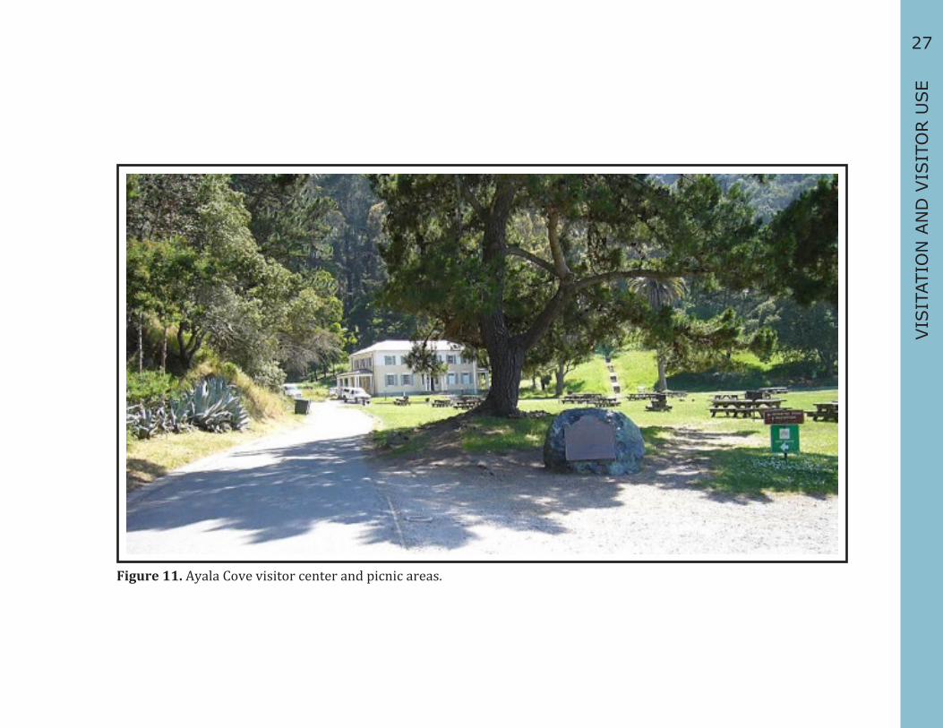
Ayala Cove
Ayala Cove is the main access point to the park and serves as the orientation hub for all park activities and information. The historic Quarantine Station’s Bachelor Officers’ Quarters serve as the Park Administrative Offices and the visitor center, and houses some of the park’s museum collections.
Visitor Amenities and Interpretive ServicesVisitor amenities include the public ferry dock, boat dock and moorings, information kiosk, restrooms, AIC Information Station, concession cafe and oyster bar, bicycle rentals, lockers (day use), maps, picnic tables and charcoal barbecues, Segway and tram tours, vending machines, visitor center, self-guided tours, and water fountains.
CirculationOnce visitors leave the dock, they pass by the AIC Information Station building on their left. From here, people take the North Ridge Trail up to the perimeter road or continue right along the road. Visitors may also move along the road towards the visitor center. Along the way, they pass a wheelchair-accessible comfort station and the concession buildings. Visitors continue along the road towards the visitor center or head towards the beach, picnic areas, or trailheads. The road continues up a steep grade to the Perimeter Road. From here, visitors turn right towards Camp Reynolds, or left towards the US Immigration Station and East Garrison.
For the purpose of this document, visitor circulation will be described in a counter-clockwise manner from Ayala Cove.
Picnic AreasThere are four group picnic areas (which may be reserved) and individual picnic tables in this area. The grassy area in front of the visitor center is used for picnics, impromptu games, sunbathing, and other activities.
ConcessionsVisitors access the tram, Segways, bicycle rentals, and the café at the concession buildings near the docks. The first concession kiosk handles bicycle and Segway rentals. The other concession building is the Cove Café, which also sells tram tickets and US Immigration Station tour tickets.
Visitor centerAn orientation video is shown in the visitor center and park staff is available to answer questions during peak visitation hours, which are usually from 10a.m. to 3:30 p.m. Exhibits there cover the park’s key interpretive periods and topics for both natural and cultural history. These exhibits include interpretive panels, a few historical objects relating to the Military and US Coast Guard operations, mounted specimens, and audio-visual programs.
AIC Information CenterVisitors may access information about activities, amenities, and resources on the island at the Information Station, which is staffed by volunteers and CSP employees.
27
VIS
ITAT
ION
AN
D V
ISIT
OR U
SE
Figure 11. Ayala Cove visitor center and picnic areas.

28
West Garrison
West Garrison’s Camp Reynolds is a 20 to 30 minute hike from Ayala Cove. To get here, visitors make a right turn at the Perimeter Road once they leave Ayala Cove. Small brown park signs give directions as well. There are panoramic views of Tiburon and Belvedere along the road. The Civil War-era hospital is the first building in the complex from this direction.
CirculationTo reach the rest of the historic complex, visitors follow the gravel road down a slope past the hospital. The main complex consists of the parade grounds, Quarters 10 & 11, the bake house, a row of officers’ quarters, a chapel (which also served as the School House), a mule barn, the Quartermaster’s Warehouse, and the Band Master’s Quarters. To leave the complex, visitors walk up the gravel road past the chapel to access the Perimeter Road. From here, visitors continue towards Battery Ledyard.
OrientationAn Interpretive wayside shelter that describes the historic complex is located next to the Civil War-era hospital. Directional park signs, signs indicating the location, and signs for the Kayak Camp, are also at this location. Once at the historic complex, small interpretive panels or a laminated flyer describes the building and some history.
Visitor AmenitiesThere are restrooms near the brick hospital building, picnic tables at the Kayak Camp, restrooms and picnic are located near the Quartermaster’s Warehouse at the water’s edge.
Interpretive ServicesWhile most interpretation here is self-guided, there are guided tours during special events and some holidays and weekends at Camp Reynolds. There are numerous interpretive panels along paths. The ELP program is held here throughout the year.
Quarters 10The parlor of Quarters 10 is furnished as a house museum exhibit. The dining room and kitchen are furnished with period-appropriate antiques or reproductions to be used for interpretive programs and special events. The second floor is used as dormitory space for park staff and volunteers, and to host special events.
The Bake HouseThe Bake House, located next to Quarters 10, is furnished with period-appropriate antiques or reproductions, and is used for interpretive programs and special events. Environmental Living Programs (ELP) are held here throughout the year. Volunteers maintain a garden with identifying signs outside the bake house.
The Quartermaster’s Warehouse The first floor of the building is used by the ELP and is set up as usable house museums. There are platform beds, a wood burning stove, tables, and small vignettes on this floor. Environmental Living Program materials are also stored here.

29
VIS
ITAT
ION
AN
D V
ISIT
OR U
SE
Figure 12. View of Camp Reynolds, AIC.

30
The Batteries
Part of the West Garrison Military Complex, the Batteries were in service from 1863 until the East Garrison was established in 1910.
CirculationOnce visitors leave the historic Camp Reynolds complex, they follow the Perimeter Road and reach the Batteries, in the following order:
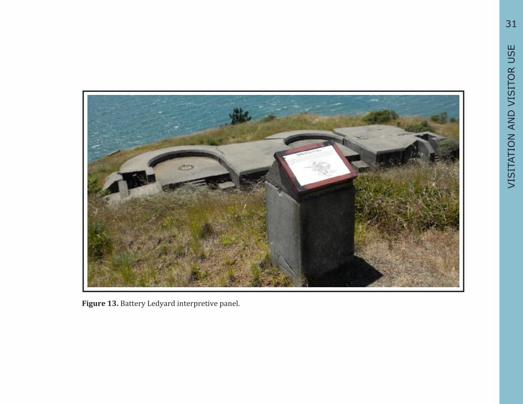
Battery LedyardVisitors look down upon Battery Ledyard as they make their way from Camp Reynolds. There is a small interpretive panel located above the site. One of the most popular vistas from AISP is at Battery Ledyard. One can see the city of San Francisco and Alcatraz Island, and it is only a 20-30 minute walk, one-way from Ayala Cove. There is a coin-operated telescope and a picnic table located here.
Battery WallaceBattery Wallace is located behind Battery Ledyard and is not accessible from the Perimeter Road. Visitors access this site from Environmental Campsites “Ridge Sites” 4 and 5. Access to the campsites is from a dirt fire road that is between Battery Wallace and Battery Drew, located off the Perimeter Road.
Battery DrewBattery Drew is the second battery the public comes to and is located on a loop off the Perimeter Road. The battery is open to the public to wander through. An interpretive panel provides a general overview at the beginning of the path to the battery. There is little information for visitors about the site.
Interpretive servicesMost interpretation at the Batteries locations consists of wayside interpretive panels that describe AISP’s cultural and natural history stories.
Nike Missile Site
The Nike missile site was used to protect San Francisco Bay during the Cold War and was the final military presence on Angel Island. It was in operation from 1955 and was dismantled in 1962 after it was deemed obsolete.
CirculationVisitors follow the Perimeter Road and reach the Nike Missile Site. From the Nike Missile Site, visitors have a view of Point Blunt, which is a Coast Guard Lighthouse and is closed to the public.
Interpretive ServicesThe site is fenced off and the public sees an interpretive panel and the above ground infrastructure.
31
VIS
ITAT
ION
AN
D V
ISIT
OR U
SE
Figure 13. Battery Ledyard interpretive panel.

32
East Garrison
The interpretive period of the East Garrison is 1898 to 1946, and emphasizes the mobilization and demobilization of troops from the Spanish American War through the Pacific Theater of World War II. East Garrison includes the Serpentine Quarry, Rock Crusher, and the Fort McDowell historic complex.
Serpentine Quarry and Rock Crusher Quarries on Angel Island were in operation from 1850 to 1922. There was a small quarry at Point Stuart, but the most heavily utilized was at Quarry Point. Stone from these quarries was used to build the fort at Alcatraz Island, the Navy base at Mare Island, and military buildings at Angel Island, the San Francisco Presidio, and Fort Point. Crushed rock was used on the island’s roads.
Visitor AmenitiesThere are picnic tables and trash cans at this site.
Interpretive ServicesAn interpretive panel at the rock crusher describes its historic use.
CirculationVisitors access the historic complex from the Perimeter Road. There is a paved minor road that goes through the historic complex and Officer’s Row, which is employee housing. Visitors access the ball field, picnic area, trails, and restrooms near the Visitor Center.
Visitor AmenitiesEast Garrison Visitor Center, baseball diamond, group picnic area and individual picnic tables, restrooms, volleyball court, self-guided tours, tram tours, Segway tours and a water fountain. Most of the buildings are empty except for the supply depot buildings located next to the visitor center, which are used for storage and maintenance for the park.
Interpretive ServicesThere are small interpretive panels in front of the visitor center, the Administration Building, the Chapel, the Hospital, and at the entrance to the historic complex. There are also two large interpretive panels located near the restrooms, which show the hiking and bicycle trails on Angel Island. Park staff and volunteers have noted the lack of interpretive services at this location. The General Plan recommends ELPs be developed here.
East Garrison Visitor Center (1989)The Fort McDowell Guardhouse houses 1500 square feet of formal exhibits, which were completed in the 1980s. Originally planned as the main access to the island, this visitor center would have replaced Ayala Cove as the primary introduction and orientation to the island. A pier was constructed to receive public ferries, but was later deemed unsafe because of wake and current conditions. The East Garrison visitor center is rarely open. The exhibits focus on the island’s military history and contain original objects from soldiers stationed at Fort McDowell.
ChapelThe chapel was restored in the 1990s. The AIC furnished the building, which is used for weddings and other special events. There are informal exhibits in the front of the chapel that provide historical and cultural interpretation.

33
VIS
ITAT
ION
AN
D V
ISIT
OR U
SE
Figure 14. Hospital building, East Garrison.

34
US Immigration Station After leaving the East Garrison, visitors continue along the Perimeter road and enter North Garrison, which was the Army’s designation for this area. Visitors pass an historic fire station, which is now the park’s maintenance yard. The US Immigration Station historic complex is part of North Garrison.
The Bureau of Immigration operated the US Immigration Station at AISP from 1910 to 1940, and was a major processing center for immigrants on the west coast. In 1940, a fire destroyed the Administration building and the station closed. The US Army received the property in 1941, and held World War II prisoners of war in the Detention Barracks until 1947. The site is going through a massive restoration and rehabilitation project, which started in 2000.
Visitor CirculationVisitors take the paved minor road from the Perimeter Road down to the historic complex. Two accessible, paved trails with benches lead from the Perimeter Road to the restrooms near the Detention Barracks. Another paved trail leads from the Hospital to the monument. Visitors access the beach along the paved road through the site.
Visitor AmenitiesGuided and self-guided tours, tram tours, Segway tours, house museum exhibits, classroom space, audio-visual programs, picnic tables, beach area, restrooms, paved trails and exterior interpretive exhibits. The entire site is accessible.
The WharfImmigrants entered the US Immigration Station site from their ferry docked at the wharf. The original pier no longer exists; however, a new section has been rebuilt for interpretation. The original US Immigration Station fog
bell is displayed here on a wooden stand along with other interpretive exhibits.
Administration Building and Asian Dining Hall FootprintsThe Administration building was once the largest structure in the cove area, and was the first place the immigrants were taken once they disembarked from their ferry. The building was destroyed in a fire in 1940, and the building footprint is now used for interpretation. The Asian Dining Hall footprint has tables and benches set up to interpret the historic use of the building.
Detention BarracksImmigrants were detained in this building while waiting for their interrogation hearings. The Barracks underwent restoration between 2006 and 2008, and is now a house museum.
HospitalThis building functioned as a hospital until 1940 and as barracks during World War II. The building is undergoing restoration and will have exhibits, interpretive offices, and flexible use spaces.
PowerhouseThe powerhouse building is closed to the public, but has the potential to be used for interpretation.
Mule BarnThis was originally used as a mule stable and was later used as a garage and housing for employees.
P.O.W. Mess HallThe Army built this structure on the recreation yard of the Detention Barracks in the early 1940s. The main room is used as an orientation area and meeting room for visitors, volunteers, and park staff.

35
VIS
ITAT
ION
AN
D V
ISIT
OR U
SE
Figure 15. US Immigration Station.

Backcountry
The Backcountry includes all trails, overlooks and vistas, and Mount Caroline Livermore.
CirculationAngel Island State Park has 13 miles of trails and roadways for hikers and nine paved miles for bicyclists. The Angel Island Loop Trail is five miles round trip with a 400-foot elevation gain. Foot trails include the North Ridge Trail, the Ida Trail, the Sunset Trail, and the Point Stewart Loop. Visitors may access trails from the Perimeter Road. The North Ridge and Sunset trails may also be accessed from Ayala Cove.
Visitor AmenitiesWayside panels are located at overlooks and vista points and there are directional signage on trails and the Perimeter Road. There are trashcans, picnic tables, and benches along the Perimeter Road.
Interpretive ServicesThe Backcountry has mostly self-guided interpretation. Volunteers occasionally lead wildflower walks on trails.
Figure 16. View from AISP, CSP 090-S21092.
36

37
EXIS
TIN
G I
NTE
RPR
ETIV
E SER
VIC
ESEXISTING INTERPRETIVE SERVICES
This section describes the existing interpretive and educational services available at Angel Island State Park (AISP). Information in this section is organized by park-wide and each Key Destination. The information in this section provides the basis for developing gap analysis and recommendations for improving and expanding these interpretive services in the future.
Park-wide InterpretationA variety of personal and non-personal interpretation is available throughout the park.
Non-personal interpretation includes: ▪ Brochures (online, print and older versions in braille) ▪ Panels and wayside shelters ▪ Flyers ▪ Orientation video (captioned) ▪ Websites (State Park and cooperating associations) ▪ Youth Programs (e.g. Jr. Rangers, Litter Getter, etc.). ▪ Pre-recorded, narrated one-hour
tram tour (concessionaire)
Personal interpretation is offered by the park and concessionaire(s) and includes: ▪ Guided Segway and Diggler Scooter
tours (concessionaire) ▪ Spring wildflower hikes (docents) ▪ Informal contacts (park staff,
concession employees, docents)Figure 17. ELP at Camp Reynolds.
38
Key Destinations
Ayala Cove
Ayala Cove is the first stop for most visitors to the island. It offers several different personal and non-personal interpretive experiences.
Non-personal interpretation: ▪ Main Visitor Center with interpretive panels,
displays, and audio-visual presentations that focus on park-wide cultural and natural history themes.
▪ Wayside interpretive panels. ▪ AIC bookstore, which sells books, merchandise,
and other park memorabilia.
Personal Interpretation: ▪ Park staff greets visitors at the dock. ▪ Staff at the AIC Bookstore, located at the dock,
provides park orientation and other information. Volunteers staff the bookstore during park hours and provide information on park topics.
▪ Explorers Tour: K-4th grade groups learn how Angel Island got its name and about the first Spanish explorers to enter San Francisco Bay
West Garrison
Camp Reynolds, part of the West Garrison, was used by the US Army from the Civil War to the turn of the 20th century. The historic core has several restored buildings that are used for interpretive programs and special events. Camp Reynolds is a twenty-minute walk from Ayala Cove, and is one of the most visited sites on the island. This site is used throughout the year by the Environmental Living Program (ELP). Visitors and stakeholders stated that they wanted additional personal interpretation here.
Non-personal interpretation: ▪ Interpretive panels and wayside maps along
the perimeter road and in front of several buildings in the historic complex.
▪ Interpretive garden: volunteers maintain a garden outside the bake house. A small sign identifies each plant.
▪ House Museum: the parlor, dining room, and kitchen of Quarters 10 and the Bake House next to it have museum exhibits. The dining room, kitchen, and Bake House are used for interpretive programs and special events.
▪ Tram stop (see park-wide interpretation).
Personal interpretation: ▪ Occasional tours of the Camp Reynolds historic
complex led by park staff and volunteers. ▪ Reenactment events include Civil War Days,
Victorian Days, and Victorian Christmas. ▪ School programs: the park, with the assistance
of volunteers, holds an ELP for fourth and fifth grade classes at the historic complex.
39
EXIS
TIN
G I
NTE
RPR
ETIV
E SER
VIC
ESThe Batteries
The Batteries include Battery Ledyard, Battery Drew, and Battery Wallace, and are part of the West Garrison. Most interpretation is limited to self-guided interpretive panels. The tram and Segway tours stop at some of these locations and some information is included in the concession-run tram audio tour.
Non-personal interpretation: ▪ Wayside panels
Personal interpretation: ▪ Tram and Segway tours: Some information about these
sites are included in the tram and Segway tours.
Nike Missile Site
Most interpretation is limited to self-guided interpretive panels. The tram and Segway tours stop here and some information is included in the audio tour.
Non-personal interpretation: ▪ Wayside panels
Personal interpretation: ▪ Tram and Segway tours: Some information about these
sites are included in the tram and Segway tours.
East Garrison
East Garrison, also called Fort McDowell, was occupied by the US Army from the late 19th century through the end of World War II. A number of buildings have been restored for use in interpretive programs, a visitor center, special events, staff housing, and park maintenance storage. Many buildings are in disrepair and are gutted. Visitors are allowed to walk through some of these empty buildings, and they have become an important part of the visitor experience. Most interpretation here is self-guided.
Non-personal interpretation: ▪ Interpretive panels along paths and in front of
buildings provide the visitor with information about East Garrison’s military history.
▪ Wayside shelters along the Perimeter Road display bicycle and hiking maps.
▪ The East Garrison visitor center provides information about Angel Island’s military history. The visitor center is only open when volunteer and park staff are available.
Personal interpretation: ▪ The Chapel is used for interpretive programs
and special events and has informal exhibits and displays set up in the entrance.
▪ The park provides occasional interpretive programs for fourth to twelfth-grade students by reservation at East Garrison where they learn about this WWI-WWII army base.
▪ Park staff and volunteers also occasionally give tours of the Chapel and Guard House/Visitor Center.
40
US Immigration Station
The US Immigration Station historic complex (landscape, building footprints, and buildings) have undergone restoration and stabilization from 2001 to present. The Detention Barracks and Administration Building Footprint have formal exhibits. Park staff offer guided walks of the grounds and guided tours of the Detention Barracks. The grounds and rooms within the Detention Barracks have self-guided wayside panels and exhibits. The Hospital Building is undergoing stabilization and will have formal exhibits and flexible use spaces for interpretive programs and special events.
Non-personal interpretation: ▪ Interpretive exhibits in the Detention Barracks and on
the grounds were developed with consideration for the needs of people with disabilities and language barriers.
▪ Wayside interpretive panels along trails and the main access road provide information about the site and are in Chinese and English.
▪ A topographic map and an interrogation table on the Administration Building footprint provide tactile, interactive, and self-guided interpretation.
▪ Interpretive panels and displays in the Detention Barracks provide tactile, audio, and interactive self-guided interpretation. A captioned digital slideshow of historic photos and is used for playing videos and presentations. A row of bunks have been set up with suitcases and personal items that visitors may touch.
▪ Interpretation on the grounds and in the orientation room of the Detention Barracks is self-guided, while the furnished rooms can be seen on a guided tour.
Personal Interpretation: ▪ Park interpretive staff and volunteers give guided and
self-guided tours five days a week. The majority of the Detention Barracks museum is shown by guided-tour; it is also self-guided during high visitation periods.
▪ The POW Mess Hall is a flexible space used for staging interpretive programs and special events as well as showing park videos and small changing exhibits.
▪ Once the hospital building is restored, room use will be flexible and adaptable to allow for changing exhibits, special events, conference space, and places for visitors to gather and reflect on their experience there.
▪ Interpretive programs, exhibits, and displays will discuss US Public Health policies towards immigrants, their experience at the site, as well as contemporary immigration issues.
▪ School programs: two-thirds of the tours are given to fourth- through sixth-grade students.
▪ Special events include the Naturalization Ceremony where US Immigration officials conduct a naturalization ceremony on AISP for US Citizenship Day.
▪ Poetry events are held at the site.

41
EXIS
TIN
G I
NTE
RPR
ETIV
E SER
VIC
ESBackcountry
The Backcountry includes all trails, overlooks and vistas, and Mount Caroline Livermore.
Non-personal interpretation: ▪ Wayside panels
Personal interpretation: ▪ Guided Hikes: A limited number of nature
tours are available by reservation. Routes vary depending on age and ability of attendants.
▪ Tram and Segway tours: Some information about these sites is included in the tram and Segway tours.
Figure 18. Segway tours of the island.

42

43
PART
NER
SH
IPS A
ND
SU
PPO
RTPARTNERSHIPS AND SUPPORT
California State Parks seeks partnerships with private and non-profit organizations to support interpretive services, recreation, conservation, and preservation programs at parks. These organizations support the CSP mission through fiscal contributions, volunteer programs, fostering community stewardship for parks, and through preservation efforts.
Partners have the ability to advocate for raise money and attention for a park’s interpretive services and long-range goals where the CSP may not. This section highlights Angel Island State Park’s (AISP) significant partners. It also describes interpretive providers who have similar programs to the park’s and who could become future partners.
Cooperating Associations
Angel Island Conservancy (AIC) is a nonprofit organization that works in partnership with AISP and CSP to facilitate the preservation, restoration, and interpretation of historical and natural resources on AISP. The Angel Island Conservancy’s goal is to create an awe-inspiring visitor experience and to build a community in support of the park.
Past projects of the AIC include the restoration and preservation of the Civil War-era officers’ quarters and bake house located at West Garrison’s Camp Reynolds, which provides visitors a “living” focus for interpretation of life in those times. More recently, the AIC has played a central role in the funding and development of this Interpretation Master Plan. Looking into the future, the AIC
will be instrumental in the implementation and funding of various projects under the IMP.
The AIC works with AISP to raise funds and to develop programs for this special place that has something for everyone. The AIC does this with the community and for the community. Whether providing scholarships for underserved students to visit the island or helping implement a project under this plan, The AIC is continually working with park staff and the community to revitalize AISP and transform it into one of the Bay Area’s must-see destinations.
Angel Island Immigration Station Foundation (AIISF) is a nonprofit 501(c) 3 organization whose mission is to promote a greater understanding of Pacific Coast immigration and its role in shaping America’s past, present, and future. AIISF raises funds to restore, preserve, and interpret the US Immigration Station at AISP, a National Historic Landmark. In partnership with the CSP, AIISF educates the public about the complex story and rich cultural heritage of Pacific Coast immigrants and their descendants.

44
AIISF has created an online repository of stories entitled “Immigrant Voices.” By going to www.aiisf.org/immigrant-voices, visitors can see a rich and diverse collection of personal stories about immigrants who came through Angel Island, as well as those who came many years after the US Immigration Station closed. AIISF also conducts outreach presentations, seminars, and teacher training workshops. Gateway to Gold Mountain, AIISF’s traveling multi-panel exhibit, which chronicles the Angel Island story, has been seen by tens of thousands of people nationwide.1
Each year, AIISF presents the Immigrant Heritage Award, which is given to individuals and organizations whose work celebrates the important contributions immigrants have made to our country. For more information about AIISF, visit www.aiisf.org.
1 “About the Foundation.” Angel Island Immigration Station Foundation. Angel Island Immigration Station Foundation, 2007-2008. Web. 29 Jul 2010. <http://www.aiisf.org/index.php/about>
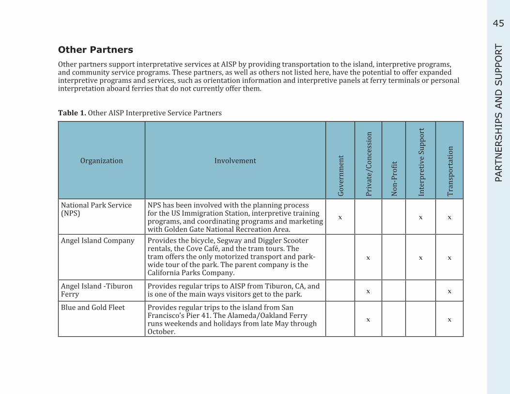
45
PART
NER
SH
IPS A
ND
SU
PPO
RTOther PartnersOther partners support interpretative services at AISP by providing transportation to the island, interpretive programs, and community service programs. These partners, as well as others not listed here, have the potential to offer expanded interpretive programs and services, such as orientation information and interpretive panels at ferry terminals or personal interpretation aboard ferries that do not currently offer them.
Table 1. Other AISP Interpretive Service Partners
Organization Involvement
Gove
rnm
ent
Priv
ate/
Conc
essi
on
Non
-Pro
fit
Inte
rpre
tive
Supp
ort
Tran
spor
tatio
n
National Park Service (NPS)
NPS has been involved with the planning process for the US Immigration Station, interpretive training programs, and coordinating programs and marketing with Golden Gate National Recreation Area.
x x x
Angel Island Company Provides the bicycle, Segway and Diggler Scooter rentals, the Cove Café, and the tram tours. The tram offers the only motorized transport and park-wide tour of the park. The parent company is the California Parks Company.
x x x
Angel Island -Tiburon Ferry
Provides regular trips to AISP from Tiburon, CA, and is one of the main ways visitors get to the park. x x
Blue and Gold Fleet Provides regular trips to the island from San Francisco’s Pier 41. The Alameda/Oakland Ferry runs weekends and holidays from late May through October.
x x

46
Organization Involvement
Gove
rnm
ent
Priv
ate/
Conc
essi
on
Non
-Pro
fit
Inte
rpre
tive
Supp
ort
Tran
spor
tatio
n
Alcatraz Cruises Ferries run a combined tour with Alcatraz and AISP. x x
USS Potomac Offers special cruises to AISP from Jack London Square in Oakland. The cruise includes a tour of the island.
x x x
California State Parks Foundation.
Hosts a podcast entitled, “Parkcast” on the CSP website about AISP. x x
Center for Volunteer and Nonprofit Leadership of Marin
Sponsors the “Week of Caring” in Marin County and has organized groups of volunteers to do service projects at AISP.
x x
Pacific Gas and Electric Organizes groups of volunteers to do service projects on AISP. x x
Service Camps Organizations like the Girl Scouts and Boy Scouts do service projects regularly on AISP. The Service Camp is organized through the park staff.
x x x
Environmental Traveling Companion
Hosts an overnight program at Camp Reynolds (West Garrison) for disadvantaged youth and people with disabilities.
x x
SFPD Wilderness Program:
The program brings San Francisco’s at-risk youth and the city’s police officers together to share positive and challenging adventures. A peace officer leads programs on AISP that may include backpacking, day hikes, and kayaking, sailing, and community-service programs.
x x

47
PART
NER
SH
IPS A
ND
SU
PPO
RTPublic Awareness and Community InvolvementThe park’s close proximity to the San Francisco Bay Area makes it a popular recreational destination for families, and offers a wealth of history for those interested in the cultural resources. Beyond visiting the park, there is a long history of community involvement in protecting and interpreting the island’s cultural and natural resources. As an example, the Angel Island Foundation (now AIC) was a nonprofit collective of community members and businesses that campaigned for the island to becomea state park in the 1940s and 1950s. Currently, the park has two very active cooperating associations that contribute funds for interpretive programs and conservation of buildings and museum collections, and sponsor many of the special events at the park. Several local and national organizations host service projects and events at AISP on a regular basis.
Public and private schools attend interpretive programs at AISP. The popular ELP at Camp Reynolds (West Garrison) draws elementary schools from the Bay Area and throughout the state. Currently, the primary users of the US Immigration Station programs are also school groups. Volunteers give many of the interpretive programs at the park, assist in special events, help maintain the buildings, and work on special service projects.
Hiking, kayaking, and bicycle groups use the island’s trails and facilities. Many local businesses and organizations use the group picnic areas at the park. Weddings are held outdoors or at the Chapel at East Garrison. Wildflower walks are popular during the springtime. Members of the National Civil War Association participate in living history programs at West Garrison’s Camp Reynolds during the Civil War Days.
Other Interpretive ProvidersAISP is part of a larger network of outdoor recreation and educational providers in the San Francisco Bay Area. Many museums, schools, organizations, and parks have programs and services that complement the park’s interpretive themes and, programs, and recreational opportunities.
The park benefits from collaborating with providers when developing interpretive programs and seeking funding for projects. As an example, the Golden Gate National Recreation Area (GGNRA), and AISP collaborate on many programs and consult in major capital projects. The two sites are historically connected, as they were part of the same military defense program, thus, they share many interpretive themes and periods. Interpretive staff at both parks shares research information and participate in interpretive training opportunities. Concessionaires also benefit from this partnership as some ferries companies offer combined tour packages between National Park Service and State Park sites.
Appendix E provides a partial listing of interpretive providers in the region. It is organized by type of interpretive services, subject matter, and distance from the park. The table is a quick glance at Bay Area’s recreational and educational opportunities. These organizations or sites have a historical connection to AISP or have similar programs and recreational opportunities. This table can be used when developing interpretive programs or when seeking new or expanded partnership opportunities.
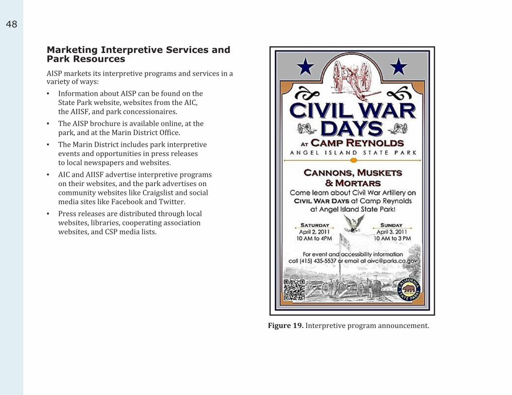
48
Marketing Interpretive Services and Park ResourcesAISP markets its interpretive programs and services in a variety of ways: ▪ Information about AISP can be found on the
State Park website, websites from the AIC, the AIISF, and park concessionaires.
▪ The AISP brochure is available online, at the park, and at the Marin District Office.
▪ The Marin District includes park interpretive events and opportunities in press releases to local newspapers and websites.
▪ AIC and AIISF advertise interpretive programs on their websites, and the park advertises on community websites like Craigslist and social media sites like Facebook and Twitter.
▪ Press releases are distributed through local websites, libraries, cooperating association websites, and CSP media lists.
Figure 19. Interpretive program announcement.

49
REF
EREN
CES
49
INTE
RPR
ETAT
ION
FRAM
EWO
RKINTERPRETATION FRAMEWORK
This section presents the foundation for interpretation from the statewide to the park levels. The Mission and Vision for interpretation statements guide the development and management of interpretive services for CSP and the park. Information in this section guides the development of content for interpretive programs, exhibits, printed and online media, and other interpretive services.
The Interpretation Overview is a starting point when planning interpretive content and curriculum. Topics and themes can be developed further, along with storylines.
CSP Interpretive FrameworkThe planning team used the Department’s interpretive framework presented here to gauge existing interpretive services and to help develop future goals.
CSP MissionThe mission of the California Department of Parks and Recreation is to provide for the health, inspiration, and education of the people of California by helping to preserve the state’s extraordinary biological diversity, protecting its most valued natural and cultural resources, and creating opportunities for high-quality outdoor recreation.
CSP VisionCSP will be the recognized leader in the park and recreation field—skilled stewards of resources, technologically wise, and relevant to all Californians.
California State Parks’ Strategic Initiatives:In 2001 and later updated in 2008, CSP developed a
strategic vision. In “The Seventh Generation,” CSP outlines its role in protecting its precious resources while balancing the recreational and educational needs of millions of Californians. It outlines five strategic initiatives that support the mission of CSP and set the direction for interpretive programming. These are: ▪ Promoting Health ▪ Achieving Sustainability ▪ Embracing Diversity ▪ Making Connections ▪ “Cool Parks” (addressing climate change)
CSP Interpretation Mission StatementInterpretation is a special form of communication that helps people understand, appreciate, and emotionally connect with the rich natural and cultural heritage preserved in parks. It is the mission of interpretation in CSP to convey messages that will help visitors value their experience, and that ultimately will also foster a conservation ethic and promote a dedicated park constituency.
CSP Education Mission StatementThe most powerful forms of education involve students in meaningful experiences that promote critical thinking and appeal to different learning styles. Our mission is to provide educational opportunities in both CSP and the classroom, assisting educators with curriculum needs and offering activities that enable students to investigate, research, and participate in interactive learning.
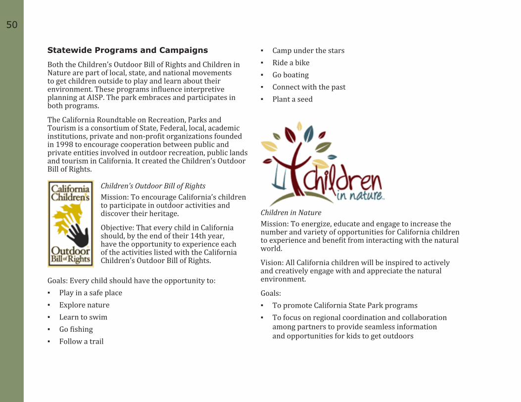
5050
Statewide Programs and Campaigns
Both the Children’s Outdoor Bill of Rights and Children in Nature are part of local, state, and national movements to get children outside to play and learn about their environment. These programs influence interpretive planning at AISP. The park embraces and participates in both programs.
The California Roundtable on Recreation, Parks and Tourism is a consortium of State, Federal, local, academic institutions, private and non-profit organizations founded in 1998 to encourage cooperation between public and private entities involved in outdoor recreation, public lands and tourism in California. It created the Children’s Outdoor Bill of Rights.
Children’s Outdoor Bill of RightsMission: To encourage California’s children to participate in outdoor activities and discover their heritage.
Objective: That every child in California should, by the end of their 14th year, have the opportunity to experience each of the activities listed with the California Children’s Outdoor Bill of Rights.
Goals: Every child should have the opportunity to: ▪ Play in a safe place ▪ Explore nature ▪ Learn to swim ▪ Go fishing ▪ Follow a trail
▪ Camp under the stars ▪ Ride a bike ▪ Go boating ▪ Connect with the past ▪ Plant a seed
Children in NatureMission: To energize, educate and engage to increase the number and variety of opportunities for California children to experience and benefit from interacting with the natural world.
Vision: All California children will be inspired to actively and creatively engage with and appreciate the natural environment.
Goals: ▪ To promote California State Park programs ▪ To focus on regional coordination and collaboration
among partners to provide seamless information and opportunities for kids to get outdoors

51
REF
EREN
CES
51
INTE
RPR
ETAT
ION
FRAM
EWO
RK ▪ To increase the number and capacity of public, private
and nonprofit organizations committed to providing opportunities to connect children with nature
▪ To engage the private sector for funding and other support for the Campaign
▪ To help provide opportunities for children to participate in unstructured play in the natural environment
▪ To further the welfare of California’s children through the following:
₋ Encourage children to experience nature and give them the opportunity to develop a sense of wonder and joy for the natural world
₋ Increase children’s awareness that nature is everywhere
₋ Build children’s knowledge of the interconnectedness of natural systems
₋ Help children develop the critical scientific and social skills necessary to address environmental issues, both locally and global.
AISP Interpretive FrameworkThe Mission and Vision for Interpretation statements for AISP were developed by the IMP planning team. This section includes previous interpretive planning information, some of which was updated and developed further for the IMP.
Declaration of PurposeThe Declaration of Purpose is the “mission statement” for each unit of the CSP System and describes the purpose of the park. It is the broadest statement of management goals,
designed to fulfill the vision for the park and providing direction for the development of the park’s 1979 General Plan.
“The purpose of Angel Island State Park is to provide for all people opportunities to enjoy forever the great scenic and natural values for this largest island in San Francisco Bay, replete with historic installations and associations, located in the midst of the San Francisco metropolitan area yet uniquely isolated by the waters of the Bay from the rush of modern transportation and pressures of modern civilization.
The function of the Division of Beaches and Parks at Angel Island State Park is: to preserve and protect the natural and historic values of Angel Island; to provide appropriate interpretive services and facilities; to defend the geographical isolation of the island, in order to preserve the unique experience for visitors which is dependent on such isolation; to provide appropriate recreational opportunities for visitors; and to provide such facilities for public service, consistent with the purpose of the park, as may be necessary for the full enjoyment of the park by the people.”
AISP Vision for InterpretationThe vision for interpretation at AISP is to create opportunities for visitors to explore the island’s natural and cultural resources, to give visitors tools to make connections to the site, to understand the park’s physical complexity and rich history, and to inspire conservation of these unique resources.
AISP’s Mission of InterpretationThe mission of interpretation at AISP is to provide visitors high quality, enjoyable, and relevant interpretive programs

5252
and exhibits, to enhance the quality of their recreational and educational experiences, and to increase their appreciation of the shared role of CSP and the visitors as stewards of these resources
Interpretive SignificanceAngel Island was an important entry point for Asian Immigrants and others entering America on the west coast. Because of this, the US Immigration Station at Angel Island was placed on the National Register of Historic Places in 1971 and the site achieved National Historic Landmark status in 1997. The island is designated a California Historical Landmark for both the US Immigration Station and the military’s presence there.
The interpretive periods include Native American, Spanish, and Mexican eras; US Military involvement from 1863 to 1964; US Public Health Service operation of the Quarantine Station; impact of the Chinese Exclusion Act and the US Immigration Service’s involvement from 1910-1940; the immigration process and immigrants’ experiences; and the transition to a state park in 1954.
Interpretive PeriodsInterpretive periods define the time period and major topics that will be identified at a park unit. It provides greater clarity to what is interpreted at the site, and allows the park to focus on specific themes, which are important to the realization of its interpretive mission and vision statements. The following interpretive periods were identified in the 1979 general plan and have been updated to reflect current interpretation at AISP:
Geologic History
Native American
Spanish 1775-1822
Mexican 1822-1846
Antonio Maria Osio 1839-1846
American 1846 to present
US Army, 1863-1962 ▪ Civil War, 1863-1865 ▪ Indian Wars, 1860s-1880s ▪ Spanish-American War and Philippine
Insurrection, 1898-1902 ▪ World War I ▪ World War II ▪ Cold War, 1954-1962
US Quarantine Station, 1891-1946 US Immigration Station, 1905-1940
California State Parks, 1954-present

53
REF
EREN
CES
53
INTE
RPR
ETAT
ION
FRAM
EWO
RKInterpretive Topics and Themes
Interpretive themes are essential to the development of effective interpretive services and planning. Themes clearly describe the significance of the resources and describe a park’s reason for being. They set the direction of interpretive programs and exhibits at the park, and evolve over time, depending on new research and the changes in approach to interpretation resources.
The first themes developed for AISP date from the 1977 Interpretive Prospectus and the 1979 general plan. The general plan laid out the approved themes and time-periods for the park and guided the long-range development of interpretation. These themes were written more than thirty years ago and are now considered general topics rather than specific themes. The park’s original themes were revised during the IMP planning process and now include a unifying theme, with primary and secondary thematic statements.
General Plan and Interpretive Prospectus Topics:
Feeling Like an Island
What makes an island
Formation of Angel Island and San Francisco bay
Marine environment
Marine climate
Ocean and river influences
Isolation
Natural History of Angel Island
Geology
▪ Formation ▪ Soils
Water Story ▪ River ▪ Bay ▪ Ocean ▪ Tides and Currents ▪ Climate
Plant Life ▪ Native Species and Communities ▪ Exotic (Introduced) Species and Communities ▪ Marine Plants ▪ Ecology of Plants at Angel Island
Animal Life ▪ Island Land Dwellers ▪ Marine Animals ▪ Ecology of Animals at Angel Island
Island Dispersal—Plants and Animals
Marine Ecosystems at Angel Island
Human Involvement with Angel Island
Native Americans
Exploration and Discovery (Spanish/Mexican)
Island Use Before the Army Came

5454
The Army Story ▪ Defense of the Bay ▪ Barracks, Bugles and Brass ▪ Life and Times of the Military Personnel, 1863-1898 ▪ Training, Transfer and Termination ▪ Firehouse of the Far West ▪ The Role of Angel Island in the Settlement
of the Far West, 1865-1898 ▪ Role of Angel Island, the Story of the
People of Angel Island, 1898-1946 ▪ Army Medicine: Role of Angel Island as
Quarantine Station and Medical Station
African Americans at Angel Island
US Immigration Story
The Quarantine Station
Cultural Contrasts in Use of Angel Island ▪ Native American Era ▪ Spanish Era ▪ Mexican Era ▪ American Era
Water Transportation: Transportation and Recreational Use of Boats throughout the History of Angel Island.
Urban Geography as seen from Angel Island
Park-wide Themes
Park Unifying Theme
AISP offers visitors a voyage through time as they explore the island’s natural and cultural history surrounded by, and in contrast to, the urban landscape of the San Francisco Bay Area.
Park-wide Primary and Supporting Themes
Angel Island played a key role in defending the west coast during a 100-year period. ▪ Angel Island’s strategic location in San Francisco Bay
made it an important location for the US government to establish military, quarantine, and immigration services.
Angel Island serves as a refuge for enjoying recreation and natural beauty amidst a large urban area.
Though Angel Island is the largest island in San Francisco Bay, factors such as isolation and terrain have limited its use over time.
The choices we make every day affect the vitality of AISP’s cultural and natural resources.
Park-wide Secondary Themes
Angel Island was once one of the large hills of Marin before the Sacramento River and the rising bay waters disconnected it from the mainland.
Due to its isolated environment, plant and animal populations on Angel Island developed differently from those on the mainland.

55
REF
EREN
CES
55
INTE
RPR
ETAT
ION
FRAM
EWO
RKAngel Island has a long and diverse maritime history.
Humans significantly altered the landscape and environment of Angel Island through extensive use of its natural resources and introduction of exotic species.
The military planted many non-native trees on Angel Island to conserve water, to curtail erosion, and to serve as windbreaks in the areas where people lived.
Maintaining healthy plant and animal populations on Angel Island often requires human intervention.
Angel Island has always relied heavily on the mainland to supply critical resources and services.
For many years, water was the most limited resource for the island’s population.
Today, AISP’s resident and visiting populations continue to rely on resources and services from the mainland.
Due to the island’s varied history, many people have connections to the park that they might not realize.
The changing ocean chemistry related to climate change will affect the marine ecosystem of the bay in ways scientists cannot yet predict.
Future climate change will affect how much water flow there is in the Sacramento River, which will in turn affect the flow of freshwater into the bay.
In the future, rising sea levels caused by the changing climate will likely impact low-lying areas of Angel Island and the entire San Francisco Bay.
People’s actions in response to climate change could minimize the impacts on the environment and help preserve and maintain AISP for future generations.
Key Destination ThemesEach Key Destination has its own distinct personality, stories, and interpretive opportunities. This section has expanded interpretive themes for each of these destinations. Interpretive planners should consult this section when developing programs, exhibits, interpretive panels, and additional storylines.
Ayala Cove
Unifying ThemeAyala Cove has a long history of human use due to its natural harbor and sheltered waters.
Primary and Supporting ThemesAyala Cove’s sheltered waters have made it the main landing point on Angel Island throughout its history.
Ayala Cove has a long history of human use prior to the 1860s; the Coast Miwok used it as a hunting and fishing camp, and the Spanish and Mexicans for cattle ranching and to supply passing ships with water and fuel.
The island’s isolation in close proximity to San Francisco made it a desirable location for the US government to set up a Quarantine Station. ▪ San Francisco’s prominence as an international shipping
and immigration port in the latter half of the 1800s led to an ever-increasing number of vessels, cargo, and people that brought communicable diseases with them.
▪ The same isolation factor that made Angel Island appropriate for a Quarantine Station also caused its closure.

5656
AISP offers a wealth of recreational opportunities for individuals, groups, and families alike.
Secondary and Supporting ThemesAs you land in Ayala Cove, you are a part of the continuing stream of visitors, from the Native Americans to the present. ▪ Archaeological evidence from middens shows that
the Coast Miwok used the island as a hunting and fishing camp and did not live here full time.
▪ Before 1859, Europeans stopped at Ayala Cove to gather wood and to make repairs on their ships.
Non-native plants and animals, introduced by humans, have altered the natural habitats on Angel Island. ▪ Two hundred years ago, Angel Island’s ecosystems,
flora and fauna were different than they are today.
Because of citizens’ efforts, Ayala Cove became the first section of Angel Island that was set aside for public use.
Racoon Strait connects the Delta to San Francisco Bay and is part of the San Francisco estuary.
West Garrison
Unifying ThemeThe West Garrison was an integral part of the west coast defense system that spanned several conflicts
Primary and Supporting ThemesCamp Reynolds was part of a network of military fortifications in the San Francisco Bay Area from 1863 to 1964. ▪ Camp Reynolds was the first military
installation on Angel Island.
Secondary and Supporting ThemesBy 1876, Camp Reynolds resembled a small town, complete with over 200 soldiers, a chapel, bakery, blacksmith, shoemaker, laundry, barber, trading store, hospital, school, cemetery, and a small farm and dairy. ▪ Camp Reynolds has had its share of colorful characters. ▪ The post community at Camp Reynolds included
civilians, craftsmen, and military personnel. ▪ Although it was isolated in the middle of San Francisco
Bay, Angel Island was considered a comfortable post.
The men stationed at Angel Island in the years following the Civil War were often assigned to suppress the Native American uprisings in the western and southwestern US.
Alcatraz Gardens was the site of a large garden cultivated by soldiers from Camp Reynolds and, later, by inmates from the military prison on Alcatraz Island.
Angel Island has a long and diverse maritime history.
57
REF
EREN
CES
57
INTE
RPR
ETAT
ION
FRAM
EWO
RK ▪ Several wharves had been constructed and used at
Camp Reynolds near the Quartermaster’s building.
The long-term sustainability of AISP’s cultural and natural resources relies on a commitment by its public and private partners. ▪ Several stabilized buildings at Camp Reynolds
are used for interpretive programs due to the strong commitment and support of community partners and park volunteers.
▪ Many people visit Camp Reynolds to learn about their friend or family members' experiences while stationed there.
Humans significantly altered the landscape and environment of Angel Island through extensive use of its natural resources and introduction of exotic species. ▪ The plants you see on Angel Island now are a long-
lasting record left by the people that once lived there. ▪ When the Army arrived in 1863 to establish
Camp Reynolds, the island, largely bare of trees, was covered with European grasses.
▪ Eucalyptus is an invasive, non-native species, which has greatly altered the natural environment on the island; at the same time, it has been an important part of the cultural landscape since the Civil War.
With no large predators on the island, maintaining healthy plant and animal populations often requires human intervention. ▪ Beginning in 1908, the military planted trees on Angel
Island to conserve water, to curtail erosion, and to serve as windbreaks in the areas where people lived.
▪ Most deer are descended from those that were introduced by the Army in 1915, and without predatory control, their numbers at times are greater than the island can naturally support.
▪ CSP actively manages the natural resources on Angel Island.
The Batteries
Unifying ThemeThe batteries on Angel Island part of the coastal defense network that protected the San Francisco Bay from the Civil War to 1915.
Primary and Supporting ThemesThe US military considered Angel Island an important location for the placement of weaponry to defend San Francisco Bay from attack. ▪ The West Garrison’s gun batteries had the most
recent technology for its day; however, military weapons technology quickly changed, rendering the gun batteries obsolete within a few years.
▪ The West Garrison’s gun batteries completed a triangle of gun positions at Fort Point, Alcatraz, and Angel Island that protected the bay from attack by sea.

5858
Nike Missile Site
Unifying ThemeThe Nike missile site was used to protect San Francisco Bay during the Cold War and was the final military presence on Angel Island.
Primary ThemesAngel Island was one of eleven Nike batteries built in the Bay Area during the Cold War.
Around 100 people were stationed at East Garrison to run the Nike site.
The battery was obsolete within 6 years of being built.
The closure of the Nike battery ended 99 years of military history on Angel Island.
East Garrison
Unifying ThemeFort McDowell processed soldiers leaving for, and returning from, overseas posts during the Spanish American War and World Wars I and II.
Primary ThemesFort McDowell served as a crossroads for soldiers coming and going from the Pacific Theater.
The Army camp at Fort McDowell was first constructed to quarantine and process soldiers returning from the Philippines during the Spanish American War.
Fort McDowell was a recruiting depot for soldiers entering the Army during World War I, and it processed those returning from Pacific posts.
Construction of a recruiting camp at Fort McDowell began in 1909, and within a few years, there was a 600-man barracks, a hospital, a main mess hall, a large post exchange, officers’ quarters, a guardhouse, and several other buildings.
Fort McDowell was a full-service operation, which offered everything a soldier needed to live, including a railroad ticket office, Wells Fargo Express Company office, a bowling alley, and baseball field.
Fort McDowell has had its fair share of colorful characters.
The busiest time for the post was directly after World War II, when thousands of soldiers passed through on their way back from the Pacific Theater.
Secondary and Supporting ThemesHumans significantly altered the landscape and environment of Angel Island through extensive use of its natural resources and introduction of exotic species. ▪ The plants you see on Angel Island now are a long
lasting record left by the people that once lived here. ▪ Angel Island’s quarries supplied construction
material for buildings on Angel Island, Alcatraz, and in San Francisco.
▪ Prison inmates provided the labor to quarry Angel Island’s rock, used to build the fortress on Alcatraz Island that later became the site of the famous prison.
▪ Quarry Point once had a hill that measured over one hundred feet; by the time quarry operations ceased the hill was completely gone.
Recreation has been an important feature of Fort McDowell from the days of the military post until today.

59
REF
EREN
CES
59
INTE
RPR
ETAT
ION
FRAM
EWO
RKThe long-term sustainability of AISP’s cultural and natural
resources relies on a commitment by its public and private partners.
Several stabilized buildings at Fort McDowell are used for interpretive programs due to the strong commitment and support of community partners and park volunteers.
Because of the island’s varied history, many people have connections to the park that they might not realize. ▪ Many people visit Fort McDowell to learn
about their friends' or family members' experiences while stationed there.
US Immigration Station
The interpretive strategy identifies two secondary interpretive periods: ▪ The development of the US Immigration
Station site from 1905 to 1910. ▪ The World War II Prisoner of War
period from 1941 to 1946.
Unifying ThemeAngel Island US Immigration Station is a lens through which the broad contemporary issues of immigration, diversity, and culture and class conflict can be examined with historical perspective. Its legacy serves as a touchstone for personalizing and humanizing the complicated intersections of race, immigration and our American identity.” (Angel Island Immigration Station Master Plan, 2003)
Primary ThemesFreedom, opportunity, war, poverty, and natural disasters are driving forces of immigration.
US immigration policy, shaped by economics and politics, often differed depending on ethnicity or nationality.
Detention at the immigration station deeply affected many immigrants, and affected staff as well.
Secondary and Supporting ThemesOver one million immigrants, principally from Pacific Rim countries, were processed through Angel Island’s US Immigration Station between 1910 and 1940.
The harshest immigration laws were directed at Chinese immigrants, in which resulted in extended detention and unfair questioning of Chinese arrivals. ▪ Other discriminatory laws were passed that
affected immigration from South Asia, Japan, the Philippines, and other Pacific Rim countries.
There was a difference in immigration policy practiced on the East Coast versus the West Coast. While the Statue of Liberty welcomed immigrants to Ellis Island, Angel Island was considered the Guardian of the Western Gate and enforcer of immigration policies.
The US Immigration Station was located on Angel Island to enforce the 1882 Chinese Exclusion Act. The design of the facility reinforced discriminatory practices and prejudice towards non-white immigrants.
Many Chinese detainees were so affected that they left poetic records of their experiences carved on the walls of the Detention Barracks.

6060
Conditions in the US Immigration Station detention facilities were crowded, unsanitary, and unsafe. ▪ The central hub of the US Immigration Station
was the Administration Building, where intake processing, administrative tasks, meals, interrogations and some detention took place.
▪ Life experiences and conditions at the US Immigration Station differed between the detainees, the administrators and officers, and the general staff and their families.
Humans significantly altered the landscape and environment of Angel Island through extensive use of its natural resources and introduction of exotic species. ▪ The plants you see on Angel Island now are a long
lasting record left by the people that once lived there. ▪ The choices we make every day affect the vitality
of Angel Island’s cultural and natural resources.
The long-term sustainability of AISP’s cultural and natural resources relies on a commitment by its public and private partners.
The US Immigration Station area has undergone several conservation efforts due to the strong commitment and support of community partners and the state and federal governments.
Because of the island’s varied history, many people have connections to the park that they might not realize.
Many people who have passed through the US Immigration Station on AISP are teaching their children and grandchildren about their experiences there.
▪ Former detainees of the US Immigration Station actively volunteer their time to teach visitors about their experiences.
Backcountry
This area consists of Mount Caroline Livermore, beaches, trails, overlooks, and other sites not located within the historic areas listed in this section.
Unifying ThemeAISP’s natural environments have persevered despite alterations made by humans.
Primary Theme and Supporting ThemesThe plants you see on Angel Island now are a long-lasting record left by the people that once lived here.
By the 1850s, Spanish and Mexican use of Angel Island caused a significant change in the landscape, due to consumption of wood for fuel and construction, and subsequent cattle ranching.
Since 1908, the federal and state governments have actively managed the natural resources and landscapes on Angel Island.
The 2008 fire on AISP cleared invasive plants and made way for native plant species to make a comeback.
The military introduced deer to Angel Island in 1915, and without predatory control, their numbers at times are greater than the island can naturally support.
The military planted trees on Angel Island to conserve water, curtail erosion, and to serve as a windbreaks in the areas where people lived.

61
REF
EREN
CES
61
INTE
RPR
ETAT
ION
FRAM
EWO
RKCSP actively manages the natural resources on Angel Island.
AISP relies heavily on the mainland to supply critical resources and services.
For many years, water had to be transported onto Angel Island to support the thousands of troops who were stationed there.
Angel Island serves as a refuge for enjoying recreation and natural beauty amidst a large urban area. ▪ After the military based closed, local
citizens petitioned the government to make Angel Island a California State Park.
▪ Because of the efforts of conservationist Caroline Livermore and other concerned citizens, the public enjoys AISP and other open spaces in Marin County today.
Curriculum StandardsTeachers often utilize CSP’s interpretive programs and services as a way to enhance their students’ learning through engaging multiple learning styles and hands-on experiences. Angel Island State Park offers a variety of interpretive programs for grades K-5 that focus on history, social science, and science, with much room to grow in the future. When developing content for interpretive programs, exhibits, and services, CSP follows the California State Board of Education Content Standards 2 (CSB) and the Education and Environmental Initiative (EEI) curriculum3. See Appendix B for the listing of CSB and EEI curriculum that best relate to the park’s interpretive themes.
2 California State Board of Education, “Content Standards.” Last modified Tuesday, September 27, 2011. Accessed April 17, 2012. http://www.cde.ca.gov/be/st/ss/index.asp.3 California Environmental Protection Agency. (2011, July 26).California’s environmental principles and concepts. Web. 18 Apr 2012. http://www.calepa.ca.gov/education/principles/

6262

63
AN
ALY
SISANALYSIS
This section analyzes the existing interpretive conditions at Angel Island State Park (AISP). First, it analyzes the current interpretive conditions from a park-wide perspective and visitor experience. Next, the information is presented by Key Destination. Finally, the section looks at park infrastructure and operational concerns.
The Interpretation Master Plan (IMP) process involved reviewing past park planning efforts, current interpretive programs and offerings and park operations4. Through the process, two stakeholder workshops were held and an informal intercept visitor survey was conducted. This data was used to identify gaps in interpretive content, media, and delivery as well as park operational challenges and visitor needs and expectations.
Park-wide Interpretation
Trip Planning
Many visitors found it cumbersome to search several websites to obtain basic information about ferries, camping, tour reservations, special events, park operations, and interpretive programs. Coordinating information between these sites was desirable. It was recognized that the park, in conjunction with cooperating associations, ferries, and on-island concessions should work to consolidate and/or combine online trip planning information.
4 Although this plan focuses specifically on interpretation, it was recognized that some park infrastructure and operational concerns should be addressed before interpretive projects take place.
Commercial Ferries
More visitors get to AISP by commercial ferry than by their own watercraft. California State Parks currently does not provide park orientation information and interpretive materials aboard ferries and at ferry terminal waiting areas. The 1979 general plan suggested putting interpretive panels on the commercial ferries; this need was identified at recent stakeholder meetings. Suggestions included interpretive panels, volunteers positioned at terminals and aboard ferries, computer kiosks, and information downloadable to hand-held devices.
Commercial ferries may cost up to $73.00 per person for a round trip ticket. During the planning process, stakeholders felt the high cost of transportation limited visitor access only to those who can afford it. Without sufficient data, it is difficult to determine whether this anecdotal evidence is accurate. However, it is reasonable to assume transportation costs limit the number of lower income visitors as well as the logistics involved in getting to the island.
Arrival Orientation
Once visitors arrived by ferry at Ayala Cove, many found it difficult to locate information about the park. At the dock, there is no consolidated park orientation, ferry schedule, or guide to what visitors can do at the park.
Greeters
Staffing levels are low during the off-season and there is not always enough staff and volunteers to greet and guide visitors to information about the park’s interpretive and recreational opportunities. Some park information is available through the Cove Café, run by a concessionaire.
64
Park Orientation and Directional Signage
Stakeholders and visitors requested clear and easy to find orientation and directional signage, especially regarding trails. They wanted more information about park hours, concessions and park tours, and recreational and interpretive opportunities at the dock and at other areas in the park.
The visitor survey indicated that the trails to the Perimeter Road were not well marked to the top, or even upon arrival at the top. There are many opportunities here to engage visitors through new technologies and their own hand-held devices.
Our analysis found that visitors wanted more orientation and park information at each of the six historic sites (Ayala Cove, West Garrison, the Batteries, East Garrison, the US Immigration Station, and the Backcountry), trailheads, and main overlooks. An orientation kiosk at each site might solve some of these problems. Information to consider for each site includes park trail maps, guides to interpretation and recreational opportunities, ferry times, and estimated walking times needed to reach Ayala Cove and various other destinations.
One of the many comments heard during the planning process was that each historic site has a distinct personality or characteristic. Currently, AISP lacks a brand that conveys a “sense of place” for the island and each interpretive destination. When developing way-finding and interpretive signage for the park, the park should consider creating universal design concepts for the island and each destination.
Connecting the Park’s Stories and Resources to VisitorsVisitors, stakeholders, park staff, cooperating associations, and volunteers alike wanted a richer interpretive experience on AISP. From improving access, to information while in the park, to offering more interpretive programs to a wider audience, everyone agreed this was important to them.
Interpretive PanelsVisitors surveyed were interested in learning more about the historic sites and natural history. While more information is needed, anecdotal evidence suggested visitors would like more and varied interpretive content on panels.
Panel DesignThere are several sizes and styles of panels in use, and some of the designs and fonts on older panels do not meet current accessibility standards. This is an opportunity to evaluate interpretive content on panels, revise old information, develop new content, and design to meet ADA requirements. Besides interpretive panels, there are other methods to consider when delivering interpretive content.
65
AN
ALY
SISSelf-Guided Interpretation
Much of the interpretive experience is geared to the self-guided visitor. The team heard many suggestions for improving self-guided interpretation: ▪ Add more multi-lingual interpretation or translations
on interpretive materials and presentations. ▪ Add more information about historic and
cultural landscape sites on brochures. ▪ Improve access to portable interpretive information. ▪ Increase interpretation of cultural and natural history
stories at interpretive destinations and overlooks. ▪ Improve trailhead and directional signage. ▪ Add media and technology to
interpretive design elements. ▪ Keep interpretive centers and exhibits in
buildings open longer and more often. ▪ Increase interpretation at overlooks and vistas. ▪ Offer opportunities to engage visitors through new
technologies and their own hand-held devices.
Interpretive Programs and Special Events
Visitors and stakeholders requested an increase in the variety of personal interpretation. Living history, environmental living programs (ELP), and the Civil War Days events at Camp Reynolds (West Garrison) are popular programs with the public and schools. Though inadequate funding and staffing levels are perennial obstacles, the park could tap into grants, increase volunteer participation, and collaborate with outside organizations for help and funding.
Other suggestions included: ▪ Additional military-related programs,
guided nature walks, and bicycle tours. ▪ Expand curriculum-based school programs for
older children, college level, and adults. ▪ Develop more natural history programs. ▪ Offer programs or kits to schools and
other off-island locations. ▪ Work with outside groups to hold
interpretive-period and content-appropriate programs and events at the park.

66
Interpretive Content
Cultural Resource InterpretationThe planning team found that visitors wanted to learn more about historical sites on the island, specifically the Nike Missile Site and the East Garrison. Many requested interpretive content in the form of personal stories of the people who lived, worked, or passed through Angel Island. Native American uses of Angel Island, immigration, medical history, and the Quarantine Station were other popular topics among surveyed visitors and stakeholders.
Natural Resource InterpretationAt stakeholder meetings and on the visitor survey, people requested more information about marine ecology, the San Francisco Bay estuary, Angel Island’s wildlife, and geology. In order not to duplicate what’s offered at other local science museums and discovery centers, the park could focus on content and services that are specific to AISP or partner with a relevant field service location.
Interpretive CentersThe 1979 general plan recommended the development of interpretive centers at: Ayala Cove, East Garrison, Camp Reynolds (West Garrison), and the US Immigration Station, along with an environmental or nature center. There are currently interpretive/visitor centers at Ayala Cove and East Garrison. Most of the interpretive planning team agreed that the current visitor centers have outdated exhibits and interpretive content, and they would like to see interpretive centers at all Key Destinations.
DiversifyAccording to California’s Strategic Initiatives, “Diversity, in all its variations, is one of California’s most valuable assets. The integral role of CSP in shaping the future of California depends on broad based support and involvement reflecting the variety of ages, ethnicities, lifestyles, and interests of a hugely diverse population.”
In the planning process, we discovered that we do not know enough about our current visitors and our potential ones. A more extensive survey should be conducted to determine this information. Knowing more about visitors and potential visitors, including those not using the park, will enable us to offer interpretive services people want and better ways to market them to a larger audience.
There are many ways to connect to visitors that cannot visit the park. The park may consider using social networking websites and the internet to deliver interpretive content. The park may also consider expanding their interpretive programs at schools, libraries, or at special events in the area.
The park may also consider expanding and strengthening partnerships, relationships, and collaborations within diverse populations and communities to determine the scope of interpretive content and services for the park.
PromotionThe key to increasing visitation, attracting funding, and developing partnerships is letting people know what AISP has to offer them. The planning team found that often, visitors did not know about the many educational and recreational opportunities at the park. Promoting interpretive services and educational programs using a variety of methods and media will reach a wider audience and increase interest in the park.
67
AN
ALY
SISInterpretive Considerations
Visitor Demographics and PsychographicsAn informal visitor survey conducted in the fall of 2010 provided some useful information. However, the data is not robust enough to make definitive statements about how people use the park, nor do they capture the entire visitor profile. Additional visitor surveys should be conducted during peak and low visitation months to gather comprehensive information about park visitors.
Interpretation Project PlansPark staff and AIC felt that an interpretation project plan should be developed for each Key Destination. These plans include recommendations for improving visitor flow, infrastructure, facilities and their uses, and interpretive services. Currently, only the US Immigration Station Hospital has an interpretation project plan.
Furnishing PlansFurnishing plans should be developed or updated for any building that is used for interpretation. A furnishing plan is an historic structure and museum’s primary planning, interpretive, acquisition, and development tool. It incorporates directions specified in the site’s General Plan and Interpretive Prospectus, and presents in careful detail the objects and the related historical information required to accurately furnish and interpret the structure.
There are furnishing plans for the US Immigration Station, the Quartermaster’s Building, Ayala Cove, and the East Garrison Visitor Centers. The Chapel at East Garrison, Quarter’s 10 and the Bake House at Camp Reynolds (West Garrison) need furnishing plans, and the Visitor Centers and the Quartermaster’s Building should have theirs updated.

68
Key Destination Interpretation
Ayala Cove
Interpretive ConcessionsVisitors access the tram, Segways, bicycle rentals, and the café at the same location. Often, however, visitors get confused as to where to purchase their tickets. This issue could be solved with clear signage. The concession also has reduced hours of operation during the year, which limits interpretive opportunities for the visitor. The park and concession may give thought to alternate forms of payment on-line, and consider whether adding tours or extending hours of operation would be feasible for them. Visitors also requested more food services and expanded Café hours.
Boat Slips and MooringsOvernight visitors on the moorings cannot access the island after the park closes, and this would be an opportunity for the park to add interpretation in the boat slip area.
The Visitor CenterThe exhibits, installed by CSP in the 1980s, are showing some wear and tear. Park staff, AIC, and volunteers have noted the need to update exhibits and expand the interpretive opportunities and topics here.
Way-finding SignageThe visitor survey indicated that the trails to the Perimeter Road were not well marked to the top, or even upon arrival at the top. There are many opportunities here to engage visitors through new technologies and their own hand-held devices.
Recreational opportunities
On the weekends, Ayala Cove is often crowded and bustling with activity. Until further studies are conducted, park staff does not know if there are gaps in recreational opportunities at Ayala Cove. With several picnic areas, Segway and bike rentals, a volleyball court, trailheads, and a large lawn in front of the visitor center, this would be a good location for interpretive-based recreational activities.
Paths and RoadsThe visitor survey found that the bike route by the visitor center was hard to navigate because of its gravel surface; several visitors indicated that they had slipped on it. Park staff should determine if the steep terrain and path conditions are barriers for visitors to reach other interpretive destinations on the island. Park staff has also indicated that visitors often find it difficult to walk up the steep hill to access the Perimeter Road from trails and from the road, which passes the visitor center. The ADA section is currently upgrading signage and access to picnic areas in Ayala Cove.
ProgramsAt the stakeholder meetings, many individuals expressed a desire to have evening interpretive programs or a campfire program at Ayala Cove.
Interpretive ContentPark-wide and park conservation topics are interpreted in the visitor center and at Ayala Cove. The staff would like to expand interpretation of the Spanish, Mexican, pre-military, and Quarantine Station stories here. There is some natural history interpretation in the visitor center; however, this topic is under-interpreted throughout the park.
Visitor AmenitiesVisitors requested more shade and seating at the ferry waiting area and the main picnic area in Ayala Cove.

69
AN
ALY
SISWest Garrison
Interpretive SignageWhile most interpretation here is self-guided, during special events and on some holidays and weekends, guided tours take place at Camp Reynolds (West Garrison). There are numerous interpretive panels along paths, and each building has an interpretive panel or a laminated flyer out front that describes its historic use. The flyer proves the need for more interpretation of these structures. As with most locations on the island, signs are in varying sizes and designs, and are made from different materials.
Interpretive OpportunitiesThere are many opportunities to develop new programs here, within the existing infrastructure. Park staff and AIC have identified the Chapel and buildings on Officers’ Row as good locations for interpretive programs and exhibits, after restoration. The Chapel was used historically as a schoolhouse, and staff has interest in using the building for ELPs and as classroom space for special events.
Overlooks and VistasThe overlooks on the way to Camp Reynolds (West Garrison) have exceptional views of Ayala Cove, Tiburon, and Sausalito, and they present great opportunities to do additional interpretation. There are a few interpretive panels along the perimeter road.
Figure 20. Officers’ Row., Camp Reynolds.

70
The Batteries
Interpretive SignageThere are small interpretive panels at each battery location that discuss the historic uses of the site. Each location has outstanding views of San Francisco Bay. Interpretation could be expanded to include more natural history interpretation and would connect the visitor to the stories of the defense of the bay through the vistas.
Nike Missile Site
Although the park officially does not allow access to the site, there are few barriers (outside of a partial fence) to keep people from wandering through the area. Stakeholders at both meetings and surveyed visitors wanted more interpretation of the Nike Missile site beyond the existing interpretive panel.
Interpretive OpportunitiesStakeholders at both meetings and surveyed visitors wanted more interpretation of the Nike Missile site.
Figure 21. Nike Missile Site.
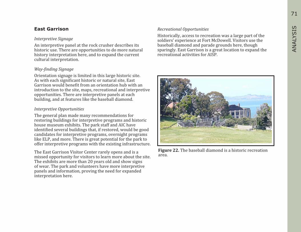
71
AN
ALY
SISEast Garrison
Interpretive SignageAn interpretive panel at the rock crusher describes its historic use. There are opportunities to do more natural history interpretation here, and to expand the current cultural interpretation.
Way-finding SignageOrientation signage is limited in this large historic site. As with each significant historic or natural site, East Garrison would benefit from an orientation hub with an introduction to the site, maps, recreational and interpretive opportunities. There are interpretive panels at each building, and at features like the baseball diamond.
Interpretive OpportunitiesThe general plan made many recommendations for restoring buildings for interpretive programs and historic house museum exhibits. The park staff and AIC have identified several buildings that, if restored, would be good candidates for interpretive programs, overnight programs like ELP, and more. There is great potential for the park to offer interpretive programs with the existing infrastructure.
The East Garrison Visitor Center rarely opens and is a missed opportunity for visitors to learn more about the site. The exhibits are more than 20 years old and show signs of wear. The park and volunteers have more interpretive panels and information, proving the need for expanded interpretation here.
Recreational OpportunitiesHistorically, access to recreation was a large part of the soldiers’ experience at Fort McDowell. Visitors use the baseball diamond and parade grounds here, though sparingly. East Garrison is a great location to expand the recreational activities for AISP.
Figure 22. The baseball diamond is a historic recreation area.
72
US Immigration Station
Interpretive OpportunitiesWhile the exhibits in the US Immigration Station are new as of 2010, not all stories could be told at the Barracks and on trails.
Additional planning meetings showed interest in the following topics: ▪ World War II, POW and post-immigration use of the site ▪ Contemporary immigration issues ▪ Personal stories of immigrants, workers,
and administration and hospital staff ▪ Expand interpretation of the immigrant
experience for cultures beyond China (e.g. India, Russia, Philippines, Japan)
▪ Marine Hospital Service on Angel Island ▪ Treating of infectious diseases ▪ US Public Health Policy regarding immigrants ▪ The differences between the Asian and
European immigrant experiences ▪ Create opportunities for visitors to record
and share their immigration stories.
Interpretive FacilitiesThe Angel Island Immigration Station Master Plan (2003) laid out potential uses for each building at the site. When funding permits, the Powerhouse, Mule Barn, and WWII Barracks have the potential to be used for interpretation.
The results of planning meetings for the hospital have indicated an interest in creating flexible interpretive spaces
within this building. The planning team recommended that we create classroom, meeting, and office spaces; historical vignettes and changing exhibit areas; and comfortable areas for visitors to gather, rest, and reflect. Many people indicated that they wanted more options for making tour and tram reservations. Tram tours and immigration station tours fill up quickly.
Backcountry
Interpretation on TrailsThere are few interpretive panels or guided hikes on trails at AISP. For example, the interpretive panels once on top of Mount Caroline Livermore were not reinstalled after the area was restored. This location provides 360-degree views of the San Francisco Bay Area. Depending on the location, there are opportunities to expand the natural history stories of the island and the San Francisco Bay Area. These sites provide an opportunity to connect Angel Island’s place in the region by telling the larger stories of the defense of the bay, immigration, and changing climate impacts to the area.

73
AN
ALY
SISPark Operations and Infrastructure
Repeatedly during the interpretive planning process, visitors, cooperating associations, and park staff noted park infrastructure and operations deficiencies as the biggest barrier to successful delivery of interpretive services. Crumbling infrastructure and the lack of funds to hire people and to do repairs is an endemic problem in all of our parks. However, by not meeting the visitors’ and organization’s basic needs, we find it difficult to focus on improving interpretive services. The planning team often looked at ways to solve some of the park’s operational challenges, such as providing better signage, interpretive panels, or guided tours, through improving interpretive services.
Three complaints that were heard the most often included difficulty getting around the park, lack of comfort services, and not enough access to facilities, programs, and park staff. It is possible to combine comfort services into interpretive services. For example, many people complained about the lack of restrooms, food, and shelter. An interpretive facility that includes restrooms, food services, and a waiting area along with exhibits would solve these issues. It is exceedingly difficult to ask a funder to donate money for a restroom; however, the same funder may not think twice about donating money towards an interpretive facility that has restrooms.
TransportationVisitors requested extended ferry and park hours or more ferry runs. This would allow them to spend more time in the park. Once on the island, visitors requested more options than the tram service, Segway tours, bicycles, and walking to get around. This would allow more time to get to interpretive programs or destinations.
Connecting transportation to interpretation may require a concessions agreement, volunteers providing tours on a shuttle or on bicycle, or other methods.
Natural and Cultural ResourcesNumerous sensitive cultural resources exist within the park. There are more than two hundred historic structures on the island. These buildings and features are a valuable resource for interpretation and for recreational opportunities. A majority of the buildings are compromised or in need of stabilization and restoration. Several buildings and sites around the park have been identified for use in interpretation, recreation, and other opportunities. These buildings will require comprehensive stabilization and restoration work before they can be used.
Other cultural resources include Native American archaeological sites, cultural landscapes throughout the island, the cemetery at Camp Reynolds (West Garrison), and most of the extant buildings and fortifications on the island. All of these resources will need some level of conservation.
Natural resource protection includes mitigating the impact to native plant and animal species and habitats when improving trails and infrastructure, and when stabilizing buildings. Education and interpretation should promote protection of these resources within the park.
Any improvements, modifications, and changes to cultural and natural resources will be subject to all applicable laws and policies and shall be considered in the interpretive planning process.
Museum Collection Development GoalsAISP would benefit from developing its museum collections in the following areas:

74
▪ US Immigration paperwork, photographs, and other documentation related to the site, employees, and immigrants.
▪ Personal items such as clothing, suitcases, or other items that immigrants used while detained at Angel Island. These will be used to interpret the immigrant’s experience at the US Immigration Station.
▪ Objects, letters, photographs, and other documentation related to the military’s use of the island from 1863-1962.
▪ Objects and documentation related to the Quarantine Station at Ayala Cove.
▪ Oral history collection of former Angel Island residents, or others with connections to the island during the pre-park era.
Operational ResourcesCurrent operation-related conditions at AISP might affect the interpretive services the park provides. The following conditions must be considered when developing interpretive services.
Visitor flowVisitor traffic through the dock and concession area causes bottlenecks at the Cove Café. State Park vehicles also use this area to access the landing craft and dock. At peak visitation times, visitors and State Park vehicles use the same space. The park should consider evaluating the dock and concessions area to improve access for both visitors and park operations.
TransportationThe tram tour and the Segway tour offered by the concession are the only motorized transportation on the island for visitor use. The park and the concession should consider adding alternative forms of transportation, such as rental golf carts or a shuttle that allows visitors to reach interpretive destinations if they do not wish to (or cannot) walk or ride a bicycle.
Public SafetyPotential risks or hazards to public safety include: ▪ Visitors have access to many unsafe or unstable
structures, especially at East Garrison. ▪ Visitors on the perimeter road meet service
vehicles, bicycles, and trams. ▪ Trails: Visitors have created many “volunteer” trails
throughout the park to access undeveloped areas, to create shortcuts, or to bypass trail switchbacks.
₋ Two major trails are closed due to erosion—one at Perle’s Beach, and a connector trail between the US Immigration Station and the East Garrison. Visitors continue to use these trails, ignoring park warning signs.
₋ The Sunset trail has switchbacks and needs fencing or trail improvements to prevent volunteer trails.
₋ Steep hillside trails may need railings or fencing. ₋ The park should develop additional trails or re-route
closed trails to meet visitor needs while maintaining park resources and providing for visitor safety.
▪ The East Garrison dock is not usable.

75
AN
ALY
SISPark Security
There are potential risks to the safekeeping of the interpretive resources and facilities in the park. These include structurally unsafe buildings, including those that contain museum collections; several buildings have collapsed recently. Some museum collections are stored in buildings that do not have proper security and environmental conditions.
Accessibility BarriersThe topography of the island makes it difficult to get people to a number of sites. Many buildings are not accessible and paths to buildings may not be accessible. Exhibits also may not meet current accessibility guidelines.
Environmental IssuesEnvironmental issues effect either visitors taking advantage of interpretive services or the actual interpretive resources, collections, or facilities. Wet and cold winter weather limits visitation to AISP. There are few indoor facilities where visitors can find shelter during inclement weather.
MaintenanceImprovement of park infrastructure, including expansion of facilities to accommodate more visitors, is difficult due to problems in getting materials and utilities to the island. At this time, water, sewer, and electrical services are limited, as is the ability to upgrade data and cellular connectivity. The steep terrain presents difficulties in the development of accessible trails. Careful consideration should be given to addressing the above issues when developing new interpretive services and interpretive facilities.
Use of Facilities and EquipmentSome interpretive resources, museum collections, or facilities could be used for purposes other than interpretative services. Some examples are: ▪ Bed and breakfast or overnight facilities for visitors. ▪ Other facilities and services under discussion
include adding meeting spaces, offering building rentals, creating a conference center, increasing recreational opportunities, expanding camping amenities such as tent cabins, adding boating facilities, providing power to the finger piers, and allowing overnight camping at the piers.

76

77
REC
OM
MEN
DAT
ION
SRECOMMENDATIONS
The Recommendations section presents solutions for improving, enhancing, and expanding interpretive services and park operations to enrich the visitor experience at Angel Island State Park (AISP). Four overarching interpretive goals were identified for the park: Orientation, Connection, Diversify, and Promote. Each goal is met through a series of objectives, and strategies. Tasks were further developed as projects to implement the objectives and strategies. Together, these elements provide the road map that will guide the development of future interpretive programs and services.
This section gives park interpretive planners tools for developing Interpretive Service Plans (ISP), which is the next level of planning after the IMP. These documents put the strategies and tasks into action. This section is formatted to show how each objective, strategy, and task relates to accomplishing the goal. When developing an ISP, the team may decide to complete one or several strategies and tasks at once.
Terminology
GoalsGoals build off the vision and mission statements of California State Parks (CSP) and AISP. Goals are broad, general concepts that describe the ultimate purpose, aim, or intent of interpretation at the park. Goals are not necessarily measurable. They are the big picture, the overall results that interpretation should achieve.
ObjectivesObjectives are specific, realistic, and measurable results that interpretation will achieve and that contribute to the accomplishment of a goal.
StrategiesStrategies are the approaches used to accomplish one or more objectives. Strategies are specific and measurable.
TasksTasks are the specific steps needed to carry out particular strategies. Tasks are projects that are prioritized in the Interpretive Action Plan, (IAP).
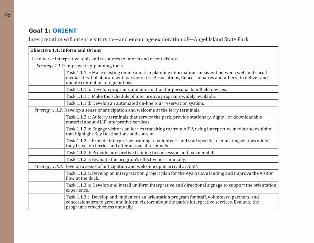
78
Goal 1: ORIENTInterpretation will orient visitors to—and encourage exploration of—Angel Island State Park.
Objective 1.1: Inform and Orient
Use diverse interpretive tools and resources to inform and orient visitors. Strategy 1.1.1: Improve trip-planning tools.
Task 1.1.1.a: Make existing online and trip planning information consistent between web and social media sites. Collaborate with partners (i.e., Associations, Concessionaires and others) to deliver and update content on a regular basis.
Task 1.1.1.b: Develop programs and information for personal handheld devices. Task 1.1.1.c: Make the schedule of interpretive programs widely available.Task 1.1.1.d: Develop an automated on-line tour reservation system.
Strategy 1.1.2: Develop a sense of anticipation and welcome at the ferry terminals.Task 1.1.2.a: At ferry terminals that service the park, provide stationary, digital, or downloadable material about AISP interpretive services. Task 1.1.2.b: Engage visitors on ferries transiting to/from AISP, using interpretive media and exhibits that highlight Key Destinations and content. Task 1.1.2.c: Provide interpretive training to volunteers and staff specific to educating visitors while they travel on ferries and after arrival at terminals. Task 1.1.2.d: Provide interpretive training to concession and partner staff.Task 1.1.2.e: Evaluate the program’s effectiveness annually.
Strategy 1.1.3: Develop a sense of anticipation and welcome upon arrival at AISP.Task 1.1.3.a: Develop an interpretation project plan for the Ayala Cove landing and improve the visitor flow at the dock.Task 1.1.3.b: Develop and install uniform interpretive and directional signage to support the orientation experience.Task 1.1.3.c: Develop and implement an orientation program for staff, volunteers, partners, and concessionaires to greet and inform visitors about the park’s interpretive services. Evaluate the program’s effectiveness annually.
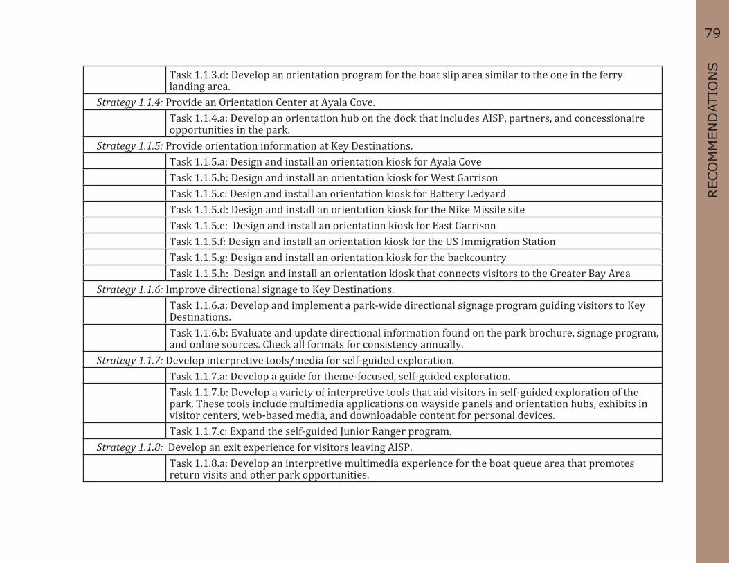
79
REC
OM
MEN
DAT
ION
STask 1.1.3.d: Develop an orientation program for the boat slip area similar to the one in the ferry landing area.
Strategy 1.1.4: Provide an Orientation Center at Ayala Cove.Task 1.1.4.a: Develop an orientation hub on the dock that includes AISP, partners, and concessionaire opportunities in the park.
Strategy 1.1.5: Provide orientation information at Key Destinations.Task 1.1.5.a: Design and install an orientation kiosk for Ayala CoveTask 1.1.5.b: Design and install an orientation kiosk for West GarrisonTask 1.1.5.c: Design and install an orientation kiosk for Battery LedyardTask 1.1.5.d: Design and install an orientation kiosk for the Nike Missile siteTask 1.1.5.e: Design and install an orientation kiosk for East GarrisonTask 1.1.5.f: Design and install an orientation kiosk for the US Immigration StationTask 1.1.5.g: Design and install an orientation kiosk for the backcountryTask 1.1.5.h: Design and install an orientation kiosk that connects visitors to the Greater Bay Area
Strategy 1.1.6: Improve directional signage to Key Destinations.Task 1.1.6.a: Develop and implement a park-wide directional signage program guiding visitors to Key Destinations.Task 1.1.6.b: Evaluate and update directional information found on the park brochure, signage program, and online sources. Check all formats for consistency annually.
Strategy 1.1.7: Develop interpretive tools/media for self-guided exploration.Task 1.1.7.a: Develop a guide for theme-focused, self-guided exploration.Task 1.1.7.b: Develop a variety of interpretive tools that aid visitors in self-guided exploration of the park. These tools include multimedia applications on wayside panels and orientation hubs, exhibits in visitor centers, web-based media, and downloadable content for personal devices.Task 1.1.7.c: Expand the self-guided Junior Ranger program.
Strategy 1.1.8: Develop an exit experience for visitors leaving AISP.Task 1.1.8.a: Develop an interpretive multimedia experience for the boat queue area that promotes return visits and other park opportunities.

80
Task 1.1.8.b: Evaluate visitor needs and experiences annually. Use this information to develop the Annual Interpretation Implementation Plan for the park.Task 1.1.8.c: Evaluate and update AISP’s website to ensure it has information useful for returning visitors.
Objective 1.2: Expand Interpretation at Ayala Cove.
Expand the interpretation of AISP’s stories at Ayala Cove using a variety of tools and methods. Strategy 1.2.1: Provide a variety of interpretive opportunities within Ayala Cove that tell park-wide stories.
Task 1.2.1.a: Evaluate, plan, and develop improvements to interpretive services and facilities within Ayala Cove that support park-wide interpretation. Task 1.2.1.b: Every five years, evaluate and update the park highlight film used for visitors. Task 1.2.1.c: Develop a teaser interpretive experience at Ayala Cove that will entice visitors to explore the rest of the island and promote return visits.Task 1.2.1.d: Upon completion of the orientation hub, evaluate the visitor center to determine if it is meeting visitor needs. Task 1.2.1.e: Every five-to-ten years, evaluate the exhibits and orientation film area in the visitor center to determine if it is meeting visitor needs. Task 1.2.1.f: Develop an interpretive project plan that incorporates immersive and hands-on exhibits at the visitor center. Task 1.2.1.g: Expand interpretive programs at Ayala Cove that tell park-wide stories.
Objective 1.3: Improve Interpretation along park routes of travel.
Provide consistent interpretation along routes of travel to highlight AISP’s Key Destinations. Strategy 1.3.1: Offer interpretive multimedia features and opportunities along routes of travel.
Task 1.3.1.a: Plan and develop self-guided interpretive content along routes of travel.Task 1.3.1.b: Design and install self-guided wayside panels.Task 1.3.1c: Plan and develop self-guided interpretive content that can be used on personal devices. Task 1.3.1.d: Plan and develop interpretive programs along routes of travel.

81
REC
OM
MEN
DAT
ION
SGoal 2: CONNECTInterpretation will inspire visitors to make connections to AISP.
Objective 2.1: Demonstrate and interpret Angel Island State Park’s place in the world.
Use interpretation to convey stories about AISP’s connection to the San Francisco Bay Area and beyond. Strategy 2.1.1: Provide structured programming relevant to AISP for all education levels.
Task 2.1.1.a: Create specific curriculum for AISP aligned with K-12 California content standards that can be used off-site. Task 2.1.1.b: Create specific curriculum for AISP aligned with K-12 California content standards that provide relevant field experiences at AISP. Task 2.1.1.c: Create specific programming that targets continuing education that can be used off site. Task 2.1.1.d: Create specific programming that targets continuing education for relevant field experiences. Task 2.1.1.e: Provide opportunities and locations for internships or skill development.
Strategy 2.1.2: Use interpretation to convey stories about AISP’s connection to the San Francisco Bay Area and beyond. Task 2.1.2.a: Develop coastal defense wayside panels that connect AISP’s sites to other relevant sites.Task 2.1.2.b: Develop wayside panels (see “panels” above) to connect AISP lighthouses to the other “aids to navigation sites” in the greater San Francisco Bay Area. Task 2.1.2.c: Develop interpretive content about AISP’s connection to the greater San Francisco Bay estuary. Task 2.1.2.d: Develop interpretive content about AISP’s connection to other land preservation sites in the San Francisco Bay Area and beyond. Task 2.1.2.e: Develop a wayside panel about AISP’s role in the exploration story of San Francisco Bay.
Strategy 2.1.3: Develop park-wide programs for primary interpretive periods.Task 2.1.3.a: Develop a park-wide interpretive experience that encompasses the Civil War story on AISP.Task 2.1.3.b: Develop a park-wide interpretive experience that encompasses the World War II story on AISP.Task 2.1.3.c: Develop a park-wide interpretive experience that includes the US Immigration and Quarantine stories on AISP.
Strategy 2.1.4: Develop park-wide interpretive opportunities for secondary interpretive periods.Task 2.1.4.a: Develop a park-wide interpretive experience that encompasses the Miwok story on AISP. Task 2.1.4.b: Create an island-wide experience that encompasses the World War I story on AISP.

82
Task 2.1.4.c: Develop a park-wide interpretive experience that encompasses the Spanish-American War story on AISP.Task 2.1.4.d: Develop a park-wide interpretive experience that encompasses the Cold War story on AISP. Task 2.1.4.e: Develop a park-wide interpretive experience that encompasses the State Park story on AISP.
Strategy 2.1.5: Explore appropriate stories and locations for multimedia experiences park-wide.Task 2.1.5.a: Determine stories best told by multimedia applications. Task 2.1.5.b: Develop and implement appropriate media applications park-wide.
Strategy 2.1.6: Evaluate and expand AISP Junior Ranger programs. Task 2.1.6.a: Evaluate and update the AISP Junior Ranger booklet annually so that it remains relevant and dynamic. Task 2.1.6.b: Expand the AISP Junior Ranger booklet to enhance Key Destinations.Task 2.1.6.c: Enhance the AISP Junior Ranger program with theme based guided experiences.
Objective 2.2: Make Connections to Cultural History
Provide interpretation that connects AISP to its unique human history. Strategy 2.2.1: Provide a robust interpretive experience at Ayala Cove.
Task 2.2.1.a: Identify and develop significant stories at Ayala Cove.Task 2.2.1.b: Develop, determine location for, and execute a site summary interpretive panel for Ayala Cove. Task 2.2.1.c: Provide labels for buildings and foundations at Ayala Cove. Task 2.2.1.d: Interpret important cultural landscape features of Ayala Cove.Task 2.2.1.e: Identify and develop diverse secondary stories for Ayala Cove.Task 2.2.1.f: Create and implement a range of interpretive services for Ayala Cove.Task 2.2.1.g: Develop a strategy for use of buildings at Ayala Cove.Task 2.2.1.h: Examine Ayala Cove as a potential location to display museum collections.Task 2.2.1.i: Create an interpretation project plan for the entire Ayala Cove site.
Strategy 2.2.2: Provide a robust interpretive experience at West Garrison.
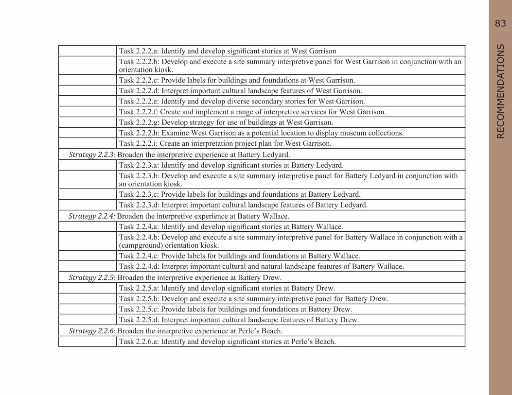
83
REC
OM
MEN
DAT
ION
STask 2.2.2.a: Identify and develop significant stories at West GarrisonTask 2.2.2.b: Develop and execute a site summary interpretive panel for West Garrison in conjunction with an orientation kiosk. Task 2.2.2.c: Provide labels for buildings and foundations at West Garrison. Task 2.2.2.d: Interpret important cultural landscape features of West Garrison.Task 2.2.2.e: Identify and develop diverse secondary stories for West Garrison.Task 2.2.2.f: Create and implement a range of interpretive services for West Garrison.Task 2.2.2.g: Develop strategy for use of buildings at West Garrison.Task 2.2.2.h: Examine West Garrison as a potential location to display museum collections.Task 2.2.2.i: Create an interpretation project plan for West Garrison.
Strategy 2.2.3: Broaden the interpretive experience at Battery Ledyard.Task 2.2.3.a: Identify and develop significant stories at Battery Ledyard.Task 2.2.3.b: Develop and execute a site summary interpretive panel for Battery Ledyard in conjunction with an orientation kiosk. Task 2.2.3.c: Provide labels for buildings and foundations at Battery Ledyard. Task 2.2.3.d: Interpret important cultural landscape features of Battery Ledyard.
Strategy 2.2.4: Broaden the interpretive experience at Battery Wallace.Task 2.2.4.a: Identify and develop significant stories at Battery Wallace.Task 2.2.4.b: Develop and execute a site summary interpretive panel for Battery Wallace in conjunction with a (campground) orientation kiosk. Task 2.2.4.c: Provide labels for buildings and foundations at Battery Wallace. Task 2.2.4.d: Interpret important cultural and natural landscape features of Battery Wallace.
Strategy 2.2.5: Broaden the interpretive experience at Battery Drew.Task 2.2.5.a: Identify and develop significant stories at Battery Drew.Task 2.2.5.b: Develop and execute a site summary interpretive panel for Battery Drew. Task 2.2.5.c: Provide labels for buildings and foundations at Battery Drew. Task 2.2.5.d: Interpret important cultural landscape features of Battery Drew.
Strategy 2.2.6: Broaden the interpretive experience at Perle’s Beach.Task 2.2.6.a: Identify and develop significant stories at Perle’s Beach.

84
Task 2.2.6.b: Develop and execute a site summary interpretive panel for Perle’s Beach. Task 2.2.6.c: Interpret important cultural landscape features of Perle’s Beach.
Strategy 2.2.7: Broaden the interpretive experience at the Rock Quarry.Task 2.2.7.a: Identify and develop significant stories at the Rock Quarry.Task 2.2.7.b: Develop and execute a site summary interpretive panel for the Rock Quarry. Task 2.2.7.c: Provide labels for buildings and foundations at the Rock Quarry. Task 2.2.7.d: Interpret important cultural landscape features of the Rock Quarry.
Strategy 2.2.8: Broaden the interpretive experience at the Nike Missile site. Task 2.2.8.a: Identify and develop significant stories at the Nike Missile site.Task 2.2.8.b: Develop and execute a site summary interpretive panel for the Nike Missile site in conjunction with an orientation kiosk. Task 2.2.8.c: Provide labels for buildings and foundations at the Nike Missile site. Task 2.2.8.d: Interpret important cultural landscape features of the Nike Missile site.
Strategy 2.2.9: Provide a robust interpretive experience at East Garrison. Task 2.2.9.a: Identify and develop significant stories at East Garrison.Task 2.2.9.b: Develop and execute a site summary interpretive panel for East Garrison in conjunction with an orientation kiosk. Task 2.2.9.c: Provide labels for buildings and foundations at East Garrison. Task 2.2.9.d: Interpret important cultural landscape features of East Garrison.Task 2.2.9.e: Identify and develop diverse secondary stories for East Garrison.Task 2.2.9.f: Create and implement a range of interpretive services for East Garrison.Task 2.2.9.g: Develop strategy for use of buildings at East Garrison.Task 2.2.9.h: Examine East Garrison as a potential location to display museum collections.Task 2.2.9.i: Create an interpretation project plan for East Garrison.
Strategy 2.2.10: Provide a robust interpretive experience at the US Immigration Station.Task 2.2.10.a: Identify and develop significant stories at the US Immigration Station.Task 2.2.10.b: Develop and execute a site summary interpretive panel for the US Immigration Station in conjunction with an orientation kiosk. Task 2.2.10.c: Provide labels for buildings and foundations at the US Immigration Station.

85
REC
OM
MEN
DAT
ION
STask 2.2.10.d: Interpret important cultural landscape features of the US Immigration Station.Task 2.2.10.e: Identify and develop diverse secondary stories for the US Immigration Station.Task 2.2.10.f: Create and implement a range of interpretive services for the US Immigration Station.Task 2.2.10.g: Develop strategy for use of buildings at the US Immigration Station.Task 2.2.10.h: Examine the US Immigration Station as a potential location to display museum collections.Task 2.2.10.i: Create an interpretation project plan for the US Immigration Station.
Strategy 2.2.11: Provide a robust interpretive experience about the Miwok story, in consultation with the Federated Indians of Graton Rancheria.
Task 2.2.11.a: Develop and determine a site summary interpretive panel for the Miwok story. Task 2.2.11.b: Interpret important cultural landscape features related to the Miwok, with consultation taking into consideration resource protection and cultural sensitivity.Task 2.2.11.c: Create and implement a range of interpretive services about the Miwok story.Task 2.2.11.d: Identify and develop diverse secondary stories for the Miwok story.
Strategy 2.2.12: Provide a robust interpretive experience park-wide with interactive interpretive opportunities.Task 2.2.12.a: Develop and implement living history programs park-wide.Task 2.2.12.b: Develop and implement first person narrative programs. Task 2.2.12.c: Develop and implement hands-on programs park-wide.Task 2.2.12.d: Develop and implement historic demonstration programs park-wide.
Objective 2.3: Make Connections to Natural History
Provide interpretation about AISP’s marine and terrestrial environment. Strategy 2.3.1: Provide programs that promote discovery and learning of AISP’s marine environment.
Task 2.3.1.a: Identify and develop a range of interpretive services about AISP’s marine environment.Task 2.3.1.b: Develop a science-based program that interprets AISP’s marine environment. Task 2.3.1.c: Develop hands on opportunities for direct contact with AISP’s marine environment. Task 2.3.1.d: Develop interpretive content about AISP’s marine resources for an Environmental Education Center. Task 2.3.1.e: Develop curriculum based field experiences that tie into AISP’s marine environment.Task 2.3.1.f: Develop and install a series of wayside panels highlighting AISP’s marine environment.

86
Task 2.3.1.g: Collaborate with other marine educators to provide content and opportunities. Task 2.3.1.h: Partner with groups for boat-side exploration of AISP’s shoreline.
Strategy 2.3.2: Provide programs that promote discovery and learning of AISP’s terrestrial environment.Task 2.3.2.a: Identify and develop a range of interpretive services about AISP’s terrestrial environment.Task 2.3.2.b: Develop a science-based program that interprets AISP’s terrestrial environment. Task 2.3.2.c: Develop hands on opportunities for direct contact with AISP’s terrestrial environment. Task 2.3.2.d: Develop interpretive content about AISP’s terrestrial resources for an Environmental Education Center. Task 2.3.2.e: Develop curriculum based field experiences that tie into AISP’s terrestrial environment.Task 2.3.2.f: Develop and install a series of wayside panels highlighting AISP’s significant natural zones.
Strategy 2.3.3: Interpret the effects that humans have had on AISP’s natural environment through time. Task 2.3.3.a: Develop interpretive content for programs that highlight ways humans have altered the natural environment. Task 2.3.3.b: Develop interpretive content for exhibits that describe the impacts of Climate Change on AISP. Educate visitors on ways that they can make a difference.
Objective 2.4: Embrace Recreation
Use recreation as a way to connect visitors to AISP Strategy 2.4.1: Develop interpretive programs, multimedia applications, and exhibits that enhance recreational experiences.
Task 2.4.1.a: Highlight existing and develop additional recreational opportunities that relate to historic recreational uses of AISP.Task 2.4.1.b: Promote AISP as a destination for a wide variety of recreational opportunities.Task 2.4.1.c: Showcase AISP as a quiet refuge in the middle of a busy urban area.Task 2.4.1.d: Develop creative programs and opportunities that encourage exploration of AISP’s recreational resources.
Strategy 2.4.2: Encourage recreation on AISP to promote health and well-being.Task 2.4.2.a: Provide interpretive opportunities for visitors to participate in structured and unstructured activities that encourage a healthy lifestyle. Task 2.4.2.b: Explore opportunities for children in the form of historic play areas on AISP.Task 2.4.2.c: Develop period gardens to educate visitors about historic food use at AISP.

87
REC
OM
MEN
DAT
ION
STask 2.4.2.d: Collaborate with partners to promote AISP as a location for healthy recreation. Task 2.4.2.e: Develop interpretive experiences that highlight the Children’s Outdoor Bill of Rights.
Strategy 2.4.3: Broaden the interpretive experience at Mt. Caroline Livermore. Task 2.4.3.a: Identify and develop significant stories at Mt. Livermore.Task 2.4.3.b: Develop and install a site summary interpretive panel for the Mt. Livermore story in conjunction with an orientation kiosk. Task 2.4.3.c: Provide labels for buildings and foundations at Mt. Livermore. Task 2.4.3.d: Interpret important cultural landscape features of Mt. Livermore.Task 2.4.3.e: Develop messaging connecting AISP to the San Francisco Bay Area and beyond. Promote this connection at the Mt. Caroline Livermore summit since it offers a 360-degree view of the bay.

88
Goal 3: DIVERSIFYInterpretation will be accessible to a diversity of visitors.
Objective 3.1: Broaden Audiences
Provide outreach to nontraditional visitors of the park through a variety of methods. Strategy 3.1.1: Promote and increase awareness of AISP’s interpretive opportunities for non-traditional users.
Task 3.1.1.a: Market interpretive services through outlets that serve non-traditional groups. Task 3.1.1.b: Utilize partnerships to share information about AISP’s diverse interpretive opportunities. Task 3.1.1.c: Evaluate and update existing resources to describe diverse interpretive opportunities.Task 3.1.1.d: Evaluate AISP’s marketing and promotional programs annually to determine their effectiveness in reaching a diverse audience. Make changes to these programs as needed to ensure the park’s services reach a diverse audience.
Objective 3.2: Improve Access
Improve access for visitors by reducing barriers that limit their full participation and inclusion in interpretive opportunities. Strategy 3.2.1: Identify barriers that prevent any visitor’s full participation in interpretive opportunities at AISP.
Task 3.2.1.a: Survey agencies and organizations that focus on underserved populations and groups. Task 3.2.1.b: Develop a list of barriers and solutions to overcome these barriers.
Strategy 3.2.2: Reduce barriers by reviewing, planning, and broadening interpretive opportunities.Task 3.2.2a: Develop multi-lingual interpretive programs and services to reach a broader audience.Task 3.2.2.b: Develop interpretive programs that can be presented at schools and organizations.Task 3.2.2.c: Develop off-site interpretive programs that schools and organizations can use at their locations.Task 3.2.2.d: Evaluate the effectiveness of AISP’s interpretive services annually to ensure they reach a diverse audience.
Objective 3.3: Expand and Maintain Partnerships
Collaborate with organizations and communities to provide a diverse set of opportunities in conjunction with AISP. Strategy 3.3.1: Partner with community and government groups serving diverse populations
Task 3.3.1.a: Identify programs that would benefit from partnerships.Task 3.3.1.b: Develop and execute mutually beneficial partnerships.

89
REC
OM
MEN
DAT
ION
STask 3.3.1.c: Evaluate partnership effectiveness on a three-to-five-year basis. Strategy 3.3.2: Include partners in planning, funding, and implementing interpretive and recreational opportunities at AISP.
Task 3.3.2.a: Identify partners working with underserved groups and include them in the park planning process. Task 3.3.2.b: Partner with agencies and groups to coordinate interpretive programs and promote interpretive services.

90
Goal 4: PROMOTEInterpretation will promote and increase interest in AISP.
Objective 4.1: Increase Interest
Market AISP as a “must-see” destination. Strategy 4.1.1: Determine diverse audience needs and interests to promote interpretive services.
Task 4.1.1.a: Conduct evaluations to determine user groups and their interpretive needs and interests.Task 4.1.1.b: Market interpretive programs to a broad range of audiences. Task 4.1.1.c: Leverage park concessions to provide marketing support for AISP’s interpretive services.Task 4.1.1.d: Advertise the park’s interpretive services at ferry terminals, on ferries, at public transit hubs, and on websites.Task 4.1.1.e: Evaluate the program’s effectiveness on an annual basis.
Objective 4.2: Promote Visitation
Interpretation will encourage visitation throughout the year. Strategy 4.2.1: Reach out to promote AISP’s year-round interpretive opportunities.
Task 4.2.1.a: Evaluate visitation trends of current interpretive opportunities biannually.Task 4.2.1.b: Develop and execute a comprehensive and cohesive marketing plan for AISP.Task 4.2.1.c: Partner with existing community programs, associations, clubs, and educational institutions to offer unique field experiences.Task 4.2.1.d: Make connections to public land partners for cross-promotional interpretive opportunities.
Objective 4.3: Enhance Destinations
Improve significant historic structures, landscapes, and recreational opportunities that support key interpretive periods. Strategy 4.3.1: Identify and determine interpretive opportunities and uses for significant historic structures and landscapes.
Task 4.3.1.a: Complete a Cultural Landscape Report (CLR) for each Key Destination to support knowledge of resources, stories, and significant landscapes to interpret. Task 4.3.1.b: Promote historic sites as potential locations for festivals and events aligned with the park’s purpose.Task 4.3.1.c: Develop and promote each Key Destination for preservation and education partnerships.

91
REC
OM
MEN
DAT
ION
SObjective 4.4: Promote Stewardship
Connect visitors to the preservation and conservation story of AISP, and inspire them to practice stewardship in their everyday lives. Strategy 4.4.1: Increase volunteer and partnership opportunities to encourage the stewardship and preservation of AISP.
Task 4.4.1.a: Train existing and future volunteers with messaging that promotes AISP’s stewardship and preservation programs.Task 4.4.1.b: Locate existing models of stewardship programs that use volunteers or partnerships, and emulate the successful techniques used
Task 4.4.1.c: Develop commercial and community partners for cross-promotional educational opportunity.
Strategy 4.4.2: Develop interpretive projects that highlight AISP’s preservation and conservation history and promote the park’s continued efforts in these areas.
Task 4.4.2.a: Develop interpretive opportunities for visitors to explore the history of the conservation and preservation of AISP by integrating into existing and future park programs. Task 4.4.2.b: Highlight examples of sustainable actions by CSP and partners that support reduced energy consumption and minimizing waste through interpretive facilities, programs, or exhibits.Task 4.4.2.c: Develop interpretive content that uses AISP as an example of the “Earth Island” concept.

92

93
INTE
RPR
ETAT
ION
ACTI
ON
PLA
NINTERPRETATION ACTION PLAN
IntroductionThe Interpretation Action Plan (IAP) is a roadmap for achieving Angel Island State Park’s (AISP) interpretive goals, detailed in the Recommendations section, over the near (i.e., 1-10 years) and long term (i.e., 10-20 years). The IAP also provides the framework for updating the park’s Annual Interpretation Implementation Plan (DOM 0902.6.3.3 Interpretation and Education).
Ten (10) interpretive Proposals are presented here. These are essentially large, overarching projects that organize Tasks under related Goals, Objectives, and Strategies. For ease of use, Tasks from the Recommendations Section appear only once under the most relevant Proposal, rather than being repeated under multiple Proposals. For a complete listing of all Tasks, refer to the Recommendation Section, in the IMP.
Each Proposal is written as a stand-alone project that might be funded in its entirety by a major grant, a designated capital campaign, or a state bond-funded program. They also can be accomplished in phases, depending on available staffing and funding capabilities in a particular fiscal year or in smaller components by individual Tasks as time and funding permit.
Proposals are written in an easy-to-read format with the first paragraph summarizing the proposal’s purpose and the second paragraph outlining the scope of work and steps involved to accomplish the project. They are a quick snapshot for both a park professional and lay audience. Park planners and supporters will find the proposals a useful tool to connect programs and projects to particular interests of donors, grantors, and administrators developing long term planning objectives for CSP.
Each Proposal is assigned a priority number from 1—4. Priority “1”indicates the Proposal is the highest priority to accomplish in the near term. Coupled with each Proposal’s prioritization is a value assigned for the timeframe for completing the Proposal identified as its Duration. This is presented in three increments: Years 1—5, Years 5—10 and Years 10—20.
Some proposals may be listed as Priority 1 but have a Duration of Years 5—10. This apparent incongruity should alert the reader that the Proposal has significant logistical constraints. It is a top priority but there is an acknowledgement that advance work is needed before the interpretive Proposal can be achieved. The advance work might include studies by specialty disciplines like historians, archaeologists, or biologists. It might mean architectural or engineering work is needed to upgrade park infrastructure before the Proposal’s visitor-serving interpretive function can be accomplished.
Park administrators and their community partners need to note both the assigned prioritization and its duration to ensure that the Proposal is completed within the identified timeframe indicated in the IAP.
Each Proposal is accompanied by a graphic image that provides a vision for the future. This is a visual presentation to convey the essence of what the project might

94
accomplish; it is not meant to be taken literally, as if it were the finished design. Each Proposal also includes a reference table listing the most relevant Tasks associated with that Proposal, including its related Objective and Strategy. Each Task includes a funding range or cost estimate shown with one or more dollar sign symbols. In estimating the value, consideration was given to all likely costs including labor, supplies and materials, travel and per diem, and contracts.
The cost estimates for each Proposal Task also is included in California State Park’s Park Infrastructure Database (PID). Project costs are regularly updated by park staff in PID. This database should be updated when current costs are needed. General price ranges are provided in the IAP.
California State Parks is responsible for approving and implementing the IAP Proposals. Typically, the scope of work for each Proposal will be accomplished by a multidisciplinary team. The core team will include the park’s administrators, AISP staff, and support from headquarters units (e.g., Interpretation & Education Division, and Acquisition & Development, if the project includes infrastructure improvements).
California State Parks also is responsible for coordinating interpretive content development and delivery with its partners (e.g., cooperating associations and foundations, Native California Indian representatives, subject-matter experts, and park stakeholders, concessionaires and ferry operators) to carry out the objectives of any given Proposal.
California State Parks will ensure that all applicable laws, regulations, and departmental guidelines are followed in implementing any project.
Table 2. Estimated funding range for each Task represented by the number of dollar signs.
$ <$50K$$ $50K-$500K$$$ $500K-$1M$$$$ >$1M

95
INTE
RPR
ETAT
ION
ACTI
ON
PLA
NProposal Overview ORIENT
Interpretation will orient visitors and encourage exploration of Angel Island State Park.
Proposal 1: WHAT’S THE SCOOP?
Insiders Info: Learning Everything You Want To Know About Angel Island State Park
Proposal 2: NOW WHAT?
Welcome and Orientation: Improving the Arrival Experience
Proposal 3: WALK WHICH WAY?
Interpretive and Way finding Tools: Orienting Visitors at Key Destinations
CONNECT
Interpretation will inspire visitors to make connections to Angel Island State Park.
Proposal 4: PEOPLE, PLACES, AND PLANS
Make Plans: Providing the Interpretive Vision for Key Destinations
Proposal 5: STORIES, SIGHTS, AND SCENES
Connect To History: Improving Interpretation of Angel Island State Park’s Human Story
Proposal 6: BEASTS, BEACHES, AND BACKCOUNTRY
Connect To Natural Resources: Learning about Angel Island State Park’s Natural Environment
Proposal 7: PADDLE, PEDAL, AND PLAY!
Connect To Recreation: Discovering Ways to Learn Through Recreational Activities
DIVERSIFY
Interpretation will be accessible to all visitors.
Proposal 8: COME ONE, COME ALL
Diversify Interpretive Services: Increasing Visitation by Improving Outreach
Proposal 9: IT TAKES A COMMUNITY TO RAISE AN ISLAND
Strengthen Community Ties: Using Interpretation to Increase Support for Angel Island State Park
PROMOTE
Interpretation will promote and increase interest in Angel Island State Park.
Proposal 10: AN ISLAND ADVENTURE AWAITS
Getting Out the Message: Promoting Interest in Angel Island State Park

96
Proposal 1: WHAT’S THE SCOOP?INSIDER'S INFO: Learning Everything You Want To Know About Angel Island
PURPOSE: Develop and deliver information about Angel Island’s interpretive services to park visitors through online and printed media, and interpretive content presented at ferry terminals and on ferries. Address deficiencies by providing coordinated visitor orientation information for Angel Island State Park. Inform visitors about available interpretive programs and services before they arrive. Coordinated Outreach will promote park exploration and increase visitor interest.
SCOPE: Develop an interpretive services plan that will coordinate content for exhibits, online and printed media, and programming for park staff, volunteers, and partners. Design interpretive exhibits, computer kiosks, and multi-media programs. Fabricate and install exhibits, produce and deliver online and printed media, and provide training to staff, volunteers, and partners.
PRIORITY: 1
DURATION: Years 1-5
Figure 23. Panels, brochures and online applications will provide visitors with consistent information about Angel Island’s interpretive services.

97
INTE
RPR
ETAT
ION
ACTI
ON
PLA
NProposal 1: WHAT’S THE SCOOP?
Objective 1.1: Inform and Orient Funding Range
Strategy 1.1.1: Improve trip-planning tools. $ Task 1.1.1.a: Make existing online and trip-planning information consistent
between web and social media sites. Collaborate with partners (i.e., Associations, Concessionaires, and others) to deliver and update content on a regular basis.
$
Task 1.1.1.b: Develop programs and information for personal handheld devices. $ Task 1.1.1.c: Make the schedule of interpretive programs available widely. $ Task 1.1.1.d: Develop an automated on-line tour reservation system. $ Strategy 1.1.2: Develop a sense of anticipation and welcome at the ferry terminals. Task 1.1.2.a: At ferry terminals that service the park, provide stationary, digital, or
downloadable information about AISP that educates and informs about the park’s interpretive services.
$$
Task 1.1.2.b: Engage visitors on ferries transiting to/from AISP, using interpretive media and exhibits that highlight Key Destinations and content. $$
Task 1.1.2.c: Provide interpretive training to volunteers and staff specific to educating visitors while on ferries and at terminals. $
Task 1.1.2.d: Provide interpretive training to concessions and partner staff. $ Task 1.1.2.e: Evaluate the program’s effectiveness annually. $
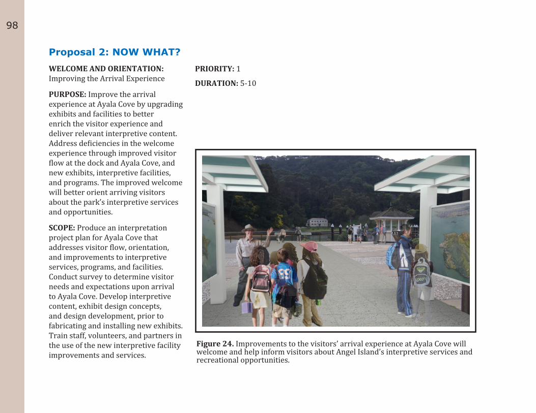
98
Proposal 2: NOW WHAT?WELCOME AND ORIENTATION: Improving the Arrival Experience
PURPOSE: Improve the arrival experience at Ayala Cove by upgrading exhibits and facilities to better enrich the visitor experience and deliver relevant interpretive content. Address deficiencies in the welcome experience through improved visitor flow at the dock and Ayala Cove, and new exhibits, interpretive facilities, and programs. The improved welcome will better orient arriving visitors about the park’s interpretive services and opportunities.
SCOPE: Produce an interpretation project plan for Ayala Cove that addresses visitor flow, orientation, and improvements to interpretive services, programs, and facilities. Conduct survey to determine visitor needs and expectations upon arrival to Ayala Cove. Develop interpretive content, exhibit design concepts, and design development, prior to fabricating and installing new exhibits. Train staff, volunteers, and partners in the use of the new interpretive facility improvements and services.
PRIORITY: 1
DURATION: 5-10
Figure 24. Improvements to the visitors’ arrival experience at Ayala Cove will welcome and help inform visitors about Angel Island’s interpretive services and recreational opportunities.
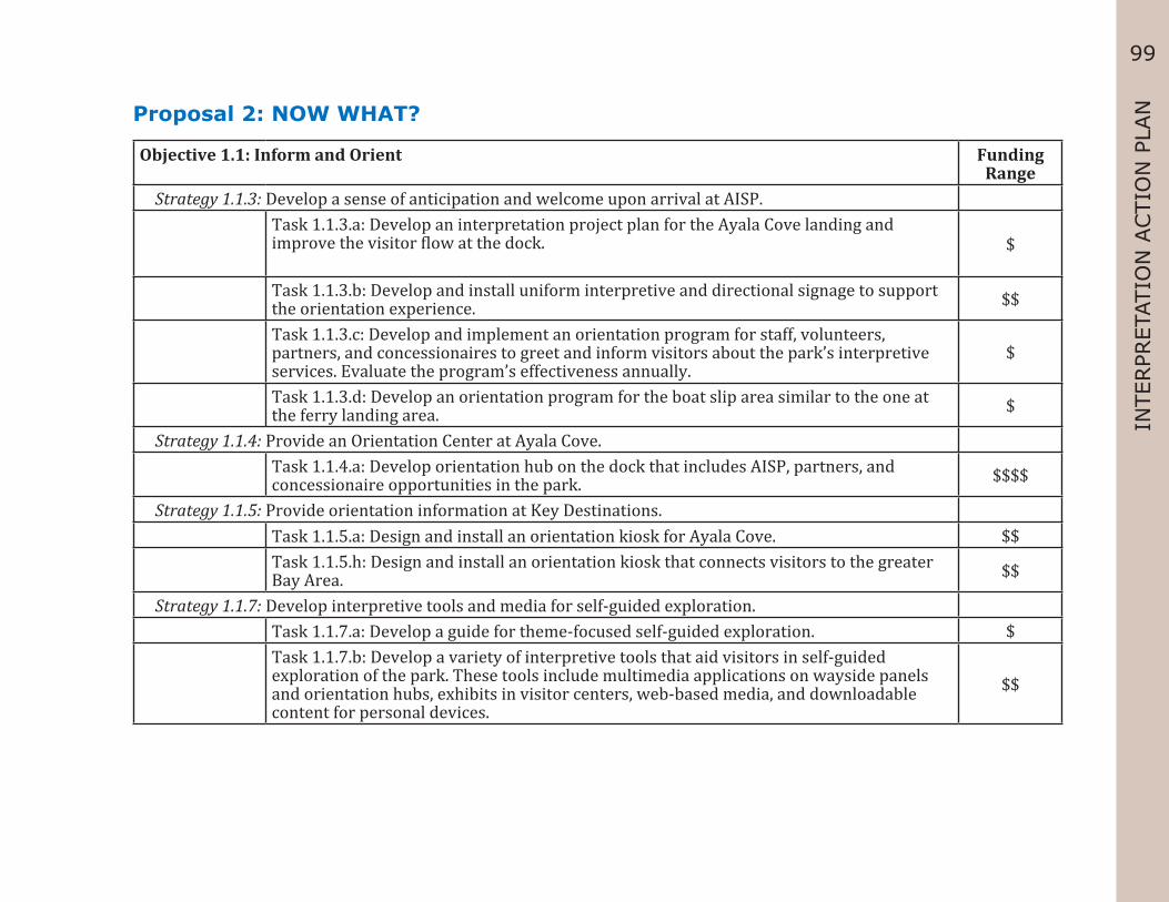
99
INTE
RPR
ETAT
ION
ACTI
ON
PLA
NProposal 2: NOW WHAT?
Objective 1.1: Inform and Orient Funding Range
Strategy 1.1.3: Develop a sense of anticipation and welcome upon arrival at AISP.Task 1.1.3.a: Develop an interpretation project plan for the Ayala Cove landing and improve the visitor flow at the dock. $
Task 1.1.3.b: Develop and install uniform interpretive and directional signage to support the orientation experience. $$
Task 1.1.3.c: Develop and implement an orientation program for staff, volunteers, partners, and concessionaires to greet and inform visitors about the park’s interpretive services. Evaluate the program’s effectiveness annually.
$
Task 1.1.3.d: Develop an orientation program for the boat slip area similar to the one at the ferry landing area. $
Strategy 1.1.4: Provide an Orientation Center at Ayala Cove.Task 1.1.4.a: Develop orientation hub on the dock that includes AISP, partners, and concessionaire opportunities in the park. $$$$
Strategy 1.1.5: Provide orientation information at Key Destinations.Task 1.1.5.a: Design and install an orientation kiosk for Ayala Cove. $$Task 1.1.5.h: Design and install an orientation kiosk that connects visitors to the greater Bay Area. $$
Strategy 1.1.7: Develop interpretive tools and media for self-guided exploration.Task 1.1.7.a: Develop a guide for theme-focused self-guided exploration. $Task 1.1.7.b: Develop a variety of interpretive tools that aid visitors in self-guided exploration of the park. These tools include multimedia applications on wayside panels and orientation hubs, exhibits in visitor centers, web-based media, and downloadable content for personal devices.
$$
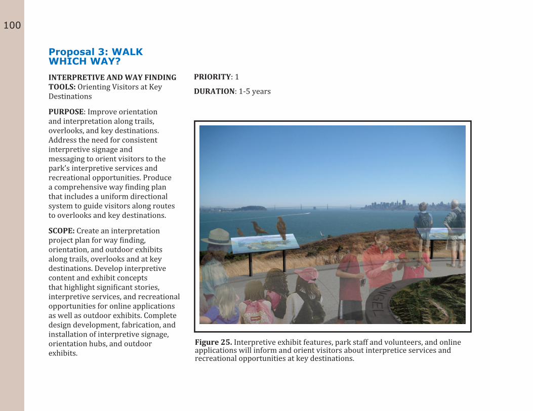
100
Proposal 3: WALK WHICH WAY?INTERPRETIVE AND WAY FINDING TOOLS: Orienting Visitors at Key Destinations
PURPOSE: Improve orientation and interpretation along trails, overlooks, and key destinations. Address the need for consistent interpretive signage and messaging to orient visitors to the park’s interpretive services and recreational opportunities. Produce a comprehensive way finding plan that includes a uniform directional system to guide visitors along routes to overlooks and key destinations.
SCOPE: Create an interpretation project plan for way finding, orientation, and outdoor exhibits along trails, overlooks and at key destinations. Develop interpretive content and exhibit concepts that highlight significant stories, interpretive services, and recreational opportunities for online applications as well as outdoor exhibits. Complete design development, fabrication, and installation of interpretive signage, orientation hubs, and outdoor exhibits.
PRIORITY: 1
DURATION: 1-5 years
Figure 25. Interpretive exhibit features, park staff and volunteers, and online applications will inform and orient visitors about interpretice services and recreational opportunities at key destinations.
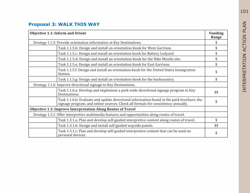
101
INTE
RPR
ETAT
ION
ACTI
ON
PLA
NProposal 3: WALK THIS WAY
Objective 1.1: Inform and Orient Funding Range
Strategy 1.1.5: Provide orientation information at Key Destinations. $ Task 1.1.5.b: Design and install an orientation kiosk for West Garrison. $ Task 1.1.5.c: Design and install an orientation kiosk for Battery Ledyard. $ Task 1.1.5.d: Design and install an orientation kiosk for the Nike Missile site. $ Task 1.1.5.e: Design and install an orientation kiosk for East Garrison. $ Task 1.1.5.f: Design and install an orientation kiosk for the United States Immigration
Station. $
Task 1.1.5.g: Design and install an orientation kiosk for the backcountry. $ Strategy 1.1.6: Improve directional signage to Key Destinations. Task 1.1.6.a: Develop and implement a park-wide directional signage program to Key
Destinations. $$
Task 1.1.6.b: Evaluate and update directional information found in the park brochure, the signage program, and online sources. Check all formats for consistency annually. $
Objective 1.3: Improve Interpretation Along Routes of Travel Strategy 1.3.1: Offer interpretive multimedia features and opportunities along routes of travel. Task 1.3.1.a: Plan and develop self-guided interpretive content along routes of travel. $ Task 1.3.1.b: Design and install self-guided wayside panels. $$ Task 1.3.1.c: Plan and develop self-guided interpretive content that can be used on
personal devices. $
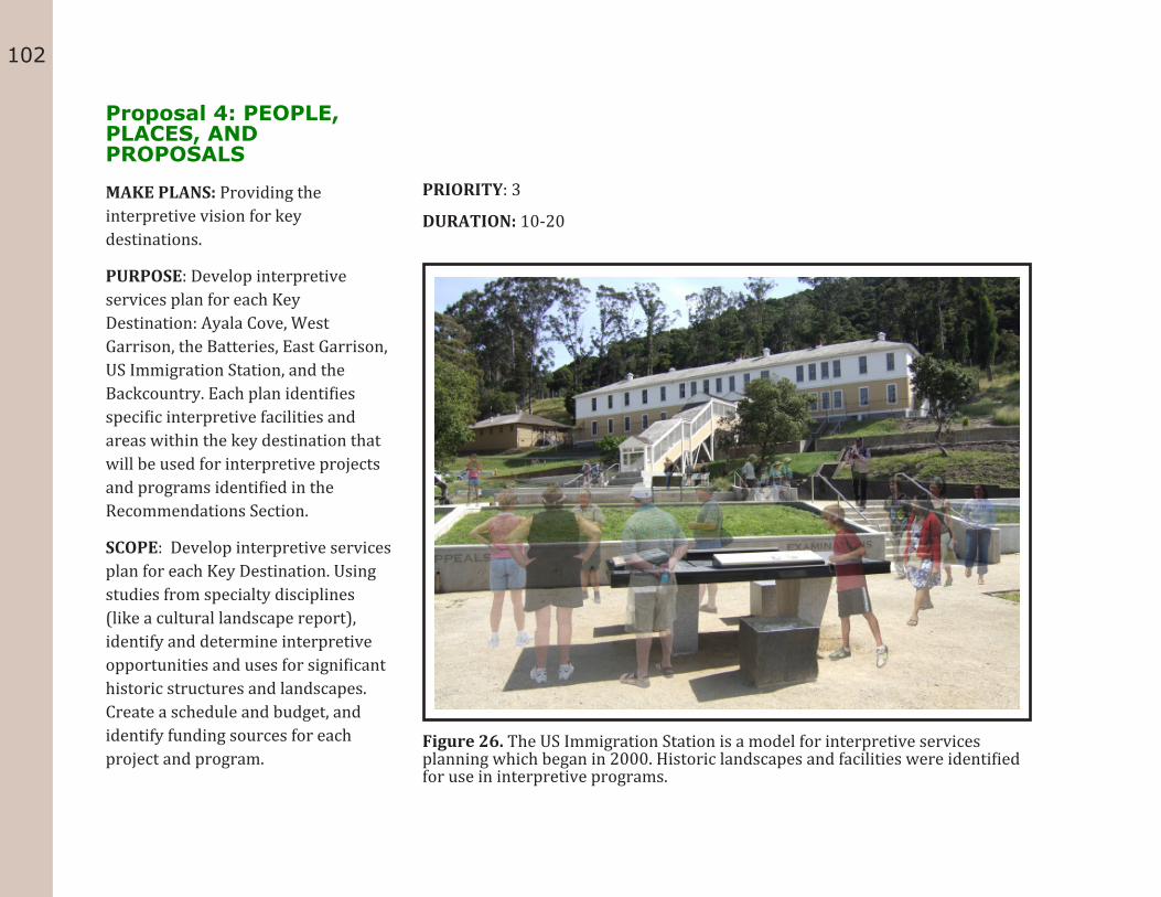
102
Proposal 4: PEOPLE, PLACES, AND PROPOSALS
MAKE PLANS: Providing the interpretive vision for key destinations.
PURPOSE: Develop interpretive services plan for each Key Destination: Ayala Cove, West Garrison, the Batteries, East Garrison, US Immigration Station, and the Backcountry. Each plan identifies specific interpretive facilities and areas within the key destination that will be used for interpretive projects and programs identified in the Recommendations Section.
SCOPE: Develop interpretive services plan for each Key Destination. Using studies from specialty disciplines (like a cultural landscape report), identify and determine interpretive opportunities and uses for significant historic structures and landscapes. Create a schedule and budget, and identify funding sources for each project and program.
PRIORITY: 3
DURATION: 10-20
Figure 26. The US Immigration Station is a model for interpretive services planning which began in 2000. Historic landscapes and facilities were identified for use in interpretive programs.

103
INTE
RPR
ETAT
ION
ACTI
ON
PLA
NProposal 4: PEOPLE, PLACES, AND PLANS
Objective 2.2: Make Connections to Cultural History Funding Range
Strategy 2.2.1: Provide a robust interpretive experience at Ayala Cove. Task 2.2.1.a: Identify and develop significant stories at Ayala Cove. $ Task 2.2.1.d: Interpret important cultural landscape features of Ayala Cove. $ Strategy 2.2.2: Provide a robust interpretive experience at West Garrison. Task 2.2.2.a: Identify and develop significant stories at West Garrison. $ Task 2.2.2.d: Interpret important cultural landscape features of West Garrison. $ Strategy 2.2.3: Broaden the interpretive experience at Battery Ledyard. Task 2.2.3.a: Identify and develop significant stories at Battery Ledyard. $ Task 2.2.3.d: Interpret important cultural landscape features of Battery Ledyard. $ Strategy 2.2.4: Broaden the interpretive experience at Battery Wallace. Task 2.2.4.a: Identify and develop significant stories at Battery Wallace. $
Task 2.2.4.d: Interpret important cultural and natural landscape features of Battery Wallace. $
Strategy 2.2.5: Broaden the interpretive experience at Battery Drew. Task 2.2.5.a: Identify and develop significant stories at Battery Drew. $ Task 2.2.5.d: Interpret important cultural landscape features of Battery Drew. $ Strategy 2.2.6: Broaden the interpretive experience at Perle’s Beach. Task 2.2.6.a: Identify and develop significant stories at Perle’s Beach. $ Task 2.2.6.c: Interpret important cultural landscape features of Perle’s Beach. $ Strategy 2.2.7: Broaden the interpretive experience at the Rock Quarry. Task 2.2.7.a: Identify and develop significant stories at the Rock Quarry. $ Task 2.2.7.d: Interpret important cultural landscape features of the Rock Quarry. $ Strategy 2.2.8: Broaden the interpretive experience at the Nike Missile site. Task 2.2.8.a: Identify and develop significant stories at the Nike Missile site. $
104
Task 2.2.8.d: Interpret important cultural landscape features of the Nike Missile site. $ Strategy 2.2.9: Provide a robust interpretive experience at East Garrison. Task 2.2.9.a: Identify and develop significant stories at East Garrison. $ Task 2.2.9.d: Interpret important cultural landscape features of East Garrison. $ Strategy 2.2.10: Provide a robust interpretive experience at the United States Immigration Station. Task 2.2.10.a: Identify and develop significant stories at the United States Immigration
Station. $
Task 2.2.10.d: Interpret important cultural landscape features of the United States Immigration Station. $
Objective 2.1: Demonstrate and Interpret Angel Island’s Place in the World Strategy 2.1.2: Use interpretation to convey stories about Angel Island’s connection to the San Francisco
Bay Area and beyond. Task 2.1.2.c: Develop interpretive content about Angel Island’s connection to the greater
San Francisco Bay estuary. $
Task 2.1.2.d: Develop interpretive content about AISP’s connection to other land preservation sites in the San Francisco Bay Area and beyond. $
Objective 2.3: Make Connections to Natural History Strategy 2.3.1: Provide programs that promote discovery and learning about Angel Island’s marine
environment. Task 2.3.1.d: Develop interpretive content about AISP’s marine resources for an
Environmental Education Center. $
Strategy 2.3.2: Provide programs that promote discovery and learning of Angel Island’s terrestrial environment.
Task 2.3.2.d: Develop interpretive content about Angel Island’s terrestrial resources for an Environmental Education Center. $
Strategy 2.3.3: Interpret the effects that humans have had on Angel Island’s natural environment through time.
Task 2.3.3.a: Develop interpretive content for programs that highlight ways humans have altered the natural environment. $
Objective 2.4: Embrace Recreation

105
INTE
RPR
ETAT
ION
ACTI
ON
PLA
N Strategy 2.4.3: Broaden the interpretive experience at Mt. Caroline Livermore. Task 2.4.3.a: Identify and develop significant stories at Mt. Livermore. $ Task 2.4.3.e: Develop messaging connecting Angel Island to the San Francisco Bay Area
and beyond. Promote this connection at the Mt. Caroline Livermore summit since it offers a 360-degree view of the bay.
$
Objective 4.4: Promote Stewardship Strategy 4.4.2: Develop interpretive projects that highlight AISP’s preservation and conservation history,
and promote the park’s continued efforts in these areas.Task 4.4.2.c: Develop interpretive content that uses Angel Island as an example of the “Earth Island” concept. $

106
Proposal 5: STORIES, SIGHTS, AND SCENES
CONNECT TO HISTORY: Improving interpretation of Angel Island’s human story
PURPOSE: Broaden cultural resource interpretation by developing and expanding interpretive services, exhibits, and programs to better connect the park’s cultural resources to diverse audiences. Identify key cultural history stories and develop programs, exhibits, and other services to deliver interpretive content on these stories.
SCOPE: Develop interpretive program plans that connect visitors to the park’s human stories at key destinations. Develop interpretive content and design concepts for exhibits, interpretive facilities, programs, and curriculum. Fabricate and install new exhibits, train staff and volunteers, and implementation new programs.
PRIORITY: 3
DURATION: 10-20
Figure 27. Develop and expand interpretive services, exhibits and programs to better connect visitors to the park’s human stories.

107
INTE
RPR
ETAT
ION
ACTI
ON
PLA
NProposal 5: STORIES, SITES, AND SCENES
Objective 2.1 Demonstrate and Interpret Angel Island’s Place in the World. Funding Range
Strategy 2.1.2: Use interpretation to convey stories about Angel Island’s connection to the San Francisco Bay Area and beyond.
Task 2.1.2.e: Develop a wayside panel about Angel Island’s role in the exploration story of San Francisco Bay.
$
Objective 2.2: Make Connections to Cultural History Strategy 2.2.1: Provide a robust interpretive experience at Ayala Cove. Task 2.2.1.e: Identify and develop diverse secondary stories for Ayala Cove. $ Task 2.2.1.f: Create and implement a range of interpretive services for Ayala Cove. $ Task 2.2.1.i: Create an interpretive program plan for the entire Ayala Cove site. $ Strategy 2.2.2: Provide a robust interpretive experience at West Garrison. Task 2.2.2.e: Identify and develop diverse secondary stories for West Garrison. $ Task 2.2.2.f: Create and implement a range of interpretive services for West Garrison. $ Task 2.2.2.i: Create an interpretive program plan for West Garrison. $ Strategy 2.2.3: Broaden the interpretive experience at Battery Ledyard. Task 2.2.3.c: Provide labels for buildings and foundations at Battery Ledyard. $ Strategy 2.2.4: Broaden the interpretive experience at Battery Wallace. Task 2.2.4.c: Provide labels for buildings and foundations at Battery Wallace. $ Strategy 2.2.5: Broaden the interpretive experience at Battery Drew. Task 2.2.5.c: Provide labels for buildings and foundations at Battery Drew. $ Strategy 2.2.6: Broaden the interpretive experience at Perle’s Beach. Task 2.2.6.b: Develop and execute a site summary interpretive panel for Perle’s Beach. $ Strategy 2.2.7: Broaden the interpretive experience at the Rock Quarry. Task 2.2.7.b: Develop and execute a site summary interpretive panel for the Rock Quarry. $ Task 2.2.7.c: Provide labels for buildings and foundations at the Rock Quarry. $

108
Strategy 2.2.8: Broaden the interpretive experience at the Nike Missile site. Task 2.2.8.b: Develop and execute a site summary interpretive panel for the Nike Missile
site.$
Task 2.2.8.c: Provide labels for buildings and foundations at the Nike Missile site. $ Strategy 2.2.9: Provide a robust interpretive experience at East Garrison. Task 2.2.9.c: Provide labels for buildings and foundations at East Garrison. $ Task 2.2.9.e: Identify and develop diverse secondary stories for East Garrison. $ Task 2.2.9.f: Create and implement a range of interpretive services for East Garrison. $ Task 2.2.9.i: Create an interpretive program plan for East Garrison. $ Strategy 2.2.10: Provide a robust interpretive experience at the United States Immigration Station. Task 2.2.10.c: Provide labels for buildings and foundations at the United States
Immigration Station.$
Task 2.2.10.e: Identify and develop diverse secondary stories for the United States Immigration Station.
$
Task 2.2.10.f: Create and implement a range of interpretive services for the United States Immigration Station.
$
Task 2.2.10.i: Create an interpretive program plan for the United States Immigration Station.
$
Strategy 2.2.11: Provide a robust interpretive experience about the Miwok story, in consultation with the Federated Indians of Graton Rancheria.
Task 2.2.11.a: Develop and determine a site summary interpretive panel for the Miwok story.
$
Task 2.2.11.b: Interpret important cultural landscape features related to the Miwok, with consultation taking into consideration resource protection and cultural sensitivity.
$
Task 2.2.11.c: Create and implement a range of interpretive services about the Miwok story.
$
Task 2.2.11.d: Identify and develop diverse secondary stories for the Miwok story. $ Strategy 2.2.12: Provide a robust interpretive experience park-wide with interactive interpretive
opportunities.

109
INTE
RPR
ETAT
ION
ACTI
ON
PLA
N Task 2.2.12.a: Develop and implement living history programs park-wide. $$ Task 2.2.12.b: Develop and implement first person narrative programs park-wide. $ Task 2.2.12.c: Develop and implement hands-on programs park-wide. $ Task 2.2.12.d: Develop and implement historic demonstration programs park-wide. $Objective 2.3: Make Connections to Natural History Strategy 2.3.4: Broaden the interpretive experience at Mt. Caroline Livermore.
Task 2.4.3.b: Develop and install a site summary interpretive panel for the Mt. Livermore story in conjunction with an orientation kiosk.
$
Task 2.4.3.d: Interpret important cultural landscape features of Mt. Livermore. $

110
Proposal 6: BEASTS, BEACHES, AND BACKCOUNTRY
CONNECT TO NATURAL RESOURCES: Learning about Angel Island’s natural environment
PURPOSE: Broaden the park’s natural resource interpretation. Develop and expand on a variety of interpretive services, exhibits, and programs to better connect the park’s natural resources to diverse audiences. Produce interpretive program plans for each key destination to identify key natural history stories and develop programs, exhibits, and other services to deliver interpretive content about the environment.
SCOPE: Prioritize the interpretation program plans for the six Key Destinations and prepare an interpretive project plan for each. Develop interpretive content and design concepts for exhibits, interpretive facilities, and programs. Fabricate and install new exhibits, train staff and volunteers, and implement new programs
PRIORITY: 3
DURATION: 10-20
Figure 28. Connect visitors to the park’s natural resources by broadening Angel Island’s interpretation of the environment.
111
INTE
RPR
ETAT
ION
ACTI
ON
PLA
NProposal 6: BEASTS, BEACHES, AND BACKCOUNTRY
Objective 2.3: Make Connections to Natural History Funding Range
Strategy 2.3.1: Provide programs that promote discovery and learning of Angel Island’s marine environment.
Task 2.3.1.b: Develop a science-based program that interprets Angel Island’s marine environment.
$
Task 2.3.1.c: Develop hands-on opportunities for direct contact with Angel Island’s marine environment.
$$
Task 2.3.1.e: Develop curriculum-based field experiences that tie into Angel Island’s marine environment.
$
Task 2.3.1.f: Develop and install a series of wayside panels highlighting Angel Island’s marine environment.
$
Task 2.3.1.g: Collaborate with other marine educators to provide content and opportunities.
$
Strategy 2.3.2: Provide programs that promote discovery and learning of Angel Island’s terrestrial environment.
Task 2.3.2.b: Develop a science-based program that interprets Angel Island’s terrestrial environment.
$
Task 2.3.2.c: Develop hands-on opportunities for direct contact with Angel Island’s terrestrial environment.
$
Task 2.3.2.e: Develop curriculum-based field experiences that tie into Angel Island’s terrestrial environment.
$
Task 2.3.2.f: Develop and install a series of wayside panels highlighting Angel Island’s significant natural zones.
$
Objective 4.4: Promote Stewardship Strategy 4.4.2: Develop interpretive projects that highlight AISP’s preservation and conservation history
and promote the park’s continued efforts in these areas.

112
Task 4.4.2.a: Develop interpretive opportunities for visitors to explore the history of the conservation and preservation of AISP by integrating into existing and future park programs.
$
Task 4.4.2.b: Highlight examples of sustainable actions from CSP and their partners that support reduced energy consumption and minimizing waste.
$
Task 4.4.2.c: Develop interpretive content that uses Angel Island as an example of the “Earth Island” concept.
$

113
INTE
RPR
ETAT
ION
ACTI
ON
PLA
NProposal 7: PADDLE, PEDAL, AND PLAY!CONNECT TO RECREATION: Discovering ways to learn through recreational activities
PURPOSE: Broaden Angel Island State Park’s connection to visitors through expansion of recreational opportunities. Produce an interpretation project plan for recreation to identify activities that relate visitors to the park’s natural and cultural resources, and interpretive stories. Develop and expand a variety of interpretive services, programs, and facilities relating to recreation. Through recreation, visitors can make lasting connections to the island while improving overall health and well-being.
SCOPE: Develop an interpretation project plan that sets the direction for expanding recreational opportunities. Identify key interpretive stories linked to recreation, and make recommendations on methods and approaches to delivering interpretive content. Include design concepts for exhibits, interpretive facilities, and programs. Fabricate and install exhibits and interpretive facilities (or enhancements made to them). Train staff and volunteers, and implement new programs.
PRIORITY: 2
DURATION: 5-10
Figure 29. Broaden the park’s recreational opportunities using interpretation.

114
Proposal 7: PADDLE, PEDAL, AND PLAY!Objective 2.3: Make Connections to Natural History Funding
Range Strategy 2.3.1: Provide programs that promote discovery and learning of Angel Island’s marine
environment. Task 2.3.1.h: Partner with groups for boat-side exploration of Angel Island’s shoreline. $Objective 2.4: Inspire Stewardship of Angel Island Strategy 2.4.1: Develop interpretive programs, multimedia applications, and exhibits that enhance
recreational experiences. Task 2.4.1.a: Highlight existing and develop additional recreational opportunities that
relate to historic recreational uses of AISP.$$
Task 2.4.1.b: Promote AISP as a destination for a wide variety of recreational opportunities.
$
Task 2.4.1.c: Showcase AISP as a quiet refuge in the middle of a busy urban area. $ Task 2.4.1.d: Develop creative programs and opportunities that encourage exploration of
AISP’s recreational resources. $
Strategy 2.4.2: Encourage recreation on AISP to promote health and well-being. Task 2.4.2.a: Provide interpretive opportunities for visitors to participate in structured
and unstructured activities that encourage a healthy lifestyle. $
Task 2.4.2.b: Explore opportunities for children in the form of historic play areas on AISP. $$ Task 2.4.2.c: Develop period gardens to educate visitors about historic food use at AISP. $$ Task 2.4.2.d: Collaborate with partners to promote AISP as a location for healthy
recreation. $
Task 2.4.2.e: Develop interpretive experiences that highlight the Children’s Outdoor Bill of Rights.
$
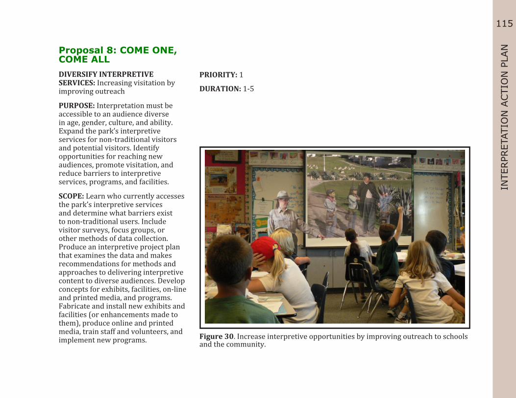
115
INTE
RPR
ETAT
ION
ACTI
ON
PLA
NProposal 8: COME ONE, COME ALLDIVERSIFY INTERPRETIVE SERVICES: Increasing visitation by improving outreach
PURPOSE: Interpretation must be accessible to an audience diverse in age, gender, culture, and ability. Expand the park’s interpretive services for non-traditional visitors and potential visitors. Identify opportunities for reaching new audiences, promote visitation, and reduce barriers to interpretive services, programs, and facilities.
SCOPE: Learn who currently accesses the park’s interpretive services and determine what barriers exist to non-traditional users. Include visitor surveys, focus groups, or other methods of data collection. Produce an interpretive project plan that examines the data and makes recommendations for methods and approaches to delivering interpretive content to diverse audiences. Develop concepts for exhibits, facilities, on-line and printed media, and programs. Fabricate and install new exhibits and facilities (or enhancements made to them), produce online and printed media, train staff and volunteers, and implement new programs.
PRIORITY: 1
DURATION: 1-5
Figure 30. Increase interpretive opportunities by improving outreach to schools and the community.

116
Proposal 8: COME ONE, COME ALL
Objective 3.1 Improve Access Funding Range
Strategy 3.1.1: Promote and increase awareness of AISP’s interpretive opportunities for non-traditional users.
Task 3.1.1.a: Market interpretive services through outlets that serve non-traditional groups.
$
Task 3.1.1.b: Utilize partnerships to share information about Angel Island’s diverse interpretive opportunities.
$
Task 3.1.1.c: Evaluate and update existing resources to describe diverse interpretive opportunities.
$
Task 3.1.1.d: Evaluate AISP’s marketing and promotional programs annually to determine their effectiveness in reaching a diverse audience. Make changes to these programs as needed to ensure the park’s services reach a diverse audience.
$
Objective 3.2: Broaden Audiences Strategy 3.2.1: Identify barriers that prevent visitor’s full participation in interpretive opportunities at
AISP. Task 3.2.1.a: Survey agencies and organizations that focus on underserved populations
and groups. $
Task 3.2.1.b: Develop a list of barriers and solutions to overcome these barriers. $ Strategy 3.2.2: Reduce barriers by reviewing, planning, and broadening interpretive opportunities. Task 3.2.2.a: Develop multi-lingual interpretive programs and services to reach a broader
audience.$$
Task 3.2.2.b: Develop interpretive programs that can be presented at schools and organizations.
$
Task 3.2.2.c: Develop off-site interpretive programs that schools and organizations can use at their locations.
$
Task 3.2.2.d: Evaluate the effectiveness of Angel Island’s interpretive services annually to ensure they reach a diverse audience.
$

117
INTE
RPR
ETAT
ION
ACTI
ON
PLA
NProposal 9: IT TAKES A COMMUNITY TO RAISE AN ISLAND
STRENGTHEN COMMUNITY TIES: Using interpretation to increase support for Angel Island
PURPOSE: Create an interpretation project plan for outreach and communication. Increase volunteerism and establish community partnerships to help support the park’s interpretive and recreational programs. Recommend ways to expand the volunteer program to include more natural and cultural resource interpretation. Devise strategies to expand community service and conservation to assist the park in preserving the island’s resources.
SCOPE: Develop an interpretation project plan for outreach and communication, and an interpretive program plan to expand the volunteer program. Implement the recommendations made in these plans, including staff and volunteer training to carry out the programs.
PRIORITY: 2
DURATION: 5-10
Figure 31. Use interpretation to increase stewardship and community ties to the park through service programs and outreach.

118
Proposal 9: IT TAKES A COMMUNITY TO RAISE AN ISLAND
Objective 3.3: Enhance Partnerships Funding Range
Strategy 3.3.1: Partner with community and government groups serving diverse populations. Task 3.3.1.a: Identify programs that would benefit from partnerships. $ Task 3.3.1.b: Develop and execute mutually beneficial partnerships. $ Task 3.3.1.c: Evaluate partnership effectiveness on a three- to-five-year basis. $ Strategy 3.3.2: Include partners in planning, funding, and implementing interpretive and recreational
opportunities at AISP. Task 3.3.2.a: Identify partners working with underserved groups and include them in the
park planning process. $
Task 3.3.2.b: Partner with agencies and groups to coordinate interpretive programs and promote interpretive services.
$
Objective 4.2: Promote Visitation Strategy 4.2.1: Reach out to constituents to promote Angel Island’s year-round interpretive opportunities. Task 4.2.1.c: Partner with existing community programs, associations, clubs, and
educational institutions to offer unique field experiences. $
Task 4.2.1.d: Make connections to public land partners for cross-promotional interpretive opportunities.
$
Objective 4.3: Enhance Destinations Strategy 4.3.1: Identify and determine interpretive opportunities and uses for significant historic
structures and landscapes. Task 4.3.1.c: Develop and promote each Key Destination for preservation and education
partnerships. $
Objective 4.4: Promote Stewardship Strategy 4.4.1: Increase volunteer and partnership opportunities to encourage the stewardship and
preservation of AISP. Task 4.4.1.a: Train existing and future volunteers with messaging that promotes AISP’s
stewardship and preservation programs. $

119
INTE
RPR
ETAT
ION
ACTI
ON
PLA
N Task 4.4.1.b: Locate existing models of stewardship programs that use volunteers and or partnerships, and emulate the successful techniques used.
$
Strategy 4.4.2: Develop interpretive projects that highlight Angel Island State Park’s preservation and conservation history, and promote the park’s continued efforts in these areas.
Task 4.4.2.a: Develop interpretive opportunities for visitors to explore the history of the conservation and preservation of AISP by integrating into existing and future park programs.
$
Task 4.4.2.b: Highlight examples of sustainable actions by CSP and partners that support reduced energy consumption and minimizing waste through interpretive facilities programs and exhibits.
$
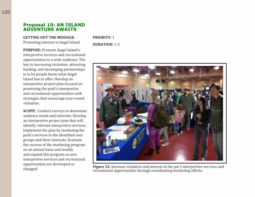
120
Proposal 10: AN ISLAND ADVENTURE AWAITSGETTING OUT THE MESSAGE: Promoting interest in Angel Island
PURPOSE: Promote Angel Island’s interpretive services and recreational opportunities to a wide audience. The key to increasing visitation, attracting funding, and developing partnerships is to let people know what Angel Island has to offer. Develop an interpretive project plan focused on promoting the park’s interpretive and recreational opportunities with strategies that encourage year-round visitation.
SCOPE: Conduct surveys to determine audience needs and interests. Develop an interpretive project plan that will identify relevant interpretive services. Implement the plan by marketing the park’s services to the identified user groups and their interests. Evaluate the success of the marketing program on an annual basis and modify and expand this program as new interpretive services and recreational opportunities are developed or changed.
PRIORITY: 1
DURATION: 1-5
Figure 32. Increase visitation and interest in the par’s interpretive services and recreational opportunities through coordinating marketing efforts.
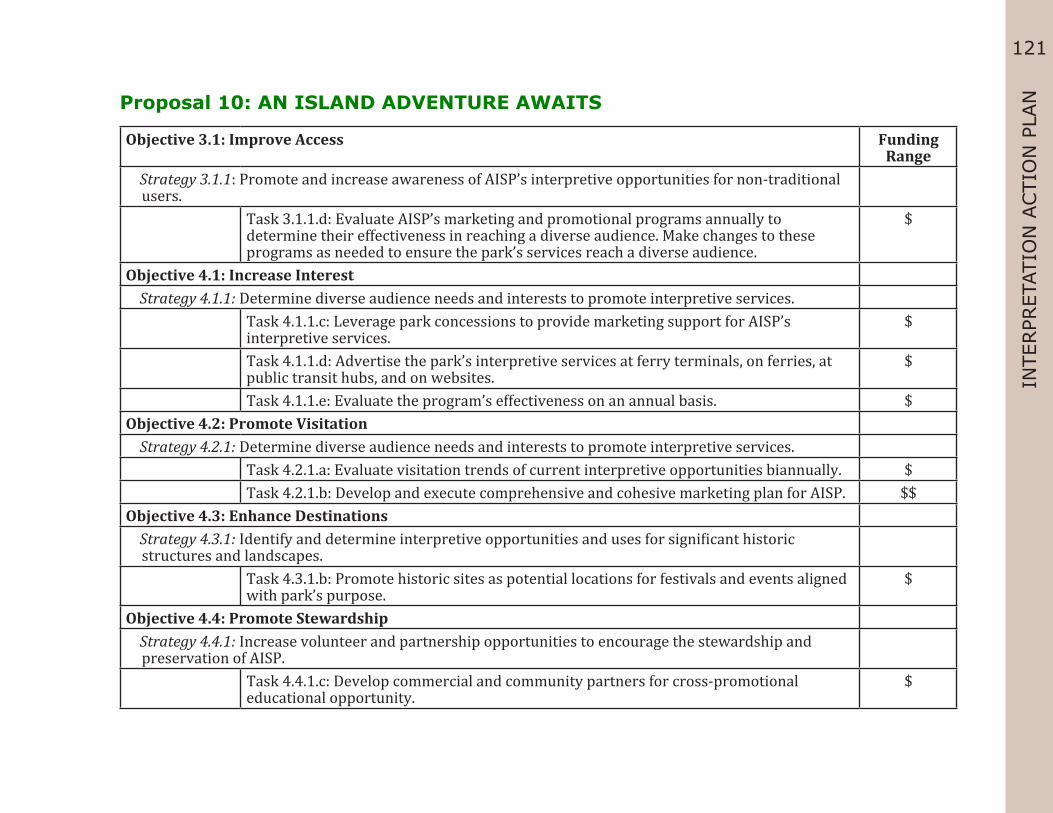
121
INTE
RPR
ETAT
ION
ACTI
ON
PLA
NProposal 10: AN ISLAND ADVENTURE AWAITS
Objective 3.1: Improve Access Funding Range
Strategy 3.1.1: Promote and increase awareness of AISP’s interpretive opportunities for non-traditional users.
Task 3.1.1.d: Evaluate AISP’s marketing and promotional programs annually to determine their effectiveness in reaching a diverse audience. Make changes to these programs as needed to ensure the park’s services reach a diverse audience.
$
Objective 4.1: Increase Interest Strategy 4.1.1: Determine diverse audience needs and interests to promote interpretive services. Task 4.1.1.c: Leverage park concessions to provide marketing support for AISP’s
interpretive services.$
Task 4.1.1.d: Advertise the park’s interpretive services at ferry terminals, on ferries, at public transit hubs, and on websites.
$
Task 4.1.1.e: Evaluate the program’s effectiveness on an annual basis. $Objective 4.2: Promote Visitation Strategy 4.2.1: Determine diverse audience needs and interests to promote interpretive services. Task 4.2.1.a: Evaluate visitation trends of current interpretive opportunities biannually. $ Task 4.2.1.b: Develop and execute comprehensive and cohesive marketing plan for AISP. $$Objective 4.3: Enhance Destinations Strategy 4.3.1: Identify and determine interpretive opportunities and uses for significant historic
structures and landscapes. Task 4.3.1.b: Promote historic sites as potential locations for festivals and events aligned
with park’s purpose. $
Objective 4.4: Promote Stewardship Strategy 4.4.1: Increase volunteer and partnership opportunities to encourage the stewardship and
preservation of AISP. Task 4.4.1.c: Develop commercial and community partners for cross-promotional
educational opportunity. $

122

123
REF
EREN
CESREFERENCES
Angel Island State Park, General Development Plan. California: California State Parks, Sacramento.1979.
Angel Island State Park, General Development Plan Amendment for Angel Island Immigration Station, Draft for Public Review. California: California State Parks, Sacramento. December 2005.
Angel Island Immigration Station Master Plan. California: California State Parks, Sacramento. 2003.
Angel Island State Park, Interpretation Master Plan: California: California State Parks, Sacramento. September 2011.
Angel Island Oral History Project, California State Parks, 1990
Basic Interpretation Learning System, California State Parks, 2005.
Bolster, Ed. Department of Fish and Game, State of California, “Terrestrial Mammal Species of Special Concern in California.” Last modified 1998. Accessed July 19, 2012. http://www.dfg.ca.gov/serp.html?q=Terrestrial Mammal Species of Special Concern in California, Bolster, B.C., Ed. 1998&cx=001779225245372747843:3y4rnp6j9ny&cof=FORID: 10&ie=UTF-8.
California State Board of Education, “Content Standards.” Last modified Tuesday, September 27, 2011. Accessed April 17, 2012. http://www.cde.ca.gov/be/st/ss/index.asp.
Department Operations Manual, Interpretation and Education and the Museum Collections Management sections, California State Parks, 2010.
Davison, Mark, and Lauren Meier. Cultural Landscape Report for the Angel Island Immigration Station, Volume l: Site History. Brookline, MA: US Department of the Interior, National Park Service, Olmsted Center for Landscape Preservation, December 2002.
Hook, Eileen. Angel Island State Park: East Garrison Visitor Center Interpretive Plan. Sacramento: State of California, 1988.
Interpretive Prospectus—Angel Island State Park, California State Parks, 1977
Interpretive Planning Workbook: Workbook for Planning
Interpretation in California State Parks, California State Parks, 2012.
National Register Nomination: Angel Island, California. California: California State Parks, Sacramento. 1970.
“Standards and Practices for Interpretive Planning.” National Association of Interpretation.” National Association of Interpretation, 2008. Web. 24 Apr 2012. <http://www.interpnet.com/>.
US Department of Commerce, “California Quickfacts.” Last modified Thursday, 07-Jun-2012 13:28:54 EDT. Accessed July 20, 2012. http://quickfacts.census.gov/qfd/states/06000.html.

124

125
GLO
SSARYGLOSSARY
AccessibilityAccessibility is “the combination of various elements in a building or outdoor area, which allows access, circulation and full use of the building, facilities and programs by a person with disabilities.” To ensure compliance with the Americans with Disabilities Act (ADA), accessibility must be addressed in all levels of planning, including interpretive center design and development, interpretive programming, trail/pathway construction and maintenance, and exhibit designs. For more information about accessibility, refer to the CSP Accessibility Guidelines, 2009. (Definition from the California Building Code 202.A.)
Annual Interpretation Implementation PlanThe Annual Interpretation Implementation Plan is prepared by district and park staff to identify objectives of the interpretation program for the district and to set priorities for the coming year. Once developed, the plan is reviewed throughout the year to help ensure objectives are met.
Concessions A concession is a private business operating under contract in a state park unit that provides products, services, and programs not normally provided by State employees. Such services are intended to enhance the recreational or educational experiences of park visitors. (DOM policy 0908.5, and DOM 1900 Concessions and Reservations)
Cooperating AssociationsCooperating Associations are local charitable, nonprofit organizations with which CSP has entered into formal agreements. These organizations are involved with one or
more CSP and are committed to funding and supporting publications, programs, events, and facilities that advance education and interpretation in CSP. Each park unit normally has one cooperating association. (DOM policy 0908.4)
Cultural LandscapesA cultural landscape is defined by the National Park Service as “a geographic area, including both cultural and natural resources and the wildlife or domestic animals therein, associated with a historic event, activity, or person, or exhibiting other cultural or aesthetic values.”
Declaration of PurposeThe declaration of purpose (called Statement of Purpose for some parks) defines the purpose of the unit in the context of the State Park System and the broadest goals of management. It includes an identification of prime resources, a broad statement of management goals consistent with unit classification, and a general statement of appropriate recreational activities.
All classified units of the California State Park System have a Declaration (or Statement) of Purpose, established during the Naming and Classification process. The Declaration of Purpose is usually updated in newer General Plans. Check the most recent park general plan for the current Declaration of Purpose. If the park has no general plan, consult the Park Unit Purpose Statements list on the Planning Division’s web page at http://www.parks.ca.gov/?page_ id=797

126
DemographicsDemographics are measurable characteristics of a segment of the public at large; they may be connected to the group’s age, ethnicity, the region where the group resides, a particular recreational interest, economic status, etc. (Planning Handbook)
DocentsDocents are a special group of highly trained volunteers who interpret the cultural, natural, and recreational resources of CSP to visitors. Each has had formalized training in a park’s history, its natural history, purpose, themes, policies, procedures, facilities, and good public communication skills. With their own unique and individual approaches, they provide an informed, scholarly foundation to interpretive programs.
Environmental Living Programs (ELPs)ELPs provide children overnight park experiences that explore the interaction between people and their environment. Students are immersed in the past through a structured program that incorporates demonstrations, hands-on activities, and follow up student assignments, all coordinated with concepts taught in the classroom. ELPs differ from standard tours and programs in their in-depth nature, their length, and their immersion of the children in the subject matter being discussed. (DOM policy 0904.6.16.2.1)
Environmental Studies ProgramsEnvironmental Studies Programs (ESPs) are similar to ELPs but are organized without the overnight stay.
Formal ExhibitsFormal exhibits are interpretive media in which historical or natural history objects are displayed apart from their original contexts, using display cabinets and other contemporary furniture, along with illustrative graphics and text. They impart messages relative to certain themes. Formal exhibits can also be interpretive panels (without objects) illustrating an event, activity, site, or people. They are versatile and can utilize many media: encased objects, natural history dioramas, models, murals, historic setting museums and vignettes, three-dimensional maps, text and graphics panels, video monitors, and audio tracks, to name a few.
Exhibits displaying cultural and natural history objects related to the resources of a unit may be shown in the controlled environments of an interpretive center or museum. Objects that characterize or portray a park theme can enhance interest, convey complex ideas, and transcend barriers of culture and language. Historically significant objects bring authenticity and “presence” to the interpretation of a historic site.
Exhibits may also be located in a natural setting, such as outdoor trailside panels. They offer flexibility and convenience for visitors who may not have the time to take a guided natural history walk or historic tour, or to see a living history program.
General PlanThe general plan is the primary management document for each unit of the California State Park System, defining a park’s primary purpose and establishing a management direction for its future development and operation. By providing a clear purpose and vision, guidance on long and short-term goals, and guidelines, the general plan defines the broadest management framework possible for

127
GLO
SSARYa unit’s development, ongoing management, interpretive
programming, and public use.
By law the State Park and Recreation Commission has the authority to review and approve General Plans of the State Park System. As land planning documents, they are subject to review under the California Environmental Quality Act (CEQA).
GoalsGoals build off the vision and mission statements. Goals are broad, general concepts that describe the ultimate purpose, aim, or intent of your interpretation. Goals are not necessarily measurable. They are the big picture, the overall results that interpretation should achieve.
Guided Walks and ToursGuided hikes, walks, talks, and tours bring together skilled interpreters with interested visitors. They make the fullest use of the resources at hand, whether they include flora and fauna, geographic features, historic buildings or artifacts, or a site where an important event occurred. As a rule, hikes are conducted in natural settings and tours at historic or other cultural sites.
GuidelinesGuidelines are found in some units’ General Plans or Prospectuses. In the General Plans, the role of the guidelines is to provide direction for accomplishing goals. If present, guidelines can be used to help develop goals, objectives, and strategies for Interpretation Master Plans.
Hands-On Exhibits and Discovery AreasHands-on, discovery areas offer participatory exhibits developed especially for visitors to handle, examine, or otherwise explore objects related to the park’s resources and themes.
Exhibits can be composed of hands-on natural or cultural objects, models, discovery boxes, photographic enlargements, interactive games, flipbooks, interactive videos and computer programs, environmental monitors (weather, tides, earthquakes, etc.), microscopes, and live animals and plants. These types of exhibits have particular appeal to children, who enjoy playacting, experimentation, and touch.
Staffing requirements and maintenance costs can be high for discovery areas. Consult a Museum Curator or Superintendent before using museum objects in hands-on exhibits or discovery areas. If possible, modern substitutions for museum objects should be obtained and used. (For more information on extended hands-on use of museum objects, see DOM Policy 2010.10.3 and 2010.10.4)
They offer flexibility and convenience for visitors who may not have the time clear purpose and vision, guidance on long and short-term goals, and guidelines, the general plan defines the broadest management framework possible for a unit’s development, ongoing management, interpretive programming, and public use. By law the State Park and Recreation Commission has the authority to review and approve General Plans of the State Park System. As land planning documents, they are subject to review under the California Environmental Quality Act (CEQA).
Hands-On ExhibitsHands-on discovery areas offer participatory exhibits developed especially for visitors to handle, examine, or

128
otherwise explore objects related to the park’s resources and themes. Exhibits can be composed of hands-on natural or cultural objects, models, and discovery. Consult a Museum Curator or Superintendent before using museum objects in hands-on exhibits or discovery areas. If possible, modern substitutions for museum objects should be obtained and used. (For more information on extended hands-on use of museum objects, see DOM Policy 2010.10.3 and 2010.10.4)
Historic SiteA historic site is a landscape significant for its association with a historic event, activity, or person.
Historic StructuresHistoric structures are original, preserved, restored, or reconstructed edifices of a particular period. Most historic structures are recognized as historical resources and require special management, including guidelines for their long-term preservation. In California State admission, maps, and brochures are generally obtained there. Some also contain a few interpretive exhibits, a telephone, and limited sales. Visitor contact counters are often located within large park visitor centers and museums.
Information Centers, Visitor Contact Counters, KiosksInformation centers, visitor contact counters, and kiosks are staffed facilities essentially developed to provide information. Often they are the first stop in the park for visitors. Park admission, maps, and brochures are generally obtained there. Some also contain a few interpretive exhibits, a telephone, and limited sales. Visitor contact counters are often located within large park visitor centers and museums.
Interpretation Action PlanThe Interpretation Action Plan is a “roadmap,” offering a realistic and flexible mechanism for achieving the park unit’s interpretive goals, objectives, and strategies. An Interpretation Action Plan should follow the development of a Master Plan and may be set up as a stand-alone document.
Intellectual PropertyIntellectual Property is creative ideas and expressions of the human mind that have commercial value and receive the legal protection of a property right. The major legal mechanisms for protecting intellectual property rights are copyrights, patents, and trademarks. Intellectual property rights enable owners to select who may access and use their property and to protect it from unauthorized use. For more information about intellectual property rights, see CSP’s Intellectual Property Handbook. (DOM policy 0907)
InterpretationInterpretation is “A mission-based communication process that forges emotional and intellectual connections between the interests of the audience and the meanings inherent in the resource.” (National Association for Interpretation definition)
Interpretation Management PlanAn Interpretation Management Plan more specifically defines the objectives, methodologies, and concepts for how goals and guidelines, as identified in the General Plan, will be achieved. The types of interpretation Management Plans include Interpretation Master Plans and Action Plans. (DOM policy 0902.6.3.1)

129
GLO
SSARYInterpretation Master Plan (IMP)
An Interpretation Master Plan takes a long-range approach to interpretation planning and may be developed for a unit, sector, or geographical region, or may be used for particular resources found throughout the state. It updates and expands upon the General Plan. The IMP provides greater background and context, while analyzing existing conditions and looking at opportunities and constraints for expanding interpretation and meeting visitor needs. The IMP can be a stand-alone document or combined with an Action Plan. (DOM policy 0902.6.3.2.1)
Interpretive Concessions Some park concessions, by contract, not only produce revenue, but also assist CSP in its interpretive efforts through their activities and, often within historic units, their period appropriate appearance. Under State Park Commission Policy 1.4, interpretive concessions must “directly relate to an interpretive theme, interpretive plan, or general plan for that unit.” Interpretive concessions may invite visitor involvement and offer lasting mementos of the park experience.
The primary sources of revenue for an interpretive concession should be derived from products or services that are in themselves interpretive or representative of the natural, cultural, or recreational resources of the park. (Refer to the DOM 1900, Concessions and Reservations, as well as the Concessions, Reservations, and Fees Division of CSP, for more information and specific policies concerning state park concessions).
Interpretive FacilitiesInterpretive facilities include interpretive installations such as exhibits, panels, and non-presented audio-visual programs. Interpretive facilities, sometimes referred to
under the broad category of “non- personal interpretation,” contribute an interpretive theme is a succinct, central message, phrased in the form of a complete sentence, about a topic of interest that a communicator wants to get across to an audience. (DOM policy 0902.4.1)
Interpretive Services PlansInterpretive Services Plans make detailed recommendations for producing formal exhibits, furnishing historic settings, creating audio-visual media, developing trails and wayside exhibits, or producing such interpretive programs as living history or environmental living activities. Interpretive Services Plans take their direction from the park unit’s General Plan and Interpretation Management Plans. Interpretive Services Plans fall into two categories: Interpretive Project Plan and Interpretive Program Plan.
Interpretive Project Plans include, but are not limited to, Exhibit Plans, Furnishing Plans, Audio-Visual Plans, and Interpretive Trail Plans.
Interpretive Program Plans include Living History Plans, Environmental Studies, and Environmental Living Plans. (DOM policy 0902.6.5.1)
Interpretive ProspectusA provisional document, the Interpretive Prospectus contains the same interpretation information as a General Plan and evaluates existing conditions for interpretation in the park unit. An Interpretive Prospectus may be developed when there is no approved General Plan for a park unit or the approved General Plan does not contain sufficient detail to guide the development of interpretive services for a unit. (DOM policy 0902.6.2.2.1)

130
Interpretive ThemeAn interpretive theme is a succinct, central message, phrased in the form of a complete sentence, about a topic of interest that a communicator wants to get across to an audience. (DOM policy 0902.4.1)
Junior Ranger Programs“Junior Rangers” is a statewide interpretive program designed for children ages 7 to 12. The program fosters appreciation for California’s rich natural and cultural heritage, emphasizing the stewardship of park resources and their connection to global issues. Children typically earn awards by taking part in activities presented by park staff, but youths may also participate via the Internet or by completing the Junior Ranger Adventure Guide. For more information, see CSP’s Junior Ranger Program Handbook.
Living History ProgramsInterpretive programming that includes presentation of authentic historical activities, events, and persons or characters, using period-appropriate attire, objects, and/or settings to help animate historical occurrences or events. The goal is to relate the past in a way that personalizes and humanizes it for visitors for a memorable educational experience.
First-person living history interpreters immerse themselves to portray the attitudes, beliefs, viewpoints, language, and mannerisms of a particular era. Third-person interpretation, which is the recommended type of living history program for CSP, uses the same information, but communicates it through a modern-day perspective. Planning, meticulous research, training, and preparation are critical to a program’s success. (DOM policy 0900.3.5.1 and 0904.6.12.1)
Mission StatementA mission statement describes what an organization—or in this case, interpretation—does every day. A good mission statement inspires and provides focus and direction. It should clearly articulate why your park’s interpretive programs exist. Mission statements should include sufficient description to separate the mission of the program from that of others. At the same time, the best mission statements are succinct and memorable enough that they can serve to guide people’s day-to-day actions.
Modern Equivalent ObjectsA number of objects manufactured today still have the same appearance and function as their historic counterparts. Some cast iron skillets, dishes, carpentry or gardening hand tools, and bolts of cloth fall into this category.
MuseumsAccording to the definition set by the American Association of Museums: a museum is an organized and permanent nonprofit institution, essentially educational or aesthetic in purpose, with a professional staff, which owns and/or utilizes tangible objects, cares for them, and exhibits them to the public on some regular schedule.
Museum CollectionsMuseum Collections are the objects (usually unique) that form the core of a museum’s activities for exhibitions, education, and research. This is understood to be different from a museum’s archives or library, where the contents may be document-based, replaceable, and less exhibition-oriented. Museum collections must be catalogued into a database for ease of access and resource tracking purposes.

131
GLO
SSARYNon-Personal Interpretation
Non-personal interpretation is interpretive media available to visitors to use without the presence of staff. Non-personal services include brochures, exhibits, waysides, signs, videos, audio programs, etc.
ObjectivesObjectives are specific, realistic, and measurable results that interpretation will achieve and that contribute to the accomplishment of a goal. Objectives for an Interpretation Master Plan are developed from the Interpretation Master Plan goals, and should be restated in the Interpretation Action Plan. Guidelines outlined in the unit General Plan should be consulted as well when developing objectives.
Outdoor/Wayside Panel ExhibitsOutdoor or wayside panel exhibits offer general orientation and introductory information on prominent park features and sites, encouraging visitors to learn about and explore the area. Wayside exhibits are generally two-dimensional, containing text and graphics, but they may also incorporate objects. Outdoor exhibits interpret resources in the immediate vicinity or may be displayed off-site to encourage travel to the area. They have the advantages of always being available, being relatively inexpensive, and allowing visitors to view them at their own pace. Their disadvantages include vulnerability to vandalism, the static nature of panel interpretation, and the visual impact of exhibit structures on the natural and historic views.
Outreach ProgramsOff-site “outreach” programs can extend park interpretation into local communities. These programs enable professional staff and docents to share their interests, skills, and knowledge with those sectors of
the community that are unable or have yet to come to park sites. Outreach programs can take many forms—workshops, classes, talks, audio-visual programs, demonstrations—and can be shaped for each group’s needs. Older adults, people with disabilities, and schoolchildren make ideal audiences for off-site interpretive programs. In addition, presentations made to local service groups help to build community support for park programs.
PartnersPartners are individuals or entities working with CSP to help increase program offerings and to facilitate park improvements. CSP recognizes many partners, including, but not limited to, individuals and groups of volunteers, cooperating associations, concessionaires, businesses, corporations and foundations, nonprofit organizations, and other government agencies.
Personal InterpretationPersonal interpretation involves an interpreter interacting with visitors through face-to-face contact. Personal services include walks, talks, demonstrations, children’s programs, roving, campfire talks, and providing information at the front desk. Personal interpretation is given in a linear fashion with the interpreter controlling the order of the information presented to the public.
Primary ThemePrimary themes define the most essential ideas of the unifying theme to tell a complete story.

132
RAPPORTRAPPORT is an acronym used to convey the key elements of quality interpretation: Relevant, Accurate, Provocative, Programmatically accessible, Organized, Retained, and Thematic. (DOM Policy 0900.3.2.1)
Roving InterpretationRoving interpretation involves mingling with the public by park personnel, who are specifically assigned to interpretive duty. Contacts may range from brief presentations to spontaneous interpretive responses to questions asked. Roving interpretation can be a very cost-effective method of providing interpretive services to visitors who may have limited time available and cannot or do not want to participate in a formal program.
Scope of CollectionsTerm used to describe the status and future plans for long-term management of a park unit’s museum objects. This encompasses what the collection includes, what to add, what not to add, and what may need to be removed from the collection. A Scope of Collections Statement (SOCS) is a document that conveys this information.
Sense of PlaceThe term “sense of place” is often used to describe either the intrinsic character of a place, or the meaning people give to it. Often a sense of place incorporates both these elements. Some places are distinctive through their physical appearance, while others have value and meaning ascribed to them through historical events or personal connections people make with the resources. The term is often used in relation to those characteristics that make a place special or unique, as well as those that foster a sense of human attachment and belonging.
Supporting ThemesSupporting themes provide perspectives that are more detailed on one or more of the primary themes.
Service LearningService Learning is a teaching method that blends community- based learning with theory and practice. Service learning differs from traditional community service activities in that it has a strong and identifiable connection with established curricula, although it does at the same time help meet community needs.
Social MediaSocial media comprises various forms of communications, such as text, photos, and video, which allow interaction among individuals, groups, and organizations. Social media consists primarily of Internet- and mobile-based tools for sharing and discussing information. For government departments, it is another tool to communicate openly with the people we serve. (For more information, refer to CSP’s Social Media Handbook)
StakeholderA stakeholder is a person who has a stake in a place, program, issue, or process. (National Association for Interpretation definition) Stakeholders may be park employees, user groups, docents and volunteers, neighbors, concessionaries, cooperating associations, government agencies, local ethnic and cultural groups, and community decision-makers. (DOM Policy 0902.3.1)
StorylineStorylines expand on the themes. They outline the key ideas, quotations, information, and examples that help support or illustrate the theme. Storylines are a guide for interpretive writers and exhibit designers in the exhibit

133
GLO
SSARYconcept and design phases. Storylines are initial guides
that will be revised and modified in the final exhibit design process.
Unit Data File (UDF)The UDF is the working file that contains an organized body of information about a unit and references the location of other pertinent research information about the unit. It acts as an organized collection of both unit data and the status of current issues (Planning Handbook, 801).
VignetteVignettes are areas within formal exhibits that, with the use of historically accurate or period appropriate architectural features, fixtures, or collections, furnishings and decor, illustrate a particular historical setting for interpreting an event, activity, or period.
Vision StatementA vision statement identifies what you want your program or organization to become. Vision is a long-term view, sometimes describing how the organization would like the world to be in which it operates. A vision creates eagerness about the future and provides a driving force to get there.
Visitor Centers/Interpretive CentersA visitor center (often also called interpretive centers) is a staffed facility that helps visitors transition from their cars or other transportation to the natural, cultural, or recreational environment of a park. A visitor center may contain exhibits, visitor facilities, and interpretive information. They may offer a variety of in-depth interpretive media—formal exhibits, historic setting vignettes, and audio-visual facilities—to inspire visitors to explore, learn about, and protect the area’s resources. (DOM policy 0905.4.1)

134

135
APP
END
IX A
135
APPENDIX A: STAKEHOLDER WORKSHOPS
Workshop #1 SummaryWorkshop 1 was held on Wednesday, October 13, 2010, from 5 to 8PM at the Belvedere Community Center. Eighteen (18) constituents attended the workshop to learn more about the interpretive planning process for Angel Island State Park (AISP), and to offer their ideas for improving the overall visitor experience. The Angel Island Conservancy (AIC) and California State Parks (CSP) welcomed participants and provided background about the interpretive planning process to date. Members from CSP explained the importance of interpretive planning, and the current state of interpretation at AISP.
AIC provided an overview of the visitor survey conducted to gather data about the expectations and experiences of AISP visitors. Following the survey feedback overview, The Sibbett Group introduced the main activity for the evening, Design the 2030 Visitor Experience. Participants were then asked to join one of six groups, which were pre-assigned. Following the first group, which met for 15 minutes, participants were asked to rotate two more times to groups of their choice. The final group was asked to present the feedback gathered from all groups. The feedback gathered during Workshop 1 helped inform the development of the Considerations and Recommendations for the IMP.
Table 3. Stakeholder Workshop #1 Participants
Name Title OrganizationNick Tipon Representative Federated Indians of the Graton Rancheria
Malcolm Margolin Founder Heyday Books and historian
Grant Din Director of Special Projects Angel Island Immigration Station Foundation
Howard Levitt Director of Communications and Partnerships, GGNRA
Golden Gate National Recreation Area & Environmental Traveling Companions
Elizabeth Goldstein President California State Parks Foundation
Roger Roberts Past President Marin Conservation League
Diane Poslosky Executive Director Environmental Traveling Companion

136136
Name Title OrganizationCarolyn Horgan Vice President, Operations Blue & Gold Ferry
Lisa Klairmont Representative of the Boating Community
Doug McConnell
John Frawley CEO Bay Institute/Aquarium of the Bay
Nicki Phelps Director of Visitor Programs and Services
Golden Gate National Parks Conservancy
Rick Parmer State Park Ranger East Bay Regional Parks
Janette Gitler Toby Garfield Romberg Center
Linda May Romberg Center
Peggy Merner Master Gardener AISP
Gail Dolton Board President AIC
Linda Moore Board Treasurer AIC
Suzanne Baden-hoop
Board of Directors AIC
Guy Lampard Board of Directors AIC
Jacquie Klose Operations Manager AIC
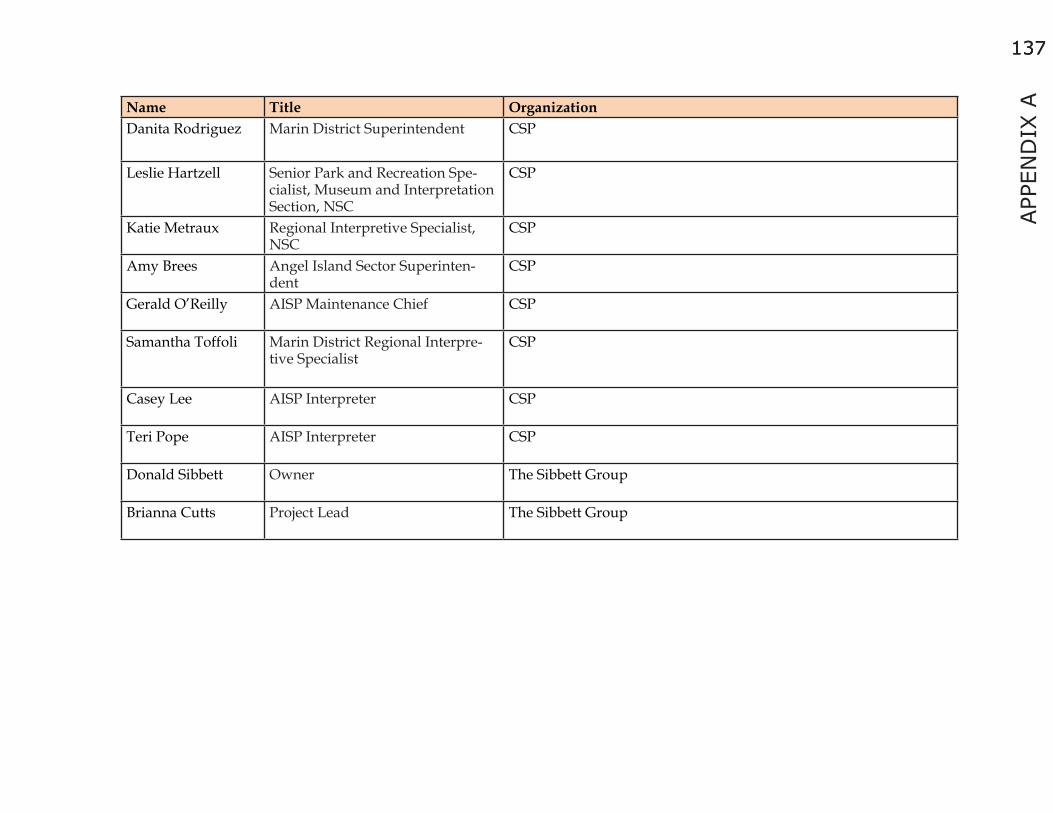
137
APP
END
IX A
137
Name Title OrganizationDanita Rodriguez Marin District Superintendent CSP
Leslie Hartzell Senior Park and Recreation Spe-cialist, Museum and Interpretation Section, NSC
CSP
Katie Metraux Regional Interpretive Specialist, NSC
CSP
Amy Brees Angel Island Sector Superinten-dent
CSP
Gerald O’Reilly AISP Maintenance Chief CSP
Samantha Toffoli Marin District Regional Interpre-tive Specialist
CSP
Casey Lee AISP Interpreter CSP
Teri Pope AISP Interpreter CSP
Donald Sibbett Owner The Sibbett Group
Brianna Cutts Project Lead The Sibbett Group

138138
Workshop #2 SummaryThe workshop was held on Monday, April 25, 2011, from 5 to 8 PM at the Tiburon Town Hall, Council Chambers. Seventeen (17) constituents attended the workshop to offer their comments on the Interpretation Master Plan (IMP) Issues, Goals, and Objectives. The goal of the meeting was for attendees to contribute ideas to IMP Issues, Goals, and Objectives to either validate the information or identify any missed opportunities. The feedback was used to finalize Objectives, and develop Strategies and Tasks.
TSG gave an overview of the workshop format and invited participants to visit any of the 10 stations facilitated by IMP team members (CSP, AIC, TSG). Each station focused on one Issue and its corresponding Goal and Objective. Participants were encouraged to share feedback in writing on large printouts. Handouts provided more direction and information. There was lively conversation and active participation by all workshop participants. The Group Activity lasted approximately 3 hours and the Workshop concluded at approximately 8:00 pm.
Table 4. Stakeholder Workshop #2 Participants
Name Title OrganizationNick Tipon Representative Federated Indians of the Graton Rancheria Malcolm Margolin Founder Heyday Books and historianGrant Din Director of Special Projects Angel Island Immigration Station Foundation
Howard Levitt Director of Communications and Partnerships, GGNRA
Golden Gate National Recreation Area & Environmental Travel-ing Companions
Elizabeth Goldstein President California State Parks Foundation Roger Roberts Past President Marin Conservation League Diane Poslosky Executive Director Environmental Traveling CompanionCarolyn Horgan Vice President, Operations Blue & Gold Ferry Lisa Klairmont Representative of the Boating CommunityDoug McConnell John Frawley CEO Bay Institute/Aquarium of the Bay
Nicki Phelps Director of Visitor Programs and Services Golden Gate National Parks Conservancy
Rick Parmer State Park Ranger East Bay Regional Parks

139
APP
END
IX A
139
Name Title OrganizationJanette Gitler Toby Garfield Romberg Center Linda May Romberg Center Peggy Merner Master Gardener AISP Gail Dolton Board President AIC Linda Moore Board Treasurer AIC Suzanne Badenhoop Board of Directors AIC Guy Lampard Board of Directors AIC Jacquie Klose Operations Manager AIC Danita Rodriguez Marin District Superintendent CSP
Leslie Hartzell Senior Park and Recreation Spe-cialist, Museum and Interpreta-tion Section, NSC
CSP
Katie Metraux Regional Interpretive Specialist, NSC CSP
Amy Brees Angel Island Sector Superinten-dent CSP

140140

141
APP
END
IX B
141
APPENDIX B: CALIFORNIA DEPARTMENT OF EDUCATION CURRICULUM STANDARDS
For the purpose of this plan, the following standards and curriculum relate directly to the park’s significant resources, interpretive periods, and themes. Only the most relevant broad topics were included in the Interpretation Master Plan. When developing content for interpretive programs and services, the reader should consult the most current and complete content standards, framework, and curriculum.
Table 5. State Curriculum Standards.
Subject Grade Topic ThemeScience K Life Sciences Different types of plants and animals inhabit the earth.
Science K Earth Sciences Earth is composed of land, air, and water.Science One Earth Sciences Weather can be observed, measured, and described.
Science Two Earth Sciences Earth is made of materials that have distinct properties and provide resources for human activities.
Science Three Earth Sciences Objects in the sky move in regular and predictable patterns.
Science Four Life Sciences All organisms need energy and matter to live and grow.
Science Four Earth Sciences The properties of rocks and minerals reflect the processes that formed them
Science Five Earth Sciences Water on Earth moves between the oceans and the land through the processes of evaporation and condensation.
Science Six Earth Science Plate tectonics accounts for important features of Earth’s surface and major geologic events.
Science Six Earth Science Shaping Earth’s Surface
Science Six Earth Science Topography is reshaped by the weathering of rock and soil, and by the trans-portation and deposition of sediment.

142142
Subject Grade Topic ThemeScience Six Ecology (Life Sciences) Organisms in ecosystems exchange energy and nutrients among themselves
and with the environment.
Science Seven Life Science Evolution: Biological evolution accounts for the diversity of species developed through gradual processes over many generations.
Science Seven Earth Sciences Earth and Life History: Evidence from rocks allows us to understand the evo-lution of life on Earth.
Science Eight Earth Sciences Earth in the Solar System: The structure and composition of the universe can be learned from studying stars and galaxies and their evolution.
Science Nine through Twelve
Life Sciences Ecology: Stability in an ecosystem is a balance between competing effects.
Science Nine through Twelve
Life Sciences Evolution: The frequency of an allele in a gene pool of a population depends on many factors and may be stable or unstable over time
Science Nine through Twelve
Life Sciences Evolution is the result of genetic changes that occur in constantly changing environments.
Science Nine through Twelve
Earth Sciences Earth’s Place in the Universe: Dynamic Earth Astronomy and planetary explo-ration reveal the solar system’s structure, scale, and change over time.
Science Nine through Twelve
Earth Sciences Processes: Plate tectonics operating over geologic time have changed the pat-terns of land, sea, and mountains on Earth’s surface.
Science Nine through Twelve
Earth Sciences Energy in the Earth System: Energy enters the Earth system primarily as solar radiation and eventually escapes as heat.

143
APP
END
IX B
143
Subject Grade Topic ThemeScience Nine
through Twelve
Earth Sciences Biogeochemical Cycles: Each element on Earth moves among reservoirs, which exist in the solid earth, in oceans, in the atmosphere, and within and among organisms as part of biogeochemical cycles.
Science Nine through Twelve
Earth Sciences Structure and Composition of the Atmosphere: Life has changed Earth’s atmo-sphere, and changes in the atmosphere affect conditions for life.
Science Nine through Twelve
Earth Sciences California Geology: The geology of California underlies the state’s wealth of natural resources as well as its natural hazards.
History and Social Science
K Learning and Working Now and Long Ago
Introduced to basic spatial, temporal, and causal relationships, emphasizing the geographic and historical connections between the world today and the world long ago.
History and Social Science
One A Child’s Place in Time and Space
Continue a more detailed treatment of the broad concepts of rights and respon-sibilities in the contemporary world. Students explore the varied backgrounds of American citizens and learn about the symbols, icons, and songs that reflect our common heritage.
History and Social Science
Two People Who Make a Difference
Explore the lives of actual people who make a difference in their everyday lives and learn the stories of extraordinary people from history whose achieve-ments have touched them, directly or indirectly.
History and Social Science
Three Continuity and Change Learn about connections to the past and the ways in which particularly local, but also regional and national, government, and traditions have developed and left their marks on current society, providing common memories. Emphasis is on the physical and cultural landscape of California, including the study of Native Americans, the subsequent arrival of immigrants, and the impact they have had in forming the character of our contemporary society.
History and Social Science
Four California: A Changing State
Students learn the story of their home state, unique in American history in terms of its vast and varied geography, its many waves of immigration, begin-ning with pre-Columbian societies, its continuous diversity, economic energy, and rapid growth.
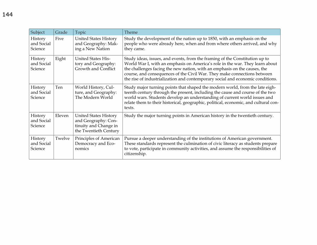
144144
Subject Grade Topic ThemeHistory and Social Science
Five United States History and Geography: Mak-ing a New Nation
Study the development of the nation up to 1850, with an emphasis on the people who were already here, when and from where others arrived, and why they came.
History and Social Science
Eight United States His-tory and Geography: Growth and Conflict
Study ideas, issues, and events, from the framing of the Constitution up to World War I, with an emphasis on America’s role in the war. They learn about the challenges facing the new nation, with an emphasis on the causes, the course, and consequences of the Civil War. They make connections between the rise of industrialization and contemporary social and economic conditions.
History and Social Science
Ten World History, Cul-ture, and Geography: The Modern World
Study major turning points that shaped the modern world, from the late eigh-teenth century through the present, including the cause and course of the two world wars. Students develop an understanding of current world issues and relate them to their historical, geographic, political, economic, and cultural con-texts.
History and Social Science
Eleven United States History and Geography: Con-tinuity and Change in the Twentieth Century
Study the major turning points in American history in the twentieth century.
History and Social Science
Twelve Principles of American Democracy and Eco-nomics
Pursue a deeper understanding of the institutions of American government. These standards represent the culmination of civic literacy as students prepare to vote, participate in community activities, and assume the responsibilities of citizenship.
145
APP
END
IX B
145
Education and the Environmental InitiativeIn 2009, the state of California unveiled its Education and the Environment Initiative (EEI). The curriculum was created to bring education about the environment into the primary and secondary classrooms serving over 6 million students throughout California. The EEI curriculum examines the interactions and interdependence of human societies and natural systems using a unique set of California Environmental Principles. When developing content for interpretive programs and services, the reader should consult the most current and complete version of this initiative.
Principle I: People Depend on Natural SystemsThe continuation and health of individual human lives and of human communities and societies depend on the health of the natural systems that provide essential goods and ecosystem services.
Principle II: People Influence Natural SystemsThe continuation and health of individual human lives and of human communities and societies depend on the health of the natural systems that provide essential goods and ecosystem services.
Principle III: Natural Systems Change in Ways that People Benefit from and can InfluenceNatural systems proceed through cycles that humans depend upon, benefit from, and can alter.
Principle IV: There are no Permanent or Impermeable Boundaries that Prevent Matter from Flowing between SystemsThe exchange of matter between natural systems and human societies affects the long-term functioning of both
Principle V: Decisions Affecting Resources and Natural Systems are Complex and Involve Many FactorsDecisions affecting resources and natural systems are based on a wide range of considerations and decision-making processes.

146146

147
APP
END
IX C
147
APPENDIX C: VISITOR SURVEY
Angel Island IMP Survey Results
Linda J. Moore
11.22.10
Survey Overview ▪ Survey was conducted September-October, 2010 ▪ Individuals were surveyed on ferries going to and from the island as well as ferry waiting areas, and café deck ▪ Results represent weekend, weekday, and holiday (Labor Day) visitor experiences ▪ Questions were compiled by IMP development team members including AIA, and State Park representatives
₋ Inbound (to island) surveys included 11 questions ₋ Outbound (from island) surveys included an additional 6 questions
▪ Survey results were input into an online tool (Survey Gizmo) for analysis
Survey Demographics ▪ 160 visitors surveyed ▪ Individuals, groups, campers, boaters were all included ▪ Surveys were conducted with various age groups, ethnicities ▪ as well as sizes and types of groups visiting the island ▪ Inbound versus outbound groups were surveyed (58% vs. 42% respectively) ▪ Collective results reflect the following breakdown:
₋ 40% holiday ₋ 45% weekend ₋ 15% weekday

148148
Visitor Profile ▪ On average, the majority of visitors were from the Bay Area
₋ 73% were local ₋ 27% out of town
▪ On weekends, there was a slightly larger percentage (36%) of visitors from out of town ▪ On the holiday, 83% of visitors were local ▪ Most groups had at least one individual in their group that had visited Angel Island before
₋ 68% of groups had a return visitor ₋ 32% of groups were all new to the island
Visitor Groups ▪ The majority were travelling with, or meeting a group
₋ 96% travelling with a group ₋ 4% travelling alone
▪ Those with a group (152 individuals) represented ₋ 720 adults ₋ 275 children
▪ The largest groups appear to have been on weekdays, when school groups and other planned tours are common ▪ Weekday surveys represented 15% of those surveyed, while the number of visitors (295) on
weekdays represented 30% of the 995 guests represented by the survey in total.

149
APP
END
IX C
149
Planning ResourcesQuestion-When planning your trip, what resources did you consult?
Websites are the primary planning resource used. Most individuals used multiple sites. (There were 212 responses from 143 respondents.) ▪ 17 individuals used no resources for planning ▪ 84 used a ferry company website ▪ 72 used the Angel Island Association website ▪ “Other” included Reserve America, hiking and travel books, and a tour leader who did the planning for a group.
Table 6. Planning Resources

150150
Planning InformationQuestion-When planning your trip, what information were you looking for? ▪ After ferry schedule, several responses were fairly evenly split
₋ How to get here ₋ Park hours ₋ Tour information ₋ What to do on the island ₋ Other- the most common response was camping information
▪ Weekday visitors were twice as likely to be looking for tour information (43%) while weekend visitors were less likely (11%) to be interested in tour information
Table 7. Planning Information

151
APP
END
IX C
151
Primary ActivityQuestion-What was your primary interest in visiting Angel Island? ▪ The overwhelming majority selected recreation, which meant hiking, picnicking, exploring, or staying in the cove ▪ Even though many intended to go to Immigration Station, or other destination,
they identified their primary activity as recreation ▪ Weekday travelers were less likely to indicate recreation (63%) as their primary purpose, while
holiday travelers were more likely (83%) to report recreation as their primary goal
Table 8. Primary Activity

152152
What Visitors Did or Planned to DoQuestion-What did you do (or plan to do) on your visit to Angel Island? ▪ Many visitors had more than one response. There were 241 selections from 156 respondents to this question ▪ The most common combination of responses was hiking and picnicking, and hiking and historical sightseeing ▪ School programs are more common on weekdays as expected, representing 8% of those surveyed
Table 9. What Visitors Did or Planned to Do

153
APP
END
IX C
153
Recognition of Island LandmarksQuestion- Have you heard of the following on Angel Island? ▪ An overwhelming number of visitors recognized the Immigration Station ▪ While the rest of the locations are a fairly even distribution, the Nike Missle
site has the least amount of promotion, yet was still recognized ▪ On weekdays, the percentage of visitors to Mt. Livermore is much lower (32%) ▪ There were only 119 responders to this question, meaning that 41 individuals, or a
full 25% of those surveyed did not recognize any of these landmarks
Table 10. Recognition of Island Landmarks
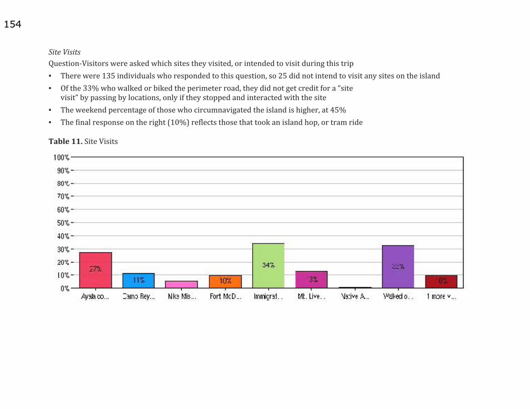
154154
Site VisitsQuestion-Visitors were asked which sites they visited, or intended to visit during this trip ▪ There were 135 individuals who responded to this question, so 25 did not intend to visit any sites on the island ▪ Of the 33% who walked or biked the perimeter road, they did not get credit for a “site
visit” by passing by locations, only if they stopped and interacted with the site ▪ The weekend percentage of those who circumnavigated the island is higher, at 45% ▪ The final response on the right (10%) reflects those that took an island hop, or tram ride
Table 11. Site Visits

155
APP
END
IX C
155
Beyond the CoveQuestion- Of the visitors surveyed we asked if they went beyond the cove, and if not, why not? ▪ Close to 90% of visitors surveyed did go beyond the cove during their visit ▪ Of those who did not,
₋ 56% were there for a specific event in the cove ₋ The rest of this small number of individuals had a variety of reasons
▪ Not enough time
▪ Just riding the ferry back and forth (with small children)
▪ Visiting with toddlers/strollers so can’t go far
Navigating the IslandQuestion- Did you use any maps, signs or brochures to find your way around or to learn about the island during your visit? ▪ The responses were evenly split 52% yes, and 48% no ▪ Of those that used maps, signs or brochures, 73% found the information helpful, and 28% said it was somewhat helpful ▪ Of those individuals who did not use maps, many were veteran visitors who knew
their way around. Only a few guests said they were unable to find maps.

156156
Learning moreQuestion-Was there any location or place you visited on the island that you would like to learn more about? (open ended question) ▪ This question was interpreted differently by
individuals either as what locations did not have enough information, or what did you see that you’d like to come back and learn more about
▪ 33 individuals responded to this question ₋ 13 wanted to know more about Immigration Station ₋ 3 wanted to know more about
Native American history ₋ Other responses included, Ft. McDowell,
Reynolds, rock crusher, batteries, quarantine station, the center of the island, and “all of it”
₋ There were no responses related to natural history of the island (could be a factor of how the question was worded)
Other comments ▪ We asked two more open ended questions
₋ What information could have made your visit more enjoyable? (outbound only)
₋ Do you have any additional comments for us to improve the visitor’s experience on the island? (inbound and outbound)
▪ There were 67 different responses that can be divided into several main categories
▪ Navigation
▪ Park services
▪ Camping
▪ Logistics/ planning ▪ Following is a sample of responses. All
responses are listed in the Appendix.
Comments- Navigation ▪ Improve signage at the top of the stairs at
the perimeter road to find the ferry and vice versa from the cove to perimeter road
▪ Map (online) showed you could get to Reynolds from either direction from the cove. It should at least note the faster route.
▪ The bike route by the Visitor Center was hazardous with the gravel on it. Several in this group slipped on it.
▪ Trails weren’t well marked to the top, or when you are at the top
▪ Distances and approximate travel times on maps would help us plan our day better.

157
APP
END
IX C
157
▪ At Immigration Station- there is a sign which says “start at bell”.
▪ This is misleading if you are not there for a guided tour. ▪ It would be nice to get an overview on the boat
of what to see and where to go on the island.
Comments- Park Services ▪ Gift shop was hard to find ▪ One guest complained about the Segways because they
interfere with the natural experience of the island. Another guest (Bay Area resident) praised the Segway tour as the best experience he’d had in the Bay Area.
▪ It was inconvenient not being able to reserve a tour before coming. It would have been nice to know before getting on the ferry if the tours were already booked.
▪ Would have liked to go in some of the buildings but very few were open
▪ Several visitors complained that the Immigration Station tour was separate from either the tram or island hop tour. They thought it should be included.
▪ More bathrooms around the island, and a few more garbage cans too.
▪ More shade in the ferry waiting area. More shady areas in the main picnic area in the cove
▪ Greener trams would improve the experience. The ones on the island were spewing a lot of smog.
▪ Café closes too early for hikers getting the last ferry to still be able to get a drink. At least the vending machines should work, but they didn’t.
▪ Signs about birds and wildlife would be neat.
▪ More hiking trails. That will encourage return visits from avid hikers.
Comments- CampingNote- this was a small number of respondents, but as a group they had a lot of suggestions ▪ Need more details on the campground
locations and amenities ▪ According to the map there was not a tap for
water, but there actually was. Garbage and toilet information would be helpful such as if we have to pack garbage out, if there is a toilet and what kind.
▪ Water at the campsite tasted very strongly of being treated- to the point of being undrinkable
▪ There wasn’t easy signage to find the campsite from the Northridge trail
▪ The campsite area wasn’t flat at all, so there was no good place to put a tent up.
Comments- Logistics/ Planning ▪ Holiday schedule for the ferries
was difficult to find online ▪ More ferries, maybe every half hour for more flexibility ▪ The websites didn’t say anything about parking and
the ferry and everything being cash only (Tiburon) ▪ It would be nice to buy the ferry
tickets online for convenience ▪ Needed more information about access for
disabled guests prior to visit, and upon arrival
158158
▪ Later ferry service would be nice- like a 9pm boat on summer
▪ weekends so you can stay and watch the sunset and enjoy the cove.
▪ Better parking information online to help plan. ▪ Golf carts you can rent to get around would be great
The good news…
99% of those surveyed would come back again
Next steps ▪ Identify low hanging fruit that can be addressed
easily by the various stakeholder groups ▪ Provide additional details as needed
to park staff, and IMP planners ▪ Meet with stakeholders to determine if further
research is warranted, or periodic surveys to continue to collect information from visitors
▪ Consider revision of survey to implement in another season
▪ Identify means to survey park staff to glean most common questions and concerns of visitors to include with this data
Survey limitations and all responses to open ended questions
Limitations of the Survey ▪ Conducted only during the fall season, and may not
reflect usage patterns of spring or summer visitors ▪ While efforts were made to survey both visitors from
San Francisco and Tiburon, a greater percentage of survey respondents were visiting via the TiburonFerries
▪ Demographic data was not captured in the interest of keeping the survey short. Data that may be valuable in future studies include:
₋ Age of visitors ₋ Which ferry they arrived on ₋ Specific questions of boaters ₋ More in-depth survey of school
and service camp groups
Learning More- All ResponsesWas there any location or place you visited on the island that you would like to learn more about? (open ended question) ▪ Camp Reynolds ▪ Ft. McDowell ▪ History of the island ▪ How to get a job and live here. ▪ Immigration Station ▪ Immigration information

159
APP
END
IX C
159
▪ Immigration station- it shouldn’t be separate from the tram tour.
▪ Mt. Livermore, the center of the island, more about immigration station
▪ Native American history ▪ Why was McDowell opened in 1910?
What was going on to open it then? ▪ Wish could have stayed longer to
visit immigration station ▪ all of it ▪ army outposts 1 ▪ batteries, and nike missle site ▪ hiking on the island ▪ hospital/ quarantine station ▪ immigration ▪ immigration station ▪ immigration station, rock crusher- there
should be signs about what this is ▪ lots! ▪ military base ▪ Native American history ▪ nike missle site ▪ the batteries ▪ visitor center ▪ was the big fence around immigration historic?
like to know more about the natural history ▪ whole island’s history
▪ Immigration- it would be nice to find info about it at the visitor’s center on the cove for people who can’t walk over there.
▪ Native American and early history.Would like more pictures and displays. Like that the buildings are labeled.
More Information- All ResponsesWhat information could have made your visit more enjoyable? (outbound only) ▪ map at cove didn’t say “you are here”
(this guest is a map maker) ▪ the ferry schedule was wrong on the website (october) ▪ weather- we needed more clothes, also
more information in the map ▪ at camp site tasted very strongly of being treated-
almost undrinkable. on northridge trail not enough signage to get to campsite and map not to scale. ranger said it was faster to go northridge trail to site, but actually perimeter was faster.
▪ The bike trail from the cove to the road was rather hazardous being gravel. Either pave it, or let bikes on the road. Several of the group slipped around on it.
▪ I would have liked to know more about the immigration tour ahead of time. Took the tram tour, but I didn’t know the immigration was separate.
▪ the ferry site didn’t say anything about parking and ferry fees being cash only. would be nice to buy the ferry tickets online for convenience

160160
▪ Didn’t get a map when arrived at island, and it was hard to remember the signs from the cove. Later ferry service would be helpful- had to rush our visit.
▪ The map online showed that you could get to Reynolds going either way... that was a little confusing. It should show the faster direction.
▪ At immigration “start at bell” sign is misleading if you are not there for a formal tour. The sign at
▪ the top of the stairs to the dock should be bigger- we missed it.
▪ Would have liked a guided tour- you couldn’t book it ahead of time for 2 people so we missed out since there were big groups.
▪ Better weather ▪ Couldn’t find the holiday boat
schedule online or by phone ▪ I couldn’t find any maps- that would have made it easier ▪ It would have been good to have more
information about access for disabled folks ▪ Location of food and gift shop- hard to find gift
shop and more food locations would be good. ▪ More clear signs to get to the perimeter trail ▪ More details on the campground
locations and amenities ▪ More ferries- maybe every half hour
to allow more flexibility ▪ Moving less firewood, and if we could have
actually burned some firewood.
▪ Need a garbage can at the top of perimeter road, more bathrooms around the perimeter
▪ Shorter line to get coffee. Everyone gets there at once and they couldn’t handle the traffic.
▪ Trails weren’t well marked. Couldn’t really tell how to get to the top. Better weather.
▪ Would have liked to go into some of the buildings ▪ a map ▪ approximate times and distances on the
maps would have helped plan our day ▪ better parking info- we ended up in a 2 hour
spot so we had to leave pretty quickly ▪ free wine on the boat ▪ ice cream ▪ don’t like the segways- you come here to
supposedly get away from cars and noise and they felt like they were everywhere.
▪ Better signage for finding the ferry from the trails/ road on the island
More Comments- All Responses ▪ Do you have any additional comments for
us to improve the visitor’s experience on the island? (inbound and outbound)
▪ Lunch location are important for planning, also it would be cool to have the students go through the process of examination etc at immigration

161
APP
END
IX C
161
▪ We’d love to have more hiking trails. This would keep hikers coming back. Also keep up trails better.There’s a downed tree on one, and a part of the dirt has washed away making it a bit hazardous in another spot.
▪ The volunteers at the Immigration Station were really helpful in answering questions and pointing out what to see on the island.
▪ It would be nice to get an overview on the boat about what to see and where to go while you have a captive audience.
▪ It would be nice to have more shade available where you wait for the ferry. It can be tough on seniors in this heat hadn’t been to the island in about 10 years, and really likes that we seem to be building it up nicely, and preserving it well
▪ Camping information was sparse and inadequate. Location of water, a detailed map, whether there was tp in the pit toilets, running and potable water are all important details
▪ Things are not well marked on top of Mt. Livermore.The trail getting there isn’t well marked either. Can you do something about the wasps around the cafe?
▪ group had a running event on the island ▪ the campsite tent area wasn’t flat ▪ travelling with a toddler, so not sure how far we’ll get ▪ When you check in at Tiburon- it would be helpful to
know if the tours are already booked to know ahead of time what to expect before you get to the island.
▪ decrease the ferry fees, and maybe have a student/ teenager rate. There’s nothing for teens to do in Marin- this could be a good destination for them.
▪ The Segway tour was one of the best experiences I’ve had in the Bay Area. It was priced right, and everyone in our group loved it.
▪ According to the map there was not a tap for water when there was. Garbage and toilet information would be very helpful. (do we have to pack garbage out, is there a toilet and what kind?)
▪ it was a bummer not having the cafe open past 5:00- at least would be good to have a convenience store. Also, why not have a late boat like 9:00?
▪ Signs about birds and wildlife would be neat. Charcoal tray at ridge site 3 is rusted out.
▪ Didn’t like having to book the site through a private company (based in Canada). Map didn’t show water at campsite.
▪ Problem is that concessions close too close to leaving time on the ferry. Can’t get a cold drink after your hike and the vending machines aren’t working.
▪ I would like to be able to bring my dog ▪ I’d like to come back separate from the
tour and do some of these activities ▪ I’d like to have golf carts that you could rent to
get around in- that would be convenient ▪ It was too crowded.Too many people on the trails. ▪ It would be good to have better rental bikes-
3 speeds were pretty tough on the hills.
162162
▪ It would be nice to have “greener” trams- those are spewing a lot of smog.
▪ More porta potties scattered around the perimeter road/ island would be helpful
▪ Would like to see “tagalongs” available on the rental bikes to take kids with you.
▪ You should create a smart phone app... lots of people would use it.
▪ attending a special mass on the island ▪ better places to get food/ snacks ▪ didn’t know anything about the island- just
planned on winging it once we got over here ▪ Could use more shade in the cove picnic areas.
Also it would be neat to have a little hotel here. ▪ Didn’t realize it would be difficult for my parents
to hike to the Immigration station, so ▪ I’m leaving them in the cove while I go see it.
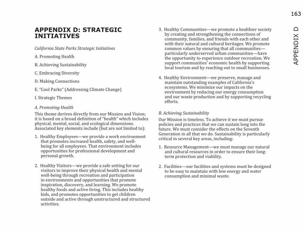
163
APP
END
IX D
163
APPENDIX D: STRATEGIC INITIATIVES
California State Parks Strategic Initiatives
A. Promoting Health
B. Achieving Sustainability
C. Embracing Diversity
D. Making Connections
E. “Cool Parks” (Addressing Climate Change)
I. Strategic Themes
A. Promoting HealthThis theme derives directly from our Mission and Vision; it is based on a broad definition of “health” which includes physical, mental, social, and ecological dimensions. Associated key elements include (but are not limited to):
1. Healthy Employees—we provide a work environment that promotes increased health, safety, and well-being for all employees. That environment includes opportunities for professional development and personal growth.
2. Healthy Visitors—we provide a safe setting for our visitors to improve their physical health and mental well-being through recreation and participation in environments and opportunities that promote inspiration, discovery, and learning. We promote healthy foods and active living. This includes healthy kids, and promotes opportunities to get children outside and active through unstructured and structured activities.
3. Healthy Communities—we promote a healthier society by creating and strengthening the connections of community, families, and friends with each other and with their natural and cultural heritages. We promote common values by ensuring that all communities—particularly underserved urban communities—have the opportunity to experience outdoor recreation. We support communities’ economic health by supporting local tourism and by reaching out to small businesses.
4. Healthy Environment—we preserve, manage and maintain outstanding examples of California’s ecosystems. We minimize our impacts on the environment by reducing our energy consumption and our waste production and by supporting recycling efforts.
B. Achieving SustainabilityOur Mission is timeless. To achieve it we must pursue policies and practices that we can sustain long into the future. We must consider the effects on the Seventh Generation in all that we do. Sustainability is particularly critical in several key areas, including:
1. Resource Management—we must manage our natural and cultural resources in order to ensure their long-term protection and viability.
2. Facilities—our facilities and systems must be designed to be easy to maintain with low energy and water consumption and minimal waste.

164164
3. Social and Political Relations—we must develop and maintain long-term, positive relations with our visitors and with the public at large in order to ensure their support for protecting and managing our parks into the future. This must include efforts to better identify ourselves to the public (branding) and to better understand and meet the public’s recreation needs.
4. Inspiring the next generation: We must build our next generation of support by instilling in children the need to protect and preserve our natural areas.
5. Fiscal Resources—we must seek additional, stable sources of funding in order to protect our parks from an expected long-term decline in General Fund support.
C. Embracing DiversityDiversity, in all its variations, is one of California’s most valuable assets. The integral role of CSP in shaping the future of California depends on broad based support and involvement reflecting the variety of ages, ethnicities, lifestyles, and interests of a hugely diverse population.
1. Our Employees: A diverse workforce increases understanding and appreciation among all employees, enables us to better understand the needs of our ever-changing population, and creates a more welcoming feeling for our visitors
2. Our Visitors: We must provide services, facilities, and programs that meet the needs of a diverse pool of current and potential visitors to ensure that visitors understand and value the role of CSP. This includes opportunities for young people from all backgrounds to experience our parks.
3. Our Communities: We must develop and strengthen partnerships, relationships, and collaborations within diverse populations and communities.
4. Cultural Resources: We must manage and protect a diverse spectrum of cultural resources that reflect the cultures of California.
D. Making Connections1. Our employees: State Parks employees represent a
wealth of knowledge, creativity, and compassion. Ideas and input should be shared and opportunities provided to work as a team.
2. Professional: CSP should strengthen connections with other public, private, and nonprofit agencies and organizations that share common missions and/or can further strengthen the CSP mission.
3. Communities: CSP should develop connections with a wide variety of communities in California to leverage knowledge, resources, and understanding. CSP should work with community groups to reach and involve youth.
4. Our Environment: Connecting ecosystems and wildlife habitats is critical to sustainable resource management.
E. “Cool Parks” Addressing Climate ChangeClimate change threatens all that we value and protect in the world. Addressing it will be the defining challenge for this and several subsequent generations of Parks leaders. We must respond in each of the following areas:

165
APP
END
IX D
165
1. Getting Our House in Order—In CSP we must reduce our emissions of greenhouse gases (GHG) through energy conservation, innovative design and other creative approaches. We must maximize the carbon-sequestering potential of our forests and other habitats when consistent with our mission.
2. Adaptation—We must modify our resource management, acquisition and restoration policies and practices to help ensure that the species and habitats we protect can successfully adapt to the effects of climate change.
3. Interpretation— We must teach our visitors, including children, about the impacts of climate change on parks and inspire them to adapt to climate change by making positive lifestyle changes. Our parks should become models of climate change best practices displaying what is at risk and what can be done about it.

166166
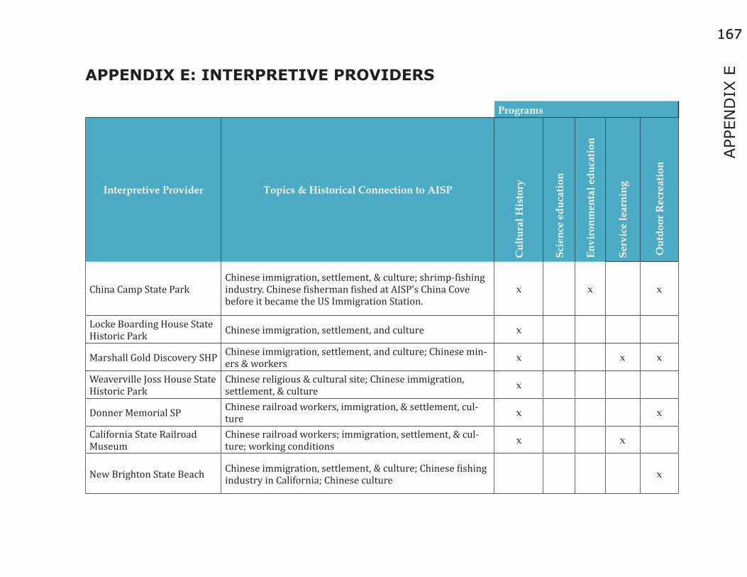
167
APP
END
IX E
167
APPENDIX E: INTERPRETIVE PROVIDERS
Programs
Interpretive Provider Topics & Historical Connection to AISP
Cul
tura
l His
tory
Scie
nce
educ
atio
n
Envi
ronm
enta
l edu
catio
n
Serv
ice
lear
ning
Out
door
Rec
reat
ion
China Camp State ParkChinese immigration, settlement, & culture; shrimp-fishing industry. Chinese fisherman fished at AISP’s China Cove before it became the US Immigration Station.
x x x
Locke Boarding House State Historic Park Chinese immigration, settlement, and culture x
Marshall Gold Discovery SHP Chinese immigration, settlement, and culture; Chinese min-ers & workers x x x
Weaverville Joss House State Historic Park
Chinese religious & cultural site; Chinese immigration, settlement, & culture x
Donner Memorial SP Chinese railroad workers, immigration, & settlement, cul-ture x x
California State Railroad Museum
Chinese railroad workers; immigration, settlement, & cul-ture; working conditions x x
New Brighton State Beach Chinese immigration, settlement, & culture; Chinese fishing industry in California; Chinese culture x

168168
Programs
Interpretive Provider Topics & Historical Connection to AISP
Cul
tura
l His
tory
Scie
nce
educ
atio
n
Envi
ronm
enta
l edu
catio
n
Serv
ice
lear
ning
Out
door
Rec
reat
ion
Wilder Ranch State Park Chinese cook who worked at the ranch was a “paper son” and went through AISP’s US Immigration Station. x x x
Colonel Allensworth State Historic Park
Colonel Allensworth was a military chaplain who was sta-tioned at AISP’s Camp Reynolds (West Garrison). Colonel Allensworth SHP describes the town he founded and his legacy there.
x x
Samuel P. Taylor State Park Gold rush history, timber industry, redwood ecology, wild-life ecology x
Mount Tamalpias State Park Coastal defense site, natural history interpretation, guided hikes x
Golden Gate National Recre-ation Area (GGNRA)
Native American culture, Spanish Empire frontier, Mexican Republic, maritime history, California Gold Rush, US Military Coastal Defense, growth of urban San Francisco, environ-mental education and resource protection.
x x x x
Fort Baker, GGNRA US Military Coastal Defense, Civil war, Indian Wars, Spanish-American War, WWI, WWII x x x

169
APP
END
IX E
169
Programs
Interpretive Provider Topics & Historical Connection to AISP
Cul
tura
l His
tory
Scie
nce
educ
atio
n
Envi
ronm
enta
l edu
catio
n
Serv
ice
lear
ning
Out
door
Rec
reat
ion
Fort Barry, GGNRA US Military Coastal Defense, Civil war, Indian Wars, Spanish-American War, WWI, WWII x
Fort Cronkhite, GGNRA US Military Coastal Defense, Civil war, Indian Wars, Spanish-American War, WWI, WWII x
Nike Missile Site, GGNRA Nike Missile Site x
Alcatraz Island US Military Coastal Defense, Civil war, Indian Wars, Spanish-American War, WWI, WWII x
Battery Chamberlin, GGNRA US Military Coastal Defense, Civil war, Indian Wars, Spanish-American War, WWI, WWII x
Crissy Airfield, GGNRA US Military Coastal Defense x x x x Crissy Field Marsh & Beach, GGNRA US Military Coastal Defense x x x
Fort Funston, GGNRA US Military Coastal Defense, Civil war, Indian Wars, Spanish-American War, WWI, WWII x x
Fort Mason, GGNRA US Military Coastal Defense, Civil war, Indian Wars, Spanish-American War, WWI, WWII x x
Fort Point National Historic Site, GGNRA
US Military Coastal Defense, Civil war, Indian Wars, Spanish-American War, WWI, WWII x x x

170170
Programs
Interpretive Provider Topics & Historical Connection to AISP
Cul
tura
l His
tory
Scie
nce
educ
atio
n
Envi
ronm
enta
l edu
catio
n
Serv
ice
lear
ning
Out
door
Rec
reat
ion
Presidio of San Francisco, GGNRA
US Military Coastal Defense, Civil war, Indian Wars, Spanish-American War, WWI, WWII x x x x
Bolinas Ridge, GGNRASan Francisco Bay Area marine ecology, climate change, environmental studies, forest and beach ecology, wildlife ecology
x
Gerbode Valley, GGNRASan Francisco Bay Area marine ecology, climate change, environmental studies, forest and beach ecology, wildlife ecology
x
Kirby Cove, GGNRASan Francisco Bay Area marine ecology, climate change, environmental studies, forest and beach ecology, wildlife ecology
x
Marin Headlands, GGNRASan Francisco Bay Area marine ecology, climate change, environmental studies, forest and beach ecology, wildlife ecology
x x
Muir Woods National Monu-ment, GGNRA
San Francisco Bay Area marine ecology, climate change, environmental studies, forest and beach ecology, wildlife ecology
x x x x x
Muir Beach, GGNRASan Francisco Bay Area marine ecology, climate change, environmental studies, forest and beach ecology, wildlife ecology
x

171
APP
END
IX E
171
Programs
Interpretive Provider Topics & Historical Connection to AISP
Cul
tura
l His
tory
Scie
nce
educ
atio
n
Envi
ronm
enta
l edu
catio
n
Serv
ice
lear
ning
Out
door
Rec
reat
ion
Muir Beach Overlook, GGNRA
San Francisco Bay Area marine ecology, climate change, environmental studies, forest and beach ecology, wildlife ecology
x
Olema Valley, GGNRASan Francisco Bay Area marine ecology, climate change, environmental studies, forest and beach ecology, wildlife ecology
x
Point Bonita Lighthouse, GGNRA
San Francisco Bay Area marine ecology, climate change, environmental studies, forest and beach ecology, wildlife ecology
x
Stinson Beach, GGNRASan Francisco Bay Area marine ecology, climate change, environmental studies, forest and beach ecology, wildlife ecology
x
Tennessee Valley, GGNRASan Francisco Bay Area marine ecology, climate change, environmental studies, forest and beach ecology, wildlife ecology
x
Baker Beach, GGNRASan Francisco Bay Area marine ecology, climate change, environmental studies, forest and beach ecology, wildlife ecology
x
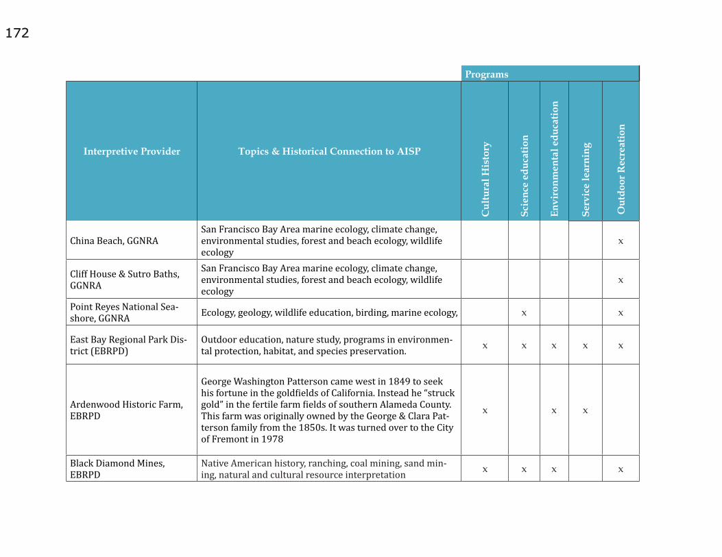
172172
Programs
Interpretive Provider Topics & Historical Connection to AISP
Cul
tura
l His
tory
Scie
nce
educ
atio
n
Envi
ronm
enta
l edu
catio
n
Serv
ice
lear
ning
Out
door
Rec
reat
ion
China Beach, GGNRASan Francisco Bay Area marine ecology, climate change, environmental studies, forest and beach ecology, wildlife ecology
x
Cliff House & Sutro Baths, GGNRA
San Francisco Bay Area marine ecology, climate change, environmental studies, forest and beach ecology, wildlife ecology
x
Point Reyes National Sea-shore, GGNRA Ecology, geology, wildlife education, birding, marine ecology, x x
East Bay Regional Park Dis-trict (EBRPD)
Outdoor education, nature study, programs in environmen-tal protection, habitat, and species preservation. x x x x x
Ardenwood Historic Farm, EBRPD
George Washington Patterson came west in 1849 to seek his fortune in the goldfields of California. Instead he “struck gold” in the fertile farm fields of southern Alameda County. This farm was originally owned by the George & Clara Pat-terson family from the 1850s. It was turned over to the City of Fremont in 1978
x x x
Black Diamond Mines, EBRPD
Native American history, ranching, coal mining, sand min-ing, natural and cultural resource interpretation x x x x

173
APP
END
IX E
173
Programs
Interpretive Provider Topics & Historical Connection to AISP
Cul
tura
l His
tory
Scie
nce
educ
atio
n
Envi
ronm
enta
l edu
catio
n
Serv
ice
lear
ning
Out
door
Rec
reat
ion
Coyote Hills, EBRPD
Native American history, mission and settler ranching and farming activities, salt production, a duck hunting club, a dairy, rock quarrying, a military NIKE missile site, and a bio sonar research facility; natural and cultural resource inter-pretation, naturalist programs, guided walks.
x x x
Crown Memorial State Beach, Crab Cove Visitor Center, EBRPD
Marine ecology, San Francisco Bay ecology, conservation, natural resource interpretation, naturalist programs, guided walks
x x
Sunol, EBRPD Native American history, ranching, natural resources inter-pretation, guided walks x x x
Tilden Regional Park, EBRPD Botanic garden and nature center, natural resource inter-pretation, environmental education, guided walks, x x x x
Chinese Historical Society of America Museum
Documentation, study, and presentation of Chinese Ameri-can history. CHSA promotes the contributions and legacy of Chinese America.
x x
Ellis Island, Statue of Liberty National Monument, NPS
American immigration history, immigrants, The museum also tells why so many people immigrated to America and what became of them after they arrived. AISP is a sister park with Ellis Island.
x
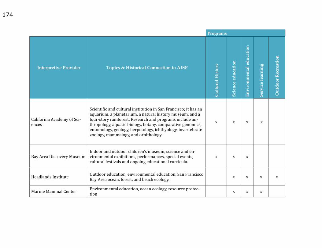
174174
Programs
Interpretive Provider Topics & Historical Connection to AISP
Cul
tura
l His
tory
Scie
nce
educ
atio
n
Envi
ronm
enta
l edu
catio
n
Serv
ice
lear
ning
Out
door
Rec
reat
ion
California Academy of Sci-ences
Scientific and cultural institution in San Francisco; it has an aquarium, a planetarium, a natural history museum, and a four-story rainforest. Research and programs include an-thropology, aquatic biology, botany, comparative genomics, entomology, geology, herpetology, ichthyology, invertebrate zoology, mammalogy, and ornithology.
x x x x
Bay Area Discovery MuseumIndoor and outdoor children’s museum, science and en-vironmental exhibitions, performances, special events, cultural festivals and ongoing educational curricula.
x x x
Headlands Institute Outdoor education, environmental education, San Francisco Bay Area ocean, forest, and beach ecology. x x x x
Marine Mammal Center Environmental education, ocean ecology, resource protec-tion x x x

175
APP
END
IX E
175
Programs
Interpretive Provider Topics & Historical Connection to AISP
Cul
tura
l His
tory
Scie
nce
educ
atio
n
Envi
ronm
enta
l edu
catio
n
Serv
ice
lear
ning
Out
door
Rec
reat
ion
Slide Ranch, part of GGNRA
Working organic farm, teaches sustainable agriculture, envi-ronmental conservation & preservation, Day and overnight group programs, summer camps, family programs, teaching internships, teacher trainings, and site rentals.
x x
YMCA Point Bonita Outdoor and Conference Center, San Francisco
Outdoor education, retreats & conferences x
Exploratorium Science education, field trips, public programs, and chil-dren’s science classes x
Golden Gate National Parks Conservancy
Ecological restoration, community stewardship, environ-mental sustainability and restoration x x
Crissy Field Center, GGN-RA Environmental education x x
Urban Watershed Environmental stewardship, service learning projects through monitoring programs. x x x