and Po i n t N e p e a n Q u a ra n t i n e S t a t i o n ...
132
Point Nepean National Park and Point Nepean Quarantine Station Management Plan 2009
Transcript of and Po i n t N e p e a n Q u a ra n t i n e S t a t i o n ...
P o i n t N e p e a n N a t i o n a l P a r ka n d
P o i n t N e p e a n Q u a r a n t i n e S t a t i o nM a n a g e m e n t P l a n
2 0 0 9
This Management Plan for Point Nepean National Park and Point Nepean Quarantine Station is approved for implementation. Its purpose is to direct all aspects of management of the area until the plan is reviewed.
A Draft Management Plan for the area was published in June 2006. Thirty-three submissions were received. All submissions have been considered in preparing this approved Management Plan.
For further information on this plan, please contact:
Manager Point Nepean Chief Executive Officer Parks Victoria Point Nepean Community TrustLevel 10, 535 Bourke Street Level 3, 22 William StreetMelbourne VIC 3000 Melbourne VIC 3000Phone: 13 1963 Phone: (03) 9927 2222
Copies
This plan may be downloaded from the Parks Victoria website www.parkweb.vic.gov.au. or the Point Nepean Community Trust website www.pointnepeantrust.org.
Copies of this plan may be purchased for $8.80 including GST from:
Parks Victoria Information CentreLevel 10, 535 Bourke StreetMelbourne VIC 3000Phone: 13 1963
Parks Victoria Rosebud OfficeHinton StreetRosebud VIC 3939Phone: (03) 5986 9100
The Point Nepean Visitor CentrePoint Nepean National ParkPoint Nepean RoadPortsea VIC 3944Tel: (03) 5984 1586
POINT NEPEAN NATIONAL PARK AND
POINT NEPEAN QUARANTINE STATION
MANAGEMENT PLAN
2009
Published in 2009 by Parks Victoria and the Point Nepean Community Trust
Parks Victoria, Level 10, 535 Bourke Street, Melbourne, Victoria, 3000 Point Nepean Community Trust, Level 3, 22 William Street, Melbourne, Victoria 3000
Parks Victoria. Point Nepean National Park and Point Nepean Quarantine Station management plan / Parks Victoria and Point Nepean Community Trust.
Melbourne: Parks Victoria and Point Nepean Community Trust, 2009.
ISBN 9780731183784 (pbk.) Bibliography. Point Nepean Quarantine Station (Vic.) National parks and reserves–Victoria–Nepean, Point, Region–Management. Quarantine–Victoria–Nepean, Point, Region–Management. Point Nepean National Park (Vic.) Point Nepean Community Trust (Vic.) 333.783099452
Cover: Views of the Port Phillip Bay and Bass Strait coast at Point Nepean, the Point Nepean Quarantine Station buildings and historic photographs of the forts, barracks and other infrastructure at Fort Nepean. Historic photographs of the forts are provided courtesy of the Australian War Memorial, Canberra. Quarantine Station photographs courtesy of Wayne Bootham, Toothpicks Creative.
Acknowledgements:
Acknowledgement of Country: In their rich culture, Indigenous Australians are intrinsically connected to the continent – including the area now known as Victoria. Parks Victoria and the Point Nepean Community Trust recognise that the planning area is part of Country of the Boonwurrung people.
Parks Victoria and the Point Nepean Community Trust are grateful to all those organisations and individuals who have contributed to this Final Management Plan. Special thanks go to:
• the Boonwurrung Foundation Ltd and the Bunurong Land Council Aboriginal Corporation.
• the members of the Point Nepean Advisory Committee: Dr Mick Lumb (Chair), Kate Baillieu, Harry Breidahl, Bernie Fox, Dr Ursula de Jong, Judy Muir, Chris Smyth, Alex Atkins, John Taylor and Dianne Weidner. Thanks are also extended to Ian Harris and Dr Michael Kennedy as former committee members and to Stephen Hare, Frank Hindley, Lisa de Jong, Bill Breidahl and Troy Muir in their role as alternative representatives for members of the committee.
• the trustees of the Point Nepean Community Trust: Simon McKeon (Chair), Geoff Bailey, Bruce Lever, Carolyn Briggs, Dr Ursula de Jong, David Stewart, Nina Cullen, Andrew Sutherland and Mark Stone. Thanks are also extended to Tom Harley as former trustee.
Note: Technical terms used in this plan are explained in the Glossary at the end of the plan.
Disclaimers:
This plan is prepared without prejudice to any negotiations or litigated outcome of any native title determination applications covering land or water within the planning area. It is acknowledged that any future outcomes of native title determination applications may necessitate amendment of this Management Plan; and the implementation of this plan may require further notifications under the procedures in Division 3 of Part 2 of the Native Title Act 1993 (Cwlth).
The plan is also prepared without prejudice to any future negotiated outcomes between the Governments/s and Victorian Aboriginal communities. It is acknowledged that such outcomes may necessitate amendment of this plan.
Every effort has been made to ensure that the information in this plan is accurate. Parks Victoria and the Point Nepean Community Trust do not guarantee that the publication is without flaw of any kind and therefore disclaim all liability for any error, loss or other consequence that may arise from any person relying on any information in the publication.
Point Nepean National Park and Point Nepean Quarantine Station Management Plan iii
FOREWORD
Point Nepean has outstanding heritage value for Australia. The Point Nepean Defence Sites and Quarantine Station Area is included on the National Heritage List. The site is particularly significant for its important role in Australia’s quarantine protection and coastal defences, with over 100 years of evidence of quarantine processes and defence fortifications.
Point Nepean is renowned for its historic features, spectacular coastal scenery and panoramic views of Bass Strait, the Rip and Port Phillip Bay.
Point Nepean is within the Country of the Boonwurrung people. Parks Victoria on behalf of the Victorian Government, and the Point Nepean Community Trust on behalf of the Australian Government, acknowledge the significance of Point Nepean to the Boonwurrung people and seek to reflect the views, interests and aspirations of the Traditional Owners in managing the park.
There is great potential to enrich and strengthen the management of Point Nepean by engaging the community’s knowledge, skills and enthusiasm. To this end, Parks
Victoria and the Point Nepean Community Trust seek to strengthen their relationships with individuals and community groups with particular interests in Point Nepean and to encourage them to share custodianship and participate in management.
This Management Plan sets the long-term management directions for Point Nepean. It will help realise the aspirations of the community and both the Victorian and Australian Governments for a truly integrated national park at Point Nepean. Implementation of the plan will see the Quarantine Station revitalised to become a key attraction. The plan will ensure that Point Nepean remains a nationally significant cultural and nature-based destination for future generations.
We thank the members of the Point Nepean Advisory Committee and the Trustees of the Point Nepean Community Trust for their valuable contributions to the plan. We also thank those individuals and organisations who contributed to the preparation of the plan and those who made submissions on the draft plan.
GAVIN JENNINGS MLC Minister for Environment and Climate Change
The HON PETER GARRETT AM MP Federal Minister for the Environment, Heritage and the Arts
Point Nepean National Park and Point Nepean Quarantine Station Management Plan v
SUMMARY
Proclaimed in August 2005, Point Nepean National Park is one of Victoria’s newest parks. The proposed inclusion of the Quarantine Station into the National Park will realise the aspirations of the State and Australian Governments and the community for a unified National Park at Point Nepean.
The Point Nepean Defence Sites and Quarantine Station Area was included on the National Heritage List on 16 June 2006 in recognition of its outstanding heritage values, particularly with regard to the Quarantine Station and defence sites. It is renowned for its beautiful coastal scenery and significant range of plants and animals, including threatened species and habitats. Its inspirational landscapes illuminate many eras of historic land use, including cultural landscape settings at the fortifications and in the Quarantine Station. Point Nepean contains extensive Indigenous places and objects that are integral to the cultural beliefs of the Boonwurrung people.
The Quarantine Station and its significant heritage values present exciting opportunities for Point Nepean to become a nationally and internationally significant cultural and nature-based tourism destination, illustrating the historic uses of the place and best practice in the adaptive re-use of the historic buildings.
This Management Plan ensures an integrated approach to the management of the National Park and Quarantine Station and sets the direction for all management prior to and following the creation of the unified National Park.
With the Quarantine Station as the vibrant heart of an integrated National Park where the past meets the present and future, the major management directions for Point Nepean include the following:
• Bring heritage buildings and settings to life through adaptive and sustainable re-use.
• Provide a focus on learning and heritage appreciation through innovative and inspiring interpretation and education opportunities to tell the stories of the place.
• Establish a range of accommodation and associated services to meet the needs of a broad market.
• Establish multi-disciplinary education and research facilities.
• Adopt a holistic approach to landscape and ecological management through programs that protect cultural settings and threatened species and habitats, build knowledge, manage the use of fire, and restore coastal woodlands and grassland habitats.
• Work in partnership with the Boonwurrung to protect Indigenous places and objects and reflect and integrate Boonwurrung knowledge, interests and aspirations for Point Nepean in all planning and management.
• Protect, conserve, manage and present historic values, with an emphasis on conserving the fortifications and managing heritage buildings through re-use.
• Provide for a mix of recreation, tourism, education, research and community uses, while applying high standards of environmental management.
• Enhance visitor experiences by improving access, providing quality facilities, establishing tourism and recreational links between attractions and opening new areas.
• Pursue and establish partnerships between the private sector, the community and managers of the land to achieve common goals and foster community participation.
This Management Plan proposes a high-level vision for Point Nepean, which includes the newly expanded Point Nepean National Park and Point Nepean Quarantine Station. The plan identifies aims and strategies to fulfil this vision. The plan’s key initiatives are summarised in figures 1 and 7.
In June 2004, the Point Nepean Community Trust was provided with $5 million from the Australian Government for the Quarantine Station.
Following the inclusion of the Point Nepean Defence Sites and Quarantine Station Area on
Summary
vi Point Nepean National Park and Point Nepean Quarantine Station Management Plan
the National Heritage List, and amendments to the Community Trust Deed land area to incorporate Police Point cliff area, the Australian Government provided an additional $27 million to the Point Nepean Community Trust to meet the Commonwealth’s obligations to effect the transfer of the remaining Commonwealth land to the State. A wide range of projects have been funded to progressively open the site to the Australian public and prepare it for active and sustainable use. The Australian Government has secured a generous donation of $10 million from a philanthropic benefactor for expenditure on a mix of respite facilities and services and community projects.
The State Government has committed $10 million to the management of heritage values at Point Nepean when the Quarantine Station is transferred to the State. Prior to the transfer, the State has committed an additional $1.2 million for heritage works, interpretation improvements and trail linkages between the National Park and the Quarantine Station.
To further realise the vision and implement the strategies in this plan, significant commitment will be required from the community, the private sector, the Government sector and other stakeholders.
Point Nepean National Park and Point Nepean Quarantine Station Management Plan vii
CONTENTS
FOREWORD iii
APPROVED MANAGEMENT PLAN iv
SUMMARY v
1 INTRODUCTION 1
1.1 Location and planning area 1 1.2 Towards the creation of an integrated national park 1 1.3 Plan development 2 1.4 Plan structure and reading the plan 4
2 BASIS 6
2.1 Regional context 6 2.2 Significance and values 7 2.3 Evidence of past use 10 2.4 Current visitor use 10 2.5 Key legislation 11 2.6 Policies and guidelines 12
3 STRATEGIC DIRECTIONS 14
3.1 Vision 14 3.2 Zoning 14 3.3 Major management directions 15
4 STRATEGIES FOR NATURAL HERITAGE CONSERVATION 20
4.1 Geological features 20 4.2 Natural landscape 20 4.3 Vegetation 22 4.4 Fauna 24 4.5 Fire management 26 4.6 Pest plants and animals 27 4.7 Coastal erosion 29
5 STRATEGIES FOR INDIGENOUS HERITAGE CONSERVATION 31
5.1 Indigenous site management 31 5.2 Indigenous cultural heritage management 33
6 STRATEGIES FOR HISTORIC HERITAGE CONSERVATION 34
6.1 Overview of historic heritage 34 6.2 Management of historic buildings, places, sites, remnants and artefacts 35 6.3 Management of the cultural landscape and settings 37 6.4 Management of historic heritage in the Quarantine Station 39 6.5 Management of historic heritage in the National Park 42 6.6 Historic heritage research and knowledge management 45
Contents
viii Point Nepean National Park and Point Nepean Quarantine Station Management Plan
7 STRATEGIES FOR VISITORS 48
7.1 Vehicle access 48 7.2 Boat access 49 7.3 Visitor use and tourism 50 7.4 Accommodation and camping 55 7.5 Walking and cycling 58 7.6 Water-based recreation 59 7.7 Events and special activities 60 7.8 Leases, licences and occasional uses 62 7.9 Public safety 64
8 STRATEGIES FOR INFORMATION, INTERPRETATION AND EDUCATION 66
9 STRATEGIES FOR COMMUNITY ENGAGEMENT 70
9.1 Community awareness 70 9.2 Community participation 71 9.3 Agency partnerships 72
10 STRATEGIES FOR INFRASTRUCTURE AND ADJACENT USES 74
10.1 Infrastructure 74 10.2 Management-related infrastructure and services 77 10.3 Authorised uses 77 10.4 Planning area boundaries and adjacent uses 78
11 PLAN IMPLEMENTATION 80
11.1 Delivery and reporting by Parks Victoria 80 11.2 Delivery and reporting by the Community Trust 81 11.3 Plan amendment 82 11.4 Evaluation and review 83
REFERENCES 85
GLOSSARY 87
APPENDICES
1 Extracts from the Point Nepean Community Trust Deed 89 2 EPBC Act heritage management principles and management plans 90 3 Management objectives for Victorian National Parks 93 4 Special protection areas 94 5 Ecological vegetation classes and rare and threatened flora 95 6 Rare, threatened and regionally significant fauna 96 7 Significant birds 97 8 Major weeds 98 9 Compliance checklist for National and Commonwealth heritage places 99 10 Appropriate use principles 104 11 National Heritage Listing 105 12 Submissions on the Draft Management Plan 113
Contents
Point Nepean National Park and Point Nepean Quarantine Station Management Plan ix
TABLES
1 Management zones and overlays 16 2 Point Nepean Quarantine Station attributes and management aims 17 3 Summary of recreation and tourism opportunities 19 4 Management of access roads and tracks 51 5 Current and planned recreation facilities 57 6 Management of walking trails 61
FIGURES
1 Key plan initiatives End of plan 2 Location " 3 The planning area " 4 Point Nepean Quarantine Station " 5 Management zones " 6 Access routes and recreation facilities " 7 Setting plan "

x Point Nepean National Park and Point Nepean Quarantine Station Management Plan
Point Nepean National Park and Point Nepean Quarantine Station Management Plan 1
1 INTRODUCTION
This Plan covers Point Nepean National Park (‘the National Park’) and the 90 ha Point Nepean Quarantine Station (‘the Quarantine Station’).
Point Nepean National Park is managed by Parks Victoria in accordance with the National Parks Act. Point Nepean Quarantine Station is managed by the Point Nepean Community Trust on behalf of the Australian Government, under the provisions of a Deed of Settlement of Trust (‘the Trust Deed’) until the scheduled transfer to the State.
The Commonwealth is currently the sole legal and beneficial owner of Point Nepean Quarantine Station. The Quarantine Station is the responsibility of the Department of Environment, Water, Heritage and the Arts (DEWHA).
Indigenous tradition indicates that the planning area is in the Country of the Boonwurrung people. This Plan adopts the spelling used by the Department of Justice. ‘Boonwurrung’ may also be spelt in a number of different ways including ‘Boonerwrung’ and ‘Bunurong’.
1.1 Location and planning area
Point Nepean National Park is located at the tip of the Nepean Peninsula on the Mornington Peninsula, approximately 90 km south of Melbourne and 2 km west of Portsea (figure 2). The seaward boundary of the National Park is the high water mark where it abuts the Port Phillip Heads Marine National Park. In other areas the seaward boundary is the low water mark. South Channel Fort in Port Phillip Bay is located approximately 6.5 km east of Portsea. The boundary at South Channel Fort extends 100 metres seaward of the mean high water mark.
Point Nepean Quarantine Station is located approximately 4 km west of Portsea. It abuts the National Park to the south and west, Police Point Shire Park to the east and Port Phillip Bay to the north. Defence Road forms the boundary on the southern edge and the high water mark forms the seaward boundary on Port Phillip Bay.
The planning area (figure 3) covers the following parcels of land:
• Point Nepean National Park (470 ha) comprising the fortifications, the Wilsons Folly conservation area, the former Range Area, Defence Road and South Channel Fort (managed by Parks Victoria)
• Point Nepean Quarantine Station (approx. 90 ha) including the cliff area and shoreline to the high water mark abutting Police Point Shire Park (figure 4) (managed by the Point Nepean Community Trust).
In March 2004 the Commonwealth transferred the area now known as Police Point Shire Park (17 ha), including buildings and improvements, to the Mornington Peninsula Shire under a Deed of Settlement of Trust.
Given the extent of the original Quarantine Station area, parts of this plan and the supporting Draft Point Nepean Quarantine Station Conservation Management Plan (PNCT 2007) also consider Police Point Shire Park and the Quarantine Anchorage Area (the area seaward of the high water mark). The Quarantine Anchorage Area is owned by the Crown and administered by the Victorian Department of Sustainability and Environment.
1.2 Towards the creation of an integrated national park
In December 1988 an area of approximately 265 ha, comprising two parcels of land at Point Nepean linked by Defence Road, was transferred from the Commonwealth to the State and opened to the public as part of the then Point Nepean National Park. At this time Point Nepean National Park extended from Point Nepean to Flinders and inland to Greens Bush, and encompassed the former Cape Schanck Coastal Park proclaimed in 1975 and parts of the former Nepean State Park proclaimed in 1978.
In 1995, following the addition of South Channel Fort, Point Nepean National Park was renamed the Mornington Peninsula National Park, having regard to its geographical extent along the coast and inland.
On 17 August 2005 amendments to the National Parks Act 1975 (Vic.) created a new Point Nepean National Park of approximately
Introduction
2 Point Nepean National Park and Point Nepean Quarantine Station Management Plan
470 ha, including the 205 ha former Range Area upon transfer of the Title from the Commonwealth to the State. Point Nepean National Park is included on Schedule Two of the National Parks Act.
On 27 March 2006 the transfer of the former Range Area was completed and the Title for the former Range Area was registered with the Titles Office.
The Point Nepean Community Trust (the Community Trust) was established by a Trust Deed on 10 June 2004 to manage the Quarantine Station until its transfer to the State for inclusion in an integrated National Park for Point Nepean.
The Community Trust was established ‘…for the benefit of all Australians to preserve, conserve and protect the Heritage Values and natural environment of the Land (the Quarantine Station and the Police Point cliff), to encourage public access to and appropriate use of the Land and to encourage and foster understanding of the local culture and history of the Land’. The Community Trust’s objectives, as stated in the Trust Deed, are listed in appendix 1.
The Trust Deed provides for the Commonwealth to transfer the Quarantine Station to the State of Victoria at an appropriate time.
The preparation and execution of an agreement for the transfer of the Quarantine Station to the State and subsequent amendments to the National Parks Act will constitute the last stage in the formation of the integrated Point Nepean National Park.
1.3 Plan development
This Management Plan was prepared by Parks Victoria and the Point Nepean Community Trust with significant input from the Point Nepean Advisory Committee, the Trustees of the Point Nepean Community Trust and other stakeholders. It was prepared on the basis of substantial existing information, reports and research findings that relate to the planning area (see the reference list).
The planning process included a review of previous plans and supporting documents for the area, including:
• Point Nepean National Park Management Plan — Point Nepean Section (CFL 1989)
• Mornington Peninsula National Park and Arthurs Seat State Park Management Plan (Parks Victoria 1998)
• Draft Community Master Plan, Portsea Defence Land, Department of Defence (Parsons Brinckerhoff 2002), and related documents, in particular the Norris Barracks/Former Quarantine Station Conservation Management Plan, Part 1: Buildings (HLCD 2002)
• Completing the Point Nepean National Park: the Victorian Government Concept Plan (Victorian Government 2003).
During the planning process the Conservation Management Plans for the forts at Point Nepean and for South Channel Fort prepared in 1990 were reviewed and amended (chapter 6).
A Draft Conservation Management Plan (PNCT 2007) was also prepared for the Point Nepean Quarantine Station (covering the original Quarantine Station area, which includes the 90 ha Quarantine Station, the historic area of Police Point and part of the National Park). In preparing this Conservation Management Plan, the Conservation Management Plan for the buildings at the Norris Barracks/former Quarantine Station (HCLD 2002) was reviewed.
Detailed studies were also commissioned by the Community Trust to examine the condition of buildings and infrastructure and investigate Aboriginal and historic archaeological evidence throughout the Quarantine Station.
An Indigenous (Boonwurrung) archaeological and heritage study was commissioned by Parks Victoria, the Community Trust and the Mornington Peninsula Shire across the whole of Point Nepean, including Police Point Shire Park, to identify Indigenous sites and enhance knowledge and understanding of Indigenous heritage values.
A holistic approach was adopted in the management planning process to address all values of Point Nepean. The process specifically considered natural heritage values, including flora, fauna, coastal landscape values and protection of coastal areas; heritage values, including Indigenous and historic
Introduction
Point Nepean National Park and Point Nepean Quarantine Station Management Plan 3
archaeological and cultural heritage values; and social values, including community expectations and the community’s overarching vision for interpretation, education and research about the rich layers of heritage at Point Nepean.
Preparation of this Management Plan involved extensive community engagement and consultation, including:
• distribution of a ‘Have Your Say’ brochure
• familiarisation tours in January 2005
• provision of up-to-date information posted regularly on the Parks Victoria and Community Trust websites
• distribution of Point Nepean Shared Planning Newsletters in April, July, November and December 2005
• six community forums, comprising five at the Quarantine Station in June and July 2005 and one in Melbourne in August 2005
• discussions with the Point Nepean Advisory Committee and the Community Trust, various stakeholder groups and individuals, including Indigenous communities, community groups, special interest groups and government agencies
• technical workshops (on natural values risk assessment; education, research and training; access and circulation; and adaptive re-use) attended by invited experts
• distribution of a community discussion paper and a public issues paper in September 2005, which invited and received submissions.
In December 2005, an initial Draft Management Plan covering the planning area was submitted to the Commonwealth Departments of Defence and the Environment and Heritage for review in accordance with the requirements of the Trust Deed. Parks Victoria and the Community Trust deferred release of the Draft Plan until the decision by the Minister for the Environment and Heritage was made on the nomination of the place to the National Heritage List to allow for the plan to be revised to meet the requirements for management of a National Heritage place if the place was listed.
On 16 June 2006 the Point Nepean Defence Sites and Quarantine Station Area was included on the National Heritage List for its outstanding heritage values (section 2.2).
The initial Draft Management Plan and supporting Conservation Management Plans were revised to address the requirements of the Environment Protection and Biodiversity Conservation Act (EPBC Act) for both National and Commonwealth Heritage places (appendix 2), and for other heritage values, in particular the requirements for places listed on the Victorian Heritage Register (VHR).
A Draft Management Plan was published for public comment in July 2006 and 33 submissions were received (appendix 12). Key changes made to the Draft Plan in preparing this final plan include:
• adding the National Heritage List citation and map (appendix 11)
• providing for the preparation of an integrated fire protection strategy
• updating the plan to incorporate new legislation to protect Aboriginal cultural heritage and providing for the preparation of cultural heritage management plans
• updating the section on natural values management to encompass the results of comprehensive flora and fauna survey work
• strengthening recognition of Indigenous tourism and opportunities for education and partnerships
• including provision for shore-based fishing adjacent to the Quarantine Station and an additional shared trail link to Gunners Cottage
• adding key elements of the Draft Quarantine Station Conservation Management Plan, including comprehensive landscape analysis and archaeological zoning
• clarifying the approvals and consultation process for works and use proposals in the Quarantine Station
• clarifying components of the master planning process, including provision for new development and removal of buildings.
Introduction
4 Point Nepean National Park and Point Nepean Quarantine Station Management Plan
This Management Plan is a strategic guide for the future integrated management of the National Park and the Quarantine Station. As a public document the Management Plan establishes how Parks Victoria and the Community Trust will protect Point Nepean’s natural, Indigenous and historic heritage and other values. It outlines a range of future tourism and recreation opportunities and shows how services and facilities will be provided for visitors to enjoy, appreciate and understand Point Nepean in ways that are consistent with the protection of its values. The Management Plan also describes cooperative land management arrangements and encourages interest groups and individuals to become involved in management and community-based programs.
As a working document, the Management Plan and the supporting Conservation Management Plans inform Parks Victoria and the Community Trust on the development of other plans, including:
• the Parks Victoria Corporate Plan
• the Point Nepean Community Trust Corporate and Business Plan
• work plans for the detailed management and maintenance of the Quarantine Station and National Park.
The Management Plan also informs further planning and the processes for managing uses, services and facilities, including master planning, economic modelling and comprehensive information, interpretation and education planning.
This approved Management Plan replaces existing management plans and will direct future management of the National Park and Quarantine Station until reviewed (section 11.3).
1.4 Plan structure and reading the plan
This Management Plan recognises the need to manage Point Nepean as a whole ecosystem with overlapping values. The integration and layering of all values is what contributes to Point Nepean’s unique sense of place. While management respects the integrated nature of the planning area and its values, the
Management Plan addresses each set of values in separate chapters.
Chapters 1 and 2 provide a comprehensive description of the planning area, including location, physical features, historical context and current use. The chapters describe the important values of the planning area and provide information on the statutory requirements and policies for the protection and management of the values.
Chapter 3 includes the vision and management zones and describes the major management directions for achieving the vision.
Chapters 4, 5 and 6 describe the natural, Indigenous and historic values respectively. These chapters also establish aims and strategies for the further identification, protection, and conservation of those values, and include a description of current conditions and the key risks to values.
Chapter 5 also addresses how the Indigenous community will participate in the management of the site, and the strategies to ensure that the significance of Point Nepean to the Boonwurrung people is fully considered in planning and implementing management activities, including interpretation and education programs.
Chapter 6 provides aims and strategies to manage non-Indigenous historic heritage values. Further detailed management policies and actions for the management of historic values are covered in the supportive Conservation Management Plans for the Quarantine Station and the Forts.
Chapter 7 identifies current and potential recreation uses and threats to values and describes strategies for visitors, including access arrangements, management for visitor enjoyment and safety and the processes for determining and establishing future uses, particularly in the Quarantine Station.
Chapter 8 describes the strategies for informing and educating the community and visitors about the values and threats described in chapters 4–7 and their management.
Chapter 9 identifies strategies for stakeholder and community engagement, including cooperative management with other agencies.
Introduction
Point Nepean National Park and Point Nepean Quarantine Station Management Plan 5
Chapter 10 describes existing and proposed infrastructure and management services, management of authorised uses, and strategies to work cooperatively with neighbours.
Chapter 11 describes the implementation of the strategies identified in the plan, and the evaluation and review of the plan.
6 Point Nepean National Park and Point Nepean Quarantine Station Management Plan
2 BASIS
2.1 Regional context
Point Nepean National Park and Point Nepean Quarantine Station are readily accessible from Melbourne via Point Nepean Road and Defence Road. Point Nepean is a narrow, tapering peninsula separating the high-energy Bass Strait coast from the relatively protected waters of Port Phillip Bay, Australia’s second-largest coastal embayment.
Access to Point Nepean relies on the arterial road network provided by the Mornington Peninsula Shire and VicRoads, and other infrastructure including a path connecting with Portsea and cycling lanes on Point Nepean Road.
Point Nepean is part of the Country of the Boonwurrung people and comprises widespread material and spiritual features and customary components of great significance to Indigenous people.
Point Nepean is within Victoria’s most popular coastal recreation region, which includes the townships of Portsea, Sorrento, Rye and Rosebud. Nearby natural and cultural heritage attractions include Mornington Peninsula National Park, Arthurs Seat State Park, Collins Settlement Historic Reserve and Cape Schanck Lighthouse.
Mornington Peninsula National Park is Victoria’s most visited National Park, receiving some 3 million visitors annually. It is contiguous with Point Nepean and is very popular for coastal walking.
The Mornington Peninsula National Park and the adjacent coastal reserves on Port Phillip Bay offer significant coastal recreational opportunities, particularly swimming and surfing. In contrast, Point Nepean offers a focus on natural and heritage appreciation. Such a focus will link well with other significant heritage sites in the region. The relatively pristine nature of Point Nepean’s coastal landscape and sense of isolation contrasts significantly with the abutting areas of the Peninsula.
Point Nepean and South Channel Fort have important defence and maritime links within the Port Phillip Region, most notably with the
Quarantine Anchorage, the Rip, Fort Franklin, Fort Queenscliff and Point Lonsdale and numerous shipwrecks along the Point Nepean coastline.
Port Phillip Heads Marine National Park is a popular marine recreation area protecting the offshore environment at Point Nepean, from Cheviot Beach on the Bass Strait coast to Observatory Point on the Port Phillip Bay coast.
The Ticonderoga Bay Sanctuary Zone north-west of Portsea was established in 1998 under the Wildlife Act 1975 (Vic.) for the protection of Bottle-nosed Dolphins in Port Phillip Bay. It extends from Police Point to the Port Phillip Heads and 500 metres from the shoreline (figure 5). Dolphins use this area for feeding and refuge.
Point Nepean is part of the Mornington Peninsula and Western Port Biosphere Reserve, designated under the United Nations Educational, Scientific and Cultural Organisation’s (UNESCO) ‘Man and the Biosphere’ program in November 2002. The Biosphere Reserve is one of only 12 in Australia and is the only urban biosphere.
Point Nepean is the most westerly sector of the Gippsland Plain bioregion and has no permanent watercourses. Early in the Quarantine Station’s history, freshwater lagoons and underground water sources were noted.
The planning area is within the Western Port Catchment in the Port Phillip and Western Port Catchment Management Authority’s area of responsibility. The Port Phillip and Western Port Regional Catchment Strategy identifies actions and strategies for the management of land, water and biodiversity in the region, including coastal and marine areas.
Many people have connections with Point Nepean and specific interests in the management and maintenance of the whole or parts of it. The local and regional communities view Point Nepean as having great potential as an education, recreation and tourism asset while needing to be managed sensitively and in an integrated manner to protect its natural, cultural and other values.
Basis
Point Nepean National Park and Point Nepean Quarantine Station Management Plan 7
Point Nepean is within Tourism Victoria’s ‘Melbourne and Surrounds’ product region, which in 2004 had the highest total visitation of all Country Victoria tourism regions, with over 3.9 million domestic visitors. It also had the highest daytrip visitation of all country Victoria tourism regions with over 2.9 million daytrip visitors, and 1.1 million overnight visitors. The Melbourne Surrounds Regional Tourism Development Plan highlights Point Nepean National Park and the Quarantine Station as key tourist destinations (Tourism Victoria 2004).
2.2 Significance and values
Many of Point Nepean’s natural, cultural heritage and social values are recognised as having national, state or regional significance and there are ample opportunities for visitors to enjoy them.
In August 1973 the National Trust of Australia (Victoria) classified the Quarantine Station as having major national importance in the history of maritime quarantine and immigration, and in October 1974 classified the landscape of the whole of Point Nepean. In May 1979 the whole of Point Nepean was included on the Register of the National Estate.
In June 2004 Point Nepean Quarantine Station and the Limestone Building (Shepherds Hut) (1845–1854) and underground sections (1844) were entered onto the Commonwealth National Heritage List. Also listed was the Commonwealth Area (333 ha), which was noted as having: ‘a broad historic landscape, featuring a considerable array of historic values, in particular those relating to national quarantine and defence history, and the local region’s maritime and European settlement history including mid 19th Century archaeological remains, over 100 years’ worth of evidence of quarantine processes, World War II defensive sites and mid to late 20th Century military training ranges’.
In September 2004 the whole of Point Nepean and the Quarantine Station and Engineer’s Jetty Anchorage Areas were included on the Victorian Heritage Register for their archaeological, aesthetic, architectural, historical, scientific and social significance to the State of Victoria. South Channel Fort is also included on the Victorian Heritage Register. South Channel Fort is of historical
and architectural significance as an important part of the Port Phillip Bay defence network and for its unique and revolutionary design as a camouflaged artificial island with disappearing-gun technology. The fort’s contribution to military architecture is considered to be of international significance.
In 2004 the Commonwealth Minister for the Environment and Heritage referred two nominations for National Heritage Register listing to the Australian Heritage Council:
• the Point Nepean Area for aesthetic, natural, Indigenous and historic values
• the Quarantine Station and surrounds for Indigenous, historic, natural and social significance.
On 16 June 2006 the Commonwealth Minister for the Environment and Heritage concluded the nomination assessment process, determining that Point Nepean has outstanding heritage values and including the Point Nepean Defence Sites and Quarantine Station Area on the National Heritage List. The National Heritage Listing covers the whole of the planning area and the Police Point Shire Park (appendix 11).
The National Heritage values of particular note include:
• a richly layered historic cultural landscape, including over 100 years of evidence of quarantine processes and defensive fortifications
• the Quarantine Station’s key role in the national quarantine system from colonial times to the Commonwealth period of government, and its exemplification of the principal characteristics of 19th and early 20th century quarantine stations, particularly during the significant 1850s to 1860s migration period
• Cheviot Beach as the place of Prime Minister Harold Holt’s disappearance, and Sir John Monash’s strong association with Fort Nepean, where he rose through the ranks of the (Melbourne) Garrison Artillery to become the commanding officer in 1897
• Point Nepean’s geopolitical coastal defence role and the significant
Basis
8 Point Nepean National Park and Point Nepean Quarantine Station Management Plan
fortifications developed there from the 1870s to 1945.
The citations for the National Heritage Listing are included in appendix 11, and in the Draft Point Nepean Quarantine Station Conservation Management Plan (PNCT 2007). The citations for the Commonwealth Heritage Listing and Victorian Heritage Register, including summary statements of significance and official values, are also included in the Draft Point Nepean Quarantine Station Conservation Management Plan.
Point Nepean National Park is assigned the IUCN – World Conservation Union Category II (National Parks) of the United Nations’ List of National Parks and Protected Areas. Category II areas are managed mainly for ecosystem conservation and appropriate recreation.
Point Nepean National Park makes a valuable contribution to Victoria’s parks and reserves system, which aims to protect viable, comprehensive, adequate and representative samples of the state’s natural environments.
Mornington Peninsula Planning Scheme recognises the heritage values of the area in heritage overlays which cover the Point Nepean Heritage Buildings Precinct (Quarantine Station) and Point Nepean Woodlands Precinct (the immediate surrounding bushland, listed as an Indigenous heritage place).
Significant features of the planning area include the following.
Natural heritage values
• Nationally listed fauna species, including one endangered and one vulnerable fauna species and 11 fauna species protected as ‘marine species’ under the provisions of the Commonwealth Environment
Protection and Biodiversity Conservation
Act 1999 (EPBC Act) (appendices 6 and 7).
• Coastal bird populations of state significance, including the Hooded Plover, which is listed under the Victorian Flora
and Fauna Guarantee Act 1988 (FFG Act), and the Shy Albatross, which is listed as vulnerable under the EPBC Act (appendix 7).
• Many significant native plants and vegetation communities, including four species of state significance and the largest remnant population of the FFG-listed Coastal Moonah Woodlands in Victoria (appendix 5).
• State geomorphological significance associated with the dune calcarenite cliffs, rock stacks, and shore platforms around Point Nepean, and regional geomorphological significance of the coastal plain area at Observatory Point.
• The planning area makes a major contribution to biodiversity conservation as one of the largest remnant native vegetation areas on the Port Phillip Bay coast and in the Port Phillip region.
• Regionally significant animal species, including the Long-nosed Bandicoot, Agile Antechinus, Southern Forest-bat, Southern Grass Skink, Metallic Skink and Blotched Blue-tongue Lizard.
• An important breeding colony for the White-faced Storm Petrel at South Channel Fort.
• Relatively undisturbed Bass Strait shoreline and intertidal habitats of high scientific significance for research and at least of state significance as feeding habitats for many bird species.
Aesthetic values
• The beauty of the landscape with many views and vistas (including opportunities to view the Rip from close proximity, the contrasting waters of both Port Phillip Bay and Bass Strait simultaneously, Queenscliff and the Melbourne skyline) and buildings and grounds in and around the Quarantine Station.
Indigenous heritage values
• Evidence of many thousands of years of use of the area by the Boonwurrung people.
• Indigenous heritage of state significance due to the extent and relative intactness of Indigenous sites and high archaeological and scientific values in a region where many existing places and sites have been destroyed.
Basis
Point Nepean National Park and Point Nepean Quarantine Station Management Plan 9
• Extensive Indigenous archaeological sites that are generally individually and collectively of high scientific significance.
Historic heritage values
• Evidence of some of the earliest European settlement in Victoria, including pastoral activities (archaeological remains of early dwellings) and lime burning, with possibly the earliest intact limestone building in Victoria (the Limestone Shepherd’s Hut).
• The second-oldest permanent quarantine station in Australia (1852–1978), comprising 52 heritage-listed buildings, including the oldest intact buildings erected for quarantine purposes in Australia, and other important heritage features including two lime kilns, a leper station and two cemeteries.
• Significant remains of Colonial and Commonwealth fortifications dating from the 1880s, with 12 Victorian Heritage Register (VHR) buildings, remnants, features and areas in the National Park, including Fort Nepean and South Channel Fort.
• High archaeological and scientific value for early Colonial settlement and quarantine-related activities.
• Evidence of a long history of military use and defence force training.
Social values
• The high heritage significance of Point Nepean to the Boonwurrung people.
• Indigenous spirituality, customs, traditional resources, history of occupation and heritage, including shell middens and stone artefacts, in addition to strong current/contemporary associations.
• Cheviot Beach, the nationally listed site of the disappearance of Australia’s 17th Prime Minister, Harold Holt.
• The wider community’s extensive and deep appreciation of the rich layers of natural and cultural heritage and the need to understand and tell the many stories embedded in the place.
• The sense of remoteness and appreciation of the isolation that is central to
understanding and appreciating the experience of Indigenous people, early European settlers and other occupants (e.g. militia and quarantined new arrivals).
• The integrity of Point Nepean extends beyond the past and current pattern of property ownership, and the community has strongly expressed a desire to see the planning area managed as an integrated ecosystem to protect its natural, cultural, coastal and other values.
• Intangible values of association reflecting peoples’ attachment to Point Nepean. The desire of the community to make real contributions to park management through involvement in education, research and other activities.
Recreation, tourism and education values
• Unique natural, marine, cultural, archaeological and geomorphologic values that provide opportunities for applied research and learning that can contribute to improved social understanding and adaptive park management.
• Boonwurrung history and culture that provides opportunities for cross-cultural learning through education and tourism.
• Substantial buildings, relics and evidence of Australian and Victorian history that provide for a wide range of educational and learning opportunities across disciplines, age groups and interests.
• A major complex of buildings and grounds highly suitable to a range of facilities and community uses, such as markets, festivals, concerts and recreational events. Together with opportunities for education, tourism and recreation, these point to substantial local and regional economic benefits.
• The range of settings and landscapes, both natural and modified, provides visitors with opportunities for short and extended stays, walking, cycling, wildlife viewing and nature appreciation.
• The location on the tip of the Mornington Peninsula, close to Melbourne, Geelong and Western Port, provides opportunities for partnerships with the tourism sector to
Basis
10 Point Nepean National Park and Point Nepean Quarantine Station Management Plan
provide quality accommodation, food and conference facilities and services and potential linkages with diving, wildlife viewing and sightseeing tours in southern Port Phillip Bay and Port Phillip Heads Marine National Park.
2.3 Evidence of past use
The current coastline configuration of Point Nepean stabilised some 4000 years ago following a period of rising sea levels dating back about 18 000 years.
Recent archaeological research indicates that Indigenous people’s occupation of the site since sea levels stabilised may have been in the form of base camps and that there may have been extended periods of residence (AASC 2007).
The extent and nature of known Indigenous sites identified through limited archaeological surveys indicates an extensive use of Point Nepean’s rich natural resources by Boonwurrung people. There is a strong possibility that further sites may be buried under shifting sands or concealed by dense vegetation.
Point Nepean played a significant role in the early European settlement of Victoria, through grazing and lime extraction activities. Lime burning to supply building materials for Melbourne required the harvesting of vast amounts of timber, the impacts of which are still evident today (Harrington 2000). The most significant extant heritage place of this era is the Limestone Shepherd’s Hut.
Archaeological remains of other early settlement buildings and structures are evident in the Quarantine Station and might also be found elsewhere on Point Nepean.
The western section of Point Nepean was gazetted as a defence reserve in 1877 as part of the defence network to protect Melbourne. Construction of the main fortifications began in 1882 and additions and changes continued until World War II. South Channel Fort was built between 1879 and 1888 to provide an inner defence in support of the forts on either side of the Heads.
Point Nepean was the first permanent quarantine station in Victoria (1852–1978) and was one of the earliest and most substantial in
Australia. It was gazetted in 1854 when a flood of settlers began arriving after the discovery of gold, and was an ideal location being isolated, secure and next to a deep-water anchorage.
A cemetery was established in 1852 for the burial of passengers from the Ticonderoga who died of typhus (typhoid fever). Another cemetery was established in 1854 for deaths at the Quarantine Station, and burials of early settlers, victims of shipwrecks, military personnel and locals took place there until 1926.
The Quarantine Station also played an important role in Australia’s post World War II military history as the site of the Army’s Officer Cadet School (1952–1985). It was also the location of the School of Army Health (part of the Army Logistics Training Centre) from 1985 until the Army left in 1998. Much of Point Nepean was used for military training and many areas remain closed to public access because of the presence of unexploded ordnance.
During the Army’s period of use, the local community participated in organised sporting and other activities at the Quarantine Station.
More recently, the buildings at Point Nepean Quarantine Station provided accommodation for approximately 400 refugees from Kosovo in 1999.
2.4 Current visitor use
Public use of Point Nepean has a relatively short history because the first areas of National Park were not opened until late 1988, following the transfer of land from the Commonwealth.
Point Nepean is accessible by Point Nepean Road, and a bus service connects Frankston railway station to the entry to Point Nepean. Visitors currently have the choice of walking, cycling or using the internal transport service (the ‘transporter’) to visit key features in the National Park. There is strong interest in reaching the end of the Point and viewing the Rip and coastal scenery.
Surveys conducted by Parks Victoria in 2004 indicate that the majority of annual visitors to the National Park come from metropolitan Melbourne, either directly or while holidaying on the Peninsula.

Basis
Point Nepean National Park and Point Nepean Quarantine Station Management Plan 11
While the planning area has a focus on natural and cultural heritage appreciation, the spectacular coastal scenery and opportunities to view shipping and wildlife, including dolphins and an occasional whale, contribute to quality visitor experiences.
Current uses of Point Nepean Quarantine Station are restricted to special events and other approved uses, including organised guided tours, due to public risk and safety issues. The Community Trust is opening the Quarantine Station progressively to a wider range of uses and activities as these issues are resolved.
Strategies for visitors are outlined in chapter 7.
2.5 Key legislation
Commonwealth The Environment Protection and Biodiversity
Conservation Act 1999 (Cwlth) (EPBC Act) applies to the whole of the planning area with respect to actions that have, will have, or are likely to have a significant impact on matters of national environmental or cultural significance. The Commonwealth Minister’s approval is required before any action which will or is considered likely to have a significant impact takes place at Point Nepean.
The EPBC Act also sets out Australia’s approach to meeting responsibilities for international conventions and treaties such as the Convention on Biological Diversity.
Schedules 5B and 7B of the Environment Protection and Biodiversity Conservation Regulations 2000 set out National and Commonwealth Heritage management principles respectively (appendix 2). The objective in managing National and Commonwealth Heritage places is to identify, protect, conserve, present and transmit, to all generations, their National and Commonwealth Heritage values.
Schedule 5A and 7A of the Regulations set out content requirements for Management Plans for National and Commonwealth Heritage places respectively. The compliance of this plan with EPBC management plan requirements is set out in appendix 9.
Part IIA of the Aboriginal and Torres Strait
Islander Heritage Protection Act 1984 (Cwlth) was repealed in May 2007. The protection of
Indigenous heritage values (including places and objects) on the remaining Commonwealth land at Point Nepean is now provided by the Aboriginal Heritage Act 2006 (Vic.).
Native title is extinguished over all of Point Nepean except the shoreline below the high water mark. The Native Title Act 1993 (Cwlth) applies to the management of the shoreline of the planning area.
Shipwrecks in Australian waters are protected by two Commonwealth Acts: the Historic
Shipwrecks Act 1976 (Cwlth) and the Customs
Act 1901 (Cwlth).
The Disability Discrimination Act 1992 (Cwlth) makes it unlawful to discriminate on the grounds of disability in most areas of life, including access to premises used by the public and the provision of goods, services and facilities. Disability is broadly defined as a physical, intellectual, psychiatric, sensory, neurological or learning disability.
Victorian Point Nepean National Park is reserved and managed under the National Parks Act 1975 (Vic.). The Act requires the Secretary to the Department of Sustainability and Environment (DSE) to preserve and protect the natural condition of the National Park, and its natural, cultural and other features and, subject to this, to provide for the use of the National Park by the public for enjoyment, recreation and education. Appropriate research activities are also provided for under the Act. The objects and provisions of the National Parks Act set the framework for the management of Point Nepean National Park (appendix 3).
The Parks Victoria Act 1998 (Vic.) enables management services for Point Nepean National Park to be provided by Parks Victoria on behalf of the Secretary. The National Parks (Park) Regulations 2003 apply to the National Park.
The Aboriginal Heritage Act 2006 (Vic.) protects all Aboriginal places, objects and Aboriginal human remains. This Act is administered by Aboriginal Affairs Victoria.
The Heritage Act 1995 (Vic.) enables the identification and protection of heritage places and objects that are of significance to the State of Victoria. This Act is administered by Heritage Victoria.
Basis
12 Point Nepean National Park and Point Nepean Quarantine Station Management Plan
The Flora and Fauna Guarantee Act 1988 (Vic.) provides a legal and administrative structure to promote and conserve Victoria’s native flora and fauna and provide for a choice of procedures which can be used for the conservation, management or control of flora and fauna and the management of potentially threatening processes.
The Coastal Management Act 1995 (Vic.) requires that the Victorian Coastal Strategy provides for the long-term planning for the Victorian coast to ensure protection of significant environmental features, to provide clear direction for the future use of the coast including the marine environment, to identify suitable development areas and opportunities on the coast, and to ensure the sustainable use of natural resources.
The Forests Act 1958 (Vic.) requires the Secretary to DSE to undertake sufficient fire protection and suppression works relating to the National Park.
The Country Fire Authority Act 1958 (Vic.) applies to the Quarantine Station and provides the basis for fire protection and fire suppression in country Victoria, not including any forest, national park or protected public land.
Other legislation that applies to future use and development includes the Catchment and Land
Protection Act 1994 (Vic.), the Occupational
Health and Safety Act 1985 (Vic.), the Environment Protection Act 1970 (Vic.), the Building Act 1993 (Vic.) and the Sustainability
Victoria Act 2004 (Vic.).
Mornington Peninsula Planning Scheme The Mornington Peninsula Planning Scheme applies to Point Nepean. Amendment C60 to the Mornington Peninsula Planning Scheme includes the Quarantine Station in a Special Use Zone 5 and Special Use Zone 6. A number of overlays also apply: Heritage Overlay for the Point Nepean Heritage Buildings Precinct (HO165) and Point Nepean Woodland Precinct (HO325); Environmental Significance Overlay Schedule 24 (ESO24) – Site of Scientific Significance; and Vegetation Protection Overlay Schedule 3 (VPO3) – Point Nepean.
The Minister for Planning is the Responsible Authority for considering and determining
applications and for approving matters required by the scheme to be done to the satisfaction of the Responsible Authority in relation to the use and development of land included in Special Use Zones 5 and 6.
The zones outline as-of-right uses (requiring no planning permit), uses for which a permit is required and uses that are prohibited. The amendment does not apply to the Commonwealth in its capacity as the occupier of the Quarantine Station land. However, the planning scheme provisions will apply upon transfer of the remaining Commonwealth land to the State.
The Point Nepean area is outside the State Government’s Urban Growth Boundary.
2.6 Policies and guidelines
The Point Nepean Community Trust Deed The Trust Deed of Settlement, established on 10 June 2004, provides the basis for the management of the 90 ha Quarantine Station by the Point Nepean Community Trust. The objects of the Trust Deed are outlined in appendix 1. On 15 June 2006, the Trust Deed was amended, with the approval of the Commonwealth Minister for Defence, to include the cliff area adjacent to Police Point Shire Park within the Trust’s area of responsibility to facilitate the transfer of all the remaining Commonwealth land at Point Nepean to the State for inclusion in the National Park.
Land Conservation Council (LCC) recommendations The LCC endorsed the existing national park status, inclusive of the former Commonwealth land at Point Nepean (LCC 1994). The LCC believed it would be appropriate for other Commonwealth land at Point Nepean to be included in the National Park. It also recommended that no further burials be allowed in the historic cemetery.
Other operational policies and guidelines The Commonwealth Department of the Environment, Water, Heritage and the Arts (DEWHA) prepares policy statements which provide guidance on the practical application
Basis
Point Nepean National Park and Point Nepean Quarantine Station Management Plan 13
of the EPBC Act. These policy statements include:
• Significant Impact Guidelines, which provide overarching guidance on whether an action requires approval under the EPBC Act
• Nationally Threatened Species and Ecological Communities Guidelines, which provide guidance on specific threatened species and ecological communities.
Other Commonwealth policy guidelines include:
• Standard Rules on the Equalisation of Opportunities for Persons with Disabilities, adopted in December 1993 by all member states of the UN including Australia
• ‘Ask First: A guide to respecting Indigenous heritage places and values’ (Australian Heritage Commission 2002)
• Australian Natural Heritage Charter for the conservation of places of natural heritage significance (Commonwealth of Australia 2002).
The National Park is managed in accordance with Parks Victoria’s operational policies and consistent with the following policies and guidelines;
• Mornington Peninsula – Mt Eliza to Point Nepean – Coastal Action Plan (CCB 2005)
• East Port Phillip Region Fire Protection Plan (DSE 2003) and Annual Fire Readiness and Response Plan
• Code of Practice for the Management of Fire on Public Land, Revision No. 1 (DSE 2006a)
• Indigenous Partnership Strategy and Action Plan (Parks Victoria 2005b)
• Guidelines for Working with Indigenous Communities (Parks Victoria 2002a)
• Guidelines and Procedures for Ecological Burning on Public Land (DSE 2004)
• Heritage Management Strategy (Parks Victoria 2003)
• Victorian Coastal Strategy (VCC 2002)
• National Strategy for the Conservation of Australia’s Biological Diversity (ANZECC 2001)
• National Strategy for Ecologically Sustainable Development (COAG 1992).
The National Park is also managed within the broader context of a number of other plans and strategies, including:
• Conservation Management Plan for Point Nepean Fortifications (Parks Victoria 2006a)
• Conservation Management Plan for South Channel Fort (Parks Victoria 2005a)
• South Channel Fort Action Plan (Parks Victoria 2000)
• Victoria’s Nature Based Tourism Strategy — Draft Plan 2007–2011 (Tourism Victoria 2007)
• Policy for Sustainable Recreation and Tourism on Victoria’s Public Land (NRE 2002)
• The Port Phillip and Western Port Regional Catchment Strategy 2004–2009 (PPWCMA 2004).
• Victoria’s Heritage — Strengthening our Communities (DSE 2006b).
Other legislation, regulations and policies at both Commonwealth and State levels apply to specific uses and developments.
14 Point Nepean National Park and Point Nepean Quarantine Station Management Plan
3 STRATEGIC DIRECTIONS
The vision and strategic directions in this Management Plan look beyond the current land tenure arrangements and seek to provide long-term direction for a fully integrated Point Nepean National Park, following the transfer of the Quarantine Station from the Commonwealth to the State of Victoria.
3.1 Vision
A future visitor to the integrated Point Nepean National Park is inspired by its rich heritage and landscapes with quality vistas of the ocean and bay environments. The Park is increasingly recognised as a unique national park in Australia, and a special tourism attraction. Nowhere else can the visitor experience and learn about such significant multi-layered aspects of Victoria’s history and culture, an experience encompassing both natural and cultural environments on a vast scale.
Visitors engage with the sheer beauty of the area and learn about its rich heritage values through outstanding educational and interpretation services. There is a sense of discovery as stories of Boonwurrung history and culture, early settlement, quarantine, maritime, defence efforts, and contemporary land use and management unfold. The park offers diverse experiences for sightseers and nature and heritage enthusiasts while retaining a sense of mystery, tranquillity and isolation. The connections many people have with the park contribute to its distinctive character and are reflected in its sense of place, which is its defining feature.
The Quarantine Station is the vibrant heart of the park, evoking a sense of activity, liveliness and community. Visitors arriving at the Quarantine Station mingle with other park users, the local community and students and marvel at the extent of heritage buildings creatively adapted for sustainable re-use. Impressed by the breadth of opportunities, many return to learn more, participate in events and activities, or relax in superb settings. Extended stays are encouraged by the range of accommodation available at the Quarantine Station and by tourism services, which take particular advantage of the park’s values and
proximity to other attractions on the Mornington Peninsula and in southern Port Phillip Bay.
Visitors’ appreciation of the park is enhanced through walking and cycling on a variety of trails linking attractions, enjoying spectacular views, participating in a variety of self-guided and guided tours or riding on the popular transporter within the Quarantine Station and to the historic forts. These uses are well balanced with the need to manage access into remote areas of the park with high scientific or cultural significance, fragile coastal environments or hazards.
Participation by the Boonwurrung people, local interest groups, researchers, students, and volunteers in management programs enhances the park’s growing reputation as a leader in community involvement. The involvement of the Boonwurrung people is especially valued and mutually rewarding.
3.2 Zoning
For the purposes of providing an overarching and integrated approach for the planning area, management zones that apply to Victorian National Parks have been applied to the Quarantine Station in the context of its future inclusion in the National Park. This plan adopts a new zone, the Recreation and Education Zone, in recognition of the historical use of the Quarantine Station for Defence Forces education, future adaptive re-use for education and the aim of providing for a future focus on learning.
The zoning scheme has been developed to:
• provide a geographic framework in which to manage the National Park and the Quarantine Station and give regard to the adjoining Port Phillip Heads Marine National Park and the Ticonderoga Bay Sanctuary Zone
• reflect the sensitivity, fragility and remoteness of natural values
• indicate which management directions have priority in different parts of the planning area
Strategic directions
Point Nepean National Park and Point Nepean Quarantine Station Management Plan 15
• indicate the types and levels of use that are appropriate throughout the planning area
• assist in minimising existing and potential conflicts between uses and activities or between activities and the protection of Point Nepean’s values
• provide a basis for assessing the suitability of future activities and development proposals.
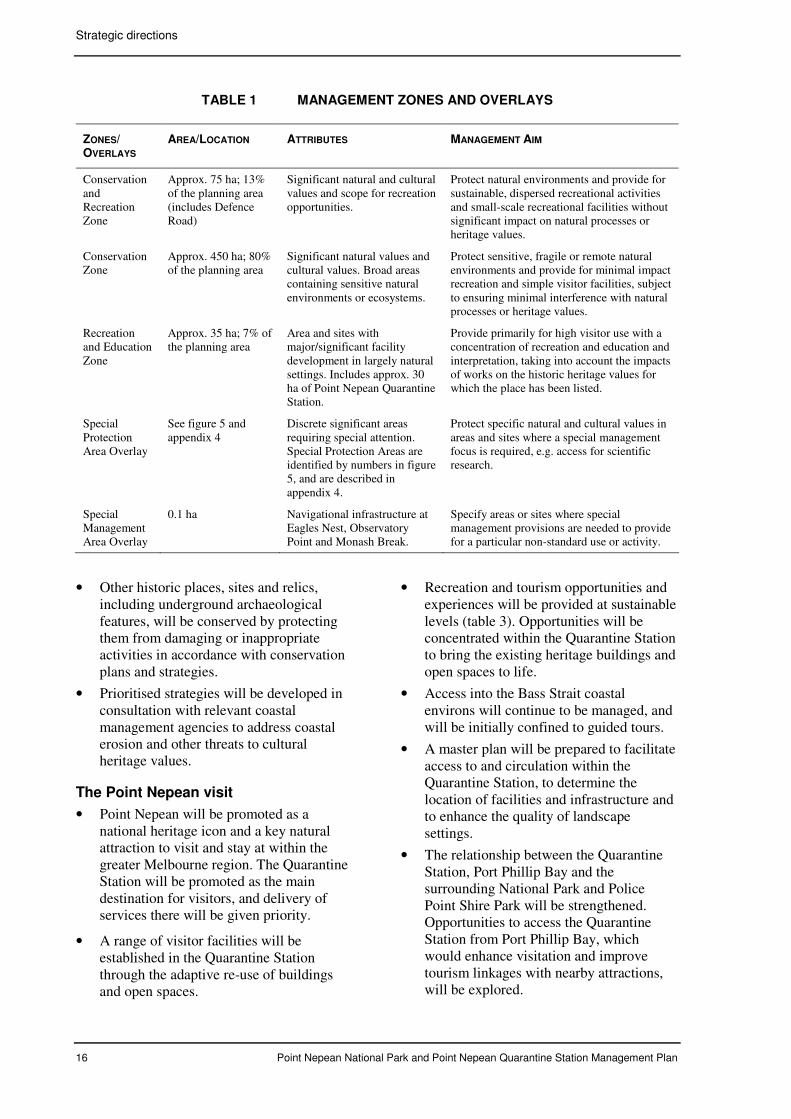
Three management zones apply: Conservation, Conservation and Recreation, and Recreation and Education. In addition, two management overlays have been designated to highlight management requirements in addition to those of the underlying primary zone (table 1 and figure 5).
The developed and cleared area of the Quarantine Station is within the Recreation and Education Zone. The boundary of this area coincides with the Mornington Peninsula Planning Scheme Special Use Zone boundary. This area has special attributes not found elsewhere within the state’s national park system (table 2). The inherent values, particularly the extent of heritage-listed buildings and quality landscape settings, provide significant opportunities for adaptive re-use and a concentration of interrelated uses.
3.3 Major management directions
The Traditional Owners’ knowledge and interests in the area and aspirations for Country
will be reflected in the park’s planning and management, in accordance with legislation and policies (Parks Victoria 2005).
Other major management directions for the planning area are outlined below.
Natural heritage conservation
• Natural heritage values will be identified, protected, conserved and presented in a holistic approach to landscape, ecology and cultural heritage and with respect to the surrounding marine environment.
• Natural heritage values management will focus on the goal to restore and maintain coastal vegetation communities and enhance habitat values. The restoration of Coastal Moonah Woodlands and grassland habitats will be given priority.
• Protection and enhancement programs based on current knowledge, risk assessments and applied research will manage threats to natural values. Pest plant and animal control will be given priority.
• Ecological principles will apply for the use and management of fire in the planning area for resource conservation and park protection purposes.
• Flora and fauna research and monitoring will be undertaken to enhance knowledge about risks to natural values and inform management programs.
• Coastal erosion will be monitored. Site damage resulting from previous land uses that threaten significant values will be rehabilitated.
• Threats to natural heritage values in areas abutting Police Point Shire Park and Portsea Golf Course will be minimised by liaising and cooperating, as appropriate, with the managers of these areas.
Indigenous heritage conservation
• Significant features of Country will be identified, interpreted, respected and managed in accordance with the views and aspirations of the Boonwurrung people.
• Aboriginal (Boonwurrung) places and objects will be protected from interference or damaging activities. Places threatened by coastal erosion will be protected where viable through consultation and working partnerships with the Boonwurrung people and relevant coastal management authorities.
• The Boonwurrung peoples’ heritage values and cultural obligations relating to Country
will be respected and reflected in all planning and management.
• Shared learning with the Boonwurrung people will be explored to learn more about Aboriginal cultural heritage values and knowledge of ecological processes.
Historic heritage conservation
• Emphasis will be given to conserving the historic forts and conserving and managing heritage buildings, with a focus on conservation through adaptive re-use.
Strategic directions
16 Point Nepean National Park and Point Nepean Quarantine Station Management Plan
TABLE 1 MANAGEMENT ZONES AND OVERLAYS
ZONES/ OVERLAYS
AREA/LOCATION ATTRIBUTES MANAGEMENT AIM
Conservation and Recreation Zone
Approx. 75 ha; 13% of the planning area (includes Defence Road)
Significant natural and cultural values and scope for recreation opportunities.
Protect natural environments and provide for sustainable, dispersed recreational activities and small-scale recreational facilities without significant impact on natural processes or heritage values.
Conservation Zone
Approx. 450 ha; 80% of the planning area
Significant natural values and cultural values. Broad areas containing sensitive natural environments or ecosystems.
Protect sensitive, fragile or remote natural environments and provide for minimal impact recreation and simple visitor facilities, subject to ensuring minimal interference with natural processes or heritage values.
Recreation and Education Zone
Approx. 35 ha; 7% of the planning area
Area and sites with major/significant facility development in largely natural settings. Includes approx. 30 ha of Point Nepean Quarantine Station.
Provide primarily for high visitor use with a concentration of recreation and education and interpretation, taking into account the impacts of works on the historic heritage values for which the place has been listed.
Special Protection Area Overlay
See figure 5 and appendix 4
Discrete significant areas requiring special attention. Special Protection Areas are identified by numbers in figure 5, and are described in appendix 4.
Protect specific natural and cultural values in areas and sites where a special management focus is required, e.g. access for scientific research.
Special Management Area Overlay
0.1 ha Navigational infrastructure at Eagles Nest, Observatory Point and Monash Break.
Specify areas or sites where special management provisions are needed to provide for a particular non-standard use or activity.
• Other historic places, sites and relics, including underground archaeological features, will be conserved by protecting them from damaging or inappropriate activities in accordance with conservation plans and strategies.
• Prioritised strategies will be developed in consultation with relevant coastal management agencies to address coastal erosion and other threats to cultural heritage values.
The Point Nepean visit
• Point Nepean will be promoted as a national heritage icon and a key natural attraction to visit and stay at within the greater Melbourne region. The Quarantine Station will be promoted as the main destination for visitors, and delivery of services there will be given priority.
• A range of visitor facilities will be established in the Quarantine Station through the adaptive re-use of buildings and open spaces.
• Recreation and tourism opportunities and experiences will be provided at sustainable levels (table 3). Opportunities will be concentrated within the Quarantine Station to bring the existing heritage buildings and open spaces to life.
• Access into the Bass Strait coastal environs will continue to be managed, and will be initially confined to guided tours.
• A master plan will be prepared to facilitate access to and circulation within the Quarantine Station, to determine the location of facilities and infrastructure and to enhance the quality of landscape settings.
• The relationship between the Quarantine Station, Port Phillip Bay and the surrounding National Park and Police Point Shire Park will be strengthened. Opportunities to access the Quarantine Station from Port Phillip Bay, which would enhance visitation and improve tourism linkages with nearby attractions, will be explored.
Strategic directions
Point Nepean National Park and Point Nepean Quarantine Station Management Plan 17
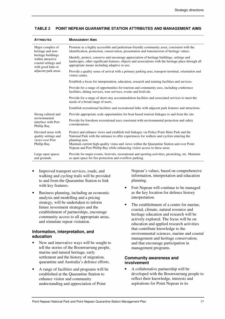
TABLE 2 POINT NEPEAN QUARANTINE STATION ATTRIBUTES AND MANAGEMENT AIMS
ATTRIBUTES MANAGEMENT AIMS
Major complex of heritage and non-heritage buildings within attractive coastal settings and with good links to adjacent park areas.
Promote as a highly accessible and pedestrian-friendly community asset, consistent with the identification, protection, conservation, presentation and transmission of heritage values.
Identify, protect, conserve and encourage appreciation of heritage buildings, settings and landscapes, other significant features, objects and associations with the heritage place through all appropriate means including adaptive re-use.
Provide a quality sense of arrival with a primary parking area, transport terminal, orientation and visitor centre.
Establish a focus for interpretation, education, research and training facilities and services.
Provide for a range of opportunities for tourism and community uses, including conference facilities, dining services, tour services, events and festivals.
Provide for a range of short-stay accommodation facilities and associated services to meet the needs of a broad range of users.
Establish recreational facilities and recreational links with adjacent park features and attractions.
Strong cultural and environmental interface with Port Phillip Bay.
Provide appropriate scale opportunities for boat-based tourism linkages to and from the site.
Provide for foreshore recreational uses consistent with environmental protection and safety considerations.
Elevated areas with quality settings and views over Port Phillip Bay.
Protect and enhance views and establish trail linkages via Police Point Shire Park and the National Park with the entrance to offer experiences for walkers and cyclists entering the planning area. Maintain current high-quality vistas and views within the Quarantine Station and over Point Nepean and Port Phillip Bay while enhancing visitor access to these areas.
Large open spaces and grounds.
Provide for major events, festivals, recreational and sporting activities, picnicking, etc. Maintain as open space for fire protection and overflow parking.
• Improved transport services, roads, and walking and cycling trails will be provided to and from the Quarantine Station to link with key features.
• Business planning, including an economic analysis and modelling and a pricing strategy, will be undertaken to inform future investment strategies and the establishment of partnerships, encourage community access to all appropriate areas, and stimulate repeat visitation.
Information, interpretation, and education
• New and innovative ways will be sought to tell the stories of the Boonwurrung people, marine and natural heritage, early settlement and the history of migration, quarantine and Australia’s defence efforts.
• A range of facilities and programs will be established at the Quarantine Station to enhance visitor and community understanding and appreciation of Point
Nepean’s values, based on comprehensive information, interpretation and education planning.
• Fort Nepean will continue to be managed as the key location for defence history interpretation.
• The establishment of a centre for marine, coastal, climate, natural resource and heritage education and research will be actively explored. The focus will be on education and applied research activities that contribute knowledge to the environmental sciences, marine and coastal management and heritage conservation, and that encourage participation in management programs.
Community awareness and involvement
• A collaborative partnership will be developed with the Boonwurrung people to reflect their knowledge, interests and aspirations for Point Nepean in its
Strategic directions
18 Point Nepean National Park and Point Nepean Quarantine Station Management Plan
planning and management and to increase broader community understanding of Aboriginal heritage.
• The Boonwurrung people will be encouraged to advise and participate in management, including research activities, ecological management programs, special events, cultural activities, guided tours and shared learning opportunities.
• A program of cultural activities, ceremonies and other special events will be encouraged to enhance broader and local community use of Point Nepean, with a focus on the Quarantine Station.
• The National Park and Quarantine Station will be actively promoted to the wider community, and consultation and engagement in planning activities and management will be actively sought.
• Local communities and visitors will be encouraged to develop a sense of custodianship for Point Nepean and become involved in management.
• Friends groups, volunteers and other community groups will be encouraged to use the resources available within the National Park and the Quarantine Station. These groups will be supported to participate in areas of park management that relate to their interests and develop an understanding and appreciation of the park’s values and the rich and diverse knowledge and aspirations of the Boonwurrung people.
• Partnerships with other organisations will be actively sought to enhance the delivery of quality tourism and visitor services and facilities, and to meet educational, research, training and community participation objectives.
• Inspiration and innovation will be sought from similar places worldwide to contribute to the delivery of quality services and facilities and to encourage links with quarantine stations around the world.
Research and monitoring
• Research programs within the existing National Park will continue in accordance with appropriate permits and approvals.
• Flora and fauna surveys will be undertaken to help define long-term ecological management objectives for all significant species and communities at Point Nepean.
• Surveys and monitoring programs will build knowledge on values, threats and impacts, including responses to the ecological use of fire and the biodiversity impacts of land use and management activities on the coastal and marine environments.
• Indigenous and historic heritage research will continue to be undertaken and encouraged to gather data and build cross-cultural understandings for shared awareness and consensual approaches to site interpretation, education and on-going conservation and management.
• Provide for protection and further scientific and ethno-historic study of significant archaeological and heritage sites and features.
• An integrated whole-of-ecosystem approach to managing and monitoring natural values, fire and pest control will be established for the entire planning area using Parks Victoria’s Environmental Management Framework.
Infrastructure
• Improvements to infrastructure and utility services will utilise, wherever possible, best-practice principles to ensure the sustainable use of resources and minimal impacts on the environment.
• Infrastructure works will be planned, designed and implemented to ensure minimal impact on natural and cultural heritage values. Heritage risk assessments will be undertaken for development works. All necessary approvals will be sought from the relevant authorities.
• A risk management approach will be taken to all assets, including the recording of key details of each heritage asset and other assets, its condition and actions/interventions taken, in an assets inventory. Protocols will be established for the storage and management of sensitive data.
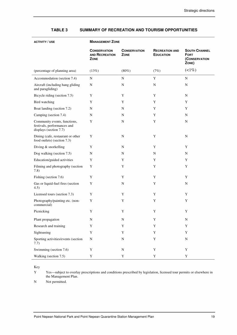
Strategic directions
Point Nepean National Park and Point Nepean Quarantine Station Management Plan 19
TABLE 3 SUMMARY OF RECREATION AND TOURISM OPPORTUNITIES
ACTIVITY / USE MANAGEMENT ZONE
CONSERVATION
AND RECREATION
ZONE
CONSERVATION
ZONE RECREATION AND
EDUCATION SOUTH CHANNEL
FORT
(CONSERVATION
ZONE)
(percentage of planning area) (13%) (80%) (7%) (<1%)
Accommodation (section 7.4) N N Y N
Aircraft (including hang gliding and paragliding)
N N N N
Bicycle riding (section 7.5) Y Y Y N
Bird watching Y Y Y Y
Boat landing (section 7.2) N N Y Y
Camping (section 7.4) N N Y N
Community events, functions, festivals, performances and displays (section 7.7)
Y N Y N
Dining (cafe, restaurant or other food outlets) (section 7.3)
Y N Y N
Diving & snorkelling Y N Y Y
Dog walking (section 7.5) N N N N
Education/guided activities Y Y Y Y
Filming and photography (section 7.8)
Y Y Y Y
Fishing (section 7.6) Y Y Y Y
Gas or liquid-fuel fires (section 4.5)
Y N Y N
Licensed tours (section 7.3) Y Y Y Y
Photography/painting etc. (non-commercial)
Y Y Y Y
Picnicking Y Y Y Y
Plant propagation N N Y N
Research and training Y Y Y Y
Sightseeing Y Y Y Y
Sporting activities/events (section 7.7)
N N Y N
Swimming (section 7.6) Y N Y Y
Walking (section 7.5) Y Y Y Y
Key
Y Yes—subject to overlay prescriptions and conditions prescribed by legislation, licensed tour permits or elsewhere in the Management Plan.
N Not permitted.
20 Point Nepean National Park and Point Nepean Quarantine Station Management Plan
4 STRATEGIES FOR NATURAL HERITAGE CONSERVATION
4.1 Geological features
Point Nepean has geological and geomorphological features of state and regional significance (Parks Victoria 1998). The dune calcarenite cliffs, rock stacks and shoreline rock platforms that display limestone weathering are of state significance. The parallel dunes (built up at Observatory Point because of the refracted swell from Port Phillip Heads) and much of the impressive cliffy coastline are of regional significance.
Visitor impacts on geological and geomorphological features have been minimal because of the limited public access to the coast and shoreline. Opening the Quarantine Station to the public is expected to increase visitor use along the coast between the Quarantine Station and The Bend and poses a potential risk to the fragile dunes (section 7.5).
Many geomorphological features of the planning area are significant to Boonwurrung people. Further archaeological investigation and ethno-historic research may reveal more about the associations the Indigenous communities have with the land and its features (chapter 5).
Further study on potential features of significance within the former Range Area has been recommended by the Geological Society of Australia (S. White, pers. comm.).
Aims
• Allow natural systems and processes to continue undisturbed where possible, and minimise impacts by management and visitors on significant geological and landform features.
• Provide for research into geological and landform features.
Management strategies
• Maintain controlled access to the Bass
Strait coastline and the coast between Fort
Nepean and The Bend to minimise
interference to natural systems and
processes (section 7.5).
• Monitor visitor use along the coast
between the Quarantine Station and The
Bend and undertake dune protection
measures as required.
• Encourage research to identify, record and
study significant landforms and coastal
processes, including landforms of special
significance to the Boonwurrung people.
• Protect significant landforms and features
from damaging or inappropriate activities
(section 5.1 and chapter 8).
4.2 Natural landscape
Point Nepean’s special landscape has been shaped by a combination of natural processes and past land uses. While the whole landscape has historic values associated with activities and associations, this section focuses on the protection and enhancement of the broad natural landscape. The protection and enhancement of the historic landscape settings in the Quarantine Station, forts and other historic sites is covered in section 6.3.
Point Nepean is renowned for its spectacular coastal scenery and panoramic views. Quality views are available from numerous vantage points, particularly the 360° views between Cheviot Hill and Fort Nepean and those from the surrounding water to the land.
The landscape is a major factor in the experience of many visitors, generating feelings of remoteness and isolation.
The landscape and adjacent seascape are intrinsic elements of Country for the Boonwurrung people and represent a significantly large and relatively protected area with extensive archaeological heritage values. The pre-European settlement landscape has been modified significantly through vegetation clearance, erosion, development and altered native vegetation communities.
Natural elements of the landscape include a relatively contiguous vegetation cover, sandy beaches interspersed with calcarenite cliffs, and undulating dune systems extending between the contrasts of the high-energy Bass Strait coast and the relatively protected waters of Port Phillip Bay.
The Management Plan for the Point Nepean Section (CFL 1989) provided direction on the
Strategies for natural heritage conservation
Point Nepean National Park and Point Nepean Quarantine Station Management Plan 21
protection and preservation of the landscape based on visual quality objectives applied to the whole of Point Nepean, other than the developed area within the Quarantine Station. The plan identified three landscape management classes:
Class A – Highest concern for landscape resources; alterations must not be evident to the casual observer.
Class B – Moderate concern for landscape resources; alterations may be apparent, but must harmonise with the surroundings and not dominate landscape characteristics.
Class C – Lowest concern for landscape resources; alterations may be dominant, but harmonise as far as practicable with the surroundings.
Most of the planning area, including the bushland surrounding the developed area within the Quarantine Station, falls within landscape Class A. The major portion of this landscape class has poor to very poor land capability for the provision of facilities, including walking tracks. New tracks should not be constructed where erosion might affect landscape values.
The natural landscape at Point Nepean is influenced by dynamic coastal processes, including natural dune blowouts and cliff subsidence (section 4.7). Other landscape modifications have resulted from the use of fire, particularly the large grassy bowl at Wilsons Folly.
The use of fire for ecological purposes, which will also assist with the clearance of unexploded ordnance in the former Range Area, will help to restore the diversity of the original natural character of Point Nepean (section 4.3). It is important to exclude fire from the primary and secondary dunes to minimise the risk of management-induced erosion and changes in landform.
The Mornington Peninsula National Park Management Plan (Parks Victoria 1998), which applied to Point Nepean, made provision for monitoring dune blow-outs, the continuation of natural coastal processes and the revegetation of coastal areas that have been disturbed by human activity. An assessment of previous land use and associated erosion within the former Rifle Range area is needed
to determine whether stabilisation works are required to protect the landscape values, and to identify sites of cultural, historical or scientific significance.
The future of the former Rifle Range area and the Monash Break, both of which represent significant modifications to the natural landscape character, needs to be determined in the context of opportunities to enhance habitat values and their potential heritage significance (section 4.4 and chapter 6).
The adjacent residential development barely intrudes on the landscape from viewpoints in existing visitor use areas. Key viewing points such as Cheviot Hill are relatively distant from the urban area.
Exotic pines on the fringes of the cleared setting in the Quarantine Station appear to be spreading into the surrounding native vegetation. These plantings and wildlings impact on the natural landscape surrounding the Quarantine Station heritage precinct.
Fencing that intrudes on the natural landscape and is assessed as being no longer required for continued access controls could be removed. Opportunities to place existing powerlines underground will also be explored (section 10.1).
There are opportunities to progressively open new areas to enable visitors to appreciate the diverse landscapes at Point Nepean, particularly in the former Range Area. In opening new areas it is important to minimise potential impacts on landscape values by utilising existing tracks where possible (section 7.5).
Aims
• Protect the natural landscape, particularly places of high scenic quality or significance, especially to the Boonwurrung people.
• Enhance opportunities for visitors to enjoy the landscape.
• Minimise visual intrusions into the natural landscape, and rehabilitate, remove or ameliorate undesirable existing intrusions where practicable.
Strategies for natural heritage conservation
22 Point Nepean National Park and Point Nepean Quarantine Station Management Plan
Management strategies
• Respect the significance of landscape to
the Boonwurrung people in planning and
implementing management activities and
interpretation and education programs
(chapters 5 and 8).
• Ensure that landscape protection
objectives are included in ecological
management programs and the provision
of visitor infrastructure.
• Continue to monitor natural coastal
processes and their effects on landscape,
and develop a prioritised program for
potential intervention to protect values in
consultation with DSE and the
Boonwurrung people (section 4.7).
• Identify and undertake landscape
protection works in the former Range
Area.
• Ensure that natural landscape protection
and enhancement works protect significant
cultural heritage values.
• Liaise with planning authorities to
minimise impacts on the views in the
planning area (sections 9.3 and 10.4).
• Monitor and provide input to management
activities by external agencies that have
potential to affect landscape values
(chapter 10).
• Remove visual intrusions on the landscape,
including fencing that is no longer
required for access management and other
infrastructure subject to further
investigation (section 10.1).
• Develop a program to increase access to
new areas and opportunities for visitors to
appreciate the natural landscape. Where
possible, use the existing track network for
visitor use to minimise the risk of
modifications to the landscape (section
7.5).
4.3 Vegetation
Point Nepean comprises the largest and most intact area of remnant coastal vegetation remaining on the Port Phillip coastline and on the southern Mornington Peninsula. The vegetation is of high conservation significance and provides habitat for flora and fauna of national and state significance.
The planning area contains one species of national significance, 12 species of state significance and more than 65 species that are regionally significant. Significant flora is listed in appendix 5.
A detailed flora survey was undertaken for the whole of the planning area in 2005–7. This survey identified eight ecological vegetation classes (EVCs) on Point Nepean (appendix 5).
Victoria’s largest remnant of Coastal Alkaline Scrub, which has been nominated for protection under the EPBC Act (as ‘Calcarenite Dune Woodland of South Eastern Australia’) is in the National Park. Covering approximately 285 ha, it includes a reference site for Moonah, with hollows for bat species. The reference site and other areas of old hollow-bearing Moonah require special protection, including exclusion of fire (appendix 4).
Typical dominant or co-dominant species, including Drooping She-oak and Coastal Banksia, are severely depleted due to previous land uses including grazing, collection of firewood for lime burning and clearance for firebreaks and infrastructure such as roads and tracks. Past uses, together with the impact of pest plants, may have severely affected the capacity for natural regeneration of the original vegetation in some areas. Restoration of species diversity in some areas may require active revegetation programs. The area to the west of the Quarantine Station, which is readily accessible, may be suitable for a ‘vegetation restoration demonstration area’ involving the community.
Pest plants, particularly Myrtle-leaf Milkwort, Italian Buckthorn and Bridal Creeper, are a significant risk to natural values within the whole planning area (section 4.6). This is particularly so in the Coastal Alkaline Scrub EVC. New and emerging pest plants, while not considered a significant risk in the short-term, will continue to be a priority for eradication in accordance with Parks Victoria’s operational policy.
Fire was probably used by the Boonwurrung people for hunting by encouraging grasslands as a food source for native animals, but little is known about the fire regimes they applied. Fire has been uncommon at Point Nepean since settlement, and its absence has probably
Strategies for natural heritage conservation
Point Nepean National Park and Point Nepean Quarantine Station Management Plan 23
contributed to the spread of Coastal Tea-tree and other woody species that now dominate much of the area. While fire is considered to be important for the maintenance of grassland and woodland communities and their associated fauna values, the lack of knowledge on fire regimes is problematic in managing these communities.
A program of small-scale ecological burning has been implemented in the Wilsons Folly area over the last six years to restore and maintain the diversity of vegetation communities, in accordance with conservation objectives that have been developed for the short to medium term. These conservation objectives aim to restore and maintain the diversity of flora and fauna in all vegetation communities by controlling the further spread of Coastal Tea-tree and invasive pest plants, controlling pest animals, and then maintaining restored areas.
Parks Victoria, in consultation with the Department of Defence, has developed a controlled burning and vegetation reduction program to facilitate the removal of unexploded ordnance (UXO) by the Department of Defence within the former Range Area, in accordance with the land transfer agreement between the State and the Commonwealth. This program includes provision for small-scale controlled burning which aims to re-establish grassland habitats and enhance Coastal Moonah Woodland now dominated by Coastal Tea-tree, hand or mechanical clearance of understorey vegetation and spraying of weeds in Coastal Moonah Woodland areas. Approximately 25 ha of the 85 ha of land contaminated by UXO will not be cleared of unexploded ordnance because of the fragile nature of the dunes and associated vegetation communities, and the high erosion risks associated with the use of fire or vegetation clearance. Exclusion of fire from the Bass Strait dunes and older hollow-bearing Coastal Moonah Woodland is important (appendix 4).
A flora and fauna survey was undertaken during 2005–2007 to build knowledge and contribute to the refinement of ecological management objectives. The survey program included mapping of vegetation communities and significant fauna habitats and the
establishment of monitoring plots in representative communities.
There is a lack of knowledge on orchids and their distribution and a lack of data on fungi, lichens, bryophytes and algae.
An important component of the research being implemented in the former Range Area is assessing the impact of ecological burning on significant indigenous flora, habitat values and pest plants through pre-burning and post-burning surveys and monitoring. The protection of Indigenous heritage values will be guided by heritage surveys undertaken in consultation with the Boonwurrung people (section 5.1).
The intertidal rock platforms along the Bass Strait coastline at Point Nepean are highly significant for studies of human-induced change to intertidal flora and fauna communities (LCC 1996). This section of coastline has had minimal human impacts because of a long history of restricted public access. In addition to on-going monitoring of the intertidal communities undertaken by Monash University, opportunities for surveys will be pursued to improve knowledge and develop strategies for the protection of values.
Modified areas such as the Monash Break and the Rifle Range provide opportunities for the enhancement of indigenous flora values. Subject to an assessment of their contribution to fire protection and heritage values (section 4.5 and chapter 6), it may be appropriate to maintain these areas for interpretation purposes while enhancing their habitat values for small mammals. As a minimum measure, the current introduced grasses should be replaced by indigenous grasses and ground-cover species. It might also be appropriate to revegetate sections of the Monash Break to enhance visitor experiences, particularly next to new walking tracks (section 7.5).
Ethno-historical research has identified that the Boonwurrung people utilised the flora for food, medicines, tools, shelter, jewellery and other purposes. Further research on the range of flora species used will improve the understanding and appreciation of Indigenous heritage (section 5.2 and chapter 8).
Strategies for natural heritage conservation
24 Point Nepean National Park and Point Nepean Quarantine Station Management Plan
Aims
• Restore, preserve and maintain plant communities, particularly Coastal Moonah Woodland and grassland habitats.
• Undertake research to enhance knowledge on flora values and threats and develop long-term ecological management objectives.
Management strategies
• In the short to medium term, restore and
maintain grassland habitats in the large
dune bowls (Wilsons Folly and Harrisons
Bowl), including regenerating Banksia and
She-oak species.
• Prevent further spread of Coastal Tea-tree
into Coastal Moonah Woodland and
grassland habitats.
• Continue to give priority to the control of
pest plants in the woodland communities
and the eradication of any new or
emerging pest plants (section 4.6),
particularly in conjunction with ecological
burning.
• Subject to an assessment of cultural
heritage and interpretation values,
revegetate or restore the floristic values of
the Rifle Range and Monash Break.
• Develop long-term objectives for
vegetation management incorporating the
results of flora surveys and mapping and
on-going monitoring. Maintain monitoring
plots in representative communities.
• Implement flora surveys in conjunction
with ecological burning in the former
Range Area.
• Prepare and implement an ecological burn
program in consultation with the
Boonwurrung people to encompass
consideration of traditional cultural
practices. Review and adapt the program
based on the results of flora, fauna and
archaeological surveys (sections 4.4 and
5.1).
• Encourage surveys of the Bass Strait
intertidal flora communities.
• Where appropriate, encourage research to
identify Aboriginal knowledge relating to
vegetation / flora, and harvesting
practices.
• Respect the cultural obligations of the
Boonwurrung people in relation to plants
and their significance in all management
and visitor activities.
• Develop and implement a program for the
restoration and revegetation of Coastal
Moonah Woodland west of the Quarantine
Station, in partnership with Friends
groups, volunteers, community groups and
students, as a demonstration site and for
interpretation purposes (chapters 8 and 9).
4.4 Fauna
Point Nepean plays a vital role in fauna conservation and is a key fauna habitat area on the Mornington Peninsula. The planning area supports at least 118 species of native vertebrate animals, including 13 mammals, 94 birds, 10 reptiles and one amphibian. Surveys and field studies have been limited, with little research into invertebrates.
Significant fauna, including those listed under the EPBC Act, are listed in appendices 6 and 7. Significant features of the planning area include:
• species that are not well represented in coastal parks elsewhere in Victoria, in particular the Long-nosed Bandicoot and potentially the nationally significant Southern Brown Bandicoot, which was last recorded in 1988
• important habitats along the Bass Strait coast for endangered and vulnerable national migratory and marine birds and regionally significant birds
• the presence of the state significant White-footed Dunnart and regionally significant mammal species including the Long-nosed Bandicoot, Swamp Rat and Southern Forest-bat
• resting habitat for Latham’s Snipe, a migratory bird species whose habitat is protected under international agreements
• a breeding population of White-faced Storm Petrels on South Channel Fort.
Recent field observations indicate that the grassland habitats in areas such as Wilsons Folly provide important habitat for small
Strategies for natural heritage conservation
Point Nepean National Park and Point Nepean Quarantine Station Management Plan 25
mammals, particularly the White-footed Dunnart and Long-nosed Bandicoot.
The White-faced Storm Petrel colony on South Channel Fort is one of only three breeding colonies in Victoria, and the breeding season extends from August to March inclusive. Fencing and access controls have been established to protect nesting habitat areas from trampling. Protected areas also provide breeding habitat for small numbers of Little Penguins. Monitoring of the storm petrel population is required to evaluate threats posed by large numbers of Silver Gulls and entrapment in old tunnels and Boxthorn (Park Victoria 2000).
The intertidal rock platforms along the Bass Strait shoreline are of high conservation and scientific significance due to a long period of protection from human impacts. The Environment Conservation Council, in its Marine, Coastal and Estuarine Investigation Final Report (ECC 2000), recommended continued restricted access to this area.
The Bass Strait coast provides important and undisturbed habitat for a range of bird species for nesting, feeding and roosting, including two threatened bird species (Hooded Plover and Shy Albatross) and a number of nationally significant migratory species and regionally significant species (appendix 6).
Point Nepean is part of a special management and monitoring program for the Hooded Plover on the Mornington Peninsula undertaken in partnership with volunteers. The Point Nepean ocean beaches provide a refuge from people and dogs compared to the beaches within the adjacent Mornington Peninsula National Park. The Hooded Plover nesting site in the Observatory Point area will require additional protection measures when the Quarantine Station area is opened to visitors (section 7.3 and 7.5).
The Wilsons Folly area is a significant fauna habitat for nesting and foraging mammals, ground-nesting and foraging birds, and reptiles (Practical Ecology 2007). Protection of the habitat values will be essential when new walking track access is provided (section 7.5).
The main threats to fauna are foxes and feral cats. Fox predation on bandicoots and cat predation on birds are considered as the highest risks to fauna values (Raulings 2005).
Competition from introduced pests such as the Black Rat and House Mouse and introduced birds also pose threats.
The lack of knowledge on fauna values is an identified key risk to fauna conservation, and improving knowledge is important to inform sound ecologically based management programs, including the use of fire. A fauna survey program at Point Nepean commenced in 2005 to enhance knowledge on fauna species, their distribution and habitat requirements. Initially, seasonal surveys will cover terrestrial and arboreal mammals, reptiles, amphibians and birds across the whole of the planning area. Pre-burning and post-burning fauna surveys and monitoring will be undertaken within the former Range Area as part of the ecological burn program (section 4.3).
Opportunities for further research and surveys, including flora and fauna surveys along the Bass Strait intertidal area and surveys for invertebrates, will be pursued.
Ethno-historical research identifies the Boonwurrung people living primarily on possums, which were an abundant food source, and occasionally kangaroos and fish. Shellfish from the surrounding intertidal areas, particularly from the Bass Strait coast, were also a major food source as evidenced by the extensive shellfish middens at Point Nepean.
It is expected that further archaeological research may uncover evidence of Indigenous food resources, including animal bones and more artefacts associated with hunting and food preparation (chapter 5).
Aims
• Provide for the long-term protection and preservation of indigenous fauna habitats and species.
• Continue to enhance terrestrial habitats for fauna species.
• Improve knowledge of the conservation of fauna and their habitats.
Management strategies
• Manage significant species and habitats
protected under the EPBC Act.
Strategies for natural heritage conservation
26 Point Nepean National Park and Point Nepean Quarantine Station Management Plan
• Undertake actions identified in FFG
action statements to reduce risks to fauna
(e.g. the Hooded Plover).
• Establish protection measures for the
Hooded Plover habitat at Observatory
Point when the Quarantine Station is
opened.
• Continue to monitor the White-faced Storm
Petrel colony at South Channel Fort and
maintain access controls to protect habitat
areas. Minimise disturbance during the
breeding season.
• Continue to implement and develop
conservation objectives (section 4.3) to
enhance the protection of fauna habitats
and significant fauna species, informed by
research and surveys.
• Continue to manage public access to the
Bass Strait coast to protect fauna habitats
and significant fauna. Limit access for
management and research purposes and
other approved use (section 7.5).
• Ensure that key fauna habitat protection
measures are included in planning for
visitor access (section 7.5).
• Control foxes and feral cats that threaten
small mammal and bird species (section
4.6).
• Develop specific actions for fauna
management using the results of fauna
surveys and monitoring.
• Undertake on-going surveys, monitoring
and evaluation of fauna and habitat
requirements before and after
controlled/ecological burning and in
accordance with the recommendations of
the surveys.
• Encourage surveys of the Bass Strait
intertidal fauna communities and
invertebrate fauna.
• Where appropriate, encourage research to
identify Aboriginal knowledge relating to
fauna.
• Respect the cultural obligations of the
Boonwurrung people in relation to fauna
and their significance in all management
and visitor activities.
4.5 Fire management
The National Parks Act requires the Secretary to DSE to ensure that appropriate and sufficient measures are taken to protect parks from injury by fire. Current fire protection measures on public land are carried out in accordance with the East Port Phillip Regional Fire Protection Plan (DSE 2003), the Code of Practice for the Management of Fire on Public Land (DSE 2006a) and Parks Victoria’s operational policies.
The suppression of any wildfire in the National Park is in accordance with the Port Phillip Region Fire Readiness and Response Plan prepared annually by DSE in consultation with the Country Fire Authority.
The use of fire by the public within the planning area is limited to fires in gas or liquid fuel fireplaces within defined recreation areas and management zones (table 3 and section 7.3). Solid fuel fires associated with approved special events and activities are subject to the fire being lit in a fireplace provided for the purpose (section 7.7).
Wildfire has been uncommon in the planning area, with the last recorded wildfire in 1976. Due to the nature and structure of fuels the planning area is considered to be a low risk area other than on days of high fire danger, and significant cleared areas within the adjacent Police Point Shire Park and Portsea Golf Course contribute to the protection of adjacent residential areas.
The Fire Protection Plan includes a three-year rolling operations plan developed annually in consultation with the community. While the Fire Protection Plan prepared in 2003 did not apply to the former Range Area, the current operations plan includes provision for controlled burns as part of the UXO clearance program within the former Range Area. Works to prepare for the burning program have included the maintenance of key vehicle access tracks through the Range Area to contribute to fire suppression in the event of a wildfire.
The three-year fire operations plan also includes the maintenance of the system of fire protection tracks and fuel breaks and liaison with private landholders for the common purpose of fire management within the National Park and on adjacent land. The current three-year operations plan for Point
Strategies for natural heritage conservation
Point Nepean National Park and Point Nepean Quarantine Station Management Plan 27
Nepean does not include provision for fuel reduction burning for the protection of assets and adjacent land.
The Quarantine Station is not covered by the three year operations plan, and the Country Fire Authority (CFA) is responsible for fire suppression there. The PNCT has prepared a fire and emergency management plan for the Quarantine Station (section 7.9).
The maintenance of cleared areas abutting the developed area in the Quarantine Station, particularly Jarman Oval, contributes to the overall integrated fire protection measures in place for Point Nepean and is expected to assist with fire suppression in the event of a wildfire. An old system of fire hydrants provided further protection to people and built assets in the Quarantine Station, however these hydrants need to be assessed for functionality (chapter 10). The role of the Monash Break and the Rifle Range as fuel breaks needs to be considered in context with potential habitat enhancement works and an assessment of their cultural values (sections 4.2, 4.3 and chapter 6).
The Boonwurrung people are interested in the use of fire as it relates to Indigenous culture and natural values management. There are opportunities for Parks Victoria and the Community Trust to work in close partnership with the Indigenous community for shared learning outcomes in developing and implementing a scientifically based burning program (section 5.2).
Aims
• Protect life, property and the planning area’s values from damage by wildfire.
• Minimise the adverse effects of fires and fire suppression efforts.
• Maintain fire regimes that are appropriate for achieving long-term ecological management objectives.
Management strategies
• Implement fire protection works in
accordance with the Port Phillip East
Regional Fire Protection Plan and the
Code of Practice for Fire Management on
Public Land.
• Prepare an integrated fire protection
strategy for the planning area. In the
interim:
� in partnership with DSE, continue to
use prescribed fire to meet ecological
management requirements
� continue to maintain the large cleared
areas abutting the developed area in
the Quarantine Station to provide for
protection of the buildings and people
� continue to slash fuel breaks along
Defence Road, Monash Break and the
Rifle Range
� maintain designated management
vehicle tracks.
• Assess the functionality of the Quarantine
Station fire hydrant and fire protection
systems and ensure that appropriate fire
protection systems are established
(chapter 10).
• Review the role of the Monash Break and
the Rifle Range as fuel breaks in the
context of the overall fire operations plan
and natural and cultural values.
• Apply guidelines from the Code of Practice
for Fire Management on Public Land in
the suppression of wildfire, in particular to
ensure the protection of known cultural
and environmental values.
• Ensure that the fire operations plan is
updated to consider the results of flora and
fauna surveys, Indigenous culture surveys
and assessment of historic heritage values
(sections 4.3, 4.4 and chapter 6).
4.6 Pest plants and animals
Pest plants pose a high risk to the whole area and in particular to Coastal Moonah Woodland and grassland habitats. More than 90 introduced species have been recorded in the planning area. Under the Catchment and Land Protection Act (CALP Act), six weed species are proclaimed as regionally controlled and one is regionally protected. Weed species of most concern are listed in appendix 8.
Myrtle-leaf Milkwort (Polygala) is considered to pose an extreme risk to the condition of the woodland communities, primarily through competition effects causing the loss of indigenous species diversity and a decline in
Strategies for natural heritage conservation
28 Point Nepean National Park and Point Nepean Quarantine Station Management Plan
natural regeneration. The difficultly in controlling Myrtle-leaf Milkwort and its widespread occurrence, are reflected in its high risk rating.
Bridal Creeper and Dolichos Creeper are dispersed and isolated and considered to pose a lesser but still moderate to high risk to the woodland communities. New and emerging weeds receive low risk ratings, but it is important to control these species to minimise the risk that they will become problem pest plants.
Boxthorn on South Channel Fort poses significant threats to the White-faced Storm Petrel colony by restricting accessibility for breeding.
The historical development of the Quarantine Station included the introduction of a range of non-indigenous plants, including a number of species that that have spread into areas of indigenous vegetation. The pines surrounding parts of the site are not culturally significant and show evidence of on-going spread and impacts on indigenous flora.
Fire is known to cause significant levels of pest plant germination, particularly Myrtle-leaf Milkwort. The ecological burning program, particularly in the former Range Area, includes provision for intensive post-fire pest plant control in order to optimise regeneration of indigenous species.
Fox and feral cat predation is considered to pose the highest risks to fauna. Foxes are thought to occur throughout Point Nepean and are widespread on the Mornington Peninsula. Little is known about the number or distribution of feral cats, although these are believed to occur throughout the planning area. The Mornington Peninsula Shire has by-laws promoting responsible pet ownership, including a 24-hour cat curfew and registration and sterilisation requirements (section 9.3).
A fox control program has been in place for approximately 12 years in the National Park and this program will be expanded as part of the ecological burning program, particularly in the former Range Area. Pre- and post-burning pest animal control will ensure that benefits to small mammals, which are expected to favour regenerating grassy woodland, is maximised.
The recent fauna survey project (section 4.4) identified threats to significant species and communities, assessed their impacts, and made recommendations for mitigating or eliminating threats. The results will be used to assist in adapting on-going pest animal controls based on targeted areas.
Proposed intertidal flora and fauna surveys (sections 4.3 and 4.4) should identify threats posed by pest plants and animals. This would be facilitated by an integrated approach to whole-of-ecosystem monitoring across the land and sea interface.
The potential to establish a pest animal exclusion zone at Point Nepean was identified in 1998 (Parks Victoria 1998). Consideration of excluding pest animals from Point Nepean or part of the planning area needs further investigation, which would take into account improved knowledge on significant species and their distribution and effectiveness of increased pest animal control programs.
Areas of Coast Tea-tree in the planning area have exhibited dieback over the last 10 years. The cause of the dieback, which is widespread on the southern Mornington Peninsula, is unknown. The impact, however, may be beneficial in that the dieback is occurring in areas where Coast Tea-tree is outside its original natural area (Calder 1986) and where its occurrence needs to be reduced (section 4.3).
Aims
• Control and where possible eradicate pest plant and animal species from Point Nepean.
• Minimise the impact of control programs on native flora and fauna.
• Restore native vegetation to areas where non-indigenous plants have been removed.
Management strategies
• Control or where possible eradicate pest
plant species in accordance with the
following priorities:
� protect Coastal Moonah Woodland,
grassland habitats, Coast Wirilda,
Rare Bitter Bush, Coast Bitter Bush,
Peninsula Daisy Bush and other
Strategies for natural heritage conservation
Point Nepean National Park and Point Nepean Quarantine Station Management Plan 29
significant species identified through
flora surveys
� eradicate vigorous new or emerging
weeds before they become established
� control or eradicate weeds listed
under the CALP Act (appendix 8),
including Boxthorn on South Channel
Fort, to minimise impacts on fauna
habitat.
• Control pest plant regeneration in areas
subject to the prescribed use of fire and
UXO clearance areas to enhance
regeneration of indigenous species.
• Control or where possible eradicate
introduced plants within the Quarantine
Station that are not culturally significant.
• Develop an on-going targeted pest animal
control program, giving priority to the
protection of small native mammals and
birds, particularly significant fauna.
Review and update the control program as
new information arises from fauna survey
and monitoring and evaluation of the
effectiveness of predator control
programs.
• Use control methods that minimise
disturbance to natural systems. Avoid or
carefully control soil disturbance and the
use of chemicals, especially where this
could impact on natural or cultural
heritage values.
• Work with the Boonwurrung people to
ensure that Aboriginal places are not
adversely affected by management
activities.
• Ensure that all significant pest plant and
animal control activities in the planning
area are incorporated into Parks
Victoria’s Environmental Information
System.
• Encourage the identification and
recording of pest plant and animal species
and their potential impacts on terrestrial
and intertidal flora and fauna.
4.7 Coastal erosion
Active natural coastal processes, including erosion, have formed Point Nepean over a long period. These processes are currently occurring along stretches of the planning area’s coastline.
Waves, winds and water acting on inherently erosive landforms result in cliff collapses, slope failures and dune blowouts.
Extensive seawall works were undertaken more than 100 years ago to protect the fortification infrastructure, but a major portion of the old seawalls on the Port Phillip Bay side has failed or eroded away. One section at the Narrows was replaced with a rock revetment in 1970 because of concerns that the sea may break through the headland.
A number of coastal studies have been undertaken over the years, particularly since the 1970s. Early reports, dating back to 1917, identify erosion and collapse of seawalls due to the refraction of waves following their passage through the Rip. Erosion is evident today along the entire section of coast between Fort Nepean and Observatory Point, including active erosion of primary dunes. Old seawalls on the Bass Strait coast at Fort Nepean are in comparatively sound condition despite exposure to high-energy sea conditions. This may be due to the natural protection provided by extensive rock platforms, and to the original construction technique on solid foundations.
A comprehensive report on the condition of seawalls and threats posed by on-going seawall failure recommended high-cost major works to construct rock revetments where seawalls were originally built (Coastal Energy Solutions 1997). Priority works implemented in 1997–98 included additional rock revetments below Fort Nepean to protect heritage infrastructure and re-instate public access, and an extension of the rock revetment to complete the Narrows gap.
In 2004, Parks Victoria initiated a further assessment of recent landslip sites to identify risks to assets, visitor safety and the environment and recommend options for remedial works and monitoring. Two slips on the Bass Strait coast are in areas that have had no previous protection. A third slip is adjacent to the Eagles Nest fortification complex where a section of seawall has failed. Monitoring of the slips is required, and appropriate remedial action will be needed if significant heritage infrastructure or public access is threatened.
Based on ecologically sustainable principles for development along the Victorian Coast (VCC 2002), there is a need for a longer-term
Strategies for natural heritage conservation
30 Point Nepean National Park and Point Nepean Quarantine Station Management Plan
approach to coastal erosion that considers the risks of potential sea level rises and the need to protect and maintain access to the Fort Nepean complex (chapter 6).
In addition, there is a need to consider landscape protection objectives and the high scenic quality of the Port Phillip Bay coastline in determining management options (section 4.2). The coastal landscape between the former Quarantine Station and Eagles Nest has minimal evidence of human intrusion. The report on Landscape Setting Types for the Victorian Coast (VCC 1998) identifies the need to take extreme care to protect the Point Nepean landscape setting type and to study the complex coastal processes before undertaking the development of any marine structures.
The views and comments of the Boonwurrung people on erosion control measures and potential impacts on Indigenous heritage values need to be considered (section 5.2).
An assessment of coastal erosion that may have resulted from previous land use (e.g. tracks through dunes in the former Range Area) is required in order to determine management requirements and the level of intervention works. Assessment of erosion along the Quarantine Station shoreline is also required.
DSE is undertaking a strategic coastal hazard assessment for the Port Phillip Region, which includes Point Nepean. This study may provide directions for the management of coastal hazards at Point Nepean and a strategic approach to the long-term management of the coastline. This will be important in developing sustainable strategies for asset protection.
Aims
• Protect Indigenous and historic heritage values and infrastructure threatened by coastal erosion.
• Allow natural coastal processes to continue without intervention unless cultural or historic heritage values, visitor facilities or other infrastructure are threatened.
• Facilitate research into the dynamic coastal processes and effects on the landform and appropriate engineering solutions.
Management strategies
• Seek to have Point Nepean identified as a
site requiring special case study status in
the current DSE coastal risk investigation
for the Port Phillip Region. Subject to the
outcomes of this study, review strategies
for the long-term management of the Point
Nepean coast.
• Establish monitoring programs at
locations where existing erosion or new
erosion threatens heritage assets, visitor
facilities and infrastructure, and develop
remedial actions to mitigate risks (section
4.2).
• Undertake an assessment of the shoreline
stability at the Quarantine Station and
Police Point cliff area, and develop
appropriate strategies to protect natural
and cultural heritage values that may be
threatened.
• Continue to give priority to the protection
of the Fort Nepean complex, essential
public access and public safety.
• Ensure that the Boonwurrung people are
consulted about all proposed coastal
protection works.
• Encourage on-going studies on coastal
processes to assist in decisions about
coastal protection works.
• Ensure that representative sections of the
seawalls on the Bass Strait coast are
maintained and preserved as examples of
historic coastal engineering treatments.
• Undertake an assessment of coastal
erosion in the former Range Area and
develop appropriate strategies to protect
natural and cultural values that may be
threatened.
Point Nepean National Park and Point Nepean Quarantine Station Management Plan 31
5 STRATEGIES FOR INDIGENOUS HERITAGE CONSERVATION
5.1 Aboriginal site management
The whole of Point Nepean is a place of high significance to the Boonwurrung people.
An archaeological survey of Point Nepean undertaken in 2005, including the Police Point Shire Park, identified 29 new archaeological sites, bringing the total number of recorded and registered sites and places to 60. Sites at Point Nepean are believed to have a maximum date of 4000 years, but are more likely to date to the past 1000–2000 years (AASC 2007).
Collectively the sites at Point Nepean are considered to be of high scientific significance and of high importance to the Boonwurrung people. Point Nepean is considered to be of state (and possibly national) archaeological and Aboriginal cultural significance due to the extent, nature and relative intactness of sites in a region where many sites have been destroyed or impacted by development (AASC 2007).
Police Point Shire Park has been assessed as having high archaeological significance due to the presence of original midden deposits on the cliff edge, potentially extending across the now cleared and mown areas.
The extent and condition of the sites, along with Point Nepean’s high archaeological potential, make this cultural landscape highly valued by the Boonwurrung people and important for archaeological studies.
The sites recorded comprise 59 shell middens and one Aboriginal heritage place (citing Boon-Tal-Ang as the Boonwurrung name for the Point Nepean area). Stone tool artefact scatters have been found at 10 midden sites, with one midden site containing 144 stone artefacts. Another site is of great importance in comprehending the patterns of use and in attempting to understand the Boonwurrung people’s knowledge of the resources within the entire Point Nepean area.
A large number of midden sites contain distinct stratigraphical horizons. While the majority of these contain only one or two distinct layers, one new site in the Wilson’s Folly area contains four or five distinct horizons (three with associated charcoal) going down to a depth of at least 2.2 metres. This site
has archaeological research potential for a sequence of carbon-14 dating and may provide valuable information on the use of the area by the Boonwurrung people.
One site in the Quarantine Station included an isolated artefact — a piece of fine white china that is believed to have been retouched. This find suggests the possibility of greater periods of cross-cultural contact in the early European settlement period.
Dense coastal vegetation and potential unexploded ordnance hazards have limited the area that has been surveyed, with most sites located along tracks or in cleared or semi-cleared areas. It is predicted that there are many more sites across Point Nepean.
The archaeological study undertaken in 2005 has recommended further surveys, particularly within the former Range Area in conjunction with the ecological burning program. The study also recommended further research on the ethno-history of the Boonwurrung people which is considered to be a high priority for them.
Many archaeological sites have been disturbed to varying degrees by erosion or past land use. Most sites are within areas not currently open to visitors. The potential for these sites to extend beyond their exposed boundaries both on and below the surface is very high. The area of highest archaeological sensitivity is considered to be all the land south of Defence Road, particularly the dunes of Bass Strait, which are included in a special protection area (appendix 4).
The main threats to sites include erosion through natural processes, potential disturbance associated with natural heritage values management, and potential for impacts from visitor use.
Sites within the Quarantine Station have been disturbed by past use. The Boonwurrung people wish to minimise future impacts from works such as vegetation clearance, firebreak management and track maintenance.
The archaeological study in 2005 recommended a program of test pitting in the cleared areas of the Quarantine Station to
Strategies for Indigenous heritage conservation
32 Point Nepean National Park and Point Nepean Quarantine Station Management Plan
determine the extent of past disturbance and to identify whether subsurface archaeological material is present. This survey work is considered important to the Boonwurrung people to enhance knowledge of their use of the area and to assist in determining strategies to minimise future potential impacts. The study also recommended protection of the sites at risk from public access along the cliff top at Police Point.
All Aboriginal places and objects, including Aboriginal human remains, are protected under the Aboriginal Heritage Act 2006 (Vic.) (section 2.5). It is an offence to damage, interfere with or endanger an Aboriginal place, object or human remains except in accordance with a Cultural Heritage Management Plan developed with the relevant Registered Aboriginal Party or, where there is no Registered Aboriginal Party, with the Department of Victorian Communities.
Issues relating to the protection of Aboriginal cultural heritage are approached in accordance with this Act.
The Aboriginal Heritage Act includes provision for the preparation of Cultural Heritage Management Plans to assess and determine the nature of cultural heritage and to set out recommendations for management and protection requirements.
Aims
• Protect Aboriginal cultural heritage places and sites in Point Nepean from interference or damaging activities.
• In partnership with the Boonwurrung people, learn more about the significance of archaeological sites and the Aboriginal cultural heritage of Point Nepean.
Management strategies
• Protect Aboriginal places and artefacts
from disturbance or damage in
partnership with the Boonwurrung people
and in accordance with the provisions of:
� relevant legislation (section 2.5)
� Commonwealth and Parks Victoria’s
Guidelines for Working with
Aboriginal Communities and
Protection of Cultural Sites
� Parks Victoria’s Indigenous
Partnership Strategy and Action Plan
(Parks Victoria 2005b).
• In partnership with the Boonwurrung
people and Aboriginal Affairs Victoria,
undertake additional survey and
assessment of Aboriginal heritage values
covering:
� remaining parts of the former Range
Area, particularly in association with
the controlled burning program and
UXO clearance (section 4.3)
� cleared areas within the Quarantine
Station, including a program of
archaeological test pitting and limited
excavation within the grounds of the
Quarantine Station
� potential test excavations, dating and
other assessments.
• Develop and implement as a priority a
Cultural Heritage Management Plan in
cooperation with the Boonwurrung people
and other relevant parties to:
� manage and protect known Aboriginal
places and objects
� foster, promote and interpret
Aboriginal practices, traditional
resources, attachments and customs
� encourage and guide further research,
survey and monitoring of Aboriginal
cultural heritage, including further
research into the ethno-history of the
Boonwurrung people
� build traditional ecological knowledge
and apply it to management practices.
• Assess annual work and volunteer
programs to minimise the potential impact
of management activities on Aboriginal
cultural heritage, in consultation with the
Boonwurrung people.
• Liaise with the Mornington Peninsula
Shire to ensure that management
recommendations for the Police Point area
and cliff-top areas are clearly
communicated.
Strategies for Indigenous heritage conservation
Point Nepean National Park and Point Nepean Quarantine Station Management Plan 33
5.2 Aboriginal cultural heritage management
The future preservation and management of Aboriginal cultural heritage at Point Nepean is a high priority for the Boonwurrung people.
On-going engagement with the Boonwurrung Foundation, the Bunurong Land Council Aboriginal Corporation and other relevant groups and individuals is essential to ensure that issues concerning Aboriginal heritage at Point Nepean are considered in all aspects of management which may affect their cultural heritage.
Partnerships need to be established to contribute to interpretation, information and education planning (chapter 8) and to involve the Aboriginal community in management. Areas of interest to the Boonwurrung people include tourism and business opportunities, the potential to establish cultural facilities, research, employment and recognition.
The aspirations of the Boonwurrung people to broaden the community’s understanding of their culture are addressed in chapter 8.
Issues relating to native title are dealt with according to the Native Title Act (section 2.5).
Aims
• Enhance relationships and partnerships with the Boonwurrung people in the management of Point Nepean.
• Nurture Aboriginal knowledge, practices, traditional resources and attachments relating to Point Nepean.
• Respect, and seek to reflect Boonwurrung peoples’ tradition, knowledge, practices, traditional resources or other beliefs and attachments in the land and waters, and aspirations for Point Nepean in all aspects of management.
Management strategies
• Continue to engage and develop
partnerships with the Boonwurrung
Foundation Ltd, the Bunurong Land
Council Aboriginal Corporation, and any
other relevant groups and individuals to
encourage the Aboriginal communities to
be involved in management.
• Maintain confidentiality in respect to
Aboriginal cultural heritage in accordance
with established protocols and in
accordance with the views of the
Boonwurrung people (chapter 8 and
section 9.2).
• Respect the significance of Point Nepean
to the Boonwurrung people in planning
and implementing management activities.
• Assess and identify a program for
Aboriginal heritage education and
interpretation in collaboration with the
Boonwurrung people and in liaison with
Aboriginal Affairs Victoria (chapter 8 and
section 9.2) and ensure that stories are
told from the perspectives of the
Boonwurrung community.
• Work with Boonwurrung people to devise
a heritage trail and guided tours that
incorporates agreed sites and their own
heritage and history, for public
interpretation and education purposes
(chapter 8).
• Work with the Boonwurrung people to
identify and develop programs for
participation in training and on-ground
management activities, and potential
business opportunities.
• Ensure that all management actions
relating to the shoreline are in accordance
with the Native Title Act (section 2.5).
• Formulate culturally sensitive protocols
for knowledge management.
34 Point Nepean National Park and Point Nepean Quarantine Station Management Plan
6 STRATEGIES FOR HISTORIC HERITAGE CONSERVATION
6.1 Overview of historic heritage
Point Nepean is of outstanding significance for its capacity to demonstrate rich layers of heritage, from natural heritage values to historic uses of the area: from the early occupation by Boonwurrung people to mid 19th Century settlement, through to important quarantine functions and defence activities to the present day.
The whole of Point Nepean, including South Channel Fort, contains sites and buildings of heritage value to Victorians and Australians. These heritage values have been formally recognised by inclusion on the National Trust Register, the Register of the National Estate, the Victorian Heritage Register (VHR), the Commonwealth Heritage List (CHL) and the National Heritage List (NHL).
Notable historic heritage features, phases or events include the following:
• Evidence of some of the earliest settlement in Victoria, including pastoral and lime-burning activities, such as the workers cottage (referred to as the Limestone Shepherds Hut) and various lime kilns.
• A Quarantine Station of national and potential international significance, which operated continuously from 1852 to 1978. The quarantine complex, which contains a distinctive pattern of buildings in modified open landscapes with exceptional examples of colonial barracks, an institutional complex and colonial revival architecture, comprises:
• Hospital / accommodation wards and kitchens (1858–59 to 1880s): comprising five two-storey hospital building, including four rendered limestone buildings built in 1858–59 in Colonial Barracks style. The fifth, Hospital Building 1, was destroyed by fire in 1916 and rebuilt in 1919 on the same site in substantially the same form, using brick rather than ‘limestone’ materials.
• A cleansing complex (1886–1900): comprising a passenger waiting room, a bath and wash house, a shower block,
an infected luggage receiving store, a store room, two bath blocks and a boiler house.
• Administration and staff quarters (1856–58 to 1916–17), including the matron’s cottage (1856–58), medical superintendent’s quarters (1880–99), medical consulting rooms and post office (Cape Cottage, 1913) and an administration building and staff quarters (1916–17). Other quarters forming part of the complex were located to the south of the site (including the remains of a possible worker’s cottage or consumptives camp — unconfirmed archaeological site, use and building date) and extant boatman/caretaker and attendant cottages at Police Point (1888–1920s) with historic references to other buildings (including an iron police quarters and quarantine school — archaeological site which has not been located).
• Isolation treatment buildings (1916–1921), including an isolation hospital and wards, a morgue and mortuary and 10 timber huts used to house WW1 influenza pandemic patients.
• A remote isolation area (1885–1930s) for cattle quarantine, a leper colony and a crematorium (thought to have been constructed in 1892).
• Twenty recorded shipwrecks in the adjacent waters.
• A cemetery dating from 1852 to 1854 for the burial of ‘Ticonderoga’ passengers, with an associated memorial (1856–58).
• The Point Nepean Cemetery (1854–1926), established for the burial of early settlers, victims of shipwrecks, quarantine staff, military personnel and locals.
• The remains of jetties, including the Quarantine Station jetty (1858–59), a jetty at Observatory Point (1878) for cattle quarantining and a jetty at Fort Nepean (1882).
Strategies for historic heritage conservation
Point Nepean National Park and Point Nepean Quarantine Station Management Plan 35
• Remnant and relatively intact structures of Colonial and Commonwealth fortifications (1880s–1940s) which formed the most heavily fortified port of the British Empire in the southern hemisphere, including:
• Fort Nepean, the site of the firing of the first Allied forces shot in WW1 and the first shot in the Far East in WW2, which is considered to be the best example in Australia of a major fort complex exhibiting the change in military engineering throughout the 19th and 20th centuries.
• South Channel Fort, which played a key role in a triangle of defence with Point Nepean and Queenscliff and acted as a submarine mining station covering the shipping channel with minefields. It represents a unique and revolutionary design as a camouflaged man-made island with disappearing gun technology.
• Evidence of Australian Defence Force operations from WW2 to the late 1980s, including:
• remains of an internment camp at Happy Valley for WW2 prisoners of war and other remnant structures, including barracks
• various sites used by the Officer Cadet School (1952–1985) for operational military training particularly in the former Range Area for rifle, grenade, mortar, anti-tank and machine gun training and assault courses
• the site of the School of Army Health, part of the Army Logistic Training Centre (1985–1998) for health officer training.
• The nationally recognised site of the accidental death of Prime Minister Harold Holt in December 1967.
• The accommodation of 400 refugees from Kosovo in 1999.
6.2 Management of historic buildings, places, sites, remnants and artefacts
Management of places of heritage significance in the planning area will be in accordance with
the Burra Charter (Australia ICOMOS 1999), the EPBC Act (Cwlth), the Heritage Act (Vic.) and other relevant legislation, policies and guidelines (sections 2.5 and 2.6).
The multiple heritage listings and legislative requirements applying to Point Nepean, while recognising the heritage values of the place, complicate the processes and controls over heritage conservation, protection and adaptive reuse activities. Under the EPBC Act, the Commonwealth Minister may accredit a Management Plan for a National Heritage place and enter into a Bilateral Agreement to minimise duplication in assessment and approval processes. Amendments to the EPBC Act in December 2006 allow local planning schemes to be accredited under the Act. The amendments also provide for reduced duplication of Australian Government and State and Territory processes by extending the ability of bilateral agreements to accredit State and Territory Government processes and enabling the Minister to rely on approval conditions set by other Australian Government and State and Territory Ministers.
A planning approval protocol was developed by the PNCT in December 2006 and formally endorsed by the Victorian Department of Sustainability and Environment in April 2007. Approval for works that will or may adversely impact on Commonwealth and National Heritage values will be sought from the Commonwealth Minister for the Environment, Heritage and Arts. To mirror the usual planning process for the remaining Commonwealth land, where required, approval-in-principle requests will also be forwarded to the relevant State Minister/s for advice, and community and State Government agency consultation will be undertaken.
Since 1990 the management of historic heritage values in the National Park has primarily been in accordance with Conservation Plans prepared by the former Historic Buildings Branch, Ministry for Housing. A Conservation Management Plan for the Quarantine Station was prepared in 2002 for the Department of Defence (HLCD 2002).
The Conservation Plans for the Point Nepean forts and South Channel Fort were reviewed and updated by Parks Victoria during the preparation of this Management Plan to reflect
Strategies for historic heritage conservation
36 Point Nepean National Park and Point Nepean Quarantine Station Management Plan
changes in the assessed condition and works that have been implemented since 1990.
The Draft Quarantine Station Conservation Management Plan (PNCT 2007) (‘the Quarantine Station CMP’), prepared by the shared planning team during the preparation of this Management Plan, now updates and supersedes the action components of the 2002 Conservation Management Plan, in particular: Chapter 4 Statements of Significance, Chapter 5 Conservation Policy and the detailed building inventories, and Chapter 6 Conservation Action.
The Quarantine Station CMP covers the original Quarantine Station area, which is now the responsibility of several land managers:
• the 90 ha Quarantine Station including the Police Point cliff area, which is owned by the Commonwealth and managed by the Point Nepean Community Trust
• the Remote Area: the cattle quarantine area and 1854 ‘new’ cemetery managed by Parks Victoria as part of Point Nepean National Park, and archaeological remnants of the former leper station, which is believed to be divided by the boundary between the current Point Nepean National Park and the 90 ha Quarantine Station
• Police Point: The Police Point Shire Park owned by the Mornington Peninsula Shire Council.
The Quarantine Station CMP also considers the adjacent Quarantine Anchorage Area as part of the contextual setting, and this area contributes to an understanding and appreciation of the historic place.
The Quarantine Station CMP recommends a coordinated approach to management of the original Quarantine Station area across tenures in the context of the whole of Point Nepean, to ensure continuity of outcomes, processes and works.
The Quarantine Station CMP also identifies the need to prepare an archaeological zoning plan for the original Quarantine Station area in order to ensure that the high potential for historic archaeological values is recognised and considered in future management and use.
Heritage assessments need to be undertaken, and where necessary Conservation
Management Plans need to be updated, for a range of historic features within the planning area, including:
• lime kiln sites (CHL, VHR)
• remains of early colonial and quarantine cottages within the Quarantine Station (NHL, CHL, VHR)
• the original cemetery within the Quarantine Station, and the Point Nepean Cemetery within the National Park
• the cattle quarantine area within the National Park
• The former leper colony believed to lie partly within the National Park and partly in the Quarantine Station
• the Happy Valley Internment Camp within the National Park
• a range of sites used for 20th Century military training purposes and navigational aids in the former Range Area of the National Park
• navigational infrastructure, including the Monash Break and Monash Light.
A risk management approach is needed for all assets, including monitoring and recording asset details, asset condition and actions or interventions taken in an assets inventory.
Protocols and methods need to be established for the collection, storage and management, curation, presentation and access to historic data, photographs, papers, artefacts and sites (section 6.6).
Aims
• Conserve and protect places and values of historic significance.
• Apply an integrated and coordinated approach to the management of the original Quarantine Station area.
• Continually build and apply knowledge about the heritage values of the place, and of leading practice in historic heritage management.
Management strategies
• Manage places of historical and cultural
significance in accordance with the Burra
Strategies for historic heritage conservation
Point Nepean National Park and Point Nepean Quarantine Station Management Plan 37
Charter of Australia ICOMOS and the
provisions of relevant legislation.
• Seek advice and approval as appropriate
from State planning and heritage agencies
and DEWHA for any works or uses that
will or may adversely impact on
Commonwealth and National Heritage
values. Ensure that all proposed works
which may have an adverse impact on
heritage values are subject to a heritage
impact assessment.
• Seek to streamline approval processes for
adaptive re-use, conservation and other
works through a bilateral agreement or
other form of agreement.
• Conserve, protect and interpret historic
sites commensurate with their assessed
value, and future accessibility in
accordance with completed conservation
management plans.
• Manage the original Quarantine Station
area across land tenures to seek continuity
of outcomes, processes and works and a
coherent visitor experience in accordance
with the Quarantine Station CMP.
• Prepare an archaeological zoning plan for
the original Quarantine Station area.
• Undertake heritage assessments for a
range of historic buildings and features
within the planning area, including those
sites listed in appendix 4, and update
Conservation Management Plans.
• Monitor, record and report on the
condition and threats posed to historic
assets and values, and apply the results to
adaptive management practices. Record
data on asset management systems.
6.3 Management of the cultural landscape and settings
Point Nepean is a broad historic landscape featuring a considerable array of historic values relating to national quarantine and defence history. The historic fabric contributes to a richly layered historic cultural landscape.
Cultural landscapes are associated with previous land use and developments and include extant buildings and modified landscape settings, views and vistas. These features, together with historic vegetation
clearance and the subsequent regeneration of indigenous and non-indigenous flora communities, have combined to create complex cultural landscape settings. It is important to protect the settings and landscapes associated with historic places, which are intrinsic to their heritage values. The largely visually intact and dramatic cultural landscapes within the broad natural landscape create an outstanding sense of place.
The cultural landscape within the Quarantine Station comprises buildings in a distinctively modified setting surrounded by a background of indigenous and introduced vegetation, which is contiguous with the surrounding National Park areas. The Quarantine Station landscape is considered to have cultural value and heritage significance because of:
• its remote and relatively inaccessible valley setting, which reinforces the isolation from settlement required for the site’s quarantine functions
• the physical orientation of the main heritage buildings towards Port Phillip Bay, which reinforces the maritime origins of the quarantine functions
• the nature of the cleared footprint, in which introduced plants of cultural value contrast visually with the surrounding indigenous vegetation, predominantly Coastal Moonah Woodland.
The Quarantine Station buildings were primarily grouped into functional precincts and have a dominantly east–west alignment and bay orientation. The original road alignment, which is itself recognised in National, Commonwealth and State heritage lists, reinforces the bay orientation. Buildings with decorative verandas greeted new arrivals from the bay. Plantings of cypress trees in the 1920s and later plantings of pine trees by the Army reinforced the road layout, but now partially obscure the linear building alignments. Significant heritage plantings include cypresses and Norfolk Island Pines, Moreton Bay Figs and New Zealand Christmas-trees (a gift to the Australian Army from their New Zealand counterparts). Fruit trees and flowers also remain around some of the former residences.
Pines in areas on the fringes of the cleared setting in the Quarantine Station are showing
Strategies for historic heritage conservation
38 Point Nepean National Park and Point Nepean Quarantine Station Management Plan
evidence of spreading into the surrounding indigenous vegetation (section 4.6). These plantings and wildlings are intruding on the natural landscape surrounding the heritage precinct.
The Quarantine Station CMP provides guidance on the management of its unique landscape attributes and recommends unified management of the whole precinct, including Police Point, to present a coherent visitor experience. The plan recommends a comprehensive landscape analysis and the preparation of a landscape plan as part of the master planning process for the Quarantine Station and surrounds (section 7.3). The plan also recommends the preparation of a manual of contemporary landscape features to conserve, maintain and enhance the unique setting and landscape characteristics.
Landscape enhancement works in the Quarantine Station, including building conservation, potential building removal, potential for new landscaping treatments and designs and materials for infrastructure and outdoor furniture will be addressed in the Master Plan (section 7.3).
Any new buildings or modifications to buildings need to be sensitive to the character and scale of existing heritage buildings and the form and character of their surrounds and settings. Locations where new development may occur without detrimental impact on heritage values, including special landscape characteristics and settings identified in the Quarantine Station CMP, will be determined as part of the master planning process.
Gardens and landscaping should reinforce and support the interpretation of historic character, functionality and sense of place. Contemporary or historical landscaping may be applied, but needs to take into account alternatives for replacement of senescent historically significant trees and vegetation, and be guided by archaeological work to determine the location, condition and fabric of subsurface features. Landscape elements of the Master Plan should identify the use of existing historic and other plant species and features such as fences to guide future gardens and landscape design.
Various forms of fencing have been used over time, particularly to seclude or define
quarantine areas, to channel movements, or for security. The design and location of fences should complement heritage buildings and the landscape settings.
The most evident cultural landscapes and settings associated with past use in the National Park include the fortifications, the cemetery, Happy Valley, Monash Break and a range of defence training sites including the Rifle Range and pistol ranges. The old seawalls built around the Point Nepean headland to protect the fortifications are integral to the cultural landscape and the historical development of the area for defence purposes.
Extensive works on the fortifications in the late 1980s, including the clearance of sand and vegetation, were undertaken to facilitate access, interpretation and maintenance. These works were in accordance with the conservation policy in Point Nepean National Park Concept Plan Report (PWD 1987). The conservation policy to conserve the forts with the minimum amount of clearing, consolidation, reconstruction, preservation and public safety measures acknowledged the unique nature of the forts in their ruinous, half-buried, vegetated form, providing a thoughtful experience in a culturally significant but semi-wild natural environment. The extent of works undertaken was directly related to the degree of interpretation required to adequately explain the forts as an ‘open-air’ museum.
The maintenance of the cultural settings of the forts at Point Nepean and South Channel Fort is still based on the policy of minimal clearance, and this approach has been adopted for the individual conservation plans prepared in 1990 and reviewed and updated by Parks Victoria in 2005 (section 6.5).
An assessment of the cultural significance of the Monash Break, the Rifle Range and miscellaneous historic sites and their landscape settings is required to determine management directions (section 6.2). Without active management intervention, the sites are expected to become overgrown. Maintaining the landscape settings of Monash Break and the Rifle Range needs to be considered in context with the overall landscape character of Point Nepean, the opportunities to enhance natural values, and their potential role in fire protection (sections 4.2, 4.3 and 4.5).
Strategies for historic heritage conservation
Point Nepean National Park and Point Nepean Quarantine Station Management Plan 39
Aims
• Conserve, protect, maintain and enhance the unique cultural landscape characteristics and heritage settings of the National Park and the Quarantine Station.
• Present the cultural landscape to complement heritage values and aid in the interpretation and use of buildings and settings.
Management strategies
• Manage the cultural landscape, open
spaces and settings of historic places and
sites in accordance with approved
conservation management plans and
heritage assessments (section 6.2).
• Undertake a comprehensive landscape
analysis as part of the master planning
process for the Quarantine Station to
address the identification, protection,
conservation, maintenance, enhancement
and presentation of the historic fabric,
including the special landscape
characteristics and settings (section 7.3).
• As part of the master plan process, identify
opportunities for locations where new
construction can occur without adverse
impacts on landscape and other heritage
values.
• Prepare a landscape features manual and
guidelines for landscape treatments and
building works in the original Quarantine
Station area in liaison with Parks Victoria,
the Mornington Peninsula Shire and
DEWHA to provide a unified approach to
landscape management.
6.4 Management of historic heritage in the Quarantine Station
Significant heritage values that require conservation and management are as follows:
National Heritage Values
• Point Nepean Quarantine Station’s outstanding contributions to National Heritage values have been recognised particularly for its human quarantine role from 1852 to 1980, its buildings and precincts particularly in the periods 1856–1875, 1875–1899 and 1900–1925, and quarantine techniques and technical
standards under State and Commonwealth Governments (Point Nepean Defence Sites and Quarantine Station Area, National Heritage List citation 105680).
Commonwealth Heritage Values
• Several crucial periods in the development of Australian quarantine; association with Dr W P Norris who authorised the overhaul of the Australian Quarantine system 1909–1912; and the role of the place temporarily housing World War 1 returned servicemen and victims of the influenza pandemic; 30 years training military officers for the Australian Army; Heaton’s monument; former hospital wards (CHL citation 105177).
• Limestone Shepherds Hut constructed in 1854, with an underground structure that predates the limestone building by 10 years or more (CHL citation 105178).
• Archaeological evidence relating to Point Nepean’s early history, including cottage ruins and lime kilns; the Officer Cadet School use of the place from 1952–1985 is acknowledged along with other military heritage values; and natural heritage values are recognised including flora, fauna and geological features (CHL citation 105579).
• Subsurface ruins of cottages, lime kilns, the Limestone Shepherds Hut and four of the five original 1857–59 quarantine hospitals as the oldest intact quarantine buildings in Australia and associated buildings; the 1899 disinfecting complex, characterising a new philosophy in the 1850s overall landscape, dictated by the design of Clerk of Works Arthur Scurry and Medical Officer Dr Reed; the immigration role and Army cadet training, 1950s–1980s; Heaton’s monument and cemeteries; the administration complex and isolation complex, the including mortuary, reflect further development in the form; the former with the parade ground and Badcoe Hall form the heart of the former Officer Cadet School — Badcoe Hall’s name association with Major Peter Badcoe VC is acknowledged (CHL citation 105611).
Strategies for historic heritage conservation
40 Point Nepean National Park and Point Nepean Quarantine Station Management Plan
Victorian Heritage Register
• Landscaping elements, notably Cypress and Norfolk Island Pines; general road layout; above and below ground archaeological remnants; all of the land formerly associated with defence and quarantine use of the place, including the seabed associated with the former quarantine anchorage and the Fort Nepean engineers’ jetty; specific buildings and archaeological remnants in the Quarantine precinct, Heaton’s monument and cemetery (old), (part) of the leper colony site and lime kilns (VHR H2030).
The earliest building, the Limestone Shepherd’s Hut, is in good condition. Steps and modern metal rails leading to the building have corroded. Key archaeological sites include the parade ground, sites of early stone labourer’s cottages, and the former quarantine jetty, quarantine foreshore area and adjacent quarantine anchorage.
An inherent part of the Quarantine Station’s value revolves around the cleansing and disinfecting process and its eight unique buildings (58–64 and 84), and the quarantine and health procedures with the hospital wards and associated buildings (1, 4, 16, 22, 25, 65, 66, 35–38 and 40–45). Building numbers are identified in figure 4.
While the area has evolved and changed, the relationship of the above buildings to each other and Port Phillip Bay is still able to be understood. Although much of the original equipment and fittings in the buildings have been removed, the Nepean Historical Society and Friends of the Quarantine Station have gathered an array of associated equipment that demonstrates some of the functional processes of the 1899–1925 period under Victorian and Commonwealth Government administration.
While periods of major growth or adaptation were accompanied by the removal of some of the earliest buildings, sufficient evidence remains to understand and appreciate the heritage values of the site as it functioned when a Quarantine Station. Key attributes that still demonstrate it primary significance include the sense of isolation and its location within a cleared valley surrounded by indigenous vegetation and evidence of its early planning and layout, including the bay
orientation of early buildings and functional groups of buildings.
Some building exteriors and many building interiors were modified during the period of Army occupation. The use of the Quarantine Station by the Army saw the construction of several major buildings as well as roads, parking areas, prefabricated classrooms and numerous sheds. Recognition of the values associated with this era of military use is addressed in the Quarantine Station CMP.
The Quarantine Station CMP includes policies covering conservation through use, coordinated management, sustainability, protection, conservation and enhancement of heritage values, and presentation, interpretation and transmission of heritage values.
The Quarantine Station CMP stresses the need for conservation through use or adaptive re-use of buildings to achieve, as far as possible, financial sustainability. Adaptive re-use of heritage places is a key strategy in Victoria’s Heritage: Strengthening our Communities (DSE 2006b).
The management of historic places and sites also needs to address the principle of ecologically sustainable development (ESD). The Quarantine Station CMP includes policies on ESD, particularly in relation to adapting buildings and improving infrastructure and services to enable public access and new uses, and on-going maintenance and management. Sustainability is particularly important having regard to the large number of heritage buildings and the requirement for regular maintenance.
Use of the Quarantine Station buildings is proposed to incorporate innovative and creative interpretation including integrating the existing Quarantine Museum with adjacent buildings through appropriate redesign, adaptation and area enhancements (chapter 8). Opportunities for other future uses and the process for encouraging support for the sustainable management of the Quarantine Station through partnerships are outlined in section 7.3.
This Management Plan envisages the establishment of leases, licences and other tenures for the short and longer term adaptive re-use of buildings or areas within the
Strategies for historic heritage conservation
Point Nepean National Park and Point Nepean Quarantine Station Management Plan 41
Quarantine Station, in accordance with the Trust Deed. These tenures, which will be consistent with the land becoming part of the National Park and have regard to the National Parks Act, will be in accordance with the EPBC Act and include measures to minimise any adverse impact on historic heritage values prior to commencement and during the life of the approved use. The establishment of tenures will be subject to public scrutiny through public and Commonwealth and State agency consultation, an Expression of Interest process and tendering processes as appropriate (section 7.8).
The Quarantine Station CMP identifies actions taken to conserve certain heritage buildings since 2002. In response to the 2002 CMP, the Department of Defence undertook capital works on a number of buildings in 2002–03, including replacement of asbestos roofing with non-hazardous and historically appropriate building materials, making safe the verandas and footings, external painting and various refurbishment works.
In 2005 a building exterior condition assessment was undertaken by the Community Trust on 39 Heritage Victoria Register buildings and 10 other buildings and structures. This study found that the majority of buildings surveyed were in reasonable to good condition. The study also identified the need for additional external works for day-to-day safety and to secure the long-term survival of buildings in a harsh coastal environment, which is corroding metal, lifting paintwork, and contributing to rising salt and damp. Essential infrastructure, including power, water, sewerage, lighting and roads in the Quarantine Station area, has been the subject of further investigations by the Community Trust (chapter 10). The Quarantine Station CMP proposes a series of actions to protect the heritage values of the place in relation to building maintenance and infrastructure works, including archaeological investigations and protection of archaeological values.
The Quarantine Station CMP includes policies and guidelines for the application of policies for the conservation of individual buildings and features and their adaptive re-use, including internal works and external modifications, consistent with and complementary to National, Commonwealth
and State official heritage values. Works plans will be prepared progressively by the Community Trust for the detailed management and maintenance of heritage and other assets during the life of the Trust.
The Quarantine Station CMP also identifies a number of buildings and structures that do not contribute to the heritage value of the place and could be removed to enhance its presentation and public safety. It also contains policies and guidelines for a number of features and infrastructure associated with quarantine practices and processes which are recognised in the National Heritage list, including a tramway system.
The Community Trust has undertaken an internal audit of buildings to determine their compliance with the Building Code of Australia, and further assessment will be undertaken prior to establishing any new uses. The Quarantine Station CMP identifies requirements for further conservation planning and analysis, including the preparation of supplementary conservation guidelines in association with proposals for adaptive reuse to ensure that architectural features of heritage significance are conserved. Priorities for works on buildings will need to consider their potential for adaptation to a range of viable uses.
Provision for memorial plaques, which need to demonstrate a connection with Point Nepean, can contribute to the understanding and appreciation of Point Nepean’s historical values and the connections many people have with the place. The master planning for the Quarantine Station should include planning for potential memorial plaques as a component of site presentation and interpretation.
The Quarantine Station CMP identifies that reinstatement of a jetty would contribute significantly to an understanding and appreciation of the sense of isolation, the bay orientation of many site features and the heritage values of the place.
The Quarantine Station CMP will be amended from time to time where new or factual information becomes apparent, and will be reviewed at least on a three yearly basis following the transfer of the Quarantine Station land to the State.
Strategies for historic heritage conservation
42 Point Nepean National Park and Point Nepean Quarantine Station Management Plan
Aims
• Identify, conserve and protect the Quarantine Station and present it as a world-class venue which demonstrates its historic uses and best practice in conservation through sensitive adaptive reuse.
• Design, manage, enable access to and adaptively re-use buildings, spaces and infrastructure in a manner that protects, enhances and conveys recognised heritage values and supports and reinforces environmental, social and economic sustainability of the place.
Management strategies
• Manage the Quarantine Station buildings,
landscapes and settings, and other
heritage features in accordance with
conservation policies and guidelines in the
Quarantine Station CMP.
• Seek advice and approval as appropriate
from State planning and heritage agencies
and DEWHA for any works or uses that
will or may adversely impact on
Commonwealth and National Heritage
values.
• Develop a rolling works program for all
priority building works to facilitate safe
public access, adaptive re-use as
appropriate and conservation works.
• Prior to the occupation of buildings,
complete an internal and external
condition audit and prepare
supplementary conservation guidelines as
required for works that may adversely
impact on heritage values.
• Ensure that renovations and extensions to
existing buildings or new buildings
complement and respect the identification,
protection, conservation, interpretation
and transmission of heritage values.
• As part of the master plan process, identify
opportunities for the relocation or removal
of assets that are determined to have no or
minimal heritage significance (section
7.3).
• Include the potential establishment of
memorial plaques as part of the master
planning process.
• Investigate the reinstatement of the
Quarantine Station jetty (section 7.2).
6.5 Management of historic heritage in the National Park
National Heritage Values
• Point Nepean’s outstanding contributions to National Heritage values have been recognised particularly for the area’s geopolitical role from the 1870s, particularly the fortifications and barracks and association with John Monash in relation to Fort Nepean and Cheviot Beach in relation to the death of Prime Minister Harold Holt (NHL citation 105680 and 105756).
Victorian Heritage Register
• All of the land formerly associated with defence and quarantine use of the place including the seabed associated with the Fort Nepean engineers’ jetty. The ‘new’ cemetery, cattle quarantine site, (part) leper colony site, lime kiln and specific buildings and remnants in the defence precinct, including the defence fortifications and engineer’s jetty and anchorage (VHR citation H2030).
Historic heritage features in the National Park are generally located within three precincts principally defined by the original land use. These precincts are:
• Point Nepean fortifications, extending from Fort Nepean into the former Range Area
• South Channel Fort
• the Remote Quarantine Area, including the cattle quarantine area, leper colony (part) and Point Nepean Cemetery.
Other historic heritage features or sites are generally dispersed within the National Park and include the Master Gunners Cottage, Cheviot Beach, Happy Valley internment camp, Monash Light and various sites used for military training purposes.
Since 1990 conservation works in the National Park have been undertaken on the forts at Point Nepean and South Channel Fort in accordance with Conservation Plans prepared by the Historic Buildings Branch, Ministry of Housing and Construction, in 1988 and 1990.
Strategies for historic heritage conservation
Point Nepean National Park and Point Nepean Quarantine Station Management Plan 43
Point Nepean Forts
Major works on the forts at Point Nepean have been focused at Fort Nepean and have included stabilisation works to Gun Emplacement No. 1, replacement of the Engine House asphalt roof membrane, repair of the long stairs, waterproofing and repairs at Gun Emplacement No. 5 and repairs to the floor in the main tunnel. Extensive new interpretation signage and displays were installed in 1996. Fort Nepean is considered to be the premier fort at Point Nepean and provides the best and most comprehensive visitor experience.
The Conservation Management Plan for the Point Nepean Forts (Parks Victoria 2006a) updates and replaces the Conservation Plan for the Point Nepean Fortifications (HBB 1990a) and the Conservation Plan for Gun Emplacement No. 1, which is a component of Fort Nepean (HBB 1988).
The updated Conservation Plan reflects changes in the assessed condition of structures and works that have been implemented since 1990. The review process has not amended the overall conservation policy for the Point Nepean Forts, which is as follows:
‘The fort structures are to be conserved with the minimum amount of clearing, consolidation, reconstruction, presentation and public safety measures required to maintain the structures and adequately interpret them to the public in accordance with the Management Plan for Point Nepean National Park and Point Nepean Quarantine Station.
Presentation of the site shall interpret the history and development of the site with minimal physical intrusions consistent with the need for visitors to be self-guiding.’
The basis for this conservation policy is that the forts at Point Nepean are considered unique in their present ruinous, half-buried and vegetated form, providing a romantic experience in a culturally significant but semi-wild natural environment (Parks Victoria, 2006a).
Restoration of the original fabric of the Point Nepean Forts for interpretation purposes is not considered appropriate having regard to the role that Fort Queenscliff has as the premier fort within the original Port Phillip Bay defence network. Unlike the forts at Point
Nepean and South Channel Fort, Fort Queenscliff has not been stripped of its fittings and military hardware.
The conservation policy for the Point Nepean Forts is supported by conservation policies and strategies for conservation works for each individual component of the fort complex covered by the original 1988 and 1990 Conservation Plans. These policies and strategies form the basis for a comprehensive heritage maintenance plan developed in 2003 by Parks Victoria for the purpose of retaining the character and preserving all structures and key features as a record of their prior role in defending Colonial Victoria and Port Phillip Bay. The maintenance plan provides for a focus on preventative programmed maintenance and minor repairs to maintain the structures in generally sound condition.
Assessments of the condition and heritage significance of components of the Point Nepean defence network located in the former Range Area, together with development of conservation policies and strategies, need to be undertaken and integrated into the Conservation Management Plan for the Point Nepean Forts when access into the sites is deemed safe.
The Point Nepean Forts largely comprise massive concrete and masonry remnants of long-redundant and dismantled structures. Many were originally built on steep slopes or cliff verges. Coastal erosion through dynamic natural processes and the failure of historic seawalls has caused progressive damage to sections of the forts and associated infrastructure and poses threats to parts of the forts (section 4.7). In addition, structural cracking is evident in many parts of the forts due to concrete decay, water seepage, pressures from sand accumulation and other causes. This progressive decay and potential for further damage caused by land slippage may mean closure to public access due to safety considerations.
In accordance with the Conservation Management Plan for the Point Nepean Forts, redevelopment of the Pearce Barracks site commenced in 2006 and the asbestos clad buildings have been removed to facilitate public access and interpretation of the site of history and significance.
Strategies for historic heritage conservation
44 Point Nepean National Park and Point Nepean Quarantine Station Management Plan
South Channel Fort
The updated Conservation Management Plan for South Channel Fort (Parks Victoria 2006a) replaces the plan prepared by Historic Buildings Branch in 1990. This updated Conservation Management Plan adopts the following conservation policy developed for South Channel Fort in 1990 (HBB 1990b):
‘The historical, architectural and technological features of the South Channel Fort shall be conserved in line with the principles of the Burra Charter.
The historical, engineering, architectural and technological features of the site will be preserved, and where required to interpret the significance of the site, restored in line with the Statement of Significance and the Principles of the Burra Charter. Key features are the profile of the fort (demonstrating Twydall principles applied to an island); and the carriage of the disappearing gun. The test room is also of note as this particular room appears in no other fort except (it is believed) Swan Island.
The site shall be protected ecologically from excessive sand erosion and disturbance as far as possible for the petrels and other birds.
The visitor experience of the Fort will be enriched by providing a better understanding and appreciation of the historical features of the site, its significance in terms of military engineering, the methods used in operation of the fort, the way of life of its garrison and role in defences of Port Phillip Bay.
The Fort shall be secured from further vandal activity and salvage by developing appropriate facilities for the security, conservation and appreciation of the site and its structures without impairment to its historic and faunal values.’
Works at South Channel Fort have included treatment of the disappearing gun remains in accordance with the Conservation Plan (HBB 1990b) and installation of interpretation signs. The jetty was refurbished in 2000 to provide for on-going safe access.
Remote Quarantine Area
The Remote Quarantine Area (figure 4) lies primarily within the National Park but also partly within the land administered by the
Community Trust. This is part of the larger original Quarantine Station area encompassing the Quarantine Station and Police Point.
The management of historic heritage values within this area will be in accordance with the Quarantine Station CMP. While the focus of the Conservation Management Plan is on the 90 ha Quarantine Station, policies for the identification, protection, conservation and presentation of historic heritage values have been prepared to ensure a coordinated management approach across all tenures, particularly for visitor appreciation outcomes and a coherent visitor experience.
Apart from the Point Nepean Cemetery, the only visible remains of other quarantine-related land use include the remnants of the Cattle Quarantine Jetty at Observatory Point, and part of the cattle fencing. There are few visible surface remains of the leper station in the area, but Coles Track, which allowed access to the leper station and cattle quarantine areas, remains visible and in use. The need to undertake research to identify the locations and any evidence of remaining historic fabric is addressed in section 6.6.
Aims
• Conserve, protect and present places and features with recognised historic heritage values in the National Park.
• Promote and present historic heritage places, features and values for heritage appreciation of historic defence installations, particularly Fort Nepean.
Management strategies
• Continue to manage the fortifications at
Point Nepean and South Channel Fort in
accordance with conservation
management plans.
• Manage the historic sites and features
within the Remote Quarantine Area in
accordance with the Quarantine Station
CMP.
• Undertake assessments of historic
components of the fortifications within the
former Range Area and update the
Conservation Management Plan for the
Point Nepean Forts.
Strategies for historic heritage conservation
Point Nepean National Park and Point Nepean Quarantine Station Management Plan 45
• Undertake heritage assessments of
dispersed historic sites and features
(section 6.2). Conserve these sites
commensurate with their assessed value,
and where appropriate, prepare
conservation management plans.
• Ensure that heritage risk assessments are
undertaken in the planning and the
implementation of ecological burning and
other vegetation modification works within
the former Range Area (section 4.3).
• Continue to implement the heritage
maintenance plan for the Point Nepean
Forts, giving priority to works at Fort
Nepean to optimise public benefit.
• Focus works at South Channel Fort on the
preservation of the remaining elements of
the disappearing gun technology,
providing a balance between visitor use
and fauna habitat protection requirements
(section 4.4).
• Monitor and record coastal erosion
adjacent to historic sites and determine
appropriate action (section 4.7).
• Continue to monitor structural cracking at
the forts and determine remedial action to
ensure that the safety of the public is
maintained.
• Present and interpret the form and
function of the Pearce Barracks site and
provide public access (section 7.3).
• Promote Point Nepean and South Channel
Fort as locations for heritage
appreciation, consistent with protection of
their cultural significance and values.
6.6 Historic heritage research and knowledge management
Significant post-settlement archaeological sites exist across the whole of Point Nepean, from the pre-quarantine period to the defence period. The Victorian Heritage Register identifies Point Nepean as an area of high archaeological significance as the location of early European settlement in Victoria. The archaeological significance was nationally recognised in June 2006 and is also recognised on the Commonwealth Heritage List in the remaining Commonwealth land. The high archaeological potential represents an opportunity for research and investigations to
build knowledge on known historic values and to discover further evidence of past use. All works that may impact on subsurface profiles are subject to permits to ensure that the archaeological potential of the place is fully considered.
There are opportunities to undertake research into maritime history, social history, technological change, past land use, health practices and the significance of particular heritage sites and values. This research is important to provide information for the completion, implementation, review and updating of conservation management plans, to apply adaptive management practices to conserving heritage assets, to contribute to interpretation, information and education (chapter 8) and to provide for community participation in management (chapter 9).
The Quarantine Station CMP identifies the need to undertake further research and investigations to enhance the level of knowledge about the former Quarantine Station and its individual elements and to establish an archive facility for the recording, storage, and documentation of records, photographs, artefacts, oral histories and other materials.
Areas identified for research within the original Quarantine Station area include:
• research into the precise location and extent of the cattle quarantine area and leper station including, if necessary, on-ground investigation to confirm documentary evidence
• archaeological investigations into evidence of early settlement and quarantine use within the parade ground area
• historical and archaeological research on the location, extent and possible remains of the 1852–54 cemetery
• archival research for material pertaining to the 1850s and 1870s early quarantine era
• investigations into the extent of the 1852–1920 cemetery and historical research to confirm who was interred there
• research into the Limestone Shepherds Hut to shed light on its possible date, uses and evolution
Strategies for historic heritage conservation
46 Point Nepean National Park and Point Nepean Quarantine Station Management Plan
• an assessment of commemorative plantings to determine the contribution that they make to the heritage values
• historical and archaeological research on the site of the former quarantine jetty, its related land area and quarantine anchorage, particularly having regard to the potential for a new jetty (section 7.2)
• research and investigations on a range of buildings including the cattle shed (27) which is thought to contain remnants of the original Quarantine Station fence, the gardener’s bungalow and sheds (31, 32) which is thought to be the earliest doctor’s residence, magazine (47), the Army Wife’s Club (72), and garage (73) which is thought to be buildings directly associated with the medical superintendent’s quarters (71 and 1038), administration buildings (9 and 10), the store (11) and inflammable store (12).
Other priorities for further ethno-historic, archival, archaeological and scientific research include:
• key people and events including the contribution of W. Perrin Norris to early federation national health practices and administration
• officially registered place names
• investigating the heritage significance of the original road alignment in the former Quarantine Station before any works are scheduled
• investigating the old quarantine water supply system referred to in Freshwater Plans for the Quarantine Station in 1916 but possibly dating back to the mid to late nineteenth century.
Historic heritage research oriented towards information, interpretation and education is also recommended, particularly prior to works being undertaken on buildings and grounds. The identification of historic associations, special features, their original purpose and use of appropriate names for buildings and features will guide their presentation and enhance public understanding and appreciation.
Other remnant structures and historic archaeological features, both known (such as the crematorium) and anticipated (such as
Sullivan’s Cottage, the original doctor’s quarters and the quarantine school) require further investigation.
Provisions for partnerships and community engagement in historic heritage research and management are outlined in chapter 9. Strategies for information, interpretation and education of historic heritage are outlined in chapter 10.
Aims
• Continually build and apply knowledge of heritage values, encouraging scientific and community-based research and open access to data, materials and knowledge gained.
• Foster community involvement in and appreciation of historic heritage management.
Management strategies
• Identify and support opportunities for
research into social history, technological
change, past land uses and their impact on
the environment or significance of
particular heritage places and values.
Apply the knowledge gained to adaptive
management practices, the review of
Conservation Management Plans, and
interpretation and education programs
(chapter 8).
• Undertake a program of priority
archaeological and other research in
consultation with Heritage Victoria and
DEHWA and other relevant community
and special interest groups and, when
opportunities arise, in association with any
works involving soil disturbance or
specific investigations or research
proposals.
• Establish and maintain an asset
management system to facilitate timely and
appropriate maintenance works to
buildings and features, infrastructure,
landscapes and vegetation and other
features including archaeological sites.
• Record, research and establish guidelines
for the use of historic names in the
planning area.
Strategies for historic heritage conservation
Point Nepean National Park and Point Nepean Quarantine Station Management Plan 47
• Establish a historically accurate
management and user-friendly building
naming and asset numbering system.
• Apply principles of culturally sensitive
knowledge management in the
management of such data as oral histories,
or relating to commemoration of deceased
persons who have an association with the
place or who are interred there.
• Develop protocols and methods for the
collection, documentation, curation
management and presentation of historic
data, photographs, maps, artefacts
moveable heritage, and other heritage
objects and archival material (chapter 8).
• Liaise with Heritage Victoria to confirm
the heritage components of the Quarantine
Station road layout.
48 Point Nepean National Park and Point Nepean Quarantine Station Management Plan
7 STRATEGIES FOR VISITORS
7.1 Vehicle access
The future integration of the Quarantine Station with the National Park provides a major opportunity to significantly improve access, enhance the sense of arrival and orientation and improve traffic safety.
On entering the National Park, visitors currently have the option of leaving their vehicle at the Visitor Centre car park and taking the transporter, or driving into the National Park along Defence Road as far as the Gunners Cottage car park, as shown on figure 6. Visitors can walk, cycle or use the transport service from Gunners Cottage to Fort Nepean.
Vehicle access into the Quarantine Station is currently on a pre-arranged basis via Defence and Ochiltree Roads. The Community Trust has an easement over the Police Point Shire Park, allowing alternative access to the site via Franklands Drive. Internal vehicle circulation within the Quarantine Station is in accordance with a traffic management plan. Internal roads largely constructed for defence uses are of varying widths, standards and condition, and planning is required to facilitate safe public use (section 7.3). The original road alignment in the Quarantine Station is cited as being of heritage significance in the Victorian Heritage Register. As road alignments have changed over the years, research is required to clarify the specific elements of the road network that are significant before any modifications are undertaken (chapter 6).
There are four small parking areas in the Quarantine Station, and the existing vehicle workshop areas (buildings 76 and 83, figure 4) could be utilised as a new parking area. Provision for new parking areas in the Quarantine Station would bring visitors onto the threshold of the highly attractive settings presented by the built heritage precinct with Port Phillip Bay as a background. The siting and design of new parking needs to ensure minimal impacts on the quality of heritage settings and the sense of isolation (chapter 6).
Traffic safety within Point Nepean can be enhanced by taking the opportunity to remove the transport service from the winding section of Defence Road between the entry to Point
Nepean and the intersection with Danson Drive. The transport service could then operate from the vicinity of a new parking area in the Quarantine Station into the National Park via Danson Drive. This opportunity would also reduce transport distances to Fort Nepean and enable increased services during peak visitor periods.
Current traffic circulation at the Point Nepean entry is confusing in that it is the access point for the National Park, the Quarantine Station and the Police Point Shire Park. A preliminary access and traffic study has identified the need for improvements to enhance both traffic and pedestrian safety and improve signage. The study also identified the need for improvements to Ochiltree Road to facilitate safe access and egress for cars, buses, cycles and service vehicles. In addition, a separate cycling path or cycling lanes along Defence Road needs to be considered between the entry to Point Nepean and the Quarantine Station (figure 6). Figure 6 shows proposed access routes and recreation facilities. Finalising access routes and visitor circulation will be undertaken through a master planning process (section 7.3).
It is planned to retain public vehicle access as far as Gunners Cottage to maintain visitor choice, enable visitors to readily embark on walks to nearby attractions and reduce reliance on transport services. The walk from Gunners Cottage to Fort Nepean is popular. Vehicle access to Gunners Cottage will continue to require a pass from the Visitor Centre.
As the primary access route to Fort Nepean, Defence Road is important for on-going use by the transport service, cyclists and walkers. The transport service ensures that access for all visitors, including people with limited mobility or those with limited time, is maintained. Sections of Defence Road require improvements to accommodate cycling, walking and, where appropriate, access for people with limited mobility.
Vehicle use for events and other activities will be set out in traffic management plans and incorporated into the master planning process. This planning will take into account future uses of the Quarantine Station (section 7.3).
Strategies for visitors
Point Nepean National Park and Point Nepean Quarantine Station Management Plan 49
The series of vehicle tracks within the former Range Area and the Wilsons Folly Area were constructed for military training purposes and will be retained where required for management purposes. Sections of these tracks are subject to erosion and other sections need to be assessed to determine measures to protect natural and cultural values. Tracks that may be determined as not being required for management, other authorised purposes such as access for the Boonwurrung people or potential future visitor use may be closed and revegetated (section 7.5).
Point Nepean has limited capacity to carry higher volumes of traffic and car parking. Capacities will need to be established to ensure that access is balanced with imperatives to protect natural and other heritage values while providing quality visitor experiences. The current parking capacity at the entry to Point Nepean and Gunners Cottage will be retained, and the capacity within the Quarantine Station will be determined through further planning during the preparation of a master plan (section 7.3).
Aims
• Provide and maintain a safe and sustainable network of vehicle roads for visitor use.
• Minimise the impact of vehicles and road and track management on Point Nepean’s cultural and natural values and visitor experiences.
• Manage vehicle access in Point Nepean to reduce reliance on private vehicles and promote viable access options such as walking, cycling and public transport.
Management strategies
• Manage vehicle roads and tracks in
accordance with table 4 and figure 6.
• Develop an arrival precinct comprising
new car parking, transporter terminal and
orientation in the Quarantine Station
(figure 7). In the interim, maintain current
access arrangements and upgrade the
entry to Point Nepean to enhance access
and traffic safety.
• Operate transport services from the new
transport terminal when established in the
Quarantine Station (figure 6).
• Continue to permit public vehicle access
on Defence Road as far as Gunners
Cottage.
• Upgrade Defence Road for improved
vehicle and cycling use and safety between
the entry to Point Nepean and Gunners
Cottage and for improved cycling use
between Gunners Cottage and Fort
Nepean.
• Upgrade Franklands Drive for improved
vehicle, pedestrian and cycling access and
egress.
• Upgrade Ochiltree Road for vehicle and
cycling access into the Quarantine Station.
• Pending conservation and adaptive re-use
of the Quarantine Station (section 7.3),
provide for internal vehicle use and road
upgrades within the Quarantine Station in
accordance with the traffic management
plan.
• Rehabilitate eroding vehicle tracks,
particularly in the former Range Area, to
protect natural and cultural values.
• Assess future access needs, including
access for the Boonwurrung people, and
close and revegetate vehicle tracks not
required for future management or visitor
access.
7.2 Boat access
The opening of the Quarantine Station to the public presents an opportunity to consider passenger ferry and private boat access to Point Nepean. Boat landing at the Quarantine Station was provided historically from the 1850s to the 1970s, with a jetty for quarantine passengers disembarking and embarking. The site of the former jetty, which was removed in 1973, lies within the extensive ‘Quarantine Anchorage Area,’ which is listed on the Victorian Heritage Register and is of archaeological significance.
Boat landing at the Quarantine Station has been prohibited for many years. Boat landing in the National Park is prohibited due to the hazardous nature of the coastline, particularly along the Bass Strait coast and west of
Strategies for visitors
50 Point Nepean National Park and Point Nepean Quarantine Station Management Plan
Observatory Point on Port Phillip Bay. Provision was made for potential boat landing in 1989 east of Observatory Point following the development of a recreation area at Observatory Point (CFL 1989). This development did not proceed.
Provision for a passenger ferry service to the National Park was also identified in 1989, possibly through a reconstructed jetty at Fort Nepean (CFL 1989). This proposal was to be the possible subject of a detailed investigation, which needed to take into account potential demand, viability, environmental and cultural considerations, and potential impact of increased visitor numbers. No investigation was undertaken and demand for such access has not arisen.
The Quarantine Station has a strong historic and geographic relationship with Port Phillip Bay and the Bellarine Peninsula. The re-establishment of boat access would enhance access to Point Nepean and reduce reliance on vehicle-based visits. It would also provide a major opportunity to link Point Nepean directly with boat-based tourism on southern Port Phillip Bay, including wildlife, diving, fishing, general sightseeing and heritage appreciation tours.
Key linkages may be established between Point Nepean and the Port Phillip Heads Marine National Park and with South Channel Fort and Queenscliff. Linkages between the components of the defence network would enhance appreciation of the nature and extent of the defence effort and the role that each component played in protecting Port Phillip Bay (chapter 6).
Provision for boat access including a potential passenger ferry jetty and boat landing needs to fully consider potential environmental and heritage impacts including the potential impact of increased boating on the Bottle-nosed Dolphins.
Aim
• Investigate, and if determined appropriate, provide for passenger ferry and boat access to the Quarantine Station to enhance visitation and provide for boat-based tourism linkages with regional attractions.
Management strategies
• Undertake a feasibility study to determine
the potential demand, users and nature of
safe boat access that may be provided in
the vicinity of the former Quarantine Jetty.
• Undertake heritage and environmental
assessments, including wildlife and
shoreline and coastal platform protection
requirements, in consultation with
Heritage Victoria, DSE, DEWHA and the
Boonwurrung people.
• Subject to feasibility and the outcomes of
assessments, develop a strategy to
construct a jetty and provide for
appropriate boat access.
7.3 Visitor use and tourism
Visitation to Point Nepean National Park has averaged 50 000 visitors per annum since opening in 1989. Popular activities include sightseeing, exploring the range of heritage sites, walking, cycling, and picnicking. Many visitors are inspired by the spectacular coastal scenery.
Visitation to Point Nepean peaks at midday, with almost all visits occurring between 10 am and 3 pm. The average length of visits is two hours (Parks Victoria 2002b).
National Park entry fees are payable at the Visitor Centre and transport fees apply for either one-way or return trips to Fort Nepean.
The hazardous nature of the waters surrounding Point Nepean poses major safety risks for water-based recreational activities, particularly swimming. These activities are well provided for in the adjacent Mornington Peninsula National Park and along the Port Phillip Bay coastline. Surfers access the waters off the end of Point Nepean by boat.
Existing key visitor sites in the National Park at the Visitor Centre, Gunners Cottage and Fort Nepean provide interpretation and information, picnic facilities and toilets. Exploring the tunnels and gun emplacements at Fort Nepean and viewing The Heads and the surrounding marine environment is the focus for many visitors.
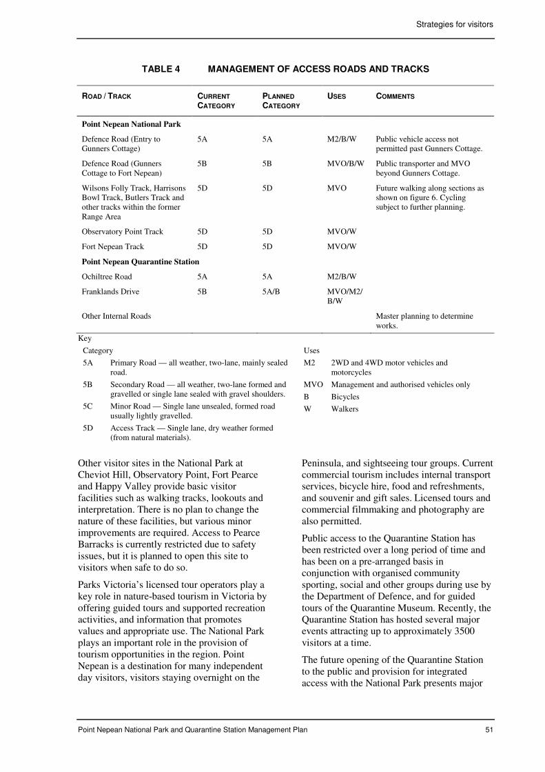
Strategies for visitors
Point Nepean National Park and Quarantine Station Management Plan 51
TABLE 4 MANAGEMENT OF ACCESS ROADS AND TRACKS
ROAD / TRACK CURRENT
CATEGORY PLANNED
CATEGORY USES COMMENTS
Point Nepean National Park
Defence Road (Entry to Gunners Cottage)
5A 5A M2/B/W Public vehicle access not permitted past Gunners Cottage.
Defence Road (Gunners Cottage to Fort Nepean)
5B 5B MVO/B/W Public transporter and MVO beyond Gunners Cottage.
Wilsons Folly Track, Harrisons Bowl Track, Butlers Track and other tracks within the former Range Area
5D 5D MVO Future walking along sections as shown on figure 6. Cycling subject to further planning.
Observatory Point Track 5D 5D MVO/W
Fort Nepean Track 5D 5D MVO/W
Point Nepean Quarantine Station
Ochiltree Road 5A 5A M2/B/W
Franklands Drive 5B 5A/B MVO/M2/B/W
Other Internal Roads Master planning to determine works.
Key
Category
5A Primary Road — all weather, two-lane, mainly sealed road.
5B Secondary Road — all weather, two-lane formed and gravelled or single lane sealed with gravel shoulders.
5C Minor Road — Single lane unsealed, formed road usually lightly gravelled.
5D Access Track — Single lane, dry weather formed (from natural materials).
Uses
M2 2WD and 4WD motor vehicles and motorcycles
MVO Management and authorised vehicles only
B Bicycles
W Walkers
Other visitor sites in the National Park at Cheviot Hill, Observatory Point, Fort Pearce and Happy Valley provide basic visitor facilities such as walking tracks, lookouts and interpretation. There is no plan to change the nature of these facilities, but various minor improvements are required. Access to Pearce Barracks is currently restricted due to safety issues, but it is planned to open this site to visitors when safe to do so.
Parks Victoria’s licensed tour operators play a key role in nature-based tourism in Victoria by offering guided tours and supported recreation activities, and information that promotes values and appropriate use. The National Park plays an important role in the provision of tourism opportunities in the region. Point Nepean is a destination for many independent day visitors, visitors staying overnight on the
Peninsula, and sightseeing tour groups. Current commercial tourism includes internal transport services, bicycle hire, food and refreshments, and souvenir and gift sales. Licensed tours and commercial filmmaking and photography are also permitted.
Public access to the Quarantine Station has been restricted over a long period of time and has been on a pre-arranged basis in conjunction with organised community sporting, social and other groups during use by the Department of Defence, and for guided tours of the Quarantine Museum. Recently, the Quarantine Station has hosted several major events attracting up to approximately 3500 visitors at a time.
The future opening of the Quarantine Station to the public and provision for integrated access with the National Park presents major
Strategies for visitors
52 Point Nepean National Park and Point Nepean Quarantine Station Management Plan
and exciting challenges for additional visitor opportunities and experiences in keeping with Point Nepean’s special qualities and remote and largely undeveloped nature. Integrating recreation, tourism, education, and community use within the Quarantine Station and establishing recreational links with surrounding areas are priorities for future use.
The contribution that Point Nepean can make to state and regional tourism is anticipated to grow significantly. The Quarantine Station provides for a focus on tourism uses that utilise the existing historic buildings and features and facilitate the experience and understanding of Point Nepean’s natural and heritage values and the coastal and marine environment. Point Nepean has the potential to become a national heritage icon and tourism destination providing for a broad nature-based ecotourism experience encompassing both the terrestrial and marine environments (section 7.2). There is an opportunity to integrate Boonwurrung culture and history into future tourism use.
The opportunity to bring Point Nepean’s heritage to life, including the creative re-use of the Quarantine Station buildings and open spaces, must take account of inherent ecological and heritage constraints. The provision of quality visitor experiences is very much dependent on protecting the natural and cultural values and providing sustainable infrastructure.
The development of commercial tourism operations within the existing National Park is guided by the National Parks Act and the Policy for Sustainable Recreation and Tourism on Public Land (NRE 2002). As the Quarantine Station is developed as a major tourism destination, commensurate with its carrying capacity, it will be important to build partnerships with the tourism industry for cross promotion and marketing.
A Setting Plan (figure 7) has been prepared to guide the range of potential future uses, consistent with the management aims for the Point Nepean Quarantine Station (table 2). The Setting Plan is informed by the conservation policy directions established in the Quarantine Station CMP.
Key proposals for visitor and community use in the Quarantine Station include:
• a new visitor centre
• a defined entry precinct to enhance the sense of arrival and maintain the sense of isolation, with car parking, orientation and a transport service terminal
• a Heritage Centre encompassing the existing Quarantine Museum and associated buildings (chapter 8)
• conference, education, research and training facilities
• accommodation facilities and related services for a range of users, including tourists, backpackers, students, visiting researchers, those seeking respite and people attending on-site activities
• dining facilities and services (cafe, restaurant and other food outlets)
• recreation and leisure facilities, including picnic facilities and amenities and potential facilities for camping in designated places
• a range of tours with facilities for tour operator services
• facilities for Friends groups, other volunteers and community uses (chapter 9)
• places to accommodate community events, performances and displays and certain sporting events within the Quarantine Station and specially designated areas (section 7.7).
A staged approach to opening the Quarantine Station is necessary due to the current nature and condition of many buildings, roads and paths and the condition of existing infrastructure. It is important to utilise best practice in the provision of services such as water, energy and waste systems to meet ecologically sustainable principles, particularly having regard to the proposed provision of a range of overnight accommodation and other supporting uses (section 7.4).
A Master Plan for the Quarantine Station and surrounds, based on the Setting Plan (figure 7), is required to:
• show how the Management Plan will be implemented
• consider the carrying capacity of the site given various opportunities and constraints
• guide the future use and development of different buildings and areas
Strategies for visitors
Point Nepean National Park and Point Nepean Quarantine Station Management Plan 53
• consider the need for new buildings and structures and the removal of buildings
• ensure that the site is made ready for community use, including remediation of site contamination to a level appropriate for the future use of the place
• guide pedestrian, bicycle and vehicle movement to and within the Quarantine Station and surrounding areas
• ensure that the location, design and layout of physical infrastructure, facilities and services meets the needs of future users and is fully sympathetic with the site’s heritage values, consistent with conservation policies in the Quarantine Station CMP.
As part of the master planning process (figure 7), the following key projects will be undertaken:
• a comprehensive assessment of site contamination and preparation of a risk management strategy and remediation works program
• a comprehensive landscape analysis (section 6.3)
• comprehensive planning for appreciation of the place’s rich heritage values and related interpretation and education facilities and services (chapter 8)
• economic analysis, feasibility studies and financial modelling to inform consideration of the future use of the Quarantine Station in ways which are economically, socially and environmentally sustainable
• identification of potential users and service and facilities providers through a tendering and expressions of interest (EOI) process.
Planning for interpretation and education is important to maintain a focus on heritage appreciation. How tourism operators may contribute to the provision of innovative and inspiring interpretation and education services will be explored as part of further planning for these services (chapter 8).
A tendering and EOI process (section 7.8) is essential to confirm the nature, suitability and viability of uses of many of the buildings and site services and identify specific requirements
proponents may have for buildings and the site to ensure viable and sustainable use. It is important to determine what proponents may contribute to achieving aims for visitor and community use and conservation objectives.
In recognition of the need for significant investment and infrastructure improvements for the sustainable development and use of the Quarantine Station, business planning will include economic modelling. An examination of infrastructure cost options, revenue scenarios and pricing strategies for future use will be undertaken. Investigating the market potential for proposed tourism uses and engaging key government agencies and other stakeholders, including the Boonwurrung people, will be required. Financial feasibility is critical to realising aspirations for the place to become a major attraction offering quality visitor experiences and world-class facilities.
The Victorian Coastal Strategy encourages the re-use of historic buildings and sites along the coast to provide for their conservation where possible (VCC 2002). The Quarantine Station CMP identifies opportunities to adapt individual buildings and areas for use and provides siting and design guidelines that will inform the tendering and EOI process.
Provision for any new buildings to provide for the key proposals for visitor and community use should be based on the principle of no net loss of open space, taking into account the overall developed footprint of the Quarantine Station and the guidelines provided in the Conservation Management Plan. It is important that any proposal for a new building demonstrates why the proposed use cannot be accommodated in an existing building and how the proposal conforms with the Conservation Management Plan policies.
A key component of master planning is to determine an appropriate carrying capacity for the Quarantine Station. This task will be informed by defining car and bus parking capacities, having regard to alternative forms of access to the site including cycling, walking, transporter-type shuttle services and potential boat and passenger ferry access and the application of a variety of innovative management practices.
Due to the large open space area and the nature of the existing development, the carrying
Strategies for visitors
54 Point Nepean National Park and Point Nepean Quarantine Station Management Plan
capacity for the Quarantine Station is expected to be relatively higher than the current carrying capacity for the National Park, which is 600 visitors at any one time.
The current carrying capacity for the National Park was determined in 1989 and was based on constraints including:
• the relatively small size of the National Park
• the very sensitive and erosion-prone nature of much of the land
• the presence of unexploded ordnance
• natural hazards, particularly strong coastal currents and rips
• aims to ensure visitor enjoyment and maintain the sense of isolation.
To date, the carrying capacity within the National Park has not been exceeded. Limits on opening hours, car park capacities and available transport services have been the most important influences in keeping visitation within the capacity, particularly during peak holiday periods when there is a high demand for visits.
Following the staged development of the Quarantine Station and recreational links with the National Park, visitor monitoring will be important to ensure that quality visitor experiences are maintained, infrastructure meets visitor service requirements and heritage values are protected. The current carrying capacity in the existing accessible National Park area will be retained initially and will be reviewed on the basis on future visitor use patterns and other information gathered from regular visitor monitoring.
Strategies to manage the carrying capacity during peak visitor periods may include extending opening hours to spread visitation over more hours of the day, pricing policies, restricting parking and improving transport services to provide for a higher turn around. Capacities will be managed by a range of methods to help disperse visitors through the planning area. This will include increased walking and cycling opportunities and investigation of water-based access, particularly for passenger ferries (section 7.4).
Establishing a passenger ferry service, boat access and boat tours would provide
opportunities to disperse visitors across a larger area. Promoting visitation during non-peak periods will also be important. Provision for transport services linking the entry to Point Nepean with the various attractions in the place may be required during peak visitor periods to reduce demand for internal car parks.
Aims
• Establish and maintain visitor facilities that provide for quality visitor experiences, enhance enjoyment and appreciation and are consistent with the protection of heritage values.
• Establish opportunities for Indigenous business and partnerships.
• Through a focus on adaptive re-use, plan and provide for a range of tourism, recreation, education and community uses within the Quarantine Station.
• Establish recreational and tourism links between the Quarantine Station, the National Park and adjacent areas.
• Provide opportunities for and encourage the provision of external tourism services while minimising impacts on natural and cultural heritage values.
• Monitor visitor use to ensure quality experiences and protection of heritage values.
• Seek partnerships with the tourism industry in the promotion and marketing of Point Nepean as a major tourism destination and in the delivery of management programs.
Management strategies
• Provide and maintain visitor facilities in
accordance with table 5 and figure 6.
• Plan and implement improvements to
facilities at existing visitor sites in the
National Park. Provide public access to
Pearce Barracks when safety issues have
been addressed.
• Actively encourage and work in
partnership with the Boonwurrung people
to contribute to visitor services and add to
the total tourism experience of Point
Nepean (chapter 8).
Strategies for visitors
Point Nepean National Park and Point Nepean Quarantine Station Management Plan 55
• Undertake comprehensive interpretation
and education planning, including
provision for a new visitor centre and an
integrated interpretation centre in the
Quarantine Station, and review the on-
going role of the existing visitor centre
(chapter 8).
• Undertake business planning for the
ecological sustainable development and
use of the Quarantine Station in
consultation with key government and
community stakeholders and relevant
market sectors.
• Develop and implement a tendering and
EOI process to actively seek partnerships
for the provision of tourism, recreation
and education facilities and services,
making use of existing buildings (section
7.8).
• Develop and implement a master plan for
the Quarantine Station and surrounds that
provides for the staged provision of
facilities for visitor and other uses and the
establishment of recreational links with
adjacent areas.
• Ensure that the master plan and any new
buildings comply with the Quarantine
Station CMP.
• Encourage licensed tour operators to
develop and deliver guided tours that
enhance the experience of visitors (chapter
8). Include provision for special tours into
restricted access areas (section 7.5).
• Host familiarisation visits for licensed tour
operators to explore their interest in
including Point Nepean in their itineraries.
• Work in partnership with the tourism
industry and tour operators to assist in the
delivery of information on Point Nepean
and in promotion and marketing activities
to enhance the profile of Point Nepean as
it is developed as a major tourism
destination, and to encourage repeat visits,
particularly in off-peak periods.
• Ensure that all licensed tour operators
have appropriate training and
accreditation and promote awareness of
Adventure Activity Standards and Minimal
Impact Guidelines.
• Ensure that information provided by
licensed tour operators that relates to
Indigenous heritage is developed and
approved by the Boonwurrung people.
• Monitor the effectiveness of tourism
services in contributing to the aims for
visitor use and conservation outcomes, and
apply continuous improvement principles
as appropriate.
• Establish a visitor-monitoring program to
monitor use patterns, numbers, and
duration of visits, modes of access,
satisfaction levels, experiences sought and
visitor impacts.
• Review the carrying capacity for the
National Park and Quarantine Station
based on the outcomes of visitor
monitoring, and develop appropriate
actions to ensure that quality experiences
are maintained and heritage values are
protected.
• Consider opportunities for shuttle
transport links and other innovative
transport services between the entry to
Point Nepean and the Quarantine Station,
linking with key attractions throughout
Point Nepean and surrounding areas.
7.4 Accommodation and camping
Accommodation has been significant in the historical development and use of the Quarantine Station as seen during the quarantine phase, the period of use by the Department of Defence and more recently to house refugees from Kosovo.
A number of buildings, originally constructed to accommodate passengers and for the administration of the quarantine function, were subsequently adapted for use by the military. New buildings were constructed to house returned servicemen during the influenza pandemic after WW1, and new accommodation buildings were constructed in the 1960s for officer cadets.
A range of other buildings were constructed at various times to provide support services to the accommodation users, including kitchens, dining and function facilities, laundries, amenity blocks and a gymnasium.
The future provision of accommodation has been identified as a major opportunity for the
Strategies for visitors
56 Point Nepean National Park and Point Nepean Quarantine Station Management Plan
re-use of a number of the buildings, as shown in the Setting Plan (figure 7). Provision for a range of accommodation options is considered a key component of realising aspirations for the place to become a major tourism asset, providing for conservation of the buildings by re-use, enhancing the visitor experience and contributing to financial viability and sustainability outcomes.
The range of accommodation that may be provided includes:
• family and group accommodation
• conference-standard or quality tourism accommodation
• school group and student accommodation
• back-packer style accommodation
• accommodation for researchers, volunteers and others involved in research and management programs
• accommodation for respite care.
On-site accommodation is an important aspect of the ‘stay, learn, enjoy and relax’ experience that Point Nepean can offer and which underpins the Healthy Parks Healthy People program. The tourism links that may be established between Point Nepean and surrounding natural and cultural attractions are a key strength to encourage stays.
Accommodation for respite use, which may include respite for carers or respite for those with disabilities or disadvantage, is an initiative that needs special consideration. The principle of providing access for people with limited mobility to facilities and services is an important consideration that needs to be addressed through the Quarantine Station master planning process. Respite for carers can be readily integrated with the range of accommodation that will be explored with the tourism sector and service providers. The level of respite and special support facilities that may be provided needs further consideration through engagement with those with respite expertise.
The market potential and the suitability of the existing buildings and infrastructure to realise accommodation opportunities needs to be explored with service providers in the next phase of planning, particularly preparation for the tendering and EOI process.
An audit of the Quarantine Station will be undertaken to identify risks and remedial measures to facilitate the safe use of buildings and grounds (chapter 10). The audit will inform potential accommodation providers when they are evaluating and determining viable proposals.
The potential for camping at Point Nepean has been identified by a Reference Group working with DSE on an investigation of opportunities for increased camping along the Victorian Coast. Camping at Point Nepean may complement the suite of potential accommodation use of the existing built infrastructure and the diversity of experiences that Point Nepean may provide. Opportunities and constraints for on-site camping will be examined during the master planning process.
Aims
• Plan and provide for a range of accommodation to attract a broad market.
• Ensure that accommodation use is consistent with conservation policies.
Management strategies
• As a priority action, engage
accommodation service providers, respite
providers and other relevant stakeholders
to confirm the range of accommodation
and support infrastructure, which may be
established utilising existing or new
buildings, or both.
• Incorporate the provision for viable
accommodation opportunities in master
planning and a tendering and EOI process
(section 7.3).
• Fully explore the potential for camping
during the master planning processes and
tendering and EOI process in consultation
with DSE.
• Establish accommodation use, and
provision for camping as appropriate,
through the staged implementation of the
Master Plan.
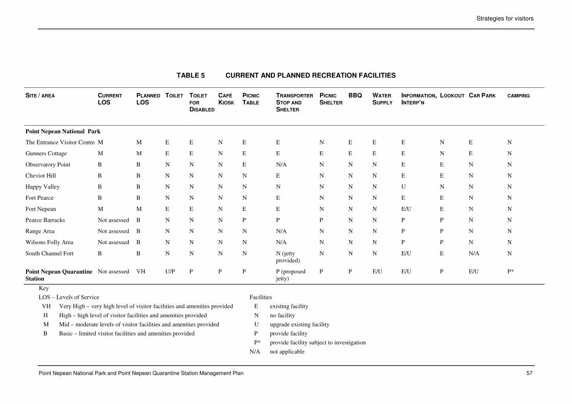
Strategies for visitors
Point Nepean National Park and Point Nepean Quarantine Station Management Plan 57
TABLE 5 CURRENT AND PLANNED RECREATION FACILITIES
SITE / AREA CURRENT
LOS PLANNED
LOS
TOILET TOILET
FOR
DISABLED
CAFÉ
KIOSK PICNIC
TABLE TRANSPORTER
STOP AND
SHELTER
PICNIC
SHELTER BBQ WATER
SUPPLY INFORMATION, INTERP’N
LOOKOUT CAR PARK CAMPING
Point Nepean National Park
The Entrance Visitor Centre M M E E N E E N E E E N E N
Gunners Cottage M M E E N E E E E E E N E N
Observatory Point B B N N N E N/A N N N E E N N
Cheviot Hill B B N N N N E N N N E E N N
Happy Valley B B N N N N N N N N U N N N
Fort Pearce B B N N N N E N N N E E N N
Fort Nepean M M E E N E E N N N E/U E N N
Pearce Barracks Not assessed B N N N P P P N N P P N N
Range Area Not assessed B N N N N N/A N N N P P N N
Wilsons Folly Area Not assessed B N N N N N/A N N N P P N N
South Channel Fort B B N N N N N (jetty provided)
N N N E/U E N/A N
Point Nepean Quarantine
Station
Not assessed VH U/P P P P P (proposed jetty)
P P E/U E/U P E/U P*
Key
LOS – Levels of Service
VH Very High – very high level of visitor facilities and amenities provided
H High – high level of visitor facilities and amenities provided
M Mid – moderate levels of visitor facilities and amenities provided
B Basic – limited visitor facilities and amenities provided
Facilities
E existing facility
N no facility
U upgrade existing facility
P provide facility
P* provide facility subject to investigation
N/A not applicable
Strategies for visitors
58 Point Nepean National Park and Point Nepean Quarantine Station Management Plan
7.5 Walking and cycling
The existing National Park provides for a range of walking opportunities (figure 6). Dog walking is prohibited within the planning area and is also currently prohibited in the Police Point Shire Park. Cycling is provided for along Defence Road between the entry to Point Nepean and Fort Pearce.
The most popular walk is from Gunners Cottage to Fort Nepean, linking with the main attractions and heritage sites and providing outstanding views. Visitors currently have the option of walking in one direction and taking the transporter in the other.
Popular short walks include the Walter Pisterman Heritage Walk from the Cemetery to Observatory Point, the walk along the beach between Observatory Point and The Bend and the Happy Valley – Cheviot Hill walks. Many of these walks provide outstanding views of the coastal settings.
The Coles Track, which links the National Park with the Quarantine Station, is very suitable as a key route for encouraging future walking from the Quarantine Station into the National Park. This walk is expected to become the new main route through to Cheviot Hill and beyond and provide for a range of short circuit walks from the Quarantine Station including walks along the beach. Increased walking along the beach will require measures to minimise impacts on Hooded Plover breeding (section 4.4) and protect sensitive fore-dune vegetation (section 4.3).
The current width and alignment of Coles Track makes it suitable to upgrade for both walking and cycling. This shared use provides an opportunity to significantly reduce walking and cycling along sections of Defence Road, and enhance visitor experiences.
A shared walking and cycling trail may also be established between Gunners Cottage and the Quarantine Station parallel to Defence Road to provide more choices and further reduce conflicts and risks associated with vehicles on Defence Road. The route for this trail would take advantage of another existing track, and minor works at each end would facilitate a complete off-road experience.
A walking link between the Quarantine Station and the Police Point Shire Park has also been
identified as an important opportunity for visitors to explore the whole of the original Quarantine Station Precinct as recommended in the Quarantine Station CMP. A link through Police Point would provide excellent viewing opportunities for visitors, including those walking into Point Nepean from the entry.
A potential walking track between Point Nepean and London Bridge in the Mornington Peninsula National Park was identified in the management planning process in 1998, subject to feasibility. This potential track would establish the final link in the long-distance walking track network on the southern Mornington Peninsula, which includes the Two Bays Walking Track and the coastal walk from Cape Schanck to London Bridge. It would also increase the range of opportunities and experiences for visitors to Point Nepean, particularly those staying at the Quarantine Station.
Current planning has identified the potential for a link track with London Bridge, primarily on existing management tracks in the Wilsons Folly area and on an existing cleared break linking the Wilsons Folly Track to the Quarantine Station as shown on figure 6. A short section of approximately 200 metres would need to be constructed at the London Bridge end. The link would provide additional coastal viewing opportunities and allow visitors to view and gain an appreciation of the management program in place to restore the significant Grassy Woodland Community at Wilsons Folly. The establishment of the link would require a review of fencing to ensure that access is still controlled in unexploded ordnance areas.
Current planning has confirmed the need to maintain controlled access along the Bass Strait coast between London Bridge and Fort Nepean for visitor safety and to protect significant values (chapters 4 and 5). Parts of this coast have dangerous cliffs, sections are impassable except at very low tides, and other sections have highly significant scientific and archaeological values that would be threatened by visitor use. The proposed link track to London Bridge is important for access to the Bass Strait coast and the opportunities available to explore accessible rock platforms and undertake extended coastal walking or water-based activities.
Strategies for visitors
Point Nepean National Park and Point Nepean Quarantine Station Management Plan 59
Future walking and potential cycling access into the former Range Area will be planned following remediation of risks associated with unexploded ordnance and when measures are put in place to ensure that sensitive sites are protected (figure 6). The future opening of the Range Area will provide new opportunities for viewing Bass Strait and the coastal hinterland. For example, there is potential to provide access to the Monash Light location and establish a lookout providing panoramic views over both Bass Strait and Port Phillip Bay.
In order to minimise impacts on the sensitive and fragile coastal environment and cultural values in the former Range Area, all future access will make use of the existing track network. Pending the opening of this area, provision for guided natural and cultural history tours by accredited tour operators will be explored to enable visitors to access these restricted areas in a safe and controlled manner (section 7.3 and chapter 8).
Aims
• Provide a sustainable network of fit-for-purpose walking and cycling trails, to enhance visitor experiences and enjoyment of Point Nepean while minimising impacts upon heritage values and appropriately managing community risks.
• As far as practicable, separate walking and cycling from vehicles and the transport service.
• Actively promote appropriate walking and cycling opportunities at Point Nepean.
Management strategies
• Provide for walking and cycling on
designated trails as shown in figure 6 and
listed in table 6.
• Continue to prohibit dogs within the
planning area.
• Give priority to the establishment of link
trails between the Quarantine Station and
existing visitor sites in the National Park.
• Liaise with the Mornington Peninsula
Shire to establish a walking link track
between the entry to Point Nepean and the
Quarantine Station through Police Point
Shire Park.
• Undertake further investigation of a link
track with London Bridge, and develop the
link subject to maintaining provisions for
public safety and protection of values.
• Provide for the longer-term staged
development of walking and potential
cycling access into parts of the former
Range Area. In the interim, encourage
potential guided tours (section 7.3).
• Explore the potential to establish a lookout
at Monash Light to provide for enhanced
viewing opportunities.
• Maintain the trail network to appropriate
standards and undertake works in
accordance with table 6.
• Provide information to visitors on the
location and description of trails and
provide clear signage to encourage all
users to stay on designated tracks to
reduce off-trail impacts and protect users
from potential risks.
• Establish self-guided heritage trails in
accordance with the outcomes of
comprehensive information, interpretation
and education planning (chapter 8).
• Promote walking and cycling in the
spectacular coastal landscapes through
websites, pre-visit information services
and marketing programs to encourage
repeat visits.
• Monitor visitor use of the track and trail
network and take measures as appropriate
to ensure that heritage values are
protected and visitor safety is not
compromised.
7.6 Water-based recreation
Currently, access to the shoreline at Point Nepean is restricted to the section of beach between Observatory Point and The Bend due to safety issues and the need to protect values.
The opening of the Quarantine Station will allow for increased walking along the beach. Currently the area is fenced. Future access requires an assessment and management of risks.
The future opening of the Quarantine Station provides an opportunity for shore-based fishing from the adjacent beach east of the boundary of the Port Phillips Heads Marine
Strategies for visitors
60 Point Nepean National Park and Point Nepean Quarantine Station Management Plan
National Park. Fishing is also permitted on and around South Channel Fort. Fishing is not permitted within the Marine National Park or from the shore along the Bass Strait coast due to access restrictions (sections 4.4 and 7.5).
Swimming is not recommended within the adjacent waters of the planning area due to hazardous shorelines and particularly strong currents and rips. Swimming, diving and snorkelling are prohibited in the intertidal area and adjacent waters of the Port Phillip Heads Marine National Park (Parks Victoria 2006b).
There has been provision for supervised swimming in association with events at the Quarantine Station, conditional on the presence of surf life saving services.
Aims
• Ensure that visitors are informed about the hazardous nature of the waters surrounding Point Nepean.
• Provide for water-based recreation along the Quarantine Station shoreline.
Management strategies
• Incorporate information on beach and
water safety on websites, in pre-visit
information and in on-site information
services.
• Following the opening of the Quarantine
Station to visitors, provide for shore-based
fishing from the beach east of the
boundary with the Port Philip Heads
Marine National Park.
• Maintain safety signage on water hazards
in currently accessible shoreline areas.
• Establish safety signage and other safety
features in the Quarantine Station in
conjunction with its opening for public use
(section 7.9).
• Investigate the potential for seasonal surf
life saving services within the Quarantine
Station area.
7.7 Events and special activities
The National Park and the Quarantine Station provide for a range of events and special
activities. Open spaces, particularly Jarman Oval and the Parade Ground, are ideal for hosting a range of outdoor events and activities. These include the annual Portsea Twilight Run, the annual polo match on Jarman Oval, croquet matches hosted by the Sorrento Croquet Club on the Parade Ground, musical events and group picnics. Horses are permitted in the Quarantine Station for the polo events, and past horse use has a historical association with the early quarantine period and subsequent Army use.
Historically the Quarantine Station has hosted a range of sporting and social activities to encourage local community interaction with defence personnel. Facilities included ovals, tennis courts, basketball courts and a gymnasium. Tennis and basketball facilities are no longer functional and their future will be subject to further planning in conjunction with the provision of a range of recreation, tourism and education facilities at the Quarantine Station.
Holding events, functions and special activities, with a focus on the Quarantine Station, provides opportunities to enhance community use of Point Nepean, foster awareness and appreciation of its special values, build and maintain a sense of identity with the place, and contribute to revenue and the place’s sustainability. These uses are integral to achieving conservation-through-use of the buildings and open spaces.
Opportunities to actively involve the Boonwurrung people in special events, including cultural events and ceremonies, would enhance visitor experiences and foster understanding and appreciation of Indigenous culture.
A number of existing buildings, including Badcoe Hall, are expected to provide opportunities for a range of indoor events and functions.
Events may cause environmental damage and over-use of the area’s resources and may affect the experiences of other users and adjacent areas if reasonable boundaries are not set and activities are not well managed.
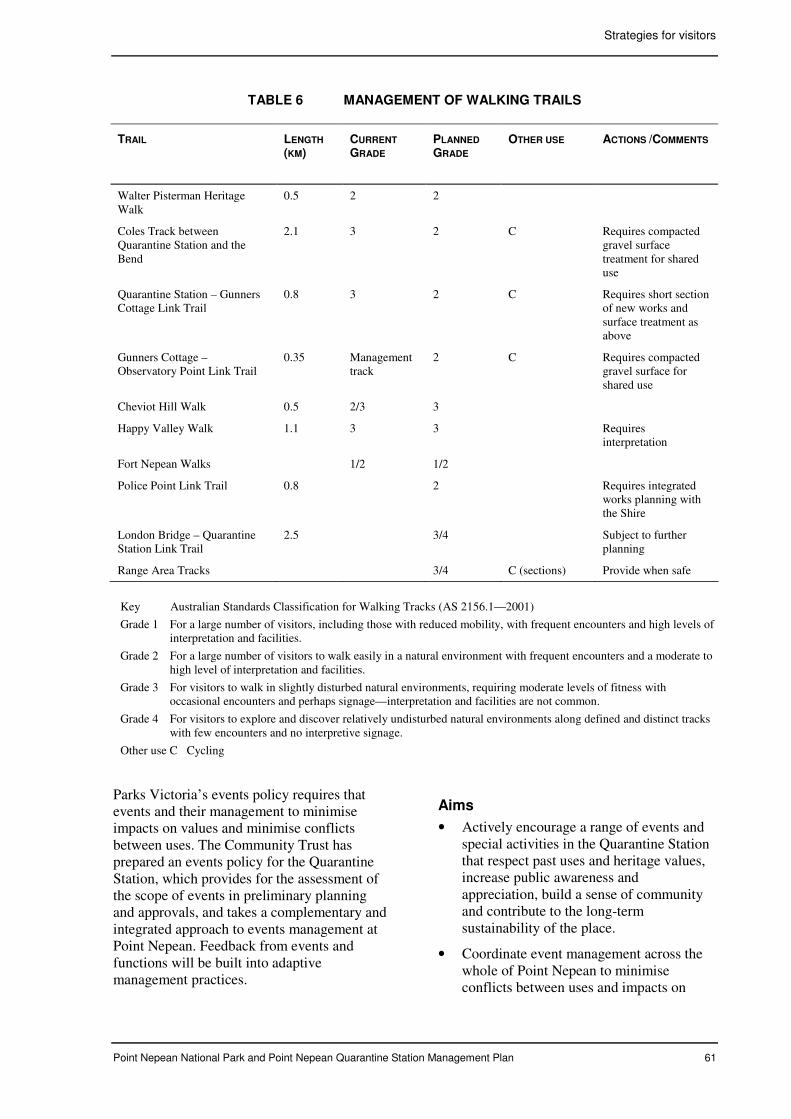
Strategies for visitors
Point Nepean National Park and Point Nepean Quarantine Station Management Plan 61
TABLE 6 MANAGEMENT OF WALKING TRAILS
TRAIL
LENGTH
(KM) CURRENT
GRADE PLANNED
GRADE OTHER USE ACTIONS /COMMENTS
Walter Pisterman Heritage Walk
0.5 2 2
Coles Track between Quarantine Station and the Bend
2.1 3 2 C Requires compacted gravel surface treatment for shared use
Quarantine Station – Gunners Cottage Link Trail
0.8 3 2 C Requires short section of new works and surface treatment as above
Gunners Cottage – Observatory Point Link Trail
0.35 Management track
2 C Requires compacted gravel surface for shared use
Cheviot Hill Walk 0.5 2/3 3
Happy Valley Walk 1.1 3 3 Requires interpretation
Fort Nepean Walks 1/2 1/2
Police Point Link Trail 0.8 2 Requires integrated works planning with the Shire
London Bridge – Quarantine Station Link Trail
2.5 3/4 Subject to further planning
Range Area Tracks 3/4 C (sections) Provide when safe
Key Australian Standards Classification for Walking Tracks (AS 2156.1—2001)
Grade 1 For a large number of visitors, including those with reduced mobility, with frequent encounters and high levels of interpretation and facilities.
Grade 2 For a large number of visitors to walk easily in a natural environment with frequent encounters and a moderate to high level of interpretation and facilities.
Grade 3 For visitors to walk in slightly disturbed natural environments, requiring moderate levels of fitness with occasional encounters and perhaps signage—interpretation and facilities are not common.
Grade 4 For visitors to explore and discover relatively undisturbed natural environments along defined and distinct tracks with few encounters and no interpretive signage.
Other use C Cycling
Parks Victoria’s events policy requires that events and their management to minimise impacts on values and minimise conflicts between uses. The Community Trust has prepared an events policy for the Quarantine Station, which provides for the assessment of the scope of events in preliminary planning and approvals, and takes a complementary and integrated approach to events management at Point Nepean. Feedback from events and functions will be built into adaptive management practices.
Aims
• Actively encourage a range of events and special activities in the Quarantine Station that respect past uses and heritage values, increase public awareness and appreciation, build a sense of community and contribute to the long-term sustainability of the place.
• Coordinate event management across the whole of Point Nepean to minimise conflicts between uses and impacts on
Strategies for visitors
62 Point Nepean National Park and Point Nepean Quarantine Station Management Plan
heritage values and appropriately maximise site carrying capacity.
Management strategies
• Develop a coordinated program for
appropriate events and special activities in
the Quarantine Station and the National
Park covering a wide range of events,
performances, festivals, markets, and
recreational and education activities.
• Permit events and functions in accordance
with polices that:
� make a positive contribution to and
excite public interest in the place
� have acceptable environmental and
cultural impacts
� do not damage natural and cultural
heritage values
� do not unduly disturb or disadvantage
other visitors and users
� properly manage liability risk
exposure
� can be appropriately managed with
available resources
� contribute revenue to the long-term
sustainability of the place where
appropriate.
• Favour events and functions that provide
community benefits or complement or
celebrate Point Nepean’s special values.
• Provide opportunities for the
Boonwurrung people to host or participate
in events and encourage their involvement
in the planning of relevant events.
• Work with the tourism industry and other
key regional stakeholders to build
opportunities for events, to coordinate
activities and to minimise any negative
impacts of events at Point Nepean.
• Ensure that events are monitored to
minimise impacts on heritage values and
the experience of other users and to
provide information for the periodic
review of the events program.
7.8 Leases, licences and occasional uses
A number of lease and licence agreements authorising certain uses apply to the planning area. Occasional uses may include, but are not limited to, research and commercial filming and photography.
All research and monitoring in the National Park by external organisations or individuals requires a research permit under the National Parks Act issued by DSE.
Research opportunities are anticipated to grow substantially in future years and will be actively encouraged and supported where the research contributes to enhanced knowledge, especially where it builds upon the heritage values of the place, and enhances place management programs (chapter 8).
The commercial filming and photography industry plays a significant role in the social and economic wellbeing of the community. A permit system applies in the National Park to manage these uses and ensure minimal impacts on values and visitor experiences. Amateur photography and filming for personal or hobby interest does not require a permit. The Community Trust is formulating operational policies for a range of occasional uses, consistent with the Trust Deed.
The Nepean Historical Society, through its Friends of the Quarantine Station subgroup, operates the Quarantine Museum and provides guided tours under a licence agreement.
The future of Point Nepean Quarantine Station is very much dependent upon establishing viable and appropriate commercial and community uses authorised under leases, licences or other tenancy or access agreements.
The Trust Deed (section 2.6) provides for both short and longer-term subleases, licences and occupancy or access rights. These must be consistent with the Trust Deed which, among other things, points to consistency with the Draft Community Master Plan (Parsons Brinckerhoff 2002). Any property tenure exceeding three months is subject to approval by the responsible Commonwealth Minister. Among others, the State of Victoria, relevant Commonwealth and State agencies and the local community are to be consulted with respect to tenancy or access agreements longer
Strategies for visitors
Point Nepean National Park and Point Nepean Quarantine Station Management Plan 63
than three months. The Consent and Approvals protocol for the use and development of the Quarantine Station provides for formal agency consideration and public comment (sections 6.2 and 6.4).
As outlined in section 7.3, a master planning process, including economic modelling and business planning, and a tendering and EOI process will identify and determine the future uses and sustainable development of the Quarantine Station.
Master planning will identify opportunities and constraints affecting the Quarantine Station and surrounds (section 7.3).
Economic modelling will build on asset management information and take concepts for adaptive re-use of the 90 ha Quarantine Station and test alternatives for the most sustainable outcome (section 7.3). The tendering and EOI process needs to engage and involve relevant government bodies, the tourism industry, the local community and other key stakeholders to determine the scope, nature and scale of future use opportunities. These opportunities must be consistent with relevant legislation and policies and provisions of the Trust Deed, and give due regard to current and future land tenures and the official heritage values of the place. The Quarantine Station CMP policies set out certain assessment criteria for proposals in relation to lessees or tenants. Further planning and consultation will need to consider the extent of site preparations, seasonality of business and consequent viability, opportunities for niche tourism development and packaging, the extent to which returns go to site upkeep, the extent of subsidy that may be required, and consideration of lease terms.
The primary objectives of the tendering and EOI process are to:
• identify suitable users and service and facility providers (proponents)
• identify what proponents can offer in terms of achieving the vision and major directions set out in this plan and the protection of heritage values through investment and value adding and other means
• identify best possible uses for buildings
• identify specific site requirements (e.g. access, parking and infrastructure) to establish viable and sustainable uses
• allow the evaluation of proposals against environmental, social and economic criteria.
The Point Nepean Advisory Committee has formulated a set of appropriate use principles for the Quarantine Station (appendix 10). Future uses will be assessed against the use principles and a range of lease, licence and other tenure arrangements that are acceptable to both Commonwealth and State Governments.
Following the EOI process, preferred proponents will be invited to submit detailed tenders for subsequent assessment, negotiation and decisions on agreed uses, site and building development and tenure arrangements. A transparent and open process of preparing EOI documentation, including specification of use and development parameters, will be critical to the success of the process and achievement of positive long-term outcomes.
The EOI process will require proponents to demonstrate:
• compliance with the Point Nepean National Park and Point Nepean Quarantine Station Management Plan
• consistency with policies of the Quarantine Station CMP
• how proposals respond to the appropriate use principles.
• how proposals respond to the provisions of the Trust Deed
• how proposals respond to development parameters, which will be prepared to ensure the protection of the many significant attributes and values of the Quarantine Station and surrounds.
Aims
• Provide for occasional uses and services consistent with protection of values and visitor experiences.
• Protect and enhance visitor experiences and heritage values.
• Plan and develop the process to establish viable and appropriate commercial and
Strategies for visitors
64 Point Nepean National Park and Point Nepean Quarantine Station Management Plan
non-commercial uses and services in the planning area.
Management strategies
• Manage occasional uses, including
research activities and proposals, in
accordance with relevant legislation and
operational policies.
• In consultation with relevant stakeholders,
examine the market potential and range,
nature and scope of commercial visitor
and user support services for integration
with recreation, education and community
uses.
• As part of the master planning for the
Quarantine Station and surrounds,
formulate a tendering and EOI process in
consultation with key stakeholders and in
accordance with the State and
Commonwealth Government requirements
to determine future uses of the site and
identify service providers.
• Integrate the outcomes of the tendering
and EOI process into the final master plan
for the Quarantine Station and surrounds
(section 7.3).
7.9 Public safety
Potential hazards and risks to visitors at Point Nepean include steep coastal cliffs, slippery rocks, strong sea currents, exposure to climatic elements, deep and fast water and wildfire during periods of high fire danger.
The calcarenite cliffs along most of the Bass Strait coastline and sections of the Port Phillip Bay coast are inherently unstable and subject to periodic collapse through natural processes. Unexploded ordnance poses hazards in the former Range Area and in some other areas of the existing National Park.
For safety and park protection purposes, the current regulations for the National Park area require all visitors to keep within the existing roads and track network and visitor use sites and only allow for access on the beach area between Observatory Point and The Bend. Continued restricted access will need to apply to many areas and some will only be opened to public access when they are determined to be safe for visitor use (section 7.5). Continued
restricted access for water-based recreation will also apply (section 7.6).
The Quarantine Station poses a range of safety issues associated with the condition of assets, including buildings, roads and paths, areas of contamination, and defence training infrastructure. The condition of assets and remedial measures are outlined in chapter 10. It will be important to undertake a range of risk mitigation measures to facilitate the staged opening of the area to the public.
Visitors need to be aware of hazards to ensure that they enjoy a safe visit. Public information and education programs are one of the most effective ways to promote safety (chapter 8). Safety messages are presented to visitors through pre-visit information, signs, brochures (e.g. Park Notes) and ranger patrols.
Parks Victoria has prime responsibility for public safety in the National park in the event of a wildfire. The existing National Park is part of the DSE Port Phillip Region for fire management. Emergency response to fire is in line with the region’s Fire Readiness and Response Plan (section 4.5) which applies to State-owned public land. The need for an integrated fire protection strategy for the whole planning area is identified in section 4.5.
Parks Victoria and the Community Trust are not the lead agencies for most emergency response situations, but provide a support role for emergency incidents where required.
Relevant agencies, including Parks Victoria in a support role, respond to incidents within the National Park area in accordance with the Mornington Peninsula Shire Municipal Emergency Management Plan.
Public safety and emergency response in the existing National Park is also guided by the Mornington Peninsula National Park Emergency Management Plan and the Point Nepean Evacuation Plan.
The PNCT has prepared a Fire and Emergency Management Plan for the Quarantine Station. The need for an integrated fire protection strategy for the planning area is addressed in section 4.5.
Security and signage for public information and awareness of potential hazards are dealt with in chapter 10.
Strategies for visitors
Point Nepean National Park and Point Nepean Quarantine Station Management Plan 65
Aims
• Provide for and promote visitor safety and awareness of safety issues and risks within Point Nepean associated with access and use.
• Promote and observe safe practices, and cooperate with emergency services.
Management strategies
• Develop and implement a risk mitigation
program to facilitate the staged opening of
the Quarantine Station for use by visitors
and the conduct of approved activities.
• Increase visitors’ awareness of safety
issues and potential hazards in Point
Nepean through the use of brochures,
websites, information services and
signage.
• Provide and maintain safety and
information signage at key locations in the
planning area.
• Maintain the Evacuation Plans for the
National Park and the Quarantine Station,
and ensure that staff, licensed tour
operators, event managers and users are
familiar with them.
• Continue to regulate access to the former
Range Area and other areas with identified
hazards.
• Cooperate with and support responsible
agencies in emergency response and
ensure that staff have adequate levels of
training in emergency procedures.
• Liaise with the Mornington Peninsula
Shire to ensure that the Municipal
Emergency Management Plan makes
adequate provision for likely incidents in
the National Park and Quarantine Station.
• Audit identified risks and hazards within
the planning area on a regular basis and
update the risk mitigation program as
appropriate.
• Prepare an integrated hazards risk
management plan that spans all tenures.
66 Point Nepean National Park and Point Nepean Quarantine Station Management Plan
8 STRATEGIES FOR INFORMATION, INTERPRETATION AND
EDUCATION
Point Nepean presents a major opportunity to develop interpretive themes, adding stories of the history, culture and contemporary lives of the Boonwurrung people with stories of early settlement, maritime, quarantine and defence history and stories of the changing natural environment.
Its close proximity to the Melbourne and Geelong Regions and the opportunities for future tourism (section 7.3) are key strengths for developing information, interpretation and education (IIE) facilities, services and programs to reach a broad audience. Point Nepean’s geographical relationship with the surrounding marine environment, including the Port Phillip Heads Marine National Park and Ticonderoga Bay Sanctuary Zone, is an additional strength.
IIE facilities, services and programs play a part in informing visitors, fostering community understanding and appreciation, building understanding of management and helping visitors to enjoy their visits. IIE can be provided by various means, including websites, brochures, and marketing campaigns, tourism and other publications, signage and displays, education programs and licensed tour operators, as well as on-site awareness-building such as open days, special events, functions and tours. These can be developed and provided in collaboration with Friends and other community groups and individuals, government bodies and other organisations.
Information on the National Park is currently available through the Parks Victoria information line (131963) and selected tourist information centres on the Mornington Peninsula. The Community Trust website provides more specific information on the Quarantine Station and its management.
The National Park currently provides a range of IIE services including:
• orientation, information and an audio-visual program at the Visitor Centre
• interpretive and education programs including school-based educational activities and talks to groups
• extensive interpretive displays and audio presentations on the history of the forts
• on-site interpretation along walking trails and at site features
• information and interpretation on the adjacent Port Phillip Heads Marine National Park.
Fort Nepean is the primary location for interpretation of the various phases of the forts and associated military use of Point Nepean and the broader defence network established to protect Port Phillip Bay (chapter 6). Interpretation at South Channel Fort is focused on its important fauna habitat values and key elements of the fort’s design and operation.
Signs play an important role in IIE services and there is a range of signs currently installed for visitor information, orientation, safety and interpretation. The age and condition of signs varies significantly and some are out of date, inconsistent or do not conform to Australian Standards. Signs need to be designed and located to minimise impacts on values and be clear, simple and relevant.
Community consultation during preparation of this plan has identified opportunities for additional and improved on-site interpretation at Fort Nepean, Pearce Barracks, Happy Valley and the Harold Holt Memorial. Interpretation of heritage values in the former Range Area and the Wilson’s Folly area will be established as these areas are opened for public access (section 7.5).
The Quarantine Station Museum currently provides interpretation of the site’s quarantine history. Opportunities for expanded presentation of Point Nepean’s heritage values were reinforced by the inclusion of the Point Nepean Defence Sites and Quarantine Station Area on the National Heritage List in 2006 (section 2.2).
Pre-booked guided tours are provided on weekends and during holiday periods. An integrated approach to IIE for the whole of Point Nepean presents many opportunities for expanding self-guided and guided tours.
Strategies for information, interpretation and education
Point Nepean National Park and Point Nepean Quarantine Station Management Plan 67
Point Nepean’s multi-layered history presents a major opportunity to develop a range of interpretation and education themes that will present the place to a wider public and all age groups over time, stimulating a greater awareness of the contribution of Point Nepean to the history of Victoria and Australia. Seeking new and innovative ways to tell the stories is a key direction in Victoria’s Heritage: Strengthening our Communities (DSE 2006b).
Key historical themes are set out in the National and Commonwealth Heritage List citations and are based on the former Australian Heritage Commission’s (AHC) Australian Historic Themes Framework. National themes included in the National Heritage List for Point Nepean are:
• Peopling Australia: living as Australia’s earliest inhabitants, migrating, migrating to seek opportunity, and migrating through organised colonisation.
• Developing Local, Regional and National Economies: providing health services, and moving goods and people.
• Building Settlements, Towns and Cities: remembering significant phases in the development of settlements, towns and cities.
• Governing: Administering Australia – controlling entry of persons with disease; Defending Australia – providing for the common defence and preparing to face invasion.
• Marking the Phases of Life – remembering the dead.
Parks Victoria’s Heritage Strategy (Parks Victoria 2003) utilised the AHC theme framework to identify other themes that are applicable to Point Nepean, including:
• Settling the Port Phillip District
• Shipping Along the Coast
• Defending Colonial Victoria
• Assessing Natural Treasures.
These themes, together with a recognition and appreciation of traditional ecological knowledge and Boonwurrung cultural heritage stories, provide an opportunity to tell the story of Point Nepean’s important role in the history
of Victoria and Australia. There is much evidence of places and values associated or connected with these themes remaining at Point Nepean.
Within the Settling Port Phillip theme there is the unique opportunity to tell the story of the quarantine experience from the viewpoint of new immigrants and those who lived, worked or were quarantined there.
In addition, the Administering Australia theme encompasses infectious disease control including Point Nepean and Victorian officials’ roles in establishing the first Australian health legislation and the national human quarantine system. It also encompasses Point Nepean’s role in the post-WW1 influenza pandemic — a story that is highly relevant to today.
Importantly, the stories of Indigenous history and culture need to be told from the perspectives of the Boonwurrung people in accordance with their aspirations for Point Nepean (chapter 5). The Boonwurrung people are keen to pursue the development of interpretation and education at Point Nepean.
Similarly, stories of defence use of the area, including defence force training and education, may be best told through the lives and achievements of those who lived, worked and learned at Point Nepean.
The shaping of the current landform and landscape through natural processes, evidence of the phases of human occupation and resource use and the evolving flora and fauna are important learning themes that can also be developed to build our understanding of Point Nepean’s special values and significance. An understanding of past and present management of these values and threats is also important (chapters 4, 5 and 6).
Building on the community consultation undertaken in the preparation of this plan, and consistent with the key policy documents (section 1.3), a Setting Plan has been developed to guide potential future uses of the Quarantine Station (figure 7). Key proposals envisaged in the Setting Plan, which will be determined through master planning, include:
• a new visitor centre within the Quarantine Station to provide orientation and information services to arriving visitors
Strategies for information, interpretation and education
68 Point Nepean National Park and Point Nepean Quarantine Station Management Plan
• a Heritage Centre profiling buildings 15, 16, 58, 59, 61–64, 79, 80 and 84, as the prime location to focus heritage interpretation, particularly in relation to quarantine, immigration, marine and maritime history, through adaptive re-use of the cluster of heritage buildings
• a site archive, library and heritage database facility potentially located in buildings 18, 19 and 20
• a Boonwurrung cultural centre with educational and interpretive programs as an integral part of the proposed Heritage Centre, potentially using building 60
• education and research facilities with a central focus of activities potentially in and around the isolation hospital and ward (buildings 25, 26, 65 and 66) and Hospital 5 and kitchen
• a central shared public hall including lecture and meeting rooms using Badcoe Hall.
The Setting Plan has been prepared as the first step towards the preparation of a master plan for the Quarantine Station (section 7.3). Further interpretation and education planning for the establishment of the proposed uses identified in the Setting Plan will involve community consultation and will require architectural and landscape designs that maintain heritage values. The application of creative adaptation techniques for presenting the many themes and stories needs to be explored. Financial feasibility and business planning is required to enable the development of sustainable high-quality visitor and user experiences (section 7.3).
These proposed uses need to be planned in a regional context and designed to integrate tourism efforts across the public and private sectors in accordance with the Victorian Coastal Strategy principles and objectives for use and development along the coast (VCC 2002). Similarly, the education and research role that Point Nepean may play needs to be planned in conjunction with existing regional facilities.
The future delivery of educational programs may be both on-site and off-site, and will aim to target all student levels, visitors and the broader community. The proposed
establishment of the National Centre for Coasts and Climate at the Quarantine Station provides a significant opportunity to seek and establish multi-disciplinary educational and research partnerships. There is an opportunity to encourage educational visits, particularly by secondary school groups undertaking curriculum-based and VCE studies, and tertiary study groups covering a range of disciplines including the sciences, arts and humanities.
Providing for coastal, marine and natural and heritage education and research is an important component of enhancing learning outcomes, building knowledge and understanding and encouraging the participation of researchers, students, volunteers and others to participate in management (chapter 9). Planning for these opportunities needs to explore how similar places worldwide have integrated education and research successfully with tourism and encouraged participation in management programs.
It is important to acknowledge that provision for IIE at Point Nepean will evolve over time through further phases of planning and the establishment of partnerships and networks across all themes and activities.
Comprehensive IIE planning will need to compile and summarise available research on heritage values and historic themes and, in consultation with relevant stakeholders, formulate a staged approach to:
• a research program to build knowledge and identify and contribute to learning outcomes
• a curation program to present and transmit the stories, artefacts and features of the place
• signage, publications and promotional material
• a works program to conserve heritage assets and apply best possible methods for the presentation of heritage values, themes and stories at Point Nepean and off-site, to raise the profile of Point Nepean.
IIE planning will also need to consider:
• the development of the IIE framework in consultation with the broad community, the Boonwurrung people, potential service
Strategies for information, interpretation and education
Point Nepean National Park and Point Nepean Quarantine Station Management Plan 69
providers, educational organisations and key stakeholders to identify demand, target audiences, themes, objectives and outcomes, methods of delivery and evaluation techniques
• opportunities and constraints, options and methods for providing additional or improved on-site interpretation at heritage sites and along recreational trails across the whole planning area
• the requirements of the Quarantine Station CMP, which sets out policies to protect, conserve, present and transmit heritage values of the site, and a range of actions for their implementation.
Aims
• Plan for and provide high-quality IIE facilities and services to foster community understanding and appreciation of Point Nepean’s significant heritage values and their conservation to visitors and the broader community.
• Help visitors to experience, understand and appreciate Point Nepean in a safe and appropriate manner and build community understanding of management activities.
• Provide promotional pre-visit information to encourage visits.
• Establish quality visitor orientation and arrival information facilities and services.
• Develop educational and research facilities and programs and encourage scientific and community participation in research, education and management activities.
• Encourage research that builds knowledge on values and contributes to IIE programs.
Management strategies
• Undertake and implement comprehensive
planning for the provision of IIE facilities
and services at Point Nepean in
accordance with the above overview.
• Establish partnerships with the
Boonwurrung people to incorporate their
knowledge and aspirations into all
relevant aspects of information,
interpretation and education (chapter 5)
and to promote greater public
understanding and appreciation of and
respect for Indigenous culture.
• Encourage the delivery of IIE programs
through guided tours, including potential
tours conducted by the Boonwurrung
people.
• Ensure that innovation and creativity is
included in the assessment of
interpretation and education proposals
and in criteria for designs.
• Ensure that quality pre-visit promotional
information is maintained and improved as
Point Nepean is developed as an iconic
destination in the region.
• Continue to inform visitors of appropriate
behaviour during their visit to conserve
and protect park values and maximise
visitor safety, and encourage minimal
impact use.
• Identify and determine the location and
functions for a new visitor centre in the
Quarantine Station, and develop the
facility. Review the on-going role of the
existing visitor centre at the entry to Point
Nepean (section 7.3).
• Determine the nature and scope for an
interpretation facility in the Quarantine
Station, prepare concept designs and
establish the facility.
• Develop a comprehensive sign plan, with a
focus on the Quarantine Station and its
integration into the National Park.
• Develop additional interpretation at the
fortifications and at other heritage sites
(chapter 6) in accordance with the
outcomes of further planning.
• Establish additional self-discovery
interpretation trails in accordance with IIE
planning outcomes.
• Improve and maintain information and
interpretation signage at South Channel
Fort.
• Facilitate establishment of multi-
disciplinary education and research uses
at the Quarantine Station.
• Develop a plan for the collection, storage,
presentation and management of resource
information, artefacts and archival
material.
• Regularly evaluate information and
interpretive services and facilities as part
of a visitor and visitor experience
monitoring program (section 7.3).
70 Point Nepean National Park and Point Nepean Quarantine Station Management Plan
9 STRATEGIES FOR COMMUNITY ENGAGEMENT
Engaging local, state-wide, Australian and potentially international community interests in Point Nepean National Park and Quarantine Station is vital to its appreciation, care, management and sustainability. Working with those communities — informing, consulting, involving, collaborating and entrusting care — will significantly enhance the outcomes for the planning area, visitors, volunteers and partners.
9.1 Community awareness
Raising the community’s awareness of the planning area’s significant values is an essential step in developing a sense of custodianship and engagement. Local and state-wide communities are more likely to be engaged if their views and values are respected and social networks are encouraged and supported. A strong connection with the National Park and Quarantine Station among visitors and in the local and wider community will assist in broader public education, raising awareness and reaching others in the community.
Education and interpretation programs (chapter 8) play an important role in raising the awareness and understanding of the planning area in the wider community. Parks Victoria aims to communicate the benefits of a healthy parks system and its contribution to the health of individuals and society through the Healthy
Parks Healthy People program.
Existing community networks, particularly those with a strong commitment to Point Nepean, provide avenues for increasing the awareness of others about Point Nepean and its values.
There is a strong community interest in the planning area as a result of the campaign to prevent the sale of any of the Commonwealth land. This interest has continued and grown throughout the planning process and will be encouraged in future management through a variety of opportunities, including the joint Parks Victoria and Community Trust Point Nepean Newsletter, websites and events.
Aims
• Increase the community’s awareness and understanding of Point Nepean’s values and management activities.
• Build a sense of shared ownership and custodianship for the planning area among community groups and individuals.
• Promote the planning area as an accessible community asset available to all.
Management strategies
• Build broader community awareness of the
opportunities to make a difference to
management through taking shared
responsibility and becoming directly
involved in the planning area’s
management.
• Continue to produce a joint Community
Trust and Parks Victoria Newsletter to
communicate interesting elements of the
planning area as well as planning and
management activities.
• Promote information on features, values
and management activities to the local and
wider community through all forms of
media and attendance at local and
regional festivals or events.
• Communicate to the broader community
the work of Friends groups, volunteers and
community groups.
• Liaise with the local community and the
Shire to enhance community
understanding of responsible pet
ownership, planting of indigenous
vegetation and problems associated with
environmental weeds.
• Develop partnerships and networks with a
range of community groups such as local
interest groups, natural interest groups,
various Friends networks, private
educators, and research institutes.
• Plan for on site open days, community
working bees, special events, festivals and
exhibitions to attract new visitors to the
planning area and raise awareness.
Strategies for community engagement
Point Nepean National Park and Point Nepean Quarantine Station Management Plan 71
9.2 Community participation
The participation of community groups and individuals can enrich and strengthen park management and is pivotal in effective long-term planning, use and protection of the park’s values.
The Boonwurrung have considerable interest in and aspirations for Point Nepean as part of Country and are an important potential source of traditional knowledge. A strong working relationship is essential to reflect their views in the planning and management of the area and reconciliation of their interests and aspirations with those of other members of the community.
Volunteers make a significant contribution to management and have helped complete projects that otherwise might not have progressed. The involvement of volunteers also fosters a greater community awareness and understanding of the planning area’s values. Other groups, such as local historical societies, naturalist groups and individuals have provided important resource information and will continue to be engaged in management.
Volunteers introduce increased capacity, diversity in skills and great enthusiasm to the planning, use and care of Point Nepean.
There are several existing Friends groups and community groups with specific interests in the planning area, ranging from historic heritage to natural values heritage. Valuable projects have been undertaken by groups, including Friends of the Quarantine Station, Friends of Point Nepean, Friends of the Point, Friends of Moonah Woodlands, Friends of the Hooded Plover, the Southern Peninsula Indigenous Flora and Fauna Association and the Peninsula Bird Observers Club. There is also a strong association with the Quarantine Station among people who have lived, studied or worked at the site.
These associations will be fostered and active involvement in the on-going management of the planning area encouraged through volunteer activities, education programs and targeted special events. Associations may also assist in developing a greater understanding of social values associated with the planning area.
Parks Victoria provides opportunities for students to gain work experience through research activities, and they could provide valuable assistance while gaining important on-site experience in natural resource and heritage management and research. The opening of the Quarantine Station to the public will greatly expand the opportunities for research activities and participation in a variety of management programs across a range of disciplines.
Volunteers and friends groups have the capacity and opportunity to raise funds for specific management projects that interest them. There is a range of Commonwealth, State and local Government grant programs for community groups.
Aims
• Strengthen management with local community knowledge and assistance.
• Actively engage interest groups, volunteers and communities in conservation, interpretation and presentation, education, research, training and management.
• Encourage and support the activities and participation of Friends groups and community groups in the on-going management of Point Nepean.
• Provide opportunities for and encourage tertiary students to undertake volunteer work experience and research that is consistent with management aims.
Management strategies
• Explore means to involve and work with
Indigenous and other communities to
reflect Boonwurrung knowledge and
aspirations in the management of the
planning area (section 5.2).
• Work with Friends groups, other
volunteers, educational bodies, community
and other groups and individuals with an
interest in Point Nepean, to grow
community interest and capabilities for
participating in a range of management
aspects, including:
� developing an understanding and
appreciation of Point Nepean’s rich
and diverse values and the aspirations
Strategies for community engagement
72 Point Nepean National Park and Point Nepean Quarantine Station Management Plan
of the Boonwurrung people to assist
Parks Victoria and the Community
Trust
� sharing knowledge and increasing
understanding and appreciation of
each other’s aspirations and goals for
Point Nepean
� contributing to determining the social
value of heritage places
� participating in special activities on-
site, such as Clean Up Australia Day
and Spring Planting Festivals
� monitoring and recording programs,
including flora and fauna observation
using standard methods
� pursuing funding, including Parks
Victoria grants and joint grants with
other groups as appropriate
� managing donated artefacts, written
and other historic information,
photographs, maps etc. to grow
knowledge and improve the
presentation of heritage values.
• Develop a long-term volunteer strategy
that incorporates the skills and interests of
volunteer groups in appropriate
management activities, including the
provision of facilities for volunteer use.
• Develop an annual volunteer work
program with opportunities for community
engagement, including opportunities to
have rewarding experiences and
celebrations of that involvement.
• Support volunteers with professional and
skilled personnel and administration.
• Provide support to secondary and tertiary
students to undertake work experience and
research activities that assist management
and provide rewarding learning
opportunities.
• Evaluate volunteer services and programs
and use the results to review the volunteer
strategy.
9.3 Agency partnerships
Although Parks Victoria and the Community Trust are responsible for the management of the planning area, other agencies are responsible for planning, managing or
regulating certain activities and can contribute to management.
All activities carried out by Parks Victoria and the Community Trust or other agencies need to accord with relevant legislation and government policy and, as far as practicable, be consistent with agencies’ policies and guidelines. To ensure this occurs, Parks Victoria and Community Trust must work closely with relevant agency staff and collaborate in implementing activities where appropriate.
The Commonwealth Department of the Environment, Water, Heritage and the Arts (DEWHA) administers the EPBC Act, which protects matters of national environmental significance including Commonwealth and National Heritage listed places. The Minister is responsible for approving medium to longer-term leases and licences in the Quarantine Station.
The Department of Defence has responsibility for the removal of unexploded ordnance in the former Range Area for a period of up to 10 years from transfer.
DSE establishes parks and provides strategic direction and policy advice for the management of the National Park, including flora and fauna values and processes threatening these natural values. Parks Victoria works in partnership with DSE for fire management and has obligations to provide fire management services.
Heritage Victoria (part of DSE) provides information and advice about places listed on the Victorian Heritage Register and Archaeological Inventory. It supports the Heritage Council through research, recommends additions to the Register and issues permits for alterations to heritage places.
The Port Phillip and Western Port Catchment Management Authority is responsible for ensuring the protection and sustainable development of land, vegetation and water resources within the region, including the preparation of the regional catchment strategy to address the impact of land use and management on the catchment (section 2.2).
The Central Coastal Board provides long-term strategic planning for the central coast of
Strategies for community engagement
Point Nepean National Park and Point Nepean Quarantine Station Management Plan 73
Victoria, including the preparation of Coastal Action Plans (section 2.6).
The Country Fire Authority (CFA) is a volunteer-based community service that responds to a variety of fire and emergency incidents. It is responsible for fire response in the Quarantine Station area.
The Environment Protection Authority (EPA Victoria) is responsible for coordinating all activities relating to the discharge of waste into the environment (section 10.1).
Through Aboriginal Affairs Victoria (AAV), the Department of Planning and Community Development has responsibility for administering legislation protecting cultural heritage (section 5.1). The Department of Planning and Community Development, AAV and the relevant Registered Aboriginal Party advise Parks Victoria on Aboriginal cultural heritage matters (section 5.1).
Tourism Victoria is the State Government authority responsible for developing and marketing Victoria to Australian and international travellers. It also facilitates private and public investment in tourism infrastructure.
The Mornington Peninsula Shire and VicRoads provide and maintain access infrastructure such as roads and paths for visitors to Point Nepean.
Mornington Peninsula Shire also administers the planning scheme that applies to the planning area. Parks Victoria and the Community Trust provide input into planning applications on adjacent land to ensure that the planning area’s values are protected. The Shire is also responsible for Police Point Shire Park.
The potential development of a bilateral agreement under the EPBC Act to facilitate works and building approvals relating to the Quarantine Station across three spheres of government is a key initiative for working with other agencies (chapter 6).
Aim
• Enhance management by collaborating with other agencies to ensure they appropriately consider the values of the planning area and contribute to planning and implementation as appropriate.
Management strategies
• Work collaboratively with all agencies to
implement the vision and directions set out
in this Management Plan. In particular
work with:
� The Department of Defence to
facilitate safe removal of unexploded
ordnance
� DEWHA for the approval and
implementation of this plan and
granting of appropriate leases and
licences to facilitate future use and
development of the Quarantine Station
� DSE regarding future planning and
management, including protection of
flora and fauna from potentially
threatening processes and fire
management
� Heritage Victoria on heritage
management and compliance with the
Heritage Act
� Port Phillip and Western Port CMA to
reduce the impacts of land use and
management on the planning area and
the development of appropriate actions
in the Regional Catchment Strategies
� CFA, DSE, Victoria Police and the
relevant State emergency services to
ensure safety and protection of values
in managing emergencies within and
around the planning area
� AAV and the relevant Registered
Aboriginal Party (if established) on
issues relating to cultural heritage
protection
� EPA Victoria to minimise impacts
associated with the discharge of waste
into the environment
� State and regional tourism authorities
to promote Point Nepean in regional
visitor information centres and in
regional tourism strategies
� Mornington Peninsula Shire for
integrated planning for access
infrastructure and administration of
the planning scheme, including input
into adjacent developments that may
impact on the planning area and
promotion of responsible pet
ownership.
74 Point Nepean National Park and Point Nepean Quarantine Station Management Plan
10 STRATEGIES FOR INFRASTRUCTURE AND ADJACENT USES
10.1 Infrastructure
The planning area contains a range of infrastructure services including water and wastewater systems, electricity, gas and telecommunications services, roads and paths, access control and safety infrastructure (including fences and gates, lighting and signs).
Quarantine Station infrastructure facilitated the range of activities that historically took place on the site, and with appropriate maintenance upgrading or redevelopment will do so into the future.
Infrastructure is important to enable use within the carrying capacity of Point Nepean, enhance the visitor and user experience and support the adaptive re-use and on-going maintenance of buildings and areas.
Elements of the Quarantine Station’s original road layout and quarantine-related infrastructure, including a tramway system, are recognised in the National Heritage listing (chapter 6).
Water and wastewater Point Nepean is serviced by a reticulated water supply entering the National Park through the main gate at the end of Point Nepean Road and extending as far west as Gunners Cottage. No drinking water is provided beyond Gunners Cottage. Most of the buildings in the Quarantine Station are serviced with water, and there is provision for the irrigation of open spaces and a fire-fighting capacity. The infrastructure is of varying sizes, ages and materials and there is currently water use within the site that is unaccounted for.
Components of the old fresh water supply system in the Quarantine Station, incorporating 11 underground rainwater storage tanks located among the buildings and two larger tanks near the peak of the hill south of Hospital 1 and 2 (Buildings 1 and 4), are still in good condition. This infrastructure dates from the early 20th century. It is not specifically mentioned in any heritage listings but potentially has heritage value and could be used to interpret the site’s early operation and management while forming a working part of
the water and wastewater management system, particularly stormwater recycling.
A Community Trust water and wastewater project indicates that the existing water supply infrastructure has adequate capacity for the proposed wide range of Quarantine Station uses and the flexibility to provide for an anticipated increase in carrying capacity, including regular high levels of use of buildings and use of open spaces for events and functions. Elements of the 1916 freshwater system may be suitable to incorporate in stormwater recycling. It also has capacity to support fire-fighting requirements (section 4.5).
The water infrastructure requires further detailed investigation to determine the exact location and condition of supplies to and within buildings. This will need to take a staged approach as appropriate uses are determined for individual buildings and their subsequent water requirements are determined (section 7.3).
The planning area is currently serviced by a combination of septic systems and a small sewage treatment plant (STP) on the foreshore area in front of Hospital 4 (Building 22). In the past the STP treated wastewater from the majority of buildings within the Quarantine Station. Treated wastewater was then disposed into Port Phillip Bay approximately 50 metres off shore — a system not now acceptable to EPA Victoria.
The toilets within the National Park are either septic or self-composting. On-going management will be based on best-practice principles, monitoring use, visitor capacities (section 7.3) and EPA requirements.
All septic systems are believed to be operational and in serviceable condition, although the STP has been out of operation since July 2005. Considerable work is required to upgrade the infrastructure. The Community Trust has prepared a detailed design specification to connect the site with the South East Water sewer in Portsea to ensure that an adequate level of wastewater servicing is provided in a safe and environmentally, socially and economically sustainable manner.
Strategies for infrastructure and adjacent uses
Point Nepean National Park and Point Nepean Quarantine Station Management Plan 75
Electricity, gas and telecommunications The planning area is connected to the Portsea electricity grid through a power main entering the site at the Point Nepean entry. It is understood that the current infrastructure is sufficient to cater for the proposed range of future uses and the consequent increase in power demands. However, the existing infrastructure requires urgent maintenance in a number of locations to provide a reliable service to the Quarantine Station in the short-term.
The planning area, particularly the Quarantine Station, may be suitable for a range of environmentally and economically sustainable power generation technologies, particularly the use of solar technologies for both hot water and power generation. Alternative technologies could replace a proportion of mains power use and direct power back into the electricity grid during periods of high generation and low site use.
The majority of the electricity infrastructure is located above ground. There is potential to relocate a large proportion of this infrastructure underground to increase infrastructure security and improve the aesthetics of the planning area.
The gas supply for the Quarantine Station was previously provided by on-site LPG tanks (up to 5100 litres in volume), which have recently been removed. The Community Trust has developed detailed design specifications to connect the site with the reticulated gas main at Portsea for a more cost-effective and reliable supply.
Telecommunications infrastructure is currently connected and extends as far west as the Quarantine Station. The current level of servicing is not adequate to meet future requirements for the potential range of uses, in particular, high-quality, interactive and creative interpretation, conference facilities and education services. Further work is required regarding mobile telephone, broadband Internet, high-speed data and video links.
Safety, security and related infrastructure There are a range of safety issues within the planning area associated with the condition of assets, including buildings, roads and paths, beach access, areas of contamination and defence training infrastructure. The condition of assets in the National Park is assessed annually using Parks Victoria’s asset management system. This system includes the identification of risk mitigation actions for assets deemed to be in an unsafe condition. The Community Trust is developing an asset management system for the Quarantine Station.
The Quarantine Station has had several building audits to identify key risks associated with asset condition. It will be important to undertake a range of risk mitigation measures to facilitate the staged opening to the public.
Various fences control access to different areas within the planning area. Public access to the Quarantine Station, and to the former Range Area and other areas of the National Park that have an unexploded ordnance risk, is currently restricted. Public access to the remaining areas of the site is restricted to National Park opening hours. Fences and gates throughout the site are of varying types and conditions. As areas become safe there will be an opportunity to remove barriers and extend public access.
There is street lighting along major roads in the planning area, particularly within the Quarantine Station. At present the planning area is not accessible after dark, so existing lighting infrastructure is not operational. The condition and adequacy of this infrastructure will need to be investigated before the area can be regularly accessed after dark.
Specialist advice has been and will be further sought to plan for major infrastructure improvements. All new proposed uses and works will be subject to an environmental and heritage impact assessment. Environment impact assessment will be guided by requirements of the EPBC Act and the Environment Effects Act 1978 (Vic.). A format for heritage impact assessments is provided in appendix 3 of the Quarantine Station CMP. Pre-works archaeological subsurface testing should be provided for in works design, along with an appraisal of impacts on natural and cultural values. Opportunities for unforeseen
Strategies for infrastructure and adjacent uses
76 Point Nepean National Park and Point Nepean Quarantine Station Management Plan
discoveries will be provided for in works plans involving surface disturbance (chapters 5 and 6). Infrastructure plans need to meet relevant Commonwealth, State and Local Government requirements, particularly for building and utilities standards and such considerations as access for people with disabilities.
Aims
• Provide best-practice infrastructure which facilitates a wide range of uses in a safe, secure and efficient manner using environmentally, socially and economically sustainable technologies while protecting Point Nepean’s significant heritage values.
• Design, lay out and provide physical infrastructure to meet the needs of future users in a manner that is sympathetic with and supports the conservation and interpretation of the site’s significant heritage values.
Management strategies
• Ensure that the capacity and design of
service infrastructure (i.e. water,
electricity, gas, telecommunications and
lighting) is flexible enough to service the
range of uses and expected increased
visitation identified in this plan.
Incorporate these requirements into the
master planning process (section 7.3).
• Minimise the impacts of infrastructure
works on natural, cultural and other
values by careful planning, design, and
construction activities. Incorporate
landscape protection objectives in
planning and design (section 4.2).
• Ensure that all new proposed uses or
works are subject to environmental and
heritage impact assessment as
appropriate.
• Actively investigate sustainable
infrastructure technologies as viable
options to upgrading or developing any
infrastructure. Remove redundant
infrastructure as required, and recycle
materials where possible.
• Investigate the water infrastructure within
the Quarantine Station to determine the
exact location and condition of
infrastructure servicing buildings and
open space areas, and the use of the
original water supply for recycling storm
water. Develop a plan to meet future needs
of users and the site.
• Construct and maintain a new wastewater
treatment system in the Quarantine Station
in accordance with detailed design
specifications.
• Undertake urgent electrical maintenance
in the Quarantine Station to provide a
reliable electricity supply, pending further
investigation and establishment of a
sustainable long-term supply system,
including options to place powerlines
underground.
• Construct a reticulated natural gas supply
within the Quarantine Station in
accordance with detailed design
specifications.
• Register all assets on an asset
management system and undertake regular
asset condition assessments. Apply
appropriate risk mitigation strategies to
any asset that poses significant risks or
that has failed.
• Develop and implement a plan for the
removal of any unnecessary fencing that
may impact on values or visitor
experiences.
• Undertake infrastructure works requiring
soil disturbance both surface and
subsurface in consultation with the
Boonwurrung people, DEWHA and
Heritage Victoria, in accordance with the
relevant legislation for ground disturbance
in areas of potential Indigenous or historic
heritage (sections 5.1 and chapter 6).
• Develop and implement an exterior
lighting plan for Defence Road and the
roads, paths and buildings within the
Quarantine Station to provide a safe night-
time environment.
• Ensure that site security issues are
addressed in further access and
circulation planning.
Strategies for infrastructure and adjacent uses
Point Nepean National Park and Point Nepean Quarantine Station Management Plan 77
10.2 Management-related infrastructure and services
Operational facilities The planning area contains facilities for storage and supporting operational management. The depot in the National Park is used for storage and maintenance purposes. Several sheds within the Quarantine Station provide storage for maintenance equipment. With the growth of visitor services and activities and the staged opening of the Quarantine Station, there is a need to consider increasing the capacity of these facilities.
Consideration will be given to integrating operational management facilities for the whole planning area, taking into account occupational heath and safety standards, functional efficiencies, and risks to the natural, cultural and other values of Point Nepean. The location and design of a works depot should minimise potential conflicts with visitor activities and not impact on the overall visitor experience or the conservation or interpretation of heritage values.
Management and visitor services Waste, including litter, is collected regularly within the National Park, which has a ‘carry in, carry out’ rubbish policy. Rubbish collection and disposal is the responsibility of event organisers within the Quarantine Station.
Waste management will be a growing issue as the Quarantine Station is opened to the public and on-site waste minimisation techniques and recycling practices will be encouraged. Waste storage, collection and disposal will be carefully managed to minimise health risks from unsightly litter or odours and the risk of attracting feral animals. Events organisers will continue to be responsible for the removal of waste generated as part of their event. Waste management servicing for the site should be best practice and deliver environmentally, socially and economically sustainable outcomes. Other management services will need to accommodate a growing number of users, including food, cleaning and potentially recreational and leisure services. These should be incorporated in the master planning process and be subject to a tendering and EOI process. Principles for the use of environmentally socially and economically sustainable
operations, products and recycling services will be included in development parameters for tendering and EOI (section 7.8).
Aims
• Provide and service the operational management and support facilities in an effective, resource-efficient and sustainable manner.
• Ensure that all management infrastructure is consistent with strategies to protect heritage and other values and enhance visitors’ access, amenity and recreation opportunities.
• Provide for a range of management and visitor services to accommodate growing numbers of visitors and users and ensure a transparent and open process for engaging service providers.
Management strategies
• Investigate and establish the development
of an integrated and efficient operational
management centre at an appropriate
location and to contemporary workplace
safety standards.
• Ensure that all operational management
depot activities do not impact on natural,
cultural and other values, nor on the
visitor experience.
• Include ecological sustainable
development principles in documentation
for assessing tenders and EOI proposals
for the supply of management, operations,
products, recycling services and
maintenance services.
10.3 Authorised uses
There are a number of uses and activities that may be permitted in the planning area, subject to specified conditions. Authorised uses of the Quarantine Station buildings are addressed in section 7.8.
The Port of Melbourne Corporation (PMC) has four structures within the planning area and requires access to them for maintenance and management. The structures are a beacon in the Quarantine Station, the Pilot Radar Beacon at Eagles Nest, the Monash Light in the former Range Area and the Monash Break.
Strategies for infrastructure and adjacent uses
78 Point Nepean National Park and Point Nepean Quarantine Station Management Plan
Eagles Nest is subject to erosion from natural coastal processes, and a report on cliff stability found that the Pilot Radar Beacon was at significant risk over the next 10 to 20 years (Golders and Associates 2004). The report recommended continued monitoring of the slip areas. Parks Victoria will need to liaise with the PMC to monitor this threat and seek agreement on appropriate remedial action.
The future of the Monash Light, and consequently Monash Break, for navigational purposes is being reviewed by the PMC. If these facilities are no longer required for navigational purposes, Parks Victoria will work with the PMC to determine their future use.
The Monash Light base itself, although reconstructed in the last 20 years, has historic values. Its heritage significance and methods for protection, conservation and on-going management will be assessed through conservation planning for heritage sites in the former Range Area (chapter 6).
The future of the Monash Break, which represents a significant modification to the natural landscape, needs to be determined in the context of its potential cultural significance, opportunities to enhance habitat values and potential role as a fire break (sections 4.3 and 4.5).
There is a disused water-holding basin in the Wilson’s Folly section of the National Park. Options for removal and rehabilitation of the site or potential re-use are being investigated by South East Water.
The Bureau of Meteorology operates a weather station on South Channel Fort that collects weather data and provides an important weather warning service for boating in Port Phillip Bay.
Aim
• Manage authorised uses in accordance with the National Parks Act and Trust Deed and minimise their impact on the values of the planning area.
Management strategies
• Continue to permit authorised uses and
services through leases and other tenure
arrangements. Impose appropriate
conditions and liaise with authorised users
to ensure that maintenance of
infrastructure and services has minimal
impact on values.
• Seek confirmation from the PMC as to its
future requirements for Monash Light and
Monash Break and develop agreed
actions.
• Continue to liaise with the PMC with
regard to coastal erosion threats to the
Pilot Radar Beacon at Eagles Nest and
remedial action options.
• Manage the disused water basin site in
accordance with the outcomes of the future
use investigation.
• Ensure that all new proposed uses or
works by public authorities are subject to
environmental and heritage impact
assessments as appropriate.
10.4 Planning area boundaries and adjacent uses
The planning area is almost entirely bordered by the surrounding waters of Bass Strait and Port Phillip Bay, as shown on figure 3.
Significant areas abutting the planning area include:
• the Port Phillip Heads Marine National Park, proclaimed in November 2002; a management plan for the Marine National Park was prepared in 2006
• the Mornington Peninsula National Park, which is managed by Parks Victoria in accordance with the Mornington Peninsula National Park and Arthurs Seat State Park Management Plan (Parks Victoria 1998)
• Police Point Shire Park
• the Quarantine Station anchorage, extending seaward from the high water mark from Observation Point in the west to Police Point cliffs in the east
• Ticonderoga Bay Sanctuary Zone within Port Phillip Bay, protected under the Wildlife Act 1975 (Vic.)
• Portsea Golf Course, which provides a buffer between the National Park and residential Portsea.
This Management Plan has been prepared in consultation with the Shire, and the Shire will
Strategies for infrastructure and adjacent uses
Point Nepean National Park and Point Nepean Quarantine Station Management Plan 79
prepare a management plan for Police Point Shire Park.
Future use and development of the Quarantine Station must consider the need to minimise impacts on the Ticonderoga Bay Sanctuary Zone, particularly the proposed provision for boating access (section 7.2).
Complementary management aims and strategies have been developed for the planning area and the adjacent Marine National Park during the management planning processes for both areas.
Neighbours Parks Victoria and the Community Trust are neighbours within the integrated planning area and this Management Plan has been prepared on a cooperative and collaborative basis. An on-going partnership is important for implementing the Plan’s aims and strategies (chapter 11).
Police Point Shire Park has a strong relationship with the National Park and the Quarantine Station in the context of visitor access, values and potential integrated management. The Shire is represented on the State Government Advisory Committee for Point Nepean that provides advice to both the Minister and Parks Victoria on Point Nepean management and the future transition of the remaining Commonwealth land for inclusion in the National Park.
Parks Victoria and the Shire consult on partnerships and complementary programs for pest plant and animal programs, fire protection and other management issues. This will continue and be expanded to include cooperative programs with the Community Trust, particularly regarding complementary management of all land at Point Nepean.
The Shire’s support for linkages through the Police Point Shire Park into the Quarantine Station is important to enhance access to the Quarantine Station and to integrate recreational use (section 7.5).
Police Point, with its historic buildings and associated open space, is integral to the cultural value of the original Quarantine Station area. An integrated approach to the implementation of the Quarantine Station CMP is important for public appreciation of the
whole heritage precinct. Complementary landscape treatments, signs and other works are recommended to present a coherent visitor experience (chapter 6).
The use of the Portsea Golf Course for passive recreation is complementary to the use of Point Nepean. While there are no significant management issues, Parks Victoria will liaise with Portsea Golf Club about complementary pest plant and animal control measures, potential habitat enhancement works and continued control of unauthorised access into the National Park.
Aims
• Continue cooperative relationships between Parks Victoria and the Community Trust.
• Cooperate with neighbours on boundary issues and complementary land use and management.
• Increase awareness and support for the National Park and the Quarantine Station and maintain good relations with neighbours.
Management strategies
• Continue the Shared Planning Team
approach for further planning and
coordinated project and program delivery
(chapter 11).
• Pursue complementary pest plant and
animal programs with the Shire and
Portsea Golf Club, including partnerships
for appropriate funding applications.
• Develop integrated strategies with the
Shire for recreational use, fire
management, implementation of the
Quarantine Station CMP, and Indigenous
heritage management.
• Remove fencing between the National Park
and Quarantine Station that is no longer
required for security or public safety
purposes.

80 Point Nepean National Park and Point Nepean Quarantine Station Management Plan
11 PLAN IMPLEMENTATION
The Management Plan sets out a high-level vision for Point Nepean and the aims and strategies to achieve the vision.
The Point Nepean Community Trust was provided with $5 million from the Commonwealth for the Quarantine Station in June 2004. On 16 June 2006, concurrent with the announcement of the inclusion of the Point Nepean Defence Sites and Quarantine Station Area on the National Heritage List, the Federal Treasurer announced an additional allocation of $27 million from the Australian Government to the Point Nepean Community Trust to meet the Commonwealth’s obligations to effect the transfer of remaining Commonwealth land at Point Nepean to the Victorian Government.
The State Government has committed $10 million to the management of heritage values at Point Nepean when the Quarantine Station is transferred to the State. An additional $0.75 million has been committed to establishing trail linkages between the National Park and the Quarantine Station.
In order to fully realise the vision for Point Nepean and implement the plan’s strategies, significant commitment and involvement will be required from the community, the private sector, the Government sector and other stakeholders.
Implementation will require an on-going effective collaborative partnership between Parks Victoria and the Point Nepean Community Trust during the transition period leading to the future inclusion of the Quarantine Station into the National Park. The on-going partnership is particularly important to ensure a coordinated approach is taken to the implementation of the vision, management aims and management strategies and achieve integrated management. Progressively opening the Quarantine Station to the public and establishing access links with the National Park are priority actions.
During implementation, Parks Victoria and the Community Trust will continue to engage the community in the key further planning tasks identified in this plan. It will be especially important to establish on-going collaborative
activities with the Boonwurrung people, interested community members, the tourism sector, specialists, scientists, and agencies in realising the vision and management directions for Point Nepean.
Infrastructure improvements and development works by Parks Victoria and the Community Trust within their respective areas of management responsibility will be coordinated to optimise community benefits and provide safe, integrated public access as soon as practicable.
11.1 Delivery and reporting by Parks Victoria
A range of approaches will be used to implement management strategies in this plan. Some will be undertaken as part of routine management activities such as ranger patrols, and others will be addressed as part of regional programs undertaken across the state each year.
A priority list of all the strategies in the plan will guide routine management and identify detailed actions in annual regional programs. Regional programs vary from year to year depending on available resources and government priorities. At the end of each year, progress towards implementing strategies in the plan will be reviewed and the priority list will be updated.
Staff report internally against performance measures included in regional programs and as to whether the completed strategy has achieved the objective. Parks Victoria reports annually to the Victorian Government on the overall delivery of regional and divisional programs. This broader reporting on management performance is available in the National Parks Act and Parks Victoria annual reports.
During the implementation of the plan, Parks Victoria will continue to report to the Point Nepean Advisory Committee so that the committee can advise the Minister for Environment and Climate Change and the Secretary to DSE on on-going planning, consultation and transitional matters.
Parks Victoria will also report to the Commonwealth on the implementation of
Plan implementation
Point Nepean National Park and Point Nepean Quarantine Station Management Plan 81
works within the former Range Area in accordance with provisions of the Land Transfer Agreement between the Commonwealth and the Minister for Environment and Climate Change.
The implementation of the plan will be consistent with Parks Victoria’s commitment to sustainable practices, which involves the delivery of operations, services and facilities in an ecologically and socially responsible manner with minimal use of expendable resources and minimal generation of waste. The threat of accelerated climate change on the park’s ecosystems is of increasing concern. Parks Victoria is changing practices to reduce greenhouse emissions and its environmental footprint.
In implementing the plan, management will respond to emerging monitoring and research information. Parks Victoria’s environmental management framework makes this possible. Based on the International Standard for Environmental Management Systems (ISO 14001), the framework ensures that the future condition of values is considered in identifying threats and developing actions to ameliorate them. Over time, the success of actions is reviewed against set objectives to ensure on-going learning and management refinement. The selection of actions and treatments of threats are guided by the precautionary principle. Management options are evaluated on the basis of least impact on the environment. Treatment of threats with a potential for serious damage that are not addressed in the plan will not be postponed for lack of information.
Parks Victoria will work with the Community Trust and use a variety of means to report to the community about the progress in implementing the plan, primarily through on-going newsletters and routine liaison with interested groups and individuals from the local community and relevant government agencies. In addition to regular updates, there will be opportunities for input by interested community members into annual priority setting and feedback on management performance. Events such as open days and community and volunteer forums coordinated with the Community Trust will offer similar opportunities for reporting and discussions about annual programs.
Monitoring and research work results will continue to be available to the community as technical reports, which will be posted on Parks Victoria’s website (www.parkweb.vic.gov.au).
Parks Victoria will report also on the evaluation of the plan (section 11.4) at the start of the new or revised plan, through routine liaison and community forums and in the subsequent draft management plan.
Future State of the Parks reports, available on the Parks Victoria’s website, will also include information on management performance in the National Park.
11.2 Delivery and reporting by the Community Trust
The Community Trust meets on a monthly basis and operates as a Board of Trustees. The Community Trust will continue to govern the implementation of its responsibilities for the Quarantine Station until the Quarantine Station’s future transfer to the State and inclusion in the National Park. The Community Trust will work with both the Commonwealth and State Governments to establish provisions for the transfer of the Quarantine Station to the State.
Members of the Community Trust’s executive team have participated in the shared planning process with Parks Victoria for the preparation of this plan and will continue to contribute to further shared planning activities as appropriate.
The Community Trust is progressively opening the Quarantine Station for public access as infrastructure, buildings, site security and public safety issues are improved. In the immediate future, the area will be available for a series of special cultural and community events and functions. Community Trustees are also working on the visionary positioning of the Quarantine Station as a national asset drawing on local, regional, national and international connections.
The Community Trust is responsible for the management, protection and conservation of the Quarantine Station as a Commonwealth Heritage place, and as part of a National Heritage listed place. This plan envisages the preparation of leases, licences and other tenures for the short and longer term use of
Plan implementation
82 Point Nepean National Park and Point Nepean Quarantine Station Management Plan
buildings or areas within the Quarantine Station in accordance with the Trust Deed. These tenures will be subject to public scrutiny and consultation with Commonwealth and State Governments (section 7.8). Any tenures and associated work plans will include measures to minimise any adverse impact on heritage values prior to commencement and during the life of the approved use.
A heritage impact statement will be prepared prior to any major works, use or development. This will include an assessment of relevant legislation, polices and guidelines pertaining to any heritage values that may be significantly impacted. Approval will be sought from the Commonwealth Minister for works for uses that will or may adversely impact on Commonwealth or National Heritage values. Requests will also be forwarded to the relevant State Minister for advice and consideration where appropriate.
The plan also proposes that consideration is given to requesting the Commonwealth Minister for the Environment, Heritage and Arts to prepare a Bilateral Agreement under section 45 of the EPBC Act or other forms of plan accreditation or agreement to streamline approval procedures (section 6.2 and chapter 9).
The Community Trust will work closely with the University of Melbourne to establish an appropriate footprint for the National Centre for Coasts and Climate in the Quarantine Station. To enable this educational use and other appropriate uses set out in this plan, the Community Trust will clarify and work through requirements and processes for subleases, licences and lesser occupancies in accordance with the Trust Deed.
The Community Trust has taxation status as a registered organisation for the purposes of tax-deductible donations.
A major philanthropic donation for respite at Point Nepean has been offered to the Australian Government. The Community Trust will work with Parks Victoria, the respite sector and other relevant stakeholders to determine a practical and workable approach to the provision of respite opportunities at Point Nepean.
To implement this plan where it specifically relates to the Quarantine Station, the
Community Trust will compile a summary table of all actions and initiatives, milestones and desired outcomes for incorporation into its Life-of-Trust works program.
The Community Trust is finalising its condition reports and asset inventories to manage the Quarantine Station’s historic heritage and other assets. This involves monitoring the existing condition of all assets, including buildings and other structures, fixtures, contents and objects, equipment, furniture, fittings and articles, infrastructure, grounds and fences. Condition reports and any works required will inform the Community Trust’s works program and annual budget.
The Community Trust is progressively developing operational procedures and guidelines for the management of specific assets, including determining fees, charges and waivers, licenses, short-term subleases and occupancy or access rights. The nature of uses and works required to ensure that assets are fit for the intended purpose must be consistent with this plan, the Conservation Management Plan and the Master Plan when completed. Fire, security, safety and risk management issues are being addressed in close cooperation with Parks Victoria. These plans are essential supporting mechanisms for realising the vision and management directions.
The Community Trust’s Annual Report provides a public record of its activities, and will report on the Community Trust’s role in shared planning and implementation of this plan.
11.3 Plan amendment
During the transition period, amendments to the plan that relate to the management of the National Park area may only be made by the Secretary to DSE, following an authorised process which includes community consultation.
Following the transfer of the Quarantine Station by the Commonwealth to the State of Victoria, and the addition of this area to Point Nepean National Park through an amendment to the National Parks Act, the plan will be amended.
Any amendment of the plan will be based on a report on the status of all strategies in the plan and will entail a comprehensive review of
Plan implementation
Point Nepean National Park and Point Nepean Quarantine Station Management Plan 83
progress in implementation of the strategies. Key areas of review will entail:
• the outcomes of further planning
• progress in opening the Quarantine Station to the public and establishment of a range of uses
• the results of monitoring and research on natural and cultural values
• the outcomes of monitoring changes in visitor use following the opening of the Quarantine Station
• any change in policy that calls into question the plan’s objectives.
Amendment of the plan will also need to consider any activity, development or use which conflicts with the provisions of the plan that may be approved by government, such as Native Title outcomes.
11.4 Evaluation and review
Under the EPBC Act, a management plan for a National Heritage place should be reviewed every five years, while National Park management plans generally remain in place for 10 years prior to review.
Until the transfer of the Quarantine Station, the Community Trust will work with Parks Victoria to periodically review overall progress towards implementing the strategies in this plan and assess progress towards achieving the plan’s vision and directions. The periodic review will include:
• any significant damage or threat to listed heritage values or places
• how plans have been made, how effectively they are operating and how effective they are in protecting and conserving listed heritage values
• compliance with the EPBC Act and regulations in relation to the listed heritage values of the place and relevant heritage management principles
• recommendations for improved protection of heritage values.
These evaluations will inform the subsequent preparation of an amended plan for the consolidated National Park.
The plan’s achievements will be assessed by considering performance areas such as:
Protecting and conserving natural values
• Overall progress towards achieving environmental conservation objectives, particularly the restoration of Coastal Grassy and Moonah Woodland.
• Meeting targets for the ecological burning program in the former Range Area to facilitate unexploded ordnance remediation by the Department of Defence.
• Timely management intervention to minimise threats posed by foxes and feral cats and pest plants.
• Meeting fire protection targets.
• Meeting community expectations as a good environmental manager.
• Minimal impact of permitted uses.
• Compliance with park regulations.
Protecting and conserving cultural values
• Overall progress towards achieving directions for Aboriginal places and objects based on agreed actions developed in consultation with the Boonwurrung people.
• Overall progress towards achieving directions for historic places, particularly implementation of Conservation Management Plans for the Quarantine Station Precinct and the forts.
• Meeting community expectations in applying best practice to the management of historic places.
• Availability and upkeep of a practical asset management system.
• Timely management intervention to minimise threats.
Managing recreation and visitor use
• Preparation of a comprehensive information, interpretation and education plan, and progress in implementing the plan.
Plan implementation
84 Point Nepean National Park and Point Nepean Quarantine Station Management Plan
• Progress in providing for visitor use of the Quarantine Station through access enhancement works, the provision of infrastructure services and preparation and implementation of the Master Plan and conduct of tendering and EOI processes.
• Progress in establishing recreational linkages between the Quarantine Station and adjacent areas.
• Progress in meeting or maintaining the levels of service for facilities (table 4).
• Meeting public safety standards for facilities and the use of open spaces.
• Meeting agreed road and track standards (table 5).
• Minimal impact from visitors, including individuals and school and tour groups.
• Maintaining visitor use levels within an acceptable carrying capacity.
• Maintaining visitor satisfaction with the adequacy of recreational opportunities.
• Meeting community expectations in relation to Parks Victoria’s and the Community Trust’s management of Point Nepean.
Providing for research and promoting understanding
• Progress towards reflecting the Boonwurrung people’s views and aspirations in planning and management.
• Progress towards historic heritage research priorities as set out in Chapter 6.
• Improved understanding of the key threats through the outcomes of flora and fauna surveys and monitoring pest plant and animal control programs.
• Progress in establishing partnerships with education and research organisations and community groups to provide education, research and training facilities and services.
• On-going partnerships with Indigenous communities and wider community participation.
Methods for evaluating the benefits of the plan are likely to be refined over time. Parks Victoria has introduced a range of structured monitoring practices to collect standardised and scientifically robust information, which can be applied to the whole planning area. In particular, these will improve understanding of the outcomes of management on natural values, and allow improved reporting and performance assessment. Partnerships with external research agencies to enhance knowledge and understanding of the values and features of Point Nepean are important to inform management decisions particularly in relation to pest and fire management. By using sound monitoring and assessment methods this monitoring and research work can strengthen the basis for comparing management performance over time.
Point Nepean National Park and Point Nepean Quarantine Station Management Plan 85
REFERENCES
AASC 2007, Point Nepean Aboriginal
Archaeological and Cultural Heritage
Project for the Point Nepean Community Trust and Parks Victoria, Australian Archaeological Survey Consultants (unpublished).
ANZECC 2001, National Strategy for the
Conservation of Australia’s Biological
Diversity, Australia and New Zealand Environment and Conservation Council, Environment Australia, Canberra.
Australian Heritage Commission 2002, Ask
First: A guide to respecting Indigenous
heritage places and values, Australian Heritage Commission, Canberra.
Australia ICOMOS 1999, The Australian
ICOMOS Charter for the Conservation of
Places of Cultural Significance (the Burra
Charter), revised edition, Australian National Committee of the International Council of Monuments and Sites, Canberra.
Brett Lane and Associates 2002, ‘Flora and Fauna Overview Report, Portsea Defence Land Master Planning Project’ (unpublished).
Calder, W. 1986, Peninsula Perspectives –
Vegetation on the Mornington Peninsula,
Victoria, Jimaringle Publications, Melbourne.
CCB 2005, Mt Eliza to Point Nepean Coastal
Action Plan 2020, Central Coastal Board, Melbourne.
CFL 1989, Point Nepean National Park
Management Plan – Point Nepean Section, Department of Conservation, Forests and Lands, East Melbourne.
COAG 1992, National Strategy for
Ecologically Sustainable Development, Council of Australian Governments, Ecologically Sustainable Development Steering Committee.
Coastal Energy Solutions 1997, Mornington Peninsula National Park: Foreshore Protection Works, Point Nepean Bayside Foreshore Protection, Coastal Energy Solutions, Melbourne (unpublished).
Commonwealth of Australia 2002, Australian
Natural Heritage Charter for the
Conservation of Places of Natural Heritage
Significance, Australian Government, Canberra.
DSE 2003, East Port Phillip Region Fire
Protection Plan, Department of Sustainability and Environment, East Melbourne.
DSE 2004, Guidelines and Procedures for
Ecological Burning on Public Land in
Victoria, Department of Sustainability and Environment, East Melbourne.
DSE 2006a, Code of Practice for the
Management of Fire on Public Land,
Revision No 1, Department of Sustainability and Environment, East Melbourne.
DSE 2006b, Victoria’s Heritage:
Strengthening our Communities, Department of Sustainability and Environment, East Melbourne.
ECC 2000, Marine Coastal and Estuarine
Investigation Final Report, Environment Conservation Council, Melbourne.
Harrington, J. 2000, An Archaeological and
Historical Overview of Limeburning in
Victoria, Heritage Council of Victoria. Melbourne.
HBB 1988, Point Nepean National Park,
Conservation Plan, Gun Emplacement 1, Historic Buildings Branch, Ministry for Housing, Melbourne.
HBB 1990a, Point Nepean National Park
Conservation Plan, Historic Buildings Branch, Ministry for Housing, Melbourne.
HBB 1990b, South Channel Fort Conservation
Plan, Historic Buildings Branch, Ministry for Housing, Melbourne.
HLCD 2002, Norris Barracks/Former Quarantine Station, Conservation Management Plan Part 1- Buildings, Helen Lardner & Associates, for Department of Defence (unpublished).
LCC 1994, Melbourne Area District 2 Review,
Final Recommendations, Land Conservation Council, Melbourne.
References
86 Point Nepean National Park and Point Nepean Quarantine Station Management Plan
LCC 1996, Marine and Coastal Special
Investigations, Draft Final
Recommendations, Land Conservation Council, Melbourne.
NRE 2002, Policy for Sustainable Recreation
and Tourism on Victoria’s Public Land, Department of Natural Resources and Environment, East Melbourne.
Parks Victoria 1998, Mornington Peninsula
National Park and Arthurs Seat State Park
Management Plan, Parks Victoria, Melbourne.
Parks Victoria 2000, South Channel Fort
Action Plan, Parks Victoria, Melbourne (unpublished).
Parks Victoria 2002a, Guidelines for working with Indigenous communities, Parks Victoria, Melbourne (unpublished).
Parks Victoria 2002b, Mornington Peninsula National Park, Visitor Vehicle Monitoring Project, Parks Victoria, Melbourne (unpublished).
Parks Victoria 2003, Heritage Management Strategy, Parks Victoria, Melbourne (unpublished).
Parks Victoria 2005a, South Channel Fort
Conservation Management Plan, Parks Victoria, Melbourne.
Parks Victoria 2005b, Indigenous Partnerships
Strategy and Action Plan, Parks Victoria, Melbourne.
Parks Victoria 2006a, Point Nepean Forts
Conservation Management Plan, Parks Victoria, Melbourne.
Parks Victoria 2006b, Port Phillip Heads
Marine National Park, Management Plan 2006, Melbourne.
Parsons Brinckerhoff 2002, Draft Community
Master Plan, Portsea Defence Land, Parsons Brinckerhoff, Melbourne.
PNCT 2007, Draft Point Nepean Quarantine Station Conservation Management Plan, Point Nepean Community Trust, Portsea (unpublished).
PPWCMA 2004, Port Phillip and Western
Port Regional Catchment Strategy 2004–
2009, Port Phillip and Western Port Regional Catchment Management Authority, Melbourne.
Practical Ecology 2007 (Picone, Ehmke et al.), Point Nepean Flora and Fauna Survey, December 2005 to January 2007, Melbourne (unpublished).
PWD 1987, Public Works Department, Point Nepean National Park, concept plan report (unpublished).
Raulings, E 2005, Risk assessment workshop: summary for Parks Victoria, Parks Victoria, Melbourne (unpublished).
Tourism Victoria 2004, Melbourne Surrounds
Regional Tourism Development Plan 2004–
2007, Tourism Victoria, Melbourne.
Tourism Victoria 2007, Victoria’s Nature
Based Tourism Strategy — Draft Plan
2007–2011, Tourism Victoria, Melbourne.
VCC 1998, Siting and Design Guidelines for
Structures on the Victorian Coast, Victoria Coastal Council, State Government of Victoria, Melbourne.
VCC 2002, Victorian Coastal Strategy 2002, Victoria Coastal Council, State Government of Victoria, Melbourne.
Victorian Government 2003, Completing Point
Nepean National Park: the Victorian
Government Concept Plan, Victorian Government, Melbourne.
Personal communication
Susan White, Geological Society of Victoria.
Point Nepean National Park and Point Nepean Quarantine Station Management Plan 87
GLOSSARY
Aboriginal cultural heritage – Aboriginal places, objects and Aboriginal human remains.
Biodiversity – the natural diversity of all life: the sum of all our native species of flora and fauna, the genetic variation within them, their habitats and the ecosystems of which they are an integral part.
Bioregion – an area with unique underlying environmental and ecological features.
Calcarenite – soils and sedimentary rock with a sandy texture which has become hardened or cemented together and is composed of largely calcium carbonate fragments formed by the mechanical breakage or abrasion of the parent rock e.g. dune limestone.
Catchment – the area of land that drains to a watercourse or estuary.
Coast – in broad terms, the sea and the seabed to the state limit (three nautical miles or 5.5 km) and the land and inland waters within the coastal catchment.
Coastline – generally where the land meets the sea.
Country – all of nature, culture and spirituality relating to an area.
Customs – observances and practices of people (includes land management and resource use) in accordance with tradition.
Ecological values – the importance of natural assets in maintaining natural ecosystems and ecological processes, of which it is a part.
Ecologically sustainable development (ESD) – development that improves the total quality of life both now and in the future, in a way that maintains the ecological processes on which life depends.
Ecosystem – a dynamic complex of interacting organisms and their associated non-living environment
Geomorphology – the scientific study of landforms and geological formations and the processes that shape them.
Habitat – the preferred location or ‘home’ of an organism.
Heritage – a place, activity, cultural way of life, structure or group of structures that has aesthetic, historic, scientific or social value for the past, present or future generations.
High water mark – the landward boundary of high water mark is the average of the highest tides (spring and neap).
Indigenous people – people who are descendants of Aboriginal Australians and Torres Strait Islanders.
Indigenous species – species that occur naturally in a region.
Infrastructure – physical structures that facilitate the human use of an area (e.g. roads, paths, buildings, jetties, toilet blocks).
Intertidal – relating to the area between low and high water levels, which is subject to daily changes in physical and biological conditions from tide movements.
Marine National Park – in Victoria, highly protected areas reserved and managed under Schedule 7 of the National Parks Act that represent the range of marine environments in Victoria, and in which no fishing, extractive or damaging activities are allowed.
Matters of National Environmental Significance – defined by the Environment Protection and Biodiversity Conservation Act to include: World Heritage Properties; Ramsar wetlands; nationally threatened species and communities; migratory species protected under international agreements; the Commonwealth marine environment; and, nuclear actions.
Monitoring – the process of systematic observation of one or more elements of the environment over time.
Nature-based tourism – tourism that provides a range of experiences that rely on attractions directly related to the natural environment.
Pests – exotic organisms (plants, animals or pathogens) that, if introduced outside their natural or previous distribution, they cause significant changes to habitats, food chains, ecosystems or human health by feeding on or competing with native species. Can refer to either terrestrial or marine species.
Practices – the traditional land management and resource use practices of Indigenous people.
Stakeholder – a person or organisation who may affect, be affected by, or perceive themselves to be affected by, a decision or activity.
Stormwater – run-off from land during and following rain. Stormwater removes accumulated material including litter, soil, nutrients, pathogens, chemicals, pesticides, oils and grease.
Threatening process – a source of potential harm or a situation with a potential to cause loss.
Glossary
88 Point Nepean National Park and Point Nepean Quarantine Station Management Plan
Tradition – the body of knowledge, belief and customs that is passed from generation to generation.
Value – natural or cultural asset (e.g. historic artefact, feature, landscape, flora and fauna species, plant community) that has been given worth or is considered desirable.
Acronyms and abbreviations
AAV – Aboriginal Affairs Victoria.
AHC – Australian Heritage Commission
ANZECC – former Australian and New Zealand Environment and Conservation Council
CFA – Country Fire Authority
CMP – Conservation Management Plan
DEWHA – Department of the Environment, Water, Heritage and the Arts (Cwlth)
DSE – Department of Sustainability and Environment (Vic)
DVC – Department of Victoria Communities
EOI – Expressions of Interest
ECC – former Environment Conservation Council (Vic)
EPBC Act – Environment Protection and Biodiversity Conservation Act 1999 (Cwlth)
EPA – Environment Protection Authority (Vic)
ESD – Ecologically Sustainable Development
FFG – Flora and Fauna Guarantee
ICOMOS – International Council on Monuments and Sites
IIE – Information, interpretation and education
LCC – former Land Conservation Council (Vic)
LOS – Levels of Service
MPS – Mornington Peninsula Shire
MPSC – Mornington Peninsula Shire Council
NRE –former Department of Natural Resources and Environment (Vic)
PMC – Port of Melbourne Corporation
PV – Parks Victoria
PNCT or Community Trust – The Point Nepean Community Trust
Trust Deed – The Deed of Trust of the Point Nepean Community Trust
UXO – unexploded ordnance
VCC – Victorian Coastal Council
Appendices
Point Nepean National Park and Point Nepean Quarantine Station Management Plan 89
APPENDIX 1 EXTRACTS FROM THE POINT NEPEAN COMMUNITY TRUST DEED
The Objects of the Trust are to protect, conserve, present and manage the Land for the benefit of all Australians consistent with the Land becoming an Integrated National Park whilst providing public access consistent with the preservation, conservation and enjoyment of the Land, and:
2.1.1 To manage the Land for the benefit of the Australian public in accordance with the future vision and key aspects of the Draft Community Master Plan.
2.1.2 To ensure future uses of the Land are environmentally, socially and economically sustainable;
2.1.3 To develop, administer, manage and operate a respite centre on the Land to be made available to the families of children with disabilities, or any other categories of persons as may be determined by the Trustee from time to time;
2.1.4 To preserve, conserve and maintain the cultural, historical and natural environmental heritage of the Land;
2.1.5 To preserve, conserve and maintain the Heritage Values of the Land;
2.1.6 To preserve, conserve and maintain the environmental features of the Land;
2.1.7 To promote, encourage and support marine and coastal education and research;
2.1.8 To provide access to the Land by the Australian public consistent with the preservation and conservation of the Land to foster and encourage the appreciation and understanding of the cultural and environmental heritage of the Land; and
2.1.9 To foster, promote, encourage and develop the knowledge, understanding, appreciation and enjoyment of and participation in the Indigenous and European culture and history of the Land by the Australian public.
The Trust Deed allows a limited array of land uses and development to take place on the Land. Private residential land uses are to be excluded, as is commercial development of the Land or any part of the Land. This prohibition does not however exclude use of the existing buildings or structures for commercial purposes consistent with the Draft Community Master Plan or the Trust Objects and which contribute to the sustainability of the land and which are ancillary to other permitted uses for example a restaurant, café or kiosk New buildings or structures may be constructed by community, charitable or not-for-profit groups consistent with the Trust Objects.
On 15 June 2006, Trustees, with approval of the Commonwealth Minister for Defence amended the Deed of Trust to:
• amend the definition of Land in clause 16.1 of the Trust Deed to include the area designated ‘Cliff Area’
• in relation to voting and quorum requirements, amend the definition of Special Majority to mean a total of 75% or more of the individual Trustees entitled to vote and voting in favour of a decision
• to set the date of 15 September each year for the Trust to provide to the Commonwealth Minister, an audited financial statement of the Trust Funds, and a report on how Trustee propose to meet and continue to meet, the requirements for preservation of the Heritage Values of the Land.
Appendices
90 Point Nepean National Park and Point Nepean Quarantine Station Management Plan
APPENDIX 2 EPBC ACT HERITAGE MANAGEMENT PRINCIPLES AND MANAGEMENT PLANS
Heritage Management Principles
10.01E National Heritage management principles (Act s. 324Y)
For subsection 324Y (1) of the Act, the National Heritage management principles are set out in Schedule 5B.
10.03D Commonwealth Heritage management principles (Act s. 341Y)
For subsection 341Y (1) of the Act, the Commonwealth Heritage management principles are set out in Schedule 7B.
Schedule 5B National Heritage management principles (regulation 10.01E)
Schedule 7B Commonwealth Heritage management principles (regulation 10.03D)
1 The objective in managing National Heritage places is to identify, protect, conserve, present and transmit, to all generations, their National Heritage values.
1 The objective in managing Commonwealth Heritage places is to identify, protect, conserve, present and transmit, to all generations, their Commonwealth Heritage values.
2 The management of National Heritage places should use the best available knowledge, skills and standards for those places, and include on-going technical and community input to decisions and actions that may have a significant impact on their National Heritage values.
2 The management of Commonwealth Heritage places should use the best available knowledge, skills and standards for those places, and include on-going technical and community input to decisions and actions that may have a significant impact on their Commonwealth Heritage values.
3 The management of National Heritage places should respect all heritage values of the place and seek to integrate, where appropriate, any Commonwealth, State, Territory and local government responsibilities for those places.
3 The management of Commonwealth Heritage places should respect all heritage values of the place and seek to integrate, where appropriate, any Commonwealth, State, Territory and local government responsibilities for those places.
4 The management of National Heritage places should ensure that their use and presentation is consistent with the conservation of their National Heritage values.
4 The management of Commonwealth Heritage places should ensure that their use and presentation is consistent with the conservation of their Commonwealth Heritage values.
5 The management of National Heritage places should make timely and appropriate provision for community involvement, especially by people who:
(a) have a particular interest in, or association with, the place; and
(b) may be affected by the management of the place.
5 The management of Commonwealth Heritage places should make timely and appropriate provision for community involvement, especially by people who:
(a) have a particular interest in, or associations with, the place; and
(b) may be affected by the management of the place;
6 Indigenous people are the primary source of information on the value of their heritage and the active participation of indigenous people in identification, assessment and management is integral to the effective protection of indigenous heritage values.
6 Indigenous people are the primary source of information on the value of their heritage and that the active participation of indigenous people in identification, assessment and management is integral to the effective protection of indigenous heritage values.
7 The management of National Heritage places should provide for regular monitoring, review and reporting on the conservation of National Heritage values.
7 The management of Commonwealth Heritage places should provide for regular monitoring, review and reporting on the conservation of Commonwealth Heritage values.
Appendices
Point Nepean National Park and Point Nepean Quarantine Station Management Plan 91
Appendix 2 cont’d
EPBC Act mandatory content of management plans
10.01C Matters to be addressed in management plan for National Heritage place (Act s 324S)
A plan for a National Heritage place, made under section 324S of the Act, must address the matters set out in Schedule 5A.
10.03B Matters to be addressed in plan for Commonwealth Heritage place (Act s 341S)
A plan for a Commonwealth Heritage place, made under section 341S of the Act, must address the matters set out in Schedule 7A.
Schedule 5A Management plans for National Heritage places (regulation 10.01C)
A management plan must:
Schedule 7A Management plans for Commonwealth Heritage places (regulation 10.03B)
A management plan must:
(a) establish objectives for the identification, protection, conservation, presentation and transmission of the National Heritage values of the place; and
(a) establish objectives for the identification, protection, conservation, presentation and transmission of the Commonwealth Heritage values of the place; and
(b) provide a management framework that includes reference to any statutory requirements and agency mechanisms for the protection of the National Heritage values of the place; and
(b) provide a management framework that includes reference to any statutory requirements and agency mechanisms for the protection of the Commonwealth Heritage values of the place; and
(c) provide a comprehensive description of the place, including information about its location, physical features, condition, historical context and current uses; and
(c) provide a comprehensive description of the place, including information about its location, physical features, condition, historical context and current uses; and
(d) provide a description of the National Heritage values and any other heritage values of the place; and
(d) provide a description of the Commonwealth Heritage values and any other heritage values of the place; and
(e) describe the condition of the National Heritage values of the place; and
(e) describe the condition of the Commonwealth Heritage values of the place; and
(f) describe the method used to assess the National Heritage values of the place; and
(f) describe the method used to assess the Commonwealth Heritage values of the place; and
(g) describe the current management requirements and goals, including proposals for change and any potential pressures on the National Heritage values of the place; and
(g) describe the current management requirements and goals, including proposals for change and any potential pressures on the Commonwealth Heritage values of the place; and
(h) have policies to manage the National Heritage values of a place, and include, in those policies, guidance in relation to the following:
(i) the management and conservation processes to be used;
(ii) the access and security arrangements, including access to the area for indigenous people to maintain cultural traditions;
(iii) the stakeholder and community consultation and liaison arrangements;
(iv) the policies and protocols to ensure that indigenous people participate in the management process;
(v) the protocols for the management of sensitive information;
(vi) the planning and management of works, development, adaptive reuse and property divestment proposals;
(h) have policies to manage the Commonwealth Heritage values of a place, and include in those policies, guidance in relation to the following:
(i) the management and conservation processes to be used;
(ii) the access and security arrangements, including access to the area for indigenous people to maintain cultural traditions;
(iii) the stakeholder and community consultation and liaison arrangements;
(iv) the policies and protocols to ensure that indigenous people participate in the management process;
(v) the protocols for the management of sensitive information;
(vi) the planning and management of works, development, adaptive reuse and property divestment proposals;
Appendices
92 Point Nepean National Park and Point Nepean Quarantine Station Management Plan
Appendix 2 cont’d
EPBC Act mandatory content of management plans
(vii)how unforeseen discoveries or disturbance of heritage are to be managed;
(viii) how, and under what circumstances, heritage advice is to be obtained;
(ix) how the condition of National Heritage values is to be monitored and reported;
(x) how records of intervention and maintenance of a heritage places register are kept;
(xi) the research, training and resources needed to improve management;
(xii) how heritage values are to be interpreted and promoted; and
(vii) how unforeseen discoveries or disturbance of heritage are to be managed;
(viii) how, and under what circumstances, heritage advice is to be obtained;
(ix) how the condition of Commonwealth Heritage values is to be monitored and reported;
(x) how records of intervention and maintenance of a heritage places register are kept;
(xi) the research, training and resources needed to improve management;
(xii) how heritage values are to be interpreted and promoted; and
(i) include an implementation plan; and (i) include an implementation plan; and
(j) show how the implementation of policies will be monitored; and
(j) show how the implementation of policies will be monitored; and
(k) show how the management plan will be reviewed. (k) show how the management plan will be reviewed.
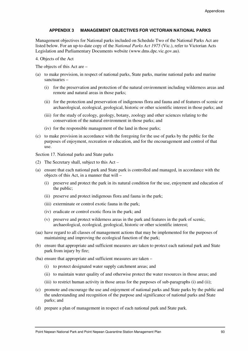
Appendices
Point Nepean National Park and Point Nepean Quarantine Station Management Plan 93
APPENDIX 3 MANAGEMENT OBJECTIVES FOR VICTORIAN NATIONAL PARKS
Management objectives for National parks included on Schedule Two of the National Parks Act are listed below. For an up-to-date copy of the National Parks Act 1975 (Vic.), refer to Victorian Acts Legislation and Parliamentary Documents website (www.dms.dpc.vic.gov.au).
4. Objects of the Act
The objects of this Act are –
(a) to make provision, in respect of national parks, State parks, marine national parks and marine sanctuaries –
(i) for the preservation and protection of the natural environment including wilderness areas and remote and natural areas in those parks;
(ii) for the protection and preservation of indigenous flora and fauna and of features of scenic or
archaeological, ecological, geological, historic or other scientific interest in those parks; and
(iii) for the study of ecology, geology, botany, zoology and other sciences relating to the conservation of the natural environment in those parks; and
(iv) for the responsible management of the land in those parks;
(c) to make provision in accordance with the foregoing for the use of parks by the public for the purposes of enjoyment, recreation or education, and for the encouragement and control of that use.
Section 17. National parks and State parks
(2) The Secretary shall, subject to this Act –
(a) ensure that each national park and State park is controlled and managed, in accordance with the objects of this Act, in a manner that will –
(i) preserve and protect the park in its natural condition for the use, enjoyment and education of the public;
(ii) preserve and protect indigenous flora and fauna in the park;
(iii) exterminate or control exotic fauna in the park;
(iv) eradicate or control exotic flora in the park; and
(v) preserve and protect wilderness areas in the park and features in the park of scenic, archaeological, ecological, geological, historic or other scientific interest;
(aa) have regard to all classes of management actions that may be implemented for the purposes of maintaining and improving the ecological function of the park;
(b) ensure that appropriate and sufficient measures are taken to protect each national park and State park from injury by fire;
(ba) ensure that appropriate and sufficient measures are taken –
(i) to protect designated water supply catchment areas; and
(ii) to maintain water quality of and otherwise protect the water resources in those areas; and
(iii) to restrict human activity in those areas for the purposes of sub-paragraphs (i) and (ii);
(c) promote and encourage the use and enjoyment of national parks and State parks by the public and the understanding and recognition of the purpose and significance of national parks and State parks; and
(d) prepare a plan of management in respect of each national park and State park.
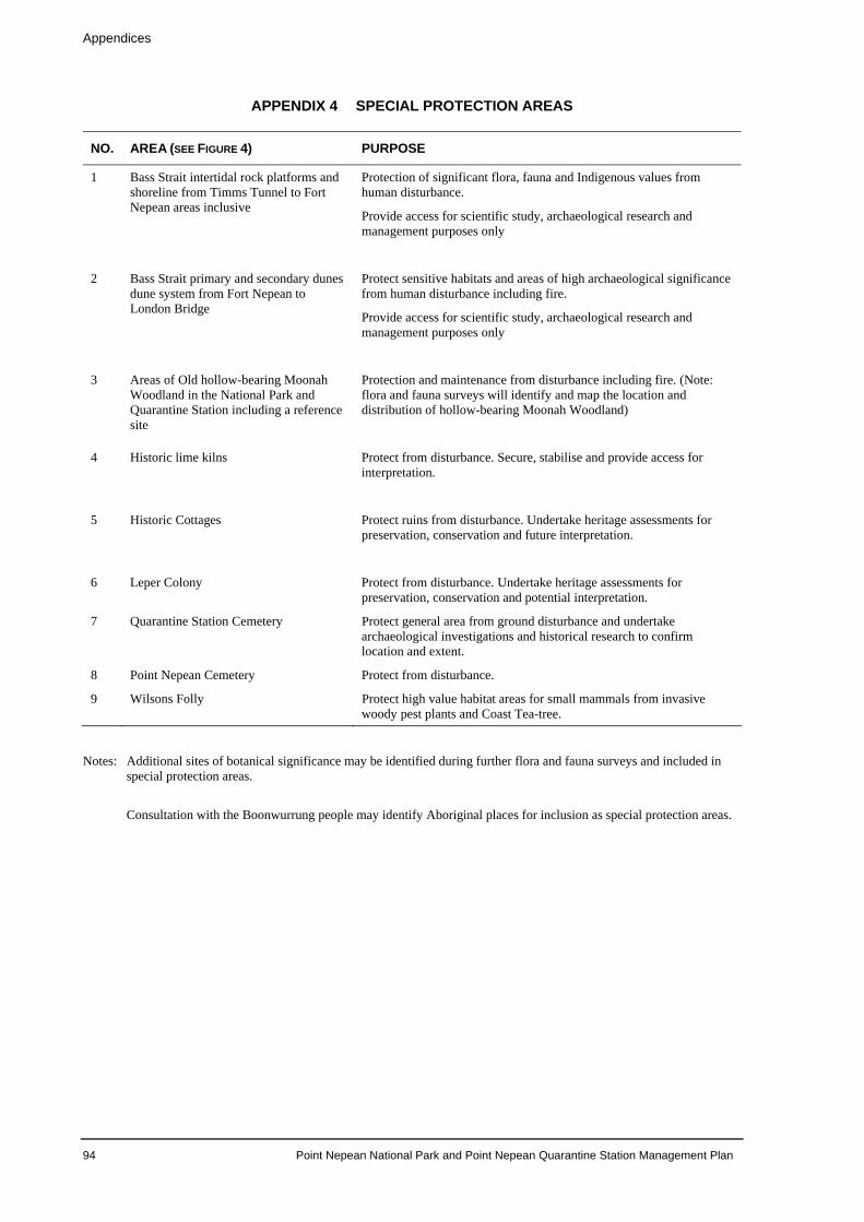
Appendices
APPENDIX 4 SPECIAL PROTECTION AREAS
NO. AREA (SEE FIGURE 4) PURPOSE
1 Bass Strait intertidal rock platforms and shoreline from Timms Tunnel to Fort Nepean areas inclusive
Protection of significant flora, fauna and Indigenous values from human disturbance.
Provide access for scientific study, archaeological research and management purposes only
2 Bass Strait primary and secondary dunes dune system from Fort Nepean to London Bridge
Protect sensitive habitats and areas of high archaeological significance from human disturbance including fire.
Provide access for scientific study, archaeological research and management purposes only
3 Areas of Old hollow-bearing Moonah Woodland in the National Park and Quarantine Station including a reference site
Protection and maintenance from disturbance including fire. (Note: flora and fauna surveys will identify and map the location and distribution of hollow-bearing Moonah Woodland)
4 Historic lime kilns Protect from disturbance. Secure, stabilise and provide access for interpretation.
5 Historic Cottages Protect ruins from disturbance. Undertake heritage assessments for preservation, conservation and future interpretation.
6 Leper Colony Protect from disturbance. Undertake heritage assessments for preservation, conservation and potential interpretation.
7 Quarantine Station Cemetery Protect general area from ground disturbance and undertake archaeological investigations and historical research to confirm location and extent.
8 Point Nepean Cemetery Protect from disturbance.
9 Wilsons Folly Protect high value habitat areas for small mammals from invasive woody pest plants and Coast Tea-tree.
Notes: Additional sites of botanical significance may be identified during further flora and fauna surveys and included in
special protection areas. Consultation with the Boonwurrung people may identify Aboriginal places for inclusion as special protection areas.
94 Point Nepean National Park and Point Nepean Quarantine Station Management Plan
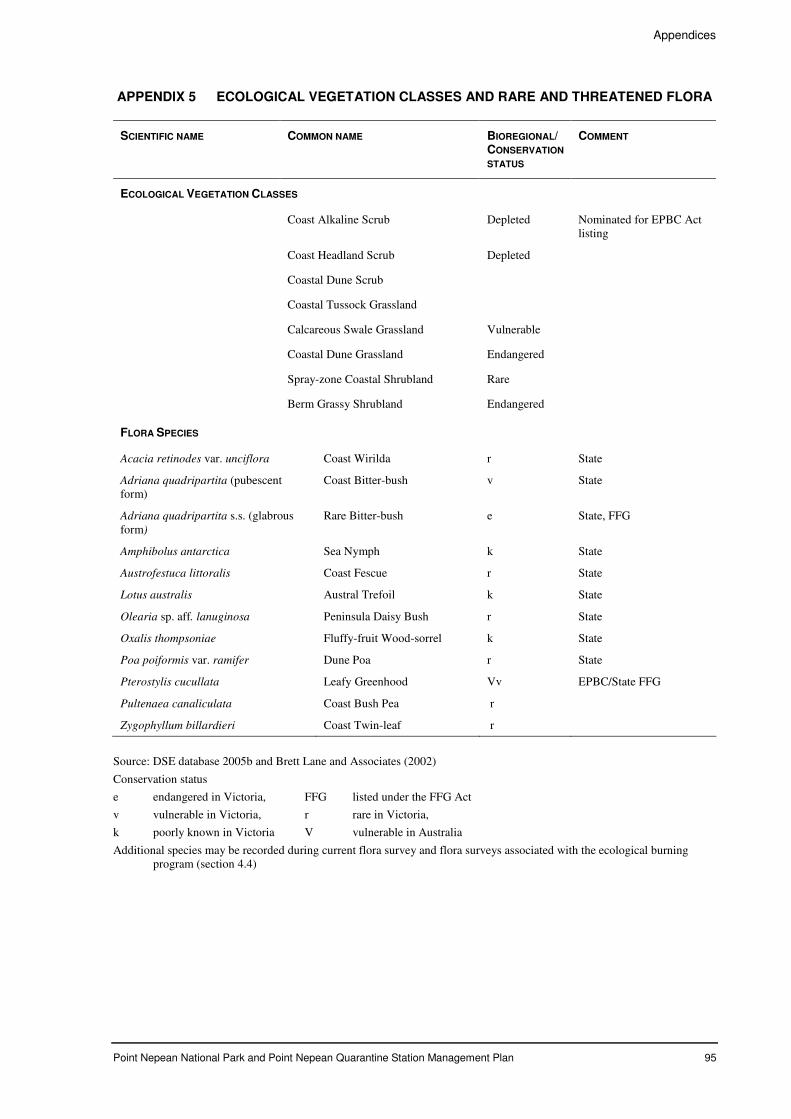
Appendices
Point Nepean National Park and Point Nepean Quarantine Station Management Plan 95
APPENDIX 5 ECOLOGICAL VEGETATION CLASSES AND RARE AND THREATENED FLORA
SCIENTIFIC NAME COMMON NAME BIOREGIONAL/ CONSERVATION
STATUS
COMMENT
ECOLOGICAL VEGETATION CLASSES
Coast Alkaline Scrub Depleted Nominated for EPBC Act listing
Coast Headland Scrub Depleted
Coastal Dune Scrub
Coastal Tussock Grassland
Calcareous Swale Grassland Vulnerable
Coastal Dune Grassland Endangered
Spray-zone Coastal Shrubland Rare
Berm Grassy Shrubland Endangered
FLORA SPECIES
Acacia retinodes var. unciflora Coast Wirilda r State
Adriana quadripartita (pubescent form)
Coast Bitter-bush v State
Adriana quadripartita s.s. (glabrous form)
Rare Bitter-bush e State, FFG
Amphibolus antarctica Sea Nymph k State
Austrofestuca littoralis Coast Fescue r State
Lotus australis Austral Trefoil k State
Olearia sp. aff. lanuginosa Peninsula Daisy Bush r State
Oxalis thompsoniae Fluffy-fruit Wood-sorrel k State
Poa poiformis var. ramifer Dune Poa r State
Pterostylis cucullata Leafy Greenhood Vv EPBC/State FFG
Pultenaea canaliculata Coast Bush Pea r
Zygophyllum billardieri Coast Twin-leaf r
Source: DSE database 2005b and Brett Lane and Associates (2002)
Conservation status
e endangered in Victoria, FFG listed under the FFG Act
v vulnerable in Victoria, r rare in Victoria,
k poorly known in Victoria V vulnerable in Australia
Additional species may be recorded during current flora survey and flora surveys associated with the ecological burning program (section 4.4)
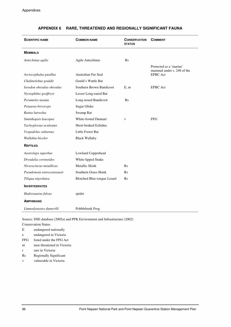
Appendices
96 Point Nepean National Park and Point Nepean Quarantine Station Management Plan
APPENDIX 6 RARE, THREATENED AND REGIONALLY SIGNIFICANT FAUNA
SCIENTIFIC NAME COMMON NAME CONSERVATION
STATUS COMMENT
MAMMALS
Antechinus agilis Agile Antechinus Rs
Arctocephalus pusillus Australian Fur Seal
Protected as a ‘marine’ mammal under s. 248 of the EPBC Act
Chalinolobus gouldii Gould’s Wattle Bat
Isoodon obesulus obesulus Southern Brown Bandicoot E, nt EPBC Act
Nyctophilus geoffroyi Lesser Long-eared Bat
Perameles nasuta Long-nosed Bandicoot Rs
Petaurus breviceps Sugar Glider
Rattus lutreolus Swamp Rat
Sminthopsis leucopus White-footed Dunnart v FFG
Tachyglossus aculeatus Short-beaked Echidna
Vespadelus vulturnus Little Forest Bat
Wallabia bicolor Black Wallaby
REPTILES
Austrelaps superbus Lowland Copperhead
Drysdalia coronoides White-lipped Snake
Niveoscincus metallicus Metallic Skink Rs
Pseudemoia entrecasteauxii Southern Grass-Skink Rs
Tiliqua nigrolutea Blotched Blue-tongue Lizard Rs
INVERTEBRATES
Hadrosaurus fulvus spider
AMPHIBIANS
Limnodynastes dumerilli Pobblebonk Frog
Source: DSE database (2005a) and PPK Environment and Infrastructure (2002)
Conservation Status
E endangered nationally
e endangered in Victoria
FFG listed under the FFG Act
nt near threatened in Victoria
r rare in Victoria
Rs Regionally Significant
v vulnerable in Victoria
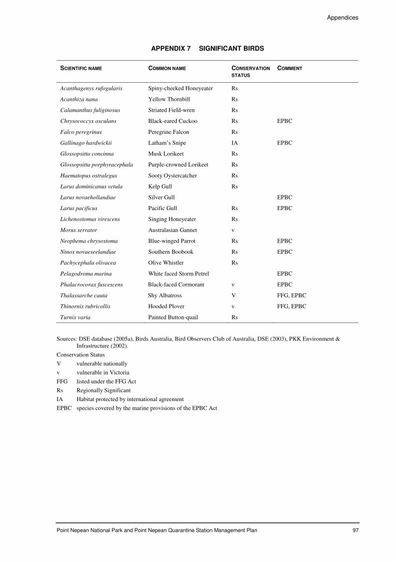
Appendices
Point Nepean National Park and Point Nepean Quarantine Station Management Plan 97
APPENDIX 7 SIGNIFICANT BIRDS
SCIENTIFIC NAME COMMON NAME CONSERVATION
STATUS COMMENT
Acanthagenys rufogularis Spiny-cheeked Honeyeater Rs
Acanthiza nana Yellow Thornbill Rs
Calamanthus fuliginosus Striated Field-wren Rs
Chrysococcyx osculans Black-eared Cuckoo Rs EPBC
Falco peregrinus Peregrine Falcon Rs
Gallinago hardwickii Latham’s Snipe IA EPBC
Glossopsitta concinna Musk Lorikeet Rs
Glossopsitta porphyracephala Purple-crowned Lorikeet Rs
Haematopus ostralegus Sooty Oystercatcher Rs
Larus dominicanus vetula Kelp Gull Rs
Larus novaehollandiae Silver Gull EPBC
Larus pacificus Pacific Gull Rs EPBC
Lichenostomus virescens Singing Honeyeater Rs
Morus serrator Australasian Gannet v
Neophema chrysostoma Blue-winged Parrot Rs EPBC
Ninox novaeseelandiae Southern Boobook Rs EPBC
Pachycephala olivacea Olive Whistler Rs
Pelagodroma marina White faced Storm Petrel EPBC
Phalacrocorax fuscescens Black-faced Cormorant v EPBC
Thalassarche cauta Shy Albatross V FFG, EPBC
Thinornis rubricollis Hooded Plover v FFG, EPBC
Turnix varia Painted Button-quail Rs
Sources: DSE database (2005a), Birds Australia, Bird Observers Club of Australia, DSE (2003), PKK Environment & Infrastructure (2002).
Conservation Status
V vulnerable nationally
v vulnerable in Victoria
FFG listed under the FFG Act
Rs Regionally Significant
IA Habitat protected by international agreement
EPBC species covered by the marine provisions of the EPBC Act
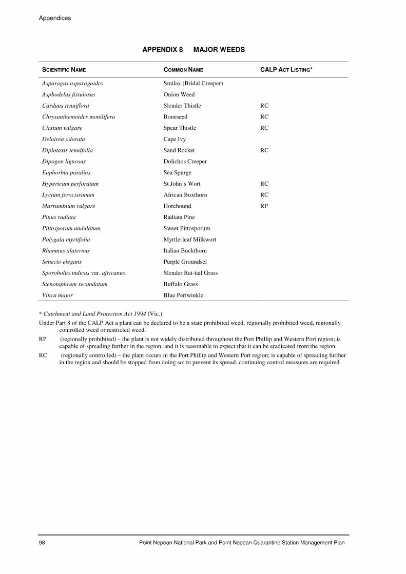
Appendices
98 Point Nepean National Park and Point Nepean Quarantine Station Management Plan
APPENDIX 8 MAJOR WEEDS
SCIENTIFIC NAME COMMON NAME CALP ACT LISTING*
Asparagus asparagoides Smilax (Bridal Creeper)
Asphodelus fistulosus Onion Weed
Carduus tenuiflora Slender Thistle RC
Chrysanthemoides monilifera Boneseed RC
Cirsium vulgare Spear Thistle RC
Delairea odorata Cape Ivy
Diplotaxis tenuifolia Sand Rocket RC
Dipogon lignosus Dolichos Creeper
Euphorbia paralias Sea Spurge
Hypericum perforatum St John’s Wort RC
Lycium ferocissimum African Boxthorn RC
Marrumbium vulgare Horehound RP
Pinus radiata Radiata Pine
Pittosporum undulatum Sweet Pittosporum
Polygala myrtifolia Myrtle-leaf Milkwort
Rhamnus alaternus Italian Buckthorn
Senecio elegans Purple Groundsel
Sporobolus indicus var. africanus Slender Rat-tail Grass
Stenotaphrum secundatum Buffalo Grass
Vinca major Blue Periwinkle
* Catchment and Land Protection Act 1994 (Vic.)
Under Part 8 of the CALP Act a plant can be declared to be a state prohibited weed, regionally prohibited weed, regionally controlled weed or restricted weed.
RP (regionally prohibited) – the plant is not widely distributed throughout the Port Phillip and Western Port region; is capable of spreading further in the region; and it is reasonable to expect that it can be eradicated from the region.
RC (regionally controlled) – the plant occurs in the Port Phillip and Western Port region; is capable of spreading further in the region and should be stopped from doing so; to prevent its spread, continuing control measures are required.
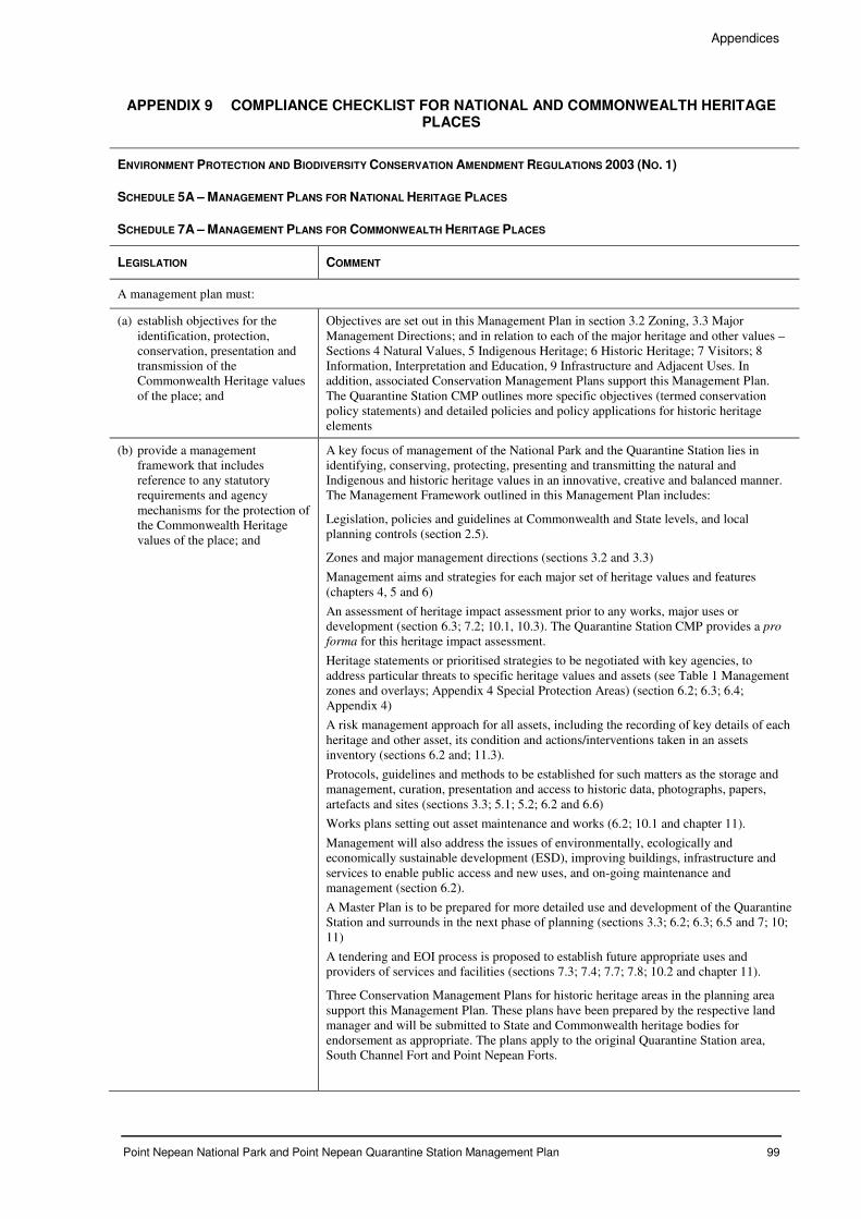
Appendices
Point Nepean National Park and Point Nepean Quarantine Station Management Plan 99
APPENDIX 9 COMPLIANCE CHECKLIST FOR NATIONAL AND COMMONWEALTH HERITAGE PLACES
ENVIRONMENT PROTECTION AND BIODIVERSITY CONSERVATION AMENDMENT REGULATIONS 2003 (NO. 1)
SCHEDULE 5A – MANAGEMENT PLANS FOR NATIONAL HERITAGE PLACES
SCHEDULE 7A – MANAGEMENT PLANS FOR COMMONWEALTH HERITAGE PLACES
LEGISLATION COMMENT
A management plan must:
(a) establish objectives for the identification, protection, conservation, presentation and transmission of the Commonwealth Heritage values of the place; and
Objectives are set out in this Management Plan in section 3.2 Zoning, 3.3 Major Management Directions; and in relation to each of the major heritage and other values – Sections 4 Natural Values, 5 Indigenous Heritage; 6 Historic Heritage; 7 Visitors; 8 Information, Interpretation and Education, 9 Infrastructure and Adjacent Uses. In addition, associated Conservation Management Plans support this Management Plan. The Quarantine Station CMP outlines more specific objectives (termed conservation policy statements) and detailed policies and policy applications for historic heritage elements
(b) provide a management framework that includes reference to any statutory requirements and agency mechanisms for the protection of the Commonwealth Heritage values of the place; and
A key focus of management of the National Park and the Quarantine Station lies in identifying, conserving, protecting, presenting and transmitting the natural and Indigenous and historic heritage values in an innovative, creative and balanced manner. The Management Framework outlined in this Management Plan includes:
Legislation, policies and guidelines at Commonwealth and State levels, and local planning controls (section 2.5).
Zones and major management directions (sections 3.2 and 3.3)
Management aims and strategies for each major set of heritage values and features (chapters 4, 5 and 6)
An assessment of heritage impact assessment prior to any works, major uses or development (section 6.3; 7.2; 10.1, 10.3). The Quarantine Station CMP provides a pro
forma for this heritage impact assessment.
Heritage statements or prioritised strategies to be negotiated with key agencies, to address particular threats to specific heritage values and assets (see Table 1 Management zones and overlays; Appendix 4 Special Protection Areas) (section 6.2; 6.3; 6.4; Appendix 4)
A risk management approach for all assets, including the recording of key details of each heritage and other asset, its condition and actions/interventions taken in an assets inventory (sections 6.2 and; 11.3).
Protocols, guidelines and methods to be established for such matters as the storage and management, curation, presentation and access to historic data, photographs, papers, artefacts and sites (sections 3.3; 5.1; 5.2; 6.2 and 6.6)
Works plans setting out asset maintenance and works (6.2; 10.1 and chapter 11).
Management will also address the issues of environmentally, ecologically and economically sustainable development (ESD), improving buildings, infrastructure and services to enable public access and new uses, and on-going maintenance and management (section 6.2).
A Master Plan is to be prepared for more detailed use and development of the Quarantine Station and surrounds in the next phase of planning (sections 3.3; 6.2; 6.3; 6.5 and 7; 10; 11)
A tendering and EOI process is proposed to establish future appropriate uses and providers of services and facilities (sections 7.3; 7.4; 7.7; 7.8; 10.2 and chapter 11).
Three Conservation Management Plans for historic heritage areas in the planning area support this Management Plan. These plans have been prepared by the respective land manager and will be submitted to State and Commonwealth heritage bodies for endorsement as appropriate. The plans apply to the original Quarantine Station area, South Channel Fort and Point Nepean Forts.
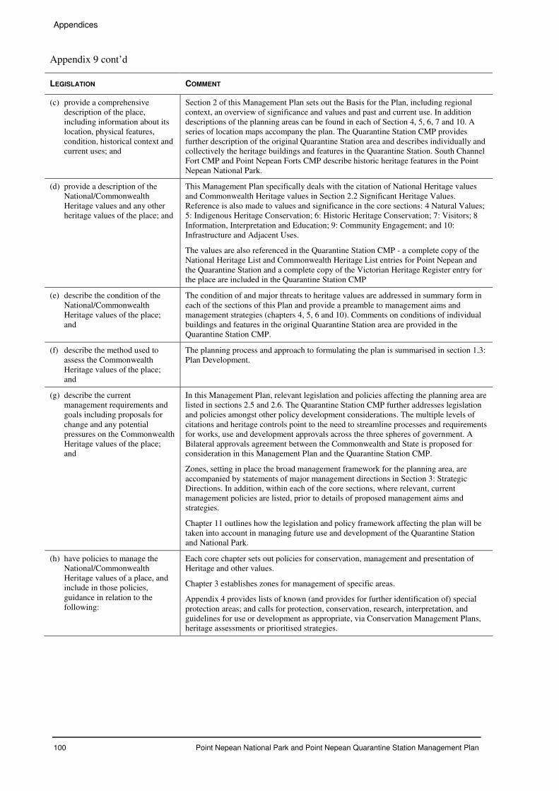
Appendices
100 Point Nepean National Park and Point Nepean Quarantine Station Management Plan
Appendix 9 cont’d
LEGISLATION COMMENT
(c) provide a comprehensive description of the place, including information about its location, physical features, condition, historical context and current uses; and
Section 2 of this Management Plan sets out the Basis for the Plan, including regional context, an overview of significance and values and past and current use. In addition descriptions of the planning areas can be found in each of Section 4, 5, 6, 7 and 10. A series of location maps accompany the plan. The Quarantine Station CMP provides further description of the original Quarantine Station area and describes individually and collectively the heritage buildings and features in the Quarantine Station. South Channel Fort CMP and Point Nepean Forts CMP describe historic heritage features in the Point Nepean National Park.
(d) provide a description of the National/Commonwealth Heritage values and any other heritage values of the place; and
This Management Plan specifically deals with the citation of National Heritage values and Commonwealth Heritage values in Section 2.2 Significant Heritage Values. Reference is also made to values and significance in the core sections: 4 Natural Values; 5: Indigenous Heritage Conservation; 6: Historic Heritage Conservation; 7: Visitors; 8 Information, Interpretation and Education; 9: Community Engagement; and 10: Infrastructure and Adjacent Uses.
The values are also referenced in the Quarantine Station CMP - a complete copy of the National Heritage List and Commonwealth Heritage List entries for Point Nepean and the Quarantine Station and a complete copy of the Victorian Heritage Register entry for the place are included in the Quarantine Station CMP
(e) describe the condition of the National/Commonwealth Heritage values of the place; and
The condition of and major threats to heritage values are addressed in summary form in each of the sections of this Plan and provide a preamble to management aims and management strategies (chapters 4, 5, 6 and 10). Comments on conditions of individual buildings and features in the original Quarantine Station area are provided in the Quarantine Station CMP.
(f) describe the method used to assess the Commonwealth Heritage values of the place; and
The planning process and approach to formulating the plan is summarised in section 1.3: Plan Development.
(g) describe the current management requirements and goals including proposals for change and any potential pressures on the Commonwealth Heritage values of the place; and
In this Management Plan, relevant legislation and policies affecting the planning area are listed in sections 2.5 and 2.6. The Quarantine Station CMP further addresses legislation and policies amongst other policy development considerations. The multiple levels of citations and heritage controls point to the need to streamline processes and requirements for works, use and development approvals across the three spheres of government. A Bilateral approvals agreement between the Commonwealth and State is proposed for consideration in this Management Plan and the Quarantine Station CMP.
Zones, setting in place the broad management framework for the planning area, are accompanied by statements of major management directions in Section 3: Strategic Directions. In addition, within each of the core sections, where relevant, current management policies are listed, prior to details of proposed management aims and strategies.
Chapter 11 outlines how the legislation and policy framework affecting the plan will be taken into account in managing future use and development of the Quarantine Station and National Park.
(h) have policies to manage the National/Commonwealth Heritage values of a place, and include in those policies, guidance in relation to the following:
Each core chapter sets out policies for conservation, management and presentation of Heritage and other values.
Chapter 3 establishes zones for management of specific areas.
Appendix 4 provides lists of known (and provides for further identification of) special protection areas; and calls for protection, conservation, research, interpretation, and guidelines for use or development as appropriate, via Conservation Management Plans, heritage assessments or prioritised strategies.
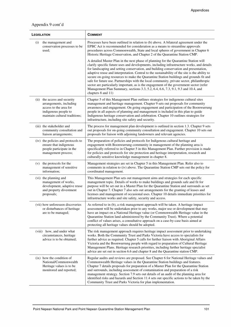
Appendices
Point Nepean National Park and Point Nepean Quarantine Station Management Plan 101
Appendix 9 cont’d
LEGISLATION COMMENT
(i) the management and conservation processes to be used;
Processes have been outlined in relation to (b) above. A bilateral agreement under the EPBC Act is recommended for consideration as a means to streamline approvals procedures across Commonwealth, State and local spheres of government in Chapter 6 Historic Heritage Conservation, and Chapter 2 of the Quarantine Station CMP.
A detailed Master Plan in the next phase of planning for the Quarantine Station will clarify specific future uses and developments, including infrastructure works, and details for landscaping and setting conservation, and building conservation and presentation, adaptive reuse and interpretation. Central to the sustainability of the site is the ability to secure on-going resources to make the Quarantine Station buildings and grounds fit and safe for future use. Partnerships with the local community, private sector, philanthropic sector are particularly important, as is the engagement of the government sector (refer Management Plan Summary, sections 3.3, 5.2, 6.4, 6.6, 7.3, 9.1, 9.3 and 10.4, and chapters 8 and 11)
(ii) the access and security arrangements, including access to the area for indigenous people to maintain cultural traditions;
Chapter 5 of this Management Plan outlines strategies for indigenous cultural sites management and heritage management. Chapter 9 sets out proposals for community awareness and engagement. On going engagement and participation of the Boonwurrung people in all aspects of planning and management is included in this plan to guide Indigenous heritage conservation and celebration. Chapter 10 outlines strategies for infrastructure, including site safety and security.
(iii) the stakeholder and community consultation and liaison arrangements;
The process for management plan development is outlined in section 1.3. Chapter 9 sets out proposals for on-going community consultation and engagement. Chapter 10 sets out proposals for liaison with adjoining landowners and relevant agencies.
(iv) the policies and protocols to ensure that indigenous people participate in the management process;
The preparation of policies and protocols for Indigenous cultural heritage and engagement with Boonwurrung community in management of the planning area is specifically referred to in Chapter 5 in this Management Plan. Further provision is made for policies and protocols for site protection and heritage interpretation, research and culturally sensitive knowledge management in chapter 8.
(v) the protocols for the management of sensitive information;
Management strategies are set in Chapter 5 in this Management Plan. Refer also to comments in relation to (iv) above. The Quarantine Station CMP sets out the policy for coordinated management.
(vi) the planning and management of works, development, adaptive reuse and property divestment proposals;
This Management Plan sets out management aims and strategies for each specific management topic. Details of works to make buildings and grounds safe and fit for purpose will be set out in a Master Plan for the Quarantine Station and surrounds as set out in Chapter 7. Chapter 7 also sets out arrangements for the granting of leases and licenses and management of occasional uses. Chapter 10 details immediate priorities for infrastructure works and site safety, security and access.
(vii) how unforeseen discoveries or disturbances of heritage are to be managed;
As referred to in (b), a risk management approach will be taken. A heritage impact assessment will be undertaken prior to any works, major use or development that may have an impact on a National Heritage value (or Commonwealth Heritage value in the Quarantine Station land administered by the Community Trust). Where a potential conflict of values arises, a consultative approach on a case-by-case basis aimed at protecting all heritage values should be adopted.
(viii) how, and under what circumstances, heritage advice is to be obtained;
The risk management approach requires heritage impact assessment prior to undertaking works. Both the Community Trust and Parks Victoria have access to specialists for further advice as required. Chapter 5 calls for further liaison with Aboriginal Affairs Victoria and the Boonwurrung people with regard to preparation of Cultural Heritage Management Plans. Heritage research priorities, including further heritage specialist advice are set out in section 6.6 and chapter 8 and the Quarantine station CMP.
(ix) how the condition of National/Commonwealth Heritage values is to be monitored and reported;
Regular audits and reviews are proposed. See Chapter 6 for National Heritage values and Commonwealth Heritage values in the Quarantine Station buildings and features. Chapter 7 details proposals for preparation of a Master Plan for the Quarantine Station and surrounds, including assessment of contamination and preparation of a risk management strategy. Section 7.9 sets out details of an audit of the planning area for identified risks and hazards and Section 11.4 sets out specific actions to be taken by the Community Trust and Parks Victoria for plan implementation.
Appendices
102 Point Nepean National Park and Point Nepean Quarantine Station Management Plan
Appendix 9 cont’d
LEGISLATION COMMENT
(x) how records of intervention and maintenance of a heritage places register are kept;
All Indigenous archaeological sites identified through the planning process and over time will be registered with AAV. All other heritage sites will be recorded on the Victorian Heritage Register.
Protocols and guidelines for knowledge management, including maintenance of records, artefacts, photographs, plans, maps etc are proposed in the next phase of planning.
A GIS-based knowledge and asset management system is being developed by the Community Trust, and is already in place in Parks Victoria.
The Quarantine Station CMP sets out the policy for protection, conservation and enhancement of heritage values, actions to implement this include establishing a site archive and conservation of artefacts.
(xi) the research, training and resources needed to improve management;
Provision is made in Chapter 8 for research and training and Chapter 9 for community engagement in management, supported by professional personnel. The Quarantine Station CMP sets out the policy for review of the CMP and application of adaptive management practices.
(xii) how heritage values are to be interpreted and promoted; and
Comprehensive interpretation, information and education planning is proposed in Chapter 8. Extensive community engagement in a wide range of activities, including conservation, interpretation and management activities is proposed in Chapter 9.
The Quarantine Station CMP sets out a series of policies and actions for historic heritage conservation including the presentation, interpretation and transmission of heritage values.
(i) include an implementation plan; and
Chapter 11 steps out key approaches to implementation, including partnership building and shared approaches to attract finances for sustainable management of the Quarantine Station and National Park. The Quarantine Station CMP sets out a series of policies and actions for implementation including requirements for coordinated management.
(j) show how the implementation of policies will be monitored; and
Annual, biannual or triennial site and asset audits are proposed. The risk management approach calls for recording of threats to heritage values or assets as they arise. Annual reports and business plans will report on implementation. Regular newsletters will inform communities of progress and provide further opportunities for engagement in planning and site management.
The Quarantine Station CMP sets out a series of policies and actions for monitoring implementation of conservation policies including policy for review of the CMP and application of adaptive management practices.
(k) show how the management plan will be reviewed.
Sections 11.3 and 11.4 provide details on amendments and review of this plan.
ENVIRONMENT PROTECTION AND BIODIVERSITY CONSERVATION AMENDMENT REGULATIONS 2003 (NO. 1)
SCHEDULE 5A – NATIONAL HERITAGE MANAGEMENT PRINCIPLES
SCHEDULE 7B – COMMONWEALTH HERITAGE MANAGEMENT PRINCIPLES
LEGISLATION COMMENT
1 The objective in managing National and Commonwealth Heritage places is to identify, protect, conserve, present and transmit, to all generations, their Commonwealth Heritage values.
This Management Plan is supported by three Conservation Management Plans for historic heritage areas as described in the preceding section. These plans collectively set out objectives, policies, actions and management strategies to achieve this Heritage Management Principle.
Appendices
Point Nepean National Park and Point Nepean Quarantine Station Management Plan 103
Appendix 9 cont’d
LEGISLATION COMMENT
2 The management of National and Commonwealth Heritage places should use the best available knowledge, skills and standards for those places, and include on-going technical and community input to decisions and actions that may have a significant impact on their National and Commonwealth Heritage values.
Open community consultation and community based and specialist based advisory groups and technical working groups were a core part of the planning methodology applied and will continue to be so in the shared planning approach being taken for Point Nepean National Park and Point Nepean Quarantine Station. Further consultation and engagement of the general community and special interest and skill groups will take place in the next phase of planning for the Quarantine Station and surrounds : Master Plan preparation and works programming
3 The management of National and Commonwealth Heritage places should respect all heritage values of the place and seek to integrate, where appropriate, and Commonwealth, State, Territory and local government responsibilities for those places.
Respect for National, Commonwealth, State and local Heritage values is central to this Management Plan and supporting Conservation Management Plans. A shared planning team comprising professionals from Commonwealth and State Government bodies has compiled these plans.
4 The management of National and Commonwealth Heritage places should ensure that their use and presentation is consistent with the conservation of their Commonwealth Heritage values.
Principles for use and presentation are outlined in each core chapter. The successful sustainable management of Point Nepean depends in the main on comprehensive information, interpretation, education and research planning outlined in chapter 9.
5 The management of National and Commonwealth Heritage places should make timely and appropriate provisions for community involvement, especially people who:
(a) have a particular interest in, or associations with, the place; and
(b) may be affected by the management of the place.
Community engagement is a core principle in the planning approach. On-going opportunities for engagement are set out in chapters 6, 8 and 9.
6 Indigenous people are the primary source of information on the value of their heritage and that the active participation of indigenous people in identification, assessment and management is integral to the effective protection of indigenous heritage values.
This principle is firmly embedded in the draft management plan, not only in Chapter 5, but also in Chapters 8 and 9.
7 The management of National and Commonwealth Heritage places should provide for regular monitoring, review and reporting on the conservation of Commonwealth Heritage values.
Annual reports are provided by the Community Trust to the Department of Environment and Water.
Appendices
104 Point Nepean National Park and Point Nepean Quarantine Station Management Plan
APPENDIX 10 APPROPRIATE USE PRINCIPLES
The Principles acknowledge that the Point Nepean site is unique within the Victorian national parks and conservation reserves system because of its cultural and historical significance and the extent and quality of the heritage buildings; the beauty of the coastal landscape associated with its location at the head of Port Phillip Bay; and the highly significant and diverse marine ecosystems that interface with relatively undisturbed terrestrial vegetation.
Providing high quality park experiences while protecting and enhancing the very special values found at Point Nepean presents both opportunities and challenges to future managers and the community.
Purpose of principles
The Principles guide the future development and use of the entire site, particularly (but not exclusively) the Quarantine Station and the way the heritage buildings may be used and operated for commercial and community purposes.
In assessing potential future uses and associated development all of the following principles will be considered.
Principles
• Use and management must be consistent with the objectives of the National Parks Act; to conserve and protect the natural and cultural environment, while providing for recreation, education, appreciation, and research.
• Use and management must be consistent with the provisions of the Environment Protection and Biodiversity Conservation Act and its objectives for the identification, protection, conservation, preservation and transmission of heritage values of the place.
• Use and management must be consistent with the provisions of other relevant legislation including the Heritage Act and the Coastal Management Act and the MPSC Planning Scheme heritage provisions.
• Uses and development must be consistent with the principles and objectives of the Victorian Coastal Strategy.
• Uses, including conservation practice, should be informed by the Australia ICOMOS Burra Charter, the Victorian Heritage Strategy and Parks Victoria’s Heritage Management Strategy.
• Uses and developments should be related to and sympathetic with the features and characteristics of Point Nepean.
• A diverse range of recreational, tourism, educational and community uses consistent with Point Nepean’s values will be encouraged with preference given to uses that minimise disturbance and have minimal impacts on the buildings and natural and cultural heritage.
• Commercial developments or leasing arrangements that could potentially diminish the capacity of managers to manage the Quarantine Station and/or adjoining areas of the National Park should be avoided.
• Collectively, use of land and buildings should generate the principal revenue requirements for on-going maintenance and administration.
• Public benefit must be the primary purpose for the commercial use of buildings and land.
• Exclusive uses that restrict access or provide services unrelated to experiencing Point Nepean’s values should be avoided.
• Future management arrangements should encourage external investment and be supported by a continuing level of public investment.
Appendices
Point Nepean National Park and Point Nepean Quarantine Station Management Plan 105
APPENDIX 11 NATIONAL HERITAGE LISTING
SUMMARY STATEMENT OF OFFICIAL NATIONAL HERITAGE VALUES
105680: Point Nepean Defence Sites and Quarantine Station Area, Defence Rd, Portsea, VIC
Refer attached Map
Summary Statement of Significance:
Point Nepean is the site of the oldest, surviving, purpose-built, barracks-style, quarantine accommodation buildings in Australia, as well as fortifications demonstrating the primary importance of coastal defence to the Australian colonies. As an island-nation, quarantine has played an important part in controlling the impact of ship-borne diseases on Australia from the early 1800s. Point Nepean is an historic landscape, which features a range of values relating to both Victorian and national quarantine processes from the 1850s and to the history of coastal defence from the 1870s.
The choice of site for quarantine purposes followed the discovery of gold in 1851, which, resulted in nearly 100,000 migrants arriving in Melbourne by sea in 1852, in one of the greatest gold rushes in history. Point Nepean was opened as a maritime quarantine reserve in 1852, following the scare caused by the arrival of the ship ‘Ticonderoga’, carrying scarlet fever and typhoid, and used for quarantine purposes as the major point of entry for quarantine cases in Victoria until 1980. The first permanent hospital buildings were erected from 1854 by the newly elected Victorian Government. The 1850s quarantine buildings at Point Nepean provide Australia's only relatively complete complex of quarantine buildings from the 1850-1870 period, thus providing crucial insight into quarantine operations and philosophies at a time when thousands of immigrants were landing in Australia in search of wealth and new opportunities offered by the discovery of gold. The Point Nepean quarantine station demonstrates the development of quarantine philosophy, encompassing the periods 1852-1875, 1875-1899 and 1900-1925, under both State and Commonwealth governments. The Quarantine Station and surrounds has a high potential for archaeological sites associated with quarantine areas located close to the shore at Ticonderoga Bay. The Quarantine Station contextual landscape also includes a cemetery near Observatory Point in addition to the pre-1858 cemetery, as well as possible archaeological evidence of the Cattle Quarantine Station and the Leper Station. In conjunction with the quarantine station at North Head, the Point Nepean quarantine station is important in illustrating the development and evolution of quarantine practices employed at Stations in the other states in the nineteenth and twentieth centuries.
Point Nepean has been part of a strategic outer line in the defence of Melbourne’s ports and harbours since the 1870s, in conjunction with fortifications at South Channel Fort, Swan Island and Queenscliff. Fort Nepean was known in the 1880s as Victoria’s ‘Gibraltar’ and in 1890 it was reported that Melbourne was the best-defended commercial city of the [British] Empire. The fortifications, based on the reports of Sir William Jervois and Lt Colonel Peter Scratchley in 1877, illustrate British military design and technology of the 1870s and 1880s, similar to Middle Head, Sydney, overlaid by changes in imperial armaments and Second World War coastal defences. Point Nepean, as part of the system of defence for Port Phillip Bay, best illustrates British military design and technology of the 1870s and 1880s, under the influence of Jervois and Scratchley. In addition, Fort Nepean may have archaeological deposits associated with military use, which extend into the waters surrounding the site of the former engineer’s jetty serving Fort Nepean. The first shot fired by Australian forces in WW1, from the batteries at Point Nepean, was at the German steamer ‘Pfalz’, which left Port Phillip during the declaration of war on 5 August 1914. The events are well documented and clearly demonstrate the geo-political importance of coastal defences, and Fort Nepean in particular, in protecting the Australian colonies as part of the British Empire. John Monash (later Sir) was attached to the [Melbourne] Garrison Artillery, focused on Fort Nepean. Monash rose through the ranks to become its commanding officer by 1897. Monash’s biographer, Geoffrey Serle, saw this as crucial to his success as commander of Australian Forces in WW1. Cheviot Beach is the place from which Australian Prime Minister Harold Holt disappeared whilst swimming in heavy surf on 17 December 1967.
Official Values:
Criteria Values
A Events, Processes
Cheviot Beach, on the southern shore of Point Nepean, is the place from which an Australian Prime Minister, Harold Holt, disappeared whilst swimming in heavy surf on 17 December 1967. Despite a major search his body was never found. The event was dramatic and well documented at the time and fuelled speculation in the media, where controversial theories to explain Holt’s disappearance were aired.
Appendices
106 Point Nepean National Park and Point Nepean Quarantine Station Management Plan
Appendix 11 cont’d
A Events, Processes Point Nepean is a broad historic landscape, featuring a considerable array of historic values relating to national quarantine and defence. Historic fabric at Point Nepean includes mid-nineteenth century archaeological remains and over one hundred year’s evidence of quarantine processes and defensive fortifications, which contribute to a richly layered historic cultural landscape.
A Events, Processes The Point Nepean Quarantine Station was the second permanent colonial quarantine station and because of its key role in the system from 1852-1980 represents a major part of the national story of human quarantine from colonial times through to the Commonwealth period of government. As an island-nation, quarantine stations played an important part in controlling the impact of ship-borne diseases on Australia from the early 1800s to the middle of the twentieth century. The choice of site for quarantine purposes followed the discovery of gold in 1851, which, resulted in nearly 100,000 migrants arriving in Melbourne by sea in 1852, in one of the greatest gold rushes in history. Point Nepean was opened as a maritime quarantine reserve in 1852, following the scare caused by the arrival of the ship ‘Ticonderoga’, carrying scarlet fever and typhoid, and used for quarantine purposes as the major point of entry for quarantine cases in Victoria until 1980. The first permanent hospital buildings were erected in 1854 by the newly formed Victorian Government.
A Events, Processes Point Nepean Quarantine Station and surrounds, in conjunction with North Head, illustrates the evolution and development of quarantine practices employed at stations in other states. The Quarantine Station includes the oldest, purpose-built, barracks-style, quarantine accommodation in Australia, as well as seminal evidence of the development of quarantine philosophy in Australia. In particular, the Quarantine Station provides comprehensive evidence of quarantine practices in the 1850s and 1860s, a period of time from which little physical evidence remains at North Head. The Point Nepean quarantine station encompasses the periods 1852-1875, 1875-1899 and 1900-1925, under the Victorian and Commonwealth governments. Structures relating to these periods include: 1852-1875 (4, 7, 15, 16, 21, 22, 25, 59, PMQ1035); 1875-1899 (26, 71, 73, PMQ1038, PMQ1040); and 1900-1925 (1, 3, 9, 10, 11, 12, 13, 18, 19, 20, 33, 35-38, 40-46, 58, 60, 61, 62, 63, 64, 65, 66, 67, 84, 85, PMQ966, PMQ1037, PMQ1041, PMQ1042, PMQ1043). Heaton’s Monument (1856-1858), a neo-Egyptian sandstone monument erected by Supervisor George Heaton, identifies the location of the first cemetery. Road alignments and infrastructure relating to the historical development of the quarantine station include Ochiltree, Bogle, Coleman and Bates Roads as well as Jackson Road and parts of Frankland’s Drive, with tramway tracks connecting building 61 with an extensive tramway system in the receiving area above the jetty. The Quarantine Station contextual landscape also includes the second cemetery near Observatory Point, as well as possible archaeological evidence of the Cattle Quarantine Station and the Leper Station.
A Events, Processes
Point Nepean, at the entrance to Port Phillip Bay, played an important geo-political role from the 1870s, protecting Melbourne, and potentially Victoria, as part of the British Empire. In 1870, the final departure of British Imperial troops placed defence in the hands of the colonial governments. British fortifications expert General Sir William Jervois RE (Royal Engineers) and Lt Colonel Peter Scratchley inspected each colony’s defences, leading to the Jervois-Scratchley reports of 1877, which were to form the basis of defence planning in Australia for the next 30 years. The reports suggested that Port Phillip Bay should be defended by a battery and keep at Queenscliffe, a fort at Point Nepean and batteries at Swan Island and South Channel Island. Guns were in place by 1886 at Fort Nepean and in 1888, Eagles Nest battery was implemented and new barracks erected at Fort Nepean. Fort Pearce was completed from 1910-1916 by the Commonwealth government, reinforcing Australia’s Empire role. The first shot fired by Australian forces in, from the batteries at Point Nepean, was at the German steamer Pfalz, which left Port Phillip during the declaration of war, on 5 August 1914. The events
Appendices
Point Nepean National Park and Point Nepean Quarantine Station Management Plan 107
Appendix 11 cont’d are well documented and clearly demonstrate the geo-political importance of coastal defences, and Fort Nepean in particular, in protecting the Australian colonies as part of the British Empire. Significant fortification sites include Fort Nepean, Eagles Nest, Fort Pearce and Pearce Barracks, erected during five development phases. Point Nepean, the first fort, was developed as follows: pre-1880 temporary fortifications; 18801886 emplacements; 18871890 converted and extended to a combination of 10 observation posts and batteries; 1910-1915 reduction in armaments; and 19391945 conversion to hooded emplacements and other uses. Fort Nepean was known in the 1880s as Victoria’s ‘Gibraltar’ and in 1890 it was reported that Melbourne was the best-defended commercial city of the British Empire.
B Rarity Point Nepean Quarantine Station (1852) is the second oldest, purpose-built, quarantine station in Australia, after North Head in Sydney (1832). It contains the oldest, purpose-built, barracks-style accommodation erected for quarantine purposes in Australia, pre-dating the oldest intact quarantine-related structures at North Head by sixteen years. The 1850s quarantine buildings at Point Nepean also provide Australia's only relatively complete complex of quarantine buildings from the 1850s-1870s period, thus providing crucial insight into quarantine operations and philosophies during a time when thousands of immigrants were landing in Australia in search of wealth and new opportunities brought by gold. The Point Nepean Quarantine Station contains seminal and rare examples of specific building types, functional groups and quarantine functions. These include: 1856-1875 Period: Matron’s Cottage (PMQ 1035) 1856-1858 Four Hospitals 2-5 (4, 16, 22, 25) 1858-1859 Kitchen for Hospital No 4 (22) 1858-1859 Bath and Wash House (59) 1866 Kitchen for Hospital No 3 (15) c. 1869 1900-1925 Period: Disinfecting Building and Boiler (84) 1900 Bath Blocks (63 and 64) 1900 Infected luggage receiving store (61) 1900 Clean luggage store (62) 1910-1916 The construction of new bathing and disinfecting buildings set new standards under the Commonwealth after 1912 and in particular during the First World War 1914-1918. This is particularly illustrated by the Isolation Hospital and Ward (65 and 66) 1916-1920, the Hospital 1 (1) 1919 and by the Emergency Huts (35-38 and 40-46) 1919, which relate to the major Australian health epidemic created by influenza in 1919.
B Rarity Geo-political and colonial defence needs drove the contemporary development of coastal fortifications at Melbourne and Sydney from the 1870s. Point Nepean has been part of a strategic outer line in the defence of Melbourne’s ports and harbours since the 1870s, in conjunction with fortifications at South Channel Fort, Swan Island and Queenscliff. The fortifications at Point Nepean, as part of the system of defence for Port Phillip Bay, best illustrate British military design and technology of the 1870s and 1880s, under the influence of the reports of Jervois and Scratchley in 1877.
C Research
Point Nepean Quarantine Station and surrounds include archaeological sites functionally associated with quarantine uses, planning and layout and buildings, close to the shore at Ticonderoga Bay and to the site of the former jetty, which
Appendices
108 Point Nepean National Park and Point Nepean Quarantine Station Management Plan
Appendix 11 cont’d have the potential to add to our understanding of nineteenth century quarantine practices and procedures. In particular this relates to the formative period from the 1850s-1870s and to the potential for confirmation and interpretation of the archival record. The Quarantine Station’s contextual landscape includes the second cemetery near Observatory Point, as well as possible archaeological evidence of the Cattle Quarantine Station and the Leper Station. These sites have the potential to add to our understanding of the planning and layout of major quarantine sites in Australia.
D Principal characteristics of a class of places
Point Nepean Quarantine Station is important in demonstrating the principal characteristics of Australian quarantine stations in the nineteenth and early twentieth centuries. These characteristics include the physical isolation of the site, individual quarantine functions and medical protocols and planning and layout, including access by sea. Landscape and spatial elements reinforce the social and medical philosophies upon which the layout of the quarantine station was based, including the separation of social classes and isolation of more contagious conditions. The main precincts at Point Nepean Quarantine Station provide a unique insight into the architectural concepts and landscape design techniques employed in quarantine stations in Australia. It is important in representing quarantine practices in the 1850s and 1860s, a period in history when significant numbers of immigrants were arriving in Australia. The location of the Medical Supervisor's cottage dating to the 1850s, on a rise to the east of the main complex, emphasises the balance between separation of staff from potential infection and the need for authority and supervision. Common periods of development with the North Head quarantine station include improvements in quarantine techniques and technical standards, both under the State Government in 1899 and subsequently under the Commonwealth Government from 1911. Particular aspects include the disinfecting and cleansing facilities and the Isolation Hospital and Wards (1916-1920) and Emergency Huts (1919) erected to cope with medical issues associated with the immediate aftermath of the First World War. Fort Nepean (1882-1891), Eagles Nest (1888), Fort Pearce (1910-1916) and Pearce Barracks (1911) at Point Nepean illustrate the characteristics of British military design and technology employed from the 1870s to the early 1900s, overlaid by related development during WW I and II. The strategic location and siting of these aspects of the place conform with the General Guiding Principles employed for a typical harbour under the Joint Naval and Military Committee for the defence of colonial ports by 1893. These include overlapping fields of fire from fortifications on headlands overlooking the approaches and channels and supporting barracks, all features recommended at Point Nepean in the Jervois-Scratchley reports of 1877.
H Significant people John Monash (later Sir) was attached to the [Melbourne] Garrison Artillery, focused on Fort Nepean. Monash rose through the ranks to become the commanding officer of Fort Nepean by 1897. Monash’s biographer, Geoffrey Serle, saw this as crucial to his success as commander of Australian Forces in WWI. The site references refer to quarantine related features identified in: Figure 19, Norris Barracks, Former Portsea Quarantine Station, Conservation Management Plan Part 1. This was prepared for the Department of Defence, Disposals and Infrastructure, by HLCD as part of HLA Envirosciences, in 2002.
Appendices
Point Nepean National Park and Point Nepean Quarantine Station Management Plan 109
Appendix 11 cont’d
105756: Quarantine Station and Surrounds, Defence Rd, Portsea, VIC
(Within listed place — refer attached map)
Summary Statement of Significance:
Point Nepean Quarantine Station and Surrounds include the oldest, surviving, purpose-built, barracks-style quarantine accommodation buildings in Australia, as well as evidence of the development of quarantine philosophy, encompassing the periods 1852-1875, 1875-1899 and 1900-1925, under both State and Commonwealth governments. As an island-nation, quarantine has played an important part in controlling the impact of ship-borne diseases on Australia from the early 1800s. The Quarantine Station and Surrounds is a broad historic landscape, which features a range of historic values relating to both Victorian and national quarantine processes and medical protocols from the 1850s. The choice of site for quarantine purposes followed the discovery of gold in 1851, which, resulted in nearly 100,000 migrants arriving in Melbourne by sea in 1852, in one of the greatest gold rushes in history. Point Nepean was opened as a maritime quarantine reserve in 1852, following the scare caused by the arrival of the ship ‘Ticonderoga’, carrying scarlet fever and typhoid, and used for quarantine purposes as the major point of entry for quarantine cases in Victoria until 1980. The first permanent hospital buildings were erected from 1854 by the newly elected Victorian Government. The 1850s quarantine buildings at Point Nepean provide Australia's only relatively complete complex of quarantine buildings from the 1850-1870 period, thus providing crucial insight into quarantine operations and philosophies at a time when thousands of immigrants were landing in Australia in search of wealth and new opportunities offered by the discovery of gold. In conjunction with the quarantine station at North Head, the Point Nepean Quarantine Station is important in illustrating the development and evolution of quarantine practices employed at Stations in the other states in the nineteenth and twentieth centuries. The Quarantine Station illustrates the principal characteristics of Australian quarantine stations, including the physical isolation of the site, quarantine functions and medical protocols and planning and layout, including access by sea. Archaeological sites with the potential to add to our understanding of nineteenth century quarantine practices and procedures are located close to the shore at Ticonderoga Bay and to the site of the former jetty.
Official Values:
Criteria Values
A Events, Processes
The Point Nepean Quarantine Station was the second permanent colonial quarantine station and because of its key role in the system from 1852-1980 represents a major part of the national story of human quarantine from colonial times through to the Commonwealth period of government. As an island-nation, quarantine has played an important part in controlling the impact of ship-borne diseases on Australia from the early 1800s to the mid-to-late twentieth century. The choice of site for quarantine purposes followed the discovery of gold in 1851, which, resulted in nearly 100,000 migrants arriving in Melbourne by sea in 1852, in one of the greatest gold rushes in history. Point Nepean was opened as a maritime quarantine reserve in 1852, following the scare caused by the arrival of the ship ‘Ticonderoga’, carrying scarlet fever and typhoid, and used for quarantine purposes as the major point of entry for quarantine cases in Victoria until 1980. The first permanent hospital buildings were erected in 1854 by the newly elected Victorian Government. Point Nepean Quarantine Station and Surrounds, in conjunction with North Head, illustrate the evolution and development of quarantine practices employed at stations in the other states. The Quarantine Station includes the oldest, purpose-built, barracks-style, quarantine accommodation in Australia, as well as seminal evidence of the development of quarantine philosophy in Australia. In particular, the Quarantine Station provides comprehensive evidence of quarantine practices in the 1850s and 1860s, a period of time from which little physical evidence remains at North Head.
Appendices
110 Point Nepean National Park and Point Nepean Quarantine Station Management Plan
Appendix 11 cont’d The Station encompasses the periods 1852-1875, 1875-1899 and 1900-1925, the latter under the Commonwealth Government. Structures and buildings relating to these periods include: 1852-1875 (Nos 4, 7, 15, 16, 21, 22, 25, 59, PMQ1035); 1875-1899 (Nos 26, 71, 73, PMQ1038, PMQ1040); and 1900-1925 (Nos 1, 3, 9, 10, 11, 12, 13, 18, 19, 20, 33, 35-38, 40-46, 58, 60, 61, 62, 63, 64, 65, 66, 67, 84, 85, PMQ966, PMQ1037, PMQ1041, PMQ1042, PMQ1043). Heaton’s Monument (1856-1858), a neo-Egyptian sandstone monument erected by Supervisor George Heaton, identifies the location of the first cemetery. Road alignments and infrastructure relating to the historical development of the quarantine station include Ochiltree, Bogle, Coleman and Bates Roads as well as Jackson Road and parts of Frankland’s Drive, with tramway tracks connecting building 61 with an extensive tramway system in the receiving area above the site of the jetty. Point Nepean Quarantine Station is a broad historic landscape, featuring a considerable array of historic values relating to national quarantine. Historic fabric at the quarantine station includes mid nineteenth century archaeological remains and over one hundred year’s evidence of quarantine processes, which contribute to a richly layered historic cultural landscape.
B Rarity Point Nepean Quarantine Station (1852) is the second oldest quarantine station in Australia, after North Head in Sydney (1832). It contains the oldest, purpose-built, barracks-style accommodation erected for quarantine purposes in Australia, pre-dating the oldest intact quarantine-related structures at North Head by sixteen years. The 1850s quarantine buildings at Point Nepean also provide Australia's only relatively complete complex of quarantine buildings from the 1850s-1870s period, thus providing crucial insight into quarantine operations and philosophies during a time when thousands of immigrants were landing in Australia in search of wealth and new opportunities brought by gold. The Point Nepean Quarantine Station contains seminal and rare examples of specific building types, functional groups and quarantine functions. These include:
1856-1875 Period: Matron’s Cottage (PMQ 1035) 1856-1858 Four Hospitals 2-5 (4, 16, 22, 25) 1858-1859 Kitchen for Hospital No 4 (22) 1858-1859 Bath and Wash House (59) 1866 Kitchen for Hospital No 3 (15) c. 1869
1900-1925 Period: Disinfecting Building and Boiler (84) 1900 Bath Blocks (63 and 64) 1900 Infected luggage receiving store (61) 1900 Clean luggage store (62) 1910-1916 The construction of new bathing and disinfecting buildings set new standards under the Commonwealth after 1912 and in particular during the First World War 1914-1918. This is particularly illustrated by the Isolation Hospital and Ward (65 and 66) 1916-1920, the Hospital 1 (1) 1919 and by the Emergency Huts (35-38 and 40-46) 1919, which relate to the major Australian health epidemic created by influenza in 1919.
C Research
Point Nepean Quarantine Station and Surrounds include archaeological sites functionally associated with quarantine uses, planning and layout and buildings, close to the shore at Ticonderoga Bay and to the site of the former jetty, which have the potential to add to our understanding of nineteenth century quarantine practices and procedures. In particular, this relates to the formative period from the 1850s-1870s and to the potential for confirmation and interpretation of the archival record.
Appendices
Point Nepean National Park and Point Nepean Quarantine Station Management Plan 111
Appendix 11 cont’d
D Principal characteristics of a class of places
Point Nepean Quarantine Station is important in demonstrating the principal characteristics of Australian quarantine stations in the nineteenth and early twentieth centuries. These characteristics include the physical isolation of the site, individual quarantine functions and medical protocols and planning and layout, including access by sea. Landscape and spatial elements reinforce the social and medical philosophies upon which the layout of the quarantine station was based, including the separation of social classes and isolation of more contagious conditions. The main precincts at Point Nepean Quarantine Station provide a unique insight into the architectural concepts and landscape design techniques employed in quarantine stations in Australia. It is important in representing quarantine practices in the 1850s and 1860s, a period in history when significant numbers of immigrants were arriving in Australia. The location of the Medical Supervisor's cottage dating to the 1850s, on a rise to the east of the main complex, emphasises the balance between separation of staff from potential infection and the need for authority and supervision. Common periods of development with the North Head quarantine station include improvements in quarantine techniques and technical standards, both under the State Government in 1899 and subsequently under the Commonwealth from 1911. Particular aspects include the disinfecting and cleansing facilities and the Isolation Hospital and Wards (1916-1920) and Emergency Huts (1919) erected to cope with medical issues associated with the immediate aftermath of the First World War. The site references refer to quarantine related features identified in: Figure 19, Norris Barracks, Former Portsea Quarantine Station, Conservation Management Plan Part 1. This was prepared for the Department of Defence, Disposals and Infrastructure, by HLCD as part of HLA Envirosciences, in 2002.
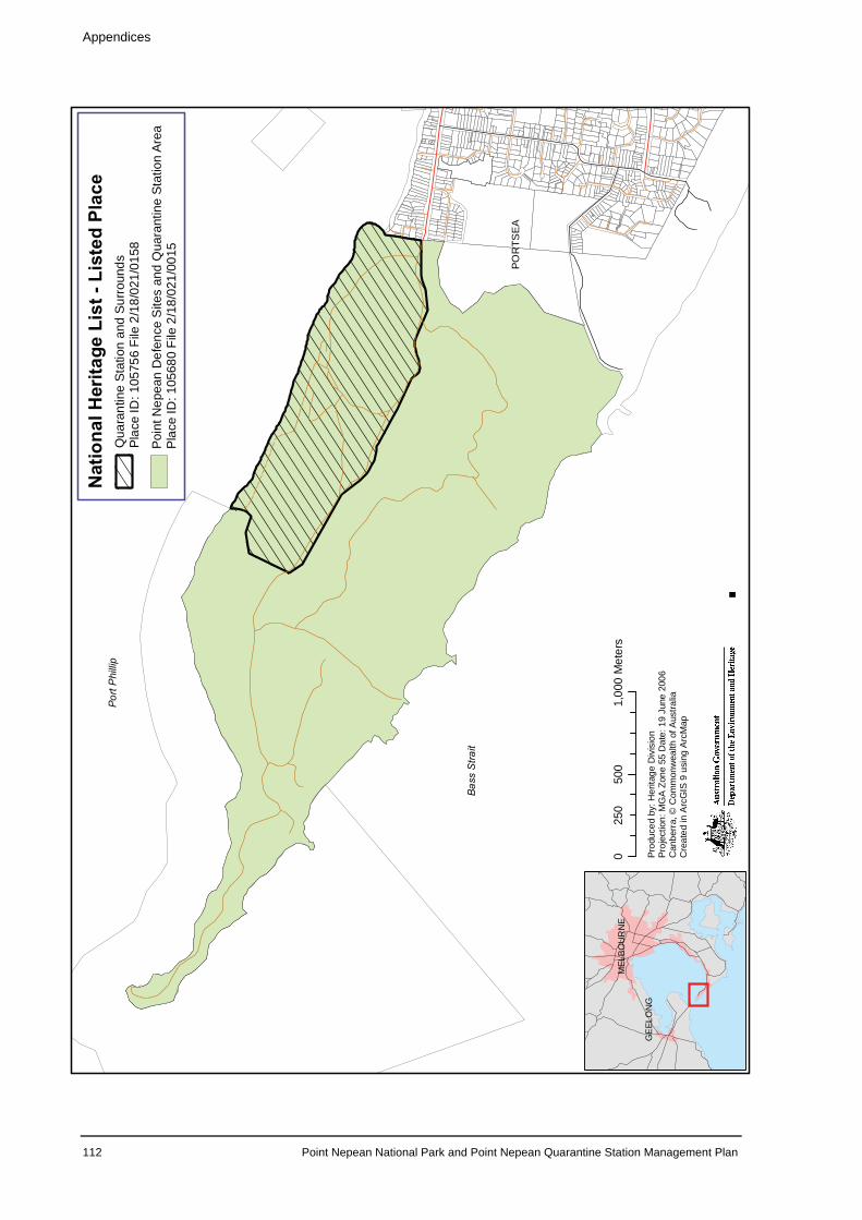
MEL
BO
UR
NE
GE
ELO
NG
050
01,
000
250
Met
ers
Prod
uced
by:H
erita
geD
ivis
ion
Proj
ectio
n:M
GA
Zone
55D
ate:
19Ju
ne20
06C
anbe
rra,
©C
omm
onw
ealth
ofA
ustra
liaC
reat
edin
Arc
GIS
9us
ing
Arc
Map
Nationa
lHerita
geList
-ListedPlace
Qua
rant
ine
Stat
ion
and
Surro
unds
Plac
eID
:105
756
File
2/18
/021
/015
8
Poin
tNep
ean
Def
ence
Site
san
dQ
uara
ntin
eSt
atio
nAr
eaPl
ace
ID:1
0568
0Fi
le2/
18/0
21/0
015
POR
TSE
A
PortPhillip
Bass
Stra
it
Appendices
112 Point Nepean National Park and Point Nepean Quarantine Station Management Plan
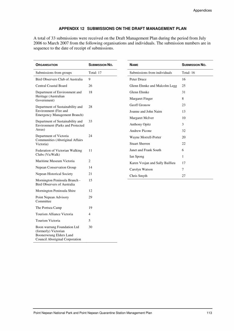
Appendices
Point Nepean National Park and Point Nepean Quarantine Station Management Plan 113
APPENDIX 12 SUBMISSIONS ON THE DRAFT MANAGEMENT PLAN
A total of 33 submissions were received on the Draft Management Plan during the period from July 2006 to March 2007 from the following organisations and individuals. The submission numbers are in sequence to the date of receipt of submissions.
ORGANISATION SUBMISSION NO.
Submissions from groups Total: 17
Bird Observers Club of Australia 9
Central Coastal Board 26
Department of Environment and Heritage (Australian Government)
18
Department of Sustainability and Environment (Fire and Emergency Management Branch)
28
Department of Sustainability and Environment (Parks and Protected Areas)
33
Department of Victoria Communities (Aboriginal Affairs Victoria)
24
Federation of Victorian Walking Clubs (VicWalk)
11
Maritime Museum Victoria 2
Nepean Conservation Group 14
Nepean Historical Society 21
Mornington Peninsula Branch - Bird Observers of Australia
15
Mornington Peninsula Shire 12
Point Nepean Advisory Committee
29
The Portsea Camp 19
Tourism Alliance Victoria 4
Tourism Victoria 5
Boon wurrung Foundation Ltd (formerly) Victorian Boonerwrung Elders Land Council Aboriginal Corporation
30
NAME SUBMISSION NO.
Submissions from individuals Total: 16
Peter Druce 16
Glenn Ehmke and Malcolm Legg 25
Glenn Ehmke 31
Margaret Finger 8
Geoff Gronow 23
Joanne and John Nairn 13
Margaret McIver 10
Anthony Opitz 3
Andrew Picone 32
Wayne Morrell-Porter 20
Stuart Sherren 22
Janet and Frank South 6
Ian Spong 1
Karen Vosjan and Sally Baillieu 17
Carolyn Watson 7
Chris Smyth 27
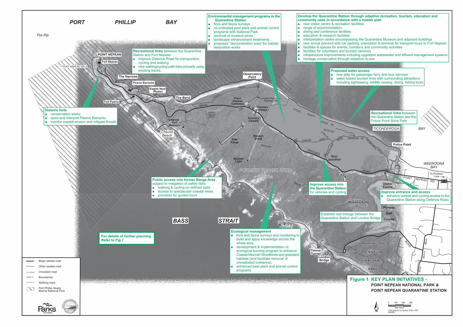
�����
����
��
�����
����
��
���
�� ��
��������
������
��
���
�� ��
��
���
�
�����
� ��
����
�������������
����� �
�� ���
��
�������� � ��������� � ��
��
���������
�������
�����
����������
���� ������ ��
����� ������ ��
� � �����
������� ��
� ��� ������� �
� ��� ������� � ����
����������
����� �
�������
���
��������
�����������
������������������
���� ���
�!���"����#�$��
��$%���$��
����� �$���
��������%�
&�����&���
��'��$���
������
���(
)�*���
�*�+*�%�$��
����������
����� �
�������
���
��������� ���!�"������#�����$
���������������
������������
������
�$��������)�'����#
�*�����)������
�$(�������
,$�$���)�����
�
����%�����%����
���������-�
�*�����)�����.
�$''��*����
���%�� ����%.�
�������������
/�"���������0*�����$�������$�������*��������$"����%����$��1���*�$�'1���*%��$������%�''*�$�#�*����$���%%�����%��-$�����'����������� "�&�'� ��(��)�"����*���)�����("�+�)������ � ��"#��(+��))(!!(,���("� ,�"�"#��",�)("+���")��+�)������ � �,-)���("�*��� ���).�+�)������ � �"���/������("�)�"�����")(!/� �"#��.��0-���"��"��1- �-!��",��,2�)�"��3-��,�"# � "�&�����'���/��)�")��&��.�)���/��$�"#4�(���"����("�*����!�"���+(�����" /(����(-� ��(��(�����/��"� +�)������ �*� /�)� �+(���'�"� 4�+-")��(" ��",�)(!!-"��5��)��'���� � +�)������ �+(��'(�-"���� ��",��(-�� !� ��'�)� � �"+�� ��-)�-����!/�('�!�"� ��")�-,�"#�-/#��,�,�&� ��&������",��++�-�"��!�"�#�!�"�� 5 ��! � .�����#��)(" ��'���("��.�(-#.��,�/��'����6- �
�"$���'������'�����'����������'��$������������0*�����$�������$��� +�(����",�+�-"�� -�'�5 � )(6(�,�"���,�/� ��/��"���",��"�!���)("��(�
/�(#��! �&��.�����("������$� ��!('���(+��"'� �'��/�"� � ��", )�/���".�")�!�"�������!�"� � /�(/( �,�7,�!(" �����("�����8�+(��.�3����
�� �(����("�&(�$
��������-������%%���� "�&�2���5�+(��/� �"#���+���5��",��(-�� ��'�)� � &����63� �,��(-�� !���"$ �&��.� -��(-",�"#������)��("
�")�-,�"#� �#.� ���"#4�&��,��+��'��&�"#4�,�'�"#4�+� .�"#��(-�
�'���"��������%�������%%���� �".�")��'�.�)����",�)5)��"#��))� ��(��.�
0-���"��"�������("���("#��+�")���(�,
�'���"���%%����$�������0*�����$�������$��+(��'�.�)�� ��",�)5)��"#
%����$%���'�����'���� +�(����",�+�-"�� -�'�5 ��",�!("��(��"#��(
3-��,��",��//�5�$"(&��,#���)�( ��.�&.(�������
� ,�'��(/!�"��*��!/��!�"����("�(+�)(�(#�)���3-�"�"#�/�(#��!��(��".�")��(� ����1(("�.��((,��", ��",�#�� ��",.�3���� �9�",�+�)����������!('���(+-"�:/�(,�,�(�,"�")�;<
� �".�")�,�/� ��/��"���",��"�!���)("��(�/�(#��!
*!�$%��%%����$����(��'������������� -32�)���(�!���#���("�(+� �+��5��� $ � &��$�"#�*�)5)��"#�("�,�+�"�,������ � �))� ��(� /�)��)-����)(� ����'��& � /�('� �("�+(��#-�,�,��(-�
&$����$%�(����� )(" ��'���("�&(�$ � (/�"��",��"���/��������)�������)$ � !("��(��)(� ������( �("��",�!���#�����.����
��%����$������$�.��3��&��"��.��0-���"��"������("��",��(�����/��"� �!/�('���+�")���(�,�+(�����" /(���� 4
)5)��"#��",�&��$�"#� "�&�&��$�"#=)5)��"#�/��.���"$ �/��!����5�- �"#
�:� ��"#����)$
��%����$������$�.��3��&��"�.��0-���"��"�������("��",��.��(��)���(�"���.�������$
��������$����(�(*�����������$����(�������$��2
� ��3�� .���������"$�#��3��&��"��.�0-���"��"�������("��",��(",("����,#�
������ $���
������ ���.
3$����4������#
1�2(�� ����,��(�,
�.��� ����,��(�,
�" ����,��(�,
�(-",����
���$�"#����)$
�(����.����/����, 1���"������("������$
�1�����
� >����� ?��
����(#��/.5�35��/�������� �("�>��@1=A�BA
�$�*���5� �6� �����������,��7���������������� �����8���������0����������������
3$����4������#
��1�������������>�C�.�
��1�������������>�C�.�
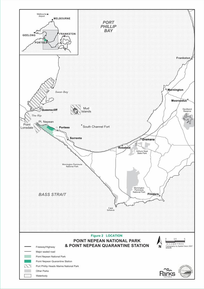
��������������
�����������
�
�� ��� �
�������
�����������
�
�����������
�
���������
� ����� ���
�����
�������� �
�����
��������� ��
����� ��
�������� ���������
���
������
� ����
� ����� �
� ���
������
� ����� ��
�� �
���������
� ������� �
� ���
� ����� �
������ �
� ���
� ��
���������
� ������� �
� ���
� ����� ����
!
�� !"�!#�#$!�!$" �!$%��$�&'��� !"�!#�#$!��($�$!" !#��"$" �!����" #$%�&�" #
� '���� ������ �
���������� ��� ���� ��� ��
���������� ��(� � �������� ����
�������������%� ��� ������ ���� ��� ��
)������ ��
� ������#
�����)���%�*$" �!
� ���&� ��#��#��� �� ��*�����+!!,�$-!.-!/ � � ) � 0 1 0 �
! 2+�2
������&����������
� ���� ��� ��
3�������� ��� ���� ��
������&����������� � ���� ��� ��
���������3������
�#%+�(�!#�
�##%�!�� � ��$!&�"�!
����"�#$
�
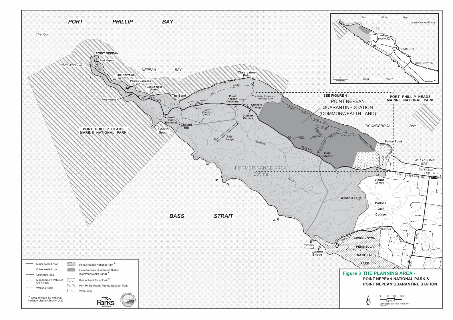
����������������������������
������������������
����������������������������
������������������
�����
����
����
�����
����
����
������
������
�����������
�������
����
������
������
����
�����
�����
�����
������
���������������
������ ��
�������
��
��������� �� ���������� �����
����
����������
������
�����
�����������
������� �� ���
����� �������� �
��� �����
������� ���
������ ������� ��
������ ������� �� ����
����������
������
� ���� �
� ��
�������� �
�����������
������������������
��������
� ���!����"��#��
���#$����#��
��������#���
���������$�
%�����%���
��&��#���
�������
���'
(�)���
�)�*)�$�#��
����������
������
� ���� �
� ��
���� !��"#� !$�%� !"��& ����'
����������������
������������
������
��#��������(�&����"
�)�����(������
�#'�������
+#�#���(�����
�
����(�����(����
���������,�
�)�����(�����-
�#&&��)����
����$�������$-�
�������������
�������
��������
�����������
����� ���� � )
�"�*$ �! #
����� �������� ��
�*+�,��,�%% ���*!�
��������
�����������
.#����/������"
�����������������)�-�,�
�*"%��� . �%����"*%�����!'�0�*"%��� . �%�+�!�%�"% �����"*% �*$$*%/ ���,���%0��0
�*�"1 ��*"%���,"! ���!'�0
�*!���,"��".�� �0#���!"% ����"*%�����!'
��� !2*03
��4*!�# �� 0�!*�0
��, !�# �� 0�!*�0
%# �� 0�!*�0
��%�& $ %��� ,"1� #�%�3��!�1'
���'"%&��!�1'
�������
� )����� 5��
��!�*&!�.,3�23��.��"����"#"*%�)��6�78�98
�������1
�#�)���2� �%��� ������ � �3�������� ��� ���� ��� ���4�������� ��5� � ������ ����
(��!#��%#��
����� �%������ % 6� ���� � ���� �� � ��
����� �%������ % 6� ���� � ���� �� � ��
�0��! ��1*: ! 0�23����"*%��� !"��& ��"#�"%&� � 1�"*%�);)�
�����������������)�-�,�
.#����/������"
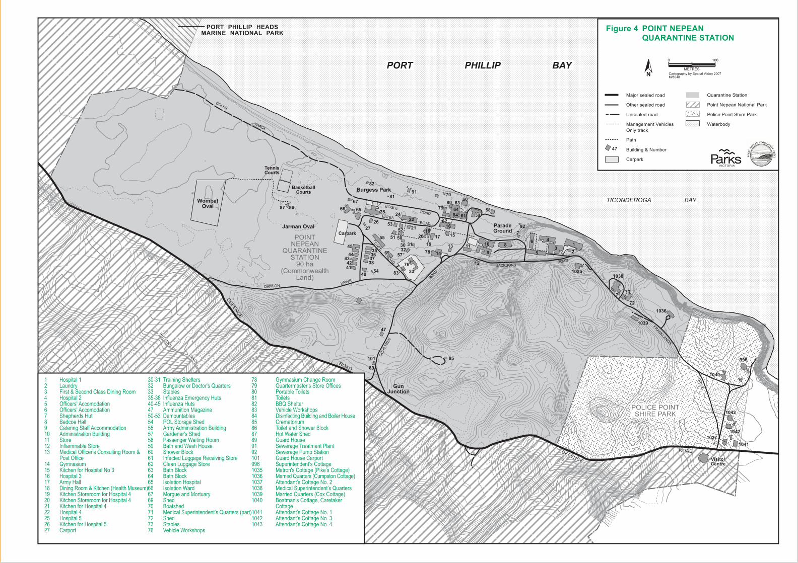
�����
�����
�����
� �������
�����
����
� ���
����� �
�������
�����
� ��
�����
���
��������
� ��
���
��
� ��
� ��
� ��
� ��
� ��
� ���
�����
�����
�������
���������� ��
����� ������ ��
����������
����� ����
���������� ����
������
� ������ ������������
������ ����������� �����
� ������
������������� �����
������� !�"#����$%
&'
(�
('
(�&'
&�
)'
)�
''
)�)'&�&'
(�
&�
(�('
&'
(�
('
&'
&�('
(�&'
&�
)'
)�
''
)�)'&�&'
(�
&�
(�('
&'
(�
('
&'
&�
&'
(�
*
*
*
*
*
*
*
*
*
*
**
**
*
*
*
*
*
*
*
**
*
*
*
*
*
*
*
*
*
*
*
*
*
*
*
*
*
*
*
*
*
*
*
*
*
*
*
*
*
*
*
*
*
*
*
*
*
*
*
*
*
*
*
*
*
*
*
*
*
*
*
*
*
�
��
�
�
�
�
���
�����
����
��
��
������
��
��
����
��
������
����
��
������
��
��
��������
����������
��
��
��
����
��
��
������
��
��
��
��
����
��
��
��
����
����
��
����� ��!"#��
��
���
��
����
��
��
��
����
��
��
��
����
����
���$���!%���
����
����
����
��������
���
%���&�����&
' ���"#��
%"(! %)*++*%! ),-./0-(*1,! 1-*"1-+! %-(2
1 ��+#�,+�-�.�/.��-�#0�"��010���&��2345�65
3�����
� )��
3�$���!�! %"*1!1,%,-145-(-1*1,!/-*"1
3�7�+�1!�"!$�+��$
#�!+�1!�"!$�+��$
��1!�"!$�+��$
3���,!�!�#��!�08"!1 �".�#+�89
��#�
�:0"$0�,�;�:�/!+
��+-�+9
�:�+��#0�!��#�#0��
��0�#�!-!����#0���"���+9
��"08!���0�#���0+!���+9
<�#!+/�$.
��
� ��������� ������ ������������������������������� ��������� !!�����"�#����������$ !!�����"�#����������% �&��&��������' (������) ����������!!�#������������* #�������������(�������� ������� +�!��,��������� -����� !!����.������������������
/���� !!����� 0��������� 1���&���!����������2����$ ���������% #������' ��������������1���&���3���&�-�����4�) 1���&�������������!������������* 1���&�������������!������������� 1���&���!������������� ���������� ���������$ 1���&���!������������% ������
�*5�� 6��������&������� (����7����������.��8�������� ��,����5�' +�!���9�:��������������*5�� +�!���9������% #����������-�9����*5�� �������,���� / ���������&���� #����#�������������(�������% 0������"���&���' /��������;�����������) (�&����;�&������$* �&�7���(��<$� +�!������ �����������=���������$� ���� �����������$� (�&�(��<$� (�&�(��<$� +�������������$$ +�������;��$% -���������-������$) �&��%* (���&��%� -�������������������.��8�������3���4%� �&��%� ��,��%$ >�&����;��<�&���
%' 0���������&��������%) 8����������.�������� !!����'* /���,��6�����'� 6�����'� ((8��&����'� >�&����;��<�&���'� �����!�������(����������(����������'� ����������'$ 6���������&�7���(��<'% ����;�����&��') 0���������)� ��7�����6��������/��)� ��7�����/�����������*� 0����������������))$ ��������������.���������*�� -����"���������3/�<�.��������4�*�$ -������8�������3���������������4�*�% #�������.���������2�?���*�' -�������������������.��8�������*�) -������8�������3��@�������4�*�* (����.��������A�����<���
�������*�� #�������.���������2�?���*�� #�������.���������2�?���*�� #�������.���������2�?��
�����
�������
�������
�����
%"(! %)*++*%! ),-./0-(*1,! 1-*"1-+! %-(2
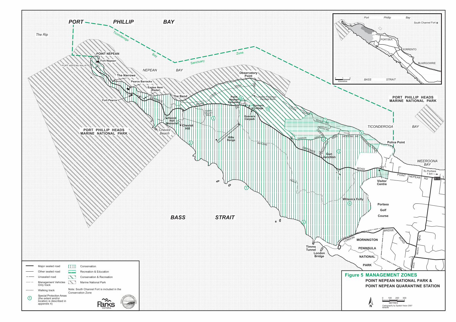
������������������������
���������
��
������
����
�
�
�
�
�
�
�
�
�
�����
����
����
�����
����
����
������
������
�����������
�������
����
������
������
����
����
�����
�����
��� ��
���� ����� ����
������ ��
���������
!��� �� � �� ��������� �����
����
���� �����
�"����
�����
�����������
������� �� ���
����� �������� �
��� �����
������� ���
����� �� ���� ��
����� �� ���� �� �##$
�����������
������� ��
!"���#$%&
�& ���&%
!&�'
!��� ��"!"&�
�(����)�*�
"*+���������,�*-*(.
���/��-
�0��(�*��(!����
!���1��!����
%��-��/(�-+�
�(��!�*(1�
�*(��-����
��2�(�*��
!�(���*
���3
��4(��
�4�54�1����
������� ��
!"���#$%&
�& ���&%
!&�'
%&���� �'���(��������%&)
������� ����%���
������������
������
!������)�*���2���(
�4���(�����*+�
��3���*�+�
6�����(����(�
�
�� *�����*%���
����*((�7�
�4���(��*()*(8
�22� 4����
!�*(1��/*((*18�
�������������
��� ��
�������
�������%���
����� ���$ # +
��&�(����'
����� �������� ��
���,��,���&�����
�������
�������%���
�+4(���� �&�&�"�"� �9��"#!��� ��"!"&���& ���&%�!&�'�:!��� ��"!"&��;$&�&� ��"�# & ���
���'��-����
����������.���������
���'��-�����.����������
/����������&� �)
�/����
$ +$$#$$ 0$$
�����1,��2�� 1��&���'����+$$3/45$65
/7���'�&������
��,���'�&������
"�'�&������
/��(������,��&�'��&�����)
%&)������)
1���&� �������������'8�,���9�������4��&��������'���'���2�����11����9�6:
����;� ���,��,���&�������'����&���������,����'��-���������
�
!�� � !��%%�!� �"&<#�&���"� �& ���&%� !&�'
!�� � !��%%�!� �"&<#�&���"� �& ���&%� !&�'
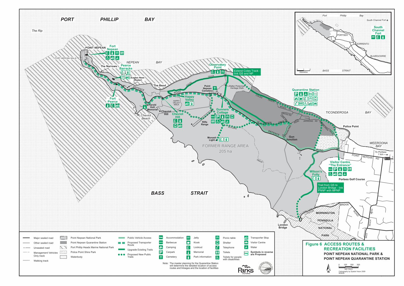
�����
����
��
�����
����
��
���
�� ��
��������
������
��
���
�� ��
��
����
�����
� ��
����
�������������
����� �
�� ���
��
�������� � ��������� � ��
��
���������
�������
�����
����������
���� ������ ��
����� ������ ��
� � �����
������� ��
� ��� ������� �
� ��� ������� �
������������ ����������
�����������
���������������
�����������������
�������� ����
!�"#$#� �#
��#$#�%&'
#' $�#'&
�'"(
����������������������
�����)���
��$# �#���'# ���#*��
������#���+"�,��-
��.�,
�����������
&��,��.��,�
)����,)���
!/������ �����
)���
���0�������
!�"#$#� �#
��#$#�%&'
#' $�#'&
�'"(
����������������������
���� !��"#� !$�%� !"��& ����'
���������������
������������
������
�����#*��/���
"�1�"���
����(�����(����
��#����2�
�����)���
)�**������ ���
����
����.�����3�
�))�
�������������
������
������
��� ���� �
����� ����� ) �
�"�*$ �! #
����� ��� ��� ��!
�*+������%% ���*!�
������
��� ���� �
�!�"��,!*$�-���*�*%.*%��!".& �/��"%'�����0"�������
�1� %.��*� #��!�2'�/�"%'�-���%.���
�+3�"2�� �"2� ��22 ##
�!*4*# .��!�%#4*!� !�*+�
�4&!�. ��1"#�"%&��!�"�#
�!*4*# .�� 0��+3�"2�!�"�#
�����4��'����"�% ���5�"�"�' $�#� '$&$ $����$# �#���'#�#' $�#'&��'"(�5��$# �#���'#��%'"'# $#��� ' $�#
�*"%��� 4 �%����"*%�����!'
�*"%��� 4 �%�-+�!�%�"% �����"*%
�*!����"��"4�� �.#���!"% ����"*%�����!'
�*�"2 ��*"%����"! ���!'
��� !3*.5
��6*!�# �� .�!*�.
�� !�# �� .�!*�.
�%# �� .�!*�.
��%�& $ %��� �"2� #%�5��!�2'
���'"%&��!�2'
#������
� ���)�� 7��
��!�*&!�4�5�35��4��"����"#"*%����8�9:�;:
�22*$$*.��"*%
��!3 2+
��$4"%&
��!4�!'
� $ � !5
� ��5
�"*#'
�**'*+�
� $*!"��
��!'�"%,*!$��"*%
�"2%"2���3�
�� �� !
� � 4�*%
�*"� �#
�*"� �#�,*!�4 *4� 0"���."#�3"�"�" #
�!�%#4*!� !���*4
�"#"�*!�� %�!
��� !
��/������������������*��,
���������� ���
�*� < �� �$�#� !�4��%%"%&�,*!��� �-+�!�%�"% �����"*%0"���. � !$"% ��� �. ��"� .��*2��"*%�*,��22 ##!*+� #��%.��"%'�& #��%.��� ��*2��"*%�*,�,�2"�"�" #
����������1�����
!�����&����

�������
��
��
������
�
�����
����
����
��� ���
���� �����
��
��
���
����
�����
�
���
����
���
�����
��
���
���
���
���
���
����
����
�������
�������
���������� ��
����� ������ ��
����������
����� ����
���������� ����
������
�������������������
������ ����������� �����
�������
���
�
����������
����������������
�����
���
�
�������
�
�
�
�
�
�
�
�
�
�
��
��
�
�
�
�
�
�
�
��
�
�
�
�
�
�
�
�
�
�
�
�
�
�
�
�
�
�
�
�
�
�
�
�
�
�
�
�
�
�
�
�
�
�
�
�
�
�
�
�
�
�
�
�
�
�
�
�
�
�
�
�
�
�
��
�
�
�
�
���
�����
����
��
��
������
��
��
����
��
������
����
��
������
��
��
��������
����������
��
��
��
����
��
��
������
��
��
��
��
����
��
��
��
����
����
��
����� ��!"#��
��
���
��
����
��
��
��
����
��
��
��
����
����
���$���!%���
����
����
����
��������
���
"��&�!'������������ !�"���#$ %&
%�� ��(!)�� &����*&!+! �,�������'()�� *%�*%+�,�%)����) " � ��� % %&�-��**'���,! )���*##(% �.�������$ ��
*���-��!)����*����"��))�����, ��&���%��,$,���� *%���� !����),��� *%
%����&%�����$��!����(
.�����$�! ������ ��*, )��%��,$,���� *%/�, � #�0�/�, %�0�%' &�%*(�0���+�%)�0�("�(,�"���, ��&�0�(�,�%� %�0��## &,�� *%�( '�'��*(,�0�**'���,! )��
����(!+!/&�������*##(% �.�����'()�� *%�����,)��,���1��("�(,�/�,2����))*##*'�� *%��),��� *%���$ ��
)���#��!+!���� ��,2 %&�-�, �%��� *%�,�%�$*,����,# %�" � �*,���%�,���+��-�� +����*$�#�% � ���*(,�$�,��*,���,! )�������%&�,���,,.���,# %�"�*##(% �.�����,���1��("�(,��*##(% �.��,*($��, �%'���%'�*"(%���,��'# �� *%��������$ ��
%���&�����&
0 ���"#��
%"'! %.1221%! ./)345)'16/! 6)1"6)2! %)'7%"'! %.1221%! ./)345)'16/! 6)1"6)2! %)'7
*�$���!�! 4/16�!%2)6%"16!6/%/)6!89)')616/!4)1"6
�*##(% �.�-��'()�� *%��,�) %)�
�,, !�"�-��*(, �#��,�) %)�
��, ��&����%�,���,�) %)�
�, #�,.��))*##*'�� *%-��**'�-��*%+�,�%)���,�) %)�
(�'**,���),��� *%��,�) %)�
�*,���*,���,����,�) %)�
��),��� *%�"�� %2�
6 ��,�*&,�$�.�3.��$�� �"� � *%�4��5/-6�76
/�����
� 8��
/�9*,����"�'�,*�'
���,����"�'�,*�'
�%���"�'�,*�'
����
/�%�&�#�%���� )"��%".��,�)2
�( "' %&�1��(#3�,��������� ������������������� ������!"
��,$�,2
�* %����$��%�(�,�%� %������ *%
�* %����$��%��� *%�"���,2
�*" )���* %���� ,����,2
:���,3*'.
��
�*��;��� ������ %&��"�%�����3��%�$,�$�,�'������&( '���*�'���,# %��+(�(,��(��<���(,���,�$"�%% %&��%'�)*%�("��� *%= ""�3��(%'�,��2�%��*�'���,# %������,�%&��*+��$$,*$, ����,�),��� *%0��*(, �#0��'()�� *%��%'�)*##(% �.�(���<�� ��$"�%�= ""�+*,#�����3�� ��*+�#����,�$"�%% %&� %�����%�>��$�����?�������)� *%�5�1�6<���!�%����%'�+(%)� *%��,���$$" )�3"���*��""�'�+ %�'�$,�) %)��<��������,#�,��$ ��� ��3,*�'".�'�+ %�'��%'�#�.� %)"('���))*##*'�� *%�%'-*,��%9*.#�%��*+�+�) " � ����%'���,! )��<����""��,����= ""�)*%�� %�)*##*%��"�#�%����*�)*%��,!�0�$,*��)���%'$,���%����, ��&��!�"(����%'�$,*#*����������"��.���,2�0����"��.���*$"��)*%)�$�<
��� *%�"���%�,��+*,��*�����%'��" #���
�, #�,.��))*##*'�� *%0��**'0�*%+�,�%)�
��, ��&����%�,�0��**%=(,,(%&��%�,�0�� 3,�,.-�,)� !��(��
��������! ���!��&!/�� ��!5&�����$!:)*������ #�� *%�+*,��������%'���, ��&��$"�)�#�%�&�#�%�0�(���*$� *%�� %)"(' %&��*(, �#$�)2�& %&��%'�+ %�%) �"�+��� 3 " �.0�)*����%',�!�%(���)�%�, *���%'�$, ) %&���,���&.�+*,"*%&���,#��(��� %�3 " �.
1������������!!;!/&������!%������$!:$"�%% %&�+*,���%�=�! � �*,�)�%�,�0� %��,$,���� *%)�%�,�0��'()�� *%��%'�,����,)��+�) " � ����%'$,*&,�#�0�&( '�'�=�"2�0��*(,���%'��$�) �"�)� ! � ��
%'1"'11/4!*"'*9'./'!%2)6616�
8���������!4�����!5�����!%������$:���&�'�'�� &%��%'�$�.� )�"�"�.*(���*�#�������%��'��*+��""�(��,�0�*$� # ����))��� %)"(' %&�" %2�&��0�"�%'�)�$�0�%��%)�#�%�0� %��&,����+�) " � ����%'�*$�%�$�)����%'��%�(,��$,*��)� *%0)*%��,!�� *%��%'�$,���,!�� *%�*+�%��(,�"�%'�)("�(,�"���, ��&��!�"(��
��&����$!;!/<��������!,!1�������%�����!:�%&�&�#�%��*+������*(, �#���)�*,��%'�2�.(��,�&,*($���*�����3" ���$�,�%�,�� $�� %$,*! ' %&���,�%&��*+�+�) " � ����%'���,! )�� %)"(' %&��))*##*'�� *%0�' % %&0��*(,*$�,�� *%��1�)*##(% �.�(���
8���������!4�����!:!*����!5�����!%���