AND LANDSCAPE CHANGEgreenvisions.usc.edu/documents/SGRappendices.pdfAsteraceae Venegasia...
86
LANDSCAPE CHANGE AND of the Eric D. Stein Shawna Dark Travis Longcore Nicholas Hall Michael Beland Robin Grossinger Jason Casanova Martha Sutula SCCWRP Technical Report #499 Appendices A, B, and C
Transcript of AND LANDSCAPE CHANGEgreenvisions.usc.edu/documents/SGRappendices.pdfAsteraceae Venegasia...

LANDSCAPECHANGE
AND
ofthe
Eric D. Stein Shawna Dark Travis Longcore Nicholas Hall Michael Beland Robin Grossinger Jason Casanova Martha Sutula
SCCWRP Technical Report #499 Appendices A, B, and C


Eric D. Stein1*, Shawna Dark2, Travis Longcore3, Nicholas Hall3, Michael Beland2, Robin Grossinger4, Jason Casanova5, and Martha Sutula1
1Southern California Coastal Water Research Project2California State University Northridge3University of Southern California4San Francisco Estuary Institute5Los Angeles and San Gabriel Rivers Watershed Council
*corresponding authorPhone 714-755-3233 | E-mail [email protected] | Web www.sccwrp.org
Established 1969
Watershed Council
Th
e L
os
Angeles and San Gabriel R
ivers
SCCWRP Technical Report # 499Appendices A, B, and CFebruary 2007
HISTORICAL ECOLOGY AND LANDSCAPE CHANGE OF THE SAN GABRIEL RIVER AND FLOODPLAIN


Acknowledgements
The authors gratefully acknowledge the following individuals and organizations
whose cooperation and assistance has been instrumental to the success of this
project. We thank the California State Library, along with Alan Jutzi, from the
Huntington Library, and Mike Hart, with Sunny Slope Water Company, for their
assistance in obtaining historic irrigation reports and maps. John Patton from the
Bureau of Land Management’s General Land Office was instrumental in acquiring
field notes and plats. Jim Shuttleworth and Steven Lipshie of the Los Angeles
County Department of Public Works provided us with workspaces, map resources,
and access to the historic aerial photo collection. We thank Christine Lam for
developing the 1880s land use map and Dan Goldberg for programming the
query agent for searching the botanical databases. We also thank Ron Davidson,
who assisted with the creation and compilation of oral history notes; Chris Tasick,
who helped in the collection and scanning of historic maps and aerial photos;
and Danielle Bram, who provided GIS support and developed some analysis tools
(3D model in ESRI ArcScene). Finally, we thank David Deis for his cartography
work. Map creation was critical to the success of this project and our ability to
visualize historical conditions. This would not have been possible without David’s
hard work, expertise, and attention to detail. The following peer reviewers have
provided valuable insight and comments to improve the quality of the document:
William Deverell, Paula Schiffman, Barry Hecht, and Jessica Hall.
Funding for this project was provided by the State of California Rivers and Moun-
tains Conservancy under Agreement #RMC3556.
Additional information on historical ecology in southern California, along with
digital products associated with this project can be obtained at:
www.csun.edu/centerforgeographicstudies/historical_ecology.html
DESIGN AND LAyOUT By:
Jason CasanovaLos Angeles & San Gabriel Rivers Watershed Council
Linda WanczykSan Francisco Estuary Institute
Cover photo courtesy of the Benjamin and Gladys Thomas Air Photo Archives, UCLA Department of Geography
This
item
is re
pro
duce
d by
per
mis
sion
of T
he H
untin
gton
Lib
rary
, San
Mar
ino,
Cal
iforn
ia


T A B L E O F C O N T E N T S
Appendix A - distribution of pl Ant species on the sAn gAbriel floodplAin . . . . . . . . . . . . . . . . . . . 1
Appendix b - historic pl Ant compendium for sAn gAbriel wAtershed . . . . . . . . . . . . . . . . . . . . . . . .17
Appendix c - trAnscripts of orAl histories compiled by J.w. reAgAn (1914) . . . . . . . . . . . . . . . . . .37
1 FLOOD OF 1825 . . . . . . . . . . . . . . . . . . . . . . . . . . . . . . . . . . . . . . . . . . . . . . . . . . . . . . . . . . . . . . . . . . . . . . . . . . . . . 37
2 FLOOD OF 1851-52 . . . . . . . . . . . . . . . . . . . . . . . . . . . . . . . . . . . . . . . . . . . . . . . . . . . . . . . . . . . . . . . . . . . . . . . . . . . 38
3 FLOOD OF 1859-60 . . . . . . . . . . . . . . . . . . . . . . . . . . . . . . . . . . . . . . . . . . . . . . . . . . . . . . . . . . . . . . . . . . . . . . . . . . . 39
4 FLOOD OF 1861-62 . . . . . . . . . . . . . . . . . . . . . . . . . . . . . . . . . . . . . . . . . . . . . . . . . . . . . . . . . . . . . . . . . . . . . . . . . . . 39
5 FLOOD OF 1867-68 . . . . . . . . . . . . . . . . . . . . . . . . . . . . . . . . . . . . . . . . . . . . . . . . . . . . . . . . . . . . . . . . . . . . . . . . . . . 43
6 FLOOD OF 1875-6 . . . . . . . . . . . . . . . . . . . . . . . . . . . . . . . . . . . . . . . . . . . . . . . . . . . . . . . . . . . . . . . . . . . . . . . . . . . . 55
7 FLOOD OF 1884 . . . . . . . . . . . . . . . . . . . . . . . . . . . . . . . . . . . . . . . . . . . . . . . . . . . . . . . . . . . . . . . . . . . . . . . . . . . . . 55
8 FLOOD OF 1886 . . . . . . . . . . . . . . . . . . . . . . . . . . . . . . . . . . . . . . . . . . . . . . . . . . . . . . . . . . . . . . . . . . . . . . . . . . . . . 68
9 FLOOD OF 1889 . . . . . . . . . . . . . . . . . . . . . . . . . . . . . . . . . . . . . . . . . . . . . . . . . . . . . . . . . . . . . . . . . . . . . . . . . . . . . 69
10 FLOOD OF 1891-1892 . . . . . . . . . . . . . . . . . . . . . . . . . . . . . . . . . . . . . . . . . . . . . . . . . . . . . . . . . . . . . . . . . . . . . . . . . 73
11 FLOOD OF 1914 . . . . . . . . . . . . . . . . . . . . . . . . . . . . . . . . . . . . . . . . . . . . . . . . . . . . . . . . . . . . . . . . . . . . . . . . . . . . . 75
TABLE OF CONTENTS

Additional information on historical ecology in southern California, along
with the following digital products associated with this project can be
obtained at the web address below:
Appendices
Extended project bibliography
List of contacts and information sources
Selected digital images, files, and data (subject to release
permissions)
Website: www.csun.edu/centerforgeographicstudies/historical_ecology.html
•
•
•
•

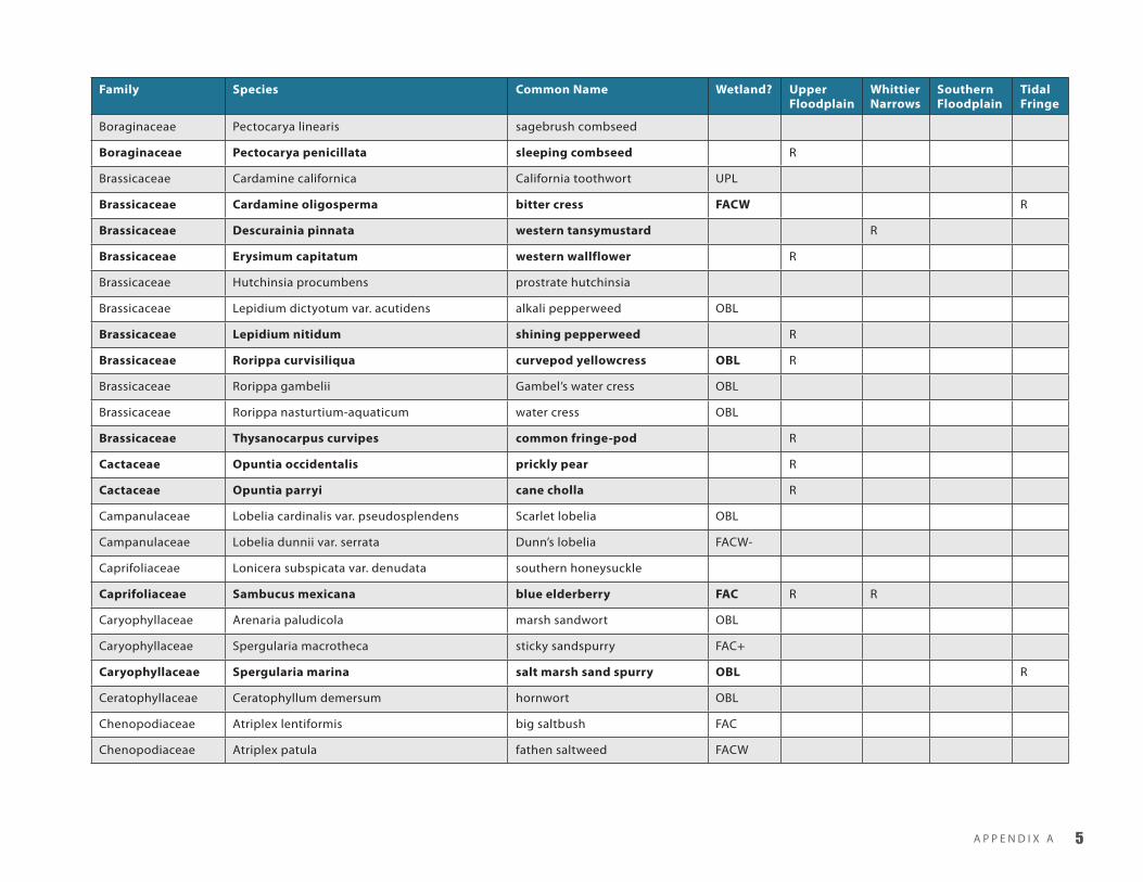
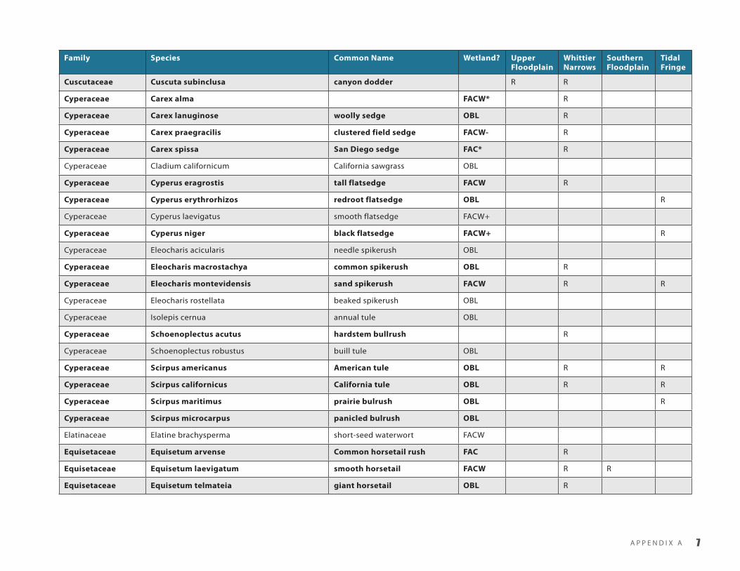
A P P E N D I X A �
AAppendix A - distribution of plAnt species on the sAn GAbriel floodplAin
This appendix lists the plant species likely to be found along the San Gabriel River from Azusa to Long Beach. Species in bold are vouch-
ered by a herbarium specimen. The location of those records are indicated by R. Other species may have been present based on habitat
descriptions, but have not yet been confirmed by a specimen. Wetland status is indicated as obligate (99%, OBL), facultative wetland
(67–99%, FACW), Facultative (34–66%, FAC), facultative upland (1–33%, FACU), or no indicator (NI).
Family Species Common Name Wetland? Upper Floodplain
Whittier Narrows
Southern Floodplain
Tidal Fringe
Aizoaceae Sesuvium verrucosum western sea-purslane R
Alismataceae Echinodorus berteroi upright burrhead OBL R
Alismataceae Sagittaria calycina var. calycina hooded arrowhead OBL
Alismataceae Sagittaria latifolia tule potato OBL
Anacardiaceae Malosma laurina laurel sumac R
Anacardiaceae Rhus integrifolia lemonade berry R
Anacardiaceae Rhus ovata sugar bush R
Anacardiaceae Rhus trilobata skunkbush sumac NI R
Apiaceae Apiastrum angustifolium wild celery R
Apiaceae Berula erecta cutleaf water-parsnip OBL R
Apiaceae Cicuta maculata var. angustifolia water hemlock NI
Apiaceae Daucus pusillus wild carrot R R
Apiaceae Eryngium aristulatum var. parishii Jepson’s button-celery OBL

H I S T O R I C E C O L O G y A N D L A N D S C A P E C H A N G E O F T H E S A N G A B R I E L R I V E R A N D F L O O D P L A I N�
Family Species Common Name Wetland? Upper Floodplain
Whittier Narrows
Southern Floodplain
Tidal Fringe
Apiaceae Hydrocotyle ranunculoides floating marshpennywort OBL
Apiaceae Hydrocotyle umbellate manyflower marshpennywort OBL
Apiaceae Oenanthe sarmentosa californica water parsley OBL R R
Apiaceae Perideridia gairdneri ssp. gairdneria Gairdner’s yampah FACW
Apiaceae Perideridia lemmonii Lemmon’s yampah
Apiaceae Sanicula bipinnata poison sanicle
Apocynaceae Apocynum cannabinum Indian hemp FAC R
Asclepiadaceae Asclepias eriocarpa Indian milkweed
Aspleniaceae Asplenium vespertinum western spleenwort
Asteraceae Achillea millefolium common yarrow FACU R
Asteraceae Ambrosia acanthicarpa annual bursage R
Asteraceae Ambrosia psilostachya western ragweed FAC R
Asteraceae Artemisia biennis biennial sagewort FAC
Asteraceae Artemisia californica California sagebrush
Asteraceae Artemisia douglasiana mugwort FACW
Asteraceae Artemisia dracunculus herbaceous sagewort
Asteraceae Aster subulatus var. ligulatus annual water-aster
Asteraceae Baccharis douglasii saltmarsh baccharis OBL
Asteraceae Baccharis emoryi Emory’s baccharis FACW R R
Asteraceae Baccharis pilularis coyote brush
Asteraceae Baccharis salicifolia mulefat FACW/FACW-
R R
Asteraceae Bebbia juncea sweetbush
Asteraceae Brickellia californica California brickellbush FACU
Asteraceae Brickellia nevinii Nevin’s brickellia R
Asteraceae Centromadia parryi Parry’s tarweed FAC R

A P P E N D I X A �
Family Species Common Name Wetland? Upper Floodplain
Whittier Narrows
Southern Floodplain
Tidal Fringe
Asteraceae Centromadia pungens common tarweed FAC
Asteraceae Chaenactis glabriuscula var. lanosa yellow pincushion R
Asteraceae Cirsium brevistylum Indian thistle R
Asteraceae Cirsium occidentale var. occidentale California thistle R
Asteraceae Encelia californica California sunflower
Asteraceae Encelia farinosa brittlebush R R
Asteraceae Ericameria parishii Parish’s goldenbush
Asteraceae Ericameria pinifolia pinebush R
Asteraceae Erigeron philadelphicus Philadelphia fleabane FAC R
Asteraceae Eriophyllum confertiflorum golden-yarrow R
Asteraceae Eriophyllum wallacei Wallace’s woolly daisy
Asteraceae Euthamia occidentalis western goldenrod OBL
Asteraceae Gnaphalium bicolor bicolored everlasting R
Asteraceae Gnaphalium californicum California everlasting
Asteraceae Gnaphalium canescens ssp. microcephalum white everlasting
Asteraceae Gnaphalium leucocephalum white-headed cudweed
Asteraceae Gnaphalium palustre western marsh cudweed FACW
Asteraceae Gnaphalium purpureum purple everlasting R
Asteraceae Gnaphalium stramineum Small-flowered cudweed R
Asteraceae Grindelia stricta coastal gumweed FACW
Asteraceae Gutierrezia californica California matchweed R
Asteraceae Gutierrezia sarothrae matchweed R
Asteraceae Hemizonia australis southern tarweed R
Asteraceae Hemizonia fasciculata common tarweed R
Asteraceae Heterotheca grandiflora telegraphweed R

H I S T O R I C E C O L O G y A N D L A N D S C A P E C H A N G E O F T H E S A N G A B R I E L R I V E R A N D F L O O D P L A I N�
Family Species Common Name Wetland? Upper Floodplain
Whittier Narrows
Southern Floodplain
Tidal Fringe
Asteraceae Heterotheca sessiflora ssp. fastigiata erect goldenaster R
Asteraceae Heterotheca villosa hairy false goldenaster R R
Asteraceae Isocoma menziesii ssp. vernonioides white-flowered goldenbush FACW R
Asteraceae Jaumea carnosa marsh jaumea OBL R
Asteraceae Lasthenia glabrata yellowray goldfields FACW R R
Asteraceae Lathyrus vestitus var. vestitus wild sweetpea R R
Asteraceae Layia glandulosa white tidy-tips
Asteraceae Lepidospartum squamatum scalebroom R
Asteraceae Pluchea sericea arroweed FACW
Asteraceae Psilocarphus tenellus var. globiferus round woolly-marbles FAC
Asteraceae Senecio flaccidus var. douglasii Douglas’ shrubby ragwort R
Asteraceae Solidago californica California goldenrod
Asteraceae Solidago confines southern goldenrod
Asteraceae Stylocline gnaphalioides everlasting nest-straw
Asteraceae Tetradymia comosa cotton-thorn
Asteraceae Venegasia carpesioides canyon sunflower
Azollaceae Azolla filiculoides mosquito fern OBL R
Bataceae Batis maritime saltwort OBL
Berberidaceae Berberis nevinii Nevin’s barberry R
Betulaceae Alnus rhombifolia white alder FACW
Blechnaceae Woodwardia fimbriata giant chain fern FACW+
Boraginaceae Cryptantha intermedia clearwater cryptantha R
Boraginaceae Cryptantha micrantha var. micrantha purple-root cryptantha
Boraginaceae Cryptantha muricata prickly cryptantha R
Boraginaceae Heliotropium curassavicum seaside heliotrope OBL R R
A P P E N D I X A �
Family Species Common Name Wetland? Upper Floodplain
Whittier Narrows
Southern Floodplain
Tidal Fringe
Boraginaceae Pectocarya linearis sagebrush combseed
Boraginaceae Pectocarya penicillata sleeping combseed R
Brassicaceae Cardamine californica California toothwort UPL
Brassicaceae Cardamine oligosperma bitter cress FACW R
Brassicaceae Descurainia pinnata western tansymustard R
Brassicaceae Erysimum capitatum western wallflower R
Brassicaceae Hutchinsia procumbens prostrate hutchinsia
Brassicaceae Lepidium dictyotum var. acutidens alkali pepperweed OBL
Brassicaceae Lepidium nitidum shining pepperweed R
Brassicaceae Rorippa curvisiliqua curvepod yellowcress OBL R
Brassicaceae Rorippa gambelii Gambel’s water cress OBL
Brassicaceae Rorippa nasturtium-aquaticum water cress OBL
Brassicaceae Thysanocarpus curvipes common fringe-pod R
Cactaceae Opuntia occidentalis prickly pear R
Cactaceae Opuntia parryi cane cholla R
Campanulaceae Lobelia cardinalis var. pseudosplendens Scarlet lobelia OBL
Campanulaceae Lobelia dunnii var. serrata Dunn’s lobelia FACW-
Caprifoliaceae Lonicera subspicata var. denudata southern honeysuckle
Caprifoliaceae Sambucus mexicana blue elderberry FAC R R
Caryophyllaceae Arenaria paludicola marsh sandwort OBL
Caryophyllaceae Spergularia macrotheca sticky sandspurry FAC+
Caryophyllaceae Spergularia marina salt marsh sand spurry OBL R
Ceratophyllaceae Ceratophyllum demersum hornwort OBL
Chenopodiaceae Atriplex lentiformis big saltbush FAC
Chenopodiaceae Atriplex patula fathen saltweed FACW

H I S T O R I C E C O L O G y A N D L A N D S C A P E C H A N G E O F T H E S A N G A B R I E L R I V E R A N D F L O O D P L A I N�
Family Species Common Name Wetland? Upper Floodplain
Whittier Narrows
Southern Floodplain
Tidal Fringe
Chenopodiaceae Atriplex serenana saltscale FAC
Chenopodiaceae Chenopodium californicum soaproot R
Chenopodiaceae Chenopodium rubrum red goosefoot
Chenopodiaceae Monolepis nuttalliana Nuttall’s povertyweed FACW
Chenopodiaceae Nitrophila occidentalis boraxweed FACW
Chenopodiaceae Salicornia virginica pickleweed OBL R
Chenopodiaceae Suaeda moquinii bush seepweed FAC+
Chenopodiaceae Suaeda taxifolia woolly seablite FACW+ R
Chenopodiaceae Sueda calcioliformis Pursh seepweed FACW+
Chenopodiaceae Sueda esteroa estuary seablite R
Cistaceae Helianthemum scoparium common sun-rose R
Convolvulaceae Calystegia macrostegia ssp. Intermedia south coast morning-glory R
Convolvulaceae Calystegia sepium western hedge bindweed OBL
Convolvulaceae Cressa truxillensis spreading alkaliweed FACW R
Cornaceae Cornus glabrata brown dogwood FACW R
Cornaceae Cornus sericea creek dogwood FACW R
Crassulaceae Crassula connata sand pygmyweed FAC R
Crassulaceae Crassula tillaea moss pygmyweed R
Crassulaceae Dudleya lanceolata lanceleaf liveforever R
Cucurbitaceae Cucurbita foetidissima calabazilla
Cucurbitaceae Marah macrocarpus southern wild-cucumber R
Cupressaceae Juniperius californica California juniper R
Cuscutaceae Cuscuta californica chaparral dodder R
Cuscutaceae Cuscuta indecora bigseed alfalfa dodder R
Cuscutaceae Cuscuta salina saltmarsh dodder R
A P P E N D I X A �
Family Species Common Name Wetland? Upper Floodplain
Whittier Narrows
Southern Floodplain
Tidal Fringe
Cuscutaceae Cuscuta subinclusa canyon dodder R R
Cyperaceae Carex alma FACW* R
Cyperaceae Carex lanuginose woolly sedge OBL R
Cyperaceae Carex praegracilis clustered field sedge FACW- R
Cyperaceae Carex spissa San Diego sedge FAC* R
Cyperaceae Cladium californicum California sawgrass OBL
Cyperaceae Cyperus eragrostis tall flatsedge FACW R
Cyperaceae Cyperus erythrorhizos redroot flatsedge OBL R
Cyperaceae Cyperus laevigatus smooth flatsedge FACW+
Cyperaceae Cyperus niger black flatsedge FACW+ R
Cyperaceae Eleocharis acicularis needle spikerush OBL
Cyperaceae Eleocharis macrostachya common spikerush OBL R
Cyperaceae Eleocharis montevidensis sand spikerush FACW R R
Cyperaceae Eleocharis rostellata beaked spikerush OBL
Cyperaceae Isolepis cernua annual tule OBL
Cyperaceae Schoenoplectus acutus hardstem bullrush R
Cyperaceae Schoenoplectus robustus buill tule OBL
Cyperaceae Scirpus americanus American tule OBL R R
Cyperaceae Scirpus californicus California tule OBL R R
Cyperaceae Scirpus maritimus prairie bulrush OBL R
Cyperaceae Scirpus microcarpus panicled bulrush OBL
Elatinaceae Elatine brachysperma short-seed waterwort FACW
Equisetaceae Equisetum arvense Common horsetail rush FAC R
Equisetaceae Equisetum laevigatum smooth horsetail FACW R R
Equisetaceae Equisetum telmateia giant horsetail OBL R

H I S T O R I C E C O L O G y A N D L A N D S C A P E C H A N G E O F T H E S A N G A B R I E L R I V E R A N D F L O O D P L A I N�
Family Species Common Name Wetland? Upper Floodplain
Whittier Narrows
Southern Floodplain
Tidal Fringe
Euphorbiaceae Chamaesyce melanadenia squaw spurge R
Euphorbiaceae Croton californicus California croton R R R
Fabaceae Amorpha fruticosa western false-indigo FAC
Fabaceae Astragalus pycnostachyus marsh milk-vetch OBL
Fabaceae Astragalus trichopodus var. lonchus Santa Barbara milk-vetch R
Fabaceae Astragulus tener alkali milk-vetch FACW
Fabaceae Lotus heermannii Heermann’s lotus R R
Fabaceae Lotus oblongifolia streambank bird’s-foot trefoil R R
Fabaceae Lotus purshianus Spanish clover R R R
Fabaceae Lotus salsuginosus coastal lotus
Fabaceae Lotus scoparius deerweed R R R
Fabaceae Lotus strigosus hairy lotus R
Fabaceae Lupinus bicolor miniature lupine R R
Fabaceae Lupinus concinnus bajada lupine
Fabaceae Lupinus latifolius broadleaf lupine
Fabaceae Lupinus succulentus succulent lupine R R
Fabaceae Lupinus truncatus truncated lupine R
Fabaceae Trifolium obtusiflorum creek clover FAC
Fabaceae Trifolium wormskioldii springbank clover FACW R
Fagaceae Quercus agrifolia coast live oak
Fagaceae Quercus engelmannii Engelmann oak
Frankeniaceae Frankenia salina alkali seaheath FACW+ R
Gentianaceae Centaurium exaltatum spring-loving centaury FACW R R
Grossulariaceae Ribes aureum var. aureum golden currant FACW R
Grossulariaceae Ribes divaricatum var. parishii spreading gooseberry FACW R R

A P P E N D I X A �
Family Species Common Name Wetland? Upper Floodplain
Whittier Narrows
Southern Floodplain
Tidal Fringe
Grossulariaceae Ribes indecorum white-flowering currant R
Hydrocharitaceae Najas flexilis nodding waternymph OBL
Hydrocharitaceae Najas marina marine water nymph OBL R
Hydrophyllaceae Eriodictyon trichocalyx hairy yerba santa R
Hydrophyllaceae Nama stenocarpum mud fiddleleaf FACW
Hydrophyllaceae Phacelia cicutaria caterpillar phacelia R
Hydrophyllaceae Phacelia distans common phacelia R
Hydrophyllaceae Phacelia stellaris Brand’s phacelia R
Iridaceae Sisyrinchium bellum blue-eyed grass FAC R
Juglandaceae Juglans californica Southern California black walnut
FAC R
Juncaceae Juncus acutus ssp. leopoldii southwestern spiny rush FACW R
Juncaceae Juncus ambiguus saline toad rush R
Juncaceae Juncus arcticus spp. littoralis wire rush OBL
Juncaceae Juncus bufonius toad rush FACW+ R R
Juncaceae Juncus lesueurii salt rush FACW
Juncaceae Juncus mexicanus mexican rush FACW R
Juncaceae Juncus phaeocephalus brownhead rush FACW R
Juncaceae Juncus textilis basket rush OBL R
Juncaceae Juncus torreyi Torrey’s rush FACW+
Juncaginaceae Triglochin maritima seaside arrowgrass OBL R R
Lamiaceae Lycopus americanus American water horehound OBL R
Lamiaceae Lycopus asper rough bugleweed OBL
Lamiaceae Monardella lanceolata Mustang mint R
Lamiaceae Salvia carduacea thistle sage
Lamiaceae Salvia columbariae chia sage R

H I S T O R I C E C O L O G y A N D L A N D S C A P E C H A N G E O F T H E S A N G A B R I E L R I V E R A N D F L O O D P L A I N�
Family Species Common Name Wetland? Upper Floodplain
Whittier Narrows
Southern Floodplain
Tidal Fringe
Lamiaceae Salvia mellifera black sage R
Lamiaceae Scutellaria bolanderi Bolander’s skullcap FACW R
Lamiaceae Stachys ajugoides bugle hedgenettle OBL
Lamiaceae Stachys albens whitestem hedgenettle OBL R
Lamiaceae Stachys bullata California hedgenettle
Lemnaceae Lemna gibba swollen duckweed OBL
Lemnaceae Lemna minor common duckweed OBL
Liliaceae Brodiaea minor dwarf brodiaea
Liliaceae Dichelostemma capitatum blue dicks R
Liliaceae Yucca whipplei chaparral yucca R
Limnanthaceae Limnanthes douglasii Douglas’ meadowfoam OBL
Loasaceae Mentzelia gracilenta slender blazing star
Loasaceae Mentzelia laevicaulis smooth-stem blazing star
Lythraceae Lythrum californicum California loostrife OBL
Malvaceae Malacothamnus davidsonii Davidson’s bush mallow
Malvaceae Malacothamnus fasciculatus chaparral mallow R
Malvaceae Malvella leprosa alkali mallow FAC* R
Malvaceae Sidalcea neomexicana salt spring checkerbloom FACW
Nyctaginaceae Mirabilis californica California four o’clock R
Oleaceae Fraxinus latifolia Oregon ash FACW
Oleaceae Fraxinus vetulina velvet ash FACW R R
Onagraceae Camissonia bistorta California sun cup R
Onagraceae Camissonia californica California suncup R
Onagraceae Camissonia cheiranthifolia ssp. suffruticosa beach evening-primrose R
Onagraceae Camissonia contorta plains evening-primrose

A P P E N D I X A ��
Family Species Common Name Wetland? Upper Floodplain
Whittier Narrows
Southern Floodplain
Tidal Fringe
Onagraceae Camissonia intermedia intermediate suncup R
Onagraceae Camissonia strigulosa sandysoil suncup R
Onagraceae Clarkia purpurea purple clarkia R
Onagraceae Epilobium canum California fuchsia
Onagraceae Epilobium ciliatum ssp. ciliatum fringed willowherb FACW R R R
Onagraceae Ludwigia peploides ssp. peploides floating primrose willow OBL
Onagraceae Oenothera elata ssp. hookeri Hooker’s evening-primrose FACW R
Orchidaceae Epipactis gigantea stream orchid OBL R R
Papaveraceae Dicentra chrysantha golden eardrops R
Papaveraceae Eschscholzia californica California poppy
Papaveraceae Platystigma linearis narrow-leaved meconella
Papaveraceae Romneya coulteri Coulter’s matilija poppy
Papaveraceae Stylomecon heterophylla wind poppy
Plantaginaceae Plantago erecta California plantain
Platanaceae Platanus racemosa western sycamore FACW R R
Plumbaginaceae Limonium californicum California sealavender OBL
Poaceae Agrostis exarata spike bentgrass FACW R
Poaceae Agrostis viridis green bentgrass R R
Poaceae Bromus carinatus California brome R R R
Poaceae Distichlis spicata saltgrass FACW R
Poaceae Elymus glaucus ssp. glaucus blue wildrye FACU
Poaceae Elymus trachycaulus ssp. subsecundus slender wheatgrass NI*
Poaceae Eragrostis mexicana ssp. virescens Mexican lovegrass FAC R R
Poaceae Eragrostis pilosa Indian lovegrass FACU
Poaceae Hordeum brachyantherum ssp. californicum meadow barley FACW R R

H I S T O R I C E C O L O G y A N D L A N D S C A P E C H A N G E O F T H E S A N G A B R I E L R I V E R A N D F L O O D P L A I N��
Family Species Common Name Wetland? Upper Floodplain
Whittier Narrows
Southern Floodplain
Tidal Fringe
Poaceae Hordeum depressum alkali barley NI
Poaceae Koeleria macrantha prairie junegrass R
Poaceae Leptochloa uninervia Mexican sprangletop R
Poaceae Leymus condensatus giant rye FACU R
Poaceae Leymus triticoides beardless wildrye FAC+ R
Poaceae Monanthochloe littoralis shoregrass OBL
Poaceae Muhlenbergia microsperma littleseed muhly R
Poaceae Paspalum distichum knotgrass OBL R
Poaceae Phalaris lemmonii Lemmon’s canarygrass FACW-
Poaceae Phalaris minor littleseed canarygrass R R
Poaceae Puccinellia nuttalliana Nuttall’s alkaligrass OBL
Poaceae Sporobolus airoides alkali sacaton FAC+
Poaceae Vulpia octoflora sixweeks fescue R
Polemoniaceae Allophyllum divaricatum purple false-gilia R
Polemoniaceae Eriastrum sapphirinum subsp. dasyanthum sapphire woollystar R R R
Polemoniaceae Gilia achilleifolia California gilia
Polemoniaceae Gilia angelensis chaparral gilia R
Polemoniaceae Gilia capitata ssp. abrotanifolia blue field-gilia R
Polemoniaceae Leptodactylon californicum prickly phlox
Polemoniaceae Linanthus aureus golden gilia R
Polemoniaceae Linanthus dianthiflorus fringed linanthus R
Polemoniaceae Linanthus parviflorus common linanthus
Polemoniaceae Navarretia atractyloides hollyleaf pincushionplant
Polemoniaceae Navarretia hamata hooked pincushionplant R
Polemoniaceae Navarretia prostrata prostrate pincushionplant OBL R

A P P E N D I X A ��
Family Species Common Name Wetland? Upper Floodplain
Whittier Narrows
Southern Floodplain
Tidal Fringe
Polygonaceae Chorizanthe parryi Parry’s spineflower R
Polygonaceae Chorizanthe procumbens prostrate spineflower R
Polygonaceae Chorizanthe staticoides Turkish rugging R
Polygonaceae Eriogonum fasciculatum ssp. foliosum California buckwheat R
Polygonaceae Eriogonum gracile slender buckwheat R R
Polygonaceae Eriogonum thurberi Thurber’s buckwheat R R
Polygonaceae Mucronea californica California spineflower R
Polygonaceae Polygonum hydropiperoides swamp smartweed OBL
Polygonaceae Polygonum lapathifolium curlytop knotweed OBL R R
Polygonaceae Polygonum punctatum Common water smartweed OBL R
Polygonaceae Pterostegia drymarioides woodland pterostegia R
Polygonaceae Rumex hymenosepalus wild rhubarb
Polygonaceae Rumex salicifolius willow dock OBL R
Portulacaceae Calandrinia ciliata red maids FACU* R
Portulacaceae Claytonia perfoliata miner’s lettuce FAC
Portulacaceae Montia perfoliata Indian Lettuce
Potamogetonaceae Potamogeton nodosus longleaf pondweed OBL
Potamogetonaceae Potamogeton pectinatus fennel-leaved pondweed
Potamogetonaceae Potamogeton pusillus small pondweed OBL
Potamogetonaceae Ruppia maritima widgeongrass OBL
Primulaceae Samolus parviflorus water pimpernel OBL R
Pteridaceae Adiantum jordanii California maiden-hair FACW
Pteridaceae Pityrogramma triangularis goldenback fern R
Ranunculaceae Clematis lasiantha pipestem clematis
Ranunculaceae Clematis ligusticifolia creek clematis FAC

H I S T O R I C E C O L O G y A N D L A N D S C A P E C H A N G E O F T H E S A N G A B R I E L R I V E R A N D F L O O D P L A I N��
Family Species Common Name Wetland? Upper Floodplain
Whittier Narrows
Southern Floodplain
Tidal Fringe
Ranunculaceae Delphinium cardinale scarlet larkspur R
Ranunculaceae Ranunculus aquatilus whitewater crowfoot OBL
Ranunculaceae Ranunculus cymbalaria alkali buttercup OBL
Resedaceae Oligomeris linifolia lineleaf whitepuff
Rhamnaceae Ceanothus cuneatus buckbrush R
Rhamnaceae Rhamnus crocea redberry buckthorn R R
Rosaceae Aphanes occidentalis Lady’s mantle
Rosaceae Cercocarpus betuloides birch-leaf mountain-mahogany
Rosaceae Horkelia cuneata wedge-leaf horkelia R
Rosaceae Potentilla anserina silver-weed cinquefoil OBL
Rosaceae Rosa californica California wild rose FAC+
Rosaceae Rubus ursinus California blackberry FACW*
Rubiaceae Galium angustifolium narrowleaf bedstraw R
Rubiaceae Galium trifidum threepetal bedstraw OBL
Salicaceae Populus balsamifera ssp. trichocarpa black cottonwood FACW R
Salicaceae Populus fremontii Fremont cottonwood FACW
Salicaceae Salix exigua sandbar willow OBL R
Salicaceae Salix gooddingii Goodding’s black willow OBL R
Salicaceae Salix laevigata red willow R
Salicaceae Salix lasiolepis arroyo willow FACW R R
Salicaceae Salix lucida ssp. lasiandra yellow willow OBL R
Saururaceae Anemopsis californica yerba mansa OBL
Scrophulariaceae Antirrhinum coulterianum Coulter’s snapdragon
Scrophulariaceae Antirrhinum nuttallianum ssp. nuttallianum Nuttall’s snapdragon R
Scrophulariaceae Castilleja affinis spp. affinis Indian paintbrush

A P P E N D I X A ��
Family Species Common Name Wetland? Upper Floodplain
Whittier Narrows
Southern Floodplain
Tidal Fringe
Scrophulariaceae Castilleja exserta purple owl’s-clover R R
Scrophulariaceae Castilleja minor ssp. spiralis lesser paintbrush OBL R R
Scrophulariaceae Castilleja tenuis hairy owl’s-clover FAC
Scrophulariaceae Cordylanthus maritimus salt marsh bird’s-beak OBL R
Scrophulariaceae Keckiella cordifolia climbing penstemon
Scrophulariaceae Linaria canadensis var. texana blue toad-flax R
Scrophulariaceae Mimulus cardinalis scarlet monkeyflower OBL R
Scrophulariaceae Mimulus floribundus manyflowered monkeyflower OBL
Scrophulariaceae Mimulus fremontii Fremont’s monkeyflower
Scrophulariaceae Mimulus guttatus seep monkeyflower OBL
Scrophulariaceae Mimulus parishii Parish’s monkeyflower FACU
Scrophulariaceae Mimulus pilosa false monkeyflower FACW R
Scrophulariaceae Penstemon spectabilis showy penstemon R
Solanaceae Datura wrightii Jimson weed R R
Solanaceae Nicotiana quadrivalvis Indian tobacco FAC R
Solanaceae Petunia parviflora wild petunia R
Solanaceae Solanum americanum common nightshade FAC
Solanaceae Solanum douglasii Douglas’ nightshade FAC R R R
Solanaceae Solanum xanti chaparral nightshade R
Typhaceae Sparganium erectum ssp. stoloniferum simplestem bur-reed OBL R R
Typhaceae Typha angustifolia narrowleaf cattail
Typhaceae Typha latifolia broadleaf cattail OBL
Urticaceae Parietaria hespera western pellitory R
Urticaceae Urtica urens dwarf nettle R
Verbenaceae Phyla lanceolata lanceleaf fogfruit FACW

H I S T O R I C E C O L O G y A N D L A N D S C A P E C H A N G E O F T H E S A N G A B R I E L R I V E R A N D F L O O D P L A I N��
Family Species Common Name Wetland? Upper Floodplain
Whittier Narrows
Southern Floodplain
Tidal Fringe
Verbenaceae Verbena lasiostachys western verbena FAC- R
Violaceae Viola pedunculata California Golden Violet
Viscaceae Phoradendron macrophyllum big leaf mistletoe
Viscaceae Phoradendron villosum oak mistletoe
Vitaceae Vitis girdiana Southern california grape R R
Zannichelliaceae Zannichellia palustris horned pondweed OBL
Zosteraceae Zostera marina eel-grass OBL

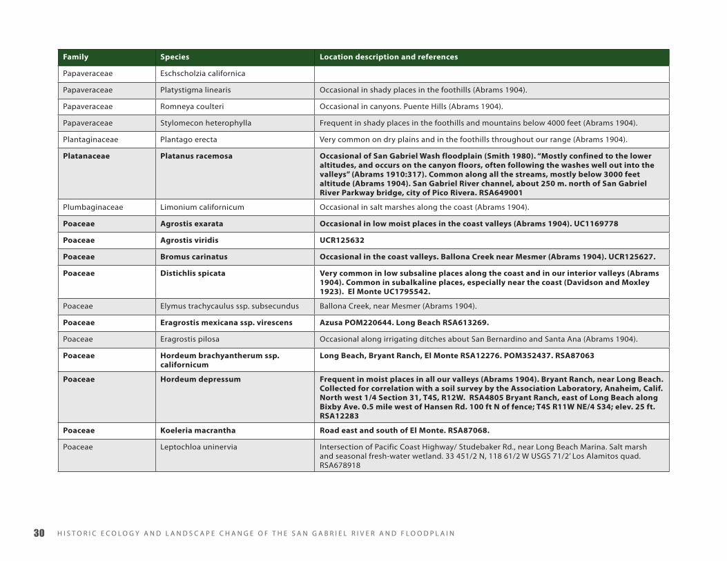
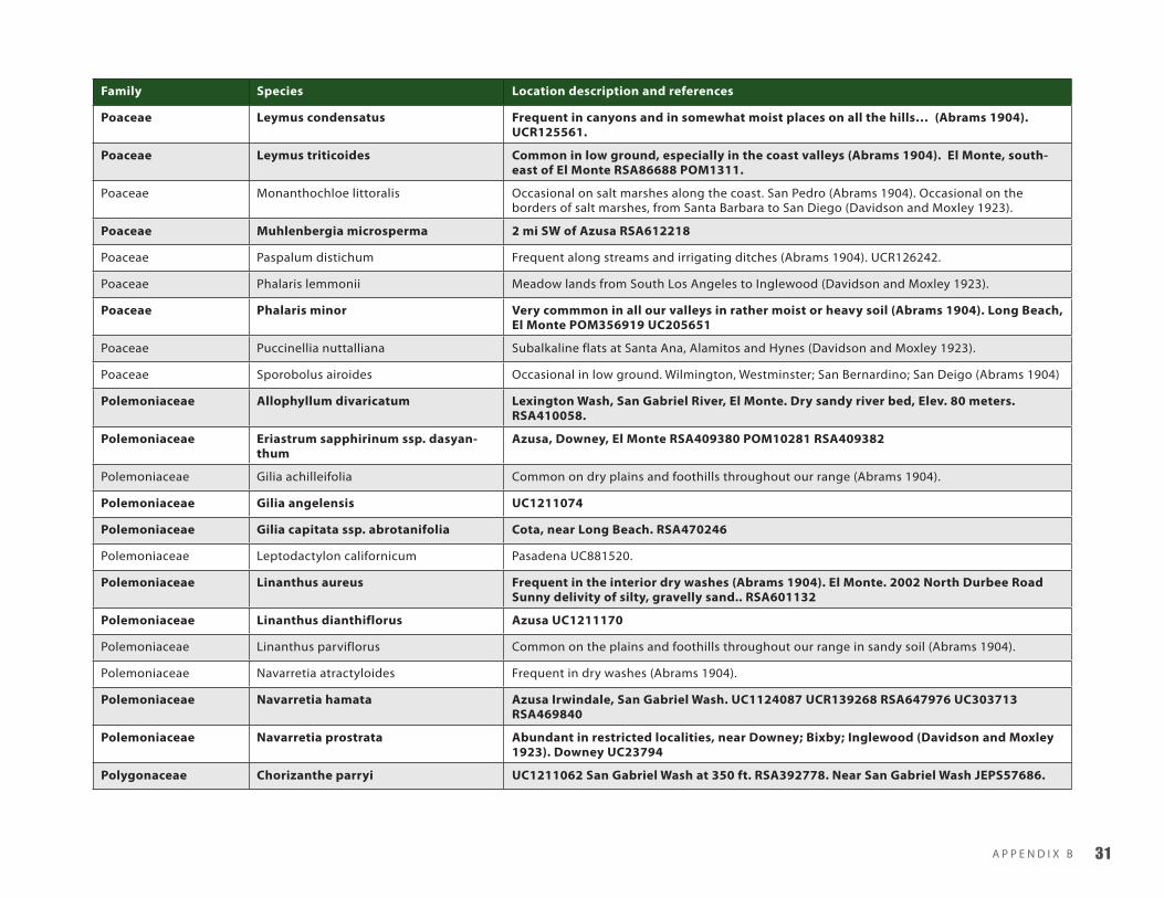
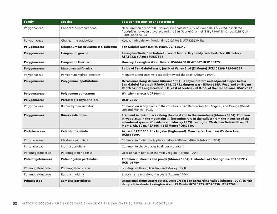
A P P E N D I X B ��
Location information for plant species of the San Gabriel River. Alphanumeric references are herbarium specimen records that can be
accessed at the Jepson Online Interchange. Species documented within study area are in bold.
Family Species Location description and references
Aizoaceae Sesuvium verrucosum Occasional in low saline places (Abrams 1904). Alamitos Bay, Long Beach RSA402667, UCR144075
Alismataceae Echinodorus berteroi Occasional along streams and banks of ponds (Abrams 1904). Limited to a few localities, on the edges of ponds and lakes, Garvanza; Alamitos; Elsinore; Lakeside (Davidson and Moxley 1923). Freshwater marsh RSA355652.
Alismataceae Sagittaria calycina var. calycina Ballona Creek (Abrams 1904)
Alismataceae Sagittaria latifolia Occasional on margins of ponds about Los Angeles (Abrams 1904). Occasional in zanjas and along stream borders Los Angeles and San Bernardino, 1890 (Davidson and Moxley 1923).
Anacardiaceae Malosma laurina Very common in the foothills and extending well up into the chaparral; less common in the interior (Abrams 1904). Intermediate and more mature zones of San Gabriel Wash (Smith 1980). UCR125611.
Anacardiaceae Rhus integrifolia Mature zones of San Gabriel Wash (Smith 1980). RSA683810. UC1787300.
Anacardiaceae Rhus ovata Approx. 300 yds N of Hwy 66 in Irwindale, ca. 500 yds E of the San Gabriel River Channel UCR100059.
Anacardiaceae Rhus trilobata Azusa UC1184972
Apiaceae Apiastrum angustifolium Common in sandy soil in the foothills and valleys (Abrams 1904). UCR125625.
Apiaceae Berula erecta Occasional along watercourses (Abrams 1904). Bassett near El Monte RSA98334.
Apiaceae Cicuta maculata var. angustifolia Frequent in marshes toward the coast (Abrams 1904).
BAppendix b - historic plAnt compendium for sAn GAbriel WAtershed

H I S T O R I C E C O L O G y A N D L A N D S C A P E C H A N G E O F T H E S A N G A B R I E L R I V E R A N D F L O O D P L A I N��
Family Species Location description and references
Apiaceae Daucus pusillus Irwindale, Azusa UCR125554. Rivera UC56506.
Apiaceae Eryngium aristulatum var. parishii In low heavy ground toward the coast (Abrams 1904).
Apiaceae Hydrocotyle ranunculoides Common in pools or slow-running streams, especialy toward the coast (Abrams 1904). Rio Hondo, shallow sluggish stream UCR678442.
Apiaceae Hydrocotyle umbellata Frequent on boarders of marshes and streams (Abrams 1904). Los Angeles River UC56503.
Apiaceae Oenanthe sarmentosa californica Frequent along slow-running streams (Abrams 1904). Lexington Wash, Bixby Ranch Long Beach POM223067, RSA458913, RSA98322.
Apiaceae Perideridia gairdneri ssp. gairdneria Occasional along borders of marshes (Abrams 1904).
Apiaceae Perideridia lemmonii Occasional in marshes toward the coast (Abrams 1904).
Apiaceae Sanicula bipinnata Los Angeles River, San Fernando Valley; Oak Knoll, Pasadena (Abrams 1904).
Apocynaceae Apocynum cannabinum Occasional in moist places along streams (Abrams 1904). Borders of marshes and moun-tain streams; not common (Davidson and Moxley 1923). Whittier Narrows RSA624645.
Aspleniaceae Asplenium vespertinum San Gabriel Canyon (Davidson and Moxley 1923).
Asteraceae Achillea millefolium San Gabriel River channel, about 600 m. north of San Gabriel River Parkway bridge, city of Pico Rivera RSA654591.
Asteraceae Ambrosia acanthicarpa Bryant Ranch, near Long Beach; T4S, R11W, SE/2 S27
Asteraceae Ambrosia psilostachya A common weed inlow ground, especially in our coast valleys (Abrams 1904). Rio Hondo at San Gabriel Blvd., near Whittier Narrows Dam and Hwy 19 UCR109690.
Asteraceae Artemisia biennis Occasional in low moist ground about Los Angeles (Abrams 1904).
Asteraceae Artemisia californica Mature zone of San Gabriel Wash (Smith 1980).
Asteraceae Artemisia douglasiana Common in low ground and along streams in the foothills (Abrams 1904).
Asteraceae Artemisia dracunculus Frequent in the valleys and foothills throughout our range (Abrams 1904).
Asteraceae Aster subulatus var. ligulatus Frequent in low subsaline places, especially along the coast (Abrams 1904).
Asteraceae Baccharis douglasii Occasional along streams in our coast region (Abrams 1904). Cienega Swamp UC63382. Los Angeles River UC63383. “Nigger” Slough, Gardena.UCR678877.
Asteraceae Baccharis emoryi Intersection of Pacific Coast Highway/ Studebaker Rd., near Long Beach Marina. Salt marsh and seasonal fresh-water wetland. RSA678873.
Asteraceae Baccharis pilularis

A P P E N D I X B ��
Family Species Location description and references
Asteraceae Baccharis salicifolia Very common along all our streams throughout our range (Abrams 1904). Pioneer zone of San Gabriel Wash (Smith 1980). “Wash” of Claremont UC75847. San Gabriel Canyon UC893723. San Gabriel River channel, about 100 m. south of Valley Boulevard bridge, city of El Monte RSA654592.
Asteraceae Bebbia juncea Occasional in dry washes (Abrams 1904).
Asteraceae Brickellia californica Occasional in the canyons of the San Gabriel and Santa Ana Mountains (Abrams 1904). Arroyo Seco, Pasadena UC472353.
Asteraceae Brickellia nevinii San Gabriel River Canyon: N of Azusa, river wash N of Hwy 39, ca 2 road mi N of Foothill Blvd. UCR104148.
Asteraceae Centromadia parryi Brackish flats toward the coast (Abrams 1904). Texaco Bryant Lease Oil Field, approx. 91.6 m SE of the intersection of Studebaker Rd. and Westminister Ave. 412 m W of San Gabriel River UCR672607.
Asteraceae Centromadia pungens Common in the plains in heavy, rather moist soil (Abrams 1904).
Asteraceae Chaenactis glabriuscula var. lanosa Common on plains and foothills, especialy in sandy soil (Abrams 1904). UCR125555. Azuza UC1211166.
Asteraceae Cirsium brevistylum El Monte SBBG98321.
Asteraceae Cirsium occidentale var. occidentale Long abandoned gravel pit on boundary between Irwindale and Azusa, east of Irwindale Ave. and south of Foothill Blvd, north edge of 210 Fwy east of the San Gabriel River chan-nel UCR125615.
Asteraceae Encelia californica Very common in the lower portions of the chaparral belt of all the mountains; also on the low hills about Los Angeles and along the coast (Abrams 1904)
Asteraceae Encelia farinosa UCR126341
Asteraceae Ericameria parishii Occasional in the lower portions of the chaparral belt of the San Gabriel, San Bernardino, and Santa Ana Ranges (Abrams 1904).
Asteraceae Ericameria pinifolia Frequent in the foothils of the San Gabriel Mountains in the lower altitudes of the chap-arral belt (Abrams 1904). SBBG54492. UC407070. UCR125608. Mature zone of San Gabriel Wash (Smith 1980).
Asteraceae Erigeron philadelphicus Occasional in low moist ground (Abrams 1904). Rivera UC63360.
Asteraceae Eriophyllum confertiflorum San Gabriel wash near Azusa UC1211059. UCR126237.
Asteraceae Eriophyllum wallacei Dry washes in the interior valleys. La Canada; San Fernando Valley (Abrams 1904).
Asteraceae Euthamia occidentalis Frequent in low ground and along streams in our valleys and foothills (Abrams 1904).
Asteraceae Gnaphalium bicolor UCR126230
Asteraceae Gnaphalium californicum Rather common on the dry plains and foothills (Abrams 1904).

H I S T O R I C E C O L O G y A N D L A N D S C A P E C H A N G E O F T H E S A N G A B R I E L R I V E R A N D F L O O D P L A I N�
Family Species Location description and references
Asteraceae Gnaphalium canescens ssp. microceph-alum
Frequent in dry washes and in the chaparral belt (Abrams 1904).
Asteraceae Gnaphalium leucocephalum Occasional in dry washes (Abrams 1904).
Asteraceae Gnaphalium palustre Occasional along river bottoms and on the margins of ponds (Abrams 1904).
Asteraceae Gnaphalium purpureum
Asteraceae Gnaphalium stramineum UCR125613
Asteraceae Grindelia stricta Borders of salt marshes along the coast (Abrams 1904).
Asteraceae Gutierrezia californica Mature zone of San Gabriel Wash (Smith 1980). Common on the interior plains and foothills, especially common on the fans at the base of the mountains (Abrams 1904).
Asteraceae Gutierrezia sarothrae UC87981
Asteraceae Hemizonia australis in dry saline areas below open grass-dominated hillside City of Long Beach; below the State University near Pacific Coast Highway; elev. 10 ft RSA292471
Asteraceae Hemizonia fasciculata Very common and general on the plains and lower hills (Abrams 1904). Downey UC89082.
Asteraceae Heterotheca grandiflora Common in waste places in sandy soil (Abrams 1904). El Monte RSA602379. Whittier JEPS30536. Rio Hondo at Valley Boulevard UCR108321
Asteraceae Heterotheca sessiflora ssp. fastigiata Frequent on dry plains and in the lower portions of the chaparral belt (Abrams 1904). UCR126233.
Asteraceae Heterotheca villosa Pioneer zone of San Gabriel Wash (Smith 1980). City of Irwindale, near junction of Foothill Blvd & Irwindale Ave., between gravel pit and the San Gabriel River channel UCR42568. Rio Hondo at Valley Boulevard
Asteraceae Isocoma menziesii ssp. vernonioides Intersection of Pacific Coast Highway/ Studebaker Rd., near Long Beach Marina. Salt marsh and seasonal fresh-water wetland. 33 451/2 N, 118 61/2 W USGS 71/2’ Los Alamitos quad RSA678916.
Asteraceae Jaumea carnosa Common in salt marshes along the coast (Abrams 1904). 100-150 ft w; at extreme se corner of Pacific Western Oil. Co. lease | State Highway | Bryant Ranch | UC729499.
Asteraceae Lasthenia glabrata Common in saline marshes, especially along the coast (Abrams 1904). Near Gardena, Nig-ger Slough UCR685099. Norwalk JEPS35389. Bryant Ranch, Long Beach RSA4774.
Asteraceae Lathyrus vestitus var. vestitus In alluvial sand 2 mi e, El Monte, San Gabriel River UC913066. Rivera UC53938
Asteraceae Lepidospartum squamatum Frequent in dry washes in all our interior valleys (Abrams 1904). Smith 1980 -- pioneer, intermediate and mature. UCR126236.
Asteraceae Pluchea sericea Rather common along the streams, especially in the interior valleys (Abrams 1904).
Asteraceae Psilocarphus tenellus var. globiferus Frequent on the plains and hills, especially in exsiccated places (Abrams 1904).

A P P E N D I X B ��
Family Species Location description and references
Asteraceae Senecio flaccidus var. douglasii Azusa, Santa Fe Dam RSA647965 UC75034.
Asteraceae Solidago californica Frequent in open places in the lower portions of the chaparral belt in th San Gabriel and Santa Ana ranges (Abrams 1904).
Asteraceae Solidago confinis Occasional in low marshy places (Abrams 1904).
Asteraceae Stylocline gnaphalioides Isolated floodplain, City of Irwindale, near junction of Foothill Blvd & Irwindale Ave., between gravel pit and the San Gabriel River channel UCR42537.
Asteraceae Tetradymia comosa Dry washes of the interior valleys, perhaps not within our region… (Abrams 1904).
Asteraceae Venegasia carpesioides Frequent in the Santa Monica, San Gabriel and Santa Ana Mountains (Abrams 1904).
Azollaceae Azolla filiculoides El Monte UC211178.
Bataceae Batis maritima Frequent in marshes on the seashore from Redondo to San Diego (Davidson and Moxley 1923).
Berberidaceae Berberis nevinii [El Monte] Library, [El Monte] RSA651197.
Betulaceae Alnus rhombifolia Common along mountain streams and occasionally extending down into the valleys (Abrams 1904). Near San Gabriel, W.H. Brewer UC5342. Often follows living streams into the edges of the valleys (Abrams 1910).
Blechnaceae Woodwardia fimbriata Frequent in all our canyons in wet, shaded places up to 1200 m. (Davidson & Moxley 1923).
Boraginaceae Cryptantha intermedia Azusa/Irwindale UCR126251 UCR125559 UCR42565.
Boraginaceae Cryptantha micrantha var. micrantha Frequent in dry washes in the interior valleys (Abrams 1904).
Boraginaceae Cryptantha muricata San Gabriel Wash, about 2 mi. south of Monrovia. RSA601941. City of Irwindale, near junction of Foothill Blvd & Irwindale Ave., between gravel pit and the San Gabriel River channel UCR157424.
Boraginaceae Heliotropium curassavicum Common in low saline places (Abrams 1904). Intersection of Pacific Coast Highway/ Studebaker Rd., near Long Beach Marina. Salt marsh and seasonal fresh-water wetland. 33 451/2 N, 118 61/2 W USGS 71/2’ Los Alamitos quad RSA678874. San Gabriel River channel, about 400m, north of San Gabriel River Parkway bridge, city of Pico Rivera RSA654726
Boraginaceae Pectocarya linearis Frequent on the mesas in the coast valleys and in moist places in the interior region (Abrams 1904).
Boraginaceae Pectocarya penicillata Rocky alluvial fan with sandy loam; coastal sage scrub of Rhus laurina, Artemisia cali-fornica, Lotus scoparius, Salvia mellifera, etc. San Gabriel Wash UCR126246 Irwindale UCR42566
Brassicaceae Cardamine californica Frequent in damp shady places in the mountains and foothills (Abrams 1904). Marshes and sluggish streams (Davidson and Moxley 1923) (gambellii). Brewer, San Gabriel UC10418.
Brassicaceae Cardamine oligosperma California State University, Long Beach RSA607508.

H I S T O R I C E C O L O G y A N D L A N D S C A P E C H A N G E O F T H E S A N G A B R I E L R I V E R A N D F L O O D P L A I N��
Family Species Location description and references
Brassicaceae Descurainia pinnata Disturbed riparian woodland in Whittier narrows RSA286432.
Brassicaceae Erysimum capitatum Azusa UC1211011.
Brassicaceae Hutchinsia procumbens In moist saline places throughout our range (Abrams 1904). In subalkaline sands on the coast (Davidson and Moxley 1923).
Brassicaceae Lepidium dictyotum var. acutidens In saline places toward the coast (Abrams 1904). Occasoinal in alkaline soils on the coastal plains (Davidson and Moxley 1923).
Brassicaceae Lepidium nitidum Azusa/Irwindale UCR126254. Pasadena UC856523.
Brassicaceae Rorippa curvisiliqua Frequent in low ground, about ponds and on river bottoms (Abrams 1904). UCR125637. Occasional on the margins of shallow pools (Davidson and Moxley 1923).
Brassicaceae Rorippa gambelii Frequent in marshes and wet places in the valleys (Abrams 1904)
Brassicaceae Rorippa nasturtium-aquaticum Common in streams (Abrams 1904). Very common in streams and marshy places (Davidson and Moxley 1923).
Brassicaceae Thysanocarpus curvipes Azusa UC1211053
Cactaceae Opuntia occidentalis Mature zone of San Gabriel Wash (Smith 1980).
Cactaceae Opuntia parryi Mature zone of San Gabriel Wash (Smith 1980).
Campanulaceae Lobelia cardinalis var. pseudosplendens Rare in marshes near Los Angeles, more common in wet places at middle altitudes in the mountains of Los Angeles, San Bernardino and San Diego Cos (Davidson and Moxley 1923).
Campanulaceae Lobelia dunnii var. serrata Frequent in moist places in the canyons of the San Gabriel and Santa Ana Mountains (Abrams 1904).
Caprifoliaceae Sambucus mexicana Frequent on low hills and in washes in all the valleys (Abrams 1904). POM305142. UCR126247. Baldwin Park RSA650339. RSA477555, RSA477570,
Caryophyllaceae Arenaria paludicola At one time common in the tule marshes of the cienegas at Los Angeles and Sherman, now exterminated by cultivation. Santa Ana River near San Bernardino (Davidson and Moxley 1923).
Caryophyllaceae Spergularia macrotheca Common in salt marshes and alkaline flats (Abrams 1904).
Caryophyllaceae Spergularia marina Common in salt marshes toward the coast (Abrams 1904). Bryant Ranch, E of Long Beach. T4S R12W SE/4 Sec.27. Alt. 15 ft. RSA12398. Intersection of Pacific Coast Highway/ Studebaker Rd., near Long Beach Marina. Salt marsh and seasonal fresh-water wetland. 33 451/2 N, 118 61/2 W USGS 71/2’ Los Alamitos quad RSA678875.
Ceratophyllaceae Ceratophyllum demersum In ponds and slow streams, frequent throughout our range (Abrams 1904). Frequent in ponds and slow streams (Davidson and Moxley 1923).
Chenopodiaceae Atriplex lentiformis In alkaline soils at Mecca, Parish (Davidson and Moxley 1923).
Chenopodiaceae Atriplex macrocarpa Rather common in saline palces toward the coast (Abrams 1904).

A P P E N D I X B ��
Family Species Location description and references
Chenopodiaceae Atriplex patula Frequent in saline places, especially toward the coast (Abrams 1904). Common in alkaline flats and coast marshes (Davidson and Moxley 1923).
Chenopodiaceae Atriplex serenana Very common throughout our range in saline places (Abrams 1904). Cienega UC56783. La Verne UC520378.
Chenopodiaceae Chenopodium californicum Frequent in the valleys and foothills (Abrams 1904). Azusa UC1211077.
Chenopodiaceae Chenopodium rubrum Occasional in saline flats and marshes along the coast (Abrams 1904).
Chenopodiaceae Monolepis nuttalliana In dry alkaline soils on the desert and in the interior valleys; Santa Monica (Davidson and Moxley 1923).
Chenopodiaceae Nitrophila occidentalis In alkaline soils along Los Angeles River; Nigger Slough, and south along the coast to lower California. Also low grounds in the interior (Davidson and Moxley 1923).
Chenopodiaceae Salicornia virginica Very common in salt marshes along the coast (Abrams 1904). Intersection of Pacific Coast Highway/ Studebaker Rd., near Long Beach Marina. Salt marsh and seasonal fresh-water wetland. 33 451/2 N, 118 61/2 W USGS 71/2’ Los Alamitos quad RSA678871.
Chenopodiaceae Suaeda moquinii Common in saline places (Abrams 1904).
Chenopodiaceae Suaeda taxifolia Frequent in saline places along the coast (Abrams 1904). Common on the edges of the coast marshes (Davidson and Moxley 1923). Long Beach UC55968.
Chenopodiaceae Sueda calcioliformis Frequent in low alkiline places toward the coast. Hyde Park; Mesmer (Abrams 1904).
Chenopodiaceae Sueda esteroa Rare species, Long Beach POM123170.
Cistaceae Helianthemum scoparium Azusa UC1211012.
Convolvulaceae Calystegia macrostegia ssp. interme-dia
Garvanza UC449949. End of Canyon Dr., 2 miles off Penn St. and 100 yds. E of Whittier College track. RSA660902.
Convolvulaceae Calystegia sepium In moist meadows in the coast region (Abrams 1904). near Los Angeles UC126774.
Convolvulaceae Cressa truxillensis Frequent in saline places throughout our range (Abrams 1904). Gardena UC56828. Long Beach JEPS47820.
Cornaceae Cornus glabrata Whittier Narrows, San Gabriel River bed near Whittier UCR24178.
Cornaceae Cornus sericea Occasional in moist ground, especially in the mountains, but reported from Cienega by Davidson (Abrams 1904). Occasional along stream banks in the San Gabriel and Cuyamaca Mts.; more frequent in the San Bernardino and San Jacinto ranges; the few trees formerly growing in the cienega near Los Angeles have been destroyed (Davidson and Moxley 1923). Whittier (moist sandy soil on deep bottomland) UCR24188
Crassulaceae Crassula connata UCR126231
Crassulaceae Crassula tillaea San Gabriel Wash RSA604602. Azusa: San Gabriel Wash at Foothill Blvd., east side UCR101270.

H I S T O R I C E C O L O G y A N D L A N D S C A P E C H A N G E O F T H E S A N G A B R I E L R I V E R A N D F L O O D P L A I N��
Family Species Location description and references
Crassulaceae Dudleya lanceolata Azusa; alluvial fan east and west of levee. SD143942
Cucurbitaceae Cucurbita foetidissima Frequent in dry sandy soil throughout our range (Abrams 1904).
Cucurbitaceae Marah macrocarpus Mature zone of San Gabriel Wash (Smith 1980). UCR164058.
Cupressaceae Juniperius californica On higher terraces with chaparral assemblage in San Gabriel Wash (Smith 1980). POM6815. “About Los Angeles it has been found near Azusa…” (Davidson and Moxley 1923). San Fernando Valley and San Gabriel Wash near the mouth of the canyon (Abrams 1904). “on dry washes on the coastal slope in southern California” (Abrams 1910: 331). San Gabriel Wash at Azusa. ca. 500+ ft alt. POM6815.
Cuscutaceae Cuscuta californica Occasional along the coast and in the interior, growing on various low shrubs (Abrams 1904). Azusa. POM156517. Irwindale. UCR125631.
Cuscutaceae Cuscuta indecora 3 miles SE of El Monte. Alt. 250 ft. [=Bassett] POM222505.
Cuscutaceae Cuscuta salina In salt marshes along the coast, growing over Salicornia, etc (Abrams 1904). Alamitos Bay. Alt. 2 m. RSA409749.
Cuscutaceae Cuscuta subinclusa Azusa; alluvial fan east and west of levee. SD143934. Lexington Wash, San Gabriel River, El Monte. Dry sandy river bed, Elev. 80 meters RSA409716.
Cyperaceae Carex alma El Monte POM1430. UC212018.
Cyperaceae Carex lanuginosa Ditch along R.R., El Monte. UC212035.
Cyperaceae Carex praegracilis Frequent in marshes in the coast valeys (Abrams 1904). El Monte RSA88757.
Cyperaceae Carex spissa El Monte, Alt. 400 ft. POM1513.
Cyperaceae Cladium californicum Swamp near San Gabriel by Brewer (Watson, Bot. Cal. 2:224). Also in (Davidson and Moxley 1923). Known from alkali flats.
Cyperaceae Cyperus eragrostis Lexington Wash near El Monte. Elevation 240 ft. RSA610522
Cyperaceae Cyperus erythrorhizos Long Beach RSA365115.
Cyperaceae Cyperus laevigatus Occasional in moist places about Los Angeles and San Bernardino (Abrams 1904). Not infre-quent along Los Angeles river (Davidson and Moxley 1923).
Cyperaceae Cyperus niger Occasional in moist sandy places on river bottoms (Abrams 1904). Long Beach UC838211 RSA365096
Cyperaceae Eleocharis acicularis Frequent in moist places along streams and on porders of ponds (Abrams 1904). Moist places in the Los Angeles and Santa Ana Rivers (Davidson and Moxley 1923).
Cyperaceae Eleocharis macrostachya Common in wet places along streams throughout our range (Abrams 1904). Common along streams (Davidson and Moxley 1923). Nigger Slough, near El Monte. POM1364.
Cyperaceae Eleocharis montevidensis El Monte, along R.R. UC306107. Long Beach. Alt. 100 [ft] RSA365443

A P P E N D I X B ��
Family Species Location description and references
Cyperaceae Eleocharis rostellata Frequent in marshes and on river bottoms about Los Angeles and San Bernardino (Abrams 1904). San Bernardino (Davidson and Moxley 1923). Alkali sink.
Cyperaceae Isolepis cernua Occasional on river bottoms about Los Angeles and Santa Barbara (Abrams 104).
Cyperaceae Schoenoplectus acutus Common along streams and marshes. “Tule” (Abrams 1904). Very common along streams and in marshes (Davidson and Moxley 1923). El Monte, Alt. 400 ft. POM1384 Southeast of El Monte. RSA92164El Monte; ditch along R.R. UC306166
Cyperaceae Schoenoplectus robustus Common in marshes, especially in somewhat saline places (Abrams 1904).
Cyperaceae Scirpus americanus Occasional on river bottoms about Los Angeles (Abrams 1904). Occasional on river bottoms,Orange, Los Angeles and San Diego Cos (Davidson and Moxley 1923). Common among tles throughout the southern counties (olneyi) (Davidson and Moxley 1923). Long Beach. RSA366046 El Monte. Alt 275 ft. RSA1406. South-east of El Monte: San Gabriel River at Slaughter Avenue and Parkway Drive. RSA602205 UC306164
Cyperaceae Scirpus californicus More common (Abrams 1904). Common in brackish marshes, less abundant than [acutus] (Davidson and Moxley 1923). Long Beach, Alamitos Ranch, East and South of El Monte. UC188245 RSA366003 RSA92163
Cyperaceae Scirpus maritimus S. B. and W. F. Parish, 1115, October, 1881. Long Beach RSA366068 UC2154
Cyperaceae Scirpus microcarpus El Monte RSA1413 UC306138
Elatinaceae Elatine brachysperma Occasional along borders of ponds toward the coast (Abrams 1904).
Equisetaceae Equisetum arvense Lexington Wash near El Monte. Elevation 240 ft. POM223056
Equisetaceae Equisetum laevigatum UCR132443. Occasional along streams (Davidson and Moxley 1923). Along mountain streams and in cienegas (Davidson and Moxley 1923). El Monte. Rivera. Whittier.
Equisetaceae Equisetum telmateia San Gabriel River, near Bassett, L. Street (E. telmateia (Davidson and Moxley 1923)).
Euphorbiaceae Chamaesyce melanadenia Azuza UC1184975.
Euphorbiaceae Croton californicus UC1211064. UC1211064. UCR125629. UCR100070. RSA647962. UCR125629. RSA479356. RSA479354. UCR125629. RSA479356. UCR100070.
Fabaceae Amorpha fruticosa Los Angeles, Davidson. UC80650.
Fabaceae Astragalus pycnostachyus In moist subsaline soil near the sea (Abrams 1904). Ballona slough UC56521. Near Santa Monica UC192246. Cienega UC397224.
Fabaceae Astragalus trichopodus var. lonchus Frequent on the plains (Abrams 1904). Grassy hills near Inglewood UC153560. Hermosa Beach; dunes of the sea coast UC397241. La Brea Canyon; Puente Hills JEPS54845. Long Beach POM9012.
Fabaceae Astragulus tener In low ground near the coast (Abrams 1904). Low ground near Hyde Park. UC153559.

H I S T O R I C E C O L O G y A N D L A N D S C A P E C H A N G E O F T H E S A N G A B R I E L R I V E R A N D F L O O D P L A I N��
Family Species Location description and references
Fabaceae Lotus heermannii Canyons of the San Gabriel and Santa Ana Mountains, below 4000 ft (Abrams 1904). El Monte, Rivera UC397212 UC80812
Fabaceae Lotus oblongifolia Along streams near Los Angeles and in San Gabriel Canyon (Abrams 1904). El Monte, Rivera UC212489 UC56569
Fabaceae Lotus purshianus UCR125617. Long Beach UC537010. Lexington Wash, San Gabriel River, El Monte. Dry sandy river bed, Elev. 80 meters RSA406258. Long Beach POM201889
Fabaceae Lotus salsuginosus In moist places on the plains and in the canyons of the foothills (Abrams 1904).
Fabaceae Lotus scoparius Smith 1980 - pioneer and intermediate zones. UCR126340. Lexington Wash, San Gabriel River, El Monte. Dry sandy river bed, Elev. 80 meters. RSA406845 Long Beach POM27731
Fabaceae Lotus strigosus UCR126587
Fabaceae Lupinus bicolor Common in all our valleys (Abrams 1904). Azusa, Irwindale, Long Beach UCR126249. UCR126249 RSA652734 RSA652739 RSA4769
Fabaceae Lupinus concinnus Occasional in dry washes in the interior valleys (Abrams 1904).
Fabaceae Lupinus latifolius Frequent in the canyons of the San Gabriel and San Bernardino Mountains (Abrams 1904)
Fabaceae Lupinus succulentus RSA625862. Long Beach JEPS65486
Fabaceae Lupinus truncatus In alluvial plain, disturbed. Santa Fe Dam RSA625864
Fabaceae Trifolium obtusiflorum [Pico] Rivera UC56623.
Fabaceae Trifolium wormskioldii Frequent in low ground in the valleys (Abrams 1904). [Pico] Rivera UC56625.
Fagaceae Quercus agrifolia The common oak of our valleys and foothills (Abrams 1904).
Fagaceae Quercus engelmannii [Q. lobata] does not extend south of the Santa Monica Mountains, but its place south of this range is taken by Quercus engelmannii which, together with Quercus agrifolia, covers consid-erable area about Pasadena, Santa Anit, and Fall brook. Abrams 1910. Frequent from Altadena to Monrovia; also occurring at Azusa and Glenora, as well as in the foothills of San Diego County (Abrams 1904).
Frankeniaceae Frankenia salina Common in saline marshes (Abrams 1904). Long Beach UCR689740. Gardena UC55882. Nigger Slough UC141119. Intersection of Pacific Coast Highway/ Studebaker Rd., near Long Beach Marina. Salt marsh and seasonal fresh-water wetland. 33 451/2 N, 118 61/2 W USGS 71/2’ Los Alamitos quad RSA678915
Gentianaceae Centaurium exaltatum Lexington Wash, San Gabriel River, El Monte. Dry sandy river bed, Elev. 80 meters RSA391490. Santa Fe Dam, 15501 E. Arrow Highway, Irwindale; 400 feet northwest of park office. RSA647968. Albino plants, 1 mile west of Azusa, Los Angeles County. POM153274.
Grossulariaceae Ribes aureum var. aureum Eaton’s Wash, near Sierra Madre (Abrams 1904). Smith 1980 -- mature zone. Irwindale, San Gabriel Wash UCR42526 UCR100062 UCR70843

A P P E N D I X B ��
Family Species Location description and references
Grossulariaceae Ribes divaricatum var. parishii On Los Angeles River near Universal City this shrub forms quite a thicket; elsewhere it occurs in isolated clumps in the foothill canyons of the Santa Monica and San Gabriel Mountains (Davidson and Moxley 1923).. Lexington Wash at El Monte in willow thickets POM360. Whittier Narrow, San Gabriel River, Pico Rivera; elev. 400 ft in willow thicket along flood plains of streams in a Coastal Sage Scrub Community RSA164867. San Ga-briel River at whittier Narrows; elev. 200 ft in moist brushy bottomland flats RSA78371. UC1010241. San Gabriel River at El Monte in willow thicket UC212382. San Gabriel River in shade of Salix UC574934. Lexington Wash, El Monte UC741681. San Gabriel River at Whittier narrows Moist brushy bottomland flats with Cornus californica, Populus tricho-carpa, etc. UCR24339. Whittier Narrows. Near bottom Semishade, in moist sandy soil on a deep bottomland. With Cornus californica, Vitis girdiana and Populus trichocarpa. UCR24340. Whittier Narrows, San Gabriel River, Pico Rivera Willow thicket along flood plains of streams in a Coastal Sage Scrub Community. UCR25493. With Rubus in Salix-Populus Jungle Lexington Wash near El Monte UCR70822
Grossulariaceae Ribes indecorum Duarte, Azusa UC921816. UCR126239. UCR125624.
Hydrocharitaceae Najas flexilis Ponds, Garvanza and Solidier’s Home (Davidson and Moxley 1923).
Hydrocharitaceae Najas marina In pond in gravel pit, Irwindale RSA603584 UCR101199
Hydrophyllaceae Eriodictyon trichocalyx Smith 1980 -- mature zone. UC1183071. UCR126238. UC1183071. UC1211013. UCR126238. RSA647963. UCR126238. UCR100064. UCR126238. RSA649604.
Hydrophyllaceae Nama stenocarpum Growing about the borders of ponds (Abrams 1904).
Hydrophyllaceae Phacelia cicutaria Abandoned gravel pit Asuza, Irwindale UCR125610
Hydrophyllaceae Phacelia distans Very commom in the plains and foothills (Abrams 1904). UCR126339. UCR125777. RSA602197. RSA602196. RSA647972. UCR42538. UCR126339. RSA647972.
Hydrophyllaceae Phacelia stellaris Bryant Ranch, near Long Beach, SE/4 Section 27, T4S, R11W Station #3. Plat. 3. RSA4765
Iridaceae Sisyrinchium bellum El Monte POM1767 UC205501
Juglandaceae Juglans californica Azusa. JEPS46456. UC1184976.
Juncaceae Juncus acutus ssp. leopoldii Salt marshes near the coast (Abrams 1904). Long Beach RSA368107
Juncaceae Juncus ambiguus El Monte UC212778
Juncaceae Juncus arcticus spp. littoralis Frequent along streams and in low ground generally throughout our range (Abrams 1904).
Juncaceae Juncus bufonius Common in the valleys and mountains in moist ground (Abrams 1904). Lexington Wash, San Gabriel River. El Monte. Alt 80 m. Bryant Ranch. Whittier Narrows. RSA368150 POM1547 RSA12415 RSA611959
Juncaceae Juncus lesueurii Occasional along streams in our foothill canyons. What seems to be the same collected by the author along New River near Long Beach (Abrams 1904).

H I S T O R I C E C O L O G y A N D L A N D S C A P E C H A N G E O F T H E S A N G A B R I E L R I V E R A N D F L O O D P L A I N��
Family Species Location description and references
Juncaceae Juncus mexicanus More common, along streams and in low ground (Abrams 1904). Lexington Wash, El Monte. RSA368237 POM1557 UC212770
Juncaceae Juncus phaeocephalus Frequent along streams and in low brackish places (Abrams 1904). Road east and south of El Monte. RSA70269. [El Monte?] Ditch along Railroad. Alt. 375 ft. POM1608
Juncaceae Juncus textilis South El Monte: San Gabriel River, near Potrero Chico. RSA603787. El Monte. POM1597 UC213636
Juncaceae Juncus torreyi Occasional along streams. Los Angeles River, Davidson (Abrams 1904).
Juncaginaceae Triglochin maritima Salt marshes along the coast (Abrams 1904). Common in salt marshes along the coast, and in moist akaline soils in the interior (Davidson and Moxley 1923). San Gabriel River near El Monte RSA368937. Long Beach RSA69593 UC142457
Lamiaceae Lycopus americanus Banks of Rio Hondo, El Monte RSA83442
Lamiaceae Lycopus asper Occasional along strream banks in the San Fernando Valley, Parish (Abrams 1904).
Lamiaceae Monardella lanceolata San Gabriel Wash UC883591
Lamiaceae Salvia carduacea Occasional in sandy soil in all the valleys and in the foothils (Abrams 1904).
Lamiaceae Salvia columbariae Azusa at Foothill Blvd. RSA401449. UC1211060
Lamiaceae Salvia mellifera Mature zone of San Gabriel River (Smith 1980). Azusa POM305154. UCR126235. Irwindale RSA647929.
Lamiaceae Scutellaria bolanderi Moist woods, El Monte, Davidson (Abrams 1904).
Lamiaceae Stachys ajugoides Frequent along streams in the valleys and in the lower altitudes of the mountains below the pine belt (Abrams 1904).
Lamiaceae Stachys albens Frequent along marshes and streams in the valleys and extending into the pine belt of all our mountains (Abrams 1904). Lexington Wash near El Monte. Elevation 240 ft. POM223057 RSA582111.
Lamiaceae Stachys bullata Frequent on shaded slopes and in canyons in all the mountains and foothills (Abrams 1904).
Lemnaceae Lemna gibba Common in slow-running streams and ponds (Abrams 1904). Common on ponds and streams (Davidson and Moxley 1923).
Lemnaceae Lemna minor Less common than Lemna gibba (Abrams 1904). Common throughout our range (Abrams 1904).
Liliaceae Brodiaea minor Occasional in heavy soil (Abrams 1904). No recent records in region.
Liliaceae Dichelostemma capitatum UC1211090. UCR126337.
Liliaceae Yucca whipplei Mature and pioneer zones of San Gabriel Wash (Smith 1980). UC1272485

A P P E N D I X B ��
Family Species Location description and references
Limnanthaceae Limnanthes douglasii Growing in wet places. Reported from Los Angeles and San Bernardino (Abrams 1904). Marshy ground near Gardena (Davidson and Moxley 1923).
Loasaceae Mentzelia gracilenta Frequent on the plains and foothils and also on the sand-dunes along the seashore (Abrams 1904).
Loasaceae Mentzelia laevicaulis Frequent in dry washes in our interior valleys and canyons (Abrams 1904).
Lythraceae Lythrum californicum Common in damp ground along streams, both in the valleys and mountains (Abrams 1904).
Malvaceae Malacothamnus davidsonii San Fernando Valley and La Canada in washes (Abrams 1904).
Malvaceae Malacothamnus fasciculatus San Gabriel Wash UC303547 Azusa UC18793
Malvaceae Malvella leprosa Common in subsaline places (Abrams 1904). Bryant Ranch, East of Long Beach [Los Alami-tos] RSA5871. RSA4834. RSA77179. Near channel of SGR
Malvaceae Sidalcea neomexicana in low subsaline places throughout our range (Abrams 1904).
Nyctaginaceae Mirabilis californica San Gabriel River Wash, Irwindale RSA652391
Oleaceae Fraxinus latifolia San Gabriel and Lytle Creek Canyons (Abrams 1904).
Oleaceae Fraxinus vetulina Azusa, Irwindale, El Monte UCR126243 UCR150614 UC277059
Onagraceae Camissonia bistorta UC1184979. RSA625859. Glendora UC166702. San Pedro UC107678.
Onagraceae Camissonia contorta Common in sandy soil in the valleys and foothills toward the coast (Abrams 1904).
Onagraceae Camissonia intermedia RSA647945
Onagraceae Camissonia strigulosa Bryant Ranch, near Long Beach, SE/4 Section 27, T4S, R11W Station #3. Plat. 3. RSA4785. RSA4784
Onagraceae Clarkia purpurea RSA685140
Onagraceae Epilobium canum Frequent in low ground in all our valleys (Abrams 1904).
Onagraceae Epilobium ciliatum ssp. ciliatum In marshes near the coast. Alamitos (Abrams 1904). In marshes near the coast. Cienega; Alamitos, Abrams (Davidson and Moxley 1923). Common in damp land in the valleys and along streams below 4000 feet (Abrams 1904). Lexington Wash, San Gabriel River, El Monte. RSA588473. New River near Long Beach. POM50051. UC306263. Rivera UC56457.
Onagraceae Ludwigia peploides ssp. peploides In stagnant water or muddy bottoms. In marshes toward the coast. Alamitos (Abrams 1904).
Onagraceae Oenothera elata ssp. hookeri Frequent in moist ground, usualy along streams, both in the valleys and mountains (Abrams 1904). Dry sandy riverbed, San Gabriel River, El Monte POM355619
Orchidaceae Epipactis gigantea “San Gabriel Canyon” UC1174781. El Monte RSA381705.
Papaveraceae Dicentra chrysantha SBBG70220
H I S T O R I C E C O L O G y A N D L A N D S C A P E C H A N G E O F T H E S A N G A B R I E L R I V E R A N D F L O O D P L A I N�
Family Species Location description and references
Papaveraceae Eschscholzia californica
Papaveraceae Platystigma linearis Occasional in shady places in the foothills (Abrams 1904).
Papaveraceae Romneya coulteri Occasional in canyons. Puente Hills (Abrams 1904).
Papaveraceae Stylomecon heterophylla Frequent in shady places in the foothills and mountains below 4000 feet (Abrams 1904).
Plantaginaceae Plantago erecta Very common on dry plains and in the foothills throughout our range (Abrams 1904).
Platanaceae Platanus racemosa Occasional of San Gabriel Wash floodplain (Smith 1980). “Mostly confined to the lower altitudes, and occurs on the canyon floors, often following the washes well out into the valleys” (Abrams 1910:317). Common along all the streams, mostly below 3000 feet altitude (Abrams 1904). San Gabriel River channel, about 250 m. north of San Gabriel River Parkway bridge, city of Pico Rivera. RSA649001
Plumbaginaceae Limonium californicum Occasional in salt marshes along the coast (Abrams 1904).
Poaceae Agrostis exarata Occasional in low moist places in the coast valleys (Abrams 1904). UC1169778
Poaceae Agrostis viridis UCR125632
Poaceae Bromus carinatus Occasional in the coast valleys. Ballona Creek near Mesmer (Abrams 1904). UCR125627.
Poaceae Distichlis spicata Very common in low subsaline places along the coast and in our interior valleys (Abrams 1904). Common in subalkaline places, especially near the coast (Davidson and Moxley 1923). El Monte UC1795542.
Poaceae Elymus trachycaulus ssp. subsecundus Ballona Creek, near Mesmer (Abrams 1904).
Poaceae Eragrostis mexicana ssp. virescens Azusa POM220644. Long Beach RSA613269.
Poaceae Eragrostis pilosa Occasional along irrigating ditches about San Bernardino and Santa Ana (Abrams 1904).
Poaceae Hordeum brachyantherum ssp. californicum
Long Beach, Bryant Ranch, El Monte RSA12276. POM352437. RSA87063
Poaceae Hordeum depressum Frequent in moist places in all our valleys (Abrams 1904). Bryant Ranch, near Long Beach. Collected for correlation with a soil survey by the Association Laboratory, Anaheim, Calif. North west 1/4 Section 31, T4S, R12W. RSA4805 Bryant Ranch, east of Long Beach along Bixby Ave. 0.5 mile west of Hansen Rd. 100 ft N of fence; T4S R11W NE/4 S34; elev. 25 ft. RSA12283
Poaceae Koeleria macrantha Road east and south of El Monte. RSA87068.
Poaceae Leptochloa uninervia Intersection of Pacific Coast Highway/ Studebaker Rd., near Long Beach Marina. Salt marsh and seasonal fresh-water wetland. 33 451/2 N, 118 61/2 W USGS 71/2’ Los Alamitos quad. RSA678918
A P P E N D I X B ��
Family Species Location description and references
Poaceae Leymus condensatus Frequent in canyons and in somewhat moist places on all the hills… (Abrams 1904). UCR125561.
Poaceae Leymus triticoides Common in low ground, especially in the coast valleys (Abrams 1904). El Monte, south-east of El Monte RSA86688 POM1311.
Poaceae Monanthochloe littoralis Occasional on salt marshes along the coast. San Pedro (Abrams 1904). Occasional on the borders of salt marshes, from Santa Barbara to San Diego (Davidson and Moxley 1923).
Poaceae Muhlenbergia microsperma 2 mi SW of Azusa RSA612218
Poaceae Paspalum distichum Frequent along streams and irrigating ditches (Abrams 1904). UCR126242.
Poaceae Phalaris lemmonii Meadow lands from South Los Angeles to Inglewood (Davidson and Moxley 1923).
Poaceae Phalaris minor Very commmon in all our valleys in rather moist or heavy soil (Abrams 1904). Long Beach, El Monte POM356919 UC205651
Poaceae Puccinellia nuttalliana Subalkaline flats at Santa Ana, Alamitos and Hynes (Davidson and Moxley 1923).
Poaceae Sporobolus airoides Occasional in low ground. Wilmington, Westminster; San Bernardino; San Deigo (Abrams 1904)
Polemoniaceae Allophyllum divaricatum Lexington Wash, San Gabriel River, El Monte. Dry sandy river bed, Elev. 80 meters. RSA410058.
Polemoniaceae Eriastrum sapphirinum ssp. dasyan-thum
Azusa, Downey, El Monte RSA409380 POM10281 RSA409382
Polemoniaceae Gilia achilleifolia Common on dry plains and foothills throughout our range (Abrams 1904).
Polemoniaceae Gilia angelensis UC1211074
Polemoniaceae Gilia capitata ssp. abrotanifolia Cota, near Long Beach. RSA470246
Polemoniaceae Leptodactylon californicum Pasadena UC881520.
Polemoniaceae Linanthus aureus Frequent in the interior dry washes (Abrams 1904). El Monte. 2002 North Durbee Road Sunny delivity of silty, gravelly sand.. RSA601132
Polemoniaceae Linanthus dianthiflorus Azusa UC1211170
Polemoniaceae Linanthus parviflorus Common on the plains and foothills throughout our range in sandy soil (Abrams 1904).
Polemoniaceae Navarretia atractyloides Frequent in dry washes (Abrams 1904).
Polemoniaceae Navarretia hamata Azusa Irwindale, San Gabriel Wash. UC1124087 UCR139268 RSA647976 UC303713 RSA469840
Polemoniaceae Navarretia prostrata Abundant in restricted localities, near Downey; Bixby; Inglewood (Davidson and Moxley 1923). Downey UC23794
Polygonaceae Chorizanthe parryi UC1211062 San Gabriel Wash at 350 ft. RSA392778. Near San Gabriel Wash JEPS57686.
H I S T O R I C E C O L O G y A N D L A N D S C A P E C H A N G E O F T H E S A N G A B R I E L R I V E R A N D F L O O D P L A I N��
Family Species Location description and references
Polygonaceae Chorizanthe procumbens Near Junction of Foothill Blvd and Irwindale Ave. City of Irwindale. Collected in isolated floodplain between gravel pit and the San Gabriel Channel (T1N, R10W, N1/2 sec. 32&33) alt. 550ft. RSA424904.
Polygonaceae Chorizanthe staticoides Azuza, Irwindale, on floodplain UC1211062. UCR125630. Etc.
Polygonaceae Eriogonum fasciculatum ssp. foliosum San Gabriel Wash (Smith 1980). UCR126342
Polygonaceae Eriogonum gracile Lexington Wash, San Gabriel River, El Monte. Dry sandy river bed, Elev. 80 meters. RSA393236 Azusa POM7641
Polygonaceae Eriogonum thurberi Downey, Lexington Wash, Rivera. RSA64768 UC473582 UCR139375
Polygonaceae Mucronea californica E side of San Gabriel Wash, just N of Valley Blvd [El Monte] UCR101299 RSA608227
Polygonaceae Polygonum hydropiperoides Frequent along streams, especially toward the coast (Abrams 1904).
Polygonaceae Polygonum lapathifolium Occasional along streams (Abrams 1904). Canyon bottom and adjacent slopes below San Gabriel Reservoir RSA602344. C57 Lexington Wash RSA466345. Peat land on Bryant Ranch east of Long Beach. 700 ft. east of center; 950 ft. So. of No. line of Same. RSA12647
Polygonaceae Polygonum punctatum Whittier narrows UCR108444.
Polygonaceae Pterostegia drymarioides UCR125551
Polygonaceae Rumex hymenosepalus Common on sandy plains in the counties of San Bernardino, Los Angeles, and Orange (David-son and Moxley 1923).
Polygonaceae Rumex salicifolius Frequent in moist places along the coast and in the mountains (Abrams 1904). Common in wet places in the mountains … becoming rare in the valleys from the intrusion of the introduced species (Davidson and Moxley 1923). Lexington Wash, San Gabriel River, El Monte. Alt. 80 m. RSA466116 El Monte POM2349.
Portulacaceae Calandrinia ciliata Azusa UC1211055. Los Angeles [Inglewood], Manchester Ave. near Western Ave UCR688999.
Portulacaceae Claytonia perfoliata Common in moist shady places below 4000 feet altitude (Abrams 1904).
Portulacaceae Montia perfoliata Common in shady places in all our mountains.
Potamogetonaceae Potamogeton nodosus Occasional in ponds in the valley region (Abrams 1904).
Potamogetonaceae Potamogeton pectinatus Common in streams and ponds (Abrams 1904). El Monte: Lake Shangri-La. RSA601917 UCR101740
Potamogetonaceae Potamogeton pusillus Los Angeles River (Davidson and Moxley 1923).
Potamogetonaceae Ruppia maritima Brackish streams along the coast (Abrams 1904).
Primulaceae Samolus parviflorus Occasional along watercourses. Lytle Creek; San Bernardino Valley (Abrams 1904). In rich damp silt in shade, Lexington Wash, El Monte UC520325 UC526238 UC877769

A P P E N D I X B ��
Family Species Location description and references
Pteridaceae Pityrogramma triangularis UCR125622
Ranunculaceae Clematis lasiantha Common in the chaparral belt, clambering over shrubs (Abrams 1904).
Ranunculaceae Clematis ligusticifolia Common in canyons in all our mountains and occasionally extending into the valleys along streams (Abrams 1904).
Ranunculaceae Delphinium cardinale RSA683816. Frequent in stream washes and canyons (Davidson and Moxley 1923). Irwin-dale, Azusa, “wash of San Gabriel River”
Ranunculaceae Ranunculus aquatilus In ponds and quiet streams throughout our region; not common (Davidson and Moxley 1923). Occasional in ponds and slow-running streams (Abrams 1904).
Ranunculaceae Ranunculus cymbalaria Frequent throughout our range in low moist places (Abrams 1904). Borders of stream and moist grounds (Davidson and Moxley 1923).
Resedaceae Oligomeris linifolia In saline soils near the coast and in sandy soils on the deserts (Davidson and Moxley 1923).
Rhamnaceae Ceanothus cuneatus West side of Junction of Sierra Madre Ave. and Vernon Ave., Azusa UCR100057. Near Downey UC73351.
Rhamnaceae Rhamnus crocea Mature zone of San Gabriel Wash (Smith 1980). San Gabriel Wash north of Baldwin Park JEPS42044
Rosaceae Aphanes occidentalis Occasional in shady places or along streams in the foothills (Abrams 1904).
Rosaceae Cercocarpus betuloides UC12144 “San Gabriel”
Rosaceae Horkelia cuneata Azusa, Irwindale UCR42561
Rosaceae Potentilla anserina Rather common in damp ground in the valleys (Abrams 1904).
Rosaceae Rosa californica Frequent throughout our range bothin the valleys and mountains (Abrams 1904).
Rosaceae Rubus ursinus Frequent in the foothills and valleys, mostly along streams (Abrams 1904). UCR70822
Rubiaceae Galium angustifolium UCR126244
Rubiaceae Galium trifidum Occasional in shady places, mostly in the interior valleys (Abrams 1904).
Salicaceae Populus balsamifera ssp. trichocarpa Frequent in the canyons of all our mountains and sometimes extending down into the valleys (Abrams 1904). Whittier UCR24188.
Salicaceae Populus fremontii Rare within our limits (Abrams 1904).
Salicaceae Salix exigua In the interior valleys, mostly beyond our limits (Abrams 1904). El Monte UC846159.
Salicaceae Salix gooddingii long abandoned gravel pit on boundary between Irwindale and Azusa, east of Irwindale Ave. and south of Foothill Blvd, north edge of 210 Fwy east of the San Gabriel River chan-nel UCR126343
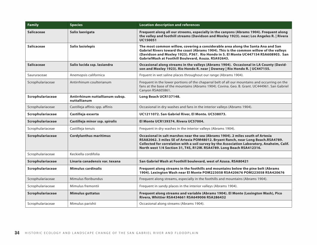
H I S T O R I C E C O L O G y A N D L A N D S C A P E C H A N G E O F T H E S A N G A B R I E L R I V E R A N D F L O O D P L A I N��
Family Species Location description and references
Salicaceae Salix laevigata Frequent along all our streems, especially in the canyons (Abrams 1904). Frequent along the valley and foothill streams (Davidson and Moxley 1923). near; Los Angeles R. | Rivera UC150051
Salicaceae Salix lasiolepis The most common willow, covering a considerable area along the Santa Ana and San Gabriel Rivers toward the coast (Abrams 1904). This is the common willow of the valleys (Davidson and Moxley 1923). P367. Rio Hondo in S. El Monte UC447154 RSA608903. San GabrielWash at Foothill Boulevard, Asuza. RSA92643.
Salicaceae Salix lucida ssp. lasiandra Occasional along streams in the valleys (Abrams 1904). Occasional in LA County (David-son and Moxley 1923). Rio Hondo R. near | Downey | Rio Hondo R. | UC447155.
Saururaceae Anemopsis californica Frquent in wet saline places throughout our range (Abrams 1904).
Scrophulariaceae Antirrhinum coulterianum Frequent in the lower portions of the chaparral belt of all our mountains and occurring on the fans at the base of the mountains (Abrams 1904). Covina. Geo. B. Grant. UC444961. San Gabriel Canyon RSA605861.
Scrophulariaceae Antirrhinum nuttallianum subsp. nuttallianum
Long Beach UCR137148.
Scrophulariaceae Castilleja affinis spp. affinis Occasional in dry washes and fans in the interior valleys (Abrams 1904).
Scrophulariaceae Castilleja exserta UC1211072. San Gabriel River, El Monte. UC538073.
Scrophulariaceae Castilleja minor ssp. spiralis El Monte UCR139374. Rivera UC57004.
Scrophulariaceae Castilleja tenuis Frequent in dry washes in the interior valleys (Abrams 1904).
Scrophulariaceae Cordylanthus maritimus Occasional in salt marshes near the sea (Abrams 1904). 2 miles south of Artesia RSA82062. 3 miles SE of Artesia POM48012. Bryant Ranch, near Long Beach.RSA4789. Collected for correlation with a soil survey by the Association Laboratory, Anaheim, Calif. North west 1/4 Section 31, T4S, R12W. RSA4789. Long Beach RSA412316.
Scrophulariaceae Keckiella cordifolia
Scrophulariaceae Linaria canadensis var. texana San Gabriel Wash at Foothill boulevard, west of Azusa. RSA80421
Scrophulariaceae Mimulus cardinalis Frequent along streams in the foothills and mountains below the pine belt (Abrams 1904). Lexington Wash near El Monte POM223058 RSA420676 POM223058 RSA420676
Scrophulariaceae Mimulus floribundus Frequent along streams, especially in the foothills and mountains (Abrams 1904).
Scrophulariaceae Mimulus fremontii Frequent in sandy places in the interior valleys (Abrams 1904).
Scrophulariaceae Mimulus guttatus Frequent along streams and variable (Abrams 1904). El Monte (Lexington Wash), Pico Rivera, Whittier RSA434661 RSA649006 RSA286432
Scrophulariaceae Mimulus parishii Occasional along streams (Abrams 1904).

A P P E N D I X B ��
Family Species Location description and references
Scrophulariaceae Mimulus pilosa Frequent along streams in the valleys and in the mountains (Abrams 1904). San Gabriel Wash RSA434676
Scrophulariaceae Penstemon spectabilis Smith 1980 - pioneer only. UCR100071. UCR126234.
Solanaceae Datura wrightii Frequent in sandy soil throughout our range (Abrams 1904). Santa Fe Dam RSA647954. Azusa, Irwindale, Long Beach
Solanaceae Nicotiana quadrivalvis Occasional in dry washes about Los Angeles (Abrams 1904). Santa Fe Dam RSA647964 RSA426746
Solanaceae Petunia parviflora Occasional on margins of ponds and along streams, especially in subsaline places (Abrams 1904). 1 me e Long Beach JEPS12187
Solanaceae Solanum americanum peat land on Bryant Ranch east of Long Beach. 700 ft. east of center; 950 ft. So. of No. line of Same. RSA12646 Lexington Wash, San Gabriel River. El Monte. Alt 80 m. RSA427317. Asuza, Irwindale, Long Beach. El Monte. UCR125636 RSA682567 RSA427317 RSA12646 RSA9650 UC519959 POM4250 UC303684
Solanaceae Solanum douglasii Lexington Wash, San Gabriel River, El Monte. Dry sandy river bed, Elev. 80 meters RSA422432. Santa Fe Dam RSA647969. Azusa/Duarte UCR126252. San Gabriel River channel, about 500 m. north of San Gabriel River Parkway bridge, city of Pico Rivera. RSA649017.
Solanaceae Solanum xanti San Gabriel River Wash: Azusa; alluvial fan east and west of levee. SD143942. San Gabriel River Wash, Azusa, alluvial fan E and W of levee; between Foothill Blvd. crossing and San Gabriel Valley Gun Club. UCR104163. Santa Fe Dam, Irwindale RSA647973 RSA652025
Typhaceae Sparganium erectum ssp. stoloniferum Occasional along streams, usually growing with Typha. New River near Alamitos (Abrams 1904). Along slow streams andirrigation ditches near Los Angeles (Davidson and Mox-ley 1923). Rosemead Blvd. and San Gabriel Blvd, just north of intersection (Irwindale) UCR108665.
Typhaceae Typha angustifolia Near Los Angeles, Davidson (Abrams 1904)
Typhaceae Typha latifolia Frequent throughout our range along margins of marshes or slow-running streams (Abrams 1904). Frequent along marshes and slow streams (Davidson and Moxley 1923).
Urticaceae Parietaria hespera UCR125609
Urticaceae Urtica urens Very common along streams and in low ground in the valeys and the lower altitudes of the mountains (Abrams 1904). Common along streams in low grounds and in the lower mountain valleys (Davidson and Moxley 1923). San Gabriel River channel, about 100 m. north of San Gabriel River Parkway bridge, city of Pico Rivera. RSA649005. RSA649019
Verbenaceae Phyla lanceolata Occasional along slow-running streams in marshy places (Abrams 1904).
Verbenaceae Verbena lasiostachys Common in the plains and in the foothills throughout our range (Abrams 1904). N of Azusa, river wash N of Hwy 39, ca 2 road mi N of Foothill Blvd. UCR117675
Violaceae Viola pedunculata In swamp-lands about Los Angeles, Davidson (Abrams 1904).

H I S T O R I C E C O L O G y A N D L A N D S C A P E C H A N G E O F T H E S A N G A B R I E L R I V E R A N D F L O O D P L A I N��
Family Species Location description and references
Viscaceae Phoradendron macrophyllum Common on sycamores (Abrams 1904). Common on sycamore, alder, willow and other decidu-ous trees (Davidson and Moxley 1923).
Viscaceae Phoradendron villosum On oaks above Pasadena (Abrams 1904).
Vitaceae Vitis girdiana Occasional along streams in the foothills (Abrams 1904). Frequent along streams in the foothills and coastal plain (Davidson and Moxley 1923). Deep bottomland in Whittier narrows with Cornus and Populus UCR24188. San Gabriel River channel, about 400 m, north of San Gabriel River Parkway bridge, city of Pico Rivera. RSA649018. Rio Hondo. Whittier Narrows. RSA597465
Zannichelliaceae Zannichellia palustris Occasional in marshes and ponds (Abrams 1904). Ponds and slow streams, Los Angeles (David-son and Moxley 1923).
Zosteraceae Zostera marina Shoal waters in bays on muddy bottoms. San Pedro (Abrams 1904)

A P P E N D I X C ��
CAppendix c - trAnscripts of orAl histories compiled by J.W. reAGAn (1914)
USACE Los Angeles County Flood Control Research, 1914-1915.
2 vols. J.W. Reagan, Consulting Engineer. Huntington Library
Manuscript Call # HM66796
Flood listings indexed pp.25-28
Contents also listed in Table of Contents but not pursued: Wells
and Logs; Soft and Hard Water in Wells; Color of Water in Wells;
Fresh Water in the Ocean; Ideas as to Necessary Channel for
Flood; Artesian Water Affected or Unaffected by Rapid Change
of Surface Water to the Sea; Ideas as to Bank Protection; Drift-
wood; [Most of the following are proposed diversions] Diversion
of Los Angeles River; Diversion of San Gabriel River [this mostly
covered in 1867-8 flood]; Diversion of New River; Diversion
of Santa Ana River; Diversion of Verdugo Wash; Diversion of
Lexington Wash; Pacoima Creek; Mission Creek; Tujunga Wash;
Sand Waves; Lick Skillet Wash; as well as an index of localities
and lists of interviewees in those localities.
1 flood of 1825 Mr. J.R. Ramirez: “In 1825, the floods were the greatest in the
past 100 years. This flood filled the whole Los Angeles river val-
ley from the bank between North Broadway and San Fernando
Sts. to the S.P.R.R. yards on the other side of the river. This flood
changed the course of the Los Angeles river eastward from its
old bank, along Main St. to somewhere near Alameda St. Its
entire course changed to the South Side of the city. The river
flowed out through the Ballona Creek before the flood, but
after it passed near the foot of the hills at Dominguez, and into
San Pedro bay.”
“There were other floods but none like that of 1825. There were
big floods in 1832-42-49-52-59 and 62. The flood of 1862 was
the largest since that of 1825 (142-43).”
Quotes from Warner extensively – look at those notes
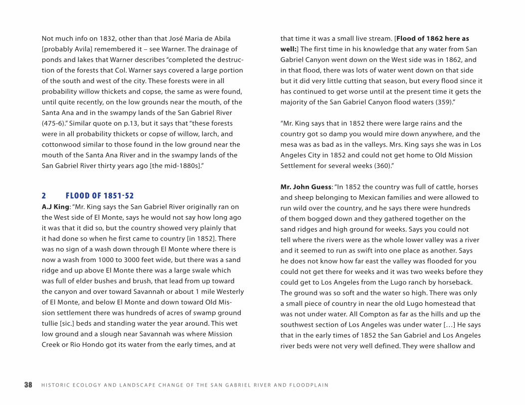
H I S T O R I C E C O L O G y A N D L A N D S C A P E C H A N G E O F T H E S A N G A B R I E L R I V E R A N D F L O O D P L A I N��
Not much info on 1832, other than that José Maria de Abila
[probably Avila] remembered it – see Warner. The drainage of
ponds and lakes that Warner describes “completed the destruc-
tion of the forests that Col. Warner says covered a large portion
of the south and west of the city. These forests were in all
probability willow thickets and copse, the same as were found,
until quite recently, on the low grounds near the mouth, of the
Santa Ana and in the swampy lands of the San Gabriel River
(475-6).” Similar quote on p.13, but it says that “these forests
were in all probability thickets or copse of willow, larch, and
cottonwood similar to those found in the low ground near the
mouth of the Santa Ana River and in the swampy lands of the
San Gabriel River thirty years ago [the mid-1880s].”
2 flood of 1851-52A.J King: “Mr. King says the San Gabriel River originally ran on
the West side of El Monte, says he would not say how long ago
it was that it did so, but the country showed very plainly that
it had done so when he first came to country [in 1852]. There
was no sign of a wash down through El Monte where there is
now a wash from 1000 to 3000 feet wide, but there was a sand
ridge and up above El Monte there was a large swale which
was full of elder bushes and brush, that lead from up toward
the canyon and over toward Savannah or about 1 mile Westerly
of El Monte, and below El Monte and down toward Old Mis-
sion settlement there was hundreds of acres of swamp ground
tullie [sic.] beds and standing water the year around. This wet
low ground and a slough near Savannah was where Mission
Creek or Rio Hondo got its water from the early times, and at
that time it was a small live stream. [Flood of 1862 here as
well:] The first time in his knowledge that any water from San
Gabriel Canyon went down on the West side was in 1862, and
in that flood, there was lots of water went down on that side
but it did very little cutting that season, but every flood since it
has continued to get worse until at the present time it gets the
majority of the San Gabriel Canyon flood waters (359).”
“Mr. King says that in 1852 there were large rains and the
country got so damp you would mire down anywhere, and the
mesa was as bad as in the valleys. Mrs. King says she was in Los
Angeles City in 1852 and could not get home to Old Mission
Settlement for several weeks (360).”
Mr. John Guess: “In 1852 the country was full of cattle, horses
and sheep belonging to Mexican families and were allowed to
run wild over the country, and he says there were hundreds
of them bogged down and they gathered together on the
sand ridges and high ground for weeks. Says you could not
tell where the rivers were as the whole lower valley was a river
and it seemed to run as swift into one place as another. Says
he does not know how far east the valley was flooded for you
could not get there for weeks and it was two weeks before they
could get to Los Angeles from the Lugo ranch by horseback.
The ground was so soft and the water so high. There was only
a small piece of country in near the old Lugo homestead that
was not under water. All Compton as far as the hills and up the
southwest section of Los Angeles was under water […] He says
that in the early times of 1852 the San Gabriel and Los Angeles
river beds were not very well defined. They were shallow and

A P P E N D I X C ��
liable to run everywhere. The Mexicans drove their cattle across
them almost anywhere, especially the San Gabriel below where
Foster bridge is at the present time; from Foster bridge up
along the mesa where the river was called Rio Hondo the banks
were well defined and the river ran in the same place […] There
were very few trees in the lower country in the early times but
the whole country was covered with mustard about seven feet
high and as thick as the hair on a dog’s back and there were
just trails leading through it (494-5).”
3 flood of 1859-60J.M. Guinn: During the SG gold rush - “On December 4, 1859
a terrify southeaster set in and in forty-eight hours twelve
inches of rain fell. The waters of the San Gabriel River rose to
an unprecedented height and in the cañons swept away the
miner’s sluices and mining machinery. The rivers overflowed
the lowlands and large tracts of the bottom lands were covered
with sand and sediment (14).”
4 flood of 1861-62“The Los Angeles Star of Jan. 25, 1862, speaking of the San
Gabriel river says it was out of its banks for the reason that the
stream became clogged and choked on the plains and then
spread over the country. It forged a new channel from the east
side of El Monte to the west side of the same place. Much dam-
age was done to ranches, houses, etc. One ranch lost 30 acres
and 5000 grape vines (2-3).”
Mr. J.D. Durffy (El Monte): “Says in 1861-2 there was a big
flood, and the water broke over El Monte, and went down what
was known as Lexington Wash. At that time Lexington Wash
did not have the semblance of a river bed there; was a large
swale above El Monte, and thick with willows and brush. The
whole section down by El Monte as far as Savannah was under
water, and down toward Old Mission; says you could not go
from el [sic.] Monte to Los Angeles would swim a horse, and
the El Monte people had to go upstream two to three miles
and cross where the water was not so deep, and then come
back to the road over the high ground; says he had to do that
more than once. But the 1861-2 flood did not make any chan-
nel or do any washing except down below Old Mission settle-
ment [Montebello?], and between Old Mission and El Monte
(272).”
Mr. Keno Parish “He says in 1861-2 there were big rains and
the country was badly flooded and the San Gabriel overflowed,
and took somewhat the same course as where New River was
afterward made in 1867. Says there was water along the road
through El Monte as far as Savannah, and in places was belly
deep to a horse.”
“Says the waters of the San Gabriel used to sink above el [sic.]
Monte and came out below in Spring above Old Mission Settle-
ment about one or two miles, and formed the Rio Hondo and
ran all the time, but was nothing more than a branch or small
creek (320).”

H I S T O R I C E C O L O G y A N D L A N D S C A P E C H A N G E O F T H E S A N G A B R I E L R I V E R A N D F L O O D P L A I N�
Mr. E.H. Dalton “He says in that flood there was no damage
done unless a few head of stock got drowned – there was noth-
ing to damage (377).”
Mr. W.T. Slack “He lived at Old Mission settlement with his
father in 1862. His father was running a distillery at the time,
and his house and distillery were washed out in the 1862 flood.
Says there was a wash or draw through El Monte in 1862, but
it was small and grown up with willows and elder bushes, not
very deep, and did not carry much water or cut out much until
the eighties (393).”
Mr. S.D. Thurman: “In 1861-2 there was 40 days of rain in one
stretch, he did not count them himself, but there was an old
lady lived with them, his aunt who always made a habit of
keeping track of that kind of thing and she claimed it rained
forty days, and he never knew her to make a mistake on that
kind of stuff. The whole country around El Monte was under
water and over as far as Savannah and all south of Monte with
exception of a sand ridge that runs from El Monte down to-
wards Old Mission. The place where he lives at the present time
[in El Monte] was all under water some 2 to 4 feet deep, and in
going from El Monte to Savannah it would swim a horse.
“In the 61-2 flood the water spread through the willow and
brush and did no cutting to speak of only when there was a
clear piece of ground sometimes there would be a current
or swirl formed and dig out a hole, says he remembers about
these holes very well (488).”
“In the early times before the 1862 flood there was not much
of a channel on either side of the Monte the water came down
out of the canyon and split up into several channels above the
Monte and ran through the brush and willows and spread all
over the country and sank into the ground and stood on the
ground. There were hundreds of acres of swamp ground below
El Monte where the water stood the year around knee deep. He
says he does not think the main channel of the San Gabriel was
200 feet wide way up above El Monte before 1862. He says the
water has run everywhere in that section and the whole coun-
try below El Monte is made ground, his place is about 2 feet
higher now than when he first got it. He dug a well up above
El Monte and got pieces of wood down 140 feet and he says he
has heard of the other wells over toward Azusa where they got
wood more than 100 feet down (489-90).”
Mr. J.M. Guinn: “The flood of 1861-62 was the greatest of
all. Nearly fifty inches of rain fell. The rivers spread over the
lowlands and the stock took to the hills for safety. In Anaheim
there was four feet of water in the streets, and spread in an
unbroken sheet to the Coyote Hills three miles beyond. Arroyo
Seco brought down immense amounts of drift which furnished
fuel to the people for years. The rain began on December 24,
1861 and continued for thirty days with but two slight inter-
ruptions.”
“The San Gabriel became dammed out on the level grounds
and broke from its easterly course from El Monte and started a
new channel west of El Monte (14).”

A P P E N D I X C ��
Mr. John Guess: “In 1861-2 there was another flood he thinks
about the same size as 1852 and probably much larger. It
rained for twenty days in a stretch, without stopping. He was in
El Monte in the 1861-2 flood and that the whole country in that
section with the exception of a sand ridge in El Monte, which
runs through El Monte; the First National Bank and dept are
setting on it and it runs on down toward old Mission – says all
the early squatters settled on it, and with the exception of this
ridge all El Monte was under water to another ridge about a
mile easterly of this sand ridge (495).”
“He says the Rio Hondo through El Monte was originally called
Lexington Wash and in early times, or up to sometime in the
‘80s, did not carry much water only when the whole country
was flooded. It was a draw in 1862 and was filled with willows
and elder bushes so thick you could hardly get through it on
horseback, and was very shallow and did not look like a wash
(495-6).”
“In the 1862 flood a part of the San Gabriel joined with the
water of Walnut wash through Puente Ranch and as far over as
Puente Hills the whole country as far over as Huntington Park
was flooded and covered with water. In that section all the low
ground for miles was under water. The San Gabriel came down
on Azusa side and joined Walnut wash [sic.] and came down
by Mud Springs. Used to be known by that name. There was a
big spring with several acres of tullies [sic.] at that time, but the
waters spread and did no washing (496-7).”
“In the 1862 flood there were some large washes made in
between the Temple ranch and Old Mission Settlement, but
were filled up again (497).”
Mr. C.E. Colton: “They used to talk among themselves when
they first came and wonder why the Mexicans were such fools
as to build their houses on the hills and pack their water,
instead of building close to the water, but they knew after the
1862 flood (521).”
John L. Slaughter: “He considers the flood of 1861-62 the
greatest of his recollection. He recollects when old Finias [sic.]
Banning used to freight between San Pedro and Los Angeles
and between Los Angeles and San Bernardino. It rained so
much in 1861-62 that the roads became impassable and how
Mr. Banning’s teams and wagons bogged up on all roads (81).”
Mr. Joseph Mesmer: “It was Mr. Mesmer’s duty to deliver
bread about town and one point of delivery was where the old
Occidental College buildings now stand. There was a regiment
of soldiers stationed there, who took bread from him going
up there every day he had occasion to notice the river. The
river narrowed up near the Pasadena St. bridge and near this
point the water was very deep. Below this the waters began
to spread and yet along Aliso St. from Main to the east bank
of the river it was all under water and impassable. True, there
were places where the water was not so deep, and even points
where land came up through the water was at Wilhelm and
Aliso Sts.”

H I S T O R I C E C O L O G y A N D L A N D S C A P E C H A N G E O F T H E S A N G A B R I E L R I V E R A N D F L O O D P L A I N��
“The river had no defined channel. It would spread out over
the valley and sometimes the wash would be on first one side
of the valley and then the other. There was a growth of willow
and other swampy vegetation which greatly impeded the flow
of the water and prevented erosion. There was nothing to
cause washes. The stream was not confined but flowed where it
would. There was little to damage and then it only overflowed.
“There was probably not over 2,000 acres of land in cultivation
in all the country about Los Angeles, and probably not more
than 4,000 acres in Los Angeles County at that time which in-
cluded Anaheim, where a German settlement had been started
(107-8).”
Mr. Wm. R. Rowland: “I was born on the Puente Ranch in the
valley of the San Gabriel river, and have lived there all my life.
“The first great floods of which I took note were those of 1861.
A great deal of rain fell that year and caused big freshets in the
San Gabriel river. The waters brought down immense quanti-
ties of big timber from the mountains. In fact, we did not know
what pine was until the flood waters brought it down from the
high mountains.”
“The was little, if any, farming, going on in those days (139).
“Old Henry Dalton and Pio Pico were cultivating small patches
of land but from lack of water they could do very little. There
was nothing to damage as there was nothing in cultivation,
and as there were practically no banks to the rivers, and when
beds were filled the waters would spread over the country and
go where the land would permit. The river really never carried
much water except during the rainy season. Then the flats
would be covered with water, and the stream bed was filled
with quicksand.”
“In the early days when the Mail [sic.] stage crossed the river
at El Monte, during the rainy season, it was practically impass-
able, on account of the quicksand, except when the sand was
packed down by first driving a herd of wild horses across the
river and sometimes it was necessary to drive them across two
or three times to settle the quicksand and make it possible for
the stage, to follow their train. The old buildings are still to be
seen at a place called Thompson’s station [sic.], where the stage
line crossed.”
“However, during the dry part of the year there was no water
in the river. In those days the people only attempted to raise
cattle, horses, and sheep and relied upon the land for grazing
only. It was very poor grazing land too, for all of the valley was
covered with cactus and brush and very little grass (140).
“Down near the old Mission [Montebello] the water would
come to the surface and this is where the stock got their water.
The cattle would graze up the valley and about every other day
would go down for water; it was too far for them to go every
day. This drainage from the swamps above formed what is
called Rio Hondo.”
Mr. J.R. Ramirez: “The flood of 1862 was the largest since that
of 1825 (143).”
Mr. J. Frank Burns: “The largest flood in Mr. Burns’ time was
that of 1862. This flood did a great deal of damage to the few
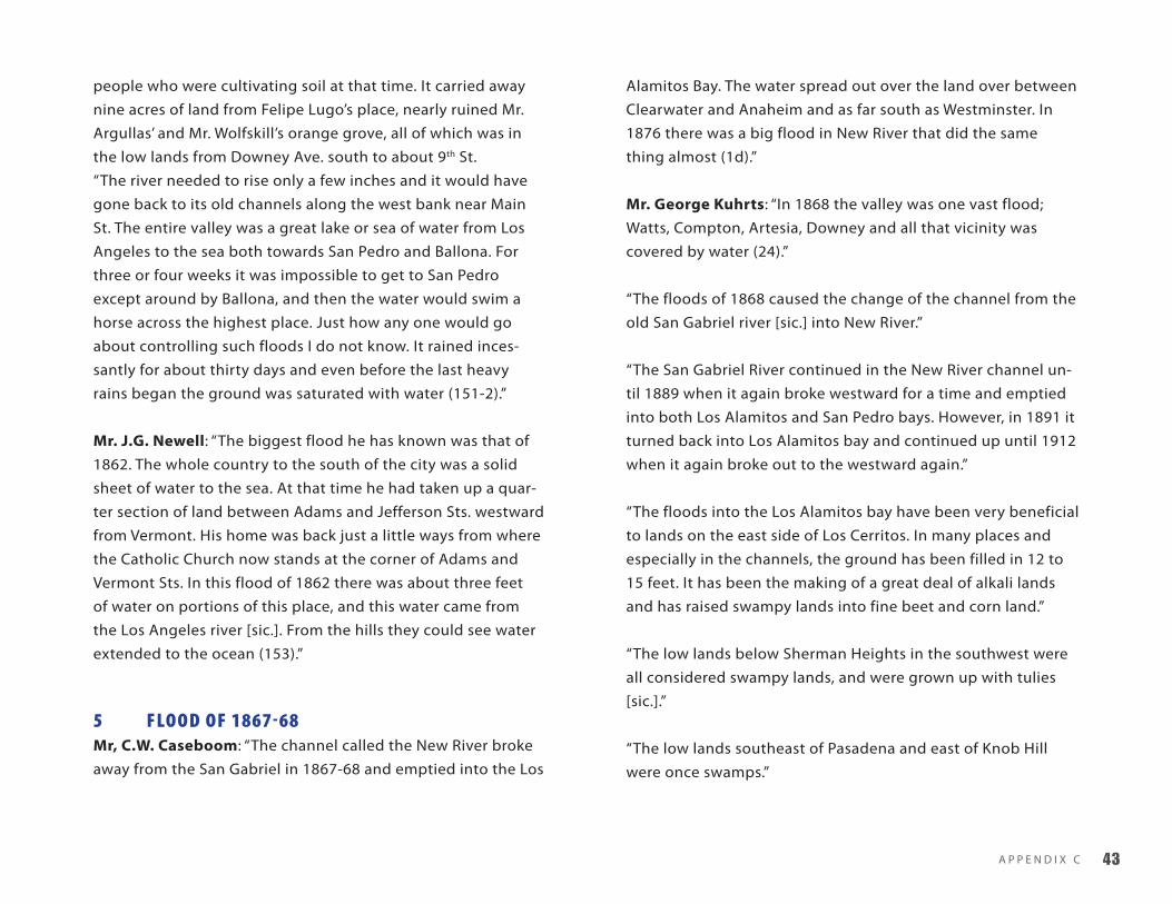
A P P E N D I X C ��
people who were cultivating soil at that time. It carried away
nine acres of land from Felipe Lugo’s place, nearly ruined Mr.
Argullas’ and Mr. Wolfskill’s orange grove, all of which was in
the low lands from Downey Ave. south to about 9th St.
“The river needed to rise only a few inches and it would have
gone back to its old channels along the west bank near Main
St. The entire valley was a great lake or sea of water from Los
Angeles to the sea both towards San Pedro and Ballona. For
three or four weeks it was impossible to get to San Pedro
except around by Ballona, and then the water would swim a
horse across the highest place. Just how any one would go
about controlling such floods I do not know. It rained inces-
santly for about thirty days and even before the last heavy
rains began the ground was saturated with water (151-2).”
Mr. J.G. Newell: “The biggest flood he has known was that of
1862. The whole country to the south of the city was a solid
sheet of water to the sea. At that time he had taken up a quar-
ter section of land between Adams and Jefferson Sts. westward
from Vermont. His home was back just a little ways from where
the Catholic Church now stands at the corner of Adams and
Vermont Sts. In this flood of 1862 there was about three feet
of water on portions of this place, and this water came from
the Los Angeles river [sic.]. From the hills they could see water
extended to the ocean (153).”
5 flood of 1867-68Mr, C.W. Caseboom: “The channel called the New River broke
away from the San Gabriel in 1867-68 and emptied into the Los
Alamitos Bay. The water spread out over the land over between
Clearwater and Anaheim and as far south as Westminster. In
1876 there was a big flood in New River that did the same
thing almost (1d).”
Mr. George Kuhrts: “In 1868 the valley was one vast flood;
Watts, Compton, Artesia, Downey and all that vicinity was
covered by water (24).”
“The floods of 1868 caused the change of the channel from the
old San Gabriel river [sic.] into New River.”
“The San Gabriel River continued in the New River channel un-
til 1889 when it again broke westward for a time and emptied
into both Los Alamitos and San Pedro bays. However, in 1891 it
turned back into Los Alamitos bay and continued up until 1912
when it again broke out to the westward again.”
“The floods into the Los Alamitos bay have been very beneficial
to lands on the east side of Los Cerritos. In many places and
especially in the channels, the ground has been filled in 12 to
15 feet. It has been the making of a great deal of alkali lands
and has raised swampy lands into fine beet and corn land.”
“The low lands below Sherman Heights in the southwest were
all considered swampy lands, and were grown up with tulies
[sic.].”
“The low lands southeast of Pasadena and east of Knob Hill
were once swamps.”

H I S T O R I C E C O L O G y A N D L A N D S C A P E C H A N G E O F T H E S A N G A B R I E L R I V E R A N D F L O O D P L A I N��
“People began to sink wells for irrigation purposes and this
began to lower the water plane and then the marshes began to
disappear (25).”
Mr. F.A. Coffman (Rivera): “There have been many big floods,
but prior to 1867 none of them ever affected anyone. In fact,
until 1890 the floods did not call for any attention. The over-
flow of the rivers never did any special damage, except some-
times a house would be washed away, otherwise the ground
was merely overflowed, and we really believed it did good
instead of damage.”
“In 1867-68 what is called New River was formed by the river
splitting above el [sic.] Monte, the new channel going into the
east of that place.”
“There is some confusion about New River actually is. Some
people call Lexington Wash the New River, but there was never
any water went over that way until 1890. Lexington Wash broke
through at that time and joined the Rio Hondo just above the
Old Mission bridge, and from that point down the river came to
be called the Rio Hondo, when in fact, it is the old San Gabriel
river. This Lexington Wash is understood by some to be the
New River (54).”
“The Rio Hondo was a small stream that extended only a mile
or so out on the flats toward El Monte. Its water came from
springs, etc., and the storm waters from Pasadena. Eaton Wash,
Bailey Cañon, Little Santa Anita Cañon, and the Santa Anita
Cañon all joined the Rio Hondo near the Old Mission.”
“What is commonly called the Rio Hondo is really the old San
Gabriel river [sic.]. Its natural outlet is to the sea, and it was
formerly through the present Long Beach harbor. When they
began developing the harbor they threw up a levee above the
harbor, and diverted the water westward. This threw the water
on to the Salt Works people, and they said ‘we do not want this
water here, it will fill our land up,’ so they put up a levee to di-
vert the water further westward, and now it is all going into the
San Pedro harbor. It is very necessary to protect the San Pedro
harbor, and if the water can be put over into Los Alamitos Bay
it should be done (55).”
Mr. Andrew Joughin: “the New River channel was said to have
been caused by a man plowing a few furrows, and from this
the stream got started. Merely an incident at that time. The Rio
Hondo at one time carried very little water and amounted to
very little at one time. Lexington Wash, however, is what made
the difference (79).”
Wm. R. Rowland: “In the flood of 1868 the San Gabriel cut over
to the eastward [sic] just below the confluence of the San Jose
Creek and the San Gabriel River is. This is what is called ‘New
River’ (141 R).”
“There was only one change in the river as far as I know, that of
1868. In that year the water made quite a change in its course.
It formed New River, leaving the old channel to Long Beach dry
for several years. In about 1876 the river began to flow to the
west of El Monte in a small amount.”

A P P E N D I X C ��
“This was caused by several farmers on the west side trying to
turn the water over their way for irrigation purposes. There was
some trouble about this for several years as it flooded some
of the people below, and they in turn tried to turn the water
back toward Bassett. It has gone on so long that there is a large
amount of water going to the west, perhaps as much as goes
down the east branch of the river (141a R).”
Mr. J. Frank Burns: “The next big flood that came was of 1868.
That did not affect us so much as the flood of 1889. The 1868
flood caused the San Gabriel river [sic.] to change its course.
The San Gabriel once flowed where the town of Azusa now
stands, that was in 1862. In 1868 the river changed more over
to the eastward and broke out into what is called New River.”
“Lexington Wash was caused by an irrigation ditch, until now
the people think that it is the old river (152).”
Tom Sanchez (Los Nietos): “He says the 1867-8 flood was when
the New River was formed he was still a small boy but remem-
bers that they had to take out several people down near Pico
over to the bluff on the Monte Belle [sic. -probably Montebello]
side. After New River broke out practically all the water went
that way up to about 1891-2. Then the water of the San Gabriel
canyon [sic.] commenced running over on the other side or
down the Rio Hondo through El Monte, came over up near
Duarte, and has continued to get more and more of the San
Gabriel canyon [sic.] water until at the present time it gets the
most of it (246).”
Mr. W.R. Dodson (El Monte): “He says that a man by the name
of Henry Roberts, now dead, told him that in the ’67 flood
that he had lived down below the narrows, and the water very
nearly stopped running, and it had been raining hard, and he
took his gun and went up to the hills by the narrows to see
what had stopped the water, and the water was blocked by
logs and drift, and he says some 25 to 50 feet high, and backed
up three or four miles, and he says when it went out made a
noise loud enough to be heard two or three miles, and broke
logs four or five foot thick, and he claims that was what caused
the New River to go off from the San Gabriel channel.
“Mr. Dodson says that after the 1867 flood he hauled wood
from one place below the Narrows for about two years. There
was a patch of ground about two acres in size and from 6 to
20 feet deep with logs and that had come from the jam at the
Narrows, and that there were lots of logs as large as five feet
in diameter that had been broken as if they were matches. He
found a dead grizzly bear out in the center of the pile of logs
after he had been hauling logs from the pile quite awhile.
The skeleton of the bear and hide was all there, and he said it
looked as if it had been caught in the flood, and tried to save
himself by riding the drift wood. Anyway he was there, and it
showed he came down in the 1867 flood.”
Mr. J.D. Durffy: “He thinks the biggest flood of his time was
the one of 1867-8, when the water broke out of the San Gabriel
channel and formed New River. It broke out a little above old
Temple place and continued south instead of making the turn

H I S T O R I C E C O L O G y A N D L A N D S C A P E C H A N G E O F T H E S A N G A B R I E L R I V E R A N D F L O O D P L A I N��
over toward the point of hills just below Old Mission settle-
ment, and all the water of San Gabriel went into New River; all
the water of San Gabriel canyon [sic.] has since flowed into the
Rio Hondo, with the exception of a small amount of overflow
in one or two of the big floods, has come by way of Lexington
Wash, or up above El Monte near Duarte (273).”
“In the 1867 flood there was quite a lot of ground cut out on
the Rio Hondo below Old Mission, and up against the bluff
on the Old Mission side; says the road used to be in the flat
and there was quite a lot of good ground, some in vineyard
between the bluff and the river, and most of it was washed out
and they had to cut a new road along the side of the hill. “
“In the 1867 flood there were thousands of cords of wood
brought down from the canyon and scattered over the country.
There were hundreds of teams hauling wood to Los Angeles
and other small towns for weeks. There was a small slough, or
branch now filled up just below his house, that was filled chuck
full of cedar and hemlock logs, some as large as three feet in
diameter, and he had wood for years (274).”
A.B.P. Patten (Downey): “He says the flood of 1867 made New
River, but it did not cut much of a channel. The channel it cut
in 1867 did not carry one-tenth of the water that went down to
Alamitos Bay, that it spread all over the country and made lots
of sloughs and swampy ground down near where Belleflower
[sic.], Clearwater and Hynes now is. Says that he has caught
fish in the sloughs and the people used to shoot ducks over in
that section. The 1884 flood cut the channel much larger and
deeper, and changed it in some places he thinks, generally to
the east (303).”
“When New River formed it followed down about the old ir-
rigating ditches in 1867 (304).”
“He says that after the New River broke out in 1867, the Rio
Hondo went down in a short time to a small flow. They could
drive across it on the old telegraph road a short while after-
wards, and there was quite a lot of quicksand in it too. “
“He says after the 1867 flood the San Gabriel continued to
fill up and get smaller, that the New River carried most of the
water until three or four years back. The bed of the San Gabriel
had filled up to such an extent that just before they put in the
protection work the bed would not average more than twenty-
five to fifty feet wide and six to eight feet deep from a short
distance above the S.P. to Santa Ana down by and below the
County farm, and there were thick willows on either side of the
banks (307-8).”
Mrs. Charles Forman: “Her folks owned an interest in the Pu-
ente ranch and their place was not very far from Puente Creek
and she remembers that water very nearly got into their house.
Does not know the exact year but it was sometime in the ‘60s.
She remembers when New river [sic.] was formed and says the
majority of the water went that way after New river [sic.] was
formed until a few years ago. The country below El Monte was
swampy and low and covered with willow, lots of springs and
lakes of water and there was where Mission Creek got its water

A P P E N D I X C ��
from, and was a live, clear stream of water, not very wide but
fairly deep. They used to cross the streams wherever they came
to them and quicksand would allow. There were not much
banks to them. The country was a stock country and the flood
in the early times did no particular damage and no cutting to
speak of. It was simply an inconvenience about getting any-
where. Would have to wait until the waters went down (351-2).”
Mr. A.J. King: “In 1867 there was another large flood and a
quick rush of water and the San Gabriel broke and formed New
River and New River carried nearly all the water of San Gabriel
for several years. Mr. King says that the cause of the New River
breaking out from San Gabriel was that he river had choked
up with willows and brush and kept filling until there was no
channel left and instead of it making the turn down by the
Temple ranch [sic.], it just continued on straight where there
was a low place or swale through the country. He says there is
no doubt in his mind but what the river had run on the New
River side of the Valley before 1867. Says the sand ridges and
formation of country shows that very plainly (360).”
Mr. W.T. Slack (San Gabriel): “He says the cause of the New
River forming in 1867 and going down to Los Alamitos by old
Pico place was that the willows had grown up so thick and
large down by the Temple ranch [sic.] and the Old Mission
settlement, that when the water came with a rush it just simply
knocked the trees down and covered them up with sand and
formed a bank or barrier, and turned the waters off down by
the Pico ranch. Some of the trees are buried there yet and
some of them were uncovered in other floods.”
“Before the ’67 flood the Rio Hondo at Old Mission was a small
live stream, fed from springs and marshy ground between El
Monte and Old Mission (393).”
Mr. Tom Hutchinson (Glendale): “Says the San Gabriel broke
out below El Monte and went down the country to Los Alami-
tos Bay in the 1867 flood, and formed New River. He says at
that time it was one complete sheet of water from Los Angeles
to Santa Ana with the exception of a few high spots. Says there
were very few trees in the country at that time and all of them
were on high ground, and no bridges, fences, or railroads and
the water had a clear sweep (395).”
Mrs. John Gaines (Compton): “She says she was not in the
1867 flood but she had a sister (now dead) that was, and she
told her they could not get out of their place for six weeks.
They lived on Olive St. between Temple and Gibson Sts., right
near where the river cut out in the 1914 flood. She said men
had to wear boards tied to their feet to keep from mireing [sic.]
down (421).”
Geo. Foster: “He remembers the 1867 flood very well and that
was the year the New River broke out from the San Gabriel
river, and he says after the New river [sic.] broke it was only a
short while until there was hardly any water running in the Rio
Hondo, in other words it took nearly all the water after it was
formed and continued to do so up to three or four years ago,
with the exception of when there was a very heavy flood and
then the Rio Hondo would get quite a lot of water.”

H I S T O R I C E C O L O G y A N D L A N D S C A P E C H A N G E O F T H E S A N G A B R I E L R I V E R A N D F L O O D P L A I N��
“Says the Rio Hondo used to be much deeper than at present;
when the Foster bridge [sic.] was first built they could drive
a four horse team under the bridge and sit on the seat of a
wagon and it has since been raised some three to four feet and
you can just about walk under it at present. From Foster bridge
[sic.] up the banks were well defined and it had quite a bit of
depth but from the Foster bridge [sic.] down there were no well
defined banks and it always overflowed very badly. The country
south and west of Foster bridge [sic.] overflowed badly in flood
seasons over as far as Watts and all through the Tweedy ranch
and Compton country, but hardly ever on the easterly side. He
says in early days the Watts country and vicinity was swampy
and tullies [sic.] grew all through there (445-6).”
Mr. Jotham Bixby (Long Beach): “The eastern boundary of my
ranch was the San Jose Creek, and the western boundary was
the Rio Hondo, and also the boundary between my place and
the Santa Gertudes Ranch.”
“Up to 1867-8 the San Gabriel River was not known to have
flowed into Los Alamitos Bay, but in that year great floods
came, the greatest in my memory, and cut what is known as
‘New River.’ The flood of 1889 again cut through to the old San
Gabriel River, and I went up just below Rivera and attempted to
turn the San Gabriel back into the New River channel, but my
efforts were of no value at this point, in fact, were all washed
away. However, higher up, the river again went back eastward
into the New River channel, and we did nothing more about it.
The San Gabriel continued to flow into this channel until 1912,
when it broke out again into the old river bed. The river is now
changing rapidly to the westward, and indications are that
it will be flowing through Compton when the next big flood
comes (456-7).“
“In 1867 the delta of the San Gabriel spread out into several
branches and were up the valley about between the old adobe
house on the north end of Los Cerritos and Dominguez. Below
this point it was all a mass of willows and marsh, and used for
grazing purposes. After this flood willows sprang up all over
the valley, up around Compton, Watts, Huntington Park, etc.
Before this time the cattle had grazed on willows and kept
them down. There were two or three very dry years between
1862-66 and thousands of cattle starved to death for lack of
grazing. They had cleaned up this valley of its marsh growth for
there were so many stock, but when the floods came in 1868
the willows came back again.“
“Terminal Island was known as Rattlesnake Island because
of the great number of rattlesnakes that infested the island.
Rattlesnake Island was entirely surrounded by water, which
was only navigable to light draft vessels (457).”
“Only a few years ago I sold the low lands just west of Long
Beach for only eight dollars per acre, as I believed it to be of
no value whatever. It was used, in the summer time to make
salt by letting the tides fill in the flats with sea water and then
diking it off to evaporate (457-8).“
“The low lands east of Los Cerritos [location?] were after noth-
ing short of an inland sea.”

A P P E N D I X C ��
“The flood of 1868 was the greatest I have known. There was
no way into Wilmington, except by water for a month.”
“Since the sugar factories were built east of Los Cerritos they
have been surrounded three times by floods. The Santa Ana
River has overflowed into Los Alamitos Bay covering all the
surrounding country.”
“In 1868 a great deal of trees, timber and debris came down
the river. I piled up wood enough to do me for several years.
“If it was not for San Pedro Harbor I would say let the river go
wherever it likes.”
“Before the New River was cut by the floods of 1868 the only
water that flowed into Alamitos Bay from Whittier Narrows was
the San Juan Creek (458).”
Mr. George H. Bixby (Long Beach): “I was a small boy during
the floods of 1868, but remember well the accounts given by
my father and others of those days. It was this year that the San
Gabriel broke over into what is now known as New River. Prior
to this time the San Gabriel river had never been known to flow
into Alamitos Bay. The only waters that flowed into Alamitos
from that section of country were the La Puente and San Jose
Creek [this conflicts with the above quote – we need to sort
this out] (462-3).”
“However, in 1868 the San Gabriel broke through eastward and
formed the channel between Rivera and Whittier, somewhere
near it present location, which it has held ever since. In 1889,
or just afterward, an attempt was made to turn the river back
into its former channel, and I spent many thousands of dollars
building a levee or dike, to turn the San Gabriel back to its old
location , but in the storm of 1891 this work was all washed out
and lost. No further attempt was made to turn the river back
into its old channel.”
“In early days the Rio Hondo did not carry a great amount of
water. It had a well defined stream bed, and at certain places
there were many deep holes where the ‘Vaqueros’ swam their
horses to give them a bath and wash off. The word ‘hondo’
means deep in Spanish, hence those deep holes.”
“The San Gabriel River had not flowed into the San Pedro har-
bor until 1912, when it again broke through to the westward
(463).”
Mr. George A. Peck: “In 1868 our troubles began with the river.
We lost about 150 acres that year, and each succeeding flood
took its quota of spoils until there was barely 150 acres left of
the original 480 acres which my father bought.”
“Lexington Wash was commonly known as Lick Skillet wash.
In those days and even now the river bed was higher than
the land on each side. When the floods came down it was no
difficulty to direct the water to either side of the river bed. The
water would flow readily either way and if left alone it would
usually split and go in each direction. However it was not left
alone (468-9).”
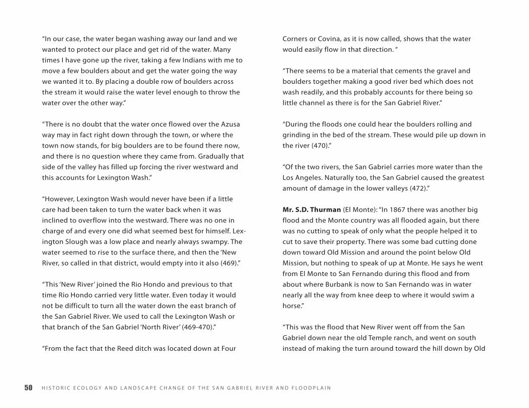
H I S T O R I C E C O L O G y A N D L A N D S C A P E C H A N G E O F T H E S A N G A B R I E L R I V E R A N D F L O O D P L A I N�
“In our case, the water began washing away our land and we
wanted to protect our place and get rid of the water. Many
times I have gone up the river, taking a few Indians with me to
move a few boulders about and get the water going the way
we wanted it to. By placing a double row of boulders across
the stream it would raise the water level enough to throw the
water over the other way.”
“There is no doubt that the water once flowed over the Azusa
way may in fact right down through the town, or where the
town now stands, for big boulders are to be found there now,
and there is no question where they came from. Gradually that
side of the valley has filled up forcing the river westward and
this accounts for Lexington Wash.”
“However, Lexington Wash would never have been if a little
care had been taken to turn the water back when it was
inclined to overflow into the westward. There was no one in
charge of and every one did what seemed best for himself. Lex-
ington Slough was a low place and nearly always swampy. The
water seemed to rise to the surface there, and then the ‘New
River, so called in that district, would empty into it also (469).”
“This ‘New River’ joined the Rio Hondo and previous to that
time Rio Hondo carried very little water. Even today it would
not be difficult to turn all the water down the east branch of
the San Gabriel River. We used to call the Lexington Wash or
that branch of the San Gabriel ‘North River’ (469-470).”
“From the fact that the Reed ditch was located down at Four
Corners or Covina, as it is now called, shows that the water
would easily flow in that direction. “
“There seems to be a material that cements the gravel and
boulders together making a good river bed which does not
wash readily, and this probably accounts for there being so
little channel as there is for the San Gabriel River.”
“During the floods one could hear the boulders rolling and
grinding in the bed of the stream. These would pile up down in
the river (470).”
“Of the two rivers, the San Gabriel carries more water than the
Los Angeles. Naturally too, the San Gabriel caused the greatest
amount of damage in the lower valleys (472).”
Mr. S.D. Thurman (El Monte): “In 1867 there was another big
flood and the Monte country was all flooded again, but there
was no cutting to speak of only what the people helped it to
cut to save their property. There was some bad cutting done
down toward Old Mission and around the point below Old
Mission, but nothing to speak of up at Monte. He says he went
from El Monte to San Fernando during this flood and from
about where Burbank is now to San Fernando was in water
nearly all the way from knee deep to where it would swim a
horse.”
“This was the flood that New River went off from the San
Gabriel down near the old Temple ranch, and went on south
instead of making the turn around toward the hill down by Old

A P P E N D I X C ��
Mission, and it followed the low part of the country and went
down to Los Alamitos Bay (490).”
“He says there were cords and cords of wood came down from
the canyon on the 1867 flood. There were trees 60 feet long
and 5 feet in diameter brought down and in some places it
scattered it all over the country and in others it stacked it up
several feet high.”
“He says in 1862-1867-1884 the whole lower country was
more or less under water. And he says there has been water
all over that country that is not mesa ground [;] that was the
way it was made. He says there was some work done above
the Peck place to keep the water from coming over on the
westerly or El Monte channel of the San Gabriel River, but does
not think it ever amounted to very much, he says he does not
know whether there was anybody helped the water to tear the
dam down or not, but he does know there were people down
Downey way and others that were interested in keeping the
water over in the westerly branch of the San Gabriel. There was
quite a lot of fussing and turning of water up by the Santa Fe
Railroad sometime about 1890. He says he helped to start the
westerly branch of the San Gabriel where it is at the present
time just west of El Monte, in trying to protect their property in
1862 (491).”
Mr. J.J. Morton (Compton): “He says the 1867-8 flood formed a
lake covering several hundred acres of land at least a mile and
a half square, above and between Gardena and Los Angeles on
the old Amstoy Place, and was known as Amstoy Lake, and he
thought he would always be there, but disappeared, he does
not know just when, but was there several years. “
“He says he has never seen the water run over to Ballona
country, but is positive it has done so, as it was very near high
enough in 1867-8 to do so, and every indication points that it
has done so.”
“In the early days of his time, all of Watts and Willows were
swamps, sloughs, and tullies [sic.], and where the black soil in
Watts is was a tullie [sic.] and peat bed. He says some people
used to cut and dry that soil and burn it. It afterwards dried out
and they burned it off and cultivated it (506).”
“He says that when the big water came in December 24, 1867
it came in a rush and looked like a wall two or three feet high;
the country was covered with mustard patches which a man
could hardly walk through – higher than a man’s head, and the
waters gathered that and brush, and he claims thousands of
snakes, squirrels, and rabbits, and the next day the bed of he
stream was practically level with the rest of country, and the
brush, mustard, and sand went on down to Rattlesnake Island,
and filled up thousands of acres of sloughs, and connected the
island with the main land.”
“He says they went above Compton and tried to turn the water
back into the old channel, but could not do so.”
“He says in 1867, when he first cam to Compton you could see
only two trees in the whole valley, one of them is still standing

H I S T O R I C E C O L O G y A N D L A N D S C A P E C H A N G E O F T H E S A N G A B R I E L R I V E R A N D F L O O D P L A I N��
(the landmark) on the north line of the Rancho San Pedro, both
trees were sycamores. In the spring of 1868 he says the willows
came up nearly as thick as the mustard was before. He says the
flood brought driftwood down the San Gabriel to the mouth of
the canyon, and spread out over thousands of acres, known as
the old Dalton place, and that there were thousands of cords
of wood, some trees 60 feet long and four feet in diameter. He
got all of his wood from there for two years and most of the
wood for Los Angeles was gotten from there. He says orange
orchards cover the same ground now (507).”
“According to Mr. Morton, the San Gabriel River used to divide
and sink and spread out about where El Monte is now, and
then below there start off again. Says there was no well defined
channel above El Monte before 1868, that he could see, on
either the east or west side of El Monte. Was cut up into several
channels and the water sank and stood on the ground down
below the Monte. Was a regular swamp below El Monte. The
1868 flood cut out a channel on either side of El Monte (508).”
Mr. Jesse Hunter (Rivera): “He was living in Los Angeles in
1867-8, and running a livery stable and wood yard where the
Angeles Hotel stands at the present time. In that flood the Los
Angeles river [sic.] went down Alameda Street in the city of
Los Angeles. The southwest section of the city was a lake as far
over as the Cienega country. Says he was delivering wood, and
sometimes he would get into water belly deep to his horse.
New River was formed in that flood, and the whole section
of country below Old Mission settlement was a lake with the
exception of a few high ridges. The Los Angeles River got very
near high enough to go out through the Cienega country in
that flood (514).”
“He says in the 60s the bed of the San Gabriel river [sic.] was
not much of a bed below the foster bridge, just wandered
over the country, but the Foster bridge [sic.] the river bed was
deeper than at the present time. He says old man Lugo brought
78,000 head of cattle from his San Bernardino ranch some time
in the 50s and turned them loose in the valley, and they kept
all the willows and brush and grass out of bed of the stream.
Mr. Hunter says that after the New River was formed it carried
most of the water up to four or five years ago. The country over
between El Monte and Old Mission was a swamp and standing
water, there were hundreds of acres of it, and there was where
Mission Creek started, and the stream was a live stream, about
20 to 30 feet wide, and not very deep at the Old Mission settle-
ment (514-515).”
J.S. Brookshire (Downey): “Came to Downey in December
1867, from San Bernardino with some other people with an ox
team of lumber and a mule team of lumber. Says he was about
fifteen or sixteen years old at the time. Says it has been rain-
ing some and on December 24th it began raining hard and the
ground was very soft and the stock was about given out, and
they were in a hurry to get over near some ranch where there
was going to be a wedding. So they unhitched the wagons
and left them just a little below where Pico bridge [sic.] is at
present, or just a little below the old Governor Downey house.
He says after the flood went down they went back to look for
the wagons and right where they had left the wagons was

A P P E N D I X C ��
where the main part of New River was, and it has been in that
particular section ever since. He says it did not wash much of
a channel, but spread all over the country, and the 1884 flood
deepened and made much more of a channel. He says the
lumber on the ox wagon was still on the wagon because it was
chained on, but it was washed quite a ways down the stream
and completely buried and turned upside down with just the
hind wheels sticking out. The rest of the wagon was completely
buried in the sand, and the lumber on the mule wagon was not
fastened on and all they found of it was the front wheels and
tongue; found that by the tongue sticking up.”
“He says the New River is very nearly in the same position from
opposite Downey north to where it left the bed of old San
Gabriel now as in 1867. Says it left the bed of San Gabriel about
one and one-half miles north of Pico bridge [sic.] (517).”
“He says the channel of the San Gabriel was practically the
same from 1867 to 1914 when the Foster bridge got blocked
and turned it west about one-half mile (518).“
“He says the majority of the water of the San Gabriel Valley has
run into New River since 1867 up to about four years ago when
the San Gabriel has been getting more and more (518-9).”
“He says there were no willows in the rivers to speak of until
after 1867 (519).”
Mr. Victor Manzanares (El Monte): “The flood of 1867-68 was
very great, and changed the course of the San Gabriel River
below to what is called New River, which empties into Los
Alamitos Bay. The whole valley was practically covered with
water that year. No damage was done to amount to anything
as the water spread out and did not run so fast as last winter.
The reason for that was in those days there was lots of brush
and trees everywhere. There were also many swamps and some
lakes which all helped to keep the water from running off so
fast.”
“But to show that there has been great floods here just above
my place along the banks of the old Rio Hondo, we have found
‘Alamos’ four feet in diameter, and other kinds of trees as well
which were very large. There used to be willow trees in the
marshy land here in the valley 3 feet or more in diameter.
These, of course, have now all disappeared.”
“The San Gabriel River never flowed over on this side of this
valley until 1867-68. It broke over some in those days, but the
most was done by men who wanted to protect their land which
was being washed by high water on the east branch of the
river (534).”
“There used to be some trouble between the Americans who
were trying to turn the river either to the east or west. Some-
times some men would go up above El Monte, where the river
divided, and put a dike or bank across the river to turn all of
the river to the east or back into its original bed. Other men
would find it out and go up there and tear their work down
and turn the water down the west side, which would come
down and join the Rio Hondo. There was some bad feeling
H I S T O R I C E C O L O G y A N D L A N D S C A P E C H A N G E O F T H E S A N G A B R I E L R I V E R A N D F L O O D P L A I N��
about turning this water from one branch of the river to the
other and sometimes it was necessary to guard the work with a
gun to get it to stay there. I know three men who were sent up
there at night to break one of those levees (534-5).”
“But we have always called the channel of the east of El Monte
near Bassett, the original and only San Gabriel river [sic.]. This
other branch was never called the San Gabriel river by our peo-
ple. The Rio Hondo we always thought of as an arroyo, nothing
more. It was only a drain from the swampy lands between here
and El Monte, and was only a couple of miles long (535).”
Mr. Sylvester Rogers (southeast of Compton): “About Christ-
mas 1867 the big rains began, and flooded a great deal of the
country. During the 1867 flood the water broke through and
ran across the Laguna and then down through Mr. Lugos and
where Judge Thomas lived, after it cam to Tweedy’s and con-
nected with the San Gabriel, and they both ran together. It
caused a great deposit of debris on about an average of two
feet deep.”
“The neighborhood of Compton was frequently overflowed by
the waters of the Los Angeles River. I consider that the deposits
left by the overflows increase the value of the land. The over-
flows raised my land about two feet, and the effects have been
about the same upon the adjoining land. Every farm there has
been benefited from the floods (543).”
“Compton is nearly south from the break. Previous to 1889 the
Los Angeles River flowed all over the country from San Gabriel
river [sic.] clear to Compton Creek. When I first moved to my
place the Los Angeles river [sic.] ran right through my farm. I
moved there about twenty-five years ago. It filled up that year
above my place and has never flowed in there since. After that
it ran mostly east of my place – about half a mile – or ran there
every flood until the flood two years ago. As near as I can recol-
lect, the bank of the river where the break now is, was as much
as six feet high-----At the time of the flood of 1867 in coming
to Los Angeles we had to go clear around the Laguna on the
east side. We went right up through what is called the San
Antonio settlement by Lugo’s and kept near the San Gabriel
river [sic.] until we got past the Laguna. We had to travel away
east of where the Southern California Railway now runs across
the Laguna Ranch. In 1867 the water went through by the lake,
where the break is now. I do not think there was any break in
1867. I think the water just overflowed the banks. It did not
make a break – just overflowed the banks and ran across the
level country there, until it came to the lake, and then it turned
and ran right down by the Lugo Ranch. I don’t think the water
flowed, but the water stayed on the Laguna Ranch at that time
about a week, then most of it sank back into the old channel
when the water commenced going down. The water on the
Laguna Ranch at that time did not have any defined channel. It
spread out in a thin sheet (543-4).”
J.G. Newell: “I also recollect the floods of 1867 or 1868. I think
perhaps it was both years, and I know that at that time the
water ran in the same place it did before-----the water at that
time came from the Los Angeles river [sic.]. I never saw any dif-
ference in the sand or debris in from 1862 and after 1868. I was

A P P E N D I X C ��
down there picking up driftwood and never saw any difference
(545).”
“Sometime “in the early 1870s” “a ditch heading below Duarte
broke out and the ditch became what is now known as Lexing-
ton Wash” (from the LA Times 1916).”
Mr. Walter P. Temple (El Monte): “ We have always understood
the old and original San Gabriel River to be the one down the
east side of El Monte or Bassett Way. The break or branch down
the west side of El Monte was a new wash which first broke
out in 1871. There were efforts by various parties to turn the
river back to its old channel but there were other parties who
wished it to continue to the westward and who would help
undo or help to undo the work of the first parties. It became
serious for time and force was used in the way of shot guns to
maintain the levee built. But none of this water belongs on the
west side, and really should be kept to the eastward. It would
not be right to have the people pay for two channels when one
is really all that is necessary (532).”
“Lexington Wash got its name from Lexington, which was once
the name of El Monte. There were a lot of Kentuckians in there
and they gave it the name.”
“Rio Hondo never carried very much water. There was never
enough water to cause any washing although the water from
all the canyons from Pasadena to the San Gabriel canyon [sic.]
flowed into it. In early days all the lands above our place here
up to El Monte were low and swampy. There was a very heavy
growth of willows, tullies [sic.], and balckberry [sic.] vines over
all. It was almost impossible for water to have washed anything
or to have had much velocity. When the big rains came the
water drained off slowly and did practically no damage (533).”
6 flood of 1875-6S.M. Bise (Compton): “He says in 1875-6 there were heavy rains
and the country just east of Compton and near Lugo was badly
flooded. He thinks the majority of the water ran about where
Temple St. is at that time (501).”
J.J.Morton (Compton): “In 1876 there was a bad flood. The
water was so deep between his place and Compton or near
Long Beach Blvd. That he had to put his feet up on the neck of
the horse to keep them of the water. That flood was particularly
bad in the section of country near Lugo and a part of what is
now Linwood, and a portion of the Tweedy ranch (509).”
7 flood of 1884 C.W. Caseboom (Los Cerritos, Long Beach): “But in 1884 we
had a big one. I woke up in the night and thought something
unusual was going on and upon looking out found that we
were surrounded by water. I woke up my folks, and also the
Martin boys who were with us at the time. I got them out and
had them hitch up the team, for at that time I was crippled and
was using crutches to get about.“
“My wife and baby and one of the boys and myself piled into
H I S T O R I C E C O L O G y A N D L A N D S C A P E C H A N G E O F T H E S A N G A B R I E L R I V E R A N D F L O O D P L A I N��
the wagon and drove down toward Long Beach. The other
boy rode a saddle horse, which we had, and went on down to
my father-in-law’s to wake him up so he could get out. When
we reached about where the gas works are the water was just
getting down there and we barely got out ahead of it. But my
father-in-law did not have time to get out before the water
caught him. He had to swim his horses and wagon out, the
water came down so fast (1).”
“We had a camp up on the Mesa where the Polytechnic High
School now is, so that we were at home again (1-1a).”
“But it rained a great deal that winter, and we did not get back
to our place for a month or six weeks, there was so much water
in the valley.”
“Kincaid had a beautiful place fixed up and to see it you would
think he was going to stay there for all time. It was nicely laid
out and he had a good house and barn, well and so on, but
this flood swept him clean. It carried away his house, barn, and
fences. It even lifted out his well casing which was twenty-
eight feet deep and carried it away. All that was left of his
house was the floor and it was sunk eighteen feet below the
surface. The water got started to cutting underneath it and
simply whipped the silt from under it and let it down. It just
about ruined Kincaid.”
“However, he went back to work and moved back onto higher
ground and built again (1a).”
Mr. A.N. Hamilton: “In 1884 Mr. Hamilton had his corrals and
house at about Washington and Figueroa Sts. The rains began
on the 7th of February, 1884, and there was little let up for
about thirty days. The river began to overflow and Mr. Ham-
ilton began to get uneasy about his cattle, which were in the
corrals. The cattle were lowing and began to get uneasy. To
make matters worse, with Mr. Hamilton, however, he was sick in
bed. But something must be done, so he got up and went out
into his corrals, got the cattle out and onto higher ground. The
water was as deep as three feet in places and he could not tell
how much deeper it would get (28-9).”
“This water came, mostly from the Los Angeles River, breaking
out from the river channel in Alameda St. about 14th St. Then it
flowed out through the southwest by Exposition Park through
the Cienega and into Ballona Bay (29).”
Mr. Geo E. Place: “In his estimation, the flood of 1884 has been
the largest in his experience. It took away every bridge except
the old covered bridge at Aliso St. The river channel was always
shallow and when the floods came the water overflowed the
lowlands of the river and went wherever the ground was low-
est. The water used to go down Central Ave., sometimes going
east and many times west of Central Ave. He has seen the water
three feet deep on Manchester and Central Aves. (32-3).”
“In 1884 the floods covered all the lower country and at Comp-
ton he has seen rowboats going about from place to place to
buy supplies (33).”

A P P E N D I X C ��
Mr. Randall H. Hewitt: “The first big flood was in 1884. There
were two sections of it. The first came down in the latter part
of February, but did little damage. A great quantity of water fell
and the country was very well soaked. Every one thought the
storm was over. The City Council had been forced to take notice
of the great danger the city was placed in should another flood
come of equal magnitude or even greater (34-5).”
“To this end, Capt. Thom. who was then mayor, appointed
a committee of three, Mr. Wm. M. Humphries who had had
considerable experience in fortifying rivers against floods.
Mr. Mullhassen who had done notable work on the Changres
river [sic.], and Mr. Hewitt. Mr. Hewitt says he did not have the
experience that Capt. Thom thought he had although he had
witnessed and experienced the actions of rivers in the east.”
“At this meeting, when it was decided to take some action to
protect the city against overflow by the river, Don Antonio
Coronel told them that there was a map in existence among
some of the old early citizens which showed the river flowing
along the bank which is now 6th St. from the southwesterly into
Nigger Slough and into Playa del Rey and Ballona. Don Antonio
said the map was practically only a sketch map but clearly
showed the relative location of hills and rivers; that succeeding
floods had gradually forced the river eastward in its channel to
where it now is (35).”
“Before this committee had gone out to inspect the river, a
second flood came down within six or eight days after the first
one and this one did the great damage to property (35-6).”
“Where the Santa Fe Station now is was a fine vineyard; about
First St. there was a fin orange orchard, and the land was, in
fact, cultivated along down the river as far as Ninth St. Mr. Wm.
Workman had a fine place over towards Boyle Heights side of
the river. However, the greater damage was done on the west
side of the river.”
“The water broke through the levees and over the lowlands
and where the Santa Fe Station now is the water was about
three feet deep. All of this water flowed westwardly into Al-
ameda St. Some 41 houses were washed away in the lowlands
near First St. and below. In those days the streets ended at the
river. The people built their houses on the sand and when the
floods came lost them.”
“At the intersection of First St. and the river a test was made for
solid rock or good foundation. A ‘divining’ rod 70 ft. long was
sunk its full length and no bottom was found. There was noth-
ing but sand and gravel all the way down.”
“All of this country has been filled in and for thousands of years
material has been washing down from the mountains as is
attested by the mammals being found six or seven miles west
of here (36).”
“The old winery of down about 9th St. was completely washed
away. The firm recovered some of their goods but a great deal
was lost and much taken up by people who found the bottles
and casks of liquors scattered about the country. Six or eight
years after the flood a man was ploughing [sic.] his field when

H I S T O R I C E C O L O G y A N D L A N D S C A P E C H A N G E O F T H E S A N G A B R I E L R I V E R A N D F L O O D P L A I N��
his plow struck something solid. It had a peculiar ‘feel’ to it and
he investigated and found a ten gallon keg of brandy buried
there (36-7).”
“The S.P. [Southern Pacific RR] had an office at the east end
of the Aliso St. bridge [sic.]. The flood carried off the office
and everything else. There was an iron safe in the office but it
was washed into the flood and never found. It sank into the
quicksand and was lost. A man had a laundry on First St. near
the river. He had a small engine and boiler to operate his ma-
chinery and to pump water. The floods came a partly washed
everything away. He found his boiler out on the edge of the
river, got some rope and thought he had secured it from being
further washed away. The next flood, however, carried it away
and was never recovered (37).”
“After the flood of 1884 a company was formed to build a
railroad from Los Angeles to San Gabriel. It became known to
a few people that there was a great transcontinental railroad
behind the project. The city gave them a great deal of land for
yard and building purposes, and helped secure right of way
over private properties. After all this was completed the Santa
Fe came in and acquired the San Gabriel railroad project (37-8).”
“The incident of the 1884 flood was when both approaches to
the one of the bridges went out leaving two cows and a horse
on the middle of the bridge. It was several days before they
could be taken off and hay and water was taken out to them.”
“It was by heroic deed of Martin Aguirre in the flood in bring-
ing people out of the river that he was elected sheriff (39).”
Mr. Geo. A. Wright: “The flood of 1884 was probably the great-
est in his time. The whole country was flooded. In Los Angeles
the water came down almost up to Main St. and he has seen
the water three to four feet deep in Alameda St. These flood
waters would cross over Main St. and flow to the Southwest
into Ballona Bay. This was also the case in 1889. This was no
doubt the natural channel of the Los Angeles river [sic.] in
earlier times.”
Mr. Geo. A. Nadeau (Long Beach): “The flood of 1884 carried
away the Nadeau vineyard, some of the houses and most part
of stock of liquors. It was just after the death of his father and
the winery was leased to a man named Cola. An instance of the
force of the waters, there was a double-ended cask which held
2000 gallons rolled along by the waters for several hundred
feet. It was expected that it would go to pieces, but it did not
(43-4).”
“No one could tell where the waters would go, especially on
the ground east of this place. A piece of land east of here
between the rivers was for sale, and a man named Frank Cox,
who lives just north of it, was the prospective purchaser. Mrs.
Nadeau went over to close the deal. While he was there it
began to rain, although there did not seem to be any prospects
before he started out. The business finally closed; he started
for home about dark. He had a top buggy but in spite of this
protection he never was wetter. The next day the water came
down and literally floated the Cox house away (44).”

A P P E N D I X C ��
Mr. S.B. Reeve: “The first flood that amounted to much, and in
Mr. Reeve’s estimation, the largest he has ever seen, was that
of 1884. In those days the Los Angeles river [sic.] practically
had no banks below Seventh St. and very low ones above that
point. That flood did not do so much damage in some ways as
the flood of last winter [1914], for the water spread out and,
because there were trees and brush and other obstruction on
almost all the land, the velocity was slow.”
“The people did not realize how much the water would rise
and, therefore, built their houses all over the flats, then when
the high water did come it did great damage and caused much
suffering. A few lives were lost.“
“The water broke out of the river banks and flowed towards
Alameda Street which is lower than the bed of the river. The
water came up halfway between Los Angeles and Main Streets
on First, and also flooded the lower portion of the city. At
Maple and 24th St. the water was between three and four feet
deep (48).”
“The floods poured westward along the then, Washington Road
and Jefferson Street, towards the southwest into Ballona Creek
and into the Ballona Bay. All through the southwest, clear to
the sea, was a solid sheet of water. All of the country called
Cienega was a great lake. Nigger Slough was swelled to great
proportions, and all of the country back of Venice was a sea of
water. Last winter a great deal of water came from Los Angeles
and flowed into Venice as everyone knows (48-9).”
Geo. E. Bouton: “The flood of 1884 was very bad, washing out
all of the bridges, except one, the old Downey Avenue bridge
[sic.]. A good many houses were washed away, and some
people drowned.”
“One instance of the danger of the flood was that where a
house had washed away and lodged against a bridge pier. Gen.
Bouton was tying timbers together to make a raft to push out
in the stream and then let it down to them with ropes, when
Martin Aguirre came along and without hesitation rode his
horse into the torrent, reached those people, and in two or
three trip had rescued them. It was a plucky thing to do and I
have always admired Martin for doing it (60).”
Mr. L.W. Head (Long Beach): “He came to Los Angeles in 1878
and the flood of 1884 was the first, and by far the greatest, in
Mr. Head’s experience.”
“Before the rains began to fall there was very little moisture in
he ground, not enough to bring up the seed, and the ground
was to dry and hard to work. About the 20th of February (ap-
proximately) the rains began, and continued without inter-
ruption for about 30 days, and it was believed the sun was not
seen during that time.”
“The ground became saturated, and then the water began to
gather and collect, forming great lakes, and spreading out all
over the country. There was water everywhere.”
H I S T O R I C E C O L O G y A N D L A N D S C A P E C H A N G E O F T H E S A N G A B R I E L R I V E R A N D F L O O D P L A I N�
“The Los Angeles River carried away the Nadeau Vineyard, the
sheds, warehouse and everything else moveable. The wine cask
was carried out to sea and lost.”
“The S.P. Railroad was washed out for miles around Los An-
geles, and on the Santa Ana Branch it was probably 30 days
before there was any traffic on the road (88).”
“In Los Angeles, Mr. Head saw the water at Alameda and
Commercial Streets more than waist deep to a man. This is
particularly remembered for Mr. Head got a man to carry him
across the stream at this point, and particularly remembers the
depth.“
“Water stood all over the lower country for sometime and was
practically impassable. From the west portion of Long Beach to
Wilmington the water could swim a horse clear across. In 1884
the tides came in as far as Anaheim Road in many places, but
that land is now all filled in five or six feet (89).”
The Los Angeles Express Notes taken from the paper, February
and March 1884 (pp.92-8)
February 1st: Fifteen inches of rain has fallen to date for
the season.
February 2nd: the Pacoima, Big and Little Tujunga are
discharging immense amounts of water over the San
Fernando Valley.
February 4th: On last Friday a man attempted to cross
•
•
•
the Arroyo Seco with a fine horse and buggy. The
buggy has not been seen, and the horse lies against a
clump of willows just north of East Los Angeles.
February 5th: The Santa Ana river [sic.] is on a boom,
running clear through to the ocean, and cannot be
forded. Another horse has been drowned in Arroyo
Seco and people now drive around by five mile house,
preferring the adobe road to a ducking in the Arroyo
Seco. The San Gabriel is still dangerous to cross owing
to the speed of the river and the change of the chan-
nel, and also the Arroyo Seco.
February 6th: The New River is flooding Downey City
and vicinity. In Las Bolsas many tracts of alfalfa and
grain are already under water. It is impossible to
understand anything about the symptoms of a local
Southern California rain. The present one which com-
menced on Sunday a week ago at one o’clock A.M. has
been one of our best downpours.
February 7th: Thursday. Up to yesterday the rain for the
storm by the Signal Service was 9.13 inches. As the
rain is still in continuance the absolute total will be
mentioned at the close of the present storm, if it ever
stops.
February 8th: there has been a fall of 21 inches at
Pasadena for the season. There has been no railway
communication with Anaheim and Santa Ana for very
many days past, with the exception of one day. The
Santa Ana trains run as far as Downey City and back
on their usual time, about one-third of their distance
to Santa Ana.
•
•
•
•

A P P E N D I X C ��
February 12th: The Santa Ana River is in some places
¾ of a mile wide resembling a foaming lake. There is
a larger volume of water now flowing from this river
into the sea than for 17 years past.
February 15th: Alameda Street is a veritable river. The
greater portion of Sonoratown is practically flooded,
especially hat portion embraced by Buena Vista,
Virgin, College, and Castelar Streets. Travel on foot is
hazardous and in every way disagreeable.
February 16th: Arroyo Seco is utterly impassable for
teams at all crossings. The San Gabriel River is running
to the sea, the first time since the spring of 1875. The
Santa Ana trains are running only to Downey since the
present rain.
February 18th: Bridges and culverts are being washed
away in every part of the country, and roads are
impassable. A south wind Saturday night and yester-
day morning blowing toward the mountains, upon
which there was a heavy fall of snow and all the way
from 20 to 24 inches deep, melted it almost instanta-
neously, and the Pacoima, the Big and Little Tujunga
and Arroyo Seco, all joined at the Los Angeles river at
their several junctions, and swelled its proportions to
a flood, as stated by old residents, to exceed any flood
since 1862-3. 21 years ago when the river deluged Al-
ameda Street at the Arroyo Seco crossing, making the
street lower than the bed of the river, as it is at some
places at present. The same thing occurred yesterday
although the water only washed in on the street
•
•
•
•
between Macey and First Streets. In what is known as
Frenchtown, east of Vignes to the river, all house were
flooded from two to six feet deep. At 1 o’clock P.M. the
river at East Los Angeles bridge was 900 feet wide, 6
to 12 feet deep, and running at a rate of fifteen miles
an hour. Shortly after the driftwood from the moun-
tains began to drift down and weakened the bridge
so that cars stopped at either end of the bridge, and
the passengers crossed the bridge on foot. About
an hour or fifty minutes afterwards the Aliso bridge
[sic.] was under mined and its supports washed out,
the bridge rapidly going to pieces was floating down
stream, near to the First Street bridge, where that
portion that held together lodged, causing the waters
to back and flow westward into the city as described.
The East Los Angeles bridge next weakened, and 100
feet of the east end was carried away, both street car
and foot bridge. During the evening the bridge across
First Street was also broken and more than half carried
away and cannot be used. The railway trestle across
Los Angeles river [sic.] at the San Felis Rancho, and the
one across the river on the Arizona route, are gone.
The houses commenced to float off in the flooded
regions about one o’clock. The damage will reach over
$1,000,000.
February 19th: The Cerritos country and the New River
country are all under water. The New River has
changed its channel which it cut in 1867, and is
running through two channels at present. [Where?]
The Los Angeles River has made a new channel below
•

H I S T O R I C E C O L O G y A N D L A N D S C A P E C H A N G E O F T H E S A N G A B R I E L R I V E R A N D F L O O D P L A I N��
the covered bridge, through the Meinzer place, and
down through the willows for over half a mile. Mr. R
Nadeau suffered a heavy wash through his 2000 acre
vineyard near Florence, and lost many thousands of
vines. There is a grand stream 15 miles in length,
composed of Old and New San Gabriel Rivers, and
the Los Angeles River after they unite which made
a terrible and grand old river to the sea.
Thursday, February 21st: Since Friday of last week no
trains have arrived here except one from Santa Ana,
three from Santa Monica and three from San Pedro.
The City Council in a body went down to the river to
view the damage and see what could be done.
March 4th: at no time since the recent flood have the
street cars of Boyle Heights and East Los Angeles line
been able to cross the river, the transfer from each
side having been made over he bridges. The piles for
the rebuilding of these structures were being sunk
steadily, but the present rain will probably so weaken
them that they will have to be replaced by others. The
bridges across New River and Santa Ana river [sic.] on
the route to Santa Ana by rail are washed away again
to a certain extent, and are so far utterly impassable.
the railway between here and San Fernando, which
has been dangerous ever since the recent washout,
is again utterly impassable, while the Soledad Canon
is again gone up. There is no knowing when we will
again have communication from the north by rail.
March 5th: The Signal Service reports the present storm
•
•
•
to be to date 4.8 inches, and a total of 26.35 inches for
the season.
March 6th: the river has accomplished little damage
during the recent rain, partly because that much dam-
age has heretofore been accomplished, and because
evergreen boughs and other protection had placed
in the more exposed and dangerous localities - - - The
Hollenbeck tract was unprotected, and badly flooded,
a house worth $500 being washed away - - The river
is falling slowly and will probably not do any more
damage.
March 7th: The present season has dropped more rain
than any other time since 1867-8. The railway trestle
across the Los Angeles River, both on the northern
and southern routes have been dangerous ever since
the first flood, especially the latter one. This morn-
ing 70 feet of the west end o it was washed out by
the flooding river, assisted by driftwood, rendering
through travel in any direction impossible for a long
time to come. Information reached us today that in
addition to the swinging condition of the railroad
bridge over the San Gabriel river [sic.], the piles have
al departed, and the Santa Ana trestle is in the same
condition east of Colton. The rainy season to date is
as follows: the first storm of any consequence during
the present season was on October 27th dropping
1.37 inches of rain. The second was on December 3rd
dropping 1.56 inches of rain. On Jan. 29-31 of the
present year, the fourth rain dropped 4.66 inches of
•
•

A P P E N D I X C ��
rain, followed by 4.64 inches of rain in the six days
following. The fifth rain occurred on February 15-16
and dropped 2.75 inches. The sixth and present rain
has dropped 9.74 inches. The rain in February which
caused the flood, dropped 9.89 inches of rain, while
the present rain dropped 9.74 inches.
March 10th: the river is utterly incontrollable, and there
is no telling where it may go without a levee. Formerly
it occupied a space between the eastern bluff and
the mesa of Sonoratown in 1862-3, and in 1867-8 the
soil is nearly all of a quicksand character, and the river
may get onto Alameda St., flood the city and reach the
sea near Ballona.
March 12th: The Los Angeles river [sic.], the Arroyo Seco
and the Santa Ana and the San Gabriel rivers were
still impassable yesterday. An estimate of the dam-
age by the recent flood has been placed at $400,000.
Notwithstanding the cessation of rain, the damage to
the railway appears to be worse than ever, and there is
no idea when we will have communication again. The
Soledad canon is washed out for the third time and
the south end of the San Fernando tunnel is washed
out for a second time.
March 14th: The change of the San Gabriel river [sic.]
from its old bed to its new channel of 1867-8 this
year has washed away a 350 acres of valuable corn
land worth $150. per acre, or a total value of $21,000.
Luckily its course did not take in or touch the Ranchito
corn country.
•
•
•
From Downey – March 12, 1884: We have been greatly
discomfited the great part of the time for the last
month and a half as all means of travel has [sic.] been
cut off from the outside world, with Old river on one
side and New river on the east and barbed wire fences
of Mr. Thomas Bixby stretching from one river to the
other.
March 18: The San Gabriel river [sic.] on this side of
Fulton Wells [location?] is now fordable, but is still
dangerous on account of quicksand.
March 20: During the forty hours preceding eight
o’clock this morning two passenger and three freight
trains from the east hauled up to the depot, which,
with the wonderful increase of business on the local
roads, has made things exceedingly lively where all
has been dormant for three weeks.
Mr. Lafayette Saunders (Long Beach): “Back in those days it
usually took 24 hours for the flood to travel from Los Angeles
to Los Cerritos. In 1884 on one Saturday they received word
that a flood was on its way from Los Angeles. Every one made
preparations against it (99).”
“Uncle Billy” Clark (Long Beach): “Long Beach or Los Cerritos
was a complete island, water being from San Pedro to Comp-
ton, Clearwater and eastward to Westminster and southward
to the ocean. Up to that time quite a good deal of shipping
was carried on Anaheim Landing. There was a settlement there
at that time. Vessels came into the harbor and discharged and
•
•
•

H I S T O R I C E C O L O G y A N D L A N D S C A P E C H A N G E O F T H E S A N G A B R I E L R I V E R A N D F L O O D P L A I N��
took on their cargoes. However, since that time little has been
done in the way of shipping. The harbor filled up and has never
been opened up again.”
“The Santa Ana river [sic.] broke over into Coyote Creek and the
flood waters came into Alamitos Bay. In fact, the waters of the
Los Angeles, Rio Hondo, San Gabriel, Coyote Creek and Santa
Ana rivers were all joined in one vast sheet of water. The coun-
try was impassable for several weeks (105).”
“Los Cerritos and surrounding country was a great stock and
sheep range. It was necessary to get the sheep out of the
low lands for they would lie down and drown. Mr. Clark, with
Fred Bixby, Deafy, a vaquero and some others went into the
flats east of Long Beach to get these sheep out. Reaching the
San Gabriel it was necessary to swim across the stream to the
slightly higher ground beyond the water was very swift and
dangerous. They went over alone, that is, without horses, but
came back on horses, and had just as difficult a time getting
back as going over. A potion of lands around Alamitos Bay is
part sand and very fine for raising celery. There is a large por-
tion, however, which is alkaline and will not grow very much.
This land east of Los Cerritos is known as the Artesian Belt and
once had many springs scattered over the land. Now they had
disappeared for the wells along the foothills have lowered the
water plane until now the water does not flow any more (105-
6).”
Mr. Joseph Mesmer: “The floods of 1884 were very great a
destructive. This flood swept away every bridge across the river
except one, the old covered bridge at Aliso St. A great deal of
damage was done to settlers and business in the low lands
along the river as all o this was overflowed. Many lives were
lost and many houses washed away (109-110).”
“Mr. Mesmer aided many people out of the flooded district,
and at Alameda St. he remembers the water was half way up
on his thighs, for he was wearing hip rubber boots and was
concerned that he did not get in over the tops of them.”
“The Los Angeles river [sic.] changed its course this year and
washed away several hundred acres of vineyards, orchards,
and fields. The valley between Main St. and Boyle Heights was
a solid sheet of water. This flood was very destructive but not
so much as that of last winter. Conditions make a great deal of
difference (110).”
Mr. Eli Graves: “On the 17th of February, 1884, our troubles
began. The water came up and was everywhere. My place
was completely inundated. Chickens, cows, horses, hogs, and
everything loose was on the move. We did not know when
the water would get higher to and wash away our fences and
buildings. Hay stacks and all crops in the fields were carried
out to sea. It was impossible to have gotten away, for we were
surrounded by deeper water than was on our place. At one
time we thought of going to neighbor’s place, which seemed
higher than ours, but we soon learned that we as well, or better
off then they were.”
A P P E N D I X C ��
“The water had immense force, and it did great damage by
washing. In the stream great cottonwood trees up to two feet
in diameter were twisted and broken as they were caught
against the bank by the current.”
“The water would get started in a whirl against some obstruc-
tion, and scoop out a bug hole, perhaps 100 feet wide and six
to eight feet deep in a short time. The water would get started
in a whirl against the roots of a tree and it would soon be
uprooted. It seemed that some obstruction of that kind was
play for the water to uproot (126).”
“Judge Venable had a place just north of mine, which was
low and swampy. His land was about a half a mile square.
Seemingly of little value at the time, it was set out to willows,
cottonwoods, and gum trees. It was not intended exactly as a
breakwater, although it was expected that it would help fill up
the low places to some extent. However, when the floods did
come, it proved to be very much of an obstruction. The floods
were turned eastward and in turn completely washed out a
man about a mile east of Mr. Graves’ place (127).”
“The light soil melts away so easily and rapidly, that the only
conceivable channel to me is one of heavy concrete sides and
bottom (128).”
Mr. Walter P. Temple (El Monte): “The flood of 1883-4 was the
largest of any in his time. In that year the San Gabriel river
[sic.] changed its course somewhat in that it cut across the Rio
Hondo just below the Whittier narrows.”
“The Rio Hondo is only a little drain which empties into the San
Gabriel river just above the old part of the Mission bridge, and
is only two miles long. It is fed by the seepage of the lowlands
between the two San Gabriel rivers [sic.] (212).”
T.W. Watson (Glendale): “He says h came to Glendale in about
1883 with his folks was a small boy about seven years old in
the 1883-4 flood, but can remember about the big water and
they were living about a mile from the Verdugo canyon [sic.]
and he says they could hear the water roar at their place. The
Verdugo wash [sic.]was running very nearly down the center of
the canyon at that time or about where Canada Boulevard is a
at the present time. He says the Verdugo wash [sic.] has filled
up considerably at the mouth of the canyon in the past twenty
years, filled some five or six feet in the bed of the stream near
the Ross packing house in the 1914 flood. In the 1884 flood
there was much more water and it spread much worse down
toward San Fernando road than in 1914 (240).”
C.C. Mason (Santa Fe Springs): “Says he lived in this section
for 38 years and the 1884 food was the largest in his time, and
the water got the highest and did more damage than any time
in the last 38 years. He says most of the damage was done in
the river bed very nearly as far down as Artesia. By river bed
he means from the Ten Mile house to New River. Down near
Artesia and below that the section of the country was a lake.
They had to do considerable work in 1884 about a mile above
Los Nietos to keep the New River from going down the Canada
Verde, which he thinks was originally the old river bed. Would
not undertake to say how long since it was the river bed, but

H I S T O R I C E C O L O G y A N D L A N D S C A P E C H A N G E O F T H E S A N G A B R I E L R I V E R A N D F L O O D P L A I N��
he signs go to show it was originally a large water course and if
you dig in it, you will find river sand (243).”
Ed Ayers (Tropico): “He says he went to Tropico in February,
1884 and has lived there ever since. When they were taking the
furniture out of the wagon, it commenced to rain and rained so
hard for three days and nights that they could hardly get out
of the house. It rained 40 inches by June, and the ground was
so well soaked that he planted a crop of corn in the middle of
June and it matured without irrigation. On February 20, 1884
it took 20 houses down the Los Angeles river in Los Angeles in
one night. It also took out the ditch for the Los Angeles water
supply west of the Los Angeles river opposite Tropico, and
caused the S.P.R.R. tunnel above San Fernando to cave and
washed about two or three miles of track out between Roscoe
and San Fernando, ad there were no trains from the north until
sometime in March. It took all the bridges in the county out
with the exception of one or two (247).”
He says “the Arroyo Seco was running very nearly bank full
until June. Says 1884 was the greatest growing year ever knew
of. Says he saw crops of barley planted and harvested and then
the ground broke and crop of pumpkins planted and a big crop
raised without any irrigation. He had apricot trees that made
eleven foot growth that season (247-8).”
“The whole lower section of Los Angeles was a lake in 1884.
There was no particular damage done in the Glendale or
Tropico district in 1884. There was just lots of water but did
not do much cutting. The Los Angeles river got much higher in
1884 than in 1914 (248).”
Mr. J.W. Fulton (Pomona): “Says he lived near Pico from about
1880 until 1884 and then came to Pomona. In the 1884 flood
he wanted to go to Texas about the first of January and could
not get away until the 25th of February on account of the
railroads being washed out. The whole country was flooded
at that time much worse than the 1914 flood. All the bridges
and railroads were washed out; the country was probably not
cut as bad as in 1914 but there was more ground flooded and
the country was much wetter. you could hardly travel for quite
a while. He says the majority of the waters of the San Gabriel
canyon went to New river [sic.] up until about five or six years
ago and have been gradually going over into Rio Hondo until
the Rio Hondo at the present time carries the most of the San
Gabriel canyon [sic.] water (262).”
C.G. Bremond (Norwalk): “In 1884 the country was so full of
water that the roads got so you could hardly drive on them and
if you got off the roads you would mire down. His wife says she
got mired crossing the roads in front of their house. And all the
bridges were washed out. Says up to 1884 the New river chan-
nel was right through Belleflower [sic.] where the school house
stands and in 1914 it changed about a mile easterly of and took
down Shady Lane or Lover’s Lane as the road was called and
there is about the official channel of the New channel or the
New river [sic.] is now. Says when he first commenced cultivat-
ing his place he used to find pieces of pine bark and chunks of
wood a foot under the surface of the ground (285).”
W.C. Sproul (Norwalk): “Before 1884 the New River was run-
ning through Belleflower [sic.], where the schoolhouse stands,
A P P E N D I X C ��
but in the 1884 flood it changed to the east a short distance
and in 1891 it came further east and down what was known
as Lover’s Lane, and afterwards came a little farther east but
dropped back to Lover’s Lane Channel and that was about
where they established the official channel (348-9).”
Levi Carse (Artesia): “He says he has lived in Artesia for 39 years
and has seen a much bigger flood in 1884, but the water never
crossed the sand ridge a half mile west of Artesia in 1884 and
did in 1914 but on account of the P.E. bridge across the New
river [sic.], backed up the water and it ran down the north side
of the P.E. tracks and some of the water went to Coyote Creek.
In 1884 Jeff Gaines went from First St., a mile and half west of
Main St. in Artesia to Compton in a boat. The channel of New
river before 1884 was through Belleflower [sic.] right where the
schoolhouse sets. Says if the water had gotten much higher at
Studebaker the New river [sic.] would have gone right down
through Norwalk. He says there are lots of sand ridges all
through the valley and there is not one of them that has not
had water down it – that is what made it (387).”
Tom Hutchinson (Glendale): “In 1884 the rains came early and
gentle and completely soaked the ground and the ground
got so soft that a horse would mire down out in the fields,
and then it came on hard rains and there was so much water
that the whole country was a lake. He was in Downey and his
mother sick in Santa Ana, and the last message they got from
her before the telegraph line washed out was she was not
expected to live, and he said he was going over there and they
tried to talk him out of it; said he could not swim; but he said
he was going anyway. He started about ten o’clock at night,
moonlight, and followed the S.P. track to where it crosses New
River; a part of the piling of the bridge of the S.P. was gone but
the tiles and rails were still holding when he got there and he
crossed them. Says the water was about up to his knees on the
bridge in places where the track had sagged, but he got across
all right, but the New River had made another channel a little
east of the bridge and the water was very swift and looked
deep but not very wide. He made a run and jump and caught
willows on the other side of the bank and pulled himself up but
lost his hat (396).”
“His mother got better and he could get no word back to the
folks at Downey and knew they would be worrying about him,
so two days later he made the trip back to Downey. The return
tip was nearly as bad as coming but he made it through. Says
he saw wagons, buggies, and horses stuck all the way along
and it was practically a lake for the greater part of the distance
(397).”
Henry Wilson (Compton): “He says that before 1884 the San
Gabriel river [sic.] where the steel bridges are and what they
call the river was not much more than an ordinary creek, or
twenty feet wide (423).”
W.H. Hughes (Norwalk): “His place backs up on New River, and
was not damaged much in the 1914 flood, but the water was
two and one-half feet deep on the place just south of his place.
He says there was a great deal more water in New River in
1884 than 1914. He says in the 1884 flood the New River came

H I S T O R I C E C O L O G y A N D L A N D S C A P E C H A N G E O F T H E S A N G A B R I E L R I V E R A N D F L O O D P L A I N��
near going off down through Santa Fe Springs, and on down
through Norwalk, it came near breaking out about three miles
above the S.P. bridge across the New River near Studebaker.
Says there was some water went off down there in 1884, an in
his opinion if nothing is done that is where New River will go
some of these times. No water went down that way in 1914.”
“He says the bed of the New River is about the place North
[sic.] of here ever since he knew the river, will run to one side
one time and the other side another time. But below here he
says it has moved some to the east. He does not think any of
the water from New River went to Hynes in 1884, thinks that
water was from the San Gabriel. He says the 1884 flood was the
largest since he has been here, but the 1889 flood was larger
than the 1914 flood (438).”
T.R. Tierce (Downey): “Says the majority of the water of the
1884 flood went out New River and has done so ever since his
recollection, until the last three or four years it has been get-
ting heavier and heavier in San Gabriel (493).”
S.M. Bise (Compton): “He says the channel of the New River
was washed out and made much larger in 1884 than it was
before that time (502).”
8 flood of 1886 George Pillsbury: “Mr. Pillsbury came to Los Angeles in 1885.
The first flood that he witnessed was one of 1886. Practically
all of the bridges were washed out that year. He, with some of
the men, went down South Main St. to do some rush work. The
streets were boggy and it was with difficulty that they reached
there, and even when they did, they could do nothing, as it
rained all day. This was on the 13th of January. They returned
home and at that time Mr. Pillsbury lived on East Downey.”
“Next morning he heard all of the whistles blowing and knew
that the river was up. So he hurriedly got a little breakfast and
started out for town. There was a horse car system of street
railways, and which usually stopped on signal but in this case
it did not. It kept going and he was wondering why, when all
of a sudden car and all went out of sight. Hurrying down to the
bridge he found the street car conductor and his two passen-
gers sitting on top of the car and all floating down stream. The
horse was cut loose and was swimming ashore.”
“Some man with a team was crossing one of the wagon bridg-
es. He reaches about half way over when the approach on the
end in front of him washed out. Before he could turn around or
back out, the approach behind him went out also. His predica-
ment was not so dangerous, however, for the central part of
the bridge stood (161).”
J.M. Guinn: “The flood of 1884 and 1886 caused considerable
damage to the lower portion of the city. The flood of 1884
swept away about fifty houses, and carried away portions of
several orange orchards and vineyards. One life was lost, that
of a milkman who attempted to cross the Arroyo Seco. The
flood of 1886 was very similar to that of 1884; the same portion
of the city was flooded – that between Alameda street [sic.]

A P P E N D I X C ��
and the river several houses were washed away, and two lives
lost during the flood of 1884 the Santa Ana river [sic.] cut a
new channel to the sea. Beginning at a point where the San-
tiago Creek enters the Santa Ana, the new river passes through
the fertile lands east at the old river, leaving a strip between
the two rivers, varying in width from one to three miles, and
discharging its waters (where it has any to discharge) into the
ocean about three miles southeast of the old river. Within a
period of seventy years we find that the three principal rivers
of our country, have all created new channels for themselves,
and have materially changed their courses; the Los Angeles,
from westerly to southeasterly; the San Gabriel, cutting a new
channel from three to six miles southeast of its old one; and
the Santa Ana, drifting in the same direction twice since 1822
(479).”
9 flood of 1889 Jesus Cruz: “In early days the valley was covered with willows,
larch, sycamore, etc. Later only willows in patches, until they
were finally cleaned out almost entirely by the settlers (7).”
C.H. Eilers: “Says the S.P.R.R. from the hill near Elftman and
Watson was completely washed out in 1889 (8).”
Ed Carson: “The railroad fill from what is now Elftman and
Watson, was washed out and the floods poured into Nigger
Slough. This was 1889. About 1894 the Slough began drying up
rapidly, and fish began to die by the tons. The stench became
so bad it became necessary to bury and burn the dead fish.
This greatly fertilized the land. By 1896 the Slough was dry and
remained so up until the winter of 1913-14 when it again filled
(9-10).”
John Mullhern: “He was here during the flood of 1889, and
says that the Los Angeles River cut through into the Alamitos
Bay side (16).”
From the Evening Express:
“Much damage has been done in about the city. Streets cut up,
conduits filled with sand, bridges carried away, railroad tracks
covered with dirt, and much other damage done.”
“The approaches to the Kuhrts street [sic.] bridge [sic.] over
the Los Angeles River were washed away. About half the Santa
Fe bridge [sic.] over the Los Angeles River swept away, and
dashed them against the Buena Vista street [sic.] bridge[sic.],
weakening the piers and badly damaging it. The S.P. pile bridge
below Kuhrts street [sic.] bridge [sic.] almost entirely carried
away. The 7th & 9th St. bridges so badly damaged as to render
them unserviceable.”
“The storm was general all over the southern section of the
State. No trains on the Santa Fe or S.P. have either arrived or
departed except one to Santa Monica.”
“Levees in numerous places have washed away.”
“The country between this city and the sea is in many places
covered by water and many ranchers will lose heavily. The ex-

H I S T O R I C E C O L O G y A N D L A N D S C A P E C H A N G E O F T H E S A N G A B R I E L R I V E R A N D F L O O D P L A I N�
tensive vegetable gardeners south of the city will lose heavily.”
“At Compton the water is very high. The citizens resorted to
boats and made their way about town in that way. The country
in that vicinity is flooded and it will be weeks before the sur-
face will be dry. On Dec. 24th the S.P. train failed to return. The
train reached Compton by noon and returned.”
“Hon. H.T. Gage says that the new San Gabriel, the old San
Gabriel and the Los Angeles rivers [sic.] have formed on body
near Downy and are sweeping toward the ocean carrying
everything with them. On the Laguna Ranch a lake five miles
in width has formed and the water nearly to the top of the hay
stacks. The Los Angeles River, two miles below the city, has
swerved from its channel and is running down Downey road
(18-19).”
Mr. C.H. Thornburg (Newhall): “The flood of 1889 shows what
the water deposits on the land. It is foolish to say that it hurts
the land to have it overflowed, for that is what made it. In the
earlier years, part of the land lying east of Los Alamitos ranch
[sic.] was white in spots, when the alkali lay in cakes on the
ground. After the flood these places were covered from a few
inches to four feet deep with silt. The land would then grow
anything (62-62a).”
“This same flood of 1889 flooded the entire country. The Santa
Ana river [sic.] came across and united with the San Gabriel.
The floods did not move rapidly, that is, there was not much
current; still in about 24 hours, the greater portion of the flood
had moved away (62a).”
D. Henderson (Compton): “In 1889 when he was living on New
River to the east of where he now lives, the floods played a pe-
culiar trick. The land was not particularly much different from
any other near there. There were a few low places, little draws
left there by some former flood. Early during the night the
flood began to come down, but he thought nothing of it. Next
morning there was no water in sight but there was a deposit of
sand and silt spread all over his place nice and level to a depth
of about eighteen inches. The river had moved further west
and left the deposit (65-6).”
D.M. Cate: “In 1889 the Los Angeles river [sic.] broke through
into Laguna ranch, and its waters were commingled with those
of the Rio Hondo and San Gabriel (74).”
Mr. William Crane: “Again in 1889 there heavy floods. The S.P.
tracks were washed out very badly. Between Los Angeles and
San Pedro the road was out of business for about a week owing
to the track being washed out between Dominguez Hill and
Wilmington. More damage was done by each succeeding flood
for the reason that more improvements have been made after
each decade (119).”
Mr. J. Frank Burns: “The flood of 1889 cam on Christmas day
when the greatest damage was done. Mr. Burns remembers
this for he went down to help out and did not get away for
the three days and nights. This flood carried out bridges and
washed away the railroads and immense damage to the whole
country. The Los Angeles river [sic.] changed to the eastward
below the city limits, broke into Laguna ranch and joined with

A P P E N D I X C ��
the San Gabriel river [sic.]. The whole country was covered with
water (152).”
Mr. George Pillsbury: “In 1889 there was another big flood.
It did great damage to the bridges and railroads, to vineyards
and farms in the valley. The Los Angeles river [sic.] changed
its course further eastward through the Laguna ranch owned
by Mrs. de Baker. She sued the Santa Fe [Railway] for damages,
claiming that their bridge caused the river to change and
wrought damage to her property. She lost the suit, however
(161-2).”
“This flood covered considerable territory, but the water did
not get as deep as some of the older floods did. Down around
Compton there was considerable water and men were pad-
dling about in boats but not everywhere they cared to go
(162).”
Mr. Thomas Gregory (Long Beach): “The flood of 1889 was a
great deal larger than that of last winter [1914], and yet the
damage was not so widespread as the last flood. The water
spread over the country more evenly and did not cut the land
as it now is. There was water from Clearwater to Compton. In
Compton the people were paddling around the country in
boats, while in Belleflower [sic.] and Summerset there was a
vast amount of water. The main channel of the river passed
right through Belleflower [sic.], but there is nothing to indicate
it today, except the sand streak (170).”
“These rivers, the Los Angeles, and the San Gabriel have been
all over the valley. It is a new river with them every time a big
flood comes. The San Gabriel river [sic.] shifts from one side of
the valley to the other. Wherever the flood waters go they carry
sand and silt, and as the grade of the river changes, the waters
drop their deposits as the current loses its velocity. The veloc-
ity, just the same, is no small matter, as around Belleflower [sic.]
the floods brought down logs, trees, etc. and it would have
kept anyone moving pretty lively to have kept up with them
(170-1).”
“Wherever the land was clear, and there was little or no ob-
struction, the water traveled along smoothly; but wherever
there was alfalfa, a stubble field, or anything of that nature it
would catch a great deal of silt. Even plowed land would catch
more silt than smooth land. A stump would give the water
a foothold, and the water would begin to whirl and dig, and
the first thing that anyone knew there was a great hole there,
and from this the water would cut back and make a channel.
Wherever there seemed to be resistance to the water, the water
would concentrate all of its energies (171).”
T.W. Watson (Glendale): “In 1889 there was another large flood
and the people had to build a dam or bulkhead at he intersec-
tion of Glendale Ave. and Verdugo road [sic.] to keep the water
from going down Glendale Ave. Some of the water did go
down Glendale Ave (240).”
J.T. Wilson (San Fernando): “In 1889 was the next most severe
flood [as compared to the 1884], but in the San Fernando
Valley it did not do as much damage as the 1884 flood, but in

H I S T O R I C E C O L O G y A N D L A N D S C A P E C H A N G E O F T H E S A N G A B R I E L R I V E R A N D F L O O D P L A I N��
other sections it did more damage. In Soledad Canyon it swept
it clear and took the railroad out. It flooded the lower section
of San Fernando Valley, but there was not the same amount of
damage in 1884 (300).”
James Hay (Norwalk): “In the 1899 flood New River very nearly
took down [the] slough that heads about where the P.E. [Pacific
Electric Railway] to Whittier crosses New River: the chinamen
gardeners by working, kept it from going out to speak of, but
some did go out. If it had broke out there it would have gone
down to Coyote Creek. He has seen the Coyote Creek a mile
wide, and the waters of Coyote Creek and Santa Ana River
together (324).”
H.C. Hubbard (San Fernando): “In 1889 he was a supervisor
and had been in town and he started to San Fernando on the
S.P.R.R. and they got as far as Roscoe, and then the water was a
solid sheet from Roscoe to Little Tujunga bridge and the tracks
of the S.P. were washed out from Roscoe to very near Pacoima
– a stretch of two or three miles. They could not across and had
to go back to town. He says there was higher water for a short
time and it rained about as hard as he ever saw it rain in 1889,
but the 1884 flood lasted much longer and there was probably
more country covered with water. The Van Nuys section was
all under water and up about where Marion is was a sheet of
water and the section of country over the other side of the S.P.
coast line was more or less under water in 1884 and 1889. The
1884 and 1889 floods were both much larger in the lower part
of the country than the 1914 flood. Did not do as much dam-
age as there was not as much to damage as at present. One
acre at the present time is worth what five acres were at that
time (354).”
“The S.P. built a dam or dyke from little Tujunga to point of hills
when they built their road [this line opened in 1871, so most
likely sometime in 1869-70], to throw the the little and big
Tujunga together so as to use on bridge and protect their right
[of ] way. The Little Tujunga or where the dyke was built from
was about where the bride across the Tujunga Wash nearest
to San Fernando is at the present time. He thinks the opening
they left was about 300 ft. wide. The dyke they built cost about
$150,000, and was all about washed out in 1884. Parts of it
there yet (354-5).”
F. Snodgrass (Compton): “He was out to the [maybe “his”?]
ranch right after the flood of 1889, and says he remembers that
one very well – says the water was from the Los Angeles River
and spread out all over the country from the S.P. tracks over
west as far as Green Meadow country, and on over to slough
west of Compton, all over Compton and down San Gabriel
River, and does not know how far east of San Gabriel, but has
been told by others that down below Clearwater there was a
sheet of water between New River and San Gabriel. Their place
was all flooded in 1889, and claims filled from one to two feet
with sediment. He says they had alfalfa in a good portion of
the ranch and it was all covered and his father just went ahead
and sowed on top, after it dried up a little, and he said they
have the finest stand they have ever had. The 1889 flood did no
washing and cutting like the 1914 flood, and did not seem to
carry the same amount of coarse sand (364).”

A P P E N D I X C ��
J.A. Montgomery (Rivera): “Says he has been in this section for
forty-six years and thinks there was more water in San Gabriel
river [sic.] in 1889-90 than in 1914 and in 1891-2 there were
some sections of New River flooded that were not flooded in
1914.”
“New River was made the year before he came to the country,
and the whole country had been overflowed. Showed it from
driftwood and slime on the ground. Says it showed very plainly
that water had been there (383).”
“He says the country below El Monte down near to Old Mission
settlement was formerly a swamp. Some three miles square,
maybe more in earlier times, but anyway that much after he
came to the country, and he says that was what used to make
Rivera such a good country. The water would come down
gradually underground and they would not have to irrigate af-
ter September. And he says in later years since the drainage of
that section it has made conditions much different. And if they
go to work and confine the rivers and straighten them and run
the water off with a rush it will it will continue to make matters
worse, and probably benefit a few and do an immense amount
of damage to the water supply of the country and lower the
water level, which would be a serious detriment to the walnut
orchards of the country. Says if it should lower the water level
two feet it would be a serious matter for the walnut growers.
In his opinion of they throw all the rivers into one channel and
confine it from the mouth of the San Gabriel Canyon to the sea
they will do the country millions of dollars of damage by lower-
ing the surface water level (384).”
M.J. McGaugh (Norwalk): “Says the New River changed its
course in 1889,commenced about two miles north of Belle-
flower [sic.] and went east from one-half to one mile. Says
the water caught them in 1889 and they had to get out of the
house and go to a neighbor’s house which was on a sand ridge
and not under water, and it was two weeks before they could
get out to Norwalk. The water was from two to four feet deep
all over his property (434).”
Sylvester Rogers: “The neighborhood of Compton was
frequently overflowed by waters of the Los Angeles River. I
consider the deposits left by the overflows increase the value
of the land. The overflows raised my land about two feet, and
the effects have been about the same upon the adjoining land.
Every farm there has benefited by the floods.”
“Compton is nearly south from the break. Previous to 1889 the
Los Angeles River flowed all over the country from San Gabriel
river [sic.] to Compton Creek. When I first moved to my place
the Los Angeles river [sic.] ran right through my farm. I moved
there about twenty-five years ago. It filled up that year above
my place and has never flowed in there since. After that it
mostly ran mostly east of my place – about half a mile – or ran
there every flood until the flood of two years ago (543).”
10 flood of 1891-1892H.J Stevenson: “The flood of 1891was the most destructive in
the Arroyo Seco. Before that time there was only a small wash,
in fact, he had not noticed any big washes anywhere before

H I S T O R I C E C O L O G y A N D L A N D S C A P E C H A N G E O F T H E S A N G A B R I E L R I V E R A N D F L O O D P L A I N��
that time. Then the floods carried away great bodies of valu-
able land (85).”
Mr. S.V.Landt: “In all his experience the flood of 1891 was
the worst. There was an old man living on his place in Arroyo
Seco, down on the lower branch just above the Buena Vista St.
bridge [sic.]. It had been raining for about ten days steady, and
the Arroyo was up and things looked very bad, and for this rea-
son he had been looking around, then started home. He told
the old man that he though it would be a good idea for him to
move his stuff all up on the mesa. The old fellow did not think
so. However, it was getting dark and the old man offered to ac-
company Mr. Landt to the bridge with his lantern. And too, the
old fellow had placed a stick at the edge of the water and said
he could tell if the river was rising. In trying to see the stick, the
old man almost stepped off the bank into the river (85-6).”
“The water had risen and carried away his stake as marker and
also he came very near stepping into the stream – it had risen
so much. So Mr. Landt told the old gentleman that he would go
up on the hill and get some young men to help him move his
things to higher ground. This he did and they then proceeded
to the bridge. When they reached it the water was almost up to
the bottom of the girders. So he told the old man he had best
go back and get his goods all out. Mr. Landt crossed the bridge
and about this time a big tree came down and was dragged be-
neath the bridge and it made the bridge tremble. In about ten
minutes the bridge was carried away. Large trees, houses, and
all kinds of wreckage began to come down. The water washed
out one approach and made the opening much wider than
before. The bridge was about 75 foot span. The storm did great
damage to each side of the Arroyo Seco. A part of his land was
completely washed away; part of a fine sycamore grove and
some valuable land (86).”
Tom Hutchinson (Glendale): “He says there was more water in
Downey in 1891 for a short time than any time he ever saw, but
that was on account of breaking out of Rio Hondo near where
Rio Hondo is on the P.E. line to Whittier or at Bangle place. But
it did not last but a short while and they turned it back and
fixed it, but while it lasted was about three feet deep at the S.P
station (397).”
Mr. T.R. Tierce (Downey): “In 1891 the water broke out of Rio
Hondo a little below Rio Hondo Station on the P.E. line to Whit-
tier, at Bangle place, and came down through Downey, and
over by the S.P. Depot the water was about three feet deep,
and went on down by Downey Cemetery and on down by what
used to be known as Newton’s Crossing, where they forded the
New River.”
“The New River has been working to the east ever since he
could remember, and he thinks since his time it has gone abut
one and one-half mile east. Says he caught a carp a foot long
in the wagon road about two miles south of Downey. When
he first remembers New River it was running about where
Belleflower [sic.] is now. Says they don’t say anything about it
but the water came very near coming though Downey in the
1914 flood, in about the same place it came from in 1891; says
he was told it broke through just a little, but the people got it
stopped and said nothing about it (493).”

A P P E N D I X C ��
11 flood of 1914 Mr. P.M. Bangle (Long Beach): “In the 1914 flood he says he
was at the station at Bangle at the time of the highest water
and the water was running about six inches over the top of the
rails; could not see the rails at all by looking up toward Domin-
guez pump station (372).”
Mr. Joseph Smith (Downey): “Says he has seen waves in the
Rio Hondo 7 feet high anyway and they would act a good deal
as the ocean waves do, they would break and you could see
the sand dropping through them, especially if it were between
you and the sun. And if there was a stick or piece of brush or
any kind of obstacle lodged there would be a bar formed in a
very few minutes. Says there were hundreds of acres of good
ground covered with this sand the river was carrying in the
1914 flood (487).”


SOuTHERN CALIFORNIA COASTAL WATER RESEARCH PROjECT Technical Report #499
February 2007
Established 1969
Watershed Council
Th
e L
os
Angeles and San Gabriel R
ivers