Anchorage Wetland Parcel Prioritization Project Wetland Parcel Prioritization Project By: Joanne...
36
Anchorage Wetland Parcel Prioritization Project By: Joanne Jones For The Great Land Trust March 31, 2010 GIS Geoprocessing, Analysis, Maps, and Report prepared by: GIS Analyst Joanne Jones under contract for the Great Land Trust [email protected] (907) 952-5868
Transcript of Anchorage Wetland Parcel Prioritization Project Wetland Parcel Prioritization Project By: Joanne...

Anchorage Wetland Parcel Prioritization Project
By:
Joanne Jones
For
The Great Land Trust
March 31, 2010
GIS Geoprocessing, Analysis, Maps, and Report prepared by: GIS Analyst Joanne Jones under contract for
the Great Land Trust [email protected] (907) 952-5868

ii
Executive Summary
The Great Land Trust (GLT) is a non-profit organization whose mission is to
work with willing landowners and other partners to conserve Southcentral Alaska’s lands
and waterways. The Anchorage Wetland Prioritization Project serves to distinguish
parcels within the Municipality of Anchorage that have the potential for such
conservation. The parcels have been classified and ranked according to guidelines set out
by the staff of the Great Land Trust as well as members of the Wetland Advisory Group
(WAG). The purpose of ranking the parcels is to identify the parcels with the greatest
potential for wetland conservation.

iii
Table of Contents
Executive Summary............................................................................................................ ii
Table of Contents............................................................................................................... iii
Table of Figures ................................................................................................................. iv
Table of Tables…………………………………………………………………………...iv
Equations............................................................................................................................ iv
1. Introduction..................................................................................................................... 5
1.1 The Client.................................................................................................................. 5
1.1.1 Client Contact Information ................................................................................ 6
1.2 Deliverables .............................................................................................................. 6
2. Methodology................................................................................................................... 7
2.1 Data Collection ......................................................................................................... 7
2.1.1 Base Data ........................................................................................................... 7
2.1.2 WAG Input Data Collection .............................................................................. 7
2.2 Preprocessing ............................................................................................................ 8
2.2.1 CAMA Data ....................................................................................................... 8
2.2.2 Base Data ........................................................................................................... 8
2.2.3 Parcel Data ....................................................................................................... 10
2.3 Filters ...................................................................................................................... 11
2.4 GeoProcessing......................................................................................................... 11
2.4.1 Wetland Data ................................................................................................... 11
2.4.2 Stream Data...................................................................................................... 13
2.4.3 Clip Wetlands (Python).................................................................................... 15
2.5 Ranking ................................................................................................................... 16
2.5.1 REV Area Multipliers ...................................................................................... 16
2.5.2 Calculation ....................................................................................................... 16
3. Project Results .............................................................................................................. 16
3.1 Maps........................................................................................................................ 16
3.2 Tables...................................................................................................................... 17
4. Conclusion .................................................................................................................... 35
5. Resources ...................................................................................................................... 35
5.1 Software .................................................................................................................. 35
5.2 GLT and WAG MembersStaff................................................................................ 35
6. References..................................................................................................................... 36
6.1 Programming and Development ............................................................................. 36

iv
Table of Figures
Figure 1 – Translating Text File to DBF………………………………………………… 8
Figure 2 - Stream Generalization Discrepancy…………………………………………...9
Figure 3 - Heads Up Digitzing to Create New Feature…………………………………. 10
Figure 4 – Duplicates…………………………………………………………………….11
Figure 5 - Assigning REV Values to Newly Merged Feature Class………………….….13
Figure 6 - Stream Buffers………………………………………………………………..14
Figure 7 - Assigning REV 2 Classification following Select by Location………………14
Figure 8 - Assigning REV 3 Classification following Select by Location………………15
Figure 9 - Anchorage – Top 200 Parcels East Midtown…………………………………17
Figure 10 - Anchorage – Top 200 Parcels West Midtown………………………………18
Figure 11 - Anchorage – Top 200 Parcels South Anchorage……………………………19
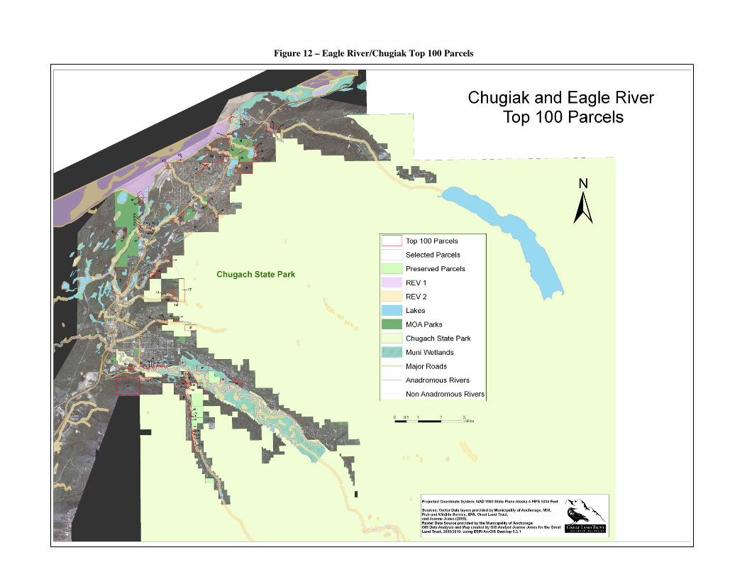
Figure 12 – Chugiak/Eagle River – Top 100 Parcels……………………………………20
Figure 13 – Indian/Girdwood Top 50 Parcels……………………………………………21
Table of Tables
Table 1 – Wetland REV Classification…………………………………………………..12
Table 2 - Assign Acreage from Wetland Clip…………………………………………...15
Table 3 - Anchorage Top 200 Parcels……………………………………………………23
Table 4 – Chugiak/Eagle River Top 100 Parcels………………………………………...29
Table 5 – Indian/Girdwood Top 50 Parcels ………………………………………..........33
Equations
Equation 1 – Scoring Parcels…………………………………………………………….16

5
1. Introduction
The Wetland Prioritization Project serves to identify parcels within the Municipality
of Anchorage that have the greatest potential for wetland conservation. The parcels were
filtered according to the following criteria:
i) parcel must be over one acre in size
ii) parcel must be on a wetland
Parcels were then ranked based on a score. The score for each parcel considered the
following:
i) adjacency to protected land
ii) expert opinion (GLT staff and WAG members)
iii) Area normalized of each type of wetland classification (REV)
1.1 The Client
The client requested large format maps to be printed that illustrate the selected parcels of
study within the Municipality of Anchorage. The client wanted the maps to include the
parcel’s ranking and to display the REV designations in each parcel. Also, a supporting
table that outlines each ranked parcel to include the total area of REV within the parcel,
the total land and building value of the parcel, the parcel’s owner information, and the
scoring attributes was to accompany the maps to relate the ranking data with each parcel
on the map respectively. The client also wanted the maps and parcel ranking to be
divided by three major geographic regions of the Municipality of Anchorage. The regions
are Anchorage, Girdwood, and Eagle River/Chugiak. The main purpose of the maps
would be to highlight the selected parcels visually for the WAG members, so they could
view each parcel on the map and its corresponding data on the supporting table document
and make the necessary comments, edits, modifications, etc. The client requested that the
maps and tables were to be modified following each WAG meeting to include all edits,
adjustments, and recommendations based on the members’ input. The client requested a
final product to be delivered electronically that consisted of: the maps, tables, data,
project report, and any supporting documentation.

6
1.1.1 Client Contact Information
Great Land Trust
619 E Ship Creek Ave. Suite 321
Anchorage, AK 99501
(907) 278-4998
www.greatlandtrust.org
1.2 Deliverables
Deliverable Date Description
Final Maps March 31,
2010
Five maps to include Eagle River/Chugiak,
Anchorage, and Girdwood illustrating top parcels
and selected parcels. Maps are 3’X2’ in size as well
as exported PDF and JPEG versions for 8.5” X 11”
size to embed in future documentation
Final Files March 31,
2010
All files used for creation of maps. All feature
classes stored in a File Geodatabase. Tables stored
in Windows file in DBF and Excel formats.
Final Report March 31,
2010
Report to serve as guideline to project; outlining data
acquisition, data processing, and GIS methodology.

7
2. Methodology
The creation of the data and maps for the Anchorage Wetland Parcel Prioritization
Project was a five month process which encompassed several meetings with GLT staff
and WAG members for modifications and was completed by one GIS Analyst.. The
steps taken by the team to meet the client’s objectives are outlined in detail below.
2.1 Data Collection
2.1.1 Base Data
The background & context data for the map included aerial photography and
several vector data layers. The Municipality of Anchorage provided the aerial
photography in a Mr.SID format. The orthophoto encompasses the entire Municipality of
Anchorage as well as surrounding areas.
The Municipality of Anchorage also provided vector data layers. The MOA layers
utilized included: wetlands, lakes, streams, parks (state and federal), community
boundaries, and roads. Fish and Wildlife Service provided detailed stream data in a
shapefile format, which was converted to a feature class, as well as supporting
documentation in the form of a data dictionary . GLT provided a vector layer for the
Anchorage Coastal Wildlife Refuge and map documents were provided by the MOA to
outline parcels that were split and preserved. GLT also provided NWI data to be used in
conjunction with the MOA wetland data. Parcel data (2009 CAMA data) was provided by
the Municipality of Anchorage in a text file format, which was formatted in Microsoft
Access to be used in ArcGIS Desktop.
2.1.2 WAG Input Data Collection
A vector layer was created for protected parcels that included GLT easements and
MOA easements and preserved parcels. This data was collected during WAG meetings,
where members outlined parcels on the maps that needed preservation designation. WAG
members also designated parcels of importance by decided whether certain parcels

8
needed more weight based on their expert opinion. This data was collected and used for
the scoring and ranking of parcels.
2.2 Preprocessing
2.2.1 CAMA Data
The text file was converted into a DBF format using Microsoft Access, where the
field names, length and data type were designated (Fig. 1).
Figure 1 – Translating Text file to DBF
This data was crucial to the project as it had the most up to date information
concerning the parcels, that will be necessary for later research.
2.2.2 Base Data
Shapefiles of stream data which included a field designating the stream as
Anadromous or Non-Anadromous were provided by the GLT. However, there were
several discrepencies and generalizations (Fig. 2). Using edit tools, the Anadromous
stream data was modified and redigitzed using the MOA stream data layer. Using the

9
sketch and trace tools, the Anadromous layer was modified to exclude generalizations
(Fig. 2). The process of heads-up digitizing was utilized to draw new line features
directly on the ortho imagery (Fig. 3).
Figure 2 – Stream Generalization Discrepancy

10
Figure 3 – Heads Up Digitzing to Create New Feature
At the end of this process, all new features were imported as feature classes into
the geodatabase, and attribute data was added as appropriate. Streams were assigned an
Anadromous field and data entry involved assigning a value of 1 or 0 for anadromous or
non-anadromous.
2.2.3 Parcel Data
The 2009 CAMA data was brought into ArcMap and joined with the existing
MOA parcel data. The purpose of this step was to include an updated version of
ownership for the parcels so appropriate contact could be made if the parcel was selected
for conservation. The data was joined on the Parcel Number field. A new field titled
‘PA_Prot’ was assigned to the parcel layer and parcels were given a 1 or 0 in this field, 1
if they were adjacent to a protected parcel (city/state/federal parks, conservation
easements, Anchorage Coastal Wildlife Refuge, etc.) and 0 if they were not adjacent.

11
Each value in this field was then multiplied by 0.5 in a new field to give less weight to
this factor for the ranking. A field entitled ‘Expert Opinion’ was also added. This field
designates whether the parcel is of importance and should be considered higher ranked
according to members of the WAG. These latter two fields will be used for the scoring
calculation for the ranking, which is described later in the report.
2.3 Filters
The following selection queries were run to begin selecting parcels:
a) parcels greater than 1 acre
b) parcels must have a wetland
Once the filters were complete a new feature class for parcels was created and data entry
attribute data was completed as necessary.
2.4 GeoProcessing
2.4.1 Wetland Data
The NWI data consisted of many discrepancies including duplicates and overlaps
(Fig. 4). The ‘Remove Duplicates’ ArcScript, (Stirbu, 2009), was downloaded and
utilized to remove all duplicate wetland polygons.
Figure 4 – Duplicates

12
The NWI wetland layer consisted of a 5-6-character code, which translated to a REV
classification. It was pointed out that the Environmental Protection Agency uses these
codes to determine wetland classification for preservation. The REV Codes range from 1
to 3, 1 being the highest potential for conservation. The NWI character code consisted of
a last digit character, which translated to the REV class. Table 1 illustrates the Wetland
REV classification.

13
A merge between the NWI wetland layer and the MOA wetland layer was done in
order to translate the NWI code to a REV classification. Once the merge was completed,
a new field was created in the new wetland layer and the REV designation was assigned
as per the guidelines from Table 1 (Fig. 5). One of the guidelines required for the project
was for all REV 3 wetlands to be omitted, therefore a selection query was done and all
REV 3 wetlands were omitted.
Figure 5 – Assigning REV Values to Newly Merged Feature Class
2.4.2 Stream Data
The stream data consisted of an attribute entitled ‘Anadromous’ and was assigned
a value of 1 or 0, 1 being anadromous and 0 being non-anadromous. Because the REV
classification includes stream buffers, the buffer tool was run on all streams. Streams
with a value of 1 for anadromous received 100’ and 300’ buffers (Fig. 6) and streams
with a value of 0 received a 300’ buffer. These buffers were created in order for a
selection query to be run on the wetland data to query out wetlands within each buffer so
the corresponding REV classification could be assigned (Fig. 7 & Fig. 8).

14
Figure 6 – Stream Buffers
Figure 7 – Assigning REV 2 Classification following Select by Location

15
Figure 8 – Assigning REV 3 Classification following Select by Location
2.4.3 Clip Wetlands (Python)
A python script was created to calculate the acreage of each wetland within each
parcel. The script looped through every parcel, clipped the wetland, and then assigned
two new fields ‘REV 1’ and ‘REV 2’ to each feature. The clip function then assigns the
acreage to the appropriate field (Table 2).
Table 2 – Assign Acreage from Wetland Clip

16
2.5 Ranking
2.5.1 REV Area Multipliers
Two new fields were created in the parcel layer to act as multiplier values for the
original acreage as assigned from the python script. The following are the fields with
multipliers:
a) REV 1 Area (Acreage X 1.5)
b) REV 2 Area (Acreage X 1)
2.5.2 Calculation
A score was given to each parcel based on acreage of wetland classification,
adjacency to protected land, and expert opinion (Equation 1).
Equation 1 – Scoring Parcels
Score = PA Prot X 0.5 + AreaN + Expert Opinion
Where:
PA Prot X 0.5 = Presence or Absence of adjacency to protected land (1 for presence and 0
for absence) multiplied by 0.5
AreaN = Acres of Wetlands Normalized after applying a multiplier to each REV
classification
Expert Opinion = Presence or absence of expert opinion (1 for increase importance and 0
for no increase)
3. Project Results
3.1 Maps
The client required large scale maps that illustrated the parcels according to rank. The
maps detail the top parcels within each required region of the Municipality of Anchorage.
The following are the required amount of selected parcels for each region:
a) Anchorage – Top 200 Parcels (Fig. 9, Fig. 10, Fig. 11)
b) Eagle River/Chugiak – Top 100 Parcels (Fig. 12)
c) Girdwood – Top 50 Parcels (Fig. 13)

17
Figure 9 – Anchorage – Top 200 Parcels East Midtown

18
Figure 10 – Anchorage – Top 200 Parcels West Midtown

19
Figure 11 – Anchorage – Top 200 Parcels South Anchorage
20
Figure 12 – Eagle River/Chugiak Top 100 Parcels

21
Figure 13 – Indian/Girdwood Top 50 Parcels

22
3.2 Tables
The client also requested tables to correspond with the parcels to illustrate the
ranking along with other attributes describing details of each parcel (ownership, land
value, REV acreage, etc.) be submitted (Tables 3, 4, and 5).

23
Table 3 - Anchorage Top 200 Parcels
RANK Parcel Number Acreage Owner_1 Owner_2 REV_1_Acre REV_2_Acre Expert Opinion PA PROT X0.5 REV_SUM AREAN SCORE
1 02018161000 104.92 FOREST HEIGHTS LLC 0.00 62.23 1 0 62.226 1.00000000000 2.000
2 00222106000 38.53 ARR 34.53 3.93 1 0 55.724 0.89551579279 1.896
3 00714454000 9.11 DAK HOLDINGS LLC 4.58 3.91 1 0 10.780 0.17323954512 1.173
4 02047123000 24.47 KAANDA LLC 2.37 6.33 1 0 9.888 0.15890011482 1.159
5 01005157000 7.14 PARK RORA 1.67 5.45 1 0 7.948 0.12773559011 1.128
6 00201119000 327.65 MOA MOA PORT 4.59 235.61 0 242.500 3.89709839733 1.897
7 01814104000 33.65 MOA HERITAGE LAND BANK 32.48 1.16 1 49.888 0.80172002547 1.302
8 01123104000 41.30 CAREY THOMAS E 26.37 9.01 1 48.569 0.78052403858 1.281
9 01485101000 80.65 MOA HERITAGE LAND BANK 16.99 21.36 1 46.837 0.75268924813 1.253
10 02002128000 119.77 NEWELL MARILYN LIVING TRUST 0.00 40.40 1 40.395 0.64917294337 1.149
11 02015121000 110.58 BREWSTER'S REST HAVEN 0.02 36.09 1 36.114 0.58037694042 1.080
12 00102108000 143.98 ARR 26.63 117.34 0 157.286 2.52767286029 1.528
13 02020125000 95.59
POTTER VIEW DEVELOPMENT CO
INC 0.00 32.82 1 32.822 0.52746847420 1.027
14 01122125000 22.21 RHODES R J & CLARA A 20.43 1.79 1 32.425 0.52109271258 1.021
15 01123103000 21.32 CAREY THOMAS E 20.30 1.02 1 31.469 0.50572572759 1.006
16 01917173000 19.06 ALASKA MENTAL HEALTH TRUST AUTHORITY 17.34 1.71 1 27.728 0.44560335594 0.946
17 01920101000 24.65 QUAN LALAY WOO 13.72 7.00 1 27.581 0.44324573883 0.943
18 02026107000 95.27 ALASKA ZOO 0.00 23.68 1 23.680 0.38055373051 0.881
19 00206131000 25.19 ARR 4.64 14.48 1 21.440 0.34455368218 0.845
20 01140280000 14.36 HICKEL INVESTMENT CO 13.53 0.84 1 21.124 0.33947006085 0.839
21 02046101000 119.53 SHOFF MARGARET D/TRUSTEE
MAHLON JAMES SHOFF REVOC
TRUST 0.00 20.69 1 20.688 0.33246076958 0.832
22 01909172000 14.68
BAYSHORE OWNERS
ASSOCIATION 4.98 9.66 1 17.126 0.27522659904 0.775
23 01122150000 14.24 OHMER KATELYN 9.27 2.57 1 16.478 0.26480939101 0.765
24 00326604000 62.31 MOA MOA AIRPORT 3.43 10.99 1 16.135 0.25929606891 0.759
25 02026108000 50.71
ALASKA BOTANICAL GARDENS
INC 0.00 15.88 1 15.879 0.25517636223 0.755
26 00422106000 41.64 UNIVERSITY OF ALASKA 5.42 7.10 1 15.230 0.24474860226 0.745
27 01505432000 14.83 L & D INC 0.00 12.76 1 12.763 0.20511044542 0.705
28 00421101000 39.89 UNIVERSITY OF ALASKA 0.00 12.15 1 12.155 0.19533088903 0.695
29 04208102000 69.11 BROWN MICHAEL E & LINDA J 0.00 11.75 1 11.745 0.18875132727 0.689
30 02017146000 24.94 MOEN RUTH M 0.00 11.72 1 11.721 0.18835632793 0.688
31 02002127000 40.13 MOA HERITAGE LAND BANK 0.00 11.26 1 11.255 0.18087939293 0.681
32 00808138000 14.07 MANOOGS ISLE II 0.00 11.24 1 11.235 0.18055664687 0.681
33 00808137000 11.19 KND INVESTMENTS LTD 0.00 11.10 1 11.102 0.17841622677 0.678
35 00204523000 82.01 ARR 2.60 6.55 1 10.443 0.16781688304 0.668

24
36 01127101000 12.98 GROPP DORA L 3.71 4.86 1 10.417 0.16740104026 0.667
37 00638157000 20.20
ANCHORAGE BAPTIST TEMPLE
INC 1.99 6.81 1 9.794 0.15739215015 0.657
38 01261103000 53.84 COOK INLET REGION INC 0.00 9.46 1 9.458 0.15199504153 0.652
39 02051121000 9.02 ABRAMSON ROBIN L 0.00 8.19 1 8.190 0.13161058332 0.632
40 02045106000 10.51 DEVON RONALD WILLIAM & JEANNE CHILTON 0.00 8.17 1 8.169 0.13128684384 0.631
41 01226168000 5.54 CREATIVE BUILDERS INC 5.02 0.52 1 8.048 0.12933657220 0.629
42 02058105000 11.19 LISKA JAYME K & DARCY C 0.00 7.95 1 7.949 0.12774672227 0.628
43 00640104000 8.79 MOA REAL ESTATE SERVICES 2.51 4.02 1 7.778 0.12499537477 0.625
44 01827102000 10.67 SIMPSON RANDALL G & FABE DANA A 1.88 4.71 1 7.532 0.12103707108 0.621
45 00929108000 5.11 MOA MOA 5501 4.80 0.32 1 7.512 0.12071524131 0.621
46 00922127000 16.51 FAITH CHRISTIAN COMMUNITY CHURCH 0.00 7.45 1 7.447 0.11967498874 0.620
47 02009102000 4.96 WOLD ANNE MARIE 1/3 & WOLD MICHELLE MARIE 1/3 & 4.96 0.00 1 7.434 0.11947048391 0.619
48 01141303000 8.26 CAMPBELL LAKE BLUFFS LLC 0.31 6.69 1 7.151 0.11491709509 0.615
49 00808135000 27.33 ALASKAN ISLE LLC 0.00 7.01 1 7.008 0.11262291553 0.613
50 01053104000 19.95 MOA MOA 7110 0.41 6.13 1 6.745 0.10839440027 0.608
51 01024428000 9.97 ELMORE RENTAL HOMES LLC 0.00 6.61 1 6.609 0.10621352857 0.606
52 02050142000 5.06 SOUTH PARK TERRACE HOME OWNERS ASSOC 3.28 1.67 1 6.588 0.10586514260 0.606
53 01416106000 4.95 WOLFLEY FREDRICK C & JANET G 2.94 2.01 1 6.425 0.10325945572 0.603
54 00918118000 5.17 WALDRON S D & WALDRON F D & WALDRON J J 1/4 EACH & WALDRON 2.23 2.93 1 6.266 0.10070321825 0.601
55 00911191000 4.99 HICKEL WALTER & REBECCA FAMILY TRUST 2.57 2.30 1 6.155 0.09890711571 0.599
56 04103321000 41.61 CREMO ROGER & GHISLANE 1.47 3.92 1 6.126 0.09845202684 0.598
57 00417120000 38.59 UNIVERSITY OF ALASKA 0.00 5.96 1 5.955 0.09570268618 0.596
58 02009183000 3.97 FERGUSSON J A & MARSHA L 3.97 0.00 1 5.952 0.09565406439 0.596
59 04103137000 6.70 FLANAGAN THOMAS J & KELLI J 0.00 5.95 1 5.948 0.09558007096 0.596
60 01205175000 6.86 WILK THOMAS S 50% & FIRMIN SUSAN M 50% 0.78 4.65 1 5.825 0.09360727481 0.594
61 02045103000 7.03 GAINES JOEL V R & NANCY A 0.00 5.41 1 5.407 0.08689367498 0.587
62 01515151000 10.27
FORSYTHE GRANT HENRY REV
TRUST FORSYTHE GRANT H/TRUSTEE 0.00 5.27 1 5.269 0.08467546930 0.585
63 01425221000 8.74 MOA ANCHORAGE SCHOOL DISTRICT 1.28 3.32 1 5.235 0.08413561787 0.584
64 01313101000 9.57 SECON INC 0.07 4.96 1 5.061 0.08132575700 0.581
65 01515143000 9.53 MOA ANCHORAGE SCHOOL DISTRICT 0.00 5.04 1 5.041 0.08100819125 0.581
66 00911401000 6.62 LAKE OTIS PROFESSIONAL CENTER LLC 1.22 3.15 1 4.978 0.08000339971 0.580
67 00808104000 9.56 YOUNG MENS CHRISTIAN ASSOCIATION OF ANCHORAGE 0.17 4.72 1 4.971 0.07988506798 0.580
68 00913120000 8.97 UNITED STATES OF AMERICA NATIONAL ARCHIVES & RECORDS 0.00 4.95 1 4.947 0.07949416613 0.579
69 00915213000 8.61
CORPORATION OF THE
PRESIDING BISHOP OF THE CHURCH OF JESUS 0.00 4.93 1 4.931 0.07924319341 0.579
70 01304470000 5.88 BAUGH GARY M 0.07 4.79 1 4.888 0.07855865462 0.579
71 01721135000 8.49
GARRETT MARY E & JOHNSON
DEANA
& SCHULTZ CAROLYN E &
SHARROCK 0.00 4.88 1 4.877 0.07836806192 0.578

25
72 00809116000 25.73 MOA REAL ESTATE SERVICES 0.00 4.86 1 4.864 0.07816897555 0.578
73 01417101000 4.29 ANCHORAGE DEVELOPMENT & CONSTRUCTION LLC 1.30 2.74 1 4.692 0.07540206435 0.575
74 01709122000 3.85 GALLO ABRAHAM 1.58 2.27 1 4.644 0.07463895465 0.575
75 02017147000 4.98 HEMENWAY KEVIN P & SARA A 0.00 4.58 1 4.579 0.07359080788 0.574
76 00726101000 16.60 MOA HERITAGE LAND BANK 0.83 3.30 1 4.553 0.07316775811 0.573
77 01102839000 4.37 DELONG LANDING LLC 0.34 4.03 1 4.546 0.07305213053 0.573
78 01141113000 3.74 MCCAW JOHN & CRAIG & BRUCE & MASON JULIAN L & 1.91 1.67 1 4.532 0.07283067646 0.573
79 00929104000 3.89 KORPI MARTHA HILDA & KORPI JOHN HENRY & 1.32 2.45 1 4.422 0.07107056927 0.571
80 01207115000 3.52 CARR-GOTTSTEIN ASSOCIATES 1.69 1.83 1 4.371 0.07023693292 0.570
81 00418102000 13.43 UNIVERSITY OF ALASKA BOARD OF REGENTS TRUSTEE 0.07 4.06 1 4.172 0.06705142108 0.567
83 01124120000 5.00 KYZER ETHEL IRREVOC TRUST KAREN & DEBORAH KYZER 1.55 1.73 1 4.055 0.06515860595 0.565
84 01024352000 4.30 SPENARD INVESTMENTS LLC % HOLIDAY INN EXPRESS 0.00 4.02 1 4.020 0.06460423857 0.565
85 01051121000 10.85 ORBUS INC 0.00 3.99 1 3.988 0.06409113800 0.564
86 01213255000 8.78 MOA ANCHORAGE SCHOOL DISTRICT 0.66 3.00 1 3.979 0.06394178648 0.564
87 01912459000 4.46
EDGEWATER HOMEOWNERS
ASSOC 0.46 3.26 1 3.950 0.06347166291 0.563
88 04102176000 14.24 BOOTH GREGORY & JANE 0.00 3.93 1 3.933 0.06320607946 0.563
89 00509107000 18.89 MOA ANCHORAGE SCHOOL DISTRICT 0.00 3.82 1 3.815 0.06131680812 0.561
90 02017145000 9.92 HAMRE CHRIS 0.00 3.75 1 3.746 0.06020500401 0.560
91 01548114000 3.21 CLIFFORD BRUCE L & ORALENA R 1.28 1.82 1 3.736 0.06003767690 0.560
92 01426142000 5.85 SKS COMMERCIAL LLC 0.67 2.70 1 3.707 0.05957370351 0.560
93 02056107000 13.64 COLE DEBI GAIL 0.00 3.70 1 3.699 0.05944360608 0.559
94 00510101000 139.74 ALASKA PACIFIC UNIVERSITY 0.00 3.63 1 3.627 0.05829331190 0.558
95 00729469000 2.68 R & L DEVELOPMENT INC 1.88 0.80 1 3.623 0.05821737648 0.558
96 01421113000 3.75 HARMAN DAVID & GAIL LIVING
TRUST 50% & HARMAN EDWARD
50% 1.10 1.84 1 3.488 0.05605828873 0.556
97 01405360000 4.54
INDEPENDENT BAPTIST CHURCH
OF ANCHORAGE 0.85 2.19 1 3.471 0.05578242049 0.556
98 01127109000 4.46 LOWENFELS JEFFREY B & HOERSTING JUDITH A 1.61 1.06 1 3.471 0.05577772811 0.556
99 01221104000 4.96 BEAUTIFUL SAVIOR LUTHERAN CHURCH OF ANCH AK & LUTHERAN 0.00 3.45 1 3.452 0.05547596852 0.555
100 00725101000 19.84 MOA HERITAGE LAND BANK 0.00 3.45 1 3.449 0.05541984707 0.555
101 01127108000 4.49 COVEY BARBARA & GODERSKY JOHN 1.57 1.06 1 3.417 0.05491669239 0.555
102 01825214000 2.49 LAVAN BONNIE M & ZIEGAHN KENNETH N 1.84 0.65 1 3.415 0.05487494664 0.555
103 01826202000 2.49 DICK WAYNE J & DOREEN J 1.72 0.77 1 3.351 0.05384700974 0.554
104 01127107000 4.46 GLASIONOV ALASKA COMMUNITY PROPERTY TRUST 1.51 1.06 1 3.320 0.05335751864 0.553
105 01127110000 4.29 LOWENFELS JEFFREY B & HOERSTING JUDITH A 1.49 1.07 1 3.304 0.05309126720 0.553
106 01705137000 2.46 RASMUSSEN ROBERT A 1.66 0.80 1 3.294 0.05293626656 0.553
107 01705131000 2.50 MCEWEN ROBERT & DEBBIE 1.57 0.93 1 3.287 0.05281610674 0.553
108 01127104000 5.48 JUST JOHN W & EVA S 1.32 1.29 1 3.267 0.05250323498 0.553

26
109 01709225000 10.04
BURGIN SALLY ARLENE
REVOCABLE TRUST 0.00 3.26 1 3.256 0.05233104563 0.552
110 00924261000 3.29 LITHIA REAL ESTATE INC 0.66 2.26 1 3.244 0.05213393097 0.552
111 01105228000 18.25 CHEN MARIA 0.10 3.07 1 3.225 0.05183250413 0.552
112 01414447000 2.17 MOA REAL ESTATE SERVICES 2.08 0.09 1 3.216 0.05168848391 0.552
113 01826102000 2.50 WHARTON EDWIN S & MELISA C 1.38 1.12 1 3.187 0.05121400910 0.551
114 01913109000 3.07 B L D DEVELOPERS INC 0.17 2.90 1 3.159 0.05077455614 0.551
115 01829209000 2.52 CALHOUN PHILLIP J & SONNET L 1.29 1.21 1 3.147 0.05056796629 0.551
116 00113267000 3.33 SWALLING JOHN C 0.13 2.93 1 3.124 0.05020987558 0.550
117 01414209000 4.76
REYNOLDS SHERMAN G &
PEGGIE A 0.95 1.68 1 3.108 0.04994625451 0.550
118 01829222000 2.49
TITUS PAULINE LEE LIVING
TRUST TITUS PAULINE LEE/TRUSTEE 1.24 1.25 1 3.105 0.04989663118 0.550
119 01825215000 2.45 ZIEGAHN KENNETH M & LAVAN BONNIE M 1.20 1.25 1 3.047 0.04896803458 0.549
120 00718329000 2.94 RAINBOW TERRACE TOWNHOUSE ASSOC 0.11 2.83 1 2.992 0.04808149697 0.548
121 00920103000 8.15 A & M INVESTMENTS LLC 0.00 2.96 1 2.964 0.04763501538 0.548
122 01825216000 2.48 BREWSTER RUTH M 1.00 1.41 1 2.910 0.04675731225 0.547
123 01127111000 3.94 ROMACK R GREG & PATRICIA J 1.24 1.04 1 2.892 0.04648154338 0.546
124 00804120000 2.50 MOA MOA 5501 0.89 1.55 1 2.885 0.04635694477 0.546
125 01406267000 2.19 MOA
STREET MAINTENANCE
OPERATIONS 1.40 0.69 1 2.794 0.04489320966 0.545
126 01209207000 16.75 MACINNES ROAD LLC 0.00 2.77 1 2.773 0.04456888622 0.545
127 00711502000 4.46
CORPORATION OF THE
PRESIDING BISHOP OF THE CHURCH OF JESUS 0.00 2.77 1 2.773 0.04455819473 0.545
128 02054133000 2.76 WHITEAKER KATHLEEN L 0.00 2.76 1 2.763 0.04440702498 0.544
129 02009182000 3.16 FERGUSSON J A & MARSHA L 1.44 0.59 1 2.748 0.04415730080 0.544
130 01218210000 3.11 GREENBELT/1983 0.08 2.63 1 2.744 0.04409578995 0.544
131 00920105000 3.42 ALEUTIAN PRIBILOF ISLANDS ASSOCIATION INC 0.20 2.40 1 2.708 0.04351134763 0.544
132 01129114000 3.78 ESSERT JOSEPH H & DEANNA M 1.09 1.06 1 2.699 0.04336738786 0.543
133 01127118000 3.78 FAULK DAVID G & BONNIE J 0.76 1.52 1 2.663 0.04280286544 0.543
134 00316114000 3.53 DRAKE JANET R 50% & DRAKE DUANE L 50% 0.25 2.27 1 2.641 0.04244772579 0.542
135 00915119000 3.69
ANCHORAGE BUSINESS CENTER
LLC 0.00 2.63 1 2.625 0.04218691562 0.542
136 01302137000 8.33 KND INVESTMENTS LTD 0.01 2.57 1 2.577 0.04141815495 0.541
137 01416107000 4.94 WOLFLEY FREDRICK C & JANET G 0.59 1.66 1 2.538 0.04079285882 0.541
138 01406471000 2.48 TAKE TWO LLC 0.79 1.30 1 2.486 0.03994953381 0.540
139 01604240000 27.20 MARTENS WALLACE 0.00 2.48 1 2.479 0.03983991542 0.540
140 00516203000 7.28 RASMUSSEN JACK O 0.00 2.45 1 2.450 0.03936728678 0.539
141 04103102000 10.00 MAURER LISA E LIVING TRUST MAURER LISA E & ERICK J/TTEES 0.00 2.44 1 2.438 0.03918767829 0.539
142 00317122000 6.34 AMERICAN BAPTIST HOME MISSION SOCIETY 0.13 2.24 1 2.434 0.03911340300 0.539
143 01207114000 2.48 EMBLEY FAMILY LTD 0.00 2.42 1 2.419 0.03886723403 0.539

27
PARTNERSHIP
144 00920113000 7.79 DISCOVERY CONSTRUCTION INC 0.22 2.08 1 2.404 0.03863894458 0.539
145 01129113000 3.54
NIELSON-ROBINSON FAMILY
TRUST NIELSON DAVID L & ROBINSON 0.89 1.06 1 2.398 0.03853744596 0.539
146 00217216000 6.78 WORTHINGTON CAL 0.11 2.20 1 2.363 0.03797457760 0.538
147 01706334000 1.65 ELIAS HENRY A 1.39 0.25 1 2.342 0.03763158657 0.538
148 00924265000 2.00 HANSON BETSY ANN 50% & RIDAH LLC 50% 0.66 1.34 1 2.324 0.03734201082 0.537
149 01706335000 1.75 PIASKOWSKI DAVID 1.08 0.67 1 2.292 0.03684097395 0.537
150 01706330000 1.73 HOPKINS BEVERLY L 1.10 0.64 1 2.279 0.03662363509 0.537
151 01705136000 2.51 JENSEN J LOWELL & JENSEN PATRICIA B INT TRUST 0.33 1.76 1 2.263 0.03636295271 0.536
152 00913211000 10.96 ANCHORAGE EAGLE LLC % LOWES'S COMPANIES INC 0.00 2.25 1 2.250 0.03616356245 0.536
153 01210129000 23.50 COLASKA INC 0.00 2.24 1 2.237 0.03595705280 0.536
154 01002261000 1.49 CAPTAIN COOK ESTATES LLC 1.49 0.00 1 2.230 0.03583066337 0.536
155 01031457000 3.48 TERRACE ON THE LAKE APARTMENTS LLC 0.00 2.22 1 2.224 0.03573366365 0.536
156 01218212000 3.08 LOMONACO BOLIN INV INC 0.18 1.94 1 2.209 0.03550119271 0.536
157 01706331000 1.75 HOPKINS BEVERLY L 0.91 0.84 1 2.201 0.03537262486 0.535
158 01207108000 2.50 EMBLEY KENNETH L 0.00 2.20 1 2.200 0.03536097909 0.535
159 01705130000 2.46 WILSON ROY N 0.34 1.68 1 2.190 0.03520174854 0.535
160 02045104000 2.98 GAINES JOEL V R 0.00 2.17 1 2.169 0.03486468548 0.535
161 01505180000 1.77 KAUFMAN YAEL B & ROBERT S 0.79 0.98 1 2.158 0.03468333816 0.535
162 00119339000 2.46 MOA REAL ESTATE SERVICES 0.00 2.13 1 2.128 0.03419633612 0.534
163 01910207000 1.80 BOBICH MATT & LINDA JOINT REVOCABLE TRUST 0.66 1.13 1 2.116 0.03400614116 0.534
164 01129112000 3.30 KROGH MARVIN A & JANET M 0.69 1.06 1 2.103 0.03379660318 0.534
165 02006102000 2.07 HORN STEVEN CARL & HORN RENDA KAYE 0.05 2.02 1 2.095 0.03366124788 0.534
166 00808135000 23.13 ALASKAN ISLE LLC 0.00 2.08 1 2.076 0.03335582978 0.533
167 01705134000 2.51 DODGE BEVERLY J 0.33 1.56 1 2.066 0.03320925372 0.533
168 00929121000 2.96
WILSON BRADLEY J REVOC
TRUST WILSON LISA A REVOC TRUST 0.00 2.06 1 2.060 0.03310451701 0.533
169 00924271000 3.10 HOMESTEAD PROPERTIES INC 0.09 1.92 1 2.059 0.03309515337 0.533
170 01408203000 1.64 WILLIAMS JOE JR 0.82 0.82 1 2.045 0.03286654037 0.533
171 04103202000 3.04 THORNQUIST ELPIDA K 0.00 2.04 1 2.045 0.03286298362 0.533
172 01127116000 3.47
HANNI W G FAM LIVING
TRUST50% HANNI S FAM LIVING TRUST50% 0.57 1.16 1 2.009 0.03228862477 0.532
173 02053134000 2.00 PULLER WADE F 0.00 1.99 1 1.992 0.03201008750 0.532
174 02015118000 179.92 MOA HERITAGE LAND BANK 0.00 1.99 1 1.987 0.03193366658 0.532
175 00912147000 5.08 SIMONIAN ARTHUR REVOCABLE TRUST 0.00 1.96 1 1.957 0.03145250027 0.531
176 01505187000 1.82 COX ROBERT E & JANICE A 0.34 1.43 1 1.943 0.03121905588 0.531
177 00911166000 2.88
UNIVERSITY PLACE
CONDOMINIUMS 0.27 1.49 1 1.900 0.03053205251 0.531
178 01414448000 1.51 LITTLE CAMPBELL CREEK HOMEOWNERS ASSOCIATION 0.76 0.75 1 1.891 0.03038937346 0.530

28
ESTATES
179 00120113000 5.44 KREIG RAYMOND A 0.00 1.85 1 1.849 0.02970778688 0.530
180 01127117000 3.07 HANNI LISA 0.53 1.05 1 1.845 0.02965725120 0.530
181 01129111000 3.09
MCQUEEN JOHN W JR & MARIE
EDA 0.50 1.06 1 1.821 0.02926008918 0.529
182 01706352000 1.45 REESE JOHN E & STEPHENS SANDRA A 0.71 0.74 1 1.798 0.02890168910 0.529
183 01528161000 9.98 MOA ANCHORAGE SCHOOL DISTRICT 0.00 1.79 1 1.791 0.02878607661 0.529
184 00801161000 1.78 SOUTHCENTRAL FOUNDATION 0.24 1.40 1 1.768 0.02840499309 0.528
185 01414208000 2.40 WILCOX RICHMOND REV TRUST WILCOX G B & RICHMOND C E/TTEE 0.64 0.79 1 1.748 0.02808647367 0.528
186 01313130000 6.62 RIVER PARK LLC 0.00 1.74 1 1.739 0.02794431119 0.528
187 02053135000 1.74 SZABO JANE M 0.00 1.74 1 1.738 0.02793678317 0.528
188 00513104000 4.22 ALASKA PACIFIC UNIVERSITY 0.00 1.74 1 1.736 0.02790567903 0.528
189 00918114000 16.90 BOYS CLUB OF ALASKA INC 0.00 1.71 1 1.713 0.02752360590 0.528
190 01548101000 4.28 CHAMBERS CONSTANCE 50% & CHAMBERS WILLIAM 0.17 1.45 1 1.706 0.02742158226 0.527
191 01306103000 2.37 CREEKSIDE MANOR LLC 0.00 1.66 1 1.657 0.02662994299 0.527
192 02045105000 1.63 WEIDEMAN ROBERT E & ILA 0.00 1.63 1 1.630 0.02618909633 0.526
193 01826126000 1.21 BALE ROBERT WILLIAM JR 0.81 0.41 1 1.616 0.02597086976 0.526
194 00801164000 1.49 SOUTHCENTRAL FOUNDATION 0.22 1.27 1 1.600 0.02571355300 0.526
195 02045102000 2.18 RUZICKA DUWAYNE 0.00 1.59 1 1.592 0.02558481295 0.526
196 01406109000 2.23 LEAKE TEMPLE AME ZION CHURCH 0.27 1.19 1 1.584 0.02545994644 0.525
197 01826125000 1.25 BALE ROBERT WILLIAM JR 0.66 0.59 1 1.578 0.02535736307 0.525
198 02056115000 1.57 MOA MOA 5501 0.00 1.57 1 1.573 0.02527363940 0.525
199 01051111000 4.16 JDK INC 0.00 1.57 1 1.572 0.02527005808 0.525
200 02051120000 1.57 WINGERD JAMES ROY 0.00 1.57 1 1.567 0.02518989757 0.525
201 01218211000 2.18 LOMONACO BOLIN INV INC 0.00 1.56 1 1.565 0.02514758821 0.525

29
Table 4 - Chugiak/Eagle River Top 100 Parcels
RANK Parcel Number Acreage Owner_1 Owner_2 REV_1_Acre REV_2_Acre
Expert Opinion PA_PROTX0.5 REV_SUM AREAN SCORE
1 06713101000 94.60 EKLUTNA INC 5.73 17.27 0.5 25.868 0.17560599725 1.67560599725
2 05219101000 254.61 EKLUTNA INC 58.42 59.68 0.0 147.309 1.00000000000 1.00000000000
3 05163158000 402.88 EKLUTNA INC 3.04 68.11 0.5 72.673 0.49333383856 0.99333383856
5 05138115000 38.37
ALASKA MISSIONARY
CONFERENCE
OF THE UNITED
METHODIST CHURCH 22.81 11.05 0.5 45.262 0.30725799883 0.80725799883
6 05175105000 30.73 EKLUTNA INC 28.08 2.62 0.5 44.740 0.30371138109 0.80371138109
7 05101140000 115.74 EKLUTNA INC 0.00 44.32 0.5 44.321 0.30086997644 0.80086997644
8 05038277000 116.82 JANKE PHYLLIS 9.18 25.87 0.5 39.643 0.26911423173 0.76911423173
9 05172144000 53.59 EKLUTNA INC 11.39 17.48 0.5 34.573 0.23469462883 0.73469462883
10 05101163000 359.69 EKLUTNA INC 0.00 29.46 0.5 29.463 0.20000785050 0.70000785050
11 05156128000 44.43
COLONY HOME
INVESTMENTS 0.00 26.21 0.5 26.215 0.17795736748 0.67795736748
12 05103332000 38.66
IZAAK WALTON LEAGUE
OF AMERICA 4.30 18.05 0.5 24.508 0.16636759048 0.66636759048
13 07813101000 63.86 GROSS JOHN L III & GROSS KENNETH L & 0.00 19.88 0.5 19.883 0.13497408558 0.63497408558
14 05189102000 83.54
COLONY HOME
INVESTMENTS INC 0.00 18.84 0.5 18.840 0.12789085808 0.62789085808
15 05033105000 39.41
MOORE FRANK H &
SANDRA 0.00 18.64 0.5 18.642 0.12655147341 0.62655147341
16 05068101000 39.70
PETERS RICHARD A &
BARBARA A 0.00 18.62 0.5 18.621 0.12641070370 0.62641070370
17 05189202000 160.67 EKLUTNA INC 0.00 16.27 0.5 16.271 0.11045550395 0.61045550395
18 05191101000 79.83 EKLUTNA INC 0.00 16.01 0.5 16.014 0.10870730053 0.60870730053
19 05102112000 19.66 EKLUTNA INC 4.21 9.37 0.5 15.681 0.10645197823 0.60645197823
20 05112211000 30.07
BOY SCOUTS OF
AMERICA 0.00 15.54 0.5 15.540 0.10549537080 0.60549537080
21 05101159000 27.29 EKLUTNA INC 0.00 14.72 0.5 14.719 0.09991881206 0.59991881206
22 05130104000 40.18 PITTENGER RICHARD W 0.00 14.69 0.5 14.688 0.09970991489 0.59970991489
23 05118201000 68.14 EKLUTNA INC 0.00 14.10 0.5 14.102 0.09572770739 0.59572770739
24 05066201000 20.85 KAANDA LLC 0.00 13.76 0.5 13.756 0.09338221929 0.59338221929
25 05202101000 29.57
WESTERN ALASKA
COUNCIL OF
BOY SCOUTS OF
AMERICA INC 1.57 9.57 0.5 11.930 0.08098704877 0.58098704877
26 05124309000 17.76 MATHIAS JASON 50% & MATHIAS RYAN 50% 0.00 11.48 0.5 11.476 0.07790631631 0.57790631631
27 05001404000 79.67 MOA
HERITAGE LAND
BANK 0.00 10.61 0.5 10.607 0.07200766684 0.57200766684
28 05093102000 65.15 EKLUTNA INC 0.00 10.17 0.5 10.175 0.06907171994 0.56907171994
29 05080116000 14.45 AKSAMIT RONALD E & LOKEN EVA 3.20 5.35 0.5 10.153 0.06892002049 0.56892002049
30 05130101000 40.04 KOEHLER KURT ALAN & CATHERINE A 0.00 9.81 0.5 9.813 0.06661219639 0.56661219639
31 06716103000 39.74
BEAR JOSEPH &
DOROTHY P 2.22 6.27 0.5 9.604 0.06519854487 0.56519854487

30
32 05138116000 38.49
ALASKA MISSIONARY
CONFERENCE
OF THE UNITED
METHODIST CHURCH 3.21 4.37 0.5 9.185 0.06235114862 0.56235114862
33 05116302000 32.05 EKLUTNA INC 1.79 5.27 0.5 7.957 0.05401438459 0.55401438459
34 05144101000 80.23
EBERHARDT BERNARD
J 0.00 7.54 0.5 7.540 0.05118165850 0.55118165850
35 05038173000 39.91 EKLUTNA INC 0.76 5.88 0.5 7.017 0.04763651927 0.54763651927
36 05065201000 5.96 WHITTERS CURT 0.00 5.96 0.5 5.963 0.04048197999 0.54048197999
37 06032101000 10.61
STEWART FAMILY
TRUST 0.00 5.92 0.5 5.924 0.04021406419 0.54021406419
38 05101171000 6.58 EKLUTNA INC 0.00 5.59 0.5 5.591 0.03795269148 0.53795269148
39 05141101000 35.01
SUSITNA GIRL SCOUT
COUNCIL 0.31 4.75 0.5 5.207 0.03534441609 0.53534441609
40 05123102000 10.11 EKLUTNA INC 0.00 5.07 0.5 5.065 0.03438526888 0.53438526888
41 06718102000 75.26 EKLUTNA INC 0.00 4.64 0.5 4.643 0.03152192620 0.53152192620
42 05174143000 14.94 ARCTIC DEVCO INC 1.22 2.10 0.5 3.929 0.02666947286 0.52666947286
43 05112201000 200.28
BOY SCOUTS OF
AMERICA 0.00 3.67 0.5 3.667 0.02489626848 0.52489626848
44 05147109000 3.57 MOA
HERITAGE LAND
BANK 0.00 3.23 0.5 3.231 0.02193647324 0.52193647324
45 05117305000 3.22 EKLUTNA INC 0.00 3.22 0.5 3.221 0.02186878024 0.52186878024
46 05123307000 3.20 EKLUTNA INC 0.00 3.20 0.5 3.195 0.02169237251 0.52169237251
47 05123301000 3.16 EKLUTNA INC 0.00 3.16 0.5 3.159 0.02144456755 0.52144456755
48 05117306000 3.19 EKLUTNA INC 0.00 3.11 0.5 3.106 0.02108575610 0.52108575610
49 05101239000 32.32 EKLUTNA INC 0.24 2.75 0.5 3.101 0.02104892841 0.52104892841
50 05123308000 3.18 EKLUTNA INC 0.00 3.09 0.5 3.085 0.02094462234 0.52094462234
51 05101170000 13.74 EKLUTNA INC 0.00 3.03 0.5 3.029 0.02056143902 0.52056143902
52 05123310000 4.19 EKLUTNA INC 0.00 2.64 0.5 2.641 0.01793060750 0.51793060750
53 06734102000 7.46
PETERSEN GROUP INC
THE 0.00 2.55 0.5 2.546 0.01728387906 0.51728387906
54 05123174000 2.54
MCGOLDRICK JIM R &
DEBORAH 0.00 2.54 0.5 2.542 0.01725728314 0.51725728314
55 05204101000 40.18
BOY SCOUTS OF
AMERICA
WESTERN ALASKA
COUNCIL 0.00 2.49 0.5 2.489 0.01689810533 0.51689810533
56 05080109000 2.11 TAN LIAN LIEW 0.82 1.22 0.5 2.455 0.01666534112 0.51666534112
57 05035322000 80.82 EKLUTNA INC 0.00 2.41 0.5 2.411 0.01636676064 0.51636676064
58 06706206000 63.81 EKLUTNA INC 0.00 2.34 0.5 2.341 0.01589134708 0.51589134708
59 05065208000 3.11
BOWDEN BENJAMIN
BARRETT 0.00 2.32 0.5 2.318 0.01573775877 0.51573775877
60 05123311000 3.48 EKLUTNA INC 0.00 2.27 0.5 2.267 0.01538945181 0.51538945181
61 05113309000 2.53 WRIGHT CARL D 0.00 2.21 0.5 2.214 0.01503122455 0.51503122455
62 06033119000 2.15
WILDWOOD
DEVELOPMENT LLC 0.00 2.15 0.5 2.154 0.01462307118 0.51462307118
63 05130107000 3.84 EKLUTNA INC 0.00 2.10 0.5 2.099 0.01424894651 0.51424894651
64 06709123000 2.92
EAGLE PLACE
CONDOMINIUM ASSOCIATION 0.00 2.01 0.5 2.012 0.01365855861 0.51365855861

31
65 05033112000 9.49
MOORE FRANK &
SANDRA 0.00 1.91 0.5 1.908 0.01295326775 0.51295326775
66 05123176000 2.25 BUBNA JEFFREY D 0.00 1.76 0.5 1.759 0.01194073852 0.51194073852
67 05080108000 1.44 TOMLINSON ROBERT C 0.57 0.83 0.5 1.687 0.01145356068 0.51145356068
68 05065205000 3.50
STEINHAUSER EVAN R
& JANET L 0.00 1.65 0.5 1.649 0.01119330849 0.51119330849
69 05038258000 2.77 DITTRICK ROBERT W & ELISABETH L 0.00 1.63 0.5 1.626 0.01103953109 0.51103953109
70 05033111000 9.46
MOORE FRANK &
SANDRA 0.00 1.63 0.5 1.625 0.01103331521 0.51103331521
71 05113315000 2.55
SCHERER EDWARD &
JAIME H 0.00 1.62 0.5 1.618 0.01098420894 0.51098420894
72 05080107000 1.36 PEKKONEN JYRI V 0.45 0.85 0.5 1.529 0.01038073656 0.51038073656
73 06709120000 12.98
EAGLE CROSSING
HOMEOWNERS ASSN 0.00 1.44 0.5 1.442 0.00979067030 0.50979067030
74 06713103000 4.03 EKLUTNA INC 0.00 1.41 0.5 1.413 0.00959193133 0.50959193133
75 06709119000 4.11
EAGLE CROSSING
HOMEOWNERS ASSN 0.00 1.39 0.5 1.395 0.00946975530 0.50946975530
76 05038257000 2.39
LABELLE JAMES D &
NORA E 0.00 1.26 0.5 1.258 0.00853998155 0.50853998155
77 05005245000 1.29
EAGLE RIVER
COMBINED LLC
C/O WEIDNER
INVESTMENTS 0.00 1.25 0.5 1.247 0.00846730851 0.50846730851
78 06710224000 2.05
EAGLE CROSSING
HOMEOWNERS ASSN 0.00 1.23 0.5 1.234 0.00837865139 0.50837865139
79 05150109000 3.31 SACKS JAY & CINDY 0.00 1.19 0.5 1.192 0.00808844268 0.50808844268
80 06716102000 174.85 EKLUTNA INC 0.00 1.18 0.5 1.184 0.00803697074 0.50803697074
81 05038256000 2.28
MARINO GREGORY G &
DEBORA S 0.00 1.17 0.5 1.165 0.00791174345 0.50791174345
82 05117317000 3.18 EKLUTNA INC 0.00 1.16 0.5 1.162 0.00788539231 0.50788539231
83 05181102000 1.12
LORENTZ MITCHELL &
OLIVIA 0.05 1.07 0.5 1.146 0.00778009550 0.50778009550
84 05123177000 1.14 BUBNA JEFFREY D 0.00 1.13 0.5 1.128 0.00765977435 0.50765977435
85 05080110000 1.43 HORN LESLIE J 0.19 0.83 0.5 1.113 0.00755508385 0.50755508385
86 05180106000 1.19 GRIFFITH SCOTT D &
HINELINE-GRIFFITH
CLAUDIA 0.00 1.10 0.5 1.102 0.00747801367 0.50747801367
87 05080124000 1.87
BLANK DEBORAH L 50%
&
BUTTERS KENNETH G
50% 0.16 0.85 0.5 1.089 0.00739125494 0.50739125494
88 05038255000 2.24 WALKER THOMAS F 0.00 0.99 0.5 0.993 0.00674184651 0.50674184651
89 05005237000 1.11
MONSARRAT LINDA
50% & POLZIN MICHAEL 50% 0.29 0.52 0.5 0.953 0.00646616372 0.50646616372
90 05121104000 17.54
HALFORD KONSTANZE
FROST 0.00 0.91 0.5 0.915 0.00620816686 0.50620816686
91 05063118000 2.02 KREBS JOCELYN E &
MORGAN SUSANNAH
L 0.00 0.91 0.5 0.907 0.00616011770 0.50616011770
92 05094128000 34.28 LBJ LLC 0.00 0.90 0.5 0.896 0.00608329534 0.50608329534
93 06710225000 1.55
EAGLE CROSSING
HOMEOWNERS ASSN 0.00 0.88 0.5 0.882 0.00599037585 0.50599037585
94 06033120000 2.15
WILDWOOD
DEVELOPMENT LLC 0.00 0.87 0.5 0.867 0.00588862646 0.50588862646

32
95 06709121000 2.01
EAGLE CROSSING
HOMEOWNERS ASSN 0.00 0.80 0.5 0.802 0.00544385721 0.50544385721
96 06710144000 3.85
PARKVIEW TERRACE
EAST PH 1-A
HOMEOWNERS
ASSOCIATION 0.01 0.73 0.5 0.747 0.00506852906 0.50506852906
97 05063119000 2.15
MOTZKO ROGER A &
CECELIA 0.00 0.74 0.5 0.744 0.00505107932 0.50505107932
98 06019101000 476.84
ALASKA MENTAL
HEALTH
TRUST
AUTHORITY/TRUSTEE 0.00 0.72 0.5 0.721 0.00489644902 0.50489644902
99 06733102000 34.70 DRIFTWOOD BAY LLC 0.00 0.72 0.5 0.719 0.00488197717 0.50488197717
100 05080118000 1.01
BEILFUSS RANDOLPH L
& PAMELA R 0.01 0.63 0.5 0.643 0.00436763210 0.50436763210

33
Table 5 - Indian/Girdwood Top 50 Parcels
RANK Parcel Number Acreage Owner_1 Owner_2 REV_1_ACRE REV_2_ACRE Expert Opinion PA_ProtX0.5 REV_SUM AREAN SCORE
1 07510471000 205.16 MOA HERITAGE LAND BANK 54.92 76.18 1 0.5 158.552 1.00000000000 2.50000000000
2 09023102000 49.97 REDMOND WILLIAM 49.31 0.67 1 0.5 74.625 0.47066614795 1.97066614795
3 07513104000 170.25 MOA HERITAGE LAND BANK 36.16 85.92 1 0.0 140.154 0.88396549368 1.88396549368
4 07506319000 10.14 MOA HERITAGE LAND BANK 0.03 5.81 1 0.5 5.851 0.03690090771 1.53690090771
5 07514104000 401.83 MOA HERITAGE LAND BANK 85.02 74.64 0.5 202.179 1.27515847110 1.77515847110
6 07509101000 67.69 MOA HERITAGE LAND BANK 18.10 26.08 1 0.0 53.228 0.33571294296 1.33571294296
7 07506204000 40.31 MOA HERITAGE LAND BANK 8.24 31.95 1 0.0 44.304 0.27942829232 1.27942829232
8 07510115000 18.99 MOA HERITAGE LAND BANK 5.55 4.01 1 0.0 12.341 0.07783644860 1.07783644860
9 07513102000 4.93 MOA HERITAGE LAND BANK 1.28 3.45 1 0.0 5.377 0.03391058122 1.03391058122
10 07510132000 5.66 MOA HERITAGE LAND BANK 0.95 2.97 1 0.0 4.394 0.02771540177 1.02771540177
11 07510229000 15.44 MOA HERITAGE LAND BANK 0.00 1.22 1 0.0 1.225 0.00772357238 1.00772357238
12 07605102000 144.32 MOA HERITAGE LAND BANK 17.06 30.22 0.5 55.812 0.35200856269 0.85200856269
13 07531104000 425.52 MOA HERITAGE LAND BANK 37.66 96.76 0.0 153.248 0.96654812635 0.96654812635
14 07520101000 139.95 MOA HERITAGE LAND BANK 12.76 25.58 0.5 44.723 0.28206988749 0.78206988749
15 07523102000 141.37 MOA HERITAGE LAND BANK 0.00 43.42 0.5 43.419 0.27384531875 0.77384531875
16 07523101000 284.59 MOA HERITAGE LAND BANK 0.00 37.50 0.5 37.500 0.23651266424 0.73651266424
17 07604104000 60.47 GIRDWOOD MINING COMPANY 0.12 28.02 0.5 28.208 0.17791139927 0.67791139927
18 07520102000 157.18 MOA HERITAGE LAND BANK 35.86 70.32 0.0 124.117 0.78281556459 0.78281556459
19 07513293000 33.23 ALASKA MENTAL HEALTH TRUST AUTHORITY/TRUSTEE 8.77 4.55 0.5 17.703 0.11165179834 0.61165179834
20 07513222000 20.96 MOA HERITAGE LAND BANK 3.63 4.90 0.5 10.348 0.06526535623 0.56526535623
21 07604104000 78.52 GIRDWOOD MINING COMPANY 0.00 10.28 0.5 10.277 0.06481648836 0.56481648836
22 07516341000 14.30 GLACIER VIEW LLC 0.99 6.94 0.5 8.418 0.05309139973 0.55309139973
23 07602401000 122.79 MOA HERITAGE LAND BANK 0.00 7.42 0.5 7.420 0.04679882815 0.54679882815
24 07502103000 1177.66 MOA HERITAGE LAND BANK 3.38 2.02 0.5 7.095 0.04474812051 0.54474812051
25 09002169000 9.41 TREMBLE R G & S E & DANIELS J M & EAGLE R J & 0.64 5.03 0.5 5.989 0.03777318795 0.53777318795
26 07507101000 3.63 MOA HERITAGE LAND BANK 2.31 1.32 0.5 4.784 0.03017335694 0.53017335694
27 07603117000 3.90 PATTON JAMES A 0.00 3.90 0.5 3.904 0.02461983234 0.52461983234
28 07507201000 3.61 MOA HERITAGE LAND BANK 0.00 3.11 0.5 3.108 0.01960378778 0.51960378778
29 07606255000 4.13
BRODIN RALPH W & CAROLYN
H 0.00 2.64 0.5 2.642 0.01666018684 0.51666018684
30 09009104000 4.99
BLACKBURN DAMON M &
JOANNE M 0.23 2.01 0.5 2.360 0.01488292667 0.51488292667
31 09007101000 1.29 THOMPSON STEVEN C 0.00 1.29 0.5 1.289 0.00813094382 0.50813094382
32 07603111000 1.37 PIKUL JAMES 0.00 1.28 0.5 1.285 0.00810320351 0.50810320351
33 07504137000 1.19 HOTEL ALYESKA LLC 0.00 1.13 0.5 1.133 0.00714773467 0.50714773467
34 07507132000 1.96
GLACIER CREEK PROPERTIES
INC 0.00 1.07 0.5 1.074 0.00677404057 0.50677404057

34
35 09002168000 7.00 TREMBLE R G & S E & DANIELS K M EAGLE R J & KIBBE B & 0.00 0.82 0.5 0.825 0.00520159258 0.50520159258
36 07503136000 3.60 6020 GROUP LLC SNOW RAVEN PROPERTIES LLC 0.00 0.70 0.5 0.702 0.00442606177 0.50442606177
37 07603116000 1.11 GOTTSDANKER ADAM 0.00 0.60 0.5 0.602 0.00379973514 0.50379973514
38 07506258000 3.29 MOA ANCHORAGE FIRE & RESCUE 0.00 0.47 0.5 0.465 0.00293349511 0.50293349511
39 07605102000 6.86 MOA HERITAGE LAND BANK 0.00 0.31 0.5 0.315 0.00198364783 0.50198364783
40 07603109000 1.06 PENNY KEVIN 0.00 0.30 0.5 0.300 0.00189129224 0.50189129224
41 07608223000 2.64 GIRDWOOD CHAPEL INC 0.00 0.30 0.5 0.296 0.00186755642 0.50186755642
42 09004129000 4.04
COWLES ROGER A & G
ARLENE 0.00 0.09 0.5 0.085 0.00053791717 0.50053791717
43 07514108000 33.14 ALASKA MENTAL HEALTH TRUST AUTHORITY/TRUSTEE 0.00 0.06 0.5 0.064 0.00040075971 0.50040075971
44 07521101000 69.23 MOA HERITAGE LAND BANK 16.58 35.17 0.0 60.046 0.37871541122 0.37871541122
45 07605102000 80.00 MOA HERITAGE LAND BANK 18.36 29.18 0.0 56.712 0.35768681403 0.35768681403
46 07601535000 149.98 ALYESKA SKI RESORT LLC 0.00 56.06 0.0 56.060 0.35357453376 0.35357453376
47 07521103000 159.23 MOA HERITAGE LAND BANK 3.79 38.32 0.0 44.009 0.27757020550 0.27757020550
48 07605102000 159.99 MOA HERITAGE LAND BANK 10.44 19.39 0.0 35.043 0.22101679441 0.22101679441
49 07513101000 32.94 MOA HERITAGE LAND BANK 7.56 17.07 0.0 28.411 0.17919000918 0.17919000918
50 07605102000 79.98 MOA HERITAGE LAND BANK 7.73 15.64 0.0 27.227 0.17172087666 0.17172087666

35
4. Conclusion
The results illustrate that there are many parcels within the Municipality of
Anchorage that have potential for wetland conservation. The GLT will now use the data
to review parcels more closely and contact landowners for further information.
The results also indicate that a heavier weight was given to parcels with wetlands
of a higher REV classification that were also designated of increased importance from
members of the WAG. Less weight was given to those parcels that were adjacent to
protected land, however, parcels that encompassed all factors were ranked fairly high.
5. Resources
5.1 Software
• ArcGIS 9.3.1 Desktop
o ArcMap
o ArcCatalog
• Microsoft Office
o Access
o Excel
o Word
• Python 2.5
• Visual Basic 6.5
• Paint
5.2 GLT Staff, WAG Members, and experts solicited for comments
• Phil Shephard Executive Director, GLT
• Dave Mitchell Conservation Director
• Heather Dean Environmental Protection Agency
• William Rice Fish and Wildlife Service
• Karen Keesecker Municipality of Anchorage
• Mary Lee Plumb-Mentjes US Army Corps of Engineers
• Nicole Hayes US Army Corps of Engineers
• Joe White US Army Corps of Engineers
• Nicole Hayes US Army Corps of Engineers
• Francis Mann Fish and Wildlife Service
• Leslie Tose US Army Corps of Engineers
• David Wigglesworth US Fish and Wildlife Service
• Jeff Urbanus Municipality of Anchorage

36
6. References
6.1 Programming and Development
ESRI Support 2010. ESRI Support Online: www.support.esri.com
ESRI Developer Network. 2010. ESRI Discussion Forum. Online:
http://edn.esri.com/.
ESRI Developer Network. 2010. ESRI Documentation Library. Online:
http://edn.esri.com/.
Stirbu, Jacob, Remove Duplcates. http://arcscripts.esri.com/details.asp?dbid=16386,
Posted July 4, 2009.