Anatomy of A Mine from Prospect to Production · ANATOMY OF A MINE FROM PROSPECT TO PRODUCTION ....
76
United States Department of Agriculture Forest Service Intermountain Research Station General Technical Report INT-GTR-35 Revised February 1995 ANATOMY OF A MINE FROM PROSPECT TO PRODUCTION
Transcript of Anatomy of A Mine from Prospect to Production · ANATOMY OF A MINE FROM PROSPECT TO PRODUCTION ....
United States Department of Agriculture
Forest Service
Intermountain Research Station
General Technical Report INT-GTR-35 Revised
February 1995
ANATOMY OF A
MINE FROM
PROSPECT TO
PRODUCTION
Foreword “Anatomy of a Mine” was first prepared in looseleaf form to aid Forest Service land managers and other administrators with mineral area responsi-bilities. The material summarized legislation af-fecting mining, defined mining terms, and dis-cussed basics of mineral exploration, develop-ment, and operation in the West. The goal then as now was to foster better understanding and com-munication about minerals and forest and range land surface values.
The 1975 guide was written primarily by private mining consultants James H. Bright and Anthony L. Payne under direction of the Minerals and En-ergy Staff (now Minerals Area Management), In-termountain Region, Forest Service. It quickly became popular with land managers in many State and Federal agencies. Planners, environmental-ists, and mining industry personnel sought copies. Educators from elementary through college levels have requested copies for classroom use.
In 1977, a revised publication was issued in the present format by the Intermountain Research Station, with funding and compilation provided by the Surface Environment and Mining Program. It was updated for another edition in 1983. Nearly 20,000 copies of the various editions have been distributed, and demand continues. A major use of the publication is in training land managers.
This 1995 edition was funded by the Forest Service’s Minerals and Geology Management Staff, Washington, DC. The combined efforts of Inter-mountain Region and Intermountain Research Sta-tion employees, and consultation with other Forest Service Regions, in reviewing and updating the material brings to the reader the most current minerals management information. We thank them all for their continued efforts to foster better under-standing of basic legislation, terminology, and pro-cesses used in the mining industry.
DENVER P. BURNS Acting Director Intermountain Research Station
DALE N. BOSWORTH Regional Forester Intermountain Region
Abstract Reviews mining laws and regulations and their
application to mining in Western States. Describes prospecting, exploration, mine development and operation, and reclamation factors.
The use of trade or firm names in this publication is for reader information only, and does not imply endorsement by the U.S. Department of Agriculture of any product or service.
Intermountain Research Station 324 25th Street
Ogden, UT 84401

ANATOMY OF A
MINE FROM
PROSPECT TO
PRODUCTION

CONTENTS Page
FOREWARD ..................................................... ii INTRODUCTION............................................... 1 MINING LAW .................................................... 3
Federal Laws ................................................. 3 Claim Location ............................................ 4 Lode vs. Placer Claims ............................... 5 Extralateral Rights ...................................... 5 Tunnel Sites ................................................ 5 Mill Sites ..................................................... 6 Claim Procedures ....................................... 6
Pursuit of Discovery ....................................... 7 Protection Prior to Discovery ......................... 8 Discovery ....................................................... 9 Locatable Minerals ......................................... 9 Leasable Minerals ........................................ 10 Salable Minerals .......................................... 10 Private Property ........................................... 11 State Laws ................................................... 11 Assessment Requirements .......................... 12 Adverse Proceedings ................................... 14 Rights of Claimants ...................................... 15 Multiple Surface Use Act of 1955 ................ 16 Occupancy ................................................... 16 Trespass Limitations .................................... 17 Federal and State Safety Requirements ...... 18 Environmental Regulations .......................... 18 Forest Service Regulations .......................... 18
PROSPECTING .............................................. 21 The Conventional Prospector ...................... 22 Amateur Prospectors ................................... 23 Regional Mineral Exploration ....................... 23 Exploration Concepts ................................... 24 Preliminary Evaluation of Exploration Results 25
EXPLORATION............................................... 26 Planning ....................................................... 27
Personnel ................................................. 27 Access ...................................................... 27 Occupancy ................................................ 27 Communications ....................................... 28 Property Adjustments ............................... 28 Contact with Federal Agencies ................. 28
Geological Exploration Methods .................. 28 Criteria for Ore Recognition ...................... 29
Geochemical Exploration Methods .............. 32 Reconnaissance Geochemistry ................ 32 Rocks ........................................................ 32 Soils .......................................................... 33 Vegetation ................................................ 35
Geophysical Exploration Methods................... 35 Gravity ...................................................... 35 Seismic ..................................................... 35 Magnetic ................................................... 35
Electromagnetic ........................................ 36 Electrical ................................................... 36 Radiometric .............................................. 37 Remote Sensing ....................................... 37
Restudy of Old Mining Districts .................... 38 Trenches, Pits, Overburden Drilling ............. 39 Exploration Drilling ....................................... 40
Hand Drilling ............................................. 41 Percussion Drilling .................................... 41 Rotary Drilling ........................................... 41 Diamond Drilling ....................................... 42
Underground Exploration ............................. 43 Bulk Sampling .............................................. 45 Pilot Testing ................................................. 46 Feasibility Studies ........................................ 46
DEVELOPMENT ............................................. 47 Drilling Large Deposits ................................. 48 Drilling Small Deposits ................................. 48 Development Shafts and Adits .................... 49 Blocking Out Ore Underground ................... 49
Proven (Measured) Ore ............................ 49 Probable (Indicated) Ore .......................... 50 Possible (Inferred) Ore ............................. 50
Access ......................................................... 50 Power ........................................................... 51 Communications .......................................... 51 Site Preparation ........................................... 52
Mine .......................................................... 52 Mill ............................................................ 53 Town Site .................................................. 53
Postponement of Production ....................... 53 PRODUCTION ................................................ 55
Underground Mining Methods ..................... 55 Open Stoping ............................................ 55 Shrinkage Stoping .................................... 55 Cut and Fill Stoping .................................. 56 Square-set Stoping ................................... 57 Block Caving ............................................. 57
Surface Mining Methods .............................. 59 Placer Mining ............................................ 59 Glory Holing .............................................. 60 Open Pit Mining ........................................ 61 Leaching Methods .................................... 62
Ore Dressing ................................................ 63 Crushing and Concentration ..................... 63 Extractive Metallurgy ................................ 64
Wastes ......................................................... 65 Mine Wastes ............................................. 65 Mill Wastes ............................................... 66 Miscellaneous Junk .................................. 67
Roads .......................................................... 67 RECLAMATION .............................................. 68

INTRODUCTION
Western North America produces more metal and mineral products today than any other region of similar size in the world. Beginning with the forty-niner’s discovery of gold, there has been one surge of mining activity after another. Silver in the Civil War era, copper at the turn of the century, potash, tungsten, phosphate, uranium, beryllium, to name but a few, have gained importance in turn as demand for metal and mineral products increased and new advances in technology were made.
When contemplating the present mineral production of the western United States, it is difficult to imagine how undeveloped much of the region must have appeared to the early explorers. The natives had in their possession only a few trinkets of gold, silver, and copper, and seemed to have little interest in, or knowledge of, minerals. The discovery of placer gold at Sutter’s Mill at Coloma, California, in January of 1848 was the first of many events that revealed the importance of the rich mineral resources of the West. The series of major new mineral discoveries since the California gold rush seems paced almost as if the region were some sort of gigantic mineral warehouse stocked with new commodities for use as they become needed.
Long gone are the days when mineral exploration consisted of probing outcrops of bold gold and silver veins. The list of minerals required by industry today includes a majority of elements on the chemist’s periodic chart, and the variety of ore deposits in which they occur is so great that no one individual could possibly be competent to prospect for them all. No government specialist, academic authority, or corporate expert is able to recognize the surface expression of all ore types under all conditions.
The era of the legendary mining engineer, who could go anywhere in the world and briskly size up the ore potential of any kind of mineral property, passed during World War I. The method of the mining engineer was to examine and sample the partially developed ore deposits found by early gold and silver prospectors, to determine if other metals might be present, low grade ores might be profitably mined by mechanized methods and treated by one of the efficient new metallurgical processes, or the property incorporated into a complex of mines, all shipping to a large, efficient, centralized smelter.
The modern explorationist goes back into areas investigated by the early prospectors and mining engineers, using new concepts of ore localization and techniques of search for mineral deposits that would have been of no interest to his predecessors. In the early years of mining, there was no market for most of the metals mined today. Transportation was inadequate, mechanized equipment and technology for development and treatment of the ores were lacking, and major capital was not available for investment in large mine developments and surface plants.
The series of recent major discoveries of previously unknown deposits of such materials as uranium, beryllium, potash, and gold makes it very clear that the long-term prediction of future mineral discoveries is a most hazardous occupation. It is not possible to determine that an area is lacking in mineral potential when the concept of the ore deposit containing it, the method of exploring for it, means of treatment, perhaps even the very use of it are totally unknown today. Therefore, the mineral explorationist views public land as a reserve of potential mineral resources in the very broadest
1

sense. He sees his task as the efficient future exploration and discovery of ore deposits of sufficient number, size, and quality to be competitively developed. In his view, the ultimate logical extension of the idea that the Nation should withdraw certain tracts of public land for specific limited uses would require the reservation of extensive areas for exploration and development of mineral resources.
Mineral values per acre may be immense in any given mineralized area These values, whether known or potential, should be considered carefully in land use planning, particularly if withdrawals from mineral exploration and development are contemplated.
People within the mining industry have come to view with skepticism any suggestion for temporary withdrawal of mineral entry in a given area, where it is proposed that the land might later be opened to mining if the need becomes great enough. They reason that the lead time required to find, explore, and develop a prospect into a producing mine is such that the only way to be sure of future mining operations is to allow normal prospecting, exploration, and development over the widest possible area. When poorly planned, hurried work is done in response to crisis. This results in expensive exploration which is often not successful in developing significant new mineral resources. Also, great damage to the surf ace environment may result.
Only a very small percentage of prospects develop into producing mines; authoritative estimates are in the range of 1 in 5,000 to 1 in 10,000. The mineralized portions of the earth’s crust are at fixed localities, and it is not possible to move the economic concentration of mineral to a location where mining might conflict less with other interests.
Mining industry leaders believe that if the search for minerals continues over broad areas, adequate new mineral resources can be found and developed. If mineral exploration is severely restricted, confined to much smaller areas, or if unreasonable burdens are placed on mining itself making investment unattractive, they feel that the number of new mineral finds will dwindle, perhaps to the point of major damage to the economy and the ability of the United States to provide for itself.
As an example of the unpredictable course of mineral development, 25 years ago Government
authorities were seriously concerned because the United States lacked uranium ore, and the country’s ability to defend itself and meet long-term energy needs was in question. Incentives were offered for uranium production, and major discoveries such as the Mi Vida deposit in Utah by independent geologist Charles Steen motivated others, so that within 10 years the Nation had developed the largest, richest uranium ore reserves in the world. Uranium mining has grown to the point of being second only to copper in economic importance in metal mining west of the Rocky Mountains.
There will be more pressure on public lands to produce minerals in the years to come. Many partially developed nations are beginning to look to their own future needs, and are no longer a source of cheap, easily available, high quality mineral raw materials. Established mineral-producing countries are becoming ever more nationalistic, and several have recently revised mining laws and imposed new taxes upon mining operations that have slowed or stopped mineral exploration. Capital formerly invested in exploration in such areas is now being directed to more politically favorable regions such as the western United States.
The increase in domestic demand for minerals progresses at an astonishing rate. More metal and mineral products have been used in the United States since World War II than were used in the entire previous history of the world, and demand increases each year. The sale of metal, minerals, and competitive products manufactured from them continue to increase in importance as a source of United States income overseas.
Society unquestionably derives major benefits from mineral production. To emphasize one commodity, the present major mining activity in the West centers upon the copper mines of Arizona, New Mexico, Utah, Nevada, and Montana. Without these mines, copper could not be produced in large quantities and at low cost, allowing its general use in mass production of electrical power, transportation, and other conveniences enjoyed by everyone today. Similar benefits could be cited in the case of other minerals such as lead, zinc, silver, gold, iron, coal, tungsten, and uranium. A healthy mining industry is important to the economy of the United States. The future need for minerals cannot be expected to diminish unless there is a major turn downward in the standard of living presently enjoyed in the
2

United States. There is no doubt that the potential for future discovery of major new mineral resources exists on public land.
Some mining people and resource managers think that the present mining laws of the United States may soon be changed or modified. However, it should be noted that none of the laws considered by Congress in recent years contemplate closure of public land to mining.
Mining has always been an authorized use of most National Forest land in the West. The language of the original legislation creating and authorizing the National Forests set forth the rights of a mineral locator as essentially the same as those of a person who locates a claim on other public land. The rights of the mineral claimant to explore and develop a valid claim on public lands open to mineral entry are clearly recognized.
The body of mining law that authorizes and controls prospecting, claim procedures, leasing, development, and extraction of minerals on public lands includes Federal and State laws, regulations issued by administering agencies based upon those laws, and court decisions that have established precedents for settling disputes. Rules established by organized mining districts, envisioned as important in early Federal law, have little significance today. The organized districts have been gradually eliminated in most western States.
Federal Laws Acquisition of mining claims on public land is a
right granted by the United States Mining Law of 1872. This law, passed by Congress on May 10, 1872, continued a policy of opening mineral lands to exploration. The United States Mining Law of 1872 expresses the general system of acquiring mining claims that was formed in California and Nevada between 1848 and 1866. Until 1866 there was a Federal policy of benign neglect with the mineral claim system in use in the West.
MINING LAW
A cornerstone of the early California Mining Law was that the discoverer obtained the right to his discovery. The early day custom was that a claim did not become property until mineral was discovered and perfected by development. This was the pattern for later law.
An 1866 mining law confirmed existing mining claims and contained the declaration that the minerals on public land were open to exploration by all citizens of the United States. The locator was given legal protection for his claim, and a system was devised by which a lode locator might acquire title by patenting. In 1870 the Placer Act amended the 1866 law to provide a method of patenting placer claims. These several acts facilitated the development of mineral resources of the western States and territories.
In 1872 the Acts of 1868 and 1870 were repassed by Congress as a single statute entitled the United States Mining Law of 1872. The acquisition of mining rights on large amounts of public land in the West is, for the most part, still governed by this law. The principal exceptions are the Mineral Leasing Act of 1920, which made certain nonmetalliferous minerals exclusively leasable and
3

not open to acquisition by claim staking, the Materials Act of 1947 that defined a group of salable minerals; the Multiple Mineral Use Act of 1954 that provided for multiple mineral development of the same tracts of public lands; the Multiple Surface Use Mining Act of July 23, 1955, that withdrew common varieties from mineral entry; and a section of the Federal Land Policy and Management Act of 1976 that redefines claim recording procedures and provides for abandonment if the procedures are not followed.
Claim Location The principal provisions of the 1872 statute are:
1. After discovery of a lode or vein, a mining claim may be located on a plot of land not exceeding 1,500 feet in length along the lode or vein and 300 feet on each side of the middle of such vein at the surface (fig. 1). Local mining district rules or State laws may limit the width of such claims to not less than 25 feet on each side
of the middle of the vein at the surface. Surface end lines must be parallel.
2. Upon completing the lode location, the locator has the exclusive right of possession and enjoyment of all (a) surface included within the lines of the location for mining purposes; and (b) all veins, lodes, or ledges throughout their entire depth if the top or apex lies inside of the surface lines extended downward vertically, even though such veins may extend outside the vertical side lines of the surface location.
3. Placer claims located by a single individual and based upon a single discovery are limited to 20 acres. An association of individuals may locate up to 160 acres on each discovery.
4. Both placer and lode locators are required to perform $100 worth of development work per claim annually in order to hold their claims against subsequent locators.
5. There is provision for acquiring 5-acre claims of nonmineral land for mill site purposes.
Figure 1.—Lode mining claim.
4
6. The section commonly referred to as the Tunnel Site Act gives an individual the right to prospect a maximum of 3,000 feet into a hillside, acquiring a prior right to all theretofore unknown veins and lodes cut by the tunnel; however, no surface rights are attached.
The United States Mining Law of 1872 does not sanction the disposal or use of public lands for purposes unrelated to mining.
Lode vs. Placer Claims The mining location laws authorize two main
types of claims—lode and placer—depending on the character of the deposit. Lode claims are staked on veins or lodes of quartz or other rock in place bearing gold, silver, cinnabar, lead, tin, copper, or other valuable deposits. Placer claims are staked on all forms of deposit, excepting veins of quartz, or other rock in place.
The locator must decide into which category his deposit falls and stake a lode or placer claim as appropriate.
In the United States Mining Law of 1872, Congress drew a distinction between the traditional gold placer composed of alluvial material along stream beds and the vein or lode found in solid rock. In many modern cases the choice is difficult as many deposits do not clearly fall into either category.
A lode is frequently considered as a zone or belt of mineralized rock clearly separated from neighboring nonmineralized rock.
Placers are superficial deposits washed down from a vein or lode occupying the beds of ancient rivers, or deposits of valuable minerals found in particles of alluvium in beds of active streams.
These definitions emphasize the present form of the deposit more than its origin, so that a deposit bounded on either side by rock in place is likely to be considered a lode. If the ore is on top of the ground and has no cover except a thin veneer of soil, it is likely to be a placer. In the case of a dispute the courts tend to find in favor of the first locator.
A placer claim can be no larger than 20 acres for an individual, with associations of up to eight persons locating multiple claims of 20 acres per person up to 160 acres. A placer location does not establish rights to any lodes within its boundaries. Placer locations must conform as nearly as practicable to rectangular legal
subdivisions. All of the persons in an association must be active participants in the venture. The rights of a “dummy locator” may be invalid, if he fails to actively assert the rights of a principal in the location. Corporations are considered to be a single person. There is no limit to the number of placer claims that may be located by an individual or association.
Extralateral Rights The locator of a valid lode mining claim
acquires the right to mine all the veins and ledges throughout their entire depth, the tops or apexes of which lie inside of the claim surface lines (fig. 2). Such veins or ledges may depart from a perpendicular in their course downward so as to extend outside vertical, downward extensions of the sidelines of the claim. Rights of the claim holder to mine the deposits after they leave the vertical claim lines underground are known as his extralateral rights.
Extralateral rights apply only to lode claims with parallel end lines and usually do not extend under adjacent private land. Lawsuits over extralateral rights were very common at one time, but today such disputes usually are settled privately.
Tunnel Sites The law provides for tunnel sites where a
horizontal excavation (adit) is made to discover lodes and veins not appearing at the surface. The owners of such tunnels gain the right of possession of any previously unknown veins or lodes discovered along the 3,000-foot distance between the portal and face of the tunnel.
A tunnel site conveys no surface rights and the right of possession of a vein discovered in a tunnel cannot be maintained unless the owner makes a lode location of the vein on the surface. Discontinuing work for 6 months constitutes abandonment of a tunnel site.
A monument must be placed at the portal of the tunnel naming the locator, stating the proposed direction of the tunnel, its height and width, and the course and distance from the portal to a permanent object in the vicinity. The boundary lines of the tunnel site must be established by stakes placed along the 3,000-foot length of the tunnel line. Tunnel sites are uncommon today.
5

Figure 2.—Extralateral rights of a lode mining claim.
Mill Sites A 5-acre plot of nonmineral land may be staked
as a mill site. The land need not be contiguous to the claim that will produce the ore for the mill. Mill sites are monumented in the same manner as lode claims. No assessment work is required; but the mill site must be used for mining and milling purposes.
Claim Procedures Under the United States Mining Law of 1872, land
is claimed for minerals by distinctly marking the location on the ground so that its boundaries can be readily traced and making a record of the name or names of the locators, date of location, and a description of the claim or claims located by reference to some natural object or permanent monument that will identify the claim. In addition, State law requires the monumentation of claims by corner posts, and in some cases, side and end center posts. A copy of a location notice must be
placed at the point of discovery and the location notice must be recorded with the recorder of the county in which the claim is situated. The Federal Land Policy and Management Act of 1976 requires that claim location documents also be filed with appropriate off ices of the Bureau of Land Management.
Historically, mining claims have been marked or staked in a variety of ways. Claim corners and discovery points have been marked on the ground by rock monuments or cairns, trimmed and blazed trees, or iron posts embedded in soil, rock, or concrete. The most common markers, however, are 4-by-4 wood posts.
It is essential that the discovery be made and that the location monument and notice be on public land open to mineral entry, otherwise the entire claim is invalid. Portions of a younger lode location may overlap older locations and claim boundary monuments may be placed on land already claimed
6

in order to square the claim or to take advantage of an extralateral right not held in apex by previous locators. The location monument is erected at some point along the centerline inside the claim. Less than 300 feet on either side of the centerline and less than 1,500 feet along the centerline may be claimed, but the claim can never exceed 600 by 1,500 feet in size.
All unappropriated Federal lands that have not been withdrawn from mineral entry are open to locations of mining claims. Appropriated public lands—those original public lands which are covered by an entry, including mining claims, patent certification, or other evidence of land disposal; or which are within a reservation, contain improvements constructed with Federal funds or are covered by certain classes of leases—are not open to mineral entry. Lands covered by mining claims validly maintained by another person are not subject to location.
Mining claims can be located in Alaska, Arkansas, Arizona, California, Colorado, Florida, Idaho, Louisiana, Mississippi, Montana, Nebraska, Nevada, New Mexico, North Dakota, Oregon, South Dakota, Utah, Washington, and Wyoming.
Land in National Monuments or National Parks, unless specifically authorized by law, Indian reservations, and acquired lands are not open for location. The claim locator must be a United States citizen or must have declared an intention to become a citizen. A domestic corporation is considered to be a citizen, regardless of the nationality of its stockholders. Employees of the Departments of the Interior and Agriculture are restricted in some ways from staking claims. A minor competent to acquire and hold interests in land under State law is a qualified locator.
The 1872 law specifically requires discovery of a valuable mineral deposit within the limits of the claim prior to locating a mining claim. Modern day mineral deposits are most often found at great depth and the actual discovery of mineral in place commonly occurs in a drill hole after considerable exploration work. The prospector or geologist finds geological, geophysical, or geochemical indications of mineralization long before the drilling phase of the program encounters the discovery of mineral in place.
Copies of the mining law and regulations in a form usable by prospectors, geologists, and Federal employees can be obtained in Title 43 of Code of Federal Regulations and in Title 30 of the U.S. Code Annotated. The pertinent portions of the 1872 law are published as a brochure by the U.S. Department of Interior, Bureau of Land Management, entitled Regulations Pertaining to Mining Claims Under the General Mining Laws of 1872, Multiple Use, and Special Disposal Provisions.
Pursuit of Discovery In past years prospecting was limited to surface
outcrops where discovery was easily made with limited equipment. Factors such as the ever-increasing demands for new mineral resources, the economic incentives to produce minerals, and the exhaustion of many known deposits make it necessary to intensify the search for new mineral deposits and to explore to considerable depths below the ground surface.
Science and technology have provided new methods, techniques, and instruments to aid in exploration. Mining companies have risked millions of dollars in mineral exploration and research. This has trained and provided experience for mineral explorationists in the art and science of ore finding. These advancements in ore finding capability open a new dimension not available to most prospectors. The old-fashioned prospector can find only what can be seen at the surface, and normally cannot afford the sophisticated methods used by the mining companies.
Exploratory work is necessary, in many instances, to perfect a discovery. The general mining laws are presently interpreted as extending an express invitation to enter upon the land and explore and, upon discovery, to claim by location with the promise of full reward. The prospector who enters upon vacant public land, peacefully and in good faith, is not a trespasser, but is a licensee or a tenant at will. This right to enter is a statutory right. A mineral discovery cannot be made without the right of entry and the time to explore.
Excavations are a necessary part of exploration for minerals. This necessity to excavate is not necessarily tantamount to removal and sale of the
7

excavated minerals. The prospector seeks only to make a discovery by the use of such an excavation. In some cases it is necessary to sell extracted minerals to meet the marketability test of the valuable mineral deposit.
Discovery of a valuable mineral deposit is essential in creating valid rights to a claim and in obtaining a patent.
Because the discovery is the foundation of title to a mining claim, discovery must be pursued diligently by a bona fide claimant. Normally, to the locator, the sequence of events is immaterial. Discovery may precede the location of a claim or may follow the act of location; however, the actual time of discovery is important in that it establishes priority between claimants and with the Government when there is conflict. Priority of discovery gives priority of rights.
When two locators are in possession of overlapping claims before discovery, a race develops between the locators to make a discovery first and the first discoverer obtains priority of rights. The rights of a locator actually begin on the date of discovery of a valuable mineral deposit on a claim. This is true whether or not the required location work precedes or follows discovery. The need for secrecy in a new discovery can be easily seen in a case of probable competition from a rival capable of staking conflicting claims. There is no substitute for discovery on a mining claim. Length of time held and amount of money or effort consumed in working on a claim does not dispense with the need for discovery.
Where the issue of discovery is raised in a controversy with the Federal Government, the finding of small amounts of subeconomic mineral in sufficient quantity to encourage or induce further prospecting and exploration is not sufficient for a discovery. The actual mineral deposit must be disclosed and available for sampling by some means. Geological inference or opinion, no matter how strong, will not substitute for the actual exposure of mineral. Hope, belief, or expectation will not sustain a discovery.
There must be physical exposure of valuable mineral in surface outcroppings, pits, shafts, or drill hole samples to demonstrate the discovery. Drill core or cuttings will usually be accepted.
A lode discovery will not suffice for a placer claim nor will a pacer discovery suffice for a lode claim, and the discovery must be within the limits of the claim.
Protection Prior to Discovery
A person actively exploring a prospect desires protection against another locator on the land that he is exploring, for the time necessary to discover minerals in place.
The courts have recognized this problem and arrived at the doctrine of pedis possessio to provide protection to the modern bona fide prospector.
Under the pedis possessio doctrine, a claimant who has peacefully and in good faith staked claims in search of valuable minerals, may exclusively hold the claims while he is diligently working against others having no better right than he, so long as he retains a continuous exclusive occupancy and in good faith works toward making a discovery. During the period that the doctrine is operative in a particular situation, the claimant must be actively working toward making a discovery by digging or drilling. Making preparations for digging or drilling may not be sufficient unless the preparatory activity directly precedes the actual digging or drilling.
Whether or not a prospector, geologist, or mining company can successfully assert rights of pedis possessio may vary in each particular case. To claim the rights there must be actual physical possession of all the ground, diligent bona fide work directed toward making a discovery, and others must be excluded.
It is common exploration practice to locate a large block of claims over and around an area where it is suspected that deposits of valuable minerals may occur. The locator of such blocks is well advised to maintain exclusive possession and to pursue a discovery on each claim.
This possession or occupancy of the claims must be more than mere presence. Geophysical testing and geochemical work, unless followed immediately by drilling, may not be sufficient. However, the requirement of physical occupancy is usually satisfied by work in progress. The exclusion
8

of others requires positive action. Rights are lost if an adverse claimant is permitted to enter the property peacefully. Pedis possessio protects against forcible entry. Thus it is necessary to deny entry to the intruding party.
If a confrontation occurs, and force is used by the entering party, the denial of entry need not be successful. The claimant or his agent simply yields to force, and then goes to his legal remedy. The claimant should make no statements indicating consent to trespass. In a land rush situation, a claim block should be patrolled to deny entry to other than authorized public officials. Proposed new changes in the Federal mining laws provide for exploration claims to cover a large area during the period prior to the discovery of valuable mineral in place. This could remedy some of the shortcomings of the 1872 Mining Law.
Discovery What is a discovery? The Federal statutes that
require discovery do not define the term, and the definition of discovery under the United States Mining Law of 1872 continues to be a subject of controversy. One basic standard for discovery has been the prudent-man test, which states that the requirements of discovery have been met when minerals have been found and there is evidence that a person of ordinary prudence would be justified in the further expenditure of labor and money, with a reasonable prospect of success in developing a valuable mine.
The test is not whether the individual claimant feels he is justified in further expenditure, but whether a hypothetical “reasonable” man would be so justified, and whether a profitable mining venture is probable.
In 1933, the U.S. Department of the Interior formulated the marketability test as a standard. The marketability test states that the mineral locator or applicant, to justify his possession of a location, must show by reason of accessibility, development, proximity to market, existence of present demand, and other factors that the deposit is of such value that it can be mined, removed, and disposed of at a profit.
The marketability test focuses on the economic value at the present time.
There continues to be a contest between the prudent man test and its extension — the marketability test. Every locator should be prepared to defend his discovery under the standards of the marketability test. If a contest develops, the claim holder may be required to prove marketability in today’s market.
In considering these definitions of discovery, certain rules must be kept in mind. The deposit discovered must be a valuable mineral deposit. This commonly means an assay or test of some kind must be made to determine the quantity and quality of metal or commodity in the discovery. The size of the deposit and the probable cost of production are also considered.
The immediate effect of a valid discovery is to remove the land upon which the discovery has been made from the unappropriated public lands.
The rules for determining what is a discovery of valuable mineral may vary according to the parties and interests involved. The tests are quite different in a contest between two adverse claimants than the tests used by the U.S. Government in a contest with a claimant. The United States, by appropriate methods, may question the validity of a claim at any time and, in the absence of a discovery, may terminate the prospector’s possession of a particular claim by adjudication. The claimant, however may locate another claim on the general site, if he is acting in good faith.
Locatable Minerals Whatever is recognized as a valuable mineral by
standard authorities, whether metallic or other substance, when found on public land open to mineral entry in quality and quantity sufficient to render a claim valuable on account of the mineral content, is considered a locatable mineral under the United States Mining Law of 1872. Specifically excluded from location are the leasable minerals, common varieties, and salable minerals described in the next two sections.
Every valuable mineral deposit that is not excluded by special legislation is a locatable mineral. The United States Mining Law of 1872 specifically mentions rock in place bearing gold, silver, cinnabar, lead, tin, copper, or other valuable deposits. As a general rule, all valuable metallic mineral deposits are locatable plus a large group of
9

nonmetallic substances which have been determined to be locatable by either the Department of the Interior, a Federal or State court, or legislation by Congress. Some of the nonmetallic minerals in this group are borax, feldspar, fluorspar, and gypsum.
If a prospector, geologist, or land agency representative has any doubts about the locatable classification of a mineral deposit, he should consult a mineral expert on this point.
Leasable Minerals The first major change in the United States
Mining Law of 1872 came with the passage of the Mineral Leasing Act of 1920. Certain minerals were withdrawn from location and were placed under the Leasing Act which provides for their development through prospecting permits and leases. No permanent rights are acquired from the U.S. Government, only the right to explore for and mine the specific minerals covered by the lease or permit.
The 1920 Act, as amended from time to time, places the following minerals under the leasing law: oil, gas, coal, oil shale, sodium, potassium, phosphate, native asphalt, solid or semisolid bitumen, bituminous rock, oil-impregnated rock or sand, and sulfur in Louisiana and New Mexico.
In general, to hold a lease, the miner is required to pay an annual rental in advance, to pay a royalty to the Government on all material removed and sold, and to comply with any other provisions written into the lease.
The acquisition of mineral deposits by a lease from the Bureau of Land Management is very different from the location of a valid claim on a mineral discovery. Areas involved in leases are large compared to individual mining claims because of the nature of the occurrence of leasable minerals. Filing fees and yearly land rental fees are collected in advance, and bonds in varying amounts are required before the issuance of either a prospecting permit or a lease.
In areas in which leasable mineral deposits are not known to occur, minerals can be leased by a noncompetitive procedure. In areas in which leasable mineral deposits are known to occur in marketable quantities, leases are issued to the
highest bidder, either by sealed bid or at public auction. Leases issued in this manner are termed competitive leases. Regulations pertaining to the leasing of minerals other than oil and gas can be obtained in a Bureau of Land Management Circular or in Title 43 of the Code of Federal Regulations.
Public lands that passed from Federal ownership through acts of Congress or disposal laws and were later reacquired by the United States are known as acquired lands. Minerals subject to location on other lands must be leased on acquired lands.
The royalty rates for each lease are set by the U.S. Department of the Interior and may be obtained from BLM offices. For all minerals in the same general area, royalties are usually the same. Royalties for the same minerals may be different in various areas of the United States.
The Multiple Mineral Use Act of 1954 allows land that is leased for one commodity to be claimed to cover minerals not in the leasable category. In some cases this can be important where locatable minerals are found in an oil and gas lease area.
Salable Minerals The Materials Act of 1947, as amended, removes
petrified wood, common varieties of sand, stone, gravel, pumice, pumicite, cinders, and some clay from location and leasing. These materials may be acquired by purchase only and are referred to as salable minerals.
Sales are handled through the agency administering the land upon the request of an interested party or upon the request of an authorized official. Sales are by competitive bidding if there is more than one interested party, otherwise a sale is negotiated by the authorized officer after the materials are appraised.
The sale of minerals does not limit the right of the U.S. Government to use the surface and to issue permits and licenses that do not interfere with the purchaser’s production of minerals. The land must be reclaimed as required by the sale contract or by law when mining is completed.
A mining claimant risks prosecution for trespass and may be liable for damages if he removes salable materials from an unpatented mining claim.
10
company attempts to obtain a lease with option toPrivate Property purchase from the owner.
It is not uncommon for minerals beneath private property to be owned by someone other than the surface owner or by the Government.
Parcels of land that passed from the public domain into private ownership prior to the Stock Raising Homestead Act of December 29, 1916, were classified as nonmineral and the minerals that might be under these lands passed to the fee owners of the surface. This 1916 Act eliminated any problems of mineral versus nonmineral lands by providing for the reservation to the United States of all minerals in every patent under this Act. Thus, most lands patented under the various homestead acts from the public domain after 1916 are open to mineral entry under the United States Mining Law of 1872.
There are many laws under which the original title to land could be obtained, and it is necessary to check the document in the land records to determine the law under which the title was granted.
Disposals under other laws both before and after the Stock Raising Homestead Act of 1916 often reserved minerals to the Government. The Secretary of the Interior has never issued regulations to dispose of these reserved minerals.
It is necessary for the miner to pay the private surface owner for damage to the surface caused by prospecting, mineral development, and mining. This is commonly done by arranging for a bond through the Bureau of Land Management as security for damage to the surface, or by entering into a contract with the surface owner.
Sections 5 and 6 of the Taylor Grazing Act of June 28, 1934, as amended, provided that the rights of the miner were not to be restricted in prospecting, locating, developing, mining, entering, or patenting under applicable laws any mineral deposits found on lands leased for grazing. The grazing lease holder cannot restrict proper and lawful ingress or egress for prospecting purposes.
Minerals that are owned in fee simple by the surface owner or that have been reserved in private ownership separately from the surface are not open for prospecting, development, or mining without permission from the owner. Normally, the mining
State Laws The United States Mining Law of 1872 did not
preempt the field, and State laws are permitted to elaborate on some aspects of mining law not covered specifically by the Federal act.
State statutes deal primarily with location procedures, some aspects of assessment requirements, and the time method for filing documents. Most western States require posting of the notice of location on the land, which is not required by Federal law. The information required on the notice varies from State to State, and contains substantially the same information as the recorded certificate.
Nearly all States require location work, although the Federal law does not. Although location work is intended to disclose the evidence of discovery, it may or may not result in a discovery. Location work is sometimes erroneously referred to as discovery work.
All States require corner monuments. End-center and side-center monuments may or may not be required and the size and character of these monuments varies from State to State.
All records of unpatented mining claims are kept in the county courthouse of the county in which the claim is located. Under provisions of the Federal Land Policy and Management Act of 1976, similar documents will have to be filed with appropriate Bureau of Land Management offices.
When the United States Mining Law of 1872 was passed, most western land was unsurveyed. In some western States there is still unsurveyed land. In many cases the descriptions of mining claims are so vague that they can properly be considered a floating claim block. For unscrupulous claimants this type of claim block may have the utilitarian value of being moved over any new discovery in the vicinity. The floating claim block can be moved anyplace that the claimant desires by moving the claim posts and thus predate claims made by the discoverer. It is normally possible to contest such action, but the claimant may hold out for a considerable cash payment for his nuisance
11

value. Many attorneys will advise the major mining company to pay rather than fight, in order to get on with exploration.
State mining laws in some cases require a map filed with the county recorder and perhaps a payment as well in lieu of location work. In Nevada, the county uses the payment to compile a master claim map, thus eliminating floating claims. Any extra fee money provides an income to the county for general use.
Most mining legislation does not vary drastically from State to State; however, there is enough variation that an element of confusion and uncertainty pervades the State mining laws and a prospector or geologist must always carefully examine the law, particularly with reference to location and assessment procedures.
Assessment Requirements The annual labor or improvements required by
the United States Mining Law of 1872 on an unpatented claim is commonly referred to as assessment work. The general purpose of this work is to assure good faith and diligence and to prevent a claimant from holding claims without working the ground, thus preventing others from making entry. The pertinent provisions of the United States Mining Law of 1872 require assessment work as follows:
...On each claim located after the 10th day of May, 1872, and until a patent has been issued therefore, not less than $100 worth of labor shall be performed or improvements made during each year...; but where such claims are held in common, such expenditure may be made upon any one claim; and upon a failure to comply with these conditions, the claim or mine upon which such failure occurred shall be open to relocation in the same manner as if no location of the same had ever been made, provided that the original locators, their heirs, assigns, or legal representatives have not resumed work upon the claim after failure and before such location.... The period within which the work required to be done annually on all unpatented mineral claims located since May 10, 1872, shall commence at
12 o’clock meridian on the 1st day of September succeeding the date of location of such claim....
By Act of February 11, 1875, the following provision was added to the United States Mining Law of 1872:
...Where a person or company has or may run a tunnel for the purposes of developing a lode or lodes, owned by said person or company, the money so expended in said tunnel shall be taken and considered as expended on said lode or lodes, whether located prior to or since May 10, 1872; and such person or company shall not be required to perform work on the surface of said lode or lodes in order to hold the same as required by this section....
The most recent Federal legislation was enacted on September 2, 1958, and provides:
...The term labor, as used in the third sentence of section 2324 of the Revised Statutes (30 U.S.C. 28), shall include, without being limited to, geological, geochemical and geophysical surveys conducted by qualified experts and verified by a detailed report filed in the county office in which the claim is located which sets forth fully (a) the location of the work performed in relation to the point of discovery and boundaries of the claim, (b) the nature, extent, and cost thereof, (c) the basic findings therefrom, and (d) the name, address, and professional background of the person or persons conducting the work. Such surveys, however, may not be applied as labor for more than two consecutive years or for more than a total of five years on any one mining claim, and each survey shall be nonrepetitive of any previous survey on the same claim....
The regulations as stated in Title 43 of the Code of Federal Regulations, provide that:
(a) The term geological surveys means surveys on the ground for mineral deposits by the proper application of the principles and techniques of the science of geology as they relate to the search for and discovery of mineral deposits;
(b) The term geochemical surveys means surveys on the ground for mineral deposits by the proper application of the principles and
12

techniques of the science of chemistry as they relate to the search for and discovery of mineral deposits;
(c) The term geophysical surveys means surveys on the ground for mineral deposits through the employment of generally recognized equipment and methods for measuring physical differences between rock types or discontinuities in geological formations; and
(d) The term qualified expert means an individual qualified by education or experience to conduct geological, geochemical or geophysical surveys, as the case may be.
In most States, filing of proof of labor in the county records is required by State law within a limited time period.
The question of what can qual i fy for assessment work is not always easy to answer. It is necessary to remember that it is $100 worth of labor and improvements. The work must have a value of $100, not necessarily cost $100. Geological, geochemical, and geophysical surveys, some road work, tunneling, digging pits, cuts or trenches, or excavations, and drilling which tends to develop the mineral deposit qualify as assessment work. The intent is to induce development of minerals and to avoid speculat ive holding of claims. Casual prospecting or surface sampling for the purpose of making a discovery will not serve as assessment work.
Over the years the courts have generally prescribed rules governing the character of the work and improvements that will satisfy the assessment work requirement. The court rulings have been lengthy and complex, but they can be summarized as fol lows: the labor and improvements, within the meaning of the statute, should be deemed to be done when the labor is performed or improvements made for the purpose of working, prospecting, or developing the mining ground embraced in the location, or for the purpose of facilitating the extraction or removal of ore.
Claims may be grouped for assessment work purposes. That is, work can be done on one or more claims rather than on each claim in a group, and the assessment work requirements can be met if the value of the work is sufficient. The
claims must be contiguous, that is, overlap or share common sidelines, and there must be a community of interest if more than one claim owner is involved. There are no rules that completely cover the grouping of claims. The circumstances in each case can be important.
As a practical matter, many claim holders do little or no assessment work on their claims and file questionable proof of labor statements. In some circumstances this may constitute perjury.
If there is a contest over the performance of assessment work, the burden of proof concerning the performance generally is on the party contending that the required work was not done. As a general rule, in court cases where a second locator attempts to relocate the claim of the original locator who has allegedly failed to perform the required assessment work, most decisions tend to protect the original locator where it appears that he has acted in good faith. The courts generally do not substitute their judgment for that of the miner if the work tends to develop the claim and facilitate the extraction of ore.
The absence of an assessment work affidavit in the county records may encourage a new claimant interested in the ground to locate new claims. The failure by the original locator to file the proof of labor forms does not verify that the required annual work was not done. If the original locator can prove that the necessary assessment work was done, he retains rights of possession under Federal law.
To the prospector or independent geologist, traveling to numerous claim groups and performing assessment work can be an onerous and expensive task. Most mining companies with large claim holdings maintain a system of records in the company files and assign one man for part or all of the year to keep track of assessment work and see that it is properly recorded. The Government may under certain circumstances invalidate a claim where assessment work has not been performed.
Effective August in, 1993, legislation was enacted that affected the requirements of recordation of new mining claim locations or sites and annual assessment requirements. The new requirements can be found in 43 CFR Part 3830 - Location of mining claims. The reader is advised to contact the local Bureau of Land Management office for further information.
13

State law requirements are still to be followed. The claimant should consult with the State for these requirements.
Adverse Proceedings The problems of adverse claimants can fall under
two general categories: 1. A contest between two private citizens or
companies over ownership of mining claims. 2. A legal action initiated by the U.S. Government
against a mining claim held by a private citizen or corporate claimant.
In past years there was much litigation over extralateral rights, where a vein apexed (fig. 2) on one claim and extended down-dip off the claim. This type of litigation was commonly bitter and costly to settle. Extralateral rights litigation between two adverse claimants is now uncommon, as negotiated settlements are more satisfactory than drawn-out expensive lawsuits.
Occasionally, two exploration groups may decide at approximately the same time to stake a large block of claims over a target area where exploration will be required to make a discovery. One group may begin staking claims first and the second group may stake from the other end of the area, possibly not knowing of the competitor’s activity, and a “staking rush” is on when either or both of the parties discover the other’s activities.
As they become aware of each other’s activities, the doctrine of pedis possessio (see Protection Prior to Discovery section) will come into use. One group may attempt to deny peaceful intrusion onto its claims by the other group. An adverse claimant situation often exists between the two groups. The key to the situation now depends on who can make a discovery first, usually by drilling. Many complex legal problems may develop as the claimants race to be the first to make a discovery.
About this time, it is possible that a group of floating older claims in the district will be moved under the claims covering the new discovery area. There is also the possibility that placer claims will be staked by unscrupulous individuals over the discovery area in the hope that the major mining company will buy out the nuisance value of the placer claims rather than fight in court. Sometimes
the mining company’s counsel will mistakenly advise a payoff; each time this is done it only compounds future difficulties.
There may be circumstances where a group of claims will appear to be abandoned. A search of the county records fails to reveal an assessment affidavit for the immediate past assessment year ending at noon on September 1. Inspection of the ground reveals no recent physical work of the kind required for assessment. Under these circumstances, a new set of claims may be staked on what appears to be open ground. The new claimant does the required location work and begins exploration—pursuit of discovery—on the claim group.
If the former claimant has in fact abandoned the claims there will be no problems; however, if the former claimant had no intention of abandoning the ground there may be a legal contest over who has the best claim to the ground. If the original claimant has filed his proof of labor, the new claimant would have to prove that the assessment work had not been done. Not having filed the proof of labor, the original claimant now may be in the position of having to prove that he performed the required assessment work.
Claims staked for leasable or salable minerals are subject to adverse action by the U.S. Government. The claimant is in trespass and may end up paying for the minerals that have been illegally removed. It is possible to locate legal mineral claims covering the same ground where the U.S. Government has leased or sold the nonlocatable minerals. No title is obtained to the nonlocatable minerals and their production cannot be impeded by the locator.
Many cases of unauthorized occupancy have caused the Government to initiate an action to remove a home or cabin or to correct some other nonmineral use.
Some claimants locate claims on land that is not open for mineral entry. This is often done where the locator believes the claims to be in a different section of land than they actually are. This may be a surveying problem, or the claimant may have failed to make the necessary check of the land management agency records to determine the status of the land.
14
Congress has given the Department of the Interior adjudicative powers in matters relating to the mining laws. The most common action is a contest of claim validity conducted under the regulations of the U.S. Department of Interior. The Department of the Interior’s authority in this area has been confirmed by the U.S. Supreme Court. The administering agency can initiate a complaint which will result in a contest through the Department of Interior under the Administrative Procedures Act for a variety of reasons, including lack of discovery. Necessary action may be initiated simultaneously in the Federal Courts to resolve urgent conflicts. After proceeding through the Department of the Interior regulations process, the contest may go to the U.S. District Court with appeals to the Circuit Court or Supreme Court. Where the contest is of great magnitude, considerable time, money, and effort can be expended in actions of this type.
At the time of application for patent, there is a 60-day period when adverse claims can be filed with the office where the patent application was initiated. An adverse claim may be brought by another claimant who can demonstrate a right to all or a portion of the claim being patented. There is also an opportunity for persons in the vicinity of a mining claim to protest that the patent applicant has not met the mining law requirements. Protests against a patent can be filed by the Forest Service at any time before patent for noncompliance with discovery or labor requirements.
Rights of Claimants Under the United States Mining Law of 1872, the
locator of a valid mining claim that has been perfected by the discovery of a presently marketable mineral deposit and by the performance of all the required acts of location acquires the exclusive right of possession and enjoyment of all of the locatable minerals within the boundaries of his location. He also acquires any appropriate extralateral rights along with the use of the surface compatible with the Multiple Surface Use Act of 1955.
Prior to the discovery of a presently marketable mineral deposit within the claims boundary, the claimant has a questionable title to the claim. Prediscovery rights can be held against an adverse
claimant under the doctrine of pedis possessio by actively pursuing discovery and maintaining continuous exclusive occupancy. This doctrine provides only tenuous prediscovery protection and it is not possible to generalize as to what action will satisfy the requirements in all cases; litigation my often result.
The claim locator has the right to prospect, develop the mineral potential, do assessment work, and perform other acts related to exploration that are not forbidden by law or regulation.
Where there are conflicting or overlapping claims, most rights are determined on the basis of priority of discovery, but subsurface rights are not necessarily so determined. Extralateral rights to a vein are based on apex considerations.
Valid, unpatented mining claims are real property in the full sense of the term, except as modified by multiple use legislation. When all requirements have been met, the locator has a valid, marketable title for mining purposes. As long as the locator complies with Federal and local laws and regulations in good faith, he has possessory title segregated from the public lands, although the paramount title remains in the U.S. Government until a patent is granted. This possessory title may be maintained indefinitely as long as the appropriate laws are complied with. This title does not include timber except as used for mining purposes on the claim, nor the r ight to nonmining use of the surface. Assessment work must be done on the claim in the amount of $100 per claim for each assessment year to maintain the possessory title. The assessment year begins at noon on September 1 of each year.
A claim locator who does not perform assessment work for a period may resume such work at any time, in the absence of the intervening rights of an adverse claimant on the ground. The original claim locator regains the same rights and title he obtained by locating the original claim, providing that he can demonstrate the existence of a valuable deposit of a locatable mineral.
The U.S. Government may initiate a contest using the Bureau of Land Management adverse claim procedures for cause affecting the legality of a mining claim. The procedure is set forth in the Federal statutes as supplemented by Department regulations.
15

In a mineral contest between the Government and a claimant the Government is required to present prima facie evidence (evidence sufficient to raise a presumption of fact or establish the fact in question unless rebutted) that the claim is invalid. The claimant has the right to retain expert assistance in defending his position and must show by a preponderance of evidence that his claim is valid.
In actual practice, the average claimant has not made a valid discovery prior to locating his claim. Many claimants mistakenly believe that compliance with State location laws fulfills the Federal requirement of discovery. It is common for a claimant to refer to having done the discovery work on a claim when in actual fact he has done the State-required location work.
Under the Multiple Surface Use Act of July 23, 1955, prior to the issuance of a patent the United States and its licensees have the right to use as much of the surface and surface resources as is necessary for access to adjacent land, providing that this use does not interfere with prospecting, mining, or processing. The claimant does not have the right to use an unpatented mining claim for purposes other than prospecting, mining, or processing operations and uses reasonably incident thereto. In the interpretation of what is “reasonably incident thereto,” there are gray areas subject to various interpretations.
The claimant has the optional right to apply for a patent. The conditions that must be met prior to filing an application are: a valid discovery of a valuable mineral deposit, the performance of $500 worth of improvements which directly facilitate the development of the mineral deposit, and the preparation of survey plat and field notes by a Deputy U.S. Mineral Surveyor. If the patent application is successful, the claimant must pay for the land at the rate of $5 per acre for a lode claim and $2.50 per acre for a placer claim. After patent, the surface and minerals on the claim are private land subject to local property taxation, and the annual assessment work is no longer required.
Multiple Surface Use Act of 1955
Congress enacted the Multiple Surface Use Act in 1955 to curtail nonmining use of the surface of
mining claims. Under the Act any mining claim located after July 23, 1955, shall not be used prior to the issuance of patent for any purposes other than prospecting, mining, or processing operations and uses reasonably incident thereto. The rights of the holder of a claim staked after July 23, 1955, and prior to patent are subject to the right of the United States to manage and dispose of the vegetative surface resources and to manage other surface resources, except the locatable mineral deposits on the claim.
The Act also provides that mining claims will be, prior to issuance of a patent, subject to the right of the Government to use so much of the surface as may be necessary for access to adjacent land. Any use of the surface of the mining claim by the Government must not endanger or materially interfere with prospecting, mining, or processing operations or uses reasonably incident thereto.
The holder of a valid mining claim is still authorized to cut and use timber from the claim for mining purposes.
The result of this legislation is that the owner of a mining claim is entitled to use the surface only as necessary for the mining operation, and the claims are subject to surface management by the Federal Government until patented.
Occupancy The mining laws permit a claimant to make reasonable use of the claim surface area prior to a patent being granted, so long as this use is connected with mining. The mining laws do not permit the use of an unpatented mining claim for land on which to build a home or cabin. There have been many cases where persons unfamiliar with the mining laws have built homes or cabins on claims staked with this idea in mind, or purchased as cabin sites.
The Mining Claims Occupancy Act passed by Congress in October 1962 enabled people making their principal residence on an improved site on a mining claim to occupy the land which the residence occupied. The law was extended until June 30, 1971.
Buildings necessary for mining facilities are allowed on valid mining claims when discovery is not an issue. It is often necessary to erect buildings on unpatented mining claims to protect equipment, store samples, or house personnel.
16

In dealing with unauthorized occupancy there is commonly a question of what is authorized use for mining purposes. Even if the claim is valid, the occupancy may exceed that needed for mining purposes. Some habitation of buildings can very well be an authorized use. The administering agency should obtain a technical opinion regarding the claim validity before questioning possible unauthorized occupancy.
Trespass Limitations The owner of an unpatented mining claim has
only limited rights to prevent trespass. He does not necessarily have the right to fence the claim and erect no trespass notices. Under the Multiple Surface Use Act, the surface may be used for nonmining purposes such as hunting and fishing by persons other than the claim holder.
After a valid discovery of valuable mineral has been made, the claimed area is no longer unappropriated public land. The intent of the law is that the same ground cannot be located or possessed by another claimant until such time as the claim is abandoned by the original claimant.
Active mining operations obviously have a right to forbid trespass in and around buildings, mine workings, and mills. For this purpose, fences and no trespassing signs are commonly erected.
Trespass on mining claims may be an accident or innocent mistake, intentional and justifiable, or intentional and not justifiable, and may be committed on the surface or underground. A person entering within the sidelines of another miner’s lode claim for the purpose of mining is a trespasser if the vein being mined apexes (see fig. 2) on the miner’s claim. The corner monuments of adjacent claims may be placed on the surface of adjacent unpatented or patented mining property for the purposes of squaring the located claim. The consent of the owner is not essential when the encroachment is open and peacefully done. The right of the overlapping locator is limited to the ground outside of the prior located claim or patented ground, except for extralateral rights that might be acquired. Subsequent objection by the prior owner is unavailing.
Prior to the Multiple Surface Use Mining Act of July 23, 1955, claimants commonly took quite
literally the statement in the United States Mining Law of 1872 that the locator acquired the exclusive right of possession and enjoyment of all the surface included within the lines of his location. Miners commonly clear t imber on a claim for development purposes, used it in surface structures and in underground workings, and sometimes sold the timber outright. Prior to 1955, the miner had no right to sell the timber except for clearance, nor could the Government remove or sell the timber on a claim except in the case of an emergency or insect infestation. In 1955, Congress enacted the Multiple Surface Use Act to curtail nonmining use of the surface of mining claims. While the locator’s possession and enjoyment is exclusive for mining purposes, the Government and its licensees may, under proper circumstances, exercise rights of way across the claim so long as in so doing they do not interfere with the mineral development of the claim.
On an inactive mining claim no trespass is committed by people passing through the area hiking, hunting, rock collecting, fishing, or for numerous other reasons. Prospectors and geologists may examine the showing on a claim without prior knowledge of its status as a mining claim or what the ownership is. It is common practice to examine mineral showings and quickly map and sample the surface and underground geology of a prospect without contacting the owner of a claim. If a prospector or geologist spent the time necessary to contact all absentee owners prior to examining all prospects more time would be spent trying to find people than in looking for ore. This type of examination is often to the advantage of the absentee claim owner, for if something of interest is found in the examination the owner will be contacted. If nothing is found he is not bothered unnecessarily.
If the owner of a valid mining claim is working the claim it is the usual custom for the prospector or geologist to stop and talk, and to gain permission to look around.
There is an occasional hermit or recluse who does not want anyone to come near his workings, let alone examine the geology or sample the showings. Unless the showings are of unusual meri t the prospect wi l l go undeveloped while such an individual is in possession of the claims.
17

Federal and State Safety Requirements
The conditions of safety around a developing or operating mine are controlled by both Federal and State laws. The mining States have State mine inspection organizations that inspect and advise on the physical condition of an operation.
On the Federal level, two safety inspection organizations exist. These are Mine Safety and Health Administration (MSHA), an agency of the U.S. Department of Labor, and Occupational Safety and Health Administration (OSHA), also an agency of the U.S. Department of Labor. These agencies have prepared pamphlets explaining their functions.
The activities of MSHA and some State mine inspection organizations overlap and some coordination exists where the State group has agreed to Federal standards. All three groups keep records and investigate serious accidents and fatalities at mine operations.
The Bureau of Mines has a safety demonstration group, operating out of Boulder City, Nevada, which researches and devises safer methods for performing various tasks.
Most western States have laws requiring that shafts, drill holes, tunnels, and small pits be covered or fenced where they can be a danger to life.
Environmental Regulations
The National Environmental Policy Act of 1969, as interpreted by the courts and implemented in the regulations of the various involved agencies, has added an important dimension to the preparation of plans for exploration and development of resources on the public lands.
An Environmental Impact Statement is not required for every transaction involving resource development. It is possible to prepare a negative declaration when, based on an impact appraisal, no significant impact is anticipated. A nominal impact declaration is also possible. Proper authorities must
concur. If National Forest lands are involved, the new regulations apply (Mineral Resources on National Forests Use Under U.S. Mining Laws, Title 36, Code of Federal Regulations, Part 228).
All mine development programs on public land must comply with appropriate regulations.
At the earliest possible time, the manager of an exploration project with the potential for developing into a producing mine should begin keeping an environmental analysis record of the condition of the air and the water in any stream or lakes on or near the project, the condition of trees and vegetation, and any wildlife disturbance resulting from the project. This environmental baseline data may prove essential in demonstrating what environmental changes occur, if any, as the result of the mining operation.
Environmental analysis and the preparation of the required statements, plans, reports, and following correct, established procedures is a complicated task which usually should be done by experts. In most cases, a mining company bringing a new mine into production employs full-time personal or consultants to do a complete job of environmental analysis. In the case of the small operator, where the project will not financially support expert help, the best plan is to obtain the necessary information from the proper authorities prior to preparing a statement for submittal.
The Mining and Minerals Policy Act of 1970 declares that it is the continuing policy of the Federal Government in the national interest to foster and encourage private enterprise in the development of an economically sound and stable domestic mining industry, the orderly and economic development of domestic resources and reserves, and the reclamation of metals and minerals to help assure the fulfillment of industrial, environmental, and security needs.
Forest Service Regulations
Forest Service Regulations, 36 CFR 228, provide for a minimum adverse environmental impact on the National Forest System surface resources from mining operations.
18

To minimize surface resource impact on mining claims, the regulations require that an operator who is conducting prospecting, exploration, development, mining, or processing of mineral resources in a National Forest file a notice of intent or plan of operations when the proposed work may cause a significant disturbance of the surface resources.
The notice of intent is submitted to the District Ranger for determination of significant disturbance of the surface resources. If significant disturbance will result, in the opinion of the District Ranger, the operator is required to submit a proposed plan of operations.
A notice of intent and a plan of operations need not be submitted for prospecting operations that use existing roads and occasionally remove samples in a manner that will not cause significant surface disturbance. Claim staking subsurface operations, and work that does not disturb vegetation or use mechanical earthmoving equipment are exempt from the notice requirements under the regulations. The notice of intent to operate must provide enough information to identify the area involved, the nature of the proposed operations, the route of access, and the method of transport. The District Ranger must notify the operator within 15 days if a plan of operations is required.
The notice of intent may be bypassed by filing a plan of operations when the operator is certain that his operations will cause a significant surface disturbance.
The plan of operations must include: 1. The name and legal mailing address of the
operator (and claimants if they are not the operators) and their lessees, assigns, or designees.
2. A map or sketch showing information sufficient to locate the proposed area of operations on the ground, existing and proposed roads or access routes to be used in connection with the operations as set forth in the regulations, and the approximate location and size of areas where surface resources will be disturbed.
3. Information sufficient to describe or identify the type of operations proposed and how they would be conducted, the type and standard of existing and proposed roads or access routes, the means of transportation used or to be used, the period during
which the proposed activity will take place, and measures to be taken to meet the requirements for environmental protection.
The plan of operations must cover the requirements reasonably foreseen for the operation for the full estimated period of activity. Whenever the operator proposes operations not foreseen in the initial plan, he must file a supplemental plan or plans.
Approval must be obtained of a proposal to build an access road to the project area to begin any planned operations. Without reasonable access, many exploration projects are not viable. Exploration activity in the National Forests can be delayed by requirements imposed under the National Environmental Policy Act.
After the Forest Service completes an environmental analysis in connection with each proposed operating plan, the Forest Service officer will determine whether an environmental statement is required. Not every plan of operations, supplemental plan, or modification will involve the preparation of an environmental statement. Environmental impacts will vary substantially depending on whether the nature of operations is prospecting, exploration, development, or processing, and on the scope of operations (such as size of operations, construction required, length of operations, and equipment required) resulting in varying degrees of disturbance to vegetative resources, soil, water, air, or wildlife. The Forest Service will prepare any environmental statements that may be required.
When the District Ranger receives the proposed plan of operations he must promptly acknowledge its receipt.
The authorized officer must make an environmental analysis within 30 days and:
1. Notify the operator that he has approved the plan of operations, or
2. Notify the operator that the proposed operations are such as not to require an operating plan; or
3. Notify the operator of any changes in, or addi-tions to, the plan of operations deemed necessary to meet the purpose of the regulations; or
4. Notify the operator that the plan is being reviewed, but that more time, not to exceed an additional 60 days, is necessary to complete the
19

review, setting forth the reasons why additional time is needed. Provided, however, that days during which the area of operations is inaccessible for inspection shall not be included when computing the 60-day period; or
5. Notify the operator that the plan cannot be approved until a final environmental statement has been prepared and filed with the Council on Environmental Quality.
New regulations dated November 4, 1993 (36 CFR Part 215) supersede the time frames for approval of operating plans under 36 CFR 228 (A).
After an operation begins, the Forest Service has the right to inspect the operation and issue notices of noncompliance with the plan. Noncompliance notices must indicate what is needed to correct the problems identified.
Some considerations in environmental protection are: air, water, solid wastes, scenic values, fish and wildlife habitat, roads, reclamation, erosion, landslides, water runoff, control of toxic materials, reshaping and revegetation of disturbed areas, and rehabilitation of fish and wildlife habitat when the operation is completed.
After the operation ceases permanently, the site must be cleaned up within a reasonable time. This may include removing equipment and structures or other facilities.
When a plan of operations is filed, a bond may be required assuring that reclamation is completed in accordance with the plan of operations.
While awaiting approval of the plan of operations the authorized officer will approve the work needed to perform assessment requirements.
During operations under an approved plan, the authorized officer may request a modification to minimize unforeseen significant disturbances. The Forest Service may be required to suggest
reasonable means of correcting the problem. The Forest Service may attempt to close down an operation that is causing irreparable and unnecessary injury to the surface resources.
The Forest Service will arrange for consultation with the Geological Survey and the Bureau of Mines or other appropriate U.S. Department of Interior agencies on significant technical questions of geology, development systems, techniques, and equipment. The operator may request this type of consultation.
All of the information will be available for examination by the public, except for information and data designated as confidential by the operator. Confidential information might include trade secrets, privileged financial and commercial information such as the known or esti-mated outline of a mineral deposit and its exact location, the details of an exploration project, and other competitive commercial information.
An operator aggrieved by a decision of an authorized officer may file an administrative appeal through the Forest Service appeal system set out in the regulations. Appeals beyond the prescribed system should go through the appropriate courts.
The regulations are applicable in Wilderness and Primitive Areas as long as the mining laws apply in these areas.
These regulations are a part of a vigorous program to minimize surface damage from mining in the National Forests. Care will be taken that the regulations are not unreasonably used to restrict the statutory right that the miner has to prospect for, and develop, minerals in public lands open to entry.
The regulations are in Title 36, Code of Federal Regulations. A question and answer pamphlet on this subject has been prepared by the Forest Service.
20

PROSPECTING
The role of the small prospector-miner has been somewhat distorted by romanticists, who gloss over the complex series of steps necessary to take a prospect into production. Perhaps only in the early gold placers of California, Idaho, and Montana were conditions favorable for the individual miner of early years to develop a small profit-making operation while keeping himself fed and clothed, using no resources other than his own sound health and optimism. From time to time, other commodities are mentioned as the hope or refuge of the small miner, such as tungsten, uranium, and quicksilver, but over the long run, most metal production comes from large efficient operations requiring huge capital investment.
In the rare instance where a prospector is successful in finding a promising mineral showing, his first thought is almost always to sell out to someone more interested than he in developing a mine. Much of his off-season activity is in the submittal of his prospects to established companies. The prospector does not consider himself to be a miner, although he often seeks temporary employment at an operating mine in order to replenish supplies, pay bills, or to wait out the winter season.
There is obvious romantic appeal and adventure in prospecting, and the possible financial reward would seemingly be an irresistible incentive. Great personal satisfaction can be derived from watching one’s preliminary idea of a prospect develop into an important resource. However, few people seem able to become proficient at prospecting or to stay at it long enough to be reasonably confident of success.
Considering the nature of ore deposits, minerals, and the enclosing wall rocks, it is obvious that the fundamental basis for all prospecting is the science of geology. To be effective, the prospector must
possess considerable geologic knowledge and insight. It does not follow, however, that the prospector must be a geologist. Many geologists are poor prospectors. They are trained to move relatively rapidly across the ground, recording and interpreting a variety of information, often of little direct significance to ore potential but necessary for complete reports and maps.
Most professional geologists are salaried employees or contractors and are reimbursed for field expenses. Few prospectors are supported, if at all, beyond a minimum subsistence level. The typical prospector depends largely or entirely upon the development of his mineral discovery for financial reward, recognition, and his own personal sense of achievement. A small number of professional geologists work independently in mineral exploration, obtaining financial support from small companies or investors’ syndicates.
Corporate geologists involved in the search for minerals most often work as a part of a team of professional specialists, technicians, contractors, and consultants. The exact makeup of this group varies from one area to another, and depends to a great extent upon the particular concepts and techniques employed.
Typically, in addition to the geologist, such diverse talents are represented as those of the geochemist, geophysicist, mining engineer, metallurgist, attorney, mineral economist, photointerpreter, computer expert, laboratory scientist (such as a mineralogist), and field technician. Any of these company personnel might refer to himself or be called an explorationist. Although the exploration work that he performs might sometimes be described as prospecting, he does not think of himself as a prospector, nor is it likely that anyone else would refer to him in this manner.
21

Usually the corporate explorationist’s activities are called mineral exploration, or regional mineral exploration where there might be risk of confusion with physical exploration-the systematic probing of a specific prospect by trenching, drilling, or underground work.
Prospecting is therefore usually the work of the prospector or the independent geologist, and includes ground reconnaissance and preliminary aerial observations. Only in special situations is systematic physical work such as sampling and drilling done at this stage. A corporate group usually refers to their preliminary mineral reconnaissance as mineral exploration. Exploration at the project level, such as drilling, trenching, and digging underground openings, is called simply exploration, and considerable confusion can result when someone unfamiliar with the specific definitions, used by an exploration group first comes in contact with them.
Prospectors can rarely afford to explore their own prospects to any extent, and must interest a well financed, established mining organization. In general, most prospecting or regional mineral exploration is done before property acquisition is undertaken. Exploration is almost never started until property acquisition is complete.
The Conventional Prospector
There are few people actively interested in prospecting today who do not have some basic training in science or engineering, if nothing more than the typical requirements for graduation from high school or an infantryman’s map reading course. Each year the opportunities expand for the average interested person to study subjects such as basic geology and mineralogy. Short courses in prospecting or in specialized aspects of mineral exploration can be attended by the private individual, although the location and timing of such offerings are not always convenient.
Rather than describe today’s conventional prospector as lacking in formal training, it would be more accurate to refer to him as a person who has not been completely trained as a professional geologist and does not undertake geologic work for others on a professional basis. A proficient
prospector will have trained himself well enough to be able to conduct independent investigations into geological relationships he knows to be, or has been told are, important in ore localization.
The greatest opportunity for the modern prospector is in following the development of new concepts of ore localization and new techniques and instrumentation, which will allow him to confidently go back into areas intensively prospected before by oldtimers. If the prospector cannot find a new ore target or a new approach, he depends far more upon a stroke of luck than prudence would justify.
An easily read and comprehensive book on prospecting has been published by the Canadian Department of Mines and Technical Surveys (“Prospecting in Canada,” by A. H. Lang, Third edition, 1970). This serious treatment of the subject emphasizes Canadian conditions, but most of it applies to prospecting anywhere. It is an excellent source of information for both novice and professional.
The modern prospector has advantages over the oldtimer in the form of better equipment, 4-wheel drive surface vehicles, and aircraft. Access into areas of interest is far better, and water, diet, and health conditions are not the serious problems they were under more primitive circumstances. Some mining experts would counter with the observation that the early prospector had to go in and stay in, making him much more effective than some of the modern dilettantes.
To become truly competent as a prospector, a person should be prepared to devote at least as much time as he might to become skilled at some other occupation such as automobile mechanic or carpenter. He should read trade journals such as the “Engineering and Mining Journal,” newspapers such as the “Northern Miner,” and Government publications such as “Mineral Facts and Problems” by the Bureau of Mines and “United States Mineral Resources” by the Geological Survey. The latter volume furnishes many important facts concerning most mineral resources of interest, and contains many specific suggestions on prospecting for various ore types.
To a lesser extent than in other vocations, it is possible for the beginner to seek out a seasoned professional prospector and to learn from him directly. Such an apprenticeship would obviously
22
be of great value to the novice, but there is rarely an incentive for the experienced hand to share his knowledge and experience.
An experienced prospector who can effectively communicate with people has little difficulty today in obtaining company support or the backing of a small investment syndicate composed of local professional or business people. The United States tax laws encourage such individual investments, inasmuch as some exploration expenses can be written off against other income. Long-term capital gain schedules can be applied to some profits, and depletion allowances are an additional incentive to the investor.
For a variety of reasons, the number of full-time professional prospectors in western North America has steadily dwindled, and most of the important discoveries of recent years, particularly in the United States, are the direct result of mineral exploration done by corporations or by independent geologists.
Amateur Prospectors In recent years, as full-time professional
prospectors have almost disappeared from the scene, amateur prospectors have become far more numerous. To many outside of the mining business it is difficult to distinguish between the two.
The publicity, sometimes highly distorted, given to rushes such as the uranium boom of the 1950’s, the convenience of modern off-road vehicles, and the increasing amount of leisure time available to so many, have combined to produce tens of thousands of amateur prospectors. Some of these individuals make great efforts to equip and train themselves, and they are capable of finding prospects worthy of exploration and development. However, the majority of the amateurs are poorly motivated and so lacking in the most rudimentary knowledge that they create difficulties for those seriously engaged in prospecting and exploration.
The amateur’s common lack of consideration for the rights of land owners, his abuse of laws and regulations, and his ill-conceived bulldozing of the surface have become so offensive that there is mounting pressure for drastic restrictions on all
prospecting and exploration activities. A great deal of wisdom and fine judgment will be required in finding ways to regulate the recreationist-prospector while not unduly restricting serious prospectors and geologists upon whom the Nation depends for future mineral discoveries.
Regional Mineral Exploration
When an established mineral organization undertakes the exploration of a large new area, some considerations are simple and straightforward. Aside from the obvious desire to continue in the business of producing minerals, the organization may consider:
1. Need to diversify. 2. Need to satisfy customer demand for a metal.
Some manufacturers, after years of dependence upon outside suppliers, may decide to enter the mining field themselves.
3. State laws, local regulations, and attitudes may encourage exploration in a given region.
4. The company may be well established in some other profitable resource industry such as petroleum, and be prohibited by antitrust laws from purchasing ongoing mineral-producing companies. In such cases, entry into the mining business is said to be “via the exploration route.”
5. The desire to achieve or maintain a reputation as the major supplier of a certain commodity, so that exploration leads of all kinds are investigated for this commodity, wherever they may be found.
As preliminary planning continues, a combination of such considerations as these, guided to a large degree by the personal judgment of a few individual decision makers, will quickly focus attention upon certain areas, often principally by a process of elimination. The resulting area of interest might be roughly 100,000 square miles in extent, something less than the area of one of the western States. It may not be possible to further narrow down the area of interest without at least a small amount of preliminary field reconnaissance.
In preliminary planning, a certain amount of “elephant country” philosophy is involved in
23

selecting regions in which to hunt. That is, one goes to Africa to hunt elephants. For example, in planning the exploration for large low-grade copper deposits, the obvious potential of the Arizona-New Mexico-Sonora region cannot be matched elsewhere. Here, many great porphyry copper deposits are developed literally within sight of each other, and large new deposits continue to be discovered in the region. There is probably no other area on earth so intensively explored during the past decade.
Wyoming and northwestern New Mexico have an impressive number of large, bedded uranium deposits that can be mined by open pit methods, and general geologic conditions are permissive of many more such occurrences. In north-central Nevada, a zone consisting of a dozen or so low-grade “invisible” gold deposits has recently been identified in which the important new Carlin deposit (the first major open pit gold mine in North America) was recently discovered and is now being mined. Geologic conditions in the surrounding region suggest that similar additional deposits remain undiscovered and, in terms of hunting for gold deposits of the Carlin type, this area is spoken of as “elephant country.”
Exploration Concepts Once an area of manageable size has been
selected for regional mineral exploration, the first step is to assemble all pertinent information such as published geologic maps and reports, private company data, commodity maps, topographic map coverage, and aerial photography. Some or all of these basic data are usually compiled on some suitable small-scale map, such as the 1:250,000 U.S. Army Map Service sheets published by the Geological Survey. If the quality of published geologic mapping permits, the basic geology, or skeletonized versions of it, is compiled. The objective of this work is to define those areas which contain the right combination of geological conditions to localize an ore deposit of the kind sought.
To illustrate the procedure, one of the ore types of interest in western North America today is tung-sten (scheelite, CaWO4) mineralization found in
distinctive skarn zones (fig. 3), where lime-silicate alteration formed around certain igneous intrusions in calcium-rich rocks such as limestone. The compilation for exploration of this ore type would emphasize the following geologic characteristics of the ore type; and the information would be gathered from literally thousands of different published sources:
1. The location and character of igneous intrusives. 2. The distribution of calcium-rich formations. 3. Previously discovered scheelite mineralization. 4. Showings of skarn. 5. Prospecting activity, particularly near known or
suspected igneous intrusions. 6. Areas overlain by younger sedimentary and
volcanic formations should be delineated carefully, for these rocks cover the tungsten deposits.
Although this is a simplified description of the steps taken to evaluate a region for a simple ore type, it illustrates the approach often used for whatever kind of ore sought. The emphasis on different kinds of geologic evidence varies from one ore type to another. The characteristic that may be important in searching for one kind of ore may have little or no significance in hunting for another. A more detailed discussion of the criteria for the recognition of various ore types is given in the chapter titled “Exploration.”
A number of features of interest in regional mineral exploration can be interpreted directly on vertical aerial photographs, available from the various Government mapping agencies or taken especially for the purpose.
Most regional exploration leaves few marks upon the ground, and the work of the prospector or geologist cannot be detected after several storms wash away the imprint of his boot. For every pit or other obvious sign of former prospectors’ interest, there are thousands of acres where the signs of mineralization were too feeble to have attracted his attention. Much exploration today is done from aircraft or surface vehicles identical in every respect to other surface users, and only the most experienced observer is able to distinguish the explorationist’s activity from the comings and
24

Figure 3.—Skarn tungsten mineralization.
goings of other scientists, resource managers, and outdoor enthusiasts.
The corporate exploration geologist will usually have received extensive indoctrination from his superiors concerning the various rules to be observed on public land and the need for cooperation with agency representatives. He will be correspondingly receptive to reasonable suggestions or instructions, particularly where the law or regulation clearly covers the situation in question.
Preliminary Evaluation of Exploration Results
Once specific areas of mineral potential have been defined, the results of prospecting or reconnaissance work are submitted to management before proceeding with property acquisition and physical exploration. Every mineral exploration project requires preliminary estimation of the merit of starting the work required to explore and develop the prospect.
The prospector or geologist makes an initial rough estimate of the general form and character of the expected ore body. The prospector uses this original concept of ore in attempting to interest people in taking over or financing his prospect. The
geologist uses his concept in presenting the project to management.
Often the preliminary report contains carefully prepared maps, quantitative data, photographs, and geologic cross sections. In larger companies, where many different exploration proposals may be considered simultaneously at regularly scheduled meetings, simplified diagrams are prepared to convey complex relationships and to serve as a focal point for discussion and decision making.
Each mining group or company has a different objective in terms of size and type of operation desired. The small mine that might be financially successful for a small group or individual is normally of no interest to a major corporation. Mining ventures must be capable of producing earnings of at least 5 to 10 cents per share if they are to be of interest to the typical mining company.
Up to this point, the area being explored may have gone through a continuing process of evaluation, however unsophisticated and incomplete. Analysis of cash flow is almost always done before the decision is made to proceed. These preliminary evaluations are usually not identified as “feasibility studies,” although some of the same methods may be used in deciding whether or not to continue. A major feasibility study and thorough evaluation is required to justify the multimillion dollar capital investment typical of a major mining operation.
25

EXPLORATION
The selection of a small area for detailed exploration may be the result of regional reconnaissance, a spot check of promising geologic situations described in published literature, submittal of a proposal by a prospector or independent geologist, or the decision to restudy an old mine or mining district.
The area selected for detailed work usually embraces additional ground outside the area of actual interest. This surrounding ground may not be concentric to the prime target area. A total of less than a square mile to as much as 10 square miles of land may be involved, depending upon the type of mineralization being explored. For example, the area required for a small high-grade mercury or gold prospect may consist of 10 to 100 acres, a massive sulfide base metal prospect a square mile or more, and major potash or phosphate potential might require acquisition of several square miles of property.
Mineral rights are secured as soon as possible after the area has been determined to have exploration potential, although details of property acquisition sometimes go on during the planning and initiation of physical exploration work. It is considered good practice to locate open ground before making initial contact with the land owners and prior claimants in the area. This sometimes leads to misunderstandings, because ranchers often do not remember the relationship between their private land holdings and various surface leases and informal agreements. They may become upset over activity on what they have come to consider their private property.
When undertaking property acquisition, it is necessary to move quickly, stake all open ground, and undertake negotiations with private land
owners and prior claimants afterward, while completing the location requirements on the staked ground. A period of relative quiet usually follows this initial burst of activity. Local residents may become somewhat frustrated at the apparent lack of follow-up just when they have begun to be interested in developments. After sufficient ground has been acquired, detailed plans for exploration are made, usually at a regional office some distance removed from the exploration project site.
The individual States specify the claim location requirements, and no two laws are exactly alike. Most States, for example, Colorado and Nevada, have changed their laws to provide for staking claims without performing the physical “location work” which became so damaging to the surface environment after the advent of the bulldozer. Some States require a map showing the location of the claim. This is done so that other interested parties can find the claim on the ground, and to eliminate the fraudulent practice of moving claims over discoveries made by others—the major abuse of the mining laws from the miner’s point of view.
These new State laws eliminate poorly planned trenching and bulldozing at the time of claim location, but of course do not restrict or limit the carefully planned exploration work the claimant may later do, nor minimize assessment work requirements.
In many regions, indiscriminate bulldozer work in performance of claim-staking requirements is a far more widespread and serious disturbance of the surface than actual mining. Such senseless scraping of the surface should be discouraged in those States where the locator has the option of not doing physical location work upon the ground.
26

used in transporting men and equipment are heavyPlanning duty, usually with 4-wheel drive, capable of
After mineral rights have been acquired and preliminary estimates of profitability made, attention turns to the choice of exploration methods to be used and the sequence in which they are to be employed. Personnel assignments are made, outside services contracted, and necessary equipment obtained and allocated.
Personnel A project manager is appointed, his title and
professional specialty depending upon the kind of exploration work to be done. Most often he will be a geologist, and he will usually remain solely occupied with this project through to completion.
All important contact should be with the project manager, for often he alone has the knowledge and authority to make decisions and to commit the company to a particular course of action. Contractors’ employees are particularly to be avoided, for they may have an erroneous conception of the objectives of the work, and are rarely authorized to talk with outsiders.
Exploration projects such as drilling programs are commonly company training grounds for recent graduates and college students on summer vacation. Such junior personnel usually have an imperfect understanding of the overall objectives of the program. Unless it is made very clear that such employees can be contacted, unauthorized attempts to obtain detailed information directly from them are almost certain to jeopardize relationships with the project manager.
Access Provision must be made for access to the drill
sites, movement of staff and contractor personnel, water for drilling supplies, and removal of samples. In the dry season, in highly fractured ground, exploration drilling may require thousands of gallons of water per day, and a major aspect of the work becomes the constant movement of large water trucks. Where water is scarce, the drill contractor may purchase it on some such basis as a flat fee per load paid to the owner of a nearby well or pond. The drills, tank trucks, and smaller vehicles
negotiating steep terrain over very poor trails and roads.
When larger drills are employed, flat pads as much as half an acre in size are leveled to site the equipment, install mud tanks, and provide for sample collection and parking for personnel. The smaller, skid- mounted drill rigs can be moved under their own power by utilizing the cable and draw works in a winching arrangement, to move them over bare ground and up steep slopes to unprepared sites. Auxiliary equipment such as pumps and tanks can be pulled into position by the drill.
Exploration drills and related machines are powered by gasoline or diesel engines, and require a modest amount of fuel storage at the drill site. Electricity requirements are small, and supplied by generators integral within the equipment, or by small portable power plants of 1/2- to 5-kilowatt capacity.
Trailer-mounted air compressors are used in some kinds of exploration drilling. Small track-mounted, air-operated drills are available. These are maneuverable enough to work in rough country without preparing elaborate .drill roads or constructing drill sites.
If terrain conditions are unusually severe or if road construction is impossible, helicopters can be used to mobilize and service the drills, although at much higher cost. When not carefully planned and efficiently utilized, helicopter servicing of exploration drills becomes prohibitively expensive.
Because of the large size of the drilling machinery required on most modern exploration projects, it is rarely feasible to use horses to mobilize and service the work. The small portable drills advertised in rockhound newspapers are not adequate for most exploration work, and find application only in very special situations.
Occupancy Where feasible, exploration work is based from established motels, hunting and fishing camps, or ranches or farms. Families are usually housed in mobile homes located in the nearest population center where utility hookups are available. In more
27

remote situations, semi-permanent or permanent buildings may be necessary, particularly after encouraging results are obtained from preliminary drilling. The first requirement is usually for sample handling in a geologic warehouse that can be locked.
Communications Elaborate communications are usually not
required on exploration projects except in the most remote situations. On large projects, or when work extends into the severe weather season, company or contractor may operate radios to facilitate movement of men, equipment, and supplies, and to provide a measure of security in the event of sudden illness or accidental injury.
Property Adjustments As attention focuses upon the specific target
area, it is sometimes necessary to make adjustments in property or in the conditions of mineral ownership. For example, it may become obvious that a certain area may be the only suitable site for disposal of mill tailings, and planning should begin to consider this as a relatively inflexible fact.
Before actual discovery of ore is made, a minor overlapping of prior claimants’ locations might easily be resolved by a simple agreement to share royalty on production that might come from the disputed area. It may be possible to secure agreement from all mineral claimants that vertical sidelines will determine mineral ownership rather than leave open the complexities of extralateral rights. Careful surveys of particularly troublesome claim boundaries may be contracted to a U.S. Mineral Surveyor with everyone’s agreement to abide by his survey. Reasonable discussion is usually possible before ore is found. After ore is found, the same suggestion might result in an immediate lawsuit or the threat of lease cancellation.
Contact With Federal Agencies In the earliest stages of planning physical
exploration work, consideration must be given to the operating plan to be submitted to the Forest Service if the claims are on National Forest land. Up to this point, particularly if it was possible to locate the claims without doing bulldozer work or
constructing roads, the surface disturbance being minimal, the job may have been done without an operating plan.
Construction or improvement of access roads, drill sites, trenches, pits, or landing areas for aircraft make it necessary to secure an approved operating plan. The location and nature of the work must be specified, and the work done in such a manner as to minimize surface damage and coordinate with other surface uses.
The intent is not to regulate the mining industry or to manage mineral resources, but to minimize damage to the surface environment. In some cases it will be necessary for the operator to submit information normally regarded as secret or competitive within the mining industry. In such cases, information necessary for approval of the operating plan will be furnished on a confidential, need-to-know basis, preferably to a Forest Service mining engineer or geologist.
Geological Exploration Methods
Understanding of the geology of the ore deposit and its general geologic setting is absolutely necessary at every step in prospecting exploration, and development. The principal method of portrayal of this information is through the use of geologic maps and cross sections, which are constantly reworked and updated as work progresses and new information becomes available. Geologic maps and sections are fundamental in exploration planning, correlation and evaluation of preliminary results, and in reporting to management.
The geologic field methods most commonly used are:
1. Geological detail is plotted directly on field sheets made from maps published by the U.S. Government, or made by Kelsh plotter using large-scale aerial photographs taken especially for the purpose. Geology may be mapped directly on the aerial photographs from which the Kelsh map was made, or on enlargements of them, and transferred to the topographic base afterward.
28
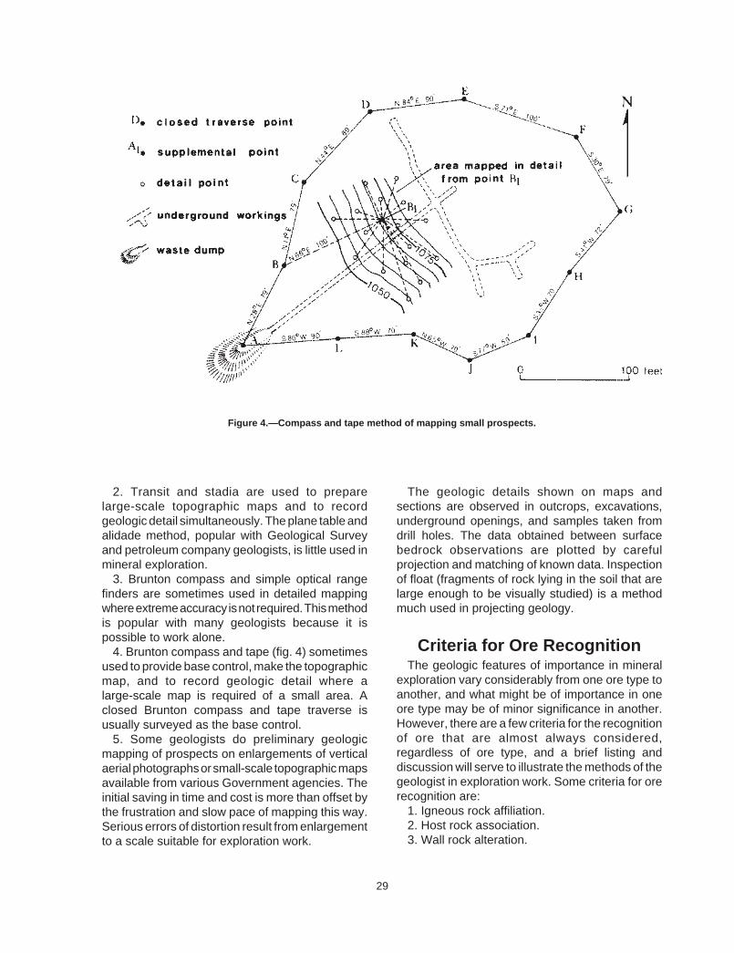
Figure 4.—Compass and tape method of mapping small prospects.
2. Transit and stadia are used to prepare large-scale topographic maps and to record geologic detail simultaneously. The plane table and alidade method, popular with Geological Survey and petroleum company geologists, is little used in mineral exploration.
3. Brunton compass and simple optical range finders are sometimes used in detailed mapping where extreme accuracy is not required. This method is popular with many geologists because it is possible to work alone.
4. Brunton compass and tape (fig. 4) sometimes used to provide base control, make the topographic map, and to record geologic detail where a large-scale map is required of a small area. A closed Brunton compass and tape traverse is usually surveyed as the base control.
5. Some geologists do preliminary geologic mapping of prospects on enlargements of vertical aerial photographs or small-scale topographic maps available from various Government agencies. The initial saving in time and cost is more than offset by the frustration and slow pace of mapping this way. Serious errors of distortion result from enlargement to a scale suitable for exploration work.
The geologic details shown on maps and sections are observed in outcrops, excavations, underground openings, and samples taken from drill holes. The data obtained between surface bedrock observations are plotted by careful projection and matching of known data. Inspection of float (fragments of rock lying in the soil that are large enough to be visually studied) is a method much used in projecting geology.
Criteria for Ore Recognition The geologic features of importance in mineral
exploration vary considerably from one ore type to another, and what might be of importance in one ore type may be of minor significance in another. However, there are a few criteria for the recognition of ore that are almost always considered, regardless of ore type, and a brief listing and discussion will serve to illustrate the methods of the geologist in exploration work. Some criteria for ore recognition are:
1. Igneous rock affiliation. 2. Host rock association. 3. Wall rock alteration.
29

4. Age of mineralization. 5. Gangue mineral association. 6. Trace metal association. 7. Structural controls. 8. Physiographic expression. 9. Weathering effects. 10. Ore mineralogy. Igneous rock affiliation—Many ore deposits are
associated with or contained within certain kinds of igneous rocks. For example, chromite ores are always found in a special kind of iron-rich rock. Some types of tungsten mineralization are always found associated with certain granitic rocks.
Host rock association—Certain kinds of wall rock act as host to specific ore types. For example, ancient reef deposits, similar to the modern coral reefs of the South Pacific, are interlayered within marine formations such as limestone. Fossil reefs are an important locus for a variety of important precious and base metal deposits.
Wall rock alteration—The mineralizing fluids that deposit ores sometimes permeate outward into the enclosing host rock, causing subtle changes in a ring-shaped contact zone (aureole) around the ore body (fig. 5). For example, limestone surrounding certain silver-lead ores is recrystallized to dolomite, coarsening the texture of the rock slightly, and making it visibly lighter in color. The aureole of wall rock alteration is quite useful in mineral exploration, for it is much larger than the ore deposit itself, and
usually is subtle enough to have escaped notice of the early prospectors and miners.
Age of mineralization—Some ore deposits occur only in rocks of a definite age. For example, much of the world’s potash is Permian in age (280 to 225 million years), and the bedded barite deposits of the West are largely restricted to formations of Silurian and Devonian age (430 to 345 millions years). Many such simple age relationships are only now becoming generally recognized, and the concept will be helpful in the mineral evaluation of many regions.
Gangue mineral association—Many ore types have distinctive gangue mineral associations (undesired minerals associated with the ore) that can be of use in mineral exploration. For example, two major regional ore belts, the Mother Lode gold and the Foothills base metal zones of California come together and mingle northwest of Yosemite National Park. Prospectors quickly learned that the appearance of barite in float or in the prospect pan was good evidence that the mineralization was of the base metal type, not gold.
Trace metal associations—Many kinds of ore deposits have distinct combinations of minute amounts of metal found in association with the principal ore metal, helping to distinguish one ore type from another. For example, the copper deposit containing nickel and cobalt is of entirely different character than a copper-molybdenum association.
Figure 5.—Wall rock alteration as a guide to ore.
30

Figure 6.—Physiographic expression of ore.
Structural controls—The analysis of structural control of ore is usually of prime importance in planning exploration, development, and production. On a regional scale, ore deposits may be found in elongated rows of individual ore occurrences or clusters of occurrences which are referred to as mineral belts or mineral lineaments. Along these trends, above average potential for ore exists. On a more restricted scale, the ore types of a given district may occur along a single fault or beneath a thrust plane, focusing attention upon an unexplored block of ground. Such relationships may become apparent only after the most painstaking detailed geologic mapping.
Physiographic expression—Individual ore deposits, and sometimes entire mining districts, are commonly altered, mineralized, and weathered so that the rock matrix consists essentially of chemically unstable or soft, easily weathered minerals and rocks (fig. 6). Erosion cuts into such zones, and the resulting depressions are often filled with gravel and lava flows and are usually densely overgrown with vegetation, all but concealing evidence of mineralization. The recognition of mineralization fringe effects, and the lateral projection of such indications beneath cover, is an approach used by many explorationists.
Weathering effects—Many of the mineral deposits currently of interest consist of relatively
small specks of valuable mineral scattered through a worthless rock matrix. The ore minerals themselves are often chemically unstable under the weathering conditions at and near the surface. The ore minerals of copper, silver, and uranium, for example, rarely survive intense weathering and are decomposed so that some or all of the metal is flushed from the outcrop in aqueous solution (ground water). This near-surface zone of leaching and flushing is called the leached capping, and it may contain none of the ore minerals characteristic of the unweathered ore deposit below. The recognition of leached cap rock has been a very successful tool of the modern exploration geologist, because the various stable oxides, sulfates, and carbonates of metals most often remaining in outcrop are extremely difficult to recognize and were easily missed by earlier explorers.
Ore mineralogy—In some instances the mineralogy of the ore itself may be important. For example, aluminum is one of the most abundant elements in the earth’s crust, yet only bauxite (a relatively rare mixture of aluminum hydroxides) has been mined as an ore of aluminum.
Most geologists have a checklist of ore criteria they think important for each ore type of interest. They might refer to the total picture of all criteria considered together, as a “conceptual model” of that type of ore occurrence. They may also have
31

definite ideas about the size, shape, and grade to be expected of this hypothetical ore deposit. Obviously, a conceptual model can be of great help in planning exploration, during mapping and drilling, and in all phases of the evaluation of results, if the risks inherent in any generalization are kept in mind. The use of a formal conceptual model is often found to improve communications with management and to facilitate discussions between explorationists, such as those between geologist and geophysicist.
Geochemical Exploration Methods
The recent great progress made in rapid, inexpensive methods of trace metal analysis has resulted in a variety of applications in geology. These are referred to as geochemistry. In mineral exploration, geochemistry is broadly applied in two different situations. Numerous samples are often collected incidental to other exploration work, such as geological mapping of underground workings. These samples are submitted for trace metal analysis and the results incorporated into the overall geologic interpretation. No confusion seems to result in calling this work geochemistry, even though the same term is used to describe trace metal analysis of air, water, soil, and rock materials as an exploration method in its own right.
Reconnaissance Geochemistry In applying geochemistry in regional mineral
exploration, the basic requirement is for a rapid, relatively inexpensive technique that will efficiently narrow interest to areas small enough to explore by more detailed methods. Simple observations can be made from the air, either visually, by the person in charge of the work, or by interpretation of aerial photography. Black and white and color photographs are used, and false color effects are obtained by using special films and filters to emphasize unusual rock, soil, and vegetative effects.
Geobotanical methods of prospecting involve the visual observation of changes in the normal appearance or distribution of certain vegetation. The plant may show visible toxic effects such as deformed or discolored leaves, or unusual size. In some cases the very presence or absence of a given kind of vegetation may betray unusual nutritive or toxic conditions. In one region, the discoloration of the leaves of a common tree, observed from fixed-wing aircraft, led to the discovery of a major new copper district. In another area, the wide spacing of a shrub common to the region, with intervening ground bare of grass, is a good indication of the host rock of nickel silicate mineralization.
Various air “sniffing” devices are coming into use in regional mineral exploration. Airborne, vehicle-mounted, and sample station detectors have been designed to measure such indicators as mercury vapor, sulfur dioxide, and radon gas in atmospheric and soil air, which may betray a weathering ore deposit below the surface, perhaps even beneath a considerable thickness of soil.
The geochemistry of surface and underground water is a reconnaissance exploration tool. Samples from springs, wells, and streams may contain trace amounts of metal in solution, indicating that the water has come in contact with a concentration of the metal, perhaps an ore deposit. Where surface water is insufficient for adequate sample coverage, a popular method is to analyze small samples of silt from the stream bed itself. This method enjoys great popularity in more arid regions because it is straightforward and can be done by technicians. However, results have proved very difficult to interpret and follow up, and much less stream sediment sampling is being done today than 10 years ago.
Rocks Perhaps the most favored detailed geochemical exploration method at present is the collection of rock chip samples, analyzed to determine if significant patterns may guide exploration. Many of the elements contained in ore deposits, and the surrounding envelope of altered rock, are not chemically stable in outcrop and may be leached
32

Figure 7.—Metal zoning in a vein system.
from the surface tone. For example, a relatively high grade vein of copper may be so thoroughly weathered and flushed from the surface that no obvious copper minerals can be visually identified, and geochemical values may be far below the metal content of minable ore, although still high enough to be indicative of commercial possibilities.
Much rock chip geochemistry is done in the hope that zonal patterns may be discerned, pointing to the area most likely to contain the ore deposit. A very simple pattern of progressive changes, upward and outward from the central portions of the district may be envisioned. A typical zonal pattern for copper veins in the Rocky Mountains, as shown in figure 7, may be quite different than for the zonation of a massive sulfide copper deposit, as shown in figure 8. Many variations of zoning are known for different kinds of ore, and are described in the technical literature. Some companies have done original research and determined their own distribution patterns for ore types of interest, often at great cost. Such privately developed concepts are closely guarded company secrets.
Other than the stone bruises left by the collector’s hammer, rock chip sampling leaves no surface disturbance of a permanent character. Rock chip
samples are transported from the project area to a centralized company or independent laboratory for preparation and analysis.
Soils In detailed exploration work, residual soils are
usually present, consisting of weathered material derived from the underlying parent bedrock (fig. 9). In many cases, analysis of such soils reveals a pattern of enriched metal values over the suboutcrop of the ore, when no visible float can be found at the surface. The method is far from infallible, and there are many variables that are either highly unpredictable or imperfectly understood. Typically, a few ounces of soil are collected at each sample site, rarely more than a few inches in depth. The sample hole is usually filled in immediately and the site marked by fixing a sample tag to a nearby shrub.
A sample-site or campsite chemical analysis is sometimes employed in soil work, using either the entire sample or only the fine material, sieved for analysis. Soil sampling does not leave signs of visible surface disturbance that remain more than a season or two.
33

Figure 8.—Metal zoning in a massive sulfide ore body.
Figure 9.—Geochemistry of residual soil over ore.
34

Vegetation The biogeochemical method is used in detailed
mineral exploration where the plant material is analyzed to determine trace metal content. The plant may show no external evidence of abnormality. To be useful, the vegetation must be fairly evenly distributed over the area to be explored, and should be known to be a reliable indicator on the basis of experience on similar projects elsewhere or extensive experimentation on the project at hand.
The biogeochemical method has been used successfully where the needles of pinyon have been found to contain unusual amounts of uranium over deposits of this metal. The pinyon, as in the case of a number of other trees and shrubs, has the capacity to selectively absorb an element through membranes in the root system, and to concentrate the element in portions of the plant itself. The roots effectively act as a much larger sampling system than single small handful of soil collected at the surface at one point.
The principal objections to the biogeochemical method are the difficulty in obtaining good samples and the complicated sample processing and analytical techniques. The same part of each plant must be collected if the results are to be significant, and in some cases the sample must be collected at the same season of the year to yield consistent results.
In recent years, biogeochemists have begun to use the mull (granular forest humus) found beneath trees. This partially decomposed material is easy to collect and analyze, and contains a sufficient amount of trace metal to be useful.
Using sampling techniques similar to those used in botanical studies, biogeochemical sampling leaves no permanent marks of damage.
Geophysical Exploration Methods
Some ore deposits contain minerals that possess physical characteristics that can be measured by suitably sensitive instruments. Exploration based on the principles of physics is called geophysics. Exploration techniques utilize such physical properties as density, magnetic behavior, electrical
conductivity, and radioactivity. Six basic geophysical exploration methods—gravity, seismic, magnetic, electromagnetic, electric, and radiometric-are commonly employed in the search for minerals.
Gravity Gravity methods depend upon the relative
density of the ore deposit and surrounding wall rock, and are not much used in metalliferous exploration. Measurements can only be made at fixed stations on the ground, and complicated corrections are required for station position and topographic conditions. The typical ore deposit is not dense enough, is too small and irregular, and occurs in a deformed structural environment, making clearly defined gravity anomalies difficult to discern and interpret.
The method has been very successful in exploring for large deposits of petroleum, natural gas, sulfur, and salt. Limited application has been reported in exploration for barite.
Seismic Seismic methods have little use in metalliferous
exploration because of the relatively small size and complicated geology of the typical ore deposit, and because of the high cost of seismic work. The method depends upon the velocities of acoustical energy in earth materials, and has been enormously successful in searching for petroleum, natural gas, and sulfur, where the large deposits may be located by simply determining attitude of the enclosing strata.
Magnetic Certain minerals distort the earth’s field, and
where sufficiently large concentrations of such minerals occur, variations can be measured by magnetometers mounted in aircraft, in ground vehicles, or positioned at stations on the ground. Magnetite iron ores have been found in many areas of the world using the airborne magnetometer.
In one case in the western United States, a very large iron deposit has recently been discovered beneath several hundred feet of barren volcanic flow rock erupted over the ore deposit. Magnetic
35

copper skarn, magnetic nickel ore, and asbestos-bearing serpentine associated with certain magnetic intrusive rocks have been found, using the magnetometer. Some geophysicists propose the use of the magnetometer to detect gold placer deposits, because of their common association with black sands largely consisting of the mineral magnetite.
Electromagnetic Of the various electrical methods of prospecting,
only the electromagnetic (EM) system can be used in aircraft. Airborne EM systems have been applied with great success, particularly in reconnaissance exploration for massive sulfide ores on the Canadian Shield.
Electromagnetic methods energize the ground inductively by means of an alternating current flowing in a transmitter coil. The resulting signal, containing ground response characteristics, is detected inductively by a receiver coil. Both coils may be mounted in the aircraft, or both placed on the ground. In one recently developed variation of the method, the transmitting coil is on the ground and the receiver in the aircraft.
The method is relatively slow and expensive, particularly when used on the ground in detailed surveys. It has not been widely applied to
exploration in the western United States, where ore deposits generally have poor electromagnetic response characteristics and may be deeply and erratically weathered, further destroying the ability of the ore to respond.
Electrical Natural electrochemical reactions near the
surface of the earth, where metallic sulfides may be subject to weathering, can be used in the simple self-potential (SP) method. The measuring instrument detects the electrical current developed during the weathering of the sulfide, as shown in figure 10.
A shortcoming of the SP method is the frequency and variety of spurious responses obtained. A more popular application of the electrical method is where controlled electrical energy is applied to the earth and the resulting electrical behavior of the ground is observed at closely spaced stations at regular intervals over the surface. An adaptation much used during the past decade is induced polarization (IF) where the conductivity of mineralized ground changes with variation of frequency of the applied current, while the conductivity of barren ground remains constant. As with the SP method, IP often produces misleading results and use of the method has declined recently.
Figure 10.—The self-potential method.
36
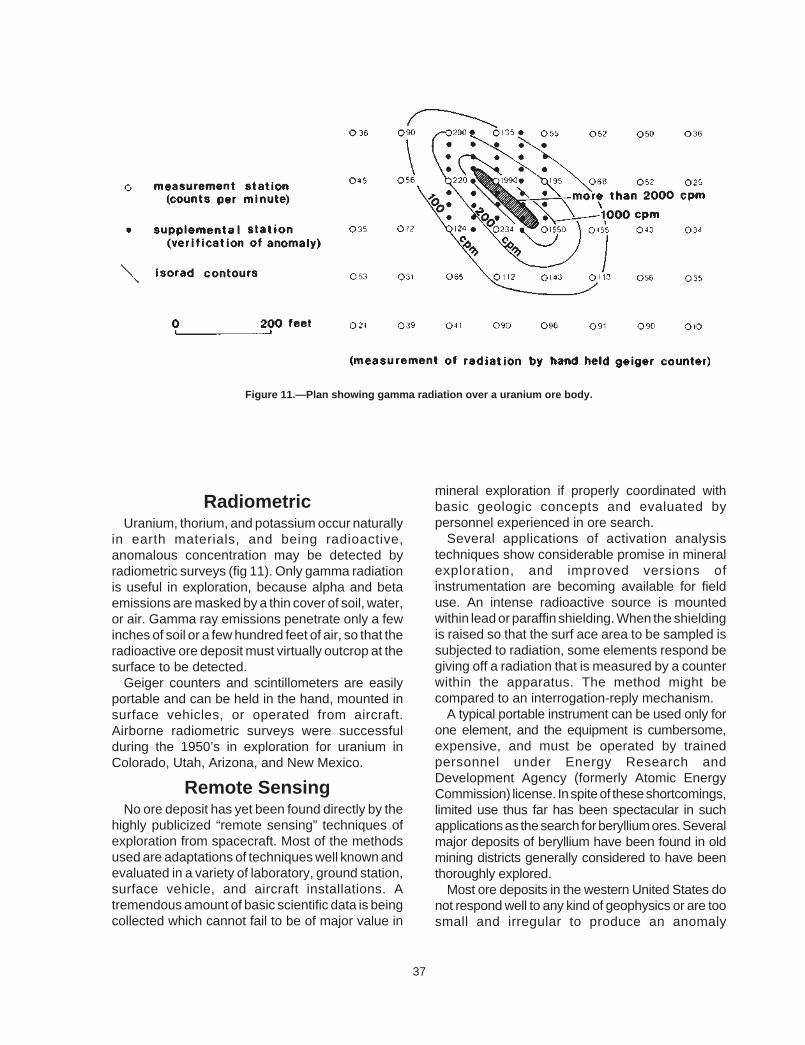
Figure 11.—Plan showing gamma radiation over a uranium ore body.
mineral exploration if properly coordinated withRadiometric basic geologic concepts and evaluated by
Uranium, thorium, and potassium occur naturally in earth materials, and being radioactive, anomalous concentration may be detected by radiometric surveys (fig 11). Only gamma radiation is useful in exploration, because alpha and beta emissions are masked by a thin cover of soil, water, or air. Gamma ray emissions penetrate only a few inches of soil or a few hundred feet of air, so that the radioactive ore deposit must virtually outcrop at the surface to be detected.
Geiger counters and scintillometers are easily portable and can be held in the hand, mounted in surface vehicles, or operated from aircraft. Airborne radiometric surveys were successful during the 1950’s in exploration for uranium in Colorado, Utah, Arizona, and New Mexico.
Remote Sensing No ore deposit has yet been found directly by the
highly publicized “remote sensing” techniques of exploration from spacecraft. Most of the methods used are adaptations of techniques well known and evaluated in a variety of laboratory, ground station, surface vehicle, and aircraft installations. A tremendous amount of basic scientific data is being collected which cannot fail to be of major value in
personnel experienced in ore search. Several applications of activation analysis
techniques show considerable promise in mineral exploration, and improved versions of instrumentation are becoming available for field use. An intense radioactive source is mounted within lead or paraffin shielding. When the shielding is raised so that the surf ace area to be sampled is subjected to radiation, some elements respond be giving off a radiation that is measured by a counter within the apparatus. The method might be compared to an interrogation-reply mechanism.
A typical portable instrument can be used only for one element, and the equipment is cumbersome, expensive, and must be operated by trained personnel under Energy Research and Development Agency (formerly Atomic Energy Commission) license. In spite of these shortcomings, limited use thus far has been spectacular in such applications as the search for beryllium ores. Several major deposits of beryllium have been found in old mining districts generally considered to have been thoroughly explored.
Most ore deposits in the western United States do not respond well to any kind of geophysics or are too small and irregular to produce an anomaly
37

sufficiently distinctive to interpret and explore. On the Canadian Shield, the typical ores possess good geophysical response characteristics. Outcrops were scoured clean of weathering effects by ice Age glaciation, so that weathering does not interfere. The thin layer of glacial drift over much of the region made traditional prospecting methods ineffective, and many ore deposits have been discovered in recent years by geophysics. Canadian explorationists are therefore much more likely to be enthusiastic about geophysical exploration than their colleagues in western North America, who are more accustomed to the complicated, unresponsive, weathered ores of the deserts and mountains.
The geophysical method that might be useful in one area may prove wholly inappropriate in another. For exam pie, airborne scintillation counters were used very effectively in radiometric reconnaissance for bedded uranium ores of the Colorado Plateau in Colorado, Utah, Arizona, and New Mexico. The same technique, when applied to exploration for uranium in Canada, was a total failure. It was found that the Colorado deposits were relatively high grade, and enclosed in a sequence of virtually non-radioactive sediments. The Canadian exploration was conducted in a terrain of granite and metamorphic wall rocks that themselves were radioactive, resulting in such a hash of background signal and false anomalies that the airborne surveys failed to delineate useful target areas within the static.
In general, the most discouraging aspect of geophysical exploration is the spurious result frequently obtained. For example, the ore deposits that furnish the best electromagnetic responses are massive sulfides, which are found in rocks containing variable amounts of pyrite and graphite. The pyrite and graphite, which are worthless and commonly show no meaningful distribution pattern in relation to the ores, yield a geophysical response that cannot be distinguished from that of the ore itself.
Many exploration holes are drilled into electromagnetic anomalies, only to encounter barren pyrite or graphite. Conversely, negative geophysical results by no means rule out the presence of an important ore deposit. For example, the most careful magnetic survey over an “invisible” gold deposit of the kind being found in northern Nevada could not be expected to delineate ore,
because these deposits contain no minerals capable of measurably distorting magnetic patterns.
It is obvious that the application of geophysics involves more than the simple ability to make the equipment work. To be successful, the geophysicist must be thoroughly grounded in fundamental ore deposit theory, or must work closely with an exploration geologist in planning and interpreting the work.
Restudy of Old Mining Districts
Only in very unusual cases is it possible to reopen a mine and simply put it back into profitable operation without doing additional exploration or development. Previous mining may have been done in ignorance of a mineral that has more recently become of economic interest, but in general, nothing of value was knowingly left by the oldtimers, or missed by scavengers during the first years after the mine closed.
Today, the exploration geologist reenters old mines and mining districts with an entirely different point of view and approach. He researches old records and undertakes geologic work because the character of mineralization may suggest the presence of an entirely new ore type or because careful analysis of the geology of an old district might reveal new possibilities at greater depths, along a faulted trend, to one side of the old workings, or in some other unexplored situation nearby.
In the study of old districts, great emphasis is placed on geology and mineralogy, because of the wealth of opportunities for inspection and sampling provided by the underground mine openings. Much can be learned from the study of structural control of the previously mined ores. Sometimes, relatively large amounts of money are spent to reopen old workings with the immediate objective only to do geologic mapping and sample the mine.
Perhaps the most discouraging aspect of restudy of formerly productive areas is the effort and cost of land acquisition. Complicated mineral rights such as numerous small patented claims, fractions, lots, former town sites, mill sites, tunnel rights, and right-of-way of various kinds make this work very
38

expensive and time consuming. The problem worsens with each new generation of heirs.
Although the typical difficult property situation is offset to some extent by the enthusiasm of working in an area where signs of mineralization abound, the project geologist must gather together enough hard geologic evidence to convince management to proceed with property acquisition before exploration can begin. If the mineral rights to a sufficiently large block of ground in the typical old mining district can be put together on reasonable terms, even for a relatively short period of time, management usually receives such projects with far more enthusiasm than proposals for exploration in virgin territory.
Trenches, Pits, Overburden Drilling
Preliminary exploration work may be undertaken by the conventional prospector, for example, in trenching to establish the trend, width, and mineral character of an ore showing protruding from soil. Many types of ore weather readily at the surface, and these surface effects must be removed if the true character of the mineralization is to be determined. Preliminary trenching and pitting may be done with the idea of making the prospect interesting to the examining geologist and to facilitate his work. Sometimes, the small miner or conventional prospector refers to this as development, but this term is more properly used in connection with the preparation of a mine for production after the presence and general character of the ore deposit is proven.
A large amount of the surface disturbance on public land is caused when the amateur prospector thinks he has located valuable ground, and begins bulldozing while staking claims. He enthusiastically scrapes into soil-covered areas of any kind with the idea that there ought to be a big mineral deposit in there somewhere. The extreme futility is where such poorly planned trenching is attempted in an area of 50 feet of soil cover. He may often decide to bulldoze crude trails on the ridge lines while the bulldozer is on the property, because in his mind this will improve access and something might be
blundered onto in the process. Prospectors, and company geologists as well,
have been heard to remark that they prefer to cut up the land visibly during the act of claim location, so that everyone will know the ground has been staked. Mining lawyers gave this advice for years, prior to the present concern for the environment, and some still do.
This kind of thinking has sharply diminished in recent years, especially where modern State mining legislation has made it possible to locate mining claims without doing physical work on the ground. These new attitudes have already greatly reduced the amount of surface disturbance over the past 5 to 10 years. In a typical western State, tens of thousands of mining claims have been staked annually. This would have amounted to hundreds of acres of surface disturbance under the old location requirements.
In serious exploration by trenching, bulldozers of various sizes are used. Such equipment is easily available and usually is present on the project for other work such as construction of access roads or preparation of drill sites. Mechanical or hydraulic rippers are used in tough ground; drilling and blasting are rarely resorted to because adequate samples can usually be collected at the point where the rock becomes too hard to be moved by blade or ripper.
If additional depth is required in hard rock, a shallow shaft is usually sunk at lower cost and with far less damage to the surface. Where topography permits, the trenches are laid out at an angle to the contour so the bulldozer can more easily dispose of the spoil to one side. The face, or uphill side of the trench, is used for geologic observation and sampling because it is clean of broken material, and survey stakes and sample tags are not knocked down easily by livestock and vehicles. It is normal practice to orient the trench at a high angle, as close to 90∞ as possible to the trend of elongated bodies such as veins or mineralized beds.
Carefully planned trenching can contribute valuable exploration information, but much trenching is a complete waste of time and effort, for example, in the fairly common situation where the bulldozer operator himself plans the work for lack of good supervision.
39

Backhoe trenching is becoming more popular in serious exploration work. Good trench wall faces are cleanly and quickly exposed in a variety of topographic and soil conditions, even on relatively flat terrain where the bulldozer would not perform well. It is possible to cut backhoe trenches straight down a hillside; in fact, this is the preferred orientation of the equipment for efficient excavation and disposal of spoil.
Surface disturbance is less than with a bulldozer, restoration of the surface is quite simple, and it is possible to selectively place the topsoil to one side and pile the deeper material to the other side so that the trench can be refilled, reversing the excavation process after geologic inspection and sampling of the trenches. It is impossible to exactly restore the surface to original contour, because the excavated material expands as much as 20 percent or more, resulting in overfilling of the trench by this amount. Aside from reducing the surface damage, it is considered good practice to backfill trenches to maintain good relations with other surface users such as holders of grazing permits.
Trenches were often excavated by hand in exploration work prior to World War II. Rising labor costs and the general availability of mechanized equipment make work of this kind too expensive to be cost effective today. Only in extremely remote areas, service by aircraft or pack string, is hand trenching considered feasible. Standard hand tools such as long-handled shovels, railroad picks, pry bars, and brooms are used.
Shallow pits or exploration shafts are excavated where irregular deposits are expected to extend beneath soil cover, or where the alluvium itself is suspected to contain valuable material such as placer gold. Soft, unconsolidated material can be dug with small backhoes to depths of 10 to 15 feet, and circular shafts several feet in diameter can be excavated with septic tank diggers to depths of about inn feet. Only the uppermost weathered bedrock can be removed by these machines, and if penetration into the rock itself is required, standard methods of shafting by drilling and blasting must be employed.
When shafting is undertaken, it is necessary to securely timber the upper portions of the opening, so that men and equipment can work on the bottom
without risk of material falling. Pneumatic drills are usually used, and blasting is done with stick dynamite and standard fuse and blasting caps. The broken material is removed using buckets hoisted by hand windlass, small winch, or power takeoff units on tractors or trucks.
Overburden drilling is a specialized shallow exploration method used to obtain small bedrock samples. The samples are used for geochemical analysis, in geophysical interpretations of various kinds, or for some indirect use, rather than as a prime exploration method where ore itself is the object of the drilling.
Exploration Drilling Exploration drilling is primarily aimed at
determining whether or not the ore target is present, and if so, to obtain a preliminary idea as to its size and grade. Secondary objectives may involve testing general geologic conditions, such as exact type of formation present, wall rock alteration, or geochemical zoning. In the early stages of the work, emphasis is placed on speed and cost, and if preliminary work is successful, a more accurate and more expensive drilling method may be used.
There are many drilling methods, but three-percussion, rotary, and diamond drill—are by far the most common in exploration work. The equipment may range in size and complexity from simple, hand-operated augers to small-scale versions of the rigs used in oil field explorations.
The pattern and spacing of exploration drill holes are dependent largely upon the size, geometric orientation, and internal distribution of mineral values of the particular kind of ore target involved. A clear conceptual model of the particular ore deposit of interest is of great help in laying out an efficient and economic drill hole pattern.
Most deposits large enough and homogenous enough to be mined by bulk methods are drilled with vertical holes arranged in square, rectangular, triangular, or fence (row of holes) patterns, as seen in plan view. Angle-hole drilling is necessary where steeply inclined vein deposits are being explored, and in general is more expensive than vertical drilling.
40

Hand Drilling Small, hand-operated drills such as the augers
and sample tubes employed in soil test work have limited application in mineral exploration. Although heavy-duty versions of this equipment have been manufactured and equipped with lightweight, aluminum drill rod extensions and tripod hoistworks, these drills are useful only under near-ideal conditions, and cannot penetrate bedrock. The most common limitation is where hard boulders are encountered in the soft soil matrix, or where excessive moisture is found. The principal use of hand drills is in testing abandoned mill tailings, which are finely ground and even grained, and are compacted well enough that the hole will stay open without caving while samples are taken from progressively deeper depths.
Many different kinds of powered augers are used in exploration, ranging in complexity from small, hand-held, post-hole diggers powered by gasoline to the large augers used to set power poles. The most serious limitations are again boulders in the soil, excessive moisture, and inability to penetrate far into the bedrock.
Percussion Drilling Several of the compressed air drills used in
drilling and blasting have been applied to exploration. The hand-held miner’s drill, similar in site and appearance to a jackhammer, is sometimes used in collecting small samples in solid bedrock to a depth of about 10 feet. Larger machines, such as the wagon drill used in highway and dam construction, are mounted on wheels and can be towed to difficult drill sites along with an air compressor mounted on a trailer.
Wagon drills, as well as a variety of small track-mounted, self-propelled percussion drills, can drill holes at any angle, often to depths of over 100 feet. The compressed air that powers the drill is also used to cool the bit and carry cuttings away from the face and out of the hole, where they are collected by simple sack holders, buckets, cyclones, or other devices, depending upon the accuracy required of the sample. Percussion drill samples are usually placed in containers and taken from the drill site for
logging and processing for analysis. Large percussion rigs, such as those used in open pit copper mines for blast hole drilling, are too heavy and cumbersome to be used in exploration work. Churn drills, the cable tool rig formerly widely used for water well drilling, are no longer much used in mineral exploration, except for small specialized adaptations used in placer evaluations.
Rotary Drilling Rotary drills are relatively fast and inexpensive to
operate in a wide variety of exploration conditions. Most of the rigs are truck-mounted and completely self-contained, including the air compressor. At higher elevations, auxiliary compressors must be provided, because of the reduced compressor efficiency. Standard tri-cone bits drill a hole 4 inches in diameter or larger, and drill cuttings are blown out of the hole with compressed air. A gasoline or diesel engine drives the unit.
Some of the equipment can be quickly converted for core sampling, although coring is less satisfactory and generally slower than with equipment specifically designed for the purpose. Most rotary drills are mounted on trucks that require relatively good roads. Angle-hole drilling is not possible with most of the rotary equipment available, and is a major limitation of the method.
Because rotary drilling is relatively rapid, samples were formerly piled on the ground in rows, each pile representing from 2 to 10 feet of advance, each row from 20 to 100 feet of hole. In recent years, practice has been to place the samples in containers and remove them from the exploration site, partly to leave a clean drill site, but also to frustrate competitors’ inspection of the drilling results and to permit geologic logging in more efficient conditions at the field office.
With equipment in good condition and a skilled operator, progress of the typical rotary rig will vary from several tens to several hundreds of feet or more per 8-hour shift, and a considerable amount of sample is generated, even using the smaller bits. Rotary drilling is particularly preferred in explora-tion where the sampling or logging is done “in-hole,” as for example where uranium is measured by scintillation probes run in and out of the hole.
41

Some geologists object to rotary drilling because the samples are broken into small chips and fragments where the structure of the bedrock cannot be seen. Others feel that the relatively low cost and good progress of the method more than offset the disadvantage of the sample obtained, and actually see some advantage to the broken material for inspection and assaying.
Diamond Drilling Diamond drilling (fig. 12) is generally considered
the most versatile drilling method, providing a superior core sample for observation and preliminary testing. The equipment can drill at any angle, including upward from underground stations. Gasoline and diesel engines are most commonly used, although air and electric motors are available. Core recovery is not always good, particularly in mineralized rock, and the method can be painfully slow and expensive. Diamond drillers are usually more experienced and may be more highly paid than other drillers, for the work is more exacting.
Water is usually the drilling medium; compressed air, crankcase oil, or kerosene are used in special situations. The core sample is cut by a circular bit embedded or set with industrial diamonds. The core passes inside the circular bit face and is collected in a core barrel which retains the sample for removal from the hole. The material ground up by the diamond bit is called sludge, and is carried up around the drill rod to the surface. The core is placed in compartmented boxes and taken to the field office.
In some cases, the sludge is carefully collected and saved as an important part of the drill sample. Sludge is collected in specially designed settling tanks and placed in metal cans for plastic containers for transport to the field office for drying and processing. The clear water is returned for drill use. Where the sludge is not saved, it is allowed to settle out in the bottom of a rude pit called a mud sump, which often overflows on hillside operations leaving an unsightly smear of light-colored drill cuttings down the slope. If drilling mud is not carefully controlled while the work is in progress,
Figure 12.—Diamond drilling, collection of sludge samples.
42

and if the mud sumps are not covered after the work is finished, a particularly unsightly and enduring blemish on the surface can be created.
A variety of additives are placed in diamond drill holes, mostly to eliminate lost circulation, when the drill fluid is lost in fractures or caverns and no sludge sample returns to the surface. Various organic and inorganic materials such as beet pulp, horse manure, and bentonite have been used, along with a number of specially prepared muds developed for use in oil field drilling. Sometimes diamond drill holes are cemented with quickset concrete under pressure, which is drilled back out as soon as it hardens, leaving the hole clean and free of fractures and caves. Sometimes it is necessary to cement after almost every advance of the bit in order to pass through troublesome ground.
Steel casing may also be set in the hole to eliminate caving and lost circulation, and to insure that a reliable core and sludge sample is obtained. By progressively reducing the bit size, and nesting the casing, each smaller size inside the other, it is possible to carry casing fairly closely behind the drill bit. Diamond cores commonly range in size from under 1 to 3 inches in diameter. It is possible to ream the smaller site holes out to accept larger casing, and various combinations of drilling mud cementing, casing, and reaming are used to carry a hole to completion with the desired core size at the bottom of the hole.
In drilling vertical holes in porphyry copper prospects, it is common to cement into the bedrock a short piece of casing called a standpipe, just large enough to receive the largest “N” casing. The casing will in turn accept the NX diamond bit and core barrel, which cuts a hole 3 inches in diameter and a core 2-1/8 inches in diameter. NX bits are used to penetrate the leached cap rock over the ore deposit. As soon as the upper, enriched portion of the sulfide zone is penetrated, “8” casing is set in the hole and the bit size reduced to EX, which cuts a hole 2-3/8 inches in diameter and a core 1-5/8 inches in diameter. After passing through the upper sulfide zone into unenriched ore, “A” casing is set and the bit reduced to AX, which cuts a hole 1-7/8 inches in diameter and a core 1-1/8 inches in diameter.
If deep penetration is desired, far below any level for which mining may presently be planned, it is considered permissible to make one further reduction by setting “E” casing and proceeding to the termination depth with EX bit, the smallest used in most American mineral exploration. EX bits cut a hole 1-1/2 inches in diameter and a core 7/8 inch in diameter. Such a sample is usually considered too small to be reliable in serious evaluation of large bulk mining situations. Upon completion of the hole, the steel casing is removed to be used again, for it is very expensive.
Underground Exploration Only in rare instances is underground exploration
the prime method of proving a prospect. A small, well-defined exploration target such as a faulted segment of a vein might be most efficiently explored by extending old underground mine openings or from new work from the surface, but in general, a certain amount of drilling is done first to at least roughly outline the ore target.
Underground work is usually erroneously referred to as tunneling. Tunnels are seldom excavated in mining, being a basically horizontal opening from one side of a mountain to the other, as in railroad and highway construction. The American metal miner refers to horizontal work into a hillside as an adit (fig. 13). If the adit is driven along an ore structure such as a vein, this is called drifting and the opening is referred to as a drift. If the adit cuts across the wall rock at an angle to the structure, it is called a crosscut and the work is referred to as crosscutting. The mouth of the adit opening is called the portal. Work upward from the adit level is called raising, and the working is referred to as a raise. If the excavation is downward, it is called a winze. Raises and winzes are usually in ore, although the same terms are used whether the work is in waste or in barren wall rock.
A shaft is a vertical or steeply inclined opening excavated from the surface. The term “inclined shaft” refers to openings inclined from vertical to 45∞ or less. When the inclination is gentle enough to accommodate a man on foot, rubber-tired
43

Figure 13.—Underground mining terms.
equipment, or conveyor belts, it may be referred to as a decline. Shafts, inclined shafts, or declines may or may not be in ore.
If work is undertaken underground from the shaft, a station is cut as a landing for men and equipment, and horizontal work from the station is by drifting or crosscutting, and is referred to as a level in the mine. Work on any mine level is generally inclined gently upward away from the shaft station, so that any water encountered will be drained toward the shaft where it can be pumped to the surface or diverted to an inactive portion of the mine.
The methods and terminology used in exploration work are the same as in standard mine development, but the openings are often driven in smaller cross sections to economize. They can later be enlarged if they are to be used for ventilating or draining a productive area, or in the movement of personnel, equipment, or ore. Excavation is usually by drilling and blasting, although soft or highly fractured ground may slowly yield to advance by “pick and poke” methods, using nothing but a steel hand bar.
Drilling is done with pneumatic drills, and compressed air furnishes the power for the drill, provides air to the men at the working face, and moves powder smoke from the heading after the blast. Holes are usually blasted with stick dynamite and standard caps and fuses. Electric blasting is sometimes used as it is safer and is more efficient than spitting each fuse separately. The material broken at each blast from the face is called a round and the material itself referred to as muck. A muck
plate or slick sheet of flat steel is sometimes laid on the floor before blasting to facilitate shoveling or mechanical loading of the muck into wheelbarrows or mine cars and removal to the surface by tramming.
If some of the broken material removed from the mine is known or suspected to be valuable, it is placed on a separate dump. It is quite common to find small dumps at exploration adit portals separated into two, three, or even more separate portions. Careful sampling may reveal little of value in the separated material. Small, rubber-tired machines are now available to load and tram from working face to portal, eliminating the need for rails in modest exploration programs underground.
In former years, it was possible to find miners skilled in the art of hand drilling or single jacking, the striking of hand steel with a short-handled heavy hammer called a single jack. Such work could be done without air compressor, air lines, or heavy drills.
Small, portable gasoline-powered drills have limited application in exploration work, and there is constant danger of carbon monoxide even in the shallowest of excavations.
Today there is a prejudice against underground work as a prime exploration method, and usually underground openings are not thought of as exploration work. Exploration is usually equated with drilling from the surface, and any mention of underground openings suggests that the work has somehow progressed to the development stage, and that the presence of ore is no longer in question.
44

Bulk Sampling In most exploration work there is a need for large,
representative samples of the ore deposit. A final cross-check of the grade of the deposit must be made, as well as testing to determine the best choice of metallurgical method. Bulk sampling may also yield other valuable data of use in planning mine and haulage facilities, the treatment method, or disposal of waste.
The mining characteristics concern such factors as the way the rock in an open pit mine may be expected to break during blasting and to support itself on a bench face, and the manner in which the rock will cave in an underground block caving operation or support itself in an underground mine. Metallurgical treatment methods can be most effectively researched by pilot testing techniques, and disposal of waste can be carefully researched using the waste from these original testing programs.
Because of the large amount of material required, bulk samples are usually collected underground. The undesired surface chemical and physical effects of weathering can be avoided, and there is less problem in controlling fly-rock when large samples are broken by blasting in confined underground openings.
In most cases, bulk sampling produces a larger volume of material than can be readily handled. A temporary sample plant is constructed at the site to reduce the size of the sample, yet retain its representative character, particularly as utilized for a final check of grade and in pilot scale mill testing. It is sometimes desirable to prepare a representative sample for prospective purchasers of the mine product.
In a typical situation, the mine-run material, blasted and mucked from individual rounds of underground advance in designated test areas, is moved to a primary surface storage bunker with a 10- to 50-ton capacity. Each round is stored separately and assigned a lot number. As each lot is removed by front end loader and transferred to the crusher, the bunker is carefully cleaned to prevent loss or buildup of fine particles of the economic minerals. The total
storage area accommodates 2 or more days of mine-run material.
A portable crushing plant with a primary jaw crusher, secondary crusher, and a vibrating screen system produces a 1M-inch mill feed product. Conveyors and transfer points are covered to reduce dust loss. The 1/Pinch product is sampled with a sample cutter producing 400 to 500 pounds per hour of sample for testing. The material is fed to a tertiary crusher producing a l0-mesh product, from which a 5-percent “split” is taken. This splitting procedure produces 20 to 30 pounds per hour, which is bagged and sent for assay. The remainder of the crushed bulk sample is fed into a pilot plant.
Samples obtained from most exploration drilling are not completely satisfactory in preparing representative bulk samples. The small samples are too finely ground by the drill, and in other ways rendered unreliable as a sample for investigation of breaking, handling, and processing characteristics.
Typically, large-scale bulk sampling is undertaken in the last stages of exploration of a low-grade ore deposit to be developed by open pit methods. At one porphyry copper property, a shaft was sunk on a centrally located portion of the drilled-out deposit in mineralization believed typical of the ore body. The shaft was sunk directly on one of the exploration drill holes, and all the material excavated was collected as one huge sample. A station was cut in the shaft, several hundred feet below the surf ace at about the level of the lowest open pit mining planned. From the station, drifts were driven radially outward in a pattern resembling the spokes of a wheel, each drift directed toward an adjacent exploration drill hole. A raise was driven on each of these drill holes, using it as a pilot, to the surface.
The material from each of the raises was separately stored as an individual bulk sample. Each sample was separately processed, and the grade of copper was analyzed as a check against the assays obtained in the original exploration drill holes. A very small upward revision of the drill hole assays was indicated, lending confidence to the enterprise, and adding millions of pounds of copper to the ore reserve available for mining.
45

Pilot Testing Preliminary metallurgical “bench tests” are
performed using a few hundred pounds of ore from the drill core. The tests provide a general idea of the milling procedures to be used in concentrating the ore.
In a major project, underground bulk sampling provides sufficient ore to operate a pilot plant with a capacity of 50 to 100 tons per day for several months. The pilot plant is a miniature version of the full-scale plant to be built to concentrate the ore from the mine. The design of the pilot testing plant is based on knowledge of the type of ore in the deposit and the details of bench testing of ore from exploration core drilling.
Details of crushing, grinding, concentration characteristics, and waste disposal can be studied over a period of time in a pilot plant. Also considered are the effects that a change in one part of the process will have on another, as well as the overall efficiency of the process. Alterations are made in the design of the full-scale plant. Costs of construction, operating costs, and waste disposal problems can be determined for use in broad planning and in the final feasibility study.
On a large project, the pilot plant work may be done in a plant specially constructed at the mine site. In other cases, pilot test work will be done at a central company laboratory location, university facility, or by metallurgical research companies specializing in this work. The small operator usually conducts pilot testing on a very small scale, and anticipates months of modification of his full-scale plant to insure good results.
Feasibility Studies At some point in the continuing exploration, it may
become apparent that the program is successful— that an ore deposit is present. Then begins the work of bringing the ore body to its full potential by developing enough ore to plan a mining operation, or to completely explore and develop the entire deposit.
In a typical feasibility study, all of the information gathered earlier is assembled and turned over to an engineer or engineering group for evaluation. While this study is underway, exploration continues as the
project geologist tests the various possible extensions of the ore body.
Once the decision has been made to begin development, the exploration geologist or prospector, who has largely been responsible for finding the ore body, leaves the scene. For a variety of reasons, the exploration geologist or prospector no longer contributes effectively to the process of making the prospect into a mine. Further geological work, drilling, or other operations to block out ore are done by a mine geologist under the supervision of local mine managers, who are, of course, Production oriented.
The formal feasibility study includes an economic analysis of the rate of return that can be expected from the mine at a certain rate of production. Some of the factors considered during such an economic analysis are:
Tons in the deposit Grade of the mine product Mill recovery Sale price of the metal or mineral Cost of mining per ton Cost of milling per ton Royalties Capital cost of the mine Capital Cost of the mill Exploration and development cost Mining rate, tons per day Depreciation method used Depletion allowance Working capital necessary Miscellaneous costs of operation Tax rate
In many cases this information will be put through a computer to calculate the dollar value of the yearly gross sales, operating costs, operating income, depreciation, depletion, income tax, net income after taxes, the cash flow and the after-tax rate of return on investment. Many companies have their own programs and computers. Outside firms are available to undertake this work for a fee. Prior to the advent of computers, this information was laboriously calculated by a team of engineers using mechanical equipment requiring hundreds of computations and days or weeks to complete the analysis.
Each mining organization has a minimum acceptable rate of return on investment. The cost of
46

borrowing capital for the mine or of generating the needed capital internally within the company must be considered. If a company has a number of attractive investment opportunities, the rate of return from the proposed mine venture may be compared with the rate expected on a different mining venture elsewhere, or with some other business opportunity unrelated to mining. Every organization has a limit to the amount of funds available for new capital investments. Management has an obligation to its stockholders
or investors to select projects with the best rate of return.
As a general rule of thumb, a project must have better than a 15-percent rate of return to be considered by a major company. An individual commonly expects a 30- to 50 percent rate of return to consider investing in a mining venture. Among other uses of the cash flow generated by the mine, these funds must finance continuing exploration elsewhere, pay for past failures, and contribute to the mine’s portion of main office and general overhead.
DEVELOPMENT
After exploration has provided a rough idea of the shape and site of an ore deposit, general geological characteristics, and average grade, and feasibility studies have thoroughly analyzed the data available, the decision to develop the property may be made.
At this time, the owner may decide to obtain outside financing. Standard loan financing is not often available to mine developers. The property may be sold outright for cash or for stock in an operating company, or a royalty on production may be retained. The owner of the new ore deposit may attempt to interest an operating group in furnishing management and undertaking operation of the mine for a percentage of the return. Often some form of joint venture is worked out, when the owner of the ore deposit will agree to share the profits after the mine has been put into production with an operator who is to provide the capital and know-how to develop the mine. Even when the company develops its own exploration find, there is
need for careful development planning because capital investment is large, and mistakes are costly from this point onward.
There are almost always small bothersome details remaining at this point that should have been attended to prior to the discovery and outlining of the ore deposit. For example, a suitable mill site or town site might not have been secured, minor property ownership problems may need to be resolved, or water rights may not be secured. For this reason, and the fact that entirely new personnel are sent in to undertake development and may not be fully familiar with all aspects of the program, company personnel are just as close-mouthed as ever in dealing with outsiders.
The various methods involved in mine development, and the emphasis given to them, depend to a large degree upon the kind of ore body involved and the mining method to be used. Some of the more common approaches to mine development will next be described to provide insight into this poorly understood aspect of mining.
47

Drilling Large Deposits One or more stages of exploration drilling,
perhaps done over several decades, may reveal the presence of a large body of what can now be called ore, considering present technology, economic conditions, and metal prices. The entire deposit, or selected portions of it, may now be drilled carefully to determine its exact grade, volume, and three- dimensional outline. The development program should furnish the following information:
1. The size and shape of the ore deposit. 2. The average grade of the deposit and total
tonnage of material that can be called ore within prescribed economic limits.
3. The distribution of different kinds of ore, and the mineralogy of ores, if more than one kind will necessitate separate handling or treatment.
4. Geology of the ore body, particularly as it will affect mine design and layout.
5. The location of waste rock which must be selectively cast to one side or left unmined.
6. Operating factors such as ground water, nature of the rock as it may affect blasting or ripping characteristics, bench level intervals, pit slopes, and need for secondary blasting.
The pattern and spacing development of drill holes requires special care because first preliminary ore reserve calculations are based upon the drill hole sample data. Some bulk minable types such as iron, coal, phosphate, and potash usually have relatively uniform distribution. Low-grade copper or molybdenum mineralization is much more erratic.
Statistical techniques are important in planning development drilling programs, and in the analysis of the sample data obtained. Enough holes must be drilled to insure continuity of geologic data between drill holes and to assess the relation of geology to grade changes.
Where mathematical procedures have been used in determining the layout of development drill holes, it may be necessary to adhere to a relatively rigid geometric pattern or interval between drill holes, and this may require preparation of drill sites in positions that would normally not be considered, at least in the initial phases of exploration work. The drill roads and drill sites are often better designed and more elaborate than for exploration, because
the equipment to be used is more complex and will be in operation over a longer period of time, and work continues the year around except in areas of extreme seasonal weather conditions.
Drilling Small Deposits If exploration of a small irregular deposit indicates
the general position of the ore deposit in the subsurface, and if a high enough grade or large enough tonnage is indicated, there may be a tradeoff decision whether to undertake more drilling, perhaps using more precise methods, or to proceed directly with a limited amount of underground development. This usually depends more upon the philosophy of management than on the facts that might be presented; some production and exploration managers prefer to drill, and cannot conceive of underground work for anything but production.
Usually the decision to continue drilling is made where costs are reasonable and there is total confidence in the sampling procedures. If the deposit lies near the surf ace and can probably be mined by open pit, there is merit in a grid of vertical drill holes to exactly define the limits before stripping waste or attempting initial mine production.
There are many cases where bold exploration drilling programs have been conducted in areas of small, erratic, high-grade ore deposits. In one such district in mountainous terrain, 10 relatively deep drill holes were put down in an old silver district, and 3 of the holes intersected mineralization suggestive of the ore mined in the past, but at scattered localities, at least 500 feet vertically, and 2,000 feet horizontally from any point where underground development might begin. The costs of further drilling, of shafting, or driving an adit were all far more than any profit that could reasonably be expected from an average ore deposit in the district. The question in a case such as this becomes not so much “what do we do with it?” as “why did we get ourselves into this dilemma?”
As in all phases of prospecting, exploration, and development, the prime function of the project geologist is to have a clear picture of the exact kind of ore sought, and the possible size and grade of the ore deposit as an economic entity.
48

Development Shafts and Adits
When the decision is made to do a certain amount of underground work as the first step in mine development, it is essential to have the plan for mining worked out. In hilly or mountainous terrain, planning is less critical because a few short edits and a raise or two (fig. 13) to the surface will inexpensively begin the development of the ore deposit and be of major value later in ventilation end in movement of men, equipment, ore and waste rock. If the terrain is relatively flat the decision to proceed is far more critical, because shafting is very expensive, and only a vertical shaft, well situated with respect to the ore deposit, will be useful during later production work. If enough data are not available to plan such work, one might seriously ask if exploration information is sufficient to proceed with development.
It is not uncommon for mines to go through two or more stages of development and redevelopment. A relatively modest shaft and hoisting facility might be entirely adequate to develop and mine 100 tons of ore per day in relatively rich material near the surface. After several years, long-term plans may indicate the need for a much larger headframe and hoist, when development of large tonnages of low grade ore deeper in the mine makes possible a production rate of 1,000 tons per day with a new and larger mill on the property. The smaller operation may have financed the major development work, and proven the larger ore reserve far more thoroughly than any exploration work that might have originally been justified. Usually these redevelopments are not intentional but are the result of higher metal prices, unexpected good results in initial development, new milling methods becoming available, or other factors.
Blocking Out Ore Underground
In a typical underground operation, it is desirable to postpone some of the development
work until after the mine is put into production. In this manner, capital investment requirements are offset as some financial return begins to come in. In the United States it is common practice to develop and produce from the upper levels of a mine, and to later deepen the shaft and develop the lower levels in a carefully planned schedule timed in coordination with depreciation of the surface plant. Usually some rule of thumb is adopted to insure that a ton of ore is developed for each ton of ore mined.
At one property, a foot of development (drifts, raises, winzes) might be done for each 10 tons of ore taken from the mine. At another property a foot of diamond drilling per ton of ore may be crude insurance that the development of the property is a viable operation.
The yearly statement of “ore reserves,” if made available in any form to outsiders, therefore does not accurately reflect the possible ultimate production of the mine. There are many reasons for such conservat ive pract ices; abrupt fluctuations of metal prices can convert ore to waste overnight, local tax laws may be applied on an “inventory” basis to a wasting asset, labor negotiations can become difficult if there is a false impression as to longevity of the operation, and there would be legal questions introduced if speculative material were called ore by management.
When a miner speaks of production plus reserves, he is making little allowance for ore that lies far ahead of present development work. Some companies have only a certain minimum tonnage of reserves on hand, and do not feel the cash required to increase the reserve figure is a good investment. Three categories of ore— proven, probable, and possible—are generally accepted in statements of ore reserves (fig. 14).
Proven (Measured) Ore Proven ore is that for which tonnage is computed
from dimensions revealed in outcrops, trenches, workings, or drill holes, and for which grade is computed from adequate sampling. The sites for inspection, sampling, and measurement are so closely spaced, on the basis of defined geological character, that the size, shape, and mineral content are well established.
49

Figure 14.—Partially developed vein, three ore categories.
Probable (Indicated) Ore Ore for which tonnage and grade are computed
partly from specific measurement, samples, or production data, and partly from projection for a reasonable distance on geological evidence is considered probable ore. The openings or exposures available for inspection, measurement, and sampling are too widely or inappropriately spaced to outline the ore completely or to establish its grade throughout.
Possible (Inferred) Ore Quantitative estimates of possible ore are based
largely on knowledge of the geological character of the deposit and few, if any, samples or measurements. Estimates are based on assumed continuity or repetition for which there is geological evidence; this evidence may include comparison with deposits of similar types. Bodies that are
completely concealed, but for which there is some geological evidence, may be included.
The terms proven, probable, and possible are used by mine operators to distinguish the ore categories in a single mine or perhaps, at most, a mining district. Locally, much more rigorous definitions of proven, probable, and possible are used. The terms measured, indicated, and inferred are applied in a much broader sense, such as in expressing the reserves of the bedded phosphate ore in a western State, and are employed mostly by Federal and State agencies, mineral economists, academicians, and commodity analysts.
Access Because of the heavy flow of traffic and large
equipment involved, the requirement for good
50
access roads is generally greatest during mine development. Many western States and counties move construction and maintenance of improved roads into a position of first priority in their budgets, especially where a good road can be easily constructed from one of the county’s towns directly to the mine. The county then not only receives the tax benefits provided directly by the mining operation, but also retains the much larger secondary benefits of commerce and employment and tax revenues from them. The tremendous economic impact of a new mine operation is often not fully appreciated by economists and land use planners more accustomed to dealing with agriculture or normal urbanization, and the financial impact may come as somewhat of a bombshell to local planners.
The access roads to a property being developed by underground methods are often in canyon bottoms and stop at the site of the main shaft of adit portal on the main development level. Additional roads over the surface of the ore deposit are not usually necessary, except to service ventilation equipment in a second exit or for other service functions specific to the site.
Where large deposits are being developed by drilling and open pit methods are planned, building access roads for drills is a major undertaking, and surface disturbance is at a maximum, especially in the area immediately over the ore. These roads can be extremely unsightly because they are so closely spaced and often traverse steep hillsides where no normal road would be planned. They will be removed during stripping and mining or will be covered by waste dumps placed around the pit as development and production continue. In general, the access roads on private property will be paid for entirely by the mining company, although they may be later opened to provide access for the public to recreational areas, vistas of the mine operation, or other areas of general interest.
Power The requirement for electricity in mining
operations is usually large from the development stage onward where essentially all power is electrical except for mobile units, such as trucks.
Large developments usually involve contracts with power companies and public utilities for new transmission lines and substations necessary to bring outside power into the property. At smaller properties, or those in very remote locations far from low-cost sources of electricity, diesel generator sets are installed within the mine-mill plant complex. The principal considerations are a site suitable for unloading and storage of bulk fuel, distance of transmission of power, and position of the plant away from residential areas because of the noise.
Energy for the powerplant is usually derived from water or hydrocarbon fuels in typical mining situations. The diesel-engine generators especially adaptable to smaller locations have outputs up to 15,000 to 20,000 kilowatts and can be preengineered by manufacturers to company specifications. Steam generating plants generally have a minimum economic output of 5,000 kilowatts. Where public utility or Government power is available, the mine owner usually finds it cheaper and more reliable than generators, and he will share in the cost of constructing the connecting line from the closest existing utility line. Up to a connected load of about 1,000 horsepower, it is cheaper to let the utility provide a primary substation; above this horsepower a more favorable rate may be obtained by constructing a private primary substation to transform incoming power to usage voltages.
Communications At most locations, entry into the development
stage calls for planning full telephone communications for the mine and mine community. In the western United States, mine operators are not as aviation conscious as in similar areas of Alaska or Canada, but some thought is usually given to a small landing strip or helicopter landing area for direct air evacuation of seriously ill or injured personnel.
As development continues, limited medical facilities are constructed, but the nature of mine and mill industrial accidents is such that immediate air or other rapid evacuation of victims is contemplated to the specialized medical facilities available only in the larger communities. Many companies maintain
51

company-owned ambulances or enter into contractual or cooperative agreements with others for ambulance service.
Site Preparation The location of the ore deposit determines the
mining method, and once the choice is made, the siting of surface facilities is a relatively inflexible analysis or checkoff to determine which location best meets requirements.
Mine If a vertical shaft is to be the main development,
it may be desirable to sink it in barren wall rock at one end or to one side of the ore deposit to keep haulage and hoisting facilities clear of actual underground mining, yet minimize tramming of ore underground to the mine exit. Inclined shafts and declines allow a measure of flexibility, for they can be directed from a suitable surface point to the ideal position underground. Horizontal development by adit is the most difficult to plan in some respects, and is usually considered only where topographic relief is considerable. Development by adit is preferable because water can be drained without pumping, and level ore haulage systems require far less energy and capital investment than hoists over shafts or conveyor systems in declines. Also, the ore and waste can be taken down and out of the mine at minimal operating cost.
The mine plant must be suitably situated for access by road. The ground beneath must be suitable for support of building foundations, and the area should be free from risk of landslides, avalanches, or unusual runoff during the various flood seasons.
The basic mine plant for underground mining operations consists of headframe, hoist, timber framing and storage area, miner’s change house, compressor house, machine shops, warehouse, office, ore storage, and ore loading and shipping facilities. In unusually severe topography, the ore may be hauled by truck, conveyor, or aerial tramway to the treatment plant, and coarse crushing may be done at the mine. Normally the ore treatment plant is placed as close to the mine as possible to reduce handling, and in some cases to facilitate return of the mill tailings underground as fill to support stoped areas (see fig. 13, 15).
In many underground mining situations, the surface plant can be located directly over the mine without fear of damage due to subsidence. Where large amounts of development must be done in barren wall rock, and the resulting waste cannot be disposed of in cut-and-fill stopes, it is necessary to provide for waste dumps near the collar of the shaft or portal of the adit.
In open pit operations, large areas are required for roads, mining, stripping, disposal of waste rock, and low-grade stockpiles or heap leaching operations.
Figure 15.—Open stope mining method.
52

Extensive parking areas are required if the employees travel to work by automobile. When space is restricted, remote parking areas are serviced by shuttle buses to take the men to the working area. If the mine is in a very remote region, temporary housing and meal facilities may be provided for visitors, maintenance personnel, and top management.
An effort is usually made to locate and construct the mine plant in harmony with the local environment, but safety and fire insurance considerations may dictate a certain amount of careful clearing of forest around the surf ace installations so that they may be protected from forest fires. This also minimizes the risk of igniting the surrounding forest if a fire starts within the plant.
In extremely difficult surface situations, mine plants, and in a few cases the ore treatment facilities, have been installed underground as a more economical measure than attempting to combat steep terrain, bitter low winter temperatures, or risk of avalanches. Today much consideration is given to locating the surface mine plant in some side canyon away from public view, even if this may involve a longer haul for ore and waste and extended access roads. With planning and a slight additional investment, it might be possible to have the entire mine operation out of sight of the average tourist.
Mill In former years, mills were generally constructed
on hillsides to utilize gravity to feed ore and water through the plant. Today, construction costs and workers’ demands favor construction of mill facilities on about the same level as the mine. The mill is situated at some convenient site between the mine and the mill tailings disposal area. The main offices and powerplant are usually located at the mill, where mine and mill are separated.
Ore crushing, blending, and storage units must be accommodated, as well as the mill structure itself and warehouses, loading, unloading, and weighing facilities. Loading and turnaround facilities for trucks and railroads may be a major space requirement, where large amounts of ore or concentrate are shipped or large quantities of mine supplies and mill reagents are received.
Town Site Whenever possible, mine planners try to avoid
getting into the business of providing housing, public buildings, streets, schools, and playgrounds. They will make every effort to utilize and expand existing facilities in nearby towns. The idea held in former years that an additional profit could be made from the company store and other tightly controlled facilities has given way to an open attitude where the company will help support local schools, trailer parks, and medical and other facilities, with private individuals or independent groups responsible for their operation.
Where a town is built for company personnel, suitable space must be provided for a small city in no way different from a mature community, except that all applicable building codes will necessarily be adhered to and the facilities commonly serve a larger proportion of younger families. The town site may be close to mine and mill, so close that the average employee can walk to work. The housing provided for families usually is an added cost of the operation, but living facilities for unmarried workers may come much closer to breaking even financially. North American mining communities average about five persons per family, and the ratio of married to single employees varies depending upon the isolation of the project.
In extremely remote situations, unusual schedules are established so that employees work relatively long shifts for short periods, with high wages and frequent short vacations, and free transportation home to their families and back. At the mine, bachelor facilities are provided for all workers. The operation is expected to yield a higher than normal return on investment to offset these increased labor costs.
Postponement of Production
Sometimes, after the excitement of the original land acquisition and exploration drilling, work on a mine project is halted. This is perplexing to local people, some of whom may have begun to make changes in their personal and business lives in
53

anticipation of the new mining operation. There are many reasons why a mining company may delay putting property into production. There are always rumors going around when this happens, and business people and community leaders sometimes call for a clear statement of intent, so that everyone will know what to expect.
Sometimes it is possible to make such statements, and periodic updates may be issued in the interests of community relations. Just as often, company management has been so taken aback by an unforeseen or uncontrollable event, or series of events, that they do not know what the best plan for the future might be. Rather than issue a false statement, or speak in generalizations tantamount to falsehood, the company may choose, or be advised, to remain silent. The local project manager sometimes has no authority to discuss the future of the project, and a meaningful statement can only be obtained from higher management.
Although there are cases when a company may decide to delay further development, it is not usually advantageous to do so. A considerable capital investment must then lie idle, providing no income. Such items as the wages of standby personnel and watchmen, costs of insurance, taxes, minimum payments on property, and assessment work on claims add up to a major expense and accomplish nothing productive. The morale of project personnel is also a consideration; professional staff prefer to be associated with a live project, where a sense of accomplishment can be gained from the day-to-day activities of a successful operation. To the individual professional person, assignment to a dormant project often translates into a dormant professional career.
Some typical reasons why a company may decide to delay production are: (1) A portion of the mining property, water rights, surface rights, or other legal rights still has not been acquired; (2) better market conditions may be anticipated; (3) equipment or personnel may be coming from other operations; (4) an assortment of unrelated prob-lems might best be solved by simply waiting them out.
Many and varied are the reasons why a company cannot put the property into operation immediately,
and some of the more critical ones are completely beyond the control of the company:
1. Drop in price of mine product, or no rise in price if this had been anticipated.
2. Increase in labor costs. 3. Unfavorable legislation or regulations. 4. Change in tax laws or assessment
procedures. 5. Threat of litigation. 6. Action of private conservation groups. 7. Lack of smelter or refinery capacity. 8. Lack of capital. 9. Delay in obtaining delivery of major
equipment. 10. Lack of transportation facilities.
Although one or two of these considerations, or similar ones, may be the paramount reason for postponing development of the mine, there are usually many other factors involved, and the “go” or “no go” decision is carefully weighed against a list of favorable and unfavorable factors, some of which may be changing while the deliberation is being made.
From the standpoint of surface damage to the environment, it is particularly unfortunate when the property must be put into a holding situation. Often, considerable damage has already been done during the exploration and development stages, and it will remain until the decision to mine is eventually made. For example, an ore deposit near the surface that is to be mined by open pit methods will have been drilled in a close-spaced pattern of vertical holes and the close network of access roads over the property will usually have made a mess of the surface, particularly from the visual standpoint. There are many people who find nothing particularly ugly about a well-engineered and smoothly running open pit mining operation; however, no one would view the drill roads as anything but an eyesore.
Although some properties have lain idle for years or even decades, most economically marginal mining properties will someday become minable. Increased efficiency of mine and mill equipment and increases in metal prices gradually lower the economic “cut-off” grade for ore over the years, and marginal properties eventually are developed.
54

PRODUCTION
Prior to development of an ore deposit, the exact choice of mining method will have been made. The type of haulageway for one mining method might be totally unsuitable for another method, and it is necessary to plan for production from the very beginning. Underground methods of mining are called stoping by the American metal miner, and are particularly varied.
Underground Mining Methods
The various stoping methods have evolved over the years to cope with particular conditions or to take advantage of certain kinds of labor, equipment, or new techniques as they become available. In selecting the most appropriate stoping methods, the size and shape of the ore body is the most important consideration. Overburden conditions, strength of ore and enclosing wall rock, water, value of ore, and other factors must also be taken into account. Although there are minor variations or modifications of most of the stoping methods, it is usually possible to clearly identify the basic method in use at a given mining operation.
Open Stoping Small ore bodies are often mined completely out,
leaving no pillar of ore in place to support the walls of the stope. In some kinds of rock, it is possible to mine out huge stopes which stand open (fig. 15) for years.
Where some of the ore body is left in place as random pillars to support walls, the material is low-grade wherever possible because it may never
be removed from the mine. Sometimes, after open stoping a mine, the pillars are “robbed” just before abandoning that portion of the mine, and the collapse of the stope walls is of no concern to the operation. Sometimes narrow veins can be open stoped, placing an occasional wood stull, or wood beam, from one wall of the stope to the other. This is called stull stoping. The stulls serve to support the vein walls, and as places to anchor wood platforms upon which the miners and equipment stand while drilling ore overhead.
Room and pillar mining (fig. 16) is commonly done in flat or gently dipping bedded ores. Pillars are left in place in a regular pattern while the rooms are mined out. In many room and pillar mines, the pillars are taken out, starting at the farthest point from the mine haulage exit, retreating, and letting the roof come down upon the floor. Room and pillar methods are well adapted to mechanization, and are used in deposits such as coal, potash, phosphate, salt, oil, shale, and bedded uranium ores.
Shrinkage Stoping Shrinkage stoping (fig. 17) is done by stoping the
ore deposit from beneath, allowing broken ore to support the stope walls, but leaving a space above the broken ore just sufficient for the miners to stand on and drill overhead. Broken ore is drawn as necessary to maintain this headroom, and because the volume of rock expands upon breaking, about a third of the broken ore is drawn from beneath as stoping progresses from the bottom of the ore block to the top.
After the stope is completed, all broken ore is removed and the walls are allowed to cave in. The
55

Figure 16.—Room and pillar mining method.
wall rock must be strong enough to support itself during shrinkage stoping, without breaking away and becoming mixed with the broken ore. Steeply dipping veins with well-defined, hard walls are most suitable for shrinkage stoping.
Cut and Fill Stoping The development work for cut and fill stoping is
similar to that for shrinkage stoping, except that as each cut of ore is removed, a layer of waste is
placed in the stope to support the stope walls and to serve as a platform for miners and their equipment. All ore is taken from the stopes as it is mined, through tightly timbered raises up through the fill, called ore chutes. Broken waste rock is commonly used for fill and usually comes from development headings elsewhere in the mine. This practice makes it possible to dispose of waste rock underground without the expense of hoisting it to the surface for dumping.
Figure 17.—Shrinkage stoping.
56

Figure 18.—Hydraulic stope fill.
A variation of the cut and fill stoping methods involves returning carefully sized mill tailings in a slurry to the stopes underground, where the slurry is hosed into place as stope fill under the pressure developed by the head. Water quickly drains from the tailings fill, which becomes compact enough to support the weight of men and equipment as they continue to stope overhead. This method is referred to as hydraulic filling (fig. 18) or sand fill mining and is a convenient way of combining the solutions to the stope fill and mill tailings disposal problem.
Rill stoping is cut and fill stoping where the slices are inclined to the horizontal, so that ore moves down out of the stope, and waste slides down into the stope from above, without the need for hand shoveling or mechanical scraping. Cut-and-fill stoping methods are used where one or both walls may be weak, so that they would collapse into the stope to mix with broken ore if not carefully supported.
Square-Set Stoping The square-set method (fig. 19) is used where
the ore is weak, and the walls are not strong enough to support themselves. The value of the ore must be relatively high, for square-setting is slow, expensive, and requires highly skilled miners and supervisors. In square-set stoping, one small block of ore is removed and replaced by a “set” or cubic frame of timber which is immediately set into place. The timber sets interlock and are filled with broken waste rock or sand fill, for they are not strong enough to support the stope walls. The waste rock or sand fill is usually added after one tier of sets, or stope cut, is made.
Block Caving The block caving method (fig. 20) is used in
mining large ore bodies that have a barren or low-grade capping too thick to strip away from the surface. In development, evenly spaced crosscuts
57

Figure 19.—Square-set stoping.
Figure 20.—Block caving underground.
58

are made below the bottom of the ore block to be caved, from which raises are driven up to the ore. The entire ore block is undercut so that it will begin caving into the raises. The weight of the capping and ore provides the force to crush and move the ore downward, where it is drawn from the raises beneath, trammed to the shaft or decline, and hoisted to the surface.
As broken ore is removed, the capping will gradually descend until broken fragments of it coming from the raises indicate that all of the ore has been withdrawn. The surface over the worked-out mine is a gigantic collapse feature, not as deep as the height of ore withdrawn, because of the “swell factor” of the broken capping, but considerably larger in diameter than the area actually caved underground.
Surface Mining Methods
Because of the rapid development of many types of large and efficient earthmoving machinery and auxiliary equipment, surface mining methods have made it possible to mine many ore deposits that would be uneconomic to develop underground. Although there is great variation in detail, only a few basic methods are employed, and the terminology is much more simple than in underground mining.
Placer Mining Placer deposits are concentrations of heavy
minerals, usually within loose alluvium that can easily be excavated and washed. Placer minerals such as gold, tin, and tungsten minerals, are of relatively high value, but the value of the placer gravel itself may be very low, often less than a dollar per cubic yard. For deposits of such low grade to be worked they must be near water, on or near the surface of the ground, and should be only loosely consolidated so that drilling and blasting are not necessary. The bulk of placer mining falls into three groups—panning and sluicing hydraulicking, and dredging.
Panning and sluicing.—The traditional gold miner’s pan is an efficient device for washing and separating placer minerals. However, the method is slow, and even in the hands of a skilled operator
only small volumes of material can be processed. Most surface deposits rich enough to be mined and concentrated by panning were worked over long ago, in many cases by Chinese workers left idle after the construction of the transcontinental railroad. With today’s high wages and employment opportunities, the deposits remaining are far too low grade to be worked on a sustained economic basis. The gold pan is now used mainly as a tool in prospecting and exploration of low-grade placer deposits being considered for bulk mining methods such as dredging.
In recent years, gold panning has become a popular outdoor recreation. There is excitement and appeal in panning an occasional nugget or a few small specks of gold. The remote chance of discovering a rich pocket somehow missed by the oldtimers provides a strong incentive. In general, far more money is made selling manuals, maps, equipment, and gas and oil to these hobbyists than is made from the gold itself. There are shops along the foothills of the Sierra in California where small quantities of placer gold are sold at great markup over metal market quotations, so that the unlucky weekend gold panner need not return home empty-handed.
In sluicing, the placer gravel is shoveled into the head of an elongated sluice box which is inclined and has various configurations of bars and traps across the bottom called riffles. Water is directed through the sluice box, and the heavy placer minerals are trapped in the riffles; the fine material is washed over them and out as a relatively barren tailing. Few deposits are left unmined in the western United States, where sluicing might be economical at present gold prices.
In both panning and sluicing operations, it is sometimes possible to collect very fine particles of gold by amalgamation, when mercury is either placed in the bottom of the riffles or smeared on copper plating. The fine gold amalgamates with the mercury and is collected by retorting in small devices which drive off the mercury as vapor, retaining the gold.
Hydraulic mining.—In hydraulic mining, or “hydraulicking,” a stream of water under great pressure is directed against the base of the placer gravel bank using pipes and large nozzles called giants. The water caves the bank, disintegrates the
59

gravel, and washes the broken material to and through sluice boxes situated in convenient positions downslope. Hydraulic mining totally disturbs large surface areas, puts much loose debris into the drain age system, and involves large surface water runoff that may cause substantial damage downstream. Many of the western States passed laws years ago to closely control “hydraulicking,” and few substantial deposits of placer gravel remain that could be mined economically within the restraints of this legislation.
Dredging.—Large alluvial deposits are mined by floating washing plants capable of excavating the gravel, processing it in the washing plant, and stacking the tailings away from the dredge pond. Two kinds of equipment—bucket line and dragline—have been used. The bucket line dredges are larger and more efficient, consisting of a continuous line of buckets that scoop the material from the gravel bank at the edge of the dredge pond, raising it to the top of the washing plant mounted in the hull. Dragline dredges are smaller and less efficient, and employ a single bucket that digs the gravel and is swung over the feeder hopper of a floating washing plant similar to the layout in a bucket line dredge, although usually smaller.
Dredging temporarily involves total disturbance of the ground surface, although with careful planning and engineering of the operation it is
possible to plan for restoration of the surface, and perhaps even to improve some aspects of the flood plain or nearby river channel. It is not possible to restore the land to the precise original contour, for the swell factor of the gravel increases volume 20 percent or more. In many areas in the West, particularly near major construction projects or cities, clean gravel placer tailings are valuable for manufacture of aggregate, or crusher run, in fills of various kinds, and can be considered a resource in their own right. In a few areas, people traveling through areas of old placer tailings, expecting the area to be some sort of wasteland, are pleased to find a great variety of fishing and water sport recreation available, and thriving wildlife in the habitat that has been created.
Because large placer deposits can be thoroughly explored before floating the dredge, such operations lend themselves to thorough planning, and it is possible to do a considerable amount of reclamation at only slight increase in overall operating costs.
Glory Holing Almost every opening at the surf ace is referred
to by local writers and mining buffs as “glory holing” (fig. 21). Actually this kind of operation is uncommon, as it involves a mine opening at the surface, from which ore is removed by gravity
Figure 21.—The glory hole mining method.
60

through raises connected to adit haulageways beneath, and by tramming the ore to the surface on the haulage level.
The glory hole method is best suited to mining on a hillside, and irregular deposits can be cleanly mined without dilution by waste wall rock. Narrow veins have been mined by glory hole; in these cases the “hole” becomes narrow and long. The benches are mined away as work descends to the bottom of the deposit or to the haulageway, so that spectacular steep sidewalls may result if the walls do not slough in. Mining can be quite selective, and little waste rock is thrown on the surface dumps. The principal environmental objection to the method is difficulty in reclamation of the surface of the mine area.
Open Pit Mining Although the basic concept of an open pit (fig. 22)
is quite simple, the planning required to develop a large deposit for surface mining is a very complex and costly undertaking. In one mine, it may be desirable to plan for blending variations in the ore so as to maintain, as nearly as possible, a uniform feed to the mill. At another operation it may be desirable to completely separate two kinds of ore, as for example, a low-grade deposit where one kind
of “oxide” ore must be treated by acid leach, but a second kind of “sulfide” ore must be treated by different methods.
The grade and tonnage of material available will determine how much waste rock can be stripped, and there is often an ultimate limit to the pit that is determined more by the economics of removing overburden than a sudden change in the ore deposit from mineral to nonmineral bearing material. The ultimate pit limit and the slope of the pit walls are therefore determined as much by economics and engineering as by geological structure. Material that is relatively high grade may be left unmined in some awkward spot extending back too deeply beneath waste.
The typical large open pit mining operation that has been in production for 10 years and more is operating under conditions that could not possibly have been foreseen by the original planners of the mine. Metal prices, machinery, and milling methods are constantly changing so that the larger operations must be periodically reevaluated, and several have been completely redeveloped from time to time as entirely different kinds of mining and milling operations.
Figure 22.—Open pit mining.
61
Sometimes the preliminary stripping of the waste overburden is contracted to firms specializing in earthmoving. Mining is usually done by track-mounted electric shovels in the large operations, and by rubber-tired diesel front-end loaders in the smaller operations. Scrapers are sometimes used in special situations. Large bucket-wheel excavators of the kind used in European coal mines have not been applied to metal mining, because this equipment is best adapted to softer bedded, relatively flat-lying strata.
Haulage is usually by truck, although railroads, inclined rails, and conveyor belts have been used. The conveyance unloads directly into a primary crusher and crushed material is stored in coarse ore bins prior to shipment to the mill.
Bench level intervals are to a large measure determined by the type of shovel or loader used, and these are selected on the basis of the character of the ore and the manner in which it breaks upon blasting and supports itself on the working face. Blastholes are usually drilled vertically by self-propelled, track-mounted pneumatic or rotary drills. Bulk explosives are loaded in the holes and large volumes of ore are broken in a single blast. Sometimes the drill holes are routinely sampled and assayed to help plan the position of the shovels in advance of mining. Blasthole assay control is especially desirable when exploration data are incomplete or lacking as in the case in the older pits which have long been mined past the limits of “ore” used in original planning.
Leaching Methods Solution mining techniques are used for
extracting soluble ores such as potash and salt in situations where conventional mining methods would not be economic. Total solution of all the mineral is not always accomplished. Sulfur is mined by the Frasch process, using steam to melt the sulfur and bring it to the surface through bore holes. The future of solution mining appears promising, for there is constant improvement in equipment, solvent, and in technology of breaking rock in place and controlling the movements of fluids through it. In mining salt, potash, and sulfur, the overburden and surface over it subside. Subsidence it desirable, because it increases the solution of
mineral, and destroys voids, reducing the amount of solution required and the time needed for it to act.
In applying methods of solution mining to traditional ores such as the base and precious metals, subsidence will not be as important as surface disturbance, for the metal taken into solutions is only a minute portion of the total rock matrix. It has been suggested that some zones of low- grade mineralization might be leached in place, and there is particular interest in copper and gold ores, which have long been leached using “vat” processes and uranium, which is easily taken into solution in a number of solvents.
Biologic activity is known to hasten the conversion of metal in many ores to a more soluble form. Several naturally occurring bacteria have been found to oxidize such insoluble minerals as copper sulfides, increasing solubility a thousand-fold over the sterile condition.
A great deal of research is being done to determine the conditions most favorable for good solution of metal, and the method can be expected to contribute significantly in future mining operations, if not become an important mining method in its own right. Operators are particularly watching developments of new organic solvents that are environmentally acceptable, are specific for the element desired, and do not react with or become consumed by wall rock.
The methods most commonly used for distribution of leach solution are flooding ponds over the leach dump, spray, trickle, and solution injection. The pregnant solutions are collected beneath the leach zone and are pumped to precipitation plants nearby or to the precipitation section of the main ore treatment plant where this is feasible.
In-Place Leaching.—Because the natural porosity of most rocks is too low for rapid, pervasive penetration of leach solutions, it is necessary to fracture the rocks artificially. Conventional explosives have been used, and one low-grade copper deposit in Arizona is repeatedly suggested as a likely place to research underground use of a nuclear device, where breakage, heat, and pressure would combine to make the copper sulfide minerals much more soluble than in ambient conditions.
62

On a more limited scale, in-place leaching has been applied to fill in old mine stopes, caved areas over block caving operations underground, and in peripheral portions of conventional open pits where the grade is too low to permit mining the material.
This method is not well enough understood, nor has enough experience been gained to apply it to a virgin, high-grade ore deposit with assurance of control and predictable recovery of values being leached. The method holds great promise, because capital costs are low and there are fewer environmental problems compared to the movement of vast tonnages of rock in conventional mining.
Mining Dumps.—Low-grade copper mines usually employ some form of leaching for recovery of small amounts of copper contained in overburden and waste. Open pit gold mine operators have begun to follow this practice, particularly where the pregnant liquor can be pumped to the precipitation section of an existing metallurgical plant. Usually no special consideration is given to the preparation of the mine dump for leaching, and in fact the decision to leach often comes after the dump was laid down. Where it is possible to plan ahead for leaching, the following operations are standard practice:
1. All vegetation is removed over the dump area. 2. The surface of the dump area is compacted
and overlain by impervious material such as clay. 3. Fine material should be separated. 4. A long, narrow dump may be desired to
promote natural aeration. 5. The surface of the dump is ripped, or otherwise
uncompacted. 6. The dump material may be moistened as it is
laid down, inducing oxidation while the material is still in direct contact with atmospheric air.
7. The dump may be leached in a series of “lifts,” which has been found to be more efficient than attempting to leach the entire waste dump in a single operation.
Heap Leaching.—Heap leaching is applied to ores where the grade is too low to pay for haulage, conventional concentration, or leaching in a vat operation. Complex ores that cannot be treated economically by conventional processes may be
mined and heap leached. The techniques are no different than for leaching mine dumps, except that the operation is totally planned, and the precipitation plant is often specifically designed for the purpose, rather than being a section of the plant at a conventional metallurgical operation. Heap leaching has been applied mainly to low-grade copper and uranium mineralization, although there is presently much interest in the method for precious metals.
Ore Dressing At most modern mining operations, whether
surface or underground, the ores are not rich enough to ship long distances to smelters, and they are subjected to milling, mineral dressing, or beneficiation. All of these terms are sometimes referred to as ore dressing. Ore dressing is the mechanical separation of the grains of ore minerals from the worthless gangue. The resulting concentrate contains most of the ore minerals, and the waste is called tailings.
Crushing and Concentration Usually two stages of crushing are used in ore
dressing because it is more efficient than crushing to a relatively small size in a single stage operation. First stage, or primary, crushers are usually jaw crushers in small operations and gyratory types in larger operations. Primary crushers and the coarse ore bins may be located at the mine, where the mine and mill operation are separated. Secondary crushers and the fine ore bins are usually at the mill, along with blending or custom facilities where more than one kind of ore is mined or received. The fine ore is ground in ball or rod mills to a size small enough to liberate the ore minerals, then classified in various kinds of machines to insure that the feed to the mill is uniform.
The various ore dressing methods are based on physical characteristics such as density, wettability, chemical reactivity toward certain reagents, and magnetic characteristics.
Flotation.—Flotation is the most widely used method of beneficiating complex and low-grade sulfide ores in the western United States. The word “concentrator” is virtually synonymous with froth flotation plant. The crushed, ground, and classified
63

ore is pulped with water, and special reagents are used to make one or more of the ore minerals water repellent and responsive to attachment with air bubbles. As the desired minerals are buoyed to the surface by the attached air bubbles, they are removed by mechanical paddles as concentrate, leaving the other minerals behind. Often several stages of flotation with selective reagents are employed to obtain the desired concentration.
Pneumatic, or air, flotation cells are long, open troughs through which the pulp flows, and gas bubbles are introduced from the bottom to accomplish agitation and frothing. Mechanical cells are boxlike and are agitated by a rotating impeller through which air bubbles are introduced.
Gravity.—Gravity methods of concentration are based on the simple fact that the ore minerals are heavier than the gangue. Gravity may be the sole method of concentration, or the equipment may be a part of the mill “flow” scheme, where waste material is separated in a series of steps. The jig is a boxlike apparatus containing a submerged screen that supports a bed of ground ore. The ore is stratified by the action of two pulses of water, one upward, downward, alternating in rapid succession. During this pulsation, particles of different density arrange themselves according to size and specific gravity, the tailing forming the top layer, a fine concentrate passing through the screen, and a coarse concentrate forming in a layer on the screen.
Shaking tables are inclined, elongated decks with cleats nailed to the surface. The table is vibrated lengthwise with a slow motion in one direction and a rapid return. A thin layer of water flows down and over the deck, and slurry feed is introduced at the upper corner. Small, heavy par-ticles ride high on the table, parallel to the cleats, to the end where they are collected. Light material washes over the cleats, down to the lower side where it spills over into a trough and is directed toward the tailings disposal area.
Where heavy, insoluble minerals are involved, a liquid of specific gravity intermediate between ore and waste can be used to make the separation in the process called sink-float. The ore need be broken only fine enough to separate ore minerals from waste, and in some deposits this means
simple screening of the material as it comes from the mine, breaking oversize to 6 inches or more. Low-grade barite ores have been economically upgraded using the sink-float process, and the method has found application in upgrading coal.
Magnetic Separation.—Approximately 20 ores are magnetic enough to be separated by the magnetic process. The separation can be either wet or dry. In one wet process, magnetic drum separators are used to lift the magnetic particles from a stream of ore pulped with water. In a typical dry process, the magnetic particles are lifted from the moving stream of ore by a fast moving magnetic cross belt.
Extractive Metallurgy Extractive metallurgy involves the recovery of
metals and metal compounds from ores and mineral concentrates. Pyrometallurgy, hydrometallurgy, and electrometallurgy are the principal methods involved. As these names imply, heat, aqueous solutions, and electric current are used to produce metals and metallic compounds of sufficient purity for the market.
Pyrometallurgy.—Electrical energy is used or fuels are burned to apply sufficient heat in refractory-lined furnaces to melt the charge of ore or mineral concentrate in the pyrometallurgical process. Some minerals are volatilized at elevated temperatures and can be recovered by distillation from kilns, furnaces, and retorts. Other metals can be separated by liquation, using differences in melting point.
Smelting is by far the most important of the pyrometallurgical processes. The ore and waste minerals are heated, altered, fluxed, or reduced to form a low-density slag and one or more liquid metals. Only high-grade ores or concentrates can be smelted because of the high cost. It is usually necessary to further refine the metal to a product of acceptable purity.
All pyrometallurgical operations produce large volumes of gas containing a wide variety of vaporized metals, dust, and fumes. Many smelters are large centralized installations that have gradually evolved over the years at some major seaport, rail point, or other shipping center. Only in a rare situation would a smelter be planned near a single mining operation in a region with relatively poor transportation facilities.
64

Hydrometallurgy.—Hydrometallurgical processes selectively dissolve metals from ores and concentrates, resulting in recovery of relatively pure metal. Various acids, such as sulfuric acid, and alkaline solvents, such as the hydroxides and carbonates of sodium or ammonium, are popular in leaching ores. Sodium and calcium cyanide solutions are widely used in extracting gold and silver from precious metal ores.
The usual technique is to agitate finely ground ore or concentrate in open vessels at atmospheric pressure. Vat leaching percolates crushed ore bedded in large, stationary, rectangular, or circular containers. There is presently much interest in these processes, because many ores that were formerly smelted may be treated by hydrometallurgy with far less air pollution and consumption of energy.
Electrometallurgy.—Two kinds of electro-metallurgical processes are in general use today. In one, the electric current is used as a source of heat; in the other, the current is used in electrolytic deposition on cathodes. Electrical heating is substituted for fuel heating where precise control of temperature is required, or the atmosphere of the furnace or purity of the metal is of concern.
Electrolytic processes include two general methods, one using an aqueous electrolyte, the other a fused salt electrolyte maintained at high temperature. The aqueous electrolyte method is widely used to purify metal produced by pyrometallurgical methods.
Wastes Some high-grade ore deposits are so massive
and so easily distinguished from wall rock that they can be removed by highly selective mining methods underground. A moderate amount of waste rock produced during development of haulageways through barren wall rock can often be disposed of as stope fill with the result that there are no large waste dumps at the surface. More often, a considerable amount of barren or low-grade material is taken from the mine during exploration and development, and disposal of broken waste
rock on the surface is a major problem.
Mine Wastes In mountainous terrain, particularly where development is by adit and where access is difficult, waste dumps are located in or near the stream bottoms. Normally, waste is dumped just beneath the level of the adit portal or shaft collar.
Where a reservoir may be desired as a source of water for mine, mill, and town site, it may be possible to locate the mine waste dump so as to impound water. Many such reservoirs have become important recreational assets for employees and the public.
There is no general fixed ratio for the amount of waste produced compared to ore, but in most cases it is less than 1:1 waste:ore in underground mining operations. At certain points in the development of bulk mining operations, such as block caving, for brief periods virtually all of the material taken from the mine will be waste rock. Shafts for ore haulage systems may deliberately be laid out well away from the ore body in waste rock to insure that these facilities will not be damaged or destroyed by mining.
Open pit operations, such as phosphate and copper, produce far more waste rock than underground methods, and disposal of this material is a major aspect of the operation. It is common for the ratio of waste to ore to exceed 1:1, and in some cases in tons or more of waste are removed for each ton of ore taken from the pit.
In the large view, some planners see major open pit mines as a solution to the surface disturbance problem. They are efficient and highly productive of metal, concentrating disruption in one local area rather than having the same production come from tens or hundreds of smaller operations scattered through the region. For example, in Nevada, one small cluster of open pit copper mines, embracing an area of several square miles, has produced more copper and molybdenum than all of the other mines in the State combined, by a very wide margin.
As in other kinds of surface reclamation, it is usually much more economic to plan the best waste disposal before the material is placed. Satisfactory solutions can often be worked out beforehand at an
65

acceptable increase in operating cost, particularly where the solution can be coordinated with other phases of the operation, such as providing a superior yard facility for the machine shops or better layout of a mine dump leaching operation.
There is a certain amount of noise pollution in drilling, blasting, movement of large equipment, and the operation of air compressors, powerplants, crushers, and mills. This noise usually affects only the people in the immediate area of the mine and mill, who are employees of the operation. Most mine operators are attempting to reduce noise wherever possible, in line with recent industrial safety studies, which show that worker fatigue can result from noisy environments.
The water draining from newly opened or abandoned mines can have a major impact upon the environment downstream. Solid particulate matter may be introduced in sizes ranging from fine silt to sand, and consisting of relatively inert material, although chemical reactions may convert some or all of it to more soluble chemical compounds. Radioactive material may be involved in some cases, and organics may be introduced into surface waters. Mine waters are often “acid” because of the common association of the iron sulfide pyrite with most metal ores and many solid fuels. Pyrite, as well as a number of other ore and gangue minerals, rapidly decomposes when broken and in contact with moisture and air, producing sulfuric acid. This chemical reaction proceeds spontaneously, and the acid mine water then has the ability to take other pollutants into solution.
Mines where broken or ground pyritic material has been used as stope fill are particularly likely to produce acid water; it is possible to minimize this to some extent by shutting off this portion of the mine, or otherwise keeping the supply of oxygen and moisture from these areas. Alternatively, a mine can be partially or entirely flooded with water to eliminate oxygen.
When it becomes necessary to reopen old mines, they are often found to be partially flooded with acid water containing much dissolved material. It may be possible to gradually release such water into surface drainage during the runoff season. Sudden
release during low water would cause major environmental damage. It is sometimes possible to treat mine water by various processes before releasing it, as for example neutralization of acid by using lime or caustic soda. Mine water may be used directly in the mill boilers, where it may be recycled to further reduce contamination of surface water.
Some mine water is of sufficiently good quality to become an important local source and environmental asset.
Mill Wastes Because most mill wastes are finely ground and
are moved to disposal areas in a water slurry, particular problems are encountered with the environment. In many milling operations the ore constitutes only a small portion of the material recovered as concentrate. For example, only 2 or 3 percent of the weight of ore in a low-grade copper mine ends up as concentrate. The 97 to 98 percent waste must be disposed of as mill tailings, which are directed through ditches, launders, and pipe systems to pond disposal areas downhill from the mill. In some cases, mill tailings can be classified and returned underground to be nozzled under pressure as stope fill.
Mill tailing ponds are usually impounded behind embankments built from the tailing material itself. Sometimes it is necessary to install drainage systems beneath the dam and pond area to facilitate drainage where the natural ground is not sufficiently porous. The site should be selected so that surface water cannot erode the toe of the embankment. It is usually necessary to construct a catchment pond downstream from the embankment to collect seepage water and tailings eroded from the face of the embankment. Decant systems take off the water after solids have separated, and the floor of the pond gradually rises as disposal continues. A major threat to the tailings pond is overflow of the embankment due to flooding in the drainage system above the tailings. Abandoned, poorly designed tailings ponds are quite troublesome in this regard, particularly where no attempt was made to stabilize the surface, or to divert surface water away from the area.
When the surface of an unstabilized tailings pond is allowed to dry, major pollution of the nearby area can occur when fine particles are picked up by the wind. Proper location, design, and operation of the
66
disposal system minimizes some of the difficulties. Again, old abandoned tailings are often a major problem.
Dissolved metals and salts, in highly toxic solutions, are sometimes found leaching from mill tailings. Modern practice is to remove this material where it is at all feasible to do so.
Miscellaneous Junk In many of the old mining camps of the West,
every trace of former mining activity has been removed by scavengers to the point that the exact position of some small districts of historical record can no longer be found with certainty. In some areas of more recent activity, for example the gold mines of the 1930’s and tungsten mines of the 1950’s, the mine buildings and equipment are less romantic, gradually having fallen into a state of vandalized disrepair that in every way qualifies them as the prime local eyesore. Eventually, all of the iron will be taken for scrap, the tanks appropriated by local ranchers and farmers, and the wood and galvanized sheeting hauled away. In the meantime, there is often little that can be done to quickly clean up these areas, unless some local regulation permits them to be classified as esthetic nuisances or safety hazards.
If a considerable amount of junk has been left in a district or group of districts, it may be possible to arrange for outside scrap collectors to make contact with the owners for a bid on salvage. Caution should be exercised, however, for these old facilities sometimes are classified as genuine antiquities at about 50 years of age, and public sentiment may be very much divided as to the merit of removal.
In presently operating mines, or newly planned operations, it is possible to insure removal of the surface plant and equipment. There are problems, however, with the law insofar as the rights to structures on lands optioned or leased from private individuals that may for one reason or another revert to original ownership.
Roads In most cases, where public funds are used for
road construction and maintenance, the public may have some use of the roads. This may abruptly terminate at the mine property boundary, and a gatekeeper may allow entry only to company
employees or people having legitimate business on the property. There are a number of reasons why mining companies do not permit people to enter the property at will. An unsuspecting tourist could easily drive off an open pit bench, fall into a tank full of solution, or become involved in any one of a hundred other industrial hazard situations. Exposure to public liability alone is enough to make most companies enclose the mine and mill area in chain link fence.
Many companies recognize the damage to their public image when the typical curious tourist may suddenly be confronted with a curt rebuff at the end of a well-traveled and maintained road, and thought is usually given to minimizing the effect. Most open pit operators arrange guided tours or self-guided vantage points where the visitor can gain a clear perception of the mine operation, yet stay at a distance where he will not be in the way or exposed to any risk. Mine tours and viewpoints engender a great amount of good will for the mining industry, and go a long way toward eliminating a potential source of friction between mine operator and the public.
Many mine operators recognize that facilities such as reservoirs, or the drainage system behind them, that provide water for mine, mill, and townsite have a considerable recreational potential for employees. Because local fish and game authorities will not usually stock or manage game on private lands from which the public has been excluded, and because of probable adverse public opinion if the areas are restricted to employee use, such recreational areas are often opened to the public, with the normal restrictions of a private landowner. More than the usual number of signs cautioning potentially hazardous situations are posted, because of the private landowner’s exposure to possible liability. Companies have been known to subsidize or entirely finance boat landings, beaches, parks, camping facilities, and ski lifts and lodges, and have been involved in game management programs, such as stocking of fish and reintroduction of game animals, where such projects would not be economically sound for a private individual.
The public is allowed use of mine access roads to recreational areas. There are sometimes unusual traffic controls, rights-of-way, and traffic movement
67

patterns. One-way traffic may be necessary at certain times on narrow roads where large off-highway units are used. Water trucks may dissipate dust almost continuously to improve driving safety and to reduce wear on truck bearings and engines. On unsurfaced haulage roads where large trucks are used, the traffic flow is often directed so that loaded trucks are against the hill rather than out on the bank, where the weight of the load may break the edge of the road down, and where the driver might experience difficulty if he
were to suddenly lose control. This results in a considerable amount of travel on the left side of open pit haul roads.
When a road has been constructed by the Forest Service for Forest purposes, the miner who desires to use it may be required to share the cost of maintenance, based perhaps upon a ton per mile fee for the miner’s proportional use of the road. The miner may be required to maintain or help to maintain such a road in the condition it was originally designed for.
RECLAMATION
There is a widespread public feeling that the mining industry has defaced vast areas; this belief probably in part originates because roads and other transportation facilities are well-developed in established mining areas. The area affected by mining is about a sixth that devoted to highways, and is approximately equal to that used for airports in this country. In terms of benefit to the Nation, mining is essential and in all fairness modern, well-planned and operated mines are not the despoilers many believe them to be.
Over the years, the increased size and efficiency of powered excavation equipment and improved drilling end blasting techniques have resulted in very low cost mining operations. As the individual and total number of these bulk mining operations have grown, so has public interest in reclamation of the surface disturbance resulting from them. Many States now require land reclamation as an integral
part of mine planning. A large percentage of mined land is now being reclaimed, or at least partially reclaimed to an acceptable condition.
Extensive research is being conducted by mining companies, several Government agencies, including the Forest Service through its SEAM program, and university scientists on the many technical facets of reclamation. Results are being shown at demonstration areas, and are being rapidly incorporated into mine planning and continuing operations.
This brief chapter makes no attempt to discuss the many technical facets of reclamation. Rather, it briefly presents several general concepts.
Satisfactory reclamation should emphasize three major objectives:
1. The productivity of the reclaimed land should at least equal that of the premine surface. This does not necessarily mean that the site must be restored
68
to an approximation of its original condition, or that surface uses after mining will be the same as those existing prior to mining. For example, an area used for marginal grazing prior to mining may be changed to a useful and attractive recreational complex, or perhaps in another case to a housing area.
2. Satisfactory reclamation should leave the mined area in a condition that will not contribute to environmental degradation either in the form of air- or water-borne materials, or from chemical pollution.
3. The reclaimed area should be esthetically acceptable and it should be safe for the uses intended.
Reclamation goals must not only be technically feasible, they must be economically attainable. In some cases restoration to the original contour is not practical. For example, in a major open pit copper operation, 500 million tons of ore are mined and sent to the mill, and a billion tons or more of overburden will be placed on waste dumps. Milling will result in almost 500 million tons of tailings, and 10 to 15 million tons of concentrate that will be shipped to the smelter, and from which 5 million tons of copper metal will be recovered. The excavation of a billion and a half tons will leave a hole nearly a cubic mile in size. Using presently available mining methods, particularly at mines already partially developed, it is not possible to economically replace the mine and mill wastes and
to restore the surface to anything like the original contour. Planning must take the reality of the situation into account and aim toward possible ultimate benefit to be derived from a surface configuration much different than prior to mining.
There are no cut and dried standard formulas for accomplishing reclamation. Almost every case differs and is influenced not only by natural variables such as climate and the material to be worked with, but by social variables such as the laws of the particular State where the operation is located, the ownership of the land, and the goals the public may wish to see pursued through reclamation. In addition, the operator’s requirements as to methods of mining and timing will affect the final decision concerning specific prescriptions for reclamation.
Mining companies now generally have expertise available for planning reclamation. Land managers can be of assistance by participating in the planning process and by contributing technical knowledge where possible and where needed. Assistance often can be given on specific information such as plant and wildlife species, seeding methods, labor sources, and plant material sources. The final decisions on reclamation will most often be the result of the combined contributions from many sources, both public and private. Reclamation ideally is just another end result of thorough mine planning.
69


U.S. Department of Agriculture, Forest Service. 1995. Anatomy of a mine from prospect to production. Gen. Tech. Rep. INT-GTR-35 revised. Ogden, UT: U.S. Department of Agriculture, Forest Service, Intermountain Research Staion. 69 p.
Reviews mining laws and regulations and their application to mining in Western States. Describes prospecting, exploration, mine development and operation, and reclamation factors.
Keywords: mining law, mineral exploration, mine development, mine operation, mining area reclamation
Federal Recycling Program Printed on Recycled Paper

INTERMOUNTAINRESEARCH STATION
�
The Intermountain Research Station provides scientific knowledge and technology to improve management, protection, and use of the forests and rangelands of the Intermountain West. Research is designed to meet the needs of National Forest managers, Federal and State agencies, industry, academic institutions, public and private organizations, and individuals. Results of research are made available through publications, symposia, workshops, training sessions, and personal contacts.
The Intermountain Research Station territory includes Montana, Idaho, Utah, Nevada, and western Wyoming. Eighty-five percent of the lands in the Station area, about 231 million acres, are classified as forest or rangeland. They include grasslands, deserts, shrublands, alpine areas, and forests. They provide fiber for forest industries, minerals and fossil fuels for energy and industrial development, water for domestic and industrial consumption, forage for livestock and wildlife, and recreation opportunities for millions of visitors.
Several Station units conduct research in additional western States, or have missions that are national or international in scope.
Station laboratories are located in:
Boise, Idaho
Bozeman, Montana (in cooperation with Montana State University)
Logan, Utah (in cooperation with Utah State University)
Missoula, Montana (in cooperation with the University of Montana)
Moscow, Idaho (in cooperation with the University of Idaho)
Ogden, Utah
Provo, Utah (in cooperation with Brigham Young University)
Reno, Nevada (in cooperation with the University of Nevada)
The policy of the United States Department of Agriculture Forest Service prohibits discrimination on the basis of race, color, national origin, age, religion, sex, or disability, familial status, or political affiliation. Persons believing they have been discriminatedagainst in any Forest Service related activity should write to: Chief, Forest Service, USDA, P.O. Box 96090, Washington, DC 20090-6090.


![Anatomy of a Mine from Prospect to Production[1]](https://static.fdocuments.in/doc/165x107/577d2ecf1a28ab4e1eb00c57/anatomy-of-a-mine-from-prospect-to-production1.jpg)