Anatomy of a mega-rock slide at ... -...
21
1 NORWEGIAN JOURNAL OF GEOLOGY Vol 99 Nr. 1 https://dx.doi.org/10.17850/njg99-1-03 Dirk Kuhn 1 , Tim F. Redfield 2 , Reginald L. Hermanns 2,3 , Michael Fuchs 1 , Jewgenij Torizin 1 & Dirk Balzer 1 1 Federal Institute for Geosciences and Natural Resources, Stilleweg 2, D–30655 Hannover, Germany. 2 Geological Survey of Norway, Postbox 6315 Torgarden, N–7491 Trondheim, Norway. 3 Department of Geosciences and Petroleum, Norwegian University of Science and Technology, Trondheim, N–7491, Norway. E-mail corresponding author (Dirk Kuhn): [email protected] Rock slope failures are a potential source of danger in polar regions. A causal connection between slope failures and climate-related glacial and deglacial processes has been inferred for the growing number of documented events. In this context, we investigated a large-scale rotational rock slide affecting the coastal ridge of Spitsbergen’s Forkastningsfjellet. Based on a detailed structural description, we discuss the kinematics, timing and potential drivers of rock slide activity and present a preliminary landslide hazard assessment. The Forkastningsfjellet rock slide has a footprint of at least 2.03 km². A minimum rock mass volume of 0.10 km³ was displaced either catastrophically or over a longer time period. Initial movement in the hanging wall of a NW-dipping listric sliding surface led to the fragmentation of the sliding mass into separated tilt blocks that created the present-day, stair-stepped morphology. The main rock slide release was probably related to the deglaciation of Isfjorden and the resulting instability of the weakened rock mass along the oversteepened slopes during Allerød times (~13,900–12,700 BP). Mass wasting and sea- cliff erosion, mainly controlled by the inherent discontinuities of the fractured and tilted rock masses, currently take place along the steep slopes of the coastal tilt blocks. A preliminary hazard analysis suggests a medium to high hazard for a reactivation of the slide or individual blocks, but uncertainty margins for this classification are large due to a lack of data. Poor control of total displacement data in particular contributes to the uncertainty. A high-acceleration reactivation of a large compartment of the slide (e.g., on the order of 10 million m 3 ) could cause a displacement wave several metres high in Longyearbyen. These results indicate a need for further multidisciplinary investigations to better understand the extent and nature of the rock slide and parameters such as displacement velocities to support a more reliable hazard and risk assessment for the Longyearbyen region. Keywords: Rock slide, deglaciation, hazard assessment, Spitsbergen, Isfjorden Received 7. August 2018 / Accepted 29. January 2019 / Published online XX Anatomy of a mega-rock slide at Forkastningsfjellet, Spitsbergen and its implications for landslide hazard and risk considerations Introduction Climate change and the related permafrost degradation are thought to influence slope stability, landscape evolution and the natural hazard potential in high- mountain and high-latitude regions (Gruber & Haeberli, 2007; Fischer et al., 2012; Seneviratne et al., 2012; Krautblatter et al., 2013; Blikra & Christiansen, 2014; Hilger et al., 2018). Global warming is not only affecting permafrost conditions but is considered to locally engender higher precipitation intensities and frequencies (Fowler & Henessy, 1995; IPCC, 2007). In this way climate-related changes can increase the likelihood of landslides. They may particularly and adversely influence the site-specific geotechnical and hydrogeological properties that govern the stability of individual slopes (Geertsema et al., 2006; Crozier, 2010; Huggel et al., 2012). Kuhn, D., Redfield, T.F., Hermanns, R.L., Fuchs, M., Torizin, J. & Balzer, D. 2019: Anatomy of a mega-rock slide at Forkastningsfjellet, Spitsbergen and its implications for landslide hazard and risk considerations. Norwegian Journal of Geology 99, 1-21. https://dx.doi.org/10.17850/njg99-1-03. © Copyright the authors. This work is licensed under a Creative Commons Attribution 4.0 International License.
Transcript of Anatomy of a mega-rock slide at ... -...

1
NORWEGIAN JOURNAL OF GEOLOGY Vol 99 Nr. 1
https://dx.doi.org/10.17850/njg99-1-03
Dirk Kuhn1, Tim F. Redfield2, Reginald L. Hermanns2,3, Michael Fuchs1, Jewgenij Torizin1 & Dirk Balzer1
1Federal Institute for Geosciences and Natural Resources, Stilleweg 2, D–30655 Hannover, Germany. 2Geological Survey of Norway, Postbox 6315 Torgarden, N–7491 Trondheim, Norway.3Department of Geosciences and Petroleum, Norwegian University of Science and Technology, Trondheim, N–7491, Norway.
E-mail corresponding author (Dirk Kuhn): [email protected]
Rock slope failures are a potential source of danger in polar regions. A causal connection between slope failures and climate-related glacial and deglacial processes has been inferred for the growing number of documented events. In this context, we investigated a large-scale rotational rock slide affecting the coastal ridge of Spitsbergen’s Forkastningsfjellet. Based on a detailed structural description, we discuss the kinematics, timing and potential drivers of rock slide activity and present a preliminary landslide hazard assessment. The Forkastningsfjellet rock slide has a footprint of at least 2.03 km². A minimum rock mass volume of 0.10 km³ was displaced either catastrophically or over a longer time period. Initial movement in the hanging wall of a NW-dipping listric sliding surface led to the fragmentation of the sliding mass into separated tilt blocks that created the present-day, stair-stepped morphology. The main rock slide release was probably related to the deglaciation of Isfjorden and the resulting instability of the weakened rock mass along the oversteepened slopes during Allerød times (~13,900–12,700 BP). Mass wasting and sea-cliff erosion, mainly controlled by the inherent discontinuities of the fractured and tilted rock masses, currently take place along the steep slopes of the coastal tilt blocks. A preliminary hazard analysis suggests a medium to high hazard for a reactivation of the slide or individual blocks, but uncertainty margins for this classification are large due to a lack of data. Poor control of total displacement data in particular contributes to the uncertainty. A high-acceleration reactivation of a large compartment of the slide (e.g., on the order of 10 million m3) could cause a displacement wave several metres high in Longyearbyen. These results indicate a need for further multidisciplinary investigations to better understand the extent and nature of the rock slide and parameters such as displacement velocities to support a more reliable hazard and risk assessment for the Longyearbyen region.
Keywords: Rock slide, deglaciation, hazard assessment, Spitsbergen, Isfjorden
Received 7. August 2018 / Accepted 29. January 2019 / Published online XX
Anatomy of a mega-rock slide at Forkastningsfjellet, Spitsbergen and its implications for landslide hazard and risk considerations
Introduction
Climate change and the related permafrost degradation are thought to influence slope stability, landscape evolution and the natural hazard potential in high-mountain and high-latitude regions (Gruber & Haeberli, 2007; Fischer et al., 2012; Seneviratne et al., 2012; Krautblatter et al., 2013; Blikra & Christiansen, 2014; Hilger et al., 2018). Global warming is not only affecting
permafrost conditions but is considered to locally engender higher precipitation intensities and frequencies (Fowler & Henessy, 1995; IPCC, 2007). In this way climate-related changes can increase the likelihood of landslides. They may particularly and adversely influence the site-specific geotechnical and hydrogeological properties that govern the stability of individual slopes (Geertsema et al., 2006; Crozier, 2010; Huggel et al., 2012).
Kuhn, D., Redfield, T.F., Hermanns, R.L., Fuchs, M., Torizin, J. & Balzer, D. 2019: Anatomy of a mega-rock slide at Forkastningsfjellet, Spitsbergen and its implications for landslide hazard and risk considerations. Norwegian Journal of Geology 99, 1-21. https://dx.doi.org/10.17850/njg99-1-03.
© Copyright the authors.This work is licensed under a Creative Commons Attribution 4.0 International License.
Glacier
Legend
Glaci-fluvial deposits
Grumantbyen & Hollendardalen Formation
Agardhfjellet Formation
Rurikfjellet Formation
Helvetiafjellet Formation
Carolinefjellet Formation
Firkanten Formation
© Norwegian Polar Institute
78°
80°
20°
25°
25°
SveagruvaEdgeøya
Spitsbergen
Hopen
Barentssøya
Kong Karls Land
Pyramiden
Nordaustlandet
Kvitoya
Longyearbyen
10°
15°
A
BBarentsburg
Ny-Ålesund
PrinsKarls
Forland
Fig. 1: A) Overview map of the Svalbard archipelago; B) Regional overview map of the working region with locations mentioned in the text; C) Geological map of the Forkastningsfjellet (Norsk Polarinstitute, 2018). Age and lithostratigraphic subdivision of the units are shown in Fig.3a.
Carolinedalen
Janusfjellet
Isfjorden
Louisfjellet
Loui
sdal
en
Forkastningsfjellet
0 km 1
CFig.2
Fig.4
Adventfjorden
Longyearbyen
Isfjorden
Carolinedalen
Hanaskogdalen
Janusfjellet
Louisfjellet
N
B
0 1 2km
Svalbard Airport
Louisfjellet
Loui
sdal
en
C Fig.5
Forkastningsfjellet
Glacier
Legend
Glaci-fluvial deposits
Grumantbyen & Hollendardalen Formation
Agardhfjellet Formation
Rurikfjellet Formation
Helvetiafjellet Formation
Carolinefjellet Formation
Firkanten Formation
© Norwegian Polar Institute
78°
80°
20°
25°
25°
SveagruvaEdgeøya
Spitsbergen
Hopen
Barentssøya
Kong Karls Land
Pyramiden
Nordaustlandet
Kvitoya
Longyearbyen
10°
15°
A
BBarentsburg
Ny-Ålesund
PrinsKarls
Forland
Fig. 1: A) Overview map of the Svalbard archipelago; B) Regional overview map of the working region with locations mentioned in the text; C) Geological map of the Forkastningsfjellet (Norsk Polarinstitute, 2018). Age and lithostratigraphic subdivision of the units are shown in Fig.3a.
Carolinedalen
Janusfjellet
Isfjorden
Louisfjellet
Loui
sdal
enForkastningsfjellet
0 km 1
CFig.2
Fig.4
Adventfjorden
Longyearbyen
Isfjorden
Carolinedalen
Hanaskogdalen
Janusfjellet
Louisfjellet
N
B
0 1 2km
Svalbard Airport
Louisfjellet
Loui
sdal
en
C Fig.5
Forkastningsfjellet
Glacier
Legend
Glaci-fluvial deposits
Grumantbyen & Hollendardalen Formation
Agardhfjellet Formation
Rurikfjellet Formation
Helvetiafjellet Formation
Carolinefjellet Formation
Firkanten Formation
© Norwegian Polar Institute
78°
80°
20°
25°
25°
SveagruvaEdgeøya
Spitsbergen
Hopen
Barentssøya
Kong Karls Land
Pyramiden
Nordaustlandet
Kvitoya
Longyearbyen
10°
15°
A
BBarentsburg
Ny-Ålesund
PrinsKarls
Forland
Fig. 1: A) Overview map of the Svalbard archipelago; B) Regional overview map of the working region with locations mentioned in the text; C) Geological map of the Forkastningsfjellet (Norsk Polarinstitute, 2018). Age and lithostratigraphic subdivision of the units are shown in Fig.3a.
Carolinedalen
Janusfjellet
Isfjorden
Louisfjellet
Loui
sdal
en
Forkastningsfjellet
0 km 1
CFig.2
Fig.4
Adventfjorden
Longyearbyen
Isfjorden
Carolinedalen
Hanaskogdalen
Janusfjellet
Louisfjellet
N
B
0 1 2km
Svalbard Airport
Louisfjellet
Loui
sdal
en
C Fig.5
Forkastningsfjellet
D. Kuhn et al.2
To date, clear evidence of a global climate-driven increase of landslide frequency and intensity and an unambiguous identification of the decisive climate-related controlling factors are still limited (Huggel et al., 2012; Gariano & Guzetti, 2016). One reason is that climate change influences landslides at different spatial and temporal scales, complicating the evaluation of the climate impacts on landslides. Also, the important influencing parameter of human activity has to be considered when possible drivers on landslide activity and their impact due to temporal transition are evaluated (Crozier, 2010; Torizin et al., 2018). Consequently, more research is necessary to evaluate the role of different drivers of slope instability
and detect possible changes related to climate change (Briceño & Basabe, 2007; Jenkins et al., 2007; Wasowski & Casarano, 2007). In this context, the arctic region of Svalbard (Fig. 1A) serves as an excellent investigative laboratory because the human impact on the environment is limited to an absolute minimum. Also, consequences of climate change are becoming evident at Svalbard as the measured temperatures are rising and permafrost degradation has been clearly established by long-term monitoring (Isaksen et al., 2007).
Climate change and related phenomena like sea-level rise, permafrost thaw and increasing extreme weather
Figure 1. (A) Overview map of the Svalbard archipelago. (B) Regional overview map of the working region with locations mentioned in the text. (C) Geological map of the Forkastningsfjellet (Norsk Polarinstitutt, 2018). Age and lithostratigraphic subdivision of the units are shown in Fig. 3A.

Fig. 2: Recent sea cliff failure of ~300.000 m³ rock on August 2016 (Svalbardposten, 2016).Active mass wasting processes along the coastline of Forkastningsfjellet illustratethe need for a detailed study and hazard evaluation. See Fig.1C for location.
NORWEGIAN JOURNAL OF GEOLOGY Anatomy of a mega-rock slide at Forkastningsfjellet, Spitsbergen 3
In this contribution, we use the term rock slide as a gravitational process in rock following the classification of Hungr et al. (2014). This term describes material and movement type without defining the velocity. Similar to Hungr et al. (2014), we define failure as the most significant movement episode in the history of rock slide and use the term catastrophic rock-slope failure (CRSF) following the description in Hermanns & Longva (2012) for a failure process that leads to an impact in the depositional area larger than the shadow angle of rock falls.
Methods
During 2017, a short field expedition was completed from a land camp at Carolinedalen (Fig. 1B). Detailed geomorphological and structural field mapping were conducted using an existing geological map at a 1:100,000 scale (Sheet C9G Adventdalen; Dallmann et al., 2001) and a digital elevation model (DEM) with a grid size of 5 m × 5 m. An additional 3D surface model was generated by photogrammetric processing of digital images taken in the field (Agisoft, 2018). Offshore bathymetry adjacent to Forkastningsfjellet was generously provided by Riko Noormets (see Roy et al., 2014). Based on photo interpretation and DEM data, the cliff-forming marker horizon of the Festningen Member (Fig. 3B) was mapped and used to construct cross-sections and estimate displacements in inaccessible or unstable terrain. Structural datasets were analysed using the Stereonet software (Allmendinger et al., 2012; Cardozo & Allmendinger, 2013).
Study area
Introduction and previous investigations
Forkastningsfjellet is a narrow, NE–SW-oriented, mountain ridge situated to the north of Longyearbyen between Carolinedalen in the north and Adventfjorden in the south (Fig. 1B). The coastal mountain range reaches a maximum altitude of 490 m and forms the eastern boundary of Isfjorden. Forkastningsfjellet is characterised by a rugged morphology, steep cliffs and a multitude of structural elements. Site specific investigations of its geomorphological and structural evolution are scarce. The general geology of the area is available in geological map-sheet C9G Adventdalen (Major, 1964; Major & Nagy, 1972) and an updated version with an explanation by Dallmann et al. (2001). Both studies mention landslides along the coastline of Forkastningsfjellet but they differ in the structural interpretation of fault blocks and do not give a detailed
events pose new challenges to the population of Svalbard. While increasing activity of small-volume landslides and a degrading building ground can be responded to by adopting improved planning and design measures, the threat of large landslides impacting deep fjords (e.g., Hermanns et al., 2013a) still awaits investigation. The impact of large subaerial landslides into fjords can generate large displacement waves that pose a serious threat to the coastal settlements and the increasing tourism sector of Svalbard (see Bornhold & Thomson, 2012; Roberts et al., 2014; Oppikofer et al., 2018b).
Recently, a relatively small (~300,000 m³) landslide was released along the NE end of Forkastningsfjellet, a part of the coastal strip adjacent to Longyearbyen, Svalbard’s administrative city (Fig. 2). Much of the seaward face of Forkastningsfjellet was itself mapped as an unstable mountainside affected by postglacial landslides and block faulting (Dallmann et al., 2001; Albertsen, 2016). The renewed instability of a small portion of the site illustrates the need for a comprehensive evaluation of slope stability of the greater Forkastningsfjellet area. In this paper, we describe the structural development of the mountainside, analyse the kinematics and potential conditioning factors of landslide activity and give a preliminary landslide hazard assessment in relation to a potential future catastrophic rock-slope failure event. This is of high importance for local risk management. The investigation is part of a collaborative effort of the Bundesanstalt fur Geowissenschaften und Rohstoffe (BGR) and the Norwegian Geological Survey (NGU) to identify potentially active large-scale mass movements in the Spitsbergen area that pose a potential threat to Svalbard´s coastal communities and their relationships to climate change.
Figure 2. Recent sea-cliff failure of ~300,000 m³ rock on August 2016 (photo by John Christian Nygaard (2016), published in Svalbardposten, 12.08.2016, http://svalbardposten.no/nyheter/stort-jordskred/19.7460). Active mass-wasting processes along the coastline of Forkastningsfjellet illustrate the need for a detailed study and hazard evaluation. See Fig. 1C for location.
D. Kuhn et al.4
description or analysis of the mass movements. The lithostratigraphy of Forkastningsfjellet was part of several sedimentological studies (Nemec et al., 1988; Gjelberg & Steel, 1995; Midtkandal et al., 2008; Grundvåg & Olaussen, 2017). Only one study on the morphostructural genesis of the range is known (Albertsen, 2016).
Geological setting and lithostratigraphy
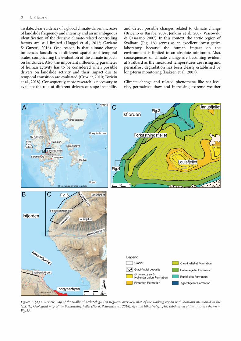
Forkastningsfjellet comprises mainly Upper Jurassic to Cretaceous sedimentary rocks of the Adventdalen Group (Parker, 1967; Dypvik et al., 1991; Dallmann et al., 2001), which is characterised by open marine through marginal-marine to continental facies associations of mudstone, shale and sandstone deposited in a shallow epicontinental basin (Fig. 3A; Dallmann, 1999; Mørk et al., 1999; Midtkandal et al., 2008).
The Adventdalen Group was differentiated into the lower Janusfjellet subgroup comprising mudstones and shales of the Agardhfjellet Formation (Jurassic) and Rurikfjellet Formation (Early Cretaceous). It is overlain by the delta ic Helvetiafjellet Formation with its cliff-forming lower sandstones of the Festningen Member (Fig. 3B) and over-lying coal-bearing shales and sandstones of the Glitre fjellet Member (Gjelberg & Steel, 1995). The latter is overlain by the heterolithic Carolinefjellet Formation comprising alternating thin sandstones and mudstones (Parker, 1967).
The study area is composed mainly of well-bedded, flat-lying strata of the Rurikfjellet and Helvetiafjellet
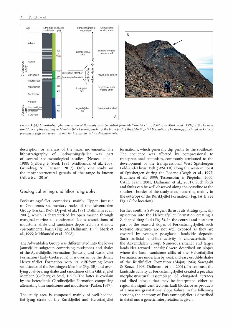
formations, which generally dip gently to the southeast. The sequence was affected by compressional to transpressional tectonism, commonly attributed to the development of the transpressional West Spitsbergen Fold-and-Thrust Belt (WSFTB) along the western coast of Spitsbergen during the Eocene (Bergh et al., 1997; Braathen et al., 1999; Tessensohn & Piepjohn, 2000; CASE Team, 2001; Dallmann et al., 2001). Such folds and faults can be well observed along the coastline at the southern border of the study area, occurring mainly in the outcrops of the Rurikfjellet Formation (Fig. 4A, B; see Fig. 1C for location).
Farther south, a SW-vergent thrust cuts stratigraphically upsection into the Helvetiafjellet Formation creating a Z-shaped drag fold (Fig. 5). In the central and northern part of the seaward slopes of Forkastningsfjellet, such tectonic structures are not well exposed as they are covered by younger postglacial landslide deposits. Such surficial landslide activity is characteristic for the Adventdalen Group. Numerous smaller and larger landslides termed ‘landslips’ were described on slopes where the basal sandstone cliffs of the Helvetiafjellet Formation are underlain by weak and easy erodible shales of the Rurikfjellet Formation (Major, 1964; Sawagaki & Koaze, 1996; Dallmann et al., 2001). In contrast, the landslide activity at Forkastningsfjellet created a peculiar morphostructural assemblage of elongated terraces and tilted blocks that may be interpreted either as regionally significant tectonic fault blocks or as products of a massive gravitational slope failure. In the following sections, the anatomy of Forkastningsfjellet is described in detail and a genetic interpretation is given.
B
Lithostratigraphicsubdivision
Depositionalenvironment
CarolinefjelletFm
RurikfjelletFm
AgardhfjelletFm
Open marine shelf
Regressive openmarine shelf
Fluvial and paralic
Shallow to distalmarine shelf
Adventd
ale
n G
roup
Age Thickness(m)
Lithology(shale/sst)
Albian
Aptian
Barremian
Hauterivian
Valanginian
Berriasian
Volgian
Kimmeridgian
Oxfordian
Callovian
Cre
taceous
Early
Jura
ssic
Late
A
Festningen Member
Glitrefjellet Member
He
lve
tiafje
llet
Fo
rma
tion
Fig. 3: A) Lithostratigraphic succession of the study area (modified from Midtkandal et al., 2007 after Mørk et al., 1999);B) The light sandstones of the Festningen Member (black arrow) make up the basal part of the Helvetiafjellet Formation.The strongly fractured rocks form prominent cliffs and serve as a marker horizon to deduce displacements.
Figure 3. (A) Lithostratigraphic succession of the study area (modified from Midtkandal et al., 2007 after Mørk et al., 1999). (B) The light sandstones of the Festningen Member (black arrow) make up the basal part of the Helvetiafjellet Formation. The strongly fractured rocks form prominent cliffs and serve as a marker horizon to deduce displacements.
NORWEGIAN JOURNAL OF GEOLOGY Anatomy of a mega-rock slide at Forkastningsfjellet, Spitsbergen 5
Description of Forkastningsfjellet geomorphology and structure
Much of the immediate region is characterised by relatively undeformed strata exhibiting gentle dips and/or very open folds. Greater Forkastningsfjellet consists of areas that conform to this regional structure, but one area diverts from the regional trend described in the following as the rockslide. This ‘structurally anomalous’ zone is bounded to the SE by a steep, west-facing, NE–SW-oriented fault scarp with an average slope gradient of 37°–40° in the upper part (Fig. 5). In the north, the scarp forms the north-facing slope of Carolinedalen; to the S it bends into an ENE-oriented lateral scarp.
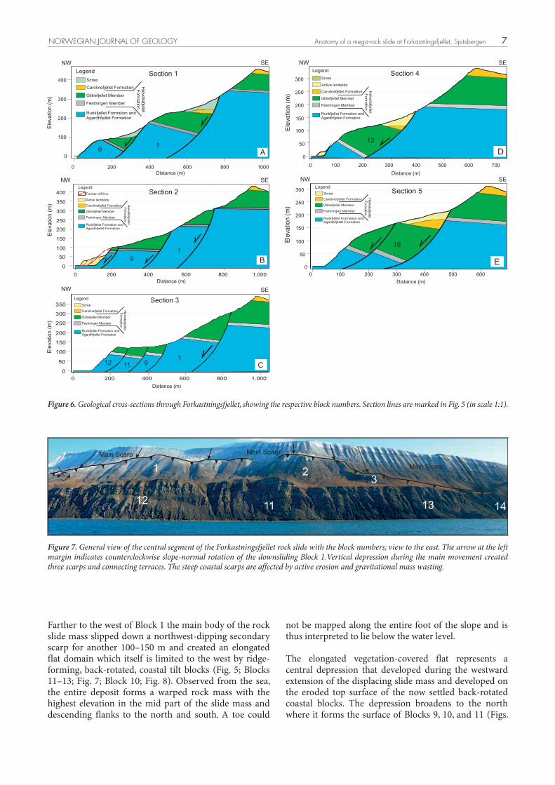
For this investigation, the anomalous zone to the NW of the scarp was divided into many individual blocks (Fig. 5). Each block is characterised by relatively high degrees of internal structural coherence. Structural discontinuities separate each block from its neighbours. Interpretive cross-sections (Fig. 6) were drawn using topographic data acquired from a 3D photogrammetric model and structural measurements, both obtained during our 2017 field expedition.
It is difficult to attribute the deformation at Forkastnings-fjellet to a period of significant tectonic extension that is otherwise undocumented in the region. As indicated by previous workers (Dallmann et al., 2001; Albertsen, 2016), the rugged, faulted, segmented surface structure of Forkastningsfjellet is best interpreted as the lateral collapse of the northwest-facing mountain front along the coastal margin of Isfjorden that is indicative of a large rotational rock slide with multiple sliding surfaces (Fig. 5). We have no reason to contradict this general interpretation. Rather, we focus on the nature of the slope itself: Its dimensions, structure and prospects for
long-term stability under a changing climatic regime. Although our conclusions are drawn specifically towards the Forkastningsfjellet site, we emphasise the likelihood that similar processes probably affect many other slopes throughout the Svalbard archipelago.
General geometry
The Forkastningsfjellet rock slide created a steep major scarp that in turn delimits a large, elongated, NW–SE-oriented amphitheatre. The scarp is the surface expression of the main, listric, west-dipping sliding surface that can be kinematically defined as a normal fault. During the gravitational rock-slope deformation, the displaced rock mass travelled downslope to the west into the Isfjorden, disintegrating along secondary sliding surfaces into several distinct domains and tilted blocks of different size and volume (Fig. 5).
The toe zone of the mass movement is not exposed as the distal parts of the mass were eroded and parts of it may have moved downslope into the submerged part of Isfjorden. Omitting this yet unknown distal part, the rock slide still shows exceptional dimensions. With an NE–SW width of 3.8 km, a length of some 800 m at the widest, and 350 m at the smallest part of the rock slide, the affected area is approximately 2,030,000 m² (2.03 km²).
For our study, we divided the rock slide into three compartments, described individually below. Although we present new structural data, physical access to many of the blocks was not possible. Our given displacement amounts were principally deduced from offsets of the cliff-building beds of the Festningen Sandstone Member (Fig. 3B).
0.5
m
1,5
0m
A
B
Fig. 4: NW-SE striking thrusts affecting the Rurikfjellet Formation. Outcrops A and B are situated along theForkastningsfjellet coastline to the south of the southern rock slide limit. See Fig. 1C and Fig. 5 for location.
Figure 4. NW–SE-striking thrusts affecting the Rurikfjellet Formation. Outcrops (A) and (B) are situated along the Forkastningsfjellet coastline to the south of the southern limit of the rock slide. See Figs. 1C & 5 for location.

D. Kuhn et al.6
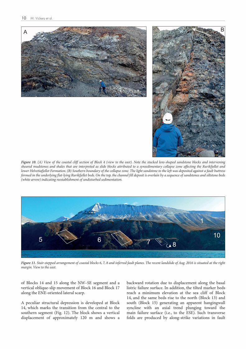
Central segment of the rock slide
The central part of the rock slide shows a stepped morphology comprising steep escarpments and flat to slightly sloping surfaces (Figs. 4, 5 & 6). A first bench is formed at the top of the landslide head that limits the first displaced block, labelled Block 1 (Fig. 7). The bench is situated at about 360 m a.s.l., indicating a drop along the main scarp of about 90 m. Farther to the south, the
head is broken into discontinuous slide blocks (Blocks 2, 3) showing an undulating height level due to variable amounts of downward displacement.
To the north, an increasing vertical displacement across the main scarp produces an arch-shaped outline of Block 1 with a ramp-like north-sloping bench indicating a simultaneous down sliding and counterclockwise rotation of the northern extension of Block 1 (Fig. 7).
Legend
17
16
15
14
13
12
11
10
9
8
7
6
5
4
3
2
1
Landslide Blocks
RecentLandslides
¼
Major scarp
Fault infered
Fault
Secondary scarp
Bathymetry
Contour lines
Thrust
Bedding
N
N
N
N
N
N
N
Section 5
Section 4
Section 3
Section 4
Section 2
Section 1Section 6
1
11
11
2
3
4
5
6
78
9
10
11
12
13
14
15
16
17
Carolinedalen
Fig. 5: Morphostructural map of Forkastningsfjellet, showing the main structures and numbered blocks ofthe rotational rock slide. Red lines show locations of geological cross sections. Sections 1 to 5 are shownin Fig. 6, section 6 in Fig. 15. The stereographic plots show mapped discontinuities as great circles (lowerhemisphere equal area), where fractures are black, bedding planes are blue and faults are red.
N N
Figure 5. Morphostructural map of Forkastningsfjellet, showing the main structures and numbered blocks of the rotational rock slide. Red lines show locations of geological cross-sections. Sections 1 to 5 are shown in Fig. 6, section 6 in Fig. 15. The stereographic plots show mapped discontinuities as great circles (lower hemisphere equal area), where fractures are black, bedding planes are blue and faults are red.
NORWEGIAN JOURNAL OF GEOLOGY Anatomy of a mega-rock slide at Forkastningsfjellet, Spitsbergen 7
not be mapped along the entire foot of the slope and is thus interpreted to lie below the water level.
The elongated vegetation-covered flat represents a central depression that developed during the westward extension of the displacing slide mass and developed on the eroded top surface of the now settled back-rotated coastal blocks. The depression broadens to the north where it forms the surface of Blocks 9, 10, and 11 (Figs.
Farther to the west of Block 1 the main body of the rock slide mass slipped down a northwest-dipping secondary scarp for another 100–150 m and created an elongated flat domain which itself is limited to the west by ridge-forming, back-rotated, coastal tilt blocks (Fig. 5; Blocks 11–13; Fig. 7; Block 10; Fig. 8). Observed from the sea, the entire deposit forms a warped rock mass with the highest elevation in the mid part of the slide mass and descending flanks to the north and south. A toe could
Figure 6. Geological cross-sections through Forkastningsfjellet, showing the respective block numbers. Section lines are marked in Fig. 5 (in scale 1:1).
23
213
1112 13 14
Main Scarp Main Scarp
Main Scarp
Fig. 7: General view of the central segment of the Forkastningsfjellet rock slide with the block numbers, view to the east.The arrow at the left margin indicates counterclockwise slope-normal rotation of the downsliding Block 1.Vertical depressionduring the main movement created three scarps and connecting terraces. The steep coastal scarps are affected by active erosionand gravitational mass wasting.
Figure 7. General view of the central segment of the Forkastningsfjellet rock slide with the block numbers; view to the east. The arrow at the left margin indicates counterclockwise slope-normal rotation of the downsliding Block 1.Vertical depression during the main movement created three scarps and connecting terraces. The steep coastal scarps are affected by active erosion and gravitational mass wasting.
Section 2
8006004002000
400
350
300
250
200
150
100
50
0
1.000
)m( noitavel
E
Distance (m)
SENW
Rurikfjellet Formation andAgardhfjellet Formation
Festningen Member
Glitrefjellet Member
Carolinefjellet Formation
tell
ejfait
evle
Hno
ita
mro
F
Former cliff line
Legend
Active landslide
19 B
200 400 600 800 1000
)m( noitavel
E
Distance (m)
Rurikfjellet Formation andAgardhfjellet Formation
Festningen Member
Glitrefjellet Member
Carolinefjellet Formation
tell
ejfait
evle
Hno
ita
mro
F
Scree
Legend
SENW
0
100
200
300
400
0A
Section 1
6 1
350
300
250
200
150
100
50
0
1.0008006004002000
NW SE
)m( noitavel
E
Distance (m)
C
Section 3
Rurikfjellet Formation andAgardhfjellet Formation
Festningen Member
Glitrefjellet Member
Carolinefjellet Formation
tell
ejfait
evl
eH
noit
amr
oF
Legend
Scree
12 11 91
Rurikfjellet Formation andAgardhfjellet Formation
Festningen Member
Glitrefjellet Member
Carolinefjellet Formation
tell
ejfait
evle
Hno
ita
mroF
Legend
Scree
NW SE
300
250
200
150
100
50
60050040030020010000
)m( noitavel
EDistance (m)
E
Section 5
15
7006005004003002001000
300
250
200
150
100
50
0
NW SE
Rurikfjellet Formation andAgardhfjellet Formation
Festningen Member
Glitrefjellet Member
Carolinefjellet Formation
tell
ejfait
evle
Hno
ita
mro
F
Scree
Legend
Active landslide
D
Section 4
13
Distance (m)
)m( noitavel
E

D. Kuhn et al.8
5, 7 & 8). To the south, a clear southwest-dipping surface drop between Blocks 11 and Block 13 is developed (Fig. 7), indicating a transfer fault that accommodates the different relative displacements of the neighbouring blocks. The flat ends at the southern limit of the main landslide body at Block 13 where an additional local escarpment between the flat surface and Block 3 indicates a local fault-bounded separation between Block 3 and the depression.
The westernmost blocks of the central rock slide segment constitute the impressive coastal cliffs of Forkastningsfjellet. The slump blocks (Blocks 10, 11, 12, 13) are elongated slabs of the upper Rurikfjellet Formation and lower Helvetiafjellet Formation with the cliff-forming sandstones of the Festningen Member on the top. The blocks show relatively low internal deformation without significant disturbance of the lithological sequence. Along strike, the blocks are affected by variable degrees of slope-parallel bedding rotation between 10° to 35° towards the east that are attributed to differential westward movement of the coherent blocks in the hangingwall of a listric sliding surface.
Northern segment
The Carolinedalen valley is taken as the northern limit of the Forkastningsfjellet rock slide as the main scarp ends at the north-facing valley slope (Figs. 5, 6 & 8). Nevertheless, conspicuous landslide deposits on the northwest-dipping slopes of Janusfjellet (Fig. 1C; Major & Nagy, 1972) adjacent to the north, indicate a possible northward continuation of the rock slide. Further fieldwork is necessary to clarify this question.
Five rock slide blocks were differentiated by photo interpretation and morphostructural analysis (Figs. 5 & 8). Forming the north-facing valley flank of Carolinedalen, Block 4 comprises a well-bedded sequence of the Rurikfjellet Formation. At the base of the slope and along the coastline, the beds show a horizontal to slight southeast inclination. In the mid and upper slope, a
gradual increase of dip is discernible due to the increasing clockwise back rotation of the landslide head. Downslope movement of Block 4 occurred along the major scarp in a northwesterly direction. Observable offsets of the Festningen Member marker beds suggest a minimum total displacement of 200 m (Fig. 6A). The same amount of northwestward displacement was deduced for the neighbouring Block 5 but also an additional westward displacement of about 20 m can be detected. Both blocks share the same lithological sequence and probably moved initially as a single block. In the course of downward displacement, this block was divided by a semicircular fault that ultimately delimited a new and independent Block 5 (Figs. 5 & 8). To the south, the semicircular fault scarp bends into the N–S-oriented secondary fault scarp that delimits Block 1 to the west. An additional displacement of the moving block was accommodated by small-scale normal faults with displacements in the range of several tens of metres (Fig. 9).
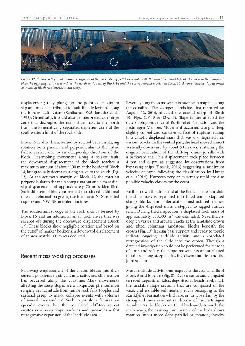
At the coastal cliff of Block 4 and the northern edge of Block 5, a puzzling outcrop can be observed that shows a major disruption of the normal bedding attitude and the structural features can be easily confused with brittle tectonic structures (Fig. 10A). Elongated lens-shaped sandstone blocks are stacked and shifted against each other and are juxtaposed with variably coloured and strongly fractured mudstone and sandstones packages, giving the impression of a chaotic mix of heterolithological units. The sandstone blocks show sharp tops and bases and are delineated by thin layers of sheared mudstone along downwardly curved sliding surfaces that plunge out of the slope.
In the central part of the outcrop, a trough-like, northwest-plunging, channel fill deposit of light sandstone is preserved that was deposited against a fault buttress formed in the underlying flat-lying Rurikfjellet beds (Fig. 10B). The re-establishment of undisturbed sedimentation after the complete infill of the depression is indicated by overlying sandstone beds.
This anomalous zone of sedimentary and structural disturbance is interpreted as a local synsedimentary
Fig. 8: segment of the Forkastningsfjellet rock slide with the numbered slide blocks and the bordering Carolinedalen valleyNorthernto the left. Note the staircase alignment of the coastal blocks (Blocks 6, 7, 8) due to increasing vertical displacement from north to south.Arrows indicate displacement amounts along the main scarp (view to the southeast).
5
67 8
910
14
12
Figure 8. Northern segment of the Forkastningsfjellet rock slide with the numbered slide blocks and the bordering Carolinedalen valley to the left. Note the staircase alignment of the coastal blocks (Blocks 6, 7, 8) due to increasing vertical displacement from north to south. Arrows indicate displacement amounts along the main scarp (view to the southeast).

NORWEGIAN JOURNAL OF GEOLOGY Anatomy of a mega-rock slide at Forkastningsfjellet, Spitsbergen 9
SE-striking and block-separating transverse faults. The larger vertical displacement amount of the latter two blocks may be connected to a larger displacement distance and an increasing general displacement of the central part of the rock slide in a WSW direction (see discussion section). Since the completion of the major block movements, considerable mass transport and erosion took place. This is evidenced by V-shaped channel formation at the block boundaries suggesting that deformation is not recent, and is also supported by the debris-filled half-graben shaped depressions at the rear part of the tilted blocks. This debris was derived from the degrading scarp. The active Isfjorden sea cliffs are strongly eroded by young slope instabilities that led to a pronounced sea cliff retreat (see below).
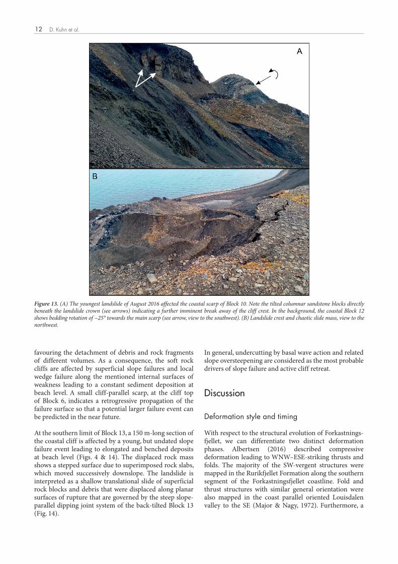
Southern segment
At the southern flank of the rock slide, the NE–SW-striking main scarp changes orientation into the ENE-oriented lateral scarp (Figs. 5, 6 & 12). The displaced rock mass in the hangingwall of the main sliding plane was divided into four separate fault blocks with variable slip directions and displacement amounts. Due to the change in orientation of the main scarp, the block movement is partitioned into a component of vertical dip-slip with a slope-parallel rotational component
collapse that may have affected an unstable delta front. The collapse produced a gully-like depression in the Rurikfjellet and lower Helvetiafjellet formations that was subsequently filled with mass flow deposits and slumps sliding down from scar walls. In this context, the stacked slide blocks with intervening sheared mudstone layers could be attributed to a sequential retrogressive collapse of the head regions, leading to stacked slide deposits that ultimately filled up the depression. Similar observations of gravitational sliding along a shallow shelf/delta slope were described from the Kvalvagen cliffs, eastern Spitsbergen by Nemec et al. (1988) and Onderdonk & Midtkandal (2010). The proposed synsedimentary mass movements represent the oldest deformation phase affecting Forkastningsfjellet. As these structures are not related to the postglacial rock slide event they will not be dealt with further below.
Farther south, the adjacent coastal Blocks 6, 7 and 8 are smaller than Block 5 and show a stair-stepped descent of the flat-topped block surfaces in a southwestward direction (Fig. 11). These tilted blocks slid down the secondary fault scarp of the back-rotated Block 1. The vertical displacements reach about 80 m for Block 6 and approximately 130 m for Block 7 and Block 8. The latter two blocks experienced an additional southwestward motion leading to an additional counterclockwise rotation of the beds of Block 7 and Block 8 along NW–
1
Fig. 9: Normal fault at the southern margin of Block 5 (Figs. 5 and 8), offsetting pervasive NE-SW striking sheeting joints.The sheeting joints dip steeply out of the face and further reduce the stability of the slope.
Figure 9. Normal fault at the southern margin of Block 5 (Figs. 5 & 8), offsetting pervasive NE–SW-striking sheeting joints. The sheeting joints dip steeply out of the face and further reduce the stability of the slope.
1
Fig. 9: Normal fault at the southern margin of Block 5 (Figs. 5 and 8), offsetting pervasive NE-SW striking sheeting joints.The sheeting joints dip steeply out of the face and further reduce the stability of the slope.
10
of Blocks 14 and 15 along the NW–SE segment and a vertical oblique-slip movement of Block 16 and Block 17 along the ENE-oriented lateral scarp.
A peculiar structural depression is developed at Block 14, which marks the transition from the central to the southern segment (Fig. 12). The block shows a vertical displacement of approximately 120 m and shows a
backward rotation due to displacement along the basal listric failure surface. In addition, the tilted marker beds reach a minimum elevation at the sea cliff of Block 14, and the same beds rise to the north (Block 13) and south (Block 15) generating an apparent hangingwall syncline with an axial trend plunging toward the main failure surface (i.e., to the ESE). Such transverse folds are produced by along-strike variations in fault
M. Vickers et al.
A
B
Fig. 10: A) View of the coastal cliff section of Block 4 (view to the east). Note the stacked lens shaped sandstone blocks and interveningsheared mudstones and shales that are interpreted as slide blocks attributed to a synsedimentary collapse zone affecting the Rurikfjelletand lower Helvetiafjellet Formation. B) Southern boundary of the collapse zone. The light sandstone to the left was deposited against a
top,fault buttress formed in the underlying flat lying Rurikfjellet beds. On the the channel fill deposit is overlain by a sequence of sandstonesand siltstone beds (white arrow) indicating reestablishment of undisturbed sedimentation.
Figure 10. (A) View of the coastal cliff section of Block 4 (view to the east). Note the stacked lens-shaped sandstone blocks and intervening sheared mudstones and shales that are interpreted as slide blocks attributed to a synsedimentary collapse zone affecting the Rurikfjellet and lower Helvetiafjellet Formation. (B) Southern boundary of the collapse zone. The light sandstone to the left was deposited against a fault buttress formed in the underlying flat-lying Rurikfjellet beds. On the top, the channel fill deposit is overlain by a sequence of sandstones and siltstone beds (white arrow) indicating reestablishment of undisturbed sedimentation.
5 7 86
10
1
Fig. 11: Stair-stepped arrangement of coastal blocks 6, 7, 8 and inferred fault planes.The recent landslide of Aug 2016 is situated at the right margin. View to the East.
Figure 11. Stair-stepped arrangement of coastal blocks 6, 7, 8 and inferred fault planes. The recent landslide of Aug. 2016 is situated at the right margin. View to the east.
A
B
Fig. 10: A) View of the coastal cliff section of Block 4 (view to the east). Note the stacked lens shaped sandstone blocks and interveningsheared mudstones and shales that are interpreted as slide blocks attributed to a synsedimentary collapse zone affecting the Rurikfjelletand lower Helvetiafjellet Formation. B) Southern boundary of the collapse zone. The light sandstone to the left was deposited against a
top,fault buttress formed in the underlying flat lying Rurikfjellet beds. On the the channel fill deposit is overlain by a sequence of sandstonesand siltstone beds (white arrow) indicating reestablishment of undisturbed sedimentation.
NORWEGIAN JOURNAL OF GEOLOGY Anatomy of a mega-rock slide at Forkastningsfjellet, Spitsbergen 11
displacement; they plunge to the point of maximum slip and may be attributed to fault-line deflections along the border fault system (Schlische, 1995; Janecke et al., 1998). Genetically, it could also be interpreted as a hinge zone that decouples the main slide mass to the north from the kinematically separated depletion zone at the southwestern limit of the rock slide.
Block 15 is also characterised by rotated beds displaying rotation both parallel and perpendicular to the listric failure surface due to an oblique-slip direction of the block. Resembling movement along a scissor fault, the downward displacement of the block reaches a maximum amount of about 100 m at the border of Block 14, but gradually decreases along strike to the south (Fig. 12). At the southern margin of Block 15, the rotation perpendicular to the main scarp runs out and a mere dip-slip displacement of approximately 70 m is identified. Such differential block movement introduced additional internal deformation giving rise to a major N–S-oriented rupture and NW–SE-oriented fractures.
The southernmost edge of the rock slide is formed by Block 16 and an additional small rock sliver that was sheared off during the downward displacement (Block 17). These blocks show negligible rotation and based on the cutoff of marker horizons, a downward displacement of approximately 100 m was deduced.
Recent mass-wasting processes
Following emplacement of the coastal blocks into their current positions, significant and active sea-cliff erosion has occurred along the coastline. Mass movements affecting the steep slopes are a ubiquitous phenomenon ranging in magnitude from minor rock falls, topples and surficial creep to major collapse events with volumes of several thousand m³. Such major slope failures are episodic events, but the correlated cliff-top retreat creates new steep slope surfaces and promotes a fast retrogressive expansion of the landslide area.
Several young mass movements have been mapped along the coastline. The youngest landslide, first reported on August 12, 2016, affected the coastal scarp of Block 10 (Figs. 2, 6, 8 & 13A, B). Slope failure affected the outcropping sequence of Rurikfjellet Formation and the Festningen Member. Movement occurred along a steep slightly curved and concave surface of rupture leading to a chaotic displaced mass that was disintegrated into various blocks. In the central part, the head moved almost vertically downward by about 50 m even sustaining the original orientation of the cliff-top drainage rills with a backward tilt. This displacement took place between 4 pm and 6 pm as suggested by observations from bypassing ships (Røsvik, 2016) suggesting a minimum velocity of rapid following the classification by Hungr et al. (2014). However, very or extremely rapid are also possible velocity classes for the event.
Farther down the slope and at the flanks of the landslide the slide mass is separated into tilted and juxtaposed slump blocks and intercalated unstructured masses giving the displaced mass a stepped to jagged surface relief. During field inspection, a displaced rock mass of approximately 300,000 m³ was estimated. Nevertheless, deep crevasses and arcuate cracks at the landslide crown and tilted columnar sandstone blocks beneath the crown (Fig. 13) lacking base support and ready to topple indicate ongoing landslide activity and a correlated retrogression of the slide into the crown. Though a detailed investigation could not be performed for reasons of time and safety, the slope movements are attributed to failure along steep coalescing discontinuities and the joint system.
More landslide activity was mapped at the coastal cliffs of Block 5 and Block 6 (Fig. 8). Debris cones and elongated terraced deposits of talus, deposited at beach level, mark the unstable slope sections that are composed of the weak and erodible sedimentary rocks belonging to the Rurikfjellet Formation which are, in turn, overlain by the strong and more resistant sandstones of the Festningen Member. As the blocks are tilted backwards towards the main scarp, the existing joint system of the beds shows rotation into a more slope-parallel orientation, thereby
1615
14
17
13
Fig. 12: Southern Segment: segment of the Forkastningsfjellet rock slide with the numbered landslide blocks, view to the southeast.SouthernNote the opposing rotation trends to the North and South of Block 14 and the active sea cliff erosion at Block 13. Arrows indicate displacementamounts of Block 16 along the main scarp.
Figure 12. Southern Segment: Southern segment of the Forkastningsfjellet rock slide with the numbered landslide blocks; view to the southeast. Note the opposing rotation trends to the north and south of Block 14 and the active sea-cliff erosion at Block 13. Arrows indicate displacement amounts of Block 16 along the main scarp.
D. Kuhn et al.12
favouring the detachment of debris and rock fragments of different volumes. As a consequence, the soft rock cliffs are affected by superficial slope failures and local wedge failure along the mentioned internal surfaces of weakness leading to a constant sediment deposition at beach level. A small cliff-parallel scarp, at the cliff top of Block 6, indicates a retrogressive propagation of the failure surface so that a potential larger failure event can be predicted in the near future.
At the southern limit of Block 13, a 150 m-long section of the coastal cliff is affected by a young, but undated slope failure event leading to elongated and benched deposits at beach level (Figs. 4 & 14). The displaced rock mass shows a stepped surface due to superimposed rock slabs, which moved successively downslope. The landslide is interpreted as a shallow translational slide of superficial rock blocks and debris that were displaced along planar surfaces of rupture that are governed by the steep slope-parallel dipping joint system of the back-tilted Block 13 (Fig. 14).
In general, undercutting by basal wave action and related slope oversteepening are considered as the most probable drivers of slope failure and active cliff retreat.
Discussion
Deformation style and timing
With respect to the structural evolution of Forkastnings-fjellet, we can differentiate two distinct deformation phases. Albertsen (2016) described compressive deformation leading to WNW–ESE-striking thrusts and folds. The majority of the SW-vergent structures were mapped in the Rurikfjellet Formation along the southern segment of the Forkastningsfjellet coastline. Fold and thrust structures with similar general orientation were also mapped in the coast parallel oriented Louisdalen valley to the SE (Major & Nagy, 1972). Furthermore, a
Figure 13. (A) The youngest landslide of August 2016 affected the coastal scarp of Block 10. Note the tilted columnar sandstone blocks directly beneath the landslide crown (see arrows) indicating a further imminent break away of the cliff crest. In the background, the coastal Block 12 shows bedding rotation of ~25° towards the main scarp (see arrow, view to the southwest). (B) Landslide crest and chaotic slide mass, view to the northwest.

NORWEGIAN JOURNAL OF GEOLOGY Anatomy of a mega-rock slide at Forkastningsfjellet, Spitsbergen 13
so-called ‘Z-Fold’ affected the overlying sediments of the Helvetiafjellet Formation at the southern extension of Forkastningsfjellet (Fig. 4). These structures were linked to the eastern zone of the West Spitsbergen Fold-and-Thrust Belt, a thin-skinned, foreland, fold-and-thrust belt that is characterised by WSW–ENE-oriented shortening and which evolved during a transpressional event in the Eocene (Harland, 1969; Dallmann et al., 1993; Maher et al., 1995; Bergh et al., 1997; Piepjohn et al., 2016).
In contrast, the recent tilt block structure of Forkastningsfjellet has been assigned to rock slide activity in postglacial times (Major & Nagy, 1972; Albertsen, 2016). This second phase is characterised by steep NE–SW-oriented releasing extensional structures that served as sliding surfaces, i.e., its orientation is roughly orthogonal to the Eocene compressional trend. Therefore, a direct reactivation of older Eocene thrust faults as sliding surfaces can be ruled out. That said Eocene compression might have initiated the intensive joint system and NE–SW-oriented fractures that have been inferred as steep releasing structures.
Type and kinematics of the rock slide
Forkastningsfjellet exhibits a peculiar morphology and a specific structural style that is indicative of rotational rock slides (Varnes, 1978; Hungr et al., 2014). Such large-scale rock-slope failures are known as a principal type of mass movement in Norway and the Arctic region and have been termed as ‘listric style complex field’ type (Braathen et al., 2004). They are characterised by complex landforms and deformation patterns due to the
fragmentation of the sliding mass into separate blocks that move and rotate in the hangingwall of one or several detachment levels.
Based on the described field observations, the Forkastningsfjellet rock slide is characterised as a multiple rotational rock slide that occurred principally on a spoon-shaped west-dipping failure surface. This listric failure surface produces the steep major fault scarp at the eastern limit of the rock slide and probably flattens downward into a low-angle detachment zone situated in the flat-lying bedding planes of the less competent shales of the lower Rurikfjellet/Adventdalen Group sediments. During the westward displacement, the rock mass broke up into secondary slumps and the associated scarps to form the observed stair-step pattern of displaced blocks and flats. Such a subdivision of the moving rock mass into relatively coherent and rigid back-rotated tilt blocks is a clear diagnostic feature of a rotational slide movement in the hangingwall of a listric sliding surface. The depth of the basal décollement is unknown, but it is assumed that it must ‘daylight’ in the west-dipping offshore slope of Isfjorden. From geometric considerations deduced from differential displacements of the rotated hangingwall blocks, a minimal depth of 60 m below sea level is assumed (Fig. 15).
Using the contemporary coastline as the western border and the main scarp as the eastern border of the Forkastningsfjellet rock slide deposits, the maximum east–west displacement is mapped in the central segment of the rock slide. This area is characterised by the highest degree of disintegration and the discrete rock slide blocks show the largest vertical displacements and the
Fig. 14: Active gravitational mass wasting along the coastal scarp of Block 13. Instability along adversely oriented slide surfaces(orientation: 26/55 NW) are a consequence of basal sea cliff erosion and slope oversteepening. White arrows indicateslope-parallel sliding surfaces, view towards North.
Figure 14. Active gravitational mass wasting along the coastal scarp of Block 13. Instability along adversely oriented slide surfaces (orientation: 26/55 NW) are a consequence of basal sea-cliff erosion and slope oversteepening. White arrows indicate slope-parallel sliding surfaces, view towards north.
D. Kuhn et al.14
largest amounts of back rotation. Though the unmapped toe area of the mass movement cannot be included in the evaluation, the displacement observations are used as indicators to assume that the maximum extension of the accumulation zone also occurred in the central segment of the landslide.
To the south, this zone of maximum displacement and block rotation is kinematically separated by the structural depression at Block 14 (Figs. 5, 7 & 12), which serves as a transition zone between a more rotational slide with a larger displacement towards the central segment and a more translational slide mode with lower displacement towards the southern flank.
This supports the interpretation that the adjacent blocks of the southern flank (Blocks 15, 16, 17) failed after the displacement of the principal rock mass of the central segment in the course of a secondary, more passive, compensation movement as a reaction to the lost lateral support. In this context, the separation of Block 16 and Block 17 could result from a dip-slip activation of arcuate, E–W-oriented en échelon fractures as secondary slip zones.
In contrast, the northern segment of the rock slide shares the same rotational deformation style as the central segment and displays considerable disintegration of the slide mass. A contemporaneous displacement of the central and the northern segment seems probable, though the horizontal displacement of the tilt blocks decreases towards the northern flank. This assumption is preliminary and infers a high uncertainty as the present limits of the rock slide mass do not reflect the true travel distance and do not consider variable and yet unknown amounts of coastal erosion. Also, a possible northward extension of the rock slide to Janusfjellet is indicated and awaits further investigation.
To estimate the travel distance and velocities of the rock slide, empirical methods can be applied that use height-over-length (H/L) ratios deduced from rock slides that occurred in regions with similar conditions. Using the current geometry of the rock slide, an H/L ratio of 0.4 or a corresponding angle of reach of 22° can be deduced.
This preliminary shadow angle of the Forkastningsfjellet rock slide can be reduced to an even smaller angle of 17° if we consider that the distal slide masses could have travelled farther offshore and down the steep eastern transition to the Isfjorden seafloor. Corresponding indications of such a scenario can be derived from bathymetric data that show conspicuous bulges along the steep slope in this part of Isfjorden (Fig. 5; Forwick & Vorren, 2011; Blinova et al., 2013; Riko Noormets, pers. comm., 2018).
Such angles are smaller than the typical shadow angles of 28–34° identified for large scale rock-slope avalanches in polar regions (Evans & Hungr, 1993; Blikra et al., 2001; Hungr et al., 2005), but reliable data on the specific rock slide type and the particular conditions of Forkastningsfjellet are not yet known.
Rock slide extension and volumes
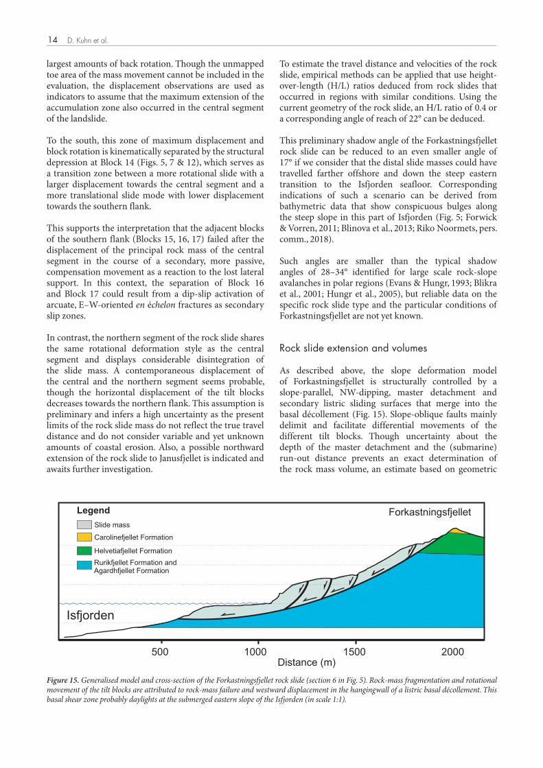
As described above, the slope deformation model of Forkastningsfjellet is structurally controlled by a slope-parallel, NW-dipping, master detachment and secondary listric sliding surfaces that merge into the basal décollement (Fig. 15). Slope-oblique faults mainly delimit and facilitate differential movements of the different tilt blocks. Though uncertainty about the depth of the master detachment and the (submarine) run-out distance prevents an exact determination of the rock mass volume, an estimate based on geometric
Isfjorden
Rurikfjellet Formation andAgardhfjellet Formation
Carolinefjellet Formation
Helvetiafjellet Formation
Slide mass
Legend
500 15001000 2000
Forkastningsfjellet
Distance (m)
Fig. 15: Generalized model and cross section of the Forkastningsfjellet rock slide (section 6 in Fig. 5). Rock mass fragmentation androtational movement of the tilt blocks is attributed to rock mass failure and westward displacement in the hangingwall of a listric basaldécollement. This basal shear zone probably daylights at the submerged eastern slope of the Isfjorden (in scale 1:1).
Figure 15. Generalised model and cross-section of the Forkastningsfjellet rock slide (section 6 in Fig. 5). Rock-mass fragmentation and rotational movement of the tilt blocks are attributed to rock-mass failure and westward displacement in the hangingwall of a listric basal décollement. This basal shear zone probably daylights at the submerged eastern slope of the Isfjorden (in scale 1:1).

NORWEGIAN JOURNAL OF GEOLOGY Anatomy of a mega-rock slide at Forkastningsfjellet, Spitsbergen 15
considerations can be attempted. Using the slope deformation area of approximately 2,030,000 m² (2.03 km²) and an average depth of the basal sliding surface of 50 m, a minimum volume of 0.1 km³ is estimated. This volume is well in the range of described complex fields in Norway (Braathen et al., 2004) but up to now, no further examples of rock slides with comparable dimensions are known from the Isfjorden margins, emphasising the unique nature of the Forkastningsfjellet rock slide and highlighting the necessity for further investigation.
Driving forces of the rock slide
Many factors determine the stability of a rock slope and many conditions have to be satisfied before sliding of such a large volume of rock can occur. In this context, it is noteworthy to stress that in spite of similar geology and morphostructural slope conditions, the east-facing slope of Forkastningsfjellet does not show any indication of large slope failures. Therefore, it is reasonable to expect a correlation of the rock slide with glacial processes in the western Isfjorden area.
Due to lacking subsurface information, a combination of interacting preconditioning, preparatory and triggering factors are considered to give a likely explanation for the rock slides along Forkastningsfjellet.
In general, factors such as as the lithology and structure determine inherent zones of weakness, which in turn control development of gravitational mass movements (Varnes, 1978; Cruden & Varnes, 1996; Hermanns & Strecker, 1999; Braathen et al., 2004; Redfield & Osmundsen, 2009; McColl, 2012; Ballantyne et al., 2014). This applies especially to Forkastningsfjellet, as the flat-lying sedimentary sequence of alternating weak shales and more competent sandstones and siltstones is highly fractured by pervasive joint systems including slope-parallel sheeting joints (Fig. 9). The formation of these fractures is conditionally assigned to the Eocene deformation phase but postglacial stress release might have intensified the break-up and weakening of the rock mass. Permafrost-controlled subaerial processes such as freeze and thaw cycles might have further weakened the rock mass through weathering and seasonal crack propagation and widening. The latter play an important role as refreezing and ice formation of meltwater can exert additional separation pressures and open up the cracks for water infiltration. In addition, the climate-related deglaciation and permafrost degradation facilitate a deeper infiltration of the melting water along the widening fractures and joints of the bedrock (Gruber & Haeberli, 2007; McColl, 2012) leading to an increasing outward directed joint water pressure and a reduced shear resistance on the potential listric sliding surfaces and the basal décollement (Blikra & Christiansen, 2014).
Kinematic feasibility of the rock slide of Forkastnings-
fjellet requires a deep sliding surface that facilitates the block rotations and the horizontal displacement component of the rock mass. This décollement is assumed to be situated along a subhorizontal sandstone-shale bedding contact of the Rurikfjellet Formation.
Based on these presumptions, a probable scenario could be an incipient rock slide activity affecting the glacially eroded and oversteepened eastern slope of Isfjorden that had lost the lateral support of the retreating glacier. Such glacial debuttressing has been suggested to cause massive rock slides and catastrophic failure (Clague & Evans, 1994; Ballantyne, 2002; Holm et al., 2004; Geertsema et al., 2006; Cossart et al., 2008; Penna et al., 2011; Hermanns et al., 2014). On the other hand, McColl & Davies (2013) have suggested that complete debuttressing is not a prerequisite for the movement of ice-contact rock slopes. These authors argue that because glacial ice can deform due to the density contrast between ice and rock, thereby failing to buttress an active rock slide. Nevertheless, glacial retreat would have left behind a strongly structured landscape and melting water discharging into the Isfjorden depression may have intensified channel and gully erosion, possibly creating unstable conditions along the Forkastningsfjellet–Isfjorden border zone and probably at the northern and southern margins of the central segment of the rock slide. Such a removal of horizontal and lateral support would have led to an initial unloading of the toe area and a subsequent retrogressive activity with a propagation of the basal failure surface along the mudstone bedding planes to the east. This is supported by recent structural investigations of the subsea-floor strata in the Isfjorden area. Blinova et al. (2013) have shown that the organic-rich shales of the Jurassic–Cretaceous Janusfjellet Subgroup served as lubricants for the principal detachment zones. This is in agreement with our interpretation that the basal décollement of the rock slide is most likely located in the same lithological unit.
The fact that original bedding is slightly inclined against the overall movement direction might be overcome by a high hydraulic head and an overpressured groundwater table that effectively reduced shear strength along an interface between permeable sandstone and impermeable shale beds.
While all these mentioned factors might have contributed to an incipient unstable rock slope, a seismic event could have finally triggered the collapse of the western slope of the Forkastningsfjellet. Such a causal connection is proposed for many paraglacial rock-slope failures and could be attributed to enhanced seismicity as a consequence of differential glacio-isostatic crustal rebound due to deglacial unloading and elastic stress redistribution of the lithosphere (e.g., McColl, 2012; McColl & Davies, 2013; Ballantyne et al., 2014).
D. Kuhn et al.16
Age and state of activity
Based on recent deglaciation studies for the Isfjorden area by Forwick & Vorren (2011) and taking into account the mentioned conditioning and triggering factors, the Forkastningsfjellet rock slide was probably active in the course of glacial retreat in the Isfjorden area since the Allerød (~13,900–12,700 years BP).
Though a later glacial advance during the Younger Dryas stage is known, the inner Isfjorden has likely been ice free since then (Forwick & Vorren, 2011). Thus, a further major glacial influence or modification of the landforms and the toe zone of the rock slide can be ruled out. This estimation of the maximum age has to be taken as a rough assumption and better temporal constraints are needed to consider the Forkastningsfjellet rock slide in the regional context. Nevertheless, this age estimation is supported by recent research. It shows increasing evidence of large-scale rock-slope failures that affected formerly glaciated mountainous regions, and that a causal relationship with the preceding episodes of glaciations and deglaciation is commonly inferred (e.g., Ballantyne, 2002; McColl, 2012; Ballantyne & Stone, 2013; Hermanns et al., 2017).
The temporal failure pattern and its drivers are under debate as documented catastrophic rock-slope failures seem to decrease in number and size with the time elapsed since the last deglaciation (Böhme et al., 2015). However, although a peak of rock slide frequency was identified for the time interval directly after deglaciation, younger rock-slope failures with a lower frequency occurred during the entire Holocene (McColl, 2012; Ballantyne et al., 2014; Böhme et al., 2015; Hilger et al., 2018). Explanations for this time lag between the destabilising effects of ice retreat and occurrence of postglacial landslide include time-dependent degradation of rock mass strength, changes in stress and strength of slopes and increasing seismicity (Ballantyne, 2002; Braathen et al., 2004; McColl, 2012; McColl & Davies, 2013; Ballantyne et al., 2014), and a relation to Holocene climate variation that can lead to shifting permafrost conditions (Hilger et al., 2018). A clear relationship between large-scale rock-slope failures and ice retreat is not yet established.
During field investigation, no indications of a reactivation along the major rock slide scarps or fresh open crevasses were observed at the plateau between the main scarp and the coastal blocks to the west. Present-day landslide activity occurs along the steep sea cliffs of the coastal blocks, where the intensely fractured rocks react with gravitational failure (Figs. 3B & 14). However, surface creep processes are common to permafrost environments; such processes can be faster than opening of cracks and thus hide rock-slope deformation. Due to nonexisting morphological indications of larger rock-slope reactivation and the lack of any deformation
measurements based on monitoring techniques, we consider that the rock slide is either presently dormant or velocities are low to very low.
Finally, based on the nonavailability of high-resolution bathymetric data, we cannot determine whether the Forkastningsfjellet rock slide was 1) a slow to fast moving rock slide throughout its slide history or 2) if the rock slide had one or several failure episodes that would have led to strong fragmentation of the toe of the slide and long run-out. The latter could be suggestive of a fast or extremely fast movement. However, the 2016 event occurred within the same material but is 2.5 magnitudes smaller in volume. In addition, the deposit is characterised in morphology and structure similar to the Forkastningsfjellet rock slide with tilted and compartmented blocks. The 2016 event was at least fast with the potential of having been very fast or extremely fast. With a simple approximation we can expect a similar behaviour of the Forkastningsfjellet rock slide. However, a better understanding of the deposit below the water line will give a better understanding of its past and potential future behaviour.
Landslide hazard
Active landslides have been mapped at the steep sea cliffs along the coastline and the areal extent and volumetric magnitude of the slope failures are quite limited. The mass movements are interpreted as typical cliff failures resulting from active wave-triggered sea-cliff undercutting and additional subaerial processes, leading to a gravity-driven downslope movement of unstable segments of the rock face (e.g., Emery & Kuhn, 1982; Sunamura, 1992; Kuhn & Prüfer, 2014). Consequently, these mass movements influence only the local coastline and do not exert a major hazard to the surroundings.
Although the stability of deforming rock slopes is assessed around the world (e.g., Willenberg et al., 2008; Blikra, 2012; Stead & Eberhardt, 2013; Macciotta et al., 2016), only three classification systems exist that relate rock-slope deformation to the hazard of failure (Hermanns et al., 2012; Jaboyedoff et al., 2012; Brideau et al., 2017) and have been proven to come to comparable results using the case of the Åknes rock slide in Norway (Oppikofer et al., 2018a). The method by Brideau et al. (2017) uses a regional frequency analysis as a starting point that is not available to us. However, the methods by Jaboyedoff et al. (2012) and Hermanns et al. (2013a) are based on morphological signs of rock-slope deformation at the back scarp and the toe and the state of activity with the method of Hermanns et al. (2012) being the most comprehensive, by adding more details on deformation rate, kinematics of deformation, and past events. As we are lacking information on the deformation at the toe of the Forkastningsfjellet rock slide, the method by Hermanns et al. (2012) represents the method for which
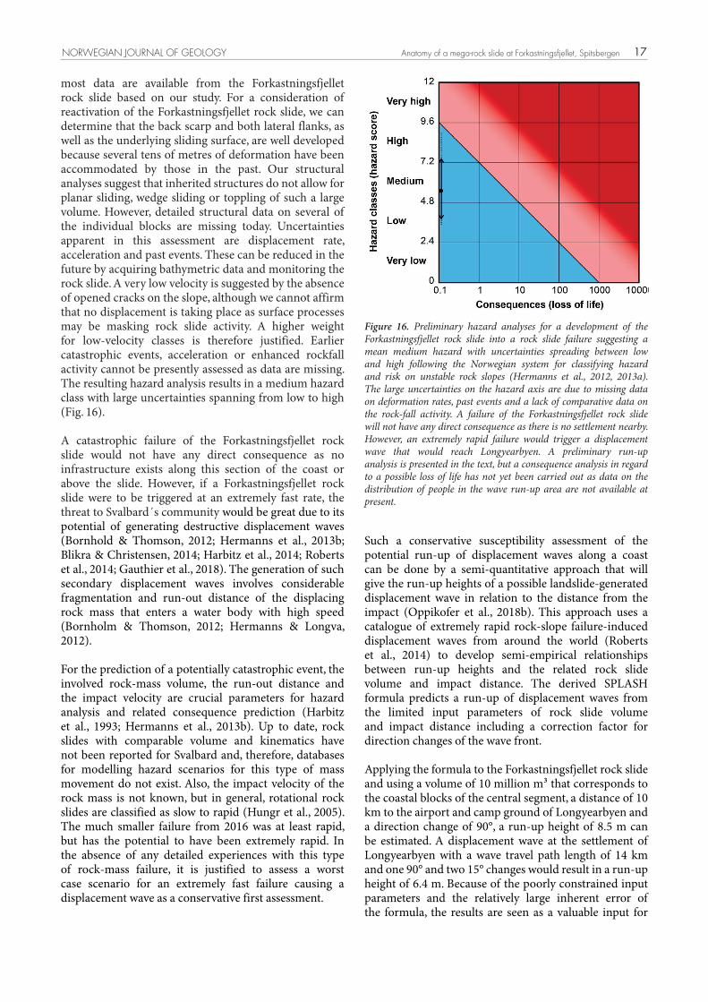
NORWEGIAN JOURNAL OF GEOLOGY Anatomy of a mega-rock slide at Forkastningsfjellet, Spitsbergen 17
most data are available from the Forkastningsfjellet rock slide based on our study. For a consideration of reactivation of the Forkastningsfjellet rock slide, we can determine that the back scarp and both lateral flanks, as well as the underlying sliding surface, are well developed because several tens of metres of deformation have been accommodated by those in the past. Our structural analyses suggest that inherited structures do not allow for planar sliding, wedge sliding or toppling of such a large volume. However, detailed structural data on several of the individual blocks are missing today. Uncertainties apparent in this assessment are displacement rate, acceleration and past events. These can be reduced in the future by acquiring bathymetric data and monitoring the rock slide. A very low velocity is suggested by the absence of opened cracks on the slope, although we cannot affirm that no displacement is taking place as surface processes may be masking rock slide activity. A higher weight for low-velocity classes is therefore justified. Earlier catastrophic events, acceleration or enhanced rockfall activity cannot be presently assessed as data are missing. The resulting hazard analysis results in a medium hazard class with large uncertainties spanning from low to high (Fig. 16).
A catastrophic failure of the Forkastningsfjellet rock slide would not have any direct consequence as no infrastructure exists along this section of the coast or above the slide. However, if a Forkastningsfjellet rock slide were to be triggered at an extremely fast rate, the threat to Svalbard´s community would be great due to its potential of generating destructive displacement waves (Bornhold & Thomson, 2012; Hermanns et al., 2013b; Blikra & Christensen, 2014; Harbitz et al., 2014; Roberts et al., 2014; Gauthier et al., 2018). The generation of such secondary displacement waves involves considerable fragmentation and run-out distance of the displacing rock mass that enters a water body with high speed (Bornholm & Thomson, 2012; Hermanns & Longva, 2012).
For the prediction of a potentially catastrophic event, the involved rock-mass volume, the run-out distance and the impact velocity are crucial parameters for hazard analysis and related consequence prediction (Harbitz et al., 1993; Hermanns et al., 2013b). Up to date, rock slides with comparable volume and kinematics have not been reported for Svalbard and, therefore, databases for modelling hazard scenarios for this type of mass movement do not exist. Also, the impact velocity of the rock mass is not known, but in general, rotational rock slides are classified as slow to rapid (Hungr et al., 2005). The much smaller failure from 2016 was at least rapid, but has the potential to have been extremely rapid. In the absence of any detailed experiences with this type of rock-mass failure, it is justified to assess a worst case scenario for an extremely fast failure causing a displacement wave as a conservative first assessment.
Such a conservative susceptibility assessment of the potential run-up of displacement waves along a coast can be done by a semi-quantitative approach that will give the run-up heights of a possible landslide-generated displacement wave in relation to the distance from the impact (Oppikofer et al., 2018b). This approach uses a catalogue of extremely rapid rock-slope failure-induced displacement waves from around the world (Roberts et al., 2014) to develop semi-empirical relationships between run-up heights and the related rock slide volume and impact distance. The derived SPLASH formula predicts a run-up of displacement waves from the limited input parameters of rock slide volume and impact distance including a correction factor for direction changes of the wave front.
Applying the formula to the Forkastningsfjellet rock slide and using a volume of 10 million m³ that corresponds to the coastal blocks of the central segment, a distance of 10 km to the airport and camp ground of Longyearbyen and a direction change of 90°, a run-up height of 8.5 m can be estimated. A displacement wave at the settlement of Longyearbyen with a wave travel path length of 14 km and one 90° and two 15° changes would result in a run-up height of 6.4 m. Because of the poorly constrained input parameters and the relatively large inherent error of the formula, the results are seen as a valuable input for
Fig. 16: Preliminary hazard analyses for a development of the Forkastningsfjellet rock slide into a rock slide failure suggesting a meanmedium hazard with uncertainties spreading between low and high following the Norwegian system to hazard and risk classify unstablerock slopes (Hermanns et al., 2012, 2013). The large uncertainties on the hazard axis are due to missing data on deformation rates,past events and lack of comparative data on the rock fall activity. A failure of the Forkastningsfjellet rock slide will not relate in any directconsequence as no settlement is near by. However, an extremely rapid failure would trigger a displacement wave that would reach Longyearbyen.A preliminary run-up analysis is presented in the text, but a consequence analysis in the light of loss of life is not carried out yet as data on thedistribution of people in the wave run-up area are not available at present.
Figure 16. Preliminary hazard analyses for a development of the Forkastningsfjellet rock slide into a rock slide failure suggesting a mean medium hazard with uncertainties spreading between low and high following the Norwegian system for classifying hazard and risk on unstable rock slopes (Hermanns et al., 2012, 2013a). The large uncertainties on the hazard axis are due to missing data on deformation rates, past events and a lack of comparative data on the rock-fall activity. A failure of the Forkastningsfjellet rock slide will not have any direct consequence as there is no settlement nearby. However, an extremely rapid failure would trigger a displacement wave that would reach Longyearbyen. A preliminary run-up analysis is presented in the text, but a consequence analysis in regard to a possible loss of life has not yet been carried out as data on the distribution of people in the wave run-up area are not available at present.
D. Kuhn et al.18
a preliminary susceptibility assessment (in the sense of run-up height) for the settlements nearby.
Our data presented here therefore show that the Forkastningsfjellet rock slide might present a threat to Longyearbyen community. However, the most important question as to whether the Forkastningsfjellet rock slide can collapse catastrophically remains open. Furthermore, the uncertainties of our hazard analyses might be too high to be useful for any risk adaptation plan. Mapping the fjord bottom in front of Forkastningsfjellet is a logical next step to better understand the behaviour of Forkastningsfjellet in the past. This can be accompanied by deformation rate measurements on Forkastningsfjellet which will reduce the uncertainties of the hazard assessment. Monitoring of Forkastningsfjellet should also include the effects of climate change as a rising sea level and an increasing permafrost degradation most likely will exert a negative influence on slope stability (Humlum et al., 2003; IPCC, 2007).
Conclusions
Forkastningsfjellet comprises a ~100 million m3 rotational rock slide, which occurred in the hangingwall of a listric, northwest-dipping slide surface. During slope deformation, the rock slide travelled to the west into the Isfjorden coastal area and was fragmented into tilt blocks of differing volumes and sizes. The main rock slide release was probably related to the deglaciation of Isfjorden and resulting failure along the oversteepened slopes during Allerød times. No observations indicative of subsequent reactivation along the scarps and tilt block boundaries were made. A dangerous large volume reactivation of the rock slide in a CRSF could reach the fjord and trigger a large displacement wave. However, no signs of such a reactivation were found.
Mass wasting and sea-cliff erosion, mainly controlled by the inherent discontinuities of the fractured and tilted rock masses, currently take place along the steep slopes of the coastal tilt blocks. Different types of mass movements can be detected, but the displaced volumes are rather small compared with the entire volume of the rock slide and do not pose a hazard to the local community.
Based on the presented preliminary results, a further more detailed investigation is warranted to better understand past rock slide behaviour and present-day deformation rates. This will also allow to collect data to better understand the kinematics of individual blocks. A possible northern extension at the coastal slopes of Janusfjellet should be part of a more thorough investigation. More multidisciplinary data are needed to determine the volume and the travel distance of the rock slide mass. Such information is needed to perform
a reliable hazard and consequence analysis as a potential reactivation event could pose a significant risk to the populated area of Longyearbyen. On the regional level, a thorough survey should be performed in order to find and map similar large-scale rock-slope failures within the Svalbard archipelago. Such an inventory is necessary to better understand the nature, controlling factors and the temporal relationships of these mass movements. Also, such an inventory offers the possibility to define magnitude-frequency relationships that are necessary to support alternative hazard assessment methods.
Acknowledgements. This paper results from fieldwork carried out in summer 2017. The authors wish to thank BGR and NGU for funding of the fieldwork. We are grateful to Riko Noormets who provided bathymetry data and to Pierick Nicolet for supporting the elaboration of the 3D-Model. P. Konietzko and A. Umbreit of Terra Polaris are thanked for field assistance and polar bear watch. Chr. Kasch supported the fieldwork with valuable information and equipment. The authors also wish to acknowledge the reviews and helpful comments of Andrée Blais-Stevens and Marten Geertsema.
References
Agisoft 2018: http://www.agisoft.com/ (accessed 14.09.2017).Albertsen, A. 2016: Cenozoic compressional tectonics and post-glacial
landsliding at Forkastningsfjellet, Spitsbergen, Svalbard. MSc thesis, Department of Geosciences Faculty of mathematics and natural sciences, University of Oslo, 81 pp.
Allmendinger, R.W., Cardozo, N. & Fisher, D. 2012: Structural geology algorithms: Vectors and tensors in structural geology. Cambridge University Press, 302 pp.
Ballantyne, C.K. 2002: Paraglacial geomorphology. Quaternary Science Reviews 21, 1935–2017.
https://doi.org/10.1016/S0277-3791(02)00005-7. Ballantyne, C.K. & Stone, J.O. 2013: Timing and periodicity of
paraglacial rock-slope failures in the Scottish Highlands. Geomorphology 186, 150–161.
https://doi.org/10.1016/j.geomorph.2012.12.030. Ballantyne, C.K., Sandeman, G.F., Stone, J.O. & Wilson, P. 2014: Rock-
slope failure following Late Pleistocene deglaciation on tectonically stable mountainous terrain. Quaternary Science Reviews 86, 144–157. https://doi.org/10.1016/j.quascirev.2013.12.021.
Bergh, S.G., Braathen, A. & Andresen, A. 1997: Interaction of basement-involved and thin-skinned tectonism in the Tertiary fold thrust belt of central Spitsbergen, Svalbard. American association of Petroleum Geologists Bulletin 81, 637–661.
Blikra, L.H. 2012: The Åknes rockslide, Norway. In Clague, J.J. & Stead, D. (eds.): Landslides: Types, Mechanisms and Modeling, Cambridge University Press, pp. 323–335.
https://doi.org/10.1017/CBO9780511740367.027. Blikra, L.H. & Christiansen, H.H. 2014: A field-based model of
permafrost-controlled rock slide deformation in northern Norway. Geomorphology 208, 34–39.
https://doi.org/10.1016/j.geomorph.2013.11.014. Blikra, L.H., Braathen, A. & Skurtveit, E. 2001: Hazard evaluation of
rock avalanches, the Baraldsnes-Oteroya area. Geological Survey of Norway Report 2001.108, 33 pp.

NORWEGIAN JOURNAL OF GEOLOGY Anatomy of a mega-rock slide at Forkastningsfjellet, Spitsbergen 19
Blinova, M., Faleide, J.I., Gabrielsen, R.H. & Mjelde, R. 2013: Analysis of structural trends of sub-sea-floor strata in the Isfjorden area of the West Spitsbergen Fold-and-Thrust Belt based on multichannel seismic data. Journal of the Geological Society 170, 657–668.
https://doi.org/10.1144/jgs2012-109. Böhme, M., Oppikofer, T., Longva, O., Jaboyedoff, M., Hermanns, R.L.
& Derron, M.H. 2015: Analyses of past and present rock slope instabilities in a fjord valley: implications for hazard estimations. Geomorphology 248, 464–474.
https://doi.org/10.1016/j.geomorph.2015.06.045. Bornhold, B.D. & Thomson, R.E. 2012: Tsunami hazard assessment
related to slope failures in coastal waters. In Clague, J.J. & Stead, D. (eds.): Landslides: Types, Mechanisms and Modeling, Cambridge University Press, pp. 59–70.
https://doi.org/10.1017/CBO9780511740367.011. Braathen, A., Bergh, S.G. & Maher, H.D. 1999: Application of a critical
wedge taper model to the tertiary transpressional fold-thrust belt on Spitsbergen, Svalbard. Bulletin of the Geological Society of America 111, 1468–1485.
https://doi.org/10.1130/0016-7606(1999)111<1468:AOACWT>2.3.CO;2. Braathen, A., Blikra, L.H., Berg, S.S. & Karlsen, F. 2004: Rock-slope
failures in Norway; type, geometry, deformation mechanisms and stability. Norwegian Journal of Geology 84, 67–88.
Briceño, S. & Basabe, P. 2007: Landslides and climate change: A world perspective, but a complex question. In McInnes, R., Jakeways, J., Fairbank, H. & Mathie, E. (eds): Landslides and Climate Change- Challenges and Solutions, Taylor and Francis Group, London, pp. 3–6.
Brideau, M.-A., Jakob, M. & McDougall, S. 2017: Methodology to estimate the rock avalanche frequency for a specific slope. Abstracts of the 4th Slope Tectonics Conference, 14–18 October, Kyoto, Japan, p. 29.
Cardozo, N. & Allmendinger, R.W. 2013: Spherical projections with OSX Stereonet. Computers & Geosciences 51, 193–205.
https://doi.org/10.1016/j.cageo.2012.07.021. CASE Team 2001: The evolution of the Fold-and-Thrust Belt. In
Tessensohn, F. (ed.): Intracontinental Fold Belts – CASE 1: West Spitsbergen, Geologisches Jahrbuch Reihe B, Band B 91, pp. 733–773.
Clague, J.J. & Evans, S.G. 1994: Formation and failure of natural dams in the Canadian Cordillera. Geological Survey of Canada Bulletin 464, 35 pp. https://doi.org/10.4095/194028.
Cossart, E., Braucher, R., Fort, M., Bourles, D.L. & Carcaillet, J. 2008: Slope instability in relation to glacial debuttressing in alpine areas (Upper Durance catchment, southeastern France): evidence from field data and 10Be cosmic ray exposure ages. Geomorphology 95, 3–26. https://doi.org/10.1016/j.geomorph.2006.12.022.
Crozier, M.J. 2010: Deciphering the effect of climate change on landslide activity: A review Geomorphology 124, 260–267.
https://doi.org/10.1016/j.geomorph.2010.04.009. Cruden, D.M. & Varnes, D.J. 1996: Landslide types and processes. In
Turner, A.K. & Schuster, R.L. (eds.): Landslides: Investigation and Mitigation - Special report 247, Transportation and Road Research Board, National Research Council, Washington D.C., National Academy Press, 673 pp.
Dallmann, W.K. (ed.) 1999: Lithostratigraphic lexicon of Svalbard. Upper Palaeozoic to Quaternary bedrock. Review and recommendations for nomenclature use. Committee on the Stratigraphy of Svalbard. Norsk Polarinstitutt, 320 pp.
Dallmann, W.K., Andresen, A., Bergh, S.G., Maher, H.D. & Ohta, Y. 1993: Tertiary fold-and-thrust belt of Spitsbergen, Svalbard: Compilation map, summary and bibliography. Norsk Polarinstitutt Meddelelser 128, 48 pp.
Dallmann, W.K., Kjaernet, T. & Nottvedt, A. 2001: Geological map of Svalbard 1:100,000, Sheet C9G Adventdalen, Norsk Polarinstitutt.
Dypvik, H., Nagy, J., Eikeland, T.A., Backer, O.K. & Johansen, H. 1991: The depositional conditions of the Bathonian to Hauterivian Janusfjellet Subgroup, Spitsbergen; a revised lithostratigraphy. Sedimentary Geology 72, 55–78.
https://doi.org/10.1016/0037-0738(91)90123-U. Emery, K.O. & Kuhn, G.G. 1982: Sea cliffs: their processes, profiles and
classification. Geological Society of America Bulletin 93, 644–654. https://doi.org/10.1130/0016-7606(1982)93<644:SCTPPA>2.0.CO;2.
Evans, S.G. & Hungr, O. 1993: The assessment of rockfall hazard at the base of talus slopes. Canadian Geotechnical Journal 30, 620–634. https://doi.org/10.1139/t93-054.
Fischer, L., Purves, R.S., Huggel, C., Noetzli, J. & Haeberli, W. 2012: On the influence of topographic, geological and cryospheric factors on rock avalanches and rockfalls in high-mountain areas. Natural Hazards and Earth System Sciences 12, 241–254.
https://doi.org/10.5194/nhess-12-241-2012. Forwick, M. & Vorren, T.O. 2011: Stratigraphy and deglaciation of the
Isfjorden area, Spitsbergen. Norwegian Journal of Geology 90, 163–179.
Fowler, A.M. & Hennessy, K.J. 1995: Potential impacts of global warming on the frequency and magnitude of heavy precipitation. Natural Hazards 11, 283–303. https://doi.org/10.1007/BF00613411.
Gariano, S.L. & Guzzetti, F. 2016: Landslides in a changing climate. Earth-Science Reviews 162, 227–252.
https://doi.org/10.1016/j.earscirev.2016.08.011. Gauthier, D., Anderson, S.A., Fritz, H.M. & Giachetti, T. 2018: Karrat
Fjord (Greenland) tsunamigenic landslide of 17 June 2017: initial 3D observations. Landslides 15, 327–332. https://doi.org/10.1007/s10346-017-0926-4.
Geertsema, M., Clague, J.J., Schwab, J.W. & Evans, S.G. 2006: An overview of recent large catastrophic landslides in northern British Columbia, Canada. Engineering Geology 83, 120–143.
https://doi.org/10.1016/j.enggeo.2005.06.028. Gjelberg, J. & Steel, R. 1995: Helvetiafjellet Formation (Barremian-
Aptian), Spitsbergen: Characteristics of a transgressive succession. In Steel, R., Felt, V.L., Johannesen, E.P. & Mathieu, C. (eds.): Sequence Stratigraphy on the Northwest European Margin, Norwegian Petroleum Society Special Publication 5, pp. 571–573.
https://doi.org/10.1016/S0928-8937(06)80087-1. Gruber, S. & Haeberli, W. 2007: Permafrost in steep bedrock slopes and
its temperature-related destabilization following climate change. Journal of Geophysical Research 112:F02S18, 10 pp.
Grundvåg, S.-A. & Olaussen, S. 2017: Sedimentology of the Lower Cretaceous at Kikutodden and Keilhaufjellet, southern Spitsbergen: implications for an onshore–offshore link. Polar Research 36:1302124, 20 pp.
Harbitz, C.B., Pedersen, G. & Gjevik, B. 1993: Numerical Simulations of Large Water Waves due to Landslides. Journal of Hydraulic Engineering 119, 1325–1342.
https://doi.org/10.1061/(ASCE)0733-9429(1993)119:12(1325). Harbitz, C.B., Glimsdal, S., Løvholt, F., Kveldsvik, V., Pedersen, G.K.
& Jensen, A. 2014: Rock slide tsunamis in complex fjords: From an unstable rock slope at Åkerneset to tsunami risk in western Norway. Coastal engineering 88, 101–122.
https://doi.org/10.1016/j.coastaleng.2014.02.003. Harland, W.B. 1969: Contribution of Spitsbergen to understanding of
tectonic evolution of North Atlantic region. In Kay, M. (ed.): North Atlantic: Geology and continental drift, American Association of Petroleum Geologists Memoir 12, pp. 817–851.
Hermanns, R.L. & Longva, O. 2012: Rapid rock-slope failures. In Clague, J.J. & Stead, D. (eds.): Landslides: Types, Mechanisms and Modeling, Cambridge University Press, pp. 59–70.
https://doi.org/10.1017/CBO9780511740367.007. Hermanns, R.L. & Strecker, M.R. 1999: Structural and lithological
controls on large Quaternary rock avalanches (sturzstroms) in arid northwestern Argentina. Geological Society of America Bulletin 111, 934–948.
https://doi.org/10.1130/0016-7606(1999)111<0934:SALCOL>2.3.CO;2.
D. Kuhn et al.20
Hermanns, R.L., Oppikofer, T., Anda, E., Blikra, L.H., Böhme, M., Bunkholt, H., Crosta, G.B., Dahle, H., Devoli, G., Fischer, L., Jaboyedoff, M., Loew, S., Sætre, S. & Yugsi Molina, F. 2012: Recommended hazard and risk classification system for large unstable rock slopes in Norway. Norges geologiske undersøkelse Report 2012.029, 53 pp.
Hermanns, R.L., Blikra, L.H., Anda, E., Saintot, A., Dahle, H., Oppikofer, T., Fischer, L., Bunkholt, H., Böhme, H., Dehls, J.F., Lauknes, T.R., Redfield, T.F., Osmundsen, P.T. & Eiken, T. 2013a: Systematic Mapping of Large Unstable Rock Slopes in Norway. In Margottini, C., Canuti, P. & Sassa, K. (eds.): Landslide Science and Practice 1: Landslide Inventory and Susceptibility and Hazard Zoning, Springer, pp. 29–34. https://doi.org/10.1007/978-3-642-31325-7_3.
Hermanns, R.L., L´Heureux, J.-S. & Blikra, L.H. 2013b: Landslide triggered tsunami, displacement wave. In Bobrowsky, P.T. (ed.): Encyclopedia of Natural Hazards, Springer, pp. 611–615.
https://doi.org/10.1007/978-1-4020-4399-4_95. Hermanns, R.L., Fauque, L. & Wilson, C.G.J. 2014: 36Cl terrestrial
cosmogenic nuclide dating suggests Late Pleistocene to Early Holocene mass movements on the south face of Aconcagua mountain and in the Las Cuevas–Horcones valleys, Central Andes, Argentina. Geological Society of London Special Publications 399, 345–368. https://doi.org/10.1144/SP399.19.
Hermanns, R.L., Schleier, M., Böhme, M., Blikra, L.H., Gosse, J., Ivy-Ochs, S. & Hilger, P. 2017: Rock-avalanche activity in W and S Norway peaks after the retreat of the Scandinavian Ice Sheet. In Mikoš, M., Vilímek, V., Yin, Y. & Sassa, K. (eds.): Advancing Culture of Living with Landslides 5: Landslides in Different Environments, Springer, pp. 331–338.
https://doi.org/10.1007/978-3-319-53483-1_39. Hilger, P., Hermanns, R.L., Gosse, J.C., Jacobs, B., Etzelmüller, B. &
Krautblatter, M. 2018: Multiple rock-slope failures from Mannen in Romsdal Valley, western Norway, revealed from Quaternary geological mapping and 10Be exposure dating. The Holocene 28, 1841–1854. https://doi.org/10.1177/0959683618798165.
Holm, K., Bovis, M.J. & Jakob, M. 2004: The landslide response of alpine basins to post-Little Ice Age glacial thinning and retreat in southwestern British Columbia. Geomorphology 57, 201–216. https://doi.org/10.1016/S0169-555X(03)00103-X.
Huggel, C., Clague, J.J. & Korup, O. 2012: Is climate change responsible for changing landslide activity in high mountains? Earth Surface Processes and Landforms 37, 77–91.
https://doi.org/10.1002/esp.2223. Humlum, O., Instanes, A. & Sollid, J.L. 2003: Permafrost in Svalbard:
a review of research history, climatic background and engineering challenges. Polar Research 22, 191–215.
https://doi.org/10.1111/j.1751-8369.2003.tb00107.x. Hungr, O., Corominas, J. & Eberhardt, E. 2005: State of the Art Paper
#4: Estimating landslide motion mechanism, travel distance and velocity. In Hungr, O., Fell, R., Couture, R. & Eberhardt, E. (eds): Proceedings, International Conference on Landslide Risk Management, Vancouver, Canada, Balkema, Taylor & Francis Group, London, pp. 99–128. https://doi.org/10.1201/9781439833711.
Hungr, O., Leroueil, S. & Picarelli, L. 2014: The Varnes classification of landslide types, an update. Landslides 11, 167–194.
https://doi.org/10.1007/s10346-013-0436-y. Intergovernmental Panel on Climate Change (IPCC) 2007: Climate
change 2007: the physical science basis. In Solomon, S., Qin, D., Manning, M., Chen, Z., Marquis, M., Averyt, K.B., Tignor, M. & Miller, H.L. (eds): Contribution of Working Group I to the Fourth Assessment Report of the Intergovernmental Panel on Climate Change, Cambridge University Press, 996 pp.
http://www.ipcc.ch/creport/ar4/wg1/ (accessed 04.05.2018).Isaksen, K., Sollid, J.L., Holmlund, P. & Harris, C. 2007: Recent
warming of mountain permafrost in Svalbard and Scandinavia. Journal of Geophysical Research 112:F02S04, 11 pp. https://doi.org/10.1029/2006JF000522. Jaboyedoff, M., Derron, M.H.,
Pedrazzini, A., Blikra, L.H., Crosta, G.B., Froese, C.R., Hermanns, R.H., Oppikofer, T., Böhme, M. & Stead, D. 2012: Fast assessment of susceptibility of massive rock instabilities. In Eberhardt, E., Froese, C., Turner, A.K. & Leroueil, S. (eds.): Landslides and Engineering Slopes: Protecting Society through Improved Understanding, Taylor & Francis Group, London, pp. 459–465.
Janecke, S.U., Vandenburg, C.J. & Blankenau, J.J. 1998: Geometry, mechanisms and significance of extensional folds from examples in the Rocky Mountain Basin and Range province, U.S.A. Journal of Structural Geology 20, 841–856.
https://doi.org/10.1016/S0191-8141(98)00016-9. Jenkins, G.O., Gibson, A.D. & Humpage, A.J. 2007: Climate change
and evolution of landslide hazard at Nefyn Bay, NorthWales. In McInnes, R., Jakeways, J., Fairbank, H. & Mathie, E. (eds): Landslides and Climate Change- Challenges and Solutions, Taylor & Francis Group, London, pp. 113–120.
Krautblatter, M., Funk, D. & Günzel, F.K. 2013: Why permafrost rocks become unstable: a rock–ice-mechanical model in time and space. Earth Surface Processes and Landforms 38, 876–887.
https://doi.org/10.1002/esp.3374. Kuhn, D. & Prüfer, S. 2014: Coastal cliff monitoring and analysis of
mass wasting processes with the application of terrestrial laser scanning: A case study of Rügen, Germany. Geomorphology 213, 153–165. https://doi.org/10.1016/j.geomorph.2014.01.005.
Macciotta, R., Martin, C.D., Morgenstern, N.R. & Cruden, D.M. 2016: Development and application of a quantitative risk assessment to a very slow moving rock slope and potential sudden acceleration. Landslides 13, 765–785.
https://doi.org/10.1007/s10346-015-0609-y. Maher, H.D., Braathen, A., Bergh, S., Dallmann, W. & Harland, W.B.
1995: Tertiary or Cretaceous age for Spitsbergen´s fold-thrust belt on the Barents Shelf. Tectonics 14, 1321–1326.
https://doi.org/10.1029/95TC01257. Major, H. 1964: Geological map of Svalbard C9G, Adventdalen, scale
1:100,000, Norsk Polarinstitutt.Major, H. & Nagy, J. 1972: Geology of the Adventdalen map area.
Skrifter 138, Norsk Polarinstitutt, 58 pp.McColl, S.T. 2012: Paraglacial rock-slope stability. Geomorphology
153–154, 1–16. https://doi.org/10.1016/j.geomorph.2012.02.015. McColl, S.T. & Davies, T.R.H. 2013: Large ice-contact slope
movements: glacial buttressing, deformation and erosion. Earth Surface Processes and Landforms 38, 1102–1115.
https://doi.org/10.1002/esp.3346. Midtkandal, I., Nystuen, J.P. & Nagy, J. 2007: Paralic sedimentation on
an epicontinental ramp shelfduring a full cycle of relative sea-level fluctuation; the Helvetiafjellet
Formation in Nordenskiöld land, Spitsbergen. Norwegian Journal of Geology 87, 343–359.
Midtkandal, I., Nystuen, J.P., Nagy, J. & Mørk, A. 2008. Lower Cretaceous lithostratigraphy across a regional subaerial unconformity in Spitsbergen: the Rurikfjellet and Helvetiafjellet formations. Norwegian Journal of Geology 88, 287–304.
Mørk, A., Dallmann, W.K., Dypvik, H., Johannesen, E.P., Larssen, G.B., Nagy, J., Nøttvedt, A., Olaussen, S., Pchelina, T.M. & Worsley, D. 1999: Mesozoic lithostratigraphy. In Dallmann, W.K. (ed.): Lithostratigraphic lexicon of Svalbard, Review and recommendations for nomenclature use. Upper Palaeozoic to Quaternary bedrock, Norsk Polarinstitutt, Tromsø, pp. 127–214.
Nemec, W., Steel, R.J., Gjelberg, J., Collinson, J.D., Prestholm, E. & Øxnevad, I.E. 1988: Anatomy of collapsed and re-established delta front in Lower Cretaceous of Eastern Spitsbergen: gravitational sliding and sedimentation processes. American Association of Petroleum Geologists Bulletin 72, 454–476.
Norsk Polarinstitutt 2018: Geological maps of Svalbard. http://svalbardkartet.npolar.no/html5/index.html?viewer=svalbardkartet.
html5 (accessed 05.05.2018).

NORWEGIAN JOURNAL OF GEOLOGY Anatomy of a mega-rock slide at Forkastningsfjellet, Spitsbergen 21
Onderdonk, N. & Midtkandal, I. 2010: Mechanisms of collapse of the cretaceous Helvetiafjellet Formation at Kvalvågen, eastern Spitsbergen. Marine and Petroleum Geology 27, 2118–2140.
https://doi.org/10.1016/j.marpetgeo.2010.09.004. Oppikofer, T., Hermanns, R.L., Jaboyedoff, M., Derron, M.-H., Brideau,
M.-A., Jakob, M., Sturzenegger, M. 2018a: Comparison between three rock slope hazard assessment methodologies based on the Åknes case study from Norway. 7th Canadian Geohazards Conference, 3–6 June, Canmore, Alberta, Canada, 8 pp.
Oppikofer, T., Hermanns, R.L., Roberts, N.J. & Böhme M. 2018b: SPLASH: Semi-empirical prediction of landslide-generated displacement wave run-up heights. Geological Society of London Special Publications 477. https://doi.org/10.1144/SP477.1.
Parker, J.R. 1967: The Jurassic and Cretaceous sequence in Spitsbergen. Geological Magazine 104, 487–505.
https://doi.org/10.1017/S0016756800049220. Penna, I.M., Hermanns, R.L., Niedermann, S. & Folguera, A. 2011:
Multiple slope failures associated with neotectonic activity in the Southern Central Andes (37º–37º30’S), Patagonia, Argentina. Geological Society of America Bulletin 123, 1880–1895.
https://doi.org/10.1130/B30399.1. Piepjohn, K., von Gosen, W. & Tessensohn, F. 2016: The Eurekan
deformation in the Arctic: an outline. Journal of the Geological Society 173, 1007–1024. https://doi.org/10.1144/jgs2016-081.
Redfield, T.F. & Osmundsen, P.T. 2009: The Tjellefonna fault system of western Norway; linking late-Caledonian extension, post-Caledonian normal faulting, and Tertiary rock column uplift with the landslide-generated tsunami event of 1756. Tectonophysics 474, 106–123.
https://doi.org/10.1016/j.tecto.2009.02.006. Roberts, N.J., McKillop, R., Hermanns, R.L., Clague, J.J. & Oppikofer,
T. 2014: Preliminary global catalogue of displacement waves from subaerial landslides. In Sassa, K., Canuti, P. & Yin, Y. (eds.): Landslide Science for a Safer Geoenvironment, Springer International Publishing, Cham, Switzerland, pp. 687–692.
https://doi.org/10.1007/978-3-319-04996-0_104. Roy, S., Senger, K., Braathen, A., Noormets, R., Hovland, M. &
Olaussen, S. 2014: Fluid migration pathways to seafloor seepage in inner Isfjorden and Adventfjorden, Svalbard. Norwegian Journal of Geology 94, 99–119.
Røsvik, H.K. 2016: Stort fjellmassiv har rast ut. Svalbardposten, 19.08.2016.
Sawagaki, T. & Koaze, T. 1996: Landslides and relict ice margin landforms in Adventdalen, central Spitsbergen, Svalbard. Polar Research 15, 139–152.
https://doi.org/10.1111/j.1751-8369.1996.tb00465.x. Schlische, R.W. 1995: Geometry and Origin of Fault-Related Folds in
Extensional Settings. American Association of Petroleum Geologists Bulletin 79, 1661–1678.
Seneviratne, S.I., Nicholls, N., Easterling, D., Goodess, C.M., Kanae, S., Kossin, J., Luo, Y., Marengo, J., McInnes, K., Rahimi, M., Reichstein, M., Sorteberg, A., Vera, C. & Zhang, X. 2012: Changes in climate extremes and their impacts on the natural physical environment. In Field, C.B., Barros, V., Stocker, T.F., Qin, D., Dokken, D.J., Ebi, K.L., Mastrandrea, M.D., Mach, K.J., Plattner, G.-K., Allen, S.K., Tignor, M. & Midgley, P.M. (eds.): Managing the Risks of Extreme Events and Disasters to Advance Climate Change Adaptation. A Special Report of Working Groups I and II of the Intergovernmental Panel on Climate Change (IPCC), Cambridge University Press, Cambridge, UK, and New York, NY, USA, pp. 109–230. https://doi.org/10.1017/CBO9781139177245.006.
Stead, D. & Eberhardt, E. 2013: Understanding the mechanics of large landslides. Italian Journal of Engineering Geology and Environment Book Series 6, 85–112.
Sunamura, T. 1992: Geomorphology of Rocky Coasts. John Wiley & Sons, Chichester, U.K., 302 pp.
Tessensohn, F. & Piepjohn, K. 2000: Eocene compressive deformation in Arctic Canada and Svalbard and its plate tectonic causes. In Roland, N.W. & Tessensohn, F. (eds.): ICAM III – III. International Conference on Arctic Margins I, Polarforschung 68, pp. 121–124.
Torizin, J., Wang, L.C., Fuchs, M., Tong, B., Balzer, D., Wan, L.Q., Kuhn, D., Li, A. & Chen, L. 2018: Statistical landslide susceptibility assessment in a dynamic environment: A case study for Lanzhou City, Gansu Province, NW China. Journal of Mountain Science 15, 1299–1318. https://doi.org/10.1007/s11629-017-4717-0.
Varnes, D.J. 1978: Slope movement types and processes. In Schuster, R.L. & Krizek, R.J. (eds.): Landslides: Analysis and Control, National Research Council, Washington D.C., Transportation Research Board Special Report 176, National Academy Press, Washington D.C., pp. 11–33.
Wasowski, J. & Casarano, D. 2007: Is the current landslide activity in the Daunia region (Italy) controlled by climate or land use change? In McInnes, R., Jakeways, J., Fairbank, H. & Mathie, E. (eds): Landslides and Climate Change- Challenges and Solutions, Taylor & Francis Group, London, pp. 41–49.
https://doi.org/10.1201/NOE0415443180.ch6. Willenberg, H., Loew, S., Eberhardt, E., Evans, K.F., Spillmann, T.,
Heincke, B., Maurer, H. & Green, A.G. 2008: Internal structure and deformation of an unstable crystalline rock mass above Randa (Switzerland): Part I — Internal structure from integrated geological and geophysical investigations. Engineering Geology 101, 1–14. https://doi.org/10.1016/j.enggeo.2008.01.015.