Analyzing GeoSpatial data with IBM Cloud Data Services & Esri ArcGIS
29
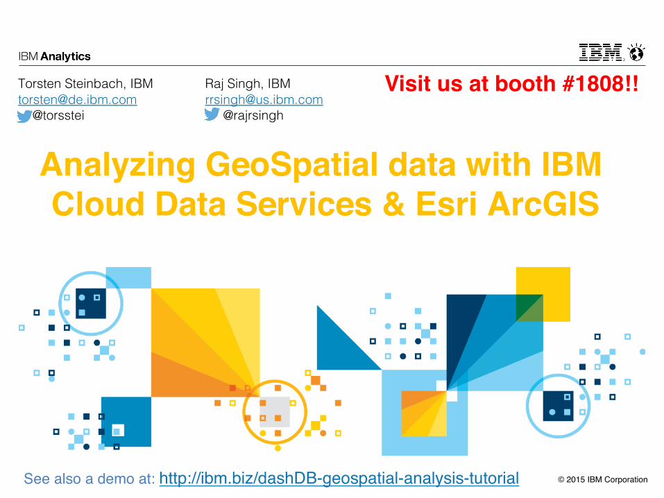
© 2015 IBM Corporation Analyzing GeoSpatial data with IBM Cloud Data Services & Esri ArcGIS Torsten Steinbach, IBM [email protected] @torsstei See also a demo at: http://ibm.biz/dashDB-geospatial-analysis-tutorial Raj Singh, IBM [email protected] @rajrsingh Visit us at booth #1808!!
-
Upload
dashdb -
Category
Technology
-
view
132 -
download
2
Transcript of Analyzing GeoSpatial data with IBM Cloud Data Services & Esri ArcGIS
© 2015 IBM Corporation
Analyzing GeoSpatial data with IBM Cloud Data Services & Esri ArcGIS
Torsten Steinbach, [email protected]! @torsstei!
See also a demo at: http://ibm.biz/dashDB-geospatial-analysis-tutorial
Raj Singh, [email protected]! @rajrsingh!
Visit us at booth #1808!!

© 2015 IBM Corporation2
Notices and Disclaimers
Copyright © 2015 by International Business Machines Corporation (IBM). No part of this document may be reproduced or transmitted in any form without written permission from IBM.
U.S. Government Users Restricted Rights - Use, duplication or disclosure restricted by GSA ADP Schedule Contract with IBM.
Information in these presentations (including information relating to products that have not yet been announced by IBM) has been reviewed for accuracy as of the date of initial publication and could include unintentional technical or typographical errors. IBM shall have no responsibility to update this information. THIS DOCUMENT IS DISTRIBUTED "AS IS" WITHOUT ANY WARRANTY, EITHER EXPRESS OR IMPLIED. IN NO EVENT SHALL IBM BE LIABLE FOR ANY DAMAGE ARISING FROM THE USE OF THIS INFORMATION, INCLUDING BUT NOT LIMITED TO, LOSS OF DATA, BUSINESS INTERRUPTION, LOSS OF PROFIT OR LOSS OF OPPORTUNITY. IBM products and services are warranted according to the terms and conditions of the agreements under which they are provided.
Any statements regarding IBM's future direction, intent or product plans are subject to change or withdrawal without notice.
Performance data contained herein was generally obtained in a controlled, isolated environments. Customer examples are presented as illustrations of how those customers have used IBM products and the results they may have achieved. Actual performance, cost, savings or other results in other operating environments may vary.
References in this document to IBM products, programs, or services does not imply that IBM intends to make such products, programs or services available in all countries in which IBM operates or does business.
Workshops, sessions and associated materials may have been prepared by independent session speakers, and do not necessarily reflect the views of IBM. All materials and discussions are provided for informational purposes only, and are neither intended to, nor shall constitute legal or other guidance or advice to any individual participant or their specific situation.
It is the customer’s responsibility to insure its own compliance with legal requirements and to obtain advice of competent legal counsel as to the identification and interpretation of any relevant laws and regulatory requirements that may affect the customer’s business and any actions the customer may need to take to comply with such laws. IBM does not provide legal advice or represent or warrant that its services or products will ensure that the customer is in compliance with any law.

© 2015 IBM Corporation3
Notices and Disclaimers (con’t)
Information concerning non-IBM products was obtained from the suppliers of those products, their published announcements or other publicly available sources. IBM has not tested those products in connection with this publication and cannot confirm the accuracy of performance, compatibility or any other claims related to non-IBM products. Questions on the capabilities of non-IBM products should be addressed to the suppliers of those products. IBM does not warrant the quality of any third-party products, or the ability of any such third-party products to interoperate with IBM’s products. IBM EXPRESSLY DISCLAIMS ALL WARRANTIES, EXPRESSED OR IMPLIED, INCLUDING BUT NOT LIMITED TO, THE IMPLIED WARRANTIES OF MERCHANTABILITY AND FITNESS FOR A PARTICULAR PURPOSE.
The provision of the information contained herein is not intended to, and does not, grant any right or license under any IBM patents, copyrights, trademarks or other intellectual property right.
§ IBM, the IBM logo, ibm.com, Bluemix, Blueworks Live, CICS, Clearcase, DOORS®, Enterprise Document Management System™, Global Business Services ®, Global Technology Services ®, Information on Demand, ILOG, Maximo®, MQIntegrator®, MQSeries®, Netcool®, OMEGAMON, OpenPower, PureAnalytics™, PureApplication®, pureCluster™, PureCoverage®, PureData®, PureExperience®, PureFlex®, pureQuery®, pureScale®, PureSystems®, QRadar®, Rational®, Rhapsody®, SoDA, SPSS, StoredIQ, Tivoli®, Trusteer®, urban{code}®, Watson, WebSphere®, Worklight®, X-Force® and System z® Z/OS, are trademarks of International Business Machines Corporation, registered in many jurisdictions worldwide. Other product and service names might be trademarks of IBM or other companies. A current list of IBM trademarks is available on the Web at "Copyright and trademark information" at: www.ibm.com/legal/copytrade.shtml.

© 2015 IBM Corporation4
The Structure of Bluemix
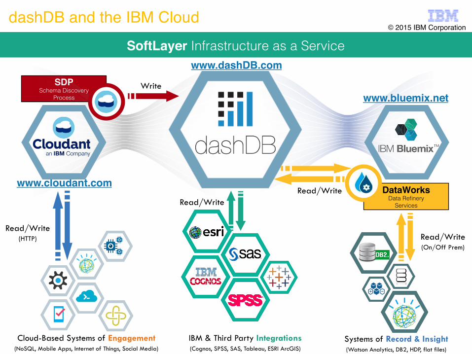
© 2015 IBM Corporation5
www.bluemix.net
www.cloudant.com
SDPSchema Discovery !
Process!
DataWorks Data Refinery!
Services!
Cloud-Based Systems of Engagement (NoSQL, Mobile Apps, Internet of Things, Social Media)
IBM & Third Party Integrations (Cognos, SPSS, SAS, Tableau, ESRI ArcGIS)
Systems of Record & Insight (Watson Analytics, DB2, HDP, flat files)
Read/Write (HTTP)
Write
Read/Write
Read/Write
Read/Write (On/Off Prem)
SoftLayer Infrastructure as a Service!
dashDB and the IBM Cloud© 2015 IBM Corporation
www.dashDB.com

© 2015 IBM Corporation6
There is Valuable and Free Data Online in the Cloud Everywhere

© 2015 IBM Corporation7
Data + Data > 2 x Data
Public Data• Weather!• News!• Stocks!• Social Media!• ...!
Enterprise Data• Orders!• CRM!• Master Data!• Operations!• ...!
Systems of Engagement• IoT!• Mobile Apps!• Cloud Apps!
Correlation of Structured
Data!
Pulling Together Data in a Central Place in the Cloud
Combining various data in a DW can be a fusion reactor for analytics
Benefits• Speed to market• Improved accuracy• Lower cost
© 2015 IBM Corporation8
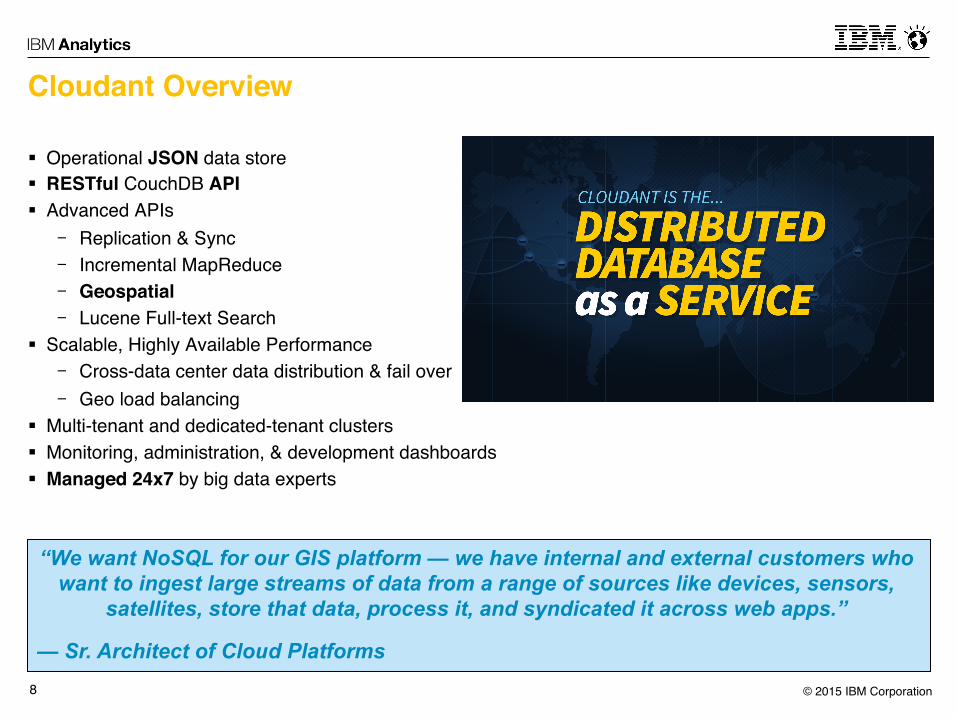
Cloudant Overview
§ Operational JSON data store§ RESTful CouchDB API§ Advanced APIs- Replication & Sync- Incremental MapReduce- Geospatial- Lucene Full-text Search
§ Scalable, Highly Available Performance- Cross-data center data distribution & fail over- Geo load balancing
§ Multi-tenant and dedicated-tenant clusters§ Monitoring, administration, & development dashboards§ Managed 24x7 by big data experts
“We want NoSQL for our GIS platform — we have internal and external customers who want to ingest large streams of data from a range of sources like devices, sensors,
satellites, store that data, process it, and syndicated it across web apps.”
— Sr. Architect of Cloud Platforms

© 2015 IBM Corporation9
Geospatial Edge: Moving data closer to users
Key Challenges§ Reduce time to delivery§ Local, read/write access§ Replication/sync in austere
environments§ Making geodata transparent to the user
Cloudant Benefits§ High Availability and Partition Tolerance§ Offline sync for iOS, Android, and
HTML5§ Sharded – geospatial data can be huge,
must span multiple nodes§ GeoHash (Consistent Hash)§ Spatial search functions§ Configurable index types

© 2015 IBM Corporation10
Cloudant Warehousing
{JSON}
Other data sources

© 2015 IBM Corporation11
Cloudant Warehousing
{JSON}
Schema Discovering Process (SDP)• Targets homogeneous databases
• Discover schema• DashDB tables are created from schema
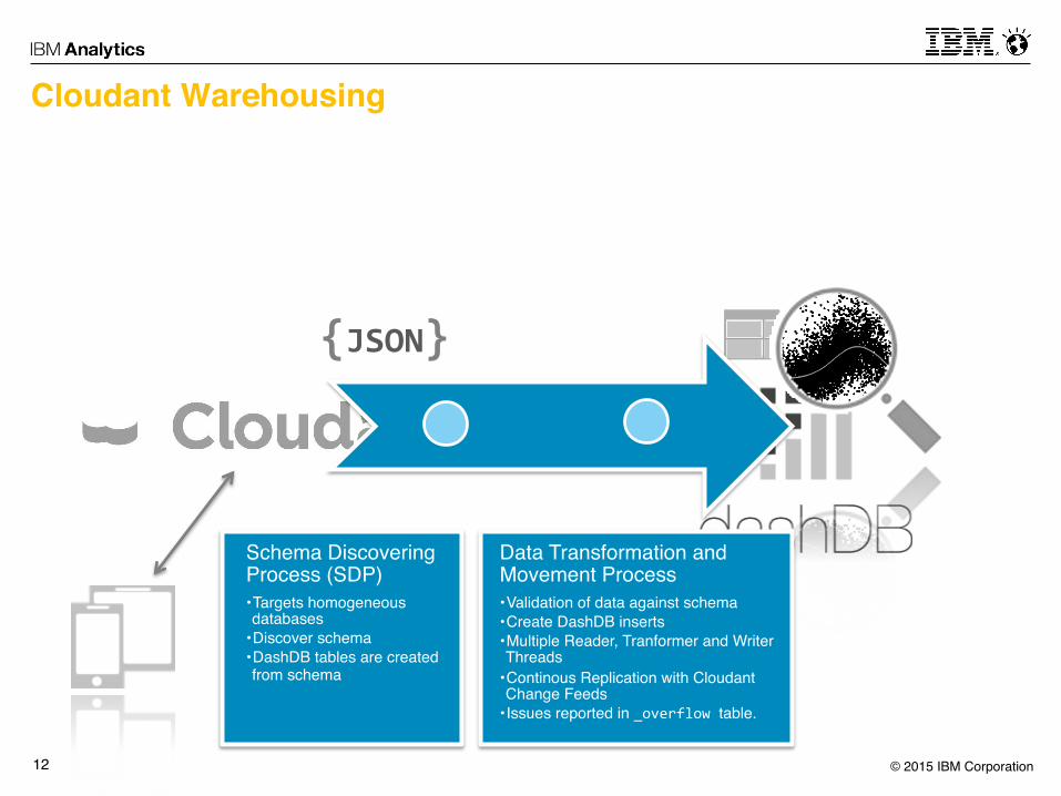
© 2015 IBM Corporation12
Cloudant Warehousing
{JSON}
Schema Discovering Process (SDP)• Targets homogeneous databases
• Discover schema• DashDB tables are created from schema
Data Transformation and Movement Process• Validation of data against schema• Create DashDB inserts• Multiple Reader, Tranformer and Writer Threads
• Continous Replication with Cloudant Change Feeds
• Issues reported in _overflow table.

© 2015 IBM Corporation13
Cloudant Warehousing with GeoJSON
{GeoJSON}
Other data sources

© 2015 IBM Corporation14
{GeoJSON}
GeoJSON data comes in 3 flavours:
{ "type": "LineString", "coordinates": [ [ 2.3200, 48.8657 ], [ 2.2951, 48.8738 ]] }
...as „Simple“ Geometry{ "type": "FeatureCollection", "features": [ { "type": "Feature", "properties": { "name": "Champs Elysées"}, "geometry": { "type": "LineString", "coordinates": [ [ 2.3200, 48.8657 ], [ 2.2951, 48.8738 ]] } }, { "type": "Feature", "properties": { "name" : "Notre-‐Dame"}, "geometry": { "type": "Point", "coordinates": [ 2.3497, 48.8528 ] } } ] }
...as Feature Collection
{ "type": "Feature", "properties": { "name": "Champs Elysées"}, "geometry": { "type": "LineString", "coordinates": [ [ 2.3200, 48.8657 ], [ 2.2951, 48.8738 ]] } }
...as Feature
© 2015 IBM Corporation15
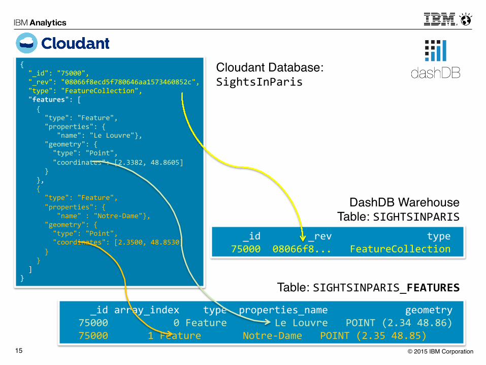
{ "_id": "75000", "_rev": "08066f8ecd5f780646aa1573460852c", "type": "FeatureCollection", "features": [ { "type": "Feature", "properties": { "name": "Le Louvre"}, "geometry": { "type": "Point", "coordinates": [2.3382, 48.8605] } }, { "type": "Feature", "properties": { "name" : "Notre-‐Dame"}, "geometry": { "type": "Point", "coordinates": [2.3500, 48.8530] } } ] }
_id _rev type 75000 08066f8... FeatureCollection
_id array_index type properties_name geometry 75000 0 Feature Le Louvre POINT (2.34 48.86) 75000 1 Feature Notre-‐Dame POINT (2.35 48.85)
Cloudant Database: SightsInParis
DashDB Warehouse Table: SIGHTSINPARIS
Table: SIGHTSINPARIS_FEATURES

© 2015 IBM Corporation16
More to read on https://cloudant.com/blog/warehousing-‐geojson-‐documents

© 2015 IBM Corporation17
GeoSpatial Analytics In dashDB
§ Implements OGC SFS & ISO SQL/MM part 3 standards for spatial!- See http://www.iso.org/iso/catalogue_detail.htm?csnumber=38651!
§ Spatial data type ST_GEOMETRY (hierarchy)!§ Enables spatial operations (e.g. joins) in database through spatial !
operators available as user defined functions!§ Dedicated support in ESRI tools starting V 10.3!§ GeoSpatial Applications Examples!
- Telco Location Data!- Utilities Smart Grid!- GPS Tracking in Transportation!- Insurance Demographics!- Cable Marketing Campaigns!- Retail Store Placement!

© 2015 IBM Corporation18
GeoData & dashDB
{GeoJSON}
WKT((),()) Shapefiles WKB
GML
© 2015 IBM Corporation19
Spatial Functions and Predicates in dashDB
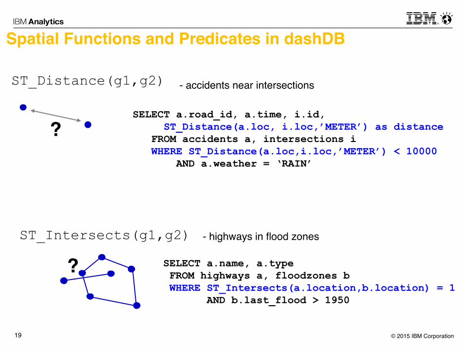
ST_Distance(g1,g2)
?
SELECT a.name, a.type FROM highways a, floodzones b WHERE ST_Intersects(a.location,b.location) = 1 AND b.last_flood > 1950
ST_Intersects(g1,g2)
?
SELECT a.road_id, a.time, i.id, ST_Distance(a.loc, i.loc,’METER’) as distance FROM accidents a, intersections i WHERE ST_Distance(a.loc,i.loc,’METER’) < 10000 AND a.weather = ‘RAIN’
- accidents near intersections
- highways in flood zones

© 2015 IBM Corporation20
And Many More …ST_Area ST_AsBinary ST_AsText ST_Boundary ST_Buffer ST_Centroid ST_Contains ST_ConvexHull ST_CoordDim ST_Crosses ST_Difference ST_Dimension ST_Disjoint ST_Distance ST_Endpoint ST_Envelope ST_Equals ST_ExteriorRing ST_GeomFromWKB ST_GeometryFromText ST_GeometryN
ST_GeometryType ST_InteriorRingN ST_Intersection ST_Intersects ST_IsClosed ST_IsEmpty ST_IsRing ST_IsSimple ST_IsValid ST_Length ST_LineFromText ST_LineFromWKB ST_MLineFromText ST_MLineFromWKB ST_MPointFromText ST_MPointFromWKB ST_MPolyFromText ST_MPolyFromWKB ST_NumGeometries ST_NumInteriorRing ST_NumPoints
ST_OrderingEquals ST_Overlaps ST_Perimeter ST_Point ST_PointFromText ST_PointFromWKB ST_PointN ST_PointOnSurface ST_PolyFromText ST_PolyFromWKB ST_Polygon ST_Relate ST_SRID ST_StartPoint ST_SymmetricDiff ST_Touches ST_Transform ST_Union ST_WKBToSQL ST_WKTToSQL ST_Within ST_X ST_Y
And more…
Simplified Constructors from x,y WKT WKB GML shapeLinear referencingSpatial aggregationST_AsGMLST_AsShape

© 2015 IBM Corporation21
Spatial Constructor Functions
§ ST_Point(x, y, srs_id) – create point at this location
§ ST_Point(‘POINT (-121.5, 37.2)’, 1)
§ ST_Linestring(‘LINESTRING (-121.5 37.2,-121.7 37.1)’,1)
§ ST_Polygon(CAST (? AS CLOB(1M)),1) – For host variable containing well-known text, well-known binary,
or shape representation
© 2015 IBM Corporation22
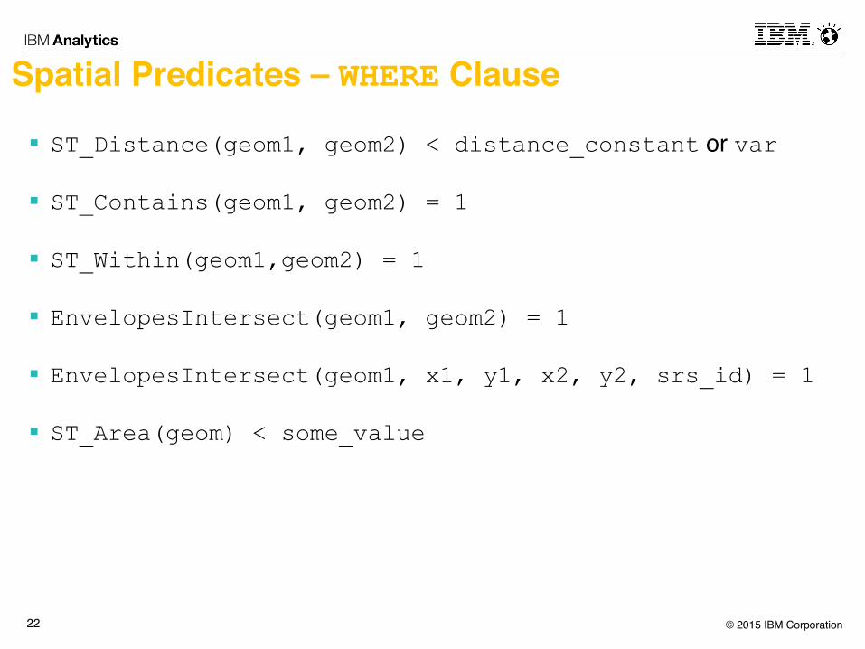
Spatial Predicates – WHERE Clause
§ ST_Distance(geom1, geom2) < distance_constant or var
§ ST_Contains(geom1, geom2) = 1
§ ST_Within(geom1,geom2) = 1
§ EnvelopesIntersect(geom1, geom2) = 1
§ EnvelopesIntersect(geom1, x1, y1, x2, y2, srs_id) = 1
§ ST_Area(geom) < some_value

© 2015 IBM Corporation23
Spatial Functions that Create New Spatial Values
§ ST_Buffer(geom, distance)
§ ST_Centroid(geom)
§ ST_Intersection(geom1, geom2)
§ ST_Union(geom1, geom2)
© 2015 IBM Corporation24
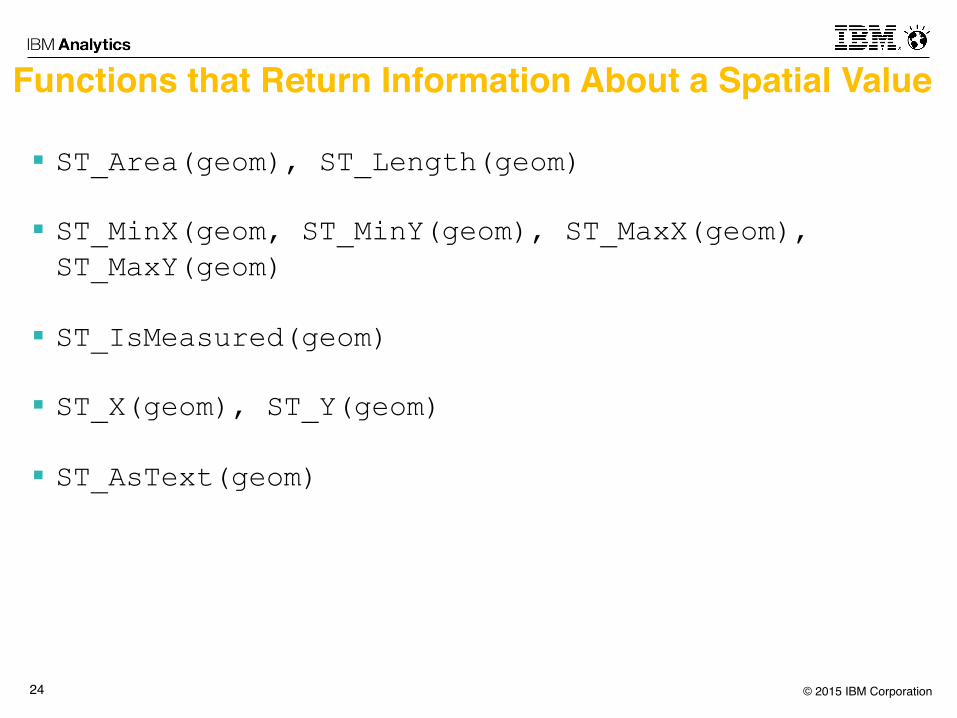
Functions that Return Information About a Spatial Value
§ ST_Area(geom), ST_Length(geom)
§ ST_MinX(geom, ST_MinY(geom), ST_MaxX(geom), ST_MaxY(geom)
§ ST_IsMeasured(geom)
§ ST_X(geom), ST_Y(geom)
§ ST_AsText(geom)
© 2015 IBM Corporation25
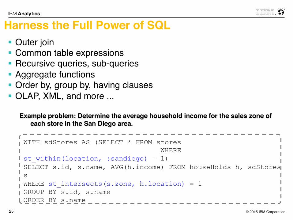
Harness the Full Power of SQL§ Outer join§ Common table expressions§ Recursive queries, sub-queries§ Aggregate functions§ Order by, group by, having clauses§ OLAP, XML, and more ...
WITH sdStores AS (SELECT * FROM stores WHERE st_within(location, :sandiego) = 1) SELECT s.id, s.name, AVG(h.income) FROM houseHolds h, sdStores s WHERE st_intersects(s.zone, h.location) = 1 GROUP BY s.id, s.name ORDER BY s.name
Example problem: Determine the average household income for the sales zone of each store in the San Diego area.

© 2015 IBM Corporation26
dashDB!
Predictive Analytics With R In dashDB§ Built-in R runtime & R Studio!
§ ibmdbR package!- Data frames logically representing data physically residing in dashDB tables
> con <- idaConnect("BLUDB", "", "")
> idaInit(con) > sysusage<-ida.data.frame('DB2INST1.SHOWCASE_SYSUSAGE')
> systems<-ida.data.frame('DB2INST1.SHOWCASE_SYSTEMS') > systypes<-ida.data.frame('DB2INST1.SHOWCASE_SYSTYPES’) !
- Push down of R data preparation to dashDB!> sysusage2 <- sysusage[sysusage$MEMUSED>50000,c("MEMUSED","USERS")] > mergedSys<-idaMerge(systems, systypes, by='TYPEID') > mergedUsage<-idaMerge(sysusage2, mergedSys, by='SID’) !
- Push down of analytic algorithms to in-db execution! > lm1 <- idaLm(MEMUSED~USERS, mergedUsage)
R Studio!Browser!
Any R Runtime! ibmdbR
ibmdbR

© 2015 IBM Corporation27
Demo:
- Cloudant - Bluemix- dashDB- Insurance Show Case
- Spatial analytics with R

© 2015 IBM Corporation28
Insurance Risk Analysis, Fraud Detection, Damage PreventionSee Video at: http://ibm.biz/dashDB-geospatial-analysis-tutorial
Public spatial data sets available online!- Historical tornados from 1950s to today: http://www.spc.noaa.gov/gis/svrgis/!- Current tornado weather warnings: http://www.nws.noaa.gov/regsci/gis/shapefiles/!- US counties: https://www.census.gov/geo/maps-data/data/tiger-line.html!
Mobile application generating!
spatial data for insurance claims for tornado damage!
Cloud warehouse service for analytics and correlation
between customer data and public or third party data!
Visualization and spatial analysis capabilities by Esri ArcGIS
www.bluemix.net!
www.cloudant.com!dashDB!
Cloud service for persistency of !
system of engagement
Insurance Master Data (customers)!

©2015 IBM Corporation
Thank you
u Visit our new web site: https://developer.ibm.com/clouddataservices
u Visit us at booth #1808!!