Analyses of the Second National Communication (SNC ...
36
Analyses of the Second National Communication (SNC) regarding possible effects and impacts on the agricultural sector in Lao PDR (V1.1) National Agriculture and Forestry Research Institute “Improving the Resilience of Agriculture Sector in Lao PDR to Climate Change Impacts” (IRAS) Prepared by: Khamtue Vonglokham Climate Change Scenario Expediter Junior Project Contact : Mr. Khamphone Mounlamai, Project Manager Email Address : [email protected] August 2013
Transcript of Analyses of the Second National Communication (SNC ...

Analyses of the
Second National Communication (SNC)
regarding possible effects and impacts on the agricultural
sector in Lao PDR (V1.1)
National Agriculture and Forestry Research Institute
“Improving the Resilience of Agriculture Sector in Lao PDR to Climate
Change Impacts” (IRAS)
Prepared by: Khamtue Vonglokham
Climate Change Scenario Expediter Junior
Project Contact : Mr. Khamphone Mounlamai, Project Manager
Email Address : [email protected]
August 2013

TOC SNC and Agriculture Page 1
TABLE OF CONTENTS…………………………………………………………………….1
EXECUTIVE SUMMARY………………………………………………………………….2
I. Introduction……………………………………………………………………………………..7
1.1 Geographical and Physical Characteristics of Lao PDR……………………………………7
1.1.1 Geography Characteristics……………………………………………………………...7
1.1.2 Water Resource…………………………………………………………………………9
1.1.3 Land Resource………………………………………………………………………….9
1.1.4 Forestry Resource……………………………………………………………………..10
1.2 Demography………………………………………………………………………………..11
1.3 Socio-Economics and Rural Development………………………………………………...11
1.3.1 Agriculture and Forestry………………………………………………………………11
1.3.2 Water management……………………………………………………………………12
1.3.3 Infrastructure development……………………………………………………………13
1.3.4 Other areas in rural development……………………………………………………...14
II. Vulnerability and Adaptation…………………………………………………………………14
2.1 Introduction……………………………………………………………………………….14
2.2 Vulnerabilities and Adaptation and Climate Change Strategy…………………………..15
2.3 Climate Trends in Lao PDR……………………………………………………………...15
2.3.1 Key vulnerabilities…………………………………………………………………...18
2.4 Climate Change in the Lao PDR…………………………………………………………….21
2.5 Vulnerability and Risk………………………………………………………………….22
2.5.1 Vulnerability……………………………………………………………………….23
2.5.2 Climate Risk……………………………………………………………………….25
III. Potential and consequences for future agriculture development for Lao PDR…………........28
3.1 Agriculture and Forestry…………………………………………………………………28

TOC SNC and Agriculture Page 2
3.2 Water management………………………………………………………………………29
3.3 Infrastructure development………………………………………………………………29
3.4 Other areas in rural development………………………………………………………...30
3.5 Government responses: ……………………………………………………….................30
3.5.1 National Adaptation Program of Action………………………………………......30
3.5.2 NAPAFU project for agriculture sector…………………………………………...31
3.5.3 Manage Climate Risks: The way forward………………………………………...32
IV. Conclusions and Recommendations…………………………………………………………34
V. Reference ………………………………………………………………………………….....35

TOC SNC and Agriculture Page 3
Executive Summary
The likely impacts of climate change have become a major concern globally in recent years,
although perhaps less so in many developing countries, with face a plethora of development
challenges that have been considered to have only limited connections to climate change. This
has begun to change, with many developing countries, such as Lao PDR, becoming more
concerned about the possible impacts of climate change and the need to consider adopting
adaptation and mitigation strategies. In a country such as Lao PDR, with a largely rural
population, substantial reliance on agriculture, and significant forestry resources, the need to
assess the likely impact of climate change on agriculture has been recognized, but so has the
problem of separating these impacts from those driven by other factors, such as population
growth and economic development. This study aims to identify potential change in climate, crop
suitability, and land use that may result from climate change, as well as to identify some of the
current and future impacts
Lao PDR, a landlocked country sharing its border with five other nations, lies in the lower
Mekong basin of the Indochina Peninsula. It stretches 1,700 km from north to south and 100 to
400 km from east to west, for total surface areas of 236,800 km2. The remaining 20 % is low
plain lying along the Mekong River and threatened by annual floods. The altitude range from
104 meters above sea level in Attapue Province to 2,820 metres in Xiengkhuang Province, at
Phoubia Mountain. More than two-thirds of Lao PDR’s people live in the south and central parts
of the country.
The principal waterway, the Mekong, flows 1,898 km from north to south through Lao PDR.
Water form many small Rivers or tributaries represents a vital natural resource for national social
and economic development, particularly for agriculture and hydroelectricity generation.
Lao PDR climate is greatly influenced by tropical typhoons from the southwest and monsoons
from the northeast, resulting in heavy rainfall and high humidity. The September/October, with a
mean annual precipitation of 1,300 mm to 3,000 mm, and the dry season from late October to
April, with average annual precipitation 1,950 mm. the temperature generally ranges from 20 °C
in the north and eastern mountainous regions and on the high plateau to 25-27 °C in the lowland
and in the plains.
Lao PDR is rich with natural resources, with the most important being water, forest and mineral
resources. During the past three decades of social and economic development, utilization of these
resources has resulted in substantial lessening in natural resource stocks. Such development,
combined with urbanization, increasingly threatens environmental quality, especially in the
capital such Vientiane, and other large cities. Pollution from solid waste, and air effluents is on
the rise
Recently, Lao PDR has experienced an accelerating rate of population increase. Between 1995
and 2005, the population grew at an average of 2.1 percent per year, the 2005 census found 5.62

TOC SNC and Agriculture Page 4
million people living in the country. Life expectancy for females stood at 63 years and for male
is was 59 years. If the current population growth rate country a total of 7.3 million people are
expected by 2020. The population density in Vientiane is highest at about 150 persons per km2.
Overall, the population in Lao PDR comprises various ethnic groups, who speak one or more of
numerous dialects and hold a wide variety of beliefs.
As an LDC with relevant adaptive capacities, Lao PDR is highly vulnerable to the impact of
climate change. Moreover without the development of capacity to manage the current risk, the
country will be exposed to event higher climate risks in the future especially impact on
agriculture sector. Assessment related to vulnerabilities and adaptations are thus critical to assist
vulnerable sector to develop strategies to manage such risks.
Information was not provided in the FNC on measures or actions to address climate change
impacts, vulnerability and adaptations, mainly become of a lack of national capacities. During
the last decade, however and understanding of climate change impact and adaptations has been
gradually developed. The National Adaptation Programme of Action (NAPA) process, under the
UNFCCC, has particularly enhanced national capacities on climate vulnerability and extreme
events.
As result of Lao PDR’s geographical location, its climate is dominated by monsoon variability,
with the southeast monsoon particularly contributing to high rainfall and temperatures between
May and September. Regression and analysis show that the annual temperature in the country
has consistently increased over the past 40 years, especially in the south, with a rate of much as
0.05°C per year.
Flooding the most frequent hazard, followed health epidemics (dengue, cholera, diarrhea, avian,
influenza), storms and droughts, Floods occur almost every year; most storm are followed by
severe floods, particularly after monsoon rains accumulate in the upper Mekong Basin. Areas
most at risk are located along the Mekong and its main tributaries. Flash floods in the north and
in southern provinces such as Savannakhet and Khammouan. Between 1995 and 2005, drought
condition were characterized by high temperatures experienced in 1996 and 1998 triggered the
occurrence of drought in specific areas. Both floods and drought have been intensifying in recent
years.
Flood in Lao have caused serious damage in all sectors, with the most severely affected being
agriculture, transportation, communication, housing and utilities. These sectors account for more
than 80 percent of total of flood impact. Assessments indicate that the people of Lao PDR are not
adequately prepared for climate hazards, particularly floods.
Levels of poverty generally increase with vulnerability to climate change and lack of adaptive
capacities. To future identify adaptation potions, vulnerability to climate change and climate
variability can be measured using the three dimensions of level of exposure, level of sensitivity,
and adaptive capacity of a system. Those systems with high level of exposure and sensitivity and

TOC SNC and Agriculture Page 5
low adaptive capacity are considered most vulnerable, while those with low levels of exposure
and sensitivity and high adaptive capacity are considered least vulnerable. Studies of
vulnerability and adaptive capacity undertaken in Lao PDR have concluded that the country is
already highly vulnerable to even the existing impact of climate change, particularly floods and
droughts. Agricultural activities, particularly related to rice production, are the most vulnerable
of all.
Over the past 40 years, the temperature in the Southeast Asia has increased. The regression
analysis shows that the annual mean temperature in the Lao PDR has experienced consistent
increase with a rate up to more than 0.02 °C/year, especially in southern part of the country.
The rainfall patterns as differentiated by the total amount of rainfall during wet and dry seasons
indicate that some part of the country such as Phongsaly, Oudomxay, Bokeo, Xayabury, Vietiane
and Borikhamxay, trend to have relative high ranfalls. In season ate some of part Xayaboury and
Vientiane. In general, it can be said that many part of the country are relatively rich of rainfall
while other are drier. This could happen even the same regions.
Climate change will be impact to physical infrastructure development in Lao PDR by direct and
indirect in recent year such as Ketsana, Nokten and Others typhoon entered the southern part of
Lao PDR causing extensive damage to the peoples. Social and physical infrastructure and other
areas productive capacities.
As mentioned above natural disaster are common in Lao PDR from drought, to river basin
floods, flash floods and storms by rainfall and temperature increased that cause for impact from
climate change in the future for development in Lao PDR. Especially is agriculture sector has
already suffered from climate change. So this study “Analyses of the Second National
Communication in the Light of Agriculture Development” for focus on agriculture development
in Lao PDR impact from climate change and adaptation need in Laos. The objective of this study
was: especially to assess the impact of climate change on development agriculture in the future
of Lao PDR. But impact from climate change not only agriculture sector other sectors are also
impact form climate change such as infrastructure development and rural development.
Government and other agencies should have strategies/measures for dissemination the
knowledge more widely and other specific knowledge gaps to the peoples especially in the rural
areas:
a) There is a lack of detailed geospatial knowledge on soil conditions concerning roadsides
and steep farmlands at a high risk of landslides.
b) There has been a lack of public outreach on the need to protect buildings from tropical
storms and flood damage.(Old-style houses built on stilts were flood-tolerant with
families retreating to sleep above the water line; nowadays, there is a tendency to insert
concrete block walls between the stilts, and serious flood damage can ensue.) There is a
general awareness of the problem, but no action has been taken to educate the public.

TOC SNC and Agriculture Page 6
c) Although there is a policy that people should not build houses close to roads, this is
largely ignored; planning for new roads or road upgrading in rural areas should
incorporate enforcement of this policy and ‘sites and services’ support to help people
comply.
d) More information is required on protective action against all risk types including those
connected with site selection for rural settlements/housing. Currently this is not planned
properly.
e) More information is needed on landslide risks, especially along main roads (for example,
the Vientiane to Luang Prabang highway was closed for three days during the 2011 wet
season due to landslides).
National Adaptation Program of Action: The NAPA identify four critical sectors for adaptation:
Agriculture, forestry, water and health includes strengthening the capacity of national
management committees and further development of early warning systems.
The Lao government in collaboration with UNDP has developed the project proposal called
“Improving the Resilience of the Agriculture Sector in Lao PDR to Climate Change
Impacts.”(IRAS) The 4-year project which started in 2011 to 2014 aims at minimizing food
insecurity resulting from climate change in Lao PDR, and reducing vulnerability of farmers to
extreme flooding and drought. The project which has been implemented by Ministry of
Agriculture and Forestry is designed to produce 4 distinct outcomes – 1) Knowledge
management 2) Capacity building 3) Community-based agricultural adaptation practice and 4)
Adaptation learning.

TOC SNC and Agriculture Page 7
I. Introduction
1.1 Geographical and Physical Characteristics of Lao PDR
The Lao PDR ratified the United Nations Framework Convention on Climate Change in 1995
and ratified the Kyoto Protocol in 2003. As a party to the Convention, the Lao PDR has actively
participated in the Convention process. As a commitment to the Convention, the country has
submitted the national circumstances, inventory and mitigation efforts/measures, and financial
and capacity constraints encountered.
After submitting its Initial National Communication in year 2000, several activities were carried
out such as Enabling Activities II, National Capacity Self-Assessment and National Adaptation
Program of Action (NAPA). The NAPA was approved by the GoL (Government of Lao PDR) in
May 2009. The national adaptation program of action composes of 49 priority schemes covering
four key sectors: agriculture, forestry, water, and health. The NCSA was also endorsed by the
GoL. It contributes to the assessment of the country’s potential for the implementation of the
Kyoto Protocol and to address the synergy issues of biodiversities, climate change, and land
degradation.
1.1.1 Geography Characteristics
The Lao PDR, is a landlocked country stretching 1,700 km from north to south and a range of
100-400 km in width, a surface area of 236,800 km2, lying in the lower Mekong basin of
Indochina Peninsular, and shares its borders with five different countries (Figure 1-1). Largely in
the northeast, 80 percent of the country’s land area is mountainous, the Annamite Mountain
Chain forming most of the eastern border with Vietnam. On the other hand, the south is covered
with green vegetation, a natural shield, providing protection against major storms coming from
the east; the remaining 20 percent, is low plain lying along the Mekong River and threatened by
annual floods. The country’s altitude rises above mean sea level from as low as 104 meters in
Attapeu to as high as 2.820 meters in Phoubia Mountain.
The country’s lowland or plain areas are lying mostly in the central and southern regions along
the country’s principal waterway, Mekong River, flowing 1,898 km from north to south. Water
in many small rivers or tributaries in the country is the vital natural resource for national social
and economic development, especially for agriculture and hydro-electricity generation.
Agriculture is the most important economic sector for the Lao PDR while electricity from hydro-
power is the national strategy to turn the Lao PDR into the “Asian Battery”, a power house for
ASEAN region.

TOC SNC and Agriculture Page 8
Figure 1-1: Lao PDR location

TOC SNC and Agriculture Page 9
1.1.2 Water Resource
The Lao PDR is rich with water resource including the Mekong’s tributaries and other countless
smaller water bodies. These tributaries contribute greatly to the macro economic development of
the country and the livelihood of the local communities. The Mekong’s 12 tributaries in the Lao
PDR supply some 247 billion cubic meters of annual surface runoff, representing some 35
percent of Mekong water flowing into its alluvial basin.
The water demand in the Lao PDR to date is still low in terms of public consumption per capita.
However, development of water resource is in increasing trend particularly in the area of
hydropower development and the irrigation system. The development of water resources is a mix
of opportunities and challenges to the Lao PDR. To ensure the support of progressive economic
development strategy, integrated water resource management framework has an important role to
make the transition of the economy compatible with conservation of the water resources.
1.1.3 Land Resources
Topographically, most land areas of the Lao PDR lie on high plateau and in mountainous
regions. There are basically two main types of land – national protected land and land for public
use. National protected land includes protected and conserved forest and alluvial basin land.
Public use land is divided into agriculture area, production forest, and land for other
development. Nearly three-quarter of the agriculture land use is paddy land. The remaining are
other annual crop, fruit tree and grassland (Figure1-2)
Figure 1-2 Distribution of Land resource by types of use, year 2009
Source: National Land Management Authority
Fruit trees1%
Grassland1%
Production forest4%
other annual crops2%
Tree plantation3%
Other uses7%
Paddy8%
Protected forest53%
Conserved forest19%
Alluvian basin2%

TOC SNC and Agriculture Page 10
Structural change of agricultural land use over the past few years requires special attention,
except for coffee and tea, land uses in all crops are increasing. The most notable one is maize
planted area the increased by nearly triple in just one-half of the decade about 86,000 ha to
212,000 ha in 2010, mostly in the upland of Northern provinces. Expansion of maize planted
areas are either by planting on fallow lands, substituting other crops or encroaching forest areas.
The statistics and evidences in the Northern Lao PDR suggested the maize is grown mostly on
fallow land implicitly reducing the rotation period of upland rice. Moreover, as maize is grown
every year on the same plots, this cultivation on upland would expose the land to degradation
risks and hence sustainable agriculture. This deserves urgent attention at all levels.
1.1.4 Forest Resources
Forest resources one of the most important renewable in the Lao PDR. Ti helps regulating
surface water runoff, hydrological system and watershed protection. Its biodiversity supports
eco-system and protect wildlife. In 2001 log protection contributed 3.32 percent of the GDP
(National Statistics Office, 2004). In teams of energy consumption, wood energy, including
charcoal and fuel wood, is the dominant source of energy for cooking, even in the capital city of
Vientiane. It also provides necessary heating to people living in highland areas during winter.
In 2002, about 41.5 percent of the country’s land area was forest cover, compared to 64 percent
in the 1960 and 70 percent in 1943 (Ministry of Agriculture and Forestry, 2002). In this areas of
forest cover in the country 41.5 percent in 2002, of this 20 percent was under dense dominant
and co-dominant canopy trees. The change of natural forest encompasses the reduction of
quantity, the structural alteration of forest land, the decline and extinction of wildlife and
biodiversity.
During the past decades, shifting cultivation has become a problematic issue and required rapid
responses of the government. In 1990, more than 210,204 rural households were holding onto
their traditional practice of shifting cultivation as their livelihoods, a major cause of the
deforestation of some 245,887 hectares annually. Nonetheless, this persisting problem of
deforestation has been largely resolved through the launch of the Community Forest program
(community-based management) in 1996-2005.
The expansion of the rubber and commercial wood plantation is a sticky issue that needs prompt
solution. Presently, the nation-wide rubber plantation accounts for some 140,550 hectares, and is
estimated to reach some 249,360 hectares by 2010. Recently, the nation’s forest cover is divided
into three separate groups down from five under the previous classification, as promulgated
under the Forestry Act amended in 2007. The three types of forests were the protected forest
(3,510,809 ha), the preserved forest (3,428,736 ha), and production forest (3,319,535 ha).

TOC SNC and Agriculture Page 11
1.2 Demography
The Lao PDR has recently experienced an increasing trend of population. During 1995 and 2005,
population grew at an average of 2.1 percent per year. The 2005 population census revealed that
there was 6.62 million of population in the Lao PDR. Of the total, about one-half was under 20
years old and about 13 percent was elderly of more than 60 years old. Furthermore, according to
the census, the life-expectancy was at 63 for females and 59 for males (Ministry of Planning and
Investment, 2005). Population density was highest in Vientiane capital at about 150 persons per
Km2 (National Statistics Office, 2004), although the population density in most areas of the Lao
PDR remained low. The high population density is usually found in and around the southern
provincial metropolitan areas and in Vientiane Municipality, the national capital, and along the
major communication corridors, e.g. Highway 13 South stretching from Vientiane to Pakse and
Saravan; meanwhile, the high population concentration in the north is found mostly in the
southern portion of Xayaboury and Luangprabang provinces, and in the key provincial districts
and again along the main highway.
The population in Lao PDR is made up of various ethnics groups with a wide variety of dialects
and beliefs. According to some historians and ethnologists, at one time more than 200 ethnic
minority groups were identified speaking more than 170 dialects. However, by the official
classification, only 49 ethnic minorities are recognized. They are grouped by their lifestyles into
four principal linguistics (Lao-Tai group, Mone-Kmou group, Hmong-Eevmien group, and
Chinese-Tibetan).
1.3 Socio-Economics and Rural Development
1.3.1 Agriculture and Forestry
Agriculture is an important sector in Laos, contributing haft of the GDP and providing employ-
ment for 80% of country’s population. In 2005, the agriculture sector grew by 3.5% overall
(CPC, 2006) but in general income generated by the sector gradually decreased in recent year. In
contrast, the percent of the country’s income generated by the industrial and service sector has
increased.
During the Fifth Plan, agriculture production increased substantially, especially crops other than
rice. At the end of the plan, rice production remained the most important crop production and
grew slightly. Rice production reaches 2.65 million tons in 2005, which translates to an average
per capita availability of approximately 457 kilograms. Maize, sesame and mungbean production
tripled those of the year 2000 while peanut and soybean production doubled those of the same
period. As shown in Table 1-1, rice production grew at an average of two percent per year during
2005 and 2010 while maze, cassava and sugar cane, among others, increased substantially.

TOC SNC and Agriculture Page 12
Table 1-1 Selected crop production (tons), 2005 and 2010, Lao PDR
Crop 2005 2010
Average Increase
per year
(%)
Rice 2,650,000 2,900,000 1.9
Maize 403,500 760,000 17.7
Cassava 51,000 161,000 43.1
Sugar cane 218,000 703,000 44.5
Source: Lao PDR, the Fifth, the Sixth National Socio-economic Development Plans
The move to commercial production was growing strongly in the high-potential areas across the
countries. Prominent among these are the emphasis on the cultivation of rubber, cashew nuts,
maize vegetables, fruit trees and sugar cane. Agricultural land use also changed considerably.
Maize planted area grew from 113.8 thousand hectares in 2005 to 151 thousand hectares in 2010.
Forestry sector can be separated into protected, conserved, watershed and production forests. In
2001, forest contributed about 3.2 percent of total GDP and about one-fourth of the total export
income (Lao PDR, 2005). As of 2002, forest with canopy of over 20 percent accounted for 41.5
percent of the country’s total land surface. To reduce shifting cultivation and enhancing income,
during 2001-2005, the GoL allocated over 3.6 million hectares of forest land to 7,125 villages
covering about 420 thousand households. During the same period, afforestation and forest
restoration were implemented in 91 thousand and 418 thousand hectares respectively.
In 2010, there were 13.6 million hectares of forest area. Of this, about one-half was protected
forest, about 27 percent was conserved forest and the remaining was production forest. The GoL
planned to increase forest area to 65 percent of total land by 2015 (Ministry of Planning and
Investment, 2010).
In the Lao PDR, forestry sector also contributes substantially to the livelihood of the rural
households. Collection of non-timber forest products for household consumption and cash
income are common in rural areas of the country. The annual value of NTFP production is as
high as US$ 200 million, most of which is fuel wood and charcoal (Lao PDR, 2005). During the
early period of development, perennial trees were exploited extensively. In 2001, about 300
thousand cubic meters of natural trees were exploited. The amount declined to one-half in 2005.
Logging is currently subject to careful consideration of sustainable forest resources.
1.3.2 Water management
In 1995, the GoL established the Lao National Mekong Committee to coordinate with different
line Agencies to carry out studies, and implement policies, strategic plans and programs of
Mekong development projects included in the Development Plan of the Mekong River
Commission. The Water Resource Coordination Committee and its secretariat office were also
established in 1997. This committee coordinates with line agencies at national level in

TOC SNC and Agriculture Page 13
developing strategies and action plans, programs and regulations necessary for the planning,
management, use and protection of water and water resources. During this period, the Integrated
Water Resource Management (IWRM) approach was adopted. The IWRM has been
mainstreamed into the Mekong sub-regional and national level.
To further strengthen integrated water resource management, over the past two years, the WREA
(now MONRE) developed a National Water Resources Policy, Strategy and Action Plan. The
draft policy aims to promote a comprehensive approach to sustainably manage water resources
through stakeholder participation and assessment of the negative impacts of socioeconomic
development on water resources. The policy is expected to be implemented by various ministries
and sectors, under the coordination of the Lao National Mekong Committee as well as
interagency coordination at the basin level.
1.3.3 Infrastructure development
Lao PDR is one of the poorest countries in the world and according to IPCC findings particularly
vulnerable to the of climate change, poor infrastructure development and according low –levels
of delivery jointly contribute to low adaptation capacity of livelihood systems.
Since the late 1990s the peace of infrastructure of expansion has increased considerably. Road
stretching from the Chinese-Lao border in the north to the Lao-Cambodia border in the south
constructed. The R3 road, also called economic square/rectangular road, which will connect
between Thailand-Laos-China, is schedule completion soon. This road infrastructure will
transform Lao PDR from a land-rock to a regional land-linked country. In addition to roads,
irrigation systems (e.g. reservoir, overloaded weir, and pump station) have been expanded to
supply water to 310,000 ha of cultivated fields during the rainy season and 215,00 ha in the dry
season (Irrigation Department of MAF, 2005).
Road is the pre-dominant mode of transport, serving nearly 90 percent of total domestic
transport, and carries tremendous economic weight in the movement of goods and persons. A
total length of road network in the affected region is 12076 km, 13 % of which, mainly national
road, are paved roads, 37% are gravel roads and 55% are earth roads. The earth roads,
particularly district and rural roads, are not built with engineering standards, and are thus
difficult to access during rainy season.
As previously noted, infrastructure is a significant concern in the context of climate change
adaptation, both because it is essential to ensure that new infrastructure is ‘climate-proof’ – able
to withstand projected climate change impacts such as more-severe floods and droughts – and
because, when infrastructure is poorly built, it can exacerbate vulnerability and the risk of
disasters such as landslides.

TOC SNC and Agriculture Page 14
The Public Works and Transport Institute plans and monitors the environmental and social
development aspects of infrastructural projects and programmes, especially resettlement and
compensation issues. Key priorities are flood and drought impacts, landslide prevention, and
improved wastewater management, especially during floods. The institute also collaborates and
coordinates with the environment/social divisions of other agencies; it participates in the Inter-
Ministerial Climate Change Working Group (further discussed below) and helps disseminate
climate information to the community.
1.3.4 Other areas in rural development
Rural development has long been recognized as the key to eradication of mass poverty and
sustainable improvement of the socio-economic will being of rural people and is one among the
eight national priority development programs of the GOL. Agriculture and forestry is considered
the pivot of rural development, with other concerned sectors to provide the necessary ancillary
support interventions (roads, social services, etc.) so as to ensure the required enabling
environment to foster agricultural and forestry production. However, past development efforts
were not well coordinated and therefore previous interventions in the rural areas did not achieved
the expected results.
Government has further recognized that agricultural and forestry development, within the rural
environment context, demands different policies, strategies and practices for the lowlands and
the uplands. This recognition is reflected in a number of political directives, laws (e.g. land/forest
and water resources laws) and decrees that support an area-based approach to rural development
to fully optimize the exploitation of its natural potentials. It also takes into consideration the
complexities of the physical endowments of the country and local socio-cultural realities, that
aim to ensure that a more balanced development effort is achieved between the urban and the
rural areas.
II. Vulnerability and Adaptation
2.1 Introduction
As a land-locked least developed country, the Lao PDR has the least adaptive capacities to
natural disasters and climate change in the World, and hence highly vulnerable to the impacts of
climate change. Without developing capacity to manage the current risk, with the increasing
climate variability and extreme events, the Lao PDR will be exposed to higher climate risk in the
future.
A Profile of disasters in the Lao PDR shows that five drought events affected more than 4.25
million people. Floods and storms frequently occurred and caused substantial damages to
properties and lives. Epidemics, in contrast, were the biggest killer with more than five hundred
people killed in five events.

TOC SNC and Agriculture Page 15
In the FNC, measures or actions to address climate change impacts, vulnerabilities and
adaptations were not provided. This was due mainly to the lack of national capacities and partly
to the international bias towards inventory and mitigation. Understanding of climate change
impacts and adaptation has been gradually developed during the last decade. The National
Adaptation Program of Action (NAPA) process, under the UNFCCC, has enhanced the national
capacities on climate vulnerability and extreme events.
In this chapter, key vulnerabilities to climate change of the Lao PDR are identified. Development
of vulnerabilities and adaptation to climate change and climate variability and extreme events in
the country is summarized. Constraints and gaps in development in this area are also identified.
2.2 Vulnerabilities and Adaptation and Climate Change Strategy
Realizing the highly vulnerable to climate change of the physical, biological and social economic
development, especially the highly valued water and forest resources and their critical driving
forces of national sustainable development of the country, the climate change strategy of Lao
PDR has given special attention to vulnerability and adaptation to climate change impacts.
Increase of resilience to climate change and its impacts in key sectors is an important goal of the
strategy (WREA, 2010). Among them are:
Mainstream climate change into agricultural sector’s policy, strategies, and action plans
to enhance adaptive capacity of the sector,
Monitoring and improving water resources and water supply system,
Intensify research and development on vulnerability and adaptation in agricultural sector
at all level,
Increase forest cover and strengthen the protection of ecosystem sensitive forest areas,
Enhance biodiversity conservation and appropriate utilization of NTFP,
Intensify research and development on vulnerability and adaptation of water resources to
climate change impacts with appropriate climate scenarios,
Develop early warning system to reduce disaster risks in water resources and public
health,
Mainstream climate change vulnerabilities into infrastructure and transportation
development
2.3 Climate Trends in Lao PDR
Vulnerability to climate change is the degree to which geophysical, biological and soio-
economic systems are susceptible and unable to crop with adverse impacts of climate change
(see Chapter 17, IPCC, 2007b; Fussel and Klien, 2006). Key vulnerability are associated with
many climate sensitive systems, including, for example, food supply, infrastructure, health, water
resources or ecosystems.

TOC SNC and Agriculture Page 16
Over the past 40 years, the temperature in the Southeast Asia has increased. The regression
analysis shows that the annual mean temperature in the Lao PDR has experienced consistent
increase with a rate up to more than 0.02 °C/year, especially in southern part of the country
(Figure 2-1)
Figure 2-1 Temperature trends in selected provinces, 1970-2010, the Lao PDR
The rainfall patterns as differentiated by the total amount of rainfall during wet and dry seasons
indicate that some part of the country such as Phongsaly, Oudomxay, Bokeo, Xayabury, Vietiane
and Borikhamxay, trend to have relative high ranfalls. In season ate some of part Xayaboury and
Vientiane. In general, it can be said that many part of the country are relatively rich of rainfall
while other are drier. This could happen even the same regions (Figure 2-2)
Historical rainfall data indicates the increasing trends of seasonal and annual rainfall in the Lao
PDR at the rates of 2,046 and 2,741 mm/year for seasonal and annual rainfall respectively. The
upward rainfall trends can be associated with an increase in the frequency of extreme events
related to heavy rainfall in the region.

TOC SNC and Agriculture Page 17
Using probability analysis, it is found that there has been an increasing in the frequency of
monthly rainfall with intensity of 600 mm. while those between 300-500 mm.
Figure 2-2 Change in monthly rainfall distribution in the Lao PDR between 1901-1953 and
1954-2006
Monthly Rainfall (mm)
Fre
qu
en
cy
800700600500400300200
40
30
20
10
0
Variable
JJA01-53
JJA54-06
Monthly Rainfall (mm)
Fre
qu
en
cy
800700600500400300200
40
30
20
10
0
Loc Scale N
441.1 51.34 159
470.8 67.26 161
Variable
JJA01-53
JJA54-06
Logistic

TOC SNC and Agriculture Page 18
2.3.1 Key vulnerabilities
The historical trends of rainfalls and temperature over the past four decades indicate the potential
increase in the future. Damages and losses the experienced over the past also suggest the
different magnitudes of the impacts in various sectors and the key vulnerability are identified.
Based on EM-DAT data, the floods caused damages about US$ 50 million per year. Similarly,
damages due to severe drought could also reach up to US$ 20 million (National Disaster
Management Office, 1996). Although number of affected people between hazards events varied
greatly, the trend was increasing (Figure 2-3). On average, floods and storms affected about 200
thousand people and killed about 40 people in the Lao PDR yearly. Large disasters could cause
damages to as high as one or more percentages of the GDP (World Bank and United Nations,
2010). In 2009, the Typhoon Ketsana hit the Lao PDR. The losses reached US$ 57.5 million or
equivalent to about 1.1% of the GDP of the country (GoL PDR, 2009).
Figure 2-3 Number of people being affected by climate hazards (Flood and Drought) in Lao PDR
Source: Analyzed from EM-DAT data
The flood disaster affect almost all sectors. (Table 2-1) provides estimates of damages from
flood that occurred during 2005-2008. It is clear that climate hazards, particularly floods caused
serious impact on the socio-economic condition of the Lao PDR. In productive sectors,
agriculture, especially rice was the main sector affected. Extensive impacts were seen in the
flood event due to Typhoon Ketsana in 2009, damages and repair costs were very high across
sectors (Table 2-2). The most severely affected were agriculture, transportation, communication

TOC SNC and Agriculture Page 19
network, houses and power lines. Damages to these sectors covered more than 80 percent of total
damages. The impacts were much higher. Without housing and electricity is critical for daily life.
No access to outside world means no help would come. Agricultural losses mean no income and
food security.
This assessment indicates that Lao people were not adequately prepared for the disastrous floods.
Effective early warning system has been common among disaster management system. This can
be supported by timely monitoring and prediction of upstream flows from rainfall forecast.
Better weather and hazard forecasting are certainly needed together with capacity development
of Lao people in managing the risks.
Table 2-1 Impact of floods by sectors in 2005-2008
Description 2005 2006 2007 2008
Number of Provinces affected 16 4 4 4
Number of Districts affected 84 20 27 26
Number of Villages affected 2,510 404 614 664
House and people
Number of Houses affected 13,549 25,292
Number of People affected 480,913 89,849 118,074 95,157
Number of People killed 2 3
Agriculture
Flooded rice field (hectares) 87,724
Rice field damaged (hectares) 55,955 6,913 256,778 28,517
Flooded Vegetable field
(hectares)
491
Cattle lost (heads) 14,941 298 343 702
Number of poultry lost 5,912 74,980 995
Number of fishpond and
aquaculture affected 4,289 168 136 44
Fishpond and aquaculture
damaged (hectares) 609 98 1,000,000 356
Infrastructure
Number of school
affected/damaged 102 13 11 63
Number of Health centers
affected 3 2 3
Number of market affected 1 1
Number of bridge damage 2 3
Number of temple affected 2
Number of locations of irrigation
affected 1,421 259 29
Number of locations of irrigation
damaged 117 23 48
Irrigation channel damaged 15,124 8,000

TOC SNC and Agriculture Page 20
(neters)
Drainage system affected
(meters) 53
Number of water wells damage 929
Number of underground water
damage 812
Number of natural spring site
damage 1
Road affected (kms.) 225,726 65
Road damaged (kms) 4 314
Number of boat lost 27
Total Value of damage and lost
($US) 28,565,000 NA NA NA
Source: Ministry of Agriculture and Forestry and National Disaster Management Organization
Table 2-2 Impact of Ketsana strom o sectors and recovery cost required in five southern
provinces (Savannakhet, Salavan, Xekong, Attapeu and Champasack provinces), 2009 (USD)
Descriptions
Number Damages and losses Costs for recovery
Houses (number) 3,178 8,644,353 17,599,647
Hospital and Health
Center (number)
39 1,251,373 1,103,088
School (number) 266 1,049,288 3,831,865
Agriculture (crop
56%, livestock 32%,
others 12%)
17,660,000 15,000,000
Commerce and
Industry
3,773,435 N.A
Tourism 777,941 N.A
Roads (kms.) 1,843 17,470,000 14,180,000
Telecommunication 3.080,000 2,900,000
Power transmission
line
3,230,000 6,900,000
Water supply and
Sanitation
566,000 533,750
Total 54,422,390 62,048,350
Source: GoL PDR (2009)
With limited evident and available information, it suggests that the key vulnerabilities in the Lao
PDR are mainly caused by floods and drought. The damages that are more frequent and severe
are agriculture, houses and road network and public services. The sector that is most vulnerable

TOC SNC and Agriculture Page 21
to climate change in the Lao PDR is agriculture and those who depend on it. Note also that there
are several other sectors that closely linked to agriculture and would contribute to its
vulnerabilities such as water resources, transportation network and public health services.
2.4 Climate Change in the Lao PDR
To analyze climate change impacts, without climate change baseline scenarios and with climate
change future scenarios and their consequences on different sectors are compared and potential
climate change impacts are assessed. To develop future climate scenarios for Lao PDR, global
climate scenarios from General Circulation Models (GCMs) are used. To reduce uncertainties,
scenarios from serveral GCMs are used in the Lao study.
The study on Lao climate scenarios used observed rainfall data from 17 stations and the output
from CGMs 14 models with resolution of 100x100 km (Masutomi et al, 2009). Three scenarios
emission (A1B, A2, B1) used in this analyze ( MONRE, 2012).
Using observed data for 1991-2000 of the Lao PDR, the baseline climate scenario from the
GCMs and scaling factors, calibration and interpolation were made to obtain future baseline
scenarios for the Lao PDR for all GCMs. Monthly rainfalls for two periods were considered –
average monthly for 2021-30 and for 2051-60
Comparing the rainfall scenarios under three emission scenarios and the baseline, following the
eight patterns, the results suggest that there would not be any significant change of rainfall
patterns in Lao PDR in all regions over the next one or two decades (Figure 2-4). However, by
the middle of this century, rainfall patterns could change considerably, particularly in some areas
of the Northern and the central region of the country. Rainfall in the Northern region is likely to
decrease while that of the central region also suggests a similar trend with less magnitude (Figure
2-5).
Analysis of seasonal rainfall changes indicate that future rainfall is expected to change. Projected
rainfalls decrease during transition period and the delays of the monsoon onsets in the southern
part of the country suggest a possible shift in rainy season. This could substantially affect the
traditional agriculture in Lao PDR.

TOC SNC and Agriculture Page 22
Figure 2-4 Regional change of monthly rainfall pattern, 2012 – 2030
Figure 2-5 Regional change of monthly rainfall pattern, 2051 - 2060
To address uncertainties, directions of changing patterns among GCMs are used to test the
confidence of the tendency among them. This study evaluated the direction of rainfall change
(either increasing or decreasing) suggested by the 14 GCMs. The level of confidence to a
particular direction of change is considered to increase if most or all of the models are in
agreement. The analysis was at an early stage and more studies would be done to address the
uncertainties.
2.5 Vulnerability and Risk
To develop additional adaptation measures to climate change require the assessment of
vulnerability of the system. Vulnerability of a system to impact of climate change is measured
using three dimensions, namely level of exposure, level of sensitivity and adaptive capacity of
the system. A system which have high level of exposure and sensitivity with low adaptive
capacity will be considered as the most vulnerable system while the one which low level of
exposure and sentivity with high adaptive capacity will be considered as the least vulnerable.

TOC SNC and Agriculture Page 23
2.5.1 Vulnerability
The study in the Lao PDR developed the aggregate indices for vulnerability and adaptive
capacity called Sensitivity and Exposure index (SEI) and Adaptive Capacity Index (ACI) to
reflect the vulnerability and adaptive capacity levels of the villages in the Lao PDR, the higher
the SEI (ACI), the more vulnerable (adaptive capacity) the village.
The results show that Only Champasak province and Vientiane capital that have small proportion
of villages that having SEI more than 0.5. Other provinces have at one-fourth or more of villages
that are sensitive and exposed to extreme climate. With some exception, the provinces that more
villages with high SEI are those with high poverty level (Table 2-3).
Table 2-3 Category of provinces based on SEI in the Lao PDR
No Category Province Name
1 Provinces with 0 - 25 % of
their total number of villages
have SEI > 0.5
Champasak, Vientiane Capital
2 Provinces with 25 - 50 % of
their total number of villages
have SEI > 0.5
Borikhamxay, Khammuane,
Saravan, Savanakhet,
Vientiane Province
3 Provinces with 50 -75 % of
their total number of villages
have SEI > 0.5
Attaeu, Borkeo, Huaphanh,
Xayabury, Xiengkhuang
4 Provinces with 75 - 100 % of
their total number of villages
have SEI > 0.5
Luangnamtha, Luangprabang,
Oudomxay, Phongsaly,
Sekong
The ACI, on the other hand, shows that most villages and provinces are low adaptive capacity to
climate change. With full ACI equals to one, most villages in the Lao PDR have low capacity to
cope with disasters. Many provinces in the country have more than 75 percent of their villages
with ACI less than 0.25. These include Attapeu, Borkeo, Huaphanh, Luangnamtha,
Luangprabang, Oudomxay, Phongsaly, Sekong, Xiengkhuang. Only Vientiane capital has less
than one-fourth of the villages with ACI less than 0.25 (Table 2-4).
Table 2-4 Category of provinces based on ACI in the Lao PDR
Category Province
Provinces with 0 - 25 % of their total number
of villages have ACI < 0.5
Vientiane Capital
Provinces with 25 - 50 % of their total number
of villages have ACI < 0.5
Khammuane, Vientiane Province
Provinces with 50 -75 % of their total number
of villages have ACI < 0.5
Borikhamxay, Champasak, Saravane,
Savannakhet, Xayabury
TOC SNC and Agriculture Page 24
Provinces with 75 - 100 % of their total
number of villages have ACI < 0.5
Attapeu, Borkeo, Huaphanh, Luangnamtha,
Luangprabang, Oudomxay, Phongsaly,
Sekong, Xiengkhuang
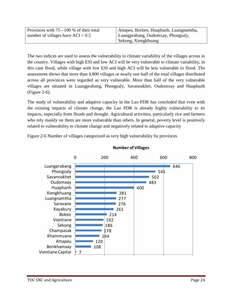
The two indices are used to assess the vulnerability to climate variability of the villages across in
the country. Villages with high ESI and low ACI will be very vulnerable to climate variability, in
this case flood, while village with low ESI and high ACI will be less vulnerable to flood. The
assessment shows that more than 4,800 villages or nearly one-half of the total villages distributed
across all provinces were regarded as very vulnerable. More than half of the very vulnerable
villages are situated in Luangprabang, Phongsaly, Savannakhet, Oudomxay and Huaphanh
(Figure 2-6).
The study of vulnerability and adaptive capacity in the Lao PDR has concluded that even with
the existing impacts of climate change, the Lao PDR is already highly vulnerability to its
impacts, especially from floods and drought. Agricultural activities, particularly rice and farmers
who rely mainly on them are more vulnerable than others. In general, poverty level is positively
related to vulnerability to climate change and negatively related to adaptive capacity
Figure 2-6 Number of villages categorized as very high vulnerability by provinces
7108120
164178186192
214261
276277281
400483
502545
646
0 200 400 600 800
Vientiane CapitalBorikhamxay
AttapeuKhammuane
ChampasakSekong
VientianeBokeo
XayaburySaravane
LuangnamthaXiengkhuang
HuaphanhOudomxay
SavannakhetPhongsaly
Luangprabang
Number of Villages

TOC SNC and Agriculture Page 25
2.5.2 Climate Risk
Climate risks depend on the probability of climate hazards and vulnerability. For the case of the
Lao PDR, villages with high vulnerability would be at high risks if climate hazards occur and
vice versa. A Matrix of risk as a function of probability of unexpected event to occur and the
consequences if the unexpected events occur can be formulated (Beer and Ziolkowski, 1995).
The approach is used to assess different levels of current and future climate risks of the villages
in the Lao PDR.
Current Climate Risks All provinces in the Lao PDR have experienced floods and droughts to
different extents. The assessment also indicates that most of them are of high risks to floods and
droughts (Figure 2-7). The provinces that have the large proportions of villages of high risks to
flooding are Xiengkhuang, Sekong and Attapeu. On the other hand, the provinces with larger
proportions of villages of high risks to drought are Savannakhet and Huaphanh (Figure 2-8).
Figure 2-7 Distribution of villages according to their climate risk (function of flood and drought)

TOC SNC and Agriculture Page 26
Figure 2-8 The provinces in Lao with villages that have high risk of i) flood and ii) drought
The results are consistent with study on vulnerability and risk due to drought which suggests
that a large proportion of households were at risks from drought, especially provinces in the
Central and Southern regions, such as Xayabury, Vientiane, Savanakhet, Khammoune and
Champasak (WREA, 2009)(Figure 2-9).
Thus, assessment of vulnerability and risks of villages in the Lao PDR indicates that households
in most part of the country have already been highly vulnerable to climate variability. The
situation is likely to be increasingly severe in the future. There are three provinces that have high
risk to floods while other six provinces having high risk to drought. The risks tend to expand
from the North to the South as time passes.

TOC SNC and Agriculture Page 27
Figure 2.9 Households in Lao PDR at risk of becoming food insecure due to drought (excluding
chronically food insecure)
Source: WREA (2009)

TOC SNC and Agriculture Page 28
III. Potential and consequences on future agriculture development for Lao PDR
3.1 Agriculture and Forestry
Several additional measures involving agriculture and forestry could help improve climate
resilience across Lao PDR:
Reforestation/forest conservation of all land with incline greater than 45%
Conservation of biodiversity on at least 10% of all forested and in each village territory,
plus critical habitats on lower slopes;
Piloting of Nucleus Estates and Smallholders frameworks for expansion of fast-growing
plantation forestry concessions in shifting cultivation communities;
Contouring / terracing of all cropland with slope of 5% to 25%for soil conservation and
water harvesting ;
Confinement of livestock to fenced grazing and cut-and-carry land and;
Improvement of irrigation systems to facilitate dry-season cropping and prevent
salinization.
Climate change affects agriculture and food production directly thorough change in agro-
ecological condition and indirectly by affecting growth and distribution of income, and thus
demand of agriculture produce. In Lao PDR crop production is the major contributor to the
agriculture sector, followed by fisheries, livestock and forestry. All the sub-sectors are
influenced by climate variations, climate change and hydro-meteorological hazards. Water
shortages during key stages of paddy can critically effect growth and yield. The most sensitive
periods to water deficit ate following and the second haft if the vegetative period. Climate
change will also influence per-and post-harvest losses of agriculture crops with impact on crop
production. Early-season drought is a problem when there is not enough standing water for
transplanting, Late-season drought affect province such as Vientiane and Savannakhet.
Approximately 100,000 ha of rainfed area ate affected by drought. Average yield are
approximately 1t/ha, ranging from 0t to 2t/ha. Therefore, drought can reduce yield by more than
1t/ha. Direct seeding is important as an alternate option requiring less labour.
The forestry sector will be also influenced by climate change, and rural communities in Lao
PDR, as in many other countries in Asia, depend on forest resources to substantiate their
requirements of food and livelihoods. Changes in soil water availability caused by the combined
effects of changes in temperature and rainfall have significant impact on biomass production and
the forest composition including reduced natural forest regeneration.
Consequences of the declining number of fallow years maintained in the shifting agriculture
systems being experienced from land pressure is a degradation of soil quality and moisture
retention which forests the growth of weed infestation. This, and the increase of pest infestation
in the monoculture cropping patterns associated with shifting cultivation further reduces the
expected yields of reduced fallow lands.

TOC SNC and Agriculture Page 29
3.2 Water management
Knowledge of climate change impacts and adaptation in the water resources sector is strong
within IWMI and the MRC, but is still quite limited in the national-level institutions, the DWR
and the LNMC. A key knowledge gap is that although there have been theoretical training
courses, they have not been followed up with practical applications, particularly with regard to
water resource management methodology
Water harvesting structures and irrigation schemes must also be upgraded and expanded. Many
existing irrigation systems are inefficient; therefore, there is a need to refine the basin-wide
irrigation systems database to incorporate information not only on location but also on type of
diversion works, type of distribution and drainage systems, water availability, service area and
user population.
There is a need for research into the potential and sustainability of using groundwater as a
resource. A more detailed analysis and research into historical data and records is also required,
along with an assessment of the potential cumulative impacts of individual interventions, e.g.
dam construction and stream diversions. More research should also be conducted on wetlands
biodiversity, transboundary issues, and agricultural planning for ‘wet’ (early onset) years versus
‘dry’ (late onset) years.
Finally, as in other sectors, there is a need to gather information on adaptation and coping
strategies toward climate variability from local communities, and to further evaluate potential
adaptation measures.
3.3 Infrastructure development
Climate change will be impact to physical infrastructure development in Lao PDR by direct and
indirect in recent year such as Ketsana, Nokten, and others typhoon entered the southern part the
Lao PDR causing extensive damage to people’s propriety, social and physical infrastructure and
other area’s productive capacity. Form climate change impact we should disseminate the
knowledge more widely. Other specific knowledge gaps include:
There is a lack of detailed geospatial knowledge on soil conditions concerning roadsides
and steep farmlands at a high risk of landslides.
There has been a lack of public outreach on the need to protect buildings from tropical
storms and flood damage.(Old-style houses built on stilts were flood-tolerant with
families retreating to sleep above the water line; nowadays, there is a tendency to insert
concrete block walls between the stilts, and serious flood damage can ensue.) There is a
general awareness of the problem, but no action has been taken to educate the public.
Although there is a policy that people should not build houses close to roads, this is
largely ignored; planning for new roads or road upgrading in rural areas should
incorporate enforcement of this policy and ‘sites and services’ support to help people
comply.

TOC SNC and Agriculture Page 30
More information is required on protective action against all risk types including those
connected with site selection for rural settlements/housing. Currently this is not planned
properly.
More information is needed on landslide risks, especially along main roads (for example,
the Vientiane to Luang Prabang highway was closed for three days during the 2011 wet
season due to landslides).
3.4 Other areas in rural development
The Lao PDR is a small, landlocked nation at the Mekong region about 80% of the surface area
is mountainous and originally thickly forested, with a few plains and plateaus. The Mekong
River forms the country’s western boundary with Burma and a large part of the western border
with Thailand. Lao PDR has a tropical climate with two distinct seasons: a dry season from mid-
October to mid-April, and a rainy season, dominated by the southwest monsoon, with high
rainfall, high humidity and high temperatures between mid-April and mid-October.
As mentioned above natural disasters are common in Laos – from droughts, to river basin floods,
flash floods and storms. From 1970 to 2010, 33 natural hazard events were logged, mostly floods
and droughts; they affected almost 9 million people and caused economic damages of over
US$400 million. Some areas are particularly exposed: Phongsali, Houaphan, and Louang
Namtha are considered ‘hotspots’ for multiple hazards, including floods, droughts, landslides,
and sea-level rise (The World Bank, 2011, p.7). There are also several man-made threats,
including floods from the uncoordinated operation of reservoirs, unexploded ordnance (land
mines), deforestation, soil erosion, and a lack of access to potable water (CIA, 2012).
Other areas rural development in Lao PDR vulnerability form climate change impact such in the
recent year Lao PDR has experienced from Ketsana, Nokten Typhoon and others Typhoon make
damaged in Lao PDR.
3.5 Government responses
3.5.1 National Adaptation Program of Action
The NAPA identify four critical sectors for adaptation: Agriculture, forestry, water and health,
includes strengthening the capacity of national disaster management committees and further
development of early warning systems. Across all four sectors, a total of 45 number of activity
were identified, of which 12 were 1st order and 33 2
nd order priority activities/project
respectively.
Agriculture: 1) Strengthen the capacity of the National Disaster Management Committees; 2)
Promote secondary profession in order to improve the livelihood of farmers affected by natural
disasters induced by climate change.

TOC SNC and Agriculture Page 31
Forestry: 1) Continue the slash and burn eradication programme and permanent job creation
program; 2) Strengthen capacity of village forestry volunteers in forest planting, caring and
management techniques as well as the use of village forests.
Water: 1) Awareness raising on water and water resource management; 2) Mapping of flood‐prone areas; 3) Establish an early warning system for flood‐prone areas, and improve and expand
meteorology and hydrology networks and weather monitoring systems; 4) Strengthen
institutional and human resource capacities related to water and water resource management; 5)
Survey underground water sources in drought prone areas; 6) Study, design and build multi‐use
reservoirs in drought prone areas.
Public Health: 1) Improve systems for the sustainable use of drinking water and sanitation with
community participation in flood and drought prone areas; 2) Improve knowledge and skills of
engineers who design and build water and sanitation systems.
3.5.2 NAPAFU project for agriculture sector
Learning by doing, the Lao government in collaboration with UNDP has developed the project
proposal called “Improving the Resilience of the Agriculture Sector in Lao PDR to Climate
Change Impacts.” The 4-year project which started in 2011 to 2014 aims at minimizing food
insecurity resulting from climate change in Lao PDR, and reducing vulnerability of farmers to
extreme flooding and drought. The project which has been implemented by Ministry of
Agriculture and Forestry is designed to produce 4 distinct outcomes – 1) Knowledge
management 2) Capacity building 3) Community-based agricultural adaptation practice and 4)
Adaptation learning.
Changing Climate Project. The project aims at addressing the vulnerable livelihoods of the rural
communities due to climate variability, particularly in the South of Laos. Increasing intensive but
irregular rainfall patterns in the recent years have caused regular floods, storms, flash floods and
draughts. Each of these climate threats has different impacts on infrastructures and ecosystems.
Amongst the most severe impacts are the regular destruction of rural roads and small-scale
irrigation schemes through flash-floods and water scarcity for household and agricultural
consumption as a consequence of droughts. The project objective is to improve local
administrative systems affecting the provision and maintenance of small scale rural infrastructure
(including water and disaster preparedness) through participatory decision making that reflects
the genuine needs of communities and natural systems vulnerable to climate risk. Three
outcomes are expected from the project:
Outcome 1: Incentives provided for local administrative institutions to integrate
climate risks into participatory planning and financing of small scale rural water
infrastructure provision.

TOC SNC and Agriculture Page 32
Outcome 2: Small scale rural infrastructure protected and diversified against
climate change induced risks (droughts, floods, erosion and landslides) in 12
districts of Sekong and Saravane provinces
Outcome 3: Natural assets (such as wetlands, forests and other ecosystems in sub-
catchments) over at least 60,000 ha are managed to ensure maintenance of critical
ecosystem services, especially water provisioning, flood control and protection
under increasing climate change induced stresses, in Sekong and Saravane
provinces of Sourthern Laos.
At sub-regional level, the Climate Change Adaptation Initiative Program under the Mekong
River Commission has implemented the local demonstration activities in the Southern Laos.
3.5.3 Manage Climate Risks: The way forward
From the sections above, it is clear that the Lao PDR is very vulnerable to impacts of climate
change. Without improving current capacity to manage climate risk, the increasing variability of
climate will expose Lao people to more serious impacts. Several general descriptions of
adaptation approaches e.g. diversifying crop portfolios and farming lands in different agro-
ecological zones etc. have been suggested through various means. In practice, adaptation at
community level usually involves informal mechanisms, village-based networks, or extended
family networks. Such mechanisms can respond to limited shocks, but not those covariate or
spatially extensive shocks. At state level, better access to greater resources is expected and many
measures are normally supported by the central government (IRI & ADPC, 2005).
State supported precautionary programs to manage climate risks should produce benefits at the
household and community levels, including reduced vulnerability to climate variability and
enhanced sustainable consumption pattern, in addition to reduction of transitory poverty.
Therefore, well-designed climate risk management programs should (IRI & ADPC, 2005):
respond to demands of communities and agencies
strengthen existing community and household precautionary strategies
be sustainable with respect to fiscal resources and institutional structures
integrate a range of information and resources, such as climate and price information,
agricultural production inputs, and credit
communicate probabilities involving a diverse set of outcomes
promote timely ‘no-regrets’ interventions that avoid expensive or irreversible
decisions
integrate decisions across local, regional and national levels.
Given the existing climate threat and the risks of the climate hazards the Lao PDR is
encountering, it is highly urgent to the country to prepare for the potential impacts. Below are,
among others, some key components that should be emphasized.

TOC SNC and Agriculture Page 33
Existing support mechanism The NAPA has contributed to the adaptation in the Lao PDR to
limited extent. The activities implemented so far have been small compared to the priority needs
identified. It is hopeful that the LCD fund of the UNFCCC would be the key financial
mechanism for the adaptation needs of the Lao PDR. Intensification of financial and technical
support from the UNFCCC is highly important and urgently needed to strengthen the adaptation
measures of the country.
Research and development the technical capacity of the related personnel must be developed and
sustained. At present, the technical analysis of vulnerability and adaptation is heavily relied on
international experts. Development and maintenance of technical capacity of national and experts
is at its early stage. More supports to strengthen coordination network among researchers within
the country and among those in the region need to be provided.
Policy mainstreaming the GoL has already integrated the climate change strategy into sectoral
and national development policy and planning. Effective mainstreaming is even more important
to the process. As pointed out in a study, despite the fact that the change in bioclimatic suitability
for the predicted 2050 was positive to some crops and negative to others, the influence of climate
change on land use,
However, was likely to be insignificant compared to other social or economic drivers
(Lefroy R. and others, 2010). How to increase the perception of long-term issues and take them
into account of the short and medium term activities is the key.
Adaptation measures adaptation programmes with strong local ownership are needed. This
includes the use of participatory inducement, public relation at all stages of adaptation, ranging
from planning to execution and evaluation. Approaches to strengthen local capacities to address
climate change and mechanisms to sustain the process are needed.
Climate-resilience cum poverty-eradication A holistic approach and workable programs should
be developed to simultaneously reduce poverty and enhance climate resilience to the rural
communities. This win-win or no-regret policy options must be practical and appropriate for the
local conditions.
Regional cooperation the tropical countries in the ASEAN and Mekong regions have many
similar social and economic structures. Technological transfers and knowledge exchange are
more practical and applicable to countries in the same region than from other regions. It is also
more cost-effective. Regional cooperation need to be strengthened.

TOC SNC and Agriculture Page 34
IV. Conclusions and Recommendations
Most government staff, particularly new recruits, require capacity building in the
preparation and budgeting of project proposals, as well as in converting strategies into
viable action plans. Capacity building programmes that create a better understanding of
climate change and the funding opportunities it presents are required. Key target
audiences include district-level agriculture and forestry extension personnel; NAFRI
project staff who do not possess specific climate change knowledge; new recruits and
technicians at key ministries; and the staff of the Department of Energy, for whom
climate change is a new concept.
Particularly in the rural areas, public/community awareness on climate change and
adaptation can be raised via use of mass media, particularly community radio, as most
people take portable radios to the fields whilst planting, weeding and harvesting their
crops. Better use could also be made of existing community radio stations and those
broadcasting in ethnic minority languages.
Capacity-building on climate change and adaptation is already occurring across Lao
PDR, but there is a need for significantly more capacity. Across all sectors, our analysis
suggests that the priorities for capacity building in climate change and adaptation within
Lao PDR should be:
The capacity to compile and analyse the most relevant data;
The ability to access and choose the appropriate information;
Improved technical expertise in the hydrology, agriculture, forestry and vocational
education sectors(for example, modelling, geospatial awareness and skills,
management information systems, monitoring and evaluation, reporting, action
planning and budgeting);
Modelling the impacts of climate change on biodiversity, agriculture and water
resources; and
Metadata compilation.

TOC SNC and Agriculture Page 35
V. References
DNDMCC, 2013, Second National Communication (SNC)
FOA, 2011, Managing Climate Change Risks for Food Security in Lao PDR
A report prepared by the Government of the Lao PDR, 2009, The Ketsana Typhoon in
the Lao PDR
AKP, 2012, Scoping Assessment of Climate Change Adaptation Priorities in the Lao
PDR
FAO, 16 An area-based livelihood-systems approach to rural development in the Lao
PDR