An update on Schneider Electric's Geospatial Intelligence - ArcFM Solution · An update on...
35
An update on Schneider Electric's Geospatial Intelligence - ArcFM Solution • Andy Schlegel • International Strategic Account Manager
Transcript of An update on Schneider Electric's Geospatial Intelligence - ArcFM Solution · An update on...
An update on Schneider
Electric's Geospatial
Intelligence - ArcFM Solution
• Andy Schlegel
• International Strategic Account Manager

Who is Schneider Electric?
The ArcFM Solution
Product Highlights Responder Designer/OHDA ArcFM Fiber Manager/ Wavepoint Orbit
Future Vision
Agenda

History
1946 1980s 2000s 2010s
1980: Started in the
AM/FM Industry
1946: Miner & Miner Founded as a Professional Consulting Engineering Firm
1987: Partnered with Esri in research and development for utility specific GIS Applications
2006: Telvent acquires 100% interest
2011: Schneider Electric purchases Telvent
100 customers 400 customers 620 customers

A global company
$31 billion sales in 2012
41% of sales in new economies
140,000+ people in 100+
countries
with a strong US presence
+18,000 US employees
40 US manufacturing facilities
committed to innovation
4-5% of sales devoted to R&D Residential 9%
Infrastructure 25%
Industrial & machines 22%
Data Centers 15%
Non-residential buildings 29%
Delivering Solutions for End Users
Some of the world class brands that we have built or acquired in our 175 year history
Who are we?

Esri Partnership
• Business partner since 1987
• Platinum Partner (Highest Level)
• Strong, unique relationship on all fronts
• Executive Management
• R&D
• Product Management
• Sales
• Delivery
• Support
• Over 1 million users
• Global market leader in GIS
• R&D cooperation is a key factor to our roadmaps
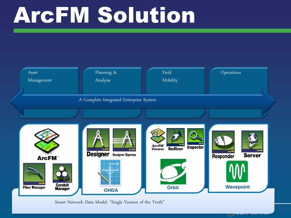
ArcFM Solution
Asset Management
Field Mobility
Planning & Analysis
Operations
Smart Network Data Model: “Single Version of the Truth”
Orbit Wavepoint OHDA
A Complete Integrated Enterprise System
Responder
• Outage Management
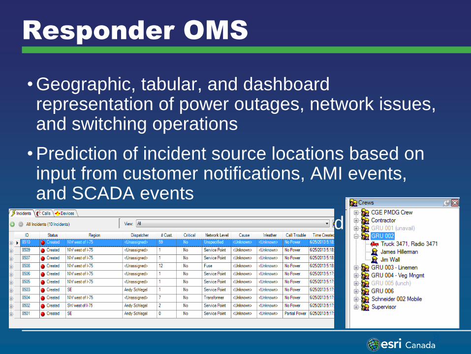
Responder OMS
• Geographic, tabular, and dashboard representation of power outages, network issues, and switching operations
• Prediction of incident source locations based on input from customer notifications, AMI events, and SCADA events
• Crew management for unplanned and planned network modifications
8

Responder OMS Benefits
• Increased revenue and reduced costs
• Rapid and reliable determination of power outage/issue location
• Identification of system reliability improvement opportunities
• Successful integration with enterprise and operational systems
• Simplified generation of outage reports
• Improved customer, regulatory and media relations
• Decreased average duration of outages
• Reduction in customer calls
• Near real-time, proactive status updates
• Optimized Crew Management
• Decreased truck roles
• Efficient truck routing
• Nested outage identification
• Mobile application in the field
9

OHDA
• Overhead Design Analysis
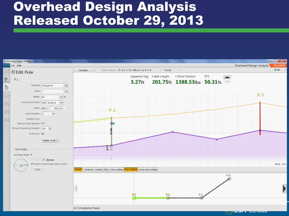
Overhead Design Analysis
Released October 29, 2013

OHDA Tools
• Sag and Tension
• Clearance Analysis
• Pole Structural Analysis
• Anchor and Guying Analysis
• 3-D rendering
• Vertically aware
• Import design contents
• Comprehensive Reporting
• Plan and profile


Wavepoint
• Web based Fiber Manger viewer
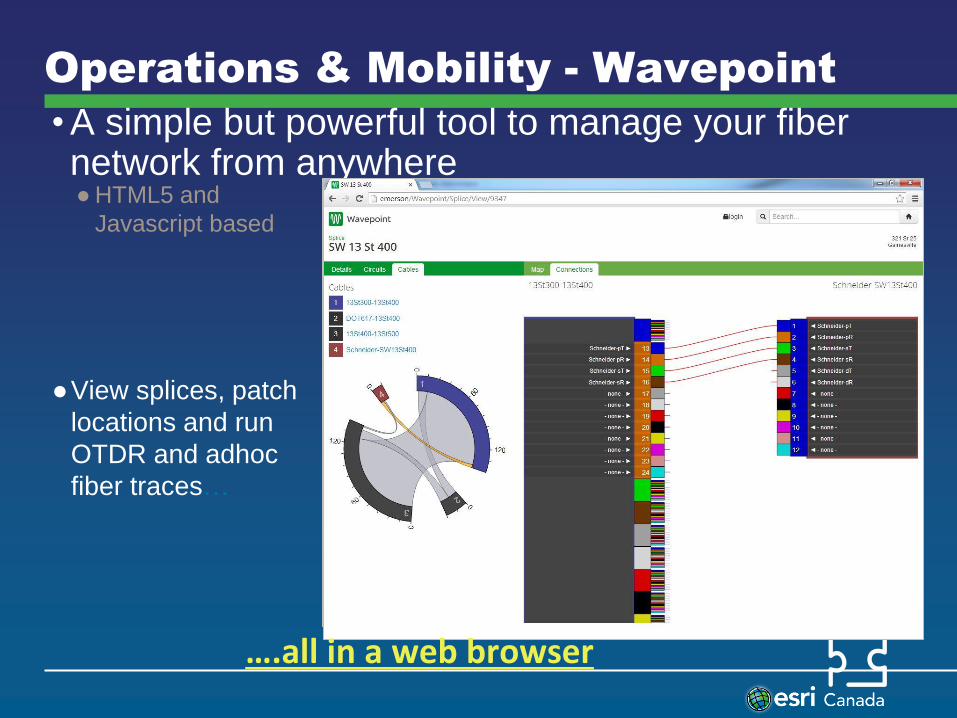
Operations & Mobility - Wavepoint
• A simple but powerful tool to manage your fiber network from anywhere
● HTML5 and
Javascript based
●View splices, patch
locations and run
OTDR and adhoc
fiber traces…
….all in a web browser
Orbit: Getting Field Work Done
• An all new, very different approach to an everyday problem
Orbit – An Introduction
What is Orbit?
Our next generation mobile platform for utilities and telecommunications providers who need gather critical information about their infrastructure.
What it Does:
Orbit allows field crews to know where to go, what to do, and what information to gather. The results of their work is reported back in real time, so that coordinators can have better information about what’s happening out there.
Video: http://www.youtube.com/watch?v=11dRmKp-rzc
How We are Different
With Orbit, We Believe:
• Gathering information in the field should be easy.
• That location is important
• That work comes from a variety of places in your organization
And how we do it is unique - we:
• Allow you to add new work types very quickly, without custom code.
• Allow crews to use a variety of devices, even their own personal devices (BYOD)
• Minimize your infrastructure concerns
• Align with your security standards.
OUR STRATEGY
Why use the cloud?
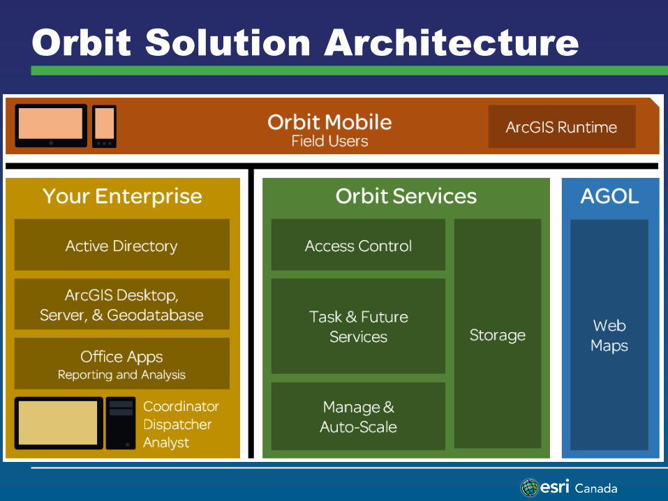
Orbit Solution Architecture

Cloud-based Services
Infrastructure, Platform and
Software
IaaS Infrastructure as a Service
PaaS Platform as a Service
SaaS Software as a Service
Solutions:
• Focused Workflows
• Continual Improvement
• Ease of Deployment
• Scalability
Building Blocks:
• Security
• Virtualization
• Database
• Operating Systems
Hardware:
• Network
• Servers
• Compute
• Drive Storage Time to Solution

Cloud-based Services
Infrastructure, Platform and
Software
IaaS Infrastructure
as a Service
PaaS Platform as a
Service
SaaS Software as a
Service Our Focus
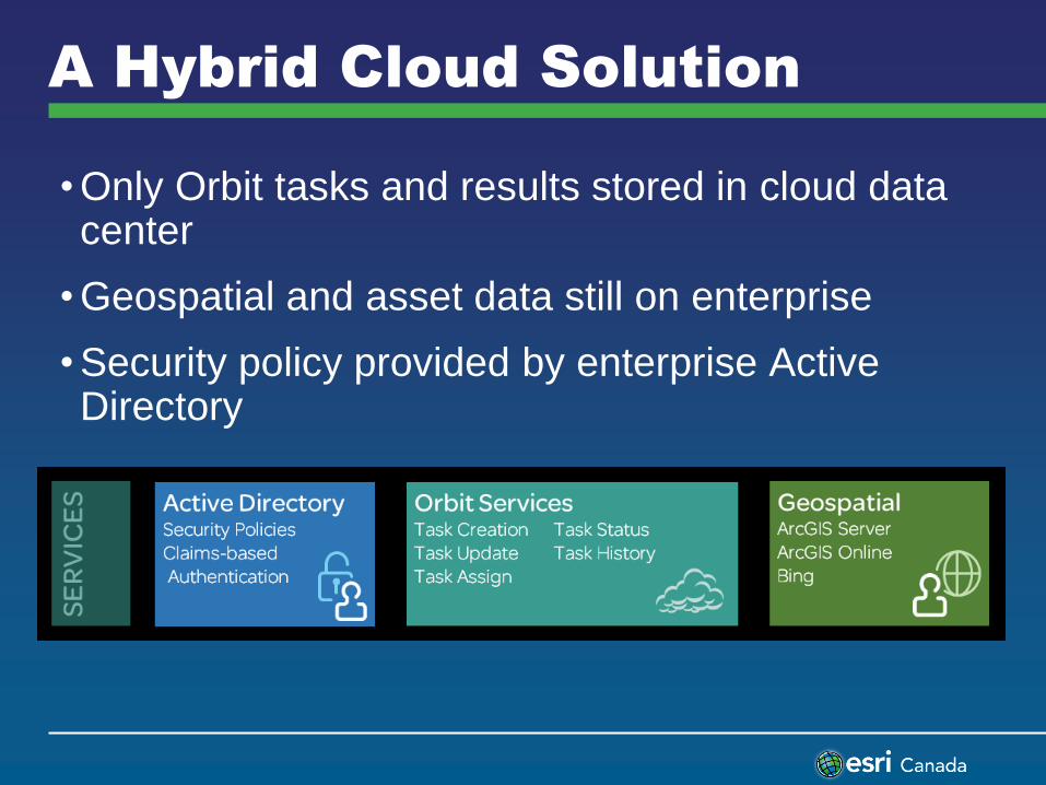
A Hybrid Cloud Solution
• Only Orbit tasks and results stored in cloud data center
• Geospatial and asset data still on enterprise
• Security policy provided by enterprise Active Directory
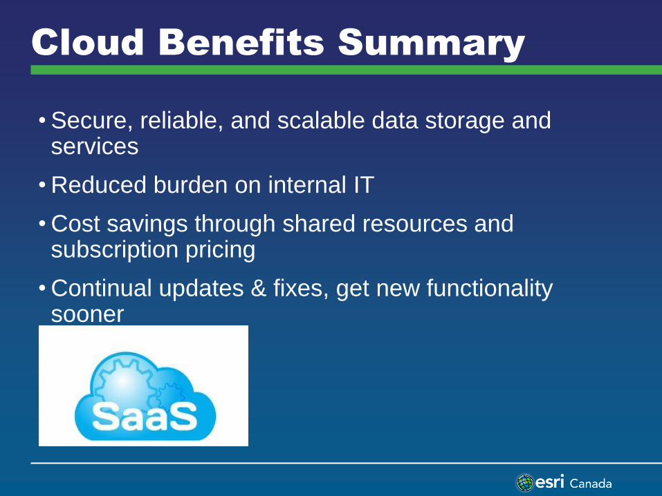
Cloud Benefits Summary
• Secure, reliable, and scalable data storage and services
• Reduced burden on internal IT
• Cost savings through shared resources and subscription pricing
• Continual updates & fixes, get new functionality sooner
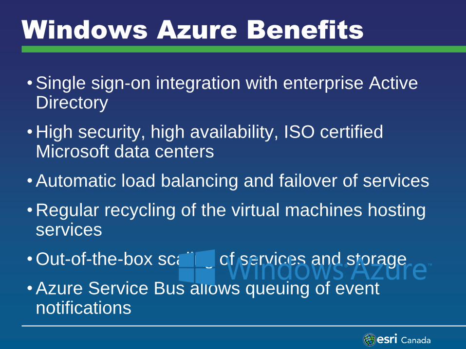
Windows Azure Benefits
• Single sign-on integration with enterprise Active Directory
• High security, high availability, ISO certified Microsoft data centers
• Automatic load balancing and failover of services
• Regular recycling of the virtual machines hosting services
• Out-of-the-box scaling of services and storage
• Azure Service Bus allows queuing of event notifications

Examples of Orbit by Utilities
• General Viewing, identify, redlining and attribute updates
Pole Inspections Gas Relight
Damage Assessment Telco
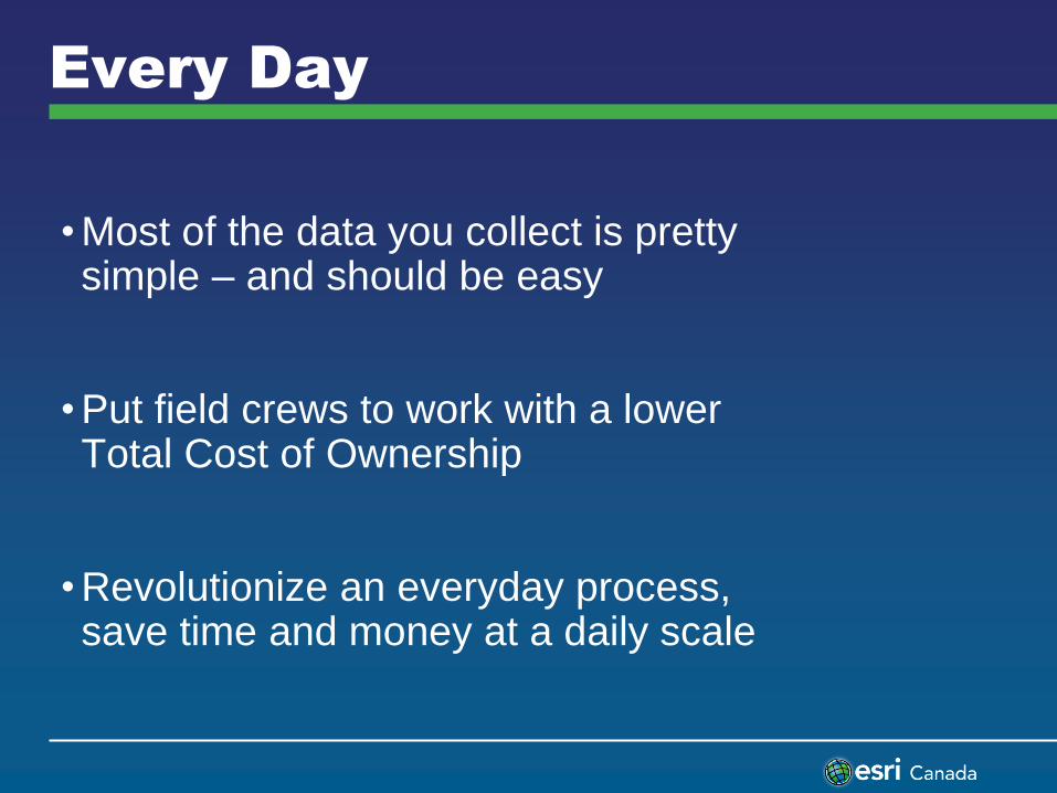
Every Day
• Most of the data you collect is pretty simple – and should be easy
• Put field crews to work with a lower Total Cost of Ownership
• Revolutionize an everyday process, save time and money at a daily scale

Future Vision
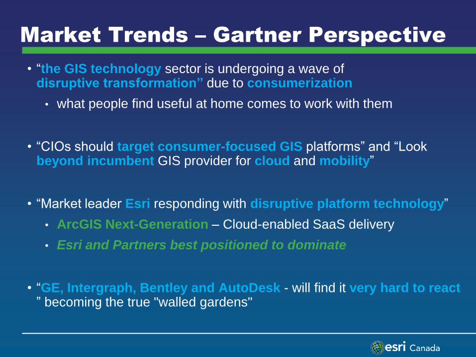
Market Trends – Gartner Perspective
• “the GIS technology sector is undergoing a wave of disruptive transformation” due to consumerization
• what people find useful at home comes to work with them
• “CIOs should target consumer-focused GIS platforms” and “Look beyond incumbent GIS provider for cloud and mobility”
• “Market leader Esri responding with disruptive platform technology”
• ArcGIS Next-Generation – Cloud-enabled SaaS delivery
• Esri and Partners best positioned to dominate
• “GE, Intergraph, Bentley and AutoDesk - will find it very hard to react ” becoming the true "walled gardens"

Key Roadmap Considerations
• Esri & ArcFM Technology Direction
• Asset and Network management enhancements in 2014
• Get Customers to the 10.2.1 Version and stay there until Next-Generation
• Will continue to patch and create new functionality at this version.
• ArcFM Solution Next-Generation
• Leverages the ArcGIS Platform
• This will lay the foundation for future work…including networks
• Has been in planning for years

personalized 24x7x365
Register Today!
https://infrastructurecommunity.schneider-electric.com
interactive

Questions?