Notes on the ecology, conservation and taxonomic status of ...

An Ecological Analysis of Conservation Priorities inthe Sonoran Desert Ecoregion
April 2000
Sand Tanks-Sauceda Mountains Complex: Conservation Site 32 in Arizona (Photo: R. Marshall)
Sonoran Institute
With Support from the Legacy Program, Agency, and Institutional Partners

Preferred Citation:
Marshall, R.M., S. Anderson, M. Batcher, P. Comer, S. Cornelius, R. Cox, A. Gondor, D. Gori, J. Humke,R. Paredes Aguilar, I.E. Parra, S. Schwartz. 2000. An Ecological Analysis of ConservationPriorities in the Sonoran Desert Ecoregion. Prepared by The Nature Conservancy ArizonaChapter, Sonoran Institute, and Instituto del Medio Ambiente y el Desarrollo Sustentable delEstado de Sonora with support from Department of Defense Legacy Program, Agency andInstitutional partners. 146 pp.
i
EXECUTIVE SUMMARY
A bi-national team was convened in 1998 to compile and analyze biological andecological data for the 55-million acre (22 million ha) Sonoran Desert Ecoregion, whichcomprises parts of Arizona, California, Sonora, and Baja, California. The objective of thisproject was to use a science-based approach to identify a network of Conservation Sitesthroughout the Ecoregion that, with proper management, would ensure the long-termpersistence of the Ecoregion's biodiversity, including rare and common species, nativevegetation communities, and the ecological processes needed to maintain these elements ofbiodiversity. The technical team convened to compile and analyze data included staff fromThe Nature Conservancy, Sonoran Institute, Instituto del Medio Ambiente y el DesarrolloSustentable del estado de Sonora, and Arizona Game and Fish Department with assistancefrom more than 100 experts from public agencies, academic institutions, conservationorganizations, Tribes, and private resource professionals. To generate awareness of theproject and attract participation by natural resource entities throughout the Ecoregion weinitiated an outreach program that included development of a project website andpresentations at more than 20 local, regional, and national meetings, symposia, conferences,etc.
We selected a representative sample of the Ecoregion's species and natural vegetationcommunities to serve as Conservation Targets, the basic unit of analysis for this exercise. Weselected a total of 353 species from six taxonomic groups (amphibians/reptiles, birds, fishinvertebrates, mammals, plants). Emphasis was placed on selecting species endemic to theEcoregion. We also used 78 natural vegetation communities to represent a broader level ofbiological organization across the Ecoregion. The approach of using both fine-scale data onspecies and coarse-scale data on vegetation communities was presumed to be a robust way torepresent the broadest array of biodiversity.
We used a variety of data sets, including species' population data housed in NaturalHeritage Programs, spatially-referenced data on vegetation, land use, hydrography,topography, land management, etc. To fill data gaps and obtain contemporary data weconvened a two-day experts workshop at the University of Arizona where 106 expertsparticipated from 51 agencies, universities, Tribes, private resource professionals, andconservation groups. All data were subjected to a set of Conservation Criteria that establishednumeric goals for each Conservation Target. Contemporary data provided by experts wereused as the nuclei for identifying the network of Conservation Sites. Sites throughout theEcoregion were evaluated for the number and types of Conservation Targets consideredviable within their boundaries. We also constructed a biophysical model using spatial data forclimate, vegetation, elevation, slope, and aspect to derive an independent index of thediversity of the Sonoran Desert Ecoregion.
In total, 100 large landscapes and 79 small, localized areas were identified across theEcoregion as a network of Conservation Sites where conservation opportunities should bepursued. The network includes 23,108,106 acres (9,355,508 ha) of lands in Mexico and theU.S. Landscape-scale Conservation Sites capture entire ecosystems, such as a complex of

ii
mountain ranges and valleys, where ecological processes remain largely intact. The 79localized Sites capture some of the Ecoregion's rarest plants and animals and were, generally,isolated from areas identified for the larger landscape Sites. When compared to thebiophysical model, the identified network of landscape-scale Conservation Sites captured89% of the Ecoregion's biophysical variation. Areas that were not adequatelyrepresented mostly in the Plains of Sonora and Arizona Uplands portions of the State ofSonora include some of the least well-known areas in the Ecoregion.
A "GAP" management analysis of the Ecoregion revealed that, at present, less the20% of the network of Conservation Sites is managed to promote the long-term persistence ofConservation Targets. Of the 18 Conservation Sites identified to conserve the Ecoregion'sriverine, riparian, and aquatic systems, only 9% are managed to promote the long-termpersistence of biodiversity. Several recommendations were identified for improving theconservation status of the network of Conservation Sites. The results of this project can serveregional and local conservation efforts by: (1) identifying the most important areas Ecoregion-wide for conservation of biological diversity; (2) providing a baseline characterization fromwhich to evaluate the status of Conservation Targets and trends in major stressors across theEcoregion, and; (3) providing an ecoregional context for designing and evaluating projects,drafting conservation proposals, and anticipating and framing budget needs.
Given that Conservation Sites overlap lands managed by public, private, andcommunal entities, a variety of approaches may be needed to accomplish the overall goal ofbiodiversity conservation. For lands already designated for conservation purposes,implementing conservation programs that abate or minimize major stressors to ConservationTargets will enable true adaptive management. Several agencies and organizationsthroughout the Ecoregion are already having success with this approach. For lands in whichconservation is one of multiple management goals, integrating Ecoregional data and a goals-based approach into comprehensive land management planning will help insure that theEcoregion's biodiversity is adequately characterized, evaluated, accounted for, and conservedthrough development of appropriate management programs. For lands in which the goal doesnot include conservation, opportunities should be identified to increase attention toconservation of biodiversity by developing collaborative programs among public and privateentities (e.g., U.S. Fish and Wildlife Service's Partners for Wildlife Program, UMA orenvironmental management area designations in Sonora, conservation easements, etc.).
iii
ACKNOWLEDGMENTS
This ecological characterization of the Sonoran Desert Ecoregion would not have beenpossible without the support of numerous people working on biodiversity conservation issues inNorthwest Mexico and the Southwestern U.S., including staff from federal, state, and local agencies,Native American Tribes, academic institutions, conservation organizations, and private corporations(see list below). We wish to express special appreciation to Peter Boice, Director of Conservation inthe Office of the Assistant Deputy Under Secretary of Defense, Thomas McCall, Jr., Deputy AssistantSecretary of the Air Force, Ms. Sheri Goodman, Deputy Undersecretary for Defense (EnvironmentalSecurity) and Principal member of DOD-DOI-USDA Integrated Military Land Use CoordinatingCommittee, James Ohmans, Chief of Conservation Programs Headquarters U.S. Marine Corps,Colonel Fred Pease, Chief of Range and Airspace Division Air Force, J. Douglas Ripley, NaturalResource Manager for the Air Force, and Colonel Thomas Lillie, Military Liaison to the Departmentof Interior for their support of this project. Funding and technical support was provided by theDepartment of Defense Legacy Program and from agency and institutional partners.
Input from those with taxonomic and natural resource management expertise within theSonoran Desert Ecoregion was critical for providing contemporary information on the distribution,abundance, and viability of species and natural communities, and on current threats and managementopportunities. The following experts graciously assisted in this process by participating in the May1998 two-day Experts Workshop held in Tucson, Arizona, and/or by providing additional informationafter the May workshop:
John Anderson, Roy C. Averill–Murray, Rich Bailowitz, Robert X. Barry, Bob Basney, R.Mitchel Beauchamp, Gary Bell, Robert Berry, Steve Boyd, Mark Briggs, Angie Brooks, Pat Brown,Stephen Buchmann, Anthony Burgess, William Calder, Faustino Camarena, Jose Campoy, AlejandroCastellanos, Carlos Castillo, Mario Cirett, Pat Comer, Troy Corman, Steve Cornelius, Jim Cornett,Robin Cox, Richard Crowe, Kevin Dahl, Virginia Dalton, Jose Delgadillo, Russell Duncan, RobertoEnriquez, Angie Evenden, Exequiel Ezcurra, Mima Falk, Richard Felger, Jefford Francisco, AlejandroGerardo, Rich Glinski, Matt Goode, Larry Gorenflo, Dave Gori, Annita Harlan, Andy Holdsworth,Ken Kingsley, Michael L'Annunziata, Hector Licon, Patricia Lock-Dawson, Rigoberto López,Eduardo Lopez Saavedra, Augustin Flores Macias, Miguel Macias, Barbara Massey, Gene Maughn,Roberto de la Maza, Mitch McClaran, Steven P. McLaughlin, Eric Mellink, Wendell Minckley, RodMondt, Guadalupe Morales, Gary Nabhan, Nancy Nicolai, Carlos Ochoa, Robert Ohmart, Carl Olson,Bruce Palmer, Ivan Parra Salazar, Yar Petryzn, Steve Prchal, Mike Pruss, Amadeo Rea, Tricia Roller,Jim Rorabaugh, Phil Rosen, Peter Ruiz, Steve Russell, Sue Rutman, Bob Schmalzel, Cecil Schwalbe,Sabra Schwartz, Wade Sherbrooke, Mike Sredl, Sally Stefferud, Jerry Stefferud, Jon Stewart, RandallStocker, Brian Sullivan, Laura Thompson-Olais, Ray Turner, Dale Turner, Carlos Valdes, Tom VanDevender, David Verity, Selso Villegas, Andres Villarreal, Sandy Vissman, Peter Warren.
A number of people were instrumental in helping launch this effort in November of 1997 andin providing oversight throughout the project, including: Michelle Leslie, Diane Vosick, John Humke,Les Corey, Andy Laurenzi, Tom Collazo, Susan Anderson, Gary Nabhan, and Barry Spicer.Additional technical assistance was provided by: Brooke Cholvin, Christine Conte, Serge Dedina, DanDorfman, Chris Fichtel, Greg Gamble, Larry Gorenflo, Dave Harris, and Xiaojun Li. Lynn Richardsdid an exemplary job of organizing the May 1998 Experts Workshop, and we thank Pat Comer, SteveCornelius, Chris Fichtel, Greg Gamble, Dave Gori, Dave Harris, Simone Holliday, John Humke,Diana Imig, Marianne Kleiberg, Andy Laurenzi, and Sabra Schwartz for facilitating expert teamsessions. Exequiel Ezcurra and Andy Holdsworth helped frame conservation challenges within the

iv
Ecoregion with their plenary presentations. Jeanene Carpenter, W.L. Minckley, Sue Rutman, andSally Stefferud provided technical review of the information regarding threats posed by exotic species.
The following staff at IMADES deserve special recognition for their work in developing thecomprehensive, cross-border ecological datasets: Alma A. Haro, Hector Licon, Maria LuisaFernandez, Gonzalo Luna, Marcia Moreno, Ivan E. Parra, Rafaela Parades Aguilar, Adrés Villarreal,Gertrudis Yanes. We thank Chris Fichtel, Larry Gorenflo, Craig Groves, Mary Harkness, DeborahJensen, Shyama Khanna, Jeff Parrish, Douglas Ripley, Roger Sayre, and Diane Vosick for reviewingearlier drafts of this manuscript.
We thank the following organizations and agencies for their technical support:
American Museum of Natural History National Park ServiceArizona Game and Fish Department Organ Pipe Cactus National Monument Habitat Branch Natural Resources Conservation Service Nongame Branch PRO-ESTEROS Research Branch PRONATURA BajaArizona-Sonoran Desert Museum PRONATURA SonoraArizona State University R. B. Duncan & Assoc. Biological Consultants Center for Environmental Studies Rincon Institute Department of Biology San Diego Natural History Museum Department of Zoology Secretaria del Medio Ambiente, Recursos Naturales
y Pesca (SEMARNAP)Biosphere 2 Sky Island AllianceBrown/Berry Consultants Sonoran Arthropod Studies InstituteBureau of Land Management Sonoran Institute Phoenix Office SWCA Inc Riverside Office The Nature ConservancyCentro de Ecología Tucson Field OfficeDepartment of Defense California Regional Office Luke Air Force Base Hassayampa River Preserve Yuma Proving Grounds New Mexico Field Office.Departamento de Investigaciones Cientificas de laUniversidad de Sonora
Northwest Mexico Program San Pedro River Preserve
Drylands Institute Tucson Audubon SocietyFish and Wildlife Service University of CA Los Angeles Botanical Garden Cabeza Prieta National Wildlife Refuge The Wildlands Project Carlsbad Ecological Services Office Tohono O'odham Dept of Natural Resources Phoenix Ecological Services Office University of ArizonaForest Service Carl Hayden Bee Research Center Coronado National Forest Dept. of Ecology & Evolutionary Biology Tonto National Forest School of Renewable Natural ResourcesGila Biological Services Universidad Autonoma de Baja CaliforniaInstituto del Medio Ambiente y el DesarrolloSustentable del estado de Sonora( IMADES)Instituto Tecnologico de Estudious Superiores deMonterrey Guaymas Campus

v
This Ecoregional Analysis was Prepared by the following Team:
Rob Marshall (Team Leader)Conservation Sciences Program ManagerThe Nature Conservancy, Tucson, Arizona
Susan AndersonDirector of Science & Stewardship, Northwest Mexico Program
The Nature Conservancy, Tucson, Arizona
Michael BatcherConsulting Ecologist and Environmental Planner
Buskirk, New York
Pat Comer, Senior EcologistThe Nature Conservancy, Boulder, Colorado
Steve Cornelius, Borderlands Program DirectorSonoran Institute, Tucson, Arizona
Robin Cox, Director of Conservation PlanningThe Nature Conservancy, San Francisco, California
Anne Gondor, Technical AssistantThe Nature Conservancy, Tucson, Arizona
Dave Gori, Senior EcologistThe Nature Conservancy, Tucson, Arizona
John Humke, Director of Agency RelationsThe Nature Conservancy, Boulder, Colorado
Rafaela Paredes Aguilar, EcologistIMADES, Hermosillo, Sonora
Ivan E. Parra, EcologistIMADES1, Hermosillo, Sonora
Sabra SchwartzHeritage Data Management System Coordinator
Arizona Game and Fish Department, Phoenix, Arizona
1 Current Affiliation: World Wildlife Fund, Guaymas, Sonora

vi
TABLE OF CONTENTS
Executive Summary .................................................................................................................... iAcknowledgments..................................................................................................................... iiiEcoregional Technical Team.......................................................................................................v
I. INTRODUCTION.....................................................................................................................1
Background and Purpose.............................................................................................................1The Sonoran Desert Environment ...............................................................................................4
Lower Colorado River Valley Subdivision....................................................................5Arizona Upland Subdivision ..........................................................................................6Plains of Sonora Subdivision .........................................................................................6Central Gulf Coast Subdivision .....................................................................................7
Human Environment ...................................................................................................................7Outreach and Coordination .........................................................................................................9
II. BIODIVERSITY CONSERVATION TARGETS................................................................12
Fine Filter Conservation Targets...............................................................................................12Coarse Filter Conservation Targets...........................................................................................14Aquatic Community Targets .....................................................................................................15Other Targets.............................................................................................................................15
III. CONSERVATION CRITERIA .............................................................................................17
Criteria for Fine Filter Conservation Targets ............................................................................17Criteria for Coarse Filter Targets ..............................................................................................18
IV. DATA PREPARATION AND SOURCES............................................................................21
Delineation of Ecoregion Boundary..........................................................................................21Data Sources..............................................................................................................................21
Natural Heritage Program ............................................................................................21Expert-Derived Data ....................................................................................................22Other Sources ...............................................................................................................22Biophysical Analysis....................................................................................................23
V. IDENTIFICATION OF CONSERVATION SITES ............................................................25
Analytical Steps ........................................................................................................................25Results of Conservation Site Identification...............................................................................26
Characteristics of Landscape-Scale Conservation Sites...............................................26Characteristics of Special Element Sites ......................................................................31How Well Were Conservation Criteria Met?...............................................................31Biophysical Representation..........................................................................................35
VI. CONSERVATION STATUS..................................................................................................38
What is a Conservation Site? ....................................................................................................38Land Management/Ownership at Landscape-Scale Conservation Sites ...................................38GAP Analysis of Conservation Sites ........................................................................................38Ecoregion-Wide Stresses...........................................................................................................40

vii
VII. NEXT STEPS & RECOMMENDATIONS ..........................................................................43
Improve Conservation Management Status at Conservation Sites............................................43Nexus with Regional Conservation Efforts...............................................................................44Evaluate Conservation Sites and Conservation Management Programs...................................44Implement Pilot Conservation Projects.....................................................................................44Integrate and Synthesize Existing Data at a Landscape-Scale ..................................................46Implement Ecosystem Monitoring Projects ..............................................................................46
VIII. REFERENCES .......................................................................................................................48IX. APPENDICES

viii
LIST OF FIGURES
Section End or Page
1. Ecoregions of the Southwestern U.S. and Northwestern Mexico .......................... end of Section I
2. Land Management in the Sonoran Desert Ecoregion ............................................. end of Section I
3. Sonoran Desert Ecoregion with Biotic Subdivisions ............................................. end of Section I
4. Elevation Map of the Sonoran Desert Ecoregion ................................................... end of Section I
5. Projected Population Growth in the Sonoran Desert Ecoregion ............................ end of Section I
6. Vegetation in the Sonoran Desert Ecoregion ........................................................ end of Section II
7. Polygon Data Provided by Experts During May 1998 Workshop ...................... end of Section IV
8. Spatial Representation of Biophysical Units ....................................................... end of Section IV
9. Landscape-Scale Conservation Sites in the Sonoran Desert Ecoregion ................end of Section V
10. Frequency Distribution for Size of Landscape-Scale Conservation Sites ....................................27
11. Frequency Distribution for Number of Conservation Targets at Conservation Sites...................28
12. Frequency Distribution for Number of Taxa Represented at Conservation Sites ........................28
13. Special Element Sites in the Sonoran Desert Ecoregion .......................................end of Section V
14. Biophysical Units Under-Represented at Conservation Sites ...............................end of Section V
15. GAP Analysis of Sonoran Desert Ecoregion Conservation Sites........................ end of Section VI

ix
LIST OF TABLES
1. Land Area Statistics for the Sonoran Desert Ecoregion .................................................................3
2. Global Distribution Characteristics for Conservation Targets .....................................................13
3. Conservation Targets by Taxonomic Group and Global Rank. ...................................................14
4. Typical Spatial Patterns for Natural Vegetation Communities ....................................................16
5. Conservation Criteria for Fine Filter Conservation Targets .........................................................18
6. Conservation Criteria for Natural Vegetation Communities Defined at the Scale of Ecological
Group............................................................................................................................................20
7. Variables and Classes Used to Assess Biophysical Representation. ............................................24
8. Summary of Conservation Targets & Taxonomic Representation at Conservation Sites ............29
9. Conservation Criteria Summary for Natural Vegetation Communities at the Level of Ecological
Group............................................................................................................................................33
10. Conservation Criteria Summary by Taxonomic Group and Ecoregional Subdivision.................34
11. Conservation Sites Where the Ecoregion's Fish Targets are Found or Have the Potential to be
Restored........................................................................................................................................35
12. Biophysical Units that Remain Under-Represented in Conservation Sites..................................36
13. List of 100 Landscape-Scale Conservation Sites Identified in Figure 9......................................37
14. Land Management Status Summary for Landscape Conservation Sites. .....................................39
15. GAP Analysis Program Land Management Status Criteria. ........................................................40
16. Major Stressors at Conservation Sites as Identified by Experts ...................................................42

x
LIST OF APPENDICES
1. Conservation Targets by Taxonomic Group
2. Heritage Program Global Ranking Definitions and Criteria for Combined Global Ranks
3. Coding System for the Sonoran Ecoregion Biophysical Model
4. Conservation Targets Identified within Conservation Sites
5. Conservation Targets Identified within Special Element Sites
6. Summary of Known Occurrences for the 78 Natural Vegetation Communities
7. Conservation Target Occurrence Summary by Ecoregional Subdivisions
8. Results of Biophysical Analysis
9. Land Management Statistics for Each of the 100 Conservation Sites
10. Exotic, Invasive Species of Concern in the Sonoran Desert Ecoregion
11. Status and Priority Inventory Needs for Ecological Groups
A Note On The Format Of This Document: Due to the large amount of data used in thisanalysis and the large number of pages of some of the tabular output, we split the reporting ofresults between the main text and appendices. Summaries of data for the Ecoregion as a wholeare incorporated into the body of the text. Longer summaries that provide data on individualspecies or conservation areas are placed in the appendices.

Conservation in the Sonoran Desert Ecoregion Page 1 of 51April 2000
I. INTRODUCTION
Background and Purpose
The Sonoran Desert Ecoregion encompasses 55 million acres (22 million hectares)in southern Arizona, southeastern California, northern Baja, California, and northwesternSonora (Figure 1). Especially rich in biological diversity the Sonoran Desert wasidentified by Olson and Dinerstein (1998) as one of the top 200 Ecoregions worldwide thatdeserve special conservation attention. The Ecoregion harbors a high proportion ofendemic plants, reptiles, and fish. Over 2500 pollinators are known (invertebrates, birds,and bats) including the highest known diversity of bee species in the world (Phillips andWentworth Comus 2000). More than 500 bird species migrate through, breed, orpermanently reside in the Ecoregion—nearly two-thirds of all species that occur innorthern Mexico, the United States and Canada. The Ecoregion is equally diverse in itshuman population with more than a dozen Native American Tribes represented, as well asmany recent migrants to the region. In 1990 the Ecoregion contained 6.9 million residents,nearly double the population size in 1970. In 2020 the population is expected to reach 12million!
A variety of impacts that adversely affect the Ecoregion's biodiversity are on theincrease. Nabhan and Holdsworth (1999) provide a detailed account of the current threatsto the Sonoran Ecoregion's biodiversity. Conversion of natural habitat to urban, suburban,and agricultural areas continues to result in widespread habitat loss. Overuse of naturalsurface water and groundwater resources and the loss of natural hydrologic regimesthreaten the viability of the Ecoregion's most diverse areas—our riverine, riparian, andestuarine habitats. Increasing recreational use of the desert is resulting in habitat loss anddeclines in some species. Finally, improper livestock management and the spread ofexotic, invasive plants and animals threaten the viability of both terrestrial andriverine/riparian systems.
From the standpoint of biodiversity conservation, it is economically andstrategically prudent to understand where and how to manage for conservation purposeswell before species and ecosystems become "endangered." Recovering species that havedeclined to low numbers or ecosystems that have been heavily degraded is far moreexpensive and problematic than maintaining our extant biodiversity. The Ecoregion'sincreasing population growth, coupled with continued depletion of water and landresources, suggest the future costs of not acting now will be high. Since available fundsfor conservation rarely meet conservation needs across a landscape, higher future costsmay simply translate to further species losses and irreversible degradation of someecosystems.
While Mexico and the U.S. share the desert's biological and ecological attributes,the International Border delineates two vastly different patterns of land tenure andmanagement. In Mexico, most of the land is held privately or communally through the

Conservation in the Sonoran Desert Ecoregion Page 2 of 51April 2000
Ejido system; a relatively small percentage of land enjoys official protected orconservation status (Figure 2 and Table 1). The 1992 change in Mexico's Constitutionenabling the sale and transfer of communal lands leaves areas important for biodiversityvulnerable to new land uses potentially incompatible with conservation; on the other handthe Constitutional change offers opportunities to use conservation tools such as easements.In the U.S. portion of the Ecoregion the majority of land is in public ownership withvarious levels of conservation status, except for river corridors which are mostly in privateownership (Figure 2). As more private lands are developed in the U.S for human uses,public lands will play an even larger role in biodiversity conservation serving as refugia forspecies and natural vegetation communities, and for providing ecosystem services such asflood protection, water purification, groundwater recharge, pollination, and nutrientcycling, among others.
The prospect of declining biodiversity in the Sonoran Desert Ecoregion need notbecome a reality, however. This Ecoregion enjoys a high degree of awareness andcommitment among its population to resolve conservation issues, and extensive cross-border collaboration on conservation issues. Lacking is an Ecoregion-wide assessment ofbiological and ecological attributes that can point to conservation priorities. So called"landscape-scale analyses" that evaluate and identify conservation options and prioritiesover large areas such as the Sonoran Desert Ecoregion are now widely regarded as acritical tool for arming conservation practitioners, policy makers, and the general publicwith the best scientific information upon which to implement conservation strategies(Pendergast et al. 1999, Carrol and Meffe 1997). We need to look no further than our ownEcoregion to see the largest Habitat Conservation Planning effort in U.S. history beinginitiated by Pima County in southern Arizona. That effort is attempting to develop a long-term plan to protect more than 70 rare species.
This document summarizes the methods and results of a two-year bi-nationalproject to identify a network of areas in the Sonoran Desert Ecoregion where, if managedappropriately for conservation, would help insure the long-term persistence of theEcoregion’s biodiversity. We convened a bi-national team to compile and analyzebiological and ecological data and to identify a potential network of conservation areas.We used an analytical method (The Nature Conservancy 1997) that subjects traditionalspecies data sets, spatial land data, and data derived from experts to a set of criteria thatevaluates areas for inclusion in the network. Highlights of this method include: (1)consideration of both species and natural vegetation communities resulting in a fine- andcoarse-scale analyses of important areas across the Ecoregion; (2) integration of a varietyof data sources including contemporary data from more than 100 experts workingthroughout the Ecoregion in federal, state, tribal, and local agencies, academic institutions,conservation groups, and private sector natural resource professionals, and; (3)identification of a network of conservation sites that emphasizes habitat conservation formultiple species and ecological processes.

Conservation in the Sonoran Desert Ecoregion Page 3 of 51April 2000
Table 1. Land Area Statistics For the Sonoran Desert Ecoregion.
States Acres Hectares % of EcoregionArizona 22,296,209 9,023,152 40.4Sonora 21,960,094 8,887,128 39.8California 6,323,537 2,559,100 11.4Baja 4,620,003 1,869,690 8.4Total 55,199,843 22,339,070
Biotic SubdivisionsLower Colorado River Valley 30,041,203 12,157,508 54.4Arizona Upland 14,413,246 5,832,960 26.1Plains of Sonora 8,388,473 3,394,769 15.2Central Gulf Coast 2,356,921 953,833 4.3Total 55,199,843 22,339,070Land Manager/OwnerMexico Private/Communal Land 23,064,090 9,333,909 41.8Bureau of Land Management 9,226,331 3,733,853 16.7U.S. Private Land 5,385,109 2,179,326 9.8Tribal Land 3,998,746 1,618,268 7.2Department of Defense 3,198,015 1,294,221 5.8State Land 3,087,365 1,249,480 5.6Mexico Biosphere Reserves 2,792,019 1,129,914 5.1U.S. Fish & Wildlife Service 1,623,914 657,190 2.9Mexico Proposed ProtectedAreas
944,418 382,200 1.7
U.S. Forest Service 869,025 351,691 1.6National Park Service 401,570 162,510 <1State Park 345,092 139,656 <1The Nature Conservancy 23,761 9,616 <1Total 54,959,455 22,241,834Special Status AreasWilderness (BLM & USFS) * 3,780,497 139,656 6.8BLM Areas of CriticalEnvironmental Concern *
843,225 341,248 1.5
Lands Unaccounted ForPortions of Salton Sea notattributed
172,354 69,779
Portions of CA not attributed 100,000 40,485Total Unaccounted Lands 272,354 110,264* Not included in total under "Land Manager/Owner" because these lands are subsets of BLM
and USFS lands.
Conservation in the Sonoran Desert Ecoregion Page 4 of 51April 2000
There are many advantages to identifying conservation priorities at the scale of anEcoregion. Ecoregions are useful units for understanding and addressing environmentalissues that transcend agency, watershed, and political boundaries, such as air pollution,water consumption, invasive exotic plants and animals (Bailey 1998). Conservation needsare framed at a scale amenable to implementation by local, regional and national entities.Finally, a landscape-scale analysis provides one context for evaluating funding needs andexpenditures of conservation management dollars.
Identifying conservation priorities at an Ecoregional scale reinforces the sharedresponsibility for biodiversity conservation among many private and public entities andemphasizes the fact that ecosystem management efforts that end abruptly at administrativeor international boundaries are, in the long-term, unlikely to accomplish the overall goal ofbiodiversity conservation. Working at the scale of an Ecoregion does not address allconservation needs, however. This effort does not obviate the need to address species-specific issues for threatened and endangered species listed under the Endangered SpeciesAct. Nor does it explicitly address certain goals that may be important in local planningefforts, such as open space and “viewsheds.”
Development of this project was facilitated by a technical team comprised of stafffrom The Nature Conservancy, Sonoran Institute, Instituto del Medio Ambiente ydesarrollo Sustentable del Estado de Sonora (IMADES), and the Arizona Game and FishDepartment with the assistance and input of more than 100 experts from all four statescomprising the Ecoregion. The technical team compiled all digital and expert-deriveddata, and worked through the various steps described in this document to identify thenetwork of Conservation Sites.
The Sonoran Desert Environment
Readers interested in a comprehensive treatment of Sonoran Desert ecology shouldrefer to the publications by the Arizona-Sonora Desert Museum, A Natural History of theSonoran Desert (Phillips and Wentworth Comus 2000); and University of Arizona Press,Ecology of Sonoran Desert Plants and Plant Communities (Robichaux 1999). Below weprovide a brief overview of the Desert’s history, geography, and ecological attributes.
The Sonoran Desert is the most tropical of the three North American warm deserts(Sonoran, Mojave and Chihuahuan). The geographic extent of the Sonoran Desert isthought to have evolved only during the last 1.5 million years as the Ecoregion becameincreasingly arid (MacMahon and Wagner 1985). Throughout this period, climaticfluctuations resulted in expansion and contraction of desert vegetation. The moderngeographic extent and vegetation communities of the Sonoran Desert are thought to havebeen established within the past 4,500-9,000 years under modern climatic regimes (VanDevender 1990). The boundaries of the Sonoran Desert are most sharply defined wheresteep elevational gradients result in abrupt changes in micro-climate and vegetation,
Conservation in the Sonoran Desert Ecoregion Page 5 of 51April 2000
especially along the mountain ranges in south-central Arizona and north-central BajaCalifornia. In other areas, such as along the California-Arizona border, elevationalgradients are gradual and the ecoregional boundary could be viewed as an arbitrary breakbetween the Sonoran and Mojave deserts (Figure 3). Based on Brown and Lowe (1980),modified from Shreve (1942, 1951) and Shreve and Wiggins (1964), the Sonoran Desertconsists of six Subdivisions, spanning from 230 to 350 north latitude. These Subdivisionsinclude the Lower Colorado River Valley, Arizona Uplands, Plains of Sonora, Central GulfCoast, Vizcaíno, and Magdalena. The Vizcaíno and Magdalena Subdivisions were omittedfrom this analysis (see section IV below), so the area evaluated in this effort lies north of270 longitude. All of the Sonoran Desert Ecoregion drains either into the Colorado Riveror directly into the Gulf of California, except for several closed basins, including theSalton Sea and Laguna Salada.
The climate of the Sonoran Desert Ecoregion is continental, with moderation inclimatic extremes provided by the Gulf of California. Average high temperature rangesfrom 500F (100C) in January to 910F (330 C) in July, though this range varies with latitudeand elevation. Occasional severe frosts occur at higher elevations, and cold temperatureslikely limit the distribution of the emblematic saguaro cactus, among other species(Spalding 1909). Although frost-free periods range from eight to twelve months, thepotential growing season is also limited by drought. Rainfall exhibits a bimodal patternwith frontal systems bringing rain in the late fall and early winter and convectional systemsresulting in sporadic but intense thunderstorms in the late summer. Total rainfall increasesas one moves west to east, with greater rainfall in higher elevations along the northern andeastern edges of the Ecoregion. Winter brings 0.8 to 6.0 inches (20-152 mm) ofprecipitation and summer 0 to 6.0 inches (0-150 mm).
Most of the Sonoran Desert lies below 2,600 ft (~800 meters) (Figure 4). Much ofthe bedrock is granite and gneiss with extensive areas of volcanic origin, the largestvolcanic mountain being Pinacate Peak in northern Sonora. The Sonoran Desert has muchof the geologic diversity of the Basin and Range province with both calcareous and acidicbedrock types. The low, rocky ranges typically remain below 4,000 ft (~1,200 m),generally oriented from northwest to southeast. The Sonoran Ecoregion harbors the mostextensive desert dune system in North America the Gran Desierto in northwesternSonora.
We used four of the Ecoregion's biotic Subdivisions to stratify the analyses and todevelop Conservation Criteria that would capture geographic and ecological diversity.Attributes of the Ecoregion's four Subdivisions considered in this analysis are describedbelow. Land area statistics for the four Subdivisions are provided in Table 1.
Lower Colorado River Valley Subdivision
Conservation in the Sonoran Desert Ecoregion Page 6 of 51April 2000
This largest and most arid Subdivision of the Ecoregion encompasses 30 millionacres (9.3 million ha). It is dominated by rolling plains and vegetation communitiesdominated by creosote bush-white bursage (Brown 1982, 1994). Coastal and interior dunesystems are best developed here (e.g., Gran Desierto, Algodones Dunes, Mohawk Dunes,Pinta Sands). Playa lakes, or closed basins temporarily filled with water, are also bestdeveloped in this Subdivision (e.g., Salton Sea). The Colorado and Gila River systems,both originating at higher elevations north and east of the desert, historically supportedextensive areas of cottonwood-willow riparian woodlands and marsh habitats. Both riversystems also fed the once extensive Colorado River Delta. Many riparian systems nowsupport extensive agricultural production. California fan palm oases occur with desertseeps in canyons mostly north and west of the Salton Sea.
A gradual transition to Mojave Desert vegetation occurs along a line from thesouthern border of Joshua Tree National Park northeast to the border with Arizona. Innortheast Baja, CA, low-lying creosote-bursage desert scrub transitions rapidly to interiorand coastal chaparral along mountain slopes to the west, and increasingly towards agave-bursage scrub to the south. Major urban centers of this Subdivision include Phoenix,Yuma, El Centro, and Mexicali.
Arizona Uplands Subdivision
Comprising 14.4 million acres (5.8 million ha) this Subdivision forms the transitionbetween the plains of the Lower Colorado River Valley and the higher elevations of theApache Highlands Ecoregion to the north and east. The Arizona Uplands receivessignificantly greater winter rainfall than the other four Subdivisions (Brown 1982, 1994).Palo verde-mixed cacti desert scrub communities form the matrix vegetation community,with extensive stands of saguaro cacti intermingled with cholla, organ pipe, barrel cactiand prickly pear, palo verde, jojoba, brittlebush, creosote bush, ocotillo, mesquite, cat-clawacacia, and ironwood. Cottonwood-willow riparian woodlands and velvet mesquitebosque were historically significant along major rivers such as the Salt, Gila, San Pedro,Santa Cruz, Bill Williams, and Magdalena, but most have been eliminated or severelyaltered through agricultural conversion, invasive exotic introductions, dams, diversions,and overdraft of groundwater. At elevations above 3300 feet (~1000 m) Sonoran desertscrub communities give way to semi-desert grassland and Chihuahuan desert scrub(Whittaker & Niering 1964). Major urban centers within this Subdivision include the cityof Tucson.
Plains of Sonora Subdivision
Comprising approximately 8.4 million acres (3.4 million ha) this southern, interiorSubdivision forms the transition between coastal desert scrub to inland, sub-tropical shorttree and thornscrub communities of the Sierra Madre Occidental. Elevations range from

Conservation in the Sonoran Desert Ecoregion Page 7 of 51April 2000
roughly 300 ft to 2,500 ft (~100 to 750 m), with a climate of dry, warm winters andmoderately warm, wet summers (Brown 1982, 1994). Ironwood and brittlebush form thedominant desert scrub community on the Plains. Much of the central interior of thisSubdivision was historically dominated by savanna grassland. Agricultural land uses haveresulted in a loss of grasses and conversion towards mesquite, acacia, and other thornscrub.In general, species richness, vegetation density, short tree abundance, and the appearanceof tropical plant species within desert scrub communities increases from north to souththrough this Subdivision. Columnar cacti, such as saguaro and organ pipe, steadilydecrease in abundance to the south with saguaros reaching their southern limit nearHermosillo (McGinnies 1981). Riparian woodlands historically supported mesquitebosques, with tropical trees such as pochote and tree morning glory. Agriculturalconversion is most concentrated along riparian zones and on the alluvial delta of the RíoSonora. Major urban centers include Hermosillo.
Central Gulf Coast Subdivision
The Ecoregion’s smallest Subdivision (2.3 million ac; 0.9 million ha) sits along thewest coast of Sonora in a roughly a 20-mile wide strip of coastal plain and steep mountainranges, including the islands of Tiburón and San Esteban. Rainfall in this hottestSubdivision is sporadic and unreliable (Brown 1982, 1994). Heterogeneous and sparsely-vegetated communities of short-trees, columnar cacti, and mixed shrubs, including copal,torchwood, cardón, ironwood, palo verde, mesquite, and ocotillo, are common. Saltbush,Frankenia, saltmarsh, and mangrove swamp occur on low interior plains and coastallowlands. A high degree of plant species endemism and a suite of species more commonto Baja California (Vizcaíno Subdivision) is a characteristic of Central Gulf Coastvegetation communities. Agricultural conversion is concentrated along riparian zones andon the alluvial delta of the Rio Sonora. Major urban centers include Guaymas.
Human Environment
Humans have relied upon the Southwest's natural resources since their arrival morethan 10,000 years ago. The most recent overviews of tribal peoples in the Sonoran Desert(Heizer 1978; Ortiz 1983) list more than a dozen groups with historic ties to the Ecoregion.Many early cultures inhabiting the Sonoran Desert Ecoregion relied on a broad strategy ofhunting and gathering as a means of survival. The earliest examples of this strategyoccurred in the Archaic Period, beginning as early as 7,500 or more years ago continuinguntil roughly AD 200 (Cordell 1997). Archaic peoples collected plants and hunted avariety of small game animals. Most lived in small settlements that shifted throughout theyear depending on the seasonal availability of different types of food.
The Pima, Yaqui, and many of the Tohono O'odham grew crops in irrigated fields,supplementing crops with hunted and gathered food. Water control was a prerequisite to

Conservation in the Sonoran Desert Ecoregion Page 8 of 51April 2000
reliable food production and larger sedentary settlements. Many approaches to irrigationused by these indigenous peoples would be adopted by the Europeans who eventuallysettled in the region and faced the same challenges of growing food in an arid environment.
The first Europeans to enter the Sonoran Desert Ecoregion were Spanish explorersin the 1530s and early 1540s who came from points south primarily in search of riches(Hartman 1989). By 1700 Spanish settlements were widely dispersed throughout much ofSonora and southern Arizona (Spicer 1962, Gerhard 1993). Spanish expansion northwardcontinued following the Mexican War of Independence in 1821, though the non-indigenous population grew slowly reaching only about 7,600 by 1760, and perhaps15,000 by 1821 (Gerhard 1993).
Following the Mexican-American War of 1846 Anglo Americans from the UnitedStates expanded into newly-acquired American territories of Arizona, California, and NewMexico. Much of the initial settlement followed the general pattern of Hispanic effortswith emphasis on agriculture, animal husbandry, and mining (Sheridan 1995). Livestockuse, in particular, increased with the largest stocking rates in the Ecoregion's historyoccurring at the end of the 19th century. Large-scale water control at the turn of thecentury, developed further with the construction of major dams in the U.S. beginning in1912, increased the rate of development within the Ecoregion by providing a more reliableeconomic foundation. The establishment of rail links with parts of Mexico and the U.S.further promoted economic growth by vastly improving communication and interactionwith areas outside of the Ecoregion.
Control of the Ecoregion's rivers and the advent of pumping technology to extractgroundwater in the first half of the 20th century spawned a large agricultural economybased primarily on cotton and more recently on a range of other vegetable, grain, andforage crops. Floodplains of many of the Ecoregion's rivers were converted from nativeriparian vegetation to large-scale agricultural production. However, since 1970 the amountof irrigated land has declined due to salinization, increased pumping costs, andgroundwater and soil contamination (Nabhan and Holdsworth 1999).
Mining for precious metals was a major impetus for exploration and earlysettlement by European colonizers. In the 20th century copper mining became a dominantindustry in Arizona, with the state accounting for more than 60 percent of U.S. copperproduction (USGS 1999). A 1992 revision in Mexico's mining law that provided forforeign investment resulted in an expansion of mining in northern Mexico, Sonora inparticular (Nabhan and Holdsworth 1999).
The end of World War II ushered in the beginning of the Ecoregion's most rapidperiod of population and economic growth and expansion of land uses. Much of thepopulation growth occurred through migration to the "sunbelt" from regions well outsideof the Sonoran Desert, primarily in search of economic opportunity. Population in theSonoran Desert Ecoregion in 1970 totaled approximately 3.5 million (Nabhan and

Conservation in the Sonoran Desert Ecoregion Page 9 of 51April 2000
Holdsworth 1999). By 1990 the population had reached 6.9 million. Average annualpopulation growth reached 4.1% during the 1970s, slowing only slightly to 3.3% duringthe 1980s and to 3.2% in the first half of the 1990s (Gorenflo 2000). For comparison, theaverage annual population growth for the entire U.S. is 0.84%, and 1.6% for Mexico. At agrowth rate of 3.2%, population doubles approximately every 22 years. Rapid, sustainedpopulation growth is anticipated to continue through at least the next two decades on bothsides of the border with the total population nearing 12 million by 2020 (Nabhan andHoldsworth 1999). Figure 5 depicts projected population growth by U.S. County andMexico Municipios.
Issues directly and indirectly related to conservation of biodiversity have resulted ingovernment action at national, state, and local levels in both Mexico and U.S. (Emanuel2000). Witness the State of Sonora System of Protected Natural Areas (SANPES), theCalifornia Desert Protection Act, designated National Conservation Areas in Arizona, andPima County's Multi-Species Habitat Conservation Planning Effort. As the Ecoregion'spopulation continues to increase so will attention to issues concerning biodiversity. Theanalyses compiled in this document provide one framework in which to evaluate futuredecisions about use of natural resources and conservation of biodiversity.
Outreach and Coordination
This initial exercise of compiling and analyzing data for the Sonoran DesertEcoregion involved scientists and technical experts familiar with the desert's naturallandscapes. To help ensure broad understanding of the effort by those not directlyengaged in the initial exercise, Sonoran Institute and The Nature Conservancy developedand carried out an outreach program over a 24-month period to a broad suite of interestswithin and beyond the Ecoregion. The purpose of this effort was to build an understandingof the process; to illustrate how the results might be used in Ecoregion-wide conservationmanagement issues; and to garner support for participation by staff from various agencies,groups, and institutions. Over the 24-month period we took the opportunity (and continueto do so) to introduce the project at numerous meetings throughout the Ecoregion. Insome cases special meetings were called. However, the outreach effort largely tookadvantage of other gatherings to inform and update varied audiences, with special attentiongiven to public land managers, non-governmental organizations, Tribal and communityleaders. These opportunities included the following:
1st Annual Border Environment Conference: Ciudad Juarez, Mexico, March 1998. Targetaudience: Mexico and U.S. conservation and community development non-governmentalorganizations.
Border XXI Program: San Diego, March 1998; Ensenada, Baja California, May 1999. Targetaudience: regional/national staff of U.S. and Mexico agencies collaborating on EPA/SEMARNAPjoint environmental management.

Conservation in the Sonoran Desert Ecoregion Page 10 of 51April 2000
Borderlands Protected Areas Managers: Cabeza Prieta National Wildlife Refuge, March1998; Tucson, August 1998; Ajo, March 1999; Tumacacori, August 1999. Target audience:public land managers of National Park Service, Fish and Widlife Service, Bureau of LandManagement, Department of Defense, SEMARNAP in Arizona and Sonora.
Field Coordinating Committee: Santa Fe, April 1998. Target audience; local and regional staffof Department of Interior agencies active along the US-Mexico border.
Arizona Riparian Council: Yuma, April 1998. Target audience: Mexican and U.S. agency,university, and other professional managers and scientists.
Sonoran Desert Ecosystem Partnership Working Group: Organ Pipe Cactus NationalMonument, April 1998. Target audience: public land managers of NPS, FWS, BLM,SEMARNAP in Arizona and Sonora.
International Sonoran Desert Alliance: Sonoyta, April 1998; Puerto Penasco, December 1999.Target audience: community-based borderlands conservation organization with memberships in 13cities, towns and settlements in Arizona and Sonora.
1st Symposium on Water and Environmental Issues of the Colorado River Border Region:San Luis Rio Colorado, Mexico, April 1998. Target audience: scientists, managers, politicians,and non-governmental organizations gathered to discuss how the binational compact governingColorado River water use could be used to ensure allocation for ecosystem function.
Barry M. Goldwater Range Partners Working Group: Luke Air Force Base, May 1998;Tucson, January 2000. Target audience: U.S. Marine Corps, Air Force military and civilian staff,Dept. of Interior staff, and non-governmental organizations.
9th US/Mexico Border States Conference: Tucson, June 1998. Target audience: scientists,resource managers working along the U.S./Mexico border.
4th Maya Forest Workshop On Cross-Border Coordination: San Cristobal de las Casas,Chiapas, Mexico, June 1998. Target audience: SEMARNAP personnel.
Dept. of Defense Legacy Program Environmental Staff: Washington January 1999. Targetaudience: civilian environmental staff at DOD HQ, Pentagon.
Dept. of Interior U.S./Mexico Border Program: Washington January 1999. Target audiencewas: associated with Interior's involvement with Border XXI, Letter of Intent, and FederalCoordinating Committee.
U.S. Fish and Wildlife Service Office of Migratory Birds: Washington January 1999. Targetaudience: national staff in Migratory Bird and Refuge offices involved with Joint Ventureprograms.World Wildlife Fund Chihuahuan Desert Ecoregional Planning Team: Washington, January1999; Tucson, November 1999. Target audience: program officers coordinating the ChihuahuanDesert Ecoregional Effort.

Conservation in the Sonoran Desert Ecoregion Page 11 of 51April 2000
National Defense Industry Association Conference: Denver, March 1999. Target audience:civilian and military environmental staff, private defense contractors.
U.S. Fish and Wildlife Servic Sonoran Desert All Bird Joint Venture: Tucson, April 1999.Target audience: U.S. state and federal agencies participating in the design of Joint Venture and it’sintegration with the Sonoran Ecoregion Project.
Exotic, Invasive Plants Workshop: Organ Pipe Cactus National Monument, June 1999.Target audience: resource management staff from federal and state agencies along border in U.S.and Mexico.
2nd Annual US/Mexico Protected Area Collaboration Letter of Intent, Tucson, July 1999.Target audience: national, regional, and local staffs of U.S., Mexico, and Tribal agenciesparticipating in implementation of the sister protected area Letter of Intent for Arizona and Sonora.
Strategic Environmental Defense Research Program: Washington, December 1999. Targetaudience: civilian and military environmental staff, university staff, and defense contractors.
Southwest Strategy Regional Executive Committee: Phoenix, February 2000. Targetaudience: regional directors of Dept. of Interior, Dept. of Defense, and Dept. of Agricultureagencies participating in the SW Strategy.
Science Technical Advisory Team for Pima County's Multi-Species Habitat ConservationPlanning effort: Tucson, March 2000. Target audience: scientists, agency natural resourcemanagers, consulting professionals and members of the public participating in planning effort.
This section intentionally blank.

Conservation in the Sonoran Desert Ecoregion Page 12 of 51April 2000
II. BIODIVERSITY CONSERVATION TARGETS
For the purpose of this Ecoregional analysis we adopted the definition ofbiodiversity articulated by Redford and Richter (1999): the natural variety and variabilityamong living organisms, the ecological complexes in which they naturally occur, and theways in which they interact with each other and the natural environment. We used the keycomponents of biodiversity—variety, variability, ecological complexes, and interaction—in identifying the basic unit for this analysis, the Conservation Target.
An ideal analysis might include all species found in the Ecoregion as ConservationTargets. This is impractical, however, because the Sonoran Desert Ecoregion harborsthousands of species, at the minimum, and our knowledge and available data are limited toa small subset. In order to overcome these gaps while still incorporating the keycomponents of biodiversity described above, we used the Coarse Filter-Fine Filterapproach in identifying a list of Conservation Targets.
The Coarse Filter is represented by ecological groups, or assemblages of plantspecies that are found in recurring patterns across the landscape. We assumed that becauseecological groups occur at larger scales than individual species they also capture abioticcomponents that support biodiversity and ecological processes (e.g, soil types,microclimates). They, therefore, are used to represent the vast majority of species in theEcoregion from common plants, to insects, to soil microbes. The Fine Filter is comprisedof the species for which distributional and population data are better known and cataloguedin databases such as those housed in Natural Heritage Programs. They are species that,due to their rarity or habitat requirements, would not likely be represented adequately bythe coarse filter. The primary advantages of the Coarse Filter-Fine Filter approachinclude: (1) evaluates biodiversity at two different scales emphasizing the habitats in whichthe Ecoregion’s species inhabit; (2) maximizes the number of species represented; (3)captures the variability in ecological conditions in which species occur; and (4) helpscompensate for data gaps that result from uneven species inventory across an Ecoregion.We solicited expert input on the Conservation Targets list prior to and during the two-dayexperts workshop described below and made modifications (both additions and deletions)based on their input.
Fine Filter Conservation Targets
For Fine Filter Conservation Targets we selected a representative cross section ofspecies (and selected subspecies) from the following taxonomic groups: amphibians, birds,fish, invertebrates, mammals, plants, and reptiles. We selected both rare and commonspecies. A total of 353 species was selected as Fine Filter Conservation Targets(Appendix 1). We used the Natural Heritage Program ranking system to assist in selectingFine Filter Targets. That system uses a five-category ranking to describe a species’ rarity.A ranking of Global 1 (G1) characterizes the rarest species, while G5 characterizes the

Conservation in the Sonoran Desert Ecoregion Page 13 of 51April 2000
most common (see Appendix 2). Global ranks for each Conservation Target werereviewed and further categorized to aid in assessment and application of ConservationCriteria identified below. For example, complex global ranks such as G2G3 wereconservatively treated as G2 for purposes of meeting Conservation Criteria. SeeAppendix 2 for rules used in streamlining global ranks. Fine Filter Conservation Targetswere classified as endemic, limited, disjunct, widespread, or peripheral, relative to theSonoran Desert Ecoregion (see Table 2 for definitions and Appendix 1 for Targetclassifications). This attribute was used to ensure that the selection of Targets was basedon criteria other than global ranks (i.e., distribution).
Table 2. Global Distribution Characteristics for Conservation Targets in the SonoranDesert Ecoregion1.
Distribution Characteristics
Restricted/Endemic
Species or vegetation community occurs primarily in one Ecoregion: it is either entirelyendemic to the Ecoregion or has more than 80% of its range within Ecoregion.
Limited Species or vegetation community occurs in the Ecoregion, but also within a few otheradjacent Ecoregions (i.e., its core range is in one or two Ecoregions, yet it may be found inseveral other Ecoregions).
Widespread Species or vegetation community is distributed widely in several to many Ecoregions, andis distributed relatively equally among Ecoregions. Widespread does not necessarily mean"common." For example, some wetland types are distributed widely, although total acreageis small and the occurrences are widely separated.
Disjunct Species or vegetation community occurs in the Ecoregion as a disjunct from the core of itsdistribution (less than 10% of its total distribution is in Ecoregion), and is more commonlyfound in other Ecoregions. Disjunct occurrences of communities reflect similarly disjunctoccurrences of key environmental factors or ecological processes, and these occurrencesmay represent variation in composition, structure, and potential for evolutionarydivergence.
Peripheral Species or vegetation community is more commonly found in other adjacent Ecoregions(less than 10% of its total distribution is in the ecoregion of interest). Peripheraloccurrences may or may not represent significant variation relative to occurrences inadjacent ecoregions. Goals for peripheral communities should account for the fact thatmost of their conservation will take place in other ecoregions. Opportunistic capture ofthese types often may be sufficient. Selection of examples for conservation should beinformed by consideration of how they compare in size, quality, and variation with those inthe adjacent or other ecoregions.
1 distribution characteristics from Anderson et al. 1999.
We selected nearly all G1 through G3 species for which data were available, forthese are the Ecoregion’s rarest elements (Table 3). We also selected a number of

Conservation in the Sonoran Desert Ecoregion Page 14 of 51April 2000
common species, including wide-ranging species that require large areas for dispersal orare nomadic (e.g., bighorn sheep and Sonoran pronghorn, respectively). Most speciesbelieved to be endemic to the Ecoregion were also included, regardless of their G rank.Experts nominated a number of species that remain unranked in national databases, yet areknown by local experts to be rare, endemic, or in decline. Most of these species wereincluded as Conservation Targets but left unranked (attributed as GU).
Table 3. Conservation Targets for the Sonoran Desert Ecoregion byTaxonomic Group and Global Rank.
Taxon Total G1(rarest)
G2 G3 G4 G5(most
common)
GU(un-
ranked)Amphibian 7 1 2 2 2Bird 31 3 3 9 6 8 2VegetationCommunities1
79 2 7 15 16 10 29
Fish 25 7 4 7 1 2 4Invertebrate 56 9 6 3 3 3 32Mammal 31 3 3 3 8 3 11Plant 171 31 40 55 15 5 25Reptile 32 3 3 9 4 2 11
Total 432 59 68 103 55 33 1141 Total includes 78 natural vegetation community types plus "ecological gradient." The 78
vegetation communities were combined into 23 ecological groups for evaluatingConservation Criteria. See Section III.
Coarse Filter Conservation Targets
All terrestrial natural vegetation communities native to the Sonoran DesertEcoregion were identified as Conservation Targets. We started with available data for 78natural vegetation communities at the Association- and Series-level (Brown 1982, 1994),and then aggregated them into 23 ecological groups (Appendix 1). Ecological groupsreflect similarity in environmental setting and characteristic ecological processes. Forexample, six wetland vegetation associations were aggregated into a Desert RiparianWoodland ecological group. Similarly, six desertscrub associations were aggregated into apalo verde-mixed cacti desertscrub ecological group. Some, but not all, ecological groupsmatch directly the Series-level types defined by Brown (1982, 1994). We used ecologicalgroups as the unit of analysis for the coarse filter. This grouping also aided in linkingclassification units to available vegetation data and land cover maps. Figure 6 presentsnatural vegetation community data (at the level of ecological group) compiled for theSonoran Desert Ecoregion. Sources for mapped vegetation data included GAP Analysismaps for California and Arizona (Arizona Gap Program 1998, Davis et al. 1998), a refined

Conservation in the Sonoran Desert Ecoregion Page 15 of 51April 2000
vegetation coverage in California from the Bureau of Land Management, and a processedsatellite image produced by IMADES for the Mexican states of Sonora and Baja California(IMADES 1998).
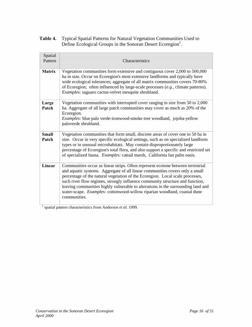
Ecological groups and the natural vegetation communities that define them werealso categorized by their global distribution pattern (Table 2) and typical spatialexpression in the Ecoregion (Table 4) to ensure that records were captured based on bothqualitative and quantitative characteristics and to ensure that aspects of biodiversity of thisEcoregion were based on criteria other than global ranks (e.g., distribution).
Aquatic Conservation Targets
A comprehensive aquatic community classification is not available for the SonoranDesert Ecoregion. Nonetheless, several aquatic communities were identified, includingseeps, basins or tinajas, and springs, intermittent and perennial streams, and playa lakes.Riparian and wetland communities also served to capture related aquatic communities.For the most part, aquatic elements of biodiversity were addressed through theidentification of Fine Filter aquatic species. For example, recognizing that theEcoregion’s fish fauna and their riverine habitat are among the most threatened entities inthe Ecoregion, we included nearly all native fish species as Conservation Targets.
Other Conservation Targets
Experts identified areas within the Sonoran Desert Ecoregion that harborparticularly high levels of biodiversity for individual taxonomic groups or provideimportant habitat for large numbers of a particular species (e.g., stopover locations forneotropical migratory birds, or particular diverse assemblages of invertebrates). Sincethese features are of obvious importance to the particular taxonomic group and, perhaps,other taxa, we included the following elements as Conservation Targets: migratory birdconcentration area, bee biodiversity area, and aquatic invertebrate biodiversity area.
To highlight areas that capture a wide range of ecological conditions we also usedthe "ecological gradient" as an explicit Conservation Target. Ecological gradients capturevariability in landscape features such as slope, elevation, aspect, abiotic diversity such assoil types and levels of insolation, as well as biotic diversity in the form of vegetationcommunities. The primary assumption behind the ecological gradient is that maintaining ahigh level of variability in these features translates to variability in ecological conditions,protection of genetic diversity within populations, and, thus, opportunities for species'distributions to change with changing environmental conditions.
Conservation in the Sonoran Desert Ecoregion Page 16 of 51April 2000
Table 4. Typical Spatial Patterns for Natural Vegetation Communities Used toDefine Ecological Groups in the Sonoran Desert Ecoregion1.
SpatialPattern Characteristics
Matrix Vegetation communities form extensive and contiguous cover 2,000 to 500,000ha in size. Occur on Ecoregion's most extensive landforms and typically havewide ecological tolerances; aggregate of all matrix communities covers 70-80%of Ecoregion; often influenced by large-scale processes (e.g., climate patterns).Examples: saguaro cactus-velvet mesquite shrubland.
LargePatch
Vegetation communities with interrupted cover ranging in size from 50 to 2,000ha. Aggregate of all large patch communities may cover as much as 20% of theEcoregion.Examples: blue palo verde-ironwood-smoke tree woodland, jojoba-yellowpaloverde shrubland.
SmallPatch
Vegetation communities that form small, discrete areas of cover one to 50 ha insize. Occur in very specific ecological settings, such as on specialized landformtypes or in unusual microhabitats. May contain disproportionately largepercentage of Ecoregion's total flora, and also support a specific and restricted setof specialized fauna. Examples: cattail marsh, California fan palm oasis.
Linear Communities occur as linear strips. Often represent ecotone between terrestrialand aquatic systems. Aggregate of all linear communities covers only a smallpercentage of the natural vegetation of the Ecoregion. Local scale processes,such river flow regimes, strongly influence community structure and function,leaving communities highly vulnerable to alterations in the surrounding land andwater-scape. Examples: cottonwood-willow riparian woodland, coastal dunecommunities.
1 spatial pattern characteristics from Anderson et al. 1999.

Conservation in the Sonoran Desert Ecoregion Page 17 of 51April 2000
III. CONSERVATION CRITERIA
The objective of this project is to identify a network of areas that, with propermanagement, would help insure the long-term persistence of the Ecoregion’s biodiversity.The extent to which this can be accomplished is a function of (1) selecting a representativeset of Conservation Targets; (2) selecting Conservation Criteria that are robust enough toensure long-term persistence; and (3) identifying a sufficient number and distribution ofviable populations across the Ecoregion to meet Conservation Criteria.
Conservation Criteria for Fine Filter Conservation Targets
Because detailed demographic and habitat data are not available for mostConservation Targets, Criteria represent a working hypothesis for the question, How muchis enough to retain viability over the long-term? For most Conservation Targets it iscurrently not possible to answer this question with certainty. As with all scientificendeavors, this hypothesis should be tested and periodically reassessed. ConservationCriteria for fine filter Targets are provided in Table 5. We believe these Criteria aremoderate for most Targets. For vulnerable or declining Targets, the Criteria may beinadequate. None of the Criteria used in this analysis should be used in lieu of criteria orgoals established under other analyses (i.e., recovery plans for listed endangered orthreatened species). We used several assumptions in developing Conservation Criteria:
! The four ecological Subdivisions of the Sonoran Desert Ecoregion represent significantecological variation for Conservation Targets. Representing and replicating examplesof each Target within each of the Subdivisions in which it naturally occurs aids inconserving the Target's natural range of ecological conditions and genetic diversity,thereby increasing the probability the Target could evolve in a changing environment.
! The viability of individual Conservation Target records identified by experts as"medium" or "high" indicates viability for at least the next 25 years.
! For Conservation Targets with natural ranges extending beyond the SonoranEcoregion, similar Critera will be applied in other Ecoregional analyses to ensure thatrangewide variability is conserved.
! The global status ranks applied to Conservation Targets (G1, G2, etc.) reflect thepotential for irrecoverable loss of a species or natural vegetation community type.Maintaining rangewide numbers of viable populations at the level of G3 and aboveprovides sufficient levels of conservation.

Conservation in the Sonoran Desert Ecoregion Page 18 of 51April 2000
Table 5. Conservation Criteria for Fine Filter Conservation Targets.
Criteria 1: Maintain all viable occurrences of G1 and G2 Conservation Targets and thoselisted as “endangered” or “threatened.” Specific numerical targets could notbe uniformly identified for this group since, in some cases, their naturaldistribution is extremely limited (e.g., one or two sites).
Criteria 2: Maintain all viable native fish populations and the stream reaches where theyoccur. Experts concluded that the native fish fauna, as a whole, had beendegraded to the point where further losses would only result in diminishedviability or functional extinction, and that, in some cases, without significantrestoration some Conservation Targets would not be restored to viability.
Criteria 3: For rare, vulnerable taxa, or species of special concern (G3, G4, G5 Targetsthat are endemic or that have limited distribution in Ecoregion), maintain ≥ 6viable occurrences in each Subdivision, or ≥ 24 occurrences for allSubdivisions in which the species occurs, to maintain their status at the rank ofG3 or above.
Criteria 4: For species of special concern (endemic G4-G5; S1-S2) maintain ≥ 6 viableoccurrences in each Subdivision (or ≥ 24 occurrences for all Subdivisions inwhich the species occurs).
Criteria 5: Conserve all known critical ecological features such as migratory birdconcentration areas, bat roosts, estuaries, springs, invertebrate concentrationareas.
Conservation Criteria for Coarse Filter Conservation Targets
For ecological groups we considered the distribution of their respective vegetationcommunities relative to the Ecoregion, their typical spatial pattern, and the scale ofclassification resolution in developing Conservation Criteria (Anderson et al. 1999).Conservation Criteria are expressed in two forms depending on the typical spatial patternof the ecological group. For the two ecological groups that form the “matrix” of theEcoregion (creosote-bursage and palo verde mixed cacti desert scrub) ConservationCriteria are expressed as a percentage of the historical extent of component vegetationcommunities (circa 1600-1800), while those for patch-forming communities are expressedas a number of occurrences (Table 6).
In the context of identifying a network of Conservation Sites, expressing Criteria asan areal extent has several advantages. Matrix-forming vegetation communitiescommunities are overwhelmingly dominant on the landscapes of the Lower ColoradoRiver Valley and Arizona Upland Subdivisions. They also dominate large, interconnectedareas identified as Conservation Sites. Splitting this interconnected network into discrete

Conservation in the Sonoran Desert Ecoregion Page 19 of 51April 2000
occurrences (e.g., a point on a map vs a broad interconnected area) in order to assess howwell Conservation Criteria were met has little meaning given the ecological importance ofmatrix community types in the long-term conservation of biodiversity. Areal measureshave been commonly applied to reserve design criteria at national scales utilizing theoryderived from island biogeography (MacArthur and Wilson 1967, Wilcox 1992, Soule andSanjayan 1998). Because, over time, larger areas support more species, Criteria expressedas an areal extent are a more robust hedge against species loss in an increasinglyfragmented landscape. For example, Wilcox (1992) estimated that with a 90% decrease inhabitat extent (e.g., Conservation Criteria = 10%), one could expect a 30% decrease overtime in the species supported by the habitat. Using inferences from this relationship, thepractical experience of managing reserves in fragmented landscapes, and the greaterlikelihood of intensive development occurring on less disturbed lands remaining outside ofconservation areas, we selected an initial Conservation Criteria for matrix-formingcommunities of 30% by Ecoregional Subdivision.
Ecosystems are dynamic, changing at varying rates with short-term cycles andlong-term trajectories. An ecological “coarse filter” should include consideration ofecological and environmental change. In essence, we are attempting to conserve a movingtarget. However, in many places short-term cycles and long-term trajectories have beenabruptly altered through human land use, and have had obvious impact on nativebiodiversity (Wilson 1992). We placed areal estimates in a historical context byexpressing the desired extent as a percentage of estimated area circa 1600-1800, the timeperiod immediately prior to wide-spread European-American settlement. The 1600-1800time period marks the beginning of the most extensive and rapid human/technology-drivenchanges to ecosystems, but is recent enough to reflect vegetation patterns under modernclimatic conditions. It therefore, provides a useful and important reference point.
We estimated the historical extent of the two matrix ecological groups by thefollowing method. We used GAP Analysis data and its equivalent for Mexico (ArizonaGap Analysis Progam 1998, Davis et al. 1998, IMADES 1998) to estimate the areacurrently comprised of urban development and agriculture for the Lower Colorado RiverValley and Arizona Upland Subdivisions the two Subdivisions in which the matrixecological groups occur. We then added the amount of developed land from theSubdivisions to the current extent of each matrix vegetation type to derive the estimatedhistorical extent. Because most of the urban and agricultural development in thoseSubdivisions is in low-lying flat areas (i.e., valley bottoms and river corridors that are mostlikely to be dominated by creosote-bursage) we added 95% of the urban/agricultural areato the current extent of creosote-bursage scrub, and 5% of the urban/agricultural area to thecurrent extent palo verde-mixed cacti scrub. Two factors suggest this was a reasonableapproach to estimating historical extent for these matrix vegetation communities: (1) desertcommunities change slowly where not disturbed by human activity, so it is reasonable toassume that areas not under human development have vegetation communities similar towhat was present before European settlement of the area, and; (2) since less than 10% of

Conservation in the Sonoran Desert Ecoregion Page 20 of 51April 2000
the Ecoregion is in urban and agricultural development the overall area being factored isnot large.
As noted above, Conservation Criteria for the ecological groups that exhibit largepatch, small patch, or linear patch spatial patterns are expressed as a number ofoccurrences (Table 6). These Criteria follow similar assumptions and numerical estimatesdescribed by Anderson et al. (1999) and take into account the low classification resolution.To capture a community's variability, Criteria include representation among theSubdivisions in which the community naturally occurs (i.e., spatial stratification) andreplication. Few theoretical or empirical studies have addressed the question of howextensive and how many different examples of a particular vegetation community areneeded to ensure conservation over the long term. As a starting point, we selected aminimum Criteria for replication: at least two viable occurrences of each natural vegetationcommunity should be conserved within each Subdivision in which the communitynaturally occurs.
Table 6. Conservation Criteria for Natural Vegetation Communities in theSonoran Desert Ecoregion Defined at the Scale of Ecological Group1.
Conservation Criteria for large patch, small patch, and linearvegetation community types (expressed as a number of sites) andfor matrix vegetation communities (expressed as a percentage ofhistoric extent).
Spatial Pattern in Ecoregion2
DistributionRelative toEcoregion
Ecological Groups ExhibitingLarge Patch, Small Patch, or Linear Patch
Spatial Patterns
Ecological GroupsExhibiting a Matrix
Spatial Pattern
Endemic 60 sites3
Limited/Disjunct 40 sites3
Widespread 20 sites3
Peripheral 5-10 (evaluate case by case)3
30% 4
1 We evaluated the extent to which Conservation Criteria were met using natural vegetation communitiesaggregated at the ecological group level.
2 See Table 4 for definitions of spatial patterns.3 Examples for particular patch type should be distributed among Subdivisions in which type naturally
occurs (e.g., Lower Colorado River Valley, Arizona Uplands, Central Gulf Coast, Plains of Sonora).4 Historic extent circa 1600-1800.

Conservation in the Sonoran Desert Ecoregion Page 21 of 51April 2000
IV. DATA PREPARATION AND SOURCES
Delineation of Ecoregion Boundaries
Ecoregions are large areas of land and water that share similar climate,physiography, and biotic communities (Bailey 1998). The Sonoran Desert Ecoregion wasinitially defined using the U.S. Forest Service ECOMAP Province scale (Bailey 1994). Abi-national workshop was held in 1996 to link the U.S. boundaries with those in Mexico,relying in part on work developed by the World Wildlife Fund (Dinerstein et al. 1995) incooperation with CONABIO (La Comisión Nacional Para El Conocimiento Y Uso De LaBiodiversidad). During this consensus process, U.S. and Mexican participants separatedout most Baja, California portions of the Sonoran Desert, as defined by Brown and Lowe(1980; i.e., Magdelana, Vizcaíno, and portions of the Central Gulf Coast Subdivision) fromthe northern and eastern parts of the Ecoregion (Figure 3). They included portions of theSinaloan thornscrub community, as defined by Brown and Lowe (1980), within theSonoran Desert Ecoregion.
To capture small portions of the Sonoran Desert in Arizona omitted by Bailey(1994), the ecoregional technical team adopted boundaries as described by Brown (1982,1994). As a basis for structuring analyses the team also adopted four of Brown's BioticSubdivisions described above (Lower Colorado River Valley, Arizona Uplands, CentralGulf Coast, and Plains of Sonora).
Data Sources
Natural Heritage Program Data
Natural Heritage Program Databases from Arizona, California, and Sonoraprovided 3,547 records for Conservation Targets and other species that occur within theSonoran Desert Ecoregion but were not selected as Conservation Targets for this analysis.All records are spatially referenced and depicted on a map as a point. Some, but not allrecords, include estimates of viability and dates of last observation. Heritage data were notavailable for Baja, California.
Both the California and Arizona Natural Heritage Programs have managed detailedinformation for natural vegetation communities. These records are also spatiallyreferenced, depicted as a point. Approximately 100 records were deemed usable for thisanalysis. All were coded to link them to ecological groups (described above). Sincerecords for Arizona, and many examples from California, are as much as 20 years old,many community records were utilized only to confirm more recent expert-derivedexamples, or to suggest additional sites for refinement of the analysis.

Conservation in the Sonoran Desert Ecoregion Page 22 of 51April 2000
Expert-Derived Data
To complement Natural Heritage data with contemporary information onConservation Targets and the areas in which they occur, we convened an experts workshopto assist in populating the database used for this analysis. Expert sessions, whereindividuals work as part of a group, have proved to be an important tool in sorting throughand integrating the complex set of environmental variables important to a species (McCoyet al. 1999). In May of 1998 we convened 106 experts from Arizona, Baja California,California, and Sonora for a two-day gathering at the University of Arizona in Tucson.Researchers and natural resource management professionals were invited from academicinstitutions, federal, state, and municipal government agencies, Native American Tribes,conservation organizations, and private corporations. Experts worked in taxonomically-aligned groups (i.e., birds, invertebrates, fish, mammals, natural vegetation communities,plants, reptiles/amphibians) to identify areas needed to meet Conservation Criteraestablished for each Conservation Target. Each taxonomic group had a facilitator,translator, and recorder.
Experts provided approximately 1,755 new data records for the Ecoregion. Allexpert data were digitized as polygons into a spatially-referenced geographic informationdata management system (Figure 7) and data forms were completed for each polygon thatincluded the following pieces of information:
1) Location information for Conservation Targets and justification for boundariesdrawn to delineate the area in which Conservation Targets were identified (on1:500,000 scale maps).
2) Species and/or natural vegetation communities found at delineated site.3) Information on the presumed viability of the Conservation Target, stated in general
categories of high, medium and low. Some experts provided a brief description ofcharacteristic processes and/or apparent threats or alterations.
4) Location and ownership/management information.5) Date the Conservation Target was last observed by the expert.6) Additional contacts and information on potential management opportunities.
Other Data Sources
Additional information on Conservation Targets was derived, or simplycorroborated, from existing reports on designated wilderness and other conservation areasin Arizona and California. The Bureau of Land Management in California kindly provideddata from their Colorado Desert Planning effort (Bureau of Land Management 1998).Additional Target occurrence information on natural vegetation communities, primarily atthe scale of ecological group, was derived using available vegetation maps (describedabove).

Conservation in the Sonoran Desert Ecoregion Page 23 of 51April 2000
All of the above data was compiled in a geographic information system usingArcview 3.1 (Environmental Systems Research Institute 1998). In addition, we obtained avariety of digital data layers to support analyses, including data on the Ecoregion's rivers,topography, land cover, soils, vegetation, human infrastructure (e.g., roads, utility lines,etc.), land management status, and Thematic Mapper satellite imagery, among others.
Biophysical Analysis
We developed an additional spatial data set to characterize biophysical variation inthe Sonoran Desert Ecoregion under the premise that abiotic features (e.g., rainfall,temperature, insolation, landform, soil texture/pH, etc.) influence the distribution ofConservation Targets, particularly natural vegetation communities. We used the analysisto evaluate how well the network of areas identified for conservation represent thebiophysical diversity of the Ecoregion.
The biophysical representation is an additional measure of ecological diversity tosupplement our limited location-specific information on the natural vegetationcommunities that define our ecological groups. It enables delineation of ConservationSites that encompass the characteristic range of environmental and, potentially, ecologicalgradients found in the Ecoregion. Conserving ecological gradients should aid in protectingecological processes and the natural variation in habitat occupied by Conservation Targets.Protecting a range of environmental gradients should also protect genetic variation withinspecies, thereby providing opportunities for speciation and adaptation to changingenvironments.
Comprehensive abiotic data sets for the entire Sonoran Ecoregion were notavailable, so we used five variables as indirect measures and developed a set of classes foreach variable to map their distribution throughout the Ecoregion (Table 7). The completecoding system for the biophysical model is provided in Appendix 3. Biophysical unitswere mapped by superimposing a one-hectare grid over the Ecoregion. The combination ofeach variable and class resulted in a set of 438 unique biophysical units for the SonoranDesert Ecoregion. See Figure 8 for a spatial representation of biophysical units.
Sixty biophysical units related to agriculture and urban land uses were removedfrom the analysis. In addition, to avoid inclusion of biophysical units resulting from errorin map data sources, those units representing less than 0.05% of each EcoregionalSubdivision were eliminated from consideration with the exception of steep slopes andcliff units, due to their natural occurrence as small areas and subsequent tendency forunder-representation. This left 248 biophysical units for review and analysis. Biophysicalunits with less than 10% of their mapped extent captured by conservation sites wereidentified as potentially under-represented units.

Conservation in the Sonoran Desert Ecoregion Page 24 of 51April 2000
Table 7. Variables and Classes Utilized to Assess Biophysical Representation inthe Sonoran Desert Ecoregion.
Variable Spatial Data Source Classes
Climate Brown & LoweSubdivisions as surrogatefor climate
4 classes: Lower Colorado, Arizona Upland,Central Gulf Coast, Plains of Sonora
Vegetation Vegetation map depictingecological groups(Figure 6)
15 vegetation classes
Elevation Digital Elevation Model 4 classes: -75 to 400 m above sea level (ASL),401-800 m ASL, 801-1075 m ASL, >1075 mASL
Slope Digital Elevation Model 3 classes: flat 0-6 degrees, mod.-steep 7-35degrees, steep-cliff >35 degrees
Aspect Digital Elevation Model 3 classes: flat, S/SW aspect (91-314 degrees),N/NE aspect (315-90 degrees)
This section intentionally blank.

Conservation in the Sonoran Desert Ecoregion Page 25 of 51April 2000
V. IDENTIFICATION OF CONSERVATION SITES
Analytical Steps
Conservation Sites were identified through a combination of computer assisted andmanual processes that evaluated the following data: (1) records for Conservation Targetsfrom Natural Heritage Program databases; (2) Target occurrence data provided by expertsand from primary and grey literature not currently in a digital database (e.g., wildernessstudy area reports); (3) spatial data sets for the Ecoregion's topography, hydrography, landuse/land cover, GAP vegetation (and equivalent data for Mexico), land management status,and Thematic Mapper satellite imagery; and (4) indices of biophysical variation frombiophysical modelling exercise.
Expert-nominated areas that captured multiple Conservation Targets from multipletaxa were used as the nuclei for identifying Conservation Sites. These nuclei can bereadily seen in Figure 7 as a convergence of overlapping polygons of different colors. Thecolors distinguish among the various taxonomic groups. Most polygons nominated byexperts contained multiple Conservation Targets. Therefore, the convergence oftaxonomic polygons not only captured multiple taxa, but also multiple ConservationTargets within a taxon.
Expert-nominated areas (polygons) varied in the precision with which boundarieswere delineated, so we evaluated each expert polygon against the rationale provided for thepolygon to determine if additional information was needed to refine the polygon's size andshape. Boundary adjustments were made based on additional information and to correctfor errors in digitization.
Conservation Target data from Heritage Programs were then displayed to identifyadditional Targets contained within or proximate to the expert-identified areas. Wemodified the boundary of expert-nominated areas to capture additional ConservationTargets where such a modification would not include areas with incompatible land uses(e.g., urban areas) or include Target occurrences that were not considered viable (e.g., fishTargets in the de-watered portion of the Gila River in Maricopa and Yuma counties).These boundary adjustments typically resulted in small adjustments to sites (i.e., extendingor contracting boundary one to several miles).
In many cases, experts nominated areas for which corroborating Heritage data wasavailable. In most cases we adopted the experts' boundaries for an area because Heritagepoint data typically does not capture the entire Target population found in a particular area.
Combined Heritage and experts data were then displayed over spatial data sets to:(1) determine if additional Conservation Targets would be captured by modifyingdelineated boundaries; (2) capture ecological gradients represented in the biophysicalmodel; or (3) determine if the proposed area overlapped with incompatible land uses and,
Conservation in the Sonoran Desert Ecoregion Page 26 of 51April 2000
therefore, should be modified to capture only areas where conservation potential exists.Boundary adjustments were also made to capture adjacent areas that contained similar,unfragmented habitat such as riparian areas adjacent to riverine systems identified for fishTargets, mountain ranges adjacent to bajadas (sloping plain bordering mountain range)identified for desertscrub communities, etc.
Results of the biophysical model were overlaid on preliminary Conservation Sitesto calculate the extent to which biophysical units were captured by Sites. Locations ofunder-represented units were highlighted for assessment and possible inclusion, or forfuture field inventory. A number of preliminary Conservation Site boundaries were thenmodified to include under-represented units.
Results of Conservation Site Identification
Two types of sites were identified, landscape-scale Conservation Sites and SpecialElement Sites. Most landscape-scale Conservation Sites comprise large areas such as aseries of mountain ranges and intervening valleys, a canyon complex, or riverinesystem and contain multiple Conservation Targets. Special Element Sites are small,localized areas containing some of the Ecoregion's rarest Conservation Targets that couldnot be captured in landscape-scale Sites.
Characteristics of Landscape-scale Conservation Sites
A total of 100 landscape-scale Conservation Sites was identified: 41 in the ArizonaUplands; 35 in the Lower Colorado River Valley; 16 in the Plains of Sonora; and 8 in theCentral Gulf Coast Subdivision (see Figure 9). In total, Conservation Sites coverapproximately 26.6 million acres (10.8 million ha), or about 50% of the Ecoregion’slandmass.
Conservation Sites vary in size from 403 acres to 5.7 million acres (163 ha to 2.5million ha), with most sites falling into two size classes, 5,000 to 50,000 acres (2023 to20,234 ha) and 100,001 to 500,000 acres (40,469 to 202,343 ha). Figure 10 charts the sizedistribution for the 100 landscape-scale Conservation Sites identified. At the gross scale ofthis analysis the boundaries delineated for Conservation Sites are conceptual, not precise.The delineated boundaries are intended to serve as a starting point for a more detailedanalysis of stresses and potential conservation management actions. However, the relativesizes and shapes of Conservation Sites are important in that they represent expert opinionon habitats and areas needed to support the Conservation Targets found within the site andrepresent some of the best remaining conservation opportunities in the Ecoregion.
A complete listing of Conservation Targets identified within Conservation Sites isprovided in Appendix 4. This listing should be considered as the minimum list of

Conservation in the Sonoran Desert Ecoregion Page 27 of 51April 2000
Conservation Targets for each Site. Incomplete inventory in many areas combined withthe impracticality of incorporating all databases throughout the Ecoregion into the analysisundoubtedly has resulted in gaps in the Conservation Target lists for some areas. Alsoincluded in Appendix 4 is a listing of the biophysical units associated with eachConservation Site. As described in Section III above, biophysical units represent acombination of parameters for vegetation, climate, elevation, aspect, and slope. Tosimplify the output only the vegetation component is listed in Appendix 4. Again, whileeach biophysical unit is not considered an actual Conservation Target, they represent aworking hypothesis addressing major ecological gradients that characterize the Ecoregion.As such the biophysical modeling results serve as an indication of how well ecologicalgradients have been represented within Conservation Sites. They also form a basis forguiding field inventories, particularly in areas of the Ecoregion that are poorly known.
Conservation Sites vary in the number of Conservation Targets harbored as well asthe number of taxonomic groups represented. For example, Sierra La Cobriza (Site 41, seeFigure 9), was identified to conserve a population of Brahea armata, the blue palm (G3).Although the Site was identified based on the occurrence of one Conservation Target, theSite is actually a complex of canyons that contain multiple occurrences of blue palm. Incontrast, the Pinacate/Organ Pipe/Cabeza Prieta/Goldwater Complex (Site 13) contains atleast 305 occurrences of 68 Conservation Targets from seven taxonomic groups. Table 8provides a summary of Conservation Target data for each Conservation Site. Figures 11and 12 summarize the frequency distributions for the number of Conservation Targets andnumber of taxa, respectively, represented at Conservation Sites.
������������������������������������������������������������������������������������������
����������������������������������������������������������������������������������������������������������������������������������������������������������������������������������������������
������������������������������������������������
���������������������������������������������������������������������������������������������������������������������������������������������������������
������������������������������������������������������
���������������������������������������������
14
35
7
32
7 6
0
5
10
15
20
25
30
35
40
0 - 5,000 5,000 - 50,000 50,001 - 100,000 100,001 -500,000
500,001 -1,000,000
> 1,000,000
Acres
Figure 10. Frequency Distribution for the Size of Landscape-Scale Conservation Sites

Conservation in the Sonoran Desert Ecoregion Page 28 of 51April 2000
������������������������������������������������
������������������������������������������������
��������������������������������������������������������
������������������������������������������������������������
������������������������������������������������������������������������������������
��������������������������������������������������������������������������������������������������������������������������������������������
������������������������������������������������������������������������������������������������������������������������������������������������
Figure 12. Frequency Distribution for Number of Taxa Represented at Conservation Sites
7891013
24
30
0
5
10
15
20
25
30
35
1 2 3 4 5 6 7
Taxa Represented
������������������������������������������������������������������������������������������������������������������������������������������������������
��������������������������������������������������������������������������������
���������������������������������������������������
����������������������������
��������������������������������������������� ����������������
53
20
9 711
10
10
20
30
40
50
60
<6 6-10 11-20 21-30 31-40 >40
Number of Conservation Targets
Num
ber
of C
onse
rvat
ion
Site
s
Figure 11. Frequency Distribution for Number of Conservation Targets at Conservation Sites

Conservation in the Sonoran Desert Ecoregion Page 29 of 51April 2000
Table 8. Summary of Conservation Targets and Taxonomic Representation atConservation Sites.
TOTAL CONSERVATION TARGETSConservation Site
#
Conservation Site Name TotalConservation
Targets
Proportion ofEcoregion
Targets
Total # ofTaxa
Represented Bird Community Fish Herpetofauna Invertebrate Mammal Plant13 Pinacate/Organ Pipe/Goldwater
Complex69 14.9% 7 2 12 2 10 1 12 30
25 Anza Borrego 41 8.9% 7 3 13 1 4 1 4 1598 Upper Gila River 40 8.7% 7 12 3 13 3 3 2 499 San Pedro River/Aravaipa Creek 39 8.4% 7 9 4 9 1 4 5 721 Tonto Creek/Salt and
Verde/Meddler Wash39 8.4% 6 9 14 3 1 2 10
8 Cerro Borrego/San Felipe Desert 38 8.2% 5 15 7 1 1 1482 Bill William's Complex 36 7.8% 7 8 2 9 5 1 5 610 Colorado River Delta 35 7.6% 7 5 9 8 4 2 1 672 Whitewater River 33 7.1% 6 6 8 3 10 1 53 Bahía de Kino/Isla Tiburón/Sierra
Bacha33 7.1% 5 5 11 2 8 7
34 Joshua Tree 32 6.9% 7 5 8 1 5 1 3 938 Colorado River/Río Hardy 31 6.7% 6 11 6 7 1 3 327 Chocolate Mountains 28 6.1% 6 4 8 1 3 3 91 Rancho El Único 28 6.1% 6 1 9 1 5 2 104 Sierra Bacha/Sierra del Viejo 27 5.8% 5 3 7 4 3 10
35 Algodones Dunes 24 5.2% 5 3 3 2 9 724 San Jacinto Foothills 23 5.0% 5 3 3 4 3 983 Agua Fria Watershed 22 4.8% 7 2 1 7 3 1 3 553 Atascosa Mountains 22 4.8% 6 3 1 2 3 3 1017 Altar Valley 18 3.9% 6 2 2 2 2 8 223 Hassayampa River 15 3.2% 6 3 5 3 1 2 112 Kofa Complex 14 3.0% 4 3 3 4 415 Cienéga Creek 13 2.8% 6 4 2 1 2 2 257 Puerto Lobos 13 2.8% 4 3 6 2 265 Yuha Basin 13 2.8% 4 1 1 8 332 Sand Tanks Mountains 12 2.6% 5 2 3 2 3 22 San Esteban Island 12 2.6% 4 4 4 2 2
29 McCoy Mountains 11 2.4% 6 1 2 3 1 2 261 San Simon/Sonoyta Valley 11 2.4% 5 1 3 3 3 114 Arnett Creek 10 2.2% 5 1 5 2 1 185 Superstition Mountains 10 2.2% 4 1 2 1 663 Sunrise Butte/Guadalupe Canyon 10 2.2% 3 2 7 193 Tucson Mountains 9 1.9% 6 1 1 2 1 2 216 Santa Rita 9 1.9% 4 1 2 4 231 Whipple Mountains 9 1.9% 3 3 4 243 San Pedro Nolasco Island 9 1.9% 2 4 570 Orococpa Valley 8 1.7% 6 1 1 1 1 2 237 Central Gulf Coast 8 1.7% 3 5 1 27 Carrizo Plains/Arroyo Bacoachito 8 1.7% 3 3 3 2
33 Salton Sea 8 1.7% 2 7 119 Sawtooth-Silverbell Mountains 8 1.7% 2 3 5
102 Harquahala Mountains 6 1.3% 4 1 2 1 295 Sabino Canyon 6 1.3% 4 1 1 2 268 San Felipe Creek 6 1.3% 4 1 1 2 271 Mecca Hills/Painted Canyon 6 1.3% 4 1 1 1 350 Río Sonora/Río San Miguel 6 1.3% 4 1 1 3 122 Río Magdalena/Río Asunción 6 1.3% 3 3 1 273 Danby Playa 6 1.3% 2 2 481 Date Creek 6 1.3% 2 5 1
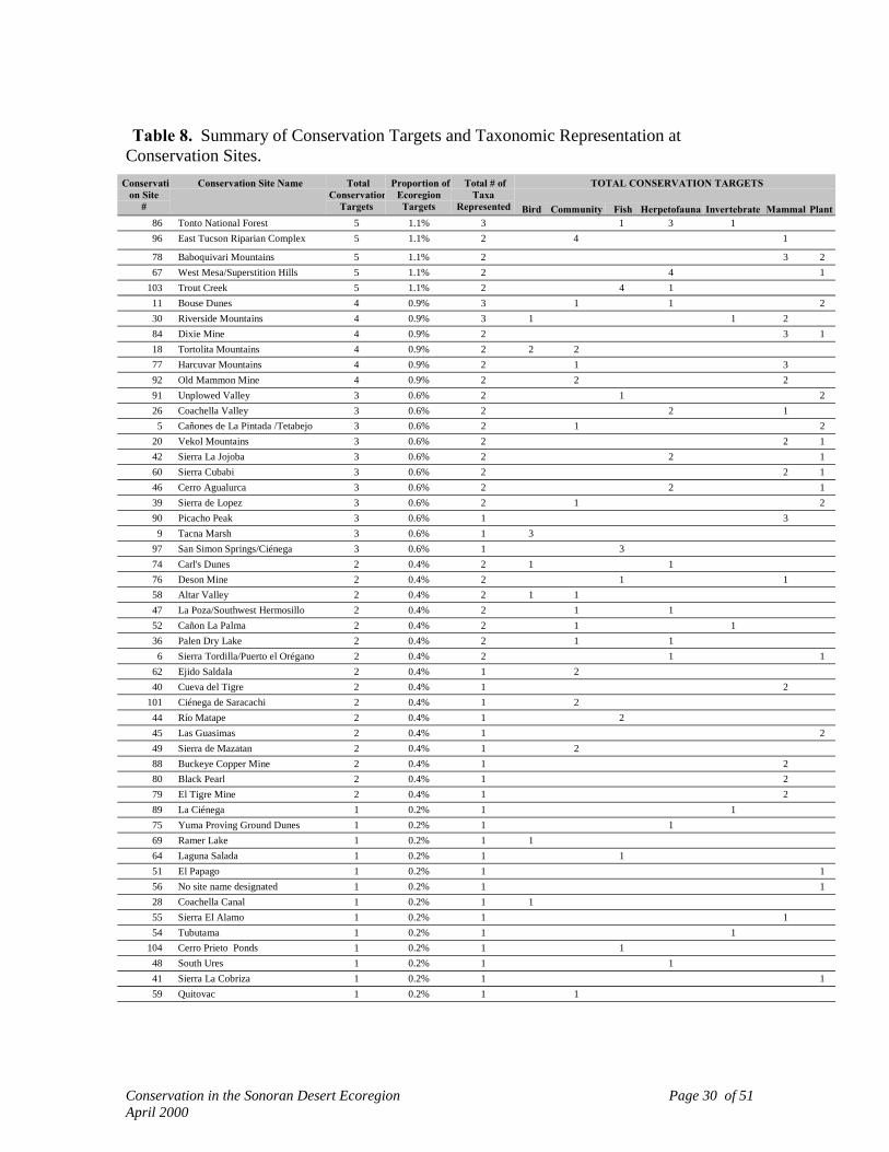
Conservation in the Sonoran Desert Ecoregion Page 30 of 51April 2000
Table 8. Summary of Conservation Targets and Taxonomic Representation atConservation Sites.
TOTAL CONSERVATION TARGETSConservation Site
#
Conservation Site Name TotalConservation
Targets
Proportion ofEcoregion
Targets
Total # ofTaxa
Represented Bird Community Fish Herpetofauna Invertebrate Mammal Plant86 Tonto National Forest 5 1.1% 3 1 3 196 East Tucson Riparian Complex 5 1.1% 2 4 1
78 Baboquivari Mountains 5 1.1% 2 3 267 West Mesa/Superstition Hills 5 1.1% 2 4 1
103 Trout Creek 5 1.1% 2 4 111 Bouse Dunes 4 0.9% 3 1 1 230 Riverside Mountains 4 0.9% 3 1 1 284 Dixie Mine 4 0.9% 2 3 118 Tortolita Mountains 4 0.9% 2 2 277 Harcuvar Mountains 4 0.9% 2 1 392 Old Mammon Mine 4 0.9% 2 2 291 Unplowed Valley 3 0.6% 2 1 226 Coachella Valley 3 0.6% 2 2 1
5 Cañones de La Pintada /Tetabejo 3 0.6% 2 1 220 Vekol Mountains 3 0.6% 2 2 142 Sierra La Jojoba 3 0.6% 2 2 160 Sierra Cubabi 3 0.6% 2 2 146 Cerro Agualurca 3 0.6% 2 2 139 Sierra de Lopez 3 0.6% 2 1 290 Picacho Peak 3 0.6% 1 3
9 Tacna Marsh 3 0.6% 1 397 San Simon Springs/Ciénega 3 0.6% 1 374 Carl's Dunes 2 0.4% 2 1 176 Deson Mine 2 0.4% 2 1 158 Altar Valley 2 0.4% 2 1 147 La Poza/Southwest Hermosillo 2 0.4% 2 1 152 Cañon La Palma 2 0.4% 2 1 136 Palen Dry Lake 2 0.4% 2 1 1
6 Sierra Tordilla/Puerto el Orégano 2 0.4% 2 1 162 Ejido Saldala 2 0.4% 1 240 Cueva del Tigre 2 0.4% 1 2
101 Ciénega de Saracachi 2 0.4% 1 244 Río Matape 2 0.4% 1 245 Las Guasimas 2 0.4% 1 249 Sierra de Mazatan 2 0.4% 1 288 Buckeye Copper Mine 2 0.4% 1 280 Black Pearl 2 0.4% 1 279 El Tigre Mine 2 0.4% 1 289 La Ciénega 1 0.2% 1 175 Yuma Proving Ground Dunes 1 0.2% 1 169 Ramer Lake 1 0.2% 1 164 Laguna Salada 1 0.2% 1 151 El Papago 1 0.2% 1 156 No site name designated 1 0.2% 1 128 Coachella Canal 1 0.2% 1 155 Sierra El Alamo 1 0.2% 1 154 Tubutama 1 0.2% 1 1
104 Cerro Prieto Ponds 1 0.2% 1 148 South Ures 1 0.2% 1 141 Sierra La Cobriza 1 0.2% 1 159 Quitovac 1 0.2% 1 1

Conservation in the Sonoran Desert Ecoregion Page 31 of 51April 2000
Integrating the concept of ecological gradients into Conservation Sites resulted incapturing complete mountain-valley-mountain complexes or shoreline to mountaincomplexes. For example, the Sauceda-Sand Tank-Table Top Mountain complex inArizona (Site 32 in Figure 9) is an unfragmented area with substantial variation insoil/substrate types and a complex topography. The entire Site captures a high level ofbiodiversity with at least 11 Conservation Targets from five taxonomic groups, a Bureauof Land Management wilderness area and two BLM Areas of Critical EnvironmentalConcern. Heritage Program and expert data identified several locations within this areathat harbor rare species (Figure 7). Extending the Site boundaries to encompass the entireSand Tank and Sauceda ranges and intervening valleys captured one of the Ecoregion’sfinest examples of the palo verde-mixed cacti matrix community type.
Characteristics of Special Element Sites
Some Conservation Targets could not be captured in landscape-scale ConservationSites. Many of these cases included single or few occurrences of particularly rare plants,fish, amphibians, and reptiles, mostly in small, isolated areas or highly fragmentedlandscapes where delineating landscape-scale Conservation Sites is not currently possible.To promote the conservation of these Targets we identified small, localized areas withonly one or several Conservation Targets as "Special Element Sites." Special ElementSites vary in size, but for the purpose of locating these sites on 1:1,000,000 scale mapseach is depicted as a point several miles in diameter. We had sufficient information toretain these areas in the analysis, in that we believe they support potentially viablepopulations of Conservation Targets. However, we currently have insufficientinformation to delineate fully functional Conservation Sites. This delineation will requiredetailed assessment and was outside of the scope of this effort.
In total we identified 79 Special Element Sites: 44 in the Lower Colorado RiverValley Subdivision, 32 in Arizona Uplands, and 3 in Plains of Sonora (Figure 13).Special Element Sites captured a total of 99 occurrences: 58 plants, 16 reptiles &hibians, 11 fish, 5 birds, 4 invertebrates, 3 mammals, and 2 communities. Eighty-oneof all occurrences (81%) were G1 and G2 targets including some of the ecoregion's rarestspecies. Appendix 5 lists the 79 Special Element Sites and the Conservation Targetscontained within them.
How Well Were Conservation Criteria Met?
Conservation Criteria were used as a guide in identifying a minimum number andspatial stratification of Conservation Sites. Below we summarize how well Criteria weremet for both fine- and coarse-filter Conservation Targets. We also summarize results ofthe biophysical modeling exercise as an additional index for how well the network of
Conservation in the Sonoran Desert Ecoregion Page 32 of 51April 2000
identified Conservation Sites reflects potential ecological variation in the Ecoregion aswhole.
Coarse filter Conservation Targets were comprised of natural vegetationcommunities, which were aggregated into ecological groups. Of the 23 ecological groupsidentified, we met, likely met, or exceeded our Conservation Criteria for 10 groups (Table9), including Palo Verde-Mixed Cacti Scrub, Creosote-Bursage, Coastal Marsh, CoastalMangrove Swamp, Sinaloan/Foothills Thornscrub, Interior Chaparral/Encinal, andCalifornia Fan Palm Oasis. While expert-derived data indicated that numerical Criteriafor Agave-Bursage Scrub, Coastal Dune, and Bedrock Shore/Sea Cave groups were notmet, nearly the entire distribution of these communities was captured within ConservationSites. Thus, it is likely that Criteria were also met for these communities. Similarly,while the areal extent of Creosote-Bursage Scrub fell short of Conservation Criteria withinthe Arizona Uplands Subdivision (i.e., 25% rather than 30%), Ecoregion-wide Criteriawere substantially exceeded. The complete summary of known occurrences of vegetationcommunities is provided in Appendix 6.
Conservation Criteria may have been met for several other ecological groups (e.g.,Sonora/Mojave Playa Lake, Mojave Desert Shrubland, Sonora/Mojave Bedrock Outcrop)but more complete inventory of landscape-scale Conservation Sites will be required todetermine the extent to which these groups were captured. Conversely, whileConservation Criteria were met for Desert Riparian Woodland, the long-term viability ofidentified areas should be a top priority for site-level review. Summaries of ConservationCriteria, urgency of action, and research/inventory needs for ecological groups are foundin Appendix 11.
For the species that make up fine filter Conservation Targets, Table 10summarizes (by taxonomic group) the degree to which Conservation Criteria were met.Appendix 7 summarizes Conservation Target occurrences by Ecoregional Subdivision.In Appendix 7 the number of sites in which each Target occurs is listed for the Ecoregionas a whole and for each Subdivision. The total number of “occurrences,” as documentedin regional databases, also is listed. Differences between the number of Sites and numberof occurrences for a Conservation Target result from some large Conservation Sitescapturing multiple occurrences of Conservation Targets.
Few Conservation Criteria were adequately met for the species that make up finefilter Conservation Targets. For some species, (e.g., several bats) inventory work yieldedmany sites for evaluation and the network of Conservation Sites identified exceeds theCriteria used in this exercise. In other cases, adequate inventory has confirmed thespecies is simply limited in its distribution to one or two locations (e.g., Sonoyta mudturtle). In those cases, meeting Conservation Criteria identified in this exercise may beimpractical and Criteria would need to be scaled appropriately by factoring geographicextent and population demography.

Conservation in the Sonoran Desert Ecoregion Page 33 of 51April 2000
Table 9. Conservation Target Summary for Natural Vegetation Communities,Summarized at the Level of Ecological Group.
Conservation Target(Ecological Groups)
PatchType1
Distribu-tion2
TotalOccur-rences
% Area ofMatrixComm.3
Captured byCons. Sites
Criteria
Palo Verde-Mixed Cacti Matrix Limited N/A 35 ExceededCreosote-Bursage Matrix Limited N/A 49 Exceeded
Interior Dunes & Plains Large Patch Limited 7 N/A Not Met
Sonora/Mojave Bedrock Outcrop Large Patch Limited 0 N/A Not Met
Semi-Desert Grassland Large Patch Limited 6 N/A Not Met
Mesquite Woodland Large Patch Limited 13 N/A Not Met
Agave-Bursage Scrub Large Patch Limited > 1 N/A Met4
Mojave Desert Shrubland Large Patch Limited 3 N/A Not MetBrittlebush-Ironwood Large Patch Limited 2 N/A Not MetTorchwood-Limberbush Desert Scrub Large Patch Limited 16 N/A Not Met
Saltbush Desert Scrub Large Patch Limited 8 N/A Not Met
Coastal Marsh Large Patch Widespread 12 N/A Met
Coastal Dunes Large Patch Widespread 5 N/A Met4
Sonora/Mojave Playa Lake Large Patch Widespread 4 N/A Not Met
Coastal Mangrove Swamp Large Patch Peripheral 11 N/A Exceeded
Sinaloan/Foothills Thornscrub Large Patch Peripheral 3 N/A Met
Interior Chaparral/Encinal Large Patch Peripheral 3 N/A Met
Interior Riparian Shrub/Woodland Small Patch Limited 2 N/A Not MetCalifornia Fan Palm Oasis Small Patch Limited 82 N/A ExceededStreams, Springs, And Sinks Small Patch Limited 10 N/A Not MetInterior Riparian Marsh Small Patch Widespread 11 N/A Not Met
Desert Riparian Woodland Linear Patch Limited 44 N/A Not Met5
Bedrock Shore/Sea Cave Linear Patch Widespread 2 N/A Met4
1 See Table 4 for patch type definitions.2 See Table 2 for distribution classes.3 Based on percent areal extent of habitat pre-European settlement.4 Although numeric criteria were not met nearly all occurrences of ecological group found in
Ecoregion were captured in Conservation Sites.5 Numerical Criteria exceeded, but viability of occurrences questionable. Site-level evaluation
required.

Conservation in the Sonoran Desert Ecoregion Page 34 of 51April 2000
Concern expressed by regional experts on the status of native fish populations ledus to depart from the convention of using numerical Criteria for this taxon. The Criteriaadopted, "maintain all viable native fish populations and the stream reaches where theyoccur," may appear to lack flexibility in light of the rapid pace of change occurring withinthe Ecoregion. However, the Sonoran Desert's riverine, aquatic, and riparian resourceshold a disproportionate amount of the Ecoregion's biodiversity and have experienced themost extensive and intensive change. In this context the Criteria adopted simply reflectthe precarious state of these Targets. Table 11 summarizes the number of ConservationSites at which fish Targets are found or have the potential to be restored.
Table 10. Conservation Target Criteria Summary by Taxonomic Group andEcoregional Subdivision1.
TaxonomicGroup
Number of Conservation Targets for which Conservation Criteriawere Not Met, Met, or Exceeded
ArizonaUplands
Central GulfCoast
LowerColorado
River ValleyPlains ofSonora
TotalTargets
N M E N M E N M E N M EBird 10 4 14 16 2 10 32Fish2 25Herpetofauna 9 2 2 11 4 3 42Invertebrate 7 1 1 2 3 56Mammal 7 1 1 5 7 1 3 31Plant 27 12 50 11 173
Total 60 8 1 34 86 6 1 301 Natural vegetation community Criteria summarized in Table 9.2 Numerical Criteria were not used for fish Targets. See narrative summary below.
Although a considerable amount of biological inventory and ecological analysishas been conducted in the Sonoran Desert Ecoregion, surprisingly little of this informationhas made it into regional databases. We suspect that the identified network ofConservation Sites actually captures many more occurrences of Conservation Targets thanis suggested by the data obtained for this analysis. There are several other likely reasonsfor gaps in data. Limited funding for biological inventory tends to focus work on rarespecies which fall under regulation by public agencies (e.g., desert tortoise). Fieldinventory for other species has varied both spatially and temporally. In many cases, onlyone to several locations are actually catalogued in regional databases. The expertworkshop used in this project was designed, in part, to overcome these data gaps. Buteven that process yielded first records for many species, mainly endemic plants for whichlittle to no information exists in regional databases. For this reason we believe thatConservation Sites capture more Targets than our analyses indicate.

Conservation in the Sonoran Desert Ecoregion Page 35 of 51April 2000
Table 11. Number of Conservation Sites at which Ecoregion's Fish ConservationTargets are Found or Have the Potential to be Restored.
Number ofConservation Sitesw/ Fish Targets orwith Potential for
Targets to beRestored1
Number ofFish
ConservationTargets
Conservation Targets2
1 3 Mexican Stoneroller, Opata Sucker, Desert Chub2 3 Quitobaquito Pupfish, Pacific Tenpounder, Sonoran Chub3 3 Spikedace, Woundfin, Loach Minnow4 2 Flannelmouth Sucker, Colorado Squawfish5 1 Bonytail6 1 Gila Chub7 3 Sonora Sucker, Speckled Dace, Razorback Sucker9 1 Desert Sucker
10 1 Roundtail Chub13 1 Gila Topminnow14 1 Longfin Dace18 1 Desert Pupfish
1 See Appendix 4 for a complete listing of Targets by Conservation Site.2 Total number of fish Conservation Targets is 25; two undescribed species (Gila sp. and Agosia
sp.) and two subspecies are not listed in this table.
Biophysical Representation
After refinements to Conservation Sites were completed, 28 biophysical unitsremained under-represented among the network of Conservation Sites (Table 12). Forexample, portions of the Plains of Sonora mapped as palo verde-mixed cacti that occur atlow elevations (sea level to 400 m ASL) and on gentle to flat landscapes appear to remainunder-represented (Figure 14). The majority of potentially under-represented types wereidentified in north-central Sonora within the Arizona Uplands and Plains of SonoraSubdivisions, and include a series of torchwood-limberbush communities that occur on arange of elevations, slopes, and aspects. Notwithstanding these potential omissions, thebiophysical analysis indicated that a substantial proportion of major environmentalgradients for the Ecoregion are likely represented within the network of ConservationSites. The complete set of biophysical classes and their distribution within the Ecoregionis summarized in Appendix 8.
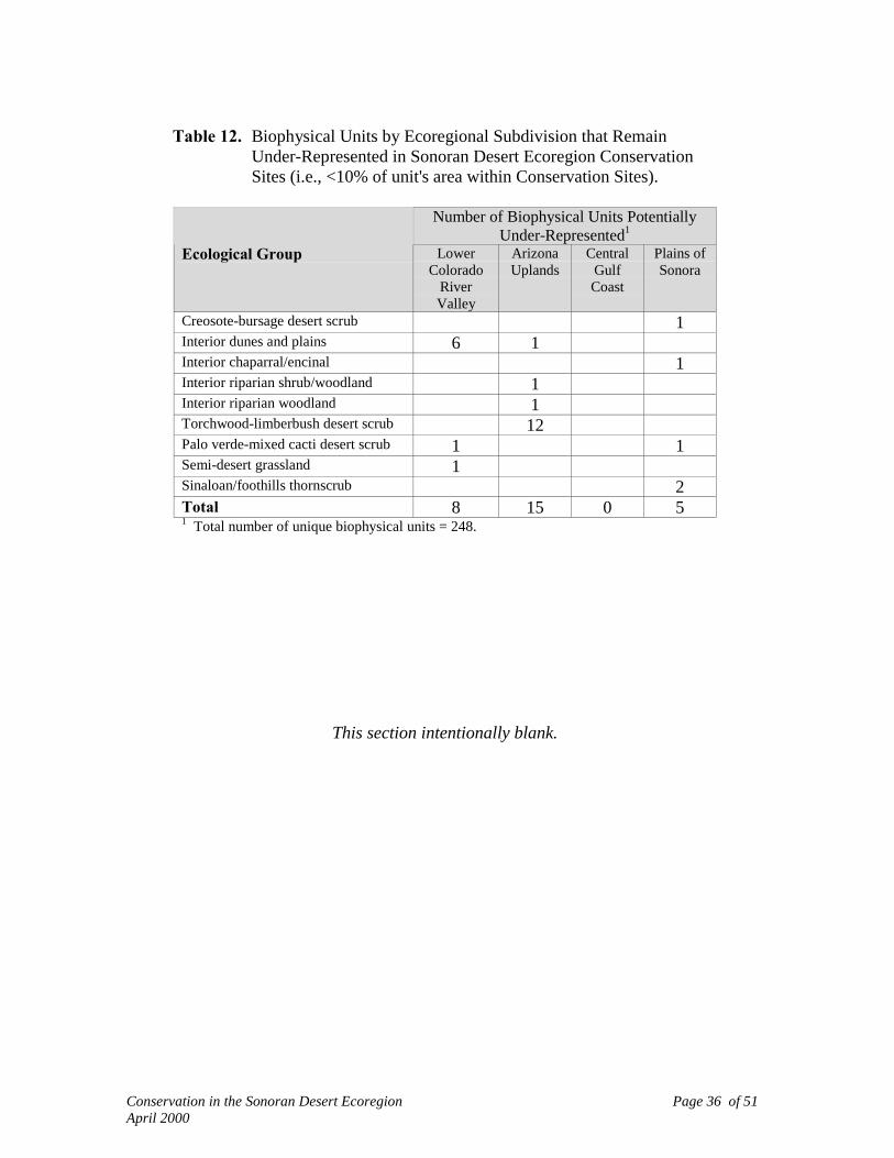
Conservation in the Sonoran Desert Ecoregion Page 36 of 51April 2000
Table 12. Biophysical Units by Ecoregional Subdivision that RemainUnder-Represented in Sonoran Desert Ecoregion ConservationSites (i.e., <10% of unit's area within Conservation Sites).
Number of Biophysical Units PotentiallyUnder-Represented1
Ecological Group LowerColorado
RiverValley
ArizonaUplands
CentralGulfCoast
Plains ofSonora
Creosote-bursage desert scrub 1Interior dunes and plains 6 1Interior chaparral/encinal 1Interior riparian shrub/woodland 1Interior riparian woodland 1Torchwood-limberbush desert scrub 12Palo verde-mixed cacti desert scrub 1 1Semi-desert grassland 1Sinaloan/foothills thornscrub 2Total 8 15 0 51 Total number of unique biophysical units = 248.
This section intentionally blank.
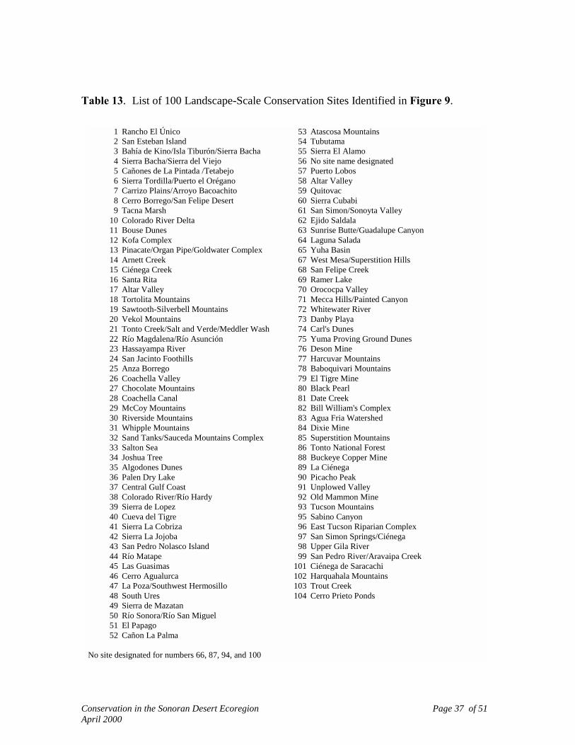
Conservation in the Sonoran Desert Ecoregion Page 37 of 51April 2000
Table 13. List of 100 Landscape-Scale Conservation Sites Identified in Figure 9.
1 Rancho El Único 53 Atascosa Mountains2 San Esteban Island 54 Tubutama3 Bahía de Kino/Isla Tiburón/Sierra Bacha 55 Sierra El Alamo4 Sierra Bacha/Sierra del Viejo 56 No site name designated5 Cañones de La Pintada /Tetabejo 57 Puerto Lobos6 Sierra Tordilla/Puerto el Orégano 58 Altar Valley7 Carrizo Plains/Arroyo Bacoachito 59 Quitovac8 Cerro Borrego/San Felipe Desert 60 Sierra Cubabi9 Tacna Marsh 61 San Simon/Sonoyta Valley
10 Colorado River Delta 62 Ejido Saldala11 Bouse Dunes 63 Sunrise Butte/Guadalupe Canyon12 Kofa Complex 64 Laguna Salada13 Pinacate/Organ Pipe/Goldwater Complex 65 Yuha Basin14 Arnett Creek 67 West Mesa/Superstition Hills15 Ciénega Creek 68 San Felipe Creek16 Santa Rita 69 Ramer Lake17 Altar Valley 70 Orococpa Valley18 Tortolita Mountains 71 Mecca Hills/Painted Canyon19 Sawtooth-Silverbell Mountains 72 Whitewater River20 Vekol Mountains 73 Danby Playa21 Tonto Creek/Salt and Verde/Meddler Wash 74 Carl's Dunes22 Río Magdalena/Río Asunción 75 Yuma Proving Ground Dunes23 Hassayampa River 76 Deson Mine24 San Jacinto Foothills 77 Harcuvar Mountains25 Anza Borrego 78 Baboquivari Mountains26 Coachella Valley 79 El Tigre Mine27 Chocolate Mountains 80 Black Pearl28 Coachella Canal 81 Date Creek29 McCoy Mountains 82 Bill William's Complex30 Riverside Mountains 83 Agua Fria Watershed31 Whipple Mountains 84 Dixie Mine32 Sand Tanks/Sauceda Mountains Complex 85 Superstition Mountains33 Salton Sea 86 Tonto National Forest34 Joshua Tree 88 Buckeye Copper Mine35 Algodones Dunes 89 La Ciénega36 Palen Dry Lake 90 Picacho Peak37 Central Gulf Coast 91 Unplowed Valley38 Colorado River/Río Hardy 92 Old Mammon Mine39 Sierra de Lopez 93 Tucson Mountains40 Cueva del Tigre 95 Sabino Canyon41 Sierra La Cobriza 96 East Tucson Riparian Complex42 Sierra La Jojoba 97 San Simon Springs/Ciénega43 San Pedro Nolasco Island 98 Upper Gila River44 Río Matape 99 San Pedro River/Aravaipa Creek45 Las Guasimas 101 Ciénega de Saracachi46 Cerro Agualurca 102 Harquahala Mountains47 La Poza/Southwest Hermosillo 103 Trout Creek48 South Ures 104 Cerro Prieto Ponds49 Sierra de Mazatan50 Río Sonora/Río San Miguel51 El Papago52 Cañon La Palma
No site designated for numbers 66, 87, 94, and 100

Conservation in the Sonoran Desert Ecoregion Page 38 of 51April 2000
VI. CONSERVATION STATUS
What Is A Conservation Site?
At the very minimum, the aggregate of all Conservation Sites represents ahypothesis: that implementing appropriate management at each of the identifiedConservation Sites would ensure the long-term persistence of most of the Ecoregion'sbiodiversity. "Appropriate management" does not imply any single type of managementregime, nor does it imply the elimination of all activities. Appropriate management meansthat major stressors are identified and abated/minimized through management actions orrestoration (passive or active). At the other end of the spectrum, a Conservation Siterepresents a focal point for developing public awareness and implementing conservationactions so that the Conservation Targets identified in this exercise, as well as all of theother species for which our selected Targets serve as a surrogate, remain viable on thelandscape.
Land Management/Ownership at Landscape-Scale Conservation Sites
Table 14 summarizes the land management status for the 100 landscape-scaleConservation Sites. Reflecting the overall land management pattern in the U.S. portion ofthe Ecoregion, the majority of Conservation Sites identified in Arizona and California(87%) are lands managed by federal or state public agencies. A comprehensive landmanagement cover that distinguishes among private, federal, and Ejido lands in Mexicohad not yet been completed during this exercise. In total, 12.6 million acres (5.0 millionha) in Sonora and Baja were identified as Conservation Sites. Of this total, 2.7 millionacres (1.1 million ha) lie within Biosphere Reserves; 777,491 acres (314,640 ha) arecomprised of areas proposed for a State of Sonora Protected areas System (SANPES1992). Appendix 9 provides land management/land ownership statistics for each of the100 Conservation Sites.
GAP Analysis of Conservation Sites
We used the GAP Analysis Land Management Status criteria (Crist et al. 2000) torank and assess the level of conservation management for the Sonoran Ecoregion. GAPuses a scale of 1 through 4 to classify the relative degree of management devoted tomaintenance of biodiversity for land units. A status of "1" denotes the highest, mostpermanent level of management, and "4" represents the minimum level of management orunknown status (Table 15).
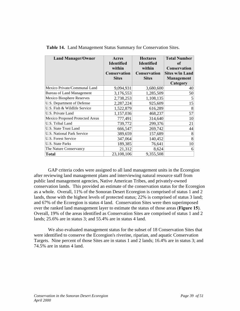
Conservation in the Sonoran Desert Ecoregion Page 39 of 51April 2000
Table 14. Land Management Status Summary for Conservation Sites.
Land Manager/Owner AcresIdentified
withinConservation
Sites
HectaresIdentified
withinConservation
Sites
Total Numberof
ConservationSites w/in LandManagement
CategoryMexico Private/Communal Land 9,094,931 3,680,600 40Bureau of Land Management 3,176,553 1,285,509 50Mexico Biosphere Reserves 2,738,253 1,108,135 5U.S. Department of Defense 2,287,224 925,609 15U.S. Fish & Wildlife Service 1,522,879 616,289 8U.S. Private Land 1,157,036 468,237 57Mexico Proposed Protected Areas 777,491 314,640 10U.S. Tribal Land 739,772 299,376 21U.S. State Trust Land 666,547 269,742 44U.S. National Park Service 389,659 157,689 8U.S. Forest Service 347,064 140,452 8U.S. State Parks 189,385 76,641 10The Nature Conservancy 21,312 8,624 6Total 23,108,106 9,355,508
GAP criteria codes were assigned to all land management units in the Ecoregionafter reviewing land management plans and interviewing natural resource staff frompublic land management agencies, Native American Tribes, and privately-ownedconservation lands. This provided an estimate of the conservation status for the Ecoregionas a whole. Overall, 11% of the Sonoran Desert Ecoregion is comprised of status 1 and 2lands, those with the highest levels of protected status; 22% is comprised of status 3 land;and 67% of the Ecoregion is status 4 land. Conservation Sites were then superimposedover the ranked land management layer to estimate the status of those areas (Figure 15).Overall, 19% of the areas identified as Conservation Sites are comprised of status 1 and 2lands; 25.6% are in status 3; and 55.4% are in status 4 land.
We also evaluated management status for the subset of 18 Conservation Sites thatwere identified to conserve the Ecoregion's riverine, riparian, and aquatic ConservationTargets. Nine percent of those Sites are in status 1 and 2 lands; 16.4% are in status 3; and74.5% are in status 4 land.

Conservation in the Sonoran Desert Ecoregion Page 40 of 51April 2000
Table 15. GAP Analysis Program Land Management Status Criteria1.
Status 1: An area having permanent protection from conversion of natural land cover and amandated management plan in operation to maintain a natural state within whichdisturbance events (of natural type, frequency, intensity, and legacy) are allowedto proceed without interference or are mimicked through management.
Status 2: An area having permanent protection from conversion of natural land cover and amandated management plan in operation to maintain a primarily natural state, butwhich may receive uses or management practices that degrade the quality ofexisting natural communities, including suppression of natural disturbance.
Status 3: An area having permanent protection from conversion of natural land cover forthe majority of the area, but subject to extractive uses of either a broad, low-intensity type (e.g., logging) or localized intense type (e.g., mining). It alsoconfers protection to federally listed endangered and threatened speciesthroughout the area.
Status 4: There are no known public or private institutional mandates or legally recognizedeasements or deed restrictions held by the managing entity to prevent conversionof natural habitat types to anthropogenic habitat types. The area generally allowsconversion to unnatural land cover throughout.
1 From Crist et al. (2000). www.gap.uidaho.edu/handbook/stewardship/
Ecoregion-Wide Stresses
During the May 1998 Experts Workshop participants were asked to indicate theprimary stressors to the areas identified for Conservation Targets. The intent of theexercise was to understand what major stressors were common to areas throughout theEcoregion. These data do not represent a scientific survey; they reflect the experience andperceptions of more than 100 experts as to the major stressors affecting biodiversity in theSonoran Desert Ecoregion. As such they provide a starting point for addressing issuesthat cross administrative, state, and international boundaries (e.g., exotic species,recreation), or re-emphasize concern over issues that have been a focal point for manyyears (e.g., water use, livestock management). By major stressors it is meant that directand indirect effects of various activities disrupt ecological processes needed to maintainnative fauna and flora. For example, the loss of land surface area or soil integrity (due todevelopment, compaction of soils, or erosion) may result in a decrease in infiltration ofprecipitation, maintenance of subsurface aquifers and riparian systems, and loss ofmycorrhizal soil communities that fix nitrogen.
Table 16 summarizes expert input on Ecoregion-wide stresses as a simple count ofthe number of landscape-scale Conservation Sites at which a particular stress was

Conservation in the Sonoran Desert Ecoregion Page 41 of 51April 2000
identified (stressors were not identified for each of the 79 special element sites). Thesedata reflect the widespread nature of the major stressors in the Sonoran Desert Ecoregion.The spread of exotic, invasive plants and animals, recreation, residential and commercialdevelopment, and improper livestock grazing were identified as major stressors at morethan half of the 100 landscape-scale Conservation Sites. These same stressors, as well asthe extraction of groundwater and the diversion or impoundment of surface water, wereidentified as major stressors at more than two-thirds of the 18 Conservation Sitesidentified to conserve the Ecoregion's riverine and riparian habitats.
In the next section we point to measures that can be taken to monitor and managemajor stressors and highlight programs already in place that were designed to accomplishthis need. Because the threat of invasive, exotic plants and animals continues to be one ofthe most insidious threats to the biodiversity of the Sonoran Desert Ecoregion, we havecompiled a list of exotics found throughout the Ecoregion that are known or presumed tohave the greatest adverse impact on native fauna and flora (Appendix 10). The issue ofexotic species in the Sonoran Desert is complex. The ability to minimize the adverseeffects of exotics on native biodiversity will be critical to the long-term health of SonoranDesert Ecoregion. However, not all exotic species pose the same degree of threat. Theintent of the list in Appendix 10 is to draw attention to those species believed to pose thegreatest threat.
This section intentionally blank.

Conservation in the Sonoran Desert Ecoregion Page 42 of 51April 2000
Table 16. Major Stressors at Sonoran Ecoregion ConservationSites as Identified by Experts1.
Summary of major stressors identified for100 Conservation Sites
Stressor Number ofSites
Introduction of exotic plants and animals 73Recreation 72Urban development 56Mining 55Improper livestock management 53Extraction of groundwater, diversion or impoundmentof surface water
40
Introduction of fire into non-fire adapted vegetationcommunity
38
Conversion of desert to agriculture 35
Summary of major stressors at 18 riverine Conservation Sites
Stressor Number ofSites
Introduction of exotic plants and animals 16Urban development 15Improper livestock management 15Extraction of groundwater, diversion or impoundmentof surface water
14
Recreation 14Mining 12Introduction of fire into non-fire adapted vegetationcommunity
10
Channelization 10Conversion of floodplain to agriculture 10
1 Information on major stressors gathered during two-day experts workshopheld May 1998 at the University of Arizona.
2 Eighteen riverine Sites identified include Sites: 14, 15, 21, 22, 23, 38, 44,50, 61, 72, 81, 82, 95, 96, 97, 98, 99, 101.

Conservation in the Sonoran Desert Ecoregion Page 43 of 51April 2000
VII. NEXT STEPS & RECOMMENDATIONS
During the 24 month period in which this project was completed a numberrecommendations and potential next steps were identified. Several of the highest priorityitems are discussed below.
Improve Conservation Management Status at Conservation Sites
The small proportion (19%) of identified Conservation Sites in GAP status 1 or 2management indicates considerable work is still needed to ensure the long-termconservation of the Ecoregion's biodiversity. Given that Conservation Sites overlap landsmanaged by public, private, and communal entities, a variety of approaches may beneeded to accomplish the overall goal of biodiversity conservation. Several potentialapproaches are briefly described below.
For lands already designated for conservation purposes, identify and implementprograms to abate or minimize site-specific stresses. Several examples are providedbelow (see Pilot Conservation Programs) of land managers targeting major stressors witheffective programs.
For lands in which conservation is one of multiple management goals, integrateEcoregional data (e.g., coarse- and fine-scale Conservation Targets) and a goals-basedapproach into comprehensive land management planning so that the Ecoregion'sbiodiversity may be adequately characterized, evaluated, accounted for, and conservedthrough development of appropriate management programs. Multiple-use managementand other Federal statutes that require biodiveristy conservation on public lands in theU.S. portion of the Ecoregion were designed to enable such a process.
For lands in which conservation is not a current goal, identify opportunities toincrease attention to conservation of biodiversity by developing collaborative programsamong public and private entities (e.g., U.S. Fish and Wildlife Service's Partners forWildlife Program). In Sonora a significant conservation opportunity exists through theUnidades de Manejo Ambiental (UMA) program, which is designed to conveyconservation protection to private lands in Sonora. UMAs, or designated environmentalmanagement areas, provide for wildlife management objectives on private lands andrequire development of a management plan. Incorporating Ecoregional data intomanagement plans and the development of conservation programs would enhance theoverall contribution of individual UMAs to biodiversity conservation in the Ecoregion.Several UMA management plans are now in place. Expansion of the program will requirethat several ongoing needs are met, among them is program oversight, technical assistancefor management planning, the integration of biodiversity data into management plans, anda program of monitoring and evaluation.

Conservation in the Sonoran Desert Ecoregion Page 44 of 51April 2000
Nexus with Regional Conservation Efforts
A significant benefit of compiling data at an Ecoregional scale is the developmentof a baseline from which to evaluate biological entities and trends as well as activitiesacross the landscape. Identifying a network of Conservation Sites establishes a goal andhelps frame the importance of species and vegetation community types in space and time.For example, in estimating the acreage of the creosote-bursage matrix vegetationcommunity across the Ecoregion, and then identifying the Conservation Sites that containextensive presumably viable populations, a common vegetation community type becomesa component of biological diversity that can be accounted for and conserved over thelong-term. In this vein the Sonoran Desert Ecoregional Analysis can serve other regionaland local conservation efforts (e.g., Pima County Habitat Conservation Plan, Federal LandManagement plan revisions, U.S. Fish & Wildlife Service's All Bird Joint Venture, etc.)by pointing out areas that are of particular import and by identifying a broad range ofspecies and vegetation communities that should serve as a focus of biodiversityconservation efforts in these areas and elsewhere.
Evaluate Conservation Sites and Conservation Management Programs
The need for additional data and analyses will never diminish, but the biodiversitythat still exists within the network of Conservation Sites will diminish if conservationopportunities are not acted on. One method to quickly understand opportunities and needsis to gain a more comprehensive understanding of the conservation management activitiescurrently being implemented at Conservation Sites and to assess the degree to whichmajor stressors are being abated and monitored. An evaluation of these elements willdraw attention to needs and funding requests targeted at specific needs can be justified interms of the overall contribution a particular Conservation Site makes to the Ecoregion.This type of evaluation should be completed for both the landscape-scale and specialelement Conservation Sites identified in this analysis. Moreover, identifying managementactivities currently being implemented across the Ecoregion would draw attention to thoseactivities that have broader utility as well as developing an understanding of how activitiescurrently implemented by multiple parties throughout the Ecoregion might benefit fromenhanced coordination.
Implement Pilot Conservation Projects
Some land managers have already begun implementing programs to abate orminimize major stressors. Several examples are provided below. Key components tothese programs include periodic evaluation of effectiveness and integration of results intoland management decisions to facilitate true adaptive management.
Conservation in the Sonoran Desert Ecoregion Page 45 of 51April 2000
An example of a pilot conservation project that may have broader applicationthroughout the Ecoregion is Organ Pipe Cactus National Monument's (Site 13) program tocontrol the spread of the exotic buffel grass (Pennisetum ciliare). By competing forspace and changing fire frequency and intensity, buffel grass can transform diverse nativedesert vegetation communities into depauperate monocultures. Over a two-year periodMonument staff and volunteers eradicated nearly 100 tons of this invasive plant from 25square miles (68 km2) near the international border. Although buffel grass is still commonacross the border in Mexico, and thus remains a threat, the Monument's abatement effortshave positioned the staff to perform less intensive follow-up monitoring and controlefforts.
The magnitude and widespread nature of the threat posed by invasive exoticssuggest another pilot conservation program that might have broad utility in the long-termconservation of the desert's biodiversity the formation of a Sonoran Desert ExoticsCouncil. Such councils, often referred to as "weed" councils, provide education, training,and coordination for public, private, and tribal land managers. The need and desire forsuch an effort was tested at a June 1999 workshop at Organ Pipe Cactus NationalMonument where federal, state, Tribal, and private land managers from the U.S. andMexico gathered to review problem areas, abatement approaches, and the design of othercouncils in the western U.S. The positive results of that forum and other efforts aroundthe Ecoregion point to a growing awareness of the problem and need to coordinateresources, training, experience, and experiments.
A third example of a pilot conservation project that may have broader applicabilityis the Bureau of Land Management's monitoring at Algodones Dunes (Site 35). A projectto monitor and evaluate the effects of recreational use of the dunes on six special statusplant species was initiated in April 1998, as part of a larger, long-term monitoringprogram for rare and endangered plants. Design and implementation of the project hasbeen a cooperative effort among staff from the Bureau of Land Management, CaliforniaFish & Game, U.S Fish & Wildlife Service, and California Native Plant Society.
The Algodones Dunes is divided into two types of use: (1) Wilderness, which isclosed to Off Highway Vehicles, and; (2) Open Areas, in which OHV use is allowed.Open Areas are further divided by the amount of use they receive from intensive to verylight use. Because the distribution and abundance of dune vegetation is dependant onprecipitation, which varies temporally and spatially, rainfall monitoring stations will beinstalled in three locations in the dunes. Thirty-four plant monitoring transects wereestablished across the entire dune system to accurately map and compare plant distributionbetween the Wilderness and Open Area. In addition, a set of low-elevation photographswas taken in 1988 and 1999 to establish a baseline map of OHV use. Overlaying thespecial status plant distribution map on the OHV use map enables comparisons of plantdistribution and density in low OHV use areas versus high use areas. This information isused to help manage recreational use of the dunes so that it is consistent with protectingthe unique biodiversity of that system.

Conservation in the Sonoran Desert Ecoregion Page 46 of 51April 2000
Integrate and Synthesize Existing Data at a Landscape-Scale
While the disciplines of conservation biology and natural resource managementhave shifted more and more to an “Ecoregional” or “Ecosystem” approach, thecomprehensive data needs for such an approach remain to be filled. We believe thatsubstantial progress would result from spending resources on integrating and synthesizingexisting expert data and knowledge into new databases that combine quantitative,qualitative, and spatial data. The experts workshop conducted for this analysis revealed avast wealth of data and knowledge that exists in published works, unpublished works,individual data bases, field notes, etc., but that remains largely unorganized for landscape-scale analyses. A key component of future landscape-scale analyses will be qualitativedata that provide context and enables more ecological-based interpretation of the speciesor natural vegetation community data that are rendered as dots on a map. Moreover,information on the size, landscape context, and condition of ecological communities(Anderson et al. 1999) will be critical for assessing viability of Conservation Targets andlocations identified for conservation management. New databases that integrate andsynthesize quantitative, qualitative, and spatial data will provide the tools necessary tocomplete more refined landscape-scale analyses in the future.
Another key component of landscape-scale analyses is a coarse filter thatcharacterizes both vegetation communities and landscape features (e.g., bajadas dissectedby wash complexes, shifting dunes, untilled valley bottoms, etc.). Future iterations ofGAP vegetation mapping data combined with biophysical models such as the one used inthis exercise or digital elevation models would provide one basis for continuing to refine acoarse filter that complements finer-scale species data. Such work should proceed inparallel in both the Mexico and U.S. portions of the Ecoregion to capitalize on theEcoregional approach taken here and to enhance the overall conservation effort in theEcoregion. In Appendix 11 we provide a brief status report and priority inventory needsfor the 23 ecological groups that were used as the coarse filter for this analysis.
Implement Ecosystem Monitoring Projects
Rapidly-increasing human population in the Sonoran Desert is one index ofpotential stress to the desert's biodiversity, but it is an indirect and imprecise index at best.Monitoring the population abundance and distribution of desert tortoise might yield dataon population trend, but unless known stressors (natural and anthropogenic) were alsobeing monitored the causes of population change would not be clear. In order to betterunderstand the state of the desert's biodiversity, a complimentary program of ecosystemmonitoring should be established. By complimentary we mean that traditional populationmonitoring on a range of species is accompanied by monitoring of the major stressorslikely to affect a suite of species. For example, one of the major threats posed by thespread of exotic plants is type conversions of native plant communities and concomitant

Conservation in the Sonoran Desert Ecoregion Page 47 of 51April 2000
habitat loss for species. The conversion of cottonwood-willow riparian forest to saltcedarand the change in bird species composition and abundance is a case in point. Some landmanagers have implemented programs to track major stressors such as invasive plants(Site 13), recreation pressures (Site 35), groundwater levels (Site 13), etc. A targetedevaluation of major stressors at Conservation Sites along with more widespread stress-based monitoring programs would yield data needed to assess the state of the desert'sbiodversity and carry out true adaptive management.
Finally, the results of this effort should not be construed as the end point oflandscape-scale analyses for the Sonoran Desert Ecoregion, but rather the beginning. Thisfirst attempt at identifying conservation priorities at the Ecoregional scale would begreatly bolstered by incorporating additional data sets that refine elements of the network,such as a detailed analysis of corridors for large mammals or more in-depth investigationof the distribution of key assemblages of pollinators. We hope this effort will spur othersto create the data sets and complete the analyses needed to answer some of theseimportant biodiversity questions.
This section intentionally blank.

Conservation in the Sonoran Desert Ecoregion Page 48 of 51April 2000
VIII. REFERENCES
Anderson, M., P. Comer, D. Grossman, C. Groves, K. Poiani, M. Reid, R. Schneider, B. Vickery,and A. Weakley. 1999. Guidelines for Representing Ecological Communities inEcoregional Conservation Plans. The Nature Conservancy, Arlington, VA. 74 pp.
Arizona Gap Analysis Program. 1998. U.S. Geological Survey/Cooperative Park StudiesUnit/University of Arizona, Tucson, Arizona.
Bailey, R.G. 1998. Ecoregions Map of North America: Explanatory Note. Prepared inCooperation with The Nature Conservancy and the U.S. Geological Survey. U.S.D.A.Forest Service, Miscellaneous Publication Number 1548. Washington, DC.
Bailey, R.G. 1995. Descriptions of the Ecoregions of the United States. Second Edition.U.S.D.A. Forest Service Miscellaneous Publication Number 1391. Washington, DC.
Bailey, R.G. 1994. Ecoregions of the United States (revised map). U.S.D.A. Forest Service.Washington D.C.
Brown, D.E. (ed.). 1994. Biotic Communities of the Southwestern United States andNorthwestern Mexico. University of Utah Press, Salt Lake City, UT.
Brown, D.E. (ed.). 1982. Biotic Communities of the American Southwest - United States andMexico. Desert Plants - Special Issue Vol. 4, No. 1-4.
Brown, D.E. and C.H. Lowe. 1980. Biotic Communities of the Southwest (map at scale1:1,000,000). U.S.D.A. Forest Service General Technical Report RM-78.
Bureau of Land Management. 1998. Draft North and East Colorado Desert CoordinatedManagement Plan. Natural Communities Digital Map. Riverside, CA.
Carrol, C.R. and G.K. Meffe. 1997. Management to Meet Conservation Goals. Pp. 385-418, InG.K. Meffe and C.R. Carrol (eds.), Principles of Conservation Biology. SinauerAssociates, Inc., Sunderland, MA.
Cohn, J.P. 1996. The Sonoran Desert: Changing Face of the Desert Keeps CommunitiesDynamic. Bioscience, 46(2):84-88.
Cooke, R.U. and R.W. Reeves. 1976. Arroyos and Environmental Change in the AmericanSouthwest. Clarendon Press, Oxford. 213 pp.
Cordell, L. 1997. Archaeology of the Southwest. Academic Press, New York.
Crist, P.J., T.C. Edwards, Jr., C.G. Homer, S.D. Bassett and B.C. Thompson. 2000. Mapping andCategorizing Land Stewardship. Version 2.1.0 GAP Analysis Program.www.gap.uidaho.edu/handbook/stewardship/

Conservation in the Sonoran Desert Ecoregion Page 49 of 51April 2000
Davis, F.W., D.M. Stoms, A.D. Holander, K.A. Thomas, P.A. Stine, D. Odion, M.I. Borchert, J.H.Thorne, M.V. Gray, R.E. Walker, K. Warner and J. Graae. 1998. The California GapAnalysis Project-Final Report, June 30, 1998. University of California, Santa Barbara,CA, 255 pp.
Dinerstein, E., D.M. Olsen, D.J. Graham, A.L. Webster, S.A. Primm, M.P. Bookbinder, and G.Ledec. 1995. A Conservation Assessment of the Terrestrial Ecoregions of Latin Americaand the Caribbean. World Bank, Washington D.C.
Emanuel, R.M. 2000. Human Dimensions of the Sonoran Desert Ecoregion: A Summary Report.Sonoran Institute, Tucson, AZ. 40 pp.
Environmental Systems Research Institute. 1998. ArcView GIS Software version 3.1. Redlands,CA.
Gerhard, P. 1993. The North Frontier of New Spain. Revised Edition. University of OklahomaPress, Norman.
Gorenflo, L. 2000. The evaluation of human population in conservation planning: an examplefrom the Sonoran Desert Ecoregion. America Verde Working Paper Series. The NatureConservancy, Latin America and Caribbean Division, Arlington, VA. 44 pp.
Grossman, D.H., D. Faber-Langendoen, A.S. Weakley, M. Anderson, P. Bourgeron, R. Crawford,K. Goodin, S. Landaal, K. Metzler, K.D. Patterson, M. Pyne, M. Reid and L. Sneddon.1998. International Classification of Ecological Communities: Terrestrial Vegetation ofthe United States. Volume I: The Vegetation Classification Standard. The NatureConservancy. Arlington, VA. 126 pp.
Hartmann, W.K. 1989. Desert Heart: Chronicles of the Sonoran Desert. Fisher Books, Tucson.
Heizer, R.F. (ed.). 1978. California. Handbook of North American Indians, Volume 8.Smithsonian Institution Press, Washington, DC.
IMADES. 1998. Sonora and Baja California Land Cover Digital map. Digitized from INEGIMaps Scale 1:250,000 Hermosillo, Mexico.
Jackson, L.L. and P.W. Comus. 1999. Ecological Consequences of Agricultural Development in aSonoran Desert Valley. Pp. 217-254 In: R.H. Robichaux (ed.), Ecology of Sonoran DesertPlants and Plant Communities. University of Arizona Press. Tucson.
MacArthur, R.H. and E.O. Wilson, 1967. The Theory of Island Biogeography. PrincetonUniversity Press, Princeton, NJ.
MacMahon, J.A. and F.H. Wagner. 1985. The Mojave, Sonoran and Chihuahuan Deserts ofNorth America. Pp. 105-201 In: Evenari, M. and I. Noy-Meir (eds.), Hot Deserts andArid Shrublands. Vol. 12A. Elsevier, New York, New York.
McGinnies, W.G. 1981. Discovering the Desert: Legacy of the Carnegie Desert BotanicalLaboratory. University of Arizona Press. 276 pp.

Conservation in the Sonoran Desert Ecoregion Page 50 of 51April 2000
McCoy, E.D, P.E. Sutton and H.R. Mushinsky. 1999. The Role of Guesswork in Conserving theThreatened Sand Skink. Conservation Biology 13:(1) 190-194.
Nabhan, G.P. and A.R. Holdsworth. 1999. State of the Biome: Uniqueness, Biodiversity, Threatsand the Adequacy of Protection in the Sonoran Bioregion. The Wildlands Project.Tucson, AZ. 80 pp.
Olsen, D.M. and E. Dinnerstein. 1998. The Global 200: A Representation approach to Conservingthe Earth's Most Biologically Valuable Ecoregions. Conservation Biology 12:502-515.
Ortiz, A. (ed.). 1983. The Southwest. Handbook of North American Indians, Volume 10.William Sturtevant, General Editor. Smithsonian Institution Press, Washington, DC.
Pendergast, J.R., R.M. Quinn and J.H. Lawton. 1999. The Gaps Between Theory and Practice inSelecting Nature Reserves. Conservation Biology 13:484-492.
Phillips, S.J. and P. Wentworth Comus. 2000. A Natural History of the Sonoran Desert.Arizona-Sonora Desert Museum Press, Tucson, AZ. 628 pp.
Pickett, S.T.A. and J.N. Thompson. 1978. Patch Dynamics and the Design of Nature Reserves.Biological Conservation 13:27-37.
Quinn, J.F. and A. Hastings. 1987. Extinction in Subdivided Habitats. Conservation Biology1:198-208.
Redford, K.H. and B.D. Richter. 1999. Conservation of Biodiversity in a World of Use.Conservation Biology 13:1246-1256.
Reynolds, S.J. 1988. Geologic Map of Arizona. Arizona Geological Survey. Map 1:1,000,000scale.
Robichaux, R.H. 1999. Ecology of Sonoran Desert Plants and Plant Communities. University ofArizona Press, Tucson. 303 pp.
SANPES. 1992. State of Sonora Protected Areas System: A set of proposals to decree 14 sitesthroughout the State of Sonora for protection. Prepared by Centro de Ecologia (currentlyIMADES), Hermosillo, Sonora.
Schmidt-Nielson, K. 1987. Animal Physiology: Adaptation and Environment. CambridgeUniversity Press. Cambridge, UK.
Sheridan, T.C. 1995. Arizona: A History. University of Arizona Press, Tucson.
Shreve, F. 1951. Vegetation of the Sonoran Desert. Carnegie Institute, Washington publ. 591.
Shreve, F. 1942. The Desert Vegetation of North America. Botanical Review 8:195-246.

Conservation in the Sonoran Desert Ecoregion Page 51 of 51April 2000
Shreve, F. and I.L. Wiggins. 1964. Vegetation and Flora of the Sonoran Desert, I. StanfordUniversity Press, Stanford. CA. 1,740 pp.
Spalding, V.M. 1909. Distribution and Movement of Desert Plants. Carnegie Inst. Wash. Publ.113. 144 pp.
Spicer, E.H. 1962. Cycles of Conquest: The Impact of Spain, Mexico, and the United States onthe Indians of the Southwest, 1533-1960. University of Arizona Press, Tucson.
Soule, M.E. and M.A. Sanjayan. 1998. Conservation Targets: Do They Help? Science 279(5359):2060-2061.
The Nature Conservancy. 1997. Designing a Geography of Hope: Guidelines for Ecoregion-Based Conservation in The Nature Conservancy. The Nature Conservancy, Arlington,VA. 84 pp.
U.S. Geological Survey. 1999. The Mineral Industry of Arizona. Reston, VA.
Van Devender, T. R. 1990. Late Quaternary Vegetation and Climate of the Sonoran Desert,United States and Mexico. Pp. 134-163 In: Betencourt, J.L, T.R. Van Devender, and P.S.Martin (eds.), Packrat Middens: the Last 40,000 Years of Biotic Change. University ofArizona Press, Tucson.
Whittaker, R.H. & W.A. Niering. 1964. Vegetation of the Santa Catalina Mountains: A GradientAnalysis of the South Slope. Ecology 46:429-452.
Wilcox, B.A. 1992. Insular Ecology and Conservation. In Conservation Biology. Pp. 95-118 In:M.E. Soule and B.A. Wilcox (eds.), Conservation Biology: An Ecological-EvolutionaryPerspective. Sinauer, Sunderland, MA. 395 pp.
Wilson, E.O. 1992. The Diversity of Life. Norton, New York, New York.

Conservation in the Sonoran Desert Ecoregion Appendix 1: Page 1 of 10April 2000
IX APPENDICESAppendix 1. Conservation Targets by Taxonomic Group and Global Rank.
Element Scientific Name Common Name Global Combined Distri- ESA PatchCode Rank Global bution Status* Type
Rank*
BirdABNLC21022 Colinus virginianus ridgwayi Masked bobwhite G5T1 G1 E LEABNME03041 Laterallus jamaicensis coturniculus California black rail G4T1 G1 L SC, AZ(T)ABNNM08012 Sterna nilotica vanrossemi Van rossem's gull billed tern G5T1 G1 L SCABPAE33043 Empidonax traillii extimus Southwestern willow flycatcher G5T2 G2 W LEABNNM08040 Sterna elegans Elegant tern G2 G2 LABPBW01114 Vireo bellii pusillus Least bell's vireo G5T2 G2 L CA(LE)ABNKC19011 Asturina nitida maxima Northern gray hawk G4G5T3 G3 L AZ(C)ABNNB03031 Charadrius alexandrinus nivosus Western snowy plover G3T3 G3 L CA(PS)ABNRB02022 Coccyzus americanus occidentalis Western yellow-billed cuckoo G5T3 G3 W PEABPBX03010 Dendroica petechia Yellow warbler G3 G3 WABNKD06071 Falco peregrinus anatum American peregrine falcon G4T3 G3 WABNSB08041 Glaucidium brasilianum cactorum Cactus ferruginous pygmy-owl G5T3 G3 E LEABPBX74050 Pipilo aberti Abert's towhee G3G4 G3 LABNME0501A Rallus longirostris yumanensis Yuma clapper rail G5T3 G3 E LEABPBK06100 Toxostoma lecontei Le conte's thrasher G3 G3 EABPBX91080 Aimophila carpalis Rufous-winged sparrow G4 G4 EABNSB10010 Athene cunicularia Burrowing owl G4 G4 W SCABNGA06060 Egretta rufescens Reddish egret G4 G4 W SCABNKC10010 Haliaeetus leucocephalus Bald eagle G4 G4 W CA(PS)ABNME03040 Laterallus jamaicensis Black rail G4 G4 P SCABNGF02010 Mycteria americana Wood stork G4 G4 P SN(T)ABPBK06050 Toxostoma bendirei Bendire's thrasher G4G5 G4 LABNYF10040 Colaptes chrysoides Gilded flicker G5 G5 EABNJB01010 Dendrocygna bicolor Fulvous whistling-duck G5 G5 L AZ(C)BNOCODE002 Dendroica petechia bryanti Mangrove yellow warbler G5 G5 LABNKD06090 Falco mexicanus Prairie falcon G5 G5 WABNGA02010 Ixobrychus exilis Least bittern G5 G5 PABNSB09010 Micrathene whitneyi Elf owl G5 G5 LABNNM08010 Sterna nilotica Gull-billed tern G5 G5 LABPBX01090 Vermivora luciae Lucy's warbler G5 G5 EABNGA02012 Ixobrychus exilis hesperis Western least bittern G5TU GU L AZ(C)BNOCOD001 Migratory Bird Concentration Area Migratory bird concentration area GU
CommunityCNOCODE01 Ecological gradient Ecological gradient250Ia Abronia villosa-mixed shrub Desert sand-verbena interior dune G1 G1 L LP250Ib Eriogonum deserticola association Colorado desert wild buckwheat sand dune G1 G1 L LP154.113 Ambrosia dummosa-Hilaria rigida White bursage-big galleta grass shrubland G2 G2 L M144.32 Ayenia microphylla-Bouteloua eriopoda Small leaf ayenia/black grama grassland G2 G2 P LP143.123 Larrea tridentata-Hilaria mutica Creosotebush/tobosa grassland G2 G2 L LP224.531 Populus fremonti-Salix gooddingii Fremont cottonwood-Goodding's black willow riparian G2 G2 L L
woodland264.811 Ruppia maritima Ditch-grass marsh G1G3? G2 W LP224.533 Salix gooddingii-Fraxinus velutina Goodding's black willow-velvet ash woodland G2 G2 P L224.511 Washingtonia filifera association California fan palm oasis G2 G2 L SP154.172 Allenrolfea occidentalis Pickleweed shrubland G3 G3224.54 Celtis reticulata shrubland Netleaf hackberry/shiny hackberry G3 G3 P SP154.115 Cercidium floridum Blue palo verde mixed desert scrub G3 G3 E LP154.127 Cercidium floridum-Olneya tesota Blue palo verde-ironwood-smoke tree woodland G3 G3 E LP133.34 Cercocarpus montanus-Eriogonum Birchleaf mountain mahogany-California buckwheat G3 G3 P LP
shrubland154.131 Encelia farinosa-Olneya tesota-Ephedra sp. Brittlebush-ironwood-Mormon tea shrubland G3 G3 L LP

Conservation in the Sonoran Desert Ecoregion Appendix 1: Page 2 of 10April 2000
Appendix 1. Conservation Targets by Taxonomic Group and Global Rank.Element Scientific Name Common Name Global Combined Distri- ESA Patch
Code Rank Global bution Status* TypeRank*
Community143.124 Hilaria rigida Big galleta grassland G3 G3 L LP234.613 Leguncularia racemosa White mangrove forest G3 G3 P LP254.713 Lepidospartum sp. Scalebroom shrubland G3? G3 P SP143.13 Parkinsonia florida-Hilaria belangeri Blue palo verde/curley mesquite shrubland G3 G3 L LP234.711 Pluchea sericea shrubland Arrow weed shrubland G3 G3 L LP224.532 Populus fremonti Fremont cottonwood riparian woodland G3? G3 L L224.521 Prosopis (sp. glandulosa, velutina) Mesquite woodland G3? G3 L LP154.114 Prosopis glandulosa Honey mesquite shrubland G3 G3 L LP234.612 Rhizophora mangle Red mangrove (black-white mangrove) forest G3 G3 P LP153.16 Acacia greggi-Parkinsonia microphylla Cat claw acacia-yellow palo verde shrubland G4 G4 L LP154.121 Ambrosia deltoidea-Cercidium Bursage-paloverde-jojoba shrubland G4 G4 E M
microphyllum-Simmondsia chinensis133.32 Arctostaphylos pungens Mexican manzanita shrubland G4 G4 P LP154.173 Atriplex canescens-Ehphedra viridis Four-wing saltbush shrubland G4 G4 L LP234.611 Avicennia germinans Black mangrove (red mangrove) forest G4 G4 P LP254.711 Baccharis sarothroides Rosinbush sonoran desert wash G4 G4 P SP254.712 Baccharis sarothroides-Cercidium Rosinbush-yellow paloverde shrubland G4 G4 E SP154.122 Carnegia gigantea-Prosopis velutina Saguaro cactus/velvet mesquite wooded shrubland G4 G4 E M154.116 Fouquieria splendens Ocotillo shrubland G4 G4 W LP154.117 Opuntia bigelovii Teddy-bear cholla shrubland G4 G4 L LP223.321 Platanus racemosa California sycamore riparian woodland G4 G4 L L223.222 Platanus wrightii Arizona sycamore riparian woodland G4 G4 L L133.31 Quercus turbinella Turbinella live-oak-Mexican manzanita shrubland G4 G4 P LP154.123 Simmondsia chinensis-Cercidium microphylla Jojoba-yellow paloverde shrubland G4 G4 L LP153.15 Yucca brevifolia Joshua tree woodland G4 G4 L LP264.821 Zostera maritima Eelgrass bed G? G4 W L254.811 Abronia maritima-Helianthus-Jouvea Gulf of California coastal strand G? G5 W L154.171 Atriplex polycarpa All-scale shrubland G5 G5 L LP244.821 Batis maritima Glasswort-saltwort flats G5 G5 P SP244.81 Distichlis spicata Coastal saltgrass G5 G5 W LP154.126 Encelia farinosa Brittlebush shrubland G5 G5 L M154.111 Larrea tridentata Creosotebush shrubland G5 G5 L M154.112 Larrea tridentata-Ambrosia dummosa Creosotebush-white bursage shrubland G5 G5 L M143.122 Prosopis sp.-Hilaria mutica Mesquite/tobosa grassland G5 G5 P LP244.73 Scirpus americanus Interior American bulrush marsh G5 G5 W SP244.71 Typha domingensis Interior cattail marsh G? G5 W SP250C Abronia-Opuntia-Coccoloba Coastal dune G? GU L LP250I Abronium-Eriogonum (group) Interior dunes and plains (group) GU154.119 Acacia (sp. farnesiana, pennatula)-Prosopis Mixed acacia-mixed thorn shrubland GU GU L LP154.156 Agave sp.-Hechtia montana-Dasylirion Agave-Hechtia montana-sotal desert scrub GU GU L LP154.15 Agave-Ambrosia-Fouquieria (group) Agave-bursage scrub (group) GU GU154.153 Ambrosia sp.-Pachycereus White bursage-cardon-organ pipe cactus GU GU L LP
pringlei-Stenocereus thurberi154.17 Atriplex-Allenrolfea-Suaeda (group) Saltbush desert scrub (group) GU GU234.61 Avicennia-Rhizophora-Lanungularia (group) Coastal mangrove forest (group) GU GU250 Bedrock shore/sea cave (group) Rocky shore/cave (group) GU254.8 Coastal dunes (group) Coastal dunes (group) G? GU244.8 Coastal marsh (group) Coastal marsh (group) GU224.53 Desert Riparian Woodland (group) Desert Riparian Woodland (group) GU200S Desert Spring/Seep Desert Spring/Seep GU GU L SP154.132 Encelia farinosa-mixed desert scrub Brittlebush-mixed desert scrub GU GU L LP

Conservation in the Sonoran Desert Ecoregion Appendix 1: Page 3 of 10April 2000
Appendix 1. Conservation Targets by Taxonomic Group and Global Rank.Element Scientific Name Common Name Global Combined Distri- ESA Patch
Code Rank Global bution Status* TypeRank*
Community154.13 Encelia-Olneya (group) Brittlebush-ironwood (group) GU GU154.135 Forchammeria watsoni Mixed short tree-thorn desert scrub GU GU E LP154.157 Fouquieria columnaris-Pachycormus discolor Boojum-elephant tree desert scrub GU GU L LP134.31 Fouquieria-Ipomoea-Acacia Sinaloan mixed thornscrub GU GU P M154.175 Frankenia palmeri-Atriplex sp. Palmer alkali heath shrubland GU GU133.3 Interior chaparral/encinal (group) Interior chaparral/encinal (group) GU254.7 Interior riparian shrub/woodland (group) Interior riparian shrub/woodland (group) GU GU154.141 Jatropha cinerea-Bursera microphylla Torchwood-limberbush-short tree scrub GU GU L LP154.142 Jatropha sp.-Bursera microphylla-Pachycereus Torchwood-limberbush-cardon association GU GU L LP
pringlei154.143 Jatropha sp.-Fouquieria columnaris Torchwood-limberbush-boojum desert scrub GU GU L LP154.14 Jatropha-Bursera (group) Torchwood-limberbush (group) GU GU154.11 Larrea tridentata (group) Creosotebush-bursage (group) GU GU L M154.124 Larrea tridentata-Canotia holocantha Creosote-crucifixion thorn shrubland GU GU L LP224.52 Mesquite woodland (group) Mesquite woodland (group) GU153.1 Mohave Desert shrubland (group) Mohave Desert shrubland (group) GU154.12 Parkinsonia-Carnegia-Opuntia (group) Palo verde-mixed cacti (group) GU GU L LP200R Perennial/Intermittent Stream Perennial/intermittent stream GU GU L SP224.515 Phoenix dactylifera-Washingtonia filifera California fan palm-date palm oasis GU GU L SP244.72 Phragmites sp. Interior giant reed marsh GU GU W SP240C Playa lake Intermittently flooded playa lake bed GU GU W LP264.71 Potamogeton sp. Pondweed marsh GU GU W SP224.522 Prosopis velutina-mixed short tree Mesquite-mixed short tree woodland G? GU L LP244.82 Salicornia sp. Glasswort sand flats G? GU W SP244.74 Scirpus olneyi Interior three-square marsh GU GU W SP250RC Sea cave Sea cave GU GU L SP134.3 Sinaloan/foothills thornscrub (group) Sinaloan/foothills thornscrub (group) GU251 Sonora/Mohave bedrock outcrop (group) Sonora/Mohave bedrock outcrop (group) GU240 Sonoran/Mohave playa lake (group) Sonoran/Mohave playa lake (group) GU250R Sparsely vegetated coastal rock shore Coastal rock shore GU GU W L251B Sparsely vegetated desert outcrops Sparsely vegetated desert outcrops GU GU L LP251I Sparsely vegetated desert pavement Desert pavement GU GU L LP200 Streams, springs and sinks (group) Streams, springs and sinks (group) GU GU143.1 Tobosa-Hilaria-Aristida-Prosopis (group) Semi-desert grassland (group) GU GU244.7 Typha-Phragmites-Scirpus (group) Interior riparian marsh (group) GU GU224.51 Washingtonia filifera (group) California fan palm oasis (group) GU GU224.513 Washingtonia filifera-Brahea armata California fan palm-blue palm oasis GU GU L SP224.512 Washingtonia filifera-Populus fremonti California fan palm-Fremont cottonwood woodland GU GU L SP
FishAFCNB02060 Cyprinodon macularius Desert pupfish G1 G1 E LEAFCNB02062 Cyprinodon macularius eremus Quitobaquito desert pupfish G1T1 G1 E LEAFCNB02061 Cyprinodon macularius macularius Desert pupfish G1T1 G1 E LEAFCJB13100 Gila elegans Bonytail G1 G1 L LEAFCJB33010 Plagopterus argentissimus Woundfin G1 G1 L LEAFCJB35020 Ptychocheilus lucius Colorado squawfish G1 G1 L LE(CA-LE/XNAFCJC11010 Xyrauchen texanus Razorback sucker G1 G1 L LEAFCJB13090 Gila ditaenia Sonora chub G2 G2 E LTAFCJB13160 Gila intermedia Gila chub G2 G2 L C, SN(P)AFCJB22010 Meda fulgida Spikedace G2 G2 L LTAFCJB37140 Tiaroga cobitis Loach minnow G2 G2 L LTAFCJB03030 Campostoma ornatum Mexican stoneroller G3 G3 L SC

Conservation in the Sonoran Desert Ecoregion Appendix 1: Page 4 of 10April 2000
Appendix 1. Conservation Targets by Taxonomic Group and Global Rank.Element Scientific Name Common Name Global Combined Distri- ESA Patch
Code Rank Global bution Status* TypeRank*
FishAFCJC02040 Catostomus clarki Desert sucker G3G4 G3 L SCAFCJC02100 Catostomus insignis Sonora sucker G3 G3 L SCAFCJC02110 Catostomus latipinnis Flannelmouth sucker G3G4 G3 W SCAFCJB13150 Gila robusta Roundtail chub G3G4 G3 W SCAFCNC05020 Poeciliopsis occidentalis Sonoran topminnow G3 G3 E LE, MX(T)AFCNC05021 Poeciliopsis occidentalis occidentalis Gila topminnow G3T3 G3 E LE, MX(T)AFCJB37150 Agosia chrysogaster Longfin dace G4 G4 L SCAFCDA01010 Elops affinis Pacific tenpounder G5 G5 PAFCJB37050 Rhinichthys osculus Speckled dace G5 G5 W SCANOCODE005 Agosia sp. Unidentified Agosia sp. ? GUAP00000005 Catostomus wigginsi Opata sucker ? GU PANOCODE020 Gila eremica Desert chub ? GUANOCODE006 Gila sp. Unidentified Gila sp. ? GU
HerpetofaunaAAAAD02010 Batrachoseps aridus Desert slender salamander G1 G1 E LEARACH01061 Eumeces gilberti arizonensis Arizona skink G5T1Q G1 L SCARAAE01041 Kinosternon sonoriense longifemorale Sonoyta mud turtle G4T1 G1 E CARACF15010 Uma inornata Coachella Valley fringe-toed lizard G1Q G1 L LTAAABB01111 Bufo microscaphus californicus Arroyo toad G4T2 G2 L LEARACJ02012 Cnemidophorus burti xanthonotus Redback whiptail G4T2 G2 E SCARADB25012 Phyllorhynchus browni lucidus Maricopa leafnose snake G5T2 G2 EAAABH01022 Rana aurora draytoni California red-legged frog G4T2T3 G2 L CA(LT)ARACF15022 Uma notata rufopunctata Cowles fringe-toed lizard G3QT2T3 G2 L SCAAABB01140 Bufo retiformis Sonoran green toad G3G4 G3 E SN(R)ARADA01021 Charina trivirgata gracia Desert rosy boa G5T3 G3 E SCARADA01023 Charina trivirgata trivirgata Mexican rosy boa G5T3 G3 E SCARADB05021 Chionactis palarostris organica Organ Pipe shovelnose snake G3T3 G3 EARACD01040 Coleonyx switaki Barefoot gecko G3 G3 L SCAAABD04171 Eleutherodactylus augusti cactorum Western barking frog G4T3 G3 EARACF12040 Phrynosoma mcallii Flat-tail horned lizard G3 G3 E SCAAABH01080 Rana chiricahuensis Chiricahua leopard frog G3 G3 L CAAABH01210 Rana tarahumarae Tarahumara frog G3 G3 E SCARADB36061 Thamnophis eques megalops Mexican garter snake G4T3 G3 E SCARADB36160 Thamnophis hammondii Two-striped garter snake G3 G3 L SCARNOCODE02 Uma notata notata Colorado desert fringe-toed lizard G3Q G3 E SN(T)ARACF15030 Uma scoparia Mojave fringe-toed lizard G3Q G3 LAAABB01112 Bufo microscaphus microscaphus Arizona toad G4T3T4 G4 L AZ(C), SN(P)ARADE02091 Crotalus exsul ruber Red diamond rattlesnake G5T4 G4 L SCARAAF01010 Gopherus agassizii Desert tortoise G4 G4 L CA(LT),AZ(C)ARAAE01023 Kinosternon flavescens arizonense Southwestern mud turtle G5T4 G4 EAAABH01250 Rana yavapaiensis Lowland leopard frog G4 G4 L SCARADB36110 Thamnophis rufipunctatus Narrow-headed garter snake G4 G4 L SCARADA01020 Charina trivirgata Rosy boa G5 G5 E SCARACJ02060 Cnemidophorus hyperythrus Orangethroat whiptail G5 G5 LARACK01030 Xantusia vigilis Desert night lizard G5 G5 L SN(T)LRCQ010013 Cnemidophorus estebanensis San Esteban whiptail G? GU EANOCODE001 Cnemidophorus nolascoensis San Pedro Nolasco whiptail GU EAIEPS00120 Crotalus molossus estebanensis San Esteban blacktail rattlesnake G1 GU E SN(P)AIEPS00111 Ctenosaura hemilopha nolascoensis San pedro nolasco spiny-tailed iguana G1 GU E SN(P)AIEPS00269 Hypsiglena torquata tiburonensis Tiburon Island night snake ? GU EAIEPS00106 Phyllodactylus homolepidurus nolascoensis San Pedro Nolasco gecko ? GU E SN(R)

Conservation in the Sonoran Desert Ecoregion Appendix 1: Page 5 of 10April 2000
Appendix 1. Conservation Targets by Taxonomic Group and Global Rank.Element Scientific Name Common Name Global Combined Distri- ESA Patch
Code Rank Global bution Status* TypeRank*
HerpetofaunaARACD04011 Phyllodactylus xanti estebanensis San Esteban leaf-toed gecko ? GU E SN(R)ANOCODE002 Rana yumanensis San Felipe leopard frog ? GULRCK045007 Sauromalus varius San Esteban iguana G? GU E SN(T)LRCK056003 Uta nolascensis San Pedro Nolasco side-blotched lizard G? GU LLRCK056004 Uta palmeri San Pedro Martir side-blotched lizard G? GU L
InvertebrateIILEP79080 Atrytonopsis cestus Cestus skipper G1G3 G1 PIMGASB9040 Eremarionta immaculata White desertsnail G1 G1 EIIORT22020 Macrobaenetes valgum Coachella giant sand treader cricket G1G2 G1 EIMGASB9102 Micrarionta rowelli mccoiana California mccoy snail G1T1 G1 EIMGASC9010 Sonorella allynsmithi Squaw peak talussnail G1 G1 E SCIMGASC9240 Sonorella eremita San xavier talussnail G1 G1 E PEIIORT26010 Stenopelmatus cahuilaensis Coachella Valley Jerusalem cricket G1G2 G1 EIMGASJ7160 Tryonia gilae Gila tryonia G1 G1 E SCIMGASJ7130 Tryonia quitobaquitae Quitobaquito tryonia G1 G1 E SCIICOL30050 Anomala carlsoni Carlson's dune beetle G2 G2 EIICOL30060 Anomala hardyorum Hardy's dune beetle G2 G2 EIINEU04010 Oliarces clara Cheese-weed owlfly G1G3 G2 E SCIILEP84030 Panoquina errans G2G3Q G2 EIICOL37020 Pseudocotalpa andrewsi Andrew's dune beetle G2G3 G2 EIMGASJ0770 Pyrgulopsis arizonae Bylas springsnail G2 G2 E SCIILEP59010 Adopaeoides prittwitzi Sunrise skipper G3G4 G3 LIILEP80090 Amblyscirtes texanae Texas roadside skipper G3G4 G3 PIICOL02362 Cicindela oregona maricopa Maricopa tiger beetle G5T3 G3 L SCIILEP56020 Ancyloxypha arene Tropical least skipper G4 G4 LIILEPH2050 Calephelis wrighti Wright's metalmark G4 G4 LIILEP64010 Stinga morrisoni Morrison's skipper G4 G4 LIILEW0W010 Eupackardia calleta G5 G5 ?IILEP39030 Heliopetes lavianus Laviana skipper G5 G5 LIILEPF0010 Hypostrymon critola Sonoran hairstreak G5 G5 EINOCODE023 Acmaeodera atactospilata ? GUINOCODE024 Acmaeodera cribocoilis ? GUINOCODE025 Acmaeodera curticulata ? GUINOCODE026 Acmaeodera lanata ? GUINOCODE027 Acmaeodera tuta ? GUINOCODE028 Acmaeodera verityi ? GUINOCODE005 Acmaeodera yumae ? GUINOCODE006 Acmaeoderoides straminea ? GUIILEP80240 Amblyscirtes elissa Elissa skipper G? GU ?INOCODE004 Ascia howarthi Howarth's white ? GUINOCODE035 Bee Biodiversity Area Bee Biodiversity Area GUINOCODE003 Centris caesalpiniae ? GUINOCODE032 Centris eisenii GUINOCODE001 Chioides catillus albofasciatus Silver-banded skipper ? GUINOCODE002 Chrysobothris platti ? GUINOCODE036 Concentration of aquatic invertebrates Concentration of aquatic invertebrates GUINOCODE012 Euchloe guaymasensis Guaymas marble ? GUINOCODE007 Hippomelas imperialis Large buprestid beetle ? GUINOCODE008 Lepismaedora algodonnes ? GUINOCODE009 Monachister californicus Sand burrowing beetle ? GUINOCODE031 Neopachylopus sp. GU

Conservation in the Sonoran Desert Ecoregion Appendix 1: Page 6 of 10April 2000
Appendix 1. Conservation Targets by Taxonomic Group and Global Rank.Element Scientific Name Common Name Global Combined Distri- ESA Patch
Code Rank Global bution Status* TypeRank*
InvertebrateINOCODE011 Opsiphanes boisduralii ? GUINOCODE017 Paracotalpa deserta ? GUINOCODE022 Perdita veris ? GUINOCODE010 Philoxenus desertorum GUINOCODE015 Pogonomyrmex anzensis ? GUINOCODE014 Polites norae ? GUINOCODE018 Sonorella burgesi ? GUINOCODE019 Sonorella pratti ? GUINOCODE021 Sonorella rothi ? GUINOCODE020 Sonorella seri ? GUINOCODE029 Squamodera ephedrae ? GUINOCODE030 Tryonia sp. Aquatic invertebrate GU
MammalAMALD01012 Antilocapra americana sonoriensis Sonoran pronghorn G5T1 G1 E LEAPOET00077 Lepus alleni tiburonensis Tiburon antelope jackrabbit G1 G1AMALE04012 Ovis canadensis cremnobates Peninsular bighorn G4G5T1 G1 E CA(LE)APOET00014 Odocoileus hemionus sheldoni Tiburon mule deer G2G3 G2AMAFF03011 Peromyscus eremicus papagensis Pinacate cactus mouse G5T1T2 G2 E CAMAFB05161 Spermophilus tereticaudus chlorus Coachella round-tailed ground squirrel G5T1T2 G2 E SCAMAJH02010 Felis onca Jaguar G3 G3 L LELMGQ020850 Myotis vivesi Fishing bat G3 G3 LAMAFF07013 Sigmodon hispidus eremicus Yuma cotton rat G5T2T3 G3 E SCAMACB02010 Choeronycteris mexicana Mexican long-tongued bat G4 G4 L SCAMACD02020 Eumops underwoodi Underwood's mastiff bat G4 G4 E SCAMACC09010 Idionycteris phyllotis Allen's big-eared bat G4 G4 L SCAMACB03021 Leptonycteris curasoae yerbabuenae Lesser long-nosed bat G4T3T4 G4 L LEAMACB01010 Macrotus californicus California leaf-nosed bat G4 G4 L SCAMACD04010 Nyctinomops femorosaccus Pocketed free-tailed bat G4 G4 LAMALE04014 Ovis canadensis mexicana Desert bighorn sheep G4G5T3 G4 PAMALE04013 Ovis canadensis nelsoni Desert bighorn sheep G4G5T4 G4 PAMACC05070 Lasiurus xanthinus Western yellow bat G5 G5 LAMACC01050 Myotis velifer Cave myotis G5 G5 W SCAMAFF03020 Peromyscus merriami Mesquite mouse G5 G5 EAPOET00022 Castor canadensis frondator Beaver G? GULMUA065190 Neotoma varia Woodrat G? GU EAPOET00238 Perognathus baileyi insularis Pocket mouse GUAPOET00240 Perognathus intermedius pinacate Rock pocket mouse GU EAMAFD01040 Perognathus longimembris kinoensis Pocket mouse G5T1? GU LAPOET00112 Peromyscus crinitus delgadilli Delgadillo's canyon mouse ? GUAPOET00103 Peromyscus eremicus tiburonensis Tiburon cactus mouse ? GULMUA083340 Peromyscus pembertoni San Pedro Nolasco deer mouse G? GU ELMUA083440 Peromyscus stephani San Esteban deer mouse G? GU EAPOET00312 Spermophilus variegatus tiburonensis Tiburon rock squirrel GUAPOET00177 Tamias dorsalis sonoriensis Chichimoco ? GU
PlantPMAGA01030 Agave arizonica Arizona agave G1Q G1 LEPMAGA010W0 Agave delamateri Tonto basin agave G1 G1 E SCPM01002090 Agave pelona G1 G1 EPMAGA010N2 Agave schottii var treleasei Trelease agave G5T1Q G1 E SCPM01002120 Agave subsimplex G1 G1 E

Conservation in the Sonoran Desert Ecoregion Appendix 1: Page 7 of 10April 2000
Appendix 1. Conservation Targets by Taxonomic Group and Global Rank.Element Scientific Name Common Name Global Combined Distri- ESA Patch
Code Rank Global bution Status* TypeRank*
PlantPDAPO030M0 Amsonia kearneyana Kearney's blue star G1 G1 E LE, AZ(C)PDFAB0F920 Astragalus tricarinatus Triple-rib milkvetch G1 G1 E CA(LE)PDCHE041D0 Atriplex parishii Parish's saltbush G1 G1 EPDAST20042 Chaenactis carphoclinia var peirsonii Peirson's pincushion G5T1 G1 EPDAST2E370 Cirsium wrightii Wright's marsh thistle G1G2 G1 EPIEPS01238 Coreocarpus sanpedroensis G1 G1 UPDFAB1A1K0 Dalea tentaculoides Gentry indigo bush G1 G1 E CPIEPS03841 Echinocereus grandis G1 G1 LPDCAC0J0E1 Echinomastus erectocentrus var acunensis Acuna cactus G3T1Q G1 E CPDAST3M4X0 Erigeron piscaticus Fish creek fleabane G1 G1 E SCPDPGN080D0 Eriogonum apachense Apache wild-buckwheat G1 G1 E AZ(C)PDPLM041Y0 Gilia maculata Little San Bernardino Mountains gilia G1 G1 LPDAST4H070 Hazardia orcuttii G1G2 G1 EPDBRA1M0B1 Lepidium flavum var felipense Borrego Valley pepper-grass G5T1 G1 EPDPLM090J3 Linanthus floribundus ssp. hallii Santa Rosa Mountains linanthus G4T1 G1 EPDFAB2C021 Lysiloma microphylla var thornberi Feather bush G5T1Q G1 EPDFAB330L0 Macroptilium supinum Supine bean G1G2 G1 LPMAGA08070 Nolina interrata G1 G1 EPDCAC0D0V0 Opuntia munzii Munz cholla G1Q G1 EPDSCR1L210 Penstemon discolor Catalina beardtongue G1 G1 EPDAST700Y0 Perityle ajoensis Ajo rock daisy G1G2 G1 EPDHYD0D011 Pholistoma auritum var arizonicum Arizona pholistoma G5T2T3 G1 LPDROS1E080 Purshia subintegra Arizona cliff rose G1Q G1 E LEPDLAM1S020 Salvia amissa Aravaipa sage G1G2 G1 LPD01524000 Schoepfia shreveana G1 G1 EPD01060070 Senecio pinacatensis G1 G1 EPDMAL020E0 Abutilon parishii Pima indian mallow G2 G2 EPDMAL020P0 Abutilon thurberi Thurber indian mallow G2? G2 E SCPNOCODE001 Acacia goldmanii G2 G2 LPM01002050 Agave chrysoglossa G2 G2 EPNOCODE003 Agave moranii G2 G2 LPMAGA010F0 Agave murpheyi Hohokam agave G2 G2 E SCPDEUP08050 Argythamnia californica California ditaxis G2 G2 EPDFAB0FB97 Astragalus lentiginosus var coachellae Coachella valley milkvetch G5T2 G2 E CA(LE)PDFAB0F532 Astragalus magdalenae var peirsonii Peirson's milkvetch G3G4T2 G2 E PE, CA(LT)PDFAB0F5Y5 Astragalus newberryi var aquarii Newberry milkvetch G5T2 G2 EPDBER02030 Berberis harrisoniana Kofa barberry G2 G2 EPNOCODE52 Brahea brandegeei Brandegee palm G2 G2 LPDONA030X0 Camissonia lewisii G2? G2 EPDPGN040J2 Chorizanthe parryi var parryi Parry's Spineflower G2T2 G2 LPDAST2E1T0 Cirsium mohavense G2G3 G2 LPDEUP0H140 Croton wigginsii Wiggin's croton G2G3 G2 LPDBOR0A120 Cryptantha ganderi Gander's cryptantha G2 G2 E SCPDCAC05022 Echinocactus horizonthalonius var nicholii Nichol turk's head cactus G4T2 G2 E LEPDAST3M580 Erigeron anchana Mogollon fleabane G2 G2 L SCPDPGN08520 Eriogonum ripleyi Ripley wild-buckwheat G2 G2 L SCPDCAC0X060 Escobaria sp. G2 G2 EPDCAC08071 Ferocactus wislizeni var tiburonensis Tiburon barrel cactus G4T2 G2 EPDRUB0N042 Galium angustifolium ssp. borregoense Borrego bedstraw G5T2 G2 E SC, RarePDAST4N0Z2 Helianthus niveus ssp. tephrodes Algodones dunes sunflower G4T3 G2 E SC, CA(LE)PDMAL0J030 Horsfordia exalata G2G3 G2 E
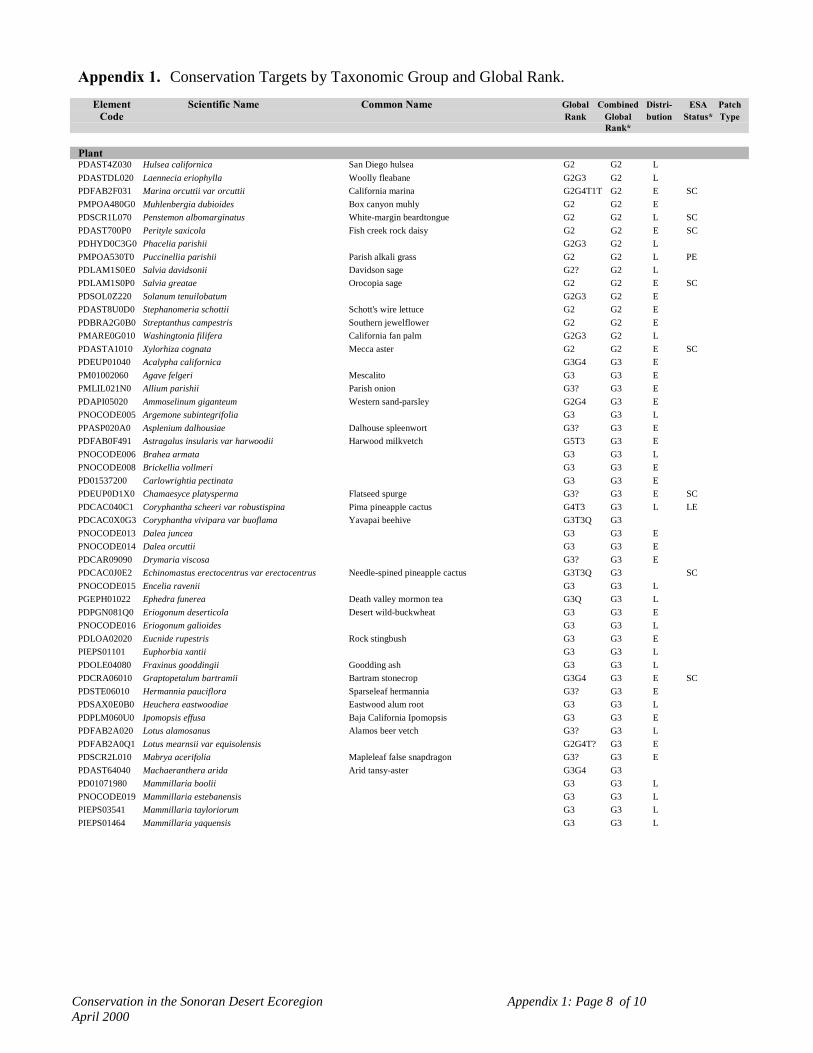
Conservation in the Sonoran Desert Ecoregion Appendix 1: Page 8 of 10April 2000
Appendix 1. Conservation Targets by Taxonomic Group and Global Rank.Element Scientific Name Common Name Global Combined Distri- ESA Patch
Code Rank Global bution Status* TypeRank*
PlantPDAST4Z030 Hulsea californica San Diego hulsea G2 G2 LPDASTDL020 Laennecia eriophylla Woolly fleabane G2G3 G2 LPDFAB2F031 Marina orcuttii var orcuttii California marina G2G4T1T G2 E SCPMPOA480G0 Muhlenbergia dubioides Box canyon muhly G2 G2 EPDSCR1L070 Penstemon albomarginatus White-margin beardtongue G2 G2 L SCPDAST700P0 Perityle saxicola Fish creek rock daisy G2 G2 E SCPDHYD0C3G0 Phacelia parishii G2G3 G2 LPMPOA530T0 Puccinellia parishii Parish alkali grass G2 G2 L PEPDLAM1S0E0 Salvia davidsonii Davidson sage G2? G2 LPDLAM1S0P0 Salvia greatae Orocopia sage G2 G2 E SCPDSOL0Z220 Solanum tenuilobatum G2G3 G2 EPDAST8U0D0 Stephanomeria schottii Schott's wire lettuce G2 G2 EPDBRA2G0B0 Streptanthus campestris Southern jewelflower G2 G2 EPMARE0G010 Washingtonia filifera California fan palm G2G3 G2 LPDASTA1010 Xylorhiza cognata Mecca aster G2 G2 E SCPDEUP01040 Acalypha californica G3G4 G3 EPM01002060 Agave felgeri Mescalito G3 G3 EPMLIL021N0 Allium parishii Parish onion G3? G3 EPDAPI05020 Ammoselinum giganteum Western sand-parsley G2G4 G3 EPNOCODE005 Argemone subintegrifolia G3 G3 LPPASP020A0 Asplenium dalhousiae Dalhouse spleenwort G3? G3 EPDFAB0F491 Astragalus insularis var harwoodii Harwood milkvetch G5T3 G3 EPNOCODE006 Brahea armata G3 G3 LPNOCODE008 Brickellia vollmeri G3 G3 EPD01537200 Carlowrightia pectinata G3 G3 EPDEUP0D1X0 Chamaesyce platysperma Flatseed spurge G3? G3 E SCPDCAC040C1 Coryphantha scheeri var robustispina Pima pineapple cactus G4T3 G3 L LEPDCAC0X0G3 Coryphantha vivipara var buoflama Yavapai beehive G3T3Q G3PNOCODE013 Dalea juncea G3 G3 EPNOCODE014 Dalea orcuttii G3 G3 EPDCAR09090 Drymaria viscosa G3? G3 EPDCAC0J0E2 Echinomastus erectocentrus var erectocentrus Needle-spined pineapple cactus G3T3Q G3 SCPNOCODE015 Encelia ravenii G3 G3 LPGEPH01022 Ephedra funerea Death valley mormon tea G3Q G3 LPDPGN081Q0 Eriogonum deserticola Desert wild-buckwheat G3 G3 EPNOCODE016 Eriogonum galioides G3 G3 LPDLOA02020 Eucnide rupestris Rock stingbush G3 G3 EPIEPS01101 Euphorbia xantii G3 G3 LPDOLE04080 Fraxinus gooddingii Goodding ash G3 G3 LPDCRA06010 Graptopetalum bartramii Bartram stonecrop G3G4 G3 E SCPDSTE06010 Hermannia pauciflora Sparseleaf hermannia G3? G3 EPDSAX0E0B0 Heuchera eastwoodiae Eastwood alum root G3 G3 LPDPLM060U0 Ipomopsis effusa Baja California Ipomopsis G3 G3 EPDFAB2A020 Lotus alamosanus Alamos beer vetch G3? G3 LPDFAB2A0Q1 Lotus mearnsii var equisolensis G2G4T? G3 EPDSCR2L010 Mabrya acerifolia Mapleleaf false snapdragon G3? G3 EPDAST64040 Machaeranthera arida Arid tansy-aster G3G4 G3PD01071980 Mammillaria boolii G3 G3 LPNOCODE019 Mammillaria estebanensis G3 G3 LPIEPS03541 Mammillaria tayloriorum G3 G3 LPIEPS01464 Mammillaria yaquensis G3 G3 L

Conservation in the Sonoran Desert Ecoregion Appendix 1: Page 9 of 10April 2000
Appendix 1. Conservation Targets by Taxonomic Group and Global Rank.Element Scientific Name Common Name Global Combined Distri- ESA Patch
Code Rank Global bution Status* TypeRank*
PlantPDLOA030K0 Mentzelia hirsutissima California stick-leaf G3? G3 EPDASC050P0 Metastelma mexicanum Wiggins milkweed vine G3? G3PMPOA480V0 Muhlenbergia gooddingii G3?Q G3 EPDPGN0G012 Nemacaulis denudata var gracilis Slender woolly-heads G4T3? G3 EPDCAC0D0E0 Opuntia echinocarpa G3? G3 LPDCAC0D224 Opuntia engelmannii var flavispina G5T3? G3 EPDCAC0D1P0 Opuntia wigginsii Wiggins cholla G3Q G3 LPDAST6T012 Palafoxia arida var gigantea Giant spanishneedle G5T3 G3 E SCPMPOA4P1L0 Paspalum virletii Virlet paspalum G3? G3 UPDAST6W0A0 Pectis imberbis Beardless chinch weed G3 G3 L SCPDAST700D1 Perityle gilensis var gilensis Gila rock daisy G4?T3 G3 EPDLNN02010 Pholisma arenarium Scaly sandplant G3 G3 EPDLNN02020 Pholisma sonorae Sand food G3 G3 E SCPDSCR2R010 Pseudorontium cyathiferum Deep canyon snapdragon G3G4 G3 EPD01523980 Schoepfia californica G3 G3 EPDAST8H3W1 Senecio carlomasonii G3? G3 EPDAST8H3W0 Senecio hartwegii Seemann groundsel G3? G3 LPNOCODE027 Sibara angelorum G3 G3 LPIEPS03194 Sibara pectinata G3 G3 LPPTHE05192 Thelypteris puberula var sonorensis Aravaipa wood fern G5T3 G3 EPDASTA1040 Xylorhiza orcuttii Orcutt's woody aster G3? G3 E SCPMAGA01060 Agave deserti Desert agave G4 G4 EPDCPP01010 Atamisquea emarginata Desert tree caper G4 G4 EPDBUR01020 Bursera microphylla Elephant-tree G4 G4 EPNOCODE010 Capsicum annuum var aviculare Chiltepin G4? G4 PPDSIM03030 Castela emoryi Crucifixion thorn G4 G4 EPDAST3L030 Ericameria brachylepis Rayless turpentine bush G4 G4 EPDAST4N0Z0 Helianthus niveus Dune sunflower G4 G4 LPDACA0E0L0 Justicia candicans Hierba azul G4 G4 EPIEPS03078 Lysiloma candida Palo blanco G4 G4 LPDLOA04010 Petalonyx linearis Longleaf sandpaper plant G4 G4 EPDANA08050 Rhus kearneyi Kearney sumac G4 G4 EPDAST8Y060 Stylocline sonorensis Mesquite neststraw G3G5 G4 EPDAST9A030 Tithonia thurberi Thurber tithonia G4 G4 EPMLIL22010 Triteleiopsis palmeri Blue sand lily G4 G4 EPMAGA0B0X0 Yucca whipplei Lechuguilla G4 G4 EPDSOL06010 Capsicum annuum Chiltepin G5 G5 WPDCAC12010 Carnegiea gigantea Saguaro cactus G5 G5 LPDAPI0Z0L0 Eryngium nasturtiifolium Hierba del sapo G5 G5 LPDCAC0X0G0 Escobaria vivipara G5T?Q G5 EPDEUP0Q1B0 Euphorbia misera Cliff spurge G5 G5 EPD00060100 Acacia crinita G? GU EPD00060140 Acacia occidentalis Tree catclaw G? GU EPD00060160 Acacia willardiana Palo liso G? GU EPD01060130 Adelia obovata G? GU EPD00060250 Adelia virgata G? GU EPD00060270 Aeschynomene fascicularis Joint vetch G? GU EPM01060110 Agave colorata Mezcal ceniza G? GU EPM01002070 Agave fortiflora G? GU EPM01060100 Agave jaiboli G? GUPM01002130 Agave zebra G? GU E

Conservation in the Sonoran Desert Ecoregion Appendix 1: Page 10 of 10April 2000
Appendix 1. Conservation Targets by Taxonomic Group and Global Rank.Element Scientific Name Common Name Global Combined Distri- ESA Patch
Code Rank Global bution Status* TypeRank*
PlantPMLIL02130 Allium haematochiton G4 GU EPD00061830 Brongniartia alamosana Palo piojo G? GU EPD00061850 Brongniartia nudiflora G? GU EPD01060120 Brongniartia shrevei G? GU EPD00062020 Bursera hindsiana Red elephant tree G? GU EPD00062310 Castela polyandra G? GU EPD00064790 Euphorbia magdalenae G? GU EPD01002240 Fouquieria columnaris Boojum tree G? GU EPD00067130 Mammillaria johnstonii G? GU EPD00067150 Mammillaria multidigitata G? GU EPD00068070 Opuntia reflexispina G? GU EPD00068890 Pithecellobium confine G? GU EPD00070490 Stegnosperma halimifolium G? GU EPD01060550 Suaeda puertopenascoa G? GU EPD01060160 Vallesia baileyana G? GU E

Conservation in the Sonoran Desert Ecoregion Appendix 2: Page 1 of 2April 2000
Appendix 2. Heritage Program Global Ranking Definitions, Endangered Species Act Status Definitionsand Criteria for Combined Global Ranks.
Global Priority Ranking Definitions
Priority ranking (1 to 5) based on the number of occurrences throughout the entirerange of the element (from Arizona Game and Fish Depratment Heritage Data ManagementSystem, 1/12/94).
GlobalRank
StateRank
G1 S1 Very Rare: 1 to 5 occurrences or very few individuals or acres.
G2 S2 Rare: 6 to 20 occurrences or few individuals or acresG3 S3 Uncommon or Restricted: 21 to 100 occurrences, rather rare throughout
a fairly wide range, or fairly common in a rather restricted range.S3S4 Fairly Common: 51 to 100 occurrences and found over a rather wide
range within the State.G4 S4 Apparently Secure: more than 100 occurrences, though it could be
quite rare in some parts of its range.G5 S5 Demonstrably Secure: more than 100 occurrences.GU Unranked.
Endangered Species Status Definitions
Federal U.S. Status under Endangered Species Act of 1973 (as amended) US Departmentof Interior, Fish and Wildlife Service (from Arizona Game and Fish Department Heritage DataManagement System, 7/23/99).
Listed SpeciesLE Listed Endangered: imminent jeopardy of extinction.LT Listed Threatened: imminent jeopardy of becoming Endangered.XN Experimental Nonessential population.
Species Proposed for ListingPE Proposed Endangered.PT Proposed Threatened.
Candidates for Listing (Federal Notice of Review: 1996)C Candidate. Species for which USFWS has sufficient information on
biological vulnerability and threats to support proposals to list asEndangered or Threatened under ESA. However, proposed rules have notyet been issued because such actions are precluded at present by otherlisting activity.
SC Species of Concern. The terms "Species of Concern" or "Species at Risk"should be considered as terms-of-art that describe the entire realm of taxawhose conservation status may be of concern to the US Fish and WildlifeService, but neither term has official status (former C2 species).

Conservation in the Sonoran Desert Ecoregion Appendix 2: Page 2 of 2April 2000
Status In Mexico
MEX Mexican Federal Endangered Species List (May 16, 1994)Secretaría de Desarollo Social, NORMA Oficial Mexicana NOM-059-ECOL-1994
SN(T) Determined Threatened in Sonora: could become endangered if factorscausing habitat deterioration or population decline continue.
Criteria for Converting Global Ranks to Combined Global Ranks
Combined global ranks were determined from the following global rank designations:
G1= G1, G1Q, G1T1, G4T1, G3T1Q, G5T1Q, G4G5T1, G5T1 (Those G_T1Q's need case by casereview), G1G2
G2= G2, G2?, G3T2, G1G3, G2G3, G3T2, G3G4T2, G2G4T1T2Q, G4T1T2,G4T2, G4?T2?, G5T2, G5T1T2, G5T1T2Q (again, those G_T2Q's need case by case review)
G3= G3, G3?, G3Q, G3?Q, G2G3Q, G2G4, G2G4T?, G3G4T3, G3G4, G3QT2T3, G3T3Q, G4T2T3,G4T3, G4T3?, G4?T3, G4?T3, G5T2T3, G5T3, G5T3?, G5T2T3Q
G4= G4, G4?, G?, G4T4, G3G5, G4T3T4, G5T4, G5T3T4, G4G5T3T4, G4G5T4, G4G5
G5= G5, G5?, G5T, G5T?
G? are probably endemics in Sonora and are treated as such with respect to Conservation Criteria (e.g.G?=G4?)

Conservation in the Sonoran Desert Ecoregion Appendix 3: Page 1 of 1April 2000
Appendix 3. Coding System for the Sonoran Ecoregion Biophysical Model.
CODE Ecological Subdivision (4 types: coded 100000 to 400000)100000 Arizona Uplands200000 Central Gulf Coast300000 Lower Colorado River Valley400000 Plains of SonoraCODE Land Cover Classification (& Ecological Groups) 19 types:
(01000 to 19000)01000 Agave-Bursage Scrub02000 Agriculture-Urban*03000 Creosotebush-Bursage Scrub04000 Coastal/Interior Dunes & Plains05000 Sonora/Mojave Playa Lake06000 Interior Chaparral/Encinal07000 Industrial-Urban*08000 Desert Riparian Woodland09000 Interior Riparian Shrub/Woodland10000 Interior Riparian Woodlands11000 Torchwood-Limberbush Scrub12000 Coastal Mangrove Forest13000 Mesquite Woodland (riparian and microphyll woodland combined)14000 Baja state boundary (minor cover map artifact)*15000 Palo verde-Mixed Cacti16000 Saltbush-Saltmarsh17000 Semi-Desert Grassland18000 Sinaloan/foothills Thornscrub19000 WaterCODE Elevation Classification (5 types: coded 000 to 400)
100 Low: -75 to 400 meters ASL200 Low-mid: 400 to 800 meters ASL300 Mid-high: 800 to 1075 meters ASL400 High: 1075 meters or more ASL
CODE Slope Categories (3 types: coded 10 to 30)10 Flat-gentle slope: 0 - 6 degrees20 Moderate - Steep: 7 - 35 degrees30 Steep - Cliff: > 35 degrees
CODE Aspect Categories (3 types: coded 1 to 3)1 Flat-gentle slope -aspect insignificant2 South-southwest: 91 - 3143 North-northeast: 315 - 90
* not used for analysis of biophysical representation.

Conservation in the Sonoran Desert Ecoregion * See Appendix 2 for Global Rank Criteria and ESA Status DefinitionsApril 2000 Appendix 4: Page 1 of 51
Appendix 4. Conservation Targets Identified within Conservation Sites.
Conservation Site #: 1 Rancho El Único Total Conservation Targets* 28(Excluding Biophysical Units)
Site Size acres: 354,759 Hectares: 143,569 Ecoregional Subdivision: Central Gulf Coast
Conservation TargetsGlobal ESA
Taxon Scientific Name Common Name Status*
Community Abronia maritima-Helianthus-Jouvea Gulf of California coastal strand G5Distichlis spicata Coastal saltgrass G5Avicennia-Rhizophora-Lanungularia (group) Coastal mangrove forest (group) GURhizophora mangle Red mangrove (black-white mangrove) forest G3Leguncularia racemosa White mangrove forest G3Washingtonia filifera association California fan palm oasis G2Desert Spring/Seep Desert Spring/Seep GUJatropha-Bursera (group) Torchwood-limberbush (group) GUFouquieria-Ipomoea-Acacia Sinaloan mixed thornscrub GU
Bird Migratory Bird Concentration Area Migratory Bird Concentration Area GUHerpetofauna Gopherus agassizii Desert Tortoise G4 CA(LT),AZ(C)Invertebrate Ascia howarthi Howarth's white GU
Euchloe guaymasensis Guaymas marble GUHypostrymon critola Sonoran hairstreak G5Panoquina errans G2Polites norae GU
Mammal Myotis vivesi Fishing Bat G3Tamias dorsalis sonoriensis Chichimoco GU
Plant Agave chrysoglossa G2Agave colorata GUAgave felgeri G3Agave fortiflora GUEuphorbia xantii G3Lysiloma candida Palo Blanco G4Mammillaria boolii Viejito G3Mammillaria johnstonii GUSchoepfia shreveana G1Vallesia baileyana GU
Biophysical Unit Abronium-Eriogonum (group) Interior dunes and plains (group) GUAgave-Ambrosia-Fouquieria (group) Agave-bursage scrub (group) GUAtriplex-Allenrolfea-Suaeda (group) Saltbush desert scrub (group) GUAvicennia-Rhizophora-Lanungularia (group) Coastal mangrove forest (group) GUJatropha-Bursera (group) Torchwood-limberbush (group) GULarrea tridentata (group) Creosotebush-bursage (group) GUMesquite woodland (group) Mesquite woodland (group) GUParkinsonia-Carnegia-Opuntia (group) Palo verde-mxed cacti (group) GU

Conservation in the Sonoran Desert Ecoregion * See Appendix 2 for Global Rank Criteria and ESA Status DefinitionsApril 2000 Appendix 4: Page 2 of 51
Appendix 4. Conservation Targets Identified within Conservation Sites.
Conservation Site #: 2 San Esteban Island Total Conservation Targets* 12(Excluding Biophysical Units)
Site Size acres: 10,334 Hectares: 4,182 Ecoregional Subdivision: Central Gulf Coast
Conservation TargetsGlobal ESA
Taxon Scientific Name Common Name Status*
Community Abronia-Opuntia-Coccoloba Coastal dune GUZostera maritima Eelgrass bed G4Avicennia-Rhizophora-Lanungularia (group) Coastal mangrove forest (group) GUFouquieria-Ipomoea-Acacia Sinaloan mixed thornscrub GU
Herpetofauna Cnemidophorus estebanensis San Esteban Whiptail GUCrotalus molossus estebanensis San Esteban Blacktail Rattlesnake GU SN(P)Phyllodactylus xanti estebanensis San Esteban Leaf-toed Gecko GU SN(R)Sauromalus varius Chuckwalla GU SN(T)
Mammal Neotoma varia GUPeromyscus pembertoni San Pedro Nolasco Deer Mouse GU
Plant Echinocereus grandis G1Mammillaria estebanensis G3
Biophysical Unit Jatropha-Bursera (group) Torchwood-limberbush (group) GUMesquite woodland (group) Mesquite woodland (group) GU
Conservation Site #: 3 Bahía de Kino/Isla Tiburón/Sierra Bacha Total Conservation Targets* 33(Excluding Biophysical Units)
Site Size acres: 698,810 Hectares: 282,805 Ecoregional Subdivision: Central Gulf Coast
Conservation TargetsGlobal ESA
Taxon Scientific Name Common Name Status*
Community Abronia-Opuntia-Coccoloba Coastal dune GUAbronia maritima-Helianthus-Jouvea Gulf of California coastal strand G5Distichlis spicata Coastal saltgrass G5Zostera maritima Eelgrass bed G4Avicennia-Rhizophora-Lanungularia (group) Coastal mangrove forest (group) GURhizophora mangle Red mangrove (black-white mangrove) forest G3Prosopis (sp. glandulosa, velutina) Mesquite woodland G3Washingtonia filifera association California fan palm oasis G2Cercidium floridum Blue palo verde mixed desert scrub G3Jatropha sp.-Bursera microphylla-Pachycereus Torchwood-limberbush-cardon association GUpringleiFouquieria-Ipomoea-Acacia Sinaloan mixed thornscrub GU
Bird Dendroica petechia bryanti Mangrove yellow warbler G5Ixobrychus exilis Least Bittern G5Migratory Bird Concentration Area Migratory Bird Concentration Area GURallus longirostris yumanensis Yuma Clapper Rail G3 LEToxostoma lecontei Le Conte's Thrasher G3
Herpetofauna Gopherus agassizii Desert Tortoise G4 CA(LT),AZ(C)Hypsiglena torquata tiburonensis Tiburon Island Night Snake GU
Mammal Lepus alleni tiburonensis Tiburon Antelope Jackrabbit G1Myotis vivesi Fishing Bat G3

Conservation in the Sonoran Desert Ecoregion * See Appendix 2 for Global Rank Criteria and ESA Status DefinitionsApril 2000 Appendix 4: Page 3 of 51
Appendix 4. Conservation Targets Identified within Conservation Sites.
Conservation TargetsGlobal ESA
Taxon Scientific Name Common Name Status*
Mammal Odocoileus hemionus sheldoni Tiburon Mule Deer G2Ovis canadensis mexicana Desert Bighorn Sheep G4Perognathus baileyi insularis Pocket Mouse GUPeromyscus eremicus tiburonensis Tiburon Cactus Mouse GUPeromyscus stephani San Esteban Deer Mouse GUSpermophilus variegatus tiburonensis Tiburon Rock Squirrel GU
Plant Agave chrysoglossa G2Agave pelona Mescal Pelon G1Agave subsimplex G1Castela polyandra GUEuphorbia xantii G3Ferocactus wislizeni var tiburonensis G2Pithecellobium confine GU
Biophysical Unit Abronium-Eriogonum (group) Interior dunes and plains (group) GUAgave-Ambrosia-Fouquieria (group) Agave-bursage scrub (group) GUAtriplex-Allenrolfea-Suaeda (group) Saltbush desert scrub (group) GUAvicennia-Rhizophora-Lanungularia (group) Coastal mangrove forest (group) GUJatropha-Bursera (group) Torchwood-limberbush (group) GULarrea tridentata (group) Creosotebush-bursage (group) GUMesquite woodland (group) Mesquite woodland (group) GUParkinsonia-Carnegia-Opuntia (group) Palo verde-mxed cacti (group) GU
Conservation Site #: 4 Sierra Bacha/Sierra del Viejo Total Conservation Targets* 27(Excluding Biophysical Units)
Site Size acres: 1,351,652 Hectares: 547,006 Ecoregional Subdivision: Central Gulf Coast
Conservation TargetsGlobal ESA
Taxon Scientific Name Common Name Status*
Community Abronia maritima-Helianthus-Jouvea Gulf of California coastal strand G5Sparsely vegetated coastal rock shore Coastal rock shore GUAvicennia-Rhizophora-Lanungularia (group) Coastal mangrove forest (group) GUWashingtonia filifera association California fan palm oasis G2Desert Spring/Seep Desert Spring/Seep GUEncelia-Olneya (group) Brittlebush-ironwood "Plains Of Sonora" (group) GUJatropha-Bursera (group) Torchwood-limberbush (group) GU
Bird Migratory Bird Concentration Area Migratory Bird Concentration Area GUSterna elegans Elegant Tern G2Toxostoma lecontei Le Conte's Thrasher G3
Invertebrate Sonorella burgesi talussnail GUSonorella pratti talussnail GUSonorella rothi talussnail GUSonorella seri talussnail GU
Mammal Macrotus californicus California Leaf-nosed Bat G4 SCMyotis vivesi Fishing Bat G3Ovis canadensis mexicana Desert Bighorn Sheep G4
Plant Agave pelona Mescal Pelon G1Agave subsimplex G1Agave zebra GU

Conservation in the Sonoran Desert Ecoregion * See Appendix 2 for Global Rank Criteria and ESA Status DefinitionsApril 2000 Appendix 4: Page 4 of 51
Appendix 4. Conservation Targets Identified within Conservation Sites.
Conservation TargetsGlobal ESA
Taxon Scientific Name Common Name Status*
Plant Allium haematochiton Red Skin Onion GUEchinocactus horizonthalonius var nicholii Nichol Turk's Head Cactus G2 LEEuphorbia misera Cliff Spurge G5Euphorbia xantii G3Fouquieria columnaris Boojum Tree GURhus kearneyi Kearney Sumac G4Sibara pectinata G3
Biophysical Unit Abronium-Eriogonum (group) Interior dunes and plains (group) GUAtriplex-Allenrolfea-Suaeda (group) Saltbush desert scrub (group) GUJatropha-Bursera (group) Torchwood-limberbush (group) GULarrea tridentata (group) Creosotebush-bursage (group) GUMesquite woodland (group) Mesquite woodland (group) GUParkinsonia-Carnegia-Opuntia (group) Palo verde-mxed cacti (group) GU
Conservation Site #: 5 Cañones de La Pintada /Tetabejo Total Conservation Targets* 3(Excluding Biophysical Units)
Site Size acres: 739,164 Hectares: 299,135 Ecoregional Subdivision: Plains of Sonora
Conservation TargetsGlobal ESA
Taxon Scientific Name Common Name Status*
Community Washingtonia filifera-Brahea armata California fan palm-blue palm oasis GUPlant Agave jaiboli GU
Brahea armata G3Biophysical Unit Jatropha-Bursera (group) Torchwood-limberbush (group) GU
Larrea tridentata (group) Creosotebush-bursage (group) GUMesquite woodland (group) Mesquite woodland (group) GUParkinsonia-Carnegia-Opuntia (group) Palo verde-mxed cacti (group) GUSinaloan/foothills thornscrub (group) Sinaloan/foothills thornscrub (group) GU
Conservation Site #: 6 Sierra Tordilla/Puerto el Orégano Total Conservation Targets* 2(Excluding Biophysical Units)
Site Size acres: 18,642 Hectares: 7,544 Ecoregional Subdivision: Plains of Sonora
Conservation TargetsGlobal ESA
Taxon Scientific Name Common Name Status*
Herpetofauna Gopherus agassizii Desert Tortoise G4 CA(LT),AZ(C)Plant Brongniartia shrevei GUBiophysical Unit Jatropha-Bursera (group) Torchwood-limberbush (group) GU
Larrea tridentata (group) Creosotebush-bursage (group) GUMesquite woodland (group) Mesquite woodland (group) GUParkinsonia-Carnegia-Opuntia (group) Palo verde-mxed cacti (group) GUSinaloan/foothills thornscrub (group) Sinaloan/foothills thornscrub (group) GU

Conservation in the Sonoran Desert Ecoregion * See Appendix 2 for Global Rank Criteria and ESA Status DefinitionsApril 2000 Appendix 4: Page 5 of 51
Appendix 4. Conservation Targets Identified within Conservation Sites.
Conservation Site #: 7 Carrizo Plains/Arroyo Bacoachito Total Conservation Targets* 8(Excluding Biophysical Units)
Site Size acres: 667,927 Hectares: 270,307 Ecoregional Subdivision: Plains of Sonora
Conservation TargetsGlobal ESA
Taxon Scientific Name Common Name Status*
Community Tobosa-Hilaria-Aristida-Prosopis (group) Semi-desert grassland (group) GUJatropha-Bursera (group) Torchwood-limberbush (group) GUEcological gradient Ecological gradient
Bird Colinus virginianus ridgwayi Masked Bobwhite G1 LEDendroica petechia Yellow Warbler G3Migratory Bird Concentration Area Migratory Bird Concentration Area GU
Herpetofauna Charina trivirgata trivirgata Mexican Rosy Boa G3 SCGopherus agassizii Desert Tortoise G4 CA(LT),AZ(C)
Biophysical Unit Interior chaparral/encinal (group) Interior chaparral/encinal (group) GUJatropha-Bursera (group) Torchwood-limberbush (group) GULarrea tridentata (group) Creosotebush-bursage (group) GUMesquite woodland (group) Mesquite woodland (group) GUParkinsonia-Carnegia-Opuntia (group) Palo verde-mxed cacti (group) GUTobosa-Hilaria-Aristida-Prosopis (group) Semi-desert grassland (group) GU
Conservation Site #: 8 Cerro Borrego/San Felipe Desert Total Conservation Targets* 38(Excluding Biophysical Units)
Site Size acres: 2,253,757 Hectares: 971,488 Ecoregional Subdivision: Lower Colorado River Valley
Conservation TargetsGlobal ESA
Taxon Scientific Name Common Name Status*
Community Eriogonum deserticola association Colorado desert wild buckwheat sand dune G1Hilaria rigida Big galleta grassland G3Distichlis spicata Coastal saltgrass G5Zostera maritima Eelgrass bed G4Avicennia-Rhizophora-Lanungularia (group) Coastal mangrove forest (group) GUWashingtonia filifera-Brahea armata California fan palm-blue palm oasis GULarrea tridentata (group) Creosotebush-bursage (group) GUProsopis glandulosa Honey mesquite shrubland G3Cercidium floridum Blue palo verde mixed desert scrub G3Fouquieria splendens Ocotillo shrubland G4Jatropha-Bursera (group) Torchwood-limberbush (group) GUJatropha cinerea-Bursera microphylla Torchwood-limberbush-short tree scrub GUJatropha sp.-Bursera microphylla-Pachycereus Torchwood-limberbush-cardon association GUpringleiAtriplex-Allenrolfea-Suaeda (group) Saltbush scrub (group) GUAllenrolfea occidentalis Pickleweed shrubland G3
Herpetofauna Bufo microscaphus californicus Arroyo toad G2 LECharina trivirgata gracia Desert Rosy Boa G3 SC

Conservation in the Sonoran Desert Ecoregion * See Appendix 2 for Global Rank Criteria and ESA Status DefinitionsApril 2000 Appendix 4: Page 6 of 51
Appendix 4. Conservation Targets Identified within Conservation Sites.
Conservation TargetsGlobal ESA
Taxon Scientific Name Common Name Status*
Herpetofauna Coleonyx switaki Barefoot Banded Gecko G3 SCCrotalus exsul ruber Red Diamond Rattlesnake G4 SCPhrynosoma mcallii Flat-tailed Horned Lizard G3 SCThamnophis hammondii Two-striped Garter Snake G3 SCXantusia vigilis Desert Night Lizard G5 SN(T)
Invertebrate Neopachylopus sp. GUMammal Ovis canadensis cremnobates Peninsular Bighorn Sheep G1 CA(LE)Plant Agave moranii G2
Argemone subintegrifolia G3Brahea armata G3Brickellia vollmeri G3Bursera hindsiana Red Elephant Tree GUBursera microphylla Elephant Tree G4Dalea juncea G3Dalea orcuttii G3Encelia ravenii G3Eriogonum galioides G3Eucnide rupestris Rock Stingbush G3Marina orcuttii var orcuttii California Marina G2 SCSibara angelorum G3Washingtonia filifera California Fan Palm G2
Biophysical Unit Abronium-Eriogonum (group) Interior dunes and plains (group) GUAtriplex-Allenrolfea-Suaeda (group) Saltbush desert scrub (group) GUInterior chaparral/encinal (group) Interior chaparral/encinal (group) GUJatropha-Bursera (group) Torchwood-limberbush (group) GULarrea tridentata (group) Creosotebush-bursage (group) GUParkinsonia-Carnegia-Opuntia (group) Palo verde-mxed cacti (group) GU
Conservation Site #: 9 Tacna Marsh Total Conservation Targets* 3(Excluding Biophysical Units)
Site Size acres: 2,417 Hectares: 978 Ecoregional Subdivision: Lower Colorado River Valley
Conservation TargetsGlobal ESA
Taxon Scientific Name Common Name Status*
Bird Ixobrychus exilis hesperis Western Least Bittern GU AZ(C)Pipilo aberti Abert's Towhee G3Rallus longirostris yumanensis Yuma Clapper Rail G3 LE
Biophysical Unit Interior riparian shrub/woodland (group) Interior riparian shrub/woodland (group) GULarrea tridentata (group) Creosotebush-bursage (group) GU

Conservation in the Sonoran Desert Ecoregion * See Appendix 2 for Global Rank Criteria and ESA Status DefinitionsApril 2000 Appendix 4: Page 7 of 51
Appendix 4. Conservation Targets Identified within Conservation Sites.
Conservation Site #: 10 Colorado River Delta Total Conservation Targets* 35(Excluding Biophysical Units)
Site Size acres: 1,038,194 Hectares: 420,168 Ecoregional Subdivision: Lower Colorado River Valley
Conservation TargetsGlobal ESA
Taxon Scientific Name Common Name Status*
Community Abronia villosa-mixed shrub Desert sand-verbena interior dune G1Distichlis spicata Coastal saltgrass G5Typha domingensis Interior cattail marsh G5Phragmites sp. Interior giant reed marsh GUPlatanus wrightii Arizona sycamore riparian woodland G4Populus fremonti-Salix gooddingii Fremont cottonwood-Goodding's black willow riparian G2
woodlandDesert Spring/Seep Desert Spring/Seep GUAtriplex-Allenrolfea-Suaeda (group) Saltbush scrub (group) GUAllenrolfea occidentalis Pickleweed shrubland G3
Bird Ixobrychus exilis hesperis Western Least Bittern GU AZ(C)Laterallus jamaicensis coturniculus California Black Rail G1 SC, AZ(T)Migratory Bird Concentration Area Migratory Bird Concentration Area GURallus longirostris yumanensis Yuma Clapper Rail G3 LESterna nilotica vanrossemi Van Rossem's Gull-billed Tern G1 SC
Fish Catostomus latipinnis Flannelmouth Sucker G3 SCCyprinodon macularius macularius Desert Pupfish G1 LEElops affinis Pacific Tenpounder G5Gila elegans Bonytail G1 LEGila robusta Roundtail Chub G3 SCPlagopterus argentissimus Woundfin G1 LEPtychocheilus lucius Colorado Squawfish G1 LE(CA-LE/XN)Xyrauchen texanus Razorback Sucker G1 LE
Herpetofauna Charina trivirgata trivirgata Mexican Rosy Boa G3 SCGopherus agassizii Desert Tortoise G4 CA(LT),AZ(C)Phrynosoma mcallii Flat-tailed Horned Lizard G3 SCUma notata rufopunctata Cowles Fringe-toed Lizard G2 SC
Invertebrate Neopachylopus sp. GUTryonia sp. Aquatic invertebrate GU
Mammal Castor canadensis frondator Beaver GUPlant Argemone subintegrifolia G3
Brickellia vollmeri G3Dalea juncea G3Dalea orcuttii G3Sibara angelorum G3Suaeda puertopenascoa GU
Biophysical Unit Abronium-Eriogonum (group) Interior dunes and plains (group) GUAtriplex-Allenrolfea-Suaeda (group) Saltbush desert scrub (group) GULarrea tridentata (group) Creosotebush-bursage (group) GUParkinsonia-Carnegia-Opuntia (group) Palo verde-mxed cacti (group) GU

Conservation in the Sonoran Desert Ecoregion * See Appendix 2 for Global Rank Criteria and ESA Status DefinitionsApril 2000 Appendix 4: Page 8 of 51
Appendix 4. Conservation Targets Identified within Conservation Sites.
Conservation Site #: 11 Bouse Dunes Total Conservation Targets* 4(Excluding Biophysical Units)
Site Size acres: 118,280 Hectares: 47,867 Ecoregional Subdivision: Lower Colorado River Valley
Conservation TargetsGlobal ESA
Taxon Scientific Name Common Name Status*
Community Parkinsonia-Carnegia-Opuntia (group) Palo verde-mixed cacti (group) GUHerpetofauna Uma scoparia Mojave Fringe-toed Lizard G3Plant Ephedra funerea Death Valley Mormon Tea G3
Pholisma arenarium Scaly Sandplant G3Biophysical Unit Abronium-Eriogonum (group) Interior dunes and plains (group) GU
Larrea tridentata (group) Creosotebush-bursage (group) GUParkinsonia-Carnegia-Opuntia (group) Palo verde-mxed cacti (group) GU
Conservation Site #: 12 Kofa Complex Total Conservation Targets* 14(Excluding Biophysical Units)
Site Size acres: 1,434,006 Hectares: 580,334 Ecoregional Subdivision: Arizona Uplands
Conservation TargetsGlobal ESA
Taxon Scientific Name Common Name Status*
Community Washingtonia filifera association California fan palm oasis G2Washingtonia filifera-Brahea armata California fan palm-blue palm oasis GUEcological gradient Ecological gradient
Herpetofauna Charina trivirgata gracia Desert Rosy Boa G3 SCGopherus agassizii Desert Tortoise G4 CA(LT),AZ(C)Xantusia vigilis Desert Night Lizard G5 SN(T)
Mammal Macrotus californicus California Leaf-nosed Bat G4 SCMyotis velifer Cave Myotis G5 SCNyctinomops femorosaccus Pocketed Free-tailed Bat G4Ovis canadensis mexicana Desert Bighorn Sheep G4
Plant Allium parishii Parish Onion G3Berberis harrisoniana Kofa Barberry G2Opuntia wigginsii Wiggin's Cholla G3Washingtonia filifera California Fan Palm G2
Biophysical Unit Larrea tridentata (group) Creosotebush-bursage (group) GUMesquite woodland (group) Mesquite woodland (group) GUParkinsonia-Carnegia-Opuntia (group) Palo verde-mxed cacti (group) GU

Conservation in the Sonoran Desert Ecoregion * See Appendix 2 for Global Rank Criteria and ESA Status DefinitionsApril 2000 Appendix 4: Page 9 of 51
Appendix 4. Conservation Targets Identified within Conservation Sites.
Conservation Site #: 13 Pinacate/Organ Pipe/Goldwater Complex Total Conservation Targets* 69(Excluding Biophysical Units)
Site Size acres: 5,748,909 Hectares: 2,487,667 Ecoregional Subdivision: Lower Colorado River Valley
Conservation TargetsGlobal ESA
Taxon Scientific Name Common Name Status*
Community Abronia villosa-mixed shrub Desert sand-verbena interior dune G1Playa lake Intermittently flooded playa lake bed GUDistichlis spicata Coastal saltgrass G5Salicornia sp. Glasswort sand flats GUBatis maritima Glasswort-saltwort flats G5Prosopis (sp. glandulosa, velutina) Mesquite woodland G3Washingtonia filifera association California fan palm oasis G2Larrea tridentata (group) Creosotebush-bursage (group) GUParkinsonia-Carnegia-Opuntia (group) Palo verde-mixed cacti (group) GUCercidium floridum-Olneya tesota Blue palo verde-ironwood-smoke tree woodland G3Allenrolfea occidentalis Pickleweed shrubland G3Ecological gradient Ecological gradient
Bird Colaptes chrysoides Gilded Flicker G5Glaucidium brasilianum cactorum Cactus Ferruginous Pygmy-owl G3 LE
Fish Cyprinodon macularius Desert Pupfish G1 LECyprinodon macularius eremus Quitobaquito Desert Pupfish G1 LE
Herpetofauna Bufo retiformis Sonoran green toad G3 SN(R)Charina trivirgata gracia Desert Rosy Boa G3 SCCharina trivirgata trivirgata Mexican Rosy Boa G3 SCChionactis palarostris organica Organ Pipe Shovelnose Snake G3Cnemidophorus burti xanthonotus Redback Whiptail G2 SCGopherus agassizii Desert Tortoise G4 CA(LT),AZ(C)Kinosternon sonoriense longifemorale Sonoyta Mud Turtle G1 CPhrynosoma mcallii Flat-tailed Horned Lizard G3 SCPhyllorhynchus browni lucidus Maricopa Leafnose Snake G2Uma notata rufopunctata Cowles Fringe-toed Lizard G2 SC
Invertebrate Tryonia quitobaquitae Quitobaquito tryonia G1 SCMammal Antilocapra americana sonoriensis Sonoran Pronghorn G1 LE
Choeronycteris mexicana Mexican Long-tongued Bat G4 SCEumops underwoodi Underwood's Mastiff Bat G4 SCLeptonycteris curasoae yerbabuenae Lesser Long-nosed Bat G4 LEMacrotus californicus California Leaf-nosed Bat G4 SCMyotis velifer Cave Myotis G5 SCNyctinomops femorosaccus Pocketed Free-tailed Bat G4Ovis canadensis mexicana Desert Bighorn Sheep G4Perognathus intermedius pinacate Rock Pocket Mouse GUPeromyscus crinitus delgadilli Delgadillo's Canyon Mouse GUPeromyscus eremicus papagensis Pinacate Cactus Mouse G2 CPeromyscus merriami Mesquite Mouse G5
Plant Acalypha californica G3Agave schottii var treleasei Trelease Agave G1 SCAstragalus magdalenae var peirsonii Peirson's Milkvetch G2 PE, CA(LT)Atamisquea emarginata Desert Tree Caper G4Berberis harrisoniana Kofa Barberry G2Capsicum annuum var aviculare Chiltepin G4Chamaesyce platysperma Flatseed Spurge G3 SCCroton wigginsii Dune Croton G2

Conservation in the Sonoran Desert Ecoregion * See Appendix 2 for Global Rank Criteria and ESA Status DefinitionsApril 2000 Appendix 4: Page 10 of 51
Appendix 4. Conservation Targets Identified within Conservation Sites.
Conservation TargetsGlobal ESA
Taxon Scientific Name Common Name Status*
Plant Cryptantha ganderi Gander's Cryptantha G2 SCDrymaria viscosa G3Echinomastus erectocentrus var acunensis Acuna Cactus G1 CEriogonum deserticola Desert Wild-buckwheat G3Eryngium nasturtiifolium Hierba Del Sapo G5Eucnide rupestris Rock Stingbush G3Helianthus niveus Dune Sunflower G4Helianthus niveus ssp. tephrodes Algodones Dunes Sunflower G2 SC, CA(LE)Justicia candicans Hierba Azul G4Machaeranthera arida Arid Tansy-aster G3Muhlenbergia gooddingii G3Palafoxia arida var gigantea Giant Spanish Needle G3 SCPerityle ajoensis Ajo Rock Daisy G1Petalonyx linearis Longleaf Sandpaper Plant G4Pholisma sonorae Sand Food G3 SCRhus kearneyi Kearney Sumac G4Senecio pinacatensis G1Stegnosperma halimifolium Amole GUStephanomeria schottii Schott's Wire-lettuce G2Suaeda puertopenascoa GUTriteleiopsis palmeri Blue Sand Lily G4Yucca whipplei Whippley's Yucca G4
Biophysical Unit Abronium-Eriogonum (group) Interior dunes and plains (group) GUAtriplex-Allenrolfea-Suaeda (group) Saltbush desert scrub (group) GUDesert Riparian Woodland (group) Desert Riparian Woodland (group) GUInterior chaparral/encinal (group) Interior chaparral/encinal (group) GUInterior riparian shrub/woodland (group) Interior riparian shrub/woodland (group) GUJatropha-Bursera (group) Torchwood-limberbush (group) GULarrea tridentata (group) Creosotebush-bursage (group) GUMesquite woodland (group) Mesquite woodland (group) GUParkinsonia-Carnegia-Opuntia (group) Palo verde-mxed cacti (group) GUSonoran/Mohave playa lake (group) Sonoran/Mohave playa lake (group) GUTobosa-Hilaria-Aristida-Prosopis (group) Semi-desert grassland (group) GUTypha-Phragmites-Scirpus (group) Interior riparian marsh (group) GU
Conservation Site #: 14 Arnett Creek Total Conservation Targets* 10(Excluding Biophysical Units)
Site Size acres: 18,698 Hectares: 7,567 Ecoregional Subdivision: Arizona Uplands
Conservation TargetsGlobal ESA
Taxon Scientific Name Common Name Status*
Community Desert Spring/Seep Desert Spring/Seep GUFish Agosia chrysogaster Longfin Dace G4 SC
Catostomus clarki Desert Sucker G3 SCCatostomus latipinnis Flannelmouth Sucker G3 SCCyprinodon macularius macularius Desert Pupfish G1 LEPoeciliopsis occidentalis occidentalis Gila Topminnow G3 LE, MX(T)
Herpetofauna Phyllorhynchus browni lucidus Maricopa Leafnose Snake G2

Conservation in the Sonoran Desert Ecoregion * See Appendix 2 for Global Rank Criteria and ESA Status DefinitionsApril 2000 Appendix 4: Page 11 of 51
Appendix 4. Conservation Targets Identified within Conservation Sites.
Conservation TargetsGlobal ESA
Taxon Scientific Name Common Name Status*
Herpetofauna Rana yavapaiensis Lowland Leopard Frog G4 SCMammal Nyctinomops femorosaccus Pocketed Free-tailed Bat G4Plant Agave murpheyi Hohokam Agave G2 SCBiophysical Unit Desert Riparian Woodland (group) Desert Riparian Woodland (group) GU
Interior chaparral/encinal (group) Interior chaparral/encinal (group) GUParkinsonia-Carnegia-Opuntia (group) Palo verde-mxed cacti (group) GU
Conservation Site #: 15 Cienéga Creek Total Conservation Targets* 13(Excluding Biophysical Units)
Site Size acres: 130,708 Hectares: 52,897 Ecoregional Subdivision: Arizona Uplands
Conservation TargetsGlobal ESA
Taxon Scientific Name Common Name Status*
Bird Aimophila carpalis Rufous-winged Sparrow G4Asturina nitida maxima Northern Gray Hawk G3 AZ(C)Colaptes chrysoides Gilded Flicker G5Pipilo aberti Abert's Towhee G3
Fish Agosia chrysogaster Longfin Dace G4 SCCyprinodon macularius macularius Desert Pupfish G1 LE
Herpetofauna Rana yavapaiensis Lowland Leopard Frog G4 SCInvertebrate Adopaeoides prittwitzi Sunrise skipper G3
Ancyloxypha arene Tropical least skipper G4Mammal Choeronycteris mexicana Mexican Long-tongued Bat G4 SC
Peromyscus merriami Mesquite Mouse G5Plant Coryphantha scheeri var robustispina Pima Pineapple Cactus G3 LE
Echinomastus erectocentrus var erectocentrus Needle-spined Pineapple Cactus G3 SCBiophysical Unit Larrea tridentata (group) Creosotebush-bursage (group) GU
Parkinsonia-Carnegia-Opuntia (group) Palo verde-mxed cacti (group) GUTobosa-Hilaria-Aristida-Prosopis (group) Semi-desert grassland (group) GU
Conservation Site #: 16 Santa Rita Total Conservation Targets* 9(Excluding Biophysical Units)
Site Size acres: 253,872 Hectares: 104,205 Ecoregional Subdivision: Arizona Uplands
Conservation TargetsGlobal ESA
Taxon Scientific Name Common Name Status*
Bird Aimophila carpalis Rufous-winged Sparrow G4Invertebrate Centris caesalpiniae GU
Sonorella eremita San Xavier talussnail G1 PEMammal Choeronycteris mexicana Mexican Long-tongued Bat G4 SC
Macrotus californicus California Leaf-nosed Bat G4 SCMyotis velifer Cave Myotis G5 SCPeromyscus merriami Mesquite Mouse G5
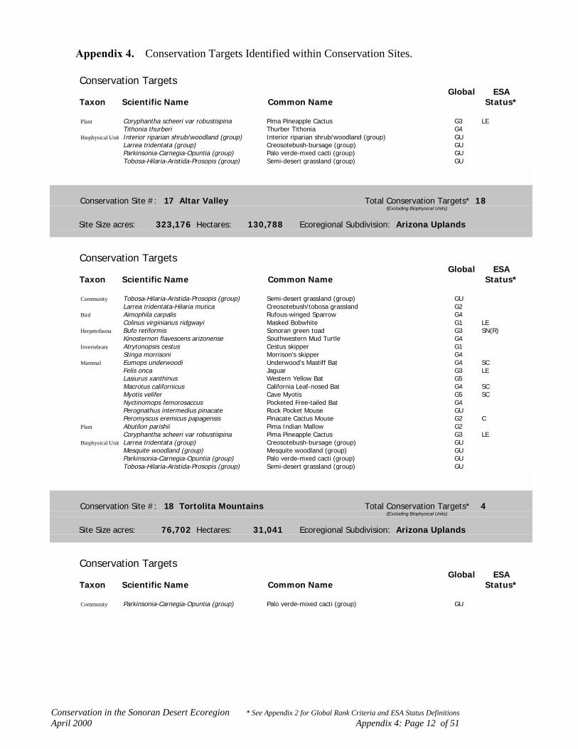
Conservation in the Sonoran Desert Ecoregion * See Appendix 2 for Global Rank Criteria and ESA Status DefinitionsApril 2000 Appendix 4: Page 12 of 51
Appendix 4. Conservation Targets Identified within Conservation Sites.
Conservation TargetsGlobal ESA
Taxon Scientific Name Common Name Status*
Plant Coryphantha scheeri var robustispina Pima Pineapple Cactus G3 LETithonia thurberi Thurber Tithonia G4
Biophysical Unit Interior riparian shrub/woodland (group) Interior riparian shrub/woodland (group) GULarrea tridentata (group) Creosotebush-bursage (group) GUParkinsonia-Carnegia-Opuntia (group) Palo verde-mxed cacti (group) GUTobosa-Hilaria-Aristida-Prosopis (group) Semi-desert grassland (group) GU
Conservation Site #: 17 Altar Valley Total Conservation Targets* 18(Excluding Biophysical Units)
Site Size acres: 323,176 Hectares: 130,788 Ecoregional Subdivision: Arizona Uplands
Conservation TargetsGlobal ESA
Taxon Scientific Name Common Name Status*
Community Tobosa-Hilaria-Aristida-Prosopis (group) Semi-desert grassland (group) GULarrea tridentata-Hilaria mutica Creosotebush/tobosa grassland G2
Bird Aimophila carpalis Rufous-winged Sparrow G4Colinus virginianus ridgwayi Masked Bobwhite G1 LE
Herpetofauna Bufo retiformis Sonoran green toad G3 SN(R)Kinosternon flavescens arizonense Southwestern Mud Turtle G4
Invertebrate Atrytonopsis cestus Cestus skipper G1Stinga morrisoni Morrison's skipper G4
Mammal Eumops underwoodi Underwood's Mastiff Bat G4 SCFelis onca Jaguar G3 LELasiurus xanthinus Western Yellow Bat G5Macrotus californicus California Leaf-nosed Bat G4 SCMyotis velifer Cave Myotis G5 SCNyctinomops femorosaccus Pocketed Free-tailed Bat G4Perognathus intermedius pinacate Rock Pocket Mouse GUPeromyscus eremicus papagensis Pinacate Cactus Mouse G2 C
Plant Abutilon parishii Pima Indian Mallow G2Coryphantha scheeri var robustispina Pima Pineapple Cactus G3 LE
Biophysical Unit Larrea tridentata (group) Creosotebush-bursage (group) GUMesquite woodland (group) Mesquite woodland (group) GUParkinsonia-Carnegia-Opuntia (group) Palo verde-mxed cacti (group) GUTobosa-Hilaria-Aristida-Prosopis (group) Semi-desert grassland (group) GU
Conservation Site #: 18 Tortolita Mountains Total Conservation Targets* 4(Excluding Biophysical Units)
Site Size acres: 76,702 Hectares: 31,041 Ecoregional Subdivision: Arizona Uplands
Conservation TargetsGlobal ESA
Taxon Scientific Name Common Name Status*
Community Parkinsonia-Carnegia-Opuntia (group) Palo verde-mixed cacti (group) GU

Conservation in the Sonoran Desert Ecoregion * See Appendix 2 for Global Rank Criteria and ESA Status DefinitionsApril 2000 Appendix 4: Page 13 of 51
Appendix 4. Conservation Targets Identified within Conservation Sites.
Conservation TargetsGlobal ESA
Taxon Scientific Name Common Name Status*
Community Carnegia gigantea-Prosopis velutina Saguaro cactus/velvet mesquite wooded shrubland G4Bird Colaptes chrysoides Gilded Flicker G5
Glaucidium brasilianum cactorum Cactus Ferruginous Pygmy-owl G3 LEBiophysical Unit Larrea tridentata (group) Creosotebush-bursage (group) GU
Parkinsonia-Carnegia-Opuntia (group) Palo verde-mxed cacti (group) GUTobosa-Hilaria-Aristida-Prosopis (group) Semi-desert grassland (group) GU
Conservation Site #: 19 Sawtooth-Silverbell Mountains Total Conservation Targets* 8(Excluding Biophysical Units)
Site Size acres: 110,577 Hectares: 44,750 Ecoregional Subdivision: Arizona Uplands
Conservation TargetsGlobal ESA
Taxon Scientific Name Common Name Status*
Mammal Macrotus californicus California Leaf-nosed Bat G4 SCMyotis velifer Cave Myotis G5 SCOvis canadensis mexicana Desert Bighorn Sheep G4
Plant Abutilon parishii Pima Indian Mallow G2Agave deserti G4Bursera microphylla Elephant Tree G4Coryphantha scheeri var robustispina Pima Pineapple Cactus G3 LEEchinocactus horizonthalonius var nicholii Nichol Turk's Head Cactus G2 LE
Biophysical Unit Larrea tridentata (group) Creosotebush-bursage (group) GUMesquite woodland (group) Mesquite woodland (group) GUParkinsonia-Carnegia-Opuntia (group) Palo verde-mxed cacti (group) GUTobosa-Hilaria-Aristida-Prosopis (group) Semi-desert grassland (group) GU
Conservation Site #: 20 Vekol Mountains Total Conservation Targets* 3(Excluding Biophysical Units)
Site Size acres: 21,950 Hectares: 8,883 Ecoregional Subdivision: Arizona Uplands
Conservation TargetsGlobal ESA
Taxon Scientific Name Common Name Status*
Mammal Macrotus californicus California Leaf-nosed Bat G4 SCMyotis velifer Cave Myotis G5 SC
Plant Echinocactus horizonthalonius var nicholii Nichol Turk's Head Cactus G2 LEBiophysical Unit Larrea tridentata (group) Creosotebush-bursage (group) GU
Parkinsonia-Carnegia-Opuntia (group) Palo verde-mxed cacti (group) GU

Conservation in the Sonoran Desert Ecoregion * See Appendix 2 for Global Rank Criteria and ESA Status DefinitionsApril 2000 Appendix 4: Page 14 of 51
Appendix 4. Conservation Targets Identified within Conservation Sites.
Conservation Site #: 21 Tonto Creek/Salt and Verde/Meddler WashTotal Conservation Targets* 39(Excluding Biophysical Units)
Site Size acres: 235,664 Hectares: 95,372 Ecoregional Subdivision: Arizona Uplands
Conservation TargetsGlobal ESA
Taxon Scientific Name Common Name Status*
Bird Coccyzus americanus occidentalis Western Yellow-billed Cuckoo G3 PEColaptes chrysoides Gilded Flicker G5Dendroica petechia Yellow Warbler G3Empidonax traillii extimus Southwestern Willow Flycatcher G2 LEFalco peregrinus anatum American Peregrine Falcon G3Glaucidium brasilianum cactorum Cactus Ferruginous Pygmy-owl G3 LEHaliaeetus leucocephalus Bald Eagle G4 CA(PS)Pipilo aberti Abert's Towhee G3Rallus longirostris yumanensis Yuma Clapper Rail G3 LE
Fish Agosia chrysogaster Longfin Dace G4 SCCatostomus clarki Desert Sucker G3 SCCatostomus insignis Sonora Sucker G3 SCCyprinodon macularius macularius Desert Pupfish G1 LEGila elegans Bonytail G1 LEGila intermedia Gila Chub G2 C, SN(P)Gila robusta Roundtail Chub G3 SCMeda fulgida Spikedace G2 LTPlagopterus argentissimus Woundfin G1 LEPoeciliopsis occidentalis occidentalis Gila Topminnow G3 LE, MX(T)Ptychocheilus lucius Colorado Squawfish G1 LE(CA-LE/XN)Rhinichthys osculus Speckled Dace G5 SCTiaroga cobitis Loach Minnow G2 LTXyrauchen texanus Razorback Sucker G1 LE
Herpetofauna Phyllorhynchus browni lucidus Maricopa Leafnose Snake G2Rana yavapaiensis Lowland Leopard Frog G4 SCThamnophis rufipunctatus Narrow-headed Garter Snake G4 SC
Invertebrate Cicindela oregona maricopa Maricopa tiger beetle G3 SCMammal Macrotus californicus California Leaf-nosed Bat G4 SC
Myotis velifer Cave Myotis G5 SCPlant Agave delamateri Tonto Basin Agave G1 SC
Agave murpheyi Hohokam Agave G2 SCEricameria brachylepis Rayless Turpentine Bush G4Eriogonum ripleyi Ripley Wild-buckwheat G2 SCJusticia candicans Hierba Azul G4Lotus mearnsii var equisolensis G3Mabrya acerifolia Mapleleaf False Snapdragon G3Perityle saxicola Fish Creek Rock Daisy G2 SCPurshia subintegra Arizona Cliffrose G1 LESalvia davidsonii Davidson Sage G2
Biophysical Unit Desert Riparian Woodland (group) Desert Riparian Woodland (group) GUInterior chaparral/encinal (group) Interior chaparral/encinal (group) GUInterior riparian shrub/woodland (group) Interior riparian shrub/woodland (group) GULarrea tridentata (group) Creosotebush-bursage (group) GUMesquite woodland (group) Mesquite woodland (group) GUParkinsonia-Carnegia-Opuntia (group) Palo verde-mxed cacti (group) GUSonoran/Mohave playa lake (group) Sonoran/Mohave playa lake (group) GUTobosa-Hilaria-Aristida-Prosopis (group) Semi-desert grassland (group) GU

Conservation in the Sonoran Desert Ecoregion * See Appendix 2 for Global Rank Criteria and ESA Status DefinitionsApril 2000 Appendix 4: Page 15 of 51
Appendix 4. Conservation Targets Identified within Conservation Sites.
Conservation Site #: 22 Río Magdalena/Río Asunción Total Conservation Targets* 6(Excluding Biophysical Units)
Site Size acres: 325,154 Hectares: 131,588 Ecoregional Subdivision: Arizona Uplands
Conservation TargetsGlobal ESA
Taxon Scientific Name Common Name Status*
Community Populus fremonti-Salix gooddingii Fremont cottonwood-Goodding's black willow riparian G2woodland
Bird Asturina nitida maxima Northern Gray Hawk G3 AZ(C)Coccyzus americanus occidentalis Western Yellow-billed Cuckoo G3 PEDendroica petechia Yellow Warbler G3
Fish Gila ditaenia Sonora Chub G2 LTPoeciliopsis occidentalis occidentalis Gila Topminnow G3 LE, MX(T)
Biophysical Unit Desert Riparian Woodland (group) Desert Riparian Woodland (group) GUInterior chaparral/encinal (group) Interior chaparral/encinal (group) GUJatropha-Bursera (group) Torchwood-limberbush (group) GULarrea tridentata (group) Creosotebush-bursage (group) GUMesquite woodland (group) Mesquite woodland (group) GUParkinsonia-Carnegia-Opuntia (group) Palo verde-mxed cacti (group) GUTobosa-Hilaria-Aristida-Prosopis (group) Semi-desert grassland (group) GU
Conservation Site #: 23 Hassayampa River Total Conservation Targets* 15(Excluding Biophysical Units)
Site Size acres: 40,937 Hectares: 16,567 Ecoregional Subdivision: Arizona Uplands
Conservation TargetsGlobal ESA
Taxon Scientific Name Common Name Status*
Bird Coccyzus americanus occidentalis Western Yellow-billed Cuckoo G3 PEDendroica petechia Yellow Warbler G3Empidonax traillii extimus Southwestern Willow Flycatcher G2 LE
Fish Agosia chrysogaster Longfin Dace G4 SCCyprinodon macularius macularius Desert Pupfish G1 LEGila elegans Bonytail G1 LEPoeciliopsis occidentalis occidentalis Gila Topminnow G3 LE, MX(T)Xyrauchen texanus Razorback Sucker G1 LE
Herpetofauna Bufo microscaphus microscaphus Arizona toad G4 AZ(C), SN(P)Eumeces gilberti arizonensis Arizona Skink G1 SCRana yavapaiensis Lowland Leopard Frog G4 SC
Invertebrate Cicindela oregona maricopa Maricopa tiger beetle G3 SCMammal Macrotus californicus California Leaf-nosed Bat G4 SC
Myotis velifer Cave Myotis G5 SCPlant Agave murpheyi Hohokam Agave G2 SCBiophysical Unit Desert Riparian Woodland (group) Desert Riparian Woodland (group) GU
Interior riparian shrub/woodland (group) Interior riparian shrub/woodland (group) GULarrea tridentata (group) Creosotebush-bursage (group) GU

Conservation in the Sonoran Desert Ecoregion * See Appendix 2 for Global Rank Criteria and ESA Status DefinitionsApril 2000 Appendix 4: Page 16 of 51
Appendix 4. Conservation Targets Identified within Conservation Sites.
Conservation TargetsGlobal ESA
Taxon Scientific Name Common Name Status*
Biophysical Unit Mesquite woodland (group) Mesquite woodland (group) GUParkinsonia-Carnegia-Opuntia (group) Palo verde-mxed cacti (group) GU
Conservation Site #: 24 San Jacinto Foothills Total Conservation Targets* 23(Excluding Biophysical Units)
Site Size acres: 164,528 Hectares: 67,960 Ecoregional Subdivision: Lower Colorado River Valley
Conservation TargetsGlobal ESA
Taxon Scientific Name Common Name Status*
Community Desert Riparian Woodland (group) Desert Riparian Woodland (group) GUWashingtonia filifera association California fan palm oasis G2Ecological gradient Ecological gradient
Bird Dendroica petechia Yellow Warbler G3Falco mexicanus Prairie Falcon G5Vireo bellii pusillus Least Bell's Vireo G2 CA(LE)
Herpetofauna Batrachoseps aridus Desert slender salamander G1 LERana aurora draytoni California Red-legged Frog G2 CA(LT)Uma inornata Coachella Valley Fringe-toed Lizard G1 LTXantusia vigilis Desert Night Lizard G5 SN(T)
Mammal Macrotus californicus California Leaf-nosed Bat G4 SCOvis canadensis cremnobates Peninsular Bighorn Sheep G1 CA(LE)Spermophilus tereticaudus chlorus Coachella Round-tailed Ground Squirrel G2 SC
Plant Argythamnia californica California Ditaxis G2Astragalus lentiginosus var coachellae Coachella Valley Milkvetch G2 CA(LE)Astragalus tricarinatus Triple-rib Milkvetch G1 CA(LE)Linanthus floribundus ssp. hallii Santa Rosa Mtns. Linanthus G1Pseudorontium cyathiferum Deep Canyon Snapdragon G3Thelypteris puberula var sonorensis Aravaipa Wood Fern G3Washingtonia filifera California fan palm G2
Plant Washingtonia filifera California Fan Palm G2Xylorhiza cognata Mecca Aster G2 SCXylorhiza orcuttii Orcutt's Woody Aster G3 SC
Biophysical Unit Interior chaparral/encinal (group) Interior chaparral/encinal (group) GULarrea tridentata (group) Creosotebush-bursage (group) GU
Conservation Site #: 25 Anza Borrego Total Conservation Targets* 41(Excluding Biophysical Units)
Site Size acres: 653,444 Hectares: 264,462 Ecoregional Subdivision: Lower Colorado River Valley
Conservation TargetsGlobal ESA
Taxon Scientific Name Common Name Status*
Community Playa lake Intermittently flooded playa lake bed GUProsopis (sp. glandulosa, velutina) Mesquite woodland G3

Conservation in the Sonoran Desert Ecoregion * See Appendix 2 for Global Rank Criteria and ESA Status DefinitionsApril 2000 Appendix 4: Page 17 of 51
Appendix 4. Conservation Targets Identified within Conservation Sites.
Conservation TargetsGlobal ESA
Taxon Scientific Name Common Name Status*
Community Populus fremonti-Salix gooddingii Fremont cottonwood-Goodding's black willow riparian G2woodland
Washingtonia filifera association California fan palm oasis G2Desert Spring/Seep Desert Spring/Seep GULarrea tridentata (group) Creosotebush-bursage (group) GUYucca brevifolia Joshua tree woodland G4Acacia greggi-Parkinsonia microphylla Cat claw acacia -yellow palo verde shrubland G4Parkinsonia-Carnegia-Opuntia (group) Palo verde-mixed cacti (group) GUQuercus turbinella Turbinella live-oak-Mexican manzanita shrubland G4Arctostaphylos pungens Mexican manzanita shrubland G4Cercocarpus montanus-Eriogonum fasciculatum Birchleaf mountain-mahogany-California buckwheat shrubland G3Ecological gradient Ecological gradient
Bird Dendroica petechia Yellow Warbler G3Falco mexicanus Prairie Falcon G5Vireo bellii pusillus Least Bell's Vireo G2 CA(LE)
Fish Cyprinodon macularius Desert Pupfish G1 LEHerpetofauna Coleonyx switaki Barefoot Banded Gecko G3 SC
Crotalus exsul ruber Red Diamond Rattlesnake G4 SCPhrynosoma mcallii Flat-tailed Horned Lizard G3 SCThamnophis hammondii Two-striped Garter Snake G3 SC
Invertebrate Pogonomyrmex anzensis GUMammal Lasiurus xanthinus Western Yellow Bat G5
Macrotus californicus California Leaf-nosed Bat G4 SCNyctinomops femorosaccus Pocketed Free-tailed Bat G4Ovis canadensis cremnobates Peninsular Bighorn Sheep G1 CA(LE)
Plant Astragalus insularis var harwoodii Harwood Milkvetch G3Astragalus magdalenae var peirsonii Peirson's Milkvetch G2 PE, CA(LT)Bursera microphylla Elephant Tree G4Chaenactis carphoclinia var peirsonii Peirson's Pincushion G1Chamaesyce platysperma Flatseed Spurge G3 SCCryptantha ganderi Gander's Cryptantha G2 SCEucnide rupestris Rock Stingbush G3Galium angustifolium ssp. borregoense Borrego Bedstraw G2 SC, RareHulsea californica San Diego Hulsea G2Lepidium flavum var felipense Borrego Valley Pepper-grass G1Mentzelia hirsutissima California Stick-leaf G3Opuntia wigginsii Wiggin's Cholla G3Streptanthus campestris Southern Jewelflower G2Washingtonia filifera California Fan Palm G2Xylorhiza orcuttii Orcutt's Woody Aster G3 SC
Biophysical Unit Interior chaparral/encinal (group) Interior chaparral/encinal (group) GULarrea tridentata (group) Creosotebush-bursage (group) GU

Conservation in the Sonoran Desert Ecoregion * See Appendix 2 for Global Rank Criteria and ESA Status DefinitionsApril 2000 Appendix 4: Page 18 of 51
Appendix 4. Conservation Targets Identified within Conservation Sites.
Conservation Site #: 26 Coachella Valley Total Conservation Targets* 3(Excluding Biophysical Units)
Site Size acres: 36,838 Hectares: 14,908 Ecoregional Subdivision: Lower Colorado River Valley
Conservation TargetsGlobal ESA
Taxon Scientific Name Common Name Status*
Herpetofauna Phrynosoma mcallii Flat-tailed Horned Lizard G3 SCUma inornata Coachella Valley Fringe-toed Lizard G1 LT
Mammal Spermophilus tereticaudus chlorus Coachella Round-tailed Ground Squirrel G2 SCBiophysical Unit Larrea tridentata (group) Creosotebush-bursage (group) GU
Conservation Site #: 27 Chocolate Mountains Total Conservation Targets* 28(Excluding Biophysical Units)
Site Size acres: 1,143,211 Hectares: 463,382 Ecoregional Subdivision: Lower Colorado River Valley
Conservation TargetsGlobal ESA
Taxon Scientific Name Common Name Status*
Community Typha domingensis Interior cattail marsh G5Prosopis (sp. glandulosa, velutina) Mesquite woodland G3Prosopis velutina-mixed short tree Mesquite-mixed short tree woodland GUWashingtonia filifera association California fan palm oasis G2Perennial/Intermittent Stream Perennial/Intermittent Stream GULarrea tridentata (group) Creosotebush-bursage (group) GUCercidium floridum Blue palo verde mixed desert scrub G3Parkinsonia-Carnegia-Opuntia (group) Palo verde-mixed cacti (group) GU
Bird Falco mexicanus Prairie Falcon G5Migratory Bird Concentration Area Migratory Bird Concentration Area GURallus longirostris yumanensis Yuma Clapper Rail G3 LEToxostoma lecontei Le Conte's Thrasher G3
Fish Cyprinodon macularius Desert Pupfish G1 LEHerpetofauna Charina trivirgata gracia Desert Rosy Boa G3 SC
Gopherus agassizii Desert Tortoise G4 CA(LT),AZ(C)Xantusia vigilis Desert Night Lizard G5 SN(T)
Mammal Macrotus californicus California Leaf-nosed Bat G4 SCMyotis velifer Cave Myotis G5 SCOvis canadensis nelsoni Desert Bighorn Sheep G4
Plant Argythamnia californica California Ditaxis G2Astragalus insularis var harwoodii Harwood Milkvetch G3Carnegiea gigantea Saguaro Cactus G5Castela emoryi Crucifixion Thorn G4Escobaria vivipara G5Opuntia munzii Munz Cholla G1Opuntia wigginsii Wiggin's Cholla G3Salvia greatae Orocopia Sage G2 SCWashingtonia filifera California Fan Palm G2
Biophysical Unit Larrea tridentata (group) Creosotebush-bursage (group) GUMesquite woodland (group) Mesquite woodland (group) GU

Conservation in the Sonoran Desert Ecoregion * See Appendix 2 for Global Rank Criteria and ESA Status DefinitionsApril 2000 Appendix 4: Page 19 of 51
Appendix 4. Conservation Targets Identified within Conservation Sites.
Conservation Site #: 28 Coachella Canal Total Conservation Targets* 1(Excluding Biophysical Units)
Site Size acres: 11,840 Hectares: 5,997 Ecoregional Subdivision: Lower Colorado River Valley
Conservation TargetsGlobal ESA
Taxon Scientific Name Common Name Status*
Bird Laterallus jamaicensis coturniculus California Black Rail G1 SC, AZ(T)Biophysical Unit Larrea tridentata (group) Creosotebush-bursage (group) GU
Mesquite woodland (group) Mesquite woodland (group) GU
Conservation Site #: 29 McCoy Mountains Total Conservation Targets* 11(Excluding Biophysical Units)
Site Size acres: 332,799 Hectares: 136,325 Ecoregional Subdivision: Lower Colorado River Valley
Conservation TargetsGlobal ESA
Taxon Scientific Name Common Name Status*
Community Parkinsonia-Carnegia-Opuntia (group) Palo verde-mixed cacti (group) GUEcological gradient Ecological gradient
Bird Falco mexicanus Prairie Falcon G5Herpetofauna Charina trivirgata gracia Desert Rosy Boa G3 SC
Gopherus agassizii Desert Tortoise G4 CA(LT),AZ(C)Uma scoparia Mojave Fringe-toed Lizard G3
Invertebrate Micrarionta rowelli mccoiana California mccoy snail G1Mammal Macrotus californicus California Leaf-nosed Bat G4 SC
Ovis canadensis nelsoni Desert Bighorn Sheep G4Plant Castela emoryi Crucifixion Thorn G4
Escobaria vivipara G5Biophysical Unit Abronium-Eriogonum (group) Interior dunes and plains (group) GU
Larrea tridentata (group) Creosotebush-bursage (group) GUMesquite woodland (group) Mesquite woodland (group) GU
Conservation Site #: 30 Riverside Mountains Total Conservation Targets* 4(Excluding Biophysical Units)
Site Size acres: 9,612 Hectares: 4,697 Ecoregional Subdivision: Lower Colorado River Valley
Conservation TargetsGlobal ESA
Taxon Scientific Name Common Name Status*
Bird Falco mexicanus Prairie Falcon G5Invertebrate Eremarionta immaculata White desertsnail G1Mammal Macrotus californicus California Leaf-nosed Bat G4 SC

Conservation in the Sonoran Desert Ecoregion * See Appendix 2 for Global Rank Criteria and ESA Status DefinitionsApril 2000 Appendix 4: Page 20 of 51
Appendix 4. Conservation Targets Identified within Conservation Sites.
Conservation TargetsGlobal ESA
Taxon Scientific Name Common Name Status*
Mammal Myotis velifer Cave Myotis G5 SCBiophysical Unit Larrea tridentata (group) Creosotebush-bursage (group) GU
Mesquite woodland (group) Mesquite woodland (group) GU
Conservation Site #: 31 Whipple Mountains Total Conservation Targets* 9(Excluding Biophysical Units)
Site Size acres: 106,955 Hectares: 53,214 Ecoregional Subdivision: Lower Colorado River Valley
Conservation TargetsGlobal ESA
Taxon Scientific Name Common Name Status*
Community Platanus wrightii Arizona sycamore riparian woodland G4Washingtonia filifera association California fan palm oasis G2Carnegia gigantea-Prosopis velutina Saguaro cactus/velvet mesquite wooded shrubland G4
Mammal Lasiurus xanthinus Western Yellow Bat G5Macrotus californicus California Leaf-nosed Bat G4 SCMyotis velifer Cave Myotis G5 SCOvis canadensis mexicana Desert Bighorn Sheep G4
Plant Carnegiea gigantea Saguaro Cactus G5Pholistoma auritum var arizonicum Arizona Pholistoma G1
Biophysical Unit Larrea tridentata (group) Creosotebush-bursage (group) GUMesquite woodland (group) Mesquite woodland (group) GU
Conservation Site #: 32 Sand Tanks Mountains Total Conservation Targets* 12(Excluding Biophysical Units)
Site Size acres: 636,196 Hectares: 257,465 Ecoregional Subdivision: Arizona Uplands
Conservation TargetsGlobal ESA
Taxon Scientific Name Common Name Status*
Community Hilaria rigida Big galleta grassland G3Parkinsonia-Carnegia-Opuntia (group) Palo verde-mixed cacti (group) GUEcological gradient Ecological gradient
Bird Colaptes chrysoides Gilded Flicker G5Pipilo aberti Abert's Towhee G3
Herpetofauna Cnemidophorus burti xanthonotus Redback Whiptail G2 SCGopherus agassizii Desert Tortoise G4 CA(LT),AZ(C)
Mammal Antilocapra americana sonoriensis Sonoran Pronghorn G1 LEMacrotus californicus California Leaf-nosed Bat G4 SCMyotis velifer Cave Myotis G5 SC
Plant Berberis harrisoniana Kofa Barberry G2Echinomastus erectocentrus var acunensis Acuna Cactus G1 C
Biophysical Unit Larrea tridentata (group) Creosotebush-bursage (group) GUParkinsonia-Carnegia-Opuntia (group) Palo verde-mxed cacti (group) GUTobosa-Hilaria-Aristida-Prosopis (group) Semi-desert grassland (group) GU

Conservation in the Sonoran Desert Ecoregion * See Appendix 2 for Global Rank Criteria and ESA Status DefinitionsApril 2000 Appendix 4: Page 21 of 51
Appendix 4. Conservation Targets Identified within Conservation Sites.
Conservation Site #: 33 Salton Sea Total Conservation Targets* 8(Excluding Biophysical Units)
Site Size acres: 255,393 Hectares: 103,356 Ecoregional Subdivision: Lower Colorado River Valley
Conservation TargetsGlobal ESA
Taxon Scientific Name Common Name Status*
Bird Athene cunicularia Burrowing Owl G4 SCCharadrius alexandrinus nivosus Western Snowy Plover G3 CA(PS)Dendroica petechia Yellow Warbler G3Mycteria americana Wood Stork G4 SN(T)Rallus longirostris yumanensis Yuma Clapper Rail G3 LESterna nilotica Gull-billed Tern G5Toxostoma lecontei Le Conte's Thrasher G3
Fish Cyprinodon macularius macularius Desert Pupfish G1 LEBiophysical Unit Larrea tridentata (group) Creosotebush-bursage (group) GU
Conservation Site #: 34 Joshua Tree Total Conservation Targets* 32(Excluding Biophysical Units)
Site Size acres: 467,273 Hectares: 189,103 Ecoregional Subdivision: Lower Colorado River Valley
Conservation TargetsGlobal ESA
Taxon Scientific Name Common Name Status*
Community Sparsely vegetated coastal rock shore Coastal rock shore GUTypha-Phragmites-Scirpus (group) Interior riparian marsh (group) GUBaccharis sarothroides Rosinbush sonoran desert wash G4Prosopis (sp. glandulosa, velutina) Mesquite woodland G3Populus fremonti-Salix gooddingii Fremont cottonwood-Goodding's black willow riparian G2
woodlandWashingtonia filifera association California fan palm oasis G2Larrea tridentata (group) Creosotebush-bursage (group) GUParkinsonia-Carnegia-Opuntia (group) Palo verde-mixed cacti (group) GU
Bird Dendroica petechia Yellow Warbler G3Falco mexicanus Prairie Falcon G5Toxostoma bendirei Bendire's Thrasher G4Toxostoma lecontei Le Conte's Thrasher G3Vireo bellii pusillus Least Bell's Vireo G2 CA(LE)
Fish Cyprinodon macularius Desert Pupfish G1 LEHerpetofauna Charina trivirgata gracia Desert Rosy Boa G3 SC
Gopherus agassizii Desert Tortoise G4 CA(LT),AZ(C)Phrynosoma mcallii Flat-tailed Horned Lizard G3 SCUma inornata Coachella Valley Fringe-toed Lizard G1 LTXantusia vigilis Desert Night Lizard G5 SN(T)
Invertebrate Oliarces clara Cheese-weed owlfly G2 SCMammal Lasiurus xanthinus Western Yellow Bat G5
Macrotus californicus California Leaf-nosed Bat G4 SC

Conservation in the Sonoran Desert Ecoregion * See Appendix 2 for Global Rank Criteria and ESA Status DefinitionsApril 2000 Appendix 4: Page 22 of 51
Appendix 4. Conservation Targets Identified within Conservation Sites.
Conservation TargetsGlobal ESA
Taxon Scientific Name Common Name Status*
Mammal Ovis canadensis nelsoni Desert Bighorn Sheep G4Plant Ammoselinum giganteum Western Sand-parsley G3
Argythamnia californica California Ditaxis G2Astragalus lentiginosus var coachellae Coachella Valley Milkvetch G2 CA(LE)Castela emoryi Crucifixion Thorn G4Escobaria vivipara G5Gilia maculata Little San Bernardino Mtns. Gilia G1Stylocline sonorensis Mesquite Neststraw G4Washingtonia filifera California Fan Palm G2Xylorhiza cognata Mecca Aster G2 SC
Biophysical Unit Abronium-Eriogonum (group) Interior dunes and plains (group) GULarrea tridentata (group) Creosotebush-bursage (group) GUMesquite woodland (group) Mesquite woodland (group) GUSonoran/Mohave playa lake (group) Sonoran/Mohave playa lake (group) GU
Conservation Site #: 35 Algodones Dunes Total Conservation Targets* 24(Excluding Biophysical Units)
Site Size acres: 291,397 Hectares: 117,927 Ecoregional Subdivision: Lower Colorado River Valley
Conservation TargetsGlobal ESA
Taxon Scientific Name Common Name Status*
Community Abronia villosa-mixed shrub Desert sand-verbena interior dune G1Larrea tridentata-Hilaria mutica Creosotebush/tobosa grassland G2Cercidium floridum Blue palo verde mixed desert scrub G3
Bird Colinus virginianus ridgwayi Masked Bobwhite G1 LELaterallus jamaicensis coturniculus California Black Rail G1 SC, AZ(T)Toxostoma lecontei Le Conte's Thrasher G3
Herpetofauna Phrynosoma mcallii Flat-tailed Horned Lizard G3 SCUma notata notata Fringe-toed Lizard G3 SN(T)
Invertebrate Acmaeodera yumae GUAcmaeoderoides straminea GUAnomala carlsoni Carlson's dune beetle G2Anomala hardyorum Hardy's dune beetle G2Hippomelas imperialis Large buprestid beetle GULepismaedora algodonnes GUMonachister californicus Sand burrowing sp. GUPhiloxenus desertorum Sand burrowing beetle GUPseudocotalpa andrewsi Andrew's dune beetle G2
Plant Astragalus insularis var harwoodii Harwood Milkvetch G3Astragalus magdalenae var peirsonii Peirson's Milkvetch G2 PE, CA(LT)Croton wigginsii Dune Croton G2Eriogonum deserticola Desert Wild-buckwheat G3Helianthus niveus ssp. tephrodes Algodones Dunes Sunflower G2 SC, CA(LE)Palafoxia arida var gigantea Giant Spanish Needle G3 SCPholisma sonorae Sand Food G3 SC
Biophysical Unit Abronium-Eriogonum (group) Interior dunes and plains (group) GULarrea tridentata (group) Creosotebush-bursage (group) GUMesquite woodland (group) Mesquite woodland (group) GU

Conservation in the Sonoran Desert Ecoregion * See Appendix 2 for Global Rank Criteria and ESA Status DefinitionsApril 2000 Appendix 4: Page 23 of 51
Appendix 4. Conservation Targets Identified within Conservation Sites.
Conservation Site #: 36 Palen Dry Lake Total Conservation Targets* 2(Excluding Biophysical Units)
Site Size acres: 3,479 Hectares: 1,408 Ecoregional Subdivision: Lower Colorado River Valley
Conservation TargetsGlobal ESA
Taxon Scientific Name Common Name Status*
Community Larrea tridentata (group) Creosotebush-bursage (group) GUHerpetofauna Gopherus agassizii Desert Tortoise G4 CA(LT),AZ(C)Biophysical Unit Abronium-Eriogonum (group) Interior dunes and plains (group) GU
Larrea tridentata (group) Creosotebush-bursage (group) GUMesquite woodland (group) Mesquite woodland (group) GUSonoran/Mohave playa lake (group) Sonoran/Mohave playa lake (group) GU
Conservation Site #: 37 Central Gulf Coast Total Conservation Targets* 8(Excluding Biophysical Units)
Site Size acres: 174,700 Hectares: 77,967 Ecoregional Subdivision: Central Gulf Coast
Conservation TargetsGlobal ESA
Taxon Scientific Name Common Name Status*
Community Abronia maritima-Helianthus-Jouvea Gulf of California coastal strand G5Distichlis spicata Coastal saltgrass G5Rhizophora mangle Red mangrove (black-white mangrove) forest G3Prosopis (sp. glandulosa, velutina) Mesquite woodland G3Jatropha sp.-Bursera microphylla-Pachycereus Torchwood-limberbush-cardon association GUpringlei
Mammal Tamias dorsalis sonoriensis Chichimoco GUPlant Ferocactus wislizeni var tiburonensis G2
Opuntia reflexispina Cholla GUBiophysical Unit Abronium-Eriogonum (group) Interior dunes and plains (group) GU
Agave-Ambrosia-Fouquieria (group) Agave-bursage scrub (group) GUAtriplex-Allenrolfea-Suaeda (group) Saltbush desert scrub (group) GULarrea tridentata (group) Creosotebush-bursage (group) GUMesquite woodland (group) Mesquite woodland (group) GUParkinsonia-Carnegia-Opuntia (group) Palo verde-mxed cacti (group) GU

Conservation in the Sonoran Desert Ecoregion * See Appendix 2 for Global Rank Criteria and ESA Status DefinitionsApril 2000 Appendix 4: Page 24 of 51
Appendix 4. Conservation Targets Identified within Conservation Sites.
Conservation Site #: 38 Colorado River/Río Hardy Total Conservation Targets* 31(Excluding Biophysical Units)
Site Size acres: 434,141 Hectares: 176,806 Ecoregional Subdivision: Lower Colorado River Valley
Conservation TargetsGlobal ESA
Taxon Scientific Name Common Name Status*
Community Typha-Phragmites-Scirpus (group) Interior riparian marsh (group) GUTypha domingensis Interior cattail marsh G5Phragmites sp. Interior giant reed marsh GUProsopis (sp. glandulosa, velutina) Mesquite woodland G3Populus fremonti-Salix gooddingii Fremont cottonwood-Goodding's black willow riparian G2
woodlandSalix gooddingii-Fraxinus velutina Goodding's black willow-velvet ash woodland G2
Bird Athene cunicularia Burrowing Owl G4 SCCoccyzus americanus occidentalis Western Yellow-billed Cuckoo G3 PEColaptes chrysoides Gilded Flicker G5Dendroica petechia Yellow Warbler G3Empidonax traillii extimus Southwestern Willow Flycatcher G2 LEHaliaeetus leucocephalus Bald Eagle G4 CA(PS)Ixobrychus exilis hesperis Western Least Bittern GU AZ(C)Laterallus jamaicensis coturniculus California Black Rail G1 SC, AZ(T)Micrathene whitneyi Elf Owl G5Pipilo aberti Abert's Towhee G3Rallus longirostris yumanensis Yuma Clapper Rail G3 LE
Fish Catostomus latipinnis Flannelmouth Sucker G3 SCElops affinis Pacific Tenpounder G5Gila elegans Bonytail G1 LEGila robusta Roundtail Chub G3 SCPlagopterus argentissimus Woundfin G1 LEPtychocheilus lucius Colorado Squawfish G1 LE(CA-LE/XN)Xyrauchen texanus Razorback Sucker G1 LE
Invertebrate Oliarces clara Cheese-weed owlfly G2 SCMammal Macrotus californicus California Leaf-nosed Bat G4 SC
Myotis velifer Cave Myotis G5 SCSigmodon hispidus eremicus Yuma Cotton Rat G3 SC
Plant Carnegiea gigantea Saguaro Cactus G5Escobaria vivipara G5Palafoxia arida var gigantea Giant Spanish Needle G3 SC
Biophysical Unit Abronium-Eriogonum (group) Interior dunes and plains (group) GUAtriplex-Allenrolfea-Suaeda (group) Saltbush desert scrub (group) GUDesert Riparian Woodland (group) Desert Riparian Woodland (group) GUInterior chaparral/encinal (group) Interior chaparral/encinal (group) GUInterior riparian shrub/woodland (group) Interior riparian shrub/woodland (group) GULarrea tridentata (group) Creosotebush-bursage (group) GUMesquite woodland (group) Mesquite woodland (group) GUParkinsonia-Carnegia-Opuntia (group) Palo verde-mxed cacti (group) GUSonoran/Mohave playa lake (group) Sonoran/Mohave playa lake (group) GUTypha-Phragmites-Scirpus (group) Interior riparian marsh (group) GU

Conservation in the Sonoran Desert Ecoregion * See Appendix 2 for Global Rank Criteria and ESA Status DefinitionsApril 2000 Appendix 4: Page 25 of 51
Appendix 4. Conservation Targets Identified within Conservation Sites.
Conservation Site #: 39 Sierra de Lopez Total Conservation Targets* 3(Excluding Biophysical Units)
Site Size acres: 20,521 Hectares: 8,305 Ecoregional Subdivision: Plains of Sonora
Conservation TargetsGlobal ESA
Taxon Scientific Name Common Name Status*
Community Ecological gradient Ecological gradientPlant Agave fortiflora GU
Agave pelona Mescal Pelon G1Biophysical Unit Jatropha-Bursera (group) Torchwood-limberbush (group) GU
Larrea tridentata (group) Creosotebush-bursage (group) GUMesquite woodland (group) Mesquite woodland (group) GUParkinsonia-Carnegia-Opuntia (group) Palo verde-mxed cacti (group) GU
Conservation Site #: 40 Cueva del Tigre Total Conservation Targets* 2(Excluding Biophysical Units)
Site Size acres: 1,453 Hectares: 588 Ecoregional Subdivision: Plains of Sonora
Conservation TargetsGlobal ESA
Taxon Scientific Name Common Name Status*
Mammal Leptonycteris curasoae yerbabuenae Lesser Long-nosed Bat G4 LEMacrotus californicus California Leaf-nosed Bat G4 SC
Biophysical Unit Jatropha-Bursera (group) Torchwood-limberbush (group) GU
Conservation Site #: 41 Sierra La Cobriza Total Conservation Targets* 1(Excluding Biophysical Units)
Site Size acres: 3,928 Hectares: 1,590 Ecoregional Subdivision: Plains of Sonora
Conservation TargetsGlobal ESA
Taxon Scientific Name Common Name Status*
Plant Brahea armata G3Biophysical Unit Jatropha-Bursera (group) Torchwood-limberbush (group) GU
Larrea tridentata (group) Creosotebush-bursage (group) GU

Conservation in the Sonoran Desert Ecoregion * See Appendix 2 for Global Rank Criteria and ESA Status DefinitionsApril 2000 Appendix 4: Page 26 of 51
Appendix 4. Conservation Targets Identified within Conservation Sites.
Conservation Site #: 42 Sierra La Jojoba Total Conservation Targets* 3(Excluding Biophysical Units)
Site Size acres: 10,483 Hectares: 4,243 Ecoregional Subdivision: Arizona Uplands
Conservation TargetsGlobal ESA
Taxon Scientific Name Common Name Status*
Herpetofauna Charina trivirgata gracia Desert Rosy Boa G3 SCGopherus agassizii Desert Tortoise G4 CA(LT),AZ(C)
Plant Agave fortiflora GUBiophysical Unit Jatropha-Bursera (group) Torchwood-limberbush (group) GU
Larrea tridentata (group) Creosotebush-bursage (group) GUParkinsonia-Carnegia-Opuntia (group) Palo verde-mxed cacti (group) GU
Conservation Site #: 43 San Pedro Nolasco Island Total Conservation Targets* 9(Excluding Biophysical Units)
Site Size acres: 968 Hectares: 392 Ecoregional Subdivision: Central Gulf Coast
Conservation TargetsGlobal ESA
Taxon Scientific Name Common Name Status*
Herpetofauna Cnemidophorus nolascoensis San Pedro Nolasco Whiptail GUCtenosaura hemilopha nolascoensis San Pedro Nolasco Spiny-tailed Iguana GU SN(P)Phyllodactylus homolepidurus nolascoensis San Pedro Nolasco Gecko GU SN(R)Uta nolascensis San Pedro Nolasco Side-blotched Lizard GU
Plant Agave chrysoglossa G2Coreocarpus sanpedroensis G1Euphorbia magdalenae GUMammillaria multidigitata GUMammillaria tayloriorum G3
Biophysical Unit Jatropha-Bursera (group) Torchwood-limberbush (group) GU
Conservation Site #: 44 Río Matape Total Conservation Targets* 2(Excluding Biophysical Units)
Site Size acres: 205,217 Hectares: 83,166 Ecoregional Subdivision: Plains of Sonora
Conservation TargetsGlobal ESA
Taxon Scientific Name Common Name Status*
Fish Gila eremica Desert Chub GUPoeciliopsis occidentalis occidentalis Gila Topminnow G3 LE, MX(T)
Biophysical Unit Desert Riparian Woodland (group) Desert Riparian Woodland (group) GUJatropha-Bursera (group) Torchwood-limberbush (group) GULarrea tridentata (group) Creosotebush-bursage (group) GUMesquite woodland (group) Mesquite woodland (group) GU

Conservation in the Sonoran Desert Ecoregion * See Appendix 2 for Global Rank Criteria and ESA Status DefinitionsApril 2000 Appendix 4: Page 27 of 51
Appendix 4. Conservation Targets Identified within Conservation Sites.
Conservation TargetsGlobal ESA
Taxon Scientific Name Common Name Status*
Biophysical Unit Sinaloan/foothills thornscrub (group) Sinaloan/foothills thornscrub (group) GU
Conservation Site #: 45 Las Guasimas Total Conservation Targets* 2(Excluding Biophysical Units)
Site Size acres: 1,065 Hectares: 431 Ecoregional Subdivision: Central Gulf Coast
Conservation TargetsGlobal ESA
Taxon Scientific Name Common Name Status*
Plant Mammillaria johnstonii GUMammillaria yaquensis G3
Biophysical Unit Mesquite woodland (group) Mesquite woodland (group) GUParkinsonia-Carnegia-Opuntia (group) Palo verde-mxed cacti (group) GU
Conservation Site #: 46 Cerro Agualurca Total Conservation Targets* 3(Excluding Biophysical Units)
Site Size acres: 11,462 Hectares: 4,639 Ecoregional Subdivision: Plains of Sonora
Conservation TargetsGlobal ESA
Taxon Scientific Name Common Name Status*
Herpetofauna Charina trivirgata trivirgata Mexican Rosy Boa G3 SCGopherus agassizii Desert Tortoise G4 CA(LT),AZ(C)
Plant Adelia obovata GUBiophysical Unit Jatropha-Bursera (group) Torchwood-limberbush (group) GU
Mesquite woodland (group) Mesquite woodland (group) GU
Conservation Site #: 47 La Poza/Southwest Hermosillo Total Conservation Targets* 2(Excluding Biophysical Units)
Site Size acres: 69,640 Hectares: 28,183 Ecoregional Subdivision: Plains of Sonora
Conservation TargetsGlobal ESA
Taxon Scientific Name Common Name Status*
Community Ecological gradient Ecological gradientHerpetofauna Charina trivirgata trivirgata Mexican Rosy Boa G3 SCBiophysical Unit Desert Riparian Woodland (group) Desert Riparian Woodland (group) GU
Jatropha-Bursera (group) Torchwood-limberbush (group) GULarrea tridentata (group) Creosotebush-bursage (group) GUMesquite woodland (group) Mesquite woodland (group) GU
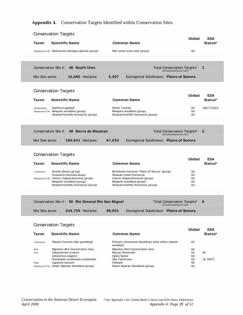
Conservation in the Sonoran Desert Ecoregion * See Appendix 2 for Global Rank Criteria and ESA Status DefinitionsApril 2000 Appendix 4: Page 28 of 51
Appendix 4. Conservation Targets Identified within Conservation Sites.
Conservation TargetsGlobal ESA
Taxon Scientific Name Common Name Status*
Biophysical Unit Parkinsonia-Carnegia-Opuntia (group) Palo verde-mxed cacti (group) GU
Conservation Site #: 48 South Ures Total Conservation Targets* 1(Excluding Biophysical Units)
Site Size acres: 15,585 Hectares: 6,307 Ecoregional Subdivision: Plains of Sonora
Conservation TargetsGlobal ESA
Taxon Scientific Name Common Name Status*
Herpetofauna Gopherus agassizii Desert Tortoise G4 CA(LT),AZ(C)Biophysical Unit Mesquite woodland (group) Mesquite woodland (group) GU
Sinaloan/foothills thornscrub (group) Sinaloan/foothills thornscrub (group) GU
Conservation Site #: 49 Sierra de Mazatan Total Conservation Targets* 2(Excluding Biophysical Units)
Site Size acres: 165,641 Hectares: 67,034 Ecoregional Subdivision: Plains of Sonora
Conservation TargetsGlobal ESA
Taxon Scientific Name Common Name Status*
Community Encelia-Olneya (group) Brittlebush-ironwood "Plains Of Sonora" (group) GUFouquieria-Ipomoea-Acacia Sinaloan mixed thornscrub GU
Biophysical Unit Interior chaparral/encinal (group) Interior chaparral/encinal (group) GUMesquite woodland (group) Mesquite woodland (group) GUSinaloan/foothills thornscrub (group) Sinaloan/foothills thornscrub (group) GU
Conservation Site #: 50 Río Sonora/Río San Miguel Total Conservation Targets* 6(Excluding Biophysical Units)
Site Size acres: 244,755 Hectares: 99,051 Ecoregional Subdivision: Plains of Sonora
Conservation TargetsGlobal ESA
Taxon Scientific Name Common Name Status*
Community Populus fremonti-Salix gooddingii Fremont cottonwood-Goodding's black willow riparian G2woodland
Bird Migratory Bird Concentration Area Migratory Bird Concentration Area GUFish Campostoma ornatum Mexcan Stoneroller G3 SC
Catostomus wigginsi Opata Sucker GUPoeciliopsis occidentalis occidentalis Gila Topminnow G3 LE, MX(T)
Plant Capsicum annuum Chiltepin G5Biophysical Unit Desert Riparian Woodland (group) Desert Riparian Woodland (group) GU

Conservation in the Sonoran Desert Ecoregion * See Appendix 2 for Global Rank Criteria and ESA Status DefinitionsApril 2000 Appendix 4: Page 29 of 51
Appendix 4. Conservation Targets Identified within Conservation Sites.
Conservation TargetsGlobal ESA
Taxon Scientific Name Common Name Status*
Biophysical Unit Jatropha-Bursera (group) Torchwood-limberbush (group) GULarrea tridentata (group) Creosotebush-bursage (group) GUMesquite woodland (group) Mesquite woodland (group) GUParkinsonia-Carnegia-Opuntia (group) Palo verde-mxed cacti (group) GUSinaloan/foothills thornscrub (group) Sinaloan/foothills thornscrub (group) GU
Conservation Site #: 51 El Papago Total Conservation Targets* 1(Excluding Biophysical Units)
Site Size acres: 4,012 Hectares: 1,624 Ecoregional Subdivision: Plains of Sonora
Conservation TargetsGlobal ESA
Taxon Scientific Name Common Name Status*
Plant Abutilon thurberi Thurber Indian Mallow G2 SCBiophysical Unit Larrea tridentata (group) Creosotebush-bursage (group) GU
Mesquite woodland (group) Mesquite woodland (group) GUParkinsonia-Carnegia-Opuntia (group) Palo verde-mxed cacti (group) GU
Conservation Site #: 52 Cañon La Palma Total Conservation Targets* 2(Excluding Biophysical Units)
Site Size acres: 28,402 Hectares: 11,494 Ecoregional Subdivision: Plains of Sonora
Conservation TargetsGlobal ESA
Taxon Scientific Name Common Name Status*
Community Washingtonia filifera association California fan palm oasis G2Invertebrate Opsiphanes boisduralii GUBiophysical Unit Interior chaparral/encinal (group) Interior chaparral/encinal (group) GU
Mesquite woodland (group) Mesquite woodland (group) GUParkinsonia-Carnegia-Opuntia (group) Palo verde-mxed cacti (group) GUTobosa-Hilaria-Aristida-Prosopis (group) Semi-desert grassland (group) GU
Conservation Site #: 53 Atascosa Mountains Total Conservation Targets* 22(Excluding Biophysical Units)
Site Size acres: 167,960 Hectares: 67,972 Ecoregional Subdivision: Arizona Uplands
Conservation TargetsGlobal ESA
Taxon Scientific Name Common Name Status*
Bird Coccyzus americanus occidentalis Western Yellow-billed Cuckoo G3 PE

Conservation in the Sonoran Desert Ecoregion * See Appendix 2 for Global Rank Criteria and ESA Status DefinitionsApril 2000 Appendix 4: Page 30 of 51
Appendix 4. Conservation Targets Identified within Conservation Sites.
Conservation TargetsGlobal ESA
Taxon Scientific Name Common Name Status*
Bird Falco peregrinus anatum American Peregrine Falcon G3Glaucidium brasilianum cactorum Cactus Ferruginous Pygmy-owl G3 LE
Fish Gila ditaenia Sonora Chub G2 LTHerpetofauna Rana tarahumarae Tarahumara Frog G3 SC
Rana yavapaiensis Lowland Leopard Frog G4 SCInvertebrate Amblyscirtes elissa Elissa skipper GU
Atrytonopsis cestus Cestus skipper G1Heliopetes lavianus Laviana skipper G5
Mammal Antilocapra americana sonoriensis Sonoran Pronghorn G1 LEChoeronycteris mexicana Mexican Long-tongued Bat G4 SCMyotis velifer Cave Myotis G5 SC
Plant Dalea tentaculoides Gentry Indigo Bush G1 CFraxinus gooddingii Goodding Ash G3Graptopetalum bartramii Bartram Stonecrop G3 SCLaennecia eriophylla Woolly Fleabane G2Lotus alamosanus Alamos Beer Vetch G3Macroptilium supinum Supine Bean G1Metastelma mexicanum Wiggins Milkweed Vine G3Paspalum virletii Virlet Paspalum G3Pectis imberbis Beardless Chinch Weed G3 SCSenecio hartwegii Seemann Groundsel G3
Biophysical Unit Larrea tridentata (group) Creosotebush-bursage (group) GUMesquite woodland (group) Mesquite woodland (group) GUParkinsonia-Carnegia-Opuntia (group) Palo verde-mxed cacti (group) GUTobosa-Hilaria-Aristida-Prosopis (group) Semi-desert grassland (group) GU
Conservation Site #: 54 Tubutama Total Conservation Targets* 1(Excluding Biophysical Units)
Site Size acres: 23,208 Hectares: 9,392 Ecoregional Subdivision: Arizona Uplands
Conservation TargetsGlobal ESA
Taxon Scientific Name Common Name Status*
Invertebrate Ascia howarthi Howarth's white GUBiophysical Unit Jatropha-Bursera (group) Torchwood-limberbush (group) GU
Mesquite woodland (group) Mesquite woodland (group) GUParkinsonia-Carnegia-Opuntia (group) Palo verde-mxed cacti (group) GU

Conservation in the Sonoran Desert Ecoregion * See Appendix 2 for Global Rank Criteria and ESA Status DefinitionsApril 2000 Appendix 4: Page 31 of 51
Appendix 4. Conservation Targets Identified within Conservation Sites.
Conservation Site #: 55 Sierra El Alamo Total Conservation Targets* 1(Excluding Biophysical Units)
Site Size acres: 28,785 Hectares: 11,649 Ecoregional Subdivision: Lower Colorado River Valley
Conservation TargetsGlobal ESA
Taxon Scientific Name Common Name Status*
Mammal Ovis canadensis mexicana Desert Bighorn Sheep G4Biophysical Unit Jatropha-Bursera (group) Torchwood-limberbush (group) GU
Larrea tridentata (group) Creosotebush-bursage (group) GUParkinsonia-Carnegia-Opuntia (group) Palo verde-mxed cacti (group) GU
Conservation Site #: 56 No site name designated Total Conservation Targets* 1(Excluding Biophysical Units)
Site Size acres: 20,562 Hectares: 8,321 Ecoregional Subdivision: Lower Colorado River Valley
Conservation TargetsGlobal ESA
Taxon Scientific Name Common Name Status*
Plant Adelia obovata GUBiophysical Unit Jatropha-Bursera (group) Torchwood-limberbush (group) GU
Larrea tridentata (group) Creosotebush-bursage (group) GUMesquite woodland (group) Mesquite woodland (group) GUParkinsonia-Carnegia-Opuntia (group) Palo verde-mxed cacti (group) GU
Conservation Site #: 57 Puerto Lobos Total Conservation Targets* 13(Excluding Biophysical Units)
Site Size acres: 240,931 Hectares: 105,654 Ecoregional Subdivision: Central Gulf Coast
Conservation TargetsGlobal ESA
Taxon Scientific Name Common Name Status*
Community Distichlis spicata Coastal saltgrass G5Salicornia sp. Glasswort sand flats GUBatis maritima Glasswort-saltwort flats G5Washingtonia filifera association California fan palm oasis G2Desert Spring/Seep Desert Spring/Seep GUAllenrolfea occidentalis Pickleweed shrubland G3
Bird Migratory Bird Concentration Area Migratory Bird Concentration Area GUSterna elegans Elegant Tern G2Toxostoma lecontei Le Conte's Thrasher G3
Mammal Myotis vivesi Fishing Bat G3Ovis canadensis mexicana Desert Bighorn Sheep G4
Plant Agave subsimplex G1Suaeda puertopenascoa GU

Conservation in the Sonoran Desert Ecoregion * See Appendix 2 for Global Rank Criteria and ESA Status DefinitionsApril 2000 Appendix 4: Page 32 of 51
Appendix 4. Conservation Targets Identified within Conservation Sites.
Conservation TargetsGlobal ESA
Taxon Scientific Name Common Name Status*
Biophysical Unit Abronium-Eriogonum (group) Interior dunes and plains (group) GUAtriplex-Allenrolfea-Suaeda (group) Saltbush desert scrub (group) GUJatropha-Bursera (group) Torchwood-limberbush (group) GULarrea tridentata (group) Creosotebush-bursage (group) GUParkinsonia-Carnegia-Opuntia (group) Palo verde-mxed cacti (group) GU
Conservation Site #: 58 Altar Valley Total Conservation Targets* 2(Excluding Biophysical Units)
Site Size acres: 373,993 Hectares: 151,353 Ecoregional Subdivision: Arizona Uplands
Conservation TargetsGlobal ESA
Taxon Scientific Name Common Name Status*
Community Ecological gradient Ecological gradientBird Pipilo aberti Abert's Towhee G3Biophysical Unit Interior chaparral/encinal (group) Interior chaparral/encinal (group) GU
Larrea tridentata (group) Creosotebush-bursage (group) GUMesquite woodland (group) Mesquite woodland (group) GUParkinsonia-Carnegia-Opuntia (group) Palo verde-mxed cacti (group) GUTobosa-Hilaria-Aristida-Prosopis (group) Semi-desert grassland (group) GU
Conservation Site #: 59 Quitovac Total Conservation Targets* 1(Excluding Biophysical Units)
Site Size acres: 15,176 Hectares: 6,142 Ecoregional Subdivision: Arizona Uplands
Conservation TargetsGlobal ESA
Taxon Scientific Name Common Name Status*
Community Desert Spring/Seep Desert Spring/Seep GUBiophysical Unit Jatropha-Bursera (group) Torchwood-limberbush (group) GU
Larrea tridentata (group) Creosotebush-bursage (group) GUParkinsonia-Carnegia-Opuntia (group) Palo verde-mxed cacti (group) GU
Conservation in the Sonoran Desert Ecoregion * See Appendix 2 for Global Rank Criteria and ESA Status DefinitionsApril 2000 Appendix 4: Page 33 of 51
Appendix 4. Conservation Targets Identified within Conservation Sites.
Conservation Site #: 60 Sierra Cubabi Total Conservation Targets* 3(Excluding Biophysical Units)
Site Size acres: 10,032 Hectares: 4,060 Ecoregional Subdivision: Arizona Uplands
Conservation TargetsGlobal ESA
Taxon Scientific Name Common Name Status*
Mammal Antilocapra americana sonoriensis Sonoran Pronghorn G1 LEOvis canadensis mexicana Desert Bighorn Sheep G4
Plant Echinomastus erectocentrus var acunensis Acuna Cactus G1 CBiophysical Unit Jatropha-Bursera (group) Torchwood-limberbush (group) GU
Parkinsonia-Carnegia-Opuntia (group) Palo verde-mxed cacti (group) GU
Conservation Site #: 61 San Simon/Sonoyta Valley Total Conservation Targets* 11(Excluding Biophysical Units)
Site Size acres: 188,024 Hectares: 76,092 Ecoregional Subdivision: Arizona Uplands
Conservation TargetsGlobal ESA
Taxon Scientific Name Common Name Status*
Community Washingtonia filifera association California fan palm oasis G2Fish Agosia chrysogaster Longfin Dace G4 SC
Cyprinodon macularius Desert Pupfish G1 LECyprinodon macularius eremus Quitobaquito Desert Pupfish G1 LE
Herpetofauna Kinosternon flavescens arizonense Southwestern Mud Turtle G4Kinosternon sonoriense longifemorale Sonoyta Mud Turtle G1 CPhyllorhynchus browni lucidus Maricopa Leafnose Snake G2
Invertebrate Ascia howarthi Howarth's white GUBee Biodiversity Area Bee Biodiversity Area GUEupackardia calleta G5
Plant Atamisquea emarginata Desert Tree Caper G4Biophysical Unit Abronium-Eriogonum (group) Interior dunes and plains (group) GU
Jatropha-Bursera (group) Torchwood-limberbush (group) GULarrea tridentata (group) Creosotebush-bursage (group) GUMesquite woodland (group) Mesquite woodland (group) GUParkinsonia-Carnegia-Opuntia (group) Palo verde-mxed cacti (group) GU
Conservation Site #: 62 Ejido Saldala Total Conservation Targets* 2(Excluding Biophysical Units)
Site Size acres: 44,985 Hectares: 18,205 Ecoregional Subdivision: Lower Colorado River Valley
Conservation TargetsGlobal ESA
Taxon Scientific Name Common Name Status*
Community Eriogonum deserticola association Colorado desert wild buckwheat sand dune G1

Conservation in the Sonoran Desert Ecoregion * See Appendix 2 for Global Rank Criteria and ESA Status DefinitionsApril 2000 Appendix 4: Page 34 of 51
Appendix 4. Conservation Targets Identified within Conservation Sites.
Conservation TargetsGlobal ESA
Taxon Scientific Name Common Name Status*
Community Prosopis glandulosa Honey mesquite shrubland G3Biophysical Unit Abronium-Eriogonum (group) Interior dunes and plains (group) GU
Larrea tridentata (group) Creosotebush-bursage (group) GU
Conservation Site #: 63 Sunrise Butte/Guadalupe Canyon Total Conservation Targets* 10(Excluding Biophysical Units)
Site Size acres: 68,067 Hectares: 30,317 Ecoregional Subdivision: Lower Colorado River Valley
Conservation TargetsGlobal ESA
Taxon Scientific Name Common Name Status*
Community Larrea tridentata (group) Creosotebush-bursage (group) GUCercidium floridum Blue palo verde mixed desert scrub G3
Herpetofauna Bufo microscaphus californicus Arroyo toad G2 LECharina trivirgata gracia Desert Rosy Boa G3 SCColeonyx switaki Barefoot Banded Gecko G3 SCCrotalus exsul ruber Red Diamond Rattlesnake G4 SCPhrynosoma mcallii Flat-tailed Horned Lizard G3 SCThamnophis hammondii Two-striped Garter Snake G3 SCXantusia vigilis Desert Night Lizard G5 SN(T)
Invertebrate Paracotalpa deserta GUBiophysical Unit Atriplex-Allenrolfea-Suaeda (group) Saltbush desert scrub (group) GU
Larrea tridentata (group) Creosotebush-bursage (group) GU
Conservation Site #: 64 Laguna Salada Total Conservation Targets* 1(Excluding Biophysical Units)
Site Size acres: 113,056 Hectares: 45,753 Ecoregional Subdivision: Lower Colorado River Valley
Conservation TargetsGlobal ESA
Taxon Scientific Name Common Name Status*
Fish Cyprinodon macularius macularius Desert Pupfish G1 LEBiophysical Unit Abronium-Eriogonum (group) Interior dunes and plains (group) GU
Atriplex-Allenrolfea-Suaeda (group) Saltbush desert scrub (group) GULarrea tridentata (group) Creosotebush-bursage (group) GU

Conservation in the Sonoran Desert Ecoregion * See Appendix 2 for Global Rank Criteria and ESA Status DefinitionsApril 2000 Appendix 4: Page 35 of 51
Appendix 4. Conservation Targets Identified within Conservation Sites.
Conservation Site #: 65 Yuha Basin Total Conservation Targets* 13(Excluding Biophysical Units)
Site Size acres: 87,711 Hectares: 35,496 Ecoregional Subdivision: Lower Colorado River Valley
Conservation TargetsGlobal ESA
Taxon Scientific Name Common Name Status*
Community Larrea tridentata-Canotia holocantha Creosote-crucifixion thorn shrubland GUBird Toxostoma lecontei Le Conte's Thrasher G3Herpetofauna Bufo microscaphus californicus Arroyo toad G2 LE
Charina trivirgata gracia Desert Rosy Boa G3 SCColeonyx switaki Barefoot Banded Gecko G3 SCCrotalus exsul ruber Red Diamond Rattlesnake G4 SCPhrynosoma mcallii Flat-tailed Horned Lizard G3 SCThamnophis hammondii Two-striped Garter Snake G3 SCUma notata notata Fringe-toed Lizard G3 SN(T)Xantusia vigilis Desert Night Lizard G5 SN(T)
Plant Castela emoryi Crucifixion Thorn G4Ipomopsis effusa Baja California Ipomopsis G3Washingtonia filifera California Fan Palm G2
Biophysical Unit Interior chaparral/encinal (group) Interior chaparral/encinal (group) GULarrea tridentata (group) Creosotebush-bursage (group) GU
Conservation Site #: 67 West Mesa/Superstition Hills Total Conservation Targets* 5(Excluding Biophysical Units)
Site Size acres: 108,443 Hectares: 44,561 Ecoregional Subdivision: Lower Colorado River Valley
Conservation TargetsGlobal ESA
Taxon Scientific Name Common Name Status*
Herpetofauna Charina trivirgata gracia Desert Rosy Boa G3 SCPhrynosoma mcallii Flat-tailed Horned Lizard G3 SCRana yumanensis San Felipe Leopard Frog GUUma notata notata Fringe-toed Lizard G3 SN(T)
Plant Chamaesyce platysperma Flatseed Spurge G3 SCBiophysical Unit Larrea tridentata (group) Creosotebush-bursage (group) GU
Mesquite woodland (group) Mesquite woodland (group) GU

Conservation in the Sonoran Desert Ecoregion * See Appendix 2 for Global Rank Criteria and ESA Status DefinitionsApril 2000 Appendix 4: Page 36 of 51
Appendix 4. Conservation Targets Identified within Conservation Sites.
Conservation Site #: 68 San Felipe Creek Total Conservation Targets* 6(Excluding Biophysical Units)
Site Size acres: 21,291 Hectares: 8,616 Ecoregional Subdivision: Lower Colorado River Valley
Conservation TargetsGlobal ESA
Taxon Scientific Name Common Name Status*
Community Typha-Phragmites-Scirpus (group) Interior riparian marsh (group) GUFish Cyprinodon macularius macularius Desert Pupfish G1 LEHerpetofauna Phrynosoma mcallii Flat-tailed Horned Lizard G3 SC
Rana yumanensis San Felipe Leopard Frog GUPlant Chaenactis carphoclinia var peirsonii Peirson's Pincushion G1
Opuntia wigginsii Wiggin's Cholla G3Biophysical Unit Larrea tridentata (group) Creosotebush-bursage (group) GU
Mesquite woodland (group) Mesquite woodland (group) GU
Conservation Site #: 69 Ramer Lake Total Conservation Targets* 1(Excluding Biophysical Units)
Site Size acres: 403 Hectares: 163 Ecoregional Subdivision: Lower Colorado River Valley
Conservation TargetsGlobal ESA
Taxon Scientific Name Common Name Status*
Bird Dendrocygna bicolor Fulvous Whistling-duck G5 AZ(C)
Conservation Site #: 70 Orococpa Valley Total Conservation Targets* 8(Excluding Biophysical Units)
Site Size acres: 24,067 Hectares: 9,842 Ecoregional Subdivision: Lower Colorado River Valley
Conservation TargetsGlobal ESA
Taxon Scientific Name Common Name Status*
Community Washingtonia filifera association California fan palm oasis G2Bird Rallus longirostris yumanensis Yuma Clapper Rail G3 LEFish Cyprinodon macularius macularius Desert Pupfish G1 LEHerpetofauna Phrynosoma mcallii Flat-tailed Horned Lizard G3 SCMammal Lasiurus xanthinus Western Yellow Bat G5
Macrotus californicus California Leaf-nosed Bat G4 SCPlant Salvia greatae Orocopia Sage G2 SC
Washingtonia filifera California Fan Palm G2Biophysical Unit Larrea tridentata (group) Creosotebush-bursage (group) GU
Mesquite woodland (group) Mesquite woodland (group) GU

Conservation in the Sonoran Desert Ecoregion * See Appendix 2 for Global Rank Criteria and ESA Status DefinitionsApril 2000 Appendix 4: Page 37 of 51
Appendix 4. Conservation Targets Identified within Conservation Sites.
Conservation Site #: 71 Mecca Hills/Painted Canyon Total Conservation Targets* 6(Excluding Biophysical Units)
Site Size acres: 27,483 Hectares: 11,122 Ecoregional Subdivision: Lower Colorado River Valley
Conservation TargetsGlobal ESA
Taxon Scientific Name Common Name Status*
Community Washingtonia filifera association California fan palm oasis G2Bird Falco mexicanus Prairie Falcon G5Mammal Nyctinomops femorosaccus Pocketed Free-tailed Bat G4Plant Argythamnia californica California Ditaxis G2
Salvia greatae Orocopia Sage G2 SCXylorhiza cognata Mecca Aster G2 SC
Biophysical Unit Larrea tridentata (group) Creosotebush-bursage (group) GUMesquite woodland (group) Mesquite woodland (group) GU
Conservation Site #: 72 Whitewater River Total Conservation Targets* 33(Excluding Biophysical Units)
Site Size acres: 90,853 Hectares: 37,201 Ecoregional Subdivision: Lower Colorado River Valley
Conservation TargetsGlobal ESA
Taxon Scientific Name Common Name Status*
Community Typha-Phragmites-Scirpus (group) Interior riparian marsh (group) GUTypha domingensis Interior cattail marsh G5Platanus wrightii Arizona sycamore riparian woodland G4Platanus racemosa California sycamore riparian woodland G4Populus fremonti-Salix gooddingii Fremont cottonwood-Goodding's black willow riparian G2
woodlandWashingtonia filifera association California fan palm oasis G2Desert Spring/Seep Desert Spring/Seep GULarrea tridentata (group) Creosotebush-bursage (group) GU
Bird Dendroica petechia Yellow Warbler G3Falco mexicanus Prairie Falcon G5Migratory Bird Concentration Area Migratory Bird Concentration Area GUSterna nilotica Gull-billed Tern G5Toxostoma lecontei Le Conte's Thrasher G3Vireo bellii pusillus Least Bell's Vireo G2 CA(LE)
Herpetofauna Cnemidophorus hyperythrus Orangethroat Whiptail G5Phrynosoma mcallii Flat-tailed Horned Lizard G3 SCUma inornata Coachella Valley Fringe-toed Lizard G1 LT
Invertebrate Acmaeodera atactospilata GUAcmaeodera cribocoilis GUAcmaeodera curticulata GUAcmaeodera lanata GUAcmaeodera tuta GUAcmaeodera verityi GUChrysobothris platti GUMacrobaenetes valgum Coachella giant sand treader cricket G1Squamodera ephedrae GU
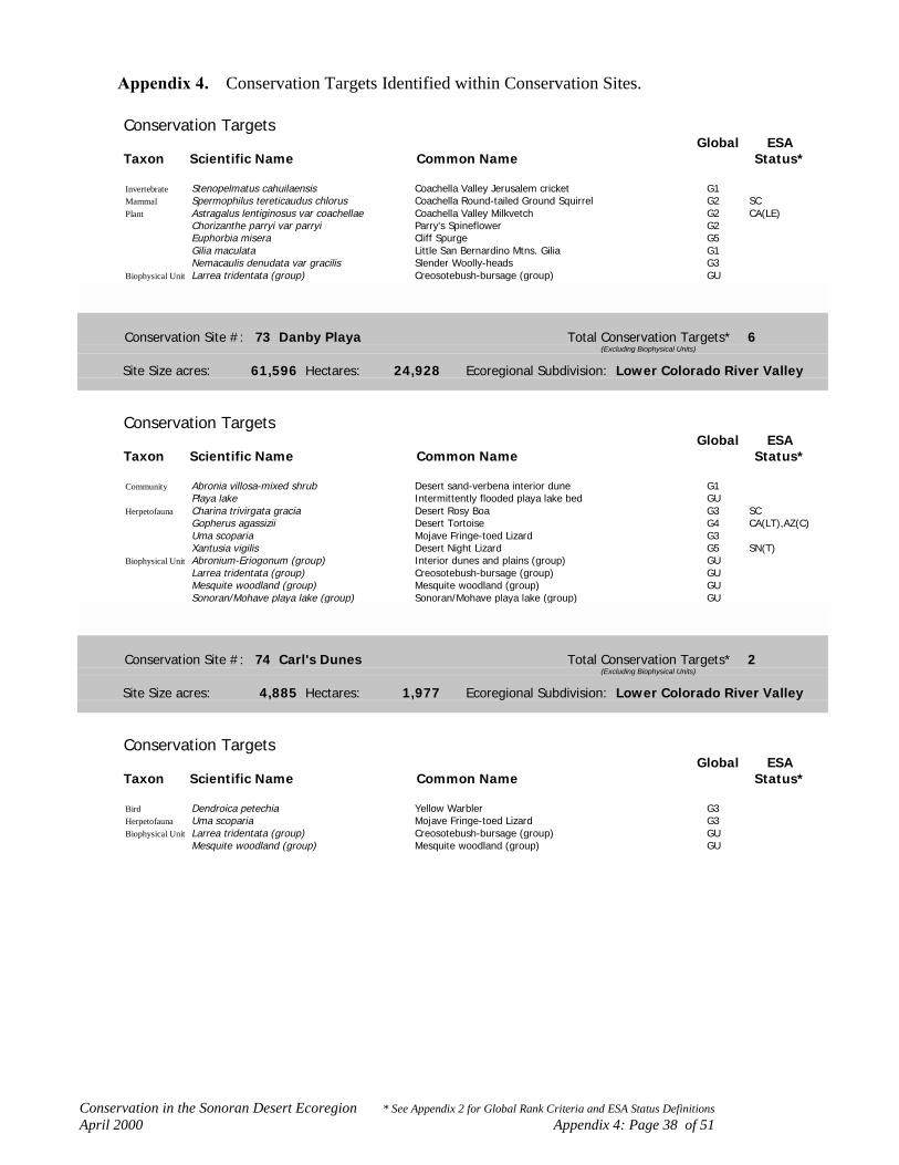
Conservation in the Sonoran Desert Ecoregion * See Appendix 2 for Global Rank Criteria and ESA Status DefinitionsApril 2000 Appendix 4: Page 38 of 51
Appendix 4. Conservation Targets Identified within Conservation Sites.
Conservation TargetsGlobal ESA
Taxon Scientific Name Common Name Status*
Invertebrate Stenopelmatus cahuilaensis Coachella Valley Jerusalem cricket G1Mammal Spermophilus tereticaudus chlorus Coachella Round-tailed Ground Squirrel G2 SCPlant Astragalus lentiginosus var coachellae Coachella Valley Milkvetch G2 CA(LE)
Chorizanthe parryi var parryi Parry's Spineflower G2Euphorbia misera Cliff Spurge G5Gilia maculata Little San Bernardino Mtns. Gilia G1Nemacaulis denudata var gracilis Slender Woolly-heads G3
Biophysical Unit Larrea tridentata (group) Creosotebush-bursage (group) GU
Conservation Site #: 73 Danby Playa Total Conservation Targets* 6(Excluding Biophysical Units)
Site Size acres: 61,596 Hectares: 24,928 Ecoregional Subdivision: Lower Colorado River Valley
Conservation TargetsGlobal ESA
Taxon Scientific Name Common Name Status*
Community Abronia villosa-mixed shrub Desert sand-verbena interior dune G1Playa lake Intermittently flooded playa lake bed GU
Herpetofauna Charina trivirgata gracia Desert Rosy Boa G3 SCGopherus agassizii Desert Tortoise G4 CA(LT),AZ(C)Uma scoparia Mojave Fringe-toed Lizard G3Xantusia vigilis Desert Night Lizard G5 SN(T)
Biophysical Unit Abronium-Eriogonum (group) Interior dunes and plains (group) GULarrea tridentata (group) Creosotebush-bursage (group) GUMesquite woodland (group) Mesquite woodland (group) GUSonoran/Mohave playa lake (group) Sonoran/Mohave playa lake (group) GU
Conservation Site #: 74 Carl's Dunes Total Conservation Targets* 2(Excluding Biophysical Units)
Site Size acres: 4,885 Hectares: 1,977 Ecoregional Subdivision: Lower Colorado River Valley
Conservation TargetsGlobal ESA
Taxon Scientific Name Common Name Status*
Bird Dendroica petechia Yellow Warbler G3Herpetofauna Uma scoparia Mojave Fringe-toed Lizard G3Biophysical Unit Larrea tridentata (group) Creosotebush-bursage (group) GU
Mesquite woodland (group) Mesquite woodland (group) GU
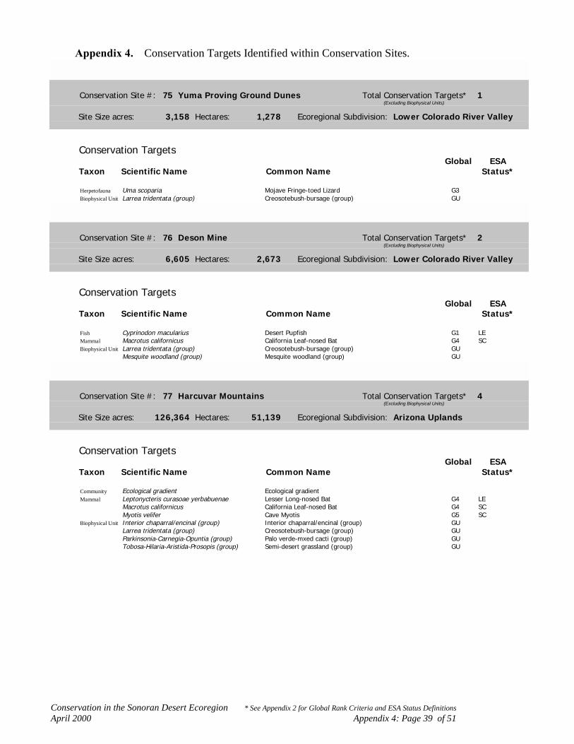
Conservation in the Sonoran Desert Ecoregion * See Appendix 2 for Global Rank Criteria and ESA Status DefinitionsApril 2000 Appendix 4: Page 39 of 51
Appendix 4. Conservation Targets Identified within Conservation Sites.
Conservation Site #: 75 Yuma Proving Ground Dunes Total Conservation Targets* 1(Excluding Biophysical Units)
Site Size acres: 3,158 Hectares: 1,278 Ecoregional Subdivision: Lower Colorado River Valley
Conservation TargetsGlobal ESA
Taxon Scientific Name Common Name Status*
Herpetofauna Uma scoparia Mojave Fringe-toed Lizard G3Biophysical Unit Larrea tridentata (group) Creosotebush-bursage (group) GU
Conservation Site #: 76 Deson Mine Total Conservation Targets* 2(Excluding Biophysical Units)
Site Size acres: 6,605 Hectares: 2,673 Ecoregional Subdivision: Lower Colorado River Valley
Conservation TargetsGlobal ESA
Taxon Scientific Name Common Name Status*
Fish Cyprinodon macularius Desert Pupfish G1 LEMammal Macrotus californicus California Leaf-nosed Bat G4 SCBiophysical Unit Larrea tridentata (group) Creosotebush-bursage (group) GU
Mesquite woodland (group) Mesquite woodland (group) GU
Conservation Site #: 77 Harcuvar Mountains Total Conservation Targets* 4(Excluding Biophysical Units)
Site Size acres: 126,364 Hectares: 51,139 Ecoregional Subdivision: Arizona Uplands
Conservation TargetsGlobal ESA
Taxon Scientific Name Common Name Status*
Community Ecological gradient Ecological gradientMammal Leptonycteris curasoae yerbabuenae Lesser Long-nosed Bat G4 LE
Macrotus californicus California Leaf-nosed Bat G4 SCMyotis velifer Cave Myotis G5 SC
Biophysical Unit Interior chaparral/encinal (group) Interior chaparral/encinal (group) GULarrea tridentata (group) Creosotebush-bursage (group) GUParkinsonia-Carnegia-Opuntia (group) Palo verde-mxed cacti (group) GUTobosa-Hilaria-Aristida-Prosopis (group) Semi-desert grassland (group) GU

Conservation in the Sonoran Desert Ecoregion * See Appendix 2 for Global Rank Criteria and ESA Status DefinitionsApril 2000 Appendix 4: Page 40 of 51
Appendix 4. Conservation Targets Identified within Conservation Sites.
Conservation Site #: 78 Baboquivari Mountains Total Conservation Targets* 5(Excluding Biophysical Units)
Site Size acres: 128,708 Hectares: 52,087 Ecoregional Subdivision: Arizona Uplands
Conservation TargetsGlobal ESA
Taxon Scientific Name Common Name Status*
Mammal Felis onca Jaguar G3 LEPerognathus intermedius pinacate Rock Pocket Mouse GUPeromyscus eremicus papagensis Pinacate Cactus Mouse G2 C
Plant Amsonia kearneyana Kearney's Blue Star G1 LE, AZ(C)Dalea tentaculoides Gentry Indigo Bush G1 C
Biophysical Unit Interior chaparral/encinal (group) Interior chaparral/encinal (group) GULarrea tridentata (group) Creosotebush-bursage (group) GUParkinsonia-Carnegia-Opuntia (group) Palo verde-mxed cacti (group) GUTobosa-Hilaria-Aristida-Prosopis (group) Semi-desert grassland (group) GU
Conservation Site #: 79 El Tigre Mine Total Conservation Targets* 2(Excluding Biophysical Units)
Site Size acres: 4,219 Hectares: 1,707 Ecoregional Subdivision: Arizona Uplands
Conservation TargetsGlobal ESA
Taxon Scientific Name Common Name Status*
Mammal Macrotus californicus California Leaf-nosed Bat G4 SCMyotis velifer Cave Myotis G5 SC
Biophysical Unit Larrea tridentata (group) Creosotebush-bursage (group) GUParkinsonia-Carnegia-Opuntia (group) Palo verde-mxed cacti (group) GU
Conservation Site #: 80 Black Pearl Total Conservation Targets* 2(Excluding Biophysical Units)
Site Size acres: 19,307 Hectares: 7,813 Ecoregional Subdivision: Arizona Uplands
Conservation TargetsGlobal ESA
Taxon Scientific Name Common Name Status*
Mammal Macrotus californicus California Leaf-nosed Bat G4 SCMyotis velifer Cave Myotis G5 SC
Biophysical Unit Larrea tridentata (group) Creosotebush-bursage (group) GUParkinsonia-Carnegia-Opuntia (group) Palo verde-mxed cacti (group) GU

Conservation in the Sonoran Desert Ecoregion * See Appendix 2 for Global Rank Criteria and ESA Status DefinitionsApril 2000 Appendix 4: Page 41 of 51
Appendix 4. Conservation Targets Identified within Conservation Sites.
Conservation Site #: 81 Date Creek Total Conservation Targets* 6(Excluding Biophysical Units)
Site Size acres: 60,871 Hectares: 24,634 Ecoregional Subdivision: Arizona Uplands
Conservation TargetsGlobal ESA
Taxon Scientific Name Common Name Status*
Fish Agosia chrysogaster Longfin Dace G4 SCCatostomus clarki Desert Sucker G3 SCCatostomus insignis Sonora Sucker G3 SCGila robusta Roundtail Chub G3 SCRhinichthys osculus Speckled Dace G5 SC
Plant Carnegiea gigantea Saguaro Cactus G5Biophysical Unit Desert Riparian Woodland (group) Desert Riparian Woodland (group) GU
Interior chaparral/encinal (group) Interior chaparral/encinal (group) GULarrea tridentata (group) Creosotebush-bursage (group) GUMesquite woodland (group) Mesquite woodland (group) GUParkinsonia-Carnegia-Opuntia (group) Palo verde-mxed cacti (group) GU
Conservation Site #: 82 Bill William's Complex Total Conservation Targets* 36(Excluding Biophysical Units)
Site Size acres: 349,932 Hectares: 143,399 Ecoregional Subdivision: Arizona Uplands
Conservation TargetsGlobal ESA
Taxon Scientific Name Common Name Status*
Community Populus fremonti-Salix gooddingii Fremont cottonwood-Goodding's black willow riparian G2woodland
Yucca brevifolia Joshua tree woodland G4Bird Coccyzus americanus occidentalis Western Yellow-billed Cuckoo G3 PE
Dendroica petechia Yellow Warbler G3Empidonax traillii extimus Southwestern Willow Flycatcher G2 LEFalco peregrinus anatum American Peregrine Falcon G3Haliaeetus leucocephalus Bald Eagle G4 CA(PS)Laterallus jamaicensis coturniculus California Black Rail G1 SC, AZ(T)Pipilo aberti Abert's Towhee G3Rallus longirostris yumanensis Yuma Clapper Rail G3 LE
Fish Agosia chrysogaster Longfin Dace G4 SCCatostomus clarki Desert Sucker G3 SCCatostomus insignis Sonora Sucker G3 SCCyprinodon macularius macularius Desert Pupfish G1 LEGila elegans Bonytail G1 LEGila robusta Roundtail Chub G3 SCPoeciliopsis occidentalis occidentalis Gila Topminnow G3 LE, MX(T)Rhinichthys osculus Speckled Dace G5 SCXyrauchen texanus Razorback Sucker G1 LE
Herpetofauna Bufo microscaphus microscaphus Arizona toad G4 AZ(C), SN(P)Charina trivirgata gracia Desert Rosy Boa G3 SCGopherus agassizii Desert Tortoise G4 CA(LT),AZ(C)Rana yavapaiensis Lowland Leopard Frog G4 SC

Conservation in the Sonoran Desert Ecoregion * See Appendix 2 for Global Rank Criteria and ESA Status DefinitionsApril 2000 Appendix 4: Page 42 of 51
Appendix 4. Conservation Targets Identified within Conservation Sites.
Conservation TargetsGlobal ESA
Taxon Scientific Name Common Name Status*
Herpetofauna Xantusia vigilis Desert Night Lizard G5 SN(T)Invertebrate Cicindela oregona maricopa Maricopa tiger beetle G3 SCMammal Lasiurus xanthinus Western Yellow Bat G5
Macrotus californicus California Leaf-nosed Bat G4 SCMyotis velifer Cave Myotis G5 SCNyctinomops femorosaccus Pocketed Free-tailed Bat G4Ovis canadensis mexicana Desert Bighorn Sheep G4
Plant Astragalus newberryi var aquarii Newberry's Milkvetch G2Cirsium mohavense G2Cirsium wrightii Wright's Marsh Thistle G1Phacelia parishii G2Purshia subintegra Arizona Cliffrose G1 LEThelypteris puberula var sonorensis Aravaipa Wood Fern G3
Biophysical Unit Desert Riparian Woodland (group) Desert Riparian Woodland (group) GUInterior chaparral/encinal (group) Interior chaparral/encinal (group) GUInterior riparian shrub/woodland (group) Interior riparian shrub/woodland (group) GULarrea tridentata (group) Creosotebush-bursage (group) GUMesquite woodland (group) Mesquite woodland (group) GUParkinsonia-Carnegia-Opuntia (group) Palo verde-mxed cacti (group) GUSonoran/Mohave playa lake (group) Sonoran/Mohave playa lake (group) GUTobosa-Hilaria-Aristida-Prosopis (group) Semi-desert grassland (group) GUTypha-Phragmites-Scirpus (group) Interior riparian marsh (group) GU
Conservation Site #: 83 Agua Fria Watershed Total Conservation Targets* 22(Excluding Biophysical Units)
Site Size acres: 554,856 Hectares: 224,547 Ecoregional Subdivision: Arizona Uplands
Conservation TargetsGlobal ESA
Taxon Scientific Name Common Name Status*
Community Ecological gradient Ecological gradientBird Coccyzus americanus occidentalis Western Yellow-billed Cuckoo G3 PE
Haliaeetus leucocephalus Bald Eagle G4 CA(PS)Fish Agosia chrysogaster Longfin Dace G4 SC
Catostomus clarki Desert Sucker G3 SCCyprinodon macularius macularius Desert Pupfish G1 LEGila intermedia Gila Chub G2 C, SN(P)Gila robusta Roundtail Chub G3 SCPoeciliopsis occidentalis occidentalis Gila Topminnow G3 LE, MX(T)Rhinichthys osculus Speckled Dace G5 SC
Herpetofauna Bufo microscaphus microscaphus Arizona toad G4 AZ(C), SN(P)Rana yavapaiensis Lowland Leopard Frog G4 SCThamnophis eques megalops Mexican Garter Snake G3 SC
Invertebrate Cicindela oregona maricopa Maricopa tiger beetle G3 SCMammal Macrotus californicus California Leaf-nosed Bat G4 SC
Myotis velifer Cave Myotis G5 SCNyctinomops femorosaccus Pocketed Free-tailed Bat G4
Plant Agave arizonica Arizona Agave G1 LEAgave murpheyi Hohokam Agave G2 SC

Conservation in the Sonoran Desert Ecoregion * See Appendix 2 for Global Rank Criteria and ESA Status DefinitionsApril 2000 Appendix 4: Page 43 of 51
Appendix 4. Conservation Targets Identified within Conservation Sites.
Conservation TargetsGlobal ESA
Taxon Scientific Name Common Name Status*
Plant Ericameria brachylepis Rayless Turpentine Bush G4Heuchera eastwoodiae Eastwood Alum Root G3Washingtonia filifera California Fan Palm G2
Biophysical Unit Interior chaparral/encinal (group) Interior chaparral/encinal (group) GUInterior riparian shrub/woodland (group) Interior riparian shrub/woodland (group) GULarrea tridentata (group) Creosotebush-bursage (group) GUParkinsonia-Carnegia-Opuntia (group) Palo verde-mxed cacti (group) GUTobosa-Hilaria-Aristida-Prosopis (group) Semi-desert grassland (group) GU
Conservation Site #: 84 Dixie Mine Total Conservation Targets* 4(Excluding Biophysical Units)
Site Size acres: 4,330 Hectares: 1,752 Ecoregional Subdivision: Arizona Uplands
Conservation TargetsGlobal ESA
Taxon Scientific Name Common Name Status*
Mammal Leptonycteris curasoae yerbabuenae Lesser Long-nosed Bat G4 LEMacrotus californicus California Leaf-nosed Bat G4 SCMyotis velifer Cave Myotis G5 SC
Plant Agave murpheyi Hohokam Agave G2 SCBiophysical Unit Parkinsonia-Carnegia-Opuntia (group) Palo verde-mxed cacti (group) GU
Conservation Site #: 85 Superstition Mountains Total Conservation Targets* 10(Excluding Biophysical Units)
Site Size acres: 199,784 Hectares: 84,867 Ecoregional Subdivision: Arizona Uplands
Conservation TargetsGlobal ESA
Taxon Scientific Name Common Name Status*
Bird Falco peregrinus anatum American Peregrine Falcon G3Fish Agosia chrysogaster Longfin Dace G4 SC
Poeciliopsis occidentalis occidentalis Gila Topminnow G3 LE, MX(T)Herpetofauna Rana yavapaiensis Lowland Leopard Frog G4 SCPlant Abutilon parishii Pima Indian Mallow G2
Ericameria brachylepis Rayless Turpentine Bush G4Erigeron piscaticus Fish Creek Fleabane G1 SCJusticia candicans Hierba Azul G4Mabrya acerifolia Mapleleaf False Snapdragon G3Perityle saxicola Fish Creek Rock Daisy G2 SC
Biophysical Unit Interior chaparral/encinal (group) Interior chaparral/encinal (group) GUInterior riparian shrub/woodland (group) Interior riparian shrub/woodland (group) GUParkinsonia-Carnegia-Opuntia (group) Palo verde-mxed cacti (group) GU

Conservation in the Sonoran Desert Ecoregion * See Appendix 2 for Global Rank Criteria and ESA Status DefinitionsApril 2000 Appendix 4: Page 44 of 51
Appendix 4. Conservation Targets Identified within Conservation Sites.
Conservation Site #: 86 Tonto National Forest Total Conservation Targets* 5(Excluding Biophysical Units)
Site Size acres: 19,870 Hectares: 8,041 Ecoregional Subdivision: Arizona Uplands
Conservation TargetsGlobal ESA
Taxon Scientific Name Common Name Status*
Fish Poeciliopsis occidentalis occidentalis Gila Topminnow G3 LE, MX(T)Herpetofauna Gopherus agassizii Desert Tortoise G4 CA(LT),AZ(C)
Rana yavapaiensis Lowland Leopard Frog G4 SCXantusia vigilis Desert Night Lizard G5 SN(T)
Invertebrate Cicindela oregona maricopa Maricopa tiger beetle G3 SCBiophysical Unit Interior chaparral/encinal (group) Interior chaparral/encinal (group) GU
Interior riparian shrub/woodland (group) Interior riparian shrub/woodland (group) GUMesquite woodland (group) Mesquite woodland (group) GUParkinsonia-Carnegia-Opuntia (group) Palo verde-mxed cacti (group) GU
Conservation Site #: 88 Buckeye Copper Mine Total Conservation Targets* 2(Excluding Biophysical Units)
Site Size acres: 10,703 Hectares: 4,331 Ecoregional Subdivision: Arizona Uplands
Conservation TargetsGlobal ESA
Taxon Scientific Name Common Name Status*
Mammal Macrotus californicus California Leaf-nosed Bat G4 SCMyotis velifer Cave Myotis G5 SC
Biophysical Unit Larrea tridentata (group) Creosotebush-bursage (group) GU
Conservation Site #: 89 La Ciénega Total Conservation Targets* 1(Excluding Biophysical Units)
Site Size acres: 3,560 Hectares: 1,441 Ecoregional Subdivision: Plains of Sonora
Conservation TargetsGlobal ESA
Taxon Scientific Name Common Name Status*
Invertebrate Concentration of aquatic invertebrates Concentration of aquatic invertebrates GUBiophysical Unit Jatropha-Bursera (group) Torchwood-limberbush (group) GU
Mesquite woodland (group) Mesquite woodland (group) GUParkinsonia-Carnegia-Opuntia (group) Palo verde-mxed cacti (group) GU

Conservation in the Sonoran Desert Ecoregion * See Appendix 2 for Global Rank Criteria and ESA Status DefinitionsApril 2000 Appendix 4: Page 45 of 51
Appendix 4. Conservation Targets Identified within Conservation Sites.
Conservation Site #: 90 Picacho Peak Total Conservation Targets* 3(Excluding Biophysical Units)
Site Size acres: 5,052 Hectares: 2,044 Ecoregional Subdivision: Arizona Uplands
Conservation TargetsGlobal ESA
Taxon Scientific Name Common Name Status*
Mammal Leptonycteris curasoae yerbabuenae Lesser Long-nosed Bat G4 LEMacrotus californicus California Leaf-nosed Bat G4 SCMyotis velifer Cave Myotis G5 SC
Biophysical Unit Larrea tridentata (group) Creosotebush-bursage (group) GUMesquite woodland (group) Mesquite woodland (group) GUParkinsonia-Carnegia-Opuntia (group) Palo verde-mxed cacti (group) GU
Conservation Site #: 91 Unplowed Valley Total Conservation Targets* 3(Excluding Biophysical Units)
Site Size acres: 101,679 Hectares: 41,149 Ecoregional Subdivision: Arizona Uplands
Conservation TargetsGlobal ESA
Taxon Scientific Name Common Name Status*
Fish Cyprinodon macularius macularius Desert Pupfish G1 LEPlant Abutilon parishii Pima Indian Mallow G2
Echinomastus erectocentrus var acunensis Acuna Cactus G1 CBiophysical Unit Parkinsonia-Carnegia-Opuntia (group) Palo verde-mxed cacti (group) GU
Conservation Site #: 92 Old Mammon Mine Total Conservation Targets* 4(Excluding Biophysical Units)
Site Size acres: 32,811 Hectares: 13,278 Ecoregional Subdivision: Arizona Uplands
Conservation TargetsGlobal ESA
Taxon Scientific Name Common Name Status*
Community Atriplex canescens-Ehphedra viridis Four-wing saltbush shrubland G4Frankenia palmeri-Atriplex sp. Palmer alkali heath shrubland GU
Mammal Leptonycteris curasoae yerbabuenae Lesser Long-nosed Bat G4 LEMacrotus californicus California Leaf-nosed Bat G4 SC
Biophysical Unit Larrea tridentata (group) Creosotebush-bursage (group) GUParkinsonia-Carnegia-Opuntia (group) Palo verde-mxed cacti (group) GU

Conservation in the Sonoran Desert Ecoregion * See Appendix 2 for Global Rank Criteria and ESA Status DefinitionsApril 2000 Appendix 4: Page 46 of 51
Appendix 4. Conservation Targets Identified within Conservation Sites.
Conservation Site #: 93 Tucson Mountains Total Conservation Targets* 9(Excluding Biophysical Units)
Site Size acres: 102,074 Hectares: 41,309 Ecoregional Subdivision: Arizona Uplands
Conservation TargetsGlobal ESA
Taxon Scientific Name Common Name Status*
Community Parkinsonia-Carnegia-Opuntia (group) Palo verde-mixed cacti (group) GUBird Aimophila carpalis Rufous-winged Sparrow G4Herpetofauna Gopherus agassizii Desert Tortoise G4 CA(LT),AZ(C)
Phyllorhynchus browni lucidus Maricopa Leafnose Snake G2Invertebrate Bee Biodiversity Area Bee Biodiversity Area GUMammal Macrotus californicus California Leaf-nosed Bat G4 SC
Myotis velifer Cave Myotis G5 SCPlant Abutilon parishii Pima Indian Mallow G2
Hermannia pauciflora Sparseleaf Hermannia G3Biophysical Unit Larrea tridentata (group) Creosotebush-bursage (group) GU
Mesquite woodland (group) Mesquite woodland (group) GUParkinsonia-Carnegia-Opuntia (group) Palo verde-mxed cacti (group) GUTobosa-Hilaria-Aristida-Prosopis (group) Semi-desert grassland (group) GU
Conservation Site #: 95 Sabino Canyon Total Conservation Targets* 6(Excluding Biophysical Units)
Site Size acres: 7,855 Hectares: 3,179 Ecoregional Subdivision: Arizona Uplands
Conservation TargetsGlobal ESA
Taxon Scientific Name Common Name Status*
Bird Glaucidium brasilianum cactorum Cactus Ferruginous Pygmy-owl G3 LEFish Gila intermedia Gila Chub G2 C, SN(P)Herpetofauna Rana yavapaiensis Lowland Leopard Frog G4 SC
Thamnophis eques megalops Mexican Garter Snake G3 SCPlant Abutilon parishii Pima Indian Mallow G2
Muhlenbergia dubioides Box Canyon Muhly G2Biophysical Unit Desert Riparian Woodland (group) Desert Riparian Woodland (group) GU
Interior riparian shrub/woodland (group) Interior riparian shrub/woodland (group) GUMesquite woodland (group) Mesquite woodland (group) GUParkinsonia-Carnegia-Opuntia (group) Palo verde-mxed cacti (group) GUTobosa-Hilaria-Aristida-Prosopis (group) Semi-desert grassland (group) GU

Conservation in the Sonoran Desert Ecoregion * See Appendix 2 for Global Rank Criteria and ESA Status DefinitionsApril 2000 Appendix 4: Page 47 of 51
Appendix 4. Conservation Targets Identified within Conservation Sites.
Conservation Site #: 96 East Tucson Riparian Complex Total Conservation Targets* 5(Excluding Biophysical Units)
Site Size acres: 7,441 Hectares: 3,011 Ecoregional Subdivision: Arizona Uplands
Conservation TargetsGlobal ESA
Taxon Scientific Name Common Name Status*
Community Prosopis velutina-mixed short tree Mesquite-mixed short tree woodland GUPopulus fremonti-Salix gooddingii Fremont cottonwood-Goodding's black willow riparian G2
woodlandSimmondsia chinensis-Cercidium microphylla Jojoba -yellow paloverde shrubland G4Atriplex canescens-Ehphedra viridis Four-wing saltbush shrubland G4
Mammal Nyctinomops femorosaccus Pocketed Free-tailed Bat G4Biophysical Unit Parkinsonia-Carnegia-Opuntia (group) Palo verde-mxed cacti (group) GU
Tobosa-Hilaria-Aristida-Prosopis (group) Semi-desert grassland (group) GU
Conservation Site #: 97 San Simon Springs/Ciénega Total Conservation Targets* 3(Excluding Biophysical Units)
Site Size acres: 18,805 Hectares: 7,610 Ecoregional Subdivision: Arizona Uplands
Conservation TargetsGlobal ESA
Taxon Scientific Name Common Name Status*
Fish Cyprinodon macularius macularius Desert Pupfish G1 LEGila intermedia Gila Chub G2 C, SN(P)Poeciliopsis occidentalis occidentalis Gila Topminnow G3 LE, MX(T)
Biophysical Unit Larrea tridentata (group) Creosotebush-bursage (group) GUParkinsonia-Carnegia-Opuntia (group) Palo verde-mxed cacti (group) GUTobosa-Hilaria-Aristida-Prosopis (group) Semi-desert grassland (group) GU
Conservation Site #: 98 Upper Gila River Total Conservation Targets* 40(Excluding Biophysical Units)
Site Size acres: 374,754 Hectares: 151,678 Ecoregional Subdivision: Arizona Uplands
Conservation TargetsGlobal ESA
Taxon Scientific Name Common Name Status*
Community Prosopis (sp. glandulosa, velutina) Mesquite woodland G3Populus fremonti-Salix gooddingii Fremont cottonwood-Goodding's black willow riparian G2
woodlandAtriplex polycarpa All-scale shrubland G5
Bird Coccyzus americanus occidentalis Western Yellow-billed Cuckoo G3 PEColaptes chrysoides Gilded Flicker G5Dendroica petechia Yellow Warbler G3Empidonax traillii extimus Southwestern Willow Flycatcher G2 LEFalco peregrinus anatum American Peregrine Falcon G3

Conservation in the Sonoran Desert Ecoregion * See Appendix 2 for Global Rank Criteria and ESA Status DefinitionsApril 2000 Appendix 4: Page 48 of 51
Appendix 4. Conservation Targets Identified within Conservation Sites.
Conservation TargetsGlobal ESA
Taxon Scientific Name Common Name Status*
Bird Glaucidium brasilianum cactorum Cactus Ferruginous Pygmy-owl G3 LEHaliaeetus leucocephalus Bald Eagle G4 CA(PS)Ixobrychus exilis hesperis Western Least Bittern GU AZ(C)Migratory Bird Concentration Area Migratory Bird Concentration Area GUPipilo aberti Abert's Towhee G3Rallus longirostris yumanensis Yuma Clapper Rail G3 LEToxostoma lecontei Le Conte's Thrasher G3
Fish Agosia chrysogaster Longfin Dace G4 SCCatostomus clarki Desert Sucker G3 SCCatostomus insignis Sonora Sucker G3 SCCatostomus latipinnis Flannelmouth Sucker G3 SCCyprinodon macularius macularius Desert Pupfish G1 LEGila intermedia Gila Chub G2 C, SN(P)Gila robusta Roundtail Chub G3 SCMeda fulgida Spikedace G2 LTPoeciliopsis occidentalis occidentalis Gila Topminnow G3 LE, MX(T)Ptychocheilus lucius Colorado Squawfish G1 LE(CA-LE/XN)Rhinichthys osculus Speckled Dace G5 SCTiaroga cobitis Loach Minnow G2 LTXyrauchen texanus Razorback Sucker G1 LE
Herpetofauna Bufo microscaphus microscaphus Arizona toad G4 AZ(C), SN(P)Rana yavapaiensis Lowland Leopard Frog G4 SCThamnophis rufipunctatus Narrow-headed Garter Snake G4 SC
Invertebrate Cicindela oregona maricopa Maricopa tiger beetle G3 SCPyrgulopsis arizonae Bylas springsnail G2 SCTryonia gilae Gila tryonia G1 SC
Mammal Macrotus californicus California Leaf-nosed Bat G4 SCMyotis velifer Cave Myotis G5 SC
Plant Echinomastus erectocentrus var acunensis Acuna Cactus G1 CEriogonum apachense Apache Wild-buckwheat G1 AZ(C)Perityle gilensis var gilensis Gila Rock Daisy G3Purshia subintegra Arizona Cliffrose G1 LE
Biophysical Unit Atriplex-Allenrolfea-Suaeda (group) Saltbush desert scrub (group) GUDesert Riparian Woodland (group) Desert Riparian Woodland (group) GUInterior riparian shrub/woodland (group) Interior riparian shrub/woodland (group) GULarrea tridentata (group) Creosotebush-bursage (group) GUMesquite woodland (group) Mesquite woodland (group) GUParkinsonia-Carnegia-Opuntia (group) Palo verde-mxed cacti (group) GUTobosa-Hilaria-Aristida-Prosopis (group) Semi-desert grassland (group) GU
Conservation Site #: 99 San Pedro River/Aravaipa Creek Total Conservation Targets* 39(Excluding Biophysical Units)
Site Size acres: 899,287 Hectares: 374,813 Ecoregional Subdivision: Arizona Uplands
Conservation TargetsGlobal ESA
Taxon Scientific Name Common Name Status*
Community Prosopis velutina-mixed short tree Mesquite-mixed short tree woodland GUPlatanus wrightii Arizona sycamore riparian woodland G4

Conservation in the Sonoran Desert Ecoregion * See Appendix 2 for Global Rank Criteria and ESA Status DefinitionsApril 2000 Appendix 4: Page 49 of 51
Appendix 4. Conservation Targets Identified within Conservation Sites.
Conservation TargetsGlobal ESA
Taxon Scientific Name Common Name Status*
Community Populus fremonti-Salix gooddingii Fremont cottonwood-Goodding's black willow riparian G2woodland
Ecological gradient Ecological gradientBird Aimophila carpalis Rufous-winged Sparrow G4
Asturina nitida maxima Northern Gray Hawk G3 AZ(C)Coccyzus americanus occidentalis Western Yellow-billed Cuckoo G3 PEColaptes chrysoides Gilded Flicker G5Dendroica petechia Yellow Warbler G3Empidonax traillii extimus Southwestern Willow Flycatcher G2 LEFalco peregrinus anatum American Peregrine Falcon G3Glaucidium brasilianum cactorum Cactus Ferruginous Pygmy-owl G3 LEPipilo aberti Abert's Towhee G3
Fish Agosia chrysogaster Longfin Dace G4 SCCatostomus clarki Desert Sucker G3 SCCatostomus insignis Sonora Sucker G3 SCCyprinodon macularius macularius Desert Pupfish G1 LEGila intermedia Gila Chub G2 C, SN(P)Gila robusta Roundtail Chub G3 SCMeda fulgida Spikedace G2 LTRhinichthys osculus Speckled Dace G5 SCTiaroga cobitis Loach Minnow G2 LT
Herpetofauna Rana yavapaiensis Lowland Leopard Frog G4 SCInvertebrate Amblyscirtes texanae Texas roadside skipper G3
Atrytonopsis cestus Cestus skipper G1Chioides catillus albofasciatus Silver-banded skipper GUCicindela oregona maricopa Maricopa tiger beetle G3 SC
Mammal Choeronycteris mexicana Mexican Long-tongued Bat G4 SCIdionycteris phyllotis Allen's Big-eared Bat G4 SCLeptonycteris curasoae yerbabuenae Lesser Long-nosed Bat G4 LEMacrotus californicus California Leaf-nosed Bat G4 SCMyotis velifer Cave Myotis G5 SC
Plant Abutilon parishii Pima Indian Mallow G2Echinomastus erectocentrus var erectocentrus Needle-spined Pineapple Cactus G3 SCErigeron piscaticus Fish Creek Fleabane G1 SCPenstemon discolor Catalina Beardtongue G1Puccinellia parishii Parish Alkali Grass G2 PESalvia amissa Aravaipa Sage G1Thelypteris puberula var sonorensis Aravaipa Wood Fern G3
Biophysical Unit Desert Riparian Woodland (group) Desert Riparian Woodland (group) GUInterior riparian shrub/woodland (group) Interior riparian shrub/woodland (group) GULarrea tridentata (group) Creosotebush-bursage (group) GUMesquite woodland (group) Mesquite woodland (group) GUParkinsonia-Carnegia-Opuntia (group) Palo verde-mxed cacti (group) GUTobosa-Hilaria-Aristida-Prosopis (group) Semi-desert grassland (group) GU

Conservation in the Sonoran Desert Ecoregion * See Appendix 2 for Global Rank Criteria and ESA Status DefinitionsApril 2000 Appendix 4: Page 50 of 51
Appendix 4. Conservation Targets Identified within Conservation Sites.
Conservation Site #: 101 Ciénega de Saracachi Total Conservation Targets* 2(Excluding Biophysical Units)
Site Size acres: 1,322 Hectares: 535 Ecoregional Subdivision: Plains of Sonora
Conservation TargetsGlobal ESA
Taxon Scientific Name Common Name Status*
Community Interior riparian shrub/woodland (group) Interior riparian shrub/woodland (group) GUPopulus fremonti Fremont cottonwood riparian woodland G3
Biophysical Unit Desert Riparian Woodland (group) Desert Riparian Woodland (group) GUMesquite woodland (group) Mesquite woodland (group) GUParkinsonia-Carnegia-Opuntia (group) Palo verde-mxed cacti (group) GU
Conservation Site #: 102 Harquahala Mountains Total Conservation Targets* 6(Excluding Biophysical Units)
Site Size acres: 44,463 Hectares: 17,994 Ecoregional Subdivision: Arizona Uplands
Conservation TargetsGlobal ESA
Taxon Scientific Name Common Name Status*
Community Ecological gradient Ecological gradientHerpetofauna Charina trivirgata gracia Desert Rosy Boa G3 SC
Rana yavapaiensis Lowland Leopard Frog G4 SCInvertebrate Calephelis wrighti Wright's metalmark G4Mammal Macrotus californicus California Leaf-nosed Bat G4 SC
Myotis velifer Cave Myotis G5 SCBiophysical Unit Larrea tridentata (group) Creosotebush-bursage (group) GU
Parkinsonia-Carnegia-Opuntia (group) Palo verde-mxed cacti (group) GUTobosa-Hilaria-Aristida-Prosopis (group) Semi-desert grassland (group) GU
Conservation Site #: 103 Trout Creek Total Conservation Targets* 5(Excluding Biophysical Units)
Site Size acres: 30,241 Hectares: 12,238 Ecoregional Subdivision: Arizona Uplands
Conservation TargetsGlobal ESA
Taxon Scientific Name Common Name Status*
Fish Agosia chrysogaster Longfin Dace G4 SCCatostomus clarki Desert Sucker G3 SCCatostomus insignis Sonora Sucker G3 SCGila robusta Roundtail Chub G3 SC
Herpetofauna Rana yavapaiensis Lowland Leopard Frog G4 SCBiophysical Unit Desert Riparian Woodland (group) Desert Riparian Woodland (group) GU
Interior chaparral/encinal (group) Interior chaparral/encinal (group) GUInterior riparian shrub/woodland (group) Interior riparian shrub/woodland (group) GU

Conservation in the Sonoran Desert Ecoregion * See Appendix 2 for Global Rank Criteria and ESA Status DefinitionsApril 2000 Appendix 4: Page 51 of 51
Appendix 4. Conservation Targets Identified within Conservation Sites.
Conservation TargetsGlobal ESA
Taxon Scientific Name Common Name Status*
Biophysical Unit Larrea tridentata (group) Creosotebush-bursage (group) GUMesquite woodland (group) Mesquite woodland (group) GUParkinsonia-Carnegia-Opuntia (group) Palo verde-mxed cacti (group) GUTobosa-Hilaria-Aristida-Prosopis (group) Semi-desert grassland (group) GU
Conservation Site #: 104 Cerro Prieto Ponds Total Conservation Targets* 1(Excluding Biophysical Units)
Site Size acres: 15,605 Hectares: 6,315 Ecoregional Subdivision: Lower Colorado River Valley
Conservation TargetsGlobal ESA
Taxon Scientific Name Common Name Status*
Fish Cyprinodon macularius macularius Desert Pupfish G1 LEBiophysical Unit Atriplex-Allenrolfea-Suaeda (group) Saltbush desert scrub (group) GU

Conservation in the Sonoran Desert Ecoregion * See Appendix 2 for Global Rank Criteria and ESA Status DefinitionsApril 2000 Appendix 5: Page 1 of 2
Appendix 5. Conservation Targets Identified within 79 Special Element Sites.
Site Taxon Subdivision Scientific Name Common Name Global ESANo. Status
200 Plant Arizona Uplands Puccinellia parishii Parish Alkali Grass G2 PE201 Plant Arizona Uplands Agave delamateri Tonto Basin Agave G1 SC202 Plant Arizona Uplands Agave delamateri Tonto Basin Agave G1 SC203 Plant Arizona Uplands Agave delamateri Tonto Basin Agave G1 SC204 Plant Arizona Uplands Agave delamateri Tonto Basin Agave G1 SC205 Plant Arizona Uplands Agave delamateri Tonto Basin Agave G1 SC206 Plant Arizona Uplands Agave delamateri Tonto Basin Agave G1 SC207 Plant Arizona Uplands Agave delamateri Tonto Basin Agave G1 SC208 Plant Arizona Uplands Agave delamateri Tonto Basin Agave G1 SC209 Plant Arizona Uplands Agave delamateri Tonto Basin Agave G1 SC210 Plant Arizona Uplands Agave delamateri Tonto Basin Agave G1 SC211 Plant Arizona Uplands Agave delamateri Tonto Basin Agave G1 SC212 Plant Arizona Uplands Agave delamateri Tonto Basin Agave G1 SC213 Plant Arizona Uplands Agave delamateri Tonto Basin Agave G1 SC214 Plant Arizona Uplands Agave delamateri Tonto Basin Agave G1 SC215 Plant Arizona Uplands Agave arizonica Arizona Agave G1 LE216 Plant Arizona Uplands Purshia subintegra Arizona Cliffrose G1 LE217 Plant Arizona Uplands Purshia subintegra Arizona Cliffrose G1 LE218 Plant Arizona Uplands Abutilon parishii Pima Indian Mallow G2219 Plant Arizona Uplands Abutilon parishii Pima Indian Mallow G2220 Plant Arizona Uplands Abutilon parishii Pima Indian Mallow G2221 Plant Arizona Uplands Abutilon parishii Pima Indian Mallow G2222 Plant Arizona Uplands Abutilon parishii Pima Indian Mallow G2222 Plant Arizona Uplands Hermannia pauciflora Sparseleaf Hermannia G3223 Plant Arizona Uplands Abutilon parishii Pima Indian Mallow G2224 Plant Arizona Uplands Abutilon parishii Pima Indian Mallow G2225 Plant Arizona Uplands Salvia amissa Aravaipa Sage G1226 Plant Arizona Uplands Lysiloma microphylla var thornberi Feather Bush G1227 Plant Arizona Uplands Echinomastus erectocentrus var Acuna Cactus G1 C
acunensis228 Plant Arizona Uplands Agave delamateri Tonto Basin Agave G1 SC228 Plant Arizona Uplands Erigeron anchana Mogollon Fleabane G2 SC229 Fish Arizona Uplands Agosia chrysogaster Longfin Dace G4 SC229 Fish Arizona Uplands Catostomus clarki Desert Sucker G3 SC229 Fish Arizona Uplands Catostomus insignis Sonora Sucker G3 SC229 Fish Arizona Uplands Gila robusta Roundtail Chub G3 SC229 Fish Arizona Uplands Rhinichthys osculus Speckled Dace G5 SC229 Plant Arizona Uplands Erigeron anchana Mogollon Fleabane G2 SC230 Invertebrate Lower Colorado River Valley Sonorella allynsmithi Squaw Peak talussnail G1 SC231 Invertebrate Lower Colorado River Valley Sonorella allynsmithi Squaw Peak talussnail G1 SC232 Reptile Lower Colorado River Valley Phyllorhynchus browni lucidus Maricopa Leafnose Snake G2233 Amphibian Arizona Uplands Rana yavapaiensis Lowland Leopard Frog G4 SC233 Fish Arizona Uplands Agosia chrysogaster Longfin Dace G4 SC233 Fish Arizona Uplands Cyprinodon macularius macularius Desert Pupfish G1 LE233 Fish Arizona Uplands Poeciliopsis occidentalis occidentalis Gila Topminnow G3 LE, MX(T)234 Fish Arizona Uplands Cyprinodon macularius macularius Desert Pupfish G1 LE235 Bird Lower Colorado River Valley Empidonax traillii extimus Southwestern Willow Flycatcher G2 LE236 Plant Lower Colorado River Valley Astragalus lentiginosus var Coachella Valley Milkvetch G2 CA(LE)
coachellae237 Plant Lower Colorado River Valley Astragalus lentiginosus var Coachella Valley Milkvetch G2 CA(LE)
coachellae238 Plant Lower Colorado River Valley Astragalus lentiginosus var Coachella Valley Milkvetch G2 CA(LE)
coachellae239 Plant Lower Colorado River Valley Argythamnia californica California Ditaxis G2240 Plant Lower Colorado River Valley Astragalus tricarinatus Triple-rib Milkvetch G1 CA(LE)

Conservation in the Sonoran Desert Ecoregion * See Appendix 2 for Global Rank Criteria and ESA Status DefinitionsApril 2000 Appendix 5: Page 2 of 2
Appendix 5. Conservation Targets Identified within 79 Special Element Sites.
Site Taxon Subdivision Scientific Name Common Name Global ESANo. Status
240 Plant Lower Colorado River Valley Gilia maculata Little San Bernardino Mtns. Gilia G1240 Reptile Lower Colorado River Valley Uma inornata Coachella Valley Fringe-toed Lizard G1 LT241 Plant Lower Colorado River Valley Argythamnia californica California Ditaxis G2242 Reptile Lower Colorado River Valley Uma inornata Coachella Valley Fringe-toed Lizard G1 LT243 Plant Lower Colorado River Valley Astragalus lentiginosus var Coachella Valley Milkvetch G2 CA(LE)
coachellae244 Plant Lower Colorado River Valley Astragalus lentiginosus var Coachella Valley Milkvetch G2 CA(LE)
coachellae245 Plant Lower Colorado River Valley Astragalus magdalenae var peirsonii Peirson's Milkvetch G2 PE, CA(LT)246 Reptile Lower Colorado River Valley Uma inornata Coachella Valley Fringe-toed Lizard G1 LT247 Plant Lower Colorado River Valley Xylorhiza cognata Mecca Aster G2 SC248 Reptile Lower Colorado River Valley Uma inornata Coachella Valley Fringe-toed Lizard G1 LT249 Plant Lower Colorado River Valley Gilia maculata Little San Bernardino Mtns. Gilia G1250 Plant Lower Colorado River Valley Astragalus magdalenae var peirsonii Peirson's Milkvetch G2 PE, CA(LT)251 Fish Lower Colorado River Valley Cyprinodon macularius Desert Pupfish G1 LE252 Reptile Lower Colorado River Valley Uma inornata Coachella Valley Fringe-toed Lizard G1 LT253 Reptile Lower Colorado River Valley Uma inornata Coachella Valley Fringe-toed Lizard G1 LT254 Plant Lower Colorado River Valley Argythamnia californica California Ditaxis G2255 Plant Lower Colorado River Valley Astragalus lentiginosus var Coachella Valley Milkvetch G2 CA(LE)
coachellae256 Fish Lower Colorado River Valley Xyrauchen texanus Razorback Sucker G1 LE257 Plant Lower Colorado River Valley Chaenactis carphoclinia var peirsonii Peirson's Pincushion G1258 Plant Lower Colorado River Valley Astragalus lentiginosus var Coachella Valley Milkvetch G2 CA(LE)
coachellae258 Reptile Lower Colorado River Valley Uma inornata Coachella Valley Fringe-toed Lizard G1 LT259 Reptile Lower Colorado River Valley Uma inornata Coachella Valley Fringe-toed Lizard G1 LT260 Reptile Lower Colorado River Valley Uma inornata Coachella Valley Fringe-toed Lizard G1 LT261 Plant Lower Colorado River Valley Gilia maculata Little San Bernardino Mtns. Gilia G1262 Reptile Lower Colorado River Valley Uma inornata Coachella Valley Fringe-toed Lizard G1 LT263 Invertebrate Lower Colorado River Valley Macrobaenetes valgum Coachella giant sand treader cricket G1264 Bird Lower Colorado River Valley Coccyzus americanus occidentalis Western Yellow-billed Cuckoo G3 PE264 Bird Lower Colorado River Valley Laterallus jamaicensis coturniculus California Black Rail G1 SC, AZ(T)264 Community Lower Colorado River Valley Populus fremonti-Salix gooddingii Fremont cottonwood-Goodding's G2
black willow riparian woodland265 Bird Lower Colorado River Valley Toxostoma lecontei Le Conte's Thrasher G3265 Invertebrate Lower Colorado River Valley Oliarces clara Cheese-weed owlfly G2 SC265 Mammal Lower Colorado River Valley Spermophilus tereticaudus chlorus Coachella Round-tailed Ground G2 SC
Squirrel265 Plant Lower Colorado River Valley Nemacaulis denudata var gracilis Slender Woolly-heads G3265 Reptile Lower Colorado River Valley Phrynosoma mcallii Flat-tailed Horned Lizard G3 SC266 Mammal Lower Colorado River Valley Spermophilus tereticaudus chlorus Coachella Round-tailed Ground G2 SC
Squirrel267 Reptile Lower Colorado River Valley Uma inornata Coachella Valley Fringe-toed Lizard G1 LT268 Plant Lower Colorado River Valley Argythamnia californica California Ditaxis G2269 Reptile Lower Colorado River Valley Uma inornata Coachella Valley Fringe-toed Lizard G1 LT270 Bird Lower Colorado River Valley Toxostoma lecontei Le Conte's Thrasher G3270 Plant Lower Colorado River Valley Gilia maculata Little San Bernardino Mtns. Gilia G1271 Plant Lower Colorado River Valley Argythamnia californica California Ditaxis G2272 Plant Lower Colorado River Valley Astragalus lentiginosus var Coachella Valley Milkvetch G2 CA(LE)
coachellae273 Reptile Lower Colorado River Valley Uma inornata Coachella Valley Fringe-toed Lizard G1 LT274 Mammal Plains of Sonora Tamias dorsalis sonoriensis Chichimoco GU275 Plant Lower Colorado River Valley Agave zebra GU276 Plant Plains of Sonora Agave fortiflora GU277 Plant Plains of Sonora Agave felgeri G3278 Community Lower Colorado River Valley Washingtonia filifera association California fan palm oasis G2

Conservation in the Sonoran Desert Ecoregion Appendix 6: Page 1 of 3April 2000
Appendix 6. Summary of known occurrences for the 78 natural vegetation communities in the SonoranDesert Ecoregion (derived from Natural Heritage Program and expert-derived data).
Known Occurrences -Sonoran Desert Ecoregion
Group totalΨ
Natural Vegetation Communities 23 Ecological Groups in grey rows TNC National Vegetation Classification Associations in white rows
GlobalRank1
EcoregionDistrib.2
PatchType3
LowerColorado
Valley
ArizonaUplands
CentralGulf
Coast
Plains ofSonora
Assoc. total
Interior Dunes And Plains "Lower ColoradoRiver Valley" (Group)
L LP 7 7
Desert Sand-Verbena Interior Dune G2G3 L LP 4 4 Colorado Desert Wild Buckwheat Sand Dune G1 L LP 3 3 Desert Pavement GU L LPCoastal Dunes (Group) W LP N/A 5 N/A 5 Coastal Dune GU L LP 1 1 Gulf Of California Coastal Strand GU W L 4 4Bedrock Shore/Sea Cave (Group) W L 1 N/A 1 N/A 2 Coastal Rock Shore GU W L 1 1 2 Sea Cave GU L SPSonora/Mojave Bedrock Outcrop (Group) L LP Sparsely Vegetated Desert Outcrops GU L LPSonora/Mojave Playa Lake (Group) W LP 4 N/A N/A 4 Intermittently Flooded Playa Lake Bed GU W LP 4 4Semi-Desert Grassland (Group) L LP 2 3 1 6 Mesquite/Tobosa Grassland G5 P LP Creosote Bush/Tobosa Grassland G2 L LP 1 1 2 Big Galleta Grassland G3G4 L LP 1 1 2 Blue Palo Verde/Curley Mesquite G3Q L LP Small Leaf Ayenia-Black Grama G2 P LPCoastal Marsh (Group) W LP 7 N/A 5 N/A 12 Coastal Saltgrass G5 W LP 4 3 7 Glasswort Sand Flats GU W SP 1 1 Glasswort-Saltwort Flats G5 P SP 1 1 Ditch-Grass Marsh G1G3? W LP Eelgrass Bed GU W L 1 2 3Coastal Mangrove Forest (Group) P LP 1 N/A 5 N/A 11 Black Mangrove - (Red Mangrove) Forest G4Q P LP Red Mangrove (Black-White Mangrove) Forest G2G3Q P LP 4 4 White Mangrove Forest G3Q P LP 1 1Interior Riparian Marsh "Lower ColoradoRiver Valley" (Group)
W SP 11 11
Interior Cattail Marsh GU W SP 4 4
Interior Giant Reed Marsh GU W SP 2 2 Interior American Bulrush Marsh G5 W SP
Interior Three-Square Marsh G? W SP Pondweed Marsh G? W SPInterior Riparian Shrub/Woodland (Group) L SP 1 1 2 Rosinbush Sonoran Desert Wash G4 P SP 1 1 Rosinbush-Yellow Paloverde Shrubland G4 L SP Scalebroom Shrubland G3? P SPMesquite Woodland (Group) L LP 7 3 3 13 Mesquite Woodland G3? L LP 6 1 3 10 Mesquite-Mixed Short Tree Woodland GU L LP 1 2 3 Arrow Weed Shrubland G3? L LP

Conservation in the Sonoran Desert Ecoregion Appendix 6: Page 2 of 3April 2000
Known Occurrences -Sonoran Desert Ecoregion
Group totalΨ
Natural Vegetation Communities 23 Ecological Groups in grey rows TNC National Vegetation Classification Associations in white rows
GlobalRank1
EcoregionDistrib.2
PatchType3
LowerColorado
Valley
ArizonaUplands
CentralGulf
Coast
Plains ofSonora
Assoc. total
Desert Riparian Woodland (Group) L L 34 8 2 44 Arizona Sycamore Riparian Woodland GU L L 3 1 4 California Sycamore Riparian Woodland G4? L L 1 1 Fremont’s Cottonwood-Gooding’s Black Willow Riparian Woodland
G2 L L 28 7 1 36
Fremont’s Cottonwood Woodland G3? L L 1 1 Gooding’s Black Willow-Velvet Ash Woodland G2 P L 1 1 Netleaf Hackberry/Shiny Hackberry G3 P SPCalifornia Fan Palm Oasis (Group)* L SP 72 3 5 2 82 California Fan Palm Oasis G3? L SP 71 2 5 1 79 California Fan Palm-Fremont’s Cottonwood Woodland
GU L SP
California Fan Palm-Blue Palm Woodland GU L SP 1 1 1 3 California Fan Palm- Date Palm Woodland GU L SPStreams, Springs, And Sinks (Group) L SP 5 2 3 10 Perennial/Intermittent Stream GU L SP 1 1 Desert Spring/Seep/Tinaja GU L SP 4 2 3 9Creosote-Bursage "Lower Colorado Valley"(Group)
L M 28 2 30
Creosote-Bush Shrubland G5 L M Creosote Bush-White Bursage Shrubland G4 L M White Bursage-Big Galleta Grass G2 L M Honey Mesquite Shrubland G3 L LP 6 6 Blue Palo Verde Mixed Desert Scrub G3? L LP 10 2 12 Teddy-Bear Cholla Shrubland G4? L LP Mixed Acacia-Mixed Thorn Shrubland GU L LPAgave-Bursage 'Viscaino Desert" Scrub(Group)
L LP
White Bursage-Cardon-Organ Pipe Cactus GU L LP Agave- Hechtia Montana- Sotal Desert Scrub GU L LP Boojum-Elephant Tree Desert Scrub GU L LPMojave Desert Shrubland (Group) L LP 3 N/A N/A 3 Joshua Tree Wooded Shrubland G4? L LP 2 2 Cat Claw Acacia-Yellow Paloverde G4 L LP 1 1Palo Verde-Mixed Cacti "Az Upland" (Group) L M 11 5 16 Bursage-Paloverde-Jojoba Shrubland G4 L M Saguaro Cactus/Velvet Mesquite Wooded Shrubland
G? L M 2 1 3
Jojoba-Yellow Palo Verde Shrubland G4 L LP 1 1 Creosote Bush- Crucifixion Thorn Shrubland GU L LP 1 1 Brittlebush Shrubland G5 L M Blue Palo Verde-Ironwood-Smoke Tree Woodland
G3? L LP 1 1
Ocotillo Shrubland GU L LP 1 1Brittlebush-Ironwood "Plains Of Sonora"(Group)
L LP 1 1 2
Brittlebush-Ironwood-Morman Tea Shrubland G3 L LP Brittlebush-Mixed Desert Scrub GU L LP Mixed Short Tree-Thorn Scrub GU P LPTorchwood-Limberbush Desert Scrub (Group) L LP 10 5 1 16 Torchwood-Limberbush-Short Tree Scrub GU L LP 4 4 Torchwood-Limberbush-Cardon-Association GU L LP 5 3 8 Torchwood-Limberbush-Boojum Desert Scrub GU L LP

Conservation in the Sonoran Desert Ecoregion Appendix 6: Page 3 of 3April 2000
Known Occurrences -Sonoran Desert Ecoregion
Group totalΨ
Natural Vegetation Communities 23 Ecological Groups in grey rows TNC National Vegetation Classification Associations in white rows
GlobalRank1
EcoregionDistrib.2
PatchType3
LowerColorado
Valley
ArizonaUplands
CentralGulf
Coast
Plains ofSonora
Assoc. total
Saltbush Desert Scrub (Group) L LP 5 3 8 All-Scale Shrubland G5 L LP Four-Wing Saltbush Shrubland G4 L LP 2 2 Pickleweed Shrubland G3 P LP 3 3 Palmer Alkali Heath Shrubland GU L LP 1Sinaloan/Foothills Thornscrub (Group)* P LP N/A N/A 2 1 3 Sinaloan Mixed Thornscrub GU P LP 2 1 3Interior Chaparral/Encinal (Group)* P LP 3 N/A 3 Turbinella Live-Oak-Mexican Manzanita Shrubland
G4 P LP 1 1
Mexican Manzanita Shrubland G4 P LP 1 1 Birchleaf Mountainmahogany-California Buckwheat Shrubland
G3? P LP 1 1
Total Occurrences 212 27 42 9 2901 See Appendix 2 for Global Ranking definitions.2 See Table 3 for descriptions of Ecoregional Distribution categories: E=endemic, L=limited, W=widespresad, P=peripheral.3 See Table 4 for descriptions of Ecoregional Patch Types: M=matrix, LP=large patch, SP=small patch, L=linear.N/A = ecological group unlikely present in Ecoregional Subdivision.

Conservation in the Sonoran Desert Ecoregion Appendix 7: Page 1 of 8April 2000
Appendix 7. Conservation Target Occurrence Summary by Ecoregional Subdivision.Number of Sites within
SubdivisionArizona Central Lower Plains Total TotalUplands Gulf Colorado of Number ofTarget
Coast River Sonora Sites with Occur-Valley Target ences
Scientific Name Common NameBirdAimophila carpalis Rufous-winged Sparrow 5 5 6
Asturina nitida maxima Northern Gray Hawk 3 3 18
Athene cunicularia Burrowing Owl 2 2 2
Charadrius alexandrinus nivosus Western Snowy Plover 1 1 1
Coccyzus americanus occidentalis Western Yellow-billed Cuckoo 8 2 10 54
Colaptes chrysoides Gilded Flicker 6 2 8 14
Colinus virginianus ridgwayi Masked Bobwhite 1 1 1 3 8
Dendrocygna bicolor Fulvous Whistling-duck 1 1 1
Dendroica petechia Yellow Warbler 6 7 1 14 20
Dendroica petechia bryanti Mangrove yellow warbler 1 1 2
Empidonax traillii extimus Southwestern Willow Flycatcher 5 2 7 69
Falco mexicanus Prairie Falcon 8 8 35
Falco peregrinus anatum American Peregrine Falcon 6 6 14
Glaucidium brasilianum cactorum Cactus Ferruginous Pygmy-owl 6 1 7 55
Haliaeetus leucocephalus Bald Eagle 4 1 5 23
Ixobrychus exilis Least Bittern 1 1 1
Ixobrychus exilis hesperis Western Least Bittern 1 3 4 6
Laterallus jamaicensis coturniculus California Black Rail 1 5 6 22
Micrathene whitneyi Elf Owl 1 1 7
Migratory Bird Concentration Area Migratory Bird Concentration Area 1 4 3 2 10 15
Mycteria americana Wood Stork 1 1 1
Pipilo aberti Abert's Towhee 7 2 9 12
Rallus longirostris yumanensis Yuma Clapper Rail 3 1 6 10 58
Sterna elegans Elegant Tern 2 2 2
Sterna nilotica Gull-billed Tern 2 2 6
Sterna nilotica vanrossemi Van Rossem's Gull-billed Tern 1 1 1
Toxostoma bendirei Bendire's Thrasher 1 1 3
Toxostoma lecontei Le Conte's Thrasher 1 3 8 12 19
Vireo bellii pusillus Least Bell's Vireo 4 4 24
CommunityAbronia maritima-Helianthus-Jouvea Gulf of California coastal strand 4 4 4
Abronia villosa-mixed shrub Desert sand-verbena interior dune 4 4 5
Abronia-Opuntia-Coccoloba Coastal dune 2 2 2
Acacia greggi-Parkinsonia microphylla Cat claw acacia -yellow palo verde shrubland 1 1 1
Allenrolfea occidentalis Pickleweed shrubland 1 3 4 4
Arctostaphylos pungens Mexican manzanita shrubland 1 1 1
Atriplex canescens-Ehphedra viridis Four-wing saltbush shrubland 2 2 2
Atriplex polycarpa All-scale shrubland 1 1 1
Atriplex-Allenrolfea-Suaeda (group) Saltbush scrub (group) 2 2 2
Avicennia-Rhizophora-Lanungularia (group) Coastal mangrove forest (group) 4 1 5 7
Baccharis sarothroides Rosinbush sonoran desert wash 1 1 1
Batis maritima Glasswort-saltwort flats 1 1 2 2
Carnegia gigantea-Prosopis velutina Saguaro cactus/velvet mesquite wooded shrubland 1 1 2 3
Cercidium floridum Blue palo verde mixed desert scrub 1 4 5 11
Cercidium floridum-Olneya tesota Blue palo verde-ironwood-smoke tree woodland 1 1 1
Cercocarpus montanus-Eriogonum fasciculatum Birchleaf mountain-mahogany-California buckwheat 1 1 1
shrubland
Desert Riparian Woodland (group) Desert Riparian Woodland (group) 1 1 1
Desert Spring/Seep Desert Spring/Seep 2 3 3 8 9

Conservation in the Sonoran Desert Ecoregion Appendix 7: Page 2 of 8April 2000
Appendix 7. Conservation Target Occurrence Summary by Ecoregional Subdivision.Number of Sites within
SubdivisionArizona Central Lower Plains Total TotalUplands Gulf Colorado of Number ofTarget
Coast River Sonora Sites with Occur-Valley Target ences
Scientific Name Common NameCommunityDistichlis spicata Coastal saltgrass 4 3 7 8
Ecological gradient Ecological gradient 7 4 3 14 14
Encelia-Olneya (group) Brittlebush-ironwood "Plains Of Sonora" (group) 1 1 2 2
Eriogonum deserticola association Colorado desert wild buckwheat sand dune 2 2 3
Fouquieria splendens Ocotillo shrubland 1 1 1
Fouquieria-Ipomoea-Acacia Sinaloan mixed thornscrub 3 1 4 4
Frankenia palmeri-Atriplex sp. Palmer alkali heath shrubland 1 1 1
Hilaria rigida Big galleta grassland 1 1 2 2
Interior riparian shrub/woodland (group) Interior riparian shrub/woodland (group) 1 1 1
Jatropha cinerea-Bursera microphylla Torchwood-limberbush-short tree scrub 1 1 4
Jatropha sp.-Bursera microphylla-Pachycereus pringlei Torchwood-limberbush-cardon association 2 1 3 7
Jatropha-Bursera (group) Torchwood-limberbush (group) 2 1 1 4 4
Larrea tridentata (group) Creosotebush-bursage (group) 8 8 12
Larrea tridentata-Canotia holocantha Creosote-crucifixion thorn shrubland 1 1 1
Larrea tridentata-Hilaria mutica Creosotebush/tobosa grassland 1 1 2 2
Leguncularia racemosa White mangrove forest 1 1 1
Parkinsonia-Carnegia-Opuntia (group) Palo verde-mixed cacti (group) 3 6 9 9
Perennial/Intermittent Stream Perennial/Intermittent Stream 1 1 1
Phragmites sp. Interior giant reed marsh 2 2 2
Platanus racemosa California sycamore riparian woodland 1 1 1
Platanus wrightii Arizona sycamore riparian woodland 1 3 4 4
Playa lake Intermittently flooded playa lake bed 3 3 4
Populus fremonti Fremont cottonwood riparian woodland 1 1 1
Populus fremonti-Salix gooddingii Fremont cottonwood-Goodding's black willow riparian 5 6 1 12 36
woodland
Prosopis (sp. glandulosa, velutina) Mesquite woodland 1 2 5 8 9
Prosopis glandulosa Honey mesquite shrubland 2 2 6
Prosopis velutina-mixed short tree Mesquite-mixed short tree woodland 2 1 3 3
Quercus turbinella Turbinella live-oak-Mexican manzanita shrubland 1 1 1
Rhizophora mangle Red mangrove (black-white mangrove) forest 3 3 3
Salicornia sp. Glasswort sand flats 1 1 2 2
Salix gooddingii-Fraxinus velutina Goodding's black willow-velvet ash woodland 1 1 1
Simmondsia chinensis-Cercidium microphylla Jojoba -yellow paloverde shrubland 1 1 1
Sparsely vegetated coastal rock shore Coastal rock shore 1 1 2 2
Tobosa-Hilaria-Aristida-Prosopis (group) Semi-desert grassland (group) 1 1 2 2
Typha domingensis Interior cattail marsh 4 4 4
Typha-Phragmites-Scirpus (group) Interior riparian marsh (group) 4 4 5
Washingtonia filifera association California fan palm oasis 2 4 10 1 17 79
Washingtonia filifera-Brahea armata California fan palm-blue palm oasis 1 1 1 3 3
Yucca brevifolia Joshua tree woodland 1 1 2 2
Zostera maritima Eelgrass bed 2 1 3 4
FishAgosia chrysogaster Longfin Dace 14 14 79
Campostoma ornatum Mexcan Stoneroller 1 1 1
Catostomus clarki Desert Sucker 9 9 55
Catostomus insignis Sonora Sucker 7 7 51
Catostomus latipinnis Flannelmouth Sucker 2 2 4 5
Catostomus wigginsi Opata Sucker 1 1 1
Cyprinodon macularius Desert Pupfish 1 6 7 10
Cyprinodon macularius eremus Quitobaquito Desert Pupfish 1 1 2 3
Cyprinodon macularius macularius Desert Pupfish 12 6 18 20

Conservation in the Sonoran Desert Ecoregion Appendix 7: Page 3 of 8April 2000
Appendix 7. Conservation Target Occurrence Summary by Ecoregional Subdivision.Number of Sites within
SubdivisionArizona Central Lower Plains Total TotalUplands Gulf Colorado of Number ofTarget
Coast River Sonora Sites with Occur-Valley Target ences
Scientific Name Common NameFishElops affinis Pacific Tenpounder 2 2 3
Gila ditaenia Sonora Chub 2 2 8
Gila elegans Bonytail 3 2 5 11
Gila eremica Desert Chub 1 1 1
Gila intermedia Gila Chub 6 6 26
Gila robusta Roundtail Chub 8 2 10 51
Meda fulgida Spikedace 3 3 18
Plagopterus argentissimus Woundfin 1 2 3 4
Poeciliopsis occidentalis occidentalis Gila Topminnow 11 2 13 33
Ptychocheilus lucius Colorado Squawfish 2 2 4 7
Rhinichthys osculus Speckled Dace 7 7 35
Tiaroga cobitis Loach Minnow 3 3 20
Xyrauchen texanus Razorback Sucker 4 3 7 28
HerpetofaunaBatrachoseps aridus Desert slender salamander 1 1 3
Bufo microscaphus californicus Arroyo toad 3 3 3
Bufo microscaphus microscaphus Arizona toad 4 4 34
Bufo retiformis Sonoran green toad 1 1 2 10
Charina trivirgata gracia Desert Rosy Boa 4 9 13 23
Charina trivirgata trivirgata Mexican Rosy Boa 2 3 5 16
Chionactis palarostris organica Organ Pipe Shovelnose Snake 1 1 15
Cnemidophorus burti xanthonotus Redback Whiptail 1 1 2 8
Cnemidophorus estebanensis San Esteban Whiptail 1 1 1
Cnemidophorus hyperythrus Orangethroat Whiptail 1 1 1
Cnemidophorus nolascoensis San Pedro Nolasco Whiptail 1 1 1
Coleonyx switaki Barefoot Banded Gecko 4 4 6
Crotalus exsul ruber Red Diamond Rattlesnake 4 4 4
Crotalus molossus estebanensis San Esteban Blacktail Rattlesnake 1 1 1
Ctenosaura hemilopha nolascoensis San Pedro Nolasco Spiny-tailed Iguana 1 1 1
Eumeces gilberti arizonensis Arizona Skink 1 1 7
Gopherus agassizii Desert Tortoise 6 2 7 4 19 28
Hypsiglena torquata tiburonensis Tiburon Island Night Snake 1 1 1
Kinosternon flavescens arizonense Southwestern Mud Turtle 2 2 2
Kinosternon sonoriense longifemorale Sonoyta Mud Turtle 1 1 2 2
Phrynosoma mcallii Flat-tailed Horned Lizard 14 14 89
Phyllodactylus homolepidurus nolascoensis San Pedro Nolasco Gecko 1 1 1
Phyllodactylus xanti estebanensis San Esteban Leaf-toed Gecko 1 1 1
Phyllorhynchus browni lucidus Maricopa Leafnose Snake 4 2 6 20
Rana aurora draytoni California Red-legged Frog 1 1 1
Rana tarahumarae Tarahumara Frog 1 1 1
Rana yavapaiensis Lowland Leopard Frog 15 15 148
Rana yumanensis San Felipe Leopard Frog 2 2 2
Sauromalus varius Chuckwalla 1 1 1
Thamnophis eques megalops Mexican Garter Snake 2 2 7
Thamnophis hammondii Two-striped Garter Snake 4 4 4
Thamnophis rufipunctatus Narrow-headed Garter Snake 2 2 3
Uma inornata Coachella Valley Fringe-toed Lizard 17 17 42
Uma notata notata Fringe-toed Lizard 3 3 3
Uma notata rufopunctata Cowles Fringe-toed Lizard 2 2 14
Uma scoparia Mojave Fringe-toed Lizard 5 5 7
Uta nolascensis San Pedro Nolasco Side-blotched Lizard 1 1 1
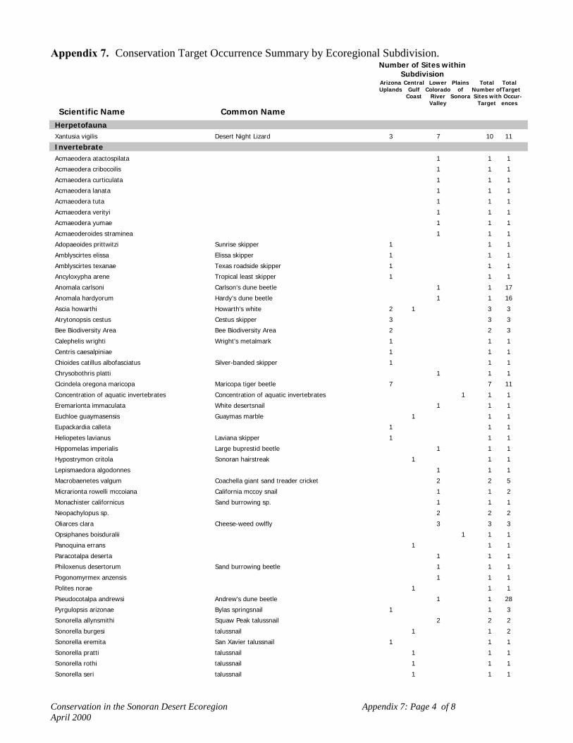
Conservation in the Sonoran Desert Ecoregion Appendix 7: Page 4 of 8April 2000
Appendix 7. Conservation Target Occurrence Summary by Ecoregional Subdivision.Number of Sites within
SubdivisionArizona Central Lower Plains Total TotalUplands Gulf Colorado of Number ofTarget
Coast River Sonora Sites with Occur-Valley Target ences
Scientific Name Common NameHerpetofaunaXantusia vigilis Desert Night Lizard 3 7 10 11
InvertebrateAcmaeodera atactospilata 1 1 1
Acmaeodera cribocoilis 1 1 1
Acmaeodera curticulata 1 1 1
Acmaeodera lanata 1 1 1
Acmaeodera tuta 1 1 1
Acmaeodera verityi 1 1 1
Acmaeodera yumae 1 1 1
Acmaeoderoides straminea 1 1 1
Adopaeoides prittwitzi Sunrise skipper 1 1 1
Amblyscirtes elissa Elissa skipper 1 1 1
Amblyscirtes texanae Texas roadside skipper 1 1 1
Ancyloxypha arene Tropical least skipper 1 1 1
Anomala carlsoni Carlson's dune beetle 1 1 17
Anomala hardyorum Hardy's dune beetle 1 1 16
Ascia howarthi Howarth's white 2 1 3 3
Atrytonopsis cestus Cestus skipper 3 3 3
Bee Biodiversity Area Bee Biodiversity Area 2 2 3
Calephelis wrighti Wright's metalmark 1 1 1
Centris caesalpiniae 1 1 1
Chioides catillus albofasciatus Silver-banded skipper 1 1 1
Chrysobothris platti 1 1 1
Cicindela oregona maricopa Maricopa tiger beetle 7 7 11
Concentration of aquatic invertebrates Concentration of aquatic invertebrates 1 1 1
Eremarionta immaculata White desertsnail 1 1 1
Euchloe guaymasensis Guaymas marble 1 1 1
Eupackardia calleta 1 1 1
Heliopetes lavianus Laviana skipper 1 1 1
Hippomelas imperialis Large buprestid beetle 1 1 1
Hypostrymon critola Sonoran hairstreak 1 1 1
Lepismaedora algodonnes 1 1 1
Macrobaenetes valgum Coachella giant sand treader cricket 2 2 5
Micrarionta rowelli mccoiana California mccoy snail 1 1 2
Monachister californicus Sand burrowing sp. 1 1 1
Neopachylopus sp. 2 2 2
Oliarces clara Cheese-weed owlfly 3 3 3
Opsiphanes boisduralii 1 1 1
Panoquina errans 1 1 1
Paracotalpa deserta 1 1 1
Philoxenus desertorum Sand burrowing beetle 1 1 1
Pogonomyrmex anzensis 1 1 1
Polites norae 1 1 1
Pseudocotalpa andrewsi Andrew's dune beetle 1 1 28
Pyrgulopsis arizonae Bylas springsnail 1 1 3
Sonorella allynsmithi Squaw Peak talussnail 2 2 2
Sonorella burgesi talussnail 1 1 2
Sonorella eremita San Xavier talussnail 1 1 1
Sonorella pratti talussnail 1 1 1
Sonorella rothi talussnail 1 1 1
Sonorella seri talussnail 1 1 1

Conservation in the Sonoran Desert Ecoregion Appendix 7: Page 5 of 8April 2000
Appendix 7. Conservation Target Occurrence Summary by Ecoregional Subdivision.Number of Sites within
SubdivisionArizona Central Lower Plains Total TotalUplands Gulf Colorado of Number ofTarget
Coast River Sonora Sites with Occur-Valley Target ences
Scientific Name Common NameInvertebrateSquamodera ephedrae 1 1 1
Stenopelmatus cahuilaensis Coachella Valley Jerusalem cricket 1 1 2
Stinga morrisoni Morrison's skipper 1 1 1
Tryonia gilae Gila tryonia 1 1 4
Tryonia quitobaquitae Quitobaquito tryonia 1 1 2
Tryonia sp. Aquatic invertebrate 1 1 1
MammalAntilocapra americana sonoriensis Sonoran Pronghorn 3 1 4 23
Castor canadensis frondator Beaver 1 1 1
Choeronycteris mexicana Mexican Long-tongued Bat 4 1 5 9
Eumops underwoodi Underwood's Mastiff Bat 1 1 2 4
Felis onca Jaguar 2 2 2
Idionycteris phyllotis Allen's Big-eared Bat 1 1 1
Lasiurus xanthinus Western Yellow Bat 2 4 6 8
Leptonycteris curasoae yerbabuenae Lesser Long-nosed Bat 5 1 1 7 25
Lepus alleni tiburonensis Tiburon Antelope Jackrabbit 1 1 2
Macrotus californicus California Leaf-nosed Bat 21 1 11 1 34 137
Myotis velifer Cave Myotis 21 5 26 63
Myotis vivesi Fishing Bat 4 4 9
Neotoma varia 1 1 1
Nyctinomops femorosaccus Pocketed Free-tailed Bat 6 3 9 16
Odocoileus hemionus sheldoni Tiburon Mule Deer 1 1 3
Ovis canadensis cremnobates Peninsular Bighorn Sheep 3 3 7
Ovis canadensis mexicana Desert Bighorn Sheep 4 3 3 10 23
Ovis canadensis nelsoni Desert Bighorn Sheep 3 3 8
Perognathus baileyi insularis Pocket Mouse 1 1 1
Perognathus intermedius pinacate Rock Pocket Mouse 2 1 3 4
Peromyscus crinitus delgadilli Delgadillo's Canyon Mouse 1 1 1
Peromyscus eremicus papagensis Pinacate Cactus Mouse 2 1 3 5
Peromyscus eremicus tiburonensis Tiburon Cactus Mouse 1 1 1
Peromyscus merriami Mesquite Mouse 2 1 3 4
Peromyscus pembertoni San Pedro Nolasco Deer Mouse 1 1 1
Peromyscus stephani San Esteban Deer Mouse 1 1 1
Sigmodon hispidus eremicus Yuma Cotton Rat 1 1 4
Spermophilus tereticaudus chlorus Coachella Round-tailed Ground Squirrel 5 5 6
Spermophilus variegatus tiburonensis Tiburon Rock Squirrel 1 1 2
Tamias dorsalis sonoriensis Chichimoco 2 1 3 16
PlantAbutilon parishii Pima Indian Mallow 14 14 24
Abutilon thurberi Thurber Indian Mallow 1 1 1
Acalypha californica 1 1 1
Adelia obovata 1 1 2 2
Agave arizonica Arizona Agave 2 2 24
Agave chrysoglossa 3 3 5
Agave colorata 1 1 1
Agave delamateri Tonto Basin Agave 16 16 39
Agave deserti 1 1 1
Agave felgeri 1 1 2 9
Agave fortiflora 1 1 2 4 4
Agave jaiboli 1 1 1

Conservation in the Sonoran Desert Ecoregion Appendix 7: Page 6 of 8April 2000
Appendix 7. Conservation Target Occurrence Summary by Ecoregional Subdivision.Number of Sites within
SubdivisionArizona Central Lower Plains Total TotalUplands Gulf Colorado of Number ofTarget
Coast River Sonora Sites with Occur-Valley Target ences
Scientific Name Common NamePlantAgave moranii 1 1 2
Agave murpheyi Hohokam Agave 5 5 39
Agave pelona Mescal Pelon 2 1 3 4
Agave schottii var treleasei Trelease Agave 1 1 2
Agave subsimplex 3 3 5
Agave zebra 1 1 2 4
Allium haematochiton Red Skin Onion 1 1 1
Allium parishii Parish Onion 1 1 2
Ammoselinum giganteum Western Sand-parsley 1 1 1
Amsonia kearneyana Kearney's Blue Star 1 1 1
Argemone subintegrifolia 2 2 2
Argythamnia californica California Ditaxis 9 9 14
Astragalus insularis var harwoodii Harwood Milkvetch 3 3 6
Astragalus lentiginosus var coachellae Coachella Valley Milkvetch 11 11 17
Astragalus magdalenae var peirsonii Peirson's Milkvetch 5 5 7
Astragalus newberryi var aquarii Newberry's Milkvetch 1 1 1
Astragalus tricarinatus Triple-rib Milkvetch 2 2 2
Atamisquea emarginata Desert Tree Caper 1 1 2 5
Berberis harrisoniana Kofa Barberry 2 1 3 10
Brahea armata 1 2 3 4
Brickellia vollmeri 2 2 2
Brongniartia shrevei 1 1 1
Bursera hindsiana Red Elephant Tree 1 1 5
Bursera microphylla Elephant Tree 1 2 3 17
Capsicum annuum Chiltepin 1 1 2
Capsicum annuum var aviculare Chiltepin 1 1 2
Carnegiea gigantea Saguaro Cactus 1 3 4 12
Castela emoryi Crucifixion Thorn 4 4 8
Castela polyandra 1 1 2
Chaenactis carphoclinia var peirsonii Peirson's Pincushion 3 3 4
Chamaesyce platysperma Flatseed Spurge 3 3 5
Chorizanthe parryi var parryi Parry's Spineflower 1 1 1
Cirsium mohavense 1 1 1
Cirsium wrightii Wright's Marsh Thistle 1 1 1
Coreocarpus sanpedroensis 1 1 2
Coryphantha scheeri var robustispina Pima Pineapple Cactus 4 4 53
Croton wigginsii Dune Croton 2 2 5
Cryptantha ganderi Gander's Cryptantha 2 2 6
Dalea juncea 2 2 2
Dalea orcuttii 2 2 2
Dalea tentaculoides Gentry Indigo Bush 2 2 9
Drymaria viscosa 1 1 1
Echinocactus horizonthalonius var nicholii Nichol Turk's Head Cactus 2 1 3 14
Echinocereus grandis 1 1 1
Echinomastus erectocentrus var acunensis Acuna Cactus 5 1 6 12
Echinomastus erectocentrus var erectocentrus Needle-spined Pineapple Cactus 2 2 9
Encelia ravenii 1 1 1
Ephedra funerea Death Valley Mormon Tea 1 1 3
Ericameria brachylepis Rayless Turpentine Bush 3 3 7
Erigeron anchana Mogollon Fleabane 2 2 4
Erigeron piscaticus Fish Creek Fleabane 2 2 5

Conservation in the Sonoran Desert Ecoregion Appendix 7: Page 7 of 8April 2000
Appendix 7. Conservation Target Occurrence Summary by Ecoregional Subdivision.Number of Sites within
SubdivisionArizona Central Lower Plains Total TotalUplands Gulf Colorado of Number ofTarget
Coast River Sonora Sites with Occur-Valley Target ences
Scientific Name Common NamePlantEriogonum apachense Apache Wild-buckwheat 1 1 1
Eriogonum deserticola Desert Wild-buckwheat 2 2 6
Eriogonum galioides 1 1 1
Eriogonum ripleyi Ripley Wild-buckwheat 1 1 5
Eryngium nasturtiifolium Hierba Del Sapo 1 1 3
Escobaria vivipara 4 4 33
Eucnide rupestris Rock Stingbush 3 3 6
Euphorbia magdalenae 1 1 1
Euphorbia misera Cliff Spurge 1 1 2 2
Euphorbia xantii 3 3 4
Ferocactus wislizeni var tiburonensis 2 2 2
Fouquieria columnaris Boojum Tree 1 1 12
Fraxinus gooddingii Goodding Ash 1 1 6
Galium angustifolium ssp. borregoense Borrego Bedstraw 1 1 7
Gilia maculata Little San Bernardino Mtns. Gilia 6 6 8
Graptopetalum bartramii Bartram Stonecrop 1 1 4
Helianthus niveus Dune Sunflower 1 1 3
Helianthus niveus ssp. tephrodes Algodones Dunes Sunflower 2 2 5
Hermannia pauciflora Sparseleaf Hermannia 2 2 4
Heuchera eastwoodiae Eastwood Alum Root 1 1 2
Hulsea californica San Diego Hulsea 1 1 1
Ipomopsis effusa Baja California Ipomopsis 1 1 1
Justicia candicans Hierba Azul 2 1 3 10
Laennecia eriophylla Woolly Fleabane 1 1 2
Lepidium flavum var felipense Borrego Valley Pepper-grass 1 1 4
Linanthus floribundus ssp. hallii Santa Rosa Mtns. Linanthus 1 1 1
Lotus alamosanus Alamos Beer Vetch 1 1 1
Lotus mearnsii var equisolensis 1 1 2
Lysiloma candida Palo Blanco 1 1 4
Lysiloma microphylla var thornberi Feather Bush 1 1 2
Mabrya acerifolia Mapleleaf False Snapdragon 2 2 11
Machaeranthera arida Arid Tansy-aster 1 1 1
Macroptilium supinum Supine Bean 1 1 4
Mammillaria boolii Viejito 1 1 2
Mammillaria estebanensis 1 1 1
Mammillaria johnstonii 2 2 4
Mammillaria multidigitata 1 1 2
Mammillaria tayloriorum 1 1 1
Mammillaria yaquensis 1 1 1
Marina orcuttii var orcuttii California Marina 1 1 1
Mentzelia hirsutissima California Stick-leaf 1 1 9
Metastelma mexicanum Wiggins Milkweed Vine 1 1 4
Muhlenbergia dubioides Box Canyon Muhly 1 1 1
Muhlenbergia gooddingii 1 1 1
Nemacaulis denudata var gracilis Slender Woolly-heads 2 2 4
Opuntia munzii Munz Cholla 1 1 2
Opuntia reflexispina Cholla 1 1 6
Opuntia wigginsii Wiggin's Cholla 1 3 4 6
Palafoxia arida var gigantea Giant Spanish Needle 3 3 7
Paspalum virletii Virlet Paspalum 1 1 1
Pectis imberbis Beardless Chinch Weed 1 1 1

Conservation in the Sonoran Desert Ecoregion Appendix 7: Page 8 of 8April 2000
Appendix 7. Conservation Target Occurrence Summary by Ecoregional Subdivision.Number of Sites within
SubdivisionArizona Central Lower Plains Total TotalUplands Gulf Colorado of Number ofTarget
Coast River Sonora Sites with Occur-Valley Target ences
Scientific Name Common NamePlantPenstemon discolor Catalina Beardtongue 1 1 2
Perityle ajoensis Ajo Rock Daisy 1 1 5
Perityle gilensis var gilensis Gila Rock Daisy 1 1 1
Perityle saxicola Fish Creek Rock Daisy 2 2 3
Petalonyx linearis Longleaf Sandpaper Plant 1 1 1
Phacelia parishii 1 1 1
Pholisma arenarium Scaly Sandplant 1 1 4
Pholisma sonorae Sand Food 2 2 10
Pholistoma auritum var arizonicum Arizona Pholistoma 1 1 1
Pithecellobium confine 1 1 1
Pseudorontium cyathiferum Deep Canyon Snapdragon 1 1 1
Puccinellia parishii Parish Alkali Grass 2 2 2
Purshia subintegra Arizona Cliffrose 5 5 10
Rhus kearneyi Kearney Sumac 1 1 2 9
Salvia amissa Aravaipa Sage 2 2 4
Salvia davidsonii Davidson Sage 1 1 1
Salvia greatae Orocopia Sage 3 3 26
Schoepfia shreveana 1 1 1
Senecio hartwegii Seemann Groundsel 1 1 1
Senecio pinacatensis 1 1 1
Sibara angelorum 2 2 2
Sibara pectinata 1 1 1
Stegnosperma halimifolium Amole 1 1 1
Stephanomeria schottii Schott's Wire-lettuce 1 1 8
Streptanthus campestris Southern Jewelflower 1 1 3
Stylocline sonorensis Mesquite Neststraw 1 1 1
Suaeda puertopenascoa 1 2 3 3
Thelypteris puberula var sonorensis Aravaipa Wood Fern 2 1 3 3
Tithonia thurberi Thurber Tithonia 1 1 1
Triteleiopsis palmeri Blue Sand Lily 1 1 6
Vallesia baileyana 1 1 2
Washingtonia filifera California Fan Palm 2 7 9 26
Xylorhiza cognata Mecca Aster 4 4 20
Xylorhiza orcuttii Orcutt's Woody Aster 2 2 23
Yucca whipplei Whippley's Yucca 1 1 1

Conservation in the Sonoran Desert Ecoregion Appendix 8: Page 1 of 7April 2000
Appendix 8. Results of biophysical Analysis (see Appendix 3 for key to coding system).C
OD
E
Bio
phys
ical
Uni
tD
escr
iptio
n
Tot
al A
cres
% o
f Eco
regi
onSu
bdiv
isio
n
Acr
es w
/inC
onse
rvat
ion
Site
s
% o
f Uni
t in
Con
serv
atio
n Si
tes
Acr
es O
utsi
deC
onse
rvat
ion
Site
s
% o
f Uni
t Out
side
Con
serv
atio
n Si
tes
Und
er-r
epre
sent
ed(U
)O
verr
epre
sent
ed(O
)
Arizona UplandsCreosote-Bursage Desert Scrub (matrix-forming communities)
103111 69,626 1.20 11,681 17 57,945 83103122 4,285 0.07 1,469 34 2,816 66103123 3,148 0.05 1,562 50 1,586 50103211 543,060 9.32 137,946 25 405,114 75103221 660 0.01 347 53 313 47103222 low-mid. elev./mod.S-SW slope 38,861 0.67 17,124 44 21,737 56 O103223 low-mid. elev./mod.N-NE slope 33,741 0.58 15,774 47 17,967 53 O103233 81 0.00 36 44 45 56103311 mid-high elev./gentle-flat 160,892 2.76 79,151 49 81,741 51 O103322 20,847 0.36 9,381 45 11,466 55103323 11,066 0.19 5,226 47 5,840 53103333 28 0.00 11 39 17 61103411 4,831 0.08 643 13 4,188 87103422 3,641 0.06 811 22 2,830 78103423 2,707 0.05 817 30 1,890 70103432 17 0.00 17 100 0 0
Estimated extent circa 1800: 1,140,000 ac 897,491 15.41 281,996 31 615,495 53Dunes and Plains
104111 1,200 0.02 788 66 412 34104211 low-mid. elev./gentle-flat 806 0.01 U
Desert Playa105111 534 0.01 434 81 100 19
Interior Chaparral/Encinal106211 2,732 0.05 1,422 52 1,310 48106222 349 0.01 283 81 66 19106223 717 0.01 545 76 172 24106311 10,625 0.18 3,627 34 6,998 66106322 6,961 0.12 2,980 43 3,981 57106323 4,421 0.08 2,544 58 1,877 42106332 25 0.00 13 52 12 48106333 24 0.00 19 79 5 21106411 9,374 0.16 1,904 20 7,470 80106422 14,495 0.25 5,361 37 9,134 63106423 9,391 0.16 4,348 46 5,043 54106432 130 0.00 60 46 70 54106433 64 0.00 23 36 41 64
Interior Riparian Shrub/Woodland109111 3,524 0.06 2,179 62 1,345 38109122 963 0.02 543 56 420 44109211 low-mid. elev./gentle-flat 18,051 0.31 14,068 78 3,983 22 O109222 2,181 0.04 343 16 1,838 84109223 969 0.02 431 44 538 56109311 7,014 0.12 5,642 80 1,372 20109322 931 0.02 225 24 706 76109323 1,058 0.02 328 31 730 69109422 high elev./mod.S-SW slope 507 0.01 35 7 472 93 U109423 299 0.01 100 33 199 67

Conservation in the Sonoran Desert Ecoregion Appendix 8: Page 2 of 7April 2000
CO
DE
Bio
phys
ical
Uni
tD
escr
iptio
n
Tot
al A
cres
% o
f Eco
regi
onSu
bdiv
isio
n
Acr
es w
/inC
onse
rvat
ion
Site
s
% o
f Uni
t in
Con
serv
atio
n Si
tes
Acr
es O
utsi
deC
onse
rvat
ion
Site
s
% o
f Uni
t Out
side
Con
serv
atio
n Si
tes
Und
er-r
epre
sent
ed(U
)O
verr
epre
sent
ed(O
)
Interior Riparian Woodlands110111 low elev./gentle-flat 801 0.01 39 5 762 95 U110211 3,255 0.06 2,300 71 955 29110311 525 0.01 440 84 85 16110333 17 0.00 16 94 1 6
Torchwood-Limberbush111111 13,696 0.24 3,943 29 9,753 71111122 1,154 0.02 243 21 911 79111123 692 0.01 87 13 605 87111211 low-mid.elev./gentle-flat 103,017 1.77 2,264 2 100,753 98 U111222 low-mid.elev./mod. S-SW slope 32,551 0.56 1,002 3 31,549 97 U111223 low-mid.elev./mod. N-NE slope 23,641 0.41 1,007 4 22,634 96 U111232 low-mid.elev./steep S-SW slope 17 0.00 1 6 16 94 U111233 low-mid.elev./steep N-NE slope 16 0.00 U111311 mid-high elev./gentle-flat 4,066 0.07 268 7 3,798 93 U111322 mid-high elev./mod. S-SW slope 8,696 0.15 374 4 8,322 96 U111323 mid-high elev./mod. N-NE slope 8,580 0.15 703 8 7,877 92 U111332 mid-high elev./steep S-SW slope 27 0.00 27 100 U111333 mid-high elev./steep N-NE slope 62 0.00 62 100 U111422 mid-high elev./mod. S-SW slope 742 0.01 1 0 741 100 U111423 high elev./mod. N-NE slope 450 0.01 U
Mesquite Woodland113111 8,054 0.14 1,050 13 7,004 87113211 91,439 1.57 20,615 23 70,824 77113222 541 0.01 292 54 249 46113223 375 0.01 256 68 119 32113311 58,911 1.01 22,062 37 36,849 63113322 1,427 0.02 815 57 612 43113323 693 0.01 287 41 406 59113433 23 0.00 23 100 0 0
Palo verde-Mixed Cacti Desert Scrub (matrix-forming communities)115111 low elev./gentle-flat 71,978 1.24 40,862 57 31,116 43 O115122 4,626 0.08 1,243 27 3,383 73115123 3,352 0.06 1,200 36 2,152 64115211 2,248,383 38.61 697,725 31 1,550,658 69115221 2,504 0.04 1,677 67 827 33115222 low-mid. elev./mod. S-SW slope 192,906 3.31 103,701 54 89,205 46 O115223 low-mid. elev./mod. N-NE slope 156,565 2.69 93,273 60 63,292 40 O115232 574 0.01 446 78 128 22115233 309 0.01 286 93 23 7115311 830,527 14.26 255,530 31 574,997 69115321 1,605 0.03 833 52 772 48115322 mid-high elev./mod. S-SW slope 218,604 3.75 95,057 43 123,547 57 O115323 mid-high elev./mod. N-NE slope 151,715 2.61 82,888 55 68,827 45 O115332 944 0.02 713 76 231 24115333 722 0.01 611 85 111 15115411 62,810 1.08 17,971 29 44,839 71115422 48,971 0.84 16,461 34 32,510 66115423 high elev./mod. N-NE slope 27,444 0.47 13,108 48 14,336 52 O115432 352 0.01 227 64 125 36115433 325 0.01 270 83 55 17
Estimated extent circa 1800: 4,040,000 ac 4,025,216 69.12 1,424,082 35 2,601,134 63

Conservation in the Sonoran Desert Ecoregion Appendix 8: Page 3 of 7April 2000
CO
DE
Bio
phys
ical
Uni
tD
escr
iptio
n
Tot
al A
cres
% o
f Eco
regi
onSu
bdiv
isio
n
Acr
es w
/inC
onse
rvat
ion
Site
s
% o
f Uni
t in
Con
serv
atio
n Si
tes
Acr
es O
utsi
deC
onse
rvat
ion
Site
s
% o
f Uni
t Out
side
Con
serv
atio
n Si
tes
Und
er-r
epre
sent
ed(U
)O
verr
epre
sent
ed(O
)
Semi-Desert Grassland117211 7,506 0.13 2,375 32 5,131 68117311 mid-high elev./gentle-flat 86,898 1.49 46,123 53 40,775 47 O117322 10,818 0.19 5,347 49 5,471 51117323 6,732 0.12 4,701 70 2,031 30117332 38 0.00 19 50 19 50117411 20,438 0.35 9,476 46 10,962 54117422 high elev./mod. S-SW slope 17,496 0.30 11,671 67 5,825 33 O117423 high elev./mod. N-NE slope 12,848 0.22 10,860 85 1,988 15 O117432 128 0.00 84 66 44 34117433 125 0.00 121 97 4 3
Water119111 3,785 0.06 2,894 76 891 24119211 12,706 0.22 11,889 94 817 6119222 (slope = map artifact) 529 0.01 500 95 29 5119223 (slope = map artifact) 484 0.01 473 98 11 2119233 (slope = map artifact) 16 0.00 16 100 0 0119311 1,006 0.02 394 39 612 61
Subdivision total 5,824,000
Central Gulf CoastAgave-Bursage Scrub
201111 5,170 0.55 4,671 90 499 10201122 1,079 0.11 856 79 223 21201123 595 0.06 573 96 22 4
Creosote-Bursage Desert Scrub203111 164,828 17.40 94,984 58 69,844 42203122 1,849 0.20 1,497 81 352 19203123 2,999 0.32 2,705 90 294 10
Dunes and Plains204111 low elev./gentle-flat 18,211 1.92 16,171 89 2,040 11 O
Torchwood-Limberbush211111 low elev./gentle-flat 177,403 18.72 163,613 92 13,790 8 O211121 1,447 0.15 1,218 84 229 16211122 low elev./mod.S-SW slope 58,149 6.14 54,922 94 3,227 6 O211123 low elev./mod. N-NE slope 41,510 4.38 39,020 94 2,490 6 O211132 149 0.02 149 100 0 0211133 102 0.01 102 100 0 0211211 4,969 0.52 4,728 95 241 5211222 8,452 0.89 8,199 97 253 3211223 7,856 0.83 7,629 97 227 3211232 80 0.01 80 100 0 0211233 139 0.01 139 100 0 0
Mangrove Swamp212111 1,261 0.13 1,146 91 115 9
Mesquite Woodland213111 low elev./ gentle-flat 87,531 9.24 61,377 70 26,154 30 O213122 463 0.05 414 89 49 11213123 823 0.09 789 96 34 4
Palo verde-Mixed Cacti Desert Scrub215111 low elev./ gentle-flat 138,938 14.66 117,166 84 21,772 16 O

Conservation in the Sonoran Desert Ecoregion Appendix 8: Page 4 of 7April 2000
CO
DE
Bio
phys
ical
Uni
tD
escr
iptio
n
Tot
al A
cres
% o
f Eco
regi
onSu
bdiv
isio
n
Acr
es w
/inC
onse
rvat
ion
Site
s
% o
f Uni
t in
Con
serv
atio
n Si
tes
Acr
es O
utsi
deC
onse
rvat
ion
Site
s
% o
f Uni
t Out
side
Con
serv
atio
n Si
tes
Und
er-r
epre
sent
ed(U
)O
verr
epre
sent
ed(O
)
215122 1,047 0.11 900 86 147 14215123 1,407 0.15 1,325 94 82 6215211 2,730 0.29 2,721 100 9 0
Saltbush-Saltmarsh216111 low elev./ gentle-flat 89,785 9.48 73,766 82 16,019 18 O216122 869 0.09 848 98 21 2
Subdivision total
947,000
Lower Colorado River ValleyCreosote-Bursage Desert Scrub (matrix-forming communities)
303111 low elev./ gentle-flat 4,125,028 34.00 2,093,032 51 2,031,996 49 O303121 1,740 0.01 935 54 805 46303122 low elev./mod. S-SW slope 140,145 1.16 87,157 62 52,988 38 O303123 low elev./mod. N-NE slope 147,240 1.21 97,820 66 49,420 34 O303132 87 0.00 49 56 38 44303133 133 0.00 106 80 27 20303211 low-mid. elev./gentle-flat 1,635,436 13.48 701,739 43 933,697 57 O303221 632 0.01 215 34 417 66303222 low-mid. elev./mod.S-SW slope 184,364 1.52 143,130 78 41,234 22 O303223 low-mid. elev./mod.N-NE slope 216,131 1.78 178,888 83 37,243 17 O303232 630 0.01 448 71 182 29303233 927 0.01 726 78 201 22303311 mid-high elev./gentle-flat 20,812 0.17 18,484 89 2,328 11 O303322 mid-high elev./mod. S-SW slope 32,527 0.27 27,744 85 4,783 15 O303323 mid-high elev./mod. N-NE slope 50,686 0.42 45,884 91 4,802 9 O303332 166 0.00 144 87 22 13303333 378 0.00 328 87 50 13303411 3,687 0.03 3,281 89 406 11303422 9,190 0.08 8,432 92 758 8303423 high elev./mod. N-NE slope 17,439 0.14 16,128 92 1,311 8 O303432 145 0.00 139 96 6 4303433 255 0.00 250 98 5 2
Estimated extent circa 1800: 8,015,000 ac 6,587,778 54.30 3,425,059 51 3,162,719 39Dunes and Plains
304111 low elev./ gentle-flat 1,659,247 13.68 1,343,912 81 315,335 19 O304122 9,536 0.08 4,503 47 5,033 53304123 9,104 0.08 4,299 47 4,805 53304132 low elev./steep S-SW slope 33 0.00 33 100 U304133 low elev./steep N-NE slope 31 0.00 31 100 U304211 9,886 0.08 6,856 69 3,030 31304222 low-mid. elev./mod. S-SW slope 1,939 0.02 51 3 1,888 97 U304223 low-mid. elev./mod. N-NE slope 1,361 0.01 12 1 1,349 99 U304232 low-mid. elev./steep S-SW slope 27 0.00 27 100 U304233 low-mid. elev./steep N-NE slope 54 0.00 54 100 U
Desert Playa305111 low elev./ gentle-flat 28,173 0.23 15,455 55 12,718 45 O305211 521 0.00 521 100 0 0
Interior Chaparral/Encinal306111 5,421 0.04 1,764 33 3,657 67306211 1,652 0.01 1,470 89 182 11306311 7,273 0.06 7,073 97 200 3306322 1,482 0.01 1,198 81 284 19

Conservation in the Sonoran Desert Ecoregion Appendix 8: Page 5 of 7April 2000
CO
DE
Bio
phys
ical
Uni
tD
escr
iptio
n
Tot
al A
cres
% o
f Eco
regi
onSu
bdiv
isio
n
Acr
es w
/inC
onse
rvat
ion
Site
s
% o
f Uni
t in
Con
serv
atio
n Si
tes
Acr
es O
utsi
deC
onse
rvat
ion
Site
s
% o
f Uni
t Out
side
Con
serv
atio
n Si
tes
Und
er-r
epre
sent
ed(U
)O
verr
epre
sent
ed(O
)
306323 1,453 0.01 1,302 90 151 10306411 2,007 0.02 1,707 85 300 15306422 2,099 0.02 1,503 72 596 28306423 3,430 0.03 2,832 83 598 17306433 16 0.00 16 100 0 0
Interior Riparian Marsh308111 1,514 0.01 1,486 98 28 2
Interior Riparian Shrubland/Woodland309111 low elev./ gentle-flat 41,503 0.34 29,313 71 12,190 29 O
Interior Riparian Woodlands310111 16,326 0.13 6,200 38 10,126 62310211 920 0.01 879 96 41 4
Torchwood-Limberbush311111 low elev./ gentle-flat 140,819 1.16 91,191 65 49,628 35 O311122 low elev./mod.S-SW slope 23,320 0.19 16,925 73 6,395 27 O311123 low elev./mod.N-NE slope 15,639 0.13 11,416 73 4,223 27 O311132 15 0.00 9 60 6 40311211 low-mid. elev./ gentle-flat 73,689 0.61 52,831 72 20,858 28 O311222 low-mid. elev./mod.S-SW slope 34,544 0.28 26,993 78 7,551 22 O311223 low-mid. elev./mod.N-NE slope 34,676 0.29 29,318 85 5,358 15 O311232 137 0.00 134 98 3 2311233 152 0.00 145 95 7 5311323 604 0.00 590 98 14 2
Mesquite Woodland313111 low elev./ gentle-flat 278,664 2.30 158,844 57 119,820 43 O313122 3,089 0.03 2,614 85 475 15313211 low-mid. elev./ gentle-flat 93,462 0.77 65,148 70 28,314 30 O313222 4,064 0.03 3,873 95 191 5313223 2,322 0.02 2,185 94 137 6
Palo verde-Mixed Cacti Desert Scrub (matrix-forming communities)315111 638,317 5.26 215,126 34 423,191 66315122 low elev./mod.S-SW slope 16,252 0.13 10,372 64 5,880 36315123 12,606 0.10 9,180 73 3,426 27315132 43 0.00 43 100 0 0315133 31 0.00 24 77 7 23315211 535,754 4.42 154,165 29 381,589 71315222 low-mid. elev./mod.S-SW slope 32,518 0.27 15,589 48 16,929 52315223 low-mid. elev./mod.N-NE slope 26,206 0.22 14,826 57 11,380 43315232 264 0.00 214 81 50 19315233 213 0.00 167 78 46 22315322 2,501 0.02 773 31 1,728 69315323 2,224 0.02 1,300 58 924 42315332 113 0.00 36 32 77 68315333 75 0.00 42 56 33 44315432 20 0.00 11 55 9 45315433 high elev./steep N-NE slope 17 0.00 1 6 16 94 U
Estimated extent circa 1800: 1,342,000 ac 1,267,154 10.45 421,869 33 845,285 65Saltbush-Saltmarsh
316111 low elev./ gentle-flat 118,002 0.97 84,527 72 33,475 28 O316211 15,749 0.13 9,009 57 6,740 43
Semi-Desert Grassland317111 low elev./ gentle-flat 2,101 0.02 159 8 1,942 92 U
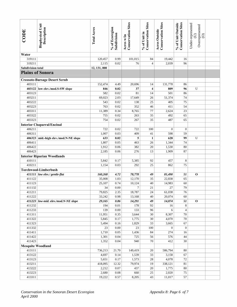
Conservation in the Sonoran Desert Ecoregion Appendix 8: Page 6 of 7April 2000
CO
DE
Bio
phys
ical
Uni
tD
escr
iptio
n
Tot
al A
cres
% o
f Eco
regi
onSu
bdiv
isio
n
Acr
es w
/inC
onse
rvat
ion
Site
s
% o
f Uni
t in
Con
serv
atio
n Si
tes
Acr
es O
utsi
deC
onse
rvat
ion
Site
s
% o
f Uni
t Out
side
Con
serv
atio
n Si
tes
Und
er-r
epre
sent
ed(U
)O
verr
epre
sent
ed(O
)
Water319111 120,457 0.99 101,015 84 19,442 16319211 2,115 0.02 76 4 2,039 96
Subdivision total 12, 131, 000Plains of SonoraCreosote-Bursage Desert Scrub
403111 152,474 4.49 20,696 14 131,778 86403122 low elev./mod.S-SW slope 846 0.02 37 4 809 96 U403123 582 0.02 81 14 501 86403211 69,023 2.03 17,649 26 51,374 74403222 543 0.02 138 25 405 75403223 763 0.02 352 46 411 54403311 11,389 0.34 8,765 77 2,624 23403322 755 0.02 263 35 492 65403323 754 0.02 267 35 487 65
Interior Chaparral/Encinal406211 722 0.02 722 100 0 0406311 1,007 0.03 409 41 598 59406323 mid.-high elev./mod.N-NE slope 633 0.02 5 1 628 99 U406411 1,807 0.05 463 26 1,344 74406422 1,912 0.06 382 20 1,530 80406423 2,185 0.06 276 13 1,909 87
Interior Riparian Woodlands410111 5,842 0.17 5,385 92 457 8410211 1,154 0.03 292 25 862 75
Torchwood-Limberbush411111 low elev./ gentle-flat 160,268 4.72 78,778 49 81,490 51 O411122 35,008 1.03 12,170 35 22,838 65411123 25,107 0.74 10,124 40 14,983 60411132 34 0.00 7 21 27 79411211 79,825 2.35 18,787 24 61,038 76411222 33,242 0.98 13,168 40 20,074 60411223 low-mid. elev./mod.N-NE slope 29,165 0.86 14,291 49 14,874 51 O411232 194 0.01 178 92 16 8411233 139 0.00 133 96 6 4411311 11,951 0.35 3,644 30 8,307 70411322 5,845 0.17 1,775 30 4,070 70411323 5,494 0.16 1,829 33 3,665 67411332 23 0.00 23 100 0 0411411 1,710 0.05 1,436 84 274 16411422 1,301 0.04 725 56 576 44411423 1,352 0.04 940 70 412 30
Mesquite Woodland413111 736,213 21.70 149,419 20 586,794 80413122 4,697 0.14 1,539 33 3,158 67413123 5,651 0.17 1,573 28 4,078 72413211 418,095 12.32 79,974 19 338,121 81413222 2,212 0.07 437 20 1,775 80413223 2,680 0.08 660 25 2,020 75413311 19,222 0.57 8,205 43 11,017 57

Conservation in the Sonoran Desert Ecoregion Appendix 8: Page 7 of 7April 2000
CO
DE
Bio
phys
ical
Uni
tD
escr
iptio
n
Tot
al A
cres
% o
f Eco
regi
onSu
bdiv
isio
n
Acr
es w
/inC
onse
rvat
ion
Site
s
% o
f Uni
t in
Con
serv
atio
n Si
tes
Acr
es O
utsi
deC
onse
rvat
ion
Site
s
% o
f Uni
t Out
side
Con
serv
atio
n Si
tes
Und
er-r
epre
sent
ed(U
)O
verr
epre
sent
ed(O
)
Palo verde-Mixed Cacti Desert Scrub415111 low elev./gentle-flat 149,571 4.41 10,608 7 138,963 93415122 1,203 0.04 210 17 993 83415123 1,409 0.04 194 14 1,215 86415211 409,960 12.08 84,119 21 325,841 79415222 6,774 0.20 1,009 15 5,765 85415223 6,213 0.18 1,243 20 4,970 80415311 mid.-high elev./gentle-flat 189,300 5.58 89,821 47 99,479 53 O415322 15,549 0.46 3,672 24 11,877 76415323 14,967 0.44 5,515 37 9,452 63415411 13,862 0.41 2,339 17 11,523 83415422 5,904 0.17 568 10 5,336 90415423 5,192 0.15 771 15 4,421 85
Semi-Desert Grassland417311 1,586 0.05 559 35 1,027 65417411 939 0.03 386 41 553 59417422 811 0.02 145 18 666 82
Sinaloan/Foothills Thornscrub418111 101,104 2.98 37,978 38 63,126 62418122 17,066 0.50 4,858 28 12,208 72418123 8,381 0.25 1,892 23 6,489 77418211 211,729 6.24 52,759 25 158,970 75418222 39,816 1.17 12,203 31 27,613 69418223 32,144 0.95 10,632 33 21,512 67418232 186 0.01 45 24 141 76418233 159 0.00 28 18 131 82418311 mid.-high elev./gentle-flat 17,738 0.52 479 3 17,259 97 U418322 11,471 0.34 1,720 15 9,751 85418323 9,511 0.28 912 10 8,599 90418411 high elev./gentle-flat 1,351 0.04 46 3 1,305 97 U418422 1,423 0.04 549 39 874 61418423 940 0.03 98 10 842 90
subdivision total 3,392,606

Conservation in the Sonoran Desert Ecoregion Appendix 9: Page 1 of 3April 2000 (No site designated for numbers 66, 87, 94, 100)
Appendix 9. Land Management Status and Approximate Acreage for the 100 Landscape-Scale Conservation SitesConservati
onSite #
Conservation Site Name State SITEACREAGE
WITHINECOREGION
Bureau ofLandMgmt
NationalPark
Service
U.S. Fish &WildlifeService
U.S.ForestService
Dept. ofDefense
Reclamation
StateTrustLand
StateParks
StateGame& Fish
Tribal LocalPark
NatureConservancy
U.S.PrivateLands
MXPrivateLands
MXBiosphere Reserve
MXProposedProtected
Total Acres
1 Rancho El Único SN 354501 0 0 0 0 0 0 0 0 0 0 0 0 0 175,163 0 175,325 350,4882 San Esteban Island SN 10334 0 0 0 0 0 0 0 0 0 0 0 0 0 0 0 10,334 10,3343 Bahía de Kino/Isla Tiburón/Sierra Seri SN 698072 0 0 0 0 0 0 0 0 0 0 0 0 0 398,625 0 297,972 696,5974 Sierra Bacha/Sierra Del Viejo SN 1351670 0 0 0 0 0 0 0 0 0 0 0 0 0 1,281,548 0 69,630 1,351,1775 Cañones De La Pintada and Tetabejo SN 739177 0 0 0 0 0 0 0 0 0 0 0 0 0 739,177 0 0 739,1776 Sierra Tordilla/Puerto el Orégano SN 18643 0 0 0 0 0 0 0 0 0 0 0 0 0 18,643 0 0 18,6437 Carrizo Plains/Arroyo Bacoachito SN 667939 0 0 0 0 0 0 0 0 0 0 0 0 0 532,150 0 135,789 667,9398 Cerro Borrego/San Felipe Desert BC 2258465 0 0 0 0 0 0 0 0 0 0 0 0 0 2,112,773 0 0 2,257,7359 Tacna Marsh AZ 2417 933 0 0 0 0 145 69 0 0 0 0 0 1,532 0 0 0 2,679
10 Colorado River Delta SN/BC 979633 0 0 0 0 0 0 0 0 0 0 0 0 0 0 1,038,212 0 455,52511 Bouse Dunes AZ 118282 110,515 0 0 0 0 0 3,230 0 0 3,109 0 0 1,482 0 0 0 118,33612 Kofa Complex AZ 1434032 471,079 0 568,353 0 359,596 0 5,368 0 0 17,666 0 0 7,658 0 0 0 1,429,72013 Pinacate-Organ Pipe-Goldwater
ComplexAZ/SN 6147015 136,040 328,960 854,483 0 1,123,387 24,209 29,617 0 0 81,742 0 0 45,495 1,424,988 1,700,049 0 5,748,971
14 Arnett Creek AZ 18698 0 0 0 15,150 0 0 0 0 0 0 0 0 3,522 0 0 0 18,67215 Ciénega Creek AZ 45872 0 2,088 0 0 3,077 0 17,671 0 0 0 4,266 0 23,194 0 0 0 50,29616 Santa Rita AZ 152544 2,703 0 0 0 0 0 19,636 0 0 65,267 0 0 63,080 0 0 0 150,68617 Altar Valley AZ 86059 68 0 72,192 0 0 0 60,102 0 0 11,680 0 0 13,385 642 0 0 158,06918 Tortolita Mountains AZ 53419 1,442 0 0 0 0 0 22,767 0 0 0 503 0 28,688 0 0 0 53,40019 Sawtooth /Silverbell Mountains AZ 110579 51,658 0 0 0 0 0 23,966 0 0 17,741 0 0 17,386 0 0 0 110,75120 Vekol Mountains AZ 21950 0 0 0 0 0 0 0 0 0 21,651 0 0 299 0 0 0 21,95021 Salt & Verde Tonto Creek AZ 356010 0 300 0 200,040 0 390 0 0 0 18,861 0 0 4,502 0 0 0 223,32322 Magdalena/Río Ascunción SN 252660 0 0 0 0 0 0 0 0 0 0 0 0 0 243,705 0 8,960 252,66523 Hassayampa River AZ 40553 21,129 0 0 0 0 0 6,532 0 0 0 0 1,075 12,289 0 0 0 41,02524 San Jacinto Foothills CA 16396 43,651 0 0 0 0 0 0 37,743 58 0 0 0 28,594 0 0 0 110,04625 Anza Borrego CA 270006 94,353 0 0 0 0 0 1,171 393,353 0 0 0 0 109,822 0 0 0 598,69926 Coachella Valley CA 36839 3,558 0 0 0 0 0 0 0 629 0 0 12,043 24,527 0 0 0 40,75727 Chocolate Mountains CA 1145037 534,574 0 30 0 461,071 0 25,647 55 0 0 0 0 119,251 0 0 0 1,140,62828 Coachella Canal/Black Rail CA 14819 4,713 0 0 0 0 0 0 0 0 0 0 0 7,127 0 0 0 11,84029 McCoy Mountains CA 336866 310,657 0 0 0 0 0 12,095 0 0 0 0 0 10,049 0 0 0 332,80130 Riverside Mountains CA 11605 5,373 0 0 0 0 0 643 0 0 3,131 0 0 477 0 0 0 9,62431 Whipple Mountains CA/AZ 131495 85,085 0 0 0 0 0 4,772 0 0 3,787 0 0 8,918 0 0 0 102,56232 Sand Tank-Sauceda Mountain
ComplexAZ 636196 133,937 0 0 0 355,114 0 2,093 0 0 141,811 0 0 842 0 0 0 636,196
33 Salton Sea CA 255397 1,181 0 47,399 0 427 0 0 341 5,068 1,102 0 0 12,156 0 0 0 67,67434 Joshua Tree CA 259547 86,082 171,754 0 0 658 0 2,323 0 316 0 0 142,473 0 0 0 403,60635 Algodones Dunes CA 291402 274,302 0 0 0 2,196 2,021 0 0 0 0 0 12,885 24 0 0 291,42836 Palen Dry Lake CA 3479 0 0 0 0 0 0 0 0 0 0 0 0 0 0 0 037 Central Gulf Coast SN 192658 2,204 0 0 0 0 0 0 0 0 0 0 1,275 152,877 0 21,540 177,89638 Colorado River/Río Hardy AZ/CA/
SN/BC427495 64,724 0 36,901 0 2,850 587 16,199 18,588 0 80,184 583 0 69,088 111,891 0 0 401,595
39 Sierra de Lopez SN 20521 0 0 0 0 0 0 0 0 0 0 0 0 20,521 0 0 20,52140 Cueva del Tigre SN 1453 0 0 0 0 0 0 0 0 0 0 0 0 1,453 0 0 1,45341 Sierra La Cobriza SN 3928 0 0 0 0 0 0 0 0 0 0 0 0 3,928 0 0 3,928
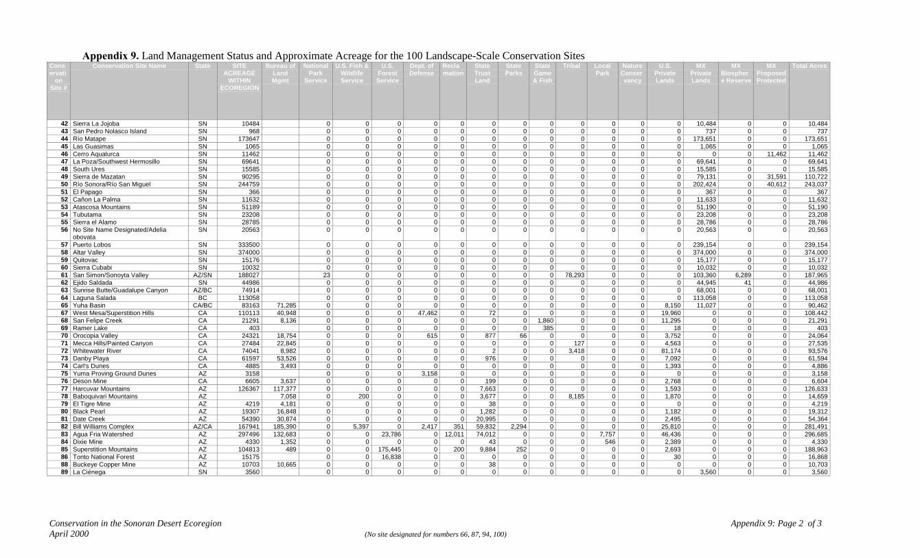
Conservation in the Sonoran Desert Ecoregion Appendix 9: Page 2 of 3April 2000 (No site designated for numbers 66, 87, 94, 100)
Appendix 9. Land Management Status and Approximate Acreage for the 100 Landscape-Scale Conservation SitesConservati
onSite #
Conservation Site Name State SITEACREAGE
WITHINECOREGION
Bureau ofLandMgmt
NationalPark
Service
U.S. Fish &WildlifeService
U.S.ForestService
Dept. ofDefense
Reclamation
StateTrustLand
StateParks
StateGame& Fish
Tribal LocalPark
NatureConservancy
U.S.PrivateLands
MXPrivateLands
MXBiosphere Reserve
MXProposedProtected
Total Acres
42 Sierra La Jojoba SN 10484 0 0 0 0 0 0 0 0 0 0 0 0 10,484 0 0 10,48443 San Pedro Nolasco Island SN 968 0 0 0 0 0 0 0 0 0 0 0 0 737 0 0 73744 Río Matape SN 173647 0 0 0 0 0 0 0 0 0 0 0 0 173,651 0 0 173,65145 Las Guasimas SN 1065 0 0 0 0 0 0 0 0 0 0 0 0 1,065 0 0 1,06546 Cerro Aqualurca SN 11462 0 0 0 0 0 0 0 0 0 0 0 0 0 0 11,462 11,46247 La Poza/Southwest Hermosillo SN 69641 0 0 0 0 0 0 0 0 0 0 0 0 69,641 0 0 69,64148 South Ures SN 15585 0 0 0 0 0 0 0 0 0 0 0 0 15,585 0 0 15,58549 Sierra de Mazatan SN 90295 0 0 0 0 0 0 0 0 0 0 0 0 79,131 0 31,591 110,72250 Río Sonora/Río San Miguel SN 244759 0 0 0 0 0 0 0 0 0 0 0 0 202,424 0 40,612 243,03751 El Papago SN 366 0 0 0 0 0 0 0 0 0 0 0 0 367 0 0 36752 Cañon La Palma SN 11632 0 0 0 0 0 0 0 0 0 0 0 0 11,633 0 0 11,63253 Atascosa Mountains SN 51189 0 0 0 0 0 0 0 0 0 0 0 0 51,190 0 0 51,19054 Tubutama SN 23208 0 0 0 0 0 0 0 0 0 0 0 0 23,208 0 0 23,20855 Sierra el Alamo SN 28785 0 0 0 0 0 0 0 0 0 0 0 0 28,786 0 0 28,78656 No Site Name Designated/Adelia
obovataSN 20563 0 0 0 0 0 0 0 0 0 0 0 0 20,563 0 0 20,563
57 Puerto Lobos SN 333500 0 0 0 0 0 0 0 0 0 0 0 0 239,154 0 0 239,15458 Altar Valley SN 374000 0 0 0 0 0 0 0 0 0 0 0 0 374,000 0 0 374,00059 Quitovac SN 15176 0 0 0 0 0 0 0 0 0 0 0 0 15,177 0 0 15,17760 Sierra Cubabi SN 10032 0 0 0 0 0 0 0 0 0 0 0 0 10,032 0 0 10,03261 San Simon/Sonoyta Valley AZ/SN 188027 23 0 0 0 0 0 0 0 78,293 0 0 0 103,360 6,289 0 187,96562 Ejido Saldada SN 44986 0 0 0 0 0 0 0 0 0 0 0 0 44,945 41 0 44,98663 Sunrise Butte/Guadalupe Canyon AZ/BC 74914 0 0 0 0 0 0 0 0 0 0 0 0 68,001 0 0 68,00164 Laguna Salada BC 113058 0 0 0 0 0 0 0 0 0 0 0 0 113,058 0 0 113,05865 Yuha Basin CA/BC 83163 71,285 0 0 0 0 0 0 0 0 0 0 0 8,150 11,027 0 0 90,46267 West Mesa/Superstition Hills CA 110113 40,948 0 0 0 47,462 0 72 0 0 0 0 0 19,960 0 0 0 108,44268 San Felipe Creek CA 21291 8,136 0 0 0 0 0 0 0 1,860 0 0 0 11,295 0 0 0 21,29169 Ramer Lake CA 403 0 0 0 0 0 0 0 385 0 0 0 18 0 0 0 40370 Orocopia Valley CA 24321 18,754 0 0 0 615 0 877 66 0 0 0 0 3,752 0 0 0 24,06471 Mecca Hills/Painted Canyon CA 27484 22,845 0 0 0 0 0 0 0 0 127 0 0 4,563 0 0 0 27,53572 Whitewater River CA 74041 8,982 0 0 0 0 0 2 0 0 3,418 0 0 81,174 0 0 0 93,57673 Danby Playa CA 61597 53,526 0 0 0 0 0 976 0 0 0 0 0 7,092 0 0 0 61,59474 Carl's Dunes CA 4885 3,493 0 0 0 0 0 0 0 0 0 0 0 1,393 0 0 0 4,88675 Yuma Proving Ground Dunes AZ 3158 0 0 0 3,158 0 0 0 0 0 0 0 0 0 0 0 3,15876 Deson Mine CA 6605 3,637 0 0 0 0 0 199 0 0 0 0 0 2,768 0 0 0 6,60477 Harcuvar Mountains AZ 126367 117,377 0 0 0 0 0 7,663 0 0 0 0 0 1,593 0 0 0 126,63378 Baboquivari Mountains AZ 7,058 0 200 0 0 0 3,677 0 0 8,185 0 0 1,870 0 0 0 14,65979 El Tigre Mine AZ 4219 4,181 0 0 0 0 0 38 0 0 0 0 0 0 0 0 0 4,21980 Black Pearl AZ 19307 16,848 0 0 0 0 0 1,282 0 0 0 0 0 1,182 0 0 0 19,31281 Date Creek AZ 54390 30,874 0 0 0 0 0 20,995 0 0 0 0 0 2,495 0 0 0 54,36482 Bill Williams Complex AZ/CA 167941 185,390 0 5,397 0 2,417 351 59,832 2,294 0 0 0 0 25,810 0 0 0 281,49183 Agua Fria Watershed AZ 297496 132,683 0 0 23,786 0 12,011 74,012 0 0 0 7,757 0 46,436 0 0 0 296,68584 Dixie Mine AZ 4330 1,352 0 0 0 0 0 43 0 0 0 546 0 2,389 0 0 0 4,33085 Superstition Mountains AZ 104813 489 0 0 175,445 0 200 9,884 252 0 0 0 0 2,693 0 0 0 188,96386 Tonto National Forest AZ 15175 0 0 16,838 0 0 0 0 0 0 0 0 30 0 0 0 16,86888 Buckeye Copper Mine AZ 10703 10,665 0 0 0 0 0 38 0 0 0 0 0 0 0 0 0 10,70389 La Ciénega SN 3560 0 0 0 0 0 0 0 0 0 0 0 0 3,560 0 0 3,560

Conservation in the Sonoran Desert Ecoregion Appendix 9: Page 3 of 3April 2000 (No site designated for numbers 66, 87, 94, 100)
Appendix 9. Land Management Status and Approximate Acreage for the 100 Landscape-Scale Conservation SitesConservati
onSite #
Conservation Site Name State SITEACREAGE
WITHINECOREGION
Bureau ofLandMgmt
NationalPark
Service
U.S. Fish &WildlifeService
U.S.ForestService
Dept. ofDefense
Reclamation
StateTrustLand
StateParks
StateGame& Fish
Tribal LocalPark
NatureConservancy
U.S.PrivateLands
MXPrivateLands
MXBiosphere Reserve
MXProposedProtected
Total Acres
90 Picacho Peak AZ 5052 0 0 0 0 0 1,787 2,641 0 0 0 0 624 0 0 0 5,05291 Unplowed Valley AZ 101680 35,067 0 0 1,547 150 1,197 48,882 0 0 0 0 0 14,547 0 0 0 101,39092 Old Mammon Mine AZ 32811 0 0 0 0 0 0 0 0 32,763 0 0 110 0 0 0 32,87393 Tucson Mountains AZ 102076 2,509 15,692 0 0 40 0 14,639 0 0 304 17,395 0 49,108 0 0 0 99,68795 Sabino Canyon AZ 6863 0 0 2,526 0 0 0 0 0 0 0 0 5,088 0 0 0 7,61496 East Tucson Riparian AZ 7441 316 0 93 0 0 12 0 0 0 0 0 7,019 0 0 0 7,44097 San Simon Springs/Ciénega AZ 18806 5,412 0 0 0 0 0 4,291 0 0 0 0 0 9,105 0 0 0 18,80898 Upper Gila River AZ 1005101 57,713 820 1,406 0 703 9,687 14,406 0 1,406 145,639 1,313 137 139,466 0 0 0 372,33799 San Pedro AZ 402770 44,861 0 0 17,418 0 0 239,954 0 0 18,041 0 7,996 75,437 0 0 0 403,707
101 Ciénega de Saracachi SN 1322 0 0 0 0 0 0 0 0 0 0 0 0 1,322 0 0 1,322102 Harquahala Mts. AZ 44464 41,889 0 0 0 0 2,506 0 0 0 0 0 34 0 0 0 44,429103 Trout Creek AZ 25157 42,000 6,683 27,926 32,025 13,074 4,319 20,725 481 148 44,121 1,115 0 12,464 0 0 0 205,080104 Cerro Prieto Ponds CA/BC 15605 41,794 6,602 28,864 32,354 13,978 4,364 20,920 616 148 44,536 1,128 61 0 15,605 0 0 15,605
Total 3,449,729 533,239 1,643,151 517,221 2,389,973 57,460 803,633 456,430 10,019 843,158 34,605 21,312 1,307,661 8,905,813 2,744,592 803,216 23,883,061

Conservation in the Sonoran Desert Ecoregion Appendix 10: Page 1 of 3April 2000
Appendix 10. Exotic, Invasive Species of Concern in the Sonoran Desert Ecoregion, by Taxonomic Group.
Scientific Name Common Name Primary Known or Presumed Impacts On Native Fauna & Flora
Amphibians/Reptiles1 Rana catesbeiana Bullfrog Preys on larvae, young, and adult native fish, frogs, salamanders, and aquatic invertebrates.2 Chelydra serpentina Snapping turtle Preys on larvae, young, and adult native fish, frogs, and salamanders.Invertebrates3 Procambarus sp.
Oroconectes sp.Crayfish Preys on larvae, young, and adult native fish, frogs, salamanders, and aquatic invertebrates.
Also feeds on aquatic plants resulting in significant changes in plant composition and cover.4 Africanized honey beeFish5 Ameiurus melas black bullhead Prey on larvae, young and adult native fish and aquatic invertebrates.6 Ameiurus natalis yellow bullhead Prey on larvae, young and adult native fish and aquatic invertebrates; adult bullhead thought to
be primarily piscivorous.7 Cypinella lutrensis red shiner Aggressively displace native fish (spikedace, loachminnow, woundfin) from preferred feeding
and spawning habitats.8 Cyprinus carpio carp Preys on eggs, larvae, young and adult native fish, and aquatic invertebrates; feeding activities
uproot aquatic vegetation and increase water turbidity. Broad physiological tolerances totemperature, water chemistry, current velocity, foods and spawning conditions probably lead itto influence most native fish directly or indirectly.
9 Gambusia affinis mosquitofish Preys on larvae, young and adults of native fish and aquatic invertebrates; native Gilatopminnow which occupy similar aquatic habitats are particularly vulnerable.
10 Ictalurus punctatus channel catfish Preys on larvae, young and adult native fish, frogs, and aquatic invertebrates.11 Lepomis cyanellus green sunfish Preys on larvae, young and adult native fish, frogs, and aquatic invertebrates.12 Micropterus dolomieui smallmouth bass Preys on larvae, young and adult native fish, frogs, and aquatic invertebrates.13 Micropterus salmoides largemouth bass Preys on larvae, young and adult native fish and aquatic invertebrates.14 Pimephales promelas fathead minnow Potentially competes with native fish for space and food; feeds on detritus (including native fish
eggs) and algae that occur on soft bottoms of pools.15 Pilodictis olivaris flathead catfish Preys on larvae, young and adult native fish and aquatic invertebrates; adult flatheads feed
principally on fish.16 Morone saxatilis striped bass Preys on larvae, young and adult native fish and aquatic invertebrates; adult striped bass feed
principally on fish.17 Morone chrysops white bass Preys on larvae, young and adult native fish and aquatic invertebrates; adult striped bass feed
principally on fish.18 Stizostedioun vitrium vitreum walleye Preys on larvae, young and adult native fish and aquatic invertebrates; adult walleye feed
principally on fish.19 Chaenobryttus gulosus warmouth Preys on larvae, young and adult native fish and aquatic invertebrates.20 Pomoxis nigromaculatus black crappie Preys on larvae, young and adult native fish and aquatic invertebrates.
Scientific Name Common Name Primary Known or Presumed Impacts On Native Fauna & Flora

Conservation in the Sonoran Desert Ecoregion Appendix 10: Page 2 of 3April 2000
21 Dorosoma petenense threadfin shad Potentially competes with native fish for space and food; feeds on bottom material and organicdetritus including native fish eggs and planktonic algae and crustaceans.
22 Ictiobus cyprinellusI. niger, and I. bubalus
bigmouth buffalo, blackbuffalo, smallmouth buffalo
Potentially competes with native fish for space and food; feeds on algae and crustaceans.
23 Poecilia latipinna sailfin molly Potentially competes with native fish for space and food; feeds on algae, crustaceans andorganic detritus including native fish eggs.
24 Lepomis macrochirus bluegill Potentially competes with native fish for space and food; feeds on algae, aquatic invertebratesand native fish.
25 Lepomis microlophus redear sunfish Potentially competes with native fish for space and food; feeds on algae and aquaticinvertebrates.
26 Tilapia mossambica Mozambique mouthbrooder Potentially competes with native fish for space and food; feeds on algae, aquatic plants andinvertebrates; larger individuals can feed on native fish.
Mammals27 Feral Horses and Burros Wild horses and burros are protected by federal legislation. Left unmanaged, they can
overgraze riparian and upland desert habitats and compete with native mule deer and pronghorn.Plants (Family)28 Bromus catharticus (Poaceae) Competes with and displaces native plants, primarily in riparian areas.29 Bromus rubens (Poaceae) Red brome Changes fire size and frequency; competes with and displaces native plants; alters soil ecology;
alters species composition & richness; alters alpha & beta diversity; alters geomorphologicalprocesses and hydrology.
30 Centaurea melitensis (Asteraceae) Malta star-thistle Competes with and displaces native plants; alters soil ecology.31 Chloris virgata (Poaceae) Feather fingergrass Competes with and displaces native plants; locally alters small mammal composition.32 Cynodon dactylon var. dactylon
(Poaceae)Bermuda grass Competes with and displaces native plants; alters soil ecology (de-oxygenates); alters species
composition & richness; alters alpha & beta diversity; alters geomorphological processes andhydrology.
33 Eragrostis cilianensis (Poaceae) Stinking lovegrass Competes with and displaces native plants.34 Eragrostis lehmanniana (Poaceae) Lehmann’s lovegrass Changes fire size and frequency; competes with and displaces native plants; alters soil ecology;
alters species composition & richness; alters alpha & beta diversity; alters geomorphologicalprocesses and hydrology.
35 Hordeum murinum ssp. glaucum(Poaceae)
Competes with and displaces native plants; alters species composition & richness; alters alpha& beta diversity; alters geomorphological processes and hydrology.
36 Panicum antidotale (Poaceae) Blue panic Competes with and displaces native plants.37 Pennisetum ciliare = Cenchrus
ciliaris (Poaceae)Buffelgrass Changes fire size and frequency; competes with and displaces native plants; lowers native
species richness and alpha and beta diversity; alters soil ecology; alters animal composition andabundance; alters geomorphological processes and hydrology.
38 Pennisetum setaceum (Poaceae) Fountain grass Changes fire size and frequency; competes with and displaces native plants; lowers nativespecies richness and alpha and beta diversity; alters soil ecology; alters animal composition andabundance.
Scientific Name Common Name Primary Known or Presumed Impacts On Native Fauna & Flora
39 Polypogon viridis (Poaceae) Rabbitsfoot grass Competes with and displaces native plants.40 Schismus arabicus (Poaceae) Arabian grass Changes fire size and frequency; competes with and displaces native plants; alters soil ecology.41 Schismus barbatus (Poaceae) Mediterranean grass Changes fire size and frequency; competes with and displaces native plants; alters soil ecology.

Conservation in the Sonoran Desert Ecoregion Appendix 10: Page 3 of 3April 2000
42 Sorghum halapense (Poaceae) Johnson grass Competes with and displaces native plants.43 Tamarix ramosissima
(Tamaricaceae)Tamarisk, salt cedar Changes fire size and frequency; competes with and displaces native plants; lowers native
species richness and density; alters soil ecology; alters species composition; alters alpha & betadiversity; alters geomorphological processes and hydrology.
44 Mesambryanthemum crystallinum(Aizoaceae)
Ice plant Displaces native annuals.
45 Mesambryanthemum nodiflorum(Aizoaceae)
Ice plant Displaces native annuals.
46 Brassica tournefortii(Brassicaceae)
Sahara mustard Competes with or displaces native annuals; interferes with lizard and mammal behavior; mayintroduce fire to vegetation types that historically did not experience fire; seasonally stabilizesdunes; unknown affects to endangered Sonoran pronghorn.
47 Sisymbrium irio (Brassicaceae) London rocket Competes with or displaces native annuals.48 Chenopodium murale
(Chenopodiaceae)Competes with and displaces native plants.
49 Salsola australis (Chenopodiaceae) Tumbleweed Changes fire size and frequency; generally a problem only in disturbed areas.50 Melilotus indicus (Fabaceae) Sweet clover Competes with and displaces native plants in riparian areas.51 Erodium cicutarium (Geraniaceae) Filaree Competes with or displaces native annuals.52 Malva parviflora (Malvaceae) Cheeseweed Competes with or displaces native annuals.
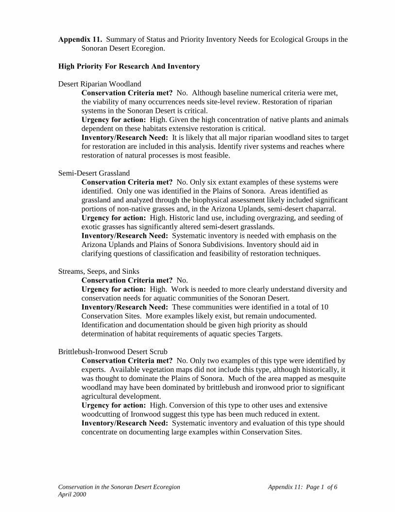
Conservation in the Sonoran Desert Ecoregion Appendix 11: Page 1 of 6April 2000
Appendix 11. Summary of Status and Priority Inventory Needs for Ecological Groups in theSonoran Desert Ecoregion.
High Priority For Research And Inventory
Desert Riparian WoodlandConservation Criteria met? No. Although baseline numerical criteria were met,the viability of many occurrences needs site-level review. Restoration of ripariansystems in the Sonoran Desert is critical.Urgency for action: High. Given the high concentration of native plants and animalsdependent on these habitats extensive restoration is critical.Inventory/Research Need: It is likely that all major riparian woodland sites to targetfor restoration are included in this analysis. Identify river systems and reaches whererestoration of natural processes is most feasible.
Semi-Desert GrasslandConservation Criteria met? No. Only six extant examples of these systems wereidentified. Only one was identified in the Plains of Sonora. Areas identified asgrassland and analyzed through the biophysical assessment likely included significantportions of non-native grasses and, in the Arizona Uplands, semi-desert chaparral.Urgency for action: High. Historic land use, including overgrazing, and seeding ofexotic grasses has significantly altered semi-desert grasslands.Inventory/Research Need: Systematic inventory is needed with emphasis on theArizona Uplands and Plains of Sonora Subdivisions. Inventory should aid inclarifying questions of classification and feasibility of restoration techniques.
Streams, Seeps, and SinksConservation Criteria met? No.Urgency for action: High. Work is needed to more clearly understand diversity andconservation needs for aquatic communities of the Sonoran Desert.Inventory/Research Need: These communities were identified in a total of 10Conservation Sites. More examples likely exist, but remain undocumented.Identification and documentation should be given high priority as shoulddetermination of habitat requirements of aquatic species Targets.
Brittlebush-Ironwood Desert ScrubConservation Criteria met? No. Only two examples of this type were identified byexperts. Available vegetation maps did not include this type, although historically, itwas thought to dominate the Plains of Sonora. Much of the area mapped as mesquitewoodland may have been dominated by brittlebush and ironwood prior to significantagricultural development.Urgency for action: High. Conversion of this type to other uses and extensivewoodcutting of Ironwood suggest this type has been much reduced in extent.Inventory/Research Need: Systematic inventory and evaluation of this type shouldconcentrate on documenting large examples within Conservation Sites.
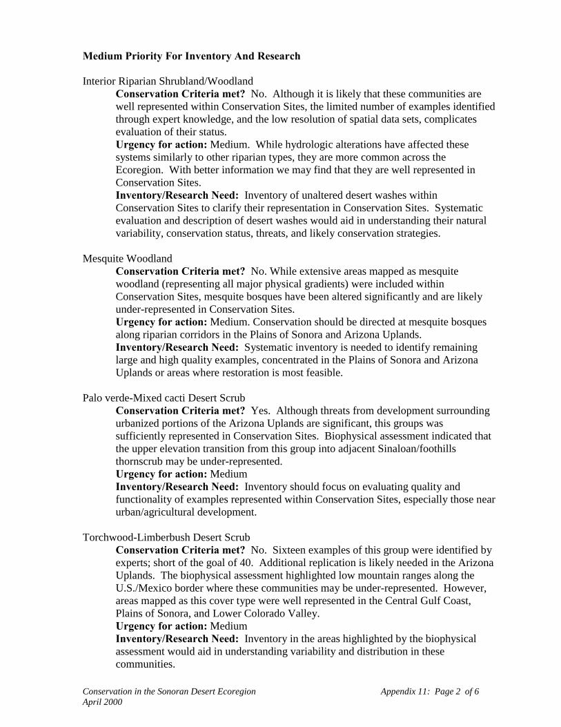
Conservation in the Sonoran Desert Ecoregion Appendix 11: Page 2 of 6April 2000
Medium Priority For Inventory And Research
Interior Riparian Shrubland/WoodlandConservation Criteria met? No. Although it is likely that these communities arewell represented within Conservation Sites, the limited number of examples identifiedthrough expert knowledge, and the low resolution of spatial data sets, complicatesevaluation of their status.Urgency for action: Medium. While hydrologic alterations have affected thesesystems similarly to other riparian types, they are more common across theEcoregion. With better information we may find that they are well represented inConservation Sites.Inventory/Research Need: Inventory of unaltered desert washes withinConservation Sites to clarify their representation in Conservation Sites. Systematicevaluation and description of desert washes would aid in understanding their naturalvariability, conservation status, threats, and likely conservation strategies.
Mesquite WoodlandConservation Criteria met? No. While extensive areas mapped as mesquitewoodland (representing all major physical gradients) were included withinConservation Sites, mesquite bosques have been altered significantly and are likelyunder-represented in Conservation Sites.Urgency for action: Medium. Conservation should be directed at mesquite bosquesalong riparian corridors in the Plains of Sonora and Arizona Uplands.Inventory/Research Need: Systematic inventory is needed to identify remaininglarge and high quality examples, concentrated in the Plains of Sonora and ArizonaUplands or areas where restoration is most feasible.
Palo verde-Mixed cacti Desert ScrubConservation Criteria met? Yes. Although threats from development surroundingurbanized portions of the Arizona Uplands are significant, this groups wassufficiently represented in Conservation Sites. Biophysical assessment indicated thatthe upper elevation transition from this group into adjacent Sinaloan/foothillsthornscrub may be under-represented.Urgency for action: MediumInventory/Research Need: Inventory should focus on evaluating quality andfunctionality of examples represented within Conservation Sites, especially those nearurban/agricultural development.
Torchwood-Limberbush Desert ScrubConservation Criteria met? No. Sixteen examples of this group were identified byexperts; short of the goal of 40. Additional replication is likely needed in the ArizonaUplands. The biophysical assessment highlighted low mountain ranges along theU.S./Mexico border where these communities may be under-represented. However,areas mapped as this cover type were well represented in the Central Gulf Coast,Plains of Sonora, and Lower Colorado Valley.Urgency for action: MediumInventory/Research Need: Inventory in the areas highlighted by the biophysicalassessment would aid in understanding variability and distribution in thesecommunities.

Conservation in the Sonoran Desert Ecoregion Appendix 11: Page 3 of 6April 2000
Interior Riparian MarshConservation Criteria met? No. Eleven examples of communities within thisgroup were identified; short of the goal of 20. However, it is likely that additionalundocumented examples are located within Conservation Sites.Urgency for action: Medium. Like aquatic communities, all wetland communities inthis desert Ecoregion are ecologically significant.Inventory/Research Need: Inventory should focus within identified ConservationSites. Research to enhance understanding of hydrologic processes would aid site-levelconservation management.
Coastal MarshConservation Criteria met? Yes. Twelve examples, with a baseline goal of 20,were located within conservation sites. It appears that the most/all functional coastalmarshes remaining in the ecoregion were included within Conservation Sites.However, additional work is needed to clarify the status and restorability of estuarinemarsh systems in the Colorado River delta.Urgency for action: MediumInventory/Research Need: No additional inventory is needed. Research into thehydrologic regimes and restoration techniques for these systems would aid in site-level conservation management.
Coastal DunesConservation Criteria met? Yes. Most coastal dunes occur within ConservationSites identified in northern Sonora.Urgency for action: Medium. Coastal development is beginning to encroach upondune systems.Inventory/Research Need: Most locations of coastal dunes are known, though thecurrent status is less well known. Sand sources of active dunes within ConservationSites should be assessed to determine if artificial barriers have been established.Invasive, introduced plant species should be identified and evaluated for feasibility ofprevention, control, or eradication.
California Fan Palm OasisConservation Criteria met? Yes. Nearly all (82) known examples of thesecommunities were identified and included within Conservation Sites.Urgency for action: MediumInventory/Research Need: No new inventory is needed at this time. Betterunderstanding of common threats to these communities (hydrologic alterations, fires)would aid in site-level management.
Saltbush Desert ScrubConservation Criteria met? No. Only eight examples of these communities wereidentified by experts. However, where this cover type was mapped in the LowerColorado River Valley and Central Gulf Coast, a high percentage was captured inConservation Sites.Urgency for action: Medium
Conservation in the Sonoran Desert Ecoregion Appendix 11: Page 4 of 6April 2000
Inventory/Research Need: Systematic inventory of these communities would helpto clarify variability and distribution in the Ecoregion and remaining high qualityexamples that have not been modified through grazing.
Low Priority For Inventory And Research
Agave-Bursage Desert ScrubConservation Criteria met? Yes. This group is primarily found on the Bajapeninsula, with limited examples in the Central Gulf Coast Subdivision. Noexamples were identified by experts, but a high percentage of this type was identifiedwithin Conservation Sites through the biophysical assessment.Urgency for action: LowInventory/Research Need: Low
Interior Dunes and PlainsConservation Criteria met? No. The distribution of active/stabilized desert dunesand desert pavements is highly skewed towards the Lower Colorado River Valley,where they are well represented with Conservation Sites. However, none of theselandscapes were identified within Conservation Sites in the Plains of Sonora.Urgency for action: Low. It is likely that undocumented dune fields and desertpavement exist within Conservation Sites identified for the Plains of Sonora.Inventory/Research Need: Additional land cover mapping would aid in identifyingactive dunes, stabilized dunes, and desert pavement areas outside of the LowerColorado River Valley, particularly in the Plains of Sonora. Sand sources of activedunes within Conservation Sites should be assessed to determine if artificial barriershave been established. Invasive, introduced plant species should be identified andevaluated for feasibility of prevention, control, or eradication.
Bedrock Shore/Sea Cave,Conservation Criteria met? Yes. It is likely that most occurrences of theseuncommon communities are included within Conservation Sites.Urgency for action: Low. No known threats to these communities.Inventory/Research Need: Systematic inventory and description of characteristicplants (vascular and non-vascular) and animals. Systematic inventory should shedlight on any threats.
Sonora/Mojave Bedrock OutcropConservation Criteria met? No. Although it is likely that a wide range of small-medium sized bedrock outcrops of diverse substrate types have been included withinConservation Sites.Urgency for action: Low. No known threat to these communities.Inventory/Research Need: Systematic inventory and description of characteristicplants (vascular and non-vascular) and animals. Development of a detailed surficialgeology map for the Ecoregion would be valuable for biophysical assessment.Systematic inventory of these communities should shed light on any threats to sites.
Sonora/Mojave Desert PlayaConservation Criteria met? No. Although many small playas are likelyrepresented within the largest Conservation Sites on flat topography.

Conservation in the Sonoran Desert Ecoregion Appendix 11: Page 5 of 6April 2000
Urgency for action: Low, per comments above.Inventory/Research Need: Systematic inventory of playa lakebeds throughout theArizona Uplands, Central Gulf Coast, and Plains of Sonora is of medium priority.Clarifying the plant (vascular and non-vascular) and animal composition amongSonoran Desert playas. Threats to these systems remain unclear but would likely beidentified through inventory and research.
Coastal Mangrove ForestConservation Criteria met? Yes. All mangrove swamps were included withinConservation Sites.Urgency for action: LowInventory/Research Need: No additional inventory is needed within the Ecoregion.Research into the hydrologic regimes and restoration techniques for these systemswould aid in site-level conservation management.
Creosote-Bursage Desert ScrubConservation Criteria met? Yes. However, 30 examples were identified by experts.The biophysical assessment further clarified the extent to which these communitieswere represented indicating that 25% of historic areal extent was represented withinConservation Sites in the Arizona Uplands (Conservation Criteria was 30%). Thismay reflect extent of urban and agricultural development in low elevation areas of theAZ Uplands. Creosote-bursage communities were well represented in other SonoranDesert Subdivisions (e.g., 43% of the Lower Colorado River Valley).Urgency for action: LowInventory/Research Need: No additional inventory is needed at this time.
Mojave Desert ShrublandConservation Criteria met? No. Three examples of these communities wereidentified by experts. However, since these communities were not represented onvegetation maps, it is difficult to evaluate the likely extent of Mojave Desertshrubland extending south into this Ecoregion. It is likely that the majority of thistype was captured within the Conservation Sites identified in California.Urgency for action: LowInventory/Research Need: No inventory is needed at this time. Classification ofthese communities would aid in evaluating the variation between examples in theSonoran Desert and Mojave Desert Ecoregions.

Conservation in the Sonoran Desert Ecoregion Appendix 11: Page 6 of 6April 2000
Sinaloan/Foothills ThornscrubConservation Criteria met? Yes. Three examples of these communities wereidentified by experts. This peripheral group was adequately represented inConservation Sites based on expert input and the biophysical assessment.Urgency for action: LowInventory/Research Need: Systematic inventory, to support classificationdevelopment, should be conducted across the range of these types. Classification ofthornscrub types, as they extend south into adjacent Ecoregions, would aid inclarifying natural variability, conservation status, and management issues.
Interior Chaparral/EncinalConservation Criteria met? Yes. Three examples of these communities wereidentified by experts. This peripheral group was adequately represented inConservation Sites based on expert input and the biophysical assessment.Urgency for action: LowInventory/Research Need: Systematic inventory would support classificationdevelopment of these systems. Research into the natural range of variation and fireregimes in these communities would aid in site-level conservation management.