AN ASSESSMENT OF THE FOREST RESOURCES OF … · little more than an uneasy truce). My biggest fear...
189
AN ASSESSMENT OF THE FOREST RESOURCES OF MASSACHUSETTS Avril L. de la Crétaz 1 , Lena S. Fletcher 1 , Paul E. Gregory 2 , William R. VanDoren 1 , and Paul K. Barten 1 1 University of Massachusetts Amherst Department of Natural Resources Conservation and 2 Massachusetts Department of Conservation and Recreation Prepared for the USDA Forest Service June 2010
Transcript of AN ASSESSMENT OF THE FOREST RESOURCES OF … · little more than an uneasy truce). My biggest fear...
AN ASSESSMENT
OF THE FOREST RESOURCES OF MASSACHUSETTS
Avril L. de la Crétaz1, Lena S. Fletcher1, Paul E. Gregory2,
William R. VanDoren1, and Paul K. Barten1
1 University of Massachusetts Amherst Department of Natural Resources Conservation
and 2 Massachusetts Department of Conservation and Recreation
Prepared for the USDA Forest Service
June 2010

AN ASSESSMENT OF THE FOREST RESOURCES
OF MASSACHUSETTS
Avril L. de la Crétaz1, Lena S. Fletcher1, Paul E. Gregory2, William R. VanDoren1, and Paul K. Barten1
1 University of Massachusetts Amherst
Department of Natural Resources Conservation and
2 Massachusetts Department of Conservation and Recreation
Prepared for the USDA Forest Service
June 2010
An Assessment of the Forest Resources of Massachusetts
Rick Sullivan, Commissioner Massachusetts Department of Conservation and Recreation 251 Causeway Street Boston, MA 02114 617-626-1250 http://www.mass.gov/dcr/ Authors: Avril L. de la Crétaz, Ph.D., Research Assistant Professor, University of Massachusetts Amherst Lena S. Fletcher, M.S., Research Associate, University of Massachusetts Amherst Paul E. Gregory, M.S., Asst. Management Forester, Myles Standish State Forest, Massachusetts Department of Conservation and Recreation William R. VanDoren, Research Assistant, University of Massachusetts Amherst
Paul K. Barten, Ph.D., Professor, University of Massachusetts Amherst, and Chair of the Massachusetts Forestry Committee The development and publication of this document were facilitated by grants from the Massachusetts Department of Conservation and Recreation and the National Association of State Foresters, and in-kind support from the Uni-versity of Massachusetts Amherst, Department of Natural Resources Conservation. The US Department of Agriculture (USDA) prohibits discrimination in all its programs and activities on the basis of race, color, national origin, sex, religion, age, disability, political beliefs, sexual orientation, or marital or family status. (Not all prohibited bases apply to all programs.) Persons with disabilities who require alternative means for communication of program information (Braille, large print, audiotape, etc.) should contact USDA's TARGET Center at (202) 720-2600 (voice and TDD). To file a complaint of discrimination, write USDA, Director, Office of Civil Rights, Room 326-W, Whitten Building, 1400 Independence Avenue. Cover photographs by: Michael Jones (salamander), Lena Fletcher (children and canopy), and the Department of Conservation and Recreation. Section title pages and criterion photographs by Michael Jones (spotted turtle), Paul Barten (various), Lena Fletcher (various), and the Department of Conservation and Recreation (various). Front cover art by Jim Taylor; back cover photo by Paul Barten.
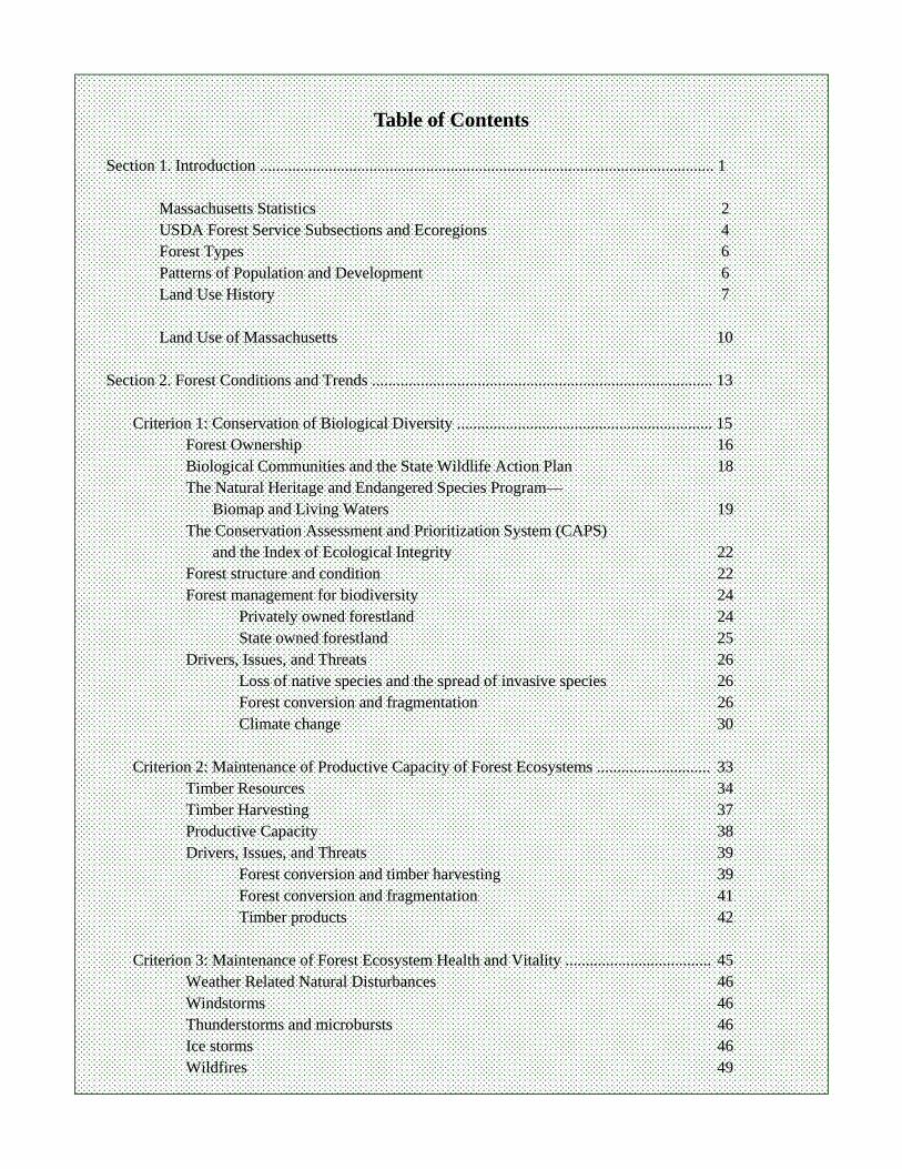
Table of Contents
Section 1. Introduction ................................................................................................................ 1
Massachusetts Statistics 2 USDA Forest Service Subsections and Ecoregions 4 Forest Types 6 Patterns of Population and Development 6 Land Use History 7 Land Use of Massachusetts 10
Section 2. Forest Conditions and Trends .................................................................................... 13
Criterion 1: Conservation of Biological Diversity ............................................................... 15
Forest Ownership 16 Biological Communities and the State Wildlife Action Plan 18 The Natural Heritage and Endangered Species Program—
Biomap and Living Waters 19 The Conservation Assessment and Prioritization System (CAPS)
and the Index of Ecological Integrity 22 Forest structure and condition 22 Forest management for biodiversity 24
Privately owned forestland 24 State owned forestland 25
Drivers, Issues, and Threats 26 Loss of native species and the spread of invasive species 26 Forest conversion and fragmentation 26 Climate change 30
Criterion 2: Maintenance of Productive Capacity of Forest Ecosystems ............................ 33
Timber Resources 34 Timber Harvesting 37 Productive Capacity 38 Drivers, Issues, and Threats 39
Forest conversion and timber harvesting 39 Forest conversion and fragmentation 41 Timber products 42
Criterion 3: Maintenance of Forest Ecosystem Health and Vitality .................................... 45
Weather Related Natural Disturbances 46 Windstorms 46 Thunderstorms and microbursts 46 Ice storms 46 Wildfires 49
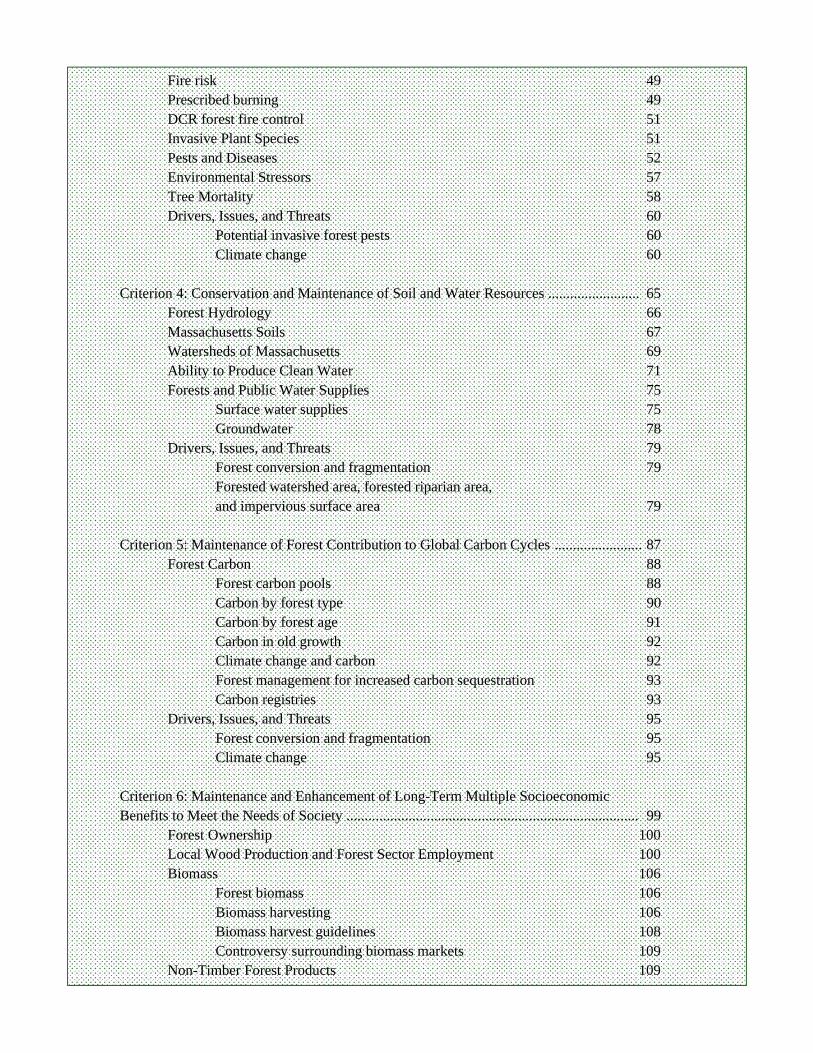
Fire risk 49 Prescribed burning 49 DCR forest fire control 51 Invasive Plant Species 51 Pests and Diseases 52 Environmental Stressors 57 Tree Mortality 58 Drivers, Issues, and Threats 60
Potential invasive forest pests 60 Climate change 60
Criterion 4: Conservation and Maintenance of Soil and Water Resources ......................... 65
Forest Hydrology 66 Massachusetts Soils 67 Watersheds of Massachusetts 69 Ability to Produce Clean Water 71 Forests and Public Water Supplies 75
Surface water supplies 75 Groundwater 78
Drivers, Issues, and Threats 79 Forest conversion and fragmentation 79 Forested watershed area, forested riparian area, and impervious surface area 79
Criterion 5: Maintenance of Forest Contribution to Global Carbon Cycles ........................ 87
Forest Carbon 88 Forest carbon pools 88 Carbon by forest type 90 Carbon by forest age 91 Carbon in old growth 92 Climate change and carbon 92 Forest management for increased carbon sequestration 93 Carbon registries 93
Drivers, Issues, and Threats 95 Forest conversion and fragmentation 95 Climate change 95
Criterion 6: Maintenance and Enhancement of Long-Term Multiple Socioeconomic Benefits to Meet the Needs of Society ................................................................................ 99
Forest Ownership 100 Local Wood Production and Forest Sector Employment 100 Biomass 106
Forest biomass 106 Biomass harvesting 106 Biomass harvest guidelines 108 Controversy surrounding biomass markets 109
Non-Timber Forest Products 109
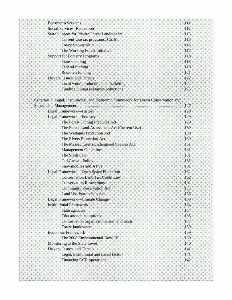
Ecosystem Services 111 Social Services (Recreation) 112 State Support for Private Forest Landowners 115
Current Use tax programs: Ch. 61 115 Forest Stewardship 116 The Working Forest Initiative 117
Support for Forestry Programs 118 State spending 118 Federal funding 119 Research funding 121
Drivers, Issues, and Threats 122 Local wood production and marketing 122
Funding/human resources reductions 123 Criterion 7: Legal, Institutional, and Economic Framework for Forest Conservation and Sustainable Management ..................................................................................................... 127
Legal Framework—History 128 Legal Framework—Forestry 129
The Forest Cutting Practices Act 129 The Forest Land Assessment Act (Current Use) 130 The Wetlands Protection Act 130 The Rivers Protection Act 130 The Massachusetts Endangered Species Act 131 Management Guidelines 131 The Slash Law 131 Old Growth Policy 131 Snowmobiles and ATVs 131
Legal Framework—Open Space Protection 132 Conservation Land Tax Credit Law 132 Conservation Restrictions 132 Community Preservation Act 133 Land Use Partnership Act 133
Legal Framework—Climate Change 133 Institutional Framework 134
State agencies 134 Educational institutions 135 Conservation organizations and land trusts 137 Forest landowners 139
Economic Framework 139 The 2008 Environmental Bond Bill 139
Monitoring at the State Level 140 Drivers, Issues, and Threats 141
Legal, institutional and social factors 141 Financing DCR operations 142
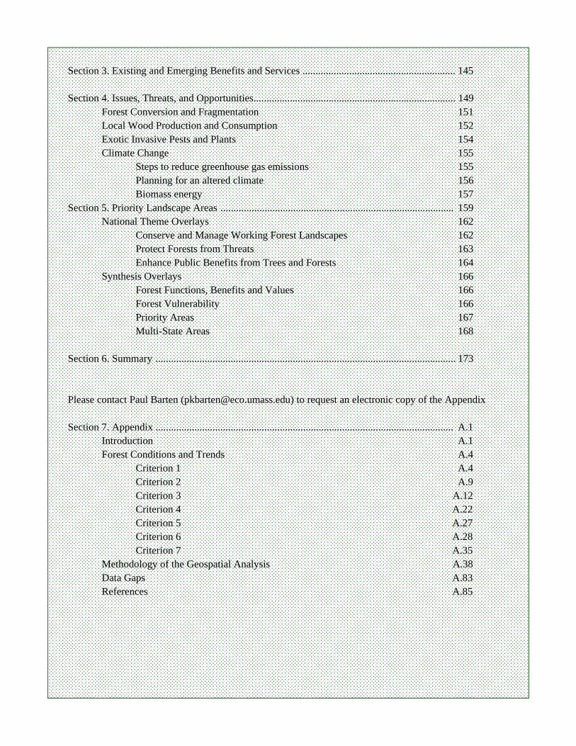
Section 3. Existing and Emerging Benefits and Services ........................................................... 145 Section 4. Issues, Threats, and Opportunities.............................................................................. 149
Forest Conversion and Fragmentation 151 Local Wood Production and Consumption 152 Exotic Invasive Pests and Plants 154 Climate Change 155
Steps to reduce greenhouse gas emissions 155 Planning for an altered climate 156 Biomass energy 157
Section 5. Priority Landscape Areas .......................................................................................... 159 National Theme Overlays 162
Conserve and Manage Working Forest Landscapes 162 Protect Forests from Threats 163 Enhance Public Benefits from Trees and Forests 164
Synthesis Overlays 166 Forest Functions, Benefits and Values 166 Forest Vulnerability 166 Priority Areas 167 Multi-State Areas 168
Section 6. Summary .................................................................................................................... 173 Please contact Paul Barten ([email protected]) to request an electronic copy of the Appendix Section 7. Appendix ................................................................................................................... A.1
Introduction A.1 Forest Conditions and Trends A.4 Criterion 1 A.4 Criterion 2 A.9 Criterion 3 A.12 Criterion 4 A.22 Criterion 5 A.27 Criterion 6 A.28 Criterion 7 A.35 Methodology of the Geospatial Analysis A.38 Data Gaps A.83 References A.85
PREFACE
This report describes and quantifies the remarkable set of functions, benefits, and values that emanate from the forests of Massachusetts. It also discusses a daunting array of drivers, issues, and threats that influence the size, continuity, character, and condition of our forests. The seven sustainability criteria developed by the Ca-nadian Council of Forest Ministers were the framework for this assessment; they highlight the diverse, complex, and inter-connected nature of forests and people in Massachusetts. After the grand successes for forest protection and restoration work in the early-20th century, foresters and planners in the 1950s and 60s gravitated toward the multiple use/sustained yield concept with the goal of “harmonizing” land and resource uses. Naturally, when taken too literally this “all things to all people on every acre” approach to forest management proved to be untenable. It has been supplanted by philosophies and manage-ment paradigms ranging from complete preservation to maximum utilization. Conservation floats back and forth along the very wide spectrum bounded by preservation and utilization. A consensus definition of the term “conservation” is, it seems, as hard to find as a wild, blight-resistant American chestnut. It seems that every per-son and group rehearses a set of working definitions that advances their agenda while bashing the values and atti-tudes of their opponents. Unfortunately, the notion of “the greatest good, for the greatest number, over the long run” is often dis-missed as an anachronism, even though it was the salvation of more than 200 million acres of forests. In the in-creasingly acrimonious debate about forests and forestry in Massachusetts, the idea of harmonizing resource uses (or deliberate protection of some functions) based on a broad and durable consensus borders on laughable. Battles are fought and victory is proclaimed when a conflict over a site or practice is “resolved” (even if the “victory” is little more than an uneasy truce). My biggest fear is that while fighting these pitched battles we are all losing the war of attrition—the permanent conversion of forests to other land uses. What is lost, of course, are the ecosystem services (clean water, clean air, wildlife habitat, biological diversity, renewable natural resources, recreation, aes-thetics, spiritual values, etc., etc.) that most residents of Massachusetts simply take for granted. They are not all irreplaceable; if you are willing to spend enough money you can clean water or air up to the forest standard. Of course, that money is no longer available for education, health care, transportation improvements, public safety, the arts, or anything else that society needs or values. We have worked on this assessment with the fervent hope that detailed, objective information about the forest resources of Massachusetts—as a whole—will focus the attention of those who care about forests and for-estry in Massachusetts on finding common ground, setting priorities, and working cooperatively to conserve for-ests for the greatest good, of the greatest number, over the long run. We also hope this information will energize more people. We hope it will inspire and help to guide decisive, goal-oriented leadership across the state, at every level of government. The window of opportunity is closing. We can argue about how forests should be managed later …as long as there are still high value forests left to manage. Over the past 20 years, it has been my experience (especially in recent years as a project leader or com-mittee chair) that there comes a time during every major study when you ask yourself …how in the world are we going to get this done? If you are very fortunate four things happen with a modest amount of direction, guidance, and encouragement. First, you are able to assemble a core team that is comprised of people who are exceptionally well-prepared, self-motivated, dependable, collegial, and productive. Second, with their help you are able to as-semble an advisory group that adds breadth, depth, specialized knowledge, and wide-ranging experience to the enterprise. (The members of our Advisory Group are listed on the next page. Thank you all for your dedicated service.) Third, at an early stage in the project both the core team and the advisory group recognize the impor-tance and potential influence of the work and push themselves to achieve the best possible result. Finally, some-thing akin to alchemy takes over and in the process of pushing themselves and helping each other the determina-tion of the entire group to deliver the best possible product grows exponentially—just when “normal people” would settle for “good enough.” In practice, “good enough” has a shelf life of about three to six months, if that.
My co-authors—Avril de la Crétaz, Lena Fletcher, Paul Gregory, and William VanDoren—are the ex-traordinary people, with the character traits noted above, whose dedication to the conservation and stewardship of the forest resources of Massachusetts is reflected in this assessment report. I could not have been more fortu-nate—thank you all. The greatest beneficiary of their work is the Commonwealth of Massachusetts at a time when clear and objective information is needed to build public awareness, inspire leadership, and guide critical, time-sensitive decisions to conserve the forests that sustain the millions of people. Paul K. Barten Amherst, Massachusetts June 2010
ACKNOWLEDGEMENTS
We would like to thank all the people who helped with this project. We are very grateful to the members of our Advisory Committee, listed below who assisted us in numerous ways. We would also like to thank Jim Taylor Massachusetts Department of Conservation and Recreation (DCR), Doug Leab (DCR finances), and Sherri Wormstead and Tom Luther, USDA Forest Service, Northeastern Area State and Private Forestry, Durham, N.H. To all of you who attended meetings, answered questions, found resources and photographs, and reviewed our numerous drafts, thank you.
Massachusetts Forest Resources Assessment Advisory Group
Eric Seaborn, Massachusetts DCR, Urban Forestry (Chair) Taber Allison, Massachusetts Audubon Society Steve Anderson, Massachusetts DCR, Division of Water Supply Protection Gordon Boyce, Massachusetts DCR, Marketing and Utilization Charles Burnham, Massachusetts DCR, Forest Health David Celino, Massachusetts DCR, Forest Fire Control Jeff Daley, Massachusetts DCR, Aide to Commissioner Sullivan Michael Downey, Massachusetts DCR, Forest Stewardship Jennifer Fish, Massachusetts DCR, Service Forestry Michael Fleming, Massachusetts DCR, Forest Legacy Ken Gooch, Massachusetts DCR, Forest Health Rachel Harris, The Urban Ecology Institute William Hill, Massachusetts DCR, Public Lands Management Jacob Kubel, Massachusetts Natural Heritage and Endangered Species Program Thomas Kyker-Snowman, Massachusetts DCR, Division of Water Supply Protection William Labich, Highstead/Harvard Forest, Wildlands and Woodlands Project Laura Marx, The Nature Conservancy Craig Nicolson, University of Massachusetts Amherst Robert O’Connor, Massachusetts Executive Office of Energy and Environmental Affairs Thomas O’Shea, Massachusetts Division of Fish and Wildlife Chris Pryor, New England Forestry Foundation and Massachusetts Chapter of the Society of American Foresters Franklin Reece, The Urban Ecology Institute Robert Rizzo, Massachusetts Department of Energy Resources Alan Snow, Massachusetts DCR, Urban Forestry Bruce Spencer, Forest Guild Suzanne Webber, Massachusetts Woodlands Cooperative Margaret Weeks, USDA Forest Service, Durham, NH Michael Bohne, USDA Forest Service, Durham, NH We are also grateful to the Massachusetts Forest Stewardship Coordinating Committee, the USDA Natural Re-sources Conservation Services State Technical Committee, the US Fish and Wildlife Service, and the National Park Service, to whom the project documents were provided for review and comment.
Introduction


- 1 -
Quabbin forest stand depicting the management objective of generating age class and species diversity. DWSP
Introduction.
Massachusetts Background Information
INTRODUCTION CONTENTS: Massachusetts Statistics USDA Forest Service Subsections and Ecoregions Forest Types Patterns of Population and Development Land Use History
INTRODUCTION The Commonwealth of Massachusetts is one of the
smallest and most densely populated states in the nation (Table 1). It also has the eighth highest percentage of forest-land and several regions that are renowned for their biodiver-sity (Table 1). One of the first sites of European settlement in North America, Massachusetts has undergone a long history of land use change, with widespread forest clearing through-out much of the nineteenth century. A strong tradition of broad-based support for the conservation of forests and the natural world developed concurrently, inspired in part by the writings of Massachusetts native Henry David Thoreau.

- 2 -
An Assessment of the Forest Resources of Massachusetts 2010
Massachusetts Statistics Massachusetts has a wide variety of forest habitats arising from substantial variations in topography, bed-
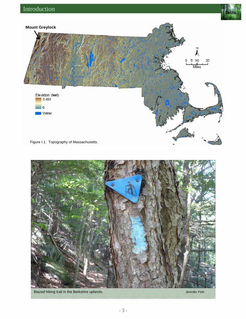
rock and surficial geology, soils, and climate. Elevations range from sea level at the coast to 3,491 feet at the summit of Mount Greylock in the western part of the state in the Taconic Mountains subsection (Figure I.1). The diverse topography of the state is the result of its complex geologic history involving multiple tectonic plate colli-sions over a period from 1.2 billion to 200 million years ago. These collisions created a series of north-south mountain ranges as the North American continent collided with other continents and volcanic island chains; each collision resulted in the accretion of new bedrock material to the continental core. These ancient mountain ranges have since eroded away leaving the hills and low mountains that define the landscape today. Variations in bed-rock composition also are the result of the region’s geologic history. While most of the bedrock underlying the state is acidic, there are substantial areas of calcareous bedrock, consisting of limestone and marble, most notably in the western part of the state in the western New England Marble Valley. Additional calcareous deposits are present in the eastern Berkshire foothills. These limestone and marble deposits originated as carbonate material in coral reefs. The reefs were pushed up against the continental basement rock as North American collided with a chain of offshore volcanic islands, during the Taconic Mountain building event, 450 million years ago (Skehan, 2001).
Soils in Massachusetts formed from surficial deposits left during repeated episodes of glaciation. Moun-tains of ice have advanced from the north, scraping away existing material and retreated, leaving massive amounts of debris behind (glacial drift). The most recent glacial retreat occurred between 21,000 and 12,000 years ago. The Massachusetts uplands were left covered with thick deposits of poorly sorted glacial till. In low-lying areas, well-sorted sands and gravels were deposited on the shores of ancient glacial lakes by fast flowing glacial melt waters, while clays accumulated in the lake beds. Sandy outwash deposits are prevalent today in several areas including the valleys of the Connecticut, Housatonic, Hoosic, and Ware Rivers. Deep sands also cover areas of the eastern Coastal Plain, Cape Cod and the Islands. More recent alluvial deposits are found in river floodplains. There are climate variations from east to west and in a less pronounced fashion from north to south. Higher eleva-tions in the central uplands and in western Massachusetts have lower temperatures, shorter growing seasons and more precipitation. The climate in the Connecticut River valley and Marble valley is more similar to the eastern part of the state than to the neighboring Berkshire Uplands and Taconic Mountains (Hall et al., 2002).
1Area: US Census Bureau; Population: US Census, 2000; estimated population in 2008 was 6,497,967. 2MassGIS, 2009a (includes forested wetlands). 3Alerich, 2000.
Table I.1. Massachusetts statistics.
Massachusetts Profile: Land and Population Area and Population estimates Ranking among
the 50 states
Total Area (acres) 6,755,000 44
Total Land Area (acres)1 5,018,000 45
Population1 6,349,000 15
Population Density (people/mi2) 810 3
Forestland Area (acres)2 3,187,000 NA
Percent Forestland 63 % 83
Introduction Intro.
- 3 -
Figure I.1. Topography of Massachusetts.
Blazed hiking trail in the Berkshire uplands. Jennifer Fish
Mount Greylock
- 4 -
An Assessment of the Forest Resources of Massachusetts 2010
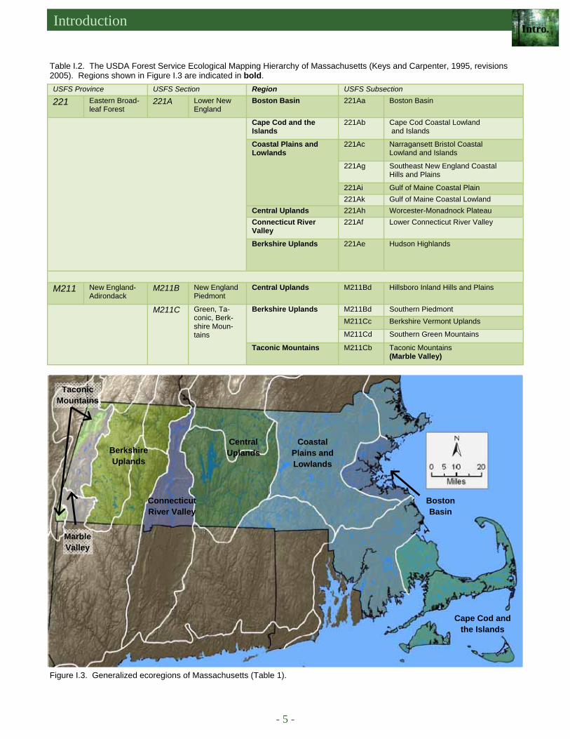
Figure I.2. Ecological subsections (ecoregions) of Massachusetts (Keys and Carpenter, 1995, revisions 2005).
USDA FOREST SERVICE SUBSECTIONS AND ECOREGIONS
Massachusetts falls within two USDA Forest Service Ecological Provinces: the Eastern Broadleaf Forest Province and the New England Adirondack Prov-ince (Keys and Carpenter, 1995). At finer scales, under the USFS ecoregional mapping system, these Provinces are subdivided into three sections and 14 different sub-sections (Figure I.2 and Table I.2). Figure I.3 shows these subsections grouped into major ecological regions that are commonly recognized by ecologists and forest-ers within the state (O’Keefe and Foster, 1998a). These regions will be used in this report to summarize varia-tions in forest condition across the state. The western New England Marble Valley, which is part of the Ta-conic Mountains subsection, has been recognized as a separate region because of its unique geological and biological characteristics. The Stockbridge Marble bed-rock formation underlies most of the Marble Valley. Nutrient-rich, calcareous soils cover much of the area, which also includes the Hoosic and Housatonic River valleys. The Marble Valley has rare habitats, unique ecological communities, and high biodiversity (Swain and Kearsley, 2000; Weatherbee, 1996).
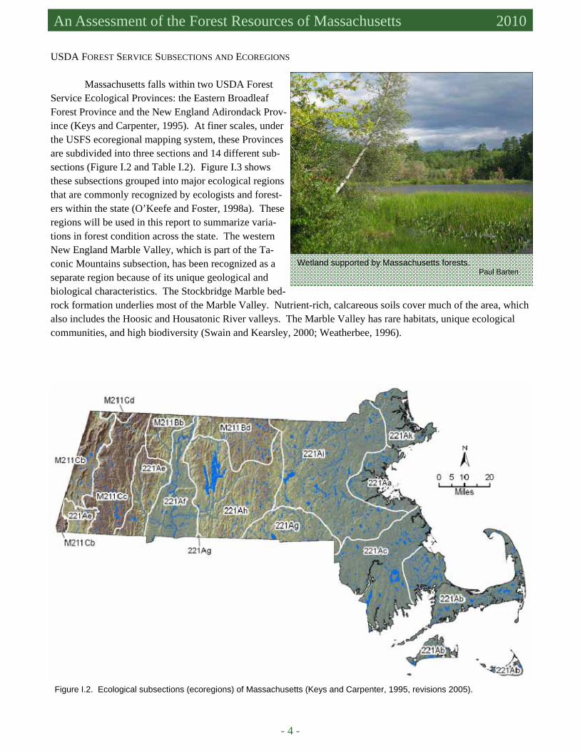
Wetland supported by Massachusetts forests. Paul Barten
Introduction Intro.
- 5 -
Table I.2. The USDA Forest Service Ecological Mapping Hierarchy of Massachusetts (Keys and Carpenter, 1995, revisions 2005). Regions shown in Figure I.3 are indicated in bold. USFS Province USFS Section Region USFS Subsection 221 Eastern Broad-
leaf Forest 221A Lower New
England Boston Basin 221Aa Boston Basin
Cape Cod and the Islands
221Ab Cape Cod Coastal Lowland and Islands
Coastal Plains and Lowlands
221Ac Narragansett Bristol Coastal Lowland and Islands
221Ag Southeast New England Coastal Hills and Plains
221Ai Gulf of Maine Coastal Plain 221Ak Gulf of Maine Coastal Lowland
Central Uplands 221Ah Worcester-Monadnock Plateau Connecticut River Valley
221Af Lower Connecticut River Valley
Berkshire Uplands
221Ae Hudson Highlands
M211 New England-
Adirondack M211B New England
Piedmont Central Uplands M211Bd Hillsboro Inland Hills and Plains
M211C Green, Ta-conic, Berk-shire Moun-tains
Berkshire Uplands
M211Bd Southern Piedmont M211Cc Berkshire Vermont Uplands M211Cd Southern Green Mountains
Taconic Mountains M211Cb Taconic Mountains (Marble Valley)
Figure I.3. Generalized ecoregions of Massachusetts (Table 1).
Taconic Mountains
Berkshire Uplands
Connecticut River Valley
Central Uplands
Coastal Plains and Lowlands
Boston Basin
Marble Valley
Cape Cod and the Islands
- 6 -
An Assessment of the Forest Resources of Massachusetts 2010
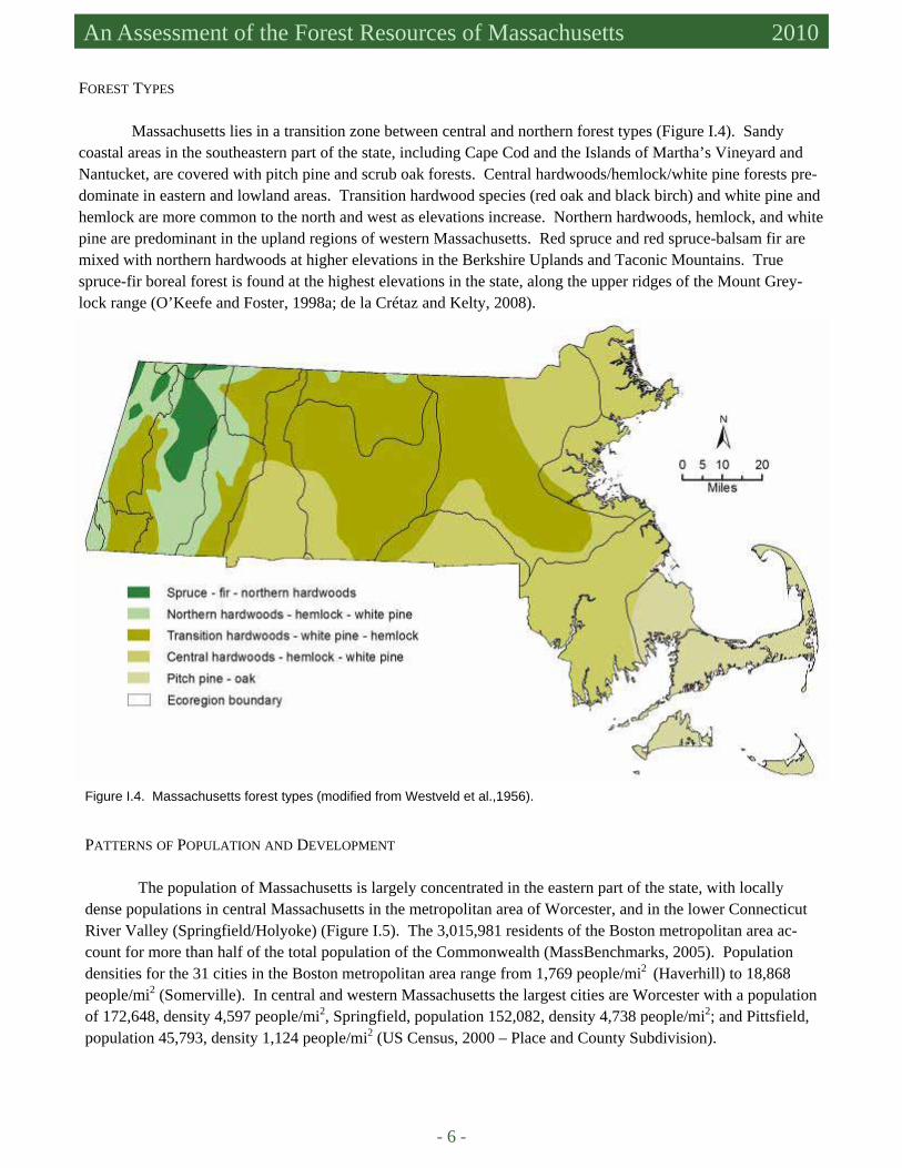
FOREST TYPES Massachusetts lies in a transition zone between central and northern forest types (Figure I.4). Sandy coastal areas in the southeastern part of the state, including Cape Cod and the Islands of Martha’s Vineyard and Nantucket, are covered with pitch pine and scrub oak forests. Central hardwoods/hemlock/white pine forests pre-dominate in eastern and lowland areas. Transition hardwood species (red oak and black birch) and white pine and hemlock are more common to the north and west as elevations increase. Northern hardwoods, hemlock, and white pine are predominant in the upland regions of western Massachusetts. Red spruce and red spruce-balsam fir are mixed with northern hardwoods at higher elevations in the Berkshire Uplands and Taconic Mountains. True spruce-fir boreal forest is found at the highest elevations in the state, along the upper ridges of the Mount Grey-lock range (O’Keefe and Foster, 1998a; de la Crétaz and Kelty, 2008).
Figure I.4. Massachusetts forest types (modified from Westveld et al.,1956).
PATTERNS OF POPULATION AND DEVELOPMENT
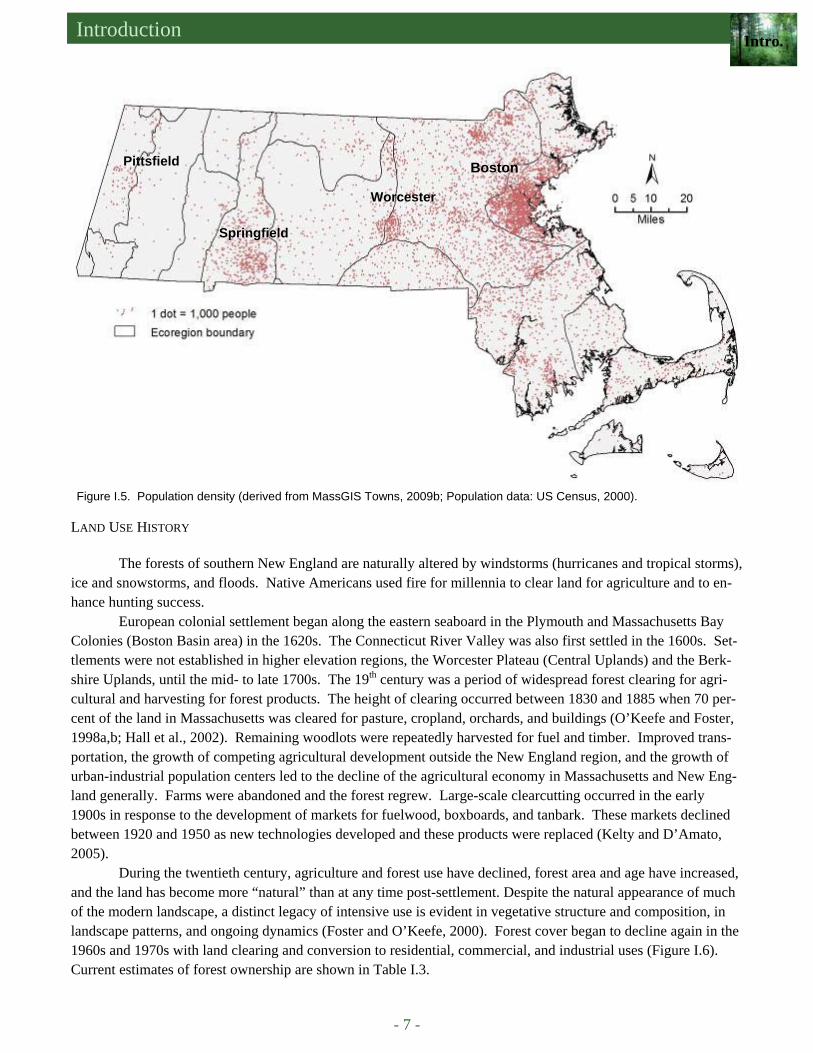
The population of Massachusetts is largely concentrated in the eastern part of the state, with locally dense populations in central Massachusetts in the metropolitan area of Worcester, and in the lower Connecticut River Valley (Springfield/Holyoke) (Figure I.5). The 3,015,981 residents of the Boston metropolitan area ac-count for more than half of the total population of the Commonwealth (MassBenchmarks, 2005). Population densities for the 31 cities in the Boston metropolitan area range from 1,769 people/mi2 (Haverhill) to 18,868 people/mi2 (Somerville). In central and western Massachusetts the largest cities are Worcester with a population of 172,648, density 4,597 people/mi2, Springfield, population 152,082, density 4,738 people/mi2; and Pittsfield, population 45,793, density 1,124 people/mi2 (US Census, 2000 – Place and County Subdivision).
Introduction Intro.
- 7 -
LAND USE HISTORY
The forests of southern New England are naturally altered by windstorms (hurricanes and tropical storms), ice and snowstorms, and floods. Native Americans used fire for millennia to clear land for agriculture and to en-hance hunting success.
European colonial settlement began along the eastern seaboard in the Plymouth and Massachusetts Bay Colonies (Boston Basin area) in the 1620s. The Connecticut River Valley was also first settled in the 1600s. Set-tlements were not established in higher elevation regions, the Worcester Plateau (Central Uplands) and the Berk-shire Uplands, until the mid- to late 1700s. The 19th century was a period of widespread forest clearing for agri-cultural and harvesting for forest products. The height of clearing occurred between 1830 and 1885 when 70 per-cent of the land in Massachusetts was cleared for pasture, cropland, orchards, and buildings (O’Keefe and Foster, 1998a,b; Hall et al., 2002). Remaining woodlots were repeatedly harvested for fuel and timber. Improved trans-portation, the growth of competing agricultural development outside the New England region, and the growth of urban-industrial population centers led to the decline of the agricultural economy in Massachusetts and New Eng-land generally. Farms were abandoned and the forest regrew. Large-scale clearcutting occurred in the early 1900s in response to the development of markets for fuelwood, boxboards, and tanbark. These markets declined between 1920 and 1950 as new technologies developed and these products were replaced (Kelty and D’Amato, 2005).
During the twentieth century, agriculture and forest use have declined, forest area and age have increased, and the land has become more “natural” than at any time post-settlement. Despite the natural appearance of much of the modern landscape, a distinct legacy of intensive use is evident in vegetative structure and composition, in landscape patterns, and ongoing dynamics (Foster and O’Keefe, 2000). Forest cover began to decline again in the 1960s and 1970s with land clearing and conversion to residential, commercial, and industrial uses (Figure I.6). Current estimates of forest ownership are shown in Table I.3.
Figure I.5. Population density (derived from MassGIS Towns, 2009b; Population data: US Census, 2000).
Springfield
Worcester
Pittsfield Boston
- 8 -
An Assessment of the Forest Resources of Massachusetts 2010
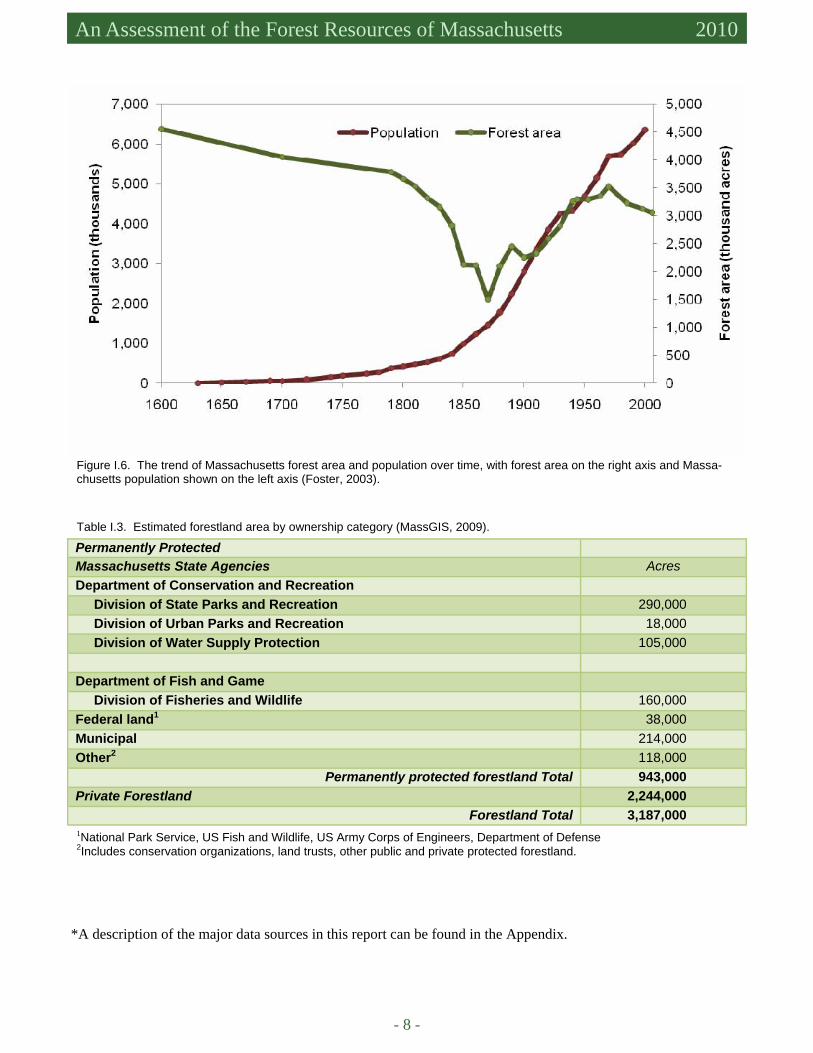
Figure I.6. The trend of Massachusetts forest area and population over time, with forest area on the right axis and Massa-chusetts population shown on the left axis (Foster, 2003).
Table I.3. Estimated forestland area by ownership category (MassGIS, 2009).
Permanently Protected Massachusetts State Agencies Acres Department of Conservation and Recreation Division of State Parks and Recreation 290,000 Division of Urban Parks and Recreation 18,000 Division of Water Supply Protection 105,000 Department of Fish and Game Division of Fisheries and Wildlife 160,000 Federal land1 38,000 Municipal 214,000 Other2 118,000
Permanently protected forestland Total 943,000 Private Forestland 2,244,000
Forestland Total 3,187,000 1National Park Service, US Fish and Wildlife, US Army Corps of Engineers, Department of Defense 2Includes conservation organizations, land trusts, other public and private protected forestland.
*A description of the major data sources in this report can be found in the Appendix.
Introduction Intro.
- 9 -
References Alerich. C.L. 2000. Forest Statistics for Massachusetts: 1985 and 1998. Research Bulletin NE-148. USDA Forest Service,
Northeastern Research Station. de la Crétaz, A.L. and M.J. Kelty. 2008. Land Type Associations of Western Massachusetts. Unpublished Report. USDA
Forest Service, Northeastern Area State and Private Forestry, Durham, NH, 108 pp. Foster, D.R. and J.F. O’Keefe. 2000. New England Forests Through Time: Insights from the Harvard Forest Dioramas. Har-
vard Forest, Petersham, MA. Distributed by the Harvard University Press, Cambridge, MA. 67 pp. Foster, D.R. 2003. Forest change and human populations in New England. Harvard Forest Dataset HF013. Available at http://
harvardforest.fas.harvard.edu. Accessed in January 2010. Hall, B., G. Motzkin, D.R. Foster, M. Syfert, and J. Burk. 2002. Three hundred years of forest and land-use change in Massa-
chusetts, USA. Journal of Biogeography 29: 1319-1335. Kelty, M.J. and A.W. D’Amato. 2005. Historical perspective on diameter-limit cutting in northeastern forests. In: Kenefic,
L.S. and R.D. Nyland, editors. Proceedings of the conference on diameter-limit cutting in northeastern forests. USDA Forest Service General Technical Report NE-341, pp. 3-15.
Keys, J.E. Jr. and C.A. Carpenter. Ecological Units of the Eastern United States: First Approximation (with revisions, Car-penter 2005). USDA Forest Service.
MassBenchmarks. 2005. Boston Metro Region. Available at http://www.massbenchmarks.org/regions/boston.htm. Accessed in January 2010.
MassGIS (Office of Geographic and Environmental Information, Commonwealth of Massachusetts, Executive Office of En-ergy and Environmental Affairs). 2009a. Land Use 2005. Available at http://www.mass.gov/mgis/. Accessed in Janu-ary 2010.
MassGIS (Office of Geographic and Environmental Information, Commonwealth of Massachusetts, Executive Office of En-ergy and Environmental Affairs). 2009b. Community Boundaries, Towns. Available at http://www.mass.gov/mgis/. Accessed in January 2010.
O’Keefe, J.F. and D.R. Foster. 1998a. An ecological history of Massachusetts forests. In C.W. Foster (Editor) Stepping Back to Look Forward: a History of the Massachusetts Forest, pp.19-66.
O’Keefe, J.F. and D.R. Foster. 1998(b). An ecological history of Massachusetts forests. Arnoldia 58(2). Skehan, J.W. 2001. Roadside Geology of Massachusetts Mountain Press Publishing Company, Missoula MT, 378 pp. Swain, P. C. and J.B. Kearsley. 2000. Classification of Natural Communities of Massachusetts (Draft). Natural Heritage &
Endangered Species Program, Massachusetts Division of Fisheries and Wildlife, Westborough, MA. US Census. 2000. Available at http://factfinder.census.gov. Accessed in January 2010. US Census. 2000. Place and County subdivision. Available at http://factfinder.census.gov/servlet/GCTTable?
ds_name=DEC_2000_SF1_U&geo_id=04000US25&_box_head_nbr=GCT-PH1&format=ST-7. Accessed in Janu-ary 2010.
Weatherbee, P.B. 1996. Flora of Berkshire County. The Berkshire Museum, Pittsfield, MA.123 pp. Westveld, M., R.I. Ashman, H.I. Baldwin, R.P. Holdsworth, R.S. Johnson, J.H. Lambert, H.J. Lutz, L. Swain, and M. Stan-
dish. 1956. Natural forest vegetation zones of New England. J. Forest. 54:332–338.
- 10 -
An Assessment of the Forest Resources of Massachusetts 2010
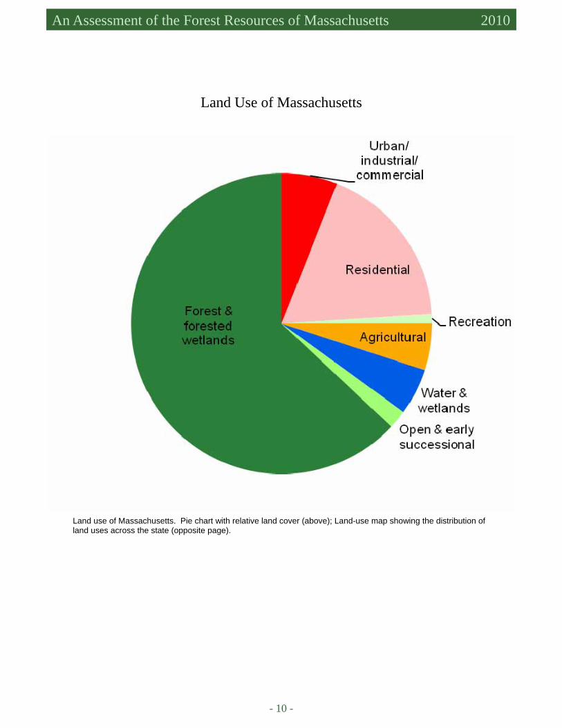
Land use of Massachusetts. Pie chart with relative land cover (above); Land-use map showing the distribution of land uses across the state (opposite page).
Land Use of Massachusetts

- 11 -

- 12 -

- 13 -
Forest Conditions and Trends

- 14 -
- 15 -
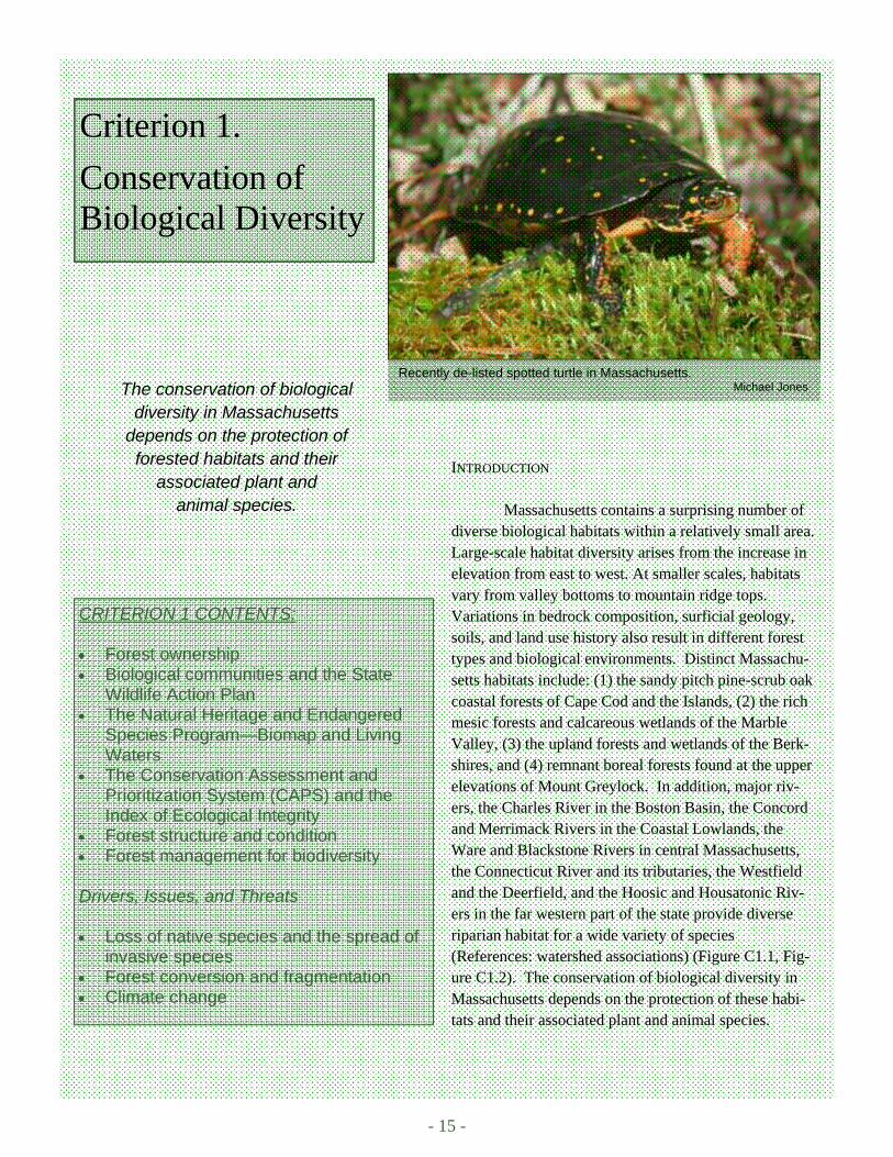
Recently de-listed spotted turtle in Massachusetts. Michael Jones
Criterion 1.
Conservation of Biological Diversity
CRITERION 1 CONTENTS: • Forest ownership • Biological communities and the State
Wildlife Action Plan • The Natural Heritage and Endangered
Species Program—Biomap and Living Waters
• The Conservation Assessment and Prioritization System (CAPS) and the Index of Ecological Integrity
• Forest structure and condition • Forest management for biodiversity Drivers, Issues, and Threats • Loss of native species and the spread of
invasive species • Forest conversion and fragmentation • Climate change
INTRODUCTION
Massachusetts contains a surprising number of diverse biological habitats within a relatively small area. Large-scale habitat diversity arises from the increase in elevation from east to west. At smaller scales, habitats vary from valley bottoms to mountain ridge tops. Variations in bedrock composition, surficial geology, soils, and land use history also result in different forest types and biological environments. Distinct Massachu-setts habitats include: (1) the sandy pitch pine-scrub oak coastal forests of Cape Cod and the Islands, (2) the rich mesic forests and calcareous wetlands of the Marble Valley, (3) the upland forests and wetlands of the Berk-shires, and (4) remnant boreal forests found at the upper elevations of Mount Greylock. In addition, major riv-ers, the Charles River in the Boston Basin, the Concord and Merrimack Rivers in the Coastal Lowlands, the Ware and Blackstone Rivers in central Massachusetts, the Connecticut River and its tributaries, the Westfield and the Deerfield, and the Hoosic and Housatonic Riv-ers in the far western part of the state provide diverse riparian habitat for a wide variety of species (References: watershed associations) (Figure C1.1, Fig-ure C1.2). The conservation of biological diversity in Massachusetts depends on the protection of these habi-tats and their associated plant and animal species.
The conservation of biological diversity in Massachusetts
depends on the protection of forested habitats and their
associated plant and animal species.
- 16 -
An Assessment of the Forest Resources of Massachusetts 2010
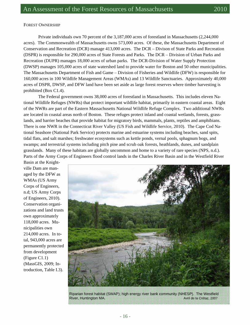
Riparian forest habitat (SWAP); high energy river bank community (NHESP). The Westfield River, Huntington MA. Avril de la Crétaz, 2007
FOREST OWNERSHIP
Private individuals own 70 percent of the 3,187,000 acres of forestland in Massachusetts (2,244,000 acres). The Commonwealth of Massachusetts owns 573,000 acres. Of these, the Massachusetts Department of Conservation and Recreation (DCR) manage 413,000 acres. The DCR – Divison of State Parks and Recreation (DSPR) is responsible for 290,000 acres of State Forests and Parks. The DCR – Division of Urban Parks and Recreation (DUPR) manages 18,000 acres of urban parks. The DCR-Division of Water Supply Protection (DWSP) manages 105,000 acres of state watershed land to provide water for Boston and 50 other municipalities. The Massachusetts Department of Fish and Game – Division of Fisheries and Wildlife (DFW) is responsible for 160,000 acres in 100 Wildlife Management Areas (WMAs) and 13 Wildlife Sanctuaries. Approximately 40,000 acres of DSPR, DWSP, and DFW land have been set aside as large forest reserves where timber harvesting is prohibited (Box C1.4).
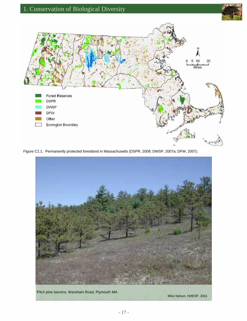
The Federal government owns 38,000 acres of forestland in Massachusetts. This includes eleven Na-tional Wildlife Refuges (NWRs) that protect important wildlife habitat, primarily in eastern coastal areas. Eight of the NWRs are part of the Eastern Massachusetts National Wildlife Refuge Complex. Two additional NWRs are located in coastal areas north of Boston. These refuges protect inland and coastal wetlands, forests, grass-lands, and barrier beaches that provide habitat for migratory birds, mammals, plants, reptiles and amphibians. There is one NWR in the Connecticut River Valley (US Fish and Wildlife Service, 2010). The Cape Cod Na-tional Seashore (National Park Service) protects marine and estuarine systems including beaches, sand spits, tidal flats, and salt marshes; freshwater ecosystems such as kettle ponds, vernal pools, sphagnum bogs, and swamps; and terrestrial systems including pitch pine and scrub oak forests, heathlands, dunes, and sandplain grasslands. Many of these habitats are globally uncommon and home to a variety of rare species (NPS, n.d.). Parts of the Army Corps of Engineers flood control lands in the Charles River Basin and in the Westfield River Basin at the Knight-ville Dam are man-aged by the DFW as WMAs (US Army Corps of Engineers, n.d; US Army Corps of Engineers, 2010). Conservation organi-zations and land trusts own approximately 118,000 acres. Mu-nicipalities own 214,000 acres. In to-tal, 943,000 acres are permanently protected from development (Figure C1.1) (MassGIS, 2009; In-troduction, Table I.3).
1. Conservation of Biological Diversity Criterion
1
- 17 -
Pitch pine barrens, Wareham Road, Plymouth MA. Mike Nelson, NHESP, 2001
Figure C1.1. Permanently protected forestland in Massachusetts (DSPR, 2008; DWSP, 2007a; DFW, 2007).
- 18 -
An Assessment of the Forest Resources of Massachusetts 2010
BIOLOGICAL COMMUNITIES AND THE STATE WILDLIFE ACTION PLAN
The Natural Heritage and Endangered Species Program (NHESP) of the Massachusetts Division of Fish-eries and Wildlife (DFW) has mapped 105 different natural communities in the state (Swain and Kearsley, 2000). Of these, 31 are identified as Forest/Woodland with more than 25% tree cover. An additional 19 are forested wet-lands. Many other natural communities, while not defined as forest, are nonetheless protected and conserved by the surrounding forest landscape. These include riverbanks, lakeshores, bogs, fens, and vernal pools among oth-ers. A listing of forest-associated rare species and status definitions may be found in Appendix C1. The Massa-chusetts Statewide Wildlife Action Plan (SWAP) put forth a simpler set of 22 habitat types by combining func-tionally similar community types where possible. The SWAP habitat types are sorted by scale. Within these cate-gories, there are three large-scale habitats, four medium-scale habitats, and four small-scale habitats that are either forested or likely to be surrounded by a forested landscape. A description of the Wildlife Action Plan and the methodology used to identify species of concern is presented in Box C1.1.
Box C1.1. The Massachusetts Statewide Wildlife Action Plan
The Commonwealth of Massachusetts Comprehensive Wildlife Conservation Strategy (DFW, 2006) is
focused on habitat preservation. Also known as the Statewide Wildlife Action Plan (SWAP), it is organized around 22 habitat types ranging from large-scale habitats such as large unfragmented landscape mosaics; to me-dium-scale habitats like the state’s large- and mid-sized rivers; to small-scale habitats such as vernal pools. SWAP describes each habitat, identifies the suite of species in greatest need of conservation associated with that habitat, and presents a map showing the distribution of the habitat across the state. There also is a description of the problems and threats facing both the habitat and species, a listing of the conservation strategies needed to conserve the habitat, and a description of the monitoring procedures required to promote the success of the con-servation strategies.
There are 257 animal species in greatest need of conservation that have been linked to one or more of the 22 habitat types. These include all federally listed species, as well as all state-listed Endangered, Threat-ened, and Special Concern species. Other vertebrates and fresh water mussels were added from regional lists of species of concern. Bird species that appear on the Partners in Flight (PIF) Tier I conservation list for Massachu-setts were added if the species breeds in Massachusetts, the population consists of at least 50 pairs, and breed-ing in the state is long-established (or if at least 100 individuals of the species migrate through or winter in the state). Additional bird species are added to the list when there is a biological concern about the status of the spe-cies and breeding or wintering populations are present in Massachusetts. Black bear, bobcat, and moose - three mammals requiring very large home ranges – were added to the list because of concern over the effects of con-tinued fragmentation of their habitat. The black racer, a snake species threatened by the proliferation of roads, and the sea lamprey, an anadromous fish native to the Connecticut River, were added in response to public con-cerns about declines in their range and abundance. SWAP provides a descriptive summary for each of the Spe-cies in Greatest Need of Conservation including a map of the most recent distribution information, life history in-formation, and key threats.
A summary of threats across all habitats shows that the five main areas of concern for species in greatest need of conservation and their associated habitat are:
1. absolute loss of habitat from development, 2. negative impacts to species and habitats from degraded water quality, 3. negative impacts to species and habitats as the result of stream flow and/or ground water regulation, 4. negative impact from invasive species, and 5. habitat loss due to fragmentation.

1. Conservation of Biological Diversity Criterion
1
- 19 -
SWAP Habitats Large-scale habitats Medium-scale habitats Small-scale habitats Connecticut and Merrimack main stems
Small streams Vernal pools**
Large & mid-sized rivers Shrub swamps** Coastal plain ponds Marine & estuarine habitats Forested swamps* Springs, caves, & mines Upland forest*
Lakes & ponds Peatlands & associated habi-tats
Large unfragmented landscape mo-saic*
Salt marsh Marshes & wet meadows**
Pitch pine/scrub oak* Coastal dunes, beaches, and small islands
Rocky coastlines
Grasslands Young forest & shrublands* Riparian forest* * Forested habitats ** Habitats likely to be surrounded by a forest Note: Inland aquatic habitats in general are dependent on the forest as a source of clean water.
THE NATURAL HERITAGE AND ENDANGERED SPECIES PROGRAM – BIOMAP AND LIVING WATERS The goal of BioMap 1 (completed in 2001) was to “identify and delineate the most important areas for
the long-term viability of terrestrial, wetland, and estuarine elements of biodiversity in Massachusetts”. The Living Waters project aimed to identify rivers and streams that are important for freshwater diversity. Digital data, resulting from the two conservation plans, “are based on documented observations of rare species, natural
Figure C1.2. Natural Heritage and Endangered Species (NHESP) Program BioMap and Living Waters Core Habitats (MassGIS, 2002; 2003).

- 20 -
An Assessment of the Forest Resources of Massachusetts 2010
communities, and exemplary habitats” (Figure C1.2). BioMap Core Habitats include 1,380,000 acres of uplands and wetlands in Massachusetts. Approximately 45% of BioMap Core Habitat areas are already permanently pro-tected. Only 16% of the Living Waters Core Habitat is protected (Massachusetts Audubon, 2009). Core Habitats represent habitats for the most viable populations of rare plants and animals in the state. Other BioMap datasets include Priority Habitats of Rare Species, Estimated Habitats of Rare Wildlife, Certified Vernal Pools, Potential Vernal Pools, BioMap Supporting Natural Landscape, Living Waters Critical Supporting Watersheds, and Natural Communities (NHESP, 2004; MassGIS, 2009). Seventy-two percent of the BioMap Core Habitat is forested.
While BioMap and Living Waters Core Habitats occur throughout the state, there are several noteworthy areas. Based on available data during the period 1978-1996, density of rare species, by ecoregion, appears to be highest in the Cape Cod and Islands region (1.1 to 3.0 records/mi2), the western New England Marble Valleys/Housatonic and Hoosic Valleys region (1.1 to 3.0 records/mi2), the Connecticut River Valley region (0.6 to 1.0/mi2) and the Taconic Mountains region (0.6 to 1.0 mi2) (Barbour et al., 1998; a description of the Marble Valley habitats may be found in Box C1.2). In the Central Uplands region, the Quabbin Reservoir watershed also pro-vides a large area of intact, unfragmented forest habitat. The Connecticut River Watershed is noted for its popula-tions of rare, freshwater mussels. Of the 12 species of freshwater mussels that occur in this area, eight are listed as endangered, threatened or of special concern (Nedeau, 2008).
The NHESP is currently working on BioMap 2, an updated and revised version of BioMap 1 above (2001). BioMap 2 will update the rare species lists using data from the past 9 years (2001-2010). In addition to the federally and state-listed rare species, BioMap 2 will note the SWAP habitats (Box C1.1) and SWAP non-listed species. BioMap 2 will include two new GIS datasets: “Important Natural Landscape” that will identify large, unfragmented habitat blocks and a spatial assessment of species vulnerability under various climate change scenarios (pers. comm. James DeNormandie, NHESP, December16, 2009). Massachusetts Audubon Society also is completing the second Massachusetts Breeding Bird Atlas (Box C1.3).
(Continued from page 19)
Box C1.2. The Western New England Marble Valley Although the Marble Valley is not recognized as a
separate subsection under the USFS ecological mapping sys-tem, it is a unique area within the state. The name derives from the marble and limestone bedrock that underlies the valleys of the Hoosic and Housatonic Rivers. The calcium-rich bedrock has generated surficial deposits and soils that are rich in min-eral nutrients and support a wide range of habitats and high levels of species diversity. Rare forest and woodland communi-ties found in the Marble Valley include Calcareous Talus habi-tat, Calcareous Forest Seep Community, Black Ash-Red Maple-Tamarack Calcareous Seepage Swamp, Major-River Floodplain Forest, Transitional Floodplain Forest, Small-River Flood Plain Forest, and Calcareous Pond Shore/Lake Shore, and Rich Mesic Forest. The Yellow Oak Dry Calcareous Forest is unique to the Marble Valley within Massachusetts (Swain and Kears-ley, 2000). The Marble Valley has attracted considerable atten-tion from the research community and from conservationists interested in documenting and protecting the unique ecology of the area (Motzkin, 1994; Weatherbee, 1996; TTOR, n.d.).
Rich Mesic Forest, Williamstown, MA. Avril de la Crétaz
1. Conservation of Biological Diversity Criterion
1
- 21 -
Housatonic River, Sheffield, MA. Avril de la Crétaz
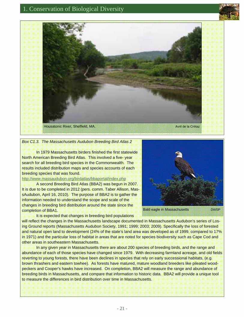
Box C1.3. The Massachusetts Audubon Breeding Bird Atlas 2
In 1979 Massachusetts birders finished the first statewide North American Breeding Bird Atlas. This involved a five- year search for all breeding bird species in the Commonwealth. The results included distribution maps and species accounts of each breeding species that was found. http://www.massaudubon.org/birdatlas/bbaportal/index.php
A second Breeding Bird Atlas (BBA2) was begun in 2007. It is due to be completed in 2012 (pers. comm. Taber Allison, Mas-sAudubon, April 16, 2010). The purpose of BBA2 is to gather the information needed to understand the scope and scale of the changes in breeding bird distribution around the state since the completion of BBA1.
It is expected that changes in breeding bird populations will reflect the changes in the Massachusetts landscape documented in Massachusetts Audubon’s series of Los-ing Ground reports (Massachusetts Audubon Society, 1991; 1999; 2003; 2009). Specifically the loss of forested and natural open land to development (24% of the state’s land area was developed as of 1999, compared to 17% in 1971) and the particular loss of habitat in areas that are noted for species biodiversity such as Cape Cod and other areas in southeastern Massachusetts.
In any given year in Massachusetts there are about 200 species of breeding birds, and the range and abundance of each of those species have changed since 1979. With decreasing farmland acreage, and old fields reverting to young forests, there have been declines in species that rely on early successional habitats, (e.g. brown thrashers and eastern towhee). As forests have matured, mature woodland breeders like pileated wood-peckers and Cooper’s hawks have increased. On completion, BBA2 will measure the range and abundance of breeding birds in Massachusetts, and compare that information to historic data. BBA2 will provide a unique tool to measure the differences in bird distribution over time in Massachusetts.
Bald eagle in Massachusetts DWSP
- 22 -
An Assessment of the Forest Resources of Massachusetts 2010
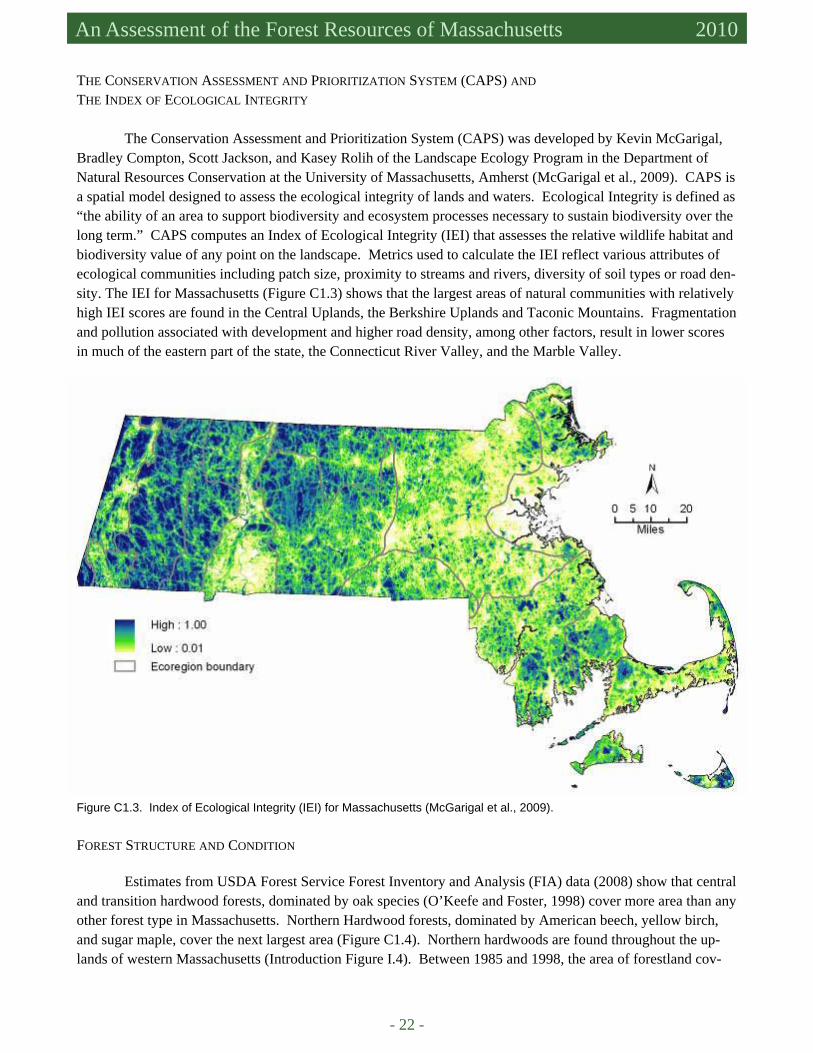
THE CONSERVATION ASSESSMENT AND PRIORITIZATION SYSTEM (CAPS) AND THE INDEX OF ECOLOGICAL INTEGRITY
The Conservation Assessment and Prioritization System (CAPS) was developed by Kevin McGarigal, Bradley Compton, Scott Jackson, and Kasey Rolih of the Landscape Ecology Program in the Department of Natural Resources Conservation at the University of Massachusetts, Amherst (McGarigal et al., 2009). CAPS is a spatial model designed to assess the ecological integrity of lands and waters. Ecological Integrity is defined as “the ability of an area to support biodiversity and ecosystem processes necessary to sustain biodiversity over the long term.” CAPS computes an Index of Ecological Integrity (IEI) that assesses the relative wildlife habitat and biodiversity value of any point on the landscape. Metrics used to calculate the IEI reflect various attributes of ecological communities including patch size, proximity to streams and rivers, diversity of soil types or road den-sity. The IEI for Massachusetts (Figure C1.3) shows that the largest areas of natural communities with relatively high IEI scores are found in the Central Uplands, the Berkshire Uplands and Taconic Mountains. Fragmentation and pollution associated with development and higher road density, among other factors, result in lower scores in much of the eastern part of the state, the Connecticut River Valley, and the Marble Valley.
Figure C1.3. Index of Ecological Integrity (IEI) for Massachusetts (McGarigal et al., 2009).
FOREST STRUCTURE AND CONDITION
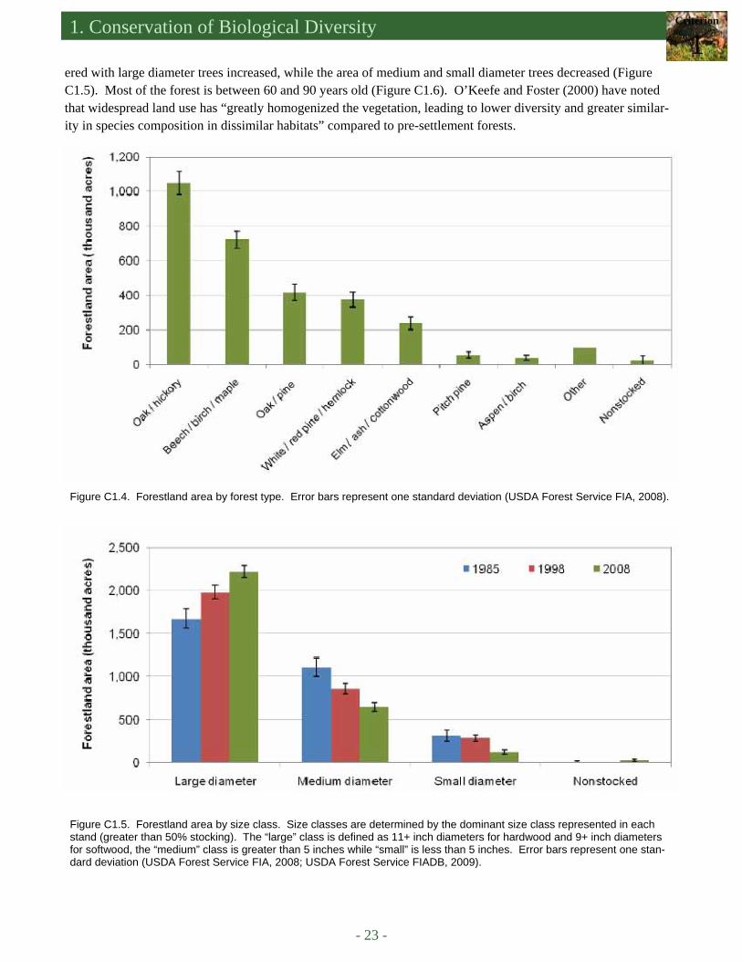
Estimates from USDA Forest Service Forest Inventory and Analysis (FIA) data (2008) show that central and transition hardwood forests, dominated by oak species (O’Keefe and Foster, 1998) cover more area than any other forest type in Massachusetts. Northern Hardwood forests, dominated by American beech, yellow birch, and sugar maple, cover the next largest area (Figure C1.4). Northern hardwoods are found throughout the up-lands of western Massachusetts (Introduction Figure I.4). Between 1985 and 1998, the area of forestland cov-
1. Conservation of Biological Diversity Criterion
1
- 23 -
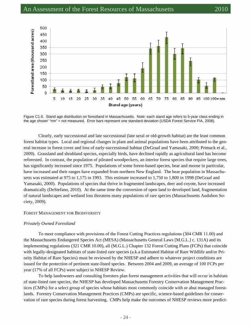
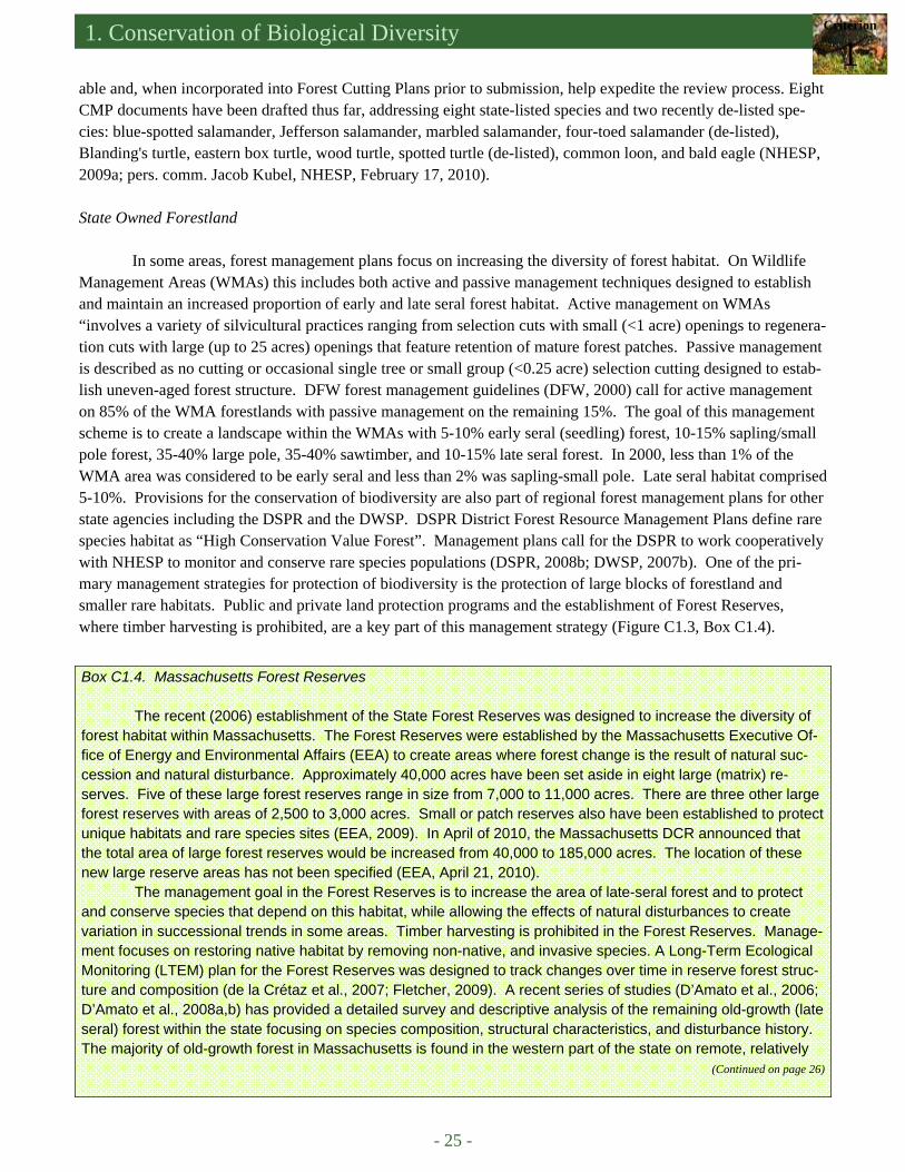
ered with large diameter trees increased, while the area of medium and small diameter trees decreased (Figure C1.5). Most of the forest is between 60 and 90 years old (Figure C1.6). O’Keefe and Foster (2000) have noted that widespread land use has “greatly homogenized the vegetation, leading to lower diversity and greater similar-ity in species composition in dissimilar habitats” compared to pre-settlement forests.
Figure C1.4. Forestland area by forest type. Error bars represent one standard deviation (USDA Forest Service FIA, 2008).
Figure C1.5. Forestland area by size class. Size classes are determined by the dominant size class represented in each stand (greater than 50% stocking). The “large” class is defined as 11+ inch diameters for hardwood and 9+ inch diameters for softwood, the “medium” class is greater than 5 inches while “small” is less than 5 inches. Error bars represent one stan-dard deviation (USDA Forest Service FIA, 2008; USDA Forest Service FIADB, 2009).
- 24 -
An Assessment of the Forest Resources of Massachusetts 2010
Clearly, early successional and late successional (late seral or old-growth habitat) are the least common forest habitat types. Local and regional changes in plant and animal populations have been attributed to the gen-eral increase in forest cover and loss of early-successional habitat (DeGraaf and Yamasaki, 2000; Primack et al., 2009). Grassland and shrubland species, especially birds, have declined rapidly as agricultural land has become reforested. In contrast, the population of pileated woodpeckers, an interior forest species that require large trees, has significantly increased since 1975. Populations of some forest-based species, bear and moose in particular, have increased and their ranges have expanded from northern New England. The bear population in Massachu-setts was estimated at 975 to 1,175 in 1993. This estimate increased to 1,750 to 1,800 in 1998 (DeGraaf and Yamasaki, 2000). Populations of species that thrive in fragmented landscapes, deer and coyote, have increased dramatically (DeStefano, 2010). At the same time the conversion of open land to developed land, fragmentation of natural landscapes and wetland loss threatens many populations of rare species (Massachusetts Audubon So-ciety, 2009). FOREST MANAGEMENT FOR BIODIVERSITY Privately Owned Forestland
To meet compliance with provisions of the Forest Cutting Practices regulations (304 CMR 11.00) and the Massachusetts Endangered Species Act (MESA) (Massachusetts General Laws [M.G.L.] c. 131A) and its implementing regulations (321 CMR 10.00), all (M.G.L.) Chapter 132 Forest Cutting Plans (FCPs) that coincide with legally-designated habitats of state-listed rare species (a.k.a Estimated Habitat of Rare Wildlife and/or Pri-ority Habitat of Rare Species) must be reviewed by the NHESP and adhere to whatever project conditions are issued for the protection of pertinent state-listed species. Between 2004 and 2009, an average of 100 FCPs per year (17% of all FCPs) were subject to NHESP Review.
To help landowners and consulting foresters plan forest management activities that will occur in habitats of state-listed rare species, the NHESP has developed Massachusetts Forestry Conservation Management Prac-tices (CMPs) for a select group of species whose habitats most commonly coincide with or abut managed forest-lands. Forestry Conservation Management Practices (CMPs) are specific, science-based guidelines for conser-vation of rare species during forest harvesting. CMPs help make the outcomes of NHESP reviews more predict-
Figure C1.6. Stand age distribution on forestland in Massachusetts. Note: each stand age refers to 5-year class ending in the age shown’ “nm” = not measured. Error bars represent one standard deviation (USDA Forest Service FIA, 2008).
1. Conservation of Biological Diversity Criterion
1
- 25 -
able and, when incorporated into Forest Cutting Plans prior to submission, help expedite the review process. Eight CMP documents have been drafted thus far, addressing eight state-listed species and two recently de-listed spe-cies: blue-spotted salamander, Jefferson salamander, marbled salamander, four-toed salamander (de-listed), Blanding's turtle, eastern box turtle, wood turtle, spotted turtle (de-listed), common loon, and bald eagle (NHESP, 2009a; pers. comm. Jacob Kubel, NHESP, February 17, 2010). State Owned Forestland
In some areas, forest management plans focus on increasing the diversity of forest habitat. On Wildlife
Management Areas (WMAs) this includes both active and passive management techniques designed to establish and maintain an increased proportion of early and late seral forest habitat. Active management on WMAs “involves a variety of silvicultural practices ranging from selection cuts with small (<1 acre) openings to regenera-tion cuts with large (up to 25 acres) openings that feature retention of mature forest patches. Passive management is described as no cutting or occasional single tree or small group (<0.25 acre) selection cutting designed to estab-lish uneven-aged forest structure. DFW forest management guidelines (DFW, 2000) call for active management on 85% of the WMA forestlands with passive management on the remaining 15%. The goal of this management scheme is to create a landscape within the WMAs with 5-10% early seral (seedling) forest, 10-15% sapling/small pole forest, 35-40% large pole, 35-40% sawtimber, and 10-15% late seral forest. In 2000, less than 1% of the WMA area was considered to be early seral and less than 2% was sapling-small pole. Late seral habitat comprised 5-10%. Provisions for the conservation of biodiversity are also part of regional forest management plans for other state agencies including the DSPR and the DWSP. DSPR District Forest Resource Management Plans define rare species habitat as “High Conservation Value Forest”. Management plans call for the DSPR to work cooperatively with NHESP to monitor and conserve rare species populations (DSPR, 2008b; DWSP, 2007b). One of the pri-mary management strategies for protection of biodiversity is the protection of large blocks of forestland and smaller rare habitats. Public and private land protection programs and the establishment of Forest Reserves, where timber harvesting is prohibited, are a key part of this management strategy (Figure C1.3, Box C1.4).
Box C1.4. Massachusetts Forest Reserves
The recent (2006) establishment of the State Forest Reserves was designed to increase the diversity of forest habitat within Massachusetts. The Forest Reserves were established by the Massachusetts Executive Of-fice of Energy and Environmental Affairs (EEA) to create areas where forest change is the result of natural suc-cession and natural disturbance. Approximately 40,000 acres have been set aside in eight large (matrix) re-serves. Five of these large forest reserves range in size from 7,000 to 11,000 acres. There are three other large forest reserves with areas of 2,500 to 3,000 acres. Small or patch reserves also have been established to protect unique habitats and rare species sites (EEA, 2009). In April of 2010, the Massachusetts DCR announced that the total area of large forest reserves would be increased from 40,000 to 185,000 acres. The location of these new large reserve areas has not been specified (EEA, April 21, 2010).
The management goal in the Forest Reserves is to increase the area of late-seral forest and to protect and conserve species that depend on this habitat, while allowing the effects of natural disturbances to create variation in successional trends in some areas. Timber harvesting is prohibited in the Forest Reserves. Manage-ment focuses on restoring native habitat by removing non-native, and invasive species. A Long-Term Ecological Monitoring (LTEM) plan for the Forest Reserves was designed to track changes over time in reserve forest struc-ture and composition (de la Crétaz et al., 2007; Fletcher, 2009). A recent series of studies (D’Amato et al., 2006; D’Amato et al., 2008a,b) has provided a detailed survey and descriptive analysis of the remaining old-growth (late seral) forest within the state focusing on species composition, structural characteristics, and disturbance history. The majority of old-growth forest in Massachusetts is found in the western part of the state on remote, relatively
(Continued on page 26)
- 26 -
An Assessment of the Forest Resources of Massachusetts 2010
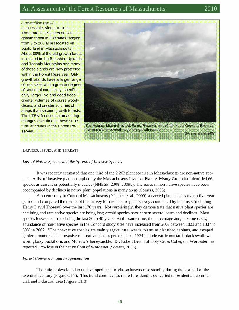
inaccessible, steep hillsides. There are 1,119 acres of old-growth forest in 33 stands ranging from 3 to 200 acres located on public land in Massachusetts. About 80% of the old-growth forest is located in the Berkshire Uplands and Taconic Mountains and many of these stands are now protected within the Forest Reserves. Old-growth stands have a larger range of tree sizes with a greater degree of structural complexity, specifi-cally, larger live and dead trees, greater volumes of course woody debris, and greater volumes of snags than second growth forests. The LTEM focuses on measuring changes over time in these struc-tural attributes in the Forest Re-serves.
(Continued from page 25)
The Hopper, Mount Greylock Forest Reserve, part of the Mount Greylock Reserva-tion and site of several, large, old-growth stands. Gonewengland, 2003
DRIVERS, ISSUES, AND THREATS Loss of Native Species and the Spread of Invasive Species
It was recently estimated that one third of the 2,263 plant species in Massachusetts are non-native spe-cies. A list of invasive plants compiled by the Massachusetts Invasive Plant Advisory Group has identified 66 species as current or potentially invasive (NHESP, 2008; 2009b). Increases in non-native species have been accompanied by declines in native plant populations in many areas (Somers, 2005).
A recent study in Concord Massachusetts (Primack et al., 2009) surveyed plant species over a five-year period and compared the results of this survey to five historic plant surveys conducted by botanists (including Henry David Thoreau) over the last 170 years. Not surprisingly, they demonstrate that native plant species are declining and rare native species are being lost; orchid species have shown severe losses and declines. Most species losses occurred during the last 30 to 40 years. At the same time, the percentage and, in some cases, abundance of non-native species in the Concord study sites have increased from 20% between 1823 and 1837 to 39% in 2007. “The non-native species are mainly agricultural weeds, plants of disturbed habitats, and escaped garden ornamentals.” Invasive non-native species present since 1974 include garlic mustard, black swallow-wort, glossy buckthorn, and Morrow’s honeysuckle. Dr. Robert Bertin of Holy Cross College in Worcester has reported 17% loss in the native flora of Worcester (Somers, 2005). Forest Conversion and Fragmentation
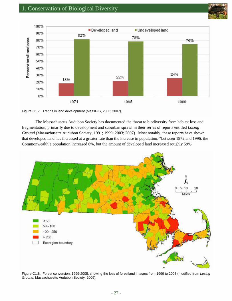
The ratio of developed to undeveloped land in Massachusetts rose steadily during the last half of the twentieth century (Figure C1.7). This trend continues as more forestland is converted to residential, commer-cial, and industrial uses (Figure C1.8).
1. Conservation of Biological Diversity Criterion
1
- 27 -
Figure C1.7. Trends in land development (MassGIS, 2003; 2007).
The Massachusetts Audubon Society has documented the threat to biodiversity from habitat loss and fragmentation, primarily due to development and suburban sprawl in their series of reports entitled Losing Ground (Massachusetts Audubon Society, 1991; 1999; 2003; 2007). Most notably, these reports have shown that developed land has increased at a greater rate than the increase in population: “between 1972 and 1996, the Commonwealth’s population increased 6%, but the amount of developed land increased roughly 59%
Figure C1.8. Forest conversion: 1999-2005, showing the loss of forestland in acres from 1999 to 2005 (modified from Losing Ground, Massachusetts Audubon Society, 2009).
- 28 -
An Assessment of the Forest Resources of Massachusetts 2010
(Massachusetts Audubon Society, 1999).” Development has been concentrated in a few areas, some of which are particularly noted for their biodi-
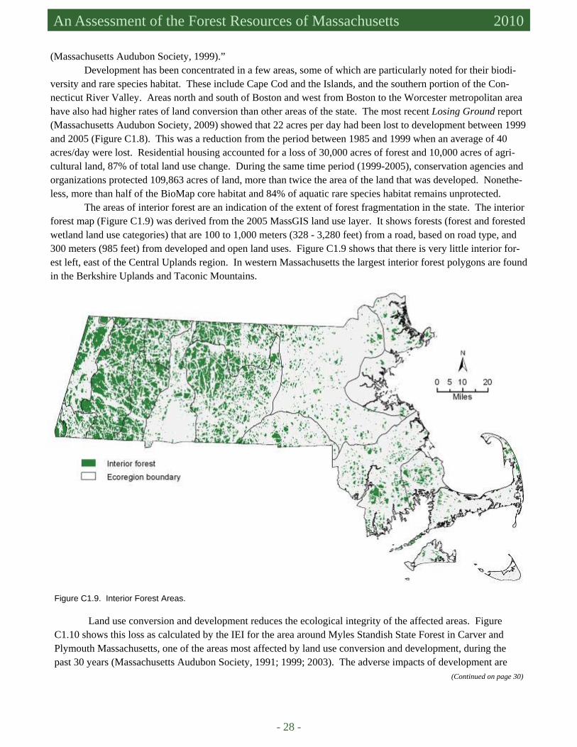
versity and rare species habitat. These include Cape Cod and the Islands, and the southern portion of the Con-necticut River Valley. Areas north and south of Boston and west from Boston to the Worcester metropolitan area have also had higher rates of land conversion than other areas of the state. The most recent Losing Ground report (Massachusetts Audubon Society, 2009) showed that 22 acres per day had been lost to development between 1999 and 2005 (Figure C1.8). This was a reduction from the period between 1985 and 1999 when an average of 40 acres/day were lost. Residential housing accounted for a loss of 30,000 acres of forest and 10,000 acres of agri-cultural land, 87% of total land use change. During the same time period (1999-2005), conservation agencies and organizations protected 109,863 acres of land, more than twice the area of the land that was developed. Nonethe-less, more than half of the BioMap core habitat and 84% of aquatic rare species habitat remains unprotected.
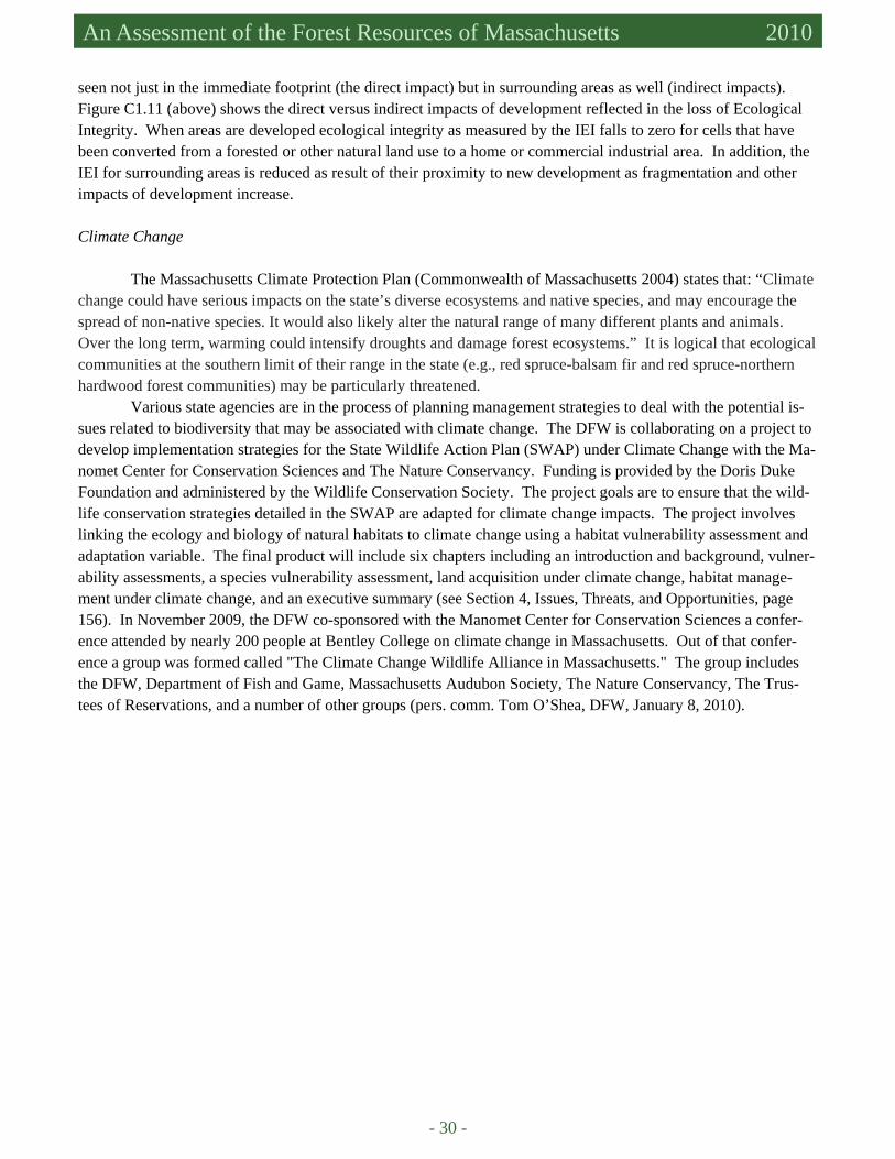
The areas of interior forest are an indication of the extent of forest fragmentation in the state. The interior forest map (Figure C1.9) was derived from the 2005 MassGIS land use layer. It shows forests (forest and forested wetland land use categories) that are 100 to 1,000 meters (328 - 3,280 feet) from a road, based on road type, and 300 meters (985 feet) from developed and open land uses. Figure C1.9 shows that there is very little interior for-est left, east of the Central Uplands region. In western Massachusetts the largest interior forest polygons are found in the Berkshire Uplands and Taconic Mountains.
Figure C1.9. Interior Forest Areas.
Land use conversion and development reduces the ecological integrity of the affected areas. Figure C1.10 shows this loss as calculated by the IEI for the area around Myles Standish State Forest in Carver and Plymouth Massachusetts, one of the areas most affected by land use conversion and development, during the past 30 years (Massachusetts Audubon Society, 1991; 1999; 2003). The adverse impacts of development are
(Continued on page 30)

1. Conservation of Biological Diversity Criterion
1
- 29 -
Figure C1.10. Index of Ecological Integrity (IEI) for Massachusetts. Inset shows the loss of ecological integrity in the area around Myles Standish State Forest between 1971 and 2005. Myles Standish State Forest is located in the Cap Cod and the Islands ecoregion (McGarigal et al., 2009).
Figure C1.11. Effects of development beyond the footprint 1971-2005, ratio of indirect to direct loss in IEI (modified from Losing Ground, Massachusetts Audubon Society, 2009).
- 30 -
An Assessment of the Forest Resources of Massachusetts 2010
seen not just in the immediate footprint (the direct impact) but in surrounding areas as well (indirect impacts). Figure C1.11 (above) shows the direct versus indirect impacts of development reflected in the loss of Ecological Integrity. When areas are developed ecological integrity as measured by the IEI falls to zero for cells that have been converted from a forested or other natural land use to a home or commercial industrial area. In addition, the IEI for surrounding areas is reduced as result of their proximity to new development as fragmentation and other impacts of development increase.
Climate Change
The Massachusetts Climate Protection Plan (Commonwealth of Massachusetts 2004) states that: “Climate change could have serious impacts on the state’s diverse ecosystems and native species, and may encourage the spread of non-native species. It would also likely alter the natural range of many different plants and animals. Over the long term, warming could intensify droughts and damage forest ecosystems.” It is logical that ecological communities at the southern limit of their range in the state (e.g., red spruce-balsam fir and red spruce-northern hardwood forest communities) may be particularly threatened.
Various state agencies are in the process of planning management strategies to deal with the potential is-sues related to biodiversity that may be associated with climate change. The DFW is collaborating on a project to develop implementation strategies for the State Wildlife Action Plan (SWAP) under Climate Change with the Ma-nomet Center for Conservation Sciences and The Nature Conservancy. Funding is provided by the Doris Duke Foundation and administered by the Wildlife Conservation Society. The project goals are to ensure that the wild-life conservation strategies detailed in the SWAP are adapted for climate change impacts. The project involves linking the ecology and biology of natural habitats to climate change using a habitat vulnerability assessment and adaptation variable. The final product will include six chapters including an introduction and background, vulner-ability assessments, a species vulnerability assessment, land acquisition under climate change, habitat manage-ment under climate change, and an executive summary (see Section 4, Issues, Threats, and Opportunities, page 156). In November 2009, the DFW co-sponsored with the Manomet Center for Conservation Sciences a confer-ence attended by nearly 200 people at Bentley College on climate change in Massachusetts. Out of that confer-ence a group was formed called "The Climate Change Wildlife Alliance in Massachusetts." The group includes the DFW, Department of Fish and Game, Massachusetts Audubon Society, The Nature Conservancy, The Trus-tees of Reservations, and a number of other groups (pers. comm. Tom O’Shea, DFW, January 8, 2010).
1. Conservation of Biological Diversity Criterion
1
- 31 -
References Barbour, H., T. Simmons, P. Swain, and H. Woolsey. 1998. Our Irreplaceable Heritage: Protecting Biodiversity in Massachu-
setts. Natural Heritage & Endangered Species Program, Massachusetts Division of Fisheries and Wildlife and the Massachusetts Chapter of The Nature Conservancy. Boston, MA.
Commonwealth of Massachusetts (Office for Commonwealth Development). 2004. Massachusetts Climate Protection Plan, 52 pp.
D’Amato, A.W., D.A. Orwig, and D.R. Foster. 2006. New estimates of Massachusetts old-growth forests: useful data for re-gional conservation and forest reserve planning. Northeastern Naturalist 13(4): 495-506.
D’Amato, A.W., and D.A. Orwig. 2008a. Stand and landscape-level disturbance dynamics in old-growth forests in western Massachusetts. Ecological Monographs 78(4): 507-522.
D’Amato, A.W., D.A. Orwig, and D.R. Foster. 2008b. The influence of successional processes and disturbance on the struc-ture of Tsuga canadensis forests. Ecological Applications 18(5):1182-1199.
DFW (Massachusetts Department of Fish and Game – Division of Fisheries and Wildlife). 2000. Forest Management Guide-lines for Wildlife Management Areas (DRAFT). Available at http://www.mass.gov/dfwele/dfw/habitat/management/bdi/forest_mgt/forest_mgt_guidelines.htm. Accessed in January 2000.
DFW (Massachusetts Department of Fish and Game – Division of Fisheries and Wildlife). 2006. 2005 Massachusetts Compre-hensive Conservation Strategy. (Statewide Wildlife Action Plan) (Revised 2006). (Massachusetts Division of Fisher-ies and Wildlife, Department of Fish and Game), Executive Office of Environmental Affairs, 791 pp.
DFW (Massachusetts Department of Fish and Game-Division of Fisheries and Wildlife). 2007. Matrix Reserve Boundaries. DeGraaf, R.M. and M. Yamasaki. 2000. New England Wildlife: habitat, natural history, and distribution. University Press of
New England, Hanover, NH. de la Crétaz, A.L., L.S. Fletcher, and M.J. Kelty. 2007. Massachusetts Forest Reserves: Long Term Ecological Monitoring
Program, Monitoring Proposal. Massachusetts Department of Conservation and Recreation, Internal Report. DeStefano, S. 2010. Coyote at the Kitchen Door: Living with wildlife in suburbia. Harvard University Press, Cambridge, MA.
196 pp. DSPR. 2008a. Massachusetts Department of Conservation and Recreation. Large Forest Reserve boundaries. DSPR (Massachusetts Department of Conservation and Recreation – Division of State Parks and Recreation). 2008b. Depart-
ment of Conservation and Recreation-Division of State Parks and Recreation: Northern Berkshire District Draft Forest Resources Management Plan. Internal Report.
DSPR (Massachusetts Department of Conservation and Recreation – Division of State Parks and Recreation). 2009. Forestry. Available at http://www.mass.gov/dcr/stewardship/forestry/. Accessed in January 2010.
DWSP (Massachusetts Department of Conservation and Recreation – Division of Water Supply Protection) 2007a. Cunning-ham Pond Forest Reserve boundaries.
DWSP (Massachusetts Department of Conservation and Recreation – Division of Water Supply Protection) 2007b. Quabbin Reservoir Watershed System: Land Management Plan, 2007-2017. Massachusetts Department of Conservation and Recreation, Division of Water Supply Protection, Office of Watershed Management.
EEA (Executive Office of Environmental and Energy Affairs). 2009. Forest Reserves. Boston, MA. February 2, 2009. Avail-able at http://www.mass.gov/Eoeea/docs/eea/lf/whatare_forestreserves.pdf. Accessed in September 2009.
EEA (Executive Office of Energy and Environmental Affairs). Press Release April 21, 2010. Patrick-Murray administration announces commonwealth forest heritage plan. Boston, MA.
Fletcher, L.S. 2009. State Forest Reserves in western Massachusetts: A baseline comparison with old-growth and non-Reserve State Forests. Report submitted in partial fulfillment of the Professional Master’s Degree Program in Forest Resources. University of Massachusetts, Amherst, MA.
Gonewengland. 2003. Available at http://www.gonewengland.org/gophoto/2003/200308.htm. Accessed in January 2010. Massachusetts Audubon Society. 1991. Losing Ground: the case for Land Conservation in Massachusetts. Massachusetts Audubon Society (J.Steel). 1999. Losing Ground: An analysis of recent rates and patterns of development and
their effects on open space in Massachusetts (second edition). Massachusetts Audubon Society (K. Breunig). 2003. Losing Ground : At what cost? Changes in land use and their impact on
habitat, biodiversity, and ecosystem services in Massachusetts (third edition). Massachusetts Audubon Society (J. DeNormandie). 2009. Losing Ground – Beyond the Footprint: Patterns of development
and their impact on the nature of Massachusetts (fourth edition). MassGIS (Office of Geographic and Environmental Information, Commonwealth of Massachusetts, Executive Office of En-
ergy and Environmental Affairs). 2002. NHESP BioMap Core Habitat. Available at http://www.mass.gov/mgis/biocore.htm. Accessed in January 2010.
MassGIS (Office of Geographic and Environmental Information, Commonwealth of Massachusetts, Executive Office of En-ergy and Environmental Affairs). 2003. NHESP Living Waters Core Habitat. Available at http://www.mass.gov/mgis/lwcore.htm. Accessed in January 2010.
MassGIS (Office of Geographic and Environmental Information, Commonwealth of Massachusetts, Executive Office of En-

- 32 -
An Assessment of the Forest Resources of Massachusetts 2010
ergy and Environmental Affairs). 2003, 2007. Land Use Summary Statistics. Available at http://www.mass.gov/mgis/landuse_stats.htm. Accessed in January 2010.
MassGIS (Office of Geographic and Environmental Information, Commonwealth of Massachusetts, Executive Office of En-ergy and Environmental Affairs). 2009. Open Space. Available at http://www.mass.gov/mgis/. Accessed in January 2010.
McGarigal, K., B.W. Compton, S.D. Jackson, and K. Rolih. 2009. Conservation Assessment and Prioritization System (CAPS) preliminary statewide Massachusetts assessment. June 2, 2009. Landscape Ecology Program, Department of Natural Resources Conservation, University of Massachusetts, Amherst.
Motzkin, G. 1994. Calcareous fens of western New England and adjacent New York State. Rhodora 96(885):44-68. Nedeau, E.J. 2008. Freshwater Mussels and the Connecticut River Watershed. Published in cooperation with the Connecticut
River Watershed Council, Greenfield, MA. National Park Service. No date given. Cape Cod National Seashore: nature and science. Available at http://www.nps.gov/
caco/naturescience/index.htm. Accessed in May 2010. NHESP (The Natural Heritage and Endangered Species Program of the Massachusetts Division of Fisheries and Wildlife).
2004. BioMap and Living Waters. Guiding Land Conservation for Biodiversity in Massachusetts (Town Reports). Natural Heritage & Endangered Species Program, Massachusetts Division of Fisheries and Wildlife, Executive Office of Environmental Affairs, Commonwealth of Massachusetts.
NHESP (The Natural Heritage and Endangered Species Program of the Massachusetts Division of Fisheries and Wildlife). 2008. A Guide to Invasive Plant Species in Massachusetts (2nd Edition). Natural Heritage & Endangered Species Pro-gram, Massachusetts Division of Fisheries and Wildlife, Executive Office of Environmental Affairs, Commonwealth of Massachusetts.
NHESP (The Natural Heritage and Endangered Species Program of the Massachusetts Division of Fisheries and Wildlife). 2009a. Forest Conservation Management Practices for Rare Species. Available at http://www.mass.gov/dfwele/dfw/nhesp/regulatory_review/forestry/forestry_cmp.htm. Accessed in January 2010.
NHESP (The Natural Heritage and Endangered Species Program of the Massachusetts Division of Fisheries and Wildlife). 2009b. Invasive Plants. Natural Heritage & Endangered Species Program, Massachusetts Division of Fisheries and Wildlife, Executive Office of Environmental Affairs, Commonwealth of Massachusetts. Available at http://www.mass.gov/dfwele/dfw/nhesp/conservation/invasives/invasive_plant_info.htm. Accessed in January 2010.
O’Keefe, J.F. and D.R. Foster. 1998a. An ecological history of Massachusetts forests. In C.W. Foster (Editor) Stepping Back to Look Forward: a History of the Massachusetts Forest, pp. 19-66.
O’Keefe, J.F. and D.R. Foster. 2000. New England Forests Through Time: Insights from the Harvard Forest Dioramas. Har-vard Forest, Petersham MA, Harvard University, Harvard University Press, Cambridge.
Primack, R.B., A.J. Miller-Rushing, K. Dharaneeswaran. Changes in the flora of Thoreau’s Concord. Biological Conserva-tion 142:500-508.
Somers, P. 2005. The Invasive Plant Problem. Available at http://www.mass.gov/portal/. Accessed in January 2010. Swain, P.C. and J.B. Kearsley. 2000. Classification of the Natural Communities of Massachusetts (Draft). Natural Heritage &
Endangered Species Program, Massachusetts Division of Fisheries and Wildlife, Westborough, MA. TTOR (The Trustees of Reserverations). No date given. Bartholomew’s Cobble. Available at http://www.thetrustees.org/
places-to-visit/berkshires/bartholomews-cobble.html. Accessed in January 2010. US Army Corps of Engineers. No date given. Charles River Natural Valley Storage Area. Available at http://
www.nae.usace.army.mil/recreati/crn/crnhome.htm. Accessed in May 2010. US Army Corps of Engineers. 2010. Knightville Dam, Huntington MA. Available at http://www.nae.usace.army.mil/recreati/
kvd/kvdhome.htm. Accessed in May 2010. US Fish and Wildlife Service. 2010. Refuge List by State: Massachusetts. Available at http://www.fws.gov/refuges/profiles/
ByState.cfm?state=MA. Accessed in May 2010. USDA Forest Service FIA. 2008. Forest Inventory and Analysis. Available at http://fia.fs.fed.us/. Accessed in January 2010. USDA Forest Service FIADB. 2009. Forest Inventory and Analysis – Data and Tools. Available at http://www.fia.fs.fed.us/
tools-data/default.asp. Accessed in January 2010. Watershed Associations: Blackstone River Watershed Association. Available at http://thebrwa.org. Accessed in January 2010. Charles River Watershed Association. Available at http://crwa.org/index.php. Accessed in January 2010. Connecticut River Watershed Council. Available at http://www.ctriver.org/. Accessed in January 2010. Hoosic River Watershed Association. Available at http://hoorwa.org/. Accessed in January 2010. Housatonic Valley Association. Available at http://www.hvatoday.org/show.cfm?page=info/. Accessed in January 2010. Merrimack River Watershed Council Inc. Available at http://www.merrimack.org/watershed/watershed.html. Ac-
cessed in January 2010. The Sudbury Assabet- and Concord Wild and Scenic River Stewardship Council. Available at http://www.sudbury-
assabet-concord.org/. Accessed in January 2010. Weatherbee, P.B. 1996. Flora of Berkshire County. The Berkshire Museum, Pittsfield, MA., 123 pp.
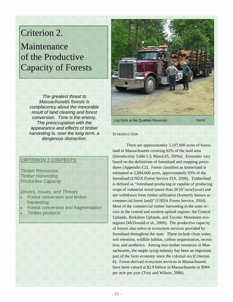
- 33 -
Log truck at the Quabbin Reservoir. DWSP
Criterion 2.
Maintenance of the Productive Capacity of Forests
CRITERION 2 CONTENTS: Timber Resources Timber Harvesting Productive Capacity Drivers, Issues, and Threats • Forest conversion and timber
harvesting • Forest conversion and fragmentation • Timber products
INTRODUCTION
There are approximately 3,187,000 acres of forest-land in Massachusetts covering 63% of the land area (Introduction Table I.3; MassGIS, 2009a). Estimates vary based on the definitions of forestland and mapping proce-dures (Appendix C2). Forest classified as timberland is estimated at 2,894,600 acres, approximately 93% of the forestland (USDA Forest Service FIA, 2008). Timberland is defined as “forestland producing or capable of producing crops of industrial wood (more than 20 [ft3/acre]/year) and not withdrawn from timber utilization (formerly known as commercial forest land)” (USDA Forest Service, 2004). Most of the commercial timber harvesting in the state oc-curs in the central and western upland regions: the Central Uplands, Berkshire Uplands, and Taconic Mountains eco-regions (McDonald et al., 2006). The productive capacity of forests also refers to ecosystem services provided by forestland throughout the state. These include clean water, soil retention, wildlife habitat, carbon sequestration, recrea-tion, and aesthetics. Among non-timber resources in Mas-sachusetts, the maple syrup industry has been an important part of the farm economy since the colonial era (Criterion 6). Forest-derived ecosystem services in Massachusetts have been valued at $2.9 billion in Massachusetts or $984 per acre per year (Troy and Wilson, 2006).
The greatest threat to Massachusetts forests is
complacency about the inexorable result of land clearing and forest conversion. Time is the enemy.
The preoccupation with the appearance and effects of timber
harvesting is, over the long term, a dangerous distraction.
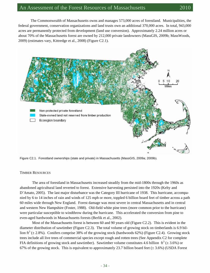
- 34 -
An Assessment of the Forest Resources of Massachusetts 2010
The Commonwealth of Massachusetts owns and manages 573,000 acres of forestland. Municipalities, the federal government, conservation organizations and land trusts own an additional 370,000 acres. In total, 943,000 acres are permanently protected from development (land use conversion). Approximately 2.24 million acres or about 70% of the Massachusetts forest are owned by 212,000 private landowners (MassGIS, 2009b; MassWoods, 2009) (estimates vary, Kittredge et al., 2008) (Figure C2.1).
Figure C2.1. Forestland ownerships (state and private) in Massachusetts (MassGIS, 2009a; 2009b).
TIMBER RESOURCES
The area of forestland in Massachusetts increased steadily from the mid-1800s through the 1960s as abandoned agricultural land reverted to forest. Extensive harvesting persisted into the 1920s (Kelty and D’Amato, 2005). The last major disturbance was the Category III hurricane of 1938. This hurricane, accompa-nied by 6 to 14 inches of rain and winds of 125 mph or more, toppled 6 billion board feet of timber across a path 60 miles wide through New England. Forest damage was most severe in central Massachusetts and in central and western New Hampshire (Foster, 1988). Old-field white pine trees (more common prior to the hurricane) were particular susceptible to windthrow during the hurricane. This accelerated the conversion from pine to even-aged hardwoods in Massachusetts forests (Berlik et al., 2002).
Most of the Massachusetts forest is between 60 and 90 years old (Figure C2.2). This is evident in the diameter distribution of sawtimber (Figure C2.3). The total volume of growing stock on timberlands is 6.9 bil-lion ft3 (± 2.8%). Conifers comprise 38% of the growing stock (hardwoods 62%) (Figure C2.4). Growing stock trees include all live trees of commercial species except rough and rotten trees (See Appendix C2 for complete FIA definitions of growing stock and sawtimber). Sawtimber volume constitutes 4.6 billion ft3 (± 3.6%) or 67% of the growing stock. This is equivalent to approximately 23.7 billion board feet (± 3.6%) (USDA Forest
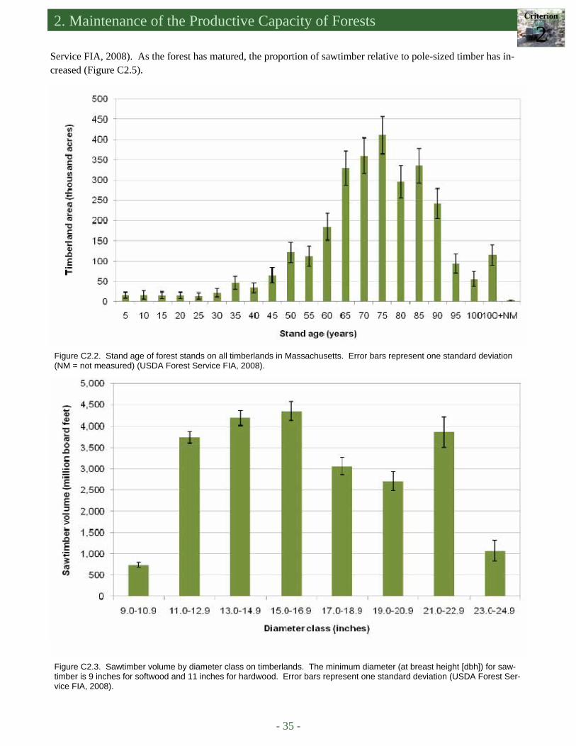
2. Maintenance of the Productive Capacity of Forests Criterion
2
- 35 -
Figure C2.2. Stand age of forest stands on all timberlands in Massachusetts. Error bars represent one standard deviation (NM = not measured) (USDA Forest Service FIA, 2008).
Figure C2.3. Sawtimber volume by diameter class on timberlands. The minimum diameter (at breast height [dbh]) for saw-timber is 9 inches for softwood and 11 inches for hardwood. Error bars represent one standard deviation (USDA Forest Ser-vice FIA, 2008).
Service FIA, 2008). As the forest has matured, the proportion of sawtimber relative to pole-sized timber has in-creased (Figure C2.5).
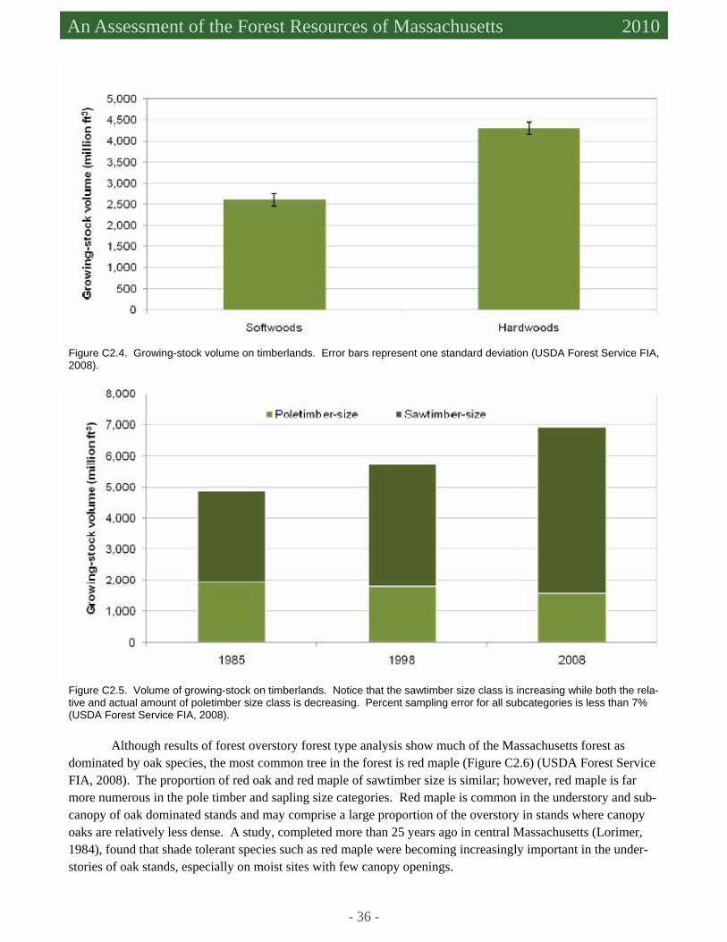
- 36 -
An Assessment of the Forest Resources of Massachusetts 2010
Figure C2.4. Growing-stock volume on timberlands. Error bars represent one standard deviation (USDA Forest Service FIA, 2008).
Figure C2.5. Volume of growing-stock on timberlands. Notice that the sawtimber size class is increasing while both the rela-tive and actual amount of poletimber size class is decreasing. Percent sampling error for all subcategories is less than 7% (USDA Forest Service FIA, 2008).
Although results of forest overstory forest type analysis show much of the Massachusetts forest as dominated by oak species, the most common tree in the forest is red maple (Figure C2.6) (USDA Forest Service FIA, 2008). The proportion of red oak and red maple of sawtimber size is similar; however, red maple is far more numerous in the pole timber and sapling size categories. Red maple is common in the understory and sub-canopy of oak dominated stands and may comprise a large proportion of the overstory in stands where canopy oaks are relatively less dense. A study, completed more than 25 years ago in central Massachusetts (Lorimer, 1984), found that shade tolerant species such as red maple were becoming increasingly important in the under-stories of oak stands, especially on moist sites with few canopy openings.
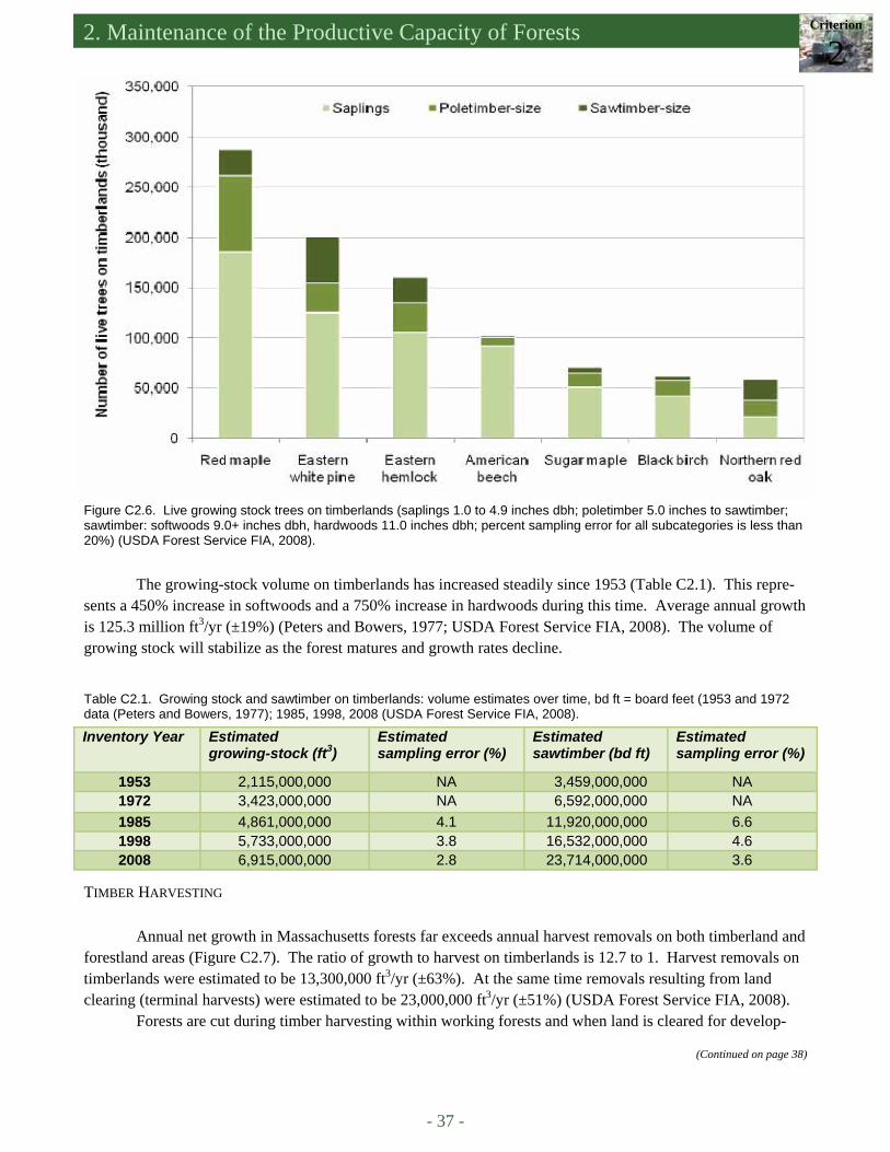
2. Maintenance of the Productive Capacity of Forests Criterion
2
- 37 -
Figure C2.6. Live growing stock trees on timberlands (saplings 1.0 to 4.9 inches dbh; poletimber 5.0 inches to sawtimber; sawtimber: softwoods 9.0+ inches dbh, hardwoods 11.0 inches dbh; percent sampling error for all subcategories is less than 20%) (USDA Forest Service FIA, 2008).
The growing-stock volume on timberlands has increased steadily since 1953 (Table C2.1). This repre-sents a 450% increase in softwoods and a 750% increase in hardwoods during this time. Average annual growth is 125.3 million ft3/yr (±19%) (Peters and Bowers, 1977; USDA Forest Service FIA, 2008). The volume of growing stock will stabilize as the forest matures and growth rates decline.
Table C2.1. Growing stock and sawtimber on timberlands: volume estimates over time, bd ft = board feet (1953 and 1972 data (Peters and Bowers, 1977); 1985, 1998, 2008 (USDA Forest Service FIA, 2008).
Inventory Year Estimated growing-stock (ft3)
Estimated sampling error (%)
Estimated sawtimber (bd ft)
Estimated sampling error (%)
1953 2,115,000,000 NA 3,459,000,000 NA 1972 3,423,000,000 NA 6,592,000,000 NA 1985 4,861,000,000 4.1 11,920,000,000 6.6 1998 5,733,000,000 3.8 16,532,000,000 4.6 2008 6,915,000,000 2.8 23,714,000,000 3.6
TIMBER HARVESTING Annual net growth in Massachusetts forests far exceeds annual harvest removals on both timberland and
forestland areas (Figure C2.7). The ratio of growth to harvest on timberlands is 12.7 to 1. Harvest removals on timberlands were estimated to be 13,300,000 ft3/yr (±63%). At the same time removals resulting from land clearing (terminal harvests) were estimated to be 23,000,000 ft3/yr (±51%) (USDA Forest Service FIA, 2008).
Forests are cut during timber harvesting within working forests and when land is cleared for develop-
(Continued on page 38)

- 38 -
An Assessment of the Forest Resources of Massachusetts 2010
Figure C2.7. Annual removals and growth on forestland (including timberland). Error bars represent one standard deviation (USDA Forest Service FIA, 2008).
ment. Forest cutting plans are required on sites that will stay as or be returned to forest cover when the harvest exceeds 25,000 board feet or 50 cords, not for land that is converted to other uses (Criterion 7). McDonald and others (2006) analyzed all forest cutting plans filed between 1984 and 2003. In the past 30 years, forest clearing for development was most prevalent in the eastern part of the state in the Boston Basin, Cape Cod and the Islands, and the Coastal Plains and Lowlands regions. From the Central Uplands to the western border of the state, timber harvesting far exceeded forest cutting for land use conversion. Current forest cover varies from 18% in the Bos-ton Basin to 88% in the Berkshire Uplands and 92% in the Taconic Mountains (MassGIS, 2002). The average cutting plan area between 1984 and 2003 was 37 acres and remained relatively constant throughout that period. An average of 650 cutting plans were filed each year (1984-2003) ranging from 447 in 1984 when the program began to 886 in 1985 with no apparent trend over time. The annual volume harvested estimated from the cutting plans (15,900,000 ft3/yr) rose and fell with the number of cutting plans filed per year.
White pine and red oak are the most harvested species statewide (Figure C2.8), (McDonald et al., 2006; USDA Forest Service FIA, 2008). There is some local variation based on regional variation in forest type. Red spruce comprises 7.5 to 10% of the harvest volume in the northern Berkshire Uplands; 10 to 20% of the harvest in the southern and eastern Berkshires consists of hemlock (McDonald et al., 2006).
McDonald and others (2006) estimated that these harvest intensities represent approximately 20% to 30% of total volume, and “are lower than typical harvest intensities in many other forests in the United States.” The intensity of harvest varied among ownership ranging from 485 ft3/acre for the Department of Fish and Game to 979 ft3/acre for federal land. Intensity of harvesting on privately owned lands was estimated at 579 ft3/acre. Mean harvest intensity across all ownerships was 620 ft3/acre. The proportion of forestland cut per year ranged from 0.1% for federal lands to 1.4% for the Division of Water Supply Protection.
Additional cutting plan data from 2004 to 2009 indicate that mean cutting plan area increased somewhat from 37 to 44 acres during the past six years, while the mean harvest intensity has decreased (Appendix C2) (DSPR, 2009a). The number of forest cutting plans filed and volume harvested during this period follow eco-nomic trends with a peak in 2006 of 6,107,800 ft3, at the time when housing starts were highest, and declining with the economic downturn that began in 2007 (Federal Reserve Bank of St. Louis, 2009).
PRODUCTIVE CAPACITY
The number of sawmills in the state has decreased steadily from 130 in 1971 to 32 sawmills and 12 port-able band mills reported from a survey in 2005 (Bond and Loud, 1992; Damery et al., 2006). Much of the timber currently extracted from Massachusetts forests is transported to sawmills outside the state for processing. The
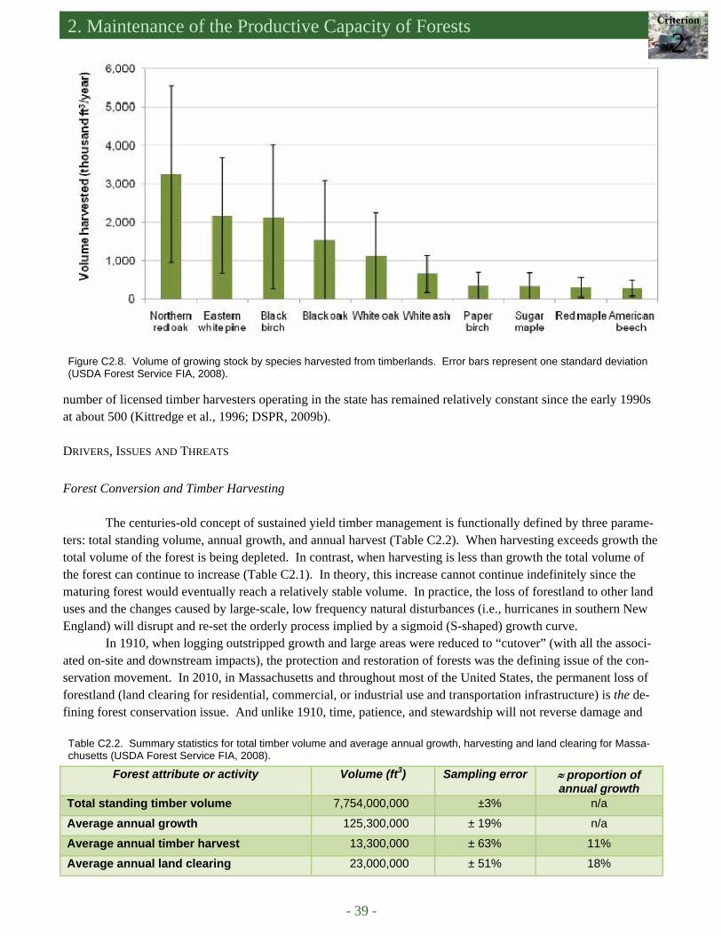
2. Maintenance of the Productive Capacity of Forests Criterion
2
- 39 -
Figure C2.8. Volume of growing stock by species harvested from timberlands. Error bars represent one standard deviation (USDA Forest Service FIA, 2008).
number of licensed timber harvesters operating in the state has remained relatively constant since the early 1990s at about 500 (Kittredge et al., 1996; DSPR, 2009b).
DRIVERS, ISSUES AND THREATS Forest Conversion and Timber Harvesting
The centuries-old concept of sustained yield timber management is functionally defined by three parame-ters: total standing volume, annual growth, and annual harvest (Table C2.2). When harvesting exceeds growth the total volume of the forest is being depleted. In contrast, when harvesting is less than growth the total volume of the forest can continue to increase (Table C2.1). In theory, this increase cannot continue indefinitely since the maturing forest would eventually reach a relatively stable volume. In practice, the loss of forestland to other land uses and the changes caused by large-scale, low frequency natural disturbances (i.e., hurricanes in southern New England) will disrupt and re-set the orderly process implied by a sigmoid (S-shaped) growth curve.
In 1910, when logging outstripped growth and large areas were reduced to “cutover” (with all the associ-ated on-site and downstream impacts), the protection and restoration of forests was the defining issue of the con-servation movement. In 2010, in Massachusetts and throughout most of the United States, the permanent loss of forestland (land clearing for residential, commercial, or industrial use and transportation infrastructure) is the de-fining forest conservation issue. And unlike 1910, time, patience, and stewardship will not reverse damage and
Table C2.2. Summary statistics for total timber volume and average annual growth, harvesting and land clearing for Massa-chusetts (USDA Forest Service FIA, 2008).
Forest attribute or activity Volume (ft3) Sampling error ≈ proportion of annual growth
Total standing timber volume 7,754,000,000 ±3% n/a
Average annual growth 125,300,000 ± 19% n/a
Average annual timber harvest 13,300,000 ± 63% 11%
Average annual land clearing 23,000,000 ± 51% 18%
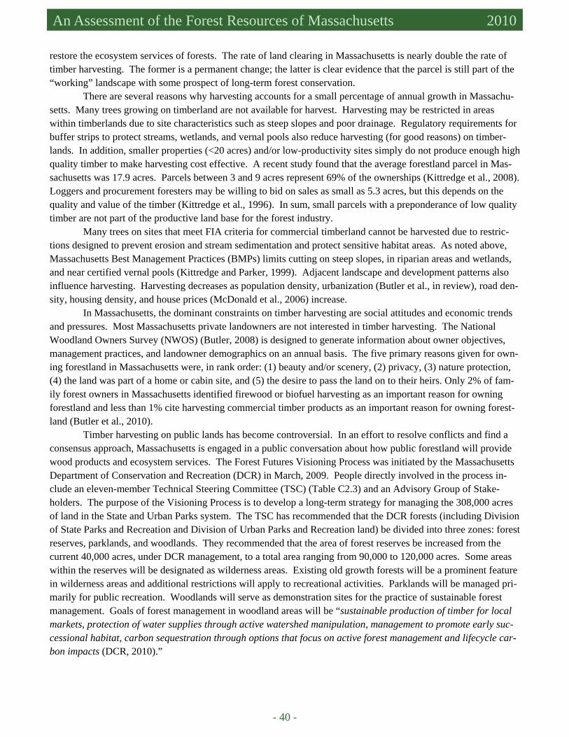
- 40 -
An Assessment of the Forest Resources of Massachusetts 2010
restore the ecosystem services of forests. The rate of land clearing in Massachusetts is nearly double the rate of timber harvesting. The former is a permanent change; the latter is clear evidence that the parcel is still part of the “working” landscape with some prospect of long-term forest conservation.
There are several reasons why harvesting accounts for a small percentage of annual growth in Massachu-setts. Many trees growing on timberland are not available for harvest. Harvesting may be restricted in areas within timberlands due to site characteristics such as steep slopes and poor drainage. Regulatory requirements for buffer strips to protect streams, wetlands, and vernal pools also reduce harvesting (for good reasons) on timber-lands. In addition, smaller properties (<20 acres) and/or low-productivity sites simply do not produce enough high quality timber to make harvesting cost effective. A recent study found that the average forestland parcel in Mas-sachusetts was 17.9 acres. Parcels between 3 and 9 acres represent 69% of the ownerships (Kittredge et al., 2008). Loggers and procurement foresters may be willing to bid on sales as small as 5.3 acres, but this depends on the quality and value of the timber (Kittredge et al., 1996). In sum, small parcels with a preponderance of low quality timber are not part of the productive land base for the forest industry.
Many trees on sites that meet FIA criteria for commercial timberland cannot be harvested due to restric-tions designed to prevent erosion and stream sedimentation and protect sensitive habitat areas. As noted above, Massachusetts Best Management Practices (BMPs) limits cutting on steep slopes, in riparian areas and wetlands, and near certified vernal pools (Kittredge and Parker, 1999). Adjacent landscape and development patterns also influence harvesting. Harvesting decreases as population density, urbanization (Butler et al., in review), road den-sity, housing density, and house prices (McDonald et al., 2006) increase.
In Massachusetts, the dominant constraints on timber harvesting are social attitudes and economic trends and pressures. Most Massachusetts private landowners are not interested in timber harvesting. The National Woodland Owners Survey (NWOS) (Butler, 2008) is designed to generate information about owner objectives, management practices, and landowner demographics on an annual basis. The five primary reasons given for own-ing forestland in Massachusetts were, in rank order: (1) beauty and/or scenery, (2) privacy, (3) nature protection, (4) the land was part of a home or cabin site, and (5) the desire to pass the land on to their heirs. Only 2% of fam-ily forest owners in Massachusetts identified firewood or biofuel harvesting as an important reason for owning forestland and less than 1% cite harvesting commercial timber products as an important reason for owning forest-land (Butler et al., 2010).
Timber harvesting on public lands has become controversial. In an effort to resolve conflicts and find a consensus approach, Massachusetts is engaged in a public conversation about how public forestland will provide wood products and ecosystem services. The Forest Futures Visioning Process was initiated by the Massachusetts Department of Conservation and Recreation (DCR) in March, 2009. People directly involved in the process in-clude an eleven-member Technical Steering Committee (TSC) (Table C2.3) and an Advisory Group of Stake-holders. The purpose of the Visioning Process is to develop a long-term strategy for managing the 308,000 acres of land in the State and Urban Parks system. The TSC has recommended that the DCR forests (including Division of State Parks and Recreation and Division of Urban Parks and Recreation land) be divided into three zones: forest reserves, parklands, and woodlands. They recommended that the area of forest reserves be increased from the current 40,000 acres, under DCR management, to a total area ranging from 90,000 to 120,000 acres. Some areas within the reserves will be designated as wilderness areas. Existing old growth forests will be a prominent feature in wilderness areas and additional restrictions will apply to recreational activities. Parklands will be managed pri-marily for public recreation. Woodlands will serve as demonstration sites for the practice of sustainable forest management. Goals of forest management in woodland areas will be “sustainable production of timber for local markets, protection of water supplies through active watershed manipulation, management to promote early suc-cessional habitat, carbon sequestration through options that focus on active forest management and lifecycle car-bon impacts (DCR, 2010).”
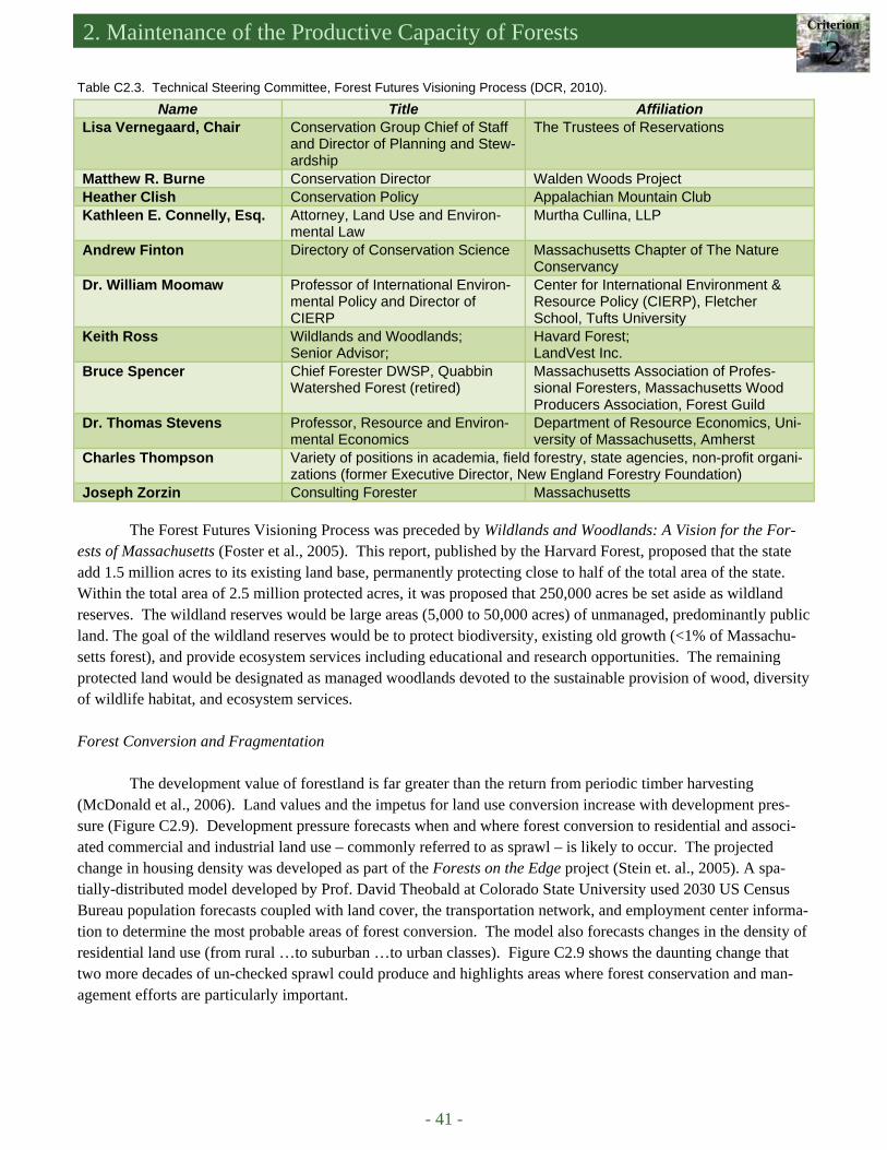
2. Maintenance of the Productive Capacity of Forests Criterion
2
- 41 -
Name Title Affiliation Lisa Vernegaard, Chair Conservation Group Chief of Staff
and Director of Planning and Stew-ardship
The Trustees of Reservations
Matthew R. Burne Conservation Director Walden Woods Project Heather Clish Conservation Policy Appalachian Mountain Club Kathleen E. Connelly, Esq. Attorney, Land Use and Environ-
mental Law Murtha Cullina, LLP
Andrew Finton Directory of Conservation Science Massachusetts Chapter of The Nature Conservancy
Dr. William Moomaw Professor of International Environ-mental Policy and Director of CIERP
Center for International Environment & Resource Policy (CIERP), Fletcher School, Tufts University
Keith Ross Wildlands and Woodlands; Senior Advisor;
Havard Forest; LandVest Inc.
Bruce Spencer Chief Forester DWSP, Quabbin Watershed Forest (retired)
Massachusetts Association of Profes-sional Foresters, Massachusetts Wood Producers Association, Forest Guild
Dr. Thomas Stevens Professor, Resource and Environ-mental Economics
Department of Resource Economics, Uni-versity of Massachusetts, Amherst
Charles Thompson Variety of positions in academia, field forestry, state agencies, non-profit organi-zations (former Executive Director, New England Forestry Foundation)
Joseph Zorzin Consulting Forester Massachusetts
Table C2.3. Technical Steering Committee, Forest Futures Visioning Process (DCR, 2010).
The Forest Futures Visioning Process was preceded by Wildlands and Woodlands: A Vision for the For-ests of Massachusetts (Foster et al., 2005). This report, published by the Harvard Forest, proposed that the state add 1.5 million acres to its existing land base, permanently protecting close to half of the total area of the state. Within the total area of 2.5 million protected acres, it was proposed that 250,000 acres be set aside as wildland reserves. The wildland reserves would be large areas (5,000 to 50,000 acres) of unmanaged, predominantly public land. The goal of the wildland reserves would be to protect biodiversity, existing old growth (<1% of Massachu-setts forest), and provide ecosystem services including educational and research opportunities. The remaining protected land would be designated as managed woodlands devoted to the sustainable provision of wood, diversity of wildlife habitat, and ecosystem services. Forest Conversion and Fragmentation
The development value of forestland is far greater than the return from periodic timber harvesting (McDonald et al., 2006). Land values and the impetus for land use conversion increase with development pres-sure (Figure C2.9). Development pressure forecasts when and where forest conversion to residential and associ-ated commercial and industrial land use – commonly referred to as sprawl – is likely to occur. The projected change in housing density was developed as part of the Forests on the Edge project (Stein et. al., 2005). A spa-tially-distributed model developed by Prof. David Theobald at Colorado State University used 2030 US Census Bureau population forecasts coupled with land cover, the transportation network, and employment center informa-tion to determine the most probable areas of forest conversion. The model also forecasts changes in the density of residential land use (from rural …to suburban …to urban classes). Figure C2.9 shows the daunting change that two more decades of un-checked sprawl could produce and highlights areas where forest conservation and man-agement efforts are particularly important.
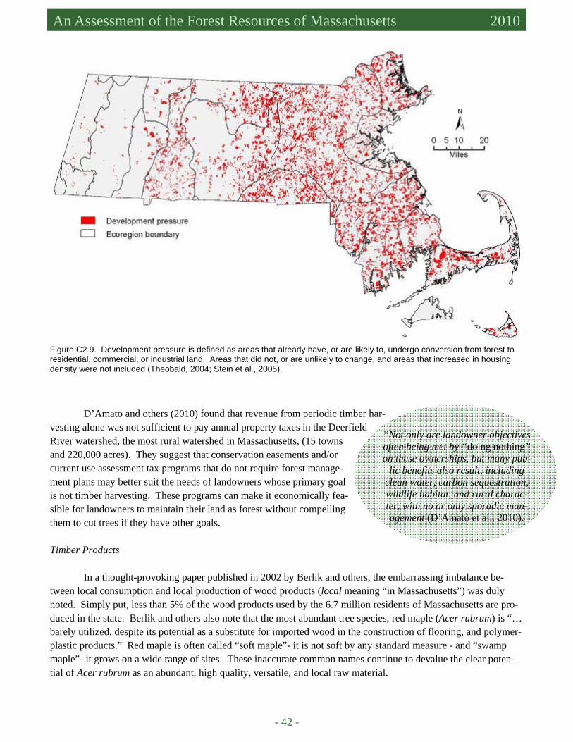
- 42 -
An Assessment of the Forest Resources of Massachusetts 2010
D’Amato and others (2010) found that revenue from periodic timber har-vesting alone was not sufficient to pay annual property taxes in the Deerfield River watershed, the most rural watershed in Massachusetts, (15 towns and 220,000 acres). They suggest that conservation easements and/or current use assessment tax programs that do not require forest manage-ment plans may better suit the needs of landowners whose primary goal is not timber harvesting. These programs can make it economically fea-sible for landowners to maintain their land as forest without compelling them to cut trees if they have other goals.
Timber Products
In a thought-provoking paper published in 2002 by Berlik and others, the embarrassing imbalance be-tween local consumption and local production of wood products (local meaning “in Massachusetts”) was duly noted. Simply put, less than 5% of the wood products used by the 6.7 million residents of Massachusetts are pro-duced in the state. Berlik and others also note that the most abundant tree species, red maple (Acer rubrum) is “…barely utilized, despite its potential as a substitute for imported wood in the construction of flooring, and polymer-plastic products.” Red maple is often called “soft maple”- it is not soft by any standard measure - and “swamp maple”- it grows on a wide range of sites. These inaccurate common names continue to devalue the clear poten-tial of Acer rubrum as an abundant, high quality, versatile, and local raw material.
Figure C2.9. Development pressure is defined as areas that already have, or are likely to, undergo conversion from forest to residential, commercial, or industrial land. Areas that did not, or are unlikely to change, and areas that increased in housing density were not included (Theobald, 2004; Stein et al., 2005).
“Not only are landowner objectives often being met by “doing nothing” on these ownerships, but many pub-
lic benefits also result, including clean water, carbon sequestration, wildlife habitat, and rural charac-ter, with no or only sporadic man-agement (D’Amato et al., 2010).
2. Maintenance of the Productive Capacity of Forests Criterion
2
- 43 -
References
Berlik, M.M., D.B. Kittredge, and D.R. Foster. 2002. The illusion of preservation: a global argument for the local production of natural resources. Harvard Forest Paper no. 26. Harvard Forest, Harvard University, Petersham, MA, 23 pp.
Bond, R.S. and A.M. Loud. 1992. Lumber production and marketing changes by sawmills in Massachusetts, 1957-1989. Northern Journal of Applied Forestry 9:67-69.
Butler, B.J. 2008. Family Forest Owners of the United States, 2006. Gen. Tech. Rep. NRS-27. Newtown Square, PA: US De-partment of Agriculture, Forest Service, Northern Research Station, 72 pp.
Butler, B.J., P.D. Miles, and M.H. Hansen. 2010. National Woodland Owner Survey Tabler web-application version 1.0. Am-herst, Massachusetts: US Department of Agriculture, Forest Service, Northern Research Station. Available at http://fiatools.fs.fed.us/NWOS/tablemaker.jsp. Accessed in February 2010.
Butler, B.J., Z. Ma, D.B. Kittredge, and P. Catanzaro. Social versus biophysical availability of wood in the northern United States. (In review: Northern Journal of Applied Forestry).
D’Amato, A.W., P.F. Catanzaro, D.T. Damery, D.B. Kittredge, and K.A. Ferrare. 2010. Are family forest owners facing a future in which forest management is not enough? Journal of Forestry 108:32-38.
Damery, D.T., C. Bellemer, and G. Boyce. 2006. Massachusetts Directory of Sawmills & Dry Kilns – 2006. DCR (Massachusetts Department of Conservation and Recreation). 2008. Forest Reserve boundaries. DCR (Massachusetts Department of Conservation and Recreation-Division of State Parks and Recreation). 2010. Forest Fu-
tures Visioning Process, Technical Steering Committee Draft Recommendations. January 22, 2010. For Public Com-ment and Review, 158 pp.
DSPR (Massachusett Department of Conservation and Recreation-Division of State Parks and Recreation). 2009a. DCR-DSPR Forest Cutting Plans.
DSPR (Massachusett Department of Conservation and Recreation-Division of State Parks and Recreation). 2009b. DCR-DSPR Licensed Timber Harvester Report.
DFW (Massachusetts Department of Fish and Game-Division of Fisheries and Wildlife). 2007. Matrix Reserve Boundaries. EEA (Executive Office of Environmental and Energy Affairs). 2009. Forest Reserves. Boston, MA. February 2, 2009. Avail-
able at http://www.mass.gov/Eoeea/docs/eea/lf/whatare_forestreserves.pdf. Accessed in September 2009. Federal Reserve Bank of St. Louis. 2009. HOUST, Housing Starts: Total: New Privately Owned Housing Units Started.
Available at http://research.stlouisfed.org/fred2/series/HOUST/. Accessed in January 2009. Foster, D.R. 1988. Species and stand response to catastrophic wind in central New England, USA. Journal of Ecology 76:135
-151. Foster, D., D. Kittredge, B. Donahue, G. Motzkin, D. Orwig, A. Ellison, B. Hall, B. Colburn, and A. D’Amato. 2005. Wild-
lands and Woodlands: A Vision for the Forests of Massachusetts. Harvard Forest, Harvard University, Petersham, MA, 24 pp.
Kelty, M.J. and A.W. D’Amato. 2005. Historical perspective on diameter-limit cutting in northeastern forests. In: Kenefic, L.S. and R.D. Nyland, editors. Proceedings of the conference on diameter-limit cutting in northeastern forests. USDA Forest Service General Technical Report NE-341: 3-15.
Kittredge, D.B. Jr., M.J. Mauri, and E.J. McGuire. 1996. Decreasing woodlot size and the future of timber sales in Massachu-setts: when is an operation too small? Northern Journal of Applied Forestry 13(2):96-101.
Kittredge, D.B. Jr. and M. Parker. 1999. Massachusetts Forestry Best Management Practices. Prepared for the Massachusetts Department of Environmental Protection, Office of Watershed Management and US Environmental Protection Agency, Region I, Water Division, Water Quality Section, 55 pp.
Kittredge, D.B., A.W. D’Amato, P. Catanzaro, J. Fish, and B. Butler. 2008. Estimating ownerships and parcels of nonindus-trial private forestland in Massachusetts. Northern Journal of Applied Forestry 25(2):93-98.
Lorimer. C.G. 1984. Development of the red maple understory in northeastern oak forests. Forest Science 30(1):3-22. MassGIS (Office of Geographic and Environmental Information, Commonwealth of Massachusetts, Executive Office of En-
ergy and Environmental Affairs). 2002. Land Use: 1951-1999. Available at http://www.mass.gov/mgis. Accessed in January 2010.
MassGIS (Office of Geographic and Environmental Information, Commonwealth of Massachusetts, Executive Office of En-ergy and Environmental Affairs). 2009a. Land Use: 2005. Available at http://www.mass.gov/mgis. Accessed in Janu-ary, 2010.
MassGIS (Office of Geographic and Environmental Information, Commonwealth of Massachusetts, Executive Office of En-ergy and Environmental Affairs). 2009b. Open Space. Available at http://www.mass.gov/mgis. Accessed in Janu-ary, 2010.
MassWoods (University of Massachusetts – Amherst Extension). 2009. Massachusetts Forests: our forests are your woods. Available at http://www.masswoods.net/index.php/forests. Accessed in January 2010.
McDonald, R.I., G. Motzkin, M.S. Bank, D.B. Kittredge, J. Burk, and D.R. Foster. 2006. Forest harvesting and land-use con-version over two decades in Massachusetts. Forest Ecology and Management 227:31-41.
- 44 -
An Assessment of the Forest Resources of Massachusetts 2010
Peters, J. R. and T.M. Bowers. Forest Statistics for Massachusetts. 1977. USDA Forest Service Resource Bulletin NE-48. Northeastern Forest Experiment Station, PA., 43 pp.
Stein, S.M., R.E. McRoberts, R.J. Alig, M.D. Nelson, D.M. Theobald, M. Eley, M. Dechter, M. Carr. 2005. Forests on the edge: housing development on America's private forests. General Technical Report PNW-GTR-636. Portland, OR: USDA Forest Service, Pacific Northwest Research Station, 16 pp.
Theobald, D.M. 2004. Housing density in 2000 and 2030 [Digital Data]. Fort Collins, CO: Colorado State University, Natural Resource Ecology Lab.
Troy, A. and M.A. Wilson. 2006. Mapping ecosystem services: practical challenges and opportunities in linking GIS and value transfer. Ecological Economics 60:435-449.
USDA Forest Service. 2004. Northeastern Forest Inventory and Analysis Methodology. Available at http://www.fs.fed.us/ne/fia/methodology/def_ip.htm. Accessed in January 2010.
USDA Forest Service FIA. 2008. Miles, P.D. 2009, 2010. Forest Inventory EVALIDator web-application version 4.01 beta. St. Paul, MN: US Department of Agriculture, Forest Service, Northern Research Station. Available at http://fiatools.fs.fed.us/Evalidator401/tmattribute.jsp. Accessed in February 2010.
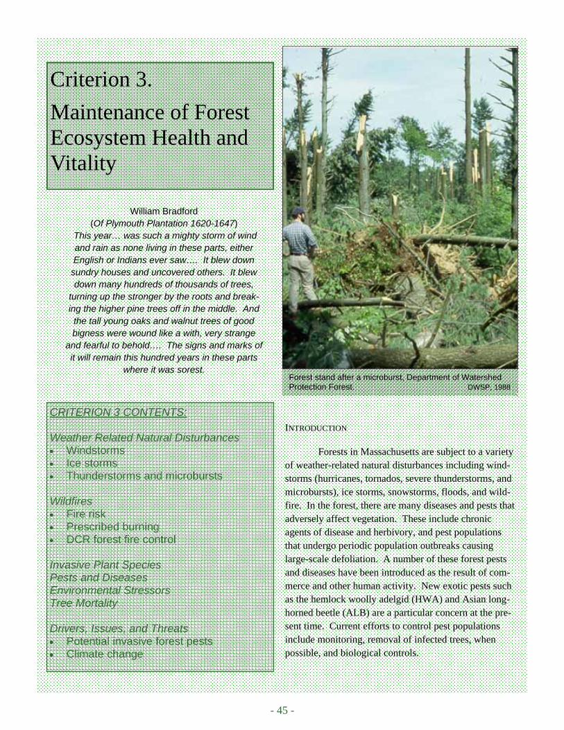
- 45 -
Forest stand after a microburst, Department of Watershed Protection Forest. DWSP, 1988
Criterion 3.
Maintenance of Forest Ecosystem Health and Vitality
CRITERION 3 CONTENTS: Weather Related Natural Disturbances • Windstorms • Ice storms • Thunderstorms and microbursts Wildfires • Fire risk • Prescribed burning • DCR forest fire control Invasive Plant Species Pests and Diseases Environmental Stressors Tree Mortality Drivers, Issues, and Threats • Potential invasive forest pests • Climate change
INTRODUCTION
Forests in Massachusetts are subject to a variety of weather-related natural disturbances including wind-storms (hurricanes, tornados, severe thunderstorms, and microbursts), ice storms, snowstorms, floods, and wild-fire. In the forest, there are many diseases and pests that adversely affect vegetation. These include chronic agents of disease and herbivory, and pest populations that undergo periodic population outbreaks causing large-scale defoliation. A number of these forest pests and diseases have been introduced as the result of com-merce and other human activity. New exotic pests such as the hemlock woolly adelgid (HWA) and Asian long-horned beetle (ALB) are a particular concern at the pre-sent time. Current efforts to control pest populations include monitoring, removal of infected trees, when possible, and biological controls.
William Bradford (Of Plymouth Plantation 1620-1647)
This year… was such a mighty storm of wind and rain as none living in these parts, either English or Indians ever saw…. It blew down
sundry houses and uncovered others. It blew down many hundreds of thousands of trees,
turning up the stronger by the roots and break-ing the higher pine trees off in the middle. And the tall young oaks and walnut trees of good bigness were wound like a with, very strange
and fearful to behold…. The signs and marks of it will remain this hundred years in these parts
where it was sorest.

- 46 -
An Assessment of the Forest Resources of Massachusetts 2010
WEATHER RELATED NATURAL DISTURBANCES Windstorms
New England is affected by Atlantic hurricanes that form over tropical ocean waters and track north along the coast or east into the Atlantic. Hurricanes gain energy from warm, ocean waters and general lose strength fol-lowing landfall. Periodically, however, these storms travel northward along the Gulf Stream and pass directly over New England causing substantial damage to the landscape. There have been 67 hurricanes recorded between 1620 and 1997. Of these, 11 (16%) caused no reported damage; 4 (6%) caused minor damage; 20 (30%) caused some tree blowdowns; and, 24 (36%) caused extensive blowdowns. There have been eight hurricanes (1635, 1788, 1804 1815, 1821, 1869 [2 storms], and 1938), with winds of 107 to 139 mph (Fujita damage scale category F3) that have blown down most of the trees in their path (Boose et al., 2001). The most recent F3 hurricane (1938) had a lasting effect on forest structure and species composition (Box C3.1).
Tornados occur more frequently than the national average. There have been 147 tornados in Massachu-setts between 1950 and 1995. Of these, 124 were classified as F1 and above on the Fujita damage scale (F1 = trees blown down) and 12 qualified as F3 or F4 tornados. An F4 tornado in Worcester County (Central Uplands ecoregion) in 1953 killed 94 people and injured 1,228 (The Tornado Project, 1996). On 5/29/1995, a category 3-4 tornado caused 4 deaths and left a continuous damage path 165 to 3,280 ft. (50 to 1,000m) wide and 30 miles (50 km) long in Great Barrington in the southwestern corner of Massachusetts. The area sustained severe forest and infrastructure damage (Bosart et al., 2006).
While very large, severe windstorms can blow down extensive areas and create new even-aged forests, more frequent, smaller, and less-severe storms create a patchy pattern of disturbance. Storms result in individual tree gaps, crown damage, broken branches, and leaf stripping. This adds snags and down deadwood (important habitat features) to the forest environment. Because the most damaging hurricane winds normally come from the southeast, some valleys and leeward hillsides can be protected from damaging winds over long periods of time (Foster and Boose, 1992; Boose et al., 2001). Over the long-term, and absent the effects of human land use, wind-storms create the uneven-aged, multi-species forest typical of remnant old-growth stands in Massachusetts (D’Amato and Orwig, 2008).
Thunderstorms and Microbursts
Microbursts are intense winds that are often, but not always, associated with thunderstorms. They de-scend from rainclouds, hit the ground, and fan out horizontally affecting small areas often with substantial im-pacts. A combination of thunderstorms, microbursts, and tornados caused extensive damage to Massachusetts forests from the Connecticut River valley to the Central Uplands on July 11, 2006. Damage was especially severe in Wendell State Forest where a combination of a microburst and a tornado uprooted trees as large as 3 ft. in di-ameter (Storm data and unusual weather phenomena, July 2006).
Ice Storms
Ice storms cause periodic, widespread damage to Massachusetts forests. Notable ice storms occurred in 1942, 1958, 1996, and 1997 (Rivers, 1998) with the most recent in December of 2008 (Box C3.2).
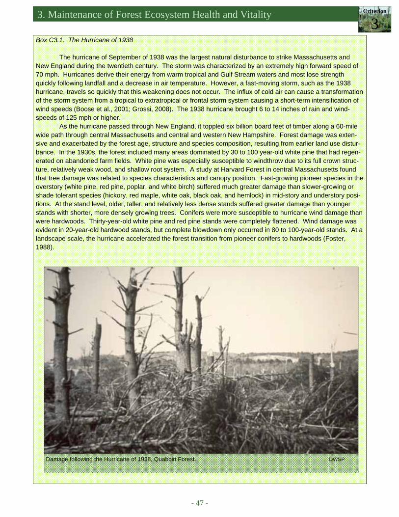
3. Maintenance of Forest Ecosystem Health and Vitality Criterion
3
- 47 -
Box C3.1. The Hurricane of 1938
The hurricane of September of 1938 was the largest natural disturbance to strike Massachusetts and New England during the twentieth century. The storm was characterized by an extremely high forward speed of 70 mph. Hurricanes derive their energy from warm tropical and Gulf Stream waters and most lose strength quickly following landfall and a decrease in air temperature. However, a fast-moving storm, such as the 1938 hurricane, travels so quickly that this weakening does not occur. The influx of cold air can cause a transformation of the storm system from a tropical to extratropical or frontal storm system causing a short-term intensification of wind speeds (Boose et al., 2001; Grossi, 2008). The 1938 hurricane brought 6 to 14 inches of rain and wind-speeds of 125 mph or higher.
As the hurricane passed through New England, it toppled six billion board feet of timber along a 60-mile wide path through central Massachusetts and central and western New Hampshire. Forest damage was exten-sive and exacerbated by the forest age, structure and species composition, resulting from earlier land use distur-bance. In the 1930s, the forest included many areas dominated by 30 to 100 year-old white pine that had regen-erated on abandoned farm fields. White pine was especially susceptible to windthrow due to its full crown struc-ture, relatively weak wood, and shallow root system. A study at Harvard Forest in central Massachusetts found that tree damage was related to species characteristics and canopy position. Fast-growing pioneer species in the overstory (white pine, red pine, poplar, and white birch) suffered much greater damage than slower-growing or shade tolerant species (hickory, red maple, white oak, black oak, and hemlock) in mid-story and understory posi-tions. At the stand level, older, taller, and relatively less dense stands suffered greater damage than younger stands with shorter, more densely growing trees. Conifers were more susceptible to hurricane wind damage than were hardwoods. Thirty-year-old white pine and red pine stands were completely flattened. Wind damage was evident in 20-year-old hardwood stands, but complete blowdown only occurred in 80 to 100-year-old stands. At a landscape scale, the hurricane accelerated the forest transition from pioneer conifers to hardwoods (Foster, 1988).
Damage following the Hurricane of 1938, Quabbin Forest. DWSP
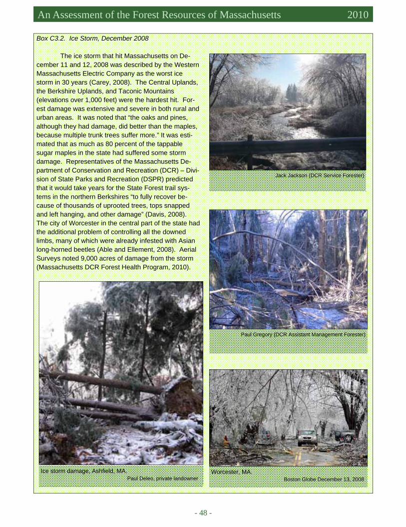
- 48 -
An Assessment of the Forest Resources of Massachusetts 2010
Box C3.2. Ice Storm, December 2008
The ice storm that hit Massachusetts on De-cember 11 and 12, 2008 was described by the Western Massachusetts Electric Company as the worst ice storm in 30 years (Carey, 2008). The Central Uplands, the Berkshire Uplands, and Taconic Mountains (elevations over 1,000 feet) were the hardest hit. For-est damage was extensive and severe in both rural and urban areas. It was noted that “the oaks and pines, although they had damage, did better than the maples, because multiple trunk trees suffer more.” It was esti-mated that as much as 80 percent of the tappable sugar maples in the state had suffered some storm damage. Representatives of the Massachusetts De-partment of Conservation and Recreation (DCR) – Divi-sion of State Parks and Recreation (DSPR) predicted that it would take years for the State Forest trail sys-tems in the northern Berkshires “to fully recover be-cause of thousands of uprooted trees, tops snapped and left hanging, and other damage” (Davis, 2008). The city of Worcester in the central part of the state had the additional problem of controlling all the downed limbs, many of which were already infested with Asian long-horned beetles (Able and Ellement, 2008). Aerial Surveys noted 9,000 acres of damage from the storm (Massachusetts DCR Forest Health Program, 2010).
Paul Gregory (DCR Assistant Management Forester)
Ice storm damage, Ashfield, MA. Paul Deleo, private landowner
Jack Jackson (DCR Service Forester)
Worcester, MA. Boston Globe December 13, 2008
3. Maintenance of Forest Ecosystem Health and Vitality Criterion
3
- 49 -
WILDFIRES Fire Risk
Most forests in Massachusetts are not subject to fires of high frequency or high intensity. Different forest types exhibit different fire susceptibility and behavior. Forest litter from northern hardwood species decomposes relatively rapidly so there is little fuel build-up on the forest floor. Hardwood forest canopies do not ordinarily carry a fire due to the high moisture content of green leaves and humidity created by the transpiration of the trees. In addition, rain and snow occur throughout the year. Droughts occur but not annually. In transition and central hardwood forests, dominated by oak species, fire risk is slightly higher although still low compared to many forest types. Oak leaves are thicker and tend to curl up after they fall leaving spaces in the leaf litter. This allows oxygen to mix with the litter and increases fire risk. Fire risk is greatest in hardwood forest types during the spring, after snowmelt but before the leaf-out, and in the autumn, after leaf fall, because the lack of the overstory canopy ex-poses fuel on the forest floor to wind and sun (Kelty et al., 2008). There has been a history of human-caused fires in the Clarksburg area of the northern Berkshires in oak-dominated forests located on dry soils and southwest fac-ing slopes (de la Crétaz and Kelty, 2008).
Pitch pine-scrub oak is the only fire-adapted forest type in Massachusetts. These forests are found grow-ing on sandy soils primarily on the southeastern coastal plain (Cape Cod and the Islands), but also on patches of outwash soils in the interior of the state. Pitch pine-scrub oak forests are susceptible to fire because (1) pine nee-dles do not decompose as quickly as hardwood leaves, leading to a build-up of fuel on the forest floor; (2) dead branches persist on the lower trunks of trees creating ladder fuels; and (3) the moisture content of the needles is low and the needles can become so dry that fire can spread through the forest canopy (Kelty et al., 2008).
In Massachusetts, lightning is almost always accompanied by rain; there are few natural forest fires. Fires occur primarily as a result of human activity; thus, the risk of forest fire increases in forest areas that are close to development and open to public use. A working group led by the USDA Forest Service developed the Northeast Wildfire Risk Assessment model (Figure C3.1) (Northeast Wildfire Risk Assessment Geospatial Work Group, 2009). The assessment is comprised of three components: (1) fuels (Scott and Burgan, 2005), (2) wildland-urban interface (Radeloff et al., 2005) (Figure C3.2), and (3) topography (slope and aspect). These three characteristics are combined to identify wildfire prone areas where hazard mitigation practices would be most effective. The Wildfire Risk Assessment also identifies and prioritizes communities most at risk from wildfire. This allows state agencies to focus resources in areas of greatest need. High and very high risk areas are areas with fire prone forest types (pitch pine – scrub oak and oak) and significant forest-human interaction.
The state forests in southeastern Massachusetts (Myles Standish in Plymouth and Carver, Manuel Correl-lus on Martha’s Vineyard, and Freetown-Fall River in Assonet) are at particularly high risk of fire. The fire-adapted pitch pine-scrub oak forests are well used and surrounded by populated areas. A fire in Myles Standish State Forest (May 1957) burned approximately 15,000 acres, stopping only when it reached the shores of Cape Cod Bay. The fire, known as the Crown Fire, was reported to have burned at a rate of 18 acres per minute with flames lengths exceeding 150 feet. The last major fire in Myles Standish State Forest occurred in 1964, burning 5,500 acres and destroying 26 structures (Mass Moments, 2006).
Prescribed Burning
Since the 1980s, Dr. William Patterson of the University of Massachusetts Amherst, has been instrumen-tal in the development of prescribed burning programs in areas where pitch pine-scrub oak forests are prevalent. Prescribed burns, sometimes in combination with mechanical treatments and grazing, are used to reduce fuel loads, and the risk of crown fires, while preserving the native pitch pine communities and open sandplain grass-lands in the Cape Cod and Islands and Connecticut River Valley regions. These controlled burns have been con-
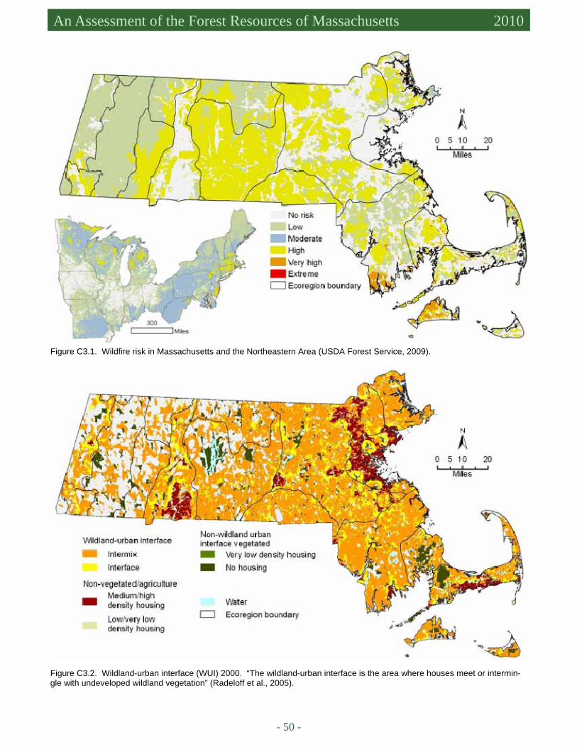
- 50 -
An Assessment of the Forest Resources of Massachusetts 2010
Figure C3.1. Wildfire risk in Massachusetts and the Northeastern Area (USDA Forest Service, 2009).
Figure C3.2. Wildland-urban interface (WUI) 2000. “The wildland-urban interface is the area where houses meet or intermin-gle with undeveloped wildland vegetation” (Radeloff et al., 2005).
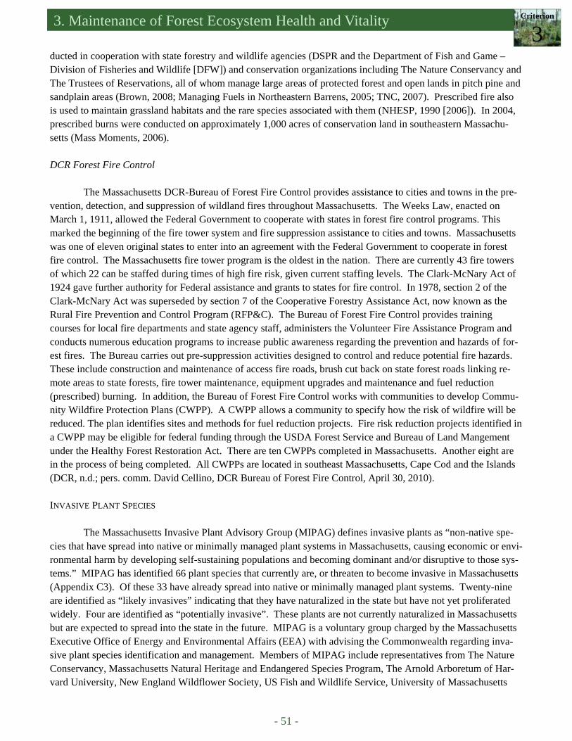
3. Maintenance of Forest Ecosystem Health and Vitality Criterion
3
- 51 -
ducted in cooperation with state forestry and wildlife agencies (DSPR and the Department of Fish and Game – Division of Fisheries and Wildlife [DFW]) and conservation organizations including The Nature Conservancy and The Trustees of Reservations, all of whom manage large areas of protected forest and open lands in pitch pine and sandplain areas (Brown, 2008; Managing Fuels in Northeastern Barrens, 2005; TNC, 2007). Prescribed fire also is used to maintain grassland habitats and the rare species associated with them (NHESP, 1990 [2006]). In 2004, prescribed burns were conducted on approximately 1,000 acres of conservation land in southeastern Massachu-setts (Mass Moments, 2006). DCR Forest Fire Control
The Massachusetts DCR-Bureau of Forest Fire Control provides assistance to cities and towns in the pre-vention, detection, and suppression of wildland fires throughout Massachusetts. The Weeks Law, enacted on March 1, 1911, allowed the Federal Government to cooperate with states in forest fire control programs. This marked the beginning of the fire tower system and fire suppression assistance to cities and towns. Massachusetts was one of eleven original states to enter into an agreement with the Federal Government to cooperate in forest fire control. The Massachusetts fire tower program is the oldest in the nation. There are currently 43 fire towers of which 22 can be staffed during times of high fire risk, given current staffing levels. The Clark-McNary Act of 1924 gave further authority for Federal assistance and grants to states for fire control. In 1978, section 2 of the Clark-McNary Act was superseded by section 7 of the Cooperative Forestry Assistance Act, now known as the Rural Fire Prevention and Control Program (RFP&C). The Bureau of Forest Fire Control provides training courses for local fire departments and state agency staff, administers the Volunteer Fire Assistance Program and conducts numerous education programs to increase public awareness regarding the prevention and hazards of for-est fires. The Bureau carries out pre-suppression activities designed to control and reduce potential fire hazards. These include construction and maintenance of access fire roads, brush cut back on state forest roads linking re-mote areas to state forests, fire tower maintenance, equipment upgrades and maintenance and fuel reduction (prescribed) burning. In addition, the Bureau of Forest Fire Control works with communities to develop Commu-nity Wildfire Protection Plans (CWPP). A CWPP allows a community to specify how the risk of wildfire will be reduced. The plan identifies sites and methods for fuel reduction projects. Fire risk reduction projects identified in a CWPP may be eligible for federal funding through the USDA Forest Service and Bureau of Land Mangement under the Healthy Forest Restoration Act. There are ten CWPPs completed in Massachusetts. Another eight are in the process of being completed. All CWPPs are located in southeast Massachusetts, Cape Cod and the Islands (DCR, n.d.; pers. comm. David Cellino, DCR Bureau of Forest Fire Control, April 30, 2010). INVASIVE PLANT SPECIES
The Massachusetts Invasive Plant Advisory Group (MIPAG) defines invasive plants as “non-native spe-cies that have spread into native or minimally managed plant systems in Massachusetts, causing economic or envi-ronmental harm by developing self-sustaining populations and becoming dominant and/or disruptive to those sys-tems.” MIPAG has identified 66 plant species that currently are, or threaten to become invasive in Massachusetts (Appendix C3). Of these 33 have already spread into native or minimally managed plant systems. Twenty-nine are identified as “likely invasives” indicating that they have naturalized in the state but have not yet proliferated widely. Four are identified as “potentially invasive”. These plants are not currently naturalized in Massachusetts but are expected to spread into the state in the future. MIPAG is a voluntary group charged by the Massachusetts Executive Office of Energy and Environmental Affairs (EEA) with advising the Commonwealth regarding inva-sive plant species identification and management. Members of MIPAG include representatives from The Nature Conservancy, Massachusetts Natural Heritage and Endangered Species Program, The Arnold Arboretum of Har-vard University, New England Wildflower Society, US Fish and Wildlife Service, University of Massachusetts
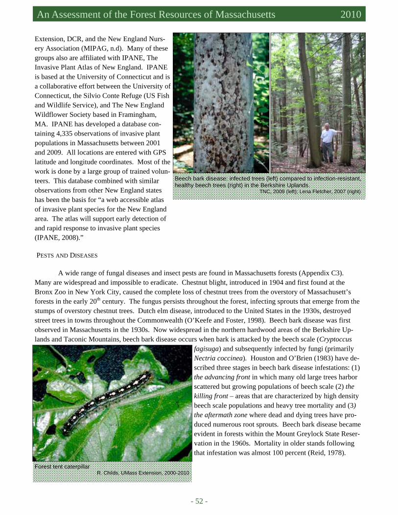
- 52 -
An Assessment of the Forest Resources of Massachusetts 2010
Extension, DCR, and the New England Nurs-ery Association (MIPAG, n.d). Many of these groups also are affiliated with IPANE, The Invasive Plant Atlas of New England. IPANE is based at the University of Connecticut and is a collaborative effort between the University of Connecticut, the Silvio Conte Refuge (US Fish and Wildlife Service), and The New England Wildflower Society based in Framingham, MA. IPANE has developed a database con-taining 4,335 observations of invasive plant populations in Massachusetts between 2001 and 2009. All locations are entered with GPS latitude and longitude coordinates. Most of the work is done by a large group of trained volun-teers. This database combined with similar observations from other New England states has been the basis for “a web accessible atlas of invasive plant species for the New England area. The atlas will support early detection of and rapid response to invasive plant species (IPANE, 2008).” PESTS AND DISEASES
A wide range of fungal diseases and insect pests are found in Massachusetts forests (Appendix C3). Many are widespread and impossible to eradicate. Chestnut blight, introduced in 1904 and first found at the Bronx Zoo in New York City, caused the complete loss of chestnut trees from the overstory of Massachusett’s forests in the early 20th century. The fungus persists throughout the forest, infecting sprouts that emerge from the stumps of overstory chestnut trees. Dutch elm disease, introduced to the United States in the 1930s, destroyed street trees in towns throughout the Commonwealth (O’Keefe and Foster, 1998). Beech bark disease was first observed in Massachusetts in the 1930s. Now widespread in the northern hardwood areas of the Berkshire Up-lands and Taconic Mountains, beech bark disease occurs when bark is attacked by the beech scale (Cryptoccus
fagisuga) and subsequently infected by fungi (primarily Nectria coccinea). Houston and O’Brien (1983) have de-scribed three stages in beech bark disease infestations: (1) the advancing front in which many old large trees harbor scattered but growing populations of beech scale (2) the killing front – areas that are characterized by high density beech scale populations and heavy tree mortality and (3) the aftermath zone where dead and dying trees have pro-duced numerous root sprouts. Beech bark disease became evident in forests within the Mount Greylock State Reser-vation in the 1960s. Mortality in older stands following that infestation was almost 100 percent (Reid, 1978).
Beech bark disease: infected trees (left) compared to infection-resistant, healthy beech trees (right) in the Berkshire Uplands. TNC, 2009 (left); Lena Fletcher, 2007 (right)
Forest tent caterpillar R. Childs, UMass Extension, 2000-2010
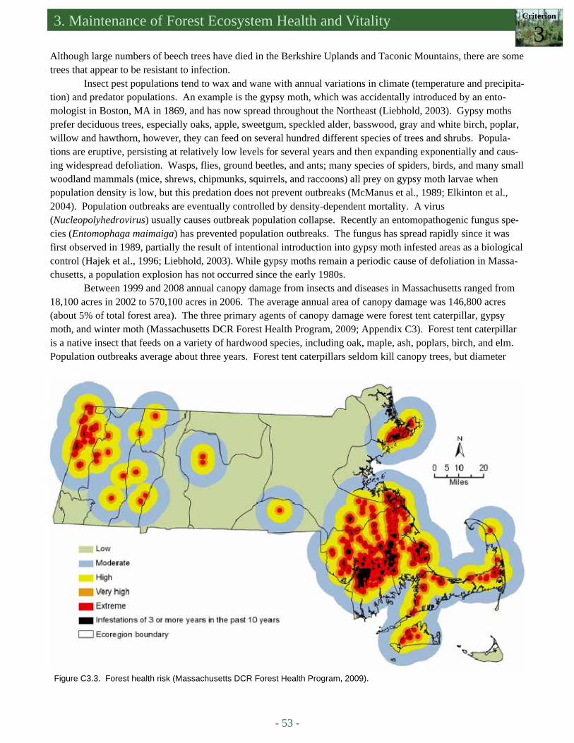
3. Maintenance of Forest Ecosystem Health and Vitality Criterion
3
- 53 -
Figure C3.3. Forest health risk (Massachusetts DCR Forest Health Program, 2009).
Although large numbers of beech trees have died in the Berkshire Uplands and Taconic Mountains, there are some trees that appear to be resistant to infection.
Insect pest populations tend to wax and wane with annual variations in climate (temperature and precipita-tion) and predator populations. An example is the gypsy moth, which was accidentally introduced by an ento-mologist in Boston, MA in 1869, and has now spread throughout the Northeast (Liebhold, 2003). Gypsy moths prefer deciduous trees, especially oaks, apple, sweetgum, speckled alder, basswood, gray and white birch, poplar, willow and hawthorn, however, they can feed on several hundred different species of trees and shrubs. Popula-tions are eruptive, persisting at relatively low levels for several years and then expanding exponentially and caus-ing widespread defoliation. Wasps, flies, ground beetles, and ants; many species of spiders, birds, and many small woodland mammals (mice, shrews, chipmunks, squirrels, and raccoons) all prey on gypsy moth larvae when population density is low, but this predation does not prevent outbreaks (McManus et al., 1989; Elkinton et al., 2004). Population outbreaks are eventually controlled by density-dependent mortality. A virus (Nucleopolyhedrovirus) usually causes outbreak population collapse. Recently an entomopathogenic fungus spe-cies (Entomophaga maimaiga) has prevented population outbreaks. The fungus has spread rapidly since it was first observed in 1989, partially the result of intentional introduction into gypsy moth infested areas as a biological control (Hajek et al., 1996; Liebhold, 2003). While gypsy moths remain a periodic cause of defoliation in Massa-chusetts, a population explosion has not occurred since the early 1980s.
Between 1999 and 2008 annual canopy damage from insects and diseases in Massachusetts ranged from 18,100 acres in 2002 to 570,100 acres in 2006. The average annual area of canopy damage was 146,800 acres (about 5% of total forest area). The three primary agents of canopy damage were forest tent caterpillar, gypsy moth, and winter moth (Massachusetts DCR Forest Health Program, 2009; Appendix C3). Forest tent caterpillar is a native insect that feeds on a variety of hardwood species, including oak, maple, ash, poplars, birch, and elm. Population outbreaks average about three years. Forest tent caterpillars seldom kill canopy trees, but diameter

- 54 -
An Assessment of the Forest Resources of Massachusetts 2010
growth is reduced and the quantity and quality of sugar maple sap is greatly reduced by defoliation. The forest tent caterpillar has many natural predators. Parasitic flies and wasps infect tent caterpillar eggs, larvae, and pupae. Beetles, ants, true bugs, spiders, birds, and small mammals prey on caterpillars. Bacillus thurengiensis (BT) has been used effectively for forest tent caterpillar control as well (Batzer and Morris, 1978; UMass Extension, 2000-2010). Winter moth was introduced from Europe to eastern Canada and is now found in Massachusetts. Popula-tions currently infest coastal areas from the North Shore to Cape Cod. Winter moth caterpillars feed on the buds and leaves of a wide variety of hardwood trees including oaks, maples, basswood, ash, and fruit trees and shrubs: apples, crabapples, and blueberries. Infested trees can die if they are completely defoliated for four consecutive years. Beginning in 2005 a group of researchers at the University of Massachusetts Amherst released two parasi-toids, Cyzenis albican, a tachnid fly and Agrypon flaveolatum, an ichneumonid (wasp), as biological control agents. Successful biological programs using these insects have been established in Nova Scotia and British Co-lumbia. Parasitized larvae were recovered in Falmouth, MA in 2007 and there are now plans for a massive C. al-bican breeding and release program in cooperation with the USDA Animal and Plant Health Inspection Service (APHIS) program (Elkinton et al., 2008).
Data from the Massachusetts DCR Forest Health Program (2009) were used to create the forest health risk map (Figure C3.3). The map was developed based on areas of infestations lasting three or more years during the past ten years (2000 to 2009) and creating different levels of risk surrounding these areas based on distance from these infestations. Areas of risk were segregated into five levels. The buffering distances were: 1 mile (extreme); 1 to 2 miles (very high) ; 2 to 5 miles (high); 5 to 10 miles (moderate); and greater than 10 miles (low).
The three pests noted above (winter moth, forest tent caterpillar, and gypsy moth) are primarily responsi-ble for the high risk areas identified in the forest health risk map. Winter moth is the primary pest on the north shore; forest tent caterpillars have repeatedly defoliated large areas of the central and western parts of the state, while forests on the south shore, Cape Cod, and Mar-tha’s Vineyard have been damaged by all three pests (Massachusetts DCR Forest Health Program, 2009). In addition to the pests and pathogens described above, two recently introduced species, the hemlock woolly adelgid (HWA) and Asian longhorned beetle (ALB) (Box C3.3), currently threaten the Massachusetts forests. Hemlock woolly adelgid is an aphid-like insect that is native to Japan. It feeds on young branches and twigs of eastern hemlock, usually close to the point of attachment between needles and twigs, causing needle loss and killing the tree within three to ten years (McClure, 1987; University of Massachusetts Amherst, 2010). HWA was accidentally introduced to Virginia in 1953 and in 2002 was found from North Carolina to the southern coast of Maine. It was first observed in Con-necticut in 1985 (McClure, 1987). In 1989 HWA was discovered in Springfield, Massachusetts (Connecticut River Valley ecoregion). Since then HWA has spread to 192 towns in Massachusetts (Figure C3.4, Appendix C3, Massachusetts DCR Forest Health Program, 2009). HWA is spread by wind, birds, deer, and humans (McClure, 1990). Hemlocks show no resistance to
Hemlock Woolly Adelgid, Quabbin Reservoir. DWSP
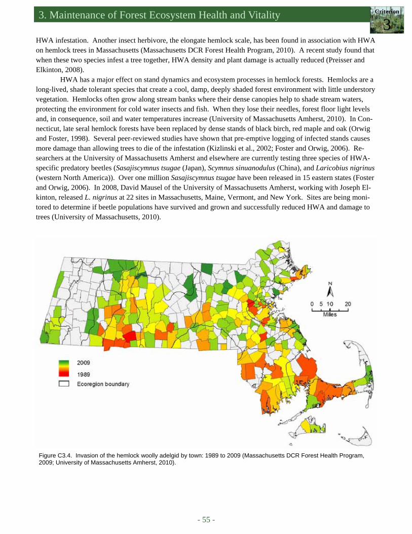
3. Maintenance of Forest Ecosystem Health and Vitality Criterion
3
- 55 -
HWA infestation. Another insect herbivore, the elongate hemlock scale, has been found in association with HWA on hemlock trees in Massachusetts (Massachusetts DCR Forest Health Program, 2010). A recent study found that when these two species infest a tree together, HWA density and plant damage is actually reduced (Preisser and Elkinton, 2008).
HWA has a major effect on stand dynamics and ecosystem processes in hemlock forests. Hemlocks are a long-lived, shade tolerant species that create a cool, damp, deeply shaded forest environment with little understory vegetation. Hemlocks often grow along stream banks where their dense canopies help to shade stream waters, protecting the environment for cold water insects and fish. When they lose their needles, forest floor light levels and, in consequence, soil and water temperatures increase (University of Massachusetts Amherst, 2010). In Con-necticut, late seral hemlock forests have been replaced by dense stands of black birch, red maple and oak (Orwig and Foster, 1998). Several peer-reviewed studies have shown that pre-emptive logging of infected stands causes more damage than allowing trees to die of the infestation (Kizlinski et al., 2002; Foster and Orwig, 2006). Re-searchers at the University of Massachusetts Amherst and elsewhere are currently testing three species of HWA-specific predatory beetles (Sasajiscymnus tsugae (Japan), Scymnus sinuanodulus (China), and Laricobius nigrinus (western North America)). Over one million Sasajiscymnus tsugae have been released in 15 eastern states (Foster and Orwig, 2006). In 2008, David Mausel of the University of Massachusetts Amherst, working with Joseph El-kinton, released L. nigrinus at 22 sites in Massachusetts, Maine, Vermont, and New York. Sites are being moni-tored to determine if beetle populations have survived and grown and successfully reduced HWA and damage to trees (University of Massachusetts, 2010).
Figure C3.4. Invasion of the hemlock woolly adelgid by town: 1989 to 2009 (Massachusetts DCR Forest Health Program, 2009; University of Massachusetts Amherst, 2010).
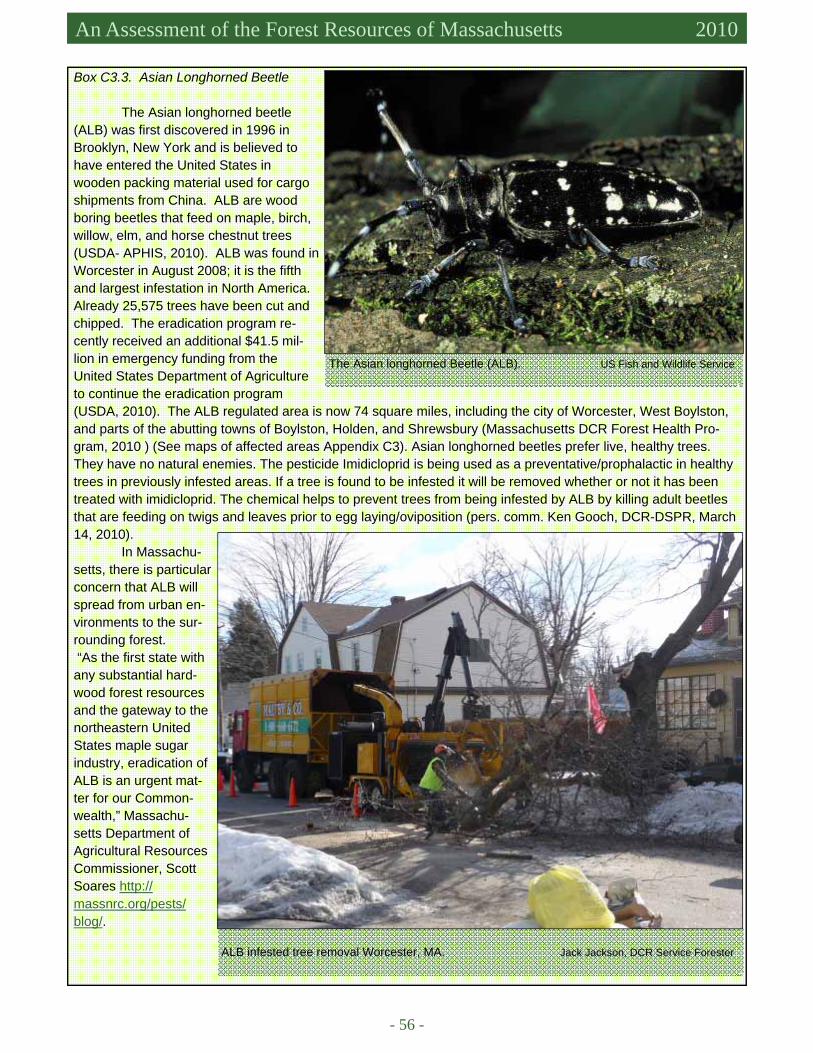
- 56 -
An Assessment of the Forest Resources of Massachusetts 2010
Box C3.3. Asian Longhorned Beetle
The Asian longhorned beetle (ALB) was first discovered in 1996 in Brooklyn, New York and is believed to have entered the United States in wooden packing material used for cargo shipments from China. ALB are wood boring beetles that feed on maple, birch, willow, elm, and horse chestnut trees (USDA- APHIS, 2010). ALB was found in Worcester in August 2008; it is the fifth and largest infestation in North America. Already 25,575 trees have been cut and chipped. The eradication program re-cently received an additional $41.5 mil-lion in emergency funding from the United States Department of Agriculture to continue the eradication program (USDA, 2010). The ALB regulated area is now 74 square miles, including the city of Worcester, West Boylston, and parts of the abutting towns of Boylston, Holden, and Shrewsbury (Massachusetts DCR Forest Health Pro-gram, 2010 ) (See maps of affected areas Appendix C3). Asian longhorned beetles prefer live, healthy trees. They have no natural enemies. The pesticide Imidicloprid is being used as a preventative/prophalactic in healthy trees in previously infested areas. If a tree is found to be infested it will be removed whether or not it has been treated with imidicloprid. The chemical helps to prevent trees from being infested by ALB by killing adult beetles that are feeding on twigs and leaves prior to egg laying/oviposition (pers. comm. Ken Gooch, DCR-DSPR, March 14, 2010).
In Massachu-setts, there is particular concern that ALB will spread from urban en-vironments to the sur-rounding forest. “As the first state with any substantial hard-wood forest resources and the gateway to the northeastern United States maple sugar industry, eradication of ALB is an urgent mat-ter for our Common-wealth,” Massachu-setts Department of Agricultural Resources Commissioner, Scott Soares http://massnrc.org/pests/blog/.
The Asian longhorned Beetle (ALB). US Fish and Wildlife Service
ALB infested tree removal Worcester, MA. Jack Jackson, DCR Service Forester

3. Maintenance of Forest Ecosystem Health and Vitality Criterion
3
- 57 -
ENVIRONMENTAL STRESSORS
Atmospheric deposition of nitrates, originating from automobile exhaust, electric utilities, and industrial processes, compromises forest health by increasing soil nitrogen and acidifying forest soils (NADP, 2000-01 revised). Nitrogen (N) is an essential plant nutrient; an excess can cause an imbalance between N and other mineral nutrients such as calcium (Ca) and magnesium (Mg) that adversely affects tree health. Soil acidification accelerates the leaching of calcium and magnesium, and, in severely affected areas, can increase plant-available aluminum (Al) and manganese (Mn). Aluminum interferes with the uptake of calcium by tree roots. Manga-nese is an essential micronutrient but phytotoxic at high concentrations (Kogelmann and Sharpe, 2006; de la Crétaz and Barten, 2007). Tree species most affected are those that naturally require higher levels of calcium and magnesium such as sugar maple and ash. The National Atmospheric Deposition Program (NADP); Na-tional Trends Network sampling station in central Massachusetts (Quabbin Forest) measured high rates of nitrate loading (16 [kg/ha]/yr, 14 [lbs/acre]/yr) in 2008 (Figure C3.5) (NADP, 2008). A nutrient imbalance can lead to chronic stress and a general decline in health that increases the susceptibility of the forest to insect infestations and drought.
Figure C3.5. Nitrate ion wet deposition (2008) in the United States. 1 kg/ha = 0.89 lbs/acre (NADP, 2008).
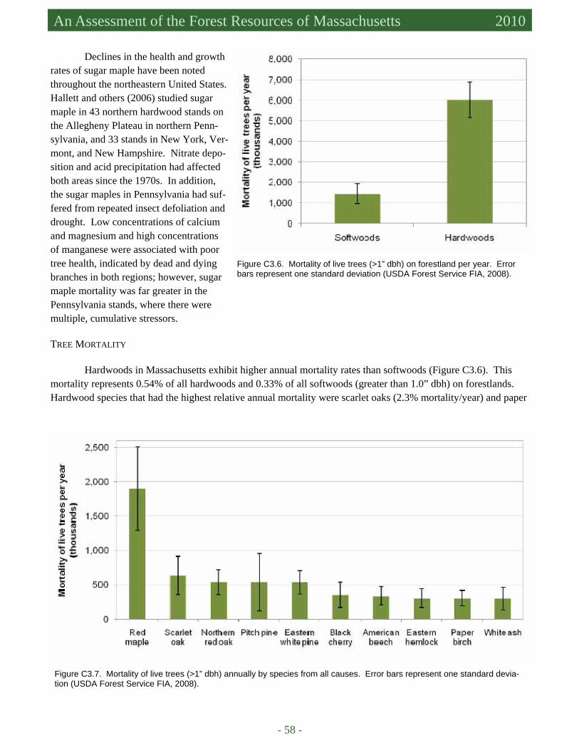
- 58 -
An Assessment of the Forest Resources of Massachusetts 2010
Declines in the health and growth rates of sugar maple have been noted throughout the northeastern United States. Hallett and others (2006) studied sugar maple in 43 northern hardwood stands on the Allegheny Plateau in northern Penn-sylvania, and 33 stands in New York, Ver-mont, and New Hampshire. Nitrate depo-sition and acid precipitation had affected both areas since the 1970s. In addition, the sugar maples in Pennsylvania had suf-fered from repeated insect defoliation and drought. Low concentrations of calcium and magnesium and high concentrations of manganese were associated with poor tree health, indicated by dead and dying branches in both regions; however, sugar maple mortality was far greater in the Pennsylvania stands, where there were multiple, cumulative stressors. TREE MORTALITY
Hardwoods in Massachusetts exhibit higher annual mortality rates than softwoods (Figure C3.6). This mortality represents 0.54% of all hardwoods and 0.33% of all softwoods (greater than 1.0” dbh) on forestlands. Hardwood species that had the highest relative annual mortality were scarlet oaks (2.3% mortality/year) and paper
Figure C3.6. Mortality of live trees (>1” dbh) on forestland per year. Error bars represent one standard deviation (USDA Forest Service FIA, 2008).
Figure C3.7. Mortality of live trees (>1” dbh) annually by species from all causes. Error bars represent one standard devia-tion (USDA Forest Service FIA, 2008).
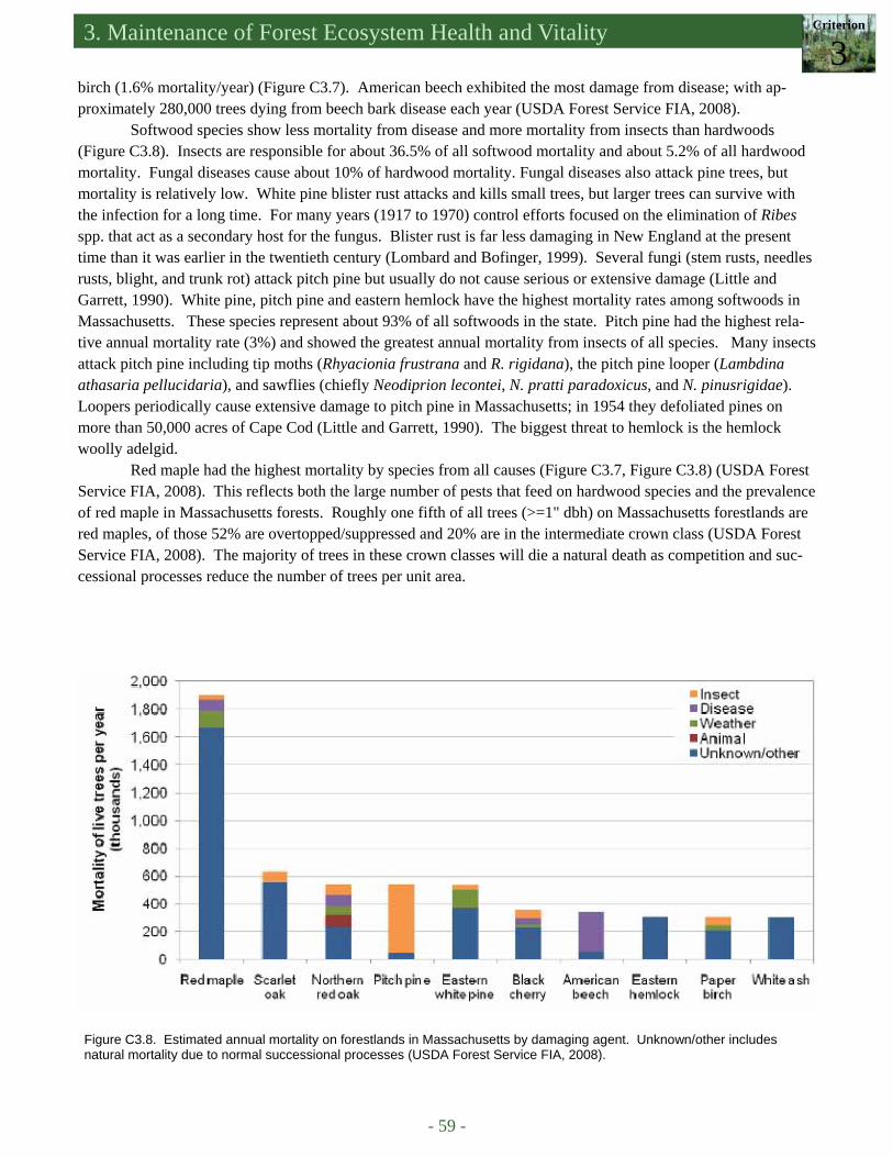
3. Maintenance of Forest Ecosystem Health and Vitality Criterion
3
- 59 -
Figure C3.8. Estimated annual mortality on forestlands in Massachusetts by damaging agent. Unknown/other includes natural mortality due to normal successional processes (USDA Forest Service FIA, 2008).
birch (1.6% mortality/year) (Figure C3.7). American beech exhibited the most damage from disease; with ap-proximately 280,000 trees dying from beech bark disease each year (USDA Forest Service FIA, 2008).
Softwood species show less mortality from disease and more mortality from insects than hardwoods (Figure C3.8). Insects are responsible for about 36.5% of all softwood mortality and about 5.2% of all hardwood mortality. Fungal diseases cause about 10% of hardwood mortality. Fungal diseases also attack pine trees, but mortality is relatively low. White pine blister rust attacks and kills small trees, but larger trees can survive with the infection for a long time. For many years (1917 to 1970) control efforts focused on the elimination of Ribes spp. that act as a secondary host for the fungus. Blister rust is far less damaging in New England at the present time than it was earlier in the twentieth century (Lombard and Bofinger, 1999). Several fungi (stem rusts, needles rusts, blight, and trunk rot) attack pitch pine but usually do not cause serious or extensive damage (Little and Garrett, 1990). White pine, pitch pine and eastern hemlock have the highest mortality rates among softwoods in Massachusetts. These species represent about 93% of all softwoods in the state. Pitch pine had the highest rela-tive annual mortality rate (3%) and showed the greatest annual mortality from insects of all species. Many insects attack pitch pine including tip moths (Rhyacionia frustrana and R. rigidana), the pitch pine looper (Lambdina athasaria pellucidaria), and sawflies (chiefly Neodiprion lecontei, N. pratti paradoxicus, and N. pinusrigidae). Loopers periodically cause extensive damage to pitch pine in Massachusetts; in 1954 they defoliated pines on more than 50,000 acres of Cape Cod (Little and Garrett, 1990). The biggest threat to hemlock is the hemlock woolly adelgid.
Red maple had the highest mortality by species from all causes (Figure C3.7, Figure C3.8) (USDA Forest Service FIA, 2008). This reflects both the large number of pests that feed on hardwood species and the prevalence of red maple in Massachusetts forests. Roughly one fifth of all trees (>=1" dbh) on Massachusetts forestlands are red maples, of those 52% are overtopped/suppressed and 20% are in the intermediate crown class (USDA Forest Service FIA, 2008). The majority of trees in these crown classes will die a natural death as competition and suc-cessional processes reduce the number of trees per unit area.
- 60 -
An Assessment of the Forest Resources of Massachusetts 2010
DRIVERS, ISSUES, AND THREATS Forests in the northeastern United States regenerate quickly after disturbances. Climate and soils in the
region favor the growth of trees. In Massachusetts, the greatest disturbance of the last 500 years was clearing for agriculture following European settlement. In 1870 only 30 percent of Massachusetts land area was forested. Now forests cover 63 percent of the landscape. Aside from human land use, windstorms, ice storms, insects and disease have repeatedly damaged and killed trees. Trees grow back following these disturbances, but the forest is changed – species composition and forest structure are inevitably altered. The introduction of species-specific exotic pests during the last 150 years (e.g., gypsy moth, chestnut blight, Dutch elm disease, beech bark disease, hemlock woolly adelgid, and Asian longhorned beetle) has accelerated and altered these processes. Potential Invasive Forest Pests
While monitoring and managing current pest populations, forest managers also must be vigilant in guard-ing against new pest invaders. The Massachusetts DCR and the Massachusetts Department of Agricultural Re-sources (MDAR) (DCR-MDAR, 2007) have identified three new pests that may threaten Massachusetts in the near future. The emerald ash borer, a native of Asia, was first identified in 2002 in southeastern Michigan. Since that time it has spread to Indiana, Illinois, Maryland, Missouri, Pennsylvania, Virginia, West Virginia, and Wis-consin, and to Ontario and Quebec in Canada. Its spread is primarily due to people transporting infested nursery stock, unprocessed logs, and firewood (McCullough et al., 2008). In 2009, it was found in New York (New York Department of Environmental Conservation, 2009). Thus far, it appears to affect only ash trees. Infested trees generally die within three to four years. Identification and “removal of all host trees is the first step in controlling an infestation.” Insecticides may be effective in some instances, but not at the forest scale. There are no known biological controls (DCR-MDAR, 2007).
The sirex wood wasp is native to Europe, Asia, and northern Africa. It was transported to the United States in solid wooden packing materials and is established in New York and Canada. It primarily attacks two and three needle pine trees. Susceptible species in Massachusetts include red pine and pitch pine. Eastern white pine is less susceptible. At low populations, the wasps select suppressed, stressed, and injured trees for egg laying. Maintaining healthy stands with appropriate silvicultural practices is one proactive method of defense against this insect. A parasitic nematode Deladenus siricidicola has also been used successfully as a biological control in the southern hemisphere (DCR-MDAR, 2007).
Sudden oak death (SOD) is caused by a fungal disease Phytophthora ramorum. It was first observed in California in 1995. While the main areas of infestation have been California and Oregon, potentially infected nursery stock was shipped throughout the United States in 2003 and 2004. Laboratory studies have shown that two eastern species, northern pin oak and northern red oak are highly susceptible to the fungus. The most effec-tive management strategy is to prevent its introduction, establishment, and spread (O’Brien et al., 2002; DCR-MDAR, 2007).
The Massachusetts Emergency Response Plan for Highly Destructive Invasive Forest Pests (DCR-MDAR, 2007) outlines a cooperative program among the DCR, the MDAR, USDA APHIS, and USDA Forest Service to detect, identify and eradicate or suppress destructive invasive forest pests.
Climate Change
Alterations in precipitation patterns and temperature regimes associated with global climate change will
inevitably affect tree health and pest populations. Large-scale consequences of climate change cannot be pre-dicted with certainty, but information about species-specific temperature and water availability responses can sug-gest possible scenarios. Many pest populations are limited by temperature. Laboratory and field testing con-
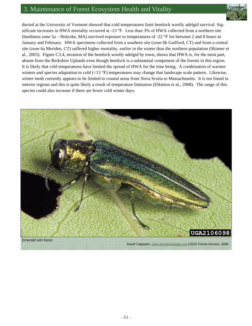
3. Maintenance of Forest Ecosystem Health and Vitality Criterion
3
- 61 -
ducted at the University of Vermont showed that cold temperatures limit hemlock woolly adelgid survival. Sig-nificant increases in HWA mortality occurred at -13 °F. Less than 3% of HWA collected from a northern site (hardiness zone 5a – Holyoke, MA) survived exposure to temperatures of -22 °F for between 2 and 8 hours in January and February. HWA specimens collected from a southern site (zone 6b Guilford, CT) and from a central site (zone 6a Meriden, CT) suffered higher mortality, earlier in the winter than the northern population (Skinner et al., 2003). Figure C3.4, invasion of the hemlock woolly adelgid by town, shows that HWA is, for the most part, absent from the Berkshire Uplands even though hemlock is a substantial component of the forests in this region. It is likely that cold temperatures have limited the spread of HWA for the time being. A combination of warmer winters and species adaptation to cold (<13 °F) temperatures may change that landscape scale pattern. Likewise, winter moth currently appears to be limited to coastal areas from Nova Scotia to Massachusetts. It is not found in interior regions and this is quite likely a result of temperature limitation (Elkinton et al., 2008). The range of this species could also increase if there are fewer cold winter days.
Emerald ash borer. David Cappaert, www.forestryimages.org,USDA Forest Service, 2008
- 62 -
An Assessment of the Forest Resources of Massachusetts 2010
References Able, D. and J.R. Ellement. 2008. Ice storm paralyzes parts of New England (close to a million without power). The Boston
Globe, December 13, 2008, Boston, MA. Batzer, H.O. and R.C. Morris. 1978. Forest tent caterpillar. Forest Insect & Disease Leaflet 9, USDA Forest Service, 5 pp. Boose, E.R., K.E. Chamberlin, and D.R. Foster. 2001. Landscape and regional impacts of hurricanes in New England. Eco-
logical Monographs 71(1):27-48. Bosart, L.F., A. Seimon, K.D. LaPenta, and M.J. Dickinson. 2006. Supercell tornadogenesis over complex terrain: the
Great Barrington, Massachusetts, tornado on 29 May 1995. Weather and Forecasting 21:897-922. Brown, M. 2008. The impossible summer burn: techniques for fuel reduction, habitat restoration, and happy locals in the
northeastern pine barrens. Fire Science Brief, a publication of the Joint Fire Science Program, issue 13:1-6. Carey, M. 2008. Powerless in the hilltowns. Daily Hampshire Gazette, December 15, 2008, Northampton, MA. Childs, R.D. 2009. The Asian longhorned beetle: an invader at the door. University of Massachusetts, Amherst, Department
of Natural Resources Conservation Seminar Series, February 19, 2009. D’Amato, A.W. and D.A. Orwig. 2008. Stand and landscape-level disturbance dynamics in old-growth forests in western
Massachusetts. Ecological Monographs 78(4):507-522. Davis, R. 2008. Ice Storm takes heavy toll on forests, sugaring. Daily Hampshire Gazette, December 18, 2008, Northamp-
ton, MA. DCR (Massachusetts Department of Conservation and Recreation). No date given. Massachusetts Bureau of Forest Fire
Control. Available at http://www.mass.gov/dcr/stewardship/firecont/index.htm. Accessed in May 2010. DCR-MDAR (Massachusetts Department of Conservation and Recreation - Massachusetts Department of Agricultural Re-
sources). 2007. Massachusetts Emergency Response Plan for Highly Destructive Invasive Forest Pests (Draft), November 26, 2007, 21 pp.
de la Crétaz, A.L. and M.J. Kelty. 2008. Land Type Associations of Western Massachusetts. Unpublished Report. USDA Forest Service, Northeastern Area State and Private Forestry, Durham, NH., 108 pp.
de la Crétaz, A.L. and P.K. Barten. 2007. Land Use Effects on Streamflow and Water Quality in the Northeastern United States. CRC Press, Taylor and Francis Group, Boca Raton, FL., 319 pp.
Elkinton, J.S., A.M. Liebhold, R.M. Muzika. 2004. Effects of alternative prey on predation by small mammals on gypsy moth pupae. Population Ecology 46(2):171-178.
Elkinton, J.S., G. Boettner, R. Hunkins, E. Hibbard, M. Sremac, R. Gwiazdowski, S. Schuefele, and A. Porter. 2008. Up-date on winter moth in New England. USDA Research Forum on Invasive Species.
Foster, D.R. 1988. Species and stand response to catastrophic wind in central New England, USA. Journal of Ecology 76:135-151.
Foster, D.R. and E.R. Boose. 1992. Patterns of forest damage resulting from catastrophic wind in central New England, USA. Journal of Ecology 80:79-98.
Foster, D.R. and D.A. Orwig. 2006. Preemptive and salvage harvesting of New England Forests: when doing nothing is a viable alternative. Conservation Biology 20(4):959-970.
Grossi, P. 2008. The 1938 Great New England Hurricane: Looking to the past to understand today’s risk. Risk Management Solutions, Inc. Newark CA., 19 pp.
Hajek A.E., J.S. Elkinton, and J.J. Witcosky. 1996. Introduction and spread of the fungal pathogen Entomophaga maimaiga (Zygomycetes: Entomophthorales) along the leading edge of gypsy moth (Lepidoptera: Lymantriidae) spread. En-vironmental Entomology 25(5):1235-1247.
Hallett, R.A., S.W. Bailey, S.B. Horsley, and R.P. Long. 2006. Influence of nutrition and stress on sugar maple at a regional scale. Canadian Journal of Forest Research 36:2235-2246.
Houston, D.R. and J.T. O’Brien. 1983. Beech bark disease. Forest Insect & Disease Leaflet 75, USDA Forest Service. IPANE (Invasive Plant Atlas of New England). 2008. Invasive Plant Atlas of New England. Available at http://
www.newfs.org/protect/invasive-plants/ipane. Accessed in May 2010. Kelty, M.J., A.W. D’Amato, and P.K. Barten. 2008. Silvicultural and Ecological Considerations of Forest Biomass Har-
vesting in Massachusetts. Prepared for the Massachusetts Division of Energy Resources & Massachusetts Depart-ment of Conservation and Recreation, 65 pp.
Kizlinski, M.L., D.A. Orwig, R.C. Cobb, and D.R. Foster. 2002. Direct and indirect ecosystem consequences of an invasive pest on forests dominated by eastern hemlock. Journal of Biogeography 29: 1489–1503.
Kogelmann, W.J. and W.E. Sharpe. 2006. Soil acidity and manganese in declining and nondeclining sugar maple stands in Pennsylvania. Journal of Environmental Quality 35(2):433-441.
Liebhold, A. 2003. Gypsy moth in North America. USDA Forest Service Northeastern Research Station (Forestry Sciences Laboratory). Available at http://www.fs.fed.us/ne/morgantown/4557/gmoth/. Accessed in March 2008.
Little, S. and P.W. Garrett. 1990. Pinus rigida Mill., Pitch Pine. In: Burns, R.M., Honkala, B.H. (Eds.), Silvics of North America. Vol. 1, Conifers. USD.A. Forest Service Agriculture Handbook 654.
Lombard, K. and J. Bofinger. 1999. White Pine Blister Rust (Cronartium ribicola) Infection incidence for selected areas of
3. Maintenance of Forest Ecosystem Health and Vitality Criterion
3
- 63 -
New Hampshire. NH Division of Forests and Lands, Department of Resources and Economic Development, 11 pp. Managing Fuels in Northeastern Barrens. 2005. Manuel F. Correllus State Forest on Martha’s Vineyard. Available at http://
www.umass.edu/nebarrensfuels/ma-barrens/vineyard/index.html. Accessed in February 2010. Massachusetts DCR Forest Health Program. 2009. Bugs Data, Massachusetts Department of Conservation and Recreation,
Amherst, MA. Massachusetts DCR Forest Health Program. 2010. Massachusetts Forest Health Highlights 2009. Massachusetts Department
of Conservation and Recreation, Amherst, MA; Northeastern Area Forest Health Protection, USDA Forest Service, Durham, NH.
Mass Moments. 2006. Fire rages at Myles Standish State Forest, May 25, 1964. Mass Humanities, National Endowment for the Humanities. Available at http://massmoments.org/. Accessed in February 2010.
MIPAG. No date given. Massachusetts Invasive Plant Advisory Group. Available at http://www.massnrc.org/mipag/index.htm#members. Accessed in May 2010.
McClure, M.S. 1987. Biology and Control of Hemlock Woolly Adelgid. Bulletin 851, The Connecticut Agricultural Experi-ment Station, New Haven, CT.
McClure, M.S. 1990. Role of wind, birds, deer, and humans in the dispersal of hemlock woolly adelgid (Homoptera: Adelgi-dae). Environmental Entomology 19(1):36-43.
McCullough, D.G. 2008. Emerald ash borer. Pest Alert. USD.A. Forest Service. Northeastern Area State and Private For-estry. NA-PR-02-04.
McManus, M., N. Schneeberger, R. Reardon, and G. Mason. 1989. Gypsy Moth Forest Insect&Disease Leaflet 162. USDA Forest Service. Available athttp://www.na.fs.fed.us/spfo/pubs/fidls/gypsymoth/gypsy.htm. Accessed in March 2008.
Morin, R. No date given. Hemlock woolly adelgid predicted range expansion. USDA Forest Service, Northeastern Research Station.
NADP (National Atmospheric Deposition Program). 2000-01 revised. Nitrogen in the Nation’s Rain. NADP Program Office Illinois State Water Survey, 2204 Griffith Drive, Champaign, Illinois 61820.
NHESP (the Natural Heritage and Endangered Species Program of the Massachusetts Division of Fisheries and Wildlife). 1990 (revised 2006). Massachusetts natural communities, prescribed burning in Massachusetts.
New York Department of Environmental Conservation. 2009. Emerald ash borer found in New York State. Wednesday June 17, 2009.
Northeast Wildfire Risk Assessment Geospatial Work Group. 2009. Draft Area Assessment. O’Brien, J.G., M.E. Mielke, S. Oak, and B. Moltzan. 2002. Pest Alert: sudden oak death. USDA Forest Service State and Pri-
vate Forestry, Northeastern Area. NA-PR-02-02. Available at http://www.na.fs.fed.us/sod/. Accessed in February 2010.
O’Keefe, J.F., and D.R. Foster. 1998. Ecological history of Massachusetts forests, In C.H.W. Foster (editor), Stepping Back to Look Forward: a History of the Massachusetts Forest, pp. 19-66.
Orwig, D.A. and Foster, D.R. 1998. Forest response to the introduced hemlock woolly adelgid in southern New England, USA. Journal of the Torrey Botanical Society 125(1):60-73.
Preisser, E.L., and J.S. Elkinton. 2008. Exploitative competition between invasive herbivores benefits a native host plant. Ecology 89(10):2671-2677.
Radeloff, V.C., R.B. Hammer, S.I. Stewart, J.S. Fried, S.S. Holcomb, and J.F. McKeefry. 2005. The wildland urban interface in the United States. Ecological Applications 15:799-805.
Reid, A.C. 1978. A Vegetational Survey of Mt. Greylock. Senior Honors Thesis, Biology Department, Williams College, Williamstown, MA.
Rivers, W.H. 1998. Manual for Continuous Forest Inventory Field Procedures. Bureau of Forestry, Division of Forests and Parks. Massachusetts Department of Environmental Management, 50 pp.
Scott, J.E. and R.E. Burgan. 2005. Standard fire behavior fuel models: a comprehensive set for use with Rothermel’s surface fire spread model. (40 fire behavior fuel model) General Technical Report RMRS-GTR-153. Fort Collins, CO, USDA Forest Service, Rocky Mountain Research Station, 72 pp.
Skinner, M., B.L. Parker, S. Gouli, and T. Ashikaga. 2003. Regional responses to hemlock woolly adelgid (Homoptera: Adlegidae) to low temperatures. Environmental Entomology 32(3):523-528.
Storm data and unusual weather phenomena. July 2006. Available at http://www.accessmylibrary.com/article-1G1-157193156/storm-data-and-unusual.html. Accessed in February 2010.
The Tornado Project. 1996. Massachusetts Tornados by County. Available at http://www.tornadoproject.com/alltorns/matorn.htm. Accessed in February 2010.
TNC (The Nature Conservancy). 2007. Prescribed fire seasons begins with successful burn at the Massasoit National Wildlife Refuge. Available at http://www.nature.org/wherewework/northamerica/states/massachusetts/press/press2942.html. Accessed in February 2010.
TNC (The Nature Conservancy). 2009. Available at www.invasive.org/gist/photosmore.html. Accessed in February 2010. UMass Extension. 2000-2010. Insects and mites: defoliators, forest tent caterpillar. Available at http://
www.umassgreeninfo.org/fact_sheets/defoliators/forest_tent_caterpillar.html. Accessed in February 2010.
- 64 -
An Assessment of the Forest Resources of Massachusetts 2010
University of Massachusetts, Amherst. 2010. Entomology researcher trying to save hemlocks from invasive pest. In the Loop, News for Faculty and Staff, Talking Points. October 20, 2009.
USDA (US Department of Agriculture). 2010. News Release. Available at http://www.usda.gov/wps/portal/!ut/p/_s.7_0_A/7_0_1OB?contentidonly=true&contentid=2010/01/0007.xml. Accessed in April 2010.
USDA – APHIS (Animal and Plant Health Inspection Service). 2010. Plant Health: Asian Longhorned Beetle. Available at http://www.aphis.usda.gov/plant_health/plant_pest_info/. Accessed in February 2010.
USDA Forest Service FIA. 2008. Miles, P.D. 2009, 2010. Forest Inventory EVALIDator web-application version 4.01 beta. St. Paul, MN: US Department of Agriculture, Forest Service, Northern Research Station. Available at http://fiatools.fs.fed.us/Evalidator401/tmattribute.jsp. Accessed in February 2010.
USDA Forest Service. 2008. Exotic insect pests discovered in more states (K. Tackett, Northeastern Area State and Private Forestry). Available at http://www.fs.fed.us/fstoday/2008/080822/03.0About%20Us/pests.html. Accessed in Febru-ary 2010.

- 65 -
Small tributary to the Quabbin Reservoir. DWSP
Criterion 4.
Conservation and Maintenance of Soil and Water Resources
CRITERION 4 CONTENTS: Forest Hydrology Massachusetts Soils Watersheds of Massachusetts Ability to Produce Clean Water Forests and Public Water Supplies • Surface water supplies • Groundwater Drivers, Issues, and Threats • Forest conversion and fragmentation • Forested watershed area, forested
riparian area, and impervious surface area
INTRODUCTION Forests are solar-powered living filters that
foster subsurface flow, minimize soil erosion, and limit sediment delivery to streams, wetlands, rivers, lakes, reservoirs, and estuaries. Organic matter from forest vegetation covers and protects forest soil. Tree roots stabilize slopes and stream banks. Trees in the riparian zone provide coarse woody debris (CWD) that dissipates the energy of flowing water in stream channels and provides es-sential habitat for aquatic macroinvertebrates and fish. Nearly 6.5 million people in Massachusetts depend on forests for clean water.
The watersheds of Massachusetts are poised at the
brink of major changes if population growth leads to more
development of the type and character of recent years.
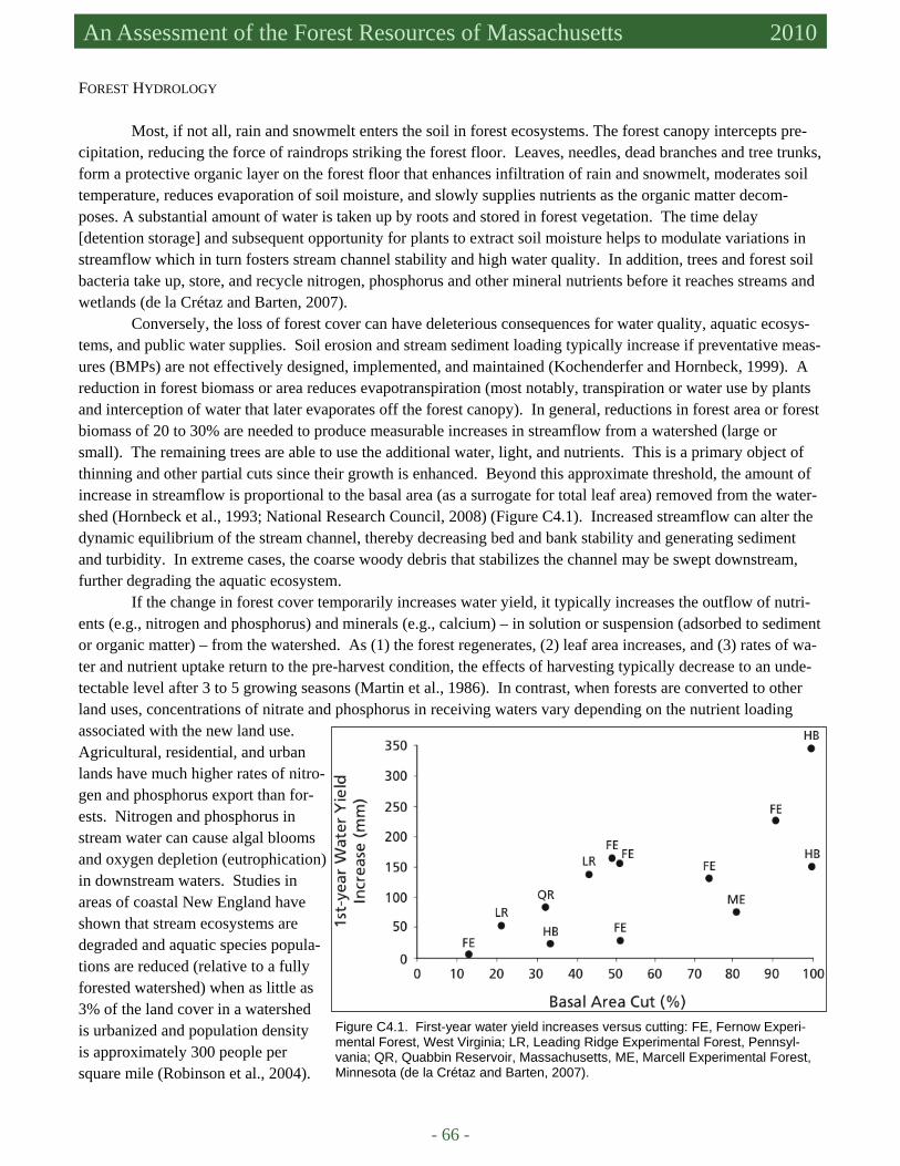
- 66 -
An Assessment of the Forest Resources of Massachusetts 2010
FOREST HYDROLOGY
Most, if not all, rain and snowmelt enters the soil in forest ecosystems. The forest canopy intercepts pre-cipitation, reducing the force of raindrops striking the forest floor. Leaves, needles, dead branches and tree trunks, form a protective organic layer on the forest floor that enhances infiltration of rain and snowmelt, moderates soil temperature, reduces evaporation of soil moisture, and slowly supplies nutrients as the organic matter decom-poses. A substantial amount of water is taken up by roots and stored in forest vegetation. The time delay [detention storage] and subsequent opportunity for plants to extract soil moisture helps to modulate variations in streamflow which in turn fosters stream channel stability and high water quality. In addition, trees and forest soil bacteria take up, store, and recycle nitrogen, phosphorus and other mineral nutrients before it reaches streams and wetlands (de la Crétaz and Barten, 2007). Conversely, the loss of forest cover can have deleterious consequences for water quality, aquatic ecosys-tems, and public water supplies. Soil erosion and stream sediment loading typically increase if preventative meas-ures (BMPs) are not effectively designed, implemented, and maintained (Kochenderfer and Hornbeck, 1999). A reduction in forest biomass or area reduces evapotranspiration (most notably, transpiration or water use by plants and interception of water that later evaporates off the forest canopy). In general, reductions in forest area or forest biomass of 20 to 30% are needed to produce measurable increases in streamflow from a watershed (large or small). The remaining trees are able to use the additional water, light, and nutrients. This is a primary object of thinning and other partial cuts since their growth is enhanced. Beyond this approximate threshold, the amount of increase in streamflow is proportional to the basal area (as a surrogate for total leaf area) removed from the water-shed (Hornbeck et al., 1993; National Research Council, 2008) (Figure C4.1). Increased streamflow can alter the dynamic equilibrium of the stream channel, thereby decreasing bed and bank stability and generating sediment and turbidity. In extreme cases, the coarse woody debris that stabilizes the channel may be swept downstream, further degrading the aquatic ecosystem. If the change in forest cover temporarily increases water yield, it typically increases the outflow of nutri-ents (e.g., nitrogen and phosphorus) and minerals (e.g., calcium) – in solution or suspension (adsorbed to sediment or organic matter) – from the watershed. As (1) the forest regenerates, (2) leaf area increases, and (3) rates of wa-ter and nutrient uptake return to the pre-harvest condition, the effects of harvesting typically decrease to an unde-tectable level after 3 to 5 growing seasons (Martin et al., 1986). In contrast, when forests are converted to other land uses, concentrations of nitrate and phosphorus in receiving waters vary depending on the nutrient loading associated with the new land use. Agricultural, residential, and urban lands have much higher rates of nitro-gen and phosphorus export than for-ests. Nitrogen and phosphorus in stream water can cause algal blooms and oxygen depletion (eutrophication) in downstream waters. Studies in areas of coastal New England have shown that stream ecosystems are degraded and aquatic species popula-tions are reduced (relative to a fully forested watershed) when as little as 3% of the land cover in a watershed is urbanized and population density is approximately 300 people per square mile (Robinson et al., 2004).
Figure C4.1. First-year water yield increases versus cutting: FE, Fernow Experi-mental Forest, West Virginia; LR, Leading Ridge Experimental Forest, Pennsyl-vania; QR, Quabbin Reservoir, Massachusetts, ME, Marcell Experimental Forest, Minnesota (de la Crétaz and Barten, 2007).
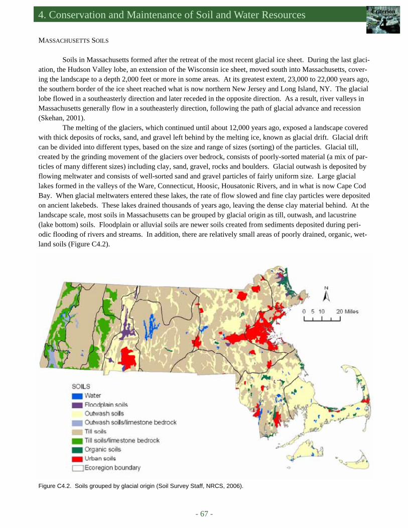
4. Conservation and Maintenance of Soil and Water Resources Criterion
4
- 67 -
MASSACHUSETTS SOILS Soils in Massachusetts formed after the retreat of the most recent glacial ice sheet. During the last glaci-
ation, the Hudson Valley lobe, an extension of the Wisconsin ice sheet, moved south into Massachusetts, cover-ing the landscape to a depth 2,000 feet or more in some areas. At its greatest extent, 23,000 to 22,000 years ago, the southern border of the ice sheet reached what is now northern New Jersey and Long Island, NY. The glacial lobe flowed in a southeasterly direction and later receded in the opposite direction. As a result, river valleys in Massachusetts generally flow in a southeasterly direction, following the path of glacial advance and recession (Skehan, 2001).
The melting of the glaciers, which continued until about 12,000 years ago, exposed a landscape covered with thick deposits of rocks, sand, and gravel left behind by the melting ice, known as glacial drift. Glacial drift can be divided into different types, based on the size and range of sizes (sorting) of the particles. Glacial till, created by the grinding movement of the glaciers over bedrock, consists of poorly-sorted material (a mix of par-ticles of many different sizes) including clay, sand, gravel, rocks and boulders. Glacial outwash is deposited by flowing meltwater and consists of well-sorted sand and gravel particles of fairly uniform size. Large glacial lakes formed in the valleys of the Ware, Connecticut, Hoosic, Housatonic Rivers, and in what is now Cape Cod Bay. When glacial meltwaters entered these lakes, the rate of flow slowed and fine clay particles were deposited on ancient lakebeds. These lakes drained thousands of years ago, leaving the dense clay material behind. At the landscape scale, most soils in Massachusetts can be grouped by glacial origin as till, outwash, and lacustrine (lake bottom) soils. Floodplain or alluvial soils are newer soils created from sediments deposited during peri-odic flooding of rivers and streams. In addition, there are relatively small areas of poorly drained, organic, wet-land soils (Figure C4.2).
Figure C4.2. Soils grouped by glacial origin (Soil Survey Staff, NRCS, 2006).

- 68 -
An Assessment of the Forest Resources of Massachusetts 2010
Sandy outwash soils tend to be excessively (very well) drained and highly permeable, while till soils have hydraulic characteristics and physical properties that range from somewhat excessively to poorly drained, and are usually less permeable. Tills are generally found on uplands and areas of steep slopes, while outwash soils are found in lowland areas with minimal relief. Bedrock composition influences soil chemistry and, in consequence, soil fertility. In the Marble Valley and the eastern Berkshire Uplands, limestone bedrock increases concentrations of mineral nutrients such as calcium and magnesium, producing high-fertility soils. Soils in other areas, with the exception of river floodplains, tend to be acidic and relatively low in nutrients (Figure 4.3). This limits the buffer-ing capacity of many forests in relation to acid deposition which, in turn, increases their sensitivity to calcium de-pletion.
Soil characteristics also have direct effects on the pathway, rate, and volume of water flow. In the highly permeable outwash soils in coastal plain areas such as Cape Cod and the Islands, infiltration of rain and snowmelt into the soil is nearly instantaneous unless there is impervious cover. There are very few streams and these are sustained by deep groundwater flow paths. In areas dominated by relatively thin glacial till soils, water yield is high, and the stream network is more extensive and complex. Infiltration rates typically exceed rainfall and snow-melt rates so most water reaches streams via shallow subsurface flow (Figure C4.4). In addition, lower air tem-peratures and evapotranspiration rates coupled with more rain and snow and steeper slopes, leads to greater water yield per unit area from upland forests.
These variations in soil characteristics, water availability, and microclimate also lead to variations in for-est type and understory vegetation. Pitch pine and scrub oak, adapted to the driest conditions, are found on out-wash deposits on Cape Cod and similar sites, while central and transition hardwoods with hemlock and white pine are found on till soils with greater water availability. Northern hardwoods grow on upland till soils where water availability is relatively high. As noted above, precipitation is typically greater in the mountainous regions and cooler temperatures reduce evapotranspiration. Rich mesic forests dominated by sugar maple, white ash, and bitternut hickory are found on nutrient-rich soils that develop on limestone bedrock.
Figure C4.3. National soil pH field measurements (NADP, 2004).
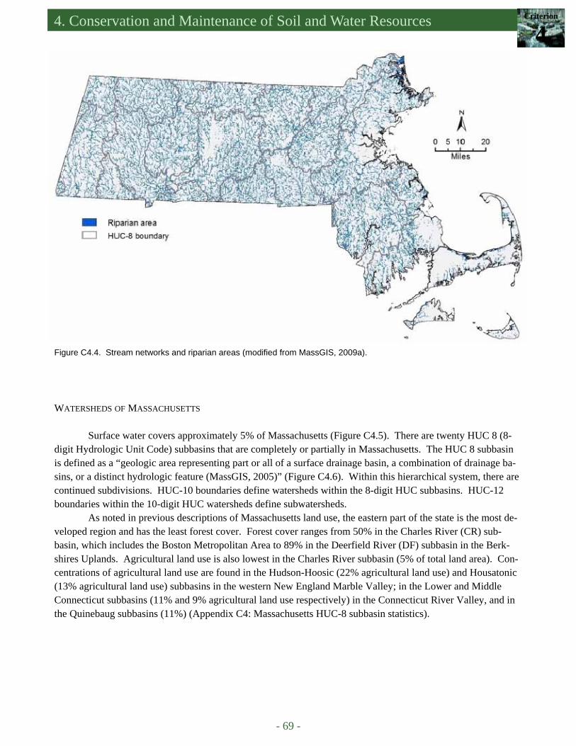
4. Conservation and Maintenance of Soil and Water Resources Criterion
4
- 69 -
Figure C4.4. Stream networks and riparian areas (modified from MassGIS, 2009a).
WATERSHEDS OF MASSACHUSETTS
Surface water covers approximately 5% of Massachusetts (Figure C4.5). There are twenty HUC 8 (8-digit Hydrologic Unit Code) subbasins that are completely or partially in Massachusetts. The HUC 8 subbasin is defined as a “geologic area representing part or all of a surface drainage basin, a combination of drainage ba-sins, or a distinct hydrologic feature (MassGIS, 2005)” (Figure C4.6). Within this hierarchical system, there are continued subdivisions. HUC-10 boundaries define watersheds within the 8-digit HUC subbasins. HUC-12 boundaries within the 10-digit HUC watersheds define subwatersheds.
As noted in previous descriptions of Massachusetts land use, the eastern part of the state is the most de-veloped region and has the least forest cover. Forest cover ranges from 50% in the Charles River (CR) sub-basin, which includes the Boston Metropolitan Area to 89% in the Deerfield River (DF) subbasin in the Berk-shires Uplands. Agricultural land use is also lowest in the Charles River subbasin (5% of total land area). Con-centrations of agricultural land use are found in the Hudson-Hoosic (22% agricultural land use) and Housatonic (13% agricultural land use) subbasins in the western New England Marble Valley; in the Lower and Middle Connecticut subbasins (11% and 9% agricultural land use respectively) in the Connecticut River Valley, and in the Quinebaug subbasins (11%) (Appendix C4: Massachusetts HUC-8 subbasin statistics).
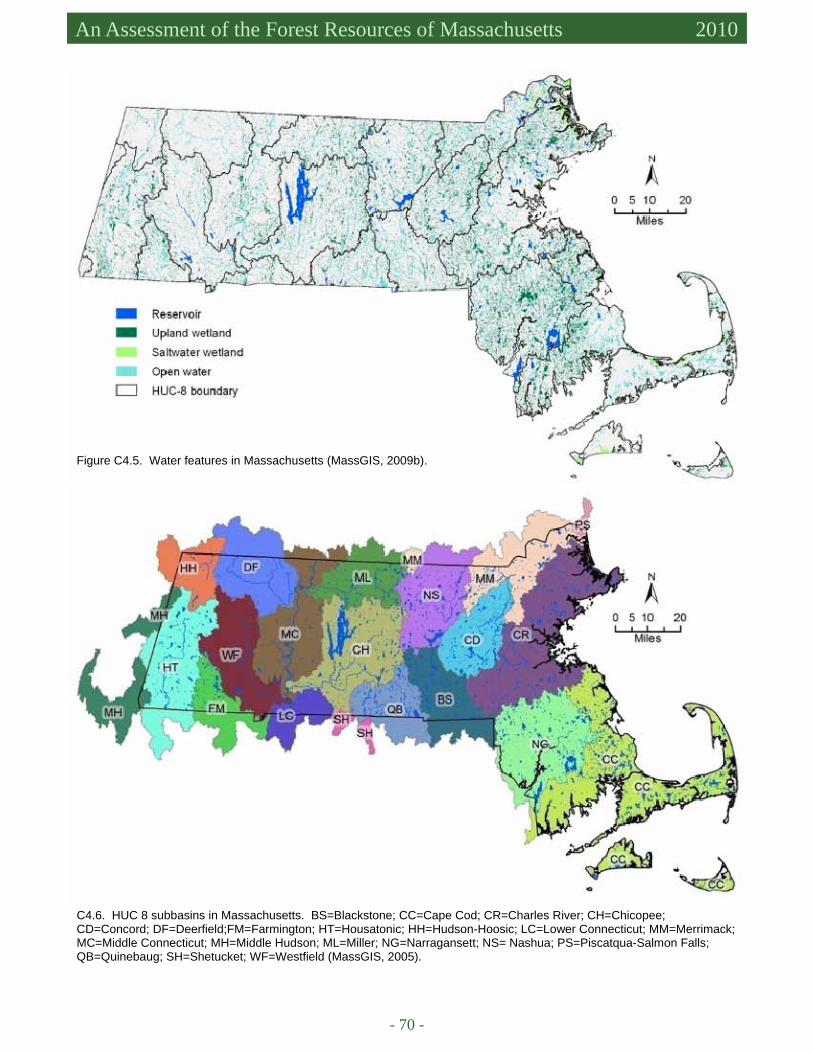
- 70 -
An Assessment of the Forest Resources of Massachusetts 2010
Figure C4.5. Water features in Massachusetts (MassGIS, 2009b).
C4.6. HUC 8 subbasins in Massachusetts. BS=Blackstone; CC=Cape Cod; CR=Charles River; CH=Chicopee; CD=Concord; DF=Deerfield;FM=Farmington; HT=Housatonic; HH=Hudson-Hoosic; LC=Lower Connecticut; MM=Merrimack; MC=Middle Connecticut; MH=Middle Hudson; ML=Miller; NG=Narragansett; NS= Nashua; PS=Piscatqua-Salmon Falls; QB=Quinebaug; SH=Shetucket; WF=Westfield (MassGIS, 2005).
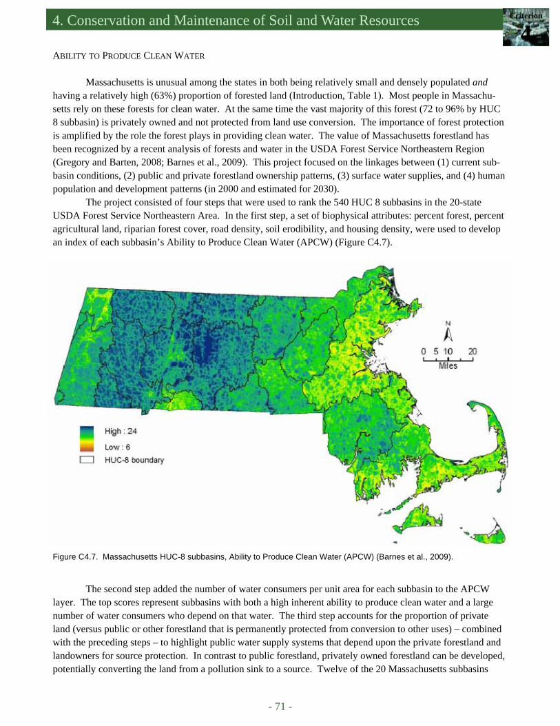
4. Conservation and Maintenance of Soil and Water Resources Criterion
4
- 71 -
ABILITY TO PRODUCE CLEAN WATER
Massachusetts is unusual among the states in both being relatively small and densely populated and having a relatively high (63%) proportion of forested land (Introduction, Table 1). Most people in Massachu-setts rely on these forests for clean water. At the same time the vast majority of this forest (72 to 96% by HUC 8 subbasin) is privately owned and not protected from land use conversion. The importance of forest protection is amplified by the role the forest plays in providing clean water. The value of Massachusetts forestland has been recognized by a recent analysis of forests and water in the USDA Forest Service Northeastern Region (Gregory and Barten, 2008; Barnes et al., 2009). This project focused on the linkages between (1) current sub-basin conditions, (2) public and private forestland ownership patterns, (3) surface water supplies, and (4) human population and development patterns (in 2000 and estimated for 2030).
The project consisted of four steps that were used to rank the 540 HUC 8 subbasins in the 20-state USDA Forest Service Northeastern Area. In the first step, a set of biophysical attributes: percent forest, percent agricultural land, riparian forest cover, road density, soil erodibility, and housing density, were used to develop an index of each subbasin’s Ability to Produce Clean Water (APCW) (Figure C4.7).
The second step added the number of water consumers per unit area for each subbasin to the APCW layer. The top scores represent subbasins with both a high inherent ability to produce clean water and a large number of water consumers who depend on that water. The third step accounts for the proportion of private land (versus public or other forestland that is permanently protected from conversion to other uses) – combined with the preceding steps – to highlight public water supply systems that depend upon the private forestland and landowners for source protection. In contrast to public forestland, privately owned forestland can be developed, potentially converting the land from a pollution sink to a source. Twelve of the 20 Massachusetts subbasins
Figure C4.7. Massachusetts HUC-8 subbasins, Ability to Produce Clean Water (APCW) (Barnes et al., 2009).
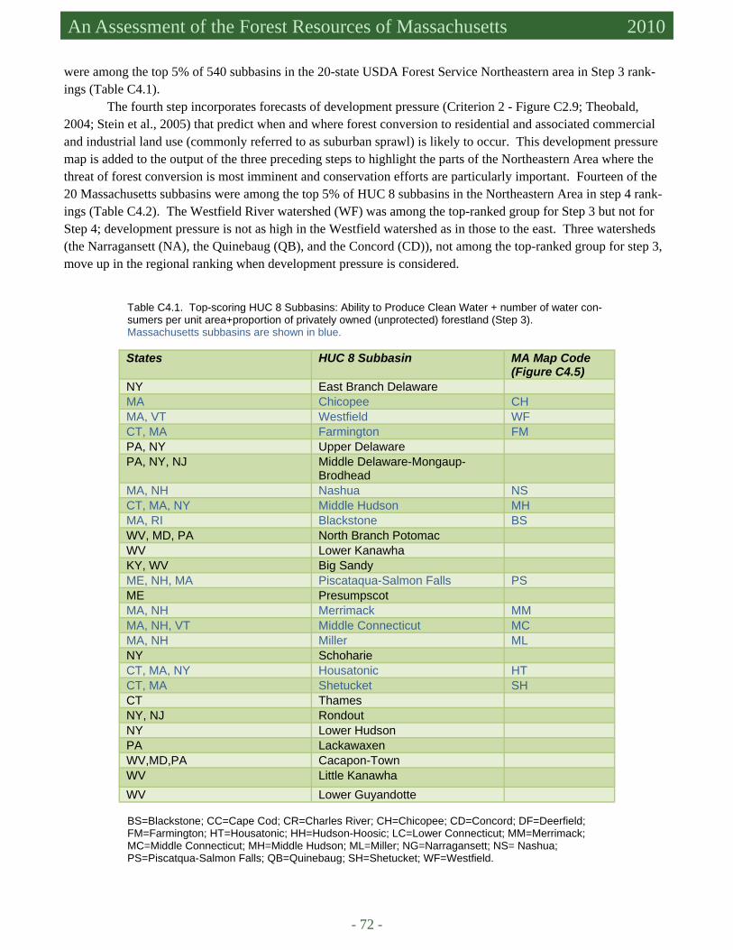
- 72 -
An Assessment of the Forest Resources of Massachusetts 2010
were among the top 5% of 540 subbasins in the 20-state USDA Forest Service Northeastern area in Step 3 rank-ings (Table C4.1).
The fourth step incorporates forecasts of development pressure (Criterion 2 - Figure C2.9; Theobald, 2004; Stein et al., 2005) that predict when and where forest conversion to residential and associated commercial and industrial land use (commonly referred to as suburban sprawl) is likely to occur. This development pressure map is added to the output of the three preceding steps to highlight the parts of the Northeastern Area where the threat of forest conversion is most imminent and conservation efforts are particularly important. Fourteen of the 20 Massachusetts subbasins were among the top 5% of HUC 8 subbasins in the Northeastern Area in step 4 rank-ings (Table C4.2). The Westfield River watershed (WF) was among the top-ranked group for Step 3 but not for Step 4; development pressure is not as high in the Westfield watershed as in those to the east. Three watersheds (the Narragansett (NA), the Quinebaug (QB), and the Concord (CD)), not among the top-ranked group for step 3, move up in the regional ranking when development pressure is considered.
Table C4.1. Top-scoring HUC 8 Subbasins: Ability to Produce Clean Water + number of water con-sumers per unit area+proportion of privately owned (unprotected) forestland (Step 3). Massachusetts subbasins are shown in blue.
BS=Blackstone; CC=Cape Cod; CR=Charles River; CH=Chicopee; CD=Concord; DF=Deerfield; FM=Farmington; HT=Housatonic; HH=Hudson-Hoosic; LC=Lower Connecticut; MM=Merrimack; MC=Middle Connecticut; MH=Middle Hudson; ML=Miller; NG=Narragansett; NS= Nashua; PS=Piscatqua-Salmon Falls; QB=Quinebaug; SH=Shetucket; WF=Westfield.
States HUC 8 Subbasin MA Map Code (Figure C4.5)
NY East Branch Delaware MA Chicopee CH MA, VT Westfield WF CT, MA Farmington FM PA, NY Upper Delaware PA, NY, NJ Middle Delaware-Mongaup-
Brodhead
MA, NH Nashua NS CT, MA, NY Middle Hudson MH MA, RI Blackstone BS WV, MD, PA North Branch Potomac WV Lower Kanawha KY, WV Big Sandy ME, NH, MA Piscataqua-Salmon Falls PS ME Presumpscot MA, NH Merrimack MM MA, NH, VT Middle Connecticut MC MA, NH Miller ML NY Schoharie CT, MA, NY Housatonic HT CT, MA Shetucket SH CT Thames NY, NJ Rondout NY Lower Hudson PA Lackawaxen WV,MD,PA Cacapon-Town WV Little Kanawha WV Lower Guyandotte
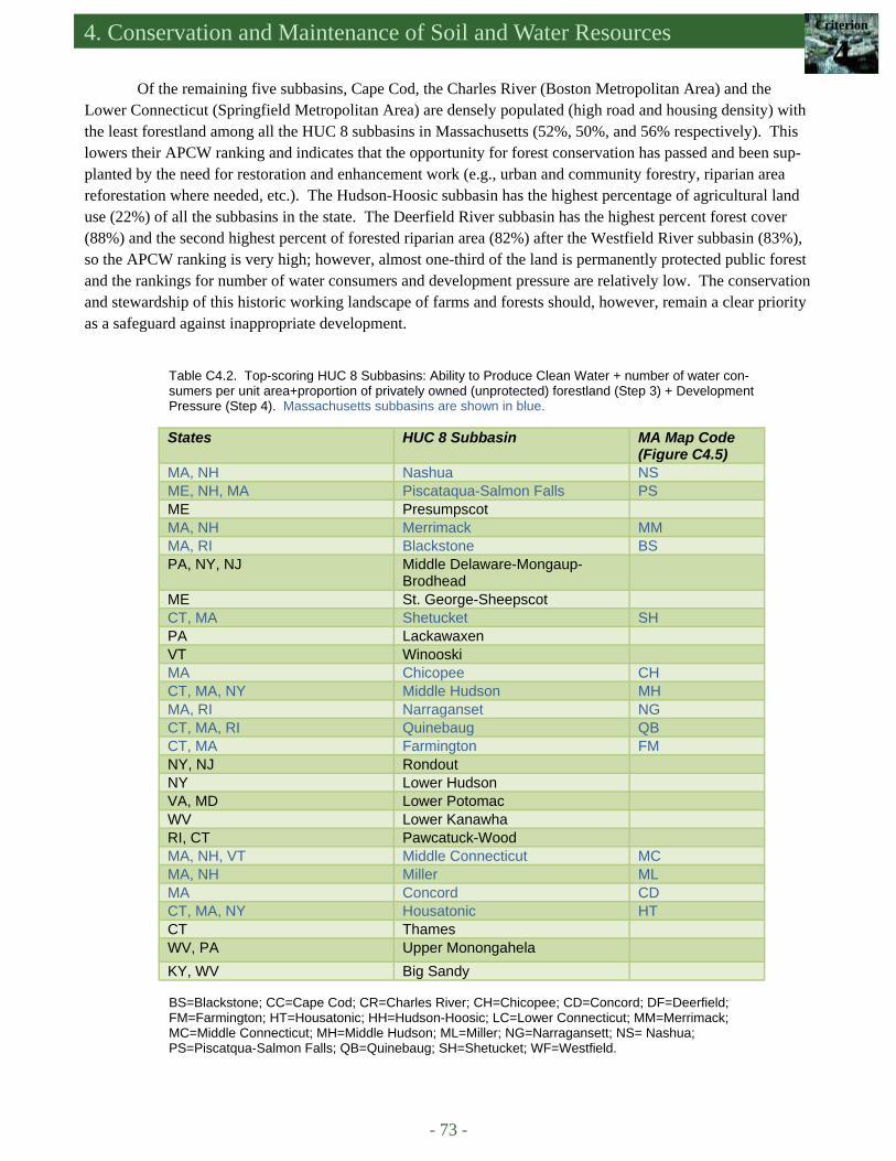
4. Conservation and Maintenance of Soil and Water Resources Criterion
4
- 73 -
Table C4.2. Top-scoring HUC 8 Subbasins: Ability to Produce Clean Water + number of water con-sumers per unit area+proportion of privately owned (unprotected) forestland (Step 3) + Development Pressure (Step 4). Massachusetts subbasins are shown in blue.
States HUC 8 Subbasin MA Map Code (Figure C4.5)
MA, NH Nashua NS ME, NH, MA Piscataqua-Salmon Falls PS ME Presumpscot MA, NH Merrimack MM MA, RI Blackstone BS PA, NY, NJ Middle Delaware-Mongaup-
Brodhead
ME St. George-Sheepscot CT, MA Shetucket SH PA Lackawaxen VT Winooski MA Chicopee CH CT, MA, NY Middle Hudson MH MA, RI Narraganset NG CT, MA, RI Quinebaug QB CT, MA Farmington FM NY, NJ Rondout NY Lower Hudson VA, MD Lower Potomac WV Lower Kanawha RI, CT Pawcatuck-Wood MA, NH, VT Middle Connecticut MC MA, NH Miller ML MA Concord CD CT, MA, NY Housatonic HT CT Thames WV, PA Upper Monongahela KY, WV Big Sandy
Of the remaining five subbasins, Cape Cod, the Charles River (Boston Metropolitan Area) and the Lower Connecticut (Springfield Metropolitan Area) are densely populated (high road and housing density) with the least forestland among all the HUC 8 subbasins in Massachusetts (52%, 50%, and 56% respectively). This lowers their APCW ranking and indicates that the opportunity for forest conservation has passed and been sup-planted by the need for restoration and enhancement work (e.g., urban and community forestry, riparian area reforestation where needed, etc.). The Hudson-Hoosic subbasin has the highest percentage of agricultural land use (22%) of all the subbasins in the state. The Deerfield River subbasin has the highest percent forest cover (88%) and the second highest percent of forested riparian area (82%) after the Westfield River subbasin (83%), so the APCW ranking is very high; however, almost one-third of the land is permanently protected public forest and the rankings for number of water consumers and development pressure are relatively low. The conservation and stewardship of this historic working landscape of farms and forests should, however, remain a clear priority as a safeguard against inappropriate development.
BS=Blackstone; CC=Cape Cod; CR=Charles River; CH=Chicopee; CD=Concord; DF=Deerfield; FM=Farmington; HT=Housatonic; HH=Hudson-Hoosic; LC=Lower Connecticut; MM=Merrimack; MC=Middle Connecticut; MH=Middle Hudson; ML=Miller; NG=Narragansett; NS= Nashua; PS=Piscatqua-Salmon Falls; QB=Quinebaug; SH=Shetucket; WF=Westfield.
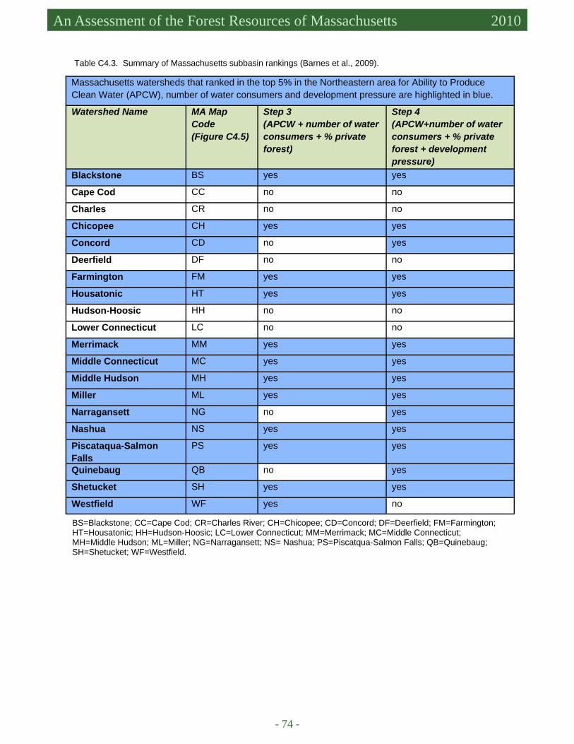
- 74 -
An Assessment of the Forest Resources of Massachusetts 2010
Massachusetts watersheds that ranked in the top 5% in the Northeastern area for Ability to Produce Clean Water (APCW), number of water consumers and development pressure are highlighted in blue.
Watershed Name MA Map Code (Figure C4.5)
Step 3 (APCW + number of water consumers + % private forest)
Step 4 (APCW+number of water consumers + % private forest + development pressure)
Blackstone BS yes yes
Cape Cod CC no no
Charles CR no no
Chicopee CH yes yes
Concord CD no yes
Deerfield DF no no
Farmington FM yes yes
Housatonic HT yes yes
Hudson-Hoosic HH no no
Lower Connecticut LC no no
Merrimack MM yes yes
Middle Connecticut MC yes yes
Middle Hudson MH yes yes
Miller ML yes yes
Narragansett NG no yes
Nashua NS yes yes
Piscataqua-Salmon Falls
PS yes yes
Quinebaug QB no yes
Shetucket SH yes yes
Westfield WF yes no
Table C4.3. Summary of Massachusetts subbasin rankings (Barnes et al., 2009).
BS=Blackstone; CC=Cape Cod; CR=Charles River; CH=Chicopee; CD=Concord; DF=Deerfield; FM=Farmington; HT=Housatonic; HH=Hudson-Hoosic; LC=Lower Connecticut; MM=Merrimack; MC=Middle Connecticut; MH=Middle Hudson; ML=Miller; NG=Narragansett; NS= Nashua; PS=Piscatqua-Salmon Falls; QB=Quinebaug; SH=Shetucket; WF=Westfield.
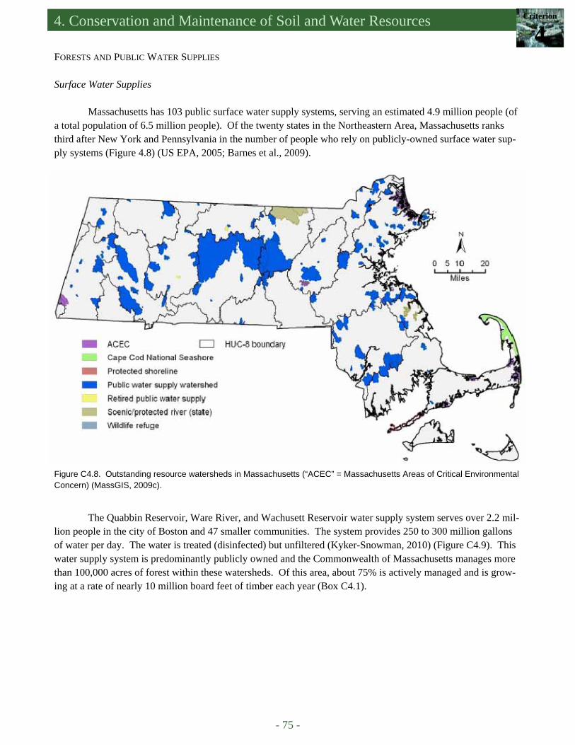
4. Conservation and Maintenance of Soil and Water Resources Criterion
4
- 75 -
FORESTS AND PUBLIC WATER SUPPLIES Surface Water Supplies
Massachusetts has 103 public surface water supply systems, serving an estimated 4.9 million people (of a total population of 6.5 million people). Of the twenty states in the Northeastern Area, Massachusetts ranks third after New York and Pennsylvania in the number of people who rely on publicly-owned surface water sup-ply systems (Figure 4.8) (US EPA, 2005; Barnes et al., 2009).
Figure C4.8. Outstanding resource watersheds in Massachusetts (“ACEC” = Massachusetts Areas of Critical Environmental Concern) (MassGIS, 2009c).
The Quabbin Reservoir, Ware River, and Wachusett Reservoir water supply system serves over 2.2 mil-lion people in the city of Boston and 47 smaller communities. The system provides 250 to 300 million gallons of water per day. The water is treated (disinfected) but unfiltered (Kyker-Snowman, 2010) (Figure C4.9). This water supply system is predominantly publicly owned and the Commonwealth of Massachusetts manages more than 100,000 acres of forest within these watersheds. Of this area, about 75% is actively managed and is grow-ing at a rate of nearly 10 million board feet of timber each year (Box C4.1).

- 76 -
An Assessment of the Forest Resources of Massachusetts 2010
Figure C4.9. Quabbin, Reservoir, Ware River, and Wachusett Reservoir water supply serving 2.2 million consumers in the Boston Metropolitan Area and Chicopee Valley (Kyker-Snowman, 2010).
Box C4.1. The Quabbin Forest …The First FSC-Certified Public Land in North America The Quabbin Reservoir is the largest component of the metropolitan-Boston water supply system. It pro-
duces 87% of the system's 300 million gallons per day (MGD) safe yield, which supplies water to 48 communities and a total of 2.2 million people. The turnover rate of the 412 billion gallon reservoir is 4 to 5 years. A compre-hensive source water protection program and a well-designed water storage and distribution system have main-tained an unfiltered water supply (with chlorine/chloramine and now ozone disinfection) in full compliance with all EPA standards. Leak repair, water conservation, and universal metering have reduced the unsustainable water demands of the 1960s and 70s to a reasonable margin below the system's safe yield since the late-1980s, with an average daily demand of just 193 MGD for 2009.
Forest Conservation Efforts
By the time the Quabbin Reservoir was de-
signed and constructed in the 1930s, engineers, watershed managers, and public health specialists clearly recognized the need to maximize the protec-tion of the reservoir from future development with adjacent forestlands (referred to as “source isola-tion” at the time). Instead of purchasing a relatively small proportion of the watershed—a strip of land around the shoreline—a much larger area was per-manently protected. The Massachusetts Division of Water Supply Protection (DWSP) owns and man-ages 65% of the 120,000 acre watershed; other pub-lic forests account for 7% and private forest land for 24% of the total area. Less than 5% of the water-shed is developed. Limited recreational use of the 55,000 acre Quabbin Forest is permitted.
(Continued on page 77)
Quabbin Reservoir DWSP
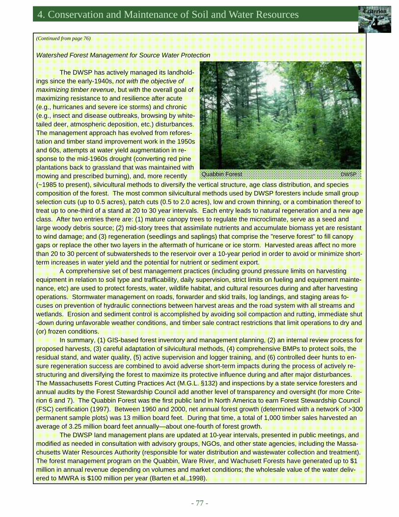
4. Conservation and Maintenance of Soil and Water Resources Criterion
4
- 77 -
Watershed Forest Management for Source Water Protection
The DWSP has actively managed its landhold-
ings since the early-1940s, not with the objective of maximizing timber revenue, but with the overall goal of maximizing resistance to and resilience after acute (e.g., hurricanes and severe ice storms) and chronic (e.g., insect and disease outbreaks, browsing by white-tailed deer, atmospheric deposition, etc.) disturbances. The management approach has evolved from refores-tation and timber stand improvement work in the 1950s and 60s, attempts at water yield augmentation in re-sponse to the mid-1960s drought (converting red pine plantations back to grassland that was maintained with mowing and prescribed burning), and, more recently (~1985 to present), silvicultural methods to diversify the vertical structure, age class distribution, and species composition of the forest. The most common silvicultural methods used by DWSP foresters include small group selection cuts (up to 0.5 acres), patch cuts (0.5 to 2.0 acres), low and crown thinning, or a combination thereof to treat up to one-third of a stand at 20 to 30 year intervals. Each entry leads to natural regeneration and a new age class. After two entries there are: (1) mature canopy trees to regulate the microclimate, serve as a seed and large woody debris source; (2) mid-story trees that assimilate nutrients and accumulate biomass yet are resistant to wind damage; and (3) regeneration (seedlings and saplings) that comprise the "reserve forest" to fill canopy gaps or replace the other two layers in the aftermath of hurricane or ice storm. Harvested areas affect no more than 20 to 30 percent of subwatersheds to the reservoir over a 10-year period in order to avoid or minimize short-term increases in water yield and the potential for nutrient or sediment export.
A comprehensive set of best management practices (including ground pressure limits on harvesting equipment in relation to soil type and trafficability, daily supervision, strict limits on fueling and equipment mainte-nance, etc) are used to protect forests, water, wildlife habitat, and cultural resources during and after harvesting operations. Stormwater management on roads, forwarder and skid trails, log landings, and staging areas fo-cuses on prevention of hydraulic connections between harvest areas and the road system with all streams and wetlands. Erosion and sediment control is accomplished by avoiding soil compaction and rutting, immediate shut-down during unfavorable weather conditions, and timber sale contract restrictions that limit operations to dry and(or) frozen conditions.
In summary, (1) GIS-based forest inventory and management planning, (2) an internal review process for proposed harvests, (3) careful adaptation of silvicultural methods, (4) comprehensive BMPs to protect soils, the residual stand, and water quality, (5) active supervision and logger training, and (6) controlled deer hunts to en-sure regeneration success are combined to avoid adverse short-term impacts during the process of actively re-structuring and diversifying the forest to maximize its protective influence during and after major disturbances. The Massachusetts Forest Cutting Practices Act (M.G.L. §132) and inspections by a state service foresters and annual audits by the Forest Stewardship Council add another level of transparency and oversight (for more Crite-rion 6 and 7). The Quabbin Forest was the first public land in North America to earn Forest Stewardship Council (FSC) certification (1997). Between 1960 and 2000, net annual forest growth (determined with a network of >300 permanent sample plots) was 13 million board feet. During that time, a total of 1,000 timber sales harvested an average of 3.25 million board feet annually—about one-fourth of forest growth.
The DWSP land management plans are updated at 10-year intervals, presented in public meetings, and modified as needed in consultation with advisory groups, NGOs, and other state agencies, including the Massa-chusetts Water Resources Authority (responsible for water distribution and wastewater collection and treatment). The forest management program on the Quabbin, Ware River, and Wachusett Forests have generated up to $1 million in annual revenue depending on volumes and market conditions; the wholesale value of the water deliv-ered to MWRA is $100 million per year (Barten et al.,1998).
(Continued from page 76)
Quabbin Forest DWSP
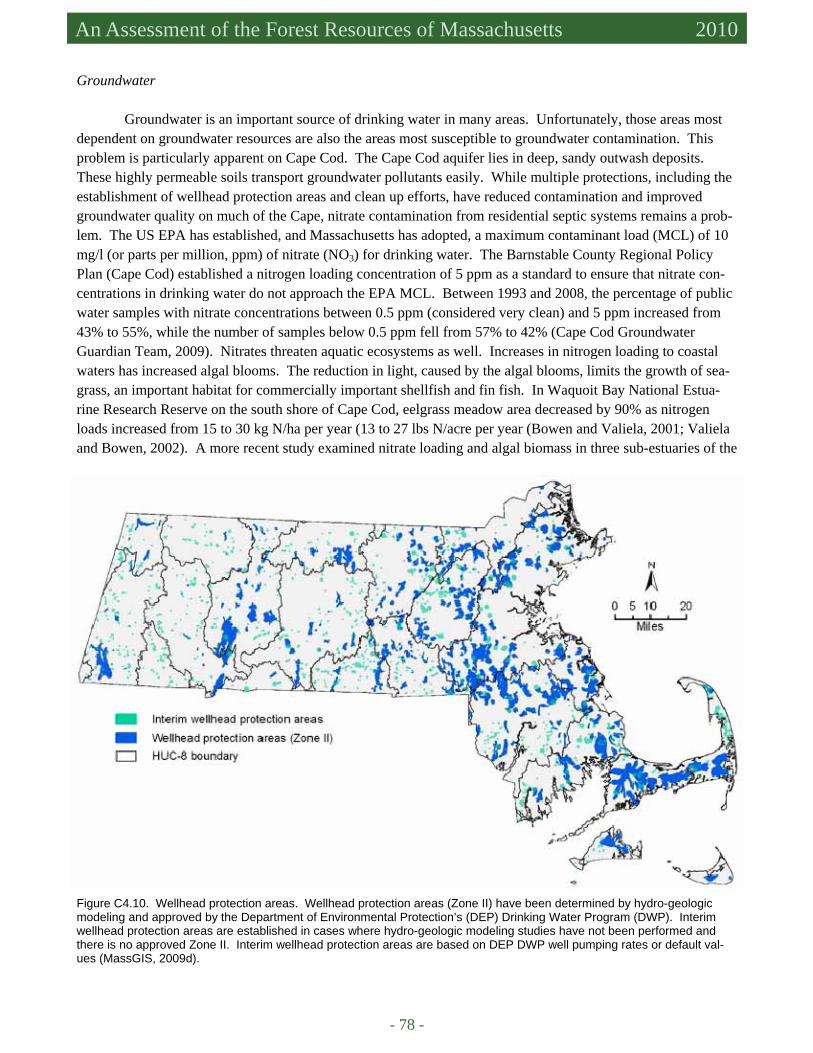
- 78 -
An Assessment of the Forest Resources of Massachusetts 2010
Groundwater Groundwater is an important source of drinking water in many areas. Unfortunately, those areas most
dependent on groundwater resources are also the areas most susceptible to groundwater contamination. This problem is particularly apparent on Cape Cod. The Cape Cod aquifer lies in deep, sandy outwash deposits. These highly permeable soils transport groundwater pollutants easily. While multiple protections, including the establishment of wellhead protection areas and clean up efforts, have reduced contamination and improved groundwater quality on much of the Cape, nitrate contamination from residential septic systems remains a prob-lem. The US EPA has established, and Massachusetts has adopted, a maximum contaminant load (MCL) of 10 mg/l (or parts per million, ppm) of nitrate (NO3) for drinking water. The Barnstable County Regional Policy Plan (Cape Cod) established a nitrogen loading concentration of 5 ppm as a standard to ensure that nitrate con-centrations in drinking water do not approach the EPA MCL. Between 1993 and 2008, the percentage of public water samples with nitrate concentrations between 0.5 ppm (considered very clean) and 5 ppm increased from 43% to 55%, while the number of samples below 0.5 ppm fell from 57% to 42% (Cape Cod Groundwater Guardian Team, 2009). Nitrates threaten aquatic ecosystems as well. Increases in nitrogen loading to coastal waters has increased algal blooms. The reduction in light, caused by the algal blooms, limits the growth of sea-grass, an important habitat for commercially important shellfish and fin fish. In Waquoit Bay National Estua-rine Research Reserve on the south shore of Cape Cod, eelgrass meadow area decreased by 90% as nitrogen loads increased from 15 to 30 kg N/ha per year (13 to 27 lbs N/acre per year (Bowen and Valiela, 2001; Valiela and Bowen, 2002). A more recent study examined nitrate loading and algal biomass in three sub-estuaries of the
Figure C4.10. Wellhead protection areas. Wellhead protection areas (Zone II) have been determined by hydro-geologic modeling and approved by the Department of Environmental Protection’s (DEP) Drinking Water Program (DWP). Interim wellhead protection areas are established in cases where hydro-geologic modeling studies have not been performed and there is no approved Zone II. Interim wellhead protection areas are based on DEP DWP well pumping rates or default val-ues (MassGIS, 2009d).
4. Conservation and Maintenance of Soil and Water Resources Criterion
4
- 79 -
bay. Nitrogen loading varies widely (by a factor of 30 to 50 times) in relation to land cover and land use. Sage Lot Pond, located primarily in a forested state park, delivered 12 kg N/ha per year (11 lbs N/acre per year) to the Bay while the Childs River sub-estuary is primarily suburban and residential and delivers 601 kg N/ha/yr (535 lbs N/acre/yr). The third sub-estuary, the Quashnet River delivers 403 kg N/ha per year (358 lbs N/acre per year). Macrophyte biomass has increased in proportion to nitrogen loading (Fox et al., 2008).
Wellhead protection areas have been established to protect recharge areas around public water supply wells (Figure C4.10). Wellhead protection areas are defined as “that area of an aquifer which contributes water to a well under the most severe pumping and recharge conditions that can be realistically anticipated (180 days of pumping at safe yield, with no recharge from precipitation) (310 CMR 22.02, DEP, 2009). Land uses prohibited within wellhead protection areas (Zone II) include land fills and open dumps, automobile salvage yards, sludge and septage monofils, disposal or stockpiling of chemically treated snow and ice that have been removed from areas outside the zone, petroleum, fuel oil and heating bulk oil stations and terminals, facilities for the treatment or disposal of non-sanitary wastewater, facilities that generate, treat, store, or dispose of hazardous waste, and land uses that result in impervious cover of more than 15% of any lot or parcel (DEP, 1996). DRIVERS, ISSUES, AND THREATS Forest Conversion and Fragmentation
Forests in Massachusetts provide and protect much of the drinking water supply in Massachusetts. How-
ever, the streams and groundwater that sustain public drinking water supplies are usually not fully protected by forests. The Massachusetts DEP (through the Source Water Assessment and Protection [DEP SWAP, n.d.] pro-gram) has identified the following top five potential threats to public water sources as follows:
• residential lawn care/gardening, • residential septic systems and cesspools, • residential fuel oil storage, • stormwater discharge, and • state-regulated underground storage tanks.
These threats are, of course, the result of forest conversion to residential, commercial, and industrial uses in criti-cal areas of watersheds that were once protected by forests. At the landscape scale many streams, rivers, and ponds in Massachusetts are not classified as public drinking water supplies. They are no less important as aquatic ecosystems and recreational, cultural, and aesthetic resources. Forested Watershed Area, Forested Riparian Area, and Impervious Surface
The quantity, timing, and quality of streamflow from watersheds, large and small, throughout Massachu-
setts are strongly influenced by the relative proportion of upland forest cover, riparian forest cover, and impervi-ous area (i.e., roads, roofs, parking lots, etc.). Forests are the ecological and hydrological counterweight to devel-opment. Riparian forests are especially important for water quality protection. Trees on streambanks and in the floodplain help to shade streams, stabilize stream temperatures, reduce nonpoint source pollutant loading, and pro-vide coarse woody debris. The contrast between forested and developed conditions shown in Figure C4.11 high-lights the most important differences in pathway, volume, and rate of stormflow. It also shows how low impact development and urban and community forest management can emulate natural systems in order to substantially reduce adverse impacts while providing a host of other benefits and values (e.g., air quality enhancement, wildlife
(Continued on page 81)

- 80 -
An Assessment of the Forest Resources of Massachusetts 2010
Forest (reference condition) 1. Deep-rooted woody vegetation maximizes interception
and evapotranspiration (available soil water storage) and soil permeability
2. The litter layer and organic horizon protect and enhance mineral soil permeability
3. Rainfall and snowmelt rates rarely exceed infiltration ca-pacity and generate overland flow
4. Stormwater flows laterally through the root zone and shal-low groundwater to streams
5. Detention storage of stormwater in the soil helps to main-tain dry weather (base) flow
6. Riparian vegetation and large woody debris help to main-tain stream channel stability
7. Water quality is favorably affected by the forest "biofilter" Conventional Development 1. Little deep-rooted woody vegetation to intercept rainfall
and promote soil permeability 2. Extensive excavation, grading, and soil compaction re-
duces infiltration capacity 3. Rainfall and snowmelt rates often exceed infiltration ca-
pacity and generate overland flow 4. Stormwater from rooftops, driveways, and lawns is hy-
draulically connected to roads then streams 5. Stormwater is collected and transmitted directly to
streams, short circuiting the soil 6. Stream channels are destabilized by the erratic flow re-
gime and the lack of riparian vegetation 7. Water quality is adversely affected by limited infiltration,
residence time, and natural filtration through the soil and shallow groundwater
Low Impact Development (with buried utilities) 1. More deep-rooted woody vegetation to intercept rainfall
and promote soil permeability 2. Soil disturbance is minimized in order to maintain infiltra-
tion capacity 3. Rainfall and snowmelt rates occasionally exceed infiltra-
tion capacity and generate overland flow 4. Stormwater from rooftops and driveways is dispersed on
to permeable areas—grassed swales and shallow depres-sions (EIA << TIA)
5. Stormwater from roads is dispersed laterally – curbs and storm drains are omitted
6. Riparian vegetation is protected or restored to help main-tain stream channel stability
7. Maximizing infiltration capacity, residence time, and natu-ral filtration through the soil and shallow groundwater minimizes water quality degradation
Figure C4.9. A comparison of structural, ecological, and hydrological characteristics of forests, conventional development, and low impact development (de la Crétaz and Barten, 2007: 248-249). TIA = total impervious area; EIA = effective [hydraulically connected] impervious area.

4. Conservation and Maintenance of Soil and Water Resources Criterion
4
- 81 -
habitat, moderating microcli-mate [summer and winter], and carbon sequestration). Figure C4.12 shows how small the margin between forest conversion and imper-vious area additions can be, if the goal is to maintain or en-hance environmental quality. As noted throughout this assessment, Massachu-setts is densely populated and, in many areas, densely forested. The countervailing effect of forest (and wetland) area and developed areas can be roughly examined in rela-tion to general thresholds: ≤10% total impervious area and ≥75% forest cover (in uplands and riparian areas). As the balance between these key watershed attributes shifts — and forest conversion to residential, commercial, and industrial land uses leads to the construction of more impervious surfaces (Figure C4.13) — excessive compaction of soils, and the intro-duction of a host of new pollutants, the flow regime and ambient water quality typically change in undesirable and
(Continued from page 79)
Figure C4.12. Predicted stream channel stability in relation to forest cover and effective impervious area (hydraulically connected to the stream) (de la Crétaz and Barten, 2007: 290 adapted from Booth et al., 2002).
Figure C4.13. Total impervious surface and 8-digit Hydrologic Unit Code watershed boundaries (see Figure C4.6 and Table C4.4) in Massachusetts (MassGIS, 2007).
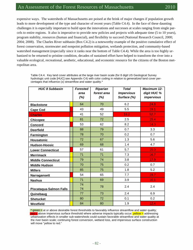
- 82 -
An Assessment of the Forest Resources of Massachusetts 2010
HUC 8 Subbasin Forested area (%)
Riparian forest area
(%)
Total Impervious Surface (%)
Maximum 12-digit HUC %impervious
Blackstone 64 70 6.2 24.8
Cape Cod 43 49 5.5 19.1
Charles 41 52 16.2 52.7
Chicopee 81 72 2.5 15.4
Concord 53 62 8.2 14.3
Deerfield 88 79 0.7 3.3
Farmington 78 70 0.2 0.7
Housatonic 72 67 1.3 5.6
Hudson-Hoosic 69 68 1.4 4.7
Lower Connecticut 57 61 5.7 15.0
Merrimack 71 71 7.3 16.7
Middle Connecticut 79 74 3.8 17.9
Middle Hudson 70 75 0.2 0.7
Millers 85 75 1.8 5.2
Narragansett 54 65 7.7 19.7
Nashua 71 69 3.9 10.1
Piscataqua-Salmon Falls 74
74 78 2.4 2.4
Quinebaug 77 73 2.4 6.9
Shetucket 80 72 0.1 0.2
Westfield 84 80 1.9 12.4
Table C4.4. Key land cover attributes at the large river basin scale (for 8 digit US Geological Survey hydrologic unit code [HUC] see Appendix C4) with color coding in relation to generalized land cover per-centages that influence (±) streamflow and water quality.*
expensive ways. The watersheds of Massachusetts are poised at the brink of major changes if population growth leads to more development of the type and character of recent years (Table C4.4). In the face of these daunting challenges it is especially important to build upon the innovations and successes at scales ranging from single par-cels to entire regions. It also is imperative to provide new policies and projects with adequate time (5 to 10 years), program stability, resources (human and financial), and flexibility to succeed (National Research Council, 2000; 2004; 2008). The Charles River subbasin (Box C4.2) is a noteworthy example of the positive cumulative effect of forest conservation, stormwater and nonpoint pollution mitigation, wetlands protection, and community-based watershed management (especially since it ranks near the bottom of Table C4.4). While the area is too highly ur-banized to be returned to pristine condition, decades of sustained effort have helped to transform the river into a valuable ecological, recreational, aesthetic, educational, and economic resource for the citizens of the Boston met-ropolitan area.
* green = at or above desirable forest thresholds to favorably influence streamflow and water quality; red = above impervious surface threshold where adverse impacts typically occur; yellow = addressing urbanization effects in smaller sub-watersheds could sustain favorable streamflow and water quality at the river basin scale; continuing forest conversion, wetland loss, and impervious surface construction will move “yellow to red.”
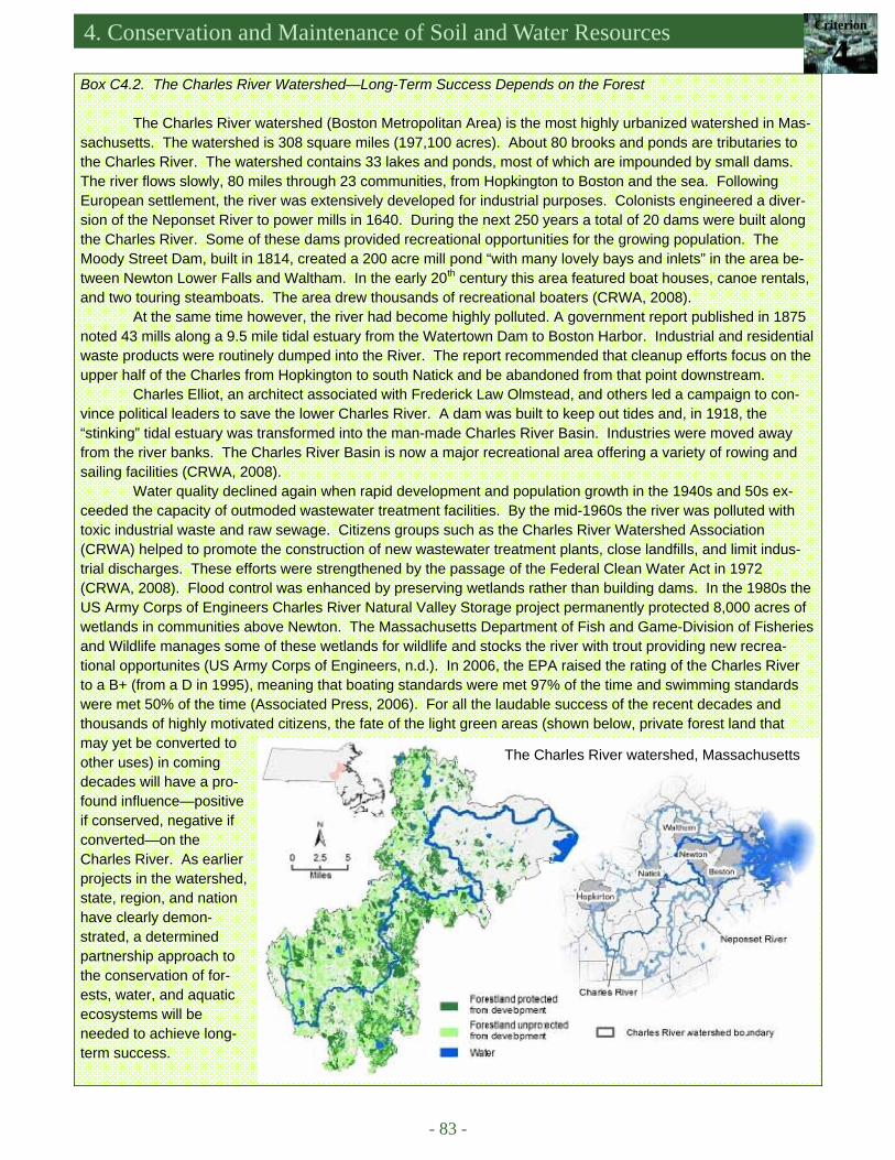
4. Conservation and Maintenance of Soil and Water Resources Criterion
4
- 83 -
Box C4.2. The Charles River Watershed—Long-Term Success Depends on the Forest
The Charles River watershed (Boston Metropolitan Area) is the most highly urbanized watershed in Mas-sachusetts. The watershed is 308 square miles (197,100 acres). About 80 brooks and ponds are tributaries to the Charles River. The watershed contains 33 lakes and ponds, most of which are impounded by small dams. The river flows slowly, 80 miles through 23 communities, from Hopkington to Boston and the sea. Following European settlement, the river was extensively developed for industrial purposes. Colonists engineered a diver-sion of the Neponset River to power mills in 1640. During the next 250 years a total of 20 dams were built along the Charles River. Some of these dams provided recreational opportunities for the growing population. The Moody Street Dam, built in 1814, created a 200 acre mill pond “with many lovely bays and inlets” in the area be-tween Newton Lower Falls and Waltham. In the early 20th century this area featured boat houses, canoe rentals, and two touring steamboats. The area drew thousands of recreational boaters (CRWA, 2008).
At the same time however, the river had become highly polluted. A government report published in 1875 noted 43 mills along a 9.5 mile tidal estuary from the Watertown Dam to Boston Harbor. Industrial and residential waste products were routinely dumped into the River. The report recommended that cleanup efforts focus on the upper half of the Charles from Hopkington to south Natick and be abandoned from that point downstream.
Charles Elliot, an architect associated with Frederick Law Olmstead, and others led a campaign to con-vince political leaders to save the lower Charles River. A dam was built to keep out tides and, in 1918, the “stinking” tidal estuary was transformed into the man-made Charles River Basin. Industries were moved away from the river banks. The Charles River Basin is now a major recreational area offering a variety of rowing and sailing facilities (CRWA, 2008).
Water quality declined again when rapid development and population growth in the 1940s and 50s ex-ceeded the capacity of outmoded wastewater treatment facilities. By the mid-1960s the river was polluted with toxic industrial waste and raw sewage. Citizens groups such as the Charles River Watershed Association (CRWA) helped to promote the construction of new wastewater treatment plants, close landfills, and limit indus-trial discharges. These efforts were strengthened by the passage of the Federal Clean Water Act in 1972 (CRWA, 2008). Flood control was enhanced by preserving wetlands rather than building dams. In the 1980s the US Army Corps of Engineers Charles River Natural Valley Storage project permanently protected 8,000 acres of wetlands in communities above Newton. The Massachusetts Department of Fish and Game-Division of Fisheries and Wildlife manages some of these wetlands for wildlife and stocks the river with trout providing new recrea-tional opportunites (US Army Corps of Engineers, n.d.). In 2006, the EPA raised the rating of the Charles River to a B+ (from a D in 1995), meaning that boating standards were met 97% of the time and swimming standards were met 50% of the time (Associated Press, 2006). For all the laudable success of the recent decades and thousands of highly motivated citizens, the fate of the light green areas (shown below, private forest land that may yet be converted to other uses) in coming decades will have a pro-found influence—positive if conserved, negative if converted—on the Charles River. As earlier projects in the watershed, state, region, and nation have clearly demon-strated, a determined partnership approach to the conservation of for-ests, water, and aquatic ecosystems will be needed to achieve long-term success.
The Charles River watershed, Massachusetts
- 84 -
An Assessment of the Forest Resources of Massachusetts 2010
References Associated Press. 2006. EPA gives lower Charles River a high B for cleanliness. April 24, 2006. Barnes, M.C., A.H. Todd, R.Whitney Lilja, and P.K. Barten. 2009. Forests, Water, and People: Drinking water supply and
forest lands in the Northeast and Midwest United States. NA-FR-01-08, United States Department of Agriculture Forest Service, Northeastern Area State and Private Forestry, Newtown Square, PA, 71 pp.
Barten, P.K., T. Kyker-Snowman, P.J. Lyons, T. Mahlstedt, R. O'Connor, and B.A. Spencer. 1998. Managing a Watershed Protection Forest. Journal of Forestry 96(8):10-15.
Booth, D.B. and C.R. Jackson. 1997. Urbanization of aquatic systems: degradation thresholds, stormwater mitigation, and the limits of mitigation. Journal of the American Water Resources Association 33:1077-1090.
Booth, D.B., D.Hartley, and R. Jackson. 2002. Forest cover, impervious-surface area, and the mitigation of stormwater im-pacts. Journal of the American Water Resources Association 38(3):835-845.
Bowen, J.L. and I. Valiela. 2001. The ecological effects of urbanization of coastal watersheds: Historical increases in nitro-gen loads and eutrophication of Waquoit Bay estuaries. Can. J. Fish Aquat. Sci. 58:1489-1500.
Cape Cod Groundwater Guardian Team. 2009. Cape Cod Aquifer. Available at http://www.capecodgroundwater.org. Ac-cessed in March 2010.
CRWA (Charles River Watershed Association). 2008. Charles River History. Available at http://www.crwa.org/cr_history.html. Accessed in March 2010.
de la Crétaz, A.L. and P.K. Barten. 2007. Land Use Effects on Streamflow and Water Quality in the Northeastern United States. CRC Press, Taylor and Francis Group, Boca Raton, FL., 319 pp.
DEP (Massachusetts Department of Environmental Protection). No date given. SWAP program. Available at http://www.mass.gov/dep/water/drinking/sourcewa.htm. Accessed in March 2010.
DEP (Massachusetts Department of Environmental Protection, Drinking Water Program). 2009. 310 CMR 22.02: Drinking Water: Definitions.
DEP (Massachusetts Department of Environmental Protection, Drinking Water Program). 1996. Model Groundwater Pro-tection, Board of Health Regulation. Available at http://www.state.ma.us/dep . Accessed in March 2010.
Fox, S.E., E. Stieve, I. Valiela, J. Hauxwell, J. McClelland. 2008. Macrophyte abundance in Waquoit Bay: effects of land-derived nitrogen loads on seasonal and multi-year biomass patterns. Estuaries and Coasts 31:532-541.
Gregory, P.E. and P.K. Barten. 2008. Public and Private Forests, Drinking Water Supplies and Population Growth in the Eastern United States. University of Massachusetts Amherst – USDA Forest Service. Available at http://www.forest-to-faucet.org. Accessed in March 2010, 6 pp.
Hornbeck, J.W., M.B. Adams, E.S. Corbett, E.S. Verry, and J.A. Lynch. 1993. Long-term impacts of forest treatments on water yield: a summary for the northeastern USA. Journal of Hydrology 150:323-344.
Kochenderfer, J.N. and J.W. Hornbeck. 1999. Contrasting timber harvesting operations illustrate the value of BMPs, in J.W. Stringer and D.L. Loftis, editors, Proceedings, 12th Central Hardwood Conference, February 28-March 2, 1999, Lexington, Kentucky, General Technical Report USDA Forest Service, Southern Forest Research Station, Ashville, NC., pp. 128-135.
Kyker-Snowman, T. 2010. Watershed Forest Management. Powerpoint presentation. Massachusetts Department of Conser-vation and Recreation – Division of Water Supply Protection.
Martin, C.W., R.S. Pierce, G.E. Likens, and F.H. Bormann. 1986. Clearcutting affects stream chemistry in the White Mountains of New Hampshire. Research Paper NE579, USDA Forest Service Northeastern Forest Experiment Station, 16 pp.
MassGIS (Office of Geographic and Environmental Information, Commonwealth of Massachusetts, Executive Office of Energy and Environmental Affairs). 2005. NRCS HUC Basins (8,10,12). Available at http://www.mass.gov/mgis/. Accessed in March 2009.
MassGIS (Office of Geographic and Environmental Information, Commonwealth of Massachusetts, Executive Office of Energy and Environmental Affairs). 2007. Impervious Surface Areas. Available at http://www.mass.gov/mgis/. Accessed in March 2009.
MassGIS (Office of Geographic and Environmental Information, Commonwealth of Massachusetts, Executive Office of Energy and Environmental Affairs). 2009a. Hydrography. Available at http://www.mass.gov/mgis/. Accessed in March 2009.
MassGIS (Office of Geographic and Environmental Information, Commonwealth of Massachusetts, Executive Office of Energy and Environmental Affairs). 2009b. Major Ponds and Major Streams; DEP Wetlands. Available athttp://www.mass.gov/mgis/. Accessed in March 2009.
MassGIS (Office of Geographic and Environmental Information, Commonwealth of Massachusetts, Executive Office of Energy and Environmental Affairs). 2009c. Outstanding Resource Waters. Available at http://www.mass.gov/mgis/. Accessed in March 2009.
MassGIS (Office of Geographic and Environmental Information, Commonwealth of Massachusetts, Executive Office of Energy and Environmental Affairs). 2009d. Wellhead Protection Areas (Zone II, IWPA). Available at http://
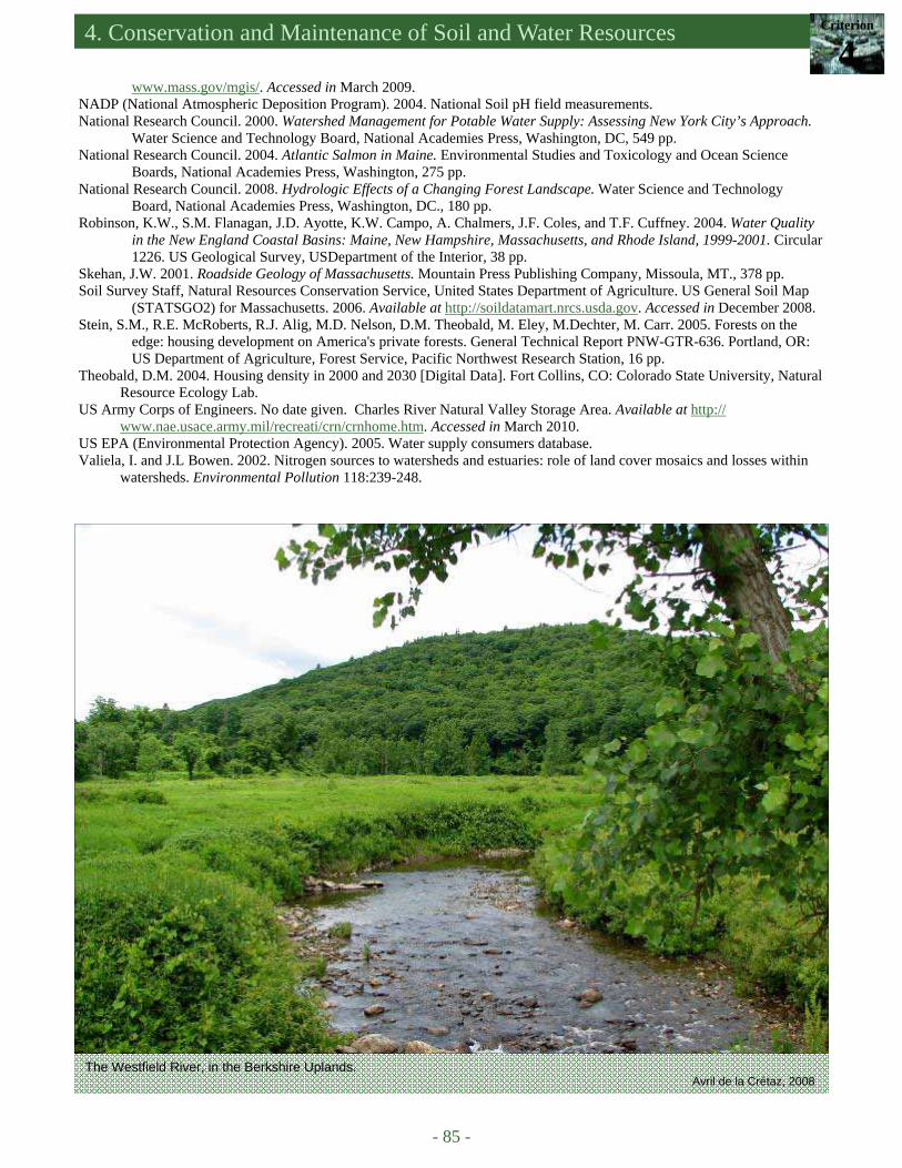
4. Conservation and Maintenance of Soil and Water Resources Criterion
4
- 85 -
www.mass.gov/mgis/. Accessed in March 2009. NADP (National Atmospheric Deposition Program). 2004. National Soil pH field measurements. National Research Council. 2000. Watershed Management for Potable Water Supply: Assessing New York City’s Approach.
Water Science and Technology Board, National Academies Press, Washington, DC, 549 pp. National Research Council. 2004. Atlantic Salmon in Maine. Environmental Studies and Toxicology and Ocean Science
Boards, National Academies Press, Washington, 275 pp. National Research Council. 2008. Hydrologic Effects of a Changing Forest Landscape. Water Science and Technology
Board, National Academies Press, Washington, DC., 180 pp. Robinson, K.W., S.M. Flanagan, J.D. Ayotte, K.W. Campo, A. Chalmers, J.F. Coles, and T.F. Cuffney. 2004. Water Quality
in the New England Coastal Basins: Maine, New Hampshire, Massachusetts, and Rhode Island, 1999-2001. Circular 1226. US Geological Survey, USDepartment of the Interior, 38 pp.
Skehan, J.W. 2001. Roadside Geology of Massachusetts. Mountain Press Publishing Company, Missoula, MT., 378 pp. Soil Survey Staff, Natural Resources Conservation Service, United States Department of Agriculture. US General Soil Map
(STATSGO2) for Massachusetts. 2006. Available at http://soildatamart.nrcs.usda.gov. Accessed in December 2008. Stein, S.M., R.E. McRoberts, R.J. Alig, M.D. Nelson, D.M. Theobald, M. Eley, M.Dechter, M. Carr. 2005. Forests on the
edge: housing development on America's private forests. General Technical Report PNW-GTR-636. Portland, OR: US Department of Agriculture, Forest Service, Pacific Northwest Research Station, 16 pp.
Theobald, D.M. 2004. Housing density in 2000 and 2030 [Digital Data]. Fort Collins, CO: Colorado State University, Natural Resource Ecology Lab.
US Army Corps of Engineers. No date given. Charles River Natural Valley Storage Area. Available at http://www.nae.usace.army.mil/recreati/crn/crnhome.htm. Accessed in March 2010.
US EPA (Environmental Protection Agency). 2005. Water supply consumers database. Valiela, I. and J.L Bowen. 2002. Nitrogen sources to watersheds and estuaries: role of land cover mosaics and losses within
watersheds. Environmental Pollution 118:239-248.
The Westfield River, in the Berkshire Uplands. Avril de la Crétaz, 2008

- 86 -
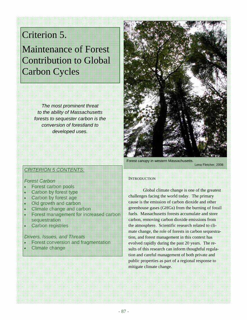
- 87 -
Forest canopy in western Massachusetts. Lena Fletcher, 2008
Criterion 5.
Maintenance of Forest Contribution to Global Carbon Cycles
CRITERION 5 CONTENTS: Forest Carbon • Forest carbon pools • Carbon by forest type • Carbon by forest age • Old growth and carbon • Climate change and carbon • Forest management for increased carbon
sequestration • Carbon registries Drivers, Issues, and Threats • Forest conversion and fragmentation • Climate change
INTRODUCTION Global climate change is one of the greatest challenges facing the world today. The primary cause is the emission of carbon dioxide and other greenhouse gases (GHGs) from the burning of fossil fuels. Massachusetts forests accumulate and store carbon, removing carbon dioxide emissions from the atmosphere. Scientific research related to cli-mate change, the role of forests in carbon sequestra-tion, and forest management in this context has evolved rapidly during the past 20 years. The re-sults of this research can inform thoughtful regula-tion and careful management of both private and public properties as part of a regional response to mitigate climate change.
The most prominent threat to the ability of Massachusetts
forests to sequester carbon is the conversion of forestland to
developed uses.

- 88 -
Massachusetts Forest Assessment 2010 An Assessment of the Forest Resources of Massachusetts 2010
FOREST CARBON Forests remove carbon dioxide from the atmosphere and fix, or sequester, carbon through photosynthe-sis, which in turn produces forest biomass. Sequestered carbon is stored in a variety of forest carbon pools: liv-ing biomass (vegetation), dead woody biomass, and organic matter in the forest floor and soil. Forests are both a source and a sink for carbon, releasing carbon through respiration (decomposition) and sequestering carbon through photosynthesis. Forest carbon was essentially in balance in the United States prior to European settle-ment (Birdsey et al., 2006). During the 19th century widespread land clearing in Massachusetts, and much of the United States, led to a large increase in carbon emissions (Birdsey et al., 2006). Forests in Massachusetts have been regrowing since the early-1900s and now are a carbon sink, sequestering more carbon annually than is lost to decay. The quantity of carbon sequestered by a given forest is dependent on a variety of factors, including forest age, forest type, and ecological site conditions. Some forest management practices may be able to in-crease the carbon sequestration potential of forests in Massachusetts (Birdsey et al., 2006; Perschel et al., 2007). Forest Carbon Pools
Massachusetts forests are relatively young, regenerating from a long history of forest clearing, which
peaked in the early-1900s (Kelty et al., 2008). This history of forest clearing has left the majority of Massachu-setts forestlands with the potential to sequester carbon and biomass across all forest ecosystem pools. Different pools sequester carbon at varying rates and differ in potential carbon storage capacity (Woodbury et al., 2007). In Massachusetts carbon is primarily sequestered in tree boles, but also in root systems, bark, foliage, dead wood, understory vegetation, forest floor (litter), and soil. The majority of carbon in Massachusetts forests is in the live trees and saplings (~50%), both above and below ground (including root systems). The next largest for-est pool in Massachusetts forests is the soil (36%), followed by the litter layer, dead wood and understory pools (Figure C5.1). When all of these pools are combined, the total forest carbon estimate for Massachusetts is about 256 million oven-dry tons of carbon, or an average estimate of about 85 tons/acre on forestland (USDA Forest Service FIA, 2008). This estimate is similar to a northeast-wide forest carbon estimate of about 75 tons/acre (Perschel et al., 2007).
Figure C5.1. Carbon in forest pools in Massachusetts (in thousand oven-dry tons). Error bars represent one standard devia-tion (USDA Forest Service FIA, 2008).
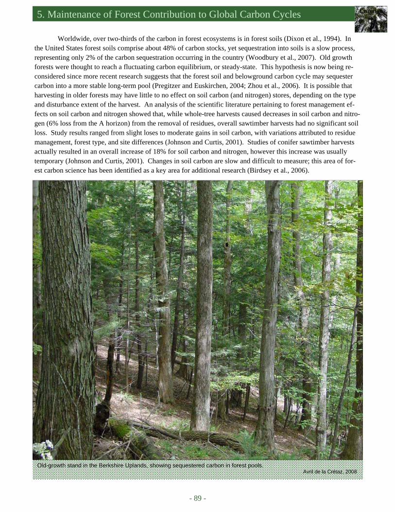
5. Maintenance of Forest Contribution to Global Carbon Cycles Criterion
5
- 89 -
Worldwide, over two-thirds of the carbon in forest ecosystems is in forest soils (Dixon et al., 1994). In the United States forest soils comprise about 48% of carbon stocks, yet sequestration into soils is a slow process, representing only 2% of the carbon sequestration occurring in the country (Woodbury et al., 2007). Old growth forests were thought to reach a fluctuating carbon equilibrium, or steady-state. This hypothesis is now being re-considered since more recent research suggests that the forest soil and belowground carbon cycle may sequester carbon into a more stable long-term pool (Pregitzer and Euskirchen, 2004; Zhou et al., 2006). It is possible that harvesting in older forests may have little to no effect on soil carbon (and nitrogen) stores, depending on the type and disturbance extent of the harvest. An analysis of the scientific literature pertaining to forest management ef-fects on soil carbon and nitrogen showed that, while whole-tree harvests caused decreases in soil carbon and nitro-gen (6% loss from the A horizon) from the removal of residues, overall sawtimber harvests had no significant soil loss. Study results ranged from slight loses to moderate gains in soil carbon, with variations attributed to residue management, forest type, and site differences (Johnson and Curtis, 2001). Studies of conifer sawtimber harvests actually resulted in an overall increase of 18% for soil carbon and nitrogen, however this increase was usually temporary (Johnson and Curtis, 2001). Changes in soil carbon are slow and difficult to measure; this area of for-est carbon science has been identified as a key area for additional research (Birdsey et al., 2006).
Old-growth stand in the Berkshire Uplands, showing sequestered carbon in forest pools. Avril de la Crétaz, 2008
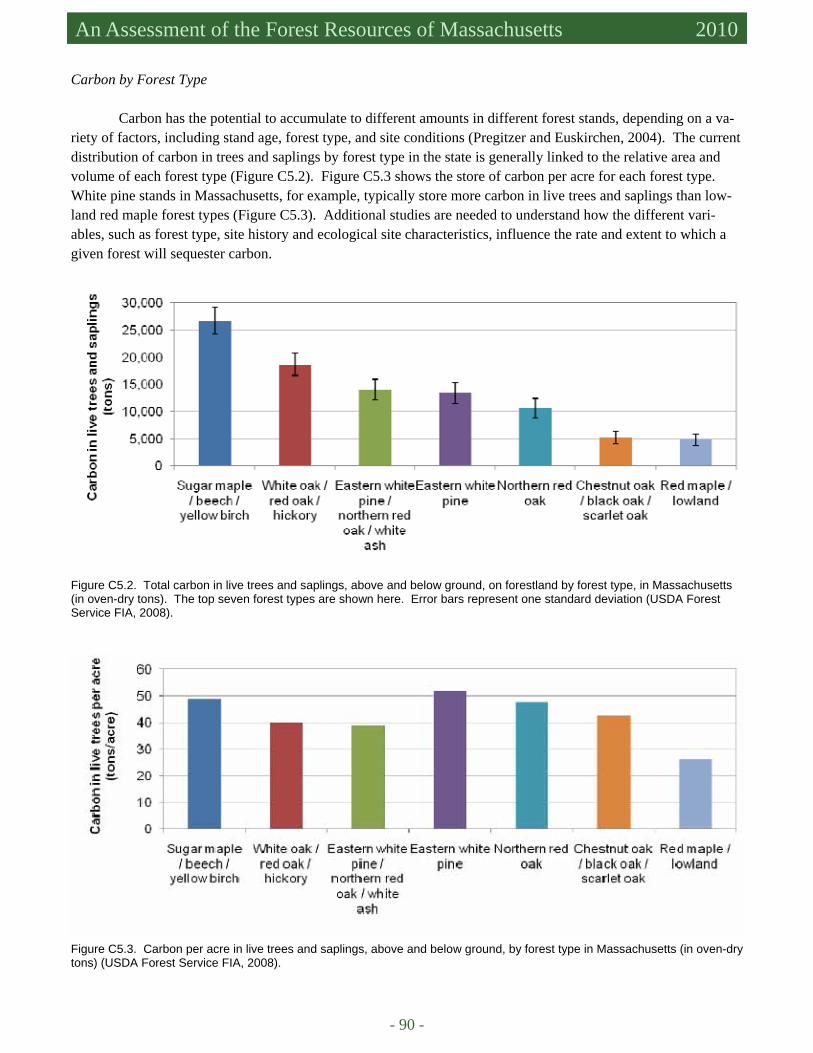
- 90 -
Massachusetts Forest Assessment 2010 An Assessment of the Forest Resources of Massachusetts 2010
Carbon by Forest Type Carbon has the potential to accumulate to different amounts in different forest stands, depending on a va-
riety of factors, including stand age, forest type, and site conditions (Pregitzer and Euskirchen, 2004). The current distribution of carbon in trees and saplings by forest type in the state is generally linked to the relative area and volume of each forest type (Figure C5.2). Figure C5.3 shows the store of carbon per acre for each forest type. White pine stands in Massachusetts, for example, typically store more carbon in live trees and saplings than low-land red maple forest types (Figure C5.3). Additional studies are needed to understand how the different vari-ables, such as forest type, site history and ecological site characteristics, influence the rate and extent to which a given forest will sequester carbon.
Figure C5.2. Total carbon in live trees and saplings, above and below ground, on forestland by forest type, in Massachusetts (in oven-dry tons). The top seven forest types are shown here. Error bars represent one standard deviation (USDA Forest Service FIA, 2008).
Figure C5.3. Carbon per acre in live trees and saplings, above and below ground, by forest type in Massachusetts (in oven-dry tons) (USDA Forest Service FIA, 2008).
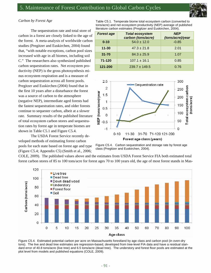
5. Maintenance of Forest Contribution to Global Carbon Cycles Criterion
5
- 91 -
Carbon by Forest Age
The sequestration rate and total store of carbon in a forest are closely linked to the age of the forest. A meta-analysis of worldwide carbon studies (Pregitzer and Euskirchen, 2004) found that, “with notable exceptions, carbon pool sizes increased with age in all biomes, including soil C.” The researchers also synthesized published carbon sequestration rates. Net ecosystem pro-ductivity (NEP) is the gross photosynthesis mi-nus ecosystem respiration and is a measure of carbon sequestration across all forest pools. Pregitzer and Euskirchen (2004) found that in the first 10 years after a disturbance the forest was a source of carbon to the atmosphere (negative NEP), intermediate aged forests had the fastest sequestration rates, and older forests continue to sequester carbon, albeit at a slower rate. Summary results of the published literature of total ecosystem carbon stores and sequestra-tion rates by forest age in temperate biomes are shown in Table C5.1 and Figure C5.4.
The USDA Forest Service recently de-veloped methods of estimating forest carbon pools for each state based on forest age and type (Figure C5.4; Appendix C5) (Smith et al., 2006; COLE, 2009). The published values above and the estimates from USDA Forest Service FIA both estimated total forest carbon stores of 85 to 100 tons/acre for forest ages 70 to 100 years old, the age of most forest stands in Mas-
Table C5.1. Temperate biome total ecosystem carbon (converted to tons/acre) and net ecosystem productivity (NEP) average of published literature carbon estimates (Pregitzer and Euskirchen, 2004).
Forest age Total ecosystem carbon (tons/acre)
NEP (tons/acre)/year
0-10 54.0 ± 12.0 -0.85
11-30 47.3 ± 21.8 2.01
31-70 84.3 ± 25.9 1.07
71-120 107.1 ± 16.1 0.85
121-200 239.7 ± 149.5 0.76
Figure C5.4. Estimated potential carbon per acre on Massachusetts forestland by age class and carbon pool (in oven-dry tons). The live and dead tree estimates are regression-based, developed from tree-level FIA data and have a residual stan-dard error of 40.8 tons/acre (live tree) and 6.5 tons/acre (dead tree). The understory and forest floor pools are estimated at the plot level from models and published equations (COLE, 2009).
Figure C5.4. Carbon sequestration and storage rate by forest age class (Pregitzer and Euskirchen, 2004).
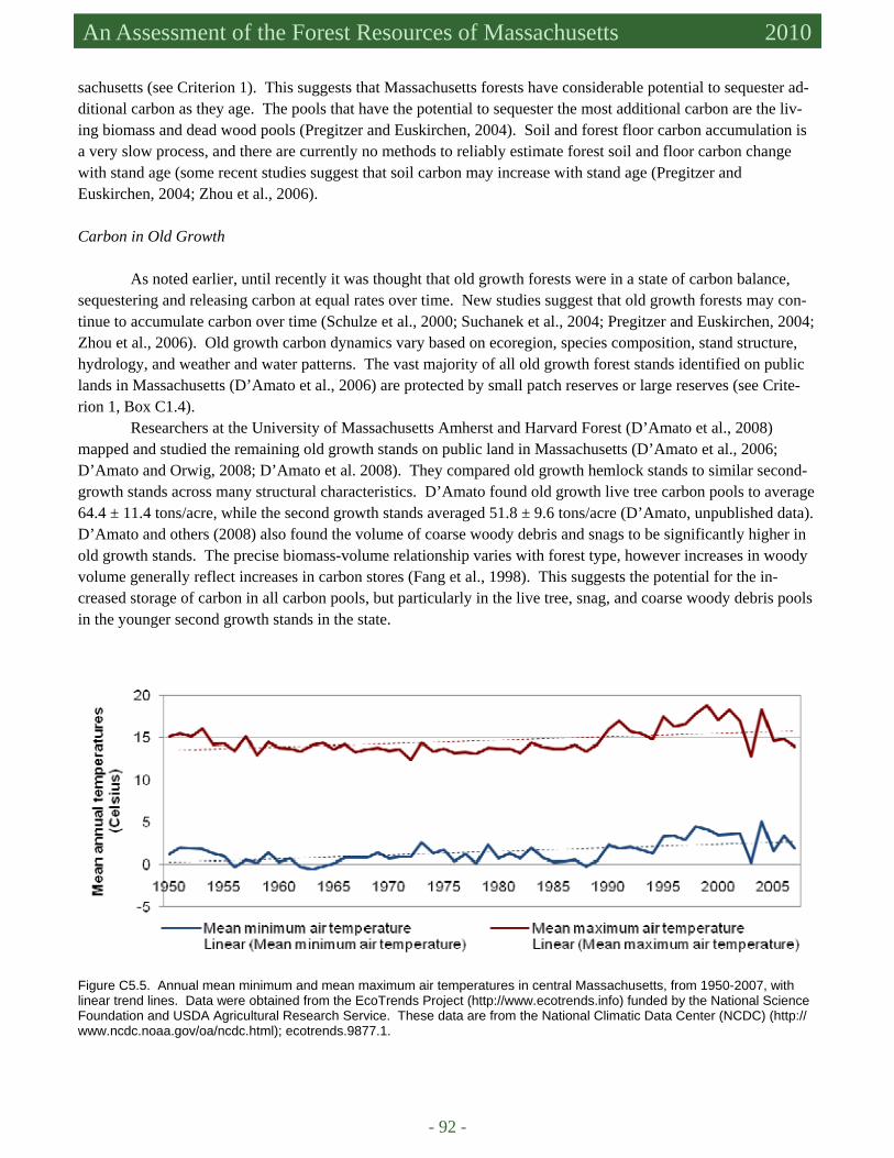
- 92 -
Massachusetts Forest Assessment 2010 An Assessment of the Forest Resources of Massachusetts 2010
sachusetts (see Criterion 1). This suggests that Massachusetts forests have considerable potential to sequester ad-ditional carbon as they age. The pools that have the potential to sequester the most additional carbon are the liv-ing biomass and dead wood pools (Pregitzer and Euskirchen, 2004). Soil and forest floor carbon accumulation is a very slow process, and there are currently no methods to reliably estimate forest soil and floor carbon change with stand age (some recent studies suggest that soil carbon may increase with stand age (Pregitzer and Euskirchen, 2004; Zhou et al., 2006).
Carbon in Old Growth
As noted earlier, until recently it was thought that old growth forests were in a state of carbon balance, sequestering and releasing carbon at equal rates over time. New studies suggest that old growth forests may con-tinue to accumulate carbon over time (Schulze et al., 2000; Suchanek et al., 2004; Pregitzer and Euskirchen, 2004; Zhou et al., 2006). Old growth carbon dynamics vary based on ecoregion, species composition, stand structure, hydrology, and weather and water patterns. The vast majority of all old growth forest stands identified on public lands in Massachusetts (D’Amato et al., 2006) are protected by small patch reserves or large reserves (see Crite-rion 1, Box C1.4).
Researchers at the University of Massachusetts Amherst and Harvard Forest (D’Amato et al., 2008) mapped and studied the remaining old growth stands on public land in Massachusetts (D’Amato et al., 2006; D’Amato and Orwig, 2008; D’Amato et al. 2008). They compared old growth hemlock stands to similar second-growth stands across many structural characteristics. D’Amato found old growth live tree carbon pools to average 64.4 ± 11.4 tons/acre, while the second growth stands averaged 51.8 ± 9.6 tons/acre (D’Amato, unpublished data). D’Amato and others (2008) also found the volume of coarse woody debris and snags to be significantly higher in old growth stands. The precise biomass-volume relationship varies with forest type, however increases in woody volume generally reflect increases in carbon stores (Fang et al., 1998). This suggests the potential for the in-creased storage of carbon in all carbon pools, but particularly in the live tree, snag, and coarse woody debris pools in the younger second growth stands in the state.
Figure C5.5. Annual mean minimum and mean maximum air temperatures in central Massachusetts, from 1950-2007, with linear trend lines. Data were obtained from the EcoTrends Project (http://www.ecotrends.info) funded by the National Science Foundation and USDA Agricultural Research Service. These data are from the National Climatic Data Center (NCDC) (http://www.ncdc.noaa.gov/oa/ncdc.html); ecotrends.9877.1.
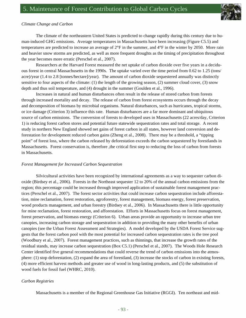
5. Maintenance of Forest Contribution to Global Carbon Cycles Criterion
5
- 93 -
Climate Change and Carbon The climate of the northeastern United States is predicted to change rapidly during this century due to hu-
man-induced GHG emissions. Average temperatures in Massachusetts have been increasing (Figure C5.5) and temperatures are predicted to increase an average of 2°F in the summer, and 4°F in the winter by 2050. More rain and heavier snow storms are predicted, as well as more frequent droughts as the timing of precipitation throughout the year becomes more erratic (Perschel et al., 2007).
Researchers at the Harvard Forest measured the net uptake of carbon dioxide over five years in a decidu-ous forest in central Massachusetts in the 1990s. The uptake varied over the time period from 0.62 to 1.25 (tons/acre)/year (1.4 to 2.8 [tonnes/hectare]/year). The amount of carbon dioxide sequestered annually was distinctly sensitive to four aspects of the climate: (1) the length of the growing season, (2) summer cloud cover, (3) snow depth and thus soil temperature, and (4) drought in the summer (Goulden et al., 1996).
Increases in natural and human disturbances often result in the release of stored carbon from forests through increased mortality and decay. The release of carbon from forest ecosystems occurs through the decay and decomposition of biomass by microbial organisms. Natural disturbances, such as hurricanes, tropical storms, or ice damage (Criterion 3) influence this rate. Human disturbances are a far more dominant and ubiquitous source of carbon emissions. The conversion of forests to developed uses in Massachusetts (22 acres/day, Criterion 1) is reducing forest carbon stores and potential future statewide sequestration rates and total storage. A recent study in northern New England showed net gains of forest carbon in all states, however land conversion and de-forestation for development reduced carbon gains (Zheng et al., 2008). There may be a threshold, a “tipping point” of forest loss, where the carbon released by deforestation exceeds the carbon sequestered by forestlands in Massachusetts. Forest conservation is, therefore ,the critical first step to reducing the loss of carbon from forests in Massachusetts. Forest Management for Increased Carbon Sequestration
Silvicultural activities have been recognized by international agreements as a way to sequester carbon di-
oxide (Birdsey et al., 2006). Forests in the Northeast sequester 12 to 20% of the annual carbon emissions from the region; this percentage could be increased through improved application of sustainable forest management prac-tices (Perschel et al., 2007). The forest sector activities that could increase carbon sequestration include afforesta-tion, mine reclamation, forest restoration, agroforestry, forest management, biomass energy, forest preservation, wood products management, and urban forestry (Birdsey et al., 2006). In Massachusetts there is little opportunity for mine reclamation, forest restoration, and afforestation. Efforts in Massachusetts focus on forest management, forest preservation, and biomass energy (Criterion 6). Urban areas provide an opportunity to increase urban tree canopies, increasing carbon storage and sequestration in addition to providing the many other benefits of urban canopies (see the Urban Forest Assessment and Strategies). A model developed by the USDA Forest Service sug-gests that the forest carbon pool with the most potential for increased carbon sequestration rates is the tree pool (Woodbury et al., 2007). Forest management practices, such as thinnings, that increase the growth rates of the residual stands, may increase carbon sequestration (Box C5.1) (Perschel et al., 2007). The Woods Hole Research Center identified five general recommendations that could reverse the trend of carbon emissions into the atmos-phere: (1) stop deforestation, (2) expand the area of forestland, (3) increase the stocks of carbon in existing forests, (4) more efficient harvest methods and greater use of wood in long-lasting products, and (5) the substitution of wood fuels for fossil fuel (WHRC, 2010).
Carbon Registries
Massachusetts is a member of the Regional Greenhouse Gas Initiative (RGGI). Ten northeast and mid-
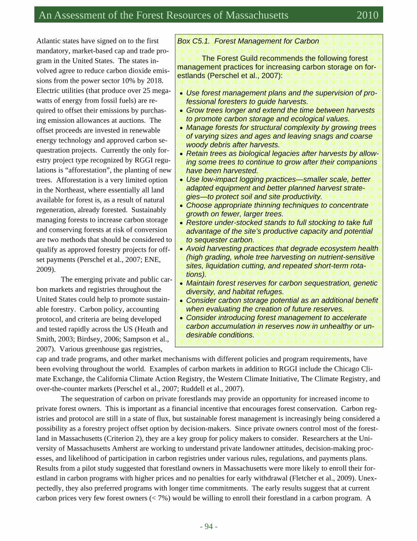
- 94 -
Massachusetts Forest Assessment 2010 An Assessment of the Forest Resources of Massachusetts 2010
Atlantic states have signed on to the first mandatory, market-based cap and trade pro-gram in the United States. The states in-volved agree to reduce carbon dioxide emis-sions from the power sector 10% by 2018. Electric utilities (that produce over 25 mega-watts of energy from fossil fuels) are re-quired to offset their emissions by purchas-ing emission allowances at auctions. The offset proceeds are invested in renewable energy technology and approved carbon se-questration projects. Currently the only for-estry project type recognized by RGGI regu-lations is “afforestation”, the planting of new trees. Afforestation is a very limited option in the Northeast, where essentially all land available for forest is, as a result of natural regeneration, already forested. Sustainably managing forests to increase carbon storage and conserving forests at risk of conversion are two methods that should be considered to qualify as approved forestry projects for off-set payments (Perschel et al., 2007; ENE, 2009).
The emerging private and public car-bon markets and registries throughout the United States could help to promote sustain-able forestry. Carbon policy, accounting protocol, and criteria are being developed and tested rapidly across the US (Heath and Smith, 2003; Birdsey, 2006; Sampson et al., 2007). Various greenhouse gas registries, cap and trade programs, and other market mechanisms with different policies and program requirements, have been evolving throughout the world. Examples of carbon markets in addition to RGGI include the Chicago Cli-mate Exchange, the California Climate Action Registry, the Western Climate Initiative, The Climate Registry, and over-the-counter markets (Perschel et al., 2007; Ruddell et al., 2007).
The sequestration of carbon on private forestlands may provide an opportunity for increased income to private forest owners. This is important as a financial incentive that encourages forest conservation. Carbon reg-istries and protocol are still in a state of flux, but sustainable forest management is increasingly being considered a possibility as a forestry project offset option by decision-makers. Since private owners control most of the forest-land in Massachusetts (Criterion 2), they are a key group for policy makers to consider. Researchers at the Uni-versity of Massachusetts Amherst are working to understand private landowner attitudes, decision-making proc-esses, and likelihood of participation in carbon registries under various rules, regulations, and payments plans. Results from a pilot study suggested that forestland owners in Massachusetts were more likely to enroll their for-estland in carbon programs with higher prices and no penalties for early withdrawal (Fletcher et al., 2009). Unex-pectedly, they also preferred programs with longer time commitments. The early results suggest that at current carbon prices very few forest owners (< 7%) would be willing to enroll their forestland in a carbon program. A
Box C5.1. Forest Management for Carbon
The Forest Guild recommends the following forest management practices for increasing carbon storage on for-estlands (Perschel et al., 2007):
• Use forest management plans and the supervision of pro-
fessional foresters to guide harvests. • Grow trees longer and extend the time between harvests
to promote carbon storage and ecological values. • Manage forests for structural complexity by growing trees
of varying sizes and ages and leaving snags and coarse woody debris after harvests.
• Retain trees as biological legacies after harvests by allow-ing some trees to continue to grow after their companions have been harvested.
• Use low-impact logging practices—smaller scale, better adapted equipment and better planned harvest strate-gies—to protect soil and site productivity.
• Choose appropriate thinning techniques to concentrate growth on fewer, larger trees.
• Restore under-stocked stands to full stocking to take full advantage of the site’s productive capacity and potential to sequester carbon.
• Avoid harvesting practices that degrade ecosystem health (high grading, whole tree harvesting on nutrient-sensitive sites, liquidation cutting, and repeated short-term rota-tions).
• Maintain forest reserves for carbon sequestration, genetic diversity, and habitat refuges.
• Consider carbon storage potential as an additional benefit when evaluating the creation of future reserves.
• Consider introducing forest management to accelerate carbon accumulation in reserves now in unhealthy or un-desirable conditions.
5. Maintenance of Forest Contribution to Global Carbon Cycles Criterion
5
- 95 -
more extensive study is in progress (involving over 1,000 surveys and focus groups of private forest owners in Massachusetts) to gauge the willingness of landowners to enroll in carbon credit programs considering varying program elements and socioeconomic characteristics (pers. comm. David Kittredge, University of Massachusetts Amherst, March 23, 2010). A pilot Forest Carbon Offset and Trading Program is available through the Working Forest Initiative (Criterion 6) for certified forestlands, however properties of less than 100 acres are generally too small to be economical at current carbon prices (DCR, 2009).
DRIVERS, ISSUES, AND THREATS Climate Change Average temperatures in Massachusetts are predicted to increase 2°F in the summer and 4°F in the winter. The increase in temperature will likely be accompanied by more rain, more severe storms, and more frequent droughts (Perschel et al., 2007). These climatic changes may exacerbate current forest stressors such as pests and disease (Criterion 3). Tree species’ ranges will shift. It is unclear exactly how climate change will influence for-ested environments; increased levels of carbon dioxide and longer growing seasons may increase growth rates, while increased stressors may increase mortality. Monitoring forest resources is, therefore, crucial to adaptive management of changing forest environments. Forest Conversion and Fragmentation
The most prominent threat to the ability of Massachusetts forests to sequester carbon is the conversion of
forestland to developed uses. The rapid conversion of forestland to developed uses (see Criterion 1) is detrimental in two ways: (1) by initially releasing large quantities of carbon and (2) by reducing the potential sequestration rate and total store in Massachusetts into the future.

- 96 -
Massachusetts Forest Assessment 2010 An Assessment of the Forest Resources of Massachusetts 2010
References Birdsey, R.A. 2006. Carbon accounting rules and guidelines for the United States forest sectors. Journal of Environmental
Quality 35:1518-1524. Birdsey, R., K. Pregitzer, and A. Lucier. 2006. Forest carbon management in the United States: 1600-2100. Journal of Envi-
ronmental Quality 35:1461-1469. COLE (Carbon On Line Estimator Development Group). 2009. COLE 1605(b) Report for Massachusetts. November 4, 2009.
Carbon On Line Estimator Version 2.0. USDA Forest Service, RWU-4104 in Durham, NH. Available at http://ncasi.uml.edu/COLE/index.html. Accessed in February 2010.
D’Amato, A., D. Orwig, and D. Foster. 2006. New estimates of Massachusetts old-growth forests: useful data for regional conservation and forest reserve planning. Northeastern Naturalist 13(4):495-506.
D’Amato, A.W. and D.A. Orwig. 2008. Stand and landscape-level disturbance dynamics in old-growth forests in western Massachusetts. Ecological Monographs 78(4):507-522.
D’Amato, A.W., D.A. Orwig, and D.R. Foster. 2008. The influence of successional processes and disturbance on the structure of Tsuga Canadensis forests. Ecological Applications 18(5): 1182-1199.
D’Amato, A.W. 2010. Unpublished data. Carbon and biomass estimates for old and second growth hemlock stands. Dixon, R.K., S. Brown, R.A. Houghton, A.M. Solomon, M.C. Trexler, and J. Wisniewski. 1994. Carbon pools and flux of
global forest ecosystems. Science 263:185-190. ENE (Environment Northeast). 2009. Forest offsets in carbon cap and trade programs: the RGGI precident. Available at
www.env-ne.org. Accessed in January 2010. Fang, J-Y, G.G. Wang, G-H. Liu, S-L. Xu. 1998. Forest biomass of China: an estimate based on the biomss – volume rela-
tionship. Ecological Applications 8(4):1084-1091. Fletcher, L.S., D. Kittredge Jr., and T. Stevens. 2009. Forest landowner’s willingness to sell carbon credits: a pilot study.
Northern Journal of Applied Forestry 26(1):35-37. Goulden, M.L., J.W. Munger, S-M. Fan, B.C. Daube, S.C. Wofsy. 1996. Exchange of carbon dioxide by a deciduous forest:
response to interannual climate variability. Science 271(5255):1576-1578. Heath, L.S. and J.E. Smith. 2003. Criteria 5, Indicator 27. In: National Report on Sustainable Forests - 2003. US Department
of Agriculture, Forest Service, FS-766. February 2004, 139 pp. Johnson, D.W. and P.S. Curtis. 2001. Effects of forest management on soil C and N storage: meta analysis. Forest Ecology
and Management 140:227-238. Kelty, M.J., A.W. D’Amato, and P.K. Barten. 2008. Silvicultural and Ecological Considerations of Forest Biomass Harvest-
ing in Massachusetts. Prepared for the Massachusetts Division of Energy Resources & Massachusetts Department of Conservation and Recreation, 65 pp.
Kittredge, D.B. 2010. Personal communication re: ongoing landowner research. March, 23, 2010. Perschel, R., A. Evans, and M. Summers. 2007. Climate change, carbon, and the forests of the Northeast. The Forest Guild,
47 pp. Pregitzer, K.S. and E.S. Euskirchen. 2004. Carbon cycling and storage in world forests: biome patterns related to forest age.
Global Change Biology 10:2052-2077. Ruddell, S., R. Sampson, M. Smith, R. Giffen, J. Cathcart, J. Hagan, D. Sosland, J. Godbee, J. Heissenbuttel, S. Lovett, J.
Helms, W. Price, and R. Simpson. 2007. The role for sustainably managed forests in climate change mitigation. Jour-nal of Forestry:314-318.
Sampson, R.N., S. Ruddell, and M. Smith. 2007. Managed forests in climate change policy: program design elements. Society of American Foresters, 22 pp.
Schulze, E-D., C.Wirth, and M. Helmann. 2000. Managing forests after Kyoto. Science 289:2058-2059. Smith, J.E., L.S. Heath, K.E. Skog, and R.A. Birdsey. 2006. Methods for calculating forest ecosystem and harvested carbon
with standard estimates for forest types of the United States. Gen. Tech. Rep. NE-343. Newtown Square, PA: US De-partment of Agriculture, Forest Service, Northeastern Research Station, 216 pp.
Suchanek, T.H., H.A. Mooney, J.F. Franklin, H. Gucinski, and S.L. Ustin. 2004. Carbon dynamics of an old-growth forest. Ecosystems 7:421-426.
USDA Forest Service FIA. 2008. Miles, P.D. 2009, 2010. Forest Inventory EVALIDator web-application version 4.01 beta. St. Paul, MN: US Department of Agriculture, Forest Service, Northern Research Station. Available at http://fiatools.fs.fed.us/Evalidator401/tmattribute.jsp. Accessed in February 2010. WHRC (Woods Hole Research Institute). 2009. Using Forests to Sequester Carbon. Available at http://www.whrc.org/
carbon/forestseq.htm. Accessed in February 2010. Woodbury, P.B., J.E. Smith, L.S. Heath. 2007. Carbon sequestration in the US forest sector from 1990 to 2010. Forest Ecol-
ogy and Management 241:14-27. Zheng, D., L.S. Heath, M.J. Ducey, and J.E. Smith. 2008. A preliminary investigation of forest carbon changes associated
with land-use change in Northern New England. 2008 Forest Inventory and Analysis (FIA) Symposium, United States Department of Agriculture Forest Service Proceedings – RMRS-P-56.

5. Maintenance of Forest Contribution to Global Carbon Cycles Criterion
5
- 97 -
Zhou, G., S. Liu, Z. Li, D. Zhang, X. Tang, C. Zhou, J. Yan, and J. Mo. 2006. Old-growth forests can accumulate carbon in soils. Science 314:1417.

- 98 -
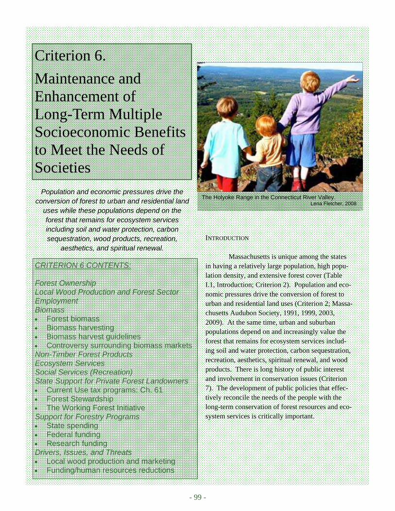
- 99 -
The Holyoke Range in the Connecticut River Valley. Lena Fletcher, 2008
Criterion 6.
Maintenance and Enhancement of Long-Term Multiple Socioeconomic Benefits to Meet the Needs of Societies
CRITERION 6 CONTENTS: Forest Ownership Local Wood Production and Forest Sector Employment Biomass • Forest biomass • Biomass harvesting • Biomass harvest guidelines • Controversy surrounding biomass markets Non-Timber Forest Products Ecosystem Services Social Services (Recreation) State Support for Private Forest Landowners • Current Use tax programs: Ch. 61 • Forest Stewardship • The Working Forest Initiative Support for Forestry Programs • State spending • Federal funding • Research funding Drivers, Issues, and Threats • Local wood production and marketing • Funding/human resources reductions
INTRODUCTION
Massachusetts is unique among the states in having a relatively large population, high popu-lation density, and extensive forest cover (Table I.1, Introduction; Criterion 2). Population and eco-nomic pressures drive the conversion of forest to urban and residential land uses (Criterion 2; Massa-chusetts Audubon Society, 1991, 1999, 2003, 2009). At the same time, urban and suburban populations depend on and increasingly value the forest that remains for ecosystem services includ-ing soil and water protection, carbon sequestration, recreation, aesthetics, spiritual renewal, and wood products. There is long history of public interest and involvement in conservation issues (Criterion 7). The development of public policies that effec-tively reconcile the needs of the people with the long-term conservation of forest resources and eco-system services is critically important.
Population and economic pressures drive the conversion of forest to urban and residential land
uses while these populations depend on the forest that remains for ecosystem services including soil and water protection, carbon sequestration, wood products, recreation,
aesthetics, and spiritual renewal.
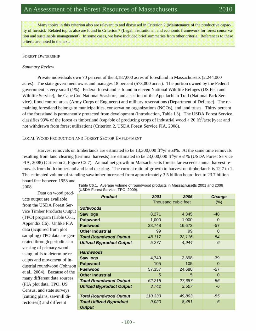
- 100 -
Massachusetts Forest Assessment 2010 An Assessment of the Forest Resources of Massachusetts 2010
Many topics in this criterion also are relevant to and discussed in Criterion 2 (Maintenance of the productive capac-ity of forests). Related topics also are found in Criterion 7 (Legal, institutional, and economic framework for forest conserva-tion and sustainable management). In some cases, we have included brief summaries from other criteria. References to these criteria are noted in the text.
FOREST OWNERSHIP Summary Review
Private individuals own 70 percent of the 3,187,000 acres of forestland in Massachusetts (2,244,000 acres). The state government owns and manages 18 percent (573,000 acres). The portion owned by the Federal government is very small (1%). Federal forestland is found in eleven National Wildlife Refuges (US Fish and Wildlife Service), the Cape Cod National Seashore, and a section of the Appalachian Trail (National Park Ser-vice), flood control areas (Army Corps of Engineers) and military reservations (Department of Defense). The re-maining forestland belongs to municipalities, conservation organizations (NGOs), and land trusts. Thirty percent of the forestland is permanently protected from development (Introduction, Table I.3). The USDA Forest Service classifies 93% of the forest as timberland (capable of producing crops of industrial wood > 20 [ft3/acre]/year and not withdrawn from forest utilization) (Criterion 2, USDA Forest Service FIA, 2008).
LOCAL WOOD PRODUCTION AND FOREST SECTOR EMPLOYMENT
Harvest removals on timberlands are estimated to be 13,300,000 ft3/yr ±63%. At the same time removals
resulting from land clearing (terminal harvests) are estimated to be 23,000,000 ft3/yr ±51% (USDA Forest Service FIA, 2008) (Criterion 2, Figure C2.7). Annual net growth in Massachusetts forests far exceeds annual harvest re-movals from both timberland and land clearing. The current ratio of growth to harvest on timberlands is 12.7 to 1. The estimated volume of standing sawtimber increased from approximately 3.5 billion board feet to 23.7 billion board feet between 1953 and 2008.
Data on wood prod-ucts output are available from the USDA Forest Ser-vice Timber Products Output (TPO) program (Table C6.1, Appendix C6). Unlike FIA data (acquired from plot sampling) TPO data are gen-erated through periodic can-vassing of primary wood-using mills to determine re-ceipts and movement of in-dustrial roundwood (Johnson et al., 2004). Because of the many different data sources (FIA plot data, TPO, US Census, and state surveys [cutting plans, sawmill di-rectories]) and different
Product 2001 2006 Change Thousand cubic feet (%) Softwoods Saw logs 8,271 4,345 -48 Pulpwood 1,000 1,000 0 Fuelwood 38,748 16,672 -57 Other Industrial 99 99 0 Total Roundwood Output 48,117 22,116 -54 Utilized Byproduct Output 5,277 4,944 -6
Hardwoods Saw logs 4,749 2,898 -39 Pulpwood 105 105 0 Fuelwood 57,357 24,680 -57 Other Industrial 5 5 0 Total Roundwood Output 62,215 27,687 -56 Utilized Byproduct Output 3,742 3,507 -6
Total Roundwood Output 110,333 49,803 -55 Total Utilized Byproduct Output
9,020 8,451 -6
Table C6.1. Average volume of roundwood products in Massachusetts 2001 and 2006 (USDA Forest Service, TPO, 2009).
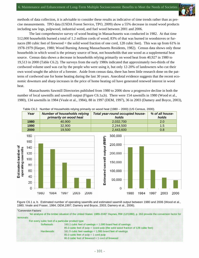
6. Maintenance and Enhancement of Long-Term Multiple Socioeconomic Benefits to Meet the Needs of Societies Criterion
6
- 101 -
methods of data collection, it is advisable to consider these results as indicative of time trends rather than as pre-cise measurements. TPO data (USDA Forest Service, TPO, 2009) show a 55% decrease in round wood products including saw logs, pulpwood, industrial wood, and fuel wood between 2001 and 2006.
The last comprehensive survey of wood heating in Massachusetts was conducted in 1982. At that time 512,000 households burned a total of 1.2 million cords of wood; 83% of that was burned in woodstoves or fur-naces (80 cubic feet of firewood = the solid wood fraction of one cord, 128 cubic feet). This was up from 61% in 1978-1979 (Harper, 1980; Wood Burning Among Massachusetts Residents, 1982). Census data shows only those households in which wood is the primary source of heat, not households that use wood as a supplemental heat source. Census data shows a decrease in households relying primarily on wood heat from 40,927 in 1980 to 19,513 in 2000 (Table C6.2). The surveys from the early 1980s indicated that approximately two-thirds of the cordwood volume used was cut by the people who were using it, but only 12-20% of landowners who cut their own wood sought the advice of a forester. Aside from census data, there has been little research done on the pat-terns of cordwood use for home heating during the last 30 years. Anecdotal evidence suggests that the recent eco-nomic downturn and sharp increases in the price of home heating oil have generated renewed interest in wood heat.
Massachusetts Sawmill Directories published from 1980 to 2006 show a progressive decline in both the number of local sawmills and sawmill output (Figure C6.1a,b). There were 154 sawmills in 1980 (Wood et al., 1980), 134 sawmills in 1984 (Veale et al., 1984), 88 in 1997 (DEM, 1997), 36 in 2003 (Damery and Boyce, 2003),
Year Number of households relying primarily on wood heat
Total year-round occupied house-holds
% of all house-holds
1980 40,900 2,032,700 2.0 1990 32,900 2,244,500 1.5 2000 19,500 2,443,600 0.8
Table C6.2. Number of Households relying primarily on wood heat (1980 – 2000) (US Census, 2000).
1Conversion Factors: “An analysis of the timber situation of the United States: 1989-2040” Haynes, RW (12/1990), p. 263 provide the conversion factor for
removals: For every cubic foot of a particular product type: Softwoods: 160.1 cubic feet of sawlogs = 1,000 board feet of sawlogs 85.0 cubic feet of pulp = 1cord pulp (the solid wood fraction of 128 cubic feet) Hardwoods: 161.5 cubic feet sawlogs = 1,000 board feet of sawlogs 85.0 cubic feet of pulp = 1 cord pulp 80.0 cubic feet of firewood = 1 cord of firewood
Figure C6.1 a, b. Estimated number of operating sawmills and estimated sawmill output between 1980 and 2006 (Wood et al., 1980; Veale and Fraser, 1984; DEM,1997; Damery and Boyce, 2003; Damery et al., 2006).

- 102 -
Massachusetts Forest Assessment 2010 An Assessment of the Forest Resources of Massachusetts 2010
and 32 in 2006 (Damery et al. 2006). Sawmill production in Massachusetts was relatively stable in the early- to mid-1980s (234,625 thousand board feet [MBF])1 in 1980, 240,125 MBF in 1984). Production has shown a con-sistent declining trend from that time on: 105,808 MBF in 1997; 60,978 MBF in 2003; 47,102 MBF in 2006 – a decline of 80%. Much of the timber that is harvested in Massachusetts is shipped out of the state (primarily to northern New England and Quebec) for processing.
There are 174 foresters and 504 harvesters licensed to practice and operate in Massachusetts at the present time (DCR, 2010). Timber and forest products related employment and revenues are shown in Table C6.3. The median rates for professional services by consulting foresters in Massachusetts are summarized in Table C6.4.
Table C6.3. Forest and paper industry economic data (AF&P, 2006; Damery et al. 2006). Employment (number of individuals)
Forestry and logging 1,013 Wood products 3,888
Pulp & paper 11,900 Total employment 16,801
Annual Payroll Income Forestry & logging $36,000,000
Wood products $170,000,000 Pulp & paper $920,000,000
Total compensation $1,126,000,000 Number of manufacturing facilities
Sawmills 32* Dry Kilns 12*
Portable Band Mills 12* Total wood product manufacturing facilities 56*
Pulp, paper, and paperboard mills 17 Converted paper products 180
Total 253 Value of industry shipments (in thousands of dollars)
Wood manufacturing $767,983,000 Paper manufacturing $3,267,199,000
Total value of industry shipments $4,035,182,000 Tax Payments
Estimated state and local taxes $89,000,000
*Data from 2006 Massachusetts Sawmill Directory (Damery et al., 2006); all other data from AF&P, 2006.
Table C6.4. Consulting forester fees in Massachusetts (Kittredge and Welsch, 1997; Hersey and Kittredge, 2005).
Task 1997 2005
Management plan preparation ($/ac) 9 11.10
Mark & administer timber sale ($/MBF) 14 19.47
Cordwood sale ($/cord) 5 6.30
Cordwood sale ($/ac) 38 56.25

6. Maintenance and Enhancement of Long-Term Multiple Socioeconomic Benefits to Meet the Needs of Societies Criterion
6
- 103 -
USDA Forest Service TPO data and Massachusetts Sawmill Directory data show a decline in the number of sawmills and timber output since the 1980s. During the same time period, harvest volume as measured from cutting plan data (1984-2003) showed no consistent pattern (McDonald et al., 2006). The difference between the declining output of Massachusetts mills and the total quantity of wood harvested, and clear anecdotal evidence (dozens of trucks loaded with logs heading north …day in, day out), suggests that Massachusetts became a net exporter of logs during the 1990s. Retaining local processing of logs is a net benefit to communities. When logs are exported, it is most often with out-of-state trucks. Even logs being sold to mills in northern Vermont, New Hampshire, and Maine (large capacity pine sawmills) are being transported on the back-haul run of Canadian-registered trucks. These trucks deliver a wide range of forest products from Canadian mills to lumber yards and home centers throughout New England. Naturally, it is more cost-effective for truckers to transport another load on the back-haul than to drive an empty truck and use almost as much fuel. This economic geography links pri-mary processors and sawmills selling logs in Massachusetts directly to market forces (diesel fuel prices and cur-rency exchange rates) over which they have no control and a limited ability to forecast.
When diesel fuel prices increased to record levels in the early summer of 2008 (over $4 per gallon) log landings were piled high throughout southern New England. It is important to note that the export of logs only generates two local jobs (a for-ester and logger) and limited revenue for the landowner. In contrast, local processing and sale of forest products—particularly for long-term uses like lumber, flooring, and furniture—increases the economic benefit to the local and regional economy substan-tially. In addition to cycles in market prices in relation to re-gional, national, and global forest products markets, the limited de-mand for locally produced wood and the regional demand for wood to haul is, ironically, analo-gous to the situation centuries ago when the first settlers of Massa-chusetts shipped spars and masts back to the mother country, Great Britain. It is also ironic and unfortunate, that consumers who have fervently embraced buy-local agriculture in Massachusetts have largely ignored or actively rejected the same ecological, economic, and social impetus for the local production of forest products. As noted elsewhere in this assessment and clearly described by Berlik, Kittredge, and Foster (2002) in “The Illusion of Preservation: A Global Argu-ment for the Local Production of Natural Resources”, the net result of this cognitive dissonance includes, but is not limited to: (1) increased conversion pressure on private forest land and the consequent loss of ecosystem ser-vices, (2) opportunity costs for local entrepreneurs, employers, and workers, and (3) an unnecessarily large per capita carbon footprint.
A log truck from Quebec leaving Massachusetts on US Interstate Route 91. William VanDoren
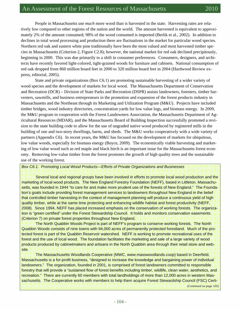
- 104 -
Massachusetts Forest Assessment 2010 An Assessment of the Forest Resources of Massachusetts 2010
People in Massachusetts use much more wood than is harvested in the state. Harvesting rates are rela-tively low compared to other regions of the nation and the world. The amount harvested is equivalent to approxi-mately 2% of the amount consumed; 98% of the wood consumed is imported (Berlik et al., 2002). In addition to declines in total wood processing and production there are fluctuations in the market for particular wood species. Northern red oak and eastern white pine traditionally have been the most valued and most harvested timber spe-cies in Massachusetts (Criterion 2, Figure C2.8); however, the national market for red oak declined precipitously, beginning in 2000. This was due primarily to a shift in consumer preferences. Consumers, designers, and archi-tects have recently favored light-colored, tight-grained woods for furniture and cabinets. National consumption of red oak dropped from 860 million board feet in 2000 to 320 million board feet in 2004 (Hardwood Review ex-press, editorial, 2005).
State and private organizations (Box C6.1) are promoting sustainable harvesting of a wider variety of wood species and the development of markets for local wood. The Massachusetts Department of Conservation and Recreation (DCR) – Division of State Parks and Recreation (DSPR) assists landowners, foresters, timber har-vesters, sawmills, and business entrepreneurs in the promotion and expansion of the forest products industry in Massachusetts and the Northeast through its Marketing and Utilization Program (M&U). Projects have included timber bridges, wood industry directories, concentration yards for low value logs, and biomass energy. In 2009, the M&U program in cooperation with the Forest Landowners Association, the Massachusetts Department of Ag-ricultural Resources (MDAR), and the Massachusetts Board of Building Inspection successfully promoted a revi-sion to the state building code to allow for the use of ungraded native wood produced by registered mills in the building of one and two-story dwellings, barns, and sheds. The M&U works cooperatively with a wide variety of partners (Appendix C6). In recent years, the M&U has focused on the development of markets for ubiquitous, low value woods, especially for biomass energy (Boyce, 2009). The economically viable harvesting and market-ing of low value wood such as red maple and black birch is an important issue for the Massachusetts forest econ-omy. Removing low-value timber from the forest promotes the growth of high quality trees and the sustainable use of the working forest. Box C6.1. Promoting Local Wood Products—Efforts of Private Organizations and Businesses Several local and regional groups have been involved in efforts to promote local wood production and the marketing of local wood products. The New England Forestry Foundation (NEFF), based in Littleton, Massachu-setts, was founded in 1944 “to care for and make more prudent use of the forests of New England.” The Founda-tion’s goals include providing forest management services to landowners throughout New England in the belief that controlled timber harvesting in the context of management planning will produce a continuous yield of high quality timber, while at the same time protecting and enhancing wildlife habitat and forest productivity (NEFF, 2008). Since 1994, NEFF has placed increased emphasis on the conservation of working forests. The organiza-tion is “green certified” under the Forest Stewardship Council. It holds and monitors conservation easements (Criterion 7) on private forest properties throughout New England. The North Quabbin Woods Project is part of NEFF’s program to conserve working forests. The North Quabbin Woods consists of nine towns with 94,000 acres of permanently protected forestland. Much of the pro-tected forest is part of the Quabbin Reservoir watershed. NEFF is working to promote recreational uses of the forest and the use of local wood. The foundation facilitates the marketing and sale of a large variety of wood products produced by cabinetmakers and artisans in the North Quabbin area through their retail store and web-site. The Massachusetts Woodlands Cooperative (MWC, www.masswoodlands.coop) based in Deerfield, Massachusetts is a for-profit business, “designed to increase the knowledge and bargaining power of individual landowners.” The organization, founded in 2001, is comprised of forest landowners committed to responsible forestry that will provide a “sustained flow of forest benefits including timber, wildlife, clean water, aesthetics, and recreation.” There are currently 60 members with total landholdings of more than 12,000 acres in western Mas-sachusetts. The Cooperative works with members to help them acquire Forest Stewardship Council (FSC) Certi-
(Continued on page 105)
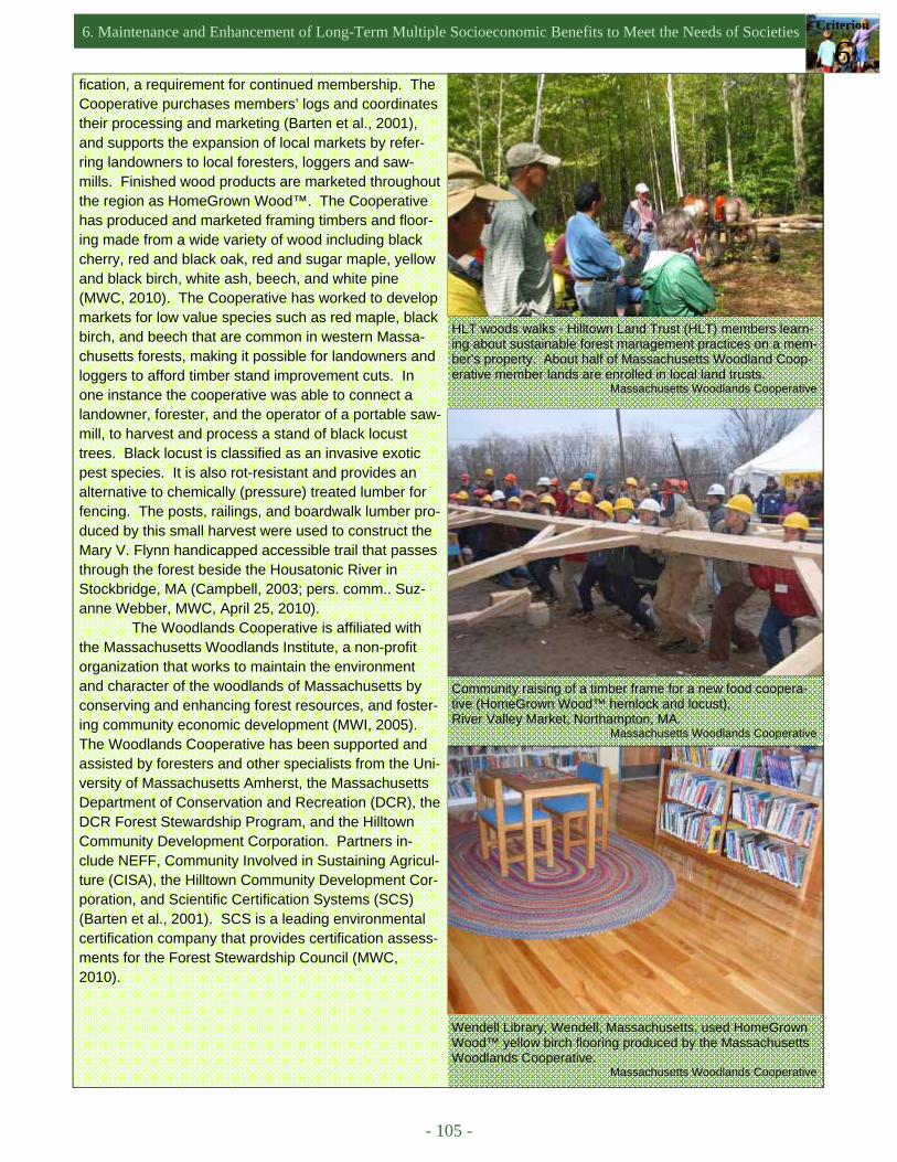
6. Maintenance and Enhancement of Long-Term Multiple Socioeconomic Benefits to Meet the Needs of Societies Criterion
6
- 105 -
fication, a requirement for continued membership. The Cooperative purchases members’ logs and coordinates their processing and marketing (Barten et al., 2001), and supports the expansion of local markets by refer-ring landowners to local foresters, loggers and saw-mills. Finished wood products are marketed throughout the region as HomeGrown Wood™. The Cooperative has produced and marketed framing timbers and floor-ing made from a wide variety of wood including black cherry, red and black oak, red and sugar maple, yellow and black birch, white ash, beech, and white pine (MWC, 2010). The Cooperative has worked to develop markets for low value species such as red maple, black birch, and beech that are common in western Massa-chusetts forests, making it possible for landowners and loggers to afford timber stand improvement cuts. In one instance the cooperative was able to connect a landowner, forester, and the operator of a portable saw-mill, to harvest and process a stand of black locust trees. Black locust is classified as an invasive exotic pest species. It is also rot-resistant and provides an alternative to chemically (pressure) treated lumber for fencing. The posts, railings, and boardwalk lumber pro-duced by this small harvest were used to construct the Mary V. Flynn handicapped accessible trail that passes through the forest beside the Housatonic River in Stockbridge, MA (Campbell, 2003; pers. comm.. Suz-anne Webber, MWC, April 25, 2010). The Woodlands Cooperative is affiliated with the Massachusetts Woodlands Institute, a non-profit organization that works to maintain the environment and character of the woodlands of Massachusetts by conserving and enhancing forest resources, and foster-ing community economic development (MWI, 2005). The Woodlands Cooperative has been supported and assisted by foresters and other specialists from the Uni-versity of Massachusetts Amherst, the Massachusetts Department of Conservation and Recreation (DCR), the DCR Forest Stewardship Program, and the Hilltown Community Development Corporation. Partners in-clude NEFF, Community Involved in Sustaining Agricul-ture (CISA), the Hilltown Community Development Cor-poration, and Scientific Certification Systems (SCS) (Barten et al., 2001). SCS is a leading environmental certification company that provides certification assess-ments for the Forest Stewardship Council (MWC, 2010).
Wendell Library, Wendell, Massachusetts, used HomeGrown Wood™ yellow birch flooring produced by the Massachusetts Woodlands Cooperative. Massachusetts Woodlands Cooperative
Community raising of a timber frame for a new food coopera-tive (HomeGrown Wood™ hemlock and locust), River Valley Market, Northampton, MA. Massachusetts Woodlands Cooperative
HLT woods walks - Hilltown Land Trust (HLT) members learn-ing about sustainable forest management practices on a mem-ber’s property. About half of Massachusetts Woodland Coop-erative member lands are enrolled in local land trusts. Massachusetts Woodlands Cooperative
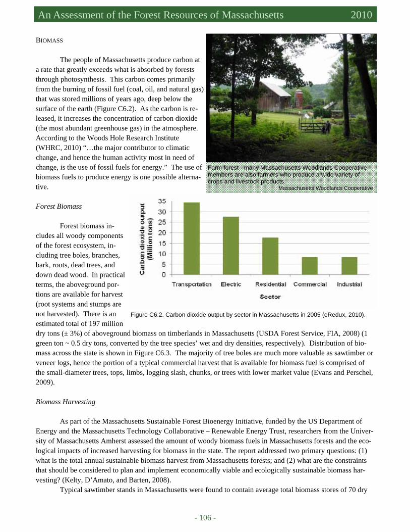
- 106 -
Massachusetts Forest Assessment 2010 An Assessment of the Forest Resources of Massachusetts 2010
BIOMASS
The people of Massachusetts produce carbon at a rate that greatly exceeds what is absorbed by forests through photosynthesis. This carbon comes primarily from the burning of fossil fuel (coal, oil, and natural gas) that was stored millions of years ago, deep below the surface of the earth (Figure C6.2). As the carbon is re-leased, it increases the concentration of carbon dioxide (the most abundant greenhouse gas) in the atmosphere. According to the Woods Hole Research Institute (WHRC, 2010) “…the major contributor to climatic change, and hence the human activity most in need of change, is the use of fossil fuels for energy.” The use of biomass fuels to produce energy is one possible alterna-tive.
Forest Biomass
Forest biomass in-
cludes all woody components of the forest ecosystem, in-cluding tree boles, branches, bark, roots, dead trees, and down dead wood. In practical terms, the aboveground por-tions are available for harvest (root systems and stumps are not harvested). There is an estimated total of 197 million dry tons (± 3%) of aboveground biomass on timberlands in Massachusetts (USDA Forest Service, FIA, 2008) (1 green ton ~ 0.5 dry tons, converted by the tree species’ wet and dry densities, respectively). Distribution of bio-mass across the state is shown in Figure C6.3. The majority of tree boles are much more valuable as sawtimber or veneer logs, hence the portion of a typical commercial harvest that is available for biomass fuel is comprised of the small-diameter trees, tops, limbs, logging slash, chunks, or trees with lower market value (Evans and Perschel, 2009).
Biomass Harvesting As part of the Massachusetts Sustainable Forest Bioenergy Initiative, funded by the US Department of Energy and the Massachusetts Technology Collaborative – Renewable Energy Trust, researchers from the Univer-sity of Massachusetts Amherst assessed the amount of woody biomass fuels in Massachusetts forests and the eco-logical impacts of increased harvesting for biomass in the state. The report addressed two primary questions: (1) what is the total annual sustainable biomass harvest from Massachusetts forests; and (2) what are the constraints that should be considered to plan and implement economically viable and ecologically sustainable biomass har-vesting? (Kelty, D’Amato, and Barten, 2008).
Typical sawtimber stands in Massachusetts were found to contain average total biomass stores of 70 dry
Farm forest - many Massachusetts Woodlands Cooperative members are also farmers who produce a wide variety of crops and livestock products. Massachusetts Woodlands Cooperative
Figure C6.2. Carbon dioxide output by sector in Massachusetts in 2005 (eRedux, 2010).
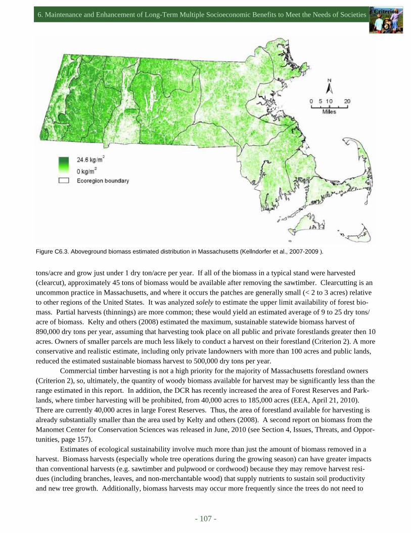
6. Maintenance and Enhancement of Long-Term Multiple Socioeconomic Benefits to Meet the Needs of Societies Criterion
6
- 107 -
Figure C6.3. Aboveground biomass estimated distribution in Massachusetts (Kellndorfer et al., 2007-2009 ).
tons/acre and grow just under 1 dry ton/acre per year. If all of the biomass in a typical stand were harvested (clearcut), approximately 45 tons of biomass would be available after removing the sawtimber. Clearcutting is an uncommon practice in Massachusetts, and where it occurs the patches are generally small (< 2 to 3 acres) relative to other regions of the United States. It was analyzed solely to estimate the upper limit availability of forest bio-mass. Partial harvests (thinnings) are more common; these would yield an estimated average of 9 to 25 dry tons/acre of biomass. Kelty and others (2008) estimated the maximum, sustainable statewide biomass harvest of 890,000 dry tons per year, assuming that harvesting took place on all public and private forestlands greater then 10 acres. Owners of smaller parcels are much less likely to conduct a harvest on their forestland (Criterion 2). A more conservative and realistic estimate, including only private landowners with more than 100 acres and public lands, reduced the estimated sustainable biomass harvest to 500,000 dry tons per year.
Commercial timber harvesting is not a high priority for the majority of Massachusetts forestland owners (Criterion 2), so, ultimately, the quantity of woody biomass available for harvest may be significantly less than the range estimated in this report. In addition, the DCR has recently increased the area of Forest Reserves and Park-lands, where timber harvesting will be prohibited, from 40,000 acres to 185,000 acres (EEA, April 21, 2010). There are currently 40,000 acres in large Forest Reserves. Thus, the area of forestland available for harvesting is already substantially smaller than the area used by Kelty and others (2008). A second report on biomass from the Manomet Center for Conservation Sciences was released in June, 2010 (see Section 4, Issues, Threats, and Oppor-tunities, page 157).
Estimates of ecological sustainability involve much more than just the amount of biomass removed in a harvest. Biomass harvests (especially whole tree operations during the growing season) can have greater impacts than conventional harvests (e.g. sawtimber and pulpwood or cordwood) because they may remove harvest resi-dues (including branches, leaves, and non-merchantable wood) that supply nutrients to sustain soil productivity and new tree growth. Additionally, biomass harvests may occur more frequently since the trees do not need to
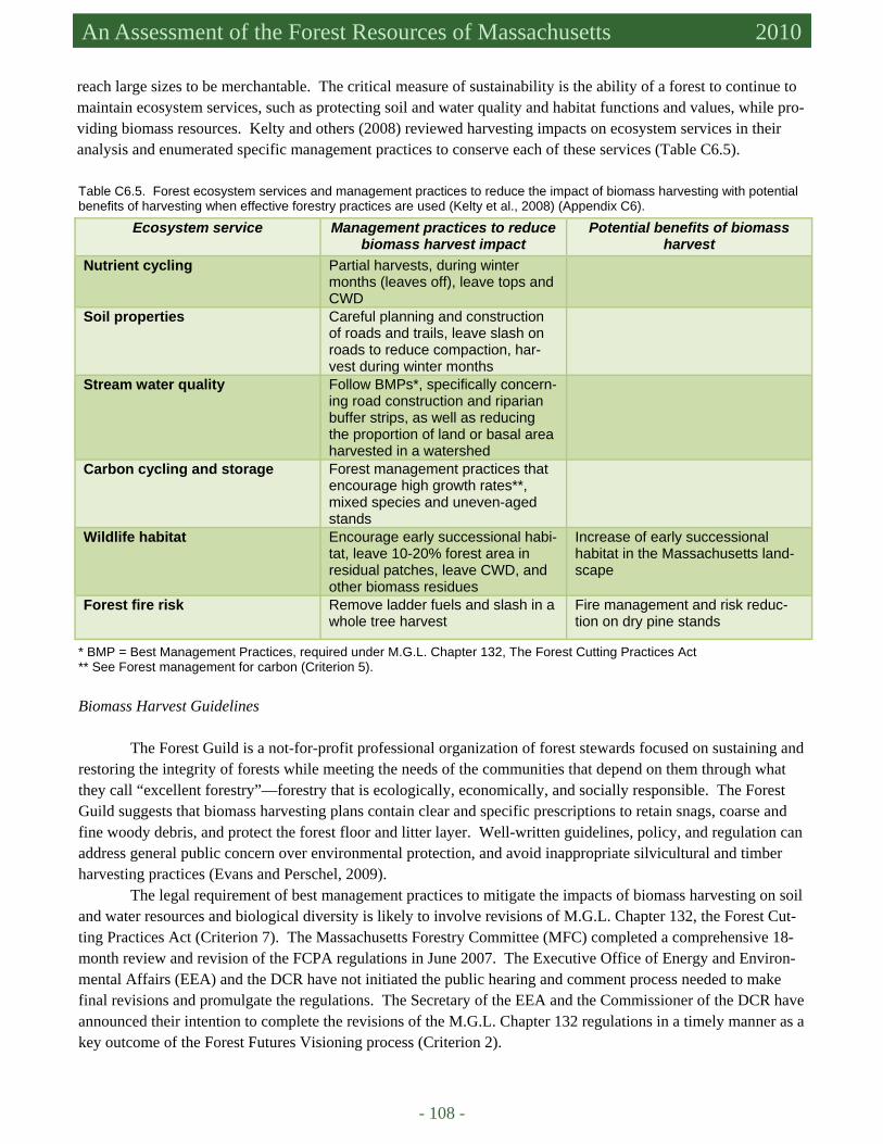
- 108 -
Massachusetts Forest Assessment 2010 An Assessment of the Forest Resources of Massachusetts 2010
reach large sizes to be merchantable. The critical measure of sustainability is the ability of a forest to continue to maintain ecosystem services, such as protecting soil and water quality and habitat functions and values, while pro-viding biomass resources. Kelty and others (2008) reviewed harvesting impacts on ecosystem services in their analysis and enumerated specific management practices to conserve each of these services (Table C6.5).
Ecosystem service Management practices to reduce biomass harvest impact
Potential benefits of biomass harvest
Nutrient cycling Partial harvests, during winter months (leaves off), leave tops and CWD
Soil properties Careful planning and construction of roads and trails, leave slash on roads to reduce compaction, har-vest during winter months
Stream water quality Follow BMPs*, specifically concern-ing road construction and riparian buffer strips, as well as reducing the proportion of land or basal area harvested in a watershed
Carbon cycling and storage Forest management practices that encourage high growth rates**, mixed species and uneven-aged stands
Wildlife habitat Encourage early successional habi-tat, leave 10-20% forest area in residual patches, leave CWD, and other biomass residues
Increase of early successional habitat in the Massachusetts land-scape
Forest fire risk Remove ladder fuels and slash in a whole tree harvest
Fire management and risk reduc-tion on dry pine stands
Table C6.5. Forest ecosystem services and management practices to reduce the impact of biomass harvesting with potential benefits of harvesting when effective forestry practices are used (Kelty et al., 2008) (Appendix C6).
* BMP = Best Management Practices, required under M.G.L. Chapter 132, The Forest Cutting Practices Act ** See Forest management for carbon (Criterion 5).
Biomass Harvest Guidelines The Forest Guild is a not-for-profit professional organization of forest stewards focused on sustaining and restoring the integrity of forests while meeting the needs of the communities that depend on them through what they call “excellent forestry”—forestry that is ecologically, economically, and socially responsible. The Forest Guild suggests that biomass harvesting plans contain clear and specific prescriptions to retain snags, coarse and fine woody debris, and protect the forest floor and litter layer. Well-written guidelines, policy, and regulation can address general public concern over environmental protection, and avoid inappropriate silvicultural and timber harvesting practices (Evans and Perschel, 2009).
The legal requirement of best management practices to mitigate the impacts of biomass harvesting on soil and water resources and biological diversity is likely to involve revisions of M.G.L. Chapter 132, the Forest Cut-ting Practices Act (Criterion 7). The Massachusetts Forestry Committee (MFC) completed a comprehensive 18-month review and revision of the FCPA regulations in June 2007. The Executive Office of Energy and Environ-mental Affairs (EEA) and the DCR have not initiated the public hearing and comment process needed to make final revisions and promulgate the regulations. The Secretary of the EEA and the Commissioner of the DCR have announced their intention to complete the revisions of the M.G.L. Chapter 132 regulations in a timely manner as a key outcome of the Forest Futures Visioning process (Criterion 2).

6. Maintenance and Enhancement of Long-Term Multiple Socioeconomic Benefits to Meet the Needs of Societies Criterion
6
- 109 -
Controversy Surrounding Biomass Markets The development of biomass power plants in western Massachusetts has been a topic of heated de-bate. There are environmentalists on both sides of the issue: those who argue for a local, renewable alternative to fossil fuels that will support rural economies and de-crease dependence on fossil fuels and opponents who counter that the potential impact of biomass harvesting on forestlands and the effect of biomass combustion on the atmosphere is a “false solution to climate change” (LeBlanc, 2009).
Small-scale biomass facilities are less contro-versial. A few small-scale biomass facilities have been built and are now in use in Massachusetts at Athol High School, Mount Wachusett Community College in Gardner, Quabbin Reservoir Visitor Center in Belchertown, and Cooley Dickinson Hospital in Northampton (Boyce, 2009; EEA, 2010). These small-scale operations provide in-teresting examples of biomass facilities that aid the local economy and promote renewable energy, but are not large enough to inflame public concern over biomass demand and forest harvesting.
There is a proposed ballot initiative (H.R. 4458) that would require energy producers to limit CO2 output to 250 lbs per MgW-hour in order to qualify as a “renewable” energy source under the Renewable Portfolio Stan-dard. Realistically, this limit would exclude all but wind and solar power producers. Biomass plants could not, under this restriction, qualify for renewable energy credits and would not be able to sell the power they produce to larger utilities as renewable energy. The initiative did not pass in the Massachusetts State Legislature. Ballot sup-porters must collect additional signatures to place the initiative on the November 2010 ballot (Brown, May 10, 2010).
NON-TIMBER FOREST PRODUCTS
There is a variety of economic activities based on non-timber, forest crops in Massachusetts. One of the most notable enterprises is the production, marketing, and distribution of maple syrup and other maple syrup prod-ucts (Box C6.2). Several other forest products, including nuts, fruits, and mushrooms (Box C6.3), may be gath-ered for personal or commercial use (Table C6.6).
Table C6.6. Examples of Understory Crops in Western Massachusetts (used with permission, Massachusetts Woodlands Co-operative, Campbell, 2003).
Massachusetts forest showing fall colors. Paul Barten
Decorative & Handicraft Products
Food Products Medicinal or Nutraceutical Plants
Wreaths, greens, cones Maple syrup and candy Witch hazel
Floral greens Nuts Ginseng, black cohosh, golden-seal, etc.
Landscaping plants Fruits Slippery elm bark, black cherry bark, etc.
Basket splints, birch bark and other wood/vine products
Mushrooms
Rustic furniture, broom handles Game animals
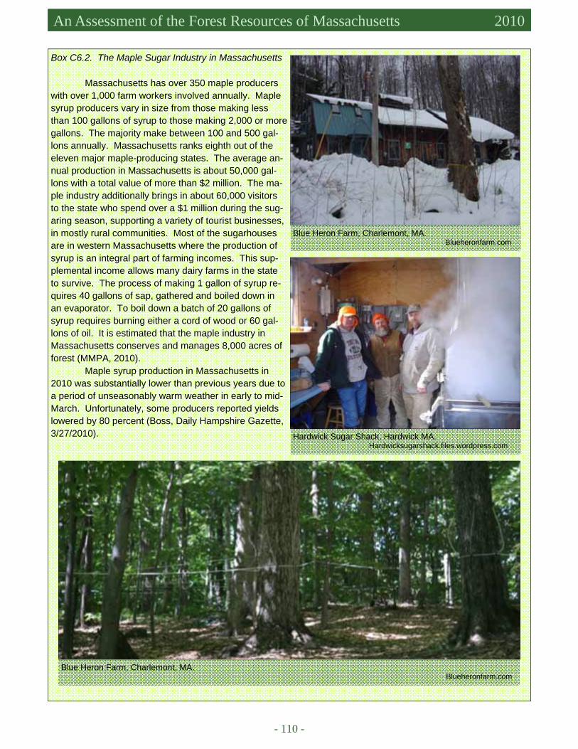
- 110 -
Massachusetts Forest Assessment 2010 An Assessment of the Forest Resources of Massachusetts 2010
Box C6.2. The Maple Sugar Industry in Massachusetts
Massachusetts has over 350 maple producers with over 1,000 farm workers involved annually. Maple syrup producers vary in size from those making less than 100 gallons of syrup to those making 2,000 or more gallons. The majority make between 100 and 500 gal-lons annually. Massachusetts ranks eighth out of the eleven major maple-producing states. The average an-nual production in Massachusetts is about 50,000 gal-lons with a total value of more than $2 million. The ma-ple industry additionally brings in about 60,000 visitors to the state who spend over a $1 million during the sug-aring season, supporting a variety of tourist businesses, in mostly rural communities. Most of the sugarhouses are in western Massachusetts where the production of syrup is an integral part of farming incomes. This sup-plemental income allows many dairy farms in the state to survive. The process of making 1 gallon of syrup re-quires 40 gallons of sap, gathered and boiled down in an evaporator. To boil down a batch of 20 gallons of syrup requires burning either a cord of wood or 60 gal-lons of oil. It is estimated that the maple industry in Massachusetts conserves and manages 8,000 acres of forest (MMPA, 2010).
Maple syrup production in Massachusetts in 2010 was substantially lower than previous years due to a period of unseasonably warm weather in early to mid-March. Unfortunately, some producers reported yields lowered by 80 percent (Boss, Daily Hampshire Gazette, 3/27/2010).
Blue Heron Farm, Charlemont, MA. Blueheronfarm.com
Blue Heron Farm, Charlemont, MA. Blueheronfarm.com
Hardwick Sugar Shack, Hardwick MA. Hardwicksugarshack.files.wordpress.com
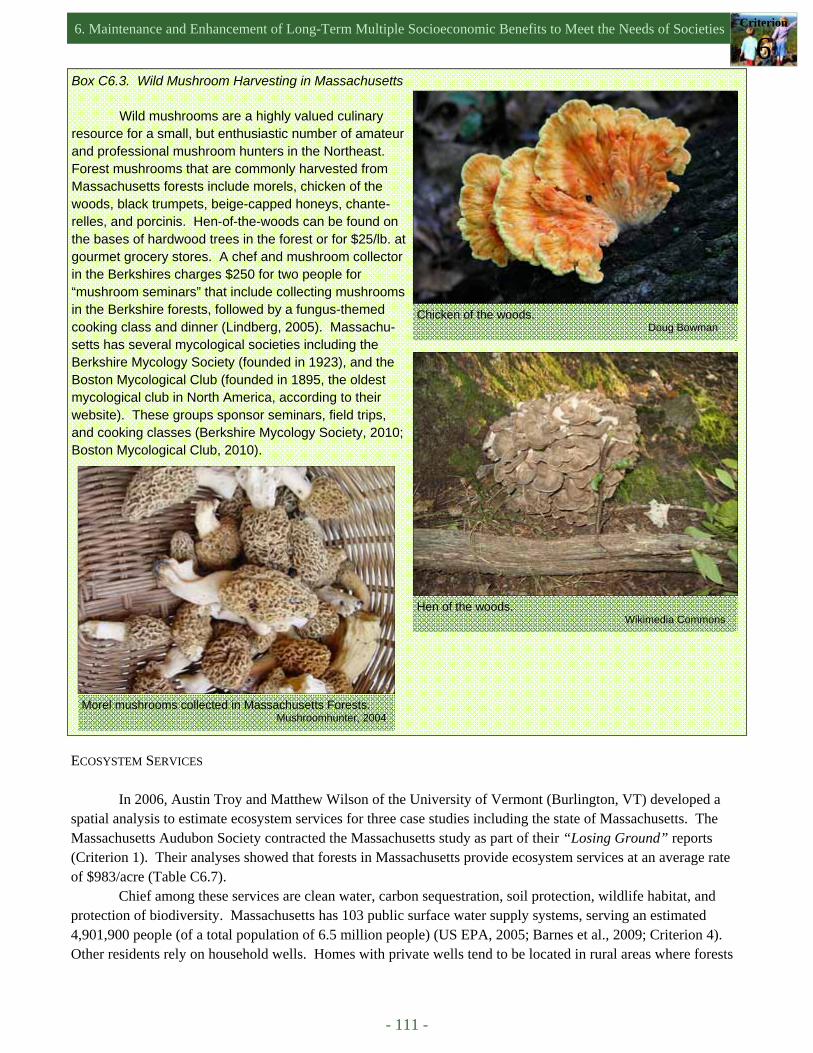
6. Maintenance and Enhancement of Long-Term Multiple Socioeconomic Benefits to Meet the Needs of Societies Criterion
6
- 111 -
Box C6.3. Wild Mushroom Harvesting in Massachusetts
Wild mushrooms are a highly valued culinary resource for a small, but enthusiastic number of amateur and professional mushroom hunters in the Northeast. Forest mushrooms that are commonly harvested from Massachusetts forests include morels, chicken of the woods, black trumpets, beige-capped honeys, chante-relles, and porcinis. Hen-of-the-woods can be found on the bases of hardwood trees in the forest or for $25/lb. at gourmet grocery stores. A chef and mushroom collector in the Berkshires charges $250 for two people for “mushroom seminars” that include collecting mushrooms in the Berkshire forests, followed by a fungus-themed cooking class and dinner (Lindberg, 2005). Massachu-setts has several mycological societies including the Berkshire Mycology Society (founded in 1923), and the Boston Mycological Club (founded in 1895, the oldest mycological club in North America, according to their website). These groups sponsor seminars, field trips, and cooking classes (Berkshire Mycology Society, 2010; Boston Mycological Club, 2010).
Chicken of the woods. Doug Bowman
Hen of the woods. Wikimedia Commons
Morel mushrooms collected in Massachusetts Forests. Mushroomhunter, 2004
ECOSYSTEM SERVICES
In 2006, Austin Troy and Matthew Wilson of the University of Vermont (Burlington, VT) developed a spatial analysis to estimate ecosystem services for three case studies including the state of Massachusetts. The Massachusetts Audubon Society contracted the Massachusetts study as part of their “Losing Ground” reports (Criterion 1). Their analyses showed that forests in Massachusetts provide ecosystem services at an average rate of $983/acre (Table C6.7).
Chief among these services are clean water, carbon sequestration, soil protection, wildlife habitat, and protection of biodiversity. Massachusetts has 103 public surface water supply systems, serving an estimated 4,901,900 people (of a total population of 6.5 million people) (US EPA, 2005; Barnes et al., 2009; Criterion 4). Other residents rely on household wells. Homes with private wells tend to be located in rural areas where forests
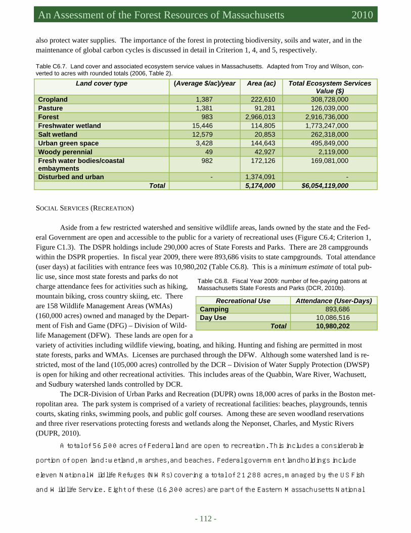
- 112 -
Massachusetts Forest Assessment 2010 An Assessment of the Forest Resources of Massachusetts 2010
Land cover type (Average $/ac)/year Area (ac) Total Ecosystem Services Value ($)
Cropland 1,387 222,610 308,728,000 Pasture 1,381 91,281 126,039,000 Forest 983 2,966,013 2,916,736,000 Freshwater wetland 15,446 114,805 1,773,247,000 Salt wetland 12,579 20,853 262,318,000 Urban green space 3,428 144,643 495,849,000 Woody perennial 49 42,927 2,119,000 Fresh water bodies/coastal embayments
982 172,126 169,081,000
Disturbed and urban - 1,374,091 - Total 5,174,000 $6,054,119,000
Table C6.7. Land cover and associated ecosystem service values in Massachusetts. Adapted from Troy and Wilson, con-verted to acres with rounded totals (2006, Table 2).
also protect water supplies. The importance of the forest in protecting biodiversity, soils and water, and in the maintenance of global carbon cycles is discussed in detail in Criterion 1, 4, and 5, respectively.
SOCIAL SERVICES (RECREATION)
Aside from a few restricted watershed and sensitive wildlife areas, lands owned by the state and the Fed-eral Government are open and accessible to the public for a variety of recreational uses (Figure C6.4; Criterion 1, Figure C1.3). The DSPR holdings include 290,000 acres of State Forests and Parks. There are 28 campgrounds within the DSPR properties. In fiscal year 2009, there were 893,686 visits to state campgrounds. Total attendance (user days) at facilities with entrance fees was 10,980,202 (Table C6.8). This is a minimum estimate of total pub-lic use, since most state forests and parks do not charge attendance fees for activities such as hiking, mountain biking, cross country skiing, etc. There are 158 Wildlife Management Areas (WMAs) (160,000 acres) owned and managed by the Depart-ment of Fish and Game (DFG) – Division of Wild-life Management (DFW). These lands are open for a variety of activities including wildlife viewing, boating, and hiking. Hunting and fishing are permitted in most state forests, parks and WMAs. Licenses are purchased through the DFW. Although some watershed land is re-stricted, most of the land (105,000 acres) controlled by the DCR – Division of Water Supply Protection (DWSP) is open for hiking and other recreational activities. This includes areas of the Quabbin, Ware River, Wachusett, and Sudbury watershed lands controlled by DCR.
The DCR-Division of Urban Parks and Recreation (DUPR) owns 18,000 acres of parks in the Boston met-ropolitan area. The park system is comprised of a variety of recreational facilities: beaches, playgrounds, tennis courts, skating rinks, swimming pools, and public golf courses. Among these are seven woodland reservations and three river reservations protecting forests and wetlands along the Neponset, Charles, and Mystic Rivers (DUPR, 2010).
A total of 56,500 acres of Federal land are open to recreation. This includes a considerable
portion of open land: wetland, marshes, and beaches. Federal government landholdings include
eleven National Wildlife Refuges (NWRs) covering a total of 21,288 acres, managed by the US Fish
and Wildlife Service. Eight of these (16,300 acres) are part of the Eastern Massachusetts National
Table C6.8. Fiscal Year 2009: number of fee-paying patrons at Massachusetts State Forests and Parks (DCR, 2010b).
Recreational Use Attendance (User-Days) Camping 893,686 Day Use 10,086,516
Total 10,980,202
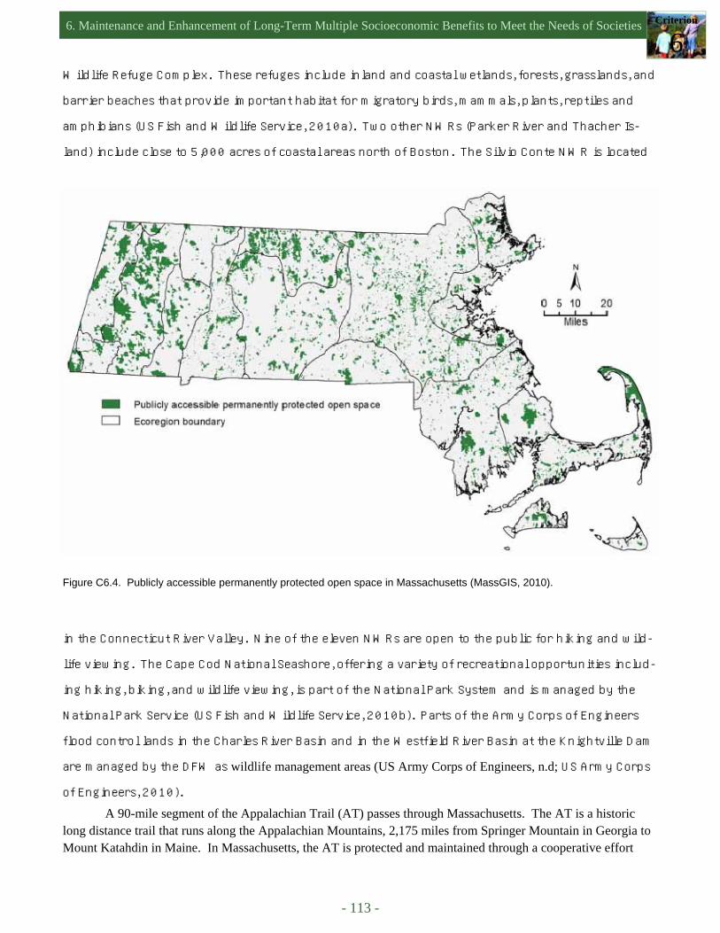
6. Maintenance and Enhancement of Long-Term Multiple Socioeconomic Benefits to Meet the Needs of Societies Criterion
6
- 113 -
Wildlife Refuge Complex. These refuges include inland and coastal wetlands, forests, grasslands, and
barrier beaches that provide important habitat for migratory birds, mammals, plants, reptiles and
amphibians (US Fish and Wildlife Service, 2010a). Two other NWRs (Parker River and Thacher Is-
land) include close to 5,000 acres of coastal areas north of Boston. The Silvio Conte NWR is located
in the Connecticut River Valley. Nine of the eleven NWRs are open to the public for hiking and wild-
life viewing. The Cape Cod National Seashore, offering a variety of recreational opportunities includ-
ing hiking, biking, and wildlife viewing, is part of the National Park System and is managed by the
National Park Service (US Fish and Wildlife Service, 2010b). Parts of the Army Corps of Engineers
flood control lands in the Charles River Basin and in the Westfield River Basin at the Knightville Dam
are managed by the DFW as wildlife management areas (US Army Corps of Engineers, n.d; US Army Corps
of Engineers, 2010). A 90-mile segment of the Appalachian Trail (AT) passes through Massachusetts. The AT is a historic
long distance trail that runs along the Appalachian Mountains, 2,175 miles from Springer Mountain in Georgia to Mount Katahdin in Maine. In Massachusetts, the AT is protected and maintained through a cooperative effort
Figure C6.4. Publicly accessible permanently protected open space in Massachusetts (MassGIS, 2010).
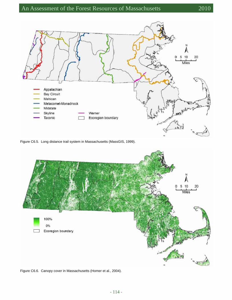
- 114 -
Massachusetts Forest Assessment 2010 An Assessment of the Forest Resources of Massachusetts 2010
Figure C6.5. Long distance trail system in Massachusetts (MassGIS, 1999).
Figure C6.6. Canopy cover in Massachusetts (Homer et al., 2004).
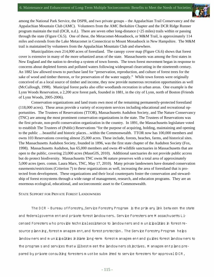
6. Maintenance and Enhancement of Long-Term Multiple Socioeconomic Benefits to Meet the Needs of Societies Criterion
6
- 115 -
among the National Park Service, the DSPR, and two private groups – the Appalachian Trail Conservancy and the Appalachian Mountain Club (AMC). Volunteers from the AMC Berkshire Chapter and the DCR Ridge Runner program maintain the trail (DCR, n.d.). There are seven other long-distance (>25 miles) trails within or passing through the state (Figure C6.5). One of these, the Metacomet-Monadnock, or M&M Trail, is approximately 114 miles and extends from the Lake Metacomet in Connecticut to Mount Monadnock in New Hampshire. The M&M trail is maintained by volunteers from the Appalachian Mountain Club and elsewhere.
Municipalities own 214,000 acres of forestland. The canopy cover map (Figure C6.6) shows that forest cover is extensive in many of the more urbanized areas of the state. Massachusetts was among the first states in New England and the nation to develop a system of town forests. The town forest movement began in response to concerns about depleted forests and polluted waters following widespread clearcutting in the nineteenth century. An 1882 law allowed towns to purchase land for “preservation, reproduction, and culture of forest trees for the sake of wood and timber thereon, or for preservation of the water supply.” While town forests were originally conceived of as a local source of timber and income, they now provide numerous recreation opportunities as well (McCullough, 1998). Municipal forest parks also offer woodlands recreation in urban areas. One example is the Lynn Woods Reservation, a 2,200 acre forest park, founded in 1881, in the city of Lynn, north of Boston (Friends of Lynn Woods, 2005-2006).
Conservation organizations and land trusts own most of the remaining permanently-protected forestland (118,000 acres). These areas provide a variety of ecosystem services including educational and recreational op-portunities. The Trustees of Reservations (TTOR), Massachusetts Audubon Society, and The Nature Conservancy (TNC) are among the most prominent conservation organizations in the state. The Trustees of Reservations was the first private, non-profit conservation organization in the country. In 1891, the Massachusetts legislature voted to establish The Trustees of (Public) Reservations “for the purpose of acquiring, holding, maintaining and opening to the public …beautiful and historic places…within the Commonwealth. TTOR now has 100,000 members and owns 103 Reservations covering almost 25,000 acres. These include, forests, beaches, farms, and historical sites. The Massachusetts Audubon Society, founded in 1896, was the first state chapter of the Audubon Society (Fox, 1998). Massachusetts Audubon, has 65,000 members and owns 49 wildlife sanctuaries in Massachusetts that are open to the public, covering 23,000 acres (MassGIS, 2010). Additional sanctuaries do not provide public access but do protect biodiversity. Massachusetts TNC owns 96 nature preserves with a total area of approximately 5,000 acres (pers. comm. Laura Marx, TNC, May 17, 2010). Many private landowners have donated conservation easements/restrictions (Criterion 7) to these organizations as well, increasing the area of forestland that is pro-tected from development. These organizations and their local counterparts foster the conservation and steward-ship of forest ecosystems through a wide range of management, research, and education programs. They are an enormous ecological, educational, and socioeconomic asset to the Commonwealth.
STATE SUPPORT FOR PRIVATE FOREST LANDOWNERS
The DCR ‒ Bureau of Forestry, Service Forestry Program is the primary link between the state
and federal government and private forest landowners. Service Foresters are Massachusetts Li-
censed Foresters who provide technical assistance to landowners and municipalities in forest re-
source planning, forest management, and forest protection. The Service Forestry Program helps
landowners and municipalities initiate long-term forest management and guides forest landowners to
the programs and services that will best meet the landowners objectives. Management plans pre-
pared by private consulting foresters must be submitted to service foresters for approval (DCR,
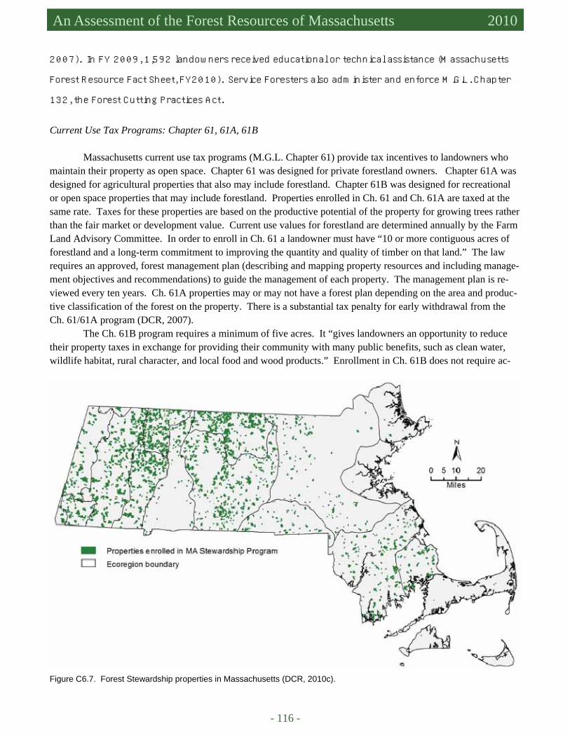
- 116 -
Massachusetts Forest Assessment 2010 An Assessment of the Forest Resources of Massachusetts 2010
2007). In FY 2009, 1,592 landowners received educational or technical assistance (Massachusetts
Forest Resource Fact Sheet, FY2010). Service Foresters also administer and enforce M.G.L. Chapter
132, the Forest Cutting Practices Act. Current Use Tax Programs: Chapter 61, 61A, 61B
Massachusetts current use tax programs (M.G.L. Chapter 61) provide tax incentives to landowners who maintain their property as open space. Chapter 61 was designed for private forestland owners. Chapter 61A was designed for agricultural properties that also may include forestland. Chapter 61B was designed for recreational or open space properties that may include forestland. Properties enrolled in Ch. 61 and Ch. 61A are taxed at the same rate. Taxes for these properties are based on the productive potential of the property for growing trees rather than the fair market or development value. Current use values for forestland are determined annually by the Farm Land Advisory Committee. In order to enroll in Ch. 61 a landowner must have “10 or more contiguous acres of forestland and a long-term commitment to improving the quantity and quality of timber on that land.” The law requires an approved, forest management plan (describing and mapping property resources and including manage-ment objectives and recommendations) to guide the management of each property. The management plan is re-viewed every ten years. Ch. 61A properties may or may not have a forest plan depending on the area and produc-tive classification of the forest on the property. There is a substantial tax penalty for early withdrawal from the Ch. 61/61A program (DCR, 2007).
The Ch. 61B program requires a minimum of five acres. It “gives landowners an opportunity to reduce their property taxes in exchange for providing their community with many public benefits, such as clean water, wildlife habitat, rural character, and local food and wood products.” Enrollment in Ch. 61B does not require ac-
Figure C6.7. Forest Stewardship properties in Massachusetts (DCR, 2010c).

6. Maintenance and Enhancement of Long-Term Multiple Socioeconomic Benefits to Meet the Needs of Societies Criterion
6
- 117 -
The Working Forest Initiative
The Working Forest Initiative (WFI), funded under the 2008 Massachusetts Environmental Bond Bill (Criterion 7), has helped to increase enrollment in the Forest Stewardship and all Ch. 61 programs. Under the Working Forest Initiative, landowners not currently enrolled in Forest Stewardship or Ch. 61 programs can be re-imbursed for the development of a new Forest Stewardship Plan by a state licensed forester. Reimbursement also is available to landowners with current Forest Stewardship and Ch. 61 management plans who wish to upgrade those plans to meet requirements for the DCR Forest Stewardship Council Group Certification Program (Box C6.4). From July, 2009 to May, 2010, 328 landowners put 34,317 acres valued at $489,700, under Stewardship plans through the WFI program. WFI funds are also available to reimburse landowners for the cost of preparing a carbon inventory and for the overhead costs of marketing, verifying, and trading carbon credits under the Massa-chusetts Pilot Carbon Offset and Trading Program (DCR, 2009b).
Box C6.4. Forest Stewardship Certification on Public and Private Forest Lands 2010
In February of 2010, Massachusetts became the second state in the nation (after Wisconsin) to offer Forest Stewardship Council (FSC) certification to pri-vate forest landowners. Through the MA Private Lands Group Certification program, the DSPR Bureau of For-estry – Service Forestry is able to include multiple land-owners under one FSC certificate. Any private land-owner currently in good standing in the state Current Use (Chapter 61, 61A, 61B) or Forest Stewardship pro-gram is eligible to apply for FSC certification. To qual-ify, owners must continue to manage their forests in accordance with the MA Current Use and Forest Stew-ardship program requirements and FSC Principles and Criteria and Northeast Regional Standards. As of May, 2010, there were 118 forested parcels (~28,000 acres) enrolled in the program in central and western Massa-chusetts. The Working Forest Initiative program as-sisted many of these landowners in the certification process. Following enrollment in the program, monitor-ing visits will be conducted to ensure compliance with FSC principles and criteria. The schedule of visits de-pends on the level of management activity on the forest property (DSPR, 2010).
Lands under the management control of the Massachusetts DSPR, DWSP, and DFW first received (FSC) certification under the criteria for sustainable for-estry and the FSC Northeast Standard in May of 2004. The Quabbin Forest (DWSP) was the first public land in North America to be certified by FSC (1997) (Box C4.1). The initial five-year certification expired in April of 2009. Agency lands and management practices went through a comprehensive re-certification audit that be-gan in March 2009 and was completed in August 2009. The 2009 re-certification audit report established two ma-jor conditions or Corrective Action Requests (CARs) for the agency lands. DSPR, DWSP, and DFW must comply with these CARs before any state lands can be re-certified. The agencies are currently fulfilling the requirements of the CARs (pers. comm. William Hill, DSPR-Bureau of Forestry, April 16, 2010).
Bruce Spencer, (Chief Forester of the DWSP [retired]) with Rob Ryan (Forest Stewardship Council) discussing green certification on Spencer’s private forestland, Leverett, MA. Jennifer Fish, DCR-DSPR Service Forester
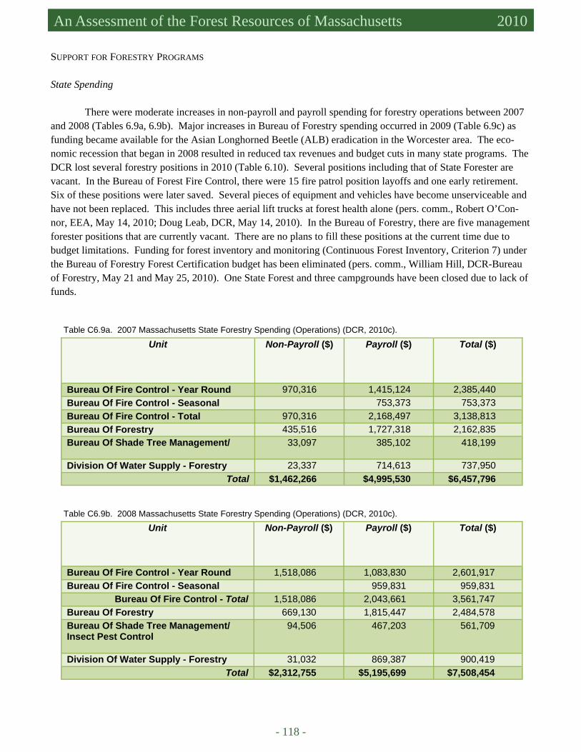
- 118 -
Massachusetts Forest Assessment 2010 An Assessment of the Forest Resources of Massachusetts 2010
SUPPORT FOR FORESTRY PROGRAMS State Spending
There were moderate increases in non-payroll and payroll spending for forestry operations between 2007 and 2008 (Tables 6.9a, 6.9b). Major increases in Bureau of Forestry spending occurred in 2009 (Table 6.9c) as funding became available for the Asian Longhorned Beetle (ALB) eradication in the Worcester area. The eco-nomic recession that began in 2008 resulted in reduced tax revenues and budget cuts in many state programs. The DCR lost several forestry positions in 2010 (Table 6.10). Several positions including that of State Forester are vacant. In the Bureau of Forest Fire Control, there were 15 fire patrol position layoffs and one early retirement. Six of these positions were later saved. Several pieces of equipment and vehicles have become unserviceable and have not been replaced. This includes three aerial lift trucks at forest health alone (pers. comm., Robert O’Con-nor, EEA, May 14, 2010; Doug Leab, DCR, May 14, 2010). In the Bureau of Forestry, there are five management forester positions that are currently vacant. There are no plans to fill these positions at the current time due to budget limitations. Funding for forest inventory and monitoring (Continuous Forest Inventory, Criterion 7) under the Bureau of Forestry Forest Certification budget has been eliminated (pers. comm., William Hill, DCR-Bureau of Forestry, May 21 and May 25, 2010). One State Forest and three campgrounds have been closed due to lack of funds.
Unit
Non-Payroll ($)
Payroll ($)
Total ($)
Bureau Of Fire Control - Year Round 970,316 1,415,124 2,385,440 Bureau Of Fire Control - Seasonal 753,373 753,373 Bureau Of Fire Control - Total 970,316 2,168,497 3,138,813 Bureau Of Forestry 435,516 1,727,318 2,162,835 Bureau Of Shade Tree Management/ 33,097 385,102 418,199
Division Of Water Supply - Forestry 23,337 714,613 737,950 Total $1,462,266 $4,995,530 $6,457,796
Table C6.9a. 2007 Massachusetts State Forestry Spending (Operations) (DCR, 2010c).
Unit
Non-Payroll ($)
Payroll ($)
Total ($)
Bureau Of Fire Control - Year Round 1,518,086 1,083,830 2,601,917 Bureau Of Fire Control - Seasonal 959,831 959,831
Bureau Of Fire Control - Total 1,518,086 2,043,661 3,561,747 Bureau Of Forestry 669,130 1,815,447 2,484,578 Bureau Of Shade Tree Management/ Insect Pest Control
94,506
467,203
561,709
Division Of Water Supply - Forestry 31,032 869,387 900,419 Total $2,312,755 $5,195,699 $7,508,454
Table C6.9b. 2008 Massachusetts State Forestry Spending (Operations) (DCR, 2010c).
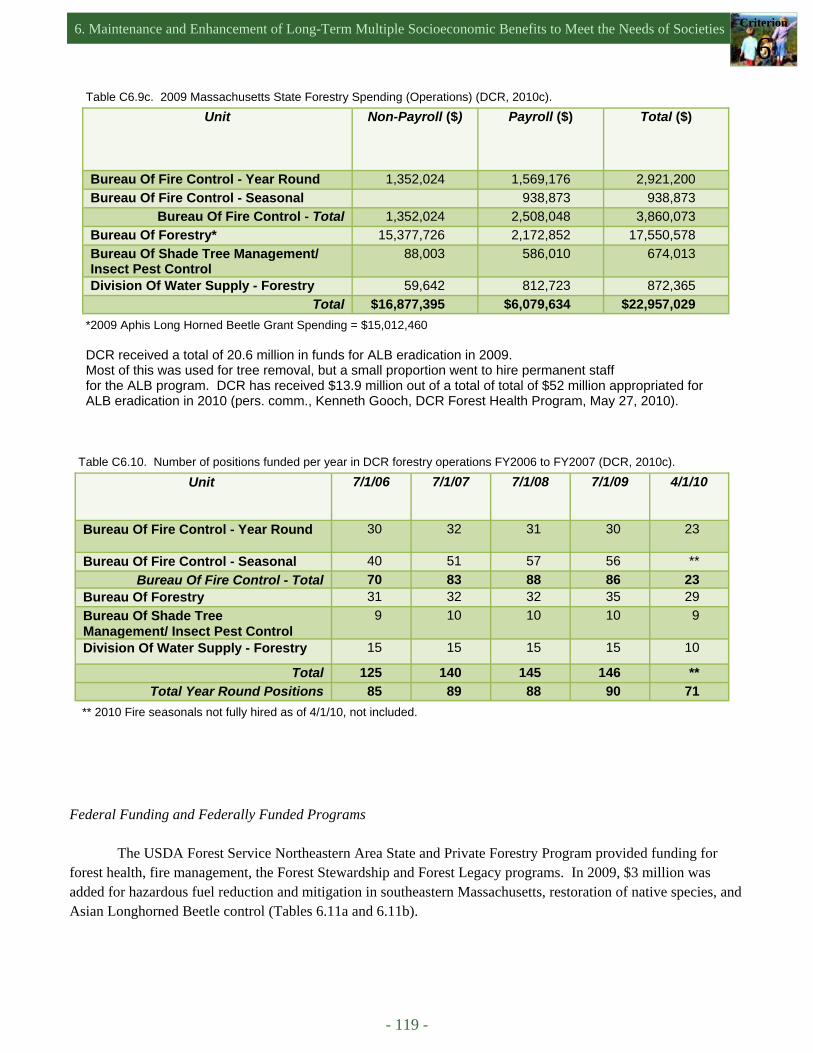
6. Maintenance and Enhancement of Long-Term Multiple Socioeconomic Benefits to Meet the Needs of Societies Criterion
6
- 119 -
Unit
Non-Payroll ($)
Payroll ($)
Total ($)
Bureau Of Fire Control - Year Round 1,352,024 1,569,176 2,921,200 Bureau Of Fire Control - Seasonal 938,873 938,873
Bureau Of Fire Control - Total 1,352,024 2,508,048 3,860,073 Bureau Of Forestry* 15,377,726 2,172,852 17,550,578 Bureau Of Shade Tree Management/ Insect Pest Control
88,003 586,010 674,013
Division Of Water Supply - Forestry 59,642 812,723 872,365 Total $16,877,395 $6,079,634 $22,957,029
Table C6.9c. 2009 Massachusetts State Forestry Spending (Operations) (DCR, 2010c).
*2009 Aphis Long Horned Beetle Grant Spending = $15,012,460 DCR received a total of 20.6 million in funds for ALB eradication in 2009. Most of this was used for tree removal, but a small proportion went to hire permanent staff for the ALB program. DCR has received $13.9 million out of a total of total of $52 million appropriated for ALB eradication in 2010 (pers. comm., Kenneth Gooch, DCR Forest Health Program, May 27, 2010).
Unit 7/1/06
7/1/07
7/1/08
7/1/09
4/1/10
Bureau Of Fire Control - Year Round 30 32 31 30 23
Bureau Of Fire Control - Seasonal 40 51 57 56 ** Bureau Of Fire Control - Total 70 83 88 86 23
Bureau Of Forestry 31 32 32 35 29 Bureau Of Shade Tree Management/ Insect Pest Control
9 10 10 10 9
Division Of Water Supply - Forestry 15 15 15 15 10
Total 125 140 145 146 ** Total Year Round Positions 85 89 88 90 71
Table C6.10. Number of positions funded per year in DCR forestry operations FY2006 to FY2007 (DCR, 2010c).
** 2010 Fire seasonals not fully hired as of 4/1/10, not included.
Federal Funding and Federally Funded Programs The USDA Forest Service Northeastern Area State and Private Forestry Program provided funding for
forest health, fire management, the Forest Stewardship and Forest Legacy programs. In 2009, $3 million was added for hazardous fuel reduction and mitigation in southeastern Massachusetts, restoration of native species, and Asian Longhorned Beetle control (Tables 6.11a and 6.11b).
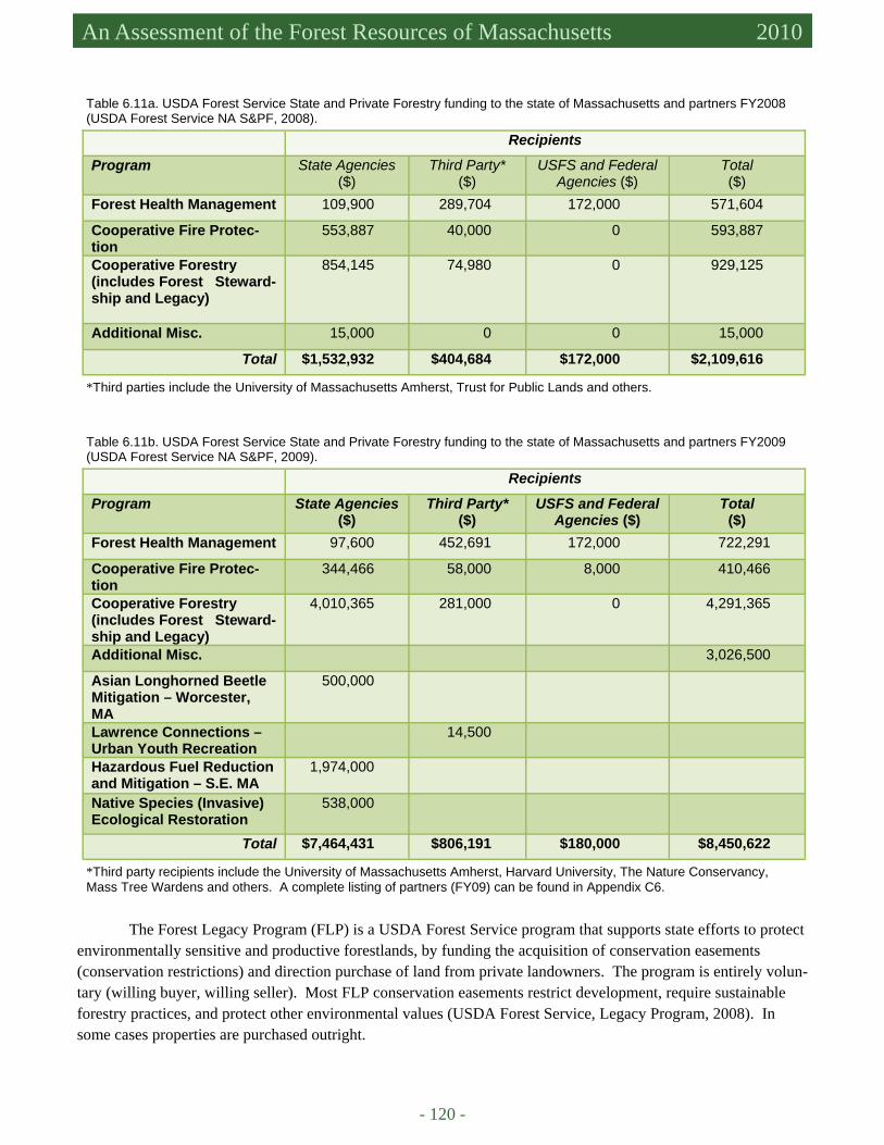
- 120 -
Massachusetts Forest Assessment 2010 An Assessment of the Forest Resources of Massachusetts 2010
Recipients
Program State Agencies ($)
Third Party* ($)
USFS and Federal Agencies ($)
Total ($)
Forest Health Management 109,900 289,704 172,000 571,604
Cooperative Fire Protec-tion
553,887 40,000 0 593,887
Cooperative Forestry (includes Forest Steward-ship and Legacy)
854,145 74,980 0
929,125
Additional Misc. 15,000 0 0 15,000
Total $1,532,932 $404,684 $172,000 $2,109,616
Table 6.11a. USDA Forest Service State and Private Forestry funding to the state of Massachusetts and partners FY2008 (USDA Forest Service NA S&PF, 2008).
*Third parties include the University of Massachusetts Amherst, Trust for Public Lands and others.
Table 6.11b. USDA Forest Service State and Private Forestry funding to the state of Massachusetts and partners FY2009 (USDA Forest Service NA S&PF, 2009).
Recipients
Program State Agencies ($)
Third Party* ($)
USFS and Federal Agencies ($)
Total ($)
Forest Health Management 97,600 452,691 172,000 722,291
Cooperative Fire Protec-tion
344,466 58,000 8,000 410,466
Cooperative Forestry (includes Forest Steward-ship and Legacy)
4,010,365 281,000 0 4,291,365
Additional Misc. 3,026,500
Asian Longhorned Beetle Mitigation – Worcester, MA
500,000
Lawrence Connections –Urban Youth Recreation
14,500
Hazardous Fuel Reduction and Mitigation – S.E. MA
1,974,000
Native Species (Invasive) Ecological Restoration
538,000
Total $7,464,431 $806,191 $180,000 $8,450,622
*Third party recipients include the University of Massachusetts Amherst, Harvard University, The Nature Conservancy, Mass Tree Wardens and others. A complete listing of partners (FY09) can be found in Appendix C6.
The Forest Legacy Program (FLP) is a USDA Forest Service program that supports state efforts to protect environmentally sensitive and productive forestlands, by funding the acquisition of conservation easements (conservation restrictions) and direction purchase of land from private landowners. The program is entirely volun-tary (willing buyer, willing seller). Most FLP conservation easements restrict development, require sustainable forestry practices, and protect other environmental values (USDA Forest Service, Legacy Program, 2008). In some cases properties are purchased outright.
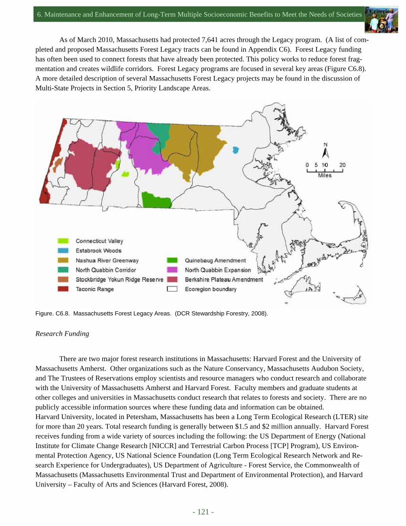
6. Maintenance and Enhancement of Long-Term Multiple Socioeconomic Benefits to Meet the Needs of Societies Criterion
6
- 121 -
As of March 2010, Massachusetts had protected 7,641 acres through the Legacy program. (A list of com-pleted and proposed Massachusetts Forest Legacy tracts can be found in Appendix C6). Forest Legacy funding has often been used to connect forests that have already been protected. This policy works to reduce forest frag-mentation and creates wildlife corridors. Forest Legacy programs are focused in several key areas (Figure C6.8). A more detailed description of several Massachusetts Forest Legacy projects may be found in the discussion of Multi-State Projects in Section 5, Priority Landscape Areas.
Figure. C6.8. Massachusetts Forest Legacy Areas. (DCR Stewardship Forestry, 2008).
Research Funding
There are two major forest research institutions in Massachusetts: Harvard Forest and the University of Massachusetts Amherst. Other organizations such as the Nature Conservancy, Massachusetts Audubon Society, and The Trustees of Reservations employ scientists and resource managers who conduct research and collaborate with the University of Massachusetts Amherst and Harvard Forest. Faculty members and graduate students at other colleges and universities in Massachusetts conduct research that relates to forests and society. There are no publicly accessible information sources where these funding data and information can be obtained. Harvard University, located in Petersham, Massachusetts has been a Long Term Ecological Research (LTER) site for more than 20 years. Total research funding is generally between $1.5 and $2 million annually. Harvard Forest receives funding from a wide variety of sources including the following: the US Department of Energy (National Institute for Climate Change Research [NICCR] and Terrestrial Carbon Process [TCP] Program), US Environ-mental Protection Agency, US National Science Foundation (Long Term Ecological Research Network and Re-search Experience for Undergraduates), US Department of Agriculture - Forest Service, the Commonwealth of Massachusetts (Massachusetts Environmental Trust and Department of Environmental Protection), and Harvard University – Faculty of Arts and Sciences (Harvard Forest, 2008).

- 122 -
Massachusetts Forest Assessment 2010 An Assessment of the Forest Resources of Massachusetts 2010
Total forest related research funding for the University of Massachusetts Amherst was approximately $2 million dollars in FY2008 with the money divided among the Department of Natural Resources Conservation, the Department of Plant, Soil, and Insect Sciences, and the Department of Landscape Architecture and Regional Plan-ning (Table 6.12). Funding resources include the National Science Foundation, USDA Forest Service, TNC, The Tree Fund Foundation, DCR and the Massachusetts Department of Environmental Protection (DEP).
DRIVERS, ISSUES, AND THREATS
Local Wood Production and Marketing It is painfully obvious that the forest products industry in Massachusetts is contracting. As noted earlier,
however, the annual volume harvested from 1984 to 2003 shows no clear (increasing or decreasing) trend (McDonald et al., 2006), indicating that a substantial amount of wood is being exported. At the same time, Mas-sachusetts imports 98% of the wood used by its residents (Berlik et al., 2002).
Suzanne Webber of the Massachusetts Woodlands Cooperative attributes these declines in the production and use of local wood to two primary factors: the loss of markets for low-value wood (pulp and paper mills in the state and region are not purchasing wood) coupled with the limited understanding of most Massachusetts residents of sustainable forest management principles and practices. The latter translates to a lack of support for (or a repu-diation of) timber harvesting as an acceptable land and resource use. While the local wood industry and markets have been in decline, there have been marked increases in public support for local agriculture encouraged by the Massachusetts Department of Agricultural Resources (MDAR) and private organizations such as CISA (Communities Involved in Sustaining Agriculture). This signals a problem and an opportunity.
Groups such as the Massachusetts Woodlands Coop and the DCR Marketing and Utilization program are attempting to develop markets for local wood and for value-added wood products, but much more can be done by both government and private groups. The Massachusetts Woodlands Cooperative is focusing on two primary strategies:
1. Transfer “Buy Local” customer awareness from agriculture into the forest sector, including widespread public
education about forest resources and the net effects of good management. 2. Encourage communities to participate in the design of “right-sized/best technology” biomass co-generation
systems for their distinct needs (Webber, 2009). Emulating the success of Vermont’s “Fuels for Schools” program is another opportunity to strengthen local mar-kets for wood. It also will require a strong commitment by residents and local and state governments to sustaining rural economies and a working landscape.
UMass Department Funding ($) Cranberry Experiment Station 33,000 Landscape Architecture and Regional Planning 21,000 Natural Resources Conservation 1,851,000 Plant, Soil and Insect Sciences 192,000
Total $2,097,000
Table 6.12. Forest-related funding at the University of Massachusetts, in the College of Natural Resources and the Environment in fiscal year 2008, rounded to the nearest thousand.
6. Maintenance and Enhancement of Long-Term Multiple Socioeconomic Benefits to Meet the Needs of Societies Criterion
6
- 123 -
There is a clear consensus among many in the forest products industry that Massachusetts state forestry agencies and private forest landowner groups should support the production and marketing of local wood, just as the MDAR, CISA, and the farming community now support local agriculture. To that end, the Massachusetts Farm Bureau Federation has received funding for a three-year Forest Marketing Coordinator position to foster the “Buy Local” movement in the forest sector. The MDAR will soon launch the Commonwealth Quality Program to increase market opportunities and awareness of local products, broadly writ. This initiative could also be helpful to the forest sector. Most of the small sawmills in Massachusetts are not configured for direct-to-consumer retail sales. So, while an allowance for native lumber exists in the Massachusetts building code most consumers are simply not aware of local sources. It does not help that local structural lumber is often not cost-competitive with spruce-pine-fir lumber from Canada and northern New England. Like a “buy local” decision for farm products, absorbing this additional cost requires a conscious and deliberate buying decision by Massachusetts residents. It took decades to build support for local agriculture with the inherent marketing advantages of freshness, quality, and health considerations. It is more challenging to build broad-based awareness of the many public benefits that emanate from private forests. It takes a very sophisticated consumer to connect a buying decision for lumber, flooring, or furniture with the conditions that sustain clean water, clean air, the conservation of biological diver-sity, and forested vistas—all of which are largely taken for granted.
Funding/Human Resources Reductions
The recent economic recession has reduced tax revenues and the funding of state forestry programs. The
impact of these cuts is not obvious in FY2007 to FY2009 spending (Tables C6.9a,b,c), but will become clear when the final numbers for FY2010 are released. There are vacancies in the Bureau of Forestry and Bureau of Forest Fire Control. Staffing levels had just begun to recover from staff cuts during the last recession (2000-2003). These gains have been quickly erased during the last three years.
- 124 -
Massachusetts Forest Assessment 2010 An Assessment of the Forest Resources of Massachusetts 2010
References AF&P (American Forest & Paper Association). 2006. Forest & paper industry at a glance – Massachusetts. Barnes, M.C., A.H. Todd, R.Whitney Lilja, and P.K. Barten. 2009. Forests, Water, and People: Drinking water supply and
forest lands in the Northeast and Midwest United States. NA-FR-01-08, United States Department of Agriculture Forest Service, Northeastern Area State and Private Forestry, Newtown Square, PA., 71 pp.
Barten, P.K., D. Damery, P. Catanzaro, J. Fish, S. Campbell, A. Fabos, and L. Fish. 2001. Massachusetts Family Forests, birth of a landowner cooperative. Journal of Forestry 99(3):23-30.
Berkshire Mycology Society. 2010. Available at http://www.bms.iwarp.com/index.html. Accessed in April 2010. Berlik, M.M., D.B. Kittredge, and D.R. Foster. 2002. The Illusion of Preservation: a global environmental argument for the
local production of natural resources. Harvard Forest Paper No. 26, Harvard Forest, Harvard University, Petersham, MA., 22 pp.
Boss, O. 2010. Sugar season sours: producers say early heat sharply cuts 2010’s sap run. Daily Hampshire Gazette March 27, 2010. Available at http://www.gazettenet.com. Accessed in April 2010.
Boston Mycological Club. 2010. Available at http://www.bostonmycologicalclub.org/. Accessed in April 2010. Boyce, G. 2009. Department of Conservation and Recreation Forest Products Marketing and Utilization Program: (1) Mission
Statement; (2) Program Overview. DCR internal document. Brown, E. 2010. Clean energy supporters laud Massachusetts Legislature’s ballot decision. Available at http://
www.blog.harvestpower.com. Accessed in May 2010. Campbell, S.M. 2003. Profiles from Working Woodlands: Exploring Forest-based Enterprises in Western Massachusetts.
Massachusetts Woodlands Institute, Montague, MA., 66 pp. Catanzaro, P., W. Sweetser, D. Kittredge, and L. Romano. 2009. Chapter 61B Open Space and Recreational Land Current
Use Tax Program. Highlands Communities Initiative (The Trustees of Reservations) and the University of Massa-chusetts-Amherst, 12 pp.
CISA (Community Involved in Sustaining Agriculture). Available at http://www.buylocalfood.org/. Accessed in May 2010. Damery, D.T. and G. Boyce. 2003. Massachusetts Directory of Sawmills & Dry Kilns – 2003. University of Massachusetts
Amherst, Massachusetts Department of Conservation and Recreation, 57 pp. Damery, D.T., C. Bellemer, and G. Boyce. 2006. Massachusetts Directory of Sawmills & Dry Kilns – 2006. University of
Massachusetts Amherst, Massachusetts Department of Conservation and Recreation. DCR (Massachusetts Department of Conservation and Recreation). No date given. Appalachian Trail. Available at http://
www.mass.gov/dcr/parks/western/appl.htm. Accessed in April 2010. DCR (Massachusetts Department of Conservation and Recreation). 2007. The Service Forestry Program. Available at http://
www.mass.gov/dcr/stewardship/forestry/service/index.htm. Accessed in May 2010. DCR (Massachusetts Department of Conservation and Recreation). 2008. Stewardship Forestry. Map of Legacy areas. Avail-
able at http://www.mass.gov/dcr/stewardship/forestry/other/. Accessed in June 2010. DCR (Massachusetts Department of Conservation and Recreation). 2009a. 2008 Annual Stakeholder Report: Promoting
Stewardship of Our Forests for a Safe and Healthy Environment, Economy, and Society. Massachusetts Department of Conservation and Recreation, Bureau of Forest Fire Control, and Forestry. Boston, MA., 45 pp.
DCR (Massachusetts Department of Conservation and Recreation). 2009b. Working Forest Initiative. DCR (Massachusetts Department of Conservation and Recreation). 2010a. Attendance FY09, State Parks. DCR (Massachusetts Department of Conservation and Recreation). 2010b. Forest Stewardship Plans. DCR (Massachusetts Department of Conservation and Recreation). 2010c. Interim budget report. Doug Leab, Business Man-
agement Specialist. DEM (Massachusetts Department of Environmental Management [now DCR], Bureau of Forestry). 1997. Directory of Saw-
mills, Dry Kilns and Lumber Treaters in Massachusetts. DSPR (Massachusetts Department of Conservation and Recreation-Division of State Parks and Recreation). 2010. MA Pri-
vate Lands Group Certification Summary Document, 6 pp. DUPR (Massachusetts Department of Conservation and Recreation- Division of Urban Parks and Recreation). No date given.
Division of Urban Parks and Recreation History. Available at http://www.mass.gov/dcr/uphistory.htm. Accessed in April 2010.
EEA (Massachusetts Executive Office of Energy and Environmental Affairs). 2010. Biomass locations. Available at http://www.mass.gov/?pageID=eoeeaterminal&L=4&L0=Home&L1=Energy%2c+Utilities+%26+Clean+Technologies&L2=Renewable+Energy&L3=Biomass&sid=Eoeea&b=terminalcontent&f=doer_renewables_biomass_locations&csid=Eoeea. Accessed in April 2010.
EEA (Massachusetts Executive Office of Energy and Environmental Affairs). Press Release April 21, 2010. Patrick-Murray administration announces commonwealth forest heritage plan. Boston, MA.
eRedux. 2010. Massachusetts Energy Consumption and Massachusetts’s Carbon Footprint. Available at http://www.eredux.com/states/state_detail.php?id=1123&state=MASSACHUSETTS. Accessed in April 2010.
Evans, A. and R. Perschel. 2009. An Assessment of Biomass Harvesting Guidelines. The Forest Guild, 20 pp.
6. Maintenance and Enhancement of Long-Term Multiple Socioeconomic Benefits to Meet the Needs of Societies Criterion
6
- 125 -
Fox, S. 1998. Massachusetts contributions to national forest conservation. In C.H.W. Foster (editor) Stepping Back to Look Forward: a history of the Massachusetts Forest. Harvard University, Harvard Forest, Petersham, MA., pp. 257-291.
Friends of Lynn Woods. 2005-2006. About Lynn Woods. Available at http://www.flw.org/aboutlw.html. Accessed in May 2010.
Hardwood Review express. 2005. Editorial: The perfect storm: red oak producers with eventually navigate to safe harbors. Hardwood Review Express 5(6):1-11.
Harper, C. 1980. Heating with Wood in Massachusetts Households. Berkshire-Franklin Resource Conservation and Develop-ment. Sunderland, MA., 27 pp.
Harvard Forest. 2008. Available at http://harvardforest.fas.harvard.edu/research/funding.html. Accessed in May 2010. Hersey, C. and D. Kittredge. 2005. The expense of private forestry: survey results of private practicing foresters in Massachu-
setts. Field note, Northern Journal of Applied Forestry 22(3):211-212. Homer, C., C. Huang, L. Yang, B. Wylie and M. Coan. 2004. Development of a 2001 National Landcover Database for the
United States. Photogrammetric Engineering and Remote Sensing 70(7), July 2004, pp. 829-840. Johnson, T.G., R.A. Harper, and M.J. Bozzo. 2004. South Carolina’s Timber Industry – an assessment of Timber Product
Output and Use, 2001. Resource Bulletin SRS-89. Ashville, NC, USDA Forest Service, Southern Research Station, 33 pp.
Kelty, M., A. D’Amato, and P.K. Barten. 2008. Silvicultural and Ecological Considerations of Forest Biomass Harvesting in Massachusetts. Massachusetts Sustainable Forest Bioenergy Initiative, Division of Energy Resources, Department of Conservation and Recreation, 65 pp.
Kellndorfer, J.M, W. Walker, K. Kirsch, G. Fiske, J. Bishop, L. LaPoint, M. Hoppus, and J. Westfall. 2007-2009. The Na-tional Biomass and Carbon Dataset 2000 (NBCD 2000). The Woods Hole Research Center, Falmouth, MA.
Kittredge, A.M. and D. Welsch. 1997. Survey of foresters working in Massachusetts. LeBlanc, S. 2009. Mass. Rethinking plans for wood-burning power plants, opponents seek to place limits on emissions. Asso-
ciated press, November 8, 2009. Lindberg, P.J. 2005. Wild mushrooms in the Berkshires. Travel and leisure magazine, October 2005. Available at http://
www.travelandleisure.com/articles/into-the-woods/2. Accessed in April 2010. Massachusetts Audubon Society. 1991. Losing Ground: the case for Land Conservation in Massachusetts. Massachusetts Audubon Society (J.Steel). 1999. Losing Ground: An analysis of recent rates and patterns of development and
their effects on open space in Massachusetts (second edition). Massachusetts Audubon Society (K. Breunig). 2003. Losing Ground: At what cost? Changes in land use and their impact on
habitat, biodiversity, and ecosystem services in Massachusetts (third edition). Massachusetts Audubon Society (J. DeNormandie). 2009. Losing Ground – Beyond the Footprint: Patterns of development
and their impact on the nature of Massachusetts (fourth edition). Massachusetts Forest Resource Fact Sheet. 2010. Northeastern Area State and Private Forestry. USDA Forest Service. MassGIS (Office of Geographic and Environmental Information, Commonwealth of Massachusetts, Executive Office of En-
ergy and Environmental Affairs). 2010. Open Space. Available at http://www.mass.gov/mgis/. Accessed in May 2010.
McCullough, R.L. 1998. Town forests: the Massachusetts Plan. In C.H.W. Foster (editor) Stepping Back to Look Forward: a history of the Massachusetts Forest. Harvard University, Harvard Forest, Petersham, MA. 292-316.
McDonald, R.I., G. Motzkin, M.S. Bank, D.B. Kittredge, J. Burk, and D.R. Foster. 2006. Forest harvesting and land-use con-version over two decades in Massachusetts. Forest Ecology and Management 227:31-41.
MDAR (Massachusetts Department of Agricultural Resources). Available at http://www.mass.gov/agr/. Accessed in May 2010.
MMPA (Massachusetts Maple Producers Association). 2010. Available at http://www.massmaple.org . Accessed in January 2010.
MWC (Massachusetts Woodlands Cooperative). 2010. Available at http://www.masswoodlands.coop/aboutmwc.htm. Ac-cessed in May 2010.
MWI (Massachusetts Woodlands Institute). 2005. Available at http://www.masswoodlandsinstitute.org/. Accessed in May 2010.
NEFF (New England Forestry Foundation). 2008. Available at http://newenglandforestry.org/about/. Accessed in May 2010. Troy, A. and M.A. Wilson. 2006. Mapping ecosystem services: practical challenges and opportunities in linking GIS and
value transfer. Ecological Economics 60:435-449. US Army Corps of Engineers. No date given. Charles River Natural Valley Storage Area. Available at http://
www.nae.usace.army.mil/recreati/crn/crnhome.htm. Accessed in March 2010. US Army Corps of Engineers. 2010. Knightville Dam, Huntington MA. Available at http://www.nae.usace.army.mil/recreati/
kvd/kvdhome.htm. Accessed in March 2010. US EPA (Environmental Protection Agency). 2005. Water supply consumers database. US Fish and Wildlife Service. 2010a. Eastern Massachusetts National Wildlife Refuge Complex. Available at http://
www.fws.gov/northeast/easternmanwrcomplex/. Accessed in May 2010.
- 126 -
Massachusetts Forest Assessment 2010 An Assessment of the Forest Resources of Massachusetts 2010
US Fish and Wildlife Service. 2010b. Refuges profiles by state. Available at http://www.fws.gov/refuges/profiles/ByState.cfm?state=MA. Accessed in May 2010.
USDA Forest Service FIA. 2008. Miles, P.D. 2009, 2010. Forest Inventory EVALIDator web-application version 4.01 beta. St. Paul, MN: US Department of Agriculture, Forest Service, Northern
Research Station. Available at http://fiatools.fs.fed.us/Evalidator401/tmattribute.jsp. Accessed in February 2010. USDA Forest Service TPO. 2009. Timber Product Output Reports. USDA Forest Service, Southern Research Station. Ver-
sion July 17, 2009. Available at http://srsfia2.fs.fed.us/php/tpo_2009/tpo_rpa_int1.php. Accessed in December 2009. USDA Forest Service. 2008. Forest Legacy Program: protecting private forest lands from conversion to non-forest uses.
Available at http://www.fs.fed.us/spf/coop/programs/loa/aboutflp.shtml. Accessed in May 2010. USDA Forest Service, Northeastern Area State and Private Forestry. 2008. Distribution of FY 20 Program Budget to Partners. USDA Forest Service, Northeastern Area State and Private Forestry. 2009. Distribution of FY 20 Program Budget to Partners. Veale, G. and D. Fraser. 1984. Sawmillers, Loggers, and Foresters Directory, 1984. Cooperative Extension Service, Univer-
sity of Massachusetts (United States Department of Agriculture and County Extension Services cooperating), 78 pp. Webber, S. 2009. Strategies to increase markets for low-grade wood and raise public awareness about the benefits of good
forest management in southern New England. Massachusetts Woodlands Cooperative. September 28, 2009. WHRC (Woods Hole Research Institute). 2009. Using Forests to Sequester Carbon. Available at http://www.whrc.org/
carbon/forestseq.htm. Accessed in February 2010. Wood, H.P., T.F. Quink, and P.B. Descamps. 1980. Directory of Commercial Sawmill Operators and Loggers in Massachu-
setts. Cooperative Extension Service, University of Massachusetts (United States Department of Agriculture and County Extension Services cooperating), 42 pp + map.
Wood Burning Among Massachusetts Residents. 1981-1982 data. Improved Wood Utilization Project, Forest Products Mar-keting and Utilization Program, Bureau of Forest Development, 16 pp.
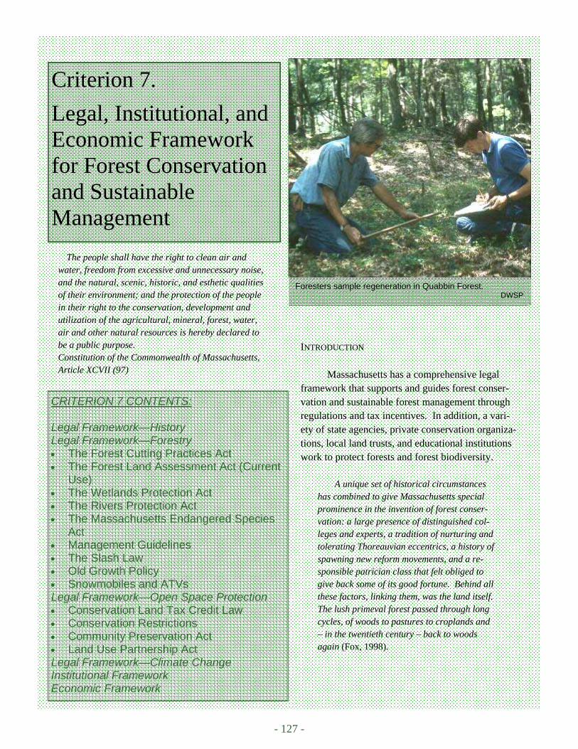
- 127 -
Foresters sample regeneration in Quabbin Forest. DWSP
Criterion 7.
Legal, Institutional, and Economic Framework for Forest Conservation and Sustainable Management
CRITERION 7 CONTENTS: Legal Framework—History Legal Framework—Forestry • The Forest Cutting Practices Act • The Forest Land Assessment Act (Current
Use) • The Wetlands Protection Act • The Rivers Protection Act • The Massachusetts Endangered Species
Act • Management Guidelines • The Slash Law • Old Growth Policy • Snowmobiles and ATVs Legal Framework—Open Space Protection • Conservation Land Tax Credit Law • Conservation Restrictions • Community Preservation Act • Land Use Partnership Act Legal Framework—Climate Change Institutional Framework Economic Framework
INTRODUCTION
Massachusetts has a comprehensive legal framework that supports and guides forest conser-vation and sustainable forest management through regulations and tax incentives. In addition, a vari-ety of state agencies, private conservation organiza-tions, local land trusts, and educational institutions work to protect forests and forest biodiversity.
A unique set of historical circumstances
has combined to give Massachusetts special prominence in the invention of forest conser-vation: a large presence of distinguished col-leges and experts, a tradition of nurturing and tolerating Thoreauvian eccentrics, a history of spawning new reform movements, and a re-sponsible patrician class that felt obliged to give back some of its good fortune. Behind all these factors, linking them, was the land itself. The lush primeval forest passed through long cycles, of woods to pastures to croplands and – in the twentieth century – back to woods again (Fox, 1998).
The people shall have the right to clean air and water, freedom from excessive and unnecessary noise, and the natural, scenic, historic, and esthetic qualities of their environment; and the protection of the people in their right to the conservation, development and utilization of the agricultural, mineral, forest, water, air and other natural resources is hereby declared to be a public purpose. Constitution of the Commonwealth of Massachusetts, Article XCVII (97)
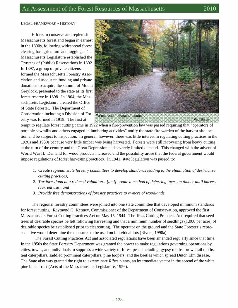
- 128 -
Massachusetts Forest Assessment 2010 An Assessment of the Forest Resources of Massachusetts 2010
LEGAL FRAMEWORK - HISTORY
Efforts to conserve and replenish Massachusetts forestland began in earnest in the 1890s, following widespread forest clearing for agriculture and logging. The Massachusetts Legislature established the Trustees of (Public) Reservations in 1892. In 1897, a group of private citizens formed the Massachusetts Forestry Asso-ciation and used state funding and private donations to acquire the summit of Mount Greylock, presented to the state as its first forest reserve in 1898. In 1904, the Mas-sachusetts Legislature created the Office of State Forester. The Department of Conservation including a Division of For-estry was formed in 1918. The first at-tempt to regulate forest cutting came in 1922 when a fire-prevention law was passed requiring that “operators of portable sawmills and others engaged in lumbering activities” notify the state fire warden of the harvest site loca-tion and be subject to inspection. In general, however, there was little interest in regulating cutting practices in the 1920s and 1930s because very little timber was being harvested. Forests were still recovering from heavy cutting at the turn of the century and the Great Depression had severely limited demand. This changed with the advent of World War II. Demand for wood products increased and the possibility arose that the federal government would impose regulations of forest harvesting practices. In 1941, state legislation was passed to:
1. Create regional state forestry committees to develop standards leading to the elimination of destructive
cutting practices, 2. Tax forestland at a reduced valuation…[and] create a method of deferring taxes on timber until harvest
(current use), and 3. Provide free demonstrations of forestry practices to owners of woodlands.
The regional forestry committees were joined into one state committee that developed minimum standards
for forest cutting. Raymond G. Kenney, Commissioner of the Department of Conservation, approved the first Massachusetts Forest Cutting Practices Act on May 15, 1944. The 1944 Cutting Practices Act required that seed trees of desirable species be left following harvesting and that a minimum number of seedlings (1,000 per acre) of desirable species be established prior to clearcutting. The operator on the ground and the State Forester’s repre-sentative would determine the measures to be used on individual lots (Rivers, 1998a).
The Forest Cutting Practices Act and associated regulations have been amended regularly since that time. In the 1950s the State Forestry Department was granted the power to make regulations governing operations by cities, towns, and individuals to suppress a wide variety of forest pests including: gypsy moths, brown tail moths, tent caterpillars, saddled prominent caterpillars, pine loopers, and the beetles which spread Dutch Elm disease. The State also was granted the right to exterminate Ribes plants, an intermediate vector in the spread of the white pine blister rust (Acts of the Massachusetts Legislature, 1956).
Forest road in Massachusetts. Paul Barten

7. Legal, Institutional, and Economic Framework for Forest Conservation and Sustainable Management Criterion
7
- 129 -
LEGAL FRAMEWORK – FORESTRY
The following statutes, regulations, and policies guide forestry practices in Massachusetts at the present time (Connolly, 2010).
• The Forest Cutting Practices Act • The Forest Land Assessment Act (Current Use) • The Wetlands Protection Act • The Rivers Protection Act • The Massachusetts Endangered Species Act • Management Guidelines • The Slash Law • Old Growth Policy
The Forest Cutting Practices Act
It is hereby declared that the public welfare requires the rehabilitation, maintenance, and protection of forestlands for the purpose of conserving water, preventing floods and soil erosion, improving the condi-tions for wildlife and recreation, protecting and improving air and water quality, and providing a con-tinuing and increasing supply of forest products for public consumption, farm use, and for the wood using industries of the Commonwealth (M.G.L. Ch. 132. Section 40. Declaration of the Policy of Common-wealth).
Massachusetts is one of only twelve states with a comprehensive forest cutting law. The Forest Cutting Practices Act (Massachusetts General Law Ch. 132) mandates the establishment of a state forestry committee rep-resenting forest landowners, wood using industries, licensed timber harvesters, consulting foresters, environ-mental organizations, and water supply and fisheries and wildlife agencies, with one member representing the public-at-large. The state forestry committee is responsible for recommending minimum forest cutting practices, which are subject to public review, to the Commissioner of the Department of Conservation and Recreation (DCR).
Ch. 132 regulates timber harvesting of wood products whenever the total volume exceeds 25,000 board feet or 50 cords on any forest stand or parcel of land at any one time. The law requires the submission of a forest cut-ting plan (FCP) with the DCR and the local conservation commission at least ten business days before the pro-posed start date. The landowner or agent must also notify all abutters within 200 ft. of the proposed cutting area. Licensed foresters in the DCR Service Forestry program review FCPs on private land. Service foresters review wetland mapping, ensure that Best Management Practices (BMPs) to protect water resources are correctly identi-fied, and that the plan meets forest regeneration requirements. Timber harvesting may commence on unregulated areas if the FCP review is not completed within the ten day period (DCR, n.d.).
Timber harvesters must be licensed to cut trees in Massachusetts (M.G.L Ch. 132 s.s 47 -50). In order to obtain a harvesting license, harvesters must demonstrate familiarity with Massachusetts timber harvesting laws, complete basic forest ecology and workplace safety training, and provide information regarding their harvesting during the previous year. Ch. 132 also establishes a Forester Licensing Board to recommend qualifications for the licensing of foresters and supervise the licensing, renewal, and complaint adjudication processes.

- 130 -
Massachusetts Forest Assessment 2010 An Assessment of the Forest Resources of Massachusetts 2010
The Forest Land Assessment Act (Current Use)
Massachusetts current use tax programs (M.G.L. Chapter 61) provide tax incentives to landowners who maintain their property as open space. Ch. 61 was designed for private forestland owners. Ch. 61A was designed for agricultural properties that also may include forestland. Ch. 61B was designed for recreational or open space properties that may include forestland. Taxes for these properties are based on the productive potential of the property for growing trees rather than the fair market or development value. Landowners who enroll in Ch. 61 are required to have forest management plans for their properties. Landowners who enroll in Ch. 61B are not. Plans are required for Ch. 61A if the land includes forest. These programs are described in greater detail in Criterion 6.
The Wetlands Protection Act
The Wetlands Protection Act (Ch. 131, ξ 40) declares that wetlands and streams are protected from activi-
ties, which would alter, dredge, fill, or harm them. Wetlands include freshwater wetlands, coastal wetlands, beaches, dunes, flats, marshes, meadows or swamps bordering the ocean or estuaries, creeks, rivers, streams, ponds and lakes. The intent of the Wetlands Protection Act is: to protect public and private water supply, ground-water supply, land containing shellfish, wildlife habitat, and fisheries; to provide flood control; and, to prevent storm damage and pollution. Persons who wish to conduct any operations in wetland areas must file a notice of intent and plans with the local Conservation Commissions, while also notifying all abutters. A public hearing is required within 21 days of the filing. Following the hearing, the Conservation Commission or other elected offi-cials can impose conditions to protect the wetland ecosystem services described above, if necessary. If local offi-cials have not acted within 21 days, any abutter or any ten residents of the town may contact the Massachusetts Department of Environmental Protection (DEP) for a determination concerning wetland status and operating con-ditions. Timber harvesting activities in wetlands and temporary stream crossings are, with minor exceptions, regulated under Ch. 132, the Forest Cutting Practices Act. M.G.L. Ch. 131 Section 4(16) governs inland fisheries and game and prohibits clearcutting on Massachusetts Department of Fish and Game (DFG) – Division of Fisher-ies and Wildlife (DFW) land (Connolly, 2010). DCR Service Foresters have the training and authority to approve temporary stream or wetland crossings as part of forest cutting plans.
The Rivers Protection Act
The Massachusetts Rivers Protection Act (M.G.L. Chapter 258 of the Acts of 1996) establishes the policy
of the state to protect the natural integrity of rivers and to encourage and establish open space along rivers (DEP, n.d). It ensures that riverfront areas are protected for the eight interests in the Wetlands Protection Act: protection of land containing shellfish, protection of wildlife habitat, flood control, storm damage prevention, prevention of pollution, and protection of fisheries. The riverfront area is the area between a river’s mean annual high water line and a parallel line 200 ft. away on both sides of the river. In some urban areas, the riverfront area is limited to 25 ft. Rivers are defined as all perennial, natural flowing rivers and streams.
The Rivers Protection Act protects 9,000 miles of Massachusetts river banks. The Rivers Protection Act does not prohibit work in riverfront areas, but applicants must demonstrate that there are no practicable alterna-tives for completing their projects and that adverse impacts will not occur or be negligibly small. As in the Wet-lands Protection Act, projects are reviewed by local conservation commissions or the DEP (DEP, n.d.). Forest management activities in riverfront areas are regulated under Chapter 132, the Forest Cutting Practices Act.
7. Legal, Institutional, and Economic Framework for Forest Conservation and Sustainable Management Criterion
7
- 131 -
The Massachusetts Endangered Species Act The Massachusetts Endangered Species Act (M.G.L. Ch. 131A) or MESA protects rare species and their
habitat. MESA prohibits the “take” of any plant or animal species listed as Endangered, Threatened or Special Concern (see Appendix C1 for definitions of these terms). The term “take” includes hunting, shooting, trapping, and collecting of rare animal species. “Take” also includes disrupting of nesting, feeding, breeding, and migratory activity. This may result from “modification, degradation or destruction of habitat.” In reference to plants, “take” means to “collect, pick, kill, transplant, cut, or process.”
To meet compliance with provisions of Forest Cutting Practices regulations (304 CMR 11.00) and MESA and its implementing regulations (321 CMR 10.00), all Ch. 132 Forest Cutting Plans that coincide with legally-designated habitats of state-listed rare species must be reviewed by the Natural Heritage and Endangered Species Program of the Massachusetts Division of Fisheries and Wildlife (NHESP) and adhere to whatever project condi-tions are issued for the protection of pertinent state-listed species. This process is described in more detail in Cri-terion 1.
Management Guidelines
M.G.L. Chapter 21: section F is entitled “Management guidelines for sustainable forestry practices on pub-
lic and private forest lands”. It requires the directors of the DCR – Division of State Parks and Recreation (DSPR) and the DFG – Division of Fisheries and Wildlife (DFW) to work together to establish management guidelines for sustainable forestry practices on public and private forestlands. The DCR is required to develop management plans for all its units, which will be submitted to the DCR Stewardship Council to “ensure consistency between recreation, resource protection, and sustainable forest management” (Connolly, 2010).
The Slash Law
M.G.L. Ch. 48 ξ16, 16A, known as the “Slash Law”, requires that tops and branches from timber harvesting
be cut close to the ground and bans the disposal of slash at specified distances from property boundaries, streams, and public highways. The intent of the “Slash Law” is to minimize unsightliness and reduce fire danger (Connolly, 2010).
Bureau of Forestry - Old Growth Policy
The Massachusetts Department of Environmental Management (DEM) (now DCR) – Bureau of Forestry
(BOF) established a policy for the management of old growth forest on DCR land that was adopted in 1998. Un-der this policy, it is the role of the BOF to: (1) provide a definition of old-growth forests, (2) preserve and main-tain the integrity of existing old-growth forests, (3) “restore” old-growth where appropriate and utilize these areas as buffers, (4) prepare site-specific management plans, and (5) create old-growth attributes in selected, previously managed stands. Management to create old growth attributes include retaining live “cull” and standing dead trees (snags), retaining coarse woody debris, leaving some unharvested trees in perpetuity, lengthening rotations, and practicing single tree or group selection cutting (DEM, 1998).
Snowmobiles and ATVs
Off highway vehicle use on forestland in Massachusetts has been a recurring issue. Motorized trail rec-
reation, snowmobiles and all-terrain vehicle use, has grown dramatically in the last ten years. This has generated

- 132 -
Massachusetts Forest Assessment 2010 An Assessment of the Forest Resources of Massachusetts 2010
widespread complaints concerning illegal off highway vehicle (OHV) use, environmental damage resulting from OHVs on both public and private lands, and concerns about serious safety risks for users and non-users alike.
A bill that recently passed the Massachusetts Senate (SB 2236) requires mandatory registration of all OHVs and increases fines and penalties for illegal OHV use (from $25 to several hundred dollars for most viola-tions. Fees and penalties will be used to assist OHV enforcement, site remediation, trail maintenance, and acquisi-tion of lands appropriate for riding. The bill requires safety training for all OHV operators 18 years and younger; reduces allowable OHV noise; strengthens the requirements for adult supervision of young operators; and estab-lishes an OHV Advisory Group that will strengthen communication among OHV riders, land owners, law enforce-ment agencies, and other stakeholders (Sullivan and Gross, 2010; pers. comm., Robert O’Connor, EEA, June 4, 2010). This legislation was passed by the Massachusetts House of Representatives on June 9, 2010.
LEGAL FRAMEWORK – OPEN SPACE PROTECTION
In addition to the current use laws, Ch. 61, Ch. 61A, and Ch. 61B, the Conservation Land Tax Credit Law,
laws governing the sale and donation of Conservation Restrictions, the Community Preservation Act and the Land Use Partnership Act (pending) legislation support the protection of open space and forestland in Massachusetts. At a regional level, Massachusetts Governor Deval Patrick is Vice Chair of the New England Governors Confer-ence Blue Ribbon Commission on Land Conservation. The Governors Conference published a report in Septem-ber of 2009, recommending regional action in collaboration with the USDA Forest Service, the region’s universi-ties, private forest landowners, and other stakeholders and interested parties to prepare a New England Forest Ini-tiative. The purpose of this initiative would be to prevent the loss of forestland and ensure the sustainability of these lands (NEG, 2009a; 2009b).
Conservation Land Tax Credit Law
M.G.L. Chapter 509 of the Acts of 2008, the Conservation Land Tax Credit Law, allows up to $50,000 in
state tax credit for donation of conservation land (up to 50% of appraised value up to $50,000). The credit may be carried for ten years. Annual loss of tax revenue is capped at $2 million total. To qualify, the land must be “in the public interest for natural resources protection including but not limited to, drinking water supplies, wildlife habi-tat and biological diversity, agricultural and forestry production, recreational opportunities, or scenic and cultural values.” The land must be protected in perpetuity. This law goes into effect in tax year 2011. Massachusetts is one of only a dozen states that now has a state tax credit for conservation land donations.
Conservation Restrictions
A Conservation Restriction (CR) (also known as a Conservation Easement) is a legal agreement between a
landowner and a conservation organization. The landowner retains ownership of the land, but sells or donates the development rights to a conservation organization. The value of the CR is the difference between the value of the land with and without development rights. If the development rights are donated, the landowner may claim the CR value as a charitable donation on their federal income tax return and is eligible to receive a state tax credit; otherwise, the landowner benefits from the proceeds of the sale. The land is permanently protected from develop-ment and the owner’s property taxes are reduced. The CR can be written to allow forest management (Catanzaro and Sweetser, n.d.). M.G.L. Chapter 184 requires that the Secretary of the Executive Office of Energy and Envi-ronmental Affairs approve and sign all CRs donated or sold to non-state organizations, before the CR becomes permanent. This establishes a form of “quality control” on the CR process and final agreement, which helps pri-vate conservation organizations, such as Land Trusts, in their negotiations. Massachusetts is the only state with

7. Legal, Institutional, and Economic Framework for Forest Conservation and Sustainable Management Criterion
7
- 133 -
this type of requirement. EEA has approved about 4,000 CRs since the law was passed in the 1970s (pers. comm., Robert O’Connor, EEA, June 9, 2010).
Community Preservation Act
M.G.L. Ch. 44B, the Community Preservation Act (CPA) passed into law on September 14, 2000. This
legislation helps communities to preserve open space and historic sites and to create affordable housing and rec-reational facilities. Individual communities decide locally to adopt the CPA or not. To date 143 communities have adopted the CPA (40% of all communities in the Commonwealth). Funding for the CPA comes from the local community and from the state. CPA communities add a surcharge of up to 3% to their local property taxes; the state government matches this, up to 100%, with monies from the statewide CPA Trust Fund, garnered from fees on real estate transactions at the state Registry of Deeds. Using CPA funding, communities have protected 10,000 acres of open space. The CPA is supported by a coalition of affordable housing and conservation groups including the Massachusetts Audubon Society, the Trust for Public Land (TPL), and The Trustees of Reservations (TTOR) (Community Preservation Coalition, 2010). Senate Bill 90 (S.B. 90), currently under consideration in the Massachusetts Legislature contains several measures to support the CPA and make it feasible for less affluent communities to adopt the CPA. From 2001 to 2007, the CPA trust fund was able to match local funds at the 100% level. The match fell in 2008 and 2009, as the program became more popular, the economy declined and the num-ber of real estate transactions decreased. S.B. 90 would increase the minimum CPA trust fund match to 75%. S.B. 90 also would allow communities to raise funds from sources other than property taxes (Community Preser-vation Coalition, 2009).
Land Use Partnership Act
Current Massachusetts zoning laws have allowed for “sprawling, unplanned development” (Massachusetts
Audubon Society, 2009). The Massachusetts Land Use Partnership Act (LUPA) (Senate Bill 365 and House Bill 3572), filed in January of 2009, would reform zoning and planning statutes statewide to encourage sustainable development, affordable housing, and the protection of natural resources. The bill allows cities and towns to regu-late maximum residential floor area and discourage the construction of “McMansions.” It is designed to facilitate cluster development and the protection of open space. It permits “natural resource protection zoning (very large lot conservation zoning) in areas of environmental resource value” and provides technical assistance grant funding from the state to municipalities to prepare land use plans and implement zoning changes (Fact Sheet: Land Use Partnership Act, 2009). The bill is supported by the Massachusetts Audubon Society and the Massachusetts Smart Growth Alliance among others. On May 18, 2010, the Joint Committee on Municipalities and Regional Govern-ment reported out its version of the zoning bill, The Comprehensive Land Use Reform and Partnership Act (CLURPA). This act is “far more comprehensive than the original LUPA legislation…essentially a redraft of (state zoning laws) rather than an effort to repair the more egregious flaws” and addresses issues of Master Plans and rules on subdivisions (pers. comm., Kurt Gartner, Massachusetts Executive Office of Environmental Affairs, June 15, 2010).
LEGAL FRAMEWORK – CLIMATE CHANGE
The Massachusetts Global Warming Solutions Act (GWSA) of 2008 sets mandatory, science-based tar-
gets for global warming pollution reductions from all sectors of the economy of 10% to 25% below today’s levels by 2020 and 80 percent by 2050. The Secretary of Energy and Environmental Affairs is required to set a 2020 emissions limit between 10% and 25% below 1990 levels and adopt a plan for meeting that limit by January 1, 2011. Increased carbon sequestration via forest growth and reduction of conversion of forests via sprawl develop-

- 134 -
Massachusetts Forest Assessment 2010 An Assessment of the Forest Resources of Massachusetts 2010
ment are two recommendations of the Forest, Agriculture, Marine and Land Use Change Sub-Committee of the GWSA Advisory Committee. The substitution of locally grown forest products for building materials with higher inherent energy use is also a recommendation of the sub-committee. The Secretary will also set 2030 and 2040 limits, leading up to the required 80 percent reduction by 2050 (Official Website of the Governor of Massachu-setts, August 13, 2008; pers. comm. Robert O’Connor, EEA, December 9, 2009).
Massachusetts is part of regional efforts to respond to climate change as well. The New England Gover-nors Conference is also a part of the Conference of New England Governors and Eastern Canadian Premiers (NEG-ECP). In 2001, the NEG-ECP developed the Climate Change Action Plan, a comprehensive and coordi-nated regional plan for reducing greenhouse gases that includes a goal of achieving 1990 emission levels by 2010 and 10% below 1990 levels by 2020. The states and provinces of the NEG-ECP are developing a variety of pro-grams and policies, including the Regional Greenhouse Gas Initiative (RGGI), to meet their commitments (Pew Center on Global Climate Change, 2010). The full report of the NEG on Land Conservation (NEG, 2009b) rec-ommends that the climate change policies “recognize the importance of New England’s forests in combating greenhouse gases and climate change”. Recommended policies will:
• allow carbon offsets for forestry projects that provide net carbon benefits and store additional carbon in a verifiable and permanent manner;
• allocate a portion of the revenues from the sale of “allowances” to emit carbon for programs that encour-age landowners to keep forests as forests and sequester more carbon;
• encourage the use of wood products to sequester carbon instead of products [e.g., concrete, steel, etc.] that have a larger carbon footprint;
• provide funding for efforts to maintain large-scale interconnected forest systems that will allow for adap-tation to climate change; and
• provide funding for research and other initiatives focused on sequestering carbon in forest products and facilitating forest adaptation to climate change.
INSTITUTIONAL FRAMEWORK State Agencies
Government agencies that are directly involved with the protection and management of public and private
forestland in Massachusetts are shown in Table C7.1. A complete list of responsibilities of each agency can be found in Appendix C7. In general, the DCR
Division of Urban Parks and Recreation (DUPR) is responsible for state parks, forests, waterways, and a variety of recreational facilities within the 36 municipalities within the Greater Boston area. The DCR Division of State Parks and Recreation (DSPR) is responsible for all similar properties outside of the Greater Boston area. In addi-tion, the director of DSPR is responsible for the proper management of all public and private forestlands. The Bu-reaus are responsible for the operational programs of the DCR. The BOF through its Management Forestry pro-gram supervises forest management, reforestation, and the development of forest or wooded areas of state lands. The Service Forestry program is responsible for the promotion of state forestry programs and the enforcement of state laws on private lands. The Forest Health program and Bureau of Forest Fire Control operate throughout the state. The Bureau of Recreation is responsible for recreational facilities within the state forests and parks (DCR Office of the General Council, 2010).
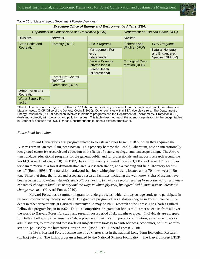
7. Legal, Institutional, and Economic Framework for Forest Conservation and Sustainable Management Criterion
7
- 135 -
Executive Office of Energy and Environmental Affairs (EEA)
Department of Conservation and Recreation (DCR) Department of Fish and Game (DFG)
Divisions Bureaus Division
State Parks and Recreation
Forestry (BOF) BOF Programs Fisheries and Wildlife (DFW)
DFW Programs
Management For-estry (state lands)
Natural Heritage and Endangered Species (NHESP)
Service Forestry (private lands)
Ecological Res-toration (DER)
Forest Health (all forestland)
Forest Fire Control (BOFFC)
Recreation (BOR)
Urban Parks and Recreation
Water Supply Pro-tection
Table C7.1. Massachusetts Government Forestry Agencies.*
*This table represents the agencies within the EEA that are most directly responsible for the public and private forestlands in Massachusetts (DCR Office of the General Council, 2010). Other agencies within EEA also play a role. The Department of Energy Resources (DOER) has been involved in biomass programs and the Department of Environmental Protection (DEP) deals more directly with wetlands and pollution issues. This table does not match the agency organization in the budget tables in Criterion 6 because the DCR Finance Department budget uses a different framework.
Educational Institutions Harvard University’s first program related to forests and trees began in 1872, when they acquired the Bussey Farm in Jamaica Plain, near Boston. This property became the Arnold Arboretum, now an internationally recognized center for research and education in the fields of botany, ecology, and landscape design. The Arbore-tum conducts educational programs for the general public and for professionals and supports research around the world (Harvard College, 2010). In 1907, Harvard University acquired the now 3,000 acre Harvard Forest in Pe-tersham to “serve as a forest demonstration area, a research station, and a teaching and field laboratory for stu-dents” (Bond, 1998). The transition hardwood-hemlock-white pine forest is located about 70 miles west of Bos-ton. Since that time, the forest and associated research facilities, including the well-know Fisher Museum, have been a center for scientists, students, and collaborators … [to] explore topics ranging from conservation and envi-ronmental change to land-use history and the ways in which physical, biological and human systems interact to change our earth (Harvard Forest, 2010).
Harvard Forest has a summer program for undergraduates, which allows college students to participate in research conducted by faculty and staff. The graduate program offers a Masters degree in Forest Science. Stu-dents in other departments at Harvard University also may do Ph.D. research at the Forest. The Charles Bullard Fellowship program began in 1962. This is a competitive program that brings mid-career scientists from all over the world to Harvard Forest for study and research for a period of six months to a year. Individuals are accepted for Bullard Fellowships because they “show promise of making an important contribution, either as scholars or administrators, to forestry and forest-related subjects from biology to earth sciences, economics, politics, admini-stration, philosophy, the humanities, arts or law” (Bond, 1998; Harvard Forest, 2010).
In 1988, Harvard Forest became one of 26 charter sites in the national Long Term Ecological Research (LTER) network. The LTER program is funded by the National Science Foundation. The Harvard Forest LTER
- 136 -
Massachusetts Forest Assessment 2010 An Assessment of the Forest Resources of Massachusetts 2010
focuses on ecological dynamics in the New England region. Scientists study changes in forest ecosystems, result-ing from natural disturbances, environmental change, and human impacts. Research topics include the effects of wind and fire, long-term climate change, land-use history, atmospheric pollution (nitrogen deposition and ozone), land management, land policy and conservation (Harvard Forest, 2010).
Harvard Forest has long advocated for the preservation of forestland. In 2005, they published Wildlands and Woodlands: A Vision for the Forests of Massachusetts (Foster et al., 2005) (Criterion 2). In May of 2010, Harvard Forest published Wildlands and Woodlands: A Vision for the New England Landscape, calling for a “long-term conservation effort to retain at least 70 percent of the region in forestland, permanently free from develop-ment.” Ninety percent of the forest would be managed as woodlands open to harvesting, while the remaining 10%, the Wildlands, would be large landscape reserves with no active management of forest vegetation and lim-ited access for other uses. Forestland would be secured through conservation easements from willing landowners, other conservation acquisitions, and economic incentives to keep forests as forests (Aber et al., 2010). The University of Massachusetts Amherst is an 1863 land grant institution, established as the Massachu-setts Agricultural College. The forestry program was started in 1909 with the hiring of one faculty member in the department of horticulture. For many years, the primary focus was on the training of undergraduates. Forestry research and graduate studies programs developed in the 1950s, following the designation of the school as the University of Massachusetts (1948). The University owns five forests, which are used for research and manage-ment demonstration projects. The largest of these are the 755 acre Mount Toby experimental forest, acquired in 1916 and the 1,200 acre Cadwell Memorial Forest acquired in 1951-52 (Bond, 1998; University of Massachusetts Amherst, 2010). Mount Toby and Cadwell Forests were permanently dedicated for “the purposes and uses of for-est and open space protection, management, and conservation, environmental education, environmental research, and public access for passive recreation and enjoyment” via Chapter 499 Acts of 2002.
At present, the forestry program is part of the Department of Natural Resources Conservation (DNRC). Undergraduate majors in DNRC choose among six concentrations: Fisheries Ecology and Conservation, Forest Ecology and Conservation, Urban Forestry and Arboriculture, Water Resources or Environmental Conservation. The Forest Ecology and Conservation concentration emphasizes “conservation challenges unique to the urbanized northeast where high population densities of citizens depend on ecosystem services from forests, most of which are owned by a complex matrix of private families, individuals, non-profit organizations, and state and local gov-ernments.” Students address issues relating to biodiversity and animal habitat, water quality, forests and global climate change, wilderness preservation, forest recreational opportunities, and the production of forest products. The concentration is nationally accredited by the Society of American Foresters. Other accredited programs in New England include the University of New Hampshire and the University of Maine at Orono. Residents of Con-necticut and Rhode Island can enroll in the forest conservation program at the University of Massachusetts on the resident tuition and fee schedule as part of an interstate agreement between the University of Massachusetts, Uni-versity of Connecticut, and the University of Rhode Island. The Urban Forestry & Arboriculture program trains arborists and urban foresters to manage trees in cities and suburbs. In addition, the Stockbridge School of Agri-culture—a two-year degree program within the University of Massachusetts—trains arborists, many of whom go on to complete a B.S. degree.
There are graduate programs in Forest Resources and Wildlife and Fisheries Conservation within DNRC. Forest research topics include forest ecology and management, watershed and wetlands science, urban forestry, building materials and wood technology, sustainable building practices, policy, and spatial information technolo-gies. Collaboration between the two graduate programs enhances the opportunity for the study of the interaction between forest management and wildlife habitats and populations (University of Massachusetts Amherst, 2010). The Department of Plant, Soil, and Insect Sciences at the University of Massachusetts has contributed greatly to the research literature regarding insect pests such as gypsy moths, winter moths, hemlock woolly adelgid, and Asian Longhorned Beetle (Criterion 3).
7. Legal, Institutional, and Economic Framework for Forest Conservation and Sustainable Management Criterion
7
- 137 -
In addition to education and research, there is a variety of outreach programs associated with the DNRC and UMassExtension. Among the most notable, the MassWoods Forest Conservation program (http://www.masswoods.net) provides educational materials regarding state forest conservation programs including Ch. 61, Ch. 61 A and Ch. 61 B. In addition, the MassWoods website provides tools for private forest landowners to locate and connect with State Service Foresters, private licensed consulting foresters, local land trusts, statewide land trusts, conservation organizations, appraisers, and estate planning attorneys who specialize in conservation law and land use. MassACORN (A Cooperative Resources Network) is an interactive website (http://www.massacorn.net) designed to provide information for landowners and others interested in forests in the West-field and Deerfield River watersheds in western Massachusetts and to aid forestland owners in making informed decisions about their woods. The Forest Resources Education for Municipal Officials (FREMO) Network project was designed to provide a way for municipal officials to connect and share experience, information, resources and advice on promoting forest conservation at the local level.
In addition to the research programs at Harvard Forest and the University of Massachusetts, a number of undergraduate colleges have programs in forest-related fields. Notable among these is Williams College in Wil-liamstown, where students in the biology department have produced research studies detailing the ecology and vegetation history of Mount Greylock and the surrounding area of northwestern Massachusetts (Reid, 1978).
There are two non-degree programs at the vocational level. North of Boston, in Danvers, the Essex Agri-cultural and Technical High School has programs in forestry and arboriculture. The forestry program at the Smith Vocational and Agricultural High School in Northampton forestry programs prepares students to become licensed timber harvesters (Bond, 1998; AgTech., 2010; Smith Voc., 2010). Conservation Organizations and Land Trusts
There is a long tradition of private citizen involvement in conservation issues in Massachusetts. Henry David Thoreau (1817-1862), citizen of Concord, Massachusetts, is considered by many to be the first conserva-tionist. Thoreau’s studies of natural processes, seed dispersal and forest succession, were not published until re-cently (Thoreau, 1993). They anticipate the development of the modern science of ecology. In an era of wide-spread forest clearing, Thoreau was one of the first Americans to consider the idea that forests had a purpose other than providing lumber for human use. Writing shortly before his death, he advocated the establishment of a pro-tected forest in Concord of 500 to 1,000 acres, “where a stick should never be cut for fuel, a common possession forever, for instruction and recreation (Fox, 1998).”
In 1876, a group of prominent Bostonians including John Greenleaf Whittier, Alice Stone Blackwell, Tho-mas Wentworth Higgenson, Lincoln Filene, and Percivel Lowell founded the Appalachian Mountain Club (AMC). The club soon became involved in forest preservation. Charles Eliot, a landscape architect and early member was instrumental in the founding of The Trustees of (Public) Reservations. In 1894, the state legislature granted the AMC the right to hold mountain and forest properties tax-free (Fox, 1998). The AMC was also actively involved in preserving forestland in other New England states and is now a regional organization. The Trustees of Reserva-tions (TTOR), the Massachusetts Audubon Society, and the Massachusetts Chapter of The Nature Conservancy (TNC) are three major statewide organizations (Criterion 6). In addition to owning and managing nature reserves and holding conservation easements on private lands, these organizations conduct a wide array of educational, research, and public outreach activities and are actively involved in the political process. Other national and re-gional organizations working in Massachusetts include The Trust for Public Lands (TPL) and the New England Forestry Foundation (NEFF). NEFF is discussed in more detail in Criterion 6 (Box C6.1).
There also are numerous regional and local conservation organizations and land trusts. The Massachu-setts Land Trust Coalition lists 131 land trusts in Massachusetts. These are located in all regions of the state from Cape Cod to the Berkshires. Two notable examples are the Berkshire Natural Resources Council and the Mount Grace Land Trust (Box C7.1).
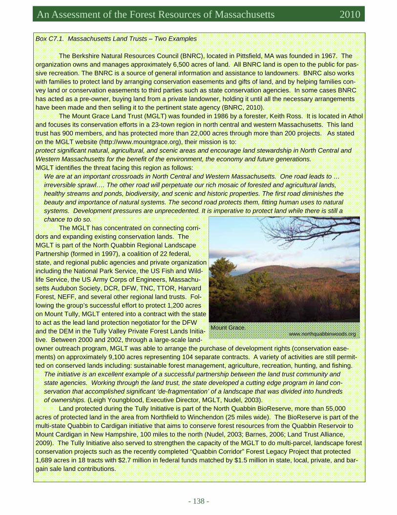
- 138 -
Massachusetts Forest Assessment 2010 An Assessment of the Forest Resources of Massachusetts 2010
Box C7.1. Massachusetts Land Trusts – Two Examples
The Berkshire Natural Resources Council (BNRC), located in Pittsfield, MA was founded in 1967. The organization owns and manages approximately 6,500 acres of land. All BNRC land is open to the public for pas-sive recreation. The BNRC is a source of general information and assistance to landowners. BNRC also works with families to protect land by arranging conservation easements and gifts of land, and by helping families con-vey land or conservation easements to third parties such as state conservation agencies. In some cases BNRC has acted as a pre-owner, buying land from a private landowner, holding it until all the necessary arrangements have been made and then selling it to the pertinent state agency (BNRC, 2010).
The Mount Grace Land Trust (MGLT) was founded in 1986 by a forester, Keith Ross. It is located in Athol and focuses its conservation efforts in a 23-town region in north central and western Massachusetts. This land trust has 900 members, and has protected more than 22,000 acres through more than 200 projects. As stated on the MGLT website (http://www.mountgrace.org), their mission is to: protect significant natural, agricultural, and scenic areas and encourage land stewardship in North Central and Western Massachusetts for the benefit of the environment, the economy and future generations. MGLT identifies the threat facing this region as follows:
We are at an important crossroads in North Central and Western Massachusetts. One road leads to …irreversible sprawl…. The other road will perpetuate our rich mosaic of forested and agricultural lands, healthy streams and ponds, biodiversity, and scenic and historic properties. The first road diminishes the beauty and importance of natural systems. The second road protects them, fitting human uses to natural systems. Development pressures are unprecedented. It is imperative to protect land while there is still a chance to do so.
The MGLT has concentrated on connecting corri-dors and expanding existing conservation lands. The MGLT is part of the North Quabbin Regional Landscape Partnership (formed in 1997), a coalition of 22 federal, state, and regional public agencies and private organization including the National Park Service, the US Fish and Wild-life Service, the US Army Corps of Engineers, Massachu-setts Audubon Society, DCR, DFW, TNC, TTOR, Harvard Forest, NEFF, and several other regional land trusts. Fol-lowing the group’s successful effort to protect 1,200 acres on Mount Tully, MGLT entered into a contract with the state to act as the lead land protection negotiator for the DFW and the DEM in the Tully Valley Private Forest Lands Initia-tive. Between 2000 and 2002, through a large-scale land-owner outreach program, MGLT was able to arrange the purchase of development rights (conservation ease-ments) on approximately 9,100 acres representing 104 separate contracts. A variety of activities are still permit-ted on conserved lands including: sustainable forest management, agriculture, recreation, hunting, and fishing.
The initiative is an excellent example of a successful partnership between the land trust community and state agencies. Working through the land trust, the state developed a cutting edge program in land con-servation that accomplished significant ‘de-fragmentation’ of a landscape that was divided into hundreds of ownerships. (Leigh Youngblood, Executive Director, MGLT, Nudel, 2003).
Land protected during the Tully Initiative is part of the North Quabbin BioReserve, more than 55,000 acres of protected land in the area from Northfield to Winchendon (25 miles wide). The BioReserve is part of the multi-state Quabbin to Cardigan initiative that aims to conserve forest resources from the Quabbin Reservoir to Mount Cardigan in New Hampshire, 100 miles to the north (Nudel, 2003; Barnes, 2006; Land Trust Alliance, 2009). The Tully Initiative also served to strengthen the capacity of the MGLT to do multi-parcel, landscape forest conservation projects such as the recently completed “Quabbin Corridor” Forest Legacy Project that protected 1,689 acres in 18 tracts with $2.7 million in federal funds matched by $1.5 million in state, local, private, and bar-gain sale land contributions.
Mount Grace. www.northquabbinwoods.org
7. Legal, Institutional, and Economic Framework for Forest Conservation and Sustainable Management Criterion
7
- 139 -
Forest Landowners
The Massachusetts Forest Land Owners Association (MFLA) is a statewide not-for-profit organization that was founded in 1970. The organization’s mission is to “educate and advocate for the interests of forest land-owners in Massachusetts, the conservation of Massachusetts trees and forests, and the health of a sustainable for-est-based economy.
The MFLA educates its members and the general public about better ways to care for woodlands. It also sponsors the Tree Farm Program in Massachusetts and co-sponsors Project Learning Tree, an environmental edu-cation program for grades K-12. MFLA is also a land trust, accepting donations of conservation restrictions or woodlands outright. MFLA’s particular interest is the protection of working forests managed to grow forest prod-ucts. The organization also acts as a political advocacy group on behalf of forest landowners, addressing policies, laws and regulations that may affect their land (MFLA, 2009).
Another forest landowners group, the Massachusetts Woodlands Cooperative (Criterion 6, Box C6.1) is comprised of 60 forest landowners who have come together to more successfully market and sell local wood prod-ucts. The MWC requires that members’ lands be Forest Stewardship Council (FSC) certified, or be in the process of qualifying for certification (MWC, 2010). In fact, FSC certification was used as an organizing framework and philosophy. ECONOMIC FRAMEWORK
Funding for state forest programs has traditionally been provided by allocations from the state legislature, the USDA Forest Service (Criterion 6), and revenues from timber sales on state lands. Public support for conser-vation of forests and forest resources is evident in the large number of private conservation organizations sup-ported primarily by member donations. In addition to funding from tax revenues, that state has passed a series of environmental bonds to assist in land acquisition for conservation purposes and to provide supplemental monies for staffing and operating expenses.
The 2008 Environmental Bond Bill
The Massachusetts Legislature recently passed the Energy and Environmental Bond Bill. Governor Deval Patrick signed the bill on August 14, 2008. It provides $1.657 billion in funding over five years for open space conservation, improvements at state parks and beaches, enhanced recreational facilities, and repair and reconstruc-tion of dams, bridges, and other transportation infrastructure owned by the DCR. This bill doubled the amount authorized by the Commonwealth’s previous environmental bond (2002), which was nearly depleted by 2008 (Official website of the Governor of Massachusetts – Press Release, August 14, 2008). The bond bill includes a $344 million bond authorization for open space protection with $36 million in grants to municipalities for “local acquisition for natural diversity” (LAND grants), $56.9 million to purchase land for DCR parks and reservations, and $67.7 million to preserve agricultural lands through state purchase of development rights. Government grants from the bond bill also will be available to assist private land trusts and municipalities with land protection and the purchase of conservation restrictions.
The bill provides $68 million to the DFG for the “planning, study, evaluation, and acquisition of land and interests in land for the purpose of protecting the native flora and fauna communities of the commonwealth.” These funds also are intended for monitoring and stewardship programs. Additional grants to DFG include 10.4 million for “implementation of the Comprehensive Wildlife Conservation Strategy (State Wildlife Action Plan), $6 million for conserving and recovering rare and endangered plant and animal species and $5 million for upland habitat management of forestlands, shrublands, and grasslands as native wildlife habitat. A total of $2.5 million is

- 140 -
Massachusetts Forest Assessment 2010 An Assessment of the Forest Resources of Massachusetts 2010
allocated to investigate the “impacts of climate change” on the biodiversity of Massachusetts. (Environmental Bond Bill, 2008).
There are two bond accounts for urban parks, which often include an urban forest – PARC- park acquisi-tions and renovations for communities ($55 million) and a new Gateways City Parks Program that includes all phases of park development including site remediation and clean up, acquisition, design, and construction in un-derserved neighborhoods ($25 million). The Conservation Partnership Grant, one of few in the United States, for land trusts and other non-profits, is dedicated to land conservation and outdoor recreation ($7 million). This pro-gram has awarded 45 grants to land trusts over the past three years totaling over $2 million. The bond includes $10 million to DCR for “for forest management and conservation purposes on state forests and parks”…including habitat improvements, boundaries, forest road repair and trail maintenance, green certification compliance pro-jects, eradication of invasives and other purposes” and $4 million for protecting and conserving the ecological and economic integrity of private forests. This allows funding for Forest Stewardship plans and many other land-owner technical assistance and outreach purposes – through the Working Forest Initiative.
MONITORING AT THE STATE LEVEL Monitoring is a crucial part of forest management and planning. Massachusetts is fortunate to have developed a remarkable dataset from sampling on state lands beginning in the late 1950s (Box C7.2).
Box C7.2. Continuous Forest Inventory Monitoring on State Lands
The Continuous Forest Inventory (CFI) on State Lands in Massa-chusetts is one of the oldest CFI systems in the nation. The first CFI plots were established in the State Forests in 1959 by the Massachusetts DEM. New plots have been established over the last 50 years as new parcels have been added to existing state land. There are now 1,700 plots on State Forests, Parks, and Reservations throughout the state. Data sets are available for 1960, 1965, 1980, and 2000.
The CFI plots are 0.20-acre circular, permanent plots laid out on a 0.5-mile square grid. Sampling at each plot consists of site descriptors (canopy disturbance, stand age, topography) and measurements of over-story trees (≥ 5 inches DBH). The data for overstory trees include DBH, species, total stem volume, merchantable stem volume and stem quality. New trees are added to the plot as they reach the minimum DBH size of 5 inches. In the 2000 inventory, the measurements were expanded from the original timber management focus to include ecological variables of dead-wood. An inventory of all standing dead trees (snags) and down deadwood (coarse woody debris) was made on each plot. Understory woody vegetation measurements also were added to the set of CFI plot data collected in 2000 (Rivers, 1998b).
The purpose of CFI sampling has evolved overtime. Early sampling was primarily for timber inventory. In 2000, the primary goal of CFI was to provide a measure of tree regeneration and to determine the extent to which understory shrubs and ground cover interfere with the growth of tree seedlings and saplings (Rivers, 1998). In 2009, CFI data was used to assess old-growth characteristics on forest reserves (deadwood, tree age, and total biomass) and to compare reserves to non-reserve state forests (Fletcher, 2009). Potential research topics using CFI data include forest succession and carbon cycle dynamics. There are many more CFI plots than USDA For-est Service FIA plots (596) in Massachusetts. CFI sampling provides data with a relatively high level of statistical reliability for forest planning and determining sustainable harvests. The DCR – Division of Water Supply Protec-tion (DWSP) has a CFI system that is very similar to the DSPR systems. The 322 plot data series also begins in 1960 on the Quabbin Forest. A state-of-the-science forest inventory and management system has been devel-oped for the Wachusett Forest in eastern Massachusetts.
Jennifer Fish measures a tree on a CFI plot in Wendell State Forest. Lena Fletcher
7. Legal, Institutional, and Economic Framework for Forest Conservation and Sustainable Management Criterion
7
- 141 -
DRIVERS, ISSUES, AND THREATS Do the Regions Legal, Institutional and Social Factors Tend to Support or Undermine Urban and Rural Forest Sustainability?
In Massachusetts, there is a strong and comprehensive legal and institutional framework to preserve and protect urban and rural forests and the ecosystem services they provide. These laws and institutions are a manifes-tation of the environmental concern of the citizens of the Commonwealth, evinced in part by the high level of par-ticipation in and donations to private conservation organizations. Massachusetts state laws regulating timber har-vesting go above and beyond national laws. The New England states are well ahead of the rest of the nation (except perhaps California) in developing a legal framework to combat and cope with global climate change.
At the same time, population pressure, especially in the eastern part of the state, has led to the rapid devel-opment of open space including forests and agricultural land. While tax relief is provided for owners of forest-land, who wish to keep their land as open space, the land is almost always more valuable as developed property. Zoning reforms that would make development more compatible with the protection of forests (LUPA) are only now being considered. Population pressures also increase tensions regarding the management and regulation of the forest that remains.
Conflict between state land managers and opponents of timber harvesting on state lands has intensified in recent years. In November of 2008, all harvesting was suspended on DSPR land (DCR, 2008). In an effort to re-solve these issues, the DCR initiated the Forest Futures Visioning (FFV) Process in March of 2009 (Criterion 2; DCR, 2010). On April 22, 2010, the DCR accepted many of the recommendations of the FFV and agreed to in-crease the area of forestland, where commercial timber harvesting is prohibited, from approximately 40,000 to 185,000 acres (Forest Reserves and Parkland). The FFV recommends that state forestland be divided into three zones: forest reserves, parklands, and woodlands. Forest Reserves would be passively managed and allowed to develop in response to natural disturbances. Parklands would be managed primarily for public recreation. Wood-lands would serve as demonstration sites for the practice of sustainable forest management (DCR, 2010). The sus-pension on harvesting will continue until the zoning allocation of state lands (into reserves, parklands, and wood-lands) is completed. Harvesting on DCR-Division of Water Supply Protection (DWSP) land was temporarily sus-pended in April 2010 while the DSWP Scientific and Technical Advisory Committee undertakes a review of the management approach and report to the Commissioner and Secretary (at their request). All DWSP lands have publicly reviewed land management plans in place. They also have active advisory groups that were established in the 1970s. The DSPR, DWSP, and DFW also are in the process of fulfilling requirements for FSC re-certification (Criterion 6, Box C6.4). At the same time that some members of the public decry the “Massachusetts Chainsaw Massacre” and are calling for further restrictions on timber harvesting and management options, others point out that Massachusetts imports 98% of the wood that it uses (Berlik et al., 2002), and that much remains to be done to support the local timber industry and marketing of local wood (Webber, 2009). Public discourse in Massachusetts is highly charged in most cases and for most issues. In short, this assessment is being written dur-ing a period of substantial uncertainty and volatility with respect to Massachusetts forest policy and state lands management. Time will tell where along the preservation ↔ conservation ↔ utilization spectrum decisions, poli-cies, and regulations will fall.
The NHESP regulations to protect rare and endangered species have frustrated and angered some private landowners. A bill has been proposed that would remove the authority of the NHESP to regulate projects and ac-tivities in priority habitat areas. The bill was reviewed by the Joint Committee on Environment, Agriculture and Natural Resources and currently remains "in committee". A wide array of environmental organizations, including the Massachusetts Audubon Society, testified against the bill and in support of NHESP at a public hearing held October 7, 2009 (Massachusetts Audubon Society, 2010).

- 142 -
Massachusetts Forest Assessment 2010 An Assessment of the Forest Resources of Massachusetts 2010
Financing DCR Operations
The Energy and Environmental Bond Bill does not provide operating funds for state forestry agencies. Recent cuts in state funding, a result of the economic recession that began in 2007, have forced cutbacks in staff-ing and equipment budgets and the closing of three campgrounds (Criterion 6). During fiscal 2008 and 2009, DCR was authorized to retain up to $600,000 of timber sale revenues to support their forestry programs. This was not included for 2010.
Nature trail in the Mount Tom State Reservation. Lena Fletcher
7. Legal, Institutional, and Economic Framework for Forest Conservation and Sustainable Management Criterion
7
- 143 -
References Aber, J.D., C.V. Cogbill, E. A. Colburn, A.W. D’Amato, B.M. Donahue, C.T. Driscoll, A.M. Ellison, T. J. Fahey, D.R. Fos-
ter, B.R. Hall, C.M. Hart, M.L. Hunter, L.C. Irland, W.S. Keeton, D.B. Kittredge, K.F. Lambert, J.N. Levitt, R.J. Lilieholm, E. L. Giddings, D.A. Orwig, J.R. Thompson. 2010. Wildlands and Woodlands: A Vision for the New Eng-land Landscape. Harvard Forest, Harvard University, Petersham, MA., 36 pp.
AgTech. 2010. Essex Agricultural and Technical High School. Environmental Science. Available at http://www.agtech.org. Accessed in June 2010.
Barnes, G. 2006. Far as eyes can see: Mount Grace Land Trust grows. Sunday Telegram, October 15, 2006, Worcester, Mass. Berlik, M.M., D.B. Kittredge, and D.R. Foster. 2002. The illusion of preservation: a global argument for the local production
of natural resources. Harvard Forest Paper no. 26. Harvard Forest, Harvard University, Petersham, MA., 23 pp. BNRC (Berkshire Natural Resources Council). 2010. Available at http://www.bnrc.net/. Accessed in June 2010. Bond, R.S.1998. Professional forestry, forestry education, and research. In C.H.W. Foster (editor) Stepping Back to Look For-
ward: a History of the Massachusetts Forest. Distributed by Harvard University by Harvard Forest, Petersham, MA., pp. 220-256.
Community Preservation Coalition. 2009. Many testify for community preservation act amendment SB 90 seeks to stabilize CPA, broaden appeal. Press Release September 29, 2010.
Community Preservation Coalition. 2010. The Community Preservation Act. Available at http://www.communitypreservation.org/index.cfm. Accessed in May 2010.
Connolly, K. Esq. 2010. Analysis of DCR legal mandates. Prepared for the DCR Forest Futures Visioning Process. January 22, 2010. Murtha Cullina LLP. Boston, MA.
DCR (Massachusetts Department of Conservation and Recreation). No date given. Available at http://www.mass.gov/dcr/stewardship/forestry/service/cutprac.htm. Accessed in May 2010.
DCR (Massachusetts Department of Conservation and Recreation). 2008. November 7, 2008. DCR Timber Harvesting Direc-tive. Available at http://www.mass.gov/dcr/documents/sctimberharvest.htm. Accessed in May 2010.
DCR (Massachusetts Department of Conservation and Recreation-Division of State Parks and Recreation). 2010. Forest Fu-tures Visioning Process, Technical Steering Committee Draft Recommendations. January 22, 2010. For Public Com-ment and Review. 158 pp.
DCR (Massachusetts Department of Conservation and Recreation) Office of the General Council. 2010. Forestry Outline, 5 pp.
DEM (Massachusetts Department of Environmental Management). 1998. Old Growth Policy. Division of Forests and Parks, Bureau of Forestry, 5 pp.
DEP (Massachusetts Department of Environmental Protection). No date given. Water, wasteland, and wetlands: Massachu-setts Rivers Protectetion Act. Available at http://www.mass.gov/dep/water/laws/rpa01.htm. Accessed in May 2010.
Environmental Bond Bill. 2008. Providing for the Preservation and Improvement of Land, Parks, and Clean Energy in the Commonwealth. Available at http://www.mass.gov/?pageID=gov3terminal&L=3&L0=Home&L1=Legislation+%26+Executive+Orders&L2=Legislation&sid=Agov3&b=terminalcontent&f=legislation_legis_environment_bond&csid=Agov3. Accessed in May 2010.
Fact Sheet: Land Use Partnership Act. 2009. Lead sponsors: Senator Harriette Chandler and Representative Kevin Honan. Fletcher, L.S. 2009. State Forest Reserves in western Massachusetts: A baseline comparison with old-growth and non-
Reserve State Forests. Report submitted in partial fulfillment of the Professional Master’s Degree Program in Forest Resources. University of Massachusetts, Amherst, MA.
Foster, D., D. Kittredge, B. Donahue, G. Motzkin, D. Orwig, A. Ellison, B. Hall, B. Colburn, and A. D’Amato. 2005. Wild-lands and Woodlands: A Vision for the Forests of Massachusetts. Harvard Forest, Harvard University, Petersham, MA., 24 pp.
Fox, S. 1998. Massachusetts contributions to national forest conservation. In C.H.W. Foster (editor) Stepping Back to Look Forward: a history of the Massachusetts Forest. Harvard University, Harvard Forest, Petersham, MA., pp. 257-291.
Harvard College. 2010. The Arnold Arboretum of Harvard University. Available at http://arboretum.harvard.edu/. Accessed in May 2010.
Harvard Forest. 2010. Research and Education in Ecology, Conservation and Forest Biology. Available at http://www.harvardforest.fas.harvard.edu. Accessed in May 2010.
Land Trust Alliance. 2009. Celebrating ten years on the Tully Trail. Press Release, August 28, 2009. Massachusetts Audubon Society (J. DeNormandie). 2009. Losing Ground – Beyond the Footprint: Patterns of development
and their impact on the nature of Massachusetts (fourth edition). Massachusetts Audubon Society. 2010. Beacon Hill Weekly Roundup. January 5, 2010. Available at http://
www.massaudubon.org/advocacy/roundup_archive.php?id=185. Accessed in June 2010. MWC (Massachusetts Woodlands Cooperative). 2010. Available at http://www.masswoodlands.coop/aboutmwc.htm. Ac-
- 144 -
Massachusetts Forest Assessment 2010 An Assessment of the Forest Resources of Massachusetts 2010
cessed in May 2010. MFLA (Massachusetts Forest Landowners Association). 2009. About Us. Available at http://www.massforests.org. Accessed
in May 2010. New England Governors Conference. 2009. A Lasting Legacy, 6 pp. New England Governors Conference. 2009. Report of the Blue Ribbon Commission on Land Conservation, 46 pp. Nudel, M. 2003. Better conservation through partnerships. Exchange – The Journal of the Land Trust Alliance 22(2):17-21. Official website of the Governor of Massachusetts – Press Release, August 13, 2008. Governor Patrick Signs Bills To Reduce
Emissions And Boost Green Jobs. Available at http://www.mass.gov/?pageID=gov3homepage&L=1&L0=Home&sid=Agov3. Accessed in May 2010.
Official website of the Governor of Massachusetts – Press Release, August 14, 2008. Governor Patrick Signs Historic Invest-ment Bill Targeting Energy and Environment. Available at http://www.mass.gov/?pageID=gov3homepage&L=1&L0=Home&sid=Agov3. Accessed in May 2010.
Pew Center on Global Climate Change. 2010. New England Governors: Climate Change Action Plan. Available at http://www.pewclimate.org/node/4652. Accessed in May 2010. Reid, A.C. 1978. A Vegetational Survey of Mt. Greylock. Senior Honors Thesis, Biology Department, Williams College,
Williamstown, MA. Rivers, W.H. 1998. Massachusetts State Forestry Programs, in C.H.W. Foster (editor) Stepping Back to Look Forward: a His-
tory of the Massachusetts Forest. Distributed by Harvard University by Harvard Forest, Petersham, MA., pp.147-219.
Rivers, W.H. 1998. Manual for Continuous Forest Inventory Field Procedures. Bureau of Forestry, Division of Forests and Parks, March, 1998, Massachusetts Department of Environmental Management, 50 pp.
Smith Voc. 2010. Smith Vocational and Agricultural High School: Horticulture/Forestry. Available at http://smith.tec.ma.us/. Accessed in June 2010.
Thoreau, H.D. 1993. Faith in a Seed (the first publication of Thoreau’s last manuscript). Island Press/Sheerwater books, Washington, D.C., 283 pp.
University of Massachusetts Amherst. 2010. Department of Natural Resources Conservation. Available at http://nrc.umass.edu/. Accessed in June 2010.
Webber, S. 2009. Strategies to increase markets for low-grade wood and raise public awareness about the benefits of good forest management in southern New England. Massachusetts Woodlands Cooperative. September 28, 2009.

- 145 -
Existing and Emerging Benefits and Services

- 146 -
An Assessment of the Forest Resources of Massachusetts 2010
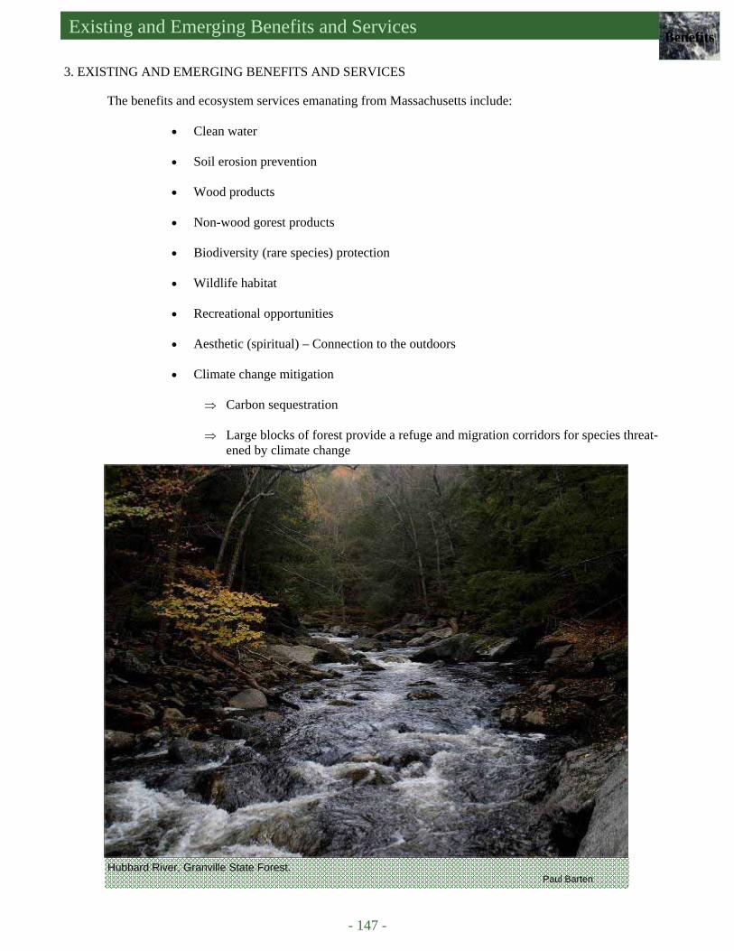
Existing and Emerging Benefits and Services Benefits
- 147 -
3. EXISTING AND EMERGING BENEFITS AND SERVICES The benefits and ecosystem services emanating from Massachusetts include:
• Clean water • Soil erosion prevention • Wood products • Non-wood gorest products • Biodiversity (rare species) protection • Wildlife habitat • Recreational opportunities • Aesthetic (spiritual) – Connection to the outdoors • Climate change mitigation
⇒ Carbon sequestration ⇒ Large blocks of forest provide a refuge and migration corridors for species threat-
ened by climate change
Hubbard River, Granville State Forest. Paul Barten

- 148 -
An Assessment of the Forest Resources of Massachusetts 2010
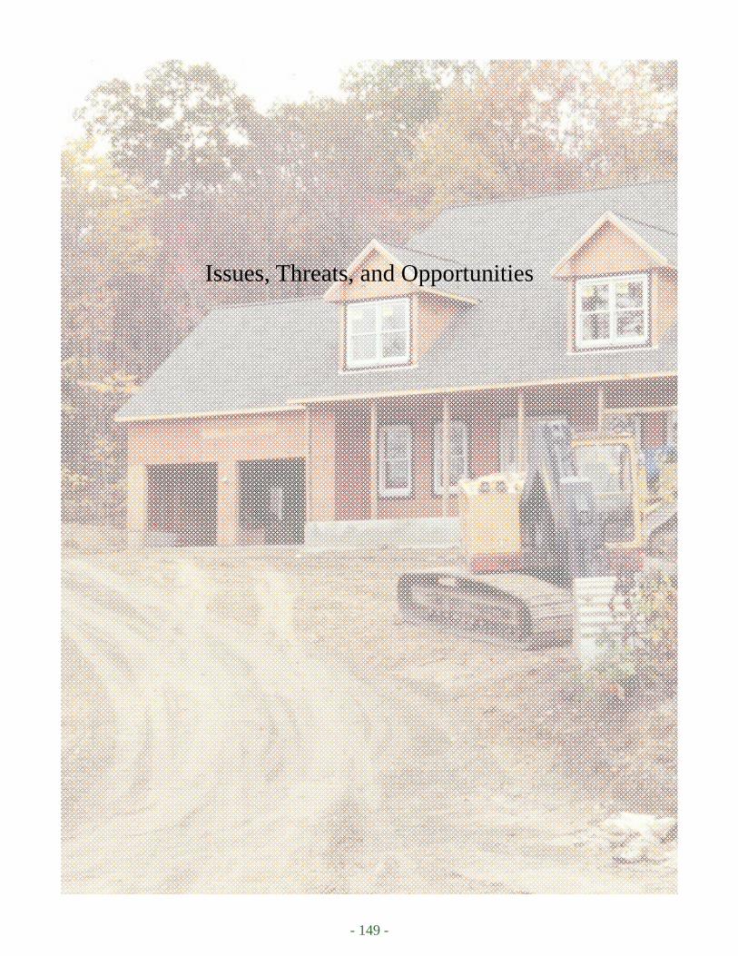
- 149 -
Issues, Threats, and Opportunities
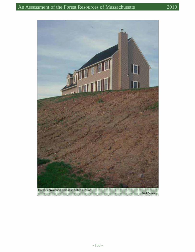
- 150 -
An Assessment of the Forest Resources of Massachusetts 2010
Forest conversion and associated erosion. Paul Barten
Issues, Threats, and Opportunities Issues
- 151 -
4. ISSUES, THREATS, AND OPPORTUNITIES FOREST CONVERSION AND FRAGMENTATION
• Threat: Forest conversion = loss of forest and the benefits the forest provides. • Threat: Forest conversion and forest fragmentation leads to reduction in ecological integrity, and
loss of habitat, especially problematic for rare species. • Opportunity: Many public and private groups are cooperating to facilitate and increase land pro-
tection in Massachusetts and the entire New England region. • Opportunity: Changes in zoning laws (pending in the legislature) should encourage development
that protects forests and wildlife habitat.
During the last 50 years, Massachusetts has lost a considerable amount of its open space—wetland, forest and agricultural land—to development. Development has been concentrated in the outer suburbs and formerly rural areas, north, west, and south of Boston, in the Worcester area (Central Uplands), on Cape Cod and the Is-lands, and in the southern Connecticut River valley near Springfield. Suburban sprawl has degraded and de-stroyed wildlife habitat and unique ecosystems, especially in southeastern Massachusetts and the Cape and Is-lands.
For the most part, development has been driven by economic trends, transportation investments, and zon-ing policy, rather than by population growth. Between 1980 and 1996, the population increased by 6%, while de-veloped land increased by 59%. Over a longer time frame, between 1950 and 1990, the population increased by 28%, developed land increased by 200% (Massachusetts Audubon, 1999). High-priced housing and land in Bos-ton and the inner suburbs has generated a demand for residential development at increasing distances from the city center. The development of outlying areas has been facilitated by the construction of commuter rail lines. There are now eight long distance commuter lines, some of which reach communities 50 miles or more from Boston. The use of public transportation is good for many reasons, not the least of which is the reduction in use of fossil fuels compared to automobile use. However, many of these outlying communities have zoning restrictions that require 1 to 2 acre house lots. Special permits must be granted for the development of cluster subdivisions and compact village centers. This inadvertently encourages sprawl, forest fragmentation, and environmental degrada-tion. At the same time, there has been a decline in average household size from 3.1 people per household in 1970 to 2.5 people per household in 2000 coupled with a substantial increase in the average size of new homes. Aver-age living space increased from 1,572 to 2,260 square feet between 1970 and 2001. Bigger houses built on larger lots for fewer people drives up resource consumption per person (Massachusetts Audubon, 2003).
Efforts to protect forest and agricultural land have increased as well. At the time of the first Losing Ground report (Massachusetts Audubon, 1991), 558,000 acres of land were permanently protected. By 2010, this had increased to 1.2 million acres, including 943,000 acres of forest (MassGIS, 2010, Introduction). Developed land in 2005 totaled approximately 1.3 million acres (MassGIS, 2009). Between 1999 and 2005, conservation agencies and organizations protected twice the amount of land that was developed (Massachusetts Audubon, 2009) (Criteria 6 and 7). In 1999, Massachusetts was losing 44 acres of open space per day to development. By 2005, this had decreased to 22 acres per day (Massachusetts Audubon 1999; 2009). These are all promising signs. There are, nevertheless, continuing concerns about the loss of priority wildlife areas. For example, more than half of the BioMap core habitat and 84% of aquatic rare species habitat remains unprotected (Criterion 1).
Zoning reform is one of the most important means of stopping suburban sprawl and associated environ-mental damage. The Community Preservation Act has helped local communities to protect open space. The
- 152 -
An Assessment of the Forest Resources of Massachusetts 2010
Comprehensive Land Use Reform and Partnership Act (CLURPA) recently reported out of the Massachusetts Legislature Joint Committee on Municipalities and Regional Government (Criterion 7), would give communities the right to regulate to regulate residential floor area while facilitating clustered development and the protection of open space. This is a vitally important step towards the conservation of the vital open space for current and future generations.
LOCAL WOOD PRODUCTION AND CONSUMPTION
Threat: Local wood production (the number and total output of sawmills) has declined precipi-
tously in the last 20 years. At the same time, annual harvest volumes have remained rela-tively constant; an increasing proportion of increasingly higher-value Massachusetts wood is being exported (primarily to northern New England and Canada).
Opportunity: Emulating buy-local agriculture by developing value-added production and market-
ing of local wood. No other component of forest management leads to as much controversy as timber harvesting. It always has and always will make many people uncomfortable, agitated, or extremely angry. Everyone knows that our trees are good and that cutting our trees is bad; especially if our demand for forest products can be efficiently met by a global market and transportation system wherein less enlightened people will sell their trees for pulp, paper, lumber, flooring, plywood, particle board, siding, utility poles, furniture, sailboat cabins, musical instruments, et cetera. This cognitive dissonance is ironic and unfortunate for a wide range of inter-related reasons.
First, local production of wood products provides landowners—especially those with larger parcels in rural areas—with an essential way to generate income, pay taxes, meet expenses, and “just say no” to develop-ment and forest conversion proposals. In other words, the cumulative financial effect of an imbalance between expenses and income can, over time, force all but the wealthiest landowners toward the subdivi-sion and sale of their land …and the consequent loss of ecosystem services to local communities and the Commonwealth.
Second, every board foot of wood that is grown, processed, and sold in Massachusetts is a positive contribu-
tion to righting the lopsided proportion of consumption (~98% from outside the state) described by Berlik and others (2002) in their aptly titled “Illusion of Preservation” paper and in many other well-documented regional, national, and international studies. Just the obvious differences in the carbon foot-print of a truckload of lumber from Quebec, Ontario, or the southeastern US versus a truckload of lumber used to build or remodel a home in Massachusetts that traveled a total of 30 or 40 miles from forest to mill to construction site should inspire more environmentally responsible purchasing decisions by Massachu-setts consumers. At present, logs are sold on the export market by local harvesters and mills, sometimes in desperation, when the only other alternative is to saw them into lumber locally at a loss. Development of local markets and effective outreach to consumers could help to correct this imbalance.
Third, active forest management is an essential tool for wildlife habitat management and restoration as well as
efforts to increase the species and structural diversity, resistance, and resilience of even-aged forests that are the legacy of 19th and 20th century farm abandonment. It should go without saying, but in order to cut a tree you must be able to sell a tree (or use the wood in ways that obviates the need for other purchases such as heating oil) unless the landowner is willing and able to underwrite or heavily subsidize the cost of timber harvesting.

Issues, Threats, and Opportunities Issues
- 153 -
Fourth, carefully planned and implemented timber harvesting can improve access and greatly enhance the opportunities for other forest uses (e.g., a forwarder road can become a hiking, mountain biking, bird-watching, and cross-country ski trail). This list of positive effects, values, and benefits of sensible and professional timber harvesting could include many more items.
Actuating sustainable forest management in a market-based economy requires someone to grow mer-chantable trees, someone to purchase timber, someone to manufacture forest products, someone to transport both raw materials and finished products, and someone to buy those products at a viable price. Consumer preferences and purchasing decisions travel back through the supply chain …all the way to the forest and the landowner. If the supply chain is broken or weak at any point (e.g., limited local sawmill capacity) the opportunity to connect local consumers with local producers is functionally non-existent or limited to the extent that it is woefully un-competitive. This supply chain is the conceptual model for the green certification process. While the Massachu-setts DCR has been active in green certification on both public and private lands there is more work to be done in certifying private foresters, harvesters, and sawmills (chain-of-custody). Certification, and the development of programs assuring consumers of the locally grown provenance of forest products―such as the Commonwealth Quality program―should help to inform and favorably influence consumer preferences. It is important and urgent for Massachusetts forest landowners, wood producers, builders, and artisans to build on the above programs and emulate the recent success of buy local agriculture in our region. However, it should be noted that 10 or 20 years of perseverance, innovation, experimentation, adaption, and education were needed for local farmers to make the transition from a commodity-based wholesale market to a quality-based retail market. Unlike farmers, forest landowners, loggers, and sawmill operators will not have the option of selling 2 x 4’s out of the back of a pickup truck on the town green every Saturday morning. So, while many of the principles and some of the practices that have helped local agriculture to compete and succeed are transferable to the forest sector, others will need to be quickly learned and effectively fostered by strategic public-sector investments. These could include (1) the purchase of conservation easements, (2) forest viability grants with terms that are at-tractive to landowners and wood producers, (3) assistance with business and marketing plans, (4) development and promotion of locally-grown and sustainability standards for lumber and firewood, and (5) K-12 and adult edu-cation and outreach programs (e.g., www.masswoods.org) that realisti-cally explain the challenges, oppor-tunities, costs, and benefits inherent to forest conservation. The development of success-ful and adaptable buy local agricul-ture programs was fostered by the obvious connections between the food you purchase and consume and your health and well being. The daily scenic vistas of the farm just down the road and the weekly inter-actions with friends and neighbors are also substantial and valued com-ponents of the “buy local” choice. For the woodlot on a back road, 20 miles from town, these connections are less obvious, less frequent, and (with the exception of a piece of fur- Forest harvesting in western Massachusetts.
William VanDoren
- 154 -
An Assessment of the Forest Resources of Massachusetts 2010
niture in daily use) arguably less satisfying for the “buy local forest products” analog. At the same time, the net ecological and socioeconomic benefit of forest conservation is at least as important on a per acre basis as farmland preservation. As noted throughout this assessment, time is the critical element. The open question is …will the con-sumers of forest products in Massachusetts redirect their purchasing decisions in a way that enhances the eco-nomic prospects of forest landowners, wood producers, builders, and artisans over the long run? The related ques-tion is, of course, will this shift in consumer values, attitudes, and behavior happen soon enough to arrest the slide in local productive capacity? And to that end, will producers and consumers find each other in time? If not, the capacity will need to be re-built and the skills re-learned by the later generations if local markets are to become a reality. If we continue on the current path, in the market-based economy of 2030, a larger number of consumers will have substantially less forest land to work with because development and forest conversion will, 10 or 20 years earlier, have superseded conservation …and the trees and the local options will be long gone. EXOTIC INVASIVE PESTS AND PLANTS
• Threat: past and current invasions of exotic invasive insect pests and fungal diseases threaten a variety of forest tree species. Invasive exotic plant species threaten the diversity of the native plant community.
• Opportunity: Cooperation with other states and volunteer groups to identify exotic, invasives
can help to limit the spread of these species. Conserving large forest blocks, public and profes-sional education, and training can help to maintain forest health.
Exotic insect pests and fungal diseases have threatened Massachusetts forests since the 19th century, caus-
ing extensive damage in many instances. The gypsy moth, accidentally introduced in 1869, continues to cause periodic defoliation. During the 20th Century, chestnut blight eliminated the American chestnut as an overstory species; Dutch elm disease killed street trees in towns throughout New England; beech bark disease infected and killed large numbers of mature beech trees in northern hardwood forests in western Massachusetts. These patho-gens continue to infest sprouts and new seedlings today, while more recently introduced pests present new dan-gers. The Hemlock woolly adelgid (HWA), first found in Massachusetts in 1989, is killing hemlock trees in many areas of the state. Efforts to eradicate the Asian Longhorned beetle (ALB), first discovered in Worcester, MA in 2008, have cost many millions of dollars and necessitated the cutting and chipping of more than 30,000 trees (Criterion 3).
Exotic invasive plants, while pervasive, typically take longer than insect pests to degrade forest health. They do, however, threaten biodiversity by out-competing native plants, causing declines in native plant popula-tions, and, as a consequence, altering established ecosystems and the habitat they now provide.
Global trade has accelerated the introduction of pest species from around the world. At the same time, modern technology enhances the ability of public agencies to monitor pest populations and manage threats across political boundaries. Thus it is increasingly possible to plan ahead for pests that pose a potential threat. The Inter-net makes it possible to quickly warn large numbers of people against actions that may help to spread pests and disease, such as transporting firewood from infected areas. Community volunteers are a large part of efforts to monitor insect pests and invasive plants. Volunteers have been active in documenting the spread of HWA, in identifying trees infested by ALB, and in locating and removing invasive plants. Volunteers also serve to increase public awareness of forest health problems.
State agencies, conservation organizations and land trusts are currently working to conserve forests, espe-cially large forest blocks. In some cases this is accomplished by aggregating several individual parcels into one block. Conserving large intact blocks of forest, in some cases reversing forest fragmentation, may help to slow
Issues, Threats, and Opportunities Issues
- 155 -
the spread of invasive plants that often become established in disturbed areas. Through its licensing program, Massachusetts has the opportunity to educate foresters and harvesters regarding management practices that can sustain forest health.
CLIMATE CHANGE
• Threat: A warming climate threatens the survival of cold-adapted ecosystems and species and may increase the winter survival and range of insect pests.
• Opportunity: Protection of large blocks of forestland and sustainable management of working
forests can increase carbon sequestration. • Opportunity: Identification of vulnerable ecosystems and species, management planning, and
the protection of large blocks of forest and connecting migration corridors may help to mitigate the loss of habitat and species diversity.
• Opportunity: Biomass energy production may create a market for low value wood.
The New England Governors Blue Ribbon Commission Report (NEG, 2009) anticipates that climate
change will have wide ranging impacts on the natural ecosystems and human society: Changes in precipitation, temperature, storm patterns, and sea level will impact habitats and plant communities and cause dislocation of native wildlife, open the way for new invasive species, and compel human communities to adapt in ways that may create additional impacts on natural resources and natural communities as well as the primary industries of agriculture, fishing, and forestry.
In order to address these issues, societies must: (1) lower the emission of greenhouse gases by reducing
outputs from existing energy sources, increasing reliance on alternative energy sources, and increasing carbon storage and (2) develop management plans that conserve and protect ecosystems and biodiversity as changes re-sulting from global climate change occur. The New England Governor’s Report recommends the development of climate change policies that recognize the important role of New England’s forests as carbon sinks and storage sites, and promote forest research and management planning to maintain healthy forest ecosystems under altered climate conditions. A draft of a recent Massachusetts report, Climate Change Adaptation: Strategies for Massa-chusetts (EEA, 2010a) points out that climate change must be considered in the context of current stressors. A key concern is how changes in temperature and disturbance regimes brought about by climate change alter the frequency and severity of wildfires and the extent of exotic pest infestations.
Steps to Reduce Greenhouse Gas Emissions
Massachusetts has already taken several steps to reduce greenhouse gas emissions. The Massachusetts
Global Warming Solutions Act (GWSA) of 2008 (Criterion 7) requires that greenhouse gas emissions be reduced by 80 percent from 1990 levels by 2050 with a reduction of between 20 and 25 percent by 2020. Prior to the pas-sage of this act, in 2007, Massachusetts became part of the Regional Greenhouse Gas Initiative (RGGI). This is an agreement among ten northeastern states (Connecticut, Delaware, Maine, Maryland, Massachusetts, New Hampshire, New Jersey, New York, Rhode Island, and Vermont) to reduce carbon dioxide emissions from power plants using a regional cap and trade program. The Massachusetts Department of Environmental Protection

- 156 -
An Assessment of the Forest Resources of Massachusetts 2010
(DEP) has developed the Massachusetts CO2 Budget Trading Program as part of the RGGI program (RGGI, 2010). This program allows electric utilities to use afforestation offset projects to qualify for the award of carbon dioxide (CO2) offset allowances. This project involves growing forests on open land with a conservation restric-tion intended to preserve that forest (DEP, 2009). In a separate project, the Working Forest Initiative Program (Criterion 6) provides funds to owners of forested land for the cost of preparing a carbon inventory and for the overhead costs of marketing, verifying, and trading carbon credits under the Massachusetts Pilot Carbon Offset and Trading Program (Carbontree, 2009; DCR, 2009). Carbontree, LLC., (New York Forestry Resource Center, Rensselaer, NY) is recruiting eligible forests to pool into an offset project that can be sold on the Chicago Climate Exchange. Landowners receive proceeds from these sales; effectively paying them for the carbon sequestered in their trees each year and rewarding them for long-term sustainable management of their forestland.
Planning for an Altered Climate
Research studies that examine the climate history of the New England region can help us to anticipate
changes that may occur. The melting of the glaciers, between 14,000 and 10,000 years ago exposed a treeless tun-dra landscape in New England. Trees migrated from the south and most of the tree species, common in the forest today were in Massachusetts by 8,000 years ago. Between 9,000 and 5,000 years ago temperatures were as much as 2°C warmer. It was also drier, leading to frequent fires. White pine was widespread and abundant, because fire created conditions favorable for seedling establishment. Dry conditions and fire also favored the establishment and growth of oak species. White pine and hemlock were present at elevations as much as 1,000 to 1,300 ft. higher than their present upper limit in the White Mountains of New Hampshire and the Adirondack Mountains of New York. As the climate became cooler and moister, white pine and oak became less abundant, while boreal species (such as red spruce and balsam fir) expanded their range to the south (Jacobson, 2009).
At the present time, Massachusetts marks the southern boundary of the contiguous northern hardwood/red spruce forest. (Red spruce is found along mountain ridges farther to the south, but only in patches at the higher elevations.) The Mount Greylock summit is the only site of the true boreal spruce-fir forest in Massachusetts. The northern hardwood/red spruce forest type is common in northern areas of the Berkshire Uplands above 1,800 ft. elevation. Between 1,000 and 1,800 ft the northern hardwoods hemlock/white pine is the predominant forest type (de la Crétaz and Kelty, 2008). Transition hardwoods (red oak, black birch, red maple) are found at lower elevations in western and central Massachusetts with central hardwoods nearer to the Connecticut border (Introduction, Figure I.4). We can expect that the spruce-fir forest will decline if, as expected, temperatures con-tinue to follow a warming trend and that oak and pine forests, will expand their range to the north and become established at higher elevations. At finer scales, many smaller scale habitats and individual species will be af-fected in unpredictable ways. While common species populations may change in relative abundance, rare species may be lost. Some climate related changes are already apparent. With a modest average global temperature in-crease of only 1.3°F, plants are leafing out earlier, amphibian breeding seasons begin earlier, Atlantic salmon mi-grations begin earlier; “the additional 3 to 12 degrees predicted for the Northeast are likely to have major impacts on ecosystems. It is predicted that these changes may cause a decoupling of bird migration and food source tim-ing and also provide a competitive advantage to non-native insects and plants (EEA, 2010a). If we hope to pre-serve the region’s biodiversity, we must maintain a forest landscape that provides a diversity of habitats and al-lows plants and animals to migrate and adapt to changing climate conditions (NEG, 2009).
Scientists and conservation organizations involved in researching and planning for climate change agree that this will involve protecting large, intact blocks of forestland and other critical habitat and connecting these blocks with migration corridors. At the same time, it is important to limit stress from other sources including, de-velopment, pests, diseases, exotic invasive plants, and pollution (EEA, 2010a; Aber et al., 2010). Land protection is an important priority for a wide array of state and private organizations in Massachusetts and New England at the present time. Building large blocks of protected land is a priority in many land protection efforts. The Tully
Issues, Threats, and Opportunities Issues
- 157 -
Valley private forest lands initiative spearheaded by the Mount Grace Land Trust in cooperation with state agen-cies (Criterion 7, Box C7.1) and the larger North Quabbin BioReserve are examples of forest aggregation –“the bundling of many land protection projects into landscape-wide or regional efforts (Aber et al., 2010).” Other strategies include monitoring, research, and flexible and adaptive management to meet changing needs.
In 2010, the Massachusetts Division of Fisheries and Wildlife (DFW) in cooperation with Manomet Cen-ter for Conservation Sciences completed an analysis, based on the Statewide Wildlife Action Plan (Criterion 1, Box C1.1), that assessed habitat and species vulnerability under two climate change scenarios: one in which there is twice the current level of atmospheric CO2 by the end of the century and one in which the CO2 is tripled. Among forested habitats, spruce-fir forests and smaller cold water lakes and ponds were ranked as critically vul-nerable. Vulnerable habitats that are forested or surrounded by forests included northern hardwood forests, cold water rivers and streams, large cold water lakes, and coldwater kettle ponds. The Connecticut River and Merri-mack River floodplains and riparian areas were also ranked as vulnerable. Pitch pine-scrub oak forests and ripar-ian forests were less vulnerable, while southern/central hardwood forests were expected to benefit from a warming scenario and expand their range. A variety of vertebrate species associated with these cold dependent habitats were identified as “species in greatest need of conservation” in a warmer climate. These include moose, bobcat, sharp-shinned hawks, blackpoll warblers, and blue-spotted salamanders among others (DFW, 2010).
Biomass Energy The use of biomass fuels for heating and electric power generation also provides a market for low value wood, poor quality trees, and logging residues. Biomass technology has qualified for financial incentives under the Massachusetts Renewable Portfolio Standard (RPS) since the RPS was created in 2002. Following the 2008 passage of the Massachusetts Global Warming Solutions Act (GWSA) the Massachusetts Department of Energy Resources (DOER) commissioned a study by the Manomet Center for Conservation Science on the greenhouse gas implications and forest sustainability impacts of biomass incentives. The scope of work also included a re-view of earlier studies done in Massachusetts (e.g., Kelty et al., 2008). DOER suspended the qualification of new biomass facilities for incentives until the Manomet study was completed; it was released on June 10, 2010 (www.mass.gov/doer). In brief, the conclusions state that burning forest biomass emits more greenhouse gases per unit of energy produced than fossil fuels. The regrowth of the forest compensates for this difference over time. Comparing biomass with other fuels used to generate electricity, the study found that biomass produced 25 percent less greenhouse gases than oil, but 3 percent more than coal, over the 40 year planning and implementa-tion period (through 2050) specified in the Massachusetts GWSA. In other words, there is not sufficient forest regrowth (biomass accumulation) in 40 years to produce a favorable carbon balance. Using current market prices and renewable energy incentives, the Manomet study estimates that biomass energy could increase forest harvest-ing by 150,000 to 250,000 green tons per year. This is not enough to support one 50 MegaWatt biomass electric plant but could sustain 16 small-scale cogeneration/heating plants (EEA, 2010b).
DOER plans to hold a series of public meetings in July to review the Manomet report and discuss the im-plications for Massachusetts energy policy. Stakeholder input will be an important part of open policy making sessions to be held in July and August, following the public meetings. Following this, DOER will engage in for-mal rulemaking to revise the RPS regulations to include standards that address biomass supply and greenhouse gas issues.

- 158 -
An Assessment of the Forest Resources of Massachusetts 2010
References Aber, J.D., C.V. Cogbill, E. A. Colburn, A.W. D’Amato, B.M. Donahue, C.T. Driscoll, A.M. Ellison, T. J. Fahey, D.R. Fos-
ter, B.R. Hall, C.M. Hart, M.L. Hunter, L.C. Irland, W.S. Keeton, D.B. Kittredge, K.F. Lambert, J.N. Levitt, R.J. Lilieholm, E. L. Giddings, D.A. Orwig, J.R. Thompson. 2010. Wildlands and Woodlands: A Vision for the New Eng-land Landscape. Harvard Forest, Harvard University, Petersham, MA., 36 pp.
Berlik, M.M., D.B. Kittredge, and D.R. Foster. 2002. The illusion of preservation: a global argument for the local production of natural resources. Harvard Forest Paper no. 26. Harvard Forest, Harvard University, Petersham, MA, 23 pp.
Carbontree. 2009. Massachusetts Pilot Carbon Project. Carbon Tree, New York Forestry Resource Center, Rensselaer, NY., 2 pp.
DCR (Massachusetts Department of Conservation and Recreation). 2009. Working Forest Initiative. DEP (Massachusetts Department of Environmental Protection). 2009. Massachusetts CO2 budget trading program. Offset
project consistency application, instruction packet, Afforestation, version 1.0, Regional Greenhouse Gas Initiative, CO2 budget trading program, 19 pp.
de la Crétaz, A.L. and M.J. Kelty. 2008. Land Type Associations of Western Massachusetts. Unpublished Report. USDA Forest Service, Northeastern Area State and Private Forestry, Durham, NH., 108 pp.
DFW (Massachusetts Department of Fish and Game – Division of Fisheries and Wildlife) and the Manomet Center for Con-servation Sciences. 2010. Climate Change and Massachusetts Fish and Wildlife Habitat and Species Vulnerability. A report to the Commonwealth of Massachusetts, 59 pp.
EEA (Massachusetts Executive Office of Energy and Environmental Affairs). 2010a. Climate Change Adaptation: Strategies for Massachusetts, Natural Resources and Habitat (Draft Report), 18 pp.
EEA (Massachusetts Executive Office of Energy and Environmental Affairs). 2010b. Patrick-Murray administration releases biomass sustainability study. Press Release June 10, 2010.
Jacobson, G.L. 2009. Past and future forest responses to climate change in New England: the urgency of maintaining healthy forested landscapes. A white paper prepared for the New England Governors Conference Commission on Land Conservation. (Report of the Blue Ribbon Commission on Land Conservation, Appendix C), 2 pp.
Kelty, M.J., A.W. D’Amato, and P.K. Barten. 2008. Silvicultural and Ecological Considerations of Forest Biomass Harvest-ing in Massachusetts. Prepared for the Massachusetts Division of Energy Resources & Massachusetts Department of Conservation and Recreation, 65 pp.
Massachusetts Audubon Society. 1991. Losing Ground: the case for Land Conservation in Massachusetts. Massachusetts Audubon Society (J.Steel). 1999. Losing Ground: An analysis of recent rates and patterns of development and
their effects on open space in Massachusetts (second edition). Massachusetts Audubon Society (K. Breunig). 2003. Losing Ground : At what cost? Changes in land use and their impact on
habitat, biodiversity, and ecosystem services in Massachusetts (third edition). Massachusetts Audubon Society (J. DeNormandie). 2009. Losing Ground – Beyond the Footprint: Patterns of development
and their impact on the nature of Massachusetts (fourth edition). MassGIS (Office of Geographic and Environmental Information, Commonwealth of Massachusetts, Executive Office of En-
ergy and Environmental Affairs). 2009. Land Use 2005. Available at http://www.mass.gov/mgis/. Accessed in Janu-ary 2010.
MassGIS (Office of Geographic and Environmental Information, Commonwealth of Massachusetts, Executive Office of En-ergy and Environmental Affairs). 2010. Open Space. Available at http://www.mass.gov/mgis/. Accessed in June 2010.
NEG (New England Governors Conference). 2009. Report of the Blue Ribbon Commission on Land Conservation, 46 pp. RGGI (Regional Greenhouse Gas Initiative). 2010. An initiative of the Northeast and Mid-Atlantic States of the US Available
at http://www.rggi.org/home. Accessed in June 2010).
- 159 -
Priority Landscape Areas

- 160 -
An Assessment of the Forest Resources of Massachusetts 2010
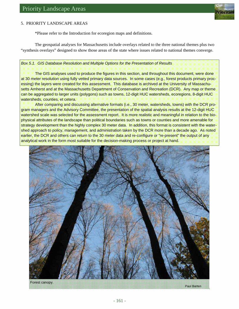
Priority Landscape Areas Priorities
- 161 -
5. PRIORITY LANDSCAPE AREAS
*Please refer to the Introduction for ecoregion maps and definitions. The geospatial analyses for Massachusetts include overlays related to the three national themes plus two
“synthesis overlays” designed to show those areas of the state where issues related to national themes converge.
Box 5.1. GIS Database Resolution and Multiple Options for the Presentation of Results The GIS analyses used to produce the figures in this section, and throughout this document, were done
at 30 meter resolution using fully vetted primary data sources. In some cases (e.g., forest products primary proc-essing) the layers were created for this assessment. This database is archived at the University of Massachu-setts Amherst and at the Massachusetts Department of Conservation and Recreation (DCR). Any map or theme can be aggregated to larger units (polygons) such as towns, 12-digit HUC watersheds, ecoregions, 8-digit HUC watersheds, counties, et cetera.
After comparing and discussing alternative formats (i.e., 30 meter, watersheds, towns) with the DCR pro-gram managers and the Advisory Committee, the presentation of the spatial analysis results at the 12-digit HUC watershed scale was selected for the assessment report. It is more realistic and meaningful in relation to the bio-physical attributes of the landscape than political boundaries such as towns or counties and more amenable for strategy development than the highly complex 30 meter data. In addition, this format is consistent with the water-shed approach to policy, management, and administration taken by the DCR more than a decade ago. As noted earlier, the DCR and others can return to the 30 meter data and re-configure or “re-present” the output of any analytical work in the form most suitable for the decision-making process or project at hand.
Forest canopy. Paul Barten
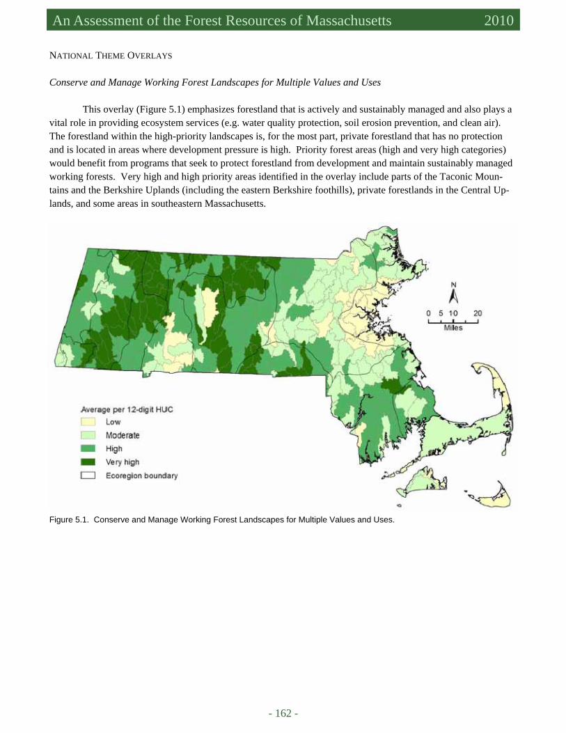
- 162 -
An Assessment of the Forest Resources of Massachusetts 2010
NATIONAL THEME OVERLAYS
Conserve and Manage Working Forest Landscapes for Multiple Values and Uses This overlay (Figure 5.1) emphasizes forestland that is actively and sustainably managed and also plays a
vital role in providing ecosystem services (e.g. water quality protection, soil erosion prevention, and clean air). The forestland within the high-priority landscapes is, for the most part, private forestland that has no protection and is located in areas where development pressure is high. Priority forest areas (high and very high categories) would benefit from programs that seek to protect forestland from development and maintain sustainably managed working forests. Very high and high priority areas identified in the overlay include parts of the Taconic Moun-tains and the Berkshire Uplands (including the eastern Berkshire foothills), private forestlands in the Central Up-lands, and some areas in southeastern Massachusetts.
Figure 5.1. Conserve and Manage Working Forest Landscapes for Multiple Values and Uses.
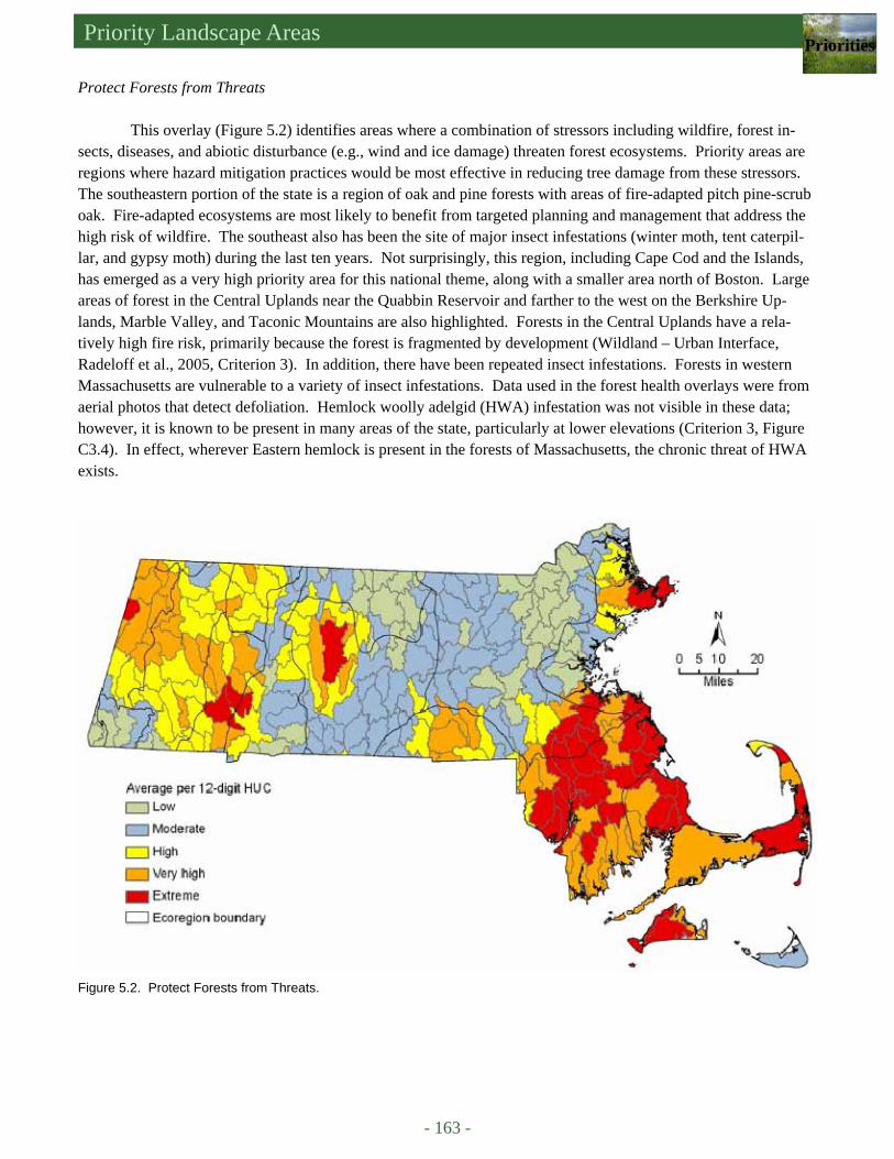
Priority Landscape Areas Priorities
- 163 -
Protect Forests from Threats This overlay (Figure 5.2) identifies areas where a combination of stressors including wildfire, forest in-
sects, diseases, and abiotic disturbance (e.g., wind and ice damage) threaten forest ecosystems. Priority areas are regions where hazard mitigation practices would be most effective in reducing tree damage from these stressors. The southeastern portion of the state is a region of oak and pine forests with areas of fire-adapted pitch pine-scrub oak. Fire-adapted ecosystems are most likely to benefit from targeted planning and management that address the high risk of wildfire. The southeast also has been the site of major insect infestations (winter moth, tent caterpil-lar, and gypsy moth) during the last ten years. Not surprisingly, this region, including Cape Cod and the Islands, has emerged as a very high priority area for this national theme, along with a smaller area north of Boston. Large areas of forest in the Central Uplands near the Quabbin Reservoir and farther to the west on the Berkshire Up-lands, Marble Valley, and Taconic Mountains are also highlighted. Forests in the Central Uplands have a rela-tively high fire risk, primarily because the forest is fragmented by development (Wildland – Urban Interface, Radeloff et al., 2005, Criterion 3). In addition, there have been repeated insect infestations. Forests in western Massachusetts are vulnerable to a variety of insect infestations. Data used in the forest health overlays were from aerial photos that detect defoliation. Hemlock woolly adelgid (HWA) infestation was not visible in these data; however, it is known to be present in many areas of the state, particularly at lower elevations (Criterion 3, Figure C3.4). In effect, wherever Eastern hemlock is present in the forests of Massachusetts, the chronic threat of HWA exists.
Figure 5.2. Protect Forests from Threats.
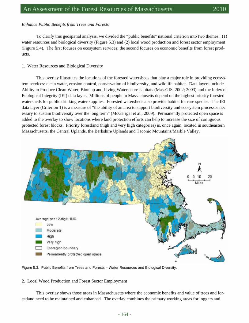
- 164 -
An Assessment of the Forest Resources of Massachusetts 2010
Enhance Public Benefits from Trees and Forests To clarify this geospatial analysis, we divided the “public benefits” national criterion into two themes: (1)
water resources and biological diversity (Figure 5.3) and (2) local wood production and forest sector employment (Figure 5.4). The first focuses on ecosystem services; the second focuses on economic benefits from forest prod-ucts.
1. Water Resources and Biological Diversity
This overlay illustrates the locations of the forested watersheds that play a major role in providing ecosys-
tem services: clean water, erosion control, conservation of biodiversity, and wildlife habitat. Data layers include Ability to Produce Clean Water, Biomap and Living Waters core habitats (MassGIS, 2002; 2003) and the Index of Ecological Integrity (IEI) data layer. Millions of people in Massachusetts depend on the highest priority forested watersheds for public drinking water supplies. Forested watersheds also provide habitat for rare species. The IEI data layer (Criterion 1) is a measure of “the ability of an area to support biodiversity and ecosystem processes nec-essary to sustain biodiversity over the long term” (McGarigal et al., 2009). Permanently protected open space is added to the overlay to show locations where land protection efforts can help to increase the size of contiguous protected forest blocks. Priority forestland (high and very high categories) is, once again, located in southeastern Massachusetts, the Central Uplands, the Berkshire Uplands and Taconic Mountains/Marble Valley.
Figure 5.3. Public Benefits from Trees and Forests – Water Resources and Biological Diversity.
2. Local Wood Production and Forest Sector Employment This overlay shows those areas in Massachusetts where the economic benefits and value of trees and for-
estland need to be maintained and enhanced. The overlay combines the primary working areas for loggers and
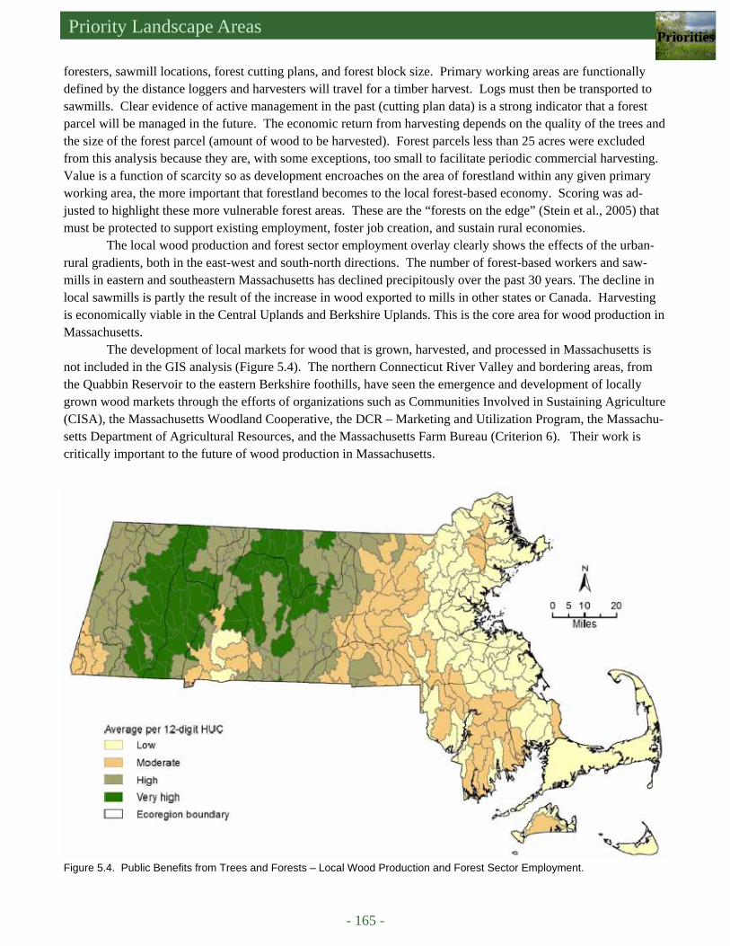
Priority Landscape Areas Priorities
- 165 -
foresters, sawmill locations, forest cutting plans, and forest block size. Primary working areas are functionally defined by the distance loggers and harvesters will travel for a timber harvest. Logs must then be transported to sawmills. Clear evidence of active management in the past (cutting plan data) is a strong indicator that a forest parcel will be managed in the future. The economic return from harvesting depends on the quality of the trees and the size of the forest parcel (amount of wood to be harvested). Forest parcels less than 25 acres were excluded from this analysis because they are, with some exceptions, too small to facilitate periodic commercial harvesting. Value is a function of scarcity so as development encroaches on the area of forestland within any given primary working area, the more important that forestland becomes to the local forest-based economy. Scoring was ad-justed to highlight these more vulnerable forest areas. These are the “forests on the edge” (Stein et al., 2005) that must be protected to support existing employment, foster job creation, and sustain rural economies.
The local wood production and forest sector employment overlay clearly shows the effects of the urban-rural gradients, both in the east-west and south-north directions. The number of forest-based workers and saw-mills in eastern and southeastern Massachusetts has declined precipitously over the past 30 years. The decline in local sawmills is partly the result of the increase in wood exported to mills in other states or Canada. Harvesting is economically viable in the Central Uplands and Berkshire Uplands. This is the core area for wood production in Massachusetts.
The development of local markets for wood that is grown, harvested, and processed in Massachusetts is not included in the GIS analysis (Figure 5.4). The northern Connecticut River Valley and bordering areas, from the Quabbin Reservoir to the eastern Berkshire foothills, have seen the emergence and development of locally grown wood markets through the efforts of organizations such as Communities Involved in Sustaining Agriculture (CISA), the Massachusetts Woodland Cooperative, the DCR – Marketing and Utilization Program, the Massachu-setts Department of Agricultural Resources, and the Massachusetts Farm Bureau (Criterion 6). Their work is critically important to the future of wood production in Massachusetts.
Figure 5.4. Public Benefits from Trees and Forests – Local Wood Production and Forest Sector Employment.
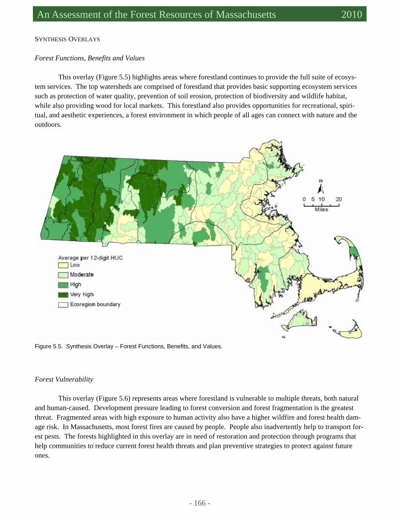
- 166 -
An Assessment of the Forest Resources of Massachusetts 2010
SYNTHESIS OVERLAYS
Forest Functions, Benefits and Values This overlay (Figure 5.5) highlights areas where forestland continues to provide the full suite of ecosys-
tem services. The top watersheds are comprised of forestland that provides basic supporting ecosystem services such as protection of water quality, prevention of soil erosion, protection of biodiversity and wildlife habitat, while also providing wood for local markets. This forestland also provides opportunities for recreational, spiri-tual, and aesthetic experiences, a forest environment in which people of all ages can connect with nature and the outdoors.
Figure 5.5. Synthesis Overlay – Forest Functions, Benefits, and Values.
Forest Vulnerability This overlay (Figure 5.6) represents areas where forestland is vulnerable to multiple threats, both natural
and human-caused. Development pressure leading to forest conversion and forest fragmentation is the greatest threat. Fragmented areas with high exposure to human activity also have a higher wildfire and forest health dam-age risk. In Massachusetts, most forest fires are caused by people. People also inadvertently help to transport for-est pests. The forests highlighted in this overlay are in need of restoration and protection through programs that help communities to reduce current forest health threats and plan preventive strategies to protect against future ones.
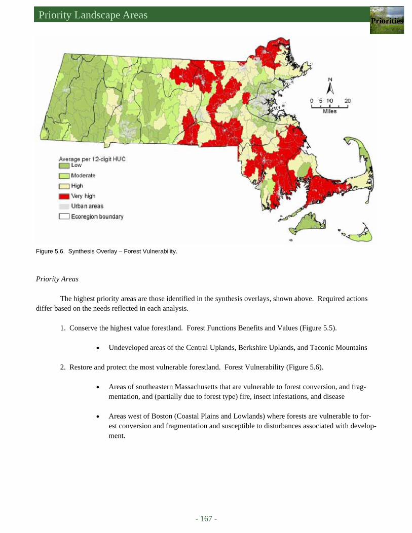
Priority Landscape Areas Priorities
- 167 -
Figure 5.6. Synthesis Overlay – Forest Vulnerability.
Priority Areas The highest priority areas are those identified in the synthesis overlays, shown above. Required actions
differ based on the needs reflected in each analysis. 1. Conserve the highest value forestland. Forest Functions Benefits and Values (Figure 5.5).
• Undeveloped areas of the Central Uplands, Berkshire Uplands, and Taconic Mountains 2. Restore and protect the most vulnerable forestland. Forest Vulnerability (Figure 5.6).
• Areas of southeastern Massachusetts that are vulnerable to forest conversion, and frag-mentation, and (partially due to forest type) fire, insect infestations, and disease
• Areas west of Boston (Coastal Plains and Lowlands) where forests are vulnerable to for-
est conversion and fragmentation and susceptible to disturbances associated with develop-ment.
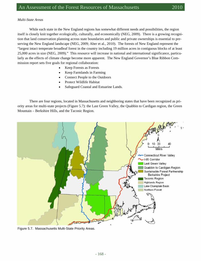
- 168 -
An Assessment of the Forest Resources of Massachusetts 2010
Multi-State Areas While each state in the New England regions has somewhat different needs and possibilities, the region
itself is closely knit together ecologically, culturally, and economically (NEG, 2009). There is a growing recogni-tion that land conservation planning across state boundaries and public and private ownerships is essential to pre-serving the New England landscape (NEG, 2009; Aber et al., 2010). The forests of New England represent the “largest intact temperate broadleaf forest in the country including 19 million acres in contiguous blocks of at least 25,000 acres in size (NEG, 2009).” This resource will increase in national and international significance, particu-larly as the effects of climate change become more apparent. The New England Governor’s Blue Ribbon Com-mission report sets five goals for regional collaboration:
• Keep Forests as Forests • Keep Farmlands in Farming • Connect People to the Outdoors • Protect Wildlife Habitat • Safeguard Coastal and Estuarine Lands.
There are four regions, located in Massachusetts and neighboring states that have been recognized as pri-
ority areas for multi-state projects (Figure 5.7): the Last Green Valley, the Quabbin to Cardigan region, the Green Mountain – Berkshire Hills, and the Taconic Region.
Figure 5.7. Massachusetts Multi-State Priority Areas.

Priority Landscape Areas Priorities
- 169 -
The Last Green Valley: The Quinnebaug and Shetucket River Valleys, located in northeastern Connecticut, south central Massachusetts, and western Rhode Island, have been described as “the last ‘dark-sky’ country in the coastal sprawl on the East Coast.” Known as “The Last Green Valley” (TLGV) the area includes approximately 695,000 acres and remains 78 percent forests and farmland. There are seven state forests, 16 wildlife management areas, and five state parks plus 35 towns with a total population of about 300,000 within the valley. In 1994, the US Congress designated the Quinnebaug and Shetucket River Valleys National Heritage Corridor, recognizing the area as a unique national resource. National Heritage designation does not imply federal government ownership or management. Rather, the National Park Service and other federal agencies work with local and state govern-ments, businesses, cultural, educational, and environmental organizations to “integrate the celebration and conser-vation of the region’s resources with the needs for sustained quality of life and quality of place.” The Last Green Valley Inc. (TLGV) is a non-profit organization that manages projects and funds from the federal legislation. It is the administrative body for the implementation of the management plan. TLGV Inc. works with a variety of part-ners, including the National Park Service, the Alliance of Natural Heritage Areas, the Universities of Connecticut and Massachusetts, local and regional conservation organizations and land trusts, and the 35 communities located within the Valley to conserve forest and agricultural land and promote economic development (including tourism) that supports the preservation of the valley. The Green Valley Institute (GVI), a collaboration among TLGV Inc., the University of Connecticut’s College of Agricultural and Natural Resources, and the University of Massachu-setts Extension Service, and the Connecticut Chapter of The Nature Conservancy (TNC), was founded in 2001 to “improve the knowledge base from which land use and natural resource decisions are made.” GVI works with a wide variety of partners including many local land trusts to educate towns, and private landowners about zoning and land protection opportunities and issues (The Last Green Valley, Inc., 2006; 2008; Green Valley Institute, 2009). Quabbin to Cardigan (Q2C): This area spans 100 miles from the Quabbin Reservoir in central Massachusetts to Mount Cardigan in New Hampshire and encompasses approximately 2 million acres. It is a large area of “intact, interconnected, ecologically significant forest.” The forests are at the edge of densely populated regions in eastern Massachusetts and southeastern New Hampshire and provide many ecosystem services to people in almost 200 cities and towns including the Boston metropolitan areas. Clean water is a priority; portions of the headwater for-est for the Connecticut and Merrimack Rivers and the watershed forest of the Quabbin Reservoir are located in the Q2C area. Q2C forests also are valued for public and private recreational areas, including several long-distance trails, and wildlife habitat. At the same time, the presence of nearby metropolitan areas, roads like Massachusetts Route 2, and the possibility of home-based employment increases development pressure on the forest and the need for planning and preservation. This area also is recognized as a Forest Legacy area (Criterion 6, Figure 6.8).
The Q2C partnership is a group of 27 private organizations and state agencies, established in 2003, work-ing on land conservation in the Q2C region in Massachusetts and New Hampshire. Land conservation is accom-plished through conservation easements/restrictions and land acquisitions (willing sellers) to member agencies. Members include the Society for Protection of New Hampshire Forests, the North Quabbin Regional Landscape Partnership, the Appalachian Mountain Club, Harvard Forest, the Audubon Societies of Massachusetts and New Hampshire, the New England Forestry Foundation, the Nature Conservancy, The Trustees of Reservations, the Mount Grace Land Trust, The Massachusetts Department of Conservation and Recreation (DCR); the Massachu-setts Department of Fish and Game, the New Hampshire Division of Forests and Lands, the New Hampshire Fish and Game Department, and the US Fish and Wildlife Service. The Partnership has developed a conservation plan that identifies 600,000 acres of core conservation focus areas (currently 39% permanently protected) representing the Q2C region’s most ecologically significant forest and 400,000 acres of supporting forest landscape (currently 26% permanently protected) that buffer and link the core forest. Land protection efforts are focused in these areas (NEG, 2010a; Q2C, 2010).
- 170 -
An Assessment of the Forest Resources of Massachusetts 2010
Green Mountain – Berkshire Hills: This area is one of the largest (700,000 acres), most heavily forested, and least fragmented working forests in south central New England; 26 percent of the region is permanently protected from development. Nearly 70,000 acres have been identified as rare species habitat. It includes the entire watershed of the Deerfield River in Massachusetts and the West River in Vermont. These waterways are home to Atlantic salmon and American shad populations. At the northern border, there are private lands that are contiguous to the Green Mountain National Forest. The Massachusetts Executive Office of Energy and Environmental Affairs (EEA) and the Vermont Department of Forests, Parks, and Recreation have been working through the ACORN project of University of Massachusetts Extension (Criterion 7) to reach private landowners in an effort to promote sustainable forest practices and land protection through programs such as Forest Stewardship. This area is also the focus of “Buy Local Wood” marketing strategies (NEG, 2010b).
The Taconic Region: This region is centered on the Taconic Mountains ridgeline that runs along the border of New York and Vermont, Massachusetts, and Connecticut. The Marble/Limestone valley borders the Taconic Mountains to the east. Marble and limestone bedrock deposits are common at various sites higher up in the moun-tains as well. This calcium-rich bedrock has created a variety of unusual habitats, calcareous wetlands, and rich mesic forests that support a high level of biodiversity. Nearly 100,000 acres within the region are mapped as rare species habitat. The state governments of New York and Massachusetts, The Nature Conservancy, and the Forest Legacy Program have all directed conservation efforts towards this area. The 2,000 acre Taconic Trail State For-est and the 8,000 acre Mount Washington Forest Reserve are located within the Taconic Region in Massachusetts. The 5,000 acre Taconic State Park in New York, abuts the Mount Washington Forest Reserve to the west. There are now 30 partner organizations working to protect land in the Taconic region, including the Berkshire Natural Resources Council (Criterion 7, Box 7.1) the National Park Service, and a variety of land trusts. Part of the con-servation strategy is to protect lands that connect the Taconic range to the Berkshire Uplands to the East and to the Adirondack Mountains in New York to the west (NEG, 2010c). The Taconic Ridge is also a Forest Legacy area in Massachusetts (Criterion 6, Figure 6.8).
Priority Landscape Areas Priorities
- 171 -
References
Aber, J.D., C.V. Cogbill, E.A. Colburn, A.W. D’Amato, B.M. Donahue, C.T. Driscoll, A.M. Ellison, T.J. Fahey, D.R. Foster, B.R. Hall, C.M. Hart, M.L. Hunter, L.C. Irland, W.S. Keeton, D.B. Kittredge, K.F. Lambert, J.N. Levitt, R.J. Lilie-holm, E.L. Giddings, D.A. Orwig, J.R. Thompson. 2010. Wildlands and Woodlands: A Vision for the New England Landscape. Harvard Forest, Harvard University, Petersham, MA., 36 pp.
Green Valley Institute. 2009. The Green Valley Institute 2009 Annual Report. Available at http://www.greenvalleyinstitute.org. Accessed in June 2010.
MassGIS (Office of Geographic and Environmental Information, Commonwealth of Massachusetts, Executive Office of En-ergy and Environmental Affairs). 2002. NHESP BioMap Core Habitat. Available at http://www.mass.gov/mgis/biocore.htm. Accessed in January 2010.
MassGIS (Office of Geographic and Environmental Information, Commonwealth of Massachusetts, Executive Office of En-ergy and Environmental Affairs). 2003. NHESP Living Waters Core Habitat.
McGarigal, K., B.W. Compton, S.D. Jackson, and K. Rolih. 2009. Conservation Assessment and Prioritization System (CAPS) preliminary statewide Massachusetts assessment. June 2, 2009. Landscape Ecology Program, Department of Natural Resources Conservation, University of Massachusetts, Amherst.
NEG (New England Governors’ Conference). 2009. Report of the Blue Ribbon Commission on Land Conservation. 46 pp. NEG (New England Governors’ Conference). 2010a. Keeping forests as forests in southern New England, part of the New
England/New York Initiative. Pilot project for the Quabbin to Cardigan (Q2C). NEG (New England Governors’ Conference). 2010b. Keeping forests as forests in southern New England, part of the New
England/New York Initiative. Green Mountain and Berkshire Hills Pilot Project. NEG (New England Governors’ Conference). 2010c. Keeping forests as forests in southern New England, part of the New
England/New York Initiative. The Berkshire Taconic Landscape. Q2C. 2010. Q2C The Quabbin-to-Cardigan Partnership, a public-private partnership conserving the Monadnock Highlands of
New Hampshire and Massachusetts. Available at http://www.q2cpartnership.org. Accessed in June 2010. Radeloff, V.C., R.B. Hammer, S.I. Stewart, J.S. Fried, S.S. Holcomb, and J.F. McKeefry. 2005. The wildland urban interface
in the United States. Ecological Applications 15:799-805. Stein, S.M., R.E. McRoberts, R.J. Alig, M.D. Nelson, D.M. Theobald, M. Eley, M. Dechter, M. Carr. 2005. Forests on the
edge: housing development on America's private forests. General Technical Report PNW-GTR-636. Portland, OR: USDA Forest Service, Pacific Northwest Research Station, 16 pp.
The Last Green Valley (Quinbaug-Shetucket Heritage Corridor, Inc.). 2006. The Trail to 2015; A Sustainability Plan for the Last Green Valley. Putnam, Connecticut. Available at http://www.thelastgreenvalley.org. Accessed in June 2010.
The Last Green Valley, Inc. 2008. 2008 Annual Report. 21 pp. Available at http://www.thelastgreenvalley.org. Accessed in June 2010.

- 172 -
An Assessment of the Forest Resources of Massachusetts 2010
- 173 -
Summary
- 174 -
An Assessment of the Forest Resources of Massachusetts 2010
SUMMARY This assessment describes the character and condition of the forest resources of Massachusetts at a critical point in time. Controversies about public land management and biomass energy, the sharp downturn in the real estate market (both a cause and consequence of the current recession), and the persistent lack of awareness of for-est functions, benefits, and values by the public at large have combined to diminish the focus on the defining issue (process or driver) for the forests and people of Massachusetts in the 21st century: sprawl (i.e., inadequately planned development) leads to forest conversion and the associated loss of essential ecosystem services. Several decades of steady progress in forest conservation and land protection by state and federal agen-cies, admirable and creative efforts by local and regional land trusts and environmental NGOs, and more recent initiatives like “Wildlands and Woodlands” notwithstanding, at an intuitive level it appears that public concern and public support have not yet risen to levels that are sufficient to counterbalance forest conversion pressures. This, of course, is the bane of forest conservation in a complex, market-based, democratic society. Half-hearted interest in forest conservation is also understandable when difficult economic times force people to choose a lim-ited number of investments from a seemingly endless list of short-term and long-term, reactive and proactive, and need-to-do and nice-to-do proposals, programs, and management alternatives. Forest conservation (a long-term, proactive investment that is typically seen as luxury not a necessity) rarely, if ever, commands the priority of edu-cation, health care, and (or) public safety in the contentious process of allocating limited financial and human re-sources. Because forests are being lost one building lot at a time—and the people of Massachusetts have enjoyed a sufficiency of forest resources for last 50 years—it is easy to become complacent and relegate conservation and stewardship to the waiting list of worthy causes. Specifically (and historically), most Americans do not value a dollar of damage avoided as much as a dollar of new production or economic growth. Although our environ-mental laws and regulations and common sense tell us that we should avoid or prevent environmental damage, our individual and collective actions on the land all too often demonstrate our willingness to settle for mitigation and restoration at the parcel scale (invariably at much higher costs than avoidance or prevention) when ecosystem ser-vices at the landscape scale have already been lost or substantially diminished. A careful reading of this assessment should lead to the general conclusion that if “past is pro-logue” (specifically, ~1970 to present) and a concerted, unified, and timely effort is not made for the next 10 to 20 years, the forest resources of Massachusetts will soon be insufficient to keep us in the manner to which we have become accustomed. In the face of global climate change, rapidly decreasing supplies of fossil fuels, and popula-tion increases from the local to the global scale, forest conservation is at least as important now as it was a century ago. This is not to suggest that population growth and the use of natural resources must somehow be magically capped. Simply put, it is a plea to use the information summarized in this assessment and the many references, data sources, and experts that it taps, to develop the public awareness, political will, and integrated strategies to, as Brooks and others (2003) succinctly state, “balance the needs of people with the capacity of the natural resource base over the long term.”
Summary Summary
- 175 -
Balancing the needs of people with the capacity of the forests is not just a matter of investing more finan-cial and human resources into conservation and stewardship. First and foremost, the complex and urgent chal-lenges and opportunities we face will require careful coordination and integration of local, regional, statewide, and interstate programs and projects. As a matter of course, any successful project or initiative will require a partner-ship approach that is characterized by a shared vision, mutual respect, and perseverance. What would this entail? Nothing less than the effective coordination and management of (for example):
• urban and community forestry/low impact development and retrofits, • private lands stewardship, • public water supply protection, • forest health management, • fuel load reduction to reduce wildfire risk (where needed), • enhanced recreational opportunities, • local production of high value forest products (e.g., flooring, furniture, etc.), • small-scale biomass energy co-generation facilities for heat and electricity, and • education and outreach efforts that encompass and support all of the above at the landscape scale.
Dedicated service and leadership at the landscape or watershed scale will be needed in order for the 2015 assess-ment of the forest resources of Massachusetts to confidently report that a more sustainable path is taking shape.