Amphibians and Reptiles in Nevada - … 87 = Linsdale...AMPHIBIANS AND REPTILES IN NEVADA1 By Jean...
61
AMPHIBIANS AND REPTILES IN NEVADA1 By Jean M. Linsdale Received February 20, 1938 Presented April 13, 1938 Although many naturalists study both amphib ians and reptiles, there is little reason to include these two groups of vertebrates in a faunal report on such a desert region as Nevada, other than the similarity in method of preserving specimens. The great contrast in the life histories of these two kinds of animals is emphasized in their dissimilar responses to environmental conditions in the Great Basin. While one characteristically in habits only the wettest situations, the other oc cupies and is especially adapted for life in the driest situations. The University of California Museum of Vertebrate Zoology has carried on zoological exploration in Nevada, under the stimulation of its founder, Miss Annie M. Alexander, since the early years of its existence. Since 1927, renewed effort in that area has brought large collections representing all the groups of terrestrial verte brates. On each expedition the collectors have been on the lookout for specimens of amphibians and reptiles in addition to their main objectives which usually were concerned with mammals or birds. Altogether more than 4,000 specimens of these cold-blooded vertebrates have been as sembled and they form the basis for this report. Names of persons who have had a part in assembling this material, a list of most of the localities where specimens were obtained, as well as other information of faunal import for this area may be found in my recent report on The Birds of Nevada (Pac. Coast Avifauna no. 23, 1936, pp. 1-145). Fifty accessions contain 4,213 specimens. As was suggested in the preceding paragraph, the present faunal report is the result of field work by many persons. I am grateful to all of these collectors and especially to E. Raymond Hall, Ward C. Russell, Henry S. Fitch, and Tom Rodgers who made special efforts to get needed specimens. In actual preparation of the report much help was received from Mr. Rodgers who made the maps and who, with Mr. Walter Paxton, catalogued and measured many specimens. I am 1 Contribution from the Museum of Vertebrate Zo ology of the University of California. thankful to the persons in charge of collections from which records were obtained (see p. 198). Mr. Lawrence M. Klauber and Mr. Charles M. Bogert have been generous in giving me results of their field work in Nevada. Dr. Joseph Grin nell has contributed to this report by advice and in other ways. Assistance in preparation of this publication was rendered by personnel of Works Progress Administration O.P. No. 465-03-3-193. Accounts of Species The sequence of genera in this report is that of the Check List of North American Amphibians and Reptiles (3rd ed.) by Stejneger and Barbour (1933). As in that check list the species and sub species are here arranged alphabetically. Depar tures from that authority are chiefly in matters of taxonomy where recently accumulated material seems to require different treatment. Items in each account are arranged according to a plan which is intended to include essential information but at the same time to allow suffi cient flexibility to discard less significant matter. For each kind the adopted scientific name with authority is given as a heading. Next below this is a vernacular name selected usually for specific application; sometimes no finer distinction than the genus is feasible. Citation is given to the original description and the type locality is indi cated for each form. When a kind has been at tributed to Nevada by some other name than the one adopted here, at least one reference is given to each such synonym, but no effort has been made to compile a complete synonymy. Because the ranges as defined in most reference works are not completely satisfactory or easily available, a brief statement of general range is given for each form. Following this is a summary of the nature of the occurrence of each form in Nevada. Then locality records are given insofar as I have been able to verify them. These are arranged by counties listed in general north to south order in the following sequence: Washoe, Storey, Ormsby, Douglas, Lyon, Humboldt, Elko, Pershing, Churchill, Lander, Eureka, White Pine, Mineral, Esmeralda, Nye, Lincoln, Clark. For most of the localities locations of specimens are This content downloaded from 128.114.163.7 on Sun, 13 Apr 2014 20:13:20 PM All use subject to JSTOR Terms and Conditions
-
Upload
truongngoc -
Category
Documents
-
view
216 -
download
2
Transcript of Amphibians and Reptiles in Nevada - … 87 = Linsdale...AMPHIBIANS AND REPTILES IN NEVADA1 By Jean...

AMPHIBIANS AND REPTILES IN NEVADA1
By Jean M. Linsdale
Received February 20, 1938 Presented April 13, 1938
Although many naturalists study both amphib ians and reptiles, there is little reason to include these two groups of vertebrates in a faunal report on such a desert region as Nevada, other than the
similarity in method of preserving specimens. The great contrast in the life histories of these two
kinds of animals is emphasized in their dissimilar
responses to environmental conditions in the Great Basin. While one characteristically in
habits only the wettest situations, the other oc
cupies and is especially adapted for life in the driest situations.
The University of California Museum of Vertebrate Zoology has carried on zoological exploration in Nevada, under the stimulation of
its founder, Miss Annie M. Alexander, since the
early years of its existence. Since 1927, renewed
effort in that area has brought large collections
representing all the groups of terrestrial verte
brates. On each expedition the collectors have been on the lookout for specimens of amphibians and reptiles in addition to their main objectives
which usually were concerned with mammals or
birds. Altogether more than 4,000 specimens of these cold-blooded vertebrates have been as
sembled and they form the basis for this report. Names of persons who have had a part in
assembling this material, a list of most of the localities where specimens were obtained, as well
as other information of faunal import for this area may be found in my recent report on The
Birds of Nevada (Pac. Coast Avifauna no. 23, 1936, pp. 1-145). Fifty accessions contain 4,213
specimens. As was suggested in the preceding paragraph,
the present faunal report is the result of field work by many persons. I am grateful to all of these collectors and especially to E. Raymond
Hall, Ward C. Russell, Henry S. Fitch, and Tom
Rodgers who made special efforts to get needed
specimens. In actual preparation of the report
much help was received from Mr. Rodgers who made the maps and who, with Mr. Walter Paxton, catalogued and measured many specimens. I am
1 Contribution from the Museum of Vertebrate Zo
ology of the University of California.
thankful to the persons in charge of collections from which records were obtained (see p. 198).
Mr. Lawrence M. Klauber and Mr. Charles M.
Bogert have been generous in giving me results
of their field work in Nevada. Dr. Joseph Grin nell has contributed to this report by advice and in other ways. Assistance in preparation of this
publication was rendered by personnel of Works
Progress Administration O.P. No. 465-03-3-193.
Accounts of Species
The sequence of genera in this report is that of the Check List of North American Amphibians and Reptiles (3rd ed.) by Stejneger and Barbour
(1933). As in that check list the species and sub
species are here arranged alphabetically. Depar tures from that authority are chiefly in matters of
taxonomy where recently accumulated material
seems to require different treatment.
Items in each account are arranged according
to a plan which is intended to include essential information but at the same time to allow suffi cient flexibility to discard less significant matter. For each kind the adopted scientific name with
authority is given as a heading. Next below this is a vernacular name selected usually for specific
application; sometimes no finer distinction than the genus is feasible. Citation is given to the
original description and the type locality is indi cated for each form. When a kind has been at
tributed to Nevada by some other name than the one adopted here, at least one reference is given
to each such synonym, but no effort has been made to compile a complete synonymy.
Because the ranges as defined in most reference
works are not completely satisfactory or easily
available, a brief statement of general range is
given for each form. Following this is a summary of the nature of the occurrence of each form in
Nevada. Then locality records are given insofar as I have been able to verify them. These are
arranged by counties listed in general north to
south order in the following sequence: Washoe,
Storey, Ormsby, Douglas, Lyon, Humboldt, Elko,
Pershing, Churchill, Lander, Eureka, White Pine, Mineral, Esmeralda, Nye, Lincoln, Clark. For most of the localities locations of specimens are
This content downloaded from 128.114.163.7 on Sun, 13 Apr 2014 20:13:20 PMAll use subject to JSTOR Terms and Conditions

198 LINSDALE
given where known; for some, published refer
ences are given, and a few are accepted from man
uscripts. Following the list of locality records comes material of systematic significance and a
summary of the natural history of each form as
known from Nevada. Most of my own observa
tions on the natural history of these animals have
been published already in the American Midland Naturalist (1938, vol. 19:20-32), and they are not
repeated here.
Abbreviations
In the paragraphs giving locality records, locations of the specimens are given where known
and the following abbreviations are used to desig nate collections which contain them:
Acad. Nat. Sci. Phila.Academy of Natural Sci
ences of Philadelphia Calif. Acad. Sci.California Academy of
Sciences
Klauber coll.Collection of L. M. Klau
ber, San Diego, Cali
fornia
Mus. Vert. Zool.Museum of Vertebrate *
Zoology, University of
California
San Diego Soc. Nat. Hist.. .San Diego Society of
Natural History Stan. Univ.Stanford University
U. C. L. A.University of California at
Los Angeles U. S. N. M.United States National
Museum
Univ. Kans.University of Kansas
Univ. Mich.Museum of Zoology, Uni
versity of Michigan
AMPHIBIA
Order Salientia
Suborder Linguata
SCAPHIOPODIDAE
Scaphiopus hammondii Baird
Western Spadefoot Toad
Original description.?Scaphiopus hammondii
Baird, Pac. R. R. Rept., 10, 1859, Abbot's report,
pt. 4, no. 4, p. 12, pl. 28 (figs. 2a, 2b, 2c, 2d) (Fort Reading [near Redding, in Shasta County], California).
Synonyms for Nevada.?Scaphiopus intermon
ianus Cope, 1883, pp. 15, 18.
Spea hammondii intermontana Cope, 1889, p. 304.
Range.?The species occurs in western North
America from British Columbia south to Mexico
and east to the western edge of the Mississippi Valley. Several geographic races have been dis
tinguished but the whole group has not yet been
satisfactorily studied. Occurrence in Nevada.?Has been found at
widely scattered localities throughout the state south to the vicinity of Bunkerville in the Virgin
River Valley near the eastern border of the state and just south of the northern boundary of Clark
County. Localities of capture are mainly at
levels between 4,000 and 6,000 feet; extremes are about 1,700 feet at the southernmost locality and
7,500 feet in Greenmonster Canon, Monitor
Range. Most of the localities are on the floors of the larger valleys. Dates of capture of adults are
mostly in the early summer months from the latter part of May through July. Extremes are in Clark County, March 28, 1923, and October 2, 1931. Farther north an early date is April 24, 1930, 5,500 feet, in Smoky Valley. Late records are on September 5 and 8, 1930, at 6,800 and
6,500 feet, in northern White Pine County. Nevada localities (Fig. 1) (380 specimens in
Museum of Vertebrate Zoology).? Washoe County: 43^ miles southwest of Diessner,
5,800 feet (Mus. Vert. Zool.); The Willows, Pyramid Lake (U. S. N. M.); Pyramid Lake
(Calif. Acad. Sci.; U. S. N. M.). Ormsby County: Carson City (U. S. N. M.). Humboldt County: Thousand Creek Hot Springs
(Mus. Vert. Zool.); Virgin Valley (Mus. Vert.
Zool.); Big Creek at base of Pine Forest Moun tains (Mus. Vert. Zool.); Quinn River Crossing (Mus. Vert. Zool.); 1 mile north to 10 miles southwest of Winnemucca (Mus. Vert. Zool.).
Elko County: Marys River, 22 miles north of Deeth (Mus. Vert. Zool.); Pinon Range (Univ. Mich. Mus.); Lower Annie Creek (Univ. Mich.
Mus.); Humboldt River Valley (Univ. Mich.
Mus.); James Canon (Univ. Mich. Mus.); Carlin (Univ. Mich. Mus.); Maggie Canon
(Univ. Mich. Mus.); Lower Maggie Creek; (Univ. Mich. Mus.); 10 miles southwest of
Midas (Mus. Vert. Zool.). Pershing County: 2 miles east of Unionville (Mus.
Vert. Zool.).
Lander County: Smith Creek (Mus. Vert. Zool.). Eureka County: 5 miles north of Beowawe (Mus.
Vert. Zool.); Winzell (Mus. Vert. Zool.). White Pine County: Cherry Creek (Mus. Vert.
Zool.); east side of Schellbourne Pass (Mus. Vert. Zool.); 2j^ miles east of Baker (Mus. Vert. Zool.).
Mineral County: East Walker River, 2 miles
This content downloaded from 128.114.163.7 on Sun, 13 Apr 2014 20:13:20 PMAll use subject to JSTOR Terms and Conditions

AMPHIBIANS AND REPTILES IN NEVADA 199
120 119 MB 117 110 115 1?4
39-tr'7 /^i?|-'"'" T-ti (IM.l h[
X /< ^ An H
38-X^ / {...: \ r, . V ft \/ | \' ^ I:-; ! Vi / <
?\ ?' ! i. ^ "" f '
37-^\ \ L-\'M\~V
36-\ \
DISTRIBUTION MAP\ \ MUSEUMof VERTEBRATE ZOOLOGY^ \
UNlVtRSlTY OF CALIFORNIA \ J 35._SCALE >-" 35
25_0 25 50 75 IQp MILES
120 19 116 117 116 115 \\
Fig. 1. Distribution of Scaphiopus hammondii in Nevada. Solid figures indi
cate specimens in Museum of Vertebrate Zoology; open figures indicate other
records.
This content downloaded from 128.114.163.7 on Sun, 13 Apr 2014 20:13:20 PMAll use subject to JSTOR Terms and Conditions

200 LINSDALE
northwest of Morgans Ranch (Mus. Vert.
Zool.); 3 miles south of Schurz, on Walker Lake
(Mus. Vert. Zool.). Esmeralda County: Arlemont (Mus. Vert. Zool.);
Fish Lake (Mus. Vert. Zool.). Nye County: Smoky Valley, 4 to 5 miles south
east of Millett P. O. (Mus. Vert. Zool.); 7 miles north of San Antonio (Mus. Vert. Zool.); Monitor Valley, 9 miles east of Toquima Peak
(Mus. Vert. Zool.); Greenmonster Canon, Monitor Range (Mus. Vert. Zool.); Fish Spring Valley, 6.5 miles north of Fish Lake (Mus. Vert. Zool.); Burned Corral Canon, Quinn Canon Mountains (Mus. Vert. Zool).
Clark County: Bunkerville (Mus. Vert. Zool.); J4 mile north of Mesquite (Mus. Vert. Zool.).
A specimen from Salt Lake City, Utah, and three or four from Pyramid Lake, Nevada, pro
vided the basis for the description of the species Scaphiopus intermontanus by Cope (1883, p. 15). According to him the frontoparietal bones,
though ossified, are not roughened in this form as in the other species of Scaphiopus. He considered this form nearest to the one from San Antonio,
Texas (S. varius), from which it differed in having the vomerine teeth between the posterior borders of the internal nares rather than entirely posterior to them. Also the lips are not cross-barred, as
they are in S. varius, and the superior region has
two pale lines on each side, which are replaced by a coarse marbling in S. varius. Compared with
hammondii this form was supposed to be distin
guished by larger size, lighter colors, and the
presence of the superior pair of light lines.
Nearly 400 specimens of this species in the Museum of Vertebrate Zoology were studied to determine the identity of the Nevada ones. These fall into general groups with characters about as Cope (1889, p. 303) indicated. However, the material is not yet sufficient to make adequate definitions of the groups. The easternmost group is represented by fourteen specimens from a single
locality in eastern Colorado. They show remark
able uniformity in the characters which have been ascribed to the form bombifrons. The eighteen specimens from southern California are nearly as
uniform in opposite development of these char acters. They have the features that have been
assigned to the form hammondii. However, the
type locality, Fort Reading, in the northern part of the Sacramento Valley, is about 125 miles north of the nearest locality represented in that lot from southern California. No specimens are available
from the northern Sacramento Valley to show
whether the population from the southern part of the state is truly hammondii.
The rest of the specimens are from scattered
western localities between these two extremes,
with few adults from any one place. They appear to demonstrate that bombifrons and hammondii are in the same species, for there is obvious inter
gradation in every character. Moreover, it
seems likely that additional material from this
intervening area would demonstrate the validity of a third race, intermontanus. In this area the
toads are less uniform than either the Colorado or California populations and they are nearer
structurally to the latter.
The variable characters in this species change
perceptibly with increase in age, thus, to some
extent, discounting their usefulness in geograph ical analysis. Table 1 (p. 200) summarizes some of the variable structural features of specimens in the Museum.
At Pyramid Lake, in 1911, 1912, and 1913, this toad was studied by Snyder (1920, p. 82). The
species was seen first from April 23 to 25, and egg laying was noted from May 28 to June 2. He
pointed out that the chorus differed from that of
Hyla and Rana, being in a lower key, somewhat
guttural, and a little rasping; also it was entirely different from that of Bufo. The animals were collected in numbers in the quiet water of irriga tion ditches and in little ponds, where at night they sprawled out motionless in the water, eyes
projecting above the surface. All of them disap peared after egg-laying on June 2, 1911. Also at Pyramid/Lake, in 1916, Van Denburgh and Slevin (1921, p. 29) from July 3 to 9, obtained fourteen specimens at dusk in pools of water on
the beach.
Ruthven and Gaige (1915, p. 15) found this
species to be common in the Humboldt Valley, about Carlin. The only adult obtained was found beneath a well curb in Carlin. Near Maggie Creek, on July 4, they collected many small,
recently transformed individuals in the dried up bed of an irrigation ditch.
Specimens were obtained by Taylor (1912, p. 345) in Humboldt County, in 1909, on May 30 and June 4 and 21.
Bufonidae
Bufo boreas boreas Baird and Girard
Northwestern Toad
Original description.?Bufo boreas Baird and
Girard, Proc. Acad. Nat. Sci. Phila., vol. 6, 1852,
pp. 174-175 (Columbia River and Puget Sound).
This content downloaded from 128.114.163.7 on Sun, 13 Apr 2014 20:13:20 PMAll use subject to JSTOR Terms and Conditions

AMPHIBIANS AND REPTILES IN NEVADA 201
TABLE 1
Variation in Spadefoot Toads from Western United States
Pigment on 1st
No. of Internasal width front toe Interorbital boss Metatarsal
Locality spec# nostril to eye Pres" Pres" tubercle
< = > absent trace ent absent trace ent long med. high
Los Angeles, Tulare, Santa
Barbara, Kern, Fresno Cos.,
Calif. 18 14 1 3 11 7 0 13 5 0 18 0 0 Lassen, Modoc, Plumas, and
Mono Cos., Calif. 35 11 11 12 35 0 0 21 13 0 27 6 2
Oregon. 2 002 101 020 101
Washington. 2 002 101 002 110 Idaho. 3 003 201 021 102
Humboldt Co., Nevada. 8 404 710 241 332 Mineral, Esmeralda Cos.,
Nevada_. 15 2 4 7 8 4 3 6 6 1 9 5 1 Lander Co., Nevada. 1 001 100 001 001
Nye Co. (adults). 17 3 2 12 8 1 8 1 15 1 8 4 5 Nye Co. (young). 263 160 79 24 257 5 1 112 149 0 183 53 6 White Pine Co., Nevada. 3 003 20 1 003 111 Elko Co., Nevada. 2200 011 020 110 Clark Co., Nevada. 2 002 101 011 200 Utah. 1 010 100 010 100 Colorado. 14 0 0 14 5 0 9 0 0 14 0 0 14 Arizona. 5 005 023 023 113 New Mexico. 1 001 100 001 100
Synonyms for Nevada.?Bufo columbiensis,
Cope, 1889, p. 271.
Bufo boreas, Ruthven and Gaige, 1915, p. 13.
Bufo boreas halophilus, Slevin, 1928, p. 96.
Range.?This race extends from southern
Alaska south to central California and eastward
in the United States to Colorado. Occurrence in Nevada.?Rather generally dis
tributed in the northern half of the state south to about the. 39th parallel; extends beyond this line at least in Smoky Valley. Limited closely to near vicinity of streams, but otherwise wide
ranging. Has been captured at altitudes from near 4,000 feet to over 9,000 feet.
Nevada localities (Fig. 2) (163 specimens in Museum of Vertebrate Zoology).?
Washoe County: Rock Creek, 7,000 feet, Granite Mountains (Mus. Vert. Zool.); 4 miles south of
Flanigan, 4,100 feet (Mus. Vert. Zool); Sut cliffe (Van Denburgh and Slevin, 1921, p. 29);
The Pyramids (Van Denburgh and Slevin, 1921, p. 29); Anaho Island, Pyramid Lake (Calif. Acad. Sci); Verdi (Mus. Vert. Zool.); Reno
(Mus. Vert. Zool.); Galena Creek (Mus. Vert.
Zool.); 3 miles south of Mount Rose, 8,500 feet
(Mus. Vert. Zool.); Incline (Mus. Vert. Zool.).
Storey County: Virginia City (U. S. N. M.). Ormsby County: Carson City (U. S. N. M.). Douglas County: Glenbrook (Calif. Acad. Sci.;
U. S. N. M.).
Humboldt County: Alder Creek (Mus. Vert.
Zool.); Leonard Creek (Mus. Vert. Zool.); Big Creek Ranch (Mus. Vert. Zool.); Quinn River Crossing (Mus. Vert. Zool.); Martin Creek R. S., Santa Rosa Mountains (Mus. Vert. Zool.).
Elko County: Mountain City (U. S. N. M.); Cobb Creek, 6 miles southwest of Mountain
City (Mus. Vert. Zool.); Marys River, 22 miles north of Deeth (Mus. Vert. Zool.); 5 miles northwest of Deep Creek (Mus. Vert. Zool.); Elko (Calif. Acad. Sci.); Wells (U. S. N. M.); Upper Humboldt Valley (U. S. N. M.); Sum mit Secret Pass (Mus. Vert. Zool.); Jerry Creek (Mus. Vert. Zool.); head of Ackler Creek
(Mus. Vert. Zool.); west side of Ruby Lake
(Mus. Vert. Zool.); South Fork of Long Creek
(Mus. Vert. Zool.); Three Lakes (Mus. Vert.
Zool.); Harrison Pass R. S. (Mus. Vert. Zool.); 3 miles south of Halleck (U. S. N. M.); James Creek (Univ. Mich.); Maggie Creek (Univ.
Mich.); Moleen Canon (Univ. Mich.); 10 and 11 miles southwest of Midas (Mus. Vert. Zool.).
This content downloaded from 128.114.163.7 on Sun, 13 Apr 2014 20:13:20 PMAll use subject to JSTOR Terms and Conditions

202 LINSDALE
Lander County: Reese River Valley, 7 miles north of Austin (Mus. Vert. Zool.); Austin
(U. S. N. M.); Big Creek (Mus. Vert. Zool.); Kingston R. S. (Mus. Vert. Zool).
Eureka County: Evans (Mus. Vert. Zool.); 4
miles south of Romano, Diamond Valley (Mus. Vert. Zool.); Winzer (Mus. Vert. Zool.).
White Pine County: Willow Creek, 2 miles south of county line (Mus. Vert. Zool.).
Esmeralda County: Fish Lake (Mus. Vert. Zool.).
Nye County: 5 miles southeast of Millett P. O.
(Mus. Vert. Zool.); South Twin River, 6,000 feet (Mus. Vert. Zool.); lj^ miles south of
Darrough's, 5,700 feet (Mus. Vert. Zool.); 7 miles north of San Antonio (Mus. Vert. Zool.). Around the southern margin of the range of
this species, in the dry areas in California and
Nevada, are several populations or groups of
populations that are segregated from one another
by desert land which has no suitable habitat for this kind of toad. Some of these populations have been distinguished and named by naturalists, but the field work in this district has not been sufficient to clarify the taxonomic relations of all
the colonies. No final treatment can be given the
species now, but it seems clear that at least the
races halophilus and nelsoni deserve recognition
in southern California and Nevada.
The greatest uncertainty remains with respect
to the toads in the vicinity of Walker Lake in western Nevada, which are here assigned to B. b.
halophilus, but which seem to have no direct geo
graphic connection with that race. Then, the sixteen specimens from Fish Lake Valley appear to represent an extreme of development of char
acters which can be detected in the southern Sierra Nevada. The most striking feature of coloration in this lot is the heavily spotted throat
possessed by all those from Fish Lake Valley. This character is shown by only one of a large series of B. b. boreas from Humboldt County,
Nevada. Apparently the Fish Lake Valley toads do not reach a large size; the largest one is only 80 mm. in head and body length.
Mention of occurrence of B. woodhousii in
Humboldt County, Nevada, in various publica tions (Taylor, 1912, p. 344; Kellogg, 1932, p. 72) apparently is based on specimens of Bufo boreas boreas in the Museum of Vertebrate Zoology.
In the vicinity of the Pine Forest Mountains, Humboldt County, Taylor (1912, pp. 343-345) found toads at levels between 4,100 and 8,500 feet. In the mountains they were present in the
meadows and small lakes. At lower altitudes
they were obtained along the streams; none being found more than fifteen feet from running water.
One tried to escape by swimming to the bottom of a stream where it remained for several minutes.
Usually, when pursued, they left the water and tried to escape over land. A mating pair was
observed at 4,350 feet on June 9, and tadpoles were observed on May 24 and August 7.
Ruthven and Gaige (1915, p. 13) found this
species to be abundant in the upper Humboldt
Valley. Several females found on July 16, in dense grass at the edge of ditches, contained eggs.
The toads were tame and usually walked rather
than hopped. Stomachs contained ants and
beetles. Tadpoles were abundant and in late
July the trails in James Canon were covered with
recently transformed individuals. These authors
report eight out of eleven adult toads having dis
tinctly oval ear patches. Length of leg to heel was less than the distance to arm insertion by half an inch or equal to the distance to the rear end of the parotoids. The color was a dull brownish
gray, with a broad light vertebral stripe, a patch of light color beneath the eye, a conspicuous black blotch between the thighs on the ventral
surface, and with the tubercles on the fingers and
toes tipped with orange.
Bufo boreas halophilus Baird and Girard
California Toad
Original description.?Bufo halophila Baird and
Girard, Proc. Acad. Nat. Sci. Phila., vol. 6, 1853,
p. 301 (Benicia, Solano County, California). Range.?Lower parts of central and southern
California, south to northern Lower California
and eastward to Nevada.
Occurrence in Nevada.?Recorded from several
localities in the vicinity of Walker Lake in west central part of the state. Whether this popula tion is connected with the main range of the race
in California or is isolated from it cannot be deter mined from the material now available.
Nevada localities (Fig. 2) (50 specimens in Mu seum of Vertebrate Zoology).?
Mineral County: 3 miles south of Schurz (Mus. Vert. Zool.); Cottonwood Creek (Mus. Vert.
Zool.).
In a series of 31 specimens from 3 miles south of Schurz on Walker Lake, Mineral County, 12 are unspotted below, 11 are faintly speckled with small dark spots, and 8 are thickly dotted with small dark spots. In each individual of this series the knees and elbows meet or overlap when
This content downloaded from 128.114.163.7 on Sun, 13 Apr 2014 20:13:20 PMAll use subject to JSTOR Terms and Conditions

( , t20 1)9 118 117 116 115 114 ~"1
f I I I ' T I 1- -L??n
\'?^aSua^
Lflft J V)\ \'-i'~-4ter4-~\-H _:_ 40-j" AQlIS^-fj~~~~~Jj^\ \ I
)^ \ ' ll I 120 119 118 117 116 115 114 ~l
*AA~" viVdYf i 0 | S' ^ I" ": ,I/T i
\ Ay A?"A^Al n???V !'"""vfl
n?I-Hv * ,., \./, I \?. >n M_ X Ptt a
| X I I.-. \ ' 7 -' DISTRIBUTION MAP \ 1 M
! \ ' ' ' . ' / ] i MUSEUMor VERTEBRATE ZOOLOGY^ S ? II vv' ^ ' S / 4??""T7
UNIVERSITY
OT CALIFORNIA \ I I
H?I-1-\>i l._^-?-/?<]] u_ scau* *?Hi s
1\\ ' -" A ^B 25 0 2,5 5,0 75 lop H
* "-" I ^^1/ ' MILES ?
II I ̂ ' ^\ I I 120 19 118 17 116 115 14 1 O
I | \ ! A^CjA J ̂ ig* ^' distribution of Bufo cognatus in southern Nevada.
11 | DISTRIBUTION MAP\ \ I | ! {MUSEUMor VERTEBRATE ZOOLOGY^ \
UNIVERSITY OF CALIFORNIA \ J
35_L_I_I __ SCALE f? Tl
j I 25 0 25 50 75 100 II MILES
I_120_m_118_]7_m_115_1H I
Fig. 2. Distribution of Bufo boreas (circles) in Nevada (1, B. b. boreas; 2, B. b. hemophilus; 3, B. b. nelsoni),
Bufo
compaetilis (squares) and Bufo woodhousii o
(triangles).
This content downloaded from 128.114.163.7 on Sun, 13 Apr 2014 20:13:20 PMAll use subject to JSTOR Terms and Conditions

204 LINSDALE
adpressed to the side of the body. Compared with the toads from the Amargosa River these have distinctly wider and more blunt heads. The tubercles on the backs are rougher and more
prominent in the Walker Lake specimens.
Bufo boreas nelsoni Stejneger
Amargosa Toad
Original description.?Bufo boreas nelsoni Stej neger, N. Amer. Fauna no. 7, 1893, pp. 220-221,
pl. 3, figs. 4a, 46 (Oasis Valley, Nye County, Nevada).
Synonym for Nevada.?Bufo boreas halophilus, Slevin, 1928, p. 96.
Range.?Southern and eastern Nye County and northern Lincoln County, Nevada.
Occurrence in Nevada.?So far known from
three separated localities, but most characteristic
population is in the upper part of the Amargosa River. Apparently this toad is more closely restricted to water than even its near relatives
which inhabit more humid districts. Near Beatty, about May 20, 1931, many small young toads were picked up near the stream; large tadpoles were obtained here on May 4, 1936.
Nevada localities (Fig. 2) (60 specimens in Mu seum of Vertebrate Zoology).?
Nye County: Springdale, north end Oasis Valley (Mus. Vert. Zool.); Oasis Valley (U. S. N. M.);
Amargosa River, 33^2 miles northeast of Beatty (Mus. Vert. Zool.); Hot Creek Valley, 5,900 feet (Mus. Vert. Zool.).
Lincoln County: Pahranagat Valley, 3 miles south of Crystal Spring (Mus. Vert. Zool.); 4 miles south of Alamo (Mus. Vert. Zool.). The characters given by Stejneger (1893, p.
220) in the diagnosis of Bufo boreas nelsoni were as follows: "Similar to B. boreas: Skin between
warts smooth; snout protracted, pointed in pro
file; webs of hind legs very large; soles rather
smooth; limbs shorter, elbows and knees not
meeting when adpressed to the sides of the body; inner metacarpal tubercle usually very large."
The 51 specimens now on hand from Oasis
Valley and the Amargosa River near Beatty agree with this diagnosis in some features and differ from it in others. They contrast with the toads of the species Bufo boreas to the north and
west in the following characters.
Small size: the largest adult in the lot measures
72.5 mm. in head and body length. This is a
little more than half the maximum size of Bufo b. boreas.
The narrow, wedge-shaped head, especially when viewed from below, is one of the striking peculiarities of this toad. This seems to be cor related with the snout protracted and pointed in
profile as mentioned by Stegneger. Limbs so reduced that when adpressed to sides
of body elbows and knees do not meet as was
pointed out by Stejneger. Small feet and reduced webbing is especially
noticeable and is just the reverse of Stejneger's statement which may not have been as he in tended.
Reduced spots below in all the large individuals contrasts with boreas and with all small ones from the Amargosa Valley. Possibly the old ones tend to lose ventral spotting.
Smooth skin and small, weakly developed, warts which characterize this lot maybe an indica tion of close restriction of these toads to the water.
Inner metacarpal tubercle appears to average
large, as Stejneger indicated.
Specimens from two other localities in southern
Nevada, Hot Creek Valley and Pahranagat Valley, seem to be nearer to this form than to any other, but the few available from there appear to
vary towards B. b. boreas.
I conclude that B. b. nelsoni is a well-marked
subspecies developed almost to the point of being a distinct species and that it is most closely re
lated to the race boreas which comes near it on the
north. This population is on the margin of the
range of the species and shows extreme develop ment of its characters. These characters are not
modified in the direction of halophilus which also occurs to the south of boreas, but typically on the lower ground nearer the Pacific coast.
Bufo cognatus Say
Great Plains Toad
Original description.?Bufo cognatus Say, in
Long, Account of an expedition from Pittsburgh to the Rocky Mountains, vol. 2, 1823, p. 190
(Arkansas River, Prowers County, Colorado). Synonym for Nevada.?Bufo lentiginosus wood
housii, Stejneger, 1893, p. 221.
Range.?Montana east to North Dakota and
south to southeastern California and into Mexico. Occurrence in Nevada.?The known localities
of capture are in the southeastern part of the
state, south of 38? N. and east of 116? W. Speci mens in Mus. Vert. Zool. were taken in May.
Nevada localities (Fig. 3) (97 specimens in Mu seum of Vertebrate Zoology).?
This content downloaded from 128.114.163.7 on Sun, 13 Apr 2014 20:13:20 PMAll use subject to JSTOR Terms and Conditions

AMPHIBIANS AND REPTILES IN NEVADA 205
Lincoln County: Crystal Spring, and 1 and 3 miles north, 4,000 feet, Pahranagat Valley
(Mus. Vert. Zool.); Pahranagat Valley (U. S. N. M.); 4 miles south of Alamo (Mus. Vert.
Zool.).
Clark County: Mesquite, west of Virgin River, 1,950 feet (Linsdale, MS); 2 miles southeast of
Overton, 1,300 feet (Mus. Vert. Zool.); Colo rado River, opposite Fort Mojave (Mus. Vert.
Zool.).
Sixty-one specimens of Bufo cognatus were ob
tained, May 16 to 24, 1932, by a party of collec tors from the Museum of Vertebrate Zoology, at the north end of Pahranagat Valley, Lincoln
County, in the vicinity of Crystal Spring. One of these collectors (Fitch, MS) made notes from
which the following items were obtained: At
Crystal Spring, on May 15, a large toad was cap
tured just before dusk along the edge of the shal low lake two hundred yards north of the camp.
At 8:30 p. m., after dark, search was begun with
flashlights for amphibians in an alfalfa field be tween camp and the lake. None was found in
the dry part of the field. Crickets were chirping in the field, but when the persons came near the
edge of the water, they recognized that a part of the chorus was made by the toads. They searched
for several rods along the shore and found two
toads, but most of the animals were out in the
water. More than twenty toads were captured within fifteen minutes, and nearly all those found in the water were males. They were found within
a patch of tules, clinging to the stems, where water was up to eighteen inches deep. The body was held at right angles with the surface of the water and only the head projected above the surface. They usually stopped croaking when the
light was brought near. On the evening of May 17, the chorus began
after dark at about 8 p. m. An hour later one
toad was found in the camp and a five minute search along the dry bottom of an irrigation ditch close by and two hundred yards from the water
yielded fourteen toads of which only two possessed the dark throat patches which characterize the
males at this season. It was not apparent that
they were moving toward the water; rather they seemed to be foraging. After one was killed, an
insect larva which it had just caught was noticed in its mouth. Since only a few females, and no
mating pairs, had been found in the water on the
previous night, it seemed evident that most of the females had not yet gone to the water.
Bufo compactilis Wiegmann
Sonoran Toad
Original description.?Bufo compactilis Wieg mann, Isis von Oken, vol. 26, pt. 7, 1833, p. 661
(Mexico). Synonym for Nevada.?Bufo lentiginosus wood
housii Stejneger, 1893, p. 221.
Range.?In the United States from southern
Nevada and Utah east to southeastern Oklahoma and south to the states of Michoacan and Tabasco in Mexico.
Occurrence in Nevada.?The known localities
of occurrence are in the southeastern part of the
state, in Meadow Valley, in the Virgin Moun
tains, and near Las Vegas. They range in altitude from 2,000 to 4,500 feet. Earliest date of capture
was on March 23 (1923) at Las Vegas; others are in mid-June, August and October 9 (1913).
Nevada localities (Fig. 2) (30 specimens in Mu seum of Vertebrate Zoology).?
Lincoln County: Caliente (Calif. Acad. Sci.); Kershaw Canon-Ryan State Park, 1 mile south of Caliente (Mus. Vert. Zool.); 7 and 21 miles south of Caliente (Mus. Vert. Zool.).
Clark County: Indian Spring, 4,000 feet, Virgin Mountains (Mus. Vert. Zool.); Las Vegas (Mus. Vert. Zool.; Calif. Acad. Sci.); Vegas Valley
(U. S. N. M.).
Wright and Wright (1933, pp. 60-61) wrote of
Bufo compactilis, as follows: " Range: Southern portions of Utah and Nevada
south far into Mexico, and east to Oklahoma and the eastern timber belt of Texas.
" Habitat: We found this toad breeding in rain
pools in open fields near streams, in pools in creek valleys, in irrigation tanks or cattle tanks. It is a desert form that may at times be seen feed
ing at night under the street lights of desert towns. "Size: Adults, 2 1/12-3 5/8 inches. (Males,
52-78 mm. Females, 54-91 mm.).
"General appearance: This broad, 'squatty'
toad of medium size is pinkish drab in color, marked with dull citrine spots. The fingers and toes are light in color. The under parts are light.
The back is covered with light tipped tubercles. In the male, the tip of the chin is white, then the folded part of the throat is pinkish buff with ecru
olive in the center. This area is followed by a
circular pectoral area of purplish lilac. "Structure: Parotoid, elongate, sometimes
smooth; no sharp-edged ridge from eye to nostril,
nostril area smooth; crown without bony ridges;
This content downloaded from 128.114.163.7 on Sun, 13 Apr 2014 20:13:20 PMAll use subject to JSTOR Terms and Conditions

206 LINSDALE
snout short, blunt; interorbital space about equal to upper eyelid; first finger at least equal to second; toes half webbed; sole tubercles large, each with a
cutting edge; tympanum much smaller than the
eye.
"Voice: The vocal sac is a large fat oblong 'sausage.' Deflated it forms a light apron cover
ing several darker folds in the rear of the throat. The call is loud and shrill, a trill.
"Breeding: They breed from May 1 to July 10, or a few stragglers later, with the late summer
rains. The brown and yellow eggs are in long fine coils, the jelly tube narrow, 1/12 inch (2 mm.), the eggs crowded, 14-20 eggs in 1 1/5 inches (30
mm.), the vitelli 1/16 inch (1.4 mm.). They hatch in 2 days. The bicolored tadpole is small, 1-1 1/8 inches (24-28 mm.), light colored, its
back a drab or light grayish olive; its belly, pale cinnamon pink; its tail crests translucent. The tooth ridges are 2/3. After a tadpole period of 40 to 60 days, they transform, June 1 to August 1, at Y2 inch (12 mm.)."
Selected differences between woodhousii and
compactilis in typical form are indicated in the fol
lowing tabulation of characters.
woodhousii compactilis
Light vertebral streak. No light vertebral streak.
Upper parts grayish or Upper parts light greenish dull yellowish brown, gray or brown, irregu blotched with a darker larly spotted with dark
color or with scattered er color,
spots. Cranial crests distinct, Cranial crests absent, or
but not high. poorly defined.
Parotoid glands twice as Parotoid glands reniform.
long as broad.
Tarsal fold indistinct or Tarsal fold present, absent.
Head-and-body length 80- Head-and-body length 60
115 mm. 87 mm.
The relationships of B. compactilis to B. wood
housii in southern Nevada are difficult to inter
pret. The preserved specimens are not quite
sufficient and there has been no opportunity to make a thorough study in the field. All the toads from Meadow Valley Wash, Indian Spring in the
Virgin Mountains, and Vegas Valley agree fairly well with descriptions of compactilis and they are
rather uniform structurally. Their occurrence in
three far-separated places seems to suggest that
the species moved into the region when it was
more humid than it is now. These localities are
on the northwestern boundary of the range of the
species. There would be little question concern
ing their identification except for the toads in the immediate vicinity of the Virgin and Colorado rivers. These show perceptible traces of com
pactilis characters, but they are here considered
as belonging to the form woodhousii and their status is discussed under that heading.
The toads here considered as compactilis, from southern Nevada and Zion Canon, Utah, have been compared with a small series (17 specimens) of B. californicus from southern California and
Lower California. I can see no differences in structure between these series. In coloration
they seem to differ in slight degree?the dark dorsal spots on the California ones being a little
more distinct and larger. Moreover, the four
preserved specimens from Las Vegas differ from the other Nevada ones to a greater degree in the
opposite direction, being marked dorsally by very small, fine dark spots.
Geographically the gap between the Nevada and California specimens is not much greater than some of the gaps within the range commonly
ascribed to compactilis. Apparently the Nevada toads deserve no greater than subspecific distinc
tion from the California ones, if indeed they should not be treated as of the same race. The toads
from Las Vegas appear more deserving of sub
specific distinction. A possible differing character is the shape of the
inflated vocal sac. Myers (1930, p. 74) reports this as rounded in californicus. Both Dickerson
(1906, fig. 96) and the Wrights (1933, p. 60) picture compactilis with an elongated, kidney shaped vocal sac. No observations have been
made to determine this character in the Nevada toads.
It is necessary, in making final taxonomic ap
praisal of toads, to study the living animals in their natural surroundings. Until further field studies can be made on this group of forms, satis
factory conclusions cannot be reached. However,
the preserved material is sufficient to show that some changes in systematic treatment of the
group will be required. Present indications are
that these toads are all in the same species. The oldest name in the lot is compactilis. At least four races seem to deserve recognition, as follows:
Bufo compactilis compactilis Wiegmann 1833
Bufo compactilis woodhousii Girard 1856
Bufo compactilis fowlcri Hinckley 1882
Bufo compactilis californicus Camp 1915
This content downloaded from 128.114.163.7 on Sun, 13 Apr 2014 20:13:20 PMAll use subject to JSTOR Terms and Conditions

AMPHIBIANS AND REPTILES IN NEVADA 207
Bufo punctatus Baird and Girard
Red-spotted Toad
Original description.?Bufo punctatus Baird' and Girard, Proc. Acad. Nat. Sci. Phila., vol. 6,
1852, p. 173 (Rio San Pedro, tributary of the Rio Grande del Norte = Devils River, Val Verde
County, Texas).
Range.?Southeastern California and south
western Utah, east to western Oklahoma and
Texas, and south through Lower California and Mexico to San Luis Potosi and Guanajuato.
Occurrence in Nevada.?Found in April, 1936,
along the Virgin River near Mesquite, in the
Virgin Mountains, and in the Dead Mountains. The toads came after dark to springs and streams,
sometimes when there was very little water.
Daylight hours were spent in concealment, often
in crevices in granite rocks. In the vicinity of
Boulder Dam, individuals were found in the sum
mer, of 1935, clinging to driftwood in the reser voir (Cowles and Bogert, 1936, p. 36).
Nevada localities (Fig. 4) (55 specimens in Mu seum of Vertebrate Zoology).?
Clark County: Virgin Springs, 2,000 feet, 8 miles north of Moapa (Mus. Vert. Zool.); Virgin River, 1 mile southwest of Mesquite, 1,500 feet (Mus. Vert. Zool.); Cabin Creek, 4,500 feet, Virgin Mountains (Mus. Vert. Zool.);
Bitter Spring, Virgin Mountains (Mus. Vert.
Zool.); Rogers Spring, 2,000 feet, 10 miles southwest of Overton (Mus. Vert. Zool.); Colorado River at mouth of Boulder Wash
(Cowles and Bogert, 1936, p. 36); Hiko Spring, 2,000 feet, Dead Mountains (Mus. Vert. Zool.).
Bufo woodhousii Girard
Rocky Mountain Toad
Original description.?Bufo woodhousii Girard, Proc. Acad. Nat. Sci. Phila., 7, 1854, p. 86 ("New
Mexico" [San Francisco Mountain, Coconino
County, Arizona]). Synonyms for Nevada.?Bufo lentiginosus
woodhousei, Cope, 1889, p. 284.
Bufo lentiginosus subspecies frontosus, Yar
row, 1875, p. 520.
Bufo woodhousii woodhousii, Cowles and
Bogert, 1936, p. 36.
Range.?Western United States and Mexico
from Idaho east to the Missouri River and south to Sonora and southern Chihuahua.
Occurrence in Nevada.?Records are all in the
southeastern part of the state, in the immediate
vicinity of the Virgin and Colorado rivers. Alti
tudinally, the localities range from about 1,000 feet up nearly to 2,000 feet.
Nevada localities (Fig. 2) (94 specimens in Museum of Vertebrate Zoology).?
Clark County: Warm Springs, 2,000 feet, 8 miles north of Moapa (Mus. Vert. Zool.); Mesquite (Mus. Vert. Zool.; San Diego Soc. Nat. Hist.;
Cowles and Bogert, 1936, p. 36); Bunkerville
(Mus. Vert. Zool.); 2 miles southeast of Overton, 1,300 feet (Mus. Vert. Zool.); Kaolin Reservoir
(Mus. Vert. Zool.); Saint Thomas (U. S. N. M.); Colorado River, 25 miles above Boulder Dam
(Mus. Vert. Zool.); near mouth of Virgin River (Mus. Vert. Zool.).
Occurrence of this species has been attributed
to northwestern Nevada by Taylor (1912, p. 342) and Kellogg (1932, p. 72) apparently on basis of
specimens of B. b. boreas in the Museum of
Vertebrate Zoology. The two specimens re
ported as this species by Stone (1911, p. 223) from Caliente, Lincoln County, are like specimens from farther south in the same valley and now in the Museum of Vertebrate Zoology. These have been included with Bufo compactilis in the present report. Also I have examined the two specimens
(nos. 18,717-18, U. S. N. M.) taken March 13 and
14, 1893, in Vegas Valley, Clark County, and listed under woodhousii by Stejneger (1893, p. 221) and have included them with B. compactilis. The other toad listed by Stejneger (loc. cit), taken on May 25, 1891, in Pahranagat Valley,
Lincoln County, resembles individuals in the
large series from that vicinity which I have identified as B. cognatus.
Toads in the Muddy River Valley, along the
Virgin River, and a little below the mouth of that river in the Colorado are nearest to B. woodhousii
as it is represented in other parts of western
United States, but they show some characters
approaching B. compactilis. Size averages small
as in the latter species. The light vertebral streak is indistinct in some specimens; the paro
toid glands are shorter in some individuals than in normal woodhousii; cranial crests are poorly
developed in some specimens. The population of toads in this area thus exhibits a wider range of variability than either compactilis or wood housii in other regions. Characters of both
species are represented but they seem to be pre
dominantly woodhousii.
This content downloaded from 128.114.163.7 on Sun, 13 Apr 2014 20:13:20 PMAll use subject to JSTOR Terms and Conditions

208 LINSDALE
Hylidae
Hyla regilla Baird and Girard
Pacific Tree-toad
Original description.?Hyla regilla Baird and
Girard, Proc. Acad. Nat. Sci. Phila., 6, 1852, p. 174 (Sacramento River [California], in Oregon and Puget Sound).
Synonyms for Nevada.?Chorophilus triseria
tus, Stone, 1911, p. 224. Pseudacris triseriata, Slevin, 1928, p. 120.
Range.?From southern British Columbia east
to Idaho and Utah and south to northern Lower California and Arizona.
Occurrence in Nevada.?Apparently the tree
toad ranges over the whole state, but records indi
cate it is present at only scattered localities. Rec
ords are from both the valleys and the moun
tains; one is as high as 9,300 feet. Nevada localities (Fig. 4) (208 specimens in
Museum of Vertebrate Zoology).?
Washoe County: 3^ mile north of Vya, 6,000 feet
(Mus. Vert. Zool); Little High Rock Canon
(Mus. Vert. Zool.); Rock Creek, 7,425 feet, Granite Mountains (Mus. Vert. Zool.); Deep hole (Mus. Vert. Zool.); 4j^ miles south of
Flanigan, 4,100 feet (Mus. Vert. Zool.); Truckee
River, 4,900 feet, near Verdi (Mus. Vert. Zool.) ;
b}/2 miles north of Incline, 9,300 feet (Mus. Vert. Zool.).
Ormsby County: Carson City (U. S. N. M.). Humboldt County: Virgin Valley (Mus. Vert.
Zool.); Pine Forest Mountains (Mus. Vert.
Zool.). Elko County: Jarbidge Mountains (Mus. Vert.
Zool.); James Creek and Carlin Peaks, Cortez Mountains (Univ. Mich. Mus.); 10 and 11 miles southwest of Midas (Mus. Vert. Zool.).
Eureka County: Eureka (Slevin, 1928, p. 116). Nye County: Amargosa River, 33^ miles north
east of Beatty (Mus. Vert. Zool.); 1 mile south east of Beatty (Mus. Vert. Zool.); Oasis Valley (U. S. N. M.); Ash Meadows (U. S. N. M.);
Pahrump Valley (Slevin, 1928, p. 116). Clark County: Cottonwood Springs and Moun
tain Spring, Charleston Mountains (U. S. N.
M.); Younts Ranch, Pahrump Valley (U. S. N.
M.); Corn Creek (U. S. N. M.); Las Vegas (Mus. Vert. Zool.; Calif. Acad. Sci.); Vegas
Valley, 1,800 feet (U. S. N. M.). Tree-toads captured on September 2, 1909, at
Las Vegas, Nevada, were reported by Stone
(1911, p. 224) as Chorophilus triseriatus. Later
lists have included this species from Nevada under the name Pseudacris triseriata apparently on the basis of this record. In response to an
enquiry about the three specimens (nos. 17,876
78, Acad. Nat. Sci. Phila.), H. W. Fowler wrote
to me on March 5, 1936, that he had been unable to locate them in the collection. Since the identification cannot be verified and the locality is far from the nearest other record stations for
the species in northeastern Utah and central
Arizona, it seems best to have further evidence before accepting this as a Nevada species.
In Elko County, tree-toads were collected in James Canon by Ruthven and Gaige (1915, p. 14). Early in August many partly grown ones
were found under stones and in sagebrush around
two small ponds. Two adults were obtained in
rock slides on Carlin Peaks, one near a spring and
the other several miles from water.
Taylor (1912, p. 343) on July 31, 1909, noted
tadpoles and young tree-toads in a lake at Duffer Peak Meadow, 8,400 feet, in the Pine Forest
Mountains, Humboldt County.
Ranidae
Rana aurora draytonii Baird and Girard
Red-legged Frog
Original description.?Rana Draytonii Baird and Girard, Proc. Acad. Nat. Sci. Phila., vol. 6,
1852, p. 174 (San Francisco, California). Range.?This race occupies a narrow strip of
land next to the Pacific coast from near Mendo
cino City, Mendocino County, California, south to the Santo Domingo River, Lower California.
Occurrence in Nevada.?Known only from
certain springs on the floor of Smoky Valley, 5,500 feet, Nye County, in the center of the state, where according to local testimony individuals of this frog brought from California were liberated several years ago by a Mr. Gendron who still
lives in the valley. Nevada locality (1 specimen in Museum of
Vertebrate Zoology).?
Nye County: Millett P. O. (Mus. Vert. Zool.).
Rana boylii sierrae Camp
Sierra Nevada Yellow-legged Frog
Original description.?Ranaboylii sierrae Camp, Univ. Calif. Publ. Zool., vol. 17, 1917, p. 120
(Matlack Lake, 10,500 feet, 2 miles south of
Kearsarge Pass, Inyo County, California).
This content downloaded from 128.114.163.7 on Sun, 13 Apr 2014 20:13:20 PMAll use subject to JSTOR Terms and Conditions

120 110 118 117 116 115 114 I I 120 119 116 117 1)6 115 114
I i I-'?I-T 1- - - 4?-?H*
I I "1-1 T 1- - ?4-_-f
K*z \ - -^ V/J?
]\'Z
\ . -^ Vi-- i
\| b \ \ I \| iD \ \ i i
?-^- ^ L_t-'a * *-"~\ \ i-_r"'?(i I
\ i N//i| ~*s ' ^^/M ?
DISTRIBUTION MAP\ \ DISTRIBUTION MAP\ S MUSEUMor VERTEBRATE Z00l06Y\ \ MUSEUMor VERTEBRATE Z00L0GY\ \ UNIVERSITY O* CALIFORNIA \*j UNIVERSITY OT CALIFORNIA \\
?__ SCALE T^-1 M 35_? SCALE W-" *
-25 0 25 50 75 100 25 0 25 50 7S 100 ' ? ? ' ' ' ? ' * ' ' ' J
MILES MILES
120 119 118 17 116 dS 1TT~^ I I '20 1)9 ' 118 17 116 115 TT~^
Fig. 4. Distribution of Hyla regilla (circles) and Bufo punctatus (triangles) Fig. 5. Distribution of Rana pipiens (circles), Rana onca (squares), and Rana g
in Nevada. fisheri (triangle) in Nevada. *?
This content downloaded from 128.114.163.7 on Sun, 13 Apr 2014 20:13:20 PMAll use subject to JSTOR Terms and Conditions

210 LINSDALE
Synonyms for Nevada.?Rana pretiosa, Slevin,
1928, p. 136. Rana temporaria pretiosa, Cope, 1889, p. 434.
Range.?Occurs only on the high parts of the central and southern Sierra Nevada, mainly in
California.
Occurrence in Nevada.?Has been collected in
the vicinity of Lake Tahoe and northward on the
slopes of Mount Rose. Records range from 6,300 feet to 9,300 feet and, seasonally, from June 12 to August 21. The frogs were found along small streams and in small shallow lakes in meadows.
Nevada localities (18 specimens in Museum of Vertebrate Zoology).?
Washoe County: 5% miles north of Incline, 9,300 feet, and Incline, at north end of Lake Tahoe
(Mus. Vert. Zool.); 3 miles south of Mount
Rose, 8,500 feet (Mus. Vert. Zool.); Lake Tahoe
(U. S. N. M.). Four specimens in U. S. N. M. from Lake Tahoe
and evidently the basis for record of Rana pretiosa from that locality (see Slevin, 1928, p. 136) were examined by me on November 7, 1933. I identi fied them as R. b. sierrae.
Rana catesbeiana Shaw
Bullfrog
Original description.?Rana catesbeiana Shaw,
Gen. Zool., vol. 3, pt. 1, 1802, p. 106, pi. 33
(South Carolina). Range.?Originally North America east of
Rocky Mountains from southern Canada to northern Mexico. Has been transplanted to
many localities in western United States. Occurrence in Nevada.?Introduced at Ash
Meadows, 2,173 feet, where a specimen was ob
tained on May 20, 1933, by W. C. Russell, and another on May 3, 1936 (Linsdale). One was heard on April 26, 1936, at Kaolin Reservoir, Clark County (Linsdale, MS).
Nevada locality (2 specimens in Museum of Vertebrate Zoology).?
Nye County: Ash Meadows (Mus. Vert. Zool.).
Rana fisheri Stejneger
Nevada Frog
Original description.?Rana fisheri Stejneger, N. Amer. Fauna no. 7,1893, p. 227 (Vegas Valley, Clark County, Nevada).
Synonym for Nevada.?Rana onca, Slevin,
1929, p. 127.
Range.?Known only from the vicinity of Las
Vegas, Vegas Valley, Clark County, Nevada.
Occurrence in Nevada.?Inhabits the springs and short streams in the near vicinity of Las Vegas, close to 2,000 feet elevation. These frogs are most
active in spring and early summer; dates of cap ture range from early in March to August 13.
Nevada localities (Fig. 5) (17 specimens in Mu seum of Vertebrate Zoology).?
Clark County: vicinity of Las Vegas (Mus. Vert.
Zool.; Calif. Acad. Sci.; U. S. N. M.).
Stejneger (1893, p. 227) described Rana fisheri from Vegas Valley, Nevada, as follows: "Heel of extended hind limb reaching anterior eye canthus, falling considerably short of tip of snout; vomer ine teeth between and projecting posteriorly be
yond choanae; no black ear patch; vertical diam
eter of tympanic disc greater than distance be
tween nostrils and eye; hind feet webbed for about two-thirds; one small metatarsal tubercle;
one weak dorso-lateral dermal fold, no dorsal
folds between; posterior lower aspect of femur
granular; back and sides with numerous small,
distinct, dark spots, surrounded by lighter; no
external vocal sacs." He added that "the great
size of the tympanic disc is also quite characteris
tic, being larger than in any of our species, except R. catesbiana, clamitans, and septentrionalis.,f
For many years this form has been considered
a synonym of Rana onca which was known from
the single type specimen obtained by Yarrow in 1872 in "Utah." So few specimens have been available from southern Utah and southern
Nevada that the relationships of the frogs in that area could not be studied satisfactorily. With the series now available from this region along with a
study of the physiography of the area, I have been able to come to conclusions as follows: The
population of frogs in Vegas Valley is sharply isolated from the closely related ones in the
Colorado and Virgin river valleys. Although other colonies of Rana are isolated in eastern and
southern Nevada, they have become less markedly differentiated from the common type of south western Rana pipiens. Whether the frogs of southern Utah and Nevada need separate recogni tion under the name onca as a species or subspecies cannot be determined without a study of the
whole species throughout its range, but it seems
plain to me that the Vegas Valley ones should be
recognized as distinct. Although entered here as a species, this form is obviously closely related to Rana pipiens and it might well be known as a race
This content downloaded from 128.114.163.7 on Sun, 13 Apr 2014 20:13:20 PMAll use subject to JSTOR Terms and Conditions

AMPHIBIANS AND REPTILES IN NEVADA 211
of that species. It contrasts most sharply with that frog in its peculiar shade of ground color, the reduction of dorsal spots, especially on the head, the enlarged tympanum, and in the reduced hind
legs. Rana onca Cope
Nevada Frog
Original description.?Rana onca Cope, in
Yarrow, Rept. Geog. and Geol. Expl. and Surv.
west of 100th mer. (= Wheeler Survey), vol. 5, Zool., 1875, p. 528, pi. 25, figs. 1-3 (Utah).
Range.?Known only from the vicinity of the
Virgin River in southern Nevada and Utah. Occurrence in Nevada.?Inhabits streams and
springs in southeastern part of the state; localities are along the Virgin and Lower Muddy rivers.
They range in altitude from about 1,200 feet up to around 2,000 feet.
Nevada localities (Fig. 5) (78 specimens in Mu seum of Vertebrate Zoology).?
Clark County: Virgin River, 1,500 feet, near
Mesquite (Mus. Vert. Zool.); Glendale (U. C. L. A.); 2 miles southeast of Overton, 1,300 feet
(Mus. Vert. Zool.); Rogers Spring, 2,000 feet, 10 miles southwest of Overton (Mus. Vert.
Zool).
According to Tanner (1931, p. 189) Rana onca
differs from R. pipiens "in having no definite nar row longitudinal folds between the dorsolateral
ridges, its smaller size, and habitat in the extreme
southwestern corner of Utah along the Virgin River. The head is as broad as long and depressed; the nostrils are nearer the eyes than the end of
the snout; can thus rostralis almost absent in the
specimens before me. Tympanic membrane
large and smooth. The limbs are well developed, digits long and webs well formed. Skin above smooth with a few warts and tubercles about the head and neck.
"The general color above is brown to olive
green with spots that are bordered with grey. The noticeable dorso-lateral fold is brown in the
specimens examined. The undersurface is white
over the belly and yellowish on the legs." Recently collected series of specimens from
several localities near the Virgin River indicate that this form is distinct from both Rana pipiens and Rana fisheri. From the former it differs by having smaller and fewer spots and these on a
paler background and with less distinct gray borders, larger tympanum, and shorter legs. It
is nearer to fisheri which reaches the extreme
development in these characters, having still
fewer dorsal spots and much shorter hind legs. The characters of smaller size and absence of
longitudinal folds between dorsolateral ridges seem not to be diagnostic in the Nevada material.
Rana pipiens Schreber
Leopard Frog
Original description.?Rana pipiens Schreber,
Naturforscher, vol. 18, 1782, p. 185, pi. 4 (New York).
Synonyms for Nevada.?Rana halecina ber
landieri, Yarrow, 1883, p. 181. Rana virescens brachycephala, Cope, 1889, p.
405.
Range.?Widespread in North America east
of the Sierra Nevada and south into Mexico. Occurrence in Nevada.?Recorded from many
lakes and larger streams in the state, mainly in
the northern and eastern parts; also present in the
immediate vicinity of the Colorado River. Locali ties of record, outside the Colorado Valley, are
mainly at altitudes between 4,000 and 6,000 feet. This is the commonest and most widespread kind of frog in the state.
Nevada localities (Fig. 5) (94 specimens in Mu seum of Vertebrate Zoology).?
Washoe County: The Willows, Pyramid Lake
(Slevin, 1928, p. 125); Truckee River, 4900
feet, near Verdi (Mus. Vert. Zool.); Truckee
River, 93^ miles east of Reno (Mus. Vert.
Zool.).
Douglas County: Minden (Mus. Vert. Zool.). Lyon County: Near Fernley (U. S. N. M.); 1 mile
southeast of Fernley (Univ. Mich. Mus.). Elko County: Marys River, 22 miles north of
Deeth (Mus. Vert. Zool.); Goose Creek, 5,000 feet (Mus. Vert. Zool.); Humboldt River Valley (Univ. Mich. Mus.); Susan Creek (Univ. Mich.
Mus.); Maggie Creek (Univ. Mich. Mus.); Moleen Canon (Univ. Mich. Mus.); 3 miles
south of Halleck (U. S. N. M.); west side of
Ruby Lake (Mus. Vert. Zool.); Elko (Calif. Acad. Sci.); Carlin (Calif. Acad. Sci.).
Churchill County: Near Fallon (U. S. N. M.). White Pine County: Cleveland Ranch, Spring
Valley (Mus. Vert. Zool.); Steptoe Creek, 6,100 feet, 53^ miles southeast of Ely (Mus. Vert.
Zool.).
Lincoln County: 3}/2 miles north of Eagle Valley, 5,600 feet (Mus. Vert. Zool.); Crystal Spring, 2 miles south, and 3 miles north (Mus. Vert.
Zool.); Pahranagat Valley (U. S. N. M.); 4
This content downloaded from 128.114.163.7 on Sun, 13 Apr 2014 20:13:20 PMAll use subject to JSTOR Terms and Conditions

212 LINSDALE
miles south of Alamo (Mus. Vert. Zool.); Caliente (Calif. Acad. Sci.).
Clark County: Colorado River, opposite Fort
Mojave (Mus. Vert. Zool.).
The leopard frog was reported as common in
the upper Humboldt Valley by Ruthven and
Gaige (1915, p. 12). Adults were found in the water of stagnant pools or on their banks, and only occasionally in running water. They were shy
and hard to capture. Stomachs contained small
toads, a few tadpoles, and insects. Specimens
taken on July 18, contained eggs. The ground color in life was almost invariably dark gray,
only one green one was obtained; small and re
cently transformed ones were grayish brown with
small, round, dark brown spots.
On May 18, 1932, at Crystal Spring, Lincoln
County, Fitch (MS) recorded in his notes that fourteen mouse traps put out the night before
along the creek from Crystal Spring to a point 100 yards east, all in thick rushes on damp ground and within a few inches of the water, held two
leopard frogs and two harvest mice (Reithrodont omys) in the morning.
Rana pretiosa luteiventris Thompson
Spotted Frog
Original description.?Rana pretiosa luteiven
tris Thompson, Proc. Biol. Soc. Wash., vol. 26,
1913, p. 53 (Annie Creek, Elko County, Nevada). Synonym for Nevada.?Rana pretiosa, Slevin,
1928, p. 136.
Range.?Southeastern Washington, Idaho, east
ern Oregon, northeastern California, and northern
Nevada.
Occurrence in Nevada.?All localities so far
reported for this frog are in southwestern Elko
County, in the upper part of the Humboldt Val
ley, and in northern Humboldt County. In altitude they are close to 5,000 feet.
Additional specimens (Univ. Mich.) collected in 1938 by C. L. Hubbs from the Reese River Valley in Lander and Nye counties extend the known
range of this frog more than 100 miles southward. The specimen from Lake Tahoe, reported as
this species (Slevin, 1928, p. 136), was examined
by me on November 7, 1933, in the U. S. N. M. It proved to be R. b. sierrae.
Nevada localities (1 specimen in Museum of Vertebrate Zoology).?
Humboldt County: Quinn River, near McDermitt
(Stan. Univ.). Elko County: Annie Creek (Univ. Mich.); Maggie
Creek (Univ. Mich.); Humboldt River Valley (Univ. Mich.).
Eureka County: Pine Creek, 2 miles east of Palisade (Mus. Vert. Zool.).
These frogs were found by Ruthven and Gaige (1915, p. 13) along the edges of flowing streams
or with their heads projecting above the vegeta tion of ponds. They were very shy and disap
peared quickly when disturbed, but usually reappeared within a short time in about the same
place.
REPTILIA
Subclass Diapsida
Order Squamata
Suborder Sauria
Gekkonidae
Coleonyx variegatus (Baird)
Banded Gecko
Original description.?Sienodactylus variegatus
Baird, Proc. Acad. Nat. Sci. Phila., vol. 12, 1858
(1859), p. 254 (Rio Grande and Gila valleys =
Colorado Desert, in southern California). Range.?Southern California and northern
Lower California east to southwestern Utah and
Texas.
Occurrence in Nevada.?Several specimens
represent localities south from 37? N. to the Colorado River. Altitudinally, the species has been captured up to 4,000 feet. The animals are
active at night and are sometimes found in the
daytime beneath rocks or other shelter on the
ground.
Nevada localities (Fig. 6) (9 specimens in Mu seum of Vertebrate Zoology).?
Nye County: Amargosa River, 33^ miles north east of Beatty (Mus. Vert. Zool.).
Clark County: Mouth of Kyle Canon, 4,000 feet, Charleston Mountains (Cowles and Bogert, 1936, p. 37); Glendale (Klauber, 1932, p. 120);
Jean (Mus. Vert. Zool.); Colorado River, 20 miles above Boulder Dam (Mus. Vert. Zool.); near mouth of Virgin River (Mus. Vert. Zool.) ; Colorado River near Boulder Dam (Cowles and Bogert, 1936, p. 37); Colorado River, 5
miles north of California boundary (Mus. Vert. Zool.).
This content downloaded from 128.114.163.7 on Sun, 13 Apr 2014 20:13:20 PMAll use subject to JSTOR Terms and Conditions

, "? "9 , ?? , , ?7 '!? "5 114 , I I 120 119 H6 117 116 115 114 I \ */Z \ _.^L,i! \
/'J?h
1 I ^ " /- \ ' ' ^lZ k /u_u
i k \ ( i N i i.- \ ( ' 3
\j ? x) L J_N $ K) -L i
*?I-\>
j-t"/A
'*-'-v ^ _i""A
36-.-.-\n "T 36-_< ^^" "I r H
\* 1 I \ ( i
DISTRIBUTION MAP\ \ DISTRIBUTION MAP\ \ w MUSEUMor VERTEBRATE Z00L0GV\ S MUSEUMor VERTEBRATE Z00L06Y\ \ 3 UNIVERSITY OT CALIFORNIA N 1 UNIVERSITY OF CALIFORNIA^* ^
35 25 0 2SCALlp 75 I0p ?-25_0 25^50 75 Mp " ^
I I_I_I_j_^ll-ES _ ' miles' ' ^
"? '9 "e l7 "6 "'* ik-Ll I Jo
il lie 17 lie lis TiT-1 1 g Fig. 6. Distribution of Coleonyx variegatus in southern Nevada. Fig. 7. Distribution of Dipso-saurus dorsalis dorsalis in southern Nevada.
to CO
This content downloaded from 128.114.163.7 on Sun, 13 Apr 2014 20:13:20 PMAll use subject to JSTOR Terms and Conditions

214 LINSDALE
Iguanidae
Dipso-saurus dorsalis dorsalis
(Baird and Girard)
Desert Iguana
Original description.?Crotaphytus dorsalis Baird and Girard, Proc. Acad. Nat. Sci. Phila., vol. 6, 1852, p. 126 (Colorado Desert, California).
Synonym for Nevada.?Dipsosaurus dorsalis,
Van Denburgh, 1897, p. 46.
Range.?Desert areas of southeastern Califor
nia, southern Nevada and adjacent parts of Utah,
Arizona and south to central Lower California.
Occurrence in Nevada.?Specimens have been
captured on the Amargosa Desert and in the near
vicinity of the Virgin and Colorado rivers. Nevada localities (Fig. 7) (31 specimens in Mu
seum of Vertebrate Zoology).?
Nye County: Amargosa Desert (U. S. N. M.); 3 miles northeast of Fairbanks Spring (Mus. Vert. Zool.).
Clark County: Mesquite (Woodbury, 1931, p. 22); Callville (U. S. N. M.); near mouth of
Virgin River (Mus. Vert. Zool.); Atlatl Rock, 2,000 feet, Valley of Fire (Mus. Vert. Zool.); 10 miles northeast of Las Vegas, 2,000 feet
(Mus. Vert. Zool.); Colorado River, 3 and 12 miles above Boulder Dam (Mus. Vert. Zool.); vicinity of Boulder City (Cowles and Bogert, 1936, p. 37); 25 miles south of Las Vegas, on
Searchlight road (Mus. Vert. Zool.); Hiko
Spring, 2,000 feet, Dead Mountains (Mus. Vert. Zool.); 2 miles northwest of Fort Mojave, 500 feet (Mus. Vert. Zool.); Colorado River, 5
miles north of California boundary (Mus. Vert,
Zool.); 22 miles north of Searchlight (Mus. Vert. Zool.).
Most of the thirty-one specimens (in Mus. Vert.
Zool.) from Nevada show distinct longitudinal dark lines on the sides of the body. Nine have two full rows of granules, on both sides, between rostral and nasal scales; 13 have at least one
granule on each side touching both rostral and
nasal; eight have a complete double row of gran
ules on one side and at least one single granule on
the other; one has a single granule on one side
and the other damaged.
Crotaphytus collaris baileyi Stejneger
Collared Lizard
Original description.?Crotaphytus baileyi Stej neger, N. Amer. Fauna, 3, 1890, pp. 103-105, pi.
12, fig. 1 (Painted Desert, Little Colorado River, Arizona).
Synonyms for Nevada.?Crotaphytus collaris,
Yarrow, 1883, p. 52.
Crotaphytus collaris baileyi, Stone, 1911, p. 224.
Crotaphytus baileyi, Van Denburgh, 1897, p. 56.
Range.?Eastern Oregon and southern Idaho
east through Utah and Colorado to western New Mexico and southwestern Texas, and south to
Lower California and northern Mexico. Another
race, closely related, occupies the territory south
of the 40th parallel east to the Mississippi River. Occurrence in Nevada.?Collared lizards live
throughout the state, but they are restricted
locally to a rather specialized habitat. Rocks make up the most conspicuous indicator of this suitable habitat; they are used in several ways by the lizards. They tend to be present in large numbers around the bases of mountain ranges.
Fewness of records in the southern part of the state seems to indicate considerably reduced
numbers there compared with the higher deserts. Most of the localities are between altitudes of
4,000 and 6,500 feet, but they extend from 1,000 to 7,500 feet.
Nevada localities (Fig. 8) (105 specimens in Museum of Vertebrate Zoology).?
Washoe County: Truckee River, between Reno
and Pyramid Lake (U. S. N. M.); Derby (U. S. N. M.); Smoke Creek (U. S. N. M.); Smoke Creek Desert (U. S. N. M.); 1 mile northeast of
Gerlach, 4,000 feet (Mus. Vert. Zool.); 1 mile west of Derby (Univ. Mich.); Pyramid Lake Indian Agency (U. S. N. M.); 7 miles east of
Vista (U. S. N. M.); 6 miles south of Pahrum Peak (Mus. Vert. Zool.).
Lyon County: Mason, 4,500 feet (Van Denburgh, 1922, p. 108); Dayton (Calif. Acad. Sci.); 29 and 23 miles west of Fallon, 4,300 feet (Mus.
Vert. Zool.).
Humboldt County: Thousand Creek Basin (Mus. Vert. Zool.); Limestones (Mus. Vert. Zool.); Big Creek Ranch (Mus. Vert. Zool.); Quinn River Crossing (Mus. Vert. Zool.).
Pershing County: South slope Granite Peak, East
Range (Mus. Vert. Zool.); 12 miles west and 2 miles south of Lovelock, 5,100 feet (Mus. Vert.
Zool.).
Churchill County: near Fallon (U. S. N. M.); mountains east of Stillwater (U. S. N. M.); 3 miles west and 7 miles east of Frenchman's
This content downloaded from 128.114.163.7 on Sun, 13 Apr 2014 20:13:20 PMAll use subject to JSTOR Terms and Conditions

AMPHIBIANS AND REPTILES IN NEVADA 215
Station (U. S. N. M.); no locality given (Burt, 1928, p. 15).
Eureka County: Cortez Mountains at Humboldt River (Univ. Mich.).
White Pine County: Mt. Moriah near Smith Creek Cave (Mus. Vert. Zool.).
Mineral County: Endowment Mine (Mus. Vert.
Zool.).
Esmeralda County: Palmetto Mountains (Rich ardson, 1915, p. 406).
Nye County: Ridge north of Wisconsin Creek, 7,500 feet (Mus. Vert. Zool.); North Twin River, 6,500 feet (Mus. Vert. Zool.); South Twin
River, 6,500 feet (Mus. Vert. Zool.); Wall
Canon, 6,500 feet (U. S. N. M.); north Kings ton Mountains (Van Denburgh, 1922, p. 108);
Tonopah (Calif. Acad. Sci.); Rhyolite (Calif. Acad. Sci.); Oasis Valley (U. S. N. M.); Cur rant (Bentley, 1919, p. 88); \}/2 miles south
west of Cactus Spring, Cactus Range (Mus. Vert. Zool.); 2 miles northwest of Indian
Spring, Belted Range (Mus. Vert. Zool.); 6, 8, and 9 miles east of Cliff Spring (Mus. Vert.
Zool.); White River Valley, 14 miles west southwest of Sunnyside (Mus. Vert. Zool.);
Hot Creek Range, 6,700 feet, 8 miles west of
Tybo (Mus. Vert. Zool.). Lincoln County: vicinity of Crystal Spring (Mus.
Vert. Zool.); Ash Spring (Mus. Vert. Zool.); 22 miles east of Panaca (U. S. N. M.); Caliente
(Calif. Acad. Sci.); Quartz Spring in Desert Mountains (U. S. N. M.); Juniper Mountains
(Van Denburgh, 1922, p. 108). Clark County: vicinity of Boulder City (Cowles
and Bogert, 1936, p. 37); 19 miles south of Las
Vegas, 2,000 feet (Mus. Vert. Zool.); Atlatl
Rock, 2,000 feet, Valley of Fire (Mus. Vert.
Zool.).
Out of the 99 specimens in the Museum of Vertebrate Zoology, 96 have two distinct rows of
interorbital scales. Three have one pair of these
scales fused into a single scale.
In the Lahontan Basin, Richardson (1915, p. 407) found collared lizards only on hillsides
among deposits of tufa and outcroppings of volcanic rock at an elevation of 4,500 feet. Ruth ven and Gaige (1915, p. 17) in Eureka County,
Nevada, found the species in only one place?the rocky summits of the Cortez Mountains. They found not more than six in four or five hours work, and many days they found none. One or two were on the ground, the rest on rocks. Because
this lizard was usually on the tops of rocks or
clinging to slopes and not on cliffs, it was con
eluded that it was a poorer climber than Scelopo rus occidentalis or Uta stansburiana. When
alarmed they rushed down into crevices. Stom
achs contained insects and spiders. In the neighborhood of Crystal Spring, Pah
ranagat Valley, Fitch (MS) on May 20, 1932, collected several and saw others in small rocky ravines and along the sides of ridges. They sometimes escaped down a hole, but usually ran
beneath the nearest rock. If the rock were turned over, the lizards seemed greatly confused, running off into the bushes and then returning several times to the spot where the rock had been before finally concealing themselves under an
other rock. On June 1, at 5,900 feet, north of Cliff Spring in Nye County, the same observer found this species in boulder strewn areas in foot
hills, where there was also gravel. It was found
down in the sagebrush area where rocky ravines
extended down into it. One young individual was shot after it had run under the edge of a sage bush. All others, when alarmed, hid under boulders. In the White River Valley, Nye County, on June 8, Fitch found one which was
clinging to a boulder, just before sunset and which allowed him to approach and capture it by hand before showing sign of alarm. Another, found
shortly after sunset the same day, was in a refuge
place beneath a boulder.
Crotaphytus wislizenii Baird and Girard
Leopard Lizard
Original description.?Crotaphytus Wislizenii Baird and Girard, Proc. Acad. Nat. Sci. Phila., vol. 6, 1852, p. 69 (Near Santa Fe, New Mexico).
Synonym for Nevada.?Crotaphytus wislizeni,
Yarrow, 1883, p. 53.
Range.?Western United States from southern
Oregon and Idaho south through Lower California and to northwestern Sonora; from eastern Cali
fornia to Texas.
Occurrence in Nevada.?Widespread in the
valleys and flats throughout the state, but
especially common on the plateau at altitudes between 4,000 and 6,000 feet.
Nevada localities (Fig. 9) (221 specimens in Museum of Vertebrate Zoology).?
Washoe County: Near Reno (Calif. Acad. Sci.); Smoke Creek Desert (U. S. N. M.); Smoke
Creek, 3,900 feet (Mus. Vert. Zool.); 1 mile south of Warm Spring (Mus. Vert. Zool.);
Flanigan, 4,200 feet (Mus. Vert. Zool.); 4^ miles south of Flanigan, 4,100 feet (Mus. Vert.
This content downloaded from 128.114.163.7 on Sun, 13 Apr 2014 20:13:20 PMAll use subject to JSTOR Terms and Conditions

216 LINSDALE
Zool.); 2 miles northeast of Sand Pass (Mus. Vert. Zool.); Fox Canon, south of Pahrum Peak (Mus. Vert. Zool.); north end of Pyramid Lake (Mus. Vert. Zool.); 1 mile northwest of The Needles (Mus. Vert. Zool.); near Sut cliffe (Calif. Acad. Sci.); Pyramid Lake Indian
Agency (U. S. N. M.); Truckee River 12 and 1 miles northwest of Wadsworth (Mus. Vert.
Zool.); Wadsworth (U. S. N. M.). Ormsby County: Carson City (U. S. N. M.). Lyon County: Mason Valley, 12 miles east of
Wellington (Mus. Vert. Zool.); 12 miles south of Yerington (Mus. Vert. Zool.); 22 miles west of Fallon (Mus. Vert. Zool.); 6j_ miles east of
Dayton (Mus. Vert. Zool.). Humboldt County: Big Creek Ranch (Mus. Vert.
Zool.); Alder Creek (Mus. Vert. Zool.); Leonard Creek (Mus. Vert. Zool); Thousand Creek Flat (Mus. Vert. Zool.); Limestones (Mus. Vert. Zool.); Quinn River Crossing (Mus. Vert.
Zool.); Amos (Mus. Vert. Zool.); Winnemucca
(Univ. Mich. Mus.); 23 miles northwest of Battle Mountain (Mus. Vert. Zool.); 7 miles north of Winnemucca (Mus. Vert. Zool.); Golconda (U. S. N. M.); 1 mile south of Gol conda (Mus. Vert. Zool.).
Elko County: Annie Creek (Univ Mich.); Carlin
(Calif. Acad. Sci.). Pershing County: Rabbit Hole, Mount Playa
(U. S. N. M.); 3 miles south of Vernon, 4,200 feet (Mus. Vert. Zool.); 2 miles west of Toulon
(Mus. Vert. Zool.); 30 miles west and 4 miles north of Lovelock, 4,300 feet (Mus. Vert. Zool.); 21 miles west and 2 miles north of Lovelock, 4,000 feet (Mus. Vert. Zool.); west base Granite
Peak, East Range (Mus. Vert. Zool.). Churchill County: Mountain Well (Mus. Vert.
Zool.); Hazen (U. S. N. M.); 7 miles west of Frenchman's Station (Univ. Mich.); 2 miles east of Sand Springs (U. S. N. M.).
Lander County: 15 miles north of Battle Moun tain (Mus. Vert. Zool.); Battle Mountain (U. S. N. M.); 26 miles north of Austin (Mus. Vert.
Zool.); Smoky Valley, between Birch and Kings ton creeks (Mus. Vert. Zool.); Kingston Creek, 6,200 feet (Mus. Vert. Zool.); 8 and 10 miles northeast of Tenabo (Mus. Vert. Zool.).
Eureka County: Beowawe (U. S. N. M.); 14 and 18 miles northeast of Tenabo (Mus. Vert.
Zool.).
White Pine County: Baker (Mus. Vert. Zool.); Antelope Springs (Van Denburgh, 1922, p. 123); Snake Creek (Van Denburgh, 1922, p. 123).
Mineral County: 6 miles northeast of Pine Grove
(Mus. Vert. Zool.); 3 and 8 miles south of Schurz (Mus. Vert. Zool.); Huntoon Valley, 6,700 feet (Mus. Vert. Zool.); Hawthorne (Van
Denburgh, 1922, p. 122). Esmeralda County: 15 miles south of Tonopah
(Mus. Vert. Zool.); Gap Spring (Mus. Vert.
Zool.); 7 miles north and 7 miles east of Arle mont (Mus. Vert. Zool.); Arlemont (Mus. Vert.
Zool.); Chiatovich Creek, 7,000 feet (Mus. Vert. Zool.); Fish Lake (Mus. Vert. Zool.); Mount Magruder (U. S. N. M.); 133^ miles northwest of Goldfield (Mus. Vert. Zool.); Goldfield (Calif. Acad. Sci.); Grapevine Moun tains (U. S. N. M.).
Nye County: Wisconsin Creek, 6,000 feet (Mus. Vert. Zool.); South Twin River, 6,000 feet (Mus. Vert. Zool.); Pea vine Creek, 6,200 feet (U. S. N. M.); vicinity of Millett P. O., Smoky Valley
(Mus. Vert. Zool.); Cloverdale Ranch (Mus. Vert. Zool.); Round Mountain (U. S. N. M.); Tonopah (Calif. Acad. Sci.); 8 to 14 miles southeast of Tonopah (Mus. Vert. Zool.); Currant (Bentley, 1919, p. 89); Rhyolite (Calif. Acad. Sci.); Oasis Valley (U. S. N. M.); Amar
gosa Desert (U. S. N. M.); 22 miles southeast of Beatty (Mus. Vert. Zool.); Pahrump Valley (U. S. N. M.); 7Y2 miles east of Cliff Spring, 5,900 feet (Mus. Vert. Zool.); Garden Valley (Mus. Vert. Zool.); White River Valley, 15
miles southwest of Sunnyside (Mus. Vert.
Zool.); Hot Creek Valley, 5^ and 6j^ miles east of Hot Creek (Mus. Vert. Zool.); Amargosa
Desert (U. S. N. M.). Lincoln County: 9 and 16 miles east of Groom
Baldy (Mus. Vert. Zool.); Penoyer Valley, 14 miles north-northwest of Groom Baldy (Mus. Vert. Zool.); J^ mile south of Hiko (Mus. Vert.
Zool.); Crystal Spring (Mus. Vert. Zool.); Pah
ranagat Valley (U. S. N. M.); Caliente (U. S. N. M.); Panaca (U. S. N. M.); Quartz Spring
(U. S. N. M.); Timpahute Mountains (U. S. N. M.).
Clark County: Cottonwood Spring, Charleston Mountains (U. S. N. M.); Indian Spring Valley
(U. S. N. M.); Vegas Valley (U. S. N. M.); 3 miles south of Mesquite, 2,500 feet (Mus. Vert.
Zool.); Saint Thomas (U. S. N. M.); Piute
Valley, 10 miles south of Searchlight and 1 mile north of California line (Klauber, 1932, p. 121); 14 miles northeast of Searchlight, 3,500 feet
(Mus. Vert. Zool.); Boulder City (Klauber, 1932, p. 121; Cowles and Bogert, 1936, p. 37); 5 miles west of Hiko Spring (Mus. Vert. Zool.);
This content downloaded from 128.114.163.7 on Sun, 13 Apr 2014 20:13:20 PMAll use subject to JSTOR Terms and Conditions

I 120 119 118 117 116 115 114 I I , 1-20 "9 118 117 116 115 114 I
I-1-1-H-"-T-1-1-_ !_____--M | i T [_ _.j_-?H
|yM.:4_3/
j?tM-"H
U^4yJ( 1 yT^f-"'H yy \/?-y t i ̂ 6* v^y M ; I
"n _? - / \ y \ k / \ \ \ S3
uj_zz \ ?M VI4 t~\_Z^z '* ^-VH
i i y (/ \ ' ! . "r > i y u ̂ " J _ * ?' r ' s
H?!-1-1?? '*
Lq_j-9-y\\\
\\?-?\s M-------y--Ji ?
I i I^ i yy I K. o VI g
: j \ y. y I Ny ';.. j i
h?l???> - > m 1???? \ i m i i \ ( \ #\ i I DISTRIBUTION MAP\ \ DISTRIBUTION MAP\^ \
! ImUSEUMof VERTEBRATE Z00L0GY\ ) MUSEUMor VERTEBRATE ZOOLOGY^ S
! UNIVERSITY OF CALIFORNIA \ J UNIVERSITY OF CALIFORNIA\J J
LI_I_ I ? SCALE ^h-~\
M LL--_- SCALE lh-M
I ~~" -1 "' 25 0 25 50 75 100 25 _ 0 25 50 75 IQp
I t _ _ . i t i -1 . ' M m ' ' ' ' ==d I
MILES MILES
j ' Jo 19 118 17 116 115 114 1 I 120 19 118 17 116 \\j U \
to
Fig. 8. Distribution of Crotaphytus collaris baileyi in Nevada. Fig. 9. Distribution of Crotaphytus wislizenii in Nevada. ^
This content downloaded from 128.114.163.7 on Sun, 13 Apr 2014 20:13:20 PMAll use subject to JSTOR Terms and Conditions

218 LINSDALE
Hiko Spring, 2,000 feet (Mus. Vert. Zool.); 5 miles southeast of Overton (Mus. Vert. Zool.).
In the Lahontan Basin, Richardson (1915, p. 408) found leopard lizards on the desert among low growths of sagebrush and other shrubs.
Breeding activities were indicated as follows. Two females from Pyramid Lake Indian Agency, between May 26 and June 1, contained two and four eggs. One at Derby, June 29, had two eggs, and one at Carson City, July 10, had three. The last one had brilliant red-orange breeding colors.
A female taken in Elko County on July 13 con
tained eggs and the first young one (129 mm.
long) was found in this vicinity on August 14. Merriam (in Stejneger, 1893, p. 168) has given
a full account of special coloration of this species in the breeding season, as follows: "In many
lizards, as well known, the male assumes a special
coloration during the breeding season. The
present species is a notable exception, the male
remaining the same, while the female undergoes a remarkable change. The whole under surface
and sides of the tail become deep salmon or even
salmon red, and the sides of the body assume the same color, either uniformly or in blotches. The
red markings on the sides usually begin as spots,
which soon unite to form transverse stripes. The
central part of the back is not affected by the
change, and the dark markings on the sides re
main distinct. None were seen in this condition until May 20, when the first red one was found on Pahroc Plain, Nev., but dozens were seen
afterward in Pahranagat Valley, Indian Spring Valley, the Amargosa Desert, Tule Canon, and numerous other localities. The change does not
take place till late in the development of the egg. Many pairs were observed in copulation in Dia
mond and the Upper Santa Clara Valleys, Utah, and thence northward to Mountain Meadows and the Escalante Desert, and westerly across the
Juniper Mountains to Meadow Creek Valley from May 11 to 19, but no trace of the red color ation had appeared. The red individuals were
always found to contain large eggs, generally measuring from 12 to 15 mm. in length, with the
coriaceous shell already formed."
The leopard lizard in Nevada feeds mainly upon
large insects, such as grasshoppers, and other
lizards. The following kinds of lizards have been identified as items of food in this area: Crotaphy tus wislizenii, Uta stansburiana, Sceloporus graci
osus, Sceloporus magister, Cnemidophorus tessela
tus, Phrynosoma platyrhinos.
Fitch (MS) made observations in 1932, in
southern Nevada, on this species as follows. On
May 14, at 10:30 a. m., he found a mating pair in a road 14 miles southeast of Tonopah. Tracks in the dust showed where the female had dragged the male. They permitted persons to approach
within a few feet without separating. Near
Crystal Spring, Lincoln County, on May 19, another mating pair was found at 6 p. m. That
morning at 5:30 o'clock, a leopard lizard was
found sunning itself on a rock. The animal was
dark in color and so sluggish that it was ap proached and caught by hand before it moved.
The leopard lizard proved to be one of the com monest reptiles of the desert in Humboldt County
(Taylor, 1912, p. 347). It was found in washes and on lesser ridges of the open desert, under various species of desert plants and was much
more common along the eastern foothills of the mountains than at any other locality visited. When really surprised the lizards exhibited great
speed, never stopping until they reached some
convenient bush, into the shelter of which they crawled and remained quiet. One escaped by running into a burrow. One was shot in the top
of a low thorny bush. When handled certain individuals made a hissing sound and vigorously attempted to bite; one uttered a low moaning sound. While at rest they kept the head raised from the ground and watched an intruder, but
when in motion they lowered it. One ran into a
bush after a cicada which apparently it failed to secure. Next it crawled along slowly, occasion
ally protruding its tongue. When a fly buzzed about the bush and lit nearby the lizard crawled
slowly toward it, and as the insect left the ground the lizard jumped four inches into the air after it. In the jump all four feet left the ground. The first female showing the red coloration of the
breeding season was captured on June 8.
On June 7,1932, in Garden Valley, Nye County, a leopard lizard was shot after it ran from a clump of grass late in the afternoon. It was muddy and dark colored, relatively sluggish, apparently having just come out after two days of cold and
rainy weather.
Sauromalus obesus (Baird)
Chuckwalla
Original description.?Euphryne obesus Baird, Proc. Acad. Nat. Sci., vol. 12, 1858 [1859], p. 253
(Fort Yuma, Arizona). Synonym for Nevada.?Sauromalus ater, Van
Denburgh and Slevin (1921, p. 30).
This content downloaded from 128.114.163.7 on Sun, 13 Apr 2014 20:13:20 PMAll use subject to JSTOR Terms and Conditions

120 119 118 117 11C 115 114 ~
r" ' i2o na ii8 ti7 ne us "+ i I \ \ I u J^\
A ( ' X. ~~"""~" "^""^ '^ / fi?~~~ *
?!-!-"\di
r--f?y\
A U\lft
\ V7
~ -4
/^V.i--?^!'
*
\ i^ ) 1 > V / \\ X V \ Ii
\>i r ̂ aM ? XV/ \V ^-l! \ /ll_-- 3
v q?^-r?* 38_^\/w'.# \ ^<_ a...?^y^" \/n *
n<*#^'; r "' i ><i / i s
\ O \ I- 4^\L ! m
DISTRIBUTION MAP
\ 1 \ 1 1 . W ^n. j M MUSEUMor VERTEBRATE
ZOOLOGY^
S \s pj |.... \ \ ^Xj tZj UNIVERSITY OF CALIFORNIA \^| \ ̂' -, A ' -- ' ? A .
a?. .. J_ SCALE 1- \Q * , A / i- S
J5-25_0 25 50 75 IQp 37--,-__x \ _. -J-\\ ^
MILES \ J U. /^\ {**"
120 19 H8 17 116 115 11^ I \A ; ̂̂ m ! 2
u- -???- W I ̂m . ** N*
i-
/ ] !
Fig. 10. Distribution of Sauromalus obesus in southern Nevada. H j " - ? m^x^ii
' Q O ?_S=ut?36
30-_ \ ? ^|
\ ( \ 1
DISTRIBUTION MAP \ 1 MUSEUMor VERTEBRATE 200L0GYNO \
UNIVERSITY OF CALIFORNIA \ I 35-_ _._-_ SCALE W--P~35 P 25_0 25 50 75 IQp MILES
I_I_I_I_,_,_i _120 I 9 118 17 116 115 ' 1?? Fig. 11. Distribution of Callisaurus draconcides in Nevada (1, C. d. myurus; ?2
2,
C. d. gabUi). ?
This content downloaded from 128.114.163.7 on Sun, 13 Apr 2014 20:13:20 PMAll use subject to JSTOR Terms and Conditions

220 LIN SD ALE
Range.?Southern Nevada, southwestern Utah,
Arizona, southern California, and northern Lower
California.
Occurrence in Nevada.?The chuckwalla has
been captured at several localities in the southern
part of the state, north tq Rhyolite. They are all south of 37? N. and below 4,000 feet altitude.
Rocky sections of the desert provide suitable habitat.
Nevada localities (Fig. 10) (6 specimens in Mu seum of Vertebrate Zoology).?
Nye County: Rhyolite (Calif. Acad. Sci.); Pah
rump Valley (U. S. N. M.). Clark County: Atlatl Rock, 2,000 feet, Valley of
Fire (Mus. Vert. Zool.); Searchlight (Klauber, 1932, p. 121); Hiko Spring (Mus. Vert. Zool.); 93^_ miles south of Dead Mountain, 2,200 feet
(Mus. Vert. Zool.); vicinity of Boulder Dam
(Cowles and Bogert, 1936, p. 37).
Callisaurus draconoides gabbii Cope
Gridiron-tailed Lizard
Original description.?Callisaurus draconoides
gabbii Cope, Rept. U. S. Nat. Mus., 1898 [1900], p. 272 (northern Lower California).
Synonyms for Nevada.?Callisaurus vcntralis
(part), Van Denburgh, 1897, p. 50. Callisaurus draconoides ventralis, Cope, 1900,
p. 274.
Callisaurus ventralis ventralis, Van Denburgh and Slevin, 1921, p. 31.
Range.?Southern Nevada, western Arizona,
southeastern California, and northern Lower
California.
Occurrence in Nevada.?This race is one of the
most abundant lizards on the sandy and gravelly
ground in southern Nevada, north to about the 38th parallel. Records show its presence nearly across Esmeralda County and north to central
Nye and Lincoln counties. It is found usually on
the floors of the valleys and is especially abundant on areas of pure sand. A long period of collecting in northern Nye County and other localities failed to show the presence of this lizard on the
high plateau of central and northern Nevada. Nevada localities (Fig. 11) (311 specimens in
Museum of Vertebrate Zoology).?
Esmeralda County: 7 miles north of Arlemont
(Mus. Vert. Zool.); Big Smoky Valley (Mus. Vert. Zool.); Fish Lake (Mus. Vert. Zool.); 2 miles northwest of Cave Spring, 5,700 feet (Mus. Vert. Zool.); Gold Mountain (Stejneger, 1893,
p. 172); 15 miles south of Tonapah (Mus. Vert.
Zool.).
Nye County: Amargosa Desert, 20 miles south east of Beatty (Mus. Vert. Zool.); Amargosa
Desert, Thorps Mill (U. S. N. M.); 3 miles northeast and 2 miles southeast of Fairbanks
Spring (Mus. Vert. Zool.); Ash Meadows (U. S. N. M.); Pahrump Valley (U. S. N. M.); 4^ miles southeast of Oak Springs, 4,750 feet (Mus. Vert. Zool.); south end of Kawich Range (Mus. Vert. Zool.).
Lincoln County: Crystal Spring (Mus. Vert.
Zool.); 11 miles south of Hiko (Mus. Vert.
Zool.); Ash Spring, 3,800 feet (Mus. Vert.
Zool.); Pahranagat Valley (U. S. N. M.); 6 miles northeast of Carp, 3,000 feet (Mus. Vert.
Zool.); 1 mile west of Coyote Spring, 2,500 feet
(Mus. Vert. Zool.).
Clark County: 2 and 5 miles southeast of Overton, 1,300 feet (Mus. Vert. Zool.); 8 miles south of Saint Thomas (Mus. Vert. Zool.); Glendale
(Klauber, 1932, p. 121); Sloan (ibid.); Boulder
City (ibid.); Las Vegas Wash, 11 and 16 miles southeast of Las Vegas (ibid.); Piute Valley, 10 miles south of Searchlight and 1 mile north of California line (ibid.); 10 miles northeast of Las Vegas (Mus. Vert. Zool.); Colorado River, 3 and 12 miles above Boulder Dam (Mus.
Vert. Zool.); Callville (U. S. N. M.); 19 miles south of Las Vegas (Mus. Vert. Zool.); opposite
Fort Mojave (Mus. Vert. Zool.); 1 mile west of Jean (Mus. Vert. Zool.); Hiko Spring, 2,000 feet (Mus. Vert. Zool.); 5 and 12 to 20 miles north of Searchlight, 3,500 feet (Mus. Vert.
Zool.); Indian Spring, 4,000 feet, Virgin Moun tains (Mus. Vert. Zool.); 3 miles south of Mes
quite, 2,500 feet (Mus. Vert. Zool.); Atlatl
Rock, 2,000 feet, Valley of Fire (Mus. Vert.
Zool.).
The race gabbii was characterized and compared with draconoides in the original description by Cope (1900, p. 272) as follows: "A band of granu lar scales behind collar only. Superciliary scales
equal frontals and in contact on middle line; larger scales before ear; legs longer; wrist beyond
muzzle, hind foot mostly so."
Callisaurus draconoides gabbii exhibits char acters as follows: Males have two large oblique lateral black blotches usually not followed by a third black spot; dark dorsal tail bars with nearly straight or slightly undulate posterior margins at least from middle to end of tail; dorsal tail bars black in males; occipital and supraorbital semi circles usually separated by a row of scales (re
This content downloaded from 128.114.163.7 on Sun, 13 Apr 2014 20:13:20 PMAll use subject to JSTOR Terms and Conditions

AMPHIBIANS AND REPTILES IN NEVADA 221
verse of condition in C. d. ventralis); ratio of tail
length to total length greater than in C. d.
ventralis; ratio of length of hind leg to body
length greater than in C. d. ventralis; femoral
pores average less than 17 (17 or more is average
in C. d. ventralis).
Merriam (in Stejneger, 1893, p. 171) gave an
extended account of the habits of this lizard in
southern Nevada where he considered it the most
characteristic reptile of the deserts. He found it
almost universally distributed there and much
more abundant than any other species. He
wrote that "it starts off at full speed, as if fired
from a cannon, and stops with equal suddenness,
thus escaping or eluding its enemies, the coyotes,
hawks, and larger lizards. When running it moves
so swiftly that the eye has difficulty in following, and when at rest its colors harmonize so well with
those of the desert that it can hardly be seen. "
The attitude of this lizard when at rest differs
from that of most others in that the knees and
elbows stand out at right angles from the body and are elevated to such a degree that they nearly reach the plane of the back. Like many other
species, it has an odd habit of performing a singu lar gymnastic exercise, consisting in rapidly drop
ping and elevating the body with the knees held
stiff at right angles to the trunk/' The same observer found the food of this lizard
to be insects and the blossoms and leaves of
plants. He noted that during the breeding season
the males develop a conspicuous patch of metallic
greenish-blue on the sides of the body and have
the power of inflating a pinkish sac under the
chin.
Geographic variation in Nevada was observed
by Merriam (op. cit, p. 172), as follows. "In
Desert Valley, just east of the Pahroc Mountains, a form of this species was found which seems to be
subspecifically distinct from the ordinary type. It is much shorter and broader, with a shorter
tail, and is bluish-gray in color. It may be the same as the animal inhabiting the desert at Pyra
mid Lake, Nevada, which point is about two
degrees further north than Desert Valley, though in the same zoological sub-zone, for the low alti
tude of a series of narrow and irregular deserts in
western Nevada carries this zone much farther
north than elsewhere. These specimens suggest
the existence of a form peculiar to the upper divi
sion (or Grayia belt) of the Lower Sonoran Zone, Callisaurus ventralis [
= gabbii] proper being
closely restricted to the lower division (or Larrea
belt) of the same zone."
Callisaurus draconoides myurus Richardson
Gridiron-tailed Lizard
Original description.?Callisaurus ventralis my
urus Richardson, Proc. U. S. Nat. Mus., vol. 48,
1915, p. 408 (Pyramid Lake Indian Agency, Washoe County, Nevada).
Synonyms for Nevada.?Callisaurus ventralis
(part), Van Denburgh, 1897, p. 50. Callisaurus draconoides ventralis, Burt, 1933,
p. 230.
Range.?Western Nevada.
Occurrence in Nevada.?This race is most
abundant in the vicinity of Pyramid Lake, but it has been found at other localities in southern
Washoe County, Lyon County, western Pershing and Churchill counties, and northern Mineral
County. Its range may not be so sharply cut off
from the rest of the species as the records shown
on the map indicate. However, some collecting
has been done in the intervening area.
Nevada localities (Fig. 11) (87 specimens in
Museum of Vertebrate Zoology).?
Washoe County: North end Pyramid Lake (Mus. Vert. Zool.); The Needles (Mus. Vert. Zool.); The Willows (U. S. N. M.); near Sutcliffe
(Calif. Acad. Sci.); Pyramid Lake Indian
Agency (Mus. Vert. Zool.; U. S. N. M.); Truckee River, 12 miles northwest of Wads worth (Mus. Vert. Zool.); Big Bend of Truckee River (U. S. N. M.); Wadsworth (Mus. Vert.
Zool.; U. S. N. M.); Derby (U. S. N. M.); Smoke Creek Desert (U. S. N. M.).
Lyon County: 27, 23, 20, and 18 miles west of
Fallon, 4,300 feet (Mus. Vert. Zool.); &/2 miles east of Dayton (Mus. Vert. Zool).
Pershing County: 16 miles west of Lovelock (Mus. Vert. Zool.).
Churchill County: 3 miles west of Hazen (Mus. Vert. Zool.); Fallon (U. S. N. M.); Carson Sink
(U. S. N. M.); near Sand Springs (Univ. Mich.; U. S. N. M.); 1 mile southeast of Salt Wells and 3 miles west of Frenchman's Station (Burt, 1933, p. 232).
Mineral County: 6 and 8 miles south of Schurz
(Mus. Vert. Zool.).
Callisaurus d. myurus, the northernmost race
in the species, reaches an extreme in several
directions of development. It has a shorter tail, fewer femoral pores, and darker dorsal coloration
compared with races immediately to the south.
All Nevada specimens of this species were
measured, but the summary shown in the accom
This content downloaded from 128.114.163.7 on Sun, 13 Apr 2014 20:13:20 PMAll use subject to JSTOR Terms and Conditions
222 LINSDALE
panying tabulation applies to only eighty or about one fifth of the individuals. Twenty of the
largest ones were selected and measured from each
of four localities.
In the region of Pyramid Lake this is the most abundant reptile over most of the area. Richard
son (1915, p. 411) observed that it occurred in
greatest numbers on the sandy desert among low
shrubs. He saw none in dense growths of sage
brush or on rocky hillsides. He noted that it was
swift, often running a hundred feet or more when
disturbed, and that it seldom ran straight ahead of an intruder, but usually moved off to the right or left in an arc. When in rapid motion, the tail
was raised above the level of the body, but never curled over the back. The tail was curled over
the back sometimes when a lizard was moving
slowly. During a light thundershower many of the lizards were found buried in loose desert sand,
where they remained until nearly stepped on before moving. A wounded individual uttered a
high-pitched cry when handled. Seven stomachs contained wasps, grasshoppers, spiders, larvae
of insects, and vegetable material. Three females taken on May 31 at the south end of Pyramid
Lake contained 4, 5, and 6 large eggs each. As Richardson (1915, p. 411) has already
pointed out the Holbrookia reported from "
north of Pyramid Lake" by Cope (1883, p. 18) was no
doubt this form.
Uta graciosa (Hallowell)
Long-tailed Uta
Original description.?Uro-saurus graciosus
Hallowell, Proc. Acad. Nat. Sci. Phila., vol. 7,
1854, pp. 92-93 ("Lower California" [= south ern California]).
Range.?Southern California, southern Nevada,
southwestern Arizona, and northeastern Lower
California.
Occurrence in Nevada.?All records are from
localities in southern and eastern Clark County, mostly in the vicinity of the Virgin and Colorado rivers. Cowles and Bogert (1936, p. 37) found this lizard especially common in the creosote bushes
bordering a stream near Boulder City. Nevada localities (Fig. 13) (21 specimens in
Museum of Vertebrate Zoology).?
Clark County: Bunkerville (U. S. N. M.); Mes
quite (San Diego Soc. Nat. Hist.); 2 miles southeast of Overton, 1,300 feet (Mus. Vert.
Zool.); Kaolin, 1,220 feet (Mus. Vert. Zool.); Callville (U. S. N. M.); Colorado River, 25 miles above Boulder Dam (Mus. Vert. Zool.); Boulder City (Cowles and Bogert, 1936, p. 37); 10 miles northeast of Las Vegas, 2,000 feet
(Mus. Vert. Zool.); Atlatl Rock, 2,000 feet, Valley of Fire (Mus. Vert. Zool.).
Uta ornata symmetrica Baird
Tree Uta
Original description.?Uta symmetrica Baird, Proc. Acad. Nat. Sci. Phila., 1858, p. 253 (Fort Yuma, Arizona).
Synonym for Nevada.?Uta ornata ornata,
Stejneger and Barbour, 1933, p. 57.
Range.?Valley of the Colorado River and the
adjacent Colorado Desert.
Occurrence in Nevada.?Definite localities are
all along the Colorado River on the southern border of the state. Cowles and Bogert (1936, p. 38) report this species as confined almost entirely to the steepest canon walls. Yarrow (1883, p. 56)
Ratio of Body
Locality Body- Tail- length to Length of Femoral length length Tail-length Hind leg pores
[Av. 77.3 105.1 73.2 16.14
Virgin River near Overton.\ Min. 73.0 99.8 .73 69.0 14
[Max. 84.1 116.2 79.1 19
[Av. 77.6 103.0 73.8 16.56
Colorado River near Fort Moj ave.. A Min. 69.9 94.0 .75 65.5 14
[Max. 87.5 118.5 81.0 20
[Av. 75.75 98.8 73.2 16.09
Amargosa Desert.<JMin. 68.2 81.2 .77- 65.5 13
[Max. 81.6 116.5 79.5 19
[Av. 76.7 94.9 70.8 13.59
Pyramid Lake.<|Min. 74.5 87.5 .80 63.4 11
[Max. 81.0 103.9 78.2 16
This content downloaded from 128.114.163.7 on Sun, 13 Apr 2014 20:13:20 PMAll use subject to JSTOR Terms and Conditions

AMPHIBIANS AND REPTILES IN NEVADA 223
reported a specimen (no. 8641, U. S. N. M.) col
lected by himself in 1872, in Nevada, but no def inite locality specified. Van Denburgh and Slevin (1921, p. 28) queried this species in their list of amphibians and reptiles of Nevada.
Nevada localities (No specimens in Museum of Vertebrate Zoology).?
Clark County: Black Canon (Cowles and Bogert, 1936, p. 38); Eldorado Canon (Cowles and
Bogert, 1936, p. 38).
Uta stansburiana stansburiana
Baird and Girard
Brown-shouldered Lizard
Original description.?Uta Stansburiana Baird and Girard, Proc. Acad. Nat. Sci. Phila., vol. 6,
1852, p. 69 (Salt Lake Valley, Utah). Stansbury's Expl. Surv. Vail. Great Salt Lake, 1852, p. 345,
pl. 5, figs. 4-6.
Synonyms for Nevada.?Uta stansburiana,
Yarrow, 1883, p. 56.
Uta stansburiana nevadensis, Ruthven and
Gaige, 1915, p. 18.
Range.?Eastern Oregon, southern Idaho,
northern California and Nevada, and most of
Utah.
Occurrence in Nevada.?Record stations are
nearly all in the northwestern part of the state,
north of Fish Lake Valley, Esmeralda County. This lizard is usually confined to the near vicinity of rocks or bushes where it can reach cover quickly
when disturbed.
Nevada localities (Fig. 12) (135 specimens in Museum of Vertebrate Zoology).?
Washoe County: Smoke Creek, 1 mile from Cali fornia line (Mus. Vert. Zool.); Pyramid (Calif.
Acad. Sci.); SutclifTe (Calif. Acad. Sci.; U. S. N. M.); Anaho Island (Calif. Acad. Sci.); Derby (Stan. Univ.); Little High Rock Canon
(Mus. Vert. Zool.); Truckee River, 12 miles northwest of Wadsworth (Mus. Vert. Zool.); Big Bend of Truckee River (U. S. N. M.); east of Reno (U. S. N. M.).
Storey County: Virginia City. Lyon County: Mason Valley, 12 miles east of
Wellington (Mus. Vert. Zool.); Lincoln High way, 22 and 29 miles west of Fallon (Mus. Vert.
Zool.); West Walker River, 12 miles south of
Yerington (Mus. Vert. Zool.). Humboldt County: Virgin Valley (Mus. Vert.
Zool.); Big Creek Ranch (Mus. Vert. Zool.);
Alder Creek (Mus. Vert. Zool.); Quinn River
Crossing (Mus. Vert. Zool.).
Elko County: Cortez Range, near Carlin (Univ. Mich.); Moleen Canon (Univ. Mich.); Piiion Canon (Univ. Mich.); 8 miles southwest of
Wendover, Utah, 4,700 feet (Mus. Vert. Zool.).
Pershing County: 2 miles west of Toulon (Mus. Vert. Zool.); 15 miles west of Lovelock, 5,100 feet (Mus. Vert. Zool.); south base Granite
Peak, East Range (Mus. Vert. Zool.). Churchill County: Hazen (Univ. Mich.); 5 miles
north of Fallon (Mus. Vert. Zool.); 2 miles east of Sand Spring (U. S. N. M.); 7 miles east of Frenchman's Station (U. S. N. M.).
Lander County: Smoky Valley, between Birch and Kingston creeks (Mus. Vert. Zool.); Clear
Creek, 6,500 feet (Mus. Vert. Zool.). Eureka County: 12 miles south of Eureka (Mus.
Vert. Zool.).
White Pine County: 8 miles west of Illipah (Burt, 1933, p. 236); Mt. Moriah near Smith Creek
Cave (Mus. Vert. Zool.).
Mineral County: East Walker River, 2 miles northwest of Morgan's Ranch (Mus. Vert.
Zool.); 7 miles north of Schurz, 4,600 feet (Mus. Vert. Zool.); Endowment Mine (Mus. Vert.
Zool.); Huntoon Valley, 6,700 feet (Mus. Vert.
Zool.).
Esmeralda County: 7 miles north of Arlemont
(Mus. Vert. Zool.); Arlemont (Mus. Vert.
Zool.); Fish Lake (Mus. Vert. Zool.). Nye County: Wisconsin Creek, 6,000 feet (Mus.
Vert. Zool.); Ophir Creek, 6,500 feet (Mus. Vert. Zool.); Last Chance Creek, 6,000 feet
(Mus. Vert. Zool.); South Twin River, 6,500 feet (Mus. Vert. Zool.); Pablo Creek, 6,400 feet (U. S. N. M.); Smoky Valley, 5 miles southeast of Millett P. O. (Mus. Vert. Zool.);
Round Mountain (U. S. N. M.); Tonopah (Calif. Acad. Sci.).
Richardson (1915, p. 412) on the basis mainly of specimens from western Nevada, characterized
Uta s. stansburiana as having "small, rounded,
and weekly carinated dorsal scales. The number of scales in a line from the interparietal plate to a
point on the rump above the posterior surfaces of
the thighs varies between 89 and 116. The aver
age for 55 specimens is 103.4. Six males have a
tail length ranging from 70 mm. to 77 mm., aver
age 74+ mm. In five females the minimum
length is 66 mm., the maximum 69 mm., and the
average 67+ mm. The femoral pores likewise are fewer in number (average 13+) than in the
This content downloaded from 128.114.163.7 on Sun, 13 Apr 2014 20:13:20 PMAll use subject to JSTOR Terms and Conditions

224 LINSDALE
other forms (= stejnegeri and hesperis).'f That author considered nevadensis to be identical with stansburiana.
Uta stansburiana stejnegeri Schmidt
Brown-shouldered Lizard
Original description.?Uta stansburiana stejne
geri, Schmidt, Amer. Mus. Nov., no. 15,1921, pp.
1-2 (Mouth of Dry Canon, Alamogordo, Otero
County, New Mexico). Synonyms for Nevada.?Uta stansburiana,
Stejneger, 1893, p. 175. Uta stansburiana stansburiana, Cowles and
Bogert, 1936, p. 38.
Range.?Southeastern California and southern
Nevada east to western Texas and south to
northeastern Lower California and northern Mexico.
Occurrence in Nevada.?Southern part of the
state is occupied by this race which extends north
along the eastern border as far as the 39th paral lel and northwest as far as Tonopah. The north
ern boundary of the range has been drawn on the
map somewhat arbitrarily, but it agrees fairly well with the treatment given this species by Van Denburgh (1922). The population in the southern end of the state is generally distributed
throughout the deserts and the mountains. Nevada localities (Fig. 12) (140 specimens in
Museum of Vertebrate Zoology).?
White Pine County: Baker (Mus. Vert. Zool.); 4 miles northeast of Baker (Univ. Mich.); 4 miles northwest of Baker (U. S. N. M.).
Esmeralda County: Goldfield (Calif. Acad. Sci.). Nye County: Rhyolite (Calif. Acad. Sci.); south
end Kawich Mountains (Mus. Vert. Zool.); 2
miles southeast of Fairbanks Spring (Mus. Vert. Zool.); Amargosa River, 3J^ miles north east of Beatty (Mus. Vert. Zool.); 2 miles northwest of Indian Spring, Belted Range (Mus. Vert. Zool.); 8 miles west of Tybo, 6,700 feet, Hot Creek Range (Mus. Vert. Zool.); 4 miles north of Hot Creek, Hot Creek Range (Mus. Vert. Zool.); Railroad Valley, 3 miles south of
Nyala, 5,600 feet (Mus. Vert. Zool.); 1Y2 to 9 miles east of Cliff Spring, 6,000 feet (Mus. Vert.
Zool.); Garden Valley, 8^_ miles northeast of
Sharp (Mus. Vert. Zool.); Ash Meadows (U. S. N. M.); Pahrump Valley (U. S. N. M.).
Lincoln County: Penoyer Valley, 9 miles south east of Belted Peak (Mus. Vert. Zool.); 16
miles east of Groom Baldy, 4,600 feet (Mus.
Vert. Zool.); Crystal Spring, and 1 mile north east (Mus. Vert. Zool.); Ash Spring (Mus. Vert.
Zool.); Pahranagat Valley (U. S. N. M.); Caliente (U. S. N. M.); 21 miles south of Cali ente (Mus. Vert. Zool.); 1 mile west of Coyote Spring, 2,500 feet (Mus. Vert. Zool.); 6 miles northeast of Carp (Mus. Vert. Zool.).
Clark County: Mountain Spring, 5,600 feet, Charleston Mountains (U. S. N. M.); Kyle Canon, 6,000 feet, Charleston Mountains (Mus. Vert. Zool.); Kyle Canon, 4,000 feet, Charles ton Mountains (Cowles and Bogert, 1936, p. 38);
Atlatl Rock, 2,000 feet, Valley of Fire (Mus. Vert. Zool.); Virgin River (U. S. N. M.); 2 and 5 miles southeast of Overton, 1,300 feet (Mus.
Vert. Zool.); Saint Thomas (U. S. N. M.); Mesquite (San Siego Soc. Nat. Hist.); 3 miles
south of Mesquite, 2,500 feet (Mus. Vert.
Zool.); Indian Spring, 4,000 feet, Virgin Mountains (Mus. Vert. Zool.); Glendale (Klau ber coll.); 3 miles northwest and 10 miles northeast of Las Vegas (Mus. Vert. Zool.); Las Vegas (Klauber coll.); Vegas Valley (U. S. N. M.); 19 miles south of Las Vegas (Mus. Vert. Zool.); 6 miles north of Searchlight (Mus. Vert. Zool.); 14 miles northeast of Searchlight
(Mus. Vert. Zool.); Searchlight (Klauber, 1932, p. 122); Jean (Klauber, 1932, p. 122); 1 mile west of Jean (Mus. Vert. Zool.); Piute Valley, 1 mile north of California line (Klauber, 1932, p. 122); Colorado River, 25 miles above Boulder Dam (Mus. Vert. Zool.); vicinity of Boulder
City (Cowles and Bogert, 1936, p. 38); Hiko
Spring, 2,000 feet (Mus. Vert. Zool.); 2 miles northwest of Fort Mojave, 500 feet (Mus. Vert. Zool.). The form of Uta which inhabits southern
Nevada was described by Richardson (1915, p.
415) as follows: "Like Uta stansburiana Baird and Girard, but with larger and more heavily carinated and acutely pointed dorsal scales. The number of scales in a line from the interparietal plate on the head to a point on the back above the posterior surfaces of the thighs varies in 111
specimens from 78 to 103; average, 86.5. The
general size is larger than that of Uta stansburiana,
especially in the ratio of the hind leg to the length from snout to anus and in the tail length. The tail length in 6 males from the Colorado River,
Arizona and California, ranges from 92.5 mm. to
104.5 mm.; average, 98.3 mm. In 8 females from
the same region the minimum length is 71.5 mm., the maximum 81.5 mm., the average 76.2 mm.,
longer than in any typical Uta stansburiana ex
This content downloaded from 128.114.163.7 on Sun, 13 Apr 2014 20:13:20 PMAll use subject to JSTOR Terms and Conditions
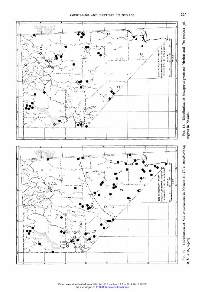
120 Ti9 118 117 116 115 114 I I 120 119 118 117 116 115 114
I I j ' I T I I _ ______?'? 1 I i I T : I __ i_-]?
?_._I_r-U^^j-t^"\""T^TA x 2\ ?_I_,?!-T~W---^i--\^"^ ftf r yA v J\
i^zf'Zzyzz i \ uyyvyyyy i ? N<v* _ \ / ??-z% ^ rr i N<$o . \ y ̂x S c |
\zSz zz . V-y \/i?- \^/a \ , .-^.y \/i? s
i xi 2 r ;
v
{-- i_ n r A Xs 3
\ Kz* Z ! Wi g
\* ' ! ' \ ! *z i xr^ I / ' y l.. / x~'_ *_?Wl \ "'e A^oil
\ ! \ \ DISTRIBUTION MAP \ w 1 DISTRIBUTION MAP \ Y MUSEUMof VERTEBRATE ZOOLOGY^Q \ MUSEUMor VERTEBRATE ZOOLOGY^ \ UNIVERSITY OF CALIFORNIA \^J UNIVERSITY OF CALIFORNIA ^ J
Vi??J_-_ SCALE T~-35 35?___ SCALE N?-? W
M " 25 0 25 50 75 100 25 0 25 50 75 100
l ? i ' - I i, - .- 'I -1 L'? i I I I _=d
MILES MILES
_120_1_9_116 _1_7__m_115_.14 1 1_120_l_9_118_1_7_116_115_114
to
Fig. 12. Distribution of Uta stansburiana in Nevada (1, U. s. stansburiana;
Fig. 13. Distribution of Sceloporvs graciosus (circles) and Uta graciosa (tri- gj
2, U. s. stejnegeri).
angles) in Nevada.
This content downloaded from 128.114.163.7 on Sun, 13 Apr 2014 20:13:20 PMAll use subject to JSTOR Terms and Conditions

226 LINSDALE
amined. The femoral pores average 14+ on
each thigh, a larger average number than is pos
sessed by Uta stansburiana A
Sceloporus graciosus graciosus
Baird and Girard
Sagebrush Lizard
Original description.?Sceloporus graciosus Baird and Girard, Proc. Acad. Nat. Sci. Phila., vol. 6, 1852, p. 69 (Valley of Great Salt Lake, Utah).
Synonyms for Nevada.?Sceloporus gracilis,
Yarrow, 1875, p. 576.
Sceloporus gratiosus, Yarrow, 1875, p. 576.
Sceloporus consobrinus, Yarrow, 1883, p. 61.
Sceloporus graciosus, Ruthven and Gaige,
1915, p. 21.
Sceloporus graciosus gracilis, Van Denburgh,
1922, p. 285.
Range.?Eastern Oregon and Nevada east to
Wyoming and Colorado and south to northeast
ern Arizona and western Oklahoma.
Occurrence in Nevada.?This race occupies most of the state above the 4,500-foot level, ex
cept the extreme southern part. It has been
taken as far south as the Charleston Mountains in Clark County. Over most of the state it
occupies the valleys and flats between 5,000 and
6,500 feet; some places occurring as high as 8,000 feet. Most frequently it is found among stands of
Artemisia tridentata. In general the habitat of this species in Nevada seems to be below that of the larger S. occidentalis. This is just the reverse of the condition in California, where the large species is more frequent in the valleys and low
ground and the small one is restricted to the mountains.
Nevada localities (Fig. 13) (101 specimens in
Museum of Vertebrate Zoology).?
Washoe County: Smoke Creek Desert (U. S. N.
M.); Horse Canon, Pahrum Peak (Mus. Vert.
Zool.); Fox Canon, 6 miles south of Pahrum Peak (Mus. Vert. Zool.); 2 miles west of Reno Hot Springs (Mus. Vert. Zool.); east side of Washoe Lake (Mus. Vert. Zool.).
Storey County: Virginia City (Van Denburgh, 1922, p. 285).
Ormsby County: Carson City (U. S. N. M.). Douglas County: 3 miles southeast of Lake Tahoe
(Mus. Vert. Zool.).
Humboldt County: Virgin Valley (Mus. Vert.
Zool.); Thousand Creek (Mus. Vert. Zool.);
Alder Creek, 5,000 and 6,000 feet (Mus. Vert.
Zool.); Big Creek, 4,800 to 6,000 feet (Mus. Vert. Zool.); Big Creek Ranch (Mus. Vert.
Zool.); Leonard Creek, 5,000 to 6,000 feet
(Mus. Vert. Zool.); Quinn River Crossing (Mus. Vert. Zool.); Amos (Mus. Vert. Zool.); Win nemucca (Mus. Vert. Zool.); Golconda (U. S.
N. M.).
Elko County: Mountain City (U. S. N. M.); Tecoma, 4,900 feet (Mus. Vert. Zool.); Wells
(Calif. Acad. Sci.); Elko (Calif. Acad. Sci.; U. S. N. M.); Carlin (Calif. Acad. Sci.; U. S. N. M.); Deeth (U. S. N. M.); Harrison Pass R. S. (Mus. Vert. Zool.); Green Mountain
Canon, Ruby Mountains (Mus. Vert. Zool.); west side of Ruby Lake, 3 miles north of Elko
County line (Mus. Vert. Zool.). Lander County: Austin (Calif. Acad. Sci.); Big
Creek Camp Ground (Mus. Vert. Zool.); Mahogany Canon (Mus. Vert. Zool.); Kings
ton R. S. (Mus. Vert. Zool.); Peterson Creek, 6,500 feet, Shoshone Mountains (Mus. Vert.
Zool.).
Eureka County: Cortez Mountains (Univ. Mich.); Palisade (Stan. Univ.); 8 miles west of Eureka
(Mus. Vert. Zool.).
White Pine County: Antelope Springs (Van Den
burgh, 1922, p. 278); Sacramento Pass, 10
miles from Osceola (Univ. Mich.); Cherry Creek, 6,800 feet (Mus. Vert. Zool.); Spring Valley, 6,000 feet, 53^2 miles southwest of
Osceola (Mus. Vert. Zool.); Deadman Creek and Smith Creek Cave, Mt. Moriah (Mus. Vert. Zool.); Lehman Cave (Mus. Vert. Zool.); Baker Creek, 6,600 to 7,500 feet (Mus. Vert.
Zool.); Baker, 5,800 feet (Mus. Vert. Zool.); Water Canon, 8 and 10 miles north of Lund
(Mus. Vert. Zool.); White River Valley, 1
mile south of Lund (Mus. Vert. Zool.). Esmeralda County: Chiatovich Creek, 7,000 and
8,200 feet (Mus. Vert. Zool.); Valcalda Spring (Mus. Vert. Zool.); 2 miles south of Piper
Peak, 7,700 feet, Silver Peak Range (Mus. Vert. Zool.); Mount Magruder, 8,000 feet
(U. S. N. M.). Nye County: Smoky Valley, 5 miles southeast of
Millett P. O. (Mus. Vert. Zool.); Round Moun tain (Calif. Acad. Sci.); Scofield Canon, Grant
Mountain (Mus. Vert. Zool.); Burned Corral
Canon, 6,700 feet, Quinn Canon Mountains
(Mus. Vert. Zool.).
Lincoln County: 15 miles east of Panaca (U. S. N. M.); Mormon Mountains (U. S. N. M.).
Clark County: Kyle Canon, 5,000 to 8,000 feet,
This content downloaded from 128.114.163.7 on Sun, 13 Apr 2014 20:13:20 PMAll use subject to JSTOR Terms and Conditions

AMPHIBIANS AND REPTILES IN NEVADA 227
Charleston Mountains (Cowles and Bogert, 1936, p. 38).
As was pointed out by Van Denburgh (1922, p. 276) the Nevada population of this species is intermediate in most characters between the
races graciosus and gracilis. Typical examples of the former, from Utah, have larger dorsal scales and brighter coloration with dorsal and lateral blotches more distinct as compared with
gracilis from Oregon and western California. Because the Nevada specimens seem to be
nearer to graciosus, especially in coloration, all
of them have been assigned here to that race.
More material from the western border of the
state might make it desirable to assign some
specimens from there to the race gracilis. The summary of measurements and scale
counts tabulated below shows some structural
characters of the Nevada population.
In Elko County, Ruthven and Gaige (1915, p. 22) found this to be the most common and widely distributed lizard. It was found at altitudes between 5,000 and 7,500 feet, but most commonly at the lower levels. It was observed among rocks
rarely, and then only where there was much soil,
for it was found to be pre-eminently a ground form preferring a fine soil. They generally found this lizard beneath sage and other bushes where the coloration was protective. It climbed among the bushes to some extent, but when alarmed
generally sought safety under dead brush or in a burrow. At night it buried itself in the loose soil. Females taken on July 4 contained large eggs; those taken on and after July 10 had none.
Females containing eggs were reported from
the region of the Pine Forest Mountains, by Taylor (1912, p. 350) as collected on May 21, June 18, and June 25.
In Water Canon, 8 miles north of Lund, White Pine County, on June 14, 1932, Boyers (MS)
made observations on fighting of two individuals of this species. The two lizards darted off a small rock under a sage bush and rolled about six inches down the slope, hanging on to each other
with their teeth. They separated and stalked around each other, with throat puffed out, belly lowered, and tail straight out behind, every few seconds displaying by raising and lowering the
body by flexing all four legs at once. After a
minute, one moved off down slope and left the other.
Sceloporus magister magister Hallowell
Rough-scaled Lizard
Original description.?Sceloporus magister Hal
lowell, Proc. Acad. Nat. Sci. Phila., vol. 7, 1854,
p. 93 (near Fort Yuma, California). Synonyms for Nevada.?Sceloporus clarkii,
Yarrow and Henshaw, 1878, p. 1645.
Sceloporus clarki clarki, Yarrow, 1883, p. 63.
Sceloporus magister, Richardson, 1915, p. 418.
Range.?From western Nevada south to north
ern Lower California and from southern Califor
nia to southern Utah.
Occurrence in Nevada.?The rough-scaled liz
ard is common in the southern and western parts of the state, below the 4,000-foot level. In the west it extends northward as far as Pyramid Lake, in the east as far as Caliente. Usually lives
where there are trees and bushes among which it climbs.
Nevada localities (Fig. 14) (73 specimens in Museum of Vertebrate Zoology).?
Washoe County: North end of Pyramid Lake
(Calif. Acad. Sci.; U. S. N. M.); near The Needles (Mus. Vert. Zool.); Sutcliffe (Calif. Acad. Sci.); The Willows (U. S. N. M.); Anaho Island (Calif. Acad. Sci.); Wadsworth (U. S.
N. M.); Derby (Van Denburgh, 1922, p. 335).
Length snout Length of Length Femoral Scales from interparietal to anus tail hind leg pores to posterior surface
of thigh 36 males (measurements in mm.)
Av. 54.31 75.85 38.27 14.56 52.71 Min. 48.4 62.2 32.7 12 44 Max. 62.4 95.0 44.4 19 61
48 females
Av. 54.94 72.35 37.29 14.20 53.66 Min. 45.7 59.9 29.4 10 44 Max.. 64.1 88.3 42.0 18 61
This content downloaded from 128.114.163.7 on Sun, 13 Apr 2014 20:13:20 PMAll use subject to JSTOR Terms and Conditions

I 120 M9 Til il? 116 115 114 1 I Y20 N9 118 U7 116 115 '14 I tO I I i-1-T-1-1-_ _i___?m I-1-1-1?'-T-1 | _ i___m *o
P-^^IYl ;.! (VMS'iA a i o ill M x^i v>
''AA^A
\'A>
V/^i 'A"t i
J_[ |<v,dX\ J .-^5\V /i-4 J N ^ A -4-a \/i-H I
1?-%-* 'v-C"/*M 1?'-V"- ,["-I /ffl
\!?o 00(411 \h6' JA_U
h?-? - v m h?- - > m
\ O ( \ I DISTRIBUTION MAP\ V DISTRIBUTION MAP\ \ MUSCUMOf VERTEBRATE ZOOLOGY^Q J MUSEUMor VERTEBRATE ZOO_06Y\ \
UNIVERSITY OT CALIFORNIA \ J I I I I I I UNIVERSITY OT CALIFORNIA \ J Ll
U__ SCALE Ne--""I rl U_L???J_- ' SCALE >~-' H II 25 0 2S Ap 75 Ky FT 25_0 25 Sp 75 Kp
MILES III MILES I I tio "9 ne \\f tU lb W4 I 1 i-o ?9 ne 17 m ils ih 1
Fig. 14. Distribution of Sceloporus magister magister in Nevada.
Fig.
15. Distribution of Sceloporus occidentalis bi-seriatus in Nevada.
This content downloaded from 128.114.163.7 on Sun, 13 Apr 2014 20:13:20 PMAll use subject to JSTOR Terms and Conditions

AMPHIBIANS AND REPTILES IN NEVADA 229
Lyon County: Lincoln Highway, 22 miles west of Fallon (Mus. Vert. Zool.).
Churchill County: Hazen (Burt and Burt, 1929, p. 451); 6 miles west of Hazen (Mus. Vert.
Zool.); 10 miles west and 5 miles north of Fal lon (Mus. Vert. Zool.); 4 miles west of Fallon
(U. S. N. M.); Fallon (U. S. N. M.); Sand
Spring (Burt, 1933, p. 238). Mineral County: 4 miles northwest of Hawthorne
(Mus. Vert. Zool.).
Esmeralda County: Columbus (Van Denburgh, 1922, p. 335); Fish Lake (Mus. Vert. Zool.); 2 miles northwest of Cave Spring, 5,700 feet
(Mus. Vert. Zool.); Grapevine Mountains
(U. S. N. M.). Nye County: Amargosa River, 3J^ miles north
east of Beatty (Mus. Vert. Zool.); Ash Mead ows (U. S. N. M.); Ash Meadows, 3.2 miles west southwest of Devil's Hole (Mus. Vert.
Zool.); Rhyolite (Calif. Acad. Sci.); Railroad
Valley, 11 miles south of Lock's Ranch (Mus. Vert. Zool.).
Lincoln County: 9 and 16 miles east of Groom
Baldy (Mus. Vert. Zool.); Crystal Spring (Mus. Vert. Zool.); % mile west of Ash Spring (Mus. Vert. Zool.); Pahranagat Valley (U. S. N. M.); Pahranagat Mountains (U. S. N. M.); Caliente
(Calif. Acad. Sci.); Meadow Valley, 21 miles south of Caliente (Mus. Vert. Zool.).
Clark County: Pahrump Valley (U. S. N. M.); Indian Spring Valley (U. S. N. M.); Kyle Canon, 4,000 feet, Charleston Mountains
(Cowles and Bogert, 1936, p. 38); Kaolin (Mus. Vert. Zool.); Overton (Cowles and Bogert, 1936, p. 38); Bunkerville (U. S. N. M.); Indian
Spring, 4,000 feet, Virgin Mountains (Mus. Vert. Zool.); Vegas Valley (U. S. N. M.); Call ville (U. S. N. M.); Jean (Klauber, 1932, p. 122) Piute Valley, 1 mile north of California line
(Klauber, 1932, p. 122); Colorado River, 25 miles above Boulder Dam (Borell, spec). Stejneger (1893, p. 179) was first to find char
acters to distinguish S. clarkii and S. magister. He decided that the most distinctive character was the difference in the spiny scales which pro tect the anterior border of the ear opening. He
wrote that "the constancy of the character was
soon verified in a large series of specimens, as
well as the concomitancy of the presence or
absence of dusky markings on the dorsal aspect of the forearm and hand."
Later, Burt (1935, p. 275) concluded that these forms show no constancy "in their described
characters when examined in large numbers, the
oldest males tending to have better developed ear denticulations than the rest of the population. Like other reptile species of the West, the ground color of the back is darker at higher altitudes and
lighter (or more brownish) about the desert floor."
The climbing habits of this lizard as observed in Washoe County were reported by Richardson
(1915, p. 419). Near Pyramid Lake he found it in bushes along the Truckee River, on tufa cliffs near the lake, on volcanic rocks in the hills, and along the lake shore, but never far out on the
desert. At Derby it was found in two types of
surroundings?in and about bushes near the
river where it was abundant, and on rocky hill
sides. He noted that as individuals ran from bush to bush, they lifted their tails above the level of the body much in the manner of gridiron-tailed lizards. It was seen basking on rocks with the smaller fence lizard. Van Denburgh and Slevin
(1921, p. 34) report that specimens taken in the
vicinity of Pyramid Lake, in July, were "
usually found on the ground under thorn bushes" and
they "were bright green and very wild." All
specimens they obtained from Rhyolite and Caliente were found on rocks on the hillsides.
In the vicinity of Crystal Spring, Pahranagat Valley, in May 1932, this species was abundant near the creek mostly among bushes or climbing
in the cotton woods. One was caught under a
board at the base of a cotton wood. One was
shot on a willow and another in leaves under an
Atriplex bush. Fitch (MS) observed the species in this vicinity on rocks and fence posts.
Merriam (in Stejneger, 1893, p. 182) observed that unlike most of the lizards inhabiting the same region, this one does not run about on the
open desert, but lives on the tree yuccas, the ruins
of stone or adobe dwellings, the nests of wood rats,
and other objects that afford it shelter and pro tection. In Pahranagat Valley he found it abundant about the ruins of stone houses and
along the faces of cliffs. He found both insects and flowers in the stomachs.
Sceloporus occidentalis bi-seriatus
Hallowell
Fence Lizard
Original description.?Sceloporus bi-seriatus
Hallowell, Proc. Acad. Nat. Sci. Phila., vol. 7,
1854, p. 93 (El Paso Creek and Tejon Valley, Kern County, California).
This content downloaded from 128.114.163.7 on Sun, 13 Apr 2014 20:13:20 PMAll use subject to JSTOR Terms and Conditions
230 LINSDALE
Synonyms for Nevada.?Sceloporus undulatus
subspecies undulatus, Yarrow, 1875, p. 573.
Sceloporus smaragdinus, Yarrow, 1883, p. 62.
Sceloporus undulatus thayeri, Yarrow, 1883,
p. 60.
Sceloporus biseriatus, Richardson, 1915, p. 421.
Sceloporus occidentalis biseriatus, Van Den
burgh and Slevin, 1921, p. 34.
Sceloporus undulatus bi-seriatus, Burt, 1933,
p. 238.
Sceloporus undulatus elongatus, Burt, 1933,
p. 243.
Range.?From eastern Oregon and southern
Idaho south to northern Lower California and from southern California to Wyoming and Texas.
Occurrence in Nevada.?This race of fence
lizard is abundant throughout the state except the extreme southern part. Records show it to
be present mainly in the mountains above 4,000 feet; they extend as high at least as 9,000 feet.
Nevada localities (Fig. 15) (215 specimens in Museum of Vertebrate Zoology).?
Washoe County: Little High Rock Canon (Mus. Vert. Zool.); Rock Creek, 5,000 feet, Granite
Mountains (Mus. Ve?t. Zool.); 10 miles north northwest of Deephole, 5,150 feet (Mus. Vert.
Zool.); Smoke Creek Desert (U. S. N. M.); Horse Canon, Pahrunl Peak (Mus. Vert. Zool.); 6 miles south of Pahrum Peak (Mus. Vert.
Zool.); Sutcliffe (Calif. Acad. Sci.; U. S. N. M.); The Willows (U. S. N. M.); Pyramid (Calif. Acad. Sci.); Verdi (Calif. Acad. Sci.; U. S. N.
M.); Reno (Calif. Acad. Sci.); 10 miles east of
Reno, 4,500 feet (Mus. Vert. Zool.); 2 miles west of Reno Hot Springs (Mus. Vert. Zool.); Galena Creek, 6,500 feet (Mus. Vert. Zool.); 1 mile north of Incline (Mus. Vert. Zool.).
Ormsby County: Carson City (U. S. N. M.). Douglas County: Glenbrook (Calif. Acad. Sci.;
U. S. N. M.).
Humboldt County: Virgin Valley (Mus. Vert.
Zool.); Big Creek Ranch (Mus. Vert. Zool.); Limestones (Mus. Vert. Zool.); Red hills, Quinn River Crossing (Mus. Vert. Zool.); 4 miles east of Winnemucca (Univ. Mich.).
Elko County: Goose Creek, 2 miles west of Utah line (Mus. Vert. Zool.); west side of Ruby Lake
(Mus. Vert. Zool.); Ruby Mountains (Calif. Acad. Sci.).
Pershing County: 8 miles south of Sulphur, 4,350 feet (Mus. Vert. Zool.); El Dorado Canon, 6,000 feet, Humboldt Range (Mus. Vert. Zool.);
east side Granite Peak, East Range (Mus. Vert. Zool.).
Churchill County: Mountain Well (Mus. Vert.
Zool). Lander County: Austin (Calif. Acad. Sci.); Big
Creek, 6,700 feet (Mus. Vert. Zool.); Kingston Creek, 7,000 and 7,500 feet (Mus. Vert. Zool.); Clear Creek, 6,500 feet (Mus. Vert. Zool.).
Eureka County: 33^_ miles southeast of Palisade
(Mus. Vert. Zool.); 8 miles west of Eureka
(Mus. Vert. Zool.).
White Pine County: Willow Creek, 2 miles south of county line (Mus. Vert. Zool.); 8 miles west of Illipah (U. S. N. M.); Smith Creek Cave, near Mt. Moriah (Mus. Vert. Zool.); Lehman Cave (Mus. Vert. Zool.); Baker Creek, 7,500 feet (Mus. Vert. Zool.); Water Caiion, 8 miles north of Lund (Mus. Vert. Zool.).
Mineral County: Endowment Mine (Mus. Vert.
Zool.).
Esmeralda County: Chiatovich Creek, 7,000 feet
(Mus. Vert. Zool.); 2 miles south of Piper Peak, 7,700 feet (Mus. Vert. Zool.); Cave Spring (Mus. Vert. Zool.); Goldfield (Calif. Acad.
Sci.); Mount Magruder (U. S. N. M.); Grape vine Mountains (U. S. N. M.).
Nye County: Wisconsin Creek 7,800 to 9,000 feet
(Mus. Vert. Zool.); Ophir Creek, 6,500 feet
(Mus. Vert. Zool.); South Twin River, 6,500 and 7,000 feet (Mus. Vert. Zool.); Mohawk R. S. (Mus. Vert. Zool.); Pablo Creek (U. S. N.
M.); Peavine Creek, 6,000 feet (U. S. N. M.); Round Mountain (Calif. Acad. Sci.); Jefferson R. S. (U. S. N. M.); Tonopah (Calif. Acad.
Sci.); 8 to 9 miles east of Cliff Spring, 6,100 feet (Mus. Vert. Zool.); Garden Valley, 8}4
miles northeast of Sharp (Mus. Vert. Zool.); Belted Range, 2 miles northwest of Indian
Spring (Mus. Vert. Zool.); 5 miles west of White Rock Spring (Mus. Vert. Zool.); near Oak Spring, 5,700 feet (Mus. Vert. Zool.); south end of Kawich Mountains (Mus. Vert.
Zool.); White River Valley, 14 miles southwest of Sunnyside (Mus. Vert. Zool.); Hot Creek
Range, 4 miles north of Hot Creek, 6,400 feet
(Mus. Vert. Zool.); Railroad Valley, 3 miles south of Nyala, 5,600 feet (Mus. Vert. Zool.);
Burned Corral Caiion, 6,500 feet, Quinn Caiion Mountains (Mus. Vert. Zool.).
Lincoln County: Southwest base of Groom Baldy, 7,200 feet (Mus. Vert. Zool.); Caliente (Calif. Acad. Sci.); Meadow Valley, 21 miles south of Caliente (Mus. Vert. Zool.).
Clark County: Charleston Mountains (U. S. N.
This content downloaded from 128.114.163.7 on Sun, 13 Apr 2014 20:13:20 PMAll use subject to JSTOR Terms and Conditions

AMPHIBIANS AND REPTILES IN NEVADA 231
M.); Charleston Park, 7,800 feet (San Diego Soc. Nat. Hist.); Kyle Canon and Harris
Spring, 4,000 to 6,000 feet, Charleston Moun
tains (Cowles and Bogert, 1936, p. 38); Kyle Cation, 6,000 feet (Mus. Vert. Zool.). The systematic relationships of S. o. bi-seriatus
in eastern Nevada have been discussed by Burt
(1933, p. 240) who decided that the numbers of
scales from the occiput to the base of the tail
provided the most constant difference between bi-seriatus and elongatus. On this basis he con
cluded that "if we arbitrarily regard all of these
lizards having 42 or less than 42 scales from the
occiput to the base of the tail as bi-seriatus and
those having more than this number as elongatus, a zone of intergradation between the two forms
becomes evident in eastern Nevada and western
Utah where the ranges of the two subspecies meet and overlap. This phenomenon is noted
in the present specimens from White Pine County, Nevada, and an intergrade with a count of 43 was collected in Eureka County to the west.
Throat patches of intergrades in Nevada may be
united as in bi-seriatus instead of separated as in
elongatus of the west and south."
My own examination of specimens has failed to
demonstrate the close relationship of these two
forms implied in the quotation just given. To me
the color pattern, especially the blue throat
patches, is more diagnostic than number of dorsal
scales. The specimens I have seen bear out Van
Denburgh's (1922) treatment of these two lizards.
However, it would not be surprising if further
material from some place eastward from Nevada
showed closer relation between the two forms.
Observations on the behavior of fence lizards in the breeding season were made on June 13,
1932, by Fitch (MS) in Water Canon, 8 miles north of Lund, White Pine County. A male on a
large boulder near the camp was feeding on flies
which it caught by sudden rushes before they had time to move. A dead male lizard of the same species attached to a fine wire was dragged over the surface of the rock. The live one im
mediately ran to it and bit its side, and then fol
lowed it away from the rock, running alongside and nipping at it.
Several yards distant another male came into
view, pursuing a female which it overtook and
caught by grasping in its mouth a fold of skin about an inch behind the axilla. These lizards lost their foothold on the slanting rock surface and rolled several feet, finally falling to the ground. After a short struggle, the female freed herself and escaped from the pursuing male.
By maneuvering the dead lizard the first male was attracted to the smaller one that had been
seen with the female. The dead one then was
removed and the first male transferred his atten
tion to the second one. His actions were the
same as had been shown toward the dead one.
Standing high off the ground, with body com
pressed and showing to advantage the bright blue patches on throat and abdomen, it moved
jerkily toward the other one. The second male at first displayed in a similar manner, but when the first one approached and nipped at it, it retreated and made an almost continuous run to a
ledge of rock about 30 feet away. One method of fighting observed here was for
one animal to run past another in a direction
opposite to its course and to bite at its legs or
abdomen as it passed. At the same time the
aggressor would move the tail and hind quarters quickly and strike a sharp blow on its opponent's head. This method of attack appeared to be just as effective as biting.
When a mirror was placed on a rock near one
of the males its reaction to the image was like that toward another live lizard, except that it lost interest in about two minutes.
Several times a fighting male suddenly broke off its attack, when no cause for disturbance was
detected, and ran to hide in a crevice; each time it returned after a few seconds.
When the dead male was dragged near the
female, the latter stood high with tail elevated and moved with a half running, half hopping gait, turning to nip at the male when it was brought too close.
On June 28, 1934, Fitch (MS) found a pair of fence lizards copulating on a rock near the Truckee
River, 5 miles west of Reno. This is evidence of a
difference of about two months in the breeding cycle here and on the coast.
Throughout northwestern Nevada, this lizard was found to be a rock-dwelling form by Richard son (1915, p. 421). Two females taken on May 24 at Reno, held 7 and 10 eggs.
The restriction to rocky places was also noted
by Ruthven and Gaige (1915, p. 20) in the upper Humboldt Valley, where they found fence lizards
in such places as cliffs, outcrops, talus slopes, and
stream beds. They observed that the lizards on warm days, were quite common everywhere over
the rocks until the hottest part of the day, when
they retired to the shaded side. Large females obtained on and before July 12 contained large eggs about ready to be laid; those collected on
July 22 had deposited their eggs. On August 14,
This content downloaded from 128.114.163.7 on Sun, 13 Apr 2014 20:13:20 PMAll use subject to JSTOR Terms and Conditions

232 LINSDALE
young ones, several days old, were seen. One
that was captured measured 55 mm. in total
length. They ran over the ground and small rocks at the base of a cliff and, when alarmed,
sought concealment under loose stones.
Courtship behavior in this species was watched on June 1, 1932, in the hills at 5,900 feet, east of Cliff Spring, Nye County (Fitch, MS). Here there were juniper trees and a few pinons on the
rocky ground. Numerous fence lizards were
seen on the rocks. A male and a female were
seen sunning themselves on a large boulder. As
the observer approached slowly they moved from one boulder to another, both always stop
ping on top of the same rock and within a few
inches of each other. Several times the male dis
played near the female, arching his back, raising his tail, advancing with short, jerky movements and standing high off the surface of the rock with throat pouch extended. Several times he moved up and pushed the female with his snout. At such times the female sidled away.
Phrynosoma douglassii ornatissimum
(Girard)
Pigmy Horned-toad
Original description.?Tapaya ornatissima Gir
ard, U. S. Expl. Exped., Herp., 1858, p. 396
(mountainous region of New Mexico). Synonyms for Nevada.?Phrynonsoma douglas
sii subspecies douglassii, Yarrow, 1875, p. 580.
Phrynosoma douglassi douglassi, Yarrow, 1883, p. 69.
Phrynosoma douglassii hernandesi, Richard
son, 1915, p. 423.
Phrynosoma hernandesi, Ruthven and Gaige,
1915, p. 23.
Occurrence in Nevada.?Specimens are avail
able from several localities in the northeast part of the state, west on the north side of the Hum
boldt River as far as the Santa Rosa Mountains, and south near the eastern border to about 39?
N. Nevada localities (Fig. 16) (9 specimens in Mu
seum of Vertebrate Zoology).?
Humboldt County: Martin Creek R. S., Santa Rosa Mountains (Mus. Vert. Zool.).
Elko County: Mountain City (U. S. N. M.); Cobb Creek, 6 miles southwest of Mountain
City, 6,550 feet (Mus. Vert. Zool.); Marys River, 22 miles north of Deeth (Mus. Vert.
Zool.); near Deeth (Van Denburgh, 1922, p.
381); Halleck (U. S. N. M.); 3 miles south of Halleck (U. S. N. M.); Carlin (Univ. Mich.
Mus.); James Caiion (Univ. Mich. Mus.). White Pine County: 7 miles southeast of Hobson
P. 0. (Mus. Vert. Zool.); Water Canon, 8 miles north of Lund (Mus. Vert. Zool.).
The record of this species from 2 miles north of
Fernley (Burt and Burt, 1929, p. 454) apparently was based on a specimen now in the University of Michigan collection. I examined this specimen on October 8, 1933, and found it to be a young individual of P. platyrhinos. The locality is more
than 160 miles from the nearest one listed above. The pigmy horned-toads were found by
Ruthven and Gaige (1915, p. 24) in Elko County, during the warmer parts of the day. At night they burrowed beneath the surface of the ground.
The adults kept close to the shelter of bushes where their broken coloration was protective.
The young ones with even coloration were ob
served more often in the open. Females taken on
July 26, contained embryos. By August 7 and 8 all adult females had given birth to their young
which were found in numbers.
Phrynosoma platyrhinos Girard
Desert Horned-toad
Original description.?Phrynosoma platyrhinos Girard, Stansbury's Expl. Surv. Vail. Great Salt
Lake, 1852, pp. 361, 363, pl. 7, figs. 1-5 (Great Salt Lake Valley, Utah).
Synonyms for Nevada.?Phrynosoma maccalli,
Yarrow, 1883, p. 65.
Phrynosoma platyrhinum, Yarrow, 1883, p.
65.
Phrynosoma douglassii ornalissimum, Burt and Burt, 1929, p. 454.
Phrynosoma platyrhinos platyrhinos, Cowles and Bogert, 1936, p. 38.
Range.?From Washington and Idaho south to northeastern Lower California and from east
ern California to western Utah. Occurrence in Nevada.?This horned toad is
common in the valleys and flat areas over most of
the state above the 2,000-foot level. Places of record are as high as 6,500 feet, and most of them are above 4,000 feet. The soil over most of this lizard's range is sandy or gravelly.
Nevada localities (Fig. 16) (253 specimens in
Museum of Vertebrate Zoology).?
Washoe County: High Rock Caiion (Mus. Vert.
Zool.); Little High Rock Caiion (Mus. Vert.
This content downloaded from 128.114.163.7 on Sun, 13 Apr 2014 20:13:20 PMAll use subject to JSTOR Terms and Conditions

I 120 119 118 117 110 IIS IK |
A- ^ r^^AM
n?A i--?
J^&wi^
r^-<^ iP"
AS' ^ r^ L--^Jvf ) k / 1' ' ^ '' # /
IP'" !> * I I
ll I >]/ IPl) pPP.pl ' ) I n?-r^P0 ^\ -? ^p*1""- % V|| (1
'^' Hf-
p*
/
'>
^ i J \!/1 ? i- p ( s rSr'A. > PP-?--,M--V A A_H \'! fe ^ ) I s
r? w\ ft \ ?*_> -4
A?i?-A
t?I-\^ i--A"J\\\ ?
V /v A A s M \ 1 ! ?
K / \ \ ' I '^?> Ar\\ td
\#<* / \_# %.
\i
V /y_U \! ^v_A li w
H?-?v?'" ?
'
&i# _ V n I H?- ^ PlT 3 % <? ? ?? # i m * p !, \?? ( s
K #1 ' __- I \ * I 1 ̂
s ! '':;' ^ \ \ I
DISTRIBUTION
MAP \ 1 M
Xx I |... V \ '
MUSEUMofVERTEBRATE
ZOOLOGY^Q S 3 S\ i !./ * 1 i UNIVERSITY OF CALIFORNIA \ J I h>
v<3 ' P J?H LL?J_ scale N^-hr w 37k-___k V ' X_11 r - Us 0 2.5 50 75 IQP VJ
NnQ-. ( A\\ MILES III ^
I \ O ' O ^\l ' I 120 119 18 117 116 115 114 J ̂
I S^o i. - * ) !
\ ; " L^c 51 Fig. 17. Distribution of Xantusia vigilis in southern Nevada.
J_i_ p; ? f^U DISTRIBUTION MAP\ \ MUSEUM or VERTEBRATE 200L0GYS^X \
UNIVERSITY OT CALIFORNIA \ ̂ ) I
35L-_J_:_t_ scale W-?: 1 n
I I 25_0 25 50 75 IQjP MILES I
I lio 119 IIS 117 116 115 114 | Fig. 16. Distribution of Phrynosoma douglassii ornaiissimum (triangles) and co
Phrynosoma platyrhinos (circles) in Nevada.
This content downloaded from 128.114.163.7 on Sun, 13 Apr 2014 20:13:20 PMAll use subject to JSTOR Terms and Conditions
234 LINSDALE
Zool.); Smoke Creek, 3,900 feet (Mus. Vert.
Zool.); 4J_ miles northeast of Flanigan, 4,100 feet (Mus. Vert. Zool.); 1 mile northeast of
Gerlach, 4,000 feet (Mus. Vert. Zool.); 2Y2 miles east and 11 miles north of Gerlach (Mus. Vert. Zool.); 4 miles west of Pahrum Peak
(Mus. Vert. Zool.); 1 mile north of Pyramid (Mus. Vert. Zool.); Pyramid Lake (Calif.
Acad. Sci.; U. S. N. M.); Reno (Calif. Acad.
Sci.); east of Reno (U. S. N. M.); 10 miles east of Reno (Mus. Vert. Zool.); Smoke Creek
Desert (U. S. N. M.); Wadsworth (U. S. N. M.).
Storey County: Virginia City (U. S. N. M.). Lyon County: 2 miles north of Fernley (Univ.
Mich.); Lincoln Highway, 22 miles west of
Fallon (Mus. Vert. Zool.); 6}-_ miles east of
Dayton (Mus. Vert. Zool.). Humboldt County: Limestones (Mus. Vert.
Zool.); Thousand Creek Basin (Mus. Vert.
Zool.); Leonard Creek (Mus. Vert. Zool.); Big Creek, 4,350 and 5,000 feet (Mus. Vert. Zool.); near Amos P. O. (Mus. Vert. Zool.); Big Creek
(Mus. Vert. Zool.); Quinn River Crossing (Mus. Vert. Zool.); 5 miles south of Quinn River
Crossing, 4,000 feet (Mus. Vert. Zool.); 5
miles northeast and 1 mile south of Golconda
(Mus. Vert. Zool.); Golconda (U. S. N. M.); 26 miles northwest of Battle Mountain (Mus. Vert. Zool.); 7 miles north of Winnemucca
(Mus. Vert. Zool.).
Elko County: 3 miles southwest of Wendover, Utah (Mus. Vert. Zool.); head of Humboldt River (U. S. N. M.).
Pershing County: Buena Vista Valley, 4,150 feet, 10 miles east and 3 miles south of Fanning (Mus. Vert. Zool.); 3 miles southwest of
Vernon, 4,300 feet (Mus. Vert. Zool.); 8 miles
south of Sulphur, 4,350 feet (Mus. Vert. Zool.); 10 miles west and 6 miles north of Sulphur, 4,000 feet (Mus. Vert. Zool.); 21 miles west and 2 miles north of Lovelock, 4,000 feet (Mus. Vert. Zool.); 30 miles west and 4 miles north of
Lovelock, 4,300 feet (Mus. Vert. Zool.). Churchill County: 5 miles north of Fallon (Mus.
Vert. Zool.).
Lander County: 14 miles north of Battle Moun tain (Mus. Vert. Zool.); 3 miles south of Izen hood (Mus. Vert. Zool.); Smoky Valley, be tween Birch and Kingston creeks (Mus. Vert.
Zool.); 8 miles northeast of Tenabo (Mus. Vert. Zool.).
Eureka County: Beowawe (U. S. N. M.); 4 miles
southeast of Romano, Diamond Valley (Mus. Vert. Zool.); 12 and 16 miles northeast of
Tenabo (Mus. Vert. Zool.).
White Pine County: Near Smith Creek Cave, Mt. Moriah (Mus. Vert. Zool.); near Baker
(Mus. Vert. Zool.; U. S. N. M.); 2Y2 miles southwest of Hamilton, 7,600 feet (Mus. Vert.
Zool.).
Mineral County: Hun toon Valley, 5,700 feet
(Mus. Vert. Zool.); Mina.
Esmeralda County: 7 miles north of Arlemont, 5,500 feet (Mus. Vert. Zool.); Arlemont (Mus. Vert. Zool.); 23^_ miles southeast of Dyer (Mus. Vert. Zool.); Fish Lake (Mus. Vert. Zool.); Cave Spring (Mus. Vert. Zool.); 10 and 15 miles south of Tonopah (Mus. Vert. Zool.); 13J^ miles northwest of Goldfield (Mus. Vert.
Zool.); Goldfield (Calif. Acad. Sci.); Grapevine Mountains, 4,200 feet (U. S. N. M.).
Nye County: Wisconsin Creek, 6,000 feet (Mus. Vert. Zool.); North of Twin River, 6,000 feet
(Mus. Vert. Zool.); South Twin River, 6,500 feet (Mus. Vert. Zool.); Pablo Creek, 6,200 feet (U. S. N. M.); Pea vine Creek, 6,000 feet
(U. S. N. M.); Smoky Valley, 5 miles south and 5 miles southeast of Millett P. O. (Mus. Vert.
Zool.); Jefferson Creek, 6,300 feet (U. S. N.
M.); Round Mountain, 6,300 feet (U. S. N. M.); Ralston Valley, 15j_i miles northeast of Tono
pah, 5,800 feet (Mus. Vert. Zool.); Tonopah (Calif. Acad. Sci.); 8 miles southeast of Tono
pah (Mus. Vert. Zool.); near Indian Spring, Belted Range (Mus. Vert. Zool.); 1 mile south of Big Dry Lake, Kawich Valley; 73^_ and 8 miles east of Cliff Spring, 5,900 feet (Mus. Vert.
Zool.); Railroad Valley, 3 miles south of Nyala, 5,600 feet (Mus. Vert. Zool.); Hot Creek
Valley 2 to 10 miles north of Hot Creek, 5,900 feet (Mus. Vert. Zool.); Rhyolite (Calif. Acad.
Sci.); Amargosa Desert (U. S. N. M.); Ash Meadows (U. S. N. M.).
Lincoln County: Penoyer Valley, 14 miles north
northwest of Groom Baldy (Mus. Vert. Zool.) ; 9 miles east of Groom Baldy, 5,500 feet (Mus. Vert. Zool.); Hancock Pass, west of Crystal
Spring (Mus. Vert. Zool.); near Crystal Spring (Mus. Vert. Zool.); north end of Penoyer
Valley (Mus. Vert. Zool.); 20 miles southwest of Pioche (Mus. Vert. Zool.); Panaca (U. S. N.
M.); 21 miles west of Panaca (Mus. Vert.
Zool.); Caliente (Calif. Acad. Sci.); 4 miles northeast of Carp (Mus. Vert. Zool.).
Clark County: Indian Spring Valley (U. S. N. M.); 12 miles east of Charleston Park, 4,400 feet
(Mus. Vert. Zool.); Las Vegas (Calif. Acad.
Sci.; U. S. N. M.); 2 miles south of Jean (Mus. Vert. Zool.); lj_ miles northwest of Fort
Mojave, 500 feet (Mus. Vert. Zool.); Hiko
This content downloaded from 128.114.163.7 on Sun, 13 Apr 2014 20:13:20 PMAll use subject to JSTOR Terms and Conditions

AMPHIBIANS AND REPTILES IN NEVADA 235
Spring, 2,200 feet, Dead Mountains (Mus. Vert. Zool.); Valley of Fire, 15 miles southeast of Crystal (Mus. Vert. Zool.); Boulder City (Cowles and Bogert, 1936, p. 39). In the northwestern part of the state Richard
son (1915, p. 423) observed this lizard on the desert among low bushes. In attempting to
escape it ran beneath the bushes rather than into mammal burrows. On a long run it often raised
its tail above the level of the sand. Two stomachs contained ants, beetles, and insect larvae. Three
females captured at the end of May, and June 2 and 9, held 13, 9, and 13 eggs.
Taylor (1912, p. 351) found this horned-toad to be more common near the foothills of the Pine
Forest Mountains than away from them on the
open desert. The animals were found on sandy, on loamy, and on sun-baked hard soil. One, when
picked up, opened its mouth and made a hissing sound. Copulation was noted on June 10 and on
June 14 a female containing ten eggs was cap
tured.
At 6 p. m. on July 31, 1934, five small horned
toads, apparently all members of a single brood were found by D. H. Johnson (MS) one mile southeast of Wadsworth, 4,200 feet, Lyon County.
The animals were scattered over a single square
yard of a level and sandy abandoned field then covered with Russian thistles. They were at
tempting to find cover beneath the plants. Near Crystal Spring, Lincoln County, Fitch
(MS) found a horned-toad sunning itself at 5:45 a. m. on May 19, 1932.
Helodermatidae
Heloderma suspectum Cope Gila Monster
Original description.?Heloderma suspectum
Cope, Proc. Acad. Nat. Sci. Phila., 1869, p. 5
(Sierra de la Union, Arizona ["Sonora"]). Range.?Southern Nevada and Utah, Arizona
and Sonora.
Occurrence in Nevada.?Records are all in the
southeastern corner of the state, as far west as
Las Vegas and as far north as Meadow Valley, but mostly in the vicinity of the Virgin River. So few specimens have been discovered as to
indicate a small population likely to become exterminated within the state.
Nevada localities (No specimens in Museum of Vertebrate Zoology).?
Lincoln County: Meadow Valley (Van Denburgh, 1922, p. 473).
Clark County: Virgin River, 8 miles below Bunk erville (U. S. N. M.); Overton (Cowles and
Bogert, 1936, p. 39); Saint Thomas (Van Den
burgh, 1922, p. 473); Las Vegas (Van Den
burgh, 1922, p. 473).
Xantushdae
Xantusia vigilis Baird
Desert Night Lizard
Original description.?Xantusia vigilis Baird, Proc. Acad. Nat. Sci. Phila., 1858 [1859], p. 255
(Fort Tejon, California). Range.?Southeastern California, southern Ne
vada, and northeastern Lower California.
Occurrence in Nevada.?Specimens represent
localities in the southern part of the state, as far
north as Coyote Spring, near 37? N., and at
altitudes up to 4,000 feet. Individuals have been
captured about the dead limbs and stumps of Joshua trees and Spanish dagger, more frequently the latter.
Nevada localities (Fig. 17) (34 specimens in Museum of Vertebrate Zoology).?
Lincoln County: Coyote Spring, 2,500 feet (Mus. Vert. Zool.).
Clark County: Pahrump Valley (U. S. N. M.); Kyle Caiion, about 4,000 feet, Charleston Mountains (Cowles and Bogert, 1936, p. 39);
10 miles east of Jean (Cowles and Bogert, 1936,
p. 39); 5 miles north of Jean (Klauber, 1932, p. 123); 1 mile west of Jean (Mus. Vert. Zool.);
Piute Valley, 1 mile north of California line
(Klauber, 1932, p. 123); 14 miles north of
Searchlight, 3,500 feet (Mus. Vert. Zool.); 3 miles south of Mesquite, 2,500 feet (Mus. Vert.
Zool). Teiidae
Cnemidophorus tesselatus tesselatus (Say)
Whip-tailed Lizard
Original description.?Ameiva tesselata Say, Long's Exp. Rocky Mts., vol. 2, 1823, p. 50
(Arkansas River, near Castle Rock Creek, Colorado).
Synonyms for Nevada.?Cnemidophorus tigris, Richardson, 1915, p. 425.
Cnemidophorus tessellatus tessellatus, Cowles and Bogert, 1936, p. 39.
Range.?Eastern Oregon and southern Idaho
south to southern Coahuila, Mexico and from
California to western Texas.
Occurrence in Nevada.?Whip-tailed lizards
This content downloaded from 128.114.163.7 on Sun, 13 Apr 2014 20:13:20 PMAll use subject to JSTOR Terms and Conditions

I , <?0 "9 "8 1{7 "0 ?> '" J I 120 119 118 117 110 115 114 I U>
npp^^SvP^i ip p?p)^PVPi
b^ PiyiL i -'JJ bPiP f UliL A - ?1
ttJ^7f^--n.^A nkA\ ^n J?ff-7/^----,.--^-ro'-'- ,1A_>(i *r7
I PJivft N~ < - -i A A?-A A '-Ay, \ c*\.? A3 $?-A
*f\l \<s ^% A ^A)\ \f, *'\ ' A | c
H?-h-v*' ,8? ? 6i win n?-r^AiJ , x cm i VjpT s
| \ ! i0 >, 1 ! JJ \ <> ̂ ) i I
I?I-?~'\$
\?'*o7nT
1?-?^p- j-^?C Tfl f
j p\.
L.
fi
I
| \ t6 t|
n- \ > n-1 X I I
DISTRIBUTION MAP \ V \ DISTRIBUTION MAP \ \ MUSEUMor VERTEBRATE ZOOLOGY^ S MUSEUMor VERTEBRATE Z00L0GY\ \ UNIVERSITY OF CALIFORNIA \1 UNIVERSITY OF CALIFORNIA ^ J
U__J_ SCALE W- T J_ SCALE N?-Pi
25_ 0 25 5p 75 100 P- 25_ _ 0 25 50 75 100
M'UES ' "miles
1 ?io "9 118 117 116 . 115 114 I I 120 119 116 117 116 115 1l4 1
Fig. 18. Distribution of Cnemidophorus tesselatus tesselatus in Nevada. Fig. 19. Distribution of Eumeces shiltonianus in Nevada.
This content downloaded from 128.114.163.7 on Sun, 13 Apr 2014 20:13:20 PMAll use subject to JSTOR Terms and Conditions

AMPHIBIANS AND REPTILES IN NEVADA 237
live in the valleys and flats throughout the state at altitudes up to at least 6,500 feet.
Nevada localities (Fig. 18) (419 specimens in Museum of Vertebrate Zoology).? Washoe County: Smoke Creek (U. S. N. M.);
Smoke Creek, 3,900 feet, 9 miles east of
California line (Mus. Vert. Zool.); near Sand Pass (Mus. Vert. Zool.); Fox Caiion, south of Pahrum Peak (Mus. Vert. Zool.); Flanigan, 4,200 feet (Mus. Vert. Zool.); north end of
Pyramid Lake (Mus. Vert. Zool.; U. S. N. M.); The Willows (Burt, 1931, p. 185); Pyramid Lake Indian Agency (Mus. Vert. Zool.; U. S. N. M.); Anaho Island (U. S. N. M.); Sutcliffe
(U. S. N. M.); Nixon (U. S. N. M.); between
Pyramid Lake and Reno (Acad. Nat. Sci.
Phila.); Truckee River, 12 miles northwest of Wadsworth (Mus. Vert. Zool.); Wadsworth
(U. S. N. M.). Ormsby County: Carson City (U. S. N. M.).
Douglas County: Topaz Lake (Mus. Vert. Zool.). Lyon County: 1 mile southeast of Fernley (Burt,
1933, p. 248); Lincoln Highway, 22 miles west of Fallon (Mus. Vert. Zool.); 6}^ miles east of
Dayton (Mus. Vert. Zool.); 12 miles south of
Yerington, West Walker River (Mus. Vert.
Zool.); Mason Valley, 12 miles east of Welling ton (Mus. Vert. Zool.).
Humboldt County: Pine Forest Mountains (Mus. Vert. Zool.); Thousand Creek (Mus. Vert.
Zool.); Big Creek Ranch (Mus. Vert. Zool.); Golconda (U. S. N. M.); Winnemucca (Burt, 1931, p. 185).
Elko County: Carlin (U. S. N. M.); Annie Creek
(Univ. Mich.); Maggie Creek (Univ. Mich.); Elko (Burt, 1931, p. 185); 11 miles southwest of Midas (Mus. Vert. Zool.).
Pershing County: 21 miles west and 2 miles north of Lovelock, 4,000 feet (Mus. Vert. Zool.); Toulon, 3,900 feet (Mus. Vert. Zool.); 3j^ miles north northeast of Toulon (Mus. Vert. Zool.); 1 mile east of Oreana, 4,300 feet (Mus. Vert.
Zool.); El Dorado Canon, 6,000 feet, west base of Granite Peak, East Range (Mus. Vert.
Zool.).
Churchill County: Hazen (Burt, 1931, p. 185); 5 miles north and 13^_ miles southwest of Fallon (Mus. Vert. Zool.); 4 miles northwest of Fallon (Burt, 1933, p. 248); 4^ miles east of Stillwater, 4,000 feet (Mus. Vert. Zool.).
Lander County: Smoky Valley, between Birch and Kingston creeks (Mus. Vert. Zool.);
Kingston Creek, 6,000 feet (Mus. Vert. Zool.). Eureka County: Palisade (Burt, 1931, p. 185).
White Pine County: Baker (Mus. Vert. Zool.); near Smith Creek Cave, Mt. Moriah (Mus. Vert. Zool.).
Mineral County: 8 miles southeast of Schurz, 4,100 feet (Mus. Vert. Zool.); Cottonwood
Creek, 7,000 feet, Mount Grant (Mus. Vert.
Zool.); Endowment Mine (Mus. Vert. Zool.); Marietta (Mus. Vert. Zool.).
Esmeralda County: 15 miles south of Tonopah (Mus. Vert. Zool.); 7 miles north of Arlemont
(Mus. Vert. Zool.); Arlemont (Mus. Vert.
Zool.); Dyer (Mus. Vert. Zool.); Fish Lake
(Mus. Vert. Zool.); Cave Spring (Mus. Vert.
Zool.); Goldfield (Burt, 1931, p. 185). Nye County: Wisconsin Creek, 6,000 feet (Mus.
Vert. Zool.); Cloverdale Ranch (Mus. Vert.
Zool.); South Twin River, 6,500 feet (Mus. Vert. Zool.); Smoky Valley, 2 miles south and 5 miles southeast of Millett P. O. (Mus. Vert.
Zool.); Tonopah (Burt, 1931, p. 185); 8 miles southeast of Tonopah (Mus. Vert. Zool.);
Amargosa River, 3^ miles northeast of Beatty (Mus. Vert. Zool.); Oasis Valley (U. S. N. M.);
3 miles northeast and 2 miles southeast of Fairbanks Spring (Mus. Vert. Zool.); Shoshone Point (U. S. N. M.); Rhyolite (Calif. Acad.
Sci.); 2 miles south of Big Dry Lake, Kawich
Valley (Mus. Vert. Zool.); 6 and 73^ miles east of Cliff Spring, 6,000 feet (Mus. Vert. Zool.);
Hot Creek Valley, 5,900 feet (Mus. Vert. Zool.); Able Spring, 5,000 feet, Railroad Valley (Mus. Vert. Zool.).
Lincoln County: 14 miles north-northwest of Groom Baldy (Mus. Vert. Zool.); 16 miles east of Groom Baldy, 4,600 feet (Mus. Vert.
Zool.); Crystal Spring (Mus. Vert. Zool.); Ash
Spring (Mus. Vert. Zool.); Pahranagat Valley (U. S. N. M.); 2 miles south of Alamo (Mus.
Vert. Zool.); Desert Valley (Van Denburgh, 1922, p. 512); Caliente (Van Denburgh, 1922,
p. 512); Meadow Creek Valley (Van Denburgh, 1922, p. 512); 21 miles south of Caliente, 3,200 feet (Mus. Vert. Zool.); 6 miles northeast of
Carp, 3,000 feet (Mus. Vert. Zool.); Coyote Spring, 2500 feet (Mus. Vert. Zool.).
Clark County: Mesquite (San Diego Soc. Nat.
Hist.); Saint Thomas (U. S. N. M.); valley of
Muddy River (Van Denburgh, 1922, p. 512); valley of Virgin River (Van Denburgh, 1922, p. 512); near mouth of Virgin River (Mus. Vert. Zool.); Atlatl Rock, 2,000 feet, Valley of Fire (Mus. Vert. Zool.); 10 miles northeast of Las Vegas, 2,000 feet (Mus. Vert. Zool.); Las
Vegas (Calif. Acad. Sci.); Vegas Valley (Van
This content downloaded from 128.114.163.7 on Sun, 13 Apr 2014 20:13:20 PMAll use subject to JSTOR Terms and Conditions

238 LINSDALE
Denburgh, 1922, p. 512); 1 mile west of Jean
(Mus. Vert. Zool.); 6 and 13 miles north of
Searchlight (Mus. Vert. Zool.); Searchlight (Klauber, 1932, p. 123); Piute Valley (Klauber, 1932, p. 123); Boulder City (Cowles and
Bogert, 1936, p. 39); Hiko Spring, 2,000 feet
(Mus. Vert. Zool.); 2 miles northwest of Fort
Mojave, 500 feet (Mus. Vert. Zool); 2 and 5 miles southeast of Overton, 1,300 feet (Mus. Vert. Zool.); Indian Spring, 4,000 feet, Virgin
Mountains (Mus. Vert. Zool.); 3 miles south of
Mesquite, 2,500 feet (Mus. Vert. Zool.). At Las Vegas, Klauber (1932, p. 123) found
this species in the mesquite sand-hummocks. He was impressed by the "peculiar jerky motion, with frequent pauses, that characterizes the
progress of this lizard when undisturbed, as com
pared with its great speed when alarmed." In Elko County, Ruthven and Gaige (1915, p.
26) found this lizard on the flats where sagebrush, salt bush, and rabbit brush grew. It was most abundant among the last type of plant where the
growth was densest. When alarmed, they ran
swiftly with tail elevated or dodged into a mam
mal burrow. Stomachs contained spiders and
insects, mainly grasshoppers and beetles. One
individual had eaten a recently hatched young one of the same species. Eggs were still carried
in females collected as late as July 13, but they had been laid by August 8. The young one that had been eaten was found on August 14.
Near Crystal Spring, in Pahranagat Valley, Lincoln County, Fitch (MS) on May 20, 1932, observed whip-tailed lizards to be abundant in the thick grass close to the water of a creek as
well as among the bushes farther up the bank. It was also abundant two miles east of there on
the ridges and in washes.
Scincidae
Eumeces skiltonianus skiltonianus
(Baird and Girard)
Western Skink
Original description.?Plestiodon Skiltonianum Baird and Girard, Proc. Acad. Nat. Sci. Phila., vol. 6, 1852, p. 69 (Oregon).
Synonyms for Nevada.?Plestiodon skiltonianus
Van Denburgh, 1922, p. 578. Eumeces skiltonianus, Ruthven and Gaige,
1915, p. 26.
Range.?British Columbia to Lower California and east to Idaho and Utah.
Occurrence in Nevada.?Skinks have been
collected on five mountain ranges, from the Cortez Mountains to the Charleston Mountains. Record
stations are mainly at altitudes between 6,500 and 8,000 feet. The animals are not especially common in any of the localities; they spend so
much time beneath cover and are so elusive as
to be hard to capture.
Nevada localities (Fig. 19) (11 specimens in Museum of Vertebrate Zoology).?
Lander County: Kingston Creek, 7,000 feet, Toyabe Mountains (Mus. Vert. Zool.).
Eureka County: James Creek, Cortez Moun
tains (Univ. Mich. Mus.). White Pine County: 2 miles west of Smith Creek
Cave, Mt. Moriah (Mus. Vert. Zool.); Baker
Creek, 6,300 feet, Snake Mountains (Mus. Vert. Zool.).
Nye County: Mohawk R. S., Toyabe Mountains
(Mus. Vert. Zool.); 1 mile east of Jefferson, 7,600 feet, Toquima Mountains (Mus. Vert.
Zool.); Scofield Canon, 8,000 feet, Mount Grant (Mus. Vert. Zool.).
Clark County: Charleston Park (San Diego Soc. Nat. Hist.; Cowles and Bogert, 1936, p. 39).
Suborder Serpentes
Boidae
Charina bottae (Blainville)
Rubber Snake
Original description.?Tortrix Bottae Blainville, Nouv. Ann. Mus. Hist. Nat., vol. 4, 1835, pp.
(57-58) 289-290, pi. 26, figs. 1, la, lb (California [Monterey?]).
Synonyms for Nevada.?Charina plumbea,
Yarrow 1883, p. 142. Charina bottae bottae, Van Denburgh and
Slevin, 1921, p. 36.
Range.?Washington south to San Bernardino
Mountains, in California and east to Montana,
Wyoming, and Utah. Occurrence in Nevada.?The specimens known
from the state are from localities close to or north
of 39? N. Nine of them are from four mountain
ranges as follows: Sierra Nevada; Santa Rosa
Mountains; Jarbidge Mountains; Toyabe Moun tains.
Nevada localities (Fig. 20) (7 specimens in Mu seum of Vertebrate Zoology).?
Washoe County: Big Bend of Truckee River
(U. S. N. M.).
This content downloaded from 128.114.163.7 on Sun, 13 Apr 2014 20:13:20 PMAll use subject to JSTOR Terms and Conditions

I 120 1)9 118 117 I1C 115 114 j j 120 119 118 117 116 115 114 1
H^~t?tV^^^*T1 fXr7y-Tyyyyx:yyyi
Li_k-x \ . ...x yy uy_x-a \ . .,x yy i
II! N -" V ' I I II > ""* ''-1 ' i I I I W
\ ' ii M U \ i .& *? ) s
H-r-\ s>
t--r"^T
H-% * i--A-1?~A <
1 X s^ ! A 1 M"
X ' ) X . A I
IJ??- \^ v T n w?- \^ ^x TTi
DISTRIBUTION MAP\ \ DISTRIBUTION MAp\ S MUSEUM of VERTEBRATE ZOOLOGY*^ S j MUSEUMor VERTEBRATE ZOOLOGY^ S
UNIVERSITY OF CALIFORNIA \ J UNIVERSITY OF' CALIFORNIA \ J
LL___l_SCALE Nf--
T LL_SCALE ^h-H H
25_0 25 50 75 IQp [ 25_0 25 50 75 top
MILES I I I I I ! MILES I 1 120 119 lie 117 116 115 114 I >l UP ?9 116 117 116 " 11*5 ' .il4 1 Fig. 20. Distribution of Charina bottae (triangles) and Coluber constrictor Fig. 21. Distribution of Coluber flagellum frenatum (triangles) and Coluber ??
mormon (circles) in Nevada. taeniatus taeniatus (circles) in Nevada. *?
This content downloaded from 128.114.163.7 on Sun, 13 Apr 2014 20:13:20 PMAll use subject to JSTOR Terms and Conditions

240 LINSDALE
Ormsby County: no locality (U. S. N. M.). Douglas County: Glenbrook (Mus. Vert. Zool.;
Calif. Acad. Sci.). Humboldt County: Martin Creek R. S., Santa
Rosa Mountains (Mus. Vert. Zool.). Elko County: 10 miles east of Jarbidge (U. S. N.
M.).
Lander County: Kingston Creek, 6,400 and 7,000 feet, Toyabe Mountains (Mus. Vert. Zool.).
Nye County: Summit Creek, 6,800 feet, Toyabe Mountains (Mus. Vert. Zool.); Wisconsin
Creek, 7,800 feet, Toyabe Mountains (Mus. Vert. Zool.).
COLUBRIDAE
Coluber constrictor mormon Baird and
Girard
Yellow-bellied Racer
Original description.?Coluber mormon Baird
and Girard, Stansbury's Expl. Surv. Vail. Great Salt Lake, Append. C, Rept., 1852, p. 351 (Valley of Great Salt Lake, Utah).
Synonym for Nevada.?Bascanion constrictor
vetustum, Richardson, 1915, p. 427.
Range.?This race occurs along the Pacific
coast from southern British Columbia to San
Diego County, California, and eastward at least to the valley of Great Salt Lake, Utah.
Occurrence in Nevada.?Except for the Douglas
County record, all Nevada specimens are from
north of 39? N. They are mainly from valleys in the high plateau districts above 4,000 feet. The
highest record stations are a little over 6,000 feet.
Nevada localities (Fig. 20) (12 specimens in Museum of Vertebrate Zoology).?
Washoe County: Rock Creek, 5,000 feet, Granite Mountains (Mus. Vert. Zool.); Wadsworth
(Richardson, 1915, p. 427); Truckee River, 4,900 feet, near Verdi (Mus. Vert. Zool.).
Ormsby County: no locality given (U. S. N. M.).
Douglas County: Hornbrook [Holbrook] (Stan. Univ.).
Elko County: Humboldt River Valley (Univ. Mich. Mus.); Cortez Mountains (Univ. Mich.
Mus.); Snell Canon, Ruby Mountains (Calif. Acad. Sci.); Harrison Pass R. S. (Mus. Vert.
Zool.); west side of Ruby Lake (Mus. Vert.
Zool.); 5 miles southwest of Whiterock (Mus. Vert. Zool.); 11 miles southwest of Midas (Mus. Vert. Zool.).
Pershing County: El Dorado Canon, 6,000 feet, West Humboldt Range (Mus. Vert. Zool.).
White Pine County: Cleveland Ranch, Spring Valley (Mus. Vert. Zool.).
Ruthven and Gaige (1915, p. 30) found a
colony of yellow-bellied racers in Elko County, on a stony slope just beneath the northern peak of the Cortez Range. The snakes were very agile and rushed away to the shelter of rocks when alarmed.
Coluber flagellum frenatum (Stejneger)
Red Racer
Original description.?Bascanion flagellum fre natum Stejneger, North Amer. Fauna, no. 7, 1893,
pp. 208-209 (Mountain Springs, Colorado Desert, San Diego County, California).
Synonyms for Nevada.?Bascanion flagelli forme subspecies testaceum, Yarrow, 1875, p. 542.
Bascanion flagellum frenatum, Richardson, 1915, p. 427.
Coluber flagellum piceus, Van Denburgh, 1922, p. 664.
Masiicophis flagellum frenatus, Klauber, 1932, p. 124.
Range.?Southward from Mariposa County in
California and southern Washoe County in Ne vada through Lower California and to northern
Sinaloa; eastward to southwestern Utah.
Occurrence in Nevada.?Nevada localities for
this species are all in the southern part of the
state, south of the 40th parallel. They are re
stricted further to levels under 5,000 feet. Speci mens usually have come from the leveler parts of
the valleys and deserts; evidently this snake
avoids the steep slopes of mountains.
Nevada localities (Fig. 21) (15 specimens in Museum of Vertebrate Zoology).?
Washoe County: Winnemucca Lake (Van Den
burgh, 1922, p. 670). Churchill County: Sand Springs (Mus. Vert.
Zool.).
Mineral County: Near Schurz (Mus. Vert. Zool.); west side of Walker Lake, 23j^ miles northwest of Hawthorne (Mus. Vert. Zool.).
Esmeralda County: Fish Lake (Mus. Vert. Zool.). Nye County: Amargosa River, 33^2 miles north
east of Beatty (Mus. Vert. Zool.). Lincoln County: Crystal Spring (Mus. Vert.
Zool.); 4 miles south of Alamo (Mus. Vert.
Zool.); 1 mile west of Coyote Spring (Mus. Vert. Zool.).
Clark County: Mesquite (Mus. Vert. Zool.); 1
mile west of Bunkerville (Mus. Vert. Zool.);
This content downloaded from 128.114.163.7 on Sun, 13 Apr 2014 20:13:20 PMAll use subject to JSTOR Terms and Conditions

AMPHIBIANS AND REPTILES IN NEVADA 241
Indian Spring, 4,000 feet, Virgin Mountains
(Mus. Vert. Zool); Overton (U. S. N. M.); Kaolin (Mus. Vert. Zool.); Vegas Valley (U. S. N. M.); Las Vegas (Van Denburgh, 1922, p. 670); Garnet (Klauber, 1932, p. 124); near
mouth of Virgin River (Mus. Vert. Zool.); Colorado River, 3 and 20 miles above Boulder Dam (Mus. Vert. Zool.); vicinity of Boulder
City (Cowles and Bogert, 1936, p. 39); Hiko
Spring, 2,000 feet (Mus. Vert. Zool.); Colorado
River, 6 miles north of California boundary (Mus. Vert. Zool.).
Three red racers were obtained toward the end
of May, 1932, near Crystal Spring, Pahranagat Valley. The first one was found about 4 p. m. on
May 24, in an Atriplex bush. It moved rapidly through the bush, keeping on the side opposite the collector (Fitch, MS) and finally coiled in the
middle of the shrub, vibrating its tail and making a rattling sound among the dry leaves. When it was caught, the snake attempted to bite and it
struggled violently with a rolling movement of the body in its effort to escape.
Coluber taeniatus taeniatus (Hallowell)
Striped Racer
Original description.?Leptophis taeniata Hal
lowell, Proc. Acad. Nat. Sci. Phila., vol. 6, 1852,
p. 181 (New Mexico west of Rio Grande). Synonyms for Nevada.?Bascanium taeniatum
subspecies later ale, Yarrow, 1875, p. 543.
Bascanium taeniatum taeniatum, Yarrow,
1883, p. 112. Bascanion taeniatum, Richardson, 1915, p.
428.
Range.?Idaho and Utah south to Mexico and
from eastern margin of California and Oregon to
western part of Texas.
Occurrence in Nevada.?Frequent in the val
leys over most of the state, south at least to 37?
15' N., in Nye County. Localities of capture are
mostly between levels of 4,000 and 6,500 feet. Nevada localities (Fig. 21) (24 specimens in
Museum of Vertebrate Zoology).? Washoe County: Little High Rock Canon (Mus.
Vert. Zool.); 8 1/8 miles southeast of Hausen, 4,800 feet (Mus. Vert. Zool.); Fox Canon, 6 miles south of Pahrum Peak (Mus. Vert. Zool.) ;
Pyramid Lake (U. S. N. M.); near Reno (Univ. Kans.).
Ormsby County: Carson City (U. S. N. M.); 4 miles southwest of Carson City (Mus. Vert.
Zool.).
Humboldt County: Big Creek, 5,000 feet (Mus. Vert. Zool.); Leonard Creek, 4,700 feet (Mus. Vert. Zool.); Quinn River Crossing (Mus. Vert.
Zool.); 5 miles southeast of Quinn River Cross
ing, 4,000 feet (Mus. Vert. Zool.); 6 miles east of Golconda (Mus. Vert. Zool.).
Elko County: Humboldt River Valley (Univ. Mich. Mus.); Annie Creek, Carlin (Univ. Mich. Mus.); Maggie Canon (Univ. Mich.
Mus.).
Pershing County: 5 miles east of Lovelock (Mus. Vert. Zool.); El Dorado Canon, 6,000-8,000 feet, West Humboldt Range (Mus. Vert. Zool.).
Lander County: Kingston Creek, 6,000 feet (Mus. Vert. Zool.).
White Pine County: Antelope Springs (U. S. N.
M.); near Smith Creek Cave, Mt. Moriah
(Mus. Vert. Zool). Mineral County: Endowment Mine, Excelsior
Mountains (Mus. Vert. Zool.).
Nye County: Wisconsin Creek, 6,000 feet (Mus. Vert. Zool.); North Twin River, 6,500 feet
(Mus. Vert. Zool.); South Twin River, 6,500 feet (Mus. Vert. Zool.); Pablo Creek, 6,200 feet
(U. S. N. M.); Cloverdale (U. S. N. M.); Y2 mile south of Oak Spring, 5,700 feet (Mus. Vert. Zool.).
Lincoln County: North end of Timpahute Range, 5,300 feet (Mus. Vert. Zool.).
Taylor (1912, p. 353) captured four striped racers in the vicinity of the Pine Forest Moun
tains, Humboldt County. He observed that while these snakes did not move as rapidly as red racers, they were by no means sluggish. Two
attempted to escape by climbing through a large sage bush. They fought vigorously, coiling themselves about the limbs of the bushes and
resisting capture.
The stomach of one specimen obtained by Ruthven and Gaige (1915, p. 29) in Elko County, contained a whip-tailed lizard.
Fitch (MS) found a striped racer at the north end of Timpahute Range, 5,300 feet, on May 15, 1932. It was in a rocky outcrop in a small ravine, part of a coil protruding from beneath a flat rock.
Salvadora grahamiae hexalepis (Cope)
Patch-nosed Snake
Original description.?Phimothyra hexalepis Cope, Proc. Acad. Nat. Sci. Phila., 1866 (1867), p. 304 (Fort Whipple, Arizona).
Synonyms for Nevada.?Salvadora hexalepis, Van Denburgh and Slevin, 1921, p. 37.
This content downloaded from 128.114.163.7 on Sun, 13 Apr 2014 20:13:20 PMAll use subject to JSTOR Terms and Conditions

I '?? "9 ",8 ",7 ",6 ",5 "4 T] I 120 119 118 117 116 . 115 IK 1
1 .l?i-v?t|?? I-1-1-1-t-1 r _. i_h42 ^ 42?ZZZZ~Z''^^\"$l\yz B X
"??vr'TX_:""\"^^"SCyvX
{A lOs -fl
^XX ^l X i Y
\
i
I
~^XX'P
$ X V! Y
"?X <J/\?X /; mK^j v ' j| ??^X 7l/%?!" /- /X-yJiv y
> >( "'^ <^ \ 1 ~x V* "/%\ iK l|l g
. I_Kv \ -^ VH __j_Ixx* V * x^x l/L. i X i b \ \ I ! '< i h#\ \
n! "! / it?' x1 ' / il??
37--v \. j-i"M 3I?;- X ''_i""XX
X/yi : [y? i VX'i
v y dJJ \ \^ \l
>_:_XY
%&-^hx
36_!_ xy CXX?
DISTRIBUTION MAP\ \ I | DISTRIBUTION MAP\ \ MUSEUMor VERTEBRATE Z00L0GY\ S j MUSEUMor VERTEBRATE Z00L0GY\ \ UNIVERSITY OF CALIFORNIA ^ \ | UNIVERSITY OF CALIFORNIA^ J
35_.___ SCALE N?-"35 I SCALE N/--"35
25_0 25 50 75 100 35 |- 25_0 25 50 75 100
MILES | ' ' MILES'
'*? ' 9 "6 ' 7 "6 "5 "* 1 1 120 19 lie 17 116 115 14 '
Fig. 22. Distribution of Salvador a grahamiae hexalepis (circles), Phyllorhyn
chus decurtatus perUnsi (triangles), and Arizona elegans occidentalis (squares) in Fig. 23. Distribution of Pituophis catenifer deserticola in Nevada.
Nevada.
This content downloaded from 128.114.163.7 on Sun, 13 Apr 2014 20:13:20 PMAll use subject to JSTOR Terms and Conditions

AMPHIBIANS AND REPTILES IN NEVADA 243
Salvadora grahamiae, Van Denburgh, 1897,
p. 182.
Range.?Desert regions of California, Nevada,
Utah, Arizona, and western Mexico; also south
ern Lower California and Tiburon Island (as restricted by Bogert, 1935, p. 89).
Occurrence in Nevada.?The eight record
stations are all south of the 40th parallel and they range in altitude from a little below 1,500 feet up to around 6,000 feet. Two specimens in the
Museum of Vertebrate Zoology were picked up dead in roads.
Nevada localities (Fig. 22) (4 specimens in Mu seum of Vertebrate Zoology).?
Washoe County: Sutcliffe, Pyramid Lake (Calif. Acad. Sci.).
Churchill County: 73^2 miles east of Frenchman's Station (Mus. Vert. Zool.).
Mineral County: Cottonwood Creek, Mount Grant (Mus. Vert. Zool.); west side of Walker
Lake, 7J^ miles northwest of Hawthorne (Mus. Vert. Zool.).
Nye County: Tonopah (Mus. Vert. Zool.). Clark County: Virgin River, near Bunkerville
(U. S. N. M.); near Saint Thomas (U. S. N.
M.); Las Vegas (Van Denburgh, 1922, p. 691); Colorado River, 20 miles above Boulder Dam
(Mus. Vert. Zool.).
Phyllorhynchus decurtatus perkinsi
Klauber
Leaf-nosed Snake
Original description.?Phyllorhynchus decurta
tus perkinsi Klauber, Bull. Zool. Soc. San Diego, no. 12, pp. 11-16 (Dry Lake, San Diego County, California).
Synonym for Nevada.?Phyllorhynchus decur
tatus, Klauber, 1932, p. 125.
Range.?Southeastern California, southern Ne
vada and western Arizona.
Occurrence in Nevada.?So far recorded only
from the vicinity of paved highways which cross
Clark County. Klauber (1932, p. 125) reported that the specimen from near Glendale was found on a high, rocky mesa with sparse vegetation.
Nevada localities (Fig. 22) (No specimens in Museum of Vertebrate Zoology).?
Clark County: 10 and 15 miles southeast of Las
Vegas (U. C. L. A.); 5 miles southwest of Glen dale (Klauber coll.).
Arizona elegans occidentalis Blanchard
Faded Snake
Original description.?Arizona elegans occiden
talis Blanchard, Occas. Papers Mus. Zool. Univ.
Mich., no. 150, 1924, p. 1 (La Jolla, San Diego County, California).
Range.?Southern California and southern
Nevada south to northern Lower California and
southeastern Arizona.
Occurrence in Nevada.?Present in the south
ern end of the state north at least to 37? 15' N. and as high as 4,400 feet. Other localities indi cate presence as far south at least as Boulder City
and as low as 1,000 feet. Nevada localities (Fig. 22) (4 specimens in Mu
seum of Vertebrate Zoology).?
Nye County: 9J^ miles south of Oak Spring, 4,400 feet (Mus. Vert. Zool.).
Clark County: Garnet (Klauber, 1932, p. 125); near mouth of Virgin River (Mus. Vert. Zool.); Boulder City (Cowles and Bogert, 1936, p. 40). Klauber (1932, p. 125) commented that in the
specimens found by him at Garnet the ground color was light brown, the spots dark brown; the color seemed midway between the dark coastal
specimens of California and the light individuals from the Colorado Desert.
The specimen from Nye County, was taken on
May 26, 1931, half an hour before sunset, as it lay motionless on the ground beneath a desert shrub
(Hall, MS).
Pituophis catenifer deserticola Stejneger
Gopher Snake
Original description.?Pituophis catenifer de
serticola Stejneger, N. Amer. Fauna, no. 7, 1893,
p. 206 (Great Basin and southwestern deserts
[= east slope of Beaverdam Mountains, south
western Utah]). Synonym for Nevada.?Pituophis sayi bcllona,
Yarrow, 1883, p. 106.
Range.?Deserts of eastern California, Nevada,
and Utah, south to northeastern Lower California. Occurrence in Nevada.?The gopher snake is
the most common and most generally distributed kind of snake in Nevada. Records are numerous
at altitudes up to a little over 7,000 feet. They are most frequent in the valleys between 4,000 and 6,000 feet. Although most frequent in moist situations gopher snakes are sometimes found
far out on the desert several miles from water.
Nevada localities (Fig. 23) (62 specimens in
Museum of Vertebrate Zoology).?
This content downloaded from 128.114.163.7 on Sun, 13 Apr 2014 20:13:20 PMAll use subject to JSTOR Terms and Conditions

244 LINSDALE
Washoe County: 12-mile Creek, 3^_ mile east of California line, 5,300 feet (Mus. Vert. Zool.);
Deephole (Mus. Vert. Zool.); 3 miles northwest of Flanigan, 4,200 feet (Mus. Vert. Zool.); Sutcliffe, Pyramid Lake (Calif. Acad. Sci.; U. S. N. M.); Nixon (Stanford Univ.); 3 miles east of Reno (Univ. Mich.); Truckee River
(U. S. N. M.). Ormsby County: Carson City (Stanford Univ.). Lyon County: Wellington (Mus. Vert. Zool.);
between Wellington and Yerington (Mus. Vert. Zool.); 10 miles northwest of Walker Lake (Mus. Vert. Zool.).
Humboldt County: Virgin Valley (Mus. Vert.
Zool.); Thousand Creek Flat (Mus. Vert.
Zool.); Big Creek (Mus. Vert. Zool.); Win nemucca (Mus. Vert. Zool.); 5 miles north of Paradise Valley (Mus. Vert. Zool.); Martin Creek R. S., Santa Rosa Mountains (Mus.
Vert. Zool.); 7 miles northeast of Golconda
(Mus. Vert. Zool.); 11 miles east and 1 mile north of Jungo, 4,200 feet (Mus. Vert. Zool.).
Elko County: Goose Creek, 2 miles west of Utah line (Mus. Vert. Zool.); 5 miles southwest of
Whiterock (Mus. Vert. Zool.); James Canon
(Univ. Mich.); Maggie Canon (Univ. Mich.); Moleen Canon (Univ. Mich.); Carlin (Calif. Acad. Sci.); South Fork Humboldt River
(U. S. N. M.); 8 miles northeast of Midas
(Mus. Vert. Zool.); west side of Ruby Lake, 5 miles east of Harrison Pass (Mus. Vert. Zool.).
Pershing County: Fanning, 5,000 feet, West Humboldt Range (Mus. Vert. Zool.).
Churchill County: Fallon (Klauber coll.). Lander County: 10 miles northeast of Battle
Mountain (Univ. Mich.); 30 miles north of Austin (Mus. Vert. Zool.); Austin (Calif. Acad.
Sci.); 10 and 15 miles northeast of Tenabo
(Mus. Vert. Zool.); 2 miles north of Birch Creek Ranch, 6,000 feet (Mus. Vert. Zool.);
Kingston Creek, 6,000 and 6,500 feet (Mus. Vert. Zool.).
Eureka County: 1 mile east of Palisade (Mus. Vert. Zool.).
White Pine County: Willard Creek, 7,150 feet, Spring Valley (Mus. Vert. Zool.); near Smith Creek Cave, Mt. Moriah (Mus. Vert. Zool.);
Hendry Creek, 8 miles southeast of Mt. Moriah (Mus. Vert. Zool.); 5 miles northwest
of Baker (Mus. Vert. Zool.); 3 miles southeast of Baker (Mus. Vert. Zool.); Water Canon, 8
miles north of Lund (Mus. Vert. Zool.); Pyr mont (U. S. N. M.).
Mineral County: 3 miles south of Schurz (Mus.
Vert. Zool.); Endowment Mine (Mus. Vert.
Zool.). Esmeralda County: 22 miles southeast of Mina
(Mus. Vert. Zool.); Fish Lake (Mus. Vert.
Zool.); Palmetto Mountains (Stanford Univ.); 13 miles south of Tonopah (Mus. Vert. Zool.); 2 miles north of Goldfield (Mus. Vert. Zool.).
Nye County: Pea vine Creek (U. S. N. M.); Smoky Valley, 5 miles southeast of Millett P. O. (Mus. Vert. Zool.); Round Mountain
(U. S. N. M.); 3 miles west of Miller's Wells
(Mus. Vert. Zool.); 6 miles southeast of Carrara
(Mus. Vert. Zool.); 2 miles southeast of Oak
Spring, 5,500 feet (Mus. Vert. Zool.); 5 miles west of White Rock Spring, Belted Range (Mus. Vert. Zool.); 2 miles south of Yucca
Pass, 3,500 feet (Mus. Vert. Zool.); White River Valley, 15 miles west-southwest of
Sunnyside, 5,500 feet (Mus. Vert. Zool.); 6 miles south of Stone Cabin (Mus. Vert. Zool.) ; Hot Creek Valley, 6J^ miles north of Hot
Creek, 5,900 feet (Mus. Vert. Zool.); 19}^ miles west of Indian Springs (Mus. Vert. Zool.).
Lincoln County: Hiko, 4,000 feet (Mus. Vert.
Zool.); 10 miles west of Caliente (Mus. Vert.
Zool.); 2 miles northwest of Caliente (Mus. Vert. Zool.); 20 miles east of Crystal Spring (Mus. Vert. Zool.); 12 miles southeast of
Groom Baldy (Mus. Vert. Zool.); Alamo (Mus. Vert. Zool.).
Clark County: Glendale (Klauber, 1932, p. 125); 1 mile south of Roger's Spring, 2,000 feet, 10
miles south of Overton (Mus. Vert. Zool.); State-line Wells (Klauber, 1932, p. 125); 10 and
14j^ miles east of Charleston Park (Mus. Vert.
Zool.).
A gopher snake found by Richardson (1915, p. 427) coiled on a wood rat's nest at Pyramid Lake had eaten a ground squirrel (Citellus mollis). Another captured on July 9, near Carson City, contained large eggs.
All specimens obtained in Elko County, by Ruthven and Gaige (1915, p. 31) had eaten small mammals. A large female found on July 30
contained large eggs.
Lampropeltis getulus boylii (Baird and
Girard)
King Snake
Original description.?Ophibolus Boylii Baird and Girard, Cat. N. A. Reptiles in Smiths. Inst., pt. 1, 1853, pp. 82-83 (Eldorado County, Califor
nia).
This content downloaded from 128.114.163.7 on Sun, 13 Apr 2014 20:13:20 PMAll use subject to JSTOR Terms and Conditions

120 119 118 117 116 115 114 I | 120 119 118 117 116 115 114
I I | T [__ _ _.!__|? I I j I T | [_____ I_-Hz
?_I-1-T'-^sr^-y^r^**~'\~'?~K^' vA ^ J\\ ?_._I_T----U?^^-^r"\"w',rt'^,""""/"A"t" gA ^ 7\
r~T / J-?< xri / i; j ! ) ; r-r /dr< Vi / i j ! / ' ?
: /'_L> do-. / /; it '. \ - i : s!~5* oo-, / .-:; ? . \ - ? 3
\U\|, y X _ ^
f?'TJ-?-1'
YP\\i \ X _ j 0Xy--X * X/ > _ \ i '^/> X : I XX YI \ / ^X X I > V" ,/X A <! \ "1 < X\ ' X X v M ?
38-y/ . y. &i 5 y *?'-'?vw N? fr'i _ >x 3
<o i * i a # ! Xo i i ,::: / E
X I I-.- T I ' X I I- \ I ?
\! Y ^ ) L ! Vi Y M L S
\ | ^/ i x, j V/ ' o
X X. Tj \ X;. ? L'
-_I_-_x' C3CX4-* ?_I_Xj' g yc^A-*
DISTRIBUTION MAP\ \ DISTRIBUTION MAP\ ? \
MUSEUMor VERTEBRATE ZOOLOGY^ \ MUSEUMor VERTEBRATE ZOOLOGY^ \
UNIVERSITY OF CALIFORNIA \ J j UNIVERSITY OF CALIFORNIA \ J
35_._ SCALE t-" 3 35_!_ ..... SCALE V-35
25 0 25 50 75 10,0 ! """' 25 0 25 50 75 100
I ? ? I I I ==i i I l ? ? > l I I -1
MILES I MILES
I 1_L_1 _I_,_,_M 1 I_|_I_j_,_,_1 1
120 1 9 118 17 116 115 114 I |_120_U9_118_\_7_]W_115_114 .
Fig. 24. Distribution of Lampropeltis getulus boylii (circles) and Lampropeltis Fig. 25. Distribution of Rhinocheilus lecontei (circles), Hypsiglena ochrorhyn- bo
pyromelana (triangle) in Nevada. chus ochrorhynchus (squares), and Sonora semiannulata (triangles) and Sonora ^
occipitalis (cross) in Nevada.
This content downloaded from 128.114.163.7 on Sun, 13 Apr 2014 20:13:20 PMAll use subject to JSTOR Terms and Conditions

246 LINSDALE
Synonyms for Nevada.?Lampropeliis boylii, Van Denburgh, 1897, p. 171.
Lampropeliis getulus californiae, Cowles and
Bogert, 1936, p. 40.
Range.?This king snake has been captured at
localities from Jackson County, Oregon south to Arizona and the San Joaiquin Valley in California and east to southwestern Utah.
Occurrence in Nevada.?All records for this snake in Nevada are south of the 39th parallel.
Three miles north of Crystal Spring, Pahranagat Valley, Lincoln County, an individual was caught at 5 p. m. on May 18, 1932, in grass at the margin of a lake (Anderson, MS).
Nevada localities (Fig. 24) (7 specimens in Mu seum of Vertebrate Zoology).?
Mineral County: near Walker Lake, 5.6 miles north of Hawthorne (Mus. Vert. Zool.).
Nye County: Amargosa River, 3^ miles north east of Beatty (Mus. Vert. Zool.); Ash Mead ows (Mus. Vert. Zool.); Currant (Van Den
burgh, 1922, p. 755). Lincoln County: 3 miles north of Crystal Spring
(Mus. Vert. Zool.); Meadow Valley, 7 miles south of Caliente (Mils. Vert. Zool.).
Clark County: 1 mile north of Glendale (Mus. Vert. Zool); Saint fnomas (U. S. N. M.); Overton (U. S. N. M.); Muddy Valley (Van Denburgh, 1922, p. 755); Boulder City (Cowles and Bogert, 1936, p. 40).
Lampropeltis pyromelana (Cope)
Arizona Ringed Snake
Original description.?Ophibolus pyromelanus Cope, Proc. Acad. Nat. Sci. Phila., 1866, p. 305
(Fort Whipple, Arizona). Range.?From east-central Nevada and Utah
east to southwestern New Mexico and south to northern Mexico.
Occurrence in Nevada.?So far as known the
two specimens (nos. 14297-98, Mus. Vert. Zool.)
from Water Canon, White Pine County, are the first ones to be obtained in this state. This
station, the northwesternmost for the species, is
in the northeast part of White River Valley and is on the west side of the south end of Egan
Range. It is about 2 miles south of 39? N. and is practically on the line of 115? W. This is ap
proximately 20 miles soath and a little west of the town of Ely.
Nevada locality (Fig. 24) (2 specimens in Mu seum of Vertebrate Zoology).?
White Pine County: Water Canon, 8 miles north of Lund (Mus. Vert. Zool.).
The two snakes listed above were captured
together at 8:30 a. m. on June 12, 1932, by L. M.
Boyers (MS). They were in a crevice 3 inches wide and 18 inches long, about five feet from a
juniper tree, and one of many cracks in a large
outcrop of irregular, broken rocks on a steep
southwest-facing slope and about 200 feet above the running water in the bottom of the canon.
The snakes were side by side, one partly on top of the other, with their heads inside the crevice.
Apparently this was a mating pair.
Rhinocheilus lecontei Baird and Girard
Long-nosed Snake
Original description.?Rhinocheilus Lecontei Baird and Girard, Cat. N. A. Reptiles in Smiths.
Inst., pt. 1, 1853, pp. 120-121 (San Diego, Cali
fornia).
Range.?This wide-ranging western species has been recorded from northern California and
southern Idaho east to western Kansas south into
northwestern Mexico and through Lower Cali fornia.
Occurrence in Nevada.?The five specimens so
far collected are from the southeastern part of the
state: one locality is a few miles south of 38? N.; the other two close to 36? N. All are within 15
miles of 115? W. The northern one was taken in late afternoon on May 28, 1932, the others in
April. At the Lincoln County locality the soil was gravelly and "white sage" the most abun
dant plant. The snake was found beneath a
small desert shrub (Harville, MS). Nevada localities (Fig. 25) (3 specimens in Mu
seum of Vertebrate Zoology).?
Lincoln County: Desert Valley, 5,400 feet, 20 miles southwest of Pioche (Mus. Vert. Zool.).
Clark County: 15}/? miles southeast of Indian
Springs (Mus. Vert. Zool.); Sloan (Klauber, 1932, p. 126); Boulder City (Klauber, 1932, p. 126); 3% miles south of Searchlight (Mus. Vert. Zool.).
Both specimens collected by Klauber (1932, p. 126) had considerable red or pink in the inter
spaces between the black blotches.
This content downloaded from 128.114.163.7 on Sun, 13 Apr 2014 20:13:20 PMAll use subject to JSTOR Terms and Conditions

AMPHIBIANS AND REPTILES IN NEVADA 247
Hypsiglena ochrorhynchus ochrorhynchus Cope
Spotted Night Snake
Original description.?Hypsiglena ochrorhyn chus Cope, Proc. Acad. Nat. Sci. Phila., 1860, pp.
246-247 (Cape San Lucas, [Lower] California). Synonym for Nevada.?Hypsiglena ochrorhyn
chus, Klauber, 1932, p. 126.
Range.?Has been captured along the Pacific coast from the San Francisco Bay region Califor nia south to the cape district of Lower California. Eastward specimens come from Nevada, Utah
and Arizona and Sonora, Mexico.
Occurrence in Nevada.?Recorded from four
widely scattered localities, indicating scattered distribution throughout the state. The specimen from Sloan was found crushed on the highway. It had swallowed a lizard (Klauber, 1932, p. 126).
Nevada localities (Fig. 25) (2 specimens in Mu seum of Vertebrate Zoology.)?
Humboldt County: Virgin Valley (Mus. Vert.
Zool.).
White Pine County: 2 miles west of Smith Creek
Cave, Mt. Moriah (Mus. Vert. Zool.). Nye County: Currant (Van Denburgh, 1922, p.
783). Clark County: Sloan (Klauber, 1932, p. 126); 4
miles west of Boulder City (Cowles and Bogert, 1936, p. 41).
Sonora occipitalis (Hallowell)
Burrowing Snake
Original description.?Rhinostoma occipitale Hallowell, Proc. Acad. Nat. Sci. Phila., vol. 7,
1854, p. 95 (Mohave Desert, California). Range.?Southeastern California and Arizona,
and southern Nevada.
Occurrence in Nevada.?The single specimen from Boulder City, listed below, was found be neath an incinerator in a yard.
Nevada locality (Fig. 25) (No specimen in Mu seum of Vertebrate Zoology).?
Clark County: Boulder City (Cowles and Bogert, 1936, p. 40).
Sonora semiannulata Baird and Girard
Burrowing Snake
Original description.?Sonora semiannulata
Baird and Girard, Cat. N. Amer. Rept., pt. 1, 1853, p. 117 (Sonora, Mexico).
Synonyms for Nevada.?Chionactis isozonus,
Richardson, 1915, p. 426. Contia isozona, Yarrow, 1875, p. 537.
Range.?From Idaho and western Nevada
eastward to about the 97th meridian in Kansas, Oklahoma, and Texas and south into Mexico.
Occurrence in Nevada.?One specimen was
obtained at each of the four localities listed below. These localities are all in the desert area near the western border of the state. The snake from
Pyramid Lake was found, about June 1, 1911, beneath a rock on a rise above the southwest
shore of the lake (Richardson, 1915, p. 426). The one from Ludwig, Lyon County, was picked up dead in April, 1935, in a mine shaft (A. Casting, in letter). The Rhyolite specimen was found in
early August, 1913, crawling over the surface of
the desert just before dark (Van Denburgh and
Slevin, 1921, p. 38). These and other records for the species indicate a preference for a rocky habi
tat.
A burrowing snake (no. 84908, Univ. Mich.) collected on August 1, 1938, by C. L. Hubbs in
Pershing County, was assigned by Stickel (1938, p. 189) to the form Sonora miniata linearis newly described by him.
Nevada localities (Fig. 25) (2 specimens in Mu seum of Vertebrate Zoology).?
Washoe County: Pyramid Lake (Stan. Univ.). Lyon County: Ludwig Gypsum Camp, 16 miles
from Yerington (Mus. Vert. Zool.); Lincoln
Highway, 22 miles west of Fallon (Mus. Vert.
Zool.).
Nye County: Rhyolite (Calif. Acad. Sci.).
Thamnophis ordinoides couchii (Kennicott)
Garter Snake
Original description.?Eutaenia couchii Kenni
cott, in Baird, Pac. R. R. Rep., vol. 10, 1859,
Abbot's Rep., pt. 4, no. 4, pp. 10-11 (Pit River, California).
Range.?Northeastern California and western
Nevada south to Kern County, California. Occurrence in Nevada.?Known from a few
localities in central-western part of the state
from Pyramid Lake to West Walker River, and east to Fallon.
Nevada localities (Fig. 26) (2 specimens in Mu seum of Vertebrate Zoology).?
Washoe County: Pyramid Lake (Stan. Univ.); Wadsworth (Stan. Univ.); Camp 12 (= Truck
ee River, near Wadsworth) (U. S. N. M.);
This content downloaded from 128.114.163.7 on Sun, 13 Apr 2014 20:13:20 PMAll use subject to JSTOR Terms and Conditions

248 LINSDALE
Truckee River, 4,900 feet, near Verdi (Mus. Vert. Zool.).
Douglas County: Glenbrook (Calif. Acad. Sci.). Lyon County: West Walker River, 4,500 feet,
103^ miles south of Yerington (Mus. Vert.
Zool.).
Churchill County: Fallon (U. S. N. M.).
Thamnophis ordinoides elegans (Baird and Girard)
Garter Snake
Original description.?Eutainia elegans Baird and Girard, Cat. N. Amer. Reptiles in Smiths.
Inst., pt. 1, 1853, pp. 34-35 (Eldorado County, California).
Synonym for Nevada.?Eutaenia elegans, Yar
row and Henshaw, 1878, p. 1638.
Range.?Central Oregon and North Coast
Ranges of California east to Warner Mountains and Sierra Nevada of Nevada and California and south through San Bernardino Mountains, Cali fornia.
Occurrence in Nevada.?Localities for this
garter snake are all near the central-western
border of the state, between Reno and Minden and in or close to the Sierra Nevada. They range in altitude from 4,500 to 6,500 feet. All captures
were made close to water.
Nevada localities (Fig. 26) (10 specimens in Museum of Vertebrate Zoology).?
Washoe County: Truckee River, 4,900 feet, near
Verdi (Mus. Vert. Zool.); 8 miles southeast of Reno (Mus. Vert. Zool.); Tahoe Meadows, 8,500 feet (Mus. Vert. Zool.).
Douglas County: Glenbrook (Calif. Acad. Sci.); Minden, Carson River (Mus. Vert. Zool.); State-line, at southeast border of Lake Tahoe
(Mus. Vert. Zool.).
Thamnophis ordinoides vagrans (Baird and Girard)
Garter Snake
Original description.?Eutainia vagrans Baird and Girard, Cat. N. Amer. Reptiles in Smiths.
Inst., pt. 1, 1853, p. 35 (California).
Synonyms for Nevada.?Thamnophis ordinoi
des elegans, Richardson, 1915, p. 429. Eutaenia vagrans vagrans, Yarrow, 1883, p.
119.
Thamnophis vagrans, Van Denburgh, 1897, p. 211.
Range.?Eastern Washington and Oregon, and
Idaho, south to Arizona and from eastern Cali
fornia through Nevada and Utah to Alberta, South Dakota, and Oklahoma.
Occurrence in Nevada.?This Great Basin race
of garter snake occurs over most of the state,
south as far as Ash Meadows and as low as 2,200 feet. It is closely restricted to the near vicinity of
water?in streams, lakes and ponds, and it ranges
upward in the mountains at least to 8,500 feet. Nevada localities (Fig. 26) (102 specimens in
Museum of Vertebrate Zoology).? Washoe County: Fish Creek (Univ. Mich.); Wall
Canon (Univ. Mich.); Grass Valley Creek (Univ. Mich.); Lost Creek (Univ. Mich.); Horse Caiion Spring (Univ. Mich.); Smoke Creek, 3,900 feet (Mus. Vert. Zool.); 4 miles south
west of Diessner, 5,800 feet (Mus. Vert. Zool.); Little High Rock Creek (Mus. Vert. Zool.); Pyramid Lake (U. S. N. M.); Winnemucca Lake (Van Denburgh, 1922, p. 833); Camp 12
(= Truckee River, near Wadsworth) (U. S. N.
M.).
Humboldt County: Pine Forest Mountains (Mus. Vert. Zool.); Quinn River Crossing (Mus. Vert.
Zool.); Virgin Valley (Mus. Vert. Zool.); Thousand Creek Flat (Mus. Vert. Zool.); 30 miles southwest of Denio (Univ. Mich.); spring at edge of Black Rock Desert (Univ.
Mich.). Elko County: Jerry Creek, Ruby Mountains
(Mus. Vert. Zool.); Copper and Coon creeks
(Mus. Vert. Zool.); Goose Creek (Mus. Vert.
Zool.); Marys River, 23 miles north of Deeth
(Mus. Vert. Zool.); Deeth (U. S. N. M.); 3 miles south of Halleck (U. S. N. M.); Elko
(Calif. Acad. Sci.); Maggie Creek (Univ. Mich.); Moleen Canon (Univ. Mich.); Ruby Lake
(U. S. N. M.; Univ. Mich.); west side of Ruby Lake (Mus. Vert. Zool.); Cave Creek, Ruby Valley (Univ. Mich.); summit of Secret Pass, 6,200 feet (Mus. Vert. Zool.); Harrison Pass
R. S. (Mus. Vert. Zool.); south fork of Long Creek (Mus. Vert. Zool.); Kleckner Creek
(Mus. Vert. Zool.); Spring Creek (Univ. Mich.); Butte Creek (Univ. Mich.); Clover Valley (Univ. Mich.); Newark Valley (Univ. Mich.).
Churchill County: Fallon (U. S. N. M.). Lander County: Battle Mountain (U. S. N. M.);
Silver Creek (U. S. N. M.); Reese River Valley, 7 miles north of Austin (Mus. Vert. Zool.); Big Creek, Toyabe Mountains (Mus. Vert. Zool.); Kingston R. S., 7,500 feet (Mus. Vert. Zool.);
Kingston Creek, 7,000 feet (Mus. Vert. Zool.).
This content downloaded from 128.114.163.7 on Sun, 13 Apr 2014 20:13:20 PMAll use subject to JSTOR Terms and Conditions

I 120 119 118 117 116 115 M4 I
L-!a ! ,1;;. j-^J^.Lf-^J JUT - lfs.f. \\
i ib* %Al/ Ax>J^ > J I H?-Pn/0 ^ ? &r^'~ ft ViTT >
H-;^H ^> <! r f ? j 0 1 x<> i? " % i , A I
fesA- AA--^------V-./> %3?H \ - \ \ 3
*>*A x^ ^7 ?i a*-Aa h?_^ \ l_/---irn * : x -A- ^
x*
n
Ml
>? o?T 8
< y ! * / H?- \ \ m a
I x:/ ; v ;.. c 'V ? I \ ( g
I I N- I I-" V \ '
DISTRIBUTION
MAP\ \ w \ >0' ) ll I I III
MUSEUMor VERTEBRATE ZOOLOGY^ S ^
Nv I I J !____?-M III UNIVERSITY OF CALIFORNIA \ I III h?>
37- -is \ ' _(--.
U._ SCALE 1-Pi W
K \ i- 7 A'<\ \ \ fl 25 0 25 50 75 10p <J
; A \ I \>Y i III MILES I b
| \ | \/ ! I 120 119 118 17 116 i\S 114 I >
i \ ' ' /^vVi ^IG- 27. Distribution of Crotalus cerastes in southern Nevada.
J_!_L_ \ Till
! DISTRIBUTION MAP\ \ II MUSEUMor VERTEBRATE ZOOLOGY^ \
! UNIVERSITY Or CALIFORNIA \ j III
I . v____??j?m
kA_L__^_ SCALE f
I i ' 1 125_0 25 5t0 75 IQp II MILES
j_1_20_U9_118 117 116 115 1H |
Fig. 26. Distribution of Thamnophis ordinoides vagrans (circles), Thamnophis Jj?
ordinoides elegans (triangles) and
Tha?nnophis
ordinoides couchii (squares) in *?
Nevada.
This content downloaded from 128.114.163.7 on Sun, 13 Apr 2014 20:13:20 PMAll use subject to JSTOR Terms and Conditions

250 LINSDALE
Eureka County: Palisade (Van Denburgh, 1922, p. 833); Wenzell (Mus. Vert. Zool.).
White Pine County: Summit of Overland Pass
(Mus. Vert. Zool.); Willow Creek, 2 miles south of county line (Mus. Vert. Zool.); Pier
mont (U. S. N. M.); Cleveland Ranch, 6100
feet, Spring Valley (Mus. Vert. Zool.); Smith
Creek, 7,100 feet, Mt. Moriah (Mus. Vert.
Zool.); Hendry Creek, 7,800 feet, Mt. Moriah
(Mus. Vert. Zool.); Snake Valley (U. S. N. M.); Willard Creek, 7,150 feet (Mus. Vert. Zool.); Baker Creek, 6,600, 7,200, and 8,400 feet (Mus. Vert. Zool.); Water Canon, 8 miles north of Lund (Mus. Vert. Zool.); White River (Univ.
Mich.). Mineral County: 3 miles south of Schurz (Mus.
Vert. Zool.).
Esmeralda County: Chiatovich Creek, 8,200 feet
(Mus. Vert. Zool.); Fish Lake, 4,800 feet (Mus. Vert. Zool.).
Nye County: Smoky Valley (Calif. Acad. Sci.); Millett P. O., 5,500 feet (Mus. Vert. Zool.); 5
miles southeast of Millett P. O. (Mus. Vert.
Zool.; Univ. Mich.); Pea vine Creek, 6,600 feet,
Toyabe Mountains (U. S. N. M.); 1 mile east
of Jefferson, 7,600 feet (Mus. Vert. Zool.); Greenmonster Canon, 8,200 feet, Monitor
Mountains (Mus. Vert. Zool.); Ash Meadows
(U. S. N. M.); Ballinger Ranch, Ash Meadows
(Mus. Vert. Zool.).
Lincoln County: 3J_ miles north of Eagle Valley, 5,600 feet (Mus. Vert. Zool.). In the grassy marshes along the Quinn River
this garter snake was fairly common in 1909
(Taylor, 1912, p. 355). When pursued they moved rapidly and took refuge in water, in some
irrigation ditch or in a pool in the river. Tad
poles were disgorged by some individuals. One, found crawling over a nest of white-crowned
sparrows, was thought to be after the young birds.
A female captured on July 31, at 8,400 feet, con
tained eggs nearly ready for hatching.
Specimens obtained at Elko in mid-July, had been eating larvae of Rana pipiens (Van Den
burgh and Slevin, 1921, p. 38). Ruthven and Gaige (1915, p. 32) found this
garter snake to be common along the larger per
manent streams in western Elko County. They
considered that most of its food came from the
water; one had eaten a toad, others contained
fish and tadpoles. Three females gave birth to
eight, ten, and twelve young on August 25, Sep
tember 2, and September 10. Richardson (1915, p. 433) reported the capture in the Lahontan
basin of females containing large eggs as follows:
Pyramid Lake Indian Agency, late May; Palisade, Eureka County, two on July 3 and 4. He con
cluded that in this area in June and July the chief food of this snake was small minnows.
Thamnophis sirtalis infernalis
(Blain ville)
Garter Snake
Original description.?Coluber infernalis Blain
ville, Nouv. Ann. Mus. Nat. Hist., vol. 4, 1835,
pp. [59-60] 291-292, pl. 26, figs. 3-3a (California). Synonyms for Nevada.?Eutaenia sirtalis sir
talis, Yarrow, 1883, p. 123. Eutaenia sirtalis parietalis, Yarrow, 1883, p.
125.
Eutaenia sirtalis obscura, Yarrow, 1883, p.
126.
Thamnophis sirtalis parietalis, Richardson, 1915, p. 428.
Range.?From southern Oregon to northern
San Diego County, California (except northwest coastal area) and east to western Nevada.
Occurrence in Nevada.?So far known only
from near the central-western border of the
state?near the south end of Pyramid Lake and close to the Carson River in Douglas County.
Nevada localities (2 specimens in Museum of Vertebrate Zoology).?
Washoe County: Nixon (Van Denburgh, 1922, p. 806); Camp 12 (= Truckee River, near
Wadsworth) (U. S. N. M.). Douglas County: 2 miles north of Minden (Mus.
Vert. Zool.); Carson River near Minden (Mus. Vert. Zool.); Carson Valley (U. S. N. M.).
Trimorphodon vandenburghi Klauber
Lyre Snake
Original description.? Trimorphodon vanden
burghi Klauber, Bull. Zool. Soc. San Diego, no. 1, 1924, p. 17 (Wildwood Ranch, 1,520 feet, near
Ramona, San Diego County, California).
Range.?Southern California and southern
Nevada.
Occurrence in Nevada.?The single specimen
from Nevada was sent to L. M. Klauber. It was
found in the substation of the Southern Sierra Power Company, near Boulder Dam.
Nevada locality (No specimen in Museum of Vertebrate Zoology).?
Clark County: near Boulder Dam (Klauber coll.).
This content downloaded from 128.114.163.7 on Sun, 13 Apr 2014 20:13:20 PMAll use subject to JSTOR Terms and Conditions

AMPHIBIANS AND REPTILES IN NEVADA 251
Crotalidae
Crotalus atrox Baird and Girard
Rattlesnake
Original description.?Crotalus atrox Baird and
Girard, Cat. N. A. Reptiles in Smiths. Inst., pt. 1, 1853, pp. 5-6 (Indianola or San Pedro, Texas).
Synonym for Nevada.?Crotalus cinereous,
Klauber, 1936, p. 239. This is now (Jan. 1,1940) the accepted name for this snake.
Range.?From the Colorado Desert east to
western Arkansas and the Trinity River in Texas and south into Mexico.
Occurrence in Nevada.?Known from only one
locality in the state, on the plain of the Colorado River in the extreme southern tip of Clark County. Specimens were captured there on May 7 and 10, 1934, and April 22, 1936.
Nevada locality (4 specimens in Museum of Vertebrate Zoology).?
Clark County: Colorado River, opposite Fort
Mojave (Mus. Vert. Zool.).
Crotalus cerastes Hallowell
Sidewinder
Original description.?Crotalus cerastes Hallo
well, Proc. Acad. Nat. Sci. Phila., vol. 7, 1854, pp. 95-96 (Mohave Desert, California).
Range.?The deserts of southeastern Califor
nia, southern Nevada, southwestern Utah, west
ern Arizona, northwestern Sonora, and northeast
ern Lower California.
Occurrence in Nevada.?Frequent in the sandy deserts of Nye and Clark counties, south of 37? N. Localities extend up to 4,500 feet.
Nevada localities (Fig. 27) (6 specimens in Mu seum of Vertebrate Zoology).?
Nye County: Amargosa Desert (U. S. N. M.); North Amargosa, 4,500 feet (U. S. N. M.); 18 miles southeast of Beatty (Mus. Vert. Zool.);
15 miles north of Ash Meadows (U. S. N. M.); Pahrump Valley (U. S. N. M.).
Clark County: 2 miles west of Indian Springs (Mus. Vert. Zool.); Indian Spring Valley (U. S.
N. M.); 1 mile north of Glendale (Mus. Vert.
Zool); Glendale (Klauber, 1932, p. 128); Mormon Mesa, 2,000 feet, 14 miles east of Glendale (Mus. Vert. Zool.); Mormon Mesa, near Virgin River (Klauber, 1932, p. 128); Dry Lake (Klauber, 1932, p. 128); Atlatl Rock, 2,000 feet, Valley of Fire (Mus. Vert. Zool.); 1 mile south of Saint Thomas (Mus. Vert. Zool.); Cottonwood Caiion (Yarrow, 1883, p. 73);
Colorado River, 3 miles above Boulder Dam
(Mus. Vert. Zool.); near Boulder City (Cowles and Bogert, 1936, p. 41).
Crotalus confluentus lutosus Klauber
Rattlesnake
Original description.?Crotalus confluentus luto
sus Klauber, Trans. San Diego Soc. Nat. Hist., vol. 6, no. 3, 1930, p. 100, pl. 10, fig. 1 (10 miles northwest of Abraham on the road to Joy, Mil lard County, Utah).
Synonyms for Nevada.?Crotalus confluentus,
Yarrow, 1883, p. 77. Crotalus lucifer, Ruthven and Gaige, 1915,
p. 33.
Crotalus oregonus, Richardson, 1915, p. 433.
Crotalus oregonus, Van Denburgh, 1921, p. 38.
Crotalus viridis lutosus, Klauber, 1936, p. 242. This is now (Jan. 1, 1940) the accepted name for this snake.
Range.?Southeastern Oregon and northern
California, east of Sierra Nevada, east to 111th meridian in Utah and south in Utah and Nevada to the edge of the high plateau of the Great Basin.
Occurrence in Nevada.?Widespread over most
of the plateau in the northern part of the state, south to about 38? N. in the west and 37? in the east side. Inhabits mainly the floors of the
valleys; especially frequent about alfalfa fields. Also present, but less frequent, in the mountains.
Found mostly at altitudes between 4,000 and
7,000 feet. Dates of capture of specimens in Museum of Vertebrate Zoology range from May
11 to September 9, and they probably represent the normal seasonal limits of activity.
Nevada localities (Fig. 28) (90 specimens in Museum of Vertebrate Zoology).? Washoe County: 12-mile Creek, % m^e east of
California line, 5,300 feet (Mus. Vert. Zool.); Painted Point, 6,000 feet, 9 miles east of Vya (Mus. Vert. Zool.); 143^ miles north and 3>_
miles east of Vya, 5,900 feet (Mus. Vert. Zool.); 23_ miles east and 11 miles north of Gerlach, 4,050 feet (Mus. Vert. Zool); %Y2 miles west of Flanigan, 4,200 feet (Mus. Vert. Zool.);
Horse Caiion, 6,000 feet, Pahrum Peak (Mus. Vert. Zool.); Fox Caiion, 6 miles south of Pahrum Peak (Mus. Vert. Zool.); Pyramid Lake (U. S. N. M.); 18 miles northeast of Reno
(Mus. Vert. Zool.); Truckee River (U. S. N. M.); Truckee River, 12 miles northwest of Wads worth (Mus. Vert. Zool.).
This content downloaded from 128.114.163.7 on Sun, 13 Apr 2014 20:13:20 PMAll use subject to JSTOR Terms and Conditions

252 LINSDALE
Lyon County: 6 miles north of Fernley (Mus. Vert. Zool.); West Walker River, 12 miles south of Yerington (Mus. Vert. Zool.).
Humboldt County: Virgin Valley (Mus. Vert.
Zool.); Big Creek (Mus. Vert. Zool.); near Big Creek Ranch (Mus. Vert. Zool.); Leonard Creek (Mus. Vert. Zool.); Quinn River Crossing (Mus. Vert. Zool.); Martin Creek R. S. (Mus.
Vert. Zool.); 26 miles northwest of Battle Mountain (Mus. Vert. Zool.).
Elko County: Mountain City (U. S. N. M.); 8 miles south of Mountain City (Mus. Vert.
Zool.); Cedar Creek, 5,600 feet, 9 miles north east of San Jacinto (Mus. Vert. Zool.); 11 miles southwest of Midas (Mus. Vert. Zool.); Cortez
Mountains (Univ. Mich.); 3^2 mile west of Debbs Creek, 6,000 feet, Pilot Peak (Mus. Vert. Zool.); Harrison Pass R. S. (Mus. Vert.
Zool.); west side of Ruby Lake (Mus. Vert.
Zool.); between Wells and Wendover, Utah, in Nevada (Univ. Mich.).
Mineral County: Southeast side of Walker Lake, 7.6 miles north of Hawthorne (Mus. Vert.
Zool.); Cottonwood Creek, 7,400 feet, Mount Grant (Mus. Vert. Zool.).
Churchill County: 5 miles west of Mountain Well
(Mus. Vert. Zool.); 9 miles east of Eastgate, 6,500 feet (Mus. Vert. Zool.).
Lander County: Peterson Creek, 6,500 feet, Shoshone Mountains (Mus. Vert. Zool.); 2
miles northwest of Birch Creek Ranch, 6,000 feet (Mus. Vert. Zool.).
White Pine County: Snake Valley (U. S. N. M.); 53^2 miles southwest of Osceola (Mus. Vert.
Zool.); Cherry Creek, 6,800 feet (Mus. Vert.
Zool.); Deadman Creek, Hendry Creek, and 2 miles west of Smith Creek Cave, Mt. Moriah
(Mus. Vert. Zool.); Water Caiion, 10 miles north of Lund (Mus. Vert. Zool.); Spring Valley, 2 miles south of Shoshone (Mus. Vert.
Zool.).
Nye County: Last Chance Creek, 6,000 feet
(Mus. Vert. Zool.); North Twin River, 6,500 feet (Mus. Vert. Zool.); Pea vine Creek (U. S.
N. M.); 12 miles north of San Antonio, 5,700 feet (Mus. Vert. Zool.); 73^ miles east of Cliff Spring, 5,900 feet (Mus. Vert. Zool.); 2 miles northwest of Indian Spring, Belted Range
(Mus. Vert. Zool); Big Creek, 5,700 feet, Quinn Caiion Mountains (Mus. Vert. Zool.).
Lincoln County: Garden Valley (Mus. Vert.
Zool.); ?>y2 miles north of Eagle Valley (Mus. Vert. Zool.); Pony Spring, and 43_ miles south
(Mus. Vert. Zool.); Pahroc Valley, 24 miles
west of Caliente (Mus. Vert. Zool.); 4 miles southwest of Caliente (Mus. Vert. Zool.). Stomachs of rattlesnakes obtained by Ruthven
and Gaige (1915, p. 33) in the upper Humboldt
Valley contained small mammals. Females cap
tured on July 6 and 10 contained large eggs (36 mm. long in one). Two specimens captured in Humboldt County on August 7, 1909, at an alti tude of 4,300 feet were thought to be a mating pair (Taylor, 1915, p. 356).
A specimen (no. 17022, Mus. Vert. Zool.) ob tained on May 24, 1934, at six miles north of
Fernley, Lyon County, is considered by Klauber
(in letter) to be more like C. c. oreganus than C. c. lutosus even though the latter would be expected in that area. It is a young individual and young ones show less differentiation in pattern and color than do adults. Until this occurrence is con
firmed by the capture of adults, I have considered it best not to include this race in the Nevada list.
Four rattlesnakes were obtained, June 12 to 14, 1932, in Water Canon, 10 miles north of Lund,
White Pine County. One was found before sunrise on the morning of June 12, on broken rocks at the base of a cliff. It was sluggish and did not move while the collector approached and
picked it up. In the evening of the same day one was obtained from among broken rocks on a
steep hillside. It rattled when a person walked over the rocks under which it was hiding. A
partly digested Lagurus was taken from its stomach. Another was found near this spot
early in the morning on June 14. It was on a
flat, oblique rock partly under a small bush. A dead white-footed mouse was suspended on a
wire a few inches in front of the snake which rattled and moved forward, all parts of the body appearing to move simultaneously. It stopped near the mouse and bit it immediately with a
short, quick motion, the head moving only two or three inches and drawing back as soon as the
mouse had been struck. After a few seconds the
snake approached and touched the mouse with
its tongue and then moved on past it. For five minutes the snake moved restlessly within two
feet of the mouse, returning several times to
touch the body or move the tongue over its fur. At the end of this time the mouse was grasped by the side of the face and the swallowing commenc
ed. This required eighteen minutes. The snake remained in a loose coil, almost motionless, while
the mouse was worked in with slight movements
of the jaws. Once the snake rattled in response
to slight movements of the observer standing
This content downloaded from 128.114.163.7 on Sun, 13 Apr 2014 20:13:20 PMAll use subject to JSTOR Terms and Conditions

AMPHIBIANS AND REPTILES IN NEVADA 253
two feet away. When rattling it made no effort to disgorge the prey. After the mouse had been
engulfed, a live fence lizard was released on the
rock. The snake watched it intently, the tongue far extended and motionless with the tips spread far apart and resting on a dead twig, and the
head swaying slightly. It finally began to move
cautiously toward the lizard which then ran
through the bush and escaped. Apparently in
pursuit, the snake crawled quickly about a foot in the same direction and then stopped within the bush where it climbed almost to the top two
feet above the ground (Fitch, MS).
Crotalus mitchellii pyrrhus (Cope) Rattlesnake
Original description.?Caudisona pyrrha Cope, Proc. Acad. Nat. Sci. Phila., 1866, p. 308 (Canyon Prieto, Yavapai County, Arizona).
* Range.?Southern Nevada, central and west
ern Arizona, southern California, south to north
ern Lower California.
Occurrence in Nevada.?So far known only
from southern Clark County in the vicinity of the Colorado River. Two specimens were ob
tained in May, 1936, from the vicinity of Nelson,
by C. M. Bogert. Nevada localities (Fig. 28) (No specimens in
Museum of Vertebrate Zoology).? Clark County: Nelson (U. C. L. A.).
Crotalus mitchellii stephensi Klauber
Rattlesnake
Original description.?Crotalus confluentus ste
phensi Klauber, Trans. San Diego Soc. Nat.
Hist., vol. 6, no. 3, 1930, p. 108 (2 miles west of Jackass Springs, 6,200 feet, Panamint Moun
tains, Inyo County, California). Synonyms for Nevada.?Crotalus confluentus
lutosus (part), Klauber, 1930, p. 102. Crotalus tigris, Stejneger, 1893, p. 214. Crotalus confluentus stephensi Klauber, 1930,
p. 109.
Range.?From Mono County to central San
Bernardino County in eastern California and
eastward into western Nevada.
Occurrence in Nevada.?This race extends
from southern Mineral County and the Belted
Range, Nye County, southeastward to the Colorado River in the vicinity of Boulder Dam. To the south it intergrades with C. m. pyrrhus (Klauber, 1936, p. 163). Altitudinally, its
range extends up to around 6,000 feet.
Nevada localities (Fig. 28) (7 specimens in Mu seum of Vertebrate Zoology).?
Mineral County: Endowment Mine, Excelsior Mountains (Mus. Vert. Zool.).
Esmeralda County: 7 miles north of Arlemont
(Mus. Vert. Zool.); McAfee Ranch (Mus. Vert.
Zool.); Lida (Klauber, 1936, p. 163); 7 miles south of Tonopah (ibid.); 1.7 miles south of
Goldfield (Mus. Vert. Zool.). Nye County: Oak Spring, Belted Range, Y2 m^e
south, }/2 mile northwest, and 4 miles southeast
(Mus. Vert. Zool.); Grapevine Mountains, above Salt Wells (U. S. N. M.).
Clark County: Indian Spring Valley (U. S. N.
M.); Harris Spring, 6,000 feet, Charleston Mountains (Cowles and Bogert, 1936, p. 41); Vegas Valley (U. S. N. M.); Vegas Wash
(U. S. N. M.); near Las Vegas (Klauber, 1930, p. 109); Las Vegas Landing (Klauber 1932, p. 127).
Crotalus scutulatus (Kennicott) Rattlesnake
Original description.?Caudisona scutulata Ken
nicott, Proc. Acad. Nat. Sci. Phila., 1861, p. 207.
Range.?Defined by Klauber (1930, p. 54) as
covering parts of Kern, Los Angeles, and San
Bernardino counties in California and extending eastward through Arizona to Texas and south to northern Mexico.
Occurrence in Nevada.?Known from two
localities in southern part of the state, south of
38? N. and within a few miles of 115? W., and a little more than 100 miles apart. Altitudes were
close to 4,000 feet in Pahranagat Valley and 2,000 feet in the vicinity of Las Vegas.
Nevada localities (Fig. 28) (2 specimens in Mu seum of Vertebrate Zoology).?
Lincoln County: 3 miles southeast of Crystal Spring, Pahranagat Valley (Mus. Vert. Zool.).
Clark County: Indian Spring, 4,000 feet, Virgin Mountains (Mus. Vert. Zool.); 12 miles south of Las Vegas (Klauber, 1932, p. 127).
Subclass Synapsida
Order Testudinata
Testudinidae
Gopherus agassizii (Cooper)
Desert Tortoise
Original description.?Xerobates agassizii
Cooper, Proc. Calif. Acad. Sci., vol. 2, 1863, pp.
This content downloaded from 128.114.163.7 on Sun, 13 Apr 2014 20:13:20 PMAll use subject to JSTOR Terms and Conditions

I 1Z0 119 118 117 116 115 114 "1 J?-L?J?^-.x^.jr-v^-X-7-A-r y/vyxil 8
_ ' ' jni / XwaT7 Y^X Xy
I if' #A^ Wxx )/k 1 M
I I I l i lJli^J^ / ' i/ /^ s n" r
p| " I \/_yN.-$"".~~-ZrfZ'S \ | J \ ^i 5 l 120 n9 ne 117 no us ?4 I
! O^lV !/xy Xi y. ) <; 1 H?-XX70 A Y &f"^" w/IMI
fcv*^^'0
*'*/---X-{--X/
/) ?y_I X ! h; \ \ !
lr Y^xyXn '
y-y-Tl
|y??LX> t--z-M z ̂ * ̂ $?X 1 1 N j Yi X
H?-?v?" ? -I *^ . ytl N_L_L_LJ xb .spszUJ ?
\ ''- ' *< _Y M-1 V \ t-1
x;/ ai. ! l t n x i w
I IX * ! ** \ \
' \ I I... V \ ',
DISTRIBUTION
HAP \ 1
j X J Aa *y J W \\ MUSEUMor VERTEBRATE ZOOLOGY^) S II \L ' / '4-f37 UNIVERSITY OT CALIFORNIA \ I
rr~ r-\-v \ '-j-i L_4 scale ^-n
! K" I Cr/X I * 0 25 50 75 My
! ? 'A \Y ' MILES
I \ ! in 1 120 is? ne it? il* lfc itf-"* 1
\ ' A a<_^5s=Q--^ ^IG* ^'
Distribution
of Gopherus agassizii in southern Nevada.
3d?-!__J 4S D V ~~T |
j
\^
? (
II DISTRIBUTION MAP\ \ I MUSEUMof VERTEBRATE ZOOLOGY^ \
UNIVERSITY OF CALIFORNIA \ J U- _I_
SCALE
T--1 f5
j | 125_0 25 50 75 IQp iii MILES
I 120 19 116 117 116 115 14 1 Fig. 28. Distribution of Crotalus
confluentus
lutosus (circles), Crotalus scutu
latus (squares), Crotalus mitchellii stephensi (triangles), Crotalus mitchellii pyrrhus
(dot in circle), and
Crotalus
atrox (cross) in Nevada.
This content downloaded from 128.114.163.7 on Sun, 13 Apr 2014 20:13:20 PMAll use subject to JSTOR Terms and Conditions

AMPHIBIANS AND REPTILES IN NEVADA 255
120-121 (Mountains of California near Fort Mohave [
= Salado Valley, on Mohave Desert]). Range.?Deserts of southeastern California,
southern Nevada and Utah, southwestern Ari
zona, south into Sonora. Also on Tiburon Island,
Lower California.
Occurrence in Nevada.?All records are in
southern Clark County, south and east of Pah
rump Valley, which is crossed by the 36th parallel. The species doubtless occupies a larger portion of the state than this, for it has been captured in southwestern Utah and north in California to
Death Valley. Nevada localities range up to
3,000 feet. Tortoises are found widely scattered over the desert on flat sandy or gravelly ground.
Nevada localities (Fig. 29) (4 specimens in Mu seum of Vertebrate Zoology).?
Clark County: 4 miles south of Mesquite, 3,000 feet (Mus. Vert. Zool.); Pahrump Valley (U. S.
N. M.); near Boulder City (Cowles and Bogert, 1936, p. 42); bend of the Colorado River (U. S.
N. M.); Piute Valley, 10 miles south of Search
light (Klauber, 1932, p. 128); 3 miles northwest of Fort Mojave (Mus. Vert. Zool.); Dead
Mountains, 1,000 feet, 114? 40' W., 35? 5' N.
(Mus. Vert. Zool.).
Trionychidae
Trionyx emoryi (Agassiz)
Soft-shelled Turtle
Original description.?Aspidonectes Emoryi Agassiz, Contr. Nat. Hist. U. S., vol. 1, 1857, p. 407 (Rio Grande, near Brownsville, Texas).
Range.?Drainage of the Rio Grande in Texas and north to Oklahoma and Arkansas; recently reported from lower Colorado River drainage in
Nevada, Arizona, California, and Lower Califor
nia, but not known to be native in this region. Occurrence in Nevada.?Present in the Colo
rado River, apparently for the whole distance it borders southern Nevada. Reported by Cowles and Bogert (1936, p. 42) from the vicinity of Boulder Lake. Commonly caught by fishermen near the California line.
Nevada localities (1 specimen in Museum of Vertebrate Zoology).?
Clark County: Colorado River, 6 miles north of California line (Mus. Vert. Zool.).
General Comment
In this report 63 kinds of amphibians (16) and
reptiles (47) are considered, on the basis of
specimens examined, to be inhabitants of the state of Nevada. In this lot 56 full species are
represented; the only ones having more than one
race in this area are as follows: Bufo boreas (3), Callisaurus draconoides (2), Uta stansburiana (2), Thamnophis ordinoides (3), and Crotalus mitchellii
(2). Species recorded that probably have been introduced to Nevada territory by man are Rana
aurora draytonii, R. catesbeiana, R. pipiens (part), and Trionyx emoryi. One species (Diadophis amabilis) reported from the Kingsbury Grade, a few miles from Carson City, Ormsby County,
Nevada, by C. P. Russell (Yosemite Nature
Notes, vol. 7, 1928, p. 67) was omitted because no
specimen was available for verification.
Because of the extremes of dryness reached, the occurrence of amphibians over the whole area
is rather discontinuous. This is especially true toward the south end of the state where there are
many colonies of amphibians at springs and short
streams, surrounded by wide stretches of desert
unsuitable for these animals. Apparently this factor of isolation has preserved several colonies
of toads and frogs sufficiently distinct from their nearest relatives to deserve recognition by name
systematically. Moreover, possibly on account
of the higher temperatures and its general loca
tion, this southern end of the state has more kinds of amphibians than the northern end. No salamanders have been found in Nevada, but
several species may occur and search should be
made for them about the mountain lakes. Bufo alvarius and Hyla arenicolor have been reported close to the borders and they probably occur
within the state near its southern tip. The lizards and snakes are, as a rule, less
closely restricted to the immediate vicinity of water than the amphibians, and their ranges are
more nearly continuous in Nevada. But these
animals are closely adapted to certain types of
ground and to other elements in their environ
ment and they vary greatly in density of popula tion. Nearly all the kinds represented reach limits of their ranges somewhere in Nevada. The
limiting factor, most often effective in determin
ing this limitation here, appears to be change in air temperature. Additional kinds of reptiles which seem likely to be discovered in Nevada are members of the genus Gerrhonotus, and snakes of
the genera Leptotyphlops, Diadophis, Chilomenis cus, Thamnophis, and Tantilla.
This content downloaded from 128.114.163.7 on Sun, 13 Apr 2014 20:13:20 PMAll use subject to JSTOR Terms and Conditions

256 linsdale
Bibliography
Bentley, G. H.
1919. Reptiles collected in the vicinity of Currant,
Nye County, Nevada. Copeia, no. 75: 87-91.
Bogert, CM.
1935. Salvadora grahamiae virgultea, a new sub
species of the patch-nosed snake. Bull.
Southern Calif. Acad. Sci., 34: 88-94.
BOTJLENGER, G. A.
1920. A monograph of the American frogs of the
genus Rana. Proc. Amer. Acad. Arts and
Sci., 55: 413-480.
Burt, C. E.
1928. The synonomy, variation, and distribution of
the collared lizard, Crotaphytus collaris (Say). Occas. Papers Mus. Zool., Univ. Mich., no.
196: 1-19, 14 figs. 1933. Some lizards from the Great Basin of the
west and adjacent areas, with comments on
the status of various forms. American Mid
land Naturalist, 14: 228-250.
1935. A key to the lizards of the United States and
Canada. Trans. Kans. Acad. Sci., 38: 255
305.
Burt, C. E., and M. D.
1929. Field notes and locality records on a collec
tion of amphibians and reptiles, chiefly from
the western half of the United States. Journ.
Wash. Acad. Sci., 19: 428-434, 448-460.
Cope, E. D.
1883. Notes on the geographical distribution of
Batrachia and Reptilia of Western North
America. Proc. Acad. Nat. Sci., Phila., 1883: 10-35.
1889. The Batrachia of North America. Bull. U. S.
Nat. Mus., 34: 525 pp., 86 pis., 119 figs, in
text.
1900. The crocodilians, lizards and snakes of North
America. Ann. Rept. U. S. Nat. Mus., 1898:
153-1270.
Cowles, R. B., and Bogert, CM.
1936. The herpetology of the Boulder Dam region
(Nev., Ariz., Utah). Herpetologica, 1:33-42.
Dickerson, M. C
1906. The frog book (New York, Doubleday, Page and Co.): xvii + 253 pp., col. pis. 1-16, half
tone pis. 1-95, 35 text figs.
Hall, E. R.
1929. A "den" of rattlesnakes in eastern Nevada.
Bull. Antivenin Inst. Amer., 3: 79-80.
Kellogg, R.
1932. Mexican tailless amphibians in the United
States National Museum. Bull. U. S. Nat.
Mus., 160: 224 pp., 24 figs., 1 pi.
Klauber, L. M.
1930. New and renamed subspecies of Crotalus
confluentus Say, with remarks on related
species. Trans. San Diego Soc. Nat. Hist., 6: 95-144, pis. 9-12, map.
1932. Amphibians and reptiles observed enroute to
Hoover Dam. Copeia, 1932, no. 3: 118-128.
1936. Crotalus mitchellii, the speckled rattlesnake.
Trans. San Diego Soc. Nat. Hist., 8: 149
184, pis. 19-20, figs. 1-3, map. 1936. A key to the rattlesnakes with summary of
characteristics. Trans. San Diego Soc. Nat.
Hist., 8: 185-276, figs. 1-112.
Myers, G. S.
1930. The status of the southern California toad, Bufo californicus (Camp). Proc. Biol. Soc.
Wash., 43: 73-78.
Richardson, C. H.
1915. Reptiles of northwestern Nevada and adja cent territory. Proc. U. S. Nat. Mus., 48:
403-435.
Ruthven, A. G.
1913. Description of a new Uta from Nevada.
Proc. Biol. Soc. Wash., 26: 27-30.
1915. An interpretation of the distribution of the
reptiles in Maggie Basin, Nevada. Bull.
Amer. Geog. Soc, 47: 948-952.
Ruthven, A. G., and Gaige, H. T.
1915. The reptiles and amphibians collected in
northeastern Nevada by the Walker-New
comb Expedition of the University of Michi
gan. Occas. Papers Mus. Zool. Univ. Mich., no. 8: 1-33.
Slevin, J. R.
1928. The amphibians of western North America.
Occas. Papers Calif. Acad. Sci., 16: 1-152.
Snyder, J. O.
1920. Scaphiopus in northern Nevada. Copeia, no. 86: 83-84.
Stejneger, L.
1893. Annotated list of the reptiles and batrachians
collected by the Death Valley Expedition in
1891, with descriptions of new species. N.
Amer. Fauna, 7: 159-228.
Stejneger, L., and Barbour, T.
1933. A check list of North American amphibians and reptiles (Cambridge, Harvard Univ.
Press): xiv + 185 pp.
Stickel, W. H.
1938. The snakes of the genus Sonora in the United
States and lower California. Copeia, 1938, no. 4:182-190.
Stone, W.
1911. On some collections of reptiles and batrachi
ans from the western United States. Proc.
Acad. Nat. Sci. Phila., 1911: 222-232.
Taylor, W. P.
1912. Field notes on amphibians, reptiles and birds
of northern Humboldt County, Nevada.
Univ. Calif. Publ. Zool., 7: 319-436.
This content downloaded from 128.114.163.7 on Sun, 13 Apr 2014 20:13:20 PMAll use subject to JSTOR Terms and Conditions

AMPHIBIANS AND KEPTILES IN NEVADA 257
Thompson, H. T.
1913. Description of a new subspecies of Rana
pretiosa from Nevada. Proc. Biol. Soc.
Wash., 26:53-55.
Van Denburgh, J.
1897. The reptiles of the Pacific Coast and Great
Basin. Occas. Papers Calif. Acad. Sci., 5:
1-236.
1922. The reptiles of western North America.
Occas. Papers Calif. Acad. Sci., 10: 1-1028.
Van Denburgh, J., and Slevin, J. R.
1921. A list of the amphibians and reptiles of
Nevada, with notes on the species in the
collection of the Academy. Proc. Calif.
Acad. Sci., ser. 4, 11: 27-38.
Yarrow, H. C.
1875. Report upon the collections of batrachians
and reptiles made in portions of Nevada,
Utah, California, Colorado, New Mexico,
and Arizona, during the years 1871, 1872,
1873, and 1874. Rept. Geog. and Geol.
Expl. and Surv. west of 100th mer. [ =
Wheeler Survey], 5 zool.: 509-584, pis. 16
25 (part). 1883. Checklist of North American Reptilia and
Batrachia, with catalogue of specimens in
U. S. National Museum. Bull. U. S. Nat.
Mus., 24:6 + 1-249 pp.
Yarrow, H. C, and Henshaw, H. W.
1878. Report upon the reptiles and batrachians
collected during the years of 1875, 1876, and
1877, in California, Arizona, and Nevada, by Dr. H. C. Yarrow, acting assistant surgeon, U. S. A., and H. W. Henshaw. Ann. Rept.
Geog. Surv. west of 100th mer. [ =
App. NN, Ann. Rept. Chief of Engineers, for 1878],
App. L: 206-226.
Woodbury, A. M.
1931. A descriptive catalogue of the reptiles of
Utah. Bull. Univ. Utah, Biol, ser., 1: x +
129, 58 figs.
This content downloaded from 128.114.163.7 on Sun, 13 Apr 2014 20:13:20 PMAll use subject to JSTOR Terms and Conditions