Ameren Powerline Reconstruction Environmental Analysis...Heritage and Cultural Resources_____42...
91
United States Department of Agriculture Ameren Powerline Reconstruction Project Preliminary Environmental Assessment for Public Comment Grand Tower–Makanda North Line in Township (T) 10 South (S), Range (R) 4 West, Sections 12, 13; T10S, R3 West, Sections 7, 8, 9, 12, 13, 14, 15, 16, 17, 23, 26, 27; T10S, R2 West, Sections 7, 8, 9, 10, 11, 15, 16, 17, 18 Forest Service Shawnee National Forest Grand Tower– Makanda North Line* November 2014
Transcript of Ameren Powerline Reconstruction Environmental Analysis...Heritage and Cultural Resources_____42...

United States Department of Agriculture
Ameren Powerline Reconstruction Project
Preliminary Environmental Assessment for Public Comment
Grand Tower–Makanda North Line in Township (T) 10 South (S), Range (R) 4 West, Sections 12, 13; T10S, R3 West, Sections 7, 8, 9, 12, 13, 14, 15, 16, 17, 23, 26, 27;
T10S, R2 West, Sections 7, 8, 9, 10, 11, 15, 16, 17, 18
Forest Service Shawnee
National Forest
Grand Tower–Makanda North
Line* November
2014

The U.S. Department of Agriculture (USDA) prohibits discrimination in all its programs and activities
on the basis of race, color, national origin, age, disability, and where applicable, sex, marital status,
familial status, parental status, religion, sexual orientation, genetic information, political beliefs,
reprisal, or because all or part of an individual's income is derived from any public assistance program.
(Not all prohibited bases apply to all programs.) Persons with disabilities who require alternative
means for communication of program information (Braille, large print, audiotape, etc.) should contact
USDA's TARGET Center at (202) 720-2600 (voice and TDD). To file a complaint of discrimination,
write to USDA, Director, Office of Civil Rights, 1400 Independence Avenue SW, Washington, DC
20250-9410, or call (800) 795-3272 (voice) or (202) 720-6382 (TDD). USDA is an equal opportunity
provider and employer.

i
Ameren Powerline Reconstruction Project Preliminary Environmental Assessment for Public Comment
Shawnee National Forest
November 2014
Responsible Official: Tim Pohlman, District Ranger
Hidden Springs and Mississippi Bluffs Ranger Districts
Contact Person: Robert Monroe, District Recreation Program Manager
602 N. First Street, Vienna, IL 62995. (618) 658-1308
Grand Tower–Makanda North Line in Township (T) 10 South (S), Range (R) 4 West, Sections 12, 13;
T10S, R3 West, Sections 7, 8, 9, 12, 13, 14, 15, 16, 17, 23, 26, 27; T10S, R2 West, Sections 7, 8, 9, 10,
11, 15, 16, 17, 18
This document and supporting documents can be found on the Shawnee National Forest Website.

Introduction – Ameren Powerline Reconstruction Project Preliminary Environmental Assessment for Public Comment
ii
Table of Contents
Acronyms ____________________________________________________________________________ iv Introduction ____________________________________________________________________________ 1 Chapter 1 – Purpose Of And Need For Action _________________________________________________ 3
Background __________________________________________________________________________ 3 Problem Statement ____________________________________________________________________ 3 Purpose and Need _____________________________________________________________________ 3 Public Involvement ____________________________________________________________________ 4
Public Issues _______________________________________________________________________ 4 CFR 218 Pre-Decisional Objection Process _______________________________________________ 5
Decision Framework ___________________________________________________________________ 5 Chapter 2 – Alternatives __________________________________________________________________ 7
Alternative 1, No Action ________________________________________________________________ 7 Alternative 2, Proposed Action ___________________________________________________________ 7
Structures __________________________________________________________________________ 7 Access Routes ______________________________________________________________________ 8 Land Use Authorization ______________________________________________________________ 9
Alternatives Eliminated from Detailed Study _______________________________________________ 10 Comparison of Alternatives _____________________________________________________________ 10
Chapter 3 – Affected Environment And Environmental Consequences _____________________________ 13 General Affected Environment for the Project Area __________________________________________ 13 Wildlife and Aquatic Resources Analysis __________________________________________________ 14
Affected Environment _______________________________________________________________ 15 Effects Analysis ____________________________________________________________________ 26
Access Routes and Transportation System _________________________________________________ 36 Affected Environment _______________________________________________________________ 36 Effects Analysis ____________________________________________________________________ 37
Botany _____________________________________________________________________________ 38 Affected Environment _______________________________________________________________ 38 Effects Analysis ____________________________________________________________________ 39
Heritage and Cultural Resources _________________________________________________________ 42 Affected Environment _______________________________________________________________ 42 Effects Analysis ____________________________________________________________________ 42
Soil and Water Resources ______________________________________________________________ 44 Affected Environment _______________________________________________________________ 44 Effects Analysis ____________________________________________________________________ 46
Chapter 4 – List Of Preparers _____________________________________________________________ 51 Chapter 5 – References __________________________________________________________________ 53 Appendix A – Design Criteria _____________________________________________________________ 73
Access Routes and Transportation System _________________________________________________ 73 Heritage and Cultural Resources _________________________________________________________ 73 Botany _____________________________________________________________________________ 73 Soil and Water Resources ______________________________________________________________ 73 Wildlife and Aquatic Species ___________________________________________________________ 75
Appendix B – Project Maps ______________________________________________________________ 79

Ameren Powerline Reconstruction Project Preliminary Environmental Assessment for Public Comment
iii
List of Tables
Table 1. Comparison of Alternatives _______________________________________________________ 10 Table 2. Proposed action management areas
5 _________________________________________________ 15
Table 3. Project area management emphasis and habitat conditions by the four analysis areas ___________ 17 Table 4. Issue indicators used to measure wildlife effects _______________________________________ 26 Table 5. Federally threatened and endangered and regionally sensitive species evaluated ______________ 28 Table 6. Illinois state listed species and forest species with viability evaluation ______________________ 29 Table 7. Forest management indicator species evaluated ________________________________________ 29 Table 8. Analysis area road miles and clearing1_______________________________________________ 31 Table 9. Effects determination summary ____________________________________________________ 33 Table 10. Cumulative effects summary _____________________________________________________ 35 Table 11. Sixth field watersheds comprising the cumulative effects analysis area (CEA) _______________ 48
List of Figures
Figure 1. Ameren project vicinity map _______________________________________________________ 2 Figure 2. Wildlife analysis areas ___________________________________________________________ 16 Figure 3. Fountain Bluff analysis area ______________________________________________________ 19 Figure 4. Big Muddy analysis area _________________________________________________________ 21 Figure 5. Cedar Creek analysis area ________________________________________________________ 23 Figure 6. Cave Creek analysis area _________________________________________________________ 25 Figure A- 1. Powerline row maintenance map for design criteria _________________________________ 78 Figure B- 1. Map 1, Structures 4-7 _________________________________________________________ 79 Figure B- 2. Map 2, Structures 21-40 _______________________________________________________ 80 Figure B- 3. Map 3, Structures 41-62 _______________________________________________________ 81 Figure B- 4. Map 4, Structures 57-84 _______________________________________________________ 82 Figure B- 5. Map 5, Structures 69-90 _______________________________________________________ 83 Figure B- 6. Map 6, Structures 96-102 ______________________________________________________ 84

Introduction – Ameren Powerline Reconstruction Project Preliminary Environmental Assessment for Public Comment
iv
Acronyms FS Forest Service
SNF Shawnee National Forest
RFSS Regional Forester Sensitive Species
IDNR Illinois Department of Natural Resources
IDT Interdisciplinary Team
ROW Right-of-way, rights-of-way
MA Management area
FR Forest roads
T&E Threatened and endangered species
NFS National Forest System
USDA United States Department of Agriculture
EA Environmental Assessment
NEPA National Environmental Policy Act
O&M Operations and Maintenance
EIS Environmental Impact Statement
FEIS Final Environmental Impact Statement
NRCS Natural Resources Conservation Service
MIS Management indicator species
TES Threatened, endangered, and sensitive species

Ameren Powerline Reconstruction Project Preliminary Environmental Assessment for Public Comment – Introduction
1
Introduction The USDA Forest Service, Shawnee National Forest (SNF) is analyzing a request from Ameren Services
(Ameren), a group within Ameren Illinois Company, to reconstruct an existing utility line (also referred to as
the powerline) that crosses National Forest System (NFS) lands and private lands (Figure 1). To ensure
appropriate oversight of the proposed project and future operation of the utility line, the Forest Service is
proposing to issue a new land use authorization (special use permit) to Ameren Illinois Company, the
applicant.
An interdisciplinary team (IDT) of Forest Service resource specialists completed the environmental analysis
and prepared this preliminary environmental assessment (EA) for public comment in compliance with the
National Environmental Policy Act (NEPA), the Council of Environmental Quality (CEQ) regulations, and
other relevant federal and state laws and regulations. Two key components of NEPA are public involvement
and disclosure of potential environmental effects. An interdisciplinary team fully evaluated and disclosed the
environmental effects of the proposed project based upon field study, resource inventory and survey, public
response to scoping, the best available science, and professional expertise. The results of the analysis
presented herein, and the public comments received on this EA, will help the Responsible Official determine
whether implementation of the project may significantly affect the quality of the human environment and
thereby require the preparation of an environmental impact statement.
This EA is an analytical, science-based document that presents the analysis of resource issues and concerns,
and further discloses the direct, indirect and cumulative environmental effects that may result from
implementation of the proposed action and alternatives [40 CFR 1500.1(b); 1500.4(b), (c)]. Scoping was
conducted to gather comments on our proposed action; three responses were received. The Responsible
Official has determined that most issues and concerns identified to date may be addressed through design
criteria. As a result, he decided that this preliminary EA would be a focused EA that would only need two
alternatives analyzed and described in detail: the Proposed Action and the No Action alternative. Supporting
documentation, including specialist reports with analyses of project area resources, any relevant technical and
scientific papers, the special use permit application from Ameren , and other pertinent data and scientific
references, will become part of the project record filed at the Shawnee National Forest Supervisor’s Office,
50 Highway 145 South, Harrisburg, Illinois. Key documents for immediate public review may be found on
the SNF website. This document begins with three chapters:
Chapter One, Purpose of and Need for Action: Includes information on the history of the project, the
problem that the proposed activities is intended to remedy, and the purpose of and need for the proposal. This
chapter details the SNF’s public involvement efforts and defines any unresolved issues developed from
public comments. It also discusses the objections process and what decisions the Responsible Official will
make.
Chapter Two, Alternatives: Provides a description of the proposed action as well as any alternatives
developed to address public issues. It includes a table summarizing the environmental consequences
associated with each alternative.
Chapter Three, Affected Environment and Environmental Consequences: Begins by describing the affected
environment (existing condition) for each resource area. It then discloses all potential direct, indirect and
cumulative effects.
These chapters are followed by important disclosures, the Finding of No Significant Impact, and a list of
references and appendices that clarify and support the analysis. This focused preliminary EA is being made
available for public comment for a mandatory 30-day period. Comments received on his document will be
analyzed and incorporated into the final EA.

Introduction – Ameren Powerline Reconstruction Project Preliminary Environmental Assessment for Public Comment
2
Figure 1. Ameren project vicinity map
See maps 1-6 in Appendix B

Ameren Powerline Reconstruction Project Preliminary Environmental Assessment for Public Comment – Chapter 1
3
Chapter 1 – Purpose Of And Need For Action
Background Ameren Illinois Company is a regulated electric and gas delivery company based in Collinsville, Illinois.
Their parent company is Ameren Corporation located in St. Louis, Missouri. As a delivery company, Ameren
is in the business of energy distribution. It serves about 1.2 million electric and 806,000 natural-gas
customers in more than 1,200 communities within a 43,700-square-mile territory. Their complex delivery
system includes about 4,500 miles of transmission lines and 45,400 miles of distribution lines. They also
have natural gas transmission and distribution mains, and underground natural gas storage fields.
In 1950, the Central Illinois Public Service Company applied for and was granted a special use permit to
construct, maintain, and operate a 130KV, 3-phase electrical powerline on approximately 3 miles of National
Forest System (NFS) lands on the Shawnee National Forest. Over the years, amendments to the permit added
line for the number of growing customers, and additional permits allowed for new corridors at other locations
on NFS land. Consolidation in the industry occurred over the years and resulted in forming Ameren Illinois
Company on October 1, 2010.
The project area for this proposal will be the Grand Tower–Makanda North electric powerline right-of-way
(ROW) as it lies on NFS lands, and will include adjacent NFS and private lands impacted by the proposed
action (Figure 1). It lies in Township 10 South, Range 4 West, Sections 12, 13; Township 10 South, Range 3
West, Sections 7, 8, 9, 12, 13, 14, 15, 16, 17, 23, 26, 27; and Township 10 South, Range 2 West, Sections 7,
8, 9, 10, 11, 15, 16, 17, and 18. This line provides reliability and energy transaction support for southern
Illinois. The Grand Tower–Makanda North line consists of 16.9 miles of 138,000 volt circuit extending from
the Grand Tower Switchyard to the Makanda, North Substation. Approximately 9 miles of this powerline is
in an existing special use permitted right-of-way (ROW) within the SNF (refer to Appendix B for all project
maps including the vicinity map). In 2008, Ameren was reissued a permit renewal consolidating several
existing utility corridors on what was then the Mississippi Bluffs Ranger District, to include the Grand
Tower–Makanda North line. Since then, the Forest has reorganized, and the Ameren permit is now
administered from the Hidden Springs Ranger District office in Vienna, IL.
Problem Statement Concerns over the amount of ground clearance of powerlines along Ameren’s Grand Tower–Makanda, North
line, as well as other sections of their powerlines, have been raised in the recent past. As part of Ameren’s
response plan to North American Reliability Corporation (NERC) Alert FAC-008, a survey of existing
ground clearances for the Grand Tower–Makanda, North line was completed in 2012. The engineering
evaluation of the survey data identified the need for higher capacity conductor and greater clearances to meet
National Electric Safety Code (NESC) requirements at the rating necessary to support reliability of the Bulk
Electric System. In addition, these improvements are necessary to comply with NERC planning standards as
determined by Transmission Planning studies.
Purpose and Need The purpose of and need for the Ameren Powerline Reconstruction Project is to bring the powerline into
compliance with National Electric Safety Code (NESC) requirements and address the safety issues related to
the ground clearance concerns. This proposal is also needed to provide for the issuance of a new land use
authorization (special use permit) to Ameren Illinois Company. This new land use authorization (permit)
would ensure that all operation and maintenance activities for this powerline are in compliance with
regulation (USFS Special Uses Handbook 2709.11 and USFS Manual 2700). The Forest will develop an

Chapter 1 – Ameren Powerline Reconstruction Project Preliminary Environmental Assessment for Public Comment
4
Operation and Maintenance (O&M) Plan as part of the permit that will help provide the necessary oversight
of project construction and future operation and maintenance of the utility line and ROW.
Public Involvement In April, 2014, the Forest mailed notice to about 265 individuals and governmental and non-governmental
organizations regarding the proposed Ameren Powerline Reconstruction Project and asked for comments on
the proposal. The scoping letter, attachments and maps were posted on the Forest’s website. In addition, the
proposal was listed on the SNF Schedule of Proposed Actions (SOPA), available on the Forest’s website, and
will continue to be listed until a decision is rendered.
Three scoping responses were received and analyzed by the IDT to identify issues. One letter, from the State
of Illinois Department of Natural Resources (IDNR), raised a number of concerns. A letter from the Illinois
Nature Preserves Commission encouraged the Forest to support the recommendations put forth by IDNR. A
third anonymous comment simply offered a suggestion to consider improving habitat for butterflies while
performing work on access roads and the powerline ROW. A detailed Content Analysis was completed;
documentation may be found in the project record. All substantive comments will be addressed and
responded to in the various resource sections of Chapter 3. All public responses may be found in the project
record.
Public Issues
An issue is defined as a disagreement or dispute regarding anticipated resource effects resulting from
implementing a proposed action. Issues are usually identified based on comments from the public or other
agencies. Resource concerns are also identified by the Forest Service IDT and included in the analysis. For
purposes of developing this preliminary EA, public comments have been separated into two issue categories:
1. Key issues are those that remain unresolved at the time of the EA analysis and may be addressed
with the development of an alternative(s) and/or mitigation measure(s). Unresolved issues meet
the intent of the Council for Environmental Quality (CEQ) NEPA regulations at 40 CFR
1500.1(b) and 1500.4(g).
2. Non-key issues are those that are not addressed in the environmental analysis or are only briefly
discussed. The CEQ NEPA regulations at 40 CFR 1501.7(a)(3) allow for issues to not be
included in the detailed analysis or can be only briefly discussed if they are: a) outside the scope
of the Proposed Action; b) already decided by law, regulation, Forest Plan, or other higher level
decision; c) irrelevant to the decision to be made; or d) conjectural and not supported by
scientific or factual evidence.
Six key issues were identified during public scoping and were approved by the Responsible Official. They
will focus the environmental effects analysis on the relevant resources of concern in the EA. Also listed
where appropriate are the indicators used in the detailed analysis to focus the disclosure of effects.
Issue 1: There is concern that the proposed activities could adversely affect endangered or threatened bats.
Indicator: Effects to individuals, hibernacula, and roosting, foraging, swarming habitat.
Issue 2: There is concern that the proposed activities could adversely affect the state-listed threatened Timber
Rattlesnake.
Indicator: Effects to individuals and suitable den and foraging habitat.
Issue 3: There is concern that the proposed activities could adversely affect the state-listed endangered
Eastern woodrat and the state-listed rice rat.

Ameren Powerline Reconstruction Project Preliminary Environmental Assessment for Public Comment – Chapter 1
5
Indicator: Effects to individuals, ravines and forested floodplain habitat, and wetlands.
Issue 4: There is concern that the proposed activities could adversely affect migratory birds, including State-
listed threatened and endangered species.
Indicator: Effects to individuals and their associated habitat.
Issue 5: There is concern that the proposed activities could adversely affect a number of State-listed plant
species.
Indicator: The amount and type of disturbance and its potential impact on the affected species.
Issue 6: There is concern that the proposed activities could adversely affect designated natural areas.
Indicator: The identification of the designated natural areas and the magnitude of potential impact to
these areas.
CFR 218 Pre-Decisional Objection Process
Recent rulemaking in 2013 replaced the post-decisional appeals process in place since 2003 (36 CFR 215)
with a pre-decisional objection process (36 CFR 218) for EA level NEPA decisions. Rather than being able to
file an “appeal” and seek higher-level administrative review of unresolved concerns after a project decision
has been made, those who are eligible will now be able to file an “objection” and seek that review while the
project decision is still in draft status.
The 36 CFR 218 regulations state that in order to be eligible to object under the Objections process, you will
need to submit timely “specific written comments” (36 CFR 218.2) during any period “designated for public
comment” (36 CFR 218.5(a)). The following two public opportunities to submit written comments have been
or will be provided for this project:
1. Scoping Period: Those who submitted comments during the scoping period designated from on or about
April 28, 2014 through May 30, 2014 initiated by the April 25, 2014 Scoping Notice have standing to file
an objection.
2. 30-Day Notice and Comment Period: Those who submit comments during the formal 30-day notice
and comment period for this preliminary EA for public comment will have standing to file an objection.
This 30-day period has been initiated by a legal notice in our newspaper of record, The Southern
Illinoisan. Comments submitted now will be used to identify any issues with the proposal or associated
environmental analysis so the EA can be finalized and a draft Decision Notice (DN) can be prepared.
Decision Framework the Responsible Official will make the following decisions after conducting and reviewing the environmental
analysis, including public involvement and interdisciplinary resource specialists’ input:
Whether the proposed project will proceed as proposed, as modified to address issues, or not at all. This
would include the proposed project construction activities and the issuance of a new special use permit.
Identification of specific resource protection measures and design criteria to be implemented for the
project. Many of these measures would be included in the O&M Plan.
Designation of monitoring requirements, if any, that would be applied for project implementation and for
operation and maintenance of the powerline through the special use permit.

Chapter 1 – Ameren Powerline Reconstruction Project Preliminary Environmental Assessment for Public Comment
6
If comments meeting the requirements for objection standing are received, the Responsible Official will
publicly distribute the Final Environmental Assessment and a Draft Decision Notice and Finding of No
Significant Issues during a 45-day objection period. Anyone who submitted timely specifically written
comments during the designated opportunities for public comment will be eligible to file objections.
Assuming objections are resolved, the Responsible Official will then be able to sign the Final DN and
implementation may begin.

Ameren Powerline Reconstruction Project Preliminary Environmental Assessment for Public Comment – Chapter 2
7
Chapter 2 – Alternatives This chapter describes each alternative and compares the alternatives considered.
Alternative 1, No Action Under this alternative, the powerline (conductor and wires) and its support structures would not be replaced.
Those structures having reached, or are near to, their end-of-life would not be replaced with structures of
adequate height and strength; therefore, improvements to the transmission lines identified in the NERC
report as necessary for long-term operation of the powerline would not be completed at this time. Fire danger
associated with low-hanging powerlines would continue to exist. No access routes would be improved or
managed in accordance with best management practices.
We would continue to implement current Forest Plan management direction for the project area. Resource
projects would continue to be developed and analyzed through the NEPA process. The current existing
condition would be affected by natural events and continuing ongoing management.
Should the No Action alternative be selected, no new special use permit would be issued and no needed
improvements to the powerline would be authorized. Should Ameren desire or need to again seek
authorization for the necessary improvements to the utility line, they would have to address the conditions or
environmental issues that resulted in the no action decision. Another NEPA process (or a supplemental to this
process) would need to be initiated. Ongoing maintenance, including road maintenance and mowing of the
right-of-way (ROW), would continue according to the existing land use authorization (special use permit).
Alternative 2, Proposed Action The Ameren Project proposed action can be described in three components. The first describes the work that
would be needed on the structures, primarily the support structures and electric wires. The second describes
the work that would be needed on the access routes. The third component details how the land use
authorization would be issued. Maps of the proposed action are in Appendix B.
Structures
In order to meet the purpose and need for the project, Ameren is proposing to replace the existing powerline
conductor with a higher capacity conductor (type 556 ACSS). Approximately 145 existing wooden H-frame
structures supporting the powerline, within the ROW, would be replaced with taller structures to obtain
adequate ground clearance at the required line rating. The remainder of the structures on this line have
reached end-of-life and would be replaced with structures of adequate height and strength. Wooden poles
would mostly be installed, but some “hybrid” (concrete base, steel top) poles would be used in areas that are
identified as most susceptible to flooding and difficult to reach for maintenance. To obtain the adequate
ground clearance, the replacement structures would be about 20 to 30 feet taller than the existing ones.
Most of the new structures would be replaced nominally within 5 feet of each existing structure. However,
there are a few cases where this distance would be farther. Typically, the structure construction area is
confined to an area of about 100 feet in width and 200 feet in length along the right-of-way centered on the
structure location. Four individual structures, numbers 31, 48, 56, and 96 (Appendix B, Maps 1-6) will be
changed to Deadend Storm Structures. A typical Deadend Storm Structures would have three uprights instead
of two, and guy wires to support the structure. These four structures would have a larger overall footprint
than the common H-frame structure.
Due to the new structures having a slightly larger span between the uprights, use of the existing pole holes is
not an option. This will, therefore, require the boring of new holes at the new structure locations. A large

Chapter 2 – Ameren Powerline Reconstruction Project Preliminary Environmental Assessment for Public Comment
8
drilling vehicle would be driven in to bore the holes. The borings for the wooden structures would be about 9
to 15 feet deep. The hole would be back filled with about 5 feet of crushed rock; spoils/soil from the hole
would be used for any additional backfill.
Hybrid pole construction would require a different process than for the wooden structures. There would be
12 locations with 2 drilled shafts to be installed at each location. The drilled shafts would be about 18 to 22
feet deep. A large drilling vehicle would be needed onsite for this activity. Due to the presence of sand and
water at these drilling locations, a polymer slurry drilling method would be used. This includes the use of
water and a polymer slurry additive to keep the shafts open while drilling. The slurry material is
environmentally friendly and biodegrades in a few days. The spent slurry would be hauled off-forest and
disposed of by Ameren. A considerable amount of water would be needed to complete this construction.
Temporary holding tanks (Adler tanks) capable of holding 21,000 gallons of water would be used at each of
these locations. A water tanker would transport water to the site.
Once the poles are installed, the existing wires would be replaced with new wire. To accomplish this, the old
wire would be used to pull in the new wire. Ameren would set up wire pulling equipment about every two
miles. After the new wire is pulled and connected to the new structures, the old structure (poles) would be
removed and the existing holes filled with rock and covered with native soils. Typically, a small amount of
rock is placed in the bottom of the hole and covered with the spoils from the new hole. If the pole cannot be
removed, the pole would be cut at ground grade and the subsurface portion of the pole left in place. The
replaced poles would be removed from the site and disposed of by Ameren.
The equipment and vehicles necessary to support the proposed project activities range in size from smaller
crew trucks to large bulldozers, excavators, drilling machines, transport trucks, cranes, and water tankers.
Much of the larger equipment is track-mounted to minimize damage to the ROW and to improve mobility.
Access Routes
To replace the powerline structures, Ameren would need to access each of 145 pole locations with a pole
carrier, a drilling truck and two bucket or crane trucks. Most of this access would be gained by driving these
vehicles in the existing powerline ROW from one pole location to the next. However, natural terrain features,
such as bluffs, cliffs, ravines, rivers, and creeks dissect the ROW, which prevent driving directly from one
pole location to the next for the length of the ROW. Therefore, different access routes would be needed. A
number of existing access routes to the ROW are currently available; no new access routes would be
constructed. Some of the existing access routes proposed for continued use are not intended for regular
vehicle traffic, and some are closed to public access altogether. Therefore, they are rarely driven, and
vegetation has encroached in the route corridor. In addition, some route surfaces are native soil and would
require hardening with gravel or rock to sustain the proposed project activities. Nearly all the proposed
access routes require some level of improvements such as spot graveling, cutting back encroaching
vegetation, blading-out existing ruts, installing additional erosion control features, and widening the road bed
to support the width of Ameren’s work vehicles. Area maps 1 through 6 (Appendix B) show the access routes
needed to reach the ROW, and the level of work needed to prepare these routes for use by heavy equipment
such as drilling rigs, excavators, and transport trucks.
The proposed access routes vary in their use, maintenance levels, and jurisdiction. These include National
Forest System (NFS) roads (varying levels/conditions), old routes created in the past for Forest Service (FS)
administrative purposes and not formally designated on the National Forest System (non-designated roads),
private roads, or county roads. Many of the NFS roads have not been regularly maintained. Most of the
proposed access routes are located in hardwood forests and consist of dirt, gravel, or crushed limestone
surfaces. Many of the county roads are oil and chip, others are gravel. In the analysis area, the proposed
routes include approximately 3 miles of Level One roads (Forest Service administrative use only, closed year
round to public motor vehicle use), 4 miles of Level Two roads (open to high clearance vehicles, seasonally

Ameren Powerline Reconstruction Project Preliminary Environmental Assessment for Public Comment – Chapter 2
9
closed for resource protection), 4 miles of Level Three roads (open for low clearance vehicles), and 3 to 4
miles of Non-Designated roads (not designated on the National Forest System, closed year round to the
public) for a total of about 14 to 15 miles that have been proposed for use and may be subject to some level
of improvement.
A minimum width of 12 feet would be needed for vehicle access over most of the access roads. To transport
the 90- to 100-foot-long structures (poles), road width would need to be wider on corners. On the sharpest
corners (U-shaped if needed), it is anticipated that a maximum turning radius of about 150 feet would be
needed, requiring that curves be gradual. The width of the road at all locations determines the need for
removing trees and vegetation. Slightly over 1,150 trees with diameters over 5 inches would be removed to
make the necessary improvements to the access routes that will accommodate passage of the equipment and
the long power poles. Additional trees less than 5 inches in diameter would also be removed as needed.
Access in the ROW would be confined as much as possible to a 20-foot-wide travel-way along the center
line of structures, unless the terrain does not allow it. In the right-of-way, on approximately 9 miles on NFS
lands, Ameren would blade the ground as needed to allow vehicles to drive between structures.
Improved Level One roads would be converted to Level Two (open to high clearance vehicles, seasonally
closed for resource protection) status in the road system database. Those currently open to public use would
continue to be open. Those routes that are not open for public use, or are not part of a public road system,
would continue to be closed and gated for resource protection and control of access to the ROW. All routes
approved for access, along with the ROW corridor, would be appropriately incorporated into the new permit
and associated O&M Plan. The permit and O&M plan would also include oversight of these routes for future
maintenance needs. The only access routes that would be allowed for future powerline ROW maintenance
(mowing and vegetation control, pole and line maintenance) would be those included in this project access
route analysis.
Some access routes would cross private land to reach the ROW corridor. Ameren would be responsible for
obtaining the necessary rights-of-way or access permission from adjacent landowners.
Once the reconstruction of the powerline and its support structures is completed, Ameren would be
responsible for site restoration. On public lands, Ameren would complete final grading and broadcast
temporary (annual) seed and permanent (perennial) seed as soon as possible after the large disturbance
activities are complete. Final seeding would include the preparation of a proper seedbed. The site would be
tilled 2 to 4 inches in depth to obtain loose friable soil, and fertilized as needed. Rutted areas would be
leveled, seeded with a USFS-approved seed mix, and mulched.
Land Use Authorization
The Forest Service is proposing to issue a new special use permit to Ameren Illinois Company that would
authorize the continued use and occupancy of NFS lands administered by the SNF for the purpose of
operating and maintaining approximately 9 miles of the Grand Tower–Makanda North line electric powerline
right-of-way. An Operations and Maintenance plan that would be developed as part of the permit would
contain specific terms and conditions for authorized activities in the ROW based on project design criteria.
Design criteria will be identified from this analysis for addressing, among other things, concerns such as
access route and ROW use and maintenance; Threatened, Endangered, and Sensitive species and habitat
protection; heritage resources protection; erosion control measures for protecting soil, water, and wetlands;
invasive species management; Forest Plan direction and standards and guidelines; and the timing of
authorized activities. The special use permit would be issued under the authority granted by Federal Land
Policy and Management Act, as amended October 21, 1976, to the applicant, Ameren Illinois Company, for a
term of 20 years.

Chapter 2 – Ameren Powerline Reconstruction Project Preliminary Environmental Assessment for Public Comment
10
Alternatives Eliminated from Detailed Study No other alternative activities were considered in detail during this phase of the analysis. The use of
helicopters to transport in the support structures was considered, but dismissed. With helicopter transport, the
amount of tree cutting would not be substantially reduced, since heavy equipment needed for the installation
of the structures would still require the same basic level of access route reconstruction and improvements.
There were three responses received during scoping. All issues and concerns came from comments submitted
by the State of Illinois Department of Natural Resources. No comments suggested led to development of
another alternative.
Comparison of Alternatives Table 1 summarizes the environmental effects of the two alternatives evaluated in detail in Chapter 3.
Table 1. Comparison of Alternatives
Alternative 1 No Action Alternative 2 Proposed Action
Wildlife and Aquatic Resources, Including Threatened, Endangered and Sensitive Species
As a result of ROW mowing, and maintenance of ROW and access routes:
Potential mortality to breeding individuals and nesting young of the year.
Reduction in the quality of grassland nest habitat.
Habitat conditions along the ROW would be largely unchanged; ROW would continue to provide little shrub nesting habitat.
Disturbance and mortality associated with continued use of roads that should be closed, and where unauthorized ATV use occurs.
Some existing routes on steep slopes are rutted and poorly drained, and are actively contributing sediment into watersheds, reducing water quality and adversely affect wildlife and aquatic species.
See Table 9 for effects determinations for all TES species.
No additional proposed project activities that would produce cumulative effects.
Effects would be associated with activities necessary to prepare the access routes for use such as tree cutting and road reconstruction, as well as installation of structures in the powerline corridor. NOTE: the same effects related to maintenance and mowing as displayed in the No Action alternative would apply under the Proposed Action. Overall effects summary:
Possible harm or mortality of wildlife when a tree is felled.
Mortality of less mobile species.
Disturbance to sensitive wildlife species.
Closing undesignated roads currently open would reduce potential impacts to wildlife.
Clearings for road construction would reduce mature forest habitat on approximately 13 acres of SNF.
Potential increase in predation/parasitism.
Possible mortality or avoidance (i.e. displacement) of wildlife during implementation.
Little change in stand level habitat from proposed clearings. A small reduction in mature forest. Clearings would create habitat for species that utilize small patches of early structural forest.
Because of small size of clearings, there would be no long-term adverse impacts from fragmentation.
Road grading and surfacing would result in modified or reduced, localized dispersal and movements of some species.
Existing erosion and poor drainage conditions would be corrected, resulting in improvement in water quality, and thus a positive impact to aquatic resources.
Proposed road closures would reduce disturbance to sensitive wildlife in Cedar Creek Bottom, Horseshoe Bluffs and Little Grand Canyon.
See Table 9 for effects determinations for all TES species.
No measureable increase in long-term adverse cumulative effects to wildlife.

Ameren Powerline Reconstruction Project Preliminary Environmental Assessment for Public Comment – Chapter 2
11
Alternative 1 No Action Alternative 2 Proposed Action
Access Routes and Transportation System
No direct effects.
The situation would continue where some existing routes on steep slopes are rutted and poorly drained, and actively contributing sediment into watersheds, thus reducing water quality and causing erosion.
Slight and continued decrease in health and safety due to the deteriorating powerline poles, including an increase in fire danger where low-hanging wires come close to the ground.
Light traffic over time would be expected to contribute to continued route deterioration on lower-standard routes not receiving scheduled maintenance. Higher standard system roads would continue to receive regularly scheduled maintenance.
No additional proposed project activities that would produce cumulative effects.
Approximately 16 miles of access routes have been proposed for use and would most likely need some level of improvement.
Proposed activities would correct existing poor drainage and result in a more sustainable system that would reduce erosion. Positive short-term and long-term effects.
There would be a short-term increase in traffic and thus, a decrease in public health and safety during project implementation, minimized by use of the design criteria.
In the long-term, there would be an expected improvement in road conditions and thus, public health and safety, resulting in a more stable and better managed transportation network with minimal erosion and drainage problems.
Proper road management and use of appropriate road closures would minimize conflicts with public use and powerline management.
No adverse cumulative impacts.
Botany Including Threatened, Endangered and Sensitive Species
No direct or indirect adverse impacts.
On-going maintenance may benefit some of the species that could be growing along the ROW.
No additional proposed project activities that would produce cumulative effects.
No impact to threatened Mead’s milkweed; not found in any areas where activities are proposed.
Design criteria would protect two of the three species found in areas subject to the disturbance proposed, French’s shootingstar (state-listed threatened) and climbing milkweed (state-listed threatened); no impacts.
Guadeloupe cucumber may be damaged in the short-term during implementation but its viability should continue in the long-term since it thrives in the openness of the ROW.
Finger dogshade and Wolf’s spikerush may possibly be damaged or destroyed at one project location in Oakwood Bottoms, but were not found during floristic surveys at this one known location. Known from at least 7 other locations within the Oakwood Bottoms area but will not impacted at any of these sites.
Finger dogshade and Wolf’s spikerush would likely re-populate their habitat and thus, there would be no adverse cumulative impacts.
On-going maintenance may benefit some of the species that could be growing along the ROW.
No negative impacts to the Little Grand Canyon/Horseshoe Bluff Ecological Area.
No adverse cumulative impacts.
Heritage and Cultural Resources
No earth-disturbing activities and thus no direct effects.
Powerline and access route maintenance could lead to additional recreation usage and an increased number of public users, and thus produce an indirect adverse effect. Surveys have identified five sites within the area of potential effects that may be indirectly affected.
There are 19 archaeological sites recorded within or near the project area.
Of the 19 heritage resources inventoried, 9 are potentially eligible for inclusion on the NRHP.
One eligible site cannot be avoided during the planned project activities. An evaluation of the site against the NRHP criteria will be conducted. If the site does have the ability to contribute meaningful information about

Chapter 2 – Ameren Powerline Reconstruction Project Preliminary Environmental Assessment for Public Comment
12
Alternative 1 No Action Alternative 2 Proposed Action
No additional proposed project activities that would produce cumulative effects.
the prehistory of the area, further excavation would be necessary to protect the archaeological material from damage related to project activities.
As noted for No Action, five sites within the area of potential effects may be indirectly affected.
Design criteria and protective measures would result in no adverse cumulative effects to heritage resources.
Soil and Water Resources
No ground disturbance from the proposed activities, and thus no direct impacts.
Soils would continue to be impacted at the current level by on-going maintenance and use of the access roads and ROW.
Soil quality and productivity would be increased in the long-term as organic matter decomposes.
Soil compaction would most likely continue at its existing level.
There would be no measurable changes to water quality.
All existing poor drainage and erosion issues would continue to deteriorate until remedied.
No additional proposed project activities that would produce cumulative effects.
Sediment delivery as a measure of water quality would be approximately 4 to 5 tons per acre.
Soil erosion potential would be highest on slopes greater than 10 percent. About 18 structures (power poles) that would be replaced lie on or adjacent to slopes greater than 10 percent grade.
Ground cover has kept erosion to about 4 to 5 tons per acre soil loss off the surface.
Most trails and roads already have compacted soils and would become more compactable during the fall, winter and spring near about 56 different structures, particularly those in or adjacent to hydric or highly compactable soils.
There would be a relatively small increase in soil stability impacts.
Heavily disturbed areas would potentially experience erosion and gullying. Direct effects in these heavily disturbed areas would include an increase in soil erosion and compaction, and possible sedimentation into gullies or streams.
Erosion, compaction, and sedimentation would decrease soil productivity by reducing the surface soil horizon.
Design criteria would minimize impacts in heavily disturbed areas.
Potentially, a decrease in water quality in the ROW could result due to any increase in sediment delivery into the ROW. Design criteria would minimize impacts.
The overall cumulative impact to soil and water resources would be minimal.

Ameren Powerline Reconstruction Project Preliminary Environmental Assessment for Public Comment – Chapter 3
13
Chapter 3 – Affected Environment And Environmental Consequences This chapter describes the physical, social, biological, and health and safety conditions that might be affected
by implementation of the alternatives. The chapter is organized by resource area. As directed by CEQ’s
implementing regulations for the National Environmental Policy Act, the disclosure of direct, indirect, and
cumulative environmental effects, or impacts, focuses on resource conditions associated with the key issues
and forms the scientific and analytical basis for comparing alternatives.
Direct effects are caused by the proposed activities and occur at the same time and place. Indirect effects are
caused by proposed activities and occur later in time or are further removed in distance. Cumulative effects
result from the incremental effects of proposed activities when added to other past, present and reasonably
foreseeable future actions, regardless of what agency or person undertakes such other actions.
This analysis is tiered to the programmatic Final Environmental Impact Statement (FEIS) for the 2006 Forest
Plan (Project Record 7.A.c and 7.A.d) and incorporates by reference the programmatic biological assessment
and U.S. Fish and Wildlife Service Biological Opinion of the Plan (Project Record 7.A.g). The Service issued
the biological opinion with restrictions to ensure that Forest Plan implementation would not likely affect
federally listed species.
The chapter begins with a general description of the overall existing condition (“affected environment”) for
the project area. This is followed by each of the resource sections that include disclosure of the potential
direct, indirect, and cumulative effects for each alternative. Note that the first section, Wildlife and Aquatic
Resources, contains an in-depth description of the existing condition, or affected environment that
supplements the general affected environment description.
For each resource, relevant key issues (see Chapter 1, Public Issues) are stated. These issues were identified
through the public scoping process and the Forest Service review process and will be used to guide disclosure
of impacts. For some resources, there may no key issues. Discussion of impacts in that case is framed by the
resource concerns identified by the resource specialist.
The relevant resources that have effects disclosed in detail in this focused preliminary EA for public comment
have been summarized from specialist reports located in the project record. They include:
♦ Wildlife and Aquatic Resources, Including Threatened, Endangered and Sensitive Species
♦ Access Routes and Transportation System
♦ Botany Including Threatened, Endangered and Sensitive Species
♦ Heritage and Cultural Resources
♦ Soil and Water Resources
A detailed effects disclosure for resources that have no or minimal impact is not included in this focused
preliminary EA, but is provided in specialist reports and other pertinent documents found in the project
record. These resources include General Recreation, Visual Resources and Visual Quality, and any Special
Areas such as Wilderness, National Recreation Areas, and Natural Areas.
General Affected Environment for the Project Area Although FS resource specialists may need to use different analysis areas (different acreages) to effectively
determine and disclose impacts relevant to their resources, the project area may be thought of as the Grand
Tower–Makanda North electric powerline right-of-way as it lies on NFS lands, and adjacent NFS and private

Chapter 3 – Ameren Powerline Reconstruction Project Preliminary Environmental Assessment for Public Comment
14
lands impacted by the proposed action. Those adjacent lands would mainly be impacted by work needed to
prepare the access routes. The project area includes portions of the Even-aged Hardwood Forest, Oakwood
Bottoms Greentree Reservoir, Mississippi and Ohio Floodplain, Candidate Wild and Scenic River, Natural
Area, Mature Hardwood Forest, Cave Valley and Heritage Resource Significant Site management areas
(MAs).
The project area has been and continues to be a well-disturbed site when considering above ground and sub-
surface disturbance. Approximately 9 miles of the powerline ROW lies on NFS lands. The powerline
corridor has been maintained in a brushy, scrubby, and grassy state. The surrounding area consists of a mix of
vegetation including forested areas, occasional natural openings and shrub habitat, riparian areas, and
farmland.
The forest areas are dominated by upland and bottomland oak species. There are also non-oak hardwood
species, pine and riparian forest. There is also a small amount of openings and shrub habitat. Forest stand
structure consists primarily of mature (50 years old and older) trees with very little young-aged (0 to 20 years
old) forest habitat. A wide variety of wildlife can be expected to be present including Indiana bats and other
bat species; bald eagles; a number of bird species; timber rattlesnakes and other snakes; various waterfowl
and wetland birds; reptiles and amphibians; and small mammals such as beaver, muskrat, mink, river otter,
gray squirrel, red and gray fox, deer mice, the Eastern woodrat, and the rice rat. Deer may also be found in
various areas.
The powerline ROW is accessed by a variety of roads and trails that cross NFS and private lands. Most of the
access routes are located in hardwood forests and consist of dirt, gravel, or crushed limestone surfaces.
Portions of the county roads are either oil and chip or gravel. There are a variety of soil types in the project
area including silt loams, silty clays, and clay loam. There are both hydric and non-hydric soils, rocky
outcrops and cliffs. There are floodplains and prime farmland designated areas, as well as wetlands in the
Oakwood Bottoms area. Soil erosion potential is generally high on soils with slopes greater than 10 percent
and soil compaction potential is very high for nearly every soil mapping unit in the project area.
Wildlife and Aquatic Resources Analysis The discussion that follows describing the affected environment and disclosing the environmental effects for
wildlife and aquatic resources, including those that are proposed or listed under the Endangered Species Act,
has been summarized from the Wildlife Specialist Report and Biological Evaluation found in the project
record (Reitz 2014b).
The wildlife analysis discloses effects of the proposed activities on terrestrial and aquatic animal species. It
describes site specific habitat conditions and evaluates effects to the following species that are known or
likely to occur within the project area:
♦ Management Indicator Species (MIS) identified in the Shawnee National Forest Land and Resource
Management Plan (Forest Plan) (USDA FS 2006).
♦ Federally threatened, endangered, proposed and candidate species.
♦ Regionally Sensitive Species (Sensitive) (USDA FS 2012a).
♦ Forest Plan species with viability evaluation (USDA FS 2006) and
♦ Illinois State-listed species

Ameren Powerline Reconstruction Project Preliminary Environmental Assessment for Public Comment – Chapter 3
15
Affected Environment
The affected environment section below expands upon what was described above under the General Affected
Environment for the Project Area section. Together, this provides a thorough understanding of the affected
environment and existing condition that applies to the discussion of wildlife and aquatic resources that
follows next, and also access routes and transportation system, botany, heritage resources, and soil and water
resources.
The project area includes portions of the Even-aged Hardwood Forest, Oakwood Bottoms Greentree
Reservoir, Mississippi and Ohio Floodplain, Candidate Wild and Scenic River, Natural Area, Mature
Hardwood Forest, Cave Valley and Heritage Resource Significant Site management areas as described in the
Forest Plan. Proposed road and transmission lines that traverse these management areas (Mas) are
summarized in Table 2 below. The Wildlife Specialist Report also identifies important MA standards and
guidelines that pertain to the proposed action and the wildlife resource.
Table 2. Proposed action management areas5
Management Area
Miles
Major Line1 Minor Line
2
Road Reconstruction
3
Road Maintenance
4
Total
Even-aged Hardwood Forest 1.4 1.0 2.3 1.8 6.5
Oakwood Bottoms Greentree Reservoir
0 1.5 1.6 1.2 4.3
Mississippi and Ohio River Floodplain
0 0.5 1.1 0 1.6
Candidate Wild and Scenic River 0.7 0.6 0.2 0 1.5
Mature Hardwood Forest 0.9 0 2.3 1.5 4.7
Cave Valley Bird Area 1.7 0.8 1.4 1.1 5.0
Heritage Resource Significant Site 0 0.5 2.1 0 2.6
Total Miles by Activity 4.7 4.9 11.0 5.6 26.2
1 – Pole replacement may require more work (e.g. install dead end structures).
2 – Includes minimal work related to pole replacement.
3 – Roads will require major work and a larger number of trees to be removed.
4 – Minor roads require minimal work and some tree removal.
5 – Miles of activity are displayed for all ownerships.
For the wildlife discussion, the analysis area includes all NFS lands affected by the proposed action and all
lands within one-quarter mile of proposed powerline and access roads. This area totals approximately 6,637
acres and was selected because it includes all proposed actions and adjacent habitats that may influence
wildlife use. This area is also large enough to assess, as needed, fragmentation related effects.
For the purpose of analysis, the wildlife project area was broken down into four distinct analysis areas
including Fountain Bluff (Figure 3), Big Muddy (Figure 4), Cedar Creek (Figure 5) and Cave Creek (Figure
6). These areas were separated out because they generally have different habitat/landscape conditions and
with the exception for some overlap between the Cave and Cedar Creek areas, occur in different watersheds.
The wildlife analysis area is displayed in Figure 2, whereas a summary of the habitat conditions and
management are displayed in Table 3.

Chapter 3 – Ameren Powerline Reconstruction Project Preliminary Environmental Assessment for Public Comment
16
Figure 2. Wildlife analysis areas

Ameren Powerline Reconstruction Project Preliminary Environmental Assessment for Public Comment – Chapter 3
17
Table 3. Project area management emphasis and habitat conditions by the four analysis areas
Management/Habitat Fountain Bluff Big Muddy Cedar Creek Cave Creek Total
Ownership Acres
National Forest 444 1,977 1,984 1,186 5,591
Private 252 145 160 489 1046
Total 696 2,122 2,144 1,675 6,637
Plan Management Area Acres
Even-age Hardwood Forest 0 0 1,153 611 1,764
Oakwood Bottoms 0 1,325 0 0 1,325
Mississippi River Floodplain 52 427 0 0 479
Cave Valley Bird Area 0 0 536 486 1,022
Wild and Scenic Area 0 337 42 0 379
Mature Hardwood Forest 0 0 368 569 937
Natural Area 0 33 43 11 87
Heritage Significant Site 644 0 0 0 644
Total 696 2,122 2,142 1,677 6,637
Cover Type Acres1
Oak 402 1,076 1,239 761 3,478
Non-Oak 20 198 178 154 550
Pine 0 0 98 99 197
Riparian Forest 0 356 366 96 818
Forest Total 422 1,630 1,881 1110 5,043
Openings 23 346 82 34 485
Upland Shrub 0 0 19 42 61
Non-Forest Total 23 346 101 76 546
Forest Structure Acres1
Seedling (0-10 yrs.) 0 54 0 0 54
Sapling (11-20 yrs) 0 0 5 0 5
Pole (21-49 yrs.) 20 216 387 66 689
Mature (50+ yrs.) 402 1,360 1,489 1,044 4,295
Total 422 1,630 1,881 1,110 5,043
Stream/Wetland2
Emergent Wetland Ac. 0 127 12 5 144
Forest Wetland Ac. 0 1,695 308 191 2,194
Riverine Ac. 0 24 0 0 24
Lake/Pond Ac. 0 30 3 <1 33
Total Wetland Acres 1,876 323 196 2,395
Floodplain 13 (<1) 293 (14) 706 (33) 375 (22) 1,387 (21)
Stream Miles 2.0 0 10.0 6.5 18.5
River Miles 0 1.3 0 0 1.3
Channel/Ditch Miles 0 10.1 0 0 10.1
Total Miles 2.0 11.4 10.0 6.5 29.9
Roads
Road Miles (Density mi/mi2) 2.4 (2.2) 7.6 (2.3) 9.8 (3.0) 8.3 (3.2) 28.1 (2.7)
1 – NFS land only 2 – National Wetland Inventory (NWI) wetlands
Chapter 3 – Ameren Powerline Reconstruction Project Preliminary Environmental Assessment for Public Comment
18
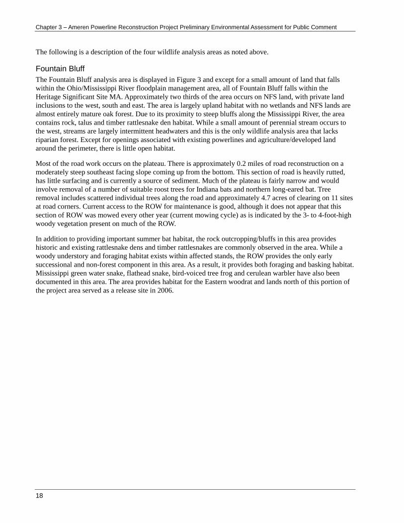
The following is a description of the four wildlife analysis areas as noted above.
Fountain Bluff
The Fountain Bluff analysis area is displayed in Figure 3 and except for a small amount of land that falls
within the Ohio/Mississippi River floodplain management area, all of Fountain Bluff falls within the
Heritage Significant Site MA. Approximately two thirds of the area occurs on NFS land, with private land
inclusions to the west, south and east. The area is largely upland habitat with no wetlands and NFS lands are
almost entirely mature oak forest. Due to its proximity to steep bluffs along the Mississippi River, the area
contains rock, talus and timber rattlesnake den habitat. While a small amount of perennial stream occurs to
the west, streams are largely intermittent headwaters and this is the only wildlife analysis area that lacks
riparian forest. Except for openings associated with existing powerlines and agriculture/developed land
around the perimeter, there is little open habitat.
Most of the road work occurs on the plateau. There is approximately 0.2 miles of road reconstruction on a
moderately steep southeast facing slope coming up from the bottom. This section of road is heavily rutted,
has little surfacing and is currently a source of sediment. Much of the plateau is fairly narrow and would
involve removal of a number of suitable roost trees for Indiana bats and northern long-eared bat. Tree
removal includes scattered individual trees along the road and approximately 4.7 acres of clearing on 11 sites
at road corners. Current access to the ROW for maintenance is good, although it does not appear that this
section of ROW was mowed every other year (current mowing cycle) as is indicated by the 3- to 4-foot-high
woody vegetation present on much of the ROW.
In addition to providing important summer bat habitat, the rock outcropping/bluffs in this area provides
historic and existing rattlesnake dens and timber rattlesnakes are commonly observed in the area. While a
woody understory and foraging habitat exists within affected stands, the ROW provides the only early
successional and non-forest component in this area. As a result, it provides both foraging and basking habitat.
Mississippi green water snake, flathead snake, bird-voiced tree frog and cerulean warbler have also been
documented in this area. The area provides habitat for the Eastern woodrat and lands north of this portion of
the project area served as a release site in 2006.

Ameren Powerline Reconstruction Project Preliminary Environmental Assessment for Public Comment – Chapter 3
19
Figure 3. Fountain Bluff analysis area

Chapter 3 – Ameren Powerline Reconstruction Project Preliminary Environmental Assessment for Public Comment
20
Big Muddy
This Big Muddy analysis area (Figure 4) includes the Big Muddy River and Oakwood Bottoms from State
Route 3 on the west to Horseshoe Bluffs on the east. Lands west of the levee (which includes about 1.5 miles
of ROW and almost all of the road work) are part of the Greentree Reservoir MA, which is inundated with
water for much of the year. East of the levee, approximately 0.50 mile of ROW traverses MA 6.2
(Mississippi and Ohio River floodplains), whereas lands closest to the Big Muddy are included in the
Candidate Wild and Scenic River MA.
Over 1,800 acres or 88 percent of the Big Muddy analysis area occur as forested wetlands (Table 3). The area
contains approximately 1.3 miles of river (Big Muddy) and 30 acres of open water. There are over 10 miles
of man-made channels and ditches which are used to flood the area and create the Greentree Reservoir
complex. Most of the Greentree Reservoir MA contains mature swamp chestnut/cherry bark and pin oak,
interspersed with pole sized red maple and ash stands. This area is also characterized by numerous openings,
levees and ditches interspersed with forest. This area has a high concentration of potential Indiana bat
maternity roosts (including a number of known roosts) because of the bottomland conditions, sawtimber
component, and large snag tree density. While snag density on lands east of the levee is high, this area has
fewer large-diameter snag trees.
While the levee between the Oakwood Bottoms and Mississippi River floodplain MA is identified as
requiring major work, few trees would be removed. However, some tree removal would be needed at road
corners along the Big Muddy access road and along NFS Road 758. It is estimated that approximately 0.9
acres of clearing would be necessary at five road curves/corners. Also, some scattered individual tree
removal may be necessary along portions of the road. While some of the lands immediately below the
powerline in the ROW are mowed, woody vegetation is being maintained along much of the ROW.
The area between the bottomland and Greentree Reservoir provides unique habitat conditions including
emergent, open water, shrub/forested wetlands, bottomland hardwoods, standing water and openings. It
provides important waterfowl migration, stopover and breeding habitat, amphibian upland and breeding
habitat, and habitat for a variety of cavity nesting species. It is within 5 miles of an Indiana bat hibernacula
and provides swarming habitat, as well as one of the largest Indiana bat maternity colonies in the state.
Indiana bats have also been documented along the ROW. Timber rattlesnake habitat occurs in Horseshoe
Bluffs along the eastern boundary, as well as on adjacent lands. Timber rattlesnakes are common within
Oakwood Bottoms during late spring, summer, and early fall months. Horseshoe Bluffs and rock habitat to
the east (Cedar Creek area) contains a remnant Eastern woodrat population and suitable habitat occurs on and
adjacent to the ROW.

Ameren Powerline Reconstruction Project Preliminary Environmental Assessment for Public Comment – Chapter 3
21
Figure 4. Big Muddy analysis area
Chapter 3 – Ameren Powerline Reconstruction Project Preliminary Environmental Assessment for Public Comment
22
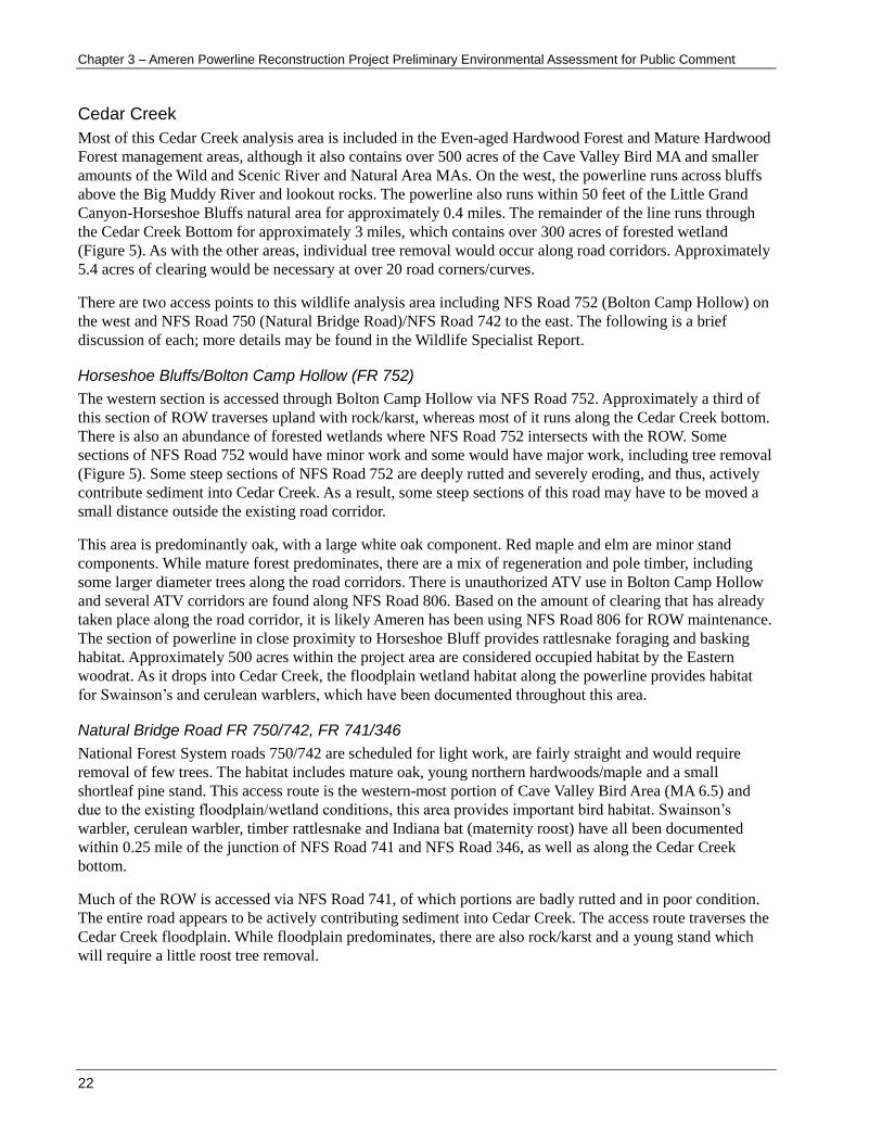
Cedar Creek
Most of this Cedar Creek analysis area is included in the Even-aged Hardwood Forest and Mature Hardwood
Forest management areas, although it also contains over 500 acres of the Cave Valley Bird MA and smaller
amounts of the Wild and Scenic River and Natural Area MAs. On the west, the powerline runs across bluffs
above the Big Muddy River and lookout rocks. The powerline also runs within 50 feet of the Little Grand
Canyon-Horseshoe Bluffs natural area for approximately 0.4 miles. The remainder of the line runs through
the Cedar Creek Bottom for approximately 3 miles, which contains over 300 acres of forested wetland
(Figure 5). As with the other areas, individual tree removal would occur along road corridors. Approximately
5.4 acres of clearing would be necessary at over 20 road corners/curves.
There are two access points to this wildlife analysis area including NFS Road 752 (Bolton Camp Hollow) on
the west and NFS Road 750 (Natural Bridge Road)/NFS Road 742 to the east. The following is a brief
discussion of each; more details may be found in the Wildlife Specialist Report.
Horseshoe Bluffs/Bolton Camp Hollow (FR 752)
The western section is accessed through Bolton Camp Hollow via NFS Road 752. Approximately a third of
this section of ROW traverses upland with rock/karst, whereas most of it runs along the Cedar Creek bottom.
There is also an abundance of forested wetlands where NFS Road 752 intersects with the ROW. Some
sections of NFS Road 752 would have minor work and some would have major work, including tree removal
(Figure 5). Some steep sections of NFS Road 752 are deeply rutted and severely eroding, and thus, actively
contribute sediment into Cedar Creek. As a result, some steep sections of this road may have to be moved a
small distance outside the existing road corridor.
This area is predominantly oak, with a large white oak component. Red maple and elm are minor stand
components. While mature forest predominates, there are a mix of regeneration and pole timber, including
some larger diameter trees along the road corridors. There is unauthorized ATV use in Bolton Camp Hollow
and several ATV corridors are found along NFS Road 806. Based on the amount of clearing that has already
taken place along the road corridor, it is likely Ameren has been using NFS Road 806 for ROW maintenance.
The section of powerline in close proximity to Horseshoe Bluff provides rattlesnake foraging and basking
habitat. Approximately 500 acres within the project area are considered occupied habitat by the Eastern
woodrat. As it drops into Cedar Creek, the floodplain wetland habitat along the powerline provides habitat
for Swainson’s and cerulean warblers, which have been documented throughout this area.
Natural Bridge Road FR 750/742, FR 741/346
National Forest System roads 750/742 are scheduled for light work, are fairly straight and would require
removal of few trees. The habitat includes mature oak, young northern hardwoods/maple and a small
shortleaf pine stand. This access route is the western-most portion of Cave Valley Bird Area (MA 6.5) and
due to the existing floodplain/wetland conditions, this area provides important bird habitat. Swainson’s
warbler, cerulean warbler, timber rattlesnake and Indiana bat (maternity roost) have all been documented
within 0.25 mile of the junction of NFS Road 741 and NFS Road 346, as well as along the Cedar Creek
bottom.
Much of the ROW is accessed via NFS Road 741, of which portions are badly rutted and in poor condition.
The entire road appears to be actively contributing sediment into Cedar Creek. The access route traverses the
Cedar Creek floodplain. While floodplain predominates, there are also rock/karst and a young stand which
will require a little roost tree removal.

Ameren Powerline Reconstruction Project Preliminary Environmental Assessment for Public Comment – Chapter 3
23
Figure 5. Cedar Creek analysis area

Chapter 3 – Ameren Powerline Reconstruction Project Preliminary Environmental Assessment for Public Comment
24
Cave Creek
Cave Creek analysis area is displayed in Figure 6. While the western-most portion of this area traverses
floodplain, most of it occurs on uplands. Like the Cedar Creek area, it contains approximately 500 acres of
the Cave Valley Bird MA, but contains more rock/karst and consequently a higher density of suitable
rattlesnake denning habitat.
This section has three access points including (1) NFS Road 743 (western-most), (2) State Highway 127 and
lands to the west, and (3) State Highway 127 and lands to the east. In addition to scattered individual tree
removal along the road corridor, a total of approximately 1.7 acres of tree clearing may be necessary at nine
sites. The following is a brief discussion of the three access points.
National Forest System Road 743 Access
National Forest System Road 743 occurs on the plateau top and is fairly open requiring little tree removal.
The route corridor contains some oak, and a mix of pine and hardwoods which traverses the Mature
Hardwood Forest MA. It appears this section of ROW is likely mowed every other year.
National Forest System Road 743a traverses a mixed-oak stand with some larger diameter roost trees, and
contains a large rock outcropping. The ROW west of NFS Road 473a runs into the Cedar Creek bottom and
is part of the Cave Valley Bird Area (eastern edge). There is a portion of the ROW that adjoins a large
forested wetland and provides excellent Swainson’s warbler habitat.
Right of Way West of State Road 127
This right-of-way access includes a narrow section of road with a fair amount of large rocks and
outcroppings. Dozens of rattlesnakes have been observed on this section of ROW in the spring of the year.
Cerulean warblers have also been observed near this area. There is a short spur that parallels the ROW
between the two access points that would require some roost tree removal. Because of the proximity of
existing rattlesnake dens, southern exposure and rock outcroppings, there is a high level of rattlesnake use in
this portion of the project area.
Right of Way East of State Road 127
This right-of-way access comes off of private land and traverses a mowed field on private land for the first
0.25 mile. Once it enters the National Forest, it is dominated by shrubs/early successional forest, although the
last 0.25 mile runs through mature mixed-oak forest. There would be little roost tree removal along this spur,
or the primary access road. One section of powerline has not been maintained annually and 3- to 4-foot-high
woody vegetation has become established. Because of the proximity to rock outcroppings and rattlesnake
dens, south facing aspect and abundance of early successional foraging habitat, use of this section of ROW
by snakes is likely to be high.

Ameren Powerline Reconstruction Project Preliminary Environmental Assessment for Public Comment – Chapter 3
25
Figure 6. Cave Creek analysis area

Chapter 3 – Ameren Powerline Reconstruction Project Preliminary Environmental Assessment for Public Comment
26
Affected Environment for Individual Species
The Wildlife Specialist Report and Biological Evaluation describe in detail the affected environment for all
wildlife and aquatic species potentially affected by the proposed action. This level of detail will not be
repeated here, and the report is in the project record. It includes details on the status, life history
requirements, threats, and project area habitat for federally threatened, endangered, and sensitive species;
Illinois State listed species; Forest species with viability evaluation; and MIS.
Effects Analysis
Four unresolved key issues were identified during project scoping relating to wildlife resources.
There is concern that the proposed activities could adversely affect endangered or threatened bats.
There is concern that the proposed activities could adversely affect the state-listed threatened Timber
Rattlesnake.
There is concern that the proposed activities could adversely affect the state-listed endangered Eastern
woodrat and the state-listed rice rat.
There is concern that the proposed activities could adversely affect migratory birds, including State-listed
threatened and endangered species.
The effects discussion as presented next is species driven. As such, the following indicators were used to
frame the analysis of wildlife effects on various species.
Table 4. Issue indicators used to measure wildlife effects
Species Wildlife Effect Indicator
Management Indicator Species
Yellow-breasted chat2 Effects to individuals, shrub openings and young regenerating forest
Worm-eating warbler2 Effects to individuals and mature upland forest
Scarlet tanager Effects to individuals and upland and bottomland mature hardwood forest.
Woodthrush2 Effects to individuals and mature bottomland hardwoods with a woody understory
Northern Bobwhite2 Effects to individuals and changes in woodland grassland habitat.
Threatened, Endangered and Proposed Species
Gray bat3
Effects to individuals, hibernacula, and roosting, foraging, swarming habitat. Indiana bat3
Northern long-eared (NLE) bat
Least tern Effects to individuals and riverine habitat.
Sensitive Species
Rafinesque’s big-eared bat3
Effects to individuals, potential hibernacula, and roosting and foraging habitat.
Southeastern myotis
Eastern small-footed bat
Tri-colored bat
Little brown myotis
Eastern woodrat3 Effects to individuals, ravines and forested floodplain habitat.
Cerulean warbler3 Effects to individuals and suitable mature forest habitat
Henslow’s sparrow Effects to individuals and suitable open land habitat.
Migrant loggerhead shrike Effects to individuals and shrub habitats.
Bald eagle Effects to individuals, suitable river and open water habitat.

Ameren Powerline Reconstruction Project Preliminary Environmental Assessment for Public Comment – Chapter 3
27
Species Wildlife Effect Indicator
Swainson’s warbler3
Effects to individuals and closed canopy bottomland habitat with a developing understory
Timber rattlesnake3 Effects to individuals and suitable den and foraging habitat
Alligator snapping turtle Effects to individuals and slow moving stream and riverine habitat.
Mississippi green watersnake Effects to individuals and suitable bald cypress/water tupelo backwater habitat.
Bird-voiced treefrog3
Flat-headed snake Effects to individuals and rocky pine/hardwood habitat.
Eastern narrow mouth toad3 Effects to individuals and open wetland and riparian habitat
Subtle Cave amphipod (Stygobromus sbutilis)
Effects to individuals and spring/seep habitat in karst areas.
Forest species with viability evaluation1
River otter Effects to individuals and suitable river/stream and open water habitat
American woodcock
Effects to individuals, shrub openings and young regenerating forest Northern bobwhite
Yellow-breasted chat
Worm eating warbler Effects to individuals and mature hardwood/riparian habitat
Wood thrush
Red-headed woodpecker Effects to individuals and open woodland and snag habitat
Gray treefrog Effects to individuals and forested riparian/wetland habitat.
Illinois State Listed Species Not Previously Listed1
Rice rat Effects to individuals and wetland habitat.
Golden mouse Effects to individuals and open woodlands/swamps.
Mississippi Kite Effects to individuals and suitable mature forest bottomland habitat.
Loggerhead shrike Effects to individuals and open lands with a shrub component.
Smooth softshell Effects to individuals and stream/river habitat
1 – Not previously listed as a TES or MIS species.
2 – Also a Forest species with viability evaluation
3 – Also listed as an Illinois State listed species
Scale of Analysis and Species Considered
The project boundary (approximately 6,637 acres) was selected for analysis of direct and indirect effects on
wildlife because it includes all proposed actions and adjacent habitats that may influence wildlife use. A total
of 64 species including T&E, Regionally sensitive, Forest species with viability evaluation, state listed
species and MIS were considered. Due to the lack of suitable habitat or recent documentation, 1 T&E, 21
sensitive species and 6 state listed species were eliminated from detailed analysis. Listing of these species
may be found in the project record.
Table 5 lists the federally threatened and endangered species and regionally sensitive species that were
evaluated in detail. Illinois State listed and Forest species with viability evaluation are displayed in Table 6
and Forest MIS species considered are displayed in Table 7.
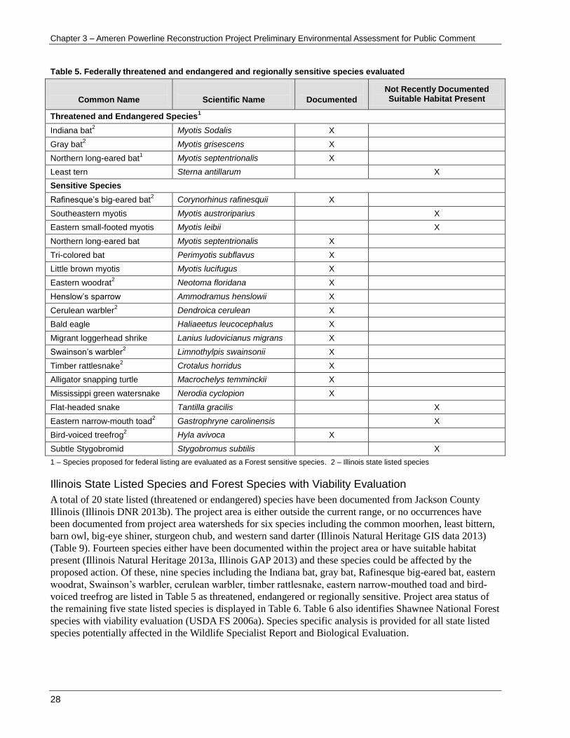
Chapter 3 – Ameren Powerline Reconstruction Project Preliminary Environmental Assessment for Public Comment
28
Table 5. Federally threatened and endangered and regionally sensitive species evaluated
Common Name
Scientific Name
Documented
Not Recently Documented Suitable Habitat Present
Threatened and Endangered Species1
Indiana bat2 Myotis Sodalis X
Gray bat2 Myotis grisescens X
Northern long-eared bat1 Myotis septentrionalis X
Least tern Sterna antillarum X
Sensitive Species
Rafinesque’s big-eared bat2 Corynorhinus rafinesquii X
Southeastern myotis Myotis austroriparius X
Eastern small-footed myotis Myotis leibii X
Northern long-eared bat Myotis septentrionalis X
Tri-colored bat Perimyotis subflavus X
Little brown myotis Myotis lucifugus X
Eastern woodrat2 Neotoma floridana X
Henslow’s sparrow Ammodramus henslowii X
Cerulean warbler2 Dendroica cerulean X
Bald eagle Haliaeetus leucocephalus X
Migrant loggerhead shrike Lanius ludovicianus migrans X
Swainson’s warbler2 Limnothylpis swainsonii X
Timber rattlesnake2 Crotalus horridus X
Alligator snapping turtle Macrochelys temminckii X
Mississippi green watersnake Nerodia cyclopion X
Flat-headed snake Tantilla gracilis X
Eastern narrow-mouth toad2 Gastrophryne carolinensis X
Bird-voiced treefrog2 Hyla avivoca X
Subtle Stygobromid Stygobromus subtilis X
1 – Species proposed for federal listing are evaluated as a Forest sensitive species. 2 – Illinois state listed species
Illinois State Listed Species and Forest Species with Viability Evaluation
A total of 20 state listed (threatened or endangered) species have been documented from Jackson County
Illinois (Illinois DNR 2013b). The project area is either outside the current range, or no occurrences have
been documented from project area watersheds for six species including the common moorhen, least bittern,
barn owl, big-eye shiner, sturgeon chub, and western sand darter (Illinois Natural Heritage GIS data 2013)
(Table 9). Fourteen species either have been documented within the project area or have suitable habitat
present (Illinois Natural Heritage 2013a, Illinois GAP 2013) and these species could be affected by the
proposed action. Of these, nine species including the Indiana bat, gray bat, Rafinesque big-eared bat, eastern
woodrat, Swainson’s warbler, cerulean warbler, timber rattlesnake, eastern narrow-mouthed toad and bird-
voiced treefrog are listed in Table 5 as threatened, endangered or regionally sensitive. Project area status of
the remaining five state listed species is displayed in Table 6. Table 6 also identifies Shawnee National Forest
species with viability evaluation (USDA FS 2006a). Species specific analysis is provided for all state listed
species potentially affected in the Wildlife Specialist Report and Biological Evaluation.

Ameren Powerline Reconstruction Project Preliminary Environmental Assessment for Public Comment – Chapter 3
29
Table 6. Illinois state listed species and forest species with viability evaluation
Common Name
Scientific Name
Documented
Not Recently Documented Suitable Habitat Present
Illinois State Listed Species
Marsh Rice Rat Oryzomys palustris X
Golden Mouse Ochrotomys nuttalli X
Mississippi Kite Ictinia mississippiensis X
Loggerhead Shrike Lanius ludovicianus X
Smooth softshell Apalone mutica X
Forest Species with Viability Evaluation
River otter Lutra canadensis X
American woodcock Scolopax minor X
Northern bobwhite Colinus virginianus X
Red-headed woodpecker Melanerpes erythrocephalus
X
Wood thrush Hylocichla mustelina X
Worm eating warbler Helmitheros vermivorum X
Yellow-breasted chat Icteria virens X
Gray treefrog Hyla versicolor X
Management Indicator Species
Table 7 displays MIS species evaluated and the habitats they represent, available project area habitat and
when available, population trend information. More detailed species-specific information is provided in the
Wildlife Specialist Report available in the project record. Additionally, the selection and rationale for these
species is located on pages 3-194 to 3-195 of the Forest Plan FEIS and preferred habitat, threats, and
management emphasis are discussed on pages 3-196 to 3-204 of the Forest Plan FEIS (USDA-FS 2006b).
Table 7. Forest management indicator species evaluated
Species
Scientific Name
Population Trend
1
Habitat
Yellow-breasted chat
2
Icteria virens -1.6 Represents species of shrublands: Herbaceous openings and upland hardwood and pine to nine years old
Worm-eating warbler
Helmitheros vermivorum
2.7 Representing ground-nesting species: Upland hardwood more than 50 years old
Scarlet tanager Piranga olivacea 0.4 Representing canopy-nesting species: Upland and bottomland hardwood more than 50 years old
Woodthrush2 Hylocichla mustelina -1.6
Representing species that nest in shrubs and small trees: Bottomland hardwood more than 50 years old (riparian areas and filter strips, and wild and scenic river corridors) and upland hardwood more than 50 years old.
Northern Bobwhite
2
Colinus virginianus -3.7 Representing species of grasslands, shrublands and edges: Wildlife and herbaceous openings, regeneration areas
1 – State-wide trend based on USGS 2014 Breeding Bird Survey Data 1966-2012. Available at: http://www.mbr-pwrc.usgs.gov/cgi-bin/atlasa12c.pl?ILL&2&12
2- Listed as a species of greatest conservation need due to declines in abundance and distribution from historic levels (Partner In Flight 2000).

Chapter 3 – Ameren Powerline Reconstruction Project Preliminary Environmental Assessment for Public Comment
30
Alternative 1, No Action
Direct and Indirect Effects
As described in Chapter 2 for the No Action alternative, no improvements to the powerline structures and
conductor would occur, thus there would be no power pole replacement or access route improvements.
Existing ROW maintenance would continue. Currently, much of the powerline is maintained every other
year, which consists of using a flail mower and tractor to remove vegetation along the entire ROW.
Herbaceous and woody vegetation is removed to a height of approximately 6 inches and effects to wildlife
include direct mortality and disturbance during mowing. Because mowing across most of the powerline can
occur throughout the spring and summer months, effects include mortality to breeding individuals and
nesting young of the year.
Early successional or old field vegetation along the ROW can provide habitat for a number of
grassland/shrub nesting species, including several migratory birds that are experiencing population declines
(Yahner et al 2002). While ROW vegetation would continue to provide nesting and foraging habitat for a
variety of wildlife, continued mowing has and will continue to reduce the quality of grassland nest habitat
(Pruitt 1996, Herkert 2001). ). Similarly, because woody vegetation is reduced through mowing, the ROW
would continue to provide little shrub nesting habitat.
While much of the access to the ROW occurs via county and NFS designated roads, existing undesignated
roads are also being used. Project area roads are shown in Figure 3 (Fountain Bluff), Figure 4 (Big Muddy),
Figure 5 (Cedar Creek), and Figure 6 (Cave Creek). See also Appendix B for all project area maps. Under No
Action, existing road management would be unchanged and year-round access from open roads would
continue. Based on field observations (Reitz 2014a), unauthorized ATV use is also occurring along
undesignated roads into Cedar Creek and Bolton Hollow. These roads are currently open to public access and
trails are expanding off of the road along the Cedar Creek floodplain. Effects to wildlife include disturbance
and mortality associated with continued road use, until such a time as these undesignated roads are closed.
Several undesignated road corridors are on steep slopes, poorly drained and are actively contributing
sediment into project area watersheds. Under No Action, sedimentation and reduced water quality from these
point sources, particularly in the Cedar Creek drainage would continue, and could potentially adversely
affect wildlife and aquatic species.
Cumulative Effects
Since the only direct and indirect effects to wildlife that would result from implementation of the No Action
alternative are those associated with the continuation of existing mowing and powerline maintenance, there
would be no additional proposed project activities that would produce cumulative effects. Other than effects
of ROW maintenance described above, existing forest and non-forest habitat would be unchanged under this
alternative as would the level of any maintenance-caused mortality. The suitability of the ROW for grassland
and shrub nesting birds would remain low and no adverse cumulative impact to wildlife and aquatic species
would be expected under this alternative.
Alternative 2, Proposed Action
The effects of the Proposed Action on wildlife are best disclosed by looking at the impacts of activities
related to road construction and reconstruction, and work on the powerline. The Wildlife Specialist Report
provides extensive detail about the impacts to wildlife and aquatic species. That detail will be summarized in
the discussion that follows. Important design criteria are discussed briefly where appropriate in the effects
discussion below, and would be implemented to eliminate or reduce impacts to wildlife and aquatic species.
These measures may be found in Appendix A – Design Criteria.

Ameren Powerline Reconstruction Project Preliminary Environmental Assessment for Public Comment – Chapter 3
31
Direct and Indirect Effects
The activities necessary to prepare the access routes for use can affect wildlife in a variety of ways including
harm or harassment during construction or use, loss or degradation of habitat, increased human access, or by
creating barriers to wildlife movement and dispersal (NRDC 1999). Temporary clearings will also be created
at a number of locations in order to move the long power poles onto the ROW. While some effects may occur
on all roads, many effects will vary depending on the existing road condition and use, or location of the road
corridor. The miles of roads affected and the estimated amount of clearing on NFS lands are summarized by
wildlife analysis area in Table 8. The effects of activities occurring specifically in each wildlife analysis area
are disclosed in detail in the Wildlife Specialist Report.
Table 8. Analysis area road miles and clearing1
Activity/Road Standard Analysis Area
Fountain Bluff Big Muddy Cedar Creek Cave Creek Total
County Road Miles 0.1 1.1 0.0 0.0 1.21
Level 1 Road Miles 0.0 1.2 1.8 0.0 3.0
Level 2 Road Miles 1.1 0.8 1.06 1.25 4.21
Level 3 Road Miles 0.0 2.3 1.52 1.4 5.22
Non-designated Road Miles 0.8 0.0 1.01 1.36 3.17
Total Road Miles 2.0 5.41 5.39 4.01 16.81
Transmission Line 0.5 3.1 3.2 2.0 8.8
Estimated Clearing acres 4.7 0.9 5.2 2.6 13.4
1 – Activities are displayed for National Forest System Lands only
Effects Common to All Roads
Direct effects would largely be limited to activities that occur to the roadbed and associated road corridor.
Direct effects from tree removal include possible harm or mortality when the tree is felled. The likelihood of
harm would be greatest during the breeding season when nests and roosts with less mobile young of the year
are present. Because design criteria would restrict removal of snags or live trees between April 1 and
November 15, any removal would occur outside the breeding season for most species. As a result, nests or
less mobile young-of-the-year would not be present, and the likelihood of mortality during tree removal
would be low.
Route construction activities including clearing of roadside vegetation, grading and resurfacing, and
culvert/ditch line maintenance, would potentially also result in mortality of less mobile species, or
disturbance to sensitive wildlife species. Disturbance to wildlife from roads is largely dependent on the level
and season of use along with whether or not a road is open, closed or restricted. The Shawnee NF reduces
impacts to wildlife by keeping roads into key habitats closed or restricted during critical periods of the year.
Road management on County and most NFS designated roads would be unchanged, whereas some
undesignated roads that are currently open to public access would be closed. Access on undesignated roads
would be limited to administrative use or for ROW maintenance by Ameren As a result, the road
management strategy in effect would be expected to reduce potential impacts to wildlife in these areas.
Effects to wildlife from clearings associated with road construction would include a reduction in mature
forest habitat on approximately 13 acres of SNF lands across the project area. Potential adverse effects to
wildlife would include a possible increase in predation/parasitism for 15 to 20 years, until forested cover is
re-established on the site. Other potential adverse effects would include possible mortality or avoidance
during implementation of activities. The small openings created by removing trees to widen the access routes
would result in little change in the habitat conditions within the affected stand, but rather would serve as a
within-stand habitat inclusion, and the wildlife community would be largely determined by the predominant

Chapter 3 – Ameren Powerline Reconstruction Project Preliminary Environmental Assessment for Public Comment
32
structural conditions of the forest around the clearing. As a result, there would be little change in stand-level
habitat from proposed clearings. While there would be a small reduction in mature forest, clearings would
create habitat for species that utilize small patches of early structural forest, including some early
successional species, as well as a number of mid- to late seral species (DeGraaf et al. 1992, Tucker 1992).
Studies of forest birds show that nest predators and parasites are reduced in predominantly forested areas
(Askins 2012, Robbins et al. 1989). For example in the mid-west, scarlet tanagers, an area sensitive MIS, are
predicted to occur in virtually any size forest patch within landscape blocks that are more than 70 percent
forested (Rosenberg et al. 1999). This is a consideration within the Ameren project area because over 80
percent of all lands and 90 percent of NFS lands are forested. Because of the small scattered nature of the
clearings, treatment would not further fragment the forest, and where they exist, interior habitat conditions
would continue to be provided. Similarly, nest predation and parasitism are reduced in predominantly
forested areas (Robbins et al. 1989, deCalesta 1998). So while an increase in predation and brood parasitism
may occur, because of the small scattered size of the clearings, the regeneration of forest in the clearings, and
the continued predominance of mature forest around the site, adverse effects associated with predation or
brood parasitism would be reduced. As a result, there would be no long-term adverse impacts from
fragmentation.
Effects Common to Undesignated Roads
Low standard roads similar to existing undesignated roads have been shown to be barriers to the dispersal of
some small mammals, reptiles and amphibians (NRDC 1999, PARC 2006). Because proposed work includes
grading and surfacing, localized dispersal and movements of some species would continue to be modified or
reduced.
Roads can degrade stream ecosystems by introducing high volumes of sediment into streams, changing
natural stream flow patterns and altering stream morphology. Deposition of sediment can also adversely
affect amphibian and invertebrate species diversity and abundance (NRDC 1999). Many of the undesignated
roads are currently open to year-round public use, are located on steep slopes or in drainage bottoms and are
actively contributing sediment into local watersheds. Design criteria would potentially reduce any short-term
increases in sediment during construction, while proposed work would improve drainage and reduce existing
sedimentation over the longer term. Additionally, existing open roads into Horseshoe Bluffs and portions of
the Cedar Creek Bottom would be closed and while some unauthorized ATV activity may still occur, it is
expected that unauthorized use would be reduced. Therefore, proposed activities would result in a long-term
improvement in stream and riparian habitat, as well as reduce impacts to aquatic resources.
Some undesignated roads, including several into more remote areas (e.g., Little Grand Canyon), or areas with
sensitive habitats (e.g., wetlands/rocky areas) are currently open to public use and disturbance to wildlife can
occur year round. While road use of undesignated roads would increase during construction, because these
roads would be closed to public access during and following implementation, disturbance and mortality to
wildlife associated with road use would be reduced.
Proposed Powerline Activities
Construction and maintenance activities along the powerline would also impact wildlife. Work would include
replacing the existing structures and wires (see the description of Alternative 2, Proposed Action in Chapter
2), and would also include clearing of low growing vegetation and some grading and surfacing along the
center of the ROW. Approximately 13 acres of grassland habitat would be affected, including a long-term
loss of habitat on approximately 10 acres that would be associated with blading and surfacing. Because work
would be concentrated in the center of the ROW, habitat outside of the lines would be largely unaffected
during construction. Direct effects would be similar to those described under road construction and activities
may cause direct mortality to less mobile species. Also, species sensitive to disturbance and increased human
activity would move out of the area during construction.

Ameren Powerline Reconstruction Project Preliminary Environmental Assessment for Public Comment – Chapter 3
33
Ameren is required by national standards that establish minimum clearings to ensure safe operation.
Therefore, Ameren must keep the ROW clear of vegetation that impedes access to the powerline. To control
vegetation height, most sections of the ROW are mowed every other year. This maintenance schedule is
expected to continue. Effects to wildlife include short-term disturbance to sensitive species along the ROW
and the access roads during maintenance operations.
Removal of vegetation in the ROW would result in direct mortality to small mammals or birds during
vegetation removal. The likelihood of mortality largely depends on the time of year. If mowing occurs during
the breeding season when nests or less mobile young are present, the risk of mortality would be higher.
While habitat for many grassland and shrub nesting species is reduced along the ROW due to frequent
mowing, continued mowing would be expected to result in disturbance and mortality to wildlife. Habitat
conditions along the ROW would be largely unchanged.
Species Effects
The Wildlife Specialist Report and Biological Evaluation include extensive documentation of the analysis on
important individual species that resulted in conclusion regarding effects determinations. This includes
disclosure regarding T&E species Indiana bat, Gray bat, and Northern long-eared bat. It also includes such
sensitive species as Rafinesque big-eared bat, Southeastern myotis, Eastern small-footed bat, tri-colored bat
and little brown bat, and disclosure on State listed species, Forest species with viability evaluation and Forest
MIS. Table 9 summarizes determinations for terrestrial and aquatic evaluated including TES, MIS, Illinois
State listed and Forest species with viability evaluation. Species that are in more than one of these categories
are duplicated.
Table 9. Effects determination summary
Species No Action Proposed Action
Threatened and Endangered Species
Pallid sturgeon
No Effect
No Effect
Indiana bat
Gray bat
Least tern
May Affect, Not Likely to Adversely Affect.
Northern long-eared bat Not Likely to Jeopardize
Regionally Sensitive Species
Northern copperbelly watersnake
Illinois chorus frog
Redspotted sunfish
Bantam sunfish
Black sandshell
Purple Lilliput
Caeciodotea beattyi
Caeciodtea bicrenata whitei
Caecidotea stygia
Anomalous spring amphipod
Packard cave amphipod
Bousfield’s amphipod
Indiana crayfish
Bigclaw crayfish
Carinate pillsnail
Cavenicolous springsnail
Sphalloplana hubrichti
Ergodesmusremingtoni
No Impact No Impact

Chapter 3 – Ameren Powerline Reconstruction Project Preliminary Environmental Assessment for Public Comment
34
Species No Action Proposed Action
Pseudosinella argentea
Short-tailed bacruid
Mississippi green watersnake
Flathead snake
Subtle stygobromid
Rafinesque’s big-eared bat
Southeastern myotis
Eastern small-footed bat
Northern long-eared bat
Tri-colored bat
Eastern woodrat
Henslow’s sparrow
Cerulean warbler
Bald eagle
Migrant loggerhead shrike
Swainson’s warbler
Alligator snapping turtle
Eastern narrow-mouth toad
Bird-voiced treefrog
No Impact May Impact individuals, but is not
likely to cause a trend toward federal listing or a loss of viability.
Timber rattlesnake May Impact individuals, but is not likely to cause a trend toward federal
listing or a loss of viability.
Illinois State Listed Species
Big-eye shiner
Sturgeon chub
Western sand darter
Common moorhen
Least bittern
Barn owl
No effect to individuals, habitat or local viability.
Indiana bat
Gray bat
Northern long-eared bat
Rafinesque big-eared bat
Eastern woodrat
Cerulean warbler
Swainson’s warbler
Eastern narrow-mouth toad
Bird-voiced treefrog
Marsh rice rat
Golden mouse
Mississippi kite
Loggerhead shrike
Smooth softshell
No effect to individuals, habitat or local viability.
Individuals may be affected. Habitat and local viability maintained
Timber rattlesnake Individuals may be affected. Habitat and local viability maintained
Forest Species with Viability Evaluation
River otter
American woodcock
Northern bobwhite
Red-headed woodpecker
Wood thrush
Worm-eating warble
Yellow-breasted chat
No effect to individuals or local viability
Individuals may be affected. Would not reduce local viability.

Ameren Powerline Reconstruction Project Preliminary Environmental Assessment for Public Comment – Chapter 3
35
Species No Action Proposed Action
Gray treefrog
American woodcock
Northern bobwhite
Individuals may be affected. Would not reduce local viability.
Individuals may be affected. Would not reduce local viability.
Management Indicator Species
Northern bobwhite Individuals may be affected. Habitat and local populations maintained.
Individuals may be affected. Habitat and local populations maintained.
Worm-eating warbler
Scarlet tanager
Woodthrush
Yellow-breasted chat
No effect to individuals. Habitat and local populations maintained.
Cumulative Effects
Cumulative effects to terrestrial and aquatic species have been evaluated on private and NFS lands within a
6,637 acre project area selected for this wildlife analysis. A 15-year timeframe, out to 2029, was used to
assess impacts. In order to understand the contribution of past actions to the cumulative effects of the
proposed action, this analysis relies on current environmental conditions as a proxy for the impacts of past
actions. On-going and anticipated future activities are summarized in
Table 10.
Table 10. Cumulative effects summary
Activity Description
Firewood Harvest Scattered across the project area along open roads
Dispersed Recreation Continued at scattered locations across the project area
Ameren Road re-construction 17.8 Miles
Ameren Powerline Construction and Maintenance
10.8 Miles
Invasive Weed Control Scattered treatment concentrated along roads and disturbed sites.
Road Maintenance Forest, county, state and private roads across the project area.
Unauthorized ATV use Variable across the project area
Agriculture – cultivated crops and pasture/hay1 135 acres
Private open land development1 103 acres
Oakwood Bottoms impoundment 1,200 acres seasonal impoundment
Prescribed Fire Approximately 500 acres per year
1 – Based on Illinois GAP land cover GIS data
Regarding aquatic effects, collectively the past, present and future activities have most likely contributed to
adverse impacts to water quality through increased sedimentation. Because the proposed action may further
increase sedimentation during construction, this would contribute towards reduced water quality and hence
result in an adverse cumulative impact. However, any increase would be short-term during construction. The
proposed action would close roads that currently have unauthorized ATV use and thus, reduce erosion.
Consequently, while there may be a short-term increase in sedimentation, over the long-term, proposed
actions would be expected to improve water quality and maintain aquatic habitat. This improvement would
be further enhanced by application of Forest Plan standards and guidelines and implementation of project
design criteria and best management practices. Also, the pre-existing erosion and poor drainage conditions on
some access routes would be corrected, resulting in a long-term improvement in water quality. Therefore, this
would be expected to result in an overall positive cumulative impact to aquatic species.

Chapter 3 – Ameren Powerline Reconstruction Project Preliminary Environmental Assessment for Public Comment
36
Regarding effects to terrestrial wildlife, disturbance associated with ATV use, firewood cutting private land
activities, road maintenance, invasive weed treatment, recreational use, oak restoration and firewood cutting
would continue. Proposed road re-construction, pole replacement and ROW maintenance would contribute
additionally to existing disturbance and possible mortality during project implementation, and thus result in a
minor adverse cumulative impact. However proposed road closures would reduce disturbance into the Cedar
Creek Bottom, Horseshoe Bluffs and Little Grand Canyon, and sensitive wildlife habitats in these areas.
In addition to clearing on NFS land, it is estimated that an additional 2 acres of clearing may be necessary on
private land. Habitat changes from proposed activities would include a reduction in mature forest on
approximately 15 acres, whereas habitat for wildlife that utilizes small pockets of early successional forest
would benefit from an increase in this acreage. This slight change in habitat would not be expected to
measurably contribute to past, ongoing and future activities.
In summary, direct effects of implementation would be short-term. Project design criteria would reduce
disturbance and mortality to species with viability evaluation including TES, state listed species and Forest
species with viability evaluation identified in the Forest Plan. Only 15 acres of forest (both NFS and private
lands) would be affected, and there would be little change in stand level habitat. While activities on NFS and
private lands would continue, existing uses or patterns of use are not expected to change. There would be
little change in the availability of suitable habitat during the analysis period. Therefore, there would be no
measureable increase in long-term adverse cumulative effects to wildlife.
Access Routes and Transportation System The discussion that follows describing the affected environment and disclosing the environmental effects for
the access routes and transportation system analysis have been summarized from the Engineering Report and
from the Road Condition Surveys report, both found in the project record. This section will focus mainly on
describing the access routes and the work needed to prepare them for use by the heavy construction
equipment. The construction needed to improve (reconstruct) and/or construct the routes and replace the
power poles in the ROW would result in impacts to various resources such as soil and water, wetlands,
botany, and wildlife. As such, those impacts will be disclosed in the sections for those various resources.
A number of assumptions were used to guide the disclosure of impacts related to the access routes and
transportation system:
♦ Route distance figures have been estimated from mapping or from field inventory. Mileages have
been updated throughout the planning process as better information has been made available and
may change slightly with additional field verification and during actual project implementation.
♦ Road work and infrastructure improvements would be conducted in accordance with Best
Management Practices.
♦ The spatial boundary and subject for analysis includes the network of roads within the project area.
♦ Effects are assessed based on a 5-year time frame, assuming all project actions associated with the
transportation network would be completed by that time.
Furthermore, the transportation analysis is based on the specific routes proposed for project use, as well as
the general Forest corridor (ROW) along the powerline. The cumulative effects analysis is based on known
current and reasonably foreseeable projects within the HUC6 watersheds that overlap the powerline project.
Affected Environment
Information on the affected environment may be found above in the General Affected Environment for the
Project Area section and the Wildlife and Aquatic Resources section. As described under the Proposed
Action, Ameren would need to access the pole locations with heavy equipment over many different access

Ameren Powerline Reconstruction Project Preliminary Environmental Assessment for Public Comment – Chapter 3
37
routes for different sections of the ROW that include FS designated roads, non-designated roads, county
roads, or other possible routes such as old logging roads and trails not formally designated on the FS road
system. For those access routes that cross private lands, Ameren would be responsible for implementing their
Stormwater Pollution Prevention Plan’s Best Management Practices to reduce or eliminate impacts.
Effects Analysis
No unresolved issues were identified during project scoping relating to the access routes and transportation
system. Indicators used to frame the analysis of transportation effects include forest transportation system
conditions, traffic levels, and health and safety concerns.
Alternative 1, No Action
As described in Chapter 2 for the No Action alternative, no improvements to the powerline structures, wires,
and conductor would occur, thus there would be no power pole replacement or access route improvements.
Existing ROW maintenance would continue. Therefore, there would be no direct effects for this alternative.
Indirect effects are anticipated due to past lack of maintenance and route improvements. Field visits have
shown that many of the existing roads and access routes have badly deteriorated due to poor drainage and
lack of maintenance. It is anticipated that under this alternative, that lack of maintenance and deterioration
would continue and thus, rutting could become deeper. There would also be a corresponding slight and
continued decrease in public and administrative health and safety due to the deteriorating powerline poles,
including an increase in fire danger where low-hanging wires come close to the ground.
Cumulative Effects
Since the only direct and indirect effects to the transportation system that would result from implementation
of the No Action alternative are those associated with the continuation of existing mowing and powerline
maintenance, there would be no additional proposed project activities that would produce cumulative effects
for this alternative. Existing routes would continue to be used for powerline access as has been done in the
recent past under the existing special use permit; maintenance would also continue, including vegetation
management and mowing. This situation would continue into the foreseeable future. Routes would also
continue to receive traffic from other Forest users, as well as occasional administrative traffic. Light traffic
over time would be expected to contribute to continued route deterioration on lower-standard routes not
receiving scheduled maintenance. Higher standard system roads would continue to receive regularly
scheduled maintenance.
Alternative 2, Proposed Action
Road width and the level of work needed would determine the degree of environmental impact; the wider the
road width, the more trees that would need to be removed and thus, more habitats would be impacted. While
a minimum width of 12 feet would be needed for most sections, it is anticipated that a maximum turning
radius of about 150 feet would be needed to allow passage of the long poles around corners along the routes.
All access routes have been located to minimize tree cutting and impacts to soil and water. Over 1,100 trees,
predominantly less than 5 inches in diameter, have been identified as needing to be removed to reconstruct
the access roads (see the Wildlife and Aquatic Resources section). Access along the ROW between towers
will be confined as much as possible to a 20-foot-wide travel-way along the center line of structures unless
the terrain does not allow it.
Roads used solely for access to the powerline will be included in Ameren’s permit to provide future access
for maintenance. Ameren will be responsible for maintaining these roads at a level that keeps them from
eroding or rutting while supporting access by mowing or maintenance crews. Forest System roads used for
public access to the area will continue to be maintained by the Forest service.
Chapter 3 – Ameren Powerline Reconstruction Project Preliminary Environmental Assessment for Public Comment
38
Direct and Indirect Effects
The necessary road and route improvements, realignments, and widening would create additional disturbed
and compacted areas during implementation. A total of approximately 16 miles of access routes have been
proposed for use and would most likely need some level of improvement. This would include improvements
to maintenance level 1, 2, and 3 FS roads and roads not formally designated on the Forest Service road
system (non-designated roads), and also private and county roads (see the Wildlife and Aquatic Resources
section). Best management practices would be used during implementation to minimize negative effects
related to compaction, erosion, and runoff. Field inspections have found a number of concerns on some of
the existing access routes including deep rutting, erosion, and severe compaction. The proposed activities
would correct the existing poor drainage and would result in a more sustainable system that in the long run
would produce less erosion. Traffic would increase during implementation (short-term), and would be
expected to return to current levels. Ongoing maintenance for infrastructure, including vegetation mowing
and any necessary short-term improvements to the access routes, would continue.
There would be a short-term increase in traffic during project implementation due to the movement of
various construction equipment, construction activities, and tree felling operations. Use of the design criteria,
including traffic control, would be expected to minimize these adverse effects. In the long-term, there would
be an expected improvement in road conditions and thus, public health and safety, through use of the
appropriate design standards and best management practices, resulting in a more stable and better managed
transportation network with minimal erosion and drainage problems. Proper road management and use of
appropriate road closure devices would minimize conflicts with public use and powerline management.
Cumulative Effects
Since existing access routes, once improved, would be used to reach the powerline corridor, there would
essentially be no increase in Forest system or private roads or trails. Therefore, considering past actions and
reasonable foreseeable actions, there would be no adverse cumulative impacts to the transportation system
for this alternative. Routes would continue to be used for powerline maintenance, including vegetation
management and mowing, for the foreseeable future. Routes would also continue to receive traffic from other
Forest users, as well as occasional administrative traffic. Higher standard system roads would continue to
receive regularly scheduled maintenance as managed with annual transportation funding appropriations.
Proper use of design criteria during project implementation, including best management practices, would
minimize long-term erosion and other negative resource effects associated with road construction and
drainage issues, and provide for a limited beneficial cumulative impact.
Botany The discussion that follows describing the affected environment and disclosing the environmental effects for
Botany resources have been summarized from the Botany Specialist Reports, plant survey documentation,
and Biological Evaluations for all threatened, endangered, and sensitive plants found in the project record.
Affected Environment
Information on the affected environment may be found above in the General Affected Environment for the
Project Area section and the Wildlife and Aquatic Resources section. In addition, the habitat for each plant
that is either federally listed, a Regional Forester Sensitive Species (RFSS), a State of Illinois Threatened
And Endangered Plant Species, or a forest species with viability evaluation is fully discussed in detail in the
Botany Specialist Reports and will not be disclosed here. The reports are available in the project record.

Ameren Powerline Reconstruction Project Preliminary Environmental Assessment for Public Comment – Chapter 3
39
Effects Analysis
Two unresolved key issues were identified during project scoping relating to botany resources:
There is concern that the proposed activities could adversely affect a number of State-listed plant species.
There is concern that the proposed activities could adversely affect designated natural areas.
Indicators used to frame the effects of the proposed activities on plants of concern include the amount and
type of disturbance and its potential impact on the affected species, and the amount and type of disturbance
to a nearby natural area.
The spatial, or geographic, boundary for the rare plant resources effects analysis is the Ameren powerline
ROW corridor and areas immediately adjacent to it, including the access routes proposed for improvements.
All proposed activities that could affect botany resources would be confined to the project area. The temporal
timeframe for the analysis is from the past 10 years, to 10 years in the reasonably foreseeable future. This
past temporal timeframe was selected since the majority of our knowledge of rare plant resources has only
come about within the last 70 years. Ten years in the past and 10 years into the future can accurately gauge
the management effects and is short enough so that any unforeseeable adverse impacts can be addressed and
mitigated.
Mead’s milkweed (Asclepias meadii) is the only plant species federally listed as threatened known to occur
on the Forest, and is only known to occur in its native condition in Saline County. A total of 83 Regional
Forester’s sensitive plant species have been documented as historically occurring within the 10 counties of
southern Illinois where there are lands managed by the Shawnee National Forest. The Botany Specialist
Report and Regional Forester’s Sensitive Plant Species (RFSS) Biological Evaluation (BE) in the project
record include a detailed table of these species and the counties where they have been located. Species
descriptions, habitat, and location information were obtained from NatureServe (2008, 2012, 2014), USDA,
NRCS Plants Database (2014), and available data and literature. Information for 2013 and 2014 was also
incorporated in this document when new information was presented.
A Botany Specialist Report was completed specifically for additional State of Illinois Listed Species that are
not already included in the RFSS BE, Plant Species with Viability Evaluations, and Botanical Extraordinary
Circumstances (including designated Natural Areas) report. This report is included in the project record. The
report lists 58 State of Illinois Threatened and Endangered plants and 5 other plant species with viability
evaluations known to occur or have been documented as historically occurring within the 10 counties of
southern Illinois.
Specifically for this project, floristic surveys were conducted in 2013 on September 27 and 30, October 22,
24, 25, and 26. Additional surveys were conducted in 2014 on June 3 and 5. Over 300 different species were
observed. A complete list of the species encountered may be found in the Botany Specialist Report available
in the project record.
Mead’s milkweed (Asclepias meadii), federally listed as threatened, was not found in any areas where
activities are proposed. Nine rare plant resources have been documented as being present in or near the
project area. The only RFSS encountered during the surveys was Dodecatheon frenchii (French’s
shootingstar, state-listed threatened). There are other known rare plant locations within or adjacent to the
project area for Cynosciadium digitatum (Finger dogshade, state-listed endangered), Eleocharis wolfii
(Wolf’s spikerush), a plant strongly resembling Matelea obliqua (climbing milkweed, state-listed threatened),
and Melothria pendula (Guadeloupe cucumber, state-listed threatened).
There are other species documented near the project area that include Botrychium biternatum (sparselobe
grapefern, state-listed threatened), other Dodecatheon frenchii locations, Glyceria arkansana (Arkansas
mannagrass, state-listed endangered), Synandra hispidula (Guyandotte beauty, state-listed endangered), and

Chapter 3 – Ameren Powerline Reconstruction Project Preliminary Environmental Assessment for Public Comment
40
Torreyochloa pallida (Pale false mannagrass, state-listed endangered). However, these known locations are
not within or adjacent to the project area and should not be impacted.
Alternative 1, No Action
Direct and Indirect Effects
As described in Chapter 2 for the No Action alternative, no improvements to the powerline structures and
conductor would occur, thus there would be no power pole replacement or access route improvements.
Existing ROW maintenance would continue. Therefore, there would be no direct or indirect adverse impacts
from the proposed project activities for this alternative. However, ongoing maintenance may directly benefit
some of the species that could be growing along the ROW. Many of the nine rare plant species noted above
or their potential habitat, specifically Finger dogshade, Wolf’s spikerush, Arkansas mannagrass, Pale false
mannagrass, and Guadeloupe cucumber would benefit because of the additional sunlight along the powerline
corridors that would result from continued maintenance.
Cumulative Effects Since the only direct and indirect effects to plants that would result from implementation of the No Action
alternative are those associated with the continuation of existing mowing and powerline maintenance, there
would be no additional proposed project activities that would produce cumulative effects for this alternative.
Some level of ongoing maintenance would be expected to continue into the foreseeable future. Cumulatively,
there should be no negative impacts to the species listed above from the periodic mowing along the ROW or
to the nearby natural area, the Little Grand Canyon/Horseshoe Bluff Ecological Area.
Alternative 2, Proposed Action
Direct and Indirect Effects
The level of disturbance that could affect rare plants and plants of concern would be ground disturbance
associated with access route improvements and power pole replacement. Activities that disturb or destroy
existing plants would result in an adverse impact. Since Mead’s milkweed, federally listed as threatened, was
not found in any areas where activities are proposed, there would be no impact to this species. Design criteria
would protect two of the three species found in areas subject to the disturbance proposed, French’s shooting
star (State-listed threatened) and climbing milkweed (State-listed threatened).
French’s shooting star is known to occur at Little Grand Canyon/Horseshoe Bluff Ecological Area; however,
the south side of the Ecological Area is well marked and borders the powerline where power poles will be
replaced. This species is not known from this boundary area and therefore, would not be negatively
impacted. It is also known from Cave and Cedar Creek valleys. A few plants were found during floristic
surveys in section 7 of T10S R2W. These plants appear to be far enough away from the traffic along the
roadway so that there would be no impacts to these plants. This site will be marked and avoided during
project implementation.
A plant was found along one of the roadways in T10S R2W Section 7 strongly resembling climbing
milkweed, a State-listed threatened species. However, it was not in flower and as such, its identity could not
be confirmed. The habitat that this plant was growing in is typical for climbing milkweed so this plant will be
treated as Matelea obliqua. This site will be marked and avoided during project implementation.
Guadeloupe cucumber is known from the powerline corridor in the Fountain Bluff Area. This annual has
flourished in the powerlines from the cutting of vegetation every two years, giving it an opportunity to
compete with other aggressive vegetation. In addition, this species likely has a sufficient seed bank in the
corridor so that it should re-establish itself following project implementation. It is expected that some plants
Ameren Powerline Reconstruction Project Preliminary Environmental Assessment for Public Comment – Chapter 3
41
of this species may be damaged in the short-term during implementation but should continue to thrive in the
long-term. No avoidance of this species is necessary.
Finger dogshade and Wolf’s spikerush may possibly be damaged or destroyed at one project location in
Oakwood Bottoms. These two species were not found during recent floristic surveys at this one known
location. They are each known from at least seven other locations within the Oakwood Bottoms area but
would not be impacted at any of these other sites. Heavy equipment activities would ideally occur during the
dry season or when the ground is completely frozen to avoid soil compaction that would prevent the success
of the seed banks and perpetuation of root systems. However, since these two species were not found during
floristic surveys at their original sites, it may be assumed that they no longer occur here, although potential
habitat occurs. It is highly unlikely that the disturbance needed to install the new poles would actually
traverse these previously known locations. Therefore, machinery may be operated during wet periods. Any
damage or destruction to these two historic populations would not cause a loss of viability to these species
that would lead to a trend toward federal listing.
Arkansas mannagrass and Pale false mannagrass occur within the Oakwood Bottoms area and Arkansas
mannagrass also occurs near the Natural Bridge area, but neither is known from within or adjacent to the
powerline corridor or roadways. Guyandotte beauty occurs near the Cedar Creek and Bear Creek areas north
of the Natural Bridge but is also not known from within or adjacent to the powerline corridor or roadways.
Sparselobe grapefern is known from Little Grand Canyon/Horseshoe Bluff Ecological Area and from the
Cedar Lake valley. The known locations for this species are nearly two miles north of the powerline corridor.
When in potential habitat for these four species, activities would ideally occur during the dry season or when
the ground is completely frozen so that any soil compaction would not interfere with the success of seed
banks and perpetuation of root systems. However, since these species are not known to occur within or
immediately adjacent to the project area, it machinery may be operated during wetter periods. No long-term
adverse impacts to these species would be expected.
A nearby natural area, the Little Grand Canyon/Horseshoe Bluff Ecological Area, borders the powerline on
its south side for a little over a half mile. Ameren has continued to maintain the ROW corridor (mowing and
cutting encroaching vegetation) up to the boundary without any adverse impacts. As proposed, all
maintenance activities and power pole replacements would remain in the ROW; there are no access route
improvements near the Little Grand Canyon/Horseshoe Bluff Ecological Area. Therefore, there would be no
negative impacts to this natural area.
Cumulative Effects
The same spatial and temporal boundaries described above have been used for the cumulative effects
analysis. Since there would be no direct or indirect impact to Mead’s milkweed (federally listed as
threatened), there would likewise be no cumulative effect. The rare plant species found in areas subject to the
proposed disturbance, French’s shooting star, and Climbing milkweed will be protected. Design criteria,
including marking areas for avoidance and monitoring known locations during and after implementation,
would protect these two species found during surveys. Since there should be no direct or indirect impacts to
French’s shooting star and Climbing milkweed, there would be no cumulative impacts.
As explained above, Finger dogshade and Wolf’s spikerush plants may be adversely impacted at one project
location in Oakwood Bottoms. However, each of these species has at least seven other locations in Oakwood
Bottoms and it is suspected that more populations exist elsewhere since there is suitable habitat throughout
the area. The proposed action should not impact these species in such a way as to lead to a trend toward
federal listing. Conditions created by the maintenance of the powerline would continue to provide habitat
conducive to these species in the long term (next 2 years, or as long as mowing continues). These two species
would likely re-populate their habitat and thus, there would be no adverse cumulative impacts.

Chapter 3 – Ameren Powerline Reconstruction Project Preliminary Environmental Assessment for Public Comment
42
The Guadeloupe cucumber is an annual plant that is thriving from the openness of the powerline corridor.
Since the direct and indirect impacts in the short-term are only temporary, and the long-term impacts are
beneficial to this species, there will be no adverse cumulative impacts.
The Arkansas mannagrass, Pale false mannagrass, Guyandotte beauty, and Sparselobe grapefern are all
known from outside of the impact areas. Since there will be no known negative impacts to any known
locations of these 4 species, there would be no adverse cumulative impacts.
Since there would be no direct or indirect impact to the Little Grand Canyon/Horseshoe Bluff Ecological
Area, there would likewise be no cumulative impact to this natural area.
Heritage and Cultural Resources The goal of the heritage resource analysis is the preservation and protection of heritage resources within the
proposed Ameren powerline corridor and the assurance that important heritage resources will not be affected
by project implementation. The earth-disturbing activities resulting from the proposed action would put
heritage resources at risk. Efforts must be made to avoid adversely affecting historic properties during a
federal undertaking.
Affected Environment
The National Historic Preservation Act of 1966 (NHPA) and its implementing regulations state, “the agency
official shall take the steps necessary to identify historic properties within the area of potential effects. The
area of potential effect is defined as “….the geographic area or areas within which an undertaking may
directly or indirectly cause alterations in the character or use of historic properties…The area of potential
effects is influenced by the scale and nature of an undertaking and may be different for different kinds of
effects caused by the undertaking.” [36CFR 800.16(d)]. The area or bounds of analysis that could directly
affect existing heritage resource sites for this project is the clearing width of the powerline corridor and the
transportation corridor (access routes) used to service the powerline.
Information on the affected environment may be found above in the General Affected Environment for the
Project Area section and the Wildlife and Aquatic Resources section. Regarding heritage resources, the
project area has been disturbed over the many decades that the powerline has been in operation. All access
routes are also disturbed sites with little new ground disturbance expected.
Effects Analysis
The effects disclosed for the heritage and cultural resource analyses have been summarized from the Heritage
Resource Report found in the project record. No unresolved issues were identified during project scoping
relating to heritage resources. The indicator used to frame the analysis of heritage effects is the preservation
and protection of heritage resources within the proposed Ameren powerline corridor.
Alternative 1, No Action
Direct and Indirect Effects
As described in Chapter 2 for the No Action alternative, no improvements to the powerline structures, wires,
and conductor would occur, thus there would be no power pole replacement or access route improvements.
There would be no direct effects to heritage resources as a result of the implementation of this alternative
because no earth-disturbing activities associated with this proposal would take place.
The existing powerline and access route maintenance would continue under this alternative and potentially
produce an indirect effect to heritage resources. This maintenance could potentially lead to additional
recreation usage and an increased number of public users may produce an indirect adverse effect. Surveys
Ameren Powerline Reconstruction Project Preliminary Environmental Assessment for Public Comment – Chapter 3
43
have identified five sites within the area of potential effects that may be indirectly affected, all of which have
a prehistoric component. Two of the sites have been vandalized in the past, but not necessarily as a result of
the presence of the powerline corridor. Archaeological sites across the Forest have been vandalized over the
years as a result of individuals searching for valuable artifacts to keep or sell. The remaining three sites do
not appear to have been vandalized and therefore have not been affected by the construction and/or
maintenance of the powerline. Monitoring of these sites has indicated that no adverse indirect effects have
resulted, and this is expected to continue into the future.
Cumulative Effects
Since there would be no direct and indirect effects to heritage resources, there would be no additional
proposed project activities that would produce cumulative effects for this alternative. Existing powerline
maintenance would continue as has been done in the recent past, including vegetation management and
mowing, according to the existing special use permit. Little or no earth-disturbing activities would be
occurring during maintenance activities and would not result in any direct or indirect effects; therefore, there
would be no cumulative impact. This situation would continue into the foreseeable future.
Alternative 2, Proposed Action
Direct and Indirect Effects
In accordance with Section 106 of the National Historic Preservation Act of 1966, as amended, the Ameren
project area was completely inventoried during 2013-2014 (CRR 09-08-03-100). A report detailing our
findings and recommendations was forwarded to the Illinois State Historic Preservation Officer (SHPO), in
accordance with 36 CFR 800.4. There are 19 archaeological sites recorded within or near the project area. Of
these, 13 were previously recorded sites: 7 prehistoric, 6 historic. Six new heritage resources (previously
unrecorded) were discovered during the inventory, including 3 prehistoric, 2 historic, and 1 multi-component
site.
Of the 19 heritage resources inventoried for this survey, 9 are not eligible for inclusion on the National
Register of Historic Places (NRHP); recording their location exhausts their research potential. Nine other
sites are considered to be potentially eligible for inclusion on the NRHP. One site that is potentially eligible
for inclusion on the NRHP cannot be avoided during the planned project activities. An evaluation of the site
against the NRHP criteria has been recommended. A site evaluation consists of determining the physical
condition and integrity of the site. Through the excavation of a small number of archaeological units, we will
be able to answer the questions: (1) Has the site been damaged by previous earth-disturbing activities; (2)
How old are the artifacts that we recovered from the site; and (3) What kinds of prehistoric activities took
place at the site? Answering these and other questions will tell us whether the site would be able to contribute
meaningful information about the prehistory of the area or region. If the site has poor integrity or does not
have the ability to contribute meaningful information on the prehistory of the area, it will be found not to be
eligible for inclusion on the NRHP.
As noted above, maintenance of the ROW and access routes would potentially result in indirect effects to
heritage resources due to additional recreation usage and an increased number of public users under the
proposed action alternative. Surveys have identified five sites within the area of potential effects of this
project that may be indirectly affected, all of which have a prehistoric component. Measures to mitigate the
effect of the increased number of users on heritage resources would include monitoring of usage and those
potentially affected sites. If monitoring determines that sites are being indirectly affected by public users, the
travel ways will be modified to avoid continual or future impacts.
Cumulative Effects
Cumulative effects analysis takes into account all known past actions, present proposed actions, and any
reasonably foreseeable actions that could result in an additive cumulative effect. For heritage resources, it is

Chapter 3 – Ameren Powerline Reconstruction Project Preliminary Environmental Assessment for Public Comment
44
important to consider impacts from actions well back in time. The area under consideration is in and around
the powerline corridor and each of the access routes.
Heritage resources have been inventoried for all federal undertakings, both in the Shawnee National Forest in
general and this project area in particular, since 1977 prior to earth disturbing land management activities.
Prior to 1977 heritage resources were not routinely protected from possible impacts though cultural resource
inventories and concomitant protective measures. Activities occurring prior to 1977 that may have impacted
heritage resources in the project area include nineteenth century land clearance activities (logging for
agricultural production and later for mine and railroad ties) and concomitant inappropriate agricultural
activities such as plowing and subsequent erosion, and mineral prospecting and extraction activities. Past
Forest Service land management activities and actions on NFS lands that may have affected heritage
resources in the past (between 1933 and 1977) include agriculture; wildfire; tree planting; dispersed
recreation and unauthorized ATV use; utility construction and maintenance; road construction and
maintenance activities; and special-use management for logging on adjacent private lands.
The major impact to heritage resources in the past was the original land clearing activities and the cultivation
of inappropriate landforms that led to substantial erosion. Cultivation and erosion degraded many ridge top
prehistoric camp and village sites.
Present actions in the project area and vicinity include powerline and right-of-way construction; maintenance
and use; management of non-native invasive species; unauthorized ATV and OHV use; user-made trail
creation and continued recreation use. All these would also be considered reasonably foreseeable actions.
For the present proposed action, the analysis concluded that there would potentially be one direct adverse
effect to heritage resources as a result of implementing the present federal action, the effect of which will be
mitigated through the section106 evaluation process in consultation with the State Historic Preservation
Officer, and a determination of eligibility for inclusion on the National Register of Historic Places prior to
project implementation. If the site has poor physical integrity or does not have the ability to contribute
meaningful information about the prehistory of the area, it will be determined to not to be eligible for
inclusion on the NRHP, and further mitigation or monitoring will not be necessary. If the site does have the
ability to contribute meaningful information about the prehistory of the area, further excavation may be
necessary to protect the archaeological material from potentially damaging project related work activities.
As also noted in the No Action alternative, there is the potential for indirect effects to five other historic
properties as a result of access route maintenance and enhanced access. The indirect effects will also be
mitigated through project monitoring and access route modification, as needed. Therefore, there would be no
cumulative effects to heritage resources as a result of the implementation of this project.
Soil and Water Resources The discussion that follows describing the affected environment and disclosing the environmental effects for
soil and water resources has been summarized from the Soil and Water Resources Report available in the
project record. The primary purpose of this assessment is to determine whether the likely effects would result
in a degradation of watershed resources (soil and water) in the project area.
Affected Environment
Information on the affected environment may be found above in the General Affected Environment for the
Project Area section and the Wildlife and Aquatic Resources section. Further detailed soil and water
information is included in the Soil and Water Resources Report. Information is provided for soils by their
proximity to the pole replacement locations and details the soil mapping unit by hydric soils, riparian soils,
and prime farmland designations where available. Some power poles to be replaced in the ROW are located
in areas designated as floodplain soils or hydric soils, or both. Some pole locations lie in upland areas, some

Ameren Powerline Reconstruction Project Preliminary Environmental Assessment for Public Comment – Chapter 3
45
in floodplain but not hydric soil units (indicating frequently flooded), and some are on floodplain and hydric
soils (indicating occasionally flooded situation). A few of the pole locations occur on soil mapping units
designated as prime farmland. Nearly half of the sites where replacement of structures is proposed are
located on hydric soils and the proposed access routes do occasionally cross wetlands, particularly in the
Oakwood Bottoms area. See the Proposed Action description for the pole replacement process to be used in
areas that are identified as most susceptible to flooding.
Soil erosion potential is generally high on soil mapping units with slopes greater than 10 percent and soil
compaction potential is very high for nearly every soil mapping unit in the activity area. Soils are generally
wet and more erodible during the fall, winter, and spring; most trails and access roads in the project area are
already compacted and are also more compactable during the fall, winter and spring. The powerline corridor
has been masticated several times in the past, and hence, the ground is already disturbed from the machinery
used for these vegetation treatments.
FS system roads, non-designated roads including private and county roads, previously used access routes,
and the powerline ROW are found within the affected sub-watersheds (sixth field watersheds).
Approximately 6.4 miles of the access routes and powerline ROW contain portions of wetland complexes
including freshwater emergent wetlands, freshwater forested/shrub wetlands, and freshwater pond, lake, and
riverine.
One important source of water quality assessment for this analysis comes from the Illinois (State) EPA 2014
Stream Assessment. In accordance with Sections 305(b) and 303(d) of the Federal Clean Water Act, the State
EPA must report to the US EPA on the quality of Illinois surface water (e.g., lakes, streams, Lake Michigan,
wetlands) and groundwater resources (Section 305b), and provide a list of those waters where their
designated uses are deemed "impaired" (Section 303d). In addition, the State EPA must assess the water
quality of all publicly-owned lakes in accordance with section 314(a)(1) of the Clean Water Act. To aid in
making these determinations, the State EPA annually collects chemical, physical, biological, habitat, and
toxicity data, depending on the type of water body. Data collected from outside sources may also be
considered during this process.
Resource quality conditions are assessed in terms of the degree to which waters attain "beneficial uses", also
called "designated uses". Pollution control programs are designed to protect designated individual uses,
including aquatic life, indigenous aquatic life, primary contact (swimming), public and food processing water
supply (drinking water), secondary contact, aesthetic quality, and fish consumption. Each state has the
responsibility to set water quality standards that protects these uses. In Illinois, the Illinois Pollution Control
Board is the regulatory body responsible for establishing water quality standards.
This 2014 analysis covers the seventy-four 6th field watersheds in the Shawnee National Forest. This
information may also be found in the project record. Water quality has been evaluated according to five
beneficial uses and rated by the State EPA in this analysis as fully supporting, non-support, or not assessed
(unknown). For any stream and lake reach receiving a less than full support designation, the source and
causes of non-attainment must be identified. Lakes (public and private) evaluated by the State EPA are also
identified. Runoff from forest, grassland, parkland, loss of riparian habitat, and stream-bank modification are
the sources occurring on areas near the Ameren project area, and most of this runoff likely occurs on private
lands. For the SNF, water quality is generally good.
Segments of six SNF rivers are candidates for inclusion in the Wild and Scenic River system. The
Management Prescription in the SNF Forest Plan states that these stream corridors must be managed
consistent with the Recreation or Scenic classification. River segments from one of these rivers, the Big
Muddy River, are located within the analysis area.

Chapter 3 – Ameren Powerline Reconstruction Project Preliminary Environmental Assessment for Public Comment
46
Effects Analysis
No unresolved issues were identified during project scoping relating to soil and water resources. The
indicators used to frame the analysis of effects to soil and water resources are sediment delivery, soil erosion,
and soil compaction.
Alternative 1, No Action
Direct and Indirect Effects
As described in Chapter 2 for the No Action alternative, no improvements to the powerline structures, wires,
and conductor would occur, thus there would be no power pole replacement or access route improvements.
Existing ROW maintenance would continue. Since there would be no ground disturbance from the proposed
activities, there would be no direct impacts to soil and water resources for this alternative. Soils would be
impacted by the on-going maintenance and use of the access roads and powerline ROW, as well as planned
and on-going natural resource management activities. In the absence of wildfire, current runoff and erosion
pattern would be maintained. An upland erosion rate of less than one ton per acre per year is predicted by the
Forest Service Water Erosion Prediction Project model (FSWEPP) for stands on steep slopes. Natural
processes and functions would continue to occur as dead material decomposes, and therefore, actual soil
organic matter may increase with an accompanying increase in microorganisms and fungi. As decomposition
proceeds, dead and down material would eventually be incorporated into the organic horizon and surface
horizons leading to increased soil nutrient capital.
There would be no tree cutting or road improvements under this Alternative. Soil quality and productivity
would be increased in the long-term as organic matter decomposes. Soil compaction would most likely
continue at its existing level. The No Action alternative would not result in measurable changes to water
quality and water quality would be maintained at current levels. All existing poor drainage and erosion issues
found in some areas of the access routes would continue to deteriorate until remedied. Some geologic erosion
could be expected to continue and some of this sediment could be expected to enter the streams.
Cumulative Effects
Since the only direct and indirect effects to soil and water resources that would result from implementation of
the No Action alternative are those associated with the continuation of existing mowing and powerline
maintenance, there would be no additional proposed project activities that would produce cumulative effects.
Barring some catastrophic event, current levels of sediment delivery, soil erosion, and soil compaction would
continue into the foreseeable future. As noted, those access route locations that are rutted and poorly
draining will continue to see further erosion. The work to correct those problems as described under the
Proposed Action alternative would not occur under No Action.
Alternative 2, Proposed Action
Direct and Indirect Effects
As described above in the description of the Proposed Action (Chapter 2) and in the Access Routes and
Transportation System environmental consequences section, approximately 16 miles of access routes and 9
miles of powerline corridor would be subject to some type of disturbance that could potentially impact soil
and water resources. A Storm Water Pollution Prevention Plan (SWPPP) provided by Ameren would be
implemented to address environmental impact concerns.
Sediment delivery as a measure of water quality would be approximately 4 to 5 tons per acre. Soil erosion
potential as a measure of soil stability would be highest on slopes greater than 10 percent. About 18
structures (power poles) that would be replaced lie on or adjacent to slopes greater than 10 percent grade.
The ROW has been masticated several times in the past, and therefore, the ground is already disturbed and

Ameren Powerline Reconstruction Project Preliminary Environmental Assessment for Public Comment – Chapter 3
47
compacted. Ground cover on this area has kept erosion to about 4 to 5 tons per acre soil loss off the surface.
The 4 to 5 tons per acre per year erosion figure is considered by the Natural Resources Conservation Service
(NRCS) as the soil loss tolerance figure for most of the soil mapping units in the project area. The soil loss
tolerance (T) is the maximum rate of soil erosion that a soil unit can have and still permit soil productivity to
be sustained indefinitely. These T values were introduced by NRCS research and have generally been
accepted by the NRCS (Troeh et al. 1991).
Soil compaction is also used as a measure of soil stability. Soil compaction would occur as result of
equipment operation. Most trails and roads are already compacted and would become more compactable
during the fall, winter and spring near about 56 different structures, particularly those in or adjacent to hydric
or highly compactable soils. Field inspections have found a number of concerns on some of the existing
access routes including deep rutting, erosion, and severe compaction. The proposed activities would correct
the existing poor drainage and would result in a more sustainable system that in the long run would produce
less erosion. Overall, there would be a relatively small increase in soil stability impacts.
Site productivity, including that found on the prime farmland and forested areas would be maintained in
portions of the project area outside heavily disturbed areas. Site productivity and riparian function on the
floodplains in the project area would be maintained with implementation of design criteria described in
Appendix A, Design Criteria. Heavily disturbed areas would potentially include eroding existing access route
segments, newly constructed access routes, and construction that would result in new gullies and other
eroded areas. Direct effects in these heavily disturbed areas would include an increase in soil erosion and
compaction, and possible sedimentation into gullies or streams. This erosion, compaction, and sedimentation
would decrease soil productivity by reducing the surface soil horizon. Overall, soil loss will remain within
tolerable limits.
A number of design criteria (Appendix A) would be implemented to minimize impacts in heavily disturbed
areas. These would include such measures as operating equipment only when soils are sufficiently dry or
frozen enough during winter season, to support equipment and avoid excessive rutting; using construction
matting and low ground pressure equipment to minimize impacts as needed; and seeding and mulching
exposed areas. Sedimentation and erosion would be reduce or eliminated at stream crossings by minimizing
the number of crossings, using crane mats and temporary bridges, and identifying optimal locations for the
crossings. Silt fencing, fiber rolls, and/or wattles would also be used as needed to reduce sedimentation.
Direct effects would also potentially include a decrease in water quality in the powerline corridor as a result
of any increase in sediment delivery into the ROW. Indirectly, this erosion could cause impairment for
beneficial uses such as aquatic life and fisheries, indigenous aquatic life, primary contact (swimming), public
and food processing water supply (drinking water), secondary contact, and aesthetic quality. Appropriate
design criteria from Appendix A would be used to minimize and control sedimentation and erosion in the
ROW.
A slurry mix would be used to drill holes for hybrid pole construction within specified wetland locations (see
the Structures paragraph in the description of the Proposed Action above). The mix is an environmentally
safe synthetic soil stabilizer in granular form. Ameren has indicated to us that “the slurry is comparatively
clean to use. However, some slurry mix will get into the ground in normal course of drilling. The material is
environmentally friendly and photo degrades in a few days” (Drilling Service Co. 2014). There should be no
direct or indirect effects from the use of the slurry.
Cumulative Effects
Cumulative watershed effects are the estimated changes in watershed conditions that might occur as a result
of implementing the proposed project when added to what has occurred in the recent past and what is
expected in the foreseeable future. Watershed cumulative effects are best addressed on a watershed basis.
Table 11 lists the spatial boundary considered in the cumulative effects analysis.

Chapter 3 – Ameren Powerline Reconstruction Project Preliminary Environmental Assessment for Public Comment
48
Table 11. Sixth field watersheds comprising the cumulative effects analysis area (CEA)
Watershed Name
Total acres Federal acres
Non-federal acres
Percent Federal
Natural areas
National Natural
Landmarks
Cave Creek – Cedar Creek
20,852
8,583
12,269
41.16
331
337
Cedar Lake – Cedar Creek
22,133
6,053
16,080
27.35
N/A
N/A
Fountain Bluff – Mississippi River
24,572
3,188
21,384
12.97
N/A
N/A
Grand Tower Island
2,291
111
2,180
4.85
N/A
N/A
Town Creek/ Big Muddy
36,243
18,737
17,506
51.70
1,001
662
Total (CEA) 106,091 36,672 69,419 34.57 1,332 999
The temporal boundary, or the time frame for considering cumulative effects, is 15 years. The 15-year time
frame provides a good basis for measuring any change in soil disturbance due to soil erosion and soil
compaction.
Physical evidence of past land uses shows that the soils in these sub-watersheds have been severely impacted
as a result of normally occurring activities including timber harvesting (mostly on private lands), road use
and maintenance, agricultural use, recreation, and other industrial uses. The soils continue to slowly recover
from this disturbance. Any disturbance to the soil resource that removes the soil to bedrock starts the soil
forming process over again. There are no activities proposed in this project that would have this effect. Past
activities within the project area such as limited tree removal and the use and maintenance of access routes
and ROW has, and will continue to, disturb and compact the soil surface and to some degree, the subsoil.
Specifically in the project area, soils have obviously been compacted as a result of decades of use and
maintenance of the powerline ROW and those routes used to access the corridor. The existing level of
compaction is expected to continue as a result of implementing the proposed action. Little, if any, new
compaction should occur that would add to the overall cumulative impact. No other project activities are
expected within the ROW in the foreseeable future other than routine maintenance; the area would be under
permit specifically for use as a powerline corridor. Other routine activities in locations surrounding the ROW,
for instance, in areas around the access routes and on private land, would be expected to continue into the
future. These activities would include recreation use (including vehicle access on those access routes that
would be open to such use, and on any adjacent roads and trails), some limited tree removal (hazard trees,
blowdowns, firewood, harvesting on private lands), and road maintenance.
Cumulative impacts result from the incremental impact of the action when added to other past, present and
reasonably foreseeable future actions. The following are on-going or planned projects around the cumulative
effects analysis area that were considered for this analysis:
Cedar Lake shoreline stabilization would reduce sedimentation in this water supply watershed. Ameren
activities have increased erosion and sedimentation in this watershed.
Open Lands Expansion project would increase ground vegetation and the accompanying root mass and
decrease erosion.

Ameren Powerline Reconstruction Project Preliminary Environmental Assessment for Public Comment – Chapter 3
49
The Big Muddy project would improve gully stabilization in this ecosystem and improve wetland
function.
Oakwood Moist Soils Unit Mastication can be expected to both increase and decrease soil erosion and
sedimentation.
Further monitoring of these projects will provide more information in the future on specific impacts.
Erosion and sedimentation are concerns that affect water quality in the cumulative effects area. As is the case
for soil compaction, past and currently existing activities have and will continue to result in erosion and
sedimentation where mitigation and best management practices have not been implemented. Sediment
delivery and soil erosion potential is expected to produce an additional 4 to 5 tons of soil loss off the surface
to the existing situation (see above, Direct and Indirect Effects). However, with implementation of the SNF
Forest Plan standards and guidelines, the design criteria proposed in Appendix A, and the Illinois Best
Management Practices, or BMPs (Holzmueller and Deizman, 2012), this additive amount would only result
in an incrementally small amount of adverse impact to water quality, and to stream structure and function.
The proposed activities would also correct the existing poor drainage and would result in a more sustainable
system that in the long run would produce less erosion, and thus provide for some beneficial cumulative
impact.
Private lands are expected to have continued timber harvesting and firewood cutting along with agricultural
land uses and recreation activities in the foreseeable future. These activities are expected to have some level
of continued impacts on the watersheds in the cumulative effects area and on private lands in the project area
due to a potential increase in sedimentation and erosion. It is important to note that Ameren would be
expected to implement Illinois BMPs on project work on private lands, and thus reduce adverse impacts.
Therefore, the overall cumulative impact to soil and water resources would be minimal.

Chapter 3 – Ameren Powerline Reconstruction Project Preliminary Environmental Assessment for Public Comment
50
This page left blank intentionally

Ameren Powerline Reconstruction Project Preliminary Environmental Assessment for Public Comment – Chapter 4
51
Chapter 4 – List Of Preparers The following Forest Service employees participated in development of the proposed action and/or
preparation of the Ameren Powerline Reconstruction Project EA as primary members of the Interdisciplinary
Team (IDT), or provided technical assistance and/or review of the EA.
Name Title Area of Responsibility
Tim Pohlman District Ranger Responsible Official
Amanda Kunzmann Deputy District Ranger Assist Responsible Official
Bob Bayer IDT Leader, TEAMS Interdisciplinary team (IDT) leader
Bob Monroe IDT leader, SNF Recreation, special uses
Richard Blume-Weaver Planning/Resource Staff Document and process oversight and review
Rod McClanahan SNF Wildlife Biologist Wildlife and threatened, endangered and sensitive species
Scott Reitz TEAMS Wildlife Biologist Wildlife and threatened, endangered and sensitive species; aquatic species
Beth Shimp Botanist Plants and threatened, endangered and sensitive species
Shannon Sharp Botanist Plants
Mary McCorvie Heritage Program Manager Heritage and cultural resources
Heather Carey Archeologist Heritage and cultural resources
Angela Kelley Realty/Lands Specialist Lands and special uses
John Depuy Soil Scientist Soil and water resources
Scott Crist Fuels Specialist Fuels and fire management concerns
Matt Lechner NEPA Coordinator NEPA and process oversight
Chris Bielecki Roads Engineer, TEAMS Enterprise Roads and transportation analysis
Janice Shultz Writer/Editor, TEAMS Enterprise Writer/Editor review
Jeremy Vaughn GIS Coordinator GIS work

Chapter 4 – Ameren Powerline Reconstruction Project Preliminary Environmental Assessment for Public Comment
52
This page left blank intentionally

Ameren Powerline Reconstruction Project Preliminary Environmental Assessment for Public Comment – Chapter 5
53
Chapter 5 – References The following references were important to developing the Ameren Powerline Reconstruction Project
proposed action and completing the analysis documented in this EA. This list includes all references from
Specialist reports and biological evaluations, and is presented by resource area.
Botany
Ambrose, D. M., W.R. Ostlie, M. R. Scheun and D. Walter. 1994. Element Steward Abstract for Chelone
oblique var. speciosa. The Nature Conservancy. Arlington, Virginia.
Anderson, M. K. and J. S. Peterson. 2000. Natural Resource Conservation Service Plant Guide. USDA,
NRCS, National Plant Data Center. Department of Environmental Horticulture, University of
California, Davis, California. 3pp
Anderson, R. C., J. S. Fralish, J. E. Armstrong and P. K. Benjamin. 1993. The ecology and biology of Panax
quinquefolius L. (Araliaceae) in Illinois. American Midland Naturalist. 129:357-372.
Basinger, M.A. 1998. Distribution, habitat, and demographic characteristics of Silene ovata Pursh
(Caryophyllaceae) populations in Illinois. Status report prepared for Illinois Department of Natural
Resources. 34 pp.
Biological and Conservation Data System. 2013. Managed by The Nature Conservancy for Illinois
Department of Natural Resources, Division of Natural Heritage, Springfield, IL.
Campbell, J.N., M. Evans, M.E. Medley and N.L. Taylor. 1988. Buffalo clovers in Kentucky (Trifolium
stonloniferum and T. reflexum): historical records, presettlement environment, rediscovery,
endangered status, cultivation and chromosome number. Rhodora 90(864)399-418.
Danderson, C.A.. 2004a. Unreviewed Draft Conservation Assessment for American Bluehearts (Buchnera
americana L.). Provided to the USDA Forest Service, Shawnee and Hoosier National Forests
December 15, 2004 (dated September 2004). Illinois Natural History Survey, Center for Biodiversity,
607 East Peabody Drive, Champaign, Ill. 27 pp.
Danderson, C.A. 2004b. Unreviewed Draft Conservation Assessment for Large Yellow Lady’s-Slipper
(Cypripedium pubescens Willd.). Provided to the USDA Forest Service, Shawnee and Hoosier
National Forests December 15, 2004 (dated October 2004). Illinois Natural History Survey, Center
for Biodiversity, 607 East Peabody Drive, Champaign, Ill. 31 pp.
Danderson, C.A.. 2004c. Unreviewed Draft Conservation Assessment for Longbeak Arrowhead [Sagittaria
australis (J.G. Smith) Small = Sagittaria longirostra (Micheli) J.G. Smith)]. Provided to the USDA
Forest Service, Shawnee and Hoosier National Forests December 15, 2004 (dated October 2004).
Illinois Natural History Survey, Center for Biodiversity, 607 East Peabody Drive, Champaign, Ill. 21
pp.
Danderson, C.A.. 2004d. Unreviewed Draft Conservation Assessment for Sand Grape (Vitis rupestris
Scheele). Provided to the USDA Forest Service, Shawnee and Hoosier National Forests December
15, 2004 (dated September 2004). Illinois Natural History Survey, Center for Biodiversity, 607 East
Peabody Drive, Champaign, Ill. 23 pp.
Deam, C. C. 2002. Flora of Indiana. Department of Conservation, Division of Forestry. Indianapolis, Indiana.
Reprint of First Edition, Published 1940. The Blackburn Press, Caldwell, NJ. 1236 pp.
Chapter 5 – Ameren Powerline Reconstruction Project Preliminary Environmental Assessment for Public Comment
54
Dolan, R. 2003. Species data collection form: Platanthera flava var. flava- Southern Rein Orchid. Butler
University, Freisner Herbarium. Indianapolis, Indiana. 12pp
Edgin, B. 2003. Data sheets for relocations of Corydalis halei, Oxalis illinoensis, Synandra hispidula, and
Styrax grandifolia.
Edgin, B. 2002. Status and distribution of known populations of Stenanthium gramineum (Ker) Morong
(grass-leaved lily) Liliaceae: An endangered plant in Illinois. A report prepared for the United States
Forest Service.
Fernald, M.L. 1950. Gray's Manual of Botany. Eighth Edition. Dioscorides Press, Portland, Oregon. 1632 pp.
Fiebig, A. E., J. T. A. Proctor, U. Posluszny and D. P. Murr. 2001. The North American ginseng
inflorescence: development, floret adscission zone, and the effect of ethylene. Canadian Journal of
Botany. 79:1049-1056.
Gleason, H.A. and A. Cronquist. 1991. Manual of Vascular Plants of Northeastern United States and
Adjacent Canada. Second Edition. The New York Botanic Garden, Bronx, New York. 910 pp.
Godfrey, R.K. and J.W. Wooten. 1979. Aquatic and Wetland Plants of Southeastern United States:
Monocotyledons. The University of Georgia Press, Athens. 712 pp.
Godfrey, R.K. and J.W. Wooten. 1981. Aquatic and Wetland Plants of Southeastern United States:
Dicotyledons. The University of Georgia Press, Athens. 933 pp.
Herkert, J.R. (editor). 1991. Endangered and Threatened Species of Illinois: Status and Distribution, Vol. 1:
Plants. Illinois Endangered Species Protection Board, Springfield, Illinois. 158 pp.
Herkert, J.R., and J.E. Ebinger, editors. 2002. Endangered and Threatened Species of Illinois: Status and
Distribution, Vol 1 – Plants. Illinois Endangered Species Protection Board, Springfield, Illinois. 161
pp.
Hill, S.R. 2002a. Conservation Assessment for French’s Shooting Star (Dodecatheon frenchii (Vasey) Rydb.).
Draft under review, provided to the USDA Forest Service, Shawnee and Hoosier National Forests
December 31, 2002. Illinois Natural History Survey, Center for Biodiversity, 607 East Peabody
Drive, Champaign, Ill. 27 pp.
Hill, S. R. 2002b. Conservation Assessment for Deerberry (Vaccinium staminium L.). Draft under review,
provided to the USDA Forest Service, Shawnee and Hoosier National Forests December 31, 2002.
Illinois Natural History Survey, Center for Biodiversity, 607 East Peabody Drive, Champaign, Ill. 36
pp.
Hill, S.R. 2003a. Conservation Assessment for Bradley’s Spleenwort (Asplenium bradleyi D.C. Eaton). Draft
under review, provided to the USDA Forest Service, Shawnee and Hoosier National Forests January
6, 2003. Illinois Natural History Survey, Center for Biodiversity, 607 East Peabody Drive,
Champaign, Ill. 27 pp.
Hill, S.R. 2003b. Conservation Assessment for Black-stem Spleenwort (Asplenium resiliens Kunze). Draft
under review, provided to the USDA Forest Service, Shawnee and Hoosier National Forests January
6, 2003. Illinois Natural History Survey, Center for Biodiversity, 607 East Peabody Drive,
Champaign, Ill. 30 pp.
Hill, S.R. 2003c. Conservation Assessment for Twining Screwstem (Bartonia paniculata (Michx.) Muhl.).
Draft under review, provided to the USDA Forest Service, Shawnee and Hoosier National Forests

Ameren Powerline Reconstruction Project Preliminary Environmental Assessment for Public Comment – Chapter 5
55
April 28, 2003. Illinois Natural History Survey, Center for Biodiversity, 607 East Peabody Drive,
Champaign, Ill. 33 pp.
Hill, S.R. 2003d. Conservation Assessment for Ofer Hollow Reedgrass (Calamagrostis porteri A. Gray ssp.
insperata (Swallen) C.W. Greene). Draft under review, provided to the USDA Forest Service,
Shawnee and Hoosier National Forests April 28, 2003. Illinois Natural History Survey, Center for
Biodiversity, 607 East Peabody Drive, Champaign, Ill. 30 pp.
Hill, S.R. 2003e. Conservation Assessment for Red Honeysuckle (Lonicera dioca L. ‘var. glaucescens
(Rydb.) Butter’). Draft under review, provided to the USDA Forest Service, Shawnee and Hoosier
National Forests March 31, 2003. Illinois Natural History Survey, Center for Biodiversity, 607 East
Peabody Drive, Champaign, Ill. 40 pp.
Hill, S.R. 2003f. Conservation Assessment for Yellow Honeysuckle (Lonicera flava Sims). Draft under
review, provided to the USDA Forest Service, Shawnee and Hoosier National Forests April 4, 2003.
Illinois Natural History Survey, Center for Biodiversity, 607 East Peabody Drive, Champaign, Ill. 37
pp.
Hill, S.R. 2003g. Conservation Assessment for Ovate catchfly (Silene ovata Pursh). Draft under review,
provided to the USDA Forest Service, Shawnee and Hoosier National Forests May 9, 2003. Illinois
Natural History Survey, Center for Biodiversity, 607 East Peabody Drive, Champaign, Ill. 31 pp.
Hill, S. R. 2003h. Conservation Assessment for Appalachian Bristle Fern (Trichomanes boschianum Sturm).
Draft under review, provided to the USDA Forest Service, Shawnee and Hoosier National Forests
January 17, 2003. Illinois Natural History Survey, Center for Biodiversity, 607 East Peabody Drive,
Champaign, Ill. 31 pp.
Hill, S. R. 2003i. Conservation Assessment for Barren Strawberry (Waldsteinia fragarioides (Michx.) Tratt.
ssp. fragarioides). Draft under review, provided to the USDA Forest Service, Shawnee and Hoosier
National Forests June 4, 2003. Illinois Natural History Survey, Center for Biodiversity, 607 East
Peabody Drive, Champaign, Ill. 39 pp.
Hill, S.R. 2007. Conservation Assessment for the Grove Bluegrass (Poa alsodes A. Gray). Draft under
review, provided to the USDA Forest Service, Shawnee and Hoosier National Forests April 30, 2007.
Illinois Natural History Survey, Center for Biodiversity, 607 East Peabody Drive, Champaign, Ill. 37
pp.
Homoya, M. A. and D. A. Rayner. 1987. Carex socialis (Cyperaceae): a new record from the Atlantic Coastal
Plain. Castanea 52:311-313.
Hutchison, M., S.D. Olson and S. Harris, Jr. 1988. Establishment Record for the Barker Bluff Research
Natural Area within the Shawnee National Forest, Hardin County, Illinois. 59 pp including maps and
appendices.
Hutchison, M. and J. White. 1973. The Yellowwood, a rare tree in Illinois. A report compiled for the Illinois
Nature Preserves Commission on September 17, 1973. 21 pp.
Iverson, L.R., D. Ketzner, and J. Karnes. 1999. Illinois Plant Information Network. Database at
http://www.fs.fed.us/ne/delaware/ilpin/ilpin.html. Illinois Natural History Survey and USDA Forest
Service. (Accessed Dec. 10, 2002).
Miller, T.R., Jr. 1999. Status of Cimicifuga rubifolia Kearney, Black Cohosh or Appalachian Bugbane, in
Illinois, 1999. Status Report prepared for the Illinois Department of Natural Resources, Wildlife
Preservation Fund, June 1999-June 2000.

Chapter 5 – Ameren Powerline Reconstruction Project Preliminary Environmental Assessment for Public Comment
56
Mohlenbrock, R.H. 1955. The Pteridophytes of Jackson County, Illinois. American Fern Journal, Vol. 45, No.
4 (Oct-Dec, 1955), pp. 143-150.
Mohlenbrock, R.H. 1956. The Pteridophytes of Jackson County, Illinois (Concluded). American Fern
Journal, Vol. 46, No. 1 (Jan-Mar, 1956), pp. 15-22.
Mohlenbrock, R.H. 1999. The Illustrated Flora of Illinois, Sedges: Carex. Southern Illinois University Press.
Carbondale and Edwardsville, Illinois. 328 pp.
Mohlenbrock, R.H. 2002. Vascular Flora of Illinois. Southern Illinois University Press, Carbondale and
Edwardsville. xiv plus 490 pp.
Mohlenbrock, R.H. and D.M. Ladd. 1978. Distribution of Illinois Vascular Plants. Southern Illinois
University Press. Carbondale, Illinois. 282 pp.
Mohlenbrock, R. H. and J. Schwegman. 1969. A new species of Carex sect. Bracteosae. Brittonia 21:77-79.
Molano-Flores, B. 2004a. Unreviewed Draft Conservation Assessment for Whorled Rosinweed (Silphium
trifoliatum L.). Provided to the USDA Forest Service, Shawnee and Hoosier National Forests
December 15, 2004 (dated October 1, 2004). Illinois Natural History Survey, Center for Biodiversity,
607 East Peabody Drive, Champaign, Ill. 33 pp.
Molano-Flores, B. 2004b. Unreviewed Draft Conservation Assessment for Sullivant’s Coneflower
(Rudbeckia fulgida var. sullivantii [C.L. Boynt. and Beadle] Cronq.). Provided to the USDA Forest
Service, Shawnee and Hoosier National Forests December 15, 2004 (dated October 1, 2004). Illinois
Natural History Survey, Center for Biodiversity, 607 East Peabody Drive, Champaign, Ill. 16 pp.
Moran, V.S. 1986. A demographic and phenological study of a population of Synandra hispidula (Michx.)
Baillon within the Wayne National Forest of southeastern Ohio. A thesis presented to the graduate
faculty of The College of Arts and Sciences of Ohio University in partial fulfillment of the
requirements for the degree of Master of Science. 107 pp.
Morano, L. D. and M. A. Walker. 1995. Soils and plant communities associated with three Vitis species.
American Midland Naturalist. 134:254-263.
NatureServe. 2008. NatureServe Explorer: An online encyclopedia of life [web application]. Version 7.0.
NatureServe, Arlington, Virginia. Available http://www.natureserve.org/explorer. (Accessed January
2009).
NatureServe. 2012. NatureServe Explorer: An online encyclopedia of life [web application]. Version 7.1.
NatureServe, Arlington, Virginia. Available http://www.natureserve.org/explorer. (Accessed August
2012).
NatureServe. 2014. NatureServe Explorer: An online encyclopedia of life [web application]. Version 7.1.
NatureServe, Arlington, Virginia. Available http://www.natureserve.org/explorer. (Accessed March
2014).
Olson, S.D. 1989. Silpium trifoliatum in Illinois. Trans. of IL Acad. of Sci 82(1,2):17-18.
Phillippe, L.R. 2004a. Unreviewed Draft Conservation Assessment for Chelone obliqua Linnaeus var.
speciosa Pennell & Wherry). Provided to the USDA Forest Service, Shawnee and Hoosier National
Forests December 16, 2004 (dated 2004). Illinois Natural History Survey, Center for Biodiversity,
607 East Peabody Drive, Champaign, Ill. 8 pp.

Ameren Powerline Reconstruction Project Preliminary Environmental Assessment for Public Comment – Chapter 5
57
Phillippe, L.R. 2004b. Unreviewed Draft Conservation Assessment for Eleocharis wolfii (A. Gray). Provided
to the USDA Forest Service, Shawnee and Hoosier National Forests December 16, 2004 (dated
2004). Illinois Natural History Survey, Center for Biodiversity, 607 East Peabody Drive, Champaign,
Ill. 10 pp.
Phillippe, L.R. 2004c. Unreviewed Draft Conservation Assessment for Phaeophyscia leana (Tuckerman)
Esslinger. Provided to the USDA Forest Service, Shawnee and Hoosier National Forests December
16, 2004 (dated 2004). Illinois Natural History Survey, Center for Biodiversity, 607 East Peabody
Drive, Champaign, Ill. 24 pp.
Phillippe, L.R. 2004d. Unreviewed Draft Conservation Assessment for Stenanthium gramineum (Ker
Gawler) Morang. Provided to the USDA Forest Service, Shawnee and Hoosier National Forests
December 16, 2004 (dated 2004). Illinois Natural History Survey, Center for Biodiversity, 607 East
Peabody Drive, Champaign, Ill. 128 pp.
Robertson, K. R. and L. R. Phillippe. 1992. The current status of Eleocharis wolfii (Gray) Patterson in
Illinois. Illinois Natural History Survey Center for Biodiversity Technical Report 1992(4), prepared
for Illinois Endangered Species Protection Board, Springfield, IL. 42 pp.
Schwegman, J. 1969. Vegetation of some seep springs in the Cretaceous Hills of southern Illinois. A thesis
submitted in partial fulfillment of the requirements for the degree of Master of Arts. Deparment of
Botany, Southern Illinois University, Carbondale. 81 pp.
Schwegman, J. 1982. A new species of Oxalis. Phytologia 50(7):463-467.
Schwegman, J. 1992a. Plant Species Biology Summary for Styrax grandifolia, Bigleaf Snowbell Bush.
Compiled for the Illinois Department of Conservation, Division of Natural Heritage on January 17,
1992. 5 pp.
Schwegman, J. 1992b. Plant Species Biology Summary for Cladrastis kentuckea, Yellowwood. Compiled for
the Illinois Department of Conservation, Division of Natural Heritage on January 21, 1992. 4 pp.
Taft, J.B. 2004a. Unreviewed Draft Conservation Assessment for Amorpha nitens Boynton. Provided to the
USDA Forest Service, Shawnee and Hoosier National Forests December 15, 2004. Illinois Natural
History Survey, Center for Biodiversity, 607 East Peabody Drive, Champaign, Ill. 21 pp.
Taft, J.B. 2004b. Unreviewed Draft Conservation Assessment for Trifolium reflexum L. Provided to the
USDA Forest Service, Shawnee and Hoosier National Forests December 15, 2004. Illinois Natural
History Survey, Center for Biodiversity, 607 East Peabody Drive, Champaign, Ill. 19 pp.
USDA Forest Service. 1992. Shawnee National Forest, Amended Land and Resource Management Plan,
Harrisburg, Illinois.
USDA Forest Service. 1992. Shawnee National Forest, Final Environmental Impact Statement for the
Amended Land and Resource Management Plan, Harrisburg, Illinois.
USDA, NRCS. 2014. The PLANTS Database, (http://plants.usda.gov). National Plant Data Center, Baton
Rouge, LA 70874-4490 USA.
Wilhelm, G. and L. Masters. 1994. The current status of Phaeophyscia leana (Tuckerman) Esslinger in
Illinois. A report prepared for the Illinois Department of Conservation, Resource Management. 17
pp.

Chapter 5 – Ameren Powerline Reconstruction Project Preliminary Environmental Assessment for Public Comment
58
Wilhelm, G., L. Masters and J. Shimp. 2000. The Illinois population of Phaeophyscia leana, one of the
world’s rarest lichens. Erigenia. 18:66-74.
Yatskievych, G. 1999. Steyermark's Flora of Missouri: Volume 1. Published by Missouri Department of
Conservation in cooperation with Missouri Botanic Garden Press, St. Louis, Missouri. 991 pp.
Roads And Transportation Systems
USDA. 2006. Shawnee National Forest Land and Resource Management Plan. USDA Forest Service,
Shawnee National Forest, Harrisburg, IL.
USDA. 2012. National Best Management Practices for Water Quality Management on National Forest
System Lands, Volume 1-National Core BMP Technical Guide. FS-990a. Washington, DC. April.
Available at:
http://www.fs.fed.us/biology/resources/pubs/watershed/FS_National_Core_BMPs_April2012.pdf
USDA. 2014. Forest Service Directive System, Forest Service Manuals and Handbooks, 7700 Series: Travel
Management. USDA Forest Service. Available: http://www.fs.fed.us/im/directives/, accessed March
14, 2014.
Soil And Water
Ameren Services. 2013. Grand Tower to Makanda 138,000 Volts Transmissions Line Rebuild. Shawnee
National Forest Plan of Development. 9 page plus 3 attachments.
Drilling Servic e Co. 2014. Re: Ameren Grand Tower-Makanda Line Recommendations. Unpublished
report.
Elliot, William J.; Hall, David E. 2010. Disturbed WEPP Model 2.0. Ver. 2013.07.01. Moscow, ID: U.S.
Department of Agriculture, Forest Service, Rocky Mountain Research Station.. Found on-line at:
http://forest.moscowfsl.wsu.edu/cgi-bin/fswepp/wd/weppdist.pl. (WEPP Model)
Holzmueller, Eric and Paul Deizman. 2012 (revision). Forestry Best Management Practices. Found on-line
at: http://mypage.siu.edu/eholzmue/index_files/ilbmp.pdf.
Illinois Environmental Protection Agency, Illinois Water Quality Report. (2014 draft version). Found on-line
at: http://www.epa.state.il.us/water/tmdl/303-appendix/2014/appendix-b2.pdf.
Illinois State Water Survey. As of 2013. Illinois Floodplain Maps. As of 2013. Found on-line at:
http://www.illinoisfloodmaps.org/.
Miller, Richard E., Stephen R. Colbert, & Larry A. Morris. 2004. Effects of heavy equipment on physical
properties of soils and on long-term productivity: A review of the current literature and current
research. Technical Bulletin No.887. Research Triangle Park, N.C. National Council for Air and
Stream Improvement (NCASI), Inc. 76 pages. Can be accessed on line at:
http://www.ncasi.org//Publications/Detail.aspx?id=2649.
Napper, Carolyn, Steven Howes, Deborah Page-Dumroese. 2009. Soil Disturbance Field Guide. Forest
Service National Technology& Development Program, 0819 1815-SDTDC 1940 Inventory and
Monitoring. 103 pages. Found on-line at: http://www.fs.fed.us/t-d/pubs/pdf/08191815.pdf.

Ameren Powerline Reconstruction Project Preliminary Environmental Assessment for Public Comment – Chapter 5
59
Natural Resource Conservation Service (NRCS), USDA. 2013 (last revised). Web Soil Survey. Found on-line
at: http://websoilsurvey.nrcs.usda.gov/app/WebSoilSurvey.aspx.
Page-Dumroese, Deborah, Abbott. A.M. & Rice, T.M. 2009. USDA Forest soil disturbance monitoring
protocol, volume 1 – rapid assessment. FS-WO-82a. Moscow , ID, USDA Forest Service, Rocky
Mountain Research Station. 29 pages. Found on-line at:
http://www.fs.fed.us/rm/pubs_other/wo_gtr082a.pdf.
Page-Dumroese, Deborah, Abbott. A.M. & Rice, T.M. 2009. USDA Forest soil disturbance monitoring
protocol, volume 2 – Supplementary Methods, Statistics, and Data Collection. FS-WO-82a. Moscow,
ID, USDA Forest Service, Rocky Mountain Research Station. 70 pages. Found on-line at:
http://www.fs.fed.us/rm/pubs_other/wo_gtr082b.pdf.
Troeh, Frederick R., J. Arthur Hobbs, and Roy A. Donahue. 1991. Soil and Water Conservation (Second
edition) (page 114 – 116). Prentice-Hall, Inc., Englewood, New Jersey.
U.S. Fish and Wildlife Service. USDI. National Wetlands Inventory (Wetlands Mapper). Found on-line at:
http://www.fws.gov/wetlands/Wetlands-Mapper.html.
USDA, Forest Service. 2012. National Best Management Practices for Water Quality Management on
National Forest System Land, Volume 1. FS-990a. Found on-line at:
http://www.fs.fed.us/biology/resources/pubs/watershed/FS_National_Core_BMPs_April2012.pdf.
USDA Forest Service. 2006. Land and Resource Management Plan – Shawnee National Forest. USDA Forest
Service, Eastern Region. 298 pages.
Wilhem, Gerald. 2009 (revised). The realities of CO2, Seeing through the smog of rhetoric and politics.
Conservation Design Forum. 14 pages. Available on line at:
http://www.cdfinc.com/xm_client/client_documents/RealitiesofCO2.pdf.
Wildlife And Aquatic Resources
Ameren Services, 2013a. Grand Tower to Makanda 138,000 Volts Transmission Line Rebuild. Shawnee
National Forest Plan of Development. 57 pp. Ameren corporate environmental services department.
118 pp.
Ameren Services, 2013b. Stormwater Pollution Protection Plan. Grand Tower-Makanda Transmission Line
Maintenance Project. Jackson County Illinois.
Askins, Robert A, C.M. Folsome-Okeefe, M.C. Hardy. 2012. Effects of vegetation, corridor width and
regional land use on early successional birds on powerline corridors. PloS One
7(2):e31520.doi:10.1371/ournal.pone.0031520.
Ballard, Scott, R.D. Bluett, G.A. Feldhamer, J.A. Kath, G.W. Kruse, S.E. Lauzon J.R. Nawrot, J.P. Shimp
and S.P. Wodowski. 2003. Eastern Woodrat Recovery Plan. Illinois Department of Natural
Resources, Bob Bluett editor. 42 pp.
Bat Conservation International. 2014. Available at: http://batcon.org. Accessed 03102014.
Brack, V., Jr. 1983. The non-hibernating ecology of bats in Indiana with emphasis on the endangered Indiana
bat, Myotis sodalis. Dissertation. Purdue University, West Lafayette, IN. 280 pp. In: USFWS. 2007a.
Indiana Bat (Myotis sodalis) Draft Recover Plan: First Revision. Fort Snelling, Minnesota. 260 pp.
Chapter 5 – Ameren Powerline Reconstruction Project Preliminary Environmental Assessment for Public Comment
60
Brack, V. 1983. The foraging ecology of bats in Indiana with emphasis on the endangered Indiana bat
(Myotis sodalis). Ph.D. dissertation, Purdue University. West Lafayette, Indiana.
Brack, V. and J. Brown. 2002. Autumn 2000 radio telemetry study of the Indiana bat in Skydusky Hollow,
Bland County, Virginia. For Appalachian Power Company, d/b/a American Electric Power,
Appendices: Biological Assessment for AEP’s 90-mile Wyoming-Jacksons Ferry 765 KV Project.
Revised July 2002. 68 pp. In Harris Branch.
Brack, Virgil, Jr. and J.O. Whitaker: 2006. The Indiana Myotis (Myotis sodalis) on an Anthropogenic
Landscape: Newport Chemical Depot, Vermillion County, Indiana. Proceedings of the Indiana
Academy of Science. 115(1): 44-52. In USDI FWS. 2007a. Indiana Bat (Myotis sodalis) Draft
Recover Plan: First Revision. Fort Snelling, Minnesota. 260 pp.
Brandon, R.A., J.M. Rubinoff, D. Mauger, T.G. Anton, and B.J. Bielema. 1994 Timber Rattlesnake Status
Report-Final Report. Illinois Endangered Species Protection Board, 42 pp.
Brauning, D.M., Grishaver, and C. Grainer. 2001. Nesting-season responses of three grassland sparrow
species to previous-year mowing on reclaimed surface mines in Clarion County, Pennsylvania.
Journal of the Pennsylvania Academy of Science 75:23-26. In USDA FS 2004a. Shawnee National
Forest Biological Evaluation of Regional Forester Sensitive Species. Revised Land and Resource
Management Plan. December 17, 2004. 76 pp.
Brown, W.S. 1993. Biology, status, and management of the timber rattlesnake (Crotalus horridus): a guide
for conservation. SSAR Herpetological Circular No. 22. 78pp.
Burhans D.E. 2001. Conservation assessment for Henslow’s Sparrow Ammodramus henslowii. USDA Forest
Service, North Central Research Station, Columbia, Missouri, USA. In USDA FS 2004a. Shawnee
National Forest Biological Evaluation of Regional Forester Sensitive Species. Revised Land and
Resource Management Plan. December 17, 2004. 76 pp.
Butchcowski 2013 – Map of White Nosed Syndrome Occurrence by County. 4/26/2013.
Caceres, M.C. and R. M. Barclay. 2000. Myotis septrentionalis. Mammalian Species 634: 1-4. In Callahan,
E.V. 1993. Indiana bat summer habitat requirements. M.S. Thesis. University of Missouri, Columbia.
84. In USFWS 2008. Biological Opinion on the Proposed Construction, Operation, and Maintenance
of the Fort Drum Connector Project (NYSDOT PIN 7804.26). For the Federally Endangered Indiana
Bat. New York Field Office. Cortland, NY 13045. 84 pp.
Callahan, E.V. 1993. Indiana bat summer habitat requirements. M.S. Thesis. University of Missouri,
Columbia. 84 pp. In USDI FWS. 2007a. Indiana Bat (Myotis sodalis) Draft Recover Plan: First
Revision. Fort Snelling, Minnesota. 260 pp.
Callahan, E.V., R.D. Drobney, and R.L. Clawson. 1997. Selection of summer roosting sites by Indiana bats
(Myotis sodalis) in Missouri. Journal of Mammalogy 78:818-825. In: USFWS. 2007a. Indiana Bat
(Myotis sodalis) Draft Recover Plan: First Revision. Fort Snelling, Minnesota. 260 pp.
Carroll, S.K. 2001. Habitat selection of bats in Southern Illinois. M.S. Thesis. Southern Illinois University,
Carbondale, IL. 77pp.
Carter, T.C., G. Feldhamer, and J. Kath. 2001. Notes on summer roosting of Indiana bats. Bat Research News
42:197-198. In: USFWS. 2007a. Indiana Bat (Myotis sodalis) Draft Recover Plan: First Revision.
Fort Snelling, Minnesota. 260 pp.

Ameren Powerline Reconstruction Project Preliminary Environmental Assessment for Public Comment – Chapter 5
61
Carter, T.C, S.K. Carroll, J.E. Hofmann, J.E. Gardner, and G.A. Feldhamer. 2002. Landscape analysis of
roosting habitat in Illinois. Pp. 160-164 in A. Kurta and J. Kennedy (eds.), The Indiana bat: biology
and management of an endangered species. Bat Conservation International, Austin, TX. In Kurta, A.
2004. Roosting Ecology and Behavior of Indiana Bats (Mytois sodalis) In Summer. In Vories, K.C.
and A. Harrington. 2005. Proceedings of the Indiana bat and coal mining: a technical interactive
forum. U.S. Department of the Interior, Office of Surface Mining, Alton, IL. 229 pp.
Carter, T.C. 2003. Summer habitat use of roost trees by the endangered Indiana bat (Myotis sodalis) in the
Shawnee National Forest of southern Illinois. Dissertation. Southern Illinois University, Carbondale,
IL. 82 pp. In: USFWS. 2007a. Indiana Bat (Myotis sodalis) Draft Recover Plan: First Revision. Fort
Snelling, Minnesota. 260 pp.
Carter, T.C. and G.A. Feldhamer. 2005. Roost tree use by maternity colonies of Indiana bats and northern
long-eared bats in southern Illinois. Forest Ecology and Management 219 (2005) 259-268.
Carter, Timothy C. 2006. Indiana Bats in the Midwest: The importance of hydric habits. Journal of Wildlife
Management, Vol. 70, No 5(Nov., 2006), pp. 1185-1190.
Castleberry, S. B., W. M. Ford, P. B Wood, N. L. Castleberry and M. T. Mengak. 2001. Movements of
Allegheny woodrats in relation to timber harvesting. Journal of Wildlife Management 65:148-156. In
Ballard, Scott, R.D. Bluett, G.A. Feldhamer, J.A. Kath, G.W. Kruse, S.E. Lauzon J.R. Nawrot, J.P.
Shimp and S.P. Wodowski. 2003. Eastern Woodrat Recovery Plan. Illinois Department of Natural
Resources, Bob Bluett editor. 42 pp.
Center for Reptile and Amphibian Conservation and Management. 2003. Timber Rattlesnake (Crotalus
horridus) Identification, Status, Ecology, and Conservation in the Midwest. 12 pp.
Clark, B.K., J.B. Bowles, and B.S. Clark. 1987. Summer status of the endangered Indiana bat in Iowa.
American Midland Naturalist 118:32-39. In: USFWS. 2007a. Indiana Bat (Myotis sodalis) Draft
Recover Plan: First Revision. Fort Snelling, Minnesota. 260 pp.
Clark, R. W. 2002. Diet of the Timber Rattlesnake, Crotalus horridus. Journal of Herpetology 36(3):494-499.
In Center for Reptile and Amphibian Conservation and Management. 2003. Timber Rattlesnake
(Crotalus horridus) Identification, Status, Ecology, and Conservation in the Midwest. 12 pp.
Cope, J.B. and S.R. Humphrey. 1977. Spring and autumn swarming behavior in the Indiana bat, Myotis
sodalis. Journal of Mammalogy 58:93-95. In: USFWS. 2007a. Indiana Bat (Myotis sodalis) Draft
Recover Plan: First Revision. Fort Snelling, Minnesota. 260 pp.
Cornell Lab of Ornithology 2014. All about Birds. Available at: http://www.allaboutbirds.org/guide..
Accessed 5/15/2014.
Cottam, M.R. and S.K. Robinson. 2003. Avian populations and nesting success of birds in pine plantations in
the Shawnee National Forest. USDA Forest Service. Unpublished Final Report. Harrisburg, IL. 9 pp.
Crim, J. A. 1961. The habitat of the woodrat in southern Illinois. Thesis, Southern Illinois University,
Carbondale, Illinois, USA. Crum 1961. In Ballard, Scott, R.D. Bluett, G.A. Feldhamer, J.A. Kath,
G.W. Kruse, S.E. Lauzon J.R. Nawrot, J.P. Shimp and S.P. Wodowski. 2003. Eastern Woodrat
Recovery Plan. Illinois Department of Natural Resources, Bob Bluett editor. 42 pp.
DeGraaf, R. M., Yamasaki, M., Leak, W.B. and J. W. Lanier. 1992. New England wildlife: management of
forested habitats. Gen Tech Rep. NE-144. Radnor, Pa, U.S. Dept. of Agric. Forest Service. Northeast
Forest Experiment Station. 271 pp.

Chapter 5 – Ameren Powerline Reconstruction Project Preliminary Environmental Assessment for Public Comment
62
Eddleman, W. R., K. E. Evans, and W. H. Elder. 1980. Habitat characteristics and management of Swainson's
warbler in southern Illinois. Wildlife Society Bulletin 8:228-33. In Natureserve 2014. Natureserve
Explorer. Available at: http://www.natureserve.org/. Accessed 3/21/2014.
Farmer, A.H., B.S. Cade, and D.F. Staufer. 2002. Evaluation of a habitat suitability index model. Pp. 172-179
in. Kurta and J. Kennedy (eds.), The Indiana bat: biology and management of an endangered species.
Bat Conservation International, Austin, TX.
Fitch, H. S. and D. G. Rainey. 1956. Ecological observations on the woodrat, Neotoma floridana. Univ.
Kansas Publ. Mus. Nat. Hist. 8:499-533. In Nawrot, Jack R. 1986. Eastern Woodrat Recovery –
Phase I: Habitat Protection and Population Enhancement. Final Report. 18 pp.
Forest Inventory Data Online. 2014. Available at: http://apps.fs.fed.us/fia/fido/index.html. Accessed
4/7/2014.
Gardner, J.E., J.D. Garner, and J.E. Hofmann. 1991a. Summary of Myotis sodalis summer habitat studies in
Illinois: with recommendations for impact assessment. Report prepared for Indiana/Gray bat
Recovery Team Meeting, Columbia, MO 28 pp. In: USFWS. 2007a. Indiana Bat (Myotis sodalis)
Draft Recover Plan: First Revision. Fort Snelling, Minnesota. 260 pp.
Gardner, J.E., J.D. Garner, and J.E. Hofmann. 1991b. Summer roost selection and roosting behavior of
Myotis sodalis (Indiana bat) in Illinois. Unpublished report to Region-3 U.S. Fish and Wildlife
Service, Fort Snelling, MN. 56 pp. In: USFWS. 2007a. Indiana Bat (Myotis sodalis) Draft Recover
Plan: First Revision. Fort Snelling, Minnesota. 260 pp.
Gardner, J.E., J.E. Hofmann, J.D. Garer, J.K. Krejca and S.E. Robinson. 1992. Distribution and Status of
Myotis austroriparius (Southeastern bat) in Illinois. Final Report. 50 pp.
Gibson, S. E. and B. A. Kingsbury. 2002. Ecology and conservation of the Timber Rattlesnake (Crotalus
horridus) in Indiana. Unpublished report for the Indiana Department of Natural Resources. In Center
for Reptile and Amphibian Conservation and Management. 2003. Timber Rattlesnake (Crotalus
horridus) Identification, Status, Ecology, and Conservation in the Midwest. 12 pp.
Gumbert, M.W. 2001. Seasonal roost tree use by Indiana bats in the Somerset Ranger District of the Daniel
Boone National Forest, Kentucky. M.S. Thesis. Eastern Kentucky University, Richmond, Kentucky.
136 pp. In: USFWS. 2007a. Indiana Bat (Myotis sodalis) Draft Recover Plan: First Revision. Fort
Snelling, Minnesota. 260 pp.
Hall, J.S. 1962. A life history and taxonomic study of the Indiana bat, Myotis sodalis. Reading Public
Museum and Art Gallery, Scientific Publications 12:1-68. In: USFWS. 2007a. Indiana Bat (Myotis
sodalis) Draft Recover Plan: First Revision. Fort Snelling, Minnesota. 260 pp.
Hamel PB. 2006. Adaptive Forest Management for Cerulean Warbler. Proceedings of Society of American
Foresters National Convention. 25 pp.
Hamel, P.B. and K.V. Rosenberg. 2006. Developing Management Guidelines for Cerulean Warbler Breeding
Habitat. Presented at the Proceedings of the 15th Central Hardwood Forest Conference. GTR-SRS-
101. pp. 364-374.
Hands , H. M., R.D. Drobney, and M.R. Ryan. 1989. Status of the Henslow’s Sparrow in the northcentral
United States. Missouri Cooperative Fish and Wildlife Research Unit, University of Missouri,
Columbia, Missouri, USA. In USDA FS 2004a. Shawnee National Forest Biological Evaluation of
Regional Forester Sensitive Species. Revised Land and Resource Management Plan. December 17,
2004. 76 pp.

Ameren Powerline Reconstruction Project Preliminary Environmental Assessment for Public Comment – Chapter 5
63
Harroff, N.K. 1999. Investigating the status of the Henslow’s Sparrow in southern Illinois. Meadowlark :48-
49. In USDA FS 2004a. Shawnee National Forest Biological Evaluation of Regional Forester
Sensitive Species. Revised Land and Resource Management Plan. December 17, 2004. 76 pp.
Herkert, J. R. 1994a. Status and habitat selection of the Henslow’s Sparrow in Illinois. Wilson Bulletin
106:35-45. In USDA FS 2004a. Shawnee National Forest Biological Evaluation of Regional Forester
Sensitive Species. Revised Land and Resource Management Plan. December 17, 2004. 76 pp.
Herkert, J.R. 2001. Effects of management practices on grassland birds: Henslow’s Sparrow. U.S.G.S.
Northern Prairie Wildlife Research Center, Jamestown, North Dakota, USA. Available at:
http://www.npwrc.usgs.gov/resource/literatr/grasbird/henslows.html. In USDA FS 2004a. Shawnee
National Forest Biological Evaluation of Regional Forester Sensitive Species. Rev Land and
Resource Management Plan. December 17, 2004. 76 pp.
Hill, L.A. 1985. “Breeding Ecology of Interior Least Terns, Snowy Plovers, and American Avocets at Salt
Plains National Wildlife Refuge, Oklahoma M.S. Thesis, Oklahoma State Univ., Stillwater. 106 pp.
In U.S. Army Core of Engineers. 1999. Biological Assessment for the Interior Population of the
Least Tern; Regulating works project, Upper Mississippi River (River Miles 0-195) and Mississippi
River and Tributaries Project, Channel Improvement Feature, Lower Mississippi River. 96 pp.
Hofmann, J. E., J. E. Gardner, and M. J. Morris. 1990. Distribution, abundance, and habitat of the marsh rice
rat (Oryzomys palustris) in southern Illinois. Transactions Illinois State Academy of Science 83:162-
180. In Illinois Department of Natural Resources. 2009. Status review and recovery outline. Marsh
Rice Rat – Oryzomys palustris. Eric. C. Hellgren, Jack R. Nawrot and Bryan Eubanks. Cooperative
Wildlife Research Unit, Southern Illinois University- Carbondale. 6 pp.
Humphrey, S.R., A.R. Richter, and J.B. Cope. 1977. Summer habitat and ecology of the endangered Indiana
bat, Myotis sodalis. Journal of Mammalogy 58:334-346. In: USFWS. 2007a. Indiana Bat (Myotis
sodalis) Draft Recover Plan: First Revision. Fort Snelling, Minnesota. 260 pp.
Illinois Comprehensive Wildlife Conservation Strategy. 2005. Illinois Department of Natural Resources. 380
pp.
Illinois Department of Natural Resources. 2009a. Status review and recovery outline. Marsh Rice Rat –
Oryzomys palustris. Eric. C. Hellgren, Jack R. Nawrot and Bryan Eubanks. Cooperative Wildlife
Research Unit, Southern Illinois University- Carbondale. 6 pp.
Illinois Department of Natural Resources. 2009b. Status review criteria for de-listing the golden mouse from
its state threatened status. Mammal Technical Advisory Committee. 6 pp.
Illinois Gap Analysis Project. 2013a. Illinois GAP Data.
Illinois Natural Heritage. 2013b. State Listed Species documentation within ten miles of the Ameren
Transmission Line. GIS Data.
Illinois Department of Natural Heritage 2013c. Illinois Threatened and Endangered Species by County. As of
October 2013. 129 pp.
Illinois Natural Heritage Survey Database. 2014. Available at: http://wwx.inhs.illinois.edu/collections/.
Accessed 2/15/2014.
Illinois Department of Natural Resources 2014. Ameren Powerline Reconstruction Project NEPA Scoping
Response. May 30, 2014. 7 pp.

Chapter 5 – Ameren Powerline Reconstruction Project Preliminary Environmental Assessment for Public Comment
64
Jane Ledwin personal communication on 2/6/2012. Phone conversation between Jane Ledwin of the
Columbus, Missouri Ecological Services Office and Scott Reitz.
Johnson, Joshua B. 2002. Spatial and Predictive Foraging Models for Gray Bats in Northwest Georgia and a
Comparison of Two Acoustical Bat Survey Techniques. Division of Forestry. Morgantown, W.V. 72
pp.
King, D.I. R.B. Chandler, J.M. Collins, W.R. Peterson and T. E. Lautzenheiser. 2009. Effects of width, edge
and habitat on the abundance and nesting success of scrub-shrub birds in powerline corridors.
Biological Conservation 142. pp. 2672-2680.
Kiser, J.D. and C.L. Elliott. 1996. Foraging habitat, food habits, and roost tree characteristics of the Indiana
bat (Myotis sodalis) during autumn in Jackson County, Kentucky. Report prepared for Kentucky
Department of Fish and Wildlife Resources, Nongame Program, Frankfort, KY. 65 pp. In: USDI
FWS 2007a. Indiana Bat (Myotis sodalis) Draft Recover Plan: First Revision. Fort Snelling,
Minnesota. 260 pp.
Kleen, V.M., L. Cordle, and R.A. Montgomery. 2004. The Illinois Breeding Bird Atlas. Illinois Natural
History Survey Special Publication No. 26. xvii + 459 pp.
Krynak, Timothy J. 2010. Bat Habitat Use and Roost Tree Selection for Northern Long-eared (Myotis
septentrionalis) in North-Central Ohio. (Electronic Thesis or Dissertation). Retrieved from
https://etd.ohiolink.edu/.
Kurta, A., K.J. Williams, and R. Mies. 1996. Ecological, behavioral, and thermal observations of a peripheral
population of Indiana bats (Myotis sodalis). Pp. 102-117 in R.M.R. Barclay and R. M. Brigham
(eds.), Bats and Forests Symposium. Research Branch, British Columbia Ministry of Forests,
Victoria, BC, Canada. In: USDI FWS 2007a. Indiana Bat (Myotis sodalis) Draft Recover Plan: First
Revision. Fort Snelling, Minnesota. 260 pp.
Kurta, A. and H. Rice. 2002. Ecology and management of the Indiana bat in Michigan. Michigan
Academician 33:361-376. In: USDI FWS 2007a. Indiana Bat (Myotis sodalis) Draft Recover Plan:
First Revision. Fort Snelling, Minnesota. 260 pp.
Kurta, A., S.W. Murray, and D.H. Miller. 2002. Roost selection and movements across the summer
landscape. Pp. 118-129 in A. Kurta and J. Kennedy (eds.), The Indiana bat: biology and management
of an endangered species. Bat Conservation International, Austin, TX. In: USFWS. 2007a. Indiana
Bat (Myotis sodalis) Draft Recover Plan: First Revision. Fort Snelling, Minnesota. 260 pp.
Kurta, A. 2004. Roosting Ecology and Behavior of Indiana Bats (Mytois sodalis) In Summer. In Vories, K.C.
and A. Harrington. 2005. Proceedings of the Indiana bat and coal mining: a technical interactive
forum. U.S. Department of the Interior, Office of Surface Mining, Alton, IL. 229 pp.
Kurta, A. 2005. Roosting ecology and behavior of Indiana bats (Myotis sodalis) in summer. Pp. 29-42 in K.C.
Vories and A. Harrington (eds.), Proceedings of the Indiana bat and coal mining: a technical
interactive forum. Office of Surface Mining, U.S. Department of the Interior, Alton, IL. Available at:
http://www.mcrcc.osmre.gov/PDF/Forums/Bat%20Indiana/TOC.pdf .)
LaVal, R.K. and M.L. LaVal. 1980. Ecological studies and management of Missouri bats, with emphasis on
cave-dwelling species. Missouri Department of Conservation, Terrestrial Series 8:1-52. In: USFWS.
2007a. Indiana Bat (Myotis sodalis) Draft Recover Plan: First Revision. Fort Snelling, Minnesota.
260 pp.

Ameren Powerline Reconstruction Project Preliminary Environmental Assessment for Public Comment – Chapter 5
65
Lewis, J. J. 2002. Conservation Assessment for the (Stygobromus subtilis ), Subtle Cave Amphipod. Shawnee
National Forest, Harrisburg, IL. 8pp. In USDA FS 2012a. Biological Evaluation Invasive Species
Management Project. Regional Forester Sensitive Species and Species of Viability Concern.
Shawnee National Forest, Illinois. 42 pp.
Lyon LJ, H.S. Crawford, E. Czuhai, R.L. Fredriksen, F. Harlow, L.J. Metz, H.A. Pearson. 1978. Effects of
fire on fauna: a state-of- the-knowledge review. General Technical Report WO-6. Washington DC:
U.S. Department of Agriculture, Forest Service.
Maddox, J. D. and S. K. Robinson. 2005. Conservation Assessment for the Loggerhead Shrike. Eastern
Region of the USDA Forest Service, Milwaukee, WI. 36pp. In USDA FS 2012a. Biological
Evaluation Invasive Species Management Project. Regional Forester Sensitive Species and Species
of Viability Concern. Shawnee National Forest, Illinois. 42 pp.
Means DB, H.W. Campbell. 1981. Effects of prescribed burning on amphibians and reptiles. Prescribed Fire
and Wildlife in Southern Forests. pp. 89-97
Menzel, M. A.; Edwards, J. W.; Menzel, J. M.; Owen, S. F.; Ford, W. M. 2000. An initial survey of habitat
use and spatial activity patterns of gray bats (Myotis grisescens) inhabiting Fricks and Lowreys Cave
in northwest Georgia. Gen. Tech. Rep. [Place of publication unknown]: Georgia Department of
Natural Resources, Non-Game Endangered Wildlife Program. 70 p. In Johnson, Joshua B. 2002.
Spatial and Predictive Foraging Models for Gray Bats in Northwest Georgia and a Comparison of
Two Acoustical Bat Survey Techniques. Division of Forestry. Morgantown, W.V. 72 pp.
Menzel, J.M., W.M. Ford, M.A. Menzel, T.C. Carter, J.E. Gardner, J.D. Garner, and J.E. Hofmann. 2005.
Summer habitat use and home-range analysis of the endangered Indiana bat. Journal of Wildlife
Management 69(1):430-436. In USDI FWS. 2014. Northern Long-eared Bat Interim Conferencing
and Planning Guidance. USFWS Regions 2, 3, 4, 5, and 6. 67 pp.
Minnesota Department of Natural Resources. 2009. Timber Rattlesnake Recovery Plan (Crotalus horridus).
Division of Ecological Services. Prepared by Timber Rattlesnake Recovery Team. 47 pp.
Monty, A.M. and G.A. Feldhamer. 202. Conservation assessment for the eastern woodrat, Neotoma floridana,
and the Allegheny woodrat, Neotoma magister Unpublished report. U.S. Forest Service, Vienna,
Illinois, USA. In Ballard, Scott, R.D. Bluett, G.A. Feldhamer, J.A. Kath, G.W. Kruse, S.E. Lauzon
J.R. Nawrot, J.P. Shimp and S.P. Wodowski. 2003. Eastern Woodrat Recovery Plan. Illinois
Department of Natural Resources, Bob Bluett editor. 42 pp.
Morzillo, A. T., G. A. Feldhamer, and M. C. Nicholson. 2003. Home range and nest use of the golden mouse
(Ochrotomys nuttalli) in southern Illinois. Journal of Mammalogy 84:553-560. In Natureserve 2014.
Natureserve Explorer. Available at: http://www.natureserve.org/. Accessed 3/21/2014.
Murray, S.W. and A. Kurta. 2004. Nocturnal activity of the endangered Indiana bat (Myotis sodalis). Journal
of Zoology 262:197-206. In: USFWS. 2007a. Indiana Bat (Myotis sodalis) Draft Recover Plan: First
Revision. Fort Snelling, Minnesota. 260 pp.
The Nature Conservancy. 1999. Species Management Abstract Henslow’s Sparrow (Ammodramus
henslowii). The Nature Conservancy, Arlington, Virginia, USA. Available:
http://www.conserveonline.org/programs/international/regional_divisions/wings of the Americas
program:internal&action=buildframes.action. In USDA FS 2012a. Biological Evaluation Invasive
Species Management Project. Regional Forester Sensitive Species and Species of Viability Concern.
Shawnee National Forest, Illinois. 42 pp.

Chapter 5 – Ameren Powerline Reconstruction Project Preliminary Environmental Assessment for Public Comment
66
Natureserve 2014. Natureserve Explorer. Available at: http://www.natureserve.org/. Accessed 3/21/2014.
Nawrot, J. R. 1974. The southern Illinois woodrat: an endangered species. M.A. Thesis. Southern Illinois
Univ., Carbondale. 101 pp. In Nawrot, Jack R. 1986. Eastern Woodrat Recovery – Phase I: Habitat
Protection and Population Enhancement. Final Report. 18 pp.
Nawrot, Jack R. 1986. Eastern Woodrat Recovery – Phase I: Habitat Protection and Population
Enhancement. Final Report. 18 pp.
Natural Resources Defense Council. 1999. End of the Road: The adverse ecological impacts of roads and
logging. 11 pp.
Owen, S. F., M. A. Menzel, J. W. Edwards, W. M. Ford, J. M. Menzel, B. R. Chapman,P . B. Wood, and K. V.
Miller 2004. Bat activity in harvested and intact forest stands in the Allegheny Mountains. Northern
Journal of Applied F restry2 1:154-159. In Carter, Timothy C. 2006. Indiana Bats in the Midwest:
The importance of hydric habits. Journal of Wildlife Management, Vol. 70, No 5(Nov., 2006), pp.
1185-1190.
Partners in Amphibian and Reptile Conservations. 2009. National Brochure No 5. U.S. Department of the
Interior, Bureau of Land Management. Denver, CO, 23 pp.
Personal communication between Scott Ballard and Scott Reitz 2014a. Phone conversation on 2/3/2014.
Personal communication Scott Ballard and Jeremy Vaughn. 2014b. email on 7/1/2014.
Personal communication between Bob Bluett and Scott Reitz 2014. Phone conversation on 7/15/2014.
Partner in Flight. 2000. Bird Conservation Plan for the Interior Low Plateaus. Physiographic Area 14. 60 pp.
Pruitt, L. 1996. Henslow’s Sparrow Status Assessment. U.S. Fish and Wildlife Service, Bloomington,
Indiana, USA. In USDA FS 2004a. Shawnee National Forest Biological Evaluation of Regional
Forester Sensitive Species. Revised Land and Resource Management Plan. December 17, 2004. 76
pp.
Reitz, Scott L. 2014a Ameren Power line Re-construction Project. Wildlife Field Notes. March 5, 2014
through March 7, 2014. Unpublished. 10 pp.
Reitz, Scott L. 2014b – Ameren Power-line Re-construction Project. Wildlife Report and Biological
Evaluation, Unpublished. 121 pp.
Renken, R.B., and Smith, J.W.. 1995. “Annual Adult Survival of Interior Least Terns.” J. Field Ornithol.,
66(1): 112-116. In U.S. Army Core of Engineers. 1999. Biological Assessment for the Interior
Population of the Least Tern; Regulating works project, Upper Mississippi River (River Miles 0-195)
and Mississippi River and Tributaries Project, Channel Improvement Feature, Lower Mississippi
River. 96 pp.
Reinert, H. K. and R. T. Zappalorti. 1988. Timber Rattlesnakes (Crotalus horridus) of the Pine Barrens: Their
movement patterns and habitat preference. Copeia 1988:964- 978. In Center for Reptile and
Amphibian Conservation and Management. 2003. Timber Rattlesnake (Crotalus horridus)
Identification, Status, Ecology, & Conservation in the Midwest. 12 pp.
Robins, J.D. 1971a. A study of Henslow’s Sparrow in Michigan. Wilson Bulletin 83:39-48. In USDA FS
2004a. Shawnee National Forest Biological Evaluation of Regional Forester Sensitive Species.
Revised Land and Resource Management Plan. Dec. 17, 2004. 76 pp.

Ameren Powerline Reconstruction Project Preliminary Environmental Assessment for Public Comment – Chapter 5
67
Robbins, C.S., J.W. Fitzpatrick, and P.B. Hamel. 1992. A warbler in trouble: Denidroica cerulean Pages 549-
562 in J.M. Hagan III and D.W. Johnston, editors. Ecology and conservation of neotropical migrant
landbirds. Smithsonian Institution Press, Washington Wilson, A. 1810. American ornithology. Vol. 2.
Bradford and Inskeep, Philadelphia. In Natureserve 2014. Natureserve Explorer. Available at:
http://www.natureserve.org/. Accessed 3/21/2014.
Robbins CS, D. K. Dawson, B. A. Dowell. 1989. Habitat area requirements of breeding birds of the Middle
Atlantic States. Wildlife Society Monograph. No. 103.
Robinson, S.K. 1996. Southern Illinois Birds, an annotated list and site guide. So. Illinois University Press,
Carbondale and Edwardsville, IL. 432 pp.
Rosenberg, K.V., R.W. Rohrbaugh, Jr., S.E. Barker, J.D. Lowe, R.S. Hames, and A.A. Dhondt. 1999. A land
managers guide to improving habitat for scarlet tanagers and other forest interior birds. The Cornell
Lab of Ornithology. 24 pp.
Rommé, R.C., K. Tyrell, and V. Brack, Jr. 1995. Literature summary and habitat suitability index model:
components of summer habitat for the Indiana bat, Myotis sodalis. Report submitted to the Nongame
Program, Indiana Department of Natural Resources, Bloomington, IN. 43 pp. In: USFWS. 2007a.
Indiana Bat (Myotis sodalis) Draft Recover Plan: First Revision. Fort Snelling, Minnesota. 260 pp.
Rosenberg, K.V., S.E. Barker, and R.W. Rohrbaugh.2000. An atlas of cerulean warbler populations. Final
report to USFWS 1997-2000 Breeding Season. Cornell Lab of Ornithology. December 2000. 56 pp.
Rueter, L. A., T. V. Henry, B. A. Milam, F. A. Feltus, A. B. Goebel, and T. L. Best. 1992. Radio-telemetric
assessment to determine the home range and foraging areas of the endangered gray bat (Myotis
grisescens). Bat Research News 33(4):72. In Johnson, Joshua B. 2002. Spatial and Predictive
Foraging Models for Gray Bats in Northwest Georgia and a Comparison of Two Acoustical Bat
Survey Techniques. Division of Forestry. Morgantown, W.V. 72 pp.
Russell, K.R., D.H. Van Lear and D.C. Guynn Jr. 1999. Prescribed Fire Effects on Herpetofauna: Review and
Management Implications. Wildlife Society Bulletin, Vol. 27. No. 2. pp. 374-384.
Sheets, J.J., J.E. Duchamp, M.K. Caylor, L.D’Acuno, J.O. Whitaker, Jr, V. Brack, Jr, and D. W. Sparks. 2013.
Habitat use by bats in two Indiana forests prior to silvicultural treatments for oak regeneration. pp.
203-217.
Smith, J.W. and Renken, R.B. 1993. “Reproductive Success of Least Terns in the Mississippi River Valley.”
Colonial Waterbirds 16(1): 39-44. In U.S. Army Core of Engineers. 1999. Biological Assessment for
the Interior Population of the Least Tern; Regulating works project, Upper Mississippi River (River
Miles 0-195) and Mississippi River and Tributaries Project, Channel Improvement Feature, Lower
Mississippi River. 96 pp.
Sparks, D.W., C.M. Ritzi, J.E. Duchamp, and J.O. Whitaker, Jr. 2005a. Foraging habitat of the Indiana bat,
(Myotis sodalis) at an urban-rural interface. Journal of Mammalogy 86:713- 718. In: USFWS. 2007a.
Indiana Bat (Myotis sodalis) Draft Recover Plan: First Revision. Fort Snelling, Minnesota. 260 pp.
Sparks, D.W., J.O. Whitaker, Jr., and C.M. Ritzi. 2005b. Foraging ecology of the endangered Indiana bat. Pp.
15-27 in K.C. Vories and A. Harrington (eds.), The Proceedings of the Indiana bat and coal mining: a
technical interactive forum Office of Surface Mining, U.S. Department of the Interior, Alton, IL.
Available at: http://www.mcrcc.osmre.gov/PDF/Forums/Bat%20Indiana/TOC.pdf.
Taylor DL. 1981. Wildlife considerations in prescribed fire in national parks. Prescribed Fire and Wildlife in
Southern Forests. April 6 through 8. Myrtle Beach SC. pp 51-55.

Chapter 5 – Ameren Powerline Reconstruction Project Preliminary Environmental Assessment for Public Comment
68
Thompson, B.C. 1982. “Distribution, Colony Characteristics, and Population Status of Least Terns Breeding
on the Texas Coast.” Ph.D. Dissertation. Texas A&M University. 124 pp. In U.S. Army Core of
Engineers. 1999. Biological Assessment for the Interior Population of the Least Tern; Regulating
works project, Upper Mississippi River (River Miles 0-195) and Mississippi River and Tributaries
Project, Channel Improvement Feature, Lower Mississippi River. 96 pp.
Tibbs, J.E. 1995. “Habitat Use by Small Fishes in the Lower Mississippi River Related to Foraging by Least
Terns (Sterna antillarum),” Thesis, University of Missouri-Columbia. In U.S. Army Core of
Engineers. 1999. Biological Assessment for the Interior Population of the Least Tern; Regulating
works project, Upper Mississippi River (River Miles 0-195) and Mississippi River and Tributaries
Project, Channel Improvement Feature, Lower Mississippi River. 96 pp.
Tucker J. 1992. Managing natural rather than artificially increased diversity: early successional birds of the
White Mountain National Forest. Thesis. Durham, New Hampshire: University of New Hampshire.
USDA-FS 2000. The Role of Fire in Nongame Wildlife Management and Community Restoration:
Traditional Uses and New Directions. Proceedings of a Special Workshop. Nashville Tenn.
Northeastern Research Station. General Technical Report NE-288. 143 pp. USDA FS. 2003.
Programmatic Biological Assessment for the Revised Land and Resource Management Plan. Daniel
Boone National Forest. November. 53 pp.
USDA FS 2004. Shawnee National Forest Biological Evaluation of Regional Forester Sensitive Species.
Revised Land and Resource Management Plan. December 17, 2004. 76 pp.
USDA FS 2005. Programmatic biological assessment for the Mark Twain National Forest, Forest Plan
Revision. Rolla, Missouri. 303 pp.
USDA FS. 2006a. Shawnee National Forest Land & Resource Management Plan. Eastern Region. 304 pp.
USDA FS 2006b. Final Environmental Impact Statement for the Land and Resource Management Plan.
Shawnee National Forest. 370 pp.
USDA FS 2006c. Appendices Final Environmental Impact Statement for the Land and Resource
Management Plan. 322 pp.
USDA-FS 2006d. Fire in Eastern Oak Forests: Delivering Science to Land Managers. M.B. Dickinson ed.
2005 November 15-17; Columbus, OH. Gen Tech. Rep. NRS-P-1. Newton Square, PA: U.S.
Department of Agriculture, Forest Service, Northern Research Station. 303 pp.
USDA FS 2007a. Shawnee National Forest. Land and Resource Management Plan Monitoring and
Evaluation Report. Fiscal Year 2007. 55 pp.
USDA FS. 2007b. Allegheny National Forest Land and Resource Management Plan, Final Environmental
Impact Statement, Warren PA. 708 pp.
USDA-FS 2008. Memorandum of Understanding between the USDA Forest Service and USDI Fish and
Wildlife Service to Promote the Conservation of Migratory Birds. Signed December 8, 2008. 13 pp.
USDA FS 2012a. Biological Evaluation Invasive Species Management Project. Regional Forester Sensitive
Species and Species of Viability Concern. Shawnee National Forest, Illinois. 42 pp.
USDA FS 2012b. Regional Forester Sensitive Animal Species for the Eastern Region. 10 pp.

Ameren Powerline Reconstruction Project Preliminary Environmental Assessment for Public Comment – Chapter 5
69
USDA FS 2012c. Shawnee National Forest Review of New Information Related to White Nosed Syndrome
and Occurrence Information for Federally Listed Bats (Indiana Bat and Gray Bat), February 2012. 25
pp.
USDA FS 2014. FS database. Available at: http://www.fs.fed.us/database/feis/animals/. Accessed 3/22/2014.
U.S. Army Core of Engineers. 1999. Biological Assessment for the Interior Population of the Least Tern;
Regulating works project, Upper Mississippi River (River Miles 0-195) and Mississippi River and
Tributaries Project, Channel Improvement Feature, Lower Mississippi River. 96 pp.
USDI FWS 1982. Gray Bat Recover Plan. Fish and Wildlife Reference Service. Denver, Co. 143 pp.
USDI FWS 1985a. Habitat suitability index models: Northern Bobwhite. 45 pp.
USDI FWS 1985b. Habitat suitability index models: American Woodcock. 36 pp.
USDI FWS 1990. Interior Population of the Least Tern (Sterna Antillarum) Recovery Plan. 95 pp.
USDI FWS. 1991. Gray Bat Species Account. Available at; http://www.fws.gov/orve/endspec/gbatsa.html.
Accessed 1/4/ 2012
USDI-FWS. 1996. Indiana bat (Technical Draft) Recovery Plan. 37 pp.
USDI FWS. 1994. Interior Least Tern Species Account. Endangered Species Division, Fort Snelling
Minnesota. 2 pp.
USDI-FWS. 1996. Indiana bat (Technical Draft) Recovery Plan. 37 pp.
USDI FWS 1999. Proposed rule: delist bald eagle (Haliaeetus leucocephalus) in the lower 48 states. Federal
Register 64:36453-36464.
USDI FWS. 2004. Managing Utility Rights of Way for Wildlife Habitat. NCTC Course Number CSP7179. A
self-study guide. Revised April 2011. 32 pp.
USDI FWS 2005a. Programmatic Biological Opinion for the Shawnee National Forest. 2006 Forest Plan.
Marion, Illinois Ecological Services Field Office. 112 pp.
USDI FWS. 2005b. Avian Protection Plan Guidelines. The Edison Electric Institute’s Avian Power Line
Interaction Committee and Fish and Wildlife Service. April 2005. 88 pp.
USDI FWS. 2005c. Biological Opinion of the Construction and Maintenance of the U.S. 24 New Haven,
Indiana to Defiance, Ohio Project for the Federally Endangered Indiana Bat. Ohio Ecological
Services Field Office, Reynoldsburg, Ohio. 61 pp.
USDI FWS 2006b. Federal Register. 12 month finding on a petition to list the cerulean warbler (Dendroica
cerulean) as threatened with critical habitat. Vol. 71, No. 234, December 6, 2006. 17 pp.
USDI FWS. 2007a. Indiana Bat (Myotis sodalis) Draft Recover Plan: First Revision. Fort Snelling,
Minnesota. 260 pp.
USDI FWS 2007b. Revised Final Biological Opinion on implementation of the revised Land and Resource
Management Plan and its effects on the Indiana bat, Daniel Boone National Forest, Kentucky.
Frankfort, Kentucky Field Office. 128 pp.
USDI FWS 2009. Gray Bat (Myotis grisescens) 5-Year Review: Summary and Evaluation. 34 pp.

Chapter 5 – Ameren Powerline Reconstruction Project Preliminary Environmental Assessment for Public Comment
70
USDI FWS 2009b. Revised Rangewide Population Estimate for the Indiana bat by USFWS Region. 5 pp.
USDI FWS 2011a. Federal Register. 90 day finding on a petition to list the eastern small-footed bat and the
northern long-eared bat as threatened or endangered. Vol. 76, No. 125, June 29, 2011. 12 pp.
USDI FWS 2011b. Abstract of Presented Papers for 2011 White-nose Syndrome Symposium. May 17-19,
2011, Little Rock Arkansas. 27 pp.
USDI FWS 2011c. White-nose syndrome. What is killing our bats? October 2010. 2 pp.
USDI FWS 2013. Federal Register. 12 month finding on a petition to list the eastern small-footed bat and the
northern long-eared bat as endangered or threatened species: Listing the northern long-eared bat as
an endangered species; proposed rule. 36 pp.
USDI FWS 2014a. Illinois County Distribution. Federally Endangered, Threatened, and Candidate Species.
30 pp. available at http://www.fws.gov/midwest/endangered/lists/illinois-cty.html.
USDI FWS. 2014b. Northern Long-eared Bat Interim Conferencing and Planning Guidance. USFWS
Regions 2, 3, 4, 5, and 6. 67 pp. Six month extension of final determination on the proposed
endangered status of the northern long-eared bat. 2 pp.
USDI FWS 2014c. Federal Register. 6 month extension of final determination on the proposed endangered
status for the northern long-eared bat. Vol. 79, No. 125. June 30, 2014. 2 pp.
Yahner, Richard H. 2004. Wildlife response to more than 50 years of vegetation maintenance on a
Pennsylvania, U.S. Right-of-way. Journal of Arboriculture 30(2). 4 pp.
Wagle, E. R. 1996. Population assessment and feeding habits of the eastern woodrat (Neotoma floridana) in
southern Illinois. Thesis, Southern Illinois University, Carbondale, Illinois, USA. In Ballard, Scott,
R.D. Bluett, G.A. Feldhamer, J.A. Kath, G.W. Kruse, S.E. Lauzon J.R. Nawrot, J.P. Shimp and S.P.
Wodowski. 2003. Eastern Woodrat Recovery Plan. Illinois Department of Natural Resources, Bob
Bluett editor. 42 pp.
Walk J.W. & Warner R.E. 2000. Grassland management for the conservation of songbirds in the Midwestern
USA. Biological Conservation. pp 94, 165-172.
Walker, Z. J. 2000. The spatial ecology of the Timber Rattlesnake (Crotalus horridus) in south central
Indiana. MS Thesis, Purdue University, Fort Wayne, IN. In Center for Reptile and Amphibian
Conservation and Management. 2003. Timber Rattlesnake (Crotalus horridus) Identification, Status,
Ecology, and Conservation in the Midwest. 12 pp.
Whelan, Christopher J. 2000. Population Viability Assessment for Cerulean Warbler (Dendroica cerulean
Wils.) 9 pp.
Winhold, L., E. Hough, and A. Kurta. 2005. Long-term fidelity by tree-roosting bats to a home area. Bat
Research News 46:9-10. In: USFWS. 2007a. Indiana Bat (Myotis sodalis) Draft Recover Plan: First
Revision. Fort Snelling, Minnesota. 260 pp.
Winhold, L. and A. Kurta. 2006. Aspects of Migration by the Endangered Indiana Bat, Myotis sodalis. Bat
Research News 47:1-11. In: USFWS. 2007a. Indiana Bat (Myotis sodalis) Draft Recover Plan: First
Revision. Fort Snelling, Minnesota. 260 pp.Whitaker, J.O., Jr. and V. Brack, Jr. 2002. Distribution
and summer ecology in Indiana. Pp. 48- 54 in A. Kurta and J. Kennedy (eds.), The Indiana bat:
biology and management of an endangered species. Bat Conservation International, Austin, TX. In:

Ameren Powerline Reconstruction Project Preliminary Environmental Assessment for Public Comment – Chapter 5
71
USFWS. 2007a. Indiana Bat (Myotis sodalis) Draft Recover Plan: First Revision. Fort Snelling,
Minnesota. 260 pp.
Whitaker, J.O., Jr. and D.W. Sparks. 2003. 2002 Monitoring program for the Indiana myotis (Myotis sodalis)
near the site of the future Six Points interchange in Hendricks and Marion Counties, Indiana as
required under the Six Points Interchange Habitat Conservation Plan. 46 pp. In: USFWS. 2007a.
Indiana Bat (Myotis sodalis) Draft Recover Plan: First Revision. Fort Snelling, Minnesota. 260 pp.
Whitaker, J.O., Jr., D.W. Sparks, and V. Brack, Jr. 2004. Bats of the Indianapolis International Airport Area,
1991-2001. Proceedings of the Indiana Academy of Science 113:151-161 In: USFWS. 2007a.
Indiana Bat (Myotis sodalis) Draft Recover Plan: First Revision. Fort Snelling, Minnesota. 260 pp.
Winter, M. and j. Faaborg. 1999. Patterns of area sensitivity in grassland-nesting birds. Conservation Biology
13:1424-1436. In USDA FS 2004a. Shawnee National Forest Biological Evaluation of Regional
Forester Sensitive Species. Revised Land and Resource Management Plan. December 17, 2004. 76
pp.
Wisconsin Department of Natural Resources. 2013. Northern Long-eared Bat Species Guidance. PUB ER-
700. Updated September 10, 2013. 10 pp.
Wood, B.A. 1995. Behavioral characteristics and habitat preferences of Henslow’s sparrow In USDA FS
2004a. Shawnee National Forest Biological Evaluation of Regional Forester Sensitive Species.
Revised Land and Resource Management Plan. December 17, 2004. 76 pp. (Ammodramus
henslowii). Thesis, Southern Illinois University, Carbondale, Illinois, USA.

Chapter 5 – Ameren Powerline Reconstruction Project Preliminary Environmental Assessment for Public Comment
72
This page left blank intentionally
Ameren Powerline Reconstruction Project Preliminary Environmental Assessment for Public Comment – Appendix A
73
Appendix A – Design Criteria The following measures are summarized from discussion in Chapter 3 of the EA and are presented by
resource area:
Access Routes and Transportation System Note: Please see other resources areas for other specific measures that apply to access routes.
Traffic control measures would be used as appropriate to provide for user and construction staff safety.
Signing shall be in accordance with the Manual on Uniform Traffic Control Devices.
Applicable National and State best management practices, Forest Plan standards and guidelines, and
project design criteria would be used during implementation to minimize adverse effects to access routes
related to soil compaction, erosion, and runoff.
♦ Forest Service National BMPs:
http://www.fs.fed.us/biology/resources/pubs/watershed/FS_National_Core_BMPs_April2012.pdf
♦ Illinois BMPs: http://web.extension.illinois.edu/forestry/timber_harvest/forestry_bmps.html
Heritage and Cultural Resources Monitor to determine the effects, if any, of increased public use in regards to five potentially affected
sites. If monitoring determines that sites are being affected by public users, the travel ways will be
modified to avoid the impact.
In consultation with the State Historic Preservation Officer, complete a section106 evaluation of the one
site that cannot be avoided during project implementation to determine its eligibility for inclusion on the
National Register of Historic Places (NRHP). If the site has poor physical integrity or does not have the
ability to contribute significant information about the prehistory of the area, it will be determined to not
to be eligible for inclusion on the NRHP, and further mitigation or monitoring will not be necessary. If
the site does have the ability to contribute meaningful information about the prehistory of the area,
further excavation and mitigation may be necessary to protect the archaeological material from
potentially damaging project related work activities.
Botany Ensure that the long-term viability of rare plant resources is not threatened by mechanical treatments.
Where threatened, endangered, or sensitive species cannot adapt to the mechanical disturbance or will
have negative impacts to known populations, plants will be protected through the use of barriers and
avoidance during project implementation.
Ameren officials will work with the Forest Service Botanist to provide barriers to one population of
Dodecatheon frenchii (French’s shooting star) and one population of cv Matelea obliqua (Climbing
milkweed) to avoid damaging or destroying these populations along FR 741A. Sites will be monitored to
ensure avoidance.
Follow Forest Plan standards and guides pertaining to washing equipment to prevent spread of NNIS.
Soil and Water Resources Operate equipment only when soils are dry enough, or frozen enough during winter season, to support
equipment. Operations should cease before rutting becomes excessive (greater than about 8 inches in
depth).

Appendix A – Ameren Powerline Reconstruction Project Preliminary Environmental Assessment for Public Comment
74
Use of heavy equipment in wet areas should be avoided to the extent possible, as stated above, to avoid
excessive rutting. These wet areas are most likely associated with structure numbers 21 through 45; 53,
57, 58, 60 through 63; 65 through 69; 75 through 78; 85, and 86. Postpone work in such areas until
ground conditions improve. As necessary, use construction matting and low ground pressure equipment
to minimize impacts.
Areas of exposed soil shall be leveled, seeded and mulched. Seeding, seeding mixtures, and fertilizer
requirements are specified in the SNF Forest Plan on pages 208-212. Ameren and its agents shall work
closely with the Forest Service to ensure that correct seeding protocols are followed. Native plant seed
mixtures provided by IDNR are also acceptable.
Seeding and mulching shall be employed to establish ground cover according to Forest Service
specifications to reduce erosion and provide cover over disturbed areas while plants are germinating.
To the extent possible, avoid equipment maintenance and fueling in areas with hydric soil. Hydric soils
are associated with structure locations 21 through 45, 66, 67, 75, 77, 78, and 85.
All refueling operations shall use the following guidelines from the Illinois BMP manual. Ameren shall
include the following direction in their Spill Prevention Plan. The Plan will be incorporated into the
special use permit O&M plan.
Handling fuels, lubricants, and waste in the field:
♦ Maintain equipment regularly. Check hoses and fittings daily to prevent leaks or spills.
♦ Designate specific areas for equipment maintenance and fueling. Locate these areas on level terrain,
a minimum of 100 feet from all streams and lakes.
♦ Collect all waste lubricants, containers and trash. Store them in leak-proof containers until they can
be transported off-site for recycling, reuse, or disposal at an approved site. Note that it is illegal to
dump fuel, lubricants, and used oil on the roads, land, or waters in Illinois.
♦ Separate all fluids and materials and keep in different labeled containers to avoid creating "hazardous
waste" and expensive waste disposal.
Spills:
♦ Equipment should be properly maintained to prevent spills.
♦ Maintain a spill-containment and cleanup kit appropriate for the materials on the operation. At a
minimum, a kit for petroleum products should include:
Plugs and clamps to control a hydraulic line break.
A container to catch leaking fluid.
A shovel to be used to construct any necessary containment structures.
Absorbent material such as sawdust to absorb fluid, especially useful in the winter when soil
is frozen.
If a spill should occur, do the following in order:
♦ Protect yourself and others. Wear protective clothing and equipment appropriate for any hazardous
materials on the operation. Avoid coming in contact with any toxic drift or fumes that may be
released.
♦ Stop the leak and attempt to control the spill.

Ameren Powerline Reconstruction Project Preliminary Environmental Assessment for Public Comment – Appendix A
75
♦ Attempt to contain the spill and keep it from spreading. Shovel a dike around the spill. Use absorbent
material, such as sawdust or loose soil, to soak up fluid. Place a bucket under a hydraulic hose break.
Prevent the spill from flowing into lakes or streams.
♦ Isolate the spill material.
Keep construction equipment out of stream channels and employ crane mats, temporary bridges or
equivalent for perennial or intermittent streams. Minimize the number of stream crossings and make
crossings at right angles to stream channels. Forest Service specialists will work with Ameren and its
agents to identify appropriate stream crossings.
Silt fencing, fiber rolls, and/or wattles shall be used as needed to reduce sedimentation and erosion at
stream crossings.
Work on levees shall be monitored. Rock shall be placed in extremely soft areas. Repairs shall be made
during replacement activities and permanent repairs shall take place once the work has been completed.
Water bars shall be constructed for erosion protection for outflows from road drainage structures to
minimize erosion and disperse the water. Use the table below as a guide.
Grade of Road Distance Between
Water Bars
(Percent) (Feet)
1 400
2 250
5 130
10 80
15 50
20 45
25+ 40
Soil or other material stockpiles shall not be kept less than 25 feet from roadways, ditches, creeks,
streams, sinkholes, and wetlands.
Site restoration design features for soil and water resources:
Unless otherwise directed in the Storm Water Pollution Prevention Plan (SWPPP), final grading shall be
completed and broadcast temporary (annual) seed and permanent (perennial) seed shall be applied as
soon as possible after the large disturbance activities are complete.
Agricultural fields or pasture areas shall not be seeded without permission from Ameren.
Final seeding will include the preparation of a proper seedbed. The site will be tilled two to four inches
depth of loose friable soil. As needed, the soil may be tested to determine the best procedure and
materials. Seeding, seeding mixtures, and fertilizer will be done as directed in the SNF Forest Plan on
pages 208-212.
Wildlife and Aquatic Species While the following measures are designed to reduce impacts, harm or harassment to individuals may still
occur and implementation does not exempt Ameren from compliance with state laws and regulations. Also,
the Illinois DNR may pose additional conditions to which Ameren must comply

Appendix A – Ameren Powerline Reconstruction Project Preliminary Environmental Assessment for Public Comment
76
Forest Dwelling Bats:
All standing or leaning dead or alive trees greater than five inches diameter at breast height (dbh) that are
suitable bat roost trees will be retained unless removal is necessary for human safety or to accomplish
project objectives (e.g. new road construction). If a suitable bat roost tree must be cut, it would not be
removed between April 1 and November 15 unless it is evaluated and/or surveyed to confirm non-use by
roosting bats and documented in a biological evaluation. The evaluation and determination of non-use by
roosting bats must be conducted by a person able to demonstrate to the Forest Service that they have the
necessary skills and experience to evaluate suitable Indiana bat roost trees and to conduct appropriate
surveys.
Suitable bat roost trees are defined as follows: standing or leaning hardwood or conifer trees that are
alive or dead, greater than five inches dbh and have any of the following features: broken tops greater
than five inches dbh, dead trunks greater than five inches dbh in multi-trunked trees, dead limbs greater
than five inches dbh, sloughing bark, cavities, cracks, splits, crevices, or knot holes.
Timber Rattlesnake:
When soil conditions are such that rutting can be minimized, construction should occur during the
denning season, or between November 15 and April 1. When construction for pole replacement occurs
outside this period, the following shall be implemented:
♦ A team of qualified individuals shall be used to identify and relocate snakes that are found within or
immediately adjacent to work locations. Crews shall check for snakes daily as they move in and out
of work locations or more often if moving from one location to the next.
♦ Equipment operators and drivers shall be on the lookout for rattlesnakes on the road as they travel to
and from the ROW. Retain a driving speed of 15 mph or less and move snakes if necessary.
♦ Crews and equipment must remain on access roads within the ROW corridor when moving from
pole to pole to minimize the likelihood of snakes being run over.
In order to reduce the likelihood that a snake would be harmed during maintenance and mowing of the
ROW, activities shall be conducted as follows:
♦ Within core habitat (see Figure A- 1), use of mechanized equipment will be restricted to the denning
period, which is November 15 and April 1.
♦ Within occupied habitat (see Figure A- 1), use of mechanized equipment will only occur between
November 15 and April 1, or June 1 to August 15.
During emergency maintenance operations, attempt, as practical, to relocate individual snakes that would
be endangered by emergency repairs.
Bald Eagle:
Disturbance is prohibited within 300 feet of each occupied eagle nest and consultation with the Fish and
Wildlife Service is required prior to removal of inactive nests.
Significant changes in the landscape are prohibited within 600 feet of an occupied eagle nest.
Management activities that could result in adverse disturbance to nesting birds shall be restricted within
1,300 feet of an eagle nest during the nesting period.
There are no known nests within 1,320 feet of proposed activities. Should a new nest be identified, the
USFWS shall be contacted and restrictions or mitigations identified if necessary.

Ameren Powerline Reconstruction Project Preliminary Environmental Assessment for Public Comment – Appendix A
77
Migratory Wildlife:
To reduce the likelihood of harm to migratory birds of concern, construction within the Cave Valley Bird
Area shall occur outside the primary nesting season, which is April 1 through July 15.
If an active hawk or owl nest is identified during project implementation, the nest tree shall be retained.
A Forest biologist should be contacted to identify the species affected and if necessary, prescribe
mitigation measures. No active nest trees shall be removed between April 1 and August 31, unless it
poses a safety hazard.
All powerline construction, maintenance and monitoring shall be consistent with the Fish and Wildlife
Service Avian Protection Plan (USDI FWS 2005b).
Wetland Dependent Wildlife:
When soil disturbing work occurs near wetlands, silt fences shall be installed to prevent sediment from
reaching streams, vernal ponds and wetlands.
When travelling through wetlands, vehicles shall stay on established roads and crossings. Any new roads
shall be constructed with culverts and directional funnels (e.g. silt fences) to prevent roads from
becoming barriers limiting access, and to reduce the likelihood of mortality to wetland dependent
wildlife.

Appendix A – Ameren Powerline Reconstruction Project Preliminary Environmental Assessment for Public Comment
78
Figure A- 1. Powerline row maintenance map for design criteria

Ameren Powerline Reconstruction Project Preliminary Environmental Assessment for Public Comment – Appendix B
79
Appendix B – Project Maps
Figure B- 1. Map 1, Structures 4-7

Appendix B – Ameren Powerline Reconstruction Project Preliminary Environmental Assessment for Public Comment
80
Figure B- 2. Map 2, Structures 21-40

Ameren Powerline Reconstruction Project Preliminary Environmental Assessment for Public Comment – Appendix B
81
Figure B- 3. Map 3, Structures 41-62

Appendix B – Ameren Powerline Reconstruction Project Preliminary Environmental Assessment for Public Comment
82
Figure B- 4. Map 4, Structures 57-84

Ameren Powerline Reconstruction Project Preliminary Environmental Assessment for Public Comment – Appendix B
83
Figure B- 5. Map 5, Structures 69-90

Appendix B – Ameren Powerline Reconstruction Project Preliminary Environmental Assessment for Public Comment
84
Figure B- 6. Map 6, Structures 96-102

Ameren Powerline Reconstruction Project Preliminary Environmental Assessment for Public Comment – Appendix B
85