Amendments to Policies Map final
12
Rushcliffe Local Plan Part 1: Core Strategy Amendments to Adopted Policies Map December 2014 Part of the Rushcliffe Local Plan LOC/02
Transcript of Amendments to Policies Map final

Rushcliffe Local Plan Part 1: Core Strategy
Amendments to Adopted Policies Map
December 2014
Part of the Rushcliffe Local Plan LOC/02

1
1. Introduction 1.1 Rushcliffe Borough Council is in the process of producing a new ‘Local Plan’.
The first part, the Local Plan Part 1: Core Strategy Development Plan Document (DPD), establishes the strategic approach to new development in the Borough up to 2028 and identifies the main strategic allocations. The Core Strategy was adopted by Rushcliffe Borough Council on Monday 22 December 2014. The second part of the Local Plan, the Local Plan Part 2: Land and Planning Policies DPD, will include non-strategic land allocations and designations as well as detailed policies for use in the determination of planning applications.
1.2 Local planning authorities must maintain an adopted policies map which
shows geographically the application of policies, proposals and designations in the adopted development plan. National regulations require that the adopted policies map is revised where necessary each time a development plan document is adopted. This document therefore shows how the adopted policies map is amended by the adoption of the Core Strategy. The adopted policies map will be updated again when the Local Plan Part 2: Land and Planning Policies DPD is adopted.
1.3 It is the Council’s intention to produce a composite version of the adopted
policies map that reflects the up to date policies and designations of the Development Plan, which will incorporate those amendments set out in this document.
2. Rushcliffe Borough Local Plan (1996) Saved Policies 2.1 The Borough Council has six ‘saved’ policies from its 1996 Local Plan. These
saved policies are set out in Appendix B of the Core Strategy and are replicated in the table below. This sets out which of these saved policies have either been superseded by the policies within the adopted Core Strategy or will continue to apply until adoption of the Land and Planning Policies DPD.
2.2 This document does not illustrate any of the remaining saved policies of the
adopted 1996 Rushcliffe Local Plan. It should therefore be read in conjunction with the 1996 Local Plan’s Proposals Map (where ‘saved’ policies apply) until the latter is superseded.

2
Table 1: Saved 1996 Local Plan Policies
Policy Is the policy saved?
Reason
ENV15 Green Belt
Yes
The policy and its associated designation on the proposals map define the full and detailed extent of the Green Belt within Rushcliffe. The policy is retained because the detailed boundaries for the whole of the Green Belt are not defined in the Local Plan Part 1 (Core Strategy). The policy will not be fully replaced until after the Local Plan Part 2: Land and Planning Policies Development Plan Document is finalised.
H1 Housing Allocations
Yes
The policy is retained as it allocates land for new housing and the development of one site is still to be completed. This policy will not be fully replaced until after the Local Plan Part 2: Land and Planning Policies Development Plan Document is finalised.
E1 Employment Land Provision
Yes
The policy is retained as it allocates land for new employment and the development of some sites is still to be completed. The policy will not be fully replaced until after the Local Plan Part 2: Land and Planning Policies Development Plan Document is finalised.
E4 Tollerton Airfield
No
It is superseded by the strategic allocation to the east of Gamston/north of Tollerton (Policy 2 and Policy B).
E7 Redevelopment of Employment Sites
Yes
The policy is retained as it covers the redevelopment of specific sites. The policy is still relevant and applicable but the matters it covers are not strategic in nature and, therefore, are not addressed by the Local Plan Part 1 (Core Strategy). The policy will not be replaced until after the Local Plan Part 2: Land and Planning Policies Development Plan Document is finalised.
E8 Langar Airfield
Yes
This policy is retained as it defines an area where new employment development is permitted at Langer Airfield. The policy is still relevant and applicable but the matters it covers are not strategic in nature and, therefore, are not addressed by the Local Plan Part 1 (Core

3
Policy Is the policy saved?
Reason
Strategy). The policy will not be replaced until the Local Plan Part 2: Land and Planning Policies Development Plan Document is finalised.
3. Strategic Allocations 3.1 The amendments to the adopted policies map set out in the following Plans (1
to 6) illustrate geographically the site boundaries of the strategic allocations identified in the Local Plan Part 1: Core Strategy DPD.
3.2 Where applicable, the amendments to the Green Belt, including the
designation of safeguarded land1, are shown. Further revisions to the adopted policies map in relation to the Green Belt may be made as part of the production of the Local Plan Part 2: Land and Planning Policies DPD.
Melton Road, Edwalton
3.3 The strategic site allocation at Melton Road, Edwalton (Policies 3 and 20) is
shown as a red line on Plan 1. The blue hatching shows the area that has been removed from the extent of the Green Belt that was established under policy ENV15 of the 1996 Local Plan. The area in orange, falling outside of the site allocation, shows the area that is removed from the Green Belt at Edwalton Golf Course and designated as safeguarded land (Policy 3). The area in green shows the new extent of the Green Belt boundary within the limits of this inset plan.
North of Bingham
3.4 The strategic site allocation at land north of Bingham (Policies 3 and 21) is
shown as a red line on Plan 2.
Former RAF Newton 3.5 The strategic site allocation at the former RAF Newton (Policy 3 and 22) is
shown as a red line on Plan 3. The blue hatching shows the area that has
1 Safeguarded land is land that is excluded from the Green Belt but safeguarded to meet longer term (i.e.
beyond the plan period) needs.

4
been removed from the extent of the Green Belt that was established under policy ENV15 of the 1996 Local Plan. Former Cotgrave Colliery
3.6 The strategic site allocation at the former Cotgrave Colliery (Policies 3 and 23)
is shown as a red line on Plan 4. The blue hatching shows the area that has been removed from the Green Belt that was designated under policy ENV15 of the 1996 Local Plan.
South of Clifton
3.7 The strategic site allocation at land south of Clifton (Policies 3 and 24) is
shown as a red line on Plan 5. The blue hatching shows the area that has been removed from the Green Belt that was established under policy ENV15 of the 1996 Local Plan.
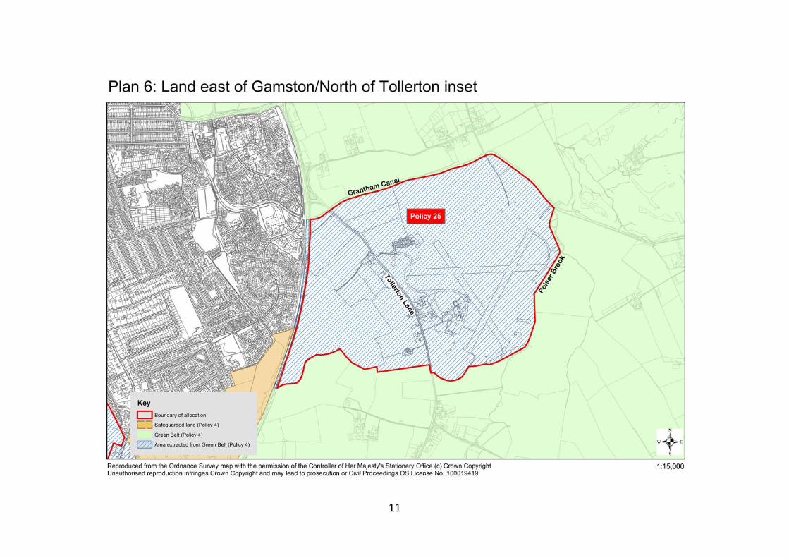
East of Gamston/North of Tollerton
3.8 The strategic site allocation at east of Gamston/north of Tollerton (Policies 3
and 25) is shown as a red line on Plan 6. The blue hatching shows the area that has been removed from the extent of the Green Belt that was established under policy ENV15 of the 1996 Local Plan. ‘Saved’ Policy E4 from the 1996 Local Plan (Tollerton Airfield) is superseded in its entirety by the policies of the adopted Core Strategy.

5

6

7

8

9

10
11