AMENDED FINAL BASIC ASSESSMENT REPORT - Cape … Ganse Vallei/A… · · 2016-01-27Ganse Vallei...
112
Cape Environmental Assessment Practitioners (Pty) Ltd Reg. No. 2008/004627/07 Telephone: (044) 874 0365 5 Progress Street, George Facsimile: (044) 874 0432 PO Box 2070, George 6530 Web: www.cape-eaprac.co.za D.J. Jeffery Directors L. van Zyl AMENDED FINAL BASIC ASSESSMENT REPORT for GANSE VALLEI RETIREMENT ESTATE on Portions 19 and 27 of 444 Ganse Vallei, Plettenberg Bay In terms of the National Environmental Management Act (Act No. 107 of 1998, as amended) & 2014 Environmental Impact Regulations Prepared for Applicant: Shelfplett 47 (Pty) Ltd By: Cape EAPrac Report Reference: BIT281/12 Department Reference: 16/3/1/1/D1/13/0069/14 Case Officer: Ms Jessica Christie Date: 27 January 2016 Comment & Review Period: 28 January to 19 February 2016
Transcript of AMENDED FINAL BASIC ASSESSMENT REPORT - Cape … Ganse Vallei/A… · · 2016-01-27Ganse Vallei...
Cape Environmental Assessment Practitioners (Pty) Ltd Reg. No. 2008/004627/07
Telephone: (044) 874 0365 5 Progress Street, George
Facsimile: (044) 874 0432 PO Box 2070, George 6530
Web: www.cape-eaprac.co.za
D.J. Jeffery Directors L. van Zyl
AMENDED FINAL BASIC ASSESSMENT
REPORT
for
GANSE VALLEI RETIREMENT ESTATE on
Portions 19 and 27 of 444 Ganse Vallei, Plettenberg Bay
In terms of the National Environmental Management Act (Act No. 107 of 1998, as amended) & 2014
Environmental Impact Regulations
Prepared for Applicant: Shelfplett 47 (Pty) Ltd By: Cape EAPrac
Report Reference: BIT281/12 Department Reference: 16/3/1/1/D1/13/0069/14
Case Officer: Ms Jessica Christie Date: 27 January 2016
Comment & Review Period: 28 January to 19 February 2016

APPOINTED ENVIRONMENTAL ASSESSMENT PRACTITIONER: Cape EAPrac Environmental Assessment Practitioners
PO Box 2070 George
6530 Tel: 044-874 0365 Fax: 044-874 0432
Report written & compiled by: Melissa Mackay (BTech & ND Nature Conservation), who has nine years’ experience as an environmental practitioner. Certifications: Director, Louise-Mari van Zyl (MA Geography & Environmental Science [US]; Registered Environmental Assessment Practitioner with the Interim Certification Board for Environmental Assessment Practitioners of South Africa, EAPASA. Ms van Zyl has over twelve years’ experience as an environmental practitioner.
PURPOSE OF THIS REPORT: Amended Final Basic Assessment for Environmental Authorisation
APPLICANT: Shelfplett 47 (Pty) Ltd
CAPE EAPRAC REFERENCE NO: BIT281/12
DEPARTMENT REFERENCE: 16/3/1/1/D1/13/0069/14
SUBMISSION DATE 27 January 2016

Ganse Vallei Retirement Estate BIT281/12
Cape EAPrac Amended Final Basic Assessment Report
AMENDED FINAL BASIC ASSESSMENT REPORT
in terms of the National Environmental Management Act, 1998 (Act No. 107 of 1998), as amended & Environmental
Impact Regulations 2014
Ganse Vallei Retirement Estate Portions 19 and 27 of 444 Ganse Vallei, Plettenberg Bay
Submitted for: Stakeholder Review & Comment This report is the property of the Author/Company, who may publish it, in whole, provided that: Written approval is obtained from the Author and that Cape EAPrac is acknowledged in the
publication; Cape EAPrac is indemnified against any claim for damages that may result from any publication of
specifications, recommendations or statements that is not administered or controlled by Cape EAPrac;
The contents of this report, including specialist/consultant reports, may not be used for purposes of sale or publicity or advertisement without the prior written approval of Cape EAPrac;
Cape EAPrac accepts no responsibility by the Applicant/Client for failure to follow or comply with the recommended programme, specifications or recommendations contained in this report;
Cape EAPrac accepts no responsibility for deviation or non-compliance of any specifications or recommendations made by specialists or consultants whose input/reports are used to inform this report; and
All figures, plates and diagrams are copyrighted and may not be reproduced by any means, in any form, in part or whole without prior written approved from Cape EAPrac.
Report Issued by: Cape Environmental Assessment Practitioners
Tel: 044 874 0365 PO Box 2070 Fax: 044 874 0432 5 Progress Street Web: www.cape-eaprac.co.za George 6530

Ganse Vallei Retirement Estate BIT281/12
Cape EAPrac Amended Final Basic Assessment Report
ORDER OF REPORT Basic Assessment Report
Appendix A : Location Map
Appendix B : Site Layout Plan
Appendix C : Site Photographs
Appendix D : Biodiversity Overlays
Appendix E : Permits / Licenses
Annexure E1 : Heritage Western Cape ROD
Annexure E2 : Municipal Services Confirmation
Appendix F : Public Participation Information
Annexure F1 : Registered I&AP List
Annexure F2 : Comments & Responses Table
Annexure F3 : Initial Notifications and Adverts
Annexure F4 : BAR Notifications
Annexure F5 : BAR Comments Received
Appendix G : Specialist Reports
Annexure G1 : Botanical Impact Assessment and Statement
Annexure G2 : Services / Engineering Report
Annexure G3 : Agricultural Potential
Annexure G4 : Planning Report
Annexure G5 : Geotechnical Report
Annexure G6 : Flood level determination
Annexure G7 : Stormwater Management Plan
Appendix H : Environmental Management Programme
Appendix I : Additional information related to waste management (N/a)
Appendix J : Other
Annexure J1 : Authority Correspondence
Annexure J2 : Windeed Property Report
Annexure J3 : Municipal Correspondence
Annexure J4 : Zoning Certificates
Ganse Vallei Retirement Estate BIT281/12
Cape EAPrac Amended Final Basic Assessment Report
TABLE OF CONTENTS
BASIC ASSESSMENT FORM .................................................................... 1
SUMMARY ................................................................................................. 3
1. INTRODUCTION ................................................................................................................................... 3 2. LEGISLATIVE AND POLICY FRAMEWORK ...................................................................................... 4
2.1 THE CONSTITUTION OF THE REPUBLIC OF SOUTH AFRICA ................................................. 4
2.2 NATIONAL ENVIRONMENTAL MANAGEMENT ACT (NEMA) .................................................... 4
2.3 NATIONAL ENVIRONMENTAL MANAGEMENT LAWS AMENDMENT ACT (ACT 25 OF 2014) ....................................................................................................................................................... 7
2.4 NATIONAL ENVIRONMENTAL MANAGEMENT: BIODIVERSITY (ACT 10 OF 2004) ................. 7
2.5 NATIONAL HERITAGE RESOURCES ACT (ACT 25 OF 1999) ...................................................... 8
2.6 NATIONAL WATER ACT, NO 36 OF 1998 .................................................................................... 8
2.6.1 NATIONAL WASTE MANAGEMENT STRATEGY .............................................................. 8
2.7 NATIONAL PROTECTED AREA EXPANSION STRATEGY (NPAES) FOR S.A. 2008 (2010) ..... 9
2.8 MUNICIPAL BIODIVERSITY SUMMARY PROJECT (SANBI BGIS) ............................................ 9
2.9 NATIONAL FORESTS ACT (NO. 84 OF 1998): ............................................................................. 9
2.10 CONSERVATION OF AGRICULTURAL RESOURCES ACT – CARA (ACT 43 OF 1983): ......... 10
2.11 OUTENIQUA COASTAL SENSITIVE AREAS (OSCA) ............................................................... 10
2.12 DEA&DP GUIDELINES ............................................................................................................... 10
3. ACTIVITY ............................................................................................................................................ 10 4. SITE DESCRIPTION AND ATTRIBUTES .......................................................................................... 12 5. PLANNING CONTEXT ....................................................................................................................... 15 6. PROCESS TO DATE .......................................................................................................................... 16
SECTION A: ACTIVITY INFORMATION .................................................. 19
1 PROJECT DESCRIPTION .................................................................................................................. 19 2. PHYSICAL SIZE OF THE ACTIVITY.................................................................................................. 28 3. SITE ACCESS ..................................................................................................................................... 29 4. DESCRIPTION OF THE PROPERTY ON WHICH THE ACTIVITY IS TO BE UNDERTAKEN AND THE LOCATION OF THE ACTIVITY ON THE PROPERTY ............................................................. 31 5. SITE PHOTOGRAPHS ....................................................................................................................... 33
SECTION B: DESCRIPTION OF RECEIVING ENVIRONMENT ............... 34
1 SITE/AREA DESCRIPTION ................................................................................................................ 34 2. GRADIENT OF THE SITE .................................................................................................................. 34 3. LOCATION IN LANDSCAPE .............................................................................................................. 34 4. GROUNDWATER, SOIL AND GEOLOGICAL STABILITY OF THE SITE ........................................ 34 5. SURFACE WATER ............................................................................................................................. 36 6. BIODIVERSITY ................................................................................................................................... 37 7. LAND USE OF THE SITE ................................................................................................................... 39 8. LAND USE CHARACTER OF SURROUNDING AREA ..................................................................... 40 9. SOCIO-ECONOMIC ASPECTS .......................................................................................................... 42 10. HISTORICAL AND CULTURAL ASPECTS ....................................................................................... 45 11. APPLICABLE LEGISLATION, POLICIES AND/OR GUIDELINES ................................................... 47

Ganse Vallei Retirement Estate BIT281/12
Cape EAPrac Amended Final Basic Assessment Report
SECTION C: PUBLIC PARTICIPATION ................................................... 50
SECTION D: NEED AND DESIRABILITY ................................................ 54
SECTION E: ALTERNATIVES ................................................................. 62
SECTION F: IMPACT ASSESSMENT, MANAGEMENT, ......................... 67
MITIGATION AND MONITORING MEASURES ....................................... 67
1 DESCRIBE THE MANNER IN WHICH THE DEVELOPMENT WILL IMPACT ON THE FOLLOWING ASPECTS: ........................................................................................................................... 67 2. WASTE AND EMISSIONS .................................................................................................................. 69 3. WATER USE ....................................................................................................................................... 70 4. POWER SUPPLY ................................................................................................................................ 71 5. DESCRIPTION AND ASSESSMENT OF THE SIGNIFICANCE OF IMPACTS PRIOR TO AND AFTER MITIGATION .................................................................................................................................. 72 6. SPECIALIST INPUTS/STUDIES AND RECOMMENDATIONS ......................................................... 88 7. IMPACT SUMMARY ........................................................................................................................... 90 8. OTHER MANAGEMENT, MITIGATION AND MONITORING MEASURES ...................................... 91
SECTION G: ASSESSMENT METHODOLOGIES AND CRITERIA,
GAPS IN KNOWLEDGE, UNDERLAYING ASSUMPTIONS AND
UNCERTAINTIES ..................................................................................... 92
SECTION H: RECOMMENDATION OF THE EAP ................................... 95
SECTION I: APPENDICES ....................................................................... 96
DECLARATIONS...................................................................................... 97
1. THE APPLICANT ................................................................................................................................ 97 2. THE INDEPENDENT ENVIRONMENTAL ASSESSMENT PRACTITIONER (EAP) ......................... 98 3. THE INDEPENDENT PERSON WHO COMPILED A SPECIALIST REPORT OR UNDERTOOK A SPECIALIST PROCESS ....................................................................................................................... 100
REFERENCES ....................................................................................... 101
Tables Table 1: NEMA 2010 listed activities for the Ganse Vallei Retirement Estate Development .................. 4
Table 2: NEMA 2014 listed activities for the Ganse Vallei Retirement Estate Development .................. 6
Table 3: Daily Water Demand (Royal Haskoning DHV, 2015) .............................................................. 24
Table 4: Peak Sewage Flow (Royal Haskoning DHV, 2015) ................................................................ 25
Figures Figure 1: Preferred layout Alternative 1a ............................................................................................... 11
Ganse Vallei Retirement Estate BIT281/12
Cape EAPrac Amended Final Basic Assessment Report
Figure 2: Preferred layout Alternative 1a ............................................................................................... 12
Figure 3: Neighbouring Property uses ................................................................................................... 13
Figure 4: Vegetation and Ecosystem Status ......................................................................................... 13
Figure 5: Critical Biodiversity Areas ...................................................................................................... 14
Figure 6: Vegetation community and Sensitivity (Pote, 2015) .............................................................. 15
Figure 7: May 2013 Urban Edge with revised Alternative 1a ................................................................ 16
Figure 8: Final BAR available on website .............................................................................................. 18
Figure 9: Preferred layout Alternative 1a ............................................................................................... 23
Figure 10: Impact of floods .................................................................................................................... 27
Figure 11: Topographical catchment area (RHDHV, 2015) .................................................................. 27
Figure 12: Road access off the N2 with proposed access to the development(Google Earth Pro 2015) ............................................................................................................................................................... 29
Figure 13: Road access off the N2 (Google Street View, 2014) ........................................................... 30
Figure 14: Preferred layout with internal roads ..................................................................................... 30
Figure 15: Location ................................................................................................................................ 31
Figure 16: Adjacent Land Uses ............................................................................................................. 32
Figure 17: Location in the landscape (Google Earth Pro 2015) ............................................................ 34
Figure 18: Soil Map (Cape Farm Mapper, 2015) .................................................................................. 35
Figure 19: Location to Keurbooms River (Google Earth Pro, 2015) ..................................................... 36
Figure 20: NFEPA Wetlands ................................................................................................................. 37
Figure 21: Vegetation type & ecosystem status (SANBI BGIS, 2014) .................................................. 39
Figure 22: Land use character of the site (Google Earth Pro, 2015) .................................................... 40
Figure 23: Land use within 500m radius (Google Earth Pro, 2015) ...................................................... 41
Figure 24: Population growth trends since 1996 (Bitou Municipality, 2014) ......................................... 42
Figure 25: Population pyramids illustrating the population dynamics since 1996 (Bitou Municipality, 2014) ...................................................................................................................................................... 43
Figure 26: Age profile (Bitou Municipality SDF, 2013) .......................................................................... 45
Figure 27: Website screenshot (Cape EAPrac, 2015) .......................................................................... 51
Figure 28: Final BAR on website ........................................................................................................... 52
Figure 29: Land Capability (Cape Farm Mapper, 2015) ........................................................................ 57
Figure 30: Alternative 1a (Option 1) ...................................................................................................... 63
Figure 31: Alternative 2a (Option 2) ...................................................................................................... 64
Figure 32: Alternative 3a (Option 3) ...................................................................................................... 65
Figure 33: Alternative 4a (Option 4) ...................................................................................................... 66

Ganse Vallei Retirement Estate BIT281/12
Cape EAPrac Amended Final Basic Assessment Report
ABBREVIATIONS AIA Archaeological Impact Assessment BGIS Biodiversity Geographic Information System BID Background Information Document CBD Central Business District ACMP Archaeological Conservation Management Plan CDSM Chief Directorate Surveys and Mapping CEMP Construction Environmental Management Plan DEA&DP Department of Environmental Affairs and Development Planning DME Department of Minerals and Energy EAP Environmental Impact Practitioner EHS Environmental, Health & Safety EIA Environmental Impact Assessment EMP Environmental Management Programme GPS Global Positioning System HIA Heritage Impact Assessment HWC Heritage Western Cape I&APs Interested and Affected Parties IDP Integrated Development Plan LUDS Land Use Decision Support LUPO Land Use Planning Ordinance NEMA National Environmental Management Act NEMAA National Environmental Management Amendment Act NEMBA National Environmental Management: Biodiversity Act NHRA National Heritage Resources Act NID Notice of Intent to Develop NSBA National Spatial Biodiversity Assessment NWA National Water Act PIA Paleontological Impact Assessment PM Post Meridiem; “Afternoon” SACAA South African Civil Aviation Authority SAHRA South African National Heritage Resources Agency SANBI South Africa National Biodiversity Institute SANS South Africa National Standards SDF Spatial Development Framework SMME Small, Medium and Micro Enterprise SAPD South Africa Police Department TIA Traffic Impact Assessment VIA Visual Impact Assessment
Ganse Vallei Retirement Estate BASIC ASSESSMENT REPORT BIT281/12
Cape EAPrac Amended Final Basic Assessment Report
SECTION 1: BASIC ASSESSMENT
REPORT
Ganse Vallei Retirement Estate BASIC ASSESSMENT REPORT BIT281/12
Cape EAPrac 1 Amended Final Basic Assessment Report
BASIC ASSESSMENT REPORT
(AUGUST 2010)
BASIC ASSESSMENT FORM (AUGUST 2011)
Basic Assessment Report in terms of the NEMA Environmental Impact Assessment Regulations, 2010
AUGUST 2010 Kindly note that: 1. This Basic Assessment Report is the standard report required by DEA&DP in terms of the EIA Regulations, 2010 and
must be completed for all Basic Assessment applications. 2. This report must be used in all instances for Basic Assessment applications for an environmental authorisation in terms of
the National Environmental Management Act, 1998 (Act No. 107 of 1998) (NEMA), as amended, and the Environmental Impact Assessment Regulations, 2010, and/or a waste management licence in terms of the National Environmental Management: Waste Act, 2008 (Act 59 of 2008) (NEM: WA), and/or an atmospheric emission licence in terms of the National Environmental Management: Air Quality Act, 2004 (Act No. 39 of 2004) (NEM: AQA).
3. This report is current as of 2 August 2010. It is the responsibility of the Applicant / EAP to ascertain whether subsequent
versions of the report have been published or produced by the competent authority.
4. The required information must be typed within the spaces provided in the report. The sizes of the spaces provided are not necessarily indicative of the amount of information to be provided. It is in the form of a table that will expand as each space is filled with typing.
5. Incomplete reports will be rejected. A rejected report may be amended and resubmitted. 6. The use of “not applicable” in the report must be done with circumspection. Where it is used in respect of material
information that is required by the Department for assessing the application, this may result in the rejection of the report as provided for in the regulations.
7. While the different sections of the report only provide space for provision of information related to one alternative,
if more than one feasible and reasonable alternative is considered, the relevant section must be copied and completed for each alternative.
8. Unless protected by law all information contained in, and attached to this report, will become public information on receipt
by the competent authority. If information is not submitted with this report due to such information being protected by law, the applicant and/or EAP must declare such non-disclosure and provide the reasons for the belief that the information is protected.
9. This report must be submitted to the Department at the postal address given below or by delivery thereof to the Registry
Office of the Department. No faxed or e-mailed reports will be accepted. Please note that for waste management licence applications, this report must be submitted for the attention of the Department’s Waste Management Directorate (tel: 021-483-2756 and fax: 021-483-4425) at the same postal address as the Cape Town Office Region A.
10. Unless indicated otherwise, two electronic copies (CD/DVD) and three hard copies of this report must be submitted to the
Department.
DEPARTMENTAL DETAILS CAPE TOWN OFFICE REGION A (Cape Winelands, City of Cape Town: Tygerberg and Oostenberg Administrations)
CAPE TOWN OFFICE REGION B (West Coast, Overberg, City of Cape Town: Helderberg, South Peninsula, Cape Town and Blaauwberg Administrations
GEORGE OFFICE (Eden and Central Karoo)

Ganse Vallei Retirement Estate BASIC ASSESSMENT REPORT BIT281/12
Cape EAPrac 2 Amended Final Basic Assessment Report
Department of Environmental Affairs and Development Planning Attention: Directorate: Integrated Environmental Management (Region A2) Private Bag X 9086 Cape Town, 8000 Registry Office 1st Floor Utilitas Building 1 Dorp Street, Cape Town Queries should be directed to the Directorate: Integrated Environmental Management (Region A2) at: Tel: (021) 483-4793 Fax: (021) 483-3633
Department of Environmental Affairs and Development Planning Attention: Directorate: Integrated Environmental Management (Region B) Private Bag X 9086 Cape Town, 8000 Registry Office 1st Floor Utilitas Building 1 Dorp Street, Cape Town Queries should be directed to the Directorate: Integrated Environmental Management (Region B) at: Tel: (021) 483-4094 Fax: (021) 483-4372
Department of Environmental Affairs and Development Planning Attention: Directorate: Integrated Environmental Management (Region A1) Private Bag X 6509 George, 6530 Registry Office 4th Floor, York Park Building 93 York Street George Queries should be directed to the Directorate: Integrated Environmental Management (Region A1) at: Tel: (044) 805 8600 Fax: (044) 874-2423
View the Department’s website at http://www.capegateway.gov.za/eadp for the latest version of this document.
DEPARTMENTAL REFERENCE NUMBER(S) File reference number (EIA): File reference number (Waste): File reference number (Other): PROJECT TITLE Ganse Vallei Retirement Estate

Ganse Vallei Retirement Estate BASIC ASSESSMENT REPORT BIT281/12
Cape EAPrac 3 Amended Final Basic Assessment Report
DETAILS OF THE ENVIRONMENTAL ASSESSMENT PRACTITIONER (EAP) Environmental Assessment Practitioner (EAP): Cape Environmental Assessment Practitioners (Pty) Ltd
Contact person: Melissa Mackay (Snr Consultant) / Louise-Mari van Zyl (Director) Postal address: P O Box 2070 George Postal code: 6530 Telephone: (044) 874 0365 Cell: 071 603 4132 E-mail: mel@cape-eaprac. co.za Fax: (044) 874 0432
EAP Qualifications BTech & ND Nature Conservation / MA Geography and Environmental Science
EAP Registrations/Associations
Director certified as an Environmental Assessment Practitioners with the Interim Certification Board for Environmental Assessment Practitioners of South Africa (EAPSA).
DETAILS OF THE EAP’S EXPERTISE TO CARRY OUT BASIC ASSESSMENT PROCEDURES Ms Mackay has been practising as an EAP since October 2006. She has successfully conducted Basic Assessments, Scoping & EIR processes, Waste Management Licenses, OSCA applications, Environmental Management Programmes, Maintenance Management Plans, 24G Rectification applications and Ad Hoc Setback Line applications for various projects during the past 9 years. EXECUTIVE SUMMARY OF THE CONTENT OF THE BASIC ASSESSMENT REPORT:
SUMMARY
1. INTRODUCTION
Cape Environmental Assessment Practitioners (Cape EAPrac) has been appointed by the
Applicant, Shelfplett 47 (Pty) Ltd, as the independent Environmental Assessment Practitioner (EAP)
to facilitate the legally required Basic Assessment process for the development of the Ganse Vallei
Retirement Estate on Portions 19 & 27 of the Farm 444 Ganse Vallei east of Plettenberg Bay in the
Western Cape.
An Application for Environmental Authorisation was submitted to the provincial Department of
Environmental Affairs & Development Planning (DEA&DP) on the 21st November 2014 and accepted
by DEA&DP on the 12th December 2014. This Application was submitted in terms of the 2010
Environmental Impact Assessment (EIA) Regulations and this Basic Assessment will be undertaken in
terms of those regulations. Due consideration will be given to any similarly listed activities in the 2014
EIA Regulations.
This report is an Amendment to the Final Basic Assessment Report that was circulated to I&APs
between 30th October and 19th November 2015. The amendments made to the previous report are
related to the layout plans. At the end of the previous comment period, the applicant revised the
layout plans. This was done to accommodate surveyed cadastral boundaries and additional
functionalities of the development such as a club house and recreational facilities. As such, this report
is being recirculated to all registered I&APs for another 21 days allowing for comment on the revised
layout plans. The comment period will extend from 29 January to 19 February 2016.
Ganse Vallei Retirement Estate BASIC ASSESSMENT REPORT BIT281/12
Cape EAPrac 4 Amended Final Basic Assessment Report
2. LEGISLATIVE AND POLICY FRAMEWORK
The legislation that is relevant to this study is briefly outlined below. These environmental
requirements are not intended to be definitive or exhaustive, but serve to highlight key environmental
legislation and responsibilities only.
2.1 THE CONSTITUTION OF THE REPUBLIC OF SOUTH AFRICA
The Constitution of the Republic of South Africa (Act 108 of 1996) states that everyone has a right to a
non-threatening environment and that reasonable measures are applied to protect the environment.
This includes preventing pollution and promoting conservation and environmentally sustainable
development, while promoting justifiable social and economic development.
This application by the applicant is being undertaken to fulfil the requirements of the Constitution.
2.2 NATIONAL ENVIRONMENTAL MANAGEMENT ACT (NEMA)
The current assessment is being undertaken in terms of the National Environmental Management Act
(NEMA, Act 107 of 1998 as amended). This Act makes provision for the identification and assessment
of activities that are potentially detrimental to the environment and which require authorisation from the
competent authority (in this case, the provincial Department of Environmental Affairs & Development
Planning, DEA&DP) based on the findings of an Environmental Assessment.
The proposed scheme entails a number of listed activities, which require a Basic Assessment (BA)
process, which must be conducted by an independent environmental assessment practitioner (EAP).
The Application for Environmental Authorisation was accepted by DEA&DP on 12th December 2014.
At the time, the 2010 EIA Regulations (GN 544, 545 and 546) were effective. On the 8th December
2014, the 2014 EIA Regulations (GN 983, 984 and 985) came into effect. In terms of the Transitional
Arrangements, this application will follow the procedures for the 2010 EIA Regulations, however the
activity should also be considered in terms of similar listed activities in the 2014 EIA Regulations. For
this reason, listed activities from both sets of Regulations have been identified below.
Table 1: NEMA 2010 listed activities for the Ganse Vallei Retirement Estate Development
Listed activity as described in GN 544, 545 and 546
Description of project activity
GN R544
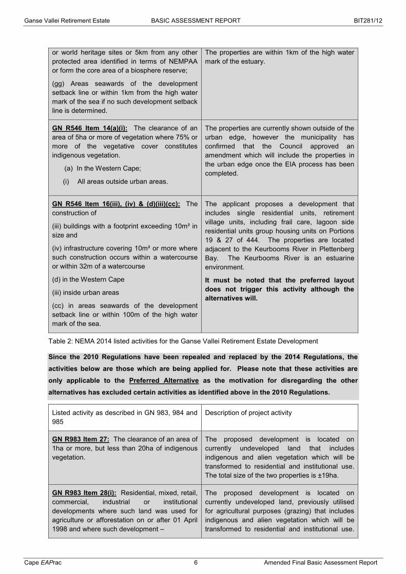
GN R544 Item 11 (x) & (xi): The construction of
(x) buildings exceeding 50m² in size and
(xi) infrastructure or structures covering 50m² in size where such construction occurs within a watercourse or 32m of a watercourse.
The applicant proposes a development that includes single residential units, retirement village units, including frail care, lagoon side residential units group housing units on Portions 19 & 27 of 444. The properties are located adjacent to the Keurbooms River in Plettenberg Bay.
It must be noted that the preferred layout does not trigger this activity although the alternatives will.
Ganse Vallei Retirement Estate BASIC ASSESSMENT REPORT BIT281/12
Cape EAPrac 5 Amended Final Basic Assessment Report
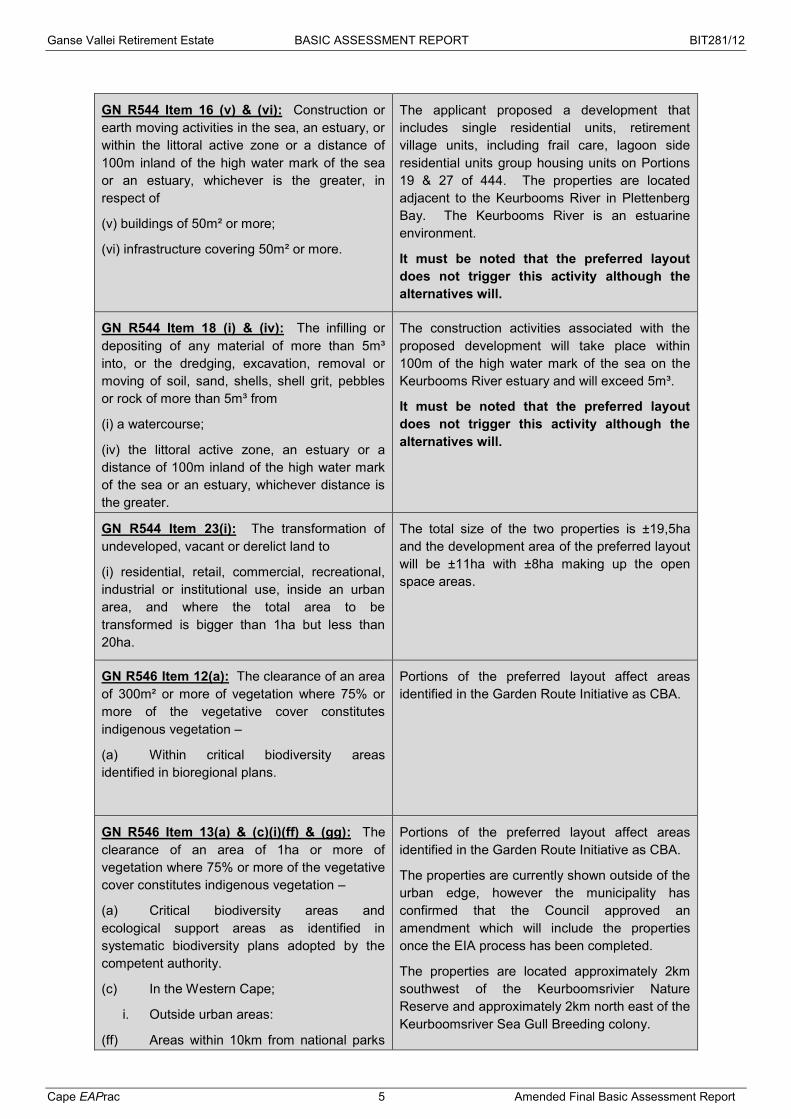
GN R544 Item 16 (v) & (vi): Construction or earth moving activities in the sea, an estuary, or within the littoral active zone or a distance of 100m inland of the high water mark of the sea or an estuary, whichever is the greater, in respect of
(v) buildings of 50m² or more;
(vi) infrastructure covering 50m² or more.
The applicant proposed a development that includes single residential units, retirement village units, including frail care, lagoon side residential units group housing units on Portions 19 & 27 of 444. The properties are located adjacent to the Keurbooms River in Plettenberg Bay. The Keurbooms River is an estuarine environment.
It must be noted that the preferred layout does not trigger this activity although the alternatives will.
GN R544 Item 18 (i) & (iv): The infilling or depositing of any material of more than 5m³ into, or the dredging, excavation, removal or moving of soil, sand, shells, shell grit, pebbles or rock of more than 5m³ from
(i) a watercourse;
(iv) the littoral active zone, an estuary or a distance of 100m inland of the high water mark of the sea or an estuary, whichever distance is the greater.
The construction activities associated with the proposed development will take place within 100m of the high water mark of the sea on the Keurbooms River estuary and will exceed 5m³.
It must be noted that the preferred layout does not trigger this activity although the alternatives will.
GN R544 Item 23(i): The transformation of undeveloped, vacant or derelict land to
(i) residential, retail, commercial, recreational, industrial or institutional use, inside an urban area, and where the total area to be transformed is bigger than 1ha but less than 20ha.
The total size of the two properties is ±19,5ha and the development area of the preferred layout will be ±11ha with ±8ha making up the open space areas.
GN R546 Item 12(a): The clearance of an area of 300m² or more of vegetation where 75% or more of the vegetative cover constitutes indigenous vegetation –
(a) Within critical biodiversity areas identified in bioregional plans.
Portions of the preferred layout affect areas identified in the Garden Route Initiative as CBA.
GN R546 Item 13(a) & (c)(i)(ff) & (gg): The clearance of an area of 1ha or more of vegetation where 75% or more of the vegetative cover constitutes indigenous vegetation –
(a) Critical biodiversity areas and ecological support areas as identified in systematic biodiversity plans adopted by the competent authority.
(c) In the Western Cape;
i. Outside urban areas:
(ff) Areas within 10km from national parks
Portions of the preferred layout affect areas identified in the Garden Route Initiative as CBA.
The properties are currently shown outside of the urban edge, however the municipality has confirmed that the Council approved an amendment which will include the properties once the EIA process has been completed.
The properties are located approximately 2km southwest of the Keurboomsrivier Nature Reserve and approximately 2km north east of the Keurboomsriver Sea Gull Breeding colony.
Ganse Vallei Retirement Estate BASIC ASSESSMENT REPORT BIT281/12
Cape EAPrac 6 Amended Final Basic Assessment Report
or world heritage sites or 5km from any other protected area identified in terms of NEMPAA or form the core area of a biosphere reserve;
(gg) Areas seawards of the development setback line or within 1km from the high water mark of the sea if no such development setback line is determined.
The properties are within 1km of the high water mark of the estuary.
GN R546 Item 14(a)(i): The clearance of an area of 5ha or more of vegetation where 75% or more of the vegetative cover constitutes indigenous vegetation.
(a) In the Western Cape;
(i) All areas outside urban areas.
The properties are currently shown outside of the urban edge, however the municipality has confirmed that the Council approved an amendment which will include the properties in the urban edge once the EIA process has been completed.
GN R546 Item 16(iii), (iv) & (d)(iii)(cc): The construction of
(iii) buildings with a footprint exceeding 10m² in size and
(iv) infrastructure covering 10m² or more where such construction occurs within a watercourse or within 32m of a watercourse
(d) in the Western Cape
(iii) inside urban areas
(cc) in areas seawards of the development setback line or within 100m of the high water mark of the sea.
The applicant proposes a development that includes single residential units, retirement village units, including frail care, lagoon side residential units group housing units on Portions 19 & 27 of 444. The properties are located adjacent to the Keurbooms River in Plettenberg Bay. The Keurbooms River is an estuarine environment.
It must be noted that the preferred layout does not trigger this activity although the alternatives will.
Table 2: NEMA 2014 listed activities for the Ganse Vallei Retirement Estate Development
Since the 2010 Regulations have been repealed and replaced by the 2014 Regulations, the
activities below are those which are being applied for. Please note that these activities are
only applicable to the Preferred Alternative as the motivation for disregarding the other
alternatives has excluded certain activities as identified above in the 2010 Regulations.
Listed activity as described in GN 983, 984 and 985
Description of project activity
GN R983 Item 27: The clearance of an area of 1ha or more, but less than 20ha of indigenous vegetation.
The proposed development is located on currently undeveloped land that includes indigenous and alien vegetation which will be transformed to residential and institutional use. The total size of the two properties is ±19ha.
GN R983 Item 28(i): Residential, mixed, retail, commercial, industrial or institutional developments where such land was used for agriculture or afforestation on or after 01 April 1998 and where such development –
The proposed development is located on currently undeveloped land, previously utilised for agricultural purposes (grazing) that includes indigenous and alien vegetation which will be transformed to residential and institutional use.

Ganse Vallei Retirement Estate BASIC ASSESSMENT REPORT BIT281/12
Cape EAPrac 7 Amended Final Basic Assessment Report
(i) Will occur inside an urban area, where the total land to be developed is bigger than 5ha.
The total size of the two properties is ±19,5ha and the development area will be ±11ha with ±8ha making up the open space areas.
The properties are currently shown outside of the urban edge, however the municipality has confirmed that the Council approved an amendment which will include the properties in the urban edge once the EIA process has been completed.
GN R985 Item 12(a)(ii): The clearance of an area of 300m² or more of indigenous vegetation –
(a) In the Western Cape; (i) Within critical biodiversity areas identified
in bioregional plans.
Portions of the preferred layout affect areas identified in the Garden Route Initiative as CBA.
Before any of the above mentioned listed activities can be undertaken, authorisation must be obtained
from the relevant authority, in this case the provincial Department of Environmental Affairs &
Development Planning (DEA&DP). Should the Department approve the proposed activity, the
Environmental Authorisation does not exclude the need for obtaining relevant approvals from other
Authorities who have a legal mandate
2.3 NATIONAL ENVIRONMENTAL MANAGEMENT LAWS AMENDMENT ACT
(ACT 25 OF 2014)
The NEM: Laws Amendment Act came into effect on the 2nd June 2014. This Act amends certain
provisions, definitions, expressions, provides clarity on issues and information related to both NEMA
and NEM:WA.
The applicability of this Act in reference to this application is related to the revised Public Participation
requirements. In terms of this Act, stakeholders will be provided with a 30 day comment period on this
Basic Assessment Report (BAR).
2.4 NATIONAL ENVIRONMENTAL MANAGEMENT: BIODIVERSITY (ACT 10 OF
2004)
NEM:BA is a Special Environmental Management Act (SEMA) and makes provision for the
management and conservation of South Africa’s biodiversity within the framework of NEMA. The Act
further provides for protection of species and ecosystems that warrant national protection, the
sustainable use of indigenous biological resources, the fair and equitable sharing of benefits arising
from bio-prospecting involving biological resources and the establishment and functions of the South
African Biodiversity Institute (SANBI).
SANBI specifies ecosystem status categories that are used in the various Biodiversity Programmes.
With respect to the latest Critical Biodiversity Areas (CBA) identified for the Garden Route, it has been
confirmed that the portions of the property and the preferred Alternative in question, fall within a CBA
area or any other important biodiversity area. In addition the vegetation type within which the

Ganse Vallei Retirement Estate BASIC ASSESSMENT REPORT BIT281/12
Cape EAPrac 8 Amended Final Basic Assessment Report
properties are located (Garden Route Shale Fynbos) is considered to be a Vulnerable ecosystem
type as per SANBI BGIS 2015.
2.5 NATIONAL HERITAGE RESOURCES ACT (ACT 25 OF 1999)
The protection and management of South Africa’s heritage resources are controlled by the National
Heritage Resources Act (NHRA)(Act No. 25 of 1999). South African National Heritage Resources
Agency (SAHRA) is the enforcing authority in the Northern Cape, and is registered as a Stakeholder
for this environmental process.
In terms of Section 38 of the National Heritage Resources Act, provision is made for the assessment
of heritage impacts as part of an EIA process.
The National Heritage Resources Act requires relevant authorities to be notified regarding this
proposed development, if the following activities are relevant:
the construction of a road, wall, power line, pipeline, canal or other similar form of linear
development or barrier exceeding 300m in length;
any development or other activity which will change the character of a site exceeding 5 000 m²
in extent;
the re-zoning of a site exceeding 10 000m² in extent.
A Notice of Intent to Develop in terms of the NHRA was submitted to Heritage Western Cape on the
10th October 2007. HWC confirmed that no further Heritage Impact Assessment was required for the
development and rezoning of Portions 19 and 27 of the Farm 444 Ganse Vallei. A copy of this
document is included in Appendix E.
2.6 NATIONAL WATER ACT, NO 36 OF 1998
Section 21 of the National Water Act (NWA) requires that authorisation be applied for from the
Department of Water Affairs (DWA) for any water use / activity in, or on the banks, of any watercourse.
Water on the site is obtained via the existing municipal reticulation for domestic use only and no
disturbance to water resources will take place, therefore no WULA is required.
2.6.1 NATIONAL WASTE MANAGEMENT STRATEGY The National Waste Management Strategy (NWMS) presents the South African government's strategy
for integrated waste management for South Africa. The NWMS is a legislative requirement of the
National Environmental Management: Waste Act, 2008 (Act No. 59 of 2008), the “Waste Act”. The
purpose of the NWMS is to achieve the objects of the Waste Act. Organs of state and affected
persons are obliged to give effect to the NWMS.
It deals among others with: Integrated Waste Management Planning, Waste Information Systems,
Waste Minimisation, Recycling, Waste Collection and Transportation, Waste Treatment, Waste
Disposal and Implementing Instruments. The NWMS is structured around a framework of eight goals.
These principles must be taken into account with regard to the design, construction and operation of
the development.

Ganse Vallei Retirement Estate BASIC ASSESSMENT REPORT BIT281/12
Cape EAPrac 9 Amended Final Basic Assessment Report
2.7 NATIONAL PROTECTED AREA EXPANSION STRATEGY (NPAES) FOR S.A.
2008 (2010)
Considering that South Africa’s protected area network currently falls far short of sustaining
biodiversity and ecological processes, the NPAES aims to achieve cost-effective protected area
expansion for ecological sustainability and increased resilience to Climate Change. Protected areas,
recognised by the National Environmental Management: Protected Areas Act (Act 57 of 2003), are
considered formal protected areas in the NPAES. The NPAES sets targets for expansion of these
protected areas, provides maps of the most important protected area expansion, and makes
recommendations on mechanisms for protected area expansion. The NPAES has set a 20-year
protected area target for each vegetation type in each biome, adding up to the overall land-based 20-
year protected area target of 12% of South Africa’s total land area.
The NPAES identifies 42 focus areas for land-based protected area expansion in South Africa. These
are large intact and unfragmented areas suitable for the creation or expansion of large protected
areas. Focus Area Number 13: Garden Route, falls within the Fynbos biome and the closest focus
area is located approximately 10,5kms north of the proposed development site (NPAES map in
Appendix D). There are several informal (private / municipal) and formal (provincial and national)
protected areas within a 10km radius of the properties.
2.8 MUNICIPAL BIODIVERSITY SUMMARY PROJECT (SANBI BGIS)
According to the information provided by the South African National Biodiversity Institute (SANBI)
through their Biodiversity GIS (BGIS) system, the environment in the Bitou Municipality is fairly
untransformed (74.6% natural areas remaining), of which 51.2% is formally protected within land-
based protected areas. There are two Marine Protected Areas (MPA), the Robberg MPA and the
Tsitsikamma MPA. There are no Ramsar sites within the municipality.
Two biomes occur within the municipality, the Forests (+/- 16.31%) and the Fynbos (83.62%), which
support ten (13) vegetation types. Three of these are classified as critically endangered, namely Cape
Lowland Alluvial Vegetation, Knysna Sand Fynbos and Langkloof Shale Renosterveld. There are no
Endangered ecosystem types according to SANBI and two listed as Vulnerable, namely Eastern
Coastal Shale Band Vegetation and Garden Route Shale Fynbos. The proposed development site
falls within the Garden Route Shale Fynbos vegetation types.
The municipality falls within two Water Management Areas (WMA), 0.83% lies in the Fish to
Tsitsikamma WMA and 99.08% falls within the Gouritz WMA. There are seven rivers which traverse
the municipal area, of which one, the Keurbooms runs along the eastern boundary of the properties.
Approximately 267 wetlands have been identified to occur within the Municipality, none of which have
Ramsar Wetland status. There are five estuaries in the municipal area, of which the Keurbooms is
closest to the properties.
Please refer to Appendix D for all Biodiversity Overlays and the SANB BGIS summary sheet.
2.9 NATIONAL FORESTS ACT (NO. 84 OF 1998):
The National Forests Act provides for the protection of forests as well as specific tree species, quoting
directly from the Act: “no person may cut, disturb, damage or destroy any protected tree or possess,
Ganse Vallei Retirement Estate BASIC ASSESSMENT REPORT BIT281/12
Cape EAPrac 10 Amended Final Basic Assessment Report
collect, remove, transport, export, purchase, sell, donate or in any other manner acquire or dispose of
any protected tree or any forest product derived from a protected tree, except under a licence or
exemption granted by the Minister to an applicant and subject to such period and conditions as may
be stipulated”.
Please refer to the Ecological Scoping Report in Appendix E1 for a detailed description of the plant
species found to occur in the area. The areas within which protected Milkwood trees grow have been
excluded from the preferred layout, however, in the event that any other protected tree species may
require cutting or pruning, an application must be made to the Department of Forestry.
2.10 CONSERVATION OF AGRICULTURAL RESOURCES ACT – CARA (ACT 43
OF 1983):
CARA provides for the regulation of control over the utilisation of the natural agricultural resources in
order to promote the conservation of soil, water and vegetation and provides for combating weeds and
invader plant species. This Act must be considered when placing roads and infrastructure on the
property.
2.11 OUTENIQUA COASTAL SENSITIVE AREAS (OSCA)
The OSCA regulations were enacted in terms of ECA and make provision for properties within
specified geographic locations between Groot Brak River and Plettenberg Bay to apply for a permit to
undertake construction and vegetation removal activities. Portions 19 and 27 of 444 fall within an
OSCA area and as such any activities identified in Regulation 1526 of November 1998 require a
permit. The local municipality has been mandated to issue OSCA permits.
An application for an OSCA will be submitted to the local municipality once the EIA process is finalised
and in the event that the proposal is authorised.
2.12 DEA&DP GUIDELINES
Guideline for Environmental Management Plans (2005)
Guideline for Public Participation (March 2013)
Guideline on Alternatives (March 2013)
Guideline on Need & Desirability (March 2013)
3. ACTIVITY
The applicant proposes the development of a residential and retirement village on Portions 19 & 27 of
444 Ganse Vallei. The properties are located between the N2 and the Keurbooms River east of
Plettenberg Bay. During the EIA process various alternatives were identified. The revised preferred
alternative (Alternative 1a) is outlined below.
The development will comprise of 4 residential components, a frail care facility, clubhouse and
recreational facilities, namely:
72 x 1 – 2 bedroom garden flats (±0.69ha);
96 x 2 – 3 bedroom units (±4.04ha);

Ganse Vallei Retirement Estate BASIC ASSESSMENT REPORT BIT281/12
Cape EAPrac 11 Amended Final Basic Assessment Report
18 x 4+ bedroom luxury apartments (±1.93ha);
188 x 2 - 3 bedroom flats (±0.82ha);
30 bed care centre (±0.09ha);
Clubhouse (±0.25ha);
Sports area (±0.13ha); and
Road network (±3.31ha).
The remainder of the property (±7.78ha) will be zoned as Private Open Space. Access to the
development will be off the N2 with internal roadways throughout the development.
Figure 1: Preferred layout Alternative 1a

Ganse Vallei Retirement Estate BASIC ASSESSMENT REPORT BIT281/12
Cape EAPrac 12 Amended Final Basic Assessment Report
Figure 2: Preferred layout Alternative 1a Please see Appendix B for detailed site plans.
4. SITE DESCRIPTION AND ATTRIBUTES
Portions 19 and 27 of 444 Ganse Vallei are located on the eastern edge of the built up area of
Plettenberg Bay in the Western Cape. The eastern boundary of the property is made up of the
Keurbooms River / Estuary, whilst the western boundary is the N2 road. To the north is a vineyard
and polo fields and to the south is the NH Hotel Group and private residences.

Ganse Vallei Retirement Estate BASIC ASSESSMENT REPORT BIT281/12
Cape EAPrac 13 Amended Final Basic Assessment Report
Figure 3: Neighbouring Property uses
The vegetation on the properties has been identified as Garden Route Shale Fynbos. Mucina and
Rutherford (2006) previously listed this ecosystem type as Endangered, however according to the
NEM:BA December 2011 and 2015 SANB BGIS, it is currently considered to be Vulnerable.
Figure 4: Vegetation and Ecosystem Status
NH Hotel
Goose Valley Golf Estate
Private residential
Vineyards & polo fields
Private residential
27/444 19/444

Ganse Vallei Retirement Estate BASIC ASSESSMENT REPORT BIT281/12
Cape EAPrac 14 Amended Final Basic Assessment Report
Portions of the properties fall within areas designated as Critical Biodiversity Areas as per the Garden
Route biodiversity plans. The eastern edges of the Preferred Alternative fall into a portion of the
identified CBA.
Figure 5: Critical Biodiversity Areas
A Botanical specialist report was undertaken by Mr Jamie Pote (see Annexure G1). According to this
report the ecological state and sensitivity of the onsite vegetation is as follows:
The vegetation on site would historically have comprised of typical Sedgefield Coastal Grassland,
on sandy soils, most likely of a coastal and alluvial nature, with some scrub fynbos and fynbos-
thicket elements present in wetter areas and where fire frequency might be lower.
Historical land use and human (anthropogenic) impacts, including the construction of residential
dwellings and dams, as well as dense alien infestation within the site, have resulted in changes to
the vegetation structure and function. A few remnant fynbos elements remain in isolated pockets,
although altered fire regimes and isolation from surrounding similar vegetation and increasing
alien invasion have exacerbated these changes. Runoff from the adjacent N2, is likely to have
also altered hydrological regimes, indicated by the presence of flora typical of moister sites
including thicket fynbos and riparian elements.
On site vegetation is composed predominantly of secondary vegetation, regenerated from
degraded and transformed areas with peripheral grassy fynbos vegetation occurring in patches.
Surrounding areas are predominantly peri-urban in nature with some isolated patches of typical
and secondary fynbos vegetation typical for the area.

Ganse Vallei Retirement Estate BASIC ASSESSMENT REPORT BIT281/12
Cape EAPrac 15 Amended Final Basic Assessment Report
The Sedgefield Coastal Grassland on site is largely secondary, regenerated from degraded or
transformed habitat, with scattered invasive species, including Wattle, Pine and Eucalyptus trees.
Patched of climax shrubby Fynbos are present, are dominated by typical scrub grassy fynbos
species, including Erica spp. Metalasia spp., Passerina spp. with a rather scant herbaceous,
restioid and grass strata. This is interspersed with a matrix of grassy vegetation, typical of
Sedgefield Coastal Vegetation. Both habitats have a relatively low biodiversity, most likely due to
it having regenerated from highly disturbed habitat.
A band of dense Thicket (Wilderness Forest-Thicket) is present along the eastern boundary of the
site, with some dense Wattle along its edges. This band of Thicket forms an important corridor
along the edge of the Estuary.
Figure 6: Vegetation community and Sensitivity (Pote, 2015)
Mr Pote confirmed in a statement that the revised layout would not differ from this determination.
5. PLANNING CONTEXT
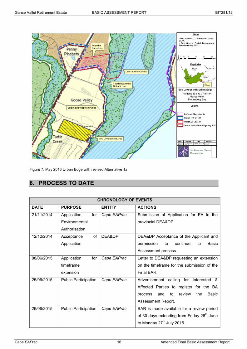
According to the May 2013 draft SDF, the properties fall on the outside of the urban edge for Bitou.
Consultation with the Bitou Municipality however, has confirmed that the Council has already issued a
decision to amend the urban edge to include the properties as an urban area. A copy of the letter is
included as Appendix E.
Bitou Municipality has also confirmed the availability of services (water, sanitation, electricity and
refuse removal).
Ganse Vallei Retirement Estate BASIC ASSESSMENT REPORT BIT281/12
Cape EAPrac 16 Amended Final Basic Assessment Report
Figure 7: May 2013 Urban Edge with revised Alternative 1a
6. PROCESS TO DATE
CHRONOLOGY OF EVENTS
DATE PURPOSE ENTITY ACTIONS
21/11/2014 Application for
Environmental
Authorisation
Cape EAPrac Submission of Application for EA to the
provincial DEA&DP
12/12/2014 Acceptance of
Application
DEA&DP DEA&DP Acceptance of the Applicant and
permission to continue to Basic
Assessment process.
08/06/2015 Application for
timeframe
extension
Cape EAPrac Letter to DEA&DP requesting an extension
on the timeframe for the submission of the
Final BAR.
25/06/2015 Public Participation Cape EAPrac Advertisement calling for Interested &
Affected Parties to register for the BA
process and to review the Basic
Assessment Report.
26/06/2015 Public Participation Cape EAPrac BAR is made available for a review period
of 30 days extending from Friday 26th June
to Monday 27th July 2015.
Ganse Vallei Retirement Estate BASIC ASSESSMENT REPORT BIT281/12
Cape EAPrac 17 Amended Final Basic Assessment Report
09/07/2015 Time extension DEA&DP Approval of request for an extension for the
submission of the Final BAR.
31/07/2015 Public Participation Cape EAPrac The Final BAR is made available for a
review period of 21 days extending from
Friday 30th October to Thursday 19th
November 2015.
18/11/2015 Layout
amendments
Applicant The Applicant proposes several
amendments to the layout. Specialist
reports are revised and the Final BAR is
amended accordingly.
18/11/2015 Time extension Cape EAPrac Application to DEA&DP for an extension of
the time permissible to submit the Final
BAR in light of the proposed revisions to
the layout.
14/12/2015 Time extension DEA&DP Approval of request for an extension for the
submission of the Final BAR.
28/01/2016 Public Participation Cape EAPrac The Amended Final BAR is made available
for a review period of 21 days extending
from Friday 29th January to Friday 19th
February 2016.
25/02/2016 Submission for
decision making.
Cape EAPrac The Final BAR including all evidence of
public participation will be submitted to
DEA&DP for decision making.
The Basic Assessment Report (BAR) has been made available for comment and review for a period of
30 days extending from Friday 25th June to Monday 27th July 2015. Several additional registrations
and one comment was received during this period. These have been collated and included in
Annexure F5 the final BAR. An additional 21 day comment period extending from Friday 30th
October to Thursday 19th November 2015 was provided. It must be noted that the following
inclusions were made to the Draft BAR in the Final BAR:
Stormwater Management Plan;
Municipality Services Confirmation;
Updated Public Participation.
Prior to the completion of the 21 day comment period, the applicant made some adjustments to the
layouts. These included the realignment of the development to accommodate the surveyed cadastral
boundaries, as well as inclusion of a clubhouse and recreational facilities and the resizing of various
units more in keeping with the retirement village concept. The DEA&DP concurred that an Amended
Final BAR should be circulated for all registered I&APs for comment for a further 21 days. This
comment period will extend from Friday 29th January to Friday 19th February 2016. Once the 21

Ganse Vallei Retirement Estate BASIC ASSESSMENT REPORT BIT281/12
Cape EAPrac 18 Amended Final Basic Assessment Report
day period is completed the final document will be submitted to the competent authority for decision
making.
Digital copies of the report are available on the Cape EAPrac website at www.cape-eaprac.co.za
under Active Projects.
Figure 8: Final BAR available on website
Ganse Vallei Retirement Estate BASIC ASSESSMENT REPORT BIT281/12
Cape EAPrac 19 Amended Final Basic Assessment Report
SECTION A: ACTIVITY INFORMATION
1 PROJECT DESCRIPTION
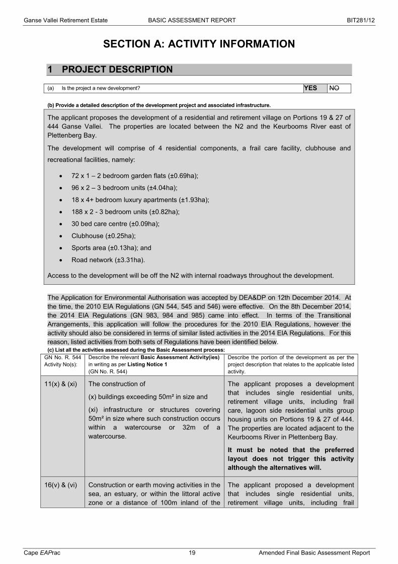
(a) Is the project a new development? YES NO (b) Provide a detailed description of the development project and associated infrastructure.
The applicant proposes the development of a residential and retirement village on Portions 19 & 27 of 444 Ganse Vallei. The properties are located between the N2 and the Keurbooms River east of Plettenberg Bay.
The development will comprise of 4 residential components, a frail care facility, clubhouse and
recreational facilities, namely:
72 x 1 – 2 bedroom garden flats (±0.69ha);
96 x 2 – 3 bedroom units (±4.04ha);
18 x 4+ bedroom luxury apartments (±1.93ha);
188 x 2 - 3 bedroom units (±0.82ha);
30 bed care centre (±0.09ha);
Clubhouse (±0.25ha);
Sports area (±0.13ha); and
Road network (±3.31ha).
Access to the development will be off the N2 with internal roadways throughout the development.
The Application for Environmental Authorisation was accepted by DEA&DP on 12th December 2014. At the time, the 2010 EIA Regulations (GN 544, 545 and 546) were effective. On the 8th December 2014, the 2014 EIA Regulations (GN 983, 984 and 985) came into effect. In terms of the Transitional Arrangements, this application will follow the procedures for the 2010 EIA Regulations, however the activity should also be considered in terms of similar listed activities in the 2014 EIA Regulations. For this reason, listed activities from both sets of Regulations have been identified below. (c) List all the activities assessed during the Basic Assessment process:
GN No. R. 544 Activity No(s):
Describe the relevant Basic Assessment Activity(ies) in writing as per Listing Notice 1 (GN No. R. 544)
Describe the portion of the development as per the project description that relates to the applicable listed activity.
11(x) & (xi) The construction of
(x) buildings exceeding 50m² in size and
(xi) infrastructure or structures covering 50m² in size where such construction occurs within a watercourse or 32m of a watercourse.
The applicant proposes a development that includes single residential units, retirement village units, including frail care, lagoon side residential units group housing units on Portions 19 & 27 of 444. The properties are located adjacent to the Keurbooms River in Plettenberg Bay.
It must be noted that the preferred layout does not trigger this activity although the alternatives will.
16(v) & (vi) Construction or earth moving activities in the sea, an estuary, or within the littoral active zone or a distance of 100m inland of the
The applicant proposed a development that includes single residential units, retirement village units, including frail

Ganse Vallei Retirement Estate BASIC ASSESSMENT REPORT BIT281/12
Cape EAPrac 20 Amended Final Basic Assessment Report
high water mark of the sea or an estuary, whichever is the greater, in respect of
(v) buildings of 50m² or more;
(vi) infrastructure covering 50m² or more.
care, lagoon side residential units group housing units on Portions 19 & 27 of 444. The properties are located adjacent to the Keurbooms River in Plettenberg Bay. The Keurbooms River is an estuarine environment.
It must be noted that the preferred layout does not trigger this activity although the alternatives will.
18(i) & (iv) The infilling or depositing of any material of more than 5m³ into, or the dredging, excavation, removal or moving of soil, sand, shells, shell grit, pebbles or rock of more than 5m³ from
(i) a watercourse;
(iv) the littoral active zone, an estuary or a distance of 100m inland of the high water mark of the sea or an estuary, whichever distance is the greater.
The construction activities associated with the proposed development will take place within 100m of the high water mark of the sea on the Keurbooms River estuary and will exceed 5m³.
It must be noted that the preferred layout does not trigger this activity although the alternatives will.
23(i) The transformation of undeveloped, vacant or derelict land to
(i) residential, retail, commercial, recreational, industrial or institutional use, inside an urban area, and where the total area to be transformed is bigger than 1ha but less than 20ha.
The total size of the two properties is ±19,5ha and the development area will be ±11ha with ±8ha making up the open space areas.
GN No. R. 546 Activity No(s):
Describe the relevant Basic Assessment Activity(ies) in writing as per Listing Notice 3 (GN No. R. 546)
Describe the portion of the development as per the project description that relates to the applicable listed activity.
12(a) The clearance of an area of 300m² or more of vegetation where 75% or more of the vegetative cover constitutes indigenous vegetation –
(a) Within critical biodiversity areas identified in bioregional plans.
Portions of the preferred layout affect areas identified in the Garden Route Initiative as CBA.
13(a) & (c)(i)(ff) & (gg)
The clearance of an area of 1ha or more of vegetation where 75% or more of the vegetative cover constitutes indigenous vegetation –
(a) Critical biodiversity areas and ecological support areas as identified in systematic biodiversity plans adopted by the competent authority.
(c) In the Western Cape;
i. Outside urban areas:
Portions of the preferred layout affect areas identified in the Garden Route Initiative as CBA.
The properties are currently shown outside of the urban edge, however the municipality has confirmed that the Council approved an amendment which will include the properties once the EIA process has been completed.
The properties are located approximately 2km southwest of the Keurboomsrivier
Ganse Vallei Retirement Estate BASIC ASSESSMENT REPORT BIT281/12
Cape EAPrac 21 Amended Final Basic Assessment Report
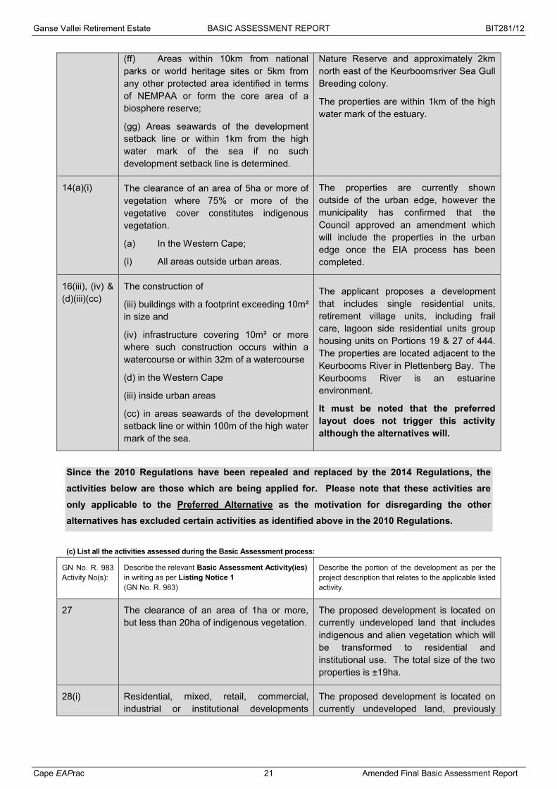
(ff) Areas within 10km from national parks or world heritage sites or 5km from any other protected area identified in terms of NEMPAA or form the core area of a biosphere reserve;
(gg) Areas seawards of the development setback line or within 1km from the high water mark of the sea if no such development setback line is determined.
Nature Reserve and approximately 2km north east of the Keurboomsriver Sea Gull Breeding colony.
The properties are within 1km of the high water mark of the estuary.
14(a)(i) The clearance of an area of 5ha or more of vegetation where 75% or more of the vegetative cover constitutes indigenous vegetation.
(a) In the Western Cape;
(i) All areas outside urban areas.
The properties are currently shown outside of the urban edge, however the municipality has confirmed that the Council approved an amendment which will include the properties in the urban edge once the EIA process has been completed.
16(iii), (iv) & (d)(iii)(cc)
The construction of
(iii) buildings with a footprint exceeding 10m² in size and
(iv) infrastructure covering 10m² or more where such construction occurs within a watercourse or within 32m of a watercourse
(d) in the Western Cape
(iii) inside urban areas
(cc) in areas seawards of the development setback line or within 100m of the high water mark of the sea.
The applicant proposes a development that includes single residential units, retirement village units, including frail care, lagoon side residential units group housing units on Portions 19 & 27 of 444. The properties are located adjacent to the Keurbooms River in Plettenberg Bay. The Keurbooms River is an estuarine environment.
It must be noted that the preferred layout does not trigger this activity although the alternatives will.
Since the 2010 Regulations have been repealed and replaced by the 2014 Regulations, the
activities below are those which are being applied for. Please note that these activities are
only applicable to the Preferred Alternative as the motivation for disregarding the other alternatives has excluded certain activities as identified above in the 2010 Regulations.
(c) List all the activities assessed during the Basic Assessment process:
GN No. R. 983 Activity No(s):
Describe the relevant Basic Assessment Activity(ies) in writing as per Listing Notice 1 (GN No. R. 983)
Describe the portion of the development as per the project description that relates to the applicable listed activity.
27 The clearance of an area of 1ha or more, but less than 20ha of indigenous vegetation.
The proposed development is located on currently undeveloped land that includes indigenous and alien vegetation which will be transformed to residential and institutional use. The total size of the two properties is ±19ha.
28(i) Residential, mixed, retail, commercial, industrial or institutional developments
The proposed development is located on currently undeveloped land, previously

Ganse Vallei Retirement Estate BASIC ASSESSMENT REPORT BIT281/12
Cape EAPrac 22 Amended Final Basic Assessment Report
where such land was used for agriculture or afforestation on or after 01 April 1998 and where such development –
(i) Will occur inside an urban area, where the total land to be developed is bigger than 5ha.
utilised for agricultural purposes (grazing) that includes indigenous and alien vegetation which will be transformed to residential and institutional use. The total size of the two properties is ±19,5ha and the development area will be ±11ha with ±8ha making up the open space areas.
The properties are currently shown outside of the urban edge, however the municipality has confirmed that the Council approved an amendment which will include the properties in the urban edge once the EIA process has been completed.
GN No. R. 985 Activity No(s):
Describe the relevant Basic Assessment Activity(ies) in writing as per Listing Notice 3 (GN No. R. 985)
Describe the portion of the development as per the project description that relates to the applicable listed activity.
12(a)(ii) The clearance of an area of 300m² or more of indigenous vegetation –
(a) In the Western Cape;
(i) Within critical biodiversity areas identified in bioregional plans.
Portions of the preferred layout affect areas identified in the Garden Route Initiative as CBA.
If the application is also for activities as per Listing Notice 2 and permission was granted to subject the application to Basic Assessment, also indicate the applicable Listing Notice 2 activities:
GN No. R. 545 Activity No(s):
If permission was granted in terms of Regulation 20, describe the relevant Scoping and EIA Activity(ies) in writing as per Listing Notice 2 (GN No. R. 545)
Describe the portion of the development as per the project description that relates to the applicable listed activity.
Waste management activities in terms of the NEM: WA (Government Gazette No. 32368):
GN No. 718 - Category A Activity No(s): Describe the relevant Category A waste management activity in writing.
Please note: If any waste management activities are applicable, the Listed Waste Management Activities Additional Information Annexure must be completed and attached to this Basic Assessment Report as Appendix I. If the application is also for waste management activities as per Category B and permission was granted to subject the application to Basic Assessment, also indicate the applicable Category B activities: GN No. 718 – Category B Activity No(s): Describe the relevant Category B waste management activity in writing.
Atmospheric emission activities in terms of the NEM: AQA (Government Gazette No. 33064): GN No. 248 Activity No(s): Describe the relevant atmospheric emission activity in writing.
(d) Please provide details of all components of the proposed project and attach diagrams (e.g. architectural drawings or perspectives, engineering drawings, process flow charts etc.). Buildings YES NO
Provide brief description:
Ganse Vallei Retirement Estate BASIC ASSESSMENT REPORT BIT281/12
Cape EAPrac 23 Amended Final Basic Assessment Report
The applicant proposes the development of a residential and retirement village on Portions 19 & 27 of 444 Ganse Vallei. The properties are located between the N2 and the Keurbooms River east of Plettenberg Bay.
The development will comprise of 4 residential components, a frail care facility, clubhouse and
recreational facilities, namely:
72 x 1 – 2 bedroom garden flats (±0.69ha);
96 x 2 – 3 bedroom units (±4.04ha);
18 x 4+ bedroom luxury apartments (±1.93ha);
188 x 2 - 3 bedroom units (±0.82ha);
30 bed care centre (±0.09ha);
Clubhouse (±0.25ha);
Sports area (±0.13ha); and
Road network (±3.31ha).
The remainder of the property (±8ha) will be zoned as Private Open Space. Access to the development will be off the N2 with internal roadways throughout the development.
Figure 9: Preferred layout Alternative 1a Infrastructure (e.g. roads, power and water supply/ storage) YES NO
Provide brief description:
Roads
The proposed development will gain access from the N2 National Road. The existing 4.5 m access to

Ganse Vallei Retirement Estate BASIC ASSESSMENT REPORT BIT281/12
Cape EAPrac 24 Amended Final Basic Assessment Report
the adjacent agricultural holdings surrounding the development will need to be upgraded to a higher standard. A Traffic Impact Assessment was undertaken as part of the initial development investigation.
The separate assignment was undertaken by SSI - Knysna Transport Sector (now Royal Haskoning DHV).
Electrical
With reference to the meeting held with the Bitou Municipal Authority and Royal Haskoning DHV, the supply of electrical bulk services will be based on the following criteria:
1. The Bitou Municipality – Electrical Department - indicated that the existing 11 kV overhead line along the N2 and which crosses the proposed site will be of sufficient capacity to provide bulk supply for these developments.
2 A tap-off point from the overhead line will be pointed out to the developer at a later stage. From here the 11 kV ring main underground line will be extended to a suitable position on site to place 2 x free standing Mini-Subs.
3 High Voltage cabling (11 kV) will run underground to the new site, where it will complete the ring main system within the mini-substation(s) serving dedicated sections of end users. Final power distribution to end users will be via meter kiosks and low Voltage underground cabling.
4 The mini sub-station(s) will be 2 x 315 kVA. The mini-substations will be of the 11 kV/400 V 50 Hz 3 phase plus Neutral type. The required high voltage switchgear will be able to break the ring main supply by means of High Voltage T type ring main switch gear.
5 Provision has been made for Distribution Kiosks complete with conventional metering device, evenly spread to serve all small holdings and dwellings.
6 The average connection to the above has been calculated at 14 kW with a diversity factor (0.285) based on the Rusck formula.
7 Once completed, the whole of the infrastructure on the new development will be handed over to the Bitou Municipality as the official Supply Authority for running and maintenance.
Water
The average daily demand (kℓ/day) for the development is based on the proposed land use mix, and was calculated as follows:
Table 3: Daily Water Demand (Royal Haskoning DHV, 2015)
Ganse Vallei Retirement Estate BASIC ASSESSMENT REPORT BIT281/12
Cape EAPrac 25 Amended Final Basic Assessment Report
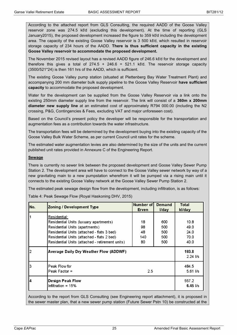
According to the attached report from GLS Consulting, the required AADD of the Goose Valley reservoir zone was 274.5 kℓ/d (excluding this development). At the time of reporting (GLS January2015), the proposed development increased the figure to 359 kℓ/d including the development area. The capacity of the existing Goose Valley reservoir is 3 500 kℓ/d, which resulted in reservoir storage capacity of 234 hours of the AADD. There is thus sufficient capacity in the existing Goose Valley reservoir to accommodate the proposed development.
The November 2015 revised layout has a revised AADD figure of 246.6 kℓ/d for the development and therefore this gives a total of 274.5 + 246.6 = 521.1 kℓ/d. The reservoir storage capacity (3500/521*24) is then 161 hrs of the AADD, which is sufficient.
The existing Goose Valley pump station (situated at Plettenberg Bay Water Treatment Plant) and accompanying 200 mm diameter bulk supply pipeline to the Goose Valley Reservoir have sufficient capacity to accommodate the proposed development.
Water for the development can be supplied from the Goose Valley Reservoir via a link onto the existing 250mm diameter supply line from the reservoir. The link will consist of a 360m x 200mm diameter new supply line at an estimated cost of approximately R794 000.00 (including the N2 crossing, P&G, Contingencies & Fees, excluding VAT and major unforeseen cost).
Based on the Council’s present policy the developer will be responsible for the transportation and augmentation fees as a contribution towards the water infrastructure.
The transportation fees will be determined by the development buying into the existing capacity of the Goose Valley Bulk Water Scheme, as per current Council unit rates for the scheme.
The estimated water augmentation levies are also determined by the size of the units and the current published unit rates provided in Annexure C of the Engineering Report.
Sewage
There is currently no sewer link between the proposed development and Goose Valley Sewer Pump Station 2. The development area will have to connect to the Goose Valley sewer network by way of a new gravitating main to a new pumpstation wherefrom it will be pumped via a rising main until it connects to the existing Goose Valley network at the Goose Valley Sewer Pump Station 2.
The estimated peak sewage design flow from the development, including infiltration, is as follows:
Table 4: Peak Sewage Flow (Royal Haskoning DHV, 2015)
According to the report from GLS Consulting (see Engineering report attachment), it is proposed in the sewer master plan, that a new sewer pump station (Future Sewer Pstn 10) be constructed at the
Ganse Vallei Retirement Estate BASIC ASSESSMENT REPORT BIT281/12
Cape EAPrac 26 Amended Final Basic Assessment Report
lowest point on the eastern boundary of Portion 19 of the Farm 444, from where sewerage will then be pumped through a new dedicated 1 465m x 90mm diameter rising main connected to the Goose Valley Sewer PS2. Based on the proposed development’s revised layout (Option 1, November 2015), with no development on the east side of the property near to the Bitou river, it is recommended to rather construct the future Pstn 10 (PS10) adjacent to the N2 in the north western corner of the property. This eliminates chances of sewage incidents in the vicinity of the Keurbooms River.
A portion of the sewerage on site will gravitate to a small internal sewerage pump station and will then be pumped to the new PS10. Sewerage from the future PS10 will then be pumped directly to the Goose Valley Sewer PS2 over a shorter distance of approximately 810m x 90mm diameter pipeline.
According to GLS Consulting, the Goose Valley Sewer PS2 has a capacity of 21 ℓ/s and will be able to handle the expected 19.4ℓ/s from the pump stations sewer catchment area, including the inflow from the Future Pstn 10 which includes the proposed development. The revised November 2015 layout (Option 1) results in an additional 1.5 ℓ/s peak flow. This increases the required capacity of the Future PS10 by approximately 1.5 ℓ/s, and the total estimated flow would then take up the full capacity of Goose Valley Sewer PS2 at 21 ℓ/s.
To further limit peak flows, additional storage can be provided at the detailed design stage of the Future PS10.
“Note: The duty point of the Goose Valley Sewer PS 2 of 21 ℓ/s is currently awaiting verification by the Bitou Municipality.” (GLS)
The +/-2 620m x 200mm diameter sewer rising main between Goose Valley Sewer Pumpstation 2 and the Ganse Valley Waste Water Treatment Plant (WWTP) has a capacity of 47.1 ℓ/s (@flow velocity 1.5m/s) and has therefore sufficient capacity to accommodate the sewerage flow from the proposed development.
Stormwater
The development is a small sub catchment of the Ganse Vallei/Keurbooms River area. A stormwater network along the internal street network must be planned according to the design flood peaks calculated.
The site consists of three distinct areas.
g land covering approximately half of the total area,
The West area is approximately 250 metres wide and slopes gently from east to west for a distance of approximately 520 metres. This part of the development slopes to the N2 on the western border.
The East area slopes in a south eastern direction, mainly towards the Bitou River.
The Ridge area, with elevations varying between 10 metres and 14 metres above mean sea level (m+ MSL), runs from north east to south west, and it lies between the flat West area and steeper sloping East area.
Of primary importance is the flood estimations carried out for the lower reaches of the both the Keurbooms and Bitou Rivers, as they influence the flood levels that occur in the floodplain of the Bitou River at the proposed development site.
Entech Consultants (Pty) Ltd carried out a floodline study on the Lower Keurbooms and Bitou Rivers in 1999 for the Anath Peninsula (site of the present Twin Rivers development) which is located opposite this development on the confluence of the two rivers. This provides reliable information for the estimation of flood levels at this point. This floodline level has an impact on a small area on the north east corner of the development property, as shown in the Figure 10 below.

Ganse Vallei Retirement Estate BASIC ASSESSMENT REPORT BIT281/12
Cape EAPrac 27 Amended Final Basic Assessment Report
Figure 10: Impact of floods
Figure 11: Topographical catchment area (RHDHV, 2015)
Piped drainage will generally be limited to minor road drainage and pipes where flow paths cross proposed roads, and surface drainage is recommended wherever possible to increase infiltration, and to minimise the concentration of flows. Overland flow paths are natural low points in which run-off concentrates in heavy rainfall events. Pipe culverts will be installed under roads where natural flow paths are crossed. A minimum size of 450 mm diameter will be used to facilitate maintenance and to prevent blockages. Alternatively, dished drains or channels can be used to cross roads where burying pipes under roads is not possible.

Ganse Vallei Retirement Estate BASIC ASSESSMENT REPORT BIT281/12
Cape EAPrac 28 Amended Final Basic Assessment Report
The following design features should be applied where possible:
-fall in the same direction as the natural slope of the land;
roads;
ow, lined dish drains crossing roads where minor natural flow paths are crossed at flat gradients.
Attenuation storage will be built into the system where and if required. It is recommended that the development (wherever possible and appropriate) limits the total area of impervious surfaces (for example, through the use of permeable paving systems for driveways and pathways), together with the use of planting and landscaping features that trap and infiltrate stormwater run-off. This will reduce the amount of stormwater run-off at source, thereby reducing impacts on the downstream drainage system, including maintenance costs.
With respect to erosion at main discharge point/s, which may cause suspended particles and silt pollution downstream, protection measures should be implemented to dissipate energy at outlets where flow velocities exceed the scour velocities for the type of soils and vegetation encountered (generally of the order of 1 m/s - 2 m/s).
Processing activities (e.g. manufacturing, storage, distribution) YES NO
Provide brief description:
Storage facilities for raw materials and products (e.g. volume and substances to be stored)
Provide brief description YES NO
Storage and treatment facilities for solid waste and effluent generated by the project YES NO
Provide brief description
Other activities (e.g. water abstraction activities, crop planting activities) YES NO
Provide brief description
2. PHYSICAL SIZE OF THE ACTIVITY
Size of the property:
(a) Indicate the size of the property (cadastral unit) on which the activity is to be
undertaken.
19/444 = 61 571.37m2
27/444 = 128 849.11m² Total size: 190 420.48m²
or 19.04ha
Size of the facility:
(b) Indicate the size of the facility (development area) on which the activity is to be
undertaken.
19/444 = 61 571.37m2
27/444 = 128 849.11m² Total size: 190 420.48m²
or 19.04ha

Ganse Vallei Retirement Estate BASIC ASSESSMENT REPORT BIT281/12
Cape EAPrac 29 Amended Final Basic Assessment Report
Size of the activity:
(c) Indicate the physical size (footprint) of the activity together with its
associated infrastructure:
1/2 bedroom garden units: 6 900m² 2/3 bedroom units: 40 400m²
2/3 bedroom flats: 8 200m² 30 bed Frail care centre: 900m2
4 bed luxury apartments: 19 300m² Clubhouse: 2 500m²
Sports area: 1 300m² Roads: 33 100m²
Total Development: 112 600m² or 11.26ha
(d) Indicate the physical size (footprint) of the activity: 79 500m2 (e) Indicate the physical size (footprint) of the associated infrastructure: 33 100m2
and, for linear activities:
Length of the activity: (f) Indicate the length of the activity: m
3. SITE ACCESS
(a) Is there an existing access road? YES NO
(b) If no, what is the distance over which a new access road will be built? m
(c) Describe the type of access road planned:
There is an existing access road of the N2 onto the properties which will be upgraded and act as the main access onto the development. A new internal road network of approximately 33 100m² (3.31ha) is proposed.
Figure 12: Road access off the N2 with proposed access to the development(Google Earth Pro 2015)

Ganse Vallei Retirement Estate BASIC ASSESSMENT REPORT BIT281/12
Cape EAPrac 30 Amended Final Basic Assessment Report
Figure 13: Road access off the N2 (Google Street View, 2014)
Figure 14: Preferred layout with internal roads Please Note: indicate the position of the proposed access road on the site plan.
Proposed access

Ganse Vallei Retirement Estate BASIC ASSESSMENT REPORT BIT281/12
Cape EAPrac 31 Amended Final Basic Assessment Report
4. DESCRIPTION OF THE PROPERTY ON WHICH THE ACTIVITY IS TO BE UNDERTAKEN AND THE LOCATION OF THE ACTIVITY ON THE PROPERTY
(a) Provide a description of the property on which the activity is to be undertaken and the location of the activity on the property. Portions 19 and 27 of 444 Ganse Vallei are located on the eastern edge of the Plettenberg Bay urban area in the Western Cape. The eastern boundary of the property is made up of the Keurbooms River / Estuary, whilst the western boundary is the N2 road. To the north is a vineyard and polo fields and to the south is the NH Hotel Group and private residences.
Figure 15: Location Please refer to Appendix A for full size location plans.

Ganse Vallei Retirement Estate BASIC ASSESSMENT REPORT BIT281/12
Cape EAPrac 32 Amended Final Basic Assessment Report
Figure 16: Adjacent Land Uses
The property was previously used for small scale agriculture, specifically grazing for horses and
livestock. It has not been utilised for this purpose for many years.
(b) Please provide a location map (see below) as appendix a to this report which shows the location of the
property and the location of the activity on the property; as well as a site map (see below) as appendix b to this report; and if applicable all alternative properties and locations.
Locality map:
The scale of the locality map must be at least 1:50 000. For linear activities of more than 25 kilometres, a
smaller scale e.g. 1:250 000 can be used. The scale must be indicated on the map. The map must indicate the
following:
an accurate indication of the project site position as well as the positions of the alternative sites, if any; road names or numbers of all the major roads as well as the roads that provide access to the site(s) a north arrow; a legend; the prevailing wind direction (during November to April and during May to October); and GPS co-ordinates (Indicate the position of the activity using the latitude and longitude of the centre point
of the site for each alternative site. The co-ordinates should be in degrees and decimal minutes. The minutes should have at least three decimals to ensure adequate accuracy. The projection that must be used in all cases is the WGS84 spheroid in a national or local projection).
Site Plan:
Detailed site plan(s) must be prepared for each alternative site or alternative activity. The site plan must contain or conform to the following: The detailed site plan must be at a scale preferably at a scale of 1:500 or at an appropriate scale. The
scale must be indicated on the plan. The property boundaries and numbers of all the properties within 50m of the site must be indicated on the
site plan. The current land use (not zoning) as well as the land use zoning of each of the adjoining properties must
be indicated on the site plan. The position of each element of the application as well as any other structures on the site must be
indicated on the site plan. Services, including electricity supply cables (indicate above or underground), water supply pipelines,
boreholes, sewage pipelines, storm water infrastructure and access roads that will form part of the development must be indicated on the site plan.
Servitudes indicating the purpose of the servitude must be indicated on the site plan. Sensitive environmental elements within 100m of the site must be included on the site plan, including (but
NH Hotel
Goose Valley Golf Estate
Private residential
Vineyards & polo fields
Private residential
27/444 19/444

Ganse Vallei Retirement Estate BASIC ASSESSMENT REPORT BIT281/12
Cape EAPrac 33 Amended Final Basic Assessment Report
not limited to): o Rivers. o Flood lines (i.e. 1:10, 1:50, year and 32 meter set back line from the banks of a river/stream). o Ridges. o Cultural and historical features. o Areas with indigenous vegetation (even if it is degraded or infested with alien species).
Whenever the slope of the site exceeds 1:10, then a contour map of the site must be submitted.
(c) For a linear activity, please also provide a description of the route.
Indicate the position of the activity using the latitude and longitude of the centre point of the site. The co-ordinates must be in degrees, minutes and seconds. The minutes should be given to at least three decimals to ensure adequate accuracy. The projection that must be used in all cases is the WGS84 spheroid in a national or local projection.
Latitude (S): Longitude (E):
34˚ 01‘ 13.78“ 23˚ 23‘ 15.69“
(d) or: For linear activities: Latitude (S): Longitude (E):
Starting point of the activity o ‘ “ o ‘ “ Middle point of the activity o ‘ “ o ‘ “ End point of the activity o ‘ “ o ‘ “ Please Note: For linear activities that are longer than 500m, please provide and addendum with co-ordinates taken every 100 meters along the route.
5. SITE PHOTOGRAPHS
Colour photographs of the site and its surroundings (taken of the site and from the site) with a description of each photograph. The vantage points from which the photographs were taken must be indicated on the site plan, or locality plan as applicable. If available, please also provide a recent aerial photograph. Photographs must be attached as Appendix C to this report. It should be supplemented with additional photographs of relevant features on the site. Date of photographs must be included. Please note that the above requirements must be duplicated for all alternative sites.

Ganse Vallei Retirement Estate BASIC ASSESSMENT REPORT BIT281/12
Cape EAPrac 34 Amended Final Basic Assessment Report
SECTION B: DESCRIPTION OF RECEIVING ENVIRONMENT
1 SITE/AREA DESCRIPTION
For linear activities (pipelines, etc.) as well as activities that cover very large sites, it may be necessary to complete copies of this section for each part of the site that has a significantly different environment. In such cases please complete copies of Section B and indicate the area which is covered by each copy No. on the Site Plan.
2. GRADIENT OF THE SITE
Indicate the general gradient of the sites (highlight the appropriate box).
Flat Flatter than 1:10 1:10 – 1:4 Steeper than 1:4
3. LOCATION IN LANDSCAPE
(a) Indicate the landform(s) that best describes the site (highlight the appropriate box(es).
Ridgeline Plateau Side slope of hill/mountain
Closed valley
Open valley
Plain Undulating plain/low hills Dune Sea-
front
(b) Please provide a description of the location in the landscape. The properties are located adjacent to the Keurbooms River / Estuary on flat, sandy plains.
Figure 17: Location in the landscape (Google Earth Pro 2015)
4. GROUNDWATER, SOIL AND GEOLOGICAL STABILITY OF THE SITE
(a) Is the site(s) located on or near any of the following (highlight the appropriate boxes)?

Ganse Vallei Retirement Estate BASIC ASSESSMENT REPORT BIT281/12
Cape EAPrac 35 Amended Final Basic Assessment Report
Shallow water table (less than 1.5m deep) YES NO UNSURE Seasonally wet soils (often close to water bodies) YES NO UNSURE Unstable rocky slopes or steep slopes with loose soil YES NO UNSURE Dispersive soils (soils that dissolve in water) YES NO UNSURE Soils with high clay content YES NO UNSURE Any other unstable soil or geological feature YES NO UNSURE An area sensitive to erosion YES NO UNSURE An area adjacent to or above an aquifer. YES NO UNSURE An area within 100m of the source of surface water YES NO UNSURE
(b) If any of the answers to the above are “YES” or “unsure”, specialist input may be requested by the Department.
(Information in respect of the above will often be available at the planning sections of local authorities. Where it exists, the
1:50 000 scale Regional Geotechnical Maps prepared by Geological Survey may also be used).
(c) Please indicate the type of geological formation underlying the site.
Granite Shale Sandstone Quartzite Dolomite Dolorite Other (describe)
Please provide a description.
Figure 18: Soil Map (Cape Farm Mapper, 2015) Soils & Geology Land Type: Hb11 Soil: Grey regic sands and other soils Geology: Aeolian sand and marine terrace gravel and sand, partly
calcareous.

Ganse Vallei Retirement Estate BASIC ASSESSMENT REPORT BIT281/12
Cape EAPrac 36 Amended Final Basic Assessment Report
5. SURFACE WATER
(a) Indicate the surface water present on and or adjacent to the site and alternative sites (highlight the appropriate boxes)?
Perennial River YES NO UNSURE
Non-Perennial River YES NO UNSURE
Permanent Wetland YES NO UNSURE
Seasonal Wetland YES NO UNSURE
Artificial Wetland YES NO UNSURE
Estuarine / Lagoonal wetland YES NO UNSURE
(b) Please provide a description. The eastern boundary of the properties is located adjacent to the Keurbooms River / Estuary.
Figure 19: Location to Keurbooms River (Google Earth Pro, 2015)
27/444 19/444

Ganse Vallei Retirement Estate BASIC ASSESSMENT REPORT BIT281/12
Cape EAPrac 37 Amended Final Basic Assessment Report
Figure 20: NFEPA Wetlands The preferred layout has been located further than 100m from the banks of the Keurboom River. A flood level determination was undertaken by Entech Consults in 1999 which calculated the following floodwater levels:
1 in 50 year: 2.70m+ MSL 1 in 100 year: 3.20m+ MSL
The eastern most edge of the Preferred Layout is located 100m inland of the high water mark of the Keurbooms River and is approximately 14 above MSL.
6. BIODIVERSITY
Please note: The Department may request specialist input/studies depending on the nature of the biodiversity occurring on the site and potential impact(s) of the proposed activity/ies. To assist with the identification of the biodiversity occurring on site and the ecosystem status consult http://bgis.sanbi.org or [email protected]. Information is also available on compact disc (cd) from the Biodiversity-GIS Unit, Ph (021) 799 8698. This information may be updated from time to time and it is the applicant/ EAP’s responsibility to ensure that the latest version is used. A map of the relevant biodiversity information (including an indication of the habitat conditions as per (b) below) and must be provided as an overlay map to the property/site plan as Appendix D to this report. (a) Highlight the applicable biodiversity planning categories of all areas on site and indicate the reason(s) provided in the
biodiversity plan for the selection of the specific area as part of the specific category).
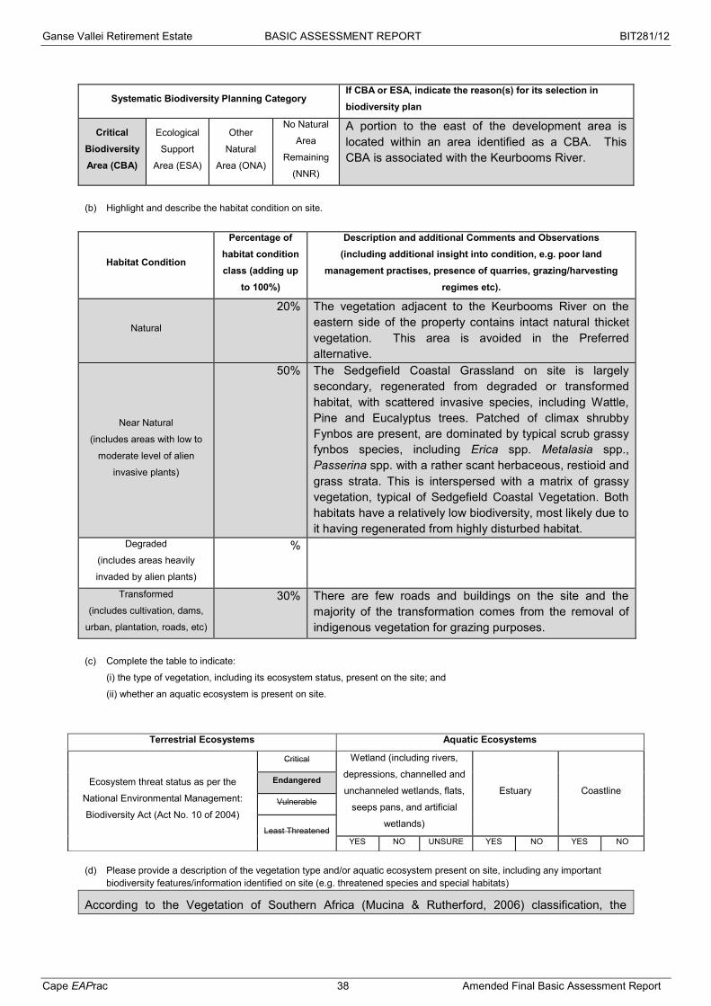
Ganse Vallei Retirement Estate BASIC ASSESSMENT REPORT BIT281/12
Cape EAPrac 38 Amended Final Basic Assessment Report
Systematic Biodiversity Planning Category If CBA or ESA, indicate the reason(s) for its selection in biodiversity plan
Critical Biodiversity Area (CBA)
Ecological
Support
Area (ESA)
Other
Natural
Area (ONA)
No Natural
Area
Remaining
(NNR)
A portion to the east of the development area is located within an area identified as a CBA. This CBA is associated with the Keurbooms River.
(b) Highlight and describe the habitat condition on site.
Habitat Condition
Percentage of habitat condition class (adding up
to 100%)
Description and additional Comments and Observations (including additional insight into condition, e.g. poor land
management practises, presence of quarries, grazing/harvesting regimes etc).
Natural
20% The vegetation adjacent to the Keurbooms River on the eastern side of the property contains intact natural thicket vegetation. This area is avoided in the Preferred alternative.
Near Natural
(includes areas with low to
moderate level of alien
invasive plants)
50% The Sedgefield Coastal Grassland on site is largely secondary, regenerated from degraded or transformed habitat, with scattered invasive species, including Wattle, Pine and Eucalyptus trees. Patched of climax shrubby Fynbos are present, are dominated by typical scrub grassy fynbos species, including Erica spp. Metalasia spp., Passerina spp. with a rather scant herbaceous, restioid and grass strata. This is interspersed with a matrix of grassy vegetation, typical of Sedgefield Coastal Vegetation. Both habitats have a relatively low biodiversity, most likely due to it having regenerated from highly disturbed habitat.
Degraded
(includes areas heavily
invaded by alien plants)
%
Transformed
(includes cultivation, dams,
urban, plantation, roads, etc)
30% There are few roads and buildings on the site and the majority of the transformation comes from the removal of indigenous vegetation for grazing purposes.
(c) Complete the table to indicate:
(i) the type of vegetation, including its ecosystem status, present on the site; and
(ii) whether an aquatic ecosystem is present on site.
(d) Please provide a description of the vegetation type and/or aquatic ecosystem present on site, including any important
biodiversity features/information identified on site (e.g. threatened species and special habitats)
According to the Vegetation of Southern Africa (Mucina & Rutherford, 2006) classification, the
Terrestrial Ecosystems Aquatic Ecosystems
Ecosystem threat status as per the
National Environmental Management:
Biodiversity Act (Act No. 10 of 2004)
Critical Wetland (including rivers,
depressions, channelled and
unchanneled wetlands, flats,
seeps pans, and artificial
wetlands)
Estuary Coastline Endangered
Vulnerable
Least Threatened YES NO UNSURE YES NO YES NO

Ganse Vallei Retirement Estate BASIC ASSESSMENT REPORT BIT281/12
Cape EAPrac 39 Amended Final Basic Assessment Report
vegetation on site is Garden Route Shale Fynbos, considered to be Endangered in NSBA 2006 and reclassified as Vulnerable in NEM:BA 2011. However, due to historical disturbances, the Grassy Fynbos vegetation on site tends to be of a secondary nature.
The vegetation on site would historically have comprised of typical Sedgefield Coastal Grassland, on sandy soils, most likely of a coastal and alluvial nature, with some scrub fynbos and fynbos-thicket elements present in wetter areas and where fire frequency might be lower.
The Sedgefield Coastal Grassland has a Critically Endangered conservation status and tends to be degraded, fragmented and invaded with various invasive species. Although elements of Sedgefield Coastal Grassland appear to be present it does appear to be of a secondary nature. When the site was visited in 2006 by the botanical specialist, the entire north-western portion was being regularly mowed and maintained as a pasture. When the site was visited in 2015, mowing had not occurred for a number of years (unknown) and there has been regeneration of herbaceous and shrubby fynbos elements. Some ecological process have been restored, however the species composition is relatively low, consisting predominantly of widespread common species.
Figure 21: Vegetation type & ecosystem status (SANBI BGIS, 2014)
NEM:BA 2011 classified Garden Route Shale Fynbos as Vulnerable and no longer Endangered.
7. LAND USE OF THE SITE
Please note: The Department may request specialist input/studies depending on the nature of the land use character of the area and potential impact(s) of the proposed activity/ies.
Untransformed area Low density residential Medium density residential
High density residential Informal residential

Ganse Vallei Retirement Estate BASIC ASSESSMENT REPORT BIT281/12
Cape EAPrac 40 Amended Final Basic Assessment Report
Retail Commercial & warehousing Light industrial Medium industrial Heavy industrial
Power station Office/consulting room Military or police
base/station/compound
Casino/entertainment complex
Tourism & Hospitality facility
Open cast mine Underground mine Spoil heap or slimes dam
Quarry, sand or borrow pit Dam or reservoir
Hospital/medical center School Tertiary education
facility Church Old age home
Sewage treatment plant
Train station or shunting yard Railway line Major road (4 lanes or
more) Airport
Harbour Sport facilities Golf course Polo fields Filling station
Landfill or waste treatment site Plantation Agriculture River, stream or
wetland Nature conservation
area Mountain, koppie or
ridge Museum Historical building Graveyard Archeological site
Other land uses (describe):
(a) Please provide a description.
Currently on site there is a residential dwelling on Portion 19 and the rest of the development site was used for agriculture in the form of grazing.
Figure 22: Land use character of the site (Google Earth Pro, 2015)
8. LAND USE CHARACTER OF SURROUNDING AREA
(a) Highlight the current land uses and/or prominent features that occur within +/- 500m radius of the site and neighbouring properties if these are located beyond 500m of the site.
Please note: The Department may request specialist input/studies depending on the nature of the land use character of the area and potential impact(s) of the proposed activity/ies.

Ganse Vallei Retirement Estate BASIC ASSESSMENT REPORT BIT281/12
Cape EAPrac 41 Amended Final Basic Assessment Report
Untransformed area Low density residential Medium density residential
High density residential Informal residential
Retail Commercial & warehousing Light industrial Medium industrial Heavy industrial
Power station Office/consulting room Military or police base/station/compound
Casino/entertainment complex
Tourism & Hospitality facility
Open cast mine Underground mine Spoil heap or slimes
dam Quarry, sand or borrow
pit Dam or reservoir
Hospital/medical center School Tertiary education
facility Church Old age home
Sewage treatment plant
Train station or shunting yard
Railway line Major road (4 lanes or more)
Airport
Harbour Sport facilities Golf course Polo fields Filling station
Landfill or waste treatment site Plantation Agriculture River, stream or
wetland Nature conservation
area Mountain, koppie or
ridge Museum Historical building Graveyard Archeological site
Other land uses (describe):
(b) Please provide a description, including the distance and direction to the nearest residential area and industrial area. There are several land use types within 500m of the cadastral boundaries of the development area. They include:
Agricultural – crops and vineyards Commercial / Industrial – Penny Pinchers and DenRon construction yard Residential – rural residential and Goose Valley housing Sport – Polo fields and infrastructure and the Goose Valley golf course Natural – Keurbooms River Dam – associated with agricultural activities.
The distances identified below are calculated from the nearest portion of the boundary.
Figure 23: Land use within 500m radius (Google Earth Pro, 2015)
Penny Pinchers -±90m
DenRon construction -±250m
Goose Valley Residential -±380m
Goose Valley Golf course±188m
Polo fields -±460m
Vineyards -±150m
Keurbooms River-±5m
Polo fields -±400m
Agriculture -±200m
Dam -±88m
Rural residential -±0m

Ganse Vallei Retirement Estate BASIC ASSESSMENT REPORT BIT281/12
Cape EAPrac 42 Amended Final Basic Assessment Report
9. SOCIO-ECONOMIC ASPECTS
Describe the existing social and economic characteristics of the community in order to provide baseline information.
According to the 2014/2015 revised Integrated Development Plan (IDP), the Census 2011 analysis indicates that “Bitou Municipality is the fourth fastest growing population in the country and the second fasted growing in the Cape Province”.
Figure 24: Population growth trends since 1996 (Bitou Municipality, 2014)
A population growth rate of 5,2 per cent per annum might have a negative impact for the municipality in the future. The following factors might influence the municipality negatively:
1. Revenue collection;
2. Increased demand for basic services; and
3. Economic stagnation
The above assertions are informed by the fact that there is a decline in the growth rate of some of the economically active population groupings. The percentage whites declined from 21,5% to 17% and the coloured population from 40,5% to 31,2% between 2006 and 2011 but at the same time the black population increased from 37,6% in 2006 to 45,2% in 2011.
The population pyramid graphs below illustrate the levels of growth per age group. The evidence presented by the graph below demonstrates that the population is growing primarily between the ages of 20 and 65 years and 0 – 20 years. These growth trends mean demand for shelter, employment, health and education facilities increased.

Ganse Vallei Retirement Estate BASIC ASSESSMENT REPORT BIT281/12
Cape EAPrac 43 Amended Final Basic Assessment Report
Figure 25: Population pyramids illustrating the population dynamics since 1996 (Bitou Municipality, 2014)
Bitou Municipality’s population had more females than males in 2011. The gender ratio in 2001 was 96,7% males (per 100 females). The ratio increased to 99,1% in 2011. The age cohort 25 to 39 proportionally indicates a larger male population representing 28% of the total male population; this however changes from age cohorts 39 upwards, where there appears to be a sharp decline in the male population. Within the elderly groups this gap widens and can be attributed to economic migratory factors or mortality amongst men.
Bitou is one of the municipal areas in the province with negatively skewed gini co-efficient. The Gini coefficient is a summary statistic of income inequality, which varies from 0, in the case of perfect equality where all households earn equal income, to 1 (in the case where one household earns all the income and other household earns nothing). In practice the coefficient is likely to vary from approximately 0,25 to 0,70. The national figure is 0,7. The graph below illustrates the monthly household income levels from households with no income to house households with the highest income per capita per month. The evidence presented in this graph illustrate that the number of households with no income increased from 13,94% in 2001 to 18,07% in 2011 and this increase is obvious right through the indigent or grant dependent categories. At the same time there is an increase (0,32% in 2001 to 0,38% in 2011) of number of households in the category R204 801,00 and more.

Ganse Vallei Retirement Estate BASIC ASSESSMENT REPORT BIT281/12
Cape EAPrac 44 Amended Final Basic Assessment Report
The graph above implies that Bitou area is mostly occupied by job seekers which means that the municipal indigent register is also growing, i.e. major coat for the municipal constitutional mandate to provide all citizens with basic services.
The 2013 Bitou Municipality SDF identified several sectors which are economic drivers. Tourism was identified as the key driver in the economy of Bitou and an emphasis was placed on the importance of providing growth in this sector in order to grow the economy and for employment creation. In Bitou tourism generates 8.7% of the district GRP and 8.6% of the employment. Bitou is a popular holiday destination and a popular retirement area.

Ganse Vallei Retirement Estate BASIC ASSESSMENT REPORT BIT281/12
Cape EAPrac 45 Amended Final Basic Assessment Report
Figure 26: Age profile (Bitou Municipality SDF, 2013)
The immediate area in the vicinity of the proposed development can be considered a medium to high income group area.
10. HISTORICAL AND CULTURAL ASPECTS
(a) Please be advised that if section 38 of the National Heritage Resources Act, 1999 (Act No. 25 of 1999), is applicable to
your proposed development, then you are requested to furnish this Department with written comment from Heritage
Western Cape as part of your public participation process. Section 38 of the Act states as follows: “38. (1) Subject to the
provisions of subsections (7), (8) and (9), any person who intends to undertake a development categorised as-
(a) the construction of a road, wall, power line, pipeline, canal or other similar form of linear development or barrier exceeding 300m in length;
(b) the construction of a bridge or similar structure exceeding 50m in length; (c) any development or other activity which will change the character of a site-
(i) exceeding 5 000 m2 in extent; or (ii) involving three or more existing erven or subdivisions thereof; or (iii) involving three or more erven or divisions thereof which have been consolidated within the past five years; or (iv) the costs of which will exceed a sum set in terms of regulations by SAHRA or a provincial heritage resources
authority; (d) the re-zoning of a site exceeding 10 000 m2 in extent; or (e) any other category of development provided for in regulations by SAHRA or a provincial heritage resources authority,
must at the very earliest stages of initiating such a development, notify the responsible heritage resources authority and furnish it with details regarding the location, nature and extent of the proposed development.”
(b) The impact on any national estate referred to in section 3(2), excluding the national estate contemplated in section
3(2)(i)(vi) and (vii), of the National Heritage Resources Act, 1999 (Act No. 25 of 1999), must also be investigated, assessed
and evaluated. Section 3(2) states as follows: “3(2) Without limiting the generality of subsection (1), the national estate may
include—
(a) places, buildings, structures and equipment of cultural significance; (b) places to which oral traditions are attached or which are associated with living heritage; I historical settlements and townscapes; (d) landscapes and natural features of cultural significance;
(e) geological sites of scientific or cultural importance;

Ganse Vallei Retirement Estate BASIC ASSESSMENT REPORT BIT281/12
Cape EAPrac 46 Amended Final Basic Assessment Report
(f) archaeological and palaeontological sites; (g) graves and burial grounds, including— (i) ancestral graves; (ii) royal graves and graves of traditional leaders; (iii) graves of victims of conflict; (iv) graves of individuals designated by the Minister by notice in the Gazette; (v) historical graves and cemeteries; and (vi) other human remains which are not covered in terms of the Human Tissue Act, 1983 (Act No. 65 of 1983); (h) sites of significance relating to the history of slavery in South Africa; (i) movable objects, including— (i) objects recovered from the soil or waters of South Africa, including archaeological and palaeontological objects and material, meteorites and rare geological specimens; (ii) objects to which oral traditions are attached or which are associated with living heritage; (iii) ethnographic art and objects; (iv) military objects; (v) objects of decorative or fine art; (vi) objects of scientific or technological interest; and (vii) books, records, documents, photographic positives and negatives, graphic, film or video material or sound recordings, excluding those that are public records as defined in section 1(xiv) of the National Archives of South Africa Act, 1996 (Act No. 43 of 1996).”
Is section 38 of the National Heritage Resources Act, 1999, applicable to the development? YES NO
UNCERTAIN
If YES, explain:
According to the activities identified above, the development on Portions 19 and 27 of 444 will exceed 5 000m² (Section 38 (c)(i)) and the rezoning will exceed 10 000m² (Section 38 (d)). In October 2007, Heritage Western Cape confirmed that no further heritage study was required and that the development could continue with no conditions. The comment has been included as Appendix E.
The HWC basic requirements for finding resources of heritage value have been provided in the EMPr.
HWC has confirmed the validity of the October 2007 decision and that it is still applicable to the site.
Will the development impact on any national estate referred to in section 3(2) of the National Heritage
Resources Act, 1999?
YES NO
UNCERTAIN
If YES, explain:
Will any building or structure older than 60 years be affected in any way? YES NO UNCERTAIN
If YES, explain:
Please Note: If uncertain, the Department may request that specialist input be provided.
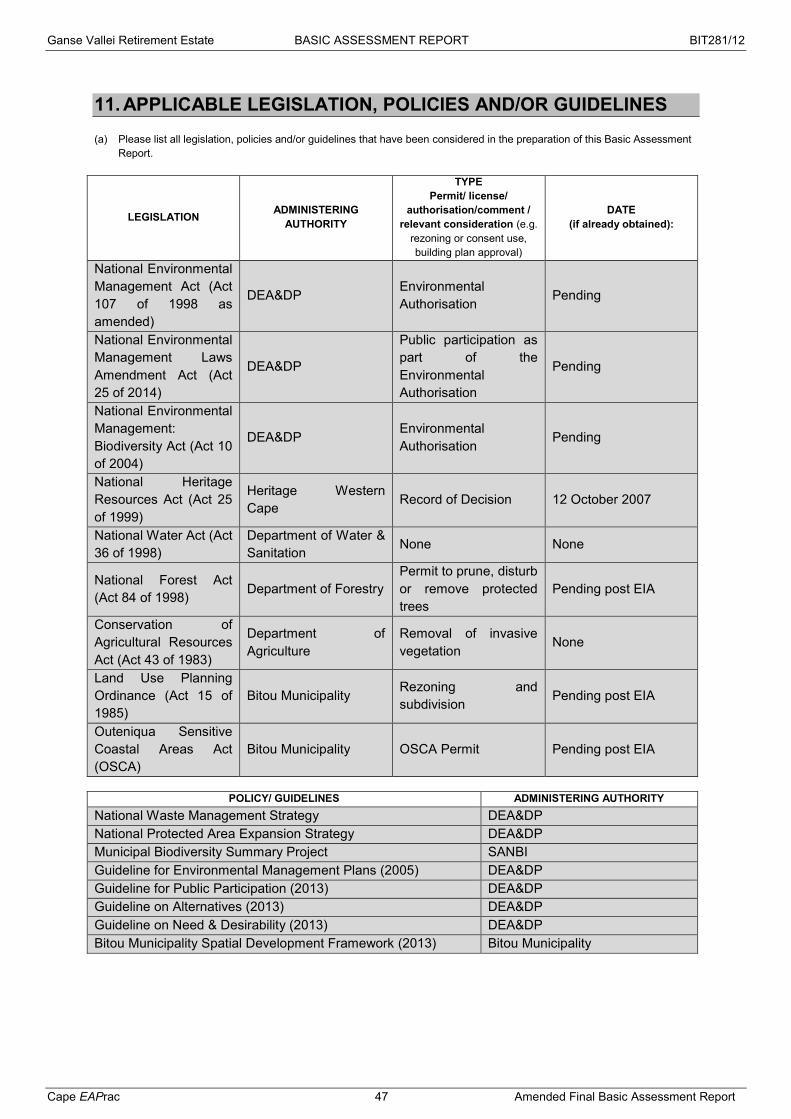
Ganse Vallei Retirement Estate BASIC ASSESSMENT REPORT BIT281/12
Cape EAPrac 47 Amended Final Basic Assessment Report
11. APPLICABLE LEGISLATION, POLICIES AND/OR GUIDELINES
(a) Please list all legislation, policies and/or guidelines that have been considered in the preparation of this Basic Assessment Report.
LEGISLATION ADMINISTERING AUTHORITY
TYPE Permit/ license/
authorisation/comment / relevant consideration (e.g.
rezoning or consent use, building plan approval)
DATE (if already obtained):
National Environmental Management Act (Act 107 of 1998 as amended)
DEA&DP Environmental Authorisation Pending
National Environmental Management Laws Amendment Act (Act 25 of 2014)
DEA&DP
Public participation as part of the Environmental Authorisation
Pending
National Environmental Management: Biodiversity Act (Act 10 of 2004)
DEA&DP Environmental Authorisation
Pending
National Heritage Resources Act (Act 25 of 1999)
Heritage Western Cape Record of Decision 12 October 2007
National Water Act (Act 36 of 1998)
Department of Water & Sanitation None None
National Forest Act (Act 84 of 1998) Department of Forestry
Permit to prune, disturb or remove protected trees
Pending post EIA
Conservation of Agricultural Resources Act (Act 43 of 1983)
Department of Agriculture
Removal of invasive vegetation
None
Land Use Planning Ordinance (Act 15 of 1985)
Bitou Municipality Rezoning and subdivision Pending post EIA
Outeniqua Sensitive Coastal Areas Act (OSCA)
Bitou Municipality OSCA Permit Pending post EIA
POLICY/ GUIDELINES ADMINISTERING AUTHORITY
National Waste Management Strategy DEA&DP National Protected Area Expansion Strategy DEA&DP Municipal Biodiversity Summary Project SANBI Guideline for Environmental Management Plans (2005) DEA&DP Guideline for Public Participation (2013) DEA&DP Guideline on Alternatives (2013) DEA&DP Guideline on Need & Desirability (2013) DEA&DP Bitou Municipality Spatial Development Framework (2013) Bitou Municipality

Ganse Vallei Retirement Estate BASIC ASSESSMENT REPORT BIT281/12
Cape EAPrac 48 Amended Final Basic Assessment Report
(b) Please describe how the legislation, policies and/or guidelines were taken into account in the preparation of this Basic Assessment Report.
LEGISLATION / POLICY / GUIDELINE DESCRIBE HOW THE LEGISLATION / POLICY / GUIDELINE WERE TAKEN
INTO ACCOUNT (E.g. describe the extent to which it was adhered to, or deviated from, etc).
National Environmental Management Act (Act 107 of 1998 as amended)
Environmental Impact Assessment is being undertaken in terms of Chapter 5 of NEMA using the 2010 EIA regulations with consideration being given to the 2014 EIA regulations.
National Environmental Management Laws Amendment Act (Act 25 of 2014)
The public participation is being undertaken in terms of this Act, specifically the 30 day comment period prescribed.
National Environmental Management: Biodiversity Act (Act 10 of 2004)
The identification of the onsite vegetation and the ecosystem status associated with the vegetation is undertaken in terms of this Act. This Act also applies to the control and management of Alien Invasive Species (AIS), which includes animals and vegetation.
National Heritage Resources Act (Act 25 of 1999)
The Record of Decision in terms of Section 38 of this Act has been issued by Heritage Western Cape.
National Water Act (Act 36 of 1998)
Since the development will be obtaining water directly from the municipality and no water resources will be affected, this Act is not applicable to this application.
National Forest Act (Act 84 of 1998)
In the event that the development requires the pruning, disturbance or removal of any protected tree species, an application must be made to the Department for a permit. This can only be undertaken once a final layout has been confirmed and before any building plans may be approved by the municipality.
Conservation of Agricultural Resources Act (Act 43 of 1983)
Although the proposal is to rezone the property, this Act will still apply for the removal and control of alien invasive vegetation, protection of water resources and the prevention of soil erosion.
Land Use Planning Ordinance (Act 15 of 1985)
The rezoning and subdivision of the properties to accommodate the land use proposed is regulated by this Ordinance. This process will only commence on the EIA process is completed.
Outeniqua Sensitive Coastal Areas Act (OSCA)
An OSCA application must be obtained prior to construction and vegetation removal activities commencing on the site.
National Waste Management Strategy
All waste from construction to decommissioning must be dealt with in terms of this strategy.
National Protected Area Expansion Strategy There are no NPAES focus areas near the development properties.
Municipal Biodiversity Summary Project
The summary provides a tool with which to evaluate the impact of the development on the environment.
Guideline for Environmental Management Plans (2005)
An EMPr has been included with this Basic Assessment to provide practical and implementable actions to ensure that the development maintains sustainability and minimise impacts through all its phases. The document is drafted as per the Guidelines and requirements of NEMA.
Guideline for Public Participation (2013)
The PPP for this process is based on this Guideline and also includes any updated regulations.
Guideline on Alternatives (2013)
Feasible and reasonable alternatives must be considered alongside the development proposal in order to ensure the Best Practicable Environmental Option (BPEO). These Guidelines have been used in their consideration.
Guideline on Need & Desirability (2013)
Need & Desirability refers to the temporal and spatial need of an area for a specific development. This Guideline was used to define the requirements and implications of Need & Desirability.
Ganse Vallei Retirement Estate BASIC ASSESSMENT REPORT BIT281/12
Cape EAPrac 49 Amended Final Basic Assessment Report
Bitou Municipality Spatial Development Framework (2013)
The proposal is identified in line with the SDF. Demographic information was obtained from this document.
Please note: Copies of any permit(s) or licences received from any other organ of state must be attached this report as Appendix E.
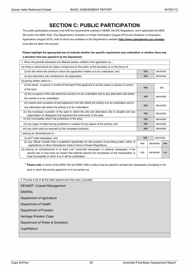
Ganse Vallei Retirement Estate BASIC ASSESSMENT REPORT BIT281/12
Cape EAPrac 50 Amended Final Basic Assessment Report
SECTION C: PUBLIC PARTICIPATION The public participation process must fulfil the requirements outlined in NEMA, the EIA Regulations, and if applicable the NEM:
WA and/or the NEM: AQA. This Department’s Guideline on Public Participation (August 2010) and Guideline on Exemption
Applications (August 2010), both of which are available on the Department’s website (http://www.capegateway.gov.za/eadp),
must also be taken into account.
Please highlight the appropriate box to indicate whether the specific requirement was undertaken or whether there was a deviation that was agreed to by the Department.
1. Were all potential interested and affected parties notified of the application by –
(a) fixing a notice board at a place conspicuous to the public at the boundary or on the fence of -
(i) the site where the activity to which the application relates is to be undertaken; and YES DEVIATED
(ii) any alternative site mentioned in the application; YES DEVIATED
(b) giving written notice to – (i) the owner or person in control of that land if the applicant is not the owner or person in control
of the land; YES N/A
(ii) the occupiers of the site where the activity is to be undertaken and to any alternative site where
the activity is to be undertaken; YES DEVIATED
(iii) owners and occupiers of land adjacent to the site where the activity is to be undertaken and to
any alternative site where the activity is to be undertaken; YES DEVIATED
(iv) the municipal councillor of the ward in which the site and alternative site is situated and any organisation of ratepayers that represent the community in the area;
YES DEVIATED
(v) the municipality which has jurisdiction in the area; YES DEVIATED
(vi) any organ of state having jurisdiction in respect of any aspect of the activity; and YES DEVIATED
(vii) any other party as required by the competent authority; YES DEVIATED
I placing an advertisement in -
(i) one* local newspaper; and YES DEVIATED
(ii) any official Gazette that is published specifically for the purpose of providing public notice of applications or other submissions made in terms of these Regulations;
YES DEVIATED N/A
(d) placing an advertisement in at least one* provincial newspaper or national newspaper, if the activity has or may have an impact that extends beyond the boundaries of the metropolitan or local municipality in which it is or will be undertaken.
YES DEVIATED N/A
* Please note: In terms of the NEM: WA and NEM: AQA a notice must be placed in at least two newspapers circulating in the
area in which the activity applied for is to be carried out.
2. Provide a list of all the state departments that were consulted:
DEA&DP: Coastal Management
SANRAL
Department of Agriculture
Department of Health
Department of Forestry
Heritage Western Cape
Department of Water & Sanitation
CapeNature

Ganse Vallei Retirement Estate BASIC ASSESSMENT REPORT BIT281/12
Cape EAPrac 51 Amended Final Basic Assessment Report
3. Please provide an overall summary of the Public Participation Process that was followed. (The detailed outcomes of this process must be included in a comments and response report to be attached to the final Basic Assessment Report (see note below) as Appendix F).
An Application for Environmental Authorisation was submitted to the provincial Department of Environmental Affairs & Development Planning (DEA&DP) on the 21st November 2014 and accepted by DEA&DP on the 12th December 2014. This Application was submitted in terms of the 2010 Environmental Impact Assessment (EIA) Regulations and this Basic Assessment will be undertaken in terms of those regulations. Due consideration will be given to any similarly listed activities in the 2014 EIA Regulations.
Site notices were placed at the entrance to the site and an advert was placed in the Kynsna / Plett Herald for publication on 25 June 2015 notifying the public of the EIA process and providing an opportunity for Interested & Affected Parties (I&APs) to register and participate.
The Basic Assessment Report (BAR) was made available for comment and review for a period of 30 days extending from Friday 26th June to Monday 27th July 2015.
Hard copies of the report were made available at the following venues:
Plettenberg Bay Library; Bitou Municipality: Planning office.
Digital copies of the report are available on the Cape EAPrac website at www.cape-eaprac.co.za under Active Projects.
Figure 27: Website screenshot (Cape EAPrac, 2015)
Some additional registrations and one comment was received during this period. These have been collated and included in Annexure F5 of the final BAR.
An additional 21 days review period was provided for the Final BAR for registered I&APs to consider the
document, extending from Friday 30th October to Thursday 19th November 2015.
It must be noted that the following inclusions were made to the Draft BAR in the Final BAR:
Stormwater Management Plan;
Municipality Services Confirmation;
Updated Public Participation.
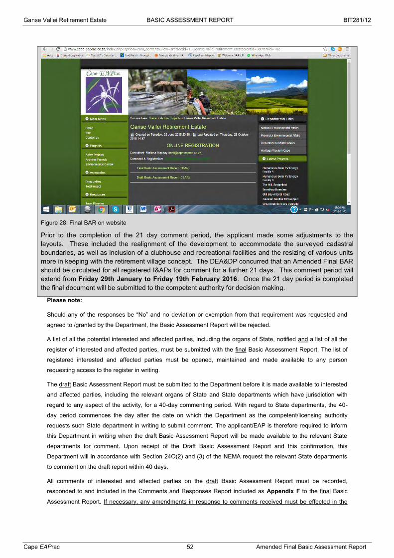
Ganse Vallei Retirement Estate BASIC ASSESSMENT REPORT BIT281/12
Cape EAPrac 52 Amended Final Basic Assessment Report
Figure 28: Final BAR on website
Prior to the completion of the 21 day comment period, the applicant made some adjustments to the layouts. These included the realignment of the development to accommodate the surveyed cadastral boundaries, as well as inclusion of a clubhouse and recreational facilities and the resizing of various units more in keeping with the retirement village concept. The DEA&DP concurred that an Amended Final BAR should be circulated for all registered I&APs for comment for a further 21 days. This comment period will extend from Friday 29th January to Friday 19th February 2016. Once the 21 day period is completed the final document will be submitted to the competent authority for decision making.
Please note:
Should any of the responses be “No” and no deviation or exemption from that requirement was requested and
agreed to /granted by the Department, the Basic Assessment Report will be rejected.
A list of all the potential interested and affected parties, including the organs of State, notified and a list of all the
register of interested and affected parties, must be submitted with the final Basic Assessment Report. The list of
registered interested and affected parties must be opened, maintained and made available to any person
requesting access to the register in writing.
The draft Basic Assessment Report must be submitted to the Department before it is made available to interested
and affected parties, including the relevant organs of State and State departments which have jurisdiction with
regard to any aspect of the activity, for a 40-day commenting period. With regard to State departments, the 40-
day period commences the day after the date on which the Department as the competent/licensing authority
requests such State department in writing to submit comment. The applicant/EAP is therefore required to inform
this Department in writing when the draft Basic Assessment Report will be made available to the relevant State
departments for comment. Upon receipt of the Draft Basic Assessment Report and this confirmation, this
Department will in accordance with Section 24O(2) and (3) of the NEMA request the relevant State departments
to comment on the draft report within 40 days.
All comments of interested and affected parties on the draft Basic Assessment Report must be recorded,
responded to and included in the Comments and Responses Report included as Appendix F to the final Basic
Assessment Report. If necessary, any amendments in response to comments received must be effected in the

Ganse Vallei Retirement Estate BASIC ASSESSMENT REPORT BIT281/12
Cape EAPrac 53 Amended Final Basic Assessment Report
Basic Assessment Report itself. The Comments and Responses Report must also include a description of the
public participation process followed.
The final Basic Assessment Report must be made available to registered interested and affected parties for
comment before submitting it to the Department for consideration. Unless otherwise indicated by the Department,
a final Basic Assessment Report must be made available to the registered interested and affected parties for
comment for a minimum of 21-days. Comments on the final Basic Assessment Report does not have to be
responded to, but the comments must be attached to the final Basic Assessment Report.
The minutes of any meetings held by the EAP with interested and affected parties and other role players which
record the views of the participants must also be submitted as part of the public participation information to be
attached to the final Basic Assessment Report as Appendix F.
Proof of all the notices given as indicated, as well as of notice to the interested and affected parties of the
availability of the draft Basic Assessment Report and final Basic Assessment Report must be submitted as part of
the public participation information to be attached to the final Basic Assessment Report as Appendix F.

Ganse Vallei Retirement Estate BASIC ASSESSMENT REPORT BIT281/12
Cape EAPrac 54 Amended Final Basic Assessment Report
SECTION D: NEED AND DESIRABILITY Please Note: Before completing this section, first consult this Department’s Guideline on Need and Desirability (August 2010) available on the Department’s website (http://www.capegateway.gov.za/eadp).
1. Is the activity permitted in terms of the property’s existing land use rights? YES NO Please explain
The property is currently zoned for Agriculture and an application for subdivision and rezoning was submitted in September 2007. This application was placed on hold due to the Guide Plans that were in place and have since fallen away. The rezoning and subdivision application will be updated once the EIA process has been completed.
Bitou Municipality has indicated that it will support the application for this EIA given that in principle support of the development has been provided by the council. They have also confirmed availability of services for the development.
2. Will the activity be in line with the following?
(a) Provincial Spatial Development Framework (PSDF) YES NO Please explain
Plettenberg Bay is identified as a settlement with low social needs, with a population of more than 5000 and a high development need. The PSDF requires that Urban Edges are determined to provide suitable development and land use management. The municipality has indicated that although the properties are not currently incorporated into the urban edge, the council has previously given in principle support of the development and will await the result of the EIA process.
(b) Urban edge / Edge of Built environment for the area YES NO Please explain
The properties are currently outside of the designated May 2013 Goose Valley Urban Edge, although the Bitou Municipality has confirmed that the they will support the EIA application given that in principle support of the development has been provided by the council..
(c) Integrated Development Plan and Spatial Development Framework of the Local
Municipality (e.g. would the approval of this application compromise the integrity of the
existing approved and credible municipal IDP and SDF?).
YES NO Please explain
The Department of Social Development (DSD) will not construct any old age homes / retirement villages as part of any government sponsored projects. Any such facilities are private and to be managed by NPO’s, thus this private development is in line with the IDP.
The SDF proposed the following land use management guidelines for the Bioregional Framework:
Development is proposed to take place on land which is already disturbed or has undergone disturbance (the majority of the properties in question have been disturbed by grazing, landscaping and residential development);
The Local Authority should seek the advice of the respective conservation authority when activities will create a large scale disturbance; (this will take place as part of the EIA process);
If the intended development will have severe impacts, the Municipality should recommend that portions of land that will not be developed remain that way and ensure that it is managed or proclaimed as a nature reserve area;
The further loss of natural areas should not be allowed.
However, the SDF has identified the following designated land uses on the properties in question:
Portion 27 falls within a Core 1b River Corridor. According to the SDF only limited development, mostly of a tourism nature may be considered in these areas.
Portion 19 falls within Intensive Agriculture. According the SDF existing and potential land
Ganse Vallei Retirement Estate BASIC ASSESSMENT REPORT BIT281/12
Cape EAPrac 55 Amended Final Basic Assessment Report
suitable for Intensive Agriculture will be protected from conversion to any other uses, including conservation.
Both properties fall outside of the Goose Valley Urban Edge. According to the SDF, no urban development shall be permitted outside of Urban Edges. Density outside the Urban Edge to be below 1du/ha, except in Rural Development areas
Both properties fall outside of the Coastal Estuarine Setback Line. According to the SDF, no development should be permitted on the seaward side of coastal setback line.
It must be noted though that Bitou Municipality has confirmed that in principle support of the development by the council was confirmed at a previous application to amend the old Guide Plan. The municipality will therefore support the EIA applicant and abide by the findings thereof.
(d) Approved Structure Plan of the Municipality YES NO Please explain
Not Applicable.
(e) An Environmental Management Framework (EMF) adopted by the Department
(e.g. Would the approval of this application compromise the integrity of the existing
environmental management priorities for the area and if so, can it be justified in terms of
sustainability considerations?)
YES NO Please explain
No adopted EMF is currently in place for the Bitou Municipality. (f) Any other Plans (e.g. Guide Plan) YES NO Please explain
Not Applicable.
3. Is the land use (associated with the activity being applied for) considered within the timeframe intended by the existing approved Spatial Development Framework (SDF) agreed to by the relevant environmental authority (i.e. is the proposed development in line with the projects and programmes identified as priorities within the credible IDP)?
YES NO Please explain
The current SDF has not been approved by the competent authority and currently excludes the property as a future development node. However, the Bitou Municipality has confirmed that the urban edge will include the properties and allow for residential usage. They have also confirmed the availability of services for the development.
4. Should development, or if applicable, expansion of the town/area concerned in terms of this land use (associated with the activity being applied for) occur here at this point in time?
YES NO Please explain
The property forms an end point and part of a corridor and logical expansion associated with development from central Plettenberg Bay to the north between the N2 and the Keurbooms river.
5. Does the community/area need the activity and the associated land use concerned (is it a societal priority)? (This refers to the strategic as well as local level (e.g. development is a national priority, but within a specific local context it could be inappropriate.)
YES NO Please explain
The Department of Social Development (DSD) will not construct any old age homes / retirement villages as part of any government sponsored projects. Any such facilities are private and to be managed by NPO’s, thus this private development is in line with the IDP. Plettenberg Bay has a high percentage of retired people either currently living in the area or intending to relocate to the area. The establishment of a retirement estate will fill this niche.
6. Are the necessary services with adequate capacity currently available (at the time of application), or must additional capacity be created to cater for the development? (Confirmation by the relevant Municipality in this regard must be attached to the final Basic Assessment Report as Appendix E.)
YES NO Please explain
The Bitou Municipality has confirmed in a meeting with the engineers (Royal Haskoning DHV) that there is

Ganse Vallei Retirement Estate BASIC ASSESSMENT REPORT BIT281/12
Cape EAPrac 56 Amended Final Basic Assessment Report
sufficient existing capacity for water and sewage to accommodate this development. Please see the Services Report in Appendix G. Final confirmation from the municipality will be included in the Final BAR once it has been obtained from the Bitou Municipality.
7. Is this development provided for in the infrastructure planning of the municipality, and if not what will the implication be on the infrastructure planning of the municipality (priority and placement of services and opportunity costs)? (Comment by the relevant Municipality in this regard must be attached to the final Basic Assessment Report as Appendix E.)
YES NO Please explain
No additional municipal infrastructure is required.
8. Is this project part of a national programme to address an issue of national concern or importance?
YES NO Please explain
9. Do location factors favour this land use (associated with the activity applied for) at this place? (This relates to the contextualisation of the proposed land use on this site within its broader context.)
YES NO Please explain
The properties are within the accepted urban area and there is easy access to retail, commercial and medical resources required by a retirement estate.
10. How will the activity or the land use associated with the activity applied for, impact on sensitive natural and cultural areas (built and rural/natural environment)?
YES NO Please explain
Specialist investigations confirm that the impact on the environment is low with mitigation and there are no cultural impacts as confirmed by HWC.
11. How will the development impact on people’s health and wellbeing (e.g. in terms of noise, odours, visual character and sense of place, etc)?
YES NO Please explain
The development is not likely to have a negative impact on people’s health and wellbeing. It is situated off the N2 and within an area that has other residential components and will not impact on the sense of place. Apart from noise impacts during construction, the noise will be of a very low significance.
12. Will the proposed activity or the land use associated with the activity applied for, result in unacceptable opportunity costs?
YES NO Please explain
Since the properties are currently zoned for Agriculture, there is a possible opportunity cost associated with the development infringing on agricultural opportunities. The property has been used for extensive grazing in the past but has been allowed to lie fallow for many years. According to Cape Farm Mapper, the land capability of the property is for moderate potential arable land. It must be noted though that the area around the Keurbooms River has all been identified as such, but it is unlikely that this potential will be fully realised due to conservation and planning issues. In addition the 2013 SDF shows the area as “Intensive Agriculture”.
In March 2007, an agricultural potential study was undertaken and the findings were that there is no irrigation potential due to the quality of the underground water which contains high sodium and chloride contents. The study also found that the soils were of poor suitability for arable agriculture.
It is thus confirmed that there are no unacceptable opportunity costs.

Ganse Vallei Retirement Estate BASIC ASSESSMENT REPORT BIT281/12
Cape EAPrac 57 Amended Final Basic Assessment Report
Figure 29: Land Capability (Cape Farm Mapper, 2015) 13. What will the cumulative impacts (positive and negative) of the proposed land
use associated with the activity applied for, be? YES NO Please explain
Possible Negative Impacts:
- Strain on municipal infrastructure – the Bitou Municipality has identified possible negative impacts on the revenue collection, increased demand for basic services and economic stagnation with additional population numbers in the area.
- Loss of moderate potential agriculture.
Possible Positive Impacts:
- Development of retirement facilities in an area where no further such development will be considered by the Department of Social Development.
- Additional revenue for the municipality. - Retention of the current economically active group within the Bitou Municipality in the future.
14. Is the development the best practicable environmental option for this land/site? YES NO Please explain
The landowner is not intending to fulfil the agricultural use of the land and its development capabilities were determined in the inclusion of the properties in the previous Guide Plan. There are no significantly negative impacts associated with this land use and it will ensure facilities are available for the upper age group in the area.
15. What will the benefits be to society in general and to the local communities? Please explain
The development will provide a place for currently economically active members of the community to remain in the municipal area.
The development will contribute to the upgrading of municipal infrastructure which benefits communities beyond the site.

Ganse Vallei Retirement Estate BASIC ASSESSMENT REPORT BIT281/12
Cape EAPrac 58 Amended Final Basic Assessment Report
(17) Please describe how the general objectives of Integrated Environmental Management as set out in section 23 of NEMA have been taken into account:
(1) The purpose of this Chapter is to promote the application of appropriate environmental management tools in order to
ensure the integrated environmental management of activities,
(2) The general objective of integrated environmental management is to:
(a) promote the integration of the principles of environ-mental management set out in section 2 into the making of all
decisions which may have a significant effect on the environment:
(b) identify, predict and evaluate the actual and potential impact on the environment, socio-economic conditions and
cultural heritage, the risks and consequences and alternatives and options for mitigation of activities, with a view to
minimizing negative impacts, maximizing benefits and promoting compliance with the principles of environmental
management set out in section 2;
This report follows the edicts to identify, predict and evaluate the actual and potential impacts associated
with this development.
(c) ensure that the effects of activities on the environment receive adequate consideration before actions are taken in
connection with them;
This has been done by means of specialist investigations to determine baseline and predict the impacts
associate with the proposal. The preferred alternative has been identified as the one having the least negative
impacts, avoidance of sensitive areas and making use of existing disturbed areas.
(d) ensure adequate and appropriate opportunity for public participation in decisions that may affect the environment;
This process follows the requirements of the 2010 EIA Regulations and the NEMA Amendment Laws Act
(Act 25 of 2014) for conducting a Public Participation Process. Consideration of the 2014 EIA Regulations has been
applied.
(e) ensure the consideration of environmental attributes in management and
An Environmental Management Programme (EMPr) has been included to ensure that the construction,
operation and any potential decommissioning of the facility in the future is managed in line with environmental
requirements and Best Practise Principles.
(f) decision-making which may have a significant effect on the environment; and identify and employ the modes of
environmental management best suited to ensuring that a particular activity is pursued in accordance with the principles of
environmental management set out in section 2.
This process is being undertaken in terms of Section 2 of NEMA.
(3) The Director-General must coordinate the activities of organs of state referred to in section 24(1) and assist them
in giving effect to the objectives of this section and such assistance may include training, the publication of manuals and
guidelines and the co-ordination of procedures.
All relevant guidelines and procedures have been used to produce this document and provide relevant
information in order for sufficient co-governance to be implemented.
(18) Please describe how the principles of environmental management as set out in section 2 of NEMA have been taken into account:
Environmental management must place people and their needs at the forefront of its concern, and serve their physical,
psychological, developmental, cultural and social interests equitably.
Retirement estates have become very popular solutions for people reaching retirement age without having to rely
on State run facilities. State run facilities tend towards frail care / terminal medical facilities and don’t cater for
more active and able bodied individuals. Private facilities have to comply with state requirements in terms of care
The facilities will provide more permanent residences with local spending power to support local economic development.
16. Any other need and desirability considerations related to the proposed activity? Please explain

Ganse Vallei Retirement Estate BASIC ASSESSMENT REPORT BIT281/12
Cape EAPrac 59 Amended Final Basic Assessment Report
but are the only current solution to filling the niche created. This proposal thus provides for the needs of retired
and elderly people whilst ensuring compliance with environmental management principles.
Development must be socially, environmentally and economically sustainable.
The development of the retirement estate provides the essential service of accommodation with medical assistance
nearby for retirees. It provides a social and economic boost for the region and the demand has been identified in
the spatial planning. The consideration of the environment in the preferred alternative supports environmental
sustainability and the operation of the facility should incorporate ongoing sustainability imperatives.
Sustainable development requires the consideration of all relevant factors including the following:
• That the disturbance of ecosystems and loss of biological diversity are avoided, or, where they cannot be
altogether avoided, are minimised and remedied;
The preferred alternative has been developed by taking into considerations the specialist studies, avoiding any
sensitive areas and ensuring that impacts are kept as low as possible.
• that pollution and degradation of the environment are avoided, or, where they cannot be altogether avoided, are
minimised and remedied;
The preferred alternative has aligned to disturbed areas as far as possible and avoided sensitive areas identified by
specialists.
• that the disturbance of landscapes and sites that constitute the nation’s cultural heritage is avoided, or where it
cannot be altogether avoided, is minimised and remedied;
The preferred alternative is complimentary to the existing environment and has no negative impacts on the cultural
heritage of the area.
• that waste is avoided, or where it cannot be altogether avoided, minimised and re-used or recycled where possible
and otherwise disposed of in a responsible manner;
Waste management must be practised as per the EMPr and Best Practise Principles. Any operator of the frail care
facility must ensure that their waste treatment plans are suitable and must obtain a license if necessary.
• that the use and exploitation of non-renewable natural resources is responsible and equitable, and takes into
account the consequences of the depletion of the resource;
The use of land has considered the loss of vegetation and impact on potential agriculture and this impact has been
deemed low significance.
• that the development, use and exploitation of renewable resources and the ecosystems of which they are part do
not exceed the level beyond which their integrity is jeopardised;
The resources such as water and electricity should are available in the municipality, however the facility should
include water and energy saving mechanisms into the design and operation of the facility.
• that a risk-averse and cautious approach is applied, which takes into account the limits of current knowledge about
the consequences of decisions and actions; and
The specialist studies and the impact predictions for the development are based on current knowledge and
expertise.
• that negative impacts on the environment and on people’s environmental rights be anticipated and prevented, and
where they cannot be altogether prevented, are minimised and remedied.
The preferred alternative is based on specialist input and aimed at avoiding significant impacts wherever possible,
whilst ensuring the development of facilities for retirees.
Environmental management must be integrated. Acknowledging that all elements of the environment are linked and
interrelated, and it must take into account the effects of decisions on all aspects of the environment and all people in the
environment by pursuing the selection of the best practicable environmental option.
The preferred alternative has been determined to be the best practicable environmental options based on specialist
input and existing land uses.
Environmental justice must be pursued so that adverse environmental impacts shall not be distributed in such a manner as
to unfairly discriminate against any person, particularly vulnerable and disadvantaged persons.
The development of the retirement estate provides facilities for people no longer directly economically active in the
community and where such facilities will no longer be commissioned by the state. It provides security for a

Ganse Vallei Retirement Estate BASIC ASSESSMENT REPORT BIT281/12
Cape EAPrac 60 Amended Final Basic Assessment Report
societal group that could be considered vulnerable.
Equitable access to environmental resources, benefits and services to meet basic human needs and ensure human well-
being must be pursued and special measures may be taken to ensure access thereto by categories of persons
disadvantaged by unfair discrimination.
The facility is available to any persons. The services are aimed at retirees of various mobility capabilities.
Responsibility for the environmental health and safety consequences of a policy, programme, project, product, process,
service or activity exists throughout its life cycle.
The consideration for the environment must be considered by the applicant for the duration of the life span of the
development. This will be achieved by means of an EMPr covering construction, operation and decommissioning.
This includes the ongoing maintenance of the property, removal of alien vegetation within the cadastral boundaries
and protection of threatened and protected species.
The participation of all interested and affected parties in environmental governance must be promoted, and all people must
have the opportunity to develop the understanding, skills and capacity necessary for achieving equitable and effective
participation, and participation by vulnerable and disadvantaged persons must be ensured.
This process meets the requirements for participation by interested and affected parties.
Decisions must take into account the interests, needs and values of all interested and affected parties, and this includes
recognizing all forms of knowledge, including traditional and ordinary knowledge.
The DEA&DP will take into account the inputs from all interested and affected parties obtained during this process.
Community wellbeing and empowerment must be promoted through environmental education, the raising of environmental
awareness, the sharing of knowledge and experience and other appropriate means.
The sharing of the information obtained during this investigation, as well as the input from interested and affected
parties is aimed at ensuring that all relevant parties have access to all information and are able to improve their
awareness of the impacts associated with this development.
The social, economic and environmental impacts of activities, including disadvantages and benefits, must be considered,
assessed and evaluated and decisions must be appropriate in the light of such consideration and assessment.
This Basic Assessment Report (BAR) has been developed to ensure that all relevant information can be
considered, assessed and evaluated in order for DEA&DP to make their decision.
The right of workers to refuse work that is harmful to human health or the environment and to be informed of dangers must
be respected and protected.
The Occupational Health & Safety Act is applicable to construction and operation of the facility.
Decisions must be taken in an open and transparent manner, and access to information must be provided in accordance
with the law.
All correspondence with and information provided to the competent authority is available to anyone who requests
it. The decision by DEA&DP will consider all relevant information and the reasons for any decision will be
communicated to all interested and affected parties.
There must be intergovernmental co-ordination and harmonisation of policies, legislation and actions relating to the
environment.
Inclusion of all relevant state departments and organs of state encourages intergovernmental strategies.
Actual or potential conflicts of interest between organs of state should be resolved through conflict resolution procedures.
Not currently applicable but will be addressed if it becomes necessary.
Global and international responsibilities relating to the environment must be discharged in the national interest.
The development of human settlements and facilities aimed at all groups within urban areas addresses local,
regional, national and international responsibilities to sustainable development.
The environment is held in public trust for the people, the beneficial use of environmental resources must serve the public
interest and the environment must be protected as the people’s common heritage.
The development of the retirement estate will not cause undue damage to the environment, and will provide for an
important aspect of social development.
The costs of remedying pollution, environmental degradation and consequent adverse health effects and of preventing,
controlling or multiplier pollution, environmental damage or adverse health effects must be paid for by those responsible for
Ganse Vallei Retirement Estate BASIC ASSESSMENT REPORT BIT281/12
Cape EAPrac 61 Amended Final Basic Assessment Report
harming the environment.
The holders of any authorisation will be required to comply with conditions to ensure that the environment is not
adversely affected. Penalties associated with contraventions of these conditions will be applicable.
The vital role of women and youth in environment management and development must be recognised and their full
participation therein must be promoted.
This must be ensured as part of the employment contracts associated with both construction and operation of the
development.
Sensitive, vulnerable, highly dynamic or stressed ecosystems, such as coastal shores, estuaries, wetlands and similar
systems require specific attention in management and planning procedures, especially where they are subject to significant
human resource usage and development pressure.
The preferred alternative and access roads will avoid sensitive areas wherever possible.

Ganse Vallei Retirement Estate BASIC ASSESSMENT REPORT BIT281/12
Cape EAPrac 62 Amended Final Basic Assessment Report
SECTION E: ALTERNATIVES Please Note: Before completing this section, first consult this Department’s Guideline on Alternatives (August 2010) available on the Department’s website (http://www.capegateway.gov.za/eadp). “Alternatives”, in relation to a proposed activity, means different means of meeting the general purposes and requirements of the activity, which may include alternatives to –
(a) the property on which, or location where, it is proposed to undertake the activity; (b) the type of activity to be undertaken; I the design or layout of the activity; (d) the technology to be used in the activity; (e) the operational aspects of the activity; and (f) the option of not implementing the activity.
The NEMA prescribes that the procedures for the investigation, assessment and communication of the potential consequences or impacts of activities on the environment must, inter alia, with respect to every application for environmental authorisation –
ensure that the general objectives of integrated environmental management laid down in NEMA and the National Environmental Management Principles set out in NEMA are taken into account; and
include an investigation of the potential consequences or impacts of the alternatives to the activity on the environment and assessment of the significance of those potential consequences or impacts, including the option of not implementing the activity.
The general objective of integrated environmental management is, inter alia, to “identify, predict and evaluate the actual and potential impact on the environment, socio-economic conditions and cultural heritage, the risks and consequences and alternatives and options for mitigation of activities, with a view to minimising negative impacts, maximising benefits, and promoting compliance with the principles of environmental management” set out in NEMA. 1. In the sections below, please provide a description of any indentified and considered alternatives and alternatives that were
found to be feasible and reasonable. Please note: Detailed written proof the investigation of alternatives must be provided and motivation if no reasonable or feasible alternatives exist.
(a) Property and location/site alternatives to avoid negative impacts, mitigate unavoidable negative impacts and maximise
positive impacts, or detailed motivation if no reasonable or feasible alternatives exist: There are no property alternatives proposed. (b) Activity alternatives to avoid negative impacts, mitigate unavoidable negative impacts and maximise positive impacts, or detailed motivation if no reasonable or feasible alternatives exist: There are no activity alternatives proposed. (c) Design or layout alternatives to avoid negative impacts, mitigate unavoidable negative impacts and maximise positive
impacts, or detailed motivation if no reasonable or feasible alternatives exist:
The applicant has provided four layout alternatives. These have developed from the original concept to the Preferred Alternative which has taken into account the site constraints and sensitive areas.
Alternative 1a (Preferred Alternative):
The development will comprise of 4 residential components, a frail care facility, clubhouse and
recreational facilities with a total of 374 units, namely:
72 x 1 – 2 bedroom garden flats (±0.69ha);
96 x 2 – 3 bedroom units (±4.04ha);
18 x 4+ bedroom luxury apartments (±1.93ha);
188 x 2 - 3 bedroom flats (±0.82ha);
30 bed care centre (±0.09ha);
Clubhouse (±0.25ha);
Sports area (±0.13ha); and

Ganse Vallei Retirement Estate BASIC ASSESSMENT REPORT BIT281/12
Cape EAPrac 63 Amended Final Basic Assessment Report
Road network (±3.31ha).
The remainder of the property (±7.78ha) will be zoned as Private Open Space. Access to the development will be off the N2 with internal roadways throughout the development. The remainder of the property (±12ha) will be zoned as Private Open Space. Access to the development will be off the N2 with internal roadways throughout the development.
Figure 30: Alternative 1a (Option 1)
This Alternative has avoided the intact indigenous vegetation adjacent to the Keurbooms River and has been shifted outside of the 100m buffer area for the estuary.
Alternative 2a:
The development will comprise of 4 residential components, a frail care facility, clubhouse and
recreational facilities with a total of 456 units, namely:
72 x 1 – 2 bedroom garden flats (±0.69ha);
96 x 2 – 3 bedroom units (±4.04ha);
18 x 4+ bedroom luxury apartments (±1.93ha);
270 x 2 - 3 bedroom flats (±1.13ha);
30 bed care centre (±0.09ha);
Clubhouse (±0.25ha);
Sports area (±0.13ha); and
Road network (±3.86ha).
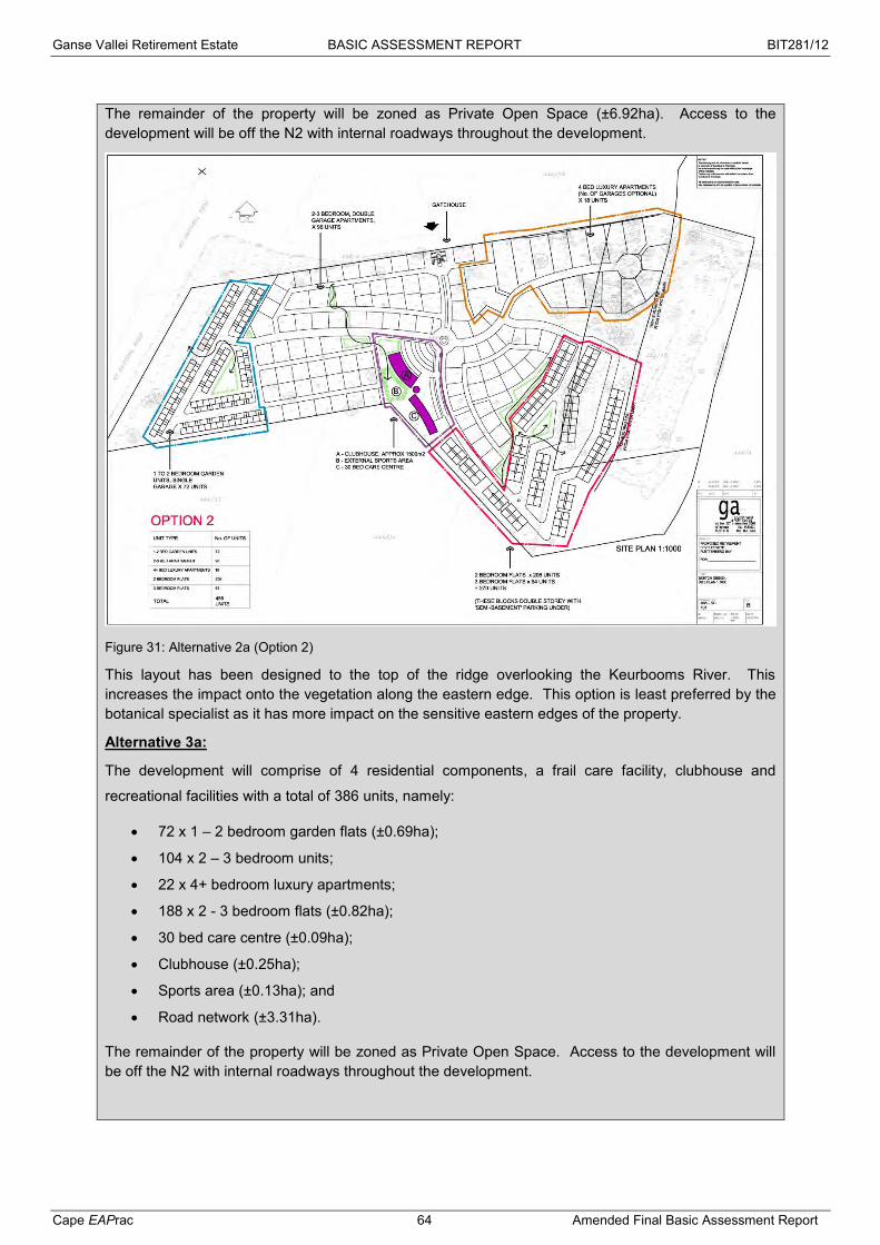
Ganse Vallei Retirement Estate BASIC ASSESSMENT REPORT BIT281/12
Cape EAPrac 64 Amended Final Basic Assessment Report
The remainder of the property will be zoned as Private Open Space (±6.92ha). Access to the development will be off the N2 with internal roadways throughout the development.
Figure 31: Alternative 2a (Option 2)
This layout has been designed to the top of the ridge overlooking the Keurbooms River. This increases the impact onto the vegetation along the eastern edge. This option is least preferred by the botanical specialist as it has more impact on the sensitive eastern edges of the property.
Alternative 3a:
The development will comprise of 4 residential components, a frail care facility, clubhouse and
recreational facilities with a total of 386 units, namely:
72 x 1 – 2 bedroom garden flats (±0.69ha);
104 x 2 – 3 bedroom units;
22 x 4+ bedroom luxury apartments;
188 x 2 - 3 bedroom flats (±0.82ha);
30 bed care centre (±0.09ha);
Clubhouse (±0.25ha);
Sports area (±0.13ha); and
Road network (±3.31ha).
The remainder of the property will be zoned as Private Open Space. Access to the development will be off the N2 with internal roadways throughout the development.

Ganse Vallei Retirement Estate BASIC ASSESSMENT REPORT BIT281/12
Cape EAPrac 65 Amended Final Basic Assessment Report
Figure 32: Alternative 3a (Option 3)
Alternative 3a is similar in area / footprint to Alternative 1a although it proposes an additional 10 units in total by means of configuration.
Alternative 4a:
The development will comprise of 4 residential components, a frail care facility, clubhouse and
recreational facilities with a total of 258 units, namely:
72 x 1 – 2 bedroom garden flats (±0.70ha);
68 x 2 – 3 bedroom units (±2.92ha);
38 x 4+ bedroom luxury apartments (±4.05ha);
80 x 2 - 3 bedroom flats (±0.36ha);
30 bed care centre (±0.09ha);
Clubhouse (±0.25ha);
Sports area (±0.14ha); and
Road network (±2.72ha).
The remainder of the property will be zoned as Private Open Space. Access to the development will be off the N2 with internal roadways throughout the development.

Ganse Vallei Retirement Estate BASIC ASSESSMENT REPORT BIT281/12
Cape EAPrac 66 Amended Final Basic Assessment Report
Figure 33: Alternative 4a (Option 4)
This alternative has fewer units in total than the preferred Alternative 1a, however there are more of the larger property sizes thus taking up a similar development area in total. This option is least preferred by applicant as it provides less opportunities for more compact units to be available to buyers.
(d) Technology alternatives (e.g. to reduce resource demand and resource use efficiency) to avoid negative impacts, mitigate unavoidable negative impacts and maximise positive impacts, or detailed motivation if no reasonable or feasible alternatives exist: There are no technology alternatives proposed. (e) Operational alternatives to avoid negative impacts, mitigate unavoidable negative impacts and maximise positive impacts, or detailed motivation if no reasonable or feasible alternatives exist: There are no operational alternatives proposed. (f) the option of not implementing the activity (the No-Go Option): The No-Go option has been used as the baseline against which the proposed alternatives have been assessed. (g) Other alternatives to avoid negative impacts, mitigate unavoidable negative impacts and maximise positive impacts, or detailed motivation if no reasonable or feasible alternatives exist: None (h) Please provide a summary of the alternatives investigated and the outcomes of such investigation: Please note: If no feasible and reasonable alternatives exist, the description and proof of the investigation of alternatives, together with motivation of why no feasible or reasonable alternatives exist, must be provided. Not applicable.

Ganse Vallei Retirement Estate BASIC ASSESSMENT REPORT BIT281/12
Cape EAPrac 67 Amended Final Basic Assessment Report
SECTION F: IMPACT ASSESSMENT, MANAGEMENT,
MITIGATION AND MONITORING MEASURES Please note: The information in this section must be duplicated for all the feasible and reasonable alternatives (where relevant).
1 DESCRIBE THE MANNER IN WHICH THE DEVELOPMENT WILL IMPACT ON THE FOLLOWING ASPECTS:
(a) Geographical and physical aspects: The development is expected to have the following impacts on the property:
Removal of natural vegetation; Increase in surface run off due to hard surfacing; Removal of alien invasive species; Soil erosion.
(b) Biological aspects: Will the development have an impact on critical biodiversity areas (CBAs) or ecological support areas (CSAs)? YES NO If yes, please describe:
A small portion of the preferred alternative (Alternative 1a) will impact on the area designated as CBA on the eastern part of the property. The majority of the corridor will reman intact.
Will the development have on terrestrial vegetation, or aquatic ecosystems (wetlands, estuaries or the coastline)?
YES NO
If yes, please describe:

Ganse Vallei Retirement Estate BASIC ASSESSMENT REPORT BIT281/12
Cape EAPrac 68 Amended Final Basic Assessment Report
Indigenous vegetation will be impacted on by the development. Due to the restrictions placed on the preferred alternative (Alternative 1) this has been minimised and has been rated as moderate by the botanical specialist.
It must be noted that the vegetation was previously classified as Endangered but has been reclassified as Vulnerable in NEM:BA 2011.
Will the development have an impact on any populations of threatened plant or animal species, and/or on any habitat that may contain a unique signature of plant or animal species?
YES NO
If yes, please describe:
Five species were identified by the botanical specialist as protected under the Western Cape Nature Conservation Laws Amendment Act (WCNCL; 3 of 2000).
Please describe the manner in which any other biological aspects will be impacted:
Disruptions to Ecological Processes as a result of Habitat fragmentation.
(c) Socio-Economic aspects: Please note that the applicant has not undertaken detailed financial calculations as each of the options will vary considerably. In the event that the proposal is granted and the planning decision process commences, the financial values and employment opportunities can be made available. What is the expected capital value of the activity on completion? TBC What is the expected yearly income or contribution to the economy that will be generated by or as a result of the activity?
TBC
Will the activity contribute to service infrastructure? YES NO How many new employment opportunities will be created in the construction phase of the activity? TBC
Ganse Vallei Retirement Estate BASIC ASSESSMENT REPORT BIT281/12
Cape EAPrac 69 Amended Final Basic Assessment Report
What is the expected value of the employment opportunities during the construction phase? TBC What percentage of this will accrue to previously disadvantaged individuals? TBC
How will this be ensured and monitored (please explain):
Records pertaining to personnel and salary must be kept in order to monitor these requirements. The Department of Labour requires that all contract teams retain this data for inspection when necessary. How many permanent new employment opportunities will be created during the operational phase of the activity? TBC
What is the expected current value of the employment opportunities during the first 10 years? TBC What percentage of this will accrue to previously disadvantaged individuals? TBC
How will this be ensured and monitored (please explain):
Records pertaining to personnel and salary must be kept in order to monitor these requirements. The Department of Labour requires that all employers retain this data for inspection when necessary. Any other information related to the manner in which the socio-economic aspects will be impacted:
The development will have a positive impact on the socio-economic aspects of the area. These include:
Contribution to municipal infrastructure; Retention of spending power in the area; Employment opportunities; Provision of facilities for retirees that have been identified as lacking.
(d) Cultural and historic aspects: None. Please see confirmation from HWC (Appendix E) that further heritage assessments are not necessary.
2. WASTE AND EMISSIONS
(a) Waste (including effluent) management Will the activity produce waste (including rubble) during the construction phase? YES NO If yes, indicate the types of waste (actual type of waste, e.g. oil, and whether hazardous or not) and estimated quantity per type? ±30M3
Building waste is expected to be generated during construction. This will include paper, plastic, rubble etc. Will the activity produce waste during its operational phase? YES NO If yes, indicate the types of waste (actual type of waste, e.g. oil, and whether hazardous or not) and estimated quantity per type?
±270M3 per annum
Typically household and office waste will be produced in the dwelling units, as well as medical waste from the frail care centre. This application does not include an assessment of the medical waste and any such authorisation will have to be obtained by the relevant service provider at the time.
According to the National Waste Information Baseline Report (2012) Fiehn and Ball (2005) estimated per capita waste generation in the Western Cape as 675kg per year or 1.85kg per day. Based on this figure and a minimum estimate of 400 pax in the facility, there will be a generation of ±740kg per day or 270m³ per year. Recycling should be strongly encouraged by the development to minimise the amount of domestic waste generated.
The development will be serviced by the Bitou Municipality. They have confirmed the availability for all services.
Where and how will the waste be treated / disposed of (describe)? If yes, indicate the types of waste (actual type of waste, e.g. oil, and whether hazardous or not) and estimated quantity per type per phase of the development?

Ganse Vallei Retirement Estate BASIC ASSESSMENT REPORT BIT281/12
Cape EAPrac 70 Amended Final Basic Assessment Report
Waste will be disposed of by the Bitou Municipality at the new regional landfill site in Mossel Bay. Has the municipality or relevant authority confirmed that sufficient capacity exist for treating / disposing of the waste to be generated by this activity(ies)? If yes, provide written confirmation from Municipality or relevant authority
YES NO
The Bitou Municipality has confirmed the availability for services for this development.
Will the activity produce waste that will be treated and/or disposed of at another facility other than into a municipal waste stream? YES NO
If yes, has this facility confirmed that sufficient capacity exist for treating / disposing of the waste to be generated by this activity(ies)? Provide written confirmation from the facility and provide the following particulars of the facility:
YES NO
Does the facility have an operating license? (If yes, please attach a copy of the license.) YES NO
Facility name: Contact person: Postal address: Postal code: Telephone: Cell: E-mail: Fax: Describe the measures that will be taken to reduce, reuse or recycle waste:
Waste minimisation must be incorporate into the operational management of the facility in order to minimise the waste generation.
(b) Emissions into the atmosphere Will the activity produce emissions that will be disposed of into the atmosphere? YES NO If yes, does it require approval in terms of relevant legislation? YES NO Describe the emissions in terms of type and concentration and how it will be treated/mitigated:
3. WATER USE
Please indicate the source(s) of water for the activity by ticking the appropriate box(es)
Municipal Water board Groundwater River, Stream, Dam or Lake Other The activity will not use water
If water is to be extracted from a groundwater source, river, stream, dam, lake or any other natural feature, please indicate the volume that will be extracted per month: m3 Please provide proof of assurance of water supply (eg. Letter of confirmation from municipality / water user associations, yield of borehole) Does the activity require a water use permit / license from DWAF? YES NO If yes, please submit the necessary application to Department of Water Affairs and attach proof thereof to this application. Describe the measures that will be taken to reduce water demand, and measures to reuse or recycle water: It is recommended that the design specifications for each unit include water saving mechanism such as low flow taps and showerheads, dual flush toilets and rainwater harvesting. If possible, grey and black water separation should be implemented where grey water can be re-used for landscaping irrigation.

Ganse Vallei Retirement Estate BASIC ASSESSMENT REPORT BIT281/12
Cape EAPrac 71 Amended Final Basic Assessment Report
4. POWER SUPPLY
Please indicate the source of power supply eg. Municipality / Eskom / Renewable energy source Municipality If power supply is not available, where will power be sourced from? Not Applicable. 3. ENERGY EFFICIENCY Describe the design measures, if any, that have been taken to ensure that the activity is energy efficient: Energy saving mechanisms must be introduced into each unit and can include energy saving lights, low use appliances, solar geysers and heaters. Describe how alternative energy sources have been taken into account or been built into the design of the activity, if any: The final designs have not yet been undertaken, however the EMPr includes several measures to promote energy saving which should be considered.

Ganse Vallei Retirement Estate BASIC ASSESSMENT REPORT BIT281/07
Cape EAPrac 72 Final Basic Assessment Report
5. DESCRIPTION AND ASSESSMENT OF THE SIGNIFICANCE OF IMPACTS PRIOR TO AND AFTER MITIGATION
Please note: While sections are provided for impacts on certain aspects of the environment and certain impacts, the sections should also be copied and completed for all other impacts.
(a) Impacts that may result from the planning, design and construction phase (briefly describe and compare the potential impacts (as appropriate), significance rating of impacts, proposed
mitigation and significance rating of impacts after mitigation that are likely to occur as a result of the planning, design and construction phase. Potential impacts on geographical and physical aspects: Alternative 1a Alternative 2a Alternative 3a Alternative 4a No Go Option Nature of impact: Soil erosion Soil erosion Soil erosion Soil erosion Soil erosion Extent and duration of impact: Localised, temporary Localised, temporary Localised, temporary Localised, temporary Localised, temporary Probability of occurrence: Possibly Possibly Possibly Possibly Occasional Degree to which the impact can be reversed: High High High High High Degree to which the impact may cause irreplaceable loss of resources: Low Low Low Low Low
Cumulative impact prior to mitigation: Low Low Low Low Low Significance rating of impact prior to mitigation (Low, Medium, Medium-High, High, or Very-High)
Low Low Low Low to Medium Low
Degree to which the impact can be mitigated: High High High High High
Proposed mitigation:
Anti-erosion measures must be in place during construction; Ground clearing should only take place when necessary; EMPr erosion procedures must be followed.
Anti-erosion measures must be in place during construction; Ground clearing should only take place when necessary; EMPr erosion procedures must be
Anti-erosion measures must be in place during construction; Ground clearing should only take place when necessary; EMPr erosion procedures must be
Anti-erosion measures must be in place during construction; Ground clearing should only take place when necessary; EMPr erosion procedures must be
Erosion mechanisms must be implemented in the event of any fires on site.

Ganse Vallei Retirement Estate BASIC ASSESSMENT REPORT BIT281/07
Cape EAPrac 73 Final Basic Assessment Report
followed. followed. followed. Cumulative impact post mitigation: Low Low Low Low Low Significance rating of impact after mitigation (Low, Medium, Medium-High, High, or Very-High)
Negligible Negligible Negligible Negligible Negligible
Potential impacts on geographical and physical aspects: Alternative 1 Alternative 2 Alternative 3 Alternative 4 No Go Option
Nature of impact: Loss of intact natural vegetation due to development
Loss of intact natural vegetation due to development
Loss of intact natural vegetation due to development
Loss of intact natural vegetation due to development
Loss of natural vegetation due to alien invasive vegetation.
Extent and duration of impact: Localised, permanent Localised, permanent Localised, permanent Localised, permanent Regional, permanent Probability of occurrence: Definite Definite Definite Definite Definite Degree to which the impact can be reversed: Low Low Low Low High Degree to which the impact may cause irreplaceable loss of resources: Low Medium Low Low High
Cumulative impact prior to mitigation: High High High High High Significance rating of impact prior to mitigation (Low, Medium, Medium-High, High, or Very-High)
High High High High High
Degree to which the impact can be mitigated: Medium Low Medium Medium High
Proposed mitigation:
Rehabilitation and landscaping should use local indigenous vegetation as far as possible in public open spaces and on undeveloped areas.
Rehabilitation and landscaping should use local indigenous vegetation as far as possible in public open spaces and on undeveloped areas.
Rehabilitation and landscaping should use local indigenous vegetation as far as possible in public open spaces and on undeveloped areas.
Rehabilitation and landscaping should use local indigenous vegetation as far as possible in public open spaces and on undeveloped areas.
Ongoing management of alien invasive species; Prevent any further agricultural activities.
Cumulative impact post mitigation: Medium Medium Medium Medium Medium Significance rating of impact after mitigation (Low, Medium, Medium-High, High, or Very-High)
Medium Medium - High Medium Medium Medium
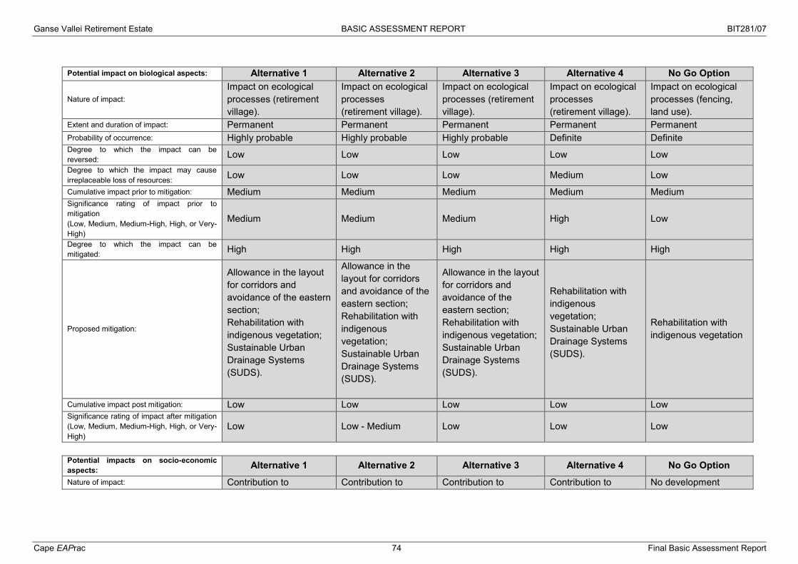
Ganse Vallei Retirement Estate BASIC ASSESSMENT REPORT BIT281/07
Cape EAPrac 74 Final Basic Assessment Report
Potential impact on biological aspects: Alternative 1 Alternative 2 Alternative 3 Alternative 4 No Go Option
Nature of impact: Impact on ecological processes (retirement village).
Impact on ecological processes (retirement village).
Impact on ecological processes (retirement village).
Impact on ecological processes (retirement village).
Impact on ecological processes (fencing, land use).
Extent and duration of impact: Permanent Permanent Permanent Permanent Permanent Probability of occurrence: Highly probable Highly probable Highly probable Definite Definite Degree to which the impact can be reversed: Low Low Low Low Low Degree to which the impact may cause irreplaceable loss of resources: Low Low Low Medium Low
Cumulative impact prior to mitigation: Medium Medium Medium Medium Medium Significance rating of impact prior to mitigation (Low, Medium, Medium-High, High, or Very-High)
Medium Medium Medium High Low
Degree to which the impact can be mitigated: High High High High High
Proposed mitigation:
Allowance in the layout for corridors and avoidance of the eastern section; Rehabilitation with indigenous vegetation; Sustainable Urban Drainage Systems (SUDS).
Allowance in the layout for corridors and avoidance of the eastern section; Rehabilitation with indigenous vegetation; Sustainable Urban Drainage Systems (SUDS).
Allowance in the layout for corridors and avoidance of the eastern section; Rehabilitation with indigenous vegetation; Sustainable Urban Drainage Systems (SUDS).
Rehabilitation with indigenous vegetation; Sustainable Urban Drainage Systems (SUDS).
Rehabilitation with indigenous vegetation
Cumulative impact post mitigation: Low Low Low Low Low Significance rating of impact after mitigation (Low, Medium, Medium-High, High, or Very-High)
Low Low - Medium Low Low Low
Potential impacts on socio-economic aspects: Alternative 1 Alternative 2 Alternative 3 Alternative 4 No Go Option
Nature of impact: Contribution to Contribution to Contribution to Contribution to No development

Ganse Vallei Retirement Estate BASIC ASSESSMENT REPORT BIT281/07
Cape EAPrac 75 Final Basic Assessment Report
municipal infrastructure, facilities for retirees, local expenditure
municipal infrastructure, facilities for retirees, local expenditure.
municipal infrastructure, facilities for retirees, local expenditure.
municipal infrastructure, facilities for retirees, local expenditure.
Extent and duration of impact: Regional Regional Regional Regional Probability of occurrence: Definite Definite Definite Definite Degree to which the impact can be reversed: Low Low Low Low Degree to which the impact may cause irreplaceable loss of resources: Low Low Low Low
Cumulative impact prior to mitigation: Significance rating of impact prior to mitigation (Low, Medium, Medium-High, High, or Very-High)
Low to Medium positive Low to Medium positive
Low to Medium positive
Low to Medium positive
Degree to which the impact can be mitigated: None None None None
Proposed mitigation:
Use of local contractors and labour; Wherever possible obtain materials locally
Use of local contractors and labour; Wherever possible obtain materials locally
Use of local contractors and labour; Wherever possible obtain materials locally
Use of local contractors and labour; Wherever possible obtain materials locally
Cumulative impact post mitigation: Significance rating of impact after mitigation (Low, Medium, Medium-High, High, or Very-High)
Medium positive Medium positive Medium positive Medium positive No additional.
Potential impacts on cultural-historical aspects: Alternative 1 Alternative 2 Alternative 3 Alternative 4 No Go Option Nature of impact: None None None None None Extent and duration of impact: Probability of occurrence: Degree to which the impact can be reversed: Degree to which the impact may cause irreplaceable loss of resources:

Ganse Vallei Retirement Estate BASIC ASSESSMENT REPORT BIT281/07
Cape EAPrac 76 Final Basic Assessment Report
Cumulative impact prior to mitigation: Significance rating of impact prior to mitigation (Low, Medium, Medium-High, High, or Very-High)
Degree to which the impact can be mitigated:
Proposed mitigation:
In the event that any heritage resources are unearthed, the correct authorities must be contacted immediately.
In the event that any heritage resources are unearthed, the correct authorities must be contacted immediately.
In the event that any heritage resources are unearthed, the correct authorities must be contacted immediately.
In the event that any heritage resources are unearthed, the correct authorities must be contacted immediately.
Cumulative impact post mitigation: Significance rating of impact after mitigation (Low, Medium, Medium-High, High, or Very-High)
None None None None None
Potential noise impacts: Alternative 1 Alternative 2 Alternative 3 Alternative 4 No Go Option Nature of impact: Construction noise Construction noise Construction noise Construction noise None Extent and duration of impact: Localised, temporary Localised, temporary Localised, temporary Localised, temporary None Probability of occurrence: Probable Probable Probable Probable None Degree to which the impact can be reversed: High High High High Degree to which the impact may cause irreplaceable loss of resources: Negligible Negligible Negligible Negligible
Cumulative impact prior to mitigation: Negligible Negligible Negligible Negligible Significance rating of impact prior to mitigation (Low, Medium, Medium-High, High, or Very-High)
Low Low Low Low
Degree to which the impact can be mitigated: High High High High
Proposed mitigation:
Construction hours must be set so as not to become a nuisance after hours;
Construction hours must be set so as not to become a nuisance after hours;
Construction hours must be set so as not to become a nuisance after hours;
Construction hours must be set so as not to become a nuisance after hours;
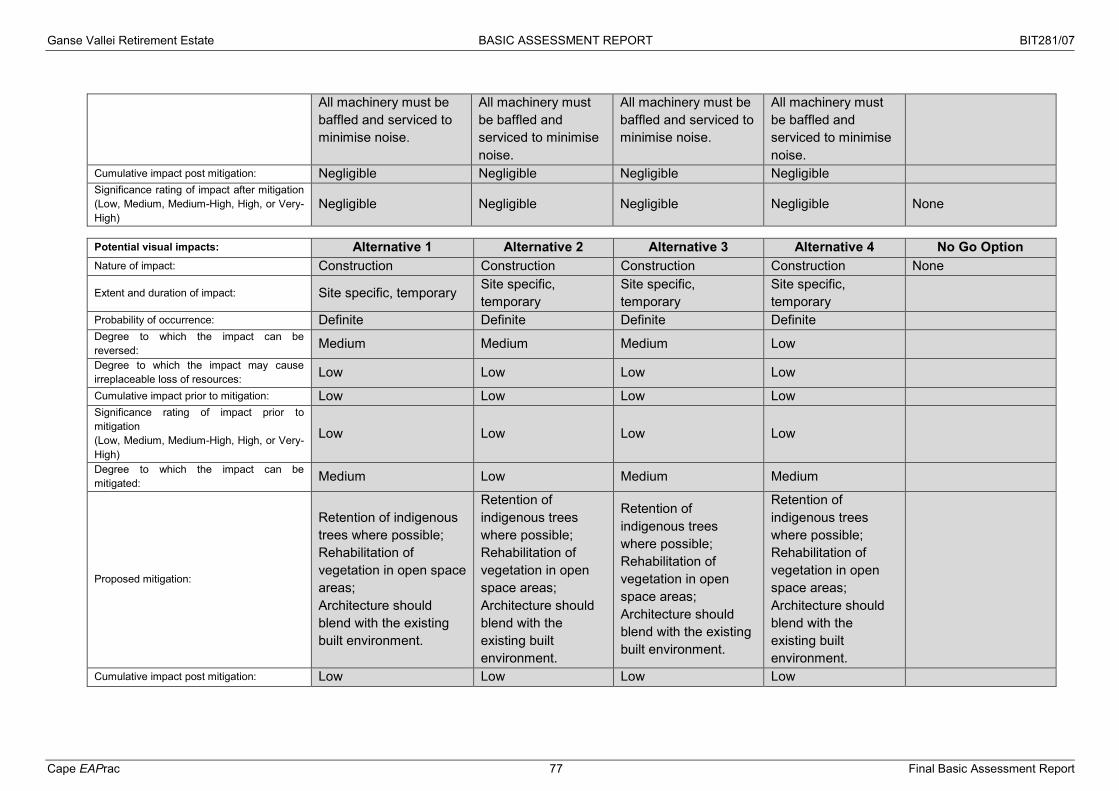
Ganse Vallei Retirement Estate BASIC ASSESSMENT REPORT BIT281/07
Cape EAPrac 77 Final Basic Assessment Report
All machinery must be baffled and serviced to minimise noise.
All machinery must be baffled and serviced to minimise noise.
All machinery must be baffled and serviced to minimise noise.
All machinery must be baffled and serviced to minimise noise.
Cumulative impact post mitigation: Negligible Negligible Negligible Negligible Significance rating of impact after mitigation (Low, Medium, Medium-High, High, or Very-High)
Negligible Negligible Negligible Negligible None
Potential visual impacts: Alternative 1 Alternative 2 Alternative 3 Alternative 4 No Go Option Nature of impact: Construction Construction Construction Construction None
Extent and duration of impact: Site specific, temporary Site specific, temporary
Site specific, temporary
Site specific, temporary
Probability of occurrence: Definite Definite Definite Definite Degree to which the impact can be reversed: Medium Medium Medium Low Degree to which the impact may cause irreplaceable loss of resources: Low Low Low Low
Cumulative impact prior to mitigation: Low Low Low Low Significance rating of impact prior to mitigation (Low, Medium, Medium-High, High, or Very-High)
Low Low Low Low
Degree to which the impact can be mitigated: Medium Low Medium Medium
Proposed mitigation:
Retention of indigenous trees where possible; Rehabilitation of vegetation in open space areas; Architecture should blend with the existing built environment.
Retention of indigenous trees where possible; Rehabilitation of vegetation in open space areas; Architecture should blend with the existing built environment.
Retention of indigenous trees where possible; Rehabilitation of vegetation in open space areas; Architecture should blend with the existing built environment.
Retention of indigenous trees where possible; Rehabilitation of vegetation in open space areas; Architecture should blend with the existing built environment.
Cumulative impact post mitigation: Low Low Low Low

Ganse Vallei Retirement Estate BASIC ASSESSMENT REPORT BIT281/07
Cape EAPrac 78 Final Basic Assessment Report
Significance rating of impact after mitigation (Low, Medium, Medium-High, High, or Very-High)
Very Low Low Very Low Very Low None
(b) Impacts that may result from the operational phase (briefly describe and compare the potential impacts (as appropriate), significance rating of impacts, proposed mitigation and significance
rating of impacts after mitigation that are likely to occur as a result of the operational phase.
Potential impacts on the geographical and physical aspects: Alternative 1 Alternative 2 Alternative 3 Alternative 4 No Go Option
Nature of impact: Loss of intact natural vegetation due to development
Loss of intact natural vegetation due to development
Loss of intact natural vegetation due to development
Loss of intact natural vegetation due to development
Loss of natural vegetation due to alien invasive vegetation.
Extent and duration of impact: Localised, permanent Localised, permanent Localised, permanent Localised,
permanent Regional, permanent
Probability of occurrence: Definite Definite Definite Definite Definite Degree to which the impact can be reversed: High Degree to which the impact may cause irreplaceable loss of resources: Low Medium Low Low High
Cumulative impact prior to mitigation: High High High High High Significance rating of impact prior to mitigation (Low, Medium, Medium-High, High, or Very-High)
High High High High High
Degree to which the impact can be mitigated: Medium Low Medium Medium High
Proposed mitigation:
Rehabilitation and landscaping should use local indigenous vegetation as far as possible in public open spaces and on undeveloped areas.
Rehabilitation and landscaping should use local indigenous vegetation as far as possible in public open spaces and on undeveloped areas.
Rehabilitation and landscaping should use local indigenous vegetation as far as possible in public open spaces and on undeveloped areas.
Rehabilitation and landscaping should use local indigenous vegetation as far as possible in public open spaces and on undeveloped areas.
Ongoing management of alien invasive species; Prevent any further agricultural activities.
Cumulative impact post mitigation: Medium Medium Medium High Medium Significance rating of impact after mitigation (Low, Medium, Medium-High, High, or Very-High)
Medium High Medium Medium Medium

Ganse Vallei Retirement Estate BASIC ASSESSMENT REPORT BIT281/07
Cape EAPrac 79 Final Basic Assessment Report
Potential impact biological aspects: Alternative 1 Alternative 2 Alternative 3 Alternative 4 No Go Option
Nature of impact: Impact on ecological processes (retirement village).
Impact on ecological processes (retirement village).
Impact on ecological processes (retirement village).
Impact on ecological processes (retirement village).
Impact on ecological processes (fencing, land use).
Extent and duration of impact: Permanent Permanent Permanent Permanent Permanent Probability of occurrence: Highly probable Highly probable Highly probable Definite Definite Degree to which the impact can be reversed: Low Low Low Low Low Degree to which the impact may cause irreplaceable loss of resources: Low Medium Low Low Low
Cumulative impact prior to mitigation: Medium Medium Medium Medium Medium Significance rating of impact prior to mitigation (Low, Medium, Medium-High, High, or Very-High)
Medium High Medium Medium Low
Degree to which the impact can be mitigated: High Low High High High
Proposed mitigation:
Allowance in the layout for corridors and avoidance of the eastern section; Rehabilitation with indigenous vegetation; Sustainable Urban Drainage Systems (SUDS).
Rehabilitation with indigenous vegetation; Sustainable Urban Drainage Systems (SUDS).
Allowance in the layout for corridors and avoidance of the eastern section; Rehabilitation with indigenous vegetation; Sustainable Urban Drainage Systems (SUDS).
Allowance in the layout for corridors and avoidance of the eastern section; Rehabilitation with indigenous vegetation; Sustainable Urban Drainage Systems (SUDS).
Rehabilitation with indigenous vegetation
Cumulative impact post mitigation: Low Low Low Low Low Significance rating of impact after mitigation (Low, Medium, Medium-High, High, or Very-High)
Low Medium Low Low Low
Potential impacts on the socio-economic aspects: Alternative 1 Alternative 2 Alternative 3 Alternative 4 No Go Option
Nature of impact: Contribution to Contribution to Contribution to Contribution to No development

Ganse Vallei Retirement Estate BASIC ASSESSMENT REPORT BIT281/07
Cape EAPrac 80 Final Basic Assessment Report
municipal infrastructure, facilities for retirees, local expenditure
municipal infrastructure, facilities for retirees, local expenditure.
municipal infrastructure, facilities for retirees, local expenditure.
municipal infrastructure, facilities for retirees, local expenditure.
Extent and duration of impact: Regional Regional Regional Regional Probability of occurrence: Definite Definite Definite Definite Degree to which the impact can be reversed: Low Low Low Low Degree to which the impact may cause irreplaceable loss of resources: Low Low Low Low
Cumulative impact prior to mitigation: Significance rating of impact prior to mitigation (Low, Medium, Medium-High, High, or Very-High)
Low to Medium positive Low to Medium positive
Low to Medium positive
Low to Medium positive
Degree to which the impact can be mitigated: None None None None
Proposed mitigation:
Use of local contractors and labour; Wherever possible obtain materials locally
Use of local contractors and labour; Wherever possible obtain materials locally
Use of local contractors and labour; Wherever possible obtain materials locally
Use of local contractors and labour; Wherever possible obtain materials locally
Cumulative impact post mitigation: Significance rating of impact after mitigation (Low, Medium, Medium-High, High, or Very-High)
Medium positive Medium positive Medium positive Medium positive No additional.
Potential impacts on the cultural-historical aspects: Alternative 1 Alternative 2 Alternative 3 Alternative 4 No Go Option Nature of impact: None None None None Extent and duration of impact: Probability of occurrence: Degree to which the impact can be reversed: Degree to which the impact may cause irreplaceable loss of resources:

Ganse Vallei Retirement Estate BASIC ASSESSMENT REPORT BIT281/07
Cape EAPrac 81 Final Basic Assessment Report
Cumulative impact prior to mitigation: Significance rating of impact prior to mitigation (Low, Medium, Medium-High, High, or Very-High)
Degree to which the impact can be mitigated:
Proposed mitigation: Cumulative impact post mitigation: Significance rating of impact after mitigation (Low, Medium, Medium-High, High, or Very-High)
Potential noise impacts: Alternative 1 Alternative 2 Alternative 3 Alternative 4 No Go Option Nature of impact: Construction noise Construction noise Construction noise Construction noise None Extent and duration of impact: Localised, temporary Localised, temporary Localised, temporary Localised, temporary None Probability of occurrence: Probable Probable Probable Probable None Degree to which the impact can be reversed: High High High High Degree to which the impact may cause irreplaceable loss of resources: Negligible Negligible Negligible Negligible
Cumulative impact prior to mitigation: Negligible Negligible Negligible Negligible Significance rating of impact prior to mitigation (Low, Medium, Medium-High, High, or Very-High)
Low Low Low Low
Degree to which the impact can be mitigated: High High High High
Proposed mitigation:
Construction hours must be set so as not to become a nuisance after hours; All machinery must be baffled and serviced to minimise noise.
Construction hours must be set so as not to become a nuisance after hours; All machinery must be baffled and serviced to minimise noise.
Construction hours must be set so as not to become a nuisance after hours; All machinery must be baffled and serviced to minimise noise.
Construction hours must be set so as not to become a nuisance after hours; All machinery must be baffled and serviced to minimise noise.
Cumulative impact post mitigation: Construction noise Construction noise Construction noise Construction noise None

Ganse Vallei Retirement Estate BASIC ASSESSMENT REPORT BIT281/07
Cape EAPrac 82 Final Basic Assessment Report
Significance rating of impact after mitigation (Low, Medium, Medium-High, High, or Very-High)
Localised, temporary Localised, temporary Localised, temporary Localised, temporary None
Potential visual impacts: Alternative 1 Alternative 2 Alternative 3 Alternative 4 No Go Option Nature of impact: Retirement village Retirement village Retirement village Retirement village None
Extent and duration of impact: Site specific, permanent Site specific, permanent
Site specific, permanent
Site specific, permanent
Probability of occurrence: Definite Definite Definite Definite Degree to which the impact can be reversed: Medium Medium Medium Low Degree to which the impact may cause irreplaceable loss of resources: Low Low Low Low
Cumulative impact prior to mitigation: Low Low Low Low Significance rating of impact prior to mitigation (Low, Medium, Medium-High, High, or Very-High)
Low Low Low Low
Degree to which the impact can be mitigated: Medium Medium Medium Low
Proposed mitigation:
Retention of indigenous trees where possible; Rehabilitation of vegetation in open space areas; Architecture should blend with the existing built environment.
Retention of indigenous trees where possible; Rehabilitation of vegetation in open space areas; Architecture should blend with the existing built environment.
Retention of indigenous trees where possible; Rehabilitation of vegetation in open space areas; Architecture should blend with the existing built environment.
Retention of indigenous trees where possible; Rehabilitation of vegetation in open space areas; Architecture should blend with the existing built environment.
Cumulative impact post mitigation: Low Low Low Low Significance rating of impact after mitigation (Low, Medium, Medium-High, High, or Very-High)
Very Low Very Low Very Low Very Low None
(c) Impacts that may result from the decommissioning and closure phase (briefly describe and compare the potential impacts (as appropriate), significance rating of impacts, proposed mitigation
and significance rating of impacts after mitigation that are likely to occur as a result of the decommissioning and closure phase.

Ganse Vallei Retirement Estate BASIC ASSESSMENT REPORT BIT281/07
Cape EAPrac 83 Final Basic Assessment Report
The retirement village is unlikely to be decommissioned in the near future as it is a residential component. The impacts associated with decommissioning are
thus generalised in this instance and should the facility be decommissioned, the relevant laws of the time must be taken into account. Potential impacts on the geographical and physical aspects: Alternative 1 Alternative 2 Alternative 3 Alternative 4 No Go Option
Nature of impact: Removal of infrastructure.
Removal of infrastructure.
Removal of infrastructure.
Removal of infrastructure.
Extent and duration of impact: Site specific, temporary Site specific, temporary
Site specific, temporary
Site specific, temporary
Probability of occurrence: Definite Definite Definite Definite Degree to which the impact can be reversed: High High High High Degree to which the impact may cause irreplaceable loss of resources: Negligible Negligible Negligible Negligible
Cumulative impact prior to mitigation: Low Low Low Low Significance rating of impact prior to mitigation (Low, Medium, Medium-High, High, or Very-High)
Low Low Low Low
Degree to which the impact can be mitigated: Medium Medium Medium Medium
Proposed mitigation:
Demolition must be limited to the infrastructure footprint; Avoid damage to vegetation; Rubble must be removed to a registered dump site.
Demolition must be limited to the infrastructure footprint; Avoid damage to vegetation; Rubble must be removed to a registered dump site.
Demolition must be limited to the infrastructure footprint; Avoid damage to vegetation; Rubble must be removed to a registered dump site.
Demolition must be limited to the infrastructure footprint; Avoid damage to vegetation; Rubble must be removed to a registered dump site.
Cumulative impact post mitigation: Low Low Low Low Significance rating of impact after mitigation (Low, Medium, Medium-High, High, or Very-High)
Very Low Very Low Very Low Very Low
Potential impact biological aspects: Alternative 1 Alternative 2 Alternative 3 Alternative 4 No Go Option Nature of impact: None None None None
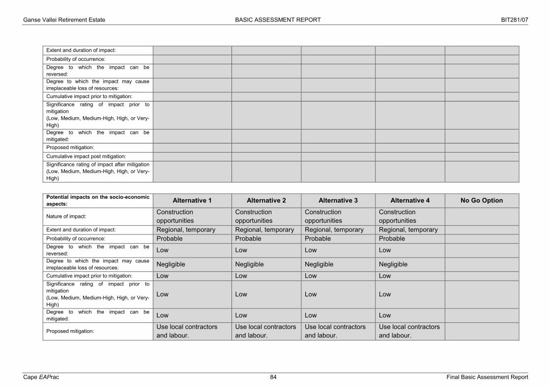
Ganse Vallei Retirement Estate BASIC ASSESSMENT REPORT BIT281/07
Cape EAPrac 84 Final Basic Assessment Report
Extent and duration of impact: Probability of occurrence: Degree to which the impact can be reversed: Degree to which the impact may cause irreplaceable loss of resources:
Cumulative impact prior to mitigation: Significance rating of impact prior to mitigation (Low, Medium, Medium-High, High, or Very-High)
Degree to which the impact can be mitigated:
Proposed mitigation: Cumulative impact post mitigation: Significance rating of impact after mitigation (Low, Medium, Medium-High, High, or Very-High)
Potential impacts on the socio-economic aspects: Alternative 1 Alternative 2 Alternative 3 Alternative 4 No Go Option
Nature of impact: Construction opportunities
Construction opportunities
Construction opportunities
Construction opportunities
Extent and duration of impact: Regional, temporary Regional, temporary Regional, temporary Regional, temporary Probability of occurrence: Probable Probable Probable Probable Degree to which the impact can be reversed: Low Low Low Low Degree to which the impact may cause irreplaceable loss of resources: Negligible Negligible Negligible Negligible
Cumulative impact prior to mitigation: Low Low Low Low Significance rating of impact prior to mitigation (Low, Medium, Medium-High, High, or Very-High)
Low Low Low Low
Degree to which the impact can be mitigated: Low Low Low Low
Proposed mitigation: Use local contractors and labour.
Use local contractors and labour.
Use local contractors and labour.
Use local contractors and labour.

Ganse Vallei Retirement Estate BASIC ASSESSMENT REPORT BIT281/07
Cape EAPrac 85 Final Basic Assessment Report
Cumulative impact post mitigation: Significance rating of impact after mitigation (Low, Medium, Medium-High, High, or Very-High)
Low Low Low Low
Potential impacts on the cultural-historical aspects: Alternative 1 Alternative 2 Alternative 3 Alternative 4 No Go Option Nature of impact: None None None None Extent and duration of impact: Probability of occurrence: Degree to which the impact can be reversed: Degree to which the impact may cause irreplaceable loss of resources:
Cumulative impact prior to mitigation: Significance rating of impact prior to mitigation (Low, Medium, Medium-High, High, or Very-High)
Degree to which the impact can be mitigated:
Proposed mitigation: Cumulative impact post mitigation: Significance rating of impact after mitigation (Low, Medium, Medium-High, High, or Very-High)
Potential noise impacts: Alternative 1 Alternative 2 Alternative 3 Alternative 4 No Go Option Nature of impact: Construction noise Construction noise Construction noise Construction noise None Extent and duration of impact: Localised, temporary Localised, temporary Localised, temporary Localised, temporary None Probability of occurrence: Probable Probable Probable Probable None Degree to which the impact can be reversed: High High High High Degree to which the impact may cause irreplaceable loss of resources: Negligible Negligible Negligible Negligible
Cumulative impact prior to mitigation: Negligible Negligible Negligible Negligible Significance rating of impact prior to mitigation Low Low Low Low

Ganse Vallei Retirement Estate BASIC ASSESSMENT REPORT BIT281/07
Cape EAPrac 86 Final Basic Assessment Report
(Low, Medium, Medium-High, High, or Very-High) Degree to which the impact can be mitigated: High High High High
Proposed mitigation:
Construction hours must be set so as not to become a nuisance after hours; All machinery must be baffled and serviced to minimise noise.
Construction hours must be set so as not to become a nuisance after hours; All machinery must be baffled and serviced to minimise noise.
Construction hours must be set so as not to become a nuisance after hours; All machinery must be baffled and serviced to minimise noise.
Construction hours must be set so as not to become a nuisance after hours; All machinery must be baffled and serviced to minimise noise.
Cumulative impact post mitigation: Negligible Negligible Negligible Negligible Significance rating of impact after mitigation (Low, Medium, Medium-High, High, or Very-High)
Negligible Negligible Negligible Negligible None
Potential visual impacts: Alternative 1 Alternative 2 Alternative 3 Alternative 4 No Go Option Nature of impact: Construction Construction Construction Construction None
Extent and duration of impact: Site specific, temporary Site specific, temporary
Site specific, temporary
Site specific, temporary
Probability of occurrence: Definite Definite Definite Definite Degree to which the impact can be reversed: Medium Medium Medium Low Degree to which the impact may cause irreplaceable loss of resources: Low Low Low Low
Cumulative impact prior to mitigation: Low Low Low Low Significance rating of impact prior to mitigation (Low, Medium, Medium-High, High, or Very-High)
Low Low Low Low
Degree to which the impact can be mitigated: Medium Medium Medium Low
Proposed mitigation: Retention of indigenous trees where possible; Rehabilitation of
Retention of indigenous trees where possible;
Retention of indigenous trees where possible;
Retention of indigenous trees where possible;

Ganse Vallei Retirement Estate BASIC ASSESSMENT REPORT BIT281/07
Cape EAPrac 87 Final Basic Assessment Report
vegetation in open space areas; Architecture should blend with the existing built environment.
Rehabilitation of vegetation in open space areas; Architecture should blend with the existing built environment.
Rehabilitation of vegetation in open space areas; Architecture should blend with the existing built environment.
Rehabilitation of vegetation in open space areas; Architecture should blend with the existing built environment.
Cumulative impact post mitigation: Low Low Low Low Significance rating of impact after mitigation (Low, Medium, Medium-High, High, or Very-High)
Very Low Very Low Very Low Very Low None
(d) Any other impacts: Potential impact: Alternative 1 Alternative 2 Alternative 3 Alternative 4 No Go Option Nature of impact: Extent and duration of impact: Probability of occurrence: Degree to which the impact can be reversed: Degree to which the impact may cause irreplaceable loss of resources:
Cumulative impact prior to mitigation: Significance rating of impact prior to mitigation (Low, Medium, Medium-High, High, or Very-High)
Degree to which the impact can be mitigated:
Proposed mitigation: Cumulative impact post mitigation: Significance rating of impact after mitigation (Low, Medium, Medium-High, High, or Very-High)
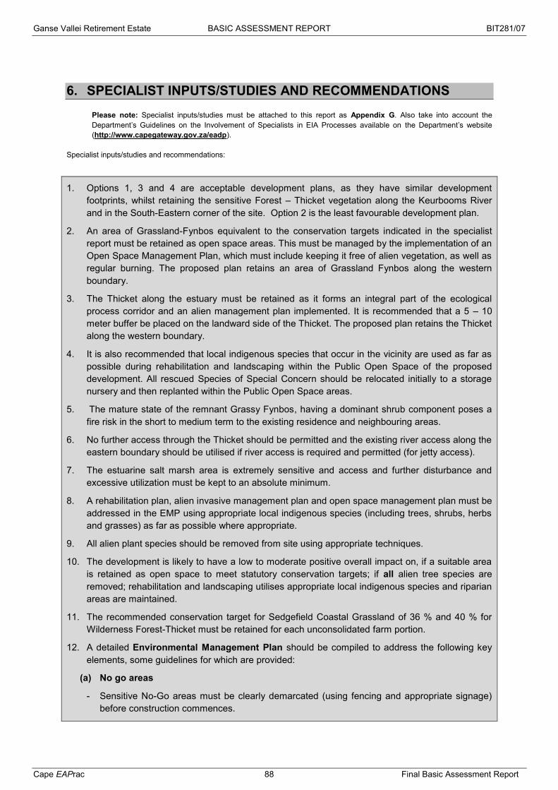
Ganse Vallei Retirement Estate BASIC ASSESSMENT REPORT BIT281/07
Cape EAPrac 88 Final Basic Assessment Report
6. SPECIALIST INPUTS/STUDIES AND RECOMMENDATIONS
Please note: Specialist inputs/studies must be attached to this report as Appendix G. Also take into account the Department’s Guidelines on the Involvement of Specialists in EIA Processes available on the Department’s website (http://www.capegateway.gov.za/eadp).
Specialist inputs/studies and recommendations:
1. Options 1, 3 and 4 are acceptable development plans, as they have similar development footprints, whilst retaining the sensitive Forest – Thicket vegetation along the Keurbooms River and in the South-Eastern corner of the site. Option 2 is the least favourable development plan.
2. An area of Grassland-Fynbos equivalent to the conservation targets indicated in the specialist report must be retained as open space areas. This must be managed by the implementation of an Open Space Management Plan, which must include keeping it free of alien vegetation, as well as regular burning. The proposed plan retains an area of Grassland Fynbos along the western boundary.
3. The Thicket along the estuary must be retained as it forms an integral part of the ecological process corridor and an alien management plan implemented. It is recommended that a 5 – 10 meter buffer be placed on the landward side of the Thicket. The proposed plan retains the Thicket along the western boundary.
4. It is also recommended that local indigenous species that occur in the vicinity are used as far as possible during rehabilitation and landscaping within the Public Open Space of the proposed development. All rescued Species of Special Concern should be relocated initially to a storage nursery and then replanted within the Public Open Space areas.
5. The mature state of the remnant Grassy Fynbos, having a dominant shrub component poses a fire risk in the short to medium term to the existing residence and neighbouring areas.
6. No further access through the Thicket should be permitted and the existing river access along the eastern boundary should be utilised if river access is required and permitted (for jetty access).
7. The estuarine salt marsh area is extremely sensitive and access and further disturbance and excessive utilization must be kept to an absolute minimum.
8. A rehabilitation plan, alien invasive management plan and open space management plan must be addressed in the EMP using appropriate local indigenous species (including trees, shrubs, herbs and grasses) as far as possible where appropriate.
9. All alien plant species should be removed from site using appropriate techniques.
10. The development is likely to have a low to moderate positive overall impact on, if a suitable area is retained as open space to meet statutory conservation targets; if all alien tree species are removed; rehabilitation and landscaping utilises appropriate local indigenous species and riparian areas are maintained.
11. The recommended conservation target for Sedgefield Coastal Grassland of 36 % and 40 % for Wilderness Forest-Thicket must be retained for each unconsolidated farm portion.
12. A detailed Environmental Management Plan should be compiled to address the following key elements, some guidelines for which are provided:
(a) No go areas
- Sensitive No-Go areas must be clearly demarcated (using fencing and appropriate signage) before construction commences.

Ganse Vallei Retirement Estate BASIC ASSESSMENT REPORT BIT281/07
Cape EAPrac 89 Final Basic Assessment Report
- Users must be clearly informed of the no-go areas and held accountable for any infringements that may occur.
- No access to the demarcated areas should be permitted. A suitable control measure (such as a fine system) must be implemented to discourage infringement.
- Activities including but not restricted to the following must not be permitted in designated no-go areas:
o Dumping of any materials (including garden refuse and litter)
(b) Indigenous flora
- It is recommended that local indigenous species that occur in the vicinity are used during any rehabilitation and landscaping within any Open Space on the site, including along pathways and road reserves.
- Species that are introduced for landscaping purposes may become naturalised within the natural vegetation communities and displace naturally occurring species, hence only locally occurring species should be used.
- Any Species of Special Concern that might require relocation should be relocated initially to a storage nursery and then replanted to within the site.
- Relevant permits must be obtained before any protracted flora are disturbed.
(c) Alien and Weed Management Plan
- Although alien species are not seriously problematic within the site they are present and should be managed to reduce the likelihood of proliferation in the future;
- An alien removal program must be implemented to remove alien vegetation from within the site as a priority.
- Cleared alien vegetation must not be dumped on adjacent intact vegetation during clearing but should be temporarily stored in a demarcated area (in consultation with the relevant botanical specialist;
- Cleared vegetation must be either removed from site or burned in-situ in temporary storage area;
- Any seed bearing material should be removed to prevent the spread of seed.
- Chopped brushwood can be used to stabilise steep areas that may be susceptible to erosion during any clearing activities and to close off unused pathways;
- A suitable revegetation or rehabilitation plan must be implemented after alien vegetation clearing;
- A long-term alien maintenance plan must be designed and implemented in conjunction with a suitably qualified expert to keep the open space areas weed free.;
- Indigenous and non-invasive exotic weeds such as Ipomoea cairica can become problematic, and should also be managed to prevent strangling and displacement of naturally occurring species.
(d) Stormwater Management Plan
- The construction aspects of the stormwater management plan should be included in the Environmental Management Plan (EMP).
- The construction aspects of the stormwater management plan must be implemented before other construction work commences.

Ganse Vallei Retirement Estate BASIC ASSESSMENT REPORT BIT281/07
Cape EAPrac 90 Final Basic Assessment Report
- Implement Best Management Practices in Stormwater Management as described in the Stormwater Management report.
- Apply the principles of Low Impact Development (LID) in the design of the drainage systems.
- The following return periods are to be used for stormwater design:
o Minor Drainage System (Piped System) – 2 years
o Major Drainage System (Surface Drainage) – 50 years to 100 years.
- The development layout must accommodate the 1:50 year and 1:100 year floodlines. To this end, the floodline levels should be staked on site, and surveyed to indicate their positions.
- The capture and storage of rainwater from roofs is recommended, and the discharge of the overflows from rainwater tanks should be promptly returned to natural overland sheetflow.
- Where any significant increases in peak discharges to downstream properties are observed, attenuation structures are recommended to reduce the peak flows.
- The stormwater modelling and drainage design should be carried out timeously in order that the Stormwater Management Plan can be implemented from the start of the construction phase of the project.
(e) Fire Management Plan
- Fire management plans should be addressed in the EMP, as the area is prone to fire.
- An adequate fire-break with adjacent vegetated areas must be incorporated into the layout.
- The large Eucalyptus trees around the property boundary must be removed as they pose a significant fire risk, in the case of a bush fire from surrounding properties.
7. IMPACT SUMMARY
Please provide a summary of all the above impacts.
Botanical:
The development is likely to have a low negative to moderate positive overall impact on, if a suitable area is retained as open space to meet statutory conservation targets; if all alien tree species are removed; rehabilitation and landscaping utilises appropriate local indigenous species and riparian areas are maintained.
Socio-Economic:
The development will have a positive impact on the social development of the area, including the upgrading and capital input for municipal infrastructure.
Visual:
The development is unlikely to have any negative visual impacts as it is located in an area with similar built environment impacts. HWC has already confirmed that no further heritage assessments will be required.
Heritage:
No impacts on cultural resources will take place. HWC has already confirmed that no further heritage assessments will be required.
Noise:
Construction noise impacts may take place, but these can be mitigated to acceptable levels with

Ganse Vallei Retirement Estate BASIC ASSESSMENT REPORT BIT281/07
Cape EAPrac 91 Final Basic Assessment Report
management recommendations.
8. OTHER MANAGEMENT, MITIGATION AND MONITORING MEASURES
(a) Over and above the mitigation measures described in Section 6 above, please indicate any additional management, mitigation and monitoring measures.
o Water and energy saving mechanisms must be built into the design considerations of the
development. (b) Describe the ability of the applicant to implement the management, mitigation and monitoring measures.
The applicant must ensure compliance with any EA and EMPr associated with this development in order to ensure that the mitigation and monitoring measures are correctly implemented.
Sufficient budgeting must be ensured for an Environmental Control Officer, rehabilitation, plant rescue and long term monitoring.
The commitment by the developers to ensure compliance must be incorporated into any homeowners constitution in order to ensure continuity.
Please note: A draft ENVIRONMENTAL MANAGEMENT PROGRAMME must be attached this report as Appendix H.

Ganse Vallei Retirement Estate BASIC ASSESSMENT REPORT BIT281/07
Cape EAPrac 92 Final Basic Assessment Report
SECTION G: ASSESSMENT METHODOLOGIES AND
CRITERIA, GAPS IN KNOWLEDGE, UNDERLAYING
ASSUMPTIONS AND UNCERTAINTIES
(a) Please describe adequacy of the assessment methods used.
The assessment is adequate for the consideration of the proposal within an urban area, supporting urban development for a vulnerable portion of the population.
(b) Please describe the assessment criteria used.
Criteria for Assessment
These criteria are drawn from the EIA Regulations, published by the Department of Environmental Affairs and Tourism (April 1998) in terms of the Environmental Conservation Act No. 73 of 1989.
These criteria include:
Nature of the impact
This is the appraisal of the type of effect the construction, operation and maintenance of a development would have on the affected environment. This description should include what is to be affected and how.
Extent of the impact
Describe whether the impact will be: local extending only as far as the development site area; or limited to the site and its immediate surroundings; or will have an impact on the region, or will have an impact on a national scale or across international borders.
Duration of the impact
The specialist should indicate whether the lifespan of the impact would be short term (0-5 years), medium term (5-15 years), long term (16-30 years) or permanent.
Intensity
The specialist should establish whether the impact is destructive or benign and should be qualified as low, medium or high. The specialist study must attempt to quantify the magnitude of the impacts and outline the rationale used.
Probability of occurrence
The specialist should describe the probability of the impact actually occurring and should be described as improbable (low likelihood), probable (distinct possibility), highly probable (most likely) or definite (impact will occur regardless of any prevention measures).
The impacts should also be assessed in terms of the following aspects:
Legal requirements
The specialist should identify and list the relevant South African legislation and permit requirements pertaining to the development proposals. He / she should provide reference to the procedures required to obtain permits and describe whether the development proposals contravene the applicable legislation.
Status of the impact
The specialist should determine whether the impacts are negative, positive or neutral (“cost – benefit” analysis). The impacts are to be assessed in terms of their effect on the project and the environment. For example, an impact that is positive for the proposed development may be negative for the

Ganse Vallei Retirement Estate BASIC ASSESSMENT REPORT BIT281/07
Cape EAPrac 93 Final Basic Assessment Report
environment. It is important that this distinction is made in the analysis.
Accumulative impact
Consideration must be given to the extent of any accumulative impact that may occur due to the proposed development. Such impacts must be evaluated with an assessment of similar developments already in the environment. Such impacts will be either positive or negative, and will be graded as being of negligible, low, medium or high impact.
Degree of confidence in predictions
The specialist should state what degree of confidence (low, medium or high) is there in the predictions based on the available information and level of knowledge and expertise.
Based on a synthesis of the information contained in the above-described procedure, you are required to assess the potential impacts in terms of the following significance criteria:
No significance: the impacts do not influence the proposed development and/or environment in any way.
Low significance: the impacts will have a minor influence on the proposed development and/or environment. These impacts require some attention to modification of the project design where possible, or alternative mitigation.
Moderate significance: the impacts will have a moderate influence on the proposed development and/or environment. The impact can be ameliorated by a modification in the project design or implementation of effective mitigation measures.
High significance: the impacts will have a major influence on the proposed development and/or environment and will result in the “no-go” option on the development or portions of the development regardless of any mitigation measures that could be implemented. This level of significance must be well motivated.
(c) Please describe the gaps in knowledge.
Botanical surveys based upon a limited sampling time period, may not reflect the actual species composition of the site due to seasonal variations in flowering times. Additionally Fynbos composition may vary depending on maturity or time since last burn.
(d) Please describe the underlying assumptions.
This section provides a brief overview of specific assumptions and limitations having an impact on this environmental application process:
It is assumed that the information on which this report is based (project information as well as existing information) is correct, factual and truthful.
The proposed development is in line with the statutory planning vision for the area and thus it is assumed that issues such as the cumulative impact of development in terms of character of the area and its resources, have been taken into account during the strategic planning for the area.
It is assumed that all the relevant mitigation measures and agreements specified in this report will be implemented in order to ensure minimal negative impacts and maximum environmental benefits.
It is assumed that Stakeholders and Interested and Affected Parties notified during the initial

Ganse Vallei Retirement Estate BASIC ASSESSMENT REPORT BIT281/07
Cape EAPrac 94 Final Basic Assessment Report
public participation process will submit all relevant comments within the designated review and comment period.
(e) Please describe the uncertainties.
Under status quo conditions, it is highly likely that there will be a continual slow regeneration of fynbos and Grassland elements, with a concomitant increase in alien invasive species.

Ganse Vallei Retirement Estate BIT281/07
Cape EAPrac 95 Final Basic Assessment Report
SECTION H: RECOMMENDATION OF THE EAP
In my view (EAP), the information contained in this application form and the documentation attached hereto is sufficient to make a decision in respect of the activity applied for. YES NO
If “NO”, list the aspects that should be further assessed through additional specialist input/assessment or whether this application must be subjected to a Scoping & EIR process before a decision can be made: If “YES”, please indicate below whether in your opinion the activity should or should not be authorised: Activity should be authorised: YES NO Please provide reasons for your opinion
o The impacts associated with the development are considered to be low negative to moderate positive overall with mitigation.
o The development compliments the adjacent land uses.
o The development provides for specific needs in the community that have been identified in the SDF.
o The existing land use potential (agriculture) is
If you are of the opinion that the activity should be authorised, then please provide any conditions, including mitigation measures that should in your view be considered for inclusion in an authorisation.
o Compliance with the recommendations and mitigations provided by the specialist.
o Compliance with the provisions of the EMPr.
o Appointment f an ECO during construction.
o The development should become a member of the Southern Cape Fire Protection Association (SCFPA).
Duration and Validity: Environmental authorisations are usually granted for a period of three years from the date of issue. Should a longer period be required, the applicant/EAP is requested to provide a detailed motivation on what the period of validity should be. Not applicable.

Ganse Vallei Retirement Estate BIT281/07
Cape EAPrac 96 Final Basic Assessment Report
SECTION I: APPENDICES The following appendices must be attached to this report:
Appendix Tick the box if Appendix is attached
Appendix A: Locality map
Appendix B: Site plan(s)
Appendix C: Photographs
Appendix D: Biodiversity overlay map
Appendix E: Permit(s) / license(s) from any other organ of state including service letters from the municipality
Appendix F:
Public participation information: including a copy of the register of interested and affected parties, the comments and responses report, proof of notices, advertisements and any other public participation information as required in Section C above.
Appendix G: Specialist Report(s)
Appendix H : Environmental Management Progamme
Appendix I: Additional information related to listed waste management activities (if applicable)
Appendix J: Any Other (if applicable) (describe)
Ganse Vallei Retirement Estate BIT281/07
Cape EAPrac 97 Final Basic Assessment Report
DECLARATIONS
1. THE APPLICANT
I, Clive Kern, in my personal capacity or duly authorised (please circle the applicable option) by Shelfplett 47 (Pty) Ltd thereto hereby declare that I: regard the information contained in this report to be true and correct, and am fully aware of my responsibilities in terms of the National Environmental Management Act of
1998 (“NEMA”) (Act No. 107 of 1998), the Environmental Impact Assessment Regulations (“EIA Regulations”) in terms of NEMA (Government Notice No. R. 543 refers), and the relevant specific environmental management Act, and that failure to comply with these requirements may constitute an offence in terms of the environmental legislation;
appointed the environmental assessment practitioner as indicated above, which meet all the requirements in terms of regulation 17 of GN No. R. 543, to act as the independent environmental assessment practitioner for this application;
have provided the environmental assessment practitioner and the competent authority with access to all information at my disposal that is relevant to the application;
will be responsible for the costs incurred in complying with the environmental legislation including but not limited to – o costs incurred in connection with the appointment of the environmental assessment
practitioner or any person contracted by the environmental assessment practitioner; o costs incurred in respect of the undertaking of any process required in terms of the
regulations; o costs in respect of any fee prescribed by the Minister or MEC in respect of the regulations; o costs in respect of specialist reviews, if the competent authority decides to recover costs; and o the provision of security to ensure compliance with the applicable management and mitigation
measures; am responsible for complying with the conditions that might be attached to any decision(s) issued
by the competent authority; have the ability to implement the applicable management, mitigation and monitoring measures; hereby indemnify, the government of the Republic, the competent authority and all its officers,
agents and employees, from any liability arising out of, inter alia, the content of any report, any procedure or any action for which the applicant or environmental assessment practitioner is responsible; and
am aware that a false declaration is an offence in terms of regulation 71 of GN No. R. 543. Please Note: If acting in a representative capacity, a certified copy of the resolution or power of attorney must be attached.
Signature of the applicant: Shelfplett 47 (Pty) Ltd Name of company: Date:
Ganse Vallei Retirement Estate BIT281/07
Cape EAPrac 98 Final Basic Assessment Report
2. THE INDEPENDENT ENVIRONMENTAL ASSESSMENT PRACTITIONER (EAP)
I, Melissa Mackay, on behalf of Cape EAPrac, as the appointed independent environmental
practitioner (“EAP”) hereby declare that I:
act/ed as the independent EAP in this application; regard the information contained in this report to be true and correct, and do not have and will not have any financial interest in the undertaking of the activity, other than
remuneration for work performed in terms of the NEMA, the Environmental Impact Assessment Regulations, 2010 and any specific environmental management Act;
have and will not have no vested interest in the proposed activity proceeding; have disclosed, to the applicant and competent authority, any material information that have or
may have the potential to influence the decision of the competent authority or the objectivity of any report, plan or document required in terms of the NEMA, the Environmental Impact Assessment Regulations, 2010 and any specific environmental management Act;
am fully aware of and meet the responsibilities in terms of NEMA, the Environmental Impact Assessment Regulations, 2010 (specifically in terms of regulation 17 of GN No. R. 543) and any specific environmental management Act, and that failure to comply with these requirements may constitute and result in disqualification;
have ensured that information containing all relevant facts in respect of the application was distributed or made available to interested and affected parties and the public and that participation by interested and affected parties was facilitated in such a manner that all interested and affected parties were provided with a reasonable opportunity to participate and to provide comments;
have ensured that the comments of all interested and affected parties were considered, recorded and submitted to the competent authority in respect of the application;
have kept a register of all interested and affected parties that participated in the public participation process;
have provided the competent authority with access to all information at my disposal regarding the application, whether such information is favourable to the applicant or not; and
am aware that a false declaration is an offence in terms of regulation 71 of GN No. R. 543. Note: The terms of reference must be attached.
Signature of the environmental assessment practitioner: Signature of the environmental assessment practitioner: Cape Environmental Assessment Practitioners (Cape EAPrac) Name of company: Date:

Ganse Vallei Retirement Estate BIT281/07
Cape EAPrac 99 Final Basic Assessment Report
TERMS OF REFERENCE FOR ENVIRONMENTAL ASSESSMENT PRACTITIONER: The Applicant provided no particular brief to Cape EAPrac to undertake and complete the assessment process, however the scope of the study has been determined with reference to the requirements of the foremost legislation namely NEMA and the EIA Regulations 2010 & 2014. The main responsibilities of the EAP include:
Submission of the required Application in order to register the project and obtain a
credible reference number;
Consultation with relevant authorities, members of the public and key stakeholders
through the environmental assessment process to ensure that the identification and
verification of relevant issues or concerns are undertaken;
Ensure the assessment of and response to issues that are raised during the scoping
phase;
Compilation of the required Basic Assessment / Scoping / EIR and EMP reports
(whichever is application to the specific application);
Describing the proposed activity, the effected environment, potential impacts, public
participation and the applicable legislation and guidelines;
Consultation with relevant Authorities, key stakeholders and members of the public to
inform them of the project proposal and environmental requirements, and elicit their input;
Open and maintain a Stakeholder Register throughout the process;
Detail the public participation process;
Document aspects that require further investigation or specialist assessment;
Document findings of the specialist studies and recommendations and/or mitigation
measures to be implemented during construction and operation phases;
Advise on changes to the development concept or alternatives that will avoid potential
negative impacts, or mitigate/minimise their significance;
Submission of the abovementioned documents to the public for review and comment in
draft format;
Submission of the abovementioned documents to the public for information if there are no
substantial changes between the draft and the final versions of the report, and for review
and comment if there are substantial changes to the final report;
Submission of relevant reports to DEADP for a decision-making; and
Notifying registered I&APs of the Department’s decision.
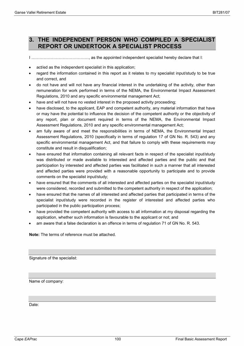
Ganse Vallei Retirement Estate BIT281/07
Cape EAPrac 100 Final Basic Assessment Report
3. THE INDEPENDENT PERSON WHO COMPILED A SPECIALIST REPORT OR UNDERTOOK A SPECIALIST PROCESS
I ……………………………………, as the appointed independent specialist hereby declare that I:
act/ed as the independent specialist in this application; regard the information contained in this report as it relates to my specialist input/study to be true
and correct, and do not have and will not have any financial interest in the undertaking of the activity, other than
remuneration for work performed in terms of the NEMA, the Environmental Impact Assessment Regulations, 2010 and any specific environmental management Act;
have and will not have no vested interest in the proposed activity proceeding; have disclosed, to the applicant, EAP and competent authority, any material information that have
or may have the potential to influence the decision of the competent authority or the objectivity of any report, plan or document required in terms of the NEMA, the Environmental Impact Assessment Regulations, 2010 and any specific environmental management Act;
am fully aware of and meet the responsibilities in terms of NEMA, the Environmental Impact Assessment Regulations, 2010 (specifically in terms of regulation 17 of GN No. R. 543) and any specific environmental management Act, and that failure to comply with these requirements may constitute and result in disqualification;
have ensured that information containing all relevant facts in respect of the specialist input/study was distributed or made available to interested and affected parties and the public and that participation by interested and affected parties was facilitated in such a manner that all interested and affected parties were provided with a reasonable opportunity to participate and to provide comments on the specialist input/study;
have ensured that the comments of all interested and affected parties on the specialist input/study were considered, recorded and submitted to the competent authority in respect of the application;
have ensured that the names of all interested and affected parties that participated in terms of the specialist input/study were recorded in the register of interested and affected parties who participated in the public participation process;
have provided the competent authority with access to all information at my disposal regarding the application, whether such information is favourable to the applicant or not; and
am aware that a false declaration is an offence in terms of regulation 71 of GN No. R. 543. Note: The terms of reference must be attached. Signature of the specialist: Name of company: Date:
Ganse Vallei Retirement Estate BIT281/07
Cape EAPrac 101 Final Basic Assessment Report
REFERENCES DWA (2001). Generic public participation guideline. Department of Water Affairs and Forestry. DEAT (2002). Integrated Environmental Management Information Series 3: Stakeholder Engagement. Department of Environmental Affairs and Tourism, Pretoria. DEADP (2003). Waste Minimisation Guideline for Environmental Impact Assessment reviews. NEMA EIA Regulations Guideline & Information Series, Department Environmental Affairs & Development Planning. DEAT (2004). Criteria for determining alternatives in EIAs, Integrated Environmental Management, Information Series 11, Department of Environmental Affairs & Tourism, Pretoria. DEAT (2004). Environmental management Plans, Integrated Environmental management, Informatino Series 12, Department Environmental Affairs & Tourism. DEAT (2005). Assessment of Impacts and Alternatives, Integrated Environmental Management Guideline Series, Department of Environmental Affairs & Tourism, Pretoria. DEAT (2005). Guideline 4: Public Participation, in terms of the EIA Regulations 2005, Integrated Environmental Management Guideline Series, Department of Environmental Affairs and Tourism, Pretoria. DEADP (2005). Guideline for the review of specialist input in the EIA process. NEMA EIA Regulations Guideline & Information Document Series, Department of Environmental Affairs & Development Planning. DEADP (2005). Guideline for involving biodiversity specialists in the EIA process. NEMA EIA Regulations Guideline & Information Document Series, Department of Environmental Affairs & Development Planning. DEADP (2005). Guideline for environmental management plans. NEMA EIA Regulations Guideline & Information Document Series, Department of Environmental Affairs & Development Planning. DEADP (2005). Provincial urban edge guideline. Department Environmental Affairs & Development Planning. DEAT (2006). EIA Regulations in terms of the National Environmental Management Act (Act No 107 of 1998) (Government Notice No R 385, R 386 and R 387 in Government Gazette No 28753 of 21 April 2006). DEADP (2006). Guideline on the Interpretation of the Listed Activities. NEMA EIA Regulations Guidelines & Information Document Series, Department of Environmental Affairs & Development Planning. DEADP (2007). Guide on Alternatives, NEMA EIA Regulations Guidelines & Information Document Series, Department of Environmental Affairs & Development Planning. DEADP (2007). Guideline on Appeals, NEMA EIA Regulations Guidelines & Information Document Series, Department of Environmental Affairs & Development Planning.

Ganse Vallei Retirement Estate BIT281/07
Cape EAPrac 102 Final Basic Assessment Report
DEADP (2007). Guideline on Exemption Applications. NEMA EIA Regulations Guidelines & Information Document Series, Department of Environmental Affairs & Development Planning. DEADP (2007). Guideline on Public Participation. NEMA EIA Regulations Guidelines & Information Document Series, Department of Environmental Affairs & Development Planning. DEADP (2009). Guideline on Need & Desirability, NEMA EIA Regulations Guideline and Information Document Series, Department Environmental Affairs & Development Planning. DEADP (2009). Guideline on Alternatives, NEMA EIA Regulations Guideline and Information Document Series, Department Environmental Affairs & Development Planning. DEADP (2009). Guideline on Transitional Arrangements, NEMA EIA Regulations Guideline and Information Document Series, Department Environmental Affairs & Development Planning. DEADP (2009). Guideline on Exemption Applications. NEMA EIA Regulations Guideline and Information Document Series, Department Environmental Affairs & Development Planning. DEADP (2009). Guideline on Appeals. NEMA EIA Regulations Guideline and Information Document Series, Department Environmental Affairs & Development Planning. DEADP (2009). Guideline on Public Participation. NEMA EIA Regulations Guideline and Information Document Series, Department Environmental Affairs & Development Planning. Keatimilwe K & Ashton PJ 2005. Guideline for the review of specialist input in EIA processes. Department Environmental Affairs & Development Planning. Lochner P (2005). Guideline for Environmental Management Plans. Department Environmental Affairs & Development Planning. Münster, F. (2005). Guidelines for Determining the Scope of Specialist Involvement in EIA Processes: Edition 1. CSIR Report No ENV-S-C 2005 053 A. Republic of South Africa, Provincial Government of the Western Cape, Department of Environmental Affairs and Development Planning, Cape Town. Oberholzer B (2005). Guideline for involving visual & aesthetic specialists. Department Environmental Affairs & Development Planning. Winter S & Beaumann N (2005). Guideline for involving heritage specialists in EIA processes. Department Environmental Affairs & Development Planning. Mucina, L. & Rutherford, M.C. (eds) 2006. The Vegetation of South Africa, Lesotho and Swaziland. Strelitzia 19. South African National Biodiversity Institute, Pretoria. Pote, Jamie (2006). Vegetation Assessment of Portions 27 & 19 of Farm 444, Plettenberg Bay (Bitou Municipality). Port Elizabeth, South Africa. Pote, Jamie (2015). Vegetation Assessment of Portions 27 & 19 of Farm 444, Plettenberg Bay (Bitou Municipality). Port Elizabeth, South Africa.

Ganse Vallei Retirement Estate BIT281/07
Cape EAPrac 103 Final Basic Assessment Report
Royal Haskoning DHV (2015). Ganse Vallei Retirement Estate Stormwater Management Plan. Royal Haskoning DHV, George, South Africa. Saayman, I. (2005). Guideline for Involving Hydrogeologists in EIA Processes: Edition 1. CSIR Report No ENV-S-C 2005 053 D. Republic of South Africa, Provincial Government of the Western Cape, Department of Environmental Affairs and Development Planning, Cape Town. SANBI Biodiversity GIS (2007). South African National Biodiversity Institute, Cape Town, South Africa.