Ambassadors of the Bay 2005 Final Report - Maine … of the Bay 2005 Final Report ... caused them...
52
1 Ambassadors of the Bay 2005 Final Report Ambassadors of the Bay 2005 Final Report
Transcript of Ambassadors of the Bay 2005 Final Report - Maine … of the Bay 2005 Final Report ... caused them...

1
Ambassadors of the Bay2005 Final ReportAmbassadors of the Bay2005 Final Report

2
Ambassadors of the Bay 2005 Final Report
This report is a project of the Mount Desert Island Water QualityCoalition’s Maine Coast Learning Expediton and Maine Sea Grant,with support from The Thomas H. Maren Foundation
Published: May 2006Photos: by Ambassadors of the Bay unless otherwise notedAuthors and artists: listed with each pieceReport editors: Jane Disney and Gwenn KubeckReport designer: Natalie Springuel
Ambassadors of the Bay 2005 Final Report
The Ambassadors of the Bay seek to:
· Gain an appreciation for the beauty and diversity of Frenchman Bay
· Identify stresses on water quality and marine resources
· Develop a bay-level perspective on the challenges for inhabitants and usersof this unique coastal environment
· Publish a report on observations and experiences for use in comprehensiveplanning, land use and conservation decision-making, and education.
To stand at the edge of the sea, to sense the ebb and flow of the tides, to feel the breathof a mist moving over a great salt marsh, to watch the flight of shore birds that haveswept up and down the surf lines of the continents for untold thousands of years, to seethe running of the old eels and the young shad in the sea, is to have knowledge of thingsthat are nearly eternal as any earthly life can be.
Rachel Carson
MSG-E-06-01

3
Preface ............................................................................................................................................................................................................
Why did we embark on this journey? ...........................................................................................................................................................
Who are the Ambassadors? ...........................................................................................................................................................................
Where did we journey? ..................................................................................................................................................................................
What did we learn? .........................................................................................................................................................................................The Ever-Shifting Ecology of Frenchman Bay ....................................................................................................................... 12
Ecological Observations on the Ambassadors of the Bay Journey 2006 ......................................................................... 12Discussion with Allied Whale ............................................................................................................................................15Bird Census ..................................................................................................................................................................... 16
Oral Histories............................................................................................................................................................................... 17
The Blue Mussel .........................................................................................................................................................................19Mussel Harvesting in Frenchman Bay ............................................................................................................................. 19Raft Mussel Aquaculture Issues ...................................................................................................................................... 22
The Story of Hadley Point ................................................................................................................................................. 24
Watersheds and Development ...............................................................................................................................................31Polluted Runoff: A Reality in the Watersheds of MDI........................................................................................................... 31Land Use and Coastal Development .................................................................................................................................. 33Land Conservation .............................................................................................................................................................. 35
How did we do it? ........................................................................................................................................................................................... 36The Nuts and Bolts.............................................................................................................................................................. 46Perspectives from the Guide’s Cockpit .............................................................................................................................. 38
Recommendations .......................................................................................................................................................................................... 40
Appendices....................................................................................................................................................................................................... 41
Table of Contents
4
5
6
8
12

4
Preface
The Ambassadors of the Bay Made Waves. It was a journey of surprises. Wherever the group of teenagers beached their kayaks in order to ask questions of and learn from the folks who liveon, love or look to Frenchman Bay for work and sustenance, they were met with excitement and appreciation. The worm diggers who had risenlong before dawn in north-central Mattawamkeag seemed surprised that anyone, much less young folks, would be interested in them and thegrueling way they wrest a living from the mud flats off Thompson Island. The Ambassadors of the Bay Made History. It was the first time that area youth ever had made a concerted effort to ‘take a snapshot’ of the bay’s health. Their eyes and video camerascaptured images ranging from local wildlife to burgeoning oceanfront development, from cruise ships to aquaculture. They did it all from their redand yellow kayaks, giving them a unique perspective on Frenchman Bay. They took their snapshot using their compassion as well as their brains.An injured seagull, wrapped in the netting of a mussel aquaculture raft, caused them first to try to save the bird - and then to ask hard questionsabout ethics and industry. The Ambassadors of the Bay Made Connections. The growing sense of a shared mission to protect the fragile waters of Frenchman Bay was palpable during a picnic lunch at Hadley Point thatbrought together a clam digger, an environmentalist with a summer home along the shore, the owner of a proposed mussel farm, concerned resi-dents and local media. The conversations among them flew as quickly as the giant bowl of steamed mussels emptied. All through it, the kids werekept hopping as they took notes, asked questions, shot footage, learned, taught and plotted the next steps of their journey.
By Abigail Curtis

5
This team would serve asAmbassadors of the Bay, ableand willing to communicate theconcerns of residents and usersof the bay, as well as to sharetheir observations about thestate of the bay: its beauty andits challenges to sustain itsnative flora and fauna whileproviding for the needs andwants of local people.
The MDI Water Quality Coalition has been working with citizens onwater quality related projects in Frenchman Bay since 1997. Over the lastdecade, many issues of concern to the residents and users of the bay havecome up. These issues include polluted runoff from paved streets and parkinglots, increasing development in the upper reaches of coastal watersheds aswell as right on the shoreline, nutrient enrichment of bays,over harvesting of marine resources, shifting of musselharvesting techniques to aquaculture, building of piers,increasing visitation by cruise ships, contamination of swimareas, declining eelgrass populations, shoreline erosion, andblooms of toxic phytoplankton. We decided it was time togather a team of community members to traverse the bay,make continuous observations, talk to people on both sidesof the bay, and discover what issues emerged as mostimportant to address in the immediate future. This teamwould serve as Ambassadors of the Bay, able and willing tocommunicate the concerns of residents and users of thebay, as well as share their observations about the state ofthe bay: its beauty and its challenges to sustain native floraand fauna while providing for the needs and wants of local people.
In the fall of 2005, students and community members set out on a fourday kayaking expedition with the aim of understanding the state of FrenchmanBay, the stresses on water quality and marine resources, the issues that areimportant to local residents, and to gain a bay-level perspective on a uniquecoastal environment. Twelve ambassadors: students in the Maine CoastLearning Expedition Program at the MDI Water Quality Coalition, MDI WaterQuality Coalition staff and volunteers, a newspaper reporter, a College of theAtlantic professor, a Jackson Laboratory biologist, and a marine extensionagent from Sea Grant who served as a registered Maine kayak guide, all
joined together as a collaborative learning community. Their plan: to recordobservations and conversations with coastal residents, document the state ofthe bay, generate a list of impacts both on shore and offshore, and produce areport for use in land use planning, conservation consideration, and education.This report is written in the ambassadors’ own words. It reflects a citizen
effort to discover the truth about the state of the bay. Thisreport should not be considered a comprehensive guideto the state of the bay; it has some answers to many of thequestions asked. But more questions were raised thananswered.
In the end, the ambassadors came to realize that all ofthe issues in the bay are interrelated. Each impact on thebay has repercussions that affect resources, or someone’slivelihood, or someone’s sense of place. Loss of eelgrassimpacts water clarity, sediments in the water column carrynutrients throughout the bay, nutrients cause algal blooms,and green shores affect property values, diminish visitorexperiences, and impact coastal businesses. Runoff
invariably carries bacteria, bacteria make water unsafe for recreational watercontact and shellfish harvesting. Piers, rafts, coastal developments, and cruiseships all change the view people remember and the experience they have bothon the land and out at sea.
The ambassadors realized that they had gained insight from theirjourney and could follow up on issues by giving testimony at public hearings,participating in comprehensive planning, collecting additional data, and assist-ing in grant writing for efforts to establish long term plans for protecting andmanaging resources in Frenchman Bay. And so their journey isn’t over.
By Jane Disney
Why did we embark on this journey?

6
As the education director of the Mount Desert Island Water Quality Coalition,Gwenn Kubeck works with students and teachers on Mount Desert Island to collectmeaningful water quality data that are used by local and state agencies to informresource management decisions. She brought to the Ambassadors of the Bay journeyseveral years of experience as an environmental educator for various marine-basedresearch and citizen science organizations. Graduating from Lewis and Clark College inPortland, Oregon with a degree in both environmental studies and biology, Gwenn isespecially interested in learning how to create collaborations between a diversity ofpeople who all rely on a common resource. Gwenn is a PADI SCUBA Divemaster and aWilderness First Responder, and has a special fondness for tide pool creatures.
Zack Steele was an Americorps Volunteer Leader at the MDI Water QualityCoalition where he was project manager for the Stanley Brook Watershed Survey at thetime of the Ambassadors of the Bay journey. A Maine native and College of the Atlanticgraduate, he brought experience in land use planning and geographic informationsystems to the expedition. Zack is a Wilderness First Responder who enjoys backpack-ing, hiking, skiing, and kayaking in his spare time.
Dr. Jane Disney has a B.S. degree in biology, a M.S. degree in genetics fromPenn State University, and a Ph.D. in zoology from Washington State University. Shecurrently serves as the executive director of the Mount Desert Island Water QualityCoalition and teaches environmental studies in an interdisciplinary semester program forhigh school students called Maine Coast Learning Expedition (MCLE). She dreamed of aprogram like MCLE when she was involving her students in water quality monitoringaround Mount Desert Island as a biology teacher at MDI High School between 1992 and2001. She took her MCLE students and a group of committed community members on akayaking expedition in the fall of 2005, to begin the process of documenting the state ofFrenchman Bay. This was her first sea kayaking venture but not her last.
Maddy Johnson is a thirteen-year-old research fellow in Maine Coast LearningExpedition (MCLE). She has attended school at Conners Emerson in Bar Harbor sincefirst grade, though this is not her first participation in the programs offered by the MDIWater Quality Coalition. In 2003, Maddy took part in some of the classes offered by thatsemester’s MCLE program. She was an apprentice in the Community EnvironmentalHealth Lab, and in the fall she took the environmental writing workshop taught byCandice Stover and the team-building classes offered by Camp Beech Cliff. In April 2004she was a River of Words poetry finalist. In sixth grade Maddy was part of a red tidemonitoring group at Conners Emerson that went out once a month on the Bar Harbordock. She continued this program through seventh grade, and helped produce abrochure to educate the public about phytoplankton towing and red tide. She also wentto the KIDS Student Summit with the same group of sixth and seventh graders, wheregroups from all over New England presented various service learning projects, andhelped present a power point presentation on their phytoplankton studies. Kayakingthis semester for Maddy was an amazing experience and real immersion into an unfamiliararea – Maddy had never before went on the ocean in a kayak. She expects, though, shewill be out again soon enough.
Who are the Ambassadors?
Natalie Springuel is a marine extension associate with the Maine Sea GrantCollege Program, based at College of the Atlantic in Bar Harbor. As a Master Maine SeaKayak and Recreation Guide, she served as the Ambassadors of the Bay’s leader on thewater. The Gulf of Maine Expedition, a five-month sea kayaking expedition to raiseawareness about the ecology and cultural legacy of this vast watershed, was Natalie’sbrainchild. Natalie’s outreach and applied research programs with Sea Grant addresssustainable tourism planning, recreation impact monitoring, waterfront access, andexpedition-based education throughout the Gulf of Maine. Through workshops,presentations, publications, field research, and on-the-water educational programs (oftenby sea kayak), Natalie provides programming that seeks to bridge the gap betweentraditional waterfront uses and the rapidly growing interest in sustainable and nature-based tourism opportunities.
The Ambassadors left to right: Terrence Reid, Maddy Johnson, Zack Steele, Jake Van Gorder,Mary Forest, Helen Hess, Gwenn Kubeck, Abby Curtis, Natalie Springuel, and Jane Disney(not pictured Zephyr McDonnell). Photo taken by Kathy Van Gorder

7
Who are Ambassadors?
At age 16, Zephyr McDonnell started volunteering to monitor water quality forthe MDI Water Quality Coalition, testing for red tide, among other things. The followingfall, Zephyr became a Maine Coast Learning Expedition research fellow. Up until then,he had been home schooled all his life, and had been learning through high schooltextbooks. Zephyr is a PADI Open Water Diver, a Wilderness First Responder, an avidrock climber and a hiker who has explored all over Acadia National Park, as well as inZion National Park. While in Zion, he hiked eight miles in knee-to-chest-deep water up ariver in a slot-canyon. With hopes of someday becoming a biologist, Zephyr loves theoutdoors and feels it is important to monitor and protect it.
Jake Van Gorder has been a student and research fellow with Maine CoastLearning Expedition for three years. Starting in fall 2003, he ventured on a trip up MountKatahdin, followed by intensive cruise ship monitoring throughout the fall of 2004. Inthe spring of 2005, Jake volunteered with the MDI Water Quality Coalition to monitor forPhaeocystis, a species of phytoplankton that can clog the gills of fish if present in largenumbers. Jake has also volunteered his time to work with students in conjunction withthe MDI Water Quality Coalition outreach program. Jake has been home schooledthroughout his life and has spent considerable time involved in creative endeavors withthe Gilbert and Sullivan Society and with the Summer Festival of the Arts. Jake recentlybecame a certified Leave No Trace Camper.
Terrence Reid is an 18-year-old senior at MDI High School. He lives on VeronaIsland just out of sight of Fort Knox. Terrence’s Maine Coast Learning Expeditionexperience became his senior project. A second-degree black belt in karate and an EagleScout, Terrence has spent two summers as a trail builder, one with the Maine Conserva-tion Corps. He is looking forward to pursuing a college degree in one of the environmen-tal sciences.
Maine Coast Learning Expedition research fellows share their kayaking experience withinterested community members. From left to right: Maddy Johnson, Jake Van Gorder, ZephyrMcDonnell, and Terrence Reid.
When not paddling alongside the Ambassadors of the Bay, Abigail Curtis canbe found covering the Mount Desert Island beat for the Bangor Daily News. She has along-standing interest in working with youth and helping empower them to makepositive change in the world. Before reporting full-time, Abigail worked with youth as anadvocate for mid-coast Maine domestic violence project New Hope for Women and thenwas a wilderness counselor at a northern Maine camp for troubled teenage girls. Shealso has served as the youth radio coordinator for community radio station WERU-FM.Abigail enjoys hiking and spending time in Maine’s beautiful outdoors.
Mary M. Forest has a marketing degree from Central Connecticut State Univer-sity, with additional credits from College of the Atlantic. She is an educator in training forsocial studies and business education. As a volunteer, she shares her life experienceswith Mount Desert Island Walter Quality Coalition, providing historical references andbusiness experiences to “think outside the box”.
Dr. Helen Hess is a professor at College of the Atlantic (COA), where sheteaches marine biology and stream ecology among many other things. She received aB.S. in Biology from UCLA in 1985 and a Ph.D. in zoology from the University ofWashington in 1991 and has been on the faculty at COA since 1994. Her formal trainingas an invertebrate zoologist has led her to develop courses that take her and herstudents wherever invertebrates are found, including local rivers, Maine’s rockyintertidal shores, and Caribbean coral reefs. Her interest in water quality issues hasstemmed directly from her teaching and research activities as well as her hobbies; she isan avid whitewater canoeist and sea kayaker. Being part of the MCLE Ambassadors ofthe Bay journey was an ideal combination of education, conservation, and recreation.

8
Where did we journey?
Day 1 September 19, 2005 Our leader and a Maine Coast Kayak Guide, Natalie Springuel, helped
us whittle our gear down to the essentials and pack it all into three tandem and twosolo kayaks. In addition to Natalie, our core expedition team was comprised ofDr. Jane Disney, executive director of the MDIWQC and the visionary who gavebirth to this idea; Zack Steele, an Americorps volunteer coordinator for a localwatershed survey; Gwenn Kubeck, education director of the MDIWQC; Dr.
Frenchman Bay, located in the Gulf of Maine, is home to an active anddiverse coastal community which settled near the bay to enjoy or utilize its manyresources. For decades, the bay has been heavily fished for both finfish andshellfish. Aquaculture leases are growing in number, both offering an alternative toconventional fishing practices and putting more pressure on existing resources.Intertidal areas offer valuable clam and worm resources. Eelgrass, which offerscritical habitat for juvenile species and helps stabilize substrate, is in decline. Inaddition, many businesses capitalize on the beauty of Frenchman Bay through thelarge and ever-growing tourism industry. The bay also attracts a growing amount ofcoastal development, which led to the town of Bar Harbor passing a moratoriumon development in order to align development practices with current planninggoals.
As a collaborative learning community, the kayak team recorded anddocumented observations and conversations that addressed the people, theecology and the issues of Frenchman Bay. Throughout the trip, they learned aboutand adhered to Leave No Trace philosophies. A day-by-day outline of theextraordinary Ambassadors of Frenchman Bay Kayak Expedition follows:
Last fall marked the beginning of a hugely successful new MDIWQCinitiative, the Ambassadors of Frenchman Bay Kayak Expedition. Four high schoolstudents involved in Maine Coast Learning Expedition, along with MDIWQC staffand community members, made a tremendous leap into the public eye when theyembarked on the four-day kayak journey to better understand the state of French-man Bay, the stresses on water quality and marine resources, the issues that areimportant to local residents, and to gain a bay-level perspective on this uniquecoastal environment.
Ambassadors of Frenchman Bay Kayak ExpeditionBy Gwenn Kubeck
Helen Hess, a professor of invertebrate biology at College of the Atlantic; and ourMaine Coast Learning Expedition students, Maddy Johnson, Zephyr McDonnell,Terrence Reid, and Jake Van Gorder, our graduate MCLE research fellow. Inaddition, the expedition was made a success by the many people and organizationsthat supported its mission (see Appendix I)
GIS mapby Jake
Van Gorder

9
Where did we journey?
Abigail Curtis(right), a
reporter from theBangor Daily
News, joined theAmbassadors for
the first leg ofthier journey.
The kayak teamobserves buoysthat mark sitesof wild mussel
draggingbetween Thomas
Island and theTwinnies.
Ambassadors andstakeholders
share a lunch ofmussels providedby Great EasternMussel Company.
Students areinterviewed atHadley Point bySusan Farley forChannel 5Television.
While we were carrying our gear to the launch point on Thompson Island, two commercialworm harvesters caught our attention and allowed us the opportunity to begin our documentingprocess by entertaining our questions about the issues they feel are impacting Frenchman Bay. Wedeparted from Thompson Island at 10 am. From there, we past Thomas Island and traveledbetween a uniquely beautiful pair of islands called the Twinnies, on the way to Hadley Point. On theway, students photo documented and recorded in their journals the types and abundance of seabirds and areas where the coastline was eroding. Jacques Seronde, a local riparian land owner, metup with us on the water and offered insight into the changes that have taken place in the FrenchmanBay ecosystem over the generations that his family has been settled here.
For lunch, the expedition landed at Hadley Point. This is the dynamic site of a proposedbottom mussel aquaculture lease. Adjacent to the proposed lease site is a long standing clamresource. The Bar Harbor Town Council, using data collected by students and the MDIWQC,recently passed a two-year clam flat conservation closure at Hadley Point and made long termchanges to the amount of harvestable clams for commercial and recreational purposes. Historicallythis area has had a healthy population of eelgrass, which is now much diminished.
At Hadley Point, we met up with commercial clam harvesters, representatives from the BarHarbor Marine Resource Committee, media reporters, mussel aquaculturists, representatives fromthe tourist industry, and residents. Students facilitated the opportunity for everyone to share theiropinions about the proposed mussel aquaculture lease and the state of Frenchman Bay. Thepresence of young people and an open and trusted venue in the spirit of an expedition provided arare opportunity for stakeholders to come together and share their concerns in a non-confronta-tional way.
From there, the Ambassadors paddled toLamoine State Park, where they visited a Maine De-partment of Marine Resource (DMR) laboratory fa-cility. The DMR scientists gave us a tour of their op-erations and an overview of their projects. Theytoo were motivated by the spirit of our expeditionand shared not only their basic information, but alsotheir insights into some of the bacterial and biotoxinissues around Frenchman Bay. Later, they joined usat our campfire to talk about the bigger picture ofinstilling bay management plans and ensuring publichealth for bay users.

10
Where did we journey?
Day 2 September 20, 2005From Lamoine, we traveled to Googin’s Ledge where a raft mussel
aquaculture venture is located. Students intended to sample for phytoplanktonaround the mussel raft to learn about the effects these rafts have on the base of ouroceanic food chain. Instead, we found a seagull caught in the netting that sur-rounded the net. The gull was alive, but in dire condition, and as a group we wereconfronted with the ethical dilemma of how to proceed. Due to rough weather
conditions and safetyconcerns, we left the gull andpulled into a nearby landingwhere we called the DMRand asked them to pursuefreeing the bird.
We then headed toHancock Point, passingmany mussel draggers on theway, which raised questionsabout the relationshipbetween mussel dragging,
Seagull trapped in the netting around a mussel aquacul-ture raft.
Ambassadors regroup to call for help for the seagull andget warm before heading to Hancock Point.
Day 3 September 21, 2005Before leaving Hancock Point, we went to the local boat dock and
sampled the water there to observe phytoplankton types and abundance. Studentsreflected on previous phytoplankton samples taken across the bay and inferredfrom these data that phytoplankton types were evenly distributed around French-man Bay. After embarking in our kayaks, the expedition was struck by the magni-tude of horizon occupied by cruise ships and reflected on the impact cruise shipsmay have on the bay’s people and ecology. Students were able to draw on thecruise ship work done by past MCLE students to gain perspective on thesequestions.
During lunch at Sorrento, we discussed “Leave No Trace” philosophiesand learned about overboard discharges in Maine from a DMR scientist. The maindestination of this day was Stave Island, an uninhabited island that has been largelyput into a land trust. Due to the unique nature of this island, we all eagerly antici-pated exploring its nooks and crannieswhile doing our best to minimize impact
Students use a field microscope to identifyphytoplankton taken from Hancock Point. Lunch at Sorrento.
the bay ecosystem. At Hancock Point, we met up with Barb Welch, the executivedirector of the Frenchman Bay Conservancy. We gathered and documentedinformation about conservation easements and lands trusts, and started to applythese concepts through discussion and journaling to what we were learning aboutFrenchman Bay.
mussel aquaculture and theeffects of these activities on

11
Where did we journey?
Day 4 September 22, 2005Waking to a magnificent sunrise, we savored the remoteness and
beauty of our location. We packed our kayaks slowly knowing that soon wewere heading back to “civilization.” We departed from Stave Island leavingvery little trace of our stay but taking many rich experiences and valuableinformation. The Ambassadors of the Bay Kayak Expedition ended at Collegeof the Atlantic (COA), where parents and community members greeted us.Kara Johnson from Allied Whale, a COA-based marine mammal educationand research organization, talked to the group about marine mammals inFrenchman Bay, habitat displacement and the impact cruise ships and trans-port ferries can have on whales and other marine life.
In conclusion, we gained tremendous insight into many of the issuesfacing Frenchman Bay during the course of our journey. One of the greatestsuccesses of the journey was the connections made between people who allhad a different but vested interest in the future of Frenchman Bay. To a largeextent, it was the people who led us to understand more deeply the issues andecology of our local bay, and it was amazing how willingly and openly peopleshared with us their thoughts and perspectives. People wanted to share theirstories and were glad to have a group of students and community memberswho wanted to listen and document each of their voices. When we unpackedour kayaks for the last time after landing at College of the Atlantic, it was clearto us all that we had only just begun to delve into the diverse learning that thisjourney had sparked. The Ambassadors of the Bay Journey provided a wealthof opportunity for the Maine Coast Learning Expedition students and theirteachers to dig deeper in the subsequent semester by collecting more data andoral histories, and by participating as active citizens in the field, lab and class-room, as well as at town meetings and in public discourse.
The Ambassadors practiced Leave No Trace throughout their journey, in this case campingwith permission on an island’s durable grassy substrate.
The Ambassadors make their final landing at College of the Atlantic.(Photo by Bob DeForrest)
on the land and spirit of the place. We were among very few people who havebeen given permission to camp on this land. But due to the educational andcollaborative nature of the expedition, we were welcomed upon arrival by BobDeForrest, a representative from Maine Coast Heritage Trust. He led us aroundthe island and pointed out ecological points of interests, while also informing usabout the conservation easement particular to Stave Island, and how that relates toland conservation all around Frenchman Bay.

12
Ecological Observations on the Ambassadors of the Bay Journey 2006By Maddy Johnson and Jane Disney
The ecological issues that were focused on during the Ambassadors ofthe Bay Kayak Journey included:
• Phytoplankton• Lobstering• Fishing• Eelgrass• Invertebrates• Marine Mammals• Birds
There were many more issues that we could have focused on regardingthe ecology of the bay, but on a four-day journey, with limited time, we decidedto look at the most accessible and observable ecological details of the bay.PhytoplanktonThe student Ambassadors had been looking at phytoplankton populations on theBar Harbor side of the bay before departure. Eucampia, a microscopic multi-cellular chain, had been the dominant phytoplankton species at multiple locationsin Frenchman Bay for weeks before the journey. While we were at HancockPoint, we decided to tow for phytoplankton and see if Eucampia was thedominant species on the other side of the bay as well. Sure enough, it was. Ourview from Hancock Point over to Bar Harbor was spectacular. Centrally
located in our field of view was a cruise ship anchored in Bar Harbor. Webegan to realize that if phytoplankton could evenly disperse throughout the bay,so could anything, like pollutants from an illegal discharge or oil from an acciden-tal spill, or a non-native speciesfrom ballast water. We realized atthat moment how interconnectedeverything is in the bay and howevents on one side of the baycould have profound impactseverywhere in the bay.
When we returned fromthe journey, we did an analysis ofphytoplankton data collected overtwo years by students and teach-ers and interns working at theCommunity Environmental HealthLaboratory located at the MDIBiological Laboratory [see appen-dix II]. We found that althoughEucampia was the dominantspecies (accounting for 26% of allspecies observed) in 2005; itaccounted for only 1% of the
Eucampia, thedominantphytoplanktonspecies at theend of 2005.
What did we learn? The Ever-Shifting Ecology of Frenchman Bay
Examiningphytoplankton
through fieldmicroscope.
Towing for phytoplankton at Hancock Point.
The viewfrom Hacock
Pointincludes a
cruise shipon the
horizon,anchored inBar Harbor.

13
LobsteringWe decided to talk with Skippy Dunton, who has been a fisherman in
this bay for over fifty years, and ask him: “What did you see fifty years ago?What do you see now?” We learned that in terms of fisheries, things aredifferent now than they were then [see GIS maps c1950 and 2005, below]. Andthis is probably not a natural thing.This is a map of lobster
For example, 50 years ago there were not as many lobster traps inFrenchman Bay. There were essentially no traps between Thompson Islandand Hadley point. Skippy had thirty traps between Hadley Point and Sand Point.It was generally understood among lobstermen that thirty was a good limit so asto not deplete the lobster stocks. Now there are ten times that many trapsbetween Hadley Point and Sand Point. And around 600 traps in the upper bay
as well. There is no telling how long the bay can sustain this level of lobsterharvesting.
FishingOne of the reasons that everyone is going after lobsters is because there
aren’t as many other kinds of resources in the bay anymore. Around 1950,structures called herring weirs were placed in numerous places around the bay.Built out of birch logs with seaweed and eelgrass filling in gaps, they trappedherring as they swam along the coast in the night. Skippy remembers six herringweirs from the middle of last century. They could be found from Thomas Islandto Hulls Cove.
There are no more weirs currently in Frenchman Bay – mostly becausethere are few herring left.
Herring aren’t the only fish that can’t be found anymore. Skippy talkedabout flounder too, how as a boy in Salisbury Cove he could go out and catch aflounder dinner for his whole family. Now, mostly due to boats that dragged forflounder and took them all out of the bay, there are few flounder left.
What did we learn? The Ever-Shifting Ecology of Frenchman Bay
observed species in 2004. We realized that the make-up of the bay is everchanging. This is probably a natural thing. So one has to be careful whentalking about the ecology of the bay. It depends on when you look.
Both on the journey and after the journey, a lot of questions emergedabout what the ecology of the bay was in the past and how it compared to thepresent ecology of the bay.
GIS maps by Maddy Johnson

14Eelgrass (Zostera marina).
green crabs, a European invader, have been abundant in Frenchman Bay forover a century. He gave us more information about invasive species includingnon-native bryozoans and tunicates. He also informed us that there had been acredible identification of the invasive Asian crab sighted on a shore nearLamoine in the last year.
Marine MammalsMarine mammals are fewer in number today than in the middle of the
last century. Skippy reported that a pod of humpback whales moved intoFrenchman Bay and fed for several days while delighted residents of MountDesert Island watched them from the shores of Degregoire Park in Bar Harbor.This would seem very unusual today. We kayaked around Frenchman Bay forfour days and in that time there were four seal sightings and a porpoise sighting.On the last day of our journey we visited with Kara Johnson from Allied Whaleat College of the Atlantic who informed us that these numbers of sightings werelower than she would have expected.
In conclusion, the ecology of Frenchman Bay, and all other ecosystemsaround the world, is always changing, and always will be changing. Data onthese changes are essential; data will help us define what changes result fromour own impacts on the environment.
EelgrassEelgrass is also less abundant than it was in earlier times. We saw
wonderful eelgrass beds at Hancock Point and off of Stave Island, but not atHadley Point. Skippy told us about the abundant eelgrass around ThomasIsland, the Twinnies and Hadley Point in 1950. Eelgrass was so thick in upperFrenchman Bay, fisherman had to be careful about going out at too low of a tide,because propellers on their boats would jam with eelgrass. You couldn’t pull upa lobster trap without having to disentangle it from the eelgrass.
Eelgrass is important for juvenile finfish and shellfish species. They canhide there and find food as they grow. It is hard to know how declining eelgrasspopulations might have affected fish populations. No one was studying all ofthese things 50 years ago. Adolescent lobsters, though not entirely dependent oneelgrass, much prefer eelgrass beds to an empty bottom. Surprisingly, there hasbeen no evidence of a decline in lobster populations in anyone’s memory.
InvertebratesWe saw many different types of marine invertebrates, although we
were not attempting a census of these creatures. Our journey revealed manysurprising species – either ones we didn’t intend to find or ones we didn’t evenknow existed. We had the privilege of having Dr. Helen Hess, a professor atCollege of the Atlantic and invertebrate expert, join us on this expedition. Shetaught us about various tide pool creatures, from seastars to bryozoans. Wedidn’t see any non-native species of marine invertebrates on our journey,although we know that some have been sighted in the Gulf of Maine. When we
returned from the journey,we decided to visit with Dr.David Towle, a crabresearcher at the MountDesert Island BiologicalLaboratory. He told us that
A lesson in sea star biologyoff of Stave Island.
What did we learn? The Ever-Shifting Ecology of Frenchman Bay

15
because phytoplankton feed on nutrients or lowering dissolved oxygen levelsthrough eutrophication.
Kara also mentioned that Allied Whale doesn’t euthanize animals. Shetold us a case where that might be warranted: if a whale beaches itself, it sendsout distress signals that cause the entire pod to follow it, thus endangering themall. If the first one to beach is euthanized, the rest may be kept safe. Killing onefor the good of the rest must be a tough decision to make as a person trying tosave whales.
One of the main issues Allied Whale deals with is habitat displacement.For example, if you get close enough to a seal so that it raises its head to lookat you, it’s been impacted. Kara recommended that people maintain a distanceof one mile from any seals, because they may abandon pups in fright. A maincause of local habitat displacement is the Cat, a local ferry boat. It produces alot of noise that is very disruptive to local marine animals. Also, Allied Whaletested and determined that, due to the Cat’s design and the fact that its enginesare in the back, a whale (or anything else for that matter) that is in front of thecat CANNOT HEAR IT! This may be why the Cat has hit 2 whales. Luckily
the Cat has been forced to reduce speed until theymake it beyond a certain point in the Bay. Thereare observers on board to look for whales.
Most of the ship-strike records AlliedWhale gets are from the Navy. Kara pointed outthat this is probably just because the Navy is sureto report all ship-strikes. Allied Whale helped tocreate a training video for the Navy that helpsthem see what a whale looks like at distance, sothey may better avoid hitting them.
What did we learn? The Ever-Shifting Ecology of Frenchman Bay
Discussion with Allied WhaleBy Zephyr McDonnell
When we landed at College of the Atlantic at the end of our kayakjourney, Kara Johnson of Allied Whale was there to answer some questions aswell as to prompt other topics. The main questions we had for her were: Whatshould we have done about the entangled bird? Who should we have called?Is this type of thing common? What are some of the issues Allied Whale seesas most relevant? She told us that if we had called Allied Whale they could nothave done anything about the gull that we found trapped in the mussel raftnetting. Apparently they don’t have the resources to go after gulls, since theydeal primarily with marine mammals. Kara advised us not to touch, or evenapproach any animal in such a state. According to her it is unusual to find ananimal that is still alive but entangled. Most of the time Allied Whale findsanimals that are dead and/or stranded, though not always.
In order to find out what we could have done about the bird on themussel raft, we talked to Rich MacDonald, an ornithologist. He said that, hadit been an eagle, we could have called Birdsacre in Ellsworth. But he thoughtthat no group would feel like it was worth it to send the gear and people outjust for a gull, which is a very common bird. A few days later we found out thatthe owner of the raft had dealt with the situation.The owner said entanglements happen quite often,even though he has decoys on the raft to deterbirds from approaching. Apparently better decoyswill have to be manufactured. The raft ownerstated that he has been pecked badly before,illustrating Kara’s point about not approaching atrapped animal.
Since it seems that birds landing onmussel rafts is a common thing, one wonders: willall the bird poop going down into the water withthe mussels create a health hazard? Also, themussel rafts might influence the population ofphytoplankton in the area, either creating blooms
Kara Johnson from Allied Whale discusses marinemammal issues with some of the Ambassadors.

16
We decided to do a census of birds visible during the trip. Maddy brought binoculars and a bird guide to aid with identification. She’s hadsome practice with bird identification, as she is somewhat of an amateur birder. Other members of the Ambassador’s team helped withidentification when we could. We saw :
TOTALS for the Journey (best estimates)Cormorant, Double Crested 66Duck, Eider 50Eagle, Bald 3Guillemot, Black 32Gull, Herring 100sGull, Black-Backed 7Gull, Bonaparte 80Kingfisher, Belted 1Loon, Common 4Osprey 2Sandpiper, Least 3Sandpiper, Semipalmated 11Sandpiper, Spotted 2Vulture, Turkey 2In addition to these birds, we saw a bald eagle neston one of the Twinnies.
Day One:Bonaparte GullsDouble Crested CormorantsHerring GullsEider DucksBlack GuillemotsCommon LoonsBelted KingfisherTurkey VultureAmerican CrowsLeast SandpiperSemipalmated SandpiperBald Eagle*Bald Eagle nest
Day Two:Semipalmated SandpipersHerring GullsBald EagleBlack GuillemotsDouble Crested ComorantsCommon Loons*One injured Herring Gull
Ambassadors of the Bay 2005: Bird Census
Day Three:Bald EagleHerring GullsDouble Crested CormorantsBlack-backed GullsOspreyBonaparte GullsBlack GuillemotsEider DucksCommon LoonsRaven*Spotted Sandpiper maybe
Day Four:Bonaparte GullsHerring GullsBlack Guillemots
Right: Calidris sandpiper.Far right: Maddy pauses to
record the bird species shehas observed.
Upper right: Bald Eagle.
What did we learn? The Ever-Shifting Ecology of Frenchman Bay

17
Concerning Eelgrass:Then: 1940’s-50’s – before mussel draggers. Eelgrass was unbelievablythick. Up the Jordan River until the low tide mark (eelgrass must be submergedtotally to grow), the stretch between Israel Point and Thomas Island and ThomasIsland and the Twinnies, along the left sides of Israel and Hadley point, there wereforests of it. Every time you pulled a trap up, you’d have to disentangle the thickmasses of eelgrass that blocked the trapped lobsters from view. You could barelyrun your boat at low tide without having the motor getting jammed with longstrands of it. People used to walk along the beach and pick up the plants they sawwashed up on shore for garden mulch. Half of it was eelgrass, the other halfseaweed.
Now: Eelgrass is sparse, decimated in some places. Mussel draggers have wipedit out almost everywhere besides up the Jordan River, where it is still plentiful.These are the suspicions, as they’re large, heavy boats, capable of tearing upmussels, they’re certainly capable of pulling up eelgrass, and the mussel draggerspass through almost all the eelgrass beds. When you pull up a trap, there is nohassle of pulling up the thick weed – none is there to get tangled in your trap.Where mulch-collectors used to pick up eelgrass, they are now using all seaweed.It is unlikely, impossible even, for the eelgrass to grow back. Mussels grow backevery two years for dragging. Eelgrass takes eleven undisturbed years to growback.
“We still think things are limitless – gas, oil – we’re ruining this planetinch by inch.”
Concerning Lobstering:Then: Between Sand Point and Hadley Point 30 lobster traps were understood tobe the limit. Sometimes Skippy had that stretch completely to himself. Three tofive lobster boats, bay-wide, were the most seen checking their traps daily. Thebiggest threats against their prey were the predatory cod, halibut and haddock.
Now: Bay-wide, there are now close to 7,000 lobster traps, about 800 traps beingthe lawful amount allowed to be set by a single lobster fisherman. There are 30-40 boats in all of Frenchman Bay. Between Sand Point and Leland Point there are300 traps. Between Thompson Island and Hadley Point there are twice that. Thelobster numbers remain fairly steady, and have gone up in number as the popula-tions of the fish that preyed on larval lobster have gone down. It’s a little surprising
that with the dramatically declining eelgrass, as adolescent lobsters much prefereelgrass to bare mud, and sometimes use eelgrass as a winter habitat, by burrowinginto them, that the lobster population is not decreasing as well.
Concerning Fish:Then: Flounder was thick. When Skippy was a boy, his mother used to send himout in his little boat, and in fifteen minutes he’d be back with eight flounder fordinner. Dogfish were plentiful as well. The MDI Biological Lab scientists, whouse dogfish in their studies, had a boat they sent out into the bay to catch as manyas they needed. Around six herring weirs were spread out through upper French-man Bay, where hundreds of bushels of herring were collected. Coincidently, theweirs, made out of birch branches, were reliant on eelgrass and seaweed to fill inthe breaches in the weir walls. The biggest industries were the ones harvesting thebig predatory fish, such as the cod, halibut and haddock.
Now: Flounder draggers wiped out the flounder, but these bottom dwelling fish arenow making a comeback in the bay because of the absence of flounder draggers(now illegal) and limits put on the number of fish you can catch. The MDI Biologi-cal Lab now has to special order their specimens, or find them in other bays off thecoast of New England. Though the skeletons of the weirs remain, and are visibleat low tide, they are no longer in use – mainly because there are no herring left inthe bay. Cod, halibut and haddock populations are not only suffering in FrenchmanBay, but are lower than they’ve ever been worldwide, due to severe over-fishing.
“One word is going to ruin this planet, just one word – greed. It’s – pathetic.”
Concerning Marine Mammals:Then: The number of whales that came into the bay regularly was not recordednor regarded as important to keep track of, but there was one memorable timewhen seven or eight large humpback whales followed a large school of herring intothe bay and stayed there several days.
Now: It is a rare thing to see whales any closer than 20 miles off shore aroundMount Desert Island. Even farther out they are sparse, as their prey are sparse.With declining cod, populations of humpbacks and other toothed whales havesuffered with them. With the increased number of boats in Frenchman Bay,whales may feel intimidated to come any closer to shore than they already are.
“We sure didn’t do a good job of protecting the bay.” -- Skippy Dunton
Skippy Dunton’s History of Frenchman BayBy Maddy Johnson and Jane Disney
What did we learn? Oral Histories

18
My name is Jacques Seronde. My family has owned land immediately adjoining the western third of Great Eastern Mussel’s (GEM)proposed lease area since around 1920. My own grandchildren are the seventh generation of my family to walk on and enjoy thatvery beautiful portion of the shore of Mount Desert Narrows – the shore of Eden.
My father Joseph Seronde was a biologist. In the 1930s he used to drag the bay bottom in the Narrows and Eastern Bay in hiswooden sloop (built by Bion Farnsworth in Hulls Cove), collecting specimens of marine organisms that he sold to the MDI laboratoryat Salisbury Cove to earn his way through college. He used to tell us about the diversity and abundance of diverse creatures he wouldfind.
When I was a child (in the 1950s), there was a herring weir in the channel between MDI and the inner Twinnie; I remember it beinghard to walk barefooted across to the Twinnie at low tide because of the extensive mussel beds. There were a lot of clams along ourshore – perhaps not as many as in the days when the Indians’ shell heaps accumulated at Old Point and in the cove near theTwinnies west of us, but enough for the clammers to fill their lugs quickly with big ones. Also at low tide, there were always a dozenor more seals growling on the outermost rocks (just west of the lease area); and I would see flounders scooting off into the shalloweelgrass when I went down to the edge of the water.
In the 1960s through 1980s especially, and on up to last year, we would often anchor and sometimes moor our sloop off our beach,about 700 feet from the northwest corner of the proposed lease area and on its outer edge. There always was eelgrass where weanchored, and there was eelgrass under us as we rowed in, all the way to the moon low tide line. Also, I would often in late springdrive over to Hadley Point to collect the piles of eelgrass wrack at the high tide edge, for our garden.
In the 1970s and 1980s, I remember my dad commenting about the decrease in number and type of marine organisms from what heremembered; I began to have a sense the bay’s abundance being in decline. In the late 1990s, I first became aware of mussel drag-gers working off our shore, so close in at high tide it seemed they were only a few hundred feet from our door. Last year, I wasstruck that there was no eelgrass to collect at Hadley Point, and I wondered about that. Then this year the aquaculture lease applica-tion was filed, and I began to learn more about the situation.
What did we learn? Oral Histories
Jacques Seronde’s Oral History of Frenchman Bay
Note: The above text is from Jacque’s testimony at a September 2005 Department of Marine Resources hearing on the GEM Aquaculturelease application at Hadley Point. Jacques provided this text to the Ambassadors for this project.

19
What did we learn? The Blue Mussel
On the journey we discovered that there are many ways to go aboutharvesting mussels. Three distinct methods of harvesting are going on inFrenchman Bay. These are wild dragging, raft mussel aquaculture , andbottom mussel aquaculture .
On the journey we saw mussel draggers and buoys marking goodmussel dragging locations between Thomas Island and the Twinnies. There aremore mussel draggers in Frenchman Bay than ever before, in large part be-cause red tides, prevalent everywhere in Maine during the spring and summerof 2005, did not occur in upper Frenchman Bay. (Shellfish cannot be harvestedin areas where there are red tide blooms. Red tide blooms cause shellfish tobecome toxic.)
When we arrived at Hadley Point on the first day of the journey, wetalked with representatives of Great Eastern Mussel Farms and other peoplewho had opinions about the proposed bottom mussel aquaculture site there.People had a lot of concerns about farming mussels from the bottom. Somethought that sediments would get suspended in the water when mussels werebeing harvested and could smother clams on nearby flats. Others worried thatthe wake from the boat at high tide could cause erosion along the shoreline.
Some felt that the eelgrass should be allowed to grow at this site, sincethe area had been abundant with eelgrass a decade ago. The Ambassadorstook notes and recorded the voices of concerned residents and the responses ofthe Great Eastern Mussel Farm representatives. The representatives assuredpeople that they too are concerned about preserving the ecology of FrenchmanBay. They explained how bottom mussel aquaculture might have fewer impactson the bay than wild dragging. They felt that natural wind and wave activity isresponsible for stirring up sediments and causing erosion along the shoreline.
On the second day of the journey, we kayaked out to the mussel raftsnear Googin’s Ledge. At first, we couldn’t see the rafts. As we got closer, werealized how small they seem in the broad expanse of Mt. Desert Narrows.When we arrived at the rafts they seemed more imposing. This might havebeen due to the rough seas that we encountered on our paddle out there. Whenwe got close to the raft we saw a live herring gull stuck in the predator nettingunder the raft. It had a severely damaged wing. We had trouble getting closeto the bird; the wind and the tide were working against us. We ended up callingthe Department of Marine Resources (DMR) and asking them to come up witha plan to help the bird. Later we found out that they called the harbormaster;he informed the owner of the raft of the situation.
Mussel Harvesting in Frenchman BayBy Jake Van Gorder and Jane Disney
Gathering of stakeholders in the future of Frenchman Bay,Hadley Point, Sept. 19, 2005.
Ambassadors encountered marker buoys between ThomasIsland and the Twinnies, left by mussel draggers to indicategood drag locations.
Wild mussel dragger off of Hadley Point.

20
Realizing that our experiences on the journey didn’t necessarily inform us ofthe efficacy of these different methods of harvesting mussels, we decided to dosome more research when we returned. We traveled back to the mussel rafts onetime to collect water quality data and see whether or not birds attracted to the raftswere leaving behind enough feces to affect bacterial levels around the raft. Wewent out on a dry day. Although the smell from the rafts was strong, there was littlefecal matter in the water, and we did not detect any bacteria in water samples wecollected.
Fortunately, there were a couple of public hearings in the fall of 2005 atwhich we could ask questions and get more information about both bottom musselaquaculture (September 29th) and raft mussel aquaculture (October 13th).
We learned that small mussels must be gathered from a different locationand seeded onto the bottom mussel aquaculture site. One place that small musselsare being harvested is off of Stave Island, where we camped on the third night of ourjourney. This is done in such a way as to not disturb the whole mussel bed. Still,some worm harvesters at the public hearing felt that the harvesting of mussel seeddisturbed areas where they want to dig for worms. For raft aquaculture, seedmussels can settle naturally out of the water column onto suspended ropes. We alsooffered testimony on raft aquaculture leases based on our observations, our research,and our conversations with people around the bay (see pages 23). We were told bythe DMR that our comments were helpful, insightful, and appreciated.
What did we learn? The Blue Mussel
Herring Gull entangled ina net surrounding musselrafts near Googin’s Ledge.
Jane’s Journal Entry9/21/05
Yesterday was a different kind of day from our first one where the sunwas shining and at each stop we met up with people enthusiastic aboutour journey and eager to talk about the issues affecting the bay.Yesterday we met one lone creature face to face in our four- hourjourney. We had paddled against the current and the wind to look atthe sole set of mussel rafts in the bay. From a distance, it didn’t look soimposing. Perhaps concerns of Salisbury Cove residents wereunfounded. We took photos and took GPS coordinates so that wecould map what the structure looked like from that point. As weapproached, we saw him. His eyes looked so tired. Wings caught inthe netting under the raft, he had the look of one who has beencrucified. We talked about all the possible strategies: Cutting the net,putting the bird in a fleece jacket, taking him to the Bio Lab and callingAnn Rivers of Acadia Wildlife Foundation- calling Charlie Phippen, theharbormaster and having him bring Ann to the raft-but wait, with twocruise ships in – would one gull make a difference? Would Charlie betoo busy? How about Rob Goodwin, and Merky and John Fendl [fromthe DMR]? They told us at our last stop that they’d do anything to helpus. We had trouble holding onto the raft as the seas got stronger,waves were kicking up, and fog was rolling in so we decided to head toa cobble beach nearby and call the DMR. Rob said he’d try to get intouch with College of the Atlantic and Allied Whale. They had a boatand rescue capabilities. I had to leave it in Rob’s hands as the fog wasgrowing thicker and the waves getting higher. We decided to hug theshore and head off to Hancock Point. We missed the Bio Lab en-tirely—we’ll come back another day.
I have been thinking about the gull; what he represents. I wish wecould talk to him—Just before we reached the raft we were askingeach other questions: If you could do one of two things: fly or talk withanimals, which would you pick? If you could talk to only domestic orwild animals, what would you choose? Natalie, our fearless guide,said wild animals. Later she told us that in all her kayaking travels,she had seen numerous dead birds, but never one in this situation.Not even on a 6-month journey in the Gulf of Maine. Why now on thisfour-day venture in a single bay?
It was fresh on our minds when we landed in Hancock and werepicked up by Barb and Mary and brought to Barb’s cozy house to dryout and warm up. We told Barb our story. She mentioned the housecat statistic. My cats have killed birds-why does this one gull storystand out?

21
What did we learn? The Blue Mussel
Mussel Dragging:• The equipment needed is a boat and a net with a cutting
bar or a chain sweep.• The net is dragged along the substrate, uprooting and
collecting mussels.• It can take about 6 years before wild mussels reach
marketable size.
Bottom Mussel Aquaculture:• Seed mussels are collected from the wild and spread
over the lease site.• Lease site is maintained against predators.• Mussel are harvested by dragging.• It takes 18-24 months for the mussels to reach market-
able size.
Raft Mussel Aquaculture:• Seed mussels are collected in the wild and attached to
ropes hung in the water.• Mussels are harvested using a crane that lifts the ropes
to a boat.• It takes 12-24 months for the mussels to reach market-
able size.
Comparing Three Mussel Harvest TechniquesBy Jake Van Gorder
Distinctive features of wild dragging, bottom mussel aquacul-ture, and raft (or suspended) mussel aquaculture.
This table compares mussel harvesting methods in terms of a number of different criteria.
Students work with the Department of Marine Resources to test water quality around a mussel raft.
Wild Dragging
Bottom Aquaculture
Suspended Aquaculture
Expenses Boat Boat, Lease Boat, Lease, Raft
Impacts on Eelgrass
Kills if dragged
Kills if dragged (lease site might not have Eelgrass)
No effect
Nutrient pollutants
Churns up sediment when dragged
Sediment off the mussels churned up, not off the bottom
Attracts birds
Predators Starfish, Eiders
Starfish, Eiders None (Net prevents birds from reaching mussels)
Quantity of mussels
Natural populations
Higher density due to seeding
30 tons/year 40X40 ft.
Quality of mussels
Variable More meat, less pearls (than wild)
More meat, less pearls (than wild)
Aesthetic Impact
Boat, Noise, Boat, Noise, Buoy
Raft, Boat, Noise, Lights

22
Overview of Raft Mussel Aquaculture IssuesBy Jane Disney
(Note: this was offered to students as a model testimony before the raftaquaculture lease public hearing described at right.)
Raft mussel aquaculture is a relatively new way to grow and harvestmussels. It has many advantages over the more traditional practice of draggingfor mussels. Growing mussels on ropes suspended from rafts may minimizeimpacts on the bottom of the bay. The mussel seed may settle out of the watercolumn onto the ropes, so that collection of mussel seed, often a disruptiveprocess from both an ecological point of view and from the wormers’ point ofview, is unnecessary.
There are many other considerations with regard to raft mussel aquac-ulture. For one, the rafts can attract a lot of birds. Mussel rafts in FrenchmanBay have, at times, had hundreds of birds floating nearby and/or gathered onthe rafts. There is extensive deposition of bird feces on and around the rafts.Bird waste contains bacteria that can be filtered through the mussels, renderingthem unsafe for human consumption. With the addition of more rafts to French-man Bay, the number of birds attracted to the lease area may increase. Waterquality testing is imperative to protect human health and to determine themaximum density of rafts in the bay.
Another consideration is the risk of wildlife entanglement in the netssurrounding the mussel rafts. On September 20th, 2005, students and commu-nity members documented the struggles of a gull trapped in the net beneath theraft while on a four-day kayaking journey aimed at documenting the state of thebay. The kayakers contacted the Department of Marine Resources (DMR),who contacted the owner of the raft. The owner confirmed that this event hadoccurred before. The kayakers consulted with Ann Rivers of Acadia WildlifeFoundation who commented that nets are often a problem for wildlife, both onthe water and on the land. She suggested that a much smaller mesh net mightprevent entanglement of birds in the future. This should be considered whenapproving new raft aquaculture leases in Frenchman Bay and elsewhere.
At the beginning of the hearing, Tim Levesque, a local mussel raftoperator, and Carter Newell, biologist with Great Eastern Mussel, stood up andtalked about the mussel rafts proposed, as well as the experimental onesalready in operation. They said they already had three 40’ by 40’ rafts, andwere shooting for three more, and wanted to expand the lease to 8 acres. Whenasked how many rafts they could legally have in this lease, they said in theory,as many as would fit, possibly up to ten small rafts. They explained that themussels will settle naturally on a bare rope, around the first of July. Newell saidthat it takes 6 weeks to harvest a raft, working 2 days per week, 12 days perraft. The lease is for ten years, and can be renewed.
Levesque and Carter estimate that the raft will create $700,000 offinancial activity in Maine. Early last year the rafts were hit by ice, whichcaused parts of the raft to sink. The timbers on the raft are two feet apart,allowing birds to fall through, but not fly back out. They have a couple of fakeeagles on the raft, and are working towards better solutions to keep birds off.Carter Newell said that, over an undetermined number of years, he has seen 8to 10 birds entangled on twelve different rafts. Tim Levesque said the musselsare tested for public health safety in Lamoine on a regular basis.
Jon Lewis, a DMR Biologist and aquaculture environmental coordinator,gave the first testimony. Lewis visits every mussel raft in Maine. He showed anunderwater video taken under the experimental raft. The video was shocking. Itshowed thousands of crabs and starfish, piled up layer upon layer, in someplaces so thick the bottom couldn’t be seen! Jon Lewis’ concerns are that thebottom may become overloaded, or soured, by lots of animals underneath theraft. He described under the raft as having a “physical reef structure.” He saidthat over time methane builds up under rafts in small patches from all thecreatures.
The biomass associated with the mussel rafts can attract predatorssuch as seals and seabirds. Mesh size in nets on the raft is key to avoidingentanglements. It has been tested: to catch a seal, 12-inch mesh is needed. Themesh on the raft is 2-inches. Seals are very unlikely to get caught, because theyare very aware, having spent their whole life avoiding obstacles. It was learned
What did we learn? The Blue Mussel
Maine DMR Public Hearing on Raft Aquaculture (10/13/05)by Zephyr McDonnell

23
What did we learn? The Blue Mussel
that there is no regulation of mesh sizearound mussel rafts. The nets around therafts go down 50’ because eider duckscan’t dive that deep. According to CarterNewell, Eiders once ate 30,000 pounds ofmussels in 5 days. When asked whetherthe mussel raft may create a dependencyproblem for stars and crabs, it was saidthat in the scale of things a 40x40 footsquare is not that big of an impact.
Verbal testimony was given byMaddy Johnson, who is a student ofMCLE (Maine Coast Learning Expedi-tion), and by myself, Zephyr McDonnell.Maddy’s testimony centered aroundsolutions to the problem of birds congre-gating on the mussel rafts. Other writtentestimonies, including Terrence Reid’s,were submitted to the DMR for consider-ation.
Lynn Thompson, a Bar Harborresident, also gave testimony. Her con-cerns seemed to be about safety: whetherthere was adequate lighting on the raft,and if the raft might cause water qualityissues.
In conclusion, it seemed that mostpeople were worried about their own lifebeing impacted, which seems typical ofhumans. One woman’s concern was thatwith the rafts being where they were, itwas hard to tack around them in hersailboat, which she later mentioned has amotor.
Testimony by Terrence ReidA couple of weeks ago, several other students and myself did a tour of Frenchman Bay to see for ourselves
what the issues of the bay were. On the first day we met with a group of people to discuss the costs and benefits of aproposed bottom aquaculture lease. On the second day, to continue on that trend we traveled out to the experimentalmussel raft that currently sits in front of Salisbury Cove.
When we got out there we found several things, the first was a bird trapped in the nets around the raft. Theseagull had apparently landed inside the raft despite the eagle decoy on it. Although we did not see them, it was evidentthat many more birds used the raft than just the one trapped in the net. There was bird dung (I think that’s the right term)all over the raft and since birds are not known for their aim, a good deal more dung had probably been dissolved into thewater about the raft.
A group of students went out on Thursday to collect water samples. We ran tests for fecal coliform, dissolvedoxygen, and oxygen consumption and examined phytoplankton. It had been dry for several days, a reason that may haveled to our negative results. We are currently looking to repeat the tests on a rainy day when the bird scat may havedissolved into the water.
In conclusion, we are gathering data in relation to potential health issues we found from our visit to the musselraft. However, at this time we lack enough evidence to conclude whether the health issues we predicted are or are not realissues.
Testimony by Zephyr McDonnellMy name is Zephyr McDonnell, and I say this as a water quality monitor with the MDI Water Quality Coalition.
I, amongst other people, went to the experimental mussel raft in Frenchman Bay with John Fendl, who works for theDMR. We did some testing for harmful bacteria and phytoplankton, and made some observations. Although there were alot of bird feces on top of the raft, the bacteria tests came back negative. This could change, however, if there was a stormthat caused the feces to be washed into the water more. It seems that if there were bird feces in the water with themussels, the mussels might filter out some of the bacteria, rendering them unfit for human consumption.
A few weeks ago, my fellow students went on a kayaking journey around Frenchman Bay. While on this journeythey noticed a gull trapped in some netting on the raft. We later learned that this is not uncommon. When we went out tothe raft again recently, we saw hundreds of birds flocking around the raft. Although there was a decoy on the raft, it didnot seem to discourage birds from landing on the raft. Maybe there should be other ways to keep birds off, perhapsusing some sort of bird-repellent coating or different netting.
Afterthoughts by Jake Van GorderI was on a kayaking trip that went by the experimental raft that is out there now. When we got closer to the raft
we saw a bird that was ensnared in the netting around the raft. It was still alive but it looked like it had been there forsome time. There was a fake eagle on the raft that must have been there to scare away birds. There was lots of white birdfeces on the wooden frame of the raft.
After the trip we thought, “What if the extra mussels sucked up all the phytoplankton in the water.” And then wethought, “What if the birds discharge in the water and the birds intestinal bacteria is eaten by the mussels and themussels are eaten by people, and the people are eating harmful bacteria!!!”
So we returned to the raft one day and took some water samples to look for bacteria. We also looked for toxicphytoplankton. We did not find any fecal coliform bacteria in the water around the raft at the time we took the samples.

24
Eelgrass distribution in Upper Frenchman Bay in 1996 including Hadley Point.Map provided by Seth Barker, Maine DMR. Map is based on aerial photography by DMR.
The Story of Hadley Point: From Clam Conservation to Bottom Mussel Aquaculture;A Model for Bay ManagementBy Gwenn Kubeck
IntroductionHadley Point, located along Route 3 in Bar
Harbor, has long been valued as a natural and publicresource. Century old shell middens nearby indicatethat this area provided an important food resourceto native peoples who occupied this area long ago.The area of water surrounding Hadley Point, calledthe Mount Desert Narrows, has been a popular sitefor the commercial harvest of mussels by draggingin recent decades. In December 2005, the MaineDepartment of Marine Resources (DMR) approveda bottom mussel aquaculture lease in this area. Theshores of Hadley Point host a valuable clam re-source, which recently received protection as aclam conservation site. Just offshore is potentialeelgrass habitat. Aerial photographs, taken in 1996by Seth Barker of the Maine Department of MarineResources, show that healthy populations of eel-grass once existed around Hadley Point (see map).Today, comparably very little eelgrass is present.Additional uses of the Hadley Point area include aproposed boat ramp and mooring field, althoughdates and scope of this undertaking have yet to bedetermined. This is also a popular site for recreat-ing, and one of the few public access points toFrenchman Bay in Bar Harbor. This diversity ofuses for the resources associated with Hadley Pointhave led to recent conversations and collaborationsthat could help lay the groundwork for stakeholderprocesses that could create more sustainablemanagement of resources in Frenchman Bay.
What did we learn? The Blue Mussel

25
Hadley Point Clam Data 2005By Chris Petersen and Kipp Quinby, College of the Atlantic
These data represent sampling by the MarineBiology class at COA on three dates over amonth’s time in the fall of 2005, supervised by Dr.Chris Petersen and Kipp Quinby. Plots werelocated at fifty-foot intervals and clams weremeasured to the lower quarter inch and recordedin size intervals.
The open northwest side of Hadley Point had anaverage of 28 clams/plot, while the closed south-east side had an average of 40 clams/plot. Thiscould either be due to the closure or to our sam-pling areas coinciding more or less with the areasof heavy spat. The vast majority of clams arevery small—generally less than an inch.
Hadley Point has clearly experienced a largesettlement event that is reflected in an extremelyhigh abundance of small clams over previousyears. While spat distribution is spatially patchy,there is no apparent difference between conser-vation closure and open area. There does appearto be a difference in the size frequency distribu-tion between the two sides, with higher abun-dance of legal clams on the closed side of thepoint than on the open side. None of these datahave yet been tested statistically.
For future monitoring efforts, COA plans to con-tinue sampling annually with several classes,which should yield relatively consistent data forthe town to use. It is also likely that students inconjunction with classes can provide someanalysis.
Clam ResourcesHadley Point has been a well-utilized site for both recreational and
commercial clammers. In the summer of 1999, anecdotal evidence of a depletedclam resource led the Bar Harbor Marine Resource Committee (MRC) togather data that would indicate the health of the Hadley Point clam resource.Working with the Mount Desert Island Water Quality Coalition (MDIWQC),and a group of teachers from the Mount Desert Island area, they conducted aclam flat survey that revealed relatively few clams of legal harvestable size(greater than two inches). MDI High School students confirmed the results ofthis survey by digging 100 sample plots from Hadley Point to Salisbury Cove inthe fall of 1999 (see Appendix III). These data were submitted to the MRCwhich recommended to the Bar Harbor Town Council a year-long clam conser-vation closure on the east side of Hadley Point. Another survey by MDI HighSchool students in 2000 revealed that an additional year was needed for theclam resource to recover. The MRC conducted a follow-up survey in 2001 andconfirmed that a full two-year closure did indeed provide enough time forrecovery of the clam resource.
After this time, the MRC attempted to manage the Hadley Point clamresource by using six-month open/closed cycles on the east side of HadleyPoint. By 2004, there was anecdotal evidence that the clam resource was indecline on both the east side and the west side of Hadley Point. The MRCrecommended rotating two year conservation closures on the east and west sideof Hadley Point to the Bar Harbor Town Council. In addition, the MRCrecommended limiting both commercial and recreational harvesters to one peckper day. The Town Council agreed, but asked to see data by Fall 2005. In2005, MDI High School students worked with College of the Atlantic studentsto assess the status of the clam flats at Hadley Point. They found mostly smallclams, which supported the MRC recommendation of a rotating two yearconservation closure at Hadley Point (see Appendix IV).
Mussel Harvest off Hadley PointTraditionally, mussels in Maine are harvested using boats and machinery
to scrape mussels from the bottom substrate where they naturally attach.Except for leased areas, Frenchman Bay is open to wild dragging, and there isno official management of this resource. Currently there are 14 wild musseldraggers in Frenchman Bay, and according to testimony given at a publichearing, the area adjacent to Hadley Point is a popular location for wild musseldragging.
What did we learn? The Blue Mussel

26
Great Eastern Mussel Farm (GEMF) is a Maine business that employs wilddraggers, and buys and sells mussels obtained by wild harvest. Simultaneously, GEMFhas pioneered an effort to employ both bottom and raft mussel aquaculture methods inMaine waters. In 1980, GEMF representatives traveled throughout Europe to researchthe latest mussel farming techniques. The Dutch style of bottom mussel aquaculture,practiced for over three centuries, stood out as a feasible way to maintain competitiveprices in the mussel industry in Maine (see GEMF website, www.eatmussels.com).Although the Dutch have been farming mussels via bottom aquaculture for decades,this is new technology for Maine.
Early in 2005, GEMF applied to the DMR for a ten-year bottom mussel aquac-ulture lease totaling 47.16 acres off of Hadley Point to be managed by AquacultureHarvesters, a subsidiary of GEMF. Mussel aquaculture proposes a more managedsystem of harvesting mussels commercially. Mussel aquaculture requires a lease, whichis regulated by the DMR.
Bottom musselaquaculture site off of
Hadley Point.Buoy in middle of
photos markslease site.
Low tide: topMid tide: middle
High tide: bottom
Eelgrass ResourcesThe U.S. Geological Survey has classified eelgrass as critical habitat for a
variety of commercially valuable fin and shellfish species. Eelgrass beds offer protectedhabitat and nursery areas for numerous juvenile species, and provide food for manyaquatic birds. Eelgrass beds can help reduce water pollution by absorbing nutrients andthen complex root system can help stabilize sediments and prevent erosion.
A 2005 USGS report stated that “preliminary evidence pointed to commercialmussel dragging as the source of habitat disturbance [in Maquoit Bay]—large bareareas within the eelgrass meadow were marked with distinctive, linear dredge scars onthe bay bottom.” (USGS: Negative Effects of CommercialMussel Dragging on Eelgrass Beds in Maine. Hilary A.Neckles, Frederick T. Short, Seth Barker and Blaine S. Kopp.2005.). This report also states that once disturbed by dragging,eelgrass beds require 11 years to re-vegetate to a level of 95percent.
According to an aerial photo taken by the DMR in 1996,Hadley Point once had an abundance (60-80% coverage) ofeelgrass. In a written testimony submitted to the DMR, JacquesSeronde, a local landowner, commented that he remembered seeingeelgrass in the Hadley Point area from the 1960s to the 1980s, “all
Eelgrass from Hadley Point, not as common as it used to be.
What did we learn? The Blue Mussel

27
the way up to the low tide line.” He states, “I would often in late spring driveover to Hadley Point to collect the piles of eelgrass wrack at the high tide line,for our garden.”
Eelgrass is not as abundant in this area any more. Photos taken at lowtide in areas adjacent to Hadley Point reveal dragging scars, indicating that theareas farther offshore where eelgrass is able to exist have also been draggedfor mussels. At the site of the proposed bottom mussel aquaculture lease atHadley Point, the DMR estimated 10-15% coverage of eelgrass. Oral historiesfrom long-time Frenchman Bay fisherman, Skippy Dunton,revealed that those who are on the water have seen a declinein eelgrass populations in this area, as well.
Ambassadors of the BayBecause Hadley Point hosts a myriad of different
coastal and marine resource users, it was an ideal location forconcerned citizens and stakeholders to come together duringthe MDIWQC initiated “Ambassadors of the Bay” kayakexpedition. The aim of this community and student led journeywas to better understand the state of Frenchman Bay, thestresses on water quality and marine resources, the issues thatare important to local residents, and to gain a bay-levelperspective on this unique coastal environment.
Those that met the kayak team at Hadley Point included Barbara andRay Rappaport, longtime residents near Hadley Point as well as retired biolo-gists. David Dunton, who is a commercial clammer in Bar Harbor and amember of the Bar Harbor Marine Resources Committee, was also at HadleyPoint to meet the kayak team. Theo and Fiona de Koning, owners of Aquacul-ture Harvesters and advisors to GEMF were there too. They have recentlymoved to the Bar Harbor area from the Netherlands and are the proprietors ofthe bottom mussel aquaculture lease at Hadley Point. Jacques Seronde, aconservation biologist whose family has resided near Hadley Point since the
Photos by Jaques Seronde, looking from his family’s propertyadjoining Hadley Point, towards the Twinnies Islands, fall 2005.
What did we learn? The Blue Mussel
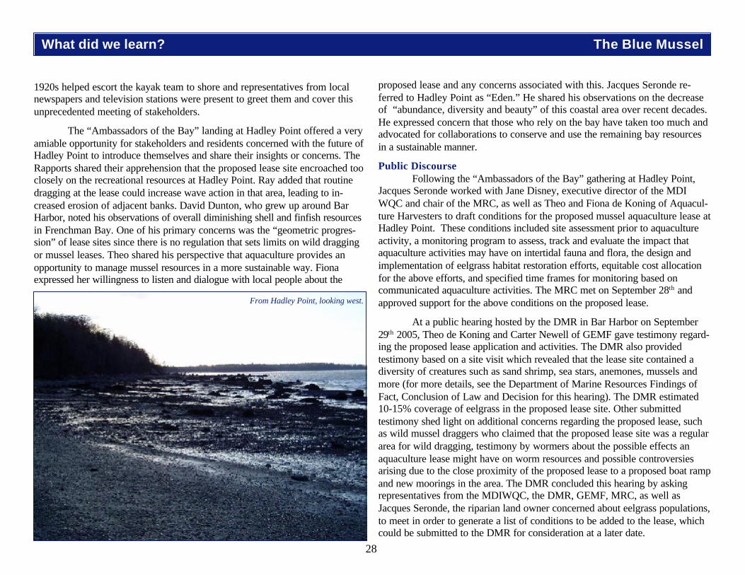
28
1920s helped escort the kayak team to shore and representatives from localnewspapers and television stations were present to greet them and cover thisunprecedented meeting of stakeholders.
The “Ambassadors of the Bay” landing at Hadley Point offered a veryamiable opportunity for stakeholders and residents concerned with the future ofHadley Point to introduce themselves and share their insights or concerns. TheRapports shared their apprehension that the proposed lease site encroached tooclosely on the recreational resources at Hadley Point. Ray added that routinedragging at the lease could increase wave action in that area, leading to in-creased erosion of adjacent banks. David Dunton, who grew up around BarHarbor, noted his observations of overall diminishing shell and finfish resourcesin Frenchman Bay. One of his primary concerns was the “geometric progres-sion” of lease sites since there is no regulation that sets limits on wild draggingor mussel leases. Theo shared his perspective that aquaculture provides anopportunity to manage mussel resources in a more sustainable way. Fionaexpressed her willingness to listen and dialogue with local people about the
proposed lease and any concerns associated with this. Jacques Seronde re-ferred to Hadley Point as “Eden.” He shared his observations on the decreaseof “abundance, diversity and beauty” of this coastal area over recent decades.He expressed concern that those who rely on the bay have taken too much andadvocated for collaborations to conserve and use the remaining bay resourcesin a sustainable manner.
Public DiscourseFollowing the “Ambassadors of the Bay” gathering at Hadley Point,
Jacques Seronde worked with Jane Disney, executive director of the MDIWQC and chair of the MRC, as well as Theo and Fiona de Koning of Aquacul-ture Harvesters to draft conditions for the proposed mussel aquaculture lease atHadley Point. These conditions included site assessment prior to aquacultureactivity, a monitoring program to assess, track and evaluate the impact thataquaculture activities may have on intertidal fauna and flora, the design andimplementation of eelgrass habitat restoration efforts, equitable cost allocationfor the above efforts, and specified time frames for monitoring based oncommunicated aquaculture activities. The MRC met on September 28th andapproved support for the above conditions on the proposed lease.
At a public hearing hosted by the DMR in Bar Harbor on September29th 2005, Theo de Koning and Carter Newell of GEMF gave testimony regard-ing the proposed lease application and activities. The DMR also providedtestimony based on a site visit which revealed that the lease site contained adiversity of creatures such as sand shrimp, sea stars, anemones, mussels andmore (for more details, see the Department of Marine Resources Findings ofFact, Conclusion of Law and Decision for this hearing). The DMR estimated10-15% coverage of eelgrass in the proposed lease site. Other submittedtestimony shed light on additional concerns regarding the proposed lease, suchas wild mussel draggers who claimed that the proposed lease site was a regulararea for wild dragging, testimony by wormers about the possible effects anaquaculture lease might have on worm resources and possible controversiesarising due to the close proximity of the proposed lease to a proposed boat rampand new moorings in the area. The DMR concluded this hearing by askingrepresentatives from the MDIWQC, the DMR, GEMF, MRC, as well asJacques Seronde, the riparian land owner concerned about eelgrass populations,to meet in order to generate a list of conditions to be added to the lease, whichcould be submitted to the DMR for consideration at a later date.
From Hadley Point, looking west.
What did we learn? The Blue Mussel
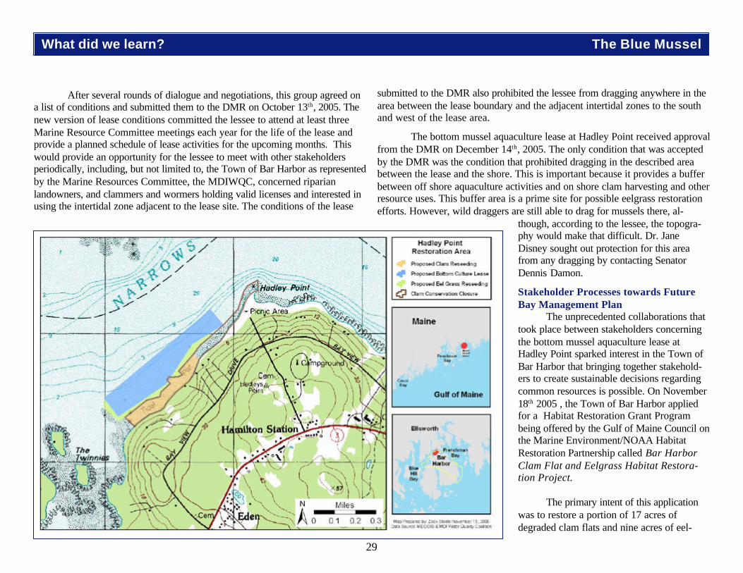
29
After several rounds of dialogue and negotiations, this group agreed ona list of conditions and submitted them to the DMR on October 13th, 2005. Thenew version of lease conditions committed the lessee to attend at least threeMarine Resource Committee meetings each year for the life of the lease andprovide a planned schedule of lease activities for the upcoming months. Thiswould provide an opportunity for the lessee to meet with other stakeholdersperiodically, including, but not limited to, the Town of Bar Harbor as representedby the Marine Resources Committee, the MDIWQC, concerned riparianlandowners, and clammers and wormers holding valid licenses and interested inusing the intertidal zone adjacent to the lease site. The conditions of the lease
submitted to the DMR also prohibited the lessee from dragging anywhere in thearea between the lease boundary and the adjacent intertidal zones to the southand west of the lease area.
The bottom mussel aquaculture lease at Hadley Point received approvalfrom the DMR on December 14th, 2005. The only condition that was acceptedby the DMR was the condition that prohibited dragging in the described areabetween the lease and the shore. This is important because it provides a bufferbetween off shore aquaculture activities and on shore clam harvesting and otherresource uses. This buffer area is a prime site for possible eelgrass restorationefforts. However, wild draggers are still able to drag for mussels there, al-
though, according to the lessee, the topogra-phy would make that difficult. Dr. JaneDisney sought out protection for this areafrom any dragging by contacting SenatorDennis Damon.
Stakeholder Processes towards FutureBay Management Plan
The unprecedented collaborations thattook place between stakeholders concerningthe bottom mussel aquaculture lease atHadley Point sparked interest in the Town ofBar Harbor that bringing together stakehold-ers to create sustainable decisions regardingcommon resources is possible. On November18th 2005 , the Town of Bar Harbor appliedfor a Habitat Restoration Grant Programbeing offered by the Gulf of Maine Council onthe Marine Environment/NOAA HabitatRestoration Partnership called Bar HarborClam Flat and Eelgrass Habitat Restora-tion Project.
The primary intent of this applicationwas to restore a portion of 17 acres ofdegraded clam flats and nine acres of eel-
What did we learn? The Blue Mussel

30
grass beds off of Hadley Point in Frenchman Bay to a more productive andsustainable condition. At the same time, the Town and its partners viewed thisrestoration project as a strategic effort to build community awareness of theimportance of these marine resources and, by engaging the community in theirprotection, to generate support for development and adoption of a future BayManagement Plan.
This grant asked for support to continue, and expand upon, volunteerstewardship efforts to survey clam flats and eelgrass beds, test water quality,re-seed clam flats, and replant eelgrass beds. A project coordinator would behired to help identify and involve stakeholders, including mussel draggers,clammers, wormers, aquaculture harvesters, among others in working withriparian land owners and other interested parties to protect and monitor thehabitats that would be restored. The Town of Bar Harbor would partner withthe MDIWQC to bring together a diverse group of students, scientists, otherinterested parties, and the general public through an education campaign ofnewspaper articles, an informational pamphlet, hands-on displays and a Resto-ration Guide for Community Nonprofits.
On January 24th 2005, the Town of Bar Harbor received notice that theBar Harbor Clam Flat and Eelgrass Habitat Restoration Project proposaldid not receive funding. The response from the Gulf of Maine Council on theMarine Environment indicated that the lack of a “clear set aside for restoredclam and eelgrass habitat that would be a “no take” zone over the long term”lowered the rank of this grant proposal and led to its dismissal. However, theGulf of Maine Council on the Marine Environment response also indicated thata revised application that addressed this issue would be seriously considered insubsequent years due to the level of community collaboration and support forthese efforts.
Collaborations ContinueCollaborations around common resources at Hadley Point continue. The
MDIWQC, in collaboration with the MDI Biological Laboratory, is laying afoundation of community education and understanding about the importance ofeelgrass for a healthy marine environment. At the same time, MDIWQC ispartnering with local schools, College of the Atlantic, and the MRC to continuemonitoring water quality at Hadley Point and collect data about clam populationsin this area.
Even after the bottom mussel aquaculture lease at Hadley Point wasapproved, the conversation continued and a memorandum of understandingbetween the MRC and GEMF was drafted and approved. This agreementincludes ongoing communication between the lessee and the Town of BarHarbor and other stakeholders via attendance at three Marine ResourceCommittee meetings each year for the life of the lease. At these meetings, thelessee will report on any activities conducted on the lease and provide a plannedschedule of lease activities for the upcoming months. In turn, the MRC andother stakeholders will provide updates on activities relating to inter tidal moni-toring, eelgrass conservation and reseeding at Hadley Point and other mattersof mutual concern and interest.
All involved parties have acknowledged the importance of monitoringwater quality around the lease site prior to and during the life of the lease andthe Bar Harbor Marine Resource Committee has committed funding to beginthese tests in spring 2006. A mutual sharing of information relevant to theaquaculture lease has been agreed upon and Fiona and Theo de Koning ex-pressed a willingness to try and attend any relevant Marine Resource Commit-tee or Town Council meetings. It is clear that the involved stakeholders maintaina willingness to work together, not only to best manage the multiple resources atHadley Point, but also to produce a model of collaboration among stakeholdersfor more sustainable management of marine and coastal resources in the future.
What did we learn? The Blue Mussel
Collaborations havecontinued into 2006 as the
MRC, COA, MDIWQC andMDI High School studentspartner to survey the clam
flats at Hadley Point.

31
Polluted Runoff: A Reality in the Watersheds of MDIBy Zephyr McDonnell
What did we learn? Watersheds and Development
One of the things we learned about this semester was the importance ofwatersheds and the many kinds of problems that can occur in watersheds. Awatershed is the geographic area of land in which all water drains to a specificbody of water. Example: the land that drains to Northeast Creek is the NortheastCreek watershed. Watersheds are necessary for life in those areas. Theyprovide habitat and recreation, they recharge aquifers, and filter toxins. Water-sheds can be devastated by pollution problems, if the problems are not preventedor stopped quickly. Watershed pollutants are classified as being Bacterial,Nutrient, Sediment, Toxic, or Thermal. Examples include: Bacterial-feces in thewatershed, Nutrient-organic matter or fertilizer, sediment and soil from erosion,toxic-pesticides or fuels, thermal heat from impervious surfaces.
it. Impervious surfaces, in addition to increasing the chances that pollution hitsthe water, greatly speeds up erosion. Evidence of this can be seen at Birch BayVillage, in Hulls Cove. In late fall of 2005 there was a large rainstorm, and alittle less than half of the upper part of the road to Birch Bay Village wasdestroyed. Unfortunately, they seem to have rebuilt the road in the same exactway, which means this is probably going to happen again.
When 10% of a watershed is covered by impervious surfaces it isconsidered impacted, at 20% it is considered impaired. This means the water-shed is less able to do its job, resulting in more erosion, less filtering of toxins,etc. An example of sedimentary pollution is a construction site in Hulls Cove.Around the same time as the washout at Birch Bay Village a hole was being dugat a site close to the beach. The hole was for pipes for some buildings that werebeing built. In order to not flood the hole, the contractor had a pump pumping
New development in Town Hill
Runoff is the most commonsource of pollution in watersheds.Rain from a storm can pick uppollutants on its way to a stream orlake or bay. This problem is in-creased if there are many impervioussurfaces in the watershed. Animpervious surface is anything watercannot go through on its way into theground, like a house roof, road, orparking lot. Since water cannot gothrough the impervious surface, itgoes over and around it. This meansthat there is more water in someareas than there used to be when itcould just disperse into the groundacross a wide area. Imagine a hugeparking lot, with only a few drains init. Where do you think the majority ofthe water that hits the lot is going?The water that entered the stormdrains has also carried all the pollut-ants that were on the pavement with
Degraded road at Birch Bay Village Polluted runoff from nearby construction hitting Hulls Cove Beach.
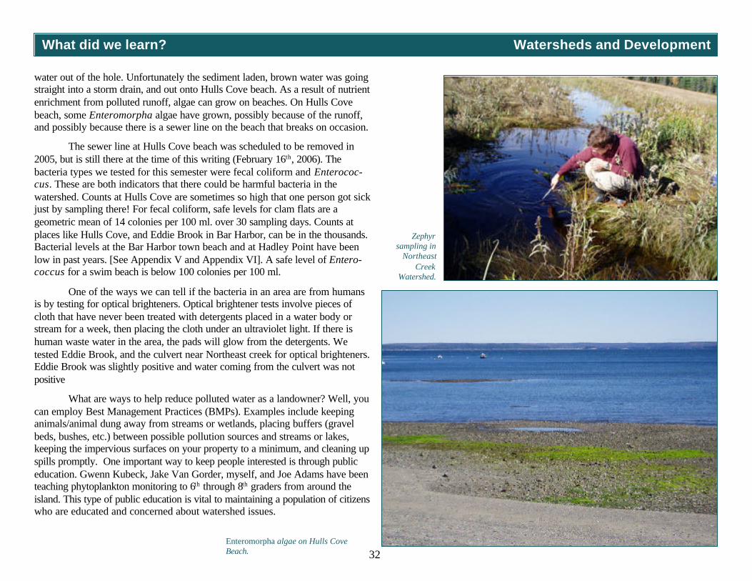
32
water out of the hole. Unfortunately the sediment laden, brown water was goingstraight into a storm drain, and out onto Hulls Cove beach. As a result of nutrientenrichment from polluted runoff, algae can grow on beaches. On Hulls Covebeach, some Enteromorpha algae have grown, possibly because of the runoff,and possibly because there is a sewer line on the beach that breaks on occasion.
The sewer line at Hulls Cove beach was scheduled to be removed in2005, but is still there at the time of this writing (February 16th, 2006). Thebacteria types we tested for this semester were fecal coliform and Enterococ-cus. These are both indicators that there could be harmful bacteria in thewatershed. Counts at Hulls Cove are sometimes so high that one person got sickjust by sampling there! For fecal coliform, safe levels for clam flats are ageometric mean of 14 colonies per 100 ml. over 30 sampling days. Counts atplaces like Hulls Cove, and Eddie Brook in Bar Harbor, can be in the thousands.Bacterial levels at the Bar Harbor town beach and at Hadley Point have beenlow in past years. [See Appendix V and Appendix VI]. A safe level of Entero-coccus for a swim beach is below 100 colonies per 100 ml.
One of the ways we can tell if the bacteria in an area are from humansis by testing for optical brighteners. Optical brightener tests involve pieces ofcloth that have never been treated with detergents placed in a water body orstream for a week, then placing the cloth under an ultraviolet light. If there ishuman waste water in the area, the pads will glow from the detergents. Wetested Eddie Brook, and the culvert near Northeast creek for optical brighteners.Eddie Brook was slightly positive and water coming from the culvert was notpositive
What are ways to help reduce polluted water as a landowner? Well, youcan employ Best Management Practices (BMPs). Examples include keepinganimals/animal dung away from streams or wetlands, placing buffers (gravelbeds, bushes, etc.) between possible pollution sources and streams or lakes,keeping the impervious surfaces on your property to a minimum, and cleaning upspills promptly. One important way to keep people interested is through publiceducation. Gwenn Kubeck, Jake Van Gorder, myself, and Joe Adams have beenteaching phytoplankton monitoring to 6th through 8th graders from around theisland. This type of public education is vital to maintaining a population of citizenswho are educated and concerned about watershed issues.
What did we learn? Watersheds and Development
Enteromorpha algae on Hulls CoveBeach.
Zephyrsampling in
NortheastCreek
Watershed.

33
What did we learn? Watersheds and Development
On the Ambassadors of the Bay journey, I noticed a lot of coastaldevelopment. I wondered if development had an effect on water quality. Iobtained fecal coliform data collected by the Department of Marine Resources(DMR) over the past ten years (fecal coliform is type of bacteria that is presentin the feces of animals; high colony counts usually indicate agricultural or septicleaching into water supplies). I also obtained Bar Harbor tax records for thesame time period. The tax records included a map of undeveloped and devel-oped properties, which I used to visually determine where developed propertieshad increased along the Bar Harbor waterfront over the past ten years. I notedthat there was an increase in development at Blunt’s Point, and so I decided tofocus on this area. Using the data from the DMR, I calculated the geometricmean of fecal coliform colony counts per year between 1995 and 2005. Begin-ning as far back as 2000, fecal coliform counts appeared to be on the rise atBlunt’s Point. In 2005, the geometric mean skyrocketed to over 21 counts per100 milliliters of water [Appendix IX]. One of the requirements to justify ashellfish harvesting closure is a geometric mean of 14 fecal coliform colonies per100 milliliters of water.
After talking with representatives of the DMR and surveying thesurrounding area, other possible sources of pollution, besides development, wereuncovered. A campground just north of the test site had had previous issues withits septic system; it was possible that the septic was leaching into the sea.Another potential problem was a stream that ran through a horse farm above thetest site. Earlier in the fall of 2005, I worked with the MDI Water QualityCoalition to do fecal coliform testing of this stream, which flows through aculvert, under Route 3, and eventually into Northeast Creek. There wereelevated levels of fecal coliform bacteria in the stream. The data revealed apositive correlation between rainfall and fecal coliform levels suggesting thatbacteria were being flushed into the stream from surrounding areas. It alsoshowed that bacteria levels decreased as the stream flowed toward the bay,meaning the bacterial pollution wasn’t being washed in by the tide. Although thesize of the stream where the testing was done was too small to be the onlycontributor to the elevated DMR fecal coliform counts at Blunt’s Point, it maybe a factor [Appendix X]. Testing is being done around the campground septicfield by the DMR to determine if that is the cause. If the campground septic isgood and it is not a source of fecal coliform bacteria at Blunt’s Point, then it ispossible that failed septic systems in new developments in the Blunt’s Pointvicinity have contributed to elevated fecal counts.
Land Use and Coastal DevelopmentBy Terrence Reid
Development near Hadley Point. Horse pasture near Northeast Creek. Northeast Creek culvert.

34
What did we learn? Watersheds and Development
Recommendations for looking at impacts of development on water qualityBy Terrence Reid
. 1. Collect baseline data for areas slated for development. If the conditions ofthe undeveloped area are unknown, there is no way of determining whetherthe development had an impact or not.
2. Continue monitoring in identified problem areas. If the campground septicproves to be the problem for Blunt’s Point, it would showcase this idea. Eventhough the septic system worked for a while, eventually it broke down again.By continuing testing in already identified problem areas, new problems canbe quickly found and fixed.
3. Use our comprehensive plan to guide land use ordinance changes. BarHarbor is in the process of making a new comprehensive plan. When manytowns make their comprehensive plans they don’t put any teeth in them anddevelopers do whatever they want. Incorporating land use policies into thecomprehensive plan would give it teeth, which could be used to keep devel-opment away from fragile environments.
4. Consider the cumulative impact of existing problems when evaluating newdevelopment. This basically means that if an area already has problems, it isgoing to be less able to handle additional impacts of new development.

35
What did we learn? Watersheds and Development
Land ConservationBy Jane Disney
What we learned from Barb Welch, executive director, Frenchman Bay ConservancyBarb taught us what a conservation easement is. It is an agreement with
a landowner that restricts how land can be used. She gave us the analogy of abundle of sticks. The sticks represent all the things that you have the right to doon a piece of land. These include the right to occupy, use, lease, sell, and developthe land. An easement involves the exchange of one or more of these rightsfrom the landowner to a land trust like the Frenchman Bay Conservancy. Peoplewho get conservation easements on their land recognize that some of those thingsmight not be good for the local environment and they are willing to give up someof those rights in exchange for tax reductions and the peace of mind that theyhave done a good thing for the land and surrounding water. Conservation ease-ments are legally binding agreements that are publicly recorded and run with the property deed for a specifiedtime or in perpetuity. So if a piece of land is sold, the conservation easement can stay in place. There can beproblems. People sometimes want to change or amend easements. These decisions are not always easy.Sometimes changes can be made. If the amendment benefits the landowner financially, then it cannot be done.
What we learned from Bob DeForrest, Maine Coast Heritage TrustBob taught us that many islands off the coast of Maine have conservation easements or are owned by
land trusts like the Maine Coast Heritage Trust. Some people get confused, thinking a conservation easementmakes a piece of land open to the public, but that is not necessarily true. They think that land conservationareas are like Acadia National Park, set aside for the public to use and enjoy. It is not easy for the public tofigure out where conservation easements are, maps of these areas are often confidential because of theconfusion about these areas.
There are many reasons why conservation easements are important. Since the primary purpose of aconservation easement is to conserve natural or man-made resources on the land, the easement itself isdescribed in terms of the resource it is designed to protect. The conservation easement might protect farmlandor forests, a historic structure, an open space, or a wetland or other type of resource.
There is a conservation easement on Stave Island; some of the land has been given to Maine CoastHeritage Trust and the rest has conservations easements that restrict use of the land to some purposes. Wewere given permission to camp on Stave Island. Bob helped us to think about leaving no trace of our timethere. We were careful with all of our wastes. Everything carried in was carried out.
“In considering landprotection, one shouldconsider the effect ofland use on waterquality.”
—Barb Welch
Upper right: Thomas Island was recently placed in a conservation easement by Maine Coast Heritage Trust.Middle right: Bob DeForrest shares a map of protected land in Frenchman Bay with Ambassadors.
Bottom right: Zack Steele and Dr. Helen Hess review map of conserved lands on Stave Island.

36
How Did We Do It?
The Nuts and Boltsby Jane Disney
Journey InspirationThe Gulf of Maine Expedition, a 1,200-mile journey from Cape Cod to
Nova Scotia sponsored by Maine Sea Grant in 2002, inspired the idea for theAmbassadors of the Bay journey. We used similar methodology as described in“Celebrating our Coastal Heritage” the Final Report of the Gulf of MaineExpedition 2002, which can be found at www.gomexpedition.org.
The Ambassadors of the Bay was a learning experience for thekayaking team on many levels and for people we engaged along the way.
To get ready, we first decided on a focus for the journey and then chosea time frame, travel route, and daily destinations. We decided to assemble akayak team that included a diversity of community members including students.We decided to depart on September 19th, 2005 and return on the first day ofautumn, September 22nd, 2005.
Journey FocusThe focus of the journey was to meet up with residents and users of the
bay and discuss the issues they felt were important to the future of the bay.Along the way, we planned to look for indicators of ecosystem health likephytoplankton populations, bird numbers and distributions, eelgrass beds, andmarine mammals.
Travel Route PlanningWe chose destinations where we could easily meet up with people and
make the observations we were interested in. We planned to travel fromThompson Island, around the Twinnies to Hadley Point, because there wereissues related to mussel dragging and worm harvesting, mussel aquaculture, andclam conservation in these areas surrounding Mount Desert Island. HadleyPoint was a convenient stopping place where people could easily meet with us.We planned to travel from Hadley Point to Lamoine State Park in order to meetup with Department of Marine Resource (DMR) biologists at our campsite.
The DMR laboratory is located right at the park. We planned to travelfrom Lamoine State Park to the MDI Biological Laboratory so that we couldmeet up with residents of Salisbury Cove and visit with marine scientists. The
residents of Salisbury Cove had special concerns about mussel aquaculture andthe building of piers and we wanted to hear their views. We planned to travelfrom the MDI Biological Laboratory to Hancock Point so that we could visitmussel aquaculture rafts near Googin’s Ledge and gain a bay-level perspectiveas we traveled across the expanse of open water. We planned to visit withFrenchman Bay Conservancy representatives who lived at Hancock Point tolearn about land conservation and its role in protecting the bay. We planned totravel from Hancock Point to Stave Island to gain perspective on issues relatedto islands and practice and assess the efficacy of Leave No Trace principles.We planned to travel from Stave Island to College of the Atlantic in Bar Harborto visit with students and representatives of Allied Whale.
Kayak TeamWe decided that the kayaking team should include young environmental
stewards and community members who could support the students’ efforts tounderstand and communicate the relevant issues in Frenchman Bay. Thestudents were all research fellows in the Maine Coast Learning ExpeditionProgram at the MDI Water Quality Coalition. These students, by enrolling in theprogram, had committed themselves to a full semester of environmental stew-ardship work on Mount Desert Island.
Maine Coast Learning ExpeditionMaine Coast Learning Expedition is a semester-long environmental
stewardship program for high school students. The program has been approvedby the state of Maine as a limited purpose school. The MDI Water QualityCoalition headquarters in Town Hill is where students, instructors, and commu-nity members work together and learn from each other in an informal educa-tional setting. The Community Environmental Health Laboratory, located at theMDI Biological Laboratory, is where students conduct their water quality-relatedresearch, as part of a collaborative outreach and education program with theMDI Biological Laboratory.
Funding and SupportThis project could not have occurred without the generous support of
many individuals and organizations. Maine Sea Grant supported the journey bydedicating Natalie Springuel’s time leading the team on the water and later,designing this report. Maine Sea Grant also provided funding for journey

37
How Did We Do It?
supplies and camp food, administration, and production of this report. A riparianlandowner contributed funds, National Park Sea Kayak Tours donated the use ofkayaks and affiliated equipment and gear, Aquaculture Harvesters provided alunch on the journey and Frenchman Bay Conservancy provided a dinner. Weintended to stop at the MDI Biological Laboratory where lunch was beingprovided, but due to weather, we had to change course and head directly toHancock Point. We put together a ground crew to help support us on ourjourney. Mary Forest and Deb Lane helped to move gear on the ground andmake sure we were fed and dry. Land crew volunteers donated their time andmileage, and provided prepared meals to the kayak team.
Overnight AccommodationsWe arranged for camping at Lamoine State Park, Hancock Point, and
Stave Island. We encountered bad weather and heavy rains on the second dayof the journey and were invited to stay with Barb Welch, of the Frenchman BayConservancy. We received special permission to stay on Stave Island, part ofwhich is owned by Maine Coast Heritage Trust (MCHT). Bob DeForrest, astaff member at MCHT, met us at Stave Island to direct us to a camping areaand teach us about the island.
Preparation and TrainingA packing list and contact information sheet was developed for every
journey participant in the journey. We shared equipment and clothing and sharedpast experiences with outdoor adventures. We visited with David Lamon,director at the Somes Meynell Wildlife Sanctuary to explore our own sense ofplace through journaling and reflection and in a series of directed activities. Wealso engaged the MDI Paddlers in helping us plan for our trip and train teammembers in kayaking skills and safety measures. We used Echo Lake fortraining the week before our journey. Every team member learned how to do a“wet exit” and practices rescue scenarios. We got an introduction to Leave NoTrace principles and got oriented for our journey.
EducationWe produced a brochure highlighting our journey, our focus and our
mission and shared it with people before, during and after the journey. Weinvited reporters to join us at locations where we were gathering. Abigail Curtis,a reporter from the Bangor Daily News, visited with the kayak team the week
before departure, and joined us on our first leg of the journey. She wrote articlesexplaining the focus of the journey. Susan Farley of Channel 5 News inter-viewed the kayak team and citizens who had come to share their issues atHadley Point. Reporter Laurie Schreiber and photographer Peter Travers alsojoined us at Hadley Pont and conducted interviewed. We produced a slide showand shared our journey with the public several days after the journey. Eachstudent research fellow followed up on one issue that came up during thejourney and researched it over the next three months. They presented theirfindings to the public at a presentation at the Maren Auditorium at the MDIBiological Laboratory on December 12th, 2005. They submitted some of theirdata and analyses to the Bar Harbor Town Planner for inclusion in the compre-hensive plan.
The Seven Principles of Leave No Trace
1. Plan Ahead and Prepare
2. Travel and Camp on Durable Surfaces
3. Dispose of Waste Properly
4. Leave What You Find
5. Minimize Campfire Impacts — Kindle No Fires
6. Respect Wildlife
7. Be Considerate of Other Visitors
Background photo: footprint in the intertidal mud.
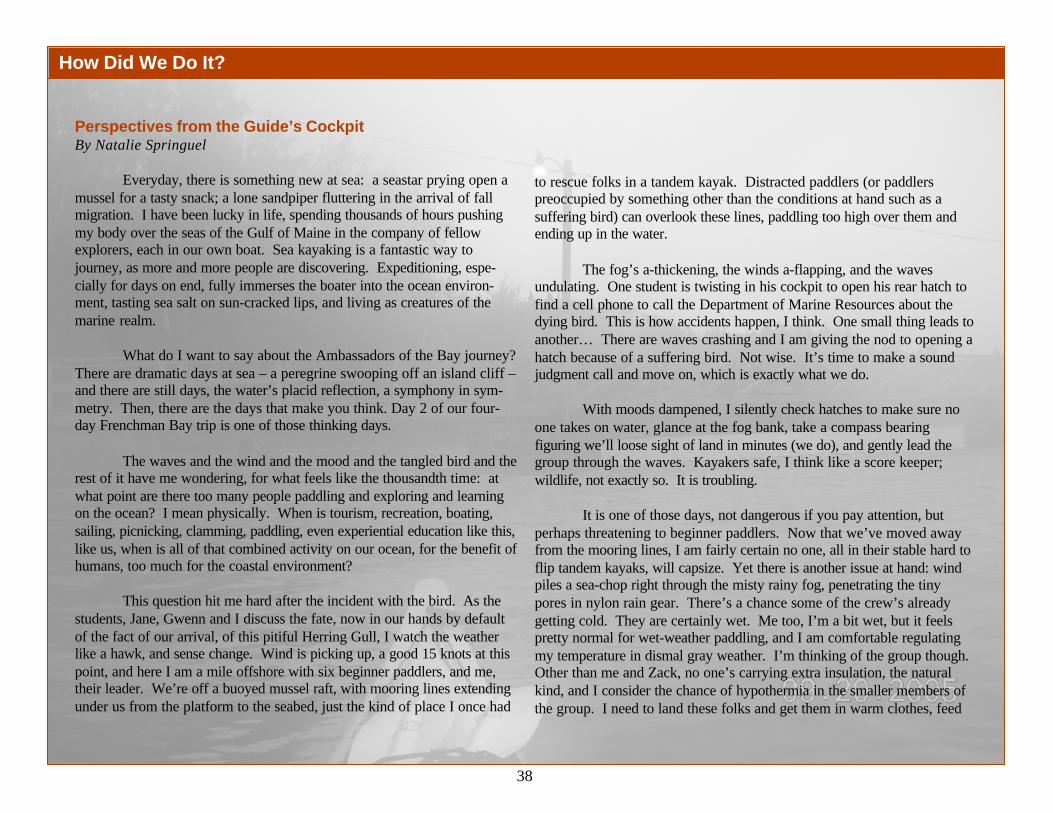
38
How Did We Do It?
Perspectives from the Guide’s CockpitBy Natalie Springuel
Everyday, there is something new at sea: a seastar prying open amussel for a tasty snack; a lone sandpiper fluttering in the arrival of fallmigration. I have been lucky in life, spending thousands of hours pushingmy body over the seas of the Gulf of Maine in the company of fellowexplorers, each in our own boat. Sea kayaking is a fantastic way tojourney, as more and more people are discovering. Expeditioning, espe-cially for days on end, fully immerses the boater into the ocean environ-ment, tasting sea salt on sun-cracked lips, and living as creatures of themarine realm.
What do I want to say about the Ambassadors of the Bay journey?There are dramatic days at sea – a peregrine swooping off an island cliff –and there are still days, the water’s placid reflection, a symphony in sym-metry. Then, there are the days that make you think. Day 2 of our four-day Frenchman Bay trip is one of those thinking days.
The waves and the wind and the mood and the tangled bird and therest of it have me wondering, for what feels like the thousandth time: atwhat point are there too many people paddling and exploring and learningon the ocean? I mean physically. When is tourism, recreation, boating,sailing, picnicking, clamming, paddling, even experiential education like this,like us, when is all of that combined activity on our ocean, for the benefit ofhumans, too much for the coastal environment?
This question hit me hard after the incident with the bird. As thestudents, Jane, Gwenn and I discuss the fate, now in our hands by defaultof the fact of our arrival, of this pitiful Herring Gull, I watch the weatherlike a hawk, and sense change. Wind is picking up, a good 15 knots at thispoint, and here I am a mile offshore with six beginner paddlers, and me,their leader. We’re off a buoyed mussel raft, with mooring lines extendingunder us from the platform to the seabed, just the kind of place I once had
to rescue folks in a tandem kayak. Distracted paddlers (or paddlerspreoccupied by something other than the conditions at hand such as asuffering bird) can overlook these lines, paddling too high over them andending up in the water.
The fog’s a-thickening, the winds a-flapping, and the wavesundulating. One student is twisting in his cockpit to open his rear hatch tofind a cell phone to call the Department of Marine Resources about thedying bird. This is how accidents happen, I think. One small thing leads toanother… There are waves crashing and I am giving the nod to opening ahatch because of a suffering bird. Not wise. It’s time to make a soundjudgment call and move on, which is exactly what we do.
With moods dampened, I silently check hatches to make sure noone takes on water, glance at the fog bank, take a compass bearingfiguring we’ll loose sight of land in minutes (we do), and gently lead thegroup through the waves. Kayakers safe, I think like a score keeper;wildlife, not exactly so. It is troubling.
It is one of those days, not dangerous if you pay attention, butperhaps threatening to beginner paddlers. Now that we’ve moved awayfrom the mooring lines, I am fairly certain no one, all in their stable hard toflip tandem kayaks, will capsize. Yet there is another issue at hand: windpiles a sea-chop right through the misty rainy fog, penetrating the tinypores in nylon rain gear. There’s a chance some of the crew’s alreadygetting cold. They are certainly wet. Me too, I’m a bit wet, but it feelspretty normal for wet-weather paddling, and I am comfortable regulatingmy temperature in dismal gray weather. I’m thinking of the group though.Other than me and Zack, no one’s carrying extra insulation, the naturalkind, and I consider the chance of hypothermia in the smaller members ofthe group. I need to land these folks and get them in warm clothes, feed

39
How Did We Do It?
them some high energy snacks, get their spirits up. The bird’s pain lingers ineveryone’s eyes.
We’ll land very soon, I announce, sensing that everyone’s tolerancefor watery weather is withering. Someone points to the nearest beach andsuggests why not there? I pause, look at the shore, and spot the house.Rats. My mind flips through all the information needed to make a quickdecision. The most important factor: we are not in an emergency situation.Some in the group are a bit charged by the conditions and certainly all seemshaken by the bird, but everyone is capable of paddling another 300 yards. Itake a deep breath and call back to the group “Let’s keep paddling aroundthe next bend up the shore a bit...” I can see the lack of understanding in thecocked heads of a couple of the adults in the group, through their hats andraincoats, but my decision is made, and for the first time of the trip I am notinviting discussion. Why? This relates back to the question that hounds meon all my trips: at what point are there too many folks using a particular bay,building, fishing, farming, playing, and living. When is there so much use thatwe can’t comfortably go about what we do without imposing on each other,or worse, without harming the seascapes through which we travel?
Perhaps that was a summer home, I think to myself, or perhaps ayear-round residence. I can’t tell and I’m a bit too conscious of keeping aneye on my crew to figure it out. The fact is, though, there was a house.Most of the shoreline in this part of Frenchman Bay is private. And privacyis a bit of a fanatical thing in America. I have encountered no less than halfa dozen landowners from Cape Cod to Maine utter dismay at me when Ihave landed a group of paddlers on their shore. People who own shore landdon’t want anyone on their beach. I just don’t do it anymore… unless it’s anemergency. I’d rather avoid the negative repercussions of landing there,especially with a cold and already depressed group. I only wish thereremained more public and undeveloped shore. To the bottom of my core, Ihope the other side of the bend delivers a house-free beach on which to land.
Five minutes later, a lovely high tide cobble shore is alive with tinyexciting surf. I land first. One at a time, I call each boat in and help catch itbefore it broaches on landing waves. No one went into the drink at themussel raft, I joke out loud, and it isn’t going to happen here either!
Everyone is on shore, relieved. Me too: there are no houses here.We can relax. I take the time needed to open hatches and dry bags, pull outextra fleece layers. One kid is really cold, shivering, but reluctant to admit it,so I cajole on the layer with humor. And gorp. You can never go wrong withgorp. There is a track-and-field kid in the group; he devours nearly thewhole bag. I am glad to pull out tomorrow’s stash, so everyone can get theirfill today. Jane calls DMR about the bird. Everyone watches the waveswhich splash more than crash now and the tension begins to ease. The birdsituation starts settling into everyone’s soul, tucked away for continuedreflection. Death is a fact of nature. And so are humans. On the water,when you travel in that amphibious zone between land and sea, it is hard toseparate the two.
We pack up the snacks, discover one student lost sunglasses foreverin the seaweed, batten down the hatches, and launch for the last few miles toHancock Point where Barbara awaits... she promises hot cocoa and pizza.The rest of the group seems comforted, yet somehow, my heart stays withthe boats, down at the beach, where the waves and fog keep them company.

40
Recommendations
What the Ambassadors of the Bay see as Necessary after their journey and their work in the community, Fall 2005
1. Support collection of baseline data around Frenchman Bay in order to understand impacts from growing industries, changes in landuse, and increases in impervious surfaces.
2. Develop a plan for the future of the bay with all stakeholders in order to ensure a healthy future for Frenchman Bay. These stake-holders may form a local alliance that can interface with regional bay management councils. Stakeholders include:
Resident AssociationsFishermen Co-operativesShellfish and Worm Harvester GroupsTownsEducational and Research InstitutionsLocal Organizations
3. Develop a plan for the future of mussel harvesting in Frenchman Bay that protects habitat and sustains the fishery.
4. Encourage people to get involved in the future of their bay. Involvement could include participation in:• Local government (town councils, committees, comprehensive planning)• Community forums and scoping sessions• Public hearings
5. Promote public education to raise awareness about bay issues by supporting:• Ambassadors of the Bay Journeys• Outreach to local schools• Opportunities to volunteer as environmental stewards
6. Form a citizen group (Friends of Frenchman Bay) to research issues and help to provide answers to questions that arise during theprocess of developing a plan for the future of Frenchman Bay.
Stave Island sand bar with Bonapartes Gulls LATIN

41
People involved with the 2005 Amabassadors of the BayCompiled by Jake Van Gorder
FirstName Last Name Position
Mary Forest Ambassador of the Bay as Ground SupportDeb Lane Ambassador of the Bay as Ground SupportNatalie Springuel Ambassador of the Bay Journey Kayak Guide and Maine
Sea GrantHelen Hess Ambassador of the Bay and College of the AtlanticZack Steele Ambassador of the Bay (Stanley Brook Watershed Survey
Coordinator)Terrence Reid Ambassador of the Bay (MCLE Student)Maddy Johnson Ambassador of the Bay (MCLE Student and Bird Counter)Gwenn Kubeck Ambassador of the Bay (MDIWQC Education Director)Jane Disney Ambassador of the Bay (MDIWQC Executive Director)Jake Van Gorder Ambassador of the Bay (Videographer and MCLE
Graduate Student)Zephyr McDonnell Ambassador of the Bay (MCLE Student)Mike McKernan MDI Biological Laboratory Education DirectorDavid Towle MDI Biological Laboratory (Crab Scientist)Theo De Koning Mussel Aquaculturist, Great Eastern Mussel FarmsFiona De Koning Mussel Aquaculturist, Great Eastern Mussel FarmsJames Houghton College of the Atlantic StaffRich MacDonald College of the Atlantic Staff and Bird ExpertAriel Durrant College of the Atlantic StudentLlewelyn Sullivan Coastal Kayaking GuideDavid Dunton Commercial Clammer and Member of Bar Harbor Marine
Resources Committee
First
Name Last Name Position
Jacques Seronde Conservationist and Frenchman Bay LandownerBob DeForrest Conservationist and Maine Coast Heritage TrustBarb Welch Conservationist-Frenchman Bay ConservancyJohn Fendl DMR ScientistRob Goodwin DMR ScientistMerky Cumbo DMR ScientistJay McGowan DMR ScientistLaurie Schreiber Reporter (Bar Harbor Times)Pete Travers Photographer (Bar Harbor Times)Sarah Hinckley Reporter (Mount Desert Islander)Susan Farley Reporter (WABI TV5)Abby Curtis Reporter, Bangor Daily NewsKara Johnson Allied WhaleRay Rappaport Resident/Retired ScientistBarbara Rappaport Resident/Retired ScientistKathy Van Gorder VolunteerDoug Van Gorder VolunteerKendrew Van Gorder VolunteerDavid Lamon VolunteerRobert Shaw National Park Kayak ToursSkippy Dunton Long time lobsterman in Frenchman BayRon Greenberg MDI Paddler
Appendix I

42
Phytoplankton Data2004-2005Source: Students and teachers from Conners Emerson School in Bar Harbor and student and teacher interns at the Community Environmental Health Laboratory, acollaborative outreach program between the MDI Water Quality Coalition and the MDI Biological Laboratory.Analysis of Data: Maddy Johnson, Research Fellow, MDI Water Quality Coalition.Data were sent to the Maine Department of Marine Resources for evaluation. Alexandrium is the type of phytoplankton responsible for red tide closures.There were extensive closures in both 2004 and 2005. Although this type is 1% or less of the total phytoplankton population in Frenchman Bay, it has profoundeffects on the toxicity of shellfish.
Appendix II
Phytoplankton of Frenchman Bay in 2004
Coscinodiscus
Didylum
Dinophysis
Melosira
Gonyaulax
Guinardia
Gyrosigma
Leptocylindrus
Navicula
Nitzchia
Phaeocystis
Rhizosolenia
Thalassionema
ThalassiosiraOther
Alexandrium
Ceratium
Chaetoceros
Chaetoceros socialis
Eucampia
26%
18%
0%
11%1%
8%1%
2%4%
1%
4%
5%
2%1%
11%
Phytoplankton of Frenchman Bay in 2005
Chaetoceros
Chaetoceros socialis
Coscinodiscus
Dinophysis
Eucampia
Thalassiosira
OtherAlexandrium
Thalassionema
Leptocylindrus
PseudonitzchiaRhizosolenia
Protoperidinium
NitzchiaNavicula
Melosira
Gyrosigma
Gonyaulax
Guinardia
26%
13%
3%1%
21%
7%
2%
10%1%
2%
2%
1%
2%
2%
1%
1%2%
4%
1%
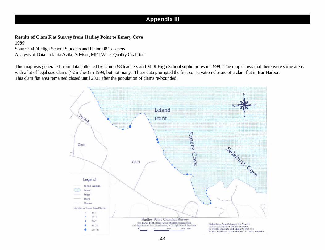
43
Appendix III
Results of Clam Flat Survey from Hadley Point to Emery Cove1999Source: MDI High School Students and Union 98 TeachersAnalysis of Data: Lelania Avila, Advisor, MDI Water Quality Coalition
This map was generated from data collected by Union 98 teachers and MDI High School sophomores in 1999. The map shows that there were some areaswith a lot of legal size clams (>2 inches) in 1999, but not many. These data prompted the first conservation closure of a clam flat in Bar Harbor.This clam flat area remained closed until 2001 after the population of clams re-bounded.

44
Distribution of Clams at Hadley Point East
0
2
4
6
8
10
12
14
16
18
20
1/4- 3/4 1-1 3/4 0ver 2
Size Range of Clams
Nu
mb
er o
f C
lam
s d
ivid
ed b
y n
um
ber
of
plo
ts s
urv
eyed
1999
2000
2001
2005
Clam Flat Data at Hadley Point1999-2005Source: Bar Harbor Marine Resources Committee and MDI High School StudentsAnalysis of Data: Jane Disney, MDI Water Quality Coalition
Citizens working with the Marine Resources Committee in Bar Harbor have surveyed the clam flats on the east side of Hadley Point repeatedly over the lastseveral years. A conservation closure in 1999 and again in 2000 resulted in a rebounding clam population by 2001. Shorter 6-month closures have notprotected the harvestable (over 2 inch) clam populations in recent years. In the fall of 2005 numerous undersized clams were counted (only data from MDIHSis shown). With proper management of the clam flats, the number of harvestable clams may again increase.
Appendix IV

45
Water Quality Data along Bar Harbor Shorefront1995-2005Source: Maine Department of Marine ResourcesAnalysis of Data: Zephyr McDonnell, Research Fellow, MDI Water Quality Coalition
Geometric Means of Fecal Coliform Bacteria Data from sites on the Bar Harbor Waterfront 1995-2005
0
5
10
15
20
25
30
Location
Fec
al C
olif
orm
Co
lon
ies
per
100
ml o
f w
ater
Narrows Campground
Hadley Point
MDI Biolab
Salisbury Cove
Emery's Cottages
Degregoire Pk. Road
Hulls Cove Beach
By Atlantic Oaks Hotel
Near Eddie Brook
Left Side Of Bar
Right of Bar
Bar Harbor Town Pier, BoatRampShore Path
Compass Harbor
Schooner Head
Near Schooner Head
This graph shows that there are low levels offecal coliform bacteria around the Bar HarborWaterfront with the exception of Eddie Brook.Fecal coliform bacteria are used as an indicator ofsewage pollution. Geometric means are used tolook at multiple samples over a period of time.The geometric mean reduces the influence of thevery high and very low numbers on the data set.Geometric mean levels above 14 colonies/100 mlof water (the red line on the graph) indicate thatshellfish are not safe to eat from these areas. TheDepartment of Marine Resources may closeclamflats due to high levels of bacteria, or if there isa potential for bacterial contamination, like near asewage outfall or overboard discharge from aprivate property.
Appendix V

46
Fecal Coliform levels at the mouth of Eddie Brook
0
20
40
60
80
100
120
1995 1996 1997 1998 1999 2000 2001 2002 2003 2004 2005
Year
Fec
al G
eom
ean
s
Geomeans
Water Quality Data at the Mouth of Eddie Brook1995-2005Source: Maine Department of Marine ResourcesAnalysis of Data: Zephyr McDonnell, Research Fellow, MDI Water Quality Coalition
The fecal coliform bacteria levels at the mouth of Eddie Brook have consistently exceeded established standards for shellfish harvesting areas over the last 10years (14 colonies per 100 ml., indicated by red line). There is a valuable shellfish resource at the mouth of Eddie Brook and on the Bar in Bar Harbor thatcannot be harvested due to this contamination. The high levels of bacteria are probably due to combined sewer overflows and storm water discharges at themouth of the brook.
Appendix VI

47
Enterococcus Levels at Town Beach West 2004-2005
0
50
100
150
200
250
300
6/10/2
004
6/24/2
004
7/7/20
04
7/12/2
004
7/26/2
004
7/28/2
004
8/9/20
04
6/23/2
005
7/5/20
05
7/18/2
005
8/1/20
05
Date
Co
lon
ies
per
100
ml.
EPA Recommended Beachwater-Quality Standard for Marine Waters
Enterococcus Levels at Town Beach in Bar Harbor
0
5
10
15
20
25
30
35
40
Town Beach East Town Beach West
Sample Site
Geo
met
ric
Mea
ns
of
Co
lon
ies
per
100
ml. 2003
2004
2005
EPA Recommended Beachwater-Quality Standard for Marine Waters
Water Quality Data at the Bar Harbor Town Beach2003-2005Source: MDI Water Quality CoalitionAnalysis of Data: Jane Disney, MDI Water Quality Coalition
The MDI Water Quality Coalition collected water samples at Town Beach over three summers as part of the Maine Healthy Beaches Program. The Bar HarborTown Council voted in the summer of 2004 not to participate in the Maine Healthy Beaches Program and did not post signs in response to data, although the signswould have indicated a clean beach, open to the public to enjoy. The EPA recommended beachwater-quality standard for marine waters is a geometric mean of 35colonies per 100 ml. of water. Geometric means at the town beach in Bar Harbor have never exceeded 35 colonies per 100 ml. of water. The EPA recommendedbeachwater-quality standard for marine waters for a single sample is 104 colonies per 100 ml. of water. The Maine Healthy Beaches monitoring protocol recom-mends re-sampling the next day when the standard is exceeded. Twice in 2004 the EPA standard was exceeded, but the level of bacteria was back down toacceptable levels by the next day. The MDI Water Quality Coalition continued to supply information to the town through the summer of 2005, which was thecleanest year at the beach on record.
Appendix VII

48
Enterococcus Levels at Hadley Point 2004-2005
0
20
40
60
80
100
7/1/20
04
7/7/20
04
7/14/2
004
7/21/2
004
7/27/2
004
8/2/20
04
6/23/2
005
6/28/2
005
7/7/20
05
7/12/2
005
7/19/2
005
7/26/2
005
8/8/20
05
Date
Co
lon
ies
per
100
ml EPA Recommended
Beachwater-Quality Standard in Marine Water
Water Quality Data at Hadley Point2004-2005Source: Interns at the Community Environmental Health LaboratoryAnalysis of Data: Jane Disney, MDI Water Quality Coalition
The MDI Water Quality Coalition has been monitoring water quality at Hadley Point in Bar Harbor as part of the Maine Healthy Coastal Beaches Programsince 2004. Enterococcus, a type of bacteria found in the gut of warm-blooded animals, is used as an indicator of the potential for swimming illness. The levelsof bacteria at Hadley Point have been consistently low over the last two years. A boat ramp is planned for Hadley Point in the near future. This may increaseboat activity and public use of the Hadley Point area. Continued monitoring of water quality in this area is imperative to ensure that public health is protected.
Appendix VIII

49
Appendix IX
Fecal Coliform Levels at Blunts Point in Frenchman Bay
0
5
10
15
20
25
1995 1996 1997 1998 1999 2000 2001 2002 2003 2004 2005
Years
Fe
ca
l C
oli
form
Co
lon
ies
pe
r 1
00
ml
(Ge
om
etr
ic M
ea
ns
)
Water Quality Data at Blunts Point in Frenchman Bay1995-2005Source: Maine Department of Marine ResourcesAnalysis of Data: Terrence Reid, Research Fellow, MDI Water Quality Coalition
This graph shows that there were low levels of fecal coliform bacteria at Blunts Point in Bar Harbor until recently. Geometric mean levels above 14 colonies per100 ml. (the red line on the graph) indicate that shellfish harvested from this area may not be safe to eat.

50
Appendix X
Water Quality Data at the Culvert Leading to Northeast CreekFall 2005Source: Maine Coast Learning ExpeditionAnalysis of Data: Terrence Reid, Research Fellow, MDI Water Quality Coalition
This graph shows that there are occasional high levels of bacteria in the culvert leading to Northeast Creek. The high levels correlate with rainfall. The culvertdrains a pasture with horses. Horse manure may account for the elevated counts during the fall.
Bacterial Levels at the Culvert Leading from the Horse Farm to Northeast Creek
0
50
100
150
200
250
300
9/30/2005 10/5/2005 10/25/2005 10/31/2005 11/7/2005 11/10/2005 11/16/2005
Data
feca
l Co
lifo
rm c
olo
nie
s p
er 1
00 m
l

51
We Believe• One person can make a difference.• Joy is found in the richness and diversity of the connections we have to our community and the environment.• Young people need connections to their community to prepare them for finding their place in the world.• Parents and community members can be key partners with teachers in education and inspiring young learners.• Community and mutual respect is strengthened through stewardship.• Stewardship is holding something in trust for another.• Students learn better when they encounter subject matter in real world contexts.• Students are empowered to solve problems in creative ways when they are educated in interdisciplinary environments by teachers and
community members who know them well.• Engaging in Environmental Stewardship should be an integral part of every citizen’s education (and life experience).• Teaching and learning in an interdisciplinary way through authentic worth and community service or stewardship activities requires a
flexible schedule with large blocks of open time.• Reflection is as important as “doing” in the process of learning.• Teaching and Learning are rich human endeavors that cannot be separated from the rest of the human experience (having friends, being
part of a community, exploring the inner self).
Our Mission is based on these beliefsThe mission of the Maine Coast Learning Expedition is to create a learning communitythat cares deeply for local environments and works toward the goal of understanding andpreserving the integrity of local watersheds and wildlife habitats on Mount Desert Island.
VisionThe students and teachers participating in Maine Coast Learning Expedition will be acommunity of learners who connect knowledge in purposeful ways to accomplish goalsby working collaboratively in variety of local settings, valuing each other as teachers andappreciating each other as learners. Students will gain self-confidence for the tasks thatlie ahead. Students will be fully empowered to seek out resources to solve problems ofimportance to themselves and their community.
Maine Coast Learning Expedition
Maine Coast Learning Expedition, Fall 2005 Students and LeadersLeft to right: Maddy Johnson, Zephyr McDonnell, Terrence Reid, Jake
Van Gorder, Gwenn Kubeck, Zack Steele

52
One way to open your eyes is to ask yourself,“What if I had never seen this before?What if I knew I would never see it again?”
Rachel Carson
Art by Maddy Johnson