ambala-district - S3WaaS
20
3,4°8 in 1881 to 2,080 in 19°1. It is still, however, a place of pilgrimage; and close to it are the temples of Pirthildakeshwar or Pirthuveshwar, built by the Marathiis during their supremacy in honour of the goddess Saraswatl (Sarsuti), and of Swami Kartik. The latter is said to have been founded before the war of the Mahabh!rata in honour of the war-god Kartaya. The town has a dispensary. Piindri.- Town in the Kaithal taIIsJ/ of Kamal. District, Punjab, situated in 29° 46' N. and 760 34' E., .on the bank of a great tank called the Pundrak tank. Population (lg01), 5,834. It was formerly one of the strongholds of the Pundirs, a Rljput tribe who held Thinesar and tbe Nardak. It has a vernacular middle scbool. Sbihl.bid.-Town in tbe Thinesar t4Asilof Karnil Dis- trict, Punjab, situated in 30° 10' N. and '76 0 52' E., on the Delhi-Umballa-Kalka Railway, 16 miles south of Ambila. Population (lgOI), II,OOg. The town was founded by one of the followers of Muhammad of Ghor at the end of. the twelfth century. It is of no commercial importance. The munici- pality WaS created in 1867-8. The income during ;tbe ten years ending 1902-3 averaged Rs. 10,900, and the expendl'" . tore Rs. 10,200. The income in 1903-4 was Rs. 12,300, . chiefly derived from octroi; and the expenditure W3./l Rs. 11,200. 'The town has a vernacular middle school and a dispensary. "tirllwari (or Azamabad-i-Tallwari, the Tarain of the' earlier Muba.mmadan historians).-Village in the District and taksilof Kamal, Punjab, situated in 29° 48' N. and 76° 59' E., 14 miles south of ThAilew and 84 north of Delhi, on the Delhi-Umballa-Kilka Railway .. Tiriwari is identified as 'be scene of Muhammad of Ghor's defeat by Prithwi Rlj (Rai Pithora), the Chauhan king of Ajmer, in II91, and of the former's victory over that king in II9L In 12~6 Tij-ud-dIn Valduz, who had made himself ~ter of the Punjab, advanced against Shams-ud-dJn Altamsh, but was .defeated· by the latter near Tarain. It derives its modern name of Azamibad from Azam Shih, son of Aurangzeb, who Was born in the town. In 1739 Nadir Shih occupied the place, th~ a fortified town, after battering its walls, and marched to encounter Muhammad Shah. A great rabat or fortified sarai still exists at Tirawari, and the walls round the village are in excellent preservation. TlUlnesar Town (.'nane.utJar),-Head-quarters of the taksu of the same name in Kamal District, Punjab, situated in 29° 59' N. and 76° 50' E., on the baQks of the SaraswatI,. and -
Transcript of ambala-district - S3WaaS
3,4°8 in 1881 to 2,080 in 19°1. It is still, however, a place ofpilgrimage; and close to it are the temples of Pirthildakeshwaror Pirthuveshwar, built by the Marathiis during their supremacyin honour of the goddess Saraswatl (Sarsuti), and of SwamiKartik. The latter is said to have been founded before thewar of the Mahabh!rata in honour of the war-god Kartaya.The town has a dispensary.
Piindri.- Town in the Kaithal taIIsJ/ of Kamal. District,Punjab, situated in 29° 46' N. and 760 34' E., .on the bank ofa great tank called the Pundrak tank. Population (lg01),5,834. It was formerly one of the strongholds of the Pundirs,a Rljput tribe who held Thinesar and tbe Nardak. It has avernacular middle scbool.
Sbihl.bid.-Town in tbe Thinesar t4Asilof Karnil Dis-trict, Punjab, situated in 30° 10' N. and '760 52' E., on theDelhi-Umballa-Kalka Railway, 16 miles south of Ambila.Population (lgOI), II,OOg. The town was founded by one ofthe followers of Muhammad of Ghor at the end of. the twelfthcentury. It is of no commercial importance. The munici-pality WaS created in 1867-8. The income during ;tbe tenyears ending 1902-3 averaged Rs. 10,900, and the expendl'" .tore Rs. 10,200. The income in 1903-4 was Rs. 12,300, .chiefly derived from octroi; and the expenditure W3./l
Rs. 11,200. 'The town has a vernacular middle school anda dispensary.
"tirllwari (or Azamabad-i-Tallwari, the Tarain of the'earlier Muba.mmadan historians).-Village in the District andtaksilof Kamal, Punjab, situated in 29° 48' N. and 76° 59' E.,14 miles south of ThAilew and 84 north of Delhi, on theDelhi-Umballa-Kilka Railway .. Tiriwari is identified as 'bescene of Muhammad of Ghor's defeat by Prithwi Rlj (RaiPithora), the Chauhan king of Ajmer, in II91, and of theformer's victory over that king in II9L In 12~6 Tij-ud-dInValduz, who had made himself ~ter of the Punjab, advancedagainst Shams-ud-dJn Altamsh, but was .defeated· by the latternear Tarain. It derives its modern name of Azamibad fromAzam Shih, son of Aurangzeb, who Was born in the town. In1739 Nadir Shih occupied the place, th~ a fortified town,after battering its walls, and marched to encounter MuhammadShah. A great rabat or fortified sarai still exists at Tirawari,and the walls round the village are in excellent preservation.
TlUlnesar Town (.'nane.utJar),-Head-quarters of thetaksu of the same name in Kamal District, Punjab, situated in29° 59' N. and 76° 50' E., on the baQks of the SaraswatI,. and
-
on the Delhi-Umballa-Kllka Railway. Population (1901),5,066. It is famous as the most sacred place in the holy landof KURUKSHKTRA,its name meaning 'the place of the god'(stlliineslnuara). In the time of Hiuen Tsiang, Thinesar wasthe capital of a Vaisya (Dais) dynasty, which ruled parts ofthe Southern Punjab, Hindustan, and Easterri Rajputana. InA.D. 648 ,a Chinese ambassador was sent to Harsha'Vardhanaof Thllnesar, but found that the Senapati Arjuna had usurpedhis kingdom, and the dynasty then became extinct. Thinesa.r,however, continued to be a place of great sanctity; but in 10J4it sacked by MahmUd of Ghazni, and although recoveredby the Hindu Raja of Delhi in 1043. it remained desolate forcenturies. By the time of Sikandar Lod! it had, however, beenin some measure restored, for that emperor proposed to makea raid on it to massacre the pilgrims. In 1567 Akbar witnessed:its great fair j but Aurangzeb desecrated the shrine and built I
a castle' in its sacred lake, whence his soldiers could fire on I
pilgrims who attempted -to bathe. At. the annexation of the:cis-Sutlej territory, the town and neighbourhood were in thepossession of a Sikh family, but they lapsed to the BritishGovernment in 1850. TMnesar was the head-quarters of aBritish District till 1862, but has since steadily declined inimportance. The municipality was created in 1867. Theincome during the ten-years ending 1902-3 averaged Rs. 7,9°0.and the expenditure Ros.7,3°0. The income in 1903-4 wasRs. 8,9°0, chiefly derived from' octroi j and the expenditurewas Rs. 8,200., The town has a vernacular middle school anda dispensary. The bathing-fairs 'held here' on the occasionof solar eclipses are sometimes attended by half a millionpilgrims.
Atnbl.la District.-Northernmost of the plains Districts BOUD- .
of the Delhi Division, Punjab, lying between 30° 2' and daries, ~on-° .' figuration,30 13' N. and 76° 19' and 77° 36' E., WIth an area of and hill1,851 square miles. It extends from the Sutlej, which sepa- and riverrates it from the District of Hoshilrpur on the north, to the systems.
Jumna, which divides it from the District of Saha.ranpur inthe United Provinces on the south-east. ,Oil the north-eastit is ,bounded by the States of NA1agarh, Patiala,Sirmili', andKalsia; on the south by the District of Kamal; and on thewest by Patilila and the District of Ludhiilna. The District isvery irregular in shape, and consists of two almost separateportions. The main portion lies between the Gfuiggar and theJumna, comprising the three taluils of Ambala, 'Naraingarh,and Jagidhri. It is formed of the plain which descends from
~
the Siwalik Hills towards the south·west. Tbilplain is fertile,generally speaking a good alll1vial l~ butiDtenected bytorrents, which pour down from tbehiHs atinterYals of a fewmiles; and it is interspersed with blocks' of stiff clay soi~ whichin. years of scanty rainfall are unproductive, so that the tract,especially the Naraingarh taAsf/, is liable to famine. In thispart of the District lies the Momi i!iiRa, a hilly tract of about93 square miles, chiefly made up of two main ridges, andculminating in the Karoh peak (4,919 feet) on the Sirmilrborder. It is inhabited by tribes of Hindu Kanets. Thesecond portion of the District is the Rilpar subdivision, whichcomprises the talmls of Rilpar and Kharar, a submontaneplain lying to the north between the Gbaggar and the Sutlej.This plain is of great fertility, highly cultivated, and wellwooded, with numerous mango groves; but its south-easternextremio/, which is heavily irrigated from the Ghaggar, iswaterlogged, and though of boundless fertility is so unhealthy
• as to be almost uninhabitable. The District also' includes thedetached tracts containing the town of Kilka and the hillcantonment of Kasauli.
Besides the great boundary streams of the Sutlej and Jumna, ;each of whose beds passes through the various stages of 'boulders, shingle, and sand, the District is traversed in everypart by innumerable minor channels. The Ghaggar rises inSirmilr State, passes through the Momi tract, crosses theDistrict at its narrowest point, and almost immediately entersPatiala; but near the town of AmbaJa it again touches Britishterritory, and skirts the border for a short distance. It ·islargely used for irrigation, the water being drawn off by meansof artificial cuts. Among other streams may be mentionedthe Chautang, Tangri, Baliali, Sirvan, Boli, Budki, and Sombh.The Western Jumna Canal has its head-works at Tajewila inthis District, and the Sirhind Canal takes off from the Sutlejat Rilpar.
Geology. With the exception of the narrow submontane strip runningalong its north~tern border, the whole District -lies on theIndo-Gangetic alluvium. The submontane tract consists ofsandstones and conglomemtes, belonging to the Upper Tertiary(Siwalik) series of the Himllayas.
Botany. The District includes three very diB'erent botanical tracts:the southem part, which belongs to the Upper Gangetic plain ;the Siwiliks in the north-east; and the Kasauli tract, whichrises to over 6,000 feet, and is Outer HimIlayan, with a floramuch the same as that of Simla below 5,000 feet above sea-
_
level. The Kalesar forest and the Morni hills generally, whichfall in the second tract, have a fairly rich Siwalik flora, withwhich a few Himalayan types, such as &Ill,. or eMI (Pznus long-i-folia), intermingle.
Tigers are occasionally shot in the Kalesar forest and the Fauna.Morni hills; there are a few bears about Momi, and leopards,hYJ:lnas,and wolves are not uncommon, while wild hog abound.Of deer six kinds are found: samba,., eNtal, and kiika,. in thehill tracts; and 'ravine deer' (Indian gazelle), antelope, andhog deer in the plains.
The climate of the plains is fairly good, though, owing to the Climatenearness of the hills, subject to severe changes of temperature. ~=:The average mean temperature of January is 39·45° and ofJune 77.55°. The hill station of Kasauli, owing to its moderateheight and nearness to the dust of the plains, is the leastesteemed for climate of the Punjab hill stations. The chiefcause of mortality is fevtti. Swamping, caused by percolationfrom the Western Jumna Canal, used to affect tbe health ofthe people injuriously; but the careful realignment of tbe canalwhich has been carried out of recent years bas, it is hoped,completely remedied the evil. ;
The rainfall varies widely in the hill, submontane, and plain Rainfall.tracts, and the average fall ranges from 28 inches at Rupar to61 at Kasauli. The District on the whole is well off in thematter of rainfal~ and there are comparatively few years'inwhich the rains fail altogether; the variations from yearto year are, however, considerable. The heaviest rainfallrecorded during the twenty years ending 1900-1 was 87 inchesat Jagadhri in 1884-5, and the lightest was 0·33 inches atDadlipur in 18'89-9°.
The earliest authentic information with reference to this HistoryDistrict is derived from the itinerary of Hiuen Tsiang, the antChinese Buddhist pilgrim of the sevent!t century. He found i~~~-it the seat of a flourishing and civilized kingdom, having itscapital at Srughna, a town identified by General Cunninghamwith the modem village of SUGH,near Jagidhri. The countryaround AmbA4 from its position felt the full force of everyimportant campaign in Northern India, but receives littlemention except as an appurtenance of Sirhind. Such refer-ences as occur in the Muhammadan historians are given in thearticles on AMBALACITYand RUPARTOWN.
The practical interest of the local annals be~ with therise of the Sikh principalities south of the Sutlej duringthe latter half of the eighteenth century. As the central
POB. L Y
_
power of the Mughal empire relaxed under the blows of theMaritMs on the one side and the MgMns on the other,numerous Sikh marauders from the. Punjab proper began toextend their encroachments beyond the Sutlej, and ere longacquired for themselves the heart of the country between thatriver and the Jumna. When the MaratM power fell beforethe British in 18°3, the whole tract was parcelled out amo.ngchiefs of various grades, from the powerful Rajas of Patiala.,Jmd, and Na-bha down to the petty sardiir who had succeededin securing by violence or fraud the possession of a fewvillages; but after RanjIt Singh began to consolidate the Sikhterritories within the Punjab, he crossed the Sutlej in 1808,and demanded tribute from the Cis-Sutlej chieftains. Thuspressed, and fearing for themselves the fate which had over-taken their brethren, the Sikh chieftains combined to applyfor aid to the British Government. The responsibility of pro-tecting the minor States from their powerful neighbour wasaccepted, and the treaty of 1809, between the British Govern-ment and RanjIt Singh, secured them in future from encr~th- I
ment on the north. Internal wars were strictly prohibited 'bya proclamation issued in 1811; but with this exception thepowers and privileges of the chiefs remained untouched.Each native ruler, great or small, including even the descen-dants of private troopers of the original invading forces, hadcivil, criminal, and fiscal jurisdiction within his own territory,subject only to the controlling authority of the Governor-General's Agent at Ambala.. No tribute was taken, nor wasany special contingent demanded, although the chieftains werebound in case of war to give active aid to the Government.The right to escheats was the sole return which was asked.The first Sikh War and the Sudej campaign of 1845 gaveGovernment an opportunity of testing the gratitude of thechieftains. Few of them, however, displayed their loyaltymore conspicuously than by abstaining from open rebellion.Their previous conduct had not been such as to encourageGovernment in its policy towards them; and a sweepingmeasure of reform was accordingly introduced, for the reduc-tion of their privileges. The Political Agency of Ambala wastransformed into a Commissionership, and police jurisdictionwas handed over to European officers. In June, 1849, afterthe second Sikh War had brought the Punjab under Britishrule, the chiefs were finally deprived of all sovereign powers.The revenues were still theirs, but the assessments were to bemade by British officials and under British regulation. Even
previous to this arrangement portions of the modern Districthad· lapsed to. Government by death or forfeiture; and thereforms of 1849 brought Ambala nearly to its present pro-portions.
During the Mutiny of 1857, although incendiary fires andother disturbances gave much ground for alarm, especially atthe first beginning of disaffection, no actual outbreak occurred,and the District was held throughout with little difficulty. In1862 the dismemberment of Thlnesar District brought threenew parganas to Amblla; since that date there have beenseveral alterations of boundary, the most important of whichwere the transfer of the Thinesar /aNi! to Karnil in 1897 andthe accession of Kasauli and Kalka from Simla in 1899.
Information as to the principal remains of archaeologicalinterest will be found in the articles on So'GHand Si.DHAURA.
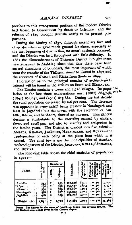
The District contains 7 towns and 1,718 villages.· Its popu- Thelation at the last three enumerations was: (1881) 864, 748, people.(1891) 863,641, and (1901) 815,880. During the last decadethe rural population decreased by 6·6 per cent. The decreasewas apparent in every taNi!, being greatest in Naraingarh andleast in }agadhri; but the towns, with the exception of Am-bala, Biiriya, and Sidhaura, showed an increase. This generaldecline is attributable to the mortality caused by cholera,fever, and small-pox, and also to scarcity and emigration inthe famine years. The Distcict is divided into five ttJIuJ/s-AloIBALA,KHARAR,J-~GADHRI,NARAINGARH,and RUPAR-thehead-quarters of each being at the place from which it isnamed. The chief towns are the municipalities of AIIBALA,the head-quarters of the District, JAGADHRI,RUPAR,SADHAURA,and BURIYA.
The following table shows. the chief statistics of populationin 19°1:-
I! Namberol 'O •• l> • std t r:.'-"'':- 'a.!!'8
d ,U-S J~"HT••/ujt. I .• e Jlili.51 I ~J f·...i! {!. > If tV' z[!
-Ambila. 355 1 295 218,006 61,p 5'4 13,7°1Riipar • 290 1 358 139,327 480'4 5'1 5,·t72Kharar • 37° 2 369 166,267 #9'4 .- 5'7 7,122Naraillgarh . 436 I 317 Igl,042 300-5 7-2 4,ouJagidhri . <loti 2 379 I 1,238 397.1 +4 5,148-- -District total 1,851 7 1,718 815,880 #007 5;6 35,465
NUI'B.-Tbe fi~ (or the ollaMib are take •• (rom I'lltIlJ'llL TIletotal Distriet area ia that &1YeDill the c_
Y2
__ _
_
~
--
--
-
~
About 62 per cent. of the people are Hindus, 30 per cent.Muhammadans, and 7 per cent. Sikhs. In the Rllpar andKharar JaluUs the language is Punjllbi, a HindI patois beingspoken in the rest of the District.
Castes and Jllts or Jats (125,000) are the chief landowning tribe. They
Christianmission ••
Generalagricul-
are divided into two widely different classes, those of the north-ern Jaksils being the fine sturdy type found in the Punjabproper, while to the east and south they are inferior in physiqueand energy. Of the Rajputs (67,000), more than two-thirdsare Muhammadans. The Malis (24,000) and Sainis (26,000)are market.gardening tribes scattered throughout the District,generally as occupancy tenants, though the Sainis hold manyvillages in Rl1par. The Milis are nearly all Hindus, the Sainischiefly Hindus with some Sikhs. The Araios (29,000) arealmost all Muhammadans, the Kambohs (9,000) chieflyHindus or Sikhs. The Glljars (46,000) are divided almostequally 'between Hindus and Muhammadans; they chieflyinhabit the:: Jumna valley and the wild broken tract lyingunder the hills, and own large herds of goats. In this Districtthe Giijars have an undeserved reputation as cattle-thiev~.In the Morni hills, Kanets (2,500), Karis (4,000), and Brih.mans (44.000) are the chief cultivators. The Kanets claim aRajput descent, the Koris are of menial status. The wholeMorni population are a simple, orderly folk, mixing as little aspossible with the people of the plains. The Banias (29,000)are the most important commercial tribe, but there are also7,000 Kbattns. Of the menial tribes may be mentioned theChamars (leather-workers, 113,000), Chuhris (scavengers;32,000), JhInwars (water-carriers, 31,000), Julahlls (weavers,20,000), Kumhiirs (potters, 9,000), Nais (barbers, II,ooO),Tar~ns (carpenters, 19,000), and Telis (oilmen, 12,000).There are 20,000 Shaikhs, 6,000 Saiyids, 16,000 FakIrs, and8,000 Jogis and Riiwals. Of the total population, 51 per cent.are supported by agriculture, 19 per cent. are industrial, 4 percent, commercial, and 3 per cent. professional
The Ludhiana American Presbyterian Mission has stationsat Ambala city and cantonment, both occupied in 1849, without-stations at Jagadhri, Mubiirakpur, Naraingarh, Raipur, andMulana. With a staff of eight missionaries, it supports a highschool, a middle school, a school for Muhammadan girls, twofor Hindu girls, and a hospital for women. The Districtcontained 959 native Christians in 1901.
Every Jaltsi! except Riipar contains a large traCt of hardclay land, which is fit for cultivation only when the rains are
a.bundant. Hence the autumn harvest, which is sown by· aid tural con-of the monsoon rains, is more important than the spring ditions.
harvest. The insecure parts are those in which this heavyclay soil predominates, chiefly in the Ambllla taltsll and in thesouthern quarter of Kharar. The rest of the four taJuilswhich abut on the Himalayas contain, with a certain pro-portion of hilly country, large tracts of good alluvial loam;the RQpar taltsll is practically secure; and such insecurity asthere is in Naraingarh and Jagadhri is due rather to thecharacter of the Rajput inhabitants than to defects of soil orclimate. :The District is intersected by numerous watercourses ,which, though to all appearance dry except after heavy rain, ;constitute a large reserve of moisture, and even in times ofdrought enable fairly good crops to be cultivated along them.
The District is held almost entirely on the pattUJiin' and Chief agri-6/uziyad,iira tenures; but sam1ndan' lands cover about 70 cn
tltt~l
. . than' D" I a IS.,essquare miles, a larger propomon m most lStncts. and princi.The following table shows the main agricultural statistics in pal crops.
1903-4, areas being in square miles;-
TaMil. Total. Cultivated. Impted. CultiYab1ewute.
Ambila . . . 355 :lU 3 38Riipar 290 193 :18 :13Kharar 370 242 :II :18IN~ . . 436 219 5 27.f.06. 267 14 39Jagidhri .
Total 1,857 1,195 71 155
The chief crops of the spring harvest are wheat and gram,which in 1903-4 occupied 309 and ISr square miles respec-tively. Barley covered only 13 square miles. Maize, theprincipal crop in autumn, occupied ISI square miles; thencame rice (lIS), pulses (95), great millet (30), and cotton (43).About 2,000 acres were under poppy. In the Momi hillsma"""'(Eleusine et>TDCQIIa), kltltlU (Do/icMs Itniji(}rus), thetuber IltKlliilu (At'Um col«an'a), and ginger are cultivated.
The area under cultivation increased from 1,171 square Improve-miles in 1890-1 to 1,195 square miles in 1903-4, in which TJ1e~ts;nlatter year it was 64 per cent. of the total area of the District. ~lu-Experiments were carried out in 1887 with a view to intra- practice.
ducing natural khiki-coloured (Nankin) cotton as a staple.The cotton was a fine strong plant with a good fibre, and madeup well as coarse cloth; but Government decided that it couldnot take the place of dyed cotton for army purposes, and the
people preferred the ordinary cotto. j both on account of its. colour and because the Nankin cotton took longer to come to
maturity and yielded a smaller proportion of fibre to seed.More recent experiments have been made with Nagpur,Egyptian, and American colton, the latter with good resultsas regards out-turn. There is a tendency to substitute thecultivation of fine rice for coarse. Loans under the LandImprovement Loans Act are not very popular, the peoplepreferring to borrow money from the village banker. OnlyRs. 1,400 was advanced under this Act during the five yearsending 1904, all for the construction of masonry wells. Loansfor seed and bullocks are readily taken in times of scarcity,when credit with the banker has failed. Rs. 31,000 was thusadvanced during the five years ending 1903-4-
Cattle, The breed of cattle is capable of improvement; but in the~rses, and alluvial lands the .weak borne-bred stock are quite equal to
eep. the work required, and being accustomed to stall-feeding donot, like the stronger cattle imported from the upland tracts,feel the change from grazing in the open. For work in heavyclay soils, or with deep irrigation wells, a finer breed of <:a;ttleis imported. Hissar bulls have been introduced. A ig~d /.deal of horse-breeding is carried on in the District; theDistrict board maintains seven horse anp five donkey stallions.Large .quantities of sheep, pigs, and poultry are kept, thehigh prices obtainable in Simla making poultry especiallyremunerative.
Irrigation. Of the total area cultivated in 19°3-4, 71 square miles, or6 per cent., were irrigated. Of this area, 43 square miles wereirrigated from well's, 3,396 acres from canals, and 23 squaremiles from streams and tanks. The head-works of both theWESTERNJUMNAand SIR-HINDCANALSlie in the District,butit receives no irrigation from the latter. About 2,500 acresare estimated as irrigable annually from the rwPn lnu, of theWeStern Jumna Canal. The District has in use 3,297 masonrywells worked by bullocks, almost all on the rope-and-bucketsystem, even in the riverain tracts; also 2,095 unbrickedwells, lever wells, and water-lif'ts.· The hill torrents afford a
.certain amount of irrigation. Of the crops harvested in1903-4, only 4 per cent. was grown on irrigated land, sugar-cane being the only crop irrigated to any great extent. It is.proposed to add to the programme of famine relief worksprojects for the construction of storage tanks for purposes ofrice irrigation in the clay tracts which largely depend on thatcrop.
The Kalesar 'reserved' forest has an area of about 19 square Forests.miles, lying principally between two low ranges of hills onthe right bank of the J urona. The chief growth is of sai, butebony and other trees are also found. This forest contains nobamboo, but a good deal grows south of it. Near Jagadhri isa C reserved' plantation of slliska", (DaIOergia Sissoo), and atAmbala a military Reserve of nearly 3 square miles forms thegrass farm. The Morni hills are -covered with a dense forestgrowth of scrub mixed with &1111(Pinus IOtlgi/o/ia) and manyother valuable trees,including the luzrrar (Tenninalia Cltelnila),the fruit of which yields a considerable revenue. In 1903-4the total forest revenue was Rs. 2,000.
A good deal of limestone is bumt in the. Momi hills; but Minerals.since 1887 the industry bas been discouraged, as it was foundthat much harm was being done to the forest growth by reck-less cutting for fuel. The. District also possesses some blockkanw quarries, which were largely used when the SirhindCanal was-under constniction; and in the Kharar ta/u;/ mill-stones are prepared. Gold is washed in minute quantities inthe sand of some of the mountain torrents, especially theSombh. 1 /-
Excellent cotton carpets are made at Ambala; and the town Aits andalso possessed four gipning factories with 369 employes in ~aDufac- •
19°4, three cotton presses with 180 employes, and two factories mesoin which cotton-ginning is combined with flour-milling, andwhich between them give employment to 63 hands. Thecantoz:unent has two Bour-mills; one of which was working in1904 and p,veemployment to S4 hands, and a factory forcabinet-making .and coach-building with 195· hands. AtSidhaura there is a cOmbined cotton-ginning and pressingfactory and flour-mill with 5S employes, and at Khinpur acombined cotton-ginning factory and flour-mill with 40, whilethe Kilka-Simla Railway workshops at Kalka give employmentto zoo operatives. A museum of industrial exhibits has re-cently been started in a building erected in memory of the lateQueen-Empress. Rllpar is famous for small articles of iron-work, and a potter in the town enjoys some celebrity for hisclay modelling. The Rllpar canal foundry was closed in 1901.
Kharar produCQ good lacquer-work, and Jagidhri has a well-deserved reputation for its brass-ware. Cotton prints aremade in some villages.
Ambalacity is a considerable grain mart, receiving grain Commerceand cotton from the Phl1lkiin States and Ludhiana, and llDd trade.
exporting them up and down COUDtry. It imports English
cloth and iron from the south, and sal~ wood, and woollen andsilk manufactures from elsewhere; and exports cotton goods,especially carpets. It bas a considerable trade in hill products,such as ginger, turmeric, potatoes, opium, and eka,.as; andSimla and Kasauli are largely supplied from it with variousnecessaries. ROpar is also an important mart for commercebetween the hills and the plains, and has a considerable trafficin grain, sugar, and indigo; salt is imported and sent to thehills in exchange for iron, ginger, turmeric, and potatoes, andcountry cloth is manufactured in the town and exported to thehills. J agidbri ca.mes on a considerable trade in metals,importing copper and iron and exporting the manufacturedproducts. It is also a centre of the borax trade. During theAmerican Civil War, a cotton mart was established at KurAli,where 5 lakbs' worth is still reported to change hands yearly.
Railways The North-Western Railway from Sahiranpur to Lahore andand roads. the Delhi-UmbalJa-Kilka line cross each other at Ambila city,
the latter being· continued by the narrow-gauge K.alka-Sirrlla I.
line. The grand trunk road passes through Ambila, wherethe KAlka road for Simla leaves it. The only other impor-tant metalled roads are from Abdullahpur (via Jagidhri) toChhachhrauli, the capital of the State of Kalsia, and from BQriyato JagAdhri. The total length of metalled roads is 103 miles,and .of unmetalled roads 404 miles. Of these, 87 miles ofmetalled and 32 miles of unmetalled roads are under the PublicWorks department, and the rest are maintained by the Districtboard. Both the Sirhind and Western Jumna Canals arenavigable, taking to a large extent the place of the rivers whichthey drain almost dry except in the summer months. TheJumna is crossed by a ferry, which is replaced in the coldseason by °abridge of boats, and the Sutlej by three ferries.
Famine. Ambila District has only once su6ered from serious faminesince its formation in 1847. This was in 1860-r, when wheatrose to 8 seers a rupee. Regarding the distress inr86~verylittle is recorded. The total number of 0pertollS0 employed onrelief worb was 46,000, and 57,000 received gratuitous relief.Only about Rs. 2,500 was spent from subscriptions, to whichGovernment added as much again. The crops failed in 1884-5and 1890. The famine of 18«)6-7 was due, not so much toany actual failure of the crops in the District (though the springharvest of 1897 was the third poor harvest in succession), as tothe state of the grain market all over India. For monthstogether the prices of all food-grains stood at about 10 seersper: rupee in rwal tracts; and in the towns, when prices were
highest, wheat rose to 7 seers, maize (the staple food of thepeople) and gram to 8 seers; and the District only escapedworse calamities than it actually suffered owing in no smalldegree to the resources of the small capitalists. The greatestdaily average number relieved was 5,279. Rs. 36,600 wasspent from District funds on gratuitous and all other forms ofrelief, and Rs. 15,000 was received from the Indian CharitableFamine Relief Fund. In the famine of 1899-19°0, thoughprices did not rise so high, the crop failure was more complete;there were heavier losses of cattle, and credit was harder toobtain. The greatest daily number relieved did not, however,exceed 816; the expenditure from District funds wasRs.•P76, and from the Charitable Relief Fund Rs. 4.925.
The District is divided f()t' administrative purposes into District5 taltsib: AMBALA,JAGADHRI,NARAINGARH,RUPAR, and dubdi:dKHARAR,the two last forming the Riipar subdivision. Each atd:taksil has a talzsf/tMr and a nai!J...taltsildiir. The District is incharge of a Deputy-Commissioner, aided by· six Assistant orExtra Assistant Commissioners, of whom one is subdivisionalofficer in charge of Riipar, and another is in charge of theDistrict treasury. Ambala is.the head-quarters of the Deputy-Inspector-General of Police, Eastern Range, and of an Execu-tive division of the Public Works department.
The Deputy-Commissioner as District Magistrate is respon- Civilsible for the criminal justice of the District. The civil judicialju~tice andwork is under a District Judge, and both officers are supervised cnme.by the Divisional Judge of the Ambila Civil Division.. Thereare three Munsifs-at head-quarters, Jagidhri, and Rupar.There are also Cantonment Magistrates at Ambila and Kasauli,with an assistant cantonment magistrate at the former place,and seven honorary magistrates. The predomiJW1t forms of .crime are burglary and cattle-theft.
In the revenue history two periods of chaos have to be Landdistinguls.ih~; the first between 1763 and 1809, when the redY~~e
h ,. sed th S' ed d'd . a mIDISSik S ha\'lhg cros e utle) proce ed to iVl e the country tratiou.among themselves and rule it with degrees of extortion whichvaried with the position, necessities, and temperament ofindividual chieftains j the second between 1809 and 1847, theperiod of British protection, when confiscation followed escheat,and So-talled settlement followed either, under conditions sodiverse as to bafile any uniformity of treatment, fiscal orhistorical .. Tll~ summary settlements were invariably pitchedtoo high, the··demand being fixed by simply commuting atcash rates the grain collections made by the Sikhs. The only
_
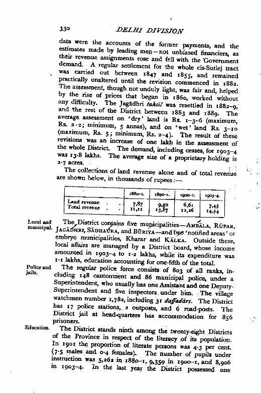
data were the accounts of the former payments, and theestimates made by leading men not unbiased financiers, astht:ir revenue assignments rose and fell with the 'Governmentdemand. A regular settlement for the whole cis-Sutlej tractwas carried out between 1847 and 1855, and remainedpractically unaltered until the revision commenced in 1882.The aSsessment, though. not unduly light, was fair and, helpedby the rise of prices that began in 1860, worked withoutany difficulty, The ]agadhri taksil was resettled in 1882-9,·and the rest of the District between 1883 and 1889' Theaverage assessment on 'dry' land is Rs. 1-3-6 (maximum,Rs, 2-2; minimum,s annas), and on 'wet' land Rs. 3-10(maximum, Rs. 5; minimum, Rs,2-4), The result of theserevisions was an increase of one lakh in the llSse$Sment ofthe whole District. The demand, including cesses, for 1903-4was 13'8 lakhs. The average size of a proprietary holding is2'7 acres. 1
The co1lections of land revenue alone and of total revenueare shown below, in thousands of rupees :-
IlI80-I. 1890"1. I'}OO'"I. 190~"'"
Land revenue 7.87 9.50 6,61 7.45Total reYenue n.II 13,87 12,36 J4,~4
.",I.oeal and The District conpins five mupicipalities--AMBALA, RUPAR,municipal. ]AGAJfuRI,SADHAU"RA,and BURIYA-and 'notified areas' or
embryo municipalities, Khalar and KALKA. Outside these,local affairs are managed by a District board, whose incomeamounted in 1903-4 to 1'2 lakhs, while its expenditure was1'1 lakhs, education aecounting for one--fifthof the total.
Police and The regular police force consists of 803 .of a1l ranks, in-jails. eluding 148 cantonment and 86 municipal POU<:e, under a
Superintendent, who usually has one Assi~ta.ntand one Deputy-Superintendent and five inspectors under hitp, ,The villagewatchmen number 1,782, including 31 tfafftulars. The Districthas 17 police stations, 2 outposts, and 6 road-posts. TheDistrict jail at head-quarters has accommodation for 856prisoners,
Education. The. District stands ninth among the twenty-eight Districtsof the. Province in respect of the literacy of its populatiop..In IQOI th~ prQportian of litexate per$ons was 4'3 per cent,(7'S males and 0'4 females), 'rhenumber of pupils underinstruction was S,262 in r88p-I, 9,359 in I!)OO-I, and 8,900in 19°3-4, In the last year the District .possessed one
-
~
secondary and 99 primary (public) schools, and 3 advancedand 69 elementary (private) schools, with 421 girls in thepublic and. 393 in the private schools. The Mission schoolin Ambala city was the only high school of the District untilGovernment opened one at Jagadhri. The District possessessix girls' schools. The total expenditure on education in1903-4 was 2'4 lakhs, of which the greater part was providedby Imperial and Provincial funds and endowments .
./ T~e Di~rict co~tains a hospital at Ambala city, and ~ven Hosp~tAlsoutlymg dlspensanes. In 1904 a total of 98,679 out-patIents and dl~-
d .. d h . .. d pensanes.an 1,982 m-patlents were treate at t ese mstItutIons, an8,697 operations performed. The aggregate expenditure wasRs. 2I,00~, which was met in nearly equal shares by Districtand munidpal funds, assisted by a grant from Government ofRs. 2,000.' A description of the Pasteur Institute and ResearchLaboratory will be found under KASAULI. There is a leperasyhlm at Ambala under the American Presbyterian Mission .
./The Philadelphia Hospital for women at Ambala is alsounder American management.
The number of successful vaccinations in 1903-4 was 15,708, Vaccina.representing 20 per 1,000 of the population. Vaccination is tion.compulsory in Ambala city and Rupar town.
[A. Kensington, CustfJ1llaryLaw of Ambila .Dis/n"ct (1893),.District Gazetteer. (1892-3), and Settlement Report (1893);J. M. Douie, Set/lemenfReport of KaT1IQ/-Ambala (1891).]Amblla TaIlsi1.-South-western talzs11 of Ambila District,
Punjab, lying between 39° 7' and 30° 27' N. and 76° 33' and77° 12' E., with area of 355 square miles. The populationin 1901 was 218,006, compared with 23°,567 in 1891. Theliead-quarters are at the city of AMBALA(population, 78,638).It also contains 295 villages. The land revenue and cessesaJDounted in 1903-4 to 2·8 lakhs. 'The faksl/ lies in the openplain, and the hard clay subsoil is almost everywhere coveredwith alluvial loam.Rupar Subdivision.-Subdivision of Ambala District, Pun-
jab, comprising the talzsils of RUPAR and KHARAR. Khararcontains the cantonment and sanitarium of KASAULIand the'notifi~_area' 9f KALKA.Ripar TaJu,U.-Northern tahSil of Ambila District, Pun-
~b, lying at the foot of the Himilayas, between 30° 4,5' and31° r3' N. and 76° 19' and 76° 44' E., with an area of290. square: miles. It is bounded on the north by the Sutlejriver, and forms part of the Rupar subd!~on. .On the north-eli-sttbe taMI runs up into the Lower Siwaliks, and along the
! ". -.
-
~
~
Sutlej is a narrow strip of low-lying country. The rest consistsof a loam plateau rich in wells, and intersected by mountaintorrent-beds. The head-works of the SIRHINDCANALare atRupar. The population in 1901 was 139.327, compared with146,816 in 1891. The head-quarters are at the town of RUPAR(population, 8,888). It also contains 358 villages. The landrevenue and cesses amounted in 1903-4 to 2·8lakhs.
Kharar.-Tahsi! of Ambala District, Punjab, lying at thefoot of the Himalayas, between 30° 34' and 30° S6' N. and76° 22' and 76° SS' E., with an area of 370 square miles, andforming part of the Rupar subdi~ion. The population in1901 was 166,267, compared with 176,298 in 1891. It con-tains 369 villages, of which Kharar is the head-quarters. Theland revenue and cesses amounted in 1903-4 to 3'1 lakhs.For administrative purposes the hill station' of KAsAULl(population, 2,192) and the tow.n of KALKA(7,04S) are in-cluded in this talzsi!. The northern part lies in the Siwaliks.Between the hills and the Ghaggar, in the east, is an unhealthytract of jungle and rice-fields. The soil in the centre and westis a fertile loam, which in the south stiffens into clay. Com-munications are everywhere rendered difficult by the torrent·beds which intersect the country.
Naraingarh.-TaAri! of AmbilaDlstrict, Punjab, lying atthe foot of the Himalayas, between 30° 19' and 30° 45' N.and 76° S~' and 77° 19' E., with an area of 436 square miles.The population in 1901 was 131,042, compared with 141,326in 1891. It contains the town of SADHAURA(population,9,812) and 317 villages, of which Naraingarh is the head-.qQarters. The land revenue and cesses amounted in 1903-4to 2'3 lakhs. The tamil includes a tract of hilly country onthe north, culminating in the Karoh peale, 4.919 feet above thesea. The lower hills are devoid of vegetation; and below themcomes a tract of rough stony country much cut up by ravines,the continuous advance of which is a most serious difficultyfor the farmer. The southern half is fairly level.
Jag&dbri Tahsil.- Eastern taMI of Ambila District,Punjab, lying at the foot of the Himilayas, between 30° 2'and 30° 28' N. and 77° 4' and 77° 36' E., with an area of406 square miles. It is bounded on the south-east by theJumna, which separates it from' the United Provinces •. Thepopulation in 1901 was 161,238. compared with 168,634 in1891. It contains the towns OfJ-'GADIiRI(population, 13,462),the head-quarters, and BURlYA(S,86 S); and 379 VIllages. Theland revenue and ·cesses amounted in 1903-4 to 2'9 lakhs.
The faltsll includes a small tract of hilly country in the Siwaliks.On the east lie the Jumna lowlands. The rest is generally levelor gently undulating, and is intersected by torrent-beds.
Manauli.-Estate in the Kharar and Rupar faltsIls ofAmbila District, Punjab, with an area of II square miles. Itwas the principal jagir held till recently by a member of theFaizullahpuria or Singhpuria family, which was' one of thetwelve great Sikh misls or confederacies. Founded earlyin the eighteenth century by Kapilr Singh, a Jat of AmritsarDistrict, the family played a great part in the Jullundur D04bunder his great-nephew, Budh Singh. In 18I1, however, theSinghpurias were expelled from their territories north ofthe Sutlej by RanjIt Singh's generals,imd confined to theestates south of that river, which they still hold From 1809to 1846 the family ranked as independent protected chiefs,but they lost their status in t~e latter year. The last owner,Sardar RaghubIr Singb, held 81 villages injagfr. These yielda net revenue of Rs. 36,000, and the .san/ar had also otherestates. After his death in 1904, the jagir was divided amonga number of his relatives.AmblJa City.-Head-quarters of the District and falts,l
of Amba:la, Punjab, situated in 30° 23' N. and 76° 46' E., on theNorth-Western Railway and the grand trunk road, at the pointwhere they are croSsed by the Delhi-Umballa-Kalka Railway;distant-by rail from CalC1'fta 1.s>77miles, from Bombay 1,105miles, and from Kmchi 848 miles. The population (1901)is 78,638: namely, Hindus, 39,601; Sikh$, 2,168; Muham-madans, $2,149; and Christians, 3,610-of whom 5°,438reside in cantonments. AmbaIa is chiefly im?Ortant as being'Oneof the largestcantonments'ln India. The garrison, whichis under'ihe'Genenifofficer commanding the Lahore division,consists of one battery of horse artillery, with an ammunitioncolumn; one regiment of British and two regiments of nativecavalry; and three regiments of British and one battalion ofnative infantry. The cantonment also contains a mountedinfantry school, companies of the Army Hospital and Bearercorps, and detachments of the Punjab Light Horse and theNorth-Western and East Indian Railway Volunteers.
The native quarter, which has a separate station on the North-Western Railway, lies four miles north-west of the cantonment.Its name is possibly derived from its mythical founder Amba,but is more probably a corruption of AmbwaIa, the 'mangovillage.' It was of no importance before the lapse of theAmbala estate in 1823, when it beCame the residence of
the Political Agent for the Cis-Sutlej States. The cantonmentwas established in 1843, and in 1849 it became the head-quarters of a District. The civil lines are situated nearthe city, and contain, besides the usual offices, a jail and ahospital. The city is well situated as a commercial centre,and is an important cotton and grain market. It also fornlsa dep6t for the supply of Simla, and carries on a considerabletrade in hill products, such as ginger and turmeric. Theartideon AMBALADISTRIcr gives details of the modern industries.A branch of the Alliance Bank of Simla has been establishedin the cantonment.
The municipality was created in 1867. The income. duringthe ten years ending 1902-3 averaged Rs. 56,200, andthe expenditure Rs. 54,3°0. The income in 1903-4 wasRs. 70,700, the chief source being octroi (Rs. 45,200); andthe expenditure was Rs. 71,9°0, the principal items beingdrainage and water-supply (Rs. 22,400), medical (Rs. 8,1dp),
I /'conservancy (Rs. 5,800), education (Rs. 6,100), public Saf~ty(Rs. 7,5°°), and general administration (Rs. 9,400). The in-come and expenditure of the cantonment fund during the tenyears ending 1903-3 averaged 1'3 lakhs. Ambala has threehigh schools and'two middle schools, besides a civil hospital.
Buriya.-Town in the Jagadhri taltsll of Ambala District,Punjab, situated in 30° 10' N. and 77° 22' 'E., 3 miles northof the North-Western Railway. Population (1901~ 5,865.Founded in the time of the emperor Humayl1n, it wascaptured by the Sikhs in 176o, and became the head-quartersof a considerable principality, which, before the treaty of 1809between the British Government and RanjIt Singh, had beendivided into the two chiefships of BUriya.and DOOgarh. Dis-sensions between. the Wid~OWSof the !as.t mal. e holder of thelatter led to its subdivision, ew years after it came underBritish protection, into th tates of Jagadhri and Diiilgarh.Jagidhri lapsed in 1829. The RanI of Dialgarh was one oftlie nine chiefs exempted from the reforms of 1846 and 1849;and she retained her position independent protectedchief until her death in 1852. when DiaIgarh also lapsed.BUriya proW.was reduced to the status of an ordinary jiigfrin 1849,Jthe town is of no commercial importance. Themunicipality was created in 1867. The incOlDeduring the tenyears ending 1902-3 averaged~. 4,300, and the expenditureRs. 5.100: The incqm~ in 1903-4 was Rs. 4.500, chiefly(rom octroi j and the expenditUre Was Rs, 4.4°0. Thereis a vernacular middle school.
~
Jagadbri Town.-Head-quarters of the tahsil of the samename in Ambala District, Punjab, situated in 30° 10' N. and77° 18' E., about 5 miles north of the North-Western Railway,on the metalled road connecting Ambala and Sahir'anpur.Population (1901), 13,462. It owes its importance to the Sikhchief Rai Singh of Buriya, who settled a commercial and manu-facturing population here. The town had been entirelydestroyed by Nldir Shah, but was rebuilt by Rai Singh in1783. It lapsed to the British Government in 1829. Thename is said to be a corruption of Ganga Dhair, so calledfrom a store of Ganges water enshrined in the foundations.Jagldhri is noted for its manufacture of iron and brass-ware.Borax, imported from the hills, is also refined, and oxide of leadmanufactured. The municipality was created in 1867. Theincome during the ten years ending 1902-3 averaged Rs. 24,790,and the expenditure Rs. 24,300. The income in 1903-4 wasRs. 25,700, chiefly' from octroi; and the expenditure wasRs. 25,500. It maintains an ADglo-verl1acular high schooland a dispensary. ;
Kilka.- Town attached for administrative purposes to theKharar tahsil of Amblila District, Punjab, situated in 30° 50' N.and 76° 57' E., at the foot of the outlying range of theHimlilay~s at an eleyation of 2,400 feet, and entirely SUI-
rounded by Patiala territory. It is the junction of the Delhi-Umballa-Klilka and Kalka-Simla Railways. Population (1901),7,045. Kalka was acquired from Patilila in 1843 as a depotfor Simla; it is also an important market for hill produce,such as ginger and turmeric. There is a considerable manu-facture of millstones, and a railway workshop is situated here,which employed 200 hands in 1904- It is administered as a'notified .~-Xasauli.-Hill station and cantonment in the Punjab,
situated in 30° 53' N. and 76° 58' E., entirely surrounded byNative States, but attached for administrative purposes to theK.harar tahsil of Amblila District; It stands on the summit ofthe long ridie overlooking Kalka, at an elevation of 6,335 feetabove the sea; and nearly 4,0.00 feet above Kalka, from whichit is distant about 9 miles. Population (190 I), 2, 192. Kasauliwas founded in 1842 as a military. station, and now serves asa convalescentdepat. It has during the summer monthsa considerable civil population, for whose accomodation hotelshave been built Owing, however, to its nearness to theplains, it is the least attractive in climate of the Punjab hillstations. The management of the station is in the hands of
a Cantonment Magistrate assisted by a cantonment committee;the Cantonment Magistrate proceeds on tour for ten days ineach month of the hot season, and is relieved of the charge ofthe treasury by the Assistant Commissioner in charge of theRllpar subdivision. The Deputy-Commissioner of Ambilaalso resides at Kasauli during part of the hot season. Thereis an Anglo-vernacular middle school. The Lawrence MilitaryAsylum at Sanawar is 3 miles away, in a portion of territoryattached to Simla District. The income and expenditureof cantonment funds during the ten years ending Ig02-3averaged Rs. 13,000.
The Pasteur Institute at Kasauli was established in IgoIfor the treatment of persons bitten by rabid animals, and nowtreats patients from all parts of Northern India. In IgOOa central Research Institute was founded, which will providemeans for the scientific study of the etiology and nature ofdisease in India, in addition to the preparation of curative serafor the diseases of man and the training of scientific workers.The institution is in charge of a Director, with a staff qfassistants. Kasauli is also the head-quarters of the Punjab .Nursing Association, and contains a dispensary. There isa brewery in the neighbourhood.
Riipar Town.-Head-quarters of the subdivision and tahsilof the same name· in Amblla District, Punjab, situated in30° 58' N. and 76° 32' E., at the point where the Sutlej issuesfrom the hills. Population (IgOl), 8,888. It is a town ofconsiderable antiquity, originally called Rtipnagar after itsfounder Ra.jl1 ROp Chand. It was occupied about 1763 byHario Singh, a Sikh chieftain, who seized upon a wide tractsouth of the Sutlej, stretching along the foot of the HimAlayas.In 1792 he divided his estates between his two sons, CharratSingh and Dewa Singh, the former of whom obtained Rtipar.The estates were confiscated in 1846, in consequence of thepart taken by the family during the Sikh War of the precedingyear. The head-works of the Sirhind Canal are situated here,and the town is an important mart of exchange between thehills and the plains. Salt is imported from the Khewramines and re-exported to the hills, in return for iron, ginger,potatoes, turmeric, opium, and ckaras. Cotton twill (sUsi) islargely manufactured, and the smiths of Rl1par have a reputa-tion for locks and other small articles of 'iron~ Rtipar 'was thescene of the celebrated meeting between Lord William Bentinckand Ranjlt Singh in 1831. There are two important religiousfairs, one Hindu, one Muhammadan. The municipality was
created in 1867. The income during the ten years ending1902-3 averaged Rs, 12,100, and the expenditure Rs. II,400.The income in 1903-4 was Rs. 141500, chiefly from octroi;and the expenditure was Rs. 16,900. Th.ere are threeAnglo-vernacular middle schools and a dispensary.
Sadhaura.-Town in the Naraingarh taksU of AmbalaDistrict, Punjab, situated in 30° 23' N. and 77° 13' E., at thefoot of the outlying range of the Himalayas. Population(1901),9,812. It dates from the time of Mahmtld of Ghami,and contains a mosque built in the reign of Shih Jahlin. Afair held yearly at the shrrr.e of the Muhammadan saint, SMhKumais, is attended by 20,000 or 30,000 persons. There issome manufacture of cotton cloth; and the town possessesa' steam printing press, and a combined cotton-ginning andpressing factory, which in 1904 employed 55 hands. Themunicipality was created in 1885. The income during the tenyears ending 1902-3 averaged Rs. 6,800, and the expenditureRs~ 6,4°0. The income in 1903-4 was Rs. 7,3°0, chieflyfram octroi; and the expenditure was Rs. 8,100. There isa vernacular middle school and a dispensary.Sugh (Srughna).-Village in the Jaglidhri taksll of Ambala
District, Punjab, situated in 30° 9' N. and 77° 23' E., in abend of the old bed of the Jumna, now a part of the WesternJumna Canal, close to ]agadhri and BUriya towns. Population(1901), 378. Srughna is mentioned by Hiuen Tsiang, theChinese pilgrim of the seventh century, as a town 31 milesin circuit, the capital of a kingdom and seat of considerablelearning, both Buddhistic and Brahmanical. He describesthe kingdom of Srughna as extending to the mountains on thenorth, and to the Ganges on the east, with the Jumna flowingthrough the midst of it. The capital he represents as havingbeen partly in ruins; but General Cunningham thought thatthere is evidence in· the coins found on the spot to show thatit was occupied down to the time of Muhammadan conquest.He thus describes the extent and position of the ruins :-
I The village of Sugh occupies one of the most remarkablepositions that I have seen during the whole course of myresearches. It is situated on a projecting triangular spur ofhigh land, and is surrounded on three sides by the bed of the'old Jumna, which is now the Western Jumna Canal On thenorth and west faces it is further protected by two deepravines, so that the position is a ready-made stronghold, whichis covered on all sides, except the west, by natural defences.In shape it is almost triangular, with a large projecting fort or
PUN. I. Z