AMALi – the Airborne Mobile Aerosol Lidar for Arctic research
17
Atmos. Chem. Phys., 10, 2947–2963, 2010 www.atmos-chem-phys.net/10/2947/2010/ © Author(s) 2010. This work is distributed under the Creative Commons Attribution 3.0 License. Atmospheric Chemistry and Physics AMALi – the Airborne Mobile Aerosol Lidar for Arctic research I. S. Stachlewska 1,2 , R. Neuber 1 , A. Lampert 1 , C. Ritter 1 , and G. Wehrle 1,3 1 Alfred Wegener Institute for Polar and Marine Research, Telegrafenberg A43, 14473 Potsdam, Germany 2 Institute of Geophysics, Faculty of Physics, University of Warsaw, Pasteura 7, 02-093 Warsaw, Poland 3 Laboratory of Atmospheric Chemistry, Paul Scherrer Institut, 5232 Villigen PSI, Switzerland Received: 30 June 2009 – Published in Atmos. Chem. Phys. Discuss.: 10 September 2009 Revised: 18 March 2010 – Accepted: 25 March 2010 – Published: 29 March 2010 Abstract. The Airborne Mobile Aerosol Lidar (AMALi) is an instrument developed at the Alfred Wegener Institute for Polar and Marine Research for reliable operation under the challenging weather conditions at the Earth’s polar regions. Since 2003 the AMALi has been successfully deployed for measurements in ground-based installation and zenith- or nadir-pointing airborne configurations during several scien- tific campaigns in the Arctic. The lidar provides backscatter profiles at two wavelengths (355/532 nm or 1064/532 nm) to- gether with the linear depolarization at 532 nm, from which aerosol and cloud properties can be derived. This paper presents the characteristics and capabilities of the AMALi system and gives examples of its usage for airborne and ground-based operations in the Arctic. As this backscatter lidar normally does not operate in aerosol-free layers special evaluation schemes are discussed, the nadir-pointing iterative inversion for the case of an unknown boundary condition and the two-stream approach for the extinction profile calculation if a second lidar system probes the same air mass. Also an intercomparison of the AMALi system with an established ground-based Koldewey Aerosol Raman Lidar (KARL) is given. 1 Introduction Backscatter airborne lidar systems have been applied to aerosol studies since the eighties, e.g. the Aerosol Lidar EX- periment (ALEX), developed at the German Aerospace Cen- ter (DLR) based on the elastic detection at 355 nm, 532 nm, 1064 nm (Moerl et al., 1981; Renger et al., 1997) or the Correspondence to: R. Neuber ([email protected]) French airborne lidar LEANDRE measuring the elastic sig- nals at 532 nm and depolarization at 1064 nm (Flamant et al., 2000). With time, significantly smaller, portable systems with modular configurations appeared on the scene. The Lidar Aerosol UltraViolet Aeroporte (LAUVA), developed at the CEA/CNRS, France is an eye-safe system based on 355 nm wavelength which can be installed on an ultralight airplane or a balloon for atmospheric applications (Chazette et al., 2007, 2008) and canopy measurements (Cuesta et al., 2009). The POrtable LIdar System (POLIS) developed at the Meteorological Institute at the University of Munich (MIM LMU) in collaboration with the Ground Truth Cen- ter Oberbayern (GTCO), Germany, has a modular design available for three configurations: two backscatter signals at 355 nm and 532 nm, or backscatter at 355 nm and its Raman nitrogen-shifted signal at 387 nm, or backscatter and depo- larization at 532 nm or 355 nm (Heese et al., 2002, 2004). Airborne lidars have been applied to study clouds, e.g. the Cloud Physics Lidar (CPL), developed at NASA based on 355 nm, 532 nm, 1064 nm elastic detection with depolariza- tion measurements at 1064 nm (McGill et al., 2002, 2003). One of the primary objectives of the Atmospheric Divi- sion at the Alfred Wegener Institute for Polar and Marine Research (AWI), Research Unit Potsdam, is to improve the understanding of the direct and indirect effects of Arctic aerosol and clouds on the climate system. The full assess- ment can only be accomplished by collaborative studies of Arctic aerosol-cloud-climate interactions by combining the experimental data of aerosol and cloud properties obtained from local observatories, field campaigns, and satellite mea- surements (Treffeisen et al., 2004; Yamanouchi et al., 2005) applied together with a regional climate model, especially designed for the Arctic (Dethloff et al., 1996; Rinke et al., 2004). The main focus of the lidar group at the AWI Potsdam Research Unit is to provide the observations of Arctic aerosol Published by Copernicus Publications on behalf of the European Geosciences Union.
Transcript of AMALi – the Airborne Mobile Aerosol Lidar for Arctic research
Atmos. Chem. Phys., 10, 2947–2963, 2010www.atmos-chem-phys.net/10/2947/2010/© Author(s) 2010. This work is distributed underthe Creative Commons Attribution 3.0 License.
AtmosphericChemistry
and Physics
AMALi – the Airborne Mobile Aerosol Lidar for Arctic research
I. S. Stachlewska1,2, R. Neuber1, A. Lampert1, C. Ritter1, and G. Wehrle1,3
1Alfred Wegener Institute for Polar and Marine Research, Telegrafenberg A43, 14473 Potsdam, Germany2Institute of Geophysics, Faculty of Physics, University of Warsaw, Pasteura 7, 02-093 Warsaw, Poland3Laboratory of Atmospheric Chemistry, Paul Scherrer Institut, 5232 Villigen PSI, Switzerland
Received: 30 June 2009 – Published in Atmos. Chem. Phys. Discuss.: 10 September 2009Revised: 18 March 2010 – Accepted: 25 March 2010 – Published: 29 March 2010
Abstract. The Airborne Mobile Aerosol Lidar (AMALi) isan instrument developed at the Alfred Wegener Institute forPolar and Marine Research for reliable operation under thechallenging weather conditions at the Earth’s polar regions.Since 2003 the AMALi has been successfully deployed formeasurements in ground-based installation and zenith- ornadir-pointing airborne configurations during several scien-tific campaigns in the Arctic. The lidar provides backscatterprofiles at two wavelengths (355/532 nm or 1064/532 nm) to-gether with the linear depolarization at 532 nm, from whichaerosol and cloud properties can be derived. This paperpresents the characteristics and capabilities of the AMALisystem and gives examples of its usage for airborne andground-based operations in the Arctic. As this backscatterlidar normally does not operate in aerosol-free layers specialevaluation schemes are discussed, the nadir-pointing iterativeinversion for the case of an unknown boundary condition andthe two-stream approach for the extinction profile calculationif a second lidar system probes the same air mass. Also anintercomparison of the AMALi system with an establishedground-based Koldewey Aerosol Raman Lidar (KARL) isgiven.
1 Introduction
Backscatter airborne lidar systems have been applied toaerosol studies since the eighties, e.g. the Aerosol Lidar EX-periment (ALEX), developed at the German Aerospace Cen-ter (DLR) based on the elastic detection at 355 nm, 532 nm,1064 nm (Moerl et al., 1981; Renger et al., 1997) or the
Correspondence to:R. Neuber([email protected])
French airborne lidar LEANDRE measuring the elastic sig-nals at 532 nm and depolarization at 1064 nm (Flamant et al.,2000). With time, significantly smaller, portable systemswith modular configurations appeared on the scene. TheLidar Aerosol UltraViolet Aeroporte (LAUVA), developedat the CEA/CNRS, France is an eye-safe system based on355 nm wavelength which can be installed on an ultralightairplane or a balloon for atmospheric applications (Chazetteet al., 2007, 2008) and canopy measurements (Cuesta etal., 2009). The POrtable LIdar System (POLIS) developedat the Meteorological Institute at the University of Munich(MIM LMU) in collaboration with the Ground Truth Cen-ter Oberbayern (GTCO), Germany, has a modular designavailable for three configurations: two backscatter signals at355 nm and 532 nm, or backscatter at 355 nm and its Ramannitrogen-shifted signal at 387 nm, or backscatter and depo-larization at 532 nm or 355 nm (Heese et al., 2002, 2004).Airborne lidars have been applied to study clouds, e.g. theCloud Physics Lidar (CPL), developed at NASA based on355 nm, 532 nm, 1064 nm elastic detection with depolariza-tion measurements at 1064 nm (McGill et al., 2002, 2003).
One of the primary objectives of the Atmospheric Divi-sion at the Alfred Wegener Institute for Polar and MarineResearch (AWI), Research Unit Potsdam, is to improve theunderstanding of the direct and indirect effects of Arcticaerosol and clouds on the climate system. The full assess-ment can only be accomplished by collaborative studies ofArctic aerosol-cloud-climate interactions by combining theexperimental data of aerosol and cloud properties obtainedfrom local observatories, field campaigns, and satellite mea-surements (Treffeisen et al., 2004; Yamanouchi et al., 2005)applied together with a regional climate model, especiallydesigned for the Arctic (Dethloff et al., 1996; Rinke et al.,2004). The main focus of the lidar group at the AWI PotsdamResearch Unit is to provide the observations of Arctic aerosol
Published by Copernicus Publications on behalf of the European Geosciences Union.

2948 I. S. Stachlewska et al.: AMALi
and clouds necessary for the modeling activities, and to in-vestigate the properties of the Arctic atmosphere via design-ing, building and operating lidar systems suitable for mea-surements in challenging Arctic conditions. One of these,the Airborne Mobile Aerosol Lidar (AMALi) was developedin 2003 (Stachlewska et al., 2004) and has been success-fully operating, integrated on board the AWI’s Polar 2 re-search aircraft, during several international campaigns. Since2009, the AMALi is also certified for operation on board theAWI’s Polar 5, a Basler BT-67 research aircraft. In 2006,the AMALi was modified. Its modular design allowed tochange the detection wavelengths from the first and the sec-ond Nd:YAG harmonics to the second and third harmon-ics which promised an improved capability for detecting thesmall Arctic Haze aerosol particles. The two exchangableconfigurations are called the IRVIS configuration (based on1064 nm and 532 nm) and the UVVIS configuration (basedon 355 nm and 532 nm). Additionally, after the modificationof the AWI’s Polar 2 and Polar 5 aircraft (opening on theroof), the option of reading out the signals in both analogand photon counting mode was included and airborne oper-ation of the AMALi not only in the nadir-pointing configu-ration but also in the zenith-pointing configuration becamepossible. Data obtained from zenith-pointing airborne mea-surements have a potential to be used in the future for valida-tion of vertical profiles of aerosol and cloud backscatter anddepolarization of the Cloud-Aerosol LIdar with OrthogonalPolarization (CALIOP) on board of the Cloud-Aerosol Lidarand Infrared Pathfinder Satellite (CALIPSO;Winker et al.,2007). Furthermore, it is possible to investigate aerosol lay-ers in the free troposphere as well as midlevel and high cirrusclouds for flights at low altitude.
Before the Arctic campaigns took place, the system wasvalidated and tested during January–April 2004 and August–December 2006 by performing ground based investigationsof the diurnal boundary layer cycle from the AWI’s LidarLaboratory in Potsdam. Additionally, robust constructionand trouble-free operation of the AMALi was proved dur-ing the lidar test flights in April 2004, March 2005 andJuly 2006. This allowed for an airborne investigation of thesea-land aerosol gradients over the north-western coastlineoffshore Bremerhaven. Additionally, after the implementa-tion of the UVVIS configuration the AMALi was operatednext to another AWI lidar, the COMpact Cloud and AerosolLidar (COMCAL; Immler et al., 2006) in vicinity of Bremer-haven, where both lidars observed the same boundary layerand cirrus structures.
The lidar group performed high quality airborne observa-tions of various atmospheric events with the AMALi systemoperated in nadir-pointing IRVIS configuration during theArctic Study of Aerosol, Clouds and Radiation ASTAR 2004and the Svalbard Experiment SVALEX 2005 campaigns inthe Arctic. After the modification, the AMALi was operatedin alternatively nadir- or zenith-pointing UVVIS configura-tion during the ASTAR 2007 and the Pan-Arctic Measure-
ments and Arctic Regional Climate Model IntercomparisonPAM-ARCMIP 2009 campaigns.
The campaigns resulted in several aerosol and cloud stud-ies involving the AMALi system. The attenuated backscatterdata obtained by another ground based lidar and the AMALioverflying it were combined to obtain profiles of extinctionand backscatter coefficient as well as lidar ratio profiles. Thiswas done using the two-stream approach which was com-pared with the corresponding Raman lidar retrievals (Stach-lewska and Ritter, 2010). For the two-stream retrievals aproper selection of the signals from both lidars which mustbe colocated in time and space is crucial (Ritter et al., 2006).The results obtained using the two-stream approach werecompared with the optical depth obtained by sunphotometerand radiosonding profiles and interpreted as clean and pol-luted Arctic conditions by the microphysical parameters re-trieved from the Raman lidar and backward trajectories cal-culated with the HYSPLIT and FLEXPART models (Stach-lewska et al., 2005).
The atmospheric dynamics were investigated using theairborne lidar combined with trajectory models. Aerosolload distributions in the lower troposphere measured bythe AMALi around Svalbard during intense easterly windswere interpreted with the ECMWF model (Stachlewska andDornbrack, 2006a) and further modelling of the extent ofthe local dust plume was simulated with the EULAG model(Dornbrack et al., 2010).
Observations of boundary layer, mixed-phase and multi-layer Arctic clouds were interpreted using meteorology. Theinfluence of the atmospheric state was found to be substan-tial, e.g. even in the free troposphere, multi-layer cloudsformed by a disturbance of the wind field near Svalbard(Lampert et al., 2010). Mixed-phase clouds in the lower tro-posphere were observed during airborne AMALi measure-ments and allowed to guide the aircraft into areas withinthese clouds for measuring in situ their microphysical param-eters (Stachlewska, 2006b; Stachlewska et al., 2006c; Gayetet al., 2007). The boundary layer mixed-phase clouds ob-served by airborne lidar, radiation and in situ instrumentationwere completely frozen at the intersection of two differentair masses in a small band along the air mass mixing zone(Richter et al., 2008). The cloud phase of boundary layermixed-phase clouds was identified based on spectral radia-tion, in situ and airborne lidar measurements. In the predom-inantly liquid cloud top layer also a much smaller amount ofice crystals was found (Ehrlich et al., 2008).
Measurements and simulations of the properties of a sub-visible Arctic ice cloud and its impact on the radiation budgetwere performed. The combined lidar, in situ and radiationinstruments evidenced an ice cloud of very low particle con-centration. Some large ice crystals and more small sphericalice crystals were observed. The radiative impact of the cloudwas calculated as−3.2 W m−2 in the solar wavelength rangeand +2.8 W m−2 in the terrestrial wavelength range (Lampertet al., 2009).
Atmos. Chem. Phys., 10, 2947–2963, 2010 www.atmos-chem-phys.net/10/2947/2010/

I. S. Stachlewska et al.: AMALi 2949
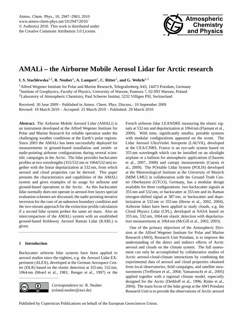
Fig. 1. The AMALi in nadir-pointing airborne configuration on board the Polar 2 aircraft (left) and inzenith-pointing configuration on board the Polar 5 (middle). The main AMALi elements are the opticalassembly (1) with its interior on the right photo, laptop (2), safety breaker box (3), laser control andcooling unit (4), and transient recorders (5).figure
40
Fig. 1. The AMALi in nadir-pointing airborne configuration onboard the Polar 2 aircraft (left) and in zenith-pointing configura-tion on board the Polar 5 (middle). The main AMALi elements arethe optical assembly (1) with its interior on the right photo, lap-top (2), safety breaker box (3), laser control and cooling unit (4),and transient recorders (5).
This paper gives a detailed description of the AMALi lidarand its performance, as well as discusses the routine evalua-tion schemes applied to the airborne data.
2 Instrument description
The AMALi is a small, robust and easy to transport lidar usedfor remote high resolution detection of the vertical and hor-izontal extent of the tropospheric aerosol load and clouds attwo wavelengths and a depolarization at one of them, simul-taneously. The lidar is mounted in two small and portablemodules. The transmitting and receiving subsystems aremounted inside a small (70×50×25 cm), light weight (45 kg)optical assembly (Fig.1). The second module comprisingthe laser control and cooling unit, the laptop, the transientrecorders and the safety breaker box is mounted in a stan-dard size rack (55×50×60 cm). The optical assembly wasspecially designed by the lidar group of AWI Potsdam in away to assure the lowest weight, space and energy consump-tion for the operation on board the Dornier Do 228 researchaircraft Polar 2. The optical assembly was manufactured bySteingross Feinmechanik, Berlin.
All vital lidar parts, i.e. the laser head, the directing op-tics, the receiving mirror and the detector block with its opto-electronic elements are mounted onto the same optical benchinside the optical assembly (Fig.1, right). The single-optical-bench design simplifies the adjustment of all optical elementsand ensures reliable and trouble-free utilization during cam-paigns, without the need of readjustment. The optical benchitself hangs on anti-shock springs attached to four posts. Thesprings eliminate vibrations of the optical bench during theoperation on board the aircraft. The weight and position ofall elements on the optical bench is chosen in a way that thecenter of gravity results in the middle of the optical assem-bly. The four posts together with a base plate form a mas-sive construction providing mechanical stability to the sys-tem. During measurements the optical assembly is coveredwith a sheet metal box capturing any scattered laser light and
Table 1. Technical specifications of the CRF-200, Big Sky Laser,Quantel, Montana, USA. This laser can be used in the AMALi lidarin the IRVIS or the UVVIS configuration.
Parameter[Unit] Value Comment
Maximum altitude for 3000safe operation[m]
Beam diameter[mm] 6Pulse Duration[ns] 11.38Beam divergence[mrad] 2.59(86.5% energy)Pulse repetition frequency[Hz] 15
The IRVIS configuration 2003–2006
Pulse energy at 1064 nm[mJ] 60Pulse energy at 532 nm[mJ] 120
The UVVIS configuration 2006–2009
Pulse energy at 1064 nm 45 absorbed by ceramic(residual)[mJ]] glass absorberPulse energy at 532 nm[mJ] 94Pulse energy at 355 nm[mJ] 15
thereby ensuring the safety of pilots and operators, as wellas protecting the detection system from stray light and back-ground radiation.
The design of AMALi allows vertical measurements innadir- and zenith-pointing configuration on board the Polar 2(Fig. 1, left) and the Polar 5 (Fig.1, middle). When it isoperated at the ground or integrated in a car/ship measure-ments are taken vertically upward. Horizontal observationsare possible for the optical assembly lying on a side. Theassembly is small and light enough to be installed in an ele-vation/azimuth moving platform to perform scans.
2.1 Transmitter subsystem
As a transmitter, a custom designed small rugged and easy tohandle flashlamp pumped Nd:YAG pulsed laser (CRF-200,Big Sky Quantel, Montana, USA) is used (Table1). It is pro-vided with a portable power supply and cooling unit whichis small (12×45×48 cm) and light weight (3 kg). The laser,equipped with frequency doubler and tripler crystals, emitssimultaneously two wavelengths. The double wavelengthbackscatter lidar scheme was chosen for its conceptual sim-pleness ensuring an easy and trouble-free operation duringfield campaigns under tough Arctic weather conditions. Thelaser is cooled with an ethylene glycol and water 1:1 solutionto ensure that the liquid will not freeze while the laser is op-erating in Arctic or at high altitudes. The maximum nominaloperation height for the laser given by the manufacturer is3 km.
In the years 2003–2006 the IRVIS configuration withthe two first harmonics was used, i.e. 1064 nm (ellipti-cal polarization) and 532 nm (linear vertical polarization)
www.atmos-chem-phys.net/10/2947/2010/ Atmos. Chem. Phys., 10, 2947–2963, 2010

2950 I. S. Stachlewska et al.: AMALi
Fig. 2. The AMALi optical assembly with schematically drawn ray-tracking at 532 nm (green) and1064 nm (red). The numbers indicate the main components of the IRVIS configuration in the assembly;1. laser head 2. directing mirror with piezo motor 3. window with Brewster’s angle 4. off-axis parabolicmirror 5. first folding mirror 6. pinhole 7. second folding mirror 8. achromatic lens 9. beam splitter10. interference filter for 1064 nm channel 11. APD for 1064 nm detection 12. interference filter for532 nm channel 13. polarizing cube 14. thin film polarizing filter 15. PMT for perpendicular 532 nmdetection 16. PMT for parallel 532 nm detection 17. optical bench 18. springs 19. posts 20. base plate. Inthe UVVIS configuration the IR detection channel is replaced with the UV detection channel comprisinginterference filter and PMT for 355nm detection. The waveplate and Glan-Taylor polarizer are integratedin the tube guiding the laser pulses through the perforation of the receiving mirror.
41
Fig. 2. The AMALi optical assembly with schematically drawnray-tracking at 532 nm (green) and 1064 nm (red). The numbersindicate the main components of the IRVIS configuration in the as-sembly; 1. laser head 2. directing mirror with piezo motor 3. win-dow with Brewster’s angle 4. off-axis parabolic mirror 5. first fold-ing mirror 6. pinhole 7. second folding mirror 8. achromatic lens9. beam splitter 10. interference filter for 1064 nm channel 11. APDfor 1064 nm detection 12. interference filter for 532 nm channel13. polarizing cube 14. thin film polarizing filter 15. PMT for per-pendicular 532 nm detection 16. PMT for parallel 532 nm detection17. optical bench 18. springs 19. posts 20. base plate. In the UVVISconfiguration the IR detection channel is replaced with the UV de-tection channel comprising interference filter and PMT for 355nmdetection. The waveplate and Glan-Taylor polarizer are integratedin the tube guiding the laser pulses through the perforation of thereceiving mirror.
wavelengths, with 11 ns short light pulses with energies of60 mJ and 120 mJ, respectively, emitted with the pulse rep-etition rate of 15 Hz. At 532 nm the laser beam divergenceδ is 2.6 mrad and the diameter of the laser beam at the laserheadg0 is 6 mm. By the end of 2006 mainly the UVVISconfiguration with the second and third harmonics was used,i.e. linearly polarized 532 nm and linearly polarized 355 nmwavelengths, with 11 ns short light pulses with energies of94 mJ and 15 mJ, respectively, emitted with the pulse repe-tition rate of 15 Hz. The residual energy of the basic wave-length of 1064 nm (less than 45 mJ) is absorbed in the hous-ing box by a white ceramic glass absorber material calledMacor. The field of view in the UV is spherical as in VIS.The exact divergence of the UV pulse was estimated by themanufacturer as 1.5–2.5 mrad, based on the measurement ofthe divergence for the 532 nm.
After the integration of the third harmonic generator crys-tal the linear polarization at 532 nm was found to be poor(above 90%). Therefore, additionally to the dual wavelengthwaveplate (CVI Laser, USA) which rotates the polariza-tion of the 532 nm wavelength to match the polarization ofthe 355 nm wavelength, also a Glan Taylor polarizer (OFR,USA) was included in the optical assembly in the tube which
is guiding the laser pulses through a hole in the telescopemirror. The Glan-Taylor prism acts as a polarization filter,passing only linear polarized light into the atmosphere. Theperpendicular polarization is absorbed in the tube. The wave-plate was adjusted by maximizing the signal at the 532 nmparallel detector and minimizing the signal at the 532 nmperpendicular detector. The Glan Taylor polarizer was thenadjusted to minimize the signal at the 532 nm perpendiculardetector. Although the degree of linear polarization of thetransmitted beam was not measured after the adjustment, weexpect it to be high due to the extinction ratio of the GlenTaylor polarizer of 5×10⁻⁵.
2.2 Receiver subsystem
The optical layout of the receiver is composed of all signalcollecting parts attached to the bottom of the optical bench.As for backscatter lidars, it is not necessary to use a pri-mary mirror that is completely rotationally symmetric, weused an off-axis primary mirror which was cut off a largerparabolic and rotationally symmetric mirror in a way that thefocal point of it is outside the mirror and not in the center ofthe mirror. If we had used a symmetric parabolic mirror wewould have had astigmatism problems. The off-axis mirroritself has a rotationally asymmetric aperture, but the aper-ture stop (pinhole) is rotationally symmetric. This choiceassures a diffraction limited optical system without astigma-tisms and at the same time it allows the lidar dimensions toremain small (size and weight) due to a compact folded opti-cal design. Hence, the use of the off-axis configuration freesthe lidar from astigmatism, while the use of the aspherical,parabolic mirror avoids spherical aberrations.
The backscattered light is collected with the off-axisparabolic mirror coated with protected silver coating(OAP 18-05-04Q, Space Optics Research Labs, USA). Themirror diameter is 10.2 cm and the clear aperture 9.9 cm. Thefocal length is 48.0 cm, while the off-axis distance is 12.7 cm.The accuracy of the mirror’s surface is high. The mirror’sroughness is low with the figure ofλ/10 wave-peak to valley(measured at 632.8 nm over 99% of the clear aperture). Themirror’s shape is good with a slope ofλ/8 waves per inch at90%. The high reflective (near-UV, VIS and near-IR spectra)silver coating is a soft chemical surface with a low durability,damage threshold and likely oxidation tarnishing. Hence, thesilver layer is additionally over-coated with a hard, single, di-electric layer of half-wavelength optical thickness at 550 nm.This protective film arrests oxidation, helps maintain highreflectance, improves the minor abrasions and tarnish resis-tance, while only marginally affecting the optical properties.
The off-axis primary mirror is mounted onto the opticalbench (Fig.2) in a way that the laser light is sent throughits central perforation of 3.1 cm diameter. The planar sec-ondary mirror is mounted on a rod which is also attached tothe optical bench. Similarly, the detector block with its opto-electronic elements, each placed inside one of the detection
Atmos. Chem. Phys., 10, 2947–2963, 2010 www.atmos-chem-phys.net/10/2947/2010/

I. S. Stachlewska et al.: AMALi 2951
module-boxes, is also attached to the optical bench. The lightcollected with the primary mirror is redirected by the firstfolding mirror onto a 1.5 mm pinhole on the detector block.Such a choice of pinhole size together with the parametersof the primary mirror result in 3.1 mrad field of view, nec-essary for the detection of the complete return signal of thestrongly divergent laser beam. After passing the pinhole thelight is redirected using the second plane folding mirror to anachromatic lens used to produce parallel rays while avoidingchromatic aberration.
In the IRVIS configuration signals of both wavelengthsare separated into two different detection channels using adichroic mirror inclined at 45◦ which transmits the 1064 nmand reflected the 532 nm signal. In the UVVIS configuration,a dichroic mirror which transmits the 355 nm and reflects the532 nm signal is used. For both configurations, the latterwavelength is additionally separated into its parallel and per-pendicular component using a polarising cube beam splitterprovided by Laseroptik Garbsen, Germany.
In front of the photo-detectors interference filters (IF) areplaced to reduce the background daylight radiation. Forthe IR channel we used a 1.0 nm wide IF centred around1064 nm and for both VIS channels a 0.15 nm IF centredaround 532 nm. For the UV channel, an IF of 1.0 nm band-width centred around 355 nm was employed. The IF filtersfor 355 nm and 532 nm are provided by Barr, USA, and An-dover Corporation, USA, respectively.
The less intense, perpendicular component of the 532 nmchannel is additionally filtered for cross-talk using a thin filmpolarising filter at a 56◦ angle. For the final installation theposition of the polarizing cube was adjusted in a laboratoryexperiment and fixed in the optimal position to minimize thecross-talk of the two 532 nm detection channels. The adjust-ment was performed in dark conditions using the Nd:YAGlaser itself. The energy of the laser beam was measured be-fore it entered the detection block unit, then consecutivelyafter the beamsplitter, the interference filter, the polarizingcube on the parallel and the perpendicular channels, and fi-nally after the thin film polarizing filter on the perpendicularchannel. Each optical element was successively adjusted andfixed. The cross-talk contribution of the parallel on the per-pendicular channel is 10−3 %, further reduced to 10−6% bythe thin film polarizing filter.
For the detection of the 1064 nm channel a Peltier cooledSi Avalanche Photo-Diode (APD) was used, and Hama-matsu R7400 photomultipliers (PMT) for the detection of the355 nm channel and the two 532 nm channels for the paralleland perpendicular component.
Due to the strongly limited range of the nadir-pointing air-borne signals a high peak of the ground return occurs. How-ever, in the IRVIS configuration, the use of absorptive neu-tral density filters to reduce the intensity of the incominglight was not necessary for analog detection. In the UVVISconfiguration with the more sensitive photon counting mode,neutral density filters were integrated in front of the PMTs
for the 532 nm parallel and the 355 nm signal to avoid sat-uration of the detectors. The optical depths of 1.0 and 0.8,respectively, were chosen in a way that the output voltage ofthe PMTs was not at the limit for more than the first 50 m ofthe lidar signal return.
2.2.1 Detection range limitation
Despite its relatively small size, AMALi in a ground basedconfiguration is powerful enough to cover the range up to thetropopause level but for airborne measurements its range islimited. The detection range in nadir-pointing airborne mea-surement is limited on the one hand by the maximum nomi-nal operation height for the laser (up to 3 km), and the max-imum allowed flight altitude without using oxygen masksby the pilots and scientific crew (up to 3 km for the instal-lation in the Polar 2 and Polar 5 aircraft). On the other handthe minimum flight altitude is imposed by eye-safety con-straints, i.e. 2.4 km for the IRVIS configuration, 2.1 km forthe UVVIS configuration (AppendixA). In zenith-pointingairborne configuration, signals are limited on the one handby the maximum nominal operation height for the laser andthe allowed flight altitude (up to 3 km). On the other handby the maximum detection range which depends on the re-quired signal-to-noise ratio (SNR), thus the integration time,which depends on the altitude of the structures of interest,e.g. for zenith-pointing cloud observations in 4 km altitude,an integration time of 15 s is used.
For the AMALi a SNR of 15 leads to errors of 5% in thedetermination of the backscatter ratio, which is acceptable.The SNR does not vary in time as measurement parametersare not modified, i.e. the laser runs stable and the high volt-age applied to the PMTs is kept unchanged. Hence, both thesignal strength and the SNR are very similar from case tocase. At a SNR of 15 or higher the total error in the retrievalof the backscatter coefficient is not dominated by the noisebut it is dependent on the choice of the the boundary con-dition value, the precision of the atmospheric density profileand the choice of the lidar ratio. When the boundary condi-tion (with the lidar constantC known) can be obtained usingthe iterative method described in this paper and the atmo-spheric density profile is retrieved from radiosonde launch,the choice of the unknown lidar ratio will be the dominantsource of errors for the AMALi retrievals.
2.2.2 Overlap
Considering the laser pulse energy, the pulse repetition rate,the laser beam divergenceδ, the beam diameter at the laserheadg0, and the primary mirror diameterT we chose thepinhole diameters with the constraint to achieve the low-est possible geometric compressionξ (Sect.3) with the low-est integration times for the weakest detection channel dur-ing the airborne nadir-pointing operation (i.e. perpendicular532 nm). To achive this we integrated an overlap-adjustment
www.atmos-chem-phys.net/10/2947/2010/ Atmos. Chem. Phys., 10, 2947–2963, 2010

2952 I. S. Stachlewska et al.: AMALi
module just after the laser head. A planar mirror which ishighly reflective for the two relevant wavelengths is mountedonto a piezo stepper motor at an angle of approximately 45◦.This mirror redirects the laser beam through the opening inthe optical bench on which the laser head is resting and sendsit almost parallel to the optical axis of the receiving telescopemirror. The distance between the telescope optical axis andthe laser beam axisd0 is set to 7.5 mm. Such constructionallows fine adjustments of the overlapξ between the emit-ted laser beam and the telescope’s mirror field of viewϕ.The complete overlap at a full field of view calculated ana-lytically for the smallθ , ϕ andδ angles approximation, fol-lows ξ=
2d0+T +g02θ+ϕ−δ
. For AMALi the overlap is completed ata distanceξmax of 235 m, when the laser beam is not inclined(θ=0). Inclination of the laser beam to the maximum appli-cable inclination angle (θ=
ϕ−δ2 ) of 0.27 mrad results inξmin
of 155 m.
2.3 Data acquisition subsystem
A single laptop computer (TOSHIBA, 2 GHz, CPU 30 GB,HD 256 MB RAM, USB-RS 232) fully controls the laser,transient recorders, detectors, and data acquisition, includ-ing storage, processing, quick-look evaluation and dis-play programs utilizing LabVIEW software. A transientrecorder (TR20-80, LICEL GmbH, Berlin) combining anA/D converter (12 bit at 20 MHz) for analog detection witha 250 MHz fast photon counting system are used. An eth-ernet control module using a TCP/IP protocol allows remotecontrol and data transfer for both photon counting and analogrecorders. Transient recorders register the pulses with a max-imum sampling rate of 20 MHz corresponding to a heightresolution of 7.5 m for one range bin.
In the ground-based configuration the standard ground-based LICEL GmbH data acquisition software is employed.Here, each lidar return signal from each channel is storedseparately at a minimum time average of 1 s. With this stan-dard software the profiles up to the tropopause level can beeasily obtained. For the airborne configurations a custom de-signed airborne LICEL GmbH software is employed. Here,typically each new lidar return signal from each of the threechannels is appended and stored with a temporal integrationof 1 s per profile in a block file of 2 min. However, a resolu-tion as fine as a single-shot acquisition is also possible.
For nadir-pointing measurements the length of collectedsignal was limited to 1000 range bins (7.5 km) to decreasethe time needed for data transfer between transient recorderand the laptop (smaller size of data files). At the same time,this provided sufficient number of bins for the required rangedetermined by the altitude of the flying aircraft for nadir-pointing configuration, i.e. maximum of 3 km a.s.l. For thisshort distance (significantly shorter than the zenith-pointingground based range), a strong signal with SNR above 15 isguaranteed, so that the PMTs can be operated in an ana-log mode only (Goodman, 1985). The measurements in
nadir-pointing airborne configuration generally provide bet-ter SNR at greater distances from the aircraft, as the mea-sured aerosol concentration and the air density increase to-wards the ground. On the other hand, for the airborne appli-cations only short integration times are permissible in orderto achieve a sufficient horizontal resolution. For the avail-able measurement range of 3 km on board the Polar 2, SNRabove 15 is achieved for an integration time of 1 s. This cor-responds to a horizontal resolution between 46 m and 77 mat a minimum of 166 km h−1 and maximum of 278 km h−1
aircraft cruising speed over ground, respectively.
For zenith-pointing airborne applications, the collectedsignal length was set to 1700 bins, which is close to the limitfor data transfer. The detectors are read out simultaneouslyin analog and photon counting mode to increase the mea-surement range and to compensate the effect of the neutraldensity filters which reduce the signal intensity. For the eval-uation of cloud systems, an integration time of 15 s is gener-ally chosen, which results in a SNR above 15 at a distance of4.5 km off the aircraft, and a horizontal resolution of about990 m for the typical cruising speed of 238 km h−1.
During daytime the background stray-light photons arecollected by the receiving subsystem together with thebackscattered laser pulses. Application of the backgroundlight correction to the lidar signals is essential in the polarregions were the background light intensity is unusually highdue to the high albedo of ice and snow covering most of thesea and land. The limited range of the nadir-pointing air-borne signals results in a difficulty to obtain the backgroundlight intensity, which has to be subtracted for any further dataevaluation. To overcome this, the data acquisition is startedby an adjustable pretrigger prior to the laser Q-switch de-signed by the LICEL GmbH especially for the AMALi air-borne applications in the Arctic. The timing of the pretriggerwas initialy chosen as a value of 25 µs corresponding to 500range bins (3.75 km). After 2006 a standard pretrigger de-lay of 20 µs and 5 µs was used for nadir- and zenith-pointingmeasurements, respectively. For the zenith evaluation, thebackground values can in principle be obtained from the sig-nal values at a far range, (if the conditions allow a reliableestimation of the background signal). However, most of thetime the pretrigger is used.
2.4 Quick-look data processing and display
The acquired in flight data can be viewed online using anespecially designed quick-look data evaluation display in thedata acquisition programs (Fig.3). Each second, a screen dis-plays currently measured raw signal profiles. Other screensare frequently updated with time series of background andrange corrected signals at 1064 nm (or 355 nm) and paral-lel 532 nm channels (analog and photon counting modes), allaveraged over 1 s or 15 s. The displays can also representratios of the signals, e.g. the depolarization ratio (532 nm
Atmos. Chem. Phys., 10, 2947–2963, 2010 www.atmos-chem-phys.net/10/2947/2010/

I. S. Stachlewska et al.: AMALi 2953
perpendicular to 532 nm parallel signal) or the color ratio(532 nm to 355 nm signal or 1064 nm to 532 nm signal).
The real time quick-look data evaluation software allowsimmediate qualitative interpretation of the aerosol contentand clouds during the flight. This initial information is suffi-cient for an on board lidar operator to guide another researchaircraft for specific measurements. During ASTAR 2004,these quick-looks acted to guide alternated remote and in situmeasurements. After identification of particularly interestingregions in mixed-phase clouds (indication of height and rel-ative concentration of water droplet and/or ice crystal areas)by lidar, the aircraft descended into the specified sections ofthese clouds to perform the in situ measurements of micro-physcial and optical parameters (Stachlewska et al., 2006c;Gayet et al., 2007). Similarly, during the ASTAR 2007 theAMALi detected a thin, subvisible ice cloud (Fig.3). Theaircraft returned to the location at the altitude indicated bylidar observations, and the in situ sensors probed single icecrystals (Lampert et al., 2009).
3 The AMALi lidar data evaluation
The AMALi lidar provides users with a high quality infor-mation on the existence, altitude distribution, vertical andhorizontal extent, backscatter and depolarization of tropo-spheric aerosols and clouds of a low optical thickness. Itdelivers profiles of the range and background corrected sig-nals, the aerosol backscatter coefficient, and the aerosol par-ticles’ non-sphericity (depolarization information). Finally,by the remedy of additional information or instrumentation,even the extinction coefficients can be retrieved.
The elastic lidar equation, usually used in a form of therange corrected signal (Eq.1), describes the received sig-nal as a function of the atmospheric and system parame-ters, whereby assumptions of quasi-monochromatic coher-ent emitted laser light and instantaneous elastic or inelasticscattering are taken into account, while processes of multiplescattering of light are being neglected (Shimoda, 1986)
S(h,λ)=P(h,λ)h2=Cξ(h)β(h,λ)T 2(h,λ) (1)
whereλ denotes the emitted wavelength andh the distancebetween the lidar and the target particle or molecule. Thedetected signalP(h,λ) is proportional to the intensity of thedetected wavelength dependent backscattered signal at a timet=2h/c. The geometrical efficiency of the detection systemξ(h) is dependent on the geometrical compression (overlapfunction) and vanishes if the solution of the lidar equationis found at the rangehgc where the emitted laser beam is en-tirely seen by the full field of view of the telescope.T (h,λ) isthe transmission of the laser energy through the atmosphere(Eq. 2) andβ(h,λ) andα(h,λ) are the total backscatter andthe total extinction coefficients. When the absorption of theemitted wavelength in the atmosphere is negligible they splitto the molecular termsβmol(h,λ) andαmol(h,λ) due to the
Fig. 3. The real-time quick-look display in the AMALi online software during a zenith-pointing con-figuration on board the Polar 2 aircraft provided the range and background corrected signals at 532 nmwith the corresponding depolarization ratios during the flight. On this day it allowed the observation ofa subvisible ice cloud at 3 km above the flight altitude of 160 m a.g.
42
Fig. 3. The real-time quick-look display in the AMALi online soft-ware during a zenith-pointing configuration on board the Polar 2 air-craft provided the range and background corrected signals at 532 nmwith the corresponding depolarization ratios during the flight. Onthis day it allowed the observation of a subvisible ice cloud at 3 kmabove the flight altitude of 160 m a.g.
Rayleigh scattering on the gaseous constituents of the atmo-sphere and the particle termsβpart(h,λ) andαpart(h,λ) dueto the Lorenz-Mie scattering on aerosols in the atmosphere.
T (h,λ)=exp(−∫ h
h0
α(h,λ)dh) (2)
The terms describing the range independent parameters ofthe lidar system appear in the definition of the lidar instru-mental constantC=P(h0,λ)ε(λ)1hA. The mean number ofphotons in the emitted laser pulseP(h0,λ) corresponds to theintensity of the wavelength dependent laser pulse emitted at atime t0. The spectral efficiency of the detection systemε(λ)
depends on the spectral efficiencies of the photo-detectorsand the spectral transmittance of the optical elements. TheA denotes the effective telescope surface andA/h2 is thesolid angle of signal collection. Finally, the1h describes thespatial resolution of the system, which is determined by thelaser pulse durationτ by definition. In reality it is limited bythe slowest component of the system (detector efficiency ortransient recorder speed) and hence always1h�cτ /2.
www.atmos-chem-phys.net/10/2947/2010/ Atmos. Chem. Phys., 10, 2947–2963, 2010

2954 I. S. Stachlewska et al.: AMALi
The ground based pulse-to-pulse fluctuations of the lidarconstantC have been investigated each time before using theAMALi in the Arctic. The utilized laser has a very low pulse-to-pulse power variability (for 80% energy (NF 8) at 15 Hzlaser power fluctuations between 10−2 to 10−3 were mea-sured). The optical assembly is closed entirely to achieveafter 30 min the thermal stabilization at 35 Celsius (inte-rior warm up due to switching on the laser), which is con-tinuously measured using a temperature sensor (MINIDANTemp 0,1, ESYS GmbH, Berlin). The measurements are ei-ther started after the warm up time or higher errors are ex-pected for the first 30 min. Prior to the Arctic campaigns wetested the variability of the lidar constantC by taking groundbased quasi-horizontal measurements in clear air conditionsafter rain episodes during the night. The measurements wereacquired at an inclination angle of 2.5 degree pointing outfrom the laboratory window over a total 6 h period for twoPMT settings (750 V and 850 V). The range and backgroundcorrected single-shot signals were plotted in a logarithmicscale, and from the slope of the linear fit to these profiles,the values ofC were obtained. The spread of theC valuewas between 3% and 5% for each PMT setting, whereby thelarger spread was obtained for the lower PMT setting. Simi-larly, it was done for a period of about 30 min on one day ofthe single-shot horizontal ground-based measurements per-formed in the Arctic and there theC values spread was about2% for 850 V PMT setting. We calculated theC also usinga method described in Stachlewska and Ritter (2010) and inthis case the spread was from 2.3% to 6.9% at different PMTsettings. Again the largest spread was obtained for the lowestapplied PMT voltage.
The long term power fluctuations of the flashlamp are anissue for regular long term lidar measurements. The AMALiis not used for monitoring of the atmosphere but for appli-cations during dedicated campaigns of a duration of a monthor two at most. Before each campaign the flashlamps are ex-changed and their power fluctuations are considered not to bean issue. The fact that similar lidar constants were measuredin different years with different PMT’s settings show that nomajor change of laser power occurred. The sensitivity varia-tion on the detector’s surfaces was also of no concern. Afterperforming the tests described above no adjustments of theoptical elements were applied during a particular campaign.During the test flights a final set of measurement parame-ters was selected and left unchanged for consistency. As theoptics were not realigned during an entire campaign the posi-tion of the light focus on the detector’s surface also remainedunchanged. After the optical assembly reached the thermalstabilization, there is no effect of the temperature on the op-tics and the alignment, so changes of the lidar constantC
from flight to flight due to alignment were not an issue.The range corrected signal (Eq.1) provides the lidar user
with a qualitative information on the existence and altitudedistribution of aerosols and clouds of a low optical thick-ness. The quantitative information can be obtained via in-
version of the lidar signals and calculation of the profiles ofthe particle backscatterβpart(h,λ) and the particle extinctionαpart(h,λ). The main difficulty of such an inversion is causedby the existence of two unknowns (α and β) in one lidarequation (Eq.1), so that no unique solution can be found.The overview of the solutions applied to invert the AMALisignals is given in Table2.
For the horizontally-pointing ground based AMALi con-figuration we use the slope method (Klett, 1981; Kunz andde Leeuw, 1993) when the assumption of an aerosol rich ho-mogeneous atmosphere can be made (e.g. in the planetaryboundary layer). Then the molecular termsβmol(h,λ) andαmol(h,λ) can be neglected, the changes of the backscattercoefficient in the intervaldh are negligible (d
dhβpart(h)=0)
and the aerosol extinction coefficient can be directly calcu-lated fromαpart(h)=−
12
ddh
S(h). Extinction profiles obtainedwith the slope method from signals averaged over 1 min with7.5 m range resolution (SNR above 15) range from the over-lap to 4 km, horizontaly.
For the slant measurements we use the two-angle or mul-tiangle approach (Sicard et al., 2002; Kovalev and Eichinger,2004; Pahlow et al., 2004) when the atmosphere is stable andcharacterised by a strong stratification.
For the vertically-pointing configuration the assumption ofthe homogeneity of the atmosphere cannot be made. In thiscase we use the Klett-Fernald-Sasano’s backward approach(Klett, 1981, 1985; Fernald, 1984; Sasano et al., 1985).To invert the lidar signals an altitude dependent lidar ratioB(h,λ)=
αpart(h,λ)βpart(h,λ)
is assumed and the equation is solved withrespect to the particle backscatter coefficient. The height in-dependent lidar constantC proves redundant in these cal-culations. The direct measurements of the lidar ratio andits calculations from Mie theory show that the relationshipbetween extinction and backscatter is highly variable, as itstrongly depends on the highly variable size distribution ofthe scattering particles in the atmosphere. A wrong estima-tion of the lidar ratio is a dominant factor, that causes am-biguity in the solution of the classic elastic lidar equation(Kovalev and Eichinger, 2004). The estimation of the range-dependent lidar ratio is challenging unless independent infor-mation on the extinction is obtained by inelastic techniques,e.g. with the Raman method (Ansmann et al., 1990) or theHigh-Spectral-Resolution method (Shipley et al., 1983). Theassumption of the lidar ratio for the iterative airborne ap-proach is discussed on an example of a real data in Sect.5.
The Klett-Fernald-Sasano’s backward inversion is per-formed starting with a point chosen far from the lidar wherethe signals are normalized to the molecular elastic backscat-ter profile at an altitude range where the signal is only causedby the molecular contribution. To obtain theαpart(h,λ) andβpart(h,λ) the profiles of the theαmol(h,λ) andβmol(h,λ)
in the Rayleigh atmosphere are subtracted. They are calcu-lated using the radiosonde data launched in direct vicinitywithin ±2 h from the AMALi measurements. If radiosonde
Atmos. Chem. Phys., 10, 2947–2963, 2010 www.atmos-chem-phys.net/10/2947/2010/

I. S. Stachlewska et al.: AMALi 2955
Table 2. The AMALi retrievals obtained with different measurement configurations and evaluation schemes. The symbols denoteα ex-tinction coefficient,β backscatter coefficient,B lidar ratio,C lidar instrumental constant,T atmospheric transmittance, SNR signal-to-noiseratio, KFS Klett-Fernald-Sassano.
Ground based configuration horizontal slant vertical(or airborne zenith-pointing )
Evaluation method slope multiangle standard backward KFSAssumptions homogeneous atmosphere stable stratification βref in aerosol free layer far
from lidar,B(h)
Retrieval α,β, C α(h),β(h) [α(h)], β(h)
Required SNR 10 15 10Integration time 1 mn 1 mn 1 mnMeasurement range 4 km 10 km tropopauseReferences Klett, 1981
Kunz and Leeuw, 1993Sicard et al., 2002Pahlow et al., 2004
Klett, 1981, 1985Fernald, 1984Sassano, 1985
Airborne configuration nadir-pointing nadir-pointing combinedwith ground basedzenith-pointing KARL
zenith-pointing combinedwith spacebornenadir-pointing CALIPSO
Evaluation method backward KFS withNewton-Raphson iterative
two-stream two-stream
Assumptions T =1 within overlap range,stable knownC, B(h)
βref at arbitrary heightor knowledge ofC
βref at arbitrary heightor knowledge ofC
Retrieval [α(h)], β(h) α(h),β(h),CAMALi ,CKARL α(h),β(h),CAMALi ,CCALIPSORequired SNR 10 15 not determinedIntegration time 1 mn 8 mn not determinedMeasurement range 3 km 650 m–3 km not determinedReferences Stachlewska et al., 2006
Gayet et al. 2007Dornbrack et al. 2010
Kunz, 1987Hugges and Paulson, 1988Stachlewska et al., 2005Ritter et al., 2006Stachlewska and Ritter, 2010
Cuesta and Flamant, 2004Wang et al., 2007
measurements were not available we took molecular profilesof the average atmosphere typical for particular month in NyAlesund (obtained from the local radiosonding climatologydata) or we calculated them from the the standard US atmo-sphere profiles. When cirrus clouds appear in the tropospherethe calculations are calibrated in the cirrus region (Ansmannet al., 1992) and treated with an uniform lidar ratio obtainedby the transmittance method (Chen et al., 2002) applied sep-arately to each cirrus case.
Finally, the unitless backscatter ratio profiles are cal-culated (Eq.3) where the BSR of 1 corresponds to pureRayleigh scattering by the molecules of the air. In the Arc-tic typical values of BSR range from 1.01–1.6 for the clearfree troposphere. For atmosphere polluted with the Arctichaze (Yamanouchi et al., 2005) the BSR reach values up to5 in the free troposphere and up to 10 near the ground. Forthe sea-salt aerosol in the Arctic marine boundary layer theBSR values range from 2 to 4. For Arctic subvisible cloudsthe BSR values reach up to 10, and for optically thick waterclouds they exceed 30.
BSR(h,λ)=βmol(h,λ)+βpart(h,λ)
βmol(h,λ)(3)
The zenith-pointing ground based profiles typically obtainedwith the Klett-Fernald-Sasano’s backward approach are eval-uated for cloudless conditions. With 1 min temporal and7.5 m range resolution these reach the tropopause level. Forthe airborne zenith-pointing profiles the averaging dependson the aim of the measurements and the distance of the struc-tures of interest. For example for the comparison of lidar pro-files with space borne CALIOP, a temporal average of 15 s re-sults in a similar horizontal resolution as the average of threesingle CALIOP profiles of about 1 km. Cirrus clouds up to6 km can be evaluated using this resolution. A 1 min tempo-ral and 7.5 m range resolution results in calculation range upto the Arctic tropopause level.
Measurements of the depolarization ratio provide infor-mation to discriminate between spherical and non-sphericalparticles in the atmosphere and are helpful in distinguishingbetween liquid and solid phase particles. If a lidar systemsimultaneously detects the backscattered light polarized in
www.atmos-chem-phys.net/10/2947/2010/ Atmos. Chem. Phys., 10, 2947–2963, 2010

2956 I. S. Stachlewska et al.: AMALi
parallel and perpendicular direction with respect to the emit-ted laser beam, the total volume depolarization ratio DR,i.e. the depolarization induced by atmospheric particles andmolecules can be obtained (Eq.4).
DR(h,λ)=DRmol(h,λ)+DRpart(h,λ)=Pperp(h,λ)
Ppar(h,λ)(4)
As the detection of both thePperp(h) andPpar(h) signals isdone using two different opto-electronic detection channelscharacterized with a different gain, both signals must be wellcalibrated to provide high quality measurements. This can bedone by instantaneous calibration using the normalization ofthe real signal to the molecular elastic backscatter one in analtitude range where the signal is only caused by the molecu-lar contribution with a known and constant depolarization of0.00376 (Behrendt and Nakamura, 2002). Usually the heightinterval in the free troposphere which appears to be clearest isused for this normalization. However, the molecular depolar-ization ratio depends on the amount of rotational Raman scat-tering detected. The stated value is the minimum ratio. Evena small amount of background aerosol in the free tropospherecan change the depolarization ratio significantly. Various cal-ibration methods are known (Biele et al., 2000; Reichardt etal., 2003; Alvarez et al., 2006; Gimmestad, 2008; Freuden-thaler et al., 2009). For AMALi the relative efficiency factorof both channels (cross-parallel/co-parallel) is determined.The linear particle depolarization ratio (Biele et al., 2000) isretrieved by division of the perpendicular particle backscattercoefficient profile by the parallel particle backscatter coeffi-cient profile. Both backscatter profiles are obtained with theKlett-Fernald-Sassano method with calibration in tropopauseor with the iterative airborne inversion described in this pa-per which is calibrated with known backscatter coefficientvalue near the aircraft. Otherwise we use the calibration inclear air of 1.4% or less (depending on the spectral bandpassof the filter). Normally the cross-talk between the two chan-nels needs to be accounted for but in the AMALi the cross-talk measured experimentally is negligible (10−6% parallelto perpendicular).
4 AMALi and KARL intercomparison
For two measurements taken with two different lidars, at thesame wavelength, time and aim, and with application of thesame profile averaging in time and space, their signal statis-tics can still differ significantly due to differences in the emit-ted laser power and field of view of their receiving telescopes(Matthias et al., 2004). The system intercomparison is cru-cial to assess their ability to obtain the same results when thesame evaluation scheme is applied.
The Koldewey Aerosol Raman Lidar (KARL;Ritter etal., 2004) is a ground based system integrated at the Kold-ewey Station in Ny-Alesund, Spitsbergen (78.9 N, 11.9 E). Itis used for the detection of tropospheric aerosols and water
vapor. During ASTAR 2004 the KARL system employedthe Nd:YAG laser operating with 30 Hz repetition rate atthe three basic harmonics, each with energy around 2 W.The receiving system based on two mirrors uses the smallerone (10.8 cm diameter with FOV of 2.25 mrad) for nearrange measurements from 650 m to 6 km. The larger mirror(30 cm diameter with FOV of 0.83 mrad) is used for far rangemeasurements from 2 km to the lower stratosphere. TheKARL detects the elastic backscatter at 355 nm, 532 nm and1064 nm, the depolarization at 532 nm, and Raman-shiftedwavelengths for nitrogen at 387 nm and 607 nm and for wa-ter vapor at 407 nm and 660 nm. In November 2006 KARLwas modified and during ASTAR 2007 measured with thenew Nd:YAG laser (Spectra Pro 290-50) working at 50 Hzwith 10 W at 355 nm and 532 nm and 20 W at 1064 nm. Anincrease of the energy output by a factor of 5 significantlyimproved the KARL’s data quality (Richter et al., 2008). Af-ter beam widening the laser has an effective divergence of0.5 mrad. With the typically used 10 min integration timeand 60 m height resolution the elastic wavelengths can be an-alyzed up to 25 km altitude under daylight conditions.
The intercomparison measurements of the AMALi and theKARL lidars were performed with both systems operatingsimultaneously at 532 nm in zenith-pointing ground basedconfiguration under the clear-sky weather conditions typi-cally chosen for lidar measurements. Observations were per-formed between 21:30–22:10 UT on 15 June 2004 at theKoldewey Station. The lidars were placed approximately30 m apart to ensure that each laser beam and telescope fieldof view did not overlap. The KARL recorded data up to thetropopause and the AMALi up to 7.5 km. Both signals wereinitially compared by simple division of background andrange corrected signals averaged to the same spatial (60 m)and temporal (5 min) intervals. Afterwards, the backscatterratio profiles were retrieved for both lidars using the Klett-Fernald-Sasano approach with the assumption of a height in-dependent lidar ratio of 30 sr. For this retrieval a calibra-tion value has to be set at the far range from the lidar and inclear atmosphere where the lidar does not detect aerosol par-ticles (Klett, 1981; stable backward solution). As the KARLsystem provides the opportunity to calibrate the signals evenin the stratosphere we used its signals for the initial calibra-tion (with a backscatter ratio value of 1.05) to assure the bestaccuracy of the KARL retrievals. At the altitude 4.8–5 kmwhere the AMALi profiles had a SNR above 15 we obtaineda realistic value of the KARL backscatter ratio of 1.26 andused this value to calibrate the AMALi retrievals. It is worthnoting that although the Arctic is generally considered clearand sparse in aerosol the backscatter ratio 1.05 on that daywould be too low for the free troposphere at 5 km.
The temporal evolution of the backscatter ratio profiles forboth lidars obtained over the whole observation period onthat day is given in Fig.4. On the same figure the profilesintegrated over 20 min intervals (red and green) at 21:30 UTand 21:50 UT as well as the profiles integrated over the entire
Atmos. Chem. Phys., 10, 2947–2963, 2010 www.atmos-chem-phys.net/10/2947/2010/

I. S. Stachlewska et al.: AMALi 2957
measurement period (blue and black) are presented. Theagreement of KARL and AMALi retrievals is very good withdeviations less than 3%. Stronger deviations, up to 30% atthe range below 750 m occur due to the incorrect adjustmentof the KARL’s near-range small mirror on that particular day,i.e. the KARL’s backscatter profiles are strongly underesti-mated in this range. The variability in the backscatter ra-tio values at a layer between 1.4 km and 2.4 km altitude arecaused by passing thin, subvisible clouds, well captured byboth lidars. As seen over a 20 min integration both lidar re-trievals converge, i.e. deviations in this height interval aremainly due to the high temporal and spatial variability ofthese clouds. The condensation in this layer must be dom-inated by small scale processes with a life time shorter than20 min since the averaging of the lidar signals is just suffi-cient to smear them out.
Good agreement of the profiles above the mentionedKARL’s lower range give evidence that both lidars obtain thesame results. Neither lidar display specific problems withthe raw signal. Noise in the signals and/or the detection effi-ciencies of both instruments are of no concern due to the highSNR. The error in the backscatter ratio due to the noise in thedata is negligible (less than 0.01 for KARL at 4.8 km) andbecomes weaker when the SNR becomes stronger, i.e. thecloser it is measured from the lidar. This is also true for theAMALi. All remaining errors due to the choice of the li-dar ratio, the choice of the reference value in the aerosol freestratosphere and the error in the air density profile are greaterthan the error due to noise in the signal. The error due to thelidar ratio assumption is a main error source, but it affectsboth systems in the same way as we used identical and con-stant lidar ratio value of 30 sr (studied in detail bySasano etal., 1985).
Further examples of AMALi and KARL intercomparisonsof the backscatter extinction are discussed inStachlewska etal. (2005); Stachlewska(2006b); Ritter et al.(2006); Stach-lewska and Ritter(2010). The AMALi results were alsocompared with the in situ instrumentation installed on boardof the aircraft for the studies involving various cloud systemsand are discussed inStachlewska et al.(2006c); Gayet et al.(2007); Lampert et al.(2009).
5 Nadir-pointing iterative airborne inversion
The standard Klett-Fernald-Sasano’s backward approachcannot be used straight forward for the data evaluation ofany nadir-pointing airborne elastic lidar measuring alone inthe lower troposphere. The main problem of using this stan-dard scheme arises from the difficulty of providing the cal-ibration value for each of the profiles. The lowermost partof the troposphere is usually rich in turbulent aerosol parti-cles generated by surface winds. In these areas the backscat-ter coefficient is highly variable during the flight and henceit is very difficult to estimate, since the phase function de-
Fig. 4. The comparison of the 532 nm backscatter ratio profiles retrieved from measurements taken be-tween 21:30–22:10 UT on 15 June 2004 for AMALi and KARL. Both lidars operated in zenith-pointingground based configuration and captured subvisible clouds passing above the lidar site at about 1.5–1.8 km. The original data of the color coded pictures have 10 min / 60 m resolution and are interpolatedby the contour routine in Matlab.
43
Fig. 4. The comparison of the 532 nm backscatter ratio profilesretrieved from measurements taken between 21:30–22:10 UT on15 June 2004 for AMALi and KARL. Both lidars operated inzenith-pointing ground based configuration and captured subvisibleclouds passing above the lidar site at about 1.5–1.8 km. The orig-inal data of the color coded pictures have 10 min / 60 m resolutionand are interpolated by thecontourroutine in Matlab.
pendence with height has to be accounted for. It is simi-larly difficult to provide any reference backscatter values inthe lower troposphere due to the lack of aerosol free layers.Also the limited signal range between the flight altitude andground/sea level adds to the signal calibration problem.
Here we present an iterative approach for the calculation ofthe backscatter coefficient profiles from the airborne elasticbackscatter lidar data, independent of the existence of aerosolfree layers or in situ calibration measurements. The applica-tion of this new approach facilitates the retrieval of profilesof calibrated backscatter ratios BSR(h) at any time duringthe whole flight. A typical backscatter coefficient profileobtained with this method is averaged over 15 s with 7.5 mrange resolution and 1 km horizontal resolution for 66 ms−1
aircraft’s cruising speed over ground. Examples of the ap-plication of this method can be found inStachlewska andDornbrack(2006a); Stachlewska et al.(2006c); Gayet et al.(2007); Dornbrack et al.(2010).
To apply the iterative approach one must assume state thatfor a short (few hundred meters) rangehgc over which the ge-ometrical compression is completed (ξ(h ≥ hgc)=1), the as-sumption of a negligible attenuation of the emitted laser lightbetween the flight altitudehf and geometrical compressionhgc is justified (Eq.5).
T[hf ,hgc](h,λ) ≈ 1−(hf −hgc) ·α(hf )<1 (5)
By neglecting the transmittance term the backscatter at thealtitudehgc can be estimated for each time step during the
www.atmos-chem-phys.net/10/2947/2010/ Atmos. Chem. Phys., 10, 2947–2963, 2010

2958 I. S. Stachlewska et al.: AMALi
Table 3. The constraints on the lidar ratio dependent on the air typeand the corresponding errors of the backscatter coefficient calcula-tion using the iterative method.
Arctic air type B(h)=const[sr] 1βpart[m−1sr−1
]
clean 20 ±1.8×10⁻⁷
low aerosol load 25 ±0.3×10⁻⁷
considerable aerosol load 30 ±0.7×10⁻⁷
polluted 35 ±1.4×10⁻⁷
highly polluted 60 ±2.6×10⁻⁷
flight (Eq.6) for known lidar constantC.
β(hgc)>S(hgc)
C(6)
The knowledge ofβ(hgc) for each consecutive profile allowsfor an application of the standard Klett-Fernald-Sasano’sbackward procedure with the following constraints. Thebackscatter coefficient calibration valueβKFS(href) is cho-sen in a far distance from the lidar and it is set in a waythat the value of the backscatter coefficientβKFS(hgc) calcu-lated using the Klett-Fernald-Sasano’s backward inversion atthe height corresponding to the completed geometrical com-pression, matches the estimated value ofβ(hgc). If these donot match, theβKFS(href) is recalculated accordingly to theclassical numerical Newton-Raphson iterative approach forfinding zeros of real valued functions, until the two valuesare the same. Of course the extinction in the overlap regioncan be also estimated to calculate the transmission term ofthe lidar equation. The clearer the atmosphere and the bet-ter αmol is known, the better the transmittance of the layer[hf ,hgc] can be estimated and the error ofβ(hgc) decreases.Hence, the iterative approach provides calibratedβ profilesandα profiles calculated with the uncertainty of the assumedlidar ratioB(h).
This method can be applied to any ground based or air-borne lidar independently of the pointing direction in whichthe lidar beam is sent. It is useful, especially in the caseswhen the calibration value cannot be estimated (lack of anaerosol-free layer) or cannot be provided a priori (from an ad-ditional on board in situ calibration instrumentation, and/oron board horizontal or vertical scanning of the emitted lidarlight is not available). Only two assumptions are made: thestandard Klett solution is applicable and the lidar constantC
is known by calibration (e.g.Stachlewska and Ritter, 2010)or other means.
In the case of the AMALi operated in nadir-pointing modefrom an aircraft in the Arctic we apply the iterative methodas follows:
1. We assume the transmission term is equal unity, asin the Arctic the losses of the AMALi laser signal
due to extinction in its overlap range can be neglected(for an extinction coefficient of 2×10⁻⁵ per meterand 235 m overlap range theexp(−2×2×10−5
×235) =
0.99, i.e. only 1% loss is due to extinction).
2. The backscatter coefficient at the end of the overlap isdirectly determined from Eq. (6) with known lidar con-stantC.
3. The backward Klett-Fernald-Sassano approach isperformed with an arbitrary boundary conditionβKFS(href).
4. With knowledge of the partial derivative∂β(hgc)
∂βKFS(href)the
boundary conditionβKFS(href) is changed in a Newton-Raphson scheme until the value of backscatter in theβKFS(hgc) matches to the value at the end of the over-lap β(hgc). Generally, less than 5 iterative steps are re-quired.
An example of an application of the iterative airborneinversion to obtain the calibrated backscatter ratio profilesalong the flight path for measurement on 19 May 2004during the ASTAR 2004 campaign depicts Fig.5. Thebackscatter ratio profiles were calculated with 15 s tempo-ral resolution corresponding to 1 km spatial resolution. Incase of thick clouds the backscatter ratio could not be re-trieved due to the multiple scattering. For these calcula-tions the AMALi instrumental constantCA was found ex-perimentally for several atmospheric conditions accordingto the methodology described in (Stachlewska and Ritter,2010) from the simultaneous measurements of AMALi andKARL taken during the Koldewey Station overflights. TheCA=1.43(±0.1)×1013 m V m3 sr was obtained for the over-flight at about 09:35 UTC on 19 May 2004. The lidar ra-tio profile obtained at the same time from the KARL datapredominantly showed background values of the lidar ra-tio of 20 sr with a layer of extremely high values of the li-dar ratio of 80 sr at about 1.8 km in an aerosol layer of lo-cal origin. The air mass transport calculated with the Hy-brid Single-Particle Lagrangian Integrated Trajectory (HYS-PLIT) model displayed a non-uniform character, wherebycontamination by anthropogenic aerosol could not be totallyexcluded. Hence, the choice of the appropriate lidar ratiofor calculations along the entire flight was not straight for-ward. We did not use the KARL’s lidar ratio profile as it wasrepresentative only for a local vertical measurement at Ny-Alesund. Multiple inversion layers often observed here andrelated to the complicated orography of the fjord (Dornbracket al., 2010; Stachlewska and Ritter, 2010) cannot be used forthe atmospheric conditions outside the fjord where we tookmost of the measurements during the ASTAR campaigns.
Therefore, a sensitivity study to estimate the error due toassumption of a different lidar ratios was performed. Foreach constraint on the lidar ratio specified in Table3 the error
Atmos. Chem. Phys., 10, 2947–2963, 2010 www.atmos-chem-phys.net/10/2947/2010/

I. S. Stachlewska et al.: AMALi 2959
Fig. 5. The calibrated backscatter ratio profiles (right) retrieved using the iterative method along theflight path (left) on 19 May 2004. The data were obtained by the nadir-pointing airborne AMALi lidarfrom a flight altitude of 2650 m during the ASTAR 2004 campaign. The bottom color scale denotes thechange of the position of the Polar 2 aircraft with time. At about 10:15 the Polar 2 took the north-turnand at about 11:15 the south-turn. The white areas in the backscatter ratio profiles indicate lack of signaldue to overflying mountains (9:21–9:32) or signal saturation in optically thick clouds (remaining).
44
Fig. 5. The calibrated backscatter ratio profiles (right) retrieved using the iterative method along the flight path (left) on 19 May 2004. Thedata were obtained by the nadir-pointing airborne AMALi lidar from a flight altitude of 2650 m during the ASTAR 2004 campaign. Thebottom color scale denotes the change of the position of the Polar 2 aircraft with time. At about 10:15 the Polar 2 took the north-turn and atabout 11:15 the south-turn. The white areas in the backscatter ratio profiles indicate lack of signal due to overflying mountains (09:21–09:32)or signal saturation in optically thick clouds (remaining).
of the backscatter coefficient calculation was obtained. Addi-tional calculations were performed for the height dependentlidar ratio set to 35 sr between 0–1600 m and to 20 sr at 1600–2500 m, for which (within the given uncertainties in Table3)the same values of the particle backscatter coefficient errorswere obtained as for the results calculated with the constantlidar ratios. This sensitivity study shows no significant hin-drance to the iterative calculations when a constant lidar ra-tio is assumed, mainly due to the short integration range ofthe AMALi measurements (maximum 3 km). The accuracyof the backscatter coefficient obtained with the iterative ap-proach is at most1βpart=2.6×10⁻⁷ m−1 sr−1. For compar-ison the accuracy of the molecular backscatter coefficient is1βmol=4.2×10 −8 m −1 sr−1.
The resultant backscatter ratios (Fig.5) were interpretedusing ECMWF operational analyses inStachlewska andDornbrack, 2006aand studied in detail using the high reso-lution numerical model EULAG inDornbrack et al., 2010.For the mentioned AMALi overflight over the KARL at09:35 UTC the extinction and backscatter coefficient profileswere derived from both lidars using the two-stream methodand the Raman method. Their comparison with two moreoverflights in clean and polluted Arctic conditions are dis-cussed inStachlewska and Ritter, 2010.
The uncertainty of the iterative method depends on sev-eral error sources. The assumption of the transmittance termT =1 in the airborne lidar equation permits the estimation ofβ(hgc) over range intervals close to the lidar, i.e. at an al-titude near the aircraft but beyond geometrical compressionof the lidar. In case of the AMALi lidar, for the height cho-
sen just below the maximum value of overlap of 235 m theexpected error for neglecting the transmittance term variesfrom 0.7% for the particle extinction of 0.15×10⁻⁴ m−1 typ-ical for clear Arctic atmosphere (T ≈0.993), up to 2.8% forthe particle extinction of 0.6×10⁻⁴ m−1 for aerosol contam-inated atmosphere (T ≈0.972). The error of the backscattercoefficient depends linearly on the transmission term, so thatany difference betweenT =1 and T=0.97 can be neglected(error 1–3%) for the iterative method. Due to the iterativeapproach the boundary condition can be estimated dependentupon the accuracy of the determination of the lidar constantC (error 2–7%). Hence, only three sources of errors remain.The error due to the choice of the molecular contribution,which is proportional to the air density in our case knownfrom radiosonding (error of about 5%), hence this error isnegligible. The error due to the signal noise in the lidar data,which is also negligible for SNR above 15 (error of about5%). Finally, the error due to the assumption of the lidarratio, which dominates the error budget of the solution, how-ever, as the partial derivative∂β(h)
∂B(h)can be calculated this er-
ror can be estimated (results are given in Table3).
6 Combined nadir-pointing and zenith-pointinginversion
The two-stream method (Kunz, 1987; Hughes and Paulson,1988, revised recently byCuesta and Flamant, 2004; Stach-lewska et al., 2005; Wang et al., 2007; Stachlewska and Rit-ter, 2010) can be applied for two lidars pointing at each
www.atmos-chem-phys.net/10/2947/2010/ Atmos. Chem. Phys., 10, 2947–2963, 2010

2960 I. S. Stachlewska et al.: AMALi
other allowing for the direct calculation of the extinction andbackscatter coefficient profiles, and hence the lidar ratio pro-files. In our case the elastic signals measured by the zenith-pointing ground based KARL are combined with the signalsfrom the nadir-pointing AMALi overflying it. The profilesof the extinction and backscatter coefficients are obtaineddirectly from the colocated in time and space airborne andground based signals by their division (extinction) and mul-tiplication (backscatter). Typically the two-stream profilesare calculated with 8–10 min temporal resolution and 60 mhorizontal resolution. The vertical extent of the profiles isdetermined by the altitudes where the method is applicable,i.e. the atmosphere above the geometrical compression of theground-based zenith pointing lidar and below the geometri-cal compression of the nadir-pointing airborne lidar. The es-sential problem for the proper application of the two-streammethod is the requirement that both lidars must sample thesame atmosphere. The pre-selection of the appropriate sig-nals can be done using the iterative correlation method (Rit-ter et al., 2006). Similarly, the two-stream algorithm has apotential to be applied for each of the time periods whenthe zenith-pointing AMALi crosses the path of the nadir-pointing satellite based CALIOP lidar.
7 Conclusions
The robust construction and trouble-free operation over thepast six years of the AMALi lidar system proved it as anexcellent tool for tropospheric airborne and ground based in-vestigations for Arctic studies. The AMALi data obtainedwith both standard and novel methodology were successfullyimplemented for several aerosol, cloud and atmospheric dy-namics case studies, as mentioned in the introduction, serv-ing a large community of end-users, which are not only “li-darists”. The AMALi has successfully been deployed insix airborne field campaigns and is planned to be involvedduring the upcoming SORPIC (Solar Radiation and PhaseDiscrimination of Arctic Clouds) in April 2010 and follow-up campaigns of PAM-ARCMIP (Pan-Arctic Measurementsand Arctic Regional Climate Model Intercomparison). TheAMALi results were successfully compared with the resultsof the two AWI ground based lidars, the KARL and theCOMCAL, as well as with the in situ instrumentation in-stalled on board of the aircraft for studies involving vari-ous cloud systems. To date, the AMALi has not been com-pared directly to other airborne lidars. However, the techni-cal specifications of the AMALi provide confidence that thissystem is built optimally for cost, size, safety, performance,and potential to obtain good quality results. For examplethe AMAli system has quite a large field of view (10−3 rad)in comparison with other airborne lidars (e.g. 10−4 rad ofthe NASA’s CPL), assuring the eye-safety of the low fly-ing nadir-pointing aircraft. Unlike large and complex three-wavelength airborne lidars (e.g. the DLR’s ALEX) and easily
portable but single-wavelength lidars (e.g. the CEA/CNRS’sLUAVA) the AMALi utilizes two-wavelengths plus depolar-ization scheme (with choice of 355/532 nm or 532/1064 nm)to balance the obtaining of additional information (backscat-ter ratio, color ratio) and keeping the lidar itself small andcompact. Moreover, the modular design of the AMALi op-tical assembly provides an opportunity to integrate an addi-tional module for the detection of the Raman-shifted wave-length (e.g. 387 nm for nitrogen) in the future.
In contrast to most of the airborne evaluation approaches,requiring the difficult assessment of the backscatter coeffi-cient calibration value along the flight in the aerosol richlower troposphere, either by estimating it or by measuringit with additional instrumentation, the iterative calculation ofthe calibration value described in this paper uses the lidarsignal alone. This approach provides calibrated quantitativeinformation on the particle backscatter coefficient, addition-ally to the qualitative range and background corrected signalsprovided typically by airborne lidars. The estimate of thecalibration value at any time during the flight allowed calcu-lation of the backscatter ratio profiles under clear-sky condi-tions, with the assumption of a constant lidar ratio of 20–25 srfor clear Arctic air and 30–35 sr for polluted Arctic air. Theseassumptions were applied to the short range AMALi mea-surements (2.7 km) under a very stable Arctic atmospherewith quasi-uniform air mass transport. For flights where theair mass transport was of non-uniform character and the con-tamination of pollutants was expected at particular altitudes,the height dependent lidar ratio must be assumed. However,the sensitivity studies performed for both types of the re-trievals showed no significant disadvantage, i.e. errors in thebackscatter coefficient of less than 2.6×10⁻⁷ m−1 sr−1 wereobtained.
Appendix A
Eye-safety constraints
To ensure the eye-safety inside the aircraft the AMALi iscovered with a sheet-metal box mounted onto the optical as-sembly. The laser light is sent to the atmosphere through anopening of 15 cm (50 cm) diameter in the floor of the Polar 2(Polar 5) aircraft or through a similar opening in the roof. Inthe latter case, the laser beam is covered by a light metal tubeup to the roof (Fig. 1, middle). Outside the aircraft, a largelaser beam divergence ensures that the laser light is eye-safeat distances off the lidar greater than 2.375 km in the IRVISand 2.1 km in the UVVIS configuration. Safe operation ofthe AMALi is achieved by switching on the laser only afterthe aircraft reaches the minimal operation height and whenthe safety shield is locked and fully covers the laser emittingsubsystem.
The eye-safety calculations were performed for both con-figurations according to the Maximum Permissible Exposure
Atmos. Chem. Phys., 10, 2947–2963, 2010 www.atmos-chem-phys.net/10/2947/2010/

I. S. Stachlewska et al.: AMALi 2961
Table A1. The Maximum Permissible Exposure (MPE) values for the direct exposure of the eye to laser radiation accordingly to theSicherheitstechnischen Festlegungen fur Lasergerate und Anlagen, VDE-Verlag Beuth 1998, ISSN 0178-224X.
Criterion 1 Criterion 2 Criterion 3Emission duration 10−9–10−7 s 10−3–10 s 10−9–10−7 s
Wavelength 315–400 nm 5.6×10³×t0.25Jm−2 5.6×10³
×t0.25Jm−2 –Wavelength 400–550 nm 5×10⁻³ Jm−2 18×t0,75Jm−2 N−0.25
×5×10−3 Jm−2
Wavelength 1050–1150 nm 5×10⁻² Jm−2 90×t0,75Jm−2 N−0.25×5×10−2 Jm−2
(MPE) for direct viewing into the laser beam (SFLA, 1998).Each MPE value of TableA1 depends on the laser specifica-tions given in Table1.
For the IRVIS configuration infrared and visible pulses areemitted from the aircraft flying at the maximum permissiblealtitude of 3 km at the minimal crusing speed of 66 m s−1.For this altitude and the laser beam divergence of 2.6 mradthe laser foot-print on the ground/sea expands to 7.8 m di-ameter and covers a surface of 47.78 m2. For the laser rep-etition rate of 15 Hz the centres of the two following laser-footprints are separated from each other by 4.4 m on theground. Hence, a motionless observer can look into 2 con-secutive laser pulses at most.
The exposure effect of 1064 nm and 532 nm pulses is ad-ditive and the actual exposure for both wavelengths must re-main below the MPE value and satisfy all following criteria:
1. The exposure to one single pulse in the pulse-sequencecannot exceed the MPE value calculated for the di-rect exposure of the eye to the laser pulse. TheMPE1
532=5×10⁻³ Jm−2 and MPE11064=50×10−3 Jm−2.The actual exposure for a 532 nm pulse with energyof 120 mJ isE1
532=2.5×10⁻³ Jm−2, and for a 1064 nmpulse with energy of 60 mJ isE1
1064=1.26×10⁻³ Jm−2.The quotients of the actual exposure and the MPE val-ues are 0.5 for 532 nm and 0.025 for 1064 nm.
2. The mean exposure to the duration of the pulse-sequence cannot exceed the MPE value for a pulse-sequence duration. For exposure durationt of0.13 s (2 pulses at 15 Hz) the MPE2
532=3.97 Jm−2
and MPE21064=19,48 Jm−2. The actual exposure aver-aged for pulse-sequence isE2
532=2.51×10⁻³ Jm−2 andE2
1064=1.26×10⁻³ Jm−2. The quotients of the MPEand the actual exposure are 0.63×10⁻³ for 532 nm and0.06×10−3 for 1064 nm.
3. The exposure to one single pulse in the pulse-sequence cannot exceed the MPE value calculatedfor the first criteria multiplied by the correction fac-tor N−0.25, whereN is number of the pulses in thepulse-sequence. Hence, the MPE3
532=4.2×10⁻³ Jm−2
and MPE31064=42×10−3 Jm−2. The actual exposure
is E3532=2.5×10⁻³ Jm−2 and E3
1064=1.26×10⁻³ Jm−2.The quotients of the MPE and the actual exposure are0.595 for 532 nm and 0.03 for 1064 nm, respectively.
For each criterion the sum of the quotients from bothwavelengths is less than 1 and the eye-safety criteria arepassed. The quotient value obtained for the third criterionis the highest and constrains the AMALi operation. To cal-culate the minimum permissible height for the eye-safe mea-surement the maximum permissible altitude is multiplied bythe square root of the final quotient of the third criterion(0.625), as the exposure intensity is proportional tor−2.Hence, the minimum permissible flight altitude for eye-safeoperation of AMALi in the nadir-pointing IRVIS configura-tion is 2372 m.
For the UVVIS configuration, ultraviolet and visiblepulses are emitted. For 355 nm, the MPE is higher than for532 nm, as the eye is less sensitive in the UV spectrum, andfor the simultaneous exposure the MPE values are not treatedadditively. The exposure is calculated as described for theIRVIS configuration. The exposure of one UV pulse withenergy of 25 mJ results in 1.57×10⁻³ Jm−2 and the averagedexposure is 3 orders of magnitude below the MPE value.Hence, the limitation of operating altitude in UVVIS nadir-pointing configuration results only from eye safety consid-erations of the VIS wavelength. Again, the third criterionis limiting for the eye safety and leads to a minimum flightaltitude of 2070 m.
Acknowledgements.The authors would like to thank the fouranonymous referees and Robyn Schofield who helped us toimprove this manuscript with their valuable comments and contri-butions.
Edited by: A. Minikin
References
Alvarez, J. M., Vaughan, M. A., Hostetler, C. A., Hunt, W. H. andWinker, D. M.: Calibration technique for polarization-sensitivelidars. J. Atmos. Ocean. Technol., 23, 683–699, 2006.
Ansmann, A., Riebesell, M., and Weitkamp, C.: Measurements ofaerosol profiles with Raman lidar, Opt. Lett., 15, 746–748, 1990.
www.atmos-chem-phys.net/10/2947/2010/ Atmos. Chem. Phys., 10, 2947–2963, 2010

2962 I. S. Stachlewska et al.: AMALi
Ansmann, A., Wandinger, U., Riebesell, M., Weitkamp, C., andMichaelis, W.: Independent measurements of extinction andbackscatter profiles in cirrus clouds by using a combined Ramanelastic-backscatter Lidar, Appl. Opt., 31, 7113–7131, 1992.
Behrendt, A. and Nakamura, T.: Calculation of the calibration con-stant of polarization lidar and its dependency on atmospherictemperature, Opt. Express, 10, 805–817, 2002.
Biele, J., Beyerle, G., and Baumgarten, G.: Polarization lidar: Cor-rections of instrumental effects, Optics Express, 7(12), 427–435,2000.
Chazette, P., Sanak, J., and Dulac, F.: New approach for aerosolprofiling with a lidar on board an ultralight aircraft: applicationto the African monsoon, Multidiscipl. Anal. Environ. Sci. Tech-nol., 41, 8335–8341, 2007.
Chazette, P., Sanak, J., Raut, J.-C., and Berthier, S.: Mini-lidarfor balloon-borne and aircraft-borne measurements, 24st Inter-national Laser Radar Conference (ILRC24), 23–27 June 2008,Boulder, CA, USA, 2008.
Chen, W., Chiang, C., and Nee, J.: Lidar Ratio and DepolarizationRatio for Cirrus Clouds, Appl. Optics, 41, 6470–6476, 2002.
Cuesta, J. and Flamant, P. H.: Two-Stream lidar inversion algo-rithm for airborne and satellite validations, in Proceedings of22nd International Laser Radar Conference (ILRC 2004), editedby: Pappalardo, G., and Amodeo, A., ESA SP-561, 1, 471–474,2004.
Cuesta, J., Chazette, P., Sanak, J., Allouis, T., Durrieu, S., Genau,P., Flamant, C., and Flamant, P. H.: New airborne lidar observesforest canopies, SPIE Newsroom, doi:10.1117/2.1200909.1732,2009.
Dethloff, K., Rinke, A., Lehmann, R., Christensen, J.H., Botzet,M., and Machenhauer, B.: Regional climate model of the Arcticatmosphere, J. Geophys. Res., 101(D8), 23401–23422, 1996.
Dornbrack, A., Stachlewska, I. S., Ritter, C., and Neuber, R.:Aerosol distribution around Svalbard during intense easterlywinds, Atmos. Chem. Phys., 10, 1473–1490, 2010,http://www.atmos-chem-phys.net/10/1473/2010/.
Ehrlich, A., Bierwirth, E., Wendisch, M., Gayet, J.-F., Mioche, G.,Lampert, A., and Heintzenberg, J.: Cloud phase identificationof Arctic boundary-layer clouds from airborne spectral reflectionmeasurements: test of three approaches, Atmos. Chem. Phys., 8,7493–7505, 2008,http://www.atmos-chem-phys.net/8/7493/2008/.
Fernald, F. G.: Analysis of atmospheric lidar observations: somecomments, Appl. Opt., 23, 652–653, 1984.
Flamant, C., Pelon, J., Chazette, P., Trouillet, V., Quinn, P., Frouin,R., Bruneau, D., Leon, J.-F., Bates, T., Johnson, J., and Living-stone, T.: Airborne lidar measurements of aerosol spatial distri-bution and optical properties over the Atlantic Ocean during aEuropean pollution outbreak of ACE-2, Tellus, 52B, 662–677,2000.
Freudenthaler, V., Esselborn, M., Wiegner, M., Heese, B., Tesche,M., Ansmann, A., Muller, D., Althausen, D., Wirth, M., Fix, A.,Ehret, G., Knipperts, P., Toledano, C., Gasteiger, J., Garhammer,M, and Seefeldner, M.: Depolarization-ratio profiling at severalwavelengths in pure Saharan dust during SAMUM, Tellus 61B,165–179, 2009.
Gimmestad, G. G.: Reexamination of depolarization in lidar mea-surements, Appl. Opt. 47, 3795–3802, 2008.
Gayet, J.-F., Stachlewska, I. S., Jourdan, O., Shcherbakov, V.,
Schwarzenboeck, A., and Neuber, R.: Microphysical and opti-cal properties of precipitating drizzle and ice particles obtainedfrom alternated lidar and in situ measurements, Ann. Geophys.,25, 1487–1497, 2007,http://www.ann-geophys.net/25/1487/2007/.
Goodman, J. W.: Statistical Optics, J. Wiley & Sons, 1985.Hughes, H. G. and Paulson, M. R.: Double-ended lidar techniques
for aerosol studies, App. Opt., 27, 2273–2278, 1988.Heese, B., Freudenthaler, V., Seefeldner, M., and Wiegner, M.: PO-
LIS - A new POrtable LIdar System for ground-based and air-borne measurements of aerosols and clouds, Proceedings of theInternational Laser Radar Conference, Quebec, Canada, 1, 71–74, 2002.
Heese, B., Freudenthaler, V., Seefeldner, M., and Wiegner, M.: Firstresults from the portable lidar system POLIS, Proceedings of theInternational Laser Radar Conference, Matera, Italy, 1, 79–82,2004.
Immler, F., Beninga, I., Ruhe, W., Stein, B., Mielke, B., Rutz, S.,Terli, O., and Schrems, O.: A new lidar system for the detectionof cloud and aerosol backscatter, depolarization, extinction andfluorescence, Reviewed and Revised Papers Presented at the 23rdInternational Laser Radar Conference (ILRC 2006), 1, 35–38,2006.
Klett, J. D.: Stable analytical inversion solution for processing lidarreturns, Appl. Opt., 20, 211–220, 1981.
Klett, J. D.: Lidar inversions with variable backscatter/extinctionvalues, Appl. Opt., 24, 211–220, 1985.
Kovalev, V. A. and Eichinger, W. E.: Elastic Lidar: Theory, Prac-tice, and Analysis Methods, J. Wiley & Sons, ISBN 0-471-20171-5, 2004.
Kunz, G. J.: Bipath Method as a way to measure the spatialbackscatter and extinction coefficients with lidar, App. Opt., 26,794–795, 1987.
Kunz, G. J. and de Leeuw, G.: Inversion of lidar signals with theslope method, Appl. Opt. 32, 3249–3256, 1993.
Lampert, A., Ehrlich, A., Dornbrack, A., Jourdan, O., Gayet, J.-F., Mioche, G., Shcherbakov, V., Ritter, C., and Wendisch, M.:Microphysical and radiative characterization of a subvisible mi-dlevel Arctic ice cloud by airborne observations - a case study,Atmos. Chem. Phys., 9, 2647–2661, 2009,http://www.atmos-chem-phys.net/9/2647/2009/.
Lampert, A., Ritter, C., Hoffmann, A., Gayet, J.-F., Mioche, G.,Ehrlich, A., Dornbrack, A., Wendisch, M., and Shiobara, M.:Lidar characterization of the Arctic atmosphere during ASTAR2007: four cases studies of boundary layer, mixed-phase andmulti-layer clouds, Atmos. Chem. Phys., 10, 2847-2866, 2010
Matthias, V., Freudenthaler, V., Amodeo, A., Balin, I., Balis, D.,Bosenberg, J., Chaikovsky, A., Chourdakis, G., Comeron, A.,Delaval, A., De Tomasi, F., Eixmann, R., Hagard, A., Komguem,L., Kreipl, S., Matthey, S., Rizi, V., Rodrigues, J. A., Wandinger,U., and Wang X.: Aerosol lidar intercomparison in the frame-work of the EARLINET project. 1. Instruments, Appl. Opt., 43,961–976, 2004.
McGill, M., Hlavka, D., Hart, W., Scott, V. S., Spinhirne, J., andSchmid, B.: Cloud Physics Lidar: instrument description and ini-tial measurement results, App. Opt., 41(18), 3725–3734, 2002.
McGill, M. J., Hlavka, D. L., Hart, W. D., Welton, E. J., and Camp-bell, J. R.: Airborne lidar measurements of aerosol optical prop-erties during SAFARI-2000, J. Geophys. Res., 108(D13), 8493,
Atmos. Chem. Phys., 10, 2947–2963, 2010 www.atmos-chem-phys.net/10/2947/2010/

I. S. Stachlewska et al.: AMALi 2963
doi:10.1029/2002JD002370, 2003.Moerl, P., Reinhardt, M. E., Renger, W., and Schellhase, R.: The
use of the airborne lidar ALEX-F for aerosol tracing in the lowertroposphere, Contr. Atmas. Phys., 45, 403–410, 1981.
Pahlow, M., Kovalev, V. A., and Parlange, M. B.: CalibrationMethod for Multiangle Lidar Measurements Appl. Opt. 43,2948–2956, 2004.
Reichardt, J., Baumgart, R., and McGee, T. J.: Three-signal methodfor accurate measurements of depolarization ratio with lidar,Appl. Opt. 42, 4909–4913, 2003.
Renger, W., Kiemle, C., Schreiber, H. G., Wirth, M., and Morl,P.: Correlative measurements in support of LITE using the air-borne backscatter lidar ALEX, in: Advances in Atmospheric Re-mote Sensing with Lidar, edited by: Ansmann, A., Neuber, R.,Rairoux, P., and Wandinger, U., Springer-Verlag, Berlin, 165–168, 1997.
Richter, A., Gayet, J.-F., Mioche, G., Ehrlich, A., and Dornbrack,A.: Mixed-Phase Clouds in the Arctic, a Synopsis of AirborneLidar, in-Situ, and Albedometer Observations, complemented byMeteorological Analyses, in: Proceedings of 24th InternationalLaser Radar Conference (ILRC 2008), 2, 881–884, 2008.
Rinke, A., Dethloff, K., and Fortmann, M.: Regional climateeffects of Arctic Haze, Geophys. Res. Lett., 31(16), L16202,doi:10.1029/2004GL020318, 2004.
Ritter, C., Kirsche, A., and Neuber, R.: Tropospheric Aerosol Char-acterized by a Raman Lidar over Spitsbergen, in: Proceedings of22nd International Laser Radar Conference (ILRC 2004), editedby: Pappalardo, G. and Amodeo, A., ESA SP-561, 1, 459–462,2004.
Ritter, C., Stachlewska, I. S., and Neuber, R.: Application of thetwo-stream evaluation for a case study of Arctic Haze over Spits-bergen, in: Proceedings of 23nd International Laser Radar Con-ference (ILRC 2006), edited by: Nagasawa, C. and Sugimoto,N., ISBN 4-9902916-0-3, 1, 507–510, 2006.
Ritter, C., Hoffmann, A., Osterloh, L., and Bckmann, C.: Estima-tion of the Liquid Water Content of a low level Arctic wintercloud, in: Proceedings of 43nd International Laser Radar Con-ference (ILRC 2008), 1, 597–582, 2008.
Sasano, Y., Browell, E. V., and Ismail, S.: Error caused by usinga constant extinction/backscattering ratio in the lidar solution,Appl. Opt., 24, 3929–3932, 1985.
Sicard, M., Chazette, P., Pelon, J., Won, J. G., and Yoon, S.-C.:Variational Method for the Retrieval of the Optical Thickness andthe Backscatter Coefficient from Multiangle Lidar Profiles Appl.Opt., 41, 493–502, 2002.
Shimoda, K.: Introduction to Laser Physics, Springer-Verlag BerlinHeidelberg, 1986.
Shipley, S. T., Tracy, D. H., Eloranta, E. W., Trauger, J. T., Sroga,J. T., Roesler, F. L., and Weinman, J. A.: A High Spectral Res-olution Lidar to measure optical scattering properties of atmo-spheric aerosols, Part I: Instrumentation and theory, Appl. Opt.,23, 3716–3724, 1983.
Sicherheitstechnische Festlegungen fur Lasergerate und Anlagen,VDE-Verlag Beuth, ISSN 0178-224X, 1998.
Stachlewska, I. S., Wehrle, G., Stein, B., and Neuber, R.: AirborneMobile Aerosol Lidar for measurements of Arctic aerosols,in: Proceedings of 22nd International Laser Radar Conference(ILRC 2004), edited by: Pappalardo, G. and Amodeo, A.,ESA SP-561, 1, 87–89, 2004.
Stachlewska, I. S., Ritter, C., and Neuber, R.: Application ofthe two-stream inversion algorithm for retrieval of extinction,backscatter and lidar ratio for clean and polluted Arctic air, in:Proceedings of SPIE, 5584, 03/1–03/8, 2005.
Stachlewska, I. S. and Dornbrack, A.: Application of iterative air-borne lidar inversion and its interpretation by means of ECMWFoperational analyses, in: Reviewed and Revised Papers Presentedat the 23rd International Laser Radar Conference (ILRC 2006),1, 471–474, 2006a.
Stachlewska, I. S.: Investigation of tropospheric arctic aerosol andmixed-phase clouds using airborne lidar technique, PhD Thesis,University of Potsdam,opus.kobv.de/ubp/volltexte/2006/698/,2006b.
Stachlewska, I. S., Gayet, J.-F., Duroure, C., Schwarzenboeck, A.,Jourdan, O., Shcherbakov, V., and Neuber, R.: Observations ofmixed-phase clouds using airborne lidar and in-situ instrumen-tation, in: Reviewed and Revised Papers Presented at the 23rdInternational Laser Radar Conference (ILRC 2006), 1, 325–328,2006c.
Stachlewska, I. S. and Ritter, C.: On retrieval of lidar extinction pro-files using Two-Stream and Raman techniques, Atmos. Chem.Phys., 10, 2813–2824, 2010,http://www.atmos-chem-phys.net/10/2813/2010/.
Treffeisen, R., Herber, A., Strom, J., Shiobara, M., Yamanouchi,T., Yamagata, S., Holmen, K., Kriews, M., and Schrems, O.:Interpretation of Arctic Aerosol Properties using Cluster Analy-sis applied to observations in the Svalbard Area, Tellus, 56B(5),457–476, 2004.
Wang, X., Frontoso, M. G., Pisani, G., and Spinelli, N.: Retrievalof atmospheric particles optical properties by combining ground-based and spaceborne lidar elastic scattering profiles, Opt. Ex-press, 15, 6734-6743, 2007.
Winker, D. M., Hunt, B. H., and McGill, M. J.: Initial perfor-mance assessment of CALIOP, Geophys. Res. Lett., 34, L19803,doi:10.1029/2007GL030135, 2007.
Yamanouchi, T., Treffeisen, R., Herber, A., Shiobara, M., Yama-gata, S., Hara, K., Sato, K., Yabuki, M., Tomikawa, Y., Rinke,A., Neuber, R., Schumacher, R., Kriews, M., Strom, J., Schrems,O., and Gernandt, H.: Arctic Study of Tropospheric Aerosol andRadiation (ASTAR) 2000: Arctic haze case study, Tellus, 57B,141–152, 2005.
www.atmos-chem-phys.net/10/2947/2010/ Atmos. Chem. Phys., 10, 2947–2963, 2010