Altjawarra Craton Diamond Project - geoscience.nt.gov.au · EL22543_AeromagAnomalies.xls Appendix 2...
14
ELKEDRA DIAMONDS NL Altjawarra Craton Diamond Project Final Relinquishment Report for EL 22543 (Mount Hogarth) By: Jo Leadbeatter Linda A Tompkins November 19, 2004 Elkedra Report No. 0154 Keywords: Northern Territory, Altjawarra Craton, Diamond Exploration, Magnetics, Elkedra Survey. Map Sheets: 1: 250,000: Sandover River (SF53-08) 1:100,000: Argadargada (6254) Copy To: NTDBIRD, Darwin, Northern Territory Elkedra Diamonds NL Perth library
Transcript of Altjawarra Craton Diamond Project - geoscience.nt.gov.au · EL22543_AeromagAnomalies.xls Appendix 2...

ELKEDRA DIAMONDS NL
Altjawarra Craton Diamond Project
Final Relinquishment Report for
EL 22543 (Mount Hogarth)
By:
Jo Leadbeatter Linda A Tompkins
November 19, 2004
Elkedra Report No. 0154
Keywords: Northern Territory, Altjawarra Craton, Diamond Exploration, Magnetics, Elkedra Survey.
Map Sheets: 1: 250,000: Sandover River (SF53-08) 1:100,000: Argadargada (6254) Copy To: NTDBIRD, Darwin, Northern Territory Elkedra Diamonds NL Perth library

i
Table of Contents
1 Introduction ...........................................................................................................................1
2 Conclusion..............................................................................................................................1
3 Geological setting...................................................................................................................1 3.1 Regional Geology............................................................................................................... 1
3.2 Tenement Geology ............................................................................................................. 1
4 Exploration Completed.........................................................................................................2 4.1 Aeromagnetic Interpretation............................................................................................... 2
4.1.1 Last Hope Palaeo-channel .......................................................................................3
4.2 Surface Sampling ............................................................................................................... 3 4.2.1 Rock chip Sampling ................................................................................................3 4.2.2 Stream Sediment Sampling .....................................................................................3 4.2.3 Loam Sampling .......................................................................................................3
4.3 Drilling ............................................................................................................................... 4 4.3.1 RAB Drilling ...........................................................................................................4
4.4 Manganese Reconnaissance ............................................................................................... 4
5 Laboratory Results................................................................................................................4 5.1 Heavy Mineral Concentrate Analysis................................................................................. 4
5.1.1 Surface Sampling ....................................................................................................5 5.1.2 RAB Drillhole Samples...........................................................................................5
5.2 Mineral Chemistry.............................................................................................................. 5 5.2.1 Surface Sampling ....................................................................................................5
5.3 Geochemistry...................................................................................................................... 6 5.3.1 Rock chip Sampling ................................................................................................6 5.3.2 Loam Sampling .......................................................................................................6 5.3.3 Stream Sediment Sampling .....................................................................................6
6 References ..............................................................................................................................6
List of Tables: Table 1: Summary of surface samples collected Table 1: Summary of surface samples collected Table 2: Summary of RAB drilling results List of Figures: Figure 1: Tenement Map: Area of relinquishment. Figure 2: Aeromagnetic anomalies and palaeodrainage interpretation Figure 3: Surface sample locations Figure 4: Drillhole collar locations Figure 5: Manganese compilation

ii
Appendices:
File number File Description Digital Data File name Appendix 1 Aeromagnetic
anomalies EL22543_AeromagAnomalies.xls
Appendix 2 Geological anomalies – manganese
EL22543_GeologyAnomalies_Manganese.xls
Appendix 3 Surface sample data EL22543_SurfaceSamples_BackgroundMinerals.xls EL22543_SurfaceSamples_Geochemistry.xls EL22543_SurfaceSamples_Indicators.xls EL22543_SurfaceSamples_Locations.xls EL22543_SurfaceSamples_MineralChemistry.xls
Appendix 4 Drillhole data EL22543_Drilling_Collars.xls EL22543_Drilling_CompositeBackgroundMinerals.xlsEL22543_Drilling_CompositeIndicators.xls EL22543_Drilling_CompositeSamples.xls EL22543_Drilling_CompositeSamplesSource.xls EL22543_Drilling_Lithology.xls EL22543_Drilling_MetaData.xls EL22543_Drilling_Surveys.xls
Appendix 5 Library codes Library_Codes.xls

1
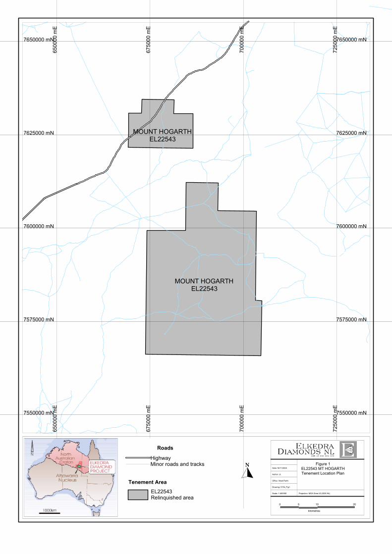
1 INTRODUCTION Exploration License EL 22543 is located on the Sandover River (SF53-08) 1:250,000 sheet in central Northern Territory (Figure 1). This report details all work carried out on the relinquished portion of the tenement up to August 9, 2004 by Elkedra Diamond NL. 2 CONCLUSION Five low priority magnetic anomalies were identified within the northern portion of the relinquished area. Two high-Cr chromites and 1 moderate-Cr chromite was recovered from surface loam and stream sediment samples in the southern portion of the relinquished area from poorly developed drainages. The chromites have similar compositions to those derived from diamondiferous kimberlites. A single-line of RAB holes across a portion of the Last Hope palaeo-channel identified gravels at 5-7m depth. No diamond indicators or diamonds were recovered from the gravel intervals. Several ferruginous surface rock chip samples in the southern area reported elevated Ce, Pb, and As. 3 GEOLOGICAL SETTING 3.1 Regional Geology The Altjawarra diamond project is located on the North Australian Craton, which represents an amalgamated terrain that was consolidated around 1,800 Ma. From a diamond exploration perspective, the significance of the North Australian Craton is that it hosts all of Australia’s diamond mines to date including the recently discovered diamondiferous Merlin kimberlites located on the eastern portion of the North Australian Craton. Of particular importance is the age of the Merlin pipes, which have been dated as Devonian (~380 Ma). Elkedra Diamonds are targeting this same kimberlite event, or younger, in the southern Georgina Basin located south of the Merlin field. The project area incorporates several kilometers of Cambro-Ordovician platform sediments of the southern Georgina Basin, which wholly veneer a basement continental block referred to as the Altjawarra Block. The southern Georgina basin and the underlying Altjawarra Block in particular, are associated with a zone of anomalously thick lithosphere extending to at least 200km depth as recognized from recent seismic tomography studies (Kennett, 1997; Van der Hilst et al., 1998; Debayle and Kennett, 2000). The geophysical data highlight the area as highly prospective for the emplacement of diamond-bearing kimberlites. 3.2 Tenement Geology The relinquished portion of the tenement is underlain predominantly by younger Tertiary and Quaternary sediments.
7550000 mN
7250
00m
E
7650000 mN
7625000 mN
7600000 mN
7575000 mN
7250
00m
E
7000
00m
E70
0000
mE
6750
00m
E
7550000 mN
6750
00m
E
6500
00m
E65
0000
mE
7650000 mN
7625000 mN
7600000 mN
7575000 mN
MOUNT HOGARTHEL22543
MOUNT HOGARTHEL22543
0 5 10
kilometres
20
Projection: MGA Zone 53 (GDA 94)
Figure 1EL22543 MT HOGARTHTenement Location PlanAuthor: JL
Office: West Perth
Drawing: 0154_Fig1
Date:19/11/2004
Scale: 1:500000
Roads
HighwayMinor roads and tracks
Tenement Area
EL22543Relinquished area

2
4 EXPLORATION COMPLETED Exploration activities undertaken include:
1) Processing and targeting for aeromagnetic anomalies off the Elkedra survey. 2) Surface Sampling 3) RAB drilling
4.1 Aeromagnetic Interpretation The release of the Elkedra aeromagnetic survey flown by Tesla Airborne for the NTGS has proved critical in this early stage of exploration and forms the basis of all geophysical work undertaken in the tenement. All aeromagnetic interpretation and processing were undertaken by Dr. Duncan Cowan of Cowan Geodata Services, Perth. The aeromagnetic, altimetric dtm and radiometric data covering the tenement area were windowed out of the Elkedra NTGS dataset. The windowed area was initially analyzed by running the “Smart” filter program of Cowan Geodata Services. The filter is a simple pattern recognition technique developed by Cowan Geodata Services. The program uses regression analysis between a window of the grid data and a typical model anomaly to identify roughly circular anomalies. The model data calculated is a full 3D vertical cylinder implementation. The method involves various inputs to the program including window size, model cylinder radius, top and bottom depths and amplitude response. The filter was run once to test response using a standard 200m diameter cylindrical model with a 30m depth, 400m grid window, and 25-200nT amplitude range. Further data enhancement and preliminary kimberlite target screening was later undertaken using a combination of techniques which included:
• 1D Wavenumber filtering • 2D Euler deconvolution depth calculation • 2D Werner deconvolution depth calculation • Modelling and inversion of individual anomalies
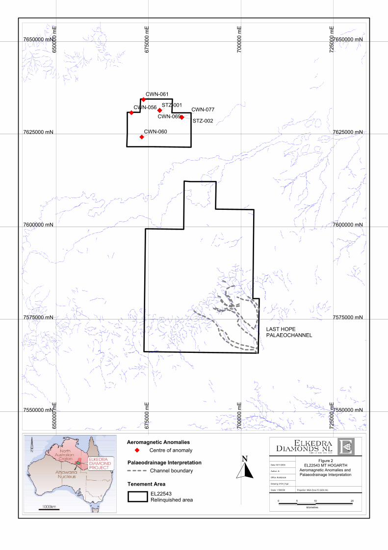
The focus was on identifying possible kimberlite targets in the presence of significant intrasedimentary background noise due to maghemite channels, areas of ferricrete, clay-pans and sinkholes and cultural sources. The altimetric dtm and radiometric data were used to assist in anomaly screening. Identifying possible kimberlite magnetic anomalies in an area of extensive drainage and palaeosurface related magnetic anomalies is difficult due to a high degree of anomaly overlap as well as interference from anomalies due to shallow basement rocks. The relatively wide line spacing of 400-m limits spatial resolution of small sources as small kimberlites located between flight lines may not be detectable or produce only weak magnetic anomalies with magnetic attributes similar to sinkholes etc. No additional anomalies were identified. Five low-priority magnetic anomalies (STZ-001 & CWN-069; STZ-002 & CWN-077 are the same anomalies) were identified (Figure 2; Appendix 1).
CWN-056
CWN-060
CWN-061
CWN-069CWN-077
STZ-001
STZ-002
7550000 mN
7250
00m
E
7650000 mN
7625000 mN
7600000 mN
7575000 mN
7250
00m
E
7000
00m
E70
0000
mE
6750
00m
E
7550000 mN
6750
00m
E
6500
00m
E65
0000
mE
7650000 mN
7625000 mN
7600000 mN
7575000 mN
FIgure 2EL22543 MT HOGARTH
Aeromagnetic Anomalies and Palaeodrainage Interpretation
0 5 10
kilometres
20
Projection: MGA Zone 53 (GDA 94)
Author: JL
Office: Bullsbrook
Drawing: 0154_Fig2
Date:19/11/2004
Scale: 1:500000
Tenement Area
Palaeodrainage Interpretation
Aeromagnetic Anomalies
EL22543Relinquished area
Channel boundary
Centre of anomaly
LAST HOPEPALAEOCHANNEL
3
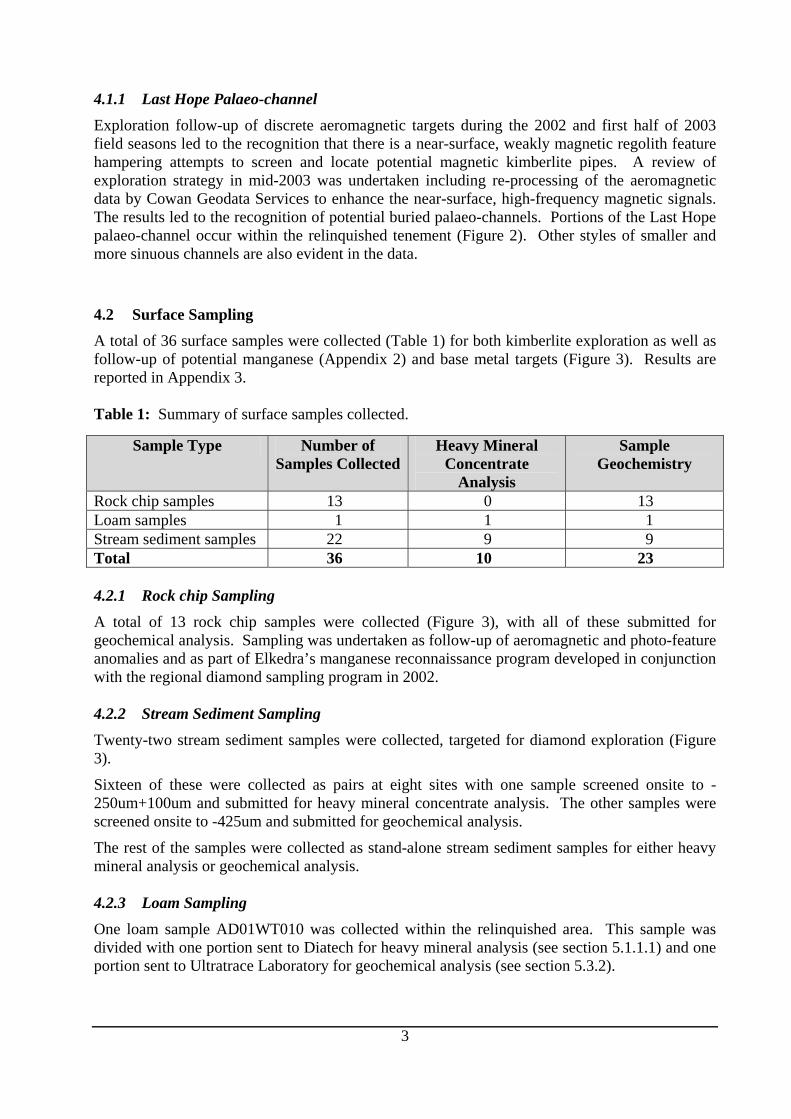
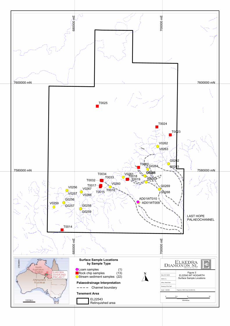
4.1.1 Last Hope Palaeo-channel Exploration follow-up of discrete aeromagnetic targets during the 2002 and first half of 2003 field seasons led to the recognition that there is a near-surface, weakly magnetic regolith feature hampering attempts to screen and locate potential magnetic kimberlite pipes. A review of exploration strategy in mid-2003 was undertaken including re-processing of the aeromagnetic data by Cowan Geodata Services to enhance the near-surface, high-frequency magnetic signals. The results led to the recognition of potential buried palaeo-channels. Portions of the Last Hope palaeo-channel occur within the relinquished tenement (Figure 2). Other styles of smaller and more sinuous channels are also evident in the data. 4.2 Surface Sampling A total of 36 surface samples were collected (Table 1) for both kimberlite exploration as well as follow-up of potential manganese (Appendix 2) and base metal targets (Figure 3). Results are reported in Appendix 3. Table 1: Summary of surface samples collected.
Sample Type Number of Samples Collected
Heavy Mineral Concentrate
Analysis
Sample Geochemistry
Rock chip samples 13 0 13 Loam samples 1 1 1 Stream sediment samples 22 9 9 Total 36 10 23 4.2.1 Rock chip Sampling A total of 13 rock chip samples were collected (Figure 3), with all of these submitted for geochemical analysis. Sampling was undertaken as follow-up of aeromagnetic and photo-feature anomalies and as part of Elkedra’s manganese reconnaissance program developed in conjunction with the regional diamond sampling program in 2002. 4.2.2 Stream Sediment Sampling
Twenty-two stream sediment samples were collected, targeted for diamond exploration (Figure 3).
Sixteen of these were collected as pairs at eight sites with one sample screened onsite to -250um+100um and submitted for heavy mineral concentrate analysis. The other samples were screened onsite to -425um and submitted for geochemical analysis.
The rest of the samples were collected as stand-alone stream sediment samples for either heavy mineral analysis or geochemical analysis. 4.2.3 Loam Sampling One loam sample AD01WT010 was collected within the relinquished area. This sample was divided with one portion sent to Diatech for heavy mineral analysis (see section 5.1.1.1) and one portion sent to Ultratrace Laboratory for geochemical analysis (see section 5.3.2).
7600000 mN
7580000 mN
7000
00m
E70
0000
mE
6800
00m
E68
0000
mE
7600000 mN
7580000 mN
G0269
G0262
G0263
G0268
V0263
T0023
T0024
V0262
G0265
AD01WT010
G0264
G0266
G0267
T0020
AD01WT009
V0261T0018
T0019V0260
T0033
T0015 T0016
T0025
T0034
T0032
T0017V0267
G0258
V0266
G0259
G0256
T0014
V0256
G0257
V0257
V0259
0 2.5 5
kilometres
10
Projection: MGA Zone 53 (GDA 94)
Figure 3EL22543 MT HOGARTH
Surface Sample LocationsAuthor: JL
Office: West Perth
Drawing: 0154_Fig3
Date:19/11/2004
Scale: 1:250000
Surface Sample Locationsby Sample Type
Loam samples (1)Rock chip samples (13)Stream sediment samples (22)
Palaeodrainage Interpretation
Tenement Area
Channel boundary
EL22543Relinquished area
LAST HOPEPALAEOCHANNEL

4
4.3 Drilling Drilling was undertaken to test a portion of the Last Hope palaeo-channel (Figure 4). All drilling results are presented in Appendix 4. 4.3.1 RAB Drilling Eight shallow RAB holes were drilled for 54m as part of a traverse across the interpreted Last Hope Palaeo-channel. Within the relinquished area only two holes intersected buried gravels, ERB0116 (5-6m) and ERB0118 (6-7m). Results are summarized in Table 2. Table 2: Summary of RAB drilling results.
Hole No. Target Total Depth (m)
Comments
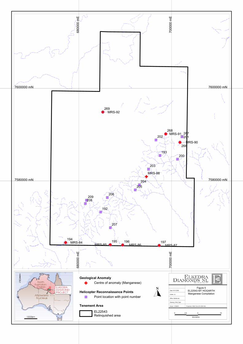
ERB-0111 Last Hope 7 No gravels encountered. ERB-0112 Last Hope 6 No gravels encountered ERB-0113 Last Hope 5 No gravels encountered ERB-0114 Last Hope 6 No gravels encountered ERB-0115 Last Hope 6 No gravels encountered ERB-0116 Last Hope 9 Gravels at 5-6m. ERB-0117 Last Hope 6 No gravels encountered ERB-0118 Last Hope 9 Gravels at 6-7m Total 54 The gravel intervals from two RAB holes within the relinquished area, and two RAB holes not included in this area, were screened to -5mm in the field and composited into one sample (A101554) for heavy mineral concentrate analysis. 4.4 Manganese Reconnaissance Following early ground based reconnaissance work in other areas, a more systematic reconnaissance helicopter assisted program was undertaken for manganese (Figure 5) in tandem with the diamond exploration surface sampling program. Targets were generated from Landsat images and radiometric data. Several areas of interest are noted within the relinquished tenement (MRS localities in Figure 5; Appendix 2). 5 LABORATORY RESULTS 5.1 Heavy Mineral Concentrate Analysis Sampling for heavy mineral concentrate analysis included surface sampling (Table 1) and downhole composite sampling from RAB drilling. Indicator mineral results are given in Appendices 3 and 4.

7600000 mN
7580000 mN
7000
00m
E
6800
00m
E68
0000
mE
7600000 mN
7580000 mN
ERB0112
ERB0111
ERB0113
ERB0114
ERB0115
ERB0116
ERB0117
ERB0118
0 2.5 5
kilometres
10
Projection: MGA Zone 53 (GDA 94)
Figure 4EL22543 MT HOGARTHDrillhole Collar LocationsAuthor: JL
Office: West Perth
Drawing: 0154_Fig4
Date:19/11/2004
Scale: 1:250000
Drillhole Collar Location by Hole Type
RAB Drilling (8)
Tenement Area
Palaeodrainage Interpretation
EL22543Relinquished area
Channel boundary
LAST HOPEPALAEOCHANNEL
268267
193200
201
266
197
203
202
204205
269
192
194 195 196
206
207
208209
MRS-91
MRS-88
MRS-90
MRS-87
MRS-92
MRS-84 MRS-85 MRS-86
7600000 mN
7580000 mN
7000
00m
E70
0000
mE
6800
00m
E68
0000
mE
7600000 mN
7580000 mN
0 2.5 5
kilometres
10
Projection: MGA Zone 53 (GDA 94)
Figure 5EL22543 MT HOGARTHManganese CompilationAuthor: JL
Office: Bullsbrook
Drawing: 0154_Fig5
Date:19/11/2004
Scale: 1:250000Tenement Area
Helicopter Reconnaissance Points
Geological Anomaly
EL22543Relinquished area
Point location with point number
Centre of anomaly (Manganese)

5
5.1.1 Surface Sampling
5.1.1.1 Loam Sampling The loam sample was processed at the Diatech Laboratory in Perth. Material was screened at -0.8mm and heavy mineral concentrate routinely observed down to +0.3mm size fraction. The -0.25 to +0.1mm fraction underwent fusion for microdiamond recovery. Results were negative with no indicator minerals or diamonds recovered. 5.1.1.2 Stream Sediment Sampling All of the samples were processed at the Diatech Laboratory in Perth. Material was screened at -0.8mm and heavy mineral concentrate routinely observed down to +0.3mm size fraction. The -0.25 to +0.1mm fraction was processed at KDC Laboratory for microdiamond recovery. Chromites were recovered from AD01WT009 (3 grains), G0262 (1 grain) and V0256 (1 grain). 5.1.2 RAB Drillhole Samples The gravel intervals from the RAB holes were sent to Striker’s laboratory Perth for processing. The -1.0+0.2mm macrofractions and the -0.2+0.1mm microdiamond fractions were processed with the +1mm material retained pending positive results of the finer fractions. Striker completed observation of the microdiamond fraction. The macrofraction was sent to Global Diamond Exploration Services for observing. No diamond indicators or diamonds were reported by either laboratory. 5.2 Mineral Chemistry 5.2.1 Surface Sampling Mineral chemical analytical work and grain identification was carried out by Dr. Wayne Taylor using a JEOL 6400 analytical SEM at the Centre for Microscopy and Microanalysis, University of Western Australia. High precision element analyses on recovered chromite grains were undertaken by Dr. Wayne Taylor using a Cameca SX-50 electron microprobe at the Electron Beam Laboratory, CSIRO Division of Exploration and Mining, ARRC, Bentley, WA. Results are presented in Appendix 3. Individual chromite grains are classified based on internal textures as observed in polished grains under the microscope. Textural classification includes smooth, crack/mosaic, pitted/porous, lamellar, and lattice. The lamellar and lattice textured grains are characterized by the presence of two interfingering chromite types (exsolution domains) whereas all other grains are composed of one chromite type. Two of the three grains recovered are high-Cr chromites with 61 wt% Cr2O3 and moderate (12 wt%) Al2O3 in G0262 and 59 wt% Cr2O3 and low Al2O3 of 9 wt% in WT009. These grains are kimberlitic and compositionally similar to chromites reported from diamondiferous kimberlites elsewhere. The third chromite has moderate Cr2O3 values of 52 wt% and higher Al2O3 values of 17 wt%. Such chromites may also be sourced from kimberlites.

6
5.3 Geochemistry 5.3.1 Rock chip Sampling The rock chip samples were analysed at Ultratrace Laboratories. Multi-elements were typically analysed by four acid digest with either an MS or OES finish, while oxides were analysed by XRF. Au was analysed by aqua regia digest with an MS finish. Several ferruginous-manganiferous rock-chip samples reported elevated values of Ce, Pb, As or S. Sample T0032 reported 403ppm Ce, 320ppm Pb and 700ppm S. Sample T0023 contained 430ppm Ce, 509ppm Pb, 480ppm S and 5ppb Au. The highest Pb value was from ferruginous rock chip sample T0014 with 1,600 ppm Pb. Samples T0015 and T0016 reported 180ppm and 100ppm As, respectively. 5.3.2 Loam Sampling The loam sample was sent to Ultratrace Laboratory where multi-element analysis was carried out by a variety of methods to test for effectiveness. Methods included four acid digest with MS or OES finish, XRF, fusion with MS or OES finish, aqua regia digest with MS finish.
No significant geochemical results reported from the loam sample. 5.3.3 Stream Sediment Sampling AD01WT009 was sent to Ultratrace Laboratory where multi-element work was carried out using fusion and four acid digest with MS or OES finishes. The rest of the stream sediment samples were submitted to Genalysis where multi-element work was carried out using four acid digest with MS or OES finishes. No significant geochemical results reported from the stream sediment samples. 6 REFERENCES Debayle, E. and Kennett, B.L.N. (2000) The Australian continental upper mantle: Structure and deformation inferred from surface waves. Journal of Geophysical Research, 105B11, 25423-25450. Kennett, B.L.N. (1997) The mantle beneath Australia. AGSO Journal of Australian Geology & Geophysics, 17(1), 49-54. Van der Hilst, R.D., Kennett, B.L.N. and Shibutani, T (1998) Upper mantle structure beneath Australia from portable array deployment. In: J. Braun et al, editors. Structure and Evolution of the Australian Continent. 39-57.