ALQUIST PRIOLO EARTHQUAKE FAULT ZONING...
17
ALQUIST‐PRIOLO EARTHQUAKE FAULT ZONING ACT by William A. Bryant California Geological Survey Surface Fault Displacement Hazard Workshop U.C. Berkeley May 20‐21, 2009 Photo by W. Bryant
-
Upload
truongdiep -
Category
Documents
-
view
233 -
download
6
Transcript of ALQUIST PRIOLO EARTHQUAKE FAULT ZONING...
ALQUIST‐PRIOLO EARTHQUAKE FAULT ZONING ACT
by
William A. Bryant
California Geological Survey
Surface Fault Displacement Hazard Workshop U.C. Berkeley
May 20‐21, 2009 Photo by W. Bryant
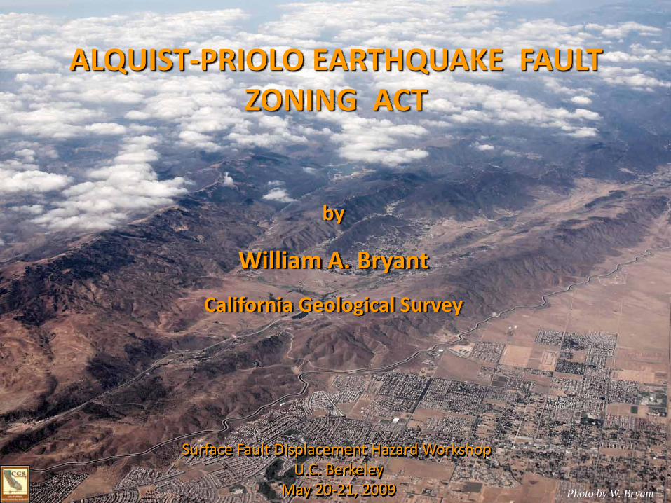
The 1971 Mw 6.6 San Fernando earthquake was associated with surface fault rupture that damaged or destroyed many structures.
Photo by E. Hart
The Alquist-Priolo (AP) Actwas enacted in 1972 following the earthquake.

The intent of the Alquist-Priolo Act is to prohibit the location of developments and structures for human occupancy across the trace of active fault , thus avoiding
the hazard of surface fault rupture.
1992 Mw 7.3 Landers Earthquake Photo by W. Bryant
Alquist-Priolo Act

Alquist-PrioloEarthquake Fault Zoning Act of 1972
Earthquake Fault Zones encompass hazardous faults, which are defined as those faults that are sufficiently active and well-defined
Sufficiently active - faults that exhibit evidence of Holocene displacement (approx. last 11,000 years)
Well-defined - trace detectable by trained geologist

Surface Fault Rupture Usually Occurs Along Pre-Existing Faults
San Andreas Fault - Wallace Creek
Photo by R. Wallace
~12 events
3.7 ka
~ 35 events
10.5 ka~ 10 m1857
~ 43 events
13.3 ka

ALQUIST-PRIOLO ACT- RESPONSIBILITIES -
STATE GEOLOGIST‐ Zones ‐
MINING & GEOLOGY BOARD‐ Sets Policies & Criteria ‐
AFFECTED LEAD AGENCIES‐ Implements ‐

Earthquake Fault Zones
Earthquake Fault Zones are regulatory zones encompassing faults meeting the zoning criteria of sufficiently active and well-defined.
Zone boundaries generally are located 500 feet away from active faults in order to accommodate imprecise locations of faults and the possible existence of active branches.

Over 4500 Site Investigations Filed With CGS
Site-Specific Investigation
The objective of a site specific investigation is to ensure that structures for human occupancy will not be located across active faults.
To accomplish this, the investigation should accurately locate active fault traces and recommend appropriately wide setbacks.

A setback, or no build zone, is delineated around active faults located during the site investigation to allow an appropriate level of conservatism or factor of safety. The width of a setback zone allows for the occurrence of near-fault deformation and the inherent uncertainties of projecting the location of the fault between known data points.
Setback from active fault as generally applied is 50 feet. The current California Code of Regulations (sec 3603a) states:
“…as the area within 50 feet of such active faults shall be presumed to be underlain by active branches of that fault unless proven otherwise by an appropriate geologic investigation and report prepared as specified Section 3603(d) of this subchapter, no such structures shall be permitted in this area.”
As currently written, there is no minimum distance. However, SMGB initially stated that 50 feet represented minimum standard. This remained in policies and criteria until 1984.
Setback

Application of the AP Act -Site Investigation in Pacifica

San Andreas Fault Zone
Proposed DevelopmentPacifica
Pacifica

Blue Lines – Site BoundaryGreen Lines – Trench LocationsRed Lines – Active Faults
Site Investigation

Site Investigation
Blue Lines – Site BoundaryGreen Lines – Trench LocationsRed Lines – Active Faults

Building Locations

City of Camarillo appealed to State Mining and Geology Board in late 2006, specifically with respect to:
City of Camarillo
•Presumption of activity of faults within an EFZ•Setback width•Fault rupture hazard mitigation
As a result of that appeal, a Technical Advisory Committee was assembled in order to review the State Mining and Geology Board’s policies and criteria to clarify and possibly update regulations.