ALOS-2 Project Manager Shin-ichi Sobue 19092017/afternoon...Prediction of extreme ... - Disaster...
29
ALOS-2 Project Manager Shin-ichi Sobue
Transcript of ALOS-2 Project Manager Shin-ichi Sobue 19092017/afternoon...Prediction of extreme ... - Disaster...

ALOS-2 Project Manager
Shin-ichi Sobue

Targets (JFY) 2014 2015 2016 2017 2018 2019 2020 2021 2022 2023 2024
Disasters & Resources
Climate Change & Water Cycle •Water Cycle
•Climate Change
•GHGs
Study On orbit Mission status:
[Land and disaster monitoring]
[Vegetation, aerosol, cloud, SST, ocean color]
[CO2, Methane]
[Wind, SST , water vapor, precipitation,]
[Precipitation 3D structure]
[CO2, Methane, CO]
Development
TRMM / PR
ALOS-2 / PALSAR-2
GPM / DPR
GCOM-W / AMSR2
GOSAT /FTS, CAI
GCOM-C / SGLI
EarthCARE / CPR
Advanced Optical
Advanced SAR
JAXA Earth Observation Satellites
[Cloud and aerosol 3D structure]
1
[1997〜2015]
[2012〜]
GOSAT-2 [2009〜]
GOSAT-3
★Research the hosted payload capability of AMSR’s successor sensor with the GOSAT-3

2
JAXA’s Earth Observation Programs
1. Disaster Risk Management
3. New Applications JAX
A’s
EO
sce
nar
io
Flood Early Warning
Mitigation
GHG Monitoring
Mitigation
Forest Monitoring
Adaptation Prediction of
extreme weather event
Ocean DSM Infrastructure
Monitoring
Landslide Monitoring
2. Climate Change (Mitigation/Adaptation)
Ge
os
pa
tial In
form
ati
on
B
y S
ate
llit
e R
em
ote
Sen
sin
g
Crustal Deformation Monitoring

Mission
sensor
PALSAR-2
(Phased Array type L-band
Synthetic Aperture Radar
2)
Launch May 24, 2014
H-IIA launch vehicle
Mass 2.1 tons
Lifetime 5 years
(target: 7 years)
Orbit Sun-synchronous,
628 km altitude,
14 days revisit,
Orbit control: ≦ +/- 500 m
Local sun
time
12:00±15 min
(descending)
24:00±15 min
(ascending)
Mission data
transmission
X-band:
800 Mbps (16 QAM),
200/400 Mbps (QPSK)
Advanced Land Observing Satellite-2 (ALOS-2)
PALSAR-2
(Phased Array type L-band
Synthetic Aperture Radar 2)
Mission objectives
- Disaster monitoring (Earthquake, Volcano,
Landslide, Flooding, …)
- Environmental monitoring (Forest, Ice sheet, …)
- Agriculture, natural resources, and ocean
- Technology development
PALSAR-2 antenna X-band downlink antenna
Solar Arrays
X Y
Z
3

“Daichi-2” (ALOS-2)
4
Mission Objectives:
Earthquake
Ice
Disaster monitoring
Environment and land management
Volcano
Forest and wetland
Agriculture &
natural resources
Ocean Flooding
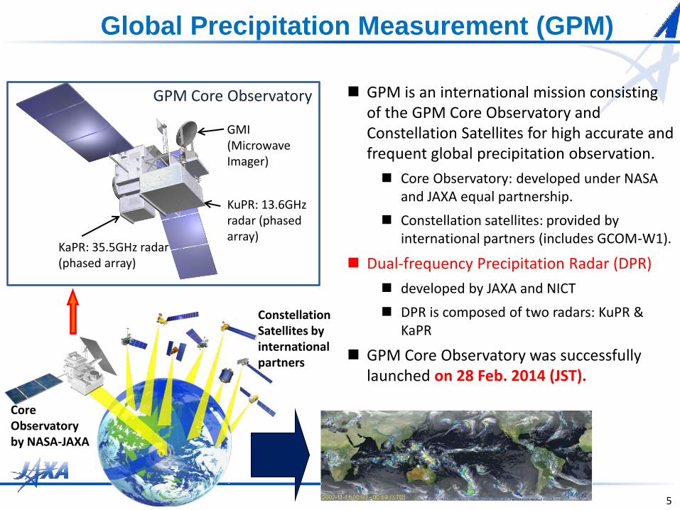
Global Precipitation Measurement (GPM)
GPM is an international mission consisting of the GPM Core Observatory and Constellation Satellites for high accurate and frequent global precipitation observation.
Core Observatory: developed under NASA and JAXA equal partnership.
Constellation satellites: provided by international partners (includes GCOM-W1).
Dual-frequency Precipitation Radar (DPR)
developed by JAXA and NICT
DPR is composed of two radars: KuPR & KaPR
GPM Core Observatory was successfully launched on 28 Feb. 2014 (JST).
KuPR: 13.6GHz radar (phased array)
KaPR: 35.5GHz radar (phased array)
GMI (Microwave Imager)
Core Observatory by NASA-JAXA
Constellation Satellites by international partners
GPM Core Observatory
5

6
GSMaP (Global) observed Hurricane Patricia and Olaf, and Typhoon Champi: 20-24 Oct. 2015, hourly animation
• Rapidly changing precipitation phenomena need frequent observations.
• Global rainfall map merging GPM Core Observatory, polar orbiting microwave radiometer/sounders, and geostationary infrared radiometers.
JAXA Global Rainfall Watch (4-hr delay) : http://sharaku.eorc.jaxa.jp/GSMaP JAXA Realtime Rainfall Watch (Himawari-area): http://sharaku.eorc.jaxa.jp/GSMaP_NOW
JAXA’s Contribution to Forecasting
“GSMaP_NOW” over “Himawari-8” area start just now! Global Satellite Mapping of Precipitation (GSMaP)
Patricia Olaf
Champi
Realtime Rainfall Watch (GSMaP_NOW)
Global Rainfall Watch (GSMaP_NRT/MVK)

Typhoon 19 by GSMaP
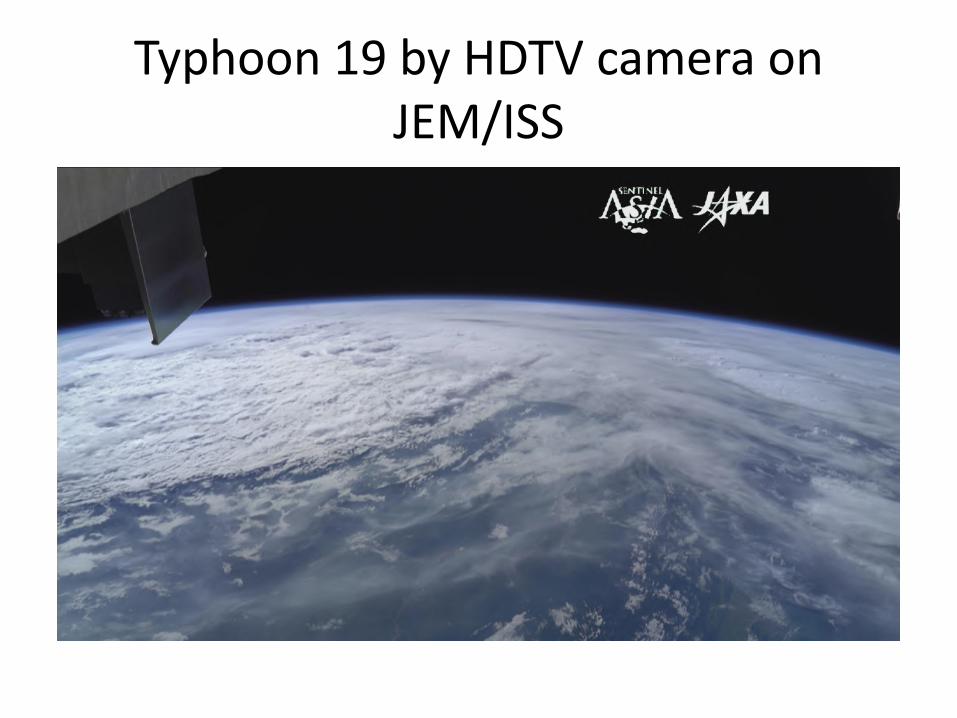
Typhoon 19 by HDTV camera on JEM/ISS

Inundation area estimation by Sentinel-Asia using ALOS-2
http://arcg.is/2h8rS7f

10
• Inundated Area Detection Using RADAR Data
Water Management: Reduce Flood Damage
11
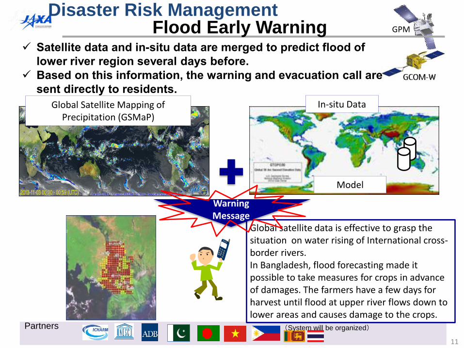
Satellite data and in-situ data are merged to predict flood of
lower river region several days before.
Based on this information, the warning and evacuation call are
sent directly to residents.
Global satellite data is effective to grasp the situation on water rising of International cross-border rivers. In Bangladesh, flood forecasting made it possible to take measures for crops in advance of damages. The farmers have a few days for harvest until flood at upper river flows down to lower areas and causes damage to the crops.
In-situ Data
Model
GPM
Partners (System will be organized)
Global Satellite Mapping of Precipitation (GSMaP)
Disaster Risk Management Flood Early Warning
Warning Message

Warning criteria Maps
AWS Satellite
Rainfall monitoring
Model preparation
Automatic prediction
Analysis /
warning
Agency/
Local gov.
Sensor network
Hazard maps,
Criteria
System
Application
GSMaP rainfall archives are analyzed by a machine learning method (RBFN), and
critical lines (CLs) of hourly rainfall and soil moisture index (SMI) are selected.
The system monitors rainfall in real-time and determines the landslide warning level.
GSMaP based Landslide Warning System (GLWS)
GSMaP-Now
- Pilot Study in the Philippines -

Overview of the prototype-system The Landslide and Flood disaster Early Warning System with GSMaP
GSMaP AWS
Tank model
GSMaP Correction
Input
Flood warning system by
estimating water level
Corrected GSMaP
Soil Moisture Index Run-off
Alert of flood disaster
Alert of landslide disaster
Landslide warning system by Non-leaner
Critical Line
Web Browser
User ID Password
Login: 10km
First user list is
necessary
(User’s Name and
Email address)
Output

GFAS-II(Global Flood Alert System ver.2)
Selection of InformationNRT or NOW
- Prob :Probable Rainfall (Risk map)- Rain :GSMaP (Observed Rainfall)
Selection Cumulative rainfall1h, 3h, 12h, 24h, 72h
Animation display of rain area
Other Functions-Selection of language
EN, ES, DE, VN-Selection of layer
Map, Aerial Photo
Search Locationby place name
Display / Hideof the menu
- Jump to the Current Location- Zooming
Legend
[Smart Phone] http://gfas.internationalfloodnetwork.org/n-gfas-web/sp/frmMain.aspx [PC] http://gfas.internationalfloodnetwork.org/n-gfas-web/pc/frmMain.aspx
Captured Image of GFAS-II web site72 Cumulative precipitation
of 11:00, May 23-26, 2015
< 5yr precip.– 10yr precip.– 30yr precip.> 30yr precip.
14
GFAS-II currently has the displays for 5 languages
(English, Japanese, Spanish, German and Vietnamese).
GFAS developed by IDI is a system to apply global satellite
precipitation estimates to flood forecasting. GFAS utilizes
GSMaP as a means of estimation to provide “global flood
risk map” that is display on the Internet. GFAS-II,
upgraded in 2017, is PC & Smartphone-friendly version,
and available to everyone around the world.

Target: Greater Mekong Subregion (GMS)
- Add free satellite-based drought information to GMS-AIN
Drought Indices and alerts -KBDI (Keetch-Byram Drought Index); daily, 10km
GMS-AIN (Great Mekong Subregion Agricultural Information Network)
15
Free data and automatically updated
-> No operational cost
ADB Joint Project on Drought Monitoring
15
15
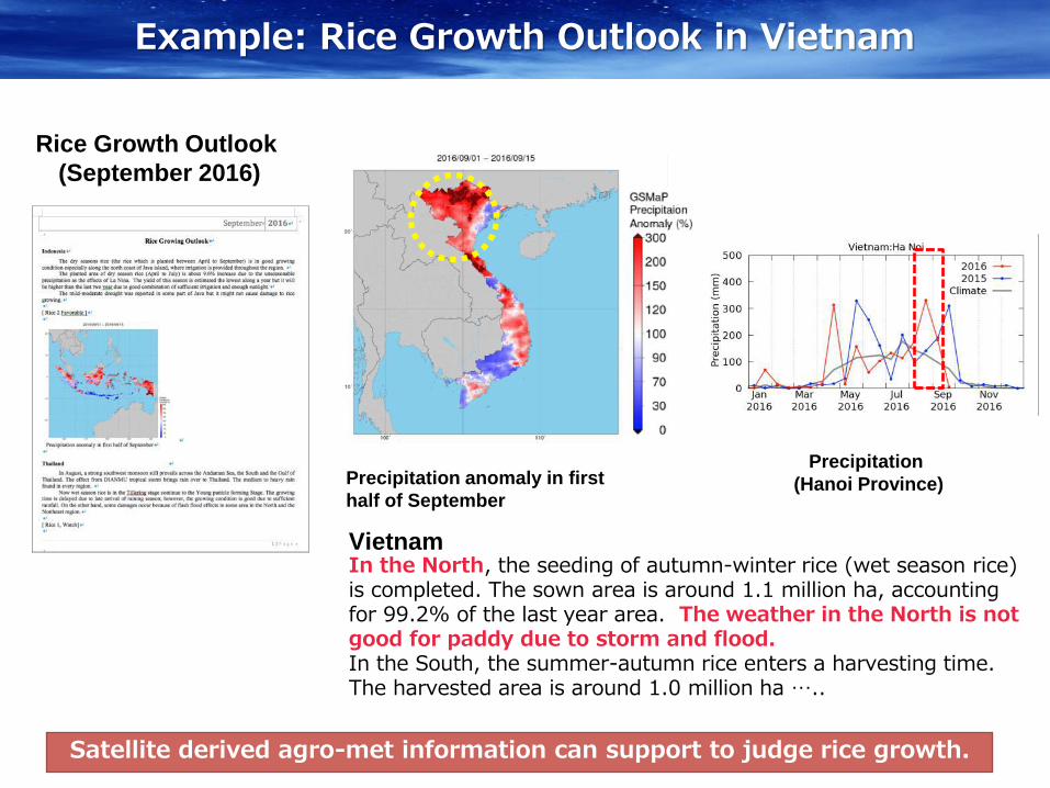
Vietnam In the North, the seeding of autumn-winter rice (wet season rice) is completed. The sown area is around 1.1 million ha, accounting for 99.2% of the last year area. The weather in the North is not good for paddy due to storm and flood. In the South, the summer-autumn rice enters a harvesting time. The harvested area is around 1.0 million ha …..
Rice Growth Outlook
(September 2016)
Precipitation anomaly in first
half of September
Satellite derived agro-met information can support to judge rice growth.
Precipitation
(Hanoi Province)
Example: Rice Growth Outlook in Vietnam

Data Cube
ALOS-2
Sentinel
ScanSAR every 42 days
Dual every 12 days MODIS Landsat
JAXA
ESA
GA/CSIRO
CSIRO
Vietnam Data Cube - SAR based rice crop monitoring scheme
Ground data GEORIICE
VNSC
VNSC, VAST, MARD
Statistical info
MARD
Met info MONRE
Analyzed info

Rice Crop Mapping in Southeast Asia
18
ADB TA Project
• Laos • Thailand • Vietnam (North) • Philippines
[2014-2016]
SAFE Project (Test site)
SAFE Project (Scaling-up)
• Myanmar • Cambodia
• Vietnam (Mekong Delta) • Indonesia
[2014-]
[2016-]
• ADB Technical Assistance project and SAFE project under the APRSAF have successfully demonstrated INAHOR using ALOS-2 with the mapping accuracy of 80-90% for the target provinces.
• Scaling-up for major rice producing areas is currently demonstrated in Vietnam and Indonesia.
Rice-planted Area Mapping Software
(INAHOR)

19

ALOS-2 ScanSAR data provision • For GEOGLAM and CEOS
– Under GEOGLAM/Asia Rice and ALOS K&C project, JAXA provides ScanSAR data at technical demonstration sites (100km x 100km – one province) in Cambodia, Myanmar, Malaysia, Lao, India, China, Thailand and Taiwan to Asia Rice crop team members with ALOS-2 download system now.
– Under Asia Pacific regionsal space agency forum (APRSAF) framework with GEOGLAM/Asia Rice, JAXA provides scale up activity for Indonesia (Top 10 rice crop production provinces) and Vietnam (Mekong)
• Proposal from JAXA
– Under cooperation with JICA and commerical data providers, JAXA starts to prepare to provide on-line access to intermidate JJ-FAST products = ScanSar ortho-slop corrected DN data and/or ALOS-2 25m path ortho-slop correct data (gamma naught) from ALOS-2 path mosaic to selected countries for each target country data where JAXA, ADB and APRSAF countries have cooperative aggeement (Indonesia, LaoPDR, Thailand, Philippine, Low Mekong (Vietnam + Cambodia)) for governmental use in respecting countries.
– JAXA starts to prepare sample data of ScanSAR data to ingest Vietnam data cube and propose CEOS ARD of SAR (1-5 degree mesh tiled data or path orth-slop corrected data) in cooperation with CEOS SEO (NASA)
– Other than ASEAN area, JAXA will discuss with commercial data distributor to have same framework of ALOS-2 ScanSAR intermidate product to target countrys’ governmetal use if CEOS and GEO community are interested in.

Coordination status with respecting countries
1. Vietnam • VNSC and CSIRO/GA already prepare to implement CEOS Mekong data cube by
the end of this year • VNSC and JAXA agreed to coordinate ALOS-2 ScanSAR data ingestion with rice crop
area estimation software (INAHOR) to CEOS Mekong data cube • JAXA and VNSC will finalize MOU for Vietnam data cube with ALOS-2 ScanSAR data
and will have Data cube workshop as a pre-workshop of GEOSS-AP agriculture working group (WG5)
2. Indonesia • LAPAN, MOA and JAXA agreed to coordinate coordinate ALOS-2 ScanSAR data
ingestion to LAPAN data archive • JAXA and LAPAN start to coordinate MOU to archive and use ALOS-2 ScanSAR data
in Indonesia
3. Thailand • JAXA and GISTDA start to discuss ALOS-2 ScanSAR data of Thailand and Lao
provision to GISTDA

JAXA’s EO Data Portals Portal Name and URL
G-Portal (GPM, TRMM, JERS-1, AQUA/AMSR-E....etc.) https://www.gportal.jaxa.jp/gp/top.html *Free andn Open Data
GCOM-W: Global Change Observation Mission-Water http://suzaku.eorc.jaxa.jp/GCOM_W/data/data_w_index.html *Free and Open Data
GSMaP: Global Satellite Mapping of Precipitation http://sharaku.eorc.jaxa.jp/GSMaP_crest/index.html *Free and Open Data
Precise Global Digital 3D Map "ALOS World 3D" Homepage (30m resolution) http://www.eorc.jaxa.jp/ALOS/en/aw3d/index_e.htm *Free and Open Data
High resolution data is available through commercial distributors. ALOS-2: PASCO (http://en.alos-pasco.com/) ALOS World 3D (5m resolution): NTT DATA and RESTEC (http://aw3d.jp/en/index.html)
Future Missions
23
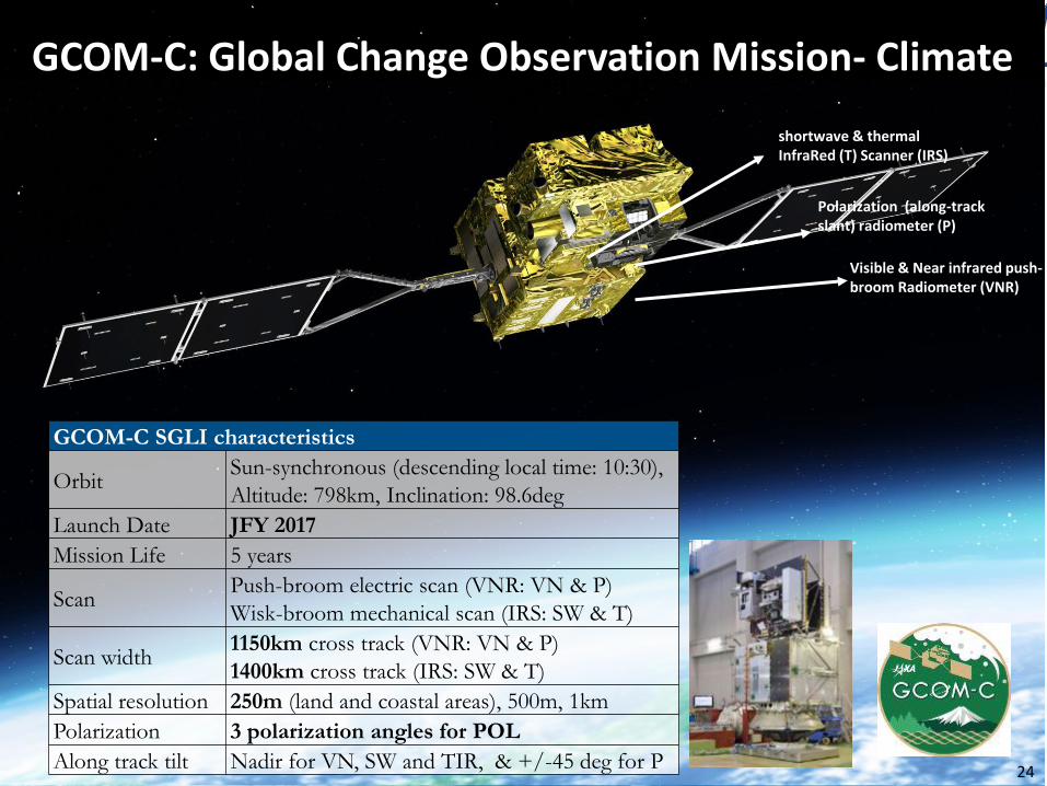
Visible & Near infrared push-broom Radiometer (VNR)
Polarization (along-track slant) radiometer (P)
shortwave & thermal InfraRed (T) Scanner (IRS)
GCOM-C SGLI characteristics
Orbit Sun-synchronous (descending local time: 10:30),
Altitude: 798km, Inclination: 98.6deg
Launch Date JFY 2017
Mission Life 5 years
Scan Push-broom electric scan (VNR: VN & P)
Wisk-broom mechanical scan (IRS: SW & T)
Scan width 1150km cross track (VNR: VN & P)
1400km cross track (IRS: SW & T)
Spatial resolution 250m (land and coastal areas), 500m, 1km
Polarization 3 polarization angles for POL
Along track tilt Nadir for VN, SW and TIR, & +/-45 deg for P
GCOM-C: Global Change Observation Mission- Climate
24 24

GOSAT-2 on orbit in early 2018
25
Upgrade in GOSAT-2 mission GOSAT achievement
GOSAT target
Measurement precision 0.5 ppm for CO2
5 ppb for CH4
2ppm for CO2 12ppb for CH4
4 ppm for CO2
32 ppb for CH4
Flux estimation 1000km for land 2000km in sub-continental scale
Anthropogenic emission CO to distinguish emission source
Ecosystem carbon exchange
Chlorophyll fluorescence to place constrains on GPP
Aerosol monitoring Aerosol size distribution and its property 25
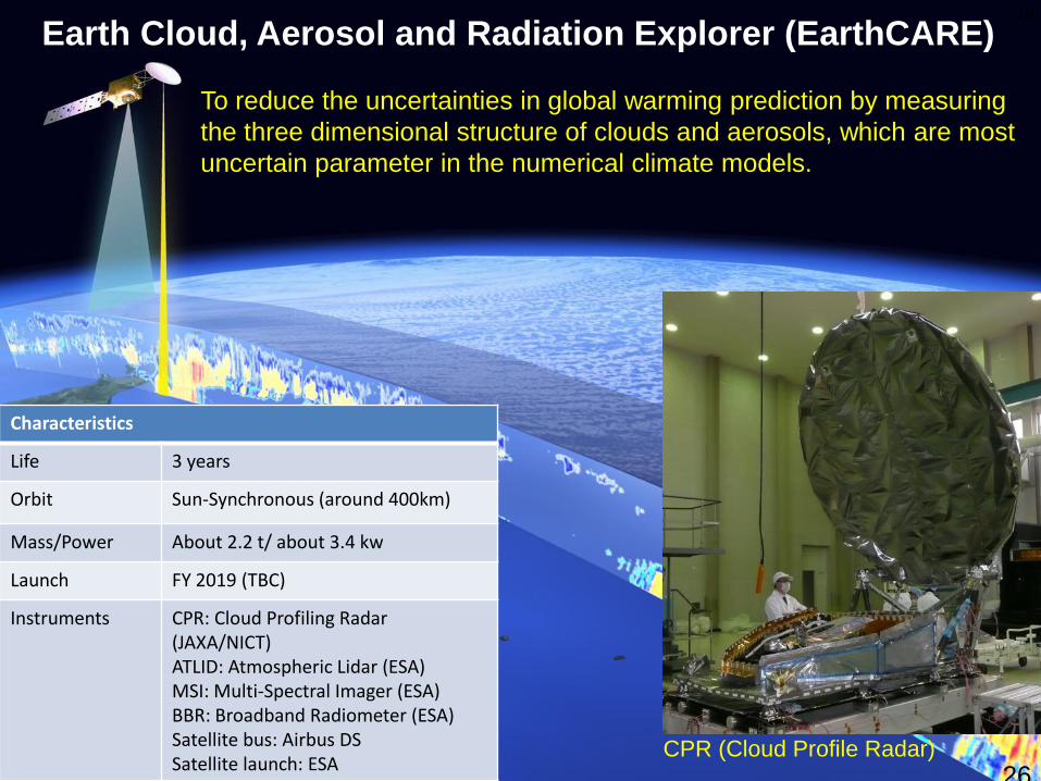
Earth Cloud, Aerosol and Radiation Explorer (EarthCARE) 26
To reduce the uncertainties in global warming prediction by measuring
the three dimensional structure of clouds and aerosols, which are most
uncertain parameter in the numerical climate models.
26 CPR (Cloud Profile Radar)
Characteristics
Life 3 years
Orbit Sun-Synchronous (around 400km)
Mass/Power About 2.2 t/ about 3.4 kw
Launch FY 2019 (TBC)
Instruments CPR: Cloud Profiling Radar (JAXA/NICT) ATLID: Atmospheric Lidar (ESA) MSI: Multi-Spectral Imager (ESA) BBR: Broadband Radiometer (ESA) Satellite bus: Airbus DS Satellite launch: ESA

27
Hazard Map
High Precision
1/25,000 Map (C) GSI
Advanced Optical Satellite
(ALOS-3)
ALOS successors: Advanced Optical Satellite and Radar Satellite
Advanced Radar Satellite (ALOS-4)
Estimate situation of magma chamber under the ground and faulting Take a decision for evacuation
マグマの上昇
地
殻変動
chikaku 地殻変動
マグマの上昇
Magma Chamber
Crucial Deformation
Rising Magma
Characteristics
Life 7 years
Orbit Sun-Synchronous (628km)
Mass About 3 t
Launch FY 2020
Resolution Spotlight 1×3 m (swath: 35km) Strip map 3/6/10m (swath: 200km) ScanSAR 25m (swath: 700km)
Characteristics
Life 7 years
Orbit Sun-Synchronous (670km)
Mass About 2.7 t
Launch FY 2020
Resolution
Panchromatic : 0.8m (swath: 70km) Multi: 3.2m (swath: 70km)

28
Thank you very much for your attention.
@Tsuruoka, Yamagata Pref. TDS Site in Japan