ALMING GOD TUNBRIDGE WELLS SOUTH DOWNS MILES …
4
DITCHLING BEACON AND THE CHATTRI MILES WITHOUT STILES YOUR COUNTRYSIDE CODE: RESPECT. PROTECT. ENJOY. Respect other people • Leave gates and property as you find them • Keep to the paths unless on Open Access Land Protect the natural environment • Take your litter home • Keep dogs under effective control Enjoy the outdoors • Plan ahead and be prepared • Follow advice and local signs GODALMING SOUTH DOWNS NATIONAL PARK These two Miles Without Stiles circular routes set in a beautiful area of the South Downs National Park are suitable for off-road class 3 all-terrain mobility scooters. Enjoy stunning 360 degree views from Ditchling Beacon, the highest point on the chalk in East Sussex, visit the historic Jack and Jill windmills or pay your respects at the peaceful Chattri war memorial. Following these trails also takes you along a section of the famous South Downs Way National Trail – a 100 mile route which runs the entire length of the South Downs National Park, from Winchester to Eastbourne. These circular routes have been made possible due to support from Gatwick Airport, which enabled surface and gateway improvements to be carried out. Keep up to date with the latest news and events from the South Downs National Park. southdowns.gov.uk/newsletter Disabled Ramblers is a small charity which was set up around 20 years ago to encourage disabled people to access the countryside on their mobility scooters. Members of the charity helped to create the two routes in this leaflet and tested each one to ensure that they are suitable for rambling on an all-terrain Class 3 mobility scooter, or equivalent power chair. For more information about the Disabled Ramblers and how you can get involved, visit disabledramblers.co.uk YOU CAN FIND THIS ROUTE ON VIEWRANGER Download the free ViewRanger app from your app store. Once registered you can search for South Downs National Park to view all of our routes. All our routes on ViewRanger are available for FREE – you do not need to buy any maps to view our walks and rides. Ditchling Beacon © Richard Reed
Transcript of ALMING GOD TUNBRIDGE WELLS SOUTH DOWNS MILES …

POINTS OF INTERESTJACK AND JILL WINDMILLSThese picturesque windmills stand atop the scenic South Downs with spectacular views out across the Sussex Weald. Jack is privately owned but Jill is often open to visitors and when the wind is blowing she may even be in operation with a guide available to explain the mysteries of milling. Visit jillwindmill.org.uk for more information.
DITCHLING BEACONOne of the highest points on the South Downs, Ditchling Beacon, once an Iron Age hillfort, has
stunning pockets of rich chalk grassland. If visiting in July look for the musk orchid, only found in the south of England, limey-green in colour and honey-scented. Between June and August you’ll also see the marsh fragrant orchid which is dark pink in colour and can be found on the northerly scarp slopes.
Amongst these spectacular flowers keep an eye out for the green hairstreak butterfly. When not in flight they hold their wings closed showing a green underside with a faint white streak. Rival males can often be seen spiralling close to shrubs.
THE CHATTRIThis beautiful memorial stands on the Downs near Patcham at the place where Hindu and Sikh soldiers who died in Brighton war hospitals during 1914-1918 were cremated.
Around one and a half million members of the Indian army fought alongside British soldiers during the war. The word ‘chattri’ means umbrella in Indian Hindi, Punjabi and Urdu and is reflected in the memorial’s style.
DITCHLING BEACON AND THE CHATTRI
MILES WITHOUT STILES
YOUR COUNTRYSIDE CODE: RESPECT. PROTECT. ENJOY.Respect other people• Leave gates and property as you find them• Keep to the paths unless on Open Access Land
Protect the natural environment• Take your litter home• Keep dogs under effective control
Enjoy the outdoors• Plan ahead and be prepared• Follow advice and local signs
GODALMING
LEWES
BOGNOR REGIS
BRIGHTON & HOVE
MIDHURSTPULBOROUGH
PORTSMOUTH
PETERSFIELD
EASTBOURNE
TUNBRIDGEWELLS
WINCHESTER
SOUTHAMPTON
CHICHESTER
THE CHATTRI& DITCHLING
GETTING HERECONTACTParking: Jack & Jill windmills free car park with height barrier.
Alternative car parking is available at Ditchling Beacon (charges apply).
South Downs National Park Authority: 01730 814810
@SDNPA /SDNPA southdownsnp
FIND YOUR WAYFollow the arrows on waymarkers.
Footpath
Bridleway
Restricted byway
Byway
Open access land National Trail Acorn
TAKE THE LEADFor a safe and fun visit with your dog please remember to keep them on a lead around livestock, horses and wildlife. Always bag and bin your dog poo – any public bin will do!
National Park Area Railway Station
SOUTH DOWNS NATIONAL PARKThese two Miles Without Stiles circular routes set in a beautiful area of the South Downs National Park are suitable for off-road class 3 all-terrain mobility scooters.
Enjoy stunning 360 degree views from Ditchling Beacon, the highest point on the chalk in East Sussex, visit the historic Jack and Jill windmills or pay your respects at the peaceful Chattri war memorial. Following these trails also takes you along a section of the famous South Downs Way National Trail – a 100 mile route which runs the entire length of the South Downs National Park, from Winchester to Eastbourne.
The Chattri © Richard Reed
These circular routes have been made possible due to support from Gatwick Airport, which enabled surface and gateway improvements to be carried out.
Keep up to date with the latest news and events from the South Downs National Park. southdowns.gov.uk/newsletter
Disabled Ramblers is a small charity which was set up around 20 years ago to encourage disabled people to access the countryside on their mobility scooters. Members of the charity helped to create the two routes in this leaflet and tested each one to ensure that they are suitable for rambling on an all-terrain Class 3 mobility scooter, or equivalent power chair.
For more information about the Disabled Ramblers and how you can get involved, visit disabledramblers.co.uk
YOU CAN FIND THIS ROUTE ON VIEWRANGERDownload the free ViewRanger app from your app store. Once registered you can search for South Downs National Park to view all of our routes. All our routes on ViewRanger are available for FREE – you do not need to buy any maps to view our walks and rides.
SOUTHDOWNS.GOV.UK
Green hairstreak © Neil Hulme
Fragrant orchid © SDNPA/Jan Knowlson
Cover photo © Alex Bamford. All uncredited photos Mischa Haller © SDNPA. Details correct at time of going to print. Please be aware that routes are shared with other users (vehicles, pedestrians, dogs, horses etc) and users of this route do so at their own risk. We do not accept any responsibility for loss, damage or injury, however caused, arising directly or indirectly from use of this leaflet. Contains Ordnance Survey data © Crown copyright and database right 2013. SDNPA/The Way Design/June 2019. © SDNPA Crown copyright
Please recycle me after use
Ditchling Beacon © Richard Reed
View from Ditchling Beacon © Sam Moore

POINTS OF INTERESTJACK AND JILL WINDMILLSThese picturesque windmills stand atop the scenic South Downs with spectacular views out across the Sussex Weald. Jack is privately owned but Jill is often open to visitors and when the wind is blowing she may even be in operation with a guide available to explain the mysteries of milling. Visit jillwindmill.org.uk for more information.
DITCHLING BEACONOne of the highest points on the South Downs, Ditchling Beacon, once an Iron Age hillfort, has
stunning pockets of rich chalk grassland. If visiting in July look for the musk orchid, only found in the south of England, limey-green in colour and honey-scented. Between June and August you’ll also see the marsh fragrant orchid which is dark pink in colour and can be found on the northerly scarp slopes.
Amongst these spectacular flowers keep an eye out for the green hairstreak butterfly. When not in flight they hold their wings closed showing a green underside with a faint white streak. Rival males can often be seen spiralling close to shrubs.
THE CHATTRIThis beautiful memorial stands on the Downs near Patcham at the place where Hindu and Sikh soldiers who died in Brighton war hospitals during 1914-1918 were cremated.
Around one and a half million members of the Indian army fought alongside British soldiers during the war. The word ‘chattri’ means umbrella in Indian Hindi, Punjabi and Urdu and is reflected in the memorial’s style.
DITCHLING BEACON AND THE CHATTRI
MILES WITHOUT STILES
YOUR COUNTRYSIDE CODE: RESPECT. PROTECT. ENJOY.Respect other people• Leave gates and property as you find them• Keep to the paths unless on Open Access Land
Protect the natural environment• Take your litter home• Keep dogs under effective control
Enjoy the outdoors• Plan ahead and be prepared• Follow advice and local signs
GODALMING
LEWES
BOGNOR REGIS
BRIGHTON & HOVE
MIDHURST PULBOROUGH
PORTSMOUTH
PETERSFIELD
EASTBOURNE
TUNBRIDGEWELLS
WINCHESTER
SOUTHAMPTON
CHICHESTER
THE CHATTRI& DITCHLING
GETTING HERE CONTACTParking: Jack & Jill windmills free car park with height barrier.
Alternative car parking is available at Ditchling Beacon (charges apply).
South Downs National Park Authority: 01730 814810
@SDNPA /SDNPA southdownsnp
FIND YOUR WAYFollow the arrows on waymarkers.
Footpath
Bridleway
Restricted byway
Byway
Open access land National Trail Acorn
TAKE THE LEADFor a safe and fun visit with your dog please remember to keep them on a lead around livestock, horses and wildlife. Always bag and bin your dog poo – any public bin will do!
National Park Area Railway Station
SOUTH DOWNS NATIONAL PARKThese two Miles Without Stiles circular routes set in a beautiful area of the South Downs National Park are suitable for off-road class 3 all-terrain mobility scooters.
Enjoy stunning 360 degree views from Ditchling Beacon, the highest point on the chalk in East Sussex, visit the historic Jack and Jill windmills or pay your respects at the peaceful Chattri war memorial. Following these trails also takes you along a section of the famous South Downs Way National Trail – a 100 mile route which runs the entire length of the South Downs National Park, from Winchester to Eastbourne.
The Chattri © Richard Reed
These circular routes have been made possible due to support from Gatwick Airport, which enabled surface and gateway improvements to be carried out.
Keep up to date with the latest news and events from the South Downs National Park. southdowns.gov.uk/newsletter
Disabled Ramblers is a small charity which was set up around 20 years ago to encourage disabled people to access the countryside on their mobility scooters. Members of the charity helped to create the two routes in this leaflet and tested each one to ensure that they are suitable for rambling on an all-terrain Class 3 mobility scooter, or equivalent power chair.
For more information about the Disabled Ramblers and how you can get involved, visit disabledramblers.co.uk
YOU CAN FIND THIS ROUTE ON VIEWRANGERDownload the free ViewRanger app from your app store. Once registered you can search for South Downs National Park to view all of our routes. All our routes on ViewRanger are available for FREE – you do not need to buy any maps to view our walks and rides.
SOUTHDOWNS.GOV.UK
Green hairstreak © Neil Hulme
Fragrant orchid © SDNPA/Jan Knowlson
Cover photo © Alex Bamford. All uncredited photos Mischa Haller © SDNPA. Details correct at time of going to print. Please be aware that routes are shared with other users (vehicles, pedestrians, dogs, horses etc) and users of this route do so at their own risk. We do not accept any responsibility for loss, damage or injury, however caused, arising directly or indirectly from use of this leaflet. Contains Ordnance Survey data © Crown copyright and database right 2013. SDNPA/The Way Design/June 2019. © SDNPA Crown copyright
Please recycle me after use
Ditchling Beacon © Richard Reed
View from Ditchling Beacon © Sam Moore
A23
PIDDINGWORTHPLANTATION
HOLT BOTTOM
HIGH PARKCORNER
NEW BARN FARM
DITCHLINGBEACON2
3
8
6
7
1
4
7
10
9
4
5
1
5
6
3
2
DIT
CH
LIN
G R
OAD
STANMER PARK
HIGH PARKWOOD
HEATHY BROW
DEW POND
Tumulus
SUSS
EX B
ORDER PA
TH
A27
3
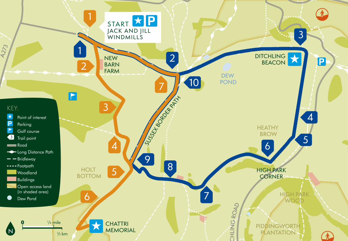
CHATTRI MEMORIAL
STARTJACK AND JILL WINDMILLS
KEY: Point of interest
Parking
Golf course
Trail point
Road
Long Distance Path
Bridleway
Footpath
Woodland
Buildings
Open access land (in shaded area)
Dew Pond
1From the car park head back out of the main
entrance and turn left following the main track up the hill.
2Continue along the South Downs Way (SDW)
to Ditchling Beacon. As you continue east along the SDW you’ll pass two dew ponds. The first on your left is fenced in and the second open for livestock to drink from. These round ponds are man-made ponds lined with clay and filled by rainwater to provide water for sheep and cattle.
3At the crest of the hill you’ll see the trig point on
your right. This is the highest point in East Sussex where you are rewarded with 360º views. Now retrace your route
some 100 metres down the hill and take the path through a wooden gate on your left. The bank to your left is the remains of the ramparts of the Iron Age hillfort that stood on Ditchling Beacon 3000 years ago. Continue on this track south, over the rise and gently downhill.
4Continue straight ahead at the path junction – here
the track steepens a little and has some loose flints.
5At the gate continue straight ahead, down the
hill. This grass slope is the steepest section of the route.
6Continue through the gate heading south. Here the
route flattens out and may be muddy in winter.
7Go through the gate on your right and across the
vehicle tracks, then head left and gradually up the hill. Do not follow the vehicle tracks along the valley floor.
8Drop down to the gate and turn right onto the
main farm track.
9At the top of the hill there is a cross road of paths,
turn right at this point and follow the Sussex Border path north, where you’ll re-join the SDW at Keymer Post.
10When you reach the SDW, turn left and
retrace the start of your walk to the car park at Jack and Jill windmills.
1From the car park head back out of the main
entrance and turn left following the main track up the hill. Turn right onto the South Downs Way (SDW) heading south.
2Continue through New Barn Farm and straight
over the crossroads of track.
3Follow the track down into Rag Bottom – this is
quite steep with occasional loose flint. Then follow the track back up the hill the other side.
4Turn left and then right to follow the track along
the edge of the field at Middle Brow.
5At the crossroads of paths turn right onto
the Sussex Border Path and continue down to the Chattri war memorial.
6When you want to continue your walk
retrace your route back up the Sussex Border Path, then continue straight over at the crossroads.
7When you reach the SDW, turn left and return
to the car park at Jack and Jill windmills.
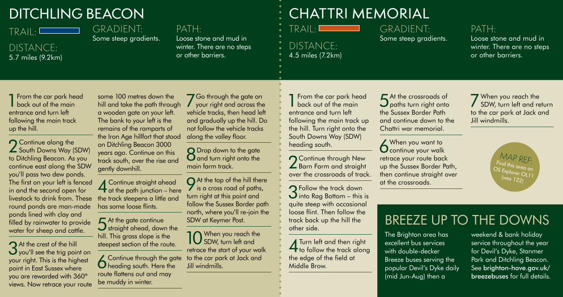
DITCHLING BEACON CHATTRI MEMORIALTRAIL:
DISTANCE: 5.7 miles (9.2km)
GRADIENT: Some steep gradients.
PATH: Loose stone and mud in winter. There are no steps or other barriers.
BREEZE UP TO THE DOWNS The Brighton area has excellent bus services with double-decker Breeze buses serving the popular Devil’s Dyke daily (mid Jun-Aug) then a
weekend & bank holiday service throughout the year for Devil’s Dyke, Stanmer Park and Ditchling Beacon. See brighton-hove.gov.uk/breezebuses for full details.
N
MAP REF: Find this area on OS Explorer OL11 (was 122)
TRAIL:
DISTANCE: 4.5 miles (7.2km)
GRADIENT: Some steep gradients.
PATH: Loose stone and mud in winter. There are no steps or other barriers.
A23
PIDDINGWORTHPLANTATION
HOLT BOTTOM
HIGH PARKCORNER
NEW BARN FARM
DITCHLINGBEACON2
3
8
6
7
1
4
7
10
9
4
5
1
5
6
3
2
DIT
CH
LIN
GRO
AD
STANMER PARK
HIGH PARKWOOD
HEATHY BROW
DEW POND
Tumulus
SUSS
EXBO
RDER PATH
A27
3
CHATTRI MEMORIAL
STARTJACK AND JILL WINDMILLS
KEY:Point of interest
Parking
Golf course
Trail point
Road
Long Distance Path
Bridleway
Footpath
Woodland
Buildings
Open access land (in shaded area)
Dew Pond
1From the car park headback out of the main
entrance and turn left following the main track up the hill.
2Continue along theSouth Downs Way (SDW)
to Ditchling Beacon. As you continue east along the SDW you’ll pass two dew ponds. The first on your left is fenced in and the second open for livestock to drink from. These round ponds are man-made ponds lined with clay and filled by rainwater to provide water for sheep and cattle.
3At the crest of the hillyou’ll see the trig point on
your right. This is the highest point in East Sussex where you are rewarded with 360º views. Now retrace your route
some 100 metres down the hill and take the path through a wooden gate on your left. The bank to your left is the remains of the ramparts of the Iron Age hillfort that stood on Ditchling Beacon 3000 years ago. Continue on this track south, over the rise and gently downhill.
4Continue straight aheadat the path junction – here
the track steepens a little and has some loose flints.
5At the gate continuestraight ahead, down the
hill. This grass slope is the steepest section of the route.
6Continue through the gateheading south. Here the
route flattens out and may be muddy in winter.
7Go through the gate onyour right and across the
vehicle tracks, then head left and gradually up the hill. Do not follow the vehicle tracks along the valley floor.
8Drop down to the gateand turn right onto the
main farm track.
9At the top of the hill thereis a cross road of paths,
turn right at this point and follow the Sussex Border path north, where you’ll re-join the SDW at Keymer Post.
10When you reach theSDW, turn left and
retrace the start of your walk to the car park at Jack and Jill windmills.
1From the car park headback out of the main
entrance and turn left following the main track up the hill. Turn right onto the South Downs Way (SDW) heading south.
2Continue through NewBarn Farm and straight
over the crossroads of track.
3Follow the track downinto Rag Bottom – this is
quite steep with occasional loose flint. Then follow the track back up the hill the other side.
4Turn left and then rightto follow the track along
the edge of the field at Middle Brow.
5At the crossroads ofpaths turn right onto
the Sussex Border Path and continue down to the Chattri war memorial.
6When you want tocontinue your walk
retrace your route back up the Sussex Border Path, then continue straight over at the crossroads.
7When you reach theSDW, turn left and return
to the car park at Jack and Jill windmills.
DITCHLING BEACON CHATTRI MEMORIALTRAIL:
DISTANCE: 5.7 miles (9.2km)
GRADIENT: Some steep gradients.
PATH: Loose stone and mud in winter. There are no steps or other barriers.
BREEZE UP TO THE DOWNS The Brighton area has excellent bus services with double-decker Breeze buses serving the popular Devil’s Dyke daily (mid Jun-Aug) then a
weekend & bank holiday service throughout the year for Devil’s Dyke, Stanmer Park and Ditchling Beacon. See brighton-hove.gov.uk/breezebuses for full details.
N
MAP REF: Find this area on OS Explorer OL11(was 122)
TRAIL:
DISTANCE: 4.5 miles (7.2km)
GRADIENT: Some steep gradients.
PATH: Loose stone and mud in winter. There are no steps or other barriers.