Allan J.Mortlock Bernice Anderson
97
Undiscovered Canberra Allan J.Mortlock Bernice Anderson
Transcript of Allan J.Mortlock Bernice Anderson
UndiscoveredCanberraAllan J.Mortlock Bernice Anderson

This book was published by ANU Press between 1965–1991.
This republication is part of the digitisation project being carried out by Scholarly Information Services/Library and ANU Press.
This project aims to make past scholarly works published by The Australian National University available to
a global audience under its open-access policy.
UndiscoveredCanberra
A collection of different places to visit, things to do and walks to take in and near Canberra.
Allan J . Mortlock and Bernice Anderson
1 E D IT • A l D EPA R TM EN T-■mill wi Sfiiiiiiiil U i 'n i i i i n
P-b'BLiCATlON DATE m i-H
Australian National University Press, Canberra, Australia and Norwalk Conn. 1978

First published in Australia 1978
Printed in Hong Kong for the Australian National University Press, Canberra
® Allan J. Mortlockand Bernice Anderson 1978
This book is copyright. Apart from any fair dealing for the purpose of private study, research, criticism, or review, as permitted under the Copyright Act,
no part may be reproduced by any process without written permission. Inquiries should be made to the publisher.
National Library of Australia Cataloguing-in-Publication entry
Mortlock, Allan John.Undiscovered Canberra.
(Canberra companions).ISBN 0 7081 1579 9.
1. Australian Capital Territory — Description and travel — Guide-books. I. Anderson, Bernice Irene, joint author. II. Title. (Series).
919.47Library of Congress No. 78-51763
North America: Books Australia, Norwalk, Conn., USA Southeast Asia: Angus & Robertson (S.E.Asia) Pty Ltd, Singapore
Japan: United Publishers Services Ltd, Tokyo
Cover photograph Robert Cooper Designed by ANU Graphic Design/Adrian Young
Typesetting by TypoGraphics Communications, Sydney Printed by Colorcraft, Hong Kong

Introduction
Visitors to Canberra, and indeed locals also, are often heard to remark that there is little to do in our national capital. It is in fact true that, once the more obvious attractions such as the War Memorial and Parliament House have been seen, one has to look harder for places of real interest. The embassies with their widely varying architectural styles provide interest certainly, but only at the slow-drive-past level. This is true of other public buildings such as the Lodge. A visit to the flora and fauna reserve at Tidbinbilla is more rewarding as one can get out of the car or bus and walk along the well laid out trails. In other words there is an opportunity to become involved. This is always more satisfying than being a passive spectator.
The purpose of the present book is to bring together descriptions of little known places in and near Canberra which are well worth a visit. These should be of special value to the second and third-time visitor to the city who is looking for something new to do as well as to the local suddenly faced with a boring weekend. Where possible the selection has been made to bring out the possibility of doing rather than simply viewing. Both young and old should enjoy solving the problem of the maze at Dunt- roon. For the same reason a short account of a horse-riding school has been included.
Like other cities Canberra is subject to continual change. Even the bus routes seem to alter regularly. Again what was once open to the public can become suddenly
i i i
closed. We apologise in advance for any difficulties that might arise due to such causes.
Allan J. Mortlock Bernice Anderson
Canberra September 1977
A cknowledgments
The authors are indebted to a number of people for providing information and assistance which have been very useful in the preparation of this bcfok. These include Professor D.A. Brown, Dr K.S.W. Campbell, Dr D.H. Coward, Dr Ann M offatt, Dr Beryl Rawson, and Miss J. Waterhouse, all of the Australian National University. Also, Mr & Mrs D.W .P. Larcombe of Environa; Mr F. Grossbechler of Yarralumla Nursery; the Chief Riding Instructor at Forest Park, Mr M. Judd; Dr R. Schodde of CSIRO Division of Wildlife; members of staff of the Royal Military College, Duntroon; Mr W.F. Thompson of St Ninian’s; Mrs Ida Black of Denham’s Beach, NSW; Officers of the Landscape Branch, NCDC, Canberra.
Thanks are due to Professor B. Mills of Sydney University for permission to use the photograph of the Mills Cross and to the Canberra Times for the photograph of Forest Park Riding School. The poem ‘Water’ by Gerald Bullett, is reproduced from his Collected Poems with the permission of Messrs J.M. Dent & Sons, and ‘Leisure’ from The Complete Poems ofW.H. Davies with the permission of Mrs H.M. Davies.Miss Allison Mortlock made the line drawings.Mr K. Smith assisted with some of the photographic enlargements.
W arning note
No responsibility whatsoever is accepted for any inconvenience, injuries due to accident, and/or other untoward events which may arise out of the use of the information given in this book. Readers should always take care to obtain the appropriate permission when venturing upon other than public lands.
Very special care should be exercised in m ining areas w h ere u n p ro tec ted sh afts rep resen t p articu lar hazards.
v i

Contents
Location Guide 2
Inner Canberra1 The Maze at Duntroon 52 The Old Canberra Inn 83 Yarralumla Nursery 114 Staircase at the Indonesian Embassy 185 Forestry Relics at Yarralumla 236 Two Unique Churches 267 Old Books, Pots and Coins 358 Capital Hill Oddities 39
On the Outskirts9 Environa 42
10 Forest Park 4811 The Ginninderra Schoolhouse Museum
and Restaurant 50
Further Out12 Mines and Mining 5413 Ginninderra Falls 6214 Red Rock Gorge 6615 The Mills Cross 6916 London Bridge 7217 Lyre-bird Haunts and Mountain Views 7518 Rocks and Fossils 78
Appendix 87
vii
Leisure
What is this life if, full of care,We have no time to stand and stare?
No time to stand beneath the boughs And stare as long as sheep and cows.
No time to see, when woods we pass, Where squirrels hide their nuts in grass.
No time to see, in broad daylight, Streams full of stars, like skies at night.
No time to turn at Beauty’s glance,And watch her feet, how they can dance.
No time to wait till her mouth can Enrich that smile her eyes began.
A poor life this if, full of care,We have no time to stand and stare.
W .H. Davies
1

Location guide
To help readers find the various points of interest described in this book, appropriate directions are included at the head of each chapter. In addition, the locations are also specified here, using easily available maps of the area. Thus, for inner Canberra, use is made of the UBD Tourist Map (8th Edition, 1977), which is on sale widely, including at service stations. On the outskirts, the popular combination 1:100,000 Natmap of the ACT (2nd Edition, 1976), has been utilised. This is available from the Government Bookshop, London Circuit, Canberra City, and certain other bookshops. Further out references to this particular map are still possible in most cases. Beyond this range the appropriate 1:100,000 National Mapping Sheets have been employed. These are also available from the Government Bookshop.
Inner Canberra (UBD Tourist Map)The Maze at Duntroon EE24 The Old Canberra Inn X12 Yarralumla Nursery R23 Staircase at the Indonesian Embassy V25 Forestry Relics at Yarralumla R25 Two Unique Churches
X13 (St Ninian’s)FF23 (Duntroon Chapel)
Old Books, Pots and Coins R31 (Weekend Gallery)
2
JJ11 (A.D. Hope Building)Capital Hill Oddities X26 Rocks and Fossils X25 (State Circle)
T27 (Deakin Outcrop)HH11 (Geology Building)
On the Outskirts (Natmap of the ACT)Environa 8727-978802 Forest Park 8727-882901The Ginninderra Schoolhouse Museum and Restaurant
8727-900031
Further Out (Natmap of the ACT)Mines and Mining 8727-117059 (Bywong)
8727-Ö52826 (Jumping Creek)8627-764881 (Iron Mine)
Ginninderra Falls 8627-774033Red Rocks Gorge 8727-845796The Mills Cross 8727-202829 London Bridge 8726-053678 Lyre-bird Haunts andMountain Views 8627-695925
Further Out (National Mapping Sheets as indicated) Rocks and Fossils
8627-677213 (Cavan limestone)8627- 662222 (Quartzite outcrops)8628- 657264 (Shearsby’s Wallpaper)
3
Inner Canberra
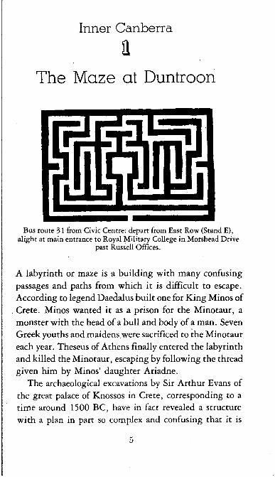
aThe Maze at Duntroon
Bus route 31 from Civic Centre: depart from East Row (Stand E), alight at main entrance to Royal Military College in Morshead Drive
past Russell Offices.
A labyrinth or maze is a building with many confusing passages and paths from which it is difficult to escape. According to legend Daedalus built one for King Minos of Crete. Minos wanted it as a prison for the Minotaur, a monster with the head of a bull and body of a man. Seven Greek youths and maidens were sacrificed to the Minotaur each year. Theseus of Athens finally entered the labyrinth and killed the Minotaur, escaping by following the thread given him by Minos’ daughter Ariadne.
The archaeological excavations by Sir Arthur Evans of the great palace of Knossos in Crete, corresponding to a time around 1500 BC, have in fact revealed a structure with a plan in part so complex and confusing that it is
5

\mj . . - ~ i
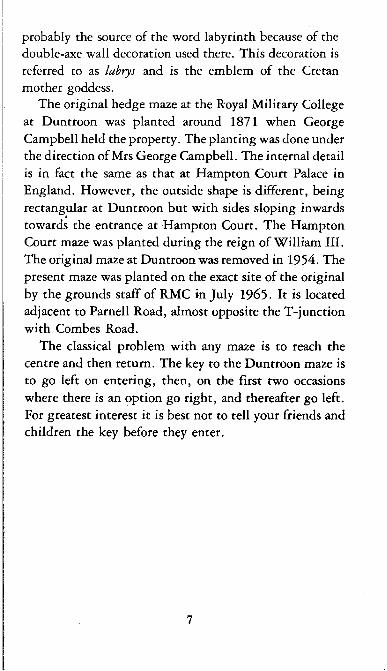
The hedge maze in the grounds of the Royal Military College at Duntroon
6
probably the source of the word labyrinth because of the double-axe wall decoration used there. This decoration is referred to as labrys and is the emblem of the Cretan mother goddess.
The original hedge maze at the Royal Military College at Duntroon was planted around 1871 when George Campbell held the property. The planting was done under the direction of Mrs George Campbell. The internal detail is in fact the same as that at Hampton Court Palace in England. However, the outside shape is different, being rectangular at Duntroon but with sides sloping inwards towards the entrance at Hampton Court. The Hampton Court maze was planted during the reign of William III. The original maze at Duntroon was removed in 1954. The present maze was planted on the exact site of the original by the grounds staff of RMC in July 1965- It is located adjacent to Parnell Road, almost opposite the T-junction with Combes Road.
The classical problem with any maze is to reach the centre and then return. The key to the Duntroon maze is to go left on entering, then, on the first two occasions where there is an option go right, and thereafter go left. For greatest interest it is best not to tell your friends and children the key before they enter.
7

gThe Old Canberra Inn
CANBERRA INNP lA tT LKXMC60
Bus routes 318 and 319 from East Row, Stand F, pass the inn just before reaching Ginninderra Drive. Or alternatively, route 30 from Northbourne Avenue, Stand J and alight at the stop nearest to the
corner of Brigalow Street and Barton Highway.
The restoration of Canberra’s oldest public house, the Old Canberra Inn, in 1976, has provided Canberra with a recreational facility of great charm and historic interest. The inn, which is situated on the Barton Highway at Lyneham, is classified by the National Trust and was built about 1860. The first innkeeper, Joseph Shumack, was the son of John Shumack, who with his wife and family arrived in Australia in the ship Lascar in November 1841, from Donerail in Cork. The family first had the Glebe farm near St John’s Church, where John Shumack died in 1849. His family moved to their own land at Lyneham in 1858, and the house was probably built shortly after this. It was first licensed as an inn on 3 1 May 1876, being at
8

that time the district’s first and only public house. It remained an inn until June 1887, when it was sold at auction to John Read, Joseph’s nephew. From then on known as The Pines, it was the home of the Read family until 1974.
Restoration was carried out by a group of consultants, including architects and historians experienced in the restoration of historic buildings. Under their expert guidance a near-derelict house has been transformed into an authentic bush tavern as it existed over one hundred years ago.
The original structure was a simple slab house with a shingle roof and without verandahs. A corrugated iron roof and verandahs were probably added at the time of licensing, as a shingle roof could be a great fire hazard. Although a new corrugated iron roof has been laid over the old, the original roof structure is still exposed on the inside. A fine example of the bush carpenter’s craft, it is constructed of round sapling rafters, collar ties and heavy tie beams with hardwood pegs spiking them to the main beams.
The basically sound structure of the original building, with the added advantage of a dry climate which has kept the old timber in a well-preserved condition, has greatly helped the work of restoration. The exterior slab walls, which had been covered by an asbestos cement lining, have been re-exposed, and the original flooring refixed. Interior partitions have been removed. The bar is the only new addition to the building, and this has been designed in the simple style of the last century, with brass and polished wood beer-pulls.
To enhance the authenticity of the restoration, old photographs and reproductions of historical records have
9

been framed and mounted on the walls. These include the original licence, and newspaper cuttings telling interesting anecdotes about the gatherings of sportsmen and the awarding of trophies following horse-races which took place in the paddock immediately opposite the inn. Behind the building there are delightful courtyards and a reconstructed old stable. Horseshoe pitching posts with horseshoes are provided for visitors to test their skill in this old bush sport. The Tooth and Co. wagon in front of the building is believed to be the same one which delivered the beer in the old days.
The inn is a delightful place for an informal drink or a barbecue meal, and is open to the public every day from 11 am. Admission is free.
A lone drinker whiles away the hours at the bar in the Old Canberra Inn
10
Yarralumla Nursery
Bus nos 231 and 232 (London Circuit, Stand D) or bus no. 320 from Woden Interchange, to the corner of Novar Street and Schlich
Street, Yarralumla, then walk towards the lake. The entrance to the government nursery is at the end of Banks Street, adjacent
to Weston Park.
One of the most significant influences on the design of the city of Canberra was the garden city movement which began in England during the late nineteenth century. Of great importance in Walter Burley Griffin’s design were the concepts of the garden suburb, the communal parkland, sweeping vistas of gardens, lawns and water, and the provision of avenues of trees for shade and shelter. Yet today’s residents and visitors probably do not realise that the site chosen for the national capital was far from hospitable to shaded parks and sheltered gardens. It was a treeless plain, subject to the extremes of hot summers and severe winter frosts, a low rainfall, and exposed to strong, dry westerly winds. Ringbarking of the natural vegetation on the surrounding hills had left them only lightly wooded. There was a shortage of milling timber, the soil was poor, and the area was overrun by rabbits. Whoever had the responsibility for establishing Canberra’s parks and gardens was faced with a difficult and unenviable task. That Canberra is now known all over the world for its avenues and gardens of delicate spring blossoms, luxuriant summer foliage and golden autumn tints can be attributed largely to the work which has been carried out at the government nursery.
11
The first government nursery was set up on a temporary site at Acton in 1911, and work proceeded almost immediately on the permanent twenty-eight-hectare site at Yarralumla to which the nursery transferred four years later. T.C.G. Weston, who was Officer-in-Charge, Afforestation Branch, from 1913 to 1926, was the man chiefly responsible for the first testing and experimenting with trees and shrubs. During the first two years, over six hundred different kinds, both natives and exotics, were grown under ‘natural conditions’ — that is, with no protection from wind or frost and no water artificially supplied after initial planting. A very high percentage survived their first test of heat, cold, drought and high winds. Especially successful were many varieties of conifers, eucalypts, wattles and oaks. Among the first casualties were the flowering eucalypts of Western Australia, and the sugar gum from South Australia — species which are noticeably missing from the Canberra garden scene today, along with the jacaranda, the Illawarra flame tree and the Moreton Bay fig. Choosing trees based on the results of these early experiments, the first permanent plantings were made in 1915. Since then more than six million native and exotic trees and shrubs propagated at the nursery have been planted in Canberra and its vicinity.
Reafforestation of the hills surrounding the capital is part of the beautification process. Mt Stromlo and-Green Hills were planted with pines and cedars. Some early correspondence between Weston and Burley Griffin suggests that Weston wished to plant other nearby hillsides with trees and shrubs exhibiting foliage of distinctive colours. If this plan had proceeded we might today be gazing upon Red Hill, Golden Hill (Mt Ainslie), Rosy Hill (Black Mountain), and Purple Hill (Mt Pleasant).
12

A peaceful pool at the Yarralumla Nursery
13
The reafforestation program which finally went ahead successfully re-established natural bushland on the hills around us.
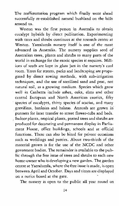
Weston was the first person in Australia to obtain eucalypt hybrids by direct pollination. Experimenting with trees and shrubs continues at the research centre at Weston. Yarralumla nursery itself is one of the most advanced in Australia. The nursery supplies seed of Australian trees, plants and shrubs to many parts of the world in exchange for the exotic species it requires. Millions of seeds are kept in glass jars in the nursery’s cool room. Trees for streets, parks and landscaping are propagated by direct sowing methods, with sub-irrigation techniques, and the use of sterilised sand and peat, not natural soil, as a growing medium. Species which grow well in Canberra include ashes, oaks, elms and other central European and North American exotics, fifty species of eucalypts, thirty species of acacias, and many grevilleas, banksias and hakeas. Annuals are grown in punnets for later transfer to street flower-tubs and beds. Indoor plants, tropical plants, potted trees and shrubs are produced for decorating and permanent display in Parliament House, office buildings, schools and at official functions. These can also be hired for private occasions such as weddings and parties. About two-thirds of the material grown is for the use of the NCDC and other goverment bodies. The remainder is available to the public through the free issue of trees and shrubs to each new home-owner who is developing a new garden. The garden centre at Yarralumla, where the free issue is made, is open between April and October. Days and times are displayed on a notice board at the gate.
The nursery is open to the public all year round on
14

One of the extensive shade houses at the Yarralumla Nursery
weekdays between 7.30 am and 3 pm, and visitors are welcome to stroll through the planted areas, the bush house, and the tropical display house. At the office, pamphlets are available answering questions commonly raised by local gardeners. The public are welcome to bring planps for identification, and to seek advice on problems such as pests and diseases. Just behind the office there is an English garden where, among other plants, specimens of rhododendrons flower profusely in spring. Beyond the English garden there is a plantation of conifers. A large specimen area runs south from the office, bordered by a series of ponds which were once used for research into aquatic plants for Lake Burley Griffin. One specimen of all the species propagated is planted in this lawn area. Unfortunately the trees in the specimen area are not yet all labelled, but staff are available to identify any in which you may be particularly interested.
15

Inside the tropical display house at the Yarralumla Nursery
16

Not all the glass houses or propagation areas are open to the public, partly because the continual traffic of visitors can disturb the sensitive balance of temperature and humidity which is necessary to ensure successful growth. However, the tropical display house is usually open and worth a visit. Among other things it contains a flourishing banana plant — quite a delight to preschoolers. The nursery has its own steam generator in the soil sterilisation area. Steam is blown through the growing medium for about twenty minutes, and the process is quite interesting to watch. Visitors may also be interested to note some experiments in automation in the growing of plants.
The inclusion of a barbecue area and children’s playground in an attractive corner overlooking the lake offers encouragement to the visitor to stay awhile and relax in this delightful setting.
17

4Staircase at the
Indonesian Embassy
The Indonesian Embassy is situated in Darwin Avenue, Yarralumla,and the nearest bus-stop is that closest to the junction of Schlich
Street and Hopetoun Circuit, on routes 231 and 232 (London Circuit, Stand D), or route 320 from Woden Interchange. From the bus-stop walk east via Schlich, Clark and Hunter Streets, Empire Circuit and
Perth Avenue into Darwin Avenue.
For anyone who is interested in the arts and culture of South-east Asia, a visit to the grounds of the Indonesian Embassy is well worthwhile. Within the grounds of the embassy there is a gate with a fascinating staircase surrounded by rows of statues. The gate is a copy of an existing temple gate in Bali — the Besakih temple. The statues along the staircase and around the terrace were hand carved in Bali and represent personalities from two ancient Hindu epics, the Ramayana and theMahabharata.
Although these stories were originally Hindu, they have been disseminated throughout South-east Asia, and are popular all over Indonesia, especially on the island of Bali, where the Hindu-Bali religion has remained strong. With the assimilation of elements of the Hindu culture into the Indonesian culture, the people have gradually come to consider both stories, with the addition of several creative Javanese side-stories, as being the vague history of their own ancestors in Indonesia.
Both the Ramayana and the Mahabharata have been an inexhaustible source of inspiration for Indonesian arts and crafts, music, literature, theatre and dance. A traditional
18
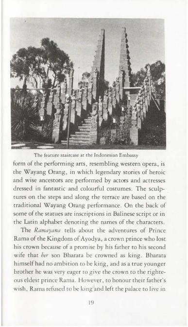
The feature staircase at the Indonesian Embassy
form of the performing arts, resembling western opera, is the Wayang Orang, in which legendary stories of heroic and wise ancestors are performed by actors and actresses dressed in fantastic and colourful costumes. The sculptures on the steps and along the terrace are based on the traditional Wayang Orang performance. On the back of some of the statues are inscriptions in Balinese script or in the Latin alphabet denoting the names of the characters.
The Ramayana tells about the adventures of Prince Rama of the Kingdom of Ayodya, a crown prince who lost his crown because of a promise by his father to his second wife that her son Bharata be crowned as king. Bharata himself had no ambition to be king, and as a true younger brother he was very eager to give the crown to the righteous eldest prince Rama. However, to honour their father’s wish, Rama refused to be king and left the palace to live in
19

A figure which decorates the feature staircase at the Indonesian Embassy
20

exile for seven years. During his absence, Bharata put a shoe of Rama’s on the throne as a symbol that the real and rightful king was Rama, and that he, Bharata, only reigned on behalf of his brother.
While Rama and his beautiful wife Princess Shita, accompanied by his other younger brother Lakshmana, were wandering in the forests, leading a life of endless sufferings, Princess Shita was kidnapped by Rahwana, the evil king of Langka (Ceylon). The mythological Garuda bird, Jatayu, saw the kidnapping of Shita and tried to rescue her, but was defeated by Rahwana, who cut off both his wings with his sword. Before he died Jatayu managed to tell Rama who had kidnapped his wife.
After a series of adventures in which Rama was assisted by the King of the Apes and his army, he finally defeated Rahwana and regained his beloved Shita. When his term of exile was finished he returned to Ayodya, where Shita underwent ordeal by fire to prove that she had never surrendered to Rahwana.
Although in the original Hindu stories there is no link between the Ramayana and theMahabharata, in Indonesia the Mahabharata is considered to be a continuation of the Ramayana. The main Mahabharata story tells of King Pandu of the Bharata dynasty who left five sons, the Pandawa brothers, who were too young to take over the reign of the Astina kingdom when he died. His blind brother who had ninety-nine sons and one daughter could not be king either. The story tells of the continous conflict between the Pandawas and the Kaurawas (the ninety-nine sons) for the right to the kingdom. This conflict, with the many treacherous deeds of the Kaurawas, culminated in the Bharatayuda (the war of the Bharata descendants), ending in the total destruction of the Kaurawas.
21

The display of statues on the steps and around the terrace is not merely decorative ornamentation. While demonstrating to visitors the beauty of Balinese stonecarving, the staircase is also symbolic. It indicates that the Indonesian people have a high and noble ideal, the Pan- casila, based on five philosophical principles, and that they are laboriously climbing up the steps to achieve the actualisation of that ideal. In trying to keep pace with modern science and technology, they do not want to lose their foothold on their own strong culture.
At the top of the steps there is a pavilion housing Indonesian musical instruments and other items. The building is in the style of a traditional Indonesian pendopo, except for the glass walls — in tropical Indonesia a.pendopo is open on all sides. The structure of superimposed roofs is easily recognisable as common on Balinese temples, old Javanese mosques and other traditional Indonesian buildings, while the pond with the small fountains has been designed to express movement and life without distracting from the sculptures around the terrace.
Visitors are invited to inspect the statues of Princess Shita, Prince Rama, and the Ape hero Hanuman from the Ramayana, and Bhima, Arjuna and other heroes from the Mahabharata.
22

§Forestry Relics at Yarralumla
Bus nos 231 and 232 (London Circuit, Stand D), or bus no. 320 from Woden Interchange, to the corner of Novar Street and Schlich Street,
Yarralumla. Walk one block west along Schlich Street to Banks Street. The entrance to the CSIRO Division of Forest Research is
immediately opposite the end of Schlich Street.
Ever since the first plantations of Pinus radiata began to flourish on the once barren hills around Canberra, the ACT has been an important centre for forestry and forest research. The CSIRO Division of Forest Research now covers a large area of land in Banks Street, Yarralumla, and within the grounds there are a number of well preserved items which were used in the Australian forestry industry around the turn of the century.
There is a large map under glass at the main entrance showing the location of the various buildings. Just beyond and to the left of the main building a replica of a pioneer sawmill, of a type common in eastern Australia around 1900, has been reconstructed. A diagram on the wall
23

Log buggy forming part of the display of forestry relics at Yarralumla
identifies the machinery and equipment. Most prominent is a portable steam engine, originally from a mill at Pialba, Queensland. It supplied power for the operation of the mill, and was also used to haul the other machinery and equipment when the mill was moved to a new site. The vertical frame-saw or break-down-saw was used over a hundred years ago at East Lynne near Bateman’s Bay. It could be fitted with two to four blades for cutting the log into flitches. The position of the log on the carriage had to be changed before the saw blades reached the carriage cross-members. The logs were fed into the frame-saw on the log carriage, which moved forward on each downward or cutting stroke of the saw. Most of the remaining equipment, which includes a crab winch, a drag-saw, hand-made spanners, pulleys, bearings and bench rollers, has come from old mills at Captain’s Flat, Braidwood or
24
Moruya. The bullock bows, yokes and bells, and the logging j inker were used in the Moruya area at the turn of the century.
Further along the roadway, adjacent to Forestry House, are some fine examples of vehicles once used for the transport of logs from forest to mill. There is a log buggy made of red gum, once used at Koondrook, Victoria; log tram bogies from Erica, Victoria, which were originally pulled by a steam tram, and a logging whim, used with a bullock team to haul karri and jarrah logs to mills in Western Australia. The history of these exhibits is given on notices placed beside them.
On weekdays, during working hours, publications on Australian forest industries can be purchased from the publications section in Forestry House, and free material suitable for school projects is available. The buildings on the site are not of great interest except for the main one, Number 9 (Office of the Director General). The Australian Forestry School, part of the Forestry and Timber Bureau, was established here in 1927, where it remained until its functions were taken over by the ANU Department of Forestry in 1965. Merger of the bureau with the CSIRO Division of Forest Research in 1975 was an occasion for such regret that a wake was held and a plaque to commemorate ‘the end of an era — 50 years of Federal Forestry’ has been erected in the entrance foyer. The foyer is worth a visit, as it has been attractively floored and panelled with samples of Australian timbers — jarrah, tallowwood, mountain ash, blackwood and Queensland walnut.
The buildings are open only during working hours, but the pioneer sawmill and other relics in the grounds can be seen at any time.
25
©Two Unique Churches
St Ninian’s Church is situated at the corner of Brigalow Street and the Barton Highway, Lyneham, and is passed by bus routes 318 and 319
(Stand F, East Row) and 30 (Stand J, Northbourne Avenue).
To reach Duntroon Military College, take bus 31 (Stand E, East Row) and alight at the main entrance in Morshead Drive, past Russell
Offices. The chapel is in Robert Campbell Road.
This chapter is about two churches, one very old and very small, one very modern and architecturally impressive. Each can lay claim to uniqueness, one because of its age, one because of its design. And each is linked in its own way with a common factor — the Campbell family who originally owned Duntroon, and who provided funds for the building of St John’s Church at Reid, and the schoolhouse attached to it.
The little stone church on the Yass Road (now the Barton Highway) was not always called St Ninian’s. In the beginning it was known simply as the North Canberra Church, part of the Presbyterian Charge of Queanbeyan- Canberra. It was dedicated in February 1873, one year before St Stephen’s, Queanbeyan, making it the first Presbyterian place of worship erected in the Queanbeyan-Canberra area. Before the erection of the permanent stone building, a wooden slab church had been built on the site as early as 1862. The need for such a building arose in a curiously unexpected way. Up until this time the Scottish immigrants — mostly brought in to work on Duntroon, Ginninderra, and other properties — were dependent for occasional Presbyterian services on
26

St Ninian’s, Lyneham, with Sunday worshippers gathering together at the entrance
travelling ministers from Goulburn and Yass. From 1861 a visiting Presbyterian minister from Braidwood conducted services regularly at the Canberra schoolhouse with the permission of George Campbell, to whom the building belonged. When in April 1862, Dr John Dunmore Lang, a hot-headed Scot noted for his fiery temperament, visited Queanbeyan to stir up Presbyterian sentiment, he stirred up conflict between himself and Campbell, whom he attacked wildly for living like a ‘lord of the manor’ in his ‘splendid domain’ at Duntroon. Subsequent to his visit, Campbell suddenly refused to allow further Presbyterian services in the Canberra schoolhouse. While the Presbyterians were discussing the building of their own church, the conflict spread. The schoolmaster, Andrew Wotherspoon, also a Presbyterian, attacked Campbell’s
27

withdrawal of permission in a series of letters to the Queanbeyan Age. This antagonised Campbell so much that he strode into the schoolhouse, dismissed Wotherspoon, and sent the children home, allegedly driving them out with a whip handle. It was against this background of personality clashes and protest that the building of a Presbyterian church at Canberra was conceived.
The first slab building, measuring eighteen feet by thirty-six feet, was designed and built by George Kin- leyside, on land donated by the Palmer family of Jer- rabomberra and Ginninderra. It was replaced by a building of Black Mountain sandstone by 1873. The growth and prosperity of the North Canberra church during the next twenty years reflected the general growth and prosperity of the small landholders of the district. By the late 1890s the congregation had grown so much that the church had to be enlarged. The extension, which was completed in 1901, was of the same rough sandstone. The dividing line between the old and the new can be seen inside in the roof timbers, and is just perceptible as a line in the external stone walls. But as the church flourished when the community around it was prospering, a decline in economic and social conditions was reflected in a decline in the fortunes of the church in the early years of this century. By 1920 the mother church at Queanbeyan saw no further use for the Canberra building. Services, already infrequent, ceased to be held. The seats and organ were removed and the building fell into disrepair. With windows broken and floorboards rotted away, it came to be used as a barn on part of a grazing lease.
This was not by any means the end of Presbyterian services in the area. With the growth of the federal capital, land was allocated for new churches of all denomina-
28

tions, and the threshold stone of the old church became the foundation stone of St Columba’s, Braddon, in 1926. Restoration of the little stone church came about through the enthusiasm and effort of the Reverend Hector Harrison, who noticed the derelict building shortly after his induction to St Andrew’s in 1940. The following year he held a Pioneers’ Memorial Service there and a restoration fund was set up. The re-opening service, held in February 1942, was attended by the Prime Minister, John Curtin, and many descendants of the early Presbyterian families, all now commemorated by small bronze plaques below the windows and on the pews and furnishings. It was Hector Harrison who gave the church its present name. St Ni- nian, a Celt, was the first Christian missionary to Scotland. According to the eighth century historian, Bede, he built a church of stone at Whithorn near Solway Firth, in 397 AD.
Although it is full of mementoes of the early pioneers, St Ninian’s today is not just a sanctuary of the past, but an active suburban church with its own minister and a large and growing congregation. Now attached to a modern church hall and office complex, it is still essentially the same stone building erected by the early Presbyterians in 1873- The fine craftsmanship of the pioneers can be seen in the way the rough blocks of sandstone have been laid in level rows, while in the sunshine the stones themselves reflect mellow warmth and a variety of muted colours. Inside are the simple furnishings of a Presbyterian church — now Uniting — with their memorial inscriptions. When the church is locked the minister may be found in his office at the south-east corner of the hall, and he will open the church to visitors who wish to see inside.
The stones in the Pioneers’ Memorial Wall, near the
29

The Anzac Memorial Chapel of St Paul at the Royal Military College, Duntroon
30

elm trees, came from the old house at Palmerville, Gin- ninderra, home of the Palmer family who once owned the land on which the church was built. There are still traces of whitewash on some of the stones. The walls around the three small gardens are built of stones from The Valley homestead on Wells Station Road. Over all, dwarfing the church, the hall and the garden, are the two immense elm trees. The one furthest from the church is even older than the church itself. According to Samuel Shumack in An Autobiography or Tales and Legends of Canberra Pioneers, ‘the magnificent elm tree near St Ninian’s church was planted by my uncle, Peter Shumack Snr, in the winter of 187 T. The tree nearest the church is believed to be a group of suckers from the original tree.
The Anzac Memorial Chapel of St Paul at the Royal Military College, Duntroon, is unique in the history of the Australian army, as it is the first single building to contain chapels of two separate denominations under the one roof. Opened in 1966, it is one of the largest churches in Canberra, and of an architectural merit which makes it one of the show pieces of the national capital.
It is believed that the site for the chapel was first suggested by Brigadier-General William Throsby Bridges, the founder and first commandant of the college, which was established by the Federal Government in 1911- Bridges directed the studies and training at the college until 1914, when he became Inspector-General of the Australian Military Forces and was promoted to Major-General. He died on 18 May 1915, from wounds received while commanding the First Australian Division at Gallipoli. He is buried on a spur of Mt Pleasant overlooking the college he founded, and it is fitting that the chapel is built at the foot of the same slope.
31

Carved lindenwood wall plaque in the Roman Catholic chapel
32
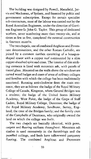
The building was designed by Fowell, Mansfield, Jarvis and Maclurean, of Sydney, and financed by public and government subscription. Except for certain specialist sub-contractors, most of the labour was carried out by the Royal Australian Engineers, under the direction of Garrison Engineer Lt John G. Taylor. This group of dedicated workers, never numbering more than twenty-six, and at times as few as five, completed the external construction in fourteen months.
The two chapels, one of combined Anglican and Protestant denominations, and the other Roman Catholic, are joined by a common narthex consisting of a hexagonshaped tower with a copper roof surmounted by a slim copper-sheathed spire and cross. The interior of this striking entrance is lined with mountain ash, with panels of tinted glass. Mounted on the walls above the windows are carved wood badges and coats of arms of military colleges and families with which the college has been traditionally associated. Running anti-clockwise from the main entrance, they are as follows: the badge of the Royal Military College of Canada, Kingston, where General Bridges was a student; the badge of the United States Military Academy, West Point; the badge of the Corps of Staff Cadets, Royal Military College, Duntroon; the badge of the Royal Military Academy, Sandhurst, Surrey, England; the crest of the Bridges family; and the family crest of the Campbells of Duntroon, who originally owned the land on which the college was built.
The two chapels are basically identical, with pews, carpets and flooring uniform throughout. Mountain ash timber is used extensively in the furnishings and the panelled ceilings, and both have tallowwood parquetry flooring. The combined Anglican and Protestant
33

denominations chapel has seating for 550, and includes a side chapel in which are preserved gifts and memorials previously used in the small wooden hut which was the college’s temporary chapel for many years. The Roman Catholic chapel, which has seating accommodation for 350, contains a free-standing sandstone altar, and some attractive wooden carvings. The crucifix above the altar was designed and executed by the Australian sculptor Tom Bass, who is also well known for other art works in Canberra, including the bronze statue of Ethos in Civic Square. Mounted on the walls are a series of representations of the Stations of the Cross. These were carved in Italy by Giuseppe Runggaldier of Ortisei, Province of Bolzano. The timber is lindenwood, and the designs were carefully chosen as appropriate to a military establishment and the modern architecture of the building. They are well worth examination. Displayed on the ends of the pews in both chapels are the regimental badges of a number of British regiments, and facing them the badges of the affiliated Australian regiments. These beautifully carved wood replicas were executed by Mr R. C. Taylor of Sydney.
Regular Sunday services are held in both chapels. There is one full-time chaplain, who is the Anglican representative, and three part-time CMF chaplains, one Roman Catholic and two Protestant. The chapel is open daily and visitors are always welcome. In addition, visitors may join a guided tour of the college which leaves the parade ground at 2.30 pm each day, from Monday to Friday, at all times of the year.
34

nOld Books,
Pots and Coins
Weekend Gallery Books is located at 5 Birdwood Street, Hughes and may be reached by bus no. 234 from Civic Centre (London Circuit, Stand D), alighting at the first stop in Kent Street, after entering
Hughes. Birdwood Street is only a few metres from this stop on the same side of Kent Street.
The classical museum is on the ground floor of the A.D. HopeBuilding at the University. This building, faced with dark grey
bricks, is located on the south side of University Avenue close to the edge of the campus nearest Civic Centre.
Being still a relatively young city Canberra does not yet boast the numbers of interesting second-hand bookshops that abound, for example, in London. There is one though that is of particular interest for the browser, with a nice collection of books, old maps, and some pictures. This shop, or gallery, if you like, is conveniently located in Hughes close by a bus route from Civic and well worth a visit.
It is operated by Mrs Barbara Burdon and was first opened in April 197 1 in a downstairs flat made vacant by the departure of a grown family. The beginning of the collection was a group of prints of the work of ornithologist John Gould. His accurate and beautifully coloured paintings of Australian birds are well known.
Catalogue No. 2 dated December 1976, available at the gallery, lists a wide variety of books and their prices. At one end of the range is an account of the voyages of Captain Cook and others drawn up from their journals by John
35

A close-up of part of the model of Ancient Rome showing the Colosseum and the Claudian Aqueduct
Hawkesworth and printed in London in 1773. This has a list price of $575. Another which catches the eye is Don Quixote de la Mancha, a translation of Cervantes’ classic published in 1818, modestly priced at $65. A final example, to emphasise the breadth of purchasing, is Malinowski’s The Sexual Life of the Savages of North-Western Melanesia, published by Routledge and Kegan Paul in 1957, listed at $24. Of course what is available for viewing and possible purchase must change from day to day, but the writer has never been disappointed even though regular visits have -been made over the years. Business hours are listed as: weekends (Friday to Monday), 10 am - 6 pm.
It is not widely known that a splendid little classical museum has been growing steadily in recent years on the
36

ANU campus. This museum is located in the A.D Hope Building and has been put together by the staff of the Department of Classics, with particular credit to Dr Ann Moffatt, the lecturer in Roman Civilisation.
There are a number of fine examples of ancient pottery from Greece and Italy, a large model of ancient Rome, and a fine collection of coins of the period. All this is set out pleasantly in well lit showcases with descriptive labels for ease of viewing. For the technically minded it is interesting to note that the glossy black surface of Athenian pottery is not due to a glaze but to a special paint mix of very fine clay particles (mostly illites) of basically the same clay as that from which the pot itself was made. The blackness of the paint and the redness of the body of the pot are both due to the presence of iron oxide. By first heating the freshly painted pot in a reducing atmosphere at 1000°C both body and paint become black due to the oxide FeO. Subsequent heating at 800°C in fresh air transforms this oxide to red Fe20 3 except in the paint where the fusing of the illite clay particles locks in the black FeO.
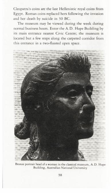
One non-ceramic object that might be singled out is the bronze portrait head of a woman. The head is of a relatively young woman with elaborate coiffure which is characteristic of the first century BC. This fine bronze has a good claim to be a portrait of a member of the Julian family, perhaps the emperor’s sister Octavia. Such a well preserved bronze head is very rare.
An interesting example from the coin collection is that which depicts on the obverse side a bust of Cleopatra, diademed. It is in the form of an 80-drachma copper piece dated 44-30 BC from the mint at Alexandria. On the reverse side is an eagle standing left on a thunderbolt.
37
Cleopatra’s coins are the last Hellenistic royal coins from Egypt. Roman coins replaced hers following the invasion and her death by suicide in 30 BC.
The museum may be viewed during the week during normal business hours. Enter the A.D. Hope Building by its main entrance nearest Civic Centre; the museum is located but a few steps along the carpeted corridor from this entrance in a two-floored open space.
Bronze portrait head of a woman in the classical museum, A .D . Hope Building, Australian National University
38

©C apital Hill Oddities
Capital Hill is at the southern end of Commonwealth Avenue. The Commemoration Stone and the geological feature may be reached by taking the small access road leading off State Circle opposite Sydney Avenue. There is a car park at the end of this access road adjacent to
the Commemoration Stone.
The no. 234 bus from Civic Centre (London Circuit, Stand D) to the Woden Interchange also travels around State Circle. Nearest stop to
the access road to the Commemoration Stone is at the junction of State Circle with Brisbane Avenue.
It is interesting to know that four major foundation stones are associated with the beginnings of Canberra. The first three, laid respectively by Andrew Fisher, King O’Malley and Lady Denman, were unveiled on 12 March 1913, and mark the official naming and commencement of the national capital. They are set in what is known as the Commemoration Stone on Capital Hill. Originally it was planned to erect an eight-metre-high coloumn at this site, but clearly this idea has not been proceeded with. In fact if the new Parliament House is eventually built on this hill the column probably never will be built, and perhaps we shall lose the Commemoration Stone as well.
The fourth foundation stone is that laid on 21 June 1920 by the Prince of Wales (later King Edward VIII) to mark the Capitol Building, a construction which has also not proceeded any further so far. As the Canberra Times remarks it must clearly be the longest-running construction project in Australia, fifty-seven years at the time of writing. The huge stone itself, turned upside down, is believed to have been used as a doorstop for the printers’
39

Geological unconformity exposed on Capital Hill
bachelor quarters in Kingston for many years. It now resides in the Australian War Memorial’s storehouse at Duntroon according to a recent story in the Canberra Times.
If one walks up to the summit of Capital Hill where the flag-pole is situated and looks down immediately to the south, an odd-looking outcrop of rock is visible. This is a nice example of what geologists call an unconformity. By this is meant a visible sign of a break in time between deposition of rocks below and rocks above the feature.
In the present case the rocks closest to the flag-pole are Black Mountain sandstone, the beds of which dip at an acute angle into the hill. Laid down approximately at right angles and on top of these are beds of Camp Hill sandstone. It may be deduced that there was a strong earth movement and a period of erosion between the end of the
40

Black Mountain sandstone deposition and the beginning of the Camp Hill sandstone deposition. Careful inspection of the middle region of the feature reveals the break between the two bedding systems, although recent erosion has blurred the picture.
It has often been said that Australia does not look after its past with the same care as other nations do theirs. The story of the foundation stone for the Capitol Building is consistent with this idea. However, in more recent times it is clear that things have changed for the better in this respect. Thus, the advent of the National Trust and its success in conserving historic buildings is apparent to all.
On State Circle almost opposite the Office of the Malaysian High Commission is another small access road leading off to a very pleasant little picnic area at the foot of Capital Hill. On the right-hand side of this road is a small building, carefully preserved in spite of its architectural simplicity. It is the hut where the original survey documents for Canberra were kept, a small but clear sign of better understanding of and care for our past.
The surveyor’s hut at the base of Capital Hill
41

On the Outskirts
DEnvirona
Reached by car via the Monaro Highway, turning left to Fraser Park about 5km past the Hindmarsh Drive intersection. Immediately after passing under the railway bridge, turn right and follow the
railway line for a few hundred metres, until reaching the entrance to the property.
While the city of Canberra stands as an impressive monument to its planner, Walter Burley Griffin, not many people are aware that the remnants of another grandiose experiment in real estate development can be seen only a few kilometres from the city, just outside the territory boundary. Standing strangely out of place in the quiet green countryside, where only sheep and cattle graze, are several pairs of massive stone pillars, an impressive arch, bandstands, and a forty-foot stone column topped by a bust of Sir Henry Parkes.
42

Obelisk at Environa topped by a bust of Sir Henry Parkes
43

Environa was conceived in the early 1920s by Henry F. Halloran, one of the earliest practitioners in Australia of the art of real estate development. He also had ambitious projects at Jervis Bay and Port Stephens. When it was announced that land in the newly developing federal capital was to be available only on leasehold, he acquired large areas of freehold along the railway line between Queanbeyan and Tralee— immediately adjacent to the ACT border—which he subdivided and promoted as ‘the nearest freehold land to the Parliamentary and Government centre’.
The prospectus maps, which can be seen in the Map Reading Room of the National Library, show that the plan bears a close resemblance to Walter Burley Griffin’s design for Canberra, with wide circular roads and provision for offices, shops, a hospital, theatres, parking lots and recreational facilities. The northern part of the subdivision, the Canberra Freehold Estate, adjoined Queanbeyan. Romantic street names — Rue de Paris, Tokio Dori, Piazza di Roma — indicate the extent of Halloran’s imaginative vision. Sales of land were advertised far afield, and the map indicates that a large number of blocks were sold, many to buyers in England.
Environa itself comprised an area closer to Tralee. According to the map it was ‘a magnificent subdivision, the design is a masterpiece of town planning on beautiful undulating land with far-reaching views and overlooking the wonderful city of Canberra itself. Right on the boundary but not within the Federal Territory, Environa is absolutely freehold (Torrens Title) and free from the onerous restrictions applicable to the Commonwealth Leasehold Titles’.
To promote development, Halloran began building the
44

One of the timber and metal bandstands at Environa
massive, rustic stone monuments that can still be seen on the estate. Whether his intention was photographic reproduction in an imaginative prospectus, or whether he was merely indulging his fancy, is not known. Other even more elaborate examples of his work were built at Tanilba, on Port Stephens, and at his home in Sydney. Using local stone and a curiously irregular and primitive style, he constructed an archway opening into a wide and imposing avenue of stone pillars, terminating in the obelisk from which Sir Henry Parkes commands a view of the national capital. The marble bust, now somewhat scarred by shooters, came from a second-hand shop in Sydney. At other vantage points around the estate stand massive summer-houses or bandstands, supported on undressed tree trunks and with corrugated iron roofs. Another unusual relic at one time was the main top-mast of the cruiser
45
Sydney, which sank the German raider Emden in 1915. It was erected in the central part of Environa as a memorial, but dry rotted at the base and collapsed. After lying in a shed for nearly thirty years it was moved to the Jervis Bay area.
Because of the slow development of Canberra and the depression of the thirties, most of the blocks in the northern subdivision, particularly those sold in England, were never developed. As the estate lay idle over the next thirty years, vague and unsubstantiated rumours of swindle grew up, while the stone monuments acquired the aura of a prehistoric ruin. Eventually the Queanbeyan Municipal Council ordered the sale of many of the blocks to collect overdue rates. A list of owners, published in 1967, revealed addresses in London, Edinburgh, and the Isle of Wight. About three hundred blocks in South Queanbeyan were compulsorily resumed and leased to the New South Wales Housing Commission. This area has become part of the residential area of Queanbeyan.
Environa itself was never put on the market. It is at present owned by Halloran’s daughter, Mrs David Lar- combe, and her husband, who built an attractive home on the property in 1970-71. Henry F. Halloran died in 1953, aged eighty-four.
The stone monuments can be seen without intruding on the property, from the roadway running parallel to the railway line going up to Tralee Station, or from the south-western boundary of Fraser Park (Tralee Speedway).
46

Original location map for Environa
47

mForest Park
Proceeding out of Canberra along the Cotter Road the entrance to Forest Park is located on the right-hand side approximately 0.5 km past the bridge over Yarralumla Creek. It is opposite the southern suburb of Curtin, is clearly sign-posted, and best reached by car.
It is a basic hope of this little book that the purchaser will find in its pages a variety of things to do in an active way as well as places to visit as a spectator only. To this end a short account is included of a unique riding school where young and old can take to the saddle.
Forest Park is unique in that it has the only fully covered riding arena in the area. This allows instruction to take place in all weathers. The type of participation is varied. At one extreme is the twenty-five or fifty minute
48

Some young riders undergoing instruction in the covered arena at Forest Park (Photograph by the Canberra Times)
private lesson for one rider ($8 and $14 respectively). Then there are the group lessons and trail rides of fifty minutes duration ($6 and $5 respectively). Longer periods are also possible. Inquire at the office (phone 81 6142) for further information and up-to-date prices. Young ladies seem to find this sport particularly interesting so do not be surprised at the clear predominance in numbers of this sex. An added flavour is provided by the very competent French riding instructor, Marcel.
For those who would rather watch, the nearby public equestrian park is to be recommended. This also borders the Cotter Road and is only separated by a plantation from Forest Park. Local pony clubs and sometimes larger zone meetings provide lively displays of horse jumping and dressage competitions most weekends.
49
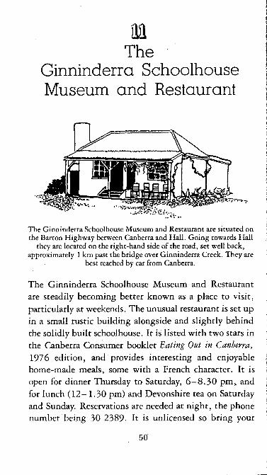
mThe
Ginninderra Schoolhouse Museum and Restaurant
The Ginninderra Schoolhouse Museum and Restaurant are situated on the Barton Highway between Canberra and Hall. Going towards Hall
they are located on the right-hand side of the road, set well back, approximately 1 km past the bridge over Ginninderra Creek. They are
best reached by car from Canberra.
The Ginninderra Schoolhouse Museum and Restaurant are steadily becoming better known as a place to visit, particularly at weekends. The unusual restaurant is set up in a small rustic building alongside and slightly behind the solidly built schoolhouse. It is listed with two stars in the Canberra Consumer booklet Eating Out in Canberra, 1976 edition, and provides interesting and enjoyable home-made meals, some with a French character. It is open for dinner Thursday to Saturday, 6 -8 .30 pm, and for lunch (12-1.30 pm) and Devonshire tea on Saturday and Sunday. Reservations are needed at night, the phone number being 30 2389- It is unlicensed so bring your
50
Period kitchen in the Ginninderra Museum
51

The old schoolhouse and attached residence, now a museum, a t Ginninderra
own liquor. The wooden restaurant building itself was transported relatively recently from elsewhere in NSW and re-erected and renovated on its present site.
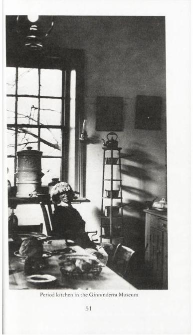
The schoolhouse is a substantial red brick building linked permanently with the one-time residence. It has a stone set in the wall underneath the main gable proclaiming it as having been built in 1883. The museum has been set up in the residence and is well worth a visit. It is open from 10 am to 5 pm, Saturdays and Sundays.
The museum is attractively different from other refurnished houses of the same period because of the wide variety of interesting household items on show and the reality lent to the displays through the use of life-size dummies. There is a kitchen, a child’s bedroom, a living -nom and a master bedroom, all fully furnished.
52
In the early days there was competition dating back to the 1880s between Ginninderra and Hall to see which would gain supremacy, particularly in respect of the final location of the post office. The original telegraph office was opened at Ginninderra in 1879 and operated by a telegraph master, Mr F. Coles, who was only fifteen years of age at the time. After the resignation of the postmaster, a Mr Harcourt, in 1882 Mr Coles took over both jobs. Eventually, after a series of changes in postmaster and the relocation of t^e office in the residence of the schoolteacher, who then operated it, the post office was shut down in 1962 and all further business conducted from Hall.
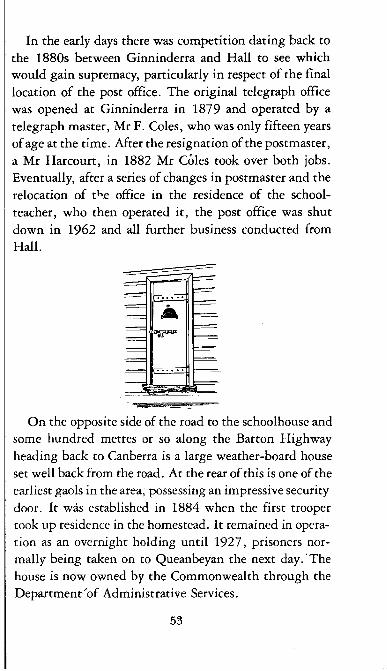
On the opposite side of the road to the schoolhouse and some hundred metres or so along the Barton Highway heading back to Canberra is a large weather-board house set well back from the road. At the rear of this is one of the earliest gaols in the area, possessing an impressive security door. It was established in 1884 when the first trooper took up residence in the homestead. It remained in operation as an overnight holding until 1927, prisoners normally being taken on to Queanbeyan the next day. The house is now owned by the Commonwealth through the Department 'of Administrative Services.
53

Further O ut
mMines and Mining
Bywong Reefs is on the eastern side of the Federal Highway about 6 km north of the Sutton-Gundaroo road, and is easily reached by car.
The turn-off is immediately adjacent to the gates of Phezulu. It is near the crest of a hill on a bend, so take care. Follow this gravel road
for about 1 km till you come to a gate leading to the area of the mines.
Jumping or Valley Creek is reached by walking for about 3 km south of the Queanbeyan Golf Course. Head in a south-easterly direction from the water tank until you come to the power transmission line, which can be followed downhill to the Queanbeyan River. Here a well-defined track turns left and leads past several abandoned farm
buildings to a ford across a small creek. Continue walking in a southerly direction along the eastern bank of Valley Creek until you
come to the smelter.
The iron mine at Paddy’s River can be reached by walking from the Cotter Kiosk, following the Cotter River downstream to its junction with Paddy's River. Follow Paddy’s River for about 200 metres until you come to a gully on your right. A track to the mine climbs along
the right side of this gully.
54

Most of the country around Canberra has been thoroughly explored and worked for mineral deposits since the early 1850s, but although a few minor gold rushes occurred there were no spectacular bonanzas, and the records generally show small returns from scattered areas. At present the nearest mineral deposit being worked on a commercial scale is near Tarago, where Woodlawn Mines is obtaining copper, lead and zinc from an open cut. Lake George Mines Ltd at Captains Flat closed down in 1962. Among the smaller abandoned sites there are few where evidence of old mining operations remains. Of these few there are three which are easily accessible from Canberra, and where shafts, adits and dilapidated structures can still be seen.
Bywong Reefs, near Sutton, was the site of a gold rush which began in November 1894, after a syndicate reported a return of fifty-one ounces of gold from four tons sent for assay. By m id-1895 about three hundred men were on the field, and plans had been announced to subdivide the land into township lots. At its peak Bywong Reefs, as described in the Goulburn Evening Penny Post, consisted of ‘two slab buildings bearing the inscription “General Store”, a brown-and-white tent with the words “Cheap Grocer” roughly traced across it, half a score of windlasses studding the hilltop and indicating the shafts, one or two slab huts for miners’ dwellings and numerous tents representing a weatherworn appearance’. During that year a school was opened, a post office began operating, two bakers and two butchers traded, and there were grand plans to build the Bywong Hotel. But by December, when the government surveyor laid out the four main streets of the proposed village of Bywong, it was already too late. A severe water shortage had made work
55

almost impossible, disillusioned fossickers were leaving the field and the village had all but disappeared.
The last of the Bywong miners was Arthur Shepherd, who began working with his father on an abandoned claim at the age of twelve, and who for more than sixty years continued to eke out a living at Bywong until his death in 1964. Almost a legend in his time, his were the last surviving memories of the early days, especially of the hardships suffered by children, sleeping on the floor with only sugar bags for blankets, living on rabbits and home-grown vegetables, and left to fend for themselves in the bush while they ‘cradled’ mullock heaps for gold to buy flour and sugar. Some of his tales were published in the Queanbeyan Age on 28 August 1976.
The remains of Bywong Reefs, which are on crown land in the midst of several hectares of bushland, include a number of shafts and heaps of excavated rubble, two walls of a mud hut, flattened wooden sheds, hundreds of kerosene tins, a stone-lined well, and unfortunately piles of junk and rubbish dumped more recently. A poppet head which was built on adjoining private property — probably as recently as 1961 — can still be seen and is being used by the present owner as a tvater tank stand. It is advisable to take care when visiting the site, as the shafts are open and unprotected. Children should not be taken into the area. A notice at the gate warns the public against entering any shaft or tunnel.
Some of the machinery from Bywong Reefs is still preserved in the local area. As part of a small museum in the grounds of Sutton Public School there is an ore crusher or three-head stamp battery, and the steam engine which operated it. The steam engine was manufactured by Ransome, Sims and Jeffries, of Ipswich, England,
56

Poppet head built over one of the deeper vertical shafts at Bywong
57

between 1890 and 1915, and the ore crusher at Denny’s Engineering, Goulburn, in the 1930s. A five-head stamp battery which was also used by Arthur Shepherd in the 1930s can be seen on the lawn on the south side of the Research School of Earth Sciences at the Australian National University. Some relics from the Lowe and Alehin mine, including a lantern, small dredge buckets, a wooden shoe last and a bee-hive frame, are now in the Queanbeyan Historical Museum — a small museum in the park behind the Queanbeyan Court House, open on Saturdays and Sundays between 2 and 4 pm.
A less spectacular site, but one well worth a visit for the pleasant walk, is on Jumping or Valley Creek, about 3 km south of Queanbeyan. In this quiet green hollow, on the eastern bank of the creek and almost immediately below a high single strand power line which spans the valley, there is an old brick smelter, and not far away an open cut in the hillside. Although it is not certain when the smelter was built, there is no doubt that this is the site of a galena lode which was discovered in the 1850s. The property at that time was part of the Dodsworth estate, owned by Captain Faunce, first police magistrate in Queanbeyan. It later became known as Primrose Valley or The Valley (not to be confused with Primrose Valley Creek which flows into the Molonglo River further to the east, near Hoskinstown). Captain Faunce sank a shaft, but did not proceed with the enterprise, and nothing more was thought of the lode for many years. In 1868 it again attracted attention, and a company was formed to mine lead and silver. Another shaft was sunk, and the ores produced such a large percentage of silver to the ton that extensive operations were carried on for a time. However this enterprise also collapsed, probably for want of capital, and no further
58

Fun in an old truck a t Bywong
interest was shown until 1897, when operations were begun by Mr Trewenack, mining manager of Captains Flat.
In August of that year John Gale published a series of articles in the Queanbeyan Observer entitled ‘Mining in the Queanbeyan District, Past and Present’, in which he described a visit to the mine at Primrose Valley. At the site, about two miles from Queanbeyan, at the confluence of two creeks, he saw a line of shafts and trenches, and a well-defined portion of the lode. ‘It has been stripped and laid bare from an outcrop to a depth of about 12 feet. The lode was about five feet wide. This depth had been reached by means of a drive of about 20 or 25 feet . . . The galena shows very freely in the ore at grass.’ John Gale made no mention of the smelter, but the open cut which he described is still to be seen on the hillside above it.
59

Old smelter at Jumping (Valley) Creek
According to reports of the NSW Department of Mines for 1898 and 1899, ore from The Valley yielded between twelve and sixty-five ounces of silver to the ton, with some lead and zinc. No further record of the mine appears in the reports after 1899- Presumably like most other mining ventures in the district its promise was short-lived.
The iron mine at Paddy’s River is probably the most well known of the abandoned mining sites in the local area, it has been described in greater detail in Rambles around Canberra (ANU Press 1977, published in association with the National Parks Association of the ACT). According to John Gale the mineral deposits at Paddy’s River, or ‘the Cotter’, were known in the 1870s, although the first recorded operation was in 1895. The existence of a fairly large ore deposit in association with an abundance of limestone, and timber for fuel, attracted the
60
attention of a number of companies in the early 1900s, but the deposit proved too complex to permit cheap treatment. As recently as 1946 there was an application fora mining lease in the area. The application was refused, on the grounds that mining operations would lead to pollution of the swimming pool in the Cotter River, as well as increasing the fire risk in the nearby pine plantation. We can be thankful for the foresight of the environmentalists who preserved this delightful area as a recreational facility.
Remains of a railway track still lead to the main entrance of the mine. This has been sealed by a gate, which should be locked, as it is not considered safe to enter. A large amount of ore-bearing rock has been dumped on the hillside. Samples of this rusty-red rock contain magnetite ore and will behave as quite powerful bar magnets.
On the opposite side of the gully, but nearer to Paddy’s River, is a limestone outcrop in which the Cotter Caves are to be found. Both entrances to these caves have been fenced off, for safety reasons, and permission must be obtained to enter them. The caves are not considered to be of great interest, especially since any formations which they once contained have been destroyed by vandals.
61
mGinninderra Falls
Bus routes 16, 40 and 4 l (Alinga Street, Stand G), to Higgins Interchange, then route 49 from Higgins Interchange. Alight close to
where bus turns right out of Southern Cross Drive into O ’Reilly Street. Walk along Southern Cross Drive which becomes Parkwood
Road and into the Parkwood property. Take the first left track which leads eventually to Cusack’s Crossing. From this junction the walk
length is approximately 4 km to the crossing.
The Ginninderra Creek Falls are described in pioneer journalist John Gale’s volume Canberra, History and Legends published in Queanbeyan in 1927. In this book he recounts how he told Sir John Forrest during a discussion of the relative merits of Dalgety and Canberra that these falls were, in his opinion, one of the show places of Canberra, outrivalling even Dalgety’s Snowy River! A striking photograph of the upper falls is included in his book, which may be seen in the National Library.
The lower falls pictured here are situated on Ginninderra Creek a hundred metres or so from its junction with the Murrumbidgee River. This junction is itself approximately half a kilometre downstream along the Murrumbidgee from Cusack’s Crossing. There is a dirt track just suitable for motor vehicles leading off Parkwood Road at the extreme western end of Belconnen just north of the NSW/ACT border, which leads through a number of gates to Cusack’s Crossing. (See Brindabella, Sheet 8627 (Edition 1), National Topographic Map Series.) This track and the falls themselves are on private property so anyone thinking of following this route must first seek permission of the owner of the Parkwood property. The
62

The lower falls on Ginninderra Creek
63

junction of the creek with the Murrumbidgee can also be reached by walking along the Murrumbidgee from Uriarra Crossing, or by canoe, although care must be exercised with the rapids met along the way and only the experienced should attempt this.
The Murrumbidgee River itself downstream of Canberra is on occasions strikingly wide and deep. Unfortunately, at the time of writing there is a strong growth of algae along the edges which would seem to indicate a certain level of pollution. Swimming and drinking is therefore precluded in this area until the completion of the Lower Molonglo Water Quality Control Centre.
Graeme Barrow in his book 25 Family Bushwalks in and around Canberra (Dagraja Press, Canberra 1977) graphically describes the quite difficult progress up Ginninderra Creek from the lower to the upper falls. Only the more enterprising and hardy would be recommended this further journey although the upper falls represent a splendid sight.
Water
Nothing is lovelier than moving water,The diamond element, innumerable jewel,
Brittle and splintering under the sharp sun, Yet softer than doves’ feathers, and more smooth
Than down of swan.
Nothing is lovelier than water tying still, When the Moon takes that stillness for her glass.
Gerald Bullett
64

/wte
A peaceful view of the Murrumbidgee River The junction with Ginninderra Creek is hidden from view on the right
65

mRed Rocks Gorge
Access on foot only, entailing a walk of about 3 km along the Murrumbidgee, either from Pine Island or from Freshford, through fairly rugged country. The 1:100,000 map of the Australian Capital
Territory shows the Red Rocks as a ‘rocky outcrop’ near Freshford Creek.
Approximately half way between Pine Island and Kambah Pool the Murrumbidgee River flows through a wild and almost inaccessible gorge, where huge grey boulders have been flung across the water and a sheer red cliff towers above on the western side. Known as the Red Rocks Gorge, it is to be preserved as a wilderness area in the future development of Tuggeranong, with no vehicular access, and open only for walking, nature study and similar low intensity activities.
The Red Rocks appear at their most spectacular from a vantage point on the opposite (eastern) side of the river. This entails a walk from Kambah Pool upstream for approximately 3 km. Do not walk along the river bank, but keep to the high ground, where there is a track close to a fence. The Red Rocks and the scenic gorge come into view soon after crossing Allens Creek. In the morning or mid-day sunlight the red colour is particularly brilliant, and the cliff face looks like a row of giant organ pipes, with the blue water of the Murrumbidgee foaming among the rocks below.
The Red Rocks can be reached by walking downstream along the western (left) bank of the river from Pine Island, after first crossing the river at a suitable place. Cut across the spur where the river makes a sharp left hand bend, and
66

The delightful swimming place a t Red Rocks Gorge
67

keep to the high ground. A walk of similar length leads from Freshford homestead, along a four-wheel-drive track which terminates about half a kilometre upstream of Red Rocks. The colourful cliffs are immediately downstream from Freshford Creek, which flows first through a pleasant shady gully, contrasting markedly with the turbulent rocky landscape and mountain of tangled driftwood at the confluence. From here it is a short but rough scramble over the rocks to reach the base of the cliffs.
The red colour of the outcrop is caused by chemical weathering of the original grey dacite which occurs throughout the gorge. The dacite is a volcanic rock which contains about 5 per cent iron, and where the fresh rock is exposed, as it is here, a ferric oxide skin forms. On rocks submerged in the river the ferric oxide is washed away, and the red colour does not appear.
When the flow of the Murrumbidgee is low, as in a dry summer, cascades and rapids alternate with deep silent pools and clean sandy beaches, making for perfect swimming after the long hot walk. However, after heavy rain, the flow is dangerously strong and the flood level high, as the piles of debris under the cliff testify. It is advisable to walk well above the river and not to attempt to swim at these times.
68

mThe Mills Cross
Proceed along the Kings Highway out of Queanbeyan towards the coast until the Captains Flat Road is met on the right. Take the
second turn on the left along this road which is some 15 km past the original turn-off. Follow this unsurfaced road for a further 5 km,
when the Mills Cross will come into view on your right. The entrance to the observatory is reached by taking the next road on the right.
It is not known to many that, situated close to Canberra, is one of the major radio telescopes of the world. The Mills Cross as it is called is located on the Molonglo Plain approximately 30 km east of Canberra. It is operated by Sydney University and the site is known as the Molonglo Radio Observatory.
The inventor of the cross is Professor B.Y. Mills who first devised the principle and tried it out at Fleurs near Sydney in 1954. The construction near Canberra was completed in 1967. The cross is composed of two arms, each a mile long, one fixed and set north-south and the other mechanically steerable and set east-west. The arms are actually 40-feet-wide cylindrical parabolas surfaced with wire mesh. The east-west arm is til table about its long axis through 55° from the zenith.
The east-west arm used alone receives signals from distant radio stars in the sky located in a narrow strip parallel to the line of latitude through the centre of the telescope. The north-south arm similarly receives signals from a strip of sky parallel to the corresponding meridian of longitude. When the two arms combine as a cross their
69

The end of the movable east-west arm of the Mills Cross radio telescope
individual signals are correlated and give a response only to directions where their reception patterns overlap. The direction of reception may be steered to any part of the southern sky by a combination of two motions, one provided by mechanical tilting and adjusting the aerial, the other by rotation of the earth (see Appendix for fuller description).
A radio telescope must be sensitive to pick up the tiny radio signals from the distant stars or other radio sources. Of equal importance is that it must be able to discriminate against nearby stars, i.e. it must have high resolving power. Both of these requirements are met by the more often seen dish telescopes providing they are large enough. However, it would be virtually impossible to build a steerable one with a diameter of one mile: the
70

largest in Australia is that at Parkes which has a diameter of 210 feet.
Because of its size the Mills Cross has both high resolution and also good sensitivity. On the debit side it is restricted to two wavelengths whereas the Parkes radio telescope can operate over a range of wavelengths. Also it is attached firmly to the earth as what is called a meridian instrument.
Among other things the Mills Cross is used for mapping the radio emissions of the Milky Way with a detail that cannot be approached by other instruments in the world. It was also of great value in discovering and studying the unusual radio sources known as ‘pulsars’ which were first observed in 1968.
Unless special permission has been gained beforehand, the visitor must be content with viewing the telescope across the security fence. However, the sheer size of the contrivance is very impressive even to the layman and is well worth the drive from Canberra to see.
71

mLondon Bridge
Reached by car initially south along the old Cooma Road from Queanbeyan then forking left into Burra Road. After a distance of
approximately 8 km past this junction look for a finger-post pointing easterly to London Bridge. Follow made road and then track through
two gates keeping right and heading down towards Burra Creek.
London Bridge is a natural archway spanning Burra Creek about 22 km south of Queanbeyan. The formation is due to the solution and erosion of limestone by water. Limestone is more readily soluble than other types of rock, and in limestone country its removal by the solvent action of river water results in underground caverns and passages, and sometimes natural bridges.
Geologists believe that Burra Creek originally flowed around the limestone outcrop in a sweeping meander, cutting steep cliffs and slopes on each outer bend. The abandoned meander channel, on the eastern side of the stream, is still recognisable, although more recent deposits of alluvial material from a right-bank tributary have filled and covered it. By cutting through the limestone obstruction, Burra Creek has shortened its length by about 400 metres, and created a beautiful piece of natural architecture. Within the limestone arch there are several other passages that are evidence of earlier cut-off channels. Burra Cave, a former through cave, is partly blocked by sediment and is not now large enough for an adult to pass through. There are a number of short, narrow passages with dead ends. The largest room in these abandoned caves is in the Douglas Cave, which is furthest to the west.
72

London Bridge
73
and whose three entrances are all on the downstream side. The caves are not of great interest except perhaps to the speleologist.
Where Burra Creek passes under London Bridge on the upstream side there is an excellent place for swimming, the water being clear and deep in places with sandbars for wading. The bridge itself is about tv/enty metres wide and as one approaches from above it is not immediately seen to be an arch. At the time of writing, it would appear that the water backing up behind the new Googong Dam will one day lap back to London Bridge, but will not inundate it. There is a sign on the way into the property indicating that it is private. In spite of this it seems that these lands are in fact government owned, being part of the Googong Catchment. Permission to enter should be sought from the Conservation and Agriculture Branch of the Department of the Capital Territory. On National Mapping Sheet 8726 (Michelago 1:100,000) there is an indication of limestone caves close by. There are also unverified stories of these having been used in the past for Aboriginal burials. Perhaps best simply to regard the spot as a pleasant and interesting place for a picnic.
74
mLyre-bird Haunts
and Mountain ViewsLocated in the Blue Range, this area is accessible by car via Adelaide Avenue, Cotter Road, and Brindabella Road. The Blue Range Road
leaves the Brindabella Road on the right 13 km from its junction with the Cotter Road.
Blue Range, on the north-western border of the ACT, is one of the less frequented areas of our mountains, yet easily accessible from the Brindabella-Mt Franklin road. A pleasant afternoon’s drive along the Blue Range Road will take the visitor past the Blue Range Hut — now a popular picnic area — through pine plantations and eucalypt forest, close to ferny gullies where lyre-birds may be heard, and eventually to a spectacular vantage point at the top of the range. No diversion off this road is necessary.
Lyre-birds are actually among the more common birds in the ACT mountains, and are found in the denser, steeper gullies along the entire length of the eastern scarps of the Brindabella and Tidbinbilla Ranges. These eastern slopes are more protected from strong westerly winds, and moister and cooler than the more exposed westerly slopes, where as a rule lyre-birds are seldom to be seen. Tree ferns are often associated with lyre-birds. In the ACT the birds are found not only in the ferny gullies but also in the dry scrub on ridges right up to the snowline area, that is, within altitudes between 1000 metres and 1600 metres. They are not found in the snow gum communities.
During the breeding season, which begins in autumn,
75

A distant view of Mt Coree from an adjacent ridge in the Brindabellas
the male lyre-bird builds throughout his territory a number of mounds of flattened earth, usually on a slope on the edge of a gully. He visits these mounds regularly each day for display and song, with the purpose of attracting a mate and defending his territory from other males. The lyre-bird’s song is characterised by a great richness and diversity of sound, and in addition to his natural ringing call he can mimic the calls of other birds and will perform a medley of whistling, clanking and chattering which is even better and louder than the efforts of the originators. Only the male birds sing.
The nesting female builds a large, bulky, messy structure of sticks, usually in a tree or fern or on a ledge. She
76

lays only one egg, usually in winter, and incubates and rears the chick alone. The young are running wild by late spring. In summer the birds are quiet.
Because of the splendour of the male lyre-bird’s tail, in display a shimmering cascade of silver, it is not surprising that the tail feathers became highly prized during the plume trade of the early 1900s, and thousands of tails were exported before the lyre-bird became protected by law. Naturalists are now happy to report that lyre-birds are no longer classified as rare fauna in New South Wales.
From many of the ridges in the mountains lyre-birds can be heard in autumn and winter. One of the best ridges is about 5 km from the Blue Range turn-off. A forest road leads off to the right along the ridge, just before a sharp right-hand bend and descent. For those familiar with maps, the grid reference is 8627-695925 (ACT 1:100,000). At the right time of the year a quiet party will hear unmistakable sounds of lyre-birds down in the gullies on either side of the ridge. However, although the birds are numerous, they are very shy and not easily seen, and the observer should not feel disappointed if he sees no more than a fleeting glimpse in the distance.
It is a further 7 km from this point to the top of Blue Range. After passing through a gate, drive a further 0.6 km where there is a water tank on the left. A short walk up a rocky prominence behind the water tank affords a view- on the left of Mt Coree (1421 m), which from this angle resembles the Matterhorn. On the peak of Mt Coree is a distinguishing fire tower. To the right is the rocky face of Devil’s Peak, a less spectacular mountain in spite of its name.
The shortest return journey at the end of your day is to go back the way you have come.
77

mRocks and Fossils
The rock outcrops in State Circle and at Deakin are both passed by the no. 234 bus route (London Circuit Stand D). There are bus-stops at
Kings Avenue and at Deakin shops.
Taemas Bridge crosses the Murrumbidgee arm of Lake Burrinjuck on the Wee Jasper Road, 20 km south of Yass. It can only
be reached by car.
The Geology Building at the Australian National University is at the corner of University Avenue and North Road. Car access is easiest
from Barry Drive. The entrance to the building faces University Avenue.
For the serious student of geology, a comprehensive guide to Canberra’s geological features is already available in the Bureau of Mineral Resources publication Rocks and Fossils around Canberra. It is not intended to reproduce here the geological history of Canberra, nor to describe all the sites mentioned in that publication. Rather, attention is drawn to a few obvious features which may be encountered on a drive through the city, along with a small geological museum and some spectacular formations further afield, at Taemas near Yass.
No one who drives around State Circle can fail to notice the exposure of strata in the cutting between Commonwealth and Kings Avenues. If you wish to study the feature in detail, there is a parking area off Kings Avenue near the East Block Offices. The cutting is best viewed from the inner side of the circle, looking out, but be careful of the traffic. Two major types of rock are exposed in the cutting. The pale-coloured, massive material in the central part is known as State Circle shale, and is believed
78

Exposed strata in State Circle cutting
79

to be the second oldest rock type in Canberra. Over- lying it are beds of Camp Hill sandstone, which are characterised by sharply defined strata of various colours. A major fold — an anticline — and many faults are very clearly visible in the Camp Hill sandstone. The break between these two rock types, coinciding with a band of ancient weathered rock, is known as an unconformity, because it indicates a break in time between the deposition of the two successive layers of sediments. The formations exposed in the cutting are significant to geologists because they give a picture of earth movements which occurred millions of years ago. Camp Hill sandstone outcrops again on Capital Hill, near the flagpole (see chapter 8, Capital Hill Oddities).
On one side of the sports ground at Deakin shops there is a high wire fence surrounding an outcrop of rock which must puzzle many residents and passers-by. The outcrop has been preserved by the NCDC because it shows the various parts of a typical fold very clearly. The crest of the anticline is nearest to Deakin shops, and best viewed from the sports oval, although it can be seen from outside the fence. It is probably of more interest to the student than to the tourist. When the sports ground is not in use, access to the oval can be obtained from the caretaker, Mr G.F. Hearne, of 76 Newdigate Street (adjacent to the grandstand gates), phone 81 2056.
Although a visit to the site is not recommended, it is interesting to note that the first Silurian fossils to be found in the southern hemisphere were discovered just upstream of the bridge where Fairbairn Avenue crosses Woolshed Creek, near the airport. The discovery was made by the Reverend W.B. Clarke, State Geologist for NSW, on one of his excursions to the southern tablelands during the last
80

View from the Wee Jasper Road near Taemas showing the unusual oval shaped outcrops
century. The fossils are brachiopods of the genus Atrypa, which are very common in the Silurian and Devonian sequences throughout the world. The discovery made possible a precise correlation between these rocks and northern hemisphere .beds of the same age.
Visitors to the Taemas area near Yass will notice bands of rock which outcrop in many places on the hillsides, often in spectacular circular or semi-circular patterns. To geologists the area is famous for its Middle Devonian fossils, and for its strikingly folded limestone formations. Several sequences of sediments occur within the Taemas structure, as it is called, and only three of them will be mentioned here. Earth movements which occurred after deposition have created a complex series of anticlines and synclines. It is because many of these are visible on the
8 1

Exposures of Cavan limestone to be seen along Mountain Creek Rload near Taemas Bridge
82

surface that the area has acquired its unique fascination.Taemas Bridge is a good starting point for those wish
ing to explore the geological features of the area. About 4 km south of the bridge there is a road junction. To the left is Mountain Creek Road which leads to Canberra via Uriarra Crossing. Approximately 1.7 km along this road on a ridge to the east there are excellent exposures of Cavan limestone. The beds outcrop in a series of plunging symmetrical anticlines and synclines which can be seen on the slopes above a small creek.
Returning to the road junction, take the road to the right, which crosses Mountain Creek and leads to Wee Jasper. Along this road you will see conspicuous rocky ribs of quartzite, in places nearly vertical, produced by differential weathering of the beds of sandstones, shales and quartzites of the Majurgong stage. About 4 km along this road there is a turn-off which leads to Taemas homestead. Close to the shore of Lake Burrinjuck, and about 3 km inside the boundary of this property, the cutting of the old road between the mouth of Oakey Creek and the old bridge exposes beds of Taemas limestone, which are crowded with fossils — close packed shells of brachiopods known as Spineila yassensis. The cliff face has been affectionately called, by generations of university students, ‘Shearsby’s Wallpaper’, after A.J. Shearsby, the geologist who did pioneering work in the Yass area. Both because the formation is on private property and because of the necessity to preserve it from damage, permission to visit Shearsby’s Wallpaper must be obtained from the manager of Cavan station, phone 27 9244, and under no circumstances are any rock samples to be taken.
As you return from Taemas Bridge towards Yass, look across Lake Burrinjuck and on the far shore you will see a
83
further outcrop in the shape of an arch just above water level. This is also part of the Taemas limestone and is known as the Shark’s Mouth or the Devil’s Elbow. On the map of Lake Burrinjuck the area is named Horseshoe.
In the foyer of the Geology Department at the Australian National University there is a display which is not only of interest to the professional geologist but also to anyone who wants to know more about rocks, minerals and gemstones. The display is changed from time to time, so that it is not possible to predict which of the many items will be on show at any particular time. As an indication of the variety of interest which is maintained, there are, for example, valuable specimens of rare minerals from many parts of the world, some in spectacular crystal form. If you are interested in gemstones you can learn about various types of cutting given to precious and semi-precious stones, with cut and polished examples. There is a display of the many different forms of silica, including attractive specimens of agate, quartz and opal. Anyone interested in the uses of rock-forming minerals in industry may see the natural sources of asbestos, aluminium, chromium, mercury and zinc, and the materials used to make such common items as electric light filaments and match heads. Another display is of specimens of rocks from the Canberra city district, placed around a map which indicates the locality in which each is found. The department also owns a number of models of extinct reptiles or dinosaurs, and some busts of ancient man.
Of particular interest I s the mural above and below the staircase in which are set samples of building stones found within 200 km of Canberra. A diagram on the staircase identifies each of them by name or locality, and many of
84

‘Shearsby’s Wallpaper’ exposed on a cutting overlooking Lake Burrinjuck
them are surprisingly little known. Near the top of the staircase is a sample of Queanbeyan marble, a handsome green stone which outcrops in the form of high bluffs on the Queanbeyan River about 5 km south of the town. Some of the stones displayed have been used extensively in the construction of many Sydney buildings. For example the large main columns of the colonade of the Sydney GPO are constructed of Moruya granite, while Gabo Island granite was used in the columns of the Treasury Building. The interior of St James Church in Sydney is partly finished in Caleula marble, a beautiful white and red streaked stone which occurs near Orange. From the immediate local area there is Mugga Mugga porphyry, a dark massive stone, almost black, which was used along
85

with Black Mountain sandstone in the construction of St John’s Church, Reid.
Unfortunately, for economic reasons very little local stone has been used in the buildings of the national capital, in spite of the hope of the curator of the Technological Museum in Sydney, who in 1915 forecast the Australian people ‘superseding the bark gunyah of the Aborigines by a capital made of home granites and marbles’. With this in mind it is worthwhile taking time to examine this attractive mural, as it indicates the wide variety of quality building and ornamental stone which can be found in the iocal region.
The building is open to the public from Monday to Friday during working hours.
86

Appendix
For the technically minded a more comprehensive description of the principle of the Mills Cross radio telescope follows.
When the two arms combine as a cross their individual signals add in directions only where their reception patterns overlap. This central region is a region of maximum sensitivity for each arm separately so that the overlap region is then doubly sensitive. Furthermore, the two arms are switched regularly from in-phase to out-of-phase connection. When they are in-phase there is a combination signal from the overlap region: when they are out- of-phase this signal is zero. The signals arising from outside the overlap region are unaffected by the switching. Thus, when a source passes through the principal
An aerial view of the Mills Cross radio telescope
87
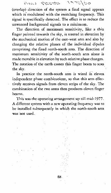
V'v'v S \= 5 o(overlap) direction of the system a final signal appears which is modulated with the switching frequency. This signal is specifically detected. The effect is to reduce the unwanted background signals to a minimum.
The direction of maximum sensitivity, like a thin finger pointed towards the sky, is steered in elevation by the mechanical motion of the east-west arm and also by changing the relative phases of the individual dipoles comprising the fixed north-south arm. The direction of maximum sensitivity of the north-south arm alone is made movable in elevation by such relative phase changes. The rotation of the earth causes this finger beam to scan the sky.
In practice the north-south arm is wired in eleven independent phase combinations, so that this arm effectively receives signals from eleven strips of the sky. The combination of the two arms then produces eleven finger beams.
This was the operating arrangement up till m id-1977. A different system with a new operating frequency was to be installed subsequently in which the north-south arm was not used.
88

This Canberra Companion will be as welcome to the local resident confronting a dull weekend as it will be to the visitor to the city. It goes beyond the usual range of tourist activities to describe places that are interestingly different to visit, unusual things to do, attractive walks to take. Clear directions and absorbing background information make a welcome blend of the practical and the entertaining, while the wide range of activities suggested offers plenty of choice to suit all tastes.
Canberra Companions are published by the Australian National University Press as a contribution to the cultural, educational and recreational life of the immediate area served by the University. Titles available or in preparation include:
Rambles around Canberra by Allan J. Mortlock and Gillian O’LoghlinTales and Legends of Canberra Pioneers by Samuel ShumackCanberra’s Embassies by Graeme Barrow Fishing around Canberra by Bryan Pratt Birds in your Canberra Garden by Henry Nix Street Trees in CanberraUndiscovered Canberra by Allan J. Mortlock and Bernice AndersonThe Australian National University — People and Places in a Landscape
Australian National University Press Canberra
ISBN 0 7081 1579 9