All maps and illustrations EARLY DESIGN SCHEMATICS AND ... · EARLY DESIGN SCHEMATICS AND ARTIST...
32
EARLY DESIGN SCHEMATICS AND ARTIST IMPRESSIONS APRIL 2018 Authorised and published by the Victorian Government, 1 Treasury Place, Melbourne All maps and illustrations are artist impressions of early design concepts. They are not final designs and are subject to change. !
Transcript of All maps and illustrations EARLY DESIGN SCHEMATICS AND ... · EARLY DESIGN SCHEMATICS AND ARTIST...

EARLY DESIGN SCHEMATICS AND ARTIST IMPRESSIONS
APRIL 2018
Authorised and published by the Victorian Government, 1 Treasury Place, Melbourne
All maps and illustrations are artist impressions of
early design concepts. They are not final designs
and are subject to change.
!

This page is intentionally blank

NORTH EAST LINK | EARLY DESIGN SCHEMATICS AND ARTIST IMPRESSIONS - APRIL 2018 1
ContentsM80 to the Eastern Freeway
North East Link - design schematic .............................................2Local toll-free trips .......................................................................3M80 interchange ............................................................................4Grimshaw Street interchange .......................................................8Elder Street, Watsonia station and shops ...................................11Lower Plenty Road interchange ..................................................14Manningham Road interchange ..................................................18Eastern Freeway interchange .....................................................20
Eastern Freeway updgrades and Doncaster Busway About the updgrades - design schematic ...................................23Eastern Freeway express lanes ...................................................24 Eastern Freeway ramp metering ................................................25 Doncaster Busway .......................................................................26Catering for complex trips (Tram Rd to Middleborough Rd) .......27
All maps and illustrations are artist impressions of
early design concepts. They are not final designs
and are subject to change.
!

NORTH EAST LINK | EARLY DESIGN SCHEMATICS AND ARTIST IMPRESSIONS - APRIL 2018
M80 to the Eastern Freeway
DESIGN CONCEPT ONLYGreensborough
Bypass
Greensborough Rd Greensborough Rd
Lower Plenty Rd Banksia St
Templestowe RdManningham Rd
Yarra River
Mar
tins
Ln
Grimshaw St
Yalla
mbi
e R
d
Ersk
ine
Rd
Bla
mey
Rd
Drysdale St
Elde
r St
Watsonia Rd
M80 Ring Rd
Plenty Rd
North East Link
North East Link (Tunnel)
North East Link (Trench)
Other roads
Bulleen Rd
EasternFwy
EasternFwy
2
North East Link - design schematic
North East Link would provide an express connection between the M80 Ring Road and the Eastern Freeway, skipping 18 sets of lights. Interchanges would be located at the M80 Ring Road, Grimshaw Street, Lower Plenty Road, Manningham Road and the Eastern Freeway.
M80 to the Eastern Freeway
M80 INTERCHANGE
GRIMSHAW ST INTERCHANGE
This is an early design concept for North East Link. It is not a final design and is subject to change based on further engineering and planning studies, feedback from communities and stakeholders and the procurement process.
LOWER PLENTY ROAD INTERCHANGE
MANNINGHAM ROAD INTERCHANGE
EASTERN FREEWAY INTERCHANGE
Greensborough Road
Greensborough Road
!North East Link
North East Link (Tunnel)
North East Link (Trench)
Other roads

NORTH EAST LINK | EARLY DESIGN SCHEMATICS AND ARTIST IMPRESSIONS - APRIL 2018
DESIGN CONCEPT ONLY
GreensboroughBypass
Greensborough Rd Greensborough Rd
Lower Plenty Rd Banksia St
Templestowe RdManningham Rd
Yarra River
Mar
tins
Ln
Grimshaw St
Yalla
mbi
e R
d
Ersk
ine
Rd
Bla
mey
Rd
Drysdale St
Elde
r St
Watsonia Rd
M80 Ring Rd
Plenty Rd
North East Link
North East Link (Tunnel)
North East Link (Trench)
Other roads
Bulleen Rd
EasternFwy
EasternFwy
3
Local, toll-free trips
Toll-free roads for local trips would be maintained between the Eastern Freeway and the M80 Ring Road.
• Between the M80 Ring Road and Watsonia Road, Greensborough Road would be rebuilt on either side of North East Link and kept open for local toll-free trips.
• Between Watsonia Road and Lower Plenty Road, Greensborough Road would run next to North East Link and be kept open for local toll-free trips.
Rebuilt Greensborough Road
Rebuilt Greensborough Road
Greensborough Road kept open for local trips
Greensborough Road
Greensborough Road
This is an early design concept for North East Link. It is not a final design and is subject to change based on further engineering and planning studies, feedback from communities and stakeholders and the procurement process.!
North East Link
North East Link (Tunnel)
North East Link (Trench)
Other roads

NORTH EAST LINK | EARLY DESIGN SCHEMATICS AND ARTIST IMPRESSIONS - APRIL 2018
DESIGN CONCEPT ONLY
GreensboroughBypass
Greensborough R
dG
reensborough Rd
Lower P
lenty Rd
Banksia St
Templestow
e Rd
Manningham
Rd
Yarra River
Martins Ln
Grimshaw St
Yallambie Rd
Erskine Rd
Blamey Rd
Drysdale St
Elder St
Watsonia R
d
M80 Ring Rd
Plenty Rd
North East Link
North East Link Tunnel
North East Link Trench
Freeway
Other roads
Bulleen R
d
EasternFw
y
EasternFw
y
M80 interchange
4
The M80 interchange would provide free-flowing access in all directions.
Traffic travelling on North East Link would be separated from local traffic.
Traffic travelling west to east between the M80 Ring Road and Greensborough Bypass would pass over traffic travelling on North East Link or Greensborough Road.
Clear signage on the M80 Ring Road and Greensborough Bypass would help drivers choose the correct lane early.
This is an early design concept for North East Link. It is not a final design and is subject to change based on further engineering and planning studies, feedback from communities and stakeholders and the procurement process.!
North East Link
North East Link (Tunnel)
North East Link (Trench)
Other roads
Gre
ensb
orou
gh R
oad
Gre
ensb
orou
gh R
oad

NORTH EAST LINK | EARLY DESIGN SCHEMATICS AND ARTIST IMPRESSIONS - APRIL 2018 5
M80 interchange - artist impression
M80 Ring Road
Greensborough Bypass
North East Link
Greensborough Road
New walking and cycling bridgeNew walking and cycling bridge
New walking and cycling bridge
Artist impression. Subject to change.!

NORTH EAST LINK | EARLY DESIGN SCHEMATICS AND ARTIST IMPRESSIONS - APRIL 20186
Artist impression. Subject to change.!
Artist impression. Subject to change.!
M80 interchange North East Link movements
M80 Ring Road to North East Link
North East Link to M80 Ring Road
Greensborough Bypass to
North East Link
North East Link to Greensborough
Bypass

NORTH EAST LINK | EARLY DESIGN SCHEMATICS AND ARTIST IMPRESSIONS - APRIL 2018 7
M80 interchange local toll-free movements
M80 Ring Road to Greensborough Bypass
M80 Ring Road to Greensborough RoadGreensborough
Bypass to Greensborough
Road
Greensborough Road to
Greensborough Bypass
Greensborough Bypass to M80 Ring Road
Greensborough Bypass to Plenty Road
Greensborough Road to M80 Ring Road and Plenty Road
Artist impression. Subject to change.!
Artist impression. Subject to change.!Artist impression. Subject to change.!
NORTH EAST LINK | EARLY DESIGN SCHEMATICS AND ARTIST IMPRESSIONS - APRIL 2018
DESIGN CONCEPT ONLY
Gre
ensb
orou
ghB
ypas
s
Greensborough Rd Greensborough Rd
Lower Plenty Rd Banksia St
Templestowe RdManningham Rd
Yarra River
Mar
tins
Ln
Gri
msh
aw S
t
Yalla
mbi
e R
d
Ersk
ine
Rd
Bla
mey
Rd
Drysdale St
Elde
r St
Watsonia Rd
M80
Rin
g R
d
Ple
nty
Rd
Bulleen Rd
EasternFwy
EasternFwy
Greensborough Rd
Greensborough Rd
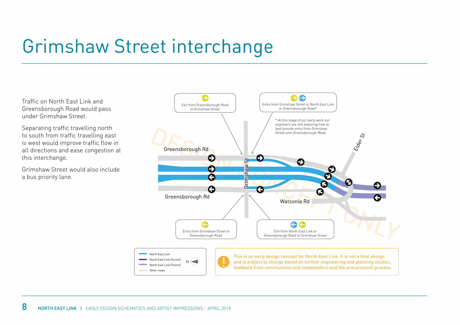
Grimshaw Street interchange
Traffic on North East Link and Greensborough Road would pass under Grimshaw Street.
Separating traffic travelling north to south from traffic travelling east to west would improve traffic flow in all directions and ease congestion at this interchange.
Grimshaw Street would also include a bus priority lane.
Exit from Greensborough Road to Grimshaw Street
Entry from Grimshaw Street to Greensborough Road
Entry from Grimshaw Street to North East Link or Greensborough Road*
Exit from North East Link or Greensborough Road to Grimshaw Street
* At this stage of our early work our engineers are still exploring how to best provide entry from Grimshaw Street onto Greensborough Road.
This is an early design concept for North East Link. It is not a final design and is subject to change based on further engineering and planning studies, feedback from communities and stakeholders and the procurement process.!
8
North East Link
North East Link (Tunnel)
North East Link (Trench)
Other roads

NORTH EAST LINK | EARLY DESIGN SCHEMATICS AND ARTIST IMPRESSIONS - APRIL 2018 9
Grimshaw Street interchange - artist impression
Grimshaw
Street
North East Link under Grimshaw Street
Hurstbridge Rail Line
To M80 Ring Road
Kempston Street
Greensborough Road under Grimshaw Street
Artist impression. Subject to change.!
All barriers shown are indicative only
NORTH EAST LINK | EARLY DESIGN SCHEMATICS AND ARTIST IMPRESSIONS - APRIL 201810
Grimshaw Street interchange local toll-free and North East Link movements
North East Link under Grimshaw Street
North East Link towards
M80 Ring Road
North East Link towards
Eastern Freeway
Greensborough Road under Grimshaw Street
Greensborough Road under North East Link towards Watsonia Road
North East Link and Greensborough Road exit and entry access
Entry to Greensborough Road
Exit from North East Link and Greensborough Road
Exit to Grimshaw Street
At this stage of our early work our engineers are still exploring how to best provide entry from Grimshaw Street onto Greensborough Road.
Artist impression. Subject to change.!
Artist impression. Subject to change.!Artist impression. Subject to change.!
Greensborough Road under North East Link
towards M80 Ring Road
Entry to North East Link

NORTH EAST LINK | EARLY DESIGN SCHEMATICS AND ARTIST IMPRESSIONS - APRIL 2018 11
DESIGN CONCEPT ONLY
Gre
ensb
orou
ghB
ypas
s
Greensborough Rd Greensborough Rd
Lower Plenty Rd Banksia St
Templestowe RdManningham Rd
Yarra River
Mar
tins
Ln
Gri
msh
aw S
t
Yalla
mbi
e R
d
Ersk
ine
Rd
Bla
mey
Rd
Drysdale St
Elde
r St
Watsonia Rd
M80
Rin
g R
d
Ple
nty
Rd
Bulleen Rd
EasternFwy
EasternFwy
Elder Street, Watsonia Station and shops
New two-way road between Elder Street and Watsonia Station and shops.
Local access from Elder Street to Watsonia Station and shops will be maintained.
From Elder Street, cars would travel south for about 400 metres on a new two-way road before crossing over a lowered North East Link to connect to the station carpark and Watsonia Road.
Green bridges between Watsonia Road and Yallambie Road would enhance walking and cycling connections along Greensborough Road.
North East Link would pass under Yallambie Road and Blamey Road.
Greensborough Road would run alongside North East Link all the way south to Lower Plenty Road and be kept open for local trips.
Greensborough Rd
Greensborough Rd
North East Link
This is an early design concept for North East Link. It is not a final design and is subject to change based on further engineering and planning studies, feedback from communities and stakeholders and the procurement process.!
North East Link
North East Link (Tunnel)
North East Link (Trench)
Other roads

NORTH EAST LINK | EARLY DESIGN SCHEMATICS AND ARTIST IMPRESSIONS - APRIL 201812
Elder Street, Watsonia Station and shops local access - artist impression
North East Link towards M80 Ring Road
Greensborough Road towards M80 Ring Road
Greensborough Road towards Watsonia Road
(one-way only)
North East Link towards Eastern Freeway
Potential new walking and cycling bridge
Watsonia Station
Greensborough Road
Artist impression. Subject to change.!
Greensborough Road towards Elder Street
(two-way to Elder Street only)
Elde
r St
reet

NORTH EAST LINK | EARLY DESIGN SCHEMATICS AND ARTIST IMPRESSIONS - APRIL 2018 13
Green bridges over North East Link
Yallambie Road and green bridge over North East Link (the traffic lights would kept at this intersection)
Green bridges over North East Link
Green bridge alongside Greensborough Road
Yallambie Road
Greensborough Road
Greensborough RoadGreensborough Road
Greensborough RoadNorth East Link
North East Link
North East Link
North East Link
To M80 Ring Road
To M
80
Ring Roa
d
Artist impression. Subject to change.! Artist impression. Subject to change.!
Artist impression. Subject to change.!
Artist impression. Subject to change.!
NORTH EAST LINK | EARLY DESIGN SCHEMATICS AND ARTIST IMPRESSIONS - APRIL 2018
DESIGN CONCEPT ONLY
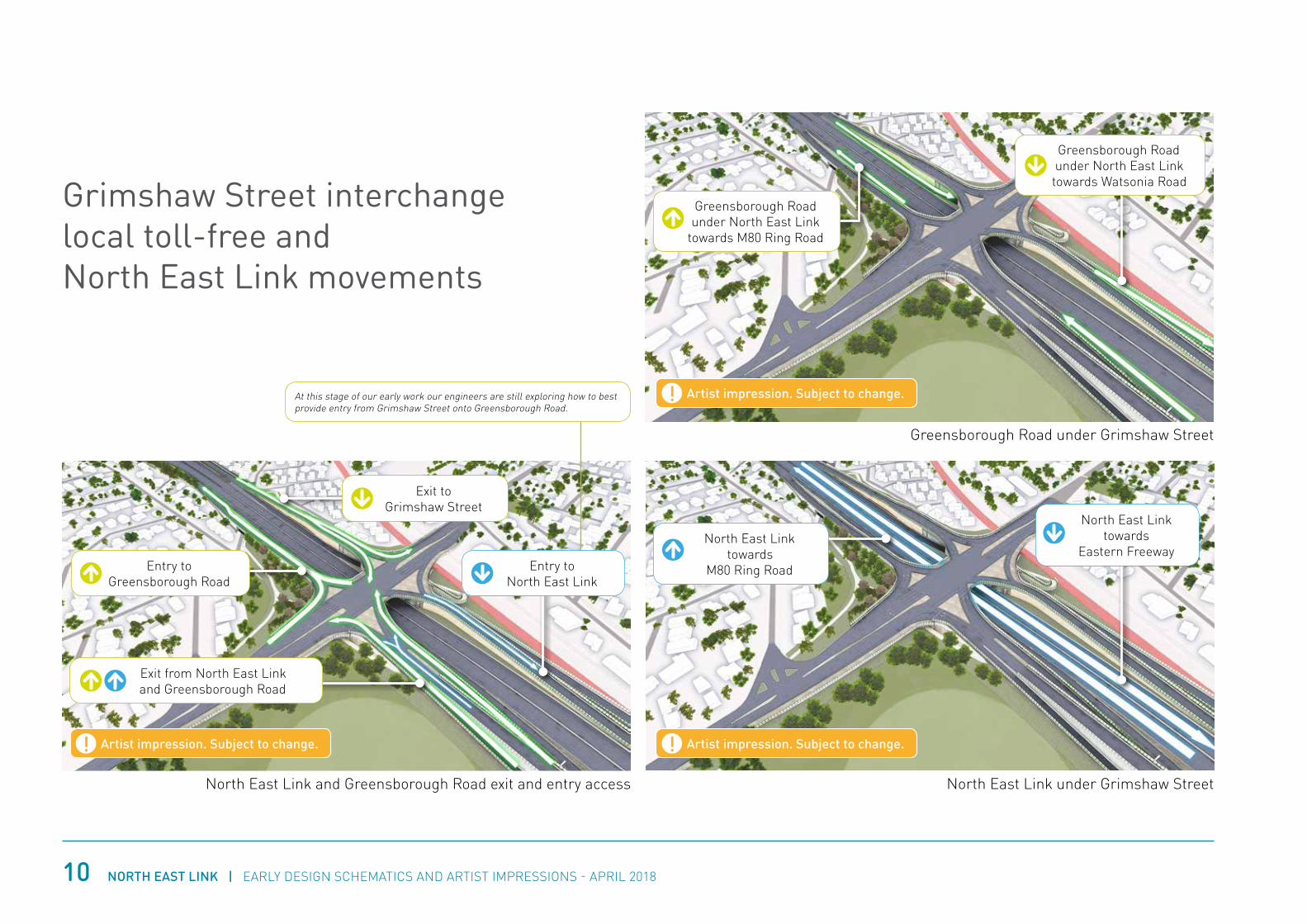
Lower Plenty Road interchange
There is a very narrow space between homes, Greensborough Road and Simpson Barracks for this interchange.
To minimise impacts on communities and the environment, the interchange is long and narrow.
This not only reduces the footprint of the interchange, it allows us to spread traffic across multiple entry/exit points so it flows freely, particularly on and off Lower Plenty Road.
Local access between Greensborough Road and Lower Plenty Road would be maintained. Local access between Drysdale Street and Greensborough Road would also be maintained.
A new one-way service road next to Greensborough Road between Edward Street and Sydney Street would:
• Distance homes from the interchange
• Prevent rat-running on Strathallan Road between North East Link and key local destinations like La Trobe University
• Keep access to Greensborough Road open for residents.
Gre
ensb
orou
ghB
ypas
s
Greensborough Rd Greensborough Rd
Lower Plenty Rd Banksia St
Templestowe RdManningham Rd
Yarra River
Mar
tins
Ln
Gri
msh
aw S
t
Yalla
mbi
e R
d
Ersk
ine
Rd
Bla
mey
Rd
Drysdale St
Elde
r St
Watsonia Rd
M80
Rin
g R
d
Ple
nty
Rd
Bulleen Rd
EasternFwy
EasternFwy
Stra
thal
lan
Rd
Entry into North East Link tunnels towards Eastern Freeway
Exit from North East Link to Lower Plenty Road
Exit from North East Link to Greensborough Road
Entry into North East Link towards M80 Ring Road
14
This is an early design concept for North East Link. It is not a final design and is subject to change based on further engineering and planning studies, feedback from communities and stakeholders and the procurement process.
!
One-way service road to distance homes from the interchange and prevent rat-running on Strathallan Road
North East Link
North East Link (Tunnel)
North East Link (Trench)
Other roads

NORTH EAST LINK | EARLY DESIGN SCHEMATICS AND ARTIST IMPRESSIONS - APRIL 2018 15
Entry into North East Link tunnel towards Eastern Freeway
Exit from North East Link to Lower Plenty Road
This interchange would be complex to build. It would most likely need to be built from top down. Once
construction is finished and the tunnels are covered, there are opportunities for new open public space in this
area including a potential wetland.
New walking and cycling path under Lower Plenty Road, connecting to River Gum Walk.
Exit from North East Link tunnel to Greensborough Road
One-way service road to distance homes from the interchange and prevent rat-running
Greensborough Road kept open for local use
Lower Plenty Road with local access to Greensborough Road kept open
Local access between Drysdale Street, Greensborough Road and Lower Plenty Road kept open
Entry into North East Link towards M80 Ring Road
Lower Plenty Road interchange - artist impression
North East Link tunnels
entry and exit
Stra
thal
lan
Roa
d
Ersk
ine
Roa
d
Simpson Barracks
Greensborough Road
Lower Plenty Road
Artist impression. Subject to change.!

NORTH EAST LINK | EARLY DESIGN SCHEMATICS AND ARTIST IMPRESSIONS - APRIL 201816
Entry into North East Link tunnels towards Eastern Freeway
Greensborough Road
Exit from North East Link to Lower Plenty Road
Lower Plenty Road
Greensborough Road
Entry to North East Link towards M80 Ring Road
Lower Plenty Road
Exit from North East Link
tunnels to Greensborough Road
Greensborough Road
Service road
Strathallan Road
Lower Plenty Road interchange North East Link movements
Greensborough Road
Getting onto North East Link
Getting off North East Link
Artist impression. Subject to change.!
Artist impression. Subject to change.!
Artist impression. Subject to change.!
Artist impression. Subject to change.!

NORTH EAST LINK | EARLY DESIGN SCHEMATICS AND ARTIST IMPRESSIONS - APRIL 2018 17
Drysdale Street
Left hand turn for trips coming from Erskine Road and beyond
Right hand turn for trips going to Erskine Road and beyond
Finl
ayso
n St
reet
Finl
ayso
n St
reet
New
tow
n Ro
ad
New
tow
n Ro
ad
Moo
rwat
ha S
tree
t
Moo
rwat
ha S
tree
t
Lower Plenty Road interchange local toll-free movements
Left hand turn for trips from
Moorwatha St, Newtown Rd and
Finlayson St.
Right hand turn for trips to
Moorwatha St, Newtown Rd and
Finlayson St.
Right hand turn for all local trips.
Greensborough Road
Greensborough Road
Greensborough Road
Lower Plenty Road
Lower Plenty Road
Lower Plenty Road
Greensborough Road to Lower Plenty Road
Drysdale Street
Lower Plenty Road to Greensborough Road
Left hand turn for all local trips.
Artist impression. Subject to change.! Artist impression. Subject to change.!
Artist impression. Subject to change.!
NORTH EAST LINK | EARLY DESIGN SCHEMATICS AND ARTIST IMPRESSIONS - APRIL 2018
DESIGN CONCEPT ONLY
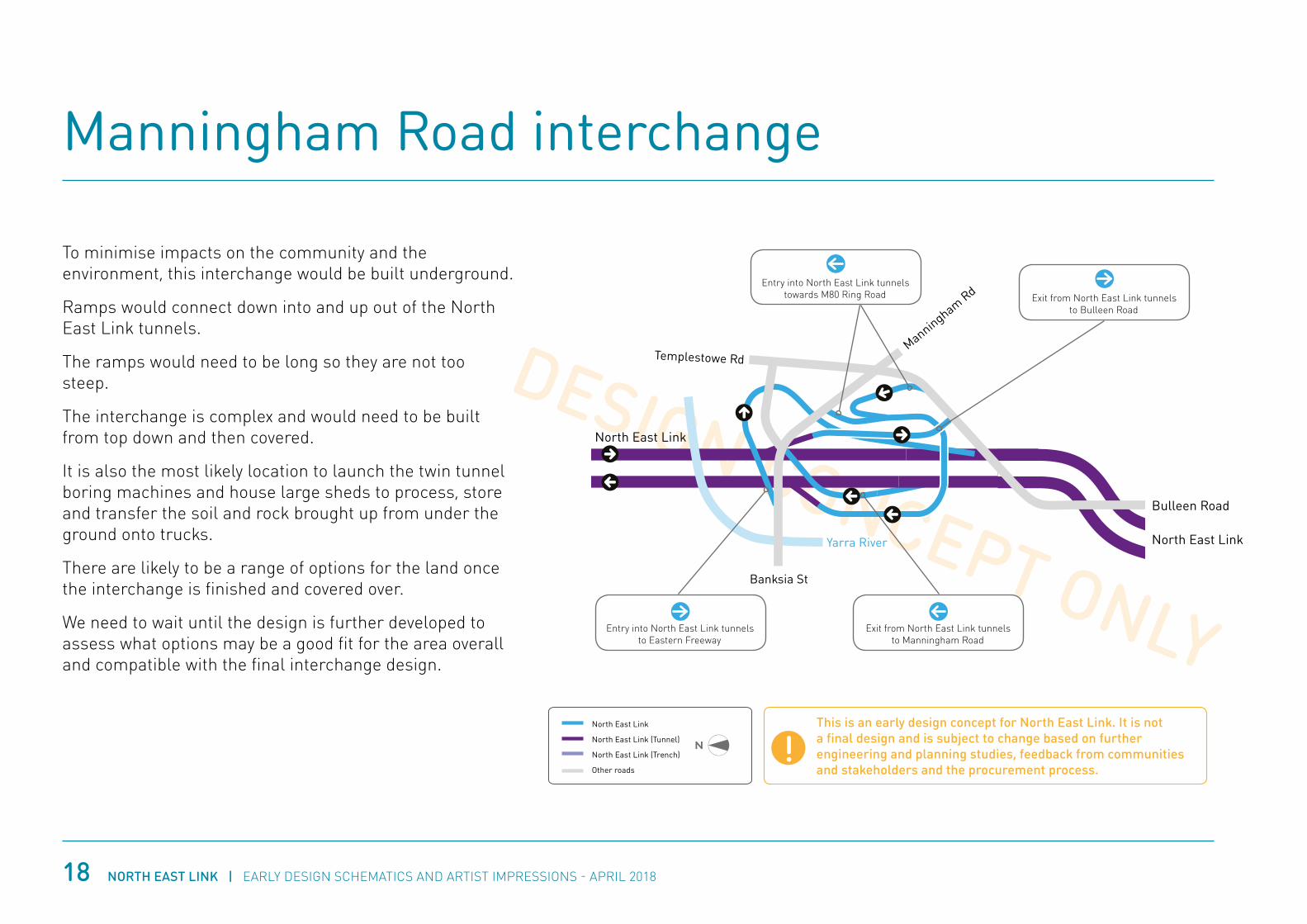
Manningham Road interchange
18
To minimise impacts on the community and the environment, this interchange would be built underground.
Ramps would connect down into and up out of the North East Link tunnels.
The ramps would need to be long so they are not too steep.
The interchange is complex and would need to be built from top down and then covered.
It is also the most likely location to launch the twin tunnel boring machines and house large sheds to process, store and transfer the soil and rock brought up from under the ground onto trucks.
There are likely to be a range of options for the land once the interchange is finished and covered over.
We need to wait until the design is further developed to assess what options may be a good fit for the area overall and compatible with the final interchange design.
GreensboroughBypass
Greensborough Rd Greensborough Rd
Lower Plenty Rd Banksia St
Templestowe RdManningham Rd
Yarra River
Mar
tins
Ln
Grimshaw St
Yalla
mbi
e R
d
Ersk
ine
Rd
Bla
mey
Rd
Drysdale St
Elde
r St
Watsonia Rd
M80 Ring Rd
Plenty Rd
North East Link
North East Link (Tunnel)
North East Link (Trench)
Other roads
Bulleen Rd
EasternFwy
EasternFwy
Entry into North East Link tunnels to Eastern Freeway
Exit from North East Link tunnels to Bulleen Road
Exit from North East Link tunnels to Manningham Road
Entry into North East Link tunnels towards M80 Ring Road
Bulleen Road
North East Link
North East Link
This is an early design concept for North East Link. It is not a final design and is subject to change based on further engineering and planning studies, feedback from communities and stakeholders and the procurement process.
!North East Link
North East Link (Tunnel)
North East Link (Trench)
Other roads

NORTH EAST LINK | EARLY DESIGN SCHEMATICS AND ARTIST IMPRESSIONS - APRIL 2018 19
Manningham Road interchange - artist impression
Exit from North East Link tunnels to Bulleen Road Bulleen Road Bridge Street
Banksia ParkExit from North East Link tunnels
to Manningham Road
Entry into North East Link tunnels towards M80 Ring Road
Entry into North East Link tunnels towards Eastern Freeway
Manningham RoadU
This interchange would be complex to build. It would most likely need to be built from top down. Once
construction is finished and the tunnels are covered, there are likely to be a range of options for the land.
Artist impression. Subject to change.!

NORTH EAST LINK | EARLY DESIGN SCHEMATICS AND ARTIST IMPRESSIONS - APRIL 2018
DESIGN CONCEPT ONLY
Eastern Freeway interchange
20
The tunnel entry and exit for North East Link would be located south of the Veneto Club car park.
Ramps would connect to the Eastern Freeway in both directions.
Bulleen Road would be raised to pass the ramps to/from Doncaster and Ringwood under it.
Bulleen Road would begin to rise from its existing level near the entrance to Marcellin College.
Where it crosses over the North East Link ramps, Bulleen Road would be raised by about 11 metres (to about the same height where it currently connects to the Eastern Freeway).
Bulleen Road would be kept open for local use.
The interchange would also allow for the new Doncaster Busway to run in dedicated lanes, separated from the freeway.
GreensboroughBypass
Greensborough Rd Greensborough Rd
Lower Plenty Rd Banksia St
Templestowe RdManningham Rd
Yarra River
Mar
tins
Ln
Grimshaw St
Yalla
mbi
e R
d
Ersk
ine
Rd
Bla
mey
Rd
Drysdale St
Elde
r St
Watsonia Rd
M80 Ring Rd
Plenty Rd
North East Link
North East Link (Tunnel)
North East Link (Trench)
Other roads
Bulleen Rd
EasternFwy
EasternFwy
Entry and exit ramps to/from Doncaster and Ringwood
North East Link ramps under a raised Bulleen Road
North East Link in tunnel under Bulleen Road
Entry and exit ramps to/from inner suburbs and city
This is an early design concept for North East Link. It is not a final design and is subject to change based on further engineering and planning studies, feedback from communities and stakeholders and the procurement process.
!North East Link
North East Link (Tunnel)
North East Link (Trench)
Other roads

NORTH EAST LINK | EARLY DESIGN SCHEMATICS AND ARTIST IMPRESSIONS - APRIL 2018 21
Eastern Freeway interchange - artist impression
Veneto Club
North East Link tunnel portals
North East Link ramps under Bulleen Road to/from Doncaster and Ringwood
North East Link ramps to/from inner suburbs and city
Bulleen Road kept open for local trips
Doncaster Busway under Bulleen Road
Artist impression. Subject to change.!Ventilation structures are generally most effective when located at tunnel exit portals. We're collecting baseline data about the local area to inform the location, design and height of the structures for North East Link so they operate safely and effectively.

NORTH EAST LINK | EARLY DESIGN SCHEMATICS AND ARTIST IMPRESSIONS - APRIL 201822
Eastern Freeway interchange North East Link and Doncaster Busway movements
North East Link exit to Doncaster and Ringwood
Doncaster Busway
Potential Doncaster Busway Park and Ride
North East Link entry to M80 Ring Road
North East Link entry to M80 Ring Road
North East Link exit to inner suburbs and city
Artist impression. Subject to change.!
Artist impression. Subject to change.!Artist impression. Subject to change.!
NORTH EAST LINK | EARLY DESIGN SCHEMATICS AND ARTIST IMPRESSIONS - APRIL 2018 23
Eastern Freeway upgrades
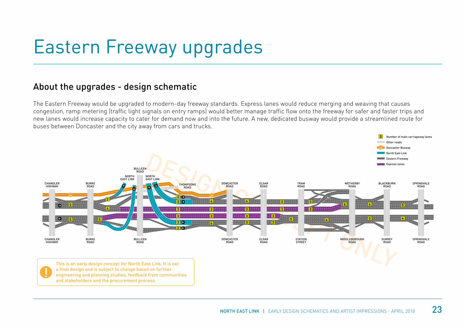
About the upgrades - design schematic
The Eastern Freeway would be upgraded to modern-day freeway standards. Express lanes would reduce merging and weaving that causes congestion, ramp metering (traffic light signals on entry ramps) would better manage traffic flow onto the freeway for safer and faster trips and new lanes would increase capacity to cater for demand now and into the future. A new, dedicated busway would provide a streamlined route for buses between Doncaster and the city away from cars and trucks.
DESIGN CONCEPT ONLYBULLEEN
ROADDONCASTER
ROADELGARROAD
STATIONSTREET
MIDDLEBOROUGHROAD
SURREYROAD
SPRINGVALEROAD
THOMPSONSROAD
BURKEROAD
CHANDLERHIGHWAY
Number of main carriageway lanes
Other roads
Doncaster Busway
North East Link
Eastern Freeway
Express lanes
DONCASTERROAD
ELGARROAD
TRAMROAD
WETHERBYROAD
BLACKBURNROAD
SPRINGVALEROAD
BURKEROAD
CHANDLERHIGHWAY
BULLEENROAD
NORTHEAST LINK
NORTHEAST LINK
3
3
3
3
4
4
3
3
3
3
35 5
5
46
6 64
3
3
3
3
3
3
3
2
22
45
5 5
This is an early design concept for North East Link. It is not a final design and is subject to change based on further engineering and planning studies, feedback from communities and stakeholders and the procurement process.
!

NORTH EAST LINK | EARLY DESIGN SCHEMATICS AND ARTIST IMPRESSIONS - APRIL 201824
Express lanes would separate traffic making long trips on the Eastern Freeway from traffic that wants to get on and off. This would reduce merging and weaving that causes congestion.
• Traffic entering the freeway from the EastLink tunnel, Springvale Road, Blackburn Road and Middleborough Road would be able to access the express lanes straight through to Chandler Highway and Hoddle Street/Alexandra Parade.
• Traffic entering the freeway from the city and Chandler Highway would be able to access express lanes straight through to Middleborough Road, Blackburn Road, Springvale Road and the EastLink tunnel.
Eastern Freeway express lanes
Express lanes to Middleborough Road
Express lanes to Chandler Highway
Separated express lanes, Tram Road heading towards Elgar Road
Doncaster Busway and new express lanes on the Eastern Freeway
Elgar Road
Artist impression. Subject to change.!
Artist impression. Subject to change.!
NORTH EAST LINK | EARLY DESIGN SCHEMATICS AND ARTIST IMPRESSIONS - APRIL 2018 25
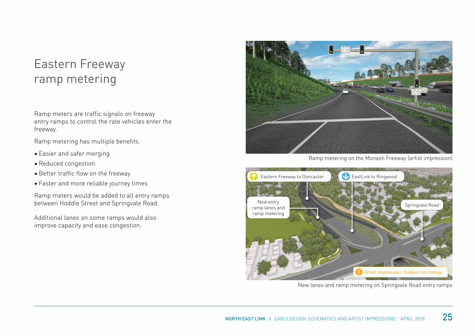
Ramp meters are traffic signals on freeway entry ramps to control the rate vehicles enter the freeway.
Ramp metering has multiple benefits.
• Easier and safer merging
• Reduced congestion
• Better traffic flow on the freeway
• Faster and more reliable journey times
Ramp meters would be added to all entry ramps between Hoddle Street and Springvale Road.
Additional lanes on some ramps would also improve capacity and ease congestion.
Eastern Freeway ramp metering
Springvale Road
EastLink to RingwoodEastern Freeway to Doncaster
New lanes and ramp metering on Springvale Road entry ramps
Ramp metering on the Monash Freeway (artist impression)
Artist impression. Subject to change.!
New entry ramp lanes and ramp metering

NORTH EAST LINK | EARLY DESIGN SCHEMATICS AND ARTIST IMPRESSIONS - APRIL 201826
Doncaster Busway would be Melbourne’s first, dedicated high-speed busway. It would run between Doncaster Park and Ride and the city.
The original concept for the Busway was to use the space in the median of the Eastern Freeway. Further development and analysis, including consultation with other agencies and bus operators, has found that the best option is to run the busway on the northern edge of the freeway between Doncaster and Chandler Highway and on the outside edges between Chandler Highway and the city.
Running the busway on the outside edge of the freeway:
• Provides a direct connection to the existing bus lanes on Hoddle Street and improves travel times
• Allows the option for bus routes on Chandler Highway to connect to the busway
• Makes the busway more efficient and reliable overall.
To allow room for the busway on the outside edges of the Eastern Freeway without requiring further acquisition, traffic lanes would need to shuffle over into the median strip.
Doncaster Busway
Chandler Highway
Doncaster Busway on the northern edge of the Eastern Freeway, passing under Chandler Highway and separating to run on both outside edges
Doncaster Busway on the northern edge of the Eastern Freeway
Busway towards Hoddle Street
Busway towards Doncaster
Artist impression. Subject to change.!
Artist impression. Subject to change.!

NORTH EAST LINK | EARLY DESIGN SCHEMATICS AND ARTIST IMPRESSIONS - APRIL 2018 27
The section of the Eastern Freeway between Tram Road and Middleborough Road needs to cater for a number of complex traffic movements over a short distance. The current design concept provides dedicated lanes braided over and under each other to keep these movements separated from each other, avoid merging and weaving that causes congestion and keep drivers safe. Examples of how braided ramps would support some of these movements are shown below.
Catering for complex movements (Tram Road to Middleborough Road)
Example 1: Separating drivers entering and exiting the freeway
Middleborough Road exit rampTram Road entry ramp
Braided ramps would
separate drivers entering the freeway at Tram Road from drivers
getting off at Middleborough
Road.
Tram Road
Artist impression. Subject to change.!

NORTH EAST LINK | EARLY DESIGN SCHEMATICS AND ARTIST IMPRESSIONS - APRIL 201828
Example 2: Separating drivers using express lanes
Middleborough Road exit ramp
Braided ramps would separate
drivers in the express lanes who need to exit at
Middleborough Road from drivers in other lanes who
are travelling straight through.
Tram Road
Artist impression. Subject to change.!
Example 3: Short local trips
Tram Road
Middleborough Road
Braided ramps would
• Keep short local trips open, safe and separated from the main carriageways• Keep drivers on the Eastern Freeway and off other roads like Doncaster
Road that are already congested during peak periods.
Artist impression. Subject to change.!
Between 400-500 drivers use the
Eastern Freeway to make short trips between
Tram Road and Middleborough Road each
hour in peak periods.

This page is intentionally blank

Follow us on social media
@northeastlinkmelb
@nelmelb
Contact us
1800 105 105
northeastlink.vic.gov.au