Aligned National Action Plan to Combat Land Degradation ...
156
Aligned National Action Plan to Combat Land Degradation, Guyana 1
Transcript of Aligned National Action Plan to Combat Land Degradation ...

Aligned National Action Plan to Combat Land Degradation, Guyana
1

Aligned National Action Plan to Combat Land Degradation, Guyana
2
Table of Contents
Acknowledgements………………………………………………………………………….…….4
Foreword…………………………………………………….…………………………………….7
Foreword by UNDP Resident Representative, Guyana………………………………..………….9
Acronyms……………………………………………………………………………………..….10
List of Figures…………………………………………………………………………...……….15
List of Tables…………………………………………………………………………………….15
List of Boxes……………………………………………………………………………..………15
Executive Summary of the Aligned National Action Plan 2015-2025 for Guyana………….…..16
1. INTRODUCTION……………………………………………………………..………….…19
1.1 Global Context – Desertification and Land Degradation…………………..………….19
1.2 United Nations Convention to Combat Desertification…………………….………….20
1.3 Guyana’s obligations under the United Nations Convention to Combat
Desertification.................................................................................................................21
1.4 The overarching goal and objectives of the Aligned NAP for Guyana
2015-2025……………………………………………………………………………...22
1.5 UNCCD Strategy 2008-2018…………………………………………………………..23
2 APPROACH FOR DEVELOPING THE ALIGNED NATIONAL ACTION PLAN………29
2.1 Governance of the Aligned NAP………………………………………………..…….29
2.2 Methodology for the preparation of the Aligned NAP…………………….………….29
2.3 Stakeholder engagement and validation……………………………………………….31
3. THE DIAGNOSTIC FRAMEWORK AND NATIONAL CONTEXT………………….….32
3.1 National Development Strategies, Policies, and Plans……………………...…………32
3.2 Other relevant action plans and programmes………………………………………….43
3.3 Acts and Regulations……………………………………………………………..……46
3.4 National Context: Geography, Climate/Weather, Natural Resources, Land Cover
And Productivity…………………………………………………………………….…52
3.5 Status of Land Degradation and Drought…………………………………………..…..57
4. ACHIEVEMENTS AND PLANS FOR ADDRESSING DESERTIFICATION, LAND
DEGRADATION AND DROUGHT…………………………………………..……………71
4.1 Guyana’s achievements in addressing Land Degradation and Drought……………….71
4.2 Protocol for Drought Early Warning System………………………………………..…73
4.3 Stakeholder engagement…………………………………………………………….…80
4.4 Education/training, and awareness………………………………………..…………..80
4.5 Cross-sectoral institutional mechanisms for national coordination and

Aligned National Action Plan to Combat Land Degradation, Guyana
3
mainstreaming…………………………………………………………………….……82
4.6 Knowledge sharing…………………………………………………………………….82
4.7 Integration and alignment with the National Development Strategy and Plan, and
relevant sectoral plans and policies…………………………………………..………..83
4.8 Regional integration and collaboration…………………………………...……………83
4.9 Sustainable development…………………………………………………………...…..84
4.10 Synergies……………………………………………………………………………….95
4.11 Capacity Building…………………………………………………………………..….97
4.12 Sustainable Land Management……………………………………………………..…97
4.13 Best Practices in Sustainable Land Management…………………………………...…99
4.14 Monitoring systems dedicated to DLDD…………………………………………….100
4.15 Policy framework……………………………………………………………………104
5. INTEGRATED INVESTMENT FRAMEWORK WITH INTEGRATED FINANCIAL
STRATEGY FOR ALIGNED NAP IMPLEMENTATION………………………….……106
5.1 Global Environment Facility…………………………………………………….……106
5.2 Resource Mobilization………………………………………………………………..109
5.3 Partnership Building and Technology Transfer………………………………………115
5.4 Action Plan for the IFS…………………………………………………………….…117
5.5 Barriers to implementing the financial strategy for SLM……………………...……..121
6. UNCCD REPORTING PROCESS FOR THE ALIGNED NAP……………………….….123
6.1 PRAIS………………………………………………………………………...………..123
7. IMPLEMENTATION FRAMEWORK AND SCHEDULE…………………..…………..124
7.1 Coordination, Communication, Synergies…………………………………………….124
7.2 Gap Assessment in the implementation of the NAP and priorities for the
Aligned NAP…………………………………………………………………………..125
7.3 Proposed priority actions to combat DLDD and promote sustainable land
management SLM………………………………………………………….………….137
7.4 Overall timeframe for Aligned NAP implementation………………………...……….137
7.5 Monitoring and Evaluation…………………………………………………………….138
8. CONCLUSIONS……………………………………………………...……………………139
9. REFERENCES………………………………………………………………………..…….141
10. APPENDICES…………………………..………….………………...……………………149
Appendix 1: Posters used for public awareness activities…………………..……………..149
Appendix 2: Photographs of project activities……………………………………….…….151
Aligned National Action Plan to Combat Land Degradation, Guyana
4
Acknowledgements
The Aligned National Action Plan to Combat Land Degradation was prepared in partnership
with the Cooperative Republic of Guyana represented by the Guyana Lands and Surveys
Commission, the United Nations Development Programme, and funded by the Global
Environment Facility under the “Support the Alignment of Guyana’s National Action Plan to the
UNCCD’s 10-year (2008-2018) Strategic Plan” Project.
Special thanks to the UNDP Guyana Country Office (Dr. Patrick Chesney and Ms. Akua
Carberry), and the then Guyana Lands & Surveys Commission’s (GL&SC) Commissioner and
Project Manager, Mr. Doorga Persaud, Ms. Oleta Williams, Ms. Andrea Mahammad and Mr.
Asib Mohamed. During the implementation of the Project, a National Action Plan Editorial
Working Group consisting appointed representatives from key agencies of the natural resources,
financial, administrative and planning sectors in Guyana was established. The function of the
Group was to facilitate the review and provide feedback on all documents emanating from the
Project within a reasonable time to facilitate efficient revision and approval of documents.
Special thanks is therefore also extended to the members who actively served in this capacity
namely:
- Mr. Colis Primo - Environmental Protection Agency
- Ms. Shenelle Agard - Guyana Geology and Mines Commission
- Ms. Janice Bollers - Guyana Geology and Mines Commission
- Mr. Carmichael Thorne - Ministry of Agriculture
- Mr. Gavin Agard - Department of Natural Resources and the Environment
- Colonel Francis Abraham - Civil Defence Commission
In addition, a National Project Board provided supervision, guidance and facilitated support from
the stakeholder agencies crucial to the multi-disciplinary work under UNCCD in Guyana.
The Aligned National Action Plan to Combat Land Degradation (NAP) is based on the results,
analysis and recommendations of Studies undertaken in 2014 & 2015 under the Project. Both
national and international consultants were contracted to undertake the following studies:
1. National Stocktaking Consultancy- spearheaded by Environmental Management Consultants.
2. Drought EWS Consultancy- spearheaded by Ms Agnes Atyang and Mr. Mario Epstein.
3. Institutional and Policy Expert Consultancy- spearheaded by Dr. Sennye Masike.
4. Integrated Investment Framework and Financing Strategy Consultancy- spearheaded by Dr.
Alexandre Borde.
5. UNCCD reporting Expert Consultancy – spearheaded by Ms. Mena Carto
6. Database Developer Consultancy- spearheaded by Mr. Clarence Garraway.

Aligned National Action Plan to Combat Land Degradation, Guyana
5
The Government of Guyana is deeply indebted to all stakeholders who have invested their time
and effort, provided information and documents, participated in the training and validation
sessions, and facilitated stakeholder consultations to ensure that this Aligned NAP has become as
integral and comprehensive as possible. The consultants and firms should also be commended
for their dedication and tireless pursuit in completing key sections of the Aligned NAP. Special
thanks to the following institutions is also extensions:
Ministry of Indigenous Peoples Affairs
Ministry of Finance
Ministry of Communities
Ministry of Agriculture
Ministry of Education
Ministry of Public Infrastructure
Ministry of the Presidency
Ministry of Communities
Guyana Geology and Mines Commission
Guyana Forestry Commission
Guyana Livestock Development Board
Guyana Office of Investment
Guyana Rice Development Board
Guyana Water Inc.
Guyana Sugar Corporation
Guyana Marketing Corporation
Ministry of Natural Resources
Bureau of Statistics
Protected Areas Commission
Hydrometeorological Services of the Ministry of Agriculture
National Drainage and Irrigation Authority
Central Housing and Planning Authority
Civil Defence Commission
Office of Climate Change
Land Reclamation Committee
Environmental Protection Agency
National Agriculture Research and Extension Institute
Mangrove Restoration Project
Protected Areas Commission
Inter American Institute for Cooperation in Agriculture
Food and Agriculture Organization of the United Nations
Delegation of European Union

Aligned National Action Plan to Combat Land Degradation, Guyana
6
World Wildlife Fund
World Bank
Inter-American Development Bank
Conservation International
Iwokrama International Centre for Rainforest Conservation and Development
United Nations Development Programme, Guyana
School of Earth and Environmental Sciences

Aligned National Action Plan to Combat Land Degradation, Guyana
7
Foreword
The major challenge for Guyana is to get the balance right between - on the one hand, the urgent
need for equitable development and improved welfare (including food security and poverty
alleviation) and, - on the other hand, the long-term sustainable management of the land and the
vast resources, and of course, efforts to adapt to and mitigate impacts of climate change. This
will depend on sufficient revenues to fund these investments. Necessarily, this will have to be
funded through production, trade and income from the vast potential of our forests and mining
areas as well as marine resources.
Guyana is in global demand!
First, the global demands for resources are ever increasing and will only accelerate over the years
to come. Guyana needs to be prepared. Second, the natural forests of Guyana play a very
important role for the future of the global climate.
It is therefore only reasonable that the global international community - with their vested interest
in sustainably managing and conserving our forests – should contribute and invest substantially
thereto.
If the full potential shall be harnessed to the benefit of all and without destroying opportunities
for the generations to come, a coordinated and balanced approach is needed.
Since Guyana became a signatory to the United Nations Convention to Combat Desertification,
the Government of Guyana has made strong progress towards living up to its commitments to the
Convention. This Aligned National Action Plan is the manifestation of these continued efforts,
not only as a commitment to the UNCCD, but moreover as a commitment to the citizens of
Guyana to ensure that its resources will be managed sustainably for the benefit of generations to
come.
Common for all natural resources sectors – a very significant improvement in infrastructure is
necessary to be able to access and harness all these benefits.
The substantial infrastructure development should, , be designed wisely to avoid the possible
negative consequences such as fragmentation and opening up of hitherto protected and remote
areas of unique forests and biodiversity.
The Aligned NAP aims to ensure that the agricultural, pasture, mining, forest, coastal and other
land uses and resources are managed as sustainable, productive systems that maintain ecosystem
productivity and ecological functions while contributing directly to the environmental protection,
economic growth and social livelihood of the people of the country.

Aligned National Action Plan to Combat Land Degradation, Guyana
8
This Aligned NAP outlines the approach and roadmap towards continuing to enhance the way of
managing land and resources in Guyana. The Aligned NAP consists of and is governed by a set
of overarching principles: Achievement of Sustainable Development; Land management
governance and policy; Education, training and awareness; Knowledge information and research;
Evaluation and monitoring and; Partnership and financing.
The Aligned NAP focuses on the primary sectors on which Guyana has depended and will
depend upon in the future. The potential of several of these sectors is very big and hitherto
largely untapped and will likely undergo rapid development. This Aligned NAP emphasizes
equitable access to resources.
This Aligned National Action Plan 2015-2025 for Guyana for the United Nations Convention to
Combat Desertification builds on the previous National Action Plan from 2006, and is updated to
be aligned with the UNCCD Strategic Plan 2008-2018. This Aligned NAP is aligned with
relevant country strategic development and policy plans.

Aligned National Action Plan to Combat Land Degradation, Guyana
9
Foreword by the Resident Representative, United Nations Development Programme (UNDP),
Guyana Country Office
As described in the Outcome Document of the United Nations Conference on Sustainable Development
(‘Rio+20’), ‘….poverty eradication, changing unsustainable and promoting sustainable patterns of
consumption and production and protecting and managing the natural resource base of economic and
social development are the overarching objectives of and essential requirements for sustainable
development. In the UNDP Strategic Plan 2014-2017, the Area of Work 1: Sustainable Development
Pathways, recognises the importance of sustainable land management and restoration of degraded land as
a scalable initiative on sustainable productive capacity.
In May 2014, UNDP commenced the project titled “Support the Alignment of Guyana’s National Action
Plan to the UNCCD’s 10-year (2008-2018) Strategic Plan” in collaboration with the Guyana Lands and
Surveys Commission (Implementing Partner) and the Global Environment Facility (Trust Fund
resources). Through the project, UNDP delivered support to the preparation of the Aligned National
Action Plan to Combat Land Degradation (Aligned NAP), which was completed in December 2015.
The Aligned NAP integrates Guyana’s obligations under the UNCCD into its national development and
sectoral planning frameworks through a renewed and participative process, and in a manner that is in line
with the global guidance contained in the UNCCD’s Strategic Plan for 2008-2018. The result has
positioned Guyana to comply with its international obligations, and also to provide a framework for
national response to the economic and social effects of land degradation on land use, livelihood and
human development.
The Aligned NAP contributes to the UNDP Country Programme Outcome: Improved functional capacity
of key natural resources and disaster risk management institutions, and is aligned to the UN’s Sustainable
Development Goals 15 – Protect, restore and promote sustainable use of terrestrial ecosystems,
sustainably manage forests, combat desertification, and halt and reverse land degradation and halt
biodiversity loss – and 16 – Promote peaceful and inclusive societies for sustainable development,
provide access to justice for all and build effective, accountable and inclusive institutions at all levels.
UNDP is therefore pleased to have been part of the development of Guyana’s Aligned NAP to Combat
Land Degradation and offers congratulations to the Government of Guyana, in general, and the GL&SC,
in particular, for the successful completion of the project.
UNDP looks forward to Guyana implementing the specific objectives under the UNCCD Plan for 2008-
2018 and adoption of the Performance Review and Assessment of the Implementation Strategy (PRAIS)
Reporting Cycle for submission to the UNCCD.
Khadija Musa
UNDP Resident Representative
22 February 2015

Aligned National Action Plan to Combat Land Degradation, Guyana
10
Acronyms
ACCC Adaptation to Climate Change in the Caribbean
ACP Affected Country Parties
ADP Agricultural Diversification Programme
CAP Conservancy Adaptation Project
CARICOM Caribbean Community and Common Market
CBD Convention on Biological Diversity
CBO Community-Based Organization
CCC Crisis Coordination Committee
CDC Civil Defence Commission
CDEMA Caribbean Disaster Emergency Management Agency (ex CDERA)
CDP Community Development Project
CI Conservation International
CIDA Canadian International Development Agency
CIMH Caribbean Institute for Meteorology and Hydrology
CITES Convention on International Trade in Endangered Species of Wild Fauna and
Flora
CRG Cooperative Republic of Guyana
CMO Caribbean Meteorological Organization
CNIRD Caribbean Network for Integrated Rural Development
COP Conference of Parties
CPACC Caribbean Planning for Adaptation to Climate Change
CRG Cooperative Republic of Guyana
CRSAP Climate Resilience Strategy and Action Plan
DCP Developed Country Parties
DEWS Drought Early Warning System
DLDD Desertification, Land Degradation and Drought
DLUPP Development of Land Use Planning Project
DMP Drought Mitigation Plan
DNRE Department of Natural Resources and the Environment
DRR Disaster Risk Management
EA Enabling Activity
EC European Commission
ECLAC Economic Commission for Latin America and the Caribbean
EDF European Development Fund
EDWC East Demurer Water Conservancy
EIA Environmental Impact Assessment
EITI Extractive Industry Transparency Initiative
ENSO El Niño Southern Oscillation
EPA Environmental Protection Agency

Aligned National Action Plan to Combat Land Degradation, Guyana
11
ESIA Environmental and Social Impact Assessment
EU European Union
EU-FLEGT Extractive Industry Transparency Initiative and the European Union Forest Law
Enforcement, Governance and Trade
EWC III Third International Conference on Early Warning
EWS Early Warning System
FAO Food and Agriculture Organization
FDI Foreign Direct Investment
FEWS NET Food Early Warning System Network
FTCI Forestry Training Centre Incorporated
GCI Guyana Citizens Initiative
GCM Global Circulation Models
GDF Guyana Defence Force
GDP Gross Domestic Product
GEF Global Environment Fund
GFC Guyana Forestry Commission
GFS Global Forecast System
GGAC Guyana Geospatial Advisory Council
GGMC Guyana Geology & Mines Commission
GINA Government Information Agency
GINRIS Guyana Integrated Natural Resources Information System
GIS Geographical Information System
GLADIS Global Land Degradation Information System
GLDA Guyana Livestock Development Authority
GL&SC Guyana Lands & Surveys Commission
GM Global Mechanism
GMTCS Guyana Marine Turtle Conservation Society
GoG Government of Guyana
GPF Guyana Police Force
GRDB Guyana Rice Development Board
GRIF Guyana REDD+ Investment Fund
GS&RD Guyana Sea and River Defence Department
GS&WC Georgetown Sewerage and Water Commission
GTA Guyana Tourism Authority
GUYSUCO Guyana Sugar Corporation
GWYA Guyana Water Authority
GWI Guyana Water Inc.
HACCP Hazard Analysis and Critical Control Point
Hydromel Hydrometeorological Department
IADB Inter-American Development Bank

Aligned National Action Plan to Combat Land Degradation, Guyana
12
ICZM Integrated Coastal Zone Management
IFAD International Fund for Agricultural Development
IFRC International Federation of Red Cross and Red Crescent Societies
IFS Integrated Finance Strategy
IIC Iwokrama International Centre
IICA Inter-American Institute for Cooperation on Agriculture
IIF Integrated Investment Framework
Indict Intended Nationally Determined Contribution
INPE National Institute for Space Research (Brazil)
IPNM Integrated Plant Nutrient Management
IRI International Research Institute for Climate and Society, University of Columbia
ISDR International Strategy for Disaster Reduction
ISM Integrated Soil Management
ITU International Telecommunication Union
IUCN International Union for Conservation of Nature
JICA Japan International Cooperation Agency
JRC Joint Research Centre of the European Commission
Kiwi
LACS Local Aid Coordination Secretariat
LADA Land Degradation Assessment in Dry lands
LCDS Low Carbon Development Strategy
LDN Land Degradation Neutrality
LRC Land Reclamation Committee
MA Millennium Assessment
MACC Mainstreaming Adaptation for Climate Change
MDGs Millennium Development Goals
M&E Monitoring and Evaluation
MEA Multilateral Environmental Agreements
MIA Mercury Initial Assessment
MMA-ADA Mahaica, Mahaicony, Abary Agricultural Development Authority
MNRE Ministry of Natural Resources and the Environment
MoU Memorandum of Understanding
MRVS Monitoring, Reporting and Verification System
MSSC Multi-Stakeholder Steering Committee
NAP National Action Plan/ Programme to Combat Land Degradation
NAREI National Agricultural Research and Extension Institute
NBAP National Biodiversity Action Plan
NBSAP National Biodiversity Strategic Action Plan
NCSA National Capacity Self-Assessment
NDIA National Drainage and Irrigation Authority

Aligned National Action Plan to Combat Land Degradation, Guyana
13
NDC National Democratic Council
NDS National Development Strategy
NEAP National Environmental Action Plan
NEPAD New Partnership for Africa’s Development
NFP National Focal Point
NFP National Forest Plan
NGO Non-Governmental Organization
NIDRMP National Integrated Disaster Risk Management Plan
NLUP National Land Use Plan
NMHS National Meteorological and Hydrological Service
NMMAP National Mangrove Management Action Plan
NOAA National Oceanic and Atmospheric Administration
NRDDB North Rupununi District Development Board
NPAS National Protected Areas System
NRMP Natural Resources Management Project
NSC National Steering Committee
NTFPs Non-Timber Forest Products
NWIS National Water Information System
NWP Numerical Weather Prediction
OAS Organization of American States
OCC Office of Climate Change
ODA Overseas Development Assistance
PAC Protected Areas Commission
PDA Public Development Aid
PMP Pest Management Practices
PPEW Platform for Promotion of Early Warning - United Nations
PRAIS Performance Review on Assessment of Implementation Strategy
PRSP Poverty Reduction Strategy Paper
REDD+ Reduced Emissions from Deforestation and Degradation
RGDP REDD+ Governance Development Plan
SD Sustainable Development
SDGs Sustainable Development Goals
SDMIS Sea Defence Management Information System
SEEC Strategic Emergency Engineering Committee
SFM Sustainable Forest Management
SIDS Small-Island Developing States
SLM Sustainable Land Management
SME Small and Micro Enterprise
SO Strategic Objective
SRDD Sea and River Defence Department

Aligned National Action Plan to Combat Land Degradation, Guyana
14
TFIR Task Force for Infrastructure Recovery
ToR Terms of Reference
TSG Technical Support Group
UN United Nations
UN/ISDR United Nations International Strategy for Disaster Reduction
UNCBD United Nations Convention on Biological Diversity
UNCCD United Nations Convention to Combat Desertification
UNDP United Nations Development Programme
UNEP United Nations Environment Programme
UNESCO United Nations Educational, Scientific and Cultural Organization
UNFCCC United Nations Framework Convention on Climate Change
UNICEF United Nations Children's Fund
UNISDR United Nations International Strategy for Disaster Reduction
UNITAR United Nations Institute for Training and Research
VPA Voluntary Partnership Agreement
WOCAT World Overview of Conservation Approaches and Technologies
WSSD World Summit on Sustainable Development
WWF World Wildlife Fund
WUA Water Users’ Association
WMO World Meteorological Organization

Aligned National Action Plan to Combat Land Degradation, Guyana
15
List of Figures
Figure 1: Natural geographic regions of Guyana………………………………………………..54
Figure 2: Areas classified as being affected by DLDD………………………………………....58
Figure 3 Areas Affected by DLDD……………………………………...………………… 69
Figure 4: Components of a drought protocol…………………………………………………....73
Figure 5: A Simple Model for the DEWS Protocol for Guyana………………………………...74
Figure 6: Actions to be taken befor the onset of a drought……………………………………...76
Figure 7: Innovative sources of funding…………………………………………………….…115
Figure 8: Home Page of PRAIS Database………………..…………………………………………123
List of Tables
Table 1: Droughts in Guyana and Relation to El Niño…………………………………….……55
Table 2: Estimates of land productivity within each land cover type………………………56
Table 3: Summary of the national land use plan……………………………………………...62
Table 4: Proportion of population (by region) using an improved drinking water source
for the period 2012-2014…………………………………………………………..…..70
Table 5: Cross-cutting projects related to the Rio Conventions……………………………...…96
Table 6: Best practices/regulations available………………………………………………….100
Table 7: GEF Land Degradation Focal Area Objectives, Program Priorities
and Expected Outcomes………………………………………..……………………..108
Table 8: Priority Areas for Aligned NAP Implementation………………………………...…..118
Table 9: Barriers to implementing the financial strategy for SLM…………………………….121
Table 10: Assessment of Operational Objectives and Expected Outcomes against
Guyana’s NAP……………...……………………………………………………..…126
Table 11: Implementation phases for the Aligned NAP……………………………………….138
List of Boxes
Box 1: Key priority actions to combat DLDD and promote SLM…………………………..137

Aligned National Action Plan to Combat Land Degradation, Guyana
16
Executive Summary of the Aligned National Action Programme 2015-2025 for Guyana
The Guyana Lands and Surveys Commission (GL&SC) is Guyana’s National Focal Point
Agency to the United Nations Convention to Combat Desertification (UNCCD).
Guyana has been actively pursuing efforts aimed at combating the negative economic, social and
environmental impacts of land degradation and desertification on the well-being of its people. To
this end, overwhelming support towards the implementation of a Project titled ‘Support the
Alignment of Guyana’s National Action Plan to the UNCCD 10 Year (2008-2018) Strategic
Plan’ was achieved and conducted through a collaborative, cross cutting and inclusionary
process. This approach involved inputs from key stakeholders in the natural resources,
environmental, agricultural sectors, civil society and other governmental agencies.
The Aligned National Action Plan provides the fundamental principles for guidance and
fulfillment of the country’s obligation to align its National Action Plan (NAP) to the UNCCD
10- Year Strategy(2008-2018). The Aligned NAP provides consideration for the need for urgent
efforts to integrate and strengthen existing National Policies, Strategies, Action Plans and the
planning framework for conservation, promotion of sustainable land management and combating
the exacerbated effects of degradation. Thus, the Aligned National Action Plan builds on the
Guyana’s previous NAP of 2006. It seeks to mainstream and presents the country’s past and
current efforts made towards aligning the National Action Plan and thereafter, implementation
and reporting to the UNCCD.
The UNCCD Strategy, aims to guide the actions of all UNCCD stakeholders and partners for the
period 2008–2018, through the following strategic and operational objectives:-
Stra
tegi
c O
bje
ctiv
es
•1: To improve the living conditions of affected populations
•2: To improve the condition of affected ecosystems
•3: To generate global benefits through effective implementation of the UNCCD
•4: To mobilize resources to support implementation of the Convention through building effective partnerships between national and international actors
Op
erat
ion
al O
bje
ctiv
es
•1: Advocacy, awareness raising and education
•2: Policy framework: To support the creation of enabling environments for promoting solutions to combat desertification/land degradation and mitigate the effects of drought
•3: Science, technology and knowledge
•4: Capacity-building
•5: Financing and technology transfer

Aligned National Action Plan to Combat Land Degradation, Guyana
17
As such, both the strategic and operational objectives form the priority baseline for the
development of Guyana’s undertaking to develop its Aligned NAP. Ultimately, in line with the
country’s stand on acceding to the ratification of the UNCCD in September 1997, Guyana joined
the international community in the recognition that desertification is a major economic, social
and environmental problem of concern.
The UNCCD Indicators aim at providing the basis for the Monitoring and Evaluation approach
to assess implementation. These Indicators which were agreed to by Member Countries and
Guyana at the twelfth Conference of the Parties (COP12) are said to guide and achieve the
synergy required by the three Rio Conventions – Desertification, Climate Change and
Biodiversity. The Indicators are also utilized to synergize measures to make land resilient to
climate change and to halt the biodiversity loss that follows the destruction of ecosystems
through land degradation and desertification.To capture the essence of the aligned NAP and its
subsequent implementation, the Performance Review on Assessment of Implementation Strategy
(PRAIS) has been developed by the UNCCD for monitoring and reporting purposes. Guyana’s
efforts included the development of an online database system to synchronize and capture data
and provide the results to the UNCCD in the PRAIS structured format. This database can be
accessed at gyprais.gov.gy.
Based on the assessment done in 2008, although land degradation in Guyana has not reached
critical point, there are indications that it is occurring at an increasing rate which corresponds to
an increase in the exploitation of natural resource, increased national agricultural drive and
increased frequency and intensity of climatic conditions. Guyana’s vulnerability from
degradation will continue to increase exponentially due to sea level rise, saline intrusion and
coastal erosion as a result of its low coastline. The coast comprises 90% of the country’s
population concentration, major economic hub, most fertile land and extensive social services
NLUP, 2013). Therefore, Guyana’s ability to implement effective measures to combat
desertification will be significantly bolstered with the successive implementation of the Aligned
NAP. Effective implementation of the NAP will be supported by the introduction of a number of
projects which are earmarked. However, to bridge the gaps identified and enable the country to
achieve the UNCCD’s objective, hinges on its ability to access the resources and technical and
scientific requirements.
In order to combat land degradation and desertification, the Aligned NAP identifies
comprehensive and robust activities to be implemented over time. The Aligned NAP proposes
the following activities to address key land degradation issues facing Guyana:

Aligned National Action Plan to Combat Land Degradation, Guyana
18
Produce sound scientific evidence and to determine the relative roles of drivers of
Desertification, Land Degradation and Drought (DLDD)
Conduct a national scientific study on land degradation
Improvement of the institutional capacity and the collaboration between governmental
agencies
Conduct training in:
o Remote sensing
o Geographic Information System (GIS)
o Multi Criteria Decision Analysis
o Information management systems/information technology
Mainstream Desertification, Land Degradation and Drought (DLDD) into relevant
national policies, strategies and plans
Efficiency of knowledge sharing systems, information flow, consistency of the body of
national policies
Finalization of the National Land Policy or Sustainable Land Management (SLM) Policy
Strengthening the links between the UNCCD and the poverty and livelihoods elements of
the sustainable development agenda, including Millennium Development Goals (MDGs)
and Sustainable Development Goals (SDGs) Trans-program integration
Mainstreaming of Sustainable Land Management (SLM) within educational
establishments
Enhancement of the knowledge and capacity of miners/land users to perform ecologically
appropriate land restoration
Enhance the capacity to cascade regional (international) forecasts of Drought Early
Warning Systems (DEWS) to the national context and the analytical capacity of staff
working on DEWS
Conduct awareness of, and training in, specialized areas such as the process of dealing
with drought in order to develop appropriate actions in case of unforeseen occurrence
Enhance the capacity to establish and manage/maintain systematic central databases with
quality checks

Aligned National Action Plan to Combat Land Degradation, Guyana
19
1. INTRODUCTION
The Aligned National Action Plan (NAP) to Combat Land Degradation was prepared in
fulfillment of Guyana’s obligation to the United Nations Convention to Combat Desertification
and its 2008-2018 Strategy.
This introductory chapter provides an overview of the background and outlines the main goal
and objectives for the Aligned NAP. Its describes the Aligned NAP both within the global
context of Desertification, Land Degradation and Drought (DLDD), and the United Nations
Convention to Combat Desertification (UNCCD). It also describes the background to the
alignment process, which all signatory countries to the UNCCD have been requested and
encouraged to undertake. In addition, it provides an overview of Guyana’s commitment to the
UNCCD.
1.1 Global Context – Desertification and Land Degradation
The UNCCD statistics (2015) indicate the following:
Drylands constitute approximately 41 per cent of the Earth's surface and support more
than 2 billion people. Between 10 and 20 per cent of drylands are degraded or
unproductive. Land degradation affects one third of the planet's land surface and
threatens the health and livelihoods of more than one billion people in over one hundred
countries.
Desertification is one of the world's most alarming processes of environmental
degradation. Each year, desertification and drought cause an estimated $42 billion in lost
agricultural production. The risks of desertification are substantial and clear. It
contributes to food insecurity, famine and poverty, and can give rise to social, economic
and political tensions that can cause conflicts, further poverty and land degradation.
Desertification and land degradation are critical concerns to most countries of the world.
Desertification by definition is the degradation of land in arid, semi-arid and dry sub-
humid areas and is caused primarily by human activities and climatic variations.
Desertification does not refer to the expansion of existing deserts. It occurs because
dryland ecosystems, which cover over one third of the world‘s land area, are extremely
vulnerable to over-exploitation and inappropriate land use. Poverty, political instability,
deforestation, overgrazing and bad irrigation practices can all undermine the productivity
of land.
Land degradation occurs on all continents except Antarctica and affects the livelihoods of
millions of people, including a large proportion of the poor in drylands. Some 10-20% of
drylands are already degraded.
Over 250 million people are directly affected by desertification, and about one billion
people in over one hundred countries are at risk. These people include many of the
world‘s poorest, most marginalized and politically weak citizens. Persistent, substantial
reduction in the provision of ecosystem services as a result of water scarcity, intensive

Aligned National Action Plan to Combat Land Degradation, Guyana
20
use of services, and climate change is a much greater threat in drylands than in non-
drylands systems.
Land degradation is a result of a long-term failure to balance demand for and supply of
ecosystem services in drylands. The magnitude and impacts of land degradation vary
greatly from place to place and change over time. Land degradation has strong adverse
impacts on non-drylands as well; affected areas may sometimes be located thousands of
kilometres away from the desertified areas. Scenarios for future development show that
the desertified area is likely to increase and the relief of pressures on drylands is strongly
correlated with poverty reduction. Desertification can be avoided by reducing the stress
on dryland ecosystems.
The global scenarios also show that coping with desertification and its related economic
conditions will likely fare better when proactive management approaches are used. On
the whole, combating desertification yields multiple local and global benefits and helps
mitigate biodiversity loss and human-induced global climate change.
The UNCCD Secretariat aims to resolve the above issues by working with member countries to
addressing them.
1.2 United Nations Convention to Combat Desertification
In recognition of the major economic, social and environmental problem posed by desertification
to many countries in all regions of the world, the United Nations Conference on Desertification
adopted a Plan of Action to Combat Desertification in 1977.
Despite this Plan of Action and other efforts, the United Nations Environment Programme
(UNEP) concluded in 1991 that the problem of land degradation in arid, semi-arid and dry sub-
humid areas had intensified, although there were "local examples of success".
As a result, the question to combat and reduce desertification was still a major concern for the
United Nations Conference on Environment and Development, which was held in Rio de Janeiro
in 1992. The Conference supported a new, integrated approach to the problem, emphasizing
action to promote sustainable development at the community level through widespread capacity
building and development. It also called on the United Nations General Assembly to establish an
Intergovernmental Negotiating Committee to prepare, by June 1994, a Convention to Combat
Desertification. The United Nations Convention to Combat Desertification (UNCCD) was
adopted in Paris on June 17, 1994 and entered into force on December 26, 1996.
Since the adoption of the Convention, some 195 countries have undergone ratification with the
importance of capacity building for its effective and efficient implementation being recognized.
This recognition has grown stronger and has been reiterated with every passing Conference of
the Parties (COP). (http://www.unccd.int/en/programmes/Capacity-
building/CBW/Features/Pages/Capacity-Building-in-the-Action-Programmes.aspx)

Aligned National Action Plan to Combat Land Degradation, Guyana
21
The UNCCD is the only internationally recognized legally binding instrument that addresses the
problem of land degradation in dry land rural areas. The UNCCD places human beings at the
centre of its concern to combat desertification and mitigate the effects of drought. It recognizes
that Governments play a critical role in combating desertification and mitigating the effects of
drought and that progress depends on local implementation of programmes in affected areas.
Since 1995, June 17 has been observed as World Day to Combat Desertification and Drought
and Guyana has been no different in planning commemorative activities.
1.3 Guyana’s obligations under the United Nations Convention to Combat
Desertification
Guyana ratified the United Nations Convention to Combat Desertification (UNCCD) on June 26,
1997 and effectively joined the international community in the recognition that desertification is
a major economic, social and environmental problem of concern on September 24, 1997.
The fundamental obligations to the Convention are: (1) The preparation of an Aligned National
Action Plan to serve as the guiding framework for implementing actions to combat
desertification/land degradation and promote sustainable land management and (2) To undertake
UNCCD reporting.
Guyana’s original NAP was prepared in 2006, and takes into consideration the need for
integration into and strengthening of the existing national policy and planning framework for
sustainable development, as well as the role of non-governmental organisations, the private
sector, local communities and civil society at large in its implementation.
Under the UNCCD, the Government of Guyana is committed to the following:
Give due priority to combating desertification and mitigating the effects of drought, and
allocating adequate resources in accordance with circumstances and capabilities;
Establishing strategies and priorities, within the framework of sustainable development
plans and/or policies, to combat desertification and mitigate the effects of drought;
Addressing the underlying causes of desertification and paying special attention to the
socio-economic factors contributing to desertification processes;
Promoting awareness and facilitating the participation of local populations, particularly
women and youth, with the support of nongovernmental organizations, in efforts to
combat desertification and mitigate the effects of drought;
Providing an enabling environment by strengthening, as appropriate, relevant existing
legislation and where they do not exist, enacting new laws and establishing long-term
policies and action programmes.
Since signing on to UNCCD, Guyana has prepared six (6) national UNCCD reports - in 2000,
2002, 2006, 2009, 2010, and 2012 respectively. These reports contain greater detail on the
situation analysis and the current situation regarding land degradation (http://www.unccd-

Aligned National Action Plan to Combat Land Degradation, Guyana
22
prais.com/Data/Reports, http://prais2.unccd-prais.com/node/508).This Aligned NAP does not
repeat the details of these reports but rather, builds upon them.
The National Assessment of Land Degradation Report (2008) concluded that the state of land
degradation in Guyana is minimal compared to other countries, with pockets of degraded areas
around the country and closely associated with certain land use types.
The case of Guyana highlights four major issues related to land degradation that must be
addressed through the implementation of the Aligned NAP: incidents of floods; droughts; salt
water intrusion in particular along Guyana’s developed but vulnerable coast; improper natural
resource utilization in the mining, forestry and agriculture sectors and; settlement expansion and
growth in rural and urban areas.
The NAP for Guyana from 2006 proposed the following actions to address these issues:
rationalizing the planning and management of land resources
rationalizing legislative overlaps
promoting effective coordination and information exchange
establishing institutional synergies
securing financial resources and establishing financial mechanisms
promoting public education and awareness
undertaking training and capacity building
addressing issues of food security, management of agriculture and sustainable
development
sustainably managing drainage basins and watersheds
developing early warning systems and emergency plans to mitigate drought
utilizing traditional knowledge and
Promoting regional aspects of preventing land degradation.
1.4 The overarching goal and objectives of the Aligned NAP for Guyana 2015-
2025
1.4.1 Goal of the Aligned NAP
The Aligned National Action Programme will facilitate the strengthening and mainstreaming of
land degradation issues into national policy and planning, as well as be useful in accessing
funds/budgets for priority actions and projects identified within the Aligned NAP.

Aligned National Action Plan to Combat Land Degradation, Guyana
23
1.4.2 Objectives of the Aligned NAP
To align the 2006 NAP with the UNCCD’s 2008-2018 Strategy.
To develop a strategic medium and long term national approach and plan for reduction
and mitigating land degradation impacts and promote sustainable land management
1.5 UNCCD Strategy 2008-2018
The UNCCD 10-Year Strategy (2008-2018) was adopted in 2007 at the Conference of Parties
Eight (COP 8) with the overall aim of improving the implementation of the Convention. The
vision of the Strategy is “to forge a global partnership to reverse and prevent
desertification/land degradation and to mitigate the effects of drought in affected areas in order
to support poverty reduction and environmental sustainability.”
The Strategy provides a unique opportunity to address some of the Convention’s key challenges,
to capitalize on its strengths and to create a new, revitalized common ground for all UNCCD
stakeholders.
Countries, and in particular Developed Country Parties (DCP) and Affected Country Parties
(ACP) who have adopted the Strategy, have committed to operational zing the Strategy in
accordance with their national priorities: to align their National Action Programmes with the
Strategy and; to report on progress made in keeping with UNCCD guidelines.
The objectives of the Strategy are two-fold comprising Strategic Objectives and Operational
Objectives. The “strategic objectives” are to be achieved over the 10 year period, and the
“operational objectives” are to guide the actions of short and medium-term effects of land
degradation. Meeting these objectives will contribute to achieving the vision for the future of
forging a global partnership to reverse and prevent desertification/land degradation and to
mitigate the effects of drought in affected areas in order to support poverty reduction and
environmental sustainability.
1.5.1 Strategic Objectives and the Operational Objectives
The UNCCD 2008-2018 Strategy was designed to achieve several specific objectives, both in the
long term and in the short/medium term. There are four (4) Strategic Objectives that will have
long-term effects (in ten years or more) which will be evaluated through specific indicators,
while 5 Operational Objectives have been defined with short and medium term effects (in three
to five years or more).
Strategic Objectives
The Strategic objectives are:
Strategic Objective 1: To improve the living conditions of affected populations.

Aligned National Action Plan to Combat Land Degradation, Guyana
24
Strategic Objective 2: To improve the condition of affected ecosystems.
Strategic Objective 3: To generate global benefits through effective implementation of
the UNCCD.
Strategic Objective 4: To mobilize resources to support implementation of the
Convention through building effective partnerships between national and international
actors.
Operational Objectives
The Operational objectives are:
Operational Objective 1: Advocacy, awareness raising and education.
Operational Objective 2: Policy framework.
Operational Objective 3: Science, technology and knowledge.
Operational Objective 4: Capacity-building.
Operational Objective 5: Financing and technology transfer.
The Indicators used to monitor the implementation of the UNCCD Strategic Objectives were
also agreed to by Member Countries, including Guyana. The Indicators are also utilized to
synergize measures to make the land resilient to climate change and to halt the biodiversity loss
that follows the destruction of ecosystems.
The UNCCD Indicators provide the basis for the Monitoring and Evaluation approach to
assess implementation and are intended to guide and achieve the synergy required by the
three Rio Conventions – Desertification, Climate Change and Biodiversity.
The Parties’ meeting held in Ankara, 2015 agreed on the scientific definition of what it
means to become Land Degradation Neutral and set targets that are on par with the
Climate Change and Biodiversity Conventions.
In addition, COP12 agreed on the set of land-based indicators that will be used to
measure progress, which they are also recommending for adoption as the primary
measures of Land Degradation Neutrality globally.
Guyana through the Guyana Lands and Surveys Commission has undertaken a Project
(Implemented by the United Nations Development Programme & funded by the Global
Environment Facility) to align the National Action Plan (NAP) to Combat Land Degradation to
the UNCCD 10 Year Strategy. The outcomes of the Project were to undertake NAP Alignment
and UNCCD Reporting using the Indicators agreed to by COP12.

Aligned National Action Plan to Combat Land Degradation, Guyana
25
1.5.2 Relationship to other Rio Conventions and Land Degradation Neutrality
In 1992, in Rio de Janiero, the Earth Summit was held. Resulting from this gathering of one
hundred and eight (108) Heads of States was the launching of three conventions namely:
UN Convention to Combat Desertification
UN Framework Convention on Climate Change (UNFCCC)
UN Convention on Biological Diversity (UNCBD)
UN Convention to Combat Desertification
Guyana has made significant progress towards its commitment to the UNCCD since its
ratification on June 26, 1997 and which became effective on September 24, 1997.
The National Focal Point (NFP) Agency is the Guyana Lands and Surveys Commission.
The role of the NFP is to prepare national reports on the implementation of the UNCCD,
and to promote Sustainable Land Management (SLM), reduce and combat land
degradation, and support landscape restoration.
Guyana has taken the initiative to prepare all required UNCCD National Reports, and
implement Projects which support local actions to reduce land degradation and promote
SLM e.g. Capacity Development and Mainstreaming for Sustainable Land Management
and the Alignment of the National Action Plan Project. Both these Projects were
implemented by the GL&SC and UNDP with funding from the GEF. Other
complementary projects exist in Guyana such as the Land Reclamation Project.
The Alignment of the National Action Plan Project has been ongoing during 2014-2015
and seeks to prepare an Aligned National Action Plan (NAP) to Combat Land
Degradation. The NAP provides a framework to enable Guyana to meet its obligations to
fulfill the work of the UNCCD Strategy (2008-2018). The framework provides key
priority actions to address the need for policy/institution strengthening, training/education
and awareness, financing and technology, synergies with the other Rio Conventions, and
reporting needs based on the indicators provided by the UNCCD.
The Draft Aligned NAP is to be implemented from 2015-2025 (10 years) to support and
promote SLM and the implementation of UNCCD Strategy at the local level.
UNCCD is utilising its Strategic Plan and along with efforts to harmonise with UNFCCC
and UNCBD, in order to integrate global to local efforts for a synergized response to deal
holistically with the issue of land degradation and droughts. Land degradation and
droughts are related to climate change and the work of UNFCCC, and to the impact on
biodiversity and the work of the UNCBD.
UNCCD’s linkage with Climate Change, the UNFCCC and the UNCBD
After ‘silo’ actions by the Conventions, the reporting process of UNCCD seeks to collectively
address the following of Guyana and other UNCCD Member countries. These objectives have

Aligned National Action Plan to Combat Land Degradation, Guyana
26
clearly identified expected impacts which are directly or indirectly linked to climate change as
highlighted below:-
Strategic objective 1: To improve the living conditions of affected populations
o Expected impact 1.1:People living in areas affected by desertification/land
degradation and drought to have an improved and more diversified livelihood
base and to benefit from income generated from sustainable land management.
o Expected impact 1.2.:Affected populations’ socio-economic and environmental
vulnerability to climate change, climate variability and drought is reduced.
Strategic objective 2: To improve the condition of affected ecosystems
o Expected impact 2.1.: Land productivity and other ecosystem goods and services
in affected areas are enhanced in a sustainable manner contributing to improved
livelihoods.
o Expected impact 2.2.: The vulnerability of affected ecosystems to climate change,
climate variability and drought is reduced.
Strategic objective 3: To generate global benefits through effective implementation of the
UNCCD
o Expected impact3.1.:Sustainable land management and combating
desertification/land degradation contribute to the conservation and sustainable use
of biodiversity and the mitigation of climate change.
Strategic objective 4: To mobilize resources to support implementation of the Convention
through building effective partnerships between national and international actors
o Expected impact 4.1.:Increased financial, technical and technological resources
are made available to affected developing country Parties, and where appropriate,
Central and Eastern European countries to implement the Convention.
o Expected impact 4.2.:Enabling policy environments are improved for UNCCD
implementation at all levels.
Guyana as a signatory to the United Nations Framework Convention on Climate Change
(UNFCCC)
UNFCCC was established in 1992 and Guyana ratified it in 1994
Kyoto Protocol 1997; 2005
Guyana is a net sink for carbon
The time frame associated with Guyana’s Intended Nationally Determined Contribution
(iNDC) is for the period up to 2025. Guyana prepared to submit its draft iNDC to the
UNFCCC in accordance with the Warsaw COP Decision 1/CP.19 and Lima 1/CP.20.
Adaptation to reduce vulnerability and enhance resilience of ecosystems and human
populations to the combined effects of climate change and land degradation requires
support to Affected Country Parties (ACP)

Aligned National Action Plan to Combat Land Degradation, Guyana
27
Guyana as signatory to the United Nations Convention on Biological Diversity (UNCBD)
Guyana signed the United Nations Convention on Biological Diversity in June 1992 and
subsequently ratified the Convention in August 1994.
Guyana’s biodiversity provides an important basis for climate regulation, freshwater,
poverty reduction, economic growth and development in areas such as, agriculture,
forestry and fisheries, payment for forest climate services, and community based
economies, particularly in hinterland communities.
Loss of biodiversity and any disruption in the provision of ecosystem services would
impact negatively on the economy and more particularly on the quality of life in the
hinterland and indigenous communities.
Climate change, deforestation and land degradation have recently received greater
recognition as current and future drivers of environmental change and threats to Guyana’s
biodiversity. These pressures have been increasing over the past decade. In addition
emerging threats that will affect biodiversity in the future include (i) overfishing (ii)
depletion of the mangrove fringe (iii) expansion of extractive industries.
The major ecosystems that can be distinguished in Guyana are: (i) forest (ii) savannah
(iii) freshwater (iv) wetland (v) coastal and (vi) marine.
Key Facts:- The ecosystems support diverse species to the extent that as of 2010
Guyana’s species status was estimated as 8,000 plant species; 467 fish; 130 amphibian;
179 reptile; 814 bird; and 225 mammal; 1,673 arthropod; over 1,200 fungi; 33 bacteria;
13 nematode; 44 algae; 17 mollusk; and an estimated 30 virus.
According to the Food and Agriculture Organisation (FAO), Guyana has a total of 1182
native tree species of which 1 species Vouacapoua Americana is listed by the
International Union for Conservation of Nature (IUCN) Red List as Critically
Endangered. Three species; Trichiliasurumuensis, Anibarosaedora, Virolasurinmensis are
listed as Endangered and a total of 18 species are listed as Vulnerable.
Threat from Land Degradation
No Critically Endangered mammals are known to occur in Guyana. The only Endangered
mammal listed by the International Union for the Conservation of Nature (IUCN) for
Guyana is the Giant Otter (Pteronurabrasiliensis). The only Endangered bird species
listed in Guyana are: Sun parakeet (Aratingasolstitialis); Hoary-throated spine tail
(Synallaxiskollari); and the Red siskin (Cardueliscucullata).
Guyana has no listed Critically Endangered or Endangered freshwater vertebrates. Of the
species known to occur in Guyana, 4.5% of mammals, 0.4% of birds, 3% of amphibians,
3.3% of reptiles and 0.3% of freshwater fish are threatened.

Aligned National Action Plan to Combat Land Degradation, Guyana
28
Land degradation in Guyana is not in the critical advanced stage as is evident in many
countries and beckons a preventative and proactive consideration as opposed to a
treatment approach.
A Land Degradation Neutrality Agreement
The Land Degradation Neutrality (LDN) Agreement and definition were adopted at the UNCCD
Conference of Parties 12 (COP12). The LDN Agreement targets desertification and the
restoration of degraded land and soil. Member countries are expected to set voluntary targets to
achieve a land-degradation neutral world that ensures that the amount of healthy and productive
land remains stable as of 2030.
The LDN Agreement follows the adoption of the Global Goals for Sustainable
Development in New York in November 2015. Sustainable Development (SD) Goal
15.3: “By 2030, combat desertification, restore degraded land and soil, including land
affected by desertification, drought and floods, and strive to achieve a land degradation-
neutral world”.
The key principle of LDN is that the people at a grassroots level, whose everyday
decisions and actions affect the condition of land and water resources, have to be
involved in designing and implementing measures to halt and reverse land degradation.
An LDN approach upholds two complementary pathways of action:
o Sustainable land management and ecosystem restoration which in tandem will
help achieve LDN
o The restoration of natural and semi-natural areas is often key to maintaining the
necessary level of ecosystem services for working landscapes as well as urban
areas
Given the adoption of the Land Degradation Neutrality, countries such as Guyana could
agree to formulate voluntary targets to achieve LDN, according to their specific National
Circumstances and Development Priorities.
The concept of avoiding Land Degradation is paramount in promoting a Green Economy,
and this has been adopted and maintained by the Cooperative Republic of Guyana
through the implementation of the Low Carbon Development Strategy, Reduced
Emissions from Deforestation and Degradation (REDD+), United Nations Framework on
Climate Change (UNFCCC) and Convention on Biological Diversity (CBD).
Aligned National Action Plan to Combat Land Degradation, Guyana
29
2 APPROACH FOR DEVELOPING THE ALIGNED NATIONAL ACTION
PROGRAMME
This chapter provides an overview of the approach and methodology applied in developing the
Aligned NAP, including governance of the alignment process.
2.1 Governance of the Aligned NAP
A National Project Board was established in 2014 with oversight responsibility for the
implementation of the NAP Alignment Project and this Board met every three months. The
Board comprised representative from the following institutions:
1. Guyana Lands and Surveys Commission (Implementing Agency)
2. Guyana Forestry Commission
3. Ministry of Local Government & Regional Development
4. Department (formerly Ministry) of Natural Resources & Environment, Ministry of the
Presidency
5. Ministry of Finance
6. Ministry of Amerindian Affairs
7. Guyana Office for Investment
8. Central Housing and Planning Authority
9. Office of Climate Change
10. Ministry of Agriculture
11. Guyana Geology and Mines Commission
12. Environmental Protection Agency
13. Civil Defence Commission
14. Protected Areas Commission
15. Private Sector Commission
16. United Nations Development Programme
This Board expired when the Aligned NAP has been finalized and approved, while it is
anticipated that a new national board or implementation committee would be established and
tasked with oversight responsibility for the implementation of the Aligned NAP.
2.2 Methodology for the preparation of the Aligned NAP
The development of the Aligned NAP was conducted through a series of six consultancies
(during 2015); the objectives of each are described below.
2.2.1 National Rapid Stocktaking Study
The objectives of this consultancy were:

Aligned National Action Plan to Combat Land Degradation, Guyana
30
To conduct an analysis of Policy and Planning Tools, and Human and Scientific
Capacity, for NAP Alignment and implementation, including the existing gaps and
obstacles.
To strengthen the human and scientific capacity of Agencies, and support implementation
of the aligned NAP using indicators (new and existing) through formal training.
2.2.2 Drought Early Warning System
The objectives of this consultancy were:
To inform the NAP Alignment process of an Early Warning System (EWS) Protocol for
Drought.
To review, assess and propose suitable technical solutions and an approved methodology
for measuring drought impacts (drought types) and an implementation plan for the EWS
on Drought in Guyana.
To identify resources and training this would strengthen the capacity of Agencies, and
support implementation of the EWS for Drought.
2.2.3 Identification and Mainstreaming of Policies to support the implementation
of the Aligned NAP
The objectives of this consultancy were:
To review the existing structures with a view of how best to place NAP implementation.
To determine how land degradation and the NAP can be integrated and mainstreamed
into sectoral policies and work programmes.
To prepare a NAP implementation plan and identify barriers to implementation.
2.2.4 Integrated Investment Framework (includes Integrated Financing Strategy)
The objective of this consultancy was:
To develop an Integrated Financial Strategy and Investment Framework, including
proposals for projects and activities for resource mobilization for NAP implementation,
and overcoming the barriers to NAP implementation.
2.2.5 Database to support the preparation of PRAIS Reports
The objectives of this consultancy were:
To design and develop an online database for Land Degradation Information in Guyana.

Aligned National Action Plan to Combat Land Degradation, Guyana
31
To prepare standard electronic forms for data collection, monitoring of National Land
Degradation and reporting to the UNCCD and Government of Guyana.
To conduct training for relevant stakeholders on the use, interpretation and analysis of the
data and the database.
Drafting the Aligned NAP for approval
The objectives of this consultancy were:
To conduct stakeholder consultations on the UNCCD reporting process
To prepare an aligned NAP.
2.3 Stakeholder Engagement and Validation
Stakeholders were consulted as an integral part of all the consultancies mentioned above. Their
comments and concerns were incorporated into the respective consultancy reports and ultimately
reflected in the present Aligned NAP. Further, the outline and draft versions of this Aligned
NAP were widely discussed and adjusted in keeping with inputs made by the various
stakeholders. Finally, this report has also been endorsed by the National Action Plan Editorial
Working Group and validated by the National Project Board for the NAPA Project.

Aligned National Action Plan to Combat Land Degradation, Guyana
32
3 THE DIAGNOSTIC FRAMEWORK AND NATIONAL CONTEXT
This chapter provides an overview of the key national development policies, strategies and plans,
as well as an overview of the key relevant national environmental and socioeconomic variables
related to desertification and land degradation.
3.1 National Development Strategies, Policies, and Plans
The following provides an overview of the relevant national development strategies, policies,
and plans related to desertification and land degradation in Guyana.
3.1.1 Low Carbon Development Strategy, including reference to the
Agreement with Norway on REDD+
The Low Carbon Development Strategy (LCDS) 2013 has relevance to the Aligned NAP.
Guyana’s LCDS was prepared in 2009 and has since been updated in 2013. The LCDS presents
Guyana’s vision and plan for the country’s forest to be protected and maintained in an effort to
reduce global carbon emissions and at the same time attract payments and financial resources
from developed countries to foster growth and development through a low carbon emissions
path. The LCDS is currently in its implementation phase and is being supported through a
partnership between GOG and the Kingdom of Norway whereby Norway has committed to
providing support to the tune of US$250 million up to 2015 in support of Guyana’s avoided
deforestation (REDD+) efforts and the building of a working model of REDD+. At the time of
preparing this report, Guyana has earned U.S$ 190 million1 as payment for forest climate
services under this partnership, representing the second largest interim REDD+ mechanism
globally (the Brazil-Norway partnership being the first) and has been able to maintain 99% of its
forests. The LCDS also outlined how Guyana intends to ensure that at least 10% of the country’s
land area would be under some form of protection. Activities have progressed in this area,
including the enactment of the Protected Areas Act and the establishment of the Protected Areas
Commission (PAC). Guyana’s policy objective in this area is to achieve the UNCBD target of
having at least 17 % of the country’s land and inland water under some form of protection by
2020.
Broadly speaking, the LCDS aims at combating poverty and responding to the impact of climate
change by avoiding deforestation and creating a low carbon, climate-resilient economy as the
basis for the environmental, social and economic transformation of the country. The LCDS
juxtaposes environmental responsibility and accelerated economic growth as complementary
rather than conflicting objectives. It does this by mobilizing financial payments for the climate
services provided by Guyana’s vast standing forests. In this way, incentives are provided for
forest preservation, and the proceeds are used to finance investment in infrastructural and social
initiatives that target accelerated economic growth along a low carbon path.

Aligned National Action Plan to Combat Land Degradation, Guyana
33
Guyana’s LCDS is an integrated strategy which encompasses each of the three pillars of
sustainable development (SD): it aims to mainstream sustainable development initiatives,
including efforts to combat climate change; reduce climate related risk and; propel
implementation of measures to adapt to climate change. The LCDS is based on national
development needs and priorities, and was developed through a national consultation exercise
during which vulnerable groups such as indigenous peoples, forest users and dependent
communities, women and youth were engaged in the development of the Strategy. A Multi-
Stakeholder Steering Committee (MSSC) was established to oversee and guide the
implementation of the LCDS. Guyana is working along with a number of partners to support the
implementation of the LCDS.
The Memorandum of Understanding between the Government of Guyana and the Kingdom of
Norway (signed November 9, 2009) is being implemented based on three (3) main contextual
approaches: a) Regular, systematic policy and political dialogue to facilitate a constructive
exchange of views on global climate change and relevant environmental issues such as
biodiversity; b) Collaboration, knowledge building, and sharing of lessons learned within the
field of sustainable, low-carbon development, with REDD-plus as the key component of this
and; c) Collaboration on REDD-plus, including establishing a framework for financial support
from Norway into a Guyana REDD-plus Investment Fund. Financial support will be linked to
Guyana's success in limiting greenhouse gas emissions from deforestation and forest degradation
and establishing institutions and practices to strengthen Guyana's ability to reduce deforestation
and forest degradation through the adoption and implementation of a REDD-plus Governance
Development Plan (RGDP).
One important aspect of the work on REDD+ is related to the development of a Monitoring,
Reporting and Verification System (MRVS) that will provide a performance measurement
framework for the REDD+ financing mechanism. This System is implemented by the Guyana
Forestry Commission (GFC) (http://www.prnewswire.com/news-releases/guyana-receives-us40-million-payment-from-norway-for-climate-
services-and-continued-low-deforestation-300080282.html)
3.1.2 The National Development Strategy 2001-2010
The National Development Strategy (NDS) represents the highest level of national planning. It is
an integrated document outlining the national strategy and policy in a number of priority areas
including agriculture, environment, forestry, fisheries, mining, tourism, land management and
the eradication of poverty. The Strategy was formulated through a comprehensive national
participatory effort and serves as a framework for policy and planning in the respective sectors of
the economy.
Chapter 22 of the NDS deals specifically with land by describing the basic features of land
management, issues and constraints and identifies broad objectives of land policy and a strategy.
Among the key policy objectives identified is the need for better collection and management of

Aligned National Action Plan to Combat Land Degradation, Guyana
34
land information and; improving the functioning of institutions with responsibilities for land and
to improve the process of making land available for development activities.
3.1.3 The Poverty Reduction Strategy Paper 2011-2015
The Poverty Reduction Strategy Paper (PRSP) is directly linked to the NDS in the areas of
economic policy, good governance, infrastructure development and improvement in social
services with the objective of reducing poverty. The main goals of the Poverty Reduction
Strategy Paper are: (i) Sustained economic expansion within the context of a deepening
participatory democracy; (ii) Access to social services including education, health, water and
housing; and (iii) Strengthening, and where necessary, expansion of social safety nets.
The NDS and the Poverty Reduction Strategy Paper complement each other in setting out the
country‘s economic and social development in the short and long term. Both strategies take into
account environmental and natural resources management, agricultural production, and
improvements in the social sectors, amongst others, which are important to combat land
degradation directly and indirectly. They have a common objective which is the reduction of
poverty. Alleviation of poverty and reversing land degradation goes hand in hand. Both involve
improving food security, educating and training people, strengthening the capacity of local
communities, and community participation.
A revised PRSP was prepared for the period 2011-2015 and rests on the following pillars: broad-
based, low-carbon led job creation; economic growth; accelerated investment in physical
infrastructure in support of growth strategy; stronger governance, institutional, and regulatory
structures; accelerated investment in human capital and primary health and; special intervention
programmes to address regional and demographic pockets of poverty.
3.1.4 National Agricultural Strategy 2013-2020
The National Strategy for Agriculture in Guyana 2013-2020 is based on the F-5 Strategic
Approach for Agriculture:
Food Security – consolidating the End of Hunger in Guyana, ensuring everyone has
enough food in every community
Fiber and Nutritious Food Accessible to citizens – nutrition security for all
Fuel Production - helping to develop alternative fuel sources, reducing dependency on
fossil fuel and creating a bio-energy industry in Guyana
Fashion and Health Products – An agro-process industry which creates a new industry
in Guyana
Furniture and Crafts – an industry which we expect to grow in importance in Guyana

Aligned National Action Plan to Combat Land Degradation, Guyana
35
Environmental sustainability through the agricultural sector is a priority of the Agriculture
Strategy, fully recognizing Guyana’s lead role in advocacy for and the implementation of
programs for global solidarity to stop climate change and its adverse effects. The National
Strategy for Agriculture in Guyana 2013-2020 outlines twenty five priorities for achieving
success in realizing Guyana’s Vision for Agriculture 2020. Included among these are steps to
safeguard against desertification and land degradation while at the same time ensuring food
security for all of Guyana. It is estimated that 1,740,000 ha of Guyana’s land is being used for
agricultural purposes, however, only about 200,000 ha (500,000 acres) are used effectively with
relatively adequate drainage and irrigation. The National Land Use Plan (August 2013) indicates
that 68% of Guyana’s land area has soils that can accommodate agriculture, while 32% were
considered to have soil not suitable for agriculture.
Priority 19 of the Agriculture Strategy commits Guyana to further develop its Agriculture Risk
Reduction and Disaster Management Program and to base its agricultural expansion and
sustainability efforts on climate-smart agriculture. This involves adaptation and mitigation
initiatives to prevent and manage floods and droughts. The Ministry of Agriculture’s Agriculture
Sector Risk Reduction and Disaster Management Plan for the period 2012 – 2020, includes
among its targets: Institutional capacities for risk assessment, hazard monitoring and
dissemination of early warning information for proactive mitigation, preparedness and response
among all end users, especially at the community level and; disaster risk reduction and climate
change adaptation policies and programmes designed to strengthen resilience to significant
hazards particularly among vulnerable groups.
The Flood Prevention and Drought Control Plan 2013-2020also focuses on reducing and
preventing floods and controlling and mitigating drought events while the National Drainage and
Irrigation Authority (NDIA) addresses the improving and upgrading of drainage and irrigation
services countrywide in ensuring that agricultural land is better protected against adverse
weather-related events. Water Security and, thus Water Management is also identified in the
Agriculture Strategy as being crucial for success and while a network of sluices and pumps to aid
drainage and irrigation exists, it is recognized that this system is still inadequate and that its
maintenance has to be improved upon.
Guyana’s Strategic Approach to Chemicals Management supports the achievement of the goal
agreed at the 2002 Johannesburg World Summit on Sustainable Development of ensuring that,
by the year 2020, chemicals are produced and used in ways that minimize significant adverse
impacts on the environment and human health. The National Strategy for Agriculture identifies
Soil Health as a major priority in the development of a modern and effective agricultural
sector, assuring food security, economic benefits and environmental protection. Soil health is
promoted through the prudent utilization of biological, chemical and physical methods in an eco-
system agronomic approach. Guyana’s Vision for Agriculture 2020 embraces the concept of

Aligned National Action Plan to Combat Land Degradation, Guyana
36
Integrated Soil Management (ISM) and Integrated Plant Nutrient Management (IPNM) and Pest
Management Practices (PMP).
A further priority of the Agriculture Strategy is to focus on Farming Systems and Techniques,
Biotechnology and Precision-Agriculture in recognition of the significant roles that these play in
improving productivity, competitiveness, promoting commercialization and adaptation for
climate change. The Ministry of Agriculture acknowledges the need for modernization in
Guyana’s farm systems and techniques, including the use of biotechnology and precision-
agriculture.
3.1.5 Costed Strategic Framework for the Ministry of Natural
Resources and the Environment 2013-2018
The goal of the Ministry of Natural Resources and the Environment as described in the Costed
Strategic Framework for the Ministry of Natural Resources and the Environment 2013-2018 that
was developed in June 2013, is to effectively coordinate and ensure that all of its agencies and
commissions are working together harmoniously to achieve Guyana’s sustainable development
and conservation of its natural resources. The strategic priorities of the Ministry are:
Effective Institutional Framework and Legislation (with 7 expected results)
Holistic and integrated planning (that lists 4 expected results)
Sustainable resource use and monitoring (that lists 7 expected results)
Cross-cutting issues (with 5 expected results)
3.1.6 Strategic Plan for the Rice Industry in Guyana-2012-
2022
Guyana Rice Development Board has a strategic Plan for the rice industry and provides an
overview of existing rice cultivated areas, as well as an overall overview of areas suitable for rice
production. It also identifies the threats facing rice production in Guyana.
The National Rice Strategy and Plan particularly targets Regions 2, 3, and 6, which are the
primary arable and food-producing regions in Guyana.
3.1.7The Integrated Disaster Risk Management Implementation
Strategy and Management Plan 2013
The Integrated Disaster Risk Management Implementation Strategy developed by the Civil
Defence Commission (CDC) in 2013,outlines the way forward for implementing the vision, goal,
strategic objectives, and expected outcomes of Guyana’s National Integrated Disaster Risk
Management Plan (NIDRMP) 2013-2023, over a ten-year timeframe. The Strategy is intended to

Aligned National Action Plan to Combat Land Degradation, Guyana
37
guide the implementation of projects and initiatives in Guyana – at national, regional and local
levels – that are required in order to meet the NIDRMP’s objectives.
The NIDRMP includes: a profile of Guyana in terms of current trends with regard to disaster;
overview of Disaster Risk Management (DRM) in Guyana; introduction to and the rationale for
NIDRMP; an assessment and gap analysis; and the NIDRMP 2013-2023. The Integrated
Disaster Risk Management Implementation Strategy includes: suggested priority activities and
projects; proposed structure for DRM in Guyana, Operational Plan and Coordination
Mechanisms; the ten-year Implementation Plan; Technical and Financial Resources required and;
the Monitoring and Evaluation (M&E) Framework.
3.1.8 Early Warning Systems Framework 2013
The Early Warning Systems Framework developed by CDC in 2013, outlines: the elements of an
early warning system (EWS); the approaches and guiding principles for an early warning system;
national institutions and stakeholders involved in EWS; pre-conditions and key strategies for
EWS in Guyana and; next steps for the way forward for early warning in Guyana.
3.1.9Disaster Risk Management Policy 2013
The Disaster Risk Management Policy developed by the Civil Defence Commission in 2013 is
divided into six sections as follows:
Section one presents the background and context of the Policy along with key contextual
processes foundational to furthering and implementing integrated disaster risk management
Section two identifies the Policy intent, vision, and details its goals and key strategic
objectives. It also identifies key regional and international approaches to disaster risk
management (DRM) and Guiding Principles and a Code of Conduct
Section three addresses the Institutional Framework for DRM in Guyana
Section four of describes Elemental Strategies for Integrated National Disaster Management.
It also covers Rehabilitation, Recovery and Reconstruction, along with resource mobilization
for disaster risk management
Section five outlines Cross Cutting Capacity Building for Furthering DRM
Section six outlines the Way Forward which calls for robust commitment and policy
implementation as being essential for building trust and commitment among Guyana’s
population in enforcing the policy

Aligned National Action Plan to Combat Land Degradation, Guyana
38
3.1.10 Draft National Land Use Policy, 2015
Guyana’s National Land Use Policy was last revised in May; 2015.The Draft National Land Use
Policy presents a good opportunity for harmonization of legislation and institutional framework
for sustainable land management and land use planning.
A review of the Draft Policy, done under the SLM Project recommended that SLM principles be
integrated into the Draft Land Use Policy while at the same time offering an overarching
framework for a SLM Policy as another option.
3.1.11 National Forest Policy Statement (2011)
The National Forest Policy Statement was issued in 2011. The overall objective of the Policy is
the conservation, protection, management and utilisation of the nation's forest resources, while
ensuring that the productive capacity of the forests for both goods and services is maintained or
enhanced. Its specific objectives are to:
(a) Promote sustainable and efficient forest activities which utilise the broad range of forest
resources and contribute to national development while allowing fair returns to local and
foreign entrepreneurs and investors;
(b) Achieve improved sustainable forest resource yields while ensuring the conservation of
ecosystems, biodiversity and the environment;
(c) Ensure watershed protection and rehabilitation: prevent and arrest the erosion of soils and the
degradation of forests, grazing lands, soil and water; promote natural regeneration,
afforestation and reforestation and; protect the forest against fire, pests and other hazards;
and
(d) Identify and quantify environmental services to generate forest incentives for national
development.
With regard to REDD+ the Guyana Forestry Commission is committed to support:
a regular, systematic policy and political dialogue to facilitate a constructive exchange of
views on global climate change and relevant environmental issues, such as biodiversity
collaboration, knowledge building, and sharing of lessons learned within the field of
sustainable, low-carbon development, with REDD-plus as the key component of this
collaboration on REDD+
3.1.12 National GIS Policy (2014)
In Guyana, geographic information use is concentrated in the natural resources and
environmental sectors for use in land boundary demarcation, overlays and monitoring. Guyana’s
National Policy on Geographic Information provides the necessary framework for identifying

Aligned National Action Plan to Combat Land Degradation, Guyana
39
key datasets needed for socio-economic development, and specifies the mechanism for data
collection, storage and dissemination.
The development of Geographic Information Systems (GIS) in Guyana has seen relatively
significant growth since July 1995 with the assistance of the Natural Resources Management
Project (NRMP). There has been significant deployment of GIS within the operations of the
Guyana Geology and Mines Commission (GGMC), Guyana Forestry Commission (GFC),
Environmental Protection Agency (EPA) and the Guyana Lands and Surveys Commission
(GL&SC). Many other private and public organisations outside of the natural resources sector
have also embraced GIS technology to varying degrees.
The GIS policy will have direct impact on increased use of the geospatial technologies in many
vital sectors such as health, education, rural and urban development, infrastructure, business, etc.
The policy wills also further the use of GIS in areas of governance, planning and decision
support.
For the successful implementation of the Policy, a national body, theGuyana Geospatial
Advisory Council (GGAC), will need to be established to enforce the data sharing agreements,
data standards, etc.. This body should encompass agencies both within and outside of the natural
resources sector.
3.1.13 National Biodiversity Action Plan 1999
The National Strategy for the Conservation and Sustainable Use of Guyana’s Biodiversity was
completed in 1997 as an initial step to define the national position on biodiversity. The Strategy
was preceded by the Country Study on Biological Diversity, which was undertaken in 1992. The
National Biodiversity Action Plan (NBAP) of 1999 is a product of national policy to elevate
concern for biodiversity to the level of planning and action. It recognizes biodiversity as an
important national asset that offers the country manifold economic options. The basis of the
productive sectors of agriculture, fisheries, forestry and wildlife is biodiversity, in which the
maintenance of diversity offers considerable opportunities and advantages.
The NBAP is consistent with the general direction of the National Development Strategy and
both documents harmonise in respect of matters relating to place and use of biological resources
for development activities. The Plan promotes both the conservation and the responsible use of
biodiversity and biological resources. It comprises a number of programme areas under which
various actions are identified for execution.
Among its objectives is recognized the importance of maintaining high water quality and
preventing serious flooding in part by protecting watersheds from erosion or down-stream
sedimentation and pollution. It recommends that as part of the ecosystem approach to
biodiversity management sectoral entities should be encouraged to adopt integrated land and

Aligned National Action Plan to Combat Land Degradation, Guyana
40
watershed management and prepare integrated management plans. The NBAP has been in the
implementation phase since 2000, with the EPA coordinating its activities.
3.1.14 National Environmental Action Plan (2001-2005)
The National Environmental Action Plan (NEAP) of 2001-2005 is a follow-on from the NEAP
of 1994 which summarizes the national environment policy and focuses on coastal zone
management, natural resources management including land resources, biodiversity, wildlife,
forestry and ecotourism, waste management and pollution control, and mining. It also takes into
consideration the role of public awareness and education in addressing environmental problems.
The NEAP also identifies and recognizes the roles and functions of relevant stakeholders
including private sector and non-governmental organizations in environmental management.
The NEAP states that "in order to conserve and improve the environment, the Government of
Guyana will endeavour to:
Assure all people living in the country the fundamental right to an environment adequate
for their health and well-being.
Achieve a balance between the use and conservation of the nation's resources to meet the
needs of economic development and improved standards of living.
Conserve and use the environment and natural resources of Guyana for the benefit of
both present and future generations, based on the principle of the exercise of sovereignty.
Maintain ecosystems and ecological processes essential for the functioning of the
biosphere to preserve biological diversity and to observe the principle of optimum
sustainable yield in the use of renewable natural resources and ecosystems, both on land
and the sea.
3.1.15 National Multi-Hazard Disaster Preparedness and Response
Plan, (2013)
The overall aim of the National Multi-hazard Preparedness and Response Plan developed by
CDC in 2013, is to detail arrangements to cope with the effects of natural and/or man-made
disasters occurring in Guyana. It seeks to assign responsibilities and to provide coordination of
emergency activities connected with major disasters, in general and specific ways.
The purpose of the Plan is to enhance the country’s ability to manage all disasters using a
comprehensive disaster management approach. It is also to ensure the timely and effective
assistance to the affected in a coordinated manner, ensuring the greatest protection of life,
property and health. The Plan defines the administrative structure in times of disaster and it
includes: a profile of Guyana; hazard/disaster risks in Guyana; disaster management system;

Aligned National Action Plan to Combat Land Degradation, Guyana
41
disaster preparedness functions; disaster response functions; early recovery plan and; key next
steps.
3.1.16 National Mangrove Management Action Plan (2001)
The National Mangrove Management Action Plan (NMMAP) of 2001 has been prepared to
foster a more coordinated approach in planning, policy formulation, inter-institutional
cooperation and the implementation of actions. It serves as the framework of an evolving plan
for effective mangrove management in Guyana, including guiding the work of key stakeholders
involved in the utilisation and protection of mangrove resources. The Guyana Forestry
Commission coordinated the development of the Action Plan and is the overall coordinating and
implementing agency. The NMMAP has been endorsed at the Agency level.
The NMMAP is a product of the National Forest Plan and Integrated Coastal Zone Management
Action Plan, recognising mangrove forests as an important coastal and riverine ecosystem and
seeks to elevate concern for mangrove forests, thereby fostering a more coordinated approach to
policy formulation, planning, inter-institutional cooperation and implementation of actions with
regard to mangroves. A number of key actions are proposed within the Plan, principal among
them being (1) reviewing policy and legislation to address the conservation of mangrove forests;
(2) reviewing zonation of mangrove forests; (3) develop minimum operating standards for
mangrove harvesting; (4) research; (5) raising of education and awareness; (6) rehabilitation and
restoration of mangrove sites and (7)monitoring and enforcement.
3.1.17 Integrated Coastal Zone Management Plan (2001)
Integrated Coastal Zone Management (ICZM) is an ongoing process that seeks to promote the
wise use, development and protection of coastal and marine resources; foster greater
collaboration among sectoral agencies and enhance economic development. In 1999 an
Integrated Coastal Zone Management committee was established to foster a more integrated
approach to coastal zone management by coordinating and facilitating the work of agencies
already directly involved in coastal zone management. In 2001 an Action Plan for Integrated
Coastal Zone Management was produced. The Plan, which has been approved by Cabinet,
addresses policy development, analysis and planning, coordination, public awareness building
and education, control and compliance, monitoring and measurement and information
management. Other activities to be undertaken are the strengthening of the institutional setup for
integrated coastal zone management; the creation of a dynamic public awareness campaign to
bring about deeper and more meaningful appreciation of the vulnerability of the coastal zone to
sea level rise and climate change; the creation of a database of coastal resources to facilitate
improved integrated coastal zone management.

Aligned National Action Plan to Combat Land Degradation, Guyana
42
3.1.18 National Forest Plan (2011)
The National Forest Plan (NFP) takes into consideration the National Forest Policy Statement of
1997 and proposes a range of activities under five programme areas including land use, forest
management, research and information, forestry training and education, and forest administration
and governance. The overall objective of the National Forest Policy Statement (2011) is the
conservation, protection, management and utilization of the nation’s forest resources, while
ensuring that the productive capacity of the forests for both goods and services is maintained or
enhanced.
One of the three specific objectives of the Policy is to: ensure watershed protection and
rehabilitation; prevent and arrest the erosion of soils and the degradation of forests, grazing
lands, soil and water; promote natural regeneration, afforestation and reforestation and; protect
the forest against fire, pests and other hazards.
The Policy recognizes that the country’s forests provide important services to the country’s
inhabitants: they protect the soil from erosion; they regulate and purify the nation’s water
supplies and; perhaps of greatest importance, they ensure environmental stability. It states that
forest management shall conserve biological diversity and its associated values, water resources,
soils, and unique and fragile ecosystems, and by so doing, maintain the ecological functions and
integrity of the forests.
The National Forest Plan has been endorsed at the Agency level with the Guyana Forestry
Commission taking the lead in coordinating activities.
3.1.19 Guyana Lands & Surveys Commission Strategic Plan (2013-
2017)
The GL&SC Strategic Plan (2013-2017), under Strategic Objective 1, includes reporting on
compliance with international commitments such as the UNCCD. This does not make reference
to the NAP however the NAP does support the achievement of 2 other strategic objectives of the
Commission’s 2013-2017 Strategic Plan: Objective 2 of the Commission’s Strategic Plan is to
make informed land management decisions based on accurate (most recent and reliable)
information. The NAP provides an update on the status of activities aimed at promoting land
management as well as recommends new activities/projects which can be used to achieve same.
Objective 4 of the Strategy seeks to optimize benefits from the land by facilitating maximization
of productive use, through observance of sustainable land management principles and ensuring
compliance with intended and legal land use. Under this objective, the Commission has
committed itself to develop clear guidelines that can be used to determine productive use of land
and ensure that all lands are allocated in accordance with principles of sustainable land
management. The NAP identifies SLM best practices which are key in the preparation of these
guidelines.

Aligned National Action Plan to Combat Land Degradation, Guyana
43
3.2 Other relevant action plans and programmes
3.4.1 Ministry of Communities, Local Democratic Organs Act (1980)
The Ministry of Communities (formerly the Ministry of Local Government and Regional
Development) is the primary Government Agency which links the various authorities with the
Central Government. It facilitates, coordinates, and monitors the execution and implementation
of a number of projects, programmes and activities in the various local government arms/organs
and ensures that these activities are in conformity with the legal framework and the policies of
the Government.The Mission of the Local Government and Regional Development is to
supervise and maintain the legal regulatory framework of the system of local and regional
administration and to encourage and facilitate the socio-economic development of all the
administrative regions of Guyana. For this purpose the Ministry supports the development of
local governance by building Local Government capacity and maintaining an appropriate
legislative, fiscal and regulatory framework for local governance. The Ministry’s guiding
principles are to: promote accountability at all Local Government levels to their constituencies
and; promote and support a partnership between Central and Local Government and Civil
Society, while maintaining a high degree of professionalism, effectiveness, efficiency and equity.
3.2.2 Guyana Livestock Development Authority (GLDA) Programme
The Guyana Livestock Development Authority (GLDA) is a semi-autonomous agency under the
Ministry of Agriculture. Its thrust is to “promote greater efficiency in the livestock product
industry and to provide enhanced services in livestock husbandry, livestock health and research
so as to make provision for effective administration and regulation of trade, commerce and
export of livestock or livestock products and for matters related and incidental.” The GLDA
delivers public services related to animal production, animal health, animal genetics, marketing,
training and extension services as well as regulatory services. The agency is also governed by the
Guyana Livestock Development Agency Act.
Among the programmes planned and implemented under the GLDA’s mandate is one that
involves protecting the gains of animal production and genetics through the provision of timely
veterinary interventions and minimizing the threat of disease from internal and external sources.
Veterinary drugs and the importation of animals are also regulated under this programme. A
second programme involves infusing local animal stock with new genetics to enable farmers to
benefit from higher productivity. Techniques of artificial insemination and embryo transfer form
part of the GLDA’s strategies. Superior genetics is supported by a third programme that is
designed to catapult farmers into higher levels of animal husbandry through better nutrition,
housing and access to authentic and validated information.

Aligned National Action Plan to Combat Land Degradation, Guyana
44
The GL&SC issues leases for grazing which are premised on certain conditions given the
potential for causing land degradation due to overgrazing of livestock.
3.2.3 Solid Waste Management Programme.
The general objective of the Georgetown Solid Waste Management Program is to contribute to
the improvement of the environmental conditions and quality of life of the population in
Georgetown and its environs. Its purpose is to implement sustainable solutions to solid waste
management in these areas. The Program addresses solid waste disposal through the
implementation of a sanitary landfill at Haags Bosch with private sector participation.
In the attempt to provide a sustainable solution to the solid waste collection and disposal
problems in Georgetown and participating National Democratic Councils, the program focuses
on: strengthening the capacity of the Municipal Solid Waste Management Department of the
Municipality of Georgetown to manage and dispose of solid waste and improve collection
logistics and cost recovery; raising public awareness within Georgetown and the NDCs for a
better management of solid waste among households, industries, commerce, etc.; Implementing
the Haags Bosch Sanitary Landfill, with the participation of a specialized operator; providing
resources to study and define technologies to treat health care health services and hazardous
waste; implementing a more efficient waste collection at the National Democratic Councils
participating in the project; providing additional resources to rehabilitate and close the Mandela
landfill.
3.2.4 GFC’s Code of Practice for Forest Operations (2014)
The Code of Practice for Timber Harvesting Operations sets out the principles, policies and
guidelines for improved forest management and timber harvesting practices. The Code contains
practices and sets standards, which have been developed based on ongoing research and practical
experience locally and abroad. The Code assists in minimizing negative impacts of timber
harvesting, through effective implementation of reduced-impact logging guidelines, participation
in the planning process by all stakeholders, and integration with other sustainable forest
management instruments.
The first draft of the Code of Practice was produced in 1994, and the first Code of Practice for
Forest Operations became operational on a voluntary basis in October 1998. The Code is under
regular review and the results of research; field experience and public input will be used to make
progressive improvements so that environmentally sound, socially responsible and economically
acceptable production forestry can be maintained.

Aligned National Action Plan to Combat Land Degradation, Guyana
45
Approximately 60% of the State Forests have been allocated to timber harvesting concessions:
Timber Sales Agreement: are granted for up to twenty-five (25) years for areas more than
24,000 hectares
Wood-cutting lease: are granted for up to ten (10) years for 8,000-24,000 hectares
State Forests permission: are granted for two (2) year period for areas less than 8,000
hectares
The Code of Practice sets minimum operational standards including requirements to plan for
selection of trees, tree fall direction, skid trail layouts and the sub-division of concessions into
blocks which are managed on 25-60 year cutting cycles.
GFC has a Code of Practice for Forest Operations 3rd Edition for State Forest Permission
Holders (Small-Scale Forest Operators), and Code of Practice for Forest Operations, 3rd Edition
For Timber Sales Agreement and Wood Cutting License Holders.
Code of Practice for Forest Operations – Timber Sales Agreement and Wood cutting License
Holders is implemented by the GFC to promote harvesting practices to improve standards of
utilization, reduce environmental impacts, and promote sustainable forest utilization.
3.2.5 Monitoring, Reporting and Verification System
Under the framework of the LCDS, a national system referred to as Monitoring, Reporting and
Verification System (MRVS) to monitor/measure, report and verify emissions or removals of
carbon from the forest sector was developed by the GFC and is currently being implemented.
The MRV system provides the basis for reporting in accordance with the principles and
procedures agreed to by GoG in relation to reducing emissions from deforestation and forest
degradation. In addition to the MRVS there are other forest governance initiatives being pursued
under the LCDS which are intended to improve sustainability and enforcement of standards to
prevent environmental degradation and excessive forest loss. Some of these measures include the
country’s commitments to the Extractive Industry Transparency Initiative and the European
Union Forest Law Enforcement, Governance and Trade (EU-FLEGT) programme
(https://eiti.org/guyana).
3.2.6 European Union Forest Law Enforcement, Governance and Trade
(EU-FLEGT)
The GoG sought to align domestic standards in the forestry sector with those of a global body to
support the long term development of trade in sustainable forest products. To that extent, the
Government aligned with the EU-FLEGT initiative. The GoG and the European Union (EU) are

Aligned National Action Plan to Combat Land Degradation, Guyana
46
working towards concluding negotiations on a Voluntary Partnership Agreement (VPA) by 2016,
with specific deadlines being:
By March 2016, finalise technical aspects of the VPA
By June 2016, finalise legal aspects of the VPA
By September 2016, formally ratify the agreement
The document “Roadmap for Guyana” highlights the EU FLEGT VPA Process
(http://www.forestry.gov.gy/wp-content/uploads/2015/09/Roadmap-for-Guyana-EU-FLEGT-VPA-
Process-Final-January-2013.pdf)
3.5 Acts and Regulations
3.5.1 Mining Act (1989)
The Mining Act of 1989, last amended in 2010, is the main legislative instrument for managing
mining in Guyana including its health and safety and environmental impacts. The Act makes
provisions with respect to prospecting for and mining of metals, minerals and precious stones,
for regulating their conveyance and for matters connected therewith. It stipulates the procedures,
terms and conditions relating to: the right to guardianship of minerals; prospecting and mining
on large-scale; prospecting licenses; steps after discovery of mineral; mining licenses;
cancellation of license and force majeure; enlargement of prospecting or mining area section;
prospecting and mining o medium and small scale; financial aspects pertaining to mining; export
of radioactive minerals; safety in mines and health and welfare of workers; restriction on rights
of holder of license or permit and surface rights; quarry license; geological and geophysical
survey; registration and licensing of dredges, etc.; forfeiture of aircraft, etc.; special provisions
relating to Amerindians section; repeals, savings and amendments of certain enactments and;
miscellaneous matters.
The Guyana Geology and Mines Commission (GGMC) is the statutory body that processes all
applications for mineral properties in Guyana.
3.5.2 Mining Amendment Regulations (2005)
Included as part of the Mining Act of 1989, are Mining Amendment Regulations which stipulate
which regulations were amended and what the amendments were. These Regulations denote fees
for a total of twenty two prescriptions. These fees include annual rents, application fees,
certification of documents, etc. The Regulations made under the Mining Act stipulate the rules
governing: the use of poisonous substances; requirements for environmental management for
large and medium scale mining; requirements for environmental management for small scale
mining; protected areas; pollution control; offences and penalties and; definitions of closed areas
and state mining reserves.
3.5.3 Forest Act (2009; amendment 2010)
Aligned National Action Plan to Combat Land Degradation, Guyana
47
The Forest Act Chapter 67:02 promotes the use of sustainable forestry, through participation
with local communities. It also provides for the declaration of Protected Areas within the
framework of the Environmental Protection Act, along with the establishment of a code of
practice which can be amended as required. The Act increases coordination with mining,
introducing the requirement for a consultation before the granting of any license for mining or
petroleum prospecting or production.
The Act was unanimously passed by Parliament in 2009 and it replaces the previous 1953 Act,
amended in 1972, 1979 (which established the Guyana Forestry Commission), 1982 (which
introduced large-scale harvesting concessions), and 1996 (which introduced timber exploratory
permits).
3.5.4 Environmental Protection Act (1996)
Recognizing the critical importance of the environment in development, the GoG enacted the
Environmental Protection Act in 1996, which unified legislation on environmental protection in
Guyana. The Environmental Protection Act identifies and confers responsibilities to the
Environmental Protection Agency (EPA) in various areas of environmental management
including monitoring, public awareness, enforcement and conservation of natural resources. The
EPA, through agreements (Memorandum of Understanding), has influenced environmental
management capacity to be streamlined and strengthened at other natural resources management
institutions.
3.5.5 Environmental Authorization Regulations (2000)
The Environmental Protection (Authorizations) Regulations 2000 contained in the
Environmental Protection Act 1996 stipulate the terms and conditions for granting environmental
authorizations to any requesting applicant. Upon the evaluation of an application, the applicant
is required to furnish any relevant document, information or environmental impact assessment as
required by the Environmental Protection Agency (EPA). Upon approval of an application, the
holder of an authorization is required to take all reasonable steps to: establish an environmental
monitoring programme; avoid all adverse environmental impacts which could result from the
activity; minimize the adverse environmental impact where the avoidance is impractical;
mitigate the impact where the impact cannot be avoided; avoid cross media transference and;
compensate for impacts.
Every holder of an environmental authorization is required to maintain the records stipulated by
the Regulations, including those pertaining to environmental monitoring, for a period of not less
than three years. These records are to be made available to the Agency as required, to determine
compliance with the environmental authorization or whether cause exists for modifying, varying,
suspending, revoking or re-issuing the authorization. It is the duty of the Agency to ensure that
the activities authorized by the Environmental Authorization do not cause pollution of the
environment or harm to human health.

Aligned National Action Plan to Combat Land Degradation, Guyana
48
The following are Environmental Authorizations and guidelines to prevent and reduce land
degradation which must be complied with by developers in order to obtain a permit from the
EPA:
Environmental Guidelines for Transportation, Storage and Occupational Handling of
Chemical/Industrial Hazardous Waste (approved September 2011)
Environmental Guidelines for Storage, Transportation and Occupational Handling of
Biomedical Waste (approved September 2011)
Environmental Guidelines for Preparation of an Environment Management Plan
(approved March 2013)
Environmental Guidelines for Removal, Treatment and Disposal of Oily Sludge
(approved September 2011)
Environmental Guidelines for Poultry Rearing (approved March 2013)
Environmental Guidelines for Spray Painting Operations (approved September 2011)
Environmental Guidelines for Swine Rearing (approved September 2011)
3.5.6 Protected Areas Act (2011)
The Protected Areas Act was passed by Guyana's National Assembly in July 2011. The Act
provides for the protection and conservation of Guyana’s natural heritage and natural capital and
maintenance of ecosystem services, as well as sustainable use of biodiversity. It provides for the
establishment of a protected areas commission, the creation of national protected areas system
and the establishment of a protected areas trust fund.
Enshrined in the Act are penalties for individuals who invade a protected area without the
permission from the Commissioner or the Minister. Second time offenders are liable to be fined
between G$100,000 to G$ 2,000,000 based on the severity of the crime while third-time
offenders can face up to five years imprisonment.
The Protected Areas Legislation paved the way for the establishment of the Protected Areas
Commission (PAC) in 2012. The PAC is responsible for ‘protection and conservation of
Guyana’s natural heritage and natural capital through the coordination and management of the
National Protected Areas System (NPAS)’. Prior to the establishment of the PAC, the
Environmental Protection Agency (EPA), which is the country’s focal point for the Convention
on Biological Diversity, solely coordinated the National Protected Areas Systems (NPAS).
Under the NPAS, four areas of extraordinary biological value were designated legally Protected
Areas: Kaieteur National Park, Shell Beach, the Kanuku Mountains, and the Iwokrama International
Centre for Rainforest Conservation and Development (IIC). Konashen, a community owned Conservation
Area, is intended to be instituted under the NPAS. Other areas proposed for protection include
Mount Roraima and Orinduik Falls. These areas ensure effective protection and sustainable

Aligned National Action Plan to Combat Land Degradation, Guyana
49
management of ecosystems within Guyana through a national system of protected areas which is
self-sustained, transparent, decentralised and managed through partnerships.
3.5.7 Draft Environmental Protection Compliance and Enforcement
Regulations
These regulations are the national governing standards for acceptable levels of noise, air quality
and water quality respectively, as well as the regulations for enforcing these regulations. The
Enforcement Regulations serve to enforce the environmental regulations. In addition, new
regulations will enforce wildlife, mining, forestry and other regulations via environmental
authorizations granted.
3.5.8 Environmental Protection Litter Enforcement Regulations (2013)
Litter is defined as any solid or liquid material or product or combination of solid or liquid
materials or products including but not limited to bottles, tins, derelict vehicles, packaging
materials, paper, glass, food, garbage, animal remains, waste, etc. and any other material or
product that is designated as litter by the Minister of Natural Resources and the Environment.
Under the Environmental Protection (Litter Enforcement) Regulations 2013, it is an offence to:
deposit litter in a public place; dispose of litter from a motor vehicle or trailer; fail to provide a
receptacle for litter as the owner of a bus and; litter the premises of another person. Litter
Prevention Wardens, officially appointed by the relevant authorities, are authorized to enforce
the provisions of the Litter Enforcement Regulations. Such authority includes the power to
arrest any person guilty of an offence under the Regulations. Penalties for littering include the
imposition of fines ranging from G$ 15,000 to G$ 100,000 by the court; an order to clean the
area littered and; payment of cost for the removal of litter.
3.5.9 Wildlife Management and Conservation Regulations (2013)
The Wildlife Management and Conservation Regulations provide for the management and
conservation of wildlife to regulate the capturing, gathering, collecting, hunting, killing or taking
of wildlife, for any purpose or use, including bush meat, scientific research and medicinal use. It
also determines the wildlife areas and the classification of wildlife, including the determination
of whether a species is vulnerable, endangered, or critically endangered. In addition, the
Regulations stipulate the prohibited wildlife collecting devices and methods. The Environmental
Protection Agency is responsible for the administration of these Regulations and any person who
is found guilty of committing an offence is liable to pay a fine ranging from G$ 30,000 to
G$ 750,000 and a period of imprisonment ranging from three months to a year, depending on the
severity of the offence.

Aligned National Action Plan to Combat Land Degradation, Guyana
50
As part of Guyana’s obligation to the UNCCD, the country is tasked with reporting on trends in
biodiversity-related indicators specific to the global Aichi Targets. The most recent National
Biodiversity Strategy and Action Plan 2012-2020 was recently prepared and approved by
Cabinet in May 2015. Within this document, priority actions are identified that will contribute to
attainment of the various Aichi Targets. While these priority actions and corresponding targets
are included in the document, no indicators have been specified. Considering the recent
completion of the document, implementation of new objectives under the plan has not yet
commenced. (The Plan also indicates initiatives that are ongoing as part of the mandate of the
respective sector agencies). The Fifth National Report to the Convention on Biodiversity
(approved by Cabinet in May 2015) includes a table on progress of achievement of the Aichi
Targets. Information for Target 7 can be found in Table 12: page 74-76 as well as from page
58-64 of this document).
Indicators used to measure progress towards the Aichi Biodiversity Targets
Target: By 2020, areas under agriculture, aquaculture and forestry are managed sustainably,
ensuring conservation of biodiversity. In achieving this, the following have been proposed for
the country (National Biodiversity Strategic Action Plan (NBSAP), page 46):
o Implementation of a well functioning REDD + framework-Lead Agency-GFC
o Development of a National Conflict Resolution Strategy for REDD + -Lead
Agency-GFC
o Development of guidelines for responsible recreational fishing and best practices
in ornamental fish collection and handling- Lead Agency-Ministry of
Agriculture.
Target: By 2020, ecosystem resilience and the contribution of biodiversity to carbon stocks have
been enhanced through conservation and restoration, including restoration of at least 15 % of
degraded ecosystems, thereby contributing to climate mitigation and adaptation and to
combating desertification. (NBSAP, pages 45-46). In achieving this, the following has been
proposed for the country:
Restoration of mined out sites - Identification of priority hotspots and three (3) priority
sites for intervention and structural and vegetative reclamation intervention were outputs
of the Land Reclamation Project – Lead Agency, Department of Natural Resources and
the Environment.
Reclamation of mined out sites (Puruni, Baramita) - Lead Agency, Guyana Geology and
Mines Commission
Restoration of mangrove belt- Lead Agency, Ministry of Agriculture (Mangrove Action
Committee, National Agricultural Research and Extension Institute

Aligned National Action Plan to Combat Land Degradation, Guyana
51
3.5.10 Guyana Lands & Surveys Commission Act (1999)
The Guyana Lands and Surveys Commission (GL&SC) was established in 1999 with its primary
function to have charge of and act as guardian over all public lands, rivers and creeks of Guyana.
Its functions also include to; execute cadastral and geodetic surveys; publish maps; maintain
records and provide access to land records; advise on land policy and; prepare land use plans.
With this in mind and recognizing that the Commission has superior authority of all state lands in
the Country (70% of all lands), the NAP and further the Aligned NAP informs GL&SC’s role as
guardian by ensuring that lands are not only administered efficiently and effectively, but
furthermore ensures that land undergoes only productive use after being administered to the
public. The alignment of the NAP aids in the development and documentation of Sustainable
Land Management guidelines, adherence to which would ensure the productive use of the land.
Given the Commission’s capacity to inform policy, it is well positioned to carry out this function
through the eventual implementation of the Aligned NAP, the development of which employed a
strong multi-sectoral approaching capturing and storing information from various key
stakeholder agencies.
3.5.11 Amerindian Act (2006)
The Amerindian Act provides for “the recognition and protection of the collective rights of
Amerindian Villages and Communities, the granting of land to Amerindian Villages and
Communities, and the promotion of good governance within Amerindian Villages and
Communities”.
The Amerindian Act establishes a procedure for land claims to be settled, and transfers authority
from the Government to Amerindian Villages and Village Councils. The Amerindian Act thus
supports and facilitates local governance, thereby allowing Amerindian Villages to make
decisions related to land occupancy, sustainable use, and, traditional activities.
Once a title is transferred to an Amerindian community, the community owns the forest
resources on that land. Under the Amerindian Act, the community has a right to decide who can
use the forest. With regard to mining, the Act provides two very important rights for Amerindian
Communities. First, Amerindians have traditional privilege to mine. Second, Amerindians have
a veto over small-scale and medium-scale mining by external parties on their titled lands except
if there is a larger scale project in the public interest. The Amerindian Act also established the
National Toshaos Council which plays a crucial role in the development of Low Carbon
Development Strategy and the involvement of Amerindian communities.
3.3.12 Sea and River Defence Act (1933)
The Sea Defence Act makes provision for the maintenance and construction of the sea defences
in Guyana. It also specifies the boundaries of the sea defence districts within the country. The

Aligned National Action Plan to Combat Land Degradation, Guyana
52
Sea Defence Board is charged with the care, maintenance, management and construction of the
sea defences. In constructing any new sea defence, a plan and an estimate of cost is prepared and
the relevant land is surveyed for the construction of the sea defence. After the Minister grants
approval for the construction, provision has to be made for funding and the expenditure has to be
sanctioned by Parliament. In cases of imminent threats posed by breaches in the sea defence, the
Minister grants approval for immediate action to mitigate any inundation. Any person who
commits any act that impairs the efficiency and operation of the sea defence is liable to be fined
and/or imprisoned.
3.3.13 Water and Sewerage Act (2002)
The Water and Sewerage Act 2002 provides for the regulation, ownership, management, control,
protection and conservation of water resources, the provision of safe water, sewerage services
and advisory services. The National Water Council oversees the development, review,
management and coordination of the National Water Policy. The Council also conducts analyses
of national and regional water use, including threats to water resources. The National Water
Policy was developed with due consideration given to the principles that: water is a natural
resource and should be used to meet the needs of the present generation without compromising
the needs of future generations; water resources should be equitably allocated for the social and
economic benefit of the people of Guyana and; water resources should be protected, conserved
and used sustainably.
3.3.14 National Drainage and Irrigation Act (1941)
The Drainage and Irrigation Act establishes the Drainage and Irrigation Board and defines its
duties and powers. The Board has the sole control and management of drainage and irrigation
works in Guyana. The Act also specifies the drainage and irrigation areas in Guyana, their
boundaries, and the fees for process and transport.
3.4 National Context: Geography, Climate/Weather, Natural Resources, Land
Cover and Productivity.
This section provides summary national data on key relevant variables in relation to
Desertification, Land Degradation and Drought (DLDD)for Guyana, and more broadly on the
relationship between DLDD and sustainable development.
3.4.1 Geography
Guyana is a tropical country, situated on the northeastern coast of the continent of South
America between 1 degree and 9 degrees north latitudes, and 56 degrees and 62 degrees west
longitudes. It is bounded on the north by the Atlantic Ocean, on the east by Suriname, on the

Aligned National Action Plan to Combat Land Degradation, Guyana
53
south and southwest by Brazil and on the west by Venezuela. It occupies a total landmass of
approximately 216,000 square km and has a coastline that is about 434 km long and varies in
width from 5 to 40 km with a continental extent of about 724 km. About 35 percent of the
country - the area approximately below 4 degrees north latitude – lies within the Amazon Basin.
There are three main rivers – the Essequibo, Demerara and Berbice, all of which drain into the
Atlantic Ocean.
Guyana has close relations with Caribbean countries because of its similarities due to its past
British Colonial influence and its membership to the Caribbean Community and Common
Market (CARICOM), which is headquartered in Georgetown, the capital city of Guyana.
Guyana has four main natural geographic regions: the Coastal Plain; Hilly Sand and Clay
Region; Highland Region and; the Rupununi Savannahs. The Coastal Plain lies about 1.4 meters
below mean high tide level and is protected by natural and man-made sea defences. Most of the
population resides on the coastal plain (see Figure 1 below).which consists of the most fertile
lands in the country.
The Hilly Sand and Clay Region occupies the north-eastern section of Guyana. This undulating
upland varies in height from 2 meters to 400 meters.This geosynclinal trough of sediment is
thickest (2000m) in the Berbice Region, increasing towards the Corentyne River and continues
into Suriname. Of Pliocene-Pleistocene age, the unconsolidated material comprises 85 percent
white quartz sand with pockets of brown and yellow sand. The high porosity enhances
infiltration and leaching of the thin layer of dark humus of the topsoil, giving stream water a
reddish tint.
The Highland Region comprising the Pakaraima Mountains,forms a part of the extensive Guiana
Highlands that covers an area of 1,300,000 km in Guyana, Venezuela and Brazil. It comprises a
series of horizontal beds of quartzitic sandstone,conglomerate and intrusive rocks of almost Pre-
Cambrian age. Varying in height from 500m to 2777m at Mt.Roraima, this formation comprises
a series of plateaus and tablelands with sharp edges and precipitous escarpments. The plateaus
are dissected by many streams and gullies thereby creating deep gorges and waterfalls.
Large tributaries of the Essequibo rise in this upland namely the Cuyuni, Mazaruni and Potaro
Rivers which have gold and diamond deposits. The Potaro is well known for the world-famous
Kaieteur Falls, which at 225 m is the highest sheer-drop waterfall in the world.
The Savannahs consist of the Intermediate Savannah and the Hinterland or Rupununi Savannah.
The Intermediate Savannah, in the eastern part of the country, lies between the Coastal Plain and
the Hilly Sand and Clay region. The larger interior or Rupununi Savannah is located in the
southwest and is divided into the North and South Savannahs by the Kanuku mountains. The

Aligned National Action Plan to Combat Land Degradation, Guyana
54
North Savannah is hillier than the South Savannah and grasslands characterize both areas. Cattle
ranching and farming are two of the main activities in the Interior Savannah.
Figure 1: Natural geographic regions of Guyana
3.4.2 Climate/Weather
Guyana’s climate has traditionally been uniform and characterised by high temperatures,
humidity and heavy rainfall with temperatures along the coast of an average high of 320C and a
low of 240C; humidity is around 70% year round and rainfall averaging 250 cm annually with

Aligned National Action Plan to Combat Land Degradation, Guyana
55
two rainy seasons on the coast (May-June and December-January) and one in the southernmost
region (April-September). The major weather system is the Inter-tropical Convergence Zone and
the major climate system is the El Niño Southern Oscillation (ENSO).
However, within the last two decades, Guyana has experienced unpredictable changes in weather
patterns characterised by severe El Niño in 1997-8 and extreme levels of precipitation on the
coast in 2005 and 2006 resulting in widespread flooding along the coast to the extent that several
areas were declared disaster areas. Guyana’s threats from natural disasters come mainly from
flooding due to the low-lying nature of its coast.
Table 1: Droughts in Guyana and their relation to El Niño
Drought Pacific Ocean
March 1987 El Niño
January 1988 El Niño
October 1997 Severe El Niño
April 2003 Immediately after El Niño
September 2006 El Niño
February 2007 Immediately after El Niño
November 2009 El Niño
January 2010 El Niño
Source: Desinventar and NOAA
3.4.3 Natural Resources
Guyana is well endowed with natural resources including fertile agricultural lands, diverse
mineral deposits, and an abundance of tropical rain forests. The agriculture sector (mainly sugar
and rice) which is estimated to be in excess of 95%, is concentrated on the coast and is one of the
most important sectors to the economy in terms of the sectoral composition of real Gross
Domestic Product (GDP). The agriculture sector contributed 22.8%; marginally higher than
22.1% at the end of 2013. (Source: BOG Annual Report, 2014, page 141).
Agriculture contributes almost 20% to Guyana’s economy with almost 40% of Guyana’s export
earnings coming from agriculture. Agriculture Sector is one of the largest areas for investment
in Guyana’s economy with more than $50B invested in current expenditure each year by small
scale and large farming enterprises. Mining (gold, diamond and bauxite) and forestry also
contribute significantly to the GDP which has continued to grow over the last decade.
The natural resource base of Guyana is dominated by forests which cover some 87% (18.3
million ha)(GFC Forestry Policy Statement, 2011) of the land area and includes wet evergreen
forest, dry evergreen forest, semi-deciduous forest and tall to low scrub. Non-forest vegetation
areas are found on the coastal plain, the intermediate and Rupununi savannahs and in the
Pakaraima highlands). The forests contain extensive biodiversity with a rich variety of plant and
animal life, including endangered wildlife, endemic species and unique ecosystems.

Aligned National Action Plan to Combat Land Degradation, Guyana
56
Mineral deposits are also extensive: mainly bauxite, gold and diamonds are exploited. The other
principal elements of the natural resource base include abundant quantities of freshwater,
agricultural land, and extensive fisheries resources.
These valuable natural resources form the basis of economic activity in Guyana. The impacts of
human activities on these resources, either in quality or quantity, are of socio-economic and
environmental importance. In this respect, the Government of Guyana has established
complementary organisational infrastructures to manage the operational programmes in the
following sectors in an environmentally sustainable way:.
3.4.4 Land Cover and Productivity
(SO2-1): Estimates, and trends in the distribution of the main land cover classes at the national
level (e.g., forests, shrubs, grassland and sparsely vegetated areas, cultivated areas).
Table 2 provides an overview of the estimates of the distribution of the main land cover classes in
affected areas in Guyana (extent in square kilometers, and proportion of the area covered by each class
in percent of the total extent of affected areas) based on Guyana Lands and Surveys Commission’s
National Land Use Plan, Guyana Sugar Corporation Field Reporting System, Guyana Rice
Development Board, New Guyana Marketing Corporation, and MRVS (2014).
Table 2: Estimates of Land Productivity Within Each Land Cover Type
Default data are derived from the Global Land Cover-SHARE databaseof the FAO and refer to the
arid, semi-arid and dry sub-humid classesof the UNEP aridity index for the period 2012 -
2015.URL:http://www.glcn.org/databases/lc_glcshare_en.jsp
Natural and semi-natural vegetation
Cultivated areas
Other areas
Forests Shrubs,
grassland and
sparsely vegetated areas
Cropland Wetlands and
water bodies
Bare land and
other areas
Km2 % Km2 % Km2 % Km2 % Km2 %
185,716
87.79 14,328 6.77 3180 1.50 3052 1.44 122 0.06
Local Data sourced from the 2013 National Land Use Plan

Aligned National Action Plan to Combat Land Degradation, Guyana
57
3.5 Status of Land Degradation and Drought
(SO 3-1).
This section describes the status of land degradation and drought in Guyana, including the
identification of ‘affected areas’.
3.5.1 Areas affected by Desertification Land Degradation and Drought
According to the UNCCD, land degradation is the “reduction or loss, in arid, semi-arid and dry
sub-humid areas, of the biological or economic productivity and complexity of rain-fed cropland,
irrigated cropland, or range, pasture, forest and woodlands resulting from land uses or from a
process or combination of processes, including processes arising from human activities and
habitation patterns, such as: (i) soil erosion caused by wind and/or water; (ii) deterioration of the
physical, chemical and biological or economic properties of soil; and (iii) long term loss of
natural vegetation;”. Simply put, land degradation is a natural process (such as wind and water
erosion, salt water intrusion, floods etc.) or a human activity (such as mining, logging,
unsustainable farming practices etc.) that results in the land not being able to sustain properly its
economic functions or the original ecological functions (ISO 1996, FAO 1998).
The following provides an overview of the drought, land degradation and deforestation in
Guyana from an overall national perspective. Broadly speaking, there is not yet a consolidated
detailed spatial overview or scientific study of land degradation in Guyana. Therefore, it is
important to acknowledge and recognize that the true extent of land degradation may be higher
than hitherto thought, and that there is a need for improved surveillance of areas with emerging
land degradation threats, such as in or near prospective mining areas.
3.5.2 Methodology used for identifying affected areas
The methodology used to identify areas affected by land degradation was informed by a variety
of methodologies that allowed a team of analysts that did an assessment of land degradation in
Guyana to capture the complex and diverse nature of data required for a study of this nature. The
methodologies included:
Consultation with Implementing and Executing Agencies and Stakeholders
Review of documents/reports
Training/institutional capacity building
Flyover exercise
The National Assessment of Land Degradation Report (2008) reported that land degradation
ranged between 150,000 and 160,000 hectares, with a potential projected increase to between

Aligned National Action Plan to Combat Land Degradation, Guyana
58
200,000 and 250,000 hectares within a 10-year period.Figure 2 shows the locations of specific
areas and points across the country which have been classified as being affected by DLDD.
Figure 2: Areas classified as being affected by DLDD

Aligned National Action Plan to Combat Land Degradation, Guyana
59
3.5.3 Drought
Drought is a normal part of climate and occurs in virtually all regions of the world. Recent
droughts have illustrated the vulnerability of South America and the Caribbean to extended
periods of precipitation deficiency. Drought preparedness planning has become a widely
accepted tool for governments at all levels to apply to reduce the risks to future events.
Because of drought’s slow onset characteristics, monitoring and early warning systems provide
the foundation for an effective drought mitigation plan. Drought differs from other natural
hazards in several ways. First, since the effects of drought often accumulate slowly over a
considerable period of time and may linger for years after the termination of the event, the onset
and end of drought is difficult to determine.
Another distinguishing feature of drought is its duration. Droughts usually require a minimum of
two to three months to become established but then can continue for months or years. The
magnitude of drought impacts is closely related to the timing of the onset of the precipitation
shortage, its intensity, and the duration of the event. As with other natural hazards, drought has
physical, social, and economic components. Well-conceived policies, preparedness plans, and
mitigation programs can greatly reduce societal vulnerability and, therefore, the risks associated
with drought.
There are many challenges to improving the management of droughts. Because of its slow onset
characteristics and lack of structural impacts, it is often disregarded. This lack of recognition of
the importance of drought as a natural hazard by some actors has been an impediment to
obtaining adequate financial support and, in many instances, an obstacle to building awareness
among policymakers at the local, national, regional, and international level. This lack of
awareness, in turn, has resulted in an under-appreciation of drought and its far-reaching impacts.
It has also perpetuated the process of dealing with drought in a crisis management mode.
3.5.4 Drought in Guyana
Drought is ranked very low as a hazard affecting Guyana. The majority of agencies identified
flooding as the major hazard. This is due largely to fact that the incidence of drought has been
intermittent with main events recalled for 2009-10 and 1997-98. Low ranking is attributed to low
visibility of drought risks and the fact that surface water sources are plentiful. It is also
noteworthy that there is no map showing drought prone areas.
Guyana has suffered meteorological, agricultural, hydrometeorological and socio-economic
drought in the last two major drought events which caused economic losses of about US$43.7
million. In 1997/98 drought resulted in forest fires in Guyana, water rationing, cessation of
logging and river transport in some places, about 35 % of rice fields were uncultivated, and
affected more than 1500 Amerindian families in Southern Guyana. During the 2009-10 drought,

Aligned National Action Plan to Combat Land Degradation, Guyana
60
the Government of Guyana (GoG) spent US$1.3 million to bring relief to farmers in Region 2
and US$16,000 daily in Region 5 on water services. The water level at the East Demerara Water
Conservancy dropped below safe limit for irrigation and there were incidences of diarrhea which
was attributed to use of unsafe water that were reported. These impacts underpin the importance
of having an effective Drought Early Warning System (DEWS).
However, with climate variability and change, drought may become more frequent as rainfall is
projected to become uncertain, with most models predicting a decrease in annual precipitation in
the Caribbean region of 5 to 15 % with the greatest change during June to August.The sector
most affected by drought is agriculture which accounts for 33 percent of employment and about
50% of export earnings (Source: BOG Annual Report, 2014). The likely impact on production
has implications on export earnings from mainly rice and sugar due to reduced irrigation
capacity, volume of food imports to mitigate the shortfalls, livestock production (causes
livestock death, reduces fertility, forage production, reduces livestock productivity, and off-take).
The impact of drought on livelihoods (e.g. crop production, aquaculture, micro and small scale
enterprises, etc.), is recognized especially for farmers in the hinterland. This is more so for the
small to medium scale farmers who are more vulnerable to drought because of their dependence
on rain-fed agriculture and creeks which would dry up during the dry season. As a consequence,
they face much greater relative loss of assets.
Other sectors affected include natural resources (especially forestry as drought affects
transportation of logs, biodiversity), public works, health, mining, inland navigation. Drought is
recognised as one of the disaster risks that Guyana faces in both the EWS Framework (CDC
2013) and the Multi-hazard Disaster Preparedness and Response Plans (CDC 2013) but the
response plans are only designed for emergencies associated with rapid onset hazards and
disasters. The National Integrated Disaster Risk Management Plan and Implementation Strategy
for Guyana (CDC 2013) identify the development of a National Drought Response Plan as a
priority.
Because various sectors are affected by drought, monitoring and impact assessment will include
agricultural production, depletion of water resources, livestock production, land degradation,
deforestation and human health.
Data for monitoring impact of data is readily available. However, in most agencies the data is
scattered and not contained in an institutional database. This needs to be addressed in order to
facilitate monitoring of indicators and to establish historical trends.

Aligned National Action Plan to Combat Land Degradation, Guyana
61
3.5.5 National Context
3.5.5.1 Geography - Coastal Zone
Sea level rise, destruction of mangroves, and coastal subsidence are among the principal
pressures on the coastal sea defences. In the aftermath of the January 2005 floods, while
significant strides have been made to improving the system of drainage and irrigation, these
efforts are still challenged by issues of managing solid waste, operational efficiency of key
drainage and irrigation infrastructure such as kokers and the continual clearing and maintaining
of waterways.
The threat to natural sea defence is ever present with the use of mangrove forest not being
monitored or regulated. While there have been efforts to develop an Integrated Mangrove
Management Plan there is a lack of data on status and use in terms of distribution, extent and
removal. Apart from its role as a natural barrier to the sea, mangroves are an important
ecosystem and their destruction represents a loss of habitat for wildlife and fish.
3.5.5.2 Biodiversity and Conservation
Guyana is a signatory to the Convention on Biological Diversity (CDB), which commits nations
of the world to conserve biological diversity and to ensure that biological resources are used
sustainably. The GoG adopted its National Biodiversity Action Plan (NBAP) on 30 November,
1999 and is making progress in the implementation of several programme areas such as research,
administrative and legal framework, public awareness and ex-situ and in-situ conservation. The
establishment of protected areas is in Programme Area 6 of the NBAP and a Protected Areas
Secretariat was established under the EPA to coordinate the establishment of a protected areas
system in Guyana while the World Bank GEF Guyana Protected Areas System Project is moving
forward with support from KfW. Some aspects of environmental protection and natural resource
conservation are also laid out in the National Environmental Action Plan (NEAP, 2001-2005).
The success of all of these programmes depends on the availability of institutional, human and
financial resources, which are being sought. The GoG also established collaborative agreements
with several institutions that work on biodiversity such as the Smithsonian Institution,
Conservation International, Iwokrama International Rainforest Programme, World Wildlife
Fund, and Flora & Fauna International.
3.5.5.3 National Land Use Plan (2013)
The GoG has recognized that effective land use planning is of vital importance to the sound
management of Guyana’s vast natural resources. The National Land Use Plan (NLUP) was
approved by Cabinet in 2013 and provides land use options for multiple land uses based on
resources. In addition to the NLUP, seven Regional Land Use Plans have been prepared. The
NLUP is a living document and it is considered the primary national planning instrument.
The NLUP report includes maps of land availability and regional development options along
with potential infrastructure links and potential development ‘hotspots’. This Aligned NAP

Aligned National Action Plan to Combat Land Degradation, Guyana
62
should serve to inform the NLUP concerning land degradation issues and thus fine tune and
adjust planning stipulated by the NLUP.
Table 3: Summary of the National Land Use Plan
Rationale for
the National
Land Use Plan
Land is a fixed resource which should be managed optimally
For direction and guidance on the best use of the land, both to meet the
needs of today but also to ensure that the future generation have the
resources they need for their lives
Land has overlapping resources and the land users have conflicts - loggers
and miners, foresters and cultivators, housing developers among others.
Land Users want to be near to Georgetown or on the Coast. The Plan
identifies land based on characteristics for various uses and conflicts can
be avoided
The National Land Use Plan presents the Current Situation – maps and
data of resources, what exists, where they exist, and how they are currently
used and managed with information. One of the useful resource maps in
the National Land Use Plan was the Land Capability and Limitation to
Agriculture and National Land Use/ Land Cover Map (See Appendix 3,
Land Use/ Land Cover (LULC) Map)
National Level
Planning The National Land Use Plan brings together and analyses existing
information with the layers of data
Consultations were held in every Region of the country, and comments and
suggestions have been taken into consideration in preparing the final
National Land Use Plan
Seven (7) Regional Land Use Plans at GL&SC have been developed which
are more detailed than the National Plan, and involved more intensive
consultations with communities. Again, this information is incorporated
into the National Land Use Plan
The National Land Use Plan is not an abstract document. It is a non-
prescriptive plan for Guyana which presented analyses for decision/ policy
makers, provided information for everyone to access national data and can
be accessed on www.lands.gov.gy
Information
analysed for
presentation in
the National
Land Use Plan
The National Land Use Plan mainly used existing information from
credible sources, such as the Guyana Forestry Commission (GFC) and
Guyana Geology and Mines Commission (GGMC) and other Agencies
Spatial information – that is, information related to location and area stored
in a Geographic Information System (GIS). As it relates to analysis of the
information, different themes or layers provided location information that
informed the content of the Plan. Such as, where investors or the public
can find available land, available land suitable for agriculture, proposed
transportation networks, proposed areas for development options
Some key
findings
98% of Guyana is still under natural vegetation. The impact of humans is
minimal away from the coast
88% of the population lives on the coastal plain. Poverty is highest in

Aligned National Action Plan to Combat Land Degradation, Guyana
63
interior areas
Forests cover over 88% of Guyana; deforestation is only 0.06% per year,
mostly due to mining
37-42% of Guyana has no land use claim on it and is ‘available’; of this
available land, 88% is forested. (See Appendix 3 Land Availability
Map)However, there is land pressure on the coastal plain, but this could be
relieved by continuous enforcement of land lease policies
Key current land uses are forestry leases (33% of Guyana), mineral
prospecting leases (19%), titled Amerindian areas (15%) protected areas
(8%), GL&SC leases (2.5%), and mining leases (2%). Mining and forestry
leases frequently overlap, causing conflicts
There are about 3.3 million hectares of good (Class I & II) agricultural
land. Beyond the coastal plain, this is concentrated in Regions 1, 6, 7 and
10. About 79% of this agricultural land is currently forested
Mining and agriculture are much more profitable per hectare than forestry
and other uses
Hydropower potential is high, with 67 potential sites identified. Guyana’s
current energy demand (about 160 MW) is less than 5% of potential
hydropower production (4 to 7 GW), offering opportunities for export
Output of the
National Land
Use Plan:
Development
Options for
Guyana
Land Use options overlap in that they use the same areas of land. Four key
areas, or ‘hotspots’, where competing land uses are particularly severe
and/or provide transport links and/or power sources, were identified and
are shown on the map (See Appendix 3, Development Options Map)
Mathews Ridge/ Port Kaituma, with high potential for forestry, mining and
agriculture. The constraints are access and power. Access could be
developed from Aurora through Kokerite to Mathews Ridge, and power
generation if the Eclipse Falls Hydropower (4 Megawatts) is developed
Bartica- Linden, with its forestry and mining uses, has potential for
agriculture, especially because of its position as a centre linking areas of
production to transport links and coastal port(s). Mined out land around
Linden could be developed for industry and export processing
Intermediate Savannahs - Canje Basin, has potential for agriculture,
livestock and plantation forestry or biofuels, coupled with an expansion in
bauxite mining. Development will require linkages with processing
centres, such as Linden and export ports such as New Amsterdam, and
potentially with Venezuela and Suriname. The Tiger Hill (15MW)
hydropower site on the Demerara River could power agro-processing
industries
North Rupununi- Savannahs area is suitable for large-scale farming
(requiring high capital costs), livestock rearing, and plantation forestry.
There is easy market access to northern Brazil or to Georgetown and New
Amsterdam as roads are developed. The area also has potential oil
deposits. The area is important with potential for conservation and

Aligned National Action Plan to Combat Land Degradation, Guyana
64
tourism. Potential road developments, providing connections to all parts of
the country, the development hotspots, potential hydropower sites, tourist
areas, and export points were prepared
Methodology
The analysis of information and data gathered was undertaken in the knowledge that the output
of the NLUP would be a series of development options both nationally and for different areas of
the country. The evaluation of development options was undertaken following the assessment of
the current situation, the identification of problems and an evaluation of options guided by an
analysis of sectoral opportunities and constraints while keeping in mind the issues raised by local
land users in the stakeholder discussions within a framework of government policies and
strategies.
Consultations for land use planning were of two types; institutional and community stakeholder
consultations. The institutional consultations were undertaken mainly in Georgetown and
followed the pattern of an initial consultation to introduce the aims of the Project followed by a
longer consultation to gather information, discuss issues and obtain any available data. Other
institutional consultations were also conducted in easily accessible Regions and during the
course of a country-wide field trip in September 2011.The majority of institutional consultations
were undertaken between February and September 2011 although follow-up consultations
continued until the end of the Project when the need arose.
Community stakeholder consultations were undertaken in each Region of the country between
February and May 2012. The aim of these consultations was to gain an insight into what the
regional land use and planning issues were so that these could serve as a guide at the strategic
level of the national land use plan. Participants for the consultations varied among Regions but
usually included representatives of National Democratic Councils (NDCs) (or Community
Development Councils in the case of Region 10), Water Users Association, Co-ops and land
users such as rice, cash crop and livestock farmers, aquaculture operators and the like. In regions
with Amerindian Areas, Toshaos and other Amerindian representatives were invited. In Regions
where municipalities existed, the relevant representatives were invited. Regional representatives
of major land use agencies such as GFC, GGMC and GL&SC were also invited.
.
3.5.5.4 Forestry
Forest lands occupy about 18.3million ha, some 87% of the total land area of the country. Of this,
12.8 million ha (74%) is State Forest land (GFC Forestry Policy Statement, 2011). The utilisation of

Aligned National Action Plan to Combat Land Degradation, Guyana
65
this vast resource has implications for sustainable land and resource management. In the forestry
sector, the GoG has recognized the importance of establishing sustainable harvesting techniques
and guidelines. The Guyana Forestry Commission (GFC) has produced a National Forest Policy
Statement (1997) and a Code of Practice for Timber Harvesting that outline sustainable use of
timber and major non-timber forest products. Several proposals are also included in the National
Development Strategy -2001-2010 (NDS) that promote forest conservation. Apart from the
above initiatives, the GFC is engaged in a forest zonation process, which could have implications
for land-use planning in Guyana. A National Forest Plan has been prepared and endorsed at the
Agency level. The forestry sector is increasingly challenged by the scarcity of traditional
commercial species, poor production planning and harvesting methods, insufficient monitoring,
and perhaps most significant, the threat to the forest resources and ecosystems from small scale
mining activities (MRVS 2014).
3.5.5.5 Agriculture
Agriculture is a major pivot of the economy of Guyana. Ninety-five percent of Guyana’s
agricultural activities are concentrated on the coast with the sector contributing as much as
118149 Million Guyana Dollars to the GDP (Bank of Guyana Report, 2014) and is boasted as
one of the main employers in Guyana with the Guyana Sugar Corporation being the largest
employer in Guyana). The threat as a consequence of flooding and drought cannot be
overemphasised. At present there are efforts to diversify the agriculture sector to introduce non-
traditional crops as well as improved technology and land management practices. It is the most
dominant activity on the coastal zone because of its favourable soil and climate for lowland
crops such as sugar cane, rice, and vegetables. A fairly comprehensive soil survey of Guyana
was completed in the 1960’s through a joint effort of the GoG and the Food and Agriculture
Organization (FAO). In recent times, however, there has been a call for agricultural expansion
and diversification in the hinterland.
3.5.5.6 Mining
Mining is the sector which is said to contribute significantly to environmental impacts and land
degradation, especially in the hinterland. Gold and diamond mining activities have been on-
going in Guyana for more than 100 years and has evolved over the years with the introduction of
improved technologies which are permitting larger operations and greater area coverage with
consequential adverse environmental implications. Mining essentially involves the removal of
vegetation and topsoil so that the underlying deposits can be mined. This represents both a direct
migration and at times loss of biodiversity and destruction of habitats, the cumulative impacts of
which are not yet known though there are increasing reports of adverse downstream impacts on
water quality, aquatic flora and fauna and most importantly local communities. Moreover,
maintaining the health of rivers in the face of increasing pressure from the mining industry is a
principal challenge.

Aligned National Action Plan to Combat Land Degradation, Guyana
66
To combat these impacts, the government has published a mining policy, and has developed
strict mining laws and regulations. These regulations, referred to as the ‘Mining Amendment
Regulations 2005’ were passed in Parliament in March 2005. Work is ongoing on other
Regulations regarding mining and a Multi-stakeholder Technical Committee, headed by GGMC,
is spearheading these efforts.
Guyana and Canada have collaborated on a project since October 1998 towards environmentally
friendly mining. This has led to an upgrade of the Environmental Unit (functional since January
1996) at GGMC to an Environmental Division which, together with other sections of GGMC,
monitors mining operations. There is also a drive to promote environmental and public
awareness among miners and stakeholders. Furthermore, large-scale mining operations, those
which use cyanide in their operations, and those in sensitive areas have long had the requirement
of Environmental Impact Assessments (EIA) to be conducted. Mining companies are required
through their permits to observe the prescribed environmental guidelines as set out in the
Regulations. In addition, there are ongoing activities by the GGMC to register all dredges and
mining activities.
3.5.5.7 Wildlife
Currently, there is no wildlife policy for Guyana but the Government has been consistently
taking steps to adequately manage this resource. There is a Wildlife Conservation and
Management bill to be tabled in Parliament in 2016, which will assist the Wildlife Management
Authority to better manage the resource. Access to genetic material and research on wildlife has
been regularized and specific guidelines such as the species protection regulations have to be
followed. The Species Protection Regulations (1999) have been enacted to regulate the wildlife
trade and Guyana is a signatory to the Convention on International Trade in Endangered Species
of Wild Fauna and Flora (CITES). This Convention seeks to protect endangered species from
over-exploitation by tightly controlling trade in live or dead animal parts through a system of
permits.
For management of the Wildlife Trade, the Wildlife Management Authority and a Wildlife
Scientific Authority are responsible for setting quotas, closed seasons, providing licenses to
exporters and generally regulating the Wildlife Trade of the country. Guyana has indicated its
desire to work with Suriname to combat smuggling and illegal trade in wildlife. There are also
Wildlife Conservation and Management Regulations that look holistically at wildlife resource
management in Guyana. These regulations are currently the subject of national consultations.

Aligned National Action Plan to Combat Land Degradation, Guyana
67
3.5.5.8 Fisheries
The fisheries sector of Guyana is comprised of three primary components: marine fisheries,
inland fisheries and aquaculture. Most of the marine fishing occurs in the shallow waters of the
continental shelf. Freshwater or inland fishing is done in rivers, creeks, lakes, reservoirs, canals,
flooded fields, and in savannah areas. The development of aquaculture has been slow but two
forms of aquaculture are practiced in the country: traditional extensive brackish water culture
and freshwater pond culture. The Draft Fisheries Bill and associated Draft Aquaculture Bill are
at the final stages of the law-making process. These together, introduce provisions to implement
the Agreement to Promote Compliance with International Conservation and Management
Measures by Fishing Vessels on the High Seas and the Agreement for the Implementation of the
United Nations Convention on the Law of the Sea.
3.5.5.9 Tourism
Tourism in Guyana is promising, especially nature based, since the country has large areas of
pristine natural tropical rain forests, natural, cultural and heritage sites, rich biodiversity and
biological resources and a varied ethnic, religious and cultural diversity. The Government
through the Tourism Authority Act in 2003 created the semi-autonomous, Guyana Tourism
Authority. In 1998, an Ecotourism Development Plan was prepared with assistance from the
Organisation of American States (OAS). Aspects are currently being implemented by the
Guyana Tourism Authority (GTA). The National Development Strategy recognizes that
protected areas are essential in the promotion of tourism; “the according of special status to areas
known to possess unique natural characteristics, is fundamental to the development of tourism in
Guyana”. GTA, in collaboration with the Guyana Bureau of Standards has been developing
standards for tour operators, hotels, and interior resorts. In the field of formal education, the
University of Guyana offers a degree and diploma programme in Tourism Studies.
From the above review on national circumstance, it is apparent that Guyana has valuable natural
resources to be utilised for the development of the country and its people. At the same time it
illustrates the range of sectors and stakeholders that are involved in land planning and
management.
Land degradation in Guyana, while perhaps not as visible at this stage, has been increasingly
occurring and the potential exists for it to expand. Apart from the interior forest belt, even within
the coastal zone and adjacent white sands region, forest cover has been lost to activities such as
sand and bauxite mining, agriculture, human settlements, and harvesting for fuel wood and poles.
While these represent the main known contributing factors to land degradation there is still to be
a comprehensive assessment of land use and degradation in Guyana.
Aligned National Action Plan to Combat Land Degradation, Guyana
68
3.5.5.10 Demographic distribution and socioeconomic information
Generally, the livelihood of people living in or near areas affected by DLDD is often adversely
affected. Under some circumstances, the communities are considered the cause of the very
degradation itself. Often, however, communities living in affected areas are particularly
vulnerable to disturbances to the ecosystems upon which they depend for their livelihoods.
Therefore, it is particularly important to ensure a good understanding of the demographic
distribution in the context of Guyana’s strides towards poverty alleviation and to meet the
broader targets of MDGs and SDGs.
3.5.5.11 Absolute and relative (proportion) numbers of people living
in areas affected by DLDD
(SO1-1).
There is not yet any detailed statistics on the numbers of people and the proportion of Guyana’s
population living in areas affected by DLDD. In Guyana, the majority of its people live in
affected areas (, primarily on or near the coastline. Figure 3 shows that there is a general spatial
overlap between population density and locations identified as being affected by and at high risk
of DLDD. The urban areas are predominantly located along the coast, and approximately 93%
of Guyana’s population lives in urban areas.

Aligned National Action Plan to Combat Land Degradation, Guyana
69
Figure 3: Areas affected by DLDD

Aligned National Action Plan to Combat Land Degradation, Guyana
70
3.5.5.12 Socioeconomic data/information of communities/people living in
affected areas
There is not yet any data/information on the relative income, income inequality and poverty
severity. Baseline data and statistics on this would be desirable, in order to be able to monitor
trends and changes in proportions of people living below the formal poverty line in the affected
areas. (SO1-1).
3.5.5.13 Other livelihood aspects of people in affected areas
Table 4 below shows the population data on those using and/or having access to an improved
drinking water source available at the national and regional level Source: 1.) Guyana Water
Inc. (GWI) Customer Information Database 2.) 2013 Preliminary Census Report 3.)
Population Census 2002 - by Regions). (SO1-2).
Table 4: Proportion of population (by region) using an improved drinking water source
for the period 2012-2014
Region Total
Population
Population using an
improved source of
drinking water
source
Proportion of Population using an
improved source of drinking water
source
Region 1 26,941 20,615 0.77
Region 2 46,810 43,255 0.92
Region 3 107416 103,000 0.96
Region 4 313,429 311,002 0.99
Region 5 49,723 46,885 0.94
Region 6 109,431 107,467 0.98
Region 7 20,280 13,881 0.68
Region 8 10,190 6,938 0.68
Region 9 24,212 22,888 0.95
Region 10 39,452 33,790 0.86
Total 747,884 709,721 0.95
Source: GWI 2015
The data shows that the majority of the population has access to improved drinking water.

Aligned National Action Plan to Combat Land Degradation, Guyana
71
4 ACHIEVEMENTS AND PLANS FOR ADDRESSING DESERTIFICATION,
LAND DEGRADATION AND DROUGHT
The GOG has fully acknowledged the potential socioeconomic impact of DLDD on the country,
including in particular on its economic development.
This chapter describes the efforts which the GOG has embarked on to combat DLDD in Guyana,
and also provides an overview of the continuous plans to adapt to address land degradation.
Approaches applied by the Government of Guyana, and, key results from a range of ecosystems
and sectors, as well as efforts on governance and institutional levels, and finally awareness and
capacity building, are described.
4.1 Guyana’s achievements in addressing Land Degradation and Drought
The key responsibility for leading and coordinating the complex implementation of the NAP
rests with the GL&SC which collaborates with a range of key natural resources and
environmental management institutions in executing this function.
In particular, this level of collaboration occurred through the National Steering Committee
(NSC) of the UNCCD. The NSC has oversight responsibility for the implementation of the
UNCCD activities and comprises the following institutions: (i) GL&SC, (ii) GFC, (iii) Guyana
Geology & Mines Commission (GGMC), (iv) Environmental Protection Agency (EPA), and (v)
Civil Defence Commission. The Committee provides guidance and advice, as well as, overlooks
the planning of activities related to the preparation of the NAP.
Since 2008, Guyana has made progress to strengthen its environmental policy framework
through the implementation of critical initiatives that directly and indirectly addresses land
degradation issues in key sectors. These include Guyana’s Low Carbon Development Strategy
that provides the overall framework and the national system to monitor, report, and verify
emissions or removal of carbon from the forest. Guyana’s commitment to the Extractive
Industry Transparency Initiative (EITI) and the EU-FLEGT are intended to further improve
sustainability and enforcement standards.
In addition, the implementation of Guyana’s Land Use Plan and the finalization of its National
Land Use Policy will further enhance and strengthen the land use policy framework to address
land degradation.
Several synergies and mechanisms emerged during the stakeholder engagement process to
prepare the Aligned NAP and critical among these were (i) inter-agency collaboration, (ii)
sharing of human resources among the key natural resources institutions (to bridge the technical
capacity gap in the short term), (iii) technical assistance, and, (iv) capacity building and training.
The institutional arrangements for Aligned NAP implementation were recognised as critical and

Aligned National Action Plan to Combat Land Degradation, Guyana
72
over the years a few changes were made to these arrangements. The institutional arrangements
are further elaborated on in Section 7 of this report.
Strengthening of institutional arrangements for natural resources and environmental management
was achieved through the creation of the Ministry of Natural Resources and the Environment
This Ministry was created to facilitate the efforts of Government to continue to focus on
expanding and diversifying the economy on the basis of rational use of Guyana’s natural
resources. The Ministry has the responsibility to coordinate activities in the forestry, mining,
environmental management, wildlife, protected areas, and land use planning sectors. In addition,
the Ministry has overall responsibility for the following institutions: GFC, GGMC, Guyana Gold
Board, GL&SC, EPA, Wildlife Management Authority, National Parks Commission and PAC to
allow for greater coordination among the principal natural resources agencies. MNRE has
prepared a Strategic Plan for the period 2013 - 2018 which outlines measures for improvement in
institutional arrangements and coordination.
The range of institutions involved in land management is complex in Guyana, with GL&SC
being the key institution. The GL&SC is cooperating with GFC and GGMC to integrate all
aspects related to desertification in order to effectively address SLM. There is regular
communication within the institutional architecture to properly combine efforts and mobilize
resources, although it may be possible to improve interactions between these institutions.
The role of each actor involved in land management is clearly identified in the attempt to achieve
maximum cohesion amongst the stakeholders and to ensure that their individual efforts foster
synergistic results. These dynamics could be further strengthened by improving institutional
capacities and mobilizing the resources necessary for roles to be executed effectively.
An important aspect of the responsible institutions is the capacity of their human resource base.
With regard to the GL&SC it would be useful to create a UNCCD National Secretariat and
Coordinating Committee to oversee the implementation of the Aligned NAP.
The existence of a functioning mechanism for dialogue and coordination amongst the relevant
stakeholders is also a keystone for the success of the UNCCD Strategy. This needs to be
strengthened to ensure that there is the required coordination across sectors, among stakeholders
involved in the task of combating desertification.
Cross sectoral committees such as the Land Reclamation Committee and the Mangrove Action
Committee are also being created to implement specific activities within the sector. Non-
Governmental Organisations (NGOs) and Community Based Organisations (CBOs) are also
actively participating and contributing, thus enhancing the institutional capacity.
4.2 Protocol for Drought Early Warning System

Aligned National Action Plan to Combat Land Degradation, Guyana
73
A Drought Early Warning System (DEWS) is a system for monitoring drought to provide timely
information for decision makers to take measures to mitigate the impact. (Protocol for Drought
Early Warning System, 2015).The success of a DEWS depends eighty percent on the capacity of
the country to detect a drought several months in advance, allowing the dissemination of the
news and preparedness to mitigate the effects. The early warning component of a drought plan is
essential because it provides the foundation on which timely decisions can be made by decision
makers at all levels.
A drought protocol has three components: monitoring and early warning; risk assessment; and
mitigation and response. The monitoring and early warning component of a drought plan is
essential because it provides the foundation on which timely decisions can be made by decision
makers at all levels.
Figure 4: Components of a drought protocol
The DEWS should be able to detect emergence of rainfall deficits which is normally the best
indicator of approaching drought period. Effective drought early warning requires the adoption
of a protocol that includes the application of tools and indices in monitoring and forecasting and
evaluation of potential impacts in specific sectors. It includes mechanisms and procedures for the
collection and analysis of data and dissemination of the early warning messages on drought
onset, progression, end, and severity to a broad group of users in a timely manner so that it can
be applied in decision making.
Sector heads and CDC can issue early warning information and this is also provided for in the
EWS framework (CDC 2013). This has the potential to cause confusion among the public which
can build mistrust. However, it is important that the EW information be issued by only a single
national agency with the requisite political authority (UNISDR 2006, United Nations 2006) such
as the CDC. This is essential for public confidence if decision-makers and other recipients are to
trust an EWS and act on the information received (Bailey 2013).
Much of the weather information available is for short periods and best suited for monitoring
meteorological drought. However, for a functional DEWS, seasonal forecasts with typically three
Monitoring and Early Warning
Risk Assessment
Mitigation and Response

Aligned National Action Plan to Combat Land Degradation, Guyana
74
month lead period are an essential addition. Integrating weather/climate information with data
and information collected by other agencies allows for better monitoring of the occurrence of the
other types of drought and their likely impact. This is useful for decision making on appropriate
mitigation measures.
The EWS framework for Guyana is based on a multi-hazard approach and provides for
participation of the institutions required for functioning of the DEWS. However, improvement is
needed in sector collaboration and coordination. Collaboration is also necessary with
neighbouring countries and regional institutions such as Caribbean Institute for Meteorology and
Hydrology (CIMH) to benefit from technical support in terms of training, equipment, research,
investigations, and the provision of related specialised services and advice(Protocol for Drought
Early Warning System, 2015).
Figure 5: A Simple Model for the DEWS Protocol for Guyana
Source: Protocol for Drought Early Warning System, 2015

Aligned National Action Plan to Combat Land Degradation, Guyana
75
The goal of the DEWS protocol is to allow the authorities to forecast well in advance, prolonged
drought and take preventive measures to reduce or mitigate the impacts. The model does not
have the sophistication of the models used in countries more advanced than Guyana in terms of
financial or human resources, but it has the virtue of being able to be implemented immediately,
with very low cost and with high reliability.
The DEWS is relatively new to the Guyanese population and as such, there is need to be as clear
and detailed as possible on every aspect of it. The main purpose of having a DEWS is to protect
lives and livelihoods from droughts, minimizing negative impacts on economy and environment.
An effective DEWS constitutes one of the key elements of any disaster reduction approach.
Devising measures to help the citizens of Guyana to be previously informed about the coming
drought and adjust through adaptations efforts is a foundational concept.
Figure 6 shows actions to be taken before the onset of the drought.

Aligned National Action Plan to Combat Land Degradation, Guyana
76
Figure 6: Actions to be taken befor the onset of a drought
CDC should develop a Drought Monitoring Plan for monitoring
climate and water supplies and identify potential shortfalls. This will
enable the Government to assess the mitigation measures and, if
necessary, modify the actions to reduce the impacts.
THE DROUGHT IS COMING
Assess population vulnerability to drought,
such as reduced crop yields, livestock losses
and reservoir depletion and draw up a
“vulnerability analysis”.
Summon all stakeholders to discuss the
potential harm due to the drought and
preventive and mitigation measures to be
implemented.
CDC shall prepare public advisories to be
disseminated through the various
communication means.
A Drought Mitigation Plan should be drawn up,
accessible and easy to interpret, establishing a
clear set of operating guidelines to govern the
prevention, mitigation and management of drought
and its impacts.
The Drought Committee decides whether the
evidence justifies the dissemination of
warnings to the country. If “Yes”, declares a
“State of Drought”.
The Hydrometeorological Service receives
communications from overseas institutions
warning on the possibility of drought in the
coming months. Reports to the Drought
Committee.
Guyana Hydrometeorological Service receives
additional equipment (one laptop, internet connection,
Office software or similar).
Two technicians from Guyana
Hydrometeorological Service receive, abroad,
training to interpret the information on
droughts received from foreigner partners.
Guyana Government signs a cooperation
agreement with foreigner services specialized
in early drought forecasts based on El Niño,
PDO and the ITCZ analysis.
CDC assembles a list with email addresses
and phone numbers of all stakeholders
potentially affected by a drought.
The Government establishes a
Drought Committee, with a member
of the CDC (Civil Defence
Commission) as chairperson.
BEFORE THE DROUGHT
Guyana Hydrometeorological Service is the focal point to receive early drought warning from
abroad.

Aligned National Action Plan to Combat Land Degradation, Guyana
77
The Drought Committee
A Drought Committee should be formed, whose function is to receive the Hydrometeorological
Service warnings about possible droughts and decide whether the evidence justifies the
dissemination of warnings to the country. It is suggested that the Committee’s chairperson
should be a member of the Civil Defence Commission (CDC), because it is the agency most
involved with natural disasters.
The committee should include, at minimum, representatives of the following agencies:
o Hydrometeorological Service (monitoring & warning);
o Government Information Agency (GINA) (communication);
o Civil Defence Commission (CDC) (communication, dissemination, preparedness &
response);
o Guyana Lands & Surveys Commission (GL&SC) (knowledge);
o National Drainage and Irrigation Authority (NDIA) (knowledge);
o Sea and River Defence Department (SRDD) (knowledge);
o Guyana Bureau of Statistics(knowledge);
o Guyana Red Cross(knowledge and skills);
o Environmental Protection Agency (EPA) (knowledge)
The Drought is Coming
The Hydrometeorological Service has the mandate to advise policy makers of any drought which
has occurred or which is likely to occur. After the Hydrometeorological Service receives two
communications from overseas institutions warning or the usual source on the possibility of
drought in the coming months, it should report the fact to the Drought Committee. The
Committee should adopt a workable definition of drought that could be used to phase in and
phase out levels of actions in response to drought.
When a meteorological drought is detected, before a drought period is declared, the Committee
should, in a meeting, analyze the situation, based essentially on the water storage levels in some
reservoirs, particularly multi-purpose reservoirs and the imbalance between water availability
and water demand prediction.
If the decision of the Committee is for the presence of a drought, this Committee shall propose to
the Government to declare a “State of Potential Drought” and a Drought Mitigation Plan should
be drawn up. The Committee must make its information accessible and easy to interpret, and it
must deliver a clear, consistent message to decision makers so that they can act on this
information.
Dissemination of the Information
People need to be warned of coming drought as soon as it is detected, but often are not.
Information needs to reach people in time for them to use it in making decisions. In establishing

Aligned National Action Plan to Combat Land Degradation, Guyana
78
information channels, the Drought Committee needs to consider when people need various kinds
of information.
Based on the information received and the approval of the Office of the President, the Civil
Defence Commission (CDC) shall prepare public advisories to be disseminated through the
various communication means: print, radio, television, mobiles, internet, etc.
As the dissemination about drought needs a skillful entity who knows how to interact with the
population, it is suggested that the dissemination of the drought forecast be done by the CDC, in
coordination with the GINA. It is important to highlight that one, and only one body should be
responsible for the dissemination of drought warnings to other stakeholders.
The CDC shall assemble a list with email addresses and phone numbers of all entities, from the
government and civil society, which have a stake in programs for the mitigation of the effects of
the drought. When a State of Drought is declared, all entities on the list will be informed by
telephone, email, text, WhatsApp and other media about the fact. All stakeholders shall be
informed. The press, NGOs and social networks should be part of the list of entities that will
receive the alert.
Each stakeholder should have a focal point, whose function will be to receive and internally
disseminate the information received from CDC within his/her organization. As there is no
formal system to determine whether advisories were actually received by the general population,
the messages should be accompanied by a warning such as "if you do not reply that you have
received this message, your organization will be disconnected from the drought forecasting
system".Only high probability of droughts messages should be publicly disseminated. The extent
of the risk is usually determined by meetings among the relevant agencies.
Although low and medium probability messages are generally avoided, as there are no existing
criteria for the determination of the magnitude of a particular risk, it is recommended that these
low and medium probability messages be disseminated, at least, within the governmental
institutions, at least.
The CDC is already making progress in incrementing the use of computer technologies for
communications, but an Information and Communication Technologies (ICT) policy and
stronger human capacities are needed.
The Role of the Civil Defence Commission
The Civil Defence Commission (CDC) plays the lead role in national disaster preparedness and
response. CDC chairs the National Disaster Platform which has the participation of all key
agencies and stakeholders. At the local level there are ten (10) Regional Democratic Councils
(RDCs) that are responsible for preparing their respective disaster preparedness and response
plans under the supervision of the CDC. The preparedness and response plans of the RDCs also
include the community-level (Neighborhood Democratic Councils).
As it is a technical entity which deals more closely with droughts, and for the sake of speed

Aligned National Action Plan to Combat Land Degradation, Guyana
79
dissemination, it is recommended that for a DEWS, the CDC be the authorizing body for issuing
the warning, which contradicts with the current national EWS Protocol. CDC has a small staff
base, however, with training and more resources it can be the leader on information on drought
forecast. It is recommended that the CDC improves the Multi-hazard EWS, which has little
mention of drought, through the adoption of this proposed DEWS.
Summoning all Stakeholders
In practical terms, after an alert of possible drought is released, meetings with all stakeholders
should be summoned to discuss the potential harm due to the drought and preventive and
mitigation measures to be implemented. The meetings should be held in the most practical venue
e.g. the capital, and should have the participation of representative leaders of various economic
and social sectors. The purpose of the meetings is to inform about the possibility of a new
drought, get reports about the losses suffered in previous droughts and ask for suggestions on
how to mitigate the impacts of the next drought. Stakeholders should include government
agencies, businessmen's and farmers' associations, NGOs, social movements, representatives of
the nine Regions and municipalities, among others.
Vulnerability Analysis
Little attention has been given to preparedness, mitigation, and prediction/early warning actions
(i.e., risk management) that could reduce future impacts and lessen the need for government
intervention in the future. Because of this emphasis on crisis management, society has generally
moved from one disaster to another with little, if any, reduction in risk. In fact, many response
measures instituted by governments, international organizations, and donors have actually
increased vulnerability by increasing dependency on internal or external assistance.
After the summoning of stakeholders, the CDC should have sufficient data to perform a
vulnerability analysis. The CDC, along with the other entities of the National Government shall
draw up a “vulnerability analysis”, the result of which will guide the development of preventive
and mitigating measures to deal with the coming drought. The purpose of vulnerability analysis
is to provide government with an effective and systematic means of assessing drought impacts,
developing mitigation actions and programs to reduce risk in advance of drought, and developing
response options that minimize economic stress, environmental losses, and social hardships
during drought.
The vulnerability analysis provides a framework for identifying the human, social, economic,
political, physical, and environmental causes of drought impacts. It directs attention to the
underlying causes of vulnerability rather than to its result. Hence, a vulnerability analysis should
begin by asking why significant impacts have occurred (or why they might occur). It is important
to realize that a combination of factors (e.g., environmental, economic, and social factors) or
underlying causes (e.g., livelihoods at risk, incentive preferences, and inappropriate crops) might
produce a given event. The government team responsible for the vulnerability analysis should

Aligned National Action Plan to Combat Land Degradation, Guyana
80
define the scope of the analysis, the most drought-prone areas and most vulnerable economic and
social sectors.
The Drought Mitigation and Monitoring Plan
The need for the development of a drought protocol and mitigation plan is vital for the
implementation of an effective DEWS. Timely forecasting, preparedness and mitigation are
central components of disaster risk reduction, and are more important than relying solely on ad-
hoc emergency response measures. A combination of top-down and bottom-up approaches is
required for development and implementation of effective preparedness and mitigation measures;
After the vulnerability analysis, coordinated by the CDC and other sectors of the Government, a
“Drought Mitigating Plan” should be drafted. This is not a fixed plan, but a conglomerate of
actions to be taken and discussed with stakeholders and authorities.
The Drought Mitigation Plan (DMP) should establish a clear set of principles or operating
guidelines to govern the prevention, mitigation and management of drought and its impacts as
well as the development of a preparedness plan that lays out a strategy to achieve these
objectives.
The DMP shall specify the respective roles of the national and the regionals government, local
communities and land users, and the resources available and required to implement appropriate
drought risk reduction activities (Protocol for Drought Early Warning System, 2015).
4.3 Stakeholder Engagement
A comprehensive strategy and approach for stakeholder engagement to ensure that the Aligned
NAP is inclusive of relevant stakeholders will be developed, so that CSOs, NGOs and STIs can
increasingly be engaged in the implementation of DLDD projects/programmes, with specific
targets. This will further highlight the need for a National Communication Strategy (See
recommendations 1 and 2 in Table 10 of this report - Assessment of Operational Objectives and
Expected Outcomes against Guyana’s NAP).
4.4 Education/training, and awareness
(Consolidated-OO-3).
This section provides an overview of approaches and activities to enhance DLDD-related
education and training. Activities under this programme area are intended to promote public
education and public awareness and increasing capacities to ensure implementation of the NAP.

Aligned National Action Plan to Combat Land Degradation, Guyana
81
Actions in the past have included:
A Gap Analyses was conducted as a part of the National Capacity Self-
Assessment(NCSA) Strategy and Action Plan (see section 4.11on “Capacity Building” in
this report) and a brochure was designed to increase awareness of the Focal Point to the
UNCCD. The NCSA Strategy and Action Plan also included a skills assessment with
specific focus on the UNCCD.
The SLM Project increased awareness of SLM through consultation workshops, training,
distribution of reports, etc. Efforts were also made to have SLM integrated into the school
curriculum, including the preparation of a Teachers Kit and a Training Video.
The use of existing tools to promote SLM is being utilized. This includes the usage of the
GL&SC website, publishing of materials by the EPA on land degradation and the
UNCCD and the creation and distribution of brochures which report on activities within
the mining sector by GGMC. GFC also promotes SLM through sustainable resource use
on its website, and through brochures and posters.
Some training was conducted at the regional and local levels including Disaster Risk
Management. NGOs and Community Based Organisations (CBOs) involved in natural
resources and conservation activities were engaged in activities relating to the promotion
of SLM.
Hinterland communities are from time to time, educated on sustainable use of the forests
to address issues of forest fires and conservation practices through the efforts of the GFC
and NGOs/CBOs. In addition, Amerindian communities receive on an annual basis
Presidential Grants for community development projects as well as financing from the
Ministry of Amerindian Affairs for their community development projects (CDPs).
Further, forested Amerindian Villages have the option of op-in under the low carbon
development strategy which would see those communities receiving monies to not
harvest forest.
Specific training initiatives were conducted and programmes available to promote SLM.
This included training workshops conducted by the SLM Project which covered a wide
range of SLM areas including Land Degradation Assessment in Drylands Methodology,
EWS, Watershed Management, Resource Valuation and Teachers Training Kit. Capacity
was developed in the areas of national land use planning, updating of the regional land
use methodology and spatial planning. GIS Training was also completed by the Land Use
Policy and Planning Section, GL&SC.
Programmes offered by the University of Guyana cover some of the target areas and
contribute to SLM. These include the Bachelor of Science (B.Sc.) Degree in
Environmental Sciences, Bachelor of Arts (B.A.) Degree in Geography, and
Postgraduate Diploma/Master of Science (MSc) Degree in Environmental Management.
The Geography programme includes Land Use Planning, GIS, Physical Geography, Land
Evaluation and Urban and Regional Planning. Two specialisation streams are offered at
the University in Natural Resources Management and Climate Change and Disaster
Management in programmes offered by the Faculties of Agriculture and Forestry,
Technology and Natural Sciences.
Specialized training courses for the forestry and mining sectors are offered by the
Forestry Training Centre Inc. and the Guyana Mining School and Training Centre Inc.

Aligned National Action Plan to Combat Land Degradation, Guyana
82
A Climate Change Manual was prepared and distributed by Conservation International
and Iwokrama and training of trainers commenced.
Other training conducted by NGOs including the World Wildlife Fund (WWF),
Iwokrama, Conservation International (CI), and other institutions such as Bina Hill
Institute, contributes to SLM.
A National Communication Strategy should be developed to facilitate more effective
mechanisms to reach and interact with relevant stakeholders on land degradation and other
related environmental issues (See recommendations 1 and 2 in Table 10 of this report -
Assessment of Operational Objectives and Expected Outcomes against Guyana’s NAP).
4.5 Cross-sectoral institutional mechanisms for national coordination and
mainstreaming.
Improving the current coordination structure is key for Guyana, to facilitate a viable mechanism
for managing the stakeholder dialogue in land management. The ability of the coordinating
mechanism to develop cooperation across all sectors in government, communities, non-
governmental organizations, and landowners in the decision making process is a vital goal of the
Convention.
The continuous process for the implementation of the UNCCD and mainstreaming of SLM
requires strong institutional capacities across sectors (forestry, agriculture, mining, etc.). Since
SLM requires the cooperation of several institutions, the responsibilities have a tendency to
overlap across sectors. For Guyana, there lies a challenge in achieving cohesion amongst the
varying institutions (GL&SC, GGMC and GFC) and engaging the participants under the
convergent platform of combating desertification and sustainable land management. The
coordination mechanism should be responsible for unifying the sectors but there is still a need
for a strong institutional architecture for implementing the activities.
Institutional mechanisms which can serve to enhance integration amongst stakeholders and
eliminate overlaps and conflicts, include the creation of task forces, committees and/or boards as
appropriate. Further, as desertification, land degradation and drought are closely linked, and
drought severity and frequency are increasing, a sub-working group or special taskforce need to
be established as part of the Agricultural Sector Working Group (see recommendation 4 in Table
10 of this report - Assessment of Operational Objectives and Expected Outcomes against
Guyana’s NAP).
4.6 Knowledge sharing
The development of a knowledge sharing system with the specific purpose of addressing and
enhancing efforts to combat DLDD is a high priority for the Cooperative Republic of Guyana

Aligned National Action Plan to Combat Land Degradation, Guyana
83
(CRG). This will assist and further enhance the efforts already undertaken by the NSC and the
National Focal Point for the UNCCD.
4.7 Integration and alignment with the National Development Strategy and
Plan, and relevant sectoral plans and policies
The Aligned NAP must be integrated into and aligned with Guyana’s National Development
Strategy and Plan and the relevant sectoral plans and policies in order to effectively combat
National DLDD.
Key relevant sector agencies have participated in the development of the Aligned NAP through
their membership on the National Coordinating Board.
In addition, the broader public will be impacted through the broader mainstreaming efforts of
DLDD.
4.8 Regional integration and collaboration
Regional collaboration initiatives outlined in the Aligned NAP include linkages and participation
in the Regional Action Programme and participation in regional initiatives such as EWS and
Information Network for land management. Actions undertaken include linkages with the
Regional Action Programme occur through participation in training and reporting. There is also
other participation in the Regional Action Programme when participation is required. The
Hydrometeorological Department has attended one regional initiative on EWS in Latin America.
Regional support is available through an NGO and Caribbean Network for Integrated Rural
Development (CNIRD). CNIRD is a NGO originating in Trinidad and Tobago and is aimed at
supporting regional partnership to realize UNCCD implementation and support training of
Caribbean member countries.
Guyana is part of the Caribbean Planning for Adaptation to Climate Change (CPACC) project.
The CPACC is a Global Environment (GEF) funded project being implemented in Caribbean
countries by the Organisation of American States (OAS). CPACC is supporting Caribbean
countries to cope with the potential adverse effects of global climate change, particularly sea
level rise in coastal areas, through vulnerability assessment, adaptation planning and capacity
building. CPACC has come to an end and the next phase, the Mainstreaming for Adaptation to
Climate Change (MACC) is expected to commence with World Bank support. In the interim,
through CIDA support, an Adaptation to Climate Change in the Caribbean (ACCC) project is
underway to continue activities. Under the CPACC initiative, Guyana was able to conduct a
socio-economic assessment of sea-level rise as part of a wider vulnerability assessment and
developed a Climate Change Adaptation Policy and Implementation Strategy for coastal and
low-lying areas.

Aligned National Action Plan to Combat Land Degradation, Guyana
84
4.9 Sustainable development
A key programme area of the Aligned NAP is the need for sustainable management of natural
resources, drainage basins and watersheds. Actions in this regard include promote and support
sustainable management in forest and mining, restoration and protection of biodiversity and
watersheds conduct ground and surface water situation analysis and strengthen and expand the
drainage and irrigation system. Progress on activities under this programme area are described in
the following sections.
The GFC/DNRE is currently collaborating with the Ministry of Amerindian Affairs and United
Nations Development Programme (UNDP) on the Amerindian Land Titling Project which is an
initiative of the Government of Guyana designed to advance the process of titling Amerindian
communities, demarcating Amerindian Villages and demarcating extensions to Amerindian
villages. The project seeks to enable Amerindians to secure their lands and natural resources with
a view towards sustainable social and economic development. It is expected that titling of
communities will strengthen land tenure security and the expansion of the asset base of
Amerindians, enabling improved long term planning for their future development. It is also
expected to enhance the opportunities for villages to op-in to the REDD+ and LCDS.
4.9.5 Enhancing livelihoods and the socioeconomic benefit of
combating land degradation
The NAP included actions to contribute to the alleviation of poverty and improving the quality of
life through identifying and implementing alternative livelihoods initiatives and diversifying
agriculture practice with value adding and promote efficient multiple land use. Some specific
actions in this regard include:
Alternative livelihoods were identified and initiatives are being implemented. These
include:
Alternative livelihood in mangrove areas such as tourism, bee keeping, etc., through the
Guyana Mangrove Restoration Project.
Community Based Tourism, especially in Amerindian communities such as Surama and
those of the North Rupununi.
Promotion of Non-Timber Forest Products (NTFPs)
The GEF Smalls Grant Project is also promoting alternative/sustainable livelihoods by
providing funding for projects such as savannah farming instead of shifting cultivation
and planting crops in the savannah instead of clearing forests

Aligned National Action Plan to Combat Land Degradation, Guyana
85
Promoting farming via hydroponics and traditional methods in mining areas such as in
Mahdia targeting the miners and the Mahdia Secondary School Students.
Several NGOs and CBOs are involved in activities promoting alternative and sustainable
livelihoods. These include the North Rupununi District Development Board, the Konashen
Community, South Central People’s Development Association, Kanuku Mountain Community
Representative Group, Village Mangrove Action Committees, etc.
The Amerindian Development Fund, which was established under the LCDS, aims to provide
support for the socio-economic and environmental development of Amerindian communities and
villages through community development projects. 160 communities are to benefit from this
project.
Agricultural diversity is being pursued and much emphasis is placed on this in the National
Agriculture Strategy, for both crop and livestock. In addition, agro-processing and value-added is
being pursued to become a new growth pole for agriculture in the Agriculture Vision 2020. A
Crop Development Unit was established at the National Agriculture Research and Extension
Institute (NAREI) to assist with crop development and a Livestock Development Unit
established at the Guyana Livestock Development Authority (GLDA) to assist with the livestock
industry.
4.9.6 Food security and sustainable agriculture
The NAP outlines a number of actions for achieving food security and sustainable development
and management of agriculture. Several initiatives are being undertaken in these areas through
the work of several agencies under the Ministry of Agriculture and other institutions, including
NGOs. Some of these actions are outlined below:
Agricultural research is being conducted by institutions within the Ministry of Agriculture
including the NAREI, the Guyana Rice Development Board (GRDB), etc. There has been
significant progress in this regard, for example, the GRDB has been producing newer and
improved varieties of rice to be cultivated, while promoting new techniques and measures to aid
with improved crop management and increased productivity. GGMC is also aiding in
agricultural research by promoting the growth of vegetables via hydroponics in Mahdia for the
students of the Mahdia Secondary School.
The Ministry of Agriculture’s National Strategy for Agriculture in Guyana focuses on a wide
range of activities including the diversification of agriculture. Initiatives include the promotion
of other crops in the coastal areas and large scale agricultural development in the savannah
regions. There is the Agricultural Diversification Programme (ADP) which aims to promote
diversification in the agriculture sector through non-traditional crops and other means. It is a
three-year project that should increase export competitiveness and employment in the
fruits/vegetables and tilapia aquaculture sectors. Downstream processing of agricultural produce
is also occurring through processing and packaging plants.
Aligned National Action Plan to Combat Land Degradation, Guyana
86
GL&SC continues to contribute to expanding agricultural production by opening up new areas
for leasing. These include areas in the Canje Basin and in the Intermediate and Rupununi
Savannahs. Coastal areas are also being considered, such as those under the Aurora Land
Development Project.
Expanded community-based agriculture initiatives are being promoted and implemented such as
initiatives by Inter-American Institute for Cooperation on Agriculture (IICA), Canadian
International Development Agency (CIDA), organic cocoa, etc.
The importance of soil health is being recognized, which will contribute to the promotion of soil
conservation and management. Soil health is a main priority area in the National Agriculture
Strategy which states that it should promoted through the prudent utilization of biological,
chemical and physical methods in an eco-system agronomic approach. The Strategy states that
Guyana will ensure implementation of affordable and practical Integrated Soil Management
which will emphasize the management of nutrient flows, but will not ignore other important
aspects of soil health, such as maintaining organic matter content, soil structure and soil
biodiversity. Some agricultural activities, such as those practiced by Guyana Sugar Corporation
(GUYSUCO), already integrates land management.
4.9.7 Sustainable Forest Management, REDD+, MRVS/VPA, EU
FLEGT, LCDS
Several initiatives are being undertaken to promote sustainable management in the forestry
sector. The forest sector is highly regulated to ensure that activities do not contribute to
significant forest loss and impact biological resources. The GFC has implemented several
measures to ensure Sustainable Forest Management (SFM) of state forest. Some of these
measures are as follows:
Developed principles, policies and guidelines for improved forest management and
timber harvesting practices. This is reflected in the National Forest Plan and the Forest
Act and management and operational guidelines.
Forest concessionaires are required to obtain Environmental Authorisation from the EPA
and prepare Forest Management and Annual Operational Plans for their operations.
Larger concessionaires are required to conduct Environmental and Social Impact
Assessments and prepare Environmental Management Plans. All large concessions must
allocate 4.5% of the total area to biodiversity conservation during the life of the
concession.
Embraced the principles of Reduced Impact Logging and has developed a Code of
Practice for Timber Harvesting which outlines measures for compliance by operators
within the sector.
Logging activities must be conducted by a cycle ranging from 40-60 years and harvesting
is done only in approved blocks. There is an annual allowable cut for each concession.

Aligned National Action Plan to Combat Land Degradation, Guyana
87
Training in Reduced Impact Logging and other measure are being provided through the
Forestry Training Centre Inc. GFC monitors each operation to ensure compliance with
the required measures.
Guyana has embraced the REDD+ framework at a national scale and through this
mechanism the country is consistently developing its efforts to reduce deforestation and
forest degradation and in particular through the application of sustainable forests
management.
A national system to monitor [measure], report and verify emissions or removals of
carbon from the forest sector was developed by the GFC and is currently being
implemented. The MRVS provides the basis for reporting in accordance with the
principles and procedures agreed to by GoG in relation to reducing emissions from
deforestation and forest degradation.
Strong forest governance that exemplifies the principles of sustainable forest management, forest
legality, and sustainable development of forest resources, and concurrently balances the social,
economic and environmental dimensions, has been a top priority for the Government of Guyana
(GoG) and the Delegation of European Union. As part of executing this common mandate,
Guyana and the EU are currently negotiating a Voluntary Partnership Agreement (VPA) under
the existing EU FLEGT Action Plan with the objective of concluding negotiations by 2016.
Guyana and the EU anticipate that the conclusion and effective implementation of the VPA will
contribute to the sustainable management of Guyana's forests, rural employment and economic
development. A VPA will be legally binding on both parties once negotiations are completed and
the agreement is concluded. When fully operational, the system will provide the assurance to the
EU buyers that Guyana's timber products were legally sourced (Joint statement on a Voluntary
Partnership Agreement (VPA) on Forest Law Enforcement, Governance and Trade (FLEGT)
between Guyana and the European Union, Georgetown, 2012.
http://eeas.europa.eu/delegations/guyana/documents/press_corner/euguyanaflegt.pdf)
In addition to the MRVS and the VPA there are other forest governance initiatives being pursued
under the LCDS which are intended to improve sustainability and enforcement of standards to
prevent environmental degradation and excessive forest loss. Some of these measures include the
country’s commitment to the Extractive Industry Transparency Initiative, Independent Forest
Monitoring and preparation of a NLUP. Other measures include institutional strengthening and
capacity building of regulatory agencies in the natural resources sector.
Further, in 2009, the Governments of Guyana and Norway signed a Memorandum of
Understanding which set out how the two countries will “work together to provide the world
with a relevant, replicable model for how REDD-plus can align the development objectives of
forest countries with the world’s need to combat climate change.” This agreement has resulted in
significant steps being undertaken to ensure deforestation is reduced and degraded forest land
restored, some of which are described above.
4.9.8 Mining and land reclamation/restoration
In the mining areas, the focus is on reclamation of previously mined out areas while ensuring
current mining practices include mine rehabilitations. There are abandoned mining areas across

Aligned National Action Plan to Combat Land Degradation, Guyana
88
Guyana which require some form of reclamation and restoration. In the past, efforts were made
to reclaim some of these sites as pilot projects. The Government now plans to intensify these
efforts through a Land Reclamation Project which is focused solely on reclamation of mined out
areas. The initiative will support the country’s commitment to REDD+ and sustainable forestry
management and the implementation of the LCDS. A Land Reclamation Committee was recently
established to focus on reclaiming of areas degraded by mining activities.
Some reclamation efforts to date include accessing the mined-out pits in Region Seven (Cuyuni-
Mazaruni) and Region Eight (Potaro-Siparuni) and conducting studies and surveys in the most
recent mined-out areas while replanting trees and other protective vegetation in the old mined-
out areas. These exercises, which are primarily carried out by the GGMC, had recently focused
on replanting some 10 hectares of mined-out white sand covered land in Mahdia, Region Eight
with the Acacia mangium, a multi-purpose plant that facilitates soil fertility by fixing nitrogen in
the soil. Replanting efforts are also currently ongoing at Isseneru, Noitgedacht, Aranka, and
Arakaka. These activities will be extended to other areas. At Noitgedacht, GGMC has been
utilising the mined-out land for three purposes: the planting of Acacia mangium and cultivating
crops between the Acacia mangium; utilising the old mining pits as fish ponds for sport fishing
and; the construction of a recreational facility for the benefit of the youths in the area.
The MNRE Land Reclamation Project has thus far identified several sites to conduct reclamation
activities, including gold and bauxite mined out areas. Efforts are also being made to have
miners comply with the environmental requirements, reclaim mined out areas and practice
progressive reclamation. This will be done through enforcement by the GGMC. The Mining
Amendment Regulations 2005 require mining operations to prepare Reclamation and Closure
Plans and conduct reclamation and closure activities. Large scale mining operations are already
rehabilitating mined out areas as part of their Closure Plan.
Guyana has also signed on to the Minamata Convention on Mercury and has commenced
activities through the GGMC, which is the country’s focal point of the Convention. A draft
Phase Out Plan for mercury was prepared in 2014 and work is currently being done to assess the
impact of mercury on the mining sector.
Assessments are also being conducted to determine the impacts of mining on the ecology in
mining areas. One recent exercise was conducted in September 2014 with the EPA, GGMC and
WWF collaborating in undertaking an Ecological and Physio-chemical Assessment of the
Konawaruk and Mazaruni Rivers. Water quality monitoring is also being done quarterly by
GGMC within the six mining districts.

Aligned National Action Plan to Combat Land Degradation, Guyana
89
4.9.9 Pipeline projects that will impact Guyana’s efforts to combat
DLDD
1) Cross Cutting Capacity Development Project
The key areas for the GL&SC as National Focal Point to the UNCCD are as follows:
Strengthening capacity for indicator-based reporting.
Strengthening capacity for monitoring and evaluation related to desertification and land
degradation.
Improvement of capacities for knowledge management including traditional knowledge, best
practices and success stories.
The three Rio Conventions call for the building of capacities of relevant individuals and
organizations (resource users, owner, consumers, community and political leaders, private and
public sector managers and experts) to engage proactively and constructively with one another to
manage a global environmental issue.
The project “Strengthening Technical Capacities to Mainstream and Monitor Rio Convention
Implementation through Policy Coordination” is a Medium Sized UNDP Project which seeks to
harmonise the work of the Focal Points in ensuring that Guyana meets it implementation needs
under the UNCCD, UNFCCC and UNCBD. The executing agency is Department of Natural
Resources and the Environment with implementation support from the National Focal Points,
GL&SC, EPA and Office of Climate Change (OCC).
The proposed project addresses the obligations that Guyana has to fulfill to the three Rio
Conventions related to assessing and integrating global environmental priorities into national
development frameworks under the UNCCD, UNFCCC and CBD. The Project has three (3)
Components, Component 1: Strengthening technical capacities for mainstreaming and
monitoring Rio Conventions, Component 2: Strengthening institutional capacities to mainstream
and monitor Rio Convention implementation through development policies, programmes and
plans, and Component 3: Improving awareness of global environmental values. The Project
would address various challenges and barriers to the implementation of the Conventions such as:
Fragmented administrative/institutional arrangements for implementing specific activities
under the Rio Conventions.
Low public awareness and education on issues related to the Rio Conventions.
Weak engagement of NGOs in the planning and management of the Rio Conventions.

Aligned National Action Plan to Combat Land Degradation, Guyana
90
Limited public sector resources (human, financial and technical) to allow effective
retention of skills needed for managing the Rio Conventions on biodiversity and land
degradation.
Lack of strategies and plans that outline national commitment for implementing
obligations under the conventions.
Weak overall communication and consultation between and among secretariats
responsible or having a stake in natural resources and the environment, in particular
coverage of Rio Convention obligations.
Lack of monitoring mechanisms to ensure that obligations under conventions are
achieved.
In particular, the project will contribute to the development of cross-cutting capacity under the
Programme framework “Integrating global environmental needs into management information
systems and monitoring”. It aims to develop capacities of individuals and organizations to plan
and develop effective environmental policy and legislation, related strategies, and plans based on
informed decision-making for global environmental management. In particular, there will be
strengthening of monitoring, and data and information management and sharing. Overall, this
project will strengthen the institutional and technical capacities, and facilitate mainstreaming and
monitoring to integrate Rio Conventions into policies, programmes, and plans.
2) Minamata Initial Assessment
This project is being undertaken in Guyana by UNDP following a UN agreement reached in
January 2013 for the establishment of a globally legally binding Convention on Mercury - “The
Minamata Convention on Mercury”. The Convention was adopted and opened for signature on
10 October 2013, at a Conference of Plenipotentiaries (Diplomatic Conference) in Kumamoto,
Japan.
The Minamata Convention is a global treaty to protect human health and the environment from
the adverse effects of mercury. The major highlights of the Minamata Convention on Mercury
include a ban on new mercury mines, the phase-out of existing ones, control measures on air
emissions, and the international regulation of the informal sector for artisanal and small-scale
gold mining.To date, 128 countries have signed the Convention, while 10 countries have ratified
it. The Government of Guyana signed the Convention in October 2013 and ratified it in
September 2014. The Convention will enter into force 90 days after it has been ratified by 50
nations.
A Mercury Initial Assessment (MIA) will provide a basis for any further work towards
implementation. As such the development of a country’s MIA will assist a country in: taking its
decision to notify the convention in accordance with article 7; developing its National
Implementation Plan in accordance with Article 20 and; preparing a national plan to reduce

Aligned National Action Plan to Combat Land Degradation, Guyana
91
emissions of mercury in accordance with Article 8. The Project’s objective is for the
Government of Guyana to undertake a Mercury Initial Assessment (MIA) to establish a national
foundation to undertake future work towards the implementation of the Convention.
The project’s expected outcomes will be a description of the following: (a) National Mercury
profile, including significant sources of emissions and releases, as well as inventories of mercury
and mercury compounds; (b) Structures, institutions, legislation already available to implement
the Convention; (c) Barriers that would hinder or prevent implementation and; (d) Technical and
financial needs for implementation of the Convention, including resources from the GEF,
national sources, bilateral sources, the private sector and others.
The Enabling Activity (EA) project has been organised into two components:
Enabling environment for decision-making on the implementation of the Minamata
Convention;
Development of the National Mercury Profile and Mercury Initial Assessment Report
3) Climate Resilience Strategy and Action Plan
The Climate Resilience Strategy and Action Plan (CRSAP) is being developed under the LCDS
by the Government of Guyana through the Office of Climate Change (OCC) to provide a
comprehensive framework for addressing climate change adaptation and resilience in Guyana.
This framework will help Guyana to address direct and indirect impacts associated with extreme
events, as well as emerging, indirect, slow-onset climate impacts and hazards. The project is
being developed in partnership with Conservation International Foundation Guyana (CI-Guyana)
with support from the Kingdom of Norway. Acclimatise, a UK based consultancy group has
been contracted to develop the CRSAP.
The CRSAP is a key project that is being funded under the Guyana – Norway agreement. The
agreement continues to make significant progress and in October 2014, Guyana earned US$ 35
million as its fourth performance based payment under the Partnership. This brings Guyana’s
total earning to US$ 150 million since the Partnership started in 2009. These earnings are being
channelled into priority investments, such as the CRSAP, which aims to assist Guyana in
achieving its long-term developmental goals.
The CRSAP is especially timely given that Guyana has already begun to feel the devastating
impacts of climate change such as hotter days and more intense rainfall. In recent years, the
country has experienced extreme weather events that have resulted in high levels of flooding
along the coast and in some inland areas. It was close to a decade ago that Guyana experienced

Aligned National Action Plan to Combat Land Degradation, Guyana
92
the highest rainfall record since 1888, which resulted in the most severe flooding in the country’s
history.
Making the economy resilient to climate change and reducing Guyana’s vulnerability and
exposure to climate change is one of the key goals of the Low Carbon Development Strategy
(LCDS). Climate change adaptation and resilience building were identified as priority under the
LCDs projects and a series of measures were identified.The CRSAP supports this vision and
will, inter-alia, help to identify current climate risks and determine options for building resilience
and adapting to climate change. In addition, the CRSAP will help to prioritise adaptation and
resilience projects.
4) National Biodiversity Strategy and Action Plan
Measures to protect biodiversity are outlined in the recently revised National Biodiversity
Strategy and Action Plan and several initiatives are being undertaken including education and
awareness, polices and legislation, institutional strengthening, implementation of projects, etc.
Guyana has over the years implemented measures to ensure the conservation and protection of
the biological and other natural resources. The LCDS outlined how Guyana intends to ensure
that at least 10% of the country’s land area would be under some form of protection. Guyana’s
policy objective is to achieve the UNCBD target of having at least 17% of the country’s land and
inland water under some form of protection by 2020.
5) Protected Areas Initiatives
Protection and conservation efforts have a long history, stretching back to 1929 and the creation
of the Kaieteur National Park, which was one of the first protected areas in the region. Since then
Guyana has made steady progress in conservation and protected areas development. Key
accomplishments include the establishment of the Iwokrama International Centre in 1996 and the
creation of the community owned conservation area at Kanashen in 2006. These achievements
ultimately paved the way for the Protected Areas Act of 2011, which was a watershed moment
for protected areas in Guyana. For the first time, Guyana has in place a national legislative
framework that allows for the establishment, management and growth of an effective system of
protected areas.
The passage of the Act was followed by the legal establishment of two new protected areas in the
Kanuku Mountains and Shell Beach. These areas joined the existing Kaieteur National Park and
Iwokrama Rainforest Reserve, and the Community Owned Conservation Area at Kanashen,
which together account for approximately 8.6% of Guyana’s landmass. The system also includes
the National Park, Zoological Park and the Botanical Gardens.

Aligned National Action Plan to Combat Land Degradation, Guyana
93
With the Act in place, 2012 saw the appointment of Protected Areas Commission (PAC) Board,
recruitment of staff members, establishment of the PAC Office and finally the opening the
Commission in November of 2012. The initial focus was on operationalizing the legal and
institutional framework, raising awareness in communities on the new legislation and the work
of the PAC, and preparing management plans for the areas within the National Protected Areas
System.
Progress was made possible in part through a number of long-standing partners for Guyana’s
protected areas, including the EPA, the Government of Germany, CI, WWF, Flora and Fauna
International and the Guyana Marine Turtle Conservation Society (GMTCS). The PAC is now
working to create new partnerships. One example is the signing of a MoU with Panthera, which
paves the way for future collaborations with the private sector and corporate groups.
Current activities are focused on the rehabilitation of the National Park, Zoological Park and the
Botanical Gardens under the Three Parks Initiative, facilitating the creation of the National
Protected Areas Trust Fund, developing a Strategic Plan for the PAC, a systems plan for the
protected areas system, management plans for individual protected areas, and establishing a field
presence in these protected areas. Partnerships will also be strengthened with local communities,
the private sector, NGOs and other important stakeholders in-country and overseas.
In addition to the national efforts, conservation is also practiced at local levels, mainly through
the initiatives of NGOs and CBOs. Some of these measures include sustainable resource
extraction and alternative means of livelihood including sustainable tourism operations. The
Iwokrama International Centre for Rainforest Conservation and Development is currently
managing a reserve of 371,000 hectares of rainforest as a protected area to ensure lasting
ecological, economic and social benefits and is working with communities within and around the
forest to develop sustainable practices in resource management and use.
Conservation International (CI) is involved in several initiatives to ensure conservation,
including supporting the establishment of the Kanuku Mountains Protected Area and the
establishment of the Kanashen Community Owned Conservation Area.
Currently, WWF is also involved in several initiatives in Guyana to promote conservation,
including biodiversity assessments, supporting the establishment and management of protected
areas, supporting the concept of green economies and payment for ecosystem services, pollution
abatement in the gold mining sector, and promoting marine turtle conservation and sustainable
fisheries. The GMTCS executes the marine turtle conservation programme at Shell Beach and is
involved in the direct monitoring of sea turtles nesting.

Aligned National Action Plan to Combat Land Degradation, Guyana
94
There has also been an increase in activities from CBOs relating to conservation. The Kanashen
Community Owned Conservation Area which was established by the community and is now the
largest protected area in the country and is managed exclusively by the community. This
effectively brings more than one million acres of rainforest under sustainable management while
ensuring the continued development of the Wai Wai people and their traditional way of life.
Karanambu Trust is involved in activities to ensure the conservation of the Rupununi savannah
and wetlands ecosystem. The North Rupununi District Development Board (NRDDB) also
promotes conservation through its activities, and is involved in several initiatives such as
sustainable community tourism, community monitoring, reporting verification system, training
and awareness, natural resources management, etc. The South Rupununi Conservation Society is
working to protect the endangered Red Siskin (Carduelis cucullata), a bird that was trapped to
near extinction to supply the cage bird trade. Other communities in the Rupununi are involved in
the sustainable management of their traditional lands and resources while some coastal CBOs are
engaged in sustainable utilization of resources from mangrove areas.
4.9.10 Drainage and irrigation
The National Strategy for Agriculture in Guyana 2013-2020 indicates that drainage to prevent
flooding is being improved with the construction of the East Demerara Northern Relief Structure
(Hope Canal) and the proposed rehabilitation of the Cunha Canal. Expansion of the current
drainage and irrigation system is also being pursued, including the Aurora Land Development
Project, Phases 2 and 3 of the MMA-ADA Project, additional drainage canal such as the one at
Cottage, acquiring of more pumps, etc. To supply irrigation water improvement in conservancies
are also being pursued such as the Conservancy Adaptation Project (East Demerara Water
Conservancy) and extending these initiatives to the Boeraserie and Tapakuma Conservancies.
The National Agriculture also indicates that the improvement in the management of the
country’s water resources is also being pursued. In 2013 a National Integrated Water Resources
Management Policy and Roadmap was prepared to ensure water resources are managed in a
manner to safeguard the health, safety and welfare of Guyana’s citizens and ecosystems and to
ensure effective, efficient, and equitable use of water resources consistent with the sustainable
development goals of the nation. In 2014 a National Wastewater Strategy was prepared and
outlined the approach to sustainably manage wastewater over the period 2014-2034 and to
reduce land-based pollution to terrestrial and coastal waters from untreated wastewater thus
allowing Guyana to meet the requirements of the LBS Protocol.
The National Agriculture Strategy states that the participation of farmers and farming
communities in the management of drainage and irrigation systems, such as the Water Users‟
Associations (WUAs) is to be optimized so that management of water, drainage and irrigation

Aligned National Action Plan to Combat Land Degradation, Guyana
95
can be improved. The WUAs have been assisting with the maintenance of the secondary
drainage and irrigation systems in key farming areas.
4.10 Synergies
4.10.5 Joint Planning and Programming for the Rio Conventions
(CONS-O-7).
This section discusses the progress being made by the GOG to improve joint programming and
planning for the three Rio Conventions, using the Sustainable Development Goals for guidance.
Implementation of the three key Multilateral Environmental Agreements (MEAs) is divided
among various agencies. Given the current shortage of human capacity within these agencies the
opportunity to develop the national knowledge management capacity for synergies between the
three conventions will be given priority. Information can be collected, saved, processed and
exchanged between institutions, professionals and policymakers through a knowledge
management network. This knowledge management network will act as a tool for unified
monitoring and reporting to the three conventions.
Three relevant efforts are note-worthy:
GFC is establishing and implementing a well-functioning REDD+ framework, which will
affirm the importance of REDD+ as a strong potential means to access funds for
combating land degradation
GFC has also established a national Conflict Resolution Strategy for REDD+
Ministry of Agriculture has led the development of guidelines for responsible recreational
fishing and best practices in ornamental fish collection and handling
The DNRE and UNDP are currently preparing a Medium Sized Project to synergise the Rio
Conventions, CDB, UNCCD and UNFCCC. These are all examples of initiatives supporting the
implementation of one convention, with strong linkages and benefits to the other conventions.
The most recent National Biodiversity Strategy and Action Plan 2012-2020 was approved by
cabinet in May 2015. Within this document, priority actions are identified that will contribute to
attainment of the various Aichi Targets. While these priority actions and corresponding targets
are included in the document, no indicator has been specified. Considering the recent
completion of the document, implementation of new objectives under the plan has not yet
commenced. The Plan also indicates initiatives that are ongoing as part of the mandate of the
respective sector agencies: restoration of mined-out sites; restoration of Mangrove Belt and;
establishment of legally Protected Areas.

Aligned National Action Plan to Combat Land Degradation, Guyana
96
The Land Reclamation Committee established under the Department of Natural Resources and
the Environment is responsible for targeting restoration of mined out areas (information on this
can be found on page 55-56 of Guyana’s Fifth National Report to the CBD. Progress towards
attainment of this target can also be found from pages 55-64 and in table 12 of this document).

Aligned National Action Plan to Combat Land Degradation, Guyana
97
4.10.6 Cross-Cutting Projects
Cross-cutting projects related to the three Rio Conventions include those listed in table 5 below.
Table 5: Cross-cutting projects related to the Rio Conventions
Name of project Project
Duration
Funding
Source
Budget
(USD)
Ongoing projects
Enhancing biodiversity protection through
strengthened monitoring, enforcement and
uptake of environmental regulations in
Guyana’s gold mining sector (MSP)
2014-2017 GEF 880,000
Strengthening technical capacities to
mainstream and monitor Rio Convention
implementation through policy
coordination (PPG)
2015-2016 GEF 50,000
Assessment and monitoring of land
degradation and the promotion of
sustainable land management practices in
the natural resources sector (PIF)
2015 UNDP 98,000
Support the alignment of Guyana’s
national action plan to the UNCCD’s 10-
year (208-2018) strategic plan (EA)
2014-2015
(possible
extension to
2016)
GEF 136,986
Minamata Initial Assessment for Guyana
(EA)
2015-2016 GEF 200,000
Amerindian land titling 2013-2016 GRIF 10,755,990
Amerindian development fund 2014-2017 GRIF 6,259,414.32
Guiana Shield Facility 2010-2015 EU; Dutch
Government
3,811,944
Pipeline projects
Strengthening technical capacities to
mainstream and monitor Rio Convention
implementation through policy
coordination (MSP)
2016-2018 GEF 1,000,000
Mainstreaming biodiversity in mining,
including assessment and monitoring of
land degradation (FSP)
2017-2020 GEF 4,030,000
Climate change mitigation 2017-2019 GEF 2,060,000
Mainstreaming disaster risk management
in agriculture
2016-2017 Government of
Japan
300,000
Japan-Guyana Climate Change Partnership 2015-2017 Government of
Japan
1,000,000

Aligned National Action Plan to Combat Land Degradation, Guyana
98
4.10.3 Operational mechanisms
(CONS-O-7)
Outreach and awareness on synergies between conventions and other initiatives being
implemented in Guyana, need to be enhanced. One such example is the Conservancy Adaptation
project31 where among the outputs was a hydrologic baseline, including a comprehensive
hydrological and topographical dataset for the improved understanding of how to increase the
discharge capacity of the flood control system.
Further, most institutions lack the technical and practical knowledge for financial and technical
resources mobilisation to implement projects and programmes dealing with synergies between
the three conventions. Since financial constraints are often cited as a major challenge to
implementation, this is a critical area for capacity development. Integrated resource mobilization
can go a long way in minimising overlaps and maximising the benefits from international and
other aid sources.
4.11 Capacity Building
(CONS-O-13)
The Cross- Cutting Capacity Development Project which is currently in the pipeline in Guyana
(see section 4.18.5 of this report) is in keeping with the requirement that countries would
undertake bottom up consultation to address the assessment of individual, institutional and
systemic capacities to implement and sustain global environmental outcomes and commitments
by countries to the Rio Conventions. This project will be done under the updating of Guyana’s
NCSA (see also section 4.4 of this report that addresses“education, training and awareness”)
4.12 Sustainable Land Management
This section focuses on activities undertaken to implement the specific actions to address SLM in
Guyana(Source: Environmental Management Consultants, Rapid Stocktaking Report, Alignment
of NAP Project (GL&SC/ UNDP/ GEF), 2014).
A National Land Degradation Assessment was conducted in 2008 and this presented the extent
and drivers of land degradation. In addition to the National Assessment, a Pilot Area was also
assessed (Local Area Degradation Assessment), with the pilot site covering an extensive area
within Region # 10, including Linden. These assessments were done under the Capacity
Development and Mainstreaming for Sustainable Land Management (SLM) Project.
The draft National Land Use Policy which was prepared in 2004 is yet to be finalized but was
revised in 2007. The Policy aims to streamline land use planning and to create conditions

Aligned National Action Plan to Combat Land Degradation, Guyana
99
necessary to achieve types of land uses which are sustainable, socially desirable and
environmentally compatible on state lands and provides the framework for coordination among
land uses, as well as, facilitates integration of land use.
A report was prepared in 2012 recommending integration of Sustainable Land Management into
the draft Land Use Policy. The National Land Use Plan was prepared and approved in 2013 and
implementation has commenced. This Plan provides support to decision-making by looking at
development options and constraints throughout the country. It was compiled by assessing
current land use, potential constraints and stakeholders’ concerns. It also provides the
methodology and data for preparation of three Regional Land Use Plans. The GL&SC Strategic
Plan 2013–2017 under Strategic Objective 1 includes reporting on compliance with international
commitments such as the UNCCD. Neither the National Land Use Plan nor the GL&SC
Strategic Plan makes reference to the NAP.
A methodology was developed for Regional Land Use Planning by the Natural Resources
Management Project (NRMP). Updating and demonstration of the methodology was completed
and a Land Use Planning System of tier levels of planning was prepared as a Paper by the
Development of Land Use Planning Project (DLUPP). In addition, a Legal Framework Report
prepared on Land Use Planning and regulation was drafted to strengthen the process of regional
land use planning, and a Discussion Paper on a Land Use System was prepared to support the
system of planning at the national, regional and local level. To date regional land use plans were
prepared for:
Lethem - Linden Road Corridor
Soesdyke – Linden Highway
Region # 6 (East BerbiceCorentyne)
Region # 9 Sub Region 1 (Rupununi)
The Land Use Coordinating Committee was approved and is now functional.
Soil health is a main priority area in the National Agriculture Strategy 2013-2020 which states
that it should be promoted through the prudent utilization of biological, chemical and physical
methods using an eco-system agronomic approach. Some measures to promote soil conservation
and stringent management through sustainable agricultural practices occur indirectly through the
Environmental Impact Assessment and Management Planning for medium and large agricultural
development. Companies pursuing large scale agricultural activities are required to outline
measures to prevent land degradation in their Environmental Management Plan.
Legislation within the environment and natural resources sector were passed, including some
which contribute directly to the prevention and mitigation of land degradation such as the Mining

Aligned National Action Plan to Combat Land Degradation, Guyana
100
Amendment Regulations 2005 made under the Mining Act 1989, the Forest Act 2009, the
Protected Areas Act 2011, Environmental Protection Litter Enforcement Regulations 2013, the
Wildlife Management and Conservation Regulations 2013, and the draft Environmental
Protection Compliance and Enforcement Regulations. These compliment previously existing
legislation, including the Environmental Protection Act 1996 and the Environmental Protection
Regulations 2000.
There is some progress in the harmonization and strengthening of institutional arrangements for
land planning and management with the creation of the Ministry of Natural Resources and the
Environment (MNRE) in 2011. MNRE was created to facilitate the efforts of Government to
continue to focus on expanding and diversifying the economy on the basis of rational use of
Guyana’s natural resources. The Ministry has the responsibility to coordinate activities in the
forestry, mining, environmental management, wildlife, protected areas, and land use planning
sectors. In addition, the Ministry has overall responsibility for the following institutions: GFC,
GGMC, Guyana Gold Board, GL&SC, EPA, Wildlife Management Authority, National Parks
Commission and PAC to allow for greater coordination among the principal natural resources
agencies. MNRE has prepared a Strategic Plan which outlines measures for improvement in
institutional arrangements and coordination. Further, institutional arrangement for land use
planning was prepared to respond at divisional level of operation (awaiting approval by MNRE).
A National Project Board was established in 2014 with oversight responsibility for the
implementation of the NAP Alignment Project and this Board meets every three months.
Land Information Systems were strengthened with networking access and continued data
extraction and updating using satellite imagery. Data include national land datasets from GL&SC
and other agencies. There was also the creation of a centralized GIS Unit by the MNRE which
collects information inclusive of activities which result in land degradation. This should also
contribute to improved harmonization. Inventories are being conducted such as the GFC
inventory on coastal mangroves conducted in 2011.
Cross sectoral committees are being created to implement specific activities within the sector,
such as the Land Reclamation Committee and the Mangrove Action Committee. NGOs and
CBOs are also actively participating and contributing, thus enhancing the institutional capacity.
4.13 Best Practices in Sustainable Land Management
Table 6 provides an overview of selected SLM practices which exemplify good and sustainable
approaches to governing, managing and utilizing natural resources. Best practices for those
sectors which pose particular challenges and opportunities for combating DLDD are prioritized.
Table 6: Best practices/regulations available

Aligned National Action Plan to Combat Land Degradation, Guyana
101
Sector
Best Practice/Regulations Available
Agency
Mining Code of Practice for Mercury Use
Code of Practice for Mine Reclamation
Code of Practice for Mine Effluents
Code of Practice for Contingency and
Response Plans
Code of Practice for Mine Waste
Management and Disposal
Code of Practice for Tailings Management
GGMC
Fisheries Sustainable Fishing Best Practices Ministry of Agriculture;
Department of Fisheries
Agriculture
Promoting Agro-Processing and Value Added
Products: Hazard Analysis and Critical Control
Point (HACCP) Global Regulations
Ministry of Agriculture
Forestry Codes of Practice for:
Wood Processing Facilities for Guyana
(Sawmills and Lumberyards)ITTO
Timber Sales Agreement and Wood Cutting
License Holders
Large Concessions
Small Concessions
Agriculture Lease
Mining Lease
GFC
Land Regional Land Use Planning Methodology
(2002)
GL&SC
Agriculture Organic Cocoa- Region 1
Organic Pineapple Region 2
Amcar
Environment Draft Compliance and Enforcement
Regulations, 2014
Wildlife Regulations
Litter Regulations
Hazardous Waste Regulations
Water Quality Regulations
Biomedical Waste Guidelines
Chemical & Industrial Wastes Guidelines
EMP Guidelines
Oily Sludge Guidelines
Poultry Rearing Guidelines
Spray Painting Guidelines
Swine Rearing Guidelines
EPA
Aligned National Action Plan to Combat Land Degradation, Guyana
102
4.14 Monitoring systems dedicated to DLDD
4.14.1 LADA, WOCAT, GLADIS
(CONS-O-8).
There is a need to establish a national monitoring system dedicated to DLDD. At the national
level, Land Degradation Assessment in Drylands (LADA) and World Overview of Conservation
Approaches and Technologies (WOCAT) have been used.LADA is a scientifically-based
approach to assessing and mapping land degradation at different spatial scales – small to large –
and at various levels – local to global. It was initiated in drylands but the methods and tools have
been developed so as to be widely applicable in other ecosystems and diverse contexts with
minimal required adaptation.1 The LADA programme was financed by the Global Environment
Facility (GEF), implemented by the United Nations Environment Programme (UNEP), and
executed by the Food and Agriculture Organisation (FAO) in close cooperation with national
institutions in Argentina, China, Cuba, Senegal, South Africa and Tunisia.
To avoid a negative bias due to a focus only on land degradation, LADA also assesses and maps
land improvement or sustainable land management (SLM) using WOCAT tools. The LADA-
WOCAT set of tools and approaches provides balanced information and mapping capabilities on
land resources status and trends in any given area, as well as on their causes, impacts and the
actual and potential future responses.
LADA’s main objective, using its mapping and assessment tools, is to identify and understand
the causes of land degradation and the impacts of land use, including the effectiveness of
current/recent responses. LADA provides a global monitoring and assessment system and an
interlinked national and local level assessment and decision- support system on land degradation
and improvement. It enables stakeholders (national multi-sectoral teams) and agencies with land
users at local level to identify and prioritize required national planning and policy interventions
and actions on the ground for promoting the wide adoption of sustainable land management
(SLM).
1FAO 2013. Land Degradation Assessment in Drylands.Authors Riccardo Biancalani, Freddy Nachtergaele Monica Petri, Sally

Aligned National Action Plan to Combat Land Degradation, Guyana
103
In addition at the global level, LADA developed a Global Land Degradation Information System
(GLADIS), which facilitates analysis of the change in the provision of ecosystem goods and
services resulting from land management practices. The main components analysed are: biomass,
soil health, water quantity, biodiversity, economic benefit and social benefit. GLADIS is based
on an assessment of the status and trends of ecosystem goods and services, including the impacts
that changes have on local populations. GLADIS summarizes findings in the form of radar
diagrams aggregating broad groups of ecosystem goods and services – biomass, soil health,
water quantity, biodiversity, also social and cultural impacts, considering their changes over a
period of about 15-25 years. GLADIS has undergone a consultative process with the six LADA
pilot countries, and a preliminary scientific peer review. Following the review, the system has
been updated and it is undergoing a further scientific and country based review.
Preliminary GLADIS results are available for the entire globe, also for each country, or for
specific land use systems within a country.2 FAO and its LADA partners also developed
DISforLADA which is a Land Degradation Indicator System.3Some of the indicators included in
the database are aridity index, biodiversity conservation, burned area, deforested area, cultivated
sloping land, ground water level, crop yield.
In Guyana, apart from the GFC which collects information on forest degradation through the
MRVS, no other Agency is known to be collecting land degradation information in a systematic
manner though institutions may collect data on a regular basis which may be related to land
degradation e.g. extent of areas degraded from mining activities.
It is proposed that GL&SC consider the following:
Review the outputs of the LADA project and GLADIS results as it regards Guyana;
Consider implementation of the LADA methodology and determine what would be
suitable indicators for Guyana;
Conduct a stakeholder engagement process to solicit inputs on the defining and refining
of these indicators for use by Guyana;
Examine the extent to which information related to the agreed indicators are being
collected in Guyana, where it exists and the status and condition of this data;
Establishing a database for land degradation to be housed at the GL≻
Establish protocols with other Agencies and organizations for the collection and sharing
of data related to the indicators;
Dedicate and mobilise resources for the continuous updating and management of this
database.
2FAO.Global Land Degradation Information System (GLADIS).
http://www.fao.org/nr/lada/index.php?option=com_content&view=article&id=161&Itemid=113&lang=en 3FAO.DISforLADA Database .http://dis-nrd.uniss.it/index.php?_mod=view

Aligned National Action Plan to Combat Land Degradation, Guyana
104
4.14.2 Assessment of sites for observation and monitoring of land
degradation
The WOCAT programme has over the past 20 years developed a standardized and harmonized
methodology for (sub) national and local-level assessment of soil and water conservation. This
methodology provides a framework for documenting and assessing sustainable land
management. It has built up a global database of over 200 SLM technologies and over 100 so-
called “approaches” (the ways and means to successfully implement a technology on the
ground).
WOCAT has developed three questionnaires – technologies4, approaches
5, categorisation
system6 which can be entered into the WOCAT database and used to generate information
related to sustainable land management. The categorisation system questionnaire can be used for
example to categorise land use type, conservation measures, degradation types and main causes
of land degradation.
In 2008, the GL&SC commissioned a report7 on land degradation in Guyana which concluded
that land degradation was not a widespread phenomenon and identified the main drivers as being
mining, logging, agriculture and settlement expansion with mining seemingly the most severe
and visible driver.
In 2012, the Government of Guyana established a Land Reclamation Committee (LRC) which
has the overarching objective of coordinating national level efforts for the reclamation of mined-
out areas and to provide guidance to the MNRE and the GGMC. Under the Land Reclamation
Project being overseen by the LRC there is a scientific basis for the selection of areas for
rehabilitation and this involves the application of a Decision Tool which includes size of
clearance; availability of rehabilitation materials etc.
As part of the consultancy, two sites were selected and visited by the team and GL&SC
representatives. These sites are located at Profit in the Abary area in Region 5, and the Dakoura
Mines at Linden in Region 10. The sites were selected from two different areas to represent and
observe different drivers of land degradation, with the site at Profit degraded from erosion and
salt water intrusion and the Dakoura Mines having the effects of bauxite mining. In addition to
these, there are several other areas in Guyana which can also serve as suitable locations to
observe and monitor land degradation.
4 WOCAT.https://www.wocat.net/fileadmin/user_upload/documents/QT_and_QA/TechQuestE.pdf 5WOCAT. https://www.wocat.net/fileadmin/user_upload/documents/QT_and_QA/AppQuestE.pdf 6WOCAT. .https://www.wocat.net/fileadmin/user_upload/documents/QT_and_QA/CategorisationSystem.pdf 7GL&SC (2008). National Assessment of Land Degradation in Guyana – Diagnostic Report

Aligned National Action Plan to Combat Land Degradation, Guyana
105
It is proposed that GL&SC consider the following:
Review the tools developed under LADA8 and WOCAT
9to determine whether they could
be adapted to the Guyana context.
Utilise the mechanism of the LRC and working closely with the land reclamation project
and key stakeholders, identify suitable locations to monitor/assess land degradation.
Apply the modified LADA/WOCAT tools, map, observe and monitor land degradation at
these sites.
The outputs from these efforts can assist in developing and implementing a programme for the
monitoring of land degradation.
4.15 Policy framework
4.15.5 Assessment of relevant policies
During 2015, an assignment was conducted on The Identification and Mainstreaming of Policies
to support an Aligned National Action Plan to combat Land Degradation. The findings indicated
that legislation within the environment and natural resources sector were passed, including some
which contribute directly to the prevention and mitigation of land degradation. These include the
Mining Amendment Regulations 2005 made under the Mining Act 1989, the Forest Act 2009,
the Protected Areas Act 2011, Environmental Protection Litter Enforcement Regulations 2013,
the Wildlife Management and Conservation Regulations 2013 and the draft Environmental
Protection Compliance and Enforcement Regulations. These compliment previously existing
legislation, including the Environmental Protection Act 1996 and the Environmental Protection
Regulations 2000.
4.15.6 National coordination and mainstreaming
The findings of the above 2015 assignment on “The Identification and Mainstreaming of Policies
to support an Aligned National Action Plan to combat Land Degradation” also indicated that
with regard to the mainstreaming and integrating NAP activities into existing national strategies
and national plans, there exist ample strategies and national plans that are currently ongoing,
which have similar activities and actions plans as the NAP, where mainstreaming can occur.
Land resource planning and management is cross-sectorial and correspondingly, implementation
of the NAP activities would require participation of all the agencies and commissions under the
Ministry of Governance. The Department of Natural Resources and the Environment(DNRE)
will be responsible for coordinating the activities. The assessment also indicated that institutions
in Guyana have sufficient capacity in terms of planning and implementing the NAP activities and
8LADA manuals. http://www.fao.org/nr/lada/index.php?option=com_content&view=article&id=152&Itemid=168&lang=en 9WOCAT. https://www.wocat.net

Aligned National Action Plan to Combat Land Degradation, Guyana
106
that there exist adequate institutional coordination and synergies in the country to implement
NAP activities which in many instances, would require coordination and synergies.
4.15.7 Synergies
The GOG is making substantial progress in the harmonization and strengthening of institutional
arrangements for land planning and management with the creation of the Ministry of Natural
Resources and the Environment (MNRE). Further, institutional arrangement for land use
planning was prepared to respond at divisional level of operation (awaiting approval by MNRE).
With respect to synergies between the GOG’s efforts to address combat DLDD, climate change
adaptation and mitigation, and biodiversity conservation, there is a need for further research and
evidence into the connection between DLDD, climate change and biodiversity. This type of
research would provide information on the interactions among these factors, including the degree
to which DLDD exacerbate the effects of climate change (and vice versa), etc., which would
guide the development of institutional mechanisms and more efficient and cost effective ways of
addressing these challenges.

Aligned National Action Plan to Combat Land Degradation, Guyana
107
5. INTEGRATED INVESTMENT FRAMEWORK WITH INTEGRATED FINANCIAL
STRATEGY FOR ALIGNED NAP IMPLEMENTATION
(CONS-O-14) (CONS-O-16)
This chapter is based on conclusions, strategic framework and the action plan emanating from
the Integrated Investment Framework (IIF) and Integrated Finance Strategy (IFS) study
conducted as part of the process of alignment of the NAP. It also includes a forecast of
adequacy, timeliness and predictability of external resources, particularly bilateral assistance
required to implement it.
The IIF and IFS are reflective of both global, regional and national developments since Rio 1992
and the original establishment of the UNCCD. Some of constraints and challenges facing the
deployment of the UNCCD are similar to those facing the UNCBD and the UNFCCC. But
compared to its two Rio sister conventions, the UNCCD has been and is particularly affected by
insufficient financing, a weak scientific basis, insufficient advocacy and awareness among
various constituencies, institutional weaknesses, and difficulties in reaching consensus among
Parties of the Convention.
Guyana has been affected by the changing policy environment since Rio, particularly so with:
the adoption of the Millennium Development Goals (MDGs); the outcomes of the World Summit
on Sustainable Development (WSSD); increased support to the least developed countries;
stronger commitment for climate change mitigation and adaptation; prospects of global
agricultural trade liberalization and; growing numbers of environmental migrants in other parts
of the World.
The Millennium Assessment (MA) has advanced the scientific basis and understanding of the
impacts of land degradation on human and ecosystem well-being through research on
biophysical and socioeconomic trends.
5.1 Global Environment Facility
The financing environment has changed profoundly within the last decade. With the Global
Environment Facility (GEF) becoming a financial mechanism for the UNCCD, official
development assistance (ODA) flows began increasing again after a decade of stagnation and
declining resources for rural development and agriculture. Donors have refocused their financing
strategies to support country-driven priorities, based on Poverty Reduction Strategy Papers
(PRSPs) and other country-led development planning instruments. Various innovative financing
instruments have also come to life, including payments for ecological services and carbon
finance.
The development of National Action Plans for the UNCCD is intended to foster initiatives to
help prevent, control and reverse land degradation and drought. The Global Mechanism, i.e., the

Aligned National Action Plan to Combat Land Degradation, Guyana
108
entity that is assisting countries to mobilize financial resources and increase investments for
sustainable land management, is aligned to the Strategy objectives by promoting resources that
enhance actions to implement the UNCCD through the Strategy. In parallel, the Global
Environment Facility, which finances several initiatives linked to climate change adaptation or
mitigation, also includes the UNCCD Strategy within its priorities and framework.
GEF 6 Cycle (GEF-6 PROGRAMMING DIRECTIONS, Extract from GEF Assembly Document
GEF/A.5/07/Rev.01, May 22, 2014) provides the details of the land degradation focal area
programs and activities for the four years for covering July 1, 2014 to June 30, 2018. The
mandate of GEF is to invest in global environmental benefits from production landscapes, as it
pertains to its role as a financial mechanism of the UNCCD.
The Land Degradation Focal Area provides the framework for eligible countries to utilize GEF
resources for implementing the Convention and its 10-year (2008-2018) Strategy which aims “to
forge a global partnership to reverse and prevent desertification/land degradation and to mitigate
the effects of drought in affected areas in order to support poverty reduction and environmental
sustainability.”
A Memorandum of Understanding between the UNCCD COP7 (Decision 6) and the GEF
Council has paved the way for direct support to affected country parties eligible for GEF
financing through enabling activities. GEF-6 would support affected country Parties in achieving
the objectives of the 10-year UNCCD Strategy, which “will involve long-term integrated
strategies that focus simultaneously in affected areas, on improved productivity of land and on
the rehabilitation, conservation, and sustainable management of land and water resources,
leading to improved living conditions, in particular at the community level.”
The amendment of the GEF instrument in 2010 has formally designated the GEF as a financial
mechanism of the UNCCD at the Fourth GEF Assembly held in May 2010 in Punta del Este,
Uruguay, and formally amended the GEF Instrument.
The GEF-6 strategy will directly support three of the four UNCCD strategic objectives on
achieving long-term benefits for affected populations (SO 1), affected areas (SO 2), and for the
global environment (SO 3). The GEF-6 replenishment phase (2014 – 2018) coincides with the
final four years of the UNCCD 10-year strategy. The alignment will ensure that countries
appropriately channel Land Degradation Focal Area investments to deliver targeted outcomes
and catalyze support for combating land degradation.
5.1.1 Goal and Priorities of the GEF-6 Cycle Land Degradation Focal Area
The goal of the land degradation focal area is to arrest and reverse current global trends in land
degradation, specifically desertification and deforestation, by promoting good SLM practices.
The primary approach for GEF-6 funding would be to address priorities that represent the best
opportunity for supporting agriculture, livestock management, and forest landscape restoration to

Aligned National Action Plan to Combat Land Degradation, Guyana
109
underpin rural livelihoods. This will directly address the need to: a) reinforce SLM for enhancing
resilience in agro-ecosystems; b) harness and maintain ecosystem services for agro-ecological
intensification; c) promote integrated management of production landscapes; and d) mainstream
SLM in sustainable development.
5.1.2 GEF Land Degradation Focal Area Objectives, Program Priorities and
Expected Outcomes
Table 7: GEF Land Degradation Focal Area Objectives, Program Priorities and Expected
Outcomes
Objectives Program Priorities Expected Outcomes and Indicators
LD 1 Agriculture and
Rangeland Systems:
Maintain or improve flow of
agro-ecosystem services to
sustain food production and
livelihoods
1) Agro-ecological
Intensification
2) SLM for climate
Smart Agriculture
Outcome 1.1: Improved agricultural,
rangeland and pastoral management.
Indicator 1.1: Land area under effective
agricultural, rangeland and pastoral
management practices and/or supporting
climate smart agriculture.
Outcome 1.2: Functionality and cover of
agro-ecosystems maintained.
Indicator 1.2: Land area under effective
management in production systems with
improved vegetative cover.
LD 2: Forest Landscapes:
Generate sustainable flows of
forest ecosystem services,
including sustaining liveli-
hoods of forest dependent
people
Program 3: Landscape
Management and
Restoration
Outcome 2.1: Support mechanisms.
LD 3:
Integrated Landscapes:
Reduce pressures on natural
resources from competing land
uses in the wider landscape
Program 4: Scaling-up
sustainable land
management through
the landscape
approach
Outcome 3.1: Support mechanisms for
SLM in wider landscapes established
Indicator 3.1: Demonstration results
strengthening cross-sector integration of
SLM.
Outcome 3.2: Integrated landscape
management practices adopted by local
communities based on gender sensitive
needs.
Indicator 3.2 Application of integrated
natural resource management practices in
wider landscapes.
LD 4: Maximising
transformational impact:
Maintain land resources and
agro-ecosystems services
through mainstreaming at scale
Program 5: SLM
Mainstreaming in
Development
Outcome 4.1: SLM mainstreamed in
development investments and value
chains across multiple scales.
Indicator 4.2: Increased investments in
SLM.

Aligned National Action Plan to Combat Land Degradation, Guyana
110
5.2 Resource Mobilization
The following section discusses the potential domestic, external and innovative sources of
financial resources. The country’s ownership of development priorities, a focus on results, the
forging of inclusive development partnerships, and transparency and accountability in the use of
resources, are all deemed critical for the successful implementation of the IIF.
5.2.1 External sources of funding
This component discusses external sources of funding, including bilateral and multilateral
donors, multinational corporations, charitable foundations, etc. While bilateral and multilateral
funding sources have traditionally contributed to the majority of project or program financing,
international funding is increasingly identified as supplementary resources. Increasingly,
international funding is now dependent upon the level of domestic resources which Guyana is
able to generate from its domestic budgets as well as, upon the level of co-financing from other
domestic and international donors/investors.
A better understanding of the international donor community is hence key, in addition to
mechanisms for increasing the mobilization of funding from external sources. Mobilizing funds
from external sources requires knowledge of the best possible development partners, their
priorities, goals, interests, policies, and budgets. Although international donors differ from one
another in terms of preferred intervention areas, financial instruments, and funding pre-requisites
and conditions, there remain several similarities among them. A number of strategic actions
could be taken in Guyana to aid in the improvement of resource mobilization from donors.
Similarly, some of these measures, such as specific reforms, may also be conducive to increasing
mobilization of funds from other external sources.(see OO5 in Table 10 of this report -
Assessment of Operational Objectives and Expected Outcomes against Guyana’s NAP).
Major funding sources are the World Bank, EU, International Fund for Agricultural
Development (IFAD), USA, Netherlands, Germany, Japan, Italy, Canada and Denmark. UNDP,
FAO, GM (Global Mechanism) and UNESCO are the UN agencies involved in natural
resources. In addition, several foreign NGOs are involved, together with CSOs. In addition to the
bilateral coordination between the foreign institutions and Guyanese institutions, the Local Aid
Coordination Secretariat (LACS) and its local development forum, four strategy groups and
sector working groups are the coordination mechanisms of technical assistance and foreign
support. Of direct relevance are the water, agriculture and environment sector working groups.
Each sector-working group consists of local and foreign institutions and is co-chaired by national
and foreign institutions.
Prioritization of budget allocation and donors support is a function of donors’ own strategies and
policies, national and macro policies and sectoral strategies and policies. As Guyana is a member

Aligned National Action Plan to Combat Land Degradation, Guyana
111
state of the United Nations, it can access several funding sources provided by the UN. However,
accessing international financing sources is of particular importance. The key policy
recommendations relevant to external financing sources are listed below:
Land and agricultural production are of vital importance. As such, donors and
international agencies should give protection, sustainable use and management of natural
resources high priority.
As desertification, land degradation and drought are closely linked, and drought severity
and frequency are increasing, a sub-working group or special taskforce needs to be
established as part of the Agricultural Sector Working Group.
Donors should consider matching-funding and sharing with the Guyanese private sector
and Guyanese Funds, in support of sustainable land management.
Donors should use debt swap mechanisms to promote and finance sustainable land
management interventions.
Non official development assistance such as Foreign Direct Investment (FDI), private
foreign investment, NGOs and CSOs should be explored and accessed.
Bilateral lending agencies
The most important source of bilateral aid for Guyana is Europe, with both the European
Commission and the Government of Norway providing significant revenue streams.
European Commission
Assistance through the European Commission (EC) under the 10th European Development Fund
(EDF) will concentrate on macro-economic support as well as continued support to the Guyana
sea defences and coastal management. A specific target of the 10th EDF programme will be
capacity building within the sea defence administration to prepare for the final hand-over of
responsibility for the maintenance of this crucial infrastructure from the EC to the national
authorities.
The EC's total allocation (2008-2013) for Guyana to address sea defence and coastal
management, amounts to €55.4 million. The sea defence project under the 9th EDF added a
contribution of €20 million to an already ongoing programme. The sea wall is critical to
safeguarding the investments in infrastructure and improved agricultural production in Guyana's
coastal belt where 90% of the population lives. It particularly serves to protect the poor who
often live close to the sea and whose livelihoods depend on agriculture (mainly rice and sugar).
The severe flood in January 2005 and the resulting loss of life and economic capacity, stressed
the continued importance of sea defences for Guyana's sustainable development.

Aligned National Action Plan to Combat Land Degradation, Guyana
112
Government of Norway: Guyana REDD+ Investment Fund
The Guyana REDD+ Investment Fund (GRIF) was established in October 2010 and is the
financial mechanism for the ongoing cooperation on climate change between Guyana and
Norway. The fund will receive up to US$250 million from Norway in performance-based
payments for the period up until 2015, based on an independent verification of Guyana’s
deforestation and forest degradation rates and progress on REDD+ enabling activities. Guyana
will invest the payments it receives, and any income earned on them, in implementing its Low
Carbon Development Strategy (LCDS).
The GRIF will provide grant financing for goods, works or services for an investment, technical
assistance or capacity building activity or activities as approved by the Steering Committee in
accordance with the GRIF Governance Framework Document. The GRIF will however not
provide financing for budget support. The GRIF has allocated a budget of $250 million for up to
2015.
Forest payments will be invested to support the creation of new low-carbon economic
opportunities for small and micro enterprise (SME) sectors and vulnerable groups. This will take
the form of grants, a mutual guarantee fund, skills development and capacity building in agencies
responsible for SME development and vulnerable groups.
Multi-lateral lending agencies
Global Mechanism
Mandated by the UNCCD to increase the effectiveness and efficiency of existing financial
mechanisms and to promote actions leading to the mobilization and channeling of substantial
financial resources, the Global Mechanism (GM) supports developing countries to position SLM
as an investment priority. In addition, the GM provides countries with specialized advice on
accessing finance for SLM from a range of public and private sources, both domestic and
international.
Since beginning its operations in 1998, the GM has been housed by the International Fund for
Agricultural Development (IFAD), one of the world's leading international financial institutions
in promoting smallholder agriculture and “enabling poor rural people to overcome poverty”.
The GM represents a major contribution for IFS design by financially supporting it and all the
initiatives linked to Sustainable Land Management. While the IFS suggest a finance strategy, the
GM, as well as the GEF 6th Focal Area, supports these activities by delivering financial support.
The World Bank and the Inter-American Development Bank (IDB) are important sources of
finance (including loans, grants and technical assistance) for development projects in Guyana.
Some of the projects currently or recently financed by these agencies and which contribute to
sustainable development of natural resources in Guyana are presented below.

Aligned National Action Plan to Combat Land Degradation, Guyana
113
Conservancy Adaptation Project (CAP)
The objective of the Conservancy Adaptation Project (CAP) is to reduce the vulnerability of
catastrophic flooding in Guyana's low-lying coastal area that is currently threatened by sea level
rise resulting from global climate change. The project activities focused essentially on providing
technical engineering baseline for future interventions designed to reduce flood vulnerability.
A specific investment loan of up to $5 million has been allocated to this project.
Amaila Falls Hydroelectric Power Project
The Amaila Falls Hydroelectric Power Project is a proposed construction of a 165 MW
(installed) hydroelectric power generation facility and associated infrastructure to be located in
west central Guyana, immediately upstream from the confluence of the Kuribrong and Amaila
Rivers, approximately 250 kilometers southwest of the capital, Georgetown. Access to the
Project consists of approximately 85 km of new roads to be constructed, and about 122 km of
existing roads to be upgraded. This is a key project for Guyana as it has the potential for a unique
transformational effect on the country by converting its base load fossil fuel electric generation
capacity to clean hydro-generation.
Loan operations, private sector loan and ordinary capital of up to $200 million have been
allocated to this project.
Strengthening of Iwokrama Phase II
Strengthening of Iwokrama Phase II is a project designed to continue the Iwokrama International
Centre’s (IIC's) climate change science program at Iwokrama together with the extension of IIC's
core business such as ecotourism, sustainable forest management, development of forests' natural
services and the advancement of local community programs.
This project has been implemented thanks to the World Bank and a budget of $500 000 has been
allocated through non-reimbursable technical cooperation and ordinary capital.
Other projects related to agriculture, environment and sustainable land management have been
facilitated in Guyana by international agencies and other external financing sources.
5.2.2 Domestic sources of funding
This section describes the efforts being made to identify and access domestic funds.
GOG considers domestic sources of funding to be the ‘first door of financing’ for any program or
project in combating desertification and sustainable land management. As such, it will strive to
raise its own domestic funds to combat DLDD, prior to these being supplemented by donor
funds. The aim is to foster Guyana’s capacity to raise domestic financial resources and propose
means for improving the mobilization of these internal resources.

Aligned National Action Plan to Combat Land Degradation, Guyana
114
An analysis was done in the form of a medium term investment plan and the main sources of
domestic funding were identified. The means of increasing the mobilization of resources to be
used in combating desertification and sustainable land management were identified and the
decision-making process for resource allocation was outlined.
The annual national budget, administered by the MOF, is the major domestic budget source to
combat DLDD. All ministries and autonomous departments request their annual budget
allocations based on the operational budget and the development budget, respectively. The
former includes salaries, rents, and running costs, whereas the latter covers the financing of
projects, programmes and other developmental activities.
Both the Ministry of Agriculture and Ministry of Natural Resources and the Environment are
institutions dealing directly with issues of relevance to SLM and DLDD. Local government
units and the private sector do not currently fund activities of direct relevance to combating
DLDD, except for farmers’ investments in agricultural activities and practices.
The following are key policy recommendations and directions of the GoG:
To ensure proper management and coordination of funds allocated within different national
institutions.
To foster an enabling environment that attracts and promotes investment in issues of
relevance, including tax incentives, subsidies and partnership with private sector.
To consider desertification and land degradation issues when plans and interventions are
being developed. This will include training, awareness raising, incentives and development
of regional land use plans.
To request the donor community and international agencies to place support for combating
desertification, land degradation and drought high on their agendas and strategies
To adjust and link appropriate/relevant initiatives to serve and match the strategy and the
objectives of the Aligned NAP.
To ensure that those companies investing and dealing with natural resources (particularly
agriculture, forestry, and mining)support and adopt sustainable land management measures
and practices, and avoid any negative impacts on natural resources and the environment
To establish an open dialogue with relevant stakeholders with regard to benefiting from and
accessing funding mechanisms.
Environmental bonds as a source domestic funding
For small-scale mining the environmental bond is set at GYD 25,000 (approximately 122 USD),
while for medium and large-scale mining, this amount is determined by the Commissioner
(generally established at 100,000 GYD or approximately 500 USD). According to “Project
Document, Land Reclamation Project (LRP), June 2014”, information sourced (from “A Full
Cost and Alternative Bonding from Land Reclamation – Bond Review and Implementation - K.

Aligned National Action Plan to Combat Land Degradation, Guyana
115
Ramdass and V. Manoo 2013) indicated that the current bonding structure and system must be
reviewed to realistically integrate land reclamation intervention both at the institutional level, as
well as the operational plans of miners.
The study indicated that current practices suggest a willingness among parcel/claim holders to
internalize this bond cost, by forgoing the prescribed environmental bonds, thus reneging on pre-
existing obligations to reclaim disturbed areas. At the time of the publication (2012), it was
observed that of the 8410 medium scale mining properties, only 22 bonds were repaid to parcel
holders. This translated to some 8.7 million dollars of forgone environmental bonds. Upon
cancellation or relinquishment of the property, the cost of debilitation is then transferred to the
GGMC.
Considering that annual commodity prices increase, in addition to the reduced time value of
currency, the actual land reclamation costs are substantially greater than the current costs
reflected in environmental regulations. This presents a financial burden and environmental
challenge for ensuring sustainable land management practices.
It was thus proposed that both the blanket and parcel bonds be revised to reflect the true cost
(Direct and Indirect) of the respective stages of land reclamation, as well as serve as a
disincentive for less than acceptable environmental practices by miners. The proposed options
are as follows:
An increase of the “total site bond” for land parcels ; or
An alternative “standard sectioned bond” which covers various sections of the site.
In anticipation of the substantial increase in bond, it was recommended that the appropriate
measures be put in place to offset the financial burden to miners. This would be achieved
through a strategic payment plan over a 5-year period, or full payment where possible.
5.2.3 Innovative sources of funding
Innovative sources of funding represent potential and non-traditional modes of financing, a new
supplementary approach aimed at increasing the amount of resources available and ensuring
better predictability of aid flows. This has been recognized as a particularly important condition
for maximizing the impact of ODA. In recent years, innovative financing mechanisms are
increasingly being seen as a stable and sustainable funding source that is not interrupted by
changes in political dynamics or donor modalities. Innovative resources are mobilized through
financial mechanisms and instruments where the principles of combating desertification and
sustainable land management are incorporated. The funds from innovative sources can be
earmarked to fund SLM activities.

Aligned National Action Plan to Combat Land Degradation, Guyana
116
Innovative financing sources include:
Financing instruments and mechanisms: GCF, Adaptation Fund, etc.
Bilateral initiatives: International Climate Initiative of Germany, Hatoyama Initiative of
Japan
New funds: United Kingdom Environmental Transition Fund, World Bank Climate
Investment Fund
Figure 7: Innovative sources of funding
5.3 Partnership Building and Technology Transfer
The UNCCD advocates the establishment of partnerships as a means to foster comprehensive
and widespread cross-sector collaboration to ensure that sustainable development initiatives are
imaginative, coherent and integrated. Partnership building is central to resource mobilization
due to the cross-sectoral nature of combating desertification and sustainable land management,
and the multitude of actors involved in it. Partnerships can be established at various levels as
follows:

Aligned National Action Plan to Combat Land Degradation, Guyana
117
Local level
Establish coalitions in order to succeed in carrying out local projects. This partnership should
encompass all the forces and competences at work in the local area, from municipal services,
through decentralized government services, civil society and NGOs, economic and industrial
settings, research centers or universities. Opportunities at the local level include collaboration
with Iwokrama, the North Rupununi District Development Board (NRDDB) and the Kanuku
Mountains group. An assessment conducted of the climate of Guyana with a focus on Iwokrama,
attempted to collate and analyse climate/hydrology data related to the Iwokrama Centre and the
surrounding regions. The project provided a valuable opportunity to establish relationships with
a network of all the major data providers not only in Guyana and the Caribbean region, but
globally as well.
The Forestry Training Centre Incorporated (FTCI) is as a result of a partnership between the
Guyana Forestry Commission, the Forest Products Association of Guyana and the Tropical
Forest Foundation with funding from the International Tropical Timber Organisation, the
Department for International Development (UK), and the World Wildlife Fund (Guianas). The
FTCI was established primarily to provide field operatives in Guyana and the wider region with
training in reduced impact logging through exposure to a model logging operation. The model
logging operation provides trainees with hands-on training in an actual timber harvesting setting
and targets forests managers and supervisory staff, inventory team leaders, chainsaw operators,
heavy duty machine operators, students, representatives of forest based communities and non-
governmental organizations.
National level
These partnerships serve to build strategic alliances at the policy level. The National
Meteorological and Hydrological Service (NMHS) of the Ministry of Agriculture provides
hydrological, meteorological, oceanographic and related data and information. It also prepares
and communicates forecasts and warnings and investigates and provides advisory services on
both national and international scales. In 2011, the Ministry of Agriculture in collaboration
WWF and Japan International Cooperation Agency (JICA), launched the National Water
Information System (NWIS). This system is an internet based, user-friendly programme that
aims to coordinate data dissemination and data sharing between data collectors and decision-
makers, centralise and standardise data collection across the multiple agencies and sectors
involved in water management. It provides easier access to timely information to assess a
country’s water resources for decision-making. Partnerships with the Ministry and WWF could
build very beneficial synergies in combating desertification and sustainable land management
Regional level

Aligned National Action Plan to Combat Land Degradation, Guyana
118
The establishment of partnerships is necessary for the success of regional integration. The New
Partnership for Africa’s Development (NEPAD) is a perfect illustration. It is an initiative based
on an integrated and comprehensive vision and strategic framework for development.
Partnerships between different African stakeholders are the established mode of functioning for
development activities on the African continent.
International level
These partners often provide direct or can facilitate project or program financing, technical
assistance, political lobby, exchange of expertise, exchange and dissemination of experiences,
and networking support among others. Partners may co-finance an ongoing program or
complement a planned program by another partner. Through the new LCDS Project areas on
Climate Resilience, Adaptation and Water Management, the upcoming Climate Resilience,
Adaptation and Water Management Initiatives will allocate up to US $100 million for a once-in-
a-generation effort to upgrade Guyana’s ability to cope with climate change. In response to a
growing awareness of the potential adverse effects of climate change and the particular
vulnerability of developing countries to this process, a significant increase in adaptation action
has been witnessed in recent years in Latin America and the Caribbean.
Of particular interest to combating desertification and to sustainable land management are South-
South partnerships. In 1999, with the medium term policy for Public Development Aid (PDA),
aid for South-South cooperation was deemed an integral part of effective methods of assistance.
In particular, the contribution of experts and the organization of training session are supported
mainly by South-South cooperation.
5.5 Action Plan for the IFS
The Action Plan for the Integrated Financing Strategy and Investment Framework summarizes
the main interventions to reach the outcomes and outputs of the strategy. The Plan uses
indicators in the form of a simple scorecard to identify the baseline situation as well as the
intended target result. Steps to reach the target are identified.

Aligned National Action Plan to Combat Land Degradation, Guyana
119
Table 8: Logical Framework for the development of an Integrated Financing Strategy and Investment Framework
in support of Guyana’s Aligned National Action Plan to Combat Land Degradation
Priority Areas for Aligned NAP Implementation
CONSOLIDATION TRACK
Indicator Target CHALLENGES/BARRIERS PHASE ESTIMATED
COSTS (USD)
1.
PO
LIC
Y A
ND
GO
VE
RN
AN
CE
To improve the institutional
capacity and the collaboration
between governmental
agencies
Reinforcement of intra-
governmental
coordination
-To allocate new resources
-To assess the identified strategies
for mainstreaming NAP activities
(implementation status, progress)
and remedy failed ones
To jeopardize the
implementation of the aligned
NAP
Phase 1 (3 years) $263,000
To undertake staff training in:
- Remote sensing
-Geographic Information
System (GIS) - Multi Criteria Decision
Analysis
- Information management
systems/information
technology
Staff expertise in state-of-
the-art geological-data
management technologies
Improve staff expertise and build-up
resilience
To remain at a sub-optimal
level of staff training and
accumulate delays
Phase 1-2 (3 years) $754,000
To mainstream Desertification,
Land Degradation and Drought
(DLDD) into relevant national
policies, strategies and plans
Efficiency of knowledge
sharing systems,
information flow,
consistency of the body of national policies
-To set up websites, training, and
the distribution of reports to relevant
agencies
-To enable the National Focal Point to share relevant DLDD information
products with stakeholders at the
national level
-To launch a communication
strategy addressing DLDD,
including synergies with climate
change and biodiversity
conservation
To fail to address DLDD to
the extent and in the
timeframe that it requires
Phase 2-4 (2 years) $104,000

Aligned National Action Plan to Combat Land Degradation, Guyana
120
CONSOLIDATION TRACK
Indicator Target CHALLENGES/BARRIERS PHASE ESTIMATED
COSTS (USD)
To finalize the National Land
Policy or Sustainable Land
Management (SLM) policy
-To establish an authoritative policy
advisory body for SLM
-To mainstream SLM within
government agencies
Unfulfilled SLM policy Phase 2-4 (short-
term)
$60,000
To strengthen the links
between the UNCCD and the
poverty and livelihoods
elements of the sustainable
development agenda, including Millennium Development
Goals (MDGs) and Sustainable
Development Goals (SDGs)
Trans-program integration To harmonize policy efforts to the
service of the development agenda
Inefficient integration of
development policy
initiatives
10 years
$49,000
2.
CA
PA
CIT
Y B
UIL
DIN
G,
AW
AR
EN
ES
S
AN
D T
RA
ININ
G
To strive for a mainstreaming of
Sustainable Land Management (SLM) within educational
establishments
To improve and enhance the
knowledge base on SLM
Lack of SLM information
and knowledge in the education establishments for
future land users/ managers
Phase 1-3, (7 years)
$287,000
To enhance the knowledge and
capacity of land users to perform
ecologically appropriate land
restoration
Constituency-level
monitoring of land
degradation
Capacity-building among direct land
users
To cause damage at the
micro-level
Phase 1-2, (1-5
years)
$680,000
To acquire the capacity to
cascade regional (international)
forecasts of Drought Early
Warning Systems (DEWS) to the
national context and analytical
capacity of staff working on
DEWS
Data appropriation and
interpretation Data
management skills
Enhanced synergy with overarching
DEWS Capacity-building
Sub-optimal use of
internationally-generated
knowledge Sub-optimal
generation and use of
scientific data
Phase 1, (6 months) $93,000

Aligned National Action Plan to Combat Land Degradation, Guyana
121
CONSOLIDATION TRACK
Indicator Target CHALLENGES/BARRIERS PHASE ESTIMATED
COSTS (USD)
To conduct awareness of, and
training in, specialized areas such
as the process of dealing with
drought in order to develop
appropriate actions in case of
unforeseen occurrence
Environmental
readiness
Capacity-building Apathy to risk of drought Phase 1, (6 months) $115,000
To enhance the capacity to
establish and manage/maintain
systematic central databases with quality checks
Degree of centralization
and management of
data
In all agencies under the
Department of Natural Resources
and the Environment and in all benefitting from training on
UNCCD Reporting (Alignment of
NAP Project)
Sub-optimal flow of scientific
data
Phase 1-4 (10
years)
$98,000
3. R
& D
To produce sound scientific
evidence and to determine the
relative roles of drivers of Desertification, Land
Degradation and Drought
(DLDD)
Analysis of biophysical and
socioeconomic drivers of DLDD
Insufficient grasp of DLDD
and dire consequences on
mitigation policies
Phase 1-2, (4 years)
$287,000
To conduct a national scientific
study on land degradation
Undertake a national scientific study
on DLDD and interactions with
climate change, and biodiversity
To ignore long-term
environmental risks
Phase 2, (2 years) $220,200

Aligned National Action Plan to Combat Land Degradation, Guyana
122
5.5 Barriers to implementing the financial strategy for SLM
Several additional barriers may jeopardize the implementation of the financial strategy for SLM
activities in Guyana and these will need to be addressed. Table 9 identifies these barriers.
Table 9: Barriers to implementing the financial strategy for SLM
Limitations of the institutional framework
These include:
Fragmented policy and legislative environment
Lack of an overarching policy and programme framework for
SLM
Overlapping mandates amongst agencies
Limited understanding of roles and responsibilities amongst stakeholders
Insufficient co-operation and co-ordination between institutions with common objectives or
with complementary functions
Lack of guidelines for SLM in the energy, livestock transport and housing sectors
Limited capacity to monitor and enforce SLM practices
III-defined property rights
Absence of appropriate forms of property rights or tenure. Security plays a key role in
controlling access to natural resources. It also defines responsibilities for actions needed to
ensure their sustainability. Where security of tenure is absent, or where property rights are poorly
defined, this may lead to unregulated exploitation of resources by multiple users (e.g. miners and
loggers), each with competing objectives. This also makes it difficult to penalise those who
degrade natural resources or reward those who enhance or protect them.
Economic barrier
Start-up and transaction costs pose a barrier to implementing SLM. The fact that the benefits of
SLM are likely to accrue mainly in the medium and long term, make individual action to engage
in SLM less attractive and, given the levels of poverty in Guyana, often impossible.
Public good dilemma
Most of the land in Guyana is State owned, which means that the land is commonly seen as a
public good. This has led to a squatting phenomenon with inadequate infrastructure provision,
which has led to land degradation. In addition, squatters do not own the land and are therefore
unlikely to invest in it through SLM.
Income inequality
The large income inequality in Guyana may drive degradation in particular areas such as along

Aligned National Action Plan to Combat Land Degradation, Guyana
123
the coastal strip and in the hinterland areas by forcing those in poverty to eke out a living on the
only resource available to them: the land.
Failure to value non-market benefits of land
Although ecosystem services provide and contribute to global public goods, many of these
goods, because of their nature are not generally traded in the marketplace. As such, they are not
generally ascribed a price and are thus regarded, to all intents and purposes, as free. This
apparent absence of value can create problems of unregulated use and over–exploitation. Thus,
while markets tend to assign value to the production of private goods and services, these prices
seldom capture the full costs (or benefits) of production decisions, including the social and
environmental impacts or unintended by-products (or externalities) and ecosystem damage.

Aligned National Action Plan to Combat Land Degradation, Guyana
124
6 UNCCD REPORTING PROCESS FOR THE ALIGNED NAP
This chapter describes Guyana’s efforts to upgrade its reporting capability and process to the
UNCCD.
A concerted effort to enhance the ability of Guyana to report to the UNCCD is being undertaken.
This effort emphasizes and addresses the specific challenges which the GOG has faced when
reporting to the UNCCD.
6.1 Performance Review and Assessment of Implementation System (PRAIS)
Reporting on the comprehensive set of impact and performance indicators for the strategic and
operational objectives of the UNCCD Strategy, requires the involvement of many stakeholders,
in particular government agencies from the different sectors. This requires strong coordination
by the Guyana Lands & Surveys Commission.
One of the current challenges with reporting is the difficulty to ensure that agencies report on the
specific indicators for which they possess the necessary data. In order to enhance GL&SC’s
ability to coordinate and facilitate the collection of data for reporting to the UNCCD, a new data
base, PRAIS, is being constructed through a process led by GL&SC. The database (which can
be accessed at gyprais.gov.gy) enables GL&SC to coordinate the collation of specific
data/indicators from the relevant/respective agencies. Both Stakeholder and Administrator
manuals are available for the use of this database
Figure 8: Home Page of PRAIS Database

Aligned National Action Plan to Combat Land Degradation, Guyana
125
7 IMPLEMENTATION FRAMEWORK AND SCHEDULE
This chapter lays out the broad framework for implementation of the Aligned NAP. This
framework takes into consideration existing frameworks, which the Aligned NAP builds upon
and integrates into since the NAP is intended to be seen within the broader context of Guyana’s
national development efforts.
Implementation of the NAP is being done through projects and programmes executed by
agencies which fall under the MNRE. For example, the NLUP was prepared by the GL&SC with
funding from the Delegation of European Union and the National Land Degradation Assessment
Study was undertaken by the Capacity Development and Mainstreaming for SLM Project. This
Project also completed other priority actions required by the NAP such as EWS, Watershed
Management, Valuation of resources and public awareness.
Other projects also contribute to activities relating to the NAP, for example projects under the
Amerindian Development Fund and the GEF Small Grants Project. NAP relevant activities are
also being supported by NGOs.
7.1 Coordination, Communication, Synergies
The operationalization and implementation of the Aligned NAP will require coordination,
communication, and synergies.
The GL&SC, as the National Focal Point Agency to the UNCCD, is mandated by inscription
‘1.5’ of the GL&SC’s Strategic Plan 2013-2017 to honour its obligations to the UNCCD. This
mandate is also incorporated in the annual work plan of the Land Use Planning and Policy
section in order to be effectively achieved. Resulting from this commitment, the country’s
national reports have been compiled and submitted to the UNCCD’s secretariat over the past
years.
The approach in completing reports is participatory and cross sectorial and requires inputs from a
wide cross section of stakeholders at the various ministries and departments, sister agencies in
the natural resources and environmental sectors, NGOs, the public and other relevant
stakeholders (see Acknowledgements section of this report). The GL&SC aims to accomplish
this cross sectorial involvement though meetings, focus group sessions, workshops and other
feedback and participatory mechanisms as appropriate.
This Aligned NAP emphasizes the need for enhanced data sharing across sectoral agencies. This
will enable timely and improved access to reliable and high quality data to inform the decision-
making process, reduce duplication of efforts and improve knowledge sharing in a robust and

Aligned National Action Plan to Combat Land Degradation, Guyana
126
responsive environment. More importantly, improved data sharing will ultimately contribute to
efficiency and effectiveness across agencies.
A strategic communication strategy is critical, both for effectively engaging stakeholders, and for
being able to mainstream the objectives and efforts related to combating DLDD, into national
and local policies, strategies, programmes and projects, as well as more broadly to be able to
reach the broader set of society/stakeholders.
GOG recognizes the strong need to synergize its commitments and efforts to combat DLDD with
those to conserve and sustainably use its biodiversity, as well as those to mitigate and adapt to
climate change.
7.2 Gap Assessment in the implementation of the NAP and priorities for the Aligned
NAP
The Gap assessment below examines the progress of the NAP implementation against the
Operational Objectives of the UNCCD Strategic Plan and provides the priorities to be dealt with
for the aligned NAP. At this stage, the results of the Rapid Stocktaking Study were used to
complete the assessments and implementation schedule as presented in Table 10 below.

Aligned National Action Plan to Combat Land Degradation, Guyana
127
Table 10: Assessment of Operational Objectives and Expected Outcomes against Guyana’s NAP
Operational
Objectives (OO) Expected Outcomes (EO)
Guyana’s Status
Gaps Recommended Action Addressed through
NAP
Addressed outside of
NAP
OO 1
Advocacy,
awareness raising
and education:
To actively influence
relevant
international,
national and local
processes and actors in adequately
addressing
desertification/land
degradation and
drought-related
issues.
EO 1.1
Desertification/land
degradation and drought
issues and the synergies
with climate change
adaptation/mitigation and
biodiversity conservation
are effectively
communicated among key constituencies at the
international, national and
local levels.
The NAP programme
area on public education
and awareness focused
on assessing the capacity
gaps for sustainable land
management and
designing education and
awareness programme to address these issues, in
particular though
through the National
Capacity Self-
Assessment Process.
Public awareness
activities were project
based and targeted
national and local
communities, including
schools and teachers.
Information was
communicated using
tools such as newsletters,
brochures, posters and
on the GL&SC website.
Collaboration were made
with sector agencies and
local NGO’s involved in
natural resources and conservation activities as
it relates to
Guyana’s progress as
regards sustainable land
management is also
reported nationally and
internationally through
the country’s
performance-based
reporting mechanism
on enabling activities specified in the Joint
Concept Note of the
MoU between the
Governments of
Guyana and Norway.
There is a lack of
adequate, consistent
and targeted
communication,
public awareness
and education
activities for critical
sectors contributing
to land degradation and the population
centers in these “hot
spot” areas.
Inadequate
collaboration
among the focal
point institutions for
the Rio
Conventions to
address issues holistically and to
build on synergies.
Limited public
awareness on NAP
especially for key
sector agencies.
The lack of
adequate awareness
and education by
civil society on land degradation and
drought.
Prepare a DLDD
Communication Strategy
(CS) focused on specific
and/or critical areas of the
aligned NAP.
The CS should contain an
action plan and targeted
population, and examines synergies with the other
Rio Conventions, present
adequate resources for
implementation and
allows for collaboration
with national stakeholders
and civil society to
promote SLM. (CONS-O-
1).
Establish knowledge
sharing systems, to enable
the National Focal Point to share relevant DLDD
information products with
stakeholders at the
national level.
A Special Taskforce needs
to be established with civil
society (including
vulnerable communities);
private and public
institutions to campaign
for SLM Practices in DLDD affected areas and
conservation practices.
EO 1.2
Desertification/land
degradation and drought
issues are addressed in
relevant international
forums, including those
pertaining to agricultural trade, climate change
adaptation, biodiversity
conservation and
sustainable use, rural
development, sustainable
development and poverty
reduction.
The UNCCD reporting
process allows for
communicating
progress at the international level.
Thus far Guyana has
submitted four national
reports to the
Secretariat.
EO 1.3
Civil society organizations
(CSOs) and the scientific
community in the North and the South are increasingly

Aligned National Action Plan to Combat Land Degradation, Guyana
128
Operational
Objectives (OO) Expected Outcomes (EO)
Guyana’s Status
Gaps Recommended Action Addressed through
NAP
Addressed outside of
NAP
engaged as stakeholders in
the Convention processes
and desertification/land
degradation and drought are
addressed in their advocacy,
awareness raising and
education initiatives.
implementing the SLM
project. Build capacity through
education programmes for
land users to perform
ecologically appropriate
landscape management
and restoration, working
on DLDD ( LADA
Methodology, Land
Management), and
technical staff to monitor and analyze DLDD using
satellite imagery and
remote sensing.
Develop a Training
Programme for SLM for
University of Guyana,
targeted short courses and
workshops in areas such
as GIS, LUP, EIA, and
others.
OO 2
Policy framework:
To support the creation of enabling
environments for
promoting solutions
to combat
desertification/land
degradation and
mitigate the effects of
drought
EO 2.1 Policy, institutional,
financial and socio-
economic drivers of
desertification/land
degradation and barriers to
sustainable land
management are assessed,
and appropriate measures to
remove these barriers are
recommended.
Drivers of land
degradation and barriers
to sustainable land management were
assessed and outputs
prepared under the
project Capacity
Development and
Mainstreaming for
Sustainable Land
Management. Drivers of
land degradation were
identified inclusive of
assessments of pilot
Lack of updated
data on the extent of
land degradation.
Lack of data related
to land degradation
in the agriculture
sector.
Integrate SLM
interventions into the national land use plan and
key sector plans
recognizing these sectors
contribute to land
degradation.
Mainstream DLDD into
relevant national policies,
strategies and plans,
including description of
time frames, instruments,
and, division of roles and

Aligned National Action Plan to Combat Land Degradation, Guyana
129
Operational
Objectives (OO) Expected Outcomes (EO)
Guyana’s Status
Gaps Recommended Action Addressed through
NAP
Addressed outside of
NAP
sites.
A draft National Land
Use Policy was prepared
and implementation
commenced on a
National Land Use Plan
to address drivers for
land degradation and
barriers to sustainable
land management.
In particular a Land Use
System of tier levels of
planning was prepared
and methodologies for
regional land use
planning developed.
responsibilities. The Focal
Point Agency should
provide incentives and
services to those actors
willing to adapt their
programs and policies.
Strengthen Environmental
and Social Impact
Assessment (ESIA)
requirements, focusing particularly on monitoring
and enforcement of
mitigation measures set
out in environmental
management plans.
Establish an authoritative
policy advisory body for
SLM, and develop a
National Land Policy.
(The Policy should
provide guidance for the
revision of the National Land Use Plan and
mainstream as the key
national planning tool).
Harmonize and strengthen
institutional arrangements
for land planning, central
database for drought
management and
management, natural
resources, environmental
management, and for disaster preparedness and
EO 2.2
Affected country Parties
revise their national action programmes (NAPs) into
strategic documents
supported by biophysical
and socio-economic
baseline information and
include them in integrated
investment frameworks.
The process to revise
and align Guyana’s NAP
with the 10-year
Strategic Plan has
commenced.
At that stage it is
expected that the aligned
NAP will include
biophysical and socio-
economic baseline
information and included
in the integrated
investment framework.
EO 2.3
Affected country Parties
integrate their NAPs and
In 2012 the Guyana
Lands and Surveys
Commission prepared a
Lack of a fully
functional land use
policy to guide

Aligned National Action Plan to Combat Land Degradation, Guyana
130
Operational
Objectives (OO) Expected Outcomes (EO)
Guyana’s Status
Gaps Recommended Action Addressed through
NAP
Addressed outside of
NAP
sustainable land
management and land
degradation issues into
development planning and
relevant sectoral and
investment plans and
policies.
report with
recommendations to
integrate sustainable
land management into
the draft land use policy.
sustainable land
management or an
overarching land
policy.
response especially
drought.
EO 2.4
Developed country Parties
mainstream UNCCD objectives and sustainable
land management
interventions into their
development cooperation
programmes/projects in line
with their support to
national sectoral and
investment plans.
A report was prepared
in 2012 that
recommended
integration of
Sustainable Land
Management into the
draft Land Use
Policy.
Lack of sustainable
land management
interventions
integrated into sectoral plans of
critical sectors
driving land
degradation.
Lack of direct
involvement of the
tourism sector
recognizing that
ecotourism is an
emerging activity.
EO 2.5
Mutually reinforcing
measures among desertification/land
degradation action
programmes and
biodiversity and climate
change mitigation and
adaptation are introduced or
strengthened so as to
enhance the impact of
interventions.
There is lack of
structured
coordination among
the focal points
responsible for the
Rio Conventions.

Aligned National Action Plan to Combat Land Degradation, Guyana
131
Operational
Objectives (OO) Expected Outcomes (EO)
Guyana’s Status
Gaps Recommended Action Addressed through
NAP
Addressed outside of
NAP
OO 3
Science, technology
& knowledge:
To become a global
authority on
scientific and
technical knowledge
pertaining to
desertification/land
degradation and
mitigation of the effects of drought.
EO 3.1
National monitoring and
vulnerability assessment on
biophysical and socio-
economic trends in affected
countries are supported.
National monitoring and
vulnerability
assessments were
executed during the
assessment of land
degradation project.
Extensive forest
monitoring by the GFC
is undertaken annually
and in particular to
advance the national
system to monitor,
report and verify
emissions and removals
of carbon from the
forest.
Vulnerability
Assessments were
conducted for the
national
communications on
climate change.
Guyana’s second
national
communication was
prepared in 2012 and
the country has commenced the process
of preparing its Third
National
Communication
Limited
coordination with
key
agencies/institutions
responsible for
biophysical and
socioeconomic
monitoring.
Lack of adequate
baseline data
readily available in
a useable format for
reporting.
National monitoring and
vulnerability assessment
of the integrity of the
biophysical and socio-
economic environment.
Develop sound scientific
evidence to undertake the
following:-
o determine the drivers
of DLDD, conduct analysis of
biophysical and
socioeconomic
drivers of DLDD
o the interactions with
climate change,
DLDD, and
biodiversity.(CONS-
O-10)
Conduct a National
Scientific Land
Degradation Study and a programme of research for
land planning and
management. This should
include monitoring of
watershed areas/aquifers.
Undertake a
comprehensive economic
analysis of the costs of the
loss of ecosystem services
due to land degradation
and drought.
Develop DLDD projects
which include climate
EO 3.2
A baseline based on the
most robust data available
on biophysical and socio-
economic trends is
developed and relevant
scientific approaches are
gradually harmonized.
EO 3.3

Aligned National Action Plan to Combat Land Degradation, Guyana
132
Operational
Objectives (OO) Expected Outcomes (EO)
Guyana’s Status
Gaps Recommended Action Addressed through
NAP
Addressed outside of
NAP
Knowledge on biophysical
and socio-economic factors
and on their interactions in
affected areas is improved
to enable better decision-
making.
change adaptation,
drought mitigation and
restoration of degraded
land, and develop tools to
assist decision-making.
Develop a mechanism to
document / store
traditional and local
technical knowledge, best
practices and success stories.
EO 3.4
Knowledge of the
interactions between climate
change adaptation, drought
mitigation and restoration of degraded land in affected
areas is improved to
develop tools to assist
decision-making.
Restoration of degraded
lands in the mining
sector is currently being
undertaken through a
Land Reclamation Project.
Specific reference
to interactions
between climate
change adaptation,
drought mitigation and restoration of
degraded land were
not undertaken.
EO 3.5
Effective knowledge-
sharing systems, including
traditional knowledge, are
in place at the global,
regional, sub regional and
national levels to support
policymakers and end users,
including through the identification and sharing of
best practices and success
stories.
The NAP programme
area on traditional
knowledge included
developing a mechanism
to gather local
knowledge and
information on a regular
basis, developing data-
base and inventorising best-practices, and
incorporating traditional
and local knowledge
best practice into the
system for land planning
and management. Some
of the initiatives include:
(i) storing best practice
information in PRAIS
reports and other reports
from GGMC‟s Land
The lack of a fully
functional,
repository or
knowledge sharing
system to support
decision-makers
information such as
successes and best
practices.

Aligned National Action Plan to Combat Land Degradation, Guyana
133
Operational
Objectives (OO) Expected Outcomes (EO)
Guyana’s Status
Gaps Recommended Action Addressed through
NAP
Addressed outside of
NAP
Reclamation Project ;
(ii) developing and
implementing a
community monitoring,
reporting and
verification (MRV)
system in the North
Rupununi for
integration onto the
wider national
Monitoring, Reporting and Verification System,
managed by the GFC, is
based on local
knowledge and will
provide a “best practice‟
model for communities
across the country; (iii)
preparing management
plans for Amerindian
areas and these are
developed by communities such as the
recently produced
management plan for the
South Central Rupununi
Area (Wapichan
Territory).
EO 3.6
Science and technology
networks and institutions
relevant to
desertification/land
degradation and drought are engaged to support UNCCD
Engagements with the
University of Guyana
were limited to
education and capacity
building and pilots
related to re-vegetation of mined out sites.
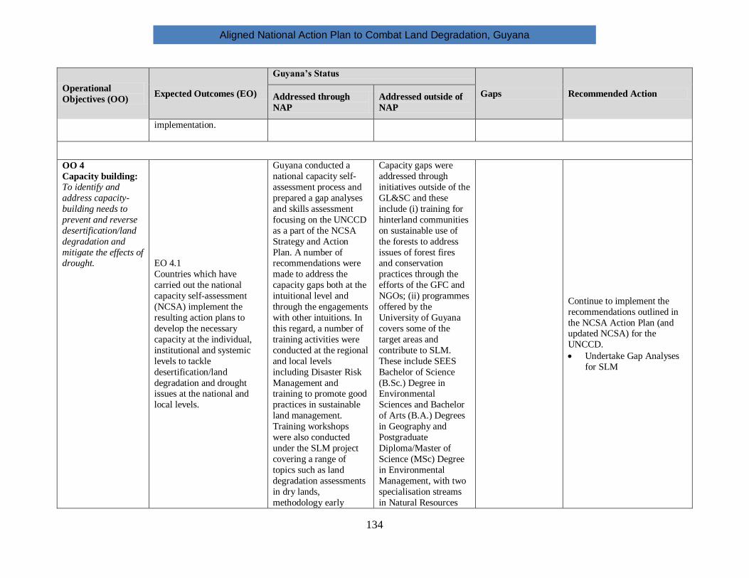
Aligned National Action Plan to Combat Land Degradation, Guyana
134
Operational
Objectives (OO) Expected Outcomes (EO)
Guyana’s Status
Gaps Recommended Action Addressed through
NAP
Addressed outside of
NAP
implementation.
OO 4
Capacity building:
To identify and
address capacity-
building needs to
prevent and reverse
desertification/land
degradation and
mitigate the effects of drought.
EO 4.1
Countries which have
carried out the national
capacity self-assessment
(NCSA) implement the
resulting action plans to
develop the necessary
capacity at the individual,
institutional and systemic
levels to tackle
desertification/land
degradation and drought issues at the national and
local levels.
Guyana conducted a
national capacity self-
assessment process and
prepared a gap analyses
and skills assessment
focusing on the UNCCD
as a part of the NCSA
Strategy and Action
Plan. A number of recommendations were
made to address the
capacity gaps both at the
intuitional level and
through the engagements
with other intuitions. In
this regard, a number of
training activities were
conducted at the regional
and local levels
including Disaster Risk
Management and training to promote good
practices in sustainable
land management.
Training workshops
were also conducted
under the SLM project
covering a range of
topics such as land
degradation assessments
in dry lands,
methodology early
Capacity gaps were
addressed through
initiatives outside of the
GL&SC and these
include (i) training for
hinterland communities
on sustainable use of
the forests to address
issues of forest fires and conservation
practices through the
efforts of the GFC and
NGOs; (ii) programmes
offered by the
University of Guyana
covers some of the
target areas and
contribute to SLM.
These include SEES
Bachelor of Science
(B.Sc.) Degree in Environmental
Sciences and Bachelor
of Arts (B.A.) Degrees
in Geography and
Postgraduate
Diploma/Master of
Science (MSc) Degree
in Environmental
Management, with two
specialisation streams
in Natural Resources
Continue to implement the
recommendations outlined in
the NCSA Action Plan (and updated NCSA) for the
UNCCD.
Undertake Gap Analyses
for SLM

Aligned National Action Plan to Combat Land Degradation, Guyana
135
Operational
Objectives (OO) Expected Outcomes (EO)
Guyana’s Status
Gaps Recommended Action Addressed through
NAP
Addressed outside of
NAP
warning systems
watershed management,
resource valuation and
GIS.
Management; and
Climate Change and
Disaster Management
and other programmes
offered by the Faculties
of Agriculture and
Forestry, Technology
and Natural Sciences;
(iii) specialized training
courses for the forestry
and mining sectors offered by the Forestry
Training Centre Inc.
and the Guyana Mining
School and Training
Centre Inc.; (iv)
training conducted by
NGOs (World Wildlife
Fund (WWF),
Iwokrama, CI, and
other institutions such
as Bina Hill Institute contributes to SLM.
EO 4.2
Those countries which have
not previously undertaken
capacity needs assessments
engage in relevant
assessments processes to
identify capacity needs for
tackling desertification/land
degradation and drought at
the national and local levels
Not applicable

Aligned National Action Plan to Combat Land Degradation, Guyana
136
Operational
Objectives (OO) Expected Outcomes (EO)
Guyana’s Status
Gaps Recommended Action Addressed through
NAP
Addressed outside of
NAP
OO 5
Financing &
technology
transfer:
To mobilize and
improve the
targeting and
coordination of
national,
bilateral and
multilateral financial and technological
resources in order
to increase their
impact and
effectiveness
EO 5.1
Affected country Parties
develop integrated
investment frameworks for
leveraging national,
bilateral and multilateral
resources with a view to
increasing the effectiveness
and impact of interventions.
A medium term
Investment Plan for
Sustainable
Development was
prepared that set out the
framework for
investments and
identified multiple
sources of financing.
Increase efforts to
mobilize financial
resources from
international financial
institutions, facilities and
funds, including Foreign
Direct Investment (FDI),
private foreign
investment, NGOs and
CSOs, and GEF (Integrated Financing
Strategy (IFS) Report).
Adequate Funding should
be allocated for training,
particularly in the areas of
remote sensing, GIS,
Multi Criteria Decision
Analysis, and, Information
management systems.
Encourage donors to use
debt swap mechanism to
promote and finance sustainable land
management
interventions.
Networking to access
adequate financing for
effective economic and
policy incentives and
technical support, notably
within the framework of
South-South and North-
South cooperation.
EO 5.2
Developed country Parties provide substantial,
adequate, timely and
predictable financial
resources to support
domestic initiatives to
reverse and prevent
desertification/land
degradation and mitigate the
effects of drought.
EO 5.3
Parties increase their efforts
to mobilize financial
resources from international financial institutions,
facilities and funds,
including the GEF, by
promoting the
UNCCD/Sustainable land
management (SLM) agenda
within the governing bodies
of these institutions.
The Medium Term
Investment Plan for
Sustainable Land
Management identified a number of funding
sources including market
mechanism, government
financing, bilateral and
multilateral, as well as,
mechanism such as
UNCCD, UNFCCC, and
CBD.
EO 5.4
Innovative sources of
finance and financing

Aligned National Action Plan to Combat Land Degradation, Guyana
137
Operational
Objectives (OO) Expected Outcomes (EO)
Guyana’s Status
Gaps Recommended Action Addressed through
NAP
Addressed outside of
NAP
mechanisms are identified
to combat
desertification/land
degradation and mitigate the
effects of drought, including
from the private sector,
market-based mechanisms,
trade, foundations and
CSOs, and other financing
mechanisms for climate
change adaptation and mitigation, biodiversity
conservation and
sustainable use and for
hunger and poverty
reduction.
EO 5.5
Access to technology by
affected country Parties is
facilitated through adequate
financing, effective
economic and policy
incentives and technical support, notably within the
framework of South-South
and North-South
cooperation.

Aligned National Action Plan to Combat Land Degradation, Guyana
138
7.3 Proposed priority actions to combat DLDD and promote sustainable land
management
The process undertaken by the GOG for the preparation of the Aligned NAP has identified a set
of priorities which individually and combined, will ensure that DLDD and SLM are firmly
addressed in policies, strategies, programmes and projects in Guyana. The approach to
determine and select these priorities is qualitative and non-scientific based on qualitative
assessment of current and anticipated future risks, threats and drivers of those threats.
Box 1: Key priority actions to combat DLDD and promote SLM
1. Establish and strengthen monitoring systems for all sectors, including GIS capacities.
2. Increase and Strengthen awareness among all stakeholders about the impacts of drought, land
degradation and deforestation.
3. Strengthen scientific foundations, research and development:
a. Relationships between DLDD, climate change and biodiversity
b. Strengthen the SLM foundations as a means to resolve DLDD, climate change and
biodiversity simultaneously
c. Comprehensive analysis of the economic losses to society caused by DLDD
4. Establish and operationalize a drought early warning system.
5. Develop and implement a coordination and communication strategy to enhance governance,
coordination, and stakeholder engagement, of efforts to combat DLDD.
6. Special effort to enhance the enforcement of mining regulations.
7. Implement the Integrated Finance Strategy and Framework.
8. Implement data and knowledge management system.
9. Develop capacity building efforts.
7.4 Overall timeframe for Aligned NAP implementation
The time frame for this Aligned NAP is 2015-2025. The Aligned NAP will be implemented in
four phases as follows:
Phase 1: 1 – 3 years
Phase 2: 3 – 5 years
Phase 3: 5 – 7 years
Phase 4: 7 – 10 years
These three-year phases are intended to enable the Aligned NAP to be synchronized with the
national policy and planning processes and cycles. Table 11 below shows the implementation
phases for the areas of focus/priorities for the Aligned NAP.

Aligned National Action Plan to Combat Land Degradation, Guyana
139
Table 11: Implementation phases for the Aligned NAP
Phase Areas of Focus/Priority for Guyana’s Aligned NAP
Phases 1-4 1. Increasing Public Awareness and Education.
Phases 2 - 3 2. Strengthening sustainable land management and policy
framework.
Phases 2 – 4 3. Mainstreaming sustainable land management interventions
and UNCCD objectives into national land use planning
processes and national sectoral and investment plans.
Phase 1-4 4. Strengthening collaboration with focal point institutions for
the Rio Convention and build on synergies.
Phases 1-4 5. Strengthening collaboration with tertiary intuitions to deliver
training and capacity building on specific areas identified in
the NCSA Action Plan for the UNCCD.
Phases 1-4 6. Improving access to, and adequacy of, financial resources for
UNCCD implementation.
7.5 Monitoring and Evaluation.
The GOG will ensure that its efforts to combat DLDD are progressing and that the results of
these efforts will have meaningful impact. To facilitate this, a plan for monitoring and
evaluation of the implementation of the overall Aligned NAP and individual actions/projects has
been developed (See Costed Strategic Framework for the Ministry of Natural Resources and the
Environment 2013-2018, June 2013). The progress and impact of the Aligned NAP will be
reviewed every five years based on evaluation of the established indicators. The responsibility
for monitoring and evaluation will rest with the National Steering Committee.

Aligned National Action Plan to Combat Land Degradation, Guyana
140
8 CONCLUSIONS
As a signatory to the United Nations Convention on Combating Desertification, Guyana is
strongly committed to meeting its obligations to prevent and mitigate drought, land degradation
and deforestation in the country.
Drought, land degradation and deforestation are of great concern to the Government of Guyana
since these directly and indirectly can cause death, poor health, and in many other ways
negatively affect the livelihood of its peoples, including through: pollution of rivers; reduced fish
stocks in rivers; surface runoff and mud slides; degradation of ecosystems and biodiversity and;
reduced economic productivity.
Guyana continues in its progress towards meeting the Sustainable Development agenda and
meeting the MDG targets.
Guyana is proud of its extensive and unique biodiversity which it is steadfast in protecting for its
present and future generations. The country’s prosperity depends heavily on this biodiversity for
food, medicines, tourism, and other forms of sustenance.
Guyana possesses vast natural resources which are essential for sustaining its development and
which will gradually increase the demand for developing its land and these resources. This
increasing demand is not just for domestic consumption and development; there is a rapidly
growing global demand for these resources, the export of which can become a substantial and
important source of national revenue.
The Government of Guyana will ensure that its economic development both in the short and the
long term, does not cause undue adverse effects on its people, who should be the very
beneficiaries of the development process. There is an increasing perception and understanding
that a good environment contributes to economic growth by reducing risks to people and by
enhancing the business and environment potential. In addition, export markets are increasingly
demanding responsibly harvested and produced goods.
Coordinating and managing the sometimes conflicting demands on the land is very challenging.
As such, the government of Guyana increasingly engages in collaborative management with its
various stakeholders (government agencies, CSOs, businesses, donors, etc.) as a reflection of this
shared responsibility. All levels of society shall have a voice and influence on the future of
Guyana.
The Government of Guyana is making substantial progress in improving and adjusting existing
policies and regulations, as well as designing new ones. These include effective safe guarding
mechanisms, mitigative measures and promotion of more sustainable land use practices. This
Aligned National Action Programme sets out the road map for the Government of Guyana to
continue implementing these plans.

Aligned National Action Plan to Combat Land Degradation, Guyana
141
It is equally crucial that policies and land use practices are underpinned by science and research.
The role of research and science in developing policies and practices must be strengthened.
Reliable research depends on good data, however there is a lack of reliable data and baselines in
several sectors, as well as limited or no integration of existing datasets.
Importantly, Guyana has a long history with close dependency on and deep knowledge of the
local environment and ecology. Guyana’s policies and practices should be grounded on insights
from its valuable local and traditional knowledge.
The impacts of DLDD further exacerbate the impacts of climate change which Guyana remains
vulnerable to. Conversely, climate change also exacerbates the impacts of DLDD. The risks
posed by rising sea levels threaten the very existence of the Guyanese people who live mostly
along the coastline, on lands which are already often under sea level.
The efforts to combat DLDD will have substantial benefits for biodiversity, which is the basis for
long term food security. These combative efforts will also benefit climate change
mitigation/adaptation since many of the causes and solutions to those problems are to be found in
appropriate SLM practices and improved governance.
The Government of Guyana continues to rigorously pursue the process of strengthening
coordination and cross-sectoral collaboration to ensure integrated approaches to combating
DLDD.

Aligned National Action Plan to Combat Land Degradation, Guyana
142
9. REFERENCES
1. Guyana Initial National Communication National Circumstances in Response to its
Commitments to the UNFCCC, Cooperative Republic of Guyana represented by the
Ministry of Agriculture in collaboration with United Nations Development Programme
with funding from Global Environment Facility, April 2002
2. Project Document, Land Reclamation Project (LRP), June 2014
3. Project Identification Form for the CCCD Project, UNDP, 2015
4. Minamata Initial Assessment, UNDP, 2015
5. National Stocktaking Activity in Support of an Aligned National Action Plan, Rapid
Stocktaking Report, February 2015
6. Costed Strategic Framework for the Ministry of Natural Resources and the Environment
2013-2018, June 2013
7. Disaster Risk Management Policy, CDC, 2013
8. Early Warning Systems Framework, CDC, 2013
9. CDC Guyana. “Drought”. (2009).
http://www.cdc.gy/index.php?option=com_content&view=article&id=74&Itemid=83
10. CDC Guyana. “Multi-Hazard Disaster Preparedness & Response Plan” (2013).
11. CDC Guyana. “National Integrated Disaster Risk Mitigation Plan and Implementation
Strategy for Guyana” (2013).
12. CDC Guyana. “Progress and challenges in Disaster Risk Management in Guyana”
(2014).
13. Guyana Lands and Surveys Commission, 2012. Funding Needs Assessment for
Sustainable Land Management Priorities Final Report.
14. GL&SC, 2012. Recommendations of Sustainable Land Management (SLM) in Guyana’s
draft Land Use Policy.
15. GL&SC 2006. Guyana’s National Action Programme to Combat Desertification
16. GL&SC. 2006. Guyana’s National Action Programme to combat Land Degradation
17. Guyana Lands and Surveys Commission (GL&SC), UNDP, GEF. “Early Warning
System Study” (2010)
18. Guyana Lands and Surveys Commission. “Guyana National Action Program To Combat
Land Degradation” (2006).
19. Guyana Lands & Surveys Commission, “Funding Needs Assessment for Sustainable
Land Management Priorities”, May 2012
20. Guyana Lands and Surveys Commission National Focal Point (UNCCD) “Guyana
National Action Programme to Combat Land Degradation”, May 2006
21. Guyana Lands & Surveys Commission, “Funding Needs Assessment for Sustainable
Land Management Priorities”, May 2012
22. Guyana Lands & Surveys Commission, “Guyana National Action Programme to combat
land degradation (in accordance with the United Nations Convention to Combat
Desertification - UNCCD)”, May 2016

Aligned National Action Plan to Combat Land Degradation, Guyana
143
23. Guyana Lands & Surveys Commission, “Development of a Medium Term Investment
Plan for Sustainable Land Management”, May 2012
24. Guyana Lands and Surveys Commission, United Nations Development Programme &
Global Environment Facility “National Assessment of Land Degradation in Guyana:
Diagnostic Report”, 2008
25. Guyana Lands and Surveys Commission (2012) Guyana National Land Use Plan.
Ministry of Natural Resources and Environment, Georgetown, Guyana
26. Guyana Land and Surveys Commission (2006). Guyana National Action Programme to
combat land degradation, Georgetown, Guyana.
27. Bank of Guyana 2014 Annual Report
28. Guyana National Budget. 2014.
29. Guyana Bureau of Statistics. 2014. Guyana Population and Housing Census, 2012.
Preliminary Report.
30. Guyana Chronicle, 2011. National Water Resources System Launched.
http://guyanachronicle.com/national-water-resources-system-launched/
31. Guyana Forestry Commission. 2013. Guyana REDD+ Monitoring Reporting and
Verification System (MRVS), Year 3 Interim Measures Report – 01 January 2012 – 31
December 2012, Version 3
32. GoG (2013). Guyana National Land Use Plan. Guyana Lands and Surveys
Commissions, Ministry of Natural Resources and Environment. Georgetown, Guyana
33. GoG (2013). The Guyana Poverty Reduction Strategy paper. Georgetown, Guyana.
34. GoG (2014) Guyana’s National Biodiversity Strategy and Action Plan (2012-2020).
Ministry of Natural Resource and Environment, EPA. Georgetown, Guyana.
35. GoG (2012). Rio+20 National Report: A Green Economy and Institutional Framework
for Sustainable Development: Guyana Context. Georgetown, Guyana.
36. GoG (2009). Forests Act 2009. Georgetown, Guyana
37. GoG (2002). Water and Sewerage Act Chapter 30:01-Laws of Guyana, Georgetown
Guyana
38. GoG (1998) Land Registry Act-Chapter 5:02. Laws of Guyana, Georgetown, Guyana
39. GoG (1998). Town and Country Planning Act. Chapter 20:01 Laws of Guyana ,
Georgetown, Guyana
40. GoG (1998) Drainage and Irrigation Act- Laws of Guyana, Georgetown, Guyana
41. GoG (1998). Education Act Chapter 39:01 Laws of Guyana, Georgetown, Guyana.
42. GoG (1998). Environmental Protection Act: Chapter 20:05. Georgetown, Guyana
43. GoG (1998). Guyana Forestry Commission Act-Laws of Guyana, Georgetown, Guyana
44. GoG (1998). Guyana Lands and Surveys Commission Act-Chapter 59:05. Laws of
Guyana, Georgetown, Guyana.
45. GoG (1998). Mahaica-Mahaicony-Abary Agricultural Development Authority Act –
Laws of Guyana, Georgetown Guyana

Aligned National Action Plan to Combat Land Degradation, Guyana
144
46. GoG (1957). Acquisition of Land (Land Settlement Act) Cap. 62:06. Laws of Guyana,
Georgetown, Guyana
47. Guyana Forestry Commission (2011). National Forest Plan, Georgetown, Guyana
48. Guyana Forestry Commission (2011). National Forestry Policy Statement, Georgetown,
Guyana.
49. MOA (2013). A national Strategy for Agriculture in Guyana 2013-2020. Ministry of
Agriculture, Georgetown, Guyana.
50. MOA (2011). Food and Nutrition Security Strategy for Guyana. Government of Guyana,
Georgetown Guyana
51. Guyana National Task Force. “Guyana Climate Change Action Plan” (2001).
52. Guyana Times. “Regions 1, 9 hit by drought”. (2015).
www.guyanatimesgy.com/2015/04/11/regions-1-9-hit-by-drought/
53. Guyana: El Niño Drought. An appeal. (1998).
https://www.ifrc.org/docs/appeals/98/1498.pdf
54. Hydrometeorological Service Guyana. “Early Warning System in Guyana”. (No date).
https://www.wmo.int/pages/prog/.../Mr.%20Cummings%20(Guyana).pdf
55. Hydrometeorological Service, Guyana. “Drought Monitoring in Guyana” (No date).
drought.unl.edu/Portals/0/docs/workshops/.../Thursday/Seulall.pdf
56. C. Isabella Bovolo, Geoff Parkin and Thomas Wagner,2009. Initial Assessment of the
Climate of Guyana and the Region with a Focus on Iwokrama. School of Civil
Engineering & Geosciences, Newcastle University, Newcastle upon Tyne., UK.
57. Chandarpal., Gitanjali, 2014. Climate Change Impacts on Guyana and Current
Initiatives. Office of Climate Change, Office of the President, Guyana,
http://www.caribank.org/uploads/2014/05/Climate-Change-Impacts-on-Guyana-and-
Current-Initiatives-by-Gitanjjali-Chandarpal.pdf
58. Cummings, Garvin, Hydrometeorological Service, Ministry of Agriculture. EWS in
Guyana .Hydromet Presentation, RECO Bogota.
https://www.wmo.int/pages/prog/drr/events/TECORAIII/Session4/Mr.%20Cummings%
20(Guyana).pdf
59. Da Silva P., 2014. Avifaunal Diversity in a Mangrove Reserve in Guyana, South
America; International Journal of Science Environmental and Technology, Vol.3, No.1,
2014. 23-32.
60. Environmental Protection Agency. 2014. Revision of the National Biodiversity Strategy
and Action Plan Stocktaking Report.
61. Economic Commission for Latin America and the Caribbean, Subregional Headquarters
for the Caribbean, 2013. Third International Conference on Small Island Developing
States. Caribbean Regional Synthesis Report.
http://www.sids2014.org/content/documents/250Synthesis%20Report%20Final%2020%
20August%202013.pdf

Aligned National Action Plan to Combat Land Degradation, Guyana
145
62. Federal Ministry for Economic Cooperation and Development (BMZ), Bonn 2007.
Technical Paper. National Action Programmes under UNCCD – Rules and Reality.
http://www.desertifikation.de/uploads/media/07-02-01_Technical_Paper_NAP.pdf
63. FAO, 2013. Guyana UN-Water Country Brief,
http://www.zaragoza.es/contenidos/medioambiente/onu/1026_eng_res5_unwater_briefs
_guyana.pdf
64. Joint statement on a Voluntary Partnership Agreement (VPA) on Forest Law
Enforcement, Governance and Trade (FLEGT) between Guyana and the European
Union, Georgetown, 2012.
http://eeas.europa.eu/delegations/guyana/documents/press_corner/euguyanaflegt.pdf
65. Keller, Marius et al. 2011. Review of Current and Planned Adaptation Action: South
America. - Guyana. International Institute for Sustainable Development.
http://www.adaptationpartnership.org/sites/default/files/LAC%20South_America%20Co
untry%20profiles%20%28Guyana%29.pdf
66. Met Office, FitzRoy Road, Exeter, Devon, EX1 3PB United Kingdom, 2012. Case
study: Guyana Hydrometeorological Office.
http://www.metoffice.gov.uk/media/pdf/q/7/Guyana_Case_study.pdf
67. Ministry of Natural Resources and the Environment,2012. Costed Strategic Framework.
http://www.nre.gov.gy/PDF/Costed%20Strategic%20Framework%20for%20the%20MN
RE%20V5_final.pdf
68. World Bank, 2014. Decision-Making and Investment Strategies for Managing Flood
Risk in Guyana. Insights into DRM. Issue #6- July 2014.
http://www.worldbank.org/en/topic/disasterriskmanagement/publication/insights-in-
drm-latin-america-caribbean
69. “Drought Early Warning Systems in the Context of Drought Preparedness and
Mitigation”. (2000). http://www.preventionweb.net/files/1882_VL102149.pdf.
70. Caribbean Disaster Emergency Management Agency (CDEMA). “El Nino blamed for
low rainfall levels” (2015).
https://www.cdema.org/index.php?option=com_content&view=category&layout=blog&
id=34&Itemid=266&limitstart=25
71. Colorado Climate Center. “Enhanced drought monitoring and early warning activities in
the Upper Colorado River Basin”.
www.cpc.ncep.noaa.gov/products/outreach/proceedings/.../NDoesken.pdf
72. Colorado Climate Center. “NIDIS Upper Colorado River Regional Drought Early
Warning System” (2015). climate.colostate.edu/~drought/
73. Columbia University. “El Niño Southern Oscillation (ENSO); Ocean-Atmosphere
Interactions” (2007). http://eesc.columbia.edu/courses/ees/climate/lectures/enso.html
74. Desinventar Inventory System of the Effects of Disasters. “Available databases”.
http://www.desinventar.org/

Aligned National Action Plan to Combat Land Degradation, Guyana
146
75. DEWFORA. “Implementing drought early warning systems in Africa: policy lessons
and future needs” (2013). https://www.unesco-
ihe.org/sites/default/files/dewfora_policy_brief_africa_-_digital_version.pdf
76. DROUGHT-R&SPI. “Review of current drought monitoring systems and identification
of (further) monitoring requirements” (2013). www.eu-drought.org/.../DROUGHT-R-
SPI-Technical-Report-No-33.
77. Dyer, J. A. “A Drought Early Warning System for Prairie Pasture Land” (2013).
http://dx.doi.org/10.4296/cwrj1304005
78. Edwards, Laura. “Foundations for a Regional Drought Early Warning System in the
Missouri River Basin” (2015). http://docslide.us/science/foundations-for-a-regional-
drought-early-warning-system-in-the-missouri-river-basin.html
79. IFAD. “Risk Management - Drought Early-Warning Systems and Contingency Plans
Risk Management - Drought Early-Warning Systems and Contingency Plans”.
www.ifad.org/lrkm/range/drought.htm
80. Institute of Industrial Science, University of Tokyo, Japan. “Satellite-based drought
monitoring and warning system – New Zealand” (2015). webgms.iis.u-
tokyo.ac.jp/DMEWS/New Zealand/search.php
81. Institute of Industrial Science, University of Tokyo, Japan. “Satellite-based drought
monitoring and warning system” (2015). webgms.iis.u-tokyo.ac.jp/DMEWS/
82. International Strategy for Disaster Reduction . “Drought Risk Reduction Framework and
Practices: Contributing to the Implementation of the Hyogo Framework for Action”
(2009). http://www.unisdr.org/files/11541_DroughtRiskReduction2009library.pdf.
83. MWAR-LAC. “Development of National Drought Atlases for the Caribbean Countries”.
www.cazalac.org/mwar_lac/index.php?id=54
84. National Drought Management Authority (Kenya). “Welcome to NDMA - Kenya”.
www.ndma.go.ke/
85. National Drought Mitigation Center (Nebraska, USA). “Caribbean Drought Training
Workshop” (2012).
http://drought.unl.edu/NewsOutreach/Outreach/Workshops/CaribbeanDroughtTraining
Workshop.aspx
86. National Drought Mitigation Center (Nebraska, USA). “Drought Early Warning
Systems in the Context of Drought
87. National Drought Mitigation Center (Nebraska, USA). “Drought Early Warning
Systems” (2009). http://www.wamis.org/agm/meetings/wies09/S10-Svoboda.pdf
88. National Drought Mitigation Center (Nebraska, USA). “Drought Monitoring and Early
Warning Information Systems (DEWIS): Tools and Techniques” (2012).
drought.unl.edu/Portals/0/docs/.../Svoboda_DEWS_Caribbean.pdf
89. National Drought Mitigation Center. “National Drought Mitigation Center Drought
Services: Collaborative Efforts Towards Drought Early Warning and Information
Systems” (2015). https://www.drought.uni-freiburg.de/Publications/.../Svoboda

Aligned National Action Plan to Combat Land Degradation, Guyana
147
90. Manual on Compliance With and Enforcement of Multilateral Environment Agreements.
UNEP. Downloaded from http://www.oas.org/dsd/Tool-
kit/Documentos/ModulleVI/Compliance%20with%20MEAs.pdf
91. United Nations Environment Programme . “Climate Early Warning System Feasibility
Report: Early Warning Systems and Hazard Prediction” (2012).
www.unep.org/science/chief.../76/.../EWS_Report_Final_Version1.pdf.
92. United Nations Environment Programme. “Early Warning Systems: State-of-Art
Analysis and Future Directions” (No date).
na.unep.net/siouxfalls/publications/early_warning.pdf.
93. United Nations Framework Convention on Climate Change. “Vulnerability and
adaptation to climate change in small island developing states”.
https://unfccc.int/files/adaptation/adverse_effects_and_response_measures_art_48/appli
cation/pdf/200702_sids_adaptation_bg.pdf
94. World Food Program. “Early-Warning System Sees Drought Coming In Namibia”
(2013).https://www.wfp.org/aid-professionals/blog/blog/early-warning-system-sees-
drought-coming-namibia
95. World Meteorological Organization. “Inter-Regional Workshop on Indices and Early
Warning Systems for Drought” (2009).
http://www.wmo.int/pages/prog/wcp/agm/meetings/wies09/wies09_present.php
96. Green, E. (Undated). National Integrated Disaster Risk Management Plan and
Implementation Strategy for Guyana. Civil Defence Commission, Georgetown, Guyana
97. UNDP (2013) Disaster Risk Management Policy, Georgetown Guyana
98. UNCCD. Ten Year Strategy Leaflet
http://www.unccd.int/Lists/SiteDocumentLibrary/10YearStrategy/Strategy-leaflet-
eng.pdf
99. UNCCD TST Issues Brief: Desertification, Land Degradation and Drought
100. UN General Assembly, 2012. High-level meeting on addressing desertification, land
degradation and drought in the context of sustainable development and poverty
eradication.
101. Global Mechanism, “Glossary for Performance and Impact Indicators, Financial Flows
and Best Practices, Review of financial flows for the implementation of the Convention
(UNCCD)”, 2010, modified by the Committee for the Review of the Implementation of
the Convention, Germany, 2013
102. Squires V.R., “Alignment of National Action Programmes with UNCCD 10 Year
Strategy Through Use of Integrated Financing Strategy Tools”, 2013
103. UNCCD, “Consideration of ways and means of promoting know-how and technology
transfer for combating desertification and/or mitigating the effects of drought, as well as
of promoting experience sharing and information exchange among parties and interested
institutions and organizations”, Committee for the review of the implementation of the
Convention, UNCCD, Bonn, 2-11 May 2005

Aligned National Action Plan to Combat Land Degradation, Guyana
148
104. UNCCD, “The 10-year strategic plan and framework to enhance the implementation of
the Convention”, 2008
105. UNCCD, Alignment of National Action Programmes with UNCCD 10 Year Strategy
Through Use of Integrated Financing Strategy Tools, February 2013
106. UNCCD, “Evaluation of the effectiveness of national action programmes to implement
the United Nations Convention to Combat Desertification”, 2015
107. Weerasinghe, R.P.M (2013). Managing Arid Areas and Sand Dunes in Sri Lanka in
Heshmati A.G. and Squires R.V (eds). Combating desertification in Asia, Africa and the
Middle East: Proven Practice. Springer Dordrecht Heidelbergy, New York, London
108. Global Mechanism, “Practical Guide to Designing Integrated Financing Strategies”,
2009
109. USAID. “Innovative Weather Model Helps Millions in Caribbean Prepare for Drought”.
https://www.usaid.gov/news-information/frontlines/science-technology-innovation-and-
partnerships/innovative-weather-model
110. Walters, Rochelle, Michael Taylor & Tannecia Stephenson. “Some Caribbean Drought
Research at Csgm, Mona”.
http://drought.unl.edu/Portals/0/docs/workshops/03222012_Kingston_Jamaica/Drought
%20Research%20in%20the%20Caribbean.pdf
111. Epstein, Mario (2015)- Guyana Drought Early Warning Protocol
112. Atyang, Agnes, 2015 Drought Early System Protocol
113. Bai ZG, Dent DL, Olsson L, Schaepma ME., 2008. Global assessment of land
degradation and improvement. Identification by remote sensing. Report 2008/01, ISRIC
– World Soil Information: Wageningen.
114. Woods Hole Oceanographic Institution. “El Niño & Other Oscillations”.
www.whoi.edu/main/topic/el-nino-other-oscillations.
115. Woods Hole Oceanographic Institution. “Reports to the Nation: El Nino and Climate
Prediction”. www.atmos.washington.edu/gcg/RTN/rtnt.html
116. Newitz, Annalee. “Are You Doing Anything to Prepare for the "Godzilla" El Niño?”
(2015). http://gizmodo.com/are-you-doing-anything-to-prepare-for-the-godzilla-el-
1723982315
117. NOAA – Climate Prediction Center. “Frequently Asked Questions About El Niño and
La Niña”.
http://www.cpc.ncep.noaa.gov/products/analysis_monitoring/ensostuff/ensofaq.shtml
118. NOAA/NIDIS. “What is National Integrated Drought Information System?” (2015).
wwa.colorado.edu › Workshops & Events › WWA Workshops
119. Pulwarty, R. S. & Mannava V. K . Sivakuman. “Information systems in a changing
climate: Early warnings and drought risk management” (2014).
http://www.sciencedirect.com/science/article/pii/S2212094714000218
120. Reports to the Nation. “El Niño and Climate Prediction”.
http://www.atmos.washington.edu/gcg/RTN/rtnt.html

Aligned National Action Plan to Combat Land Degradation, Guyana
149
121. State Climate Office of North Carolina. “Global Patterns - El Niño-Southern Oscillation
(ENSO)”. http://climate.ncsu.edu/climate/patterns/ENSO.html
122. Trotman, A. & Robert Webb. “Drought Early Warning Information Systems: reducing
drought risks in a changing climate”. http://www.climate-services.org/iccs-3-parallel-
session-drought-early-warning-information-systems-reducing-drought-risks-changing
123. Trotman, A.R. & David A. Ferrel. “Drought Impacts and Early Warning in the
Caribbean - The Drought of 2009-2010”.
https://www.wmo.int/pages/prog/drr/events/Barbados/Pres/4-CIMH-Drought.pdf.
124. Report of the first session of the Partnership Initiative on Sustainable Land Management
High Level Meeting, held in Port of Spain, Trinidad and Tobago 6 May 2011.
http://cnirdregional.org/wp-content/uploads/2012/05/PISLM-High-Level-
Comprehensive-Report.pdf

Aligned National Action Plan to Combat Land Degradation, Guyana
150
10. APPENDICES
Appendix 1: Posters used for public awareness activities

Aligned National Action Plan to Combat Land Degradation, Guyana
151

Aligned National Action Plan to Combat Land Degradation, Guyana
152
Appendix 2: Photographs of Project Activities
Presentation of Stakeholders’ Comments Awareness materials procured by the Project
The Project participated at GuyExpo, 2014 Focus Group Session were held with Agencies
Training on the use of the Database for the
preparation of the PRAIS Report
Field trip to a Mining Area to identify sites for
monitoring land degradation

Aligned National Action Plan to Combat Land Degradation, Guyana
153
Appendix 3
Map of Land Cover/ Land Use

Aligned National Action Plan to Combat Land Degradation, Guyana
154
Map showing Development Options, Hotspots and Infrastructure Linkages

Aligned National Action Plan to Combat Land Degradation, Guyana
155
Map showing Available Land (Includes Prospecting Areas)

Aligned National Action Plan to Combat Land Degradation, Guyana
156
FOR MORE INFORMATION
Contact the National Focal Point Agency to the UNCCD:
Guyana Lands and Surveys Commission
22 Upper Hadfield Street, Durban Backlands,
G\town, Guyana
Website: lands.gov.gy
Email: [email protected]
Tel: (592) 226 0527 Ext 107, 206