Alexander the Great's tombolos at Tyre and Alexandria, eastern ...
24
Alexander the Great's tombolos at Tyre and Alexandria, eastern Mediterranean N. Marriner a, ⁎ , J.P. Goiran b , C. Morhange a a CNRS CEREGE UMR 6635, Université Aix-Marseille, Europôle de l'Arbois, BP 80, 13545 Aix-en-Provence cedex 04, France b CNRS MOM Archéorient UMR 5133, 5/7 rue Raulin, 69365 Lyon cedex 07, France Received 25 July 2007; received in revised form 10 January 2008; accepted 11 January 2008 Available online 2 February 2008 Abstract Tyre and Alexandria's coastlines are today characterised by wave-dominated tombolos, peculiar sand isthmuses that link former islands to the adjacent continent. Paradoxically, despite a long history of inquiry into spit and barrier formation, understanding of the dynamics and sedimentary history of tombolos over the Holocene timescale is poor. At Tyre and Alexandria we demonstrate that these rare coastal features are the heritage of a long history of natural morphodynamic forcing and human impacts. In 332 BC, following a protracted seven-month siege of the city, Alexander the Great's engineers cleverly exploited a shallow sublittoral sand bank to seize the island fortress; Tyre's causeway served as a prototype for Alexandria's Heptastadium built a few months later. We report stratigraphic and geomorphological data from the two sand spits, proposing a chronostratigraphic model of tombolo evolution. © 2008 Elsevier B.V. All rights reserved. Keywords: Tombolo; Spit; Tyre; Alexandria; Mediterranean; Holocene 1. Introduction The term tombolo is used to define a spit of sand or shingle linking an island to the adjacent coast. Despite a long history of inquiry (Gulliver, 1896, 1899; Johnson, 1919; Escoffier, 1954; Guilcher, 1958), the literature has traditionally focused upon form-process aspects of their geomorphology with very little attention being paid to the salients' sedimentary history. Whilst the origins of spits and barrier islands have been the subject of significant scientific debate, notably with the rich North American literature (see Davis, 1994; Stapor and Stone, 2004; Stone et al., 2004; Schwartz and Birkemeier, 2004; Otvos and Giardino, 2004; Gardner et al., 2005; Simms et al., 2006), papers discussing tombolo evolution – their stratigraphic architecture and stages of accretion – are few and far between. The meagre corpus of recent literature has tended to concentrate on: (1) the role of contemporary processes operating around tombolos (Hine, 1979; Dally and Pope, 1986; Silvester and Hsu, 1993; Flinn, 1997; Courtaud, 2000; Browder and McNinch, 2006); (2) establishing a typology of shoreline salients and tombolos (Zenkovich, 1967; Sanderson and Eliot, 1996); and (3) modelling the geometrical relationships of these depositional forms relative to the break- water island (Ming and Chiew, 2000). Although the use of detached breakwaters in shoreline protection has renewed inter- est in salient accretion, understanding of the dynamics and sedimentary history of these forms on longer centennial and millennial timescales remains poor (Clemmensen et al., 2001). The processes governing tombolo formation are similar to those observed in the growth of spits, bars and barrier islands (Anthony and Blivi, 1999; Blivi et al., 2002). Tombolos develop in shallow areas behind island barriers, where sufficient sediment supply coupled with wave and wind action are favourable to beach accretion. Tides, swell and currents serve as the transport- ing media, interacting with the island to set up a complex pattern of wave refraction and diffraction on the lee of the obstacle. In terms of sequence stratigraphy tombolos are part of the Highstand Systems Tract (Catuneanu, 2002, 2005; Cattaneo and Steel, 2003) and, like deltas and estuaries, the inception of their prograding sediment wedges is dated to approximately 8000 to Available online at www.sciencedirect.com Geomorphology 100 (2008) 377 – 400 www.elsevier.com/locate/geomorph ⁎ Corresponding author. E-mail address: [email protected] (N. Marriner). 0169-555X/$ - see front matter © 2008 Elsevier B.V. All rights reserved. doi:10.1016/j.geomorph.2008.01.013
Transcript of Alexander the Great's tombolos at Tyre and Alexandria, eastern ...

Available online at www.sciencedirect.com
2008) 377–400www.elsevier.com/locate/geomorph
Geomorphology 100 (
Alexander the Great's tombolos at Tyre and Alexandria,eastern Mediterranean
N. Marriner a,⁎, J.P. Goiran b, C. Morhange a
a CNRS CEREGE UMR 6635, Université Aix-Marseille, Europôle de l'Arbois, BP 80, 13545 Aix-en-Provence cedex 04, Franceb CNRS MOM Archéorient UMR 5133, 5/7 rue Raulin, 69365 Lyon cedex 07, France
Received 25 July 2007; received in revised form 10 January 2008; accepted 11 January 2008Available online 2 February 2008
Abstract
Tyre and Alexandria's coastlines are today characterised by wave-dominated tombolos, peculiar sand isthmuses that link former islands to theadjacent continent. Paradoxically, despite a long history of inquiry into spit and barrier formation, understanding of the dynamics and sedimentaryhistory of tombolos over the Holocene timescale is poor. At Tyre and Alexandria we demonstrate that these rare coastal features are the heritage of along history of natural morphodynamic forcing and human impacts. In 332 BC, following a protracted seven-month siege of the city, Alexander theGreat's engineers cleverly exploited a shallow sublittoral sand bank to seize the island fortress; Tyre's causeway served as a prototype forAlexandria's Heptastadium built a few months later. We report stratigraphic and geomorphological data from the two sand spits, proposing achronostratigraphic model of tombolo evolution.© 2008 Elsevier B.V. All rights reserved.
Keywords: Tombolo; Spit; Tyre; Alexandria; Mediterranean; Holocene
1. Introduction
The term tombolo is used to define a spit of sand or shinglelinking an island to the adjacent coast. Despite a long history ofinquiry (Gulliver, 1896, 1899; Johnson, 1919; Escoffier, 1954;Guilcher, 1958), the literature has traditionally focused uponform-process aspects of their geomorphology with very littleattention being paid to the salients' sedimentary history. Whilstthe origins of spits and barrier islands have been the subject ofsignificant scientific debate, notablywith the richNorthAmericanliterature (see Davis, 1994; Stapor and Stone, 2004; Stone et al.,2004; Schwartz andBirkemeier, 2004; Otvos andGiardino, 2004;Gardner et al., 2005; Simms et al., 2006), papers discussingtombolo evolution – their stratigraphic architecture and stagesof accretion – are few and far between. The meagre corpus ofrecent literature has tended to concentrate on: (1) the role ofcontemporary processes operating around tombolos (Hine, 1979;Dally and Pope, 1986; Silvester and Hsu, 1993; Flinn, 1997;
⁎ Corresponding author.E-mail address: [email protected] (N. Marriner).
0169-555X/$ - see front matter © 2008 Elsevier B.V. All rights reserved.doi:10.1016/j.geomorph.2008.01.013
Courtaud, 2000; Browder andMcNinch, 2006); (2) establishing atypology of shoreline salients and tombolos (Zenkovich, 1967;Sanderson and Eliot, 1996); and (3) modelling the geometricalrelationships of these depositional forms relative to the break-water island (Ming and Chiew, 2000). Although the use ofdetached breakwaters in shoreline protection has renewed inter-est in salient accretion, understanding of the dynamics andsedimentary history of these forms on longer centennial andmillennial timescales remains poor (Clemmensen et al., 2001).
The processes governing tombolo formation are similar tothose observed in the growth of spits, bars and barrier islands(Anthony and Blivi, 1999; Blivi et al., 2002). Tombolos developin shallow areas behind island barriers, where sufficient sedimentsupply coupled with wave and wind action are favourable tobeach accretion. Tides, swell and currents serve as the transport-ing media, interacting with the island to set up a complex patternof wave refraction and diffraction on the lee of the obstacle.
In terms of sequence stratigraphy tombolos are part of theHighstand Systems Tract (Catuneanu, 2002, 2005; Cattaneo andSteel, 2003) and, like deltas and estuaries, the inception of theirprograding sediment wedges is dated to approximately 8000 to

Fig. 1. Tyre's tombolo set against some of the Mediterranean's better known examples.
378 N. Marriner et al. / Geomorphology 100 (2008) 377–400
6000 BP (Stanley and Warne, 1994). They comprise triangularforms, widest at the base – where the initial accretion begins –thinning laterally towards the island obstacle. The scales ofthese landforms can vary considerably from just a few tens ofmetres behind small obstacles up to 15 km as in the case ofOrbetello on the Italian coast (Fig. 1; Gosseaume, 1973).Although single tombolo bridges tend to be the rule, there aregood examples of tombolo pairs (for example Giens, France,see Blanc, 1959; Courtaud, 2000) and even triplets (Orbetello,Italy, see Gosseaume, 1973) from the Mediterranean. Doubletombolo formation is attributed to waves approaching the islandflanks at different angles of incidence, with lagoons developingin the sheltered area between the twin salients (Blanc, 1959).
The overriding requirements for tombolo formation are:(1) high sediment supply, for example at the margin of rivermouths; (2) a physical barrier against the swell; and (3) coastalprocesses conducive to the development of a sand bank, i.e., bi-directional currents converging towards this physical barrier(Davies, 1980).
Here, we report stratigraphic and geomorphological data fromthe isthmus of Tyre in Lebanon. Juxtaposed against other circum-Mediterranean examples (e.g. Orbetello, Giens, Gibraltar andAlexandria), Tyre is a small sedimentary system rendering it idealfor scientific inquiry and the formulation of a stratigraphic model(Fig. 2). These data are then compared and contrasted withresearch undertaken on Alexandria's tombolo at the margin of theNile delta in Egypt (Goiran, 2001; Goiran et al., 2005).
2. Meteo-marine and geomorphological contexts
The coastal plain in the Tyre vicinity reaches awidth of 2–3 km.This is atypical of the south Lebanese coastline which is otherwisedominated by a series of Cenomanian and Eocene headlands thatprotrude into the sea (Dubertret, 1955; Sanlaville, 1977). Tyre liesupon an uplifted horst, bounded to the east by the Roum fault andto the south by the Rosh Hanikra–Ras Nakoura fault (Morhangeet al., 2006). A series of ENE-trending faults intersect the Tyriancoastal plain putting into contact the Cenomanian and Eocenegeology. The coastal plain is dominated by both consolidated and
clastic Quaternary deposits. Throughout the Holocene, the Tyriancoastline has been protected by a broken chain of sandstoneoutcrops, part of a drowned N–S ridge that runs parallel to thecoastline (Dubertret, 1955; Sanlaville, 1977). The obliquestratification of the latter indicates that they are aeolian in origin.The sandstone ridges are locally referred to as ‘ramleh’ and are thechronostratigraphic analogues of the ‘kurkar’ ridges rimming theIsraeli coast (Frechen et al., 2001, 2002, 2004; Sivan and Porat,2004). These Quaternary outcrops have dampened the effects ofthe swell, and aerial photographs show an intricate pattern ofwave diffraction in the lee of Tyre island. The defensive locationand natural anchorages afforded by these offshore sandstoneridges attracted human societies from the Bronze Age onwards(Marriner et al., 2006). Successive cultures, including Canaan,Phoenician, Persian, Hellenistic, Roman and Byzantine havesignificantly marked and modified the coastal landscapes (Kat-zenstein, 1997; Doumet-Serhal, 2004; Marriner, 2007; Marrineret al., in press).
Despite early attempts by Nabuchodonozor II to link Tyre tothe mainland during the 6th century BC (Fleming, 1915; Nir,1996; Katzenstein, 1997), stratigraphic data demonstrate that thecity remained an island until 332 BC, separated from the continentby ∼800–1000 m of sea (Marriner et al., 2007). Followingstubborn resistance by the Tyrians, Alexander the Great cleverlyexploited the shallow bathymetry induced by Tyre's proto-tombolo, to build a causeway and breach the island's insularity.When the city eventually fell to the Macedonian armies, thecauseway was strengthened using rubble from destroyed quartersof the city (see Diodorus Siculus, writing in the 1st century BC,1967). In its most advanced stage, it is speculated that the sea-bridge reached an averagewidth of 200Greek feet, or∼60m (Nir,1996). This engineering feat, a prototype for Alexandria'scauseway built a year later, significantly artificialised the coastlineand accelerated accretion of the salient.
Tyre's tombolo comprises a W–E-trending salient, 1500 mlong by 3000 m wide (Fig. 2), and lies∼9 km south of the Litaniembouchure. The Litani is Lebanon's most important fluvialsystem, transiting ∼284×106 m3 of sediment per year (Abd-el-Al, 1948; Soffer, 1994). Previously performed clay mineralogical

Fig. 2. Location of core sites on the Tyrian peninsula (black dots denote the sites).
379N. Marriner et al. / Geomorphology 100 (2008) 377–400
analyses indicate that it has been one of the primary sedimentsources for the isthmus during the Holocene (Marriner, 2007).The Litani yields a unique clay composition comprising illite–smectite phases (50–60%) and kaolinite (40–50%). Very highkaolinite content is unique to south Lebanon, with all fluvialsystems between the rivers Litani and Awali manifesting similarmineralogical signatures (Ribes et al., 2003).
The Tyrian coastline is subject to a microtidal wave regime(b45 cm). In light of this, wave impact, longshore currents andswell diffraction are the key factors driving tombolo formation.Dominant coastal winds and swell derive from the south-west,with periodic north-westerlies giving rise to bi-directional drift.Wave climatological data attest to high-energy sea-states; waveheights of more than 5 m are measured every ∼2 years, andgreater than 7 m every ∼15 years (Rosen and Kit, 1981;Goldsmith and Sofer, 1983; Carmel et al., 1985a,b). The site isexposed to a wide swell window with a fetch of ∼750 km fromthe northwest and ∼650 km from the southeast.
3. Methods and data acquisition
3.1. Field data acquisition
At Tyre, a total of 25 cores was obtained (Fig. 2). Sedimentswere extracted using a 10 cm by 200 cm mechanised corer. Coresections were lined with a protective sleeve to avoid sedimentslumping. All cores were GPS levelled and depths quoted onlogs have been benchmarked against mean biological sea level(i.e. the maximum height of the subtidal zone, Laborel and
Laborel-Deguen, 1994). This benchmark was established usingthe upper limit of living Balanus populations growing on themodern harbour quay faces. At Alexandria, 13 cores were drilledalong the city's present seaboard (Fig. 3). Here we presentstratigraphic data from two cores, C2 and C9, deriving from thetombolo, either side of Alexander the Great's Heptastadium(Hesse, 1998). Following extraction, all cores were stored incold rooms at the CEREGE geoscience facilities in Aix-en-Provence, France.
3.2. Sediment analysis
Initial facies descriptions (e.g. colour, petrofacies) wereundertaken under standardised laboratory conditions, beforesampling to establish general stratigraphy. Samples were ovendried at 40 °C and subsequently described using the Munsellcolour scheme. Dry sediment aggregates were weighed andwashed through twomesh sizes, 2 mm and 50 μm, to separate outthe gravel (N2 mm), sand (2 mm to 50 μm) and silt and clay(b50 μm) fractions. In most cases, 100 g of dry aggregate werewashed through to ensure the statistical validity of the results. Thedried fractions were weighed and data plotted against strati-graphic logs in percentages.
The sand fraction was subjected to mechanical sieving. Atleast 50 g of dry sands were used. These were mechanicallysieved using 15 meshes descending in size from 1.6 mm to0.063 mm, and accordingly weighed. Statistical analyses weresubsequently performed to establish various grain size para-meters such as histograms, fractiles and graphical indices.

Fig. 3. Location map of core sites at Alexandria.
380 N. Marriner et al. / Geomorphology 100 (2008) 377–400
3.3. Biostratigraphy
Identification of molluscan shells was undertaken upon theretained gravel fraction and assigned to assemblages accordingto the Péres and Picard (1964), Péres (1982), Barash and Danin(1992), Poppe and Goto (1991, 1993), Bellan-Santini et al.(1994), Bitar and Kouli-Bitar (1998) and Doneddu and Trainito(2005) classification systems. Both in situ and extra situ taxawere identified.
Ostracoda were extracted from the dry sand fraction(N150μm). Aminimumof 100 valves was identified and assignedto five assemblages on the basis of their ecological preferences:fresh water, brackish lagoonal, marine lagoonal, coastal andmarine.
3.4. Chronostratigraphy
Radiocarbon dates and numerous archaeological dataprecisely constrain the chronology of the various sedimentaryenvironments observed (Table 1). All dates have been calibratedusing OxCal version 3.10, and are quoted to 2σ (Bronk Ramsey,2001). Material dated included seeds, wood and charcoalremains, and in situ molluscan marine shells (corrected forreservoir effects during calibration).
3.5. Numerical models
At Tyre the stratigraphic datasets are based upon a series offour cores (see Fig. 2), 8 to 16 m in depth. A N–S transect wasobtained with an aim to elucidate the stages of accretion ofthe sedimentary bodies. With the collaboration of S. Meulé(CEREGE CNRS), a swell propagation model was run forbathymetries at 5500 BP and 2000 AD, to better understand thediffraction of the swell by the breakwater island (Marriner et al.,2007). Bathymetric data were derived from the 1998 SHOMmarine map of the Tyrian coastal area (Service Hydrographiqueet Océanographique de la Marine, 1998, Ports du Liban, 7514,1:25000) and coupled with our chronostratigraphic datasets toobtain a representative coastal reconstruction of Tyre at ∼5500BP. Based on our observations of the archaeology and coastalstratigraphy, a local 5 m relative sea-level rise was factored intothis reconstruction. The model used equations from the Steady-State Spectral Wave Model (STWAVE) with a JONSWAP swellspectrum (McKee Smith et al., 2001). A total of six model runswas completed for swell scenarios at 2000 AD from 225°, 270°and 315°, and at 5500 BP at 225°, 270° and 315° (dominantswell direction). Wave spectra were generated for each anglescenario using a standard swell height of 2.6 m with a periodof 6 s. Each spectrum was subsequently propagated over the

Table 1Radiocarbon dates for Tyre (no shading) and Alexandria (shading)
381N. Marriner et al. / Geomorphology 100 (2008) 377–400
digitised bathymetry to yield data outputs on swell compassdirection (Dir), significant wave height of swell (Hs) and thepeak period of the swell in seconds (Tp). Numerical output filescomprised a grid area 99 cells N–S by 65 cells E–W, yielding atotal of 6425 data points.
4. Results
4.1. Chronostratigraphic results
Here we describe the stratigraphic data obtained from fourTyrian cores.
4.1.1. Core T18 El Bass/Mashuk salient base: descriptionCore T18 was drilled between Tell Mashuk and El Bass. This
area comprises the oldest part of the subaerial salient sensustricto; the sedimentary record attests to the accretion andprogradation of the beach ridges from 6000BP onwards. The claysubstratum is transgressed by a fine-bedded marine sand (unit A)dated to∼6000 BP (Figs. 4–5). Unit A is dominated by molluscsfrom the subtidal sands (Bittium sp., Tricolia pullus, Rissoalineolata) and silty or muddy-sand assemblages (Nassariuspygmaeus, Macoma sp., Macoma cumana, Rissoa monodonta).Marine-lagoonal (Loxoconcha spp., Xestoleberis sp.) and coastal(Aurila convexa, Pontocythere sp., Urocythereis sp.) ostracodtaxa characterise the unit. The unit records rapid beach ridgeaccretion and by∼5500 BP, a protected environment is indicatedby the litho- and biostratigraphic proxies (units B and C).
In unit B, diagnostic beach sedimentology at the baseshallows up to a lagoon environment. The top of the facies isdated to 4180±30 14C years BP, or 2430–2200 cal. BC. Thesparse molluscan indicators are exclusively dominated byCerastoderma glaucum, a lagoon-tolerant taxa. In unit C, thesilts and clays comprise N95% of the total sediment fraction.This fine-grained sedimentology, allied with sparse tests ofC. glaucum, concurs continued lagoonal conditions. Wehypothesise the existence of a shallowing-up sediment-chokedlagoon, which could have served as an anchorage haven duringthe Bronze Age (Marriner et al., in press). Unit D constitutes abrown clay lithofacies dated to Roman times. The unit did notyield any marine fauna; plant macrorests and fossil snail testsare concurrent with a marsh environment that persisted in the ElBass area until 1864, after which time it was drained foragricultural and sanitary purposes (Carmona and Ruiz, 2004).
4.1.2. Core T13: descriptionCore T13 derives from the septentrional lobe of the tombolo,
just north of the ancient causeway. Around 10 m of Holocene fillrecords the marine transgression and progradation of the northernflank of the tombolo. The transgression is dated to∼8000 BP andis onlapped by a poorly sorted shelly silt and fine sand unit(Fig. 6). Unit A is lithodependent, with reworking of the un-derlying clay substratum (Cohen-Seffer et al., 2005). The ostracodfauna is dominated by the brackish-lagoonal species Cyprideistorosa, with minor peaks of marine-lagoonal (Loxoconcha spp.)and coastal (A. convexa, Aurila woodwardii) taxa (Fig. 7). A

Fig. 4. Core T18 marine macrofauna.
382 N. Marriner et al. / Geomorphology 100 (2008) 377–400
protected marginal marine environment is corroborated by themacrofauna suites comprising taxa from the upper muddy-sandassemblage in sheltered areas (Cerithium vulgatum, Loripeslacteus), subtidal sands assemblage (R. lineolata, Rissoa scurra,Mitra ebenus) and the lagoonal assemblage (Parvicardiumexiguum, Hydrobia acuta, C. glaucum, Fig. 8).
After ∼7000 BP, transgressive ridges eventually breachedthe area, with an onshore movement of coarse sand and gravel(unit B). The unit is characterised by the following macrofaunaassemblages: subtidal sands, upper muddy-sand assemblage insheltered areas and the hard substrate assemblage. A sharpdecline in C. torosa is countered by peaks of marine-lagoonal
and coastal ostracod species. Outer marine species such as Se-micytherura spp., Callistocythere spp. and Neocytherideis sp.were also drifted in.
Around 3000 BP, against a backdrop of decelerating sea-level rise (Sivan et al., 2001), we record the rapid accretion of awell-sorted fine sand lithofacies (unit C). The subtidal sand andhard substrate taxa Bittium reticulatum and Turboella similisdominate the unit. High relative abundances of marine-lagoonaland coastal ostracod taxa are consistent with a middle to low-energy shoreface. The top of unit D is dated 2650±35 14C BP.Factoring in ∼3 m of RSL change since antiquity, this suggestsa proto-tombolo surface within 2±1 m of the water surface by

Fig. 5. Core T18 ostracods.
383N. Marriner et al. / Geomorphology 100 (2008) 377–400
the 4th century BC. Unit E comprises a poorly sorted, coars-ening-upward sediment devoid of macro- and microfossils. Weascribe this to a prograding Byzantine shoreface.
4.1.3. Core T14: descriptionCore T14 lies 120 m south of core site T13, on the opposite
side of the causeway. The marine flooding surface is dated to∼7800 BP by a poorly sorted sand unit which transgresses theclay substratum (Fig. 9). Fine sand and a shelly gravel fractioncharacterise the sediment texture. Four ecological groupsdominate the unit's macrofauna suite: the upper clean-sandassemblage (Pirenella conica), the subtidal sand assemblage(R. lineolata, Rissoa dolium, M. ebenus), the upper muddy-sand assemblage in sheltered areas (L. lacteus, C. vulgatum),lagoonal (P. exiguum, Hydrobia ventrosa) and the subtidalsands and hard substrates assemblage (B. reticulatum). Theostracod fauna is dominated by the brackish-lagoonal speciesC. torosa, with the presence of marine-lagoonal taxa such asLoxoconcha spp. and Xestoleberis aurantia (Fig. 10). Theselitho- and biostratigraphic indicators translate to a low-energylagoonal environment, protected from the open sea by beach
and berm transgressive ridges (Otvos, 2000). Small peaks ofcoastal and marine taxa are concurrent with phases of breachingof these protective barriers during storm episodes.
Unit B comprises an aggrading silty-sand unit. Molluscantests are absent from the unit and the ostracod faunal density islow, with just a few tests of the coastal species A. convexa. It isoverlain by unit C, a poorly sorted gravely sand unit charac-terised by weakly developed grain size histograms, typical of abeach shoreface. Poorly preserved hard substrate molluscantests (Gibbula varia, Fusinus pulchellus, Chama gryphoides,Cantharus pictus, Conus mediterraneus) and the absence ofan ostracod fauna concur high-energy swash zone dynamicscharacterised by the reworking of imported molluscan tests. Thechronology is coeval with a Hellenistic beach face (2795±3014C BP, T14-14).
Unit D is characterised by a well-sorted silty-sand unit. Themolluscan fauna is poor, with rare tests of in situ Donaxsemistriatus (upper clean-sand assemblage) indicating rapidrates of sedimentation that hinder the development of abiocenosis. The ostracod faunas are dominated by the marine-lagoonal species Loxoconcha spp. and X. aurantia, with smaller
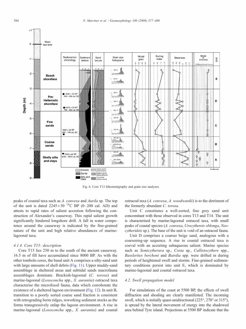
Fig. 6. Core T13 lithostratigraphy and grain size analyses.
384 N. Marriner et al. / Geomorphology 100 (2008) 377–400
peaks of coastal taxa such as A. convexa and Aurila sp. The topof the unit is dated 2245±30 14C BP (0–200 cal. AD) andattests to rapid rates of salient accretion following the con-struction of Alexander's causeway. This rapid salient growthsignificantly hindered longshore drift. A fall in water compe-tence around the causeway is indicated by the fine-grainednature of the unit and high relative abundances of marine-lagoonal taxa.
4.1.4. Core T15: descriptionCore T15 lies 250 m to the south of the ancient causeway.
16.5 m of fill have accumulated since 8000 BP. As with theother tombolo cores, the basal unit A comprises a silty-sand unitwith large amounts of shell debris (Fig. 11). Upper muddy-sandassemblage in sheltered areas and subtidal sands macrofaunaassemblages dominate. Brackish-lagoonal (C. torosa) andmarine-lagoonal (Loxoconcha spp., X. aurantia) ostracod taxacharacterise the microfossil fauna, data which corroborate theexistence of a sheltered lagoon environment (Fig. 12). In unit B,transition to a poorly sorted coarse sand fraction is consistentwith retrograding berm ridges, reworking sediment stocks as theforms transgressively onlap the lagoon environment. A rise inmarine-lagoonal (Loxoconcha spp., X. aurantia) and coastal
ostracod taxa (A. convexa, A. woodwardii) is to the detriment ofthe formerly abundant C. torosa.
Unit C constitutes a well-sorted, fine grey sand unitconcomitant with those observed in cores T13 and T14. The unitis characterised by marine-lagoonal ostracod taxa, with smallpeaks of coastal species (A. convexa, Urocythereis oblonga, Neo-cytherideis sp.). The base of the unit is void of an ostracod fauna.
Unit D comprises a coarser beige sand, analogous with acoarsening-up sequence. A rise in coastal ostracod taxa iscoeval with an accreting subaqueous salient. Marine speciessuch as Semicytherura sp., Costa sp., Callistocythere spp.,Basslerites berchoni and Bairdia spp. were drifted in duringperiods of heightened swell and storms. Fine-grained sedimen-tary conditions persist into unit E, which is dominated bymarine-lagoonal and coastal ostracod taxa.
4.2. Swell propagation model
For simulations of the coast at 5500 BP, the effects of swelldiffraction and shoaling are clearly manifested. The incomingswell, which is initially quasi-unidirectional (225°, 270° or 315°),is spread by the lateral movement of energy into the shadowedarea behind Tyre island. Projections at 5500 BP indicate that the

Fig.7
.CoreT13
ostracods.
385N. Marriner et al. / Geomorphology 100 (2008) 377–400
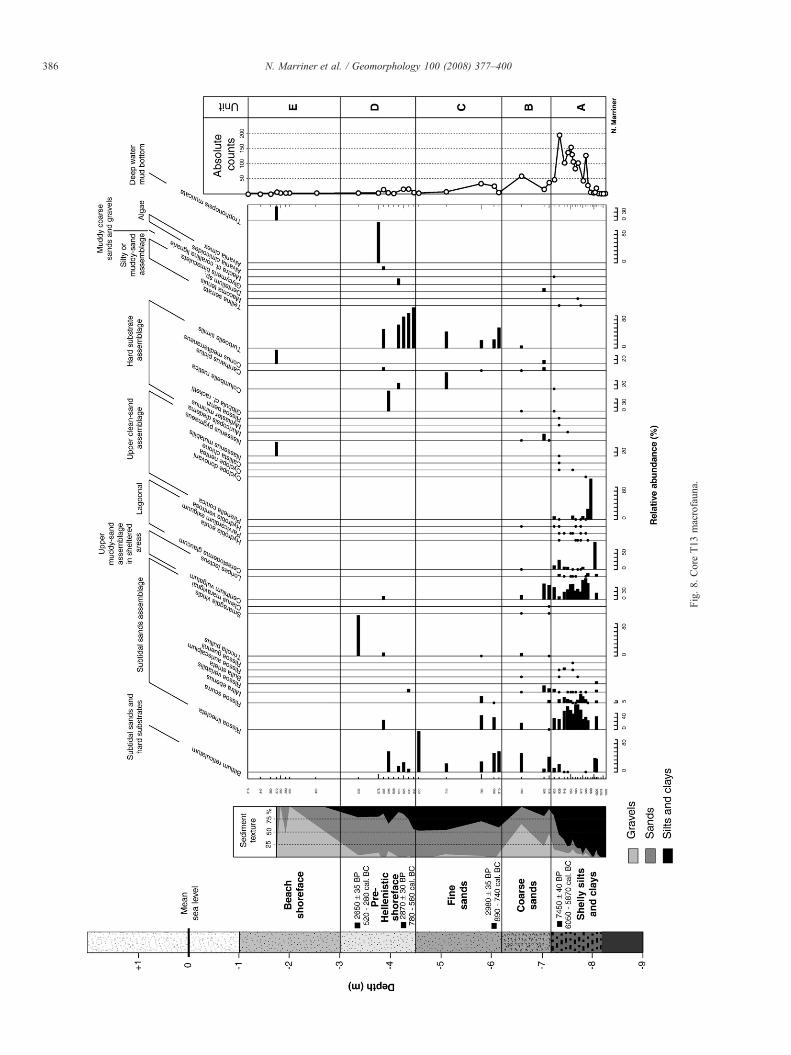
Fig.8.
CoreT13
macrofaun
a.
386 N. Marriner et al. / Geomorphology 100 (2008) 377–400

Fig. 9. Core T14 lithostratigraphy and grain size analyses.
387N. Marriner et al. / Geomorphology 100 (2008) 377–400
majority of the swell incident energy is blocked by the naturalN–S-trending breakwater (Fig. 13). As the wave energy thatpasses the obstacle spreads laterally into the shadow region, thetotal energy is distributed over a broader area reducing the swellheight leeward of the island from N1.80 m west of the island tob0.75 m on the eastern shadow side (propagated wave height is2.6 m with a period of 6 s). This shadow generated a significantnatural shelter zone for the offshore anchoring of boats, greatlyincreasing the anchorage capacity of the city (Marriner et al.,2007). The core transect falls in an area of very lowwave height(∼0.40 m), evoking the rapid accretion of the marine bottom.We conclude that the early accretion of the proto-tombolo tookplace in two areas: (1) along the continental margin of TellMashuk the sedimentological data show that limited accom-modation space led to the rapid progradation of a salientstrandplain, as corroborated by low wave heights along thecoastal fringe; (2) secondarily in the wave shadow behind Tyreisland the models show a sharp fall in energy accompanied by aconcomitant marine bottom shallowing. The greater accom-modation space means, however, that the tombolo remained asubaqueous form in this zone. By a process of positive feed-back, the shallowing bathymetry altered the pattern ofdiffraction and refraction leading to the shallowing of deeperdistal areas between the island and the continent. A bi-directional drift pattern was also created by the island obstacle.
Late Roman tectonic subsidence (Morhange et al., 2006)means that the breakwater effects of Tyre island are much lesspronounced today than for 5500 BP. A significant wave shadowis generated to the north and south of the tombolo for projectionsat 225° and 315°. Meteorological data indicate that although thestrongest winds and swell derive from the south-west, north-westerlies are also very frequent (33% of total winds). North-westerly swell diffraction and refraction appear to be the maintransport mechanisms in translating Litani sediments to theTyrian peninsula. The models suggest that westerly winds andswell, though less frequent than the dominant south-westerliesand north-westerlies, were also significant in forcing the initialaccretion of the sand bank.
5. Discussion and interpretations
Here we marry the chronostratigraphic and modelling data toreport details on the Holocene morphodynamics and process-response of Tyre's tombolo. We then compare this three-phasemodel with Alexandria's tombolo.
5.1. Three-phase model of tombolo morphogenesis
High-resolution analyses shed light on three importantgeomorphological aspects: (1) natural accretion of Tyre's early

Fig.1
0.CoreT14
ostracods.
388 N. Marriner et al. / Geomorphology 100 (2008) 377–400

Fig. 11. Core T15 lithostratigraphy and grain size analyses.
389N.Marriner
etal.
/Geom
orphology100
(2008)377–400

Fig.12
.CoreT15
ostracod
s.
390 N. Marriner et al. / Geomorphology 100 (2008) 377–400

Fig. 13. Wave heights for 225°, 270° and 315° propagated swells (adapted from Marriner et al., 2007).
391N. Marriner et al. / Geomorphology 100 (2008) 377–400

392 N. Marriner et al. / Geomorphology 100 (2008) 377–400
Holocene marine bottom, leeward of the island breakwater andakin to a stratigraphic trap; (2) formation of a wave-dominatedproto-tombolo after 6000 BP; and (3) the wide-reachinganthropogenic impacts of the Hellenistic causeway (Fig. 14).
5.1.1. Origin and development— Early Holocene transgression(8000 to 6000 cal. years BP)
A north–south transect comprising three cores, T13, T14 andT15, elucidates the tombolo's stratigraphy. In this area, leewardof the island breakwater, the Maximum Flooding Surface(MFS) is dated to ∼8000 BP (Fig. 15). The litho- andbiostratigraphic signatures of this transgression comprise siltand sand rich in molluscan shells. Fine-grained sediments andbrackish and marine-lagoonal faunas translate shallow, low-energy waterbodies during this period. Shelter was afforded by
Fig. 14. Morphodynamic evolution of Tyre's tombolo between ∼8000 BP and today.coastal area (Service Hydrographique et Océanographique de la Marine, 1998, Portsobtain a representative coastal reconstruction of Tyre at each time slice.
Tyre's elongated sandstone ridges which cumulatively acted asa shore-parallel breakwater, corroborated by the numericalmodels.
Core T18 was drilled between Tell Mashuk and El Bass, theoldest portion of the continental salient sensu stricto. Twocontrasting facies record the early growth of the tombolomargin. The clay substratum is transgressed by fine-beddedmarine sand dated to ∼6000 BP (Figs. 4–5). After 5500 BP, thetransition from marine sand to choked lagoon sediments isconcurrent with the accretion of the salient, culminating in theisolation of the back-barrier lagoon. This rapid coastal accretionis explained by the mid-Holocene stillstand regime and highsediment supply, inducing a loss of accommodation space.Although the density of core networks does not allow theprecise spatial dimensions of the lagoon to be established, local
Bathymetric data were derived from the 1998 SHOM marine map of the Tyriandu Liban, 7514, 1:25000) and coupled with our chronostratigraphic datasets to

Fig. 15. Chrono- and ostracod biostratigraphy of tombolo cores T13–T15.
393N.Marriner
etal.
/Geom
orphology100
(2008)377–400
394 N. Marriner et al. / Geomorphology 100 (2008) 377–400
topography and geomorphological prospections in this areasuggest that at its greatest extent, it could have reached the baseof Tell Mashuk, a Bronze Age settlement presently landlocked∼1700 m from the sea (Marriner et al., in press).
Stratigraphies north and south of this lagoon system haveyielded prograding ridge systems. Core T7 shows that the baseof Tell Chawakir was transgressed before rapidly prograding toform the southern continental base of the salient. Between TellChawakir and Tell Rachidiye, the stratigraphy has revealed aseries of Pleistocene paleosols similar to those encountered onthe Carmel coast (Cohen-Seffer et al., 2005). No marinedeposits have been elucidated in this area, pertaining to therelative stability of this portion of Tyre's maritime façade duringthe Holocene.
5.1.2. Pre-Hellenistic proto-tombolo phase (6000 to 2400 cal.years BP)
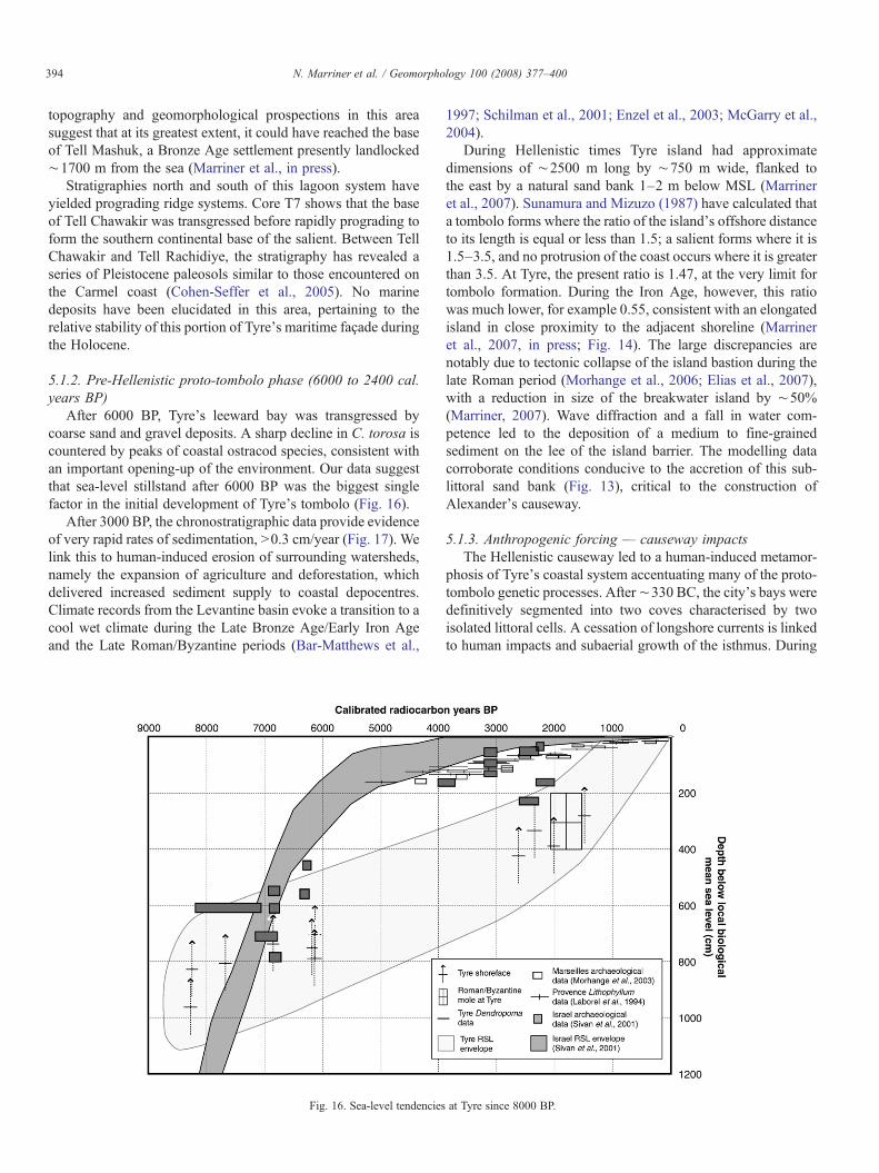
After 6000 BP, Tyre's leeward bay was transgressed bycoarse sand and gravel deposits. A sharp decline in C. torosa iscountered by peaks of coastal ostracod species, consistent withan important opening-up of the environment. Our data suggestthat sea-level stillstand after 6000 BP was the biggest singlefactor in the initial development of Tyre's tombolo (Fig. 16).
After 3000 BP, the chronostratigraphic data provide evidenceof very rapid rates of sedimentation, N0.3 cm/year (Fig. 17). Welink this to human-induced erosion of surrounding watersheds,namely the expansion of agriculture and deforestation, whichdelivered increased sediment supply to coastal depocentres.Climate records from the Levantine basin evoke a transition to acool wet climate during the Late Bronze Age/Early Iron Ageand the Late Roman/Byzantine periods (Bar-Matthews et al.,
Fig. 16. Sea-level tendencies
1997; Schilman et al., 2001; Enzel et al., 2003; McGarry et al.,2004).
During Hellenistic times Tyre island had approximatedimensions of ∼2500 m long by ∼750 m wide, flanked tothe east by a natural sand bank 1–2 m below MSL (Marrineret al., 2007). Sunamura and Mizuzo (1987) have calculated thata tombolo forms where the ratio of the island's offshore distanceto its length is equal or less than 1.5; a salient forms where it is1.5–3.5, and no protrusion of the coast occurs where it is greaterthan 3.5. At Tyre, the present ratio is 1.47, at the very limit fortombolo formation. During the Iron Age, however, this ratiowas much lower, for example 0.55, consistent with an elongatedisland in close proximity to the adjacent shoreline (Marrineret al., 2007, in press; Fig. 14). The large discrepancies arenotably due to tectonic collapse of the island bastion during thelate Roman period (Morhange et al., 2006; Elias et al., 2007),with a reduction in size of the breakwater island by ∼50%(Marriner, 2007). Wave diffraction and a fall in water com-petence led to the deposition of a medium to fine-grainedsediment on the lee of the island barrier. The modelling datacorroborate conditions conducive to the accretion of this sub-littoral sand bank (Fig. 13), critical to the construction ofAlexander's causeway.
5.1.3. Anthropogenic forcing — causeway impactsThe Hellenistic causeway led to a human-induced metamor-
phosis of Tyre's coastal system accentuating many of the proto-tombolo genetic processes. After∼330 BC, the city's bays weredefinitively segmented into two coves characterised by twoisolated littoral cells. A cessation of longshore currents is linkedto human impacts and subaerial growth of the isthmus. During
at Tyre since 8000 BP.

Fig. 17. Tombolo sedimentation rates from cores T13 and T14.
395N. Marriner et al. / Geomorphology 100 (2008) 377–400
Roman times, this progradation accommodated urban growth(necropolis, hippodrome etc.).
5.1.4. Holocene sea-level tendencies at TyreHolocene sea-level tendencies at Tyre are depicted in Fig. 16.
Although the results fit well with low error (±5 cm) sea-leveldata from the stable coasts of Provence (Laborel et al., 1994;Morhange et al., 2001, 2003), the large error margins andabsence of accurate sea-level indicators found at Tyre mean thatthe envelope cannot be used as a precise RSL curve. The 3 mcollapse of the Tyrian horst during the late Roman period isevidenced by two types of data (i) Archaeological — Tyre'snorthern Roman mole is currently 2.5 m below present sea level(Descamps, personal communication), translating a subsidenceof∼3–3.5m. On the southern shore, walls and drowned quarriesat −2.5 m below MSL have also been discovered (El Amouriet al., 2005); and (ii) Stratigraphic — similar subsidence istranslated in the city's coastal stratigraphy, notably a∼3m offsetin sediment accommodation space and radiocarbon dated stratabetween Tyre and Sidon (Marriner, 2007).
5.2. Tyre vs. Alexandria: forcing agents and geomorphology
One of the most celebrated tombolo examples, both in termsof its geological and archaeological scopes, is that of Alexandriaad Aegyptum (Goiran, 2001; Goiran et al., 2005). The palaeo-island of Pharos is today a heavily urbanised peninsula, 3.25long by 1.1 km wide, linked to the continent by a 1.3×0.7 kmisthmus (Fig. 17). The tombolo separates two marine bays: a2×1.5 km eastern bay (Stanley and Bernasconi, 2006), which
sheltered a series of seaport complexes during antiquity, and alarge western bay (10 km long by 2.5 km wide) partiallyprotected by the drowned extension of the Pharos aeolianiteridge. The presence of this offshore ridge has significantlyinfluenced swell currents on its leeward side. Both bays todayoperate as isolated littoral cells whilst offshore the dominantmarine currents and sediment drift run west to east (Fig. 18).
Geomorphological and chronological parallels betweenTyre and Alexandria render a direct comparison of the twosites particularly interesting from a number of aspects. (1) Thegeomorphology of both sites has been significantly influencedby the inherited Pleistocene landscapes, namely a series ofpartially-drowned aeolianite ridges that run parallel to the presentcoastline (Butzer, 1962; Stanley and Hamza, 1992; El-Asmar andWood, 2000) and between which great tracts of Holocene coastalsediments have accumulated. (2) This drowned topography hasgiven rise to two breakwater islands (Fig. 19). The dimensions ofboth breakwaters have changed significantly since their marineflooding between 8000 and 7500 BP. Changes in the size of theshielding breakwaters are discernible in the Holocene sedimentrecord. As at Tyre, ancient Alexandria comprised a long shore-parallel breakwater (Pharos ridge)whose reconstructedHellenisticdimensions,∼5500m long by∼1300 m wide, are approximatelytwice those at Tyre for the same period (Goiran, 2001). (3) Bothsites lie in proximity to important fluvial systems, the Nile (Said,1993) and the Litani (Abd-el-Al, 1948). Although the scales ofthese fluvial systems are not directly comparable, the two riverswere significant in dictating sediment budgets and the nature ofthe highstand deposits during the accretion of the tombolos (Chenet al., 1992; Warne and Stanley, 1993a,b; Stanley and Warne,

Fig. 18. Morphodynamic evolution of the Alexandria and Tyre isthmuses since antiquity.
396 N. Marriner et al. / Geomorphology 100 (2008) 377–400
1998). (4) Alexandria and Tyre were modified by humanintervention at the same time (332 and 331 BC). Assessing thesynchronicity or disynchronicity of stratigraphic impacts isinteresting from geomorphological and historical perspectives.(5) The two sites underwent significant subsidence around the lateRoman period (∼6±0.5 m at Alexandria and∼3±0.5 m at Tyre).These rapid relative sea-level movements had two impacts:(a) from a geomorphological standpoint, it greatly diminished thedimensions of the breakwater obstacles, reducing the size of thewave shadows; and (b) from a stratigraphic perspective, it createdsignificant accommodation space for the deposition of newsediment tracts.
5.3. Description and interpretation of the tombolo stratigraphyat Alexandria
On the basis of a 10 m-long transgressive–regressivesediment sequence (C2; Goiran, 2001) a series of phases inthe accretion of Alexandria's tombolo have been elucidated(Fig. 19). The proximity of core C2 to the Heptastadium rendersit particularly sensitive in recording geomorphological changes
and human impacts. We note a number of stratigraphicsimilarities between Alexandria and Tyre.
5.3.1. Phase 1— marine flooding (8000 to 6000 cal. years BP)Like Tyre, the inception of marine sedimentation at
Alexandria is dated to ∼7800 BP, consistent with the floodingof deltas throughout the circum-Mediterranean (Stanley andWarne, 1994). This flooding surface is onlapped by a shellysand unit coeval with the reworking of transgressed deposits.
5.3.2. Phase 2 — accretion of the proto-tombolo (6000 to2400 cal. years BP)
Between 5400 BP and 4200 BP, we elucidate a Cladocorabiodeposition in cores C2 and C9, comprising broken coralbranches enveloped in a silty clay matrix (Fig. 19). Thechronostratigraphic analogue at Tyre constitutes medium-grainedsand. The origin of this biodeposition is explained by the erosionof bioherms in proximity to Alexandria. Juxtaposition of coarseand fine-grained sediment stocks evokes seasonality in currentsand sediment deposition patterns; the coarse biodeposition isinferred to have been reworked and deposited during winter
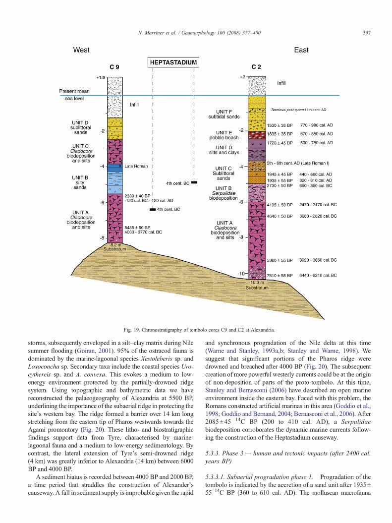
Fig. 19. Chronostratigraphy of tombolo cores C9 and C2 at Alexandria.
397N. Marriner et al. / Geomorphology 100 (2008) 377–400
storms, subsequently enveloped in a silt–clay matrix during Nilesummer flooding (Goiran, 2001). 95% of the ostracod fauna isdominated by the marine-lagoonal species Xestoleberis sp. andLoxoconcha sp. Secondary taxa include the coastal species Uro-cythereis sp. and A. convexa. This evokes a medium to low-energy environment protected by the partially-drowned ridgesystem. Using topographic and bathymetric data we havereconstructed the palaeogeography of Alexandria at 5500 BP,underlining the importance of the subaerial ridge in protecting thesite's western bay. The ridge formed a barrier over 14 km longstretching from the eastern tip of Pharos westwards towards theAgami promontory (Fig. 20). These litho- and biostratigraphicfindings support data from Tyre, characterised by marine-lagoonal fauna and a medium to low-energy sedimentology. Bycontrast, the lateral extension of Tyre's semi-drowned ridge(4 km) was greatly inferior to Alexandria (14 km) between 6000BP and 4000 BP.
A sediment hiatus is recorded between 4000 BP and 2000 BP,a time period that straddles the construction of Alexander'scauseway. A fall in sediment supply is improbable given the rapid
and synchronous progradation of the Nile delta at this time(Warne and Stanley, 1993a,b; Stanley and Warne, 1998). Wesuggest that significant portions of the Pharos ridge weredrowned and breached after 4000 BP (Fig. 20). The subsequentcreation of more powerful westerly currents could be at the originof non-deposition of parts of the proto-tombolo. At this time,Stanley and Bernasconi (2006) have described an open marineenvironment inside the eastern bay. Faced with this problem, theRomans constructed artificial marinas in this area (Goddio et al.,1998; Goddio and Bernand, 2004; Bernasconi et al., 2006). After2085±45 14C BP (200 to 410 cal. AD), a Serpulidaebiodeposition corroborates the dynamic marine currents follow-ing the construction of the Heptastadium causeway.
5.3.3. Phase 3 — human and tectonic impacts (after 2400 cal.years BP)
5.3.3.1. Subaerial progradation phase 1. Progradation of thetombolo is indicated by the accretion of a sand unit after 1935±55 14C BP (360 to 610 cal. AD). The molluscan macrofauna

Fig. 20. Top: Palaeogeographical reconstruction of Alexandria's tomboloaround 5500 BP. The reconstruction factors in a relative sea-level change of 7 msince this time. Note the existence of an extensive 14 km breakwater ridge thatshielded Alexandria's western bay. We hypothesise that a number of breachesexisted in the sandstone ridge creating a low-energy lagoon environment on theleeward side at this time. Middle and bottom: Palaeogeographical reconstructionof Alexandria's tombolo at 330 BC. The reconstruction factors in a 5 m relativesea-level change since the Ptolemaic period that has significantly reduced thedimensions of Pharos island.
398 N. Marriner et al. / Geomorphology 100 (2008) 377–400
is dominated by three assemblages: the upper clean-sandassemblage (Cyclope donovani, Sphoeronassa mutabilis, Spisulasubtruncata, Venus gallina), the upper muddy-sand assemblage insheltered areas (Venerupis rhomboides), and the sublittoral sandsassemblage (B. reticulatum latreilli, R. lineolata). The ostracodfauna is dominated by lagoonal (65% of the relative abundance)and coastal taxa (30%). The litho- and biostratigraphies concurprogradation of the salient flanks, with its passage from amarine tocontinental form characterised by wide sandy beaches.
5.3.3.2. Tectonic collapse. During the 7th–9th centuries AD,tectonic collapse accounts for the rapid submersion of greattracts of the tombolo (Goiran, 2001; Goddio et al., 2006).Recent underwater archaeological research undertaken on thewestern margin of the Nile delta (embouchure of the Canopicbranch and the ancient eastern harbour of Alexandria; Goddioet al., 2006) demonstrates the anomalous presence of late 7thcentury AD remains at 6 m below present sea level (Goddioet al., 2006), consistent with a collapse of Alexandria's easternharbour during the 8th century AD (Goiran, 2001). At the sameperiod, the late Roman cities of Eastern Canopus andHerakleion experienced a similar catastrophic event. Regionalinstability has been linked to substantial readjustment of the5000 m-thick Tertiary and Quaternary Nile sediments (Said,1993).
This 6 m collapse generated considerable accommodationspace and led to the deposition of a diverse sedimentary facies,consistent with anthropogenic impacts. Most of the cores attest tocoarse sediments except inside the renovated harbour basinswhere silt facies are indicative of artificial confinement. Forexample, in C2, silt deposits and gypsum crystals are consistentwith a low-energy environment, indicative of an artificial harbourbasin.
5.3.3.3. Subaerial progradation phase 2. The coastal responseof this catastrophic submersion was rapid as the tomboloestablished a new equilibrium profile in balance with the highlocal sediment budget. After 1635±35 14C BP (8th–9th centuriesAD), transition to a rounded pebble then coarse sand faciescorroborates the progradation of the tombolo flanks, acceleratedby the creation of new accommodation space. Rapid coastaldeformation during the Islamic and Medieval periods isconcurrent with data from Tyre, and is typical of semi-openenvironments with a high sediment budget.
6. Conclusions
Largely concomitant chronostratigraphies at Tyre and Alex-andria attest to the importance of the offshore island breakwatersin creating pre-Hellenistic proto-tombolos. Our data indicate thatthe salients lay within 1–2m of sea level by the time of Alexanderthe Great, thus considerably facilitating the construction ofAlexander's causeways. At both sites, the causeway impacts arequasi-identical, with the irreversible segmentation of the originalbays coupled with a sharp fall in water competence, leading to acomplete human-induced metamorphosis of the Tyrian andAlexandrian coastal systems. Finally, the study demonstrates

399N. Marriner et al. / Geomorphology 100 (2008) 377–400
the scope of an applied geomorphological approach in helping toanswer archaeological questions.
Acknowledgements
The authors wish to thank the ANR-CNRS (GEOPAM), theAssociation Internationale pour la Sauvegarde de Tyr, CEAlexUMS 1218, the Supreme Council of Archaeology in Egypt, thehead of Islamic Antiquity, the Lebanese Directorate General ofAntiquities, the Franco-Lebanese program Cèdre, ECLIPSE/CNRS, UNESCO CPM and the Leverhulme Trust for technicaland financial support. This research is a contribution to theproject ArcheoMed: patrimoine culturel de la Méditerranée(InterReg IIIB MEDOCC).
References
Abd-el-Al, I., 1948. Le Litani, étude hydrologique. Service hydrologique de laRépublique Libanaise, Beirut.
Anthony, E.J., Blivi, A.B., 1999. Morphosedimentary evolution of a delta-sourced, drift-aligned sand barrier–lagoon complex, western Bight of Benin.Marine Geology 158, 161–176.
Barash, A., Danin, Z., 1992. Fauna Palaestina, mollusca I. Annotated List ofMediterranean Molluscs of Israel and Sinai. The Israel Academy of Sciencesand Humanities, Jerusalem.
Bar-Matthews, M., Ayalon, A., Kaufman, A., 1997. Late Quaternary paleoclimatein the Eastern Mediterranean Region from stable isotope analysis ofspeleothems in Soreq cave, Israel. Quaternary Research 47, 155–168.
Bellan-Santini, D., Lacaze, J.C., Poizat, C., 1994. Les biocénoses marines etlittorales de Méditerranée. Coll. Patrimoines Naturels, vol. 19. MuséumNational d'Histoire Naturelle.
Bernasconi, M.P., Melis, R., Stanley, J.-D., 2006. Benthic biofacies to interpretHolocene environmental changes and human impact in Alexandria's EasternHarbour, Egypt. Holocene 16, 1163–1176.
Bitar, G., Kouli-Bitar, S., 1998. Inventaire des mollusques marines benthiquesdu Liban et remarques biogéographiques sur quelques espèces nouvellementsignalés. Mesogée 56, 37–44.
Blanc, J.-J., 1959. Recherches sédimentologiques littorales et sous-marines enProvence occidentale, PhD thesis. Masson, Paris.
Blivi, A., Anthony, E.J., Oyédé, L.M., 2002. Sand barrier development in thebight of Benin, West Africa. Ocean and Coastal Management 45, 185–200.
Bronk Ramsey, C., 2001. Development of the radiocarbon program OxCal.Radiocarbon 43, 355–363.
Browder, A.G., McNinch, J.E., 2006. Linking framework geology andnearshore morphology: correlation of paleo-channels with shore-obliquesandbars and gravel outcrops. Marine Geology 231, 141–162.
Butzer, K.W., 1962. Pleistocene stratigraphy and prehistory in Egypt.Quaternaria 6, 451–477.
Carmel, Z., Inman, D.L., Golik, A., 1985a. Characteristics of storm waves offthe Mediterranean coast of Israel. Coastal Engineering 9, 1–19.
Carmel, Z., Inman, D.L., Golik, A., 1985b. Directional wave measurement atHaifa, Israel, and sediment transport along the Nile littoral cell. CoastalEngineering 9, 21–36.
Carmona, P., Ruiz, J.M., 2004. Geomorphological and geoarchaeologicalevolution of the coastline of the Tyre tombolo: preliminary results. Bulletind'Archéologie et d'Architecture Libanaises Hors-Série 1, 207–219.
Cattaneo, A., Steel, R.J., 2003. Transgressive deposits: a review of theirvariability. Earth-Science Reviews 62, 187–228.
Catuneanu, O., 2002. Sequence stratigraphy of clastic systems: concepts, merits,and pitfalls. Journal of African Earth Sciences 35, 1–43.
Catuneanu, O., 2005. Principles of Sequence Stratigraphy. Elsevier, London.Chen, Z., Warne, A.G., Stanley, D.J., 1992. Late Quaternary evolution of the
northwestern Nile Delta between Rosetta and Alexandria, Egypt. Journal ofCoastal Research 8, 527–561.
Clemmensen, L.B., Richardt, N., Andersen, C., 2001. Holocene sea-levelvariation and spit development: data from Skagen Odde, Denmark.Holocene 11, 323–331.
Cohen-Seffer, R., Greenbaum, N., Sivan, D., Jull, T., Barmeir, E., Croitoru, S.,Inbar, M., 2005. Late Pleistocene-Holocene marsh episodes along theCarmel coast, Israel. Quaternary International 140141, 103–120.
Courtaud, J., 2000. Dynamiques géomorphologiques et risques littoraux. Cas duTombolo de Giens (Var, France méridionale), PhD thesis. Université deProvence, Aix-en-Provence.
Dally, W.R., Pope, J., 1986. Detached breakwaters for shore protection.Technical Report. Coastal Engineering Research Centre, WaterwaysExperiment Station. CERC-86-1.
Davies, J.L., 1980. Geographical Variation in Coastal Development. Longman,London.
Davis, R.A. (Ed.), 1994. Geology of Holocene Barrier Island Systems. Springer-Verlag, Berlin.
Doneddu, M., Trainito, E., 2005. Conchiglie del Mediterraneo. Il Castello,Trezzano sul Naviglio.
Doumet-Serhal, C. (Ed.), 2004. Decade: a decade of archaeology and history inthe Lebanon. Archaeology and History in Lebanon, Beirut.
Dubertret, L., 1955. Carte géologique duLiban au 1:200,000, avec notice explicative.Ministère des Travaux Publics, Beyrouth.
El Amouri, M., El Helou, M., Marquet, M., Noureddine, I., Seco Alvarez, M.,2005. Mission d'expertise archéologique du port sud de Tyr, sud Liban:résultats préliminaires. Bulletin d'Archéologie et d'Architecture Libanaises.Hors-Série, vol. 2, pp. 91–110.
El-Asmar, H.M., Wood, P., 2000. Quaternary shoreline development: thenorthwestern coast of Egypt. Quaternary Science Reviews 19, 1137–1149.
Elias, A., Tapponnier, P., Singh, S.C., King, G.C.P., Briais, A., Daëron, M.,Carton, H., Sursock, A., Jacques, E., Jomaa, R., Klinger, Y., 2007. Activethrusting offshore Mount Lebanon: source of the tsunamigenic A.D. 551Beirut–Tripoli earthquake. Geology 35, 755–758.
Enzel, Y., Bookman, R., Sharon, D., Gvirtzman, H., Dayan, U., Ziv, B., Steinc,M., 2003. Late Holocene climates of the Near East deduced from Dead Sealevel variations and modern regional winter rainfall. Quaternary Research60, 263–273.
Escoffier, F.F., 1954. Travelling forelands and the shoreline processes associatedwith them. Bulletin US Beach Erosion Board 9, 11–14.
Fleming, W.B., 1915. History of Tyre. Columbia University Press, New York.Flinn, D., 1997. The role of wave diffraction in the formation of St. Ninian's
Ayre (Tombolo) in Shetland, Scotland. Journal of Coastal Research 13,202–208.
Frechen, M., Dermann, B., Boenigk, W., Ronen, A., 2001. Luminescencechronology of aeolianites from the section at Givat Olga— Coastal Plain ofIsrael. Quaternary Science Reviews 20, 805–809.
Frechen, M., Neber, A., Dermann, B., Tsatskin, A., Boenigk, W., Ronen, A.,2002. Chronostratigraphy of aeolianites from the Sharon Coastal Plain ofIsrael. Quaternary International 89, 31–44.
Frechen, M., Neber, A., Tsatskin, A., Boenigk, W., Ronen, A., 2004.Chronology of Pleistocene sedimentary cycles in the Carmel Coastal Plainof Israel. Quaternary International 121, 41–52.
Gardner, J.V., Dartnell, P., Mayer, L.A., Hughes Clarke, J.E., Calder, B.R.,Duffy, G., 2005. Shelf-edge deltas and drowned barrier-island complexeson the northwest Florida outer continental shelf. Geomorphology 64,133–166.
Goddio, F., Bernand, A., 2004. Sunken Egypt— Alexandria. Periplus, London.Goddio, F., Bernand, A., Bernand, E., Darwish, I., Kiss, Z., Yoyotte, J., 1998.
Alexandria: the Submerged Royal Quarters. Periplus, London.Goddio, F., Clauss, M., Gerigk, C., 2006. Egypt's Sunken Treasures. Prestel
Publishing, London.Goiran, J.-P., 2001. Recherches géomorphologiques dans la région littorale
d'Alexandrie, Egypte, PhD thesis. Université de Provence, Aix-en-Provence.Goiran, J.-P., Marriner, N., Morhange, C., Abd El-Maguib, M., Espic, K.,
Bourcier, M., Carbonel, P., 2005. Evolution géomorphologique de la façademaritime d'Alexandrie (Egypte) au cours des six derniers millénaires.Méditerranée 104, 61–64.
Goldsmith, V., Sofer, S., 1983. Wave climatology of the southeasternMediterranean. Israel Journal of Earth Science 32, 1–51.

400 N. Marriner et al. / Geomorphology 100 (2008) 377–400
Gosseaume, E., 1973. Le tombolo triple d'Orbetello (Toscane). Bulletin de laSociété Languedocienne de Géographie 7, 3–11.
Guilcher, A., 1958. Coastal and Submarine Morphology. Methuen and Co. Ltd.,London.
Gulliver, F.P., 1896. Cuspate forelands. Geological Society of America Bulletin7, 399–422.
Gulliver, F.P., 1899. Shoreline topography. Proceedings of the AmericanAcademy of Arts and Science 34, 149–258.
Hesse, A., 1998. Arguments pour une nouvelle hypothèse de localisation del'Heptastade d'Alexandrie. Etudes alexandrines 1, 1–33.
Hine, A.C., 1979. Mechanisms of berm development and resulting beach growthalong a barrier spit complex. Sedimentology 6, 333–351.
Johnson, D.W., 1919. Shore Processes and Shoreline Development. Wiley, NewYork.
Katzenstein, H.J., 1997. The History of Tyre. Ben-Gurion University of theNegev Press, Jerusalem.
Laborel, J., Laborel-Deguen, F., 1994. Biological indicators of relative sea-levelvariations and co-seismic displacements in the Mediterranean region.Journal of Coastal Research 10, 395–415.
Laborel, J., Morhange, C., Lafont, R., Le Campion, J., Laborel-Deguen, F.,Sartoretto, S., 1994. Biological evidence of sea-level rise during the last4500 years on the rocky coasts of continental southwestern France andCorsica. Marine Geology 120, 203–223.
Marriner, N., 2007. Geoarchaeology of Phoenicia's buried harbours: Beirut,Sidon and Tyre: 5000 years of human–environment interactions, unpub-lished PhD thesis. Université de Provence, Aix-en-Provence.
Marriner, N., Morhange, C., Doumet-Serhal, C., Carbonel, P., 2006. Geosciencerediscovers Phoenicia's buried harbors. Geology 34, 1–4.
Marriner, N., Morhange, C., Meulé, S., 2007. Holocene morphogenesis ofAlexander the Great's isthmus at Tyre in Lebanon. Proceedings of theNational Academy of Sciences 104 (22), 9218–9223.
Marriner, N., Morhange, C., Carayon, N., in press. Ancient Tyre and its har-bours: 5000 years of human–environment interactions. Journal of Archae-ological Science. doi:10.1016/j.jas.2007.09.003.
McGarry, S., Bar-Matthews, M., Matthews, A., Vaks, A., Schilman, B., Ayalon,A., 2004. Constraints on hydrological and paleotemperature variations in theEastern Mediterranean region in the last 140 ka given by the δD values ofspeleothem fluid inclusions. Quaternary Science Reviews 23, 919–934.
McKee Smith, J., Sherlock, A.R., Donald, T., 2001. STWAVE: Steady-StateSpectral Wave Model User's Manual for STWAVE Version 3.0. U.S. ArmyCorps of Engineers, Washington DC.
Ming, D., Chiew, Y.-M., 2000. Shoreline changes behind detached breakwater.Journal of Waterway, Port, Coastal, and Ocean Engineering 63–70 March/April.
Morhange, C., Laborel, J., Hesnard, A., 2001. Changes of relative sea levelduring the past 5000 years in the ancient harbor of Marseilles, SouthernFrance. Palaeogeography, Palaeoclimatology, Palaeoecology 166, 319–329.
Morhange, C., Blanc, F., Bourcier, M., Carbonel, P., Prone, A., Schmitt-Mercury, S., Vivent, D., Hesnard, A., 2003. Bio-sedimentology of the lateHolocene deposits of the ancient harbor of Marseilles (Southern France,Mediterranean sea). Holocene 13, 593–604.
Morhange, C., Pirazzoli, P.A., Marriner, N., Montaggioni, L.F., Nammour, T.,2006. Late Holocene relative sea-level changes in Lebanon, EasternMediterranean. Marine Geology 230, 99–114.
Nir, Y., 1996. The city of Tyre, Lebanon and its semi-artificial tombolo.Geoarchaeology 11, 235–250.
Otvos, E.G., 2000. Beach ridges — definitions and significance. Geomorphol-ogy 32, 83–108.
Otvos, E.G., Giardino, M.J., 2004. Interlinked barrier chain and delta lobedevelopment, northern Gulf of Mexico. Sedimentary Geology 169, 47–73.
Péres, J.-M., 1982. Major benthic assemblages. In: Kinne, O. (Ed.), MarineEcology, vol. 5, part 1. Wiley, Chichester, pp. 373–522.
Péres, J.-M., Picard, J., 1964. Nouveau manuel de bionomie benthique de la merMéditerranée. Rec. Trav. Station Marine Endoume, vol. 31. Marseille.
Poppe, G.T., Goto, Y., 1991. European Seashells, vol. I. Verlag ChristaHemmen, Wiesbaden.
Poppe, G.T., Goto, Y., 1993. European Seashells, vol. II. Verlag ChristaHemmen, Wiesbaden.
Ribes, E., Borschneck, D., Morhange, C., Sandler, A., 2003. Recherche del'origine des argiles du bassin portuaire antique de Sidon. Archaeology andHistory in Lebanon 18, 82–94.
Rosen, D., Kit, E., 1981. Evaluation of the wave characteristics at theMediterranean coast of Israel. Israel Journal of Earth Science 30, 120–134.
Said, R., 1993. The River Nile: Geology, Hydrology and Utilization. PergamonPress, New York.
Sanderson, P., Eliot, I.G., 1996. Shoreline salients on the coast of WesternAustralia. Journal of Coastal Research 12, 761–773.
Sanlaville, P., 1977. Étude géomorphologique de la région littorale du Liban.Publications de l'Université Libanaise, Beyrouth.
Schilman, B., Bar-Matthews, M., Almogi-Labin, A., Luz, B., 2001. Globalclimate instability reflected by Eastern Mediterranean marine records duringthe late Holocene. Palaeogeography, Palaeoclimatology, Palaeoecology 176,157–176.
Schwartz, R.K., Birkemeier, W.A., 2004. Sedimentology and morphodynamicsof a barrier island shoreface related to engineering concerns, Outer Banks,NC, USA. Marine Geology 211, 215–255.
Silvester, R., Hsu, J.R.C., 1993. Coastal Stabilization: Innovative Concepts.Prentice Hall, New Jersey.
Simms, A.R., Anderson, J.B., Blum, M., 2006. Barrier-island aggradation viainlet migration: Mustang Island, Texas. Sedimentary Geology 187,105–125.
Sivan, D., Porat, N., 2004. Evidence from luminescence for Late Pleistoceneformation of calcareous aeolianite (kurkar) and paleosol (hamra) in theCarmel Coast, Israel. Palaeogeography, Palaeoclimatology, Palaeoecology211, 95–106.
Sivan, D., Wdowinski, S., Lambeck, K., Galili, E., Raban, A., 2001. Holocenesea-level changes along the Mediterranean coast of Israel, based onarchaeological observations and numerical model. Palaeogeography,Palaeoclimatology, Palaeoecology 167, 101–117.
Soffer, A., 1994. The Litani River: fact and fiction. Middle Eastern Studies 30,963–974.
Stanley, D.J., Hamza, H., 1992. Terrigenous-carbonate sediment interface (LateQuaternary) along the northwestern margin of the Nile Delta. Journal ofCoastal Research 8, 153–171.
Stanley, D.J., Warne, A.G., 1994. Worldwide initiation of Holocene marinedeltas by deceleration of sea-level rise. Science 265, 228–231.
Stanley, D.J., Warne, A.G., 1998. Nile Delta in its destruction phase. Journal ofCoastal Research 14, 794–825.
Stanley, D.J., Bernasconi, M.P., 2006. Holocene depositional patterns andevolution in Alexandria's Eastern Harbor, Egypt. Journal of CoastalResearch 22, 283–297.
Stapor, F.W., Stone, G.W., 2004. A new depositional model for the buried4000 yr BP New Orleans barrier: implications for sea-level fluctuations andonshore transport from a nearshore shelf source. Marine Geology 204,215–234.
Stone,G.W., Liu,B., Pepper,D.A.,Wang, P., 2004. The importance of extratropicaland tropical cyclones on the short-term evolution of barrier islands along thenorthern Gulf of Mexico, USA. Marine Geology 210, 63–78.
Sunamura, T., Mizuzo, O., 1987. A study on depositional shoreline formsbehind an island. Annual Report of the Institute of Geosciences, theUniversity of Tsukuba 13, 71–73.
Warne, A.G., Stanley, D.J., 1993a. Late Quaternary evolution of the northwestNile Delta and adjacent coast in the Alexandria region, Egypt. Journal ofCoastal Research 9, 26–64.
Warne, A.G., Stanley, D.J., 1993b. Archaeology to refine Holocene subsidencerates along the Nile Delta Margin, Egypt. Geology 21, 715–718.
Zenkovich, V.P., 1967. Processes of Coastal Development. Oliver and Boyd,London.