Alex Larrabee. .
26
Alex Larrabee ELK RIVER QUAD SHERBURNE
-
Upload
buddy-watts -
Category
Documents
-
view
215 -
download
0
Transcript of Alex Larrabee. .

Alex Larrabee
ELK RIVER QUAD SHERBURNE
http://pics4.city-data.com/mapszip/zma17899.png
http://www.ltanet.org/landtrustdirectory/minnesota27.gif
LOCATION

http://ougseurope.org/rockon/surface/eskers.asp
ESKERS

http://www.americaswetlandresources.com/background_facts/detailedstory/images/clip_image007.jpg
http://upload.wikimedia.org/wikipedia/commons/c/c3/Point_bar_and_cut_bank.jpg
http://www.tol.ca/files/web_images/engineering/environment/Slope_Page_Info/cut-bank.jpg
RIVERS
Mississippi River

http://www.toptenz.net/wp-content/uploads/2008/12/mississippi-river.jpg
SCOUR MARKS

http://www.epa.gov/watershed/images/watershedsched.gif
http://ahoy.tk-jk.net/RiverImages/MississippiRiverBasin.jpg
The region or area drained by a river, stream, etc.; drainage area. – dictionary.com
http://www.gda.state.mn.us/maps/RiverBasins.gif WATERSHED
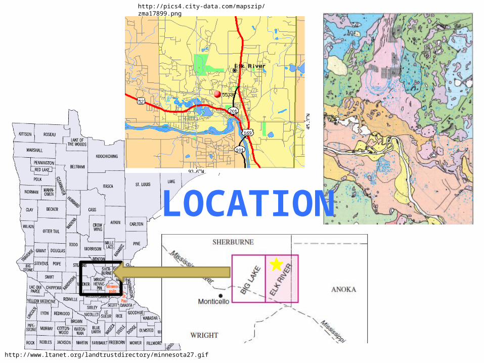
Till over ice-contact deposits: Consist of poorly sorted sand and gravel; layers of silty sand to cobble gravel; little to no shale; deposited be meltwater flowing on, under, or adjacent to the ice.
NORTH WEST QUARTER
gsiIce-walled lake deposits: Lacustrine sediment consisting of predominantly very fine- to medium-grained sand. Interpreted to have been deposited in a lake within stagnant ice. As the ice melted, the lake sediment remained as a high plateau on the landscape.
iw

Till/sand complex: Mixture of sediments including till, ice-contact sand and gravel, and minor lacustrine deposits
gc
NORTH EAST QUARTER
Glacial lake deposits: Lacustrine sediment consisting of very fine- to medium-grained sand; no gravel. In places the fine-grained sand has been sculpted by wind to form dunes.
gl

SOUTH WEST QUARTER
Till- Unsorted sediment consisting of pebbles (abundant, cobbles (common), and boulders (rare) in a loamy matrix; pockets of silt, sand,and gravel in places.
dt
Alluvium – terrace deposits: Fluvial sediments laid down during early, high stages of the Mississippi River and preserved as terraces above the modern floodplain. Predominantly medium – to coarse-grained sand with up to 40 percent gravel.
tl

SOUTH EAST QUARTERAlluvium – terrace deposits: Fluvial sediments laid down during early, high stages of the Mississippi River and preserved as terraces above the modern floodplain. Predominantly medium – to coarse-grained sand with up to 40 percent gravel.
Alluvium – floodplain deposits: River-channel, overbank, and slackwater sediments consisting predominantly medium- to coarse-grained sand; interbedded with sandy loam to silt loam; layers of sand and gravel. Organic debris may be disseminated in the sediments and/or form discrete peat beds.
tlal
tu
tc
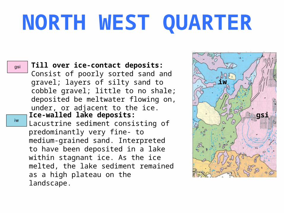
WATER – WELL
http://www.dep.state.pa.us/dep/deputate/watermgt/wc/Subjects/SrceProt/Ground/images/Priv_wells.jpg

http://www.anokanaturalresources.com/soil/geo_his_sandplain.htm
ICE MARGIN

IRREGULAR TROUGH

http://s3.hubimg.com/u/2318886_f520.jpg
SOIL ACIDITY

http://www.climate-charts.com/blog/wp-images/2008mar01/World_Koppen_Map-638-422.png
http://www.tufts.edu/med/informid/images/seasonality/article1-Koppen_climate-500.gifCLIMATE

DfaHumid Continental
Humid with severe winter, no dry season, hot summer
http://www.tufts.edu/med/informid/images/seasonality/article1-Koppen_climate-500.gif

DfbHumid Continental
Humid with severe winter, no dry season, hot summer
http://www.tufts.edu/med/informid/images/seasonality/article1-Koppen_climate-500.gif
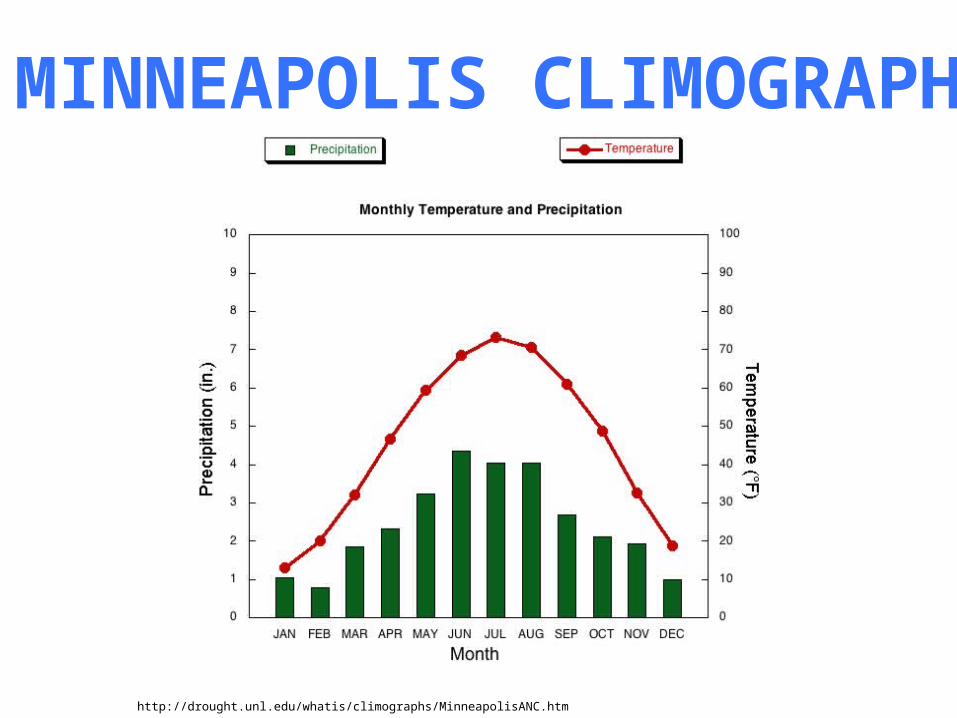
http://drought.unl.edu/whatis/climographs/MinneapolisANC.htm
MINNEAPOLIS CLIMOGRAPH

ELK RIVER WEATHERJan Feb Mar Apr May Jun Jul Aug Sep Oct Nov Dec
Avg. High 22⁰ 28⁰ 40⁰ 57⁰ 71⁰ 78⁰ 84⁰ 81⁰ 72⁰ 60⁰ 42⁰ 27⁰
Avg. Low 1⁰ 7⁰ 20⁰ 34⁰ 45⁰ 55⁰ 58⁰ 57⁰ 48⁰ 37⁰ 24⁰ 8⁰
Mean 12⁰ 18⁰ 31⁰ 46⁰ 58⁰ 67⁰ 72⁰ 68⁰ 60⁰ 48⁰ 34⁰ 18⁰
Avg. Precip. 0.8in 0.7in 1.6in 2.6in 3.7in 4.4in 4.1in 3.8in 3.3in 2.4in 1.6in 1.0in
Degrees in Fahrenheit
http://countrystudies.us/united-states/weather/minnesota/elk-river.htm

Current Conditions
SE Elk River, Elk River, Minnesota (PWS)Updated: 1 min 29 sec ago
59.7 °F Mostly Cloudy
Humidity: 38%
Dew Point: 34 °F
Wind: 5.8 mph from the West
Wind Gust: 8.7 mph
Pressure: 31.01 in (Rising)
Visibility: 10.0 miles
UV: 4 out of 16
Clouds: Mostly Cloudy 6000 ft (Above Ground Level)
Elevation: 954 ft
FORECAST/WEATHER5-2-2010
http://www.wunderground.com/US/MN/Elk_River.html
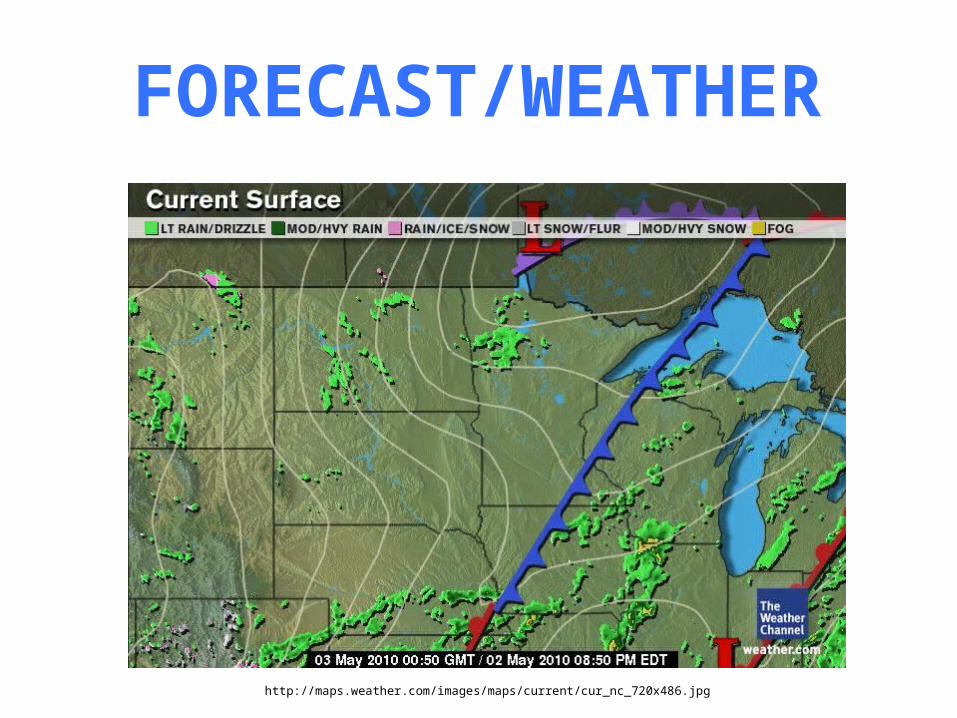
FORECAST/WEATHER
http://maps.weather.com/images/maps/current/cur_nc_720x486.jpg

ECOLOGICAL CLASSIFICATIONSYSTEM
http://svinetfc4.fs.fed.us/research/section/regions.jpg
http://www.dnr.state.mn.us/ecs/index.html
Eastern Broadleaf Forest Province (222)
http://www.dnr.state.mn.us/ecs/index.html

ECOLOGICAL CLASSIFICATIONSYSTEM
http://www.dnr.state.mn.us/ecs/222M/index.html
Minnesota and Northeast Iowa Morainal Section (222M)
Anoka Sand Plain Subsection (222Mc)
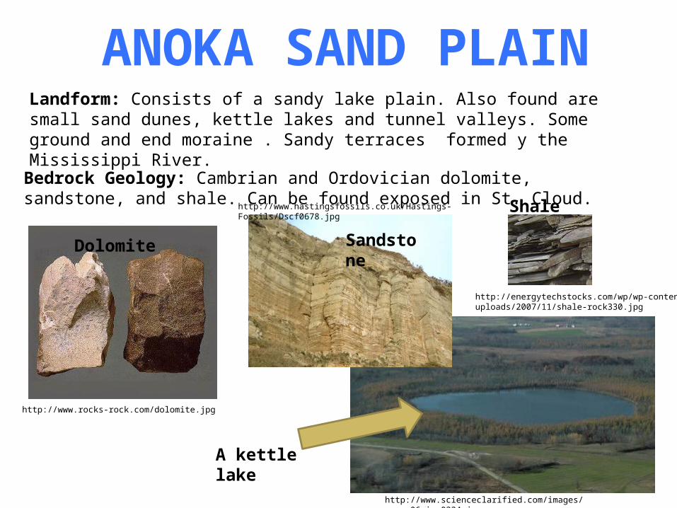
ANOKA SAND PLAINLandform: Consists of a sandy lake plain. Also found are small sand dunes, kettle lakes and tunnel valleys. Some ground and end moraine . Sandy terraces formed y the Mississippi River.
http://www.scienceclarified.com/images/uesc_06_img0334.jpg
A kettle lake
Bedrock Geology: Cambrian and Ordovician dolomite, sandstone, and shale. Can be found exposed in St. Cloud.
http://www.rocks-rock.com/dolomite.jpg
http://www.hastingsfossils.co.uk/Hastings-Fossils/Dscf0678.jpg
http://energytechstocks.com/wp/wp-content/uploads/2007/11/shale-rock330.jpg
Dolomite Sandstone
Shale

MINNESOTA BEDROCK
http://upload.wikimedia.org/wikipedia/commons/e/e0/Bedrock_geology_of_Minnesota.gif
Sedimentary Rock- Limestone- Shale
- Sandstone

http://soils.usda.gov/use/worldsoils/mapindex/order.html
GLOBAL SOIL REGIONS