Alcoa Australia Year 11 & 12 Teacher Resource
15
1 Revised April 2020 Alcoa Australia Year 11 & 12 Teacher Resource Introduction Alcoa’s Australian operations form an integrated aluminium industry that includes bauxite mines and alumina refineries in Western Australia and an aluminium smelter in Victoria. The Alcoa education program offers a wide range of activities that apply to each of the elements of the aluminium process. Resources relevant to teachers of students in years 11-12 are available below. Information, worksheets and activities Mining Process Rehabilitation Process Year 11 Geography Unit 2 Teacher Resource Year 12 Geography Unit 3 Teacher Resource Mapping Bauxite Geology of Bauxite Simulated Bayer Process Geography Earth and Environment Science, Integrated Science Chemistry, Integrated Science Flora Survey -Quadrat Activity Biology, Integrated Science
Transcript of Alcoa Australia Year 11 & 12 Teacher Resource

1
Revised April 2020
Alcoa Australia Year 11 & 12 Teacher Resource
Introduction Alcoa’s Australian operations form an integrated aluminium industry that includes bauxite mines and
alumina refineries in Western Australia and an aluminium smelter in Victoria. The Alcoa education program
offers a wide range of activities that apply to each of the elements of the aluminium process.
Resources relevant to teachers of students in years 11-12 are available below.
Information, worksheets and activities
Mining Process
Rehabilitation Process
Year 11 Geography Unit 2 Teacher
Resource Year 12 Geography Unit 3
Teacher Resource
Mapping Bauxite
Geology of Bauxite
Simulated Bayer
Process
Geography
Earth and Environment Science, Integrated Science
Chemistry, Integrated Science
Flora Survey -Quadrat Activity Biology, Integrated Science

2
Revised April 2020
Mining Process
Alcoa’s bauxite mining operations in Western Australia occur in the Darling Range. The bauxite occurs as
a result of a lateritic weathering process and is often found on the sides of the hills. To access the bauxite
there are a number of steps involved in the mining process.
Pre-mining surveys are conducted in all new mining areas to provide information on fauna and
vegetation; to map the extent of dieback disease; and to identify any significant Aboriginal or European
heritage sites or potential community impacts. Any identified impacts are avoided or management plans
are developed.
Exploration drilling is undertaken to identify
the specific location of ore bodies within the mine
lease that are suitable for mining. Drilling starts at
wide spacing (60m) and then focuses in on
identified ore bodies.
Grade control drilling is undertaken to obtain
detailed chemical composition information of the
ore planned for mining. This information is used
to plan when to mine different pits. The mines
must supply a constant grade of ore to the
refineries by mixing ore of different grades from
different pits.
Mine planning takes into account any significant vegetation, fauna or heritage sites and any potential
community impacts identified during the pre-mining surveys as well as avoiding the spread of dieback
disease. A number of mine plans are produced, including a conceptual 25-year mine plan, a 10-year mine
schedule and a detailed five-year mine plan.
The Five-Year Mine Plan and the Mining and Management Program (MMP) are submitted each year for
government approval. The MMP summarises the major environmental management programs that will
be undertaken to minimise the impacts of mining with emphasis on issues relevant to the next five
years.
New infrastructure is developed when mining moves into a new area within the mineral lease. For
example, the ore crusher is usually relocated closer to the new mine area to reduce the trucking distances.
This happens about every 10-20 years. New roads are created each year to allow access to areas to be
mined in the following few years.
Timber within Alcoa’s mine lease belongs to the State Government. Before clearing, the Forest Products
Commission takes any marketable timber from areas where mining is planned each year. Once all
marketable timber has been taken by the Forest Products Commission, all remaining timber is cleared
from the areas to be mined and positioned in rows. Wood waste is utilised by third parties for charcoal
production, as wood chips for Alcoa sites and as fauna habitats in the rehabilitated mine areas. Some is
also burnt.

3
Revised April 2020
Topsoil and overburden make up the soil profile. The topsoil layer contains a large store of seed and
nutrients that are vital to the success of the forest rehabilitation and is about 15 cm thick.
The overburden layer is 20-80cm of gravely
sub-soil material sitting above a cemented laterite
layer known as caprock.
These layers are removed separately using
scrapers prior to mining. Due to the uneven nature
of the caprock, the scrapers are unable to remove
the entire overburden layer as some of this material
will remain in the hollows in the caprock. This is
known as secondary overburden.
Secondary overburden is removed using a small
excavator.
Caprock is a solid rock layer containing bauxite
and rests above the friable bauxite layer in the soil
profile. This caprock layer is usually broken by
blasting.
Crushing and conveying to refineries occurs once the caprock layer has been broken and the
bauxite is ready to be mined. An excavator or loader is used to load the bauxite onto haul trucks for
transport to the crusher. The crusher is used to break the ore down to a smaller size suitable for transport
along conveyor belts to the refineries.
Bauxite profile before mining
Jarrah forest
Soil layer
Caprock 1-1.5m
Friable Bauxite 4-8m
Clay up to 40m
Granite Bedrock

4
Revised April 2020
Rehabilitation Process
Each year, mine pits that have had the ore removed and roads that are no longer needed are
rehabilitated. The long-term objective of Alcoa’s mine rehabilitation is to establish a self-sustaining jarrah
forest ecosystem that maintains or enhances conservation, timber, water, recreation and other forest
values. Alcoa’s rehabilitation process has been developed and improved since operations commenced in
1963 and currently involves a number of important steps.
Pre-ripping and landscaping take place
first. Pre-ripping breaks up the compaction of
the pit floor caused by heavy mining equipment.
A bulldozer with a winged tine, which is like an
inverted T attached, rips the floor of the pit. This
helps roots to penetrate through the soil profile.
Large rocks are buried, vertical pit faces are
flattened down and the pit floor is smoothed to
blend the mined area into the surrounding
landscape.
Soil return takes place with overburden and
topsoil layers being returned. Wherever
possible, fresh topsoil is returned directly to
rehabilitated areas from pits that have been
cleared recently. This maximises the topsoil
seed store, which is important for optimising
the number of plant species in rehabilitated areas.
Contour ripping is undertaken to increase the soil’s water storage
capacity. This contour ripping is undertaken with a multi-pronged ripper.
Contour ripping creates mounds across the slopes in rehabilitation, which
are important for erosion control. In flat areas and areas with a low
potential to erode, the rip lines may be partially flattened by a heavy bar
dragged behind the ripping dozer.
Seeding is done to encourage the return of plant species into rehabilitated
areas. The seed mix is specially formulated by Alcoa and contains 50 to 80
species and is applied at a rate of about 1 kg per hectare.
Recalcitrant planting takes place to ensure the return
of species that are unable to be established from the
seed in the topsoil or applied seed mix. These plants
include many grasses and sedges that produce little
viable seed. On order from Alcoa, local suppliers grow up
to 600,000 seedlings of these species through tissue
culture (cloning) or cuttings and plants these seedlings
by hand in the rehabilitated areas.
5
Revised April 2020
Fertilising is done to improve the establishment and early growth rates of trees and under storey in
revegetated areas. Fertiliser is applied by helicopter to newly rehabilitated areas, usually around August.
Ongoing monitoring and management of rehabilitated areas takes place to ensure the return of
plant species into rehabilitated areas. Around March each year, when the rehabilitation is about nine
months old, the previous year’s rehabilitation is monitored to check that the number of established plants
meets targets agreed by the Department of Biodiversity Conservation and Attractions (DBCA) and Alcoa,
and to identify any areas that need further treatment to control weeds or repair any erosion.
Around 15 months of age, botanical species richness (number of different plant species) is monitored against
internal and government standards.
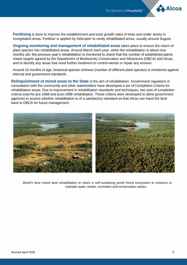
Relinquishment of mined areas to the State is the aim of rehabilitation. Government regulators in
consultation with the community and other stakeholders have developed a set of Completion Criteria for
rehabilitation areas. Due to improvement in rehabilitation standards and techniques, two sets of completion
criteria exist for pre-1988 and post-1988 rehabilitation. These criteria were developed to allow government
agencies to assess whether rehabilitation is of a satisfactory standard so that Alcoa can hand the land
back to DBCA for future management.
World’s best mined land rehabilitation to return a self-sustaining jarrah forest ecosystem to enhance or
maintain water, timber, recreation and conservation values.

6
Revised April 2020
Rehabilitation is a staged process. These photos have been taken in the same area of rehabilitation
and show progress over 20 years.
Six months Four Years
13 years 20 years

7
Revised April 2020
Year 11 Geography Unit 2 – Global networks and interconnections – Alcoa links
To assist geography teachers address year 11 Geography curriculum Unit 2 – Global networks and interconnections,
Alcoa has developed a series of questions relating to the different aspects of Depth Study One.
Depth Study One
Using fieldwork and/or secondary sources students investigate the reasons for, and consequences of, the changing
spatial distribution of production and consumption (and, where appropriate, reuse) of at least one commodity,
goods or services from one of the following groups:
a mineral ore or fossil-based energy resource – iron ore, coal, bauxite, natural gas or oil
Investigate:
The nature of the commodity, good or service Describe bauxite as a commodity including location.
Where else in the world is bauxite located?
Describe the processes used in mining bauxite.
The process of diffusion of the commodity, good or service and its spatial outcomes
What are the markets for the bauxite?
What does value add mean?
How does Alcoa value add bauxite?
What are the markets for alumina?
How does Alcoa value add alumina?
Define: upstream, midstream and downstream.
The changes occurring in the spatial distribution of the production and consumption of the commodity, good or service in Australia and overseas, and the geographical factors responsible for these changes
Describe how the spatial distribution of bauxite production
changes and the geographical factors responsible.
Where does the downstream consumption of bauxite take place?
What geographical factors influence the location of Alcoa’s alumina refineries in Western Australia?
Where are the markets for alumina?
What geographical factors influence the distribution of these markets?
What further consumption takes place downstream?
The role played by technological advances in transport and/or telecommunications in facilitating these changes in the spatial distribution
Describe the transport system used for bauxite and the
technological advances that are utilised.
What additional technological systems are used in the production of bauxite?
What telecommunication tools are utilised by the company that make it easier to operate globally?
8
Year 11 Geography Unit 2 – Global networks and interconnections – Alcoa links continued
Revised April 2020
The role played by governments and enterprises in the internationalisation of the production and consumption of the commodity, good or service, such as the reduction or elimination of the barriers to movement between countries
How does government influence global operations?
How is the business structured to operate globally?
Implications of the changes in the nature and spatial distribution of the production and distribution of the commodity, good or service for people, places and the biophysical environment at a variety of scales, including the local
What variations can occur in bauxite that affect production?
What are the implications of changes in the spatial distribution of bauxite at a local level?
What impact does mining have on the biophysical environment? What is done to reduce impacts?
Likely future changes in the nature and spatial distribution of the production and consumption of the commodity, good or service
What are the potential changes to the distribution of bauxite as a commodity?
The impact of these changes on less developed countries (LDC) in terms of sustainability
What are the limitations less developed countries face when mining bauxite?
The ways people and places embrace, adapt to, or resist the forces of international economic integration, and the spatial, economic, social and geopolitical consequences of these responses
How does the global economy impact on alumina markets?
How has Alcoa adapted to the international economy?
What influence does Alcoa have on the local economy?
How does Alcoa demonstrate corporate social responsibility?
Are there any geopolitical influences that impact the production of bauxite?

9
Year 12 Geography Unit 3 – Global environmental change – Alcoa links
Revised April 2020
To assist geography teachers address year 12 Geography curriculum Unit 3 – Global environmental change, Alcoa
has developed a series of questions relating to the different aspects of Depth Study Two.
Depth Study Two
Using fieldwork and/or secondary sources, students investigate how the impacts of land cover change are being
addressed and evaluated.
approach to land cover restoration and rehabilitation, and the mitigation of future land cover changes, including preservation strategies
Describe the processes used prior to the commencement of mining activity to mitigate potential land cover changes
the current and proposed strategies, at local to global levels, implemented to mitigate the adverse effects of either global climate change or loss of biodiversity
Describe the rehabilitation process
What research is undertaken to mitigate potential impacts on biodiversity?
how human activity has adapted, or may be required to adapt, to either global climate change or loss of biodiversity
How have approaches to rehabilitation changed since the commencement of Alcoa mining operations on WA?
Describe strategies that have been introduced to minimise potential impacts prior to rehabilitation
a program designed to address the impacts of land cover change on local and regional environments
In addition to site rehabilitation, what additional programs exist to address impacts of land cover change on local and regional environments?
an evaluation of the program, giving consideration to environmental, economic and social benefit and costs
Compare and contrast an area of rehabilitation to an area not cleared for mining
Sketch
an evaluation of at least one alternative approach to the management of land cover change in the area being studied, using the concept of sustainability to determine the extent to which the approach has the potential to address the issue into the future
Compare

10
Revised April 2020
Mapping Bauxite
Topic: Mining
Background Information: Bauxite occurs through a weathering process of granite and laterite over millions of years. In Western Australia,
bauxite is formed on the sides of hills starting at a depth of approximately 0.5m and reaching an average depth of 4-
5m including the caprock. Bauxite is also located in other regions of the world.
You will need:
Global map showing mineral deposits
Paper
Pencils
What you need to do:
Find the different locations of bauxite around the world.
Draw a Venn diagram showing similarities and differences between the locations.
Is there a pattern to the locations?
Extension/Alternatives
Which of these areas have active mining?
Compare and contrast the communities where mining operations exist and have existed.
What are the longitudes and latitudes for the different locations?
Using a blank map, shade the areas where bauxite is located.
What other minerals can be found in these regions?
Final question
What can you deduce from the presence of bauxite in these regions?
Curriculum Links: Geography
Reference Lateritic Bauxites
G. Bardossy and G.J.J. Aleva
Developments in Economic Geology No. 27
Elsevier Press 1990

11
Revised April 2020
Mapping Bauxite continued
Teacher resource:

12
Revised April 2020
Geology of Bauxite
Topic: Mining
Background Information: There are 3 different types of rock: igneous (volcanic), sedimentary and metamorphic. The Bauxite of the Darling
Ranges is predominantly formed from igneous rock, mainly granite that has been altered through a weathering and
leaching process.
Darling Range bauxite is found by taking samples of laterite in possible mining areas along the scarp. Laterite is the
remains of granites and some dolerites that have been chemically and physically altered by a weathering process over
millions of years. Where there is enough Gibbsite (Alumina mineral) concentrated in the laterite it is called bauxite.
Most bauxite is formed on the sides of hills starting at a depth of approximately 0.5m and reaching an average depth of
4-5m including the caprock.
Alumina is refined from bauxite, aluminium is then smelted from the alumina.
You will need:
Personal Protective Equipment (PPE)
Closed in shoes, long trousers and long sleeves
Paper
Pen/pencil
Container for samples
What you need to do:
Collect a sample of:
Caprock
Friable bauxite
Clay zone
Compare samples, describe colour, texture, size, any patterns etc.
Note the differences and similarities between the areas where they have been collected from.
Create a table that shows the physical properties of the rocks.
Extension / Alternatives
Draw a sample of caprock and label components – iron rich elements, gibbsite, quartz grains
Create a profile using the samples
Create a poster noting the physical properties of the samples and showing the profile.
Curriculum Links: Earth and Environment Science, Integrated Science

13
Revised April 2020
Geology of Bauxite continued
Sketch Describe Compare
Soil
Caprock
Friable Bauxite
Clay
Granite
14
Revised April 2020
Simulated Bayer Process
Topic: Refining
You will need:
Borax
Sand
Mud / Soil
Distilled water
150ml Beakers / stirring rod
Plastic cup
Filter paper or syringe with filter attachment
Microwave
What you need to do:
Create the slurry
Mix the borax, sand and mud together in equal quantities – this simulates ‘bauxite ore’
Weigh 100g of ‘bauxite ore’
Place into 150ml beaker
Add 100ml of distilled water
Digestion
Place in microwave on 100% power for 45 seconds
Remove carefully
Stir with stirring rod
Allow to stand for 10 seconds
Clarification
Decant into a plastic cup (note sand in bottom of beaker)
Assemble syringe filter
Draw 35ml solution from plastic cup
Expel first 20ml of this back into a beaker
Alternatively use the filter paper to filter the solution
Once filtrate is clear, transfer remainder into a fresh 150ml beaker
Precipitation
Cool on crushed ice until crystals first appear (after temperature drops to 40oC, leave for about 2 minutes)
Extension/Alternatives
Describe the process in your own words.
What else could you use to simulate the Bayer process?
Discussion:
The filtrate is supersaturated. As it cools, crystals will precipitate out until new solubility equilibrium is reached.
Stir and note what happens.
Curriculum Links: Chemistry, Integrated Science

15
Revised April 2020
Flora Survey - Quadrat Activity
Topic: Rehabilitation and Rehabilitation
Background Information:
In Western Australia bauxite mining occurs in the Jarrah Forest. The Jarrah Forest is a biodiversity hot spot and some
plant species can vary between locations. As part of the mine planning and approval process, flora surveys are
conducted to map vegetation types and identify rare and priority species in the areas proposed for mining.
Once rehabilitation has taken place flora monitoring is conducted to measure the success of mine rehabilitation and
its similarity to unmined forest.
You will need:
Tape measure
String
Writing/sketching materials,
Camera (not essential).
What you need to do
Pick a large vegetated area and estimate the size
Use the string to create a quadrate that is a minimum of one metre square
Record the number and species of flora within the quadrate.
Extension / Alternatives
Graph the results
Survey multiple quadrats and calculate the average to estimate species richness (i.e. number of species)
Calculate the number and variety of plant species within the larger area, based on an analysis of the quadrate information
Choose some samples to sketch. You may even like to collect some samples to press in a book and write descriptions of
Create a transect 5-10 metres in length, apply markers each metre. Sketch plant the profile of the transect showing the different heights and species of plants
Curriculum Links: Biology, Integrated Science