Alarmed by the rapid deterioration of the wetlands, landowners
25
24 Alarmed by the rapid deterioration of the wetlands, landowners, sportsmen, sci- entists, and environmentalists have worked hard over the years to find ways to halt or slow the loss. A number of wetland restoration methods were used in the LaBranche Wetlands. These include: So far the measures tried have been at least partially successful but the LaBranche Wetlands probably cannot recover unless freshwater from the Mississippi River can be introduced. Methods for achieving this are being investigated at present. Louisiana “Big Blue” Iris in the LaBranche Wetlands. photo: Dinah Maygarden 12. The LaBranche Wetlands The Interstate 10 passes over the brackish marsh of the LaBranche Wetlands between the Jefferson-St. Charles Parish line and the Bonnet Carré Spillway, making it one of the most highly visible wetland in our area. The LaBranche Wetlands comprise approximately 20,000 acres of mostly cypress swamp, intermediate marsh and shallow open water ponds. The map of the LaBranche Wetlands has changed dramatically over the latter half of the 20th Century. In the 1950’s there was one open water pond in the north- west corner, created early in the century by a failed agricultural project. With the construction of the I-10, however, more ponds quickly appeared. Already compromised by previous changes, the marsh near the Lake began to disinte- grate quickly once access canals for construction equipment cut through the lakeshore. By allowing brackish lake water into fresher habitats, the break-up of an intact marsh was set in motion. In 1965, Hurricane Betsy pushed a huge storm surge of salty water into the marsh. This multiplied the damaging effects of opening the shoreline to build the interstate. As a result, the open water areas in the LaBranche Wetlands increased from 300 acres to more than 4,200 acres. More recently, Hurricane Georges and the drought experienced in 1999 and 2000, dealt another blow to these fragile wetlands, creating salt- water intrusion that has had a lasting effect. Added to the erosion woes is the industrial pollution of Bayou Trepagnier. This small bayou has one of the worst cases of sediment contamination in the state derived from the disposal of oil refinery waste. The majority of the pollution took place prior to the enactment of the Clean Water Act in the 1970’s. Water control structures placed at breaks in the shoreline to keep brackish, high wave energy lake water out of the marsh; Christmas tree fences to trap sediment; The first federally funded Coastal Wetlands Planning, Protection and Restoration Act (CWPPRA) project put in place to fill an open-water area with lake-bot- tom sediments and create approximately 350 acres of new marsh; Armoring the shoreline with rocks and closing openings that cause the marsh to further deteriorate; A project to add more shoreline armoring, marsh terracing and vegetative planting is planned by the Coastal Wetlands Planning, Protection and Restoration Act (CWPPRA) program. These activities are designed to protect the shoreline from wave erosion and to build new marsh habitat by trapping sediment and encouraging new vegetative growth; Scientists and environmental protection groups have worked closely with the state and federal agencies and the refining companies to seek a solution to the question of how to remediate the Bayou Trepagnier contamination. There is now a plan ready to be implemented that will include both remedi- ation of the contamination and restoration of the surrounding wetlands. ● ● ● ● ● ●
Transcript of Alarmed by the rapid deterioration of the wetlands, landowners

24
Alarmed by the rapid deterioration of the wetlands, landowners, sportsmen, sci-entists, and environmentalists have worked hard over the years to find waysto halt or slow the loss. A number of wetland restoration methods were usedin the LaBranche Wetlands. These include:
So far the measures tried have been at least partially successful but theLaBranche Wetlands probably cannot recover unless freshwater from theMississippi River can be introduced. Methods for achieving this are beinginvestigated at present.
Louisiana “Big Blue” Iris in the LaBranche Wetlands. photo: Dinah Maygarden
12. The LaBranche Wetlands
The Interstate 10 passes over the brackish marsh of the LaBranche Wetlandsbetween the Jefferson-St. Charles Parish line and the Bonnet Carré Spillway,making it one of the most highly visible wetland in our area.
The LaBranche Wetlands comprise approximately 20,000 acres of mostlycypress swamp, intermediate marsh and shallow open water ponds. The mapof the LaBranche Wetlands has changed dramatically over the latter half ofthe 20th Century. In the 1950’s there was one open water pond in the north-west corner, created early in the century by a failed agricultural project. Withthe construction of the I-10, however, more ponds quickly appeared. Alreadycompromised by previous changes, the marsh near the Lake began to disinte-grate quickly once access canals for construction equipment cut through thelakeshore. By allowing brackish lake water into fresher habitats, the break-upof an intact marsh was set in motion. In 1965, Hurricane Betsy pushed a hugestorm surge of salty water into the marsh. This multiplied the damaging effectsof opening the shoreline to build the interstate. As a result, the open waterareas in the LaBranche Wetlands increased from 300 acres to more than4,200 acres. More recently, Hurricane Georges and the drought experiencedin 1999 and 2000, dealt another blow to these fragile wetlands, creating salt-water intrusion that has had a lasting effect. Added to the erosion woes is theindustrial pollution of Bayou Trepagnier. This small bayou has one of the worstcases of sediment contamination in the state derived from the disposal of oilrefinery waste. The majority of the pollution took place prior to the enactmentof the Clean Water Act in the 1970’s.
Water control structures placed at breaks in the shoreline to keep brackish,high wave energy lake water out of the marsh;
Christmas tree fences to trap sediment;
The first federally funded Coastal Wetlands Planning, Protection andRestoration Act (CWPPRA) project put in place to fill an open-water area with lake-bot-tom sediments and create approximately 350 acres of new marsh;
Armoring the shoreline with rocks and closing openings that cause the marsh to further deteriorate;
A project to add more shoreline armoring, marsh terracing and vegetative planting is planned by the Coastal Wetlands Planning, Protection andRestoration Act (CWPPRA) program. These activities are designed to protectthe shoreline from wave erosion and to build new marsh habitat by trapping sediment and encouraging new vegetative growth;
Scientists and environmental protection groups have worked closely withthe state and federal agencies and the refining companies to seek a solutionto the question of how to remediate the Bayou Trepagnier contamination.There is now a plan ready to be implemented that will include both remedi-ation of the contamination and restoration of the surrounding wetlands.
l
l
l
l
l
l

25
Today, a newly completed hurricane protection levee follows the southern borderof the LaBranche Wetlands, parallel to Airline Highway, protecting the land onthe river side from storm surges. Development projects in the unprotected wet-lands are much less likely now. However, because this property is in private own-ership, the landowners may see fit to develop. A permit application was filed byone of the landowners in 2002 for a massive airport project. Currently an envi-ronmental impact statement is being prepared. This emphasizes the vulnerabilityof this area. Its future remains in the hands of the private landowners. UnlikeBayou Sauvage National Wildlife Refuge, LaBranche receives no governmentprotection at this time.
Despite private ownership, there is public access in the LaBranche Wetlands. Aboat launch on the Bonnet Carré Spillway levee provides access to BayouLaBranche and Bayou Trepagnier (see map and directions). On BayouLaBranche you can explore about five miles of mostly cypress swamp by canoeor small flat boat. This route is especially beautiful in the spring when the cypresstrees are leafing out and the Louisiana irises are blooming. The numbers of iriseshave decreased dramatically in recent years due to saltwater intrusion and thereare many dead cypress trees that succumbed to salt stress since HurricaneGeorges. In spite of all the changes, the LaBranche Wetlands are beautiful andbiologically productive. This is an easily accessible site that is worth visiting on aregular basis.
Recently dead cypress in the Labranche Wetlands are a sign of severesaltwater intrusion
New Orleans high school students enjoying a canoe trip in theLaBranche Wetlands
13. The Bonnet Carré Spillway
The Bonnet Carré Spillway is a dominant feature on any map or aerial photo-graph of St. Charles Parish. It may be thought of as a giant safety valve on theMississippi River, which was once in charge of the landscape. The Spillway wasbuilt in the early 1930's, as part of the flood control plan for the lower MississippiRiver after the devastating flood of 1927. The U.S. Army Corps of Engineerschose a site near an old crevasse at Bonnet Carré Bend. Since then, wheneverthe spring floods on the river are great enough to threaten the New Orleans lev-ees below Bonnet Carré, the Spillway is opened to relieve the pressure of thehigh water by sending flood water into Lake Ponchartrain. The massive spillwaystructure made of 350 bays of reinforced concrete, stretches 7,000 feet. In eachbay are 20 timbers that must be individually removed by a crane to open thestructure. The Spillway has been opened eight times, most recently in 1997.
Never before in the history of the Bonnet Carré Spillway has an opening drawnmore attention from scientists, environmentalists, and the general public than in1997. Large amounts of work and funding have been spent in the past decadeon the effort to improve water quality in Lake Pontchartrain. When the Spillwaywas opened fully, ten percent of the river's flood stage flow was directed into theLake, which, because it is actually a shallow estuarine system, is very sensitive tosudden changes. The river water replaced the brackish water with muddy, coldfresh water, nutrients and other contaminants washed from 40% of the UnitedStates. Later that year, as the temperatures rose, algal blooms occurred in theLake on a larger scale than ever recorded. Due to the concerns about the toxicityof some of these algae, warnings against recreational use of Lake Pontchartrainwere issued. After the Spillway opening the Lake was able to rebound andrestore its balance, but the short-term impact was great enough that the nextopening will raise many questions from all those concerned about the health ofLake Pontchartrain.

26
Recreation in the Bonnet Carré Spillway
The Bonnet Carré Spillway is managed by the US Army Corps of Engineers. Itprovides many recreational opportunities including boating and fishing, hunting,all terrain vehicle (ATV) use, bird watching and dog training. For the safety of theusers of the Spillway, the Corps has developed a plan separating hunting fromother activities. There are two tracts devoted to ATV use, one on either side ofAirline Highway. Hunting is allowed in other designated areas that are not closeto the levees and main waterways. Access points include the main boat launchon the east guide levee just to the north of Airline Highway and the ATV accessarea to the south of Airline Highway. There is a second boat launch on the eastguide levee beneath the I-10 bridge, close to the lake shore. This provides accessto the Spillway and Lake Pontchartrain. At the end of the east guide levee at theLake, there is a park area with a fishing pier providing valuable public access toLake Pontchartrain. This is the site of a shoreline restoration project where con-crete and other materials have been used to armor the shoreline to prevent fur-ther erosion. A nature trail created by local resident and wetlands activist MiltonCambre provides a way to explore the natural beauty of the wooded shorelinebetween the Spillway levee and Bayou LaBranche. For more information aboutrecreational activities in the Bonnet Carré Spillway,www.mvn.usace.army.mil/recreation or call 985.764.0126.
Cranes are used to pull the “pins” that hold back the Mississippi Riverat the Bonnet Carré Spillway
Directions:
To reach the LaBranche Wetlands and the Bonnet Carré Spillway take the I-10west from New Orleans and exit at the I-310. Exit the I-310 at US Hwy 61and go west to Norco. (See map above.)
Bonnet Carré Spillway Structure:
To get to the spillway structure on the river, take a left off Airline Hwy (US 61)onto Apple Street in Norco. Follow Apple Street to the river and turn right.You will see the spillway structure as River Road turns abruptly to the right.
Bonnet Carré Spillway Boat Launches:
Take Airline Highway through Norco and take a right on the Bonnet CarréSpillway East Guide Levee Road. Immediately on your left is the mainSpillway boat launch and recreation area. There is a shelter and portable toi-lets. Camping is allowed with a permit.
To reach the boat launch at the northern end of the Spillway, continue downthe east guide levee road for two miles. Take the ramp off the levee on the leftand go under the railroad trestle. The boat launch is under the I-10 bridge. Thepark, nature trail and fishing pier are found on the other side of the I-10 br idge.
LaBranche Wetlands Boat Launch:
To get to the LaBranche Wetlands, stay on Airline Highway (US 61) in Norco.After passing the Motiva Refinery, turn right onto the east guide levee roadand follow it towards the Lake Pontchartrain. The boat launch is on the rightabout two miles down the levee road.
13.
Boat! Launch
Boat! Launch
Point!Park

27
Students learn to measure the salt content of water using hydrometers during awetland fieldtrip
As you drive the levee road, Bayou Trepagnier will be on your right hiddenbehind the trees but parallel to the levee. The canal that follows the levee isEngineer’s Canal, a "borrow" canal for the levee construction. About one miledown the levee road there is a cut linking the canal and Bayou Trepagnier.Contamination is very heavy in this location and has entered Engineer’sCanal. It is obviously unwise to fish here if you intend to eat what you catch.
14. Bayou Sauvage National Wildlife Refuge
Bayou Sauvage National Wildlife Refuge protects the remains of the south shorewetlands to the east of the City of New Orleans. Several refuge access points arelocated along US Highway 90. Also available are a bikeway on the levee andswamp tour located at an exit from the I-10.
Bayou Sauvage was dedicated as a National Wildlife Refuge in 1986, after a somewhat turbulent history that included many development schemes, none ofwhich came to fruition. This 23,000-acre tract of land was originally designatedfor development in the late 1950's, and these development plans were not entire-ly abandoned until the land became part of the federal wildlife refuge system.
The first step taken in the plan to expand the City of New Orleans eastward wasthe construction of hurricane protection levees. Today these levees define thecharacter of the remaining wetlands as the water levels are artificially main-tained. More than half the refuge is within these levees. The remaining unleveedportion borders Lake Pontchartrain and Lake Borgne. The marsh within the leveesis dominated by freshwater habitat due to the lack of interchange between thebrackish lakes and the interior. Today, Bayou Sauvage itself is a narrow water-way greatly altered in recent times by changes in hydrology brought about bythe human developments in the area.
The History of the Bayou Sauvage Area
US Highway 90 to the east of New Orleans follows the ridge of high ground builtby Bayou Sauvage, an ancient course of the Mississippi River. Fifty years ago, hugeoak trees heavy with Spanish moss overhung the roadway. Beneath the oak treeswere thick stands of palmettos. Many other species of trees also grew there. Tallcypress trees grew in the swamp a short distance from the road, while closer to LakePontchartrain and Lake Borgne were marshes through which small bayous mean-dered. The marshes and swamps were full of wildlife and a haven for flocks of tens of thousands of waterfowl that came to feed in the winter. There were fewhuman-made interruptions in the landscape. Today a journey along Highway 90looks very different. The City of New Orleans now sprawls for miles to the east.After the subdivisions of New Orleans East end, development stretches on along thehighway. A few miles after the I-510 interchange the small businesses and housesfinally end and you cross one of many levees. On your left a sign announces BayouSauvage National Wildlife Refuge. Old Bayou Sauvage, which was responsible forbuilding the land around you, runs alongside the highway to the left.
The wetlands and bayou are not as rich and beautiful as they once were. They havebeen drastically altered by human activities. The extensive network of levees andcanals that dissect the wetlands of Bayou Sauvage National Wildlife Refuge haveinterrupted the natural interaction between the marsh and adjoining bodies of water.Today the US Fish and Wildlife Service manages the water levels to control landloss.
Much land was lost after the levees were built, but before Bayou Sauvage becamea National Wildlife Refuge. Between 1956 and 1990, 76% of the non-fresh (brack-ish and intermediate) marshes were lost, converted either to open water or freshmarsh. While some parts of the refuge flooded and marsh broke up, others driedout. These changes were all the result of altering of the hydrology of the wetlands.Wetlands are being damaged or destroyed in this way in many places in coastalLouisiana. Please refer to the map overlay to see the visual impact of these changes.Please refer to the map overlay on the opposite page. This shows part of the refugein 1956 and 2000 and illustrates dramatically the rapid deterioration of the marsh.
In the 1960’s the construction of the I-10 greatly impacted the wetlands. This was amassive construction project, made difficult by the soft sand, silt and clay soils of thewetlands. It involved digging miles of canals to bring heavy equipment and sand."Borrow pits" were excavated to retrieve the sand of the ancient Pine Islands buriedunder the marsh. A broad channel was dug and filled with sand to make theroadbed. This disturbance damaged the delicate wetland soils. When the I-10 wasconstructed exit ramps were put in, anticipating the suburbs that were to sprawl oneither side of the highway. Detailed plans were drawn up for the development of theentire area. This grand development scheme eventually failed for economic andpolitical reasons and because wetland advocates argued strongly for preservation of the area. Today the citizens of New Orleans can enjoy the benefits of a large,productive wetland area which is now their own National Urban Wildlife Refuge.

28
Directions:
From New Orleans take I-10 east to the Chalmette exit (I-510). Take the I-510 tothe US Hwy. 90 exit and turn east on Hwy. 90. Travel about 2.75 miles and lookfor the US Fish and Wildlife Service sign for Bayou Sauvage on the left. There isa good parking lot and a restroom at the boardwalk entrance. From this parkinglot you can also hike or bike the Maxent Levee trail.
14b. The Joe Madere unit and the Bayou Thomas Boardwalk and canoe trail
This short boardwalk is located at the Joe Madere Unit on Highway 90 on theopposite side from the Ridge Trail. Here you will see a freshwater marsh habitat,which is a good place to identify many species of plants and animals. BayouThomas itself was a branch of the Bayou Sauvage distributary. Joe Madere, forwhom this unit is named and who lived at this site for many years was instrumen-tal in the creation of the refuge, recalls being able to take a pirogue on BayouThomas all the way to Lake Borgne. Today levees and the Gulf IntracoastalWaterway (GIWW) have altered the landscape forever. There is a canoe launchhere and a canoe trail winds through the marsh, marked by wood duck boxesplaced by Joe Madere. It joins with and follows Bayou Thomas as far as thelevee. A walk on top of the levee affords a unique view across the refuge, to theGIWW and the surrounding marsh. Here you can observe the stark contrastbetween the unhealthy impounded marsh and the healthy marsh on the outside ofthe levee. On a winter afternoon, this is a great place to go to observe the leg-endary waterfowl that congregate on the refuge. As well as ducks and geese,many other species of birds make their home in the refuge.
Directions:
Follow the same directions for the Ridge Trail, but continue past the entrancefor a few hundred yards, looking on the right for a second Bayou Sauvagesign. Turn in here to find the boardwalk and the canoe launch.
14c. The Bayou sauvage Bike Trail
Have you ever biked through a marsh? It may not sound very wise, but becauseof the hurricane levees that surround most of Bayou Sauvage, you can do justthat. The Bike Trail is valuable because it provides accessibility to an area that isdifficult to traverse. Abundant wildlife can be observed in the marsh from the highvantage point of the pathway. Be sure to take binoculars along.
Directions:
The Bike Trail can be reached at exit 251 on I-10. This is also the access pointfor the swamp tour that presently operates in the refuge. You can also accessthe Bike Trail by taking exit 254 (Highway 11, Irish Bayou), and taking thedirt road that runs parallel to I-10 as far as the levee. Take care at this exit, asit can be confusing. To schedule a swamp tour, call 504.236.3143. (See Mapon Page 31.)
Opportunities for Exploring Bayou SauvageNational Wildlife Refuge14a. The Ridge Trail
This trail begins at the refuge entrance on Highway 90 where the MaxentLevee crosses the highway. The Ridge Trail is 0.3 miles of boardwalk throughmostly bottomland hardwood habitat. The trail begins close to Bayou Sauvage, onhigh ground created by the bayou when it was an active distributary of theMississippi River. Signs along the trail identify the important species of thishabitat. If you are observant, you can see signs of the abundant animal lifeinhabiting this area, including deer, hogs, and squirrels. In late summer andfall, the golden silk spiders festoon the forest with their huge golden webs,while an abundance of butterflies and other insects find food in the forest.Woodpeckers take advantage of the many dead trees and can often be seenalong the trail. At the end of the boardwalk the bottomland forest gives wayto the remnant of the cypress swamp (which was logged out at the turn of the20th century) and opens into freshwater marsh. Looking over the marsh youcan spot the open water of a large pond called Blind Lagoon. This “edge habi-tat” where you are standing is the transition between two habitats. Greaterbiological diversity is found in such places, and many species come to feed.During migration times in fall and early spring, watch for the small migratorybirds such as warblers and cedar waxwings. Look for the migratory waterfowl(ducks, coots, geese) that make the refuge famous. Birds of prey such as redshouldered and red tailed hawks, kestrels, and peregrine falcons also use thishabitat as their hunting ground.
Students explore the Bayou Sauvage Ridge Trail

29
Image B 1956
Overlaying imagery of one time period on another helps us to see thedrastic changes that have taken place in the wetlands. This overlay showsa section of Bayou Sauvage National Wildlife Refuge that has sustainedsignificant wetland loss. The top image (Image A) was taken in 1998. Thebottom image (Image B) was taken in 1956.

30
U.S. Fish and Wildlife Services Education Programs
The U.S. Fish and Wildlife Service provides educational opportunities, includingweekend programs for families and children, and a summer camp program.There are many opportunities to explore the refuge by canoe, bike and on footwith a ranger to guide and interpret. For further information, go to the US Fishand Wildlife Service website at: http://southeastlouisiana.fws.gov/bay-ousauvage.html or call the Southeast Louisiana Refuges office in Lacombe at985.882.2000.
15. The eastern Land Bridge - lake St. Catherine
This fragile, low-lying strip of marshy land separates Lake Pontchartrain from LakeSt. Catherine and from Mississippi Sound. Historically, it provided a link betweenthe south and north shores of the Lake, and a route to Mississippi. Highway 90 fol-lows the land bridge and crosses Chef Menteur Pass and The Rigolets, the twopasses that link the Lake with Mississippi Sound and the Gulf of Mexico. A drivealong Highway 90 provides a fascinating glimpse into the “Camp Culture” ofsouthern Louisiana. Humorous and affectionate names are given to the camps andhouses that provide their owners with access to the rich fishing waters of the adja-cent lakes and marshes.
At the Rigolets stands Fort Pike State Historic Site. Fort Pike is one of many fortsbuilt to protect Louisiana’s coastline after the British invasion of the war of 1812.Here also is a popular boat launch where you can gain access to some of the best fishing in the world. For more information about the fort, visit the Louisiana StateParks web site at http://www.lastateparks.com/ and go to the Historic Sites section.
16. Wetland Places to Explore Within the City
16a. Lincoln Beach
Lincoln Beach is the historic African American amusement beach on HayneBoulevard in Eastern New Orleans. Lincoln Beach is currently under restora-tion by the city of New Orleans and is projected to reopen to the public forswimming and recreation in the next few years. The water quality in the Lakeat Lincoln Beach is better than most locations on the south shore.
The Sewerage and Water Board of New Orleans is also currently sponsoringa water quality improvement project at Lincoln Beach. The Sewerage andWater Board have worked in partnership with the University of New Orleansand Burke Kleinpeter Incorporated to create natural habitats that enhanceLincoln Beach aesthetically and help to improve water quality. This projectinvolves 12.5 acres of submersed vegetation (SAV), areas of wetland vegetationon the shoreline that act as a buffer to filter stormwater runoff, an arboretum,trails, and observation platforms. The plan is that school groups and familieswill be able to learn about the upland, wetland and aquatic habitats here atLincoln Beach. Interpretive materials have been developed to help visitorsidentify plants. This is a unique area in the city of New Orleans for environ-mental education. Stay tuned for developments to this valuable publicresource. For more information, call the Sewerage and Water BoardEnvironmental Department at 504.942.3855.
16b. Pontchartrain Beach
Pontchartrain Beach, located at the northern end of Elysian Fields Boulevardopened to the public in 2003 after decades of closure. This heralds a new erafor the south shore of Lake Pontchartrain, which has better water quality todaythan it has had since the 1960’s. Once again, the residents of New Orleanscan enjoy the natural beauty of Lake Pontchartrain at the site of OldPontchartrain Beach Amusement Park.
17. Audubon Nature Institute Facilities
17a. Louisiana Nature center
Opened in 1980, and part of the Audubon Nature Institute since 1994, theLouisiana Nature Center is an educational facility dedicated to celebrating lifethrough nature by sharing the excitement, fun, and discovery of the naturalworld and our relationship to it. The Nature Center’s multi-use facility includesa large interpretive center, classrooms, resource center, planetarium, and three miles oftrails situated in an 86-acre forest and wetlands.
Hwy 90 between Lakes Ponctchartrain and St. Catherine is a precarious locationfor camps and homes. photo: Karen Westphal, LSU

31
The Nature Center provides educational programs and services to students,teachers, scouts and families. There is a wide offering of age appropriate educa-tional programs designed to meet the goals of the Louisiana Science EducationStandards. In addition to its permanent facilities, the Nature Center sponsorsvarious programs throughout the year, including overnight programs, sciencediscovery activities, canoeing, wilderness hikes and summer camps. TheNature Center is one of ten Audubon facilities dedicated to celebrating the wonders of nature.
Directions:
From I-10, take Read Road South. After crossing Lake Forest Boulevard, take aleft into Joe Brown Park. Follow the signs until you enter Louisiana NatureCenter. For more information, call the Nature Center at: 504.246.5672 or800.774.7394 or visit www.auduboninstitute.org/lnc/visit.htm. (See map below.)
17b. Audubon Zoo
A visit to the Audubon Zoo's Louisiana Swamp Exhibit, a re-creation of a 1930’sswamp settlement, introduces the public to many of the larger organisms andsome of the cultural aspects of the wetland habitats of our area. The zoo offers avery extensive educational program. For more information visit: www.audubonin-stitute.org/education/index.htm The zoo is found at 6500 Magazine Street inuptown New Orleans. Call 504.866.ITS.AZOO or visit: www.auduboninstitute.org
Region 4. The Eastern Marshes
St. Bernard and East Bank Plaquemines Parish
The wetlands of St. Bernard and east bank Plaquemines Parish are mostly marsh,ranging in salinity from brackish to salt water. Areas of higher ground mark oldcourses of the Mississippi River and its distributaries. Much of present day St.Bernard Parish lies within a delta lobe created by the river as it flowed to the eastmore than 5,000 years ago. The northern portion of east bank of PlaqueminesParish is within the St. Bernard delta lobe, while the southern part was formedlater by the modern "Bird's Foot" delta of the river.
The bend in the river below Chalmette, known as English Turn marks a pointwhere the river has switched courses. Today it turns suddenly to the south. In thepast it continued east. Today, two small bayous mark this eastern course. Closer tothe river is Bayou Terre au Boeufs (land of the buffalo or cattle), and further eastis Bayou la Loutre (Otter Bayou). It is hard to imagine these small waterways car-rying the main channel of the Mississippi River but scientists believe they did.
At high water times the river water overflowed and spread out, depositing its sedi-ment load, building a large delta lobe that once extended farther out than thepresent location of the Chandeleur Islands.
Today this delta lobe is deteriorating rapidly and the Chandeleur Islands arediminishing in size and migrating landward. The St. Bernard delta lobe is said tobe at the end of the natural cycle of building and destruction. The sediments aresubsiding and the waves of the Gulf of Mexico are reworking the sands of thebarrier island arc. But this natural process has been impacted by human activitiesthat have increased the rate of land loss.
Chief among the human changes in this area is the Mississippi River Gulf Outlet(MRGO). Built in 1963 to increase efficiency in shipping by providing a moredirect route for container ships heading to and from the port of New Orleans, theMRGO channel was originally 500 feet wide and -40 feet deep. Today its widthin some places has increased to 2,000 feet, due to the continual erosion of itsbanks. The MRGO has altered the natural hydrology of the region, allowing saltwater to penetrate far into fresher water habitats, killing many areas of cypressswamp. The channel was cut through the natural ridge of Bayou la Loutre andcaused those wetlands landward of the ridge to be exposed to saline water.

32
19. Yscloskey and Shell Beach
Yscloskey is a small, close knit fishing community located at the intersection ofBayou la Loutre and the Yscloskey Canal. After crossing the bridge, turn tothe left and follow the canal to Shell Beach. The road ends at the MississippiRiver Gulf Outlet. Old Shell Beach was once on the other side of the MRGO,on the banks of Lake Borgne. The US Army Corps of Engineers moved thebuildings in the early 1960’s before building the channel. The remains of thevillage and old Fort Beauregard cling to the eroding shoreline of the lake.
At Shell Beach is a busy boat launch run by the Campos, an Islenos family. Ifyou do not have a boat, this is as far as you can go, but it is a popular sitefor fishing and provides a vantage point for looking out across the brackishmarsh to Lake Borgne. There is little shelter from the elements at Shell Beach,so be prepared to deal with heat in summer, chilly north winds after a coldfront in the winter, and mosquitoes, and midges on occasion.
Directions:
To reach Yscloskey, take Judge Perez Drive (Hwy 39) out of Chalmette andtake a left on Hwy 46 before you reach the intersection with Bayou Road.Follow Hwy 46 for about 9 miles to its intersection with Bayou Road nearReggio. Take a left (you are still on Hwy 46, but following Bayou La Loutre).After about 5 miles you will reach Yscloskey where a bridge crosses thebayou. To reach Shell Beach, take a left after crossing the bridge and followthe road until it ends at the MRGO. A right hand turn from the bridge willtake you to Hopedale. (See color Map on Page 42.)
In addition, high salinity water enters Lake Pontchartrain via the MRGO, theIntracoastal Waterway, and the Industrial Canal.
It is necessary for the US Army Corps of Engineers (USACE) to continuallydredge the channel to keep it at a navigable depth. After Hurricane Georges in1998, the silting of the channel was so severe that questions were raised aboutwhether the USACE could afford to keep it open. A growing number of peopleare advocating for closure of the MRGO channel and for building a barrier toprevent saltwater intrusion. This would help protect the remaining wetlands of St.Bernard Parish, as well as limit saltwater intrusion into Lake Pontchartrain. Theoptions for “closure” are being studied by the USACE. This issue is made complexby the economic needs of the shipping industry in a large port like New Orleans.
Field Trip Opportunities in St. Bernard and Plaquemines Parishes
18. Los Islenos Heritage and Cultural Society Museum
Old Bayou Road follows Bayou Terre aux Beoufs and is a good example of a com-munity built on the natural bayou ridge. There are many old dwellings alongBayou Road, and a visit to the Islenos Heritage Museum will take you deepinto the fascinating history of the Islenos Culture, which is still strong in ruralSt. Bernard parish. The Islenos people came from the Canary Islands in the18th century and until recently, because of their geographic isolation, kepttheir wetland-dependent way of life and Spanish language intact. Today,with modern influence the use of Spanish is dying, as is the dependence onhunting, fishing and trapping for a livelihood. However, many people of Islenosdescent continue to make their living from commercial fishing and are very proudof their heritage. Call ahead to schedule a visit to the museum. The phonenumber is 504.682.0862.
St. Bernard Parish students learn about the legacy of the Mississippi River GulfOutlet at Shell Beach
Oystermen with their harvest at Yskloskey

33
Directions:
The Caernarvon structure is located on the river levee close to the St. Bernard-Plaquemines Parish boundary on Highway 39. From Chalmette, take St.Bernard Highway (hwy 46) to Poydras. Take a right on Highway 39 and fol-low it to the parish line. After passing through the hurricane floodgate on thehighway, you will see the Caernarvon diversion structure atop the river levee.From Yskloskey, follow Highway 46 back to Judge Perez Drive and take a left.At the intersection with Bayou Road, turn right and continue to the intersectionof highways 46 and 39 in Poydras. Here take a left on Highway 39, followingsigns to St. Bernard State Park. To reach Caernarvon, pass the entrance to thepark and cross the parish line at Elevated Boats Incorporated (EBI).
There are two boat launches here for access to Big Mar, Lake Lery, and themaze of waterways leading through the St. Bernard and Plaquemines marsh-es. Lynn Dean's boat launch beside Elevated Boats Incorporated (EBI) is pub-lic, while the Delacroix Corporation, the major landowner in this area, has agated launch close by. You will need to call Delacroix Corporation for the keyto the gate.
20. Caernarvon Freshwater Diversion Project
A visit to Caernarvon provides a strong contrast between the brackish envi-ronment at Shell Beach, and the freshwater habitats found close to theMississippi River. St. Bernard State Park has shelter and bathrooms, both ofwhich are welcome after a trip to Shell Beach.
The Caernarvon Freshwater Diversion Project was the first large diversion ofMississippi River water designed to reintroduce fresh water in wetlandsimpacted by saltwater intrusion. Constructed in the early 1990's,Caernarvon has provided valuable information about the long-term effects offreshwater diversion and has helped in the design of Davis Pond, a largerriver reintroduction project opened in 2003 in west bank St. Charles Parish.At Caernarvon, five culverts run beneath the levee and can divert up to 8,000cubic feet per second (cfs) of river water into a canal on the other side of thelevee. Large iron sluice gates open and close the culverts and are operatedby Army Corps of Engineers personnel. The Louisiana Department of NaturalResources monitors the ecological impact of the project.
By reducing water salinity and introducing nutrients, the project increases plant growth and diversity. It does not introduce large amounts of sediment into themarsh because the structure takes water from high in the river's water column.This water contains less sediment than the water deeper in the river. After flow-ing through the canal the water enters Big Mar, an open water pond wherethe flow slows, and much of the sediment settles to the bottom.
The results of nearly a decade of diversion have been positive overall,with approximately 500 acres of freshwater marsh restored and much greaterproductivity of many species of plants and animals. Controversy hasoccurred, however, and lessons have been learned, especially in relation tothe concerns raised by oystermen and shrimpers. The reduced salinity dis-placed the oyster beds that were closer to the diversion project, although overthe long run, the oyster production in Breton Sound has increased since the diver-sion began. The brown shrimp harvest has diminished, however.
These changes caused litigation between the oyster industry and the state ofLouisiana. The oystermen have thus far been successful in their suits againstthe government and billions of dollars in damages may be awarded to theplaintiffs. This experience was a lesson learned so that oyster leases weremoved at the government’s expense before the new diversion at Davis Pondwas opened. In 1998 the interagency committee that operates the diversionagreed to reduce the volume of the diversion to satisfy the concerns of thecommercial and recreational fishermen. More recently, a new managementapproach that has been tried uses a pulse method where a large volume ofriver water is released over a relatively short period of time, mimicking aflood event on the river. This new method is meeting with success.
The Caernarvon Freshwater Diversion structure from the air

34
21. Gore Pumping Station - Lake Borgne Levee District
At Gore Pumping Station there is an interesting project taking place designed torestore a cypress swamp that was almost killed by saltwater intrusion caused bythe MRGO. The stark, leafless cypress trees of the "ghost swamp" are immediate-ly visible when you arrive at the site. A closer look reveals that nearer to thepumping station itself the trees are healthier than those farther away. This isbecause this swamp is being actively restored by stormwater runoff, which ispumped over the levee. The pumping station introduces freshwater into theswamp from the drainage system of the communities along Judge Perez Drive, aswell as some treated wastewater from the settling ponds of the nearby sewagetreatment plant. The freshwater, with additional nutrients, is helping the cypresstrees in the swamp to recover. Many of the trees showed almost no sign of lifebefore the start of the project, and are now recovering. This project, jointly spon-sored by the Lake Borgne Levee District, St. Bernard Parish, and the LakePontchartrain Basin Foundation, provides an example of how stormwater runoffcan benefit wetlands. It also illustrates how communities and wetlands can bothbenefit from their interdependence.
Directions:
The Gore Pumping Station is located on Judge Perez Drive near St. Bernard HighSchool. To get there from Chalmette, drive south on Judge Perez Drive. Aftercrossing the high bridge over the Violet Canal look for a left-hand bend in theroad. The Gore Pumping Station is on the left of this bend. To arrange a visit tothis site, call the Lake Borgne Levee District at 504.862.5941.
No marsh, no fisheries...The Edge Effect
In coastal Louisiana the seafood industry is essential to the economy and partof every day life. But all indications show that we should not take it for grant-ed. There is a relationship between the loss of wetlands and the productionof seafood that is a little more complex than meets the eye. In fact, as themarsh deteriorates, the biological productivity for species such as shrimpactually increases because there are more edges where aquatic animalscan feed. However, a point is eventually reached when there is so littlemarsh remaining to provide food and cover that the population of shrimpand other marsh-dependent species suddenly falls, and productivity and fishand seafood harvests crash. We are not sure where on this curve we currentlyare.
The simple rule to remember is no marsh, no shrimp, redfish, blue crabs, speck-led trout, or any other species that depend on the marsh to complete their lifecycle. Another important point is that the more marsh we lose in St. Bernardand Plaquemines Parishes, the more vulnerable all of the people living inGreater New Orleans are to hurricanes.
This swamp is being restored by stormwater at the Gore Pumping Station
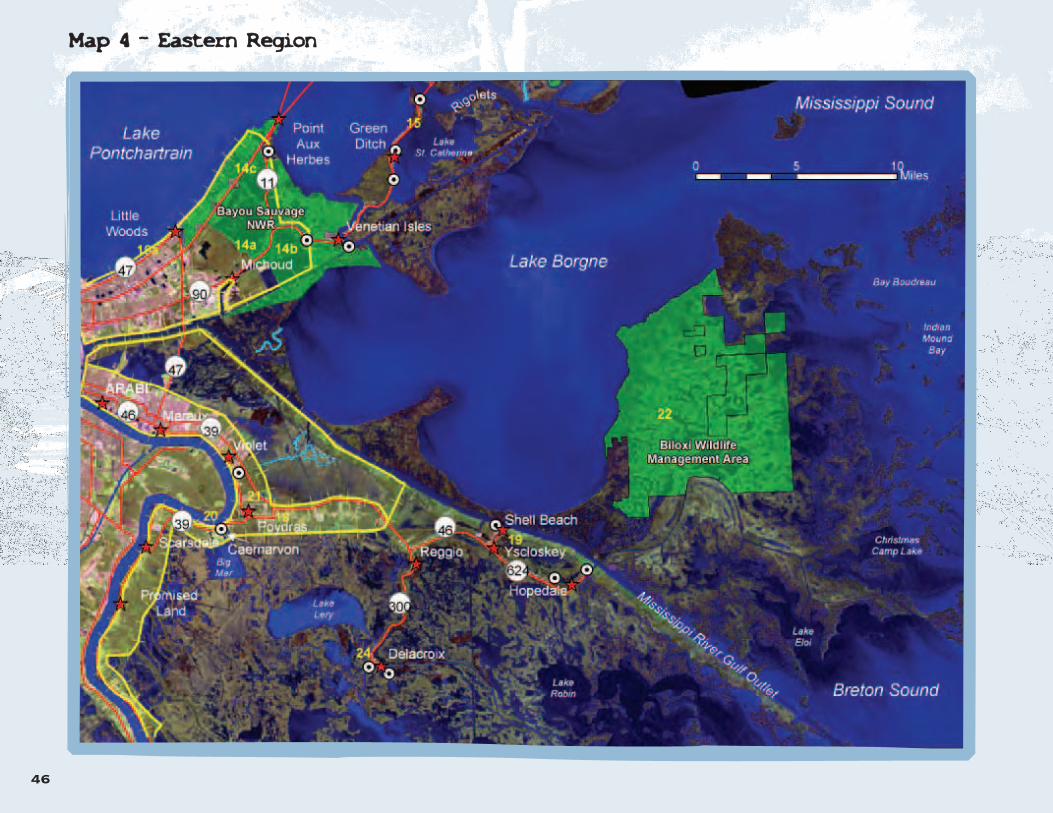
22. Biloxi Wildlife Management Area
Sometimes known simply as the Louisiana Marsh, this area is one of the most undis-turbed wetlands in Louisiana. The Biloxi Wildlife Management Area is situatedbetween the east shore of Lake Borgne and Chandeleur Sound (see Map 4 -Eastern Region, Page 42). The area consists of 40,000 acres of brackish and saltmarsh with no permanent human settlements. Often people who use the area dur-ing the week do not see another vessel and many go there to seek refuge from citylife. Hunters, fishers and wildlife enthusiasts from all over Louisiana and the GulfCoast enjoy the area, which is open for day use. Contact the Louisiana Departmentof Wildlife and Fisheries for regulations before planning an overnight stay in thearea. Keep the remoteness of the area in mind when planning a trip and be sureto pack emergency signaling equipment, VHF radio, cell phone, extra water, etc.
Directions:
The area is only accessible by boat or seaplane. The best places to launch areHopedale, Shell Beach, Chef Menteur Pass, and The Rigolets.
23. Plaquemines Parish Marshes
There are three State Wildlife Management Areas on the east bank of PlaqueminesParish. They are the Bohemia, Delta, and Breton Wildlife Management Areas. Allthree are accessible only by boat or seaplane, and there are few public boat

35
launches available in east Plaquemines Parish. Bohemia is located at the end ofHighway 39, making it the most easily accessed of the three areas. An opportuni-ty to visit any of these areas should not be passed up. Situated at the southern endof the Mississippi flyway, these marshes are the winter home of many thousands ofmigratory birds. The fishing opportunities in this region are great and they may bemore underutilized than other areas.
Once in the marsh there are no settlements and many cuts, canals, ponds, bayous,and bays exist. One could easily get lost in this region, so be sure you knowwhere you are at all times and have emergency communication equipment withyou.
Directions:
To reach these areas you will need a boat and the only public boat launchesare the Pointe a la Hache Marina and Lynn Dean's launch on Highway 39 atthe border of Plaquemines and St. Bernard Parishes. (See Map 4 - EasternRegion, Page 43.)
24. Bayou Terre aux Boeufs and Delacroix
The historic Islenos community of Delacroix is situated at the end of Highway300 on Bayou Terre aux Boeufs. Also located here is the End of the WorldMarina where a boat may be launched to follow the bayou to MozambiquePoint in Breton Sound.
Directions:
From Chalmette, take Judge Perez Drive and turn left on Hwy 46 and follow itfor about 9 miles to the intersection with Bayou Road. Take a right on BayouRoad and a left on Hwy 300. Follow Highway 300 until it ends at Delacroix.(See Map 4 - Eastern Region, Page 43.)
Region 5. The Pearl river Basin
The Pearl River was named “Taleatcha” or “Rock River” by its Colapissa Indianinhabitants because of the abundance of pearl-bearing freshwater mussels (historicmarker at Indian River on the West Pearl River).
The Pearl River Basin is technically a separate drainage basin from thePontchartrain Basin, but the two do interact hydrologically. The three branches ofthe Pearl River - the West, Middle, and East Pearl Rivers - function as distributariesof the main river. The Pearl River, with its many branches, tributaries and associat-ed bayous and sloughs, flows through largely unspoiled bottomland forest, riverswamp, and finally, coastal marshes. It forms a floodplain wilderness of which fewremain today. The Pearl River Basin deserves inclusion here not only because of itsbeauty and diversity but because of the field trip opportunities the area offers.
The Pearl River Basin remains a truly wild and unspoiled place, although anumber of changes have taken place through the 20th Century. In the1950’s a major navigation project was undertaken to connect Bogalusa withthe Gulf of Mexico. The Pearl River Navigation Canal was built for barge traf-fic at this time. This little-used navigation canal is no longer used by barge traf-fic and the three locks along its length are rarely operated. The US ArmyCorps of Engineers has maintained the locks, canal and other structures butare planning to decommission this as a federally funded project. The naviga-tion project was resurrected in the 1990’s with a proposal to resume dredgingon the West Pearl and the Navigation Canal. A lawsuit stopped this project onenvironmental grounds. When the canal was built, two low water sills wereconstructed to maintain water flow in the canal.
Located on the Pearl and Bogue Chitto Rivers, these sills are obstacles to migra-tion for the Gulf sturgeon, a threatened species of fish. The Gulf sturgeondepends on its upstream migration for breeding and its population is perilous-ly low, partly due to these obstructions. Plans for a fish bypass on the PearlRiver are currently under review. Please go to www.pearlfishway.org for moredetails on this project.
Other management projects on the lower Pearl include an additional sill struc-ture on Wilson Slough, designed to direct water to the East Pearl. This has beena problematic project and is also thought to be an obstacle to sturgeon migra-tion.
Field Trip Opportunities in The Pearl River Basin
25. The Bogue Chitto National Wildlife Refuge
The Bogue Chitto National Wildlife Refuge is a great place to exploreunspoiled riverine habitats. Boat launches at Locks One and Three on thePearl River Navigation Canal provide access to the West Pearl and BogueChitto Rivers via the Pearl River Navigation Canal. With a little planning youmay leave a vehicle at a boat launch down river and take a day or two togently travel a section of the beautiful Pearl by canoe or kayak, exploringtributaries and connecting sloughs as you go.
25a. Lock One to the West Pearl River
There is a boat launch on either side of the lock. The launch to the right takesyou onto the section of the Pearl River Navigation Canal that quickly connectswith the main channel of the West Pearl River. The launch on the left takes youinto the canal, which is a pretty waterway for an introduction to the area. Itpasses through several areas of wetland and it is possible, when water levelsare high enough, to get to the West Pearl via waterways through the swamp. Atrail also follows the canal from Lock One along which you can walk for abouttwo miles. A beautiful cypress tupelo swamp lies beside this trail.

36
The habitat along this section of the West Pearl River is mostly bottomlandhardwood forest because the river has deposited large amounts of sediment,filling its valley. A trip on the upper West Pearl and its tributaries can providea fascinating glimpse into dynamic river geology. Spacious sand and gravelbars protrude into the channel at each turn, while the opposite cut bank givesthe observer a lesson in sedimentary geology as the current has cut throughthe sand, gravel and clay layers. In places there are low-lying sloughs ofcypress and tupelo swamp. Wildlife is abundant along the banks of the river.Beaver, wild boar and deer are among some of the larger mammals thatleave their imprints on the soft sand bars, while the diverse habitats make thisarea a haven for a long list of birds.
Directions:
From New Orleans, take the I-10 east to Slidell. Take the I-59 exit in Slidelland travel north to exit 3 (to the town of Pearl River). Turn left onto Highway1090 and go about one mile to the intersection of Highways 11 and 41. Gostraight at this crossroads. You will now be on highway 41 North. Travelapproximately 8 miles and look for the Corps of Engineers Lock One sign onthe right. This road takes you about 1.5 miles to Lock One. (See map atright.)
25b. Lock Three to the Bogue Chitto River
Entering at Lock Three, you can get quickly by canoe (or motor boat) to theBogue Chitto River, which crosses the canal south of the boat launch.However, to travel downstream on the Bogue Chitto River, you will first needto portage your canoe around the above-mentioned sill. There is a winch thatcan be used to swing a small, motorized boat over the sill. The Bogue Chitto,the West Pearl and the Pearl Rivers form an “H” shape as they intersect a fewmiles further downstream from the intersection of the canal and the BogueChitto.
25c. Lock Three to Devil’s Swamp
An alternative route when launching at Lock Three is to turn from the canalinto Devil’s Swamp. The entrance is about 100 yards from the launch on theleft bank of the canal. Be prepared for the current to take you into an unfor-gettably beautiful but somewhat confusing tupelo and cypress swamp. Withexperience it is possible to navigate through the swamp to the main channelof the Bogue Chitto River. Go with a guided group the first few times andalways take a compass. (See map at right.)
Directions to Lock Three:
Follow the same route for Lock One, but continue north along Highway 41. Atthe town of Bush the highway turns sharply to the right and you join Highway 21to Bogalusa. After this turn, go 3 miles further to the town of Sun, looking for theCorps of Engineers sign to Lock Three on the right. Turn at this sign and follow theroad for about 1.75 miles to the lock and boat launch. (See map at right.)
26. Poole’s Bluff
At Poole’s Bluff there is a public boat launch maintained by the US ArmyCorps of Engineers. It provides access to the Pearl River and the Pearl RiverNavigation Canal. Here the river has yet to divide into its various distribu-taries, so it carries more water than any channel farther downstream and canhave a fast current. The Poole’s Bluff Sill is just downstream from the entranceto the Pearl River Navigation Canal and must be portaged for safety reasons.These sills are potentially deadly as they create a strong “roller” current thatcan pull even an expert swimmer beneath the surface. Several people havelost their lives at Poole’s Bluff. Safety concerns aside, Poole’s Bluff is a goodplace to launch to explore the Pearl River, the Pearl River Navigation Canaland the backwaters nearby. A short paddle upstream on the river will bringyou into a backwater swamp on the left side with numerous floating camps.During higher water times, this beautiful area can be explored at length bycanoe or kayak. Please note that the Poole’s Bluff area is not within the BogueChitto National Wildlife Refuge, and therefore there is private property on thebanks of the river. Please do not trespass.

37
Directions to Poole’s Bluff
Use the directions above to Lock Three in the town of Sun, and continue north onHighway 21 traveling towards Bogalusa. Look for the Poole’s Bluff sign on theright hand side approximately 5 miles north of the Lock Three sign in Sun.
The Lower Pearl River Basin
Sites 28 through 32 are in the Pearl River Wildlife Management Area, owned andmanaged by the Louisiana Department of Wildlife and Fisheries. This is an activehunting and fishing area. To enter any Wildlife Management Area you arerequired to have a valid Wild Louisiana Stamp, a valid fishing license or a validhunting license, even if you do not intend to hunt or fish. There are strict regulationsregarding dogs in WMAs, so it is advisable to leave your dog behind. LouisianaWildlife and Fisheries enforcement agents patrol the area, and will stop to checkthat you have the required license. Please use caution while exploring in a WildlifeManagement Area. For information on hunting seasons and regulations, pleasecall the Louisiana Department of Wildlife and Fisheries, District 7 at 225.765.2360.
27. Honey Island Swamp Nature Trail
This nature trail provides an opportunity to walk through a part of one of ourlargest unspoiled bottomland hardwood forest and river swamps. It is an idealplace to observe wildlife. With the required permits, you can explore the trailsof this vast area. But always be aware of the dangers associated with hunting.Wear bright colors while walking on the trail.
Directions:
Take 1-59 North from Slidell. Exit at Honey Island exit (5B), 0.5 miles north ofWest Pearl River bridge. Turn left onto old Highway 11 and follow it into the PearlRiver Wildlife Management Area. Go about 2 miles and follow the signs to thenature trail and parking lot. There are maps and information brochures availableat the trail head. (See Map on Page 38.)
28. Dr. Wagner’s Honey Island Swamp Tours
Perhaps the safest and most educational way to explore a part of the West PearlRiver region is to take a swamp tour with Honey Island Swamp Tours. This swamptour is one of the best in the area, being led by knowledgeable naturalists, includ-ing Dr. Paul Wagner, an ecologist who has a thorough knowledge of the PearlRiver Basin.
Directions:
Take I-10 to Slidell. At Exit 266 take a right on Gause Blvd. (Hwy 190 east).Follow Gause Blvd. for 2 miles. Turn left on Military Road (Hwy 1090). The roadcrosses over I-10 after 1 mile. After crossing this bridge, take a right on the I-10service road. Follow this road for 1.5 miles. At the end of the road you will reachCrawford Landing and the swamp tour office, gift shop, and parking lot. (See mapon Page 38.) Call 985.641.1769 for more information and reservations or visitwww.honeyislandswamp.com.
Cypress swamp at Poole’s Bluff
Other Boat Launches in the Lower PearlRiver Basin
29. Davis Landing
This boat launch is in the Pearl River Wildlife Management Area, managed bythe Louisiana Department of Wildlife and Fisheries. The boat launch is a cou-ple of river miles above Crawford Landing, so you can put in here and traveldown to Crawford Landing or on to Indian Village Landing (see below). Atthis launch you can also access many smaller waterways that meanderthrough the swamp adjoining the river if you do not wish to get on the mainriver channel. About mid-way between Davis Landing and Crawford landing,the Middle Pearl branches off the West Pearl. The Middle Pearl offers manypossibilities for exploration of the vast bottomland and swamp, through whichmany branching waterways run. One excellent route is Peach Lake, whichbranches off to the north soon after you join the Middle Pearl.

38
Directions:
Follow the same directions from Slidell as forHoney Island Swamp Tours, but pass the turn-ing to Honey Island Swamp Tours and contin-ue one more mile north on highway 1090 toDavis Landing Road. Take a right and followthe road to a "T" junction. Bear to the left andcontinue on Davis Landing Road until you reachthe river.See Map.
30. Indian Village Landing
This small, quiet boat launch puts you straightonto the West Pearl River, so launch here onlyif you feel confident about being in the mainchannel, or if you have a motor. You can floatfrom here down to the boat launch on the WestPearl on Highway 90 at White Kitchen.
Directions:
To reach Indian Village Landing from Slidell,take the Gause Boulevard exit (highway 190east from the I-10). At the intersection withHighway 1090 take a right, following 190 east.Go about 2 miles and at the intersection with190 and 190 Business take left, staying on 190east. Go 1 mile on 190 east. Look for IndianVillage Road on the left. Follow Indian VillageRoad to the river. (See map at right.)
31. Highway 90 Boat Launches
There are three boat launches on Highway 90,which allow access to the branches of thePearl (West, Middle, and East). At this pointthese river distributaries are leaving theswamp and entering the coastal marshes ofthe Pearl River Delta. A completely differentlandscape and ecology take over here, equallyas fascinating as the swamps and bottomlandforest upstream. Many bayous meanderthrough the marsh between the main channels.To reach these launches follow Highway 90east from New Orleans, or 190 east fromSlidell, which intersects with Highway 90 atWhite Kitchen Preserve, then turn left (east) ontoHighway 90. The Boat Launches are adjacent tothe highway. (See map at right.)
32. White Kitchen Preserve
White Kitchen Preserve is a 586-acre tract ofland within the lower Pearl River Basin nearSlidell. It is owned and managed by TheNature Conservancy of Louisiana. You can visitthe preserve easily at the boardwalk trail locat-ed at the junction of Highway 90 and Highway190. The boardwalk begins at the rest area atthis intersection. Incidentally, this rest area wasthe first Louisiana Welcome Center, whichopened in 1936. Here a grove of beautiful oldlive oaks draped in Spanish moss, along withloblolly pines indicate that you are on a ridgeof high ground. The boardwalk takes you intoa good example of a cypress-tupelo swamp, avery diverse freshwater habitat. Along withbald cypress and black tupelo gum are manyother species of plants, including red maple,
willows, royal ferns, giant blue irises, andswamp lilies. A wide variety of animals alsoinhabit the swamp. These include wood ducks,barred owls, pig frogs, alligators, and snakes.As you walk along the boardwalk, the vegeta-tion changes from predominantly cypress-tupe-lo to willows and buttonbush. This is the transi-tion zone between swamp and marsh. Thistransition zone is an "edge" habitat, which isfrequented by more species than other habi-tats. Here many species of birds may be seen feeding.
The transition zone finally gives way to marsh.This freshwater marsh is very diverse. You cancount many different species of plants in asmall area. Some species to look for are bull-tongue, pickerelweed, and white water lily.Many wading birds feed in the shallow waterof the marsh. These include many types ofherons, including great egrets, snowy egrets,great blue herons, and tricolored herons. Thesebirds nest in a huge rookery in the cypresstrees seen far across the marsh. There is also abald eagle's nest in one of these trees. Thishuge nest is more than 80 years old and hasbeen active for many of these years. Presently,a breeding pair of southern bald eagles returnsto the nest each fall. They repair the nest andlay eggs in November or December. The younghatch in January, and in April they may beseen flying for the first time. At the beginning ofMay the eagles begin their annual migration tothe north. If you have access to a birding tele-scope, this is the best device to observe the eaglesduring the winter and spring. Binoculars workless well because the nest is far from the end ofthe boardwalk. For more information about theWhite Kitchen Preserve, contact the LouisianaNature Conservancy Northshore Field Office at985.809.1414 or go towww.nature.org/louisiana.

3339
Hydrophytic Plant - A plant characterized by its adaptations to awater-saturated environment.
Intermediate - A habitat (marsh) in which the salinity measuresbetween two and ten parts per thousand.
Levee - A raised embankment preventing overflow of water.
Nonpoint Source Pollution - Pollution that has many diffuse sourcessuch as runoff from farm fields or streets.
Pleistocene Epoch - The epoch before the Holocene in the CenozoicEra and Neogene Period of the geologic time scale. The last great iceage took place in the Pleistocene Epoch.
Pleistocene Terrace - Layers of sediment, consisting mostly of layersof gravel and coarse sand, deposited by rivers during the PleistoceneEpoch. The Pleistocene Terrace covers nearly a third of Louisiana, includ-ing the northern part of the Lake Pontchartrain Basin.
Point Source Pollution - Pollution that has a specific discrete sourcesuch a pipe from a factory or a sewage plant.
Riverine - Associated with rivers, streams, and their floodplains.
Saline - Synonymous with saltwater: water having a salinity of 20 partsof salt to one thousand parts of water (parts per thousand or ppt).
Salinity - The degree of saltiness, usually referring to water (oftenmeasure as concentration of chloride ions or related to the measure ofthe conductivity of a water sample (parts per thousand or ptt).
Saltwater - Water having a salinity if 20 parts of salt to one thousandparts of water (parts per thousand or ppt).
Sand - Sedimentary material composed of grains of between 0.0624mmand 2 mm. Sand particles are larger than silt particles.
Sedimentary Rocks - Rock formed by the accumulation of sedimentwhich is deposited by water or wind. In the Pontchartrain Basin water isthe agent of deposition.
Silt - Sedimentary material composed of composed of grains ranging indiameter from 1/265 to 1/16 mm. Silt particles are larger than clay par-ticles, but smaller than sand.
Submersed – An aquatic plant that grows completely underwater.
Subsidence - The sinking or settling of part of the earth's crust withrespect to the surrounding parts.
Topographic map - A map that marks the variations in elevation acrossa given landscape.
GlossaryAquatic - Pertaining to an organism (plant or animal) adapted to living in water.
Biological Productivity – Represents the food potentially available to thefood web from plant material in the ecosystem. Net productivity is given by theamount organic matter formed by the process of photosynthesis, less the amountlost through respiration.
Brackish - Containing a mix of fresh and salt water.
Clay - Sedimentary material composed of grains smaller than 1/256 mm in diame-ter. Clay particles are smaller than silt.
Delta - A landform created by alluvial deposits at the mouths of rivers or tidal inlets.
Detritus - Disintegrated plant or animal material and debris from organic decom-position. The separation or breaking down of a substance into its component parts.
Emergent - Rising above a surrounding medium, as in wetland plants protrudingabove the water level.
Estuary - The lower course of a river where the current is met by ocean tidesand where freshwater meets saltwater.
Freshwater - Water with a salt content of between zero and two parts per thousand.
Holocene Epoch - The most recent epoch in the Cenozoic Era and NeogenePeriod of the geologic time scale (the Holocene includes the present).
Hydric Soil - Soil characterized by, and showing the effects of, the presence ofwater.
Hydrology - The study of the behavior of water in the atmosphere, on the earth'ssurface, and underground.

40
Banbury, M. M., Rheams, A. B., Lyons, S. E.,Flanagan, S., Greene, M. C., 2002. Lessons onthe Lake: An Educators Guide to thePontchartrain Basin. The Lake Pontchartrain BasinFoundation, Metairie, LA.
Cirillo, Stephanie. 1998. Lake PontchartrainBasin Foundation Case Statement. The LakePontchartrain Basin Foundation, Metairie, LA.
Coreil, Paul D. Wetlands Functions and Values.1998. LSU Agricultural Center Louisiana CooperativeExtension Service, Louisiana Sea Grants, andLouisiana Department of Natural Resources, BatonRouge, LA.
Daigle, D., Davidson, D., Louisiana Wetlands: AField Trip Guide. LSU Agricultural Center,Cooperative Extension Service, Baton Rouge earthDay, Coalition to Restore Coastal Louisiana, BatonRouge, LA.
Davis, Donald W. Crevasses on the LowerCourse of the Mississippi River.
Gegenheimer, Elizabeth. 1997. Bayou Sauvage: Birthof a National Wildlife Refuge, Reclamationof a Threatened Coastal Wetland.
Norgress, Rachael Edna. 1947. The History ofthe Cypress Lumber Industry in Louisiana,Reprinted from the Louisiana Historical Quarterly, Vol.30, No. 3.
Northlake Nature Center. Northlake NatureCenter Fast Facts.
Otvos, Irvin G., Jr. 1978. New Orleans-SouthHancock Holocene Barrier Trends andOrigins of Lake Pontchartrain. Transactions -Gulf Coast Association of Geological Societies, VolXXVIII.
Penland, S., Beall, A., Waters, J., Kindinger, J.,(Editors), Environmental Atlas of the LakePontchartrain Basin. Lake Pontchartrain BasinFoundation, Metairie, LA.
Portier Gorman, C., Schultz, D. 1998. Self-Guidedtours of the Barataria-Terrebonne Estuaryfor Classroom and Citizen Groups. Bartaria-Terrebonne National Estuary Program, Thibodaux,LA.
Sims, Julia, Kemp, John. 1996. Manchac Swamp:Louisiana's Undiscovered Wilderness.
Spearing, D. 1995. Roadside Geology ofLouisiana. Mountain Press Publishing Company,Missoula, Montana.
Stone, James H., Ed. 1980. EnvironmentalAnalysis of Lake Pontchartrain, Louisiana,its Surrounding Wetlands and Selected LandUses. Prepared for the U.S. Army Engineer District,New Orleans.
The Coalition to Restore Coastal Louisiana. 1999. Notime to Lose: Facing the Future of Louisianaand the Crisis of Coastal Land Loss. BatonRouge, LA.
Thomas, R. A. 1996. Class Notes , BIOS 4653,Ecology of the Mississippi River Delta Region,University of New Orleans.
U.S. Fish and Wildlife Service, Southeast LouisianaRefuges Headquarters, packet of information onBayou Sauvage National Wildlife Refuge and BogueChitto National Wildlife Refuge. Slidell, LA.
US Army Corps of Engineers. Vicksburg District.1994. West Pearl River Navigation Project,Final Environmental Impact Statement.
RReeffeerreenncceess Harland Bartholomew and Associates. 1959. Reportto New Orleans East, Inc.
Kesselheim, A. S. Eckhardt Slattery, B. Higgins, S,Schilling, M. 1995. WOW! The Wonders ofWetlands Environmental Concern, Inc. and TheWatercourse.
Louisiana Department of Natural Resources. 1999.Coast 2050: Toward a Sustainable CoastalLouisiana, an Executive Summary. Baton Rouge,LA.
Louisiana Department of Wildlife and Fisheries.Joyce Wildlife Management Area Swamp Walkand Water Trails.
Lousiana Coastal Wetlands Planning, Protection andRestoration News: Watermarks. Fall 1998. DoBigger Diversions Mean Bigger Results? U.S.Army Corps of Engineers, New Orleans, LA.
Mastrototaro, J. 2001. A Citizen’s Guide toProtecting Wetlands in the PontchartrainBasin. Lake Pontchartrain Basin Foundation, Metairie,LA.
Maygarden, D., Thomas, R. 1996. LaBranche:Lessons of a Wetland Paradise: anEducator's Guide. The Audubon Institute, NewOrleans, LA.
Oak trees in Fontainebleau

41
Places to Go:Alligator Bayou Swamp Tour, 35019, Alligator BayouRoad, Prairieville, LA 70769. 1.888.3SWAMPS.http://www.alligatorbayou.com
Bluebonnet Swamp Nature Center, 10503 N. OakHills Parkway, Baton Rouge, 225.757.8905 or go tohttp://www.brec.org/nature/
Fontainebleau State Park, P.O. Box 8925, Mandeville,LA. 70470-8925. call 985.624.4443 or go tohttp://www.lastateparks.com/fontaine/fontaine.htm
Los Islenos Heritage & Cultural Society and IslenosMuseum, 1357 Bayou Rd. St. Bernard, LA 70085. 504.682.0862. http://www.losislenos.org
Louisiana Nature Center, P.O. Box 870610 NewOrleans, LA 70187-0610. 504.246.5672.http://www.auduboninstitute.org
Northlake Nature Center. P.O. Box 2572 Covington,LA 70434. 985.626.1238. http://www.northlakena-ture.org
Tickfaw State Park, 27225 Patterson Rd. Springfield,LA. 70462-8906. 224.294.5020. http://www.lastateparks.com
US Fish and Wildlife Service, Southeast LouisianaRefuges Visitors Center, 61309 Hwy 434, LacombeLA 70458. Call 985.882.2000
Groups to go With:Canoe and Trail Adventures. Byron Almquist runs a fullschedule of outdoor pursuits including many canoetrips in the Pontchartrain Basin. Call 504.834.5257 E-mail: [email protected]://www.canoeandtrail.com
Bayou Haystackers Paddling Club. http://www.bayouhaystackers.com
Dr. Wagner's Honey Island Swamp Tours, Crawford Landing, Slidell. 985.641.1769. http://www.honeyislandswamp.com
Finding your WayNew Orleans Map Company, Inc. 3225 28th Street,Metairie, LA 504.837.7734. Here you can obtainUSGS topographic maps, aerial photographs andmany other types of maps.
Louisiana’s Atlas Website: http://www.atlas.lsu.edu Goto this website to find Digital Ortho Quarter Quads(DOQQS - or large scale aerial photography) andother digital map data that can be downloaded on yourcomputer.
Organizations Concerned With Wetland IssuesLake Pontchartrain Basin Foundation. P.O. Box 6965Metairie, LA 70009-6965. LPBF is a non-profit organiza-tion working to restore the environmental quality of thePontchartrain Basin. Call 504.836.2215 or504.836.2238 (education office).http://www.saveourlake.org
The Coalition to Restore Coastal Louisiana is a non-profitorganization concerned with coastal restoration issuesfor all of coastal Louisiana. 746 Main Street, BatonRouge LA 70802. 225.344.6555. http://www.crcl.org
The Sierra Club, Delta Chapter works on a broad rangeon environmental issues, including wet lands.http://lousiana.sierraclub.org. There are three groupswithin the Pontchartrain Basin: the New OrleansGroup, the Baton Rouge Group and the Honey IslandGroup (Florida Parishes). Links to all these groups arefound on the Delta Chapter web site.
St. Bernard Wetlands Foundation, Inc. focuses onrestoration of St. Bernard Parish's wetlands. ContactBecky and Gatien Livaudais, P.O. Box 1694 Meraux,LA 70075. 504.271.2837.
Educational Facilities and ResourcesPontchartrain Institute for Environmental Sciences,University of New Orleans. Visit http://www.pies/outreach.uno.edu; Education andOutreach Program: http://www.outreach.edu; contactDinah Maygarden by e-mail: [email protected]
Turtle Cove Environmental Research Station, SoutheasternLouisiana University. Contact Robert Moreau by e-mail:[email protected] or visit: http://www.selu.edu/turtle-cove/
Selected Web Sites forFurther Wetland Exploration
http://americaswetland.comis the web site for the Campaign to Save CoastalLouisiana.
http://savelawetlands.orgis the web site of The Office of Coastal Restoration andManagement of the Louisiana Department of NaturalResources (LADNR). One of LADNR's jobs is to manageand monitor the projects that are restoring our coastal wet-lands.
http://www.lacoast.govis the official site of the Coastal Wetlands Protection,Planning, and Restoration Act (CWPPRA) and contains awealth of information about specific coastal restorationprojects all over coastal Louisiana, including thePontchartrain Basin.
http://www.wlf.state.la.usLouisiana Department of Wildlife and Fisheries Go to the section on hunting and fishing for informationabout the Wildlife Management Areas.
http://www.wetmaap.orgWETMAAP (Wetland Education Through Mapping andAerial Photography) is an excellent educationalresource. Two sites in the Lake Pontchartrain Basin arehighlighted. These are Martello Castle in St. BernardParish and Mandeville in St. Tammany Parish.
http://www.southeastlouisiana.fws.govis the site of the US Fish and Wildlife Service's SoutheastLouisiana National Wildlife Refuges Division. Go to thissite for excellent information about Bayou Sauvage, BigBranch, Bogue Chitto, Delta and Breton NationalWildlife Refuges, all located in the Pontchartrain Basin.
http://www.lastateparks.comtakes you to the web site of the Louisiana State Parks. Hereyou can find details for Fontainebleau, Tickfaw and FairviewRiverside State Parks and Fort Pike Historical Area.
http://www.nature.org/louisianais the website address of The Nature ConservancyLouisiana Chapter. The Nature Conservancy managesseveral preserves containing valuable wetland habitatsin the Pontchartrain Basin.
http://www.auduboninstitute.orgis the web address of the Audubon Institute. There youcan find information on the wetland-related programs atthe Louisiana Nature Center, Audubon Zoo and theAquarium of the Americas.
WWeettllaanndd RReessoouurrcceess aanndd CCoonnttaaccttss
iinn tthhee LLaakkee PPoonnttcchhaarrttrraaiinn BBaassiinn

Updated for Second Edition by Sammy Briuglio
Maps are powerful tools that help us understand the landscape. Using a combina-tion of field exploration and map reading, a wealth of information can be gainedabout the geography and the natural habitats of an area.
The color maps in this guide were created using a tool known as a GeographicInformation System or GIS. In its simplest form, a GIS is a collection of computer hard-ware and software, which stores geographic data (i.e. roads, water, parks) andallows the user to create maps. In a GIS, data are stored as layers. For example,roads, rivers and or parks would each be a separate layer. These data “layers”can be built one over the other. A map may be created, for example, with a roadlayer over a river layer to show roads and rivers of an area and where they inter-sect. However, a GIS stores and uses many kinds of data.
Satellite images and aerial photographs are often used as backgrounds on mapsto give the user a realistic perspective of what he or she is looking at. In thisguide, a full-color 2002 satellite image from the LOSCO CD-ROM was used alongwith several mapping layers in order to provide the user with this realistic perspec-tive.
The geographic data in Maps 1 through 4 found in this guide clearly show themarshes, swamps, water bodies, roads, urban areas, etc. of the areas described inthe text. These maps are designed to help you gain an understanding of theregion in which the field trip sites are found. For example, you can see how devel-opment in some coastal areas is confined to the higher ground of natural levees(see Highways 300, 46 and 624 in St. Bernard Parish on map 4).
In addition to a basic knowledge of geography and some computer techniques,field experiences add a great deal to your understanding of GIS mapping in gen-eral. Real-life experience and understanding of a geographic area add a powerfuldimension to your ability to accurately create a mapped representation of thearea, which can be efficiently used by others. After you have visited a couple ofdifferent sites and studied your location on the maps, you will better learn whatdifferent habitats look like.
The following information includes descriptions and source data for each of thedata layers used in creating the maps for this guide. For more information on GISmapping and where to obtain these data layers as well as others which may beuseful in mapping local areas, please see the references section.
AAnn IInnttrroodduuccttiioonn ttoo tthhee GGIISS MMaappss
Data Sources:
State Parks, State Wildlife Management Areasand National Wildlife Refuges: Data from US Fishand Wildlife Service were used to update bound-aries of the National Wildlife Refuges;
Data from Louisiana Wildlife and Fisheries wereused to delineate State Wildlife ManagementAreas.
Towns: Data from LOSCO CD.
Scenic Streams: Data provided by the USGS.
References:
Louisiana GIS CD. 1995 and 2003 update.Louisiana Oil Spill Coordinator’s Office (LOSCO).
Louisiana Oil Spill Contingency Plan Map CD.Pipelines of Louisiana. 1986. Pennwell PublishingCompany.
Roads of Louisiana. 1997. Hart Graphics, Inc.
42

MMaapp 11 -- WWeesstteerrnn RReeggiioonnss
43

44
MMaapp 22 -- NNoorrtthh SShhoorree && PPeeaarrll RRiivveerr BBaassiinn

45
MMaapp 33 -- SSoouutthh SShhoorree RReeggiioonn
46
MMaapp 44 -- EEaasstteerrnn RReeggiioonn

Dragonfly on Arrowhead at White Kitchen PreserveStudents at Bayou savuage National Wildlife Refuge