Alabang Original
9
description
map of Ayala Alabang village
Transcript of Alabang Original
[Type the company name]
Foresight and Insights A Planned Community Analysis
AILEEN RACHELLE FADER
ARCH161URBAN DESIGN AND COMMUNITY PLANNING
UNDER PROF. MARIA LISA SANTOS
1
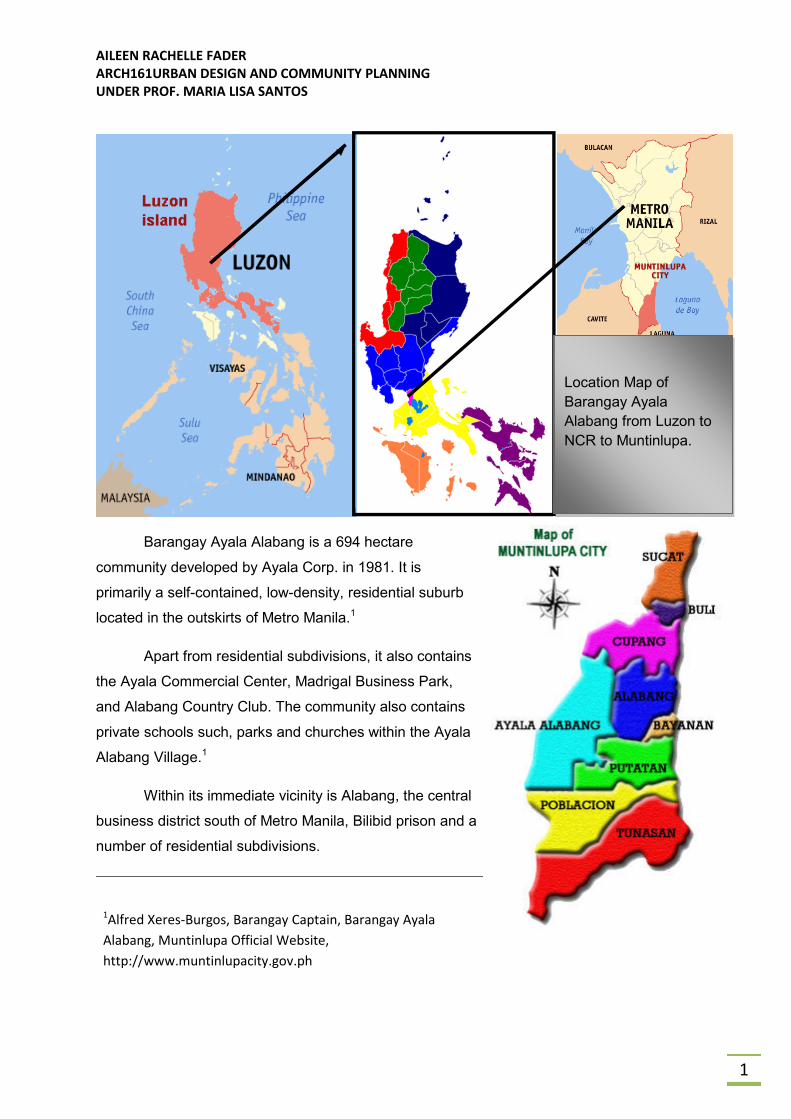
Barangay Ayala Alabang is a 694 hectare
community developed by Ayala Corp. in 1981. It is
primarily a self-contained, low-density, residential suburb
located in the outskirts of Metro Manila.1
Apart from residential subdivisions, it also contains
the Ayala Commercial Center, Madrigal Business Park,
and Alabang Country Club. The community also contains
private schools such, parks and churches within the Ayala
Alabang Village.1
Within its immediate vicinity is Alabang, the central
business district south of Metro Manila, Bilibid prison and a
number of residential subdivisions.
1Alfred Xeres-Burgos, Barangay Captain, Barangay Ayala
Alabang, Muntinlupa Official Website,
http://www.muntinlupacity.gov.ph
Location Map of
Barangay Ayala
Alabang from Luzon to
NCR to Muntinlupa.
AILEEN RACHELLE FADER
ARCH161URBAN DESIGN AND COMMUNITY PLANNING
UNDER PROF. MARIA LISA SANTOS
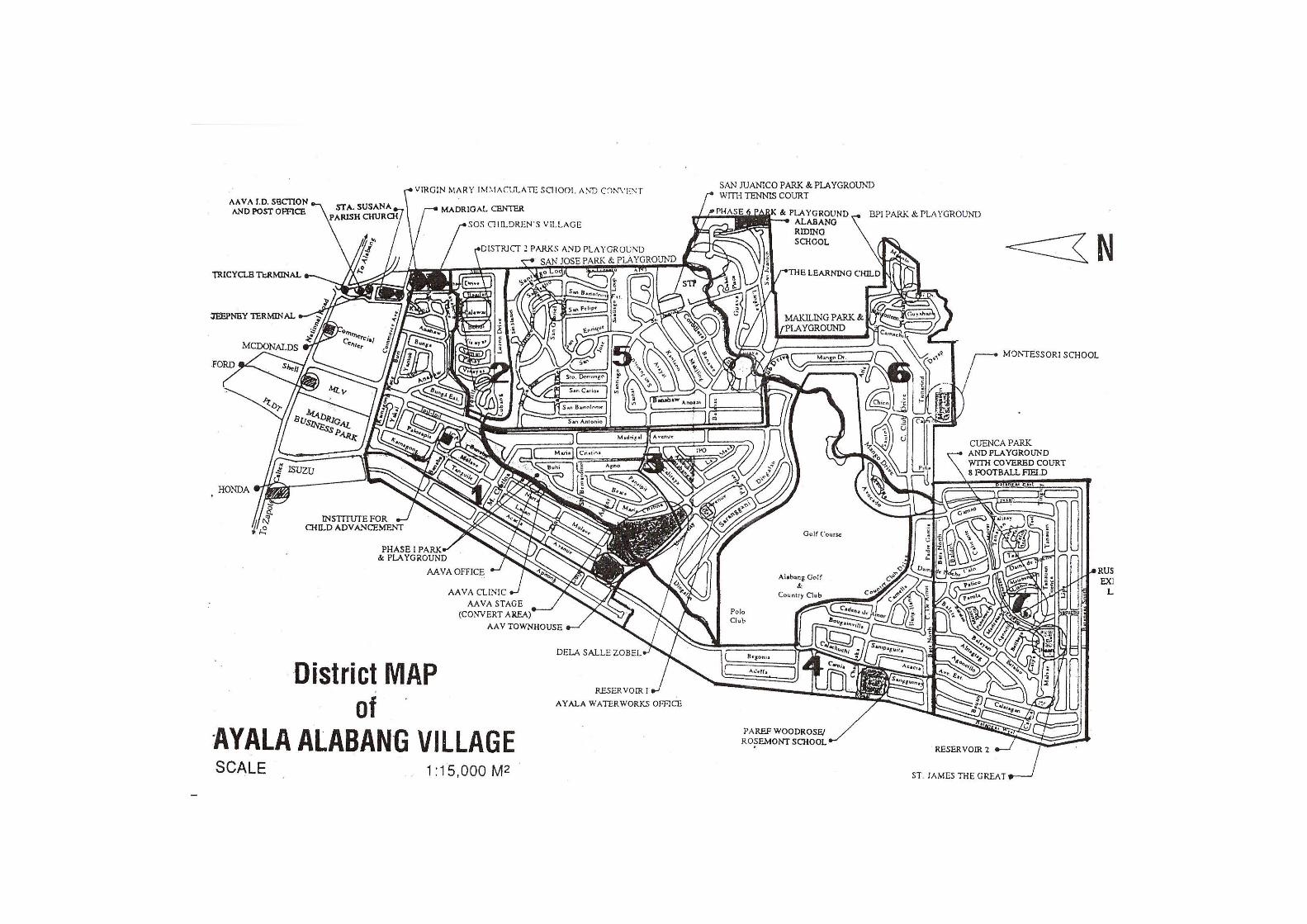
2
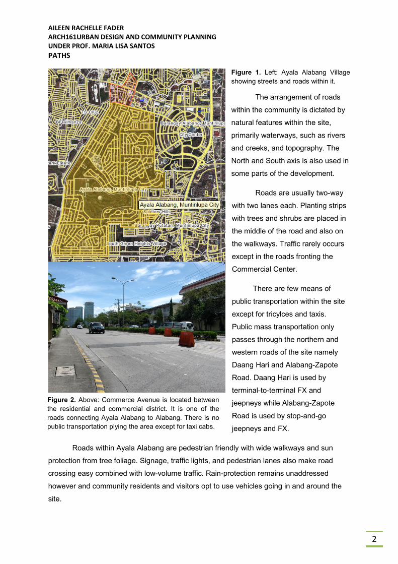
PATHS
Figure 1. Left: Ayala Alabang Village
showing streets and roads within it.
The arrangement of roads
within the community is dictated by
natural features within the site,
primarily waterways, such as rivers
and creeks, and topography. The
North and South axis is also used in
some parts of the development.
Roads are usually two-way
with two lanes each. Planting strips
with trees and shrubs are placed in
the middle of the road and also on
the walkways. Traffic rarely occurs
except in the roads fronting the
Commercial Center.
There are few means of
public transportation within the site
except for tricylces and taxis.
Public mass transportation only
passes through the northern and
western roads of the site namely
Daang Hari and Alabang-Zapote
Road. Daang Hari is used by
terminal-to-terminal FX and
jeepneys while Alabang-Zapote
Road is used by stop-and-go
jeepneys and FX.
Roads within Ayala Alabang are pedestrian friendly with wide walkways and sun
protection from tree foliage. Signage, traffic lights, and pedestrian lanes also make road
crossing easy combined with low-volume traffic. Rain-protection remains unaddressed
however and community residents and visitors opt to use vehicles going in and around the
site.
Figure 2. Above: Commerce Avenue is located between
the residential and commercial district. It is one of the
roads connecting Ayala Alabang to Alabang. There is no
public transportation plying the area except for taxi cabs.
AILEEN RACHELLE FADER
ARCH161URBAN DESIGN AND COMMUNITY PLANNING
UNDER PROF. MARIA LISA SANTOS
4
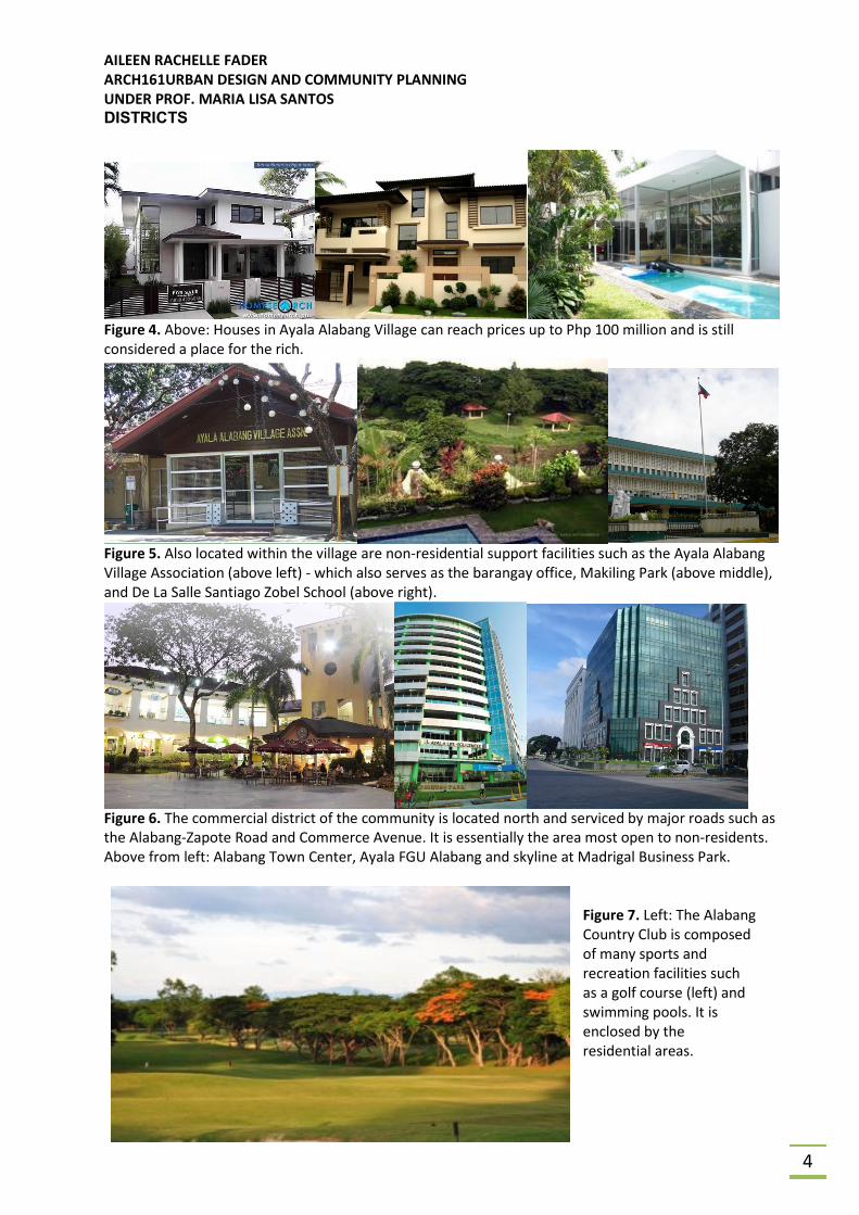
DISTRICTS
Figure 4. Above: Houses in Ayala Alabang Village can reach prices up to Php 100 million and is still
considered a place for the rich.
Figure 5. Also located within the village are non-residential support facilities such as the Ayala Alabang
Village Association (above left) - which also serves as the barangay office, Makiling Park (above middle),
and De La Salle Santiago Zobel School (above right).
Figure 6. The commercial district of the community is located north and serviced by major roads such as
the Alabang-Zapote Road and Commerce Avenue. It is essentially the area most open to non-residents.
Above from left: Alabang Town Center, Ayala FGU Alabang and skyline at Madrigal Business Park.
Figure 7. Left: The Alabang
Country Club is composed
of many sports and
recreation facilities such
as a golf course (left) and
swimming pools. It is
enclosed by the
residential areas.
AILEEN RACHELLE FADER
ARCH161URBAN DESIGN AND COMMUNITY PLANNING
UNDER PROF. MARIA LISA SANTOS
5
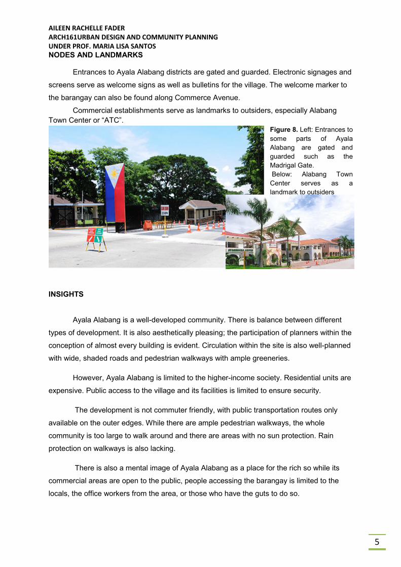
NODES AND LANDMARKS
Entrances to Ayala Alabang districts are gated and guarded. Electronic signages and
screens serve as welcome signs as well as bulletins for the village. The welcome marker to
the barangay can also be found along Commerce Avenue.
Commercial establishments serve as landmarks to outsiders, especially Alabang
Town Center or “ATC”.
Figure 8. Left: Entrances to
some parts of Ayala
Alabang are gated and
guarded such as the
Madrigal Gate.
Below: Alabang Town
Center serves as a
landmark to outsiders
INSIGHTS
Ayala Alabang is a well-developed community. There is balance between different
types of development. It is also aesthetically pleasing; the participation of planners within the
conception of almost every building is evident. Circulation within the site is also well-planned
with wide, shaded roads and pedestrian walkways with ample greeneries.
However, Ayala Alabang is limited to the higher-income society. Residential units are
expensive. Public access to the village and its facilities is limited to ensure security.
The development is not commuter friendly, with public transportation routes only
available on the outer edges. While there are ample pedestrian walkways, the whole
community is too large to walk around and there are areas with no sun protection. Rain
protection on walkways is also lacking.
There is also a mental image of Ayala Alabang as a place for the rich so while its
commercial areas are open to the public, people accessing the barangay is limited to the
locals, the office workers from the area, or those who have the guts to do so.
AILEEN RACHELLE FADER
ARCH161URBAN DESIGN AND COMMUNITY PLANNING
UNDER PROF. MARIA LISA SANTOS
3
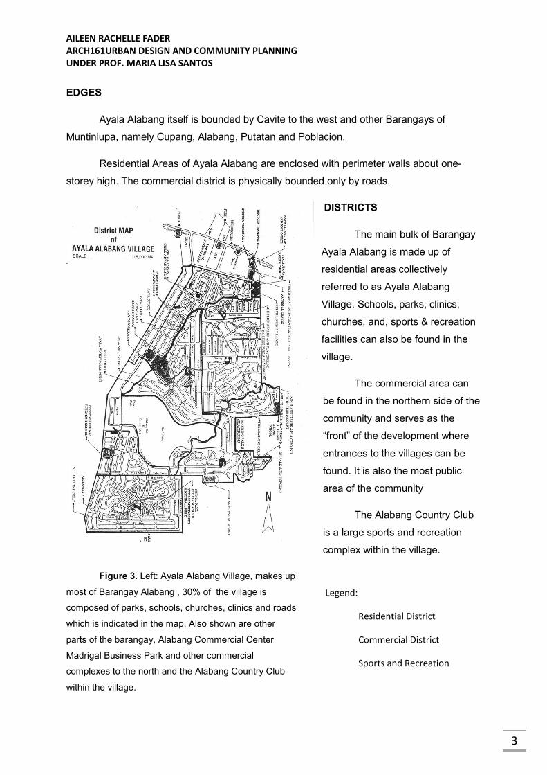
EDGES
Ayala Alabang itself is bounded by Cavite to the west and other Barangays of
Muntinlupa, namely Cupang, Alabang, Putatan and Poblacion.
Residential Areas of Ayala Alabang are enclosed with perimeter walls about one-
storey high. The commercial district is physically bounded only by roads.
DISTRICTS
The main bulk of Barangay
Ayala Alabang is made up of
residential areas collectively
referred to as Ayala Alabang
Village. Schools, parks, clinics,
churches, and, sports & recreation
facilities can also be found in the
village.
The commercial area can
be found in the northern side of the
community and serves as the
“front” of the development where
entrances to the villages can be
found. It is also the most public
area of the community
The Alabang Country Club
is a large sports and recreation
complex within the village.
Figure 3. Left: Ayala Alabang Village, makes up
most of Barangay Alabang , 30% of the village is
composed of parks, schools, churches, clinics and roads
which is indicated in the map. Also shown are other
parts of the barangay, Alabang Commercial Center
Madrigal Business Park and other commercial
complexes to the north and the Alabang Country Club
within the village.
Legend:
Residential District
Commercial District
Sports and Recreation
AILEEN RACHELLE FADER
ARCH161URBAN DESIGN AND COMMUNITY PLANNING
UNDER PROF. MARIA LISA SANTOS
6
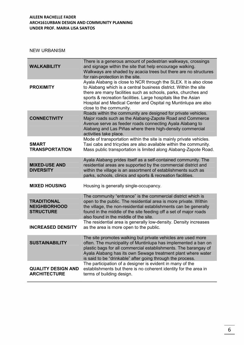
NEW URBANISM
WALKABILITY
There is a generous amount of pedestrian walkways, crossings and signage within the site that help encourage walking. Walkways are shaded by acacia trees but there are no structures for rain-protection in the site.
PROXIMITY
Ayala Alabang is close to NCR through the SLEX. It is also close to Alabang which is a central business district. Within the site there are many facilities such as schools, parks, churches and sports & recreation facilities. Large hospitals like the Asian Hospital and Medical Center and Ospital ng Muntinlupa are also close to the community.
CONNECTIVITY
Roads within the community are designed for private vehicles. Major roads such as the Alabang-Zapote Road and Commerce Avenue serve as feeder roads connecting Ayala Alabang to Alabang and Las Piñas where there high-density commercial activities take place.
SMART TRANSPORTATION
Mode of transportation within the site is mainly private vehicles. Taxi cabs and tricycles are also available within the community. Mass public transportation is limited along Alabang-Zapote Road.
MIXED-USE AND DIVERSITY
Ayala Alabang prides itself as a self-contained community. The residential areas are supported by the commercial district and within the village is an assortment of establishments such as parks, schools, clinics and sports & recreation facilities.
MIXED HOUSING
Housing is generally single-occupancy.
TRADITIONAL NEIGHBORHOOD STRUCTURE
The community “entrance” is the commercial district which is open to the public. The residential area is more private. Within the village, the non-residential establishments can be generally found in the middle of the site feeding off a set of major roads also found in the middle of the site.
INCREASED DENSITY
The residential area is generally low-density. Density increases as the area is more open to the public.
SUSTAINABILITY
The site promotes walking but private vehicles are used more often. The municipality of Muntinlupa has implemented a ban on plastic bags for all commercial establishments. The barangay of Ayala Alabang has its own Sewage treatment plant where water is said to be “drinkable” after going through the process.
QUALITY DESIGN AND ARCHITECTURE
The participation of a designer is evident in many of the establishments but there is no coherent identity for the area in terms of building design.
AILEEN RACHELLE FADER
ARCH161URBAN DESIGN AND COMMUNITY PLANNING
UNDER PROF. MARIA LISA SANTOS
7
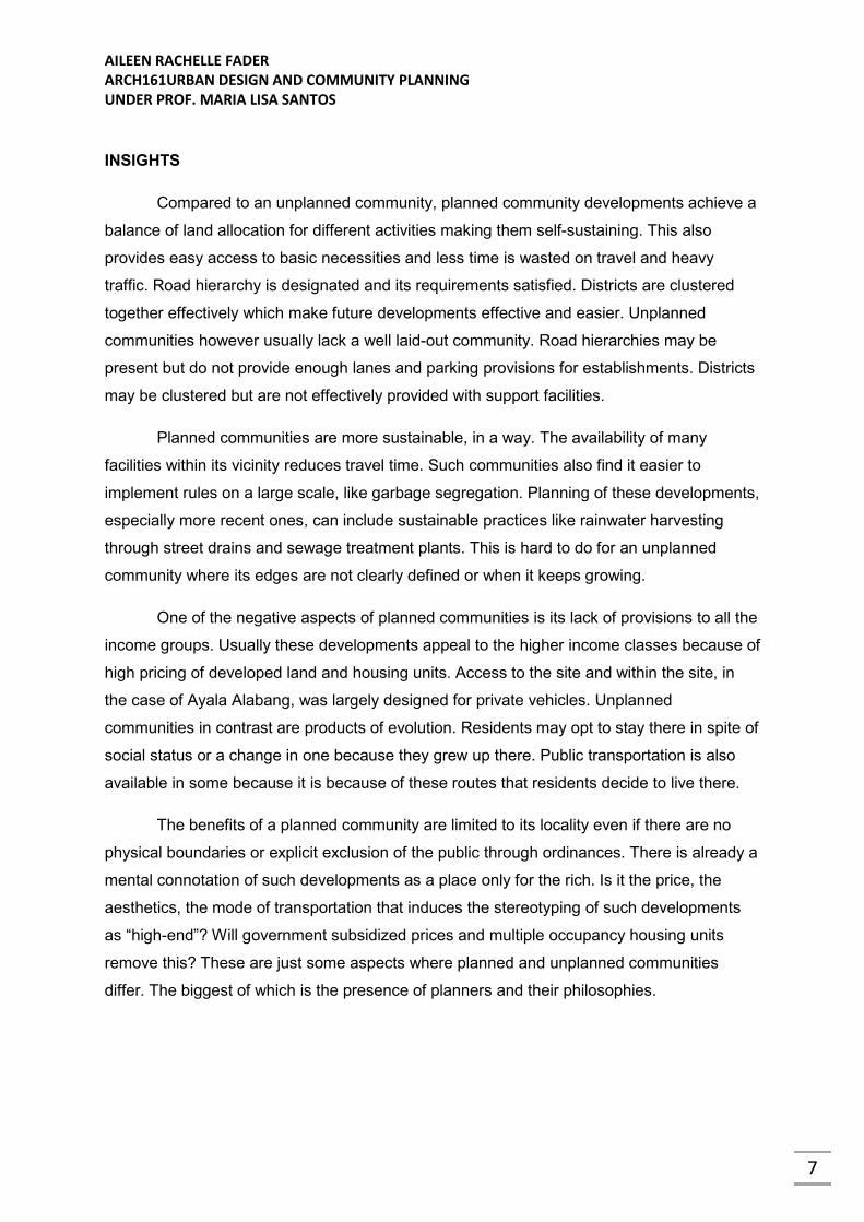
INSIGHTS
Compared to an unplanned community, planned community developments achieve a
balance of land allocation for different activities making them self-sustaining. This also
provides easy access to basic necessities and less time is wasted on travel and heavy
traffic. Road hierarchy is designated and its requirements satisfied. Districts are clustered
together effectively which make future developments effective and easier. Unplanned
communities however usually lack a well laid-out community. Road hierarchies may be
present but do not provide enough lanes and parking provisions for establishments. Districts
may be clustered but are not effectively provided with support facilities.
Planned communities are more sustainable, in a way. The availability of many
facilities within its vicinity reduces travel time. Such communities also find it easier to
implement rules on a large scale, like garbage segregation. Planning of these developments,
especially more recent ones, can include sustainable practices like rainwater harvesting
through street drains and sewage treatment plants. This is hard to do for an unplanned
community where its edges are not clearly defined or when it keeps growing.
One of the negative aspects of planned communities is its lack of provisions to all the
income groups. Usually these developments appeal to the higher income classes because of
high pricing of developed land and housing units. Access to the site and within the site, in
the case of Ayala Alabang, was largely designed for private vehicles. Unplanned
communities in contrast are products of evolution. Residents may opt to stay there in spite of
social status or a change in one because they grew up there. Public transportation is also
available in some because it is because of these routes that residents decide to live there.
The benefits of a planned community are limited to its locality even if there are no
physical boundaries or explicit exclusion of the public through ordinances. There is already a
mental connotation of such developments as a place only for the rich. Is it the price, the
aesthetics, the mode of transportation that induces the stereotyping of such developments
as “high-end”? Will government subsidized prices and multiple occupancy housing units
remove this? These are just some aspects where planned and unplanned communities
differ. The biggest of which is the presence of planners and their philosophies.