AL BADHAN-AL FAR' A-TUBAS ROAD ENVIRONMENTAL ASSESSMENT ApE 05
30
AL BADHAN-AL FAR' A-TUBAS ROAD ENVIRONMENTAL ASSESSMENT ApE 05--/37 WB6- .RDl> Palestinian National Authority Ministry of Public Works The United States Agency For International Development West Bank and Gaza Mission Prepared by: In association with: MWH JUNE 2005 CH2MHILl
Transcript of AL BADHAN-AL FAR' A-TUBAS ROAD ENVIRONMENTAL ASSESSMENT ApE 05

AL BADHAN-AL FAR' A-TUBAS ROADENVIRONMENTAL ASSESSMENT
ApE 05--/37 WB6- .RDl>
PalestinianNational Authority
Ministry of Public Works
The United States AgencyFor International Development
West Bank and Gaza Mission
Prepared by: In association with:
MWH
JUNE 2005
CH2MHILl

TABLE OF CONTENTS
EXECUTIVE SUMMARY
1. INTRODUCTION 11.1 Objectives and Scope of Work 11.2 Environmental Assessment Requirements and Procedures I1.3 Scoping and Approach to the Environmental Assessment 21.4 Key Issues and Issues Eliminated From Further Study 3
2. PURPOSE AND NEED 4
3. ALTERNATIVES INCLUDING THE PROPOSED ACTION 73.1 Proposed Action 73.2 Alternative 1 - Resurface Only 73.3 No-action Alternative 7
4. AFFECTED ENVIRONMENT 94.1 Field Study ., 94.2 Water Resources 94.3 Cultural Resources 114.4 Natural Areas and Wildlife Habitat 124.5 Health and Safety 134.6 Traffic 134.7 Solid Waste Managemeot 13
5. ENVIRONMENTAL CONSEQUENCES 155.1 Water Resources 155.2 Cultural Resources 165.3 Natural Areas and Wildlife Habitat 165.4 Health and Safety """"""""""""""""""""""""""" 175.5 Traffic 185.6 Solid Waste Management 185.7 Cumulative Effects 195.8 Irreversible and Irretrievable Commitment of Resources 20
6. MITIGA nON & MONITORING PLAN 21
~- CONCLUSION 23
8. CONSULTATIONS AND LIST OF PREPARERS 24
9. REFERENCES 25
LIST OF FIGURESFigure 1 Project Area
APPENDIXAppendix Environmental Scoping Statement

EXECUTIVE SUMMARY
ES-l Introduction
To support the people of the West Bank and the Palestinian National Authority, and to improvethe condition of roads in selected locations, the United States Agency for InternationalDevelopment ("USAID") has proposed to fmance the rehabilitation, reconstruction, andresurfacing of the AI Badhan-AI Far'a-Tubas Road located in the Nablus and TubasGovernorates. During discussion of priority projects with USAID, the Ministry of Public Worksand Housing, Ministry of Local Government, and the Ministry of Planning identified this projeclas a priority project.
This Environmental Assessment (EA) was conducted between May 2005 and June 2005, todetermine the reasonably foreseeable significant social and environmental effects. both beneficialand adverse. that the Proposed Project and the alternatives could be expected to have during andafter construction. The EA is intended to provide the decision makers with a comparison of theimpacts of each alternative in order to allow them to make an informed decision as to which. ifany, alternative to construct. The assessment includes discussions of efforts to avoid or minimizethe adverse effects and methods to maximize the positive effects.
Before an environmental analysis begins, the agency detennines the appropriate level of study toidentify issues and concerns that will be the focus of the assessment effort. Project scopingaccomplishes this through early coordination with interested and impacted agencies, stakeholdersand the public. The Scoping Session and other individual meetings required under USAIDguidelines provide the fIrSt opportunities to present views regarding potential project impacts.These views, together with the requirements of EQA and USAID regulations, are the basis fordevelopment of the EA.
The project team held a Scoping Session in Al Far'a on June 1,2005. The meeting covered abroad range of topics including project design, construction issues, environmental concernsfocusing on solid waste management, and scope of work for the EA. During the meeting specialemphasis was placed on the solid waste management problem along the road. The Governor ofJenin spoke on the subject, in addition to a representative from the Joint Services Council forSolid Waste Management Comments and questions from the public focused primarily on theroad design (drainage, lights, guardrails, road width, and other design issues) although there wasconcern over whether private property would be affected, and questions on the management onsolid waste.
Key IssuesThe environmental team carefully reviewed comments received from the public, stakeholders, andgovernmental agencies and determined that the following issues are relevant to the decisions thatmust be made for this project: health and safety, traffic, water resources, cultural resources, solidwaste management, and natural areas and wildlife habitat.
ES-Table 1: Key Issues Considered in this Environmental Assessment
Issue
I Traffic
I Reason for Consideration in the EAExisting road is unsafe; it is dangerously narrow in spots and visibility deficiencies are amajor concern. Removal of the large volumes of trash/debris from the road and the WadiAl Far'a will improve public health. Protection of workers and the public duringconstruction is hi I si ificant.The road often has high volumes of commercial traffic and is a primary artery for the area.Construction ma im e traffic and . t local communtties.
ES-

I Issue I Reason for Consideration in the EA---
Water Resources-00
TheAI Far'a spring flows into the Wadi AI Far'a one of only four wadis in the West Bankthat have permanent flow year around. Any contamination or damage to the AI Far'a spring~~tream durin,~ constrnction could have seri~pacts on the community.
CUltural Resotlrces--
Two archaeological SIteS have been identified in close proximity to the road; Tel AI Far'aan ancient settlement from th~ 7th millennium, and a 15th century water mill.As part of the project large volumes of trash/debris will be removed from the road and fromthe Wadi Al Far'a. The illegal dumping occurring along the roadside is a major healthconcern. Efforts should be made by the local communities to maintain the clean conditionof the road and wadi a~theproiect is complete. ---
Solid WasteManagement
Natural Areas andWildlife Habitat
A section of the Wadi AI Far'a, the AI Far'a East, near the road is listed at an EcologicallyHighly Significant Area. While this area is highly polluted with waste/debris and containsother signs of chronic and severe disturbance, potential impacts to this sensitive area fromimolementation of the t)roje~ t~ be assessed.
Project Need
Improvement of AI Badhan-AI Far' a-Tubas Road will include widening, reconstruction, andresurfacing of approximately 7 kin of existing road. The primary purpose of this project is toimprove the transportation network in the region, improve the level of service of the road, and toreduce the potential for accidents due to the poor condition of the road and the outdated design ofthe existing route. Much of this 7 km segment is in disrepair and in places the road is dangerouslynarrow with sharp bends that make it difficult to see oncoming traffic. Currently, no guardrailsexist to protect travelers from the steep drop into the Wadi AI Far'a. The narrow lanes, lack ofshoulders, limited sight distance, sharp curves, and steep grades are major safety concerns for thisroute.
The road is a primary artery for the area, and therefore improvement is a high priority. It servesall commercial traffic traveling from Jericho and Nablus connecting to Tubas, Jenin, Qalqilya andTulkarem Districts. Recently this section of highway has become the main route due to closure ofthe Nablus-Al Badhan Road (Highway 57)
Proposed Action
Improvement of Al Badhan-AI Far'a-Tubas Road will include widening, reconstruction, andresurfacing of approximately 7 km of existing road to improve safety and level of service. Trafficsignage, safety markings, sidewalks, lane marking, repair of existing stonewalls, and drainageimprovements will be provided Major widening and realignment of a narrow gorge section of AlBadhan will be performed by lowering the existing road by 5m depth and removing the existingstonewall structure. The excavated material will be reused to construct the new alignment. Inplaces it will be necessary to remove rock from the hillside to improve visibility. Constructionwill occur within the existing right-of-way and will not divert from the existing road. Privateproperty will not be required.
In conjunction with the road improvements, the Al Far'a stream will be cleaned of the largevolumes of garbage currently being dumped over the road edge. A new guardrail will be installedalong the new road alignment to improve safety and discourage future dumping.
Alternatives Considered
Alternative I - Resurface Onlv
Under this alternative the road will be resurfaced and guardrails placed in particularly narrowareas for safety. Although the surface will be in1proved, the road will not be widened and the
ES-2

current dangerously narrow lanes will remain unchanged. Limited visibility will continue to be asafety concern. Under this alternative, the trash/debris will be removed from the area.
No-action Alternative
Under the No-action Alternative there will be no improvement to the road. The road will continueto deteriorate and be characterized by unsafe narrow lanes and poor visibility. The large volwnesof trash and debris will remain, creating a degraded environment and contributing to the pollutionof the stream.
Environmental Consequences
The sensitive cultural and natural resources in the study area were inventoried during fieldinvestigations and through literature review and are discussed at length in Section 4. During initialfield visits and project investigation, it was found that there was potential for significant impactsresulting from construction activities to the Al Far'a spring and downstream waters, the Wadi AlFar'a East (a significant natural area) and to two significant cultural resources, the Tel AI Far'aand a 15m century watermill. Section 5 discusses in detail the potential impacts to these resourcesfrom implementation of the Proposed Action or the alternatives. It has been determined that therewill be no impacts to the sensitive environmental and cultural resources in the area fromimplementation of the Proposed Action as long as the mitigation measures listed in Section 6 arestrictly adhered to.
Conclusion
This Environmental Assessment concludes that the Proposed Action is necessary to meet theproject needs of improving the regional transportation network, improving level of service, andimproving safety on Al Badhan-Al Far'a- Tubas Road. This action will also improve the naturaland human environment by the removal of the trash/debris illegally dumped along the road. TheProposed Action will have no significant adverse social, economic, or environmental impacts atlevels that would warrant an Environmental Impact Statement as long as Palestinian engineeringpractices, codes, and regulations are adhered to, and mitigation measures are implemented duringconstruction. Unless significant impacts are identified as a result of agency review, this processwill require no further environmental analysis.
ES-3

IntroductionAI Badhan-AI Far'a-Tubas Road Improvement
SECTION 1
Introduction
To support the people of the West Bank and the Palestinian National Authority, and to improvethe condition of roads in selected locations, the United States Agency for InternationalDevelopment ("USAID") bas proposed to finance the rehabilitation. reconstruction. andresurfacing of the AI Badhan-Ai Far'a-Tubas Road located in the Nablus and TubasGovernorates. During discussion of priority projects with USAlD, the Ministry of Public Worksand Housing, Ministry of Local Government, and the Ministry of Planning identified this projectas a priority project.
Objectives and Scope of Work1.1
The Donor community has combined efforts for an assessment of damage in the West Bank andGaza since March I, 200 I. This group developed a report of priority projects for each sector andgeographic area. After reviewing this report, the USAID West Bank and Gaza Mission decided tofocus its response to road rehabilitation projects. This program, Priority Roads Phase 3 Program,includes the rehabilitation and reconstruction of seven priority roads, identified during discussionswith the Ministry of Public Works and Housing, Ministry of Local Government, and the Ministryof Planning. This program is designed to rehabilitate the priority roads damaged by militaryincursions and lack of maintenance, to bring tangible benefits to the Palestinian people, provide aboost to the Palestinian economy, and strengthen the municipal transportation infrastructure. AnInitial Environmental Evaluation (lEE) was completed for the seven priority roads. Based on theresults of background research and field studies, the lEE recommended further evaluation and anEnVironmental Assessment (EA) for Al Badhan-AI Far'a- Tubas Road.
The purpose of this EA is to evaluate the project impacts according to USAID and Palestinianenvironmental guidelines, and to identify mitigation measures and monitoring requirements where
appropriate.
~nvironmental Assessment Requirements and Procedures1.2
Projects supported by U.S. government funds are subject to U.S. as well as local environmentalregulations. Under both Palestinian and U.S. law, projects that require construction can requirepreparation of an EA or Environmentallmpact Assessment (E1A), once a fonnal agencydetermines whether a proposed agency action may have a significant environmental impact. Thisreport was prepared in accordance with USAID environmental procedures found in 22 Code ofFederal Regulation (CFR) Part 216. Table 1 presents a summary of these procedures.

AI Badhan-AI Far'a- Tubas Road Improvement Introduction
Description of Procedure RemarksUSAW Procedure
Scope ofEA or EIS Identification of significant action issues anddetermination of issues to be addressed in EAor Environmental Impact Swdy (EIS). Basedon consultations with experts, public andprivate a~encies and host gov_~ents
Written Scoping Statementcovering key issues and scopefor EA or EIS submitted forreview and approval by BureauEnvironmental Officer (SEa)
Preparation ofEA orEIS
Report is prepared for reviewand approval ofBEO.
Monitoring andMitigation
EA or EIS includes a monitoringprogram that specifiesresponsibilities and reporting.The present EA will incorporateconstruction mitigationmeasures into project biddocuments. ---
Revisions In the case of major changes in the scope ofwork or nature of the project during itsimplementation, the Negative Declaration, EAor EIS will be reviewed and the aboveprocedures will be carried out -~~--- --
Supplements to the EA or EISwill be required and BEDreview and approval is required
Palestinian environmental policies are outlined in "The Palestinian Environmental AssessmentPolicy" (2000) and are under the jurisdiction of the Environmental Quality Authority (EQA).Palestinian environmental policy defmes types of projects likely to have environmental effects.Annex I to the policy lists 14 types of proposed projects for which an Environmental ImpactAssessment (EIA) is mandatory. According to the Annex, extensions to these projects should bescreened for the need for an EIA. This EA has been prepared to atteDlpt to respond to bothPalestinian and USAID environmental policies. For this project, the Palestinian EnvironmentalQuality Authority (EQA) participated in the Scoping Meeting and was provided a copy of theScoping StateDlent.
1.3 Scoping and Approach to the Environmental Assessment
Before an environmental analysis begins, the agency determines the appropriate level of study toidentify issues and concerns that will be the focus of the assessment effort. Project scopingaccomplishes this through early coordination with interested and impacted agencies, stakeholdersand the public. The Scoping Session and other individual meetings required under USAIDguidelines provide the first opportunities to present views regarding potential project impacts.These views, together with the requirements of EQA and USAID regulations, are the basis fordevelopment of the EA.
The project team held a Scoping Session in Al Far'a on June 1,2005. The meeting covered abroad range of topics including project design. construction issues, environmental concernsfocusing on solid waste management, and scope of work for the EA.
Sixty-nine people attended the meeting. Residents of Al Far'a Camp, Tubas, Tammun, AI Far'aVillage, Al Badhan, Aqrabaniya, Nablus, Yassed. Jenin, and Talluza were present. The followingagencies, localities, or groups were represented at the meeting. A list of attendees and theMeeting Minutes is provided in the appendix.

AI Badhan-AI Far'a- Tubas Road Improvement Introduction
Governor of JeninPalestinian Environmental Quality AuthorityAI Aqrabaniya Local CouncilAI Far'a Local CouncilTubas Local CouncilAI Far'a CampYassed Local CouncilTammun Local CouncilTalluza Local CouncilMinistry of IrrigationMinistry of Public Works and HousingMinistry of TransportationMinistry of Local GovernmentTubas MunicipalityFar'a Youth CenterJoint Services CouncilAI Najah UniversityBirzeit University
During the meeting special emphasis was placed on the solid waste management problem alongthe road. The Governor of Jenin spoke on the subject, in addition to a representative from theJoint Services Council for Solid Waste Management.
Comments and questions from the public focused primarily on the road design (drainage, lights,guardrails, road width, and other design issues) although there was concern over whether privateproperty would be affected, and questions on the management on solid waste. In addition, therewere requests to extend the scope of the project to include additional roads. During the meeting itwas stressed that the project would be contained within the existing right-of-way and would notdeviate from the existing alignment, and that private land would not be required. The commentsand questions were addressed right away during the meeting. The comments and questions fromthe meeting are provided in the appendix.
The environmental team developed a list of significant issues based on the results of the ScopingSession and consultations with governmental agencies. The EA team, in consultation withUSAID and EQA, developed the proposed approach for evaluation of significant issues and theEA outline. A Scoping Statement that incorporates these results was subsequently reviewed andapproved by USAID.
1.4 Key Issues and Issues Eliminated From Further Study
The environmental team carefully reviewed comments received from the public, stakeholders, andgovernmental agencies and determined that the following issues are relevant to the decisions thatmust be made for this project: health and safety; traffic; water resources; cultural resources; solidwaste management; and natural areas and wildlife habitat.
The following environmental, social, and land use parameters: threatened and endangered species;land use; seismic, geology and soils; construction site debris; noise; and air quality were notidentified as a project-specific issue or concern by the environmental team and therefore are notcovered in detail in this document. Although not considered to be a major issue requiring adetailed analysis of effects, each topic was still carefully considered during the scoping process.The appendix contains the Environmental Scoping Statement which provides discussion of theissues that are, and that are not, considered significant.
,

AI Badhan-AI Far'a- Tubas Road Improvement Purpose and Need
SECTION 2
Purpose and Need
2.1 Need for the Proposed Project
Improvement of Al Badhan-AI Far'a- Tubas Road will include widening, reconstruction, andresurfacing of approximately 7 kin of existing road. The primary purpose of this project is toimprove the transportation network in the region, improve the level of service of the road. andto reduce the potential for accidents due to the poor condition of the road and the outdateddesign of the existing route. Much of this 7 kin segment is in disrepair and is characterized bysubstandard vertical/horizontal geometrics. In places the road is dangerously narrow withsharp bends that make it difficult to see oncoming traffic. Currently, no guardrails exist toprotect travelers from the steep drop into the Wadi AI Far'a. The narrow lanes, lack ofshoulders, limited sight distance, sharp curves, and steep grades are major safety concerns forthis route. Photo I shows the road's narrow width and dangerous curves.
Photo 1: Al Badhan-AI Far'a-Tubas Road
4

Al Badhan-AI Far'a- Tubas Road Improvement Purpose and Need
The road is a primary artery for the area. and therefore improvement is a high priority. Itserves all commercial traffic traveling from Jericho and Nablus connecting to Tubas, Jenin,Qalqilya and Tulkarem Districts. Recently this section of highway has become the main routedue to closure of the Nablus-Al Badhan Road (Highway 57). The population of the nearbycommunities and projected growth rates is provided in Table 2. The road serves over150,000 residents from the nearby towns and communities; and serves a proportionally higherpopulation when one considers that it serves the commercial traffic for the Tubas, Jenin,Qalquilya, and Tulkarem Districts. The population is expected to consistently increasethroughout the area, and is predicted to more than double by the year 2020. Photo 2 showsthe high volumes of traffic that are often present on the road today. Currently, heavytruck/tractor and bus traffic make up a considerable percentage of the traffic on the road.
Table 2: Population of Communities in the Project region*
*Source: Wilber Smith AssocilZtes. 1991. Nllblus-JeninHigh_y En"ironmentlll Assessment**ForecllSt by PCBS*** Extrilpoillted bllSed on 1997-2010 growth Nltes+ All number beyond 1997 extrapolated based on constant regional
growth rate.
Photo 2: High volumes of traffic on Al Badhan-AI Far'a-Tubas Road
,

AI Badhan-AI Far'a-Tubas Road Improvement Purpose and Need
The road system plays an important role in the socio-economic character of an area. Clearly,the AI Badhan-AI Far'a-Tubas Road is very important for commerce flow in the area and animproved level of service and safety will promote economic development and developmentopportunities in the surrounding communities. The area is agriculturally oriented focusing oncrop production, fruits, and vegetables. Improvement of the road will make it easier forfarmers to transport crops, produce, and other agricultural products to markets. Improvedaccess will be provided for other goods and services.
Before the military incursions, the tourism industry was well-developed in the Al Badhan areawith tourists visiting during the spring and summer to enjoy the restaurants, the local parks,and the swimming pools built around the area's natural springs. Tourism in AI Badhan hasdeclined significantly with the military incursions and road closures of the past five years. Itis expected that this project will stimulate tourism in the area by providing an improved andsafer transportation network. Furthermore, the area will be made more pleasant to touristsand local residents by the removal of the unsightly and unsafe volume of trash and debris thatare currently being dumped from the road.
6

Alternatives Including the Proposed ActionAl Badhan-AI Far'a- Tubas Road Improvement
SECTION 3
Alternatives Including the Proposed Action
3.1 Proposed Action
The project is located in the northern West Bank area south of Tubas and north of Nablus, withinthe Tubas and Nablus Governorates. Specifically, improvements will begin at the Al MalaqiBridge in the Nablus District and will continue north through the AI Far'a Refugee Camp up tothe Tammun intersection in the Tubas District. Figure I shows the location of the project.
Improvement of Al Badhan-AI Far'a- Tubas Road will include widening, reconstruction, andresurfacing of approximately 7 km of existing road to improve safety and level of service. Therehabilitation work will include excavation of the damaged road, then relaying with a pulverizinglayer and two layers of base material and resurfacing with a 1m wide asphalt concrete pavementwith 1cm of wearing course. The asphalt and macadam layers on the existing road will beremoved and reused as a sub base. Traffic signage, safety markings, sidewalks, lane marking,repair of existing stonewalls, and drainage improvements will be provided. Major widening andrealignment of a narrow gorge section of AI Badhan will be performed by lowering the existingroad by 5m depth and removing the existing stonewall structure. The excavated material will bereused to construct the new alignment. In places it will be necessary to remove rock from thehillside to improve visibility.
It is important to note that construction will occur within the existing right-of-way and will notdivert from the existing road. Private property will not be required.
In conjunction with the road improvements, the Al Far'a stream will be cleaned of the largevolumes of garbage currently being dumped over the road edge. A new guardrail will be installedalong the new road alignment to improve safety and discourage future dumping.
Two alternatives are under consideration for this project. These alternatives are discussed below
3.2 Alternative 1 - Resurface Only
Under this alternative the road will be resurfaced and guardrails placed in particularly narrowareas for safety. Although the surface will be improved. the road will not be widened and thecurrent dangerously narrow lanes will remain unchanged. Limited visibility will continue to be asafety concern. Under this alternative, the trash/debris will be removed from the area.
3.3 No-action Alternative
Under the No-action Alternative there will be no improvement to the road. The road will continueto deteriorate and be characterized by unsafe narrow lanes and poor visibility. The large volumesof trash and debris will remain, creating a degraded environment and contributing to the pollutionof the stream.

Al Badhan-Al Far'a- Tubas Road Improvement Alternatives Including dIe Proposed Action
Insert Figure 1 - Project Area
8

AI Badhan-AI Far'a-Tubas Road Improvement Affected Enviromnent
SECTION 4
Affected Environment
This chapter describes the present condition of the environment within the project area. Thekey issues generated through the scoping process define the general scope of theenvironmental concern for the project. This chapter forD1S the scientific and analytic basis forthe comparison of the alternatives.
4.1 Field Study
Field activities involved a site visit on May 15-16, 2005 by the project scientist, projectengineer, and by experts from Birzeit University (archaeologists, a botanist, wildlife biologist,and a geographer), to determine the need for an environmental assessment and to identifysignificant environmental issues that should be studied during the environmental assessmentprocess. The field activities focused on the potential archaeological resources including andsurrounding the proposed construction area, the presence of sensitive species or habitats, andsurrounding land uses. Additional information was gathered from the available literature andby conversations with the Palestinian Environmental Quality Authority and the Joint ServicesCouncil.
4.2 Water Resources
The AI Badhan-AI Far'a-Tubas Road is located in close proximity to the Wadi Al Far'a, oneof the main flood wadis in the West Bank with a watershed length of 20 kin. The Wadi AlFar'a descends east from Nablus to the Jordan River, eventually draining to the Dead Sea.Water in the Wadi Al Far'a is permanent, flowing year around. With a total discharge of 14.1MCM/yr, springs provide the baseflow component of the system, thus preventing the Wadi el-Far' a stream from drying up in the summer. The perennial spring system is supplied by acomplex of 14 springs, the most famous of which is the Al Far'a spring (Birzeit University-Calvin College Partnership 2003). The Wadi Al Far'a is characterized by hills and basins anda steep descent from the mountain ridges to the valley floor.
The Al Far'a spring is located next to the road in the Al Far'a Camp and is widely used forhuman consumption and irrigation. While this spring is the dominant feeding spring for theWadi Al Far'a, a second smaller spring, Daleib spring, is located a short distance south of theAI Far'a spring. Both springs are located in close proximity to the road; Figure 1 shows thelocations of the two springs. Recently a concrete structure has been constructed to cover andprotect the Al Far'a spring (Photo 3). Water from the Al Far'a spring is used for supplyingthe AI Far'a Refugee Camp and AI-Far'a village with domestic water. The rest of the waterflows in the Wadi Al Far'a and is used for irrigation. Another spring system, the AI Badhanspring system, is located northeast of Nablus and west of the project area. This spring systemincludes three main springs that drain to Wadi Al Badhan then to Wadi Al Far'a and are usedfor irrigation purposes.
Most Wadis are seasonal and flow only during the winter season during flood periods. TheWadi al Far'a is only one of four wadis that has pennanent flow year round (MOPIC 1998).It is important to note, however, that between the years 2000-2003 the spring did not flowduring the mid summer months. The cause of the drought was believed to be from lack ofrainfall and from an increase in water pumped from the surrounding wells lowering thegroundwater table (Birzeit University-Calvin College Partnership 2003).
9

AI Badhan-AI Far'a- Tubas Road Improvement Affected Environment
Photo 3: Protected AI Far'a Spring (structure on the left of photo)
The Wadi Al Far'a is part of the larger regional Dead Sea Rift Zone that has formednumerous horst and grabens that confine the surface water drainage system of the Wadi AlFar'a. In the West Bank, aquifer formations are part of three main basins: Western, Eastern,and North Eastern Basins, which form the Mountain Aquifer. The Wadi Al Far'a is containedwithin the Eastern Mountain Aquifer System (MOPIC 1998). Within the Eastern MountainSystem, the aquifer system feeding the Wadi Al Far'a is the Jenin Subseries which is made oflimestone and chalky limestone and is located in the north of the West Bank around the cityof Jenin; it is considered to be a good local aquifer (MOPIC 1998). This aquifer system alsofeeds the Nablus, Sabastiye, and Al Badban springs, and feeds the shallow groundwater wellsin the Jenin area.
Two primary factors contributing to the degradation of water quantity and quality includecontamination of wadis and inadequate protection of aquifer recharge areas. As part of theEmergency Natural Resources Protection Plan. MOPIC (1998) classified different areas basedon the degree of sensitivity to the pollution of groundwater aquifers. In order of greatestprotection to least these classifications are:
.
.
.
.
Highly SensitiveLocally Highly SensitiveSensitiveModerately SensitiveNot Sensitive
According to this plan, strips around the four pennanent wadis in the West Bank were drawn.These wadis are considered to be sensitive recharge areas although the area around the wadisis considered not sensitive. Because it is one of the four pennanent wadis, the Wadi Al Far'ais considered a Sensitive Recharge Area. The sensitivity is dependent on the fact thatdevelopment near the streams could cause deterioration of water quality (MOPIC 1998).
Many of the villages in the area have no sewer system. but instead rely on latrine pits orpumping to the Wadi AI Far'a for disposal of wastewater (Birzeit University-Calvin CollegePartnership 2003). Nablus-East, however, is the major pollution source for the water runninginto the Wadi AI Far'a system Nablus east-side untreated wastewater is discharged to Wadi
10

AI Badhan-AI Far'a-Tubas Road Improvement Affected Environmen
AI Sajour which meets and connects to the Wadi Al Hammam, in the Talluza area. Thewastewater then flows into Wadi Al Badhan towards the east aad discharges into Wadi AlFar'a polluting the downstream water.
Within the project area, a major environmental and health concern is the large volume oftrash/debris that is being dumped from the AI Badhao-AI Far'a Road into the Wadi Al Far'aand the Al Far'a stream. This issue is addressed herein in the section on Solid WasteManagement.
4.3 Cultural Resources
Human history in Palestine extends over a million years and contains a richness andcomplexity not found in other areas due to the fact that Palestine is a narrow land bridgebetween Africa and Asia over which peoples from north and south have moved continuously.The northern district of Palestine was important to the history of the region, serving as aneconomic and military corridor between Egypt (to the south) and Syria (to the north) for fourthousand years, from 3,000 B.C. until the Crusader period (1187 AD.).
As part of the Emergency Natural Resources Protection Plan, the Ministry of Planning andInternational Cooperation (MOPIC 1999) and the Ministry of Antiquities have developed alist of endangered cultural heritage sites in the West Bank that should be protected fromdevelopment. There are two sites listed as endangered cultural heritage sites within closeproximity to the road: Tel Al Far'a and Wadi Badhan-Wadi Far'a. The location of Tel AlFar'a was conf1ffi1ed during the field investigation. It is located in the Al Far'a refugee campon a steep hill next to the road. The AI Far'a spring is located at the foot of this hill. This siteis believed to be the biblical town ofTirzah (circa 5,000 BCE), and there is evidence that thefirst settlers arrived as early as the 7th millennium (De Vaux and Chambon 1993).
In the 3rd millennium, the city of Tel AI Far'a prospered and was fortified by a wall with astone rampart. Eventually the city became one of the most important Canaanite city statesaround which a new wall was built. Today an earthen wall from this settlement is located onthe edge of the Al Badhan-AI Far'a-Tubas Road. The city was destroyed and rebuilt severaltimes; it was later abandoned after the spread of epidemics from the Babylonian invasion ofthe 6th century BC (MOPIC 1999). This site has a high potential to be promoted for tourism(Birzeit University-Calvin College Partnership 2003).
A 15th century water mill located in the valley adjacent to the Al Badhan-AI Far'a roadupstream of the Al Malaqi bridge was also identified during the field investigation. Thiswater mill is located close to the Wadi Badhan-Wadi Far'a, a listed endangered culturalheritage site that is known for the many historic water mills and Roman caves that arecontained within the area (MOPIC 1999). Table 3 provides a summary of the archaeologicalresources in the project area; Figure I shows the locations of these sites.
Table 3: Archaeological Resources Within the Project Area
Name
Water Mill
I Site Location I Al!;e I Site ImnortanceSou~west of AI Far'a First settlers as Canaanite City:-i):eIieved to be theVillage; near the AI Far'a early as 7,000 biblical city ofTirzah. Listed as anSD~ BCE endan ered cultural herita~e site.Upstream of the AI Malaqi 15m-century. Wadi Badhan-Wadi AI-Far'a is listedBridge near Wadi Badhan. Likely used until as an endangered cultural heritage site.
I Wadi Far'a area. the 20th ceo .*'.Correspondence with Dr:~bduIfattah. BiIZeit UniversitY. Expert in Geography. Archaeology. and Cul~ Landscapes.-

Al Badhan-AI Far'a-Tubas Road Improvement Affected Environment
The remains of a Crusader castle are located approximately 0.5 kIn away in view of the road.This is well outside of the project boundaries.
4.4 Natural Areas and Wildlife Habitat
Natural areas and wildlife habitat includes native or naturalized plants and plant communitiesthat support native wildlife. The road improvements will be made to the existing road thathas already altered the natural environment. During the field survey. only weeds and commonplant species were observed along the existing road.
MOPIC (2000) developed an inventory of ecologically significant and sensitive areas in theWest Bank for the Emergency Natural Resources Protection Plan. Detemlination of a site asan ecologically sensitive area was based on the following criteria:
Exceptional habitat or biological communities presentAn ecosystem with limited representationUnusually high diversity of biological communities or speciesProvides a natural habitat for indigenous species that are rare or endangeredKey lynchpin or watershed with ramifications for adjacent areas.
The effort was aimed at classifying areas in the West Bank as Highly Significant, ModeratelySignificant, or Not Significant. Based on these criteria, a section of the Wadi Al Far'a, theWadi Al Far'a East, has been listed by MOPIC as an Ecologically Highly Significant Area,although it was observed during the field investigations for this project that it is polluted withwaste/debris and contains other signs of severe disturbance.
Al Far'a East (IN-6) is a 1,000 dunum site, located approximately 0.5 kIn southeast of the AlFar'a Camp between the Al Far'a Camp and the Al Malaqi Bridge. The area is located 100-200 m above sea level and receives approximately 450-500mm rainfall annually. The year-around flow of water from the Al-Far'a spring, and location at the periphery of the TammunNature Reserve allow this area to support numerous plants and animals that are rareelsewhere in the project region. The area is high in biodiversity because of its location on thetransitions between the Mediterranean territory and the Irano- Turanian territory. Several wildplant species grow here including Ceratonia siliqua, Crataegus aronia, Quercus cal/iprinos,Calycotome vil/osa, Retama raetam, Pistacia lentiscus, Ziziphus spina-christi and others.Furthermore, the continuously flowing Al Far'a stream creates a wetland environment thatsupports plant species adapted to such an environment contributing to the uniqueness of thearea.
Just southeast of the project limits, another section of the Wadi AI Far'a is also listed as anEcologically Highly Significant Area. This area begins near the Al Aqrabaniye village andfollows the AI Far'a stream downstream. While the AI Aqrabaniye site (N3) is ecologicallyimportant it is located outside of the boundaries for this project and will not be affected by theproject.
According to the study completed by Birzeit University-Calvin College Partnership (2003)the Wadi AI Far'a has suffered from vegetation degradation as a result of overgrazing, over-cutting of vegetation, polluted waters, and the take-over of non-indigenous species. Israelisettlements and military policies and procedures have also significantly impacted thebiological environment in the Wadi AI Far'a. The ecological integrity of the area is alsobeing significantly compromised by the current practice of dumping municipal trash over theroad and into the wadi.
12

AffectedEnvironmeJAI Badhan-AI Far'a-Tubas Road Improvement
4.5 Health and Safety
The primary purpose of this project is to improve the level of service and to reduce thepotential for accidents due to the poor condition of the road and the outdated design of theexisting route. The road is in disrepair and is characterized by substandard vertical/horizontalgeometrics. In places the road is dangerously narrow with a sharp drop into the adjacentvalley. There are no guardrails on the existing road. The narrowness of the road andvisibility deficiencies are major safety concerns for this route.
Again, large volumes of household trash/debris have been dumped alongside the road and intothe Wadi AI Far'a creating a nuisance and posing a significant risk to public health. The AlFar'a stream as it flows through the Wadi AI Far'a is used extensively for irrigation purposes.
Health and safety for workers and the public may be affected during construction activities.Increased traffic due to lane closures, movement ofbeavy machinery and constructionmaterials, and increased dust and noise pose a risk to both workers and the public. Workersmay be affected by prolonged exposure to sun and heat and by exposure to the solid wasteduring clean up activities.
Traffic
Because AI Badhan-Ai Far'a- Tubas Road is a main route for commercial traffic travelingfrom Jericho and Nablus and servicing Tubas, Jenin, Qalqilya. and Tu1karem Districts anyconstruction has the ability to change traffic patterns, impede traffic and impact the localcommunities. The existing road is very narrow in places and supports high volumes of trafficfrom heavy trucks/tractors, buses, and small vehicles.
Solid Waste Management
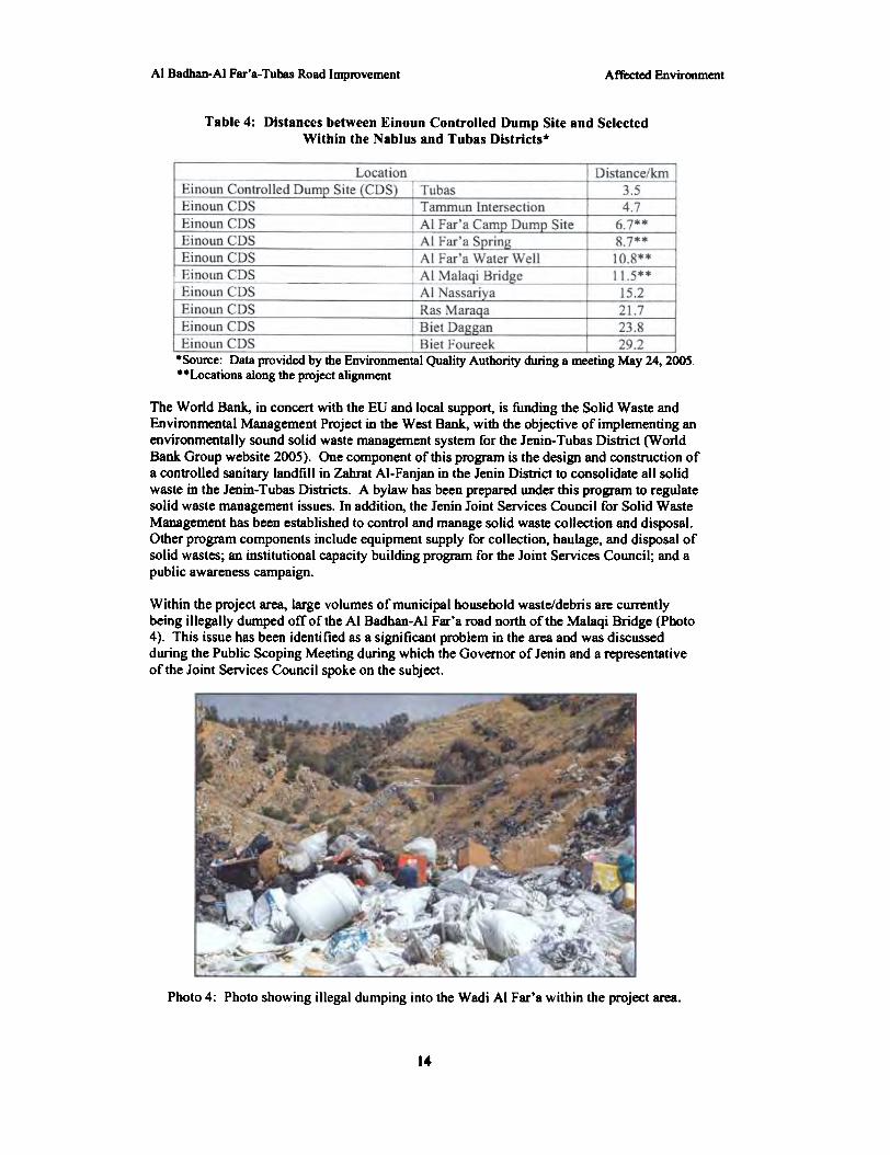
The improper handling of solid waste in Palestine has been identified as a major cause ofwater quality deterioration, land degradation, air pollution, and aesthetic degradation (MnEA2000). Within the AI Far'a watershed. the status of solid waste management is consideredinadequate and falls far behind modem standards of waste management. Palestinianregulations prohibit random dumping, however, these regulations are rarely enforced.Random dumping of waste is frequent and has, historically, been caused by a lack ofdesignated dumping sites. Waste collection vehicles are rare and only exist in the AI-Far'arefugee camp and in AI-Jiftlik. Generally, waste disposal occurs when the village councilssubcontract for a local vehicle to haul the waste away with collection occwring once or twicea week from designated collection points. The village councils have no authority on the fateof the waste after it is collected (Environmental Quality Authority 2004). In the past, thisproblem has been exacerbated by road closures in the area. making it very difficult to reachdesignated dumping sites. There are currently five controlled dump sites in the area. theclosest is just north of Tubas, within the Tubas municipality, in Einoun. Figure I shows theapproximate location of this dump site. The distances between the Einoun controlled dumpsite and sites within the project area are provided in Table 4.
3
Affected EnvironmentAI Badban-Al Far'a-Tubas Road Improvement
Table 4: Distances between Einoun Controlled Dump Site and SelectedWithin the Nablus and Tubas Districts.
I EinoUD CDS I Tammun Intersection
Einoun CDSEinoun CDS
*Source: Data provided by the Environmental Quality Authority during a meeting May 24, 2005.**Locations along the project alignment
The World Bank. in concert with the EU and local support, is funding the Solid Waste andEnvironmental Management Project in the West Bank, with the objective of implementing anenvironmentally sound solid waste management system for the Jenin- Tubas Disbict (WorldBank Group website 2005). One component of this program is the design and construction ofa conb'olled sanitary landfill in Zahrat Al-Fanjan in the Jenin Disbict to consolidate all solidwaste in the Jenin- Tubas Districts. A bylaw has been prepared under this program to regulatesolid waste management issues. In addition, the Jenin Joint Services Council for Solid WasteManagement has been established to control and manage solid waste collection and disposal.Other program components include equipment supply for collection, haulage, and disposal ofsolid wastes; an institutional capacity building program for the Joint Services Council; and apublic awareness campaign.
Within the project area. large volumes of municipal household waste/debris ~ currentlybeing illegally dumped off of the AI Badhan-AI Fac'a road north of the Maiaqi Bridge (Photo4). This issue has been identified as a significant problem in the area and was discussedduring the Public Scoping Meeting during which the Governor of Jenin and a representativeof the Joint Services Council spoke on the subject.
Photo 4: Photo showing illegal dumping into the Wadi AI Fac'a within the project area.
14

AI Badhan-AI Far'a- Tubas Road Improvement Environmental Consequences
SECTIONS
Environmental Consequences
This chapter describes the changes that may be expected by implementing one of the actionalternatives or by taking no action. Cumulative effects are discussed in this section.Cumulative effects result from incremental impacts of proposed activities when added toother past, present, and reasonably foreseeable actions regardless of what agency or personundertakes such other actions.
5.1 Water Resources
Proposed Action - Because of the importance of the Al Far'a spring and stream to the localcommunities, to the environment, and to area wildlife, any contamination or damage fromconstruction activities could have serious consequences. Reconstruction of Al Badhan-AIFar'a- Tubas Road, however, will not result in adverse impacts to the Al Far'a spring or to thedownstream waters, although the close location of the spring and stream to the road willrequire measures to protect the stream from impacts during construction. Duringconstruction, waste such as dirt, construction materials, aggregates, concrete, asphalt, etc. willbe generated. Stringent sediment control procedures will need to be implemented to preventthese wastes washing with rainwater into the Al Far'a spring and stream. Construction spoilpiles and waste material will be stored temporarily at designated protected areas located anappropriate distance from the spring and downstream waters to avoid possible impacts.Additional mitigation will consist of the temporary installation of a physical barrier in thewadi to separate the stream and riparian vegetation from equipment, materials, and personnelthat may enter the wadi during construction and cleanup of the trash/debris. It will benecessary to allow some equipment into the wadi area for construction activities, and removalof the trash from the area. A dirt path/road is located in the wadi which can be utilized byconstruction equipment to avoid impacts to vegetation, wildlife habitat, and the Al Far'astream. Section 6, Mitigation and Monitoring lists the mitigation measures that will beimplemented to minimize and eliminate impacts.
The project will have a significant positive impact on the environmental conditions along theroute, including positive impacts to water quality. Removal of the large volumes of trash anddebris from the roadside and the wadi will improve water quality of the Al Far'a stream,providing benefits to area wildlife and the local human population. Cleanup of the area andimprovement of the water quality is a key issue if the area is to be a draw for tourism, as itwas in the past. The improvements will include a guardrail to discourage continued dumpingin this drainage. The guardrail will discourage but will not eliminate all future dumping. Forthe benefits of trash removal to continue, local communities must make improvements tosolid waste management and enforce the existing regulations that prohibit random dumping.
Alternative I - Resurface Onlv - Under Alternative I there will be no impacts to the waterquality of the Al Far'a spring or the Wadi Al Far'a from construction activities. The samemitigation measure will be in place as described above and the same improvements to waterquality will occur with the removal of trash/debris and the installation of a guardrail. Thisalternative poses a lesser risk to the Al Far'a stream than the Proposed Action. The majorexcavation and reconstruction that will occur near Al Badhan to lower the road under theProposed Action will not occur here. And, while some equipment and workers will need toenter the wadi area for trash removal, the level of activity in the wadi will be less than underthe Proposed Action.
IS

AI Badhan-AI Far'a- Tubas Road Improvement Environmental Consequences
No-action Alternative - Under the No-action Alternative there would be no impacts to thewater quality of the Al Far'a spring or the Wadi Al Far'a from construction activities. Thelarge volumes of trash/debris, however, would remain along the roadside and in the wadi andwould continue to pollute the area and impact water quality.
5.2 Cultural Resources
Proposed Action - Reconstruction of AI Badhan-AI Far'a-Tubas Road has the potential todamage the cultural resources located along the road if proper care and mitigation are notimplemented during construction. Of particular concern is the Tel Al Far'a, located next tothe road in the Al Far'a Camp. While most of the excavated areas and antiquities are locatedat the top of the Tel, part of an earthen wall is located along the shoulder of the road. TheProject Manager for this project and the cultural resources expert from Birzeit Universityhave been coordinating closely on what improvements can and cannot be done in this area toavoid disturbing the Tel Al Far'a. The road will not be widened in this area, only resurfacingwill occur with minor excavation (0.5 m) to remove the existing road layers. There will be aprotective exclusion zone around the ancient wall fragment where no excavation will occur.The wall and Tel will be completely avoided during construction activities. A footpath forpedestrian use is being considered for this area along the roadside but will not disturb the Tel.The cultural resources expert has approved of this approach; any significant changes will needto obtain his approval and concurrence.
Excavation to widen the road in the narrow gorge section of AI Badhan has the potential ofunearthing new cultural resources. If this occurs, construction will cease until the Ministry ofTourism and Antiquities is alerted and provided time to assess the site. The existingstonewall structure that will be replaced in the narrow gorge section of Al Badhan was alsoassessed by the Birzeit University cultural resources expert, who confirmed that the structureis not a historical structure or an important cultural resource. He has approved thereplacement of this structure.
The 15th century watermill on the AI Far'a stream will be avoided during construction.Mitigation measures to protect the Al Far'a stream (see Water Resources) will also protect thewatermill. Equipment, materials, and personnel will not be allowed into the stream or beallowed to disturb the watermill. Adverse impacts are not expected.
Section 6, Mitigation and Monitoring, lists the mitigation measures that will be implementedto minimize and eliminate impacts to the cultural resources, both known and unknown, in thearea.
Alternative I - R~surface Only - Under Alternative I there will be no impacts to the Tel AlFar'a or to the ISdt century watennill from construction activities. This alternative does notpose any additional threat to cultural resources over the Proposed Action. As described above,extreme care will be used during resurfacing in the vicinity of the Tel AI Far'a. The samemitigation measures will be in place as described above and in Section 6.
No-action Alternative - Under the No-action Alternative there will be no impacts to the Tel AlFar'a or to the 15th century watermill from construction activities.
5.3 Natural Areas and Wildlife Habitat
Proposed Action - Although the Proposed Action will occur on existing right-of-way and willnot divert from the existing road, the improvement has the potential to damage the naturalareas and wildlife habitat located in the Wadi Al Far'a East if proper care and mitigation arenot implemented during construction. The area is considered a Highly Significant ecological
16

AI Badhan-AI Far'a-Tubas Road Improvement Environmental Consequences
resource and will need to be protected from impacts. Of particular concern duringconstruction is the AI Far'a stream and the vegetation located along the stream and in thewadi. The mitigation measures described under 5.1. Water Resources will protect thevegetation and wildlife habitat within the wadi. Implementation of stringent sediment controlmeasures, the installation of a physical barrier to protect the stream, and the use of theexisting dirt road/path in the wadi to move equipment, materials, and humans will reduceimpacts to the point of insignificance. Significant impacts are not expected.
Removal of the solid waste and installation of a guardrail to discourage dumping willsignificantly improve this sensitive natural area. Again. these improvements will betemporary unless illegal dumping is better controlled in the future.
Alternative I - Resurface Only - Under Alternative I there will be no impacts to natural areasor wildlife habitat from construction activities. The same mitigation measure will be in placeas described above and the same improvements to the wadi will occur with the removal oftrash/debris and the installation of a guardrail. This alternative poses a lesser risk to thehabitat and vegetation in the wadi than the Proposed Action. Again, the major excavation andreconstruction that will occur near Al Badhan to lower the road under the Proposed Actionwill not occur here. Some equipment and workers will need to enter the wadi for trashremoval, however, the level of activity in the wadi will be less than under the ProposedAction.
No-action Alternative - Under the No-action Alternative there will be no construction-relatedimpacts to the natural areas and wildlife habitat that exist in the Wadi Al Far'a. However, thesignificant benefits to the environment from removal of the solid waste will not occur.
5.4 Health and Safety
Proposed Action - With proper planning and mitigation, there will be no negative impacts tothe health and safety of workers or to the general public during construction. Duringconstruction, safety measures will be implemented to protect people from injury and adjacentproperty from damage. Workers will be protected with proper training and knowledge of theequipment/machinery they are handling. Implementation of an active safety program andprovision of safety equipment will be required and will provide further protection. Measureswill be provided to define and isolate construction zones by using warning signs, pylons,fencing, and ribbon barriers. During construction, the provision of a comprehensive safetyplan and traffic plan, in addition to appropriate safety equipment, and proper training, willminimize risk and protect workers and the public. The Contractor is required to comply withall U.S. and local safety standards stated in their contract. See Section 6 for the mitigationmeasures that will be implemented during construction.
By widening and improving the road, this project will result in significant improvements topublic health and safety. The road is dangerously narrow near Al Badhan with limited sightdistance around curves. No guardrail exists to protect drivers from the steep drop into theWadi Al Far'a. The Proposed Action will widen the road, improve sight distance, and installa guardrail providing significant safety benefits to the drivers using the road. Furthermore,the cleanup of the large volumes of trash/debris from the roadside and the Wadi AI Far'a willalso provide significant health benefits. Again, these benefits will be temporary if the localcommunities continue to allow illegal dumping and fail to enforce Palestinian environmentalregulations.
Alternative I - Resurface Only - During the construction period, this alternative will notresult in any adverse impacts to the health and safety of workers or the public as long as theplanning and mitigation measures described above and in Section 6 are implemented.

AI Badhan-AI Far'a-Tubas Road Improvement Environmental Consequences
This alternative will not provide the significant safety benefits for drivers as provided underthe Proposed Action. The existing narrow lanes and visibility deficiencies will remain posinga serious risk to public safety. This alternative does, however, make provisions for a guardrailprotect drivers from the drop into the wadi.
The same benefits to public health from the removal of the trash/debris will occur asdescribed above.
No-action Alternative - Under the No-action Alternative the road will continue to be veryunsafe with narrow lanes, poor visibility, and an unprotected drop into the wadi. The largevolumes of trash/debris will remain, and the benefits to public health will not occur.
5.5 Traffic
Prooosed Action - It is expected that the Proposed Action will result in improvements totraffic after the road is widened and sight distance is improved. The road is a major artery inthe area and currently carries large volumes of large and small vehicles. Widening the road,improving visibility, and improving safety should result in significant benefits to traffic flow.
Under this alternative there may be adverse impacts to traffic flow from constructionactivities, however, these impacts will be temporary and will be minimized by the mitigationmeasures described in Section 6. A detailed Traffic Plan will be prepared for the project andadhered to closely. Throughout most of the construction area an open lane will be maintainedto allow traffic to pass with minimal disruption. In the narrow gorge area of AI Badhan,however, excavation and lowering of the road will require full closure of the road. In thisarea, an alternative route will be maintained to allow traffic through. Flagmen will be on-sitedirecting traffic as necessary to maintain traffic flow and safe conditions.
Alternative 1 - Resurface Onlv - Like the Proposed Action, Alternative 1 may also havetemporary, adverse, construction-related impacts on traffic flow that will be minimized withmitigation.
This alternative, however, will not produce the long-tenn benefits to traffic flow that willresult from widening the road and improving sight distance. Resurfacing alone will notaddress traffic problems. The road is currently heavily utilized and will continue to be so inthe future; the population is expected to increase significantly within the next 15 years.Traffic will continue to a problem and will be exacerbated by population growth.
~action Alternative - Under the No-action Alternative, the short-tenD inconvenience ofpossible traffic congestion and other traffic impacts from construction activities will notoccur. However, like Alternative 1, the long-tenD benefits to traffic flow from widening theroad and improving sight distance will also not occur.
5.6 Solid Waste Management
ProDosed Action - The Proposed Action will have a significant positive impact on the solidwaste management problem along the road. The area will be cleared of solid waste and a newguardrail will be installed discourage future dumping. It will be the responsibility of the localcommunities to maintain these improvements. To be successful, it will be very important thatthe local communities work together to implement a stronger solid waste managementprogram with better oversight and quality control. Solid waste must be taken to one of thefive controlled dump sites in the area. The closest, in Einoun, is less than 10 miles from theAl Far'a Camp and less than 12 miles from the AI Malaqi Bridge. During the June 1,2005
18

Environmental ConsequencesAI Badhan-AI Far'a-Tubas Road Improvement
Public Scoping meeting, the Governor of Jenin and a representative of the Joint ServicesCouncil for Solid Waste Management strongly encouraged the sWTounding communities touse the controlled dump site near Tubas (in Einoun). To change the practice of illegaldumping, the public must be made aware of the risks associated with the practice and beencouraged to behave in a more responsible manner. Palestinian Law prohibits randomdumping; the law needs to be enforced so that the frequency of the action is reduced. This iscritical to protect the sensitive environment associated with the Wadi Al Far'a, to protect thewater quality of the Al Far'a stream, to reduce the risk to human health, and to make the areamore appealing to tourists and visitors.
The solid waste management problem may become less significant after the comprehensivesolid waste management project in Jenin is completed and the sanitary landfill is constructed(estimated completion is 2006).
During d1e project, all trash/debris removed from d1e area during cleanup, and anyconstruction debris generated that is not reused, will be disposed of in a designated disposalsite in an environmentally safe manner. Because of its proximity to the project, the mostlikely disposal site is the dump site in Einoun.
The intent of the project is to reuse excavated material to the greatest extent possible.Mitigation measures will protect the sensitive environmental concerns in the Wadi Al Far'afrom impacts from construction-generated waste.
Alternative 1 - Resurface Only - The same issues on solid waste management discussed forthe Proposed Action also apply to Alternative 1. The trash/debris will be removed from thearea under this alternative and a guardrail placed to discourage future dumping.
The amount of consb"uction-generated waste will be lower under this alternative, incomparison to the Proposed Action, since major excavation will not occur. Mitigationmeasures will protect the environment from any consb"uction waste generated duringresurfacing of the road.
No-action Alternative - Under the No-action Alternative the large volumes of trash/debriswill remain degrading the environment and posing a risk to public health.
S.7 Cumulative Effects
Cumulative effects are a result of the incremental impacts on a resource that result from theinteraction of two or more individual actions. Cumulative effects can result from minor, butcollectively substantial actions undertaken over a period of time. Cumulative effects can beeither beneficial or adverse.
There are no known future construction projects that have been identified on Al Badhan-AIFar' a-Tubas Road that would result in adverse cumulative effects on the natural or humanenvironment.
As part of the 1998 Wye River Agreement between the Palestinian National Authority andIsrael, USAlD proposed to finance the design and construction of a north-south highway inthe northern part of the West Bank. The EA for this highway was completed in 2001 (WilberSmith Associates 200 I). If the project moves forward and is constructed, this highway, theNablus-Jenin highway, will connect with the AI Badhan-AI Far'a-Tubas Road. Thecombination of the two projects will result in cumulative benefits to travel flow, safety, andeconomic development in the northern West Bank.
19

AI Badhan-AI Far'a- Tubas Road Improvement Environmental Consequences
5.8 Irreversible and Irretrievable Commitment of Resources
Both the Proposed Action and Alternative I will involve an irretrievable commitment oflabor, material, energy, and funds, in addition to the time spent in the design, construction,and maintenance of the proposed road. There would not be an irreversible commitment ofresources with any alternative discussed herein.
20

AI Badhan-AI Far'a- Tubas Road Improvement Mitigation and Monitoring
SECTION 6
Mitigation & Monitoring Plan
The following mitigation procedures will be implemented during construction to minimize oreliminate impacts.
Miti{!ationIssue)- Potentially hazardous materials (oil, grease, hydraulic fluid, battery
acid, radiator fluid, etc.) will be disposed of in an environmentallyfriendly manner. Spilled materials will be contained and removedand will not be allowed to enter surface waters.
)- Silt fence barriers will be used to contain and prevent silt fromentering surface waters. Sediment control procedures will be closelyadhered to.
)- A temporary barrier will be installed in the Wadi AI Far'a to protectthe AI Far'a stream, riparian vegetation, and the IS'" centurywatennill from construction activities. Equipment, materials, andworkers will not be allowed to disturb the stream or the vegetationalong the stream.
)- To protect the AI Far'a stream and vegetation in the wadi,equipment, materials, and workers will use the dirt road/path in thewadi those during construction and cleanup activities that must takeplace in the wadi.
)- See Solid Waste Management for other mitigation protecting waterqualitY.
Cultural Resources )- All necessary precautions to protect and preserve cultural orarchaeological resources will be taken within the construction zones.If archaeological resources are uncovered, construction shall ceaseimmediately in the area until the Ministry of Tourism andAntiquities is contacted and the site is evaluated.
)- In order to minimize the potential for loss or damage to culturalresources, the Contractor will alert workers about the possibility ofunearthing archaeological artifacts and about punitive actions fortheft or vandalism. Workers shall be required to stop all potentiallydamaging activities, notify the Contractor, and alert the Ministry ofTourism and Antiquities if they suspect cultural resources are beingdamaged.
)- An exclusion zone will be established around the Tel Al Far'aearthen wall located on the side of the road. Excavation will notoccur within the exclusion zone to protect the ancient wall. Outsideof the exclusion zone near the Tel Al Far'a, excavation will beminimal (~ 0.5 m) to protect the Tel.
)- Improvements near the Tel AI Far'a will be closely coordinated withthe Birzeit University cultural resources expert and will require hisapproval and concurrence.
)- See Water Resources for other mitigation protecting the 15d1 centurywatermill. Equipment, materials, and personnel will not be allowedto disturb the watermill.
Natural Areas andWildlife Habitat
). Measures will be implemented to protect trees and avoid treeremoval.
). See Solid Waste Management for other mitigation protecting naturalareas and wildlife habitat.
). See Water Resources for other mitigation protecting the vegetationand wildlife habitat in the wadi.
21

Al Badhan-AI Far'a- Tubas Road Improvement Mitigation and Monitoring
Issue Miti!!ation
Health and Safety )- Safety Plans will be prepared for both public safety and workersafety.
)- Traffic Plan will be prepared to minimize potential for accidents.)- Construction zones will be clearly defined with warning signs,
pylons, fencing and ribbon barriers.)- Adequate hearing protection, hard hats, safety goggles, brightly
colored vests and other appropriate safety equipment will beprovided for workers.
Traffic ). Preparation of a Traffic Plan with phasing for construction.). Local authorities will be contacted and emergency routes for
emergency vehicles will be maintained.). Construction activities will be organized so that traffic disruptions
and delays are minimized.). Temporary alternative lanes and routes will be managed to allow
traffic to pass through with minimal disruption.). Flagmen will be provided to direct traffic and minimize conflicts.
Solid WasteManagement
)- Construction spoil piles and waste material will be storedtemporarily at designated protected areas an appropriate area fromthe Al Far'a stream.
)- All waste material will be disposed of at designated disposal sites inan environmentally safe manner. The nearest controlled disposal siteis in Einoun, just north of Tubas.
)- Excavated material will be reused to the greatest extent possible.
22

AI Badhan-AI Far'a-Tubas Road Improvement Conclusion
SECTION 7
Conclusion
This Environmental Assessment concludes that the Proposed Action is necessary to improvesafety and efficient travel along Al Badhan-AI Far' a- Tubas Road. This action will alsoimprove the natural and human environment by the removal of the trash/debris illegallydumped along the road. The Proposed Action will have no significant adverse social,economic, or environmental impacts at levels that would warrant an Environmental ImpactStatement as long as Palestinian engineering practices, codes, and regulations are adhered to,and mitigation measures are implemented during construction. Unless significant impacts areidentified as a result of agency review, this process will require no further environmentalanalysis.
23

AI Badhan-AI Far'a- Tubas Road Improvement References
SECTION 8
Consultations and List of Preparers
8.1 CONSULTATIONS
During the course of preparing the EA, the team members consulted with the followinggovernmental and non-governmental agencies through the Public Scoping Meeting and individualconsultations:
Governor of JeninPalestinian Environmental Quality AuthorityAI Aqrabaniya Local CouncilAl Far'a Local CouncilTubas Local CouncilAl Far'a CampYassed Local CouncilTammun Local CouncilTalluza Local CouncilMinistry of IrrigationMinistry of Public Works and HousingMinistry of TransportationMinistry of Local GovernmentTubas MunicipalityFar'a Youth CenterJoint Services CouncilAI Najah UniversityBirzeit University
8.2 LIST OF PREP ARERS
The following professionals were involved with the preparation of the EA.
Anne Patterson, USAIDAnan Masri, USAIDHal McCabe, CH2M HillChris McCormick, MWHShannon Donley, MWHlmad Nassar, CH2M Hill
Mission Environmental OfficerChief EngineerProject DirectorProject ManagerEnvironmental Team LeaderPublic Outreach
Subject Area S~cia1istCultural Landscape! AntiquitiesArchaeologyGeographyBotanyBiology
Dr. Kamal Abdulfattah, Birzeit UniversityMr. Ibrahim al-MaKhariza, Birzeit UniversityMr. Abdulhalim al- Tumaizi, Birzeit UniversityDr. Othman Sharkas, Birzeit UniversityDr. Adima al-Sughayyan, Birzeit University
24

Rcferelx:esAI Bacllan-AI Far'a- Tubas Road Improvement
SECTION 9
References
Applied Research Institute-Jerusalem (ARU). 1997. The Status of the Environment in the WestBank.
Birzeit University-Calvin College Partnership. 2003. Wadi el-Far'a Project Report: AnEnvironmental Assessment of the Wadi el-Far'a Watershed. USAID funded.
CH2M Hill. 2003. West Bank Water Resources Integrated Water Resources Program Phase Ill,Environmental Assessment for Stonnwater, Domestic Wastewater Master Plan forHebron.
De Vaux, Rand A. Chambon. 1993. Far'ah. Tel EI- (North). Pages 433-440. In The NewEncyclopedia of Archaeological Excavations in the Holyland. The Israel ExplorationSociety. Jerusalem.
Environmental Quality Authority. 2004. The Fam'a and Jerash Integrated WatershedManagement Project. Al Far'a Baseline Report.
IUCN.2004. 2004IUCN Red List of Threatened Species. www.rcdlist.or2. Accessed 11 May2005.
Ministry of Planning and International Cooperation (MOPIC). 1998. Sensitive Water ResourcesRecharge Areas in the West Bank Governorates.
MOPIC. 1998. Regional Plan for the West Bank Governorates, Water and Wastewater ExistingSituation.
MOPIC. 1999. Endangered Cultural Heritage Sites in the West Bank Governorates, EmergencyNatural Resources Protection Plan.
MOPIC. 2000. Ecologically Significant Areas in the West Bank Governorates.
Palestinian National Autbority, Ministry of Environmental Affairs (MnEA). 2000. ThePalestinian Environmental Assessment Policy.
Palestinian CentJal Bm'eau of Statistics (PCBS). 1997 Census.hgg://www.~bs.0r2/nhc 97/tab e.8S0X. Accessed May 23, 2005.
USAID West Bank & Gaza. 2005. Conservation of Biological Diversity Analysis, Annex to theUSAID/West Bank & Gaza FY 2005-2008 StJategic Plan. DRAFT Version.
Wilber Smith Associates. 2001. Nablus-Jenin Highway Environmental Assessment.
World Bank Group, Solid Waste and Environmental Management Project Status: Ongoing.Website: bn»://inweb 18. worldbank. orQ/rnna/men8. nsf/Countries/W est::!: B~288FDE9E9A16F34585256BIFOO31925B?OoenDocument. Accessed 15 May 2005.
25