AKCIAP NR AEB T1-01 COASTAL IMPACT ASSISTANCE …
31
Transcript of AKCIAP NR AEB T1-01 COASTAL IMPACT ASSISTANCE …


AKCIAP_NR_AEB_T1-01
1
STATE OF ALASKA COASTAL IMPACT ASSISTANCE PROGRAM
ALEUTIANS EAST BOROUGH
The Borough will be conducting this project as a legislatively named CIAP recipient on behalf of the State of Alaska
PROJECT TITLE: Create a Resource Development Land Use Permitting System to Protect Coastal Resources in the Aleutians East Borough Resource Development District PROJECT CONTACT
Contact Name: Sharon Boyette Address: 3380 C Street, Suite 205, Anchorage, AK 99503 Telephone Number: (907) 274-7555 Fax Number: (907) 276-7569 Email Address: [email protected]
PROJECT LOCATION The Aleutians East Borough (AEB) Resource Development District was approved by the AEB Assembly and incorporated into the AEB Code in 2006. A map of the AEB Resource Development District is shown below.
Aleutians East Borough Resource Development District Map
Resource Development
District
December 2006

AKCIAP_NR_AEB_T1-01
2
The Resource Development District includes all Borough Land between the 160000’00” and 162000’00” degrees longitude, excluding the City of Sand Point and its boundaries, the City of King Cove and its boundaries, and the Nelson Lagoon Residential and Commercial districts (AEBMC §40.15.040(a)). PROJECT DURATION Three and a half years. ESTIMATED COST:
Spending Estimate ($) TOTAL Year 1 Year 2 Year 3 Year 4 $255,050 $50,800 $64,750 $100,000 $39,500
Funding per Allocation Year of CIAP ($) TOTAL FY 07 FY 08 FY 09 FY 10 $255,050 $255,050
PROJECT DESCRIPTION: This AEB proposed Tier 1 project, “Create a Resource Development Land Use Permitting System to Protect Coastal Resources in the Aleutians East Borough Resource Development District,” will benefit the coastal environment by constructing a permitting system to regulate resource development activities in the AEB coastal zone. The goal will be to maximize resource development opportunities while protecting coastal resources through an organized, efficient permit program that implements the goals and objectives of the AEB Code and the Alaska Coastal Zone Management Program. AEB, a small rural government with a small staff and limited finances, does not have a Resource Development Permitting System. Other boroughs in Alaska (e.g. Bristol Bay Borough, Lake and Peninsula Borough, North West Arctic Borough, Matunuska-Susitna Borough, and the North Slope Borough) have developed and implemented resource development permitting systems to regulate resource development activities in the AEB coastal zone. While the AEB has not had the ability to fund this project itself, as the larger boroughs have done, it does have natural resources that are attractive for development including natural gas and gold. The AEB wishes to act in advance of industry exploration and development to implement an effective permitting system which will: • protect coastal resources and the environment; • protect fish resources and ensure continuation of a productive commercial fishery; • protect subsistence resources; • ensure that future growth and development is in accord with the values of its residents; • identify, avoid, and mitigate the negative effects of development; • protect human health and the environment by prohibiting adverse impacts of industrial
pollution;

AKCIAP_NR_AEB_T1-01
3
• ensure public involvement in permitting, planning, and zoning decisions; • be sensitive and responsive to subsistence and other life styles that exist in the communities
that the development will affect; and • protect the historical, economic, social, and cultural values of the coastal areas.
Problem Statement: In 2006, the AEB Code was amended to establish a Resource Development District in anticipation of oil, gas and mining resource development opportunities (AEBMC §40.15.040). A Planning Commission was established to ensure systematic and organized development of the borough through a Comprehensive Plan, a Coastal Zone Management Plan, and Land Use Regulations (Permitting and Zoning) (AEBMC §40.05). To date, the AEB has developed a Comprehensive Plan and a Coastal Zone Management Plan (AEBMC §40.10). It also has established Zoning Districts (AEBMC §40.15) and developed a basic outline of how Land Use Permitting and Zoning will be completed in the Resource Development District (AEBMC §40.20). The Planning Commission was named and started meeting in 2009. However, AEB has not yet developed a Permitting Program to manage resource development within the Resource Development District. Scope: There are a number of steps that AEB needs to take to develop an effective Land Use Permitting System to Protect Coastal Resources in the Aleutians East Borough Resource Development District, including:
1. Obtain Community Input: Community meetings will be held to obtain input on what kind of regulations should be put in place to protect coastal resources in the AEB Resource Development District. AEB will hire a consultant to work with AEB staff to coordinate the community workshops and document the findings. The information gathered will be used by the AEB Planning Commission to develop a Resource Development Permitting System, including: permit forms; stipulations; standard operating procedures; a permit tracking database; and an inspection/audit compliance program.
2. Refine AEB Code, Title 40, Chapter 20: Using the information gathered at the community
meetings, along with AEB’s existing Comprehensive Plan, Coastal Zone Management Plan and AEB Code, the AEB Planning Commission (supported by AEB staff, and legal and technical consulting support) will propose for AEB Assembly approval a revision to the AEB Code at Title 40, Chapter 20, Planning, Platting and Land Use for the Resource Development District. The revision will provide additional specificity on: permit forms; standard operating procedures for reviewing and approving applications; standard stipulations to protect coastal resources and achieve the goals and objectives of the Comprehensive Plan, the Coastal Zone Management Plan, and AEB code; the inspection/audit compliance program; and fee schedule.
3. Develop Permit Application Forms: AEB will hire a consultant to work with AEB staff and
the Planning Commission to develop Land Use Permit Application Forms for the AEB Resource Development District to meet the requirements of AEBMC §40.20. The AEB

AKCIAP_NR_AEB_T1-01
4
Planning Commission will approve the application forms, after obtaining input from the affected communities and potentially regulated industries. The permit application forms will be made available on the AEB website.
4. Develop Standard Operating Procedures: AEB will hire a consultant to work with AEB
staff and the Planning Commission to develop Standard Operating Procedures (SOPs) for reviewing and approving Resource Development District Land Use Permit Applications. These procedures will include preparation of AEB staff recommendations and review and approval criteria for the Planning Director, Planning Commission and Assembly. A written manual of SOPs will be developed as a desktop reference for AEB Permit Staff, AEB Administrators, the Planning Commission and the Assembly. The consultant will provide SOP training to AEB staff, so that they can carry out the permitting program thereafter.
5. Develop Standard Stipulations: AEB will hire technical and legal consultants to work with AEB staff and the Planning Commission to develop standard stipulations that will be applied to AEB Land Use Permits in the Resource Development District to protect coastal resources and achieve the goals and objectives of the Comprehensive Plan, Coastal Zone Management Plan, and AEB Code. The AEB Planning Commission will approve the standard stipulations, after obtaining input from the affected communities and potentially regulated industries. The standard stipulations will be made available on the AEB website. These standard stipulations will serve as a starting point for an evergreen process. Stipulations will be updated at least annually to incorporate new technology, scientific information, local knowledge, and changes in the coastal areas or environment. Additionally, AEB will add project-specific stipulations to land use permits, as appropriate, to protect coastal resources and achieve the goals and objectives of the Comprehensive Plan, Coastal Zone Management Plan, and AEB Code.
6. Develop Fee and Penalty Schedule: AEB will hire technical and legal consultants to work
with AEB staff and the Planning Commission to develop a fee and penalty schedule to provide funding to: run the Resource Development Land Use Permitting System; conduct inspections and audits: and remedy non-compliance.
7. Develop Land Use Permit Database: AEB will hire a computer consultant to work with
AEB staff and the Planning Commission to develop an electronic permit tracking database to efficiently and effectively handle all the paperwork associated with Resource Development Land Use Permits. The technical consultant hired to develop the permit program will advise the computer consultant on how to craft the permit database to effectively capture and process permit, inspection, and audit data.
There will be two levels to this database: (1) AEB internal and (2) public access. The AEB internal database structure will be used by AEB Planning Department staff, the Planning Commission and the Assembly to store information, track compliance, and search for information.

AKCIAP_NR_AEB_T1-01
5
A portion of the AEB internal database will be made available on the AEB website, where the public can view: permit applications; staff recommendations; Planning Commission decisions; Assembly decisions; final permits; deadlines; inspection results; audits results; and compliance violation results. Information on this website will include documents that the public or applicant is asked to comment on and final copies of all other documents and decisions. The web-based system will provide an opportunity to submit electronic comments to improve public access and permit review efficiency. A dedicated server and scanner will be purchased at AEB expense, not grant funds, to support the database and enter information. The consultant will provide training to AEB staff to run and maintain the database, and training to the Planning Commission and the Assembly to use the database.
8. Develop Inspection &Audit Compliance Program: AEB will hire technical and legal
consultants to work with AEB staff and the Planning Commission to develop an inspection and auditing compliance program. Inspection and audit forms will be developed, along with standard operating procedures for conducting inspections and audits and writing up findings. Standard forms will be developed to handle enforcement action. The consultants will provide training to AEB staff on how to conduct inspections and audits, write up findings and carry out enforcement to protect coastal resources and ensure compliance with Resource Development District Land Use Permits, the AEB Comprehensive Plan, and the Coastal Zone Management Plan.
MEASUREABLE GOALS AND OBJECTIVES: Year One
1. Conduct community meetings in Sand Point, Nelson Lagoon, Cold Bay, Akutan, False Pass, and King Cove.
2. Document written findings summarizing community input.
3. Prepare written recommendations for the AEB Planning Commission on how to refine the AEB Code Title 40, Chapter 20 to incorporate community input on how best to protect coastal resources.
4. Draft a revision to the AEB Code at Title 40, Chapter 20, Planning, Platting and Land Use
for the Resource Development District to provide additional specificity on the Land Use Permitting Program to protect coastal resources. Obtain Planning Commission and Assembly approval and codify new changes in the AEB Code.
Year Two
5. Develop Land Use Permit Application Forms for the AEB Resource Development District and obtain AEB Planning Commission approval.
6. Develop a written fee and penalty schedule and obtain AEB Planning Commission and Assembly approval.

AKCIAP_NR_AEB_T1-01
6
7. Develop standard stipulations that will be applied to AEB Land Use Permits in the
Resource Development District and obtain AEB Planning Commission approval.
8. Develop Standard Operating Procedures (SOPs) for reviewing and approving Resource Development District Land Use Permit Applications. Obtain AEB Planning Commission approval of SOPs and publish a desktop reference of SOPs. Provide training on SOPs.
Year Three and Four 9. Develop an inspection and auditing compliance program that includes written inspection
and audit forms and standard operating procedures for conducting and documenting inspection and audit findings. Obtain AEB Planning Commission and Assembly approval.
10. Develop standard forms to handle enforcement action. Provide training to AEB staff on how to conduct inspections and audits, write up findings, and carry out enforcement to protect coastal resources.
11. Develop an electronic permit tracking database to efficiently and effectively handle all of
the paperwork associated with Resource Development Land Use Permits. Provide training on how to run and maintain the database.
12. Purchase a server and scanning system to support the new permits database, install and
train AEB staff on use. (The AEB will fund purchase of the necessary equipment.) PROJECT CONSISTENCY WITH CIAP AUTHORIZED USE: The proposed project is consistent with three Authorized Uses of CIAP funds. However, its primary Authorized Use is No. 1: This project is consistent with Authorized Use No. 1 “projects and activities for the conservation, protection, or restoration of coastal areas, including wetlands,” because it develops a Resource Development Land Use Permitting System to Protect Coastal Resources in the Aleutians East Borough Resource Development District. The permitting program will establish land use permit stipulations that mitigate impacts to coastal resources, and will develop a system to inspect, audit, and track compliance with those limitations to ensure protection is actually occurring. The land use permitting system will be built to incorporate developments in technology, scientific data, and local knowledge, to continuously improve coastal resources protection, while allowing resource development to occur. COORDINATION WITH FEDERAL RESOURCES OR PROGRAMS: AEB will continue to work with the ADNR and MMS to interface its own permitting system with the other state and federal agencies’. COST SHARING OR MATCHING OF FUNDS: The Aleutians East Borough will contribute all necessary grant administrative costs and project management costs for this project. The AEB will also purchase all necessary equipment with its general funds.

AKCIAP_NR_AEB_T1-02
1
STATE OF ALASKA COASTAL IMPACT ASSISTANCE PROGRAM
ALEUTIANS EAST BOROUGH
The Borough will be conducting this project as a legislatively named CIAP recipient on behalf of the State of Alaska
PROJECT TITLE: Cold Bay Boat Ramp Rehabilitation Project PROJECT CONTACT
Contact Name: Sharon Boyette Address: 3380 C Street, Suite 205, Anchorage, AK. 99503 Telephone Number: 907-274-7555 Fax Number: 907-276-7569 Email Address: [email protected]
PROJECT LOCATION Cold Bay is located in the Izembek National Wildlife Refuge at the western end of the Alaska Peninsula. It lies 634 miles southwest of Anchorage and 180 miles northeast of Unalaska.
Cold Bay services the fishing industry and houses a number of federal offices with services focused on Aleutian transportation and wildlife protection. Subsistence and recreational fishing and hunting are a part of the local culture. Several active lodges in town provide guided hunting, especially water fowl, and fishing. PROJECT DURATION The project is expected to take less than one year to design and construct.
Cold Bay, Alaska

AKCIAP_NR_AEB_T1-02
2
ESTIMATED COST: Spending Estimate ($)
TOTAL Year 1 Year 2 Year 3 Year 4 $90,000 $90,000 # # #
Funding per Allocation Year of CIAP ($)
TOTAL FY 07 FY 08 FY 09 FY 10 $90,000 $90,000
PROJECT DESCRIPTION: This proposed Tier 1 project, Cold Bay Boat Ramp Rehabilitation, will result in benefits to the coastal environment by keeping public access to the sea consolidated at one point along the coast, at the existing boat ramp. The City boat ramp is located next to the city dock and is currently being undermined by erosion. The ramp is the only appropriate access to the ocean on the Cold Bay road and trail system, inside the Izembek National Wildlife Refuge. Repairing the damaged city boat ramp will eliminate the recent tendency of local boaters to put their boats into the ocean at other points along the coastal areas, which will result in beach degradation.
Problem Before the Cold Bay boat ramp was built, boaters on/offloaded their boats elsewhere, such as at the mouth of Trout Creek. When the beach sand got too loose, they would on/offload further down the beach, and so on, which ultimately caused damage and degradation to the pristine coastline located inside the Izembek National Wildlife Refuge. There are 40 boats in town that are licensed to use the boat ramp. There are a variety of boat ramp users:
• 26 recreational boats; about half are also used to guide hunters and fishermen
Aerial view of Cold Bay, the aircraft hub of the region.
Boat Ramp
AKCIAP_NR_AEB_T1-02
3
• 11 government (two Fish and Game, and nine U.S. Fish & Wildlife Refuge) The USF&W Refuge staff state the ramp is very important in order to launch their boats for doing studies.
• 1 commercial- Aleut Enterprise has a boat for emergencies when transferring fuel (in case of an oil spill)
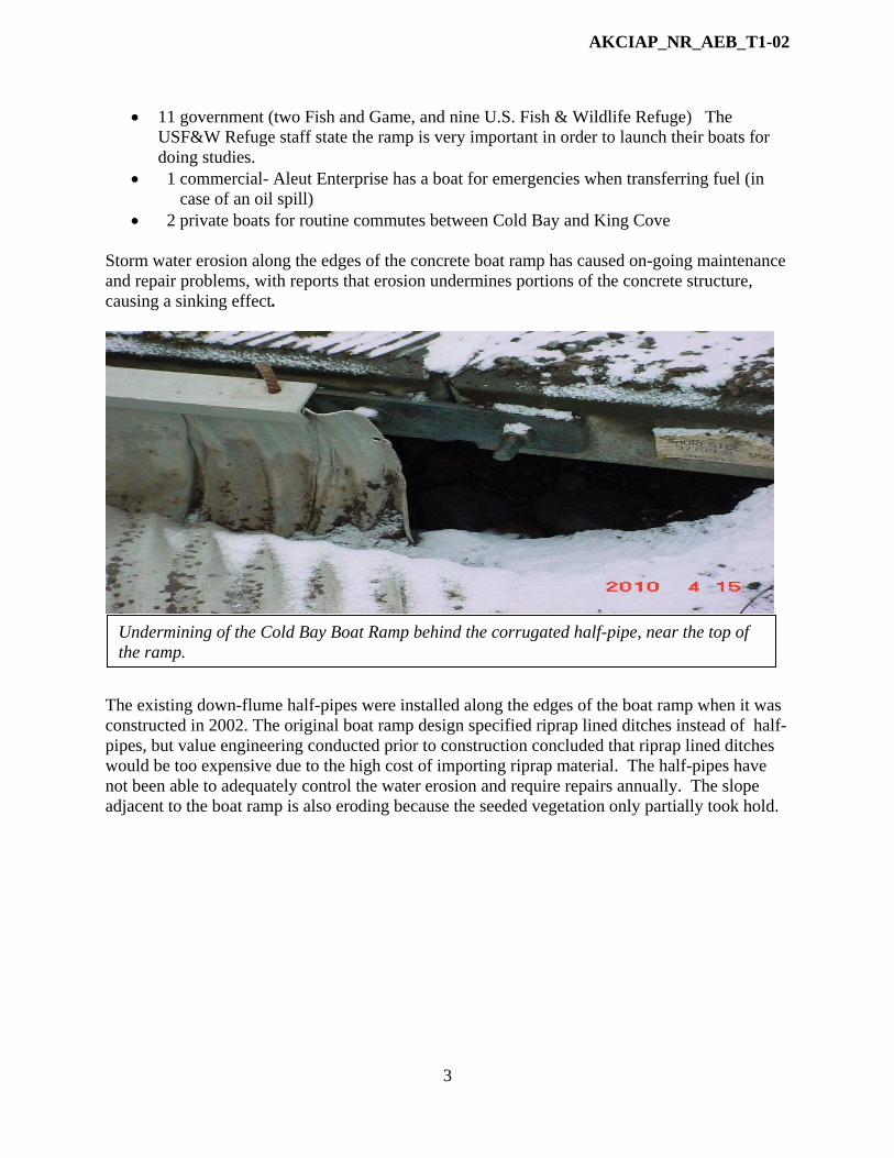
• 2 private boats for routine commutes between Cold Bay and King Cove Storm water erosion along the edges of the concrete boat ramp has caused on-going maintenance and repair problems, with reports that erosion undermines portions of the concrete structure, causing a sinking effect.
The existing down-flume half-pipes were installed along the edges of the boat ramp when it was constructed in 2002. The original boat ramp design specified riprap lined ditches instead of half-pipes, but value engineering conducted prior to construction concluded that riprap lined ditches would be too expensive due to the high cost of importing riprap material. The half-pipes have not been able to adequately control the water erosion and require repairs annually. The slope adjacent to the boat ramp is also eroding because the seeded vegetation only partially took hold.
Undermining of the Cold Bay Boat Ramp behind the corrugated half-pipe, near the top of the ramp.

AKCIAP_NR_AEB_T1-02
4
Solution The recommended solution for the boat ramp is to replace the half pipes with riprap lined ditches, a permanent erosion control solution. The feasibility of the project hinges on local availability of riprap material. The material will be available locally during the summer of 2011 from the current operator of the King Cove quarry. The project will require an engineered design which would entail pre-design site inspection, construction drawings signed and sealed by a licensed Civil Engineer, and post construction site inspection. Construction would entail removal of approximately 260 lineal feet of existing down flume half-pipes, and replacement with Riprap Type I (ADOT specification, 4 to 8 inch diameter angular rock) on top of geo-textile erosion control fabric. Some excavation and ditch grading prior to placement of the rock and geo-textile fabric would be required. The slopes adjacent to the ramp would also be reseeded. Both design and construction of the project will be completed within one construction season. Coordination Efforts with State or Local Entities The Aleutians East Borough has coordinated the submittal of this proposal with the City of Cold Bay. This coordination will continue through project implementation. MEASUREABLE GOALS AND OBJECTIVES: There are two outcomes of the Cold Bay Boat Ramp Rehabilitation Project that will help protect the coastal environment and conserve the pristine beaches inside the Izembek National Wildlife Refuge:
1. An adequately functioning boat ramp will remove the inclination of local boaters to put their boats in the water on Refuge beaches. This will keep public access to the sea consolidated at one appropriate point along the coast. This will also eliminate the associated vehicle trampling of coastal habitat (low-brush tundra and a variety of other plants) when trying to access those beaches for off/onloading boats (a common event before the boat ramp was constructed).
2. An adequately functioning boat ramp will protect the coastline by eliminating sand and gravel runoff and other ramp debris washed into the bay caused by erosion underneath the ramp.
Eroding slope adjacent to the boat ramp; the vegetation is only partially established.

AKCIAP_NR_AEB_T1-02
5
PROJECT CONSISTENCY WITH CIAP AUTHORIZED USE: The proposed project is consistent with CIAP Authorized Use #1: Projects and activities for the conservation, protection, or restoration of coastal areas, including wetlands. Cold Bay is located inside the Izembek National Wildlife Refuge. The refuge is a 315,000 acre wilderness of low-brush tundra with pristine beaches, wetlands, lagoons, lakes, abundant plant varieties, and wildlife. The restoration of the Cold Bay Community Boat Ramp will protect this coastal area by keeping boat access to the sea consolidated at one point in the refuge. This will help keep the human footprint inside this pristine wilderness to a minimum. COORDINATION WITH FEDERAL RESOURCES OR PROGRAMS: As the U.S Fish and Wildlife Service and the Alaska Dept of Fish and Game are heavy users of the Cold Bay boat ramp, they have both expressed their concerns about the current condition of the boat ramp. They have expressed their concern regarding the use of other unprotected areas for boat launching. Both agencies have stated their support of this project. COST SHARING OR MATCHING OF FUNDS CIAP funds will not be used for cost sharing or as matching funds at this time. However, Aleutians East Borough staff time will be contributed as in-kind for grant administration and project management.

AKCIAP_NR_AEB_T1-03
1
STATE OF ALASKA COASTAL IMPACT ASSISTANCE PROGRAM
ALEUTIANS EAST BOROUGH
The Borough will be conducting this project as a legislatively named CIAP recipient on behalf of the State of Alaska
PROJECT TITLE: Nelson Lagoon Coastal Erosion Study Project PROJECT CONTACT
Contact Name: Sharon Boyette Address: 3380 C Street, Suite 205, Anchorage, AK. 99503 Telephone Number: 907-274-7555 Fax Number: 907-276-7569 Email Address: [email protected]
PROJECT LOCATION Nelson Lagoon is located on the north coast of the Alaska Peninsula, 580 miles southwest of Anchorage. The community is situated north of the Alaska Peninsula National Wildlife Refuge on a slender strand of sand between the Bering Sea and a lagoon of the same name, approximately 23 miles west of Port Moller.
The strand is a sand spit formed by the accumulation of sediment transported to the northeast from the north-facing shore of the Alaska Peninsula. As a result of sediment transport, the strand
Nelson Lagoon

AKCIAP_NR_AEB_T1-03
2
is a dynamic feature whose length has increased steadily the past several decades, but somewhat at the expense of its long exposed flank along the Bering Sea. Over its entire strand, the width of the shoreline appears to be retreating somewhat uniformly at a rate of five feet per year. However, there are also “hot spots” where the erosion has become more acute with localized shoreline retreat rates.
PROJECT DURATION The project will take 3.5 years to complete. ESTIMATED COST:
Spending Estimate ($) TOTAL Year 1 Year 2 Year 3 Year 3.5 $238,800 $109,900 $58,900 $40,000 $30,000
Funding per Allocation Year of CIAP ($)
TOTAL FY 07 FY 08 FY 09 FY 10 $238,800 $238,800
PROJECT DESCRIPTION: There is currently a cycle of an encroaching shoreline from erosion that impacts Nelson Lagoon community facilities. The debris and contaminants from these overtaken facilities then impacts the shoreline and the coastal environment. This cycle is continuous because site planning for facility development occurs without proper understanding of the trends, rates, and causes of the erosion processes affecting the Nelson Lagoon coastline. This proposed Tier 1 project, Nelson Lagoon Coastal Erosion Study Project will benefit the Nelson Lagoon coastal environment by providing shoreline erosion data, measurements, and
The Nelson Lagoon spit, looking northeast. The Bering Sea is to the left and the lagoon is to the right. The town is in the background.

AKCIAP_NR_AEB_T1-03
3
analysis necessary to consider in the site planning, design, and construction of development projects. The primary objective is to ensure protection of the coastal area. The analysis of coastal erosion processes, causes, and rates along the Nelson Lagoon shoreline also will provide the best methods to mitigate shoreline retreat. The application of these mitigation measures are badly needed in order to save vulnerable community facilities from the encroaching Bering Sea while simultaneously saving the Bering Sea from debris and other contaminants from overtaken facilities. Background The Village of Nelson Lagoon, Alaska is located on a spit that is being threatened continuously by erosion from both the Bering Sea side and lagoon side of the spit. In the past, the village was protected by the winter ice pack, but during the last several decades, this protection has been in significant decline due to global warming. The shoreline is now exposed to the winds and tidal surges of severe winter storms. As a result, debris from overtaken facilities is washing into the sea. Twelve properties, including a landfill facility, and 10 residential dwellings along a one-mile stretch of the community’s shoreline are now at risk. Tidal surge now comes to within a few feet of one house. Residents are concerned about losing facilities to storm surges and the associated pollution to the Bering Sea from debris. Observations from residents indicate that some sections of the shorelines have experienced accelerated rates of erosion. Residents can pinpoint and discuss past storm-induced erosion, but cannot identify a trend or predict where it will occur next. Past development of certain facilities and supporting activities have negatively impacted the coastline. Beach gravel was dug and hauled from two beaches directly adjacent to town on the lagoon side to supply new airport construction in the 1980s. According to residents, this accelerated erosion of the two beach sections of coastline.
Wooden seawall built by residents
Gravel was dug and hauled from the section of shoreline designated by the right and left white arrows. This accelerated erosion in these areas. A wooden seawall was built to protect the point.

AKCIAP_NR_AEB_T1-03
4
Residents had to build a wooden seawall to protect residences and stop debris from washing into the lagoon (see photo above and below).
Fuel tanks were also moved away from the eroding shoreline in 1995. They were moved to the new tank farm site further inland.
Old Fuel Tank Farm Site
Current Fuel Tank Farm Site
Old and current locations of the fuel tank farm.
Wooden seawall built at the point, by residents (referenced above). Although the structure is still standing after 30 years, sections are falling apart and washing away as debris into the lagoon.

AKCIAP_NR_AEB_T1-03
5
There are now concerns for potential environmental impacts on the coastline. The community landfill and sewage lagoon, built in the early 1990s, are now only 75 feet from the eroding shoreline. The concern is that landfill debris and sewage will soon be overtaken by the Bering Sea. This would have a serious impact on the marine environment.
The old landfill was closed down in the 1990’s because of erosion. As can be seen, the boundary of the old landfill site is currently on the beach. Residents state that encroaching erosion has uncovered and washed away debris. Every winter, large sections of the 10-mile water transmission line (4-inch diameter poly propylene pipe) from the water source to town are exposed from erosion. The pipe either freezes and/or breaks up as a result of wave action. The water supply to town is halted as a result. Thousands of feet of the broken line ends up as debris in the Bering Sea.
Old Landfill Current Landfill
The current landfill is 75 feet from the shoreline; the boundary of the old landfill is now on the beach. The concern now regards the proximity of the current landfill to the encroaching shoreline.

AKCIAP_NR_AEB_T1-03
6
The community has replaced 19,778 feet of transmission line from 2007 to 2009. The Nelson Lagoon Tribal Council, Aleutians East Borough, and the US Department of Agriculture have been making plans to develop a project partnership to relocate the line. However, because nobody knows where the next storm-induced erosion will occur, there is currently a dilemma as to where the water transmission line should be relocated.
Two objectives have become critical components of local community planning in Nelson Lagoon: Sustainable facility development that will not impact the sea, and the protection of existing facilities vulnerable to erosion. Protecting these facilities from the Bering Sea will also protect the Bering Sea from contamination by debris and other substances from overtaken facilities. Studies are needed to identify shoreline erosion trends and magnitude, and to identify
This map shows the locations of 19,778 feet of water transmission line (4-inch polypropylene pipe) that has been replaced between the years 2006-2009. A significant amount of the pipe washes into the sea as debris.
A section of community water transmission line completely exposed by beach erosion. The exposed line either freeze in the winter and/ or break from wave action and wash into the sea.

AKCIAP_NR_AEB_T1-03
7
effective mitigation measures for the protection of existing facilities and coastline. Unfortunately, there have been no studies to date. Project Proposal There are three work components involved in this project:
1) Development of a Nelson Lagoon historic shoreline erosion map and analysis 2) Perform a beach profile study of Nelson Lagoon coastal sections 3) Develop a quantitative understanding of the wave exposure of the Nelson Lagoon
waterfront by performing a wave climate study. Work Component #1 Nelson Lagoon Historic Shoreline Erosion Map and Analysis The site placement of community facilities has become a critical component of both local planning for community development in Nelson Lagoon, and in protecting the coastal environment. Unfortunately, there has been no detailed mapping or studies to date to identify erosion trends and where this hazard to the coastline may be the greatest. To help accomplish effective and sustainable site placement of facilities that will not impact the coastal environment, the Aleutians East Borough proposes to develop a Historic Shoreline Erosion Map to cover both sides of the Nelson Lagoon Spit down to the community water source. The Historic Shoreline Erosion Map will be based on a historic shoreline digitized from a 1963 USGS topographic base map and overlain with digital aerial orthophotos from the 70’s, 80’s 90’s. New 2011 aerial photography is required to complete the analysis and is stated in this proposal. The objectives are twofold:
1) Identify and measure erosion, erosion trends, and magnitude of the Nelson Lagoon shoreline.
2) Based on historic shoreline erosion and trends, develop an erosion projection of future shorelines by year. From this projection, identify appropriate, sustainable sites for future infrastructure development and areas of non-development.
The project will take place in two phases: Phase 1- Aerial Photography and Ortho-rectification The AEB will contract with a professional geospatial services firm to acquire 2011 imagery of the Nelson Lagoon shoreline. The flight path will cover an approximate 10-mile stretch of land from the tip of the spit to the community water source.

AKCIAP_NR_AEB_T1-03
8
The process in this phase will include acquiring 2011 aerial photography, a ground control survey, aerotriangulation, DTM/DEM collection, image scanning, ortho-rectification, and digital output. The natural color aerial photography will be acquired at 1” = 800’ scale utilizing GPS/IMU technology. From this photography, the firm will create color digital orthophotography at 0.5-foot pixel resolution. The orthophoto images will be stitched together as mosaics and will provide the current shoreline coverage for the study (a digital orthophoto is a photographic image that has been horizontally corrected for the effects of relief displacement and other image distortions and displacements. It is a photographic map stored in a digital computer environment). Available historic aerial photos of the same shoreline coverage taken in 1972, 1983, 1997, and 2001 will be ortho-rectified as well in order to improve the accuracy of the analysis of the historic shorelines. Phase 2- Mapping and Interpretation The AEB will contract with a professional mapping/engineering firm for developing mapping from the aerial photography and for performing the shoreline analysis. Mapping staff will convert the 1972, 1983, 1997, 2001 and 2011 shoreline digital photos into map layers and overlay the 1963 USGS topographic base map. Shorelines will be digitized from these sources. Distances between each successive shoreline will be measured. The map will also delineate areas of the spit that appear to be experiencing sediment buildup (as a result of wind direction which will be notated). An erosion projection of future shorelines will be calculated using past erosion trends. The projection will be used to identify appropriate, sustainable sites for future infrastructure development, as well as areas for non-development. Coastal engineering staff will analyze the data and write a report documenting the process and findings. The time series analysis of the historic shorelines will determine the rate of coastline erosion and provide the evidence needed to designate appropriate areas for development and for natural hazard areas (non development). By mapping natural hazards and documenting the rate
The flight path shows the coverage area of the project to be mapped and analyzed (from the tip of the spit to the community water source.
Community Water Source
Nelson Lagoon

AKCIAP_NR_AEB_T1-03
9
of erosion, the Tribal and AEB governments will then be able to prioritize the protection of community infrastructure in the community development planning process. If not protected from erosion, there is risk to the natural marine environment (from such things as marine debris created from structures eroding into the ocean, and contamination caused by flooding of sewage lagoons and dumpsites). The shoreline analysis will also be used to provide data to support effective mitigation of natural hazards such as erosion and improve overall resource management. Work Component #2 Nelson Lagoon Beach Profile study of Nelson Lagoon Coastal Sections Problem Definition: The shoreline of the Nelson Lagoon strand is retreating, due to wave-induced erosion, at a generally steady overall rate, but with several locations experiencing somewhat larger erosion rates, while other locations experience lesser rates. Any consideration of measures to mitigate this erosion will require basic information about the erosion rates and the likely causes of the more intensely erosional locations. Approach: Establish several beach profiles at generally regular intervals along several miles of the strand, from the town to where the strand attaches to the mainland. Each beach profile will extend from a secure surveyed benchmark on the strand in a direction perpendicular to the beach toward the Bering Sea shoreline and beyond to a depth of about 30 ft. Each profile will be surveyed at least twice during the open-water season. The onshore sections will be surveyed by conventional techniques (i.e. survey level and rod). Offshore sections will be surveyed from a small boat equipped with a precision fathometer and range-finding (i.e. distance measuring) equipment. A bathymetric chart will be developed to aid the Wave Climate Study portion of this project. To the maximum extent possible, Nelson Lagoon residents will be employed for these efforts. Goals and objectives for each project year are listed below. Analysis: Rates of erosion will be determined by quantitative comparison of successive measurements of each beach profile. Rates of change of the cross-sectional areas defined by successive beach profiles will enable estimates of the alongshore sediment transport through each beach profile. Also, incidental observations of erosion/accretion activity at each profile will be documented for additional insight into the processes that are shaping the shoreline. Work Component #3 Wave Climate Study Objective: Develop a quantitative understanding of the wave exposure of the Nelson Lagoon waterfront and adjacent beach strand. Determine frequencies of occurrence of potentially destructive wave conditions on Nelson Lagoon waterfront and adjacent beach strand. Present results as graphs and/or tables of wave properties (wave height, period, and direction). Results will enable better planning of beach protection measures, when used in conjunction with results of the two other companion studies of this project- historical shoreline erosion mapping, and beach profiling measurements. Methods: Wave conditions along the Nelson Lagoon community waterfronts and the adjacent beach strand will be computed and evaluated for their potentially destructive capabilities according to the following procedures.

AKCIAP_NR_AEB_T1-03
10
1) Historical wind observations will be assembled from National Weather Service
records and routine airport observations (Nelson Lagoon, Port Moller, and other representative locations). Available data will be augmented by collection of observations through interviews of Nelson Lagoon residents.
2) Frequency-of-occurrence statistics will be developed for wind speed/direction and duration to the extent that historical observations will permit.
3) Using statistics developed under (2), “deep-water” wave conditions (i.e. wave height and period that prevail before waves are affected by local water depth”) will be determined for locations on both Bering Sea and lagoon sides of Nelson Lagoon community. “Deep-water” wave conditions will be computed through use of established forecasting formulas available in Coastal Engineering Manual of U.S. Army Corps of Engineers.
4) Using an available wave transformation computational algorithm (e.g. “STWave”), wave conditions along the shoreline will be computed for those wind conditions (speed, direction, and duration) that are clearly most capable of producing destructive waves. Results of these computations will be correlated with results of the historical shoreline mapping and the summer beach profiling measurements.
Coordination Efforts with State and Local Entities The Aleutians East Borough coordinates with Nelson Lagoon Tribal Staff and residents on a routine basis regarding the protection of the coastline and erosion. Much of the information in this proposal was supplied by Nelson Lagoon Staff. The AEB is also currently working on a Comprehensive Community Development Plan with Nelson Lagoon. MEASURABLE GOALS AND OBJECTIVES The goal of this project is the mutual protection of the Nelson Lagoon coastline and the community facilities that inhabit it. More specifically, it is protecting community facilities vulnerable to the encroaching Bering Sea, while simultaneously protecting the Bering Sea from debris and other contaminants from impacted and/or vulnerable facilities. The combined three work components of this project will provide a thorough understanding of the trends, rates, and causes of the erosion processes affecting the Nelson Lagoon coastline. This knowledge is necessary for effective site planning, design, and construction of sustainable community facilities. The analysis of coastal erosion processes will also aid in developing measures to mitigate shoreline retreat in strategic locations. Mapping and Analysis The Nelson Lagoon Historic Shoreline Erosion Mapping will show erosion rates, trends, and averages from the base year 1963 to 2011. Shoreline erosion projections calculated from trends (five or 10-year increments) will indicate to planners what facilities need to be moved away from the encroaching shoreline (and when), and also where new development should and should not take place. The objective is to develop a planning tool (mapping) so that the site development of new facilities are not vulnerable to shoreline erosion, thus reducing the potential for debris from impacted facilities polluting the coastal environment.

AKCIAP_NR_AEB_T1-03
11
Beach Profiles The beach profile analysis will compliment the Historic Shoreline Erosion Mapping by confirming rates of erosion with quantitative comparison of successive measurements of each beach profile. Rates of change will enable estimates of the alongshore sediment transport through each beach profile. Incidental observations of erosion/accretion activity at each profile will be documented for additional insight into the processes that are shaping the shoreline. Conclusions will be summarized in a format that will be useful to planners and engineers who must determine and prepare best courses of action to address risks of shoreline erosion and stability in and around the community of Nelson Lagoon. Wave Climate Study This study will demonstrate a quantitative understanding of the wave exposure of the Nelson Lagoon waterfront and adjacent beach strand. Results will enable better planning of beach protection measures, when used in conjunction with results of the two other companion studies of this project, historical shoreline erosion mapping, and beach profiling measurements. The report will describe in detail all data collected, analyses of those data, and computations of wave properties both in deep-water and at the shoreline. The information in this project will also be included in the update of the Nelson Lagoon Comprehensive Community Development Plan, currently underway. Analysis and evaluation of coastal erosion processes along the Nelson Lagoon shoreline will now be considered in the site planning, design, and construction of community facilities to ensure protection of the coastal area, which will in turn, help ensure sustainable community development. PROJECT CONSISTENCY WITH CIAP AUTHORIZED USE: This project addresses CIAP authorized use 1: Projects and activities for the conservation, protection, or restoration of coastal areas, including wetlands. The Nelson Lagoon Erosion Study will assist in the protection of the Nelson Lagoon coastal area by delineating areas where natural hazards such as severe coastal erosion and slope instability are occurring. The study will be used by planners at a very detailed level to fully evaluate construction risk, and to ensure that coastal areas are not damaged by planned/proposed development. The analysis of the study data will also provide a better understanding to engineers of the coastal erosion processes, rates, and trends affecting the Nelson Lagoon shoreline thereby providing support for hazard mitigation projects that may prevent the damage from occurring. Damage to infrastructure from erosion has the potential to impact coastal areas through increased marine debris, oil spills, landfill failure, etc. Projects that prevent such damage help to protect coastal areas. COORDINATION WITH FEDERAL RESOURCES OR PROGRAMS: The Army Corps of Engineers has reviewed this project proposal and made recommendations about project coverage. They are interested in using this information to assist them in their planned shoreline protection project for Nelson Lagoon. The United States Department of Agriculture and the Alaska Native Tribal Health Consortium (federally funded) have made recommendations to us about the need for this project so that

AKCIAP_NR_AEB_T1-03
12
future development is planned in a coordinated, sustainable manner that considers conditions in the coastal environment. The results of this project (erosion projection) will provide the information they need to properly plan and relocate the 10-mile community transmission line. Not only will this ensure the uninterrupted supply of water to the village, it will also ensure that thousands of feet of exposed/broken 4-inch black polypropylene pipe line are not washed into the Bering Sea. The results of the project will be shared with all community development funding agencies for the purpose of showing where development should and should not take place, so that both the coastal environment and the facilities in this coastal environment are mutually protected and sustained. COST SHARING OR MATCHING OF FUNDS: CIAP funds will be used as in-kind contributions to the Army Corps of Engineers planned Shoreline Protection Project for Nelson Lagoon. Aleutians East Borough staff time will also be contributed as in-kind to this project for project administration and management.

AKCIAP_NR_AEB_T1-04
1
STATE OF ALASKA COASTAL IMPACT ASSISTANCE PROGRAM
ALEUTIANS EAST BOROUGH
The Borough will be conducting this project as a legislatively named CIAP recipient on behalf of the State of Alaska
PROJECT TITLE: Educational Pamphlet: Protecting the Coastline and Wildlife from Fuel Oil and Debris PROJECT CONTACT
Contact Name: Sharon Boyette Address: 3380 C Street, Suite 205 Anchorage, AK 99503 Telephone Number: 907-274-7555 Fax Number: 907-276-7569 Email Address: [email protected]
PROJECT LOCATION The Aleutian East Borough is located on the Alaska Peninsula. The coastline begins near Nelson Lagoon, approximately 580 miles southwest of Anchorage, and proceeds down to Akutan Island. It contains 2,547 miles of wild and scenic coastline.
Aleutians East Borough Communities

AKCIAP_NR_AEB_T1-04
2
PROJECT DURATION The project will take one year to complete. ESTIMATED COST:
Spending Estimate ($) TOTAL Year 1 Year 2 Year 3 Year 4 $16,000 $16,000 0 0 0
Funding per Allocation Year of CIAP ($) TOTAL FY 07 FY 08 FY 09 FY 10 $16,000 $16,000
PROJECT DESCRIPTION: There are approximately 500 commercial fishing vessels working the Aleutians East Borough’s waters and accessing the harbors and coastal facilities in the region. The Aleutians East Borough has identified fuel spills and the improper disposal of plastics and other materials as a hazard that affects the regions coastline and wildlife. Providing an educational pamphlet to the commercial fishing operators and public is an effective strategy to address the effects oil and debris have on the coastline and wildlife and prevention technologies and techniques. Under the direction of the AEB administrator and natural resources director, a pamphlet will be developed by a consultant and distributed to the commercial fishing operators and be available to the public. The pamphlet will address the effects fuel oil has on wildlife; the way commercial operators can prevent and reduce fuel spills, it will explain that the discharge of oil is illegal, and will emphasize and encourage the use of fuel collars and inline bilge water filters. It will also address the effects the disposal of plastics and other materials in the ocean have on the surrounding coastline and wildlife. The pamphlets will be mailed to the known commercial fishing vessels and be available to others that enter the Borough’s waters. The pamphlets will be available to the public at the Akutan Harbor, False Pass Harbor, King Cove Harbor, Sand Point Harbor and all City offices in the region and on the Aleutians East Borough website commercial fisheries link at www.aleutianseast.org. MEASUREABLE GOALS AND OBJECTIVES:
• Produce 1,000 educational pamphlets about the effects fuel oil and debris have on the Aleutians East Borough’s coastline and wildlife and appropriate prevention technologies and techniques.
• Distribute publication to the commercial fishing vessels through the United States Postal Service and post on the Aleutians East Borough’s website in the Commercial Fishing section.

AKCIAP_NR_AEB_T1-04
3
• Provide publication to the transient fleet and public at the Akutan Harbor, False Pass Harbor, King Cove Harbor, Sand Point Harbor and all City offices in the region.
• By the end of this distribution, a minimum of 250 commercial fishing vessels’ crews and members of the public will have an increased knowledge of the effects fuel and debris have on the coastline and wildlife; and harbormasters in Akutan, False Pass, King Cove and Sand Point will identify at least 50 vessels with increased use of technologies and techniques, especially fuel collars and inline bilge water filters, to prevent the discharge of fuel oil in the Borough’s waters
PROJECT CONSISTENCY WITH CIAP AUTHORIZED USE: This project will support authorized use #1: Projects and activities for the conservation, protection, or restoration of coastal areas, including wetlands. The numerous commercial fishing vessels and members of the public whom access the Aleutians East Borough waters have a negative and harmful impact on the water quality and shoreline of the surrounding areas through accidental or careless discharge of fuel oils and debris. This measure will provide educational information to the commercial fishing vessel operators and public as an effective strategy to address the concerns of pollution and adverse affects to the coastline and wildlife in the region. By reducing impacts on the waters and wildlife through education, coastal areas will be protected. COORDINATION WITH FEDERAL RESOURCES OR PROGRAMS: Although there is currently no project coordination with federal resources or programs, we intend to communicate with government agencies regarding any advice and/or assistance they may have to offer. We will also share the results of this project with theses agencies. COST SHARING OR MATCHING OF FUNDS: The Aleutians East Borough will contribute indirect grant administration costs and direct project management costs to this project.

AKCIAP_NR_AEB_T2-01
1
STATE OF ALASKA COASTAL IMPACT ASSISTANCE PROGRAM
ALEUTIANS EAST BOROUGH
The Borough will be conducting this project as a legislatively named CIAP recipient on behalf of the State of Alaska
PROJECT TITLE: Akutan Wildlife Hazards Beach Clean-Up PROJECT CONTACT
Contact Name: Sharon Boyette Address: 3380 C Street, Suite 205 Anchorage, AK 99503 Telephone Number: 907-274-7555 Fax Number: 907-276-7569 Email Address: [email protected]
PROJECT LOCATION Akutan is located on Akutan Island in the eastern Aleutians, one of the Krenitzin Islands of the Fox Island group on the Alaska Peninsula. It lies 766 air miles southwest of Anchorage and 35 miles east of Unalaska. The beach clean-up area consists of approximately 4 miles of coastline and is located between the Old Whaling Station and the Trident Seafoods facility.
City of Akutan and Surrounding Area Beach Clean-Up Area is from the Whaling Station to the Trident Seafoods Plant
(Delineated in Blue - - )

AKCIAP_NR_AEB_T2-01
2
PROJECT DURATION: This project is expected to take less than a year to complete. ESTIMATED COST:
Spending Estimate ($) TOTAL Year 1 Year 2 Year 3 Year 4 $5,200 $5,200 0 0 0
Funding per Allocation Year of CIAP ($)
TOTAL FY 07 FY 08 FY 09 FY 10 $5,200 $5,200
PROJECT DESCRIPTION: The beach area in Akutan between the Old Whaling Station and the Trident Seafoods facility is littered with plastics and other debris that present hazards to the wildlife and pollute the coastline. The pollutants are a result of items being washed up on shore from boats and other sources. In order to mitigate the issue, two adults and three young adults will be hired to conduct a clean-up of the area. A vessel and crew consisting of an operator and supervisor will be hired to transport the young adults to and from the shoreline between the Old Whaling Station and Trident Seafoods. The young adults will clean-up the area, which will take an equivalent of three days, and the hired vessel and crew will transport the garbage to and dispose of the garbage at the Akutan landfill. MEASUREABLE GOALS AND OBJECTIVES:
• Clean up plastics and other harmful and unattractive debris along 4 miles of shoreline. PROJECT CONSISTENCY WITH CIAP AUTHORIZED USE: This project supports authorized use #1: Projects and activities for the conservation, protection, or restoration of coastal areas, including wetlands. The plastics and other debris found on the shoreline between Akutan’s Old Whaling Station and the Trident Seafoods Facility have a negative impact on the wildlife and coastline of Akutan. This measure will restore the coastline to its natural state and will remove the hazards that have an adverse effect on the wildlife. By cleaning up the coastline, coastal areas and wildlife will be protected. COORDINATION WITH FEDERAL RESOURCES OR PROGRAMS: This project was suggested by the U.S. Army Corps of Engineers as a mitigation measure for the Akutan Harbor Construction underway at this time. The AEB will coordinate with the Corps and any other state or federal agencies as necessary. COST SHARING OR MATCHING OF FUNDS:

AKCIAP_NR_AEB_T2-01
3
CCIAP funds will not be used for cost sharing and matching funds at this time. The AEB will provide all grant administration costs and project management costs as an in-kind contribution to this project.