AJO PEAK TO TINAJAS ALTAS: FLORA OF SOUTHWESTERN … · The highest elevations of the Ajo Mountains...
40
Felger, R.S., S. Rutman, J. Malusa, and T.R. Van Devender. 2013. Ajo Peak to Tinajas Altas: Flora of southwestern Arizona: An introduction. Phytoneuron 2013-5: 1–40. Published 28 January 2013. ISSN 2153 733X AJO PEAK TO TINAJAS ALTAS: FLORA OF SOUTHWESTERN ARIZONA: AN INTRODUCTION RICHARD STEPHEN FELGER Herbarium, University of Arizona Tucson, Arizona 85721 [email protected] & Sky Island Alliance P.O. Box 41165 Tucson, Arizona 85717 *author for correspondence: [email protected] SUSAN RUTMAN Organ Pipe Cactus National Monument 10 Organ Pipe Drive Ajo, Arizona 85321 JIM MALUSA School of Natural Resources and the Environment University of Arizona Tucson, Arizona 85721 [email protected] THOMAS R. V AN DEVENDER Herbarium, University of Arizona Tucson, Arizona 85721 & Sky Island Alliance P.O. Box 41165 Tucson, Arizona 85717 [email protected] ABSTRACT An introduction is provided for the modern and fossil vascular plant flora of the contiguous protected areas of Organ Pipe Cactus National Monument, Cabeza Prieta National Wildlife Refuge, and the Tinajas Altas Region in southwestern Arizona—the heart of the Sonoran Desert. These three entities encompass 514,242 hectares (1,270,700 acres), approximately 5141 km 2 (1985 mi 2 ). Elevation and ecological diversity generally decreases from east (Organ Pipe) to west (Tinajas Altas) while aridity increases from east to west, both correlating with decreasing botanical diversity. The lower elevation portions area are within the Lower Colorado Valley subdivision of the Sonoran Desert—the most arid portion of this desert; the higher elevation portions are within the Arizona Upland subdivision of the Sonoran Desert, and the highest elevations of the Ajo Mountains in Organ Pipe have a unique dwarf woodland above the actual desert. The modern flora includes 737 taxa (species, subspecies, varieties, and hybrids) in 423 genera and 93 families. Non-native species make up 10.9% (80 species) of the total flora, although only 6.9% (51 species) are established as reproducing populations. Twenty-six of all the non-natives are grasses. Seven non-natives have become invasive species that pose serious threats to the native ecosystems: red brome (Bromus rubens), buffelgrass (Cenchrus ciliaris), fountain grass (C. setaceus), Arabian and Mediterranean grasses (Schismus arabicus, S. barbatus), Sahara mustard (Brassica tournefortii), and tamarisk (Tamarix chinensis).
Transcript of AJO PEAK TO TINAJAS ALTAS: FLORA OF SOUTHWESTERN … · The highest elevations of the Ajo Mountains...
Felger, R.S., S. Rutman, J. Malusa, and T.R. Van Devender. 2013. Ajo Peak to Tinajas Altas: Flora of southwestern Arizona: An introduction. Phytoneuron 2013-5: 1–40. Published 28 January 2013. ISSN 2153 733X
AJO PEAK TO TINAJAS ALTAS: FLORA OF SOUTHWESTERN ARIZONA:
AN INTRODUCTION
RICHARD STEPHEN FELGER Herbarium, University of Arizona
Tucson, Arizona 85721 [email protected]
& Sky Island Alliance
P.O. Box 41165 Tucson, Arizona 85717
*author for correspondence: [email protected]
SUSAN RUTMAN Organ Pipe Cactus National Monument
10 Organ Pipe Drive Ajo, Arizona 85321
JIM MALUSA
School of Natural Resources and the Environment University of Arizona
Tucson, Arizona 85721 [email protected]
THOMAS R. VAN DEVENDER
Herbarium, University of Arizona Tucson, Arizona 85721
& Sky Island Alliance
P.O. Box 41165 Tucson, Arizona 85717
ABSTRACT An introduction is provided for the modern and fossil vascular plant flora of the contiguous
protected areas of Organ Pipe Cactus National Monument, Cabeza Prieta National Wildlife Refuge, and the Tinajas Altas Region in southwestern Arizona—the heart of the Sonoran Desert. These three entities encompass 514,242 hectares (1,270,700 acres), approximately 5141 km2 (1985 mi2). Elevation and ecological diversity generally decreases from east (Organ Pipe) to west (Tinajas Altas) while aridity increases from east to west, both correlating with decreasing botanical diversity. The lower elevation portions area are within the Lower Colorado Valley subdivision of the Sonoran Desert—the most arid portion of this desert; the higher elevation portions are within the Arizona Upland subdivision of the Sonoran Desert, and the highest elevations of the Ajo Mountains in Organ Pipe have a unique dwarf woodland above the actual desert.
The modern flora includes 737 taxa (species, subspecies, varieties, and hybrids) in 423 genera and 93 families. Non-native species make up 10.9% (80 species) of the total flora, although only 6.9% (51 species) are established as reproducing populations. Twenty-six of all the non-natives are grasses. Seven non-natives have become invasive species that pose serious threats to the native ecosystems: red brome (Bromus rubens), buffelgrass (Cenchrus ciliaris), fountain grass (C. setaceus), Arabian and Mediterranean grasses (Schismus arabicus, S. barbatus), Sahara mustard (Brassica tournefortii), and tamarisk (Tamarix chinensis).
Felger, Rutman, Malusa, and Van Devender: Flora of southwestern Arizona
2
The fossil record includes more than 201 species of vascular plant species recovered from packrat (Neotoma spp.) middens spanning more than 43,000 years. The fossils include at least 171 species still present in the flora area, or 26% of the modern native flora of 656 taxa, as well as at least 30 species that are no longer present, or l4.6% of the native flora.
We anticipate multiple forthcoming articles in this journal for a comprehensive temporal flora of the three contiguous protected borderland areas in southwestern Arizona. These floristic treatments will include current taxonomy, original identification keys, brief descriptions, common names when available in English, Spanish, and the local O’odham language, local and global distributions, specimen citations for the modern flora as well as the fossils, and pertinent observations including natural history and literature. These contributions will also be posted open access on the website of the University of Arizona Herbarium (ARIZ).
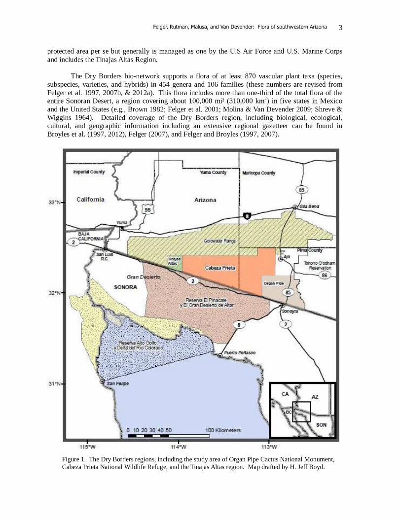
KEY WORDS: Sonoran Desert, vascular plant flora, Arizona, Organ Pipe Cactus National Monument, Cabeza Prieta National Wildlife Refuge, Tinajas Altas, deep history, non-native species, invasive species Fly, drive, or walk across this desert and the one plant you see most is creosotebush (Larrea divaricata). This hardy shrub is one of the key elements of the Sonoran Desert as well as most of the deserts of North and South America. Look again and you see veins of denser green along dry watercourses anastomosing down the bajadas and valley plains and collecting larger and greener at the draining bottomlands. Most of this green is made up of double ribbons of galleries of small trees formed by the legume trinity of mesquites, palo verdes, and desert ironwood (Prosopis, Parkinsonia, and Olneya). Many of the shrubs and other perennials likewise concentrate in the added soil moisture of the watercourses in the familiar xeroriparian (literally “dry-wet”) pattern. Once in a while you might see a flash flood. This is the heart of the Sonoran Desert, where desert mountains emerge like islands from the desert flats. Creosotebush (Larrea) and bursage (Ambrosia dumosa and/or A. deltoidea) are among the most conspicuous perennials across most of the valley plains and expansive bajadas. Two words–mixed desertscrub—belie a potpourri of the hundreds of species on complex upland habitats. Climb the highest mountains, the Ajos, and you are in strange sparse woodland with sky island populations of oak, juniper, and rosewood (Quercus, Juniperus, and Vauquelinia) and many others. A thin cover of plants adapted to shifting sands speckles the dunes of the Pinta Sands. A special vegetation and flora is seen on the several large and even small playas following the rare times of sufficient rains. The few oases and other wetlands and big canyons have their own highly diverse floras. Most significantly the environment remains largely in a surprisingly intact, natural state, although the threats are major and escalate like anywhere else. Generally hidden from view are the influences of changing climates and influences of thousands of years of people living on and traveling through this land. The flora area is the heart of the largest zone of contiguous protected desert in the Americas, 7,515,221 acres (3,041,410 ha) at the heart of the Sonoran Desert, which we refer to as the six “Dry Borders” regions (Figure 1; Felger & Broyles 1997, 2007). Spanning 210 miles (338 km) from San Felipe, Baja California, to just southwest of Phoenix, Arizona, these six Dry Borders regions are: 1) Organ Pipe Cactus National Monument, 2) Cabeza Prieta National Wildlife Refuge, and 3) Sonoran Desert National Monument in Arizona; 4) Reserva de la Biosfera El Pinacate y Gran Desierto de Altar in Sonora and 5) Reserva de la Biosfera Alto Golfo de California y Delta del Río Colorado in Sonora and Baja California; and the 6) Barry M. Goldwater Range. The Goldwater Range in Arizona is not a
Felger, Rutman, Malusa, and Van Devender: Flora of southwestern Arizona
3
protected area per se but generally is managed as one by the U.S Air Force and U.S. Marine Corps and includes the Tinajas Altas Region. The Dry Borders bio-network supports a flora of at least 870 vascular plant taxa (species, subspecies, varieties, and hybrids) in 454 genera and 106 families (these numbers are revised from Felger et al. 1997, 2007b, & 2012a). This flora includes more than one-third of the total flora of the entire Sonoran Desert, a region covering about 100,000 mi² (310,000 km2) in five states in Mexico and the United States (e.g., Brown 1982; Felger et al. 2001; Molina & Van Devender 2009; Shreve & Wiggins 1964). Detailed coverage of the Dry Borders region, including biological, ecological, cultural, and geographic information including an extensive regional gazetteer can be found in Broyles et al. (1997, 2012), Felger (2007), and Felger and Broyles (1997, 2007).
Figure 1. The Dry Borders regions, including the study area of Organ Pipe Cactus National Monument, Cabeza Prieta National Wildlife Refuge, and the Tinajas Altas region. Map drafted by H. Jeff Boyd.
Felger, Rutman, Malusa, and Van Devender: Flora of southwestern Arizona
4
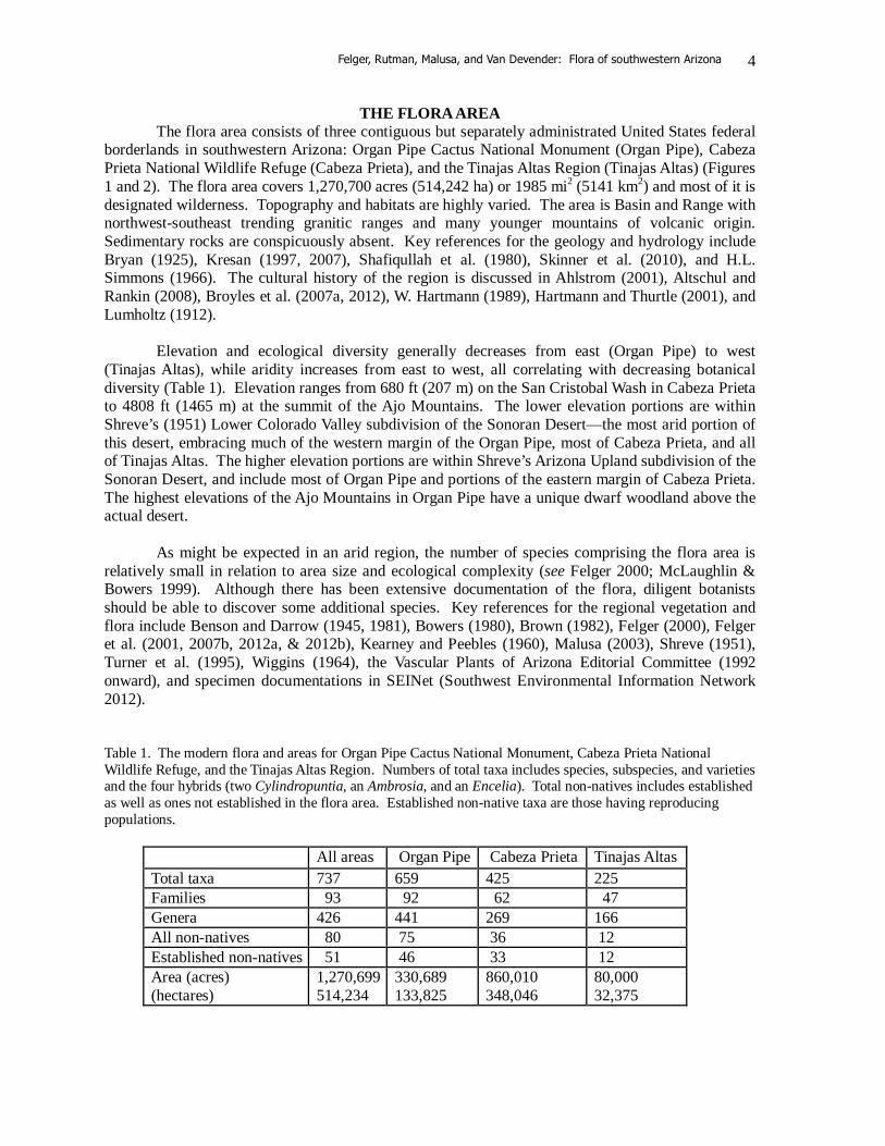
THE FLORA AREA The flora area consists of three contiguous but separately administrated United States federal borderlands in southwestern Arizona: Organ Pipe Cactus National Monument (Organ Pipe), Cabeza Prieta National Wildlife Refuge (Cabeza Prieta), and the Tinajas Altas Region (Tinajas Altas) (Figures 1 and 2). The flora area covers 1,270,700 acres (514,242 ha) or 1985 mi2 (5141 km2) and most of it is designated wilderness. Topography and habitats are highly varied. The area is Basin and Range with northwest-southeast trending granitic ranges and many younger mountains of volcanic origin. Sedimentary rocks are conspicuously absent. Key references for the geology and hydrology include Bryan (1925), Kresan (1997, 2007), Shafiqullah et al. (1980), Skinner et al. (2010), and H.L. Simmons (1966). The cultural history of the region is discussed in Ahlstrom (2001), Altschul and Rankin (2008), Broyles et al. (2007a, 2012), W. Hartmann (1989), Hartmann and Thurtle (2001), and Lumholtz (1912). Elevation and ecological diversity generally decreases from east (Organ Pipe) to west (Tinajas Altas), while aridity increases from east to west, all correlating with decreasing botanical diversity (Table 1). Elevation ranges from 680 ft (207 m) on the San Cristobal Wash in Cabeza Prieta to 4808 ft (1465 m) at the summit of the Ajo Mountains. The lower elevation portions are within Shreve’s (1951) Lower Colorado Valley subdivision of the Sonoran Desert—the most arid portion of this desert, embracing much of the western margin of the Organ Pipe, most of Cabeza Prieta, and all of Tinajas Altas. The higher elevation portions are within Shreve’s Arizona Upland subdivision of the Sonoran Desert, and include most of Organ Pipe and portions of the eastern margin of Cabeza Prieta. The highest elevations of the Ajo Mountains in Organ Pipe have a unique dwarf woodland above the actual desert. As might be expected in an arid region, the number of species comprising the flora area is relatively small in relation to area size and ecological complexity (see Felger 2000; McLaughlin & Bowers 1999). Although there has been extensive documentation of the flora, diligent botanists should be able to discover some additional species. Key references for the regional vegetation and flora include Benson and Darrow (1945, 1981), Bowers (1980), Brown (1982), Felger (2000), Felger et al. (2001, 2007b, 2012a, & 2012b), Kearney and Peebles (1960), Malusa (2003), Shreve (1951), Turner et al. (1995), Wiggins (1964), the Vascular Plants of Arizona Editorial Committee (1992 onward), and specimen documentations in SEINet (Southwest Environmental Information Network 2012). Table 1. The modern flora and areas for Organ Pipe Cactus National Monument, Cabeza Prieta National Wildlife Refuge, and the Tinajas Altas Region. Numbers of total taxa includes species, subspecies, and varieties and the four hybrids (two Cylindropuntia, an Ambrosia, and an Encelia). Total non-natives includes established as well as ones not established in the flora area. Established non-native taxa are those having reproducing populations.
All areas Organ Pipe Cabeza Prieta Tinajas Altas Total taxa 737 659 425 225 Families 93 92 62 47 Genera 426 441 269 166 All non-natives 80 75 36 12 Established non-natives 51 46 33 12 Area (acres) (hectares)
1,270,699 514,234
330,689 133,825
860,010 348,046
80,000 32,375

Felger, Rutman, Malusa, and Van Devender: Flora of southwestern Arizona
5
Although the flora area covers a substantial portion of the Sonoran Desert, endemism as a proportion of the total flora is not especially high (see Felger 2000). Examples of species endemic or essentially endemic to the flora area and adjacent areas such as northwestern Sonora include:
Croton wigginsii, dune croton Dimorphocarpa pinnatifida, dune spectacle-pod Euphorbia platysperma, dune spurge Perityle ajoensis, Ajo rock-daisy Stephanomeria schottii, Schott’s wire-lettuce
Plants rare in the USA or Arizona, or ones reported as taxa of conservation concern include all of the above as well as:
Astragalus insularis var. harwoodii, sand locoweed Atamisquea emarginata, palo hediondo Berberis harrisoniana, Kofa Mountain barberry Cryptantha ganderi, dune cryptantha Drymaria viscosa, sticky drymary Echinomastus erectocentrus var. acunensis, acuña cactus Eryngium nasturtiifolium, hierba del sapo Helianthus niveus subsp. tephrodes, dune sunflower Hermannia pauciflora, dwarf burstwort Jatropha cinerea, ashy limberbush Juncus cooperi, Cooper’s rush Lophocereus schottii, senita Matelea cordifolia, heart-leaf milkweed vine Mirabilis tenuiloba, long-lobed four o’clock Peniocereus striatus, dahlia-root cereus Perityle ajoensis, Ajo rock daisy Sibara angelorum, a winged rock-cress Solanum hindsianum, Hind’s nightshade Vauquelinia californica subsp. sonorensis, Sonoran rosewood
None of the above endemics, or locally rare plants (e.g., ones with highly restricted distributions in Arizona or USA), or even ones listed as plants of conservation concern are in reality globally endangered. The status of each of these plants will be discussed in the individual treatments in forthcoming species accounts. Some plants, native and non-native, are apparently extirpated, or locally extinct, from the flora area, although common elsewhere (* denotes a plant not native to the flora area).
Atriplex lentiformis, quail bush Eleocharis coloradoensis, dwarf spikerush Juncus bufonius, toad rush Matelea cordifolia, heart-leaf milkweed vine Myosurus minimus, dwarf mouse-tail
*Nasturtium officinale, watercress *Poa annua, winter grass
The five largest plant families in terms of number of species are the composites (Asteraceae), grasses (Poaceae), legumes (Fabaceae), cacti (Cactaceae), and euphorbs (Euphorbiaceae). The largest genera are listed below with the number of species and infraspecific taxa (in parenthesis).
Felger, Rutman, Malusa, and Van Devender: Flora of southwestern Arizona
6
Euphorbia, 18 Cylindropuntia, 9 (5) Cryptantha sensu lato, 8 Eriogonum, 8 Phacelia, 8 Lycium, 7 Muhlenbergia, 7 Boerhavia, 6 (2) Ambrosia, 6
Atriplex, 6 Bouteloua, 6 Mentzelia, 6 Amaranthus, 5 Aristida, 5 (2) Asclepias, 5 Ditaxis, 5 Astragalus, 4 (2)
Non-native species make up 10.9% (80 species) of the total modern flora of the three areas,
although only 6.9% (51 species) are full established as reproducing populations (Table 1). Twenty-six of all non-natives are grasses. Many of the non-natives are more or less restricted to disturbed habitats. The 29 non-native species that do not have reproducing populations in the flora area include “strays” such as shepherd’s purse (Capsella bursa-pastoris), safflower (Carthamus tinctorius), sunflower (Helianthus annuus), and wheat (Triticum aestivum), as well ones persisting from cultivation, such as the figs (Ficus carica) and pomegranates (Punica granatum) at Quitobaquito (e.g., Felger et al. 1992), and tree tamarisk (Tamarix aphylla). Some non-native plants are no longer known from the flora area, e.g., watercress (Nasturtium officinale) and winter grass (Poa annua). Purple prickly-pear (Opuntia santa-rita) at Quitobaquito and velvet ash (Fraxinus velutina) and elderberry (Sambucus coerulea) in the Ajo Mountains, possibly planted in historic times, are also no longer present. Agricultural, urbanized, and other disturbed habitats including the roadside along Mexico Highway 2 in adjacent Sonora are major sources of non-natives spreading into the flora area. Roads such Arizona Highway 85, which bisects Organ Pipe, and borderland roads made by the U.S. Border Patrol serve as major invasion corridors for non-native plants. Seven non-natives of Old World origin have become invasive species that pose serious threats to the native ecosystems, e.g., red brome (Bromus rubens), buffelgrass (Cenchrus ciliaris), fountain grass (C. setaceum), Arabian and Mediterranean grasses (Schismus arabicus and S. barbatus), Sahara mustard (Brassica tournefortii), and tamarisk (Tamarix chinensis). Others of concern include Lehmann’s lovegrass (Eragrostis lehmanniana), wild barley (Hordeum murinum), and slender-leaf iceplant (Mesembryanthemum nodiflorum). Wildlife overview in the flora area is provided in Broyles et al. (2012), Griffin (2007), Henry (2007), and Rosen (2007) among others. Fish, reptiles, birds, and mammals listed as endangered or ones of conservation concern include the Sonoyta (Quitobaquito) pupfish (Cyprinodon eremus), Sonoran mud turtle (Kinosternon sonoriense longifemerale), cactus ferruginous pygmy-owl (Glaucidium brasilianum cactorum), lesser long-nosed bat (Leptonycteris curasoae yerbabuenae), and especially the Sonoran pronghorn (Antilocapra americana sonoriensis).
Felger, Rutman, Malusa, and Van Devender: Flora of southwestern Arizona
7
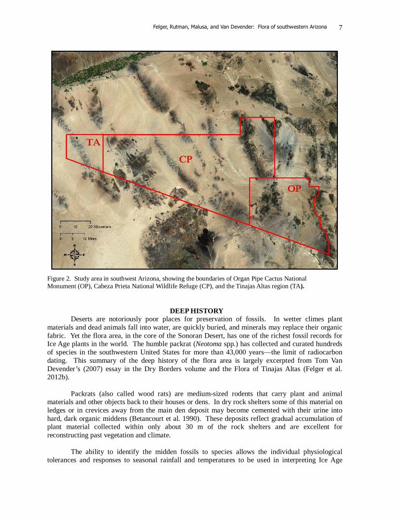
Figure 2. Study area in southwest Arizona, showing the boundaries of Organ Pipe Cactus National Monument (OP), Cabeza Prieta National Wildlife Refuge (CP), and the Tinajas Altas region (TA).
DEEP HISTORY
Deserts are notoriously poor places for preservation of fossils. In wetter climes plant materials and dead animals fall into water, are quickly buried, and minerals may replace their organic fabric. Yet the flora area, in the core of the Sonoran Desert, has one of the richest fossil records for Ice Age plants in the world. The humble packrat (Neotoma spp.) has collected and curated hundreds of species in the southwestern United States for more than 43,000 years—the limit of radiocarbon dating. This summary of the deep history of the flora area is largely excerpted from Tom Van Devender’s (2007) essay in the Dry Borders volume and the Flora of Tinajas Altas (Felger et al. 2012b). Packrats (also called wood rats) are medium-sized rodents that carry plant and animal materials and other objects back to their houses or dens. In dry rock shelters some of this material on ledges or in crevices away from the main den deposit may become cemented with their urine into hard, dark organic middens (Betancourt et al. 1990). These deposits reflect gradual accumulation of plant material collected within only about 30 m of the rock shelters and are excellent for reconstructing past vegetation and climate. The ability to identify the midden fossils to species allows the individual physiological tolerances and responses to seasonal rainfall and temperatures to be used in interpreting Ice Age

Felger, Rutman, Malusa, and Van Devender: Flora of southwestern Arizona
8
climates. Shreve (1915) discussed the role of climate in controlling the elevational distributions of plants on mountains, where cold and competition often set the upper limits and heat and drought the lower limits. In the bi-seasonal rainfall regime of the Sonoran Desert region, completely different sets of annuals (ephemerals) respond to winter-spring and summer monsoonal rainfall. Their presence and abundance in midden assemblages are excellent indicators of the seasonal distribution of rainfall in the past. The Ice Ages are synonymous with the Pleistocene epoch, which ended about 11,600 ybp (years before “present,” or radiocarbon years before 1950), and was followed by the contemporary epoch known as the Holocene. The last glacial episode during the Pleistocene in North America is the Wisconsin, during which glaciers reached their maximum extent around 21,000 ybp, and began a 10,000-year retreat to end the Pleistocene and begin the Holocene.
Within the study area, packrat middens older than 9000 ybp consistently contain remains of plants now found at higher elevations in woodland or chaparral or at higher latitudes in the present Mojave Desert. The annual plants identified in these late Wisconsin and early Holocene assemblages are almost entirely species that grow in response to winter-spring, or cool season rains. Most of the modern Sonoran Desert dominants and many of the summer ephemerals are closely tied to summer rainfall, and they did not appear in the assemblages until the middle or late Holocene—the last 6,000 years. These changes in plant distributions indicated that winter rainfall from Pacific fronts was much greater than today, and summer monsoonal rainfall from the warm tropical oceans was greatly reduced (Van Devender 1990; Van Devender et al. 1994). However, some C4 grasses (including Bothriochloa barbinodis, Bouteloua barbata, and B. curtipendula) and summer annuals appear several thousand years earlier in the midden record, and although they may have been responding to spring or fall precipitation and not summer monsoons, some argue that summer precipitation may have developed as early as 13,858 ybp (Holmgren et al. 2011).
The Ice Age climates of the flora area allowed associations of plants and animals not seen today. In the Tinajas Altas Mountains, for example, remains of holly-leaf bursage (Ambrosia ilicifolia), a regional desert endemic, were found in late Wisconsin and early Holocene assemblages together with single-leaf pinyon (Pinus edulis var. fallax), California juniper (Juniperus californica), and skunk bush (Rhus aromatica), all typical of relatively cooler, moister climes. Assuming conservative eco-physiology among species since the Pleistocene (a hypothesis for which there is ample support, e.g., Martinez-Meyer & Peterson 2006), the only way to get a holly-leaf bursage in the company of a pinyon pine is in a climate that no longer exists, one in which the winters are warmer yet the summers are cooler. Under this scenario, the bursage wouldn’t freeze and the pinyon wouldn’t roast. Warmer winters during the Ice Age seem improbable, but Bryson and Wendland (1967) were among the first to recognize that stupendous glaciers at high latitudes could actually block the Arctic air masses from moving south, in much the same way the Colorado Plateau and Rockies block the ‘blue northers’ cold fronts that import the coldest temperatures to the Chihuahuan Desert and the Mexican Plateau in the mid-continent. The adiabatic warming of downslope winds would further moderate winter lows.
Relatively modern communities were developed for about only 5–10% of the 2.4 million years of the Pleistocene (Porter 1989; Winograd et al. 1997), during the interglacial episodes. Thus the modern interglacial climate and ecological setting found in the flora area/Dry Borders region today is unusual. Woodland/chaparral communities with single-leaf pinyon, juniper, and Joshua tree (Yucca brevifolia) in desert lowlands and unusual biotic mixtures were the norm for about 90% of the Pleistocene.
Felger, Rutman, Malusa, and Van Devender: Flora of southwestern Arizona
9
According to the midden fossil record, numerous plant species made many and varied changes in their geographic ranges, yet most are morphologically indistinguishable from their modern descendants. Long-lived trees and succulents including pinyon, junipers, oak (Quercus turbinella), Joshua tree, and others spread into desert lowlands while plants of summer-rainfall affinity such as saguaro (Carnegiea gigantea) and foothill palo verde (Parkinsonia microphylla) were restricted to small refugia, perhaps in central Sonora.
In the 1960–70s students of Paul S. Martin used macrofossils in packrat middens to
reconstruct late Pleistocene glacial and interglacial vegetation and climates in all four major deserts of North America. Hundreds of well-preserved fossils identified to extant species demonstrated that there was virtually no extinction or speciation in plants, invertebrates, and small vertebrates at the Wisconsin–Holocene glacial/interglacial climatic change. Instead, geographic ranges fluctuated on time scales ranging from decades to millennia, strongly suggesting that geographic ranges should not be used as taxonomic characters. Midden assemblages definitively demonstrated that plant communities are strongly individualistic with each species responding independently to climate changes. In the late Wisconsin glacial, anomalous associations of species not found today were typical in Ice Age equable climates with milder winters, much cooler summers, and a shift to winter rainfall dominance (Betancourt et al. 1990). Arizona Upland in Deep History The Ice Age vegetation in the elevations that today support the Arizona Upland subdivision of the Sonoran Desert, including the eastern part of the flora area, was a pinyon-juniper-oak woodland. In the 1970s Hal Coss, a naturalist at Organ Pipe Cactus National Monument, discovered a pinyon-juniper midden in a cave at 975 m on the south side of Montezuma’s Head, a prominent peak in the Ajo Mountains. He led Paul S. Martin, Jim Mead, Art Phillips, and Tom Van Devender to the remote roadless site. Four separate samples were dated from 13,500–21,840 ybp (Van Devender 1990). The midden assemblages recorded remarkable mesic woodland vegetation with single-leaf pinyon, Rocky Mountain and Utah junipers (J. scopulorum and J. osteosperma), scrub oak (Quercus turbinella), Joshua tree, big sagebrush (Artemisia tridentata complex), shadscale (Atriplex confertifolia), and snowberry (Symphoricarpos sp.). The nearest populations of Rocky Mountain juniper today are about 270 km to the northeast. The big sagebrushes are dominants in Great Basin desertscrub communities 390–440 km to the north-northeast. The nearest Joshua trees, the arborescent yucca that characterizes large areas of the modern Mojave Desert, are near Aguila, Arizona, 225 km to the north-northwest. Organ pipe cactus (Stenocereus thurberi) and other Arizona Upland dominants visible from the cave were not in the samples. Additional Wisconsin-aged midden samples from 915 m in Alamo Canyon in the Ajo Mountains were dated at 14,500 and 32,000 ybp and contained similar woodland assemblages. Ice Age woodlands were in the Ajo Mountains for at least 18,500 years of the Wisconsin glacial until, about 11,000 years ago, when the single-leaf pinyon, Rocky Mountain juniper, and big sagebrush disappeared. The modern vegetation of the Ajos, crowned with relictual woodland plants and a broad skirt of Arizona Upland desertscrub, formed perhaps 8000 years ago. Lower Colorado River Valley in Deep History
At the western extent of the study area, in the Tinajas Altas Mountains, a series of 21 middens from 330–580 m records changes in the vegetation from more than 43,200–1230 ybp. In the middle and late Wisconsin, woodlands of California juniper, single-leaf pinyon, Mojave sage (Salvia mohavensis), and desert tree-beargrass (Nolina bigelovii) were present. This vegetation is very similar to modern areas in the Joshua Tree National Monument in California (Van Devender 1987, 1990).
Felger, Rutman, Malusa, and Van Devender: Flora of southwestern Arizona
10
Today, the Lower Colorado River Valley subdivision of the Sonoran Desert is mostly creosotebush (Larrea) desertscrub in the valleys, while the mountains and bajadas hold brittlebush (Encelia farinosa), white bursage (Ambrosia dumosa), creosotebush, and the conspicuous foothill palo verde and/or elephant tree (Bursera microphylla). Creosotebush desertscrub began to form by 8900 ybp, and between 4010 and 1230 ybp relatively modern desertscrub communities formed with the arrival of foothill palo verde. A sample from 330 m elevation on the west side of the Tinajas Altas Mountains and nine samples at 240–245 m in the nearby Butler Mountains provide additional insight into the Ice Age vegetation of the lower elevations in the modern Sonoran Desert (Van Devender 1990). The midden from the Tinajas Altas Mountains reveals a late Wisconsin xeric woodland with California juniper, Mojave sage, creosotebush, brittlebush, and holly-leaf and white bursages (Ambrosia ilicifolia and A. dumosa). The Butler Mountains, a simple slender ridge of granite rising above the Yuma Dunes at the westernmost fringe of the study area, held a similar Wisconsin flora, except without juniper. The modern tetraploid race of creosotebush was identified in a Tinajas Altas midden dominated by California juniper and Joshua tree, radiocarbon dated at 18,700 ybp (Hunter et al. 2001; Van Devender 1990). This midden record near the height of the Wisconsin glacial maximum suggests that relatively modern creosotebush–white bursage desertscrub could have been present in the Lower Colorado River Valley for most of the 1.8 million years of the Pleistocene—after the immigration of creosotebush from South America into North America. Considering that the Ice Age vegetation in all the higher-elevation areas in the Sonoran Desert supported Ice Age woodlands, desertscrub in the Lower Colorado River Valley may have been more stable with a minimum of fluctuations. A recent study of the phylogeographic, spatial genetic, and population genetics of brittlebush (Encelia farinosa) supports this notion, with the patterns of genetic variation consistent with the hypothesis that brittlebush persisted during the Pleistocene in the Lower Colorado River Valley, as well as on the Plains of Sonora and in Baja California Sur (Fehlberg & Ranker 2009). Deep History Summary
Plant remains from the Pleistocene epoch documented single-leaf pinyon-juniper-oak woodland/chaparral with few to none of the modern long-lived trees, shrubs, or succulents at 550–1525 m in the modern Arizona Upland of the Sonoran Desert. At lower elevations in the modern Lower Colorado River Valley subdivision (240–550 m), Ice Age woodlands were dominated by California juniper and Joshua tree. Away from the mountains simple desertscrub dominated by creosotebush, white bursage, and big galleta grass (Hilaria rigida) was likely present for most of the Pleistocene. The tetraploid Sonoran Desert chromosomal race of creosotebush was present at 330 m on the west side of the Tinajas Altas Mountains 18,700 ybp in the Wisconsin full glacial.
During the Holocene epoch, most Ice Age woodland plants disappeared from the flora area.
Desertscrub with saguaro and brittlebush formed 8000–9000 ybp in association with catclaw acacia (Senegalia (Acacia) greggii) and blue palo verde (Parkinsonia florida). About 4500 ybp modern Sonoran Desert communities formed with the arrival of foothill palo verde, organ pipe cactus, and desert ironwood (Olneya tesota). Fossils from the flora area middens have yielded more than 201 species. These fossils include at least 171 species still present in the flora area, or 26% of the modern native flora of 656 taxa. Additionally, fossils of at least 30 species, or l4.6% of the modern native flora, are no longer present.
Felger, Rutman, Malusa, and Van Devender: Flora of southwestern Arizona
11
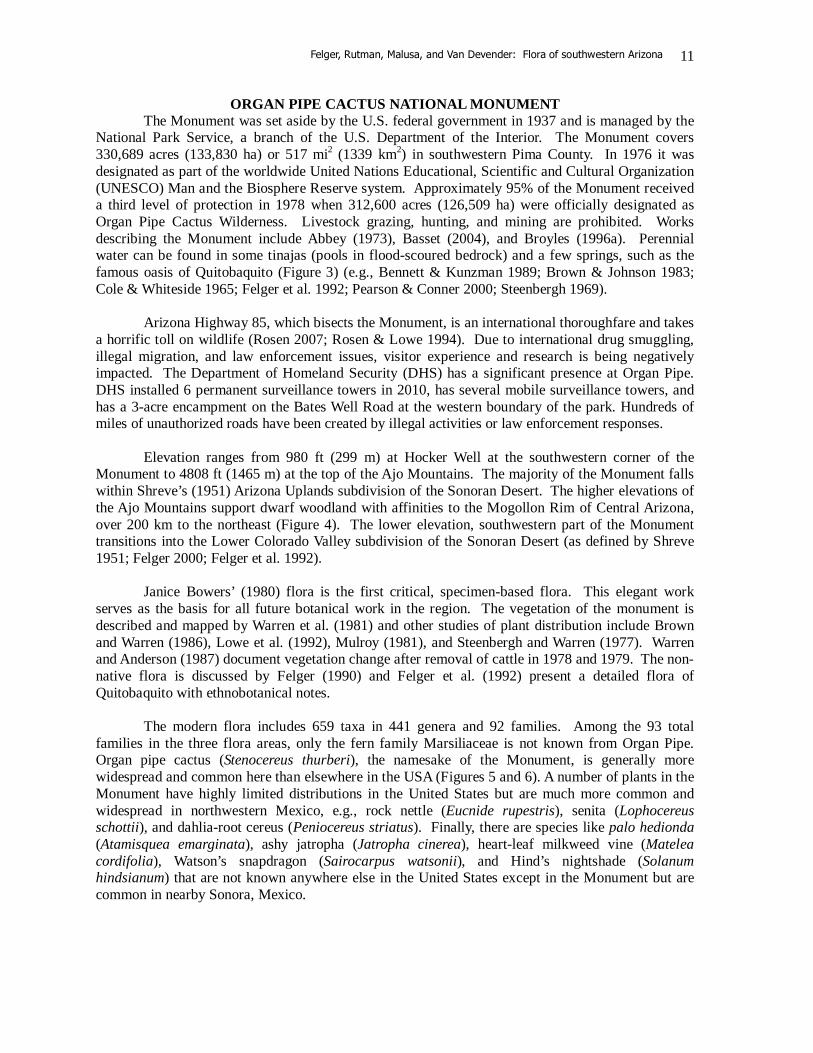
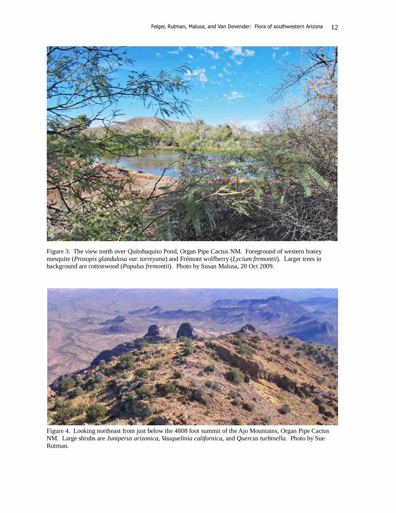
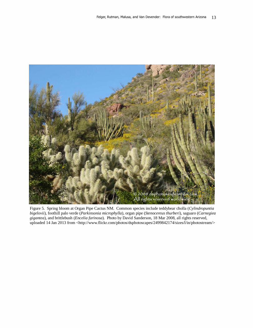
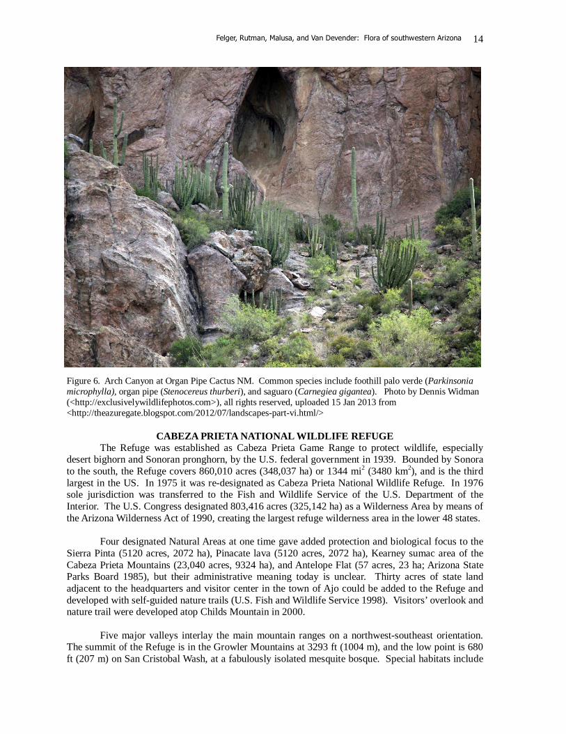
ORGAN PIPE CACTUS NATIONAL MONUMENT The Monument was set aside by the U.S. federal government in 1937 and is managed by the National Park Service, a branch of the U.S. Department of the Interior. The Monument covers 330,689 acres (133,830 ha) or 517 mi2 (1339 km2) in southwestern Pima County. In 1976 it was designated as part of the worldwide United Nations Educational, Scientific and Cultural Organization (UNESCO) Man and the Biosphere Reserve system. Approximately 95% of the Monument received a third level of protection in 1978 when 312,600 acres (126,509 ha) were officially designated as Organ Pipe Cactus Wilderness. Livestock grazing, hunting, and mining are prohibited. Works describing the Monument include Abbey (1973), Basset (2004), and Broyles (1996a). Perennial water can be found in some tinajas (pools in flood-scoured bedrock) and a few springs, such as the famous oasis of Quitobaquito (Figure 3) (e.g., Bennett & Kunzman 1989; Brown & Johnson 1983; Cole & Whiteside 1965; Felger et al. 1992; Pearson & Conner 2000; Steenbergh 1969). Arizona Highway 85, which bisects the Monument, is an international thoroughfare and takes a horrific toll on wildlife (Rosen 2007; Rosen & Lowe 1994). Due to international drug smuggling, illegal migration, and law enforcement issues, visitor experience and research is being negatively impacted. The Department of Homeland Security (DHS) has a significant presence at Organ Pipe. DHS installed 6 permanent surveillance towers in 2010, has several mobile surveillance towers, and has a 3-acre encampment on the Bates Well Road at the western boundary of the park. Hundreds of miles of unauthorized roads have been created by illegal activities or law enforcement responses. Elevation ranges from 980 ft (299 m) at Hocker Well at the southwestern corner of the Monument to 4808 ft (1465 m) at the top of the Ajo Mountains. The majority of the Monument falls within Shreve’s (1951) Arizona Uplands subdivision of the Sonoran Desert. The higher elevations of the Ajo Mountains support dwarf woodland with affinities to the Mogollon Rim of Central Arizona, over 200 km to the northeast (Figure 4). The lower elevation, southwestern part of the Monument transitions into the Lower Colorado Valley subdivision of the Sonoran Desert (as defined by Shreve 1951; Felger 2000; Felger et al. 1992). Janice Bowers’ (1980) flora is the first critical, specimen-based flora. This elegant work serves as the basis for all future botanical work in the region. The vegetation of the monument is described and mapped by Warren et al. (1981) and other studies of plant distribution include Brown and Warren (1986), Lowe et al. (1992), Mulroy (1981), and Steenbergh and Warren (1977). Warren and Anderson (1987) document vegetation change after removal of cattle in 1978 and 1979. The non-native flora is discussed by Felger (1990) and Felger et al. (1992) present a detailed flora of Quitobaquito with ethnobotanical notes. The modern flora includes 659 taxa in 441 genera and 92 families. Among the 93 total families in the three flora areas, only the fern family Marsiliaceae is not known from Organ Pipe. Organ pipe cactus (Stenocereus thurberi), the namesake of the Monument, is generally more widespread and common here than elsewhere in the USA (Figures 5 and 6). A number of plants in the Monument have highly limited distributions in the United States but are much more common and widespread in northwestern Mexico, e.g., rock nettle (Eucnide rupestris), senita (Lophocereus schottii), and dahlia-root cereus (Peniocereus striatus). Finally, there are species like palo hedionda (Atamisquea emarginata), ashy jatropha (Jatropha cinerea), heart-leaf milkweed vine (Matelea cordifolia), Watson’s snapdragon (Sairocarpus watsonii), and Hind’s nightshade (Solanum hindsianum) that are not known anywhere else in the United States except in the Monument but are common in nearby Sonora, Mexico.
Felger, Rutman, Malusa, and Van Devender: Flora of southwestern Arizona
12
Figure 3. The view north over Quitobaquito Pond, Organ Pipe Cactus NM. Foreground of western honey mesquite (Prosopis glandulosa var. torreyana) and Frémont wolfberry (Lycium fremontii). Larger trees in background are cottonwood (Populus fremontii). Photo by Susan Malusa, 20 Oct 2009.
Figure 4. Looking northeast from just below the 4808 foot summit of the Ajo Mountains, Organ Pipe Cactus NM. Large shrubs are Juniperus arizonica, Vauquelinia californica, and Quercus turbinella. Photo by Sue Rutman.
Felger, Rutman, Malusa, and Van Devender: Flora of southwestern Arizona
13
Figure 5. Spring bloom at Organ Pipe Cactus NM. Common species include teddybear cholla (Cylindropuntia bigelovii), foothill palo verde (Parkinsonia microphylla), organ pipe (Stenocereus thurberi), saguaro (Carnegiea gigantea), and brittlebush (Encelia farinosa). Photo by David Sanderson, 18 Mar 2008, all rights reserved, uploaded 14 Jan 2013 from <http://www.flickr.com/photos/dsphotoscapes/2499842174/sizes/l/in/photostream/>
Felger, Rutman, Malusa, and Van Devender: Flora of southwestern Arizona
14
Figure 6. Arch Canyon at Organ Pipe Cactus NM. Common species include foothill palo verde (Parkinsonia microphylla), organ pipe (Stenocereus thurberi), and saguaro (Carnegiea gigantea). Photo by Dennis Widman (<http://exclusivelywildlifephotos.com>), all rights reserved, uploaded 15 Jan 2013 from <http://theazuregate.blogspot.com/2012/07/landscapes-part-vi.html/>
CABEZA PRIETA NATIONAL WILDLIFE REFUGE The Refuge was established as Cabeza Prieta Game Range to protect wildlife, especially desert bighorn and Sonoran pronghorn, by the U.S. federal government in 1939. Bounded by Sonora to the south, the Refuge covers 860,010 acres (348,037 ha) or 1344 mi2 (3480 km2), and is the third largest in the US. In 1975 it was re-designated as Cabeza Prieta National Wildlife Refuge. In 1976 sole jurisdiction was transferred to the Fish and Wildlife Service of the U.S. Department of the Interior. The U.S. Congress designated 803,416 acres (325,142 ha) as a Wilderness Area by means of the Arizona Wilderness Act of 1990, creating the largest refuge wilderness area in the lower 48 states. Four designated Natural Areas at one time gave added protection and biological focus to the Sierra Pinta (5120 acres, 2072 ha), Pinacate lava (5120 acres, 2072 ha), Kearney sumac area of the Cabeza Prieta Mountains (23,040 acres, 9324 ha), and Antelope Flat (57 acres, 23 ha; Arizona State Parks Board 1985), but their administrative meaning today is unclear. Thirty acres of state land adjacent to the headquarters and visitor center in the town of Ajo could be added to the Refuge and developed with self-guided nature trails (U.S. Fish and Wildlife Service 1998). Visitors’ overlook and nature trail were developed atop Childs Mountain in 2000. Five major valleys interlay the main mountain ranges on a northwest-southeast orientation. The summit of the Refuge is in the Growler Mountains at 3293 ft (1004 m), and the low point is 680 ft (207 m) on San Cristobal Wash, at a fabulously isolated mesquite bosque. Special habitats include
Felger, Rutman, Malusa, and Van Devender: Flora of southwestern Arizona
15
the Pinta Sands, the Pinacate Lava Flow, and the playas—Las Playas and the smaller Dos Playas and Pinta Playa. The Pinta Sands are the only substantial dunes in the flora area. The Pinacate Lava has a flora essentially indistinguishable from that of the contiguous and larger, low-elevation volcanic areas south of the international border (Felger 2000). The diversity of the landscape is shown in Figs. 7–11. Perennial or near permanent water can be found in several tinajas and one spring (Broyles 1996b). As in the Goldwater Range, most of the natural waterholes have been artificially enlarged (“enhanced”). Several represos (impoundments) have been built, modified, or maintained by game managers. While the “improved” waterholes provide habitat for migratory birds, they also allow increased feral honeybee populations, which undoubtedly has an adverse effect on the highly diverse and unique native pollinator bees (Buchmann & Nabhan 1996), and they are of questionable value for target species (Broyles 1996b; Broyles & Cutler 1999). Recreational use consists largely of camping, hiking, and vehicular travel primarily on the Camino del Diablo. Grazing and mining are prohibited, and hunting is stringently controlled. Airspace over the Refuge is restricted and controlled by the military, and the military makes extensive use of low-level air space over most of the Refuge. Except for a few isolated locations where telemetry equipment is installed for monitoring aircraft, there are no authorized, ground-based uses of the Refuge by the military. The Air Force restricts gunnery training to locations north of the Refuge. Frequent noise including sonic booms from training flights over the Refuge can be annoying but environmental effects on non-humans appear to be minimal (Krausman et al. 2004). The U.S. Border Patrol has a significant presence along the southern margin of the Refuge. There is a communications and radar center atop Childs Mountain and there used to be a major military installation on the mountain (Broyles et al. 2007b). A 2011 study using imagery from 2008 found 7739 miles of vehicular trails on the Refuge (Cabeza Prieta NWR 2011) Norman Simmons (1965, 1966), assistant manager of Cabeza Prieta 1961–1966, produced the first specimen-based flora of the Refuge. Malusa (2003) prepared vegetation maps for portions of the Refuge as well as adjacent BLM lands. The modern flora includes 425 taxa in 269 genera and 62 families. Sibara angelorum, a winged rockcress, is known from the United States by a single Cabeza Prieta specimen. Another small desert annual, sticky drymary (Drymaria viscosa) is also known for the United States only from the Refuge, and another annual, Eryngium nasturtiifolium, is known in the United States only from Cabeza Prieta and the southeastern part of the Tohono O’odham lands. No jojoba (Simmondsia chinensis) has been found on the Refuge in spite of the fact that it is listed in some checklists. The lack of jojoba, undoubtedly due to aridity, may be one reason why there are so few mule deer on the Refuge. Although the Refuge lacks the distinctive higher-elevation vegetation seen in Organ Pipe, the tops of the larger mountains support plant species not seen at lower elevations. The spectacular scallop-leaf sage (Salvia vaseyi) was discovered atop the Sierra Pinta and the nearby Coyote Mountains on the Goldwater Range (Cain et al. 2010) and is known otherwise only from Baja California and California mountains west of the intervening desert. Other “western desert” plants enter the western part of Refuge and also occur in Tinajas Altas, generally in steep granitic ranges. Examples include: Ambrosia ilicifolia, holly-leaf bursage Ditaxis brandegeei, Sonoran silverbush Echinocactus polycephalus, many-headed
barrel cactus Fagonia pachyacantha, sticky fagonia Opuntia basilaris, beavertail prickly pear
Nolina bigelovii, desert tree-beargrass Peucephyllum schottii, pygmy cedar Rhus kearneyi, desert sumac Thamnosma montana, turpentine broom Triteleiopsis palmeri, blue sand-lily
Felger, Rutman, Malusa, and Van Devender: Flora of southwestern Arizona
16
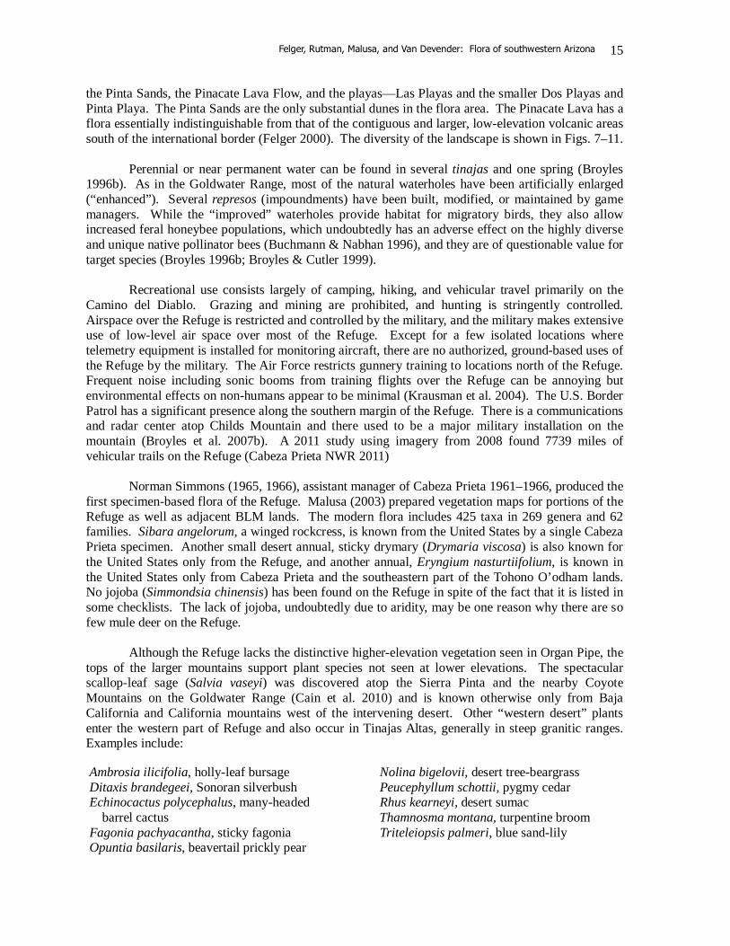
Figure 7. Ocotillo (Fouquieria splendens) towering over petroglyphs in the Growler Mountains of Cabeza Prieta NWR. Photo by Brad Wilson, DVM, 5 Mar 2010, all rights reserved, uploaded 24 Dec 2012 from <http://www.flickr.com/photos/frogdr/>
Felger, Rutman, Malusa, and Van Devender: Flora of southwestern Arizona
17
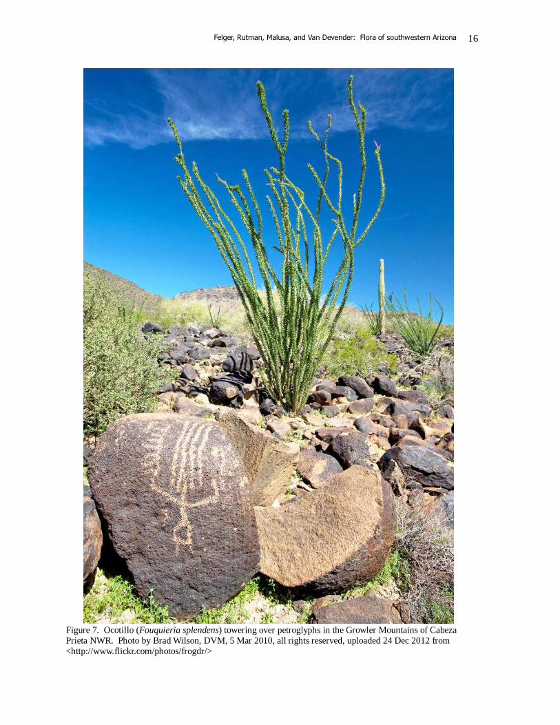
Figure 8. The view southeast to the Bryan Mountains of Cabeza Prieta NWR, as seen from the Mohawk Mountains at 2600 feet. Common species include teddybear cholla (Cylindropuntia bigelovii), foothill palo verde (Parkinsonia microphylla), Agave deserti, and creosotebush (Larrea divaricata). Photo by Jim Malusa, Dec 2010.
Felger, Rutman, Malusa, and Van Devender: Flora of southwestern Arizona
18
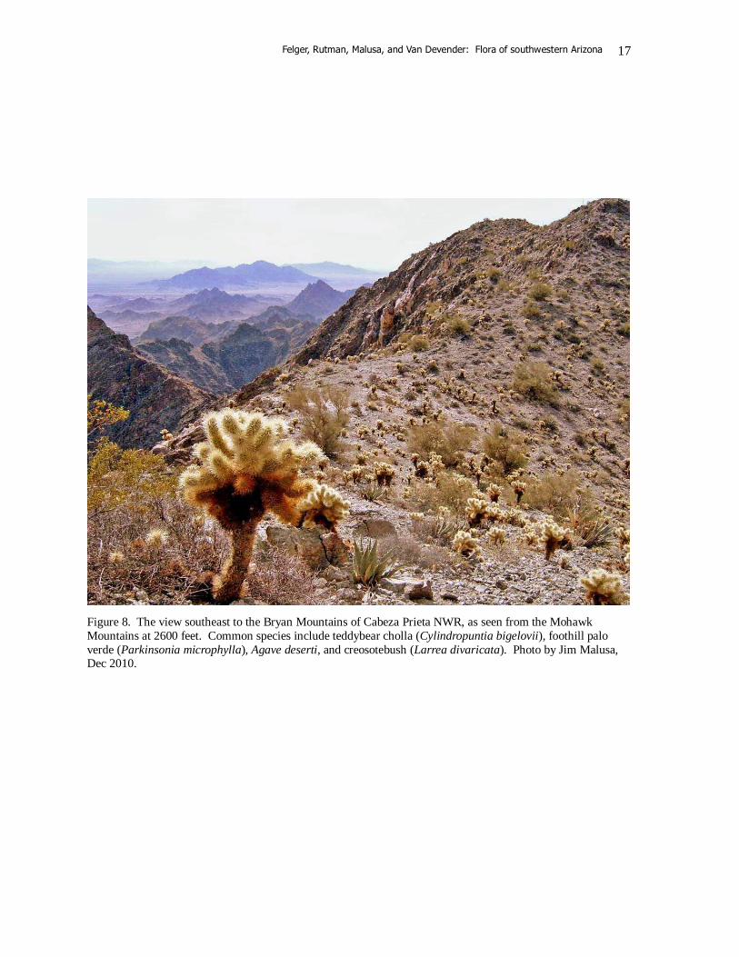
Figure 9. The view to the Sierra Lechuguilla, on the west boundary of Cabeza Prieta NWR. The small pale shrubs are Ambrosia dumosa, which replaces Ambrosia deltoidea in the more arid western reaches of the study area. Also shown are creosotebush and saguaro. Photo by Jim Malusa, 5 Apr 2011.
Felger, Rutman, Malusa, and Van Devender: Flora of southwestern Arizona
19
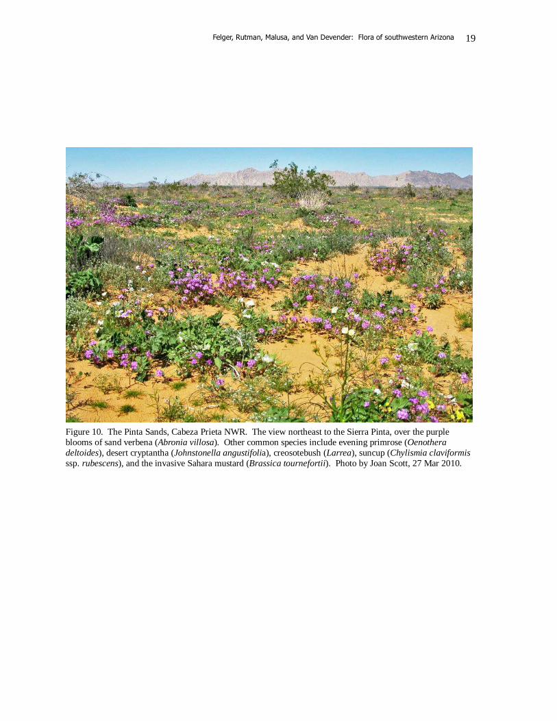
Figure 10. The Pinta Sands, Cabeza Prieta NWR. The view northeast to the Sierra Pinta, over the purple blooms of sand verbena (Abronia villosa). Other common species include evening primrose (Oenothera deltoides), desert cryptantha (Johnstonella angustifolia), creosotebush (Larrea), suncup (Chylismia claviformis ssp. rubescens), and the invasive Sahara mustard (Brassica tournefortii). Photo by Joan Scott, 27 Mar 2010.
Felger, Rutman, Malusa, and Van Devender: Flora of southwestern Arizona
20
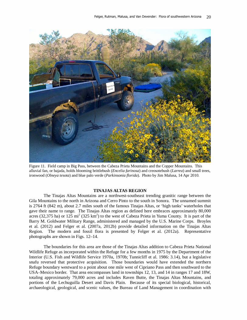
Figure 11. Field camp in Big Pass, between the Cabeza Prieta Mountains and the Copper Mountains. This alluvial fan, or bajada, holds blooming brittlebush (Encelia farinosa) and creosotebush (Larrea) and small trees, ironwood (Olneya tesota) and blue palo verde (Parkinsonia florida). Photo by Jim Malusa, 14 Apr 2010.
TINAJAS ALTAS REGION The Tinajas Altas Mountains are a northwest-southeast trending granitic range between the Gila Mountains to the north in Arizona and Cerro Pinto to the south in Sonora. The unnamed summit is 2764 ft (842 m), about 2.7 miles south of the famous Tinajas Altas, or ‘high tanks’ waterholes that gave their name to range. The Tinajas Altas region as defined here embraces approximately 80,000 acres (32,375 ha) or 125 mi2 (325 km2) to the west of Cabeza Prieta in Yuma County. It is part of the Barry M. Goldwater Military Range, administered and managed by the U.S. Marine Corps. Broyles et al. (2012) and Felger et al. (2007a, 2012b) provide detailed information on the Tinajas Altas Region. The modern and fossil flora is presented by Felger et al. (2012a). Representative photographs are shown in Figs. 12–14. The boundaries for this area are those of the Tinajas Altas addition to Cabeza Prieta National Wildlife Refuge as incorporated within the Refuge for a few months in 1975 by the Department of the Interior (U.S. Fish and Wildlife Service 1970a, 1970b; Tunnicliff et al. 1986: 3.14), but a legislative snafu reversed that protective acquisition. Those boundaries would have extended the northern Refuge boundary westward to a point about one mile west of Cipriano Pass and then southward to the USA–Mexico border. That area encompasses land in townships 12, 13, and 14 in ranges 17 and 18W, totaling approximately 79,000 acres and includes Raven Butte, the Tinajas Altas Mountains, and portions of the Lechuguilla Desert and Davis Plain. Because of its special biological, historical, archaeological, geological, and scenic values, the Bureau of Land Management in coordination with
Felger, Rutman, Malusa, and Van Devender: Flora of southwestern Arizona
21
the Department of Defense subsequently designated much of the former addition as the Tinajas Altas Mountain Area of Critical Environmental Concern (ACEC) of irregular configuration comprising about 53,000 acres (21,449 ha) (U.S. Department of the Interior 1990).
On December 3, 1982, the Tinajas Altas Mountains became an Arizona State Natural Area with the concurrence of the Air Force and Marine Corps. The designated area consisted of the same 79,000 acres that had been briefly added to the Cabeza Prieta National Wildlife Refuge in 1975. Although this natural area designation had no direct legal effect, it recognized the mountains for several special attributes “[their] relatively undisturbed character, the wildlife and vegetation indigenous to the location, the several tinajas (or natural water tanks) located in the mountains, and the fact that the tinajas were an important stopping place along the Camino del Diablo” (Tunnicliff et al. 1986: sec. 14, p. 10). "In the late 1990s, a binational agreement was signed between Mexico and the United States that affected the border region of northwest Mexico and southwest Arizona. It was inspired by the Biosphere Reserve designation on the Mexican side. The agreement encouraged cooperative actions with a goal of natural resource protection. BLM’s Tinajas Altas Area of Critical Environmental Concern was one of the listed areas (U.S. Department of the Interior 1997)” (Broyles & Hartman 2012: 173–174). Tinajas Altas is the most arid portion of the flora area. The core area is the approximately 80,000 acres (32,375 ha) encompassing the Tinajas Altas Mountains from Cipriano Pass to the Mexico border at Frontera Canyon and the south end of the Lechuguilla Valley. Elevation ranges from 950 to 2764 ft (290 to 842 m). The region is within Shreve’s (1951) Lower Colorado Valley subdivision of the Sonoran Desert. An arroyo from a hanging valley in these granitic mountains downcuts steeply through joint fractures to scour and pluck a staircase of pools (Figure 15). Nine sets of intermittent and perennial pools, the Tinajas Altas, hold at least 22,000 gallons when full. Because of the ample and dependable water it was a major prehistoric site, utilized for millennia by Native Americans (Broyles et al. 2012; Bryan 1925; Hartmann & Thurtle 2001; Nichols 1997, 2007). This was the site of the Hia Ced O’odham village of 'Ó'ovak and the numerous bedrock grinding holes and a rich archeological record attest to a long occupation. The O’odham name is 'Ó'ovak or O'o Voopod ('where the arrows were shot'), or historically transcribed also as Oo'oo'woopa ('where the arrows lie down') or Oouvuak. Lumholtz reports the legend that two O'odham men shot arrows from opposite sides of the mountain’s spine. One’s arrows cleared the mountain; the other’s fell short and made holes in the mountains that became tinajas. Fillman Bell (Broyles et al. 2007b) asserts that 'O'ovak means 'a drawing hole' or 'place where moisture is gathered.' Permanent water made the Tinajas Altas “renowned in the pioneer history of the district” according to Lumholtz (1912: 239, 396), although he complained of “pieces of cast-off clothing, rusty tin cans, and other cheerless marks of human occupancy” in January 1910. If you were traveling across the Camino del Diablo, part of the old Yuma–Caborca trail, you would head for the Tinajas Altas. Sometimes the lower tanks would be dry and getting to the upper tanks could be daunting, and some travelers did not know about the upper pools or were not able to reach them. Missing the tinajas and their water could spell death to desert travelers. The importance of Tinajas Altas grew during the California gold rush of the mid-nineteenth century and by the end of that century they became a focus for desert research by the likes of WJ McGee (1898, 1901) and Edgar Mearns. Mearns (1907: 122) wrote, “This important station is at the east base of the [mountains], beside the lowest of a chain of natural rock tanks, in a steep ravine, containing an unfailing and almost inexhaustible supply of good water. The upper tanks are easily overlooked and difficult of access, which facts afford the most plausible explanation of the loss of lives of many persons whose bones and graves were thickly scattered about our camp.”
Felger, Rutman, Malusa, and Van Devender: Flora of southwestern Arizona
22
The modern, present-day flora includes 225 taxa in 166 genera and 47 families. The fossil record includes at least 121 taxa in 97 genera and 36 families, and among these 6 families (Cupressaceae, Pinaceae, Apiaceae, Koeberliaceae, Ranunculaceae, Verbenaceae) and at least 29 species in 17 genera are no longer present in the region (Felger et al. 2012a). Tinajas Altas and the western margin of Cabeza Prieta are host to a desert four o’clock (Mirabilis tenuiloba) known from few other places in Arizona. The dune spurge (Euphorbia platysperma) occurs at or very near the southwestern corner of the area and is extremely rare in the United States. There are 12 non-native species in the flora, which is only 5.3% of the total flora. We include some modern as well as fossil specimens from the Butler Mountains with the Tinajas Altas region because it is a western outlier to the range and has yielded a rich assemblage of fossils recovered from ancient packrat middens (Felger et al. 2012b; Van Devender 1990). This small, extremely arid, granitic range 4 miles west of the Tinajas Altas Mountains has a summit of 1169 ft (356 m). Its base is partially buried by drifting sands.
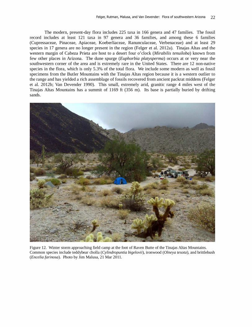
Figure 12. Winter storm approaching field camp at the foot of Raven Butte of the Tinajas Altas Mountains. Common species include teddybear cholla (Cylindropuntia bigelovii), ironwood (Olneya tesota), and brittlebush (Encelia farinosa). Photo by Jim Malusa, 21 Mar 2011.
Felger, Rutman, Malusa, and Van Devender: Flora of southwestern Arizona
23
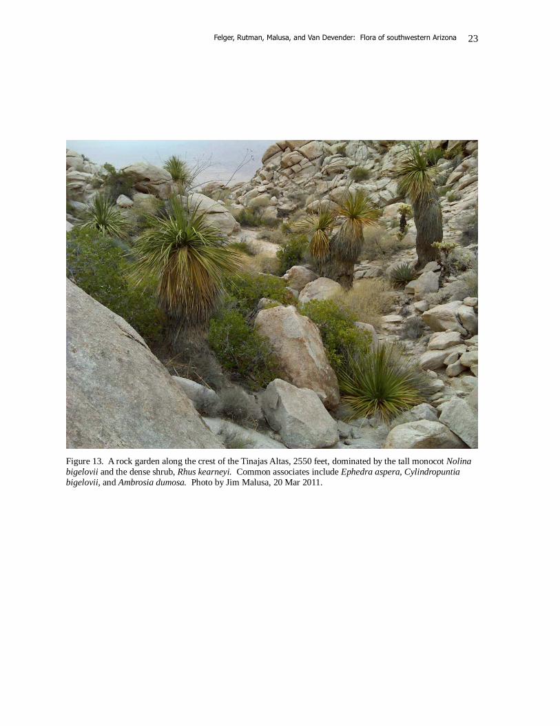
Figure 13. A rock garden along the crest of the Tinajas Altas, 2550 feet, dominated by the tall monocot Nolina bigelovii and the dense shrub, Rhus kearneyi. Common associates include Ephedra aspera, Cylindropuntia bigelovii, and Ambrosia dumosa. Photo by Jim Malusa, 20 Mar 2011.
Felger, Rutman, Malusa, and Van Devender: Flora of southwestern Arizona
24
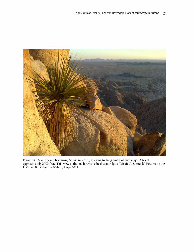
Figure 14. A lone desert beargrass, Nolina bigelovii, clinging to the granites of the Tinajas Altas at approximately 2000 feet. This view to the south reveals the distant ridge of Mexico’s Sierra del Rosario on the horizon. Photo by Jim Malusa, 3 Apr 2012.
Felger, Rutman, Malusa, and Van Devender: Flora of southwestern Arizona
25
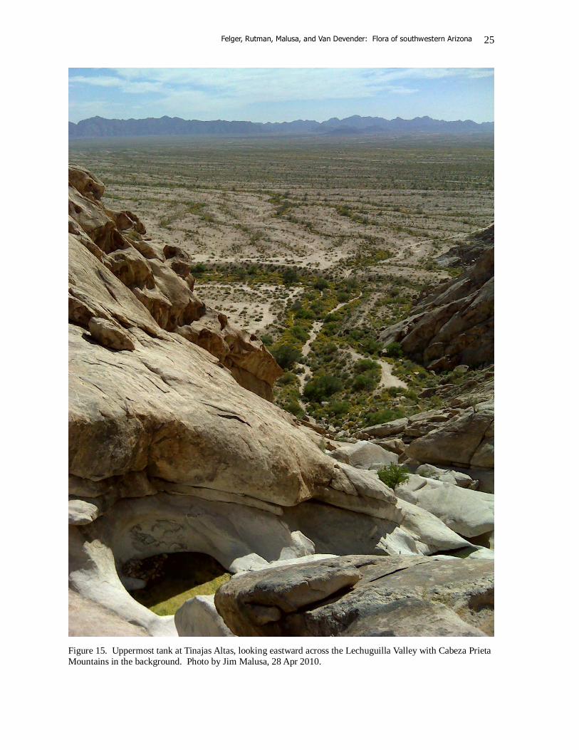
Figure 15. Uppermost tank at Tinajas Altas, looking eastward across the Lechuguilla Valley with Cabeza Prieta Mountains in the background. Photo by Jim Malusa, 28 Apr 2010.
Felger, Rutman, Malusa, and Van Devender: Flora of southwestern Arizona
26
CLIMATIC CONSIDERATIONS Hot and dry! For many people, these two words sum up the climate of the Southwest. This is a desert and perhaps nothing defines a desert more than high temperatures and the paired factors of low rainfall and unpredictability—or variability, as shown so elegantly by Shreve (1951) and then by Ezcurra and Rodrígues (1986). Variability is so great that it’s normal that you’ll rarely experience ‘normal’ weather – that is, a temperature or precipitation event that is equal to the 30-year average (Figure 16). This climate summary relies heavily on the work of Comrie and Broyles (2002), Sellers et al. (1985), Sheppard et al. (2002), and the weather data of National Park Service employee Charles Conner (on file at Organ Pipe Cactus National Monument). Low soil moisture and excessive evaporation count as powerful factors influencing the distribution of plants and animals in the study area, especially the seasonal extreme drought and hot weather of late spring and early summer. Wintertime freezing also plays a major role in distributions of the many Sonoran Desert plants with a “tropical” affinity. Summers are predictably long and hot, and winters mild. Rainfall varies wildly—highest eastward in the Ajo Mountains with at least 15 inches (38 cm) average and lowest westward with perhaps 3–4 inches (7.6–10.2 cm) average at Tinajas Altas. Rainfall on the east side of the region is bimodal, generally (or hopefully) with summer rains and winter-spring rains, while at the western margin of the region summer rainfall is often non-existent, rare, or substantially reduced. Thus, the flora area lies across a climatic and biotic transition from a quite bimodal and higher rainfall along its east side towards a mostly winter rainfall and very much drier conditions westward. Summer monsoons, generally occurring July to September, are a northern extension of a tropical phenomenon, yet the moisture that feeds these storms is drawn locally from the warm Gulf of California. Often highly localized and violent, the summer storms can bring heavy rainfall of brief duration, but such rains tend to be sporadic, spotty, and undependable, drenching one place and leaving another bone dry. Summer rains may fail regionally as well as locally, and especially westward. At the other end of the spectrum, summer storms can be real soakers, sometimes producing more than 1 inch, and on rare occasions 4 to 6 inches, of rainfall in a single event. Fall can be dry, or the occasional hurricane-fringe or tropical depression storms (“backdoor monsoons”) in late summer and fall can dump huge amounts of rain over great expanses. These rains can result in spectacular development because the plants are often already in an active state of growth from the summer monsoon—the soil is still relatively moist and the weather still warm. Plant growth among many larger perennials generally is slow and recruitment may occur sporadically instead of regularly or annually. Saguaro (Carnegiea gigantea) populations, for example, are maintained by pulses in recruitment that may occur decades apart. Young saguaros need the right combination of summer rains and moderate winters, and probably fall and winter rains, coupled with nurse plants or microhabitats to protect tender young seedlings through their most vulnerable years (e.g., Pierson & Turner 1998; Steenbergh 1967; Steenbergh & Lowe 1976, 1977). Once in a while hurricane-fringe or tropical cyclone/depression rains bridge the summer monsoon and winter rains, producing spectacular growth of perennials as well as carpets of annuals. This scenario happened in part of the flora region in late September 1997 as a result of Hurricane Nora and again in late September 2003 as a result of Tropical Depression Marty when summer annuals continued growing and flowering intermixed with early growth and flowering of winter-spring (cool season) annuals. The carpets of green continued on through the following spring.
Felger, Rutman, Malusa, and Van Devender: Flora of southwestern Arizona
27
Another unusual weather phenomenon is the microburst associated with exceedingly strong downdrafts from thunderstorms, sometimes with winds exceeding 100 mph in small areas, with the power of a little localized tornado (but straight line winds rather than rotating like a tornado). Such microbursts can cover a swath up to four kilometers wide and a few kilometers long. Microbursts can topple saguaros, large chollas (Cylindropuntia fulgida and C. bigelovii), ocotillos (Fouquieria splendens), and palo verdes (Parkinsonia microphylla). These plants are especially vulnerable to microburst winds on valley floors and plains of sandy soils when the soil is wet from heavy rains. Cool-season (winter-spring) rains, frontal storms originating in the Pacific Ocean, may begin as cooler weather approaches in November and can variously occur off and on through March. Typically these rains are gentler than the summer rains and can deliver widespread precipitation. Sporadic El Niño years sometimes can bring exceptional amounts of winter-spring rains, resulting in spectacular displays of spring wildflowers. Fog is rare, and if it occurs, it happens in wintertime at lower mid-valley elevations. Snow is also rare, with only a few inches sometimes falling atop the highest mountains, and lasting but briefly. April, and especially May and most of June become increasingly hot and dry—desiccating is an appropriate word. The hot weather and seasonal drought of late spring and early summer severely limit the survival and distribution of Sonoran Desert plants. Even chollas and prickly pears become wilted and flaccid. The spring annuals are gone and many trees and shrubs lose their leaves. High temperatures rival records set elsewhere in North America and frequent winds intensify the aridity. Across the region maximum daily temperatures commonly exceed 100–113°F (38–45°C) from late April to early October. Average July monthly maximum temperatures are over 105˚F (40.6˚C) in summer, although temperatures are generally lower on the tops of the larger mountains. Summer temperatures in the region sometimes exceed 120ºF (48.9ºC). On 28 July 1995, Yuma, about 60 west of the study area, reached its all-time high at 124ºF (51ºC). It is impressive to find the vegetation and flora so rich and varied in this extremely arid place. Winter daytime temperatures often range between 60 and 75°F (15.5 and 24°C), and the average monthly minimum winter temperatures are about 40˚F (4.4˚C). Across most of the region temperatures commonly dip several degrees below freezing on a few nights during each of the colder months. Many species in the region are frost sensitive, e.g., elephant tree (Bursera microphylla), ashy jatropha (Jatropha cinerea), and limberbush (J. cuneata). However, certain places or microhabitats can be nearly or entirely frost-free, permitting a number of species with tropical or subtropical affinities to thrive. Charles Conner, of the National Park Service, has been monitoring a set of remote-sensing weather stations in Organ Pipe from the late 1980s to the present (December 2012). His report of weather records for 2003 in the Monument illustrates the range of variation and extremes that can influence the distribution of plant life. The following paragraphs for 2003 illustrate some considerations of the weather in Organ Pipe, but not the whole flora area, where it may be even hotter and drier: "The coldest day of the year was December 28, with several low valley sites getting down to 19°F (-7°C) and the coldest being the Salsola Site, 2 miles east of Blankenship Well, that got down to 7.3°F (-13.7°C). Alamo Canyon, above the wash bottom, fell to 32°F (0°C), and Bull Pasture, higher up the mountain, never got below freezing. The Bull Pasture low was 33°F (0.6°C), typical for that site. (In the last seven years it has only gotten below freezing at Bull Pasture once: 29.8°F (-1.2°C) on January 31, 2002.) The hottest two days of the year were July 13 and August 10. The winner was Aguajita Wash, just on the other side of the hills and east of Quitobaquito, at 122°F on August 10. Next was Salsola Site, which topped out at 116°F the same day. On July 13 two other hot sites were
Felger, Rutman, Malusa, and Van Devender: Flora of southwestern Arizona
28
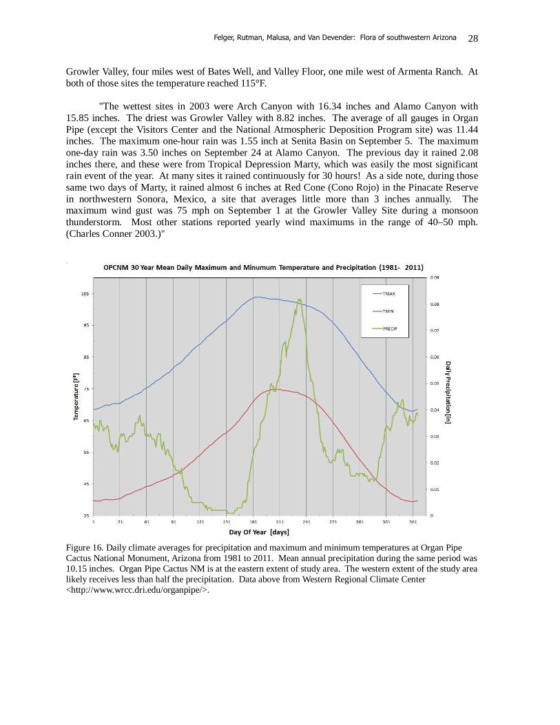
Growler Valley, four miles west of Bates Well, and Valley Floor, one mile west of Armenta Ranch. At both of those sites the temperature reached 115°F. "The wettest sites in 2003 were Arch Canyon with 16.34 inches and Alamo Canyon with 15.85 inches. The driest was Growler Valley with 8.82 inches. The average of all gauges in Organ Pipe (except the Visitors Center and the National Atmospheric Deposition Program site) was 11.44 inches. The maximum one-hour rain was 1.55 inch at Senita Basin on September 5. The maximum one-day rain was 3.50 inches on September 24 at Alamo Canyon. The previous day it rained 2.08 inches there, and these were from Tropical Depression Marty, which was easily the most significant rain event of the year. At many sites it rained continuously for 30 hours! As a side note, during those same two days of Marty, it rained almost 6 inches at Red Cone (Cono Rojo) in the Pinacate Reserve in northwestern Sonora, Mexico, a site that averages little more than 3 inches annually. The maximum wind gust was 75 mph on September 1 at the Growler Valley Site during a monsoon thunderstorm. Most other stations reported yearly wind maximums in the range of 40–50 mph. (Charles Conner 2003.)"
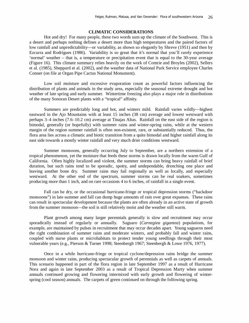
Figure 16. Daily climate averages for precipitation and maximum and minimum temperatures at Organ Pipe Cactus National Monument, Arizona from 1981 to 2011. Mean annual precipitation during the same period was 10.15 inches. Organ Pipe Cactus NM is at the eastern extent of study area. The western extent of the study area likely receives less than half the precipitation. Data above from Western Regional Climate Center <http://www.wrcc.dri.edu/organpipe/>.
Felger, Rutman, Malusa, and Van Devender: Flora of southwestern Arizona
29
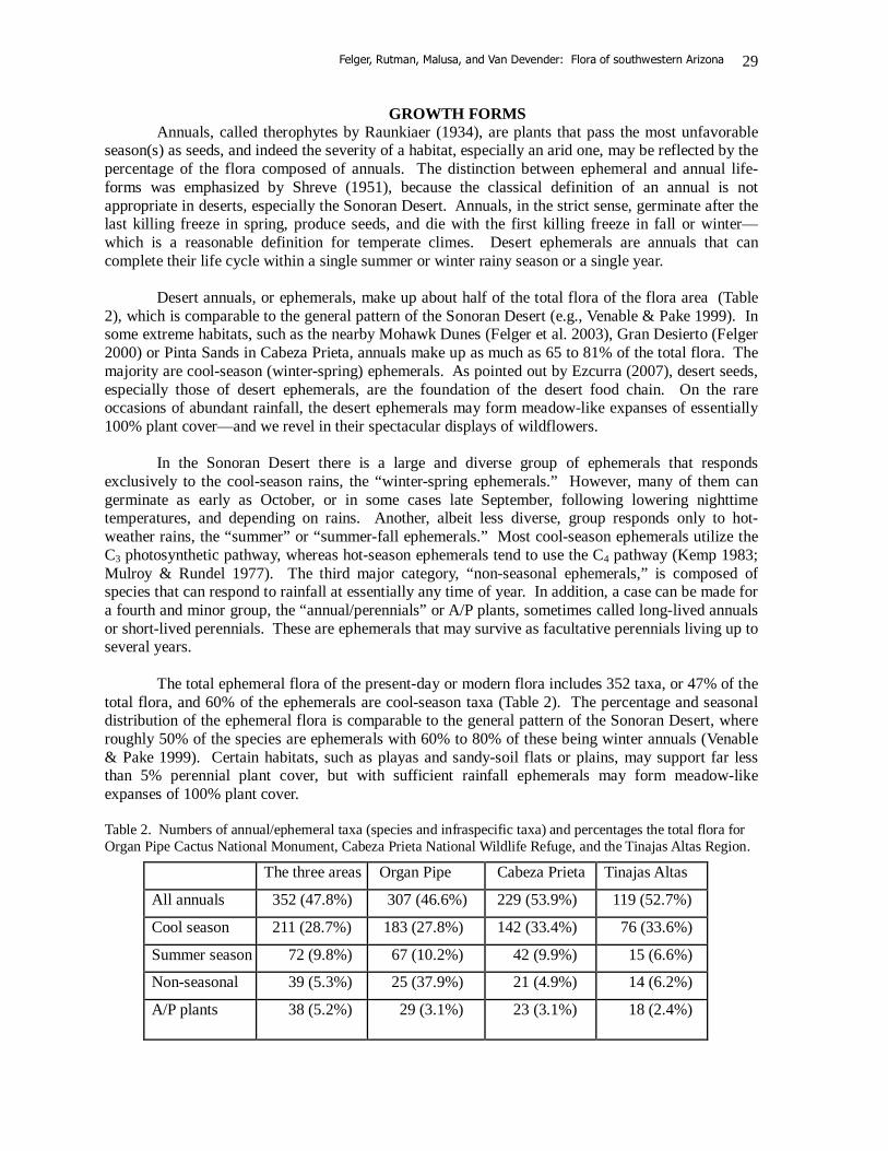
GROWTH FORMS Annuals, called therophytes by Raunkiaer (1934), are plants that pass the most unfavorable season(s) as seeds, and indeed the severity of a habitat, especially an arid one, may be reflected by the percentage of the flora composed of annuals. The distinction between ephemeral and annual life-forms was emphasized by Shreve (1951), because the classical definition of an annual is not appropriate in deserts, especially the Sonoran Desert. Annuals, in the strict sense, germinate after the last killing freeze in spring, produce seeds, and die with the first killing freeze in fall or winter—which is a reasonable definition for temperate climes. Desert ephemerals are annuals that can complete their life cycle within a single summer or winter rainy season or a single year. Desert annuals, or ephemerals, make up about half of the total flora of the flora area (Table 2), which is comparable to the general pattern of the Sonoran Desert (e.g., Venable & Pake 1999). In some extreme habitats, such as the nearby Mohawk Dunes (Felger et al. 2003), Gran Desierto (Felger 2000) or Pinta Sands in Cabeza Prieta, annuals make up as much as 65 to 81% of the total flora. The majority are cool-season (winter-spring) ephemerals. As pointed out by Ezcurra (2007), desert seeds, especially those of desert ephemerals, are the foundation of the desert food chain. On the rare occasions of abundant rainfall, the desert ephemerals may form meadow-like expanses of essentially 100% plant cover—and we revel in their spectacular displays of wildflowers. In the Sonoran Desert there is a large and diverse group of ephemerals that responds exclusively to the cool-season rains, the “winter-spring ephemerals.” However, many of them can germinate as early as October, or in some cases late September, following lowering nighttime temperatures, and depending on rains. Another, albeit less diverse, group responds only to hot-weather rains, the “summer” or “summer-fall ephemerals.” Most cool-season ephemerals utilize the C3 photosynthetic pathway, whereas hot-season ephemerals tend to use the C4 pathway (Kemp 1983; Mulroy & Rundel 1977). The third major category, “non-seasonal ephemerals,” is composed of species that can respond to rainfall at essentially any time of year. In addition, a case can be made for a fourth and minor group, the “annual/perennials” or A/P plants, sometimes called long-lived annuals or short-lived perennials. These are ephemerals that may survive as facultative perennials living up to several years. The total ephemeral flora of the present-day or modern flora includes 352 taxa, or 47% of the total flora, and 60% of the ephemerals are cool-season taxa (Table 2). The percentage and seasonal distribution of the ephemeral flora is comparable to the general pattern of the Sonoran Desert, where roughly 50% of the species are ephemerals with 60% to 80% of these being winter annuals (Venable & Pake 1999). Certain habitats, such as playas and sandy-soil flats or plains, may support far less than 5% perennial plant cover, but with sufficient rainfall ephemerals may form meadow-like expanses of 100% plant cover. Table 2. Numbers of annual/ephemeral taxa (species and infraspecific taxa) and percentages the total flora for Organ Pipe Cactus National Monument, Cabeza Prieta National Wildlife Refuge, and the Tinajas Altas Region.
The three areas Organ Pipe Cabeza Prieta Tinajas Altas
All annuals 352 (47.8%) 307 (46.6%) 229 (53.9%) 119 (52.7%)
Cool season 211 (28.7%) 183 (27.8%) 142 (33.4%) 76 (33.6%)
Summer season 72 (9.8%) 67 (10.2%) 42 (9.9%) 15 (6.6%)
Non-seasonal 39 (5.3%) 25 (37.9%) 21 (4.9%) 14 (6.2%)
A/P plants 38 (5.2%) 29 (3.1%)
23 (3.1%) 18 (2.4%)

Felger, Rutman, Malusa, and Van Devender: Flora of southwestern Arizona
30
One of the most striking features of desert ephemerals is their extreme plasticity in size (e.g., Felger 2000; Felger et al. 2012a, 2012b; Inouye 1991). Many ephemerals can germinate with minimal rainfall and develop into tiny plants that produce seed(s) in one or a few fruits before perishing. Sometime there may be more than 1000 individual plants per meter square, composed of grasses and/or other small or dwarfed ephemerals, or with sufficient soil moisture individuals of these same species can become extraordinarily large. For example, during El Niño years the attractive, white-flowered dune evening primrose (Oenothera deltoides) may develop shrub-like plants more than 1–1.5 m across with hundreds of flowers, but during a spring of low rainfall the plants may reproduce as small, essentially stemless rosette plants with only one or a few flowers and fruits. The common summer ephemeral Amaranthus palmeri sometimes grows to 2 m in height, although drought-stunted seed-producing plants can be less than 10 cm tall. Individual plants of the large-flowered caltrop (Kallstroemia grandiflora) may reach 2+ m across on sandy soil following favorable summer and early fall rains, although plants with stems 15–30 cm are commonplace. Reproductive parts also may vary with soil moisture. For example, desert chinchweed (Pectis papposa), a common hot-weather ephemeral, characterized by awned achenes, shows a tendency to produce awnless achenes during drought stress. Likewise, under severe drought conditions the ubiquitous non-seasonal ephemeral grass six-weeks three-awn (Aristida adscensionis) may produce spikelets with greatly reduced awns or even no awns. Winter-spring (cool-season) ephemerals include 211 taxa, or 60% of the total ephemeral flora, and 29% of the total flora. Cool-season ephemerals tend to have temperate or northern affinities (Felger 2000; Shreve 1951). Their closest biogeographic affinities are often with the Mojave Desert or Californian region, western Arizona, southern Nevada, and sometimes southwestern Utah. Since rainfall patterns vary so greatly from year to year, each year may bring a different vegetational and floristic spectrum of winter-spring ephemerals or wildflowers. There is a general progression of early to late cool-season ephemeral species. The mustards (Brassicaceae), borages (Boraginaceae), desert star-vine (Brandegea bigelovii, Cucurbitaceae), and certain composites (Asteraceae, e.g., desert rock-daisy, Perityle emoryi) are among the earliest cool-season ephemerals to germinate and flower. They can appear as early as late September or early October—as soon as the period of high soil temperature has passed. Some early germinating, fast-growing winter-spring weedy ephemerals of Old World origin, such as Sahara mustard (Brassica tournefortii), red brome (Bromus rubens), and Arabian and Mediterranean grasses (Schismus spp.), seem “to get a jump” on some of the natives and out-compete them (see Barrows et al. 2009; Brooks 2000; Felger 2000). For example, the spreading rosette leaves of Sahara mustard and herbage of Arabian and Mediterranean grasses often cover over and inhibit growth or germination of the seemingly slower growing or perhaps later-germinating natives. Among cool-season ephemerals the early, or rosette leaves are almost always larger than the stem leaves, which in some instances are represented by scale leaves or leaves may be absent. As temperatures rise and the soil dries, the rosette leaves tend to wither or fall away by the time the plants begin flowering and fruiting. Some spring ephemerals, such as brittle spine-flower (Chorizanthe brevicornu), California suncup (Eulobus californicus), various buckwheat species (Eriogonum), and Schott’s wire-lettuce (Stephanomeria schottii) are essentially leafless at flowering or fruiting time, looking like miniature palo verdes (Parkinsonia).
Some spring annuals, such as the desert buckwheat (Eriogonum deflexum, and to a lesser extent E. trichopes) and wheelscale orach (Atriplex elegans), sometimes continue to flower well into the late spring drought season or even early summer. Some of these plants may germinate late in spring and mature in early summer. Occasionally they survive through the hot summer to produce flowers and seeds in fall. Drought limits their life span and such plants in the flora area do not survive beyond one year.
Felger, Rutman, Malusa, and Van Devender: Flora of southwestern Arizona
31
Summer, or hot-weather, ephemerals are represented by 72 species, or 20% of the total ephemeral flora, or 9.8% of the total flora. These plants tend to have southern or tropical affinities. As with cool-season ephemerals, they are generally derived from perennial ancestors. In contrast to the cool-season ephemerals, hot-weather ephemerals do not form basal rosettes and there is little variation in species composition from early to late summer. An exception, however, is thread-stem carpetweed (*Mollugo cerviana), a diminutive summer ephemeral that forms a basal rosette of minute leaves. (It is supposedly not native to the New World.) Among the most numerous and ubiquitous, or predictable, members of the summer ephemeral flora are amaranths (Amaranthus spp.), spiderlings (Boerhavia spp.), six-weeks needle grama and six-weeks grama (Bouteloua aristidoides and B. barbata var. barbata), caltrops (Kallstroemia spp.), woolly tidestromia (Tidestromia lanuginosa), and desert chinchweed (Pectis papposa). Several non-seasonal ephemerals, such as six-weeks threeawn (Aristida adscensionis) and some desert spurges (Euphorbia (Chamaesyce) spp.) are often common among the obligate summer ephemerals.
Non-seasonal ephemerals, comprising 39 species, or 11% of the total ephemeral flora and 5.3% of the total flora, are capable of germinating and maturing at any season. These plants are primarily limited by soil moisture rather than temperature. Some are frost sensitive and may disappear or be damaged by freezing weather, but may quickly recover or re-appear when conditions are favorable (e.g., fringed spurge, Euphorbia setiloba). Among the most common non-seasonal ephemerals are various small euphorbs (Ditaxis neomexicana, D. serrata, Euphorbia micromera, and E. polycarpa), papilionoid legumes (Dalea mollis, Marina parryi, and Phaseolus filiformis), desert datura (Datura discolor), and two grasses, six-weeks threeawn (Aristida adscensionis) and little-seed muhly (Muhlenbergia microsperma).
Succulent ephemerals are mostly cool-season species, e.g., fringed redmaids (Calandrinia ciliata), sand-cress (Cistanthe monandra), pygmy stonecrop (Crassula erecta), iceplants (*Mesembryanthemum crystallinum and *M. nodiflorum), and broomrape (Orobanche spp.). Hot-season succulent ephemerals are represented by the purslanes (Portulaca spp.). Facultative annual/perennial species (“AP” plants) include 37 species or 8% of the total annual flora, or 5% of the total flora. Two closely related borages, Johnstonella (Cryptantha) holoptera and J. (Cryptantha) racemosa, and an evening primrose (Chylismia arenaria) germinate only with winter-spring rains (as do their strictly ephemeral congeneric species), but may survive several years as perennials. Among the more common and widespread AP plants are two closely related desert spurges (Euphorbia micromera and E. polycarpa), the composite Leucosyris arida (Arida arizonica), and buffelgrass (*Cenchrus ciliaris). Woody or semi-woody perennials and shrubs form a diverse group accounting for the majority of the perennial plant cover. Most are drought deciduous and some exhibit drought-induced dieback of portions or even all of their stems. Even species usually perceived as evergreen, such as creosotebush (Larrea divaricata) lose most or occasionally all of their leaves during the most severe droughts. Desert sumac (Rhus kearneyi), pygmy cedar (Peucephyllum schottii), and jojoba (Simmondsia chinensis) are generally evergreen but may shed many or even most of their leaves in extreme drought. Two grasses, galleta grass (Hilaria rigida) and bush muhly (Muhlenbergia porteri), are unusual among Sonoran Desert grasses by taking on the growth-form of small shrubs. Galleta grass plants can survive extreme drought by persisting as underground rhizomes. Diversity of tree species is relatively low in deserts and arid regions. Among the largest trees in the flora area are riparian or wetland species found along major canyons and at waterholes: canyon hackberry (Celtis reticulata), cottonwood (Populus fremontii), and Goodding willow (Salix gooddingii). These trees are winter-deciduous, reflecting their temperate affinity. In canyons of the
Felger, Rutman, Malusa, and Van Devender: Flora of southwestern Arizona
32
Ajo Mountains, scrub oak (Quercus turbinella), can reach heights of 8+ m and trunks nearly 1 m in diameter. Also found in canyon bottoms and on steep mountain slopes, the evergreen Arizona rosewood (Vauquelinia californica) can reach a height of 47 ft (14.5 m) but is often shrub-sized. Arizona juniper (Juniperus arizonica) is a common tree or large shrub at middle to higher elevations of the Ajo Mountains. Several legumes and giant cacti are the most widespread tree-sized plants in the desert landscapes. The arborescent legume flora is dominated by two mesquites (Prosopis glandulosa and P. velutina), ironwood (Olneya tesota), two palo verdes (Parkinsonia florida and P. microphylla), and smoke tree (Psorothamnus spinosus). In addition, crucillo (Condalia globosa) occasionally becomes arborescent, reaching up to 18 ft (5.5 m). Crucifixion thorn (Castela emoryi) attains a height of 25 ft (7.6 m) on floodplains in the Valley of the Ajo in Organ Pipe, but is more often shrubby. For the most part the lager trees in lowland and more arid regions are concentrated along xeroriparian drainageways, although elephant tree (Bursera microphylla) and foothill palo verde (Parkinsonia microphylla), as well as desert tree-beargrass (Nolina bigelovii) are common on many rocky desert slopes.
Nineteen native tree species occur in the flora area, apart from the columnar cacti: Bursera microphylla, elephant tree Castela emoryi, crucifixion thorn Celtis reticulata, canyon hackberry Chilopsis linearis, desert willow Condalia globosa, crucillo Juniperus arizonica, Arizona juniper Olneya tesota, ironwood Nolina bigelovii, desert tree-beargrass Parkinsonia florida, blue palo verde Parkinsonia microphylla, foothill palo verde Populus fremontii, Frémont cottonwood Prosopis glandulosa, honey mesquite Prosopis pubescens, screwbean Prosopis velutina, velvet mesquite Psorothamnus spinosus, smoke tree Quercus turbinella, scrub oak Salix gooddingii, Goodding willow Sapindus drummondii, soapberry Vauquelinia californica, Sonoran rosewood
Plants with succulent stems and/or leaves are especially conspicuous across most of southwestern Arizona, and span a wide range of growth forms. The saguaro (Carnegiea gigantea) is the tallest organism across much of the desert landscape, reaching over 40 ft (12 m) tall in the flora area. Other large cacti that sometimes exceed shrub size are chain-fruit cholla (Cylindropuntia fulgida var. fulgida), senita (Lophocereus schottii), and organ pipe (Stenocereus thurberi). Perennial, rosette-forming leaf succulents, agaves (Agave spp.) and banana yucca (Yucca baccata) and the much smaller Arizona live-forever (Dudleya arizonica), are restricted to rocky slopes and soils. Although vines are generally few in deserts, there are 28 species of vining plants in the flora area, or 3.8% of the total flora. Among the more common perennial vines are the milkweed Funastrum hartwegii and the malpigh Cottsia gracilis. The cucurbit Brandegea bigelovii, a cool-season ephemeral, sometimes festoons desert shrubs in green curtains. The wild tepary bean (Phaseolus acutifolius) is abundant at high elevations in the Ajo Mountains during the late summer,

Felger, Rutman, Malusa, and Van Devender: Flora of southwestern Arizona
33
and the non-seasonal ephemeral legume Phaseolus filiformis is often common at lower elevations. Hot- and cool-season ephemerals as well as perennials make up the list of vining plants:
Ephemeral/annual vines: Brandegea bigelovii, desert star-vine Cuscuta spp., dodder Echinopepon wrightii, wild balsam-apple Ipomoea spp., morning glory Maurandya antirrhiniflora, blue snapdragon-vine Neogaerrhinum filipes, yellow twining-snapdragon Phaseolus acutifolius, tepary Phaseolus filiformis, desert bean Vicia ludoviciana, dear-pea vetch
Perennial vines:
Clematis drummondii, Texas virgin-bower Cottsia gracilis, slender janusia Cucurbita digitata, finger-leaf gourd Cucurbita palmata, coyote gourd Funastrum hartwegii, climbing milkweed Jacquemontia pringlei, desert cluster-vine Marah gilensis, big root Matelea cordifolia, heart-leaf milkweed vine Matelea parvifolia, spear-leaf milkweed vine Metastelma arizonicum Rhynchosia senna, Texas snout-bean Tragia nepetifolia, nose-burn Tumamoca macdougalii, Tumamoc globe-berry
Geophytes (perennials with underground storage organs, and above ground portions deciduous during unfavorable seasons) are relatively few. These plants are widely scattered across the region and show active growth and flowering at various seasons. The monocot geophytes produce “bulbs” or corms:
Allium macropetalum, desert onion Calochortus kennedyi, desert mariposa lily Dichelostemma capitatum, wild hyacinth Hesperocallis undulata, Ajo lily Triteleiopsis palmeri, blue sand-lily Zephyranthes longifolia, plains rain-lily
Non-monocot geophytes are characterized by enlarged underground tuberous roots. Examples include:
Aristolochia watsonii, Indian root Cucurbita digitata, finger-leaf gourd Cucurbita palmata, coyote gourd Hoffmannseggia glauca, hog potato Mirabilis multiflora, Colorado four o’clock Proboscidea altheifolia, desert devil’s claw Tumamoca macdougalii, Tumamoc globe-berry

Felger, Rutman, Malusa, and Van Devender: Flora of southwestern Arizona
34
THREATS TO THE FLORA AREA Significant threats to the natural resources and visitor experiences include overuse by visitors in developed zones, groundwater drawdown and pesticide and herbicide drift from disturbed habitats on the Sonora side of the border, and shocking borderland violence and U.S. Border Patrol activities. As recently as 1990, one could backpack across the heart of flora area and encounter no people, no vehicles, no lights. Invasive species were largely concentrated along dirt tracks, water resources, and the highways fringing and bisecting the flora area. Less than two decades later, the flora area is seriously threatened by invasive species, smugglers and job seekers and the Border Patrol, wildfire and severe drought (e.g., Broyles & Haynes 2010; Felger & Broyles 2007c; Felger et al. 2007b). Factsheets, management plans, and general information on the natural and human resources and protection of the region are available at the websites of the various responsible U.S. agencies including the regional offices of the U.S. Marine Corps <http://www.yuma.usmc.mil> and the U.S. Air Force <http://www.luke.af.mil>, Cabeza Prieta National Wildlife Refuge <http://www.fws.gov/ southwest/refuges/arizona/cabeza>, Organ Pipe Cactus National Monument <http://www.nps.gov/orpi>, and the U.S. Border Patrol <http://www.cbp.gov>. In spite of the problems, the vast major of the region remains premier protected desert country unlike anywhere else in the world.
ACKNOWLEDGEMENTS
Over the years many friends and colleagues have provided information and assistance, and/or accompanied us in the field, and helped make these publications finally become a reality. In this regard we thank Kelly W. Allred, Daniel F. Austin, Marc A. Baker, Janice Emily Bowers, H. Jeff Boyd, Bradley (Brad) Boyle, Benjamin Daniel Brandt, Bill Broyles, Tony L. Burgess, Alberto Búrquez, Steven M. Buckley, J. Travis Columbus, Mark A. Dimmitt, Ellen Dorn, Luke Taylor Evans, Exequiel Ezcurra, Mark Fishbein, Paul F. Fryxell, Peter Gierlach, Judy Ann Gibson, Edward Erik Gilbert, W. Eugene Hall, Stephen F. Hale, Gayle Harrison Hartmann, James L. Heard, Ann Lane Hedlund, James Henrickson, Wendy Caye Hodgson, Sarah Hunkins, Philip D. Jenkins, Richard A. Johnson, Leslie R. Landrum, the late Cynthia A. Lindquist, Richard Burton Laugharn, Elizabeth Makings, Curtis McCasland, Michelle (Shelley) McMahon, Angelina Martínez-Yrízar, Lucinda McDade, Guy Nesom, Amy Pate, J. Mark Porter, Adrianne G. Rankin, Jon P. Rebman, the late Charlotte Reeder and John Reeder, Frank W. Reichenbacher, Karen Reichhardt, Ana Lilia Reina-G., Andrew Michael Salywon, Jesús Sánchez-Escalante, Andrew C. Sanders, Silke Schneider, Joan Evelyn Scott, Richard W. Spellenberg, Victor W. Steinmann, David Jonathan Taylor, Timothy James Tibbitts, Gordon C. Tucker, Billie L. Turner, Raymond Mariner Turner, Sula Elizabeth Vanderplank, Jim Verrier, Benjamin Theodore Wilder, Michael F. Wilson, and George Yatskievych. Richard Felger: I especially appreciate Bill Broyles introducing me to so much of this great place and for good times in the field, encouragement, and expert information, editing, and reviewing. I thank the Wallace Research Foundation for supporting so much of my work. Jim Malusa: I gratefully acknowledge the National Park Service for the support of research in Organ Pipe NM and Cabeza Prieta NWR, and the U.S. Marine Corps and U.S. Navy for their support of research on the Goldwater Range. Many thanks, too, to those who brought me to the desert and to those who joined me in the field: Edward Abbey, George Ferguson, Peter Friederici, Dennis Froehlich, John Malusa, Keith Meldahl, Karen Reichhardt, Sue Rutman, Peter Sundt, Tim Tibbetts, Ray Turner, and Peter Warren. Sue Rutman: A special thanks to the national park visitors and fellow scientist who always reinvigorated my excitement about desert plans. Lastly, thanks to Mom, who encouraged my romance with plants. Tom Van Devender: I especially thank the late Paul S. Martin for inspiring me to scour the Sonoran Desert in search of ancient packrat middens and to learn plants by gestalt.
Felger, Rutman, Malusa, and Van Devender: Flora of southwestern Arizona
35
LITERATURE CITED Abbey, E. 1973. Cactus Country. Time-Life Books, New York. Ahlstrom, R.V.N. (ed.). 2001. A Cultural Resources Overview and Assessment for the Cabeza Prieta
National Wildlife Refuge. SWCA Environmental Consultants, report No. 01–24, Tucson. Altschul, J.H. and A.G. Rankin. 2008. Fragile Patterns: The Archaeology of Western Papaguería.
SRI Press, Tucson. Arizona State Parks Board. 1985. Memorandum of Understanding with Cabeza Prieta National
Wildlife Refuge: Natural Area Register, October 25, and Registered Natural Areas report, December 3. Phoenix.
Barrows, C.W., E.B. Allen, M.L. Brooks, and M.F. Allen. 2009. Effects of an invasive plant on a desert sand dune landscape. Biological Invasions 11: 673–686.
Bassett, C.A. 2004. Organ Pipe: Life on the Edge. Univ. of Arizona Press, Tucson. Bennett, P.S. and M.R. Kunzman. 1989. A History of the Quitobaquito Resource Management Area,
Organ Pipe Cactus National Monument, Arizona. Technical Report No. 26, Cooperative National Park Resource Studies Unit, University of Arizona, Tucson.
Benson, L. and R.A. Darrow. 1945. A Manual of Southwestern Desert Trees and Shrubs. Univ. of Arizona Bulletin 15, no. 2.
Benson, L. and R.A. Darrow. 1981. Trees and Shrubs of the Southwestern Deserts, 3rd edition. Univ. of Arizona Press, Tucson.
Betancourt, J.L., T.R. Van Devender, and P.S. Martin. 1990. Packrat Middens: The Last 40,000 Years of Biotic Change. Univ. of Arizona Press, Tucson.
Bezy, J.V., J.T. Gutmann, and G.B. Haxel. 2000. A Guide to the Geology of Organ Pipe Cactus National Monument and the Pinacate Biosphere Reserve. Arizona Geological Survey, Down-to-Earth 9. 63 pp.
Bowers, J.E. 1980. Flora of Organ Pipe Cactus National Monument. Journal Arizona-Nevada Academy of Science 15: 1–11, 33–47.
Brooks, M.L. 2000. Competition between alien annual grasses and native annual plants in the Mojave Desert. American Midland Naturalist 144: 92–108.
Brown, B.T. and R.R. Johnson. 1983. The distribution of bedrock depressions (tinajas) as sources of surface water in Organ Pipe Cactus National Monument, Arizona. Journal of the Arizona-Nevada Academy of Science 18: 61–68.
Brown, B.T. and P.L. Warren. 1986. A Descriptive Analysis of Woody Riparian Vegetation at Quitobaquito Oasis, Organ Pipe Cactus National Monument, Arizona. Technical Report No. 19, Cooperative National Park Resource Studies Unit, University of Arizona, Tucson.
Brown, D.E. (ed.). 1982. Biotic Communities of the American Southwest—United States and Mexico. Desert Plants 4: 3–341. Reprinted and revised 1994 as Biotic Communities: Southwestern United States and Northwestern Mexico. Univ. of Utah Press, Salt Lake City, Utah.
Broyles, B. 1996a. Organ Pipe Cactus National Monument. Southwest Parks and Monuments, Tucson.
Broyles, B. 1996b. Surface water resources for prehistoric peoples in western Papaguería of the North American southwest. Journal of Arid Environments 33: 483–495.
Broyles, B. and T.L. Cutler. 1999. Effect of surface water on desert bighorn sheep in the Cabeza Prieta National Wildlife Refuge, southwestern Arizona. Wildlife Society Bulletin 27: 1082–1088.
Broyles, B., L. Evans, R.S. Felger, and G.P. Nabhan. 2007b. Our grand desert: A gazetteer. Pp. 509–607, in Felger and Broyles (eds.), Dry Borders: Great Natural Reserves of the Sonoran Desert. Univ. of Utah Press, Salt Lake City.
Broyles, B., R.S. Felger, G.P. Nabhan, and L. Evans. 1997. Our grand desert: A gazetteer for northwestern Sonora, southwestern Arizona, and northeastern Baja California, in Felger and
Felger, Rutman, Malusa, and Van Devender: Flora of southwestern Arizona
36
Broyles (eds.), Dry Borders: Binational Sonoran Desert reserves. Journal of the Southwest 39: 703–856.
Broyles, B. and G.H. Hartmann. 2012. Surveyors to campers: 1854 to the present. Pp. 115–175, in Broyles, Hartmann, T.E. Sheridan, G.P. Nabhan, and M.C. Thurtle, Last Water on the Devil’s Highway: A Cultural and Natural History of Tinajas Altas. Univ. of Arizona Press, Tucson.
Broyles, B., G.H. Hartmann, T.E. Sheridan, G.P. Nabhan, and M.C. Thurtle. 2012. Last Water on the Devil’s Highway: A Cultural and Natural History of Tinajas Altas. Univ. of Arizona Press, Tucson.
Broyles, B. and M. Haynes. 2010. Desert Duty, On the Line with the U.S. Border Patrol. Univ. of Texas Press, Austin.
Broyles, B., A.G. Rankin, and R.S. Felger. 2007a. Native peoples of the Dry Borders Region. Pp. 128–146 in Felger and Broyles (eds.), Dry Borders: Great Natural Reserves of the Sonoran Desert. Univ. of Utah Press, Salt Lake City.
Bryan, Kirk. 1925. The Papago Country, Arizona: a Geographic, Geologic, and Hydrologic Reconnaissance with a Guide to Desert Watering Places. United States Geological Survey, Water-Supply Paper 499, Washington, D.C.
Bryson, R.A. and W.M. Wendland. 1967. Radiocarbon Isochrones of the Retreat of the Laurentide Ice Sheet. University of Wisconsin, Department of Meteorology, Technical Report no. 35, Madison.
Buchmann, S.L. and G.P. Nabhan. 1996. The Forgotten Pollinators. Island Press, Washington, D.C. Cabeza Prieta National Wildlife Refuge. 2011. Vehicle Trails Associated with Illegal Border
Activities on Cabeza Prieta National Wildlife Refuge, July 2011. <http://azwild.org/action/CabezaPrieta_2011July.pdf> Accessed 14 Jan 2013. Cain, J.W., III, B.D. Jansen, R.S. Felger, and P.R. Krausman. 2010. Scallopleaf sage (Salvia vaseyi,
Lamiaceae) discovered in Arizona. Journal of the Botanical Research Institute of Texas 4: 755–760.
Cole, G.A. and M.C. Whiteside. 1965. An ecological reconnaissance of Quitobaquito spring, Arizona. Journal of the Arizona Academy of Sciences 3: 159–163.
Comrie, A.C. and B. Broyles. 2002. Variability and spatial modeling of fine-scale precipitation data for the Sonoran Desert of south-west Arizona. Journal of Arid Environments 50: 573–592.
Ezcurra, E. 2007. The desert inside us. Pp. xi–xiii in R.S. Felger and B. Broyles (eds.), Dry Borders: Great Natural Reserves of the Sonoran Desert. Univ. of Utah Press, Salt Lake City.
Ezcurra, E. and V. Rodrígues. 1986. Rainfall patterns in the Gran Desierto, Sonora, Mexico. Journal of Arid Environments 10: 13–28.
Fehlberg, S.D. and T.A. Ranker. 2009. Evolutionary history and phylogeography of Encelia farinosa (Asteraceae) from the Sonoran, Mojave, and Peninsular Deserts. Molecular Phylogenetics and Evolution 50: 326–335.
Felger, R.S. 1990. Non-native Plants of Organ Pipe Cactus National Monument. Cooperative National Park Resource Studies Unit, Technical Report No. 31, University of Arizona, Tucson.
Felger, R.S. 2000. Flora of the Gran Desierto and Río Colorado of Northwestern Mexico. Univ. of Arizona Press, Tucson.
Felger, R.S. 2007. Living resources at the center of the Sonoran Desert: Native American plant and animal utilization. Pp. 147–192 in Felger and B. Broyles (eds.), Dry Borders: Great Natural Reserves of the Sonoran Desert. Univ. of Utah Press, Salt Lake City.
Felger, R.S. and B. Broyles (eds.). 1997. Dry Borders: Binational Sonoran Desert reserves. Journal of the Southwest 39: 303–860.
Felger, R.S. and B. Broyles (eds.). 2007. Dry Borders: Great Natural Reserves of the Sonoran Desert. Univ. of Utah Press, Salt Lake City.
Felger, R.S., B. Broyles, M. Wilson, G.P. Nabhan, and D. Turner. 2007a. Six Grand Reserves, one Sonoran Desert. Pp. 3–26 in Felger and Broyles (eds.), Dry Borders: Great Natural Reserves of the Sonoran Desert. Univ. of Utah Press, Salt Lake City.
Felger, Rutman, Malusa, and Van Devender: Flora of southwestern Arizona
37
Felger, R.S., M.B. Johnson, and M.F. Wilson. 2001. Trees of Sonora, Mexico. Oxford Univ. Press, New York.
Felger, R.S., S. Rutman, T.R. Van Devender, and S.M. Buckley. 2012a. Checklist of vascular plants of Organ Pipe Cactus National Monument, Cabeza Prieta National Wildlife Refuge, and Tinajas Altas, Arizona. Canotia 8: 1–53.
Felger, R.S., S. Rutman, M.F. Wilson, and K. Mauz. 2007b. Botanical diversity of southwestern Arizona and northwestern Sonora. Pp. 202–271 in Felger and B. Broyles (eds.), Dry Borders: Great Natural Reserves of the Sonoran Desert. University of Utah Press, Salt Lake City.
Felger, R.S., D.S. Turner, and M.F. Wilson. 2003. Flora and vegetation of the Mohawk Dunes, Arizona. Sida 20: 1153–1185.
Felger, R.S., T.R. Van Devender, B. Broyles, and J. Malusa. 2012b. Flora of Tinajas Altas, Arizona—A century of botanical forays and forty thousand years of Neotoma chronicles. Journal of the Botanical Research Institute of Texas 6: 157–257.
Felger, R.S., P.L. Warren, S.A. Anderson, and G.P. Nabhan. 1992. Vascular plants of a desert oasis: Flora and ethnobotany of Quitobaquito, Organ Pipe Cactus National Monument, Arizona. Proceedings of the San Diego Society of Natural History 8: 1–39.
Felger, R.S., M. Wilson, B. Broyles, and G.P. Nabhan. 1997. The binational Sonoran Desert Biosphere Network and its plant life, in Felger and Broyles (eds.), Dry Borders: Binational Sonoran Desert reserves. Journal of the Southwest 39: 411–560.
Griffen, D.J. 2007. Birds of Arizona’s southwestern borderland. Pp. 280–302 in R.S. Felger and B. Broyles (eds.), Dry Borders: Great Natural Reserves of the Sonoran Desert. Univ. of Utah Press, Salt Lake City.
Hartmann, G.H. and M.C. Thurtle. 2001. The archaeology of Tinajas Altas, a desert water hole in southwestern Arizona. Kiva 66: 489–518.
Hartmann, W.K. 1989. Desert Heart. Fisher Books, Tucson. Henry, R.S. 2007. Mammals of the Sonoran borderland reserves. Pp. 272–279 in R.S. Felger and B.
Broyles (eds.), Dry Borders: Great Natural Reserves of the Sonoran Desert. Univ. of Utah Press, Salt Lake City.
Holmgren, C.A., J.L. Betancourt, and K.A. Rylander. 2011. Vegetation history along the eastern, desert escarpment of the Sierra San Pedro Mártir, Baja California, Mexico. Quaternary Research 75: 647–657.
Hunter, K.L., J.L. Betancourt, B.R. Riddle, T.R. Van Devender, K.L. Cole, and W.G. Spaulding. 2001. Ploidy race distributions since the last glacial maximum in the North American desert shrub, Larrea tridentata. Global Ecology and Biogeography 10: 521–533.
Inouye, R.S. 1991. Population biology of desert annual plants. Pp. 27–54 in G.A. Polis (ed.), The Ecology of Desert Communities. Univ. of Arizona Press, Tucson.
Kearney, T.H. and R.H. Peebles. 1960. Arizona Flora, 2nd edition with supplement by J.T. Howell and E. McClintock. Univ. of California Press, Berkeley.
Kemp, P.R. 1983. Phenological patterns of Chihuahuan Desert plants in relation to the timing of water availability. Journal of Ecology 71: 427–436.
Krausman, P.R., L.K. Harris, C.L. Blasch, K.K. G. Koenen, and J. Francene. 2004. Effects of Military Operations on Behavior and Hearing of Endangered Sonoran Pronghorn. Wildlife Monographs 157: 1–41.
Kresan, P.L. 1997. A geologic tour of the lower Colorado River region of Arizona and Sonora, in R.S. Felger and B. Broyles (eds.), Dry Borders: Binational Sonoran Desert reserves. Journal of the Southwest 39: 567–612.
Kresan, P.L. 2007. A geologic tour of the lower Colorado River region of Arizona and Sonora. Pp. 31–45 in R.S. Felger and B. Broyles (eds.), Dry Borders: Great Natural Reserves of the Sonoran Desert. Univ. of Utah Press, Salt Lake City.
Felger, Rutman, Malusa, and Van Devender: Flora of southwestern Arizona
38
Lowe, C.H., E.B. Wirt, and P.C. Rosen. 1992. Vegetation structure and diversity in natural communities at Organ Pipe Cactus National Monument. Sensitive Ecosystem Program, Organ Pipe Cactus National Monument, Arizona. Final Report to National Park Service, Cooperative Park Studies Unit, University of Arizona, Tucson. 173 pages.
Lumholtz, C.S. 1912. New Trails in Mexico: Travels among the Papago, Pima and Cocopa Indians. Charles Scribner Sons, New York. Reprinted 1971, Rio Grande Press, Glorieta, NM; also reprinted 1990, Univ. of Arizona Press.
Malusa, J. 2003. Vegetation of the eastern Cabeza Prieta NWR and adjacent BLM lands, Arizona: Vegetation Classification for the Endangered Sonoran Pronghorn. Report for Organ Pipe Cactus National Monument, National Park Service. NPS Cooperative Agreement CA1248.00.002, Task Agreement UA2-71. <http://arizona.openrepository.com/arizona/handle/ 10150/128489> Accessed 29 Dec 2012.
Martinez-Meyer, E. and A.T. Peterson. 2006. Conservatism of ecological niche characteristics in North American plant species over the Pleistocene-to-Recent transition. Journal of Biogeography 33: 1779–1789.
McGee, W.J. 1898. Papagueria. National Geographic Magazine 9: 345–371. McGee, W.J. 1901. The Old Yuma Trail. National Geographic Magazine 12: 103–143. McLaughlin, S.P. and J.E. Bowers. 1999. Diversity and affinities of the flora of the Sonoran Floristic
Province. Pp. 12–35 in R.H. Robichaux (ed.), Ecology of the Sonoran Desert Plants and Plant Communities. Univ. of Arizona Press, Tucson.
Mearns, E.A. 1892–1893. Field books, Mexican Boundary Survey, Volume 3. On file, United States National Herbarium, library, Natural History Museum, Smithsonian Institution. Washington, D.C.
Mearns, E.A. 1907. Mammals of the Mexican Boundary of the United States. United States National Museum Bulletin 56.
Molina-Freanar, F. and T.R. Van Devender (eds.). 2010. Diversidad Biologíca del Estado de Sonora. Universidad Nacional Autónoma de México, México D.F.
Mulroy, T.W. 1971. Perennial vegetation associated with the organ pipe cactus in Organ Pipe Cactus National Monument, Arizona. Masters thesis, University of Arizona, Tucson.
Mulroy, T.W. and T.W. Rundel. 1977. Annual plants: Adaptations to desert environments. Bioscience 27: 109–114.
Nichols, T. 1997. Afield with desert scientists, in Dry Borders: Binational Sonoran Desert reserves. Journal of the Southwest 39: 53–370.
Nichols, T. 2007. Afield with desert scientists. Pp. 85–91, in R.S. Felger and B. Broyles (eds.), Dry Borders: Great Natural Reserves of the Sonoran Desert. Univ. of Utah Press, Salt Lake City.
Pearson, G. and C.W. Conner. 2000. The Quitobaquito desert pupfish, an endangered species within Organ Pipe Cactus National Monument: Historical significance and management challenges. Natural Resources Journal 40: 379–410.
Pierson, E.A. and R.M. Turner. 1998. An 85-year study of saguaro (Carnegiea gigantea) demography. Ecology 79: 2676–2693.
Porter, S.C. 1989. Some geological implications of average Quaternary glacial conditions. Quaternary Research 32: 245–261.
Raunkiaer, C. 1934. The Life Forms of Plants and Statistical Plant Geography, being the collected papers of C. Raunkiaer, introduction by A.G. Tansley. Clarendon Press, Oxford.
Rosen, P.C. 2007. Reptiles and amphibians of arid southwestern Arizona and northwestern Sonora. Pp. 310–337 in R.S. Felger and B. Broyles (eds.), Dry Borders: Great Natural Reserves of the Sonoran Desert. Univ. of Utah Press, Salt Lake City.
Rosen, P.C. and C.H. Lowe. 1994. Highway mortality of snakes in the Sonoran Desert of southern Arizona. Conservation Biology 68: 143–148.
Sellers, W.D., R.H. Hill, and M. Sanderson-Rae. 1986. Arizona Climate: the First Hundred Years. Univ. of Arizona Press, Tucson.
Felger, Rutman, Malusa, and Van Devender: Flora of southwestern Arizona
39
Shafiqullah, M., P.E. Damon, D.J. Lynch, S.J. Reynolds, W.A. Rehrig, and R.H. Raymond. 1980. K-Ar geochronology and geologic history of southwestern Arizona and adjacent areas. In J.P. Jenney and C. Stone (eds.), Studies in Western Arizona. Arizona Geological Society Digest 12: 200–243.
Sheppard, P.R., A.C. Comrie, G.D. Packin, K. Angersbach, and M.K. Hughes. 2002. The climate of the US Southwest. Climate Research 21: 219–238.
Shreve, F. 1915. The Vegetation of a Desert Mountain Range as Conditioned by Climatic Factors. Carnegie Institution of Washington Publication no. 217. Washington, D. C.
Shreve, F. 1951. Vegetation of the Sonoran Desert. Carnegie Institution of Washington Publication no. 591. Washington, D.C. Reprinted: Pp. 1–186 + 37 plates in F. Shreve and I.L. Wiggins. 1964. Vegetation and Flora of the Sonoran Desert, Vol. 1. Stanford Univ. Press, Stanford.
Shreve, F. and I.L. Wiggins. 1964. Vegetation and Flora of the Sonoran Desert, Vols 1 and 2. Stanford Univ. Press, Stanford.
Skinner, L.A., G. Haxel, and P. J. Umhoefer. 2010. Geological report on Organ Pipe Cactus National Monument [ORPI] and surrounding region. US Geological Survey, Flagstaff, Arizona. Report and ArcMap database.
Simmons, H.L. 1966. The geology of the Cabeza Prieta Game Range. Arizona Geological Society Digest 8: 147–157.
Simmons, N.M. 1965. Flora of the Cabeza Prieta Game Range. U.S. Bureau of Sport Fisheries and Wildlife, Cabeza Prieta Game Range, Ajo.
Simmons, N.M. 1966. Flora of the Cabeza Prieta Game Range. Arizona Academy of Science 4:93–104.
Southwest Environmental Information Network (SEInet). 2013 onward. <http://swbiodiversity.org/seinet/index.php> Accessed 5 Jan 2013 and earlier. Steenbergh, W.F. 1967. Critical factors during the first years of life of the saguaro (Cereus
giganteus) at Saguaro National Monument. Masters thesis, University of Arizona, Tucson. Steenbergh, W.F. 1969. A report on recent ecological problems at Quitobaquito Springs, Organ Pipe
Cactus National Monument, Arizona. On file, Organ Pipe Cactus National Monument. Steenbergh, W.F. and C.H. Lowe. 1976. Ecology of the saguaro I: the role of freezing weather in a
warm-desert plant population. Pp. 49–92, Research in the Parks, U.S. Department of the Interior, National Parks Symposium Series 1.
Steenbergh, W.F. and C.H. Lowe. 1977. Ecology of the Saguaro II: Reproduction, germination, establishment, growth, and survival of the young plant. National Park Service Scientific Monograph Series 8: 1–242.
Steenbergh, W.F. and P.L. Warren. 1977. Preliminary Ecological Investigation of Natural Community Status at Organ Pipe Cactus National Monument. Cooperative National Park Resources Study Unit Technical Report 3, University of Arizona, Tucson.
Tunnicliff, B., S.K. Brickler, M.W. Garcia, J. Utter, R.C. Johnson, H.T. Coss, G.H. Hartmann, D.E. Jickling, M.E. Wilcosz, J.M. Sanders, S.T, Moore, and J.D. Doyle (Natural Resources Planning Team). 1986. Natural Resources Management Plan for Luke Air Force Range. School of Renewable Natural Resources, College of Agriculture, University of Arizona, Tucson.
Turner, R.M., J.E. Bowers, and T.L. Burgess. 1995. Sonoran Desert Plants: An Ecological Atlas. Univ. of Arizona Press, Tucson.
Turner, R.M. and D.E Brown. 1982. Sonoran desertscrub, in D.E. Brown (ed.), Biotic communities of the American Southwest–United States and Mexico. Desert Plants 4:181–221. Reprinted and revised 1994 as Biotic Communities: Southwestern United States and Northwestern Mexico. Univ. of Utah Press, Salt Lake City.
U.S. Department of the Interior, Bureau of Land Management, Phoenix District Office. 1990. Lower Gila South Resource Management Plan (Goldwater Amendment).
<http://archive.org/stream/lowergilasouthre29unit/ lowergilasouthre29unit_djvu.txt> Accessed 22 Dec 2012.
Felger, Rutman, Malusa, and Van Devender: Flora of southwestern Arizona
40
U.S. Department of the Interior. 1997. Letter of Intent between the Department of the Interior of the United States and the Secretariat of Environment, Natural Resources, and Fisheries of the United Mexican States for the Joint Work in Natural Protected Areas on the U.S.–Mexico Border, May 5.
U.S. Fish & Wildlife Service. 1998. Final Programmatic Environmental Assessment for the Future management of Cabeza Prieta National Wildlife Refuge and Draft Comprehensive Conservation Plan. U.S. Fish & Wildlife Service, Albuquerque.
U.S. Fish & Wildlife Service. 1970a. Master Plan, backup volume, Cabeza Prieta National Wildlife Range, 1970 (July). U.S. Fish & Wildlife Service [probably Albuquerque].
U.S. Fish & Wildlife Service. 1970b. Master Plan, brochure, Cabeza Prieta National Wildlife Range. U.S. Government Printing Office, Washington DC.
Van Devender, T.R. 1987. Holocene vegetation and climate in the Puerto Blanco Mountains, southwestern Arizona. Quaternary Research 27: 51–72.
Van Devender, T.R. 1990. Late Quaternary vegetation and climate of the Sonoran Desert, United States and Mexico. Pp. 134–165 in J.L. Betancourt, T.R. Van Devender, and P.S. Martin (eds.), Packrat Middens: The Last 40,000 Years of Biotic Change. Univ. of Arizona Press. Tucson.
Van Devender, T.R. 2007. What packrats told us about deep ecology and the ecological detectives who solved the case. Pp. 58–68 in R.S. Felger and B. Broyles (eds.), Dry Borders: Great Natural Reserves of the Sonoran Desert. Univ. of Utah Press, Salt Lake City.
Van Devender, T.R., T.L. Burgess, J.C. Piper, and R.M. Turner. 1994. Paleoclimatic implications of Holocene plant remains from the Sierra Bacha, Sonora, Mexico. Quaternary Research 41: 99–108.
Vascular Plants of Arizona Editorial Committee. 1992 onward. Vascular plants of Arizona. Journal of the Arizona-Nevada Academy of Science and Canotia.
<http://www.canotia.org/vpa_project.html> Accessed 1 Dec 2012. Venable, D.L. and C.E. Pake. 1999. Population ecology of Sonoran Desert annual plants. Pp. 115–
142 in R.H. Robichaux (ed.), Ecology of Sonoran Desert Plants and Plant Communities. Univ. of Arizona Press, Tucson.
Warren, P.L. and L.S. Anderson. 1987. Vegetation Recovery Following Livestock Removal near Quitobaquito Spring, Organ Pipe Cactus National Monument, Arizona. Technical Report No. 20, Cooperative National Park Resource Studies Unit, University of Arizona, Tucson.
Warren, P.L., B.K. Mortenson, B.D. Treadwell, J.E. Bowers, and K.L. Reichhardt. 1981. Vegetation of Organ Pipe Cactus National Monument. Technical Report No. 8, Cooperative National Park Resource Studies Unit, University of Arizona, Tucson.
Wiggins, I.L. 1964. Flora of the Sonoran Desert. Pp. 189–1740 in F. Shreve and Wiggins, Vegetation and Flora of the Sonoran Desert, Vols. 1 and 2. Stanford Univ. Press, Stanford.
Winograd, I.J., J.M. Landwehr, K.R. Ludwig, T.B. Coplen, and A.C. Riggs. 1997. Duration and structure of the past four interglaciations. Quaternary Research 48: 141–154.