AIS Land Infrastructure on German Inland Waterways - PIANC€¦ · SMART RIVERS 2015 ( ... Paper 93...
7
“SMART RIVERS 2015” Buenos Aires, Argentina, 7-11 September 2015 SMART RIVERS 2015 (www.pianc.org.ar/sr2015) Paper 93 - Page 1/7 Paper 93 – AIS Land Infrastructure on German Inland Waterways RAINER STRENGE; Traffic Technologies Centre, Federal Waterways and Shipping Administration of Germany, Koblenz, Germany Email (1 st author): [email protected] ABSTRACT: The PIANC RIS Guidelines and Recommendations for River Information Services (RIS) list Inland AIS as a key technology in identifying and tracking vessels on inland waterways. The German Federal Waterways and Shipping Administration (WSV) implemented an AIS network at major inland waterways. Initial operation phase for testing has started after installation was completed in December 2014. The paper will introduce the technical concept and the experiences made. 1 INTRODUCTION The PIANC RIS Guidelines and Recommendations for River Information Services (RIS) list Inland AIS as a key technology in identifying and tracking vessels on inland waterways. Inland AIS is a system that automatically exchanges navigational data between vessels and between vessels and stations on land. It was developed to support navigation on board such vessels and for supporting River Information Services (RIS). Inland AIS devices cyclically transmit vessel related data such as identity, current position, vessel type, ship´s dimensions, draught and Dangerous Goods status if applicable. Further navigational data can also be exchanged between vessels and land based services. Thanks to subsiding programmes most inland vessels now equipped with Inland AIS combined with the Electronic Chart Display and Information System (ECDIS) for displaying AIS data on board. The Central Commission for Navigation on the River Rhine CCNR introduced mandatory Inland AIS and Inland ECDIS for commercial inland vessels on the Rhine in December 2014. Most European countries are expected to make AIS mandatory on their waterways. This will enable European inland waterway administration authorities to install and operate RIS, which predicates Inland AIS. With the aim to support on board navigation and land based RIS the Federal Ministry of Transport and Digital Infrastructure (BMVI) of Germany decided to set-up an AIS land infrastructure that covers selected Category A inland waterways, i.e. Rhine, Mosel, Main, Main-Danube Canal, Danube, the West German Canal Network and the Mittelland Canal, figure 1. A total of about 2,400 km of inland waterways are now covered by AIS land infrastructure. The initial operation phase for testing has started after installation was completed in December 2014. Figure 1: Overview of the German inland AIS network
Transcript of AIS Land Infrastructure on German Inland Waterways - PIANC€¦ · SMART RIVERS 2015 ( ... Paper 93...

“SMART RIVERS 2015” Buenos Aires, Argentina, 7-11 September 2015
SMART RIVERS 2015 (www.pianc.org.ar/sr2015) Paper 93 - Page 1/7
Paper 93 – AIS Land Infrastructure on German Inland Waterways
RAINER STRENGE; Traffic Technologies Centre, Federal Waterways and Shipping Administration of Germany, Koblenz,
Germany
Email (1st author): [email protected]
ABSTRACT: The PIANC RIS Guidelines and Recommendations for River Information Services (RIS) list Inland AIS as a key technology in identifying and tracking vessels on inland waterways. The German Federal Waterways and Shipping Administration (WSV) implemented an AIS network at major inland waterways. Initial operation phase for testing has started after installation was completed in December 2014. The paper will introduce the technical concept and the experiences made.
1 INTRODUCTION
The PIANC RIS Guidelines and
Recommendations for River Information Services (RIS) list Inland AIS as a key technology in identifying and tracking vessels on inland waterways. Inland AIS is a system that automatically exchanges navigational data between vessels and between vessels and stations on land. It was developed to support navigation on board such vessels and for supporting River Information Services (RIS). Inland AIS devices cyclically transmit vessel related data such as identity, current position, vessel type, ship´s dimensions, draught and Dangerous Goods status if applicable. Further navigational data can also be exchanged between vessels and land based services.
Thanks to subsiding programmes most inland
vessels now equipped with Inland AIS combined with the Electronic Chart Display and Information System (ECDIS) for displaying AIS data on board. The Central Commission for Navigation on the River Rhine CCNR introduced mandatory Inland AIS and Inland ECDIS for commercial inland vessels on the Rhine in December 2014. Most European countries are expected to make AIS mandatory on their waterways. This will enable European inland waterway administration authorities to install and operate RIS, which predicates Inland AIS.
With the aim to support on board navigation and land based RIS the Federal Ministry of Transport and Digital Infrastructure (BMVI) of Germany
decided to set-up an AIS land infrastructure that covers selected Category A inland waterways, i.e. Rhine, Mosel, Main, Main-Danube Canal, Danube, the West German Canal Network and the Mittelland Canal, figure 1. A total of about 2,400 km of inland waterways are now covered by AIS land infrastructure. The initial operation phase for testing has started after installation was completed in December 2014.
Figure 1: Overview of the German inland AIS network

“SMART RIVERS 2015” Buenos Aires, Argentina, 7-11 September 2015
SMART RIVERS 2015 (www.pianc.org.ar/sr2015) Paper 93 - Page 2/7
2 RIS IN Germany
Inland AIS has been developed to support on board navigation and shore based RIS services in inland navigation. Due to the data provided and its periodic reporting behaviour, Inland AIS ship borne mobile stations inform about the psitions of the ship, its identity, size and draught as well as its vessel type. Also navigation related information can be exchanged between land and ship via Inland AIS land infrastructure. As information content and the data exchange are standardised, those data can easily be provided to RIS services, where information is required about navigation related ship data, traffic situation in the waterway or ship movements. The services and systems which have been implemented in Germany in recent years are a good basis for the use of RIS. Some RIS are actually already in use, and improvements and developments are being implemented or planned.
Traffic monitoring at Oberwesel inland VTS
Centre - to support radar surveillance in the gorges sector of the Rhine River,figure 2;
Information services - to derive actual traffic situation and provide means for the provision of safety related information to the vessels;
Lock management - to support advanced lock planning and to allow feedback to vessels approaching regarding suitable time of arrival to avoid unnecessary waiting time, figure 3;
Calamity abatement - to provide the positions of the vessel affected and an actual traffic situation in case of an accident;
Waterway statistics - to provide data about the traffic and the usage of the fairway;
Ship reporting - to simplify reporting via VHF at certain reporting points by using automatically derived AIS position reports;
Waterway charges - to allow for the re-examination of the exact distance travelled by the vessel and an automated billing procedure;
Analyses for the optimisation of the fairway - to provide data about the traffic flow, vessel characteristics (size) and areas used in the fairway as a basis for further development of the waterways.
Figure 2: AIS data display in Oberwesel Inland VTS Centre
Figure 3: Optimizing lock management on the basis of AIS data
Danube River (pilot project)
İt should be noted, that none of the mentioned
services will use Inland AIS as a sole mean but Inland AIS will provide valuable additional functionality to ease the task of the RIS operators and improve the services provided.

“SMART RIVERS 2015” Buenos Aires, Argentina, 7-11 September 2015
SMART RIVERS 2015 (www.pianc.org.ar/sr2015) Paper 93 - Page 3/7
AS
AS
AS
3 TECHNICAL CONCEPT
3.1 System components
The Inland AIS infrastructure was designed in compliance with PIANC RIS Guidelines, the IALA Recommendation A-124 “On the AIS Service“ and the UNECE Res. No. 63 “International Standard for Vessel Tracking and Tracing (VTT).
The main components of the Inland AIS infrastructure are:
Inland AIS land stations; Inland AIS repeater stations; Regional AIS servers ; Test and evaluation centre.
Figure 4 provides an overview about the general structure of the system.
Figure 4: General structure of the AIS network
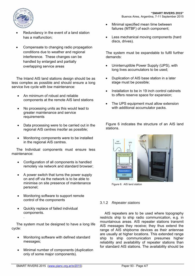
3.1.1 AIS land stations
The AIS land stations are the transmitter/ receivers located along the fairways. Ensuring a comprehensive VHF radio coverage of the assigned waterways is a precondition for a good working system. At first the AIS land-based station locations had to be identified. However, the existing infrastructure of the Nautical Information Radio (NIF), i.e. equipment cabinet, antennae masts, power supply and land line data communication equipment, have been used. Field strength tests conducted for the NIF service was used to verify the selected locations. The NIF service makes use of the same frequency band as Inland AIS so the radio propagation conditions are comparable. These data were used to draft an expected radio coverage chart as a basis to determine AIS land station locations, figure 5.
Figure 5: Overlapping service areas with regard to radio
propagation at Saar River The overlapping of service range areas of the
individual AIS land stations were planned for two reasons:
“SMART RIVERS 2015” Buenos Aires, Argentina, 7-11 September 2015
SMART RIVERS 2015 (www.pianc.org.ar/sr2015) Paper 93 - Page 4/7
Redundancy in the event of a land station
has a malfunction;
Compensate to changing radio propagation conditions due to weather and regional interference. These changes can be handled by enlarged and partially overlapping service areas
The Inland AIS land stations design should be as
less complex as possible and should ensure a long service live cycle with low maintenance:
An minimum of robust and reliable
components at the remote AIS land stations
No processing units as this would lead to greater maintenance and service requirements
Data processing were to be carried out in the regional AIS centres insofar as possible;
Monitoring components were to be installed in the regional AIS centres.
The Individual components must ensure less maintenance:
Configuration of all components is handled remotely via network and standard browser;
A power switch that turns the power supply on and off via the network is to be able to minimise on site presence of maintenance personel;
Monitoring software to support remote control of the components
Quickly replace of failed individual components. .
The system must be designed to have a long life cycle:
Monitoring software with defined standard
messages;
Minimal number of components (duplication only of some major components).
Minimal specified mean time between failures (MTBF) of each component;
Less mechanical moving components (hard discs, drives).
The system must be expandable to fulfil further demands:
Uninterruptible Power Supply (UPS), with
long lives accumulators to be used;
Duplication of AIS base station in a later stage must be possible;
Installation to be in 19 inch control cabinets to offers reserve space for expansion;
The UPS equipment must allow extension with additional accumulator packs.
Figure 6 indicates the structure of an AIS land stations.
Figure 6: AIS land station
3.1.2 Repeater stations
AIS repeaters are to be used where topography
restricts ship to ship radio communication, e.g. in mountainous areas. AIS repeater stations transmit AIS messages they receive; they thus extend the range of AIS shipborne devices as their antennae are usually at higher locations. This extended range ship to ship communication presumes higher reliability and availability of repeater stations than for standard AIS stations. The availability should be
“SMART RIVERS 2015” Buenos Aires, Argentina, 7-11 September 2015
SMART RIVERS 2015 (www.pianc.org.ar/sr2015) Paper 93 - Page 5/7
99.75%. Therefore hardware components of AIS repeater station are doubled, figure 7.
If several repeater stations are used in the same
geographical area this may cause radio channel overload due to internecine transmission of AIS messages between individual repeater stations. Therefore, a so called intelligent repeater has been developed to prevent this overload. Intelligent repeaters are software modules that process received AIS messages in a predetermined way. Intelligent repeaters ensure that an AIS message is only retransmitted once. This lightens the load on the radio channels concerned and makes the information involved available to all.
Figure 7: AIS repeater station
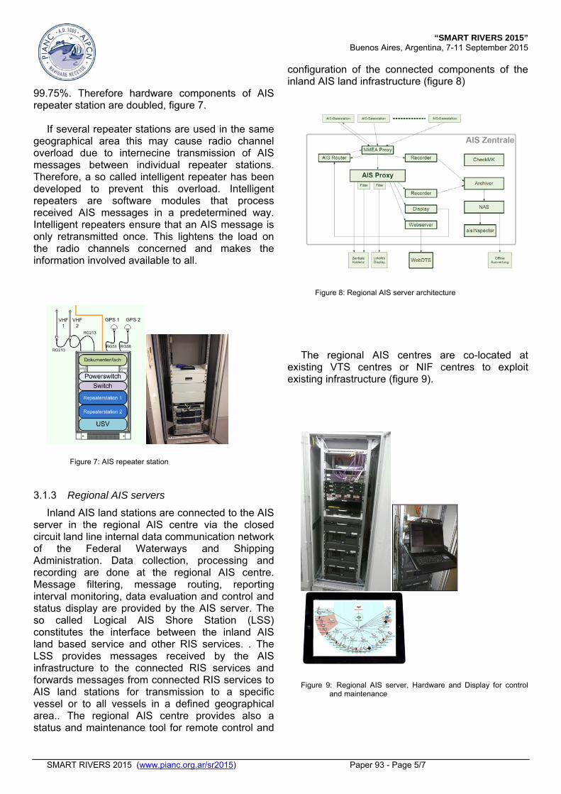
3.1.3 Regional AIS servers
Inland AIS land stations are connected to the AIS server in the regional AIS centre via the closed circuit land line internal data communication network of the Federal Waterways and Shipping Administration. Data collection, processing and recording are done at the regional AIS centre. Message filtering, message routing, reporting interval monitoring, data evaluation and control and status display are provided by the AIS server. The so called Logical AIS Shore Station (LSS) constitutes the interface between the inland AIS land based service and other RIS services. . The LSS provides messages received by the AIS infrastructure to the connected RIS services and forwards messages from connected RIS services to AIS land stations for transmission to a specific vessel or to all vessels in a defined geographical area.. The regional AIS centre provides also a status and maintenance tool for remote control and
configuration of the connected components of the inland AIS land infrastructure (figure 8)
Figure 8: Regional AIS server architecture
The regional AIS centres are co-located at existing VTS centres or NIF centres to exploit existing infrastructure (figure 9).
Figure 9:Regional AIS server, Hardware and Display for control
and maintenance

“SMART RIVERS 2015” Buenos Aires, Argentina, 7-11 September 2015
SMART RIVERS 2015 (www.pianc.org.ar/sr2015) Paper 93 - Page 6/7
3.1.4 Test and evaluation centre
The Test and evaluation centre (figure 10) has the following tasks:
system monitoring; system and fault analysis; statistical evaluation; configuration of individual components; system software component management;
Serving as a test platform.
Figure 11: indicates one example of monitoring system performance.
Figure 10: Test and evaluation centre
Figure 11: Indicating the measured signal strength along a river section
3.2 Project set-up a AIS land infrastructure
The project establishing an AIS land was initiated in 2013 following a decision of the Ministry of Transport and Digital Infrastructure (BMVI). The project was special funded by the Government (Federal Infrastructure Acceleration Programme II). The call for tender for establishing the Inland AIS land infrastructure was split into two parts:
Set-up of 86 AIS land stations and 9 AIS repeater stations;
Set-up 4 regional AIS servers and the test and evaluation centre.
Kick-off was in March 2014. Initial operation phase for testing has started after installation was completed in December 2014.
3.3 Experience made
Since beginning of the test phase the Inland AIS land stations are in operation and deliver received AIS messages to the regional AIS centres. The repeater stations at the Rhine River are in operation and ensure comprehensive AIS coverage for supporting navigation in the mountainous region of the Rhine. The availability of individual components of the Inland AIS land infrastructure and the overall system availability are recorded and evaluated in the central test and evaluation centre. The system shows the expected performance. However, according to the experiences made some adjustments should be considered. 3.3.1 Land line data communication network
One challenge has been connecting the AIS shore stations to the existing closed circuit land line internal data communication network of the Federal Waterways and Shipping Administration. The data transfer between the stations is based on a virtual private network employing Ethernet technology for the protocol. The delay time of some seconds measured of the data delivered seems to be not acceptable for possible time critical applications. Therefore the network performance must be designed according to the demands of the services provided.

“SMART RIVERS 2015” Buenos Aires, Argentina, 7-11 September 2015
SMART RIVERS 2015 (www.pianc.org.ar/sr2015) Paper 93 - Page 7/7
3.3.2 VHF radio coverage
The Inland AIS land stations are co-located at the existing VHF voice communication NIF stations. A first survey indicates that some areas at the course of the fairway are not fully covered by AIS base stations. In some areas there are gaps of several 100 meters; in some areas the right side of the fairway is covered but not the left side. In those areas the reception of the AIS messages is highly dependent on the quality of the ship installation of the AIS VHF antenna. Poor AIS antenna installations or a not optimal place of the AIS antenna are often reasons for a weak reception of the signals. It has to be decided how much of the AIS coverage gaps at the river are acceptable and at what margin additional Inland AIS shore station are required to fill those gaps. This, of course, is dependent on the application using the AIS information and on its resilience regarding short loss of AIS tracks.
3.3.3 Regional AIS server
The regional AIS server provides a basic data processing of received AIS messages utilised by the so called AIS Logical land station (LLS). This includes doublet filtering of the same AIS message delivered from different AIS land stations, area filtering of received messages depending if the transmitting ship is inside or outside the area, message type filtering and reporting interval filtering. Those functions will serve the general requirements of applications using the AIS data but depending on the specific application. More or different functionalities might be required. These demands will be further investigated with regard to services/applications.
3.4 Maintenance
All components in the Inland AIS land infrastructure can be remotely controlled and configured. A status display of each AIS shore station including all components is available for the maintenance personnel. The status of the component is visualised and documented using a standard analysis software programme. Procedures for regular maintenance work at the AIS infrastructure are currently being developed and tested.
.
4 SUMMARY
Setting up a land based AIS infrastructure at the most relevant Inland waterways is a further step towards the implementation of River Information Services (RIS) in Germany. The AIS network allows the exchange of relevant information’s between ships and Inland VTS centres, RIS centres, locks etc. for services developed to improve safety and efficiency of navigation.The German Waterways and Shipping Administration will continue to improve its AIS capability. For example, a next step will be the extension of the AIS infrastructure towards the remaining waterways with commercial traffic which are not jet covered.
REFERENCES
River Information Services (RIS) in Germany Nils Braunroth, Stefan Bober, PIANC World Congress 2014