
Airport Link Phase 2 – Detailed Feasibility Studyeisdocs.dsdip.qld.gov.au/Airport Link/EIS/Volume...
24
Airport Link Phase 2 – Detailed Feasibility Study APPENDIX B - COMMUNITY CONSULTATION REPORT October 2006
Transcript of Airport Link Phase 2 – Detailed Feasibility Studyeisdocs.dsdip.qld.gov.au/Airport Link/EIS/Volume...
Airport Link Phase 2 – Detailed Feasibility Study
APPENDIX B - COMMUNITY CONSULTATION REPORT
October 2006

PAGE i
Contents 1. Introduction 1
2. Consultation approach 3 2.1 Consultation approach 3 2.2 Consultation program 3 2.3 Proposed Northern Busway 5
3. Consultation Activities 6 3.1 Summary of consultation activities 6 3.2 Consultation participation 7 3.3 Ongoing Consultation 8
4. Stakeholders 9
5. Community issues 11 5.1 Key Issues – General Community Consultation 11 5.1.1 Property Impacts 12 5.1.2 Air quality and ventilation 13 5.1.3 Traffic and transport 13 5.1.4 Construction impacts 14 5.1.5 Community facilities 15 5.1.6 Project Design 16 5.1.7 Integration with Northern Busway 16 5.1.8 Project benefits 16
6. Outcomes 18 6.1 Design Modifications 18 6.2 Urban Design 18 6.3 Mitigation Strategies 19
7. Conclusion 21
PAGE 1
1. Introduction This report provides an overview of the community consultation for the Airport Link Environmental Impact Statement (EIS) undertaken between July 2005 and July 2006. It describes the consultation approach and process, activities undertaken, consultation issues and outcomes. A more detailed report is available as Technical Report 14 – Community Consultation.
This report was prepared prior to the exhibition of the EIS. Details of activities, results and outcomes of the final stage of consultation will be addressed by a supplementary report following the public exhibition of the EIS.
This report addresses Section 1.4 of the Terms of Reference (TOR) for the Airport Link EIS, which requires reporting of:
Consultation methodology, including criteria for identifying stakeholders and the communication methods used;
Stakeholders consulted;
Issues raised;
Strategies put into place to resolve these concerns and or enhance particular positive impacts; and
The extent to which the public consultation program satisfied the requirements under the State Development and Public Works Organisation Act 1971.
The consultation objectives for the EIS included:
Provide clear communication to community members of project objectives, project definition, EIS process, and scope of assessment;
Obtain community input to identifying local values to be considered as part of the assessment and project design process;
Provide inclusive and regular opportunities for community members to participate in consultation;
Seek community input at the neighbourhood and community level in identifying potential impacts, mitigation and regeneration strategies in areas which may accommodate project infrastructure or where the local environment may change during construction or operation;
Seek consultation input to impact assessment, urban design and regeneration outcomes, mitigation strategy development, and development of the project reference design; and
Achieve the statutory requirements for consultation under the State Development and Public Works Organisations Act 1971 and other statutory requirements as appropriate.
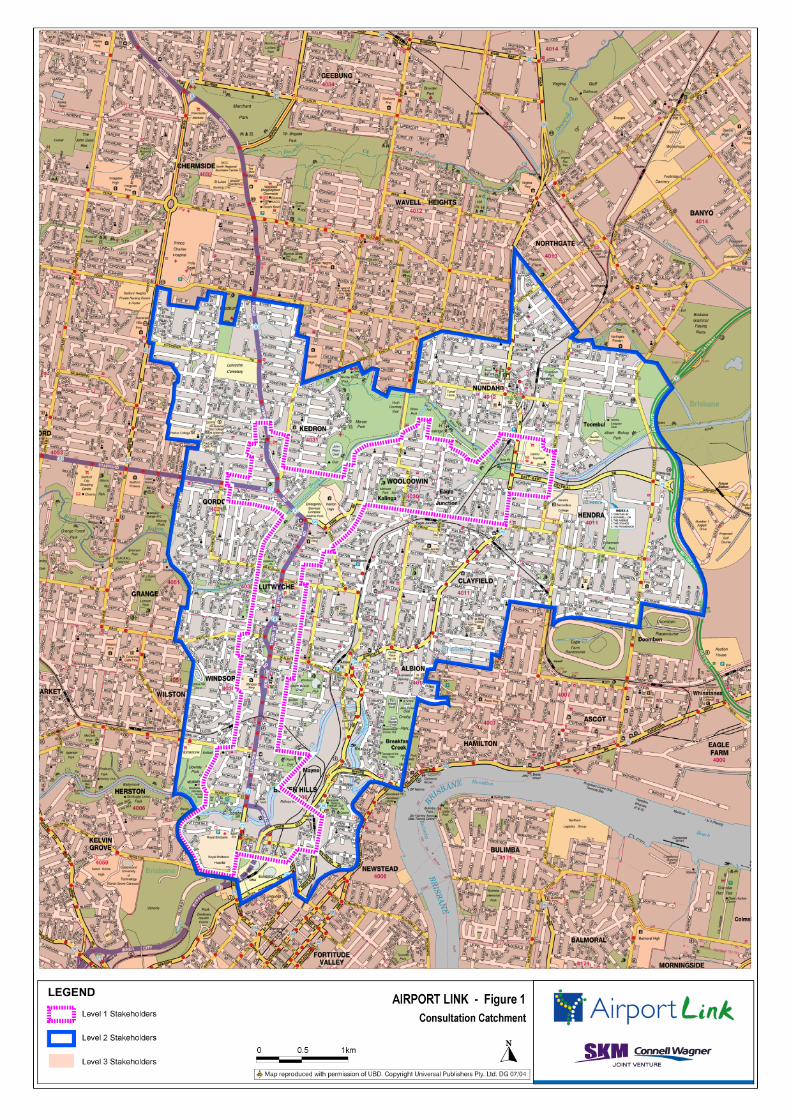
The consultation catchment for Airport Link generally covers the inner northern suburbs of Bowen Hills, Windsor, Albion, Lutwyche, Clayfield, Hendra, Herston, Kalinga, Wooloowin, Kedron, Nundah, Toombul and Gordon Park (refer Figure 1).
A further 147,000 households, businesses, property owners and organisations in Brisbane’s northern suburbs received five Airport Link newsletters, while city wide communication strategies provided information to other Brisbane residents.

PAGE 3
2. Consultation approach This section provides an overview of the consultation approach and program for the Airport Link EIS.
Preparation of the EIS has involved an in-depth investigation of local conditions, potential benefits and impacts resulting from Airport Link, and issues of concern related to Airport Link during construction and operation. Community consultation contributed to the preparation of the EIS by ensuring technical studies examined areas of interest to members of the community, and helping to identify ways to minimise potential impacts and maximise potential benefits of Airport Link.
Community consultation was integrated with both the preparation of the EIS and development of the project reference design. Community feedback gathered during community consultation was considered in the development and refinement of the project design, assessment of potential benefits and impacts, and identification of mitigation measures.
2.1 Consultation approach A three-level consultation approach was adopted for the Airport Link EIS, which sought to ensure that those people with a direct interest in the project’s outcomes were provided with the highest level of consultation and communication. Table 2-1 provides a summary of the consultation approach adopted for the Airport Link EIS.
Table 2-1 Consultation Approach
Stakeholder Level Consultation approach
Level 1: Residents, property owners, businesses, community facilities and community groups in those neighbourhoods where the local environment may change during construction or operation. Level 1 Stakeholders will receive the highest level of consultation and communication with the EIS team, including targeted briefings and meetings with community groups.
Level 2: Residents, property owners, businesses, community facilities and community groups in those suburbs closest to the alignment and connections, including Bowen Hills, Windsor, Albion, Lutwyche, Clayfield, Hendra, Herston, Kalinga, Wooloowin, Kedron, Nundah, Toombul and Gordon Park. Level 2 includes those stakeholders that may experience the benefits or impacts of the project, with strategies including newsletters and information sessions.
Level 3: Other stakeholders in greater Brisbane, including people that register in response to community information and consultation strategies. Strategies included 1800 project information line, news articles and media releases.
The consultation process was supported by the broader project team, enabling a high level of information to and personal contact with residents, businesses and property owners. The consultation team also worked closely with the Airport Link Communication and Stakeholder Management team to provide information to the broader community and regional stakeholders.
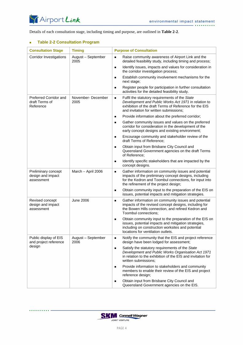
2.2 Consultation program The consultation program ran concurrently with the environmental assessment and project design processes. Four rounds of community consultation were undertaken between July 2005 and July 2006 to input into the development of the project reference design and preparation of the EIS. A further round of consultation will be undertaken with the display of the EIS for community comment in accordance with the statutory requirements of the State Development and Public Works Organisation Act 1971.
PAGE 4
Details of each consultation stage, including timing and purpose, are outlined in Table 2-2.
Table 2-2 Consultation Program
Consultation Stage Timing Purpose of Consultation
Corridor Investigations August – September 2005
Raise community awareness of Airport Link and the detailed feasibility study, including timing and process;
Identify issues, impacts and values for consideration in the corridor investigation process;
Establish community involvement mechanisms for the next stage;
Register people for participation in further consultation activities for the detailed feasibility study.
Preferred Corridor and draft Terms of Reference
November- December 2005
Fulfil the statutory requirements of the State Development and Public Works Act 1971 in relation to exhibition of the draft Terms of Reference for the EIS and invitation for written submissions;
Provide information about the preferred corridor; Gather community issues and values on the preferred
corridor for consideration in the development of the early concept designs and existing environment;
Encourage community and stakeholder review of the draft Terms of Reference;
Obtain input from Brisbane City Council and Queensland Government agencies on the draft Terms of Reference;
Identify specific stakeholders that are impacted by the concept designs.
Preliminary concept design and impact assessment
March – April 2006 Gather information on community issues and potential impacts of the preliminary concept designs, including for the Kedron and Toombul connections, for input into the refinement of the project design;
Obtain community input to the preparation of the EIS on issues, potential impacts and mitigation strategies.
Revised concept design and impact assessment
June 2006 Gather information on community issues and potential impacts of the revised concept designs, including for the Bowen Hills connection, and refined Kedron and Toombul connections;
Obtain community input to the preparation of the EIS on issues, potential impacts and mitigation strategies, including on construction worksites and potential locations for ventilation outlets.
Public display of EIS and project reference design
August – September 2006
Notify the community that the EIS and project reference design have been lodged for assessment;
Satisfy the statutory requirements of the State Development and Public Works Organisation Act 1971 in relation to the exhibition of the EIS and invitation for written submissions;
Provide information to stakeholders and community members to enable their review of the EIS and project reference design;
Obtain input from Brisbane City Council and Queensland Government agencies on the EIS.
PAGE 5
2.3 Proposed Northern Busway The Queensland Government, through TransLink, is planning the Northern Busway to connect the Inner Northern Busway at Royal Children’s Hospital (Herston) to Aspley/ Bracken Ridge via Windsor, Lutwyche, Kedron and Chermside.
Planning for that section of the busway between Herston and Kedron has been brought forward by TransLink to allow for planning of the Busway in parallel with Airport Link. The proposed Northern Busway follows a similar corridor to Airport Link between Bowen Hills and Kedron.
Consultation for Airport Link was undertaken concurrently with consultation for the proposed Northern Busway to allow community members to understand and consider the potential benefits and impacts of both projects. This included shared consultation activities, including community information sessions and staffed library displays, and reference to each of the projects in community information and consultation activities.
PAGE 6
3. Consultation Activities A range of consultation activities were undertaken as part of the EIS investigations to allow people with different interests in the project to learn more about the project and provide input to the preparation of the EIS and the development of the project reference design.
The following provides a summary of consultation activities undertaken for the preparation of the EIS, including level of participation. A more detailed overview is provided in the Technical Report No 14 – Community Consultation in Volume 3 of the EIS.
3.1 Summary of consultation activities Consultation activities undertaken during the preparation of the EIS included:
Four public displays located at ward offices, Council libraries, State electoral offices and Council offices within or near to the study corridor, with one at each stage of the consultation process to provide information on the corridor investigations, preferred corridor, preliminary concept design and EIS investigations;
Public exhibition of the draft ToR for the EIS, between Monday 7 November 2005 and Wednesday, 21 December 2005, in accordance with the requirements of the State Development and Public Works Organisation Act 1971;
Distribution of four project newsletters, to more than 150,000 households, businesses, registered stakeholders, and property owners, providing information on Airport Link, including the EIS, concept designs and community consultation activities;
Distribution of approximately 8,000 Level One Stakeholder letters on four occasions (August 2005, November 2005, March 2006 and June 2006), to residents, businesses and property owners near the project works, informing those communities closest to the works about Airport Link and encouraging them to participate in community consultation activities;
A total of 14 community information sessions, over four rounds of consultation, which provided opportunities for community members to find out more about the project and to meet with members of the project team, and attended by a total of about 2,100 people;
Four rounds of staffed library displays, involving 14 separate staffed library displays, to provide additional opportunities for community members to speak with a member of the project team and find out more about the project, and attended by a total of 630 people;
Establishment of two community liaison groups (CLGs) and one local business liaison group (LBLG) to provide input into the development of the project reference design and EIS investigations. The CLGs comprise representatives from community organisations within the study corridor and the LBLG comprises representatives of local businesses and major community facilities (i.e. schools).
Six meetings of the CLGs, including two joint meetings, and five meetings of the LBLG to present information and gather feedback on the EIS investigations and concept design;
A briefing to five local neighbourhoods near to the proposed surface infrastructure and construction works to discuss issues relating to Airport Link that were relevant to their local neighbourhood, and to understand concerns for local neighbourhoods for consideration in the EIS investigations and development of the project reference design, attended by about 90 people;
PAGE 7
Briefings with a range of community, industry and government stakeholders to provide information on the project and to identify any specific issues or concerns for consideration in the EIS investigations and development of the project reference design;
Two whole of Government agency briefings, held on Thursday, 3 November 2005 and Thursday, 11 May 2006 with representatives of Queensland Government and Brisbane City Council agencies with an interest in the EIS. The purpose of the first briefing was to provide agencies with information on the project background, timing, process and EIS, including the draft ToR. The second briefing was an update on the EIS and final ToR, as well as the preliminary project design and outcomes of community consultation;
Establishment and staffing of a 1800 free call project information line, reply paid mailing address, and email address to enable community members to provide input and obtain information on the project; Approximately 2,770 enquiries or comments have been received from community members since the commencement of the project;
Four rounds of public advertisements in local and state newspapers, to provide updates on Airport Link, information on the EIS process and concept design, and details of community consultation activities;
Notification of the exhibition period for the draft ToR in the Courier Mail and The Weekend Australian on Saturday, 5 November 2005, in accordance with the State Development and Public Works Organisation Act; and
Establishment of a website for the Airport Link EIS to provide information on the EIS, project design, traffic and transport studies and community consultation activities, including copies of the Initial Advice Statement and draft ToR.
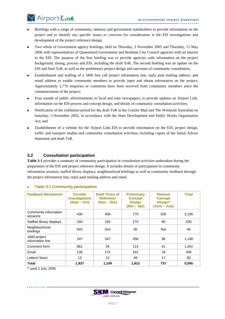
3.2 Consultation participation Table 3-1 provides a summary of community participation in consultation activities undertaken during the preparation of the EIS and project reference design. It includes details of participation in community information sessions, staffed library displays, neighbourhood briefings as well as community feedback through the project information line, reply paid mailing address and email.
Table 3-1 Community participation
Feedback Mechanism Corridor investigations (Sept – Oct)
Draft Terms of Reference
(Nov – Dec)
Preliminary Concept Design
(Mar – Apr)
Revised Concept Design*
(June – July)
Total
Community information sessions 430 400 770 505 2,105
Staffed library displays 250 150 170 60 630 Neighbourhood briefings N/A N/A 90 N/a 90
1800 project information line 247 347 458 96 1,148
Comment form 861 26 114 41 1,042 Email 136 174 162 18 490 Letters/ faxes 13 12 48 17 90 Total 1,937 1,109 1,812 737 5,595 * until 2 July 2006
PAGE 8
3.3 Ongoing Consultation The Airport Link EIS consultation process is ongoing and will continue for the duration of the EIS to provide community input into the project design, impact assessment and mitigation strategies. The EIS will be placed on public exhibition and written submissions invited from community members. Ongoing consultation activities include:
Public display of the draft EIS and project reference design;
Round five of community information sessions and staffed library displays;
One meeting of the community liaison groups;
One meeting of the local business liaison group;
Stakeholder briefings to identify specific concerns relating to the project design and EIS;
Staffing of the 1800 project information line, email and reply paid mailing address; and
Airport Link EIS website, to provide information on the outcomes of the EIS investigations.
PAGE 9
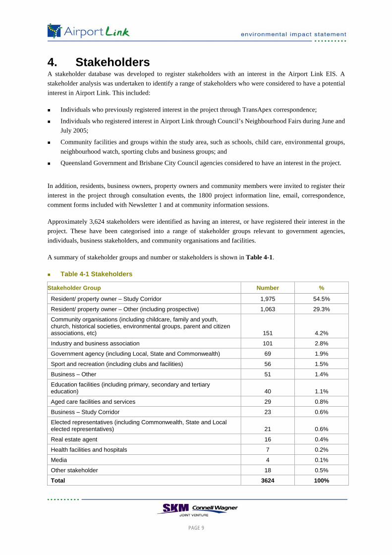
4. Stakeholders A stakeholder database was developed to register stakeholders with an interest in the Airport Link EIS. A stakeholder analysis was undertaken to identify a range of stakeholders who were considered to have a potential interest in Airport Link. This included:
Individuals who previously registered interest in the project through TransApex correspondence;
Individuals who registered interest in Airport Link through Council’s Neighbourhood Fairs during June and July 2005;
Community facilities and groups within the study area, such as schools, child care, environmental groups, neighbourhood watch, sporting clubs and business groups; and
Queensland Government and Brisbane City Council agencies considered to have an interest in the project.
In addition, residents, business owners, property owners and community members were invited to register their interest in the project through consultation events, the 1800 project information line, email, correspondence, comment forms included with Newsletter 1 and at community information sessions.
Approximately 3,624 stakeholders were identified as having an interest, or have registered their interest in the project. These have been categorised into a range of stakeholder groups relevant to government agencies, individuals, business stakeholders, and community organisations and facilities.
A summary of stakeholder groups and number or stakeholders is shown in Table 4-1.
Table 4-1 Stakeholders
Stakeholder Group Number %
Resident/ property owner – Study Corridor 1,975 54.5%
Resident/ property owner – Other (including prospective) 1,063 29.3%
Community organisations (including childcare, family and youth, church, historical societies, environmental groups, parent and citizen associations, etc) 151 4.2%
Industry and business association 101 2.8%
Government agency (including Local, State and Commonwealth) 69 1.9%
Sport and recreation (including clubs and facilities) 56 1.5%
Business – Other 51 1.4%
Education facilities (including primary, secondary and tertiary education) 40 1.1%
Aged care facilities and services 29 0.8%
Business – Study Corridor 23 0.6%
Elected representatives (including Commonwealth, State and Local elected representatives) 21 0.6%
Real estate agent 16 0.4%
Health facilities and hospitals 7 0.2%
Media 4 0.1%
Other stakeholder 18 0.5%
Total 3624 100%

PAGE 10
Residents and property owners comprised the largest stakeholder group, representing over 80% of all stakeholders. Community organisations were the second largest stakeholder group representing about 4% of stakeholders.
About 53% of stakeholders on the stakeholder register have a postal address within the study corridor. Further details on stakeholders is included in Technical Report 14 – Community Consultation.

PAGE 11
5. Community issues This section provides an overview of issues raised during consultation for the EIS investigations and project design, from different sources. It includes input from community and local business liaison group meetings, community information sessions, stakeholder meetings, comment forms, the 1800 project information line and emails to the project team. A more detailed list of community issues is contained in the Technical Report 14 – Community Consultation in Volume 3 of the EIS.
5.1 Key Issues – General Community Consultation Input gathered from community information sessions, comment forms, stakeholder briefings, submissions, emails and calls to the 1800 project information line was analysed to identify the range of issues being commented on by community members. More than 5,600 individual comments were received and recorded in the stakeholder database. These were reported to the EIS and engineering teams during the EIS investigations.
The ‘top five’ categories of issues raised from community feedback accounted for about 63% of total issues raised from community feedback. These included:
Property impacts (e.g. property acquisition, impact on property values, volumetric acquisition);
Consultation process (e.g. registration for involvement, consultation activities, etc);
Traffic issues (e.g. impact on adjacent roads, increases in traffic, interchanges with existing roads);
Ventilation outlets (e.g. number and location, filtration, visual impact); and
Transport policy and strategic options (e.g. congestion, integration with other projects, cycle and pedestrian facilities, public transport).
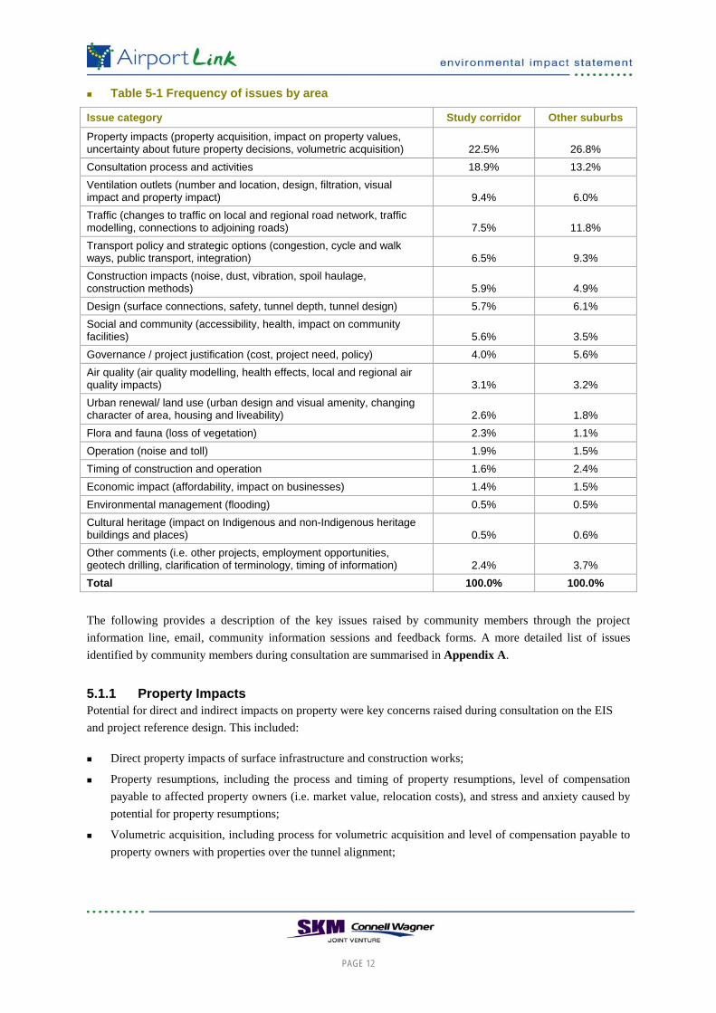
Table 5-1 summarises the frequency of issues raised according to participants’ postal address. It indicates that the issues of highest priority for people based in the study corridor suburbs relate to property impacts, consultation, ventilation outlets, and traffic.
Issues of highest priority for residents in other suburbs outside of the study corridor included property impacts, consultation, traffic, project design and ventilation outlets.
PAGE 12
Table 5-1 Frequency of issues by area
Issue category Study corridor Other suburbs
Property impacts (property acquisition, impact on property values, uncertainty about future property decisions, volumetric acquisition) 22.5% 26.8% Consultation process and activities 18.9% 13.2% Ventilation outlets (number and location, design, filtration, visual impact and property impact) 9.4% 6.0% Traffic (changes to traffic on local and regional road network, traffic modelling, connections to adjoining roads) 7.5% 11.8% Transport policy and strategic options (congestion, cycle and walk ways, public transport, integration) 6.5% 9.3% Construction impacts (noise, dust, vibration, spoil haulage, construction methods) 5.9% 4.9% Design (surface connections, safety, tunnel depth, tunnel design) 5.7% 6.1% Social and community (accessibility, health, impact on community facilities) 5.6% 3.5% Governance / project justification (cost, project need, policy) 4.0% 5.6% Air quality (air quality modelling, health effects, local and regional air quality impacts) 3.1% 3.2% Urban renewal/ land use (urban design and visual amenity, changing character of area, housing and liveability) 2.6% 1.8% Flora and fauna (loss of vegetation) 2.3% 1.1% Operation (noise and toll) 1.9% 1.5% Timing of construction and operation 1.6% 2.4% Economic impact (affordability, impact on businesses) 1.4% 1.5% Environmental management (flooding) 0.5% 0.5% Cultural heritage (impact on Indigenous and non-Indigenous heritage buildings and places) 0.5% 0.6% Other comments (i.e. other projects, employment opportunities, geotech drilling, clarification of terminology, timing of information) 2.4% 3.7% Total 100.0% 100.0%
The following provides a description of the key issues raised by community members through the project information line, email, community information sessions and feedback forms. A more detailed list of issues identified by community members during consultation are summarised in Appendix A.
5.1.1 Property Impacts Potential for direct and indirect impacts on property were key concerns raised during consultation on the EIS and project reference design. This included:
Direct property impacts of surface infrastructure and construction works;
Property resumptions, including the process and timing of property resumptions, level of compensation payable to affected property owners (i.e. market value, relocation costs), and stress and anxiety caused by potential for property resumptions;
Volumetric acquisition, including process for volumetric acquisition and level of compensation payable to property owners with properties over the tunnel alignment;
PAGE 13
Impact of tunnelling construction on properties above or near the tunnel alignment, including potential for damage to properties due to vibration or subsidence caused by construction and compensation arrangements for likely damage;
Potential impact on property values in those areas near the surface connections, ventilation outlets or tunnel alignment, including concern about loss of money for property owners who need to sell their property in a period of uncertainty, and concern about financial hardship caused to property owners if their asset value is affected by the project; and
Uncertainty relating to future property decisions, including buying, selling or renovating properties near to surface works or the tunnel alignment.
5.1.2 Air quality and ventilation The number and location of ventilation outlets and concerns about air quality, community health, property values and community facilities are key community issues. The potential need for and effectiveness of filtration were also identified as important issues for some community members.
Specific issues relating to air quality and ventilation included:
The number and location of ventilation outlets, including concern about the proximity of ventilation outlets to sensitive land uses such as schools, child care, aged care and open space and recreation areas;
Visual impact of ventilation outlets from open space and residential areas, including potential impacts on property values;
The need for filtration to be incorporated into ventilation outlets to reduce potential long-term health impacts;
Changes to air quality near ventilation outlets and potential health effects for nearby residents and school children from ventilation outlets, including Wooloowin State School, Kedron State High School, and Hendra College;
Potential for a higher level of commercial vehicles to be attracted to Airport Link and subsequent concerns about diesel emissions, if Airport Link is connected (via NSBT) to Ipswich Road;
Need for online real time monitoring and reporting of air quality during construction and operation of Airport Link, including monitoring at Kalinga Park; and
Cumulative air quality impacts of NSBT ventilation outlet at Bowen Hills and Airport Link ventilation outlet at Windsor.
5.1.3 Traffic and transport Traffic and transport issues were key community concerns. These included construction related issues such as traffic disruptions and impact of construction vehicles, as well as operational issues such as changes to traffic on local and regional road networks.
A concern for many community members is the potential for Airport Link to exacerbate existing congestion issues at the intersection of the East-West Arterial and Nudgee Road and at the Airport roundabout, causing further delays for motorists accessing the Airport and Gateway Motorway.
Community members also identified benefits resulting from reduced traffic on some surface roads and opportunities to provide better local environments.
PAGE 14
Other traffic and transport issues identified during consultation on the EIS and concept design include:
Concern about an increase in traffic and “rat-running” on local streets, as a result of traffic accessing Airport Link, changes to local traffic access during construction and operation, motorists trying to avoid the toll and motorists avoiding traffic congestion caused by construction works;
Need to ensure that Airport Link decreases “rat-running” through residential streets;
Concerned about “funnelling” of traffic into the tunnel through the closure of some surface roads and loss of traffic lanes on surface roads;
Need to maintain safe and easy access for local streets near surface connections;
Consideration of a congestion tax for users of existing roads to discourage car use; and
Need for consideration of alternative transport options and improvements to public transport facilities to reduce dependence on private vehicles.
5.1.4 Construction impacts Impacts for residents near construction works and concerns about impacts on properties and community facilities as a result of construction activities were frequently raised issues.
Impacts of vibration on buildings and building occupants were raised as a key concern, especially for residents above the tunnel alignment in Wooloowin and Clayfield. Particular concerns included:
Operation hours of tunnelling and disruption for residents caused by night-time tunnelling works;
Potential damage to buildings and structures, including swimming pools, caused by vibration and subsidence; and
Process for compensation and rectifying damage to properties caused by vibration or subsidence.
The need for safe pedestrian and cycle access (including for elderly, school children, and people with disability) to be maintained near construction worksites and surface works was an important issue for many community members. This included:
In the vicinity of Kedron State High School (to Kedron Brook) and Wooloowin State School (across and along Lutwyche Road) for school students, due to trucks and heavy machinery, including the need for regular communication with students and parents of changes to pedestrian access near schools during construction;
Across and along Lutwyche Road/ Gympie Road including to Kedron Brook and community facilities such as schools, St Andrew’s Anglican Church, and bus stops;
From the Stuckey Road/ Alma Road neighbourhood to Kalinga Park, Toombul railway station and Toombul shopping centre; and
Need to avoid confusion and uncertainty for pedestrians (particularly children and elderly) in the vicinity of worksites.
Other concerns raised in relation to construction included:
Impacts of construction noise from surface works on nearby residents, businesses, and community facilities (specifically schools), including the need to provide temporary noise barriers to reduce impacts of construction noise;
PAGE 15
Air pollution resulting from construction activities, such as dust generated from surface works and spoil haulage, and impacts of emissions from construction vehicles;
Timing and duration of construction activities, including concern if construction activities were to occur 24 hours a day;
The removal of spoil from construction worksites, including haulage routes, need for consideration of rail for spoil haulage and timing and duration of spoil haulage;
Disruption to drop-off and pick-up areas at Wooloowin State School, including impact on parking for parents;
Need to provide safe access near worksites to avoid confusion and uncertainty for motorists;
Impact on open space and recreation areas and facilities from construction activities, including loss of open space at Kalinga Park and Kedron Brook, disruption to bicycle paths and pedestrian access, loss of amenity for park users due to construction noise, and loss of land area or use of Kedron State High School ovals;
Impact of traffic disruptions and changes to local access near worksites and construction works, and the need to maintain access to properties during construction works; and
Impact on parking for residents and businesses near construction worksites due to workers parking in local streets.
5.1.5 Community facilities Potential impacts on community facilities, particularly local schools and open space and recreation areas, are important community issues. This included construction impacts as well as longer-term operational impacts.
Impact on open space and recreation areas, particularly Kedron Brook and Kalinga Park, was a key concern of many residents and frequently raised during all consultation activities. This included:
Loss of open space and recreation areas due to construction activities (i.e. construction worksites and cut and cover tunnel) and surface infrastructure (i.e. transition structures);
Disruption to pedestrian and cycle access along and to Kedron Brook and Kalinga Park, including at Sandgate Road and Gympie Road;
Loss of amenity for park users, from construction activities and operation of Airport Link, such as noise, visual impact of surface infrastructure, and disruption to park access;
Loss of vegetation, including vegetation that has high community or ecological value, particularly the Hoop Pines at Kalinga Park (adjacent to Sandgate Road);
Need to replace the loss of open space at Kedron Brook and Kalinga Park, including replacement of mature tree species; and
Need for the playground at Kalinga Park (adjacent to Lewis Street) impacted by cut and cover construction activities to be replaced and improved following construction.
Other impacts for community facilities identified during community consultation included:
Impacts for Kedron State High School and Wooloowin State School, including;
– Noise and dust from construction activities;
– Increased traffic noise from transition structures, including the need to provide appropriate noise attenuation measures;

PAGE 16
– Pedestrian safety for students in the vicinity of worksites and transition structures, including across Lutwyche Road and between Kedron State High School and Kedron Brook;
– Concern about the effect of school enrolments due to parents’ perception of construction impacts and proximity of the project; and
– Proximity of ventilation outlet at Kedron, and potential health effects for school children;
Impacts for St Andrew’s Anglican Church, including visual impact of surface infrastructure on the historical context of the church, noise and dust from construction activities, traffic noise from elevated and transition structures, impact on property access and potential impact on the historical value of the lych-gate; and
Impact on Department of Emergency Services site, including loss of building, changes to access and disruption to workers.
5.1.6 Project Design A number of issues were raised which were directly related to the project design, including the tunnel alignment and location and surface connections. Many of these issues also related to impacts on property, open space and traffic and transport. They include:
Suggestion that the tunnel be located under Kedron Brook rather than the residential area of Wooloowin and Clayfield, to avoid impact on residential properties;
Suggestion that the tunnel pass under Sandgate Road to connect to the East-West Arterial east of Sandgate Road;
Potential for the transition structures at Clayfield (west of Sandgate Road) to be covered to reduce noise impacts for residents at Alma Road/ Stuckey Road neighbourhood;
Airport Link should be extended beyond the Airport roundabout to reduce traffic congestion caused by this roundabout; and
Elevated structure at Stafford Road restricts right turn access to properties on the southern side of Stafford Road (i.e. for traffic heading east).
5.1.7 Integration with Northern Busway The need for integration of planning for Airport Link and the Northern Busway was a frequent issue raised during consultation. Many community members identified the need to consider the cumulative effects of both projects for local residents and businesses such as construction impacts, visual impacts, changes to air quality, property impacts, and changes to local access. Many people also recognised a number of benefits of integrating the construction of both projects, such as reduced community impacts, including possibility to combine construction worksites and potential to reduce the combined construction period of both projects.
5.1.8 Project benefits There is widespread community recognition that Brisbane has a traffic congestion problem and that there is a need to “do something” to address the increasing traffic and transport issues. Many people who expressed concern about potential impacts of Airport Link also expressed support for the project. However, many were concerned that potential impacts in local areas near construction works, tunnel alignment and surface connections would outweigh the broader benefits.

PAGE 17
Project benefits identified by consultation participants included:
Reduced traffic congestion, including on local roads that are currently used as “rat runs”;
Better air quality near existing heavily congested roads where surface traffic is reduced;
Potential to reduce freight vehicle numbers on surface roads;
Opportunities to facilitate urban regeneration outcomes;
Improved amenity for areas with reduced congestion; and
Faster, more direct routes between homes and businesses.

PAGE 18
6. Outcomes The following provides an outline of the design modifications, urban design proposals, and mitigation strategies developed in response to consultation with local residents, businesses, and the broader community.
6.1 Design Modifications Consultation with community members and other stakeholders assisted in the identification of potential impacts during the development of the project design. Some potential impacts were therefore mitigated by design modifications. General modifications are outlined below.
Modifications to surface connections, including:
– Provision of u-turn facility at intersection to Stafford and Gympie roads to provide access for motorists travelling east to properties on the southern side of Stafford Road;
– Refinement of the transition structures at the Department of Emergency Services to reduce impact on the sports oval;
– Refinement to the transition structure from Sandgate Road to allow pedestrian access to Kalinga Park to be achieved from Stuckey Road;
– Change to road layout at the Kedron connection to decrease the surface footprint and reduce property impacts;
– Refinement of the design at Windsor and Kedron to allow for the construction of the proposed Northern Busway.
Consideration of visual impacts in recommending the location and height of ventilation outlets;
Modifications to construction planning, including
– Refinement of the construction worksite at Kedron to provide safe and easy access between the Kedron State High School and Kedron Brook for students;
– Refinement to the construction worksite at Clayfield to maintain access to Toombul shopping centre and railway station from Alma Road/ Stuckey Road;
– Changes to the proposed construction methods to reduce potential property impacts resulting from subsidence; and
– Changes to proposed construction methods of the east-west tunnel, including provision to allow turning of the tunnel boring machine, to decrease impacts for local residents.
6.2 Urban Design The following outlines proposed urban design measures for each of the connections identified in response to issues raised by community members during community consultation undertaken for the preparation of the EIS.
General Create themed urban design and landscape treatments for retaining and transition structures, flyovers,
portals, ventilation outlets and sound barriers and integrate these with the existing environment of Bowen Hills/ Windsor, Kedron and Toombul.

PAGE 19
Bowen Hills/ Windsor Ensure integration of connections to and from open space connecting the north and south banks of
Enoggera Creek and the pedestrian/ cycle bridge provided by the NSBT;
Create themed urban design and landscape treatments for retaining and transition structures, flyovers, portals, ventilation outlets and sound barriers and integrate these with the existing environment of Bowen Hills; and
Adopt a high quality design approach integrating architecture and landscape design to achieve a visually acceptable outcome for the southern ventilation station and ventilation outlet. The ventilation outlet could form part of a city gateway to or from the Airport.
Kedron Rehabilitate and revegetate areas impacted during construction to Kedron Brook (if any), including the
construction of a ‘natural’ waterway including pools and riffles in the low-flow channel of Kedron Brook;
Provide high amenity planting to screen the sound barriers, ramp and transition structures impacting on the local residential precinct at Lutwyche (Colton and Windsor Avenues), Gordon Park (Swan and Suez Streets) and Kedron (Gympie Road, Erskine Street, Lasseter Street, Leckie Road and Park Terrace);
In consultation with Education Queensland, and the school community, explore options for an attractive, safe and accessible entrance for the Wooloowin State School, and to the extent reasonable and practicable, contribute with appropriate works, towards the improvement of this entrance.
Adopt an intense screen planting program for the above-ground infrastructure, particularly the acoustic screens at and above ground level, to achieve an acceptable urban landscape in an intense transport corridor.
Adopt a high-quality design response, integrating architecture and landscape planning to achieve a visually pleasing outcome for the ventilation station and ventilation outlet.
Toombul Reconstruct Schulz Canal to form a ‘natural’ wetland and waterway suitable for floodway performance and
consistent with the urban design objectives for an attractive urban wetland habitat, such that the works include board walks and viewing platforms;
Reinstate the drainage path from Jackson Street to Schulz Canal, with planted beds and banks for landscape effect, ecological robustness and streambank stability;
Provide equitable pedestrian and cycle connections north-south crossing of Stuckey and Alma Roads across Schulz Canal through to Ross Park, the Toombul rail station and the bus station;
Create areas of high quality landscape amenity and recreation, including the reinstatement of the playground, picnic and barbeque facilities in Kalinga Park, adjacent to Lewis Street;
Adopt a high-quality design response for the ventilation station and ventilation outlet, having regard for the proximity of residential development and the scale and form of nearby buildings. The design response should integrate architecture and landscape planning to achieve a desirable visual and urban outcome in this sensitive location, without compromising the air quality outcome sought for the tunnel ventilation system.
6.3 Mitigation Strategies The EIS identifies a range of mitigation strategies in response to issues raised by community members in community consultation, to maximise the benefits and reduce the impacts of Airport Link on local communities. Some of the mitigation strategies identified during consultation or identified to reduce impacts raised by

PAGE 20
community members during consultation are outlined below. A full list of mitigation strategies for construction and operation is outlined in Chapter 19 – Draft Outline Environmental Management Plans.
Proposed mitigation strategies include:
Measures to reduce impacts of construction, including:
– restrictions on hours of surface construction works,
– use of enclosed, acoustic lined work sheds and temporary noise barriers;
– use of established truck routes and arterial roads for the haulage of construction materials and spoil, and where practicable, providing direct access from worksites to arterial roads to minimise truck traffic in local streets;
– avoiding haulage tasks during peak traffic periods and school drop-off and pick-up times in the vicinity of Kedron State High School and Wooloowin State School;
– Managing impacts of vehicle emissions on adjacent properties; and
Traffic management measures near construction works to minimise impacts on local streets and of workers parking, and notifying the broader and local community about changed traffic conditions;
Maintaining safe pedestrian and cycle access near construction works, including to community facilities such as schools, child care facilities, churches, aged care accommodation, open space, health care and shopping facilities, including notifying the local community, and in particular, local schools, about changes to pedestrian and cycle access;
Minimising disturbance to vegetation communities and potential for harming native fauna during construction;
Conducting building condition surveys on buildings of State Heritage significance along the tunnel alignment prior to construction works;
Implementation of community information program to inform residents, businesses, community groups and motorists of project activities and potential impacts; and
Establishing an air quality monitoring station near each ventilation outlet no less than 12 months before commencement of the tunnel operations.
A full list of mitigation strategies is outlined in Chapter 19 – Draft Outline Environmental Management Plans.

PAGE 21
7. Conclusion Approximately 3,600 people have participated in consultation during the preparation of the EIS and project design and more than 147,000 households and businesses have received direct communications from the project team. More than 5,600 individual comments have been analysed to inform this consultation report.
Community consultation identified a range of social, economic and environmental issues for consideration in the EIS investigations and development of the project design. These related to local and regional benefits and impacts as well as local benefits and impacts near surface infrastructure, the tunnel alignment and construction activities.
Key regional benefits and impacts identified during community consultation include:
Potential for Airport Link to exacerbate existing congestion issues at the intersection of the East-West Arterial and Nudgee Road and at the Airport roundabout, causing further delays for motorists accessing the Airport and Gateway Motorway;
Opportunities to reduce traffic on some surface roads;
Potential impacts of spoil disposal, including impacts of spoil haulage on traffic congestion, on Kingsford Smith Drive, and cumulative impacts of Airport Link and the North-South Bypass Tunnel spoil haulage programs;
Traffic disruption and increase in congestion caused by construction works;
Impact on regional open space and recreation areas and facilities, including loss of land areas in Kalinga Park and Kedron Brook, and need for the cycle paths and pedestrian access to be maintained during construction and operation;
Benefits and impacts for regional education facilities, including impacts on Kedron State High School, which provides education to many students from outside of the local area, and opportunities to improve access to Hendra Secondary College for regional students;
Impact on Emergency Services Complex, including loss of buildings, access, disruption to workers; and
Impacts of tolling, including cost of toll and the need to consider differential tolls, including for pensioners, commercial vehicles, peak periods, and shorter distances, to encourage people to use the tunnel, and the need to maintain alternatives to Airport Link.
Key local benefits and impacts identified by community members during consultation included:
Property impacts, including near surface infrastructure, tunnel alignment and construction works, impact on property values and property resumptions;
Construction impacts on residential neighbourhoods, local businesses, community facilities and transport networks, including noise, dust, and parking for construction workers;
Air quality and ventilation, including changes to air quality and potential health effects, location of ventilation outlets and proximity to residential areas, schools, aged care and open space areas, need for filtration to be included in ventilation outlets, and visual impact of ventilation outlets including impact on property values and potential for mitigation of visual impacts;
Air quality impacts of increase in diesel trucks using the Airport Link if it connects to the Western Freeway and Ipswich Road is a concern for the local community.
PAGE 22
Social and community benefits and impacts, such as impact on community facilities, changes to local neighbourhoods, and opportunities to improve urban landscapes to create better conditions in residential areas and local centres;
Visual impact of tunnel infrastructure, including elevated roadways, transition structures and ventilation outlets;
Local traffic issues, including opportunities to decrease “rat-running” in residential areas and changes to local traffic access; and
Benefits and impacts for local businesses such as improved access to local businesses following construction, and impacts for businesses near construction works.
Consultation will continue for the duration of the EIS, including the public exhibition and invitation for written submissions from community members.


