Airborne observations of trace gases over boreal Canada during ...

Airborne Observations of Snow
1. Satellite mission concept development:• Technology development• Calibration and validation• Algorithm development
2. Operational snow surveys:• NOAA NOHRSC, Gamma Airborne Surveys, 1980 – Present• Airborne Snow Observatory (ASO, lidar/hyperspectral), 2013 – Present
3. Local to regional science studies (mainly lidar, stereophotogrammetry)• Snow depth spatial variability in various landscape• Repeatability of snow patterns
How has airborne science been used for Snow?
• Large, complete spatial coverage (vs ground observations)• Bridges gap between point ground observations and satellite data high
spatial resolution• Helps address scaling & model validation questions• Efficient way to demonstrate constellation approach (multiple observations
from different instruments/frequencies)
Value of airborne science for Snow?
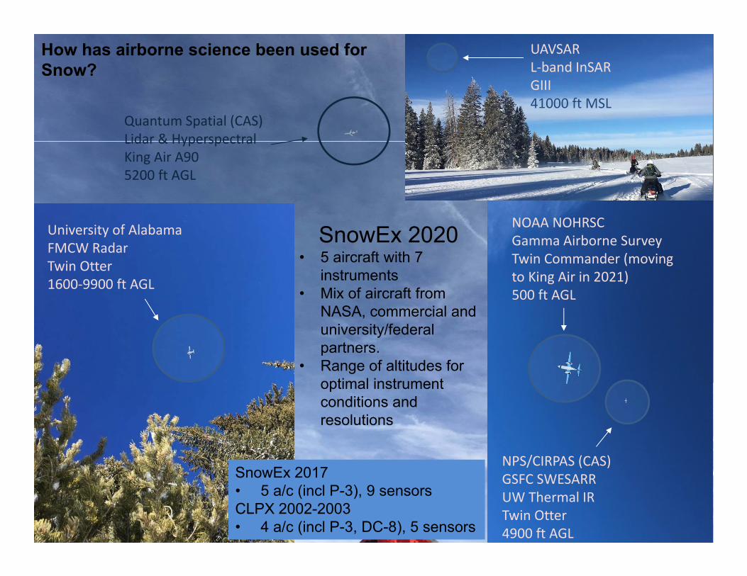
NOAA NOHRSC Gamma Airborne SurveyTwin Commander (moving to King Air in 2021)500 ft AGL
NPS/CIRPAS (CAS)GSFC SWESARRUW Thermal IRTwin Otter4900 ft AGL
University of Alabama FMCW RadarTwin Otter1600‐9900 ft AGL
Quantum Spatial (CAS)Lidar & HyperspectralKing Air A905200 ft AGL
UAVSARL‐band InSARGIII41000 ft MSL
SnowEx 2020• 5 aircraft with 7
instruments• Mix of aircraft from
NASA, commercial and university/federal partners.
• Range of altitudes for optimal instrument conditions and resolutions
How has airborne science been used for Snow?
SnowEx 2017• 5 a/c (incl P-3), 9 sensorsCLPX 2002-2003• 4 a/c (incl P-3, DC-8), 5 sensors

Future of Airborne Snow ObservationsLessons Learned• Limitations on availability, flexibility, instrument accommodation on NASA aircraft
• Multiple last-minute schedule changes due to other commitments/maintenance impacted science• Limited flexibility and availability of smaller NASA aircraft (Twin Otter, Pilatus PC-12)• NASA lidar capabilities do not match snow needs. Airborne lidar will be critical for future snow
(and Earth Science) campaigns. • Onerous requirements for non-NASA aircraft (e.g. Medical clearance, Part 135, NAVAIR)
• New requirements should be relayed to instrument operators 6 months before they are implemented
• Grace period for signed contracts
Future airborne science needs• Multiple instruments for coincident observations (through multiple aircraft or large aircraft)
• Optical, microwave, lidar to efficiently demonstrate constellation approach• Multiple frequencies (e.g. L-band, S-band, X/Ku-band) to test multi-frequency retrieval scheme
• Time series approach: critical to assess how snow changes over time availability, cost• Autonomous observations: easier use of small UAVs to provide flexibility
Need for large payload, prolonged duration aircraft• Flying larger/multiple instruments (P-3 more useful than DC-8 for snow)• Long-endurance aircraft to cover large areas efficiently and/or base further away• Test/demonstrate scaling up for space • Continuing need for smaller aircraft option for collecting multiple observations