AIP GEN 0.1-1 SEYCHELLES 01 OCT 06 - Platinum Airways
204
AIP GEN 0.1-1 SEYCHELLES 01 OCT 06 Seychelles Civil Aviation Authority AIP AMDT 1/06 PART 1 –GENERAL (GEN) GEN 0. GEN 0.1 PREFACE 1. Name of the publishing authority The SEYCHELLES AIP is published by Seychelles Civil Aviation Authority. 2. Applicable to ICAO documents. The AIP is prepared in accordance with the standards and recommended practices (SARPs) of Annex 15 to the convention on International Civil Aviation and the Aeronautical Information Services Manual (ICAO Doc 8126). Charts contained in the AIP are Produced in accordance with Annex 4 to the convention on International Civil Aviation and Aeronautical Chart Manual (ICAO Doc 8697). Differences from ICAO Standards, Recommended Practices and Procedures are published in subsection GEN 1.7 of this document. 3. The AIP structure and established regular amendment interval 3.1 The AIP structure The AIP forms part of the integrated aeronautical information package, details of which are provided in subsection GEN 3.1. The principal AIP structure is shown in graphic form on page GEN 0.1-3. The AIP is made up of three parts, General (GEN), Enroute (ENR) and Aerodrome (AD). These are divided into sections and subsections as applicable, containing various types of information. 3.1.1 Part 1 – GENERAL (GEN) Part 1 consists of five sections containing information as described hereafter: GEN 0. – Preface, Record of AIP Amendments, Record of AIP Supplements, Checklist of AIP pages, List of hand amendments to the AIP and Table of contents to Part 1. GEN 1. National regulations and requirements - Designated authorities; Entry, transit and departure of aircraft; Entry, transit and departure of cargo, Aircraft instruments, equipment and flight documents, Summary of national regulations and international agreements/conventions; and Differences from ICAO Standards, Recommended Practices and Procedures. GEN 2. Tables and Codes – Measuring systems, aircraft markings, holidays; Abbreviation used in AIS publications; Chart symbols; Location indicators; List of radio navigational aids; Conversion tables; and Sunset/Sunrise Tables tables. GEN 3. Services – Aeronautical information services; Aeronautical charts; Air traffic services; Communication services; Meteorological services; and Search and rescue. GEN 4. Charges for aerodromes/helicopters and air navigation services – Aerodrome/heliport charges and Air navigation services charges. 3.1.2 Part 2 – En-route (ENR) Part 2 consists of seven sections containing information as described hereafter; ENR 1. General rules and procedures – General rules; Visual flight rules; Instrument flight rules; ATS airspace classification; Holding; approach and departure procedures; Radar services and procedures; Altimeter setting procedures; Regional supplement procedures; Air traffic flow management; Flight planning; Addressing of flight plan message; Interception of civil aircraft; Unlawful interference and Air traffic incidence. ENR 2. Air traffic services airspace - Detailed description of Flight information regions (FIR); Upper flight information region (UIR) and Terminal control area (TMA) ENR 3. ATS routes – Detailed description of Upper ATS routes; Area navigation routes; Other routes and En-route holdings Note: Other types of routes which are specified in connection with procedures for traffic to and from aerodromes/helicopter landing areas are described in the relevant sections and subsection of Part 3 – Aerdromes.
Transcript of AIP GEN 0.1-1 SEYCHELLES 01 OCT 06 - Platinum Airways

AIP GEN 0.1-1 SEYCHELLES 01 OCT 06
Seychelles Civil Aviation Authority AIP AMDT 1/06
PART 1 –GENERAL (GEN)
GEN 0.
GEN 0.1 PREFACE
1. Name of the publishing authority
The SEYCHELLES AIP is published by Seychelles Civil Aviation Authority.
2. Applicable to ICAO documents.
The AIP is prepared in accordance with the standards and recommended practices (SARPs) of Annex 15 to the convention on International Civil Aviation and the Aeronautical Information Services Manual (ICAO Doc 8126). Charts contained in the AIP are Produced in accordance with Annex 4 to the convention on International Civil Aviation and Aeronautical Chart Manual (ICAO Doc 8697). Differences from ICAO Standards, Recommended Practices and Procedures are published in subsection GEN 1.7 of this document.
3. The AIP structure and established regular amendment interval
3.1 The AIP structure
The AIP forms part of the integrated aeronautical information package, details of which are provided in subsection GEN 3.1. The principal AIP structure is shown in graphic form on page GEN 0.1-3.
The AIP is made up of three parts, General (GEN), Enroute (ENR) and Aerodrome (AD). These are divided into sections and subsections as applicable, containing various types of information.
3.1.1 Part 1 – GENERAL (GEN)
Part 1 consists of five sections containing information as described hereafter:
GEN 0. – Preface, Record of AIP Amendments, Record of AIP Supplements, Checklist of AIP pages, List of hand amendments to the AIP and Table of contents to Part 1.
GEN 1. National regulations and requirements - Designated authorities; Entry, transit and departure of aircraft; Entry, transit and departure of cargo, Aircraft instruments, equipment and flight documents, Summary of national regulations and international
agreements/conventions; and Differences from ICAO Standards, Recommended Practices and Procedures.
GEN 2. Tables and Codes – Measuring systems, aircraft markings, holidays; Abbreviation used in AIS publications; Chart symbols; Location indicators; List of radio navigational aids; Conversion tables; and Sunset/Sunrise Tables tables.
GEN 3. Services – Aeronautical information services; Aeronautical charts; Air traffic services; Communication services; Meteorological services; and Search and rescue.
GEN 4. Charges for aerodromes/helicopters and air navigation services – Aerodrome/heliport charges and Air navigation services charges.
3.1.2 Part 2 – En-route (ENR)
Part 2 consists of seven sections containing information as described hereafter;
ENR 1. General rules and procedures – General rules; Visual flight rules; Instrument flight rules; ATS airspace classification; Holding; approach and departure procedures; Radar services and procedures; Altimeter setting procedures; Regional supplement procedures; Air traffic flow management; Flight planning; Addressing of flight plan message; Interception of civil aircraft; Unlawful interference and Air traffic incidence.
ENR 2. Air traffic services airspace - Detailed description of Flight information regions (FIR); Upper flight information region (UIR) and Terminal control area (TMA)
ENR 3. ATS routes – Detailed description of Upper ATS routes; Area navigation routes; Other routes and En-route holdings
Note: Other types of routes which are specified in connection with procedures for traffic to and from aerodromes/helicopter landing areas are described in the relevant sections and subsection of Part 3 – Aerdromes.

GEN 0.1-2 AIP 03 APR 14 SEYCHELLES
AIP AMDT 1/14 Seychelles Civil Aviation Authority
ENR 4. Radio navigation aids/systems – Radio navigation aids – en-route; Special navigation systems; Name-code designators for significant points; and Aeronautical ground lights – enroute.
ENR 5. Navigation Warnings – Prohibited; restricted and danger areas; Military exercises and training areas; Other activities of a dangerous nature; Air navigation obstacles – en-route; Aerial sporting and recreational activities and bird migration and area with sensitive fauna.
ENR 6. En-route charts – En-route Chart – ICAO and index charts.
3.1.3 Part 3 – AERODROMES (AD)
Part 3 consists of four sections containing information briefly described hereafter.
AD 1. Aerodrome/Helicopter - landing areas; Introduction; Aerodrome/Helicopter landing areas availability; Rescue and fire fighting services; and Index to aerodromes and helicopter landing areas and Grouping of aerodromes/helicopter landing area.
AD 2. Aerodromes – Detailed information about aerodromes including helicopter landing areas, if located at the aerodromes.
AD 3. Helicopter landing areas – Detailed information about helicopter landing areas including those not located at aerodromes.
3.2 Regular amendment intervals
Regular amendment to the AIP will be issued once every six months. The publication dates will be
normally on the first day of April and October of each calendar year.
In case there are no amendments to be published during a publication cycle, a nil notification shall be published on the 30th day of April or October as the case may be.
4. Service to contact in case of detection of errors or omissions in this AIP
In the compilation of the AIP, care has been taken to ensure that the information contained therein is accurate and complete. Any errors and omissions which may nevertheless be detected, as well as any correspondence concerning the integrated Aeronautical information package, should be referred to: The General Manager (Air Navigation Services), Seychelles Civil aviation Authority, P.O Box 181, Victoria, Mahe, Seychelles. Telephone: (248) 4384180. Email: [email protected]

AIP GEN 0.1-3 SEYCHELLES 01 OCT 06
Seychelles Civil Aviation Authority AIP AMDT 1/06
THE INTERGRATED AERONAUTICAL INFORMATION PACKAGE
NOTAM AND PIB
AIP including Amendments and
Supplements
AIC Check list and summaries
PART 1 PART 3
GEN 0
PART 2
GEN 1
National regulations & requirements
GEN 2
Table and codes
GEN 3
Services
GEN 4
Charges for aerodromes/ helicopter landing areas & air navigation services
ENR 1
General rules & procedures
ENR 2
ATS airspace
ENR 3
ATS routes
ENR 4
Radio navigation aids/systems
ENR 5
Navigation warnings
ENR 6
En-Route Charts
AD 1
Aerodromes/ helicopter landing areas introduction
AD 2
Aerodromes

AIP GEN 0.2-1 SEYCHELLES 01 OCT 06
Seychelles Civil Aviation Authority AIP AMDT 1/06
GEN 0.2 RECORDS OF AIP AMENDMENTS
AIP AMENDMENT
AIRAC AIP AMENDMENT
Nr/Year Publication date
Date inserted
Inserted by
Nr/Year Publication date
Effective date
Inserted by

AIP GEN 0.3-1 SEYCHELLES 01 OCT 06
Seychelles Civil Aviation Authority AIP AMDT 1/06
GEN 0.3 RECORD OF AIP SUPPLEMENTS
Nr/Year Subject AIP section
affected Period of validity
Cancellation record

AIP GEN 0.4 - 1 SEYCHELLES 03 APR 14
Seychelles Civil Aviation Authority AIP AMDT 1/14
GEN 0.4 CHECKLIST OF AIP PAGES
PAGE DATE PAGE DATE PAGE DATE
PART 1 – GENERAL (GEN)
GEN 0 2.5-1 1 OCT 06 1.3-1 1 APR 09
0.1-1 1 OCT 06 2.6-1 1 OCT 06 1.3-2 1 APR 09
0.1-2 3 APR 14 2.6-2 1 OCT 06 1.4-1 16 DEC 10
0.1-3 1 OCT 06 2.7-1 1 OCT 06 1.5-1 1 OCT 06
0.2-1 1 OCT 06 1.5-2 23 AUG 12
0.3-1 1 OCT 06 GEN 3 1.6-1 1 OCT 06
0.4-1 3 APR 14 3.1-1 3 APR 14 1.7-1 3 APR 14
0.4-2 3 APR 14 3.1-2 23 AUG 12 1.7-2 1 APR 09
3.1-3 23 AUG 12 1.7-3 16 DEC 10
3.1-4 BLANK 1.8-1 1 APR 09
0.5-1 1 OCT 06 3.2-1 3 APR 14 1.8-2 1 APR 09
0.6-1 23 AUG 12 3.2-2 23 AUG 12 1.8-3 1 APR 09
0.6-2 23 AUG 12 3.2-3 23 AUG 12 1.9-1 1 OCT 06
0.6-3 1 OCT 06 3.3-1 3 APR 14 1.10-1 1 OCT 06
3.3-2 BLANK 1.10-2 3 APR 14
GEN 1 3.4-1 23 AUG 12 1.11-1 1 OCT 06
1.1-1 3 APR 14 3.4-2 23 AUG 12 1.12-1 1 APR 09
1.1-2 BLANK 3.4-3 1 OCT 06 1.13-1 1 OCT 06
1.2-1 1 APR 07 3.5-1 3 APR 14 1.14-1 1 OCT 06
1.2-2 3 APR 14 3.5-2 1 DEC 12 1.14-2 1 OCT 06
1.3-1 1 OCT 06 3.5-3 3 APR 14 1.14-3 1 OCT 06
1.4-1 1 OCT 06 3.5-4 1 DEC 12 1.14-4 1 OCT 06
1.5-1 1 OCT 06 3.5-5 1 DEC 12 1.14-5 1 OCT 06
1.6-1 1 OCT 06 3.5-6 1 DEC 12 1.14-6 1 OCT 06
1.7-1 16 DEC 10 3.6-1 3 APR 14 1.14-7 1 OCT 06
1.7-2 16 DEC 10 3.6-2 23 AUG 12 2.1-1 3 APR 14
1.7-3 16 DEC 10 3.6-3 23 AUG 12 2.1-2 BLANK
2.2-1 23 AUG 12
GEN 2 GEN 4 2.2-2 BLANK 2.1-1 1 OCT 06 4.1-1 3 APR 14
2.1-2 3 APR 14 4.1-2 3 APR 14 ENR 3
2.2-1 1 OCT 06 4.2-1 1 APR 08 3.1-1 23 AUG 12
2.2-2 1 OCT 06 3.1-2 23 AUG 12
2.2-3 1 OCT 06 ENR 0 3.1-3 23 AUG 12
2.2-4 1 OCT 06 0.6-1 3 APR 14 3.1-4 23 AUG 12
2.2-5 1 OCT 06 0.6-2 1 APR 08 3.1-5 23 AUG 12
2.3-1 1 OCT 06 0.6-3 3 APR 14 3.1-6 23 AUG 12
2.3-2 1 OCT 06 3.1-7 23 AUG 12
2.3-3 1 OCT 06 ENR 1 3.1-8 23 AUG 12
2.3-4 1 OCT 06 1.1-1 1 OCT 06 3.1-9 23 AUG 12
2.3-5 1 OCT 06 1.1-2 1 OCT 06 3.1-10 23 AUG 12
2.3-6 1 OCT 06 1.1-3 1 OCT 06 3.2-1 23 AUG 12
2.3-7 1 OCT 06 1.2-1 1 APR 07 3.2-2 23 AUG 12
2.4-1 1 OCT 06 1.2-2 1 APR 07 3.2-3 23 AUG 12

GEN 0.4-2 AIP 03 APR 14 SEYCHELLES
AIP AMDT 1/14 Seychelles Civil Aviation Authority
3.2-4 23 AUG 12 AD 1
3.2-5 23 AUG 12 1.1-1 2 JUN 11 2 FSIA-57 16 DEC 10
3.2-6 23 AUG 12 1.1-2 1 OCT 06 2 FSIA-59 23 AUG 12
3.2-7 23 AUG 12 1.2-1 1 OCT 06 2 FSIA-60 23 AUG 12
3.2-8 23 AUG 12 1.3-1 2 JUN 11 2 FSIA-61 23 AUG 12
3.3-1 23 AUG 12 1.3-2 1 OCT 06 2 FSIA-62 23 AUG 12
3.3-2 BLANK 1.4-1 1 OCT 06 2 FSIA-63 23 AUG 12
3.4-1 1 APR 08 2 FSIA-64 23 AUG 12
3.5-1 23 AUG 12 AD 2 2 FSIA-65 23 AUG 12
3.6-1 1 APR 08 2 FSIA-1 3 JUN 10 2 FSIA-66 3 APR 14
ENR 4 2 FSIA-2 16 DEC 10 2 FSIA-67 23 AUG 12
4.1-1 1 APR 08 2 FSIA-3 23 AUG 12
4.2-1/3 3 APR 14
2 FSIA-4 3 APR 14 2 FSIA-69 23 AUG 12
4.3-1 23 AUG 12 2 FSIA-5 23 AUG 12 2 FSIA-71 23 AUG 12
4.3-2 23 AUG 12 2 FSIA-6 23 AUG 12 2 FSIA-73 23 AUG 12
4.3-3 23 AUG 12 2 FSIA-7 23 AUG 12 2 FSIA-75 23 AUG 12
4.4-1 1 OCT 06 2 FSIA-8 23 AUG 12
2 FSIA-9 23 AUG 12 2.2 FSPP-01 1 APR 08
ENR 5 2 FSIA-10 23 AUG 12 2.2 FSPP-03 1 APR 08
5.1-1 1 APR 07 2 FSIA-11 23 AUG 12 2.2 FSPP-05 1 APR 08
5.2-1 1 OCT 06 2 FSIA-12 23 AUG 12 2.2 FSPP-07 1 APR 08
5.3-1 1 OCT 06 2 FSIA-13 3 JUN 10 2 FSPP-1 2 JUN 11
5.4-1 1 OCT 06 2 FSIA-15 3 JUN 10 2 FSPP-2 2 JUN 11
5.5-1 1 OCT 06 2 FSIA-17 3 JUN 10 2 FSPP-3 2 JUN 11
5.6-1 1 OCT 06 2 FSIA-19 BLANK 2 FSPP-4 2 JUN 11
2 FSIA-21 BLANK 2 FSPP-5 2 JUN 11
2 FSIA-23 3 APR 14
ENR 6 2 FSIA-25 16 DEC 10
6.1-1 1 APR 08 2 FSIA-27 16 DEC 10
6.1-3 3 JUN 10 2 FSIA-29 16 DEC 10
6.1-5 3 JUN 10 2 FSIA-31 16 DEC 10
6.1-7 23 AUG 12 2 FSIA-33 3 JUN 10
6.1-9 23 AUG 12 2 FSIA-35 3 JUN 10
2 FSIA-37 3 JUN 10
PART 3 – AERODROMES (AD) 2 FSIA-39 3 JUN 10
2 FSIA-41 3 JUN 10
AD 0 2 FSIA-43 3 JUN 10
0.6-1 3 APR 14 2 FSIA-45 3 JUN 10
0.6-2 3 APR 14 2 FSIA-47 16 DEC 10
2 FSIA-48 3 APR 14
0.6-4 3 JUN 10 2 FSIA-49 23 AUG 12
0.6-5 3 JUN 10 2 FSIA-51 23 AUG 12
0.6-6 3 JUN 10 2 FSIA-53 16 DEC 10
0.6-7 3 JUN 10 2 FSIA-54 3 APR 14
2 FSIA-55 16 DEC 10


AIP GEN 0.5-1 SEYCHELLES 01 OCT 06
Seychelles Civil Aviation Authority AIP AMDT 1/06
GEN 0.5 LIST OF HAND AMENDMENTS TO THE AIP
AIP pages (s)
affected
Amendment text
Introduced by AIP Amendment NR

AIP GEN 0.6- 1 SEYCHELLES 23 AUG 12
Seychelles Civil Aviation Authority AIP AIRAC AMDT 1/12
GEN 0.6 TABLE OF CONTENTS TO PART 1 GEN 1. NATIONAL REGULATIONS AND REQUIREMENTS
Pages
GEN 1.1 Designated authorities GEN 1.1-1
GEN 1.2 Entry, transit and departure of aircraft GEN 1.2-1
GEN 1.3 Entry, transit and departure of passengers and crew GEN 1.3-1
GEN 1.4 Entry, transit and departure of cargo GEN 1.4-1
GEN 1.5 Aircraft instruments, equipment and flight documents GEN 1.5-1
GEN 1.6 Summary of national regulations and international agreements/conventions GEN 1.6-1
GEN 1.7 Differences from ICAO Standards, Recommended Practices and Procedures GEN 1.7-1/3
GEN 2. TABLES AND CODES
GEN 2.1 Measuring system, aircraft markings, holidays GEN 2.1-1
GEN 2.1.1 Units of measurement GEN 2.1-1
GEN 2.1.2 Temporal Reference System GEN 2.1-1
GEN 2.1.3 Horizontal reference System GEN 2.1-2
GEN 2.1.4 Vertical Reference System GEN 2.1-2
GEN 2.1.5 Aircraft nationality and registration marks GEN 2.1-2
GEN 2.1.6 Calendar of Public holidays in Seychelles GEN 2.1-2
GEN 2.2 Abbreviations used in AIS publications GEN 2.2-1/5
GEN 2.3 Chart symbols GEN 2.3-1/7
GEN 2.4 Location indicators GEN 2.4-1
GEN 2.5 List of radio navigation aids GEN 2.5-1
GEN 2.6 Conversion tables GEN 2.6-1
GEN 2.7 Sunrise/Sunset tables GEN 2.7-1
GEN 3. SERVICES
GEN 3.1 Aeronautical Information Services GEN 3.1-1
GEN 3.1.1 Responsible service GEN 3.1-1
GEN 3.1.2 Area of responsibility GEN 3.1-1
GEN 3.1.3 Aeronautical publications GEN 3.1-1
GEN 3.1.4 Aeronautical Information Publication GEN 3.1-1
GEN 3.1.5 Amendment service to the AIP GEN 3.1-1
GEN 3.1.6 Supplement to the AIP GEN 3.1-2
GEN 3.1.7 NOTAM and preflight information bulletins GEN 3.1-2
GEN 3.1.8 Aeronautical Information Circulars GEN 3.1-2
GEN 3.1.9 Checklist and summary of NOTAM GEN 3.1-2
GEN 3.1.10 Specifications for AIP Supplements GEN 3.1-3
GEN 3.1.11 Sale of publications GEN 3.1-3

AIP GEN 0.6- 2 SEYCHELLES 23 AUG 12
Seychelles Civil Aviation Authority AIP AIRAC AMDT 1/12
GEN 3.1.12 AIRAC system GEN 3.1-3
GEN 3.1.13 Preflight information service at aerodromes GEN 3.1-3
GEN 3.1.14 Electronic terrain and obstacle data GEN 3.1-3
GEN 3.2 Aeronautical charts GEN 3.2-1
GEN 3.2.1 Responsible service GEN 3.2-1
GEN 3.2.2 Maintenance of charts GEN 3.2-1
GEN 3.2.3 Purchase arrangements GEN 3.2-1
GEN 3.2.4 Aeronautical chart series available GEN 3.2-1
GEN 3.2.5 List of aeronautical charts available GEN 3.2-2
GEN 3.2.6 Index to the world Aeronautical Chart (WAC) – ICAO 1:1 000 000 GEN 3.2-3
GEN 3.2.7 Topographical charts GEN 3.2-3
GEN 3.2.8 Corrections to charts not contained in the AIP GEN 3.2-3
GEN 3.3 Air traffic services GEN 3.3-1
GEN 3.3.1 Responsible service GEN 3.3-1
GEN 3.3.2 Area of responsibility GEN 3.3-1
GEN 3.3.3 Types of services GEN 3.3-1
GEN 3.3.4 Co-ordination between the operator and ATS GEN 3.3-1
GEN 3.3.5 Minimum flight altitude GEN 3.3-1
GEN 3.3.6 ATS units address list GEN 3.3-1
GEN 3.4 Communication services GEN 3.4-1
GEN 3.4.1 Responsible service GEN 3.4-1
GEN 3.4.2 Area of responsibility GEN 3.4-1
GEN 3.4.3 Types of service GEN 3.4-1
GEN 3.4.4 Requirements and conditions GEN 3.4-1
GEN 3.4.5 Aeronautical fixed services: telegraph GEN 3.4-2
GEN 3.4.6 Aeronautical fixed service: telephone GEN 3.4-3
GEN 3.5 Meteorological services GEN 3.5-1
GEN 3.5.1 Responsible service GEN 3.5-1
GEN 3.5.2 Area of responsibility GEN 3.5-1
GEN 3.5.3 Meteorological observations and reports GEN 3.5-1
GEN 3.5.4 Types of services GEN 3.5-1
GEN 3.5.5 Notification required from operators GEN 3.5-1
GEN 3.5.6 Aircraft reports GEN 3.5-2
GEN 3.5.7 VOLMET service GEN 3.5-2
GEN 3.5.8 SIGMET and AIRMET services GEN 3.5-2
GEN 3.5.9 Other automated meteorological services GEN 3.5-2

AIP GEN 0.6- 3 SEYCHELLES 1 OCT 06
Seychelles Civil Aviation Authority AIP AMDT 1/06
GEN 3.6 Search and rescue GEN 3.6-1
GEN 3.6.1 Responsible service GEN 3.6-1
GEN 3.6.2 Area of responsibility GEN 3.6-1
GEN 3.6.3 Types of service GEN 3.6-1
GEN 3.6.4 SAR agreements GEN 3.6-2
GEN 3.6.5 Conditions of availability GEN 3.6-2
GEN 3.6.6 Procedures and signals used GEN 3.6-2
GEN 3.6.7 Communications GEN 3.6-2
GEN 3.6.8 Search and rescue signals GEN 3.6-2
GEN 3.6.9 Ground to air visual signal code GEN 3.6-3
GEN 3.6.10 Air to ground visual signal code GEN 3.6-3
GEN 4. CHARGES FOR AERODROMES/HELICOPTER LANDING AREAS
AND NAVIGATION SERVICES
GEN 4.1 Landing of aircraft GEN 4.1-1
GEN 4.1.1 Minimum charge GEN 4.1-1
GEN 4.1.2 Parking hangarage and long-term of aircraft GEN 4.1-1
GEN 4.1.3 Passenger service GEN 4.1-1
GEN 4.1.4 Security GEN 4.1-1
GEN 4.1.5 Noise-related items GEN 4.1-1
GEN 4.1.6 Other charges GEN 4.1-2
GEN 4.1.7 Exemptions GEN 4.1-2
GEN 4.1.8 Reductions GEN 4.1-2
GEN 4.1.9 Night charges GEN 4.1-2
GEN 4.1.10 Methods of payment GEN 4.1-2
GEN 4.2 Air navigation services charges GEN 4.2-1
GEN 4.2.1 Route air navigation services fee GEN 4.2-1
GEN 4.2.2 Methods of payment GEN 4.2-1

AIP GEN 1.1-1 SEYCHELLES 03 APR 14
Seychelles Civil Aviation Authority AIP AMDT 1/14
GEN 1 NATIONAL REGULATIONS AND REQUIREMENTS
GEN 1.1 DESIGNATED AUTHORITIES
The addresses of the designated authorities concerned with facilitation of international air navigation are as follows: 1. Civil Aviation Chief Executive Officer
Seychelles Civil Aviation Authority P.O. Box 181 Victoria, Mahe
Tel: (248) 438 40 00 Fax: (248) 438 40 09 / 438 40 30 AFS: FSIAYAYX
2. Meteorology
Director General Meteorological Services Ministry of Environment & Natural Resources P.O. Box 1145, Victoria, Mahe
Tel: (248) 438 40 00 / 4384358 / 4384352 Fax: (248) 4384369 / 4384371 AFS: FSIAYMYX
3. Customs
Director General Trades Tax Import and Price Control Division Ministry of Finance Liberty House Victoria, Mahe
Tel: (248) 422 43 33 Fax: (248) 422 54 58
4. Immigration
Director General of Immigration Department of Internal Affairs Immigration Division Independence House P.O. Box 430 Victoria, Mahe
Tel: (248) 461 11 10 Fax: (248)4 22 50 35
5. Health
Director General Primary Health Care Ministry of Health and Social Affairs P.O. Box 52 Victoria, Mahe
Tel: (248) 438 80 00 Fax: Nil
6. En-route and Aerodrome Charges Chief Executive Officer
Seychelles Civil Aviation Authority P.O. Box 181 Victoria, Mahe
Tel: (248) 438 40 00 Fax: (248) 438 40 09 / 438 40 30
AFS: FSIAYAYX 7. Agricultural Quarantine
Director Plant Protection Section Ministry of Environment and Natural Resources P.O. Box 166 Victoria, Mahe
Tel: (248) 432 24 11 / 432 24 12 Fax: (248) 432 21 13
8. Aircraft Accident Investigation
Chief Executive Officer Seychelles Civil Aviation Authority P.O. Box 181 Victoria, Mahe
Tel: (248) 438 40 00 Fax: (248) 438 40 09 / 438 40 30
9. Department of legal Affairs
Attorney General’s Chambers P.O. Box 58
National House , Victoria, Mahe Tel: (248) 438 30 00 Fax: (248) 422 50 63

AIP GEN 1.2-1 SEYCHELLES 01 APR 07
Seychelles Civil Aviation Authority AIP AMDT 1/07
GEN 1.2 ENTRY, TRANSIT AND DEPARTURE OF AIRCRAFT 1. General International flights into, from or over Seychelles territory shall be subject to the current Seychelles regulations relating to civil aviation. These regulations correspond to the Standard and Recommended Practices contained in Annex 9 to the Convention on International Civil Aviation. Aircraft flying into or departing from Seychelles territory shall make their first landing at or final departure from Seychelles International Airport. 2. Scheduled flights
2.1 General
For regular international scheduled flights operated by foreign airlines into Seychelles, the following requirements must be met; The States of the airlines must be a party to the International Air Services Transit Agreement and /or the International Air Transport Agreement. The airlines must be eligible to make the flight under the provisions of a bilateral or multilateral agreement to which the States of the airlines and Seychelles are contracting parties and must have a permit to operate into Seychelles. Applications for such permits shall be transmitted to the Chief Executive Officer of the Seychelles Civil Aviation, P.O.Box 181 Victoria, Mahe, Seychelles.
Documentary requirements for clearance of aircraft It is necessary that the under-mentioned aircraft documents be submitted by airline operators for clearance on arrival and departure of their aircraft to and from Seychelles. All documents listed below must follow the ICAO standard format as set forth in the relevant appendices to ICAO Annex 9 and are acceptable when furnished in English or French, completed ineligible handwriting. No visas are required in connection with such documents.
Aircraft documents required on arrival / departure
Required by
General Declaration
Cargo Manifest
Passenger Manifest
Taxation (Import Control)
2 (Two) 2 (Two) 1 (One) Departure only
Health 1(One) - - Note: If no passengers are embarking/disembarking and no articles are loaded/offloaded , one crew declaration is required by Taxation Division (Import Control)
3. Non – Scheduled flights 3.1 Procedures If an operator wishes to carry out a non-scheduled flight making a non-traffic stop at Seychelles International Airport, permission for such a flight should be obtained from the Chief Executive Officer prior to carrying out such operation not less than 72 hours in advance giving the following information:-
a) Name of Operator, full postal address including telephone, fax and email contacts;
b) Type of aircraft (ICAO model) c) MTOW expressed in kgs or Ibs. d) Previous aerodrome of departure prior to
arrival in Seychelles, including arrival date and time in UTC.
e) Number of crew and passengers arriving. If in transit, indicate number of passengers disembarking or joining.
f) Date of departure, time in UTC and next destination aerodrome.
g) Number of crew and passengers departing. h) If flight is exchanging passengers with cruise
ship in Port Victoria, to submit the following;
name of cruise ship. number of passengers being exchanged. name of local tour operator in Seychelles
(with contact person) assisting with passenger exchange.
i) If flight is chartered to bring in a large group of passengers, to submit; number of passengers arriving and
departing including crew. name of local tour operator in Seychelles
(with contact person) assisting with passenger arrival and departure.

GEN 1.2-2 AIP 03 APR 14 SEYCHELLES
AIP AMDT 1/14 Seychelles Civil Aviation Authority
j) Names of hotel establishments for passengers and crew.
3.2 Documentary requirements for clearance of
aircraft Same requirements as for Scheduled Flights. Public health measures remain for non-scheduled flights. 4. Private Flights Prior permission to operate such flight whether over flying the FIR or landing in Seychelles is to be submitted 72 hours in advance to the following contacts: Email: Primary - [email protected] Alternate - [email protected] Fax: Primary - (+248) 4384128 Alternate – (+248) 4384009 Operators of private jets remaining on ground for more than 24 hours are required to carry a complete and fully serviceable tow-bar onboard their aircraft due to relocating requirement (tow) for aircraft to the NPA. Documents to apply for such flights can be downloaded from SCAA website: www.scaa.sc 4.1 Documentary requirements for clearance of
private aircraft. Same as for scheduled flights. 5. Public health measures applied to aircraft Aircraft must be disinsected “blocks away” using WHO approved insecticide from last point of departure. The overhead lockers, cupboards or any other closets should be left open whilst spraying at blocks away. In the Health Section of the GENDEC Form, it should state the time the door is closed, the spraying time (which should preferably be done before aircraft push-back) and the time aircraft takes off. Canisters are to be kept and handed to the Public Health Officer upon boarding of aircraft. On arrival, all doors and windows must be kept closed until the Public Health Officer gives clearance for passengers to disembark. If it is found that spraying is not done or there is no proof that spraying was done accordingly, the Public Health Officer will carry out
disinsection upon boarding of the aircraft on arrival including the aircraft holds. The airline will be billed for canister usage through the Ground Handling Agent (Air Seychelles). Should the Captain/cabin crew refuse the re-spraying or spraying respectively, the Public Health Officer will prevent disembarkation of passengers and legal proceedings will be instituted against the Captain and the airline. Passengers & crew who embark from a yellow fever endemic area should be notified prior to disembarkation to present their valid yellow fever vaccination card to the Public Health Officer within the arrival lounge for verification. The Captain is to liaise with the Ground Handling Agent (Air Seychelles) upon arrival in Seychelles for necessary cabin cleaning services and removal of refuse prior to closure of aircraft doors. Under no circumstances are refuse to be left in bags / boxes on the ramp or at the remote parking area by the aircraft wheels”.
AIP GEN 1.3- 1 SEYCHELLES 1 OCT 06
Seychelles Civil Aviation Authority AIP AMDT 1/06
GEN 1.3 ENTRY, TRANSIT AND DEPARTURE OF PASSENGERS AND CREW
1. Taxation (Import Control) requirements
1.1 Baggage or articles belonging to disembarking passengers are immediately released except for those selected by the Taxation Authorities. Only an oral declaration of contents is required when the green and red channels are in operation.
1.2 The crew must produce a written declaration of
all contents on request. 1.3 No taxation (export control formalities are
normally required on departure, except only in cases of suspicion.
2. Immigration requirements
2.1 No documents or visas are required of passengers arriving and departing on the same flight (short duration transit). 2.2 Intending immigrants must hold a valid passport and a resident permit issued in advance. 2.3 Temporary visitors must hold a valid passport and onward ticket and guaranteed accommodation and funds for intended length of stay in Seychelles. 2.4 All visitors, with the exception of those mentioned in 2.1 above, must complete a disembarkation card. 2.5 It is the responsibility of the carrier to issue disembarkation cards to its passengers. 2.6 Flight crew members, except those arriving and departing on the same flight must hold a valid passport. 3. Public health requirements 3.1 Arriving passengers and crew do not need any certificates of vaccination or immunization. 3.2 On departure, no health formalities are required.

AIP GEN 1.4- 1 SEYCHELLES 1 OCT 06
Seychelles Civil Aviation Authority AIP AMDT 1/06
GEN 1.4 ENTRY, TRANSIT AND DEPARTURE OF CARGO
1. Taxation (Import Control) requirements
concerning cargo and other articles
1.1 The following documents are required for clearance of imported goods through taxation control: a) Commercial Invoice b) Import Entry c) Copy of Airways Bill d) Import Permit
1.1.1 No clearance documents are required with respect to goods retained on board an aircraft for onward carriage to a destination outside the territory of Seychelles.
1.1.2 Upon exportation of goods, the following documents are required for the clearance of shipments to be exported by air: a) Export Entry b) Export Permit c) Commercial Invoice 2. Agricultural Quarantine Sanitary certificates or related documents are required only in respect of the following animal and plant shipments in the related circumstances:-
obtain the appropriate clearance from the Agricultural Quarantine Officer following an inspection.
2.1 Animals 2.1.2 An import permit obtained from the veterinary services from the Ministry of Environment and Natural Resources is a pre requisite for the importation of animals or their carcasses (meat and meat products), eggs, semen of stock or poultry. 2.1.2 Dogs, cats and other animals are prohibited except under licence issued by the Director of Veterinary Services or a veterinary certificate issued by the appointed authority in the country of origin which shall be declared to taxation (Import Control) on arrival. 2.2 Plants and plants products An import permit obtained from the Plant Protection Section of the Ministry of Environment and Natural Resources is a pre requisite for the importation of plant materials. A duplicate certificate from the country of origin must accompany the consignment. Importers are required to declare all plant materials to the Taxation Officer (Import Control) on arrival into Seychelles and

AIP GEN 1.5- 1 SEYCHELLES 1 OCT 06
Seychelles Civil Aviation Authority AIP AMDT 1/06
GEN 1.5 AIRCRAFT INSTRUMENTS EQUIPMENT AND FLIGHT DOCUMENTS
1. General Commercial air transport aircraft operating in Seychelles must adhere to the provisions of ICAO Annex 6 Operation of Aircraft, Part 1 - International Commercial Air Transport - Aeroplanes, Chapter 6 (Aero plane Instruments Equipment and Flight Documents) and Chapter 7 (Aeroplane Communication and Navigation Equipment) and off the Region Supplementary Procedures applicable to the AFI Region (ICAO Doc 7030/4)
2. Special equipment to be carried by aircraft
- Nil -
3. Equipment to be carried by all types of flights All aircraft within the Seychelles territory when flying under Instrument Flights Rules (IFR) within controlled airspace shall carry the following equipment:-
a) radio equipment capable of maintaining two-way
communication with the appropriate aeronautical radio stations.
b) radio equipment capable of enabling the aircraft to be
navigating on the intended route including the equipment specified in Regulation 11 in schedule 15 to the Air Navigation Order 1976.
c) radio equipment capable of providing a continuous
indication of the aircraft’s distance from the appropriate aeronautical radio stations.
4. Equipment to be carried on all internal and
on certain flights 4.1 Signaling equipment At least one emergency locator transmitter (ELT) preferably 406MHz.
4.2 Survival equipment a) first aid equipment b) life jacket for each person on board c) additional floatation equipment capable of supporting one fifth of the number of persons on board. d) life rafts sufficient to accommodate all persons on
board. e) for aircraft flying 400 nautical miles from the nearest
aerodrome, life raft sufficient to accommodate all persons on board the flying machine.
Note: For the purpose of (e), the flying time shall be calculated on the assumption that the aircraft is flying in still air at the speed specified in the relevant certificate at Airworthiness as the speed for compliance with the regulation governing flights over water.

AIP GEN 1.6- 1 SEYCHELLES 1 OCT 06
Seychelles Civil Aviation Authority AIP AMDT 1/06
GEN 1.6 SUMMARY OF NATIONAL REGULATIONS AND INTERNATIONAL AGREEMENTS
CONVENTIONS Following is a list of Civil Aviation Legislation and air navigation regulations and agreements in force in Seychelles. It is essential that everyone engaged in air operations be acquainted with these relevant regulations .Copies of such documents may be obtained from respective designated Authorities and their address can be found on page GEN 1.1-1/2
TITLE
CONTENTS
Civil Aviation Act 1949 (Overseas Territories) Order 1969. The Air Navigation(Overseas Territories) Order 1976
Registration and markings of aircraft: Air Operators Certificates: Airworthiness and Equipment of Aircraft: Aircraft Crew and Licensing, Operation of Aircraft; Fatigue, Crew Documents and Records; Control of Air Traffic; Aerodrome, Aeronautical lights and Dangerous lights; General Scheduled to Regulations
The Air Transport (Licensing of Air Services) Regulations 1970 as amended
Licensing of Air Services
Civil Aviation (Control of Obstruction ) Act
Control of Obstacles
Trades Tax Act 1985
Regulations governing Import and export of goods
Animals , Bird & Poultry Diseases and Importation Ordinance 1975 as amended
Regulations covering Importation of live animals , birds or poultry
Plants, Pest and Animal ordinance 1958 as amended
Regulation controlling importation of animals, animal products, plants, plant parts, fruits, vegetables and seeds
The protection of Local Agricultural Produce Ordinance 1973 as amended
Regulation controlling importation of animals, animal products, plants, plant parts, fruits, vegetables and seeds

AIP GEN 1.7- 1 SEYCHELLES 16 DEC 10
Seychelles Civil Aviation Authority AIP AMDT 2/10
GEN 1.7 DIFFERENCES FROM ICAO STANDARDS, RECOMMENDED PRACTICES AND PROCEDURES
ANNEX 1 PERSONNEL LICENSING (10th Edition - July 2006)
Chapter 4:
4.3.1.1 Age: The applicant shall be not less than 20 years of age.
4.3.1.4 Medical Fitness: The applicant shall hold a current Class 1 Medical Assessment. ANNEX 2 RULES OF THE AIR (10th Edition - July 2005) Nil Notification ANNEX 3 METEOROLOGICAL SERVICES FOR INTERNATIONAL AIR NAVIGATION (16th Edition - July 2007) Chapter 4: 4.6.3 Observation of Runway Visual Range (RVR) is not made at Seychelles International Airport.
ANNEX 4 AERONAUTICAL CHARTS (10th Edition - July 2001) Nil Notification ANNEX 5 UNITS OF MEASUREMENT TO BE USED IN AIR AND GROUND OPERATIONS (4th Edition - July 1979) Nil Notification ANNEX 6 OPERATION OF AIRCRAFT Part 1 - International Commercial Air Transport (8th Edition –July 2001) - Nil Notification Part 2 - International General Aviation (Aeroplanes) - Nil Notification Part 3 - International Operations (Helicopters) - Nil Notification ANNEX 7 AIRCRAFT NATIONALITY AND REGISTRATION MARKS (5th Edition - July 2003) Nil Notification ANNEX 8 AIRWORTHINESS OF AIRCRAFT (9th Edition - July 2001) Nil Notification ANNEX 9 FACILITATION (12th Edition - 2005) Chapter 2:
2.4 The presentation of a stamped General Declaration is required. 2.8 The presentation of a Cargo Manifest is required. 2.8.1 Information concerning the nature of goods is required.
2.23 to 2.32 All aircraft arriving in Seychelles are now required to be disinsected blocks away at the last point of departure. Failure to satisfy the Health Authorities that this has been done satisfactorily will require the aircraft to be properly disinsected prior to disembarkation of passengers.
2.33 to 2.40 Permission for non-traffic stops for non-scheduled flights must be obtained from the Chief Executive Officer, Seychelles Civil Aviation Authority, P O Box 181, Victoria, Mahe.
Chapter 3:
3.9 Embarkation/Disembarkation cards are required to be completed by all passengers. It is the responsibility of the carriers to issue disembarkation cards to their passengers.

AIP GEN 1.7- 2 SEYCHELLES 16 DEC 10
Seychelles Civil Aviation Authority AIP AMDT 2/10
3.10 to 3.10.2 The format of the Embarkation/Disembarkation card does not conform entirely to that laid down in Appendix 5 of ICAO Annex 9.
3.16 A written declaration is required on arrival only from crew if duration of stay exceeds two hours.
3.17 Although Red and Green channels exist, the government reserves the right to search all arriving passengers and accompanying baggage.
3.17.1 Since the introduction of the Trades Tax Act, the office of the Commissioner of Taxes has taken over the
duties of the Customs. All reference to the word Customs have been replaced by the word taxation by the coming into force of the associated legislation.
3.28 An Embarkation card is required.
Chapter 4: 4.9 to 4.9.1 Export entry is required for exportation of cargo.
4.53 Unaccompanied baggage by air is treated as cargo for the purpose of clearance through taxation controls.
Chapter 5: 5.4 Disembarking passengers, being transferred from one flight to another at Seychelles International Airport must pass through Immigration Controls, except in special circumstances and as approved by local authorities.
5.11 to 5.13 Free zones are not considered feasible or necessary at present.
Chapter 6: 6.10 At present passengers and crew have to proceed across the open apron between the Terminal Building and the parked aircraft, and vice versa.
6.33 No facilities are provided for passengers not connecting immediately with another aircraft. Passengers are therefore required to pass through Immigration Control and Taxation if the duration of stay exceeds one hour.
6.35 Transit passengers are required to await connections either in the airport concourse area or in the Departure Lounge.
6.9 No nursing or paramedic staff are provided at the Airport. First aid is provided by trained Fire Service personnel until medical help arrives. When necessary, ambulances and nursing / medical personnel are made available when prior notice of such a requirement is given via Air Seychelles Ground Handling or Air Traffic Control.
ANNEX 10 AERONAUTICAL TELECOMMUNICATIONS Volume 1 – Radio Navigation Aids (6th Edition - 2006) Chapter 2
2.1 The SIA ILS is uncategorized. The localizer coverage sector does not extend to 31.5km (17nm) between 10 degrees and 35 degrees from the front course line. It also does not extend to 18.5km (10nm) outside of plus and minus 35 degrees to the west of runway 13. The lateral placement of the glide path antenna with respect to the runway centerline is 85metres. The glide path antenna is abeam the threshold. The threshold is displaced by 305metres with a nominal crossing height of zero feet.
Volume II – Communication Procedures (6th Edition - October 2001) - Nil Notification Volume 111 – Digital Data Communication Systems (2nd Edition - July 2007) - Nil Notification Volume 1V – Surveillance Radar and Collision Avoidance Systems (4th Edition - July 2007) Nil Notification Volume V – Aeronautical Radio Frequency Spectrum Utilization (2nd Edition - July 2001) - Nil Notification

AIP GEN 1.7- 3 SEYCHELLES 16 DEC 10
Seychelles Civil Aviation Authority AIP AMDT 2/10
ANNEX 11 AIR TRAFFIC SERVICES (13th Edition - July 2001)
Chapter 2: 2.23.2 No procedures established for interception of civil aircraft.
2.24 No procedures have been established for specifying the requirements for carriage and operation of pressure altitude reporting transponders.
3.7.4.1 Downstream clearance is not prescribed. 3.7.5 ATFM procedures have not been fully implemented within Seychelles FIR.
Declared capacity of ATS is not available.
Chapter 3:
3.7.2.1 Seychelles currently has no standards/procedures related to transonic acceleration phases of flight for supersonic aircraft.
Chapter 4:
4.3 Air traffic services do not provide OFIS broadcasts, either on VHF or HF. ANNEX 12 SEARCH AND RESCUE (8th Edition - 2004) Chapter 3:
3.1 No formal letters of agreement have been signed with adjacent States with regard to coordination and conduct of joint SAR operations.
ANNEX 13 AIRCRAFT ACCIDENT INVESTIGATION (9th Edition – July 2001) Nil Notification ANNEX 14 AERODROMES Volume 1 – Aerodrome Design and Operations (4th Edition - July 2004) - Nil Notification Volume 11 – Heliports (2nd Edition – 1995) - Nil Notification ANNEX 15 AERONAUTICAL INFORMATION SERVICES (12th Edition - July 2004) Chapter 6:
6.1.1 AIRAC is not applied in full but the system is sometimes used when information is given ample time for
a NOTAM to be issued at least 28 days in advance of the effective date.
ANNEX 16 ENVIRONMENT PROTECTION Volume1 – Aircraft Noise (4th Edition - July 2005) - Nil Notification Volume 11 – Aircraft Engines Emissions (2nd July 1993) - Nil Notification ANNEX 17 SECURITY (8th Edition - April 2008) Nil Notification ANNEX 18 THE SAFE TRANSPORT OF DANGEROUS GOODS BY AIR (3rd Edition - July 2001) Nil Notification

AIP GEN 2.1-1 SEYCHELLES 01 OCT 06
Seychelles Civil Aviation Authority AIP AMDT 1/06
GEN 2 TABLES AND CODES
GEN 2.1 MEASURING SYSTEMS, AIRCRAFT MARKINGS AND PUBLIC HOLIDAYS
2.1.1. Units of measurement The tables of units of measurement shown below will be used by aeronautical station within Seychelles FIR for air and ground operations.
For measurement of:
Units used
Distance used in navigation position Reporting ,etc generally in excess of 2 Nautical miles
Nautical miles and tenths
Relatively short distances such as those relating to aerodromes (e.g. runway lengths)
Metres
Altitudes, elevation and heights
Meters/feet
Horizontal speed including wind speed
Knots
Vertical speed
Feet per minutes
Wind direction for landing and taking off
Degrees Magnetic
Wind direction except for landing and take off
Degrees True
Visibility including runway visual range
Kilo metres or metres
Altimeter setting
Hecto Pascal
Temperature
Degrees Celsius
Weight
Metric tones or kilometers
Time
Hours and minutes, beginning at midnight UTC
2.1.2 Temporal Reference System General The temporal reference system uses Gregorian calendar and Universal Time Co-ordinated (UTC) is employed by local air navigation services and in publication issued by the Aeronautical Information Services.
o Reporting of time is expressed to the nearest minute, e.g. 12:40:35 is reported as 1241. o Local time in Seychelles is UTC plus 4 hours

GEN 2.1-2 AIP 03 APR 14 SEYCHELLES
AIP AMDT 1/14 Seychelles Civil Aviation Authority
2.1.3 Horizontal Reference System 2.1.3.1 Designation of datum All published geographical coordinates indicating latitude and longitude are expressed at present in local datum. Certain facilities in Seychelles International airport and other domestic aerodromes have been evaluated in accordance with common global reference system, the World Geodetic System (1984) [WGS 84] . 2.1.3.2 Area of application The area of application for the published geographical coordinates coincides with the area of responsibility of the Aeronautical Information Services, i.e the entire territory of the Republic of Seychelles as well as the airspace over the high seas encompassed by the Seychelles Flight Information Region and Farquhar Atoll which lies within the Antananarivo Flight Information Region in accordance with the regional air navigation agreement.
2.1.3.3 Use of an asterisk to identify published geographical coordinates
- Nil -
2.1.4 Vertical Reference System All elevations are measured based on the Standard Barometric Pressure at Mean Sea Level. 2.1.5 Aircraft nationality and registration marks The nationality mark for aircraft registered in Seychelles is S7. The nationality mark is followed by a hyphen and a registration mark consisting of 3 letters, e.g. S7-AAS.
2.16 Calendar of public holidays in Seychelles
Name Date/Day
New Year’s Day 1st and 2nd January
Good Friday Friday before Easter
Easter Saturday Saturday before Easter
Labour Day 1st May
Liberation Day 5th June
Corpus Christi 19th June
National Day 18th June
Independence Day 29th June
Assumption 15th August
All Saints Day 1st November
Immaculate Conception 8th December
Christmas Day
25th December
Note: Whenever a public holiday falls on a Sunday, the following Monday is also declared a public holiday.

AIP GEN 2.2- 1 SEYCHELLES 1 OCT 06
Seychelles Civil Aviation Authority AIP AMDT 1/06
GEN 2.2 ABBREVIATIONS USED IN AIS PUBLICATIONS
Abbreviations marked by an asterisk (*) are either different from or not contained in ICAO Doc 8400
A APP Approach control office or approach control AAL Above aerodrome level APR April ABM Abeam APRX Approximate or approximately ABM Aerodrome beacon ARFOR Area forecast ABT About ARO Air traffic services reporting office ABV Above ARP Aerodrome reference point ACC Area control centre or area control ARR Arrive or arrival ACCID Notification of an aircraft accident ASC Ascend or ascending to ACFT Aircraft ASDA Accelerate – stop distance available ACK Acknowledge ATA Actual time of arrival ACL Altimeter check location ATC Air traffic control CAN Aircraft classification number ATD Actual time of departure ACP Acceptance (message type designator) ATS Air traffic services ACPT Accept or accepted ATTN Attention AD Aerodrome ATZ Aerodrome traffic zone ADDN Addition or additional AUG August ADF Automatic direction-finding equipment AUTH Authorized or authorization ADJ Adjacent AUW All up weight ADR Advisory route AUX Auxiliary ADZ Advise AVBL Available AFIL Flight plan filed in the air AVGAS Aviation gasoline AFIS Aerodrome flight information service AVTUR Aviation turbine fuel AFS Aeronautical fixed service AWY Airway AFT After AFTN Aeronautical fixed telecommunication
network B
A/G Air-to- ground B BlueAGA Aerodromes air routes and ground aids BCN Beacon AGL Above ground level BCST Broadcast AIC Aeronautical information circular BDRY Boundary AIP Aeronautical information publication BECMG Becoming AIRAC Aeronautical information regulation control BKN Broken AIREP Air-report BLDG BuildingAIS Aeronautical information services BRG Bearing ALR Alerting (message type designator) BRKG Braking ALS Approach lighting system BTN Between ALT Altitude ALTN Alternate or alternating C AMDT Amendment (AIP amendment) C Degrees Celsius AMS Aeronautical mobile service CAT Category AMSL Above mean sea level CAT Clear air turbulence AOC Aerodrome obstacle chart CAVOK Visibility cloud and present weather better
than prescribed values or conditions AP Airport CD Candela APCH Approach CDN Co-ordination CH Channel CHG Modification (type designator) CLR Clear

AIP GEN 2.2- 2 SEYCHELLES 1 OCT 06
Seychelles Civil Aviation Authority AIP AMDT 1/06
CLSD Closed EXP Expect or expected or expecting CM Centimeter EXTD Extend or extending CNL Cancelled COM Communications F CONC Concrete F Fixed COND Condition FAC Facilities CONT Continue or continued FAL Facilitation of international air Transport COR Correct or corrected or Correction FCST ForecastCTA Control area FEB February CTL Control FIC Flight information centre CTN Caution FIR Flight information region CTR Control zone FIS Flight information service CWY Clearway FL Flight level FLG Flashing D FLR Flares DCT Direct FLT Flight DEC December FLTCK Flight check DEG Degrees FLUC Fluctuating or fluctuation or Fluctuated DEP Depart or departure DES Descend FLW Follows or flowing DEST Destination FM FromDETRESFA
Distress phase FPL Field flight plan
DEV Deviation or deviating FREQ Frequency DH Decision height Fri Friday DIST Distance FRQ Frequent DLA Delay or delayed FST First DME Distance measuring equipment FT Feet DNG Danger or dangerous DP Dew point G DRG During G Green DSB Double side band GA Go ahead DTG Date-time group G/A Ground to air DUR During GEN General DVOR Doppler VOR GEO Geographic GND Ground E GNDCK Ground check E East GP Glide path EAT Expected approach time GRVL Gravel EET Estimated elapsed time GS Ground speed ELBA Emergency location beacon - aircraft H ELEV Elevation H24 Continuous day and night service ELR Extra long range HBN Hazard beacon EMERG Emergency HDG Heading EOBT Estimated off-block time HEL Helicopter EQPT Equipment HF High frequency EST Estimate or estimated HGT Height or height above ETD Estimated time of departure HJ Sunrise to sunset EV Every HLDG Holding EXER Exercises or exercising or to Exercise HN Sunset to sunrise HO
Service available to meet operational requirements
HOL Holiday

AIP GEN 2.2- 3 SEYCHELLES 1 OCT 06
Seychelles Civil Aviation Authority AIP AMDT 1/06
HOSP Hospital LM Localizer, middle HPA Hecto Pascal LO Localizer, outer HR Hours LOC Local or locally or location HS Service available during hours of LRG Long range scheduled operations HX No specific working hours M M Metres I MAG Magnetic IAC Instrument approach chart MAINT Maintenance IAC Indicated air speed MAP Aeronautical maps and charts IBN Identification beacon MAPT Missed approach point ID Identifier or identify MAR March IDENT Identification MAX Maximum IFR Instrument flight rules MAY May ILS Instrument landing system MDA Minimum descent altitude IMC Instrument meteorological MDH Minimum decent height Instrument MEA Mean en-route altitude INBD Inbound MEHT Minimum eye height above INCERFA Uncertainty Threshold INFO Information MET Meteorological or meteorology INOP Inoperative METAR Aviation routine weather report INS Inertial navigation system MHZ Megahertz INSTL Install or installation MIL Military INSTR Instrument MNM Minimum INT Intersection MNTN Maintain INTL International MON Monday INTRP Interrupt or interruption MRG Medium range INTST Intensity MRP ATS/MET reporting point MS Minus J MSA Minimum safe altitude JAN January MSG Message JUL July MSL Mean sea level JUN JUNE MT Mountain MWO Meteorological watch office K KG Kilograms N Khz Kilohertz N North N/A* Not applicable KM Kilometers NAV Navigation KMH Kilometers per hour NDB Non-directional beacon KT Knots NGT Night KW Kilowatts NM Nautical miles NML Normal L NOF International NOTAM office L Left(Runway identification) NOSIG No significant change L Locator NOTAM Notice to Airmen LAT Latitude LDA Landing distance available NOV November LDG Landing NR Number LEN Length LGT Light or lighting O LGTD Lighted OBST Obstacle LIH Light intensity high OCA Obstacle clearance altitude LIL Light intensity low OCC Occulting LIM Light intensity medium OCH Obstacle clearance height

AIP GEN 2.2- 4 SEYCHELLES 1 OCT 06
Seychelles Civil Aviation Authority AIP AMDT 1/06
LLZ Localizer OCNL Occasional or occasionally OCS Obstacle clearance surface RNAV Radio navigation OCT October RNG Radio range OPMET Operational meteorological ROBEX Regional OPMET bulletin (information) Exchange (scheme) OPN Open or opening ROC Rate of climb OPR Operator or operate or operative ROFOR Route forecast or operating or operational RQMNTS Requirements OPS Operations RPT RepeatO/R On request RSC Rescue sub-centre RTE Route P RTF Radiotelephone PANS Procedures for air navigation RTT Radio teletypewriter Service RV Rescue vessel PAPI Precision approach path indicator RVR Runway visual range PCN Pavement classification number RWY Runway PERM Permanent PPR* Prior permission required S PNR Point of no return S South POB Persons on board SALS Simple approach lighting PRKG Parking system PROC Procedure SAR Search and Rescue PROV Provisional SARPS Standards and recommended PS Plus practices (ICAO) PSN Position SAT Saturday PWR Power SDBY Standby SEC Seconds Q SELCAL Selective calling system QBI Compulsory IFR flight SEP September QDM Magnetic heading SER Service or servicing QDR Magnetic bearing SFC Surface QFE Atmospheric pressure at SLG Signal aerodrome elevation (or at rwy SIGMET Information concerning en-route threshold) weather phenomena which may QFU Magnetic orientation of runway affect the safety of aircraft QNH Altimeter sub-scale setting to operations obtain elevation when on the SIGWX Significant weather ground SITA Societe Internationale QTE True bearing Telecommunication Aeronautique QUAD Quadrant SKED Schedule or scheduled SMC Surface movement control R SPECI Aviation selected special weather R Received Report R Red SR Sunrise R Restricted area SRG Short range R Right SSR Search and rescue region RB Rescue boat SS Sunset RCC Rescue co-ordination centre SSB Single side band RCF Radio communication failure Sub Subject RCL Runway centre line SUN Sunday RDL Radial SUP Supplement RDO Radio SUPPS Regional supplementary REC Receive or receiver Procedures REG Registration SVC Service REQ Request or requested SVCBL Serviceable RMK Remark SVFR* Special visual flight rules

AIP GEN 2.2- 5 SEYCHELLES 1 OCT 06
Seychelles Civil Aviation Authority AIP AMDT 1/06
T W TA Transition altitude W West TAF Aerodrome forecast W White TAS True air speed WAC World aeronautical chart 1:1 000 000 TDZ Touch down zone WBAR Wing bar lights TEL Telephone WDI Wind direction indicator TEMPO Temporary or temporarily WED Wednesday TEND Trend forecast WEF With effect from TFC Traffic WIE With immediate effect TGL Touch- and go landing WIP Work in progress THR Threshold WPT Way point THRU Through WRNG Warning THU Thursday WS Wind shear TIL Until WSW West south west TKOF Take-off WX Weather TMA Terminal control area TOC Top of climb X TODA Take off distance available XBAR Crossing TORA Take off run available TR Track Y TRANS Transmits or transmitter Y YellowTUE Tuesday YR Your TWR Aerodrome control tower or Aerodrome control TWY Taxiway TYP Type of aircraft U UAR Upper air route UFN Until further notice UIR Upper flight information region UNL Unlimited UNREL Unreliable U/S Unserviceable UTC Universal Time Co-ordinated V VAC Visual approach chart VAR Magnetic Variation VDF Very high frequency direction finding Station VER Vertical VFR Visual flight rules VHF Very high frequency VIA By y way of VIS Visibility VLR Very long range VOLMET Meteorological information for Aircraft in flight VOR VHF omni directional radio range VRB Variable VWS Vertical wind shear

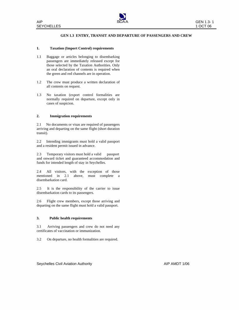
AIP GEN 2.3- 1 SEYCHELLES 1 OCT 06
Seychelles Civil Aviation Authority AIP AMDT 1/06
GEN 2.3 CHART SYMBOLS
AIP GEN 2.3- 2 SEYCHELLES 1 OCT 06
Seychelles Civil Aviation Authority AIP AMDT 1/06

AIP GEN 2.3- 3 SEYCHELLES 1 OCT 06
Seychelles Civil Aviation Authority AIP AMDT 1/06

AIP GEN 2.3- 4 SEYCHELLES 1 OCT 06
Seychelles Civil Aviation Authority AIP AMDT 1/06

AIP GEN 2.3- 5 SEYCHELLES 1 OCT 06
Seychelles Civil Aviation Authority AIP AMDT 1/06
TMA SEY
TMA SEY D: AMSL to FL 145 A: Above FL 145 to
UNL
119.7
119.7 D below FL145, A above FL 145 to UNL

AIP GEN 2.3- 6 SEYCHELLES 1 OCT 06
Seychelles Civil Aviation Authority AIP AMDT 1/06

AIP GEN 2.3- 7 SEYCHELLES 1 OCT 06
Seychelles Civil Aviation Authority AIP AMDT 1/06

AIP GEN 2.4- 1 SEYCHELLES 1 OCT 06
Seychelles Civil Aviation Authority AIP AMDT 1/06
GEN 2.4 LOCATION INDICATORS
The location indicators marked with an asterisk (*) cannot be used in the address component of AFS messages.
1. ENCODE
2. DECODE
Location Indicators
Indicators Location
ALPHONSE FSAL*
FSAL* ALPHONSE
ASSUMPTION FSAS*
FSAS* ASSUMPTION
BIRD FSSB* FSSB* BIRD
COETIVY FSSC*
FSSC*
COETIVY
DARROS
FSDA*
FSDA*
DARROS
DENIS FSSD*
FSSD*
DENIS
DESROCHES FSDR*
FSDR*
DESROCHES
FARQUHAR FSFA* FSFA* FARQUHAR
FREGATE FSSF*
FSSF*
FREGATE
MARIE-LOUISE
FSMA*
FSMA*
MARIE-LOUISE
PLATTE FSPL*
FSPL*
PLATTE
PRASLIN FSPP*
FSPP*
PRASLIN
REMIRE FSSR*
FSSR*
REMIRE
SEYCHELLES ATCC/FIC FSSS FSSS SEYCHELLES ATCC/FIC
SEYCHELLES INTERNATIONAL AIRPORT
FSIA
FSIA
SEYCHELLES INTERNATIONAL AIRPORT

AIP GEN 2.5- 1 SEYCHELLES 1 OCT 06
Seychelles Civil Aviation Authority AIP AMDT 1/06
GEN 2.5 LIST OF RADIO NAVIGATIONAL AIDS
ID
STATION
NAME
AID
PURPOSE
STATION
NAME
AID
ID
PURPOSE
COE
COETIVY
NDB
AE
COETIVY
NDB
COE
AE
PRA
PRASLIN
DVOR
AE
PRASLIN
DVOR
PRA
AE
PRA
PRASLIN
DME
AE
PRASLIN
DME
PRA
AE
SEY
SEYCHELLES
NDB
AE
SEYCHELLES
NDB
SEY
AE
SEY
SEYCHELLES
DVOR
AE
SEYCHELLES
DVOR
SEY
AE
SEY
SEYCHELLES
DME
AE
SEYCHELLES
DME
SEY
AE
SIA
SEYCHELLES
ILS
A
SEYCHELLES
ILS
SIA
A
Note 1: Purpose above indicates that the aid is used either as an approach aid (A )and/or as an en-route aid (E). Note 2: The SEY DVOR and SEY DME are co-located. Note 3: The PRA DVOR and PRA DME are co-located.

AIP GEN 2.6- 1 SEYCHELLES 1 OCT 06
Seychelles Civil Aviation Authority AIP AMDT 1/06
GEN 2.6 CONVERSION TABLES
NM to KM
1 NM = 1.852KM
KM to NM
1 KM= 0.54 NM
FT to M
1 FT = 0.3048M
M to FT
1M = 3.281FT
NM
KM
KM
NM
FT
M
M
FT
0.1 0.2 0.3 0.4 0.5 0.6 0.7 0.8 0.9 1 2 3 4 5 6 7 8 9 10 20 30 40 50 60 70 80 90 100 200 300 400 500
0.185 0.370 0.556 0.741 0.926 1.111 1.296 1.482 1.667 1.852 3.704 5.556 7.408 9.260 11.112 12.964 14.816 16.668 18.520 37.040 55.560 74.080 92.600 111.120 129.640 148.160 166.690 185.200 370.400 555.600 740.800 926.000
0.1 0.2 0.3 0.4 0.4 0.6 0.7 0.8 0.9 1 2 3 4 5 6 7 8 9 10 20 30 40 50 60 70 80 90 100 200 300 400 500
0.05 0.11 0.16 0.22 0.27 0.32 0.38 0.43 0.49 0.54 1.08 1.62 2.16 2.70 3.24 3.78 4.32 4.86 5.40 10.80 16.20 21.60 27.00 32.40 37.80 43.20 48.60 54.00 107.99 161.99 215.98 269.98
1 2 3 4 5 6 7 8 9 10 20 30 40 50 60 70 80 90 100 200 300 400 500 600 700 800 900 1 000 2 000 3 000 4 000 5 000
0.305 0.610 0.914 1.219 1.524 1.829 2.134 2.438 2.743 3.048 6.096 9.144 12.192 15.240 18.288 21.336 24.384 27.432 30.480 60.960 91.440 121.920 152.400 182.880 213.360 243.840 274.320 304.800 609.600 914.400 1219.200 1524.000
1 2 3 4 5 6 7 8 9 10 20 30 40 50 60 70 80 90 100 200 300 400 500 600 700 800 900 1000 2000 3000 4000 5000
3.28 6.56 9.84 13.12 16.40 19.69 22.97 26.25 29.53 32.81 65.62 98.43 131.23 164.04 196.85 229.66 262.47 295.28 328.08 656.17 984.25 1 312.34 1 640.42 1 968.50 2 296.59 2.624.67 2 952.76 3 280.84 6 561.68 9 842.52 13 123.36 16 404.20

AIP GEN 2.6- 2 SEYCHELLES 1 OCT 06
Seychelles Civil Aviation Authority AIP AMDT 1/06
Note: From decimal minutes of an arc to seconds of an arc.
MIN
SEC
MIN
SEC
MIN
SEC
MIN
SEC
0.01 0.02 0.03 0.04 0.05 0.06 0.07 0.08 0.09 0.10 0.11 0.12 0.13 0.14 0.15 0.16 0.17 0.18 0.19 0.20 0.21 0.22 0.23 0.24 0.25
0.6 1.2 1.8 2.4 3.0 3.6 4.2 4.8 5.4 6.0 6.6 7.2 7.8 8.4 9.0 9.6 10.2 10.8 11.4 12.0 12.6 13.2 13.8 14.4 15.0
0.26 0.27 0.28 0.29 0.30 0.31 0.32 0.33 0.34 0.35 0.36 0.37 0.38 0.39 0.40 0.41 0.42 0.43 0.44 0.45 0.46 0.47 0.48 0.49 0.50
15.6 16.2 16.8 17.4 18.0 18.6 19.2 19.8 20.4 21.0 21.6 22.2 22.8 23.4 24.0 24.6 25.2 25.8 26.4 27.0 27.6 28.2 28.8 29.4 30.0
0.51 0.52 0.53 0.54 0.55 0.56 0.57 0.58 0.59 0.60 0.61 0.62 0.63 0.64 0.65 0.66 0.67 0.68 0.69 0.70 0.71 0.72 0.73 0.74 0.75
30.6 31.2 31.8 32.4 33.0 33.6 34.2 34.8 35.4 36.0 36.6 37.2 37.8 38.4 39.0 39.6 40.2 40.8 41.4 42.0 42.6 43.2 43.8 44.4 45.0
0.76 0.77 0.78 0.79 0.80 0.81 0.82 0.83 0.84 0.85 0.86 0.87 0.88 0.89 0.90 0.91 0.92 0.93 0.94 0.95 0.96 0.97 0.98 0.99
45.6 46.2 46.8 47.4 48.0 48.6 49.2 49.8 50.4 51.0 51.6 52.2 52.8 53.4 54.0 54.6 55.2 55.8 56.4 57.0 57.6 58.2 58.8 59.4

AIP GEN 2.7-1 SEYCHELLES 01 OCT 06
Seychelles Civil Aviation Authority AIP AMDT 01/06
GEN 2.7 SUNRISE AND SUNSET
2.7.1 The times in the table below are given in
local time (+ 4 UTC) for the beginning of civil morning twilight to the end of civil evening twilight for the year 2006 .
2.7.2 The tables are calculated for the year 2006. In this period, the times on an arbitrary date and place will deviate less than 2 minutes from the times on the same date and place in the average year.
AERODROME : SEYCHELLES/International (FSIA)
ARP: 04 40 27.64S 055 31 18. 67E
MONTH /DAY SR SS MONTH/DAY SR SS MONTH/DAY SR SS JAN 1-3 0611 1834 MAY 1-16 0617 1812 SEP 1-8 0615 1817 4-7 0613 1835 17-24 0618 1812 9-12 0613 1816 8-11 0615 1837 25-31 0619 1812 13-16 0611 1816 12-16 0617 1839 17-20 0609 1815 17-22 0619 1840 JUN 1-4 0620 1812 21-24 0607 1814 23-28 0621 1841 5-8 0621 1813 25-27 0606 1813 29-31 0622 1841 9-13 0622 1814 28-30 0604 1812 14-17 0623 1815 OCT 1-6 0602 1811 FEB 1-5 0623 1841 18-22 0624 1816 7-10 0600 1811 6-12 0624 1840 23-26 0625 1817 11-16 0558 1810 13-28 0625 1837 27-30 0626 1818 17-23 0556 1810 24-27 0555 1810 MAR 11-4 0625 1835 JUL 1-2 0626 1818 28-31 0554 1810 5-13 0624 1832 3-9 0627 1819 14-19 0623 1829 10-29 0628 1822 NOV 1-19 0553 1814 20-25 0622 1827 30-31 0627 1822 20-25 0554 1816 26-31 0621 1824 26-30 0556 1818 AUG 1-4 0627 1822 APR 1-5 0620 1822 5-9 0626 1822 DEC 1-5 0557 1820 6-12 0619 1820 10-13 0625 1822 6-10 0600 1822 13-20 0618 1817 14-16 0624 1821 11-15 0601 1825 21-30 0617 1814 17-19 0623 1821 16-21 0604 1828 20-22 0622 1821 22-27 0607 1831 23-31 0618 1819 28-31 0609 1833

AIP GEN 3.1-1 SEYCHELLES 03 APR 14
Seychelles Civil Aviation Authority AIP AMDT 01/14
GEN 3 SERVICES
GEN 3.1 AERONAUTICAL INFORMATION SERVICES
3.1.1 Responsible service The Aeronautical Information Services which forms part of the Seychelles Civil Aviation Authority ensures the flow of information necessary for the safety, regularity and efficiency of international and national air navigation within the area of its responsibility as indicated under GEN 3.1.2 below. It consists of combined AIS Headquarters, International NOTAM Office (NOF) and AIS units established at Seychelles International Airport as listed under GEN 3.1.5 below. 3.1.1.1 AIS Headquarters / International NOTAM
office (NOTAM) address Seychelles Civil Aviation Authority Aeronautical Information Services P O Box 181 Victoria, Mahe Tel: (248) 4384186 Fax: (248) 4384179 AFS; FSIAYNYX The service is provided in accordance with the provisions contained in ICAO Annex 15 - (Aeronautical Information Services).
Hours of service are from 0400 UTC to 1200 UTC, Monday to Friday, except on public holidays. 3.1.2 Area of responsibility The Aeronautical Information Service is responsible for the collection and dissemination for the entire territory of Seychelles and for the airspace over the high seas encompassed by the Seychelles Flight Information Region. 3.1.3 Aeronautical publications 3.1.3.1 The aeronautical information is provided in the form of the Integrated Aeronautical Information Package consisting of the following elements; - Aeronautical Information Publication (AIP); - Amendment service to the AIP (AIP AMDT); - Supplement to the AIP (AIP SUP); - NOTAM and Pre-Flight Information Bulletins (PIB) - Aeronautical Information Circulars (AIC); - Check lists and Summaries NOTAMs and the related monthly check lists are issued via the Aeronautical Fixed Service (AFS), while PIB are made available at the AIS unit. All other elements of the package are distributed by air mail.
3.14 Aeronautical Information Publication The AIP is the basic aviation document intended primarily to satisfy international requirements for exchange of permanent aeronautical information and long duration temporary changes essential for air navigation. AIP Seychelles is published in one Volume. The AIP is published in a loose-leaf form in English for use in international and domestic operations, whether the flight is a commercial or private one. 3.1.5 Amendment services to the AIP (AIP
AMDT) Amendments to the AIP are made by means of replacement sheets. Two types of AIP AMDT are produced: 1. - Regular AIP amendment (AIP AMDT) issued in accordance with the established regular interval (ref GEN 0.1-2) and identified by a plain cover sheet. This incorporates permanent changes into the AIP on the indicated publication date ; and 2. - AIRAC AIP Amendment (AIRAC AIP AMDT) issued in accordance with the AIRAC System and identified by plain cover sheet and the acronym – AIRAC. This incorporates Operational significant permanent changes into the AIP on the indicated AIRAC effective date. A briefing description of the subjects affected by the amendment is given on the AIP Amendment cover sheet. New information included on the reprinted AIP pages is annotated or identified by a vertical line in the margin (or immediately to the left) of the change or addition. Each AIP page and each AIP replacement page introduced by an amendment, including the amendment cover sheet are dated. The date consists of the day, month, and year of the publication date (regular AIP AMDT) or of the AIRAC effective date (AIRAC AIP AMDT) of the information. Each AIP amendment cover sheet includes references to the serial number of those elements, if any, of the integrated Aeronautical Information Package which have been incorporated in the AIP by the amendment and are consequently cancelled.

GEN 3.1-2 AIP 23 AUG 12 SEYCHELLES
AIP AMDT 01/12 Seychelles Civil Aviation Authority
Each AIP AMDT and each AIRAC AIP AMDT are allocated separate serial numbers which are consecutive and based on the calendar year. The year, indicated by two digits, is a part of the serial number of the amendment e.g. AIP AMDT 1/96 .AIRAC AIP AMDT 1/96.
A checklist of AIP pages containing page number/chart title and publication or effective date (day, month by name and year) of the information is reissued with each amendment and is an integral part of the AIP. 3.1.6 Supplement to the AIP (AIP SUP) Temporary changes of long duration (three months and longer) and information of short duration which consists of extensive text and /or graphics, supplementing the permanent information contained in the AIP are published as AIP Supplements (AIP SUP). Operational temporary changes to the AIP are published in accordance with the AIRAC system and its established effective dates and are identified clearly by the acronym AIRAC AIP SUP. AIP Supplements are separated by information subject (General- GEN), En-route ENR and Aerodromes-AD and are placed accordingly at the beginning of each AIP PART. Supplements are published on yellow paper to be conspicuous and to stand out from the rest of the AIP. Each AIP Supplement (regular or AIRAC ) is allocated a serial number which is consecutive and based on the calendar year, i.e. AIP SUP 1/96 ; AIRAC AIP SUP 1/96 An AIP Supplement is kept in the AIP as long as all or some of its contents remain valid. The period of validity of the information contained in the AIP Supplement will normally be given in the supplement itself. Alternatively, NOTAM may be used to indicate changes to the period of validity or cancellation of the supplement. The checklist of AIP Supplements currently in force is issued in the monthly printed plain – language summary of NOTAM in force. 3.1.7 NOTAM and Pre-flight Information Bulletins:
(PIB) NOTAM: A notice distributed by means of telecommunication, containing information concerning the establishment, condition or change in any aeronautical facility, service, procedure or hazard, the timely knowledge of which is essential to personnel concerned with flight operations. The text of each NOTAM contains the information in the order shown in the ICAO NOTAM Format and is
composed of the significant / uniformed abbreviated phraseology assigned to the ICAO NOTAM code complemented by ICAO abbreviations, indicators, identifiers, designators, callsigns, frequencies, figures and plain language. NOTAMs are originated and issued for Seychelles FIR and are distributed in two series identified by the letters A and B. Series A. General rules, en-route navigation and communication facilities, airspace restrictions and information concerning Seychelles International Airport. Series B. Information on national aerodromes and helicopter landing areas. Pre-flight Information Bulletins: (PIB) which contain a recapitulation of current NOTAM and other information of urgent character for the operator / flight crews are available at the aerodrome AIS unit of Seychelles International airport only. 3.1.8 Aeronautical Information Circulars (AIC) The Aeronautical Information Circulars (AIC) contains information on the long term forecast of any major change in legislations, regulations, procedures or facilities. The information is of a purely explanatory or advisory nature concerning technical, legislative or purely administrative matters liable to affect flight safety. AICs are divided by subject and are issued in two series (A and B). AIC Series A contains information affecting international civil aviation and is given international distribution while AIC Series B contains information affecting national aviation only and is given national distribution. Each AIC is numbered consecutively within each series on a calendar year basis. The year, indicated by two digits, is part of the serial number of the AIC e.g. AIC 1/96. A checklist of AIC currently in force is issued t concerning technical, legislative or purely administrative twice a year. 3.1.9 Checklist and summary of NOTAM A Checklist of valid NOTAM is issued monthly via AFS. The checklist is followed by a printed summary of NOTAM distributed by mail to all recipients of the Integrated Aeronautical Information Package. It contains a plain language (English) presentation of the valid NOTAM and information about the number of the latest issued AIP AMDT AIRAC AIP AMDT, AIP SUP and AIC as well as the numbers of the elements issued under the AIRAC that will become effective or , if none, the NIL AIRAC notification.

AIP GEN 3.2.1 SEYCHELLES 03 APR 14
Seychelles Civil Aviation Authority AIP AMDT 01/14
GEN 3.2 AERONAUTICAL CHARTS
3.2.1 Responsible service The Civil Aviation Authority of Seychelles provides a wide range of aeronautical charts for use by the civil aviation industry. The aeronautical information service office produces the charts which are part of the AIP. All other aeronautical charts are produced by the department of surveys. Charts suitable for pre-flight planning and briefing, selected from those listed in the ICAO Aeronautical Chart Catalogue (Doc 7101) are available for reference at the AIS Unit. The charts are produced in accordance with the provisions contained in ICAO Annex 4 Aeronautical Charts. Differences to those provisions are detailed in subsection GEN 1.7 3.2.2 Maintenance of Charts
The aeronautical charts included in the AIP are kept up to date by amendments to the AIP. Corrections to the aeronautical charts not contained in the AIP are
3.2.4 Aeronautical chart series available
The following series of aeronautical charts are available and produced by the Authority:-
a) [ADC] Aerodrome Chart - ICAO b) [APDC] Aircraft Parking/Docking Chart - ICAO c) [AOC] Aerodrome Obstruction Chart-ICAO
Type A d) [ENRC] En-route Chart - ICAO e) [IAC] Instrument Approach Chart - ICAO f) [SID] Standard Departure Chart - ICAO g) [STAR] Standard Arrival Chart - ICAO
3.2.4.1 General description of each series A general description of each series is published in ICAO Annex 4 - Aeronautical Charts.
3.2.3 Purchase arrangement Charts as listed under subsection 3.2.4 below may be obtained from the following address:- Seychelles Civil Aviation Authority Aeronautical Information Services PO Box 181 Victoria Mahe Tel: (248) 438 4186 Fax: (248) 438 4179 AFS: FSIAYNYX The AIS unit has copies of the ICAO Aeronautical Chart Catalogue (Doc 7101) where all aeronautical charts or chart series produced by Seychelles and other countries are listed and known to be generally available to civil aviation.

GEN 3.2.2 AIP 23 AUG 12 SEYCHELLES
AIP AMDT 1/12 Seychelles Civil Aviation Authority
3.2.5 List of Aeronautical Charts available
Title of series
Scale
Name and / or number
Price
Date
[ADC] Aerodrome Chart* - AD 2 FSIA - 13 - AD 2.2 FSPP - 01
Available as part of the AIP
See AIP page
[APDC] Aircraft Parking/Docking Chart - ICAO*
- AD 2 FSIA - 15 Available as part of the AIP
See AIP page
[AOC] Aerodrome Obstruction Chart-ICAO Type A*
- AD 2 FSIA - 17 Available as part of the AIP
See AIP page
[ENRC] En-route Chart – ICAO*
1:6 000 000 1:5 000 000
Nil
Nil
Nil
- FIR Chart - TMA Chart - IFR Transit: Low level (single aircraft operation) - IFR Transit: Low level (multiple aircraft operation) RNP 1 Transition Routes
Available as part of the AIP
See AIP pages
[IAC] Instrument Approach Chart - ICAO*
FSIA ILS W RWY 31 (CAT C-D) ILS X RWY 31 (CAT A-B) ILS Y RWY 31 (CAT C-D) ILS Z RWY 31 (CAT A-B) NDB RWY 31 (CAT A-D) VOR X RWY 13(CAT A-D) VOR Z RWY 13 (CAT A-D) VOR Z RWY 31 (CAT A-D) VOR a RWY 31 via route ALPHA (CAT A-B) VOR c RWY13 via Route Charlie (CAT A-B) ILS V RWY31 via Route Delta (CAT A-B) RNAV GNSS Y RWY 13 (CAT A-D) RNAV GNSS Y RWY 31 (CAT A-D) RNAV RNP Z RWY 13 (CAT C-D) RNAV RNP Z RWY 31 (CAT C-D) FSPP VOR a CAT (A-B) VOR b CAT (C) VOR c CAT (A-B)
Available as part of the AIP
See AIP pages
[SID] Standard Departure Chart - ICAO*
FSIA RNP 1 SID RWY 13 FSIA RNP 1 SID RWY 31
Available as part of the AIP
See AIP pages
[STAR] Standard Arrival Chart – ICAO*
FSIA RNP 1 STAR RWY 13 FSIA RNP 1 STAR RWY 31
Available as part of the AIP
See AIP pages
Note: Those Chart series marked by an asterisk forms part of the AIP Seychelles.

AIP GEN 3.2- 3 SEYCHELLES 23 AUG 12
Seychelles Civil Aviation Authority AIP AIRAC AMDT 1/12
3.2.6 Index to the World Aeronautical Chart
(WAC) - ICAO 1;1,000,000
Nil
3.2.7 Topographical Charts To supplement the aeronautical charts, a wide range of topographical charts are available from the Ministry of Land Use and Habitat, Geo-Informatics Division, P.O Box 199, Victoria, Mahe.
3.2.8 Correction to charts not contained in the AIP shall be recorded in this table.
Charts Location Corrections

AIP GEN 3.3-1 SEYCHELLES 03 APR 14
Seychelles Civil Aviation Authority AIP AMDT 1/14
GEN 3.3 AIR TRAFFIC SERVICES 3.3.1. Responsible service: The Air Navigation Services division of the Seychelles Civil Aviation Authority is the responsible authority for the provision of air traffic services within the Seychelles Flight Information Region. Chief Executive Officer Seychelles Civil Aviation Authority P.O.Box 181 Victoria, Mahe Tel: (248) 4 38 40 00 Fax: (248) 4 38 40 09 AFS: FSIAYAYX The services are provided in accordance with the provisions contained in the following ICAO documents:- Annex 2 - Rules of the Air Annex 11 - Air Traffic Services Doc 4444 - ATM/501 - Procedures for Air Navigation
Services – Air Traffic Management Doc 8168 - Procedures for Air Navigation Services -
Aircraft Operations (PANS OPS) Doc 7030 - Regional Supplementary Procedures Note: Differences to ICAO SARPs are detailed in subsection GEN1.7.
3.3.2 Area of responsibility Air traffic services are provided for the entire territory of Seychelles including its territorial waters as well as the airspace over the high seas within the Seychelles FIR.
3.3.3 Types of Services: The following types of services are provided: - Flight Information Services (FIS) and Alerting
Services (ALRS) - Area Control (ACC) - (Procedural) - Approach Control (APP)- (Procedural) - Aerodrome Control (TWR) 3.3.4 Co-ordination between the operator and ATS Co-ordination between the operator and air traffic services is effected in accordance with Para 2.15 of ICAO Annex 11 and Para 2.1.1.4 and 10.4 of Procedures for Air Navigation Services - Air Traffic Management Doc 4444. 3.3.5 Minimum flight altitude The minimum flight altitudes on the ATS routes, as presented in section ENR 3, have been determined so as to ensure a minimum vertical clearance above the controlling obstacles in the area concerned.
3.3.6 ATS Units address list
Unit Name
Postal Address
Telephone Nr
Fax Nr
Telex
Nr
AFS address
1 2 3 4 5 6
Seychelles ACC Seychelles Civil Aviation Authority P.O. Box 181,Victoria, Mahe Seychelles
(248) 4 38 41 93
(248) 4 38 40 30
Nil
FSSSZQZX
Seychelles APP Same as for Seychelles ACC
(248) 4 38 41 92
(248) 4 38 40 30
Nil
FSIAZPZX
Seychelles TWR
Same as for Seychelles ACC
(248) 4 38 41 91
(248) 4 38 40 30
Nil
FSIAZTZX
Praslin TWR
Same as for Seychelles ACC
(248) 4 28 46 30
(248) 4 38 4030
Nil
FSIAYAYX

GEN 3.3-2 AIP 23 AUG 13 SEYCHELLES
AIP AMDT 1/12 Seychelles Civil Aviation Authority
INTENTIONALLY LEFT BLANK

AIP GEN 3.4- 1 SEYCHELLES 23 AUG 12
Seychelles Civil Aviation Authority AIP AIRAC AMDT 1/12
GEN 3.4 COMMUNICATION SERVICES
3.4.1 Responsible service The Seychelles Civil Aviation Authority is responsible for the provision of telecommunication and navigation services in Seychelles, on the following address: Chief Executive Officer Seychelles Civil Aviation Authority P.O. Box 181 Victoria, Mahe Tel: (248) 4 38 40 00 Fax: (248) 4 38 40 09 / 4 38 40 30 AFS: FSIAYAYX The service is provided in accordance with the provisions contained in the following ICAO documents: Annex 10 - Aeronautical Telecommunications Doc 8400 - Procedures for Air Navigation Services- ICAO Abbreviations and Codes (PANS-ABC) Doc 8585 - Designators for Aircraft operating Agencies Doc 7030 - Regional Supplementary Procedures Doc 7910 - Location Indicators
3.4.2 Area of responsibility Communication services are provided for the entire Seychelles FIR. Arrangements for such services on a continuing basis should be made with the Director of Operations and Aviation Safety, who is also responsible for the application of the regulations concerning the design, type and installations of aircraft radio stations. Responsibility for the day-to-day operation of these services is vested in the Senior Aeronautical Telecommunication Engineer located at the Seychelles International Airport. Inquiries, suggestions or complaints regarding any telecommunication service should be referred to the Air Navigation Service. 3.4.3 Types of service 3.4.3.1 Radio navigation services The following types of radio aids to navigation are available: LF/MF non-directional beacon (NDB) Instrument landing system (ILS VHF omni directional radio range (VOR) Distance - measuring equipment (DME)
3.4.3.2 Mobile service The aeronautical stations maintain a continuous watch on their stated frequencies during the published hours of service unless otherwise notified. An aircraft will normally communicate with the air ground control radio station that exercises control in the area in which the aircraft is flying. Aircraft should maintain a continuous watch on the appropriate frequency of the control station and should not abandon watch without informing the control radio station except in an emergency. 3.4.3.3 Fixed service The messages to be transmitted over the Aeronautical Fixed Service (AFS) are accepted only if: a) They satisfy the requirements of ICAO Annex10, Vol. II, Chapter 3, 3.3; b) They are prepared in the form specified in ICAO Annex 10; c) The text of an individual message does not exceed 200 groups. General aircraft operating agency messages are only accepted for transmission to countries that have agreed to accept Class ‘B’ traffic. 3.4.3.4 Broadcasting service
- Nil - 3.4.3.5 Language used
English Note 1: Details of the various facilities available for the en-route traffic can be found in Part 2, ENR 4. Note 2: Details of the facilities available at the individual aerodromes can be found in the relevant sections of Part 3 (AD), In cases where a facility is serving both the en-route traffic and the aerodromes, details are given in the relevant sections of Part 2 (ENR) and Part 3 (AD). 3.4.4 Requirements and conditions The requirements of the Seychelles Civil Aviation Authority and the general conditions under which the communication services are available for international use as well as the requirements for the carriage of radio equipment are contained in the Telecommunications and Broadcasting Act of Seychelles.

AIP GEN 3.4- 2 SEYCHELLES 23 AUG 12
Seychelles Civil Aviation Authority AIP AIRAC AMDT 1/12
3.4.5 AERONAUTICAL FIXED SERVICES: TELEGRAPH
LEGEND Simplex circuit Duplex circuit װ International circuit < ׀ >
SEYCHELLES
MET OFFICE
JOHANNESBURG INTERNATIONAL COMM CENTRE FAJSYFYX
SEYCHELLES COMMS CENTRE
FSIAYFYX
SEYCHELLES
TWR
SEYCHELLES
ACC
SEYCHELLES NOF
FSIAYNYX
NAIROBI INTERNATIONAL COMM CENTRE HKNAYNYX

AIP GEN 3.4- 3 SEYCHELLES 1 OCT 06
Seychelles Civil Aviation Authority AIP AMDT 1/06
3.4.6 AERONAUTICAL FIXED SERVICES: TELEPHONE
NAIROBI
ACC
MADAGASCAR
ACC
SEYCHELLES ACC
DAR- ES – SALAAM
ACC
MAURITIUS ACC
MUMBAI
ACC
MOGADISHU
FIC

AIP GEN 3.5-1 SEYCHELLES 03 APR 14
Seychelles Civil Aviation Authority AIP AMDT 1/14
GEN 3.5 METEOROLOGICAL SERVICES
3.5.1 Responsible Service
3.5.1.1 The Seychelles National Meteorological Service is the Meteorological Authority for Seychelles. This authority is derived from Section (3) of the Meteorology Act 2000 relating to the Meteorological Service performance of air navigation functions. The policy of the Seychelles Meteorological Authority is to discharge its responsibilities for the provision of meteorological services to Seychelles based national and international civil aviation operations in accordance with ICAO Annex 3 and other national and international requirements as may be promulgated from time to time. Head of Meteorological Authority Weather and Climate Services Division Ministry of Environment and Energy P.O. Box 1145 Victoria, Mahe, Seychelles Phone: (248) 4384358 / 4384352 Fax: (248) 4384369 / 4384371 Email: [email protected]
3.5.1.2 Meteorological and Climatological services for civil aviation in Seychelles are provided by the Seychelles National Meteorological Service designated as the Meteorological Air Navigation Service Provider (ANSP) for Seychelles under the Air Navigation Service Provision Regulation:
3.5.1.3 Applicable ICAO Documents
The Standards, Recommended Practices and when applicable, the procedures contained in the following ICAO documents are applied:
Annex 3 - Meteorological Service for International Air Navigation; Doc 8896 - Manual on Aeronautical Meteorological Practice; Doc 7030 - Regional Supplementary Procedures
3.5.1.4 The Seychelles Met Authority’s objective is to supply operators, flight crew members, ATS units, airport management and other civil aviation users with the meteorological information necessary for the performance of their respective functions, thus contributing towards the safety, regularity and efficiency of air navigation. All ICAO Annex 3 Standards are applied in Seychelles unless a difference has been filed with ICAO. Seychelles differences from ICAO standards and recommended practices are listed in GEN 1.7.
3.5.2 Area of Responsibility
The Seychelles Met Authority provides area Meteorological Watch for the Seychelles Flight Information Region (FIR).
Victoria, Mahe, Seychelles Phone: (248) 4384358 / 4384352 Fax: (248) 4384369 / 4384371
Email: [email protected] AFS: FSIAYMYX

GEN 3.5-2 AIP 01 DEC 12 SEYCHELLES
AIP AMDT 1/12 Seychelles Civil Aviation Authority
3.5.2 Meteorological Observations and Reports
Table GEN 3.5.3 Meteorological Observations and Reports Aerodrome/Location Indicator
Observation/Reports Observing Instruments/Sites
Hours of
Operation
Climate Information Type Frequency
Seychelles International/FSIA
Wind Cup Anemometer
H24
Climate. Tables
Available based on data
for >10yrs
Temp/Dew Point
Mercury in glass thermometer
Press. Aneroid Barometer
Routine Met
Reports
Hourly
Special Reports
As/When warranted
METARS Hourly SPECIs As/When
warranted
TREND Forecast
Hourly
3.5.4 Types of Services
3.5.4.1 Aerodrome Forecast (TAFs)
The aerodrome forecast (TAF) is the primary method of providing the forecast weather information that pilots require about an aerodrome in an abbreviated format. The TAF consists of a concise statement of the mean or average meteorological conditions expected at an aerodrome during the specified period of validity. TAF for Seychelles International airport are prepared to cover 24 hour operations. TAFs are for validity period of 30 hours and issued every 6 hours as follows: 2300, 0500, 1100 and 1700 UTC for TAFs of validity period starting at 0000, 0600, 1200, and 1800 UTC respectively.
In addition TAFs for other aerodromes/alternates are also made available to operators and flight crew upon request.
3.5.4.2 Landing Forecasts TREND type landing forecasts are issued and appended to all Local Routine and Special Reports and also to METARs and SPECIs. The validity of the TREND forecast is 2 hours.
3.5.4.3 Forecast for Take-off Forecast for take-off comprising of surface wind direction and speed, air temperature and QNH are available on request within 3 hours before expected time of departure of an aircraft.

AIP GEN 3.5-3 SEYCHELLES 03 APR 14
Seychelles Civil Aviation Authority AIP AMDT 1/14
3.5.4.4 Flight Documentation
Flight documentation is provided for all international flights. The flight documentation comprises of:
1. Significant weather chart(s);
2. Upper winds and Upper air chart(s);
3. A forecast for take-off;
4. METAR and, where available, SPECI for the aerodrome of departure, en-route alternate aerodromes, the aerodrome of intended landing and destination alternate aerodromes;
5. TAF for the aerodrome of departure
and intended landing, en-route and destination alternate aerodromes;
6. SIGMET information and
appropriate Special air-report;
7. A copy of the latest satellite imagery when requested (if available).
Flight documentation for domestic flight is normally provided upon request and may include some or all of the above depending on the specific request.
3.5.4.5 En-Route forecasts for Low Levels
En-route forecasts for low level flights that cannot be obtained from WAF centres can be prepared and issued upon request; however these forecasts may be for restricted areas (Southwestern Indian Ocean and adjacent African continent). Forecast charts will comprise of:
a) Low level winds and temperatures at grid points;
b) Low level significant weather chart (surface-10000 ft).
3.5.4.6 Briefing/Consultation Briefing and/or consultation are provided, on request, to flight crew members and/or other flight operations personnel at the airport meteorological office. Meteorological information used for briefing and consultation shall include any or all information listed in 3.5.4.4 above. Operators and flight crew members requiring such service shall advise the meteorological office in advance whether such briefing/consultation shall be in lieu of flight documentation. Briefing/consultation is available by phone [(248)4384358], however this will be restricted to very local operations such as aerial photography, flight crew training, helicopter operations etc.
3.5.5 Notification required from operators Notification from operators in respect of briefing/consultation, flight documentation and other meteorological information needed is normally required for all international flights of more than 3500km. (Ref. ICAO Annex 3, 2.3). Such notification should be received at least 6 hours before the expected time of departure. In addition the Meteorological Office shall be notified by the operator requiring service when: (a) New routes or new types of operations
are planned
(b) Changes of a lasting character are to be made scheduled operations; and
(c) Other changes, affecting the provision
of meteorological service, are planned.
The meteorological office shall be notified by the operator or a flight crew member:
a) Of flight schedules; b) When non-scheduled flights are to
be operated; and

GEN 3.5-4 AIP 01 DEC 12 SEYCHELLES
AIP AMDT 1/12 Seychelles Civil Aviation Authority
c) When flights are delayed, advanced or cancelled.
In addition, notification for non-scheduled flights should contain the following information:
a) Estimated time of departure;
b) Destination and estimated time of arrival;
c) Route to be flown and estimated
times of arrival at, and departure from, any intermediate aerodrome(s);
d) Alternate aerodromes;
e) Cruising level(s).
3.5.6 Aircraft Reports
3.5.6.1 Routine Aircraft Observation
Routine aircraft observations are required to be issued during the climb-out and en-route phases of the flight. (Ref, ICAO Annex 3, 5.2).
3.5.6.2 Special Aircraft Observation
Special aircraft observations are required to be issued by aircraft as Special air report whenever any of the following conditions are encountered or observed. (Ref, ICAO Annex 3, 5.5)
a) Severe turbulence;
b) Severe icing;
c) Severe mountain wave;
d) Thunderstorms, without hail, that are
obscured, embedded, widespread or in squall
lines;
e) Heavy duststorm or heavy sandstorm;
f) Volcanic ash cloud;
g) re-eruption volcanic activity or a volcanic
eruption.
3.5.7 VOLMET Service The VOLMET service is currently unavailable.

AIP GEN 3.5-5 SEYCHELLES 01 DEC 12
Seychelles Civil Aviation Authority AIP AMDT 01/12
3.5.2 SIGMET and AIRMET Services Table GEN 3.5.8.1
Name of MWO/ Location Indicators
Hours FIR or CTA served
Type of SIGMET/ Validity
Specific SIGMET procedures
AIRMET procedures
ATS Unit served
Additional information
1 2 3 4 5 6 7 8 SEYCHELLES FSIA
H24 SEYCHELLES FIR
SIGMET/ 4 HR SIGMET SST/ 4 HR
TC and VA SIGMET issued on advisory from TCAC and VAAC
Nil SEYCHELLES ACC
Nil
3.5.2.1 General
For the safety of air traffic within the Seychelles FIR, the airport Meteorological office also undertakes the functions of the Meteorological Watch Office (MWO). This consists of a continuous weather watch within the lower and upper Seychelles FIR and the issuance of appropriate information (SIGMET) including warnings for the respective aerodromes. The Seychelles MWO also issues SIGMET (TC) and SIGMET (VA) based on advisories from the regional Tropical Cyclone Advisory Centre (TCAC) in Réunion and Volcanic Ash Advisory Centre (VAAC) in Pretoria respectively.
3.5.2.2 Area Meteorological Watch The area meteorological watch service for the Seychelles FIR is performed by the Seychelles Meteorological Watch Office (MWO) based at Seychelles international airport. The office is responsible for the preparation and dissemination of SIGMETS with the occurrence or expected occurrence of one or more of the following phenomena:
a) Thunderstorms; b) Tropical cyclones; c) Severe
turbulence/windshear d) Severe icing; e) Severe mountain waves; f) Volcanic ash clouds.
SIGMET messages are identified by the letters WS at the beginning of the header line whilst those referring to tropical cyclones and
volcanic ash will be identified by WC and WV respectively. SIGMETS are valid for 4 hours, for volcanic ash cloud and tropical cyclones; a further outlook for up to 6 hours may be included and are re-issued if they are to remain valid after the original period expires. They can be cancelled or amended within the period of validity. SIGMETS are numbered sequentially from 0001 UTC each day.
Tropical Cyclone/Volcanic ash cloud SIGMETS will be issued based on advisory information provided by the relevant TCAC/VAAC.
3.5.2.3 Warning Service 1) Aerodrome Warnings
Aerodrome warnings are issued and disseminated through the Air Traffic Services unit to aircraft operators and other aerodrome users with the occurrence or expected occurrence of the following weather phenomena. a) Tropical Cyclones (when the surface
mean wind speed is expected to be ≥ 63 km/h (34 kt);
b) Severe Thunderstorms; c) Strong surface wind/squalls;
1) Wind Shear/Turbulence Warnings
Forecasters at Seychelles International airport regularly review the weather conditions and monitor aircraft reports

GEN 3.5-6 AIP 01 DEC 12 SEYCHELLES
AIP AMDT 1/12 Seychelles Civil Aviation Authority
of wind shear/turbulence experienced on the approach or climb out. Where a potential low level (below 1600 ft) wind shear conditions exists, a warning is issued; this will be based on one or more of the following criteria:
a) Mean surface wind speed at least 20
kt irrespective of direction;
b) Mean surface wind speed of at least 15 kt with direction within the sector 140-300 degrees;
c) The magnitude of the vector difference between the mean surface wind and the gradient wind (an estimate of the wind at 2000 ft) of at least 40 kts;
3.5.3 Other Automated Meteorological Services
Table GEN 3.5.9
Service Name Information Available
Areas, Routes and aerodromes covered
Tel/Fax/ e-mail/URL
Remarks
Nil Nil Nil Nil Nil

AIP GEN 3.6-1 SEYCHELLES 03 APR 14
Seychelles Civil Aviation Authority AIP AMDT 1/14
GEN 3.6 SEARCH AND RESCUE 3.6.1 Responsible Service The search and rescue service in Seychelles is provided by Seychelles Civil Aviation Authority in collaboration with the Police Department and the Seychelles Coast Guard which have the responsibility of making the necessary facilities available. The postal and telegraphic addresses of Seychelles Civil Aviation Authority are given on page GEN 1.1-1. The services are available on H24 basis. The addresses of the Police Department and Seychelles Coast Guard are as follows:- Commissioner of Police Police Headquarters P.O.Box 46 Victoria Mahe Seychelles Tel. (248) 428 80 00 / 4 32 25 91 Telegraphic Address; COMPOL SEYCHELLES [email protected] Seychelles Coast Guard Victoria Mahe Seychelles Tel: 248) 4 22 44 11 Fax: (248) 4 32 32 88 E-mail:[email protected]
Joint Rescue Co-ordination Centre Seychelles Civil Aviation Authority Victoria Mahe Tel: (248) 4 290900 / 2520020 Fax: 248) 4 224665 / 4 323288 AFS; FSIAYAYX and FSSSZQZX The service is provided in accordance with the provisions contained in ICAO Annex 12 - Search and Rescue. 3.6.2 Area of responsibility The search and Rescue service is responsible for SAR operations with Seychelles FIR 3.6.3 Types of service Details of available SAR assets locally are given in Table 3.6.3 below. In addition, various elements of the police organization, the merchant marine and the defence forces are available for search and rescue missions when required. The aeronautical maritime and public telecommunications services are available to the search and rescue organization No amphibian aircraft are available. Aircraft and marine craft are equipped to communicate on VHF 121.5 MHz HF 500, 2182 and 8364 KHz. Ground rescue teams are equipped to communicate on VHF 121.9 MHz.
When SAR operations are required, the Joint Rescue Coordination Centre is activated at Seychelles Coast Guard. The address is as follows;
Table 3.6.3 Search and Rescue Units
Name of location Location Facilities available Remarks
1 2 3 4 Seychelles International Airport
04 40 27.46 S 055 31 18.67 E 9km
3x Eurocopter- EC120B 1x Partenavia- P68 1x Beechcraft 1900D (B1900D) 1x Dornier- D0228 5x Twin Otter (DHC6) 2 x Y12E 1 x Cessna Caravan –F 406 Inshore 2x Rescue Vessels
On request operations- day On request operation-day/night On request operation-day/night On request operation-day/night On request operation-day/night On request operation- day/night On request operation- day/night H24
Seychelles Coast Guard
7km NW of Seychelles International Airport
Marine merchants through GMDSS Rescue vessels
On request H24

GEN 3.6-2 AIP 23 AUG 12 SEYCHELLES
AIP AMDT 01/12 Seychelles Civil Aviation Authority
3.6.4 SAR agreements An agreement is in force between the SAR services of Seychelles and India concerning the provision of alerting service via the COSPAS - SARSAT satellite system. Request for the entry of aircraft, equipment and personnel from other states to engage in the search for aircraft in distress or to rescue survivors of aircraft accidents should be transmitted to the Chief Executive Officer of Seychelles Civil Aviation Authority. Instructions as to the mode of control which will be exercised on entry of such aircraft and personnel will be provided by Seychelles Rescue Coordination Centre, in accordance with a standing plan for the conduct of search and rescue in its area of responsibility. 3.6.5 Conditions of availability The SAR service and facilities in Seychelles can be made available to neighbouring States upon request to the Chief Executive Officer of Seychelles Civil Aviation Authority provided they are not engaged in search and rescue operations in Seychelles territory. The aircraft mentioned in table 3.6.3 and marine crafts except the rescue boats are not specifically equipped but can be adapted for search and rescue purposes. 3.6.6 Procedures and signals used Procedures for pilots in command observing an accident or intercepting a distress call and /or message are outlined in ICAO Annex 12 Chapter 5. 3.6.7 Communications Transmission and reception of distress messages within the Seychelles Search and Rescue Area are handled in accordance with ICAO Annex 10, Volume 2, Chapter 5, paragraph 5.3. For communication during search and rescue operations, the codes and abbreviations published in ICAO Abbreviations and Codes (Doc 8400) will be used .The frequency 121.5 MHz is guarded continuously by the Seychelles Air Traffic Control Tower and Seychelles Air Traffic Control Centre within the TMA .Only Cable and Wireless Coast Station continuously guard the international maritime distress frequencies. At present there are no aircraft dedicated for Search and Rescue. Aircraft will use their normal callsigns or registrations during search and rescue operations.
3.6.8 Search and Rescue Signals The search and rescue signals to be used are those prescribed in ICAO Annex 12. 3.6.8.1 Signals with surface craft: The following manoeuvres performed in sequence by an aircraft would indicate that the aircraft wishes to direct a surface craft towards an aircraft or a surface craft in distress: a) circling the surface craft at least once; b) crossing the projected course of the surface craft close ahead at low altitude and;
i) rocking the wings; or ii) opening and closing the throttle; or iii) changing the propeller pitch.
Note: Due to high noise level on board surface craft, the sound signals in ii) and iii) may be less effective than the visual signal in i) and are regarded as alternative means of attracting attention. c) heading in the direction in which the surface craft
is to be directed. Repetition of such manoeuvres has the same meaning.
The following manoeuvres by an aircraft means that the assistance of the surface craft to which the signal is directed is no longer required: a) crossing the wake of the surface craft close astern
at a low altitude and; b) rocking the wings; or c) opening and closing the throttle; or d) changing the propeller pitch. Note: the following replies may be made by surface craft to the signals in 3.6.8.1; – For acknowledging receipt of signals: 1) the hoisting of the “code pennant” (vertical red and white stripes) close up (meaning understood); 2) the flashing of a succession of “T’s” by signal lamp in the Morse code; 3) the changing of heading to follow the aircraft. – For indicating inability to comply: 1) the hoisting of the international flag “N” (a
blue and white checkered square); 2) the flashing of a succession of “N’s” in the
Morse code.

AIP GEN 3.6-3 SEYCHELLES 23 AUG 12
Seychelles Civil Aviation Authority AIP AMDT 1/12
3.6.9 Ground to air visual signal code 3.6.9.1 Ground-air visual signal code for use by survivors
No.
Message
Code symbol
1
Require assistance
2
Require medical assistance
3
No or Negative
4
Yes or Affirmative
5
Proceeding in this direction
The above symbols shall be at least 2.5 metres (8 feet) long and shall be made as conspicuous as possible. Note 1: The symbols may be formed by any means such as: strips of fabric, parachute material, pieces of wood, stones
or such like material; marking the surface by tramping, or staining with oil. Note 2: Attention to the above signals may be attracted by other means such as radio, flares, smoke and reflected light.
3.6.10 Air to ground visual signal code The following signals by an aircraft means that the ground signals have been understood: a) during the hours of daylight: - by rocking the aircraft’s wings; b) during the hours of darkness: - by flashing on and off twice the aircraft’s landing lights or, if not so equipped, by
switching on and off twice its navigation lights. Note: A lack of the above signals would indicate that the ground signal has not been understood.

GEN 3.6-4 AIP 23 AUG 12 SEYCHELLES
AIP AMDT 01/12 Seychelles Civil Aviation Authority
INTENTIONALLY LEFT BLANK

AIP GEN 4.1-1 SEYCHELLES 03 APR 14
Seychelles Civil Aviation Authority AIP AMDT 1/14
GEN 4. CHARGES FOR AERODROMES, HELICOPTER LANDING AREAS AND AIR NAVIGATION SERVICES
4.1 Landing of aircraft The maximum permissible take-off weight allowed as specified under the regulations of the state in which the aircraft is registered shall be in accordance with the following:-
International flights Aircraft weight Charge per 1000kg) or part thereof (kg) (Seychelles Rupees) Up to 10 000 SR 22.00 10 001 – 60 000 SR 27.00 60 001 – 110 000 SR 33.00 110 001 – 210 000 SR 36.50 Above 210 000 SR 41.50 4.1.1 Minimum charge A minimum landing charge of SR550.00 by day and SR770.00 by night is levied for any flight terminating at Seychelles International Airport.
At Seychelles International Airport, landing fees for aircraft not exceeding a weight of 2000kg, operated by authorized flying clubs or privately owned, and used solely for private or business purposes or for instrument or practice flying and not being used for hire or reward shall be one half of the appropriate fee, provided that The Chief Executive Officer may , at his discretion, approve an annual or monthly landing charge which shall be in lieu of single charges and shall cover all landings by such aircraft within the period for which the annual or monthly charge is paid, and shall be calculated, in the case of an annual charge at SR1000.00
Helicopter The landing fees for helicopters shall be at the rate of one half of that applicable to fixed wing aircraft. 4.1.2 Parking and hangar facilities available to aircraft
When an aircraft is parked in the open on an area prepared and provided for that purpose, and is so parked for a period of more than six continuous hours, there shall be paid a parking fee based on the area occupied by the aircraft.
4.1.2.1 Charge to be applicable Seychelles Rupees 7.50 for each 45 square metres or part thereof, for each day.
4.1.2.2 Exemption Notwithstanding the foregoing provisions, no parking fee shall be payable in respect of an aircraft for which no landing fees are required to be paid. 4.1.2.3 Hangar age charges
This will be determined with local operators. 4.1.2.4 Long- term storage Limited, for light aircraft only. 4.1.3 Passenger service fee (PSF) All residents are required to pay SR 250.00 PSF upon departure. Non-residents are required to pay US$ 50.00 PSF upon departure. (refer exemptions below). 4.1.3.1 Exemptions All transit passengers and departing passengers, residents or non-residents who are less than twelve years old are exempted from paying passenger service fees. 4.1.4 Security No security charges are levied, unless special security arrangements have been made for aircraft and equipment. 4.1.5 Noise – related items - Nil - 4.1.6 Other charges 4.1.6.1 Payment of Jet fuel at Seychelles International
airport; The following methods of payment are those which are only accepted for all International flights; Accepted Fuel Cards;
a) Multi Services b) Avcard c) Aster d) World Fuel services e) U.V Air Card

GEN 4.1-2 AIP 03 APR 14 SEYCHELLES
AIP AMDT 1/14 Seychelles Civil Aviation Authority
f) Colt International g) Credit Agreement with ENI – Rome h) United Aviation i) Aerofuels j) Air-Card k) Petrofer l) Credit/Debit Cards accepted
4.1.7 Exemptions No fee is payable in respect of a landing at an aerodrome; a) of an aircraft in respect of which the Seychelles
Civil Aviation Authority has given special landing permission, provided that the aircraft is being used for the purpose specific to permission given and is operated in accordance with any directions given by the Chief Executive Officer of SCAA,
b) of an aircraft that is carrying out a test flight with
the approval of the Chief Executive Officer of SCAA,
c) of an aircraft or class of aircraft exempted by
Seychelles Civil Aviation Authority. 4.1.8 Reductions Where an aircraft has landed at an aerodrome for the sole purpose of training or checking flying personnel by prior arrangement with the Chief Executive Officer of SCAA, the fee for such landing shall one third of the appropriate fee specified in GEN 4.1 to this AIP. 4.1.9 Night charges Where the landing or take-off of an aircraft occurs between 1900 hours and 0530hours local time, a 40% increase on the normal landing charges indicated above will be payable as a result of usage of extra lighting facilities. 4.1.10 Methods of Payment Landing and parking charges levied for daily rates are payable at the time the aerodrome is used or, in the case of regular users, on demand at the end of each calendar month in respect of charges accruing during the month. Parking charges levied at monthly or quarterly intervals are payable at the beginning of the next calendar month.

AIP GEN 4.2- 1 SEYCHELLES 1 APR 08
Seychelles Civil Aviation Authority AIP AMDT 1/08
GEN 4.2 AIR NAVIGATION SERVICE CHARGES 4.2.1 Route Air Navigation Service Fee
4.2.1.1 Users of Seychelles International Airport will be charged for the services rendered by the ATC units within Seychelles. 4.2.1.2 The route air navigation services fee payable in respect of an aircraft shall be paid to the IATA ATC Building and Collection Agency by the operator of the aircraft, on or before the 15th day of the month immediately following the month in which the flight was made and the Agency shall within 15 days of receipt of such payment pay to Seychelles Civil Aviation Authority the sum so paid.
4.2.1.3 Subject to subparagraph 4.2.1.5, there shall be charged to the operator/owner in respect of an aircraft flying within Seychelles Flight Information region. 4.2.1.4 The route air navigation service fee charged under subparagraph 4.2.1.3 in respect of each aircraft shall be calculated in accordance with the following formula: K x D x √ w
50 Where: K: means United States Dollar 0.345 D: The distance flown within Seychelles Flight Information Region expressed in nautical miles. W: The maximum take off weight for the aircraft authorized by its certificate of Airworthiness expresses in tones.
4.2.1.5 The following aircraft shall be exempted from
the payment of the route air navigation service fee:-
a) aircraft while engaged in test flight made at the
request of the Chief Executive Officer (SCAA);
b) for commercial aircraft while engaged in technical check flights with no remuneration being received for passengers and goods (if any) on board the aircraft, with prior notification to Seychelles Civil Aviation Authority;
c) aircraft engaged in flights for search and rescue purposes, with prior notification to Seychelles Civil Aviation Authority;
d) aircraft engaged in a technical return flight due to technical disturbances, adverse weather conditions and similar causes;
e) Seychelles military aircraft;
f) aircraft used solely for the transportation of the representatives of a foreign State or of United Nation personnel with prior notification to Seychelles Civil Aviation Authority;
g) aircraft owned by foreign States and assigned to
police and custom authorities of those states for navigation and inspection;
h) aircraft operating between Seychelles
International Airport and other aerodromes within the terminal control area at or below 14,500ft above mean sea level;
i) any other aircraft or class of aircraft as may be
exempted by Seychelles Civil Aviation Authority under special circumstances.
4.2.2 Methods of payment All charges shall be paid in US Dollars or Euros rounded to the nearest dollar/euro. If payments are not made;
a) collection can be done by distress, and b) permission to fly to or from Seychelles
territory can be denied and permission already granted can be withdrawn.

AIP ENR 0.6-1 SEYCHELLES 03 APR 14
Seychelles Civil Aviation Authority AIP AIRAC AMDT 1/14
PART 2 EN- ROUTE (ENR) Pages
ENR 0.6 TABLE OF CONTENTS TO PART 2 ENR 0.6-1/3 ENR 1 GENERAL RULES AND PROCEDURES
ENR 1.1 General rules ENR 1.1-1 ENR 1.1.1 General ENR 1.1-1 ENR 1.1.2 Dropping of objects ENR 1.1-1 ENR 1.1.3 Acrobatic manoeuvres ENR 1.1-1 ENR 1.1.4 Parachute descents ENR 1.1-1 ENR 1.1.5 Low flying rule ENR 1.1-1 ENR 1.1.6 Times and units of measurement ENR 1.1-2 ENR 1.1.7 Airspace structure ENR 1.1-2 ENR 1.1.8 Prohibited areas and flight restrictions ENR 1.1-2 ENR 1.1.9 Take offs and landings of aeroplanes, rotorcraft, airships and powered gliders ENR 1.1-2 ENR 1.1.10 Balloons, kites and airships ENR 1.1-2 ENR 1.1.11 Micro-light operation ENR 1.1-3 ENR 1.2 Visual flight rules ENR 1.2-1 ENR 1.2.1 General ENR 1.2-1 ENR 1.2.2 VFR flights position reporting ENR 1.2-2 ENR 1.2.3 Change from VFR to IFR ENR 1.2-2 ENR 1.3 Instrument flight rules ENR 1.3-1 ENR 1.3.1 Rules applicable to all IFR flights ENR 1.3-1 ENR 1.3.3 Change from IFR flight to VFR flight ENR 1.3-1 ENR 1.3.4 Visual approach ENR 1.3-1 ENR 1.3.5 Clearance to fly maintaining own separation while in VMC ENR 1.3-1 ENR 1.3.6 Rules applicable to IFR flights within controlled airspace ENR 1.3-2 ENR 1.3.7 Rules applicable to IFR flights outside controlled airspace ENR 1.3-2 ENR 1.3.8 Communications ENR 1.3-2 ENR 1.3.9 Position reports ENR 1.3-2 ENR 1.4 ATS airspace classification ENR 1.4-1 ENR 1.4.1 General ENR 1.4-1 ENR 1.4.2 Table of airspace classification applicable in Seychelles ENR 1.4-1 ENR 1.5 Holding, approach and departure procedures ENR 1.5-1 ENR 1.5.1 General ENR 1.5-1 ENR 1.5.2 Arriving flights ENR 1.5-1 ENR 1.5.3 Departing flights ENR 1.5-1 ENR 1.5.4 Radio communication equipment failure procedures ENR 1.5-2 ENR 1.6 Radar services and procedures ENR 1.6-1 ENR 1.7 Altimeter setting procedures ENR 1.7-1 ENR 1.7.1 Introduction ENR 1.7-1 ENR 1.7.2 Basic altimeter setting procedures ENR 1.7-1 ENR 1.7.3 Take-off and climb ENR 1.7-1 ENR 1.7.4 Vertical separation en-route ENR 1.7-1 ENR 1.7.5 Approach and landing ENR 1.7-1 ENR 1.7.6 Missed approach ENR 1.7-2 ENR 1.7.7 Description of altimeter setting region ENR 1.7-2 ENR 1.7.8 Flight planning ENR 1.7-2 ENR 1.7.9 Table of cruising levels ENR 1.7-2

ENR 0.6-2 AIP 01 APR 08 SEYCHELLES
AIP AMDT 1/08 Seychelles Civil Aviation Authority
ENR 1.8 Regional supplementary procedures (Doc 7030) ENR 1.8-1 ENR 1.8.1 Introduction ENR 1.8-1 ENR 1.8.2 Visual flight rules (ICAO Annex 2) ENR 1.8-1 ENR 1.8.3 Special application of instrument flight rules ENR 1.8-1 ENR 1.8.4 Air Traffic advisory service (PANS-ATM) ENR 1.8-1 ENR 1.8.5 Adherence to ATC approved route (ICAO Annex 2) ENR 1.8-1 ENR 1.8.6 RNP 12.6 navigation requirements ENR 1.8-1 ENR 1.8.7 Safety assessment criteria ENR 1.8-2 ENR 1.8.8 Monitoring of aircraft navigation performance ENR 1.8-2 ENR 1.8.9 Separation Minima ENR 1.8-2 ENR 1.8.10 Operator’s procedures ENR 1.8-2 ENR 1.8.11 Weather deviation ENR 1.8-2 ENR 1.8.12 ATS contingency procedures ENR 1.8-3 ENR 1.8.13 Operation of Airborne Collision Avoidance System ENR 1.8-3 ENR 1.9 Air traffic flow management (ATFM) ENR 1.9-1 ENR 1.10 Flight planning ENR 1.10-1 ENR 1.10.1 Procedures for the submission of a flight plan ENR 1.10-1 ENR 1.10.2 Time of submission ENR 1.10-1 ENR 1.10.3 Place of submission ENR 1.10-1 ENR 1.10.4 Contents and completion of a flight plan ENR 1.10-1 ENR 1.10.5 Changes to a flight plan ENR 1.10-1 ENR 1.10.6 Adherence to ATS route structure ENR 1.10-2 ENR 1.10.7 Authorization for special flights ENR 1.10-2 ENR 1.10.8 Maximum cruising levels for short-range flights ENR 1.10-2 ENR 1.10.9 Repetitive flight plan system ENR 1.10-2 ENR 1.10.10 Incidental changes and cancellations of RPL ENR 1.10-2 ENR 1.10.11 Delay ENR 1.10-2 ENR 1.10.12 ATS messages ENR 1.10-2 ENR 1.10.13 Closing a flight plan (arrival report) ENR 1.10-2 ENR 1.11 Addressing of flight plan messages ENR 1.11-1 ENR 1.12 Interception of civil aircraft ENR 1.12-1 ENR 1.13 Unlawful interference ENR 1.13-1 ENR 1.13.1 Procedures (crew) ENR 1.13-1 ENR 1.13.2 Procedures (ATC) ENR 1.13-1 ENR 1.14 Air traffic incidents ENR 1.14-1 ENR 1.14.1 Definition of air traffic incidents ENR 1.14-1 ENR 1.14.2 Definitions for aircraft proximity and AIRPROX ENR 1.14-1 ENR 1.14.2 Use of Air Traffic Incident Report form ENR 1.14-1 ENR 1.14.3 Reporting procedures (including in-flight procedures) ENR 1.14-1 ENR 1.14.4 Purpose of reporting and handling of the incident report form ENR 1.14-1/7 ENR 2 AIR TRAFFIC SERVICES AIRSPACE ENR 2.1 FIR, UIR, TMA ENR 2.1-1 ENR 2.2 Other regulated airspace ENR 2.2-1 ENR 3 ATS ROUTES ENR 3.1 Lower ATS routes ENR 3.1-1/9 ENR 3.1.1 Low Level IFR Routes ENR 3.1-10 ENR 3.2 Upper ATS routes ENR 3.2-1/8 ENR 3.3 Area navigation (RNAV) routes ENR 3.3-1 ENR 3.4 Helicopter routes ENR 3.4-1 ENR 3.5 Other routes ENR 3.5-1 ENR 3.6 En-route holding ENR 3.6-1

AIP ENR 0.6-3 SEYCHELLES 03 APR 14
Seychelles Civil Aviation Authority AIP AIRAC AMDT 1/14
ENR 4 RADIO NAVIGATION AIDS/SYSTEMS ENR 4.1 Radio navigation aids/systems – En-route ENR 4.1-1 ENR 4.2 Data Link Services in the Seychelles FIR ENR 4.2-1 ENR 4.3 Code designators for significant points ENR 4.3-1/3 ENR 4.4 Aeronautical ground lights – En-route ENR 4.4-1 ENR 5 NAVIGATION WARNING ENR 5.1 Prohibited, restricted and danger areas ENR 5.1-1 ENR 5.2 Military exercise and training areas ENR 5.2-1 ENR 5.3 Other activities of dangerous nature and other potential hazards ENR 5.3-1 ENR 5.4 Air navigation obstacles – En-route ENR 5.4-1 ENR 5.5 Aerial sporting and recreational activities ENR 5.5-1 ENR 5.5.1 General ENR 5.5-1 ENR 5.6 Bird migration and areas with sensitive fauna ENR 5.6-1 ENR 5.6.1 Reporting of bird strike ENR 5.6-1 ENR 6 EN-ROUTE CHARTS ENR 6.1 FIR Chart ENR 6.1-1 ENR 6.1 TMA Chart ENR 6.1-3 ENR 6.1 IFR Transit route (Low level single aircraft operation) ENR 6.1-5 ENR 6.1 IFR Transit Route (Low level Multiple aircraft operation) ENR 6.1-7 ENR 6.1 RNP-1 Transition routes ENR 6.1-9

AIP ENR 1.10-1 SEYCHELLES 01 OCT 06
Seychelles Civil Aviation Authority AIP AMDT 1/06
ENR 1.10 FLIGHT PLANNING
1.10.1 Procedures for the submission of a flight plan
A flight plan shall be submitted in accordance with Para 3.3.1, ICAO Annex 2, prior to operating:- a) any flight or portion thereof to be provided
with air traffic control service, b) any flight operated into or from the Seychelles
group of islands within Seychelles FIR, to facilitate the provision of flight information, alerting and search and rescue services,
c) any flight across international borders. For flight operations specified in (b) above, all relevant permanent flight data (ie, Operator, Registration, Speed, Communication, Navigation equipments, Emergency survival equipment, Colour identification etc.,) shall be provided to ATC prior to undertaking any such operation. In order to activate such flights on a day to day basis, the operator or its authorized representative shall submit the following information via any means of communication to the ATC Control Tower or Area Control Centre at Mahe, Seychelles, at least 30 minutes prior to operating such flights:- a. Call sign and/or registration, b. Flight rules and type of flight, c. Departure aerodrome, d. Estimated off block time, e. Destination aerodrome and total estimated
elapsed time, f. Route of flight, g. Alternate aerodrome(s), h. Persons on board and fuel endurance, i. Any other information relevant /desired for
operating such flight. 1.10.2 Time of submission Except for repetitive flight plans, a flight plan shall be submitted at least 30 minutes prior to departure, taking into account the requirements of ATS units including coordination requirements in the airspace along the route to be flown by the aircraft. 1.10.3 Place of submission Flight plans shall be submitted to the aerodrome control tower , where available, at the departure aerodrome. In the absence of such an office at the departure aerodrome, a flight plan shall be submitted by telephone to the aerodrome control tower.
1.10.4 Contents and completion of a flight plan ICAO flight plan forms are available at Seychelles International Airport (AIS and control tower). The instructions for completing those forms shall be followed. When a flight plan is submitted by telephone or tele-fax, the sequence of items in the flight plan form shall be strictly adhered to. 1.10.5 Changes to a flight plan 1.10.5.1 Subject to the provisions in ICAO Annex 2, 3.6.2.2 (Inadvertent Changes), all changes to a flight plan submitted for an IFR flight or a VFR flight operated as a controlled flight, shall be reported as soon as practicable to the appropriate air traffic services unit. 1.10.5.2 For other VFR flights, significant changes to a flight plan shall be reported as soon as practicable to the appropriate air traffic services unit. 1.10.5.3 In the event of a delay in departure of 30 minutes or more for a flight for which a flight plan has been submitted, the flight plan shall be amended or a new flight plan shall be submitted after the old plan has been cancelled. 1.10.5.4 Whenever a flight, for which a flight plan has been submitted, is cancelled, the appropriate ATS unit shall be informed immediately. 1.10.5.5 Changes to a current flight plan for a controlled flight during flight shall be reported or requested, subject to the provisions in ICAO Annex 2, 3.6.2 (Adherence to flight plan). 1.10.5.6 Significant changes to a flight plan for an uncontrolled VFR flight include changes in endurance or in the total number of persons on board and changes in time estimates of 30 minutes or more. 1.10.5.7 If a delay in departure of a controlled flight is not properly reported, the relevant flight plan data may no longer be readily available to the appropriate ATS unit when a clearance is ultimately requested, which will consequently result in extra delay for the flight. 1.10.5.8 If a delay in departure (or cancellation) of an uncontrolled VFR flight is not properly reported, alerting or search and rescue action may be unnecessarily initiated when the flight fails to arrive at the destination aerodrome within 30 minutes after its current ETA.

ENR 1.10-2 AIP 03 APR 14 SEYCHELLES
AIP AIRAC AMDT 1/14 Seychelles Civil Aviation Authority
1.10.6 Adherence to ATS route structure No flight plans shall be filed for routes deviating from the published ATS route structure unless prior permission has been obtained from the relevant Air Traffic Control Unit. 1.10.7 Authorization for special flights Flights of a specific character, such as survey flights, scientific research flights etc… may be exempted from the restriction specified above. A request for exemption shall be made to ATC so as to be received at least one week before the intended day of operation. 1.10.8 Maximum cruising levels for short- range flights It is generally recommended not to select levels above FL240 for flights up to a distance of 300NM. Traffic from the Seychelles TMA with a destination in the Seychelles TMA should file MAXIMUM FL 250. 1.10.9 Repetitive flight plan system 1.10.9.1 General The procedures concerning the use of repetitive flight plans (RPL) conform to ICAO Doc 7030 and the PANS –ATM 13th edition. RPL list relating to flights in and to flights overflying the Seychelles FIR shall be submitted at least two weeks in advance, to the following address; Air Navigation Services Division Seychelles Civil Aviation Authority Post Box 181 Victoria Mahe, Seychelles AFS: FSSSZQZX /FSIAZTZX Fax : (248) 4 38 4179 RPL list shall be replaced in their entirety by a new list prior to the introduction of the summer and winter schedules. 1.10.10 Incidental changes and cancellations of
RPL Incidental changes to and cancellations of RPL relating to departures from Seychelles International Airport shall be notified to ATC as early as possible and not later than 30 minutes before departure. Incidental changes to and cancellations of RPL relating to departures from aerodromes other than Seychelles International Airport shall be notified to ATC as early as possible and not later than 30 minutes before departure.
1.10.11 Delay When a specific flight is likely to encounter a delay of one hour or more in excess of the departure time stated in the RPL, the ATS unit serving the departure aerodrome shall be notified immediately. Delays relating to departures from Seychelles International Airport shall be notified to control tower, Tel: (248) 4384191 / 4384192 Failure to comply with this procedure may result in the automatic cancellation of the RPL for that specific flight at one or more of the ATS units concerned. 1.10.12 ATS Messages For a flight operated on an RPL, a flight plan message (FPL) will be transmitted. Departure messages (DEP) or delay messages (DLA) relating to such flights will be transmitted to ATS units outside the SEYCHELLES FIR. 1.10.13 Closing a flight plan (arrival report) A report of arrival shall be made at the earliest possible after landing to ATC office of the arrival aerodrome In the case of a landing at an aerodrome which is not the destination aerodrome (diversionary landing), the responsible ATC unit shall be informed accordingly. In the absence of a local ATS unit at the aerodrome of diversionary landing, the pilot is responsible for passing the arrival report to the destination aerodrome. Arrival reports shall contain the following elements of information; - aircraft identification - departure aerodrome - destination aerodrome - time of arrival

AIP ENR 1.1- 1 SEYCHELLES 1 OCT 06
Seychelles Civil Aviation Authority AIP AMDT 1/06
ENR 1 GENERAL RULES AND PROCEDURES
ENR 1.1 GENERAL RULES
1.1.1 General The air traffic rules and procedures applicable to air traffic services in Seychelles territory conform to Annex 2 and 11 to the Convention on International Civil Aviation and to those portions of procedures applicable to the Regional Supplementary Procedures applicable to the AFI region, except for the differences listed in GEN 1.7 of this AIP. 1.1.1.1 Minimum safe height Aircraft shall not be flown below the minimum safe height except when necessary for take-off and landing. The minimum safe height is the height at which neither an unnecessary noise disturbance nor unnecessary hazards to persons and property in the event of an emergency landing are to be feared. However, over any congested area of a city, town or settlement, this height shall be at least 1500 ft (450m) above the highest fixed object within 2000 ft (600m) of the aircraft whichever is higher. 1.1.1.2 Minimum safe altitude The minimum safe altitude within a radius of 25nm centred on the ‘SEY’ DVOR is 4200ft QNH. 1.1.2 Dropping of objects The dropping or spraying of objects or other substances out of or from an aircraft is prohibited. 1.1.3 Acrobatic manoeuvres An aircraft shall not carry out any aerobatic manoeuvres:- a) over the congested area of any city , town
settlement, or b) within controlled airspace except with the consent of
the appropriate local air traffic control unit. 1.1.4 Parachute descents: Parachute descents, other than emergency descents, shall not be made except under conditions prescribed by the appropriate authority and as indicated by relevant information, advice and/or clearance from the appropriate local air traffic services unit.
1.1.5 Low flying rule
1a) An aircraft other than a helicopter shall not fly over any congested area of a city, town or settlement below; i) such height as would enable the aircraft to a light clear of the area and without danger to persons or property on the surface in the event of failure of a power unit; or ii) a height of 1500ft above the highest fixed object within 2000ft of the aircraft whichever is higher.
b) A helicopter shall not fly below such height as would enable it to alight without danger to persons or property on the surface, in the event of failure of a power unit c) Except with the permission in writing to the Minister and in accordance with an conditions therein specified a helicopter shall not fly over a congested area of a city, town or settlement below a height of 1500ft above the highest fixed object within 2000ft of the helicopter. d) An aircraft shall not fly:-
i) Over, or within 3000ft of ,any assembly in the open air of more than 1000 persons assembled for the purpose of witnessing or participating in any organised event, except with the permission in writing of the Minister and in accordance with any conditions therein specified and with the consent in writing of the organisers of the event; or ii) below such height as would enable it to alight clear of the assembly in the event of the failure of a power; Provided that where a person is charged with an offence under this order by reason of a contravention of this sub-paragraph , it shall be a good defence to prove that the flight of the aircraft over, or within 3000ft of the assembly was made at a reasonable height and for a reason not connected with the assembly or with the event which was the occasion for the assembly. e) An aircraft shall not fly closer than 500ft to any person, vessel, vehicle or structure. 2 a) The provisions of paragraphs 1(a) (ii) and 1(c) of the low flying rule shall not apply to an aircraft flying:- i) on a route notified for the purpose of this Rule, or

AIP ENR 1.1- 2 SEYCHELLES 1 OCT 06
Seychelles Civil Aviation Authority AIP AMDT 1/06
ii) on a special VFR flight as defined in ENR 1.2-1 (AIP) of these rules in accordance with instructions given for the purposes of that rule by the appropriate ATC unit. b) Paragraphs 1(d) and (e) of this Rules shall not apply to an aircraft which is being used for police purposes. c) Paragraphs stated above shall not apply to the flight of an aircraft over or within 3 000ft of an assembly of persons gathered for the purpose of witnessing an event which consists wholly or principally of an aircraft race or contest or an exhibition of flying, if the aircraft is taking part in such a race, contest or exhibition or is engaged on a flight arranged by, or made with the consent in writing of, the organisers of the event. d) Paragraph 1(e) of this Rule shall not apply to: i) any aircraft, while it is landing or taking off in accordance with normal aviation practice, ii) any glider while it is hill-soaring, iii) any aircraft, while it is flying for the purposes of agriculture, horticulture, forestry or public health or as a measure against weather conditions, surface icing or oil pollution, or for training for dropping of articles for any such purposes, if the articles are dropped with the permission of the Minister and in accordance with any conditions subject to which that permission may have been given. 3) Nothing in this Rule shall prohibit an aircraft from flying in such a manner as is necessary for the purpose of saving lifes. 4) Nothing in this Rule shall prohibit any aircraft from flying in accordance with normal aviation practice, from the purpose of taking off from landing at or practising approaches to landing at or checking navigational aids or procedures at a Government aerodrome or a licensed aerodrome in the territory or at any aerodrome in any other country, provided that the practising of approaches to landing shall be confined to the airspace customarily used by aircraft when landing or taking off in accordance with normal aviation practice at the aerodrome concerned. 5) Nothing in this Rule shall apply to any captive balloon or kite. 1.1.6 Times and units of measurement Co-ordinated Universal Time (UTC) and the prescribed units of measurement shall be applied to flight operations in Seychelles.
1.1.7 Airspace structure For the performance of the flight information and alerting services, Seychelles Civil Aviation Authority (SCAA) has established a flight information region, which is published in this AIP. Within the flight information region the SCAA establishes portions of controlled and uncontrolled airspace according to the extent of the air traffic services maintained therein on the basis of airspace classification described in subsection ENR 1.4. Within controlled airspace, VFR flights may be prohibited completely or partly by the air traffic services with regards to limitation of space and time if urgently required by the degree of intensity of air traffic subject to air traffic control. 1.1.8 Prohibited areas and flight
restrictions The SCAA will establish prohibited and restricted areas, when necessary, for the prevention of danger to public safety or order, especially for the safety of air traffic. The areas established have been published in ENR 5.1 of this AIP. 1.1.9 Take-offs and landings of aeroplanes, rotorcraft,
airships and powered gliders For take-offs and landings of aeroplanes, rotorcraft and airships, take-offs and landings of powered gliders and gliders outside designated aerodromes or on a cross country flight, permission from the Chief Executive Officer - SCAA is still required. This also applies to landings of parachutists outside designated aerodromes.
1.1.10 Balloons, kites and airships 9.1 Within the Territory; 1a) a captive balloon or kite shall not be flown at a height of more than 60m above ground level or within 60m of any vessel, vehicle or structure, b) a captive balloon shall not be flown within 5km of an aerodrome. c) a balloon exceeding 2m in any linear dimension at any stage of its flights, including any basket or other equipment attached to the balloon shall not be flown in controlled airspace, d) a kite shall not be flown within 5km of an aerodrome:
e) an airship shall not be moored without the permission in writing of the Minister and in accordance

AIP ENR 1.1- 3 SEYCHELLES 1 OCT 06
Seychelles Civil Aviation Authority AIP AMDT 1/06
with any conditions subject to which that permission may be granted. 2) A captive balloon when in flight shall be securely moored, and shall not be left unattended unless it is fitted with a device which ensures its automatic deflation if it breaks free of its moorings. 3) 1.1.11 Micro-light Operation Micro light aircraft operation shall be conducted in accordance with the following procedures:- a) details of the intended flight shall be provided to ATC at least 30 minutes from expected departure time,
b) It must be equipped with appropriate VHF equipment to enable two - way communication with the appropriate ATC unit,
c) must comply with ATC instructions as far as practicable, d) shall conduct the flight under the visual flight rules (VFR).

AIP ENR 1.11- 1 SEYCHELLES 1 OCT 06
Seychelles Civil Aviation Authority AIP AMDT 1/06
ENR 1.11 ADDRESSING OF FLIGHT PLAN MESSAGES .Flight movement messages relating to traffic into or via the Seychelles FIR shall be addressed as stated below in order to warrant correct relay and delivery via the Aeronautical Fixed Services system. Category of flight (IFR, VFR or both)
Route (into or via FIR and /or TMA)
Message address
1 2 3 IFR flights Into or via Seychelles FIR;
And in addition, for flights; - within the Seychelles FIR
above FL 245 - into Seychelles TMA - via Seychelles TMA
FSSSZQZX
FSSSZQZX
FSIAZTZX
FSSSZQZX
VFR flights -within Seychelles TMA -within Seychelles FIR
FSIAZTZX
FSSSZQZX
All flights Seychelles International Airport and within Seychelles territory
FSIAZTZX
Note: Flight movement messages in this context comprise of flight plan messages, amendment messages relating thereto and flight plan cancellation messages (ICAO PANS-ATM Doc 4444, Part VIII, 2.1.1.3 refers).

AIP ENR 1.12- 1 SEYCHELLES 1 APR 09
Seychelles Civil Aviation Authority AIP AMDT 1/09
ENR 1.12 INTERCEPTION OF CIVIL AIRCRAFT
1.12.1 There are no aircraft designated for interception of civil aircraft within the territory of Seychelles and within its
airspace. Such occurrences may require the expertise of outside agencies and will be executed, taking into consideration necessary diplomatic requirements and protocols.

AIP ENR 1.13- 1 SEYCHELLES 1 OCT 06
Seychelles Civil Aviation Authority AIP AMDT 1/06
ENR 1.13 UNLAWFUL INTERFERENCE
1.13.1 Procedures (crew) The following procedures are intended for use by aircraft when unlawful interference occurs and the aircraft is unable to notify an ATS unit of this fact; 1.13.1.2 Unless considerations onboard the aircraft dictate otherwise, the pilot-in-command should attempt to continue flying on the assigned track and at the assigned cruising level at least until notification to an ATS unit is possible, 1.13.1.3 When an aircraft which is subjected to an act of unlawful interference must depart from its assigned track or its assigned cruising level without being able to make radiotelephony contact with local ATS, the pilot in command should whenever possible:-
a) attempt to broadcast warnings on HF and the VHF emergency frequency and other appropriate frequencies unless considerations aboard the aircraft dictate otherwise. Other equipment such as onboard transponders, data links etc, should also be used when it is advantageous to do so and circumstances permit, and
b) proceed in accordance with applicable special
procedures for in - flight contingencies where such procedures have been established and promulgated in Doc 7030 - Regional Supplementary Procedures, or
c) if no applicable regional procedures have been
established, proceed at a level which differs from the cruising levels normally used for IFR flight in the Seychelles FIR by 1000 ft (300m) if above FL 290 or by 500ft (150m) if below FL 290.
1.13.2 Procedures (ATC) Once it is suspected or informed that an aircraft has been subjected to unlawful interference, local air traffic service units will endeavour to provide all necessary assistance to the aircraft concerned and shall immediately provide increased separation with other traffic. Air Traffic Control Officers will follow local standing instructions related to such circumstances.

AIP ENR 1.14- 1 SEYCHELLES 1 OCT 06
Seychelles Civil Aviation Authority AIP AMDT 1/06
ENR 1.14 AIR TRAFFIC INCIDENTS
1.14.1 Definition of air traffic incidents Air traffic incident is used to indicate a serious occurrence related to the provision of air traffic services such as;
a) aircraft proximity (AIRPROX), b) Serious difficulty resulting in a hazard to
aircraft caused, for example, by; 1) faulty procedures, 2) non- compliance with procedures or, 3) failure of ground facilities
1.14.2 Definitions for aircraft proximity and
AIRPROX Aircraft proximity: A situation in which in the opinion of the pilot or the air traffic services personnel, the distance between aircraft, as well as their relative positions and speed, has been such that the safety of the aircraft involved may have been compromised. Aircraft proximity is classified as follows:-
a) Risk of collision: The risk classification of aircraft proximity in which serious risk of collision has existed.
b) Safety not assured: The risk classification of aircraft proximity in which the safety of the aircraft may have been compromised
c) No risk of collision: The risk classification of aircraft proximity in which no risk of collision has existed.
d) Risk not determined: The risk classification of aircraft proximity in which insufficient information was available to determine the risk involved or inconclusive or conflicting evidence precluded such determination.
e) AIRPROX: The code word used in air traffic incident report to designated aircraft proximity.
1.14.3 Use of the Air Traffic Incident Report form (see model on pages ENR 1.14-3 to 1.14-7 )
The Air Traffic Incident Report Form is intended for use;
a) by a pilot for filing a report on air traffic incident after arrival or for confirming a report made initially by radio during flight.
Note: The form, if available on board may also be of use in providing a pattern for making the initial report in flight.
b) by an ATS unit for recording an air traffic incident report received by radio or telephone.
Note: The form may be used as the form for the text of a message to be transmitted over the AFS network. 1.14.3. Reporting procedures (including in- flight
procedures) The following are the procedures to be followed by a pilot who is or has been involved in an incident; a) during flight, use the appropriate air/ground
frequency for reporting an incident of major significance, particular if it involves other aircraft, so as to permit the facts to be ascertained immediately,
b) as promptly as possible after landing, submit a
complete Air Traffic Incident Report Form. An initial report made by radio should contain the following information:- a) aircraft identification b) type of incident, e.g. aircraft proximity c) the incident; 1.a) and b), 2.a), b), c), d), n), 3.a), b),
I,) 4.a) ,b), d) miscellaneous, 1.e) The confirmatory report on an incident of major significance initially reported by radio or the initial report on any other incident should be submitted to the Air Navigation Services Division of SCAA for submission to the Chief Executive Officer. The pilot should complete the Air Traffic Incident Report Form, supplementing the details of the initial reports as necessary. 1.14.4 Purpose of reporting and handling of the
incident report form The purpose of reporting of aircraft proximity incidents and their investigation is to promote the safety of aircraft. The degree of risk involved in an aircraft proximity incident should be determined in the incident investigation and classified as “risk of collis“safety not assured”, “no risk of collision” or “risk not determined.
AIP ENR 1.14- 2 SEYCHELLES 1 OCT 06
Seychelles Civil Aviation Authority AIP AMDT 1/06
The purpose of the form is to provide investigatory authorities with as complete information on an air traffic incident as possible and to enable them to report
back with the least possible delay to the pilot or operator concerned, the result of the investigation of the incident and, if appropriate, the remedial action taken.

AIP ENR 1.14- 3 SEYCHELLES 1 OCT 06
Seychelles Civil Aviation Authority AIP AMDT 1/06
AIR TRAFFIC INCIDENT REPORT FORM
For use when submitting and receiving reports on air traffic incidents. In an initial report by radio, shaded items should be included.
A-AIRCRAFT IDENTIFICATION B-TYPE OF INCIDENT AIRPROX/PROCEDURE/FACILITY*
C-THE INCIDENT
1. General
a) Date / time of incident……………………………………………………………………...UTC b) Position……………………………………………………………………………………..
2. Own aircraft
a) Heading and route………………………………………………………………………….. b) True airspeed…………………….measure in ( ) kt ( ) km/h c) Level and altimeter setting…………………………………………………………………. d) Aircraft climbing or descending
( ) Level flight ( ) Climbing ( ) Descending e) Aircraft bank angle
( ) Wings level ( ) Slight bank ( ) Moderate bank ( ) Steep bank ( ) Inverted ( ) Unknown
f) Aircraft direction of bank
( ) Left ( ) Right ( ) Unknown g) Restrictions to visibility (select as many as required )
( ) Sunglare ( ) Windscreen pillar ( ) Dirty windscreen ( ) Other cockpit structure ( ) None
h) Use of aircraft lighting (select as many as required) ( ) Navigation lights ( ) Strobe ( ) Cabin lights ( ) Red anti- collision lights ( ) Landing/ taxi lights ( ) Logo (tail fin) lights ( ) Other ( )
i) Traffic avoidance advice issued by ATS
( ) Yes, based on radar ( ) Yes based on visual sighting ( ) Yes, based on other information ( ) No
j) Traffic information issued ( ) Yes, based on radar ( ) Yes, based on visual sighting ( ) Yes, based on other information ( ) No
k) Airborne collision avoidance system- ACAS
( ) Not carried ( ) Type ( ) Traffic advisory issued ( ) Resolution advisory issued

AIP ENR 1.14- 4 SEYCHELLES 1 OCT 06
Seychelles Civil Aviation Authority AIP AMDT 1/06
l) Radar identification
( ) No radar available ( ) Radar identification ( ) No radar identification m) Other aircraft sighted ( ) Yes ( ) No ( ) Wrong aircraft sighted
n) Avoidance action taken ( ) Yes ( ) No ( )
o) Type of flight plan IFR /VFR /none 3. Other aircraft
a) Type and call sign / registration (if known)………………………………………………. b) If a) above not known, describe below ( ) High wing ( ) mid wing ( ) Low wing ( ) Rotorcraft ( )1 engine ( ) 2 engines ( ) 3 engines ( ) 4 engines ( ) More than 4 engines Marking colour or other available details
……………………………………………………………………………………………………………. ……………………………………………………………………………………………………………. ……………………………………………………………………………………………………………
c) Aircraft climbing or descending ( ) Level flight ( ) Climbing ( ) Descending ( ) Unknown d) Aircraft bank angle ( ) Wings level ( ) Slight bank ( ) Moderate bank ( ) Steep bank ( ) Inverted ( ) Unknown e) Aircraft direction of bank ( ) Left ( ) Right ( )Unknown f) Lights displayed ( ) Navigation lights ( )Strobe lights ( ) Cabin lights ( ) Red anti – collision lights ( ) Landing / taxi lights ( ) Logo (tail fin) lights ( ) Other ( ) None ( ) Unknown g) Traffic avoidance advice issued by ATS ( ) Yes, based on radar ( ) Yes, based on visual sighting ( )Yes, based on other information ( ) No ( ) Unknown h) Traffic information issued ( ) Yes, based on radar ( )Yes, based on visual sighting ( )Yes, based on other information ( )No ( )Unknown i) Avoiding action taken ( ) Yes ( ) No ( ) Unknown
4. Distance a) Closet horizontal distance -------------------------------------------------------------------------- b) Closet vertical distances ---------------------------------------------------------------------------

AIP ENR 1.14- 5 SEYCHELLES 1 OCT 06
Seychelles Civil Aviation Authority AIP AMDT 1/06
5. Flight weather conditions
a) IMC/VMC* b) Above /below * clouds/fog/haze or between layers* c) Distance vertically from cloud ------- m/ft* below ------- m/ft* above d) In cloud/rain/snow sleet/fog/haze* e) Flying into/out of* sun f) Flight visibility ------- m/km*
6. Any other information considered important by the pilot-in-command -------------------------------------------------------------------------------------------------------------------- -------------------------------------------------------------------------------------------------------------------- -- ----------------------------------------------------------------------------------------------------------------- -------------------------------------------------------------------------------------------------------------------- -------------------------------------------------------------------------------------------------------------------- -------------------------------------------------------------------------------------------------------------------- -------------------------------------------------------------------------------------------------------------------- D – MISCELLANEOUS 1.Information regarding reporting aircraft
a) Aircraft registration------------------------------------------------------------------------------------
b) Aircraft type -------------------------------------------------------------------------------------------- c) Operator ------------------------------------------------------------------------------------------------ d) Aerodrome of departure ---------------------------------------------------------------------------- e) Aerodrome of first landing ------------------- destination -------------------------------------- f) Reported by radio or other means to -----(name of ATS unit) at time ---- utc--------- g) Date/time/place of completion of form ---------------------------------------------------------
2. Function, address and signature of person submitting report
a) Function ---------------------------------------------------------------------------------------------- b) Address ----------------------------------------------------------------------------------------------- c) Signature --------------------------------------------------------------------------------------------- d) Telephone number ---------------------------------------------------------------------------------
E – SUPPLEMENTARY INFORMATION BY ATS UNIT CONCERNED 1. Receipt of report
a) Report received via AFTN/radio/telephone/other (specify)* ------------------------ b) Report received by ---------------------- (name of ATS unit) ---------------------------
2. Details of ATS action
Clearance, incident seen (radar/visually, warning given, result of local enquiry, etc.) ----------------------------------------------------------------------------------------------------------------- ----------------------------------------------------------------------------------------------------------------- ----------------------------------------------------------------------------------------------------------------- 3. Function and signature of person receiving report
a) Function ------------------------------ b) Signature -----------------------------------------------
DIAGRAMS OF AIRPROX Mark passage of other aircraft relative to you, in plan on the left and in elevation on the right, assuming

AIP ENR 1.14- 6 SEYCHELLES 1 OCT 06
Seychelles Civil Aviation Authority AIP AMDT 1/06
YOU are at the centre of each diagram. Include first sighting and passing distance.
Instructions for the completion of the Air Traffic Incident Report Form
Item A Aircraft identification of the aircraft filing the report. B An AIRPROX report should be filed immediately by radio. C1 Date/time UTC and position in bearing and distance from a navigation aid or in LAT/LONG C2 Information regarding aircraft filing the report, tick as necessary. C2 c) E.g. FL 350/ 1 013hpa or 2 5000ft / QNH 1007 hPa or 1 200ft/ QFE 998 hpa C3 Information regarding the other aircraft involved. C4 Passing distance – state units used.

AIP ENR 1.14- 7 SEYCHELLES 1 OCT 06
Seychelles Civil Aviation Authority AIP AMDT 1/06
C6 Attach additional papers as required. The diagrams may be used to show aircraft’s Positions. D1 f) State name of ATS unit and date/time in UTC D1 g) Date and time in UTC E2 Include details of ATS unit such as service provided, radiotelephony frequency, SSR Codes assigned and altimeter setting. Use diagram to show the aircraft’s position and attach additional papers as required.

AIP ENR 1.2- 1 SEYCHELLES 1 APR 07
Seychelles Civil Aviation Authority AIP AMDT 1/07
ENR 1.2 VISUAL FLIGHT RULES 1.2.1 General 1.2.1.1 Except when operating as a special VFR flight, VFR flights shall be conducted so that the aircraft is flown in conditions of visibility and distance from clouds equal to or greater than those specified in Table below.
Altitude Band Airspace Class Flight Visibility Distance from Cloud At and above 10,000 ft AMSL
A ***D, E G
8 km
1500m horizontally, 1,000 ft vertically
Below 10,000 ft AMSL and above 3,000 ft AMSL, or above 1,000 ft above terrain, whichever is the higher
A***D,E,G
5 km
1500m horizontally, 1,000 ft vertically
At and below 3,000 ft AMSL, or 1,000 ft above terrain, whichever is the higher
A***D,E,G
5 km
1500m horizontally, 1,000 ft vertically
G
5 km**
Clear of cloud and with the surface in sight
* Note 1: When the height of the transition altitude is lower than 10,000 ft (3050 m) AMSL, FL100 should be used
in lieu of 10,000 ft. ** Note 2: Lower flight visibilities to 1500m may be permitted for flights operating:-
a) at indicated speeds of 140kts or less provided that the prevailing visibility will give adequate
opportunity to observe other traffic or any obstacles in time to avoid collision; or
b) in circumstances in which the probability of encounters with other traffic would normally be low, e.g. in areas of low volume traffic and for aerial work at low levels.
c) Helicopters may be permitted to operate in less than 1500m flight visibility, if manoeuvred at a speed
that will give adequate opportunity to observe other traffic or obstacles in time to avoid collision. *** Note 3: The VMC minima in Class A airspace are included for guidance to pilots and do not imply acceptance
of VFR flights in Class A airspace.
1.2.1.2 Except when a clearance is obtained from an air traffic control unit, VFR flights shall not take off or land at an aerodrome within a control zone, or enter the aerodrome traffic zone or traffic pattern; a) when the cloud ceiling is less than 1500 ft (450 m),
or b) when the ground visibility is less than 5 km.
1.2.1.3 VFR flights shall not be operated between sunset and sunrise. 1.2.1.4 Unless authorized by the appropriate ATS authority, VFR flights shall not be operate; a) above FL 145, b) at transonic and supersonic speeds.

AIP ENR 1.2- 2 SEYCHELLES 1 APR 07
Seychelles Civil Aviation Authority AIP AMDT 1/07
1.2.1.5 Except where otherwise indicated in air traffic control clearances or specified by the appropriate ATS authority, VFR flights in level cruising flight when operated above 3000 ft (900m) from the ground or water, or a higher datum as specified by the appropriate ATS authority, shall be conducted at a flight level appropriate to the track as specified in the Tables of cruising levels in Appendix 3 of ICAO Annex 2. 1.2.1.6 VFR flights shall comply with the provisions of air traffic control service as specified in Para 3.6 of ICAO Annex 2, when; a) when operating within Class D airspace, b) when forming part of aerodrome traffic at controlled
aerodromes, or c) when operated as special VFR flights. 1.2.1.7 Provided that in the controlled zone, in the case of a special VFR flight, the aircraft shall be flown in accordance with any instructions given by the appropriate air traffic control unit. For the purpose of this Rule, “special VFR flight” means a VFR flight made in Instrument Meteorological Conditions or at night in a control zone in respect of which the appropriate air traffic control unit has given permission for the flight to be made in accordance with special instructions given by that unit instead of in accordance with the Instrument Flight Rules. 1.2.2 VFR flights position reporting 1.2.2.1 VFR flights outbound to other outlying islands should make the following reports to ATC:- a) control zone boundary (20nm SEY DME), b) top of descent at destination aerodrome, c) visual sighting of destination aerodrome, d) joining circuit where instructed by ATC, e) ATA on ground via VHF/HF radio. f) any other position as deemed necessary by ATC. 1.2.2.2 VFR flights inbound to Mahe from outlying islands should make the following reports to ATC:- a) airborne time from departure aerodrome, b) top of descent,
c) control zone boundary (20nm from SEY DME), c) any other position as deemed necessary by ATC. 1.2.3 Change from VFR to IFR 1.2.3.1 An aircraft operating in accordance with VFR which wishes to change to compliance with IFR shall:- a) if a FPL was submitted, communicate the
necessary changes to be effective to its current FPL, and
b) obtain a clearance from ATC prior to proceeding IFR when in controlled airspace.

AIP ENR 1.3-1 SEYCHELLES 01 APR 09
Seychelles Civil Aviation Authority AIP AMDT 01/09
ENR 1.3 INSTRUMENT FLIGHT RULES
1.3.1 Rules applicable to all IFR flights
1.3.1.1 Aircraft equipment Aircraft shall be equipped with suitable instruments and navigation equipment appropriate to the route to be flown. 1.3.2 Minimum levels Except when necessary for take-off or landing or when specifically authorized by the Minister, an IFR flight shall be flown at a level that is not below the minimum flight altitude established by Seychelles or where no such minimum flight altitude has been established, a) over high terrain or in mountainous areas, at a
level which is at least 2000 ft (600m) above the highest obstacle located within 8km of the estimated position of the aircraft,
b) elsewhere than as specified in a) at a level which is at least 1000ft (300m) above the highest obstacle located within 8KM of the estimated position of the aircraft.
Note: The estimated position of the aircraft will take account of the navigation accuracy which can be achieved on the relevant route segment, having regard to the navigational facilities available on the ground and in the aircraft.
1.3.3 Change from IFR flight to VFR flight An aircraft electing to change the conduct of its flight from compliance with the instrument flight rules to compliance with the visual flight rules shall; a) notify the appropriate air traffic services unit specifically that the IFR is cancelled and communicate thereto the changes to be made to its current flight plan. b) not cancel its IFR flight unless it is anticipated and intended that the flight will be continued for a reasonable period of time in uninterrupted visual meteorological conditions.
1.3.4 Visual approach IFR flights may be cleared to execute visual approaches provided the pilot has the destination aerodrome in sight and can maintain visual reference to the terrain and;
a) the ground visibility reported is 5 km or
more,
b) the reported cloud ceiling is not below the approved initial approach level for the aircraft so cleared, and
c) reports at the initial approach level or at any
time during the instrument approach procedure indicates that the visibility will permit a visual approach and there is reasonable assurance that the landing can be accomplished.
1.3.5 Clearances to fly maintaining own separation
while in VMC
When so requested by an aircraft and provided it is agreed by the pilot of the other aircraft, an ATC unit may clear a controlled flight, including departing and arriving flights operating in airspaces of Class D and E in VMC during the hours of daylight, to fly subject to maintaining own separation to one another and remaining in VMC. When a controlled flight is so cleared, the following shall apply:
a) the clearance shall be for a specified portion of the flight at or below 10,000 feet during climb or descent and subject to further restrictions as and when prescribed on the basis of regional air navigation agreement.
b) If there is a possibility that flight under visual
meteorological conditions may become impracticable, an IFR flight shall be provided with alternative instructions to be complied with in the event that flight in VMC cannot be maintained for the term of the clearance.
c) The pilot of an IFR flight, on observing that
conditions are deteriorating and considering that operation in VMC will become impossible, shall inform ATC before entering Instrument Meteorological Conditions (IMC) and shall proceed with the alternative instructions given.
Note1. The provision of vertical and horizontal separation by an ATC unit is not applicable in respect of any specified portion of a flight cleared subject to maintaining own separation and remaining in VMC. It is for the flight so cleared to ensure, for the duration of the clearance, that it is not operated in such proximity to other flights as to create collision hazard.

ENR 1.3-2 AIP 01 APR 09 SEYCHELLES
AIP AMDT 01/09 Seychelles Civil Aviation Authority
Note 2. The objectives of air traffic control service as prescribed in Annex 11 do not include collision with terrain. The procedures prescribed in this document do not therefore relieve pilots of their responsibility to ensure that any flight clearance issued by ATC units is safe in this respect. 1.3.6 Rules applicable to IFR flights within
controlled airspace 1.3.6.1 IFR flights shall comply with the provisions of ICAO Annex 2 to the convention on International Civil Aviation when operated in controlled airspace. 1.3.6.2 An IFR flight operating in cruising flight in controlled airspace shall be flown at cruising level as reflected in the table of cruising levels in Appendix 3 of ICAO Annex 2. 1.3.6.3 An IFR flight operating in cruising flight in Seychelles FIR within RVSM airspace [FL290 and F410] shall be flown at an RVSM cruising level, specific to the direction of flight.
1.3.7 Rules applicable to IFR flights outside controlled airspace
1.3.7.1 Cruising Levels
An IFR flight operating in level cruising flight outside of controlled airspace shall be flown at a cruising level appropriate to its tract as specified in the table of cruising levels in Appendix 3 of CAO Annex 2. 1.3.8 Communications
An IFR flight operating outside controlled airspace but within or into areas or long routes designated by the appropriate ATS authority in accordance with 3.3.1.2 c) or d) of ICAO Annex 2, shall maintain a listening watch on the appropriate radio frequency and establish two-way communication as necessary with the air traffic services unit providing flight information service.
1.3.9 Position reports
An IFR flight operating outside controlled airspace and required by Seychelles Civil Aviation Authority to submit a flight plan and maintain a listening watch on the appropriate radio frequency and establish two-way communication as necessary with the appropriate air traffic services unit providing flight information service, shall report position as specified in Para 3.6.3 of ICAO Annex 2 for controlled flights.

AIP ENR 1.4-1 SEYCHELLES 16 DEC 10
Seychelles Civil Aviation Authority AIP AIRAC AMDT 2/10
ENR 1.4 ATS AIRSPACE CLASSIFICATION
1.4.1 General ATS airspace in Seychelles is classified and designated in accordance with Class A, D, E and G as per the table of airspace classification. Class A Airspace bounded by Seychelles FIR above FL145. Class D (i) within Seychelles control zone, centered on SEY VOR, within a radius of 20 NM, extending from MSL to FL65. (ii) within Seychelles terminal control area, centered on PRA VOR, up to 200NM, between FL65 to FL145. Class E Along the entire SEY FIR beyond 200nm from PRA between FL65 to FL145. Class G Outside Seychelles control zone and terminal control area, below FL65.
ENR 1.4.2 TABLE OF AIR SPACE CLASSIFICATION APPLICABLE IN SEYCHELLES Class Types of
Flight Separation Provided
Service Provided Speed Limitation
Radio Communication Requirements
Subject to ATC requirements
A IFR only All aircraft Air Traffic Control service
Not applicable Continuous two-way
Yes
D IFR IFR from IFR Air traffic control service including traffic information about VFR flights and traffic avoidance advise on request.
250 kts below FL100
Continuous two-way
Yes
VFR Nil IFR/VFR and VFR/ VFR Traffic information between VFR and IFR flights and traffic avoidance advise on request.
250 kts below FL100
Continuous two-way
Yes
E
IFR IFR from IFR ATC service and traffic information on VFR flight as far as practicable.
250 kts below FL100
Continuous two-way
Yes
VFR Nil Traffic information as far as practical
250 kt below FL100
No No
G
IFR Nil Flight information service
250 kts below FL100
Continuous two-way
No
VFR Nil Flight information service
250 kts below FL100
No No
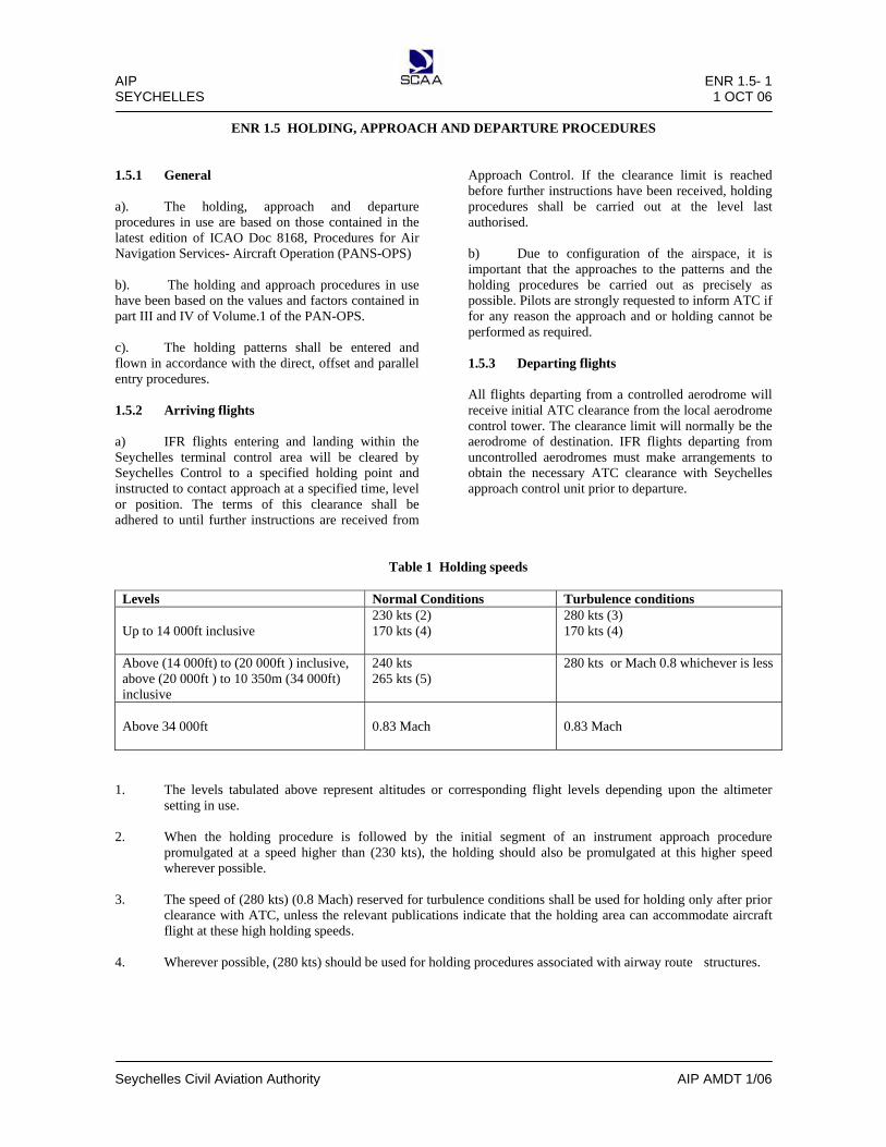
AIP ENR 1.5- 1 SEYCHELLES 1 OCT 06
Seychelles Civil Aviation Authority AIP AMDT 1/06
ENR 1.5 HOLDING, APPROACH AND DEPARTURE PROCEDURES
1.5.1 General
a). The holding, approach and departure procedures in use are based on those contained in the latest edition of ICAO Doc 8168, Procedures for Air Navigation Services- Aircraft Operation (PANS-OPS) b). The holding and approach procedures in use have been based on the values and factors contained in part III and IV of Volume.1 of the PAN-OPS. c). The holding patterns shall be entered and flown in accordance with the direct, offset and parallel entry procedures. 1.5.2 Arriving flights a) IFR flights entering and landing within the Seychelles terminal control area will be cleared by Seychelles Control to a specified holding point and instructed to contact approach at a specified time, level or position. The terms of this clearance shall be adhered to until further instructions are received from
Approach Control. If the clearance limit is reached before further instructions have been received, holding procedures shall be carried out at the level last authorised. b) Due to configuration of the airspace, it is important that the approaches to the patterns and the holding procedures be carried out as precisely as possible. Pilots are strongly requested to inform ATC if for any reason the approach and or holding cannot be performed as required. 1.5.3 Departing flights All flights departing from a controlled aerodrome will receive initial ATC clearance from the local aerodrome control tower. The clearance limit will normally be the aerodrome of destination. IFR flights departing from uncontrolled aerodromes must make arrangements to obtain the necessary ATC clearance with Seychelles approach control unit prior to departure.
Table 1 Holding speeds
Levels Normal Conditions Turbulence conditions Up to 14 000ft inclusive
230 kts (2) 170 kts (4)
280 kts (3) 170 kts (4)
Above (14 000ft) to (20 000ft ) inclusive, above (20 000ft ) to 10 350m (34 000ft) inclusive
240 kts 265 kts (5)
280 kts or Mach 0.8 whichever is less
Above 34 000ft
0.83 Mach
0.83 Mach
1. The levels tabulated above represent altitudes or corresponding flight levels depending upon the altimeter setting in use. 2. When the holding procedure is followed by the initial segment of an instrument approach procedure
promulgated at a speed higher than (230 kts), the holding should also be promulgated at this higher speed wherever possible.
3. The speed of (280 kts) (0.8 Mach) reserved for turbulence conditions shall be used for holding only after prior
clearance with ATC, unless the relevant publications indicate that the holding area can accommodate aircraft flight at these high holding speeds.
4. Wherever possible, (280 kts) should be used for holding procedures associated with airway route structures.

AIP ENR 1.5- 2 SEYCHELLES 23 AUG 12
Seychelles Civil Aviation Authority AIP AIRAC AMDT 1/12
Table II Speeds for procedures calculated in knots (kts)
Aircraft Category
V at Range of speeds for
initials approach
Range of final
approach speeds
Max speeds for visual
manoeuvring (circle)
Max speeds for missed approach
Intermediate Final
A <91kts 90/150(100)*
70/100 100 100 110
B 91/120kts 120/180(140)*
85/130 135 130 150
C 121/140kts 160/240
115/160 180 160 240
D 141/165kts 185/250
130/185 205 185 265
E 166/210kts 185/250
155/230 240 230 275
Note 1: V at – speed at threshold based on 1.3 times stall speed in the landing configuration at maximum certified landing mass. Note 2: *Maximum speed for reversal and racetrack procedures. 1.5.4 Radio communication equipment failure procedures The procedures to be followed by aircraft in the FIR and TMA, up to the termination of the Transition Routes, which are required to maintain two way radio communications experiencing radio equipment failure, shall conform to those specified in ICAO Annex 2 - Rules of the Air, paragraph 3.6.5 applicable to IFR as follows: a) attempt shall be made to establish contact on another frequency appropriate to the route or area. If this attempt
fails, attempt to establish communication with other aircraft or other aeronautical stations on frequencies appropriate to the route or area;
b) If the attempts specified under (a) fail, the aircraft station shall transmit its message twice on the designated
frequency(ies), preceded by the phrase “TRANSMITTING BLIND” and, if necessary, include the addressee(s) for which the message is intended.
c) When an aircraft station is unable to establish communication due to receiver failure, it shall transmit reports at
the scheduled times, or positions, on the frequency in use, preceded by the phrase “TRANSMITTING BLIND DUE TO RECEIVER FAILURE”. The aircraft station shall transmit the intended message, following this by a complete repetition. During this procedure, the aircraft shall also advise the time of its next intended transmission and transmit information regarding the intention of the pilot-in-command with respect to the continuation of the flight of the aircraft.
d) maintain last assigned speed and level, or minimum flight altitude if higher, for a period of 20 minutes
following the aircraft’s failure to report its position over a compulsory reporting point and thereafter adjust level and speed in accordance with filed flight plan;
c) at the TMA, proceed according to flight plan route and relevant Transition Route to the terminating waypoint. For procedures to be followed beyond the Transition Routes see AD 2.22.3.

AIP ENR 1.6- 1 SEYCHELLES 1 OCT 06
Seychelles Civil Aviation Authority AIP AMDT 1/06
ENR 1.6 RADAR SERVICES AND PROCEDURES
1.6.1 No radar services are available within Seychelles FIR.

AIP ENR 1.7- 1 SEYCHELLES 03 APR 14
Seychelles Civil Aviation Authority AIP AMDT 1/14
ENR 1.7 ALTIMETER SETTING PRODEDURES
1.7.1 Introduction
a) The altimeter setting procedures in use conform to those contained in ICAO Doc 8168, Volume 1, Part 6 and are given in full below. Differences are shown in quotation marks. b) Transition altitudes are given on the instrument approach charts for Seychelles International Airport. c) QNH reports and temperature information for use in determining adequate terrain clearance are provided in MET broadcasts and are available on request from the air traffic services units. QNH values are given in Hecto Pascals. 1.7.2 Basic altimeter setting procedures
1.7.2.1 General a) The transition altitude for Seychelles International Airport is 4500ft QNH. b) Aerodrome beyond a distance of 25NM from the ARP of Seychelles International Airport, the transitional altitude is 3500ft QNH. c) Vertical positioning of aircraft when at or below the transition altitude is expressed in terms of altitudes. While passing through the transition layer, vertical positioning is expressed in terms of flight levels when ascending. d) Flight level zero is located at the atmospheric pressure level of 1013.2 hpa (29.92 inches). e). Consecutive flight levels are separated by a pressure interval corresponding to 500ft (152.4m) in the standard atmosphere. Example of the relationship between flight levels and altimeter indications are given in the following table, the metric equivalents being (29.92 inches).
Flight level (Number)
Altimeter (Feet)
Indication (Metres)
10 1000 300 15 1500 450 20 2000 600 50 5000 1500 100 10000 3050 150 15000 4550 200 20000 6100
1.7.3 Take-off and climb
A QNH altimeter setting is made available to aircraft in taxi clearance prior to take-off.
Vertical positioning of aircraft during climb is expressed in terms of altitude until reaching the transition altitude above which vertical positioning is expressed in terms of flight levels.
1.7.4 Vertical separation en-route
1.7.4.1 Vertical separation during en-route phase of flight shall be expressed in terms of flight levels at all times during an IFR flight.
1.7.4.2 IFR and VFR flights above 3000ft (900m) when
in level cruising flight shall be flown at such flight levels, corresponding to the magnetic tracks shown in the Table of Cruising Levels at 1.7.9 below.
1.7.4.3 However, due to the change in variation on the
tracks from Seychelles to Mauritius, Reunion and Coetivy, it has been agreed that traffic routing outbound from Seychelles on the Mauritius/ Reunion/Coetivy track will select WESTBOUND Flight levels i.e. 60, 80, 100, 280, 320, 340, 380, etc… whilst flights inbound to Seychelles on these tracks will select EASTBOUND Flight levels ie, 50, 70, 90, 290, 310, 330, 350, etc.
1.7.5 Approach and landing A QNH altimeter setting is made available in approach clearance and in clearance to enter the traffic circuit. QFE altimeter setting is available on request. Vertical positioning of aircraft during approach is controlled by reference to flight levels until reaching the transition level below which vertical positioning is controlled by reference to altitudes. 1.7.6 Missed approach The relevant portion of 2.1 and 2.4 shall be applied in the event of a missed approach. 1.7.7 Description of altimeter setting region
- Nil -
1.7.8 Flight planning The levels at which a flight is to be conducted shall be specified in a flight plan:- i) in terms of flight levels if the flight is to be conducted at or above the transition level, and

ENR 1.7-2 AIP 01 APR 09 SEYCHELLES
AIP AMDT 01/09 Seychelles Civil Aviation Authority
ii) in terms of altitude if the flight is to be conducted in the vicinity of an aerodrome and at below the transition altitude.
Note 1: Flights of short durations in the vicinity of an aerodrome may often be conducted only at altitude below the transition altitude (low level routes). Note 2: Flight levels are specified in a flight plan by numbers and not in terms of feet or meters as in the case with altitudes.
1.7.9 Table of cruising levels
IFR and VFR flights above 4200 feet in level cruising flight shall be flown at flight levels corresponding to the magnetic tracks shown in the following table so as to provide the required terrain and minimum vertical separation clearance, unless such flights are operating under flight conditions as stipulated in 1.7.4.2 above:
MAGNETIC TRACKS
EASTBOUND
WESTBOUND
000 degrees to 179 degrees
180 degrees to 359 degrees
IFR Flights
VFR Flights IFR Flights VFR flights
Altitude Altitude Altitude Altitude FL
Feet FL Feet FL Feet FL Feet
50 5000 55 5500 70 7000 75 7500 40 4000 45 4500 90 9000 95 9500 60 6000 65 6500 110 11000 115 11500 80 8000 85 8500 130 13000 135 13500 100 10000 105 10500 150 15000
NO VFR FLIGHTS ABOVE
FL145
120 12000 125 12500 170 17000 140 14000 145 14500 190 19000 160 16000
NO VFR FLIGHTS ABOVE
FL145
210 21000 180 18000 230 23000 200 20000 250 25000 220 22000 270 27000 240 24000 290 29000
RVSM
AIRSPACE
260 26000 310 31000 280 28000 330 33000 300 30000
RVSM
AIRSPACE
350 35000 320 32000 370 37000 340 34000 390 39000 360 36000 410 41000 380 38000 430 43000 400 40000 470 47000 450 45000 etc etc etc etc
Note: Some of the lower levels in the above table of cruising levels may not be usable due to terrain clearance requirements.

AIP ENR 1.8- 1 SEYCHELLES 1 APR 09
Seychelles Civil Aviation Authority AIP AMDT 1/09
ENR 1.8 REGIONAL SUPPLEMENTARY PROCEDURES (DOC 7030)
1.8.1 Introduction
The supplementary procedures in force are given in their entirety. Differences are shown in question marks. 1.8.2 Visual flights rules (ICAO Annex 2)
VFR flights operated within control zone established at an aerodrome serving international flights and in specified portions of the associated terminal control area shall:-
a) have two-way radio communications, b) obtain permission from the appropriate air traffic control unit, and c) report positions as required.
Note: The phrase ‘specified portions of the associated terminal control area’ is intended to signify at least those portions of the TMA to be used by IFR flights in association with approach, holding departure and noise abatement procedures.
1.8.3 Special application of instrument flight rules
Flights shall be conducted in accordance with the instrument flight rules when operating above FL245 within the TMA.
1.8.4 Air traffic advisory service (PANS- ATM)
Nil
1.8.5 Adherence to ATC approved route (ICAO Annex 2, Paragraph 3.6.2.2)
If an aircraft has inadvertently deviated from the route specified in its ATC clearance, it shall forthwith take action to regain such routes without delay as soon as the deviation has been confirmed.
1.8.6 RNP 10 Navigation Requirements 1.8.6.1 Introduction
ATC shall apply 10 minutes (or 100NM) lateral separation minima to aircraft which are approved for RNP 10 operations on all ATS routes implemented within the Seychelles FIR.
1.8.6.2 Pilots must advice ATC of any deterioration or failure of their navigation systems below the navigation
requirements for RNP 10. ATC shall then provide alternative separation or alternative routing. 1.8.6.3 An aircraft that is unable to meet the minimum navigational requirements for RNP 10 must file a flight plan at
or below FL280. Operations above FL280 for these aircraft will be subject to ATC approval and shall be based on the following:-
(a) traffic density; (b) communications facilities available; (c) weather conditions; (d) aircraft status (State Aircraft) or any other factors as deemed pertinent.
1.8.6.4 Pilots of such aircraft wishing to operate on ATS routes specified in 1.8.6.1, at FL 290 or above must indicate their level requirements at item 18 of the ICAO flight plan as RMK/REQ FL (insert level).

AIP ENR 1.8- 2 SEYCHELLES 1 APR 09
Seychelles Civil Aviation Authority AIP AMDT 1/09
1.8.6.4 An ATC Unit receiving a request for a non- RNP 10 approved aircraft to operate at FL290 or above on any ATS Route within Seychelles FIR, will coordinate with the adjacent ATC Units affected by the flight.
1.8.7 Safety Assessment Criteria 1.8.7.1 The safety criteria associated with the implementation of lateral separation of 100NM will be in accordance with
the requirements for RNP 10 navigation performance, ie, aircraft navigation performance accuracy of 95 percent lateral and longitudinal position accuracy of 10 NM (+ /-).
1.8.8 Monitoring of Aircraft Navigation Performance
Monitoring of aircraft navigation performance is a joint responsibility between operators, States of Registry or States of operators, as applicable, regulatory authorities and ATS providers. The ATC authority will investigate any causes of such deviations in conjunction with the aircraft operator and the State of Registry, or the State of the Operator as applicable.
1.8.9 Separation Minima 1.8.9.1 Lateral Separation Minima
A lateral separation minima of 10 minutes or 100NM shall be applied between aircraft equipped in accordance with RNP 10 navigation requirements, when operating on ATS Routes within Seychelles FIR.
1.8.9.2 Longitudinal Separation
A longitudinal separation of 10 minutes or 100NM shall be applied between aircraft equipped in accordance with RNP 10 navigation requirements, when operating on ATS Routes within Seychelles FIR.
1.8.9.3 Vertical Separation
A vertical separation minima of 1000 feet shall be applied between all aircraft operating at FL280 or below. A vertical separation minima of 1000 feet shall be applied between all RVSM approved aircraft, including State aircraft operating between FL290 and FL 410. A vertical separation minima of 2000 feet shall be applied all between all aircraft operating above FL410. A vertical separation minima of 2000 feet shall be applied between State non-RVSM aircraft and RVSM approved aircraft when operating in RVSM airspace between FL290 and FL410.
1.8.10 Operator’s Procedures 1.8.10.1 The aircraft operator shall ensure in-flight procedures, crew manuals and training programmes are established in
accordance with RNP 10 navigation requirements. 1.8.11 Weather Deviation 1.8.11.1 Pilots experiencing adverse weather conditions and wishing to deviate from filed flight plan/track shall request
approval from ATC where two-way communication is available. In the case where two-way communication is not available (HF radio) with the designated ATC Unit, pilots shall broadcast their intensions on the last HF frequency in use and on VHF frequencies 121.5 Mhz and 126.9 Mhz before commencing the deviation.
1.8.11.2 If aircraft is ACAS equipped, pilot must monitor and follow any RA /TA that are received for traffic collision
avoidance measures. 1.8.11.3 Once the deviation is terminated and the aircraft is back on its designated route, pilots shall broadcast this
information on the last HF frequency is use with the designated ATC Unit and also on VHF 121.5 Mhz and 126.9 Mhz.

AIP ENR 1.8- 3 SEYCHELLES 1 APR 09
Seychelles Civil Aviation Authority AIP AMDT 1/09
1.8.12 ATS Contingency Procedures 1.8.12.1 Details regarding applicable ATS contingency plan containing procedures in place to ensure the continued
safety of air navigation in the event of complete or partial disruptions of air traffic services within the Seychelles Flight Information Region are published in AIP Supplement 01/08, dated 1st April 2008.
1.8.13 Operation of Airborne Collision Avoidance Systems(ACAS) 1.8.13.1 Pilots Responsibilities
ACAS is intended to serve as a support to visual collision avoidance, application of right-of-way rules and air traffic separation services. For ACAS to work as designated, immediate and correct crew response to ACAS advisories is essential. Delayed crew response or reluctance of flight crew to adjust the aircraft’s flight path, as advised by ACAS due to air traffic control clearance provisions or other operational factors, could significantly decrease or negate the protection afforded by ACAS. When operating within Seychelles Flight Information region, flight crews are expected to respond to ACAS in accordance with the following guidelines:
a) Respond to TA’s by attempting to establish visual contact with the intruder aircraft and other aircraft that may be in the vicinity. Coordinate to the degree possible with other crew members and ATC to assist in searching for the traffic. Do not deviate from an assigned clearance based only on TA information. For any traffic that is acquired visually, continue to maintain or attain a safe separation in accordance with current regulations and accepted operating practise.
b) When an RA occurs, the pilot should respond immediately by direct attention to RA displays and
manoeuvre as indicated, unless doing so would jeopardise the safe operation of the flight, or the flight crew can assure separation with the help of definitive visual acquisition of the aircraft causing the RA. By not responding to the RA, the flight crew effectively takes responsibility for achieving safe operation. In doing so, the following should be taken into consideration:
i) The traffic acquired visually may also be equipped with ACAS and it may manoeuvre in
response to the RA that has been automatically coordinated with you own ACAS; ii) The traffic acquired visually may not be the same aircraft causing the RA;
iii) Visual perception of the encounter may be misleading unless it is positively clear that the
target acquired visually or confirmed by ATC is the one generating the RA and there are no other complicating circumstances. The pilot’s instinctive reaction should always be to respond to RA’s in the direction and to the degree displayed.
c) Inform ATC of TA/RA and avoiding action taken and file an MOR as appropriate, to be
forwarded to the and forward a copy to the Chief Executive Officer, SCAA, for safety investigation requirements.
1.8.13.2 ATCOs responsibilities
a) Upon receipt of TA/RA information from a pilot, the ATCO should attempt to establish the identity of the intruder aircraft as far as practicable. The ATCO should not attempt to issue clearances that would negate the correcting action being taken by the pilot as a result of a TA/RA occurrence. The ATCO immediately double check all clearances issued to the aircraft concerned in order to determine the possible cause of the confliction.
b) The ATCO shall log down the events of the occurrence, inform the immediate Supervisor and shall
file an MOR as appropriate. The occurrence shall be thoroughly investigated and safety recommendations implemented to avoid recurrences.

AIP ENR 1.9- 1 SEYCHELLES 1 OCT 06
Seychelles Civil Aviation Authority AIP AMDT 1/06
ENR 1.9 AIR TRAFFIC FLOW MANAGEMENT
1.9.1 Air Traffic Flow Management techniques are not applicable within Seychelles FIR.

AIP ENR 2.1-1 SEYCHELLES 03 APR 14
Seychelles Civil Aviation Authority AIP AIRAC AMDT 1/14
ENR 2.1- FIR, UIR, TMA
Name Lateral limit
Vertical limits Class of airspace
Unit providing
service
Callsign Languages Area and
conditions of use Hours of service
Frequency/purpose
Remarks
1 2 3 4 5 SEYCHELLES FIR 02 00 00 S 044 00 00 E 10 42 00 N 060 00 00 E 10 00 00 S 060 00 00 E 10 00 00 S 045 00 00 E 10 20 00 S 044 00 00 E 02 00 00 S 044 00 00 E
UNL --------------------------
GND /MSL Class of airspace applicable within Seychelles FIR:- A- Airspace bounded by Seychelles FIR
above FL145 to unlimited; D- Airspace within the TMA, between
FL65 to FL145 and within the control zone;
E- Airspace from FL65 to FL145 beyond 200nm radius from PRA DVOR;
G- Airspace outside the control zone and terminal control area, below FL65.
Seychelles ACC
Seychelles Control ENG /H24
120.20 Mhz 121.50 Mhz/ Emergency Frequency INO-1 AFI-3
3476 3467 5634 5517 8879 5658
13306 11300 13288
AFI- 4 10018
SELCAL AVBL
UIR; NIL
SEYCHELLES TMA
A circle of 200NM radius centered on PRA DVOR (04 18 26.52 S 055 42 25.44 E)
UNL --------------------------------------
FL 65 Class of Airspace: A & D.
SEYCHELLES CONTROL ZONE
A circle of 20 NM radius centred on SEY” DVOR (04 40 36.83 S 055 31 59.20 E) AMSL/ up to F65 Class of Airspace: D.
Seychelles APP Seychelles APP Note: Combined approach and aerodrome control provided.
Seychelles Approach ENG /H24
119.70 Mhz Freq 118.30 Mhz 121.50 Mhz / Emergency frequency
Note1: All flights intending to operate within the Seychelles FIR shall file a flight plan and contact Seychelles ACC on HF radio at least 20 minutes prior to entering the FIR. Pilots shall also maintain two-way radio communication and report position as instructed. Note 2: All Airline Operators who have aircraft equipped with satellite telephone (SATPHONE) are to note that Seychelles Air Traffic Control Centre can be contacted on the following telephone numbers in case of HF/VHF communications failure while flying within the Seychelles FIR: - (248) 4384193 or (248) 4384000.

ENR 2.1-2 AIP 23 AUG 12 SEYCHELLES
AIP AIRAC AMDT 01/12 Seychelles Civil Aviation Authority
INTENTIONALLY LEFT BLANK

AIP ENR 2.2-1 SEYCHELLES 23 AUG 12
Seychelles Civil Aviation Authority AIP AIRAC AMDT 1/12
ENR 2.2- OTHER REGULATED AIRSPACE
2.2.1 No other regulated airspace has been established within the Seychelles FIR.

AIP ENR 2.2-2 SEYCHELLES 23 AUG 12
Seychelles Civil Aviation Authority AIP AIRAC AMDT 1/12
Intentionally Left Blank

AIP ENR 3.1-1 SEYCHELLES 23 AUG 12
Seychelles Civil Aviation Authority AIP AIRAC AMDT 1/12
ENR 3.1 LOWER ATS ROUTES
Route designator Names of significant
Points Coordinates
Track MAG (GEO)
VOR RDL DIST
(COP)
Upper limits Lower limits
Airspace
Classification
Lateral limits (NM)
Direction of cruising levels
VAR (MAG)
Remarks Controlling
Unit Frequency
1 2 3 4 5 6 7
N628
▲BUSUX (FIR BDRY) 03 55 00.00 S 060 00 00.00 E ▲GITOP 04 00 24.00 S 059 01 54.00 E ▲PRASLIN (PRA) VOR/DME 04 18 26.52 S 055 42 25.49 E
090˚ 270˚
58NM
FL245 FL65
Class A Above F145
100
Eastbound
↓ ↑
Westbound
W 5.7233
Seychelles
ACC FREQ:
120.20MHZ 3467KHZ 3476KHZ 5634KHZ 5517KHZ 7595KHZ 8879KHZ 8890KHZ
11 300KHZ 10 018KHZ 13 288KHZ 13 351KHZ 17 961KHZ
090˚ 270˚
200NM
W 5.6314
W 5.2272
A610
▲XABON (FIR BDRY) 04 08 28.11S 044 00 00.00 E ▲LOTER 04 10 30.85 S 045 39 11.37 E ▲ANTIS 04 11 54.89 S 046 53 52.90 E ▲ALRUS 04 13 00.44 S 047 57 50.58 E ▲KATEB 04 15 30.00 S 052 22 18.00 E ▲PRASLIN (PRA) VOR/DME 04 18 26.52 S 055 42 25.49 E
093˚ 273˚
99NM
FL245 FL65
Class A Above F145
100
Eastbound
↓ ↑
Westbound
W 2.2798
Seychelles
ACC FREQ:
120.20MHZ 3 467KHZ 3476KHZ 5634KHZ 5517KHZ 7595KHZ 8879KHZ 8890KHZ
11 300KHZ 10 018KHZ 13 288KHZ 13 351KHZ 17 961KHZ
093˚ 273˚
75NM
W 2.7258
093˚ 273˚
64NM
W 3.0668
093˚ 274˚
264 NM
W 3.3584
094˚ 275˚
200NM
W 4.4995
W 5.2272

AIP ENR 3.1-2 SEYCHELLES 23 AUG 12
Seychelles Civil Aviation Authority AIP AIRAC AMDT 1/12
ENR 3.1 LOWER ATS ROUTES
Route designator Names of significant
Points Coordinates
Track MAG (GEO)
VOR RDL DIST
(COP)
Upper limits Lower limits
Airspace
Classification
Lateral limits (NM)
Direction of cruising levels
VAR (MAG)
Remarks Controlling
Unit Frequency
1 2 3 4 5 6 7
B459
MIROV
(FIR BDRY) 10 00 00.00 S 052 36 08.00 E
NORSI 07 15 15.00 S 054 07 17.00 E
PRASLIN (PRA) VOR/DME 04 18 26.52 S 055 42 25.49 E
BOMOB 01 34 30.00 S 057 38 24.00 E
CLAVA (FIR BDRY) 01 46 12.11 N 060 00 00.00 E
036˚ 215
187 NM
FL245 FL65
Class A Above F145
100
Eastbound
↓ ↑
Westbound
W 7.9342
Seychelles ACC FREQ:
120.20MHZ 3 467KHZ 3476KHZ 5634KHZ 5517KHZ 5658KHZ 7595KHZ 8879KHZ 8890KHZ
11 300KHZ 10 018KHZ 13 288KHZ 13 351KHZ 17 961KHZ
035˚ 213
200NM
W 6.4825
040˚ 219
200NM
W 5.2272
039˚ 219
245NM
W 4.3732
W 3.5315
G424
ANVET
(FIR BDRY) 03 11 14.85 S 044 00 00.00 E
MITCH 02 00 00.00 S 045 31 36.66 E GEPAR 01 07 35.11 S 046 38 32.73 E
GABTO 00 11 19.89 N 048 19 12.18 E
053˚ 233˚
116NM
FL245 FL65
Class A Above F145
100
Eastbound
↓ ↑
Westbound
W 1.8955
Seychelles
ACC FREQ:
120.20MHZ 3 467KHZ 3476KHZ 5634KHZ 5517KHZ 5658KHZ 7595KHZ 8879KHZ 8890KHZ
11 300KHZ 10 018KHZ 13 288KHZ 13 351KHZ 17 961KHZ
053˚ 233˚
85NM
W 1.8595
053˚ 233˚
128NM
W 1.8302
053˚ 234˚
167NM
W 1.7667

AIP ENR 3.1-3 SEYCHELLES 23 AUG 12
Seychelles Civil Aviation Authority AIP AIRAC AMDT 1/12
ENR 3.1 LOWER ATS ROUTES
Route designator Names of significant
Points Coordinates
Track MAG (GEO)
VOR RDL DIST
(COP)
Upper limits Lower limits
Airspace
Classification
Lateral limits (NM)
Direction of cruising levels
VAR (MAG)
Remarks Controlling
Unit Frequency
1 2 3 4 5 6 7
ITPOK 01 54 19.89 N 050 30 39.02 E
UNKOB 03 36 51.81 N 052 42 00.00 E IMKOT 05 23 50.58 N 055 00 00.00 E
NEROT 07 41 36.81 N 058 00 00.00 E
VUTAS (FIR BDRY) 09 12 00.00 N 060 00 00.00 E
053˚ 234˚
167 NM
FL245 FL65
Class A Above F145
100
Eastbound
↓ ↑
Westbound
W 1.7507
Seychelles ACC FREQ:
120.20MHZ 3 467KHZ 3476KHZ 5634KHZ 5517KHZ 7595KHZ 8879KHZ
11300KHZ 10 018KHZ 13 288KHZ 13 351KHZ 17 961KHZ
053˚ 234˚
174NM
W 1.7509
053˚ 234˚
226NM
W 1.7393
054˚ 235˚
149NM
W 1.7057
W 1.6605
G465
NESAM
(FIR BDRY) 10 00 00.00 S 048 31 54.00 E
OKLAB 06 24 37.00 S 053 06 29.00 E PRASLIN (PRA) VOR/DME 04 18 26.52 S 055 42 25.49 E
ORLOM 02 58 36.00 S 058 46 06.00 E OTKIR
(FIR BDRY) 02 26 19.49 S 060 00 00.00 E
058˚ 238˚
347NM
FL245 FL65
Class A Above F145
100
Eastbound
↓ ↑
Westbound
W 6.8410
Seychelles ACC FREQ:
120.20MHZ 3 467KHZ 3476KHZ 5634KHZ 5517KHZ 7595KHZ 8879KHZ 8890KHZ
11300KHZ 10 018KHZ 13 288KHZ 13 351KHZ 17 961KHZ
057˚ 236˚
200NM
W 5.7702
072˚ 251˚
200NM
W 5.2272
072˚ 251˚
200NM
W 5.1319
071˚ 251˚
81 NM
W 5.0692

AIP ENR 3.1-4 SEYCHELLES 23 AUG 12
Seychelles Civil Aviation Authority AIP AIRAC AMDT 1/12
ENR 3.1 LOWER ATS ROUTES
Route designator
Names of significant Points
Coordinates
Track MAG (GEO)
VOR RDL DIST
(COP)
Upper limits Lower limits
Airspace
Classification
Lateral limits (NM)
Direction of cruising levels
VAR (MAG)
Remarks Controlling
Unit Frequency
1 2 3 4 5 6 7
G658
NETAR
(FIR BDRY) 02 27 40.44 S 044 00 00.00 E
NIBAK 03 01 11.95 S 047 27 04.79 E
DEBNO 03 25 29.55 S 050 00 00.00 E
DANEL 03 48 06.00 S 052 24 30.00 E
PRASLIN (PRA) VOR/DME 04 18 26.52 S 055 42 25.49 E
101˚ 281˚
209NM
FL245 FL65
Class A Above F145
Eastbound
↓ ↑
Westbound
W 1.6233
Seychelles ACC FREQ:
120.20MHZ 3 467KHZ 5634KHZ 5517KHZ 5658KHZ 7595KHZ 8879KHZ
10 018KHZ 13 306KHZ 13 288KHZ 13 351KHZ 17 961KHZ
101˚ 282˚
155NM
W 2.7102
102˚ 282˚
146NM
W 3.5335
102˚ 284˚
200NM
W 4.2871
W 5.2272
R400
EGLOM
(FIR BDRY) 00 44 55.66 N 047 24 12.08 E
GABTO 00 11 19.89 N 048 19 12.18 E
UTOPA 01 26 51.42 S 051 00 00.00 E
122˚ 302˚
64NM
FL245 FL65
Class A Above F145
Eastbound
↓ ↑
Westbound
W 1.3773
Seychelles ACC FREQ:
120.20MHZ 3 467KHZ 5634KHZ 5517KHZ 5658KHZ 7595KHZ 8879KHZ
10 018KHZ 13 306KHZ 13 288KHZ 13 351KHZ 17 961KHZ
122˚ 303˚
188NM
W 1.7667
123˚ 304˚
130NM
W 2.9749

AIP ENR 3.1-5 SEYCHELLES 23 AUG 12
Seychelles Civil Aviation Authority AIP AIRAC AMDT 1/12
ENR 3.1 LOWER ATS ROUTES
Route designator Names of significant
Points Coordinates
Track MAG (GEO)
VOR RDL DIST
(COP)
Upper limits Lower limits
Airspace
Classification
Lateral limits (NM)
Direction of cruising levels
VAR (MAG)
Remarks Controlling
Unit Frequency
1 2 3 4 5 6 7
R400
▲ MOGUD 02 34 36.00 S 052 51 12.00 E ▲ PRASLIN VOR/DME 04 18 26.52 S 055 42 25.49 E ▲ RERUS 07 38 00.00 S 056 05 36.00 E ▲ ALRAN (FIR BDRY) 10 00 00.00 S 056 22 21.02 E
124˚ 306˚
200 NM
FL245 FL65
Class A Above F145
100
Eastbound
↓ ↑
Westbound
Westbound ↓ ↑
Eastbound
W 3.8514
Seychelles ACC FREQ:
120.20MHZ 3467KHZ 3476KHZ 5634KHZ 5517KHZ 7595KHZ 8879KHZ 8890KHZ 11300KHZ 10 018KHZ 13 288KHZ 13 351KHZ 17 961KHZ
178˚ 360˚
200NM
W 5.2272
180˚ 001˚
142NM
W 7.1055
W 8.7176
R212
▲ PERRY (FIR BDRY) 06 00 00.00 S 060 00 00.00 E ▲ PRASLIN (PRA) VOR/DME 04 18 26.52 S 055 42 25.49 E
117˚ 298˚
276NM
FL245 FL65
Class A Above F145
100
Eastbound
↓ ↑
Westbound
W 6.7650
W 5.2272
R401
▲ AXINA (FIR BDRY) 06 49 46.83 N 055 00 00.00 E ▲ IMKOT 05 23 50.58 N 055 00 00.00 E ▲UTRON 02 00 00.00 N 055 14 53.96 E
183˚ 003˚
86NM
FL245 FL65
Class A Above F145
100
Westbound
↓ ↑
Eastbound
W 1.4104
Seychelles ACC FREQ:
120.20MHZ 3467KHZ 3476KHZ 5634KHZ 5517KHZ 7595KHZ 8879KHZ 8890KHZ 11300KHZ 10 018KHZ 13 288KHZ 13 351KHZ 17 961KHZ
177˚ 358˚
203NM
W 1.7393
178˚ 359˚
177NM
W 2.7047

AIP ENR 3.1-6 SEYCHELLES 23 AUG 12
Seychelles Civil Aviation Authority AIP AIRAC AMDT 1/12
ENR 3.1 LOWER ATS ROUTES
Route designator Names of significant
Points Coordinates
Track MAG (GEO)
VOR RDL DIST
(COP)
Upper limits Lower limits
Airspace
Classification
Lateral limits (NM)
Direction of cruising levels
VAR (MAG)
Remarks Controlling
Unit Frequency
1 2 3 4 5 6 7
R401
UDLET
00 57 54.00 S 055 27 48.00 E
PRASLIN (PRA) VOR/DME 04 18 26.52 S 055 42 25.49 E
RUBAM 07 39 18.00 S 055 40 24.00 E
AMBAN (FIR BDRY) 10 00 00.00 S 055 38 55.17 E
179˚ 001˚
200 NM
FL245 FL65
Class A Above F145
100
Westbound
↓ ↑
Eastbound
W 3.7519
Note 1. Southbound traffic shall maintain westbound semicircular flight levels. Note 2. Northbound traffic shall maintain eastbound semicircular flight levels.
186˚ 007˚
200 NM
W 5.2272
187˚ 008˚
140NM
W 7.0401
W 8.5871
R775
▲ UNPAR 00 49 21.38 S 045 27 31.03 E ▲ MITCH 02 00 00.00 S 045 31 36.66 E ▲ SOKAR 06 00 00.00 S 045 45 34.88 E ▲ BERIL (FIR BDRY) 10 00 00.00 S 045 59 45.43 E
177˚ 358˚
70NM
FL245 FL65
Class A Above F145
100
Eastbound
↓ ↑
Westbound
W 1.4090
Seychelles ACC FREQ:
120.20MHZ 3467KHZ 3476KHZ 5634KHZ 5517KHZ 7595KHZ 8879KHZ 8890KHZ
11300KHZ 10 018KHZ 13 288KHZ 13 351KHZ 17 961KHZ
178˚ 359˚
239NM
W 1.8302
179˚ 001˚
239NM
W 3.6118
W 6.0767

AIP ENR 3.1-7 SEYCHELLES 23 AUG 12
Seychelles Civil Aviation Authority AIP AIRAC AMDT 1/12
ENR 3.1 LOWER ATS ROUTES
Route designator
Names of significant Points
Coordinates
Track MAG (GEO)
VOR RDL DIST
(COP)
Upper limits Lower limits
Airspace
Classification
Lateral limits (NM)
Direction of cruising levels
VAR (MAG)
Remarks Controlling
Unit Frequency
1 2 3 4 5 6 7
R780
▲ APKAK (FIR BDRY) 00 11 20.98 S 046 14 33.34 E ▲ GEPAR 01 07 35.11 S 046 38 32.73 E ▲ NIBAK 03 01 11.95 S 047 27 04.79 E ▲ ALRUS 04 13 00.44 S 047 57 50.58 E ▲ UVDOX 07 00 00.00 S 049 09 41.64 E ▲ DENLI (FIR BDRY) 10 00 00.00 S 050 28 06.00 E
158˚ 338˚
61 NM
158˚ 338˚
123NM
159˚ 339˚
78NM
159˚ 340˚
184NM
160˚ 342˚
195NM
FL245 FL65
Class A Above F145
100
Eastbound
↓ ↑
Westbound
W 1.3920
W 1.7970
W 2.7102
W 3.3584
W 5.1012
W 7.3876
Seychelles ACC FREQ:
120.20MHZ 3467KHZ 3476KHZ 5634KHZ 5517KHZ 7595KHZ 8879KHZ 8890KHZ
11300KHZ 10 018KHZ 13 288KHZ 13 351KHZ 17 961KHZ
R 782
▲ BERIL (FIR BDRY) 10 00 00.00 S 045 59 45.43 E ▲ TIKAR 08 00 00.00 S 049 27 51.03 E ▲ MIRON 06 01 12.00 S 052 50 12.00 E ▲ PRASLIN VOR/DME 04 18 26.52 S 055 42 25.49 E
065˚ 244˚
238NM
064˚ 244˚
233NM
064˚ 244˚
200NM
FL245 FL65
Class A Above F145
100
Eastbound
↓ ↑
Westbound
W 6.0767
W 5.7783
W 5.4946
W 5.2272

AIP ENR 3.1-8 SEYCHELLES 23 AUG 12
Seychelles Civil Aviation Authority AIP AIRAC AMDT 1/12
ENR 3.1 LOWER ATS ROUTES Route designator
Names of significant Points
Coordinates
Track MAG (GEO)
VOR RDL DIST
(COP)
Upper limits Lower limits
Airspace
Classification
Lateral limits (NM)
Direction of cruising levels
Remarks Controlling
Unit Frequency
1 2 3 4 5 6 7
W735
▲ AVIMO (FIR BDRY) 03 32 52.00 S 050 52 39.00 E ▲ APNAK 01 00 00.00 N 052 26.07 E ▲ ATUTI 01 27 33.07 S 053 57 12.34 E ▲ PRASLIN VOR/DME 04 18 26.52 S 055 42 25.49 E
148˚ 332˚
176 NM
148˚ 332˚
174NM
150˚ 330˚
200NM
FL245 FL65
Class A Above F145
100
Eastbound
↓ ↑
Westbound
W 1.3822
W 2.4515
W 3.6417
W 5.2272
Seychelles ACC REQ: 120.20MHZ 3467KHZ 3476KHZ 5634KHZ 5517KHZ 7595KHZ 8879KHZ 8890KHZ
11300KHZ 10 018KHZ 13 288KHZ 13 351KHZ 17 961KHZ

AIP ENR 3.1-9 SEYCHELLES 23 AUG 12
Seychelles Civil Aviation Authority AIP AIRAC AMDT 1/12
ENR 3.1 LOWER ATS ROUTES
Route designator Names of significant
Points Coordinates
Track MAG (GEO)
VOR RDL DIST
(COP)
Upper limit Lower limit
Airspace
classification
Lateral Limits
Direction of cruising levels
VAR (MAG
Remarks Controlling/
Unit Frequency
1 2 3 4 5 6 7
M609
▲ KISAK (FIR BDRY) 07 50 00.00 S 044 00 00.00 E ▲ ATOLA (FIR BDRY) 10 00 00.00S 046 28 36.30 E
134˚ 315˚
194NM
FL245 FL65
Class A Above F145
100
Eastbound
↓ ↑
Westbound
W 4.0997
W 6.2244
Seychelles ACC FREQ:
120.20MHZ 3467KHZ 3476KHZ 5634KHZ 5517KHZ 7595KHZ 8879KHZ 8890KHZ
11300KHZ 10 018KHZ 13 288KHZ 13 351KHZ 17 961KHZ
M651
▲ ESTOK (FIR BDRY) 02 42 41.02 N 049 50 10.76 E ▲ ITPOK 01 54 19.89 N 050 30 39.02 E ▲ TEXAR 00 07 23.66 N 052 00 00.00 E ▲ ANVIX 01 44 36.00 S 053 33 36.00 E ▲PRASLIN (PRA) VOR/DME 04 18 26.52 S
055 42 25.49
141˚ 321˚
63NM
141˚ 322˚
139NM
142˚ 323˚
146NM
143˚ 325˚
200NM
FL245 FL65
Class A Above F145
100
Eastbound
↓ ↑
Westbound
W 1.3755
W 1,7507
W 2.6421
W 3.6677
W 5.2272
M665
▲ ITLOX (FIR BDRY) 01 10 19.05 S 045 01 33.89 E ▲ MITCH 02 00 00.00 S 045 31 36.66 E ▲ ANTIS 04 11 54.89 S 046 53 52.90 E ▲ UVESO 07 00 00.00 S 048 39 35.75 E ▲ ANKOR 10 00 00.00 S 050 34 50.00 E
149˚ 330˚
56NM
149˚ 329˚
151NM
150˚ 331˚
201NM
151˚ 333˚
212NM
FL245 FL65
Class A Above F145
100
Eastbound
↓ ↑
Westbound
W 1.4211
W 1.8302
W 3.0668
W 4.9628
W 7.4180
Seychelles ACC FREQ:
120.20MHZ 3467KHZ 3476KHZ 5634KHZ 5517KHZ 7595KHZ 8879KHZ 8890KHZ
11300KHZ 10 018KHZ 13 306KHZ 13 288KHZ 13 351KHZ 17 961KHZ

AIP ENR 3.1-10 SEYCHELLES 23 AUG 12
Seychelles Civil Aviation Authority AIP AIRAC AMDT 1/12
ENR 3.1.1 LOW LEVEL IFR ROUTES
3.1.1.1 Low Level IFR Transit Routes have been implemented in Seychelles International Airport and the following islands: i) Bird Island (FSSB) ii) Denis Island (FSSD) iii) Fregate Island (FSSF) iv) Praslin Island (FSPP) 3.1.1.2 Two charts have been provided applicable for single aircraft operation or multiple aircraft operation along such routes. 3.1.1.3 Charts are available at ENR 6.1-5 and 6.1-7.

AIP ENR 3.2-1 SEYCHELLES 23 AUG 12
Seychelles Civil Aviation Authority AIP AIRAC AMDT 1/12
ENR 3.2 UPPER ATS ROUTES
Route designator Names of significant
Points Coordinates
Track MAG (GEO)
VOR RDL DIST
(COP)
Upper limits Lower limits
Airspace
Classification
Lateral limits (NM)
Direction of cruising levels
VAR (MAG)
Remarks Controlling
Unit Frequency
1 2 3 4 5 6 7
N628
▲BUSUX (FIR BDRY) 03 55 00.00 S 060 00 00.00 E ▲GITOP 04 00 24.00 S 059 01 54.00 E ▲PRASLIN (PRA) VOR/DME 04 18 26.52 S 055 42 25.49 E
090˚ 270˚
58NM
UNL
FL245
Class A Above F145
100
Eastbound
↓ ↑
Westbound
W 5.7233
Seychelles ACC FREQ:
120.20MHZ 3467KHZ 3476KHZ 5634KHZ 5517KHZ 7595KHZ 8879KHZ 8890KHZ
11300KHZ 10 018KHZ 13 288KHZ 13 351KHZ 17 961KHZ
090˚ 270˚
200NM
W 5.6314
W 5.2272
UA610
▲XABON (FIR BDRY) 04 08 28.11S 044 00 00.00 E ▲LOTER 04 10 30.85 S 045 39 11.37 E ▲ANTIS 04 11 54.89 S 046 53 52.90 E ▲ALRUS 04 13 00.44 S 047 57 50.58 E ▲KATEB 04 15 30.00 S 052 22 18.00 E ▲PRASLIN (PRA) VOR/DME 04 18 26.52 S 055 42 25.49 E
093˚ 273˚
99NM
UNL
FL245
Class A Above F145
100
Eastbound
↓ ↑
Westbound
W 2.2798
Seychelles ACC FREQ:
120.20MHZ 3467KHZ 3476KHZ 5634KHZ 5517KHZ 7595KHZ 8879KHZ 8890KHZ
11300KHZ 10 018KHZ 13 288KHZ 13 351KHZ 17 961KHZ
093˚ 273˚
75NM
W 2.7258
093˚ 273˚
64NM
W 3.0668
093˚ 274˚
264 NM
W 3.3584
094˚ 275˚
200NM
W 4.4995
W 5.2272

AIP ENR 3.2-2 SEYCHELLES 23 AUG 12
Seychelles Civil Aviation Authority AIP AIRAC AMDT 1/12
ENR 3.2 UPPER ATS ROUTES
Route designator Names of significant
Points Coordinates
Track MAG (GEO)
VOR RDL DIST
(COP)
Upper limits Lower limits
Airspace
Classification
Lateral limits (NM)
Direction of cruising levels
VAR (MAG)
Remarks Controlling
Unit Frequency
1 2 3 4 5 6 7
UB459
MIROV
(FIR BDRY) 10 00 00.00 S 052 36 08.00 E
NORSI 07 15 15.00 S 054 07 17.00 E
PRASLIN (PRA) VOR/DME 04 18 26.52 S 055 42 25.49 E
BOMOB 01 34 30.00 S 057 38 24.00 E
CLAVA (FIR BDRY) 01 46 12.11 N 060 00 00.00 E
036˚ 215
187 NM
UNL
FL245
Class A Above F145
100
Eastbound
↓ ↑
Westbound
W 7.9342
Seychelles ACC FREQ:
120.20MHZ 3467KHZ 3476KHZ 5634KHZ 5517KHZ 7595KHZ 8879KHZ 8890KHZ
11300KHZ 10 018KHZ 13 288KHZ 13 351KHZ 17 961KHZ
035˚ 213
200NM
W 6.4825
040˚ 219
200NM
W 5.2272
039˚ 219
245NM
W 4.3732
W 3.5315
UG424
ANVET
(FIR BDRY) 03 11 14.85 S 044 00 00.00 E
MITCH 02 00 00.00 S 045 31 36.66 E GEPAR 01 07 35.11 S 046 38 32.73 E
GABTO 00 11 19.89 N 048 19 12.18 E
053˚ 233˚
116NM
UNL
FL245
Class A Above F145
100
Eastbound
↓ ↑
Westbound
W 1.8955
Seychelles ACC FREQ:
120.20MHZ 3467KHZ 3476KHZ 5634KHZ 5517KHZ 7595KHZ 8879KHZ 8890KHZ
11300KHZ 10 018KHZ 13 288KHZ 13 351KHZ 17 961KHZ
053˚ 233˚
85NM
W 1.8595
053˚ 233˚
128NM
W 1.8302
053˚ 234˚
167NM
W 1.7667

AIP ENR 3.2-3 SEYCHELLES 23 AUG 12
Seychelles Civil Aviation Authority AIP AIRAC AMDT 1/12
ENR 3.2 UPPER ATS ROUTES
Route designator Names of significant
Points Coordinates
Track MAG (GEO)
VOR RDL DIST
(COP)
Upper limits Lower limits
Airspace
Classification
Lateral limits (NM)
Direction of cruising levels
VAR (MAG)
Remarks Controlling
Unit Frequency
1 2 3 4 5 6 7
ITPOK 01 54 19.89 N 050 30 39.02 E
UNKOB 03 36 51.81 N 052 42 00.00 E IMKOT 05 23 50.58 N 055 00 00.00 E
NEROT 07 41 36.81 N 058 00 00.00 E
VUTAS (FIR BDRY) 09 12 00.00 N 060 00 00.00 E
053˚ 234˚
167 NM
UNL
FL245
Class A Above F145
100
Eastbound
↓ ↑
Westbound
W 1.7507
Seychelles ACC FREQ:
120.20MHZ 3467KHZ 3467KHZ 5634KHZ 5517KHZ 7595KHZ 8879KHZ 8890KHZ
11300KHZ 10 018KHZ 13 288KHZ 13 351KHZ 17 961KHZ
053˚ 234˚
174NM
W 1.7509
053˚ 234˚
226NM
W 1.7393
054˚ 235˚
149NM
W 1.7057
W 1.6605
UG465
NESAM (FIR BDRY) 10 00 00.00 S 048 31 54.00 E
OKLAB 06 24 37.00 S 053 06 29.00 E PRASLIN (PRA) VOR/DME 04 18 26.52 S 055 42 25.49 E
ORLOM 02 58 36.00 S 058 46 06.00 E OTKIR
(FIR BDRY) 02 26 19.49 S 060 00 00.00 E
058˚ 238˚
347NM
UNL
FL245
Class A Above F145
100
Eastbound
↓ ↑
Westbound
W 6.8410
Seychelles ACC FREQ:
120.20MHZ 3467KHZ 3476KHZ 5634KHZ 5517KHZ 7595KHZ 8879KHZ 8890KHZ
11300KHZ 10 018KHZ 13 288KHZ 13 351KHZ 17 961KHZ
057˚ 236˚
200NM
W 5.7702
072˚ 251˚
200NM
W 5.2272
072˚ 251˚
200NM
W 5.1319
071˚ 251˚
81 NM
W 5.0692

AIP ENR 3.2-4 SEYCHELLES 23 AUG 12
Seychelles Civil Aviation Authority AIP AIRAC AMDT 1/12
ENR 3.2 UPPER ATS ROUTES
Route designator
Names of significant Points
Coordinates
Track MAG (GEO)
VOR RDL DIST
(COP)
Upper limits Lower limits
Airspace
Classification
Lateral limits (NM)
Direction of cruising levels
VAR (MAG)
Remarks Controlling
Unit Frequency
1 2 3 4 5 6 7
UG658
NETAR
(FIR BDRY) 02 27 40.44 S 044 00 00.00 E
NIBAK 03 01 11.95 S 047 27 04.79 E
DEBNO 03 25 29.55 S 050 00 00.00 E
DANEL 03 48 06.00 S 052 24 30.00 E
PRASLIN (PRA) VOR/DME 04 18 26.52 S 055 42 25.49 E
101˚ 281˚
209NM
UNL
FL245
Class A Above F145
Eastbound
↓ ↑
Westbound
W 1.6233
Seychelles ACC FREQ:
120.20MHZ 3467KHZ 3476KHZ 5634KHZ 5517KHZ 7595KHZ 8879KHZ 8890KHZ
11300KHZ 10 018KHZ 13 288KHZ 13 351KHZ 17 961KHZ
101˚ 282˚
155NM
W 2.7102
102˚ 282˚
146NM
W 3.5335
102˚ 284˚
200NM
W 4.2871
W 5.2272
UR400
EGLOM
(FIR BDRY) 00 44 55.66 N 047 24 12.08 E
GABTO 00 11 19.89 N 048 19 12.18 E
UTOPA 01 26 51.42 S 051 00 00.00 E
122˚ 302˚
64NM
UNL FL245
Class A Above F145
Eastbound
↓ ↑
Westbound
W 1.3773
Seychelles ACC FREQ:
120.20MHZ 3467KHZ 3476KHZ 5634KHZ 5517KHZ 7595KHZ 8879KHZ 8890KHZ
11300KHZ 10 018KHZ 13 288KHZ 13 351KHZ 17 961KHZ
122˚ 303˚
188NM
W 1.7667
123˚ 304˚
130NM
W 2.9749

AIP ENR 3.2-5 SEYCHELLES 23 AUG 12
Seychelles Civil Aviation Authority AIP AIRAC AMDT 1/12
ENR 3.2 UPPER ATS ROUTES
Route designator Names of significant
Points Coordinates
Track MAG (GEO)
VOR RDL DIST
(COP)
Upper limits Lower limits
Airspace
Classification
Lateral limits (NM)
Direction of cruising levels
VAR (MAG)
Remarks Controlling
Unit Frequency
1 2 3 4 5 6 7
UR400
▲ MOGUD 02 34 36.00 S 052 51 12.00 E ▲ PRASLIN VOR/DME 04 18 26.52 S 055 42 25.49 E ▲ RERUS 07 38 00.00 S 056 05 36.00 E ▲ ALRAN (FIR BDRY) 10 00 00.00 S 056 22 21.02 E
124˚ 306˚
200 NM
UNL
FL245
Class A Above F145
100
Eastbound
↓ ↑
Westbound
Westbound ↓ ↑
Eastbound
W 3.8514
Seychelles ACC FREQ:
120.20MHZ 3467KHZ 3476KHZ 5634KHZ 5517KHZ 7595KHZ 8879KHZ 8890KHZ 11300KHZ 10 018KHZ 13 288KHZ 13 351KHZ 17 961KHZ
178˚ 360˚
200NM
W 5.2272
180˚ 001˚
142NM
W 7.1055
W 8.7176
UR212
▲ PERRY (FIR BDRY) 06 00 00.00 S 060 00 00.00 E ▲ PRASLIN (PRA) VOR/DME 04 18 26.52 S 055 42 25.49 E
117˚ 298˚
276NM
UNL
FL245
Class A Above F145
100
Eastbound
↓ ↑
Westbound
W 6.7650
W 5.2272
UR401
▲ AXINA (FIR BDRY) 06 49 46.83 N 055 00 00.00 E ▲ IMKOT 05 23 50.58 N 055 00 00.00 E ▲UTRON 02 00 00.00 N 055 14 53.96 E
183˚ 003˚
86NM
UNL
FL245
Class A Above F145
100
Westbound
↓ ↑
Eastbound
W 1.4104
Seychelles ACC FREQ:
120.20MHZ 3467KHZ 3476KHZ 5634KHZ 5517KHZ 7595KHZ 8879KHZ 8890KHZ 11300KHZ 10 018KHZ 13 288KHZ 13 351KHZ 17 961KHZ
177˚ 358˚
203NM
W 1.7393
178˚ 359˚
177NM
W 2.7047

AIP ENR 3.2-6 SEYCHELLES 23 AUG 12
Seychelles Civil Aviation Authority AIP AIRAC AMDT 1/12
ENR 3.2 UPPER ATS ROUTES
Route designator Names of significant
Points Coordinates
Track MAG (GEO)
VOR RDL DIST
(COP)
Upper limits Lower limits
Airspace
Classification
Lateral limits (NM)
Direction of cruising levels
VAR (MAG)
Remarks Controlling
Unit Frequency
1 2 3 4 5 6 7
UR401
UDLET
00 57 54.00 S 055 27 48.00 E
PRASLIN (PRA) VOR/DME 04 18 26.52 S 055 42 25.49 E
RUBAM 07 39 18.00 S 055 40 24.00 E
AMBAN (FIR BDRY) 10 00 00.00 S 055 38 55.17 E
179˚ 001˚
200 NM
UNL
FL245
Class A Above F145
100
Westbound
↓ ↑
Eastbound
W 3.7519
Note 1. Southbound traffic shall maintain westbound semicircular flight levels. Note 2. Northbound traffic shall maintain eastbound semicircular flight levels.
186˚ 007˚
200 NM
W 5.2272
187˚ 008˚
140NM
W 7.0401
W 8.5871
UR775
▲ UNPAR 00 49 21.38 S 045 27 31.03 E ▲ MITCH 02 00 00.00 S 045 31 36.66 E ▲ SOKAR 06 00 00.00 S 045 45 34.88 E ▲ BERIL (FIR BDRY) 10 00 00.00 S 045 59 45.43 E
177˚ 358˚
70NM
UNL
FL245
Class A Above F145
100
Eastbound
↓ ↑
Westbound
W 1.4090
Seychelles ACC FREQ:
120.20MHZ 3467KHZ 3476KHZ 5634KHZ 5517KHZ 7595KHZ 8879KHZ 8890KHZ
11300KHZ 10 018KHZ 13 288KHZ 13 351KHZ 17 961KHZ
178˚ 359˚
239NM
W 1.8302
179˚ 001˚
239NM
W 3.6118
W 6.0767
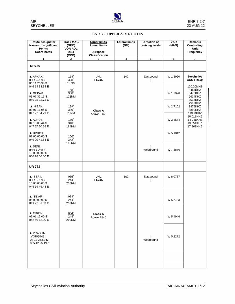
AIP ENR 3.2-7 SEYCHELLES 23 AUG 12
Seychelles Civil Aviation Authority AIP AIRAC AMDT 1/12
ENR 3.2 UPPER ATS ROUTES
Route designator Names of significant
Points Coordinates
Track MAG (GEO)
VOR RDL DIST
(COP)
Upper limits Lower limits
Airspace
Classification
Lateral limits (NM)
Direction of cruising levels
VAR (MAG)
Remarks Controlling
Unit Frequency
1 2 3 4 5 6 7
UR780
▲ APKAK (FIR BDRY) 00 11 20.98 S 046 14 33.34 E ▲ GEPAR 01 07 35.11 S 046 38 32.73 E ▲ NIBAK 03 01 11.95 S 047 27 04.79 E ▲ ALRUS 04 13 00.44 S 047 57 50.58 E ▲ UVDOX 07 00 00.00 S 049 09 41.64 E ▲ DENLI (FIR BDRY) 10 00 00.00 S 050 28 06.00 E
158˚ 338˚
61 NM
158˚ 338˚
123NM
159˚ 339˚
78NM
159˚ 340˚
184NM
160˚ 342˚
195NM
UNL
FL245
Class A Above F145
100
Eastbound
↓ ↑
Westbound
W 1.3920
W 1.7970
W 2.7102
W 3.3584
W 5.1012
W 7.3876
Seychelles ACC FREQ:
120.20MHZ 3467KHZ 3476KHZ 5634KHZ 5517KHZ
7595KHZ 8879KHZ 8890KHZ
11300KHZ 10 018KHZ
13 288KHZ 13 351KHZ 17 961KHZ
UR 782
▲ BERIL (FIR BDRY) 10 00 00.00 S 045 59 45.43 E ▲ TIKAR 08 00 00.00 S 049 27 51.03 E ▲ MIRON 06 01 12.00 S 052 50 12.00 E ▲ PRASLIN VOR/DME 04 18 26.52 S 055 42 25.49 E
065˚ 244˚
238NM
064˚ 244˚
233NM
064˚ 244˚
200NM
UNL
FL245
Class A Above F145
100
Eastbound
↓ ↑
Westbound
W 6.0767
W 5.7783
W 5.4946
W 5.2272

AIP ENR 3.2-8 SEYCHELLES 23 AUG 12
Seychelles Civil Aviation Authority AIP AIRAC AMDT 1/12
ENR 3.2 UPPER ATS ROUTES
Route designator
Names of significant Points
Coordinates
Track MAG (GEO)
VOR RDL DIST
(COP)
Upper limits Lower limits
Airspace
Classification
Lateral limits (NM)
Direction of cruising levels
Remarks Controlling
Unit Frequency
1 2 3 4 5 6 7
UW735
▲ AVIMO (FIR BDRY) 03 32 52.00 S 050 52 39.00 E ▲ APNAK 01 00 00.00 N 052 26.07 E ▲ ATUTI 01 27 33.07 S 053 57 12.34 E ▲ PRASLIN VOR/DME 04 18 26.52 S 055 42 25.49 E
148˚ 332˚
176 NM
148˚ 332˚
174NM
150˚ 330˚
200NM
UNL
FL245
Class A Above F145
100
Eastbound
↓ ↑
Westbound
W 1.3822
W 2.4515
W 3.6417
W 5.2272
Seychelles ACC REQ: 120.20MHZ 3467KHZ 3476KHZ 5634KHZ 5517KHZ 7595KHZ 8879KHZ 8890KHZ
11300KHZ 10 018KHZ 13 288KHZ 13 351KHZ 17 961KHZ

AIP ENR 3.3-1 SEYCHELLES 23 AUG 12
Seychelles Civil Aviation Authority AIP AIRAC AMDT 1/12
ENR 3.3 AREA NAVIGATION (RNAV) ROUTES
Route designator Names of significant
Points Coordinates
Track MAG (GEO)
VOR RDL DIST
(COP)
Upper limit Lower limit
Airspace
classification
Lateral Limits
Direction of cruisi4g levels
VAR (MAG
Remarks Controlling/
Unit Frequency
1 2 3 4 5 6 7
UM609
▲ KISAK (FIR BDRY) 07 50 00.00 S 044 00 00.00 E ▲ ATOLA (FIR BDRY) 10 00 00.00S 046 28 36.30 E
134˚ 315˚
194NM
UNL
FL245
Class A Above F145
100
Eastbound
↓ ↑
Westbound
Seychelles ACC FREQ:
120.20MHZ 3467KHZ 3476KHZ 5634KHZ 5517KHZ 7595KHZ 8879KHZ 8890KHZ
11300KHZ 10 018KHZ 13 288KHZ 13 351KHZ 17 961KHZ
UM651
▲ ESTOK (FIR BDRY) 02 42 41.02 N 049 50 10.76 E ▲ ITPOK 01 54 19.89 N 050 30 39.02 E ▲ TEXAR 00 07 23.66 N 052 00 00.00 E ▲ ANVIX 01 44 38.21 S 053 33 36.35 E ▲PRASLIN (PRA) VOR/DME 04 18 26.52 S 055 42 25.44 E
141˚ 321˚
63NM
141˚ 322˚
139NM
142˚ 323˚
146NM
143˚ 325˚
200NM
UNL
FL245
Class A Above F145
100
Eastbound
↓ ↑
Westbound
UM665
▲ ITLOX (FIR BDRY) 01 10 19.05 S 045 01 33.89 E ▲ MITCH 02 00 00.00 S 045 31 36.66 E ▲ ANTIS 04 11 54.89 S 046 53 52.90 E ▲ UVESO 07 00 00.00 S 048 39 35.75 E ▲ ANKOR 10 00 00.00 S 050 34 50.00 E
149˚ 330˚
56NM
149˚ 329˚
151NM
150˚ 331˚
201NM
151˚ 333˚
212NM
UNL
FL245
Class A Above F145
100
Eastbound
↓ ↑
Westbound
Seychelles ACC FREQ:
120.20MHZ 3467KHZ 3476KHZ 5634KHZ 5517KHZ 7595KHZ 8879KHZ 8890KHZ
11300KHZ 10 018KHZ 13 288KHZ 13 351KHZ 17 961KHZ

AIP ENR 3.3-2 SEYCHELLES 23 AUG 12
Seychelles Civil Aviation Authority AIP AIRAC AMDT 1/12
Intentionally Left Blank

AIP ENR 3.5- 1 SEYCHELLES 23 AUG 12
Seychelles Civil Aviation Authority AIP AIRAC AMDT 1/12
ENR 3.5 OTHER ROUTES
3.5.1 RNP 1 Transition routes in the Seychelles FIR.
ROUTE ID WPT ID P/T Fly-over Course (° T) Dist. (nm)
T100 NORSI IF N
LESLY TF N 023.84 127.23
T101 OKLAB IF N
LESLY TF N 059.57 129.98
T102 KATEB IF N
JEFFY TF N 101.27 142.3
T103 DANEL IF N
JEFFY TF N 112.25 148.28
T104 MOGUD IF N
KAREN TF N 119.52 161.81
T105 ANVIX IF N
KAREN TF N 142.74 162.5
T106 ATUTI IF N
KAREN TF N 152.92 164.01
T107 UDLET IF N
FOSTY TF N 175.94 172.76
T108 BOMOB IF N
FOSTY TF N 221.03 180.15
T109 ORLOM IF N
DIKSY TF N 236.01 173.76
T110 GITOP IF N
DIKSY TF N 257.19 162.97
T111 RERUS IF N
IDRIS TF N 350.72 129.8
T112 RUBAM IF N
IDRIS TF N 001.88 129.5

AIP ENR 3.6- 1 SEYCHELLES 1 APR 08
Seychelles Civil Aviation Authority AIP AMDT 1/08
ENR 3.6 EN- ROUTE HOLDING
HLDG
ID/FIX/WPT Coordinates
INBD TRK
(MAG)
DIR of PTN
MAX IAS
(KT)
MIN-MAX HLDG LVL FL/FT(MSL)
TIME(min)
Or DIST OUBD
Controlling
Unit and Frequency
1 2 3 4 5 6 7
Praslin PRA VOR/DME
04 18 26.52 S
055 42 25.49 E
222˚
Right
220
240
4200FT FL 145
Above FL 145
1
1
Seychelles APP
119.7 Mhz
Seychelles ACC
120.2 Mhz
Note: The en-route holdings may be used only when indicated as clearance limit or after permission from the appropriate ATC unit. .

AIP ENR 4.1- 1 SEYCHELLES 1 APR 08
Seychelles Civil Aviation Authority AIP AMDT 1/08
ENR 4.1 RADIO NAVIGATION AIDS/SYSTEMS – EN ROUTE
Name of Station
(VOR/VAR)
ID Frequency Hours of Operation
Coordinates Elev DME Antenna
Remarks
1 2 3 4 5 6 7
PRASLIN DVOR/DME
(5˚W)
PRA
115.7 MHZ (CH104X )
H24
04 18 26.52 S 055 42 25.49 E
337m AMSL
Pilots may anticipate ranges of 200nm plus at cruising levels

AIP ENR 4.2-1 SEYCHELLES 03 APR 14
Seychelles Civil Aviation Authority AIP AMDT 1/14
ENR 4.2 DATA LINK SERVICES IN THE SEYCHELLES FIR 4.2.1 INTRODUCTION 4.2.1.1 Data link services are available to FANS1/A equipped aircraft operating in the Seychelles FIR on a 24-hour
basis. 4.2.1.2 The data link services will not affect current procedures for non-data link equipped aircraft operating in the
same airspace. 4.2.2 BACKGROUND 4.2.2.1 Controller Pilot Data Link Communications (CPDLC) and Automatic Dependent Surveillance-Contract (ADS-C)
data link applications will be used to provide services to FANS1/A equipped aircraft, in particular over the oceanic region beyond existing VHF voice communications.
4.2.2.2 Messages will be transferred by satellite data links. 4.2.2.3 CPDLC supports the following services:
a) Emergency alerting; b) Pilot to Controller downlink of position reports and clearance requests; c) Controller to Pilot uplink of ATC clearances and instructions; and d) Free text as a supplement to pre-formatted message elements.
4.2.2.4 The provision of Pre-Departure Clearance (PDC) via CPDLC will not be available. 4.2.2.5 ADS-C supports the following services:
a) Emergency alerting; and b) Automatic reporting by the aircraft Flight Management System (FMS) of aircraft position and intent
information. The FMS reports the required information in accordance with parameters selected by the ground system.
4.2.3 LOGON PROCEDURES 4.2.3.1 The AFN LOGON address for Seychelles FIR is FSSS. 4.2.3.2 To avoid automatic rejection of the LOGON, the flight identification number used by the pilot in the LOGON
process must be identical to the flight identification number filed in the flight plan. 4.2.3.3 A LOGON must be received from the aircraft before any data link connections can be initiated by the ground
system. This is achieved via the ATS Facility Notification (AFN) LOGON process to be initiated by the pilot in accordance with company procedures.
4.2.3.4 Aircraft requesting data link services inbound to Seychelles FIR are required to manually LOGON onto FSSS at
least 15 minutes prior to the estimated time for entering the Seychelles FIR. Data link equipped aircraft departing from aerodromes within the Seychelles FIR, and requesting data link shall LOGON to FSSS as soon as possible after departure. Pilots who are unable to establish data link connection are to inform ATC on VHF or HF radio.
4.2.4 CPDLC APPLICATION 4.2.4.1 Aircraft that have established data link connections will maintain CPDLC as the primary communication
means. When using CPDLC, the primary and secondary HF voice frequencies will be used as back-up communication medium and a SELCAL check will be conducted.

ENR 4.2-2 AIP 03 APR 14 SEYCHELLES
AIP AMDT 1/14 Seychelles Civil Aviation Authority
4.2.4.2 To ensure the correct synchronization of messages, controller/pilot dialogues opened by CPDLC must be closed by CPDLC. Controller/pilot dialogues opened by voice must be closed by voice.
4.2.4.3 Due to inherent integrity checks and a coded reference to any preceding related message contained within
CPDLC messages, a clearance issued by CPDLC requires only the appropriate CPDLC response, not a read back as would be required if the clearance had been issued by voice.
4.2.4.4 The downlink response “WILCO” indicates that the pilot accepts the full terms of the whole uplink message. 4.2.4.5 A downlink message response “AFFIRM” is not an acceptable acknowledgement or reply to a CLEARANCE
issued by CPDLC. 4.2.4.6 To avoid ambiguity in message handling and response, a CPDLC downlink message should not contain more
than one clearance request. 4.2.4.7 If multiple clearance requests are contained in a single downlink message and the controller cannot approve
all requests, the uplink message “UNABLE” will be sent as a response to the entire message. A separate message containing a response to those requests that can be complied with will be sent by the controller.
4.2.4.8 If any ambiguity exists as to the intent of a particular message, clarification must be sought by voice. 4.2.4.9 Standard pre-formatted message elements must be used whenever possible. Free text messages should be only
when an appropriate pre-formatted message element does not exist or to supplement the pre-formatted message element. The use of free text should be kept to a minimum.
4.2.4.10 When CPDLC connection is established, aircraft will be instructed to transfer from voice to CPDLC. Pilots
should then downlink a CPDLC position report at the FIR Boundary entry point then ADS reporting only. This is to ensure that CPDLC connection is active with Seychelles Control.
4.2.4.11 When CPDLC connection is established, aircraft will be instructed to transfer from voice to CPDLC. The
phraseology used is: TRANSFER TO SEYCHELLES CONTROL ON DATA LINK: MONITOR [HF frequency primary/secondary] 4.2.4.12 CPDLC connections will be terminated at the FIR boundary position or when entering VHF coverage. The
CONTACT [unit name][frequency] message and the END SERVICE message will be sent as separate messages. The END SERVICE message will be sent as soon as possible after receipt of the WILCO response message to the CONTACT message.
4.2.5 ADS-C APPLICATION 4.2.5.1 ADS Periodic and Event contracts will be established automatically after a successful LOGON. 4.2.5.2 The Periodic reporting interval is 27 minutes and the Event reporting is compulsory reporting points. 4.2.5.3 ADS contracts will be manually terminated at the Seychelles FIR boundary by the controller. 4.2.6 DATA LINK FAILURE 4.2.6.1 Pilots recognizing a failure of a CPDLC connection must immediately establish communications on the
appropriate voice frequency. Voice must continue to be used as the primary medium for communication until a CPDLC connection has been re-established and the controller has authorized the return to data link
4.2.6.2 In the event of an unexpected CPDLC shutdown, the controller will immediately advise all data link
connected aircraft of the failure by voice. Instructions will continue to be issued by voice until the return of data link system. The return of the system to an operational state will require a new AFN LOGON from the affected aircraft.

AIP ENR 4.2-3 SEYCHELLES 03 APR 14
Seychelles Civil Aviation Authority AIP AMDT 1/14
4.2.6.3 In case of ADS only failure, Seychelles Control shall inform pilots of the failure and CPDLC position reports will be used.
4.2.7 EMERGENCY PROCEDURES 4.2.7.1 Pilots should notify ATC of emergency situations by the most appropriate means (voice or CPDLC) 4.2.7.2 If a CPDLC MAYDAY/ PAN message is received, the controller will immediately acknowledge receipt of the
emergency by using the Free Text message "ROGER MAYDAY/PAN" 4.2.7.3 Normal emergency procedures shall be followed. Controller may also attempt to make voice contact with the
pilot. 4.2.8 FLIGHT PLAN NOTIFICATION 4.2.8.1 Aircraft planning to utilize data link communication must annotate their ICAO flight plan as follows:
a) CPDLC capability must be notified by inserting the alphanumeric designator J5 or J6 in Item 10 Field 10a; b) ADS-C capability must be notified by inserting the alphanumeric designator D1 in Item 10 Field 10b; c) Aircraft registration must be inserted in Item 18 as the ground system uses the information during the
AFN LOGON;

AIP ENR 4.3 - 1 SEYCHELLES 23 AUG 12
Seychelles Civil Aviation Authority AIP AIRAC AMDT 1/12
ENR 4.3 NAME – CODE DESIGNATORS FOR SIGNIFICANT POINTS
Name Latitude Longitude REMARKS
ALRAN 100000.00S 0562221.02E UR400
ALRUS 041300.44S 0475750.58E UA610, UR780
AMBAN 100000.00S 0553855.17E UR401
ANKOR 100000.00S 0503450.00E UM665
ANTIS 041154.89S 0465352.90E UA610
ANVET 031114.85S 0440000.00E UG424
ANVIX 014438.21S 0533336.35E UM651
APKAK 001120.98S 0461433.34E UR780, UW735
ATOLA 100000.00S 0462836.30E UM609
ATUTI 012750.00S 0535720.00E UW735
AVIMO 033252.00N 0505239.00E UW735
AXINA 064946.83N 0550000.00E UR401
BERIL 100000.00S 0455945.43E UR775
BOMOB 013432.33S 0573821.67E UB459
BUSUX 035500.00S 0600000.00E N628
CLAVA 014612.11N 0600000.00E UB459
DALON 044421.21S 0553655.12E RNP Z RW31
DANEL 034805.94S 0522436.12E UG658
DAVID 045513.11S 0553733.18E RNP Z RW31, GNSS RW31/RNP 1 STAR 31
DEBNO 032529.55S 0500000.00E UG658
DENLI 100000.00S 0502806.00E UR780
DIKSY 043603.00S 0562151.86E RNP 1 SID/STAR 13/31
DOTTY 044708.61S 0551953.62E RNP 1 SID/STAR 13
ESTOK 024241.02N 0495010.76E UM651
FOCKY 042438.68S 0551951.41E GNSS RW13/RNP 1 STAR 13
FOSTY 035101.59S 0554004.99E RNP 1 SID/STAR 13/31
FREDY 043430.00S 0552749.00E RNP Z RW13
FS400 043705.64S 0552749.39E RNP Z RW13
FS401 043833.57S 0552835.72E RNP Z RW13
FS600 043839.67S 0552920.14E RNP 1 SID 31
FS601 043150.73S 0552814.74E RNP 1 SID 31
FS650 044341.96S 0553556.37E RNP 1 SID 13
FS700 041715.21S 0552927.76E RNP 1 STAR 13
FS701 042046.93S 0553956.23E RNP 1 STAR 13
FS705 042950.40S 0550953.72E RNP 1 STAR 13

AIP ENR 4.3 - 2 SEYCHELLES 23 AUG 12
Seychelles Civil Aviation Authority AIP AIRAC AMDT 1/12
FS706 043219.69S 0553441.91E RNP 1 SID/STAR 31
GABTO 001119.89N 0481912.18E UG424, UR400
GEPAR 010735.11S 0463832.73E UG424, UR780
GILLY 045549.11S 0554543.42E RNP Z RW31, GNSS RW31/RNP 1 STAR 31
GITOP 040000.00S 0590100.09E N628
HERMY 044043.53S 0553231.78E RNP Z RW13
IDRIS 052913.87S 0554439.13E RNP 1 SID/STAR 13/31
IMKOT 052350.58N 0550000.00E UG424, UR401
ITLOX 011019.05S 0450133.89E UM665
ITPOK 015419.89N 0503039.02E UG424
JEFFY 044419.89S 0544203.19E RNP 1 SID/STAR 13/31
JERAD 044735.94S 0554541.73E GNSS RW31
JUDDY 044643.39S 0553716.22E GNSS RW31
KAREN 035432.51S 0551201.18E RNP 1 SID/STAR 13/31
KATEB 041636.19S 0522216.50E UA610
KISAK 075000.00S 0440000.00E UM609
LAZWA 042421.32S 0552645.60E Route Echo
LESLY 051815.94S 0545849.19E RNP 1 SID/STAR 13/31
LINDA 042701.05S 0552530.08E RWY 13 VOR Z/RNP 1 STAR 13
LIZZY 043225.43S 0551757.59E GNSS 13/ RNP 1 SID 31
LOTER 041030.85S 0453911.37E UA610
LUWIE 045124.52S 0554137.47E GNSS 31
MAGGY 042945.69S 0554423.54E Route Delta
MALON 042529.51S 0552747.47E RNP Z RW13/RNP Z RW31/GNSS RW13/ RNP 1 SID/STAR 13/31
MIRON 060120.00S 0525020.00E UR782
MIROV 100000.00S 0523608.00E UB459
MITCH 020000.00S 0453136.66E UG424
MOGUD 023434.20S 0525109.77E UR400
MONIK 044814.77S 0553830.20E RWY 31 VOR Z
NATLY 042857.49S 0552252.55E GNSS 13
NEROT 074136.81N 0580000.00E UG424
NESAM 100000.00S 0483154.00E UG465
NETAR 022740.44S 0440000.00E UG658
NIBAK 030111.95S 0472704.79E UR780
NORSI 071515.00S 0540717.00E UB459
ODRIN 044254.51S 0553400.65E GNSS RW31
OKLAB 062437.00S 0530629.00E UG465
OLIVA 043800.18S 0552912.48E GNSS RW13

AIP ENR 4.3 - 3 SEYCHELLES 23 AUG 12
Seychelles Civil Aviation Authority AIP AIRAC AMDT 1/12
ORLOM 025836.79S 0584606.77E UG465
OTKIR 022619.49S 0600000.00E UG465
PATTY 043722.52S 0552859.74E RNP Z RW31
PERRY 060000.00S 0600000.00E UR212
PETER 044138.67S 0554338.02E RNP Z RW31/RNP 1 STAR 31
RANDY 042836.15S 0553303.51E Route Alpha/Whiskey
RERUS 073757.14S 0560538.50E UR400
RUBAM 073917.11S 0554023.50E UR401
SANDY 044608.46S 0550620.85E RNP 1 SID/STAR 13
SAMES 044637.93S 0554013.14E RNP Z RW31/ ILS RWY31/ RNP 1 STAR 31
SAVVY 043130.31S 0554224.05E Route Delta
SELBY 042942.15S 0553757.47E GNSS RW31
SINDY 042913.79S 0554827.74E GNSS 13
SOKAR 060000.00S 0454534.88E UR775
TASHA 042920.26S 0552201.10E RWY 13 VOR X
TERRY 043304.18S 0552545.23E GNSS RW13
TEXAR 000723.66N 0520000.00E UM651
TIKAR 080000.00S 0492751.03E UR782
UDLET 005751.49S 0552750.71E UR401
UNKOB 033551.81N 0524200.00E UG424
UNPAR 004921.38S 0452731.03E UR775
UTOPA 012651.42S 0510000.00E UR400
UTRON 020000.00N 0551453.96E UR401
UVDOX 070000.00S 0490941.64E UR780
UVESO 070000.00S 0483935.75E UM665
VIDOT 045627.99S 0552522.54E RNP 1 SID/STAR 13
VUTAS 091200.00N 0600000.00E UG424
XABON 040828.11S 0440000.00E UA610

AIP ENR 4.4-1 SEYCHELLES 01 OCT 06
Seychelles Civil Aviation Authority AIP AMDT 01/06
ENR 4.4 AERONAUTICAL GROUND LIGHTS – ENROUTE
Name Ident Coordinates
Type and intensity
(1000 candelas)
Characteristics
Operating
Hours
Remarks
St Anne Island Peak (827ft/ 847ft amsl) -TV masts 04 36 12S 055 30 15E
HBN
FR
H24
----
North East Point Peak (410ft amsl) 04 34 49S 055 27 51E
HBN
Flg R every 3 sec
1400 to 0200
----
South East Island 04 40 24S 055 32 02E
HBN
Gp F (3)
HN
High ground 583 ft (amsl). 3 lights 450ft East to West
St Louis Peak (986ft amsl) 04 36 54S 055 26 27E
HBN
F R
HN
(TX stn Aerial)
Le Rocher (550ft amsl) 04 39 00S 055 28 00E
HBN
Flg R 40 every min
HN
----
Petit Paris (390ft amsl) 04 40 00S 055 29 00E
HBN
Flg R 40 every min
HN
---
Anemometer Mast
OBST
F R
HN
Abeam NW end of Rwy, appx 71m from RCL
Anemometer Mast
OBST
F R
HN
Abeam NW end of Rwy appx 80m from RCL
St Louis TV mast (908 ft amsl) 04 36 54S 055 26 27E
OBST
F R
HN
---
Anse Faure TV Mast (242 ft amsl) 04 05 40.2S 055 31 44.9E
OBST
F (5) R
HN
3 Steady red at top and 2 at midsection
Danzil TV mast 04 37 10S 055 24 13E
OBST
---
---
Red /White markings (unlit)
Sans Sousi Radio Mast 04 37 46S 055 27 55E
OBST
F R
HN
---
La Misere TV Mast 04 40 05S 055 28 29E
OBST
---
---
Red/White markings (unlit)
Grand Anse Radio Masts 1) 04 40 43.4S 055 27 15.9E 2) 04 40 40.4S 055 27 16.1E 3) 04 40 36.4S 055 27 15.4E 4) 04 4032.4S 055 27 15.4E
OBST
F R
HN
Orange/White markings
1. Hgt 158 ft (amsl) 2. Hgt 187 ft (amsl) 3. Hgt 216 ft (amsl) 4. Hgt 187 ft (amsl)
Rosebelle Telephone Mast (2180ft amsl) 04 39 36S 055 27 42E
OBST
F R
HN
---

AIP ENR 5.1- 1 SEYCHELLES 1 APR 07
Seychelles Civil Aviation Authority AIP AMDT 1/07
ENR 5 NAVIGATION WARNINGS
ENR 5.1 PROHIBITED, RESTRICTED AND DANGER AREAS
Identification, name and lateral
limits Upper limit Lower limit
Remarks (time of activity, type of
restriction, nature of hazard, risk of
interception) 1 2 3
PROHIBITED AREAS There are no prohibited or danger areas in the Seychelles group of islands.
RESTRICTED AREAS
Aride Island 04 12 45 S 055 40 10 E
Bird Island 03 43 17.29 S 055 12 31.31 E
Cousin Island 04 19 84 S 055 39 96 E
Fregate Island 04 35 01.99 S 055 56 46.58 E
→ 2000FT GND
Bird Sanctuary Bird Sanctuary Bird Sanctuary Bird Sanctuary
Note 1: Flights over the four islands mentioned above are restricted unless special permission has been obtained to operate below 609m (2000ft), and within half a nautical mile of their shores/coastlines.
Note 2: Except for the purpose of landing and take-off, pilots are requested to remain above 609m (2000ft) when within half a nautical mile of the coastlines of all other islands in order to minimize disturbance of wild life.

AIP ENR 5.2- 1 SEYCHELLES 1 OCT 06
Seychelles Civil Aviation Authority AIP AMDT 1/06
ENR 5.2 MILITARY EXERCISE AND TRAINING AREAS
5.2.1 Military exercise and training areas have not been established within Seychelles FIR.

AIP ENR 5.3- 1 SEYCHELLES 1 OCT 06
Seychelles Civil Aviation Authority AIP AMDT 1/06
ENR 5.3 OTHER ACTIVITIES OF DANGEROUS NATURE AND OTHER POTENTIAL HAZARDS
5.3.1 Activities of dangerous nature and other potential hazards have not been specifically identified within Seychelles FIR.

AIP ENR 5.5- 1 SEYCHELLES 1 OCT 06
Seychelles Civil Aviation Authority AIP AMDT 1/06
ENR 5.5 AERIAL SPORTING AND RECREATIONAL ACTIVITIES
5.5.1 General Aerial sporting and recreational activities shall be carried out only after obtaining appropriate approval from the Chief Executive Officer, Seychelles Civil Aviation Authority. The application for approval shall specify in detail:- (1) the area of operation, (2) time of operation, (3) type of operations, (4) safety precautions to be undertaken.

AIP ENR 5.6-1 SEYCHELLES 01 OCT 06
Seychelles Civil Aviation Authority AIP AMDT 01/06
ENR 5.6 BIRD MIGRATION AND AREAS WITH SENSITIVE FAUNA
5.6.1 Reporting of bird strike
5.6.1.1 General To achieve more comprehensive statistics of bird strikes, the Seychelles Civil Aviation Authority is continuously collecting data on strikes reports as and when they occur. All pilots operating within the Seychelles FIR are therefore requested to report to the Seychelles Civil Aviation Authority on all cases of bird strikes or incidents where a risk of bird strike has been present. 5.6.1.2 Report To facilitate the reporting of incidents, a Bird Strike Reporting Form has been produced and may be obtained at airport offices, public aerodromes or from Seychelles Civil Aviation Authority. In connection with incidents on or near an aerodrome, pilots are requested to organise the collection of the bird, or as much of the remnants, as far as practicable and forward to: SATCO Operations Air Navigation Services Division Seychelles Civil Aviation Authority PO Box 181 Victoria Mahe Seychelles. Any supplementary information on the circumstances under which the incident took place should also be added. 5.6.1.3 Areas with sensitivity fauna
Areas of sensitive fauna is listed ENR 5.1-1


N628
Edito
rial, N
EW R
OUTE
DES
IGNA
TOR
N628
Effective 3 JUN 10
AIP AIRAC AMDT 1/10
ENR 6.1 - 3

AERODROME ELEV 12 FTHEIGHTS RELATED TORWY THR ELEV 12 FT
APPTWR
119.70122.30
SEYCHELLES INTLIFR TRANSIT ROUTES
(CAT A-B)055°20’ 055°30’ 055°40’ 055°50’ 055°60’
04°10’
04°20’
04°30’
04°40’
04°50’
05°00’
05°10’
04°10’
04°20’
04°30’
04°40’
04°50’
04°60’
05°10’
055°20’ 055°30’ 055°40’ 055°50’ 055630’
PRAVOR/DME 115.7
CH 104X
13 DME PRA R-2
30
ALPHA
FREGATEISLAND
RANDY
SEY R-115
AH
PL
A
12 DM
E SEY R-010
SEYNDB 373.0
SEYVOR/DME 113.1
CH 78X
SIAILS 110.3CH 40X
This chart is to be usedin conjunction with
appropriate approachcharts.
0051
AH
Mss
elnu
0004
XA
MC
TA
ybde
siroh
tua
2986
PRA
R-19
5U
NIF
ORM
GOLF
24.4
DM
E SE
Y R-
211
24.4
DM
E PR
A R-
031
GOLF
LOW LEVEL (SINGLE AIRCRAFT OPERATION)
8.5 DME PRA R-285
23.6 DM
E SEY R-010
WH
ISKEY
FSIA RUNWAY 13/31Standard Take-O� Minima
Ceiling 1000 FT Visual referenceSt Anne and Cerf Island
FSPP RUNWAY 33Standard Take-O� Minima
Ceiling 1000 FT Visual referenceMiller and Cap Jean Marie
AIP Seychelles ENR 6.1 - 5
Seychelles Civil Aviation Authority AIP AIRAC AMDT 1/10
2000 FTMEA
1. Non-IFR cruising altitudes in use due to the close proximity of FSIA with FSPP2. MEA on all routes is 2000ft, except when established in the hold or on the commencement of a published IAP3. Requests can be made inbound to FSPP to intercept the inbound Radial of the published IAP before the IAF, not below 2000 ft.4. Visual departures from FSIA and FSPP with reference to the critical obstacles required.
Effective 3 JUN 10
MSA 25 NMSEY VOR
4200 R-165
R-300
3400
4200
10NM
2 5NM
ED
ITO
RIA
L,R
E P
AG
ING
, IN
CLU
SIO
N O
F W
AY
PO
INT
S:
EG
NA
HC
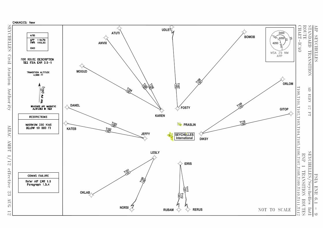


AIP AD 0.6-1 SEYCHELLES 03 APR 14
Seychelles Civil Aviation Authority AIP AIRAC AMDT 1/14
AD PART 3 – AERODROMES (AD)
AD 0.6 TABLE OF CONTENTS TO PART 3
AD 1. AERODROMES/HELCOPTER LANDING AREAS – INTRODUCTION Pages AD 1.1 Aerodrome/helicopter landing areas availability AD 1.1-1/2 AD 1.2 Rescue and fire fighting services and snow plan AD 1.2-1 AD 1.3 Index to aerodromes/helicopter landing areas AD 1.3-1/2 AD 1.4 Grouping of aerodromes/helicopter landing areas AD 1.4-1 AD 2. AERODROMES SEYCHELLES INTERNATIONAL AIRPORT FSIA AD 2.1 Aerodrome location indicator and name AD 2 FSIA -1 FSIA AD 2.2 Aerodrome geographical and administrative data AD 2 FSIA -1 FSIA AD 2.3 Operational hours AD 2 FSIA -1 FSIA AD 2.4 Handling services and facilities AD 2 FSIA -2 FSIA AD 2.5 Passenger facilities AD 2 FSIA -2 FSIA AD 2.6 Rescue and firefighting services AD 2 FSIA -2 FSIA AD 2.7 Seasonal availability - clearing AD 2 FSIA -2 FSIA AD 2.8 Aprons taxiways and check locations data AD 2 FSIA -3 FSIA AD 2.9 Surface movement guidance and control system and markings AD 2 FSIA -3 FSIA AD 2.10 Aerodrome obstacle AD 2 FSIA -4 FSIA AD 2.11 Meteorological information provided AD 2 FSIA -4 FSIA AD 2.12 Runway physical characteristics AD 2 FSIA -5 FSIA AD 2.13 Declared distances AD 2 FSIA -5 FSIA AD 2.14 Approach and runway lighting AD 2 FSIA -6 FSIA AD 2.15 Other lighting, secondary power supply AD 2 FSIA -7 FSIA AD 2.16 Helicopter landing area AD 2 FSIA -7 FSIA AD 2.17 ATS airspace AD 2 FSIA -7 FSIA AD 2.18 ATS communication facilities AD 2 FSIA -7 FSIA AD 2.19 Radio navigation and landing aids AD 2 FSIA -8 FSIA AD 2.20 Local traffic regulations AD 2 FSIA -9 FSIA AD 2.21 Noise abatement procedures AD 2 FSIA -10 FSIA AD 2.22 Flight procedures AD 2 FSIA -10/11 FSIA AD 2.23 Additional information AD 2 FSIA -11 FSIA AD 2.24 Charts related to Seychelles International Airport AD 2 FSIA -12/75 PRASLIN FSPP AD 2.1 Aerodrome location indicator and name AD 2.2-1 FSPP AD 2.2 Aerodrome geographical and administrative data AD 2.2-1 FSPP AD 2.3 Operational hours AD 2.2-1 FSPP AD 2.4 Handling services and facilities AD 2.2-1 FSPP AD 2.5 Passenger facilities AD 2.2-2 FSPP AD 2.6 Rescue and fire fighting services AD 2.2-2 FSPP AD 2.7 Seasonal availability –clearing AD 2.2-2 FSPP AD 2.8 Aprons, taxiways and check locations data AD 2.2-2 FSPP AD 2.9 Surface movement guidance and control system and markings AD 2.2-2 FSPP AD 2.10 Aerodrome obstacles AD 2.2-3 FSPP AD 2.11 Meteorological information provided AD 2.2-3 FSPP AD 2.12 Runway physical characteristics AD 2.2-3 FSPP AD 2.13 Declared distances AD 2.2-3 FSPP AD 2.14 Approach and runway lighting AD 2.2-4 FSPP AD 2.15 Other lighting, secondary power supply AD 2.2-4 FSPP AD 2.16 Helicopter landing area AD 2.2-4 FSPP AD 2.17 ATS airspace AD 2.2-4 FSPP AD 2.18 ATS communication facilities AD 2.2-4

AD 0.6-2 AIP 03 APR 14 SEYCHELLES
AIP AIRAC AMDT 1/14 Seychelles Civil Aviation Authority
FSPP AD 2.19 Radio navigation and landing aids AD 2.2-5 FSPP AD 2.20 Local traffic regulations AD 2.2-5 FSPP AD 2.21 Noise abatement procedures AD 2.2-5 FSPP AD 2.22 Flight procedures AD 2.2-5 FSPP AD 2.23 Additional information AD 2.2-5 FSPP AD 2.24 Charts related to the aerodrome AD 2.2-5

AIP AD 1.1- 1 SEYCHELLES 2 JUN 11
Seychelles Civil Aviation Authority AIP AIRAC AMDT 1/11
AD 1. AERODROMES /HELICOPTER LANDING AREAS - INTRODUCTION
AD 1.1 AERODROME / HELICOPTER LANDING AREAS AVAILABILITY
1. General conditions under which aerodromes / helicopter landing areas and associated facilities are available for use. Commercial flights are not permitted to take off from or land at any aerodrome/heliport not listed in this AIP except in cases of real emergency or when special permission has been obtained from Seychelles Civil Aviation Authority. In addition to the aerodrome / heliports available for public use listed in this AIP, a number of other aerodromes/airfields are located on some outlying islands. These aerodromes/airfields are available only for private flights and are subject to permission for use by the owner. Details about these aerodromes/airfields can be obtained at the address listed below: Seychelles Civil Aviation Authority P.O. Box 181 Victoria Mahe Seychelles. Landings made other than at Seychelles International Airport or a designated alternate aerodrome/ helicopter landing area. If a landing is made other than at Seychelles International Airport or a designated alternate aerodrome within Seychelles territory, the pilot in command shall report the landing as soon as practicable to the health, taxation (Import Control) and immigration authorities Seychelles International Airport. This notification may be made through any available communication link. The pilot in command shall be responsible for ensuring that: a) cargo, baggage and mail are not removed from the
aircraft except as provided below, b) any foodstuff of overseas origin or any plant material
is not removed from the aircraft except where local food is unobtainable. All food refuse including peelings, cores, stones, of fruit, etc. must be collected and returned to the galley refuse container, the contents of which should not be removed from the aircraft except for hygiene reasons. In such circumstance the contents must be destroyed either by burning or by deep burial.
Movement of persons and vehicles on aerodrome Demarcation of zones The grounds of FSIA aerodrome is divided into two zones:
a) a public zone comprising of the part of the aerodrome open to the public; and
b) a restricted zone comprising of the rest of the
aerodrome. Movement of persons Access to the restricted zone is authorized only under the conditions prescribed by special rules governing the FSIA aerodrome. The taxation (Import Control), police, and health inspection offices and the premises assigned to transit traffic are normally accessible only to passengers, to staff of the public authorities and airlines and to authorized persons in pursuit of their duty. The movement of persons having access to the restricted zones of the FSIA aerodrome is subject to the conditions prescribed by the air navigation regulations and by the special rules laid down by the Airport Management Section of SCAA. Movement of vehicles The movement of vehicles in the restricted zones is strictly limited to vehicles driven or used by persons carrying a traffic permit or an official card of admittance. Drivers of vehicles, of whatever type, operating within the confines of the FSIA aerodrome must respect the direction of the traffic, the traffic signs and the posted speed limits and generally comply with the provisions of the Highway Code and with the instructions given by the relevant competent authorities serving the International Airport. Policing Policing and security is provided within designated restricted zones of the aerodrome. Special security service can be arranged on demand for aircraft and equipment. Use of the helicopter landing areas Unless permission has been granted by Seychelles Civil Aviation Authority, the heliports listed in this document may be used only for flights in accordance with Visual Flights Rules (VFR).

AIP AD 1.1- 2 SEYCHELLES 1 OCT 06
Seychelles Civil Aviation Authority AIP AMDT 1/06
The direction of TKOF zones at the individual heliport refers only to zones and are determined to be free of obstructions. Pilots shall, before using a heliport, ensure that a clear approach and departure can be carried out and, in case of an emergency that suitable landing sites are available along the planned track, taking into consideration the performance of the helicopter. Landing, parking and storage of aircraft on an aerodrome/heliport under the control of Seychelles Civil Aviation Authority The conditions under which aircraft may land and be parked, housed or othewise dealt with at any of the aerodromes/heliports under the control of Seychelles Civil Aviation Authority are as follows; a) The fees and charges for the landing, parking or housing of aircraft shall be those published by Seychelles Civil Aviation Authority, hereinafter referred to as “SCAA”, in the AIP or AIC. b) The fees or charges for any supplies or services which may be furnished to aircraft by or on behalf of SCAA shall be such reasonable fees and charges as may be determined by SCAA for the aerodrome/heliport, unless otherwise as agreed before such fees or charges are incurred,. The fees and charges referred to shall accrue from day to day and shall be payable to SCAA following the termination of service or as mutually agreed.
c) SCAA shall have a lien on the aircraft, its parts and accessories, for such fees and charges as aforesaid.
d) If payment of such fees and charges is not made to SCAA within 14 days after a letter demanding payment thereof has been sent by post addressed to the registered owner of the aircraft, SCAA shall be entitled to sell destroy or otherwise dispose of the aircraft and any of its parts and accessories and to apply the proceeds from so doing to the payment of such fees and charges. e) Neither SCAA nor any servant or agent of the government shall be liable for loss or damage to the aircraft, its part or accessories or any property contained in the aircraft in the event that such loss and damage occurred while the aircraft was on any aerodrome/heliport under the control of SCAA or is in the course of landing at or taking off from any such aerodrome/heliport. 2. Applicable ICAO documents The Standards and Reccommended Practices of ICAO Annex 14, Volumes 1 and 2, are applied without differences.
3. Civil use of military air bases - Nil - 4. CAT II and III operations at FSIA The ILS installed and operational at Seychelles International Airport is uncategorised. 5. Friction measuring device used and friction level below which the runway is declared slippery when it is wet - Nil - 6. Other information - Nil -

AIP AD 1.2- 1 SEYCHELLES 1 OCT 06
Seychelles Civil Aviation Authority AIP AMDT 1/06
AD 1.2 RESCUE AND FIRE FIGHTING SERVICES AND SNOW PLAN
1. RESCUE AND FIRE FIGHTING SERVICES At aerodromes approved for scheduled and /or non- scheduled traffic for aircraft carrying passengers, rescue and fire fighting services and in some cases, sea rescue services, are available and established in accordance with local civil aviation regulations. Details on the presence of rescue and fire fighting services and its extent are published in this section under AD 2 to this AIP. Scheduled or non scheduled traffic for aircraft carrying passengers are not allowed to use aerodromes not having adequate rescue and fire fighting services.
Each individual service is categorized according to ICAO Annex 14 requirement including subsidiary documents for aerodromes, category 1-9. For helicopter landing areas, categories HI – H3 apply.
Temporary changes will be published by NOTAM. 2. SNOW PLAN - Nil -

AIP AD 1.3-1 SEYCHELLES 2 JUN 11
Seychelles Civil Aviation Authority AIP AIRAC AMDT 1/11
AD 1.3 INDEX TO AERODROMES AND HELICOPTER LANDING AREAS
Aerodrome/heliport Location indicator
Type of Traffic Permitted
International S = Scheduled National NS = Non-scheduled (INTL-NTL) IFR-VFR P = Private L = licensed UL = Unlicensed
Reference to AD Section and remarks
1 2 3 4 5
Aerodromes
ALPHONSE *FSAL
NTL
VFR
L - P - NS
AD 2 FSAL
ASSUMPTION *FSAS
NTL
VFR
UL - P - NS
AD 2 FSAS
BIRD *FSSB
NTL
VFR
L - P - S
AD 2 FSSB
COETIVY *FSSC
NTL
VFR
L - P - NS
AD 2 FSSC
DARROS *FSDA
NTL
VFR
L - P - NS
AD 2 FSDA
DENIS *FSSD
NTL
VFR
L - P - NS
AD 2 FSSD
DESROCHES *FSDR
NTL
VFR
L - P - NS
AD 2 FSDR
FARQUHAR *FSFA
NTL
VFR
UL - P - NS
AD 2 FSFA
FREGATE *FSSF
NTL
VFR
L - P - NS
AD 2 FSSF
MARIE-LOUISE *FSMA
NTL
VFR
UL - P - NS
AD 2 FSMA
PLATTE *FSPL
NTL
VFR
UL - P - NS
AD 2 FSPL
PRASLIN *FSPP
NTL
IFR-VFR
L - S - NS
AD 2 FSPP 2
REMIRE *FSSR
NTL
VFR
UL - P - NS
AD 2 FSSR
SEYCHELLES INTERNATIONAL AIRPORT *FSIA
INTL-NTL
FR-VFR
L - S - NS
AD 2 FSIA 1
Helicopter Landing Areas
SEYCHELLES INTERNATIONAL AIRPORT *FSIA
INTL-NTL
IFR-VFR
L - S - NS
AD 2.FSIA-7

AIP AD 1.4- 1 SEYCHELLES 1 OCT 06
Seychelles Civil Aviation Authority AIP AMDT 1/06
AD 1.4 GROUPING OF AERODROMES AND HELICOPTER LANDING AREAS
The criteria applied by Seychelles in grouping aerodromes and helicopter landing areas for the provision of information in this AIP is as follows:- 1. Primary or major international aerodromes
and helicopter landing areas The aerodromes and helicopter landing areas of entry or departure for international air traffic, where:-
a) all formalities concerning import control, immigration, health, animal and plant quarantine and similar procedures are carried out,
b) air traffic services are available on a regular and
continuous basis (H24). 2. Secondary or other international aerodromes
and helicopter landing areas There are currently no designated secondary or other international aerodromes and helicopter landing areas listed for this purpose in Seychelles. Apart from Seychelles International Airport, all other aerodromes and helicopter landing areas are used primarily for domestic air traffic. However, in special circumstances or in cases of emergency, Praslin aerodrome may be designated as the secondary aerodrome depending on the operating performance of the aircraft and the nature of emergency at the time.

AIP AD 2 FSIA - 1 SEYCHELLES 03 JUN 10
Seychelles Civil Aviation Authority AIP AIRAC AMDT 01/10
AD 2. AERODROMES
FSIA AD 2.1 AERODROME LOCATION INDICATOR AND NAME
FSIA – SEYCHELLES INTERNATIONAL
FSIA AD 2.2 AERODROME GEOGRAPHICAL AND ADMINISTRATIVE DATA
1 ARP coordinates and site at AD 04 40 27.64S 055 31 18.67E - Centre of runway 2 Direction and distance from (city) South-East of Victoria, 9.6KM 3 Elevation/Reference temperature 3. 65M (12 ft) 31.4º C 4 MAG VAR/Annual change 5.37º W (2007) / Negligible 5 Geoid Undulation at AD ELEV PSN 111.4422ft (33.968m) 6 AD Administration, address, telephone,
Tele-fax, AFS
Seychelles Civil Aviation Authority P.O. Box 181 Victoria Mahe Seychelles Tel: (248) 384000 Fax: (248) 384030/384009 AFS: FSIAYAYX
7 Types of traffic permitted (IFR/VFR) IFR/VFR 8 Remarks Government (Unlicensed) – Public
FSIA AD 2.3 OPERATIONAL HOURS
1 AD Administration MON-FRI 0800hrs -1600hrs (0400-1200 UTC) 2 Taxation(Import Control)and immigration H24 3 Health and sanitation H24 4 AIS Briefing Office As AD Administration 5 ATS Reporting Office (ARO) H24 6 MET Briefing Office H24 7 ATS H24 8 Fuelling H24 9 Handling H24 10 Security H24 11 De-icing Nil 12 Remarks AIS: Service available from 0400 to 1200 week days. From
1200 to 0400, service available from personnel at SIA Control Tower.

AD 2 FSIA - 2 AIP 16 DEC 10 SEYCHELLES
AIP AIRAC AMDT 01/10 Seychelles Civil Aviation Authority
FSIA AD 2.4 HANDLING SERVICES AND FACILITIES
1 Cargo-handling facilities Full range of equipment available except B747 main deck loader
2 Fuel/oil types AVTUR Jet A1, AVGAS 100LL AEROSHELL 390, 500, W100, 100 and 120
3 Fuelling facilities/capacity AVTUR on hydrant - 5 positions; AVGAS from mini Refueller, from domestic apron
4 De-icing facilities Nil 5 Hangar space for visiting aircraft Limited; by arrangement - light aircraft only 6 Repair facilities for visiting aircraft Minor repairs on all aircraft types; spare parts for BN2,
DHC6, B747, B757/B767, F406 and B1900D. 7 Remarks Non-scheduled and private aircraft will be required to carry
a towbar on board if one is not available in Seychelles. AGNIS is provided for Bays 1, 3, 5 and 6.
AGNIS GUIDANCE SYSTEMS are provided for parking on Bays 1, 3, 5 and 6 giving standard centre line guidance, i.e. Aircraft on centre – both slots Green Aircraft to the left – left slot Red – right slot Green Aircraft to the right – right slot Red – left slot Green Additionally, a simple Stop Guidance System will be operated by a marshaller giving the following indications on lights installed immediately below the AGNIS system on each mast: - Green light on - Proceed to this bay. Orange light on - Continue with caution. Aircraft 5 metres from parking position. Red light on - Stop; Aircraft has reached parking position.
FSIA AD 2.5 PASSENGER FACILITIES
1 Hotels None at Airport. 2 Restaurants Limited at airport; available in neighbouring hotels. 3 Transportation Taxis, hire cars and buses; crew coach. 4 Medical facilities First aid room; Ambulance (2 berth). Hospital in Victoria 5 Bank and Post Office Available. Nil Post Office; letter box only 6 Tourist Office Tourist information desk only; Office located in town 7 Remarks Nil
FSIA AD 2.6 RESCUE AND FIRE FIGHTING SERVICES
1 AD category for fire fighting Required: CAT 8
Available: CAT 9 2 Rescue equipment 5 x Rescue & Fire Fighting vehicles totaling 48,712 litres of
water 6170 litres of foam 602 kg of DCP and 50 kg of BCF Forcing and breaking equipment available One rescue boat with life raft (1 x65 men) One Fire Fighting boat with life raft (3 x 65 men) I x ambulance provided Diving and Underwater Lifting Equipment available
3 Capability for removal of disabled aircraft Limited; Arrangements will be made with adjacent states. 4 Remarks Service provided H24.
FSIA AD 2.7 SEASONAL AVAILABILITY - CLEARING
1 Types of clearing equipment Nil 2 Clearance priorities Nil 3 Remarks Nil

AIP AD 2 FSIA - 11 SEYCHELLES 23 AUG 12
Seychelles Civil Aviation Authority AIP AIRAC AMDT 1/12
2.22.4 Procedures for VFR within Seychelles
CTR/TMA Provided traffic conditions so permit, VFR flights shall operate under the conditions described below; a) submit a flight plan indicating the purpose of the
flight, either filed or on VHF 118.3Mhz or VHF 119.7Mhz,
b) take-off, joining and landing clearances shall be obtained from Seychelles Control Tower,
c) position reports shall be submitted to the
appropriate ATC unit as requested, d) the flight shall be conducted with visual
reference to the surface and it shall remain clear of clouds and in sight of the surface.
e) two-way radio communication shall be
maintained on the appropriate frequency prescribed by ATC.
2.22.5 Procedures for SVFR flights within Seychelles
CTR
a) a flight plan shall be submitted for the flight concerned either filed or on VHF 118.3Mhz or VHF 119.7Mhz,
b) ATC clearance shall be obtained from Seychelles
Control Tower for take-off, routing, joining and landing,
c) deviation from ATC clearance may only be made
when prior permission has been obtained from the appropriate ATC unit,
d) the flight shall be conducted with visual
reference to the surface and it shall remain clear of clouds
e) two-way radio communication shall be established on the frequency prescribed before the flight takes place within the Control Zone.
2.22.6 Procedures for non scheduled VFR flights
All non-scheduled VFR flights wanting to operate at Seychelles International Airport must inform Seychelles Control Tower at least fifteen (15) minutes prior to their expected time of departure. This is to facilitate the completion of various ATC procedures and requirements in time which is considered essential for planning towards a safe and orderly flow and operation of air traffic. Failure to do so may result in delays to the aircraft concerned.
2.22.7 VFR routes within Seychelles CTR
Nil specifically established.
FSIA AD 2.23 ADDITIONAL INFORMATION
Bird concentration in the vicinity of the Seychelles International Airport
Limited numbers of pigeons, cattle egrets and mynah birds can be present in the active strip during daylight hours. Bird control measures and scaring activity takes place on a regular basis at Seychelles International Airport
.

AD 2 FSIA - 12 AIP 23 AUG 12 SEYCHELLES
AIP AIRAC AMDT 1/12 Seychelles Civil Aviation Authority
FSIA AD 2.24 CHARTS RELATED TO SEYCHELLES INTERNATIONAL AIRPORT Page Aerodrome Chart - ICAO AD 2 FSIA -13 Aircraft Parking /Docking Chart - ICAO AD 2 FSIA -15 Aerodrome Obstruction Chart- ICAO Type A AD 2 FSIA -17 Conventional Instrument Approach Procedures AD 2 FSIA -23 Instrument Approach Chart – ICAO ILS W RWY 31 (ACFT CAT C-D) AD 2 FSIA -25 Instrument Approach Chart – ICAO ILS X RWY 31 (ACFT CAT A-B) AD 2 FSIA -27 Instrument Approach Chart – ICAO ILS Y RWY 31 (ACFT CAT C-D) AD 2 FSIA -29 Instrument Approach Chart – ICAO ILS Z RWY 31 (ACFT CAT A-B) AD 2 FSIA -31 Instrument Approach Chart – ICAO NDB RWY 31 (ACFT CAT A-D) AD 2 FSIA -33 Instrument Approach Chart – ICAO VOR X RWY 13 (ACFT CAT A-D) AD 2 FSIA -35 Instrument Approach Chart – ICAO VOR Z RWY 13 (ACFT CAT A-D) AD 2 FSIA -37 Instrument Approach Chart – ICAO VOR Z RWY 31 (ACFT CAT A-D) AD 2 FSIA -39 Instrument Approach Chart – ICAO VOR a RWY 31 via Route Alpha (CAT A+B) AD 2 FSIA -41 Instrument Approach Chart – ICAO VOR c RWY 13 via Route Charlie (CAT A+B) AD 2 FSIA -43 Instrument Approach Chart – ICAO ILS V RWY 31 via Route Delta (CAT A+B) AD 2 FSIA -45 RNAV (GNSS) Instrument Approach Procedures AD 2 FSIA -47 Instrument Approach Chart – ICAO RNAV (GNSS) RWY 13 AD 2 FSIA -49 Instrument Approach Chart – ICAO RNAV (GNSS) RWY 31 AD 2 FSIA -51 RNAV (RNP) Instrument Approach Procedures AD 2 FSIA -53 Instrument Approach Chart – ICAO RNAV (RNP) RWY 13 AD 2 FSIA -55 Instrument Approach Chart – ICAO RNAV (RNP) RWY 31 AD 2 FSIA -57 RNP-1 SID and STAR Procedures AD 2 FSIA -59 Standard Departure Chart Instrument – ICAO SID RNP-1 RWY 13 (IDRIS 1B, LESLY 1B, JEFFY 1B, KAREN 1B, FOSTY 1B, DIKSY 1B) AD 2 FSIA -67 Standard Departure Chart Instrument – ICAO SID RNP-1 RWY 31 (IDRIS 3A, LESLY 3A, JEFFY 3A, KAREN 3A, FOSTY 3A, DIKSY 3A) AD 2 FSIA -69 Standard Arrival Chart Instrument – ICAO STAR RNP-1 RWY 13 (IDRIS 1C, LESLY 1C, JEFFY 1C, KAREN 1C, FOSTY 1C, DIKSY 1C) AD 2 FSIA -71 Standard Arrival Chart Instrument – ICAO STAR RNP-1 RWY 13 (IDRIS 1R, LESLY 1R, JEFFY 1R, KAREN 1R, FOSTY 1R, DIKSY 1R) AD 2 FSIA -73 Standard Arrival Chart Instrument – ICAO STAR RNP-1 RWY 31 (IDRIS 3D, LESLY 3D, JEFFY 3D, KAREN 3D, FOSTY 3D, DIKSY 3D) AD 2 FSIA -75

AIP AD 2 FSIA - 23 SEYCHELLES 03 APR 14
Seychelles Civil Aviation Authority AIP AMDT 1/14
CONVENTIONAL INSTRUMENT APPROACH PROCEDURES
1. Introduction 1.1 The following Conventional Instrument Approach Procedures are designed in accordance with criteria as stipulated in the ICAO PANS-OPS (Doc 8168) Volume 2. 2. Instrument Approach Procedures 2.1 RNAV fixes have been provided at each Initial Approach Fix (IAF) to facilitate direct RNP-1 operations to the conventional procedures. 2.2 The procedures also contain DME Arc transitions to the Initial Approach Fixes. 3. Contact 3.1 Any comments or queries in regards to the following procedures shall be directed to: PANS OPS Manager Safety Regulation Division Seychelles Civil Aviation Authority P.O Box 181 Mahe Seychelles Tel: (248) 4384181 Fax: (248) 4384179 Email: [email protected]

AIP AD 2 FSIA - 3 SEYCHELLES 23 AUG 12
Seychelles Civil Aviation Authority AIP AIRAC AMDT 1/12
FSIA AD 2.8 APRONS, TAXIWAYS AND CHECK LOCATIONS DATA
1 Apron surface and strength Surface: Concrete
Strength: PCN 72 / R / B / W / U 2 Taxiway width, surface and strength Width: 23M
Surface: Concrete Strength: PCN 72 / R / B / W / U
3 ACL location and elevation Location: Any point on the RWY or Taxi Holding PSTN Elevation: 3.05M/10 FT
4 VOR/INS checkpoints VOR: Taxiway A and B INS: Bay 1 S04 40 11.9540 E55 3039. 6601 Bay 2 S04 40 13.0834 E55 3041. 2723 Bay 3 S04 40 13.7069 E55 3042 .1667 Bay 4 S04 40 14.0765 E55 30 42.6939 Bay 5 S04 40 15.1954 E55 30 44.2962 Bay 6 S04 40 16.5095 E55 30 46.1783
5 Remarks TWY loop changed to TWY C &TWY D
FSIA AD 2.9 SURFACE MOVEMENT GUIDANCE AND CONTROL SYSTEM AND MARKINGS
1 Use of aircraft stand ID signs, TWY guide
lines and visual docking/ parking guidance system of aircraft stands
Taxiing guidance signs at all intersections with TWY and RWY and at all holding positions Guide lines at apron. Nose-in guidance at aircraft stands.
2 RWY and TWY markings and LGT RWY: Designation, THR, TDZ, centre line, edge runway
end as appropriate, marked and lighted. TWY: Centre line, holding positions at all TWY/RWY Inter-sections, marked and lighted.
3 Stop bars Stop bars where appropriate. 4 Remarks AGNIS guidance system on Bays 1, 3, 5 and 6
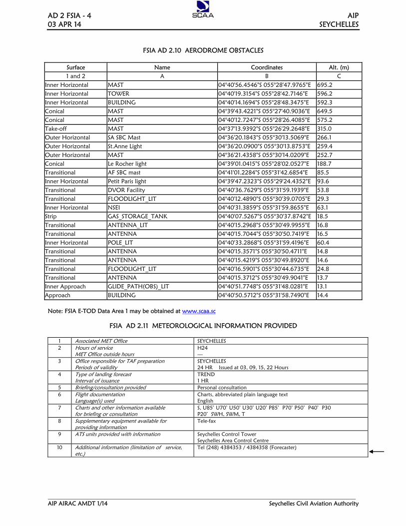
AD 2 FSIA - 4 AIP 03 APR 14 SEYCHELLES
AIP AIRAC AMDT 1/14 Seychelles Civil Aviation Authority
FSIA AD 2.10 AERODROME OBSTACLES
Surface Name Coordinates Alt. (m) 1 and 2 A B C
Inner Horizontal MAST 04°40'56.4546"S 055°28'47.9765"E 695.2 Inner Horizontal TOWER 04°40'19.3154"S 055°28'42.7146"E 596.2 Inner Horizontal BUILDING 04°40'14.1694"S 055°28'48.3475"E 592.3 Conical MAST 04°39'43.4221"S 055°27'40.9036"E 649.5 Conical MAST 04°40'12.7247"S 055°28'26.4085"E 575.2 Take-off MAST 04°37'13.9392"S 055°26'29.2648"E 315.0 Outer Horizontal SA SBC Mast 04°36'20.1843"S 055°30'13.5069"E 266.1 Outer Horizontal St.Anne Light 04°36'20.0900"S 055°30'13.8753"E 259.4 Outer Horizontal MAST 04°36'21.4358"S 055°30'14.0209"E 252.7 Conical Le Rocher light 04°39'01.0415"S 055°28'02.0527"E 188.7 Transitional AF SBC mast 04°41'01.2284"S 055°31'42.6854"E 85.5 Inner Horizontal Petit Paris light 04°39'47.2323"S 055°29'24.4352"E 93.6 Transitional DVOR Facility 04°40'36.7629"S 055°31'59.1939"E 53.8 Transitional FLOODLIGHT_LIT 04°40'12.4890"S 055°30'39.0705"E 29.3 Inner Horizontal NSEI 04°40'31.3859"S 055°31'59.8655"E 63.1 Strip GAS_STORAGE_TANK 04°40'07.5267"S 055°30'37.8742"E 18.5 Transitional ANTENNA_LIT 04°40'15.2968"S 055°30'49.9955"E 16.8 Transitional ANTENNA 04°40'15.7044"S 055°30'50.7419"E 16.5 Inner Horizontal POLE_LIT 04°40'33.2868"S 055°31'59.4196"E 60.4 Transitional ANTENNA 04°40'15.3571"S 055°30'50.4711"E 14.8 Transitional ANTENNA 04°40'15.4219"S 055°30'49.8920"E 14.6 Transitional FLOODLIGHT_LIT 04°40'16.5901"S 055°30'44.6735"E 24.8 Transitional ANTENNA 04°40'15.3712"S 055°30'49.9041"E 13.7 Inner Approach GLIDE_PATH(OBS)_LIT 04°40'51.7748"S 055°31'48.0281"E 13.1 Approach BUILDING 04°40'50.5712"S 055°31'58.7490"E 14.4
Note: FSIA E-TOD Data Area 1 may be obtained at www.scaa.sc
FSIA AD 2.11 METEOROLOGICAL INFORMATION PROVIDED
1 Associated MET Office SEYCHELLES 2 Hours of service
MET Office outside hours H24 —
3 Office responsible for TAF preparation Periods of validity
SEYCHELLES 24 HR Issued at 03, 09, 15, 22 Hours
4 Type of landing forecast Interval of issuance
TREND 1 HR
5 Briefing/consultation provided Personal consultation 6 Flight documentation
Language(s) used Charts, abbreviated plain language text English
7 Charts and other information available for briefing or consultation
S, U85’ U70’ U50’ U30’ U20’ P85’ P70’ P50’ P40’ P30 P20’ SWH, SWM, T
8 Supplementary equipment available for providing information
Tele-fax
9 ATS units provided with information Seychelles Control Tower Seychelles Area Control Centre
10 Additional information (limitation of service, etc.)
Tel (248) 4384353 / 4384358 (Forecaster)

AIP AD 2 FSIA - 47 SEYCHELLES 16 DEC 10
Seychelles Civil Aviation Authority AIP AIRAC AMDT 2/10
RNAV (GNSS) INSTRUMENT APPROACH PROCEDURES
1. Introduction 1.1 The following RNAV (GNSS) Instrument Approach Procedures are designed in accordance with criteria as stipulated in the ICAO PANS-OPS (Doc 8168) Volume 2. 2. Instrument Approach Procedures 2.1 For RNAV (GNSS) Instrument Approach Procedures, the aircraft shall be GNSS equipped with FAA TSO 129(A), 145() or 146() receivers. 2.2 The navigation system shall meet ICAO RNP APPR accuracy (see ICAO PBN Manual, Doc 9613). 2.3 Operators shall ensure that they hold the necessary operational approvals as part of the Operations Specification of the AOC in order to conduct RNAV (GNSS) Instrument Approach Procedures (see ICAO PBN Manual, Doc 9613). 2.4 General Aviation users shall ensure that they meet the training and operational requirements stipulated in ICAO PBN Manual, Doc 9613. 3. Instrument Approach Procedure Coding Tables 3.1 Seychelles International (FSIA) Runway 13 RNAV (GNSS) Instrument Approach Procedures
NO Way-point ID P/T Fly-Over Course (°T) Var 5.37W
Turn Direction
Altitude (ft) Dist (nm / Time (min)
Speed Limit
1 MALON IF N 234.90 L 4200 6.0000 250
2 FOCKY IF N 144.91 4200 5.2458 250
3 LIZZY IF N 054.92 R 4200 6.0000 250
4 NATLY TF N 3500A 210
5 TERRY (FAF)
TF 144.91 2500 5.0000
6 OLIVA (MAPt)
TF Y 144.91 6.0000
7 SINDY DF N L 4200 250
8 SINDY/ MAHF HM 240.84 R 4200 1 MIN 250
NOTE: Maximum speeds indicated in the table are for crew information and not to be coded.

AD 2 FSIA - 48 AIP 03 APR 14 SEYCHELLES
AIP AIRAC AMDT 1/14 Seychelles Civil Aviation Authority
3.2 Seychelles International (FSIA) Runway 31 RNAV (GNSS) Instrument Approach Procedures NO Way-point ID P/T Fly-Over Course (°T)
Var 5.37W Turn
Direction Altitude (ft) Dist (nm /
Time (min) Speed Limit
1 DAVID IF N 046.99 L 4200 5.5580 250
2 GILLY IF N 317.00 4200 6.0000 250
3 JERAD IF N 226.98 R 4200 5.5578 250
4 LUWIE TF N 2500A 210
5 JUDDY (FAF)
TF 317.00 2500 6.3746
6 ODRIN (MAPt)
TF Y 319.39 5.0001
7 SELBY DF N R 4200 250
8 SELBY/ MAHF HM 196.67 R 4200 1 MIN 250
NOTE: Maximum speeds indicated in the table are for crew information and not to be coded. 4. Contact 4.1 Any comments or queries in regards to the following procedures shall be directed to: PANS OPS Manager Safety Regulation Division Seychelles Civil Aviation Authority P.O Box 181 Mahe Seychelles Tel: (248) 4384271 Fax: (248) 4384269 Email: [email protected]

AIP AD 2 FSIA - 5 SEYCHELLES 23 AUG 12
Seychelles Civil Aviation Authority AIP AIRAC AMDT 1/12
Warning Rapid changes of wind speed and direction and moderate to severe turbulence often occur on both runway approaches but particularly on the approach to runway 13 at Seychelles International Airport. Reports of wind shear in excess of 20 knots have been received from aircraft approaching to RWY 13 when surface wind is in the sector 140º – 240º at speeds of 15 knots or more during the south east monsoons. Strong updrafts and downdrafts often occur during these conditions during the latter stages of the approach and along the runway.
FSIA AD 2.12 RUNWAY PHYSICAL CHARACTERISTICS
Designations RWY NR
TRUE & MAG BRG
Dimensions of RWY (M)
Strength (PCN) and surface of RWY and SWY
THR coordinates
THR elevation and highest elevation of TDZ of precision APP RWY
1 2 3 4 5 6 13 125° GEO
130° MAG 2987 x 46 PCN 72 /R/B/W/U
Concrete 04 40 05.49S
055 30 47.03E THR 3.05M/ 10 FT
31 305° GEO 310° MAG
2987 x 46 PCN 72 / R/B/W/U Concrete
04 40 49.78S 055 31 50.30E
THR 3.05M/ 10 FT
Slope of
RWY-SWY
SWY
dimensions (M)
CWY
dimensions (M)
Strip
dimension (M)
OFZ
Remarks 7 8 9 10 11 12
Nil Nil 1493 x 180 3110 x 152 Nil Nil
Nil
Nil
610 x 180
3110 x 152
Nil Runway 13/31 strip width cleared only to ICAO non-instrument runway requirements. Total strip width is 152M.
FSIA AD 2.13 DECLARED DISTANCES
RWY Designator
TORA (M)
TODA (M)
ASDA (M)
LDA (M)
Remarks
1 2 3 4 5 6
13
31
2987
2987
4480
3597
2987
2987
2682
2682
LDA for runway 13/31reduced to 2682m due to runway thresholds being displaced by 305M for both runways. TODA RWY 13 represents 1½ runway length as departure path is over the sea.

AD 2 FSIA - 6 AIP 23 AUG 12 SEYCHELLES
AIP AIRAC AMDT 1/12 Seychelles Civil Aviation Authority
FSIA AD 2.14 APPROACH AND RUNWAY LIGHTING
RWY Desig-
APCH LGT type LEN INSTS
THR LGT colour WBAR
VASIS (MEHT) PAPI
TDZ, LGT LEN
RWY Centre Line LGT Length, spacing colour, INTST
RWY edge LGT LEN, spacing colour INTST
RWY End LGT colour WBAR
SWY LGT LEN (M)
Remark
1 2 3 4 5 6 7 8 9 10 13 SALS1
RAIL 427M LIH
Green2
PAPI3 3°
Nil Nil 2682M 60M White, LIH4
Red Nil Coastal Hazard Beacon5
31
SALS 427M LIL
Green2
PAPI3 3°
Nil Nil 2682M 60M White, LIH4
Red Nil
Notes: 1. SALS/RAIL The approach lighting to RWY 13 is a variable five stage High Intensity collocated SALS and RAIL system containing the following elements:- 2 NM ARRAY - A line of lights 2nm from touchdown consisting of five concrete pontoons 200ft apart each pontoon carrying four lights, three of which are steady and one flashing in sequence beckoning aircraft towards the runway. These flashing lights are on a different circuit and can be switched on and off separately from the steady lights. The lights are angled towards the NE direction in order to give early guidance to aircraft. 1 NM ARRAY - Situated 1 nm from touchdown, a line of five concrete pontoons spaced 200ft apart each carrying four lights, three of which are steady and one flashing in sequence beckoning aircraft towards the runway. A roll guidance bar consisting of four concrete pontoons either side of the first lead in pontoons forms an inverted Tee (T) to approaching aircraft. These pontoons carry two steady lights each lights and are spaced to give the bar a width of 175 feet. 2. RTIL: Flashing White at 60 flashes every minute. 3. PAPI: RWY 13 is offset to NE and must not be used when more than 2.6NM from the RWY due to intervening high ground to the right of the approach path. 4. LIH: RWY 13/31 High intensity, 5 stages white. First 305M displaced threshold –Red 5. Coastal Hazard Beacons Le Rocher (04°39'01.0415"S 055°28'02.0527"E -elevation 550 feet). Flashing red lights at rate of 40 per minute Petit Paris (04°39'47.2323"S 055°29'24.4352"E - elevation 390 feet). Flashing red lights at rate of 40 per minute NE Point (043429S 552751E - elevation 410 feet). Flashing red lights at rate of 40 per minute

AIP AD 2 FSIA - 53 SEYCHELLES 16 DEC 10
Seychelles Civil Aviation Authority AIP AIRAC AMDT 01/10
RNAV(RNP) INSTRUMENT APPROACH PROCEDURES
1. Introduction 1.1 The following RNAV (RNP) Instrument Approach Procedures are designed in accordance with criteria as stipulated in the ICAO PANS-OPS (Doc 8168) Volume 2 and ICAO RNP AR Manual (Doc 9905). 2. Instrument Approach Procedures 2.1 For RNAV (RNP) Instrument Approaches Procedures, operators shall ensure that they hold the necessary
operational approvals as part of the Operations Specification of the AOC in order to conduct RNAV (GNSS)
Instrument Approach Procedures (see ICAO PBN Manual, Doc 9613). 2.4 RNP AR operations require special authorization of the State of Operator/Registry. 2.5 The current acceptable standard for the approval of RNP AR operations is the FAA AC 119. 2.6 Foreign aircraft and operators shall also seek the permission of the Seychelles Civil Aviation Authority prior to
undertaking such operation at the contact indicated below. The request shall include a copy of the Operations Specifications where such approval has been conveyed by the State of Operator/Registry and any associated limitation or restrictions.
3. Instrument Approach Procedure Coding Tables 3.1 Seychelles International (FSIA) Runway 13 RNAV(RNP) Instrument Approach Procedures
NO Way-point ID
P/T Fly-Over Course (°T) Var 5.37W
Turn Direction
Altitude (ft)
Dist (nm / Time (min)
Speed Limit
Arc Centre
1 MALON IF N 4200A 250
2 FREDY TF N 179.84 2200A 8.96 210
3 FS400 TF Y 179.85 1400A 2.58
4 FS401 RF Y 124.41 L 860A 1.72 04°37'05.3695"S / 055°29'35.9384"E
5 RWY13 TF Y 124.9 410(0.15) 690(0.30)
2.66
6 HERMY TF Y 109.9 L 500A 1.85 185
7 MALON DF N 328.96 L 19.29 250
8 MALON/ MAHF
HM 179.84 4200 1 MIN 250
NOTE: Maximum speeds indicated in the table are for crew information and not to be coded.

AD 2 FSIA - 54 AIP 03 APR 14 SEYCHELLES
Seychelles Civil Aviation Authority AIP AIRAC AMDT 1/14
3.2 Seychelles International (FSIA) Runway 31 RNAV (RNP) Instrument Approach Procedures NO Way-point
ID P/T Fly-Over Course (°T)
Var 5.37W Turn
Direction Altitude
(ft) Dist (nm / Time
(min) Speed Limit
1 GILLY IF N 329.26 4200A 10.7642
2 DAVID IF N 17.23 4200A 9.0556
3 PETER IF N 214.48 4200A 6.0000
4 SAMES TF N 2000A 210
5 DALON TF N 304.48 2000 4.0000
6 RWY31 TF Y 304.46 460 750
6.1654
7 PATTY TF N 319.92 500A 4.6193 185
8 MALON TF N 354.19 4200 11.8869
9 MALON/ MAHF
HM 179.84 R 4200 1 MIN 250
NOTE: Maximum speeds indicated in the table are for crew information and not to be coded. 4. Contact 4.1 Any comments or queries in regards to the following procedures shall be directed to: PANS OPS Manager Safety Regulation Division Seychelles Civil Aviation Authority P.O Box 181 Mahe Seychelles Tel: (248) 4384271 Fax: (248) 4384269 Email: [email protected]

AIP AD 2 FSIA - 59 SEYCHELLES 23 AUG 12
Seychelles Civil Aviation Authority AIP AIRAC AMDT 1/12
RNP-1 SIDs and STARs
1. Introduction 1.1 The following RNP-1 SIDs and STARs are designed in accordance with criteria as stipulated in the ICAO PANS-OPS (Doc 8168) Volume 2. 1.2 For RNP-1 STARs and SIDs operations, the aircraft shall be equipped and the navigation systems shall meet
the ICAO RNP-1 standard of accuracy, or equivalent, such as JAA TGL 10 or FAA AC 90-96A Appendix 2- Precision Area Navigation (P-RNAV).
1.3 Operators shall ensure that they hold the necessary operational approvals as part of the Operations
Specification of the AOC in order to conduct RNP-1 SIDs and STARs. 1.4 SID and STAR FMS coding tables are provided at 3 below. Significant point coordinates are published in ENR section 4.3. 2. FSIA Standard Instrument Departure (SID) 2.1 FSIA Standard Instrument Departure (SID) Procedures 2.1.1 Departing aircraft shall contact Seychelles APP as soon as possible after passing 1000 FT, unless otherwise instructed by Seychelles TWR.
Note: see FSIA AD 2.22.3 for action in the event of radio failure.
2.1.2 Departing IFR traffic leaving Seychelles CTA while on a SID is required to:
a. Climb at a minimum gradient of 5% to 1,500 FT (300 FT per NM) for RWY 13; b. Climb at a minimum gradient of 8% to 1,000 FT (486 FT per NM) for RWY 31; c. Observe speed restrictions as per FMS coding tables; d. Level restrictions that apply at waypoints is displayed on the chart; e. Advise ATC at start-up if unable to comply
2.2 FSIA Standard Instrument Departure (SID) Level Restrictions 2.2.1 Initial climb is restricted to FL 060. Further climb clearance as instructed by Seychelles APP. 2.2.2 When a departing aircraft on a SID is cleared to climb to a level higher than the initially cleared level or the
level(s) specified in a SID, the aircraft shall climb directly to the cleared level, unless the SID vertical restrictions are reiterated as part of the clearance.
2.2.3 For all stages of flight, clearances to climb, cancel any previous restrictions or levels, unless they are reiterated
as part of the clearance. 2.2.4 Aircraft when first approaching a cleared level should ensure that the vertical closure speed is not excessive and must avoid overshooting the cleared level, manually overriding if necessary. 2.2.5 ATC may cancel a SID and provide direct routing.

AIP AD 2 FSIA - 60 SEYCHELLES 23 AUG 12
Seychelles Civil Aviation Authority AIP AIRAC AMDT 1/12
2.3 FSIA RNP-1 SID Procedure Coding Tables
IDRIS 1B (RNP 1 SID RWY 13) # ID P/T Fly-over Course (° T) Turn Direction Altitude (ft) Dist. (nm) / Time (min) Speed Limit (kts)1 CA 124.9 500
2 FS650 DF Y R +1500
3 IDRIS DF N
LESLY 1B (RNP 1 SID RWY 13)
# ID P/T Fly-over Course (° T) Turn Direction Altitude (ft) Dist. (nm) / Time (min) Speed Limit (kts)1 CA 124.9 500
2 FS650 DF Y R +1500
3 VIDOT DF N -14000
4 LESLY TF N 230.67 34.24
JEFFY 1B (RNP 1 SID RWY 13)
# ID P/T Fly-over Course (° T) Turn Direction Altitude (ft) Dist. (nm) / Time (min) Speed Limit (kts)1 CA 124.9 500
2 FS650 DF Y R +1500
3 DOTTY DF N -11000
4 SANDY TF N 274.21 +15000 13.56
5 JEFFY TF N 274.23 24.32
KAREN 1B (RNP 1 SID RWY 13)
# ID P/T Fly-over Course (° T) Turn Direction Altitude (ft) Dist. (nm) / Time (min) Speed Limit (kts)1 CA 124.9 500
2 FS650 DF Y L +1500
3 FS700 DF N +10000
4 KAREN TF N 322.36 28.54
FOSTY 1B (RNP 1 SID RWY 13)
# ID P/T Fly-over Course (° T) Turn Direction Altitude (ft) Dist. (nm) / Time (min) Speed Limit (kts)1 CA 124.9 500
2 FS650 DF Y L +1500
3 FS701 DF N +10000
4 FOSTY TF N 000.3 29.61
DIKSY 1B (RNP 1 SID RWY 13)
# ID P/T Fly-over Course (° T) Turn Direction Altitude (ft) Dist. (nm) / Time (min) Speed Limit (kts)1 CA 124.9 500
2 FS650 DF Y L +1500
3 DIKSY DF N

AIP AD 2 FSIA - 61 SEYCHELLES 23 AUG 12
Seychelles Civil Aviation Authority AIP AIRAC AMDT 1/12
IDRIS 3A (RNP 1 SID RWY 31)
# ID P/T Fly-over Course (° T) Turn Direction Altitude (ft) Dist. (nm) / Time (min) Speed Limit (kts)1 CA 304.9 500
2 FS600 DF N R +1000 180
3 FS601 TF N 350.88 L 6.87
4 LIZZY TF N 266.79 L 10.29
5 IDRIS TF N 154.79 62.49
LESLY 3A (RNP 1 SID RWY 31)
# ID P/T Fly-over Course (° T) Turn Direction Altitude (ft) Dist. (nm) / Time (min) Speed Limit (kts)1 CA 304.9 500
2 FS600 DF N R +1000 180
3 FS601 TF N 350.88 L 6.87
4 LIZZY TF N 266.79 L 10.29
5 LESLY TF N 202.71 49.46
JEFFY 3A (RNP 1 SID RWY 31)
# ID P/T Fly-over Course (° T) Turn Direction Altitude (ft) Dist. (nm) / Time (min) Speed Limit (kts)1 CA 304.9 500
2 FS600 DF N R +1000 180
3 FS601 TF N 350.88 L 6.87
4 LIZZY TF N 266.79 L 10.29
5 JEFFY TF N 251.69 37.76
KAREN 3A (RNP 1 SID RWY 31)
# ID P/T Fly-over Course (° T) Turn Direction Altitude (ft) Dist. (nm) / Time (min) Speed Limit (kts)1 CA 304.9 500
2 FS600 DF N R +1000 180
3 FS601 TF N 350.88 R 6.87
4 MALON TF N 355.89 L 6.34
5 KAREN TF N 332.89 34.6
FOSTY 3A (RNP 1 SID RWY 31)
# ID P/T Fly-over Course (° T) Turn Direction Altitude (ft) Dist. (nm) / Time (min) Speed Limit (kts)1 CA 304.9 500
2 FS600 DF N R +1000 180
3 FS601 TF N 350.88 R 6.87
4 MALON TF N 355.89 R 6.34
5 FOSTY TF N 019.71 36.43

AIP AD 2 FSIA - 62 SEYCHELLES 23 AUG 12
Seychelles Civil Aviation Authority AIP AIRAC AMDT 1/12
DIKSY 3A (RNP 1 SID RWY 31)
# ID P/T Fly-over Course (° T) Turn Direction Altitude (ft) Dist. (nm) / Time (min) Speed Limit (kts)1 CA 304.9 500
2 FS600 DF N R +1000 180
3 FS601 TF N 350.88 R 6.87
4 FS706 TF N 094.27 -6000 6.46
5 DIKSY TF N 094.53 47.25 3. FSIA Standard Instrument Arrival (STAR) 3.1 FSIA Standard Instrument Arrival Procedures 3.1.11 On initial call an arriving aircraft shall pass the following information to Seychelles APP:
a. Aircraft Callsign; b. Passing level; c. Aircraft Type, and for aircraft in the heavy wake turbulence category the word "Heavy"; d. STAR designation; e. ATIS information and QNH.
3.2 FSIA Standard Instrument Arrival (STAR) Level Restrictions 3.2.1 For all stages of flight, clearances to descend cancel any previous restrictions or levels, unless they are
reiterated as part of the clearance. 3.2.2 Aircraft when first approaching a cleared level should ensure that the vertical closure speed is not excessive
and must avoid undershooting the cleared level, manually overriding if necessary. 3.2.3 Additional speed and level restrictions are applicable and will be instructed by ATC. 3.2.4 ATC may cancel a STAR and provide direct routing. 3.3 FSIA Standard Instrument Departure (SID) Speed Control 3.3.1 Pilots shall adhere to the speed (IAS) approved or assigned by ATC and shall request ATC approval before
making any changes thereto. If it is essential to make an immediate temporary change in speed, e.g. due to turbulence, ATC shall be notified as soon as possible that such a change has been made. Pilots unable to maintain the last assigned speed during any particular phase of flight, e.g. for aircraft performance reasons, shall inform ATC as soon as possible in order that another speed/alternative clearance can be issued.
3.3.2 The pilot must advise ATC if a speed adjustment is considered excessive or contrary to aircraft operating
specifications.

AIP AD 2 FSIA - 63 SEYCHELLES 23 AUG 12
Seychelles Civil Aviation Authority AIP AIRAC AMDT 1/12
3.4 FSIA RNP-1 STAR Procedure Coding Tables
IDRIS 1C (RNP 1 STAR RWY 13)
# ID P/T Fly-over Course (° T) Turn Direction Altitude (ft) Dist. (nm) / Time (min) Speed Limit (kts)1 IDRIS IF N
2 VIDOT TF N 329.45 +16000 37.86
3 DOTTY TF N 329.46 +13000 10.77
4 FS705 TF N 329.89 R 19.9
5 FOCKY TF N 062.55 R 11.21
6 LINDA TF N 112.73 2300 6.11
LESLY 1C (RNP 1 STAR RWY 13)
# ID P/T Fly-over Course (° T) Turn Direction Altitude (ft) Dist. (nm) / Time (min) Speed Limit (kts)1 LESLY IF N
2 SANDY TF N 013.23 -13000 32.84
3 FS705 TF N 012.32 R 16.6
4 FOCKY TF N 062.55 R 11.21
5 LINDA TF N 112.73 2300 6.11
JEFFY 1C (RNP 1 STAR RWY 13)
# ID P/T Fly-over Course (° T) Turn Direction Altitude (ft) Dist. (nm) / Time (min) Speed Limit (kts)1 JEFFY IF N
2 FS705 TF N 062.6 31.32
3 FOCKY TF N 062.55 R 11.21
4 LINDA TF N 112.73 2300 6.11
KAREN 1C (RNP 1 STAR RWY 13)
# ID P/T Fly-over Course (° T) Turn Direction Altitude (ft) Dist. (nm) / Time (min) Speed Limit (kts)1 KAREN IF N
2 LINDA TF N 157.38 2300 35.01
FOSTY 1C (RNP 1 STAR RWY 13)
# ID P/T Fly-over Course (° T) Turn Direction Altitude (ft) Dist. (nm) / Time (min) Speed Limit (kts)
1 FOSTY IF N
2 FS700 TF N 202.1 -6000 28.17
2 LINDA TF N 191.5 2300 8.34

AIP AD 2 FSIA - 64 SEYCHELLES 23 AUG 12
Seychelles Civil Aviation Authority AIP AIRAC AMDT 1/12
DIKSY 1C (RNP 1 STAR RWY 13)
# ID P/T Fly-over Course (° T) Turn Direction Altitude (ft) Dist. (nm) / Time (min) Speed Limit (kts)1 DIKSY IF N
2 FS701 TF N 289.92 -9000 44.55
3 FS700 TF N 288.54 L -6000 11.04
4 LINDA TF N 202.16 2300 10.49
IDRIS 1R (RNP 1 STAR RWY 13)
# ID P/T Fly-over Course (° T) Turn Direction Altitude (ft) Dist. (nm) / Time (min) Speed Limit (kts)1 IDRIS IF N
2 VIDOT TF N 329.45 +16000 37.86
3 DOTTY TF N 329.46 +13000 10.77
4 FS705 TF N 329.89 R 19.9
5 FOCKY TF N 062.55 R 11.21
6 MALON TF N 096.08 +4200 7.97
LESLY 1R (RNP 1 STAR RWY 13)
# ID P/T Fly-over Course (° T) Turn Direction Altitude (ft) Dist. (nm) / Time (min) Speed Limit (kts)1 LESLY IF N
2 SANDY TF N 013.23 -13000 32.84
3 FS705 TF N 012.32 R 16.6
4 FOCKY TF N 062.55 R 11.21
5 MALON TF N 096.08 +4200 7.97
JEFFY 1R (RNP 1 STAR RWY 13)
# ID P/T Fly-over Course (° T) Turn Direction Altitude (ft) Dist. (nm) / Time (min) Speed Limit (kts)1 JEFFY IF N
2 FS705 TF N 062.6 31.32
3 FOCKY TF N 062.55 R 11.21
4 MALON TF N 096.08 +4200 7.97
KAREN 1R (RNP 1 STAR RWY 13)
# ID P/T Fly-over Course (° T) Turn Direction Altitude (ft) Dist. (nm) / Time (min) Speed Limit (kts)1 KAREN IF N
2 MALON TF N 152.91 +4200 34.6
FOSTY 1R (RNP 1 STAR RWY 13)
# ID P/T Fly-over Course (° T) Turn Direction Altitude (ft) Dist. (nm) / Time (min) Speed Limit (kts)1 FOSTY IF N
2 FS700 TF N 202.1 -6000 28.17
3 MALON TF N 191.5 +4200 8.37

AIP AD 2 FSIA - 65 SEYCHELLES 23 AUG 12
Seychelles Civil Aviation Authority AIP AIRAC AMDT 1/12
DIKSY 1R (RNP 1 STAR RWY 13)
# ID P/T Fly-over Course (° T) Turn Direction Altitude (ft) Dist. (nm) / Time (min) Speed Limit (kts)
1 DIKSY IF N
2 FS701 TF N 289.92
-9000 44.55
3 FS700 TF N 288.54 L -6000 11.04
4 MALON TF N 191.5
+4200 8.37
IDRIS 3D (RNP 1 STAR RWY 31)
# ID P/T Fly-over Course (° T) Turn Direction Altitude (ft) Dist. (nm) / Time (min) Speed Limit (kts)
1 IDRIS IF N
2 GILLY TF N 001.84 L 33.27 3 SAMES TF N 329.09
+2000 10.68
LESLY 3D (RNP 1 STAR RWY 31)
# ID P/T Fly-over Course (° T) Turn Direction Altitude (ft) Dist. (nm) / Time (min) Speed Limit (kts)
1 LESLY IF N
2 DAVID TF N 059.34 L
44.94
3 SAMES TF N 017.34
+2000 8.97
JEFFY 3D (RNP 1 STAR RWY 31)
# ID P/T Fly-over Course (° T) Turn Direction Altitude (ft) Dist. (nm) / Time (min) Speed Limit (kts)
1 JEFFY IF N
2 DAVID TF N 101.1 L
56.45
3 SAMES TF N 017.34
+2000 8.97
KAREN 3D (RNP 1 STAR RWY 31)
# ID P/T Fly-over Course (° T) Turn Direction Altitude (ft) Dist. (nm) / Time (min) Speed Limit (kts)
1 KAREN IF N
2 MALON TF N 152.91 L +10000 34.6
3 FS706 TF N 134.61
+7000 9.69
4 PETER TF N 136.1 R
12.87
5 SAMES TF N 214.48
+2000 6
FOSTY 3D (RNP 1 STAR RWY 31)
# ID P/T Fly-over Course (° T) Turn Direction Altitude (ft) Dist. (nm) / Time (min) Speed Limit (kts)
1 FOSTY IF N
2 PETER TF N 175.97 R
50.5
3 SAMES TF N 214.48 +2000 6
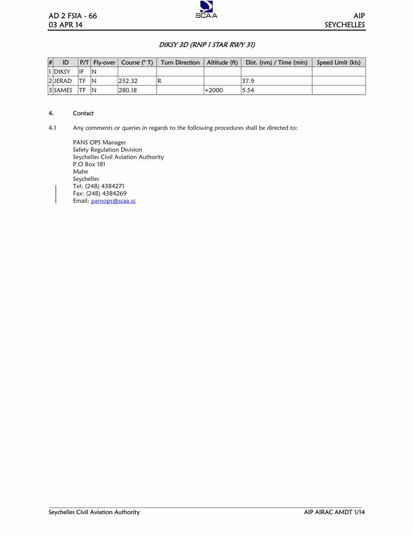
AD 2 FSIA - 66 AIP 03 APR 14 SEYCHELLES
Seychelles Civil Aviation Authority AIP AIRAC AMDT 1/14
DIKSY 3D (RNP 1 STAR RWY 31)
# ID P/T Fly-over Course (° T) Turn Direction Altitude (ft) Dist. (nm) / Time (min) Speed Limit (kts)
1 DIKSY IF N
2 JERAD TF N 252.32 R
37.9
3 SAMES TF N 280.18 +2000 5.54
4. Contact 4.1 Any comments or queries in regards to the following procedures shall be directed to: PANS OPS Manager Safety Regulation Division Seychelles Civil Aviation Authority P.O Box 181 Mahe Seychelles Tel: (248) 4384271 Fax: (248) 4384269 Email: [email protected]

AIP AD 2 FSIA - 7 SEYCHELLES 23 AUG 12
Seychelles Civil Aviation Authority AIP AIRAC AMDT 1/12
FSIA AD 2.15 OTHER LIGHTING, SECONDARY POWER SUPPLY
1 ABN/IBN location, characteristics and
hours of operation Nil
2 LDI location and LGT Anemometer location and LGT
LDI: Nil Anemometer: 71M from RCL. Abeam North west end of RWY. ( lighted)
3 TWY edge and centre line lighting Edge: Nil Centre line: TWY A , B and loop TWY - Green
4 Secondary power supply/switch-over time
Emergency lights available at 40 minutes for RWY 13/31. Full standby power available; Maximum changeover time - 10 SEC
5 Remarks Lights on windsocks at beginning of both Runway 13/31
FSIA AD 2.16 HELICOPTER LANDING AREA
1 Coordinates TLOF or THR of FATO Nil 2 TLOF and/or FATO elevation M/FT Nil 3 TLOF and FATO area dimensions,
surface, strength, marking Nil
4 True and MAG BRG of FATO Nil 5 Declared distance available Nil 6 APP and FATO lighting Nil 7 Remarks Two designated parking areas located between Bay1 and
taxiway alpha. Apron also available for helicopter landing with prior permission from ATC.
FSIA AD 2.17 ATS AIRSPACE
1 Designation and lateral limits SEYCHELLES CTZ A circle of 20NM radius centred on SEY DVOR 04 40 36.83 S 055 31 59.20 E
2 Vertical limits GND/MSL to 6500 FT MSL 3 Airspace classification D 4 ATS unit call sign
Language(s) Seychelles Tower English
5 Transition altitude 4 500 FT MSL 6 Remarks Nil
FSIA AD 2.18 ATS COMMUNICATION FACILITIES
Service
designation
Call sign
Frequency
Hours of operation
Remarks 1 2 3 4 5
APP Seychelles Approach
119.70 Mhz 118.30 Mhz 121.50 Mhz
H24 H24 H24
Primary frequency Secondary frequency Emergency frequency Note: APP and TWR combined.
TWR Seychelles Tower
118.30 Mhz 119.70 Mhz 121.50 Mhz
H24 H24 H24
Primary frequency Secondary frequency Emergency frequency Note: TWR and APP combined.
SMC Tower 121.90MHZ H24 Control of vehicular movement only.

AD 2 FSIA - 8 AIP 23 AUG 12 SEYCHELLES
AIP AIRAC AMDT 1/12 Seychelles Civil Aviation Authority
FSIA AD 2.19 RADIO NAVIGATION AND LANDING AIDS
Type of aid, CAT of ILS/MLS (For VOR/ILS/
MLS, give VAR)
ID
Frequency
Hours of operation
Site of transmitting
antenna coordinates
Elevation of
DME tx antenna
Remarks 1 2 3 4 5 6 7
DVOR1 (5.37ºW/2007)
SEY 113.10MHZ H24 04 40 36. 83 S 055 31 59.20 E
Shielded due to high terrain in the sector radials 215°-225° and 235-305°
DME1 (5.37ºW/2007)
SEY CH78X H24 04 40 36. 89 S 055 31 58.85 E
57.98(m) 190.22(ft)
Co-located with SEY DVOR
NDB1 (5.37ºW/2007)
SEY 373KHZ H24 04 37 03..34 S 055 26 22.05 E
Coverage 400NM
LLZ1, 2 & 3
Uncategorised
SIA 110.3MHZ H24 04 39 55. 30 S 055 30 32.47 E
1.58NM from THR RWY 31
GP1 335MHZ H24 04 40 51.81 S 055 31 47.92 E
Angle 3°. Antenna not located at required distance prior THR RWY 31.
DME1 SIA CH40X H24 04 40 23.73 S 055 31 10. 07 E
54.75(m) 179.64(ft)
Frequency paired with ILS LLZ. Reading zero at THR RWY 31.
Note1: Navaids maintenance periods are as follows: SEY DVOR/DME: 1st Wednesday of every month between 0400 - 0800 UTC. SEY NDB: Every Monday between 0400 - 0800 UTC. SIA DME: Every 4th Wednesday between 0400 - 0800 UTC. SIA ILS GP/LLZ: 2nd Wednesday of every month between 0400 - 0800 UTC. PRA DVOR/DME: 3rd Wednesday of every month between 0400 -0800 UTC. Note 2: SIA Localizer: Possibility of false capture
WARNING: Possibility of false capture of “SIA” localizer prior to crossing radial 150 SEY DVOR. Therefore pilots approaching from the southwest and wishing to intercept the “SIA” localizer for abbreviated ILS approach to runway 31 should avoid arming automatic localizer capture prior to crossing radial 150˚ “SEY” DVOR.
Note 3: ILS Uncategorised - For the purpose of obstruction limitation and removal, classed as non-precision (see ICAO Annex 14). - For the purpose of runway strip width, classed as non-precision (total 150m) (see ICAO Annex 14). - GP antenna position does not provide landing to THR. Transition to PAPI required when visual.
:
.

AIP AD 2 FSIA - 9 SEYCHELLES 23 AUG 12
Seychelles Civil Aviation Authority AIP AIRAC AMDT 1/12
FSIA AD 2.20 LOCAL TRAFFIC REGULATIONS
1. Airport regulations
At Seychelles International Airport, a number of local regulations apply. These regulations are available at SCAA, with certain important details already incorporated in this document. It covers generally: a) the meaning of markings and signs; b) information about aircraft stands including visual
docking guidance system; c) information about taxiing from aircraft stands
including taxi clearance; d) limitations in the operation of large aircraft
including limitations in the use of the aircraft’s own power for taxiing;
e) helicopter operations; f) marshaller assistance and towing assistance; g) use of engine power exceeding idle power h) engine start-up and use of APU; i) fuel spillage; and j) precautions during extreme weather conditions. These local regulations can be requested, in writing, from;
Chief Executive Officer Seychelles Civil Aviation Authority P.O.Box 181 Victoria, Mahe Seychelles.
2. Taxiing to and from stands
Arriving aircraft will be allocated a parking stand by the Control Tower prior to exiting the manoeuvring area. General aviation aircraft will be guided by a ground marshaller if a parking stand without AGNIS has been allocated and no tow bar is required . Departing IFR flights shall contact the Control Tower to obtain ATC clearance before commencing taxy. Request for ATC clearance may take place at the earliest 10 minutes prior to engine start-up. Departing aircraft shall obtain push-back clearance and taxi instruction from Seychelles Tower on 119.70 MHZ or 118.30MHZ.
3. Parking area for small aircraft (General aviation)
General aviation aircraft shall be guided by marshaller to the parking area designated for small aircraft.
4. Parking area for helicopters
Parking area for helicopters will be on the apron or at the northern parking area, as instructed by ATC
5. Apron – taxiing during winter conditions
- Nil -
6. Taxiing – limitations
- Nil -
7. School and training flights- technical test flights – use of runways
School and training flights shall only be made after the necessary permission has been obtained from the Chief Executive of SCAA and air traffic control.
8. Helicopter traffic – limitations
Non-scheduled public air traffic with helicopter is permitted only after prior approval from the Seychelles Civil Aviation Authority. Any contact concerning the above shall be made via the handling company or directly to the Chief Executive Officer of SCAA during the hours of service and, if possible at least 72 hours before the flight is to be carried out. Any request for approval of traffic shall contain the following information; a) Owner/operator b) Type of helicopter, registration/call sign c) Date and time of arrival and departure, routings
and destination. Other details relevant to the evaluation of the request shall be given as required.
9. Removal of disabled aircraft from runways
When an aircraft is wrecked on the runway, removal of such wreckage shall be subject to approval from the Seychelles Civil Aviation Authority.

AD 2 FSIA - 10 AIP 23 AUG 12 SEYCHELLES
AIP AIRAC AMDT 1/12 Seychelles Civil Aviation Authority
FSIA AD 2.21 NOISE ABATEMENT PROCEDURES No auxiliary power unit (APU) start up or run up between 1500 UTC and 0300 UTC on the international apron and NPA unless in accordance with aircraft arrival and departure procedures. FSIA AD 2.22 FLIGHT PROCEDURES General Unless special permission has been obtained from Seychelles Area Control Centre or Seychelles Tower as appropriate, flight within Seychelles FIR shall be in accordance with both Instrument Flight Rules (IFR) and Visual Flight Rules (VFR). 2.22.1 Procedures for IFR flights within Seychelles
TMA The inbound, transit and outbound routes shown on the charts may be varied at the discretion of air traffic control. As required for separation purposes, aircraft may be instructed to maintain VOR radials which may be different with that of their intended designated airways. This will be of a temporary duration and the respective aircraft will be cleared to maintain their designated tracks once the required separation has been achieved. 2.22.2 Radar procedures within Seychelles TMA
- Nil -
2.22.3 Radio communication failure procedures In the event that an aircraft is unable to communicate with Seychelles air traffic services units, it will be assumed that the following procedures shall be adopted. 2.22.3.1 For IFR Flights The procedures to be followed by aircraft at the termination of the Transition Routes, which are required to maintain two way radio communications experiencing radio equipment failure, shall conform to those specified in ICAO Annex 2 - Rules of the Air, paragraph 3.6.5 as follows:
a) proceed according to flight plan route along the relevant STAR to the initial approach fix or waypoint serving the destination aerodrome and runway in use and, when required to comply with (b) below, hold over this fix or waypoint until commencement of descent;
b) commence descent from fix or waypoint specified in (a) above at, or as close as possible to, the expected approach time last received and acknowledged; or, of no expected approach time has been received and acknowledged, at or as close as possible to, the estimated time of arrival resulting from the current flight plan;
c) complete a normal instrument approach
procedure as specified for the designated fix or waypoints associated with the current runway in use; and
d) land, if possible within 30 minutes after the
estimated time of arrival specified in (b) or last acknowledged expected approach time, whichever is later.
2.22.3.2 For VFR Flights
Where contact has previously been established:- Continue to destination aerodrome maintaining VMC, land and contact Seychelles Control Tower or Area Control Centre by telephone. Where the destination is Mahe, route via Harrison Rock and continue towards Seychelles International Airport. Seychelles Control Tower will keep a lookout and give light signals as appropriate. On receipt of a green light the pilot will land on the runway in use. If air traffic control wishes the aircraft to circle between Harrison Rock and the airport at 1000ft QNH, it will give the pilot a steady red light and the pilot will watch out for further instructions. Where contact has not been established with ATC: The pilot will return to the aerodrome of departure or suitable alternate maintaining VMC and shall contact Seychelles Control Tower or Area Control Centre by telephone. The pilot should not enter the controlled zone without an ATC clearance except in the case of an emergency whereby the pilot will keep clear of the instrument letdown paths and approach via Harrison Rock below 1000ft maintaining VMC and keeping vigilant lookout for any other traffic and comply with light signals from Seychelles Control Tower. Note- All aerodromes have telephone contact with Mahe.

AIP AD 2 FSPP -1 SEYCHELLES 2 JUN 11 _____________________________________________________________________________________________
Seychelles Civil Aviation Authority AIP AIRAC AMDT 1/11
AD 2 AERODROMES
FSPP AD 2.1 AERODROME LOCATION INDICATOR AND NAME
FSPP – PRASLIN
FSPP AD 2.2 AERODROME GEOGRAPHICAL AND ADMINISTRATIVE DATA
1 ARP coordinates and site at AD 0419 09.27S 055 41 29.78E 2 Direction and distance from (city) 045º, 25Nm 3 Elevation/Reference temperature 3.05M ( 10FT) 31.3° 4 MAG VAR/Annual change 5º W 5 AD Administration, address, telephone,
Tele-fax, AFS
Seychelles Civil Aviation Authority P.O. Box 181 Victoria Mahe Seychelles Tel: (248) 384000 Fax: (248) 384030
6 Types of traffic permitted (IFR/VFR) IFR/VFR 7 Remarks Small aircraft operations only
FSPP AD 2.3 OPERATIONAL HOURS
1 AD Administration MON-FRI 0400 - 1200 UTC 2 Taxation(Import Control)and immigration Nil 3 Health and sanitation Nil 4 AIS Briefing Office Nil 5 ATS Reporting Office (ARO) Nil 6 MET Briefing Office Nil 7 ATS Aerodrome control available primarily between
0300 – 1500 UTC. 8 Fuelling Nil 9 Handling Nil
10 Security Nil 11 De-icing Nil 12 Remarks Nil
FSPP AD 2.4 HANDLING SERVICES AND FACILITIES
1 Cargo – handling facilities Nil 2 Fuel / oil types Nil 3 Fuelling facilities Nil 4 De-icing facilities Nil 5 Hangar space for visiting aircraft Nil 6 Repair facilities for visiting aircraft Nil 7 Remarks Nil

AIP AD 2 FSPP -2 SEYCHELLES 2 JUN 11 _____________________________________________________________________________________________
Seychelles Civil Aviation Authority AIP AIRAC AMDT 1/11
FSPP AD 2.5 PASSENGER FACILITIES
1 Hotels None available at Praslin aerodrome 2 Restaurants Available at airport and in neighbouring hotels and
guesthouses 3 Transportation Taxis, car hires and buses 4 Medical facilities Clinic at Grand Anse, located 2.5 km from the aerodrome 5 Bank and Post Office Available at Grand Anse, 2.5 km from the aerodrome 6 Tourist Office Tourist information desk only 7 Remarks Nil
FSPP AD 2.6 RESCUE AND FIRE FIGHTING SERVICES
1 AD category for fire fighting CAT 5 2 Rescue equipment 3 x Rescue & Fire Fighting vehicles totaling 7,500litres of
water 1050 litres of foam 150 kg of DCP and 45kg of CO2 Forcing and breaking equipment available Rescue boat with life raft (1 x65 men) I x ambulance provided 2 Complete sets of Diving Equipment available
3 Capacity for removal of disabled aircraft Local arrangement 4 Remarks Service provided 24 hours
FSPP AD 2.7 SEASONAL AVAILABILITY - CLEARING
1 Types of clearing equipment Nil 2 Clearing priorities Nil 3 Remarks Nil
FSPP AD 2.8 APRONS, TAXIWAYS AND CHECK LOCATIONS DATA
1 Apron surface and strength Surface: Concrete
Strength: Not determined 2 Taxiway width, surface and strength Width: 8m
Surface: Concrete Strength: Not determined
3 ACL location and elevation Location: Nil Elévation: 3.05m / 10ft
4 VOR/INS checkpoints Nil 5 Remarks Aircraft heavier than a Shorts 360 are subject to approval
from SCAA, depending on the frequency of flights.
FSPP AD 2.9 SURFACE MOVEMENT GUIDANCE AND CONTROL SYSTEM AND MARKINGS
1 Use of aircraft stand ID signs, TWY guidelines and visual docking/parking guidance system of aircraft stands
Nil
2 RWY and TWY markings and LGT RWY: Designation, THR, centre line, runway edge and end. Marked and lighted. TWY: Centre line holding positions at all TWY/RWY intersection. Marked and lighted.
3 Stop bars Marked and lighted. Wing bars lighted. 4 Remarks Blue Apron edge lights

AIP AD 2 FSPP -3 SEYCHELLES 2 JUN 11 _____________________________________________________________________________________________
Seychelles Civil Aviation Authority AIP AIRAC AMDT 1/11
FSPP AD 2.10 AERODROME OBSTACLES
In approach/TKOF areas In circling area and at AD Remarks 1 2
RWY/AREA affected Obstacle type Elevation Markings/Lgt
Coordinates Obstacle type Elevation Markings/ Lgt
Nil
a b c a 15 APCH 33 TKOF
Mountain Peak 40m /131ft LGTD
04 18 14S 055 40 58E
Nil
15 APCH 33 TKOF
Mountain Peak 110m /361 ft LGTD
04 17 43S 055 40 52E
Nil
15 APCH 33 TKOF
Mountain Peak 180m /591 ft LGTD
04 17 53S 055 41 19E
Nil
33 APCH Mountain Peak 260m /853ft LGTD
04 20 16S 055 43 37E
Nil
FSPP AD 2.11 METEOROLOGICAL INFORMATION PROVIDED
- Nil -
FSPP AD 2.12 RUNWAY PHYSICAL CHARACTERISTICS
Designations RWY Number
TRUE &MAG BRG
Dimensions of RWY (M)
Strength (PCN) and surface of RWY and SWY
THR coordinates
THR elevation and highest elevation of TDZ of precision APP RWY
1 2 3 4 5 6 15 149 ˚ GEO
154 ˚ MAG 1405 X 30 Concrete 04 18 55.40S
055 41 21.49E THR 3.05m /10 ft
33 329 ˚ GEO 334 ˚ MAG
1405 X 30 Concrete 04 19 26.65S 055 41 40.17E
THR 3.05m /10ft
Slope of RWY – SWY
SWY dimensions
CWY dimension Strip dimensions OFZ Remarks
Nil Nil Nil 1490m x 150m 90m Nil Nil 222m Nil 1490m x 150m 90m Turning area available
at the end of RWY 33
FSPP AD 2.13 DECLARED DISTANCES
RWY Designators TORA (M)
TODA (M)
ASDA (M)
LDA (M)
Remarks
1 2 3 4 5 6 15 33
1316 1094
1316 1094
(5.24%)
1316 1316
1110 1238 (5.2°)
Nil Nil
Supplementary take-off distance for runway 33: 574m (3.3%) 765m (5.0%)

AIP AD 2 FSPP -4 SEYCHELLES 2 JUN 11 _____________________________________________________________________________________________
Seychelles Civil Aviation Authority AIP AIRAC AMDT 1/11
FSPP AD 2.14 APPROACH AND RUNWAY LIGHTING
RWY Desig
APCH LGT type LEN INSTS
THR LGT colour WBAR
VASIS (MEHT) PAPI
TDZ LGT LEN
RWY Ctr line LGT Length, spacing, colour , INST
RWY edge LGT LEN, spacing colour INST
RWY End LGT colour WBAR
SWY LGT LEN (M) colour
Remarks
1 2 3 4 5 6 7 8 9 10 15 SALS
60m LIL Green PAPI
4.5˚ Nil Nil 1217
50m LIH White Nil *
33 SALS 60m LIL
Green PAPI 3.5˚
Nil Nil 1217 50m LIH
White Nil **
* RWY 15 - Glide Slope Angle 4.5 ̊** RWY 33 - Glide Slope Angle 3.5 ̊
FSPP AD 2.15 OTHER LIGHTING, SECONDARY POWER SUPPLY
1 ABN/IBN location, characteristics and hours of operation Nil 2 LDI location and LGT Anemometer location and LGT LDI: Nil
Anemometer :75m south-east of the Tower. Not lighted
3 TWY edge and centre line lighting Edge: Blue LIH Centre line: Nil
4 Secondary power supply /switch-over time Emergency lights: gooseneck flares available within 15 mins. Full standby power available with immediate changeover time.
FSPP AD 2.16 HELICOPTER LANDING AREA
Nil specifically designated
FSPP AD 2.1 ATS AIRSPACE
1 Designation and lateral limits Aerodrome traffic zone within
1.5nm of aerodrome boundary. 2 Vertical limits GND/MSL to 2 000ft MSL 3 Airspace classification D 4 ATS unit call sign Language (s) Praslin Tower (English) 5 Transition altitude 4200ft QNH 6 Minimum safe altitude 2500ft QNH
FSPP AD 2.18 ATS COMMUNICATION FACILITIES
Service designation Call sign Frequency Hours of operation Remarks
1 2 3 4 5 TWR Praslin Tower 122.30 MHZ HJ & HO btn 1500-0300 UTC Nil SMC Praslin Tower 121.80MHZ HJ & HO btn 1500-0300 UTC Nil
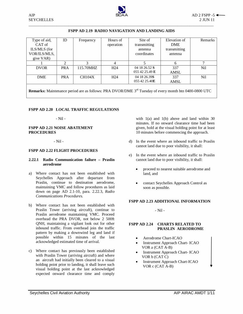
AIP AD 2 FSPP -5 SEYCHELLES 2 JUN 11 _____________________________________________________________________________________________
Seychelles Civil Aviation Authority AIP AIRAC AMDT 1/11
FSPP AD 2.19 RADIO NAVIGATION AND LANDING AIDS
Type of aid, CAT of
ILS/MLS (for VOR/ILS/MLS,
give VAR)
ID Frequency Hours of operation
Site of transmitting
antenna coordinates
Elevation of DME
transmitting antenna
Remarks
1 2 3 4 5 6 7 DVOR PRA 115.70MHZ H24 04 18 26.52 S
055 42 25.49 E 337
AMSL Nil
DME PRA CH104X H24 04 18 26.39S 055 42 25.40E
337 AMSL
Nil
Remarks: Maintenance period are as follows: PRA DVOR/DME 3rd Tuesday of every month btn 0400-0800 UTC FSPP AD 2.20 LOCAL TRAFFIC REGULATIONS
- Nil - FSPP AD 2.21 NOISE ABATEMENT PROCEDURES
- Nil - FSPP AD 2.22 FLIGHT PROCEDURES 2.22.1 Radio Communication failure – Praslin
aerodrome a) Where contact has not been established with
Seychelles Approach after departure from Praslin, continue to destination aerodrome, maintaining VMC and follow procedures as laid down on page AD 2.1-10, para. 2.22.3, Radio Communications Procedures.
b) Where contact has not been established with
Praslin Tower (arriving aircraft), continue to Praslin aerodrome maintaining VMC. Proceed overhead the PRA DVOR, not below 2 500ft QNH, maintaining a vigilant look out for other inbound traffic. From overhead join the traffic pattern by making a downwind leg and land if possible within 15 minutes of the last acknowledged estimated time of arrival.
c) Where contact has previously been established
with Praslin Tower (arriving aircraft) and where an aircraft had initially been cleared to a visual holding point prior to landing, it shall leave such visual holding point at the last acknowledged expected onward clearance time and comply
with 1(a) and 1(b) above and land within 30 minutes. If no onward clearance time had been given, hold at the visual holding point for at least 10 minutes before commencing the approach.
d) In the event where an inbound traffic to Praslin
cannot land due to poor visibility, it shall:
e) In the event where an inbound traffic to Praslin cannot land due to poor visibility, it shall:
• proceed to nearest suitable aerodrome and
land, and
• contact Seychelles Approach Control as soon as possible.
FSPP AD 2.23 ADDITIONAL INFORMATION
- Nil - FSPP AD 2.24 CHARTS RELATED TO
PRASLIN AERODROME
• Aerodrome Chart-ICAO • Instrument Approach Chart- ICAO
VOR a (CAT A-B) • Instrument Approach Chart- ICAO
VOR b (CAT C) • Instrument Approach Chart-ICAO
VOR c (CAT A-B)

APPTWR
119.70118.30
: Edi
toria
lE
GN
AH
CAERODROMECHART - ICAO
04°40’27.64”S055°31’18.68”E
SEYCHELLES INTLSEYCHELLESAERODROME
ALTITUDES , ELEVATIONS IN FEETBEARINGS ARE MAGNETICDIMENSIONS IN METRES
00010050METERS
5.37°W(2007)
ILS LOC110.3
RWY DIRECTION THR BEARING STRENGTH
13
HELIPORT
04°40'05.49" S055°30'47.04“ E
DECLARED DISTANCES
TAKE-OFF DISTANCE AVAILABLE
etercnoCm64x
m7892
Fire StationAnemometer
THR 31ELEV. 12 FT
MARKING AIDS RWY 13/31 AND EXIT TWY
ELEV - 12 FT
Windsock
Anemometer
ApronSEY
VOR/DME 113.1CH 78X
Sea
Sea
Sea
Sea
ARP
THR 13ELEV. 12 FT
310°
130°
MET
ATC Tower
Windsock
280
PAPI 3°
PAPI 3°
13
13
31
LIGHTING AIDS RWY 13/31 AND EXIT TWY
3104°40'49.78" S055°31'50.31“ E
125° GEO130° MAG
305° GEO310° MAG
REJECTED TAKE-OFF DISTANCEAVAILABLE
LANDING DISTANCE AVAILABLE
PCN 72/R/B/W/U
PCN 72/R/B/W/U
RWY 13 RWY 3179530844
78927892
28622862
LandingThreshold
LandingThreshold
Rabbit Lights
Parking Area
AIP Seychelles AD 2 FSIA - 13
Seychelles Civil Aviation Authority AIP AIRAC AMDT 1/10
Effective 3 JUN 10

APPTWR
119.70118.30
ngisedeR:
EG
NA
HC
AIRCRAFT PARKING /DOCKING CHART - ICAO
SEYCHELLES INTLSEYCHELLESAERODROME
ALTITUDES , ELEVATIONS IN FEETBEARINGS ARE MAGNETICDIMENSIONS IN METRES
5.37°W(2007)
APRON ELEV10 FT
13
TWY A
TWY
B
12
3
1
23
4
5
6
METContolTower
TERMINAL
Light ACFTPARKING
55-30.7 9.03-558.03-556.03-55
04-40.2
INS COORDINATES FOR AIRCRAFT STANDS
1. 04°40’12” S055°30’42” E
2.
3.
4.
5.
6.
1.
2.
3.
LIGHT AIRCRAFTTAXIWAYS 75 FT WIDE
TAXIWAYS AND APRON BEARING STRENGTH - Nil
All parking positions in front of International Terminal arenose-in
04°40’12” S055°30’42” E
04°40’12” S055°30’42” E
04°40’12” S055°30’48” E
04°40’12” S055°30’48” E
04°40’18” S055°30’48” E
04°40’12” S055°30’42” E
04°40’12” S055°30’42” E
04°40’12” S055°30’42” E
AIP Seychelles AD 2 FSIA - 15
Seychelles Civil Aviation Authority AIP AIRAC AMDT 1/10
Effective 3 JUN 10

ELEV
ATIO
NSIN
FEET
-DIM
ENSI
ONS
INME
TRES
AERO
DROM
EOB
STRU
CTIO
NCH
ART
-ICA
OTY
PEA
(OPE
RATI
NGLI
MITA
TION
S)
SEYC
HELL
ESIN
TLSE
YCHE
LLES
AERO
DROM
E
° 013° 031
MA
GN
ETIC
VARI
ATIO
N5.
37°W
(200
7)
GR
OU
ND
LEV
EL
IDE
NT
IFIC
AT
ION
NU
MB
ER
TR
EE
OR
SH
RU
B
PO
LE,T
OW
ER
,AN
TE
NN
AE
TC
BU
ILD
ING
OR
LAR
GE
ST
RU
CT
UR
E
RO
UD
OR
TR
AC
K
TR
AN
SM
ISS
ION
LIN
E,O
VE
RH
EA
DC
AB
LE
TE
RR
AIN
PE
NE
TR
AT
ING
OB
ST
ST
RU
CT
ION
PLA
NE
LEG
END
2
AM
END
MEN
TRE
CORD
1.N
ew
ORD
ERO
FA
CCU
RACY
HO
RIZ
ON
TAL
1mV
ER
TIC
AL
1m
12’
2987
m29
87m
%2. 1E
POL
S
100'
200'
300'
400'
500'
600'
700'
5000
m
800'
900'
1000
'
31
CO
NC
RE
TE
298
7mx
46m
DE
CLA
RE
DD
ISTA
NC
ES
TAK
E-
OF
FR
UN
AV
AIL
AB
LETA
KE
-O
FF
DIS
TAN
CE
AV
AIL
AB
LEA
CC
ELE
RA
TE
ST
OP
DIS
TAN
CE
AV
AIL
AB
LELA
ND
ING
DIS
TAN
CE
AV
AIL
AB
LE
2987
m29
87m
2987
m29
87m
2987
m29
87m
2987
m29
87m
RW
Y31
RW
Y13
RWY
13-3
1
01020304060708090100
110
120
50
050
100
150
150
250
300
350
400
F E E T
M E T R E S
VE
RT
ICA
LS
CA
LE
0000
010005
00040003
00020001
00510
0015
00
100
030
050
050
010
0020
0030
00
FE
ET
ME
TR
ES
HO
RIZ
ON
TAL
SC
ALE
0
1
0
12’
13
7000
m90
00m
1100
0m12
000m
2%2.1
EP
OLS
3
272'
127
2'2
272'
3
272'
44
AIP Seychelles AD 2 FSIA - 17
Seychelles Civil Aviation Authority AIP AIRAC AMDT 1/10
Effective 3 JUN 10

5001000150020002500
ContourIntervals
INSTRUMENTAPPROACHCHART - ICAO
AERODROME ELEV 12 FTHEIGHTS RELATED TO
THR RWY 31 ELEV 12 FTAPPTWR
119.70118.30
SEYCHELLES INTL (FSIA)ILS W RWY 31
(CAT C - D)
ALTITUDES, ELEVATIONS IN FEETBEARINGS, TRACKS AND RADIALS
ARE MAGNETICDISTANCES IN NAUTICAL MILES
055°20’ 055°30’ 055°40’ 055°50’
055°20’ 055°30’ 055°40’ 055°50’
04°30’
04°40’
04°50’
04°30’
04°40’
04°50’0150
NM
5.37°W(2007)
SEYNDB 373.0
SEYVOR/DME 113.1
CH 78X
10 NM
1415
1398
2104
1959
145
310°4200 FT ALT
MISSED APPROACH:Climb to 4200 FT ALTImmediate right turn totrack 030°M outbound.At 4200 FT ALT turnleft direct NDB “SEY”and hold or as directedby ATC.
TRANSITION ALTITUDE4500 FT ALT
TCH 50
ELEV 12’YES‘EMD/ROVmorfMN13YWRRHT
50501
130° 310°4200(4188)
VOR/DMESEY
130°
310°
030° 2000
(1988)
MIN
10
(IF)D7.0‘SIA’ / ‘SEY’
085°
Missed ApproachCAT - DCAT - C
Maximum 160 KIAS ,Maximum 140 KIAS ,until established on 030°Moutbound
(MAPt)CAT-D = D2.2 ‘SIA’ / ‘SEY’CAT-C = D2.0 ‘SIA’ / ‘SEY’
FAP - MAPt ( ) 4.8 NMCAT D 3:36 2:52 2:24 1:48
NDBSEY
130°
030°
4200 FT ALT
MAX
160 K
IAS
SIAILS 110.3CH 40X
2.2
ILSSIA
RECOMMENDED PROFILE
Descent Gradient 5.24% (3°)
Position ALT/HGTFAP 2000 (1188)
Straight-inApproach
OCA/HMIN
Rate of descent FT/MIN 420 530 640 850
KTS 80 100 120 160
Circling - CAT D MAX 160 KIAS
C D
R-165
R-300 VOR/DME”SEY”
1270 (1258)
Position ALT/HGT4 1280 (1268)
6 1920 (1908) 3 960 (948)5 1590 (1578) 2 640 (628)
CAT D
130°
265°
130°
310°
130°
MAPtCAT-D = 2.2 DMECAT-C = 2.0 DME‘SIA’ / ’SEY’
2986
(FAP)D6.3
‘SIA / ‘SEY’
FAP6.3 DME
‘SEY / ‘SIA’
GP INOP 640 (628) 700 (688)
IF7.0 DME2000 FT
CAUTIONGP located abeam displacedthreshold. GP height at RWYhead 50 FT.
If visual, intercept PAPI glideslope and continue to land
2000 FT ALT
ILS 640 (628) 700 (688)
NAV EQUIPMENT REQUIREDNDB & DME
WARNING1. Shielding of VOR/DME may occur
between radials 215/224 and 235/300due to high terrain.
2.Turbulence may be experienced on both approaches,particulary with wind from westerly quadrants whendowndraught can be severe on short final RWY 13.
GP 3.0°
873
431
1959
400
308
619
Lighthouse
AIPSeychelles AD 2 FSIA - 25
Seychelles Civil Aviation Authority
S (
Ref
er N
OT
AM
A00
49/1
0)E
DO
C E
MA
N
:
EG
NA
HC
Circling Prohibited between R-165 & R-300from VOR “SEY” to the west.
Effective 16 DEC 10
MSA 25 NMSEY VOR
4200 R-165
R-300
3400
4200
10MN
2 5MN
SAMES10 DME
‘SIA’/’SEY’
SAMESD10
’SIA’/’SEY
AIP AIRAC AMDT 2/10

5001000150020002500
ContourIntervals
INSTRUMENTAPPROACHCHART - ICAO
AERODROME ELEV 12 FTHEIGHTS RELATED TO
THR RWY 31 ELEV 12 FTAPPTWR
119.70118.30
SEYCHELLES INTL (FSIA)ILS X RWY 31
(CAT A - B)
ALTITUDES, ELEVATIONS IN FEETBEARINGS, TRACKS AND RADIALS
ARE MAGNETICDISTANCES IN NAUTICAL MILES
055°20’ 055°30’ 055°40’ 055°50’
055°20’ 055°30’ 055°40’ 055°50’
04°30’
04°40’
04°50’
04°30’
04°40’
04°50’0150
NM5.37°W
(2007)
SEYNDB 373.0
SEYVOR/DME 113.1
CH 78X
10 NM
1415
1398
2104
1959
145
310°4200 FT ALT
MISSED APPROACH:Climb to 4200 FT ALTImmediate right turn totrack 030°M outbound.At 3000 FT ALT turnleft direct NDB “SEY”and hold or as directedby ATC.
TRANSITION ALTITUDE4500 FT ALT
TCH 50
ELEV 12’YES‘EMD/ROVmorfMN13YWRRHT
50501
130° 310°4200(4188)
VOR/DMESEY
130°
310°
030° 2000
(1988)GP 3.0°
MIN
10
(IF)D7.0‘SIA’ / ‘SEY’
085°
Missed ApproachCAT - BCAT - A
Maximum 130 KIAS ,Maximum 100 KIAS .until established on 030°Moutbound
(MAPt)CAT-B = D1.9 ‘SIA’ / ‘SEY’CAT-A = D1.6 ‘SIA’ / ‘SEY’
FAP - MAPt ( ) 4.4 NMCAT B 3:18 2:38 2:12 1:39
NDBSEY
130°
030°
3000 FT ALT
MAX
160 K
IAS
SIAILS 110.3CH 40X
1.6
ILSSIA
RECOMMENDED PROFILE
Descent Gradient 5.24% (3°)
Position ALT/HGTFAP 2000 (1188)
Straight-inApproach
OCA/H AMIN
Rate of descent FT/MIN 420 530 640 850
KTS 80 100 120 160
Circling
B
R-165
R-300 VOR/DME”SEY”
510 (498) 780 (768)
Position ALT/HGT4 1280 (1268)
6 1920 (1908) 3 960 (948)5 1590 (1578) 2 640 (628)
CAT B
130°
265°
130°
310°
130°
MAPtCAT-B = 1.9 DMECAT-A = 1.6 DME‘SIA’ / ’SEY’
2986
(FAP)D6.3
‘SIA / ‘SEY’
FAP6.3 DME
‘SEY / ‘SIA’
510 (498)GP INOP 605 (593)
IF7.0 DME‘SEY / ‘SIA’’2000 FT
CAUTIONGP located abeam displacedthreshold. GP height at RWYhead 50 FT.
If visual, intercept PAPI glideslope and continue to land
510 (498)ILS 605 (593)
NAV EQUIPMENT REQUIREDNDB & DME
WARNING1. Shielding of VOR/DME may occur
between radials 215/224 and 235/300due to high terrain.
2.Turbulence may be experienced on both approaches,particulary with wind from westerly quadrants whendowndraught can be severe on short final RWY 13.
2500 FT ALT
1.9
873
431
1959
400
308
619
Lighthouse
AIPSeychelles AD 2 FSIA - 27
Seychelles Civil Aviation Authority
:E
GN
AH
C
Circling Prohibited between R-165 & R-300from VOR “SEY” to the west.
Effective 16 DEC 10
MSA 25 NMSEY VOR
4200 R-165
R-300
3400
4200
10MN 52MN
SAMES10 DME
‘SIA’/’SEY’
SAMESD10
’SIA’/’SEY
S (
Ref
er N
OT
AM
A00
49/1
0)E
DO
C E
MA
N
AIP AIRAC AMDT 2/10

INSTRUMENTAPPROACHCHART - ICAO
AERODROME ELEV 12 FTHEIGHTS RELATED TO
THR RWY 31 ELEV 12 FTAPPTWR
119.70118.30
SEYCHELLES INTL (FSIA)ILS Y RWY 31
(CAT C - D)
ALTITUDES, ELEVATIONS IN FEETBEARINGS, TRACKS AND RADIALS
ARE MAGNETICDISTANCES IN NAUTICAL MILES
055°20’ 055°30’ 055°40’ 055°50’
055°20’ 055°30’ 055°40’ 055°50’
04°30’
04°40’
04°50’
04°30’
04°40’
04°50’
0150NM
5.37°W(2007)
SEYNDB 373.0
SEYVOR/DME 113.1
CH 78X
10 NM/DME
10 DME‘SEY/SIA’
FAP6.3 DME ‘SEY/SIA’
2000 FT
1415
1398
2104
1959
2986 14503
0°
4200 FT ALT
MISSED APPROACH:Climb to 4200 FT ALT. Immediateright turn to track 030°M outbound.At 4200 FT ALT turn left directVOR “SEY” and hold or as directedby ATC.
TRANSITION ALTITUDE4500 FT ALT
TCH 50ELEV 12
’YES‘EMD/ROVmorfMN13YWRRHT50501
130° 310°4200(4188)
VOR/DMESEY
310°
030° 2000
(1988)GP 3.0°
4200 FT ALT
10
(FAP)D6.3
Missed ApproachCAT - DCAT - C
Maximum 160 KIAS ,Maximum 140 KIAS ,until established on 030°Moutbound
310°
RECOMMENDED PROFILE
Descent Gradient 5.24% (3°)
Position ALT/HGTFAP 2000 (1188)
MINRate of descent FT/MIN 420 530 640 850
KTS 80 100 120 160
FAP - MAPt ( 4.1 NM)CAT D 3:04 2:27 2:03 1:32
Position ALT/HGT4 1280 (1268)
6 1920 (1908) 3 960 (948)5 1590 (1578) 2 640 (628)
CAT D
2.2
SIAILS 110.3CH 40X
ILSSIA
(MAPt)CAT-D = D2.2 ‘SIA’ / ‘SEY’CAT-C = D2.0 ‘SIA’ / ‘SEY’
5001000150020002500
ContourIntervals
310°
130°
125°
135°
130°
MAPtCAT-D = 2.2 DMECAT-C = 2.0 DME‘SIA’ / ‘SEY’
Straight-inApproach
Circling - CAT D MAX 160 KIAS
C D
R-165
VOR/DME”SEY”
1270 (1258)GP INOP 640 (628) 700 (688)
R-300
If visual, intercept PAPI glideslope and continue to land
CAUTIONGP located abeam displacedthreshold. GP height at RWYhead 50 FT.
640 (628) 700 (688)ILS
13 DMEArc SEY
VO R
2500 FT ALT
NAV EQUIPMENT REQUIREDVOR & DME
WARNING1. Shielding of VOR/DME may occur
between radials 215/224 and 235/300due to high terrain.
2.Turbulence may be experienced on both approaches,particulary with wind from westerly quadrants whendowndraught can be severe on short final RWY 13.
115°
115°
873
431
1959
400
308
619
Lighthouse
2000 ft
2000 ft
AIPSeychelles AD 2 FSIA - 29
Seychelles Civil Aviation Authority
:E
GN
AH
C
Circling Prohibited between R-165 & R-300from VOR “SEY” to the west.
AIP AIRAC AMDT 2/10
Effective 16 DEC 10
MSA 25 NMSEY VOR
4200 R-165
R-300
3400
4200
10MN 52MN
165°
045°
SAMESD10
’SIA’/’SEY
SAMES10 DME
‘SIA’/’SEY’
S (
Ref
er N
OT
AM
A00
49/1
0)E
DO
C E
MA
N

INSTRUMENTAPPROACHCHART - ICAO
AERODROME ELEV 12 FTHEIGHTS RELATED TO
THR RWY 31 ELEV 12 FTAPPTWR
119.70118.30
SEYCHELLES INTL (FSIA)ILS Z RWY 31
(CAT A - B)
ALTITUDES, ELEVATIONS IN FEETBEARINGS, TRACKS AND RADIALS
ARE MAGNETICDISTANCES IN NAUTICAL MILES
055°20’ 055°30’ 055°40’ 055°50’
055°20’ 055°30’ 055°40’ 055°50’
04°30’
04°40’
04°50’
04°30’
04°40’
04°50’0150
NM5.37°W
(2007)
SEYNDB 373.0
SEYVOR/DME 113.1
CH 78X
10 NM/DME
10 DME‘SEY/SIA’
FAP6.3 DME ‘SEY/SIA’
2000 FT
1415
1398
2104
1959
2986 14503
0°
4200 FT ALT
MISSED APPROACH:Immediate right turn to track 030°MClimb to 4200 FT ALT.At 3000 FT ALT turn left directVOR “SEY” and hold or as directedby ATC.
TRANSITION ALTITUDE4500 FT ALT
TCH 50ELEV 12
’YES‘EMD/ROVmorfMN13YWRRHT50501
130° 310°4200(4188)
VOR/DMESEY
310°
030° 2000
(1988)
SAMESD10.0
GP 3.0°
3000 FT ALT
10
(FAP)D6.3
Missed ApproachCAT - BCAT - A
Maximum 130 KIAS ,Maximum 100 KIAS .until established on 030°Moutbound
310°
RECOMMENDED PROFILE
Descent Gradient 5.24% (3°)
Position ALT/HGTFAP 2000 (1188)
MINRate of descent FT/MIN 420 530 640 850
KTS 80 100 120 160
FAP - MAPt ( C A T B ) 4.4 NM 3:18 2:38 2:12 1:36
Position ALT/HGT4 1280 (1268)
6 1920 (1908) 3 960 (948)5 1590 (1578) 2 640 (628)
CAT B
1.6
SIAILS 110.3CH 40X
ILSSIA
(MAPt)CAT-B = D1.9 ‘SIA’ / ‘SEY’CAT-A = D1.6 ‘SIA’ / ‘SEY’
5001000150020002500
ContourIntervals
310°
130°
125°
135°
130°
MAPtCAT-B = 1.9 DMECAT-A = 1.6 DME‘SIA’ / ‘SEY’
Straight-inApproach
A
Circling
B
R-165
VOR/DME”SEY”
510 (498) 780 (768)510 (498)GP INOP 605 (593)
R-300
If visual, intercept PAPI glideslope and continue to land
CAUTIONGP located abeam displacedthreshold. GP height at RWYhead 50 FT.
510 (498) 605 (593)ILS
2500 FT ALT
NAV EQUIPMENT REQUIREDVOR & DME
WARNING1. Shielding of VOR/DME may occur
between radials 215/224 and 235/300due to high terrain.
2.Turbulence may be experienced on both approaches,particulary with wind from westerly quadrants whendowndraught can be severe on short final RWY 13.
115°
115°
1.9
873
431
1959
400
308
619
Lighthouse
2000 ft
‘SEY/SIA’ ‘SEY/SIA’
AIPSeychelles AD 2 FSIA - 31
Seychelles Civil Aviation Authority
:E
GN
AH
C
Circling Prohibited between R-165 & R-300from VOR “SEY” to the west.
Effective 16 DEC 10
MSA 25 NMSEY VOR
4200 R-165
R-300
3400
4200
10MN 52MN
165°
045°
SAMES10 DME
‘SIA’/’SEY’
S (
Ref
er N
OT
AM
A00
49/1
0)E
DO
C E
MA
N
AIP AIRAC AMDT 2/10

INSTRUMENTAPPROACHCHART - ICAO
AERODROME ELEV 12 FTHEIGHTS RELATED TO
THR RWY 31 ELEV 12 FTAPPTWR
119.70118.30
SEYCHELLES INTL (FSIA)NDB RWY 31
(CAT A - D)
ALTITUDES, ELEVATIONS IN FEETBEARINGS, TRACKS AND RADIALS
ARE MAGNETICDISTANCES IN NAUTICAL MILES
055°20’ 055°30’ 055°40’ 055°50’
055°20’ 055°30’ 055°40’ 055°50’
04°30’
04°40’
04°50’
04°30’
04°40’
04°50’
0150NM
5.37°W(2007)
SEYNDB 373.0
SEYVOR/DME 113.1
CH 78X
10 NM
FAF7.0 DME ‘SEY/SIA’
2000 FT
1415
1398
2104
1959
2986 14503
0°
310°
MISSED APPROACH:Climb to 4200 FT ALTImmediate right turn totrack 030°M outbound.At 4200 FT ALT turnleft direct NDB “SEY”and hold or as directedby ATC.
TRANSITION ALTITUDE4500 FT ALT
TCH 50ELEV 12
’YES‘EMD/ROVmorfMN13YWRRHT50501
130° 310°4200
(4188)
VOR/DMESEY
130°
310°
030° 2000
(1988)
VPA 3.0°
MIN
4200 FT ALT
10
(FAF)D7.0
1270 (1258) FAF - MAPt 3.2 NM 2:24 1:55 1:36 1:12
NDBSEY
130°
310°
MAPt3.8 DME ‘SEY/SIA’
MAX 160 KIAS
MAX
160 K
IAS
(MAPt)D3.8
2.5% M-APP5.0% M-APP 820 (808)
RECOMMENDED PROFILE
Descent Gradient 5.24% (3°)
Position ALT/HGTFAF 2000 (1188)
Straight-inApproach
OCA/H A
Rate of descent FT/MIN 420 530 640 850
KTS 80 100 120 160
Circling - CAT D MAX 160 KIAS
B C D
R-165
R-300 VOR/DME”SEY”
510 (498) 780 (768) 1270 (1258)
Position ALT/HGT4 1280 (1268)
6 1920 (1908) 3 960 (948)5 1590 (1578) 2 640 (628)
CAT D
130°
5001000150020002500
ContourIntervals
085°
265°
130°
130°
4200 FT ALT310°
2500 FT ALT
310°NDB ‘SEY’
NAV EQUIPMENT REQUIREDDME
WARNING1. Shielding of VOR/DME may occur
between radials 215/224 and 235/300due to high terrain.
2.Turbulence may be experienced on both approaches,particulary with wind from westerly quadrants whendowndraught can be severe on short final RWY 13.
873
431
1959
400
308
619
Lighthouse
‘SEY/SIA’ ‘SEY/SIA’
AIP Seychelles AD 2 FSIA - 33
Seychelles Civil Aviation Authority
ED
ITO
RIA
L, R
E P
AG
ING
:E
GN
AH
C
Circling Prohibited between R-165 & R-300from VOR “SEY” to the west.
AIP AIRAC AMDT 1/10
Effective 3 JUN 10
MSA 25 NMSEY VOR
4200 R-165
R-300
3400
4200
10NM
2 5NM

INSTRUMENTAPPROACHCHART - ICAO
AERODROME ELEV 12 FTHEIGHTS RELATED TO
THR RWY 13 ELEV 12 FTAPPTWR
119.70118.30
SEYCHELLES INTL (FSIA)VOR X RWY 13
(CAT A - D)
ALTITUDES, ELEVATIONS IN FEETBEARINGS, TRACKS AND RADIALS
ARE MAGNETICDISTANCES IN NAUTICAL MILES
055°20’ 055°30’ 055°40’ 055°50’
055°20’ 055°30’ 055°40’ 055°50’
04°30’
04°40’
04°50’
04°30’
04°40’
04°50’
0150NM
5.37°W(2007)
Missed ApproachCAT - C & DCAT - BCAT - A
Maximum 160 KIAS ,Maximum 130 KIAS ,Maximum 100 KIAS .until established on 130°M outbound
SEYNDB 373.0
SEYVOR/DME 113.1
CH 78X
10 NM
11 DME ‘SEY’2500 FT
1415
1398
2104
1959
2986
145
130°
MISSED APPROACH:Immediate left turn totrack 130°M.Climb to 4200 FT ALT.At 4200 FT ALT turnright direct VOR “SEY”and hold or as directedby ATC.
TRANSITION ALTITUDE4500 FT ALT
TCH 50 ELEV 12
THR RWY 13NM from VOR/DME ‘SEY’10 50551
340°160° 4200(4188)
VOR/DMESEY
1760(1748)
130°
2500(2488)
(SDF)D6.5
(FAF)D10.0
VPA 3.0°
FAF - MAPt 5.5 NM 4:07 3:18 2:45 2:03
DM
E A
RC
, LE
AD
RA
DIA
LS, M
AP
ALT
ITU
DE
, MS
A S
EC
TO
RS
, NA
ME
CO
DE
ES
:E
GN
AH
C
1120 (1108)
6.5 DME ‘SEY’
4200 FT ALT
MIN
RECOMMENDED PROFILE
Descent Gradient 5.24% (3°)
Position ALT/HGTFAF 2500 (2488)
Circling only
OCA/H AMIN
Rate of descent FT/MIN 420 530 640 850
KTS 80 100 120 160B C D
R-165
R-300 VOR/DME”SEY”
Circling Prohibited between R-165 & R-300from VOR “SEY” to the west.
Position ALT/HGT
CAT D
130°
5001000150020002500
ContourIntervals
4200 FTALT
3400 FT ALT
RDPLGTS
NAV EQUIPMENT REQUIREDDME
WARNING1. Shielding of VOR/DME may occur
between radials 215/224 and 235/300due to high terrain.
2.Turbulence may be experienced on both approaches,particulary with wind from westerly quadrants whendowndraught can be severe on short final RWY 13.
(MAPt)D4.5
1120(1108)
324°
144°
MAPt4.5 DME ‘SEY’
340°
160°
D11.0
340°
144°
1 DME ‘SEY’02500 FT
340°
144°
873
431
1959
400
308
619
Lighthouse
CAT D MAX 160 KIAS
AIP Seychelles AD 2 FSIA - 35
Seychelles Civil Aviation Authority
NOTEAIRCRAFT TO CONFIGUREFOR LANDING PRIOR TOTHE FAF TO AVOID GPWSWARNING
15 DME ‘SEY’
315°
335°
AIP AIRAC AMDT 1/10
Effective 3 JUN 10
MSA 25 NMSEY VOR
4200 R-165
R-300
3400
4200
10NM
2 5NM
TASHA15 DME
‘SIA’/’SEY’
TASHAD15.0

INSTRUMENTAPPROACHCHART - ICAO
AERODROME ELEV 12 FTHEIGHTS RELATED TO
THR RWY 13 ELEV 12 FTAPPTWR
119.70118.30
SEYCHELLES INTL (FSIA)VOR Z RWY 13
(CAT A - D)
ALTITUDES, ELEVATIONS IN FEETBEARINGS, TRACKS AND RADIALS
ARE MAGNETICDISTANCES IN NAUTICAL MILES
055°20’ 055°30’ 055°40’ 055°50’
055°20’ 055°30’ 055°40’ 055°50’
04°30’
04°40’
04°50’
04°30’
04°40’
04°50’0150
NM5.37°W
(2007)
Missed ApproachCAT - C & DCAT - BCAT - A
Maximum 160 KIAS ,Maximum 130 KIAS ,Maximum 100 KIAS .until established on 130°M outbound
SEYNDB 373.0
SEYVOR/DME 113.1
CH 78X
10 NM
10 DME ‘SEY’2300 FTFAF
10 DME ‘SEY’2300 FT
1415
1398
2104
1959
2986 145
205°
130°
4200 FTALT
MISSED APPROACH:MAPt 6.0 DME beforeVOR “SEY”.Climb to 4200 FT ALTImmediate left turn totrack 130°M outbound.At 4200 FT ALT turnright direct VOR “SEY”and hold or as directedby ATC.
TRANSITION ALTITUDE4500 FT ALT
TCH 50 ELEV 12
THR RWY 13NM from VOR/DME ‘SEY’10 505
355°175° 4200(4188)
VOR/DMESEY
1080(1068)
130°
2300(2288)
(MAPt)D6.0
(FAF)D10.0
VPA 3.0°
FAF - MAPt 4.0 NM 3:00 2:24 2:00 1:30
DM
E A
RC
RA
DIA
LS, E
DIT
OR
IAL,
RE
PA
GIN
G, N
AM
E C
OD
ES
:E
GN
AH
C
1120 (1108) 1270 (1258)
MAPt6.0 DME ‘SEY’
4200 FT ALT
MIN
RECOMMENDED PROFILE
Descent Gradient 5.24% (3°)
Position ALT/HGTFAF 2300 (2288)
Circling only
OCA/H AMIN
Rate of descent FT/MIN 420 530 640 850
KTS 80 100 120 160B C D
R-165
R-300 VOR/DME”SEY”
Circling Prohibited between R-165 & R-300from VOR “SEY” to the west.
Position ALT/HGT
32
CAT D
130°
960 (948)640 (628)
5001000150020002500
ContourIntervals
355°
175°
3400 FTALT160°
340°
RDPLGTS
NAV EQUIPMENT REQUIREDDME
WARNING1. Shielding of VOR/DME may occur
between radials 215/224 and 235/300due to high terrain.
2.Turbulence may be experienced on both approaches,particulary with wind from westerly quadrants whendowndraught can be severe on short final RWY 13.
160°
355°
355°160°
873
431
1959
400
308
619
Lighthouse
CAT D MAX 160 KIAS
AIP Seychelles AD 2 FSIA - 37
Seychelles Civil Aviation Authority
15 DME ‘SEY’
330°
350°
AIP AIRAC AMDT 1/10
Effective 3 JUN 10
MSA 25 NMSEY VOR
4200 R-165
R-300
3400
4200
10NM
2 5NM
045°
300°
LINDA15 DME
‘SIA’/’SEY’
LINDAD15.0

INSTRUMENTAPPROACHCHART - ICAO
AERODROME ELEV 12 FTHEIGHTS RELATED TO
THR RWY 31 ELEV 12 FTAPPTWR
119.70118.30
SEYCHELLES INTL (FSIA)VOR Z RWY 31
(CAT A - D)
ALTITUDES, ELEVATIONS IN FEETBEARINGS, TRACKS AND RADIALS
ARE MAGNETICDISTANCES IN NAUTICAL MILES
055°20’ 055°30’ 055°40’ 055°50’
055°20’ 055°30’ 055°40’ 055°50’
04°30’
04°40’
04°50’
04°30’
04°40’
04°50’
0150NM
5.37°W(2007)
SEYNDB 373.0
SEYVOR/DME 113.1
CH 78X
10 NM/DME
8 DME‘SEY’FAF
6.3 DME ‘SEY’2000 FT
MAPt2.5 DME ‘SEY’
1415
1398
2104
1959
2986 145
130°
030°
4200 FT ALT
MISSED APPROACH:MAPt 2.5 DME beforeVOR “SEY”.Climb to 4200 FT ALTImmediate right turn totrack 030°M outbound.At 4200 FT ALT turnleft direct VOR “SEY”and hold or as directedby ATC.
TRANSITION ALTITUDE4500 FT ALT
TCH 50ELEV 12
’YES‘EMD/ROVmorfMN13YWRRHT50501
145° 325°4200(4188)
VOR/DMESEY
030° 2000
(1988)
(MAPt)D2.5
(IF)D8.0
VPA 3.0°
FAF - MAPt 3.8 NM 2:51 2:16 1:54 1:25
10
(FAF)D6.3
2.5% M-APP5.0% M-APP
4200 F TMissed ApproachCAT - C +DCAT - A + B
Maximum 160 KIAS ,Maximum 130 KIAS ,until established on 030°M outbound
RECOMMENDED PROFILE
Descent Gradient 5.24% (3°)
Position ALT/HGTFAF 2000 (1188)
Straight-inApproach
OCA/H AMIN
Rate of descent FT/MIN 420 530 640 850
KTS 80 100 120 160
Circling - CAT D MAX 160 KIAS
B C D
R-165
R-300 VOR/DME”SEY”
510 (498) 780 (768)
860 (848)695 (683)
1270 (1258)
Position ALT/HGT4 1280 (1268)
6 1920 (1908) 3 960 (948)5 1590 (1578) 2 640 (628)
5001000150020002500
ContourIntervals
145°
325°
145°
140°150°
NAV EQUIPMENT REQUIREDDME
325°
WARNING1. Shielding of VOR/DME may occur
between radials 215/224 and 235/300due to high terrain.
2.Turbulence may be experienced on both approaches,particulary with wind from westerly quadrants whendowndraught can be severe on short final RWY 13.
325°
130°
2500 FT ALT
873
431
1959
400
308
619
Lighthouse
13 DMEArc SEY
VO R
2000 ft
2000 ft
AIP Seychelles AD 2 FSIA - 39
Seychelles Civil Aviation Authority
DM
E A
RC
RA
DIA
LS, E
DIT
OR
IAL,
RE
PA
GIN
G, N
AM
E C
OD
ES
:E
GN
AH
C
Circling Prohibited between R-165 & R-300from VOR “SEY” to the west.
AIP AIRAC AMDT 1/10
Effective 3 JUN 10
MSA 25 NMSEY VOR
4200 R-165
R-300
3400
4200
10NM
2 5NM
165°
045°
MONIK10 DME
‘SIA’/’SEY’
(MONIK)D10

INSTRUMENTAPPROACHCHART - ICAO
AERODROME ELEV 12 FTHEIGHTS RELATED TO
THR RWY 31 ELEV 12 FTAPPTWR
119.70118.30
SEYCHELLES INTL (FSIA)VOR a RWY 31
VIA ROUTE ALPHA(CAT A + B)
ALTITUDES, ELEVATIONS IN FEETBEARINGS, TRACKS AND RADIALS
ARE MAGNETICDISTANCES IN NAUTICAL MILES
055°20’ 055°30’ 055°40’ 055°50’
055°20’ 055°30’ 055°40’ 055°50’
04°30’
04°40’
04°50’
04°30’
04°40’
04°50’
5.37°W(2007)
SEYNDB 373.0
SEYVOR/DME 113.1
CH 78X
10 NM
3 DME‘SEY’
FAF5.0 DME ‘SEY’
1500 FT
1415
1398
2104
1959
2986 145130°
1500
FTAL
T
WARNING
MISSED APPROACH:Immediate left turn totrack 130°M.Climb to 2500 FT ALT.Passing 3 DME VOR‘SEY’, turn left track320°M to intercept010°M outbound VOR ‘SEY’to position “RANDY”and hold or as directedby ATC.
TRANSITION ALTITUDE4500 FT ALT
TCH 50ELEV 12
’YES‘EMD/ROVmorfMN13YWRRHT505
VOR/DMESEY
130° 1500
(1488)
(RANDY)D12.0
VPA 3.0°
1:52 1:30 1:15 0:56
RANDY
10
(FAF)D5.0
12 NM
MAPtCAT-B = 2.5 DMECAT-A = 2.0 DME
‘SEY’
320°
(MAPt)CAT-B = D2.5 ’SEY’CAT-A = D2.0 ‘SEY’
010° 190°1500(1488)
FAF - MAPt ( ) 2.5 NMCAT B
Missed ApproachCAT - BCAT - A
Maximum 130 KIAS ,Maximum 100 KIAS .until established on 130°M outbound
2.0 2.5
MIN
RECOMMENDED PROFILE
Descent Gradient 5.24% (3°)
Position ALT/HGTFAF 1500 (1488)
Circling only
OCA/H AMIN
Rate of descent FT/MIN 420 530 640 850
KTS 80 100 120 160B
R-165
R-300 VOR/DME”SEY”
550 (538) 780 (768)
Position ALT/HGT
1280 (1268)4960 (948)3
CAT B
5001000150020002500
ContourIntervals
190°
NAV EQUIPMENT REQUIREDDME
1. Shielding of VOR/DME may occurbetween radials 215/224 and 235/300due to high terrain.
2.Turbulence may be experienced on both approaches,particulary with wind from westerly quadrants whendowndraught can be severe on short final RWY 13.
190°
190°190°
0150NM
230°
‘PRA’
873
431
1959
400
308
619
Lighthouse
AIP Seychelles AD 2 FSIA - 41
Seychelles Civil Aviation Authority
ED
ITO
RIA
L, R
E P
AG
ING
, NA
ME
CO
DE
S:
EG
NA
HC
Circling Prohibited between R-165 & R-300from VOR “SEY” to the west.
010°
AIP AIRAC AMDT 1/10
Effective 3 JUN 10
MSA 25 NMSEY VOR
4200 R-165
R-300
3400
4200
10NM
2 5NM

INSTRUMENTAPPROACHCHART - ICAO
AERODROME ELEV 12 FTHEIGHTS RELATED TO
THR RWY 31 ELEV 12 FTAPPTWR
119.70118.30
SEYCHELLES INTL (FSIA)VOR c RWY 13
VIA ROUTE CHARLIE(CAT A + B)
ALTITUDES, ELEVATIONS IN FEETBEARINGS, TRACKS AND RADIALS
ARE MAGNETICDISTANCES IN NAUTICAL MILES
055°20’ 055°30’ 055°40’ 055°50’
055°20’ 055°30’ 055°40’ 055°50’
04°30’
04°40’
04°50’
04°30’
04°40’
04°50’
5.37°W(2007)
SEYNDB 373.0
SEYVOR/DME 113.1
CH 78X
10 NM
FAF5.0 DME ‘SEY’
1500 FT
1415
1398
2104
1959
2986 145
130°
1500 FT ALT
MISSED APPROACH:Immediate left turn totrack 130°M.Climb to 2500 FT ALT.Passing 3 DME VOR‘SEY’, turn left track360°M to intercept054°M VOR ‘SEY’ toposition “SAVVY”and hold or as directedby ATC.
TRANSITION ALTITUDE4500 FT ALT
TCH 50ELEV 12
’YES‘EMD/ROVmorfMN13YWRRHT505
VOR/DMESEY
130°
1500(1488)
(SAVVY)D13.8
2:19 1:51 1:33 1:09
SAVVY
10
13.8 NM
MAPtCAT-B = 1.9 DMECAT-A = 1.4 DME
‘SEY’
360°
(MAPt)CAT-B = D1.9 ’SEY’CAT-A = D1.4 ‘SEY’
054° 234°1500
(1488)
FAF - MAPt 3.1 NM
1.4 1.9
MIN
RECOMMENDED PROFILE
Descent Gradient 5.24% (3°)
Position ALT/HGTFAF 1500 (1488)
Circling only
OCA/H AMIN
Rate of descent FT/MIN 420 530 640 850
KTS 80 100 120 160B
R-165
R-300 VOR/DME”SEY”
510 (498) 780 (768)
Position ALT/HGT
1280 (1268)4960 (948)3
3 DME‘SEY’
10 DME‘SEY’1500 FT
Missed ApproachCAT - BCAT - A
Maximum 130 KIAS ,Maximum 100 KIAS .until established on 130°Moutbound
(IF)D10.0
11.4 NM ‘PRA’
16.5 NM ‘SEY’
054° outbound
234° inbound
(FAF)5.0 DME ‘SEY’
ROU
TE
CHARLIE
5001000150020002500
ContourIntervals
MSA 25 NMSEY VOR
MAGGY
054°
VPA 3.0°
NAV EQUIPMENT REQUIREDDME
WARNING1. Shielding of VOR/DME may occur
between radials 215/224 and 235/300due to high terrain.
2.Turbulence may be experienced on both approaches,particulary with wind from westerly quadrants whendowndraught can be severe on short final RWY 13.
234°
234°
185°
175°‘PRA’23
4°
‘SEY’
0150NM
873
431
1959
400
308
619
Lighthouse
AIP Seychelles AD 2 FSIA - 43
Seychelles Civil Aviation Authority
ED
ITO
RIA
L, R
E P
AG
ING
,NA
ME
CO
DE
S:
EG
NA
HC
Circling Prohibited between R-165 & R-300from VOR “SEY” to the west.
AIP AIRAC AMDT 1/10
Effective 3 JUN 10
4200 R-165
R-300
3400
4200
10NM
2 5NM

INSTRUMENTAPPROACHCHART - ICAO
AERODROME ELEV 12 FTHEIGHTS RELATED TO
THR RWY 31 ELEV 12 FTAPPTWR
119.70118.30
SEYCHELLES INTL (FSIA)ILS V RWY 31
VIA ROUTE DELTA(CAT A + B)
ALTITUDES, ELEVATIONS IN FEETBEARINGS, TRACKS AND RADIALS
ARE MAGNETICDISTANCES IN NAUTICAL MILES
055°20’ 055°30’ 055°40’ 055°50’
055°20’ 055°30’ 055°40’ 055°50’
04°30’
04°40’
04°50’
04°30’
04°40’
04°50’
5.37°W(2007)
SEYNDB 373.0
10 NM/DME
1415
1398
2104
1959
145
2000 FT ALT
MISSED APPROACH:Immediate right turn to track 030°Moutbound.Climb to 4200 FT ALT.At 3000 FT ALT left turn directVOR “SEY” and hold or as directedby ATC.
TRANSITION ALTITUDE4500 FT ALT
TCH 50
ELEV 12 ’YES‘EMD/ROVmorfMN13YWRRHT505
VOR/DMESEY
030° 2000
(1988)
(SAVVY)D13.8 ‘SEY’
3:18 2:38 2:12 1:39
SAVVY
10
MAPtCAT-B = 1.9 DMECAT-A = 1.6 DME‘SIA’/‘SEY’
(MAPt)CAT-B = D1.9 ’SIA’/’SEYCAT-A = D1.6 ‘SIA’/’SEY’
054° 234°
FAP - MAPt 4.4 NM(CAT B)
1.6 1.9
MIN
RECOMMENDED PROFILE
Descent Gradient 5.24% (3°)
Position ALT/HGT
Straight-inApproach
OCA/H AMIN
Rate of descent FT/MIN 420 530 640 850
KTS 80 100 120 160
Circling
B
R-165
R-300 VOR/DME”SEY”
510 (498) 780 (768)
510 (498) 605 (593)
Position ALT/HGT
Missed ApproachCAT - BCAT - A
Maximum 130 KIAS ,Maximum 100 KIAS .until established on 030°M outbound
13.0 NM ‘PRA’
13.8 NM ‘SEY’
4.5
SIAILS 110.3CH 40X
250°FAP6.3 DME ‘SIA’/’SEY’
2000 FT
310°
030°
3000 FT ALT
4200 FT ALT
2000(1988)
310°
GP 3.0°
(FAP)D6.3
’SIA’/’SEYILSSIA
CAT B
FAP 2000 (1188) 4 1280 (1268)6 1920 (1908) 3 960 (948)5 1590 (1578) 2 640 (628)
250°
115°/25 DME‘PRA’
ROU
TED
ELTA
If visual, intercept PAPI glideslope and continue to land
CAUTIONGP located abeam displacedthreshold. GP height at RWYhead 50 FT.
ILS
5001000150020002500
ContourIntervals
MSA 25 NMSEY VOR
310°
130°
2500 FT ALT
054°
MAGGY
510 (498) 605 (593)GP INOP
NAV EQUIPMENT REQUIREDVOR & DME
25 DME“PRA”
WARNING1. Shielding of VOR/DME may occur
between radials 215/224 and 235/300due to high terrain.
2.Turbulence may be experienced on both approaches,particulary with wind from westerly quadrants whendowndraught can be severe on short final RWY 13.
SEYVOR/DME 113.1
CH 78X
234°
‘SEY’
0150NM
185°‘PRA’
185°‘PRA’
175
11.4 DM
E‘PRA’
°
115°
873
431
1959
400
308
619 130°2986
Lighthouse
AIP Seychelles AD 2 FSIA - 45
Seychelles Civil Aviation Authority
ED
ITO
RIA
L, R
AD
IAL
DE
FIN
ITIO
N IN
PR
OF
ILE
, RE
PA
GIN
G, N
AM
E C
OD
ES
:E
GN
AH
C
Circling Prohibited between R-165 & R-300from VOR “SEY” to the west.
AIP AIRAC AMDT 1/10
Effective 3 JUN 10
4200 R-165
R-300
3400
4200
10NM
2 5NM

INSTRUMENTAPPROACHCHART - ICAO
AERODROME ELEV 12 FTHEIGHTS RELATED TO
THR RWY 13 ELEV 12 FTAPPTWR
119.70118.30
SEYCHELLES INTL (FSIA)RNAV(RNP) Z RWY 13
(CAT C - D)
ALTITUDES, ELEVATIONS IN FEETBEARINGS, TRACKS AND RADIALS
ARE MAGNETICDISTANCES IN NAUTICAL MILES
055°20’ 055°30’ 055°40’ 055°50’
055°20’ 055°30’ 055°40’ 055°50’
04°30’
04°40’
04°50’
04°30’
04°40’
04°50’
0150NM
5.37°W(2007)
SEYVOR/DME 113.1
CH 78X
10 NM
MALON
1415
13982104
1959
2986 145
MISSED APPROACH:
Immediate left turn to
MALON and hold or as
Climb to 4200 FT ALT.
directed by ATC.
TRANSITION ALTITUDE4500 FT ALT
RDH 50ELEV 12
THR RWY 13NM from RWY1310 05
860(848)
FS401(FAF)
VPA 3.0°
FAF - MAPt 6.9 NM 3:27 2:57 2:35 2:18
NE
W:
EG
NA
HC
MIN
RECOMMENDED PROFILE
Descent Gradient 5.24% (3°)
Position ALT/HGTFAF(FREDY) 2225(2108)
STRAIGHT IN
DA/HMIN
Rate of descent FT/MIN 637 743 849 955
KTS 120 140 160 180C D
Circling not authorized Position ALT/HGT
CAT D
5001000150020002500
ContourIntervals
4200
MSA 25 NMARP
165
3003400
4200FTALT
GNSS REQUIRED
WARNING1.Turbulence may be experienced on the approach,
particulary with wind from westerly quadrants whendowndraught can be severe on short final RWY 13.
(MAPt)RWY13
410(398)
185°
RWY13
130°
873
431
1959
400
308
619
Lighthouse
CAT D MAX 185 KIAS ON FINAL
AIP Seychelles AD 2 FSIA - 55
Seychelles Civil Aviation Authority AIP AIRAC AMDT 1/10
SPECIAL AIRCRAFT ANDAIRCREW AUTHORIZATIONREQUIRED
FS400
1400(1388)
2200(2188)
FREDY
810 (798) 810 (798)RNP 0. 3 (2.5% Map)
APPROACH
MALON3400A
185°185°
FS400 1403(1391)FS401 860(848)
005°
RDPLGTS
MAPt
FS400
(FAF)
185°185°
130°
10NM THR RWY 13
FREDY
RF LEGS REQUIRED
MIN MAX
5°C46°C
RNP 0. 3 (5.0% Map) 690 (678) 690 (678)
4200
10NM
2 5NM
BARO VNAV
3400
FS401
HERMY
2.MAX 185 KIAS to FS402
Missed Approach
RNP0.3 REQUIRED FOR MISSED APPROACH
HERMY then left turn to
410 (398) 410 (398)RNP 0.15
Effective 3 JUN 10

INSTRUMENTAPPROACHCHART - ICAO
AERODROME ELEV 12 FTHEIGHTS RELATED TO
THR RWY 3 1 ELEV 12 FTAPPTWR
119.70118.30
SEYCHELLES INTL (FSIA)RNAV(RNP) Z RWY 31
(CAT C - D)
ALTITUDES, ELEVATIONS IN FEETBEARINGS, TRACKS AND RADIALS
ARE MAGNETICDISTANCES IN NAUTICAL MILES
055°20’ 055°30’ 055°40’ 055°50’
055°20’ 055°30’ 055°40’ 055°50’
04°30’
04°40’
04°50’
04°30’
04°40’
04°50’
0150NM
5.37°W(2007)
SEYVOR/DME 113.1
CH 78X
10 NM
MALON
1415
13982104
1959
2986 145
MISSED APPROACH:
Immediate right turn to
MALON and hold or as
Climb to 4200 FT ALT.
directed by ATC.
TRANSITION ALTITUDE4500 FT ALT
FAF - MAPt 6.3 NM 3:09 2:42 2:22 2:06
NE
W:
EG
NA
HC
MIN
RECOMMENDED PROFILE
Descent Gradient 5.24% (3°)
Position ALT/HGTFAF (DALON) 2000(1988)
STRAIGHT IN
DA/HMIN
Rate of descent FT/MIN 637 743 849 955
KTS 120 140 160 180C D
Circling not authorized Position ALT/HGT
CAT D
5001000150020002500
ContourIntervals
4200
MSA 25 NMARP
R-165
R-300
3400
4200FTALT
GNSS REQUIRED
WARNING1.Turbulence may be experienced on the approach,
particulary with wind from westerly quadrant.
185°
RW31
873
431
1959
400
308
619
Lighthouse
CAT D MAX 185 KIAS
AIP Seychelles AD 2 FSIA - 57
Seychelles Civil Aviation Authority AIP AIRAC AMDT 1/10
SPECIAL AIRCRAFT ANDAIRCREW AUTHORIZATIONREQUIRED
750 (738) 750 (738)RNP 0. 3 (2.5% Map)
APPROACH
005°
RDPLGTS
MAPt
PATTY
FAF360°
325°
10DME SEY
DALON
MIN MAX
5°C46°C
RNP 0. 3 (5.0% Map) 460 (448) 460 (448)
4200
10NM
2 5NM
BARO VNAV
4200
2.MAX 185 KIAS to PATTY
Missed Approach
RNP0.3 REQUIRED FOR MISSED APPROACH
PATTY then right turn to
GILLYDAVID
ESMAY
TRANSITION ALTITUDE4500 FT ALT
TCH 50ELEV 12
50501
THR31
310°
2000A(1188)
(IF)
VPA 3.0°
10
(FAF)(MAPt)
310°
ESMAYDALON
NM from THR RWY 31THR RWY 31
2000
2000A
4200A
4200A 4200A
310°
310°
6
4
6220°
335°11
023°
9
PETER
Effective 3 JUN 10
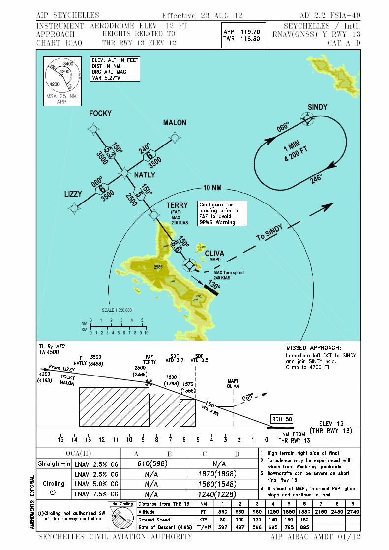


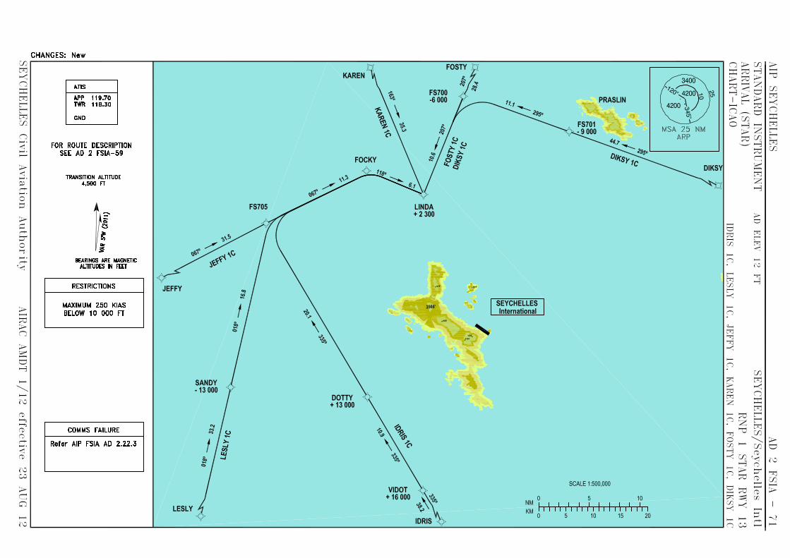


AERODROMECHART - ICAO
04°19’09.27”S055°41’29.78”E
APPTWR
119.70122.30
PRASLINSEYCHELLESAERODROME
ng is edeR:
EG
NA
HC
RWY DIRECTION THR BEARING STRENGTH
15
HELIPORT
04°18'55.40" S055°41'21.49“ E
DECLARED DISTANCES
TAKE-OFF DISTANCE AVAILABLE
ELEV - 10 FT
3304°19'26.65" S055°41'40.17“ E
REJECTED TAKE-OFF DISTANCEAVAILABLE
LANDING DISTANCE AVAILABLE
ALTITUDES , ELEVATIONS IN FEETBEARINGS ARE MAGNETICDIMENSIONS IN METRES
00010050METERS
5.37°W(2007)
Terminal
THR 33ELEV. 10 FT
ARP Air TrafficContolTower
Apron
Fire Station
Sea
Sea
33
15
eter
cnoC
m03
xm5
041
THR 15ELEV. 10 FT
MARKING AIDS RWY 15/33 AND EXIT TWY
LIGHTING AIDS RWY 15/33 AND EXIT TWY
1533
149° GEO154° MAG
329° GEO334° MAG
Concrete
Concrete
AIP Seychelles AD 2.2 FSPP - 01
Seychelles Civil Aviation Authority AIP AMDT 1/08

INSTRUMENTAPPROACHCHART - ICAO
AERODROME ELEV 10 FTHEIGHTS RELATED TORWY THR ELEV 10 FT
APPTWR
119.70122.30
PRASLIN (FSPP)VOR a
(CAT A - B)
ALTITUDES, ELEVATIONS IN FEETBEARINGS, TRACKS AND RADIALS
ARE MAGNETICDISTANCES IN NAUTICAL MILES
055°40’ 055°50’
04°10’
0150NM
5.37°W(2007) 10 NM
195°
MISSED APPROACH:Climb to 1500 FT ALTImmediate left turn totrack 195°M outbound.TO 7 DME. Then turnleft to intercept 015°Mand hold at 6.5 DMEor as directed by ATC.
TRANSITION ALTITUDE4500 FT ALT
TCH 50ELEV 10
NM from VOR/DME ‘PRA’501 0
210°
195°
2500(2490)
VOR/DMEPRA
1500(1490)
(IF)D7.0
FAF - MAPt 3 NM 2:15 1:48 1:30 1:07
ng is edeR:
EG
NA
HC
580 (570)
MAPt3.5 DME‘PRA’
MIN
RECOMMENDED PROFILE
Descent Gradient
Position ALT/HGTFAF
Circling only
OCA/H AMIN
Rate of descent FT/MIN
KTS 80 100 120 160B
VOR/DME”PRA”Circling Prohibited NE of RWY
Position ALT/HGT43625
CAT B
3 DME‘PRA’
2500 FT
PRAVOR/DME 115.7
CH 104X
04°20’
04°10’
04°20’
055°30’
055°40’ 055°50’055°30’
787
699
439
1204
1060853
623566
1093
760
1050
7 DME ‘PRA’1500 FT
Missed ApproachCAT - BCAT - A
Maximum 130 KIAS ,Maximum 100 KIAS .until established on 195°M outbound
ARIDE ISLANDRESTRICTED AREA
COUSIN ISLANDRESTRICTED AREA
D3.0
(FAF)D6.5
(MAPt)D3.5
4 3.5
2500
FTAL
T
5001000150020002500
ContourIntervals
2500
MSA 25 NMPRA VOR
030°
210°
1500
FTAL
T
195°01
5°
FAF6.5 DME ‘PRA’
1500 FT
NAV EQUIPMENT REQUIREDDME
030°
210°
015°
210°
210°
015°
1500
FTAL
T
1500 (1490)
420 530 640 850
AIP Seychelles AD 2.2 FSPP - 03
Seychelles Civil Aviation Authority AIP AMDT 1/08

INSTRUMENTAPPROACHCHART - ICAO
AERODROME ELEV 10 FTHEIGHTS RELATED TORWY THR ELEV 10 FT
APPTWR
119.70122.30
PRASLIN (FSPP)VOR b
(CAT C)
ALTITUDES, ELEVATIONS IN FEETBEARINGS, TRACKS AND RADIALS
ARE MAGNETICDISTANCES IN NAUTICAL MILES
055°40’ 055°50’
04°10’
0150NM
5.37°W(2007)
10 NM
TRANSITION ALTITUDE4500 FT ALT
TCH 50ELEV 10
NM from VOR/DME ‘PRA’501 0
230°050° 2500(2490)
VOR/DMEPRA
195°
1500(1490)
(IF)D7.0
FAF - MAPt 2.5 NM 1:52 1:30 1:15 0:56
ng is edeR:
EG
NA
HC
MAPt4.0 DME‘PRA’
MIN
RECOMMENDED PROFILE
Descent Gradient
Position ALT/HGTFAF
Circling only
OCA/HMIN
Rate of descent FT/MIN
KTS 80 100 120 160C
VOR/DME”PRA”Circling Prohibited NE of RWY
Position ALT/HGT43625
CAT C
3 DME‘PRA’
2500 FT
PRAVOR/DME 115.7
CH 104X
04°20’
04°10’
04°20’
055°30’
055°40’ 055°50’055°30’
787
699
439
1204
1060853
623 566
1093
760
1050
Missed ApproachMaximum 160 KIASuntil established on 195°M outbound
ARIDE ISLANDRESTRICTED AREA
COUSIN ISLANDRESTRICTED AREA
D3.0
(FAF)D6.5
(MAPt)D4.0
4 3.5
870 (860)
2500
MSA 25 NMPRA VOR
5001000150020002500
ContourIntervals
2500
FTAL
T05
0°
230°
1500
FTAL
T
195°01
5°
FAF6.5 DME ‘PRA’
1500 FT
NAV EQUIPMENT REQUIREDDME
195°
7 DME ‘PRA’1500 FT
MISSED APPROACH:Climb to 1500 FT ALTImmediate left turn totrack 195°M outbound.TO 7 DME. Then turnleft to intercept 015°Mand hold at 6.5 DMEor as directed by ATC.
015°230°
230°
230°
015°
1500
FTAL
T
1500 (1490)
420 530 640 850
AIP Seychelles AD 2.2 FSPP - 05
Seychelles Civil Aviation Authority AIP AMDT 1/08

INSTRUMENTAPPROACHCHART - ICAO
AERODROME ELEV 10 FTHEIGHTS RELATED TORWY THR ELEV 10 FT
APPTWR
119.70122.30
PRASLIN (FSPP)VOR c
(CAT A - B)
ALTITUDES, ELEVATIONS IN FEETBEARINGS, TRACKS AND RADIALS
ARE MAGNETICDISTANCES IN NAUTICAL MILES
055°40’ 055°50’
04°10’
5.37°W(2007)
10 NM
MISSED APPROACH:Climb to 2000 FT ALTImmediate right turn totrack 185°M outbound.Passing 2000 FT ALT.Then turn left directVOR PRA and holdor as directed by ATC.
TRANSITION ALTITUDE4500 FT ALT
TCH 50ELEV 10
NM from VOR/DME ‘PRA’501 0
270°
185°
2500(2490)
VOR/DMEPRA
1500(1490)
(IF)D7.0
FAF - MAPt 2.5 NM
ng is edeR:
EG
NA
HC
910 (900)
MAPt3.5 DME‘PRA’
MIN
RECOMMENDED PROFILE
Descent Gradient
Position ALT/HGTFAF
Circling only
OCA/H AMIN
Rate of descent FT/MIN
KTS 80 100 120 160B
VOR/DME”PRA”Circling Prohibited NE of RWY
Position ALT/HGT43625
CAT B
7 DME1500 FT
PRAVOR/DME 115.7
CH 104X
04°20’
04°10’
04°20’
055°30’
055°40’ 055°50’055°30’
787
699
439
1204
1060853
623
566
1093
760
1050
Missed ApproachCAT - BCAT - A
Maximum 130 KIAS ,Maximum 100 KIAS .until established on 195°M outbound
ARIDE ISLANDRESTRICTED AREA
COUSIN ISLANDRESTRICTED AREA
(FAF)D6
(MAPt)D3.5
4
2500 FT ALT
5001000150020002500
ContourIntervals
2500
MSA 25 NMPRA VOR
270°
090°
FAF6 DME ‘PRA’
1500 FT
NAV EQUIPMENT REQUIREDDME
090°
0150NM
270°185°
2000 FT
270°
1:52 1:30 1:15 0:56
1500 (1490)
420 530 640 850
105°
105°
AIP Seychelles AD 2.2 FSPP - 07
Seychelles Civil Aviation Authority AIP AMDT 1/08