AILA Future Leaders Award Slideshow
37
JUST ADD WATER: Reclaiming THE intertidal ecotone ROBERT GREEN The University of New South Wales Faculty Advisor: Linda Corkery
-
Upload
robert-green -
Category
Documents
-
view
226 -
download
3
description
Just Add Water: Reclaiming the Intertidal Ecotone Robert Green The University of New South Wales Faculty Advisor: Linda Corkery
Transcript of AILA Future Leaders Award Slideshow

Design RepoRt: 2011 gRaDuating stuDio
RobeRt gReen
JUST ADD
WATER:Reclaiming
THE intertidal
ecotone
ROBERT GREEN
The University of New South WalesFaculty Advisor: Linda Corkery

CAMELLIA: characterised by a large industrial area on the foreshore of the Parramatta River, covering an area of 40 ha to the north of Grand Ave.
The industry in this area includes large open yard areas for storage of shipping containers and other items.
“Shell AnnouncesTHE ClOSURE OF Australia’s longest Running oil refinery in Sydney’s west”
Tuesday12th April 2011

overgrown mangroves
SHELL OIL
grand ave
INDUSTRIAL RAIL LINE
brackish wetland
brackish wetlandbrackish wetland
reedlandswamp-oak floodplain forest
mangroves
bird migration
reveal tidal fluctuation
water quality
improve habitat
improve habitat
education
mangrovesmangroves
mangroves
mangroves
mangroves
mangroves
mangroves
swamp-oak floodplain forest
swamp-oak floodplain forest
swamp-oak floodplain forest
swamp-oak floodplain forest
swamp-oak floodplain forest
swamp-oak floodplain forest
reedland
saltmarsh
saltmarsh
saltmarsh
saltmarsh
saltmarsh
high risk
medium risk
low risk
building line
flood hazard: 100 year flood event
“Shell Announces THE CLOSURE OF Australia’s longest running oil refinery in Sydney’s west.”
Tuesday 12th April 2011
high technology employment
UWS
OK
faile
d faile
d
faile
dfa
iled
faile
d
faile
d
faile
dfa
iled
parramatta river
2.17 ha130 L/s
4.5 h260 L/s
1.3 ha70 L/s
1.7 ha115 L/s
duck river
improve:stoRMWateR QuaLitY
enhance:eCoLogiCaL LinKages
engage:CHanging LanD use
increase:FoResHoRe aCCess
address:FaiLeD seaWaLLs
understand:FLooD RisK
SITE ANALYSIS

C A M E L L I A R I V E R F R O N T :E x i s t i n g C o n d i t i o n s
C A M E L L I A R I V E R F R O N T+ 5 Y e a r s
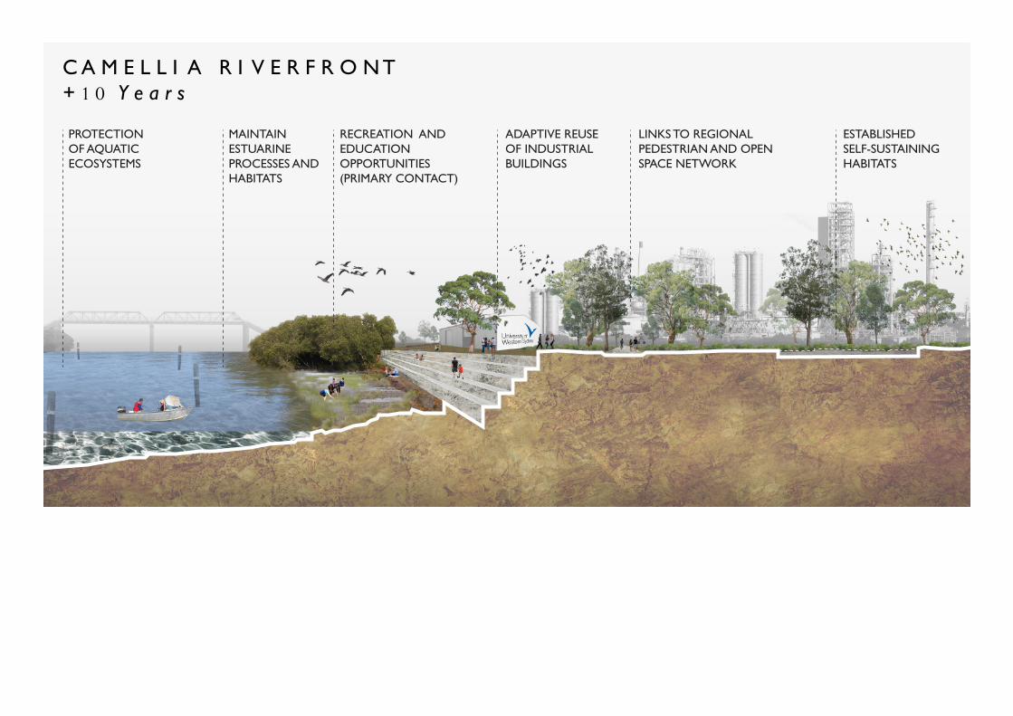
C A M E L L I A R I V E R F R O N T+ 1 0 Y e a r s
POOR WATER QUALITY
OVERGROWN MANGROVES
BANKEROSION
FAILED SEAWALL
LIMITED ACCESS TO WATERFRONT
ABANDONED INDUSTRIAL RAIL LINE
LIMITED HABITAT
UNTREATED STORMWATER
IMPROVED WATER QUALITY
RECREATION AND EDUCATION OPPORTUNITIES(SECONDAY CONTACT)
PUBLIC SPACE
INTERTIDAL SALTMARSH
IMPROVED PUBLIC ACCESS TO FORESHORE
GREENCONNECTIONS TO WATERS EDGE
IMPROVED HABITAT
WSUD INTERVENTIONS
PROTECTION OF AQUATIC ECOSYSTEMS
MAINTAIN ESTUARINE PROCESSES AND HABITATS
RECREATION AND EDUCATION OPPORTUNITIES(PRIMARY CONTACT)
LINKS TO REGIONAL PEDESTRIAN AND OPEN SPACE NETWORK
ADAPTIVE REUSE OF INDUSTRIAL BUILDINGS
ESTABLISHED SELF-SUSTAINING HABITATS
SHORELINE INTERVENTION: Rebuilding a functional shoreline

C A M E L L I A R I V E R F R O N T :E x i s t i n g C o n d i t i o n s
C A M E L L I A R I V E R F R O N T+ 5 Y e a r s
C A M E L L I A R I V E R F R O N T+ 1 0 Y e a r s
POOR WATER QUALITY
OVERGROWN MANGROVES
BANKEROSION
FAILED SEAWALL
LIMITED ACCESS TO WATERFRONT
ABANDONED INDUSTRIAL RAIL LINE
LIMITED HABITAT
UNTREATED STORMWATER
IMPROVED WATER QUALITY
RECREATION AND EDUCATION OPPORTUNITIES(SECONDAY CONTACT)
PUBLIC SPACE
INTERTIDAL SALTMARSH
IMPROVED PUBLIC ACCESS TO FORESHORE
GREENCONNECTIONS TO WATERS EDGE
IMPROVED HABITAT
WSUD INTERVENTIONS
PROTECTION OF AQUATIC ECOSYSTEMS
MAINTAIN ESTUARINE PROCESSES AND HABITATS
RECREATION AND EDUCATION OPPORTUNITIES(PRIMARY CONTACT)
LINKS TO REGIONAL PEDESTRIAN AND OPEN SPACE NETWORK
ADAPTIVE REUSE OF INDUSTRIAL BUILDINGS
ESTABLISHED SELF-SUSTAINING HABITATS

STRATEGIC ACTIONS: Expanding on the project’s goals in addressing some of the wider landscape issues and how these are addressed through a number of site interactions, each of which have consequences for the site and the region.

EXISTING:
Development of the foreshore will embrace the industrial past of the area and reestablish the ecological interface between the river and changing local infrastructure

IDENTIFY KEY SITES: potential to change the character of currently neglected river areas
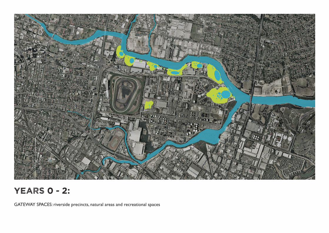
YEARS 0 - 2:
GATEWAY SPACES: riverside precincts, natural areas and recreational spaces

FORESHORE WALK: Continuous access along the river, a unifying movement corridor, linking these gateway spaces and providing recreational opportunities
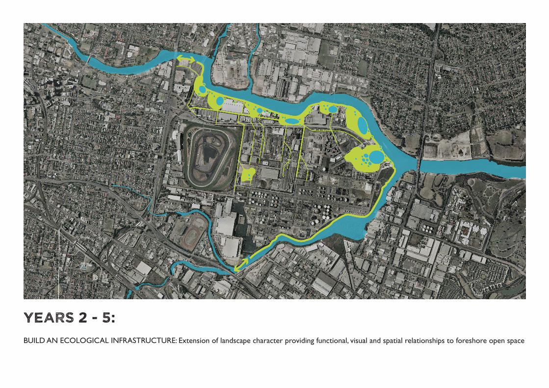
years 2 - 5:
BUILD AN ECOLOGICAL INFRASTRUCTURE: Extension of landscape character providing functional, visual and spatial relationships to foreshore open space

years 5 - 10:
REORIENTATE URBANISM TO THE RIVER: Urban form assists use and activation of foreshore open space (active frontages, linkages)

CURATE THE VISION THROUGH TIME: Design and stage improvements so that the landscape can be understood and enjoyed in each phase of it’s development.
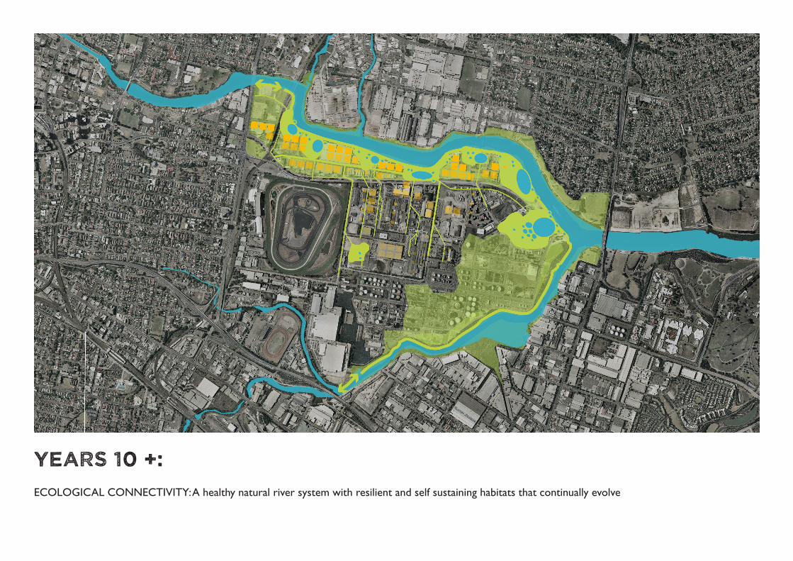
Years 10 +:
ECOLOGICAL CONNECTIVITY: A healthy natural river system with resilient and self sustaining habitats that continually evolve
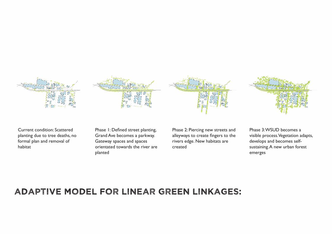
ADAPTIVE MODEL FOR LINEAR GREEN LINKAGES:
Current condition: Scattered planting due to tree deaths, noformal plan and removal of habitat
Phase 1: Defined street planting, Grand Ave becomes a parkway.Gateway spaces and spaces orientated towards the river areplanted
Phase 2: Piercing new streets and alleyways to create fingers to the rivers edge. New habitats are created
Phase 3: WSUD becomes a visible process. Vegetation adapts, develops and becomes self-sustaining. A new urban forest emerges

ECOLOGICAL CONNECTIVITY: A healthy natural river system with resilient and self sustaining habitats that continually evolve
CURATE THE VISION THROUGH TIME: Design and stage improvements so that the landscape can be understood andenjoyed in each phase of it’s development.
REORIENTATE URBANISM TO THE RIVER: Urban form assists use and activation of foreshore open space (active frontages, link-ages)
BUILD AN ECOLOGICAL INFRASTRUCTURE: Extension of landscape character providing functional, visual and spatial relationships to foreshore open space
FORESHORE WALK: Continuous access along the river, a unifying movement corridor, linking these gateway spaces and providing recreational opportunities
GATEWAY SPACES: riverside precincts, natural areas and recreational spaces
IDENTIFY KEY SITES: potential to change the character of currently neglected river areas
CAMELLIA: Development of the foreshore will embrace the industrial past of the area and re-establish the ecological interface between the river and changing local infrastructure
Th
E S
TR
AT
Eg
y
EX
IST
ING
Ye
ar
s 0
-2Y
ea
rs
2-5
Ye
ar
s 5
-10
Ye
ar
s 1
0 +
C A M E L L I A R I V E R F R O N T :E x i s t i n g C o n d i t i o n s
C A M E L L I A R I V E R F R O N T+ 5 Y e a r s
C A M E L L I A R I V E R F R O N T+ 1 0 Y e a r s
POOR WATER QUALITY
OVERGROWN MANGROVES
BANKEROSION
FAILED SEAWALL
LIMITED ACCESS TO WATERFRONT
ABANDONED INDUSTRIAL RAIL LINE
LIMITED HABITAT
UNTREATED STORMWATER
IMPROVED WATER QUALITY
RECREATION AND EDUCATION OPPORTUNITIES(SECONDAY CONTACT)
PUBLIC SPACE
INTERTIDAL SALTMARSH
IMPROVED PUBLIC ACCESS TO FORESHORE
GREENCONNECTIONS TO WATERS EDGE
IMPROVED HABITAT
WSUD INTERVENTIONS
PROTECTION OF AQUATIC ECOSYSTEMS
MAINTAIN ESTUARINE PROCESSES AND HABITATS
RECREATION AND EDUCATION OPPORTUNITIES(PRIMARY CONTACT)
LINKS TO REGIONAL PEDESTRIAN AND OPEN SPACE NETWORK
ADAPTIVE REUSE OF INDUSTRIAL BUILDINGS
ESTABLISHED SELF-SUSTAINING HABITATS
“ShellAnnouncesThE ClOSUREOF Australia’slongestRunning oilrefinery inSydney’swest.”
Tuesday12th April 2011
1 2 3 4
1. Create an urban fabric that creates a publicly accessible and vibrant river edge with strong visual connections to the water. Streets and public spaces are designed to encourage and support pedestrians, cyclists and transit users.
2. Encourage active, publicly-engaging ground floor uses along the rivers edge promenade.
3. Grand Ave becomes a parkway/boulevard that provides for pedestrian amenity, commuter bikelanes, and mass transit.
simple ecotones with equal andhomogeneous surfaces.
inclusion of each medium in the other, creating multiple ecotones
edges or banks treated in such a way as to lengthen the ecotone considerably without excessively modifying the environment.
a common interpenetration of media (such as that found at the edge of a saltmarsh)
an ecotone that could have been formed by an animal modifying its environment
Main axis’ and through block connections
ADAPTIVE MODEL FOR LINEAR gREEN LINKAgES
ShORELINE INTERVENTION
STRATEgIC ACTIONS
Connections to the urban form
Dedicated public realm open space pattern
View corridors open up to the water’s edge at special places
Spaces for pedestrians, cyclists and transit
Ground floor public engagement: Community CommercialUrban Mixed-UsePublic Engagement Uses
Current condition: Scattered planting due to tree deaths, no formal plan and removal of habitat
Phase 1: Defined street planting, Grand Ave becomes a parkway.Gateway spaces and spaces orientated towards the river are planted
Phase 2: Piercing new streets and alleyways to create fingers to the rivers edge. New habitats are created
Phase 3: WSUD becomes a visible process. Vegetation adapts, de-velops and becomes self-sustaining. A new urban forest emerges
JUST ADD
Robert GreenLAND 2402 Landscape Design 8: Graduating Project,Faculty of the Built Environment, University of New South WalesNovember 2011
CONNECTIONS TO THE URBAN FORM:
1. Create an urban fabric that creates a publicly accessible and vibrant river edge with strong visual connections to the water. Streets and public spaces are designed to encourage and support pedestrians, cyclists and transit users.2. Encourage active, publicly-engaging ground floor uses along the rivers edge promenade.3. Grand Ave becomes a parkway/boulevard that provides for pedestrian amenity, commuter bike lanes, and mass transit.


Existing grade will be excavated and modified creating a rich mix of hydric and mesic conditions. Supporting the remediation of intertidal saltmarsh and mudflats will attract a diversity of wildlife, from fish and amphibians to birds and mammals. Visitors will be able to enjoy this restored nature through a boardwalk, which provides an ideal viewing platform of the fragile saltmarsh and marsh exhibits, as well as providing educational signage, bird watching and fishing opportunities. This space makes new habitats instantly accessible to the public. The design geometry of the boardwalk is based on projected lines from the urban form, the existing shoreline, linkages to the river and the industrial rail line.

Camellia’s seawalls have masked the tectonic nature of its association with the river and any indication of tidal flux or the water life that inhabits the intertidal zones. The virgin condition of the waterfront has been so effectively removed and distorted by human intervention that the user has become disengaged from any visual or physical recognition of the site condition. So with this new inclined interface between the land and tidal fluctuations, we begin to visually reactivate tidal perception


Shorebirds were once present in Sydney in their thousands, but in this urban environment they face a variety of threats, including habitat loss and human disturbance. Migratory shorebirds are trans-hemispheric travellers and urbanisation is increasingly impacting on their populations worldwide, which means addressing issues relating to species conservation at a local level is just part of a global concern.

This site actively responds to human disturbance to shorebird dynamics. The ‘minimum approaching distances’ were taken into consideration, bird hide/bird blind as well as a habitat island and significant distancing have all been provided to aid in minimizing disturbance of shorebird habitats.

Pluvialis fulva
Curlew SandpiperCalidris ferruginea
Red-necked Stint
Sharp-tailed SandpiperCalidris acuminata
Common GreenshankTringa nebularia
Common SandpiperActitis hypoleucos
Grey-tailed TattlerHeteroscelus brevipes
Eastern CurlewNumenius madagascariensis
Pectoral SandpiperCalidris melanotus
Philomachus pugnax
Ruddy TurnstoneArenaria interpres
Red KnotCalidris canutus
Marsh SandpiperTringa stagnatilis
Black-tailed GodwitLimosa limosa
Bar-tailed GodwitLimosa laponnica
Latham’s SnipeGallinago hardwickii
WhimbrelNumenius phaeopus
6030 45150
REVERSING THE RAPID DECLINE OF AUSTRALIA’S SHOREBIRDS
EAST ASIAN-AUSTRALIASIAN FLYWAY
Annual population estimates with linear regression line of shorebird numbers (migratory and resident) based on data collected during annual aerial surveys during October, 1983–2006. Estimates were derived from systematic sampling of 10 surveys bands, which cover 12% (332,360 km ) of eastern Australia (2,697,000 km ), a third of the continent.
1,500,000
1,000,000
500,000
200720021997199219871982
NOVEMBER JANUARY
MA
RCH
SEPT
EMBE
R
JULY MAY
Migratory breedingin the Arctic North
60,000 arrive from Northern
Hemisphere
50,000 stay for the summer, the rest continue South
Resid
ent shorebirds
Live in the area all year
Migrating shorebirds
Numbers swell to 60,000
before leaving
Shorebirds (Charadriiformes) and their wetland habitats are under threat worldwide. While data exist for shorebird population trends for many parts of the world, two thirds of Australia’s populations have not been assessed. We report the results of a large-scale aerial shorebird survey, sampling about a third of the Australian continent over a period of 24 years (1983–2006). Migra-tory shorebirds have declined by 73%, Australian resident shorebirds by 81%.
Of the 10 wetlands supporting the highest number of shorebirds within the survey bands, eight were inland wetlands and only two coastal, emphasising the importance of inland wetlands for shorebirds. Wetland area decreased significantly at four of the 10 main sites. Annual rainfall showed no trends (1983–2005) but water extraction was substantial for four of the 10 wetlands, contributing to reduced flooding extent and frequency.
Loss of wetlands due to river regulation is a significant contributor to the drastic decline in shorebird numbers in Australia, largely unrecognized in international conservation agreements in Australia.
gATEWAy (EAST)
Existing grade will be excavated and modified creating a rich mix of hydric and mesic conditions. Supporting the remediation of intertidal saltmarsh will attract a diversity of wildlife, from fish and amphibians to birds and mammals. Visitors will be able to enjoy this restored nature through a series of boardwalks that provide education, bird watching and fishing opportunities. This space makes new habitats instantly accessible to the public.
This site actively responds to human disturbance to shorebird dynamics. A bird hide/bird blind as well as habitat island and significant distancing have all been provided to aid in minimising disturbance of shorebird habitats.
The reading of the tidal change is neutralised to the vertical face of the wall, removed from visual recognition. A new inclined interface between the land and the tidal fluctuations will be inserted to visually reactivate tidalperception.
N
0 10 20 40 100
SECTION A-A
The edge of the urban forest, an important resource within the urban fabric providing economic, ecological and social benefits. It buffers industrial facilities, provides terrestrial habitats, encourages physical activity aides in microclimate regulation, soil and air quality management.
The threshold between land and intertidal zone has a linear planting of small trees to further soften the visual impact of human activity and movement on shorebird habitats. The plantings are adequate to hide joggers and cyclists which are set back from the edge, but are permeable and still allow access to the tidal pools and saltmarsh viewing perimeter.
In areas of higher water levels, constructed tide pools will provide habitats for estuarine organisms as well as become an interactive water feature, valuable education tools and recreational fascinations for the public. This is where the land meets the river, and it is here where the inter-tidal zone is framed.
Bird hide to ensure close proximity to the bird life. Balustrade becomes a screen that becomes a wall to conceal bird watchers.
Image: Smilja Milovanovic-Bertram Bird Blind in Hornsby Bend, Austin, TX
Shorebirds were once present in Sydney in their thousands, but in an urban environment they face a variety of threats, including habitat loss and human disturbance.
Migratory shorebirds are trans-hemispheric travellers and urbanisation is increasingly impacting on their populations worldwide, which means addressing issues relating to species conservation at a local level is just part of a global concern.
Saltmarsh provides habitat and food for invertebrates such as crabs, insects including mosquitoes, molluscs and spiders, as well as for fish, birds and bats. It is a breeding and nursery ground for marine life, and filters nutrients that would otherwise enter estuarine waters.
Plants of the Coastal Saltmarsh community:Sarcocornia quinquefloraSuaeda australisTriglochin striataSporobolus virginicusWilsonia backhouseiLampranthus tegensHalosarcia pergranulataJuncus kraussiiSamolus repens
A boardwalk provides an ideal viewing platform of the fragile saltmarsh ecosystem and marsh exhibits. They need to allow for walkers, prams and wheelchair access as well as educational signage and wayfinding.
The design geometry of the boradwalk is based on projected lines from the urban form, existing shoreline, river linkages road network and industrial rail line.
S C A L E 1 : 2 5 0
80m
80m
A
A B B C D E F
B
CD E F
highest high tide TIDAL RANGE (Homebush Bay)
High: 1.0 m AHDLow: -0.7 m AHD
average high tide
average low tide
A
A


With the university predicted to expand across the river into Camellia, we are presented with the chance to reuse old industrial buildings as educational facilities. These industrial structures can provide points of interest along the corridor, however should not compromise biodiversity values or require the clearing of native vegetation. Past tendency for landuses along the river to orient away from, rather than towards the river, have resulted in a ‘back of house’ feel. It is crucial this building opens up to the river and actively promotes an interraction with it.

There is a level of flexibility in the design of the open space to cater for public events and changing recreational patterns in the future. The foreshore needs to provide a variety of spaces for enjoying the river. River steps provide seating spaces and access down to the water level. The relationship is intensified as tides change seating relationships and availability at different points of the day. Natural fluctuations are celebrated and interactions with the river encouraged.

gATEWAy (WEST)
2.17 haCATCHMENT AREA
130 L/sQ FLOW (3 MONTH)
21.4 L15 DAY RETENTION MINIMUM VOLUME
1.7 haCATCHMENT AREA
115 L/sQ FLOW (3 MONTH)
18.9 L15 DAY RETENTION MINIMUM VOLUME
4.5 haCATCHMENT AREA
260 L/sQ FLOW (3 MONTH)
42.7 L15 DAY RETENTION MINIMUM VOLUME
1.3 haCATCHMENT AREA
70 L/sQ FLOW (3 MONTH)
11.5 L15 DAY RETENTION MINIMUM VOLUME
Industrial railway
River ForeshorePCC South
Stormwater Drainage
N
0 10 20 40 100
SECTION B-B
Uncovering the abandoned, industrial railway line and turning it into a linear public par. Opportunity to establish a corridor that would serve as primary pedestrian and cycle access, and act as stormwater treatment facility and ecological amenity, promoting active living, providing access to the river along its length and acting as a car free connection through Camellia.
Adaptive urban reuse of industrial warehouses and factories for new eco-industry and land uses, such as the university. In turn reducing environmental impact of new buildings and urban sprawl.
Past tendency for landuses along the river to orient away from, rather than towards the river, resulting in a ‘back of house’ feel. It is crucial this building opens up to the river and actively promotes an interraction with it.
Image: Richard RogersTransforming the East River Waterfront, NYC
There has to be a level of flexibility in the design of the open space to cater for public events and changing recreational patterns in the future.
The foreshore needs to provide a variety of spaces for enjoying the river. River steps provide seating spaces and access to water level. The relationship is intensified as tides change seating relationships and availiability. Natural fluctuations are celebrated and interration with the river encouraged.
Keeping the old seawall footings references the past form of the shoreline, adds visual interest, helps the public read tidal rhythms and provides perching for bird species.
Where appropriate structural habitat element would be added to provide both surface area for the attachment of invertebrates and retreats for fish and mobile invertebrates
The Parramatta River catchment represents an enormously significant recreational, scenic and economic resource for the community, and improving water quality is of great importance. Because of the extent of development, waterways are affected by poor water quality and a changed flow regime. Stormwater and runoff management needs to be integrated into all planning and design.
When new seawalls are built or existing seawalls changed, there is the opportunity to include more habitat-friendly designs into the new structures in the attempt to increase local marine diversity by increasing the com-plexity of their habitat
With the university predicted to expand across the river into Camellia, we are pre-sented with the chance to reuse old industrial buildings as educational facilities. These industrial structures can provide points of interest along the corridor, however should not compromise biodiversity values or require the clearing of native vegetation. Op-portunities to incorporate water recycling and stormwater management should also be investigated. Changes in land use offer the potential to change the character of currently neglected river areas and integrate better address to the river and enhance visual and access links.
S C A L E 1 : 2 5 0
removed blocks act as tide pools for habitat
sandstone seawall
ledges provide habitats and retreats
A
A
B
B
C D
C
E
D
F
G
E
G
F
B
B


Each set of tanks sit in a large square depressed plot, calculated to hold the entire contents of the tank in the event of a major leak. Canals are cut into the existing grid network to supply water to the holding depressions. The refinery will reconstitute natural and settled landscapes as well as theirinterplay, with a new relation of overflows, water levels and flood mitigation.

AN INTERFACE BETWEEN THE COMMUNITY AND THE ENVIRONMENT
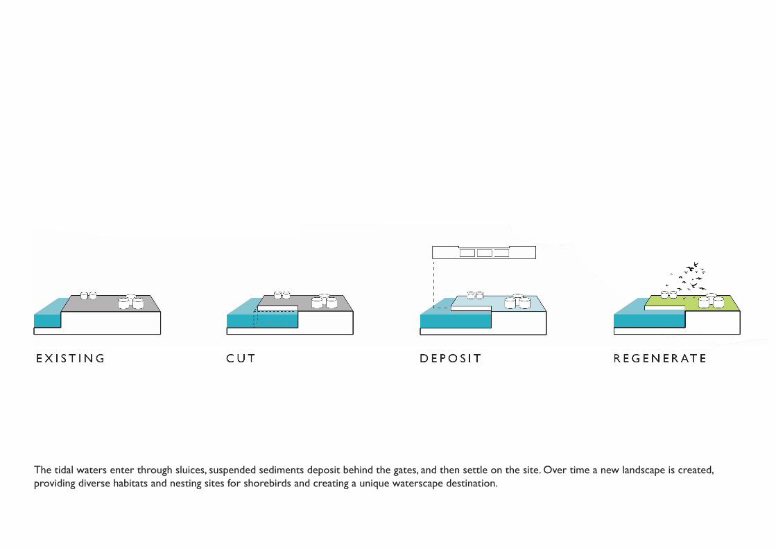
The tidal waters enter through sluices, suspended sediments deposit behind the gates, and then settle on the site. Over time a new landscape is created, providing diverse habitats and nesting sites for shorebirds and creating a unique waterscape destination.
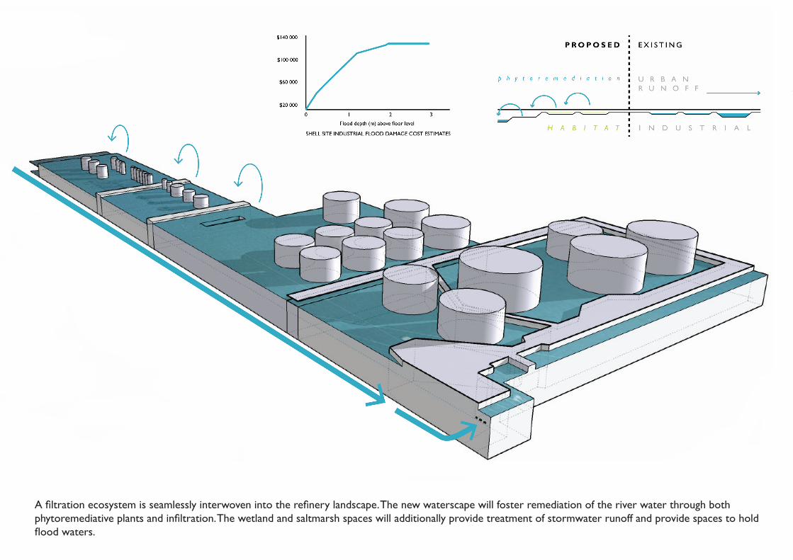
A filtration ecosystem is seamlessly interwoven into the refinery landscape. The new waterscape will foster remediation of the river water through both phytoremediative plants and infiltration. The wetland and saltmarsh spaces will additionally provide treatment of stormwater runoff and provide spaces to hold flood waters.

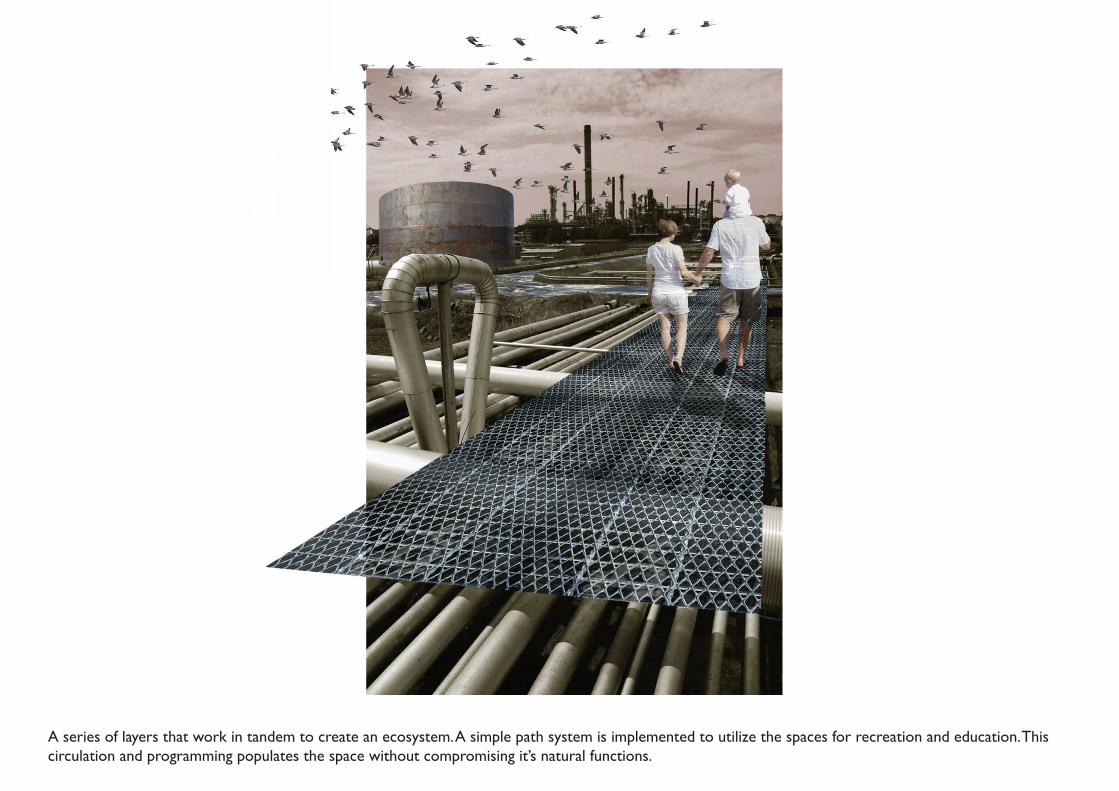
A series of layers that work in tandem to create an ecosystem. A simple path system is implemented to utilize the spaces for recreation and education. This circulation and programming populates the space without compromising it’s natural functions.
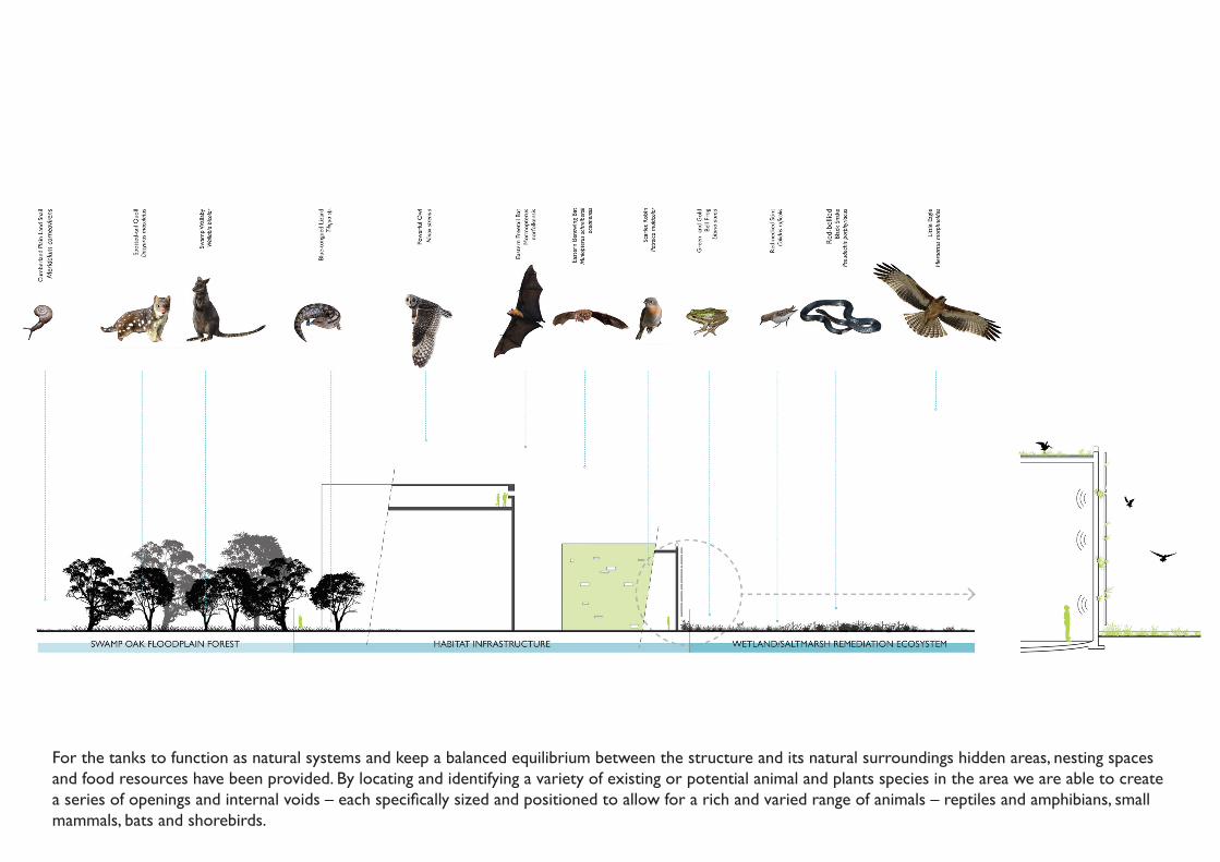
For the tanks to function as natural systems and keep a balanced equilibrium between the structure and its natural surroundings hidden areas, nesting spaces and food resources have been provided. By locating and identifying a variety of existing or potential animal and plants species in the area we are able to create a series of openings and internal voids – each specifically sized and positioned to allow for a rich and varied range of animals – reptiles and amphibians, small mammals, bats and shorebirds.

The preservation of the tanks demands a minimal intervention that respects the original form without compromising the new program and activities within it. A series of auditoriums and viewing galleries occupy the internal space and allow non-interruptive bird watching.